2015 castnet annual network plan - epa.gov · pdf file2015 castnet annual network plan ... the...
TRANSCRIPT

Sumatra, FL (SUM156)
2015 CASTNET Annual Network Plan
Clean Air Markets Division
Office of Atmospheric Programs
US Environmental Protection Agency
June 30, 2015

Page 2 of 103
Table of Contents 1. Network Overview ................................................................................................................................................................... 3
2. Ozone Data ............................................................................................................................................................................... 3
3. Network Audit Requirements .................................................................................................................................................. 4
4. Daily Quality Control Checks .................................................................................................................................................... 4
5. Performance Evaluations (PE) .................................................................................................................................................. 4
6. Field TSA ................................................................................................................................................................................... 7
7. National Performance Audit Program (NPAP) ......................................................................................................................... 8
8. Facilities TSA............................................................................................................................................................................. 8
9. Annual Monitoring Network Plans and Network Assessment ................................................................................................. 9
10. Ozone Network Modification ................................................................................................................................................... 9
11. Data Reporting and Certification ............................................................................................................................................. 9
Appendix A. Detailed Site Information .................................................................................................................................................. 10
Appendix B. Ozone Validation Template ............................................................................................................................................... 89
Appendix C. Ozone Season by State ...................................................................................................................................................... 92
Appendix D. CASTNET QAPP Ozone Certification Flowchart ................................................................................................................. 94
Appendix E. EPA Regional Office Contacts Information ........................................................................................................................ 95
Appendix F. Outline for TSA Report ....................................................................................................................................................... 96
Appendix G. Current list of 40 CFR Part 58 Compliant CASTNET Ozone Monitoring Sites .................................................................... 97
Appendix H. CBSA Code and Title for CASTNET Sites .......................................................................................................................... 100
Appendix I. Summary of CASTNET Ozone Monitoring Sites – 2015 .................................................................................................... 103
List of Tables Table 1 Audit Levels for Performance Evaluations (PE) ............................................................................................................................. 5 Table 2 Proposed PE and Field TSA Schedule for 2015 and 2016 .............................................................................................................. 5 Table 3 NPAP Audit History for 2011-2015 Period .................................................................................................................................... 8 Table 4 Network Plan Schedule ................................................................................................................................................................. 9

Page 3 of 103
1. Network Overview The Clean Air Status and Trends Network (CASTNET) is a long-term monitoring network designed to measure acidic pollutants and ambient ozone concentrations in rural areas. CASTNET is managed collaboratively by the Environmental Protection Agency – Clean Air Markets Division (EPA), the National Park Service – Air Resources Division (NPS), and the Bureau of Land Management – Wyoming State Office (BLM-WSO). In addition to EPA, NPS, and BLM-WSO, numerous other participants including tribes, other federal agencies, States, private land owners, and universities provide network support. The EPA contractor, AMEC Foster Wheeler (AMEC), operates the EPA-sponsored sites while the NPS and BLM-WSO contractor, Air Resource Specialists, Inc. (ARS), operates the remaining sites. An overview of the CASTNET monitoring program can be found here: <http://epa.gov/castnet/javaweb/docs/CASTNET_Factsheet_2013.pdf>. All CASTNET sites measure weekly concentrations of SO2, SO4
2-, HNO3, NO3-, NH4
+, Cl- and the base cations using a 3-stage filter pack. Most CASTNET sites also monitor ambient ozone (O3) concentrations, reported as hourly averages, using a continuous analyzer. All CASTNET O3 monitors, except the Howland AmeriFlux site, ME (HOW191), meet the siting criteria as specified within 40 Code of Federal Regulations (CFR) Part 58 Appendices D and E. These O3 monitors collect hourly measurements on a continuous basis for the entire year and utilize daily one-point quality control (QC) checks. Additional information regarding detailed siting criteria, monitoring objectives, site types, and other relevant parameters for each monitoring site per the requirements of 40 CFR Part 58.10(b) may be found in Appendix A. As of June 2015, 93 CASTNET sites include a 3-stage filter pack. Seventy-nine CASTNET sites collect ambient O3 concentrations and 32 of these sites measure meteorology continuously. CASTNET also measures continuous trace level NOy, SO2, and CO at select sites. To ensure consistency across the network, EPA operates a collocated site (ROM206) at Rocky Mountain National Park, Colorado (ROM406). Also, EPA operates a collocated monitor (MCK231) at Mackville, KY (MCK131). Data are routinely compared to identify any biases between ambient data from collocated instruments. The CASTNET quality assurance (QA) program is managed by an independent QA Manager and QA Project Supervisor. Additionally, network QA is maintained through an independent audit program supported by Environmental Engineering & Measurement Services, Inc. (EE&MS). EE&MS performs annual Performance Evaluations (PE) at every CASTNET O3 site unless a State or EPA Regional Office performs this annual audit. EE&MS also performs a Technical Systems Audit (TSA) at every CASTNET site every other year. A third-party auditor performs the facility TSA at the operations centers for both the EPA and NPS/BLM-WSO contractors and laboratories every third year. The NPS established their regulatory O3 monitoring program before 1990. In 2010 and 2011, EPA upgraded all EPA-sponsored CASTNET O3 analyzers to Thermo Scientific™ Model 49i monitors, installed Thermo Scientific™ Model 49i monitors with onboard O3-generators as on-site transfer standards, and updated the QA/QC procedures at all EPA-sponsored sites to comply with the requirements in 40 CFR Part 58. This upgrade improved the overall quality of data, reliability of the analyzers, and comparability of the data with other regulatory monitoring networks (e.g., State and Local Air Monitoring Sites (SLAMS), NCore). CASTNET O3 data are used to calculate design values for all sites where data completeness requirements are met. The CASTNET program follows QA/QC procedures and schedules to meet the regulatory requirements detailed in Appendix B. The procedures in this annual network plan originate from the requirements placed on States for SLAMS per guidance in 40 CFR Part 58.10, but have been adjusted to encompass a federally-operated national monitoring network.
2. Ozone Data CASTNET monitors measure ambient O3 concentrations for the entire year, which extends beyond the required ozone season for most states (Appendix C). CASTNET submits ambient concentrations in near real time to AIRNow Tech <www.airnowtech.org> and reports data to the CASTNET website daily <http://epa.gov/castnet/javaweb/index.html>. BLM-WSO also displays O3 data on their website <http://www.blmwarms.net/>. AMEC and ARS submit the hourly O3 concentrations to EPA’s Air Quality System’s (AQS) database on a monthly basis and daily 1-point precision results on a quarterly basis. EPA submits O3 data from two collocated monitors (ROM206 and MCK231) to AQS, but the data are identified as ‘NAAQS Excluded’ as these data are used for QA purposes. In addition to the collocated QA monitors, EPA operates a non-regulatory O3 analyzer above the tree canopy (23.5 meters (m)) at the Howland AmeriFlux site, ME (HOW191). The HOW191 O3 monitor does not meet the siting criteria in 40 CFR Part 58 Appendix E, so these data are not submitted to AQS.
Page 4 of 103
Following guidance in 40 CFR Part 58.15, CASTNET site managers submit their annual data certification letter, including the AQS Data Certification Report (AMP600) to the EPA Office of Air Quality Planning and Standards (OAQPS) and applicable EPA Regional Offices by May 1 of each year. When air monitoring data are affected by exceptional events, States may petition EPA to exclude those data from any use related to NAAQS determinations. As detailed in 40 CFR Part 50.14 and the Exceptional Events Rule <http://www.epa.gov/ttn/analysis/exevents.htm>, State agencies are required to demonstrate to their EPA Regional Office when an exceptional event occurred. States have until July 1 of the following calendar year to identify hourly O3 values that may have been affected by an exceptional event and request that the data be flagged accordingly in AQS. When a State agency believes that CASTNET O3 data are affected by an exceptional event, the agency should submit the following information to Timothy Sharac ([email protected]) to request the data be flagged as a possible exceptional event:
date/time range of incident,
type of exceptional event, and
CASTNET site(s) Exceptional event types and their associated AQS qualifier codes are listed at the following website: <https://aqs.epa.gov/aqsweb/codes/data/QualifierCodes.html>. CASTNET uses the measurement quality objectives and validation templates described in the Quality Assurance Handbook for Air Pollution Measurement Systems QA Handbook Volume II, Appendix D Revision 0, May 2013 <http://www.epa.gov/ttnamti1/files/ambient/pm25/qa/QA-Handbook-Vol-II.pdf> (reproduced in Appendix B of this document) to ensure that the highest quality data are being submitted to AQS. These validation templates describe operational and systematic criteria for O3 measurements, including requirements for frequency of measurements or audits, calibration schedules, and acceptance criteria for QC checks. In addition to the QC checks required for meeting the measurement quality objectives and validation templates, semi-annual system checks are performed at each CASTNET site. During these checks, a field operations technician challenges the on-site analyzer and reverifies the on-site transfer standard, calibrates the on-site analyzer to the traveling transfer standard (Level 2) as needed, and verifies the data logger and the shelter temperature probe using National Institute of Standards and Technology (NIST) traceable standards. All on-site O3 transfer standards at CASTNET sites are NIST-traceable at Level 3. CASTNET contractors use the results from these system checks to perform the final validation of the hourly O3 measurement data. A flow chart diagram of the O3 certification process is illustrated in Appendix D.
3. Network Audit Requirements The network audit requirements for 40 CFR Part 58 compliance are summarized in Appendix B. CASTNET managers provide EPA Regional Offices with the facility and field TSA schedules at least 6 months in advance to ensure EPA Regional Offices have sufficient time to arrange for travel if they choose to attend the audit. The EPA Regional Office contacts are listed in Appendix E.
4. Daily Quality Control Checks Automated zero/precision/span (ZPS) scans are performed nightly at 0, 60, and 225 ppb, respectively, but additional scans may be run manually to troubleshoot problems. The criteria for the automated ZPS scans are included in Appendix B. Three additional audit points at 40, 90, and 150 ppb are verified during the Sunday multi-point check at EPA-sponsored CASTNET sites. Daily QC results are updated on the CASTNET website daily for EPA-sponsored CASTNET sites.
5. Performance Evaluations (PE) An independent auditor performs annual PEs in accordance with EPA’s Quality Assurance Handbook for Air Pollution Measurement Systems: Volume II - Ambient Air Specific Methods, and 40 CFR Parts 53 and Parts 58 Revisions to Ambient Air Monitoring Regulations: Final Rule and submits these results to AQS on a quarterly basis. Verification of the O3 analyzer during the PE audit requires that the zero/span be within ±2% of the full scale of the best fit linear line. The auditor selects target concentration values among the ten audit levels, as described in guidance from OAQPS in 2011 <http://www.epa.gov/ttn/airs/airsaqs/memos/expanded%20audit.pdf>. A minimum of three audit levels that represent routine concentrations at the monitoring site are required (see Table 1 for acceptable audit ranges). Audit levels 1 and 2 must be within ±1.5 ppb or within ±15%, whichever is greater, to meet the acceptance criteria. Levels 3-10 must be within ±15% to meet the acceptance criteria. The target values must bracket 85% of a site’s concentration levels.
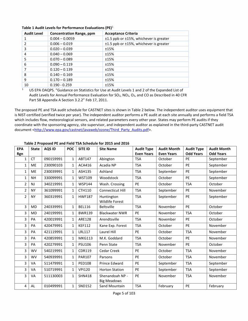
Page 5 of 103
Table 1 Audit Levels for Performance Evaluations (PE)1
Audit Level Concentration Range, ppm Acceptance Criteria
1 0.004 – 0.0059 ±1.5 ppb or ±15%, whichever is greater
2 0.006 – 0.019 ±1.5 ppb or ±15%, whichever is greater
3 0.020 – 0.039 ±15%
4 0.040 – 0.069 ±15%
5 0.070 – 0.089 ±15%
6 0.090 – 0.119 ±15%
7 0.120 – 0.139 ±15%
8 0.140 – 0.169 ±15%
9 0.170 – 0.189 ±15%
10 0.190 - 0.259 ±15% 1 US EPA OAQPS. “Guidance on Statistics for Use at Audit Levels 1 and 2 of the Expanded List of
Audit Levels for Annual Performance Evaluation for SO2, NO2, O3, and CO as Described in 40 CFR Part 58 Appendix A Section 3.2.2” Feb 17, 2011.
The proposed PE and TSA audit schedule for CASTNET sites is shown in Table 2 below. The independent auditor uses equipment that is NIST-certified (verified twice per year). The independent auditor performs a PE audit at each site annually and performs a field TSA which includes flow, meteorological sensors, and related parameters every other year. States may perform PE audits if they coordinate with the sponsoring agency, site supervisor, and independent auditor as explained in the third-party CASTNET audit document <http://www.epa.gov/castnet/javaweb/ozone/Third_Party_Audits.pdf>.
Table 2 Proposed PE and Field TSA Schedule for 2015 and 2016 (continued) EPA Rgn
State AQS ID POC SITE ID Site Name Audit Type Even Years
Audit Month Even Years
Audit Type Odd Years
Audit Month Odd Years
1 CT 090159991 1 ABT147 Abington TSA October PE September
1 ME 230090103 1 ACA416 Acadia NP TSA October PE September
1 ME 230039991 1 ASH135 Ashland TSA September PE September
1 NH 330099991 1 WST109 Woodstock TSA October PE September
2 NJ 340219991 1 WSP144 Wash. Crossing PE October TSA October
2 NY 361099991 1 CTH110 Connecticut Hill TSA September PE November
2 NY 360319991 1 HWF187 Huntington Wildlife Forest
TSA September PE September
3 MD 240339991 1 BEL116 Beltsville TSA November PE October
3 MD 240199991 1 BWR139 Blackwater NWR PE November TSA October
3 PA 420019991 1 ARE128 Arendtsville TSA November PE October
3 PA 420479991 1 KEF112 Kane Exp. Forest TSA October PE November
3 PA 421119991 1 LRL117 Laurel Hill PE October TSA November
3 PA 420859991 1 MKG113 M.K. Goddard TSA October PE November
3 PA 420279991 1 PSU106 Penn State TSA November PE October
3 WV 540219991 1 CDR119 Cedar Creek PE October TSA November
3 WV 540939991 1 PAR107 Parsons PE October TSA November
3 VA 511479991 1 PED108 Prince Edward PE September TSA September
3 VA 510719991 1 VPI120 Horton Station PE September TSA September
3 VA 511130003 1 SHN418 Shenandoah NP - Big Meadows
PE November TSA November
4 AL 010499991 1 SND152 Sand Mountain TSA February PE February

Page 6 of 103
Table 2 Proposed PE and Field TSA Schedule for 2015 and 2016 (continued) EPA Rgn
State AQS ID POC SITE ID Site Name Audit Type Even Years
Audit Month Even Years
Audit Type Odd Years
Audit Month Odd Years
4 FL 120619991 1 IRL141 Indian River Lagoon
TSA February PE February
4 FL 120779991 1 SUM156 Sumatra TSA February PE February
4 GA 132319991 1 GAS153 Georgia Station TSA February PE February
4 KY 212219991 1 CDZ171 Cadiz PE March TSA March
4 KY 211759991 1 CKT136 Crockett PE April TSA March
4 KY 212299991 1 MCK131 Mackville PE March TSA March
4 KY 212299991 2 MCK231 Mackville Collocated
PE March TSA March
4 KY 210610501 1 MAC426 Mammoth Cave NP
PE March TSA March
4 MS 281619991 1 CVL151 Coffeeville PE March TSA February
4 NC 370319991 1 BFT142 Beaufort PE November TSA October
4 NC 371239991 1 CND125 Candor PE November TSA October
4 NC 371139991 1 COW137 Coweeta TSA March PE March
4 NC 370119991 1 PNF126 Cranberry TSA March PE March
4 TN 470419991 1 ESP127 Edgar Evins TSA April PE April
4 TN 470259991 1 SPD111 Speedwell TSA March PE April
4 TN 470090101 1 GRS420 Great Smoky NP - Look Rock
PE October TSA September
5 IL 171199991 1 ALH157 Alhambra PE June TSA August
5 IL 170191001 1 BVL130 Bondville PE August TSA August
5 IL 170859991 1 STK138 Stockton PE June TSA August
5 IN 181699991 1 SAL133 Salamonie Reservoir
TSA August PE August
5 IN 180839991 1 VIN140 Vincennes PE June TSA August
5 MI 261619991 1 ANA115 Ann Arbor TSA August PE August
5 MI 261659991 1 HOX148 Hoxeyville TSA August PE August
5 MI 261579991 1 UVL124 Unionville TSA August PE August
5 MN 271370034 1 VOY413 Voyageurs NP PE August TSA August
5 OH 390479991 1 DCP114 Deer Creek PE April TSA April
5 OH 390179991 1 OXF122 Oxford PE April TSA April
5 OH 391219991 1 QAK172 Quaker City PE April TSA April
5 WI 551199991 1 PRK134 Perkinstown PE August TSA August
6 AR 050199991 1 CAD150 Caddo Valley PE February TSA February
6 OK 400019009 1 CHE185 Cherokee Nation PE February TSA March
6 TX 483739991 1 ALC188 Alabama-Coushatta
PE March TSA February
6 TX 480430101 1 BBE401 Big Bend NP PE March TSA March
6 TX 483819991 1 PAL190 Palo Duro PE February TSA March
7 NE 311079991 1 SAN189 Santee Sioux PE July TSA June
8 CO 080519991 1 GTH161 Gothic PE June TSA June

Page 7 of 103
Table 2 Proposed PE and Field TSA Schedule for 2015 and 2016 (continued) EPA Rgn
State AQS ID POC SITE ID Site Name Audit Type Even Years
Audit Month Even Years
Audit Type Odd Years
Audit Month Odd Years
8 CO 080830101 1 MEV405 Mesa Verde NP TSA April PE April
8 CO 080699991 1 ROM206 Rocky Mtn NP Collocated
PE June TSA June
8 CO 080690007 1 ROM406 Rocky Mtn NP Collocated
PE June TSA June
8 MT 300298001 1 GLR468 Glacier NP TSA June PE June
8 ND 380070002 1 THR422 Theodore Roosevelt NP
PE September TSA July
8 SD 460330132 3 WNC429 Wind Cave NP PE September TSA July
8 UT 490370101 1 CAN407 Canyonlands NP TSA April PE April
8 UT 490471002 1 DIN431 Dinosaur NM TSA July PE July
8 WY 560030002 1 BAS601 Basin PE June TSA June
8 WY 560019991 1 CNT169 Centennial PE June TSA June
8 WY 560450003 1 NEC602 Newcastle PE June TSA June
8 WY 560359991 1 PND165 Pinedale PE August TSA June
8 WY 560391011 1 YEL408 Yellowstone NP PE June TSA May
9 AZ 040038001 1 CHA467 Chiricahua NM TSA April PE April
9 AZ 040058001 1 GRC474 Grand Canyon NP TSA April PE April
9 AZ 040170119 1 PET427 Petrified Forest TSA April PE April
9 CA 060719002 1 JOT403 Joshua Tree NP TSA May PE April
9 CA 060893003 1 LAV410 Lassen Volcanic NP
PE May TSA May
9 CA 060690003 1 PIN414 Pinnacles NM PE May TSA April
9 CA 061070009 1 SEK430 Sequoia NP - Ash Mountain
PE May TSA May
9 CA 060430003 1 YOS404 Yosemite NP - Turtleback Dome
PE May TSA May
9 NV 320330101 1 GRB411 Great Basin NP TSA May PE April
10 AK 020680003 1 DEN417 Denali NP TSA July PE June
Note: See Appendix H for CBSA Codes for CASTNET sites as available
6. Field TSA An independent auditor performs field TSAs every other year at each CASTNET site. The purpose of these audits is to provide an
independent assessment of the site, the equipment performance, and the proficiency of the site operator. The auditor verifies that
filter pack flow, the O3 analyzer, and the meteorological sensors meet the criteria listed in Appendix B and the CASTNET QAPP at
<http://java.epa.gov/castnet/documents.do>. The auditor also completes a PE for O3 in addition to field TSAs. The auditor performs
through-the-probe (TTP) audits to verify there are no line losses within the system and documents whether any objects or pollutant
sources violate the CASTNET siting criteria; see the CASTNET QAPP for siting criteria at
<http://java.epa.gov/castnet/documents.do>. During the field TSA, the auditor discusses any issues related to equipment, siting
criteria, or operator handling with the operator and/or site supervisor. The independent auditor submits audit results to the site
supervisor, site operator, site funding agency, and CASTNET contractor following the audit. A summary of audit results are available
in a quarterly report and posted to the CASTNET website under “Quality Assurance” at
<http://java.epa.gov/castnet/documents.do>.

Page 8 of 103
The independent auditor sends TSA announcement letters to the agency contractor, site operator, and site sponsor describing the
purpose of the site visit 2-4 weeks prior to field TSA to ensure all parties involved are prepared. An EPA, NPS, or BLM-WSO
representative may also attend the field TSA. CASTNET staff coordinate with States and EPA Regional Offices to provide six months’
notice prior to the field TSAs and their participation in the field TSAs is encouraged. The EPA Regional Office contacts are listed in
Appendix E. The proposed schedule for 2015 is shown in Table 2. It is required that at least ten percent of all CASTNET sites have a
field TSA completed each year. CASTNET performs field TSAs at fifty percent of the network sites each year to ensure network-wide
consistency in the data, exceeding the ten percent requirement for regulatory monitors.
7. National Performance Audit Program (NPAP) The purpose of the NPAP is to assess the proficiency of the monitoring organization. The EPA Clean Air Markets Division (CAMD)
coordinates with OAQPS, EPA Regional Offices (listed in Appendix E), and the Environmental Services Assistance Team (ESAT) to
fulfill the requirements under the NPAP. Each network is required to complete NPAP audits at 20% of the sites each year. OAQPS is
responsible for selecting the sites to audit, and special priority is given to those sites with design values near the ozone NAAQS. The
NPAP auditor is responsible for submitting the audit results to AQS. Through-the-probe audits are also performed during an NPAP
audit using a zero air generator to supply the carrier gas to an ozone generator. Audit ozone concentrations are delivered to the
through-the-probe dual glass manifold connected to the monitor’s inlet probe while venting excess flow to the atmosphere. The
ozone generator is referenced back to a level 2 ozone standard which is in turn referenced to a level 1 standard reference
photometer. The auditor selects 3 or 4 known target concentrations to determine the accuracy of the on-site ozone analyzer. The
acceptable ranges are the same as those used for the annual performance evaluations in Table 1.
Table 3 NPAP Audit History for 2011-2015 Period (as of June 2015)
8. Facilities TSA CASTNET uses an independent auditor to conduct the facilities portion of the TSA at contractor ozone laboratories once every three
years. CASTNET staff may also attend the facility audit when travel funds are available. CASTNET staff provide the date of the
scheduled audit to the EPA Regional Offices at least six months prior to the visit. The purpose of the facility TSA is to provide a
qualitative appraisal of the total measurement system. Site planning, organization, documentation and operation are evaluated to
ensure that good QA/QC practices are being applied throughout the monitoring program. An outline of the facility TSA is available in
Appendix F. RTI International last performed facility TSAs at AMEC, Inc. in Newberry, FL in 2012 and at ARS, Inc. in Fort Collins, CO in
2013. An independent auditor will be selected for the 2015 AMEC Foster Wheeler facility audit. The facility TSA consists of an
EPA
Region Audited Total Sites Completed (%)
Scheduled for
2015
Scheduled Completion
for 2015 (%)
1 5 5 100 0 100
2 3 3 100 0 100
3 7 12 58 5 100
4 8 17 47 9 100
5 8 13 62 5 100
6 5 5 100 0 100
7 1 1 100 0 100
8 11 13 85 2 100
9 8 9 89 1 100
10 1 1 100 0 100
Page 9 of 103
assessment of the staff, facilities, data and document control, and the quality control programs. Results, findings, and the responses
to the findings can be found on the CASTNET/Ozone webpage <http://epa.gov/castnet/javaweb/ozone.html>.
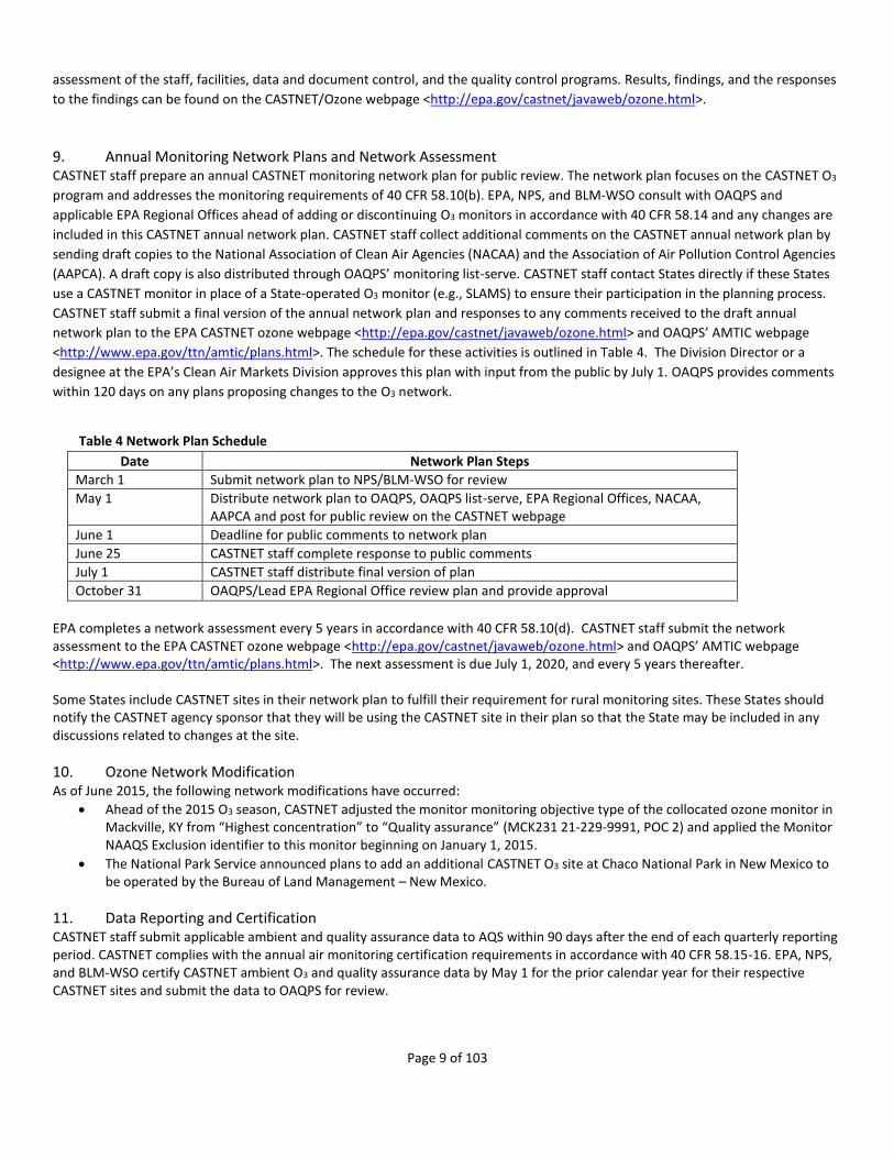
9. Annual Monitoring Network Plans and Network Assessment CASTNET staff prepare an annual CASTNET monitoring network plan for public review. The network plan focuses on the CASTNET O3
program and addresses the monitoring requirements of 40 CFR 58.10(b). EPA, NPS, and BLM-WSO consult with OAQPS and
applicable EPA Regional Offices ahead of adding or discontinuing O3 monitors in accordance with 40 CFR 58.14 and any changes are
included in this CASTNET annual network plan. CASTNET staff collect additional comments on the CASTNET annual network plan by
sending draft copies to the National Association of Clean Air Agencies (NACAA) and the Association of Air Pollution Control Agencies
(AAPCA). A draft copy is also distributed through OAQPS’ monitoring list-serve. CASTNET staff contact States directly if these States
use a CASTNET monitor in place of a State-operated O3 monitor (e.g., SLAMS) to ensure their participation in the planning process.
CASTNET staff submit a final version of the annual network plan and responses to any comments received to the draft annual
network plan to the EPA CASTNET ozone webpage <http://epa.gov/castnet/javaweb/ozone.html> and OAQPS’ AMTIC webpage
<http://www.epa.gov/ttn/amtic/plans.html>. The schedule for these activities is outlined in Table 4. The Division Director or a
designee at the EPA’s Clean Air Markets Division approves this plan with input from the public by July 1. OAQPS provides comments
within 120 days on any plans proposing changes to the O3 network.
Table 4 Network Plan Schedule
Date Network Plan Steps
March 1 Submit network plan to NPS/BLM-WSO for review
May 1 Distribute network plan to OAQPS, OAQPS list-serve, EPA Regional Offices, NACAA, AAPCA and post for public review on the CASTNET webpage
June 1 Deadline for public comments to network plan
June 25 CASTNET staff complete response to public comments
July 1 CASTNET staff distribute final version of plan
October 31 OAQPS/Lead EPA Regional Office review plan and provide approval
EPA completes a network assessment every 5 years in accordance with 40 CFR 58.10(d). CASTNET staff submit the network assessment to the EPA CASTNET ozone webpage <http://epa.gov/castnet/javaweb/ozone.html> and OAQPS’ AMTIC webpage <http://www.epa.gov/ttn/amtic/plans.html>. The next assessment is due July 1, 2020, and every 5 years thereafter. Some States include CASTNET sites in their network plan to fulfill their requirement for rural monitoring sites. These States should notify the CASTNET agency sponsor that they will be using the CASTNET site in their plan so that the State may be included in any discussions related to changes at the site.
10. Ozone Network Modification As of June 2015, the following network modifications have occurred:
Ahead of the 2015 O3 season, CASTNET adjusted the monitor monitoring objective type of the collocated ozone monitor in Mackville, KY from “Highest concentration” to “Quality assurance” (MCK231 21-229-9991, POC 2) and applied the Monitor NAAQS Exclusion identifier to this monitor beginning on January 1, 2015.
The National Park Service announced plans to add an additional CASTNET O3 site at Chaco National Park in New Mexico to be operated by the Bureau of Land Management – New Mexico.
11. Data Reporting and Certification CASTNET staff submit applicable ambient and quality assurance data to AQS within 90 days after the end of each quarterly reporting period. CASTNET complies with the annual air monitoring certification requirements in accordance with 40 CFR 58.15-16. EPA, NPS, and BLM-WSO certify CASTNET ambient O3 and quality assurance data by May 1 for the prior calendar year for their respective CASTNET sites and submit the data to OAQPS for review.
Page 10 of 103
Appendix A. Detailed Site Information (Page 1 of 79) CASTNET O3 monitors meet the siting criteria as specified within 40 CFR Part 58 Appendices D and E. Following guidance from 40 CFR Part 58.10b, the following detailed information required for each CASTNET monitor is listed in the following pages. The following parameters are the same at all CASTNET sites: - Current sampling frequency is continuous - Sampling season is 01/01 – 12/31 - Frequency of one-point QC check is daily
Parameters required by Part 58.10b, but not available include: - Traffic count (AADT)

Page 11 of 103
Appendix A. Detailed Site Information (Page 2 of 79) AQS ID 01-049-9991
CASTNET ID SND152
Site Name Sand Mountain
GPS Coordinates 34.289001, -85.970065
Street Address Sand Mountain Alabama Agricultural Experiment Station, Crossville, Al 35962
County DeKalb
Distance to Roadway > 100 meters
CBSA Name Fort Payne, AL Micropolitan Statistical Area
Pollutant Ozone, 1
Parameter Code 44201
NAAQS Monitoring Objective Highest Concentration
Monitor Type EPA
Instrument Thermo 49I
Method Code 047
FRM or FEM FEM
Collecting Agency EPA/CAMD
Spatial Scale Regional Scale
Reporting Agency EPA/CAMD
Start Date 01-JAN-11
Sampling Frequency Continuous
Sampling Season 01/01 - 12/31
Probe Height 10 meters
Distance to Trees > 50 meters
Distance Between Collocated N/A
Wind Obstruction 360 degrees
Probe Material Teflon(R)
Changes w/in 18 months N
Frequency for 1 Pt QC Daily
Last PE Date 05-MAR-14

Page 12 of 103
Appendix A. Detailed Site Information (Page 3 of 79) AQS ID 02-068-0003
CASTNET ID DEN417
Site Name Denali NP
GPS Coordinates 63.7232, -148.9676
Street Address Denali National Park
County Denali
Distance to Roadway > 100 meters
Pollutant Ozone, 1
Parameter Code 44201
NAAQS Monitoring Objective Unknown
Monitor Type NON-EPA FEDERAL
Instrument Thermo 49C
Method Code 047
FRM or FEM FEM
Collecting Agency National Park Service
Spatial Scale Neighborhood
Reporting Agency National Park Service
Start Date 01-JUN-87
Sampling Frequency Continuous
Sampling Season 01/01 - 12/31
Probe Height 10 meters
Distance to Trees > 50 meters
Distance Between Collocated N/A
Wind Obstruction 360 degrees
Probe Material Teflon(R)
Changes w/in 18 months N
Frequency for 1 Pt QC Daily
Last PE Date 24-JUN-14
Page 13 of 103
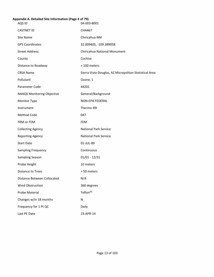
Appendix A. Detailed Site Information (Page 4 of 79) AQS ID 04-003-8001
CASTNET ID CHA467
Site Name Chiricahua NM
GPS Coordinates 32.009405, -109.389058
Street Address Chiricahua National Monument
County Cochise
Distance to Roadway > 100 meters
CBSA Name Sierra Vista-Douglas, AZ Micropolitan Statistical Area
Pollutant Ozone, 1
Parameter Code 44201
NAAQS Monitoring Objective General/Background
Monitor Type NON-EPA FEDERAL
Instrument Thermo 49I
Method Code 047
FRM or FEM FEM
Collecting Agency National Park Service
Reporting Agency National Park Service
Start Date 01-JUL-89
Sampling Frequency Continuous
Sampling Season 01/01 - 12/31
Probe Height 10 meters
Distance to Trees > 50 meters
Distance Between Collocated N/A
Wind Obstruction 360 degrees
Probe Material Teflon(R)
Changes w/in 18 months N
Frequency for 1 Pt QC Daily
Last PE Date 23-APR-14
Page 14 of 103
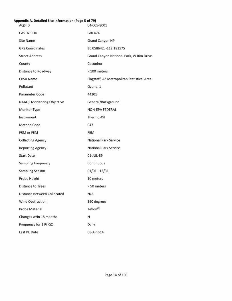
Appendix A. Detailed Site Information (Page 5 of 79) AQS ID 04-005-8001
CASTNET ID GRC474
Site Name Grand Canyon NP
GPS Coordinates 36.058642, -112.183575
Street Address Grand Canyon National Park, W Rim Drive
County Coconino
Distance to Roadway > 100 meters
CBSA Name Flagstaff, AZ Metropolitan Statistical Area
Pollutant Ozone, 1
Parameter Code 44201
NAAQS Monitoring Objective General/Background
Monitor Type NON-EPA FEDERAL
Instrument Thermo 49I
Method Code 047
FRM or FEM FEM
Collecting Agency National Park Service
Reporting Agency National Park Service
Start Date 01-JUL-89
Sampling Frequency Continuous
Sampling Season 01/01 - 12/31
Probe Height 10 meters
Distance to Trees > 50 meters
Distance Between Collocated N/A
Wind Obstruction 360 degrees
Probe Material Teflon(R)
Changes w/in 18 months N
Frequency for 1 Pt QC Daily
Last PE Date 08-APR-14
Page 15 of 103
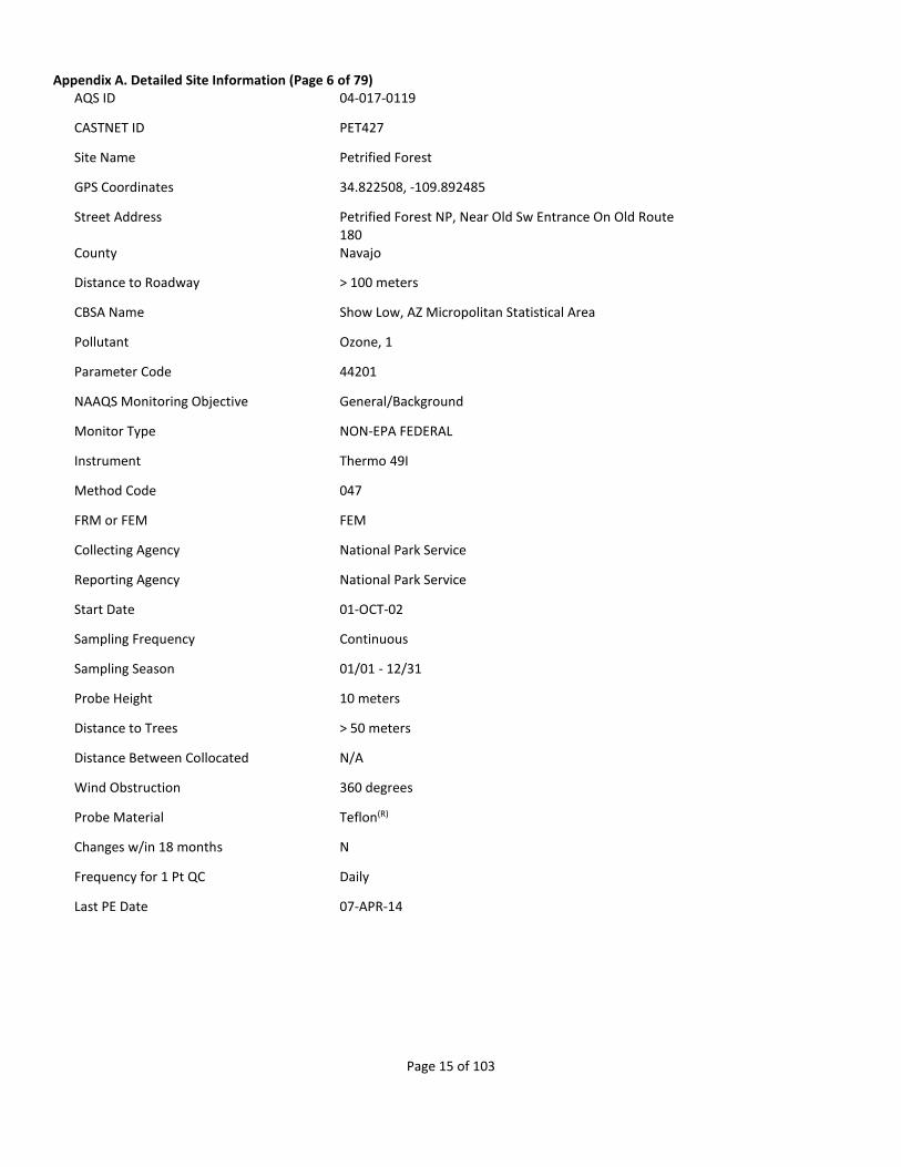
Appendix A. Detailed Site Information (Page 6 of 79) AQS ID 04-017-0119
CASTNET ID PET427
Site Name Petrified Forest
GPS Coordinates 34.822508, -109.892485
Street Address Petrified Forest NP, Near Old Sw Entrance On Old Route 180
County Navajo
Distance to Roadway > 100 meters
CBSA Name Show Low, AZ Micropolitan Statistical Area
Pollutant Ozone, 1
Parameter Code 44201
NAAQS Monitoring Objective General/Background
Monitor Type NON-EPA FEDERAL
Instrument Thermo 49I
Method Code 047
FRM or FEM FEM
Collecting Agency National Park Service
Reporting Agency National Park Service
Start Date 01-OCT-02
Sampling Frequency Continuous
Sampling Season 01/01 - 12/31
Probe Height 10 meters
Distance to Trees > 50 meters
Distance Between Collocated N/A
Wind Obstruction 360 degrees
Probe Material Teflon(R)
Changes w/in 18 months N
Frequency for 1 Pt QC Daily
Last PE Date 07-APR-14
Page 16 of 103
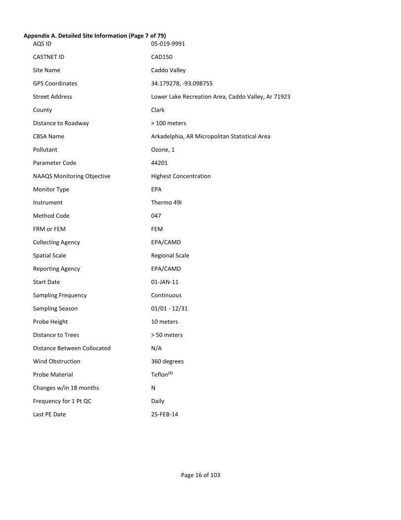
Appendix A. Detailed Site Information (Page 7 of 79) AQS ID 05-019-9991
CASTNET ID CAD150
Site Name Caddo Valley
GPS Coordinates 34.179278, -93.098755
Street Address Lower Lake Recreation Area, Caddo Valley, Ar 71923
County Clark
Distance to Roadway > 100 meters
CBSA Name Arkadelphia, AR Micropolitan Statistical Area
Pollutant Ozone, 1
Parameter Code 44201
NAAQS Monitoring Objective Highest Concentration
Monitor Type EPA
Instrument Thermo 49I
Method Code 047
FRM or FEM FEM
Collecting Agency EPA/CAMD
Spatial Scale Regional Scale
Reporting Agency EPA/CAMD
Start Date 01-JAN-11
Sampling Frequency Continuous
Sampling Season 01/01 - 12/31
Probe Height 10 meters
Distance to Trees > 50 meters
Distance Between Collocated N/A
Wind Obstruction 360 degrees
Probe Material Teflon(R)
Changes w/in 18 months N
Frequency for 1 Pt QC Daily
Last PE Date 25-FEB-14
Page 17 of 103
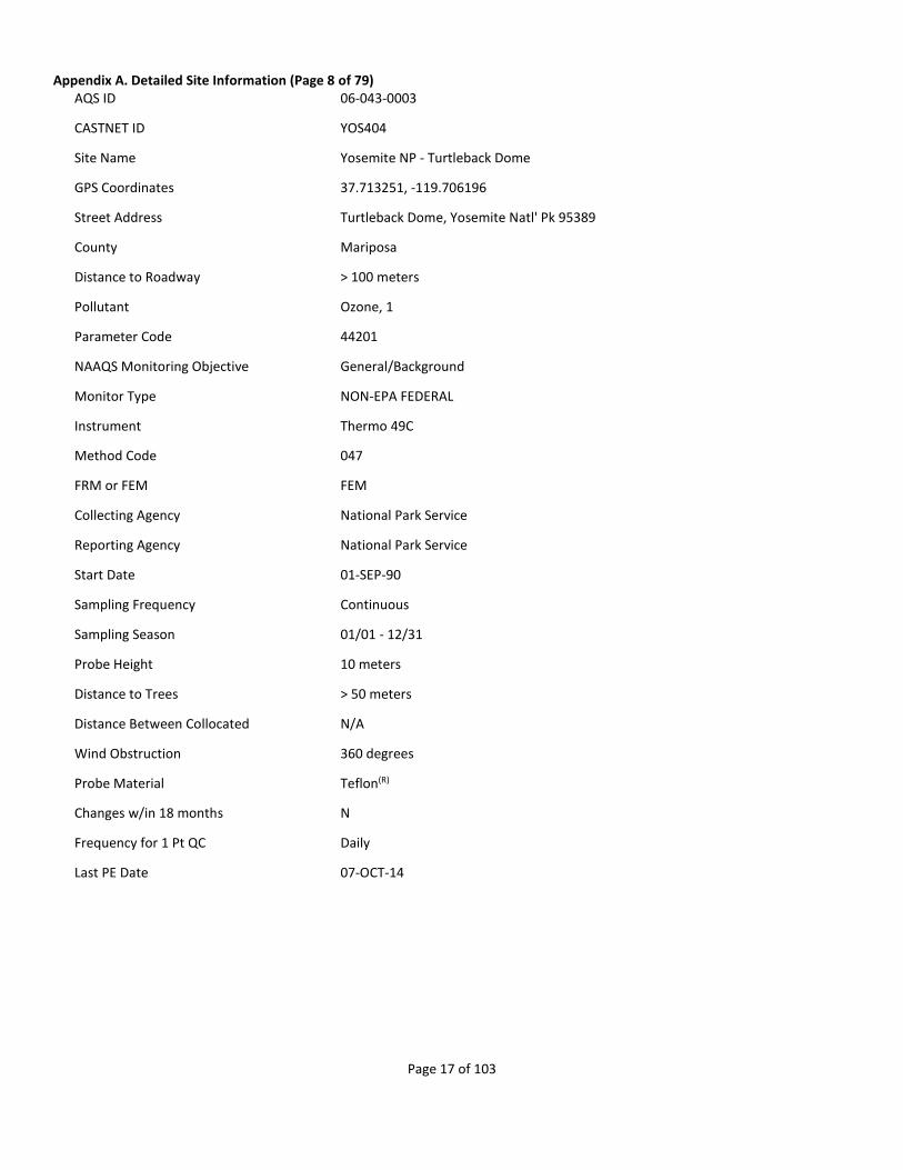
Appendix A. Detailed Site Information (Page 8 of 79) AQS ID 06-043-0003
CASTNET ID YOS404
Site Name Yosemite NP - Turtleback Dome
GPS Coordinates 37.713251, -119.706196
Street Address Turtleback Dome, Yosemite Natl' Pk 95389
County Mariposa
Distance to Roadway > 100 meters
Pollutant Ozone, 1
Parameter Code 44201
NAAQS Monitoring Objective General/Background
Monitor Type NON-EPA FEDERAL
Instrument Thermo 49C
Method Code 047
FRM or FEM FEM
Collecting Agency National Park Service
Reporting Agency National Park Service
Start Date 01-SEP-90
Sampling Frequency Continuous
Sampling Season 01/01 - 12/31
Probe Height 10 meters
Distance to Trees > 50 meters
Distance Between Collocated N/A
Wind Obstruction 360 degrees
Probe Material Teflon(R)
Changes w/in 18 months N
Frequency for 1 Pt QC Daily
Last PE Date 07-OCT-14
Page 18 of 103
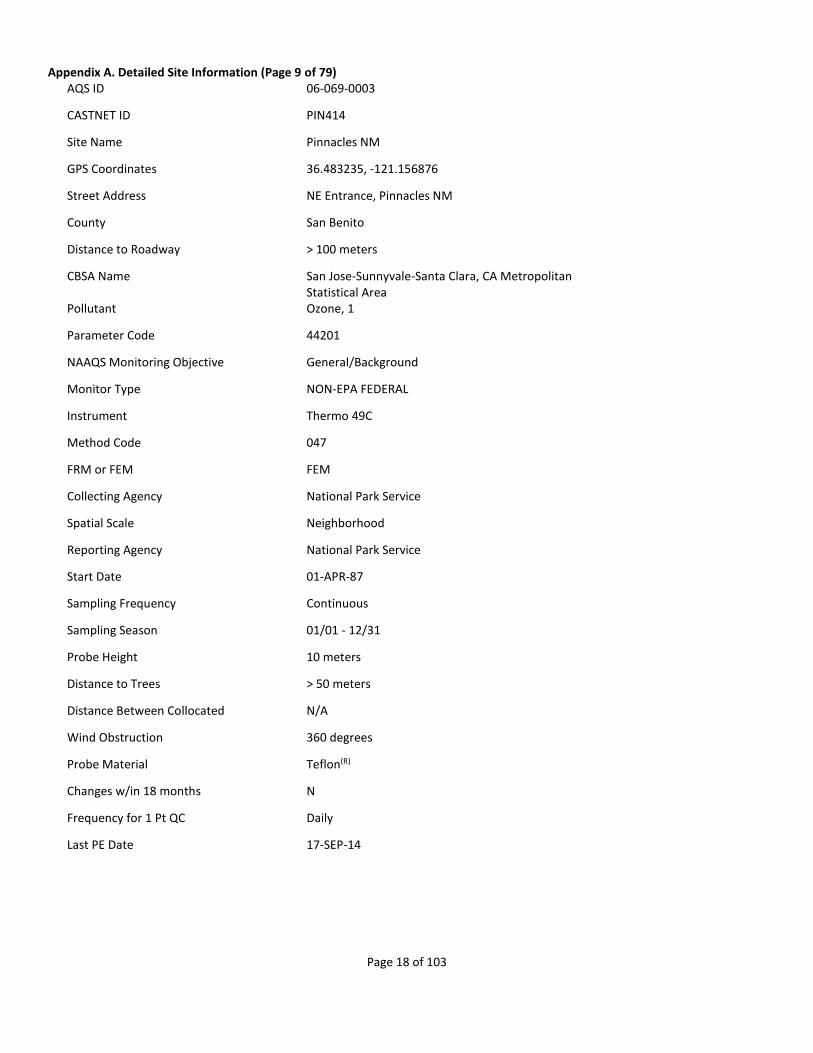
Appendix A. Detailed Site Information (Page 9 of 79) AQS ID 06-069-0003
CASTNET ID PIN414
Site Name Pinnacles NM
GPS Coordinates 36.483235, -121.156876
Street Address NE Entrance, Pinnacles NM
County San Benito
Distance to Roadway > 100 meters
CBSA Name San Jose-Sunnyvale-Santa Clara, CA Metropolitan Statistical Area
Pollutant Ozone, 1
Parameter Code 44201
NAAQS Monitoring Objective General/Background
Monitor Type NON-EPA FEDERAL
Instrument Thermo 49C
Method Code 047
FRM or FEM FEM
Collecting Agency National Park Service
Spatial Scale Neighborhood
Reporting Agency National Park Service
Start Date 01-APR-87
Sampling Frequency Continuous
Sampling Season 01/01 - 12/31
Probe Height 10 meters
Distance to Trees > 50 meters
Distance Between Collocated N/A
Wind Obstruction 360 degrees
Probe Material Teflon(R)
Changes w/in 18 months N
Frequency for 1 Pt QC Daily
Last PE Date 17-SEP-14

Page 19 of 103
Appendix A. Detailed Site Information (Page 10 of 79) AQS ID 06-071-9002
CASTNET ID JOT403
Site Name Joshua Tree NP
GPS Coordinates 34.069569, -116.388933
Street Address Joshua Tree National Monument
County San Bernardino
Distance to Roadway > 100 meters
CBSA Name Riverside-San Bernardino-Ontario, CA Metropolitan Statistical Area
Pollutant Ozone, 1
Parameter Code 44201
NAAQS Monitoring Objective Highest Concentration
Monitor Type NON-EPA FEDERAL
Instrument Thermo 49I
Method Code 047
FRM or FEM FEM
Collecting Agency National Park Service
Spatial Scale Regional Scale
Reporting Agency National Park Service
Start Date 01-OCT-93
Sampling Frequency Continuous
Sampling Season 01/01 - 12/31
Probe Height 10 meters
Distance to Trees > 50 meters
Distance Between Collocated N/A
Wind Obstruction 360 degrees
Probe Material Teflon(R)
Changes w/in 18 months N
Frequency for 1 Pt QC Daily
Last PE Date 06-MAY-14
Page 20 of 103
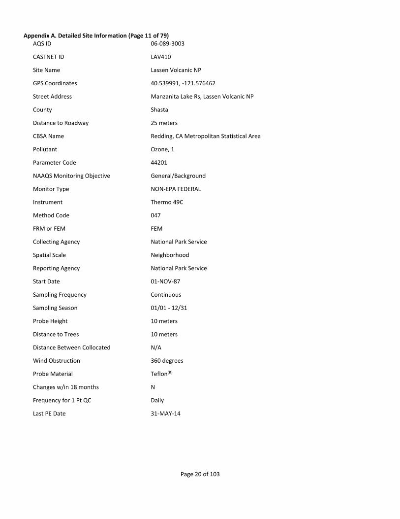
Appendix A. Detailed Site Information (Page 11 of 79) AQS ID 06-089-3003
CASTNET ID LAV410
Site Name Lassen Volcanic NP
GPS Coordinates 40.539991, -121.576462
Street Address Manzanita Lake Rs, Lassen Volcanic NP
County Shasta
Distance to Roadway 25 meters
CBSA Name Redding, CA Metropolitan Statistical Area
Pollutant Ozone, 1
Parameter Code 44201
NAAQS Monitoring Objective General/Background
Monitor Type NON-EPA FEDERAL
Instrument Thermo 49C
Method Code 047
FRM or FEM FEM
Collecting Agency National Park Service
Spatial Scale Neighborhood
Reporting Agency National Park Service
Start Date 01-NOV-87
Sampling Frequency Continuous
Sampling Season 01/01 - 12/31
Probe Height 10 meters
Distance to Trees 10 meters
Distance Between Collocated N/A
Wind Obstruction 360 degrees
Probe Material Teflon(R)
Changes w/in 18 months N
Frequency for 1 Pt QC Daily
Last PE Date 31-MAY-14

Page 21 of 103
Appendix A. Detailed Site Information (Page 12 of 79) AQS ID 06-107-0009
CASTNET ID SEK430
Site Name Sequoia NP - Ash Mountain
GPS Coordinates 36.489469, -118.829153
Street Address Sequoia & Kings Canyon NP
County Tulare
Distance to Roadway 40 meters
CBSA Name Visalia-Porterville, CA Metropolitan Statistical Area
Pollutant Ozone, 1
Parameter Code 44201
NAAQS Monitoring Objective General/Background
Monitor Type NON-EPA FEDERAL
Instrument Thermo 49I
Method Code 047
FRM or FEM FEM
Collecting Agency National Park Service
Reporting Agency National Park Service
Start Date 01-JUL-99
Sampling Frequency Continuous
Sampling Season 01/01 - 12/31
Probe Height 10 meters
Distance to Trees 5 meters
Distance Between Collocated N/A
Wind Obstruction 360 degrees
Probe Material Teflon(R)
Changes w/in 18 months N
Frequency for 1 Pt QC Daily
Last PE Date 08-OCT-14
Page 22 of 103
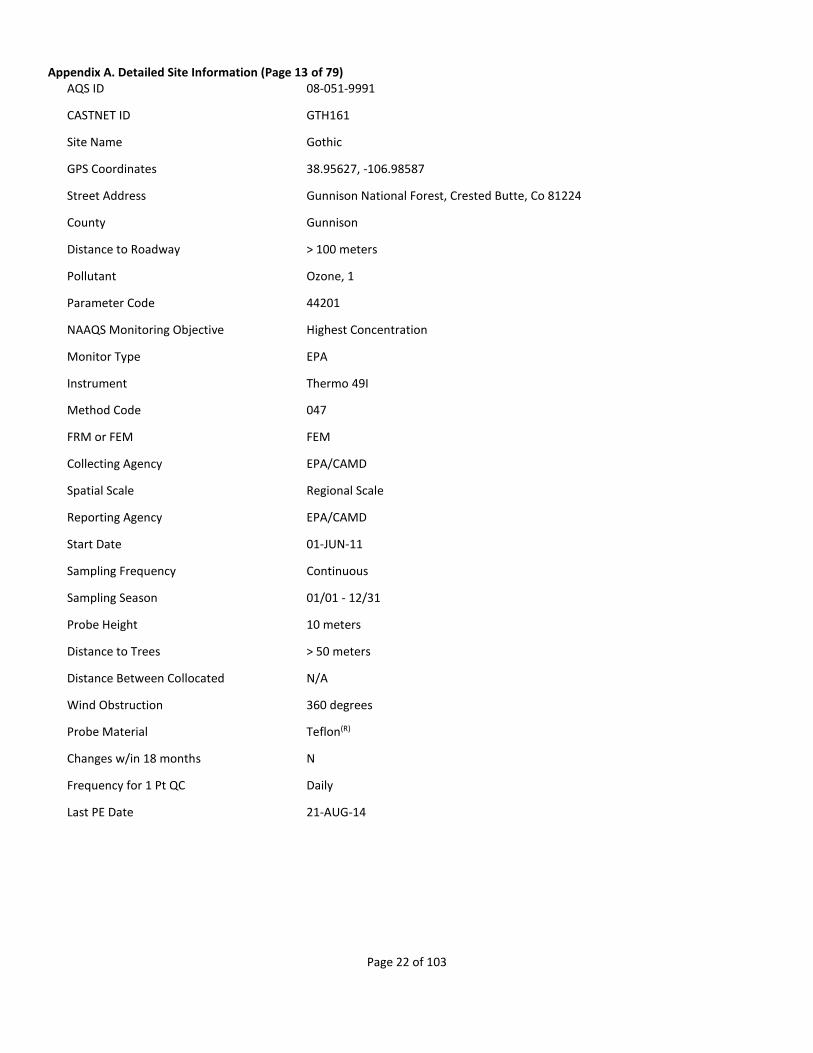
Appendix A. Detailed Site Information (Page 13 of 79) AQS ID 08-051-9991
CASTNET ID GTH161
Site Name Gothic
GPS Coordinates 38.95627, -106.98587
Street Address Gunnison National Forest, Crested Butte, Co 81224
County Gunnison
Distance to Roadway > 100 meters
Pollutant Ozone, 1
Parameter Code 44201
NAAQS Monitoring Objective Highest Concentration
Monitor Type EPA
Instrument Thermo 49I
Method Code 047
FRM or FEM FEM
Collecting Agency EPA/CAMD
Spatial Scale Regional Scale
Reporting Agency EPA/CAMD
Start Date 01-JUN-11
Sampling Frequency Continuous
Sampling Season 01/01 - 12/31
Probe Height 10 meters
Distance to Trees > 50 meters
Distance Between Collocated N/A
Wind Obstruction 360 degrees
Probe Material Teflon(R)
Changes w/in 18 months N
Frequency for 1 Pt QC Daily
Last PE Date 21-AUG-14

Page 23 of 103
Appendix A. Detailed Site Information (Page 14 of 79) AQS ID 08-069-0007
CASTNET ID ROM406
Site Name Rocky Mtn NP
GPS Coordinates 40.278129, -105.545635
Street Address Rocky Mountain National Park, Estes Park, Co 80517
County Larimer
Distance to Roadway > 100 meters
CBSA Name Fort Collins-Loveland, CO Metropolitan Statistical Area
Pollutant Ozone, 1
Parameter Code 44201
NAAQS Monitoring Objective General/Background
Monitor Type NON-EPA FEDERAL
Instrument Thermo 49I
Method Code 047
FRM or FEM FEM
Collecting Agency National Park Service
Spatial Scale Neighborhood
Reporting Agency National Park Service
Start Date 01-AUG-87
Sampling Frequency Continuous
Sampling Season 01/01 - 12/31
Probe Height 10 meters
Distance to Trees > 50 meters
Distance Between Collocated 7.5 m
Wind Obstruction 360 degrees
Probe Material Teflon(R)
Changes w/in 18 months N
Frequency for 1 Pt QC Daily
Last PE Date 31-OCT-14
Page 24 of 103
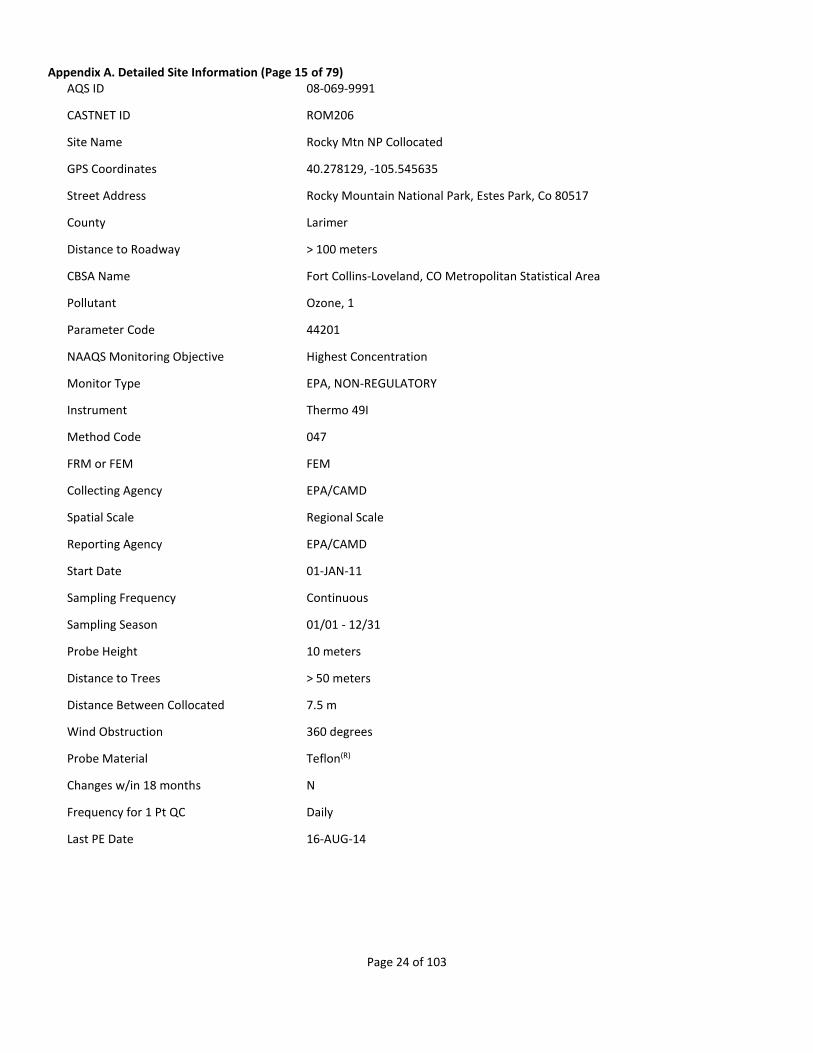
Appendix A. Detailed Site Information (Page 15 of 79) AQS ID 08-069-9991
CASTNET ID ROM206
Site Name Rocky Mtn NP Collocated
GPS Coordinates 40.278129, -105.545635
Street Address Rocky Mountain National Park, Estes Park, Co 80517
County Larimer
Distance to Roadway > 100 meters
CBSA Name Fort Collins-Loveland, CO Metropolitan Statistical Area
Pollutant Ozone, 1
Parameter Code 44201
NAAQS Monitoring Objective Highest Concentration
Monitor Type EPA, NON-REGULATORY
Instrument Thermo 49I
Method Code 047
FRM or FEM FEM
Collecting Agency EPA/CAMD
Spatial Scale Regional Scale
Reporting Agency EPA/CAMD
Start Date 01-JAN-11
Sampling Frequency Continuous
Sampling Season 01/01 - 12/31
Probe Height 10 meters
Distance to Trees > 50 meters
Distance Between Collocated 7.5 m
Wind Obstruction 360 degrees
Probe Material Teflon(R)
Changes w/in 18 months N
Frequency for 1 Pt QC Daily
Last PE Date 16-AUG-14

Page 25 of 103
Appendix A. Detailed Site Information (Page 16 of 79) AQS ID 08-083-0101
CASTNET ID MEV405
Site Name Mesa Verde NP
GPS Coordinates 37.198398, -108.490462
Street Address Mesa Verde National Park, Colorado
County Montezuma
Distance to Roadway > 100 meters
Pollutant Ozone, 1
Parameter Code 44201
NAAQS Monitoring Objective Highest Concentration
Monitor Type NON-EPA FEDERAL
Instrument Thermo 49C
Method Code 047
FRM or FEM FEM
Collecting Agency National Park Service
Spatial Scale Regional Scale
Reporting Agency National Park Service
Start Date 01-MAY-93
Sampling Frequency Continuous
Sampling Season 01/01 - 12/31
Probe Height 10 meters
Distance to Trees > 50 meters
Distance Between Collocated N/A
Wind Obstruction 360 degrees
Probe Material Teflon(R)
Changes w/in 18 months N
Frequency for 1 Pt QC Daily
Last PE Date 05-MAY-14

Page 26 of 103
Appendix A. Detailed Site Information (Page 17 of 79) AQS ID 09-015-9991
CASTNET ID ABT147
Site Name Abington
GPS Coordinates 41.84046, -72.010368
Street Address 80 Ayers Rd, Abington, Ct 06230
County Windham
Distance to Roadway > 100 meters
CBSA Name Willimantic, CT Micropolitan Statistical Area
Pollutant Ozone, 1
Parameter Code 44201
NAAQS Monitoring Objective Highest Concentration
Monitor Type EPA
Instrument Thermo 49I
Method Code 047
FRM or FEM FEM
Collecting Agency EPA/CAMD
Spatial Scale Regional Scale
Reporting Agency EPA/CAMD
Start Date 01-JUN-11
Sampling Frequency Continuous
Sampling Season 01/01 - 12/31
Probe Height 10 meters
Distance to Trees > 50 meters
Distance Between Collocated N/A
Wind Obstruction 360 degrees
Probe Material Teflon(R)
Changes w/in 18 months N
Frequency for 1 Pt QC Daily
Last PE Date 14-NOV-14

Page 27 of 103
Appendix A. Detailed Site Information (Page 18 of 79) AQS ID 12-061-9991
CASTNET ID IRL141
Site Name Indian River Lagoon
GPS Coordinates 27.849215, -80.455595
Street Address Sebastian Inlet State Recreation Area, Vero Beach, Fl 32963
County Indian River
Distance to Roadway > 100 meters
CBSA Name Sebastian-Vero Beach, FL Metropolitan Statistical Area
Pollutant Ozone, 1
Parameter Code 44201
NAAQS Monitoring Objective Highest Concentration
Monitor Type EPA
Instrument Thermo 49I
Method Code 047
FRM or FEM FEM
Collecting Agency EPA/CAMD
Spatial Scale Regional Scale
Reporting Agency EPA/CAMD
Start Date 01-JAN-11
Sampling Frequency Continuous
Sampling Season 01/01 - 12/31
Probe Height 10 meters
Distance to Trees > 50 meters
Distance Between Collocated N/A
Wind Obstruction 360 degrees
Probe Material Teflon(R)
Changes w/in 18 months N
Frequency for 1 Pt QC Daily
Last PE Date 13-FEB-14
Page 28 of 103
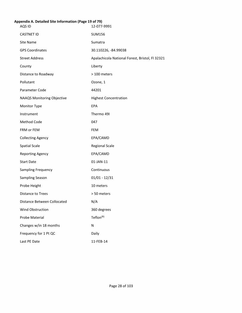
Appendix A. Detailed Site Information (Page 19 of 79) AQS ID 12-077-9991
CASTNET ID SUM156
Site Name Sumatra
GPS Coordinates 30.110226, -84.99038
Street Address Apalachicola National Forest, Bristol, Fl 32321
County Liberty
Distance to Roadway > 100 meters
Pollutant Ozone, 1
Parameter Code 44201
NAAQS Monitoring Objective Highest Concentration
Monitor Type EPA
Instrument Thermo 49I
Method Code 047
FRM or FEM FEM
Collecting Agency EPA/CAMD
Spatial Scale Regional Scale
Reporting Agency EPA/CAMD
Start Date 01-JAN-11
Sampling Frequency Continuous
Sampling Season 01/01 - 12/31
Probe Height 10 meters
Distance to Trees > 50 meters
Distance Between Collocated N/A
Wind Obstruction 360 degrees
Probe Material Teflon(R)
Changes w/in 18 months N
Frequency for 1 Pt QC Daily
Last PE Date 11-FEB-14

Page 29 of 103
Appendix A. Detailed Site Information (Page 20 of 79) AQS ID 13-231-9991
CASTNET ID GAS153
Site Name Georgia Station
GPS Coordinates 33.181173, -84.410054
Street Address Georgia Station Georgia Agricultural Experiment Station, Williamson, Ga 30292
County Pike
Distance to Roadway > 100 meters
CBSA Name Atlanta-Sandy Springs-Marietta, GA Metropolitan Statistical Area
Pollutant Ozone, 1
Parameter Code 44201
NAAQS Monitoring Objective Highest Concentration
Monitor Type EPA
Instrument Thermo 49I
Method Code 047
FRM or FEM FEM
Collecting Agency EPA/CAMD
Spatial Scale Regional Scale
Reporting Agency EPA/CAMD
Start Date 01-JAN-11
Sampling Frequency Continuous
Sampling Season 01/01 - 12/31
Probe Height 10 meters
Distance to Trees > 50 meters
Distance Between Collocated N/A
Wind Obstruction 360 degrees
Probe Material Teflon(R)
Changes w/in 18 months N
Frequency for 1 Pt QC Daily
Last PE Date 04-MAR-14
Page 30 of 103
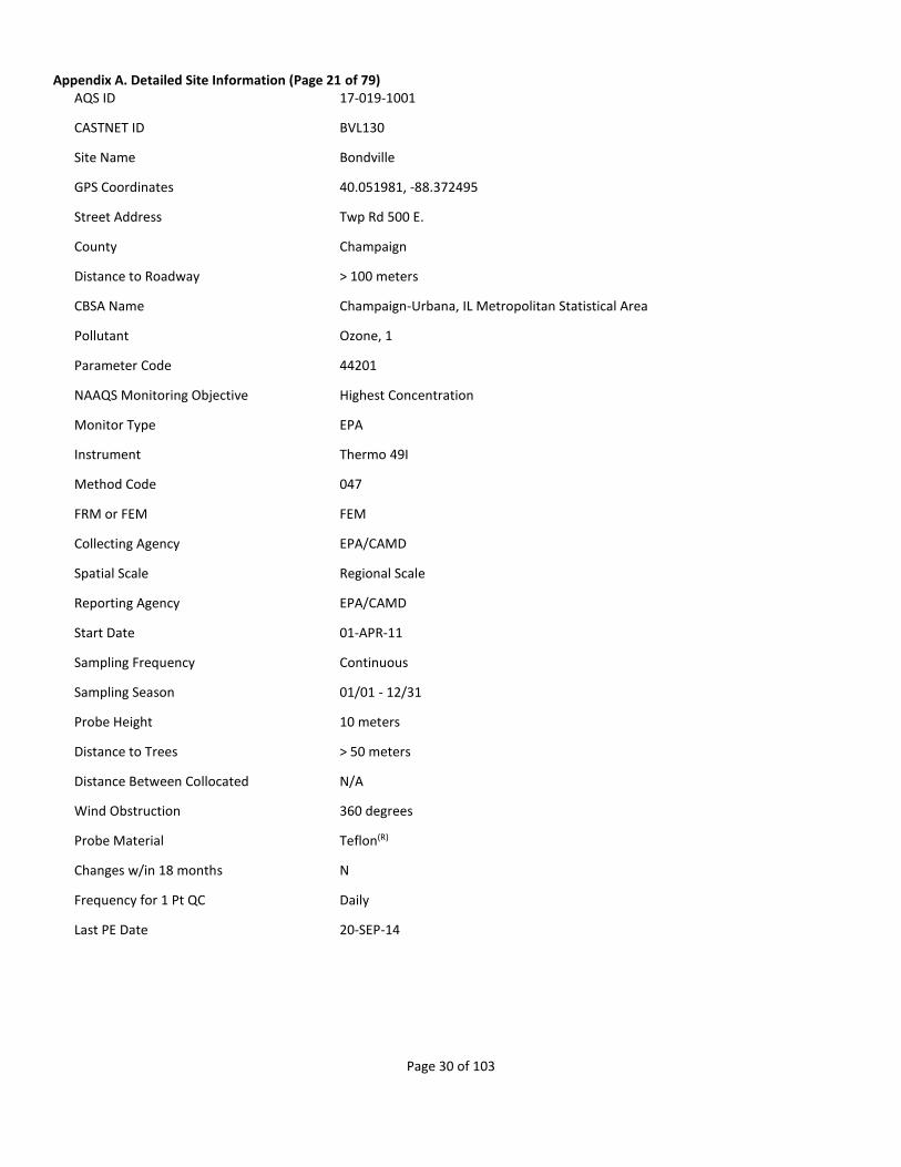
Appendix A. Detailed Site Information (Page 21 of 79) AQS ID 17-019-1001
CASTNET ID BVL130
Site Name Bondville
GPS Coordinates 40.051981, -88.372495
Street Address Twp Rd 500 E.
County Champaign
Distance to Roadway > 100 meters
CBSA Name Champaign-Urbana, IL Metropolitan Statistical Area
Pollutant Ozone, 1
Parameter Code 44201
NAAQS Monitoring Objective Highest Concentration
Monitor Type EPA
Instrument Thermo 49I
Method Code 047
FRM or FEM FEM
Collecting Agency EPA/CAMD
Spatial Scale Regional Scale
Reporting Agency EPA/CAMD
Start Date 01-APR-11
Sampling Frequency Continuous
Sampling Season 01/01 - 12/31
Probe Height 10 meters
Distance to Trees > 50 meters
Distance Between Collocated N/A
Wind Obstruction 360 degrees
Probe Material Teflon(R)
Changes w/in 18 months N
Frequency for 1 Pt QC Daily
Last PE Date 20-SEP-14

Page 31 of 103
Appendix A. Detailed Site Information (Page 22 of 79) AQS ID 17-085-9991
CASTNET ID STK138
Site Name Stockton
GPS Coordinates 42.287216, -89.99995
Street Address 10952 E. Parker Rd, Stockton, Il 61085
County Jo Daviess
Distance to Roadway > 100 meters
Pollutant Ozone, 1
Parameter Code 44201
NAAQS Monitoring Objective Highest Concentration
Monitor Type EPA
Instrument Thermo 49I
Method Code 047
FRM or FEM FEM
Collecting Agency EPA/CAMD
Spatial Scale Regional Scale
Reporting Agency EPA/CAMD
Start Date 01-APR-11
Sampling Frequency Continuous
Sampling Season 01/01 - 12/31
Probe Height 10 meters
Distance to Trees > 50 meters
Distance Between Collocated N/A
Wind Obstruction 360 degrees
Probe Material Teflon(R)
Changes w/in 18 months N
Frequency for 1 Pt QC Daily
Last PE Date 21-JUL-14

Page 32 of 103
Appendix A. Detailed Site Information (Page 23 of 79) AQS ID 17-119-9991
CASTNET ID ALH157
Site Name Alhambra
GPS Coordinates 38.869001, -89.622815
Street Address 5403 State Road 160, Highland, Il 62249
County Madison
Distance to Roadway > 100 meters
CBSA Name St. Louis, MO-IL Metropolitan Statistical Area
Pollutant Ozone, 1
Parameter Code 44201
NAAQS Monitoring Objective Highest Concentration
Monitor Type EPA
Instrument Thermo 49I
Method Code 047
FRM or FEM FEM
Collecting Agency EPA/CAMD
Spatial Scale Regional Scale
Reporting Agency EPA/CAMD
Start Date 01-APR-11
Sampling Frequency Continuous
Sampling Season 01/01 - 12/31
Probe Height 10 meters
Distance to Trees > 50 meters
Distance Between Collocated N/A
Wind Obstruction 360 degrees
Probe Material Teflon(R)
Changes w/in 18 months N
Frequency for 1 Pt QC Daily
Last PE Date 22-JUL-14

Page 33 of 103
Appendix A. Detailed Site Information (Page 24 of 79) AQS ID 18-083-9991
CASTNET ID VIN140
Site Name Vincennes
GPS Coordinates 38.740792, -87.484923
Street Address Southwest Purdue Agricultural Center, Vincennes, In 47591
County Knox
Distance to Roadway > 100 meters
CBSA Name Vincennes, IN Micropolitan Statistical Area
Pollutant Ozone, 1
Parameter Code 44201
NAAQS Monitoring Objective Highest Concentration
Monitor Type EPA
Instrument Thermo 49I
Method Code 047
FRM or FEM FEM
Collecting Agency EPA/CAMD
Spatial Scale Regional Scale
Reporting Agency EPA/CAMD
Start Date 01-APR-11
Sampling Frequency Continuous
Sampling Season 01/01 - 12/31
Probe Height 10 meters
Distance to Trees > 50 meters
Distance Between Collocated N/A
Wind Obstruction 360 degrees
Probe Material Teflon(R)
Changes w/in 18 months N
Frequency for 1 Pt QC Daily
Last PE Date 23-JUL-14

Page 34 of 103
Appendix A. Detailed Site Information (Page 25 of 79) AQS ID 18-169-9991
CASTNET ID SAL133
Site Name Salamonie Reservoir
GPS Coordinates 40.816038, -85.661407
Street Address Hamilton Rd, Lagro, In 46941
County Wabash
Distance to Roadway > 100 meters
CBSA Name Wabash, IN Micropolitan Statistical Area
Pollutant Ozone, 1
Parameter Code 44201
NAAQS Monitoring Objective Highest Concentration
Monitor Type EPA
Instrument Thermo 49I
Method Code 047
FRM or FEM FEM
Collecting Agency EPA/CAMD
Spatial Scale Regional Scale
Reporting Agency EPA/CAMD
Start Date 01-JUN-11
Sampling Frequency Continuous
Sampling Season 01/01 - 12/31
Probe Height 10 meters
Distance to Trees > 50 meters
Distance Between Collocated N/A
Wind Obstruction 360 degrees
Probe Material Teflon(R)
Changes w/in 18 months N
Frequency for 1 Pt QC Daily
Last PE Date 19-JUL-14

Page 35 of 103
Appendix A. Detailed Site Information (Page 26 of 79) AQS ID 21-061-0501
CASTNET ID MAC426
Site Name Mammoth Cave NP
GPS Coordinates 37.131794, -86.142953
Street Address Mammoth Cave NP - Alfred Cook Road
County Edmonson
Distance to Roadway > 100 meters
CBSA Name Bowling Green, KY Metropolitan Statistical Area
Pollutant Ozone, 1
Parameter Code 44201
NAAQS Monitoring Objective General/Background
Monitor Type NON-EPA FEDERAL
Instrument Thermo 49I
Method Code 047
FRM or FEM FEM
Collecting Agency National Park Service
Reporting Agency National Park Service
Start Date 01-AUG-97
Sampling Frequency Continuous
Sampling Season 01/01 - 12/31
Probe Height 10 meters
Distance to Trees > 50 meters
Distance Between Collocated N/A
Wind Obstruction 360 degrees
Probe Material Teflon(R)
Changes w/in 18 months N
Frequency for 1 Pt QC Daily
Last PE Date 16-OCT-14
Page 36 of 103
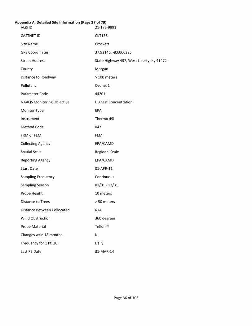
Appendix A. Detailed Site Information (Page 27 of 79) AQS ID 21-175-9991
CASTNET ID CKT136
Site Name Crockett
GPS Coordinates 37.92146, -83.066295
Street Address State Highway 437, West Liberty, Ky 41472
County Morgan
Distance to Roadway > 100 meters
Pollutant Ozone, 1
Parameter Code 44201
NAAQS Monitoring Objective Highest Concentration
Monitor Type EPA
Instrument Thermo 49I
Method Code 047
FRM or FEM FEM
Collecting Agency EPA/CAMD
Spatial Scale Regional Scale
Reporting Agency EPA/CAMD
Start Date 01-APR-11
Sampling Frequency Continuous
Sampling Season 01/01 - 12/31
Probe Height 10 meters
Distance to Trees > 50 meters
Distance Between Collocated N/A
Wind Obstruction 360 degrees
Probe Material Teflon(R)
Changes w/in 18 months N
Frequency for 1 Pt QC Daily
Last PE Date 31-MAR-14

Page 37 of 103
Appendix A. Detailed Site Information (Page 28 of 79) AQS ID 21-221-9991
CASTNET ID CDZ171
Site Name Cadiz
GPS Coordinates 36.784053, -87.85015
Street Address 5720 Old Dover Rd, Cadiz, Ky 42211
County Trigg
Distance to Roadway > 100 meters
CBSA Name Clarksville, TN-KY Metropolitan Statistical Area
Pollutant Ozone, 1
Parameter Code 44201
NAAQS Monitoring Objective Highest Concentration
Monitor Type EPA
Instrument Thermo 49I
Method Code 047
FRM or FEM FEM
Collecting Agency EPA/CAMD
Spatial Scale Regional Scale
Reporting Agency EPA/CAMD
Start Date 01-MAR-11
Sampling Frequency Continuous
Sampling Season 01/01 - 12/31
Probe Height 10 meters
Distance to Trees > 50 meters
Distance Between Collocated N/A
Wind Obstruction 360 degrees
Probe Material Teflon(R)
Changes w/in 18 months N
Frequency for 1 Pt QC Daily
Last PE Date 28-MAR-14

Page 38 of 103
Appendix A. Detailed Site Information (Page 29 of 79) AQS ID 21-229-9991
CASTNET ID MCK131/231
Site Name Mackville
GPS Coordinates 37.704678, -85.048706
Street Address 542 Wesley-Miller Rd, Harrodsburg, Ky 40330
County Washington
Distance to Roadway > 100 meters
Pollutant Ozone, 1/2
Parameter Code 44201
NAAQS Monitoring Objective Highest Concentration/Quality Assurance
Monitor Type EPA
Instrument Thermo 49I
Method Code 047
FRM or FEM FEM
Collecting Agency EPA/CAMD
Spatial Scale Regional Scale
Reporting Agency EPA/CAMD
Start Date 01-MAR-11
Sampling Frequency Continuous
Sampling Season 01/01 12/31
Probe Height 10 meters
Distance to Trees > 50 meters
Distance Between Collocated 0 m
Wind Obstruction 360 degrees
Probe Material Teflon(R)
Changes w/in 18 months N/Y
Frequency for 1 Pt QC Daily
Last PE Date 30-MAR-14/30-MAR-14
Page 39 of 103
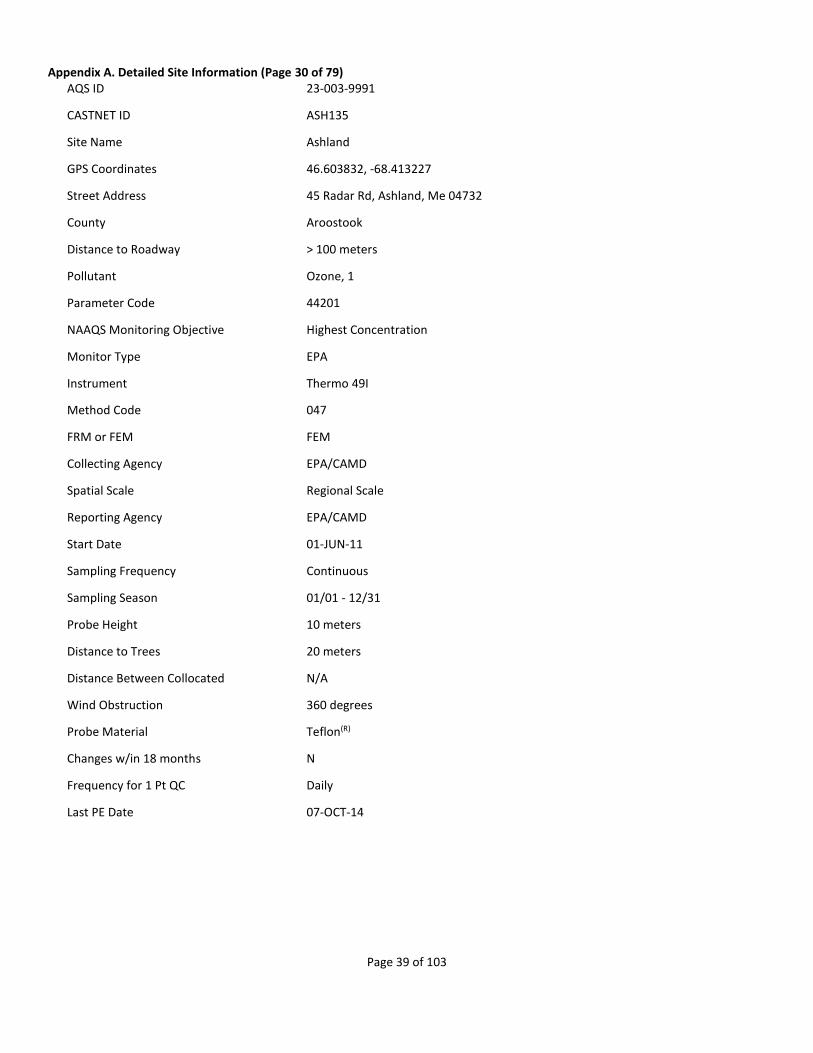
Appendix A. Detailed Site Information (Page 30 of 79) AQS ID 23-003-9991
CASTNET ID ASH135
Site Name Ashland
GPS Coordinates 46.603832, -68.413227
Street Address 45 Radar Rd, Ashland, Me 04732
County Aroostook
Distance to Roadway > 100 meters
Pollutant Ozone, 1
Parameter Code 44201
NAAQS Monitoring Objective Highest Concentration
Monitor Type EPA
Instrument Thermo 49I
Method Code 047
FRM or FEM FEM
Collecting Agency EPA/CAMD
Spatial Scale Regional Scale
Reporting Agency EPA/CAMD
Start Date 01-JUN-11
Sampling Frequency Continuous
Sampling Season 01/01 - 12/31
Probe Height 10 meters
Distance to Trees 20 meters
Distance Between Collocated N/A
Wind Obstruction 360 degrees
Probe Material Teflon(R)
Changes w/in 18 months N
Frequency for 1 Pt QC Daily
Last PE Date 07-OCT-14
Page 40 of 103
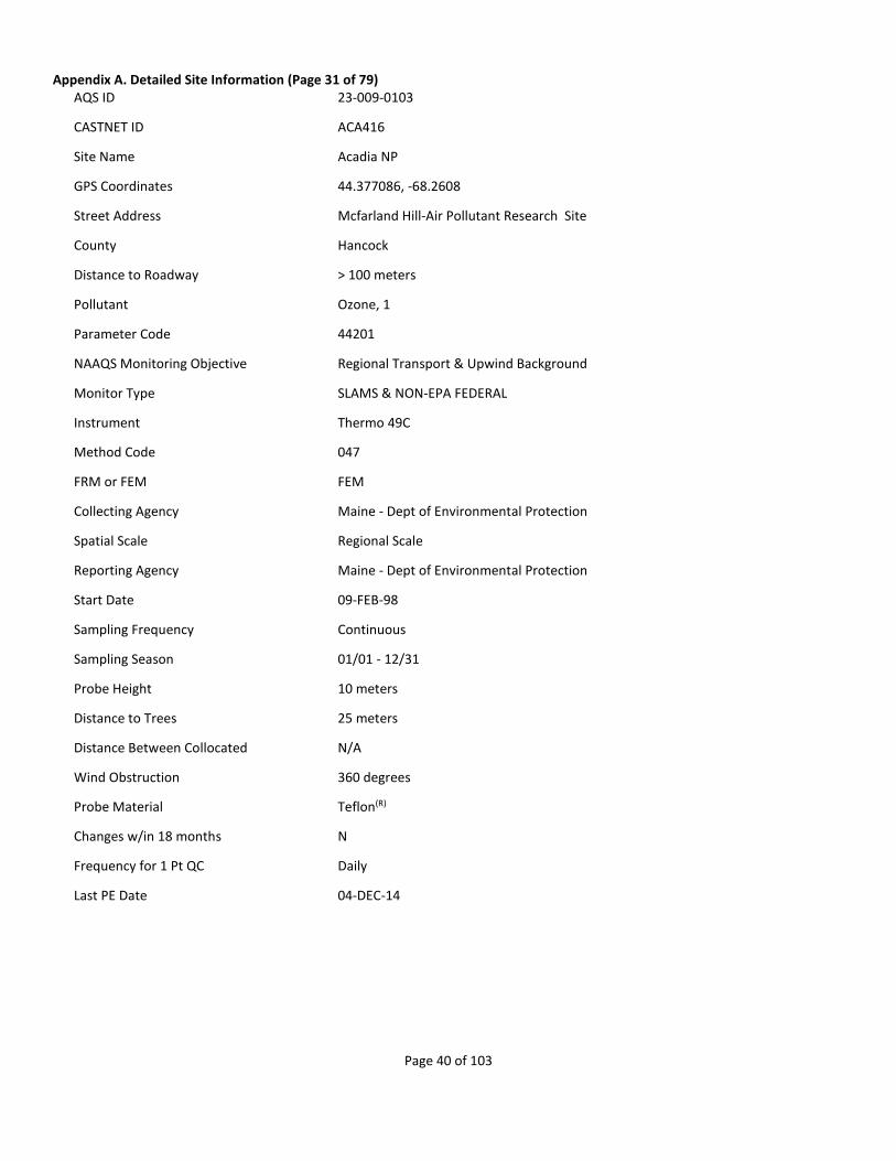
Appendix A. Detailed Site Information (Page 31 of 79) AQS ID 23-009-0103
CASTNET ID ACA416
Site Name Acadia NP
GPS Coordinates 44.377086, -68.2608
Street Address Mcfarland Hill-Air Pollutant Research Site
County Hancock
Distance to Roadway > 100 meters
Pollutant Ozone, 1
Parameter Code 44201
NAAQS Monitoring Objective Regional Transport & Upwind Background
Monitor Type SLAMS & NON-EPA FEDERAL
Instrument Thermo 49C
Method Code 047
FRM or FEM FEM
Collecting Agency Maine - Dept of Environmental Protection
Spatial Scale Regional Scale
Reporting Agency Maine - Dept of Environmental Protection
Start Date 09-FEB-98
Sampling Frequency Continuous
Sampling Season 01/01 - 12/31
Probe Height 10 meters
Distance to Trees 25 meters
Distance Between Collocated N/A
Wind Obstruction 360 degrees
Probe Material Teflon(R)
Changes w/in 18 months N
Frequency for 1 Pt QC Daily
Last PE Date 04-DEC-14

Page 41 of 103
Appendix A. Detailed Site Information (Page 32 of 79) AQS ID 24-019-9991
CASTNET ID BWR139
Site Name Blackwater NWR
GPS Coordinates 38.444971, -76.111274
Street Address Blackwater National Wildlife Refuge, Cambridge, Md 21613
County Dorchester
Distance to Roadway > 100 meters
CBSA Name Cambridge, MD Micropolitan Statistical Area
Pollutant Ozone, 1
Parameter Code 44201
NAAQS Monitoring Objective Highest Concentration
Monitor Type EPA
Instrument Thermo 49I
Method Code 047
FRM or FEM FEM
Collecting Agency EPA/CAMD
Spatial Scale Regional Scale
Reporting Agency EPA/CAMD
Start Date 01-JAN-11
Sampling Frequency Continuous
Sampling Season 01/01 - 12/31
Probe Height 10 meters
Distance to Trees > 50 meters
Distance Between Collocated N/A
Wind Obstruction 360 degrees
Probe Material Teflon(R)
Changes w/in 18 months N
Frequency for 1 Pt QC Daily
Last PE Date 13-NOV-14

Page 42 of 103
Appendix A. Detailed Site Information (Page 33 of 79) AQS ID 24-033-9991
CASTNET ID BEL116
Site Name Beltsville
GPS Coordinates 39.028177, -76.817127
Street Address Powder Mill Rd, Laurel, Md 20708
County Prince George's
Distance to Roadway > 100 meters
CBSA Name Washington-Arlington-Alexandria, DC-VA-MD-WV Metropolitan Statistical Area
Pollutant Ozone, 1
Parameter Code 44201
NAAQS Monitoring Objective Highest Concentration
Monitor Type EPA
Instrument Thermo 49I
Method Code 047
FRM or FEM FEM
Collecting Agency EPA/CAMD
Spatial Scale Regional Scale
Reporting Agency EPA/CAMD
Start Date 01-APR-11
Sampling Frequency Continuous
Sampling Season 01/01 - 12/31
Probe Height 10 meters
Distance to Trees > 50 meters
Distance Between Collocated N/A
Wind Obstruction 360 degrees
Probe Material Teflon(R)
Changes w/in 18 months N
Frequency for 1 Pt QC Daily
Last PE Date 10-NOV-14
Page 43 of 103
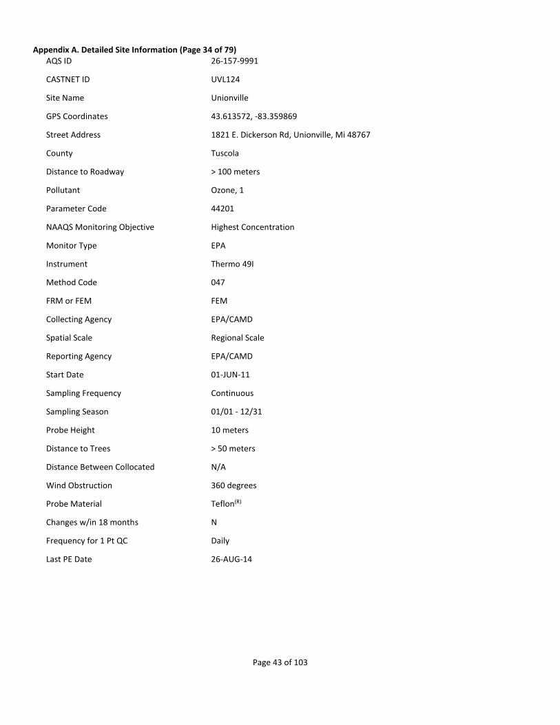
Appendix A. Detailed Site Information (Page 34 of 79) AQS ID 26-157-9991
CASTNET ID UVL124
Site Name Unionville
GPS Coordinates 43.613572, -83.359869
Street Address 1821 E. Dickerson Rd, Unionville, Mi 48767
County Tuscola
Distance to Roadway > 100 meters
Pollutant Ozone, 1
Parameter Code 44201
NAAQS Monitoring Objective Highest Concentration
Monitor Type EPA
Instrument Thermo 49I
Method Code 047
FRM or FEM FEM
Collecting Agency EPA/CAMD
Spatial Scale Regional Scale
Reporting Agency EPA/CAMD
Start Date 01-JUN-11
Sampling Frequency Continuous
Sampling Season 01/01 - 12/31
Probe Height 10 meters
Distance to Trees > 50 meters
Distance Between Collocated N/A
Wind Obstruction 360 degrees
Probe Material Teflon(R)
Changes w/in 18 months N
Frequency for 1 Pt QC Daily
Last PE Date 26-AUG-14

Page 44 of 103
Appendix A. Detailed Site Information (Page 35 of 79) AQS ID 26-161-9991
CASTNET ID ANA115
Site Name Ann Arbor
GPS Coordinates 42.416636, -83.90218
Street Address 10070 Strawberry Lake Rd, Dexter, Mi 48130
County Washtenaw
Distance to Roadway > 100 meters
CBSA Name Ann Arbor, MI Metropolitan Statistical Area
Pollutant Ozone, 1
Parameter Code 44201
NAAQS Monitoring Objective Highest Concentration
Monitor Type EPA
Instrument Thermo 49I
Method Code 047
FRM or FEM FEM
Collecting Agency EPA/CAMD
Spatial Scale Regional Scale
Reporting Agency EPA/CAMD
Start Date 01-JUN-11
Sampling Frequency Continuous
Sampling Season 01/01 - 12/31
Probe Height 10 meters
Distance to Trees > 50 meters
Distance Between Collocated N/A
Wind Obstruction 360 degrees
Probe Material Teflon(R)
Changes w/in 18 months N
Frequency for 1 Pt QC Daily
Last PE Date 24-SEP-14
Page 45 of 103
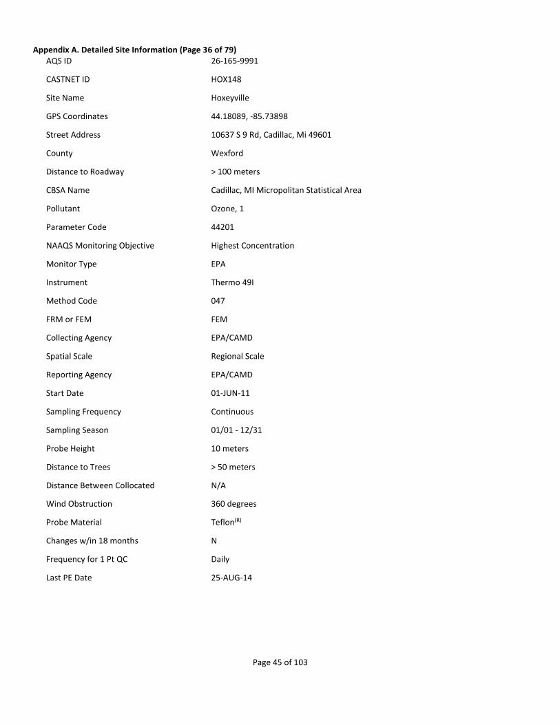
Appendix A. Detailed Site Information (Page 36 of 79) AQS ID 26-165-9991
CASTNET ID HOX148
Site Name Hoxeyville
GPS Coordinates 44.18089, -85.73898
Street Address 10637 S 9 Rd, Cadillac, Mi 49601
County Wexford
Distance to Roadway > 100 meters
CBSA Name Cadillac, MI Micropolitan Statistical Area
Pollutant Ozone, 1
Parameter Code 44201
NAAQS Monitoring Objective Highest Concentration
Monitor Type EPA
Instrument Thermo 49I
Method Code 047
FRM or FEM FEM
Collecting Agency EPA/CAMD
Spatial Scale Regional Scale
Reporting Agency EPA/CAMD
Start Date 01-JUN-11
Sampling Frequency Continuous
Sampling Season 01/01 - 12/31
Probe Height 10 meters
Distance to Trees > 50 meters
Distance Between Collocated N/A
Wind Obstruction 360 degrees
Probe Material Teflon(R)
Changes w/in 18 months N
Frequency for 1 Pt QC Daily
Last PE Date 25-AUG-14
Page 46 of 103
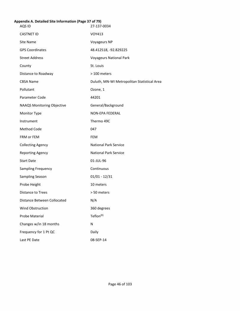
Appendix A. Detailed Site Information (Page 37 of 79) AQS ID 27-137-0034
CASTNET ID VOY413
Site Name Voyageurs NP
GPS Coordinates 48.412518, -92.829225
Street Address Voyageurs National Park
County St. Louis
Distance to Roadway > 100 meters
CBSA Name Duluth, MN-WI Metropolitan Statistical Area
Pollutant Ozone, 1
Parameter Code 44201
NAAQS Monitoring Objective General/Background
Monitor Type NON-EPA FEDERAL
Instrument Thermo 49C
Method Code 047
FRM or FEM FEM
Collecting Agency National Park Service
Reporting Agency National Park Service
Start Date 01-JUL-96
Sampling Frequency Continuous
Sampling Season 01/01 - 12/31
Probe Height 10 meters
Distance to Trees > 50 meters
Distance Between Collocated N/A
Wind Obstruction 360 degrees
Probe Material Teflon(R)
Changes w/in 18 months N
Frequency for 1 Pt QC Daily
Last PE Date 08-SEP-14

Page 47 of 103
Appendix A. Detailed Site Information (Page 38 of 79) AQS ID 28-161-9991
CASTNET ID CVL151
Site Name Coffeeville
GPS Coordinates 34.002747, -89.799183
Street Address Jamie L. Whitten Plant Materials Center, Coffeeville, Ms 38922
County Yalobusha
Distance to Roadway > 100 meters
Pollutant Ozone, 1
Parameter Code 44201
NAAQS Monitoring Objective Highest Concentration
Monitor Type EPA
Instrument Thermo 49I
Method Code 047
FRM or FEM FEM
Collecting Agency EPA/CAMD
Spatial Scale Regional Scale
Reporting Agency EPA/CAMD
Start Date 01-JAN-11
Sampling Frequency Continuous
Sampling Season 01/01 - 12/31
Probe Height 10 meters
Distance to Trees 17 meters
Distance Between Collocated N/A
Wind Obstruction 360 degrees
Probe Material Teflon(R)
Changes w/in 18 months N
Frequency for 1 Pt QC Daily
Last PE Date 28-FEB-14
Page 48 of 103
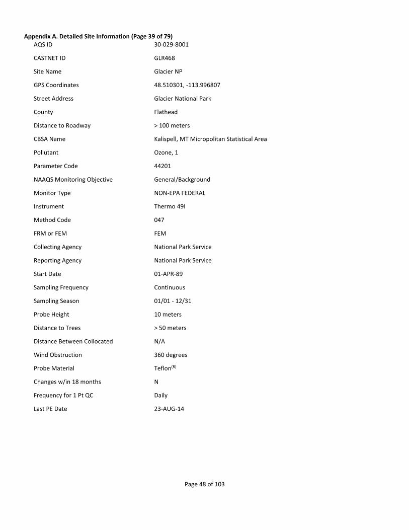
Appendix A. Detailed Site Information (Page 39 of 79) AQS ID 30-029-8001
CASTNET ID GLR468
Site Name Glacier NP
GPS Coordinates 48.510301, -113.996807
Street Address Glacier National Park
County Flathead
Distance to Roadway > 100 meters
CBSA Name Kalispell, MT Micropolitan Statistical Area
Pollutant Ozone, 1
Parameter Code 44201
NAAQS Monitoring Objective General/Background
Monitor Type NON-EPA FEDERAL
Instrument Thermo 49I
Method Code 047
FRM or FEM FEM
Collecting Agency National Park Service
Reporting Agency National Park Service
Start Date 01-APR-89
Sampling Frequency Continuous
Sampling Season 01/01 - 12/31
Probe Height 10 meters
Distance to Trees > 50 meters
Distance Between Collocated N/A
Wind Obstruction 360 degrees
Probe Material Teflon(R)
Changes w/in 18 months N
Frequency for 1 Pt QC Daily
Last PE Date 23-AUG-14

Page 49 of 103
Appendix A. Detailed Site Information (Page 40 of 79) AQS ID 31-107-9991
CASTNET ID SAN189
Site Name Santee Sioux
GPS Coordinates 42.829154, -97.854128
Street Address State Spur 54d, Niobrara, Ne 68760
County Knox
Distance to Roadway > 100 meters
Pollutant Ozone, 1
Parameter Code 44201
NAAQS Monitoring Objective Highest Concentration
Monitor Type EPA
Instrument Thermo 49I
Method Code 047
FRM or FEM FEM
Collecting Agency EPA/CAMD
Spatial Scale Regional Scale
Reporting Agency EPA/CAMD
Start Date 01-JAN-11
Sampling Frequency Continuous
Sampling Season 01/01 - 12/31
Probe Height 10 meters
Distance to Trees > 50 meters
Distance Between Collocated N/A
Wind Obstruction 360 degrees
Probe Material Teflon(R)
Changes w/in 18 months N
Frequency for 1 Pt QC Daily
Last PE Date 02-JUN-14

Page 50 of 103
Appendix A. Detailed Site Information (Page 41 of 79) AQS ID 32-033-0101
CASTNET ID GRB411
Site Name Great Basin NP
GPS Coordinates 39.005121, -114.215932
Street Address Great Basin National Park
County White Pine
Distance to Roadway > 100 meters
Pollutant Ozone, 1
Parameter Code 44201
NAAQS Monitoring Objective Highest Concentration
Monitor Type NON-EPA FEDERAL
Instrument Thermo 49C
Method Code 047
FRM or FEM FEM
Collecting Agency National Park Service
Spatial Scale Regional Scale
Reporting Agency National Park Service
Start Date 01-SEP-93
Sampling Frequency Continuous
Sampling Season 01/01 - 12/31
Probe Height 10 meters
Distance to Trees 10 meters
Distance Between Collocated N/A
Wind Obstruction 360 degrees
Probe Material Teflon(R)
Changes w/in 18 months N
Frequency for 1 Pt QC Daily
Last PE Date 27-MAY-14

Page 51 of 103
Appendix A. Detailed Site Information (Page 42 of 79) AQS ID 33-009-9991
CASTNET ID WST109
Site Name Woodstock
GPS Coordinates 43.944519, -71.700787
Street Address Hubbard Brook Experimental Forest, North Woodstock, Nh 03262
County Grafton
Distance to Roadway 50 meters
CBSA Name Lebanon, NH-VT Micropolitan Statistical Area
Pollutant Ozone, 1
Parameter Code 44201
NAAQS Monitoring Objective Highest Concentration
Monitor Type EPA
Instrument Thermo 49I
Method Code 047
FRM or FEM FEM
Collecting Agency EPA/CAMD
Spatial Scale Regional Scale
Reporting Agency EPA/CAMD
Start Date 01-JUN-11
Sampling Frequency Continuous
Sampling Season 01/01 - 12/31
Probe Height 10 meters
Distance to Trees 10 - 30 meters
Distance Between Collocated N/A
Wind Obstruction 360 degrees
Probe Material Teflon(R)
Changes w/in 18 months N
Frequency for 1 Pt QC Daily
Last PE Date 11-NOV-14
Page 52 of 103
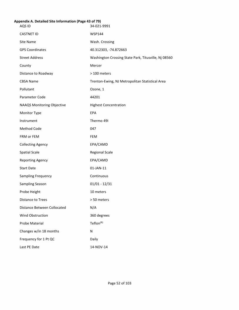
Appendix A. Detailed Site Information (Page 43 of 79) AQS ID 34-021-9991
CASTNET ID WSP144
Site Name Wash. Crossing
GPS Coordinates 40.312303, -74.872663
Street Address Washington Crossing State Park, Titusville, Nj 08560
County Mercer
Distance to Roadway > 100 meters
CBSA Name Trenton-Ewing, NJ Metropolitan Statistical Area
Pollutant Ozone, 1
Parameter Code 44201
NAAQS Monitoring Objective Highest Concentration
Monitor Type EPA
Instrument Thermo 49I
Method Code 047
FRM or FEM FEM
Collecting Agency EPA/CAMD
Spatial Scale Regional Scale
Reporting Agency EPA/CAMD
Start Date 01-JAN-11
Sampling Frequency Continuous
Sampling Season 01/01 - 12/31
Probe Height 10 meters
Distance to Trees > 50 meters
Distance Between Collocated N/A
Wind Obstruction 360 degrees
Probe Material Teflon(R)
Changes w/in 18 months N
Frequency for 1 Pt QC Daily
Last PE Date 14-NOV-14
Page 53 of 103
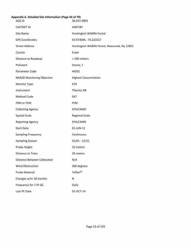
Appendix A. Detailed Site Information (Page 44 of 79) AQS ID 36-031-9991
CASTNET ID HWF187
Site Name Huntington Wildlife Forest
GPS Coordinates 43.973044, -74.223317
Street Address Huntington Wildlife Forest, Newcomb, Ny 12852
County Essex
Distance to Roadway > 100 meters
Pollutant Ozone, 1
Parameter Code 44201
NAAQS Monitoring Objective Highest Concentration
Monitor Type EPA
Instrument Thermo 49I
Method Code 047
FRM or FEM FEM
Collecting Agency EPA/CAMD
Spatial Scale Regional Scale
Reporting Agency EPA/CAMD
Start Date 01-JUN-11
Sampling Frequency Continuous
Sampling Season 01/01 - 12/31
Probe Height 10 meters
Distance to Trees 20 meters
Distance Between Collocated N/A
Wind Obstruction 360 degrees
Probe Material Teflon(R)
Changes w/in 18 months N
Frequency for 1 Pt QC Daily
Last PE Date 01-OCT-14

Page 54 of 103
Appendix A. Detailed Site Information (Page 45 of 79) AQS ID 36-109-9991
CASTNET ID CTH110
Site Name Connecticut Hill
GPS Coordinates 42.400875, -76.653516
Street Address Connecticut Hill Wildlife Management Area, Newfield, Ny 14867
County Tompkins
Distance to Roadway > 100 meters
CBSA Name Ithaca, NY Metropolitan Statistical Area
Pollutant Ozone, 1
Parameter Code 44201
NAAQS Monitoring Objective Highest Concentration
Monitor Type EPA
Instrument Thermo 49I
Method Code 047
FRM or FEM FEM
Collecting Agency EPA/CAMD
Spatial Scale Regional Scale
Reporting Agency EPA/CAMD
Start Date 01-JAN-11
Sampling Frequency Continuous
Sampling Season 01/01 - 12/31
Probe Height 10 meters
Distance to Trees 30 meters
Distance Between Collocated N/A
Wind Obstruction 360 degrees
Probe Material Teflon(R)
Changes w/in 18 months N
Frequency for 1 Pt QC Daily
Last PE Date 05-SEP-14

Page 55 of 103
Appendix A. Detailed Site Information (Page 46 of 79) AQS ID 37-011-9991
CASTNET ID PNF126
Site Name Cranberry
GPS Coordinates 36.105435, -82.045015
Street Address Pisgah National Forest, Newland, Nc 28657
County Avery
Distance to Roadway > 100 meters
Pollutant Ozone, 1
Parameter Code 44201
NAAQS Monitoring Objective Highest Concentration
Monitor Type EPA
Instrument Thermo 49I
Method Code 047
FRM or FEM FEM
Collecting Agency EPA/CAMD
Spatial Scale Regional Scale
Reporting Agency EPA/CAMD
Start Date 01-JAN-11
Sampling Frequency Continuous
Sampling Season 01/01 - 12/31
Probe Height 10 meters
Distance to Trees > 50 meters
Distance Between Collocated N/A
Wind Obstruction 360 degrees
Probe Material Teflon(R)
Changes w/in 18 months N
Frequency for 1 Pt QC Daily
Last PE Date 30-OCT-14

Page 56 of 103
Appendix A. Detailed Site Information (Page 47 of 79) AQS ID 37-031-9991
CASTNET ID BFT142
Site Name Beaufort
GPS Coordinates 34.884668, -76.620666
Street Address Open Grounds Farm, Beaufort, Nc 28516
County Carteret
Distance to Roadway > 100 meters
CBSA Name Morehead City, NC Micropolitan Statistical Area
Pollutant Ozone, 1
Parameter Code 44201
NAAQS Monitoring Objective Highest Concentration
Monitor Type EPA
Instrument Thermo 49I
Method Code 047
FRM or FEM FEM
Collecting Agency EPA/CAMD
Spatial Scale Regional Scale
Reporting Agency EPA/CAMD
Start Date 01-JAN-11
Sampling Frequency Continuous
Sampling Season 01/01 - 12/31
Probe Height 10 meters
Distance to Trees > 50 meters
Distance Between Collocated N/A
Wind Obstruction 360 degrees
Probe Material Teflon(R)
Changes w/in 18 months N
Frequency for 1 Pt QC Daily
Last PE Date 25-NOV-14

Page 57 of 103
Appendix A. Detailed Site Information (Page 48 of 79) AQS ID 37-113-9991
CASTNET ID COW137
Site Name Coweeta
GPS Coordinates 35.060527, -83.43034
Street Address USDA Southern Research Station, Coweeta Hydrologic Laboratory, Otto, Nc 28763
County Macon
Distance to Roadway > 100 meters
Pollutant Ozone, 1
Parameter Code 44201
NAAQS Monitoring Objective Highest Concentration
Monitor Type EPA
Instrument Thermo 49I
Method Code 047
FRM or FEM FEM
Collecting Agency EPA/CAMD
Spatial Scale Regional Scale
Reporting Agency EPA/CAMD
Start Date 01-JAN-11
Sampling Frequency Continuous
Sampling Season 01/01 - 12/31
Probe Height 10 meters
Distance to Trees > 50 meters
Distance Between Collocated N/A
Wind Obstruction 360 degrees
Probe Material Teflon(R)
Changes w/in 18 months N
Frequency for 1 Pt QC Daily
Last PE Date 26-MAR-14

Page 58 of 103
Appendix A. Detailed Site Information (Page 49 of 79) AQS ID 37-123-9991
CASTNET ID CND125
Site Name Candor
GPS Coordinates 35.26333, -79.83754
Street Address 136 Perry Dr, Candor, Nc 27229
County Montgomery
Distance to Roadway > 100 meters
Pollutant Ozone, 1
Parameter Code 44201
NAAQS Monitoring Objective Highest Concentration
Monitor Type EPA
Instrument Thermo 49I
Method Code 047
FRM or FEM FEM
Collecting Agency EPA/CAMD
Spatial Scale Regional Scale
Reporting Agency EPA/CAMD
Start Date 01-JAN-11
Sampling Frequency Continuous
Sampling Season 01/01 - 12/31
Probe Height 10 meters
Distance to Trees > 50 meters
Distance Between Collocated N/A
Wind Obstruction 360 degrees
Probe Material Teflon(R)
Changes w/in 18 months N
Frequency for 1 Pt QC Daily
Last PE Date 24-NOV-14
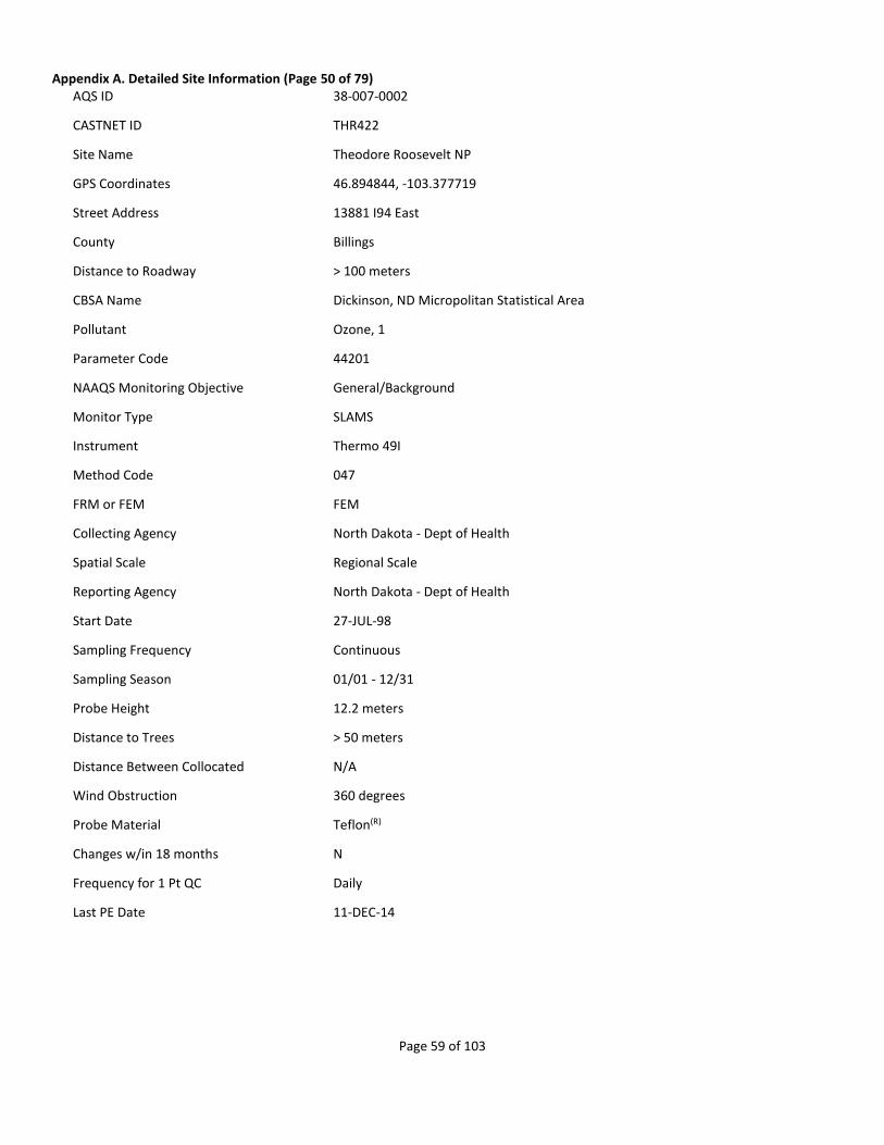
Page 59 of 103
Appendix A. Detailed Site Information (Page 50 of 79) AQS ID 38-007-0002
CASTNET ID THR422
Site Name Theodore Roosevelt NP
GPS Coordinates 46.894844, -103.377719
Street Address 13881 I94 East
County Billings
Distance to Roadway > 100 meters
CBSA Name Dickinson, ND Micropolitan Statistical Area
Pollutant Ozone, 1
Parameter Code 44201
NAAQS Monitoring Objective General/Background
Monitor Type SLAMS
Instrument Thermo 49I
Method Code 047
FRM or FEM FEM
Collecting Agency North Dakota - Dept of Health
Spatial Scale Regional Scale
Reporting Agency North Dakota - Dept of Health
Start Date 27-JUL-98
Sampling Frequency Continuous
Sampling Season 01/01 - 12/31
Probe Height 12.2 meters
Distance to Trees > 50 meters
Distance Between Collocated N/A
Wind Obstruction 360 degrees
Probe Material Teflon(R)
Changes w/in 18 months N
Frequency for 1 Pt QC Daily
Last PE Date 11-DEC-14
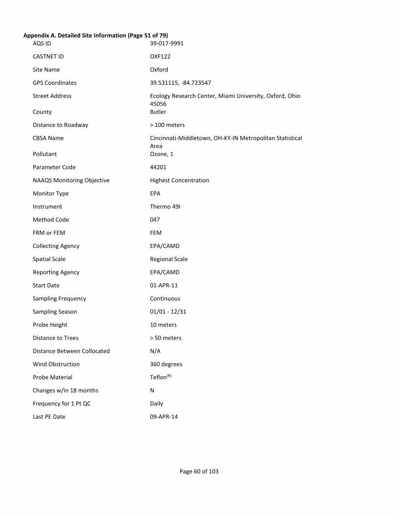
Page 60 of 103
Appendix A. Detailed Site Information (Page 51 of 79) AQS ID 39-017-9991
CASTNET ID OXF122
Site Name Oxford
GPS Coordinates 39.531115, -84.723547
Street Address Ecology Research Center, Miami University, Oxford, Ohio 45056
County Butler
Distance to Roadway > 100 meters
CBSA Name Cincinnati-Middletown, OH-KY-IN Metropolitan Statistical Area
Pollutant Ozone, 1
Parameter Code 44201
NAAQS Monitoring Objective Highest Concentration
Monitor Type EPA
Instrument Thermo 49I
Method Code 047
FRM or FEM FEM
Collecting Agency EPA/CAMD
Spatial Scale Regional Scale
Reporting Agency EPA/CAMD
Start Date 01-APR-11
Sampling Frequency Continuous
Sampling Season 01/01 - 12/31
Probe Height 10 meters
Distance to Trees > 50 meters
Distance Between Collocated N/A
Wind Obstruction 360 degrees
Probe Material Teflon(R)
Changes w/in 18 months N
Frequency for 1 Pt QC Daily
Last PE Date 09-APR-14

Page 61 of 103
Appendix A. Detailed Site Information (Page 52 of 79) AQS ID 39-047-9991
CASTNET ID DCP114
Site Name Deer Creek
GPS Coordinates 39.635888, -83.260563
Street Address Deer Creek State Park, Mt Sterling, Oh 43143
County Fayette
Distance to Roadway > 100 meters
CBSA Name Washington Court House, OH Micropolitan Statistical Area
Pollutant Ozone, 1
Parameter Code 44201
NAAQS Monitoring Objective Highest Concentration
Monitor Type EPA
Instrument Thermo 49I
Method Code 047
FRM or FEM FEM
Collecting Agency EPA/CAMD
Spatial Scale Regional Scale
Reporting Agency EPA/CAMD
Start Date 01-APR-11
Sampling Frequency Continuous
Sampling Season 01/01 - 12/31
Probe Height 10 meters
Distance to Trees 15 meters
Distance Between Collocated N/A
Wind Obstruction 360 degrees
Probe Material Teflon(R)
Changes w/in 18 months N
Frequency for 1 Pt QC Daily
Last PE Date 09-APR-14

Page 62 of 103
Appendix A. Detailed Site Information (Page 53 of 79) AQS ID 39-121-9991
CASTNET ID QAK172
Site Name Quaker City
GPS Coordinates 39.942714, -81.337914
Street Address 58163 St. Johns Rd, Quaker City, Oh 43773
County Noble
Distance to Roadway > 100 meters
Pollutant Ozone, 1
Parameter Code 44201
NAAQS Monitoring Objective Highest Concentration
Monitor Type EPA
Instrument Thermo 49I
Method Code 047
FRM or FEM FEM
Collecting Agency EPA/CAMD
Spatial Scale Regional Scale
Reporting Agency EPA/CAMD
Start Date 01-JAN-11
Sampling Frequency Continuous
Sampling Season 01/01 - 12/31
Probe Height 10 meters
Distance to Trees > 50 meters
Distance Between Collocated N/A
Wind Obstruction 360 degrees
Probe Material Teflon(R)
Changes w/in 18 months N
Frequency for 1 Pt QC Daily
Last PE Date 08-APR-14

Page 63 of 103
Appendix A. Detailed Site Information (Page 54 of 79) AQS ID 40-001-9009
CASTNET ID CHE185
Site Name Cherokee Nation
GPS Coordinates 35.750786, -94.669789
Street Address South Highway 59, Rr1, 1795 Dahlonegah Park Road, Stilwell, Oklahoma
County Adair
Distance to Roadway > 100 meters
Pollutant Ozone, 1
Parameter Code 44201
NAAQS Monitoring Objective Regional Transport & General/Background
Monitor Type TRIBAL & EPA
Instrument Teledyne ML9811
Method Code 091
FRM or FEM FEM
Collecting Agency EPA/CAMD
Spatial Scale Regional Scale
Reporting Agency EPA/CAMD
Start Date 01-JUL-02
Sampling Frequency Continuous
Sampling Season 01/01 - 12/31
Probe Height 10 meters
Distance to Trees > 50 meters
Distance Between Collocated N/A
Wind Obstruction 360 degrees
Probe Material Teflon(R)
Changes w/in 18 months N
Frequency for 1 Pt QC Daily
Last PE Date 02-SEP-14
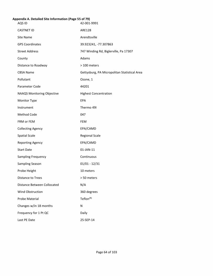
Page 64 of 103
Appendix A. Detailed Site Information (Page 55 of 79) AQS ID 42-001-9991
CASTNET ID ARE128
Site Name Arendtsville
GPS Coordinates 39.923241, -77.307863
Street Address 747 Winding Rd, Biglerville, Pa 17307
County Adams
Distance to Roadway > 100 meters
CBSA Name Gettysburg, PA Micropolitan Statistical Area
Pollutant Ozone, 1
Parameter Code 44201
NAAQS Monitoring Objective Highest Concentration
Monitor Type EPA
Instrument Thermo 49I
Method Code 047
FRM or FEM FEM
Collecting Agency EPA/CAMD
Spatial Scale Regional Scale
Reporting Agency EPA/CAMD
Start Date 01-JAN-11
Sampling Frequency Continuous
Sampling Season 01/01 - 12/31
Probe Height 10 meters
Distance to Trees > 50 meters
Distance Between Collocated N/A
Wind Obstruction 360 degrees
Probe Material Teflon(R)
Changes w/in 18 months N
Frequency for 1 Pt QC Daily
Last PE Date 25-SEP-14

Page 65 of 103
Appendix A. Detailed Site Information (Page 56 of 79) AQS ID 42-027-9991
CASTNET ID PSU106
Site Name Penn State
GPS Coordinates 40.720902, -77.931759
Street Address 1366 Tadpole Rd, Pennsylvania Furnace, Pa 16865
County Centre
Distance to Roadway > 100 meters
CBSA Name State College, PA Metropolitan Statistical Area
Pollutant Ozone, 1
Parameter Code 44201
NAAQS Monitoring Objective Highest Concentration
Monitor Type EPA
Instrument Thermo 49I
Method Code 047
FRM or FEM FEM
Collecting Agency EPA/CAMD
Spatial Scale Regional Scale
Reporting Agency EPA/CAMD
Start Date 01-APR-11
Sampling Frequency Continuous
Sampling Season 01/01 - 12/31
Probe Height 10 meters
Distance to Trees > 50 meters
Distance Between Collocated N/A
Wind Obstruction 360 degrees
Probe Material Teflon(R)
Changes w/in 18 months N
Frequency for 1 Pt QC Daily
Last PE Date 24-SEP-14

Page 66 of 103
Appendix A. Detailed Site Information (Page 57 of 79) AQS ID 42-047-9991
CASTNET ID KEF112
Site Name Kane Exp. Forest
GPS Coordinates 41.598119, -78.767866
Street Address Kane Experimental Forest, Allegheny National Forest, Wilcox, Pa 15870
County Elk
Distance to Roadway > 100 meters
CBSA Name St. Marys, PA Micropolitan Statistical Area
Pollutant Ozone, 1
Parameter Code 44201
NAAQS Monitoring Objective Highest Concentration
Monitor Type EPA
Instrument Thermo 49I
Method Code 047
FRM or FEM FEM
Collecting Agency EPA/CAMD
Spatial Scale Regional Scale
Reporting Agency EPA/CAMD
Start Date 01-JUN-11
Sampling Frequency Continuous
Sampling Season 01/01 - 12/31
Probe Height 10 meters
Distance to Trees 20 meters
Distance Between Collocated N/A
Wind Obstruction 360 degrees
Probe Material Teflon(R)
Changes w/in 18 months N
Frequency for 1 Pt QC Daily
Last PE Date 23-SEP-14
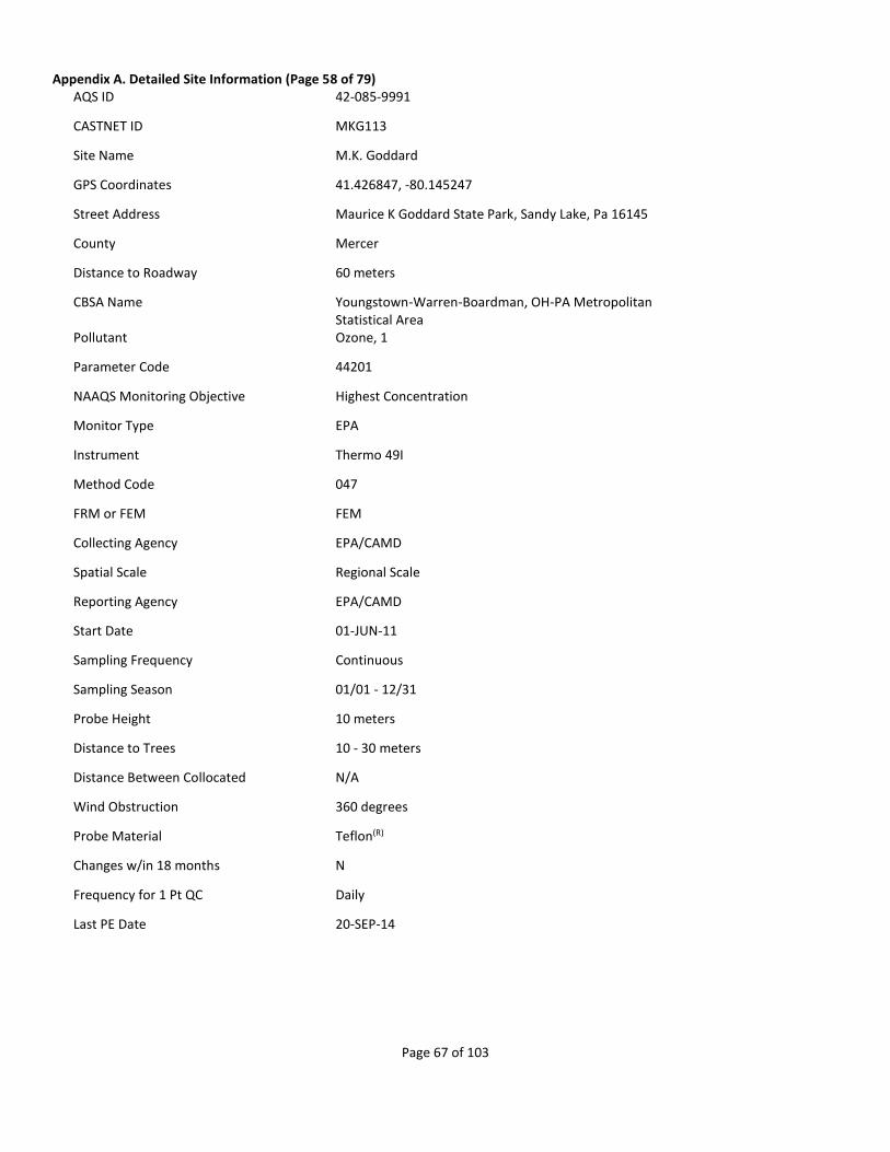
Page 67 of 103
Appendix A. Detailed Site Information (Page 58 of 79) AQS ID 42-085-9991
CASTNET ID MKG113
Site Name M.K. Goddard
GPS Coordinates 41.426847, -80.145247
Street Address Maurice K Goddard State Park, Sandy Lake, Pa 16145
County Mercer
Distance to Roadway 60 meters
CBSA Name Youngstown-Warren-Boardman, OH-PA Metropolitan Statistical Area
Pollutant Ozone, 1
Parameter Code 44201
NAAQS Monitoring Objective Highest Concentration
Monitor Type EPA
Instrument Thermo 49I
Method Code 047
FRM or FEM FEM
Collecting Agency EPA/CAMD
Spatial Scale Regional Scale
Reporting Agency EPA/CAMD
Start Date 01-JUN-11
Sampling Frequency Continuous
Sampling Season 01/01 - 12/31
Probe Height 10 meters
Distance to Trees 10 - 30 meters
Distance Between Collocated N/A
Wind Obstruction 360 degrees
Probe Material Teflon(R)
Changes w/in 18 months N
Frequency for 1 Pt QC Daily
Last PE Date 20-SEP-14

Page 68 of 103
Appendix A. Detailed Site Information (Page 59 of 79) AQS ID 42-111-9991
CASTNET ID LRL117
Site Name Laurel Hill
GPS Coordinates 39.988309, -79.251573
Street Address Laurel Hill State Park, Rockwood, Pa 15557
County Somerset
Distance to Roadway > 100 meters
CBSA Name Somerset, PA Micropolitan Statistical Area
Pollutant Ozone, 1
Parameter Code 44201
NAAQS Monitoring Objective Highest Concentration
Monitor Type EPA
Instrument Thermo 49I
Method Code 047
FRM or FEM FEM
Collecting Agency EPA/CAMD
Spatial Scale Regional Scale
Reporting Agency EPA/CAMD
Start Date 01-APR-11
Sampling Frequency Continuous
Sampling Season 01/01 - 12/31
Probe Height 10 meters
Distance to Trees > 50 meters
Distance Between Collocated N/A
Wind Obstruction 360 degrees
Probe Material Teflon(R)
Changes w/in 18 months N
Frequency for 1 Pt QC Daily
Last PE Date 19-SEP-14

Page 69 of 103
Appendix A. Detailed Site Information (Page 60 of 79) AQS ID 46-033-0132
CASTNET ID WNC429
Site Name Wind Cave NP
GPS Coordinates 43.557639, -103.483856
Street Address Wind Cave National Park, South Dakota
County Custer
Distance to Roadway > 100 meters
Pollutant Ozone, 3
Parameter Code 44201
NAAQS Monitoring Objective Regional Transport & General/Background
Monitor Type SLAMS
Instrument Thermo 49I
Method Code 047
FRM or FEM FEM
Collecting Agency South Dakota - Dept of Environment and Natural Resources
Spatial Scale Regional Scale
Reporting Agency South Dakota - Dept of Environment and Natural Resources
Start Date 01-JAN-05
Sampling Frequency Continuous
Sampling Season 01/01 - 12/31
Probe Height 3.35 meters
Distance to Trees > 50 meters
Distance Between Collocated N/A
Wind Obstruction 360 degrees
Probe Material Glass
Changes w/in 18 months N
Frequency for 1 Pt QC Daily
Last PE Date 11-DEC-14

Page 70 of 103
Appendix A. Detailed Site Information (Page 61 of 79) AQS ID 47-009-0101
CASTNET ID GRS420
Site Name Great Smoky NP - Look Rock
GPS Coordinates 35.633482, -83.941606
Street Address Great Smoky Mountains NP Look Rock
County Blount
Distance to Roadway > 100 meters
CBSA Name Knoxville, TN Metropolitan Statistical Area
Pollutant Ozone, 1
Parameter Code 44201
NAAQS Monitoring Objective General/Background
Monitor Type SLAMS & NON-EPA FEDERAL
Instrument Thermo 49I
Method Code 047
FRM or FEM FEM
Collecting Agency National Park Service
Spatial Scale Neighborhood
Reporting Agency National Park Service
Start Date 01-JUL-88
Sampling Frequency Continuous
Sampling Season 01/01 - 12/31
Probe Height 10 meters
Distance to Trees > 50 meters
Distance Between Collocated N/A
Wind Obstruction 360 degrees
Probe Material Teflon(R)
Changes w/in 18 months N
Frequency for 1 Pt QC Daily
Last PE Date 27-OCT-14

Page 71 of 103
Appendix A. Detailed Site Information (Page 62 of 79) AQS ID 47-025-9991
CASTNET ID SPD111
Site Name Speedwell
GPS Coordinates 36.46983, -83.826511
Street Address 718 Russell Hill Rd, Speedwell, Tn 37870
County Claiborne
Distance to Roadway > 100 meters
Pollutant Ozone, 1
Parameter Code 44201
NAAQS Monitoring Objective Highest Concentration
Monitor Type EPA
Instrument Thermo 49I
Method Code 047
FRM or FEM FEM
Collecting Agency EPA/CAMD
Spatial Scale Regional Scale
Reporting Agency EPA/CAMD
Start Date 01-MAR-11
Sampling Frequency Continuous
Sampling Season 01/01 - 12/31
Probe Height 10 meters
Distance to Trees > 50 meters
Distance Between Collocated N/A
Wind Obstruction 360 degrees
Probe Material Teflon(R)
Changes w/in 18 months N
Frequency for 1 Pt QC Daily
Last PE Date 31-MAR-14

Page 72 of 103
Appendix A. Detailed Site Information (Page 63 of 79) AQS ID 47-041-9991
CASTNET ID ESP127
Site Name Edgar Evins
GPS Coordinates 36.03893, -85.73305
Street Address Edgar Evans State Park, Smithville, Tn 37166
County DeKalb
Distance to Roadway > 100 meters
Pollutant Ozone, 1
Parameter Code 44201
NAAQS Monitoring Objective Highest Concentration
Monitor Type EPA
Instrument Thermo 49I
Method Code 047
FRM or FEM FEM
Collecting Agency EPA/CAMD
Spatial Scale Regional Scale
Reporting Agency EPA/CAMD
Start Date 01-MAR-11
Sampling Frequency Continuous
Sampling Season 01/01 - 12/31
Probe Height 10 meters
Distance to Trees > 50 meters
Distance Between Collocated N/A
Wind Obstruction 360 degrees
Probe Material Teflon(R)
Changes w/in 18 months N
Frequency for 1 Pt QC Daily
Last PE Date 27-MAR-14

Page 73 of 103
Appendix A. Detailed Site Information (Page 64 of 79) AQS ID 48-043-0101
CASTNET ID BBE401
Site Name Big Bend NP
GPS Coordinates 29.302651, -103.177813
Street Address Big Bend National Park, Texas
County Brewster
Distance to Roadway > 100 meters
Pollutant Ozone, 1
Parameter Code 44201
NAAQS Monitoring Objective Highest Concentration
Monitor Type NON-EPA FEDERAL
Instrument Thermo 49C
Method Code 047
FRM or FEM FEM
Collecting Agency National Park Service
Spatial Scale Regional Scale
Reporting Agency National Park Service
Start Date 01-OCT-90
Sampling Frequency Continuous
Sampling Season 01/01 - 12/31
Probe Height 10 meters
Distance to Trees > 50 meters
Distance Between Collocated N/A
Wind Obstruction 360 degrees
Probe Material Teflon(R)
Changes w/in 18 months N
Frequency for 1 Pt QC Daily
Last PE Date 20-MAR-14

Page 74 of 103
Appendix A. Detailed Site Information (Page 65 of 79) AQS ID 48-373-9991
CASTNET ID ALC188
Site Name Alabama-Coushatta
GPS Coordinates 30.701577, -94.674011
Street Address 361 Tombigbee Rd, Livingston, Tx 77351
County Polk
Distance to Roadway > 100 meters
Pollutant Ozone, 1
Parameter Code 44201
NAAQS Monitoring Objective Highest Concentration
Monitor Type EPA
Instrument Thermo 49I
Method Code 047
FRM or FEM FEM
Collecting Agency EPA/CAMD
Spatial Scale Regional Scale
Reporting Agency EPA/CAMD
Start Date 01-APR-11
Sampling Frequency Continuous
Sampling Season 01/01 - 12/31
Probe Height 10 meters
Distance to Trees > 50 meters
Distance Between Collocated N/A
Wind Obstruction 360 degrees
Probe Material Teflon(R)
Changes w/in 18 months N
Frequency for 1 Pt QC Daily
Last PE Date 12-MAR-14

Page 75 of 103
Appendix A. Detailed Site Information (Page 66 of 79) AQS ID 48-381-9991
CASTNET ID PAL190
Site Name Palo Duro
GPS Coordinates 34.88061, -101.664703
Street Address Palo Duro Canyon State Park, Canyon, Tx 79015
County Randall
Distance to Roadway > 100 meters
CBSA Name Amarillo, TX Metropolitan Statistical Area
Pollutant Ozone, 1
Parameter Code 44201
NAAQS Monitoring Objective Highest Concentration
Monitor Type EPA
Instrument Thermo 49I
Method Code 047
FRM or FEM FEM
Collecting Agency EPA/CAMD
Spatial Scale Regional Scale
Reporting Agency EPA/CAMD
Start Date 01-JUN-11
Sampling Frequency Continuous
Sampling Season 01/01 - 12/31
Probe Height 10 meters
Distance to Trees > 50 meters
Distance Between Collocated N/A
Wind Obstruction 360 degrees
Probe Material Teflon(R)
Changes w/in 18 months N
Frequency for 1 Pt QC Daily
Last PE Date 25-MAR-14

Page 76 of 103
Appendix A. Detailed Site Information (Page 67 of 79) AQS ID 49-037-0101
CASTNET ID CAN407
Site Name Canyonlands NP
GPS Coordinates 38.458323, -109.82126
Street Address Canyonlands National Park, Utah
County San Juan
Distance to Roadway > 100 meters
Pollutant Ozone, 1
Parameter Code 44201
NAAQS Monitoring Objective Highest Concentration
Monitor Type NON-EPA FEDERAL
Instrument Thermo 49I
Method Code 047
FRM or FEM FEM
Collecting Agency National Park Service
Spatial Scale Regional Scale
Reporting Agency National Park Service
Start Date 01-SEP-92
Sampling Frequency Continuous
Sampling Season 01/01 - 12/31
Probe Height 10 meters
Distance to Trees > 50 meters
Distance Between Collocated N/A
Wind Obstruction 360 degrees
Probe Material Teflon(R)
Changes w/in 18 months N
Frequency for 1 Pt QC Daily
Last PE Date 06-MAY-14

Page 77 of 103
Appendix A. Detailed Site Information (Page 68 of 79) AQS ID 49-047-1002
CASTNET ID DIN431
Site Name Dinosaur NM
GPS Coordinates 40.4373, -109.3046
Street Address Dinosaur National Monument
County Uintah
Distance to Roadway > 100 meters
CBSA Name Vernal, UT Micropolitan Statistical Area
Pollutant Ozone, 1
Parameter Code 44201
NAAQS Monitoring Objective General/Background
Monitor Type NON-EPA FEDERAL
Instrument Thermo 49I
Method Code 047
FRM or FEM FEM
Collecting Agency National Park Service
Reporting Agency National Park Service
Start Date 01-JAN-12
Sampling Frequency Continuous
Sampling Season 01/01 - 12/31
Probe Height 10 meters
Distance to Trees > 50 meters
Distance Between Collocated N/A
Wind Obstruction 360 degrees
Probe Material Teflon(R)
Changes w/in 18 months N
Frequency for 1 Pt QC Daily
Last PE Date 15-JUL-14
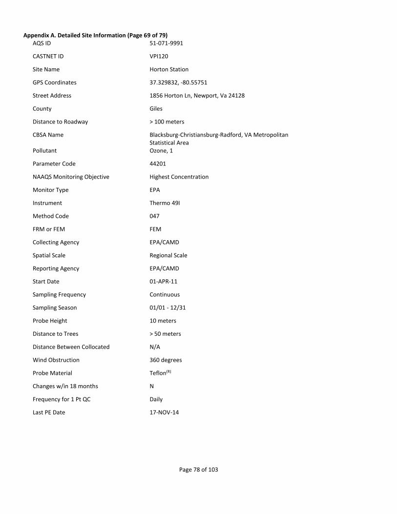
Page 78 of 103
Appendix A. Detailed Site Information (Page 69 of 79) AQS ID 51-071-9991
CASTNET ID VPI120
Site Name Horton Station
GPS Coordinates 37.329832, -80.55751
Street Address 1856 Horton Ln, Newport, Va 24128
County Giles
Distance to Roadway > 100 meters
CBSA Name Blacksburg-Christiansburg-Radford, VA Metropolitan Statistical Area
Pollutant Ozone, 1
Parameter Code 44201
NAAQS Monitoring Objective Highest Concentration
Monitor Type EPA
Instrument Thermo 49I
Method Code 047
FRM or FEM FEM
Collecting Agency EPA/CAMD
Spatial Scale Regional Scale
Reporting Agency EPA/CAMD
Start Date 01-APR-11
Sampling Frequency Continuous
Sampling Season 01/01 - 12/31
Probe Height 10 meters
Distance to Trees > 50 meters
Distance Between Collocated N/A
Wind Obstruction 360 degrees
Probe Material Teflon(R)
Changes w/in 18 months N
Frequency for 1 Pt QC Daily
Last PE Date 17-NOV-14

Page 79 of 103
Appendix A. Detailed Site Information (Page 70 of 79) AQS ID 51-113-0003
CASTNET ID SHN418
Site Name Shenandoah NP - Big Meadows
GPS Coordinates 38.5231, -78.43471
Street Address Shenandoah NP Big Meadows
County Madison
Distance to Roadway > 100 meters
Pollutant Ozone, 1
Parameter Code 44201
NAAQS Monitoring Objective Population Exposure
Monitor Type SLAMS & 192842
Instrument Thermo 49I
Method Code 047
FRM or FEM FEM
Collecting Agency National Park Service
Spatial Scale Neighborhood
Reporting Agency National Park Service
Start Date 01-JUL-85
Sampling Frequency Continuous
Sampling Season 01/01 - 12/31
Probe Height 10 meters
Distance to Trees > 50 meters
Distance Between Collocated N/A
Wind Obstruction 360 degrees
Probe Material Teflon(R)
Changes w/in 18 months N
Frequency for 1 Pt QC Daily
Last PE Date 18-NOV-14

Page 80 of 103
Appendix A. Detailed Site Information (Page 71 of 79) AQS ID 51-147-9991
CASTNET ID PED108
Site Name Prince Edward
GPS Coordinates 37.165222, -78.307067
Street Address Prince Edward-Gallion State Forest, Burkeville, Va 23922
County Prince Edward
Distance to Roadway > 100 meters
Pollutant Ozone, 1
Parameter Code 44201
NAAQS Monitoring Objective Highest Concentration
Monitor Type EPA
Instrument Thermo 49I
Method Code 047
FRM or FEM FEM
Collecting Agency EPA/CAMD
Spatial Scale Regional Scale
Reporting Agency EPA/CAMD
Start Date 01-JAN-11
Sampling Frequency Continuous
Sampling Season 01/01 - 12/31
Probe Height 10 meters
Distance to Trees > 50 meters
Distance Between Collocated N/A
Wind Obstruction 360 degrees
Probe Material Teflon(R)
Changes w/in 18 months N
Frequency for 1 Pt QC Daily
Last PE Date 18-NOV-14

Page 81 of 103
Appendix A. Detailed Site Information (Page 72 of 79) AQS ID 54-021-9991
CASTNET ID CDR119
Site Name Cedar Creek
GPS Coordinates 38.879503, -80.847677
Street Address Cedar Creek State Park, Cedarville, Wv 26611
County Gilmer
Distance to Roadway > 100 meters
Pollutant Ozone, 1
Parameter Code 44201
NAAQS Monitoring Objective Highest Concentration
Monitor Type EPA
Instrument Thermo 49I
Method Code 047
FRM or FEM FEM
Collecting Agency EPA/CAMD
Spatial Scale Regional Scale
Reporting Agency EPA/CAMD
Start Date 01-APR-11
Sampling Frequency Continuous
Sampling Season 01/01 - 12/31
Probe Height 10 meters
Distance to Trees > 50 meters
Distance Between Collocated N/A
Wind Obstruction 360 degrees
Probe Material Teflon(R)
Changes w/in 18 months N
Frequency for 1 Pt QC Daily
Last PE Date 21-NOV-14

Page 82 of 103
Appendix A. Detailed Site Information (Page 73 of 79) AQS ID 54-093-9991
CASTNET ID PAR107
Site Name Parsons
GPS Coordinates 39.090434, -79.661742
Street Address USDA Northern Research Station, Monongahela National Forest, Parsons, Wv 26287
County Tucker
Distance to Roadway > 100 meters
Pollutant Ozone, 1
Parameter Code 44201
NAAQS Monitoring Objective Highest Concentration
Monitor Type EPA
Instrument Thermo 49I
Method Code 047
FRM or FEM FEM
Collecting Agency EPA/CAMD
Spatial Scale Regional Scale
Reporting Agency EPA/CAMD
Start Date 01-JUN-11
Sampling Frequency Continuous
Sampling Season 01/01 - 12/31
Probe Height 10 meters
Distance to Trees > 50 meters
Distance Between Collocated N/A
Wind Obstruction 360 degrees
Probe Material Teflon(R)
Changes w/in 18 months N
Frequency for 1 Pt QC Daily
Last PE Date 19-NOV-14

Page 83 of 103
Appendix A. Detailed Site Information (Page 74 of 79) AQS ID 55-119-9991
CASTNET ID PRK134
Site Name Perkinstown
GPS Coordinates 45.206525, -90.597209
Street Address W 10746 County Highway M, Medford, Wi 54451
County Taylor
Distance to Roadway > 100 meters
Pollutant Ozone, 1
Parameter Code 44201
NAAQS Monitoring Objective Highest Concentration
Monitor Type EPA
Instrument Thermo 49I
Method Code 047
FRM or FEM FEM
Collecting Agency EPA/CAMD
Spatial Scale Regional Scale
Reporting Agency EPA/CAMD
Start Date 01-APR-11
Sampling Frequency Continuous
Sampling Season 01/01 - 12/31
Probe Height 10 meters
Distance to Trees > 50 meters
Distance Between Collocated N/A
Wind Obstruction 360 degrees
Probe Material Teflon(R)
Changes w/in 18 months N
Frequency for 1 Pt QC Daily
Last PE Date 10-SEP-14

Page 84 of 103
Appendix A. Detailed Site Information (Page 75 of 79) AQS ID 56-001-9991
CASTNET ID CNT169
Site Name Centennial
GPS Coordinates 41.364531, -106.24002
Street Address Roosevelt National Forest, Centennial, Wy 82055
County Albany
Distance to Roadway > 100 meters
CBSA Name Laramie, WY Micropolitan Statistical Area
Pollutant Ozone, 1
Parameter Code 44201
NAAQS Monitoring Objective Highest Concentration
Monitor Type EPA
Instrument Thermo 49I
Method Code 047
FRM or FEM FEM
Collecting Agency EPA/CAMD
Spatial Scale Regional Scale
Reporting Agency EPA/CAMD
Start Date 01-JUN-11
Sampling Frequency Continuous
Sampling Season 01/01 - 12/31
Probe Height 10 meters
Distance to Trees > 50 meters
Distance Between Collocated N/A
Wind Obstruction 360 degrees
Probe Material Teflon(R)
Changes w/in 18 months N
Frequency for 1 Pt QC Daily
Last PE Date 23-AUG-14

Page 85 of 103
Appendix A. Detailed Site Information (Page 76 of 79) AQS ID 56-003-0002
CASTNET ID BAS601
Site Name Basin
GPS Coordinates 44.28, -108.0411
Street Address Basin (WARMS Station)
County Big Horn
Distance to Roadway > 100 meters
Pollutant Ozone, 1
Parameter Code 44201
NAAQS Monitoring Objective General/Background
Monitor Type NON-EPA FEDERAL
Instrument Thermo 49I
Method Code 047
FRM or FEM FEM
Collecting Agency Bureau of Land Management - Wyoming office
Reporting Agency Bureau of Land Management - Wyoming office
Start Date 28-NOV-12
Sampling Frequency Continuous
Sampling Season 01/01 - 12/31
Probe Height 10 meters
Distance to Trees > 50 meters
Distance Between Collocated N/A
Wind Obstruction 360 degrees
Probe Material Teflon(R)
Changes w/in 18 months N
Frequency for 1 Pt QC Daily
Last PE Date 17-JUL-14

Page 86 of 103
Appendix A. Detailed Site Information (Page 77 of 79) AQS ID 56-035-9991
CASTNET ID PND165
Site Name Pinedale
GPS Coordinates 42.929031, -109.787796
Street Address Skyline Dr, Pinedale, Wy 82941
County Sublette
Distance to Roadway > 100 meters
Pollutant Ozone, 1
Parameter Code 44201
NAAQS Monitoring Objective Highest Concentration
Monitor Type EPA
Instrument Thermo 49I
Method Code 047
FRM or FEM FEM
Collecting Agency EPA/CAMD
Spatial Scale Regional Scale
Reporting Agency EPA/CAMD
Start Date 01-JUN-11
Sampling Frequency Continuous
Sampling Season 01/01 - 12/31
Probe Height 10 meters
Distance to Trees > 50 meters
Distance Between Collocated N/A
Wind Obstruction 360 degrees
Probe Material Teflon(R)
Changes w/in 18 months N
Frequency for 1 Pt QC Daily
Last PE Date 16-JUL-14

Page 87 of 103
Appendix A. Detailed Site Information (Page 78 of 79) AQS ID 56-039-1011
CASTNET ID YEL408
Site Name Yellowstone NP
GPS Coordinates 44.565356, -110.400338
Street Address Yellowstone National Park
County Teton
Distance to Roadway > 100 meters
CBSA Name Jackson, WY-ID Micropolitan Statistical Area
Pollutant Ozone, 1
Parameter Code 44201
NAAQS Monitoring Objective General/Background
Monitor Type NON-EPA FEDERAL
Instrument Thermo 49C
Method Code 047
FRM or FEM FEM
Collecting Agency National Park Service
Reporting Agency National Park Service
Start Date 01-JUL-96
Sampling Frequency Continuous
Sampling Season 01/01 - 12/31
Probe Height 10 meters
Distance to Trees 15 meters
Distance Between Collocated N/A
Wind Obstruction 360 degrees
Probe Material Teflon(R)
Changes w/in 18 months N
Frequency for 1 Pt QC Daily
Last PE Date 24-AUG-14

Page 88 of 103
Appendix A. Detailed Site Information (Page 79 of 79) AQS ID 56-045-0003
CASTNET ID NEC602
Site Name Newcastle
GPS Coordinates 43.873, -104.1919
Street Address Newcastle, Warms Station
County Weston
Distance to Roadway > 100 meters
Pollutant Ozone, 1
Parameter Code 44201
NAAQS Monitoring Objective General/Background
Monitor Type NON-EPA FEDERAL
Instrument Thermo 49I
Method Code 047
FRM or FEM FEM
Collecting Agency Bureau of Land Management - Wyoming office
Reporting Agency Bureau of Land Management - Wyoming office
Start Date 14-NOV-12
Sampling Frequency Continuous
Sampling Season 01/01 - 12/31
Probe Height 10 meters
Distance to Trees > 50 meters
Distance Between Collocated N/A
Wind Obstruction 360 degrees
Probe Material Teflon(R)
Changes w/in 18 months N
Frequency for 1 Pt QC Daily
Last PE Date 22-JUL-14

Page 89 of 103
Appendix B. Ozone Validation Template1 (continued)
1) Requirement (O3) 2) Frequency 3) Acceptance Criteria 4) Information /Action2
CRITICAL CRITERIA-OZONE
One Point QC Check Single analyzer
1/ 2 weeks < +7% (percent difference)
1 and 2) 40 CFR Part 58 App A Sec 3.2 3) Recommendation based on DQO in 40 CFR Part 58 App A Sec 2.3.1.2. QC Check Conc range 0.01 - 0.10 ppm, relative to routine concentrations
Zero/span check 1/ 2 weeks Zero drift < + 1.5 ppb Span drift < + 7 %
1 and 2) QA Handbook Volume 2 Section 12.3 3) Recommendation and related to DQO
OPERATIONAL CRITERIA - OZONE
Shelter Temperature Range
Daily (hourly values)
20 to 30o C. (Hourly avg) or per manufacturers specifications if designated to a wider temperature range
1, 2 and 3) QA Handbook Volume 2 Section 7.2.2 Generally the 20-30 o C range will apply but the most restrictive operable range of the instruments in the shelter may also be used as guidance. FRM/FEM list found on AMTIC provides temperature range for given instrument. FRM/FEM monitor testing is required at 20-30o C range per 40 CFR Part 53.32
Shelter Temperature Control
Daily (hourly values) < + 2o C SD over 24 hours 1, 2 and 3) QA Handbook Volume 2 Section 7.2.2
Shelter Temperature Device Check
1/6 mo + 2o C of standard 1, 2 and 3) QA Handbook Volume 2 Section 7.2.2
Annual Performance Evaluation Single analyzer
Every site 1/year within period of monitor operation, 25 % of sites quarterly
Percent difference of audit levels 3-10 < +15% Audit levels 1&2 + 1.5 ppb difference or 15%
1 and 2) 40 CFR Part 58 App A sec 3.2.2 3) Recommendation- 3 audit concentrations not including zero. AMTIC guidance 2/17/2011 http://www.epa.gov/ttn/amtic/cpreldoc.html
Federal Audits (NPAP) 1/year at selected sites 20% of sites audited
Audit levels 1&2 + 1.5 ppb difference all other levels percent difference + 10%
1) 40 CFR Part 58 App A sec 2.4 2) NPAP adequacy requirements on AMTIC 3) NPAP QAPP/SOP
Verification/Calibration
Upon receipt/adjustment/repair/installation/moving and repair and recalibration of standard of higher level 1/6 months if manual zero/span performed biweekly 1/year if continuous zero/span performed daily
All points within + 2 % of calibration range of best-fit straight line Linearity error <5%
1) 40 CFR Part 50 App D 2) Recommendation 3) Recommendation- Linearity error 40 CFR Part 50 App D Multi-point calibration (0 and 4 upscale points) 40 CFR Part 50 App D sec 5.2.3
Zero Air/Zero Air Check 1/year Concentrations below LDL 1) 40 CFR Part 50 App D Section 4.1 2 and 3) Recommendation
Ozone Level 2 Standard
Certification/recertification to Standard Reference Photometer (Level 1)
1/year single point difference < + 3%
1) 40 CFR Part 50 App D Section 5.4 2 and 3) Transfer Standard Guidance EPA-454/B-10-001 Level 2 standard (formerly called primary standard) usually transported to EPA Regions SRP for comparison
Level 2 and Greater Transfer Standard Precision
1/year Standard Deviation less than 0.005 ppm or 3% whichever is greater
1) 40 CFR Part 50 Appendix D Sec 3.1 2) Recommendation, part of reverification 3) 40 CFR Part 50 Appendix D Sec 3.1
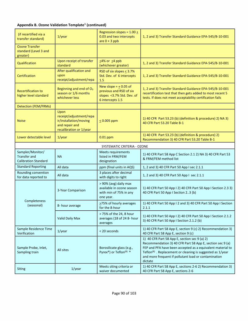
Page 90 of 103
Appendix B. Ozone Validation Template1 (continued)
(if recertified via a transfer standard)
1/year Regression slopes = 1.00 + 0.03 and two intercepts are 0 + 3 ppb
1, 2 and 3) Transfer Standard Guidance EPA-545/B-10-001
Ozone Transfer standard (Level 3 and greater)
Qualification Upon receipt of transfer standard
+4% or +4 ppb (whichever greater)
1, 2 and 3) Transfer Standard Guidance EPA-545/B-10-001
Certification
After qualification and upon receipt/adjustment/repair
RSD of six slopes < 3.7% Std. Dev. of 6 intercepts 1.5
1, 2 and 3) Transfer Standard Guidance EPA-545/B-10-001
Recertification to higher level standard
Beginning and end of O3 season or 1/6 months whichever less
New slope = + 0.05 of previous and RSD of six slopes <3.7% Std. Dev. of 6 intercepts 1.5
1, 2 and 3) Transfer Standard Guidance EPA-545/B-10-001 recertification test that then gets added to most recent 5 tests. If does not meet acceptability certification fails
Detection (FEM/FRMs)
Noise
Upon receipt/adjustment/repair/installation/moving and repair and recalibration or 1/year
< 0.005 ppm 1) 40 CFR Part 53.23 (b) (definition & procedure) 2) NA 3) 40 CFR Part 53.20 Table B-1
Lower detectable level 1/year 0.01 ppm 1) 40 CFR Part 53.23 (b) (definition & procedure) 2) Recommendation 3) 40 CFR Part 53.20 Table B-1
SYSTEMATIC CRITERIA - OZONE
Sampler/Monitor/ Transfer and Calibration Standard
NA Meets requirements listed in FRM/FEM designation
1) 40 CFR Part 58 App C Section 2.1 2) NA 3) 40 CFR Part 53 & FRM/FEM method list
Standard Reporting Units
All data ppm (final units in AQS) 1, 2 and 3) 40 CFR Part 50 App I sec 2.1.1
Rounding convention for data reported to AQS
All data 3 places after decimal with digits to right truncated
1, 2 and 3) 40 CFR Part 50 App I sec 2.1.1
Completeness (seasonal)
3-Year Comparison
> 90% (avg) daily max available in ozone season with min of 75% in any one year.
1) 40 CFR Part 50 App I 2) 40 CFR Part 50 App I Section 2.3 3) 40 CFR Part 50 App I Section 2..3 (b)
8- hour average >75% of hourly averages for the 8-hour
1) 40 CFR Part 50 App I 2 and 3) 40 CFR Part 50 App I Section 2.1.1
Valid Daily Max > 75% of the 24, 8 hour averages (18 of 24 8- hour averages
1) 40 CFR Part 50 App I 2) 40 CFR Part 50 App I Section 2.1.2 3) 40 CFR Part 50 App I Section 2.1.2 (b)
Sample Residence Time Verification
1/year < 20 seconds 1) 40 CFR Part 58 App E, section 9 (c) 2) Recommendation 3) 40 CFR Part 58 App E, section 9 (c)
Sample Probe, Inlet, Sampling train
All sites Borosilicate glass (e.g., Pyrex®) or Teflon(R) ®
1) 40 CFR Part 58 App E, section sec 9 (a) 2) Recommendation 3) 40 CFR Part 58 App E, section sec 9 (a) FEP and PFA have been accepted as a equivalent material to Teflon(R) . Replacement or cleaning is suggested as 1/year and more frequent if pollutant load or contamination dictate
Siting 1/year Meets siting criteria or waiver documented
1) 40 CFR Part 58 App E, sections 2-6 2) Recommendation 3) 40 CFR Part 58 App E, sections 2-6

Page 91 of 103
Appendix B. Ozone Validation Template1 (continued)
EPA Standard Ozone Reference Photometer (SRP) Recertification (Level 1)
1/year Regression slope = 1.00 + 0.01 and intercept < 3 ppb
1,2 and 3) Transfer Standard Guidance EPA-454/B-10-001 This is usually at a Regional Office and is compared against the traveling SRP
Precision(using 1-point QC checks)
Calculated annually and as appropriate for design
value estimates 90% CL CV < 7%
1) 40 CFR Part 58 App A 2.3.1.2 & 3.2.1 2) 40 CFR Part 58 App A sec 4 (b) 3) 40 CFR Part 58 App A sec 4.1.2
Bias (using 1-point QC checks)
Calculated annually and as appropriate for design value estimates
95% CL < + 7% 1) 40 CFR Part 58 App A 2.3.1.2 & 3.2.1 2) 40 CFR Part 58 App A sec 4 (b) 3) 40 CFR Part 58 App A sec 4.1.3
Annual PE Primary QA Organization (PQAO) Evaluation
1/year
95% of audit percent differences fall within the one point QC check 95% probability intervals at
PQAO level of aggregation
1) 40 CFR Part 58 App A Section 3.2.2 2) Recommendation 3) 40 CFR Part 58 App A sec 4.1.4 & 4.1.5
1 Table reproduced from OAQPS’ Quality Assurance Handbook for Air Pollution Measurement Systems. Volume II Ambient Air Quality Monitoring Program EPA-454/B-13-003 May, 2013. Appendix D. Revision No. 0. http://www.epa.gov/ttnamti1/files/ambient/pm25/qa/QA-Handbook-Vol-II.pdf 2 Match numbered details within the 4) Information/Action column with columns (1) Requirement (O3), (2) Frequency, and (3) Acceptance Criteria.

Page 92 of 103
Appendix C. Ozone Season by State1 (continued)
State Begin month End month
Alabama March October
Alaska April October
Arizona January December
Arkansas March November
California January December
Colorado March September
Connecticut April September
Delaware April October
District of Columbia April October
Florida March October
Georgia March October
Hawaii January December
Idaho May September
Illinois April October
Indiana April September
Iowa April October
Kansas April October
Kentucky March October
Louisiana AQCR2 019,022 March October
Louisiana AQCR 106 January December
Maine April September
Maryland April October
Massachusetts April September
Michigan April September
Minnesota April October
Mississippi March October
Missouri April October
Montana June September
Nebraska April October
Nevada January December
New Hampshire April September
New Jersey April October
New Mexico January December
New York April October
North Carolina April October
North Dakota May September
Ohio April October
Oklahoma March November
Oregon May September
Pennsylvania April October
Puerto Rico January December
Rhode Island April September
South Carolina April October
South Dakota June September
Tennessee March October
Texas AQCR 106,153, 213, 214, 216 January December
Texas AQCR 022, 210, 211, 212, 215, 217, 218 March October
Utah May September
Vermont April September
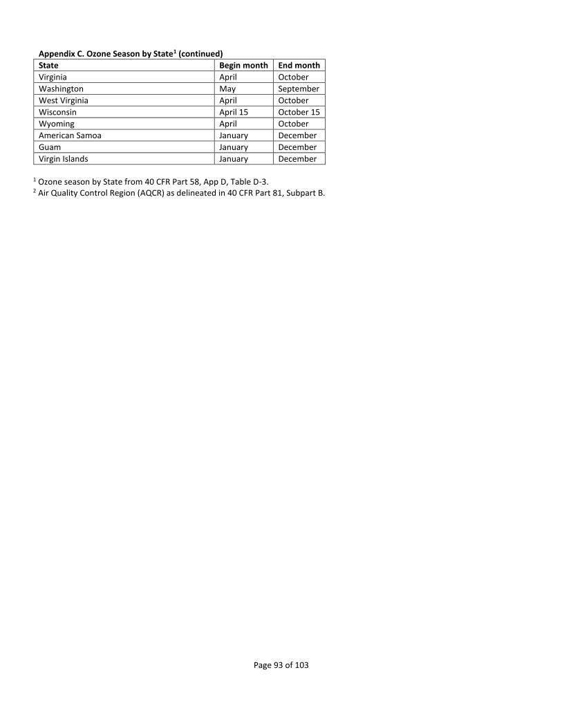
Page 93 of 103
Appendix C. Ozone Season by State1 (continued)
State Begin month End month
Virginia April October
Washington May September
West Virginia April October
Wisconsin April 15 October 15
Wyoming April October
American Samoa January December
Guam January December
Virgin Islands January December
1 Ozone season by State from 40 CFR Part 58, App D, Table D-3. 2 Air Quality Control Region (AQCR) as delineated in 40 CFR Part 81, Subpart B.
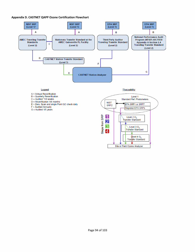
Page 94 of 103
Appendix D. CASTNET QAPP Ozone Certification Flowchart

Page 95 of 103
Appendix E. EPA Regional Office Contacts Information
EPA Region Name Phone Email
Region 1 Judge, Robert 617-918-8387 [email protected]
Region 2 Ruvo, Richard A.; Mustafa, Mustafa
212-637-4014; 732-906-6881
[email protected]; [email protected]
Region 3 Hyden, Loretta 215-814-2113 [email protected]
Region 4 Rinck, Todd; Garver, Daniel
404-562-9062; 404-562-9839
[email protected]; [email protected]
Region 5 McGrath, Jesse 312-886-1532 [email protected]
Region 6 Sather, Mark 214-665-8353 [email protected]
Region 7 Nichols, Robert; Grooms, Leland
913-551-5266; 913-551-5010
[email protected]; [email protected]
Region 8 Payton, Richard; Rickard, Joshua
303-312-6439; 303-312-6460
[email protected]; [email protected]
Region 9 Biland, Larry; Felix, Elfego
415-947-4132;
415-947-4141 [email protected]; [email protected]
Region 10 Hall, Christopher 206-553-0521 [email protected]

Page 96 of 103
Appendix F. Outline for TSA Report 1. Executive Summary 2. Introduction 3. General Program and Quality Management (Audit of EPA contractor’s office and NPS contractor’s office)
a. Complete General/Quality Management Forms b. Findings, Discussions, Recommendations
4. Network Management a. Complete Network Management, Field Support, Instrument Certification/Testing, Standards and Calibrations, and
Instrument Repair Forms b. Table listing the site locations, number of monitors at each location, type of monitor (SLAMS, SPM, etc…), what is
measured c. Findings, Discussions, Recommendations
5. Field Operations a. Complete Field Overview Forms b. Table that list site name, AQS ID, and pollutants monitored c. Findings, Discussions, Recommendations
6. Laboratory Operations a. Complete Laboratory Operations Forms b. Findings, Discussions, Recommendations
7. Data and Data Management a. Complete Data and Data Management Forms b. Findings, Discussions, Recommendations
8. Quality Control and Quality Assurance

Page 97 of 103
Appendix G. Current list of 40 CFR Part 58 Compliant CASTNET Ozone Monitoring Sites (continued) EPA RGN
ST AQS_ID POC SITE_ID AGY PQAO1 COUNTY NOTES ‘112 ‘12 ‘13 ‘14 ‘15
1 CT 090159991 1 ABT147 EPA EPA Windham Y Y Y Y Y
1 ME 230039991 1 ASH135 EPA EPA Aroostook Y Y Y Y Y
1 ME 230090103 1 ACA416 NPS ME Hancock Y Y Y Y Y
1 ME 230199991 1 HOW132 EPA EPA Penobscot Discontinued 10/2012
Y Y
1 NH 330099991 1 WST109 EPA EPA Grafton Y Y Y Y Y
2 NJ 340219991 1 WSP144 EPA EPA Mercer Y Y Y Y Y
2 NY 360319991 1 HWF187 EPA EPA Essex Y Y Y Y Y
2 NY 361099991 1 CTH110 EPA EPA Tompkins Y Y Y Y Y
3 MD 240199991 1 BWR139 EPA EPA Dorchester Y Y Y Y Y
3 MD 240339991 1 BEL116 EPA EPA Prince George's
Y Y Y Y Y
3 PA 420019991 1 ARE128 EPA EPA Adams Y Y Y Y Y
3 PA 420279991 1 PSU106 EPA EPA Centre Y Y Y Y Y
3 PA 420479991 1 KEF112 EPA EPA Elk Y Y Y Y Y
3 PA 420859991 1 MKG113 EPA EPA Mercer Y Y Y Y Y
3 PA 421119991 1 LRL117 EPA EPA Somerset Y Y Y Y Y
3 VA 510719991 1 VPI120 EPA EPA Giles Y Y Y Y Y
3 VA 511130003 1 SHN418 NPS NPS Madison Y Y Y Y Y
3 VA 511479991 1 PED108 EPA EPA Prince Edward
Y Y Y Y Y
3 WV 540219991 1 CDR119 EPA EPA Gilmer Y Y Y Y Y
3 WV 540939991 1 PAR107 EPA EPA Tucker Y Y Y Y Y
4 AL 010499991 1 SND152 EPA EPA DeKalb Y Y Y Y Y
4 FL 120619991 1 IRL141 EPA EPA Indian River Y Y Y Y Y
4 FL 120779991 1 SUM156 EPA EPA Liberty Y Y Y Y Y
4 GA 132319991 1 GAS153 EPA EPA Pike Y Y Y Y Y
4 KY 210610501 1 MAC426 NPS NPS Edmonson Y Y Y Y Y
4 KY 211759991 1 CKT136 EPA EPA Morgan Y Y Y Y Y
4 KY 212219991 1 CDZ171 EPA EPA Trigg Y Y Y Y Y
4 KY 212299991 1 MCK131 EPA EPA Washington Y Y Y Y Y
4 KY 212299991 2 MCK231 EPA EPA Washington QA only beginning 1/1/20153
Y Y Y Y
4 MS 281619991 1 CVL151 EPA EPA Yalobusha Y Y Y Y Y
4 NC 370119991 1 PNF126 EPA EPA Avery Y Y Y Y Y
4 NC 370319991 1 BFT142 EPA EPA Carteret Y Y Y Y Y
4 NC 371139991 1 COW137 EPA EPA Macon Y Y Y Y Y
4 NC 371239991 1 CND125 EPA EPA Montgomery Y Y Y Y Y
4 TN 470090101 1 GRS420 NPS NPS Blount Y Y Y Y Y
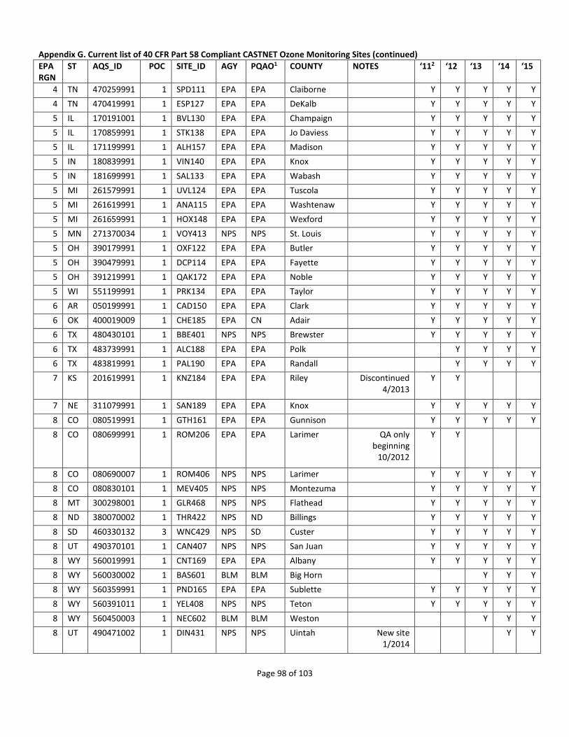
Page 98 of 103
Appendix G. Current list of 40 CFR Part 58 Compliant CASTNET Ozone Monitoring Sites (continued) EPA RGN
ST AQS_ID POC SITE_ID AGY PQAO1 COUNTY NOTES ‘112 ‘12 ‘13 ‘14 ‘15
4 TN 470259991 1 SPD111 EPA EPA Claiborne Y Y Y Y Y
4 TN 470419991 1 ESP127 EPA EPA DeKalb Y Y Y Y Y
5 IL 170191001 1 BVL130 EPA EPA Champaign Y Y Y Y Y
5 IL 170859991 1 STK138 EPA EPA Jo Daviess Y Y Y Y Y
5 IL 171199991 1 ALH157 EPA EPA Madison Y Y Y Y Y
5 IN 180839991 1 VIN140 EPA EPA Knox Y Y Y Y Y
5 IN 181699991 1 SAL133 EPA EPA Wabash Y Y Y Y Y
5 MI 261579991 1 UVL124 EPA EPA Tuscola Y Y Y Y Y
5 MI 261619991 1 ANA115 EPA EPA Washtenaw Y Y Y Y Y
5 MI 261659991 1 HOX148 EPA EPA Wexford Y Y Y Y Y
5 MN 271370034 1 VOY413 NPS NPS St. Louis Y Y Y Y Y
5 OH 390179991 1 OXF122 EPA EPA Butler Y Y Y Y Y
5 OH 390479991 1 DCP114 EPA EPA Fayette Y Y Y Y Y
5 OH 391219991 1 QAK172 EPA EPA Noble Y Y Y Y Y
5 WI 551199991 1 PRK134 EPA EPA Taylor Y Y Y Y Y
6 AR 050199991 1 CAD150 EPA EPA Clark Y Y Y Y Y
6 OK 400019009 1 CHE185 EPA CN Adair Y Y Y Y Y
6 TX 480430101 1 BBE401 NPS NPS Brewster Y Y Y Y Y
6 TX 483739991 1 ALC188 EPA EPA Polk Y Y Y Y
6 TX 483819991 1 PAL190 EPA EPA Randall Y Y Y Y
7 KS 201619991 1 KNZ184 EPA EPA Riley Discontinued 4/2013
Y Y
7 NE 311079991 1 SAN189 EPA EPA Knox Y Y Y Y Y
8 CO 080519991 1 GTH161 EPA EPA Gunnison Y Y Y Y Y
8 CO 080699991 1 ROM206 EPA EPA Larimer QA only beginning
10/2012
Y Y
8 CO 080690007 1 ROM406 NPS NPS Larimer Y Y Y Y Y
8 CO 080830101 1 MEV405 NPS NPS Montezuma Y Y Y Y Y
8 MT 300298001 1 GLR468 NPS NPS Flathead Y Y Y Y Y
8 ND 380070002 1 THR422 NPS ND Billings Y Y Y Y Y
8 SD 460330132 3 WNC429 NPS SD Custer Y Y Y Y Y
8 UT 490370101 1 CAN407 NPS NPS San Juan Y Y Y Y Y
8 WY 560019991 1 CNT169 EPA EPA Albany Y Y Y Y Y
8 WY 560030002 1 BAS601 BLM BLM Big Horn Y Y Y
8 WY 560359991 1 PND165 EPA EPA Sublette Y Y Y Y Y
8 WY 560391011 1 YEL408 NPS NPS Teton Y Y Y Y Y
8 WY 560450003 1 NEC602 BLM BLM Weston Y Y Y
8 UT 490471002 1 DIN431 NPS NPS Uintah New site 1/2014
Y Y

Page 99 of 103
Appendix G. Current list of 40 CFR Part 58 Compliant CASTNET Ozone Monitoring Sites (continued) EPA RGN
ST AQS_ID POC SITE_ID AGY PQAO1 COUNTY NOTES ‘112 ‘12 ‘13 ‘14 ‘15
9 AZ 040038001 1 CHA467 NPS NPS Cochise Y Y Y Y Y
9 AZ 040058001 1 GRC474 NPS NPS Coconino Y Y Y Y Y
9 AZ 040170119 1 PET427 NPS NPS Navajo Y Y Y Y Y
9 CA 060430003 1 YOS404 NPS NPS Mariposa Y Y Y Y Y
9 CA 060690003 1 PIN414 NPS NPS San Benito Y Y Y Y Y
9 CA 060719002 1 JOT403 NPS NPS San Bernardino
Y Y Y Y Y
9 CA 060893003 1 LAV410 NPS NPS Shasta Y Y Y Y Y
9 CA 061070009 1 SEK430 NPS NPS Tulare Y Y Y Y Y
9 NV 320330101 1 GRB411 NPS NPS White Pine Y Y Y Y Y
10 AK 020680003 1 DEN417 NPS NPS Denali Y Y Y Y Y
10 WA 530531010 1 MOR409 NPS NPS Pierce Discontinued 11/2013
Y Y Y
Network Total Sites4
77 78 78 78 77
1 See Appendix I for details on PQAO 2 Year column indicates monitor may be compared to the NAAQS for that year 3 Bold font indicates status change to the monitor for the upcoming year 4 Network Total Sites does not include the two NAAQS-excluded monitors (ROM206 and MCK231)

Page 100 of 103
Appendix H. CBSA Code and Title for CASTNET Sites (continued) EPA RGN
AQS ID POC CASTNET ID
STATE COUNTY DV PPB1
CBSA2 POP.3
1 090159991 1 ABT147 CT Windham Willimantic, CT
1 230039991 1 ASH135 ME Aroostook
1 230090103 1 ACA416 ME Hancock 65
1 230199991 1 HOW132 ME Penobscot Bangor, ME 153,923
1 330099991 1 WST109 NH Grafton Lebanon, NH-VT
2 340219991 1 WSP144 NJ Mercer 76 Trenton-Ewing, NJ 366,513
2 360319991 1 HWF187 NY Essex
2 361099991 1 CTH110 NY Tompkins Ithaca, NY 101,564
3 240199991 1 BWR139 MD Dorchester 75 Cambridge, MD
3 240339991 1 BEL116 MD Prince George's
80 Washington-Arlington-Alexandria, DC-VA-MD-WV
5,582,170
3 420019991 1 ARE128 PA Adams Gettysburg, PA
3 420279991 1 PSU106 PA Centre 72 State College, PA 153,990
3 420479991 1 KEF112 PA Elk St. Marys, PA
3 420859991 1 MKG113 PA Mercer Youngstown-Warren-Boardman, OH-PA
565,773
3 421119991 1 LRL117 PA Somerset 65 Somerset, PA
3 510719991 1 VPI120 VA Giles 63 Blacksburg-Christiansburg-Radford, VA
162,958
3 511130003 1 SHN418 VA Madison 69
3 511479991 1 PED108 VA Prince Edward
62
3 540219991 1 CDR119 WV Gilmer 60
3 540939991 1 PAR107 WV Tucker
4 010499991 1 SND152 AL DeKalb 66 Fort Payne, AL
4 120619991 1 IRL141 FL Indian River 65 Sebastian-Vero Beach, FL 138,028
4 120779991 1 SUM156 FL Liberty
4 132319991 1 GAS153 GA Pike 72 Atlanta-Sandy Springs-Marietta, GA
5,268,860
4 210610501 1 MAC426 KY Edmonson 71 Bowling Green, KY 125,953
4 211759991 1 CKT136 KY Morgan
4 212219991 1 CDZ171 KY Trigg Clarksville, TN-KY 273,949
4 212299991 1 MCK131 KY Washington 69
4 212299991 2 MCK231 KY Washington
4 281619991 1 CVL151 MS Yalobusha 63
4 370119991 1 PNF126 NC Avery 63
4 370319991 1 BFT142 NC Carteret Morehead City, NC
4 371139991 1 COW137 NC Macon
4 371239991 1 CND125 NC Montgomery 66
4 470090101 1 GRS420 TN Blount 74 Knoxville, TN 698,030
4 470259991 1 SPD111 TN Claiborne 62
4 470419991 1 ESP127 TN DeKalb
5 170191001 1 BVL130 IL Champaign Champaign-Urbana, IL 231,891
5 170859991 1 STK138 IL Jo Daviess 68
5 171199991 1 ALH157 IL Madison 76 St. Louis, MO-IL 2,812,896

Page 101 of 103
Appendix H. CBSA Code and Title for CASTNET Sites (continued) EPA RGN
AQS ID POC CASTNET ID
STATE COUNTY DV PPB1
CBSA2 POP.3
5 180839991 1 VIN140 IN Knox 73 Vincennes, IN
5 181699991 1 SAL133 IN Wabash Wabash, IN
5 261579991 1 UVL124 MI Tuscola
5 261619991 1 ANA115 MI Washtenaw Ann Arbor, MI 344,791
5 261659991 1 HOX148 MI Wexford Cadillac, MI
5 271370034 1 VOY413 MN St. Louis 59 Duluth, MN-WI 279,771
5 390179991 1 OXF122 OH Butler 77 Cincinnati-Middletown, OH-KY-IN
2,130,151
5 390479991 1 DCP114 OH Fayette 72 Washington Court House, OH
5 391219991 1 QAK172 OH Noble
5 551199991 1 PRK134 WI Taylor 63
6 050199991 1 CAD150 AR Clark Arkadelphia, AR
6 400019009 1 CHE185 OK Adair 75
6 480430101 1 BBE401 TX Brewster 71
6 483739991 1 ALC188 TX Polk
6 483819991 1 PAL190 TX Randall Amarillo, TX 249,881
7 311079991 1 SAN189 NE Knox 68
8 080519991 1 GTH161 CO Gunnison
8 080690007 1 ROM406 CO Larimer 76 Fort Collins-Loveland, CO 299,630
8 080699991 1 ROM206 CO Larimer Fort Collins-Loveland, CO 299,630
8 080830101 1 MEV405 CO Montezuma 69
8 300298001 1 GLR468 MT Flathead 54 Kalispell, MT
8 380070002 1 THR422 ND Billings 57 Dickinson, ND
8 460330132 3 WNC429 SD Custer 63
8 490370101 1 CAN407 UT San Juan 69
8 490471002 1 DIN431 UT Uintah Vernal, UT
8 560019991 1 CNT169 WY Albany Laramie, WY
8 560030002 1 BAS601 WY Big Horn
8 560359991 1 PND165 WY Sublette
8 560391011 1 YEL408 WY Teton 65 Jackson, WY-ID
8 560450003 1 NEC602 WY Weston
9 040038001 1 CHA467 AZ Cochise 73 Sierra Vista-Douglas, AZ
9 040058001 1 GRC474 AZ Coconino 72 Flagstaff, AZ 134,421
9 040170119 1 PET427 AZ Navajo 70 Show Low, AZ
9 060430003 1 YOS404 CA Mariposa 77
9 060430003 2 YOS204 CA Mariposa
9 060690003 1 PIN414 CA San Benito 70 San Jose-Sunnyvale-Santa Clara, CA
1,836,911
9 060719002 1 JOT403 CA San Bernardino
90 Riverside-San Bernardino-Ontario, CA
4,224,851
9 060893003 1 LAV410 CA Shasta 68 Redding, CA 177,223
9 061070009 1 SEK430 CA Tulare 93 Visalia-Porterville, CA 442,179
9 320330101 1 GRB411 NV White Pine 74
10 020680003 1 DEN417 AK Denali 52

Page 102 of 103
Appendix H. CBSA Code and Title for CASTNET Sites (continued) EPA RGN
AQS ID POC CASTNET ID
STATE COUNTY DV PPB1
CBSA2 POP.3
10 530531010 1 MOR409 WA Pierce 52 Seattle-Tacoma-Bellevue, WA
3,439,809
1 Design values are displayed for the 2011-2013 sampling period when data completeness is sufficient. These values originate from OAQPS’ Air Trends website: http://epa.gov/airtrends/values.html 2 CBSA = Core Based Statistical Area - A statistical geographic entity consisting of the county or counties associated with at least one core (urbanized area or urban cluster) of at least 10,000 population, plus adjacent counties having a high degree of social and economic integration with the core as measured through commuting ties with the counties containing the core. Definitions of statistical areas are from the Office of Management and Budget Federal Register Notice Vol 65, No. 249. December 27, 2000. http://www.whitehouse.gov/sites/default/files/omb/fedreg/metroareas122700.pdf 3POP. = CBSA 2010 Census https://www.census.gov/popest/data/historical/2010s/vintage_2011/metro.html

Page 103 of 103
Appendix I. Summary of CASTNET Ozone Monitoring Sites – 2015
2015 SUMMARY
PQAO1 PQAO Name Number of Sites
1344 Environmental Protection Agency – Clean Air Markets Division 522
0745 National Park Service – Air Resources Division 21
1366 Bureau of Land Management – Wyoming State Office 2
905 Cherokee Nation 1
0973 South Dakota – Department of Environment and Natural Resources 1
0782 North Dakota – Department of Health 1
0635 Maine Department of Environmental Protection – Bureau of Air Quality Control 1
Total 79
1 Principal Quality Assurance Organization (PQAO) as identified within the AQS AMP480 report. 2 EPA-CAMD’s site count of 52 includes two NAAQS Excluded ozone monitors: the EPA-sponsored QA monitor in Rocky Mountain National Park, CO (ROM206) and the collocated QA monitor in Mackville, KY (MCK231).