20150112 hudson bay park ntr - saskatoon.ca · hudson bay park neighbourhood traffic review january...
TRANSCRIPT

HudsonBayParkNeighbourhoodTrafficReview
January 12, 2015
Transportation&UtilitiesDepartment
CityofSaskatoon

Hudson Bay Park Neighbourhood Traffic Review
January 12, 2015 i City of Saskatoon
Acknowledgements
The completion of this review would not be possible without the contribution of the
following organizations and individuals:
Hudson Bay Park residents
Hudson Bay Park Community Association
Saskatoon Police Service
Saskatoon Light & Power
City of Saskatoon Fire Department
City of Saskatoon Environmental Services
City of Saskatoon Transit
City of Saskatoon Transportation
Great Works Consulting
Councillor Darren Hill

Hudson Bay Park Neighbourhood Traffic Review
January 12, 2015 ii City of Saskatoon
Executive Summary
The objective of the Neighbourhood Traffic Management Program is to address traffic
concerns within neighbourhoods such as speeding, shortcutting, and pedestrian safety.
The program was revised in August 2013 to address traffic concerns on a
neighbourhood-wide basis. The revised program involves additional community and
stakeholder consultation that provides the environment for neighbourhood residents and
City staff to work together in developing solutions that address traffic concerns. The
process is outlined in the Traffic Calming Guidelines and Tools, City of Saskatoon,
2013.
A public meeting was held in April of 2014 to identify traffic concerns and potential
solutions within the Hudson Bay Park neighbourhood. As a result of the meeting a
number of traffic assessments were completed to confirm and quantify the concerns
raised by the residents. Based on the residents input and the completed traffic
assessments, a Traffic Management Plan was developed and presented to the
community at a follow-up meeting held in October 2014.
A summary of recommended improvements for the Hudson Bay Park neighbourhood
are included in Table ES-1. The summary identifies the locations, the recommended
improvement, and a schedule for implementation. The schedule to implement the Traffic
Management Plan can vary depending on the complexity of the proposed improvement.
According to the Traffic Calming Guidelines and Tools document, the time frame may
range from short-term (1 to 2 year); medium-term (3 to 5 years) and long-term (5 years
plus). Accordingly, the specific time frame to implement the improvements for these
neighbourhoods ranges from 1 to 5 years.
The resulting proposed Hudson Bay Park Traffic Management Plan is illustrated in
Exhibit ES-1.

Hudson Bay Park Neighbourhood Traffic Review
January 12, 2015 iii City of Saskatoon
Table ES-1: Hudson Bay Park Neighbourhood Recommended Improvements
Location Recommended Improvement Time Frame
Avenue P & Bowerman Street Install stop sign
1 to 2 years
Avenue P & Edmonton Avenue Install stop sign
Avenue H & 31st Street Install zebra crosswalks (north and
south legs)
Faulkner Crescent & McMillan Avenue
Upgrade yield sign to stop sign (northbound)
32nd Street at Avenue I, Avenue J, Avenue K, &
Avenue L Install yield signs
McMillan Avenue (curve north of 31st Street)
Install median islands on north & south side of crosswalk/curve
3 to 5 years (devices will be
installed temporarily until
proven effective)
Avenue I & 37th Street Install median island & standard
crosswalk (north leg)
Avenue I & 36th Street Install median island (north leg)
Valens Drive (in front of Henry Kelsey School)
Install permanent curb extension
5 years plus Avenue I between Howell
Avenue & 36th Street Install sidewalk (on west side/park
side)

4
5
81
2
3
9
6
7
2 2 2
LOCATION MEASURE PROPOSED
MEDIAN ISLANDS
YIELD SIGN
CURB EXTENSION (PERMANENT)
MEDIAN ISLAND
MEDIAN ISLAND
STOP SIGN
STOP SIGN
ZEBRA CROSSWALK
SIDEWALK
1
2
3
4
5
6
7
8
9
EXISTING TRAFFIC SIGNAL
EXISTING STOP SIGN
EXISTING YIELD SIGN
BUS ROUTE
EXISTING TRAFFICCALMING LOCATION
PEDESTRIAN ACTUATEDSIGNAL LOCATION
PROPOSED TRAFFIC CALMING(MAYFAIR NEIGHBOURHOOD TRAFFIC PLAN)

Hudson Bay Park Neighbourhood Traffic Review
January 12, 2015 v City of Saskatoon
TABLE OF CONTENTS
Acknowledgements ........................................................................................................ i
Executive Summary ...................................................................................................... ii
1. Introduction .............................................................................................................. 1
2. Identifying Issues, Concerns, & Possible Solutions .................................................. 1
3. Assessment ............................................................................................................. 6
4. Plan Development .................................................................................................. 10
5. Recommended Plan and Cost Estimates ............................................................... 13
APPENDICES
A. 33rd Street Concerns
B. All Way Stop Assessments
C. Pedestrian Device Assessments
D. Recommendation Review Matrix

Hudson Bay Park Neighbourhood Traffic Review
January 12, 2015 vi City of Saskatoon
LIST OF TABLES
Table 3-1: City of Saskatoon Street Classifications and Characteristics ......................... 7
Table 3-2: Speed Studies and Average Daily Traffic Counts (2014) ............................... 8
Table 3-3: All-way Stop Assessments ............................................................................. 9
Table 3-4: Pedestrian Assessment ............................................................................... 10
Table 4-1: Recommended Improvements to Reduce Speeding and Shortcutting ......... 11
Table 4-2: Recommended Pedestrian Safety Improvements – School Sites ................ 11
Table 4-3: Recommended Traffic Control Improvements .............................................. 12
Table 4-4: Adjusted Recommended Improvements ...................................................... 13
Table 4-5: Added Improvements ................................................................................... 13
Table 5-1: Traffic Calming Cost Estimate ...................................................................... 14
Table 5-2: Marked Pedestrian Crosswalks Cost Estimate ............................................. 15
Table 5-3: Traffic Control Cost Estimate ....................................................................... 15
Table 5-4: Sidewalk Cost Estimate................................................................................ 15
Table 5-5: Hudson Bay Park Neighbourhood Recommended Improvements ............... 16
LIST OF EXHIBITS
Exhibit 5-1: Recommended Hudson Bay Park Traffic Management Plan ..................... 17

Hudson Bay Park Neighbourhood Traffic Review
January 12, 2015 1 City of Saskatoon
1. Introduction
The purpose of this project was to develop a Traffic Management Plan for the Hudson
Bay Park neighbourhood following the implementation procedure outlined in the City of
Saskatoon Traffic Calming Guidelines and Tools adopted by City Council in August
2013.
The Hudson Bay Park neighbourhood is located on the west side of the South
Saskatchewan River and is bound by Circle Drive to the northwest, 31st Street to the
south, and Avenue I to the east. The neighbourhood is intersected by 33rd Street, a
major arterial which carries high volumes of traffic between the west end and the
downtown and core areas of the city. The area use is mostly residential, with an
elementary school (Henry Kelsey School) on Valens Drive and 33rd Street West.
The development and implementation of the traffic management plan includes four
stages:
Stage 1 - Identify existing problems, concerns and possible solutions through the
initial neighbourhood consultation and the Shaping Saskatoon Website.
Stage 2 - Develop a draft traffic plan based on resident’s input and traffic
assessments.
Stage 3 - Present the draft traffic plan to the neighbourhood at a follow-up meeting;
circulate the plan to other civic divisions for feedback; make adjustments as needed;
and present the plan to City Council for approval.
Stage 4 - Implement the proposed measures in specific time frame, short term (1 to
2 years), medium term (3 to 5 years) or long term (5 years plus).
2. Identifying Issues, Concerns, & Possible Solutions
A public meeting was held in April of 2014 to identify traffic concerns within the
neighbourhood. At the meeting, residents were given the opportunity to express their
concerns and suggest possible solutions.
The following pages summarize the concerns and suggested solutions identified during
the initial consultation with the neighbourhood residents.

Hudson Bay Park Neighbourhood Traffic Review
January 12, 2015 2 City of Saskatoon
CONCERN 1 – SPEEDING AND SHORTCUTTING
Shortcutting occurs when non-local traffic passes through the neighbourhood on local
streets which are designed and intended for low volumes of traffic. In the case of
Hudson Bay Park, the nearby arterial streets (33rd St, and Avenue I) are designated to
accommodate larger volumes of traffic.
As speeding often accompanies shortcutting, these concerns have been grouped into
one category.
Neighbourhood concerns for speeding and shortcutting were at the following
locations:
Faulkner Crescent: shortcutting to avoid the traffic signals at Avenue P & 33rd Street
Howell Avenue McMillan Avenue: speeding near park; shortcutting between 29th Street & 33rd
Street Eby Street: school buses speeding Avenue P at Bowerman Street & Edmonton Avenue: offset intersections; drivers
speeding around corners Valens Drive
Proposed solutions identified by residents:
Install median islands on Faulkner Crescent Speed humps Roundabouts Enforcement Extend Edmonton Avenue to reduce shortcutting on Howell Avenue 40kph speed limit on residential streets Install stop signs (Avenue P at Bowerman Street & Edmonton Avenue) Install yield signs at all uncontrolled intersections between Avenue L, Avenue H,
29th Street, & 33rd Street. Snow clearing around median islands may be an issue; extend parking
restrictions to ensure clearance for graders.

Hudson Bay Park Neighbourhood Traffic Review
January 12, 2015 3 City of Saskatoon
CONCERN 2 - PEDESTRIAN SAFETY
A majority of the residents were concerned about pedestrian safety surrounding the
school sites and parks within Hudson Bay Park (Henry Kelsey School, Henry Kelsey
Park, Pierre Radisson Park).
Pedestrian crosswalks need to adhere to the City of Saskatoon Council Policy C07-018
Traffic Control at Pedestrian Crossings, November 15, 2004 which states the following:
“The installation of appropriate traffic controls at pedestrian
crossings shall be based on warrants listed in the document entitled
“Traffic Control at Pedestrian Crossings – 2004” approved by City
Council in 2004.”
Neighbourhood concerns regarding pedestrian safety were at the following
locations:
McMillan Avenue: near park Valens Drive: parking over crosswalk; U-turns Avenue I & 36th Street U-turns in school zone
Proposed solutions identified by residents:
Install sidewalk on Avenue I between Howell Avenue & 36th Street on park side (Henry Kelsey Park)
Install pedestrian/cyclist crossing on Circle Drive from Avenue P to Glenwood Avenue and/or Henry Kelsey North Park to south end of Cardinal Place; crossing Circle Drive (i.e. tunnel, bridge)
Place signs to identify parks / playgrounds & areas where kids are playing 40kph speed limit all year round at school zones, parks, & playgrounds Install cameras or unmarked police cars to address U-turns in school zone Public safety blitz School provide staff in the morning to help children and tell drivers not to park in
crosswalk Consideration for effects of traffic calming devices and cyclists

Hudson Bay Park Neighbourhood Traffic Review
January 12, 2015 4 City of Saskatoon
CONCERN 3 – PARKING
Parking is allowed on all city streets unless signage is posted. According to City of
Saskatoon Bylaw 7200, The Traffic Bylaw, vehicles are restricted from parking within
10 metres of an intersection and one metre of a driveway crossing.
Neighbourhood concerns regarding parking were at the following locations:
Buses park in front of Henry Kelsey School on Valens Drive around the curve, limiting visibility.
Parking over the crosswalk in front of the Henry Kelsey School Parking congestion around the Oliver Lodge
Proposed solutions identified by residents:
Move the school bus loading zone south of the Henry Kelsey School on Valens Drive to improve visibility.

Hudson Bay Park Neighbourhood Traffic Review
January 12, 2015 5 City of Saskatoon
CONCERN 4 – 33rd STREET
Residents identified a number of concerns regarding speeding, shortcutting, and
pedestrian safety along 33rd Street. An extensive review of 33rd Street (between Idylwyld
Drive and Confederation Drive) will begin in 2015. All concerns were documented and
will be included in the review. A list of the 33rd Street concerns are shown in Appendix
A.

Hudson Bay Park Neighbourhood Traffic Review
January 12, 2015 6 City of Saskatoon
3. Assessment
Stage 2 of the plan development included developing a draft traffic management plan.
This was completed through the following actions:
Create a detailed list of all the issues provided by the residents.
Collect historical traffic data and information the City has on file for the
neighbourhood.
Prepare a data collection program that will provide the appropriate information
needed to undertake the assessments.
Complete the data collection, which may include:
o Intersection turning moving counts
o Pedestrian counts
o Daily and weekly traffic counts
o Average speed measurements
Assess the issues by using the information in reference with City policies, bylaws,
and guidelines, transportation engineering design guidelines and technical
documents, and professional engineering judgement.
The following sections provide details on the data collected for traffic volumes (peak
hours, daily, and weekly), travel speed, and pedestrian movements.
1. Traffic Volumes and Travel Speeds
Traffic volumes and travel speeds were measured to assist in determining the need for
traffic calming devices. In Saskatoon the neighbourhood streets are classified typically
as either local or collector streets. Traffic volumes (referred to as Average Daily Traffic)
on these streets should meet the City of Saskatoon guidelines shown in Table 3-1.

Hudson Bay Park Neighbourhood Traffic Review
January 12, 2015 7 City of Saskatoon
Table 3-1: City of Saskatoon Street Classifications and Characteristics
Travel speeds were measured to determine the 85th percentile speed, which is the
speed at which 85 percent of vehicles are travelling at or below. The speed limit in the
Hudson Bay Park area is 50kph, except for school zones (33rd Street and Valens Drive)
where the speed limit is 30kph from September and June, 8:00am to 5:00pm, excluding
weekends.
The speed studies and Average Daily Traffic (ADT) on streets where speeding was
identified as an issue are summarized in Table 3-2.
Characteristics
Classifications
Back Lanes Locals Collectors
Residential Commercial Residential Commercial Residential Commercial
Traffic function Access function only (traffic
movement not a consideration)
Access primary function (traffic movement secondary
consideration)
Traffic movement and land access of equal importance
Average Daily Traffic
(vehicles per day)
<500 <1,000 <1,000 <5,000 <5,000 8,000-10,000
Typical Speed Limits (kph)
20 50 50
Transit Service Not permitted Generally avoided Permitted
Cyclist No restrictions or special
facilities No restrictions or special
facilities No restrictions or special
facilities
Pedestrians Permitted, no special
facilities
Sidewalks on one or both sides
Sidewalks provided where
required
Typically sidewalks provided
both sides
Sidewalks provided where
required
Parking Some restrictions No restrictions or restriction
on one side only Few restrictions other than
peak hour

Hudson Bay Park Neighbourhood Traffic Review
January 12, 2015 8 City of Saskatoon
Table 3-2: Speed Studies and Average Daily Traffic Counts (2014)
Street Between ClassificationAverage Daily Traffic (vpd)
Speed (kph)
McMillan Avenue
29th Street & 30th Street
local
492 46.6
Avenue L 29th Street & 30th Street
568 38.7
Howell Avenue
33rd Street & Avenue I
815 45.6
Faulkner Crescent
33rd Street McMillan Avenue
515 27.3
Avenue I 36th Street & 37th Street
minor collector 1911 55.4
Avenue H 30th Street & 31st Street
arterial 2929 52.2
2. Turning Movement Counts
Turning movement counts were completed to determine the need for an all-way (i.e. 3-
way or 4-way) stop control. All-way stop controls need to the meet City of Saskatoon
Council Policy C07-007 Traffic Control – Use of Stop and Yield Signs, January 26,
2009. Criteria outlined in the policy that may warrant an all-way stop include a peak
hour count greater than 600 vehicles or an ADT greater than 6,000 vehicles per day.
Results of the studies are shown in Table 3-3.

Hudson Bay Park Neighbourhood Traffic Review
January 12, 2015 9 City of Saskatoon
Table 3-3: All-way Stop Assessments
Location Peak Hour
Traffic Count Average Daily Traffic (vpd)
Results
McMillan Avenue & 31st Street 55 610 All-way stop not warranted Avenue H & 31st Street 596 5960
As a result of the assessment there are no an all-way stop controls recommended.
Details of the all-way stop assessments are provided in Appendix B.
3. Pedestrian Assessments
Pedestrian assessments are conducted to determine the need for pedestrian actuated
signalized crosswalks which, in adherence to the City of Saskatoon Council Policy C07-
018 Traffic Control at Pedestrian Crossings, November 15, 2004, are typically active
pedestrian corridor (flashing yellow lights) or pedestrian-actuated signals. A warrant
system assigns points for a variety of conditions that exist at the crossing location,
including:
The number of traffic lanes to be crossed;
the presence of a physical median;
the posted speed limit of the street;
the distance the crossing point is to the nearest protected crosswalk point; and
the number of pedestrian and vehicles at the location.
Pedestrian and traffic data is collected during the five peak hours of: 8:00am-9:00am,
11:30am-1:30pm, and 3:00pm-5:00pm.
In addition, if a pedestrian actuated crosswalk is not warranted, a standard marked
pedestrian crosswalk, or a zebra (i.e. striped crosswalk) may be considered. A summary
of the pedestrian studies are provided in Table 3-4.
Hudson Bay Park Neighbourhood Traffic Review
January 12, 2015 10 City of Saskatoon
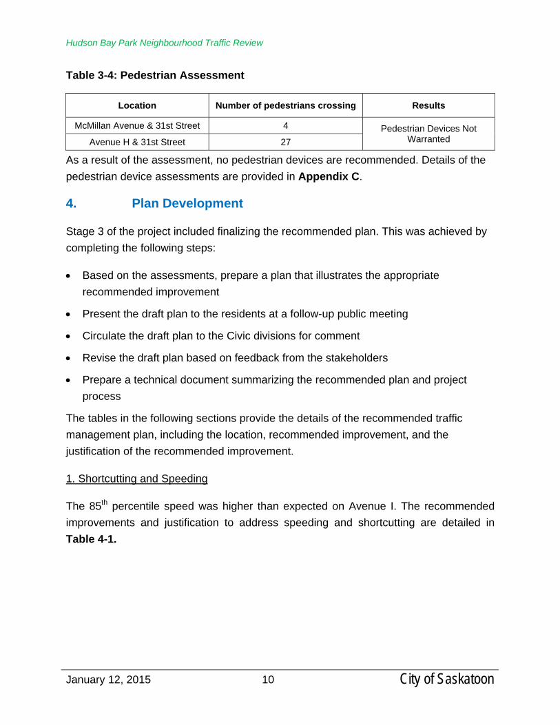
Table 3-4: Pedestrian Assessment
Location Number of pedestrians crossing Results
McMillan Avenue & 31st Street 4 Pedestrian Devices Not Warranted Avenue H & 31st Street 27
As a result of the assessment, no pedestrian devices are recommended. Details of the
pedestrian device assessments are provided in Appendix C.
4. Plan Development
Stage 3 of the project included finalizing the recommended plan. This was achieved by
completing the following steps:
Based on the assessments, prepare a plan that illustrates the appropriate
recommended improvement
Present the draft plan to the residents at a follow-up public meeting
Circulate the draft plan to the Civic divisions for comment
Revise the draft plan based on feedback from the stakeholders
Prepare a technical document summarizing the recommended plan and project
process
The tables in the following sections provide the details of the recommended traffic
management plan, including the location, recommended improvement, and the
justification of the recommended improvement.
1. Shortcutting and Speeding
The 85th percentile speed was higher than expected on Avenue I. The recommended
improvements and justification to address speeding and shortcutting are detailed in
Table 4-1.

Hudson Bay Park Neighbourhood Traffic Review
January 12, 2015 11 City of Saskatoon
Table 4-1: Recommended Improvements to Reduce Speeding and Shortcutting
Location Recommended Improvement1 Justification
Avenue I & 36th Street Raised median island Reduce speed near park
(transit route)
Avenue I & 37th Street Raised median island Reduce speed near park
(transit route)
1 For details on these devices refer to the City of Saskatoon Traffic Calming Guidelines and Tools
2. Pedestrian Safety
Hudson Bay Park residents identified pedestrian safety concerns near the Pierre
Radisson Park (McMillan Avenue) and the Henry Kelsey School (Valens Drive) as a
priority. The safety of the pedestrian environment near schools is important to
encourage people to walk to school, as opposed to being dropped off. There a currently
no marked crosswalks on Avenue H (arterial) between 29th Street and 33rd Street.
Accordingly, the recommended improvements to increase pedestrian safety are detailed
in Table 4-2.
Table 4-2: Recommended Pedestrian Safety Improvements – School Sites
Location Recommended Improvement Purpose
McMillan Avenue (curve north of 31st Street)
Raised median islands (on either side of crosswalk/curve)
Improve pedestrian safety near park/curve
Avenue H & 31st Street Zebra crosswalk
Improve pedestrian (currently no marked crosswalks on
Avenue H between 29th Street & Avenue H)
Valens Drive (in front of Henry Kelsey School)
Permanent curb extension
Improve pedestrian safety (prevents parking within
intersection & over crosswalks; prevents U-turns)
Avenue I & 37th Street Standard pedestrian crosswalk Improve pedestrian safety near
park
Avenue I between Howell Avenue & 36th Street
Install sidewalk (west side only) Improve pedestrian safety near
park
The Active Transportation Plan is a comprehensive city-wide study that will help to
provide more choices for moving around Saskatoon by addressing community and
infrastructure needs for cycling, walking, and other modes of active transportation.

Hudson Bay Park Neighbourhood Traffic Review
January 12, 2015 12 City of Saskatoon
During the public consultation, residents recommended installation of a
pedestrian/cyclist bridge across Circle Drive connecting Hudson Bay Park to the north
side of Circle Drive. Possible connections identified were Ave P to Glenwood Ave are
and/or Henry Kelsey North Park to the south end of Cardinal Place. These may be
reviewed as part of the Active Transportation Plan.
3. Traffic Control
The recommended improvements to intersections that will improve the level of safety by
clearly identifying the right-of-way through traffic controls are provided in Table 4-3.
Table 4-3: Recommended Traffic Control Improvements
Location Recommended Improvement Purpose
Avenue P & Bowerman Street; Avenue P & Edmonton
Avenue Stop sign
Enhance compliance (offset intersection; drivers speeding
around corners; currently uncontrolled)
Faulkner Crescent &
McMillan Avenue Upgrade yield sign to stop sign
Enhance compliance (drivers shortcutting; not stopping at T-
intersection)
32nd Street at Avenue I, Avenue J, Avenue K, &
Avenue L Yield Signs Enhance compliance
4. Parking Improvements
The Administration will discuss parking issues in front of the Henry Kelsey School (ie.
bus loading zones) with the Public School Board and principal of the Henry Kelsey
School.
Follow up Consultation – Presentation of Traffic Management Plan
The initial recommended improvements were presented at a follow-up public meeting in
October 2014. Recommended improvements that were not supported by the residents
were eliminated or altered accordingly. A decision matrix detailing the list of
recommended improvements presented at the follow-up meeting are included in
Appendix D. A decision matrix for additional comments received after the draft traffic
plan is also included in Appendix D.

Hudson Bay Park Neighbourhood Traffic Review
January 12, 2015 13 City of Saskatoon
The following table displays a list of the improvements that were adjusted based on the
feedback received at the October 2014 follow up meeting.
Table 4-4: Adjusted Recommended Improvements
Location Improvement Reason Resident feedback Decision
Avenue I & 37th Street
Median island Reduce speeding
near park
Agreed. Add crosswalk to further enhance
pedestrian safety near park.
Carried
The list of the improvements that were added based on the feedback received at the
follow up meeting held in October 2014 is shown in Table 4-5.
Table 4-5: Added Improvements
Location Improvement Reason
Faulkner Crescent & McMillan Avenue
Upgrade yield sign to stop sign (northbound)
Enhance compliance (drivers shortcutting; not stopping at T-intersection)
Avenue I between Howell Avenue & 36th Street
Install sidewalk on west side (near park)
Improve pedestrian safety
All Civic Divisions supported the Traffic Management Plan provided all devices installed
will allow transit and emergency vehicles to manoeuvre around them without causing
damage to the structure.
Saskatoon Light & Power identified issues with overhead power lines over Circle Drive
near the proposed location for the pedestrian/cyclist bridge. As previously mentioned,
this will be reviewed as part of the Active Transportation Plan.
5. Recommended Plan and Cost Estimates
Stage 4, the last stage of the process, is to install the recommended improvements for
the Hudson Bay Park neighbourhood within the specified timeframe. The timeframe
depends upon the complexity and cost of the solution. A short term time frame is
defined by implementing the improvements within 1 to 2 years; medium-term is 3 to 5
years; and long-term is 5 years plus.

Hudson Bay Park Neighbourhood Traffic Review
January 12, 2015 14 City of Saskatoon
The placement of pedestrian and traffic control signage will be completed short-term (1
to 2 years).
All traffic calming measures will be installed temporarily using rubber curbing until
proven effective, and will be implemented short-term (1 to 2 years).
Permanent traffic calming often includes removing the temporary barriers and
reconstructing with concrete. The timeline for permanent traffic calming may depend on
the complexity of the device and the availability of funding; therefore the timeline is
medium-term (3 to 5 years).
The estimated costs of the improvements included in the Neighbourhood Traffic
Management Plan are outlined in the following tables:
Table 5-1: Traffic Calming Cost Estimate
Table 5-2: Marked Pedestrian Crosswalks Cost Estimate
Table 5-3: Traffic Control Cost Estimate
Table 5-4: Sidewalk Cost Estimate
Table 5-1: Traffic Calming Cost Estimate
Location Device (s) Temporary Permanent Time Frame
McMillan Avenue (curve north of 31st
Street) Raised median islands $1,000 $12,000
3 to 5 years Avenue I & 37th Street Raised median island $500 $6,000
Avenue I & 36th Street Raised median island $500 $6,000
Valens Drive (in front of Henry Kelsey School)
Curb extension NA (installed
2013) $40,000
Total $2,000 $64,000
Temporary traffic calming will be installed in 2015 and will be monitored to determine its
effectiveness. If proven effective, the devices will be made permanent. Until they are
made permanent, the devices will remain temporary and maintained on a yearly basis.
An estimated cost for maintenance is about $5,000 per year. The maintenance typically

Hudson Bay Park Neighbourhood Traffic Review
January 12, 2015 15 City of Saskatoon
involves the replacement of damage curbs as result of the winter- snow removal,
damage from vehicle impact, etc.
Table 5-2: Marked Pedestrian Crosswalks Cost Estimate
Location Device (s) Cost
Estimate Time Frame
Avenue H & 31st Street 4 signs & zebra markings crosswalks $1,200
1 to 2 years Avenue I & 37th Street 2 signs & standard markings $1,400
Total $2,600
The operating impact on an annual basis to maintain a painted crosswalk is
approximately $60 each.
Table 5-3: Traffic Control Cost Estimate
Location Device (s) Number of
Signs Cost
Estimate Time Frame
Avenue P & Bowerman Street
Stop sign 1 $250
1 to 2 years
Avenue P & Edmonton Avenue
Stop sign 1 $250
Faulkner Crescent & McMillan Avenue
Stop sign 1 $250
32nd Street at Avenue I, Avenue J, Avenue K,
& Avenue L Yield signs 8 $2,000
Total $2,750
Table 5-4: Sidewalk Cost Estimate
Location Device (s) Cost
Estimate Time Frame
Avenue I between Howell Avenue & 36th
Street Sidewalk $77,000 5 years plus
The total cost estimate for the signage, pavement markings, and temporary traffic
calming devices to be installed in 2015 is $7,350. The total cost estimate, including the
installation of permanent traffic calming and sidewalk installations is $148,350.

Hudson Bay Park Neighbourhood Traffic Review
January 12, 2015 16 City of Saskatoon
Resulting from the plan development process, the recommended improvements,
including the location, type of improvement, and schedule for implementation are
summarized in Table 5-5. The resulting recommended Hudson Bay Park Traffic
Management Plan is illustrated in Exhibit 5-1.
Table 5-5: Hudson Bay Park Neighbourhood Recommended Improvements
Location Recommended Improvement Time Frame
Avenue P & Bowerman Street Install stop sign
1 to 2 years
Avenue P & Edmonton Avenue
Install stop sign
Avenue H & 31st Street Install zebra crosswalks (north and south legs)
Faulkner Crescent & McMillan Avenue
Upgrade yield sign to stop sign (northbound)
32nd Street at Avenue I, Avenue J, Avenue K, &
Avenue L Install yield signs
McMillan Avenue (curve north of 31st Street)
Install median islands on north & south side of crosswalk/curve
3 to 5 years (devices will be installed temporarily until proven
effective)
Avenue I & 37th Street Install median island & standard crosswalk (north leg)
Avenue I & 36th Street Install median island (north leg)
Valens Drive (in front of Henry Kelsey School)
Install permanent curb extension
5 years plus Avenue I between Howell
Avenue & 36th Street Install sidewalk (on west side/park side)

4
5
81
2
3
9
6
7
2 2 2
LOCATION MEASURE PROPOSED
MEDIAN ISLANDS
YIELD SIGN
CURB EXTENSION (PERMANENT)
MEDIAN ISLAND
MEDIAN ISLAND
STOP SIGN
STOP SIGN
ZEBRA CROSSWALK
SIDEWALK
1
2
3
4
5
6
7
8
9
EXISTING TRAFFIC SIGNAL
EXISTING STOP SIGN
EXISTING YIELD SIGN
BUS ROUTE
EXISTING TRAFFICCALMING LOCATION
PEDESTRIAN ACTUATEDSIGNAL LOCATION
PROPOSED TRAFFIC CALMING(MAYFAIR NEIGHBOURHOOD TRAFFIC PLAN)

Appendix A
33rd Street Concerns

1. Ave P - congestion; running red lights; speeding; needs left turn signal from 33rd to Ave P; not yielding to pedestrians when turning right on red; needs left turn northbound/southbound to improve traffic flow.
2. Keep parking on 33rd St; parking cannot be removed without it becoming a freeway.
3. Ave K - Drivers not stopping at active pedestrian corridor; more traffic calming devices are needed on to improve pedestrian safety on 33rd St from Ave I to Valens Drive.
4. New neighbourhoods being developed will increase traffic volumes. 5. Supportive of keeping parking on 33rd Street: removal of parking will create
higher traffic speeds. 6. Installing parking meters favored for the business commercial areas. 7. Discourage traffic - prioritize east/west traffic by improving signal timing at
Idylwyld and 33rd Street westbound. 8. Restriction is supported - difficult to back out from a driveway; do not allow two
lanes. 9. Sidewalk be marked more clearly to improve pedestrian safety. 10. Consider sidewalk clearing/snow removal with traffic calming – narrow road
cause issues for snow equipment. 11. Sidewalk maintenance on south side – improve pedestrian safety. 12. Enforcement – speeding – safety for crosswalks, school zones and do not allow
semi’s (big trucks). 13. General support of left turns – allows residential access. 14. Divert 33rd Street commuter traffic at Circle Drive with additional lanes may
improve traffic flow. 15. Garbage and recycle carts – keep as front pickup. 16. Avenue D – keep lights - reduces left turn difficulties and restricts speeding. 17. Circle Drive – reduce lights – may improve the congestion on 33rd Street. 18. Residents on 33rd St will have to back their vehicles out of the driveways directly
into a traffic lane. 19. Traffic moves in orderly and efficient manner right now. Additional lane will
increase speed and you get people trying to get into the pole position. 20. Addition of another lane will make it difficult to cross the street, especially kids on
their way to school. 21. Shortcutting from 33rd St to avoid Ave P intersection (33rd St to Faulkner Cres to
McMillan Ave near park to 29th St). 22. Valens Avenue – shorter light cycle needed; improve traffic flow. 23. Ave K – pedestrian-activated crossing on 33rd St placed too high to see
Ave P & 33rd St - needs turning signals to turn onto Ave P; left turn signal may reduce shortcutting on Faulkner Crescent.

Appendix B
All Way Stop Assessments

All-way Stop Assessment (Policy C07-007 – Traffic Control – Use of Stop & Yield Signs) The following conditions, singly or in combination, may warrant the installation of all-way stop signs: i) When five or more collisions are reported in the last twelve month period and are of a type susceptible to correction by an all-way stop control. ii) When the total number of vehicles entering the intersection from all approaches averages at least 600 per hour for the peak hour or the total intersection entering volume exceeds 6,000 vehicles per day. iii) The average delay per vehicle to the minor street traffic must be 30 seconds or greater during the peak hour. iv) As an interim measure to control traffic while arrangements are being made for the installation of traffic signals.
Location
Criteria 1: 5 or more
collisions in last twelve
months
Criteria 2: at least 600
vehicles per peak hour OR 6,000 vehicles
per day
Criteria 3: average delay
per vehicle greater than 30sec during
peak hour
Criteria 4: Interim for
traffic signals Results
McMillan Avenue & 31st Street
0 collisions – Criteria NOT
met
55 peak hour, 610 – Criteria NOT
met
Below 30sec – Criteria NOT met
No plans for traffic signals – Criteria NOT
met
All-way stop NOT warranted
Avenue H & 31st Street
0 collisions – Criteria NOT
met
596 peak hour, 5,960 – Criteria
NOT met
Below 30sec – Criteria NOT met
No plans for traffic signals – Criteria NOT
met
All-way stop NOT warranted

Appendix C
Pedestrian Device Assessments

Pedestrian device assessment (Traffic Controls at Pedestrian Crossing, 2004) McMillan Avenue & 31st Street: 1.LanesPriorityPoints:L= 2 lanes =numberoflanes.LANF= 0.0 points =(L‐2) x 3.6 to a max of 15 points, urban x‐section only.2.MedianPriorityPoints:MEDF= 6.0 points =indicating there is no physical median here.3.SpeedPriorityPoints:S= 50 kph = speed limit or 85th percentile speed.SPDF= 6.7 points = (S‐30) / 3 to a maximum of 10 points.4.PedestrianProtectionLocation:D= 300 m = distance from study location to nearest protected crosswalk.LOCF= 7.5 points = (D‐200) / 13.3 to a maximum of 15 points.5.Pedestrian/VehicleVolumePriorityPoints:H= 5.0 = ( hours ) duration of counting period.Ps= 4.0 = total number of children, teenagers, seniors and/or impaired
counted.Pa= 0.0 = total number of adults counted.Pw= 6.0 = weighted average of pedestrians crossing the main street.Pcm= 1.2 = weighted average hourly pedestrian volume crossing the main
street.V= 211.0 = volume of traffic passing through the crossing(s).Vam= 42.2 = average hourly volume of traffic passing through the
crossing(s).VOLF= 0.1 points = Vam x Pcm / 5006.SatisfactionofInstallationCriteria:SUMF = ( LANF + MEDF + SPDF + LOCF + VOLF )= 20 points(P.A. Signal Warrant Points)
Thetotalofthewarrantpointsislessthan100indicatingthatapedestrianactuatedsignalisNOTwarranted.

Avenue H & 31st Street: 1.LanesPriorityPoints:L= 2 lanes =numberoflanes.LANF= 0.0 points =(L‐2) x 3.6 to a max of 15 points, urban x‐section only.2.MedianPriorityPoints:MEDF= 6.0 points =indicating there is no physical median here.3.SpeedPriorityPoints:S= 50 kph = speed limit or 85th percentile speed.SPDF= 6.7 points = (S‐30) / 3 to a maximum of 10 points.4.PedestrianProtectionLocation:D= 400 m = distance from study location to nearest protected crosswalk.LOCF= 15.0 points = (D‐200) / 13.3 to a maximum of 15 points.Actualvalue= 15.03759 Points
5.Pedestrian/VehicleVolumePriorityPoints:H= 5.0 = ( hours ) duration of counting period.Ps= 27.0 = total number of children, teenagers, seniors and/or impaired
counted.Pa= 0.0 = total number of adults counted.Pw= 40.5 = weighted average of pedestrians crossing the main street.Pcm= 8.1 = weighted average hourly pedestrian volume crossing the main
street.V= 2008.0 = volume of traffic passing through the crossing(s).Vam= 401.6 = average hourly volume of traffic passing through the
crossing(s).VOLF= 6.5 points = Vam x Pcm / 5006.SatisfactionofInstallationCriteria:SUMF = ( LANF + MEDF + SPDF + LOCF + VOLF )= 34 points(P.A. Signal Warrant Points)
Thetotalofthewarrantpointsislessthan100indicatingthatapedestrianactuatedsignalisNOTwarranted.

Appendix D
Recommendation Review Matrix

Decision Matrix – Recommendations proposed at initial meeting
Item Location Proposed Measure Decision
1 McMillan Ave (curve north of 31st St)
Install median islands on north & south side of crosswalk/curve
Carried.
2 McMillan Ave (near park)
Install median island & playground sign (southbound)
Removed. Sign not necessary. Issues with emergency vehicles entering back lane.
3 Valens Dr (in front of Henry Kelsey School)
Install permanent curb extension Carried.
4 Ave I & 37th St Install median island (north leg) Carried. Add crosswalk.
5 Ave I & 36th St Install median island (north leg) Carried. Ensure bus turning movements or move to south leg.
6 Ave P & Bowerman St
Install stop sign Carried.
7 Ave P & Edmonton Ave
Install stop sign Carried.
8 Circle Dr near end of Ave P
Include in Active Transportation Plan - Install pedestrian/cyclist bridge across Circle Dr to connect Ave P to Glenwood Ave are and/or Henry Kelsey North Park to the south end of Cardinal Place
Removed. To be reviewed as part of the Active Transportation Plan. Change to pedestrian/cyclist bridge, not tunnel. Ensure location does not interfere with overhead power lines.
9 Ave H & 31st St Install zebra crosswalks (north and south legs) Carried.

Decision Matrix – Additional comments
Item Location Recommendation / Concern Decision
1 Faulkner Cres & McMillan Ave
Upgrade yield sign to stop sign (northbound)
Carried. Driver's shortcutting down McMillan Ave/Faulkner Cres to 33rd St. Enhance compliance at intersection.
2 Circle Dr Install sound walls Noted.
3 Ave P & 33rd St Protected left turn phase at traffic signals (to reduce shortcutting on McMillane Ave & Faulkner Cres)
Comments will be included in 33rd St Review.
4 Faulkner Cres Install median islands
Rejected. Speed study indicated speeds and traffic volumes were within acceptable range. Shortcutting may be reduced through 33rd St improvements.
5 Eby St Speeding concerns. Noted. No recommendations at this time. Not a through street.
6 Ave I between Howell Ave & 36th St
Install sidewalk (on west side/park side)
Carried.
7 Ave I, Ave J, Ave K, & Ave L between 29th St & 33rd St
Install yield signs at uncontrolled intersections.
30th St & 31st St will be is inlcuded in the list of neighbourhoods for the Stop & Yield Retrofit Program (Wesmount) and will be installed in spring 2015. Intersections along 32nd St (at Ave I, Ave, J, Ave, K, & Ave L) will be added.
8 38th St & Ave D Snow maintenance around islands may be an issue - extend "no Parking" zone
Noted. Parking restrictions will be added if snow clearing is an issue.