2016 local agency national highway system routes in washington
TRANSCRIPT

COUNTY City NHS Route Description From To RouteID Begin_Pt End_Pt Length NHS CodeAsotin Fleshman Way 15th Street 13th St 120000230i 0.00 0.40 0.40 1Asotin Fleshman Way 13th St Ashley Dr 120000230i 0.40 1.01 0.61 1Asotin Fleshman Way Ashley Dr Idaho/Wash S/L 120000230i 1.01 1.44 0.42 1Asotin 15th St Dustin Loop / Fleshman Way Poplar St 120000240i 1.88 3.04 1.16 1Asotin 15th St Poplar St US 12 120000240i 3.04 3.17 0.13 1Benton Kennewick W Clearwater Ave N Columbia Center Blvd N Quay St 140000560i 1.76 2.57 0.81 1Benton Kennewick W Clearwater Ave N Quay St N Irving Pl 140000560i 2.57 3.16 0.59 1Benton Kennewick W Clearwater Ave N Irving Pl N Edison St 140000560i 3.16 3.41 0.25 1Benton Kennewick W Clearwater Ave N Edison St US 395 140000560i 3.41 4.99 1.58 1Benton Kennewick Vista Way US 395 W Kennewick Ave 140000560i 4.99 5.26 0.27 1Benton Kennewick N Columbia Center Blvd W Clearwater Ave W Quinault Ave 140000590i 1.15 2.08 0.93 1Benton Kennewick N Columbia Center Blvd W Quinault Ave W Canal Dr 140000590i 2.08 2.30 0.22 1Benton Kennewick N Columbia Center Blvd W Canal Dr City Limits (Rr-Uxing) 140000590i 2.30 2.50 0.20 1Benton Kennewick W Columbia Dr US 395 / SR 240 N Kent Pl 140000660i 0.00 0.22 0.22 1Benton Kennewick W Columbia Dr N Kent Pl N Beech St 140000660i 0.22 1.32 1.10 1Benton Kennewick E Columbia Dr N Beech St SR 397 / N Gum St 140000660i 1.32 1.63 0.32 1Benton Kennewick S Carmichael Dr W Vineyard DR W Kennewick Ave 140000680i 0.00 0.13 0.13 1Benton Kennewick E & W 1st AVE S Garfield St SR 397 140000680i 0.13 1.11 0.98 1Benton Kennewick W Kennewick Ave US 395 S Yelm St 140000820i 1.00 1.36 0.35 1Benton Kennewick W Kennewick Ave S Yelm St S Rainier St 140000820i 1.36 1.77 0.41 1Benton Kennewick W Kennewick Ave S Rainier St S Olympia St 140000820i 1.77 2.02 0.25 1Benton Kennewick W Kennewick Ave S Olympia St W Carmichael Dr 140000820i 2.02 2.45 0.43 1Benton Kennewick Hildebrand Rd US 395 Southridge Blvd 140001010i 0.00 0.27 0.27 1Benton Kennewick Hildebrand Blvd Southridge Blvd S Sherman St 140001010i 0.27 1.43 1.16 1Benton Kennewick Steptoe St Clearwater Ave 10th Ave 140001010i 3.73 4.27 0.53 1Benton Kennewick Steptoe St W Clearwater Ave Center Pkwy 140001010i 4.27 4.63 0.36 1Benton Kennewick N Steptoe ST Richland North C/L Richland South C/L 140001010i 4.63 6.11 1.49 1Benton Kennewick W Gage Blvd Bellerive Dr N Center Parkway 140001050i 1.71 2.66 0.95 1Benton Kennewick N Center Parkway W Gage Blvd W Quinault Ave 140001050i 2.66 2.92 0.27 1Benton Kennewick W Quinault Ave N Center Parkway N Columbia Center Blvd 140001050i 2.92 3.28 0.35 1Benton Richland Columbia Center Blvd City Limits (R/R Xing) SR-240 140000590i 2.50 2.89 0.39 1Benton Richland Keene Rd City Limits I-182 Overpass 140000850i 6.74 7.52 0.78 1Benton Richland Keene Rd I-182 Overpass Shockley Rd 140000850i 7.52 8.67 1.14 1Benton Richland Keene Rd Shockley Rd Gage Blvd 140000850i 8.67 10.34 1.68 1Benton Richland Steptoe St Richland C/L Columbia Park Trl 140001010i 6.11 6.48 0.37 1Benton Richland Gage Blvd Keene Rd Bellerive Dr 140001050i 0.88 1.71 0.83 1Benton Richland Bypass Highway / Stevens Dr SR-240 Saint St 140001080i 2.73 2.93 0.20 1Benton Richland Stevens Dr Saint St Spengler St 140001080i 2.93 3.43 0.51 1Benton Richland Stevens Dr Spengler Rd Horn Rapids Rd 140001080i 3.43 5.68 2.25 1Benton Richland George Washington Way SR-240 / I-182 (Bridge Seat) Adams St / Columbia Point Dr 140001180i 0.00 0.41 0.41 1Benton Richland George Washington Way Adams St / Columbia Point Dr Comstock St 140001180i 0.41 0.66 0.25 1Benton Richland George Washington Way Comstock St Bradley Blvd 140001180i 0.66 0.93 0.27 1Benton Richland George Washington Way Bradley Blvd Williams Blvd 140001180i 0.93 1.95 1.02 1Benton Richland George Washington Way Williams Blvd Mcmurray ST 140001180i 1.95 2.95 1.00 1Benton Richland George Washington Way Mcmurray ST Spengler St 140001180i 2.95 4.21 1.26 1Benton Richland George Washington Way Spengler St University Dr 140001180i 4.21 5.22 1.01 1
2016 Local Agency National Highway System Routes in Washington

COUNTY City NHS Route Description From To RouteID Begin_Pt End_Pt Length NHS Code
2016 Local Agency National Highway System Routes in Washington
Benton Richland George Washington Way University Dr Horn Rapids Rd 140001180i 5.22 6.47 1.24 1Chelan Wenatchee Russell St S Miller St Okanogan Ave 160000420i 1.04 1.54 0.50 1Chelan Wenatchee Ferry St Okanogan Ave SR 285 160000420i 1.54 1.81 0.27 1Chelan Wenatchee Ferry St Methow St SR 285 160000420i 1.81 2.04 0.23 1Chelan Wenatchee Ferry St SR 285 S Wenatchee Ave 160000420i 2.04 2.17 0.13 1Chelan Wenatchee S Miller St Crawford Ave Russell St 160000470i 0.51 1.01 0.50 1Chelan Wenatchee Miller St S Russell St Washington St 160000470i 1.01 1.76 0.75 1Chelan Wenatchee N Miller St Washington St 5th St 160000470i 1.76 2.27 0.50 1Chelan Wenatchee N Miller St 5th St Springwater St 160000470i 2.27 2.75 0.49 1Chelan Wenatchee Marr St S. Mission St. S. Wenatchee Ave. 160000494i 0.00 0.15 0.15 1Chelan Wenatchee S Wenatchee Ave Stevens St Ferry St. 160000510i 0.00 0.16 0.16 1Chelan Wenatchee Mission St. Stevens St. Marr St. 160000570i 0.00 0.12 0.12 1Chelan Wenatchee S. Wenatchee Ave. Stevens St. Marr St. 160000740i 0.00 0.14 0.14 1Clallam S Airport Rd US 101 W Edgewood Dr 180000550i 0.00 0.68 0.68 2Clallam Port Angeles W Front St N Lincoln St N Oak St 180000730i 0.00 0.21 0.21 3Clallam Port Angeles W Front St / Marine Dr N Oak St W 1st St 180000730i 0.21 0.45 0.25 3Clallam Port Angeles W 1st St S Lincoln St S Valley St 180000780i 0.00 0.43 0.43 3Clallam Port Angeles Marine Dr S Valley St SR 117 at S Tumwater Truck Rte 180000780i 0.43 0.70 0.27 3Clallam Port Angeles Marine Dr SR 117 at S Tumwater Truck Rte Boat Haven Dr 180000780i 0.70 0.84 0.14 3Clallam Port Angeles Marine Dr Boat Haven Dr W Hill St 180000780i 0.84 1.66 0.82 3Clallam Port Angeles S Airport Rd W Edgewood Dr Port Angeles Airport Entrance 180002000i 0.00 0.36 0.36 2Clark NE Highway 99 Vancouver C/L (.25mi S Of NE 63rd St) NE 63 St 200000970i 2.77 3.02 0.25 1Clark NE Highway 99 NE 63rd St NE 78th St 200000970i 3.02 3.77 0.75 1Clark NE Highway 99 NE 78 St NE 99 St 200000970i 3.77 4.81 1.04 1Clark NE Highway 99 NE 99 St NE 134 St 200000970i 4.81 6.66 1.85 1Clark NE Fourth Plain Rd NE 102nd Ave Vancouver C/L (0.125mi E of NE 102nd Ave) 200001210i 6.74 6.88 0.13 1Clark NE St Johns Rd NE 68th St NE 78th St 200001410i 2.44 3.38 0.94 1Clark NE Andresen Rd Vancouver C/L NE 58 St 200001530i 3.63 4.09 0.46 1Clark NE Andresen Rd NE 58th St NE 78th St 200001530i 4.09 5.11 1.02 1Clark NE Andresen Rd NE 78 St NE 83 St / Padden Pkwy 200001530i 5.11 5.34 0.23 1Clark Padden Pkwy / 83rd St NE78th St Connector NEAndersen Rd (NE 69th Ave) 200001580i 0.00 0.72 0.72 1Clark Padden Pkwy / 83rd St NE Andersen Rd / NE 69th Ave NE 94th Ave 200001580i 0.72 2.01 1.29 1Clark NE 78th St NE 94th Ave NE 117th Ave 200001580i 2.01 3.15 1.14 1Clark NW 78 St NW Lakeshore NW 9th Ave 200001640i 0.00 0.61 0.61 1Clark NW 78 St NW 9 Ave NE Hazeldell 200001640i 0.61 1.13 0.52 1Clark NE 78th St Hazel Dell SR 5 200001640i 1.13 1.34 0.21 1Clark NE 78th St I 5 Old 99 200001640i 1.34 1.46 0.12 1Clark NE 78th St NE Hwy 99 NE 16th Ave 200001640i 1.46 1.78 0.32 1Clark NE 78th St NE 16th Ave NE Padden Pkwy 200001640i 1.78 3.70 1.92 1Clark Camas NW 6th Ave SW 6th Ave NW 7th Ave (east leg) 200002000i 0.00 0.68 0.68 1Clark Camas NW 6th Ave NW 7th Ave (east leg) NE Adams St 200002000i 0.68 1.01 0.33 1Clark Camas NE Adams St NE 6th Ave NE 3rd Ave 200002000i 1.01 1.17 0.15 1Clark Camas NE 3rd Ave NE Adams St NE Dallas St 200002000i 1.17 1.32 0.15 1Clark Camas NE 3rd Ave / Evergreen Hwy SR 500 / NE Garfield St NE Lechner/6th 200002120i 0.00 1.74 1.74 1Clark Vancouver Mill Plain I-5 / SR 501 Fort Vancouver Way 200000860i 0.00 0.18 0.18 1Clark Vancouver E Mill Plain Blvd Fort Vancouver Wy East Reserve St 200000860i 0.18 0.64 0.47 1

COUNTY City NHS Route Description From To RouteID Begin_Pt End_Pt Length NHS Code
2016 Local Agency National Highway System Routes in Washington
Clark Vancouver E Mill Plain Blvd East Reserve St Grand Blvd 200000860i 0.64 1.22 0.58 1Clark Vancouver E Mill Plain Blvd Grand Blvd Brandt Rd 200000860i 1.22 1.80 0.58 1Clark Vancouver E Mill Plain Blvd Brandt Rd N Andresen Rd 200000860i 1.80 3.15 1.35 1Clark Vancouver E Mill Plain Blvd N Andresen Rd N Garrison Rd 200000860i 3.15 3.67 0.52 1Clark Vancouver E Mill Plain Blvd Garrison Rd SE 97th Ave 200000860i 3.67 4.60 0.93 1Clark Vancouver SE Mill Plain Blvd SE 97th Ave SE 107 Ave 200000860i 4.60 5.09 0.49 1Clark Vancouver SE Mill Plain Blvd SE 107 Ave I-205 200000860i 5.09 5.26 0.18 1Clark Vancouver SE Mill Plain Blvd I-205 SE 117th Av 200000860i 5.26 5.61 0.35 1Clark Vancouver SE Mill Plain Blvd 117th Ave SE 136 Ave 200000860i 5.61 6.56 0.95 1Clark Vancouver SE Mill Plain Blvd SE 136 Ave SE 164th Ave 200000860i 6.56 7.95 1.39 1Clark Vancouver SE Mill Plain Blvd SE 164th Ave SE 192nd Ave 200000860i 7.95 9.40 1.45 1Clark Vancouver Washington St W 5th St W 8th St 200000870i 0.00 0.16 0.16 1Clark Vancouver Washington St W 7th St W Evergreen Blvd 200000870i 0.16 0.27 0.11 1Clark Vancouver Washington St W Evergreen Blvd Mcloughlin Blvd 200000870i 0.27 0.69 0.42 1Clark Vancouver W/E Mc Loughlin Blvd Washington St C St 200000940i 0.52 0.68 0.16 1Clark Vancouver Main St W Mc Loughlin Blvd W Fourth Plain Blvd 200000970i 0.69 1.06 0.37 1Clark Vancouver Main St W Fourth Plain Blvd W 29th St 200000970i 1.06 1.22 0.16 1Clark Vancouver Main St W 29th St E 40th St 200000970i 1.22 1.84 0.62 1Clark Vancouver Main St E40th St NE 45th St 200000970i 1.84 2.07 0.24 1Clark Vancouver Main St 45th Street & Main St Intersection NE Ross St 200000970i 2.07 2.61 0.54 1Clark Vancouver NE Highway 99 NE Ross St Vancouver C/L (.25mi S Of NE 63rd St) 200000970i 2.61 2.77 0.16 1Clark Vancouver SE 34th St SE 164th Ave 192nd Ave 200001020i 0.00 1.25 1.25 1Clark Vancouver Broadway St E Mc Loughlin Blvd E Fourth Plain Blvd 200001070i 0.64 1.00 0.37 1Clark Vancouver Broadway St/E 28th St E Fourth Plain Blvd Main St 200001070i 1.00 1.12 0.12 1Clark Vancouver C St I-5 End Of Ramp E 8th St 200001090i 0.00 0.05 0.05 1Clark Vancouver C St E 8th St E Mc Loughlin Blvd 200001090i 0.05 0.58 0.53 1Clark Vancouver SE 192nd Ave SR 14 SE 34th St 200001140i 0.00 0.91 0.91 1Clark Vancouver SE 192nd Ave SE 34th St SE 15th St 200001140i 0.91 1.86 0.95 1Clark Vancouver SE 192nd Ave SE 15th St SE 1st St 200001140i 1.86 2.64 0.78 1Clark Vancouver NE 192nd Ave SE 1st St NE 13th St 200001140i 2.64 3.39 0.76 1Clark Vancouver NE 192nd Ave NE 13th St NE 18th St 200001140i 3.39 3.64 0.25 1Clark Vancouver Fourth Plain Blvd SR 501 Scott Ave 200001210i 0.00 0.58 0.58 1Clark Vancouver Fourth Plain Blvd Scott Ave NW Kauffman Ave 200001210i 0.58 0.70 0.12 1Clark Vancouver Fourth Plain Blvd Kauffman Avee Main St 200001210i 0.70 1.16 0.46 1Clark Vancouver Fourth Plain Blvd Main St Broadway St 200001210i 1.16 1.22 0.05 1Clark Vancouver Fourth Plain Blvd Broadway St F St (North Leg) 200001210i 1.22 1.41 0.19 1Clark Vancouver Fourth Plain Blvd F St (North Leg) I-5 200001210i 1.41 1.66 0.25 1Clark Vancouver Fourth Plain Blvd I-5 NE 62nd Ave 200001210i 1.66 4.35 2.70 1Clark Vancouver Fourth Plain Blvd NE 62nd Ave NE 65th Ave 200001210i 4.35 4.54 0.19 1Clark Vancouver NE Fourth Plain Bv NE 65th Ave NE 86 Ave 200001210i 4.54 5.55 1.01 1Clark Vancouver NE Fourth Plain Bv NE 86th Ave I-205 200001210i 5.55 6.47 0.91 1Clark Vancouver NE Fourth Plain Bv I-205 NE 102nd Ave 200001210i 6.47 6.74 0.28 1Clark Vancouver NE Fourth Plain Rd Vancouver C/L (0.125mi E of NE 102nd Ave) SR 503 200001210i 6.88 7.61 0.74 1Clark Vancouver NE Fourth Plain Rd SR 503 137th Ave 200001210i 7.61 8.69 1.07 1Clark Vancouver NE Fourth Plain Rd 137th Ave Ward Rd 200001210i 8.69 9.19 0.50 1Clark Vancouver NE Fourth Plain Rd Ward Rd 152nd Ave 200001210i 9.19 9.44 0.24 1
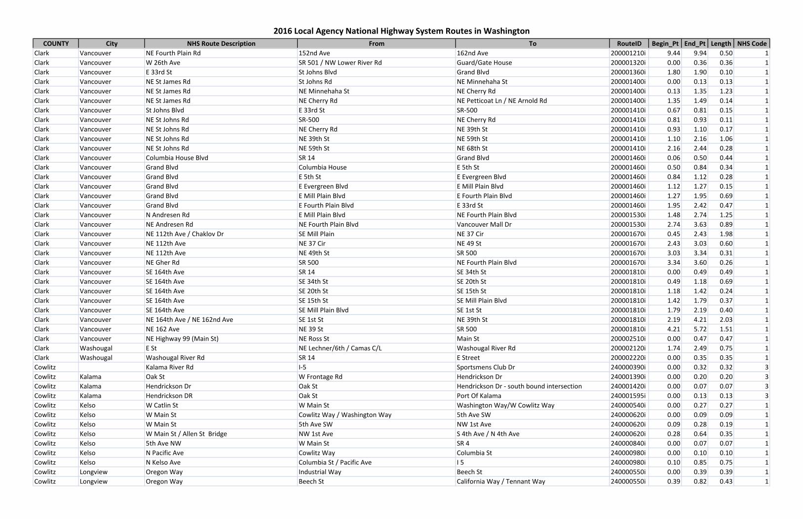
COUNTY City NHS Route Description From To RouteID Begin_Pt End_Pt Length NHS Code
2016 Local Agency National Highway System Routes in Washington
Clark Vancouver NE Fourth Plain Rd 152nd Ave 162nd Ave 200001210i 9.44 9.94 0.50 1Clark Vancouver W 26th Ave SR 501 / NW Lower River Rd Guard/Gate House 200001320i 0.00 0.36 0.36 1Clark Vancouver E 33rd St St Johns Blvd Grand Blvd 200001360i 1.80 1.90 0.10 1Clark Vancouver NE St James Rd St Johns Rd NE Minnehaha St 200001400i 0.00 0.13 0.13 1Clark Vancouver NE St James Rd NE Minnehaha St NE Cherry Rd 200001400i 0.13 1.35 1.23 1Clark Vancouver NE St James Rd NE Cherry Rd NE Petticoat Ln / NE Arnold Rd 200001400i 1.35 1.49 0.14 1Clark Vancouver St Johns Blvd E 33rd St SR-500 200001410i 0.67 0.81 0.15 1Clark Vancouver NE St Johns Rd SR-500 NE Cherry Rd 200001410i 0.81 0.93 0.11 1Clark Vancouver NE St Johns Rd NE Cherry Rd NE 39th St 200001410i 0.93 1.10 0.17 1Clark Vancouver NE St Johns Rd NE 39th St NE 59th St 200001410i 1.10 2.16 1.06 1Clark Vancouver NE St Johns Rd NE 59th St NE 68th St 200001410i 2.16 2.44 0.28 1Clark Vancouver Columbia House Blvd SR 14 Grand Blvd 200001460i 0.06 0.50 0.44 1Clark Vancouver Grand Blvd Columbia House E 5th St 200001460i 0.50 0.84 0.34 1Clark Vancouver Grand Blvd E 5th St E Evergreen Blvd 200001460i 0.84 1.12 0.28 1Clark Vancouver Grand Blvd E Evergreen Blvd E Mill Plain Blvd 200001460i 1.12 1.27 0.15 1Clark Vancouver Grand Blvd E Mill Plain Blvd E Fourth Plain Blvd 200001460i 1.27 1.95 0.69 1Clark Vancouver Grand Blvd E Fourth Plain Blvd E 33rd St 200001460i 1.95 2.42 0.47 1Clark Vancouver N Andresen Rd E Mill Plain Blvd NE Fourth Plain Blvd 200001530i 1.48 2.74 1.25 1Clark Vancouver NE Andresen Rd NE Fourth Plain Blvd Vancouver Mall Dr 200001530i 2.74 3.63 0.89 1Clark Vancouver NE 112th Ave / Chaklov Dr SE Mill Plain NE 37 Cir 200001670i 0.45 2.43 1.98 1Clark Vancouver NE 112th Ave NE 37 Cir NE 49 St 200001670i 2.43 3.03 0.60 1Clark Vancouver NE 112th Ave NE 49th St SR 500 200001670i 3.03 3.34 0.31 1Clark Vancouver NE Gher Rd SR 500 NE Fourth Plain Blvd 200001670i 3.34 3.60 0.26 1Clark Vancouver SE 164th Ave SR 14 SE 34th St 200001810i 0.00 0.49 0.49 1Clark Vancouver SE 164th Ave SE 34th St SE 20th St 200001810i 0.49 1.18 0.69 1Clark Vancouver SE 164th Ave SE 20th St SE 15th St 200001810i 1.18 1.42 0.24 1Clark Vancouver SE 164th Ave SE 15th St SE Mill Plain Blvd 200001810i 1.42 1.79 0.37 1Clark Vancouver SE 164th Ave SE Mill Plain Blvd SE 1st St 200001810i 1.79 2.19 0.40 1Clark Vancouver NE 164th Ave / NE 162nd Ave SE 1st St NE 39th St 200001810i 2.19 4.21 2.03 1Clark Vancouver NE 162 Ave NE 39 St SR 500 200001810i 4.21 5.72 1.51 1Clark Vancouver NE Highway 99 (Main St) NE Ross St Main St 200002510i 0.00 0.47 0.47 1Clark Washougal E St NE Lechner/6th / Camas C/L Washougal River Rd 200002120i 1.74 2.49 0.75 1Clark Washougal Washougal River Rd SR 14 E Street 200002220i 0.00 0.35 0.35 1Cowlitz Kalama River Rd I-5 Sportsmens Club Dr 240000390i 0.00 0.32 0.32 3Cowlitz Kalama Oak St W Frontage Rd Hendrickson Dr 240001390i 0.00 0.20 0.20 3Cowlitz Kalama Hendrickson Dr Oak St Hendrickson Dr - south bound intersection 240001420i 0.00 0.07 0.07 3Cowlitz Kalama Hendrickson DR Oak St Port Of Kalama 240001595i 0.00 0.13 0.13 3Cowlitz Kelso W Catlin St W Main St Washington Way/W Cowlitz Way 240000540i 0.00 0.27 0.27 1Cowlitz Kelso W Main St Cowlitz Way / Washington Way 5th Ave SW 240000620i 0.00 0.09 0.09 1Cowlitz Kelso W Main St 5th Ave SW NW 1st Ave 240000620i 0.09 0.28 0.19 1Cowlitz Kelso W Main St / Allen St Bridge NW 1st Ave S 4th Ave / N 4th Ave 240000620i 0.28 0.64 0.35 1Cowlitz Kelso 5th Ave NW W Main St SR 4 240000840i 0.00 0.07 0.07 1Cowlitz Kelso N Pacific Ave Cowlitz Way Columbia St 240000980i 0.00 0.10 0.10 1Cowlitz Kelso N Kelso Ave Columbia St / Pacific Ave I 5 240000980i 0.10 0.85 0.75 1Cowlitz Longview Oregon Way Industrial Way Beech St 240000550i 0.00 0.39 0.39 1Cowlitz Longview Oregon Way Beech St California Way / Tennant Way 240000550i 0.39 0.82 0.43 1

COUNTY City NHS Route Description From To RouteID Begin_Pt End_Pt Length NHS Code
2016 Local Agency National Highway System Routes in Washington
Cowlitz Longview 15th Ave Nichols Blvd / Tennant Way Hudson St 240000550i 0.82 1.61 0.79 1Cowlitz Longview 15th Ave Hudson St Washington Way 240000550i 1.61 1.84 0.23 1Cowlitz Longview 15th Ave Washington Way Ocean Beach Hwy 240000550i 1.84 2.24 0.40 1Cowlitz Longview Washington Way Industrial Way 32nd Ave 240000560i 0.00 0.53 0.53 1Cowlitz Longview Washington Way 32nd Ave 30th Ave 240000560i 0.53 0.73 0.20 1Cowlitz Longview Washington Way 30th Ave Nichols Blvd 240000560i 0.73 1.19 0.46 1Cowlitz Longview Washington Way Nichols Blv 17th Ave 240000560i 1.19 1.91 0.72 1Cowlitz Longview Larch St / 16th Ave Washington Way / 17th Ave Washington Way / 16th Ave 240000560i 1.91 2.10 0.20 1Cowlitz Longview Washington Way 16th Ave 15th Ave 240000560i 2.10 2.21 0.11 1Cowlitz Longview Washington Way 15th Ave SR-4 / Longview C/L 240000560i 2.21 2.91 0.70 1Cowlitz Longview Louisiana ST / 17th Ave Washington Way / 16th Ave Washington Way / 17th Ave 240001230i 0.00 0.20 0.20 1Cowlitz Longview Tennant Way Oregon Way 9th Ave 240001240i 1.74 2.13 0.39 1Cowlitz Longview Tennant Way 9th Ave 7th Ave 240001240i 2.13 2.27 0.14 1Cowlitz Longview Tennant Way 7th Ave 3rd Ave Ramp 240001240i 2.27 2.49 0.22 1Douglas Grant Rd Kentucky Ave (C/L) N Nile Ave 260000550i 1.37 2.34 0.98 2Douglas Grant Rd N Nile Ave N Stark Ave 260000550i 2.34 3.09 0.75 2Douglas Grant Rd N Stark Ave S Union Ave 260000550i 3.09 3.34 0.25 2Douglas Grant Rd S Union Ave Pangborn Rd 260000550i 3.34 3.66 0.32 2Douglas Grant Rd Pangborn Dr Urban Industrial Ave 260000550i 3.66 3.84 0.18 2Douglas Airport Way / Pangborn Dr Grant Rd - Traffic Circle Airport Terminal Rd 260000550i 3.84 4.18 0.34 2Douglas East Wenatchee Eastmont Ave Grant Rd 7th St NE (West Leg) 260000540i 1.12 1.84 0.73 1Douglas East Wenatchee Eastmont Ave 7th St NE (West Leg) 9th St NE 260000540i 1.84 1.99 0.14 1Douglas East Wenatchee Grant Rd SR 28 James Ave 260000550i 0.00 0.95 0.95 2Douglas East Wenatchee Grant Rd James Ave Kentucky Ave (C/L) 260000550i 0.95 1.37 0.41 2Douglas East Wenatchee 9th St NE SR 28 Valley Mall 260000710i 0.00 0.07 0.07 1Douglas East Wenatchee 9th St NE Valley Mall Pkwy Baker St 260000710i 0.07 0.20 0.13 1Douglas East Wenatchee 9th St NE Baker Street N Eastmont 260000710i 0.20 0.65 0.45 1Franklin Road 68 Court Street W Argent St 300000390i 0.00 0.93 0.93 1Franklin Pasco N Road 68 W Argent St I-182 Intercha 300000390i 0.93 1.66 0.72 1Franklin Pasco S 10th Ave SR 397 W A St 300000450i 0.00 0.19 0.19 1Franklin Pasco S 10th Ave W A St W Clark St 300000450i 0.19 0.37 0.18 1Franklin Pasco W Court St US 395 N Road 36 300000460i 2.15 2.61 0.46 1Franklin Pasco W Court St N Road 36 N Road 44 300000460i 2.61 3.11 0.50 1Franklin Pasco W Court St N Road 44 .03 Mi W of N Road 44 300000460i 3.11 3.36 0.25 1Franklin Pasco W Court St N Road48 N Road 64 300000460i 3.36 4.37 1.01 1Franklin Pasco W Court St N Road 64 N Road 68 300000460i 4.37 4.62 0.25 1Franklin Pasco W Lewis St US 395 N 24th Ave 300000510i 0.00 0.46 0.46 1Franklin Pasco W Lewis St N 26th Ave N 20th Ave 300000510i 0.46 0.73 0.27 1Franklin Pasco W Lewis St N 20th Ave N 14th Ave 300000510i 0.73 1.24 0.51 1Franklin Pasco W Lewis St N 14th Ave N 10th Ave 300000510i 1.24 1.54 0.30 1Franklin Pasco W Lewis St N 10th Ave N 5th Ave 300000510i 1.54 1.91 0.37 1Franklin Pasco W Lewis St N 4th Ave N 1st Ave 300000510i 1.91 2.37 0.46 1Franklin Pasco E Lewis St N 1st Ave N Wehe 300000510i 2.37 2.82 0.46 1Franklin Pasco E Lewis St N Wehe Ave N Cedar Ave 300000510i 2.82 3.32 0.50 1Franklin Pasco E Lewis St N Cedar Ave E Lewis Pl 300000510i 3.32 3.49 0.17 1Franklin Pasco E Lewis St E Lewis Pl Pasco Kahlotus Rd (at US 12 WB Ramps) 300000510i 3.49 4.17 0.68 1

COUNTY City NHS Route Description From To RouteID Begin_Pt End_Pt Length NHS Code
2016 Local Agency National Highway System Routes in Washington
Franklin Pasco W Clark St N 10th Ave N 1st Ave 300000560i 0.28 1.01 0.74 1Franklin Pasco N 20th Ave W Lewis St W Sylvester 300000600i 0.18 0.50 0.32 1Franklin Pasco N 20th Ave W Sylvester I-182 300000600i 0.50 1.50 1.00 1Franklin Pasco N 20th Ave I-182 W Argent Road 300000600i 1.50 2.01 0.51 2Franklin Pasco N 4th Ave W Lewis St W Clark St 300000610i 0.28 0.35 0.07 1Franklin Pasco N 4th Ave W Clark St W Sylvester St 300000610i 0.35 0.57 0.22 1Franklin Pasco N 4th Ave W Sylvester St W Marie St 300000610i 0.57 0.91 0.35 1Franklin Pasco N 4th Ave W Marie St W Court St 300000610i 0.91 1.04 0.13 1Franklin Pasco N 4th Ave W Court St I-182 300000610i 1.04 1.64 0.60 1Grant Moses Lake Stratford Rd SR 171 / Broadway Ave Valley Rd 340001900i 0.22 0.70 0.48 1Grant Moses Lake Stratford Rd W Valley Rd SR 17 340001900i 0.70 1.05 0.35 1Grant Moses Lake S Pioneer Way SR 17 ( Rd K NE aka Clover Dr.) Riviera Ave 340001940i 0.00 1.36 1.36 1Grant Moses Lake S Pioneer Way Riviera St E 3rd Ave 340001940i 1.36 1.72 0.37 1Grant Moses Lake Pioneer Way 3rd Ave SR 171 / Broadway Ave 340001940i 1.72 1.81 0.09 1Grays Harbor Aberdeen Division Wishkah Market 360000770i 0.00 0.06 0.06 1Grays Harbor Aberdeen Market St Division Park 360000770i 0.06 0.31 0.25 1Grays Harbor Aberdeen Market Park (US 101) Alder (US101) 360000770i 0.31 0.38 0.07 1Island Ault Field Rd Langley Blvd 0.250 Mi E of Old Goldie Rd 380000600i 0.27 1.53 1.26 1King S 320th St Federal Way E C/L (.14mi West of Military Rd) Military Rd S / Peasley Canyon Rd 420000200i 5.07 5.23 0.16 1King Peasley Canyon Rd S Military Rd S / S 320th St Peasley Canyon Way S 420000200i 5.23 6.27 1.04 1King 140th Ave SE / 140th Way SE SE Petrovitsky Rd SR 169 (Maple Valley Hwy) 420000880i 8.94 10.93 2.00 1King 16th Ave SW SW 116th St SW 100th St 420001170i 7.50 8.51 1.01 1King White Center Cutoff SW / 17th Ave SW 16th Ave SW / SW 100th St SW Roxbury St 420001170i 8.51 8.79 0.28 1King 272nd St S I-5 (North Bound On/Off Ramp) Military Rd S 420001270i 1.15 1.24 0.09 1King 272nd St S / 272nd Way / 277th St S Military Rd S 55th Ave S 420001270i 1.24 2.69 1.45 1King S 277th St 55th Ave S W Valley Hwy 420001270i 2.69 3.38 0.69 1King S 277th St W Valley Hwy SR 167 (NB On/Off Ramp) 420001270i 3.38 3.67 0.28 1King SE Petrovitsky Rd Renton E C/L (100ft W of 134th Ave SE) 140th Ave SE 420001910i 6.53 6.91 0.38 1King SE 128th St / SE 128th Way Renton C/L (158th Ave SE) 164th Ave SE 420002160i 3.83 4.18 0.35 1King SE 128th St / SE 128th Way 164 Ave SE 196th Ave SE 420002160i 4.18 6.18 1.99 1King 1st Ave S SW 116th St SW 112th St 420002200i 3.59 3.85 0.25 1King 1st Ave S / Myers Way S SW 112th St S 99th St 420002200i 3.85 4.79 0.94 1King Issaquah Hobart Rd Tiger Mountain Rd SE / Uab 2003 SE May Valley Rd 420002600i 0.00 4.10 4.10 1King Issaquah Hobart Rd SE SE May Valley Rd SE 104th St / Issaquah S C/L 420002600i 4.10 5.82 1.72 1King SE 231st St SR 169 / Maple V / Black Diamond Rd SE 232nd St (At Petrovitsky Rd) 420002970i 0.00 0.27 0.27 1King SE Petrovitsky Rd / 200th Ave SE 232nd St 0.15mi N of Sweeney Rd SE 420002970i 0.27 0.72 0.45 1King Des Moines Memorial Dr S. / 14th Ave S West Marginal Way S / SR 99 C/L Seattle/S Director St 420003780i 0.00 0.22 0.22 1King Rainier Ave S S Of S 115th Pl 75th Ave S 420004960i 1.28 2.53 1.25 1King Issaquah Hobart Rd. SE CRMP 9.44 (SR 18 Uxing) Tiger Mtn. Rd. SE 420006440i 0.00 0.34 0.34 1King Avondale Road NE NE 116th St (Redmond N C/L ) NE 128th Way 420007940i 2.53 3.43 0.91 1King Avondale Road NE NE 128th Way NE Woodinville-Duvall Rd 420007940i 3.43 6.23 2.79 1King Sahalee Way NE Sammamish N C/L (.34mi N Of NE 37th Way) Redmond-Fall City Rd (SR 202) 420008540i 7.27 7.90 0.63 1King NE 124th St Willows Rd NE Woodinville Redmond Rd NE (SR 202) 420009140i 3.45 4.50 1.04 1King NE 124th St Woodinville Redmond Rd NE (SR 202) 162nd Pl NE 420009140i 4.50 4.91 0.42 1King NE 124th/128th/130th St 162nd Pl NE Avondale Rd NE 420009140i 4.91 6.59 1.67 1King Woodinville Duvall Rd Woodinville C/L - 171st St Avondale Rd NE 420009420i 2.97 4.53 1.56 1
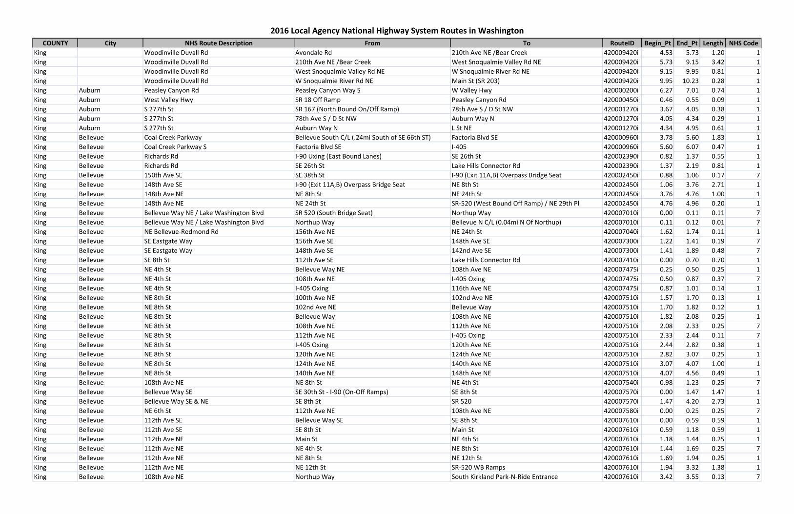
COUNTY City NHS Route Description From To RouteID Begin_Pt End_Pt Length NHS Code
2016 Local Agency National Highway System Routes in Washington
King Woodinville Duvall Rd Avondale Rd 210th Ave NE /Bear Creek 420009420i 4.53 5.73 1.20 1King Woodinville Duvall Rd 210th Ave NE /Bear Creek West Snoqualmie Valley Rd NE 420009420i 5.73 9.15 3.42 1King Woodinville Duvall Rd West Snoqualmie Valley Rd NE W Snoqualmie River Rd NE 420009420i 9.15 9.95 0.81 1King Woodinville Duvall Rd W Snoqualmie River Rd NE Main St (SR 203) 420009420i 9.95 10.23 0.28 1King Auburn Peasley Canyon Rd Peasley Canyon Way S W Valley Hwy 420000200i 6.27 7.01 0.74 1King Auburn West Valley Hwy SR 18 Off Ramp Peasley Canyon Rd 420000450i 0.46 0.55 0.09 1King Auburn S 277th St SR 167 (North Bound On/Off Ramp) 78th Ave S / D St NW 420001270i 3.67 4.05 0.38 1King Auburn S 277th St 78th Ave S / D St NW Auburn Way N 420001270i 4.05 4.34 0.29 1King Auburn S 277th St Auburn Way N L St NE 420001270i 4.34 4.95 0.61 1King Bellevue Coal Creek Parkway Bellevue South C/L (.24mi South of SE 66th ST) Factoria Blvd SE 420000960i 3.78 5.60 1.83 1King Bellevue Coal Creek Parkway S Factoria Blvd SE I-405 420000960i 5.60 6.07 0.47 1King Bellevue Richards Rd I-90 Uxing (East Bound Lanes) SE 26th St 420002390i 0.82 1.37 0.55 1King Bellevue Richards Rd SE 26th St Lake Hills Connector Rd 420002390i 1.37 2.19 0.81 1King Bellevue 150th Ave SE SE 38th St I-90 (Exit 11A,B) Overpass Bridge Seat 420002450i 0.88 1.06 0.17 7King Bellevue 148th Ave SE I-90 (Exit 11A,B) Overpass Bridge Seat NE 8th St 420002450i 1.06 3.76 2.71 1King Bellevue 148th Ave NE NE 8th St NE 24th St 420002450i 3.76 4.76 1.00 1King Bellevue 148th Ave NE NE 24th St SR-520 (West Bound Off Ramp) / NE 29th Pl 420002450i 4.76 4.96 0.20 1King Bellevue Bellevue Way NE / Lake Washington Blvd SR 520 (South Bridge Seat) Northup Way 420007010i 0.00 0.11 0.11 7King Bellevue Bellevue Way NE / Lake Washington Blvd Northup Way Bellevue N C/L (0.04mi N Of Northup) 420007010i 0.11 0.12 0.01 7King Bellevue NE Bellevue-Redmond Rd 156th Ave NE NE 24th St 420007040i 1.62 1.74 0.11 1King Bellevue SE Eastgate Way 156th Ave SE 148th Ave SE 420007300i 1.22 1.41 0.19 7King Bellevue SE Eastgate Way 148th Ave SE 142nd Ave SE 420007300i 1.41 1.89 0.48 7King Bellevue SE 8th St 112th Ave SE Lake Hills Connector Rd 420007410i 0.00 0.70 0.70 1King Bellevue NE 4th St Bellevue Way NE 108th Ave NE 420007475i 0.25 0.50 0.25 1King Bellevue NE 4th St 108th Ave NE I-405 Oxing 420007475i 0.50 0.87 0.37 7King Bellevue NE 4th St I-405 Oxing 116th Ave NE 420007475i 0.87 1.01 0.14 1King Bellevue NE 8th St 100th Ave NE 102nd Ave NE 420007510i 1.57 1.70 0.13 1King Bellevue NE 8th St 102nd Ave NE Bellevue Way 420007510i 1.70 1.82 0.12 1King Bellevue NE 8th St Bellevue Way 108th Ave NE 420007510i 1.82 2.08 0.25 1King Bellevue NE 8th St 108th Ave NE 112th Ave NE 420007510i 2.08 2.33 0.25 7King Bellevue NE 8th St 112th Ave NE I-405 Oxing 420007510i 2.33 2.44 0.11 7King Bellevue NE 8th St I-405 Oxing 120th Ave NE 420007510i 2.44 2.82 0.38 1King Bellevue NE 8th St 120th Ave NE 124th Ave NE 420007510i 2.82 3.07 0.25 1King Bellevue NE 8th St 124th Ave NE 140th Ave NE 420007510i 3.07 4.07 1.00 1King Bellevue NE 8th St 140th Ave NE 148th Ave NE 420007510i 4.07 4.56 0.49 1King Bellevue 108th Ave NE NE 8th St NE 4th St 420007540i 0.98 1.23 0.25 7King Bellevue Bellevue Way SE SE 30th St - I-90 (On-Off Ramps) SE 8th St 420007570i 0.00 1.47 1.47 1King Bellevue Bellevue Way SE & NE SE 8th St SR 520 420007570i 1.47 4.20 2.73 1King Bellevue NE 6th St 112th Ave NE 108th Ave NE 420007580i 0.00 0.25 0.25 7King Bellevue 112th Ave SE Bellevue Way SE SE 8th St 420007610i 0.00 0.59 0.59 1King Bellevue 112th Ave SE SE 8th St Main St 420007610i 0.59 1.18 0.59 1King Bellevue 112th Ave NE Main St NE 4th St 420007610i 1.18 1.44 0.25 1King Bellevue 112th Ave NE NE 4th St NE 8th St 420007610i 1.44 1.69 0.25 7King Bellevue 112th Ave NE NE 8th St NE 12th St 420007610i 1.69 1.94 0.25 1King Bellevue 112th Ave NE NE 12th St SR-520 WB Ramps 420007610i 1.94 3.32 1.38 1King Bellevue 108th Ave NE Northup Way South Kirkland Park-N-Ride Entrance 420007610i 3.42 3.55 0.13 7
COUNTY City NHS Route Description From To RouteID Begin_Pt End_Pt Length NHS Code
2016 Local Agency National Highway System Routes in Washington
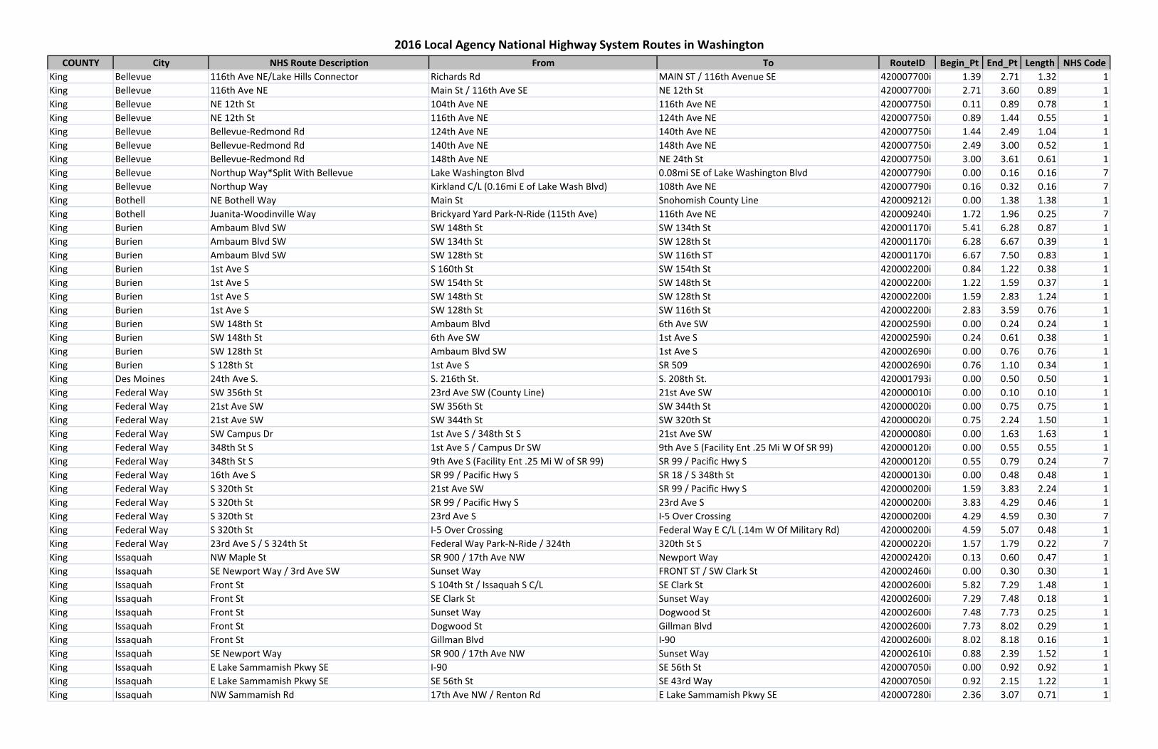
King Bellevue 116th Ave NE/Lake Hills Connector Richards Rd MAIN ST / 116th Avenue SE 420007700i 1.39 2.71 1.32 1King Bellevue 116th Ave NE Main St / 116th Ave SE NE 12th St 420007700i 2.71 3.60 0.89 1King Bellevue NE 12th St 104th Ave NE 116th Ave NE 420007750i 0.11 0.89 0.78 1King Bellevue NE 12th St 116th Ave NE 124th Ave NE 420007750i 0.89 1.44 0.55 1King Bellevue Bellevue-Redmond Rd 124th Ave NE 140th Ave NE 420007750i 1.44 2.49 1.04 1King Bellevue Bellevue-Redmond Rd 140th Ave NE 148th Ave NE 420007750i 2.49 3.00 0.52 1King Bellevue Bellevue-Redmond Rd 148th Ave NE NE 24th St 420007750i 3.00 3.61 0.61 1King Bellevue Northup Way*Split With Bellevue Lake Washington Blvd 0.08mi SE of Lake Washington Blvd 420007790i 0.00 0.16 0.16 7King Bellevue Northup Way Kirkland C/L (0.16mi E of Lake Wash Blvd) 108th Ave NE 420007790i 0.16 0.32 0.16 7King Bothell NE Bothell Way Main St Snohomish County Line 420009212i 0.00 1.38 1.38 1King Bothell Juanita-Woodinville Way Brickyard Yard Park-N-Ride (115th Ave) 116th Ave NE 420009240i 1.72 1.96 0.25 7King Burien Ambaum Blvd SW SW 148th St SW 134th St 420001170i 5.41 6.28 0.87 1King Burien Ambaum Blvd SW SW 134th St SW 128th St 420001170i 6.28 6.67 0.39 1King Burien Ambaum Blvd SW SW 128th St SW 116th ST 420001170i 6.67 7.50 0.83 1King Burien 1st Ave S S 160th St SW 154th St 420002200i 0.84 1.22 0.38 1King Burien 1st Ave S SW 154th St SW 148th St 420002200i 1.22 1.59 0.37 1King Burien 1st Ave S SW 148th St SW 128th St 420002200i 1.59 2.83 1.24 1King Burien 1st Ave S SW 128th St SW 116th St 420002200i 2.83 3.59 0.76 1King Burien SW 148th St Ambaum Blvd 6th Ave SW 420002590i 0.00 0.24 0.24 1King Burien SW 148th St 6th Ave SW 1st Ave S 420002590i 0.24 0.61 0.38 1King Burien SW 128th St Ambaum Blvd SW 1st Ave S 420002690i 0.00 0.76 0.76 1King Burien S 128th St 1st Ave S SR 509 420002690i 0.76 1.10 0.34 1King Des Moines 24th Ave S. S. 216th St. S. 208th St. 420001793i 0.00 0.50 0.50 1King Federal Way SW 356th St 23rd Ave SW (County Line) 21st Ave SW 420000010i 0.00 0.10 0.10 1King Federal Way 21st Ave SW SW 356th St SW 344th St 420000020i 0.00 0.75 0.75 1King Federal Way 21st Ave SW SW 344th St SW 320th St 420000020i 0.75 2.24 1.50 1King Federal Way SW Campus Dr 1st Ave S / 348th St S 21st Ave SW 420000080i 0.00 1.63 1.63 1King Federal Way 348th St S 1st Ave S / Campus Dr SW 9th Ave S (Facility Ent .25 Mi W Of SR 99) 420000120i 0.00 0.55 0.55 1King Federal Way 348th St S 9th Ave S (Facility Ent .25 Mi W of SR 99) SR 99 / Pacific Hwy S 420000120i 0.55 0.79 0.24 7King Federal Way 16th Ave S SR 99 / Pacific Hwy S SR 18 / S 348th St 420000130i 0.00 0.48 0.48 1King Federal Way S 320th St 21st Ave SW SR 99 / Pacific Hwy S 420000200i 1.59 3.83 2.24 1King Federal Way S 320th St SR 99 / Pacific Hwy S 23rd Ave S 420000200i 3.83 4.29 0.46 1King Federal Way S 320th St 23rd Ave S I-5 Over Crossing 420000200i 4.29 4.59 0.30 7King Federal Way S 320th St I-5 Over Crossing Federal Way E C/L (.14m W Of Military Rd) 420000200i 4.59 5.07 0.48 1King Federal Way 23rd Ave S / S 324th St Federal Way Park-N-Ride / 324th 320th St S 420000220i 1.57 1.79 0.22 7King Issaquah NW Maple St SR 900 / 17th Ave NW Newport Way 420002420i 0.13 0.60 0.47 1King Issaquah SE Newport Way / 3rd Ave SW Sunset Way FRONT ST / SW Clark St 420002460i 0.00 0.30 0.30 1King Issaquah Front St S 104th St / Issaquah S C/L SE Clark St 420002600i 5.82 7.29 1.48 1King Issaquah Front St SE Clark St Sunset Way 420002600i 7.29 7.48 0.18 1King Issaquah Front St Sunset Way Dogwood St 420002600i 7.48 7.73 0.25 1King Issaquah Front St Dogwood St Gillman Blvd 420002600i 7.73 8.02 0.29 1King Issaquah Front St Gillman Blvd I-90 420002600i 8.02 8.18 0.16 1King Issaquah SE Newport Way SR 900 / 17th Ave NW Sunset Way 420002610i 0.88 2.39 1.52 1King Issaquah E Lake Sammamish Pkwy SE I-90 SE 56th St 420007050i 0.00 0.92 0.92 1King Issaquah E Lake Sammamish Pkwy SE SE 56th St SE 43rd Way 420007050i 0.92 2.15 1.22 1King Issaquah NW Sammamish Rd 17th Ave NW / Renton Rd E Lake Sammamish Pkwy SE 420007280i 2.36 3.07 0.71 1
COUNTY City NHS Route Description From To RouteID Begin_Pt End_Pt Length NHS Code
2016 Local Agency National Highway System Routes in Washington
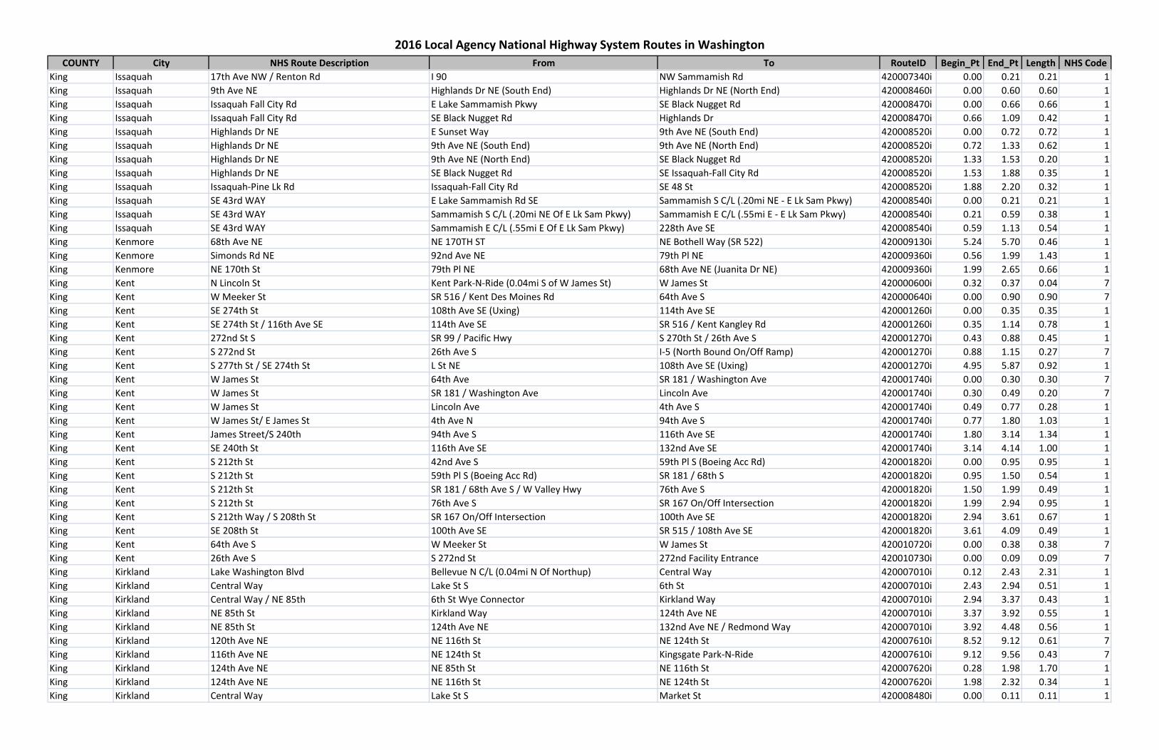
King Issaquah 17th Ave NW / Renton Rd I 90 NW Sammamish Rd 420007340i 0.00 0.21 0.21 1King Issaquah 9th Ave NE Highlands Dr NE (South End) Highlands Dr NE (North End) 420008460i 0.00 0.60 0.60 1King Issaquah Issaquah Fall City Rd E Lake Sammamish Pkwy SE Black Nugget Rd 420008470i 0.00 0.66 0.66 1King Issaquah Issaquah Fall City Rd SE Black Nugget Rd Highlands Dr 420008470i 0.66 1.09 0.42 1King Issaquah Highlands Dr NE E Sunset Way 9th Ave NE (South End) 420008520i 0.00 0.72 0.72 1King Issaquah Highlands Dr NE 9th Ave NE (South End) 9th Ave NE (North End) 420008520i 0.72 1.33 0.62 1King Issaquah Highlands Dr NE 9th Ave NE (North End) SE Black Nugget Rd 420008520i 1.33 1.53 0.20 1King Issaquah Highlands Dr NE SE Black Nugget Rd SE Issaquah-Fall City Rd 420008520i 1.53 1.88 0.35 1King Issaquah Issaquah-Pine Lk Rd Issaquah-Fall City Rd SE 48 St 420008520i 1.88 2.20 0.32 1King Issaquah SE 43rd WAY E Lake Sammamish Rd SE Sammamish S C/L (.20mi NE - E Lk Sam Pkwy) 420008540i 0.00 0.21 0.21 1King Issaquah SE 43rd WAY Sammamish S C/L (.20mi NE Of E Lk Sam Pkwy) Sammamish E C/L (.55mi E - E Lk Sam Pkwy) 420008540i 0.21 0.59 0.38 1King Issaquah SE 43rd WAY Sammamish E C/L (.55mi E Of E Lk Sam Pkwy) 228th Ave SE 420008540i 0.59 1.13 0.54 1King Kenmore 68th Ave NE NE 170TH ST NE Bothell Way (SR 522) 420009130i 5.24 5.70 0.46 1King Kenmore Simonds Rd NE 92nd Ave NE 79th Pl NE 420009360i 0.56 1.99 1.43 1King Kenmore NE 170th St 79th Pl NE 68th Ave NE (Juanita Dr NE) 420009360i 1.99 2.65 0.66 1King Kent N Lincoln St Kent Park-N-Ride (0.04mi S of W James St) W James St 420000600i 0.32 0.37 0.04 7King Kent W Meeker St SR 516 / Kent Des Moines Rd 64th Ave S 420000640i 0.00 0.90 0.90 7King Kent SE 274th St 108th Ave SE (Uxing) 114th Ave SE 420001260i 0.00 0.35 0.35 1King Kent SE 274th St / 116th Ave SE 114th Ave SE SR 516 / Kent Kangley Rd 420001260i 0.35 1.14 0.78 1King Kent 272nd St S SR 99 / Pacific Hwy S 270th St / 26th Ave S 420001270i 0.43 0.88 0.45 1King Kent S 272nd St 26th Ave S I-5 (North Bound On/Off Ramp) 420001270i 0.88 1.15 0.27 7King Kent S 277th St / SE 274th St L St NE 108th Ave SE (Uxing) 420001270i 4.95 5.87 0.92 1King Kent W James St 64th Ave SR 181 / Washington Ave 420001740i 0.00 0.30 0.30 7King Kent W James St SR 181 / Washington Ave Lincoln Ave 420001740i 0.30 0.49 0.20 7King Kent W James St Lincoln Ave 4th Ave S 420001740i 0.49 0.77 0.28 1King Kent W James St/ E James St 4th Ave N 94th Ave S 420001740i 0.77 1.80 1.03 1King Kent James Street/S 240th 94th Ave S 116th Ave SE 420001740i 1.80 3.14 1.34 1King Kent SE 240th St 116th Ave SE 132nd Ave SE 420001740i 3.14 4.14 1.00 1King Kent S 212th St 42nd Ave S 59th Pl S (Boeing Acc Rd) 420001820i 0.00 0.95 0.95 1King Kent S 212th St 59th Pl S (Boeing Acc Rd) SR 181 / 68th S 420001820i 0.95 1.50 0.54 1King Kent S 212th St SR 181 / 68th Ave S / W Valley Hwy 76th Ave S 420001820i 1.50 1.99 0.49 1King Kent S 212th St 76th Ave S SR 167 On/Off Intersection 420001820i 1.99 2.94 0.95 1King Kent S 212th Way / S 208th St SR 167 On/Off Intersection 100th Ave SE 420001820i 2.94 3.61 0.67 1King Kent SE 208th St 100th Ave SE SR 515 / 108th Ave SE 420001820i 3.61 4.09 0.49 1King Kent 64th Ave S W Meeker St W James St 420010720i 0.00 0.38 0.38 7King Kent 26th Ave S S 272nd St 272nd Facility Entrance 420010730i 0.00 0.09 0.09 7King Kirkland Lake Washington Blvd Bellevue N C/L (0.04mi N Of Northup) Central Way 420007010i 0.12 2.43 2.31 1King Kirkland Central Way Lake St S 6th St 420007010i 2.43 2.94 0.51 1King Kirkland Central Way / NE 85th 6th St Wye Connector Kirkland Way 420007010i 2.94 3.37 0.43 1King Kirkland NE 85th St Kirkland Way 124th Ave NE 420007010i 3.37 3.92 0.55 1King Kirkland NE 85th St 124th Ave NE 132nd Ave NE / Redmond Way 420007010i 3.92 4.48 0.56 1King Kirkland 120th Ave NE NE 116th St NE 124th St 420007610i 8.52 9.12 0.61 7King Kirkland 116th Ave NE NE 124th St Kingsgate Park-N-Ride 420007610i 9.12 9.56 0.43 7King Kirkland 124th Ave NE NE 85th St NE 116th St 420007620i 0.28 1.98 1.70 1King Kirkland 124th Ave NE NE 116th St NE 124th St 420007620i 1.98 2.32 0.34 1King Kirkland Central Way Lake St S Market St 420008480i 0.00 0.11 0.11 1

COUNTY City NHS Route Description From To RouteID Begin_Pt End_Pt Length NHS Code
2016 Local Agency National Highway System Routes in Washington
King Kirkland Market St Central Way Forbes Creek D 420008480i 0.11 1.41 1.30 1King Kirkland 98th Ave NE Forbes Creek D NE 116th St 420008480i 1.41 2.07 0.66 1King Kirkland Market St / 98th Ave NE NE 116th St NE 124th St 420008480i 2.07 2.61 0.54 1King Kirkland 100th Ave NE NE 124th St NE 132nd St 420008480i 2.61 3.11 0.50 1King Kirkland 100th Ave NE NE 132nd St Simonds Rd 420008480i 3.11 3.97 0.85 1King Kirkland NE 116th St 120th Ave NE I-405 / Exit 20a 420009090i 1.36 1.48 0.12 7King Kirkland NE 124th St 100th Ave NE 116th Ave NE 420009140i 0.88 1.87 0.99 1King Kirkland NE 124th St 116th Ave NE I-405 Nb Off Ramp 420009140i 1.87 2.19 0.32 7King Kirkland NE 124th St I-405 Nb Off Ramp Willows Rd NE 420009140i 2.19 3.45 1.27 1King Kirkland Simonds Rd NE 100th Ave NE 92nd Ave NE 420009360i 0.00 0.56 0.56 1King Mercer Island Island Crest Way I-90 SE 40th St 420007130i 0.00 0.93 0.93 1King Newcastle Coal Creek Parkway SE SE 95th Way Bellevue South C/L (.24mi South of SE 66) 420000960i 1.98 3.78 1.80 1King Normandy Park 1st Ave S SR 509 / S 174th St SW 171st St 420002200i 0.00 0.15 0.15 1King Normandy Park 1st Ave S SW 171st St S 160th St 420002200i 0.15 0.84 0.69 1King Redmond Redmond Way SR 202 / 164th Ave NE 160th Ave NE 420007005i 0.00 0.28 0.28 1King Redmond Redmond Way 132nd Ave NE 148th Ave NE 420007010i 4.48 5.54 1.06 1King Redmond Redmond Way 148th Ave NE 154th Ave NE 420007010i 5.54 6.03 0.49 1King Redmond Redmond Way 154th Ave NE 160th Ave NE 420007010i 6.03 6.34 0.31 1King Redmond Cleveland St Redmond Way 164th Ave NE (SR 202) 420007010i 6.34 6.64 0.30 1King Redmond W Lake Sammamish Pkwy NE NE 51st St Leary Way 420007020i 7.39 7.92 0.53 1King Redmond W Lake Sammamish Pkwy NE Bel-Rd Rd NE 51st St 420007020i 7.92 8.86 0.94 1King Redmond W Lake Sammamish Pkwy NE Leary Way Redmond Way 420007030i 0.00 0.35 0.35 1King Redmond 154th Ave Redmond Way NE 85th St 420007030i 0.35 0.71 0.36 1King Redmond NE Bellevue-Redmond Rd W Lake Sammamish NE 40th St 420007040i 0.00 0.36 0.36 1King Redmond NE Bellevue-Redmond Rd * Split B NE 40th St 156th Ave NE 420007040i 0.36 1.62 1.27 1King Redmond NE 24th St NE Bellevue-Redmond Rd 148 Ave NE 420007040i 1.74 2.16 0.42 1King Redmond 148th Ave NE SR 520 (WB Off Ramp) / NE 29th Pl Redmond Way 420007840i 0.00 2.82 2.82 1King Redmond 148 Ave NE Ext / NE 90th St Redmond Way 154th Ave NE 420007840i 2.82 3.76 0.93 1King Redmond NE 90th St 154th Ave NE Woodenville Redmond Rd (SR 202) 420007840i 3.76 4.28 0.53 1King Redmond 154th Ave NE 85th St NE 90th St 420007870i 0.00 0.25 0.25 1King Redmond Avondale Road Extension SR 520 Over Xing SR 202 Redmond Way Union Hill Rd 420007940i 0.00 0.35 0.35 1King Redmond Avondale Road NE Union Hill Rd NE 116th St (Redmond N C/L ) 420007940i 0.35 2.53 2.18 1King Redmond NE 80th St Redmond Way Redmond Woodinville Rd (SR 202) 420008070i 0.00 0.16 0.16 1King Redmond W Lake Sammamish Way NE 154th Ave NE NE Redmond Way 420008090i 0.00 0.18 0.18 1King Renton Duvall Ave NE / Coal Creek Parkway SR 900 / NE Sunset Blvd NE 24th St 420000960i 1.19 1.69 0.50 1King Renton Coal Creek Parkway SE NE 24th St SE 95th Way 420000960i 1.69 1.98 0.29 1King Renton Logan Ave S SR 900 / S 3rd St Airport Way 420001060i 0.00 0.37 0.37 1King Renton Logan Ave N Airport Way N 6th St 420001060i 0.37 0.87 0.50 1King Renton Logan Ave N N 6th St Park Ave N 420001060i 0.87 1.49 0.62 1King Renton Park Ave N SR 900 / Bronson Way / N 1st St N 3rd St 420001280i 0.00 0.28 0.28 1King Renton Park Ave N N 3rd St N 6th St 420001280i 0.28 0.66 0.38 1King Renton Park Ave N / NE Park Dr N 6th St I 405 Sb Uxing Lanes 420001280i 0.66 1.54 0.88 1King Renton Houser Way N SR 900 / Bronson Way SR 900 / Mill Ave S 420001320i 0.00 0.39 0.39 1King Renton Airport Way Logan Ave S Shattuck Ave S 420001520i 0.00 0.16 0.16 1King Renton Airport Way Shattuck Ave S Rainier Ave N 420001520i 0.16 0.39 0.23 1King Renton SW 43rd St E Tukwila C/L (E end of Railroad UCrossing) E Valley Hwy / Rainier Ave S 420001910i 2.71 3.70 0.99 1
COUNTY City NHS Route Description From To RouteID Begin_Pt End_Pt Length NHS Code
2016 Local Agency National Highway System Routes in Washington
King Renton SW 43rd St E Valley Hwy / Rainier Ave S Talbot RD S 420001910i 3.70 4.03 0.33 1King Renton Carr Rd / SE 176th St / SE Petrovitsky Rd 96th Ave S / Talbot Rd S Renton E C/L (100ft W of 134th Ave SE) 420001910i 4.03 6.53 2.50 1King Renton Grady Way S Smithers Ave S (SR 515) SR 167 / Rainier Ave S 420002020i 0.00 0.45 0.45 1King Renton Grady Way SW SR 167 / Rainier Ave S Longacres Dr SW 420002020i 0.45 1.41 0.97 1King Renton N 3rd St Logan Ave N Burnett Ave N 420002160i 0.00 0.11 0.11 1King Renton N 3rd St Burnett Ave N Houser Way N 420002160i 0.11 0.61 0.50 1King Renton N 3rd St Houser Way N Sunset Blvd N (SR 900) 420002160i 0.61 0.67 0.05 1King Renton N 3rd St Sunset Blvd N (SR 900) I 405 Uxing 420002160i 0.67 0.71 0.04 1King Renton NE 3rd St / NE 4th St I-405 Uxing Renton C/L / 158th Ave SE 420002160i 0.71 3.83 3.12 1King Renton Factory Pl N Houser Way N N 4th St 420002180i 0.00 0.16 0.16 1King Renton N 4th St Factory Pl N / N 3rd Pl Logan Ave N 420002180i 0.16 0.62 0.46 1King Renton N 6th St Logan Ave N N Park Ave 420002210i 0.00 0.25 0.25 1King Renton Rainier Ave N SR 900 / S 2nd St S 115th Pl 420004960i 0.00 1.28 1.28 1King Sammamish Issaquah-Pine Lk Rd SE 48th St 228th Ave SE 420008520i 2.20 4.17 1.97 1King Sammamish 228th Ave SE SE 43rd Way Issaquah Pine Lake Rd 420008540i 1.13 2.11 0.98 1King Sammamish 228th Ave SE Issaquah Pine Lake Rd NE 25th Way 420008540i 2.11 5.50 3.39 1King Sammamish Sahalee Way NE NE 25th Way Sammamish N C/L (.34mi N Of NE 37th Way) 420008540i 5.50 7.27 1.77 1King Seatac 26th Ave S / 28th Ave S Parking lot Ent Rd south of S 200th St S 200th St 420001793i 0.94 1.03 0.09 1King Seatac 26th Ave S / 28th Ave S S 200th St S 188th St 420001793i 1.03 1.89 0.86 1King Seatac S 188th St I-5 SB Uxing International Blvd / SR 99 420001890i 0.00 1.21 1.21 2King Seatac S 188th St/12th Pl/DesMoines Memorial Way International Blvd/SR 99 SR 509 420001890i 1.21 2.56 1.36 1King Seatac North Seatac Airport Access Rd / Arrivals Dr S 160th St / SR-518 Pacific Hwy S (SR 99) 420001960i 0.00 1.76 1.76 2King Seatac Tukwila International Blvd (SR 99 Ghost) SR-518(North Bridge Seat) S 154th St 420002070i 0.00 0.09 0.09 1King Seatac Tukwila International Blvd (SR 99 Ghost) S 154th St Military Rd S 420002070i 0.09 0.17 0.07 1King Seattle Olson Pl SW SW Roxbury St Olson/Myers Park-N-Ride 420002150i 3.99 4.31 0.33 1King Seattle Olson Pl SW Olson/Myers Park-N-Ride 1st Ave S / Myers Way S 420002150i 4.31 4.42 0.10 7King Seattle Myers Way S S 99th St Olson Myers Park-N-Ride Entrance/Exit 420002200i 4.79 5.18 0.40 1King Seattle 1st Ave S / Myers Way S Olson Myers Park-N-Ride Entrance/Exit Olson Pl SW 420002200i 5.18 5.36 0.18 7King Seattle 1st Ave S Olson Pl SW S Cloverdale St 420002200i 5.36 5.63 0.27 7King Seattle S Cloverdale St SR 509 (North Bound Off Ramp) SR 509 (South Bound Lanes) 420002200i 5.63 5.72 0.08 7King Seattle S Albro Pl Corgiat Dr S Stanley Ave S 420002660i 0.08 0.22 0.14 5King Seattle S Albro Pl Stanley Ave S Hardy St 420002660i 0.22 0.33 0.11 5King Seattle S Albro Pl Hardy St Ellis Ave S 420002660i 0.33 0.44 0.11 1King Seattle Ellis Ave S S Albro Pl E Marginal Way 420002660i 0.44 0.89 0.45 1King Seattle Corson Ave S S Michigan St Airport Way S 420002740i 0.49 0.83 0.33 1King Seattle East Marginal Way S Seattle South C/L (0.26mi S/O 16th Ave S) 16th Ave S 420002980i 3.64 3.89 0.26 1King Seattle East Marginal Way S 16th Ave S 14thAve S 420002980i 3.89 3.99 0.10 1King Seattle East Marginal Way S 14th Ave S Carleton Ave S 420002980i 3.99 4.48 0.48 1King Seattle East Marginal Way S Carleton Ave S Michigan Ave 420002980i 4.48 5.01 0.53 1King Seattle East Marginal Way S S Michigan Ave 1st Ave S (Bridge) 420002980i 5.01 5.22 0.21 1King Seattle Seattle Blvd S 4th Ave S S Dearborn St 420003060i 0.00 0.08 0.08 1King Seattle Airport Way S S Dearborn St S Royal Brougham Way 420003060i 0.08 0.38 0.30 1King Seattle Airport Way S (SB) S Royal Broughham Way I-5 (Airport South bound Off Ramp) 420003060i 0.38 0.55 0.17 1King Seattle Airport Way S I-5 (Airport SB Off Ramp) S Holgate S St 420003060i 0.55 0.84 0.30 1King Seattle Airport Way S S Holgate S St S Lander N St 420003060i 0.84 1.28 0.44 1King Seattle Airport Way S S Lander N St S Spokane St 420003060i 1.28 1.88 0.60 1
COUNTY City NHS Route Description From To RouteID Begin_Pt End_Pt Length NHS Code
2016 Local Agency National Highway System Routes in Washington
King Seattle Airport Way S S Spokane St S Alaska St 420003060i 1.88 2.58 0.70 1King Seattle Airport Way S S Alaska St S Lucile St 420003060i 2.58 3.13 0.56 1King Seattle Airport Way S S Lucile St 13th Ave S 420003060i 3.13 3.55 0.42 1King Seattle Airport Way S 13th Ave S S Hardy St 420003060i 3.55 3.75 0.20 1King Seattle Airport Way S S Hardy St Military Rd S Connection / S Rose St 420003060i 3.75 5.16 1.40 5King Seattle Airport Way S Military Rd S Connection / S Rose St Seattle South C/L (0.4mi S Of S Norfolk St) 420003060i 5.16 5.56 0.40 5King Seattle Airport Way S Tukwila E C/L (2.13mi S Of S Hardy St) Seattle South C/L (0.26mi S Of S Norfolk St) 420003060i 5.89 6.59 0.70 5King Seattle Airport Way S (NB) I5 Airport Nb Off Airport Way S 420003100i 0.00 0.27 0.27 1King Seattle SW Spokane NR St 16th Ave SW SW Spokane St 420003130i 0.00 0.26 0.26 3King Seattle SW Roxbury St Olson Pl SW 14th Ave SW 420003190i 1.14 1.74 0.60 1King Seattle SW Roxbury St 14th Ave SW 35th Ave SW 420003190i 1.74 2.86 1.12 1King Seattle Duwamish Ave S S Spokane SR St E Marginal Way S 420003200i 0.00 0.19 0.19 3King Seattle S Dawson St 4th Ave S Truck/Rail Facility Entrance 420003230i 0.00 0.08 0.08 5King Seattle S Alaska St M L King Jr Way S S Columbian Way 420003400i 0.30 0.49 0.19 1King Seattle S Columbian Way (South Leg) S Alaska St 15th Ave S 420003400i 0.49 1.38 0.89 1King Seattle 15th Ave S S Columbian Way (South Leg) S Nevada St 420003400i 1.38 1.48 0.10 1King Seattle 15th Ave S S Nevada St S Columbian Way (North Leg) 420003400i 1.48 1.75 0.27 1King Seattle S Columbian Way (North Leg) 15th Ave S 14th Ave 420003400i 1.75 1.97 0.22 1King Seattle West Seattle Freeway 14th Ave I-5 NB Ramp(Center of Overpass) 420003400i 1.97 2.27 0.30 1King Seattle West Seattle Freeway I-5 NB Ramp(Center of Overpass) Alaskan Way / East Marginal Way S Xings 420003400i 2.27 3.21 0.94 1King Seattle West Seattle Freeway (Bridge) Alaskan Way / East Marginal Way S Xings Delridge Rmps 420003400i 3.21 4.11 0.90 1King Seattle West Seattle Freeway (Bridge) Delridge Ramps 35th Ave SW 420003400i 4.11 5.21 1.10 1King Seattle Fauntleroy Way SW 35th Ave SW SW Avalon Way 420003400i 5.21 5.31 0.09 1King Seattle Fauntleroy Way SW SW Avalon Way SW Alaska St 420003400i 5.31 5.58 0.28 1King Seattle Fauntleroy Way SW SW Alaska St SW Edmunds St 420003400i 5.58 5.71 0.13 1King Seattle Fauntleroy Way SW SW Edmunds St SW Findlay St 420003400i 5.71 6.21 0.50 1King Seattle Fauntleroy Way SW SW Findlay St SW Graham St 420003400i 6.21 6.60 0.39 1King Seattle Fauntleroy Way SW SW Graham St California Ave SW 420003400i 6.60 6.85 0.24 1King Seattle West Seattle Bridge/S Columbia Way Spokane St Viaduct at 6th St S Columbia Way at 14th Ave 420003401i 0.00 0.64 0.64 1King Seattle SW Morgan St Fauntleroy Way SW 35th Ave SW 420003420i 0.00 0.48 0.48 1King Seattle Highland Park Way SW West Marginal Way SW SR 99 / W Marginal Way S 420003420i 2.97 3.32 0.35 1King Seattle S Michigan St E Marginal Way Corson Ave S 420003460i 0.00 0.55 0.55 1King Seattle Stanley Ave S S Hardy St S Albro Pl 420003460i 0.83 0.91 0.08 1King Seattle S Hardy St Stanley Ave S Airport Way S 420003460i 0.91 0.96 0.05 5King Seattle 35th Ave SW Fauntleroy Way SW Avalon Way SW 420003470i 0.00 0.07 0.07 1King Seattle 35th Ave SW Avalon Way SW SW Alaska St 420003470i 0.07 0.28 0.21 1King Seattle 35th Ave SW SW Alaska St SW Brandon St 420003470i 0.28 0.78 0.50 1King Seattle 35th Ave SW SW Brandon St SW Morgan St 420003470i 0.78 1.41 0.63 1King Seattle 35th Ave SW SW Morgan St SW Myrtle St 420003470i 1.41 1.78 0.38 1King Seattle 35th Ave SW SW Myrtle St SW Holden S St 420003470i 1.78 2.16 0.37 1King Seattle 35th Ave SW SW Holden St SW Thistle St 420003470i 2.16 2.54 0.38 1King Seattle 35th Ave SW SW Thistle St SW Roxbury St 420003470i 2.54 3.28 0.75 1King Seattle S Hanford St E Marginal Way S 1st Ave S 420003520i 0.00 0.27 0.27 5King Seattle Royal Brougham Way S 4th Ave S Airport Way S 420003590i 0.00 0.30 0.30 1King Seattle Delridge Way SW W Marginal Way SW SW Andover St 420003600i 0.00 0.31 0.31 1King Seattle Delridge Way SW SW Andover St SW Dakota St 420003600i 0.31 0.44 0.13 1

COUNTY City NHS Route Description From To RouteID Begin_Pt End_Pt Length NHS Code
2016 Local Agency National Highway System Routes in Washington
King Seattle Delridge Way SW SW Dakota St SW Juneau St 420003600i 0.44 1.58 1.14 1King Seattle Delridge Way SW SW Juneau St Sylvan Way SW 420003600i 1.58 2.53 0.96 1King Seattle Delridge Way SW Sylvan Way SW SW Thistle St 420003600i 2.53 3.11 0.58 1King Seattle Delridge Way SW SW Thistle St SW Barton St 420003600i 3.11 3.64 0.53 1King Seattle Delridge Way SW SW Barton St 17th Ave SW 420003600i 3.64 3.82 0.18 1King Seattle 17th Ave SW Delridge Way SW SW Roxbury St 420003600i 3.82 3.91 0.10 1King Seattle SW Admiral Way Calif Ave SW SW Avalon Way Oxing / SW Spokane Wb 420003690i 1.39 2.57 1.18 1King Seattle West Marginal Way SW SW Spokane St /Delridge Way SW SW Edmunds St 420003700i 0.19 1.23 1.04 1King Seattle West Marginal Way SW SW Edmunds St Highland Park Way SW 420003700i 1.23 2.67 1.44 1King Seattle SW Spokane St W Marginal Way SW 11th Ave SW 420003710i 0.51 1.06 0.55 3King Seattle SW Spokane St 11th Ave SW S Spokane St 420003710i 1.06 1.17 0.12 3King Seattle S Spokane (N Route & S Route) St SW Spokane St E Marginal Way S 420003710i 1.17 1.48 0.31 3King Seattle SW Florida St 13th Ave SW 16th Ave SW 420003730i 0.41 0.50 0.10 3King Seattle 16th Ave SW / Klickitat Ave SW SW Florida St SW Spokane St 420003730i 0.50 1.42 0.91 3King Seattle 16th Ave SW / Klickitat Ave SW 11th Ave SW 13th Ave SW 420003730i 1.42 1.60 0.19 3King Seattle 11th Ave SW SW Spokane St Kilckitat Ave SW 420003730i 1.60 1.67 0.06 3King Seattle 14th Ave S C/L Seattle/S Director St Dallas Ave S / 16th Ave S 420003780i 0.22 0.58 0.35 1King Seattle 14th Ave S S Sullivan St East Marginal Way S 420003780i 0.58 1.07 0.50 1King Seattle 4th Ave S S Royal Brougham Way Airport Way S 420003800i 0.00 0.28 0.28 4King Seattle 4th Ave S Airport Way S Yesler Way 420003800i 0.28 0.64 0.36 4King Seattle 4th Ave / 4th Ave S Yesler Way Madison St 420003800i 0.64 1.00 0.36 1King Seattle 4th Ave Madison St Seneca St 420003800i 1.00 1.11 0.12 1King Seattle 4th Ave Seneca St Union St 420003800i 1.11 1.25 0.14 1King Seattle 4th Ave Union St Battery St 420003800i 1.25 1.91 0.65 1King Seattle Duwamish Ave S Alaskan Way NB Ramp E Marginal Way S 420003810i 0.00 0.03 0.03 3King Seattle East Marginal Way S Duwamish Ave S S Spokane St (East Bound) 420003810i 0.03 0.18 0.15 3King Seattle East Marginal Way S S Spokane St (East Bound) S Hinds St 420003810i 0.18 0.47 0.30 5King Seattle S Henderson St Renton Ave S Rainier Ave S 420003830i 0.25 0.55 0.30 1King Seattle S Henderson St Martin Luther King Jr Way S Renton Ave S 420003830i 0.55 0.68 0.13 1King Seattle S Plum St Rainier Ave S 23rd Ave S 420003880i 0.00 0.03 0.03 1King Seattle Swift Ave S S Albro Pl S Eddy St 420003900i 1.09 1.43 0.34 1King Seattle S Myrtle St / Swift Ave S S Eddy St 32nd Ave S 420003900i 1.43 2.33 0.90 1King Seattle S Othello St / S Myrtle Pl 32nd Ave S Martin Luther King Jr Way 420003900i 2.33 2.85 0.52 1King Seattle 8th Ave Facility Stewart St 420004000i 0.54 0.58 0.04 6King Seattle 9th Ave N Westlake Ave N Mercer St 420004040i 0.00 0.18 0.18 1King Seattle 9th Ave N / 9th Ave Mercer St Westlake Ave 420004040i 0.18 0.67 0.49 1King Seattle 9th Ave Stewart St Facility 420004040i 0.91 0.95 0.04 6King Seattle W Nickerson St 15th Ave W 13th Ave W 420004080i 1.64 1.91 0.27 1King Seattle W Nickerson St 13th Ave W 12th Ave W 420004080i 1.91 1.98 0.07 1King Seattle W Nickerson St 12th Ave W 3rd Ave W 420004080i 1.98 2.60 0.62 1King Seattle W Nickerson St 3rd Ave W Queen Anne Ave N 420004080i 2.60 2.77 0.17 1King Seattle Nickerson St Queen Anne Ave N Westlake Ave N / SR 99 420004080i 2.77 3.35 0.59 1King Seattle Westlake Ave N SR 99 Newton St 420004080i 3.35 4.05 0.70 1King Seattle Westlake Ave N Newton St 9th Ave N 420004080i 4.05 4.71 0.66 1King Seattle Westlake Ave N 9th Ave N Harrison St 420004080i 4.71 5.08 0.37 1King Seattle Westlake Ave N Harrison St Denny Way 420004080i 5.08 5.32 0.24 1

COUNTY City NHS Route Description From To RouteID Begin_Pt End_Pt Length NHS Code
2016 Local Agency National Highway System Routes in Washington
King Seattle Westlake Ave Denny Way Stewart St 420004080i 5.32 5.68 0.37 1King Seattle S Walker St 23rd Ave S Rainier Ave S 420004120i 0.00 0.04 0.04 1King Seattle S Dearborn St Seattle Blvd S 7th Ave S 420004320i 0.00 0.19 0.19 1King Seattle S Dearborn St 7th Ave S Rainier Ave S 420004320i 0.19 0.76 0.57 1King Seattle 2nd Ave Wall St Stewart St 420004330i 0.33 0.79 0.46 1King Seattle 2nd Ave Stewart St Pine St 420004330i 0.79 0.84 0.06 1King Seattle 2nd Ave Pine St Pike St 420004330i 0.84 0.92 0.08 1King Seattle 2nd Ave Pike St Marion St 420004330i 0.92 1.32 0.40 1King Seattle 2nd Ave Marion St Yesler Way 420004330i 1.32 1.54 0.22 1King Seattle 2nd Ave Ext S Yesler Way S Jackson St 420004330i 1.54 1.75 0.21 1King Seattle 2nd Ave Extension S S Jackson St 4th Ave S 420004330i 1.75 1.81 0.06 4King Seattle S Jackson St Alaskan Way S 1st Ave S 420004340i 0.00 0.08 0.08 1King Seattle S Jackson St 1st Ave S 2nd Ave S 420004340i 0.08 0.21 0.12 1King Seattle S Jackson St 2nd Ave S 2nd Avenue Extended S 420004340i 0.21 0.30 0.09 4King Seattle S Jackson St 2nd Avenue Extended S 5th Ave S 420004340i 0.30 0.39 0.09 1King Seattle S Jackson St 5th Ave S 14th Ave S 420004340i 0.39 1.02 0.63 1King Seattle Harrison St 5th Ave N Broad St 420004370i 0.00 0.08 0.08 1King Seattle W Galer Flyover 16th Ave W / Alaskan Way W Elliott Ave W 420004390i 0.00 0.30 0.30 5King Seattle Queen Anne Ave N W Roy St Mercer St 420004450i 1.95 2.01 0.06 1King Seattle James St 2nd Ave 4th Ave 420004480i 0.07 0.19 0.12 1King Seattle James St 4th Ave 7th Ave 420004480i 0.19 0.37 0.18 1King Seattle James St 7th Ave Boren Ave 420004480i 0.37 0.62 0.25 1King Seattle Martin Luther King Way S Rainier Ave S S Alaska St 420004490i 3.28 4.39 1.11 1King Seattle Martin Luther King Way S S Alaska St S Othello St 420004490i 4.39 6.13 1.74 1King Seattle Martin Luther King Way S S Othello St Seattle South C/L(0.13m N Of Boeing Acc Rd) 420004490i 6.13 8.03 1.90 1King Seattle 23rd Ave S Rainer Ave S S Jackson St 420004510i 1.40 2.42 1.02 1King Seattle 23rd Ave S S Jackson St S Yesler Way 420004510i 2.42 2.59 0.17 1King Seattle 24th Ave E / 23rd Ave E / 23rd Ave E Yesler Way Boyer Ave E 420004510i 2.59 4.92 2.33 1King Seattle East Montlake Pl E / 24 Ave E Boyer Ave E E Lake Washington Blvd 420004510i 4.92 5.56 0.65 1King Seattle Columbia St 2nd Ave 1st Ave 420004520i 0.25 0.31 0.06 1King Seattle Leary Ave NW NW Market St 17th Ave NW 420004530i 0.00 0.42 0.42 1King Seattle NW Leary Way 17th Ave NW Leary Way NW 420004530i 0.42 0.86 0.44 1King Seattle Leary Way NW NW Leary Way 8th Ave NW 420004530i 0.86 1.11 0.25 1King Seattle Leary Way NW 8th Ave NW NW 36th St 420004530i 1.11 1.71 0.60 1King Seattle N 36th St Leary Way NW Fremont Ave N 420004530i 1.71 2.21 0.49 1King Seattle Fremont Ave N N 35th St N 34th St 420004530i 2.21 2.27 0.06 1King Seattle Fremont Ave N N 34th St Nickerson St 420004530i 2.27 2.51 0.24 1King Seattle Marion St 2nd Ave 6th Ave 420004540i 0.18 0.43 0.25 1King Seattle Madison St 2nd Ave 4th Ave 420004560i 0.18 0.30 0.12 1King Seattle Madison St 4th Ave 6th Ave 420004560i 0.30 0.43 0.12 1King Seattle Madison St 6th Ave 7th Ave 420004560i 0.43 0.49 0.06 1King Seattle Madison St 7th Ave 9th Ave 420004560i 0.49 0.61 0.12 1King Seattle Madison St 9th Ave Broadway 420004560i 0.61 0.97 0.36 1King Seattle E Madison St Broadway 20th Ave 420004560i 0.97 1.77 0.80 1King Seattle E Madison St 20th Ave 23rdAve 420004560i 1.77 1.99 0.21 1King Seattle Alaskan Way Yesler Way Madison Way 420004590i 0.00 0.16 0.16 1

COUNTY City NHS Route Description From To RouteID Begin_Pt End_Pt Length NHS Code
2016 Local Agency National Highway System Routes in Washington
King Seattle Alaskan Way Madison St Broad St 420004590i 0.16 1.27 1.10 1King Seattle Broad St Alaskan Way Elliott Ave 420004590i 1.27 1.32 0.05 1King Seattle Elliott Ave Broad St Denny Way 420004590i 1.32 1.61 0.29 1King Seattle Elliott Ave W Denny Way Western Ave W 420004590i 1.61 1.74 0.14 1King Seattle Elliott Ave W Western Ave W W Mercer Pl 420004590i 1.74 2.35 0.60 1King Seattle Elliott Ave W W Mercer Pl W Galer St 420004590i 2.35 2.85 0.50 1King Seattle 15th Ave W W Galer St W Armour St 420004590i 2.85 3.72 0.87 1King Seattle 15th Ave W W Armour St W Bertona St 420004590i 3.72 4.10 0.39 1King Seattle 15th Ave W W Bertona St W Emerson St 420004590i 4.10 4.36 0.25 1King Seattle 15th Ave NW (Ballard Br) W Emerson St NW 50 St 420004590i 4.36 5.12 0.76 1King Seattle 15th Ave NW NW 50th St NW Market St 420004590i 5.12 5.37 0.25 1King Seattle 15th Ave NW NW Market St NW 85th St 420004590i 5.37 6.89 1.52 1King Seattle 15th Ave NW NW 85th St NW 87th St 420004590i 6.89 7.02 0.13 1King Seattle Holman Rd NW NW 87th St Greenwood Ave N / N 105th St 420004590i 7.02 8.37 1.35 1King Seattle N Northgate Way / N 105th St Greenwood Ave N Meridian Ave N 420004590i 8.37 9.49 1.12 1King Seattle N Northgate Way Meridian Ave N Corliss Ave N 420004590i 9.49 9.61 0.12 1King Seattle N Northgate Way Corliss Ave N 1st Ave NE 420004590i 9.61 9.73 0.12 7King Seattle NE Northgate Way 1st Ave NE 3rd Ave NE 420004590i 9.73 9.86 0.13 1King Seattle NE Northgate Way 3rd Ave NE Roosevelt Way NE 420004590i 9.86 10.24 0.38 1King Seattle NE Northgate Way Roosevelt Way NE 15th Ave NE 420004590i 10.24 10.49 0.25 1King Seattle NE Northgate Way 15th Ave NE Lake City Way N 420004590i 10.49 11.09 0.60 1King Seattle Seneca St 1st Ave 2nd Ave 420004600i 0.00 0.07 0.07 1King Seattle Seneca St 2nd Ave 4th Ave 420004600i 0.07 0.19 0.12 1King Seattle Elliott Ave Broad St Elliot Ramp To SR 99 420004610i 0.00 0.46 0.46 1King Seattle Western Ave Bell St / SR-99 Off Ramp Broad St 420004630i 0.97 1.33 0.36 1King Seattle Western Ave Broad St W Denny Way 420004630i 1.33 1.57 0.24 1King Seattle W Western Ave W Denny Way Elliott Ave W 420004630i 1.57 1.75 0.17 1King Seattle Union St 5th Ave 4th Ave 420004640i 0.28 0.34 0.06 1King Seattle 1st Ave S 1 Ave (South Ramps) S Royal Brougham Way 420004650i 2.50 2.68 0.18 1King Seattle 1st Ave S Edgar Martinez Dr S S Spokane St 420004652i 0.00 1.30 1.30 1King Seattle 1st Ave S S Spokane St E Marginal Way S 420004652i 1.30 2.89 1.58 1King Seattle Pike St 2nd Av 4th Ave 420004660i 0.06 0.18 0.12 1King Seattle Pike St 4th Ave 9th Ave 420004660i 0.18 0.49 0.31 1King Seattle Pike St 9th Ave Boren Ave 420004660i 0.49 0.61 0.12 1King Seattle Battery St 4th Ave 6th Ave 420004670i 0.18 0.31 0.12 1King Seattle Aurora Ave 6th Ave Denny Way 420004670i 0.31 0.38 0.07 1King Seattle Pine St Boren Ave 9th Av 420004680i 0.88 1.01 0.12 1King Seattle Pine St 9th Ave 5th Ave 420004680i 1.01 1.25 0.24 1King Seattle Pine St 5th Ave 2nd Ave 420004680i 1.25 1.43 0.18 1King Seattle 4th Ave S E Marginal Way S Dawson St 420004690i 0.00 0.80 0.80 5King Seattle 4th Ave S S Dawson St Costco Ent 420004690i 0.80 1.43 0.62 1King Seattle 4th Ave S Costco Ent S Spokane St 420004690i 1.43 1.91 0.48 1King Seattle 4th Ave S S Spokane St S Horton St 420004690i 1.91 2.10 0.20 1King Seattle 4th Ave S S Horton St S Lander St 420004690i 2.10 2.48 0.38 1King Seattle 4th Ave S S Lander St S Royal Brougham Way 420004690i 2.48 3.35 0.87 1King Seattle Olive Way Stewart ST Westlake Ave / 5th Ave 420004700i 0.00 0.10 0.10 1

COUNTY City NHS Route Description From To RouteID Begin_Pt End_Pt Length NHS Code
2016 Local Agency National Highway System Routes in Washington
King Seattle Olive Way 5th Ave 7th Ave 420004700i 0.10 0.22 0.12 1King Seattle Olive Way 7th Ave Terry Ave 420004700i 0.22 0.40 0.19 6King Seattle Olive Way Terry Ave Minor Ave 420004700i 0.40 0.52 0.12 6King Seattle Olive Way Minor Ave Melrose Ave 420004700i 0.52 0.62 0.10 6King Seattle E Olive Way Melrose ave Bellevue Ave 420004700i 0.62 0.68 0.06 6King Seattle E Olive Way Bellevue Ave E Denny Way 420004700i 0.68 0.79 0.11 1King Seattle E Olive Way E Denny Way Belmont Ave E 420004700i 0.79 0.90 0.11 1King Seattle E Olive Way Belmont Ave E Broadway E 420004700i 0.90 1.05 0.15 1King Seattle 5th Ave N Roy St Harrison St 420004710i 0.06 0.29 0.23 1King Seattle 5th Ave N Harrison St Broad St 420004710i 0.29 0.39 0.09 1King Seattle 5th Ave N Broad St Denny Way 420004710i 0.39 0.54 0.15 1King Seattle 5th Ave Pine St Union St 420004710i 1.24 1.40 0.16 1King Seattle Eastlake Ave E Fairview Ave N E Aloha St 420004720i 0.00 0.43 0.43 1King Seattle Eastlake Ave E Aloha St Roy St 420004720i 0.43 0.55 0.12 1King Seattle Eastlake Ave E Roy St Mercer St 420004720i 0.55 0.61 0.06 1King Seattle Eastlake Ave E Mercer St Stewart St 420004720i 0.61 0.93 0.32 1King Seattle Stewart St Eastlake Ave E Boren Ave 420004720i 0.93 1.18 0.25 6King Seattle Stewart St Boren Ave 9th Ave 420004720i 1.18 1.30 0.12 6King Seattle Stewart St 9th Ave 8th Ave 420004720i 1.30 1.36 0.06 6King Seattle Stewart St 8th Ave 7th Ave 420004720i 1.36 1.42 0.06 6King Seattle Stewart St 7th Ave Westlake Ave 420004720i 1.42 1.51 0.09 1King Seattle Stewart St Westlake Ave 5th Ave 420004720i 1.51 1.54 0.03 1King Seattle Stewart St 5th Ave 2nd Ave 420004720i 1.54 1.73 0.18 1King Seattle 6th Ave Madison St Marion St 420004730i 1.05 1.11 0.06 1King Seattle Fairview Ave N Denny Way Mercer St 420004740i 0.73 1.15 0.41 1King Seattle Fairview Ave N Mercer St Valley St 420004740i 1.15 1.24 0.10 1King Seattle 7th Ave Stewart St Olive Way 420004770i 0.45 0.52 0.07 6King Seattle Wall St Denny Way 5th Ave 420004780i 0.00 0.11 0.11 1King Seattle Wall St 5th Ave 2nd Ave 420004780i 0.11 0.29 0.18 1King Seattle Broad St Elliott Ave Western Ave 420004800i 0.00 0.06 0.06 1King Seattle Broad St Western Ave 1st Ave 420004800i 0.06 0.12 0.06 1King Seattle Broad St 1 Ave Denny Way 420004800i 0.12 0.28 0.15 1King Seattle Broad St Denny Way Harrison St 420004800i 0.28 0.47 0.20 1King Seattle Broad St Harrison St Westlake Ave N 420004800i 0.97 1.03 0.06 1King Seattle Denny Way Western Ave W 2nd Ave 420004840i 0.00 0.21 0.21 1King Seattle Denny Way 2nd Ave 4th Ave 420004840i 0.21 0.39 0.18 1King Seattle Denny Way 4th Ave Westlake Ave 420004840i 0.39 0.88 0.49 1King Seattle Denny Way Westlake Ave Terry Ave 420004840i 0.88 0.94 0.06 1King Seattle Denny Way Terry Ave Fairview Ave 420004840i 0.94 1.08 0.14 1King Seattle Denny Way Fairview Ave Stewart St 420004840i 1.08 1.24 0.17 1King Seattle Denny Way Stewart St Melrose Ave 420004840i 1.24 1.38 0.13 6King Seattle E Denny Way Melrose Ave Bellevue Ave 420004840i 1.38 1.43 0.05 6King Seattle E Denny Way Bellevue Ave E Olive Way 420004840i 1.43 1.48 0.05 1King Seattle 2nd Ave S S King St S Jackson St 420004880i 0.12 0.19 0.06 4King Seattle Bellevue Ave E E Denny Way Olive Way 420004890i 0.61 0.71 0.10 6King Seattle 15th Ave NE NE 145th St NE 140th St 420004920i 3.16 3.42 0.26 1

COUNTY City NHS Route Description From To RouteID Begin_Pt End_Pt Length NHS Code
2016 Local Agency National Highway System Routes in Washington
King Seattle 15th Ave NE NE 140th St Pinehurst Way N 420004920i 3.42 4.52 1.11 1King Seattle Pinehurst Way NE / Roosevelt Way NE 15th Ave NE NE Northgate Way 420004920i 4.52 5.01 0.49 1King Seattle Roosevelt Way NE NE Northgate W NE 92nd St 420004920i 5.01 5.89 0.88 1King Seattle Roosevelt Way NE NE 92nd St NE 85th St 420004920i 5.89 6.26 0.38 1King Seattle Roosevelt Way NE NE 85th St NE 75th St 420004920i 6.26 6.77 0.51 1King Seattle Roosevelt Way NE NE 75th St NE 73rd St 420004920i 6.77 6.87 0.11 1King Seattle Roosevelt Way NE NE 73th St NE 65th St 420004920i 6.87 7.27 0.40 1King Seattle Roosevelt Way NE NE 65th St NE 45th St 420004920i 7.27 8.27 1.00 1King Seattle Roosevelt Way NE NE 45th St Eastlake Ave NE (NE 41st St) 420004920i 8.27 8.64 0.36 1King Seattle Valley St Westlake Ave N Fairview Ave N 420004940i 0.00 0.19 0.19 1King Seattle Fairview Ave N Valley St St East Lake Ave E 420004940i 0.19 0.80 0.60 1King Seattle Eastlake Ave E Fairview Ave N E Boston St 420004940i 0.80 1.21 0.41 1King Seattle Eastlake Ave E E Boston St E Hamlin St 420004940i 1.21 1.72 0.51 1King Seattle Eastlake Ave E E Hamlin St Fuhrman Ave E 420004940i 1.72 2.18 0.46 1King Seattle Eastlake Ave E (University Br) Fuhrman Ave E NE 40th St 420004940i 2.18 2.48 0.30 1King Seattle Eastlake Ave NE NE 40th St NE 41st St 420004940i 2.48 2.59 0.12 1King Seattle 11th Ave NE Eastlake Ave NE NE 45th St 420004940i 2.59 2.90 0.31 1King Seattle 11th Ave NE NE 45th St NE 50th St 420004940i 2.90 3.16 0.25 1King Seattle 11th Ave NE / 12th Ave NE NE 50th St NE 75th St 420004940i 3.16 4.42 1.26 1King Seattle 12th Ave NE NE 75th St SR 522 / Lake City Way N 420004940i 4.42 4.54 0.12 1King Seattle W Mercer St / W Mercer Pl Elliott Ave W 1st Ave N 420004950i 0.00 0.66 0.66 1King Seattle Mercer St / W Mercer St 1st Ave N Dexter Ave N 420004950i 0.66 1.27 0.61 1King Seattle Mercer St Dexter Ave N 9 Ave N 420004950i 1.27 1.40 0.13 1King Seattle Mercer St 9th Ave N Westlake Ave N 420004950i 1.40 1.46 0.06 1King Seattle Mercer St Westlake Ave N Fairview Ave N 420004950i 1.46 1.65 0.19 1King Seattle Rainier Ave S 75th Ave S S Henderson St 420004960i 2.53 4.40 1.87 1King Seattle Rainier Ave S S Henderson St Martin Luther King Way S 420004960i 4.40 8.41 4.01 1King Seattle Rainier Ave S Martin Luther King Way I-90 (East Bound Lanes) 420004960i 8.41 9.47 1.06 1King Seattle Rainier Ave S I-90 (East Bound Lanes) S Jackson St 420004960i 9.47 10.19 0.72 1King Seattle Boren Ave S S Jackson St E Yesler Way 420004960i 10.19 10.44 0.25 1King Seattle Boren Ave E Yesler Way Olive Way 420004960i 10.44 11.56 1.13 1King Seattle Boren Ave Olive Way Howell St 420004960i 11.56 11.62 0.06 1King Seattle Boren Ave Howell St Stewart St 420004960i 11.62 11.70 0.08 1King Seattle Boren Ave Stewart St Fairview Ave 420004960i 11.70 11.80 0.10 1King Seattle Boren Ave Fairview Ave Denny Way 420004960i 11.80 11.87 0.06 1King Seattle Roy St 5th Ave N 2nd Ave N 420004970i 0.06 0.30 0.24 1King Seattle Roy St 2nd Ave N Queen Anne Ave 420004970i 0.30 0.49 0.18 1King Seattle Howell St 8th Ave / Olive Way Terry Ave 420004980i 0.00 0.15 0.15 6King Seattle Howell St Terry Ave Yale Ave 420004980i 0.15 0.33 0.19 6King Seattle Eastlake Ave Yale Ave Denny Way 420004980i 0.33 0.40 0.07 1King Seattle Eastlake Ave Denny Way Stewart St 420004980i 0.40 0.48 0.08 1King Seattle NW Market St 15th Ave NW 9th Ave NW 420005210i 3.74 4.10 0.36 1King Seattle NW Market St 9th Ave NW Greenwood Ave N 420005210i 4.10 4.95 0.86 1King Seattle N 46th St Greenwood Ave N Green Lake Way N 420005210i 4.95 5.38 0.43 1King Seattle N 34th St Fremont Ave N Meridian Ave N 420005250i 0.00 0.75 0.75 1King Seattle N Pacific St Meridian Ave N NE 40th St 420005250i 0.75 1.50 0.75 1

COUNTY City NHS Route Description From To RouteID Begin_Pt End_Pt Length NHS Code
2016 Local Agency National Highway System Routes in Washington
King Seattle NE Pacific Pl NE Pacific St Montlake Blvd NE (SR 513) 420005280i 0.00 0.19 0.19 1King Seattle NE 80th St Corliss Way N Banner Way NE 420005500i 3.33 3.42 0.09 1King Seattle Greenwood Ave N N 145th St N 130th St 420005510i 1.20 2.01 0.81 1King Seattle Greenwood Ave N N 130th St N 105th St / Holman Rd NW 420005510i 2.01 3.26 1.25 1King Seattle Green Lake Way N N 50th St Aurora Ave N (SR 99) 420005610i 2.62 3.07 0.45 1King Seattle NE Pacific St 15th Ave NE NE Pacific Pl 420005620i 1.74 2.01 0.27 1King Seattle NE Pacific St NE Pacific Pl Montlake Blvd NE (SR 513) 420005620i 2.01 2.20 0.19 1King Seattle NE 41st St Roosevelt Way N Eastlake Ave NE 420005630i 0.00 0.03 0.03 1King Seattle NE 42nd St 7th Ave NE Roosevelt Way N 420005650i 0.00 0.14 0.14 1King Seattle N 50th St Green Lake Way N Meridian Ave N 420005690i 0.64 0.95 0.31 1King Seattle NE 50th St / N 50th St Meridian Ave N Latona E Ave NE 420005690i 0.95 1.35 0.40 1King Seattle NE 50th St Latona E Ave NE 5th Ave NE 420005690i 1.35 1.45 0.10 1King Seattle NE 50th St 5th Ave NE 7th Ave NE 420005690i 1.45 1.55 0.10 1King Seattle NE 50th St 7th Ave NE Roosevelt Av 420005690i 1.55 1.71 0.16 1King Seattle NE 50th St Roosevelt Ave Brooklyn Ave 420005690i 1.71 1.86 0.15 1King Seattle NE 50th St Brooklyn Ave NE 15th Ave NE 420005690i 1.86 1.96 0.11 1King Seattle NE 103rd St 1st Ave NE 3rd Ave NE (to Facility Ent) 420005710i 0.00 0.13 0.13 7King Seattle NE 103rd St 3rd Ave NE (to Facility Ent) 5th Ave NE 420005710i 0.13 0.25 0.13 7King Seattle N 45th St 5th Ave NE Roosevelt Way N 420005770i 1.12 1.36 0.24 1King Seattle NE 45th St Roosevelt Way N 11th Ave 420005770i 1.36 1.41 0.05 1King Seattle NE 45th St 11th Ave Brooklyn Ave 420005770i 1.41 1.51 0.11 1King Seattle NE 45th St Brooklyn Ave NE Montlake Blvd (SR 513) 420005770i 1.51 2.27 0.75 1King Seattle NE Ravenna Blvd NE 65th St 8th Ave NE 420005890i 0.31 0.51 0.20 1King Seattle 1st Ave NE NE 103rd St NE Northgate Way 420005930i 0.50 0.88 0.38 7King Seattle 5th Ave NE Northgate P-N-Ride (0.12mi N Of Northgate) NE 103rd St 420005950i 3.67 4.17 0.50 7King Seattle Roosevelt Way NE 5th Ave NE NE 125th St 420005970i 0.00 0.34 0.34 1King Seattle Lake City Way NE 12th Ave NE Roosevelt Way N 420006000i 0.00 0.20 0.20 1King Seattle Corliss Way N N 85th St 2nd Ave NE 420006020i 0.00 0.33 0.33 1King Seattle N 85th St / NW 85th St 15th Ave NW Fremont Ave N 420006040i 1.01 2.26 1.26 1King Seattle N 85th St Fremont Ave N Wallingford Ave N 420006040i 2.26 2.89 0.63 1King Seattle N 85th St Wallingford Ave N I-5 On Ramp 420006040i 2.89 3.14 0.25 1King Seattle Banner Way NE I-5 (North Bound On-Ramp) NE 80th St 420006040i 3.14 3.55 0.41 1King Seattle Banner Way NE NE 80th St 5th Ave NE 420006040i 3.55 3.70 0.16 1King Seattle Banner Way NE 5th Ave NE NE 75th St 420006040i 3.70 3.87 0.17 1King Seattle NE 75th St Banner Way NE Roosevelt Way N 420006040i 3.87 4.02 0.15 1King Seattle NE 75th St Roosevelt Way N 20th Ave NE 420006040i 4.02 4.52 0.50 1King Seattle NE 75th St 20th Ave NE 25th Ave NE 420006040i 4.52 4.80 0.28 1King Seattle 8th Ave NE NE 65th St NE Ravenna Blvd 420006050i 0.25 0.42 0.17 1King Seattle 15th Ave NE NE 50th St NE 41st St 420006080i 3.42 3.98 0.56 1King Seattle 15th Ave NE NE 41st St NE Campus Wb P 420006080i 3.98 4.03 0.05 1King Seattle 15th Ave NE NE Campus Eb P NE Pacific St 420006080i 4.03 4.25 0.22 1King Seattle N 145th St Greenwood Ave N Aurora Ave N (SR 99 & SR 523) 420006770i 0.25 0.74 0.49 1King Seattle N 130th St Greenwood Ave N Aurora Ave N (SR 99) 420006830i 0.25 0.74 0.49 1King Seattle NE 130th St Aurora Ave N (SR 99) 5th Ave NE 420006830i 0.74 1.74 1.00 1King Seattle 44th St NE / Pend Oreille Rd 25th Ave NE Montlake Blvd NE (SR 513) 420006880i 0.00 0.05 0.05 1King Seattle NE 125th St Roosevelt Way NE 28th Ave NE 420006900i 0.00 0.95 0.95 1
COUNTY City NHS Route Description From To RouteID Begin_Pt End_Pt Length NHS Code
2016 Local Agency National Highway System Routes in Washington
King Seattle NE 125th St 28th Ave NE 33rdAve NE 420006900i 0.95 1.19 0.24 1King Seattle NE 125th St 33rd Ave NE 35th Ave NE 420006900i 1.19 1.28 0.09 1King Seattle Ravenna Ave NE SR 522 / NE 92nd St NE 85th St 420006930i 0.00 0.46 0.46 1King Seattle Ravenna Ave NE NE 85th St 25th Ave NE 420006930i 0.46 0.71 0.26 1King Seattle 25th Ave NE Ravenna S Ave N NE 70th St 420006930i 0.71 1.21 0.50 1King Seattle 25th Ave NE NE 70th St Montlake Blvd NE (SR 513) 420006930i 1.21 2.62 1.40 1King Seattle 24th Ave NE NE Northgate Way Lake City Way (SR 522) 420006950i 0.00 0.33 0.33 1King Seattle 13th Ave SW SW Florida St Port Facilities (SW Massachusetts St) 420010710i 0.00 0.17 0.17 3King Seattle Corgiat Dr S S Albro Pl 18th Ave S 420010750i 0.00 0.17 0.17 5King Seattle S Hardy St Stanley Ave S S Albro Pl 420010755i 0.00 0.14 0.14 5King Seattle S King St 2nd Ave S Amtrack Station 420010760i 0.00 0.05 0.05 4King Shoreline 15th Ave NE NE 196th St NE 175th St 420004920i 0.62 1.66 1.04 1King Shoreline 15th Ave NE NE 175th St NE 155th St 420004920i 1.66 2.66 1.00 1King Shoreline 15th Ave NE NE 155th St NE 145th St 420004920i 2.66 3.16 0.50 1King Shoreline N 155th St Westminister Way N Aurora Ave N (SR 99) 420008150i 0.00 0.12 0.12 1King Shoreline NE 175th St 15th Ave NE I-5 420008200i 0.56 1.30 0.74 1King Shoreline N 175th St I-5 Aurora Ave N (SR 99) 420008200i 1.30 2.06 0.76 1King Shoreline Westminster Way N Greenwood Ave N N 155th St 420008230i 0.00 0.59 0.59 1King Shoreline 15th Ave NE Ballinger Way NE (SR 104) NE 196th St 420008290i 0.00 0.49 0.49 1King Tukwila Interurban Ave S I-405 I-5 420000270i 0.00 1.83 1.83 1King Tukwila Interurban Ave I-5 S 133th St 420000270i 1.83 2.11 0.28 1King Tukwila Orillia Rd S 42nd Ave S I-5 SB Uxing 420001790i 2.80 4.35 1.55 1King Tukwila SW 43rd St / S 180th St W VALLEY HWY (aka SR 181) E Tukwila C/L (E end of RR UnderCrossing) 420001910i 2.49 2.71 0.22 1King Tukwila Grady Way SW Longacres Dr SW Interurban Ave 420002020i 1.41 1.85 0.44 1King Tukwila Tukwila International Blvd (SR 99 Ghost) Military Rd S S 152nd St 420002070i 0.17 0.23 0.06 1King Tukwila Tukwila International Blvd (SR 99 Ghost) S 152nd St S 148th St 420002070i 0.23 0.50 0.27 1King Tukwila Tukwila International Blvd (SR 99 Ghost) S 148th St S 144th St 420002070i 0.50 0.76 0.26 1King Tukwila Tukwila International Blvd (SR 99 Ghost) S 144th St S 140th St 420002070i 0.76 1.02 0.26 1King Tukwila Tukwila International Blvd (SR 99 Ghost) S 140th St 37th Ave S 420002070i 1.02 1.48 0.45 1King Tukwila Tukwila International Blvd (SR 99 Ghost) 37th Ave S SR 99 On Ramp 420002070i 1.48 2.11 0.63 1King Tukwila Tukwila International Blvd (SR 99 Ghost) SR 99 On Ramp SR 99 (North Bound Uxing) 420002070i 2.11 2.55 0.44 1King Tukwila Tukwila International Blvd / Pacific Hwy S SR 99 (North Bound Uxing) Boeing Access Rd 420002070i 2.55 3.20 0.65 1King Tukwila Boeing Access Rd E Marginal Way Airport Way 420002870i 0.00 0.20 0.20 1King Tukwila Boeing Access Rd Airport Way I-5 Oxing 420002870i 0.20 0.45 0.25 1King Tukwila Boeing Access Rd I-5 Oxing Martin Luther King Jr Way 420002870i 0.45 0.60 0.15 1King Tukwila Interurban/E Margina S 133rd St Boeing Access Rd 420002980i 0.00 1.71 1.71 1King Tukwila East Marginal Boeing Access Rd Seattle South C/L (0.26mi S Of 16th Ave S) 420002980i 1.71 3.64 1.93 1King Tukwila Airport Way S / Boeing Field King Co Intl Seattle South C/L (1.80mi S Of S Hardy St) Tukwila E C/L (2.13mi S Of S Hardy St) 420003060i 5.56 5.89 0.33 5King Tukwila Airport Way S Seattle South C/L (0.26mi S of S Norfolk St) Boeing Access Rd 420003060i 6.59 6.79 0.20 5King Tukwila Martin Luther King Way S North C/L S Ryan Way 420004490i 8.03 8.16 0.13 1King Woodinville Woodinville Duvall Rd NE North Woodinville Way 151st Ave NE 420009420i 1.48 1.67 0.19 1King Woodinville Woodinville Duvall Rd 151st Ave NE 156th Ave NE 420009420i 1.67 2.04 0.37 1King Woodinville Woodinville Duvall Rd 156th Ave NE 160th Ave NE 420009420i 2.04 2.30 0.25 1King Woodinville Woodinville Duvall Rd 160th Ave NE Woodinville C/L - 171st St 420009420i 2.30 2.97 0.67 1King Woodinville Woodinville Way (NE) / 195th NE SR 522 Woodinville-Duvall Rd 420009490i 0.48 1.27 0.79 1Kitsap Newberry Hill Rd NW SR 3 Silverdale Way 440001000i 1.73 1.98 0.24 1
COUNTY City NHS Route Description From To RouteID Begin_Pt End_Pt Length NHS Code
2016 Local Agency National Highway System Routes in Washington
Kitsap Kitsap Mall Blvd NW Silverdale Way NW Randall Way NW 440001190i 0.00 0.45 0.45 1Kitsap Kitsap Mall Blvd NW Randall Way NW SR 3 (NB On/Off Ramp) 440001190i 0.45 0.55 0.11 1Kitsap Kitsap Mall Blvd NW SR 3 (North Bound On/Off Ramp) SR 303 (Begin Bridge Over SR 3) 440001190i 0.55 0.61 0.05 1Kitsap Ridgetop Blvd NW Silverdale Way NW Mickelberry Rd NW 440001300i 0.00 0.37 0.37 1Kitsap Ridgetop Blvd NW Mickelberry Rd NW NW Myhre Rd 440001300i 0.37 0.61 0.25 1Kitsap Ridgetop Blvd NW NW Myhre Rd SR 303 440001300i 0.61 0.98 0.37 1Kitsap Silverdale Way NW Chico Way NW Byron St 440001320i 0.00 0.52 0.52 1Kitsap Silverdale Way NW NW Byron St Anderson Hill 440001320i 0.52 0.70 0.18 1Kitsap Silverdale Way NW Anderson Hill Kitsap Mall Blvd 440001320i 0.70 1.32 0.62 1Kitsap Silverdale Way NW Kitsap Mall Blvd SR 303 / Waaga Way 440001320i 1.32 2.07 0.75 1Kitsap Silverdale Way NW Waaga Way (SR 303) Mp 2.076 Ridgetop Blvd Mp 3.615 440001320i 2.07 3.60 1.53 1Kitsap Bremerton Washington Ave Burwell St Manette Bridge 440000530i 0.00 0.30 0.30 1Kitsap Bremerton Manette Bridge Washington Ave Wheaton Way 440000530i 0.30 0.64 0.34 1Kitsap Bremerton Wheaton Way Manette Bridge Sheridan Rd 440000530i 0.64 2.10 1.46 1Kitsap Bremerton Farragut St Navy Installation Entrance SR- 304 (SRmp 1.15) 440000582i 0.00 0.11 0.11 1Kitsap Bremerton 11th St SR 310 / Kitsap Way Callow Ave 440000840i 0.00 0.16 0.16 1Kitsap Bremerton 11th St Callow Ave N Chester Ave 440000840i 0.16 0.99 0.83 1Kitsap Bremerton 11th St Chester Ave SR 303 / Warren Ave 440000840i 0.99 1.12 0.13 1Kitsap Bremerton 11th St SR 303 / Warren Ave Pacific Ave 440000840i 1.12 1.40 0.28 1Kitsap Bremerton 11th St / Washington Ave Pacific Ave Manette Br 440000840i 1.40 1.64 0.24 1Kitsap Port Orchard Bethel Rd SE SR 160 / Sedgewick Rd SE Lund Ave 440000690i 3.30 4.31 1.01 1Kitsap Port Orchard Bethel Rd SE SE Lund Ave Mitchell Rd SE (South C/L) 440000690i 4.31 4.47 0.15 1Kitsap Port Orchard Bethel Ave Mitchell Rd SE(South C/L) SR 166 Roundabout 440000690i 4.47 5.39 0.93 1Kitsap Port Orchard SE Sedgwick Rd Glenwood Rd SW SW Sidney Rd 440000720i 0.00 0.37 0.37 1Kitsap Port Orchard SE Sedgwick Rd Sidney Rd 0.18mi NW Of Sidney Rd (UAB 1990) 440000720i 0.37 0.65 0.28 1Kitsap Port Orchard SW SEDGWICK RD 0.18mi NW Of Sidney Rd (UAB 1990) Begin SR 160 440000720i 0.65 0.81 0.16 1Kittitas Ellensburg University Way (Vantage Hwy) Vista Rd (vicinity of East C/L) Brick Rd 460000001i 0.00 0.32 0.32 1Kittitas Ellensburg University Way Brick Rd N Maple St 460000001i 0.32 0.50 0.19 1Kittitas Ellensburg University Way N Maple St N Main St 460000001i 0.50 1.28 0.77 1Kittitas Ellensburg University Way N Main St N Wenas St 460000001i 1.28 1.60 0.32 1Kittitas Ellensburg University Way (Cascade Way) Wenas St N Cora St 460000001i 1.60 1.73 0.13 1Kittitas Ellensburg University Way (Cascade Way Ext) N Cora St Reecer Creek Rd 460000001i 1.73 2.82 1.09 1Kittitas Ellensburg University Way (Cascade Way Ext) Reecer Creek Rd Currier St 460000001i 2.82 3.26 0.44 1Kittitas Ellensburg University Way (Cascade Way Ext) US 97 C/L (.05mi S of Reecer Creek Rd) 460000001i 3.26 3.43 0.17 1Kittitas Ellensburg Canyon Rd I-90 W Mountain View Ave / S Main St 460000210i 0.29 1.11 0.82 1Kittitas Ellensburg S Main St W Mountain View Ave E 1st Ave 460000210i 1.11 1.66 0.56 1Kittitas Ellensburg N Main St E 1st Ave University Way / 8th Ave 460000210i 1.66 2.17 0.50 1Klickitat Hood River Bridge SR14 WA/OR Border 480000300i 0.00 0.45 0.45 1Lewis Centralia S Gold St Exhibitor Rd / National Ave Summa St 500000650i 1.09 2.51 1.42 1Lewis Centralia NE Kresky Ave Scott-Johnson Rd State St 500000660i 1.42 2.13 0.72 1Lewis Centralia Kresky Ave State St, CR-MP-2.119 E Summa St, CR-MP-2.217 500000660i 2.13 2.23 0.10 1Lewis Centralia BN Overpass Northbound E Summa St W Chestnut St 500000660i 2.23 2.59 0.36 1Lewis Centralia S Tower Ave W Chestnut St W Cherry St 500000660i 2.59 2.67 0.08 1Lewis Centralia Harrison Ave I 5 Overpass High St 500000700i 3.01 3.17 0.17 1Lewis Centralia Harrison Ave High St W 1st St 500000700i 3.17 3.53 0.36 1Lewis Centralia Harrison Ave W 1st St Main St 500000700i 3.53 3.77 0.24 1
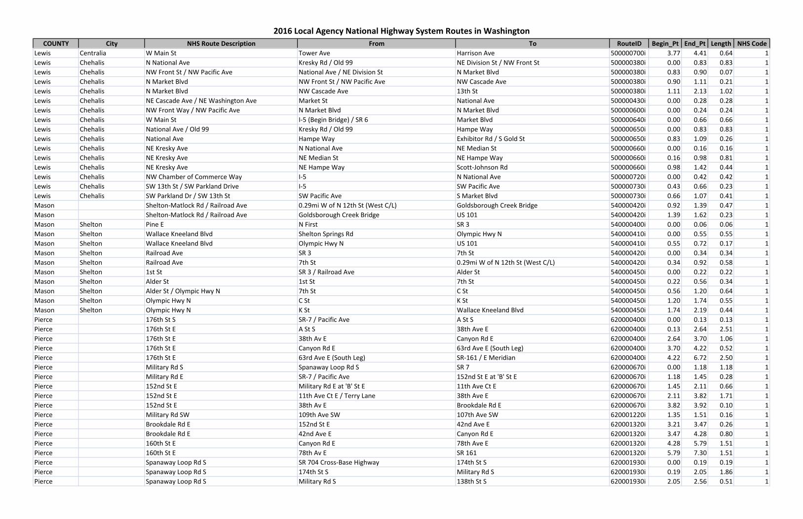
COUNTY City NHS Route Description From To RouteID Begin_Pt End_Pt Length NHS Code
2016 Local Agency National Highway System Routes in Washington
Lewis Centralia W Main St Tower Ave Harrison Ave 500000700i 3.77 4.41 0.64 1Lewis Chehalis N National Ave Kresky Rd / Old 99 NE Division St / NW Front St 500000380i 0.00 0.83 0.83 1Lewis Chehalis NW Front St / NW Pacific Ave National Ave / NE Division St N Market Blvd 500000380i 0.83 0.90 0.07 1Lewis Chehalis N Market Blvd NW Front St / NW Pacific Ave NW Cascade Ave 500000380i 0.90 1.11 0.21 1Lewis Chehalis N Market Blvd NW Cascade Ave 13th St 500000380i 1.11 2.13 1.02 1Lewis Chehalis NE Cascade Ave / NE Washington Ave Market St National Ave 500000430i 0.00 0.28 0.28 1Lewis Chehalis NW Front Way / NW Pacific Ave N Market Blvd N Market Blvd 500000600i 0.00 0.24 0.24 1Lewis Chehalis W Main St I-5 (Begin Bridge) / SR 6 Market Blvd 500000640i 0.00 0.66 0.66 1Lewis Chehalis National Ave / Old 99 Kresky Rd / Old 99 Hampe Way 500000650i 0.00 0.83 0.83 1Lewis Chehalis National Ave Hampe Way Exhibitor Rd / S Gold St 500000650i 0.83 1.09 0.26 1Lewis Chehalis NE Kresky Ave N National Ave NE Median St 500000660i 0.00 0.16 0.16 1Lewis Chehalis NE Kresky Ave NE Median St NE Hampe Way 500000660i 0.16 0.98 0.81 1Lewis Chehalis NE Kresky Ave NE Hampe Way Scott-Johnson Rd 500000660i 0.98 1.42 0.44 1Lewis Chehalis NW Chamber of Commerce Way I-5 N National Ave 500000720i 0.00 0.42 0.42 1Lewis Chehalis SW 13th St / SW Parkland Drive I-5 SW Pacific Ave 500000730i 0.43 0.66 0.23 1Lewis Chehalis SW Parkland Dr / SW 13th St SW Pacific Ave S Market Blvd 500000730i 0.66 1.07 0.41 1Mason Shelton-Matlock Rd / Railroad Ave 0.29mi W of N 12th St (West C/L) Goldsborough Creek Bridge 540000420i 0.92 1.39 0.47 1Mason Shelton-Matlock Rd / Railroad Ave Goldsborough Creek Bridge US 101 540000420i 1.39 1.62 0.23 1Mason Shelton Pine E N First SR 3 540000400i 0.00 0.06 0.06 1Mason Shelton Wallace Kneeland Blvd Shelton Springs Rd Olympic Hwy N 540000410i 0.00 0.55 0.55 1Mason Shelton Wallace Kneeland Blvd Olympic Hwy N US 101 540000410i 0.55 0.72 0.17 1Mason Shelton Railroad Ave SR 3 7th St 540000420i 0.00 0.34 0.34 1Mason Shelton Railroad Ave 7th St 0.29mi W of N 12th St (West C/L) 540000420i 0.34 0.92 0.58 1Mason Shelton 1st St SR 3 / Railroad Ave Alder St 540000450i 0.00 0.22 0.22 1Mason Shelton Alder St 1st St 7th St 540000450i 0.22 0.56 0.34 1Mason Shelton Alder St / Olympic Hwy N 7th St C St 540000450i 0.56 1.20 0.64 1Mason Shelton Olympic Hwy N C St K St 540000450i 1.20 1.74 0.55 1Mason Shelton Olympic Hwy N K St Wallace Kneeland Blvd 540000450i 1.74 2.19 0.44 1Pierce 176th St S SR-7 / Pacific Ave A St S 620000400i 0.00 0.13 0.13 1Pierce 176th St E A St S 38th Ave E 620000400i 0.13 2.64 2.51 1Pierce 176th St E 38th Av E Canyon Rd E 620000400i 2.64 3.70 1.06 1Pierce 176th St E Canyon Rd E 63rd Ave E (South Leg) 620000400i 3.70 4.22 0.52 1Pierce 176th St E 63rd Ave E (South Leg) SR-161 / E Meridian 620000400i 4.22 6.72 2.50 1Pierce Military Rd S Spanaway Loop Rd S SR 7 620000670i 0.00 1.18 1.18 1Pierce Military Rd E SR-7 / Pacific Ave 152nd St E at 'B' St E 620000670i 1.18 1.45 0.28 1Pierce 152nd St E Military Rd E at 'B' St E 11th Ave Ct E 620000670i 1.45 2.11 0.66 1Pierce 152nd St E 11th Ave Ct E / Terry Lane 38th Ave E 620000670i 2.11 3.82 1.71 1Pierce 152nd St E 38th Av E Brookdale Rd E 620000670i 3.82 3.92 0.10 1Pierce Military Rd SW 109th Ave SW 107th Ave SW 620001220i 1.35 1.51 0.16 1Pierce Brookdale Rd E 152nd St E 42nd Ave E 620001320i 3.21 3.47 0.26 1Pierce Brookdale Rd E 42nd Ave E Canyon Rd E 620001320i 3.47 4.28 0.80 1Pierce 160th St E Canyon Rd E 78th Ave E 620001320i 4.28 5.79 1.51 1Pierce 160th St E 78th Av E SR 161 620001320i 5.79 7.30 1.51 1Pierce Spanaway Loop Rd S SR 704 Cross-Base Highway 174th St S 620001930i 0.00 0.19 0.19 1Pierce Spanaway Loop Rd S 174th St S Military Rd S 620001930i 0.19 2.05 1.86 1Pierce Spanaway Loop Rd S Military Rd S 138th St S 620001930i 2.05 2.56 0.51 1
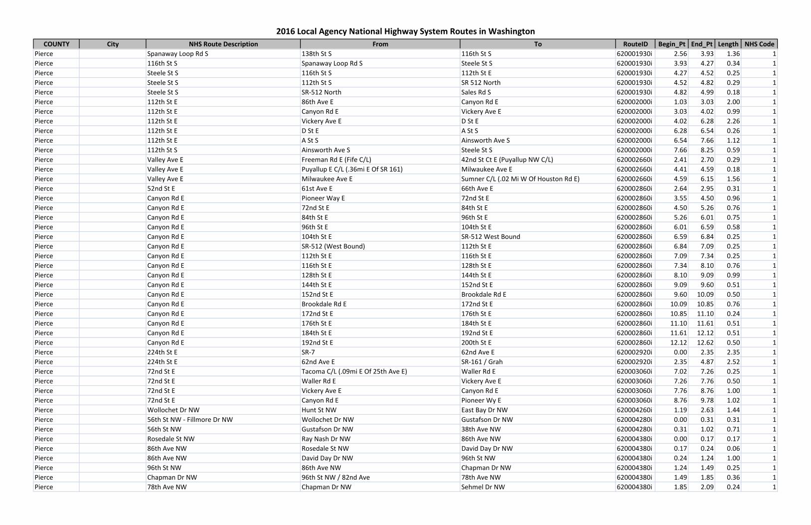
COUNTY City NHS Route Description From To RouteID Begin_Pt End_Pt Length NHS Code
2016 Local Agency National Highway System Routes in Washington
Pierce Spanaway Loop Rd S 138th St S 116th St S 620001930i 2.56 3.93 1.36 1Pierce 116th St S Spanaway Loop Rd S Steele St S 620001930i 3.93 4.27 0.34 1Pierce Steele St S 116th St S 112th St E 620001930i 4.27 4.52 0.25 1Pierce Steele St S 112th St S SR 512 North 620001930i 4.52 4.82 0.29 1Pierce Steele St S SR-512 North Sales Rd S 620001930i 4.82 4.99 0.18 1Pierce 112th St E 86th Ave E Canyon Rd E 620002000i 1.03 3.03 2.00 1Pierce 112th St E Canyon Rd E Vickery Ave E 620002000i 3.03 4.02 0.99 1Pierce 112th St E Vickery Ave E D St E 620002000i 4.02 6.28 2.26 1Pierce 112th St E D St E A St S 620002000i 6.28 6.54 0.26 1Pierce 112th St E A St S Ainsworth Ave S 620002000i 6.54 7.66 1.12 1Pierce 112th St S Ainsworth Ave S Steele St S 620002000i 7.66 8.25 0.59 1Pierce Valley Ave E Freeman Rd E (Fife C/L) 42nd St Ct E (Puyallup NW C/L) 620002660i 2.41 2.70 0.29 1Pierce Valley Ave E Puyallup E C/L (.36mi E Of SR 161) Milwaukee Ave E 620002660i 4.41 4.59 0.18 1Pierce Valley Ave E Milwaukee Ave E Sumner C/L (.02 Mi W Of Houston Rd E) 620002660i 4.59 6.15 1.56 1Pierce 52nd St E 61st Ave E 66th Ave E 620002860i 2.64 2.95 0.31 1Pierce Canyon Rd E Pioneer Way E 72nd St E 620002860i 3.55 4.50 0.96 1Pierce Canyon Rd E 72nd St E 84th St E 620002860i 4.50 5.26 0.76 1Pierce Canyon Rd E 84th St E 96th St E 620002860i 5.26 6.01 0.75 1Pierce Canyon Rd E 96th St E 104th St E 620002860i 6.01 6.59 0.58 1Pierce Canyon Rd E 104th St E SR-512 West Bound 620002860i 6.59 6.84 0.25 1Pierce Canyon Rd E SR-512 (West Bound) 112th St E 620002860i 6.84 7.09 0.25 1Pierce Canyon Rd E 112th St E 116th St E 620002860i 7.09 7.34 0.25 1Pierce Canyon Rd E 116th St E 128th St E 620002860i 7.34 8.10 0.76 1Pierce Canyon Rd E 128th St E 144th St E 620002860i 8.10 9.09 0.99 1Pierce Canyon Rd E 144th St E 152nd St E 620002860i 9.09 9.60 0.51 1Pierce Canyon Rd E 152nd St E Brookdale Rd E 620002860i 9.60 10.09 0.50 1Pierce Canyon Rd E Brookdale Rd E 172nd St E 620002860i 10.09 10.85 0.76 1Pierce Canyon Rd E 172nd St E 176th St E 620002860i 10.85 11.10 0.24 1Pierce Canyon Rd E 176th St E 184th St E 620002860i 11.10 11.61 0.51 1Pierce Canyon Rd E 184th St E 192nd St E 620002860i 11.61 12.12 0.51 1Pierce Canyon Rd E 192nd St E 200th St E 620002860i 12.12 12.62 0.50 1Pierce 224th St E SR-7 62nd Ave E 620002920i 0.00 2.35 2.35 1Pierce 224th St E 62nd Ave E SR-161 / Grah 620002920i 2.35 4.87 2.52 1Pierce 72nd St E Tacoma C/L (.09mi E Of 25th Ave E) Waller Rd E 620003060i 7.02 7.26 0.25 1Pierce 72nd St E Waller Rd E Vickery Ave E 620003060i 7.26 7.76 0.50 1Pierce 72nd St E Vickery Ave E Canyon Rd E 620003060i 7.76 8.76 1.00 1Pierce 72nd St E Canyon Rd E Pioneer Wy E 620003060i 8.76 9.78 1.02 1Pierce Wollochet Dr NW Hunt St NW East Bay Dr NW 620004260i 1.19 2.63 1.44 1Pierce 56th St NW - Fillmore Dr NW Wollochet Dr NW Gustafson Dr NW 620004280i 0.00 0.31 0.31 1Pierce 56th St NW Gustafson Dr NW 38th Ave NW 620004280i 0.31 1.02 0.71 1Pierce Rosedale St NW Ray Nash Dr NW 86th Ave NW 620004380i 0.00 0.17 0.17 1Pierce 86th Ave NW Rosedale St NW David Day Dr NW 620004380i 0.17 0.24 0.06 1Pierce 86th Ave NW David Day Dr NW 96th St NW 620004380i 0.24 1.24 1.00 1Pierce 96th St NW 86th Ave NW Chapman Dr NW 620004380i 1.24 1.49 0.25 1Pierce Chapman Dr NW 96th St NW / 82nd Ave 78th Ave NW 620004380i 1.49 1.85 0.36 1Pierce 78th Ave NW Chapman Dr NW Sehmel Dr NW 620004380i 1.85 2.09 0.24 1
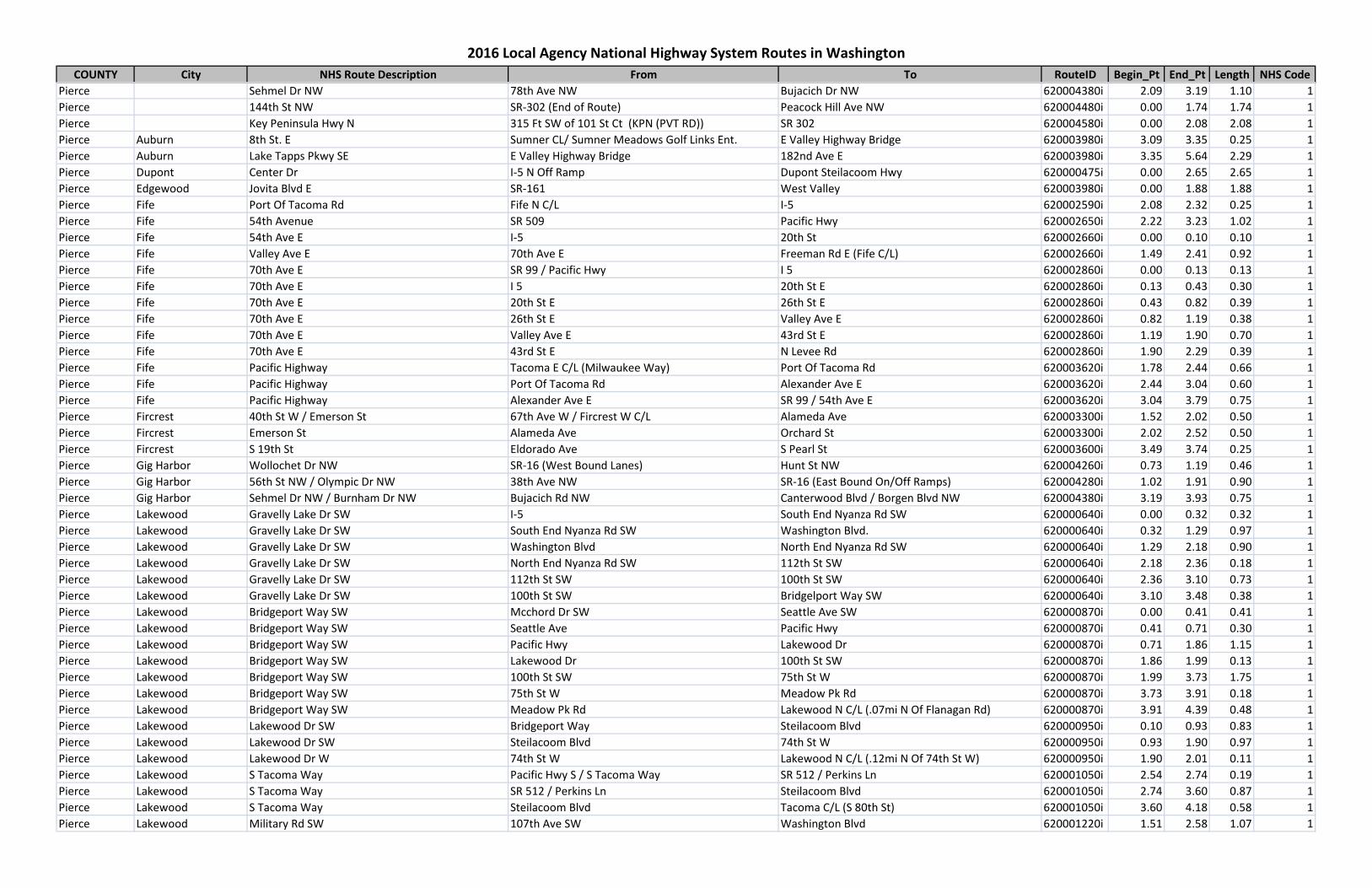
COUNTY City NHS Route Description From To RouteID Begin_Pt End_Pt Length NHS Code
2016 Local Agency National Highway System Routes in Washington
Pierce Sehmel Dr NW 78th Ave NW Bujacich Dr NW 620004380i 2.09 3.19 1.10 1Pierce 144th St NW SR-302 (End of Route) Peacock Hill Ave NW 620004480i 0.00 1.74 1.74 1Pierce Key Peninsula Hwy N 315 Ft SW of 101 St Ct (KPN (PVT RD)) SR 302 620004580i 0.00 2.08 2.08 1Pierce Auburn 8th St. E Sumner CL/ Sumner Meadows Golf Links Ent. E Valley Highway Bridge 620003980i 3.09 3.35 0.25 1Pierce Auburn Lake Tapps Pkwy SE E Valley Highway Bridge 182nd Ave E 620003980i 3.35 5.64 2.29 1Pierce Dupont Center Dr I-5 N Off Ramp Dupont Steilacoom Hwy 620000475i 0.00 2.65 2.65 1Pierce Edgewood Jovita Blvd E SR-161 West Valley 620003980i 0.00 1.88 1.88 1Pierce Fife Port Of Tacoma Rd Fife N C/L I-5 620002590i 2.08 2.32 0.25 1Pierce Fife 54th Avenue SR 509 Pacific Hwy 620002650i 2.22 3.23 1.02 1Pierce Fife 54th Ave E I-5 20th St 620002660i 0.00 0.10 0.10 1Pierce Fife Valley Ave E 70th Ave E Freeman Rd E (Fife C/L) 620002660i 1.49 2.41 0.92 1Pierce Fife 70th Ave E SR 99 / Pacific Hwy I 5 620002860i 0.00 0.13 0.13 1Pierce Fife 70th Ave E I 5 20th St E 620002860i 0.13 0.43 0.30 1Pierce Fife 70th Ave E 20th St E 26th St E 620002860i 0.43 0.82 0.39 1Pierce Fife 70th Ave E 26th St E Valley Ave E 620002860i 0.82 1.19 0.38 1Pierce Fife 70th Ave E Valley Ave E 43rd St E 620002860i 1.19 1.90 0.70 1Pierce Fife 70th Ave E 43rd St E N Levee Rd 620002860i 1.90 2.29 0.39 1Pierce Fife Pacific Highway Tacoma E C/L (Milwaukee Way) Port Of Tacoma Rd 620003620i 1.78 2.44 0.66 1Pierce Fife Pacific Highway Port Of Tacoma Rd Alexander Ave E 620003620i 2.44 3.04 0.60 1Pierce Fife Pacific Highway Alexander Ave E SR 99 / 54th Ave E 620003620i 3.04 3.79 0.75 1Pierce Fircrest 40th St W / Emerson St 67th Ave W / Fircrest W C/L Alameda Ave 620003300i 1.52 2.02 0.50 1Pierce Fircrest Emerson St Alameda Ave Orchard St 620003300i 2.02 2.52 0.50 1Pierce Fircrest S 19th St Eldorado Ave S Pearl St 620003600i 3.49 3.74 0.25 1Pierce Gig Harbor Wollochet Dr NW SR-16 (West Bound Lanes) Hunt St NW 620004260i 0.73 1.19 0.46 1Pierce Gig Harbor 56th St NW / Olympic Dr NW 38th Ave NW SR-16 (East Bound On/Off Ramps) 620004280i 1.02 1.91 0.90 1Pierce Gig Harbor Sehmel Dr NW / Burnham Dr NW Bujacich Rd NW Canterwood Blvd / Borgen Blvd NW 620004380i 3.19 3.93 0.75 1Pierce Lakewood Gravelly Lake Dr SW I-5 South End Nyanza Rd SW 620000640i 0.00 0.32 0.32 1Pierce Lakewood Gravelly Lake Dr SW South End Nyanza Rd SW Washington Blvd. 620000640i 0.32 1.29 0.97 1Pierce Lakewood Gravelly Lake Dr SW Washington Blvd North End Nyanza Rd SW 620000640i 1.29 2.18 0.90 1Pierce Lakewood Gravelly Lake Dr SW North End Nyanza Rd SW 112th St SW 620000640i 2.18 2.36 0.18 1Pierce Lakewood Gravelly Lake Dr SW 112th St SW 100th St SW 620000640i 2.36 3.10 0.73 1Pierce Lakewood Gravelly Lake Dr SW 100th St SW Bridgelport Way SW 620000640i 3.10 3.48 0.38 1Pierce Lakewood Bridgeport Way SW Mcchord Dr SW Seattle Ave SW 620000870i 0.00 0.41 0.41 1Pierce Lakewood Bridgeport Way SW Seattle Ave Pacific Hwy 620000870i 0.41 0.71 0.30 1Pierce Lakewood Bridgeport Way SW Pacific Hwy Lakewood Dr 620000870i 0.71 1.86 1.15 1Pierce Lakewood Bridgeport Way SW Lakewood Dr 100th St SW 620000870i 1.86 1.99 0.13 1Pierce Lakewood Bridgeport Way SW 100th St SW 75th St W 620000870i 1.99 3.73 1.75 1Pierce Lakewood Bridgeport Way SW 75th St W Meadow Pk Rd 620000870i 3.73 3.91 0.18 1Pierce Lakewood Bridgeport Way SW Meadow Pk Rd Lakewood N C/L (.07mi N Of Flanagan Rd) 620000870i 3.91 4.39 0.48 1Pierce Lakewood Lakewood Dr SW Bridgeport Way Steilacoom Blvd 620000950i 0.10 0.93 0.83 1Pierce Lakewood Lakewood Dr SW Steilacoom Blvd 74th St W 620000950i 0.93 1.90 0.97 1Pierce Lakewood Lakewood Dr W 74th St W Lakewood N C/L (.12mi N Of 74th St W) 620000950i 1.90 2.01 0.11 1Pierce Lakewood S Tacoma Way Pacific Hwy S / S Tacoma Way SR 512 / Perkins Ln 620001050i 2.54 2.74 0.19 1Pierce Lakewood S Tacoma Way SR 512 / Perkins Ln Steilacoom Blvd 620001050i 2.74 3.60 0.87 1Pierce Lakewood S Tacoma Way Steilacoom Blvd Tacoma C/L (S 80th St) 620001050i 3.60 4.18 0.58 1Pierce Lakewood Military Rd SW 107th Ave SW Washington Blvd 620001220i 1.51 2.58 1.07 1
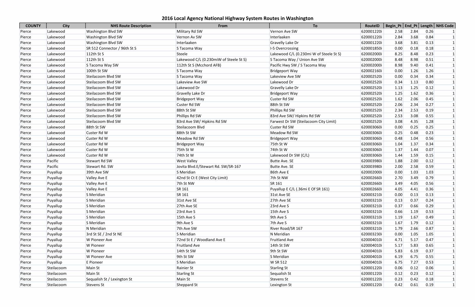
COUNTY City NHS Route Description From To RouteID Begin_Pt End_Pt Length NHS Code
2016 Local Agency National Highway System Routes in Washington
Pierce Lakewood Washington Blvd SW Military Rd SW Vernon Ave SW 620001220i 2.58 2.84 0.26 1Pierce Lakewood Washington Blvd SW Vernon Av SW Interlaaken 620001220i 2.84 3.68 0.84 1Pierce Lakewood Washington Blvd SW Interlaaken Gravelly Lake Dr 620001220i 3.68 3.81 0.13 1Pierce Lakewood SR 512 Connector / 96th St S S Tacoma Way I-5 Overcrossing 620001850i 0.00 0.18 0.18 1Pierce Lakewood 112th St S Steele Lakewood C/L (0.230mi W of Steele St S) 620002000i 8.25 8.48 0.23 1Pierce Lakewood 112th St S Lakewood C/L (0.230miW of Steele St S) S Tacoma Way / Union Ave SW 620002000i 8.48 8.98 0.51 1Pierce Lakewood S Tacoma Way SW 112th St S (Mcchord AFB) Pacific Hwy SW / S Tacoma Way 620002000i 8.98 9.40 0.41 1Pierce Lakewood 100th St SW S Tacoma Way Bridgeport Way 620002160i 0.00 1.26 1.26 1Pierce Lakewood Steilacoom Blvd SW S Tacoma Way Lakeview Ave SW 620002520i 0.00 0.34 0.34 1Pierce Lakewood Steilacoom Blvd SW Lakeview Ave SW Lakewood Dr 620002520i 0.34 1.13 0.80 1Pierce Lakewood Steilacoom Blvd SW Lakewood Dr Gravelly Lake Dr 620002520i 1.13 1.25 0.12 1Pierce Lakewood Steilacoom Blvd SW Gravelly Lake Dr Bridgeport Way 620002520i 1.25 1.62 0.36 1Pierce Lakewood Steilacoom Blvd SW Bridgeport Way Custer Rd SW 620002520i 1.62 2.06 0.45 1Pierce Lakewood Steilacoom Blvd SW Custer Rd SW 88th St SW 620002520i 2.06 2.34 0.27 1Pierce Lakewood Steilacoom Blvd SW 88th St SW Phillips Rd SW 620002520i 2.34 2.53 0.19 1Pierce Lakewood Steilacoom Blvd SW Phillips Rd SW 83rd Ave SW/ Hipkins Rd SW 620002520i 2.53 3.08 0.55 1Pierce Lakewood Steilacoom Blvd SW 83rd Ave SW/ Hipkins Rd SW Farwest Dr SW (Steilacoom City Limit) 620002520i 3.08 4.35 1.28 1Pierce Lakewood 88th St SW Steilacoom Blvd Custer Rd SW 620003060i 0.00 0.25 0.25 1Pierce Lakewood Custer Rd W 88th St SW Meadow Rd SW 620003060i 0.25 0.48 0.23 1Pierce Lakewood Custer Rd W Meadow Rd SW Bridgeport Way 620003060i 0.48 1.04 0.56 1Pierce Lakewood Custer Rd W Bridgeport Way 75th St W 620003060i 1.04 1.37 0.34 1Pierce Lakewood Custer Rd W 75th St W 74th St W 620003060i 1.37 1.44 0.07 1Pierce Lakewood Custer Rd W 74th St W Lakewood Dr SW (C/L) 620003060i 1.44 1.59 0.15 1Pierce Pacific Stewart Rd SW West Valley Butte Ave. SE 620003980i 1.88 2.00 0.12 1Pierce Pacific Stewart Rd. SW Jovita Blvd.E/Stewart Rd. SW/SR-167 Butte Ave. SE 620003980i 2.00 2.58 0.59 1Pierce Puyallup 39th Ave SW S Meridian 86th Ave E 620002000i 0.00 1.03 1.03 1Pierce Puyallup Valley Ave E 42nd St Ct E (West City Limit) 7th St NW 620002660i 2.70 3.49 0.79 1Pierce Puyallup Valley Ave E 7th St NW SR 161 620002660i 3.49 4.05 0.56 1Pierce Puyallup Valley Ave E SR 161 Puyallup E C/L (.36mi E Of SR 161) 620002660i 4.05 4.41 0.36 1Pierce Puyallup S Meridian SR 161 31st Ave SE 620003210i 0.00 0.13 0.13 1Pierce Puyallup S Meridian 31st Ave SE 27th Ave SE 620003210i 0.13 0.37 0.24 1Pierce Puyallup S Meridian 27th Ave SE 23rd Ave S 620003210i 0.37 0.66 0.29 1Pierce Puyallup S Meridian 23rd Ave S 15th Ave S 620003210i 0.66 1.19 0.53 1Pierce Puyallup S Meridian 15th Ave S 9th Ave S 620003210i 1.19 1.67 0.49 1Pierce Puyallup S Meridian 9th Ave S 7th Ave S 620003210i 1.67 1.79 0.12 1Pierce Puyallup N Meridian 7th Ave SW River Road/SR 167 620003210i 1.79 2.66 0.87 1Pierce Puyallup 3rd St SE / 2nd St NE S Meridian N Meridian 620003230i 0.00 1.05 1.05 1Pierce Puyallup W Pioneer Ave 72nd St E / Woodland Ave E Fruitland Ave 620004010i 4.71 5.17 0.47 1Pierce Puyallup W Pioneer Fruitland Ave 14th St SW 620004010i 5.17 5.83 0.65 1Pierce Puyallup W Pioneer 14th St SW 9th St SW 620004010i 5.83 6.19 0.37 1Pierce Puyallup W Pioneer Ave 9th St SW S Meridian 620004010i 6.19 6.75 0.55 1Pierce Puyallup E Pioneer S Meridian W SR 512 620004010i 6.75 7.27 0.53 1Pierce Steilacoom Main St Rainier St Starling St 620001220i 0.06 0.12 0.06 1Pierce Steilacoom Main St Starling St Sequalish St 620001220i 0.12 0.23 0.12 1Pierce Steilacoom Sequalish St / Lexington St Main St Stevens St 620001220i 0.23 0.42 0.18 1Pierce Steilacoom Stevens St Sheppard St Lexington St 620001220i 0.42 0.61 0.19 1

COUNTY City NHS Route Description From To RouteID Begin_Pt End_Pt Length NHS Code
2016 Local Agency National Highway System Routes in Washington
Pierce Steilacoom Military Rd Shepard St 109th Ave SW 620001220i 0.61 1.35 0.74 1Pierce Steilacoom Steilacoom Blvd Steilacoom Blvd E C/L (Farwest Dr SW) Puyallup St 620002520i 4.35 5.37 1.01 1Pierce Steilacoom Puyallup St Steilacoom Blvd Rainier St 620002520i 5.37 5.43 0.06 1Pierce Steilacoom Rainier St Puyallup St Union Ave 620002520i 5.43 5.90 0.47 1Pierce Sumner Valley Ave E / Pacific Ave / Bridge St Sumner C/L (.02 Mi W Of Houston Rd E) Fryar Ave 620002660i 6.15 6.50 0.35 1Pierce Sumner Traffic Ave Thompson St Main St 620003470i 0.00 0.36 0.36 1Pierce Sumner Stewart Rd. SW Butte Ave. SE Sumner CL/ Sumner Meadows Golf Enter 620003980i 2.58 3.09 0.51 1Pierce Sumner Main Ave SR 410 Thompson St 620004000i 5.11 5.20 0.08 1Pierce Tacoma S Jackson Ave S 19th St 6th Ave 620000870i 7.83 8.95 1.12 1Pierce Tacoma S Orchard St S 19th St S 12th St 620000940i 0.00 0.53 0.53 1Pierce Tacoma S Orchard St S 12th St S 9th St 620000940i 0.53 0.73 0.20 1Pierce Tacoma S Orchard St 6th Ave S 9th St 620000940i 0.73 0.89 0.16 1Pierce Tacoma Lakewood Dr W Lakewood N C/L (.12mi S Of 74th St) 64th St W 620000950i 2.01 2.50 0.50 1Pierce Tacoma Orchard St W * Split Tacoma S C/L (Hannah Pierce Rd) Cirque Dr W / S 56th St 620000950i 2.74 3.04 0.30 1Pierce Tacoma Orchard St W * Split Cirque Dr W / S 56th St S 48th St 620000950i 3.04 3.55 0.51 1Pierce Tacoma S Orchard St * Split S 48th St Emerson St 620000950i 3.55 4.05 0.50 1Pierce Tacoma S Orchard St Emerson St S 19th St 620000950i 4.05 5.56 1.51 1Pierce Tacoma S Tacoma Way S 80th St S 74th St 620001050i 4.18 4.54 0.36 1Pierce Tacoma S Tacoma Way S 74th St S 56th St 620001050i 4.54 5.65 1.11 1Pierce Tacoma S Tacoma Way S 56th St S 50th St 620001050i 5.65 6.03 0.38 1Pierce Tacoma S Tacoma Way S 50th St S 47th St 620001050i 6.03 6.25 0.22 1Pierce Tacoma S Tacoma Way S 47th St S Washington St 620001050i 6.25 6.58 0.33 1Pierce Tacoma S Tacoma Way S Washington St S 38th St 620001050i 6.58 6.79 0.21 1Pierce Tacoma S Tacoma Way S 38th St S 35th St 620001050i 6.79 7.28 0.50 1Pierce Tacoma S Tacoma Way S 35th St S M St 620001050i 7.28 8.59 1.31 1Pierce Tacoma S Tacoma Way S M St Pacific Ave 620001050i 8.59 9.50 0.90 1Pierce Tacoma S Union Ave S 38th St S Center St 620001080i 0.52 1.17 0.65 1Pierce Tacoma S Union Ave S Center St SR-16 (South Ramp) 620001080i 1.17 1.39 0.22 1Pierce Tacoma S Union Ave SR 16 S Ramp SR-16 (North Ramp) 620001080i 1.39 1.48 0.09 1Pierce Tacoma S Union Ave SR 16 N Ramp S 19th St 620001080i 1.48 1.98 0.51 1Pierce Tacoma S Union Ave S 19th St S 12th St 620001080i 1.98 2.49 0.51 1Pierce Tacoma S Union Ave S 12th St S 10th St 620001080i 2.49 2.61 0.12 1Pierce Tacoma S Union Ave S 10th St S 9th St 620001080i 2.61 2.67 0.06 1Pierce Tacoma S Union Ave S 9th St 6th Ave 620001080i 2.67 2.85 0.18 1Pierce Tacoma S Pearl St 6th Ave SR 16 Undercrossing 620001130i 3.40 3.52 0.12 1Pierce Tacoma S Sprague Ave S 25th St S 19th St 620001230i 0.00 0.42 0.42 1Pierce Tacoma S Sprague Ave S 19th St S 15th St 620001230i 0.42 0.69 0.27 1Pierce Tacoma S Sprague Ave S 15th St S 11th St 620001230i 0.69 0.98 0.29 1Pierce Tacoma S Yakima Ave S 12th St I St Trans 620001330i 7.87 8.21 0.33 1Pierce Tacoma I St Trans S Yakima Ave S 6th St 620001330i 8.21 8.33 0.13 1Pierce Tacoma S I St S 6th St Division Ave 620001330i 8.33 8.66 0.32 1Pierce Tacoma N I St Division Ave N 4th St 620001330i 8.66 8.83 0.18 1Pierce Tacoma N I St N 4th St N 5th St 620001330i 8.83 8.91 0.07 1Pierce Tacoma N I St N 5th St N Steele St 620001330i 8.91 9.54 0.64 1Pierce Tacoma N 21st St N Steele St N Pine St 620001330i 9.54 9.79 0.24 1Pierce Tacoma N 21st St N Pine St N Union Ave 620001330i 9.79 10.29 0.50 1

COUNTY City NHS Route Description From To RouteID Begin_Pt End_Pt Length NHS Code
2016 Local Agency National Highway System Routes in Washington
Pierce Tacoma N 21st St N Union Ave N Washington St 620001330i 10.29 10.37 0.08 1Pierce Tacoma N 21st St N Washington St N Cheyenne St 620001330i 10.37 11.01 0.64 1Pierce Tacoma N 21st St N Cheyenne St N Shirley St 620001330i 11.01 11.54 0.53 1Pierce Tacoma N 21st St N Shirley St SR 163/ N Pearl St 620001330i 11.54 11.79 0.25 1Pierce Tacoma A St S 14th St/I-705 Off Ramp S 13th St 620001490i 0.08 0.15 0.07 1Pierce Tacoma A St S 13th St S 11th St 620001490i 0.15 0.29 0.14 1Pierce Tacoma S Steele St S 96th St S 90th St 620001650i 0.00 0.41 0.41 1Pierce Tacoma S Hosmer St * Split S 90th St S 84th St 620001650i 0.41 0.79 0.38 1Pierce Tacoma S Hosmer St S 84th St S 80th St 620001650i 0.79 1.04 0.25 1Pierce Tacoma S Hosmer St * Split S 80th St S 72nd St 620001650i 1.04 1.58 0.54 1Pierce Tacoma E 26th St (E Bay St) E Portland Ave I-5 Under Crossing 620001830i 0.00 0.23 0.23 1Pierce Tacoma Steele St S Sales Rd S S 96th St 620001930i 4.99 5.52 0.53 1Pierce Tacoma Pacific Ave S 38th St S 34th St 620001970i 0.00 0.49 0.49 1Pierce Tacoma Pacific Ave S 34th St S 26h St 620001970i 0.49 1.04 0.55 1Pierce Tacoma Pacific Ave S 26th St S 24th St 620001970i 1.04 1.17 0.14 1Pierce Tacoma Pacific Ave S 24th St S 11th St 620001970i 1.17 2.11 0.94 1Pierce Tacoma E Portland Ave 72nd St E E 64th St 620002490i 2.61 3.11 0.50 1Pierce Tacoma E Portland Ave E 64th St E 56th St 620002490i 3.11 3.61 0.50 1Pierce Tacoma E Portland Ave E 56th St E 38th St 620002490i 3.61 4.77 1.16 1Pierce Tacoma E Portland Ave E 38th St E Fairbanks St 620002490i 4.77 5.18 0.40 1Pierce Tacoma E Portland Ave E Fairbanks St I-5 620002490i 5.18 5.90 0.72 1Pierce Tacoma E Port Of Tacoma Rd E 11th St Marshall Ave 620002590i 0.00 1.46 1.46 1Pierce Tacoma E Port Of Tacoma Rd Marshall Ave Fife N C/L 620002590i 1.46 2.08 0.62 1Pierce Tacoma E Alexander Ave E 11th St Lincoln Ave 620002630i 0.58 1.23 0.65 1Pierce Tacoma E Alexander Ave Lincoln Ave Facility Enterance 620002630i 1.23 2.28 1.05 1Pierce Tacoma Taylor Way E 11th St SR 509 620002650i 0.00 2.22 2.22 1Pierce Tacoma S 74th St Lakewood Dr SW (C/L) South Tacoma Way 620003060i 1.59 2.77 1.18 1Pierce Tacoma S 74th St South Tacoma Way S Lawrence St 620003060i 2.77 2.96 0.19 1Pierce Tacoma S 74th St S Lawrence St S Alder St 620003060i 2.96 3.10 0.14 1Pierce Tacoma E & S 72nd / S 74th St S Alder St E Portland Ave 620003060i 3.10 6.38 3.29 1Pierce Tacoma E 72nd St E Portland Ave Tacoma C/L (.09mi E Of 25th Ave E) 620003060i 6.38 7.02 0.63 1Pierce Tacoma S 56th St Tacoma C/L (Orchard St W) S Ferdinand St 620003160i 3.21 3.36 0.15 1Pierce Tacoma S 56th St S Ferdinand St S Proctor St 620003160i 3.36 3.98 0.61 1Pierce Tacoma S 56th St S Proctor St S Durango St 620003160i 3.98 4.04 0.06 1Pierce Tacoma S 56th St S Durango St South Tacoma Way 620003160i 4.04 4.23 0.20 1Pierce Tacoma S 56th St S Tacoma Way I-5 620003160i 4.23 5.30 1.07 1Pierce Tacoma S 38th St Pacific Ave I-5 620003380i 0.00 1.38 1.38 1Pierce Tacoma S 38th St I-5 Off Ramp W S Steele St 620003380i 1.38 1.63 0.26 1Pierce Tacoma S 38th St S Steele St S Warner St 620003380i 1.63 2.20 0.57 1Pierce Tacoma E 38th St E Portland Ave E Howe St 620003400i 0.00 0.35 0.35 1Pierce Tacoma E 38th St E Howe St E Mckinley Ave 620003400i 0.35 0.62 0.27 1Pierce Tacoma E 38th St E Mckinley Ave SR 7 620003400i 0.62 0.82 0.20 1Pierce Tacoma S 19th St S Jefferson Ave Tacoma Ave S 620003600i 0.11 0.28 0.17 1Pierce Tacoma S 19th St Tacoma Ave S S J St 620003600i 0.28 0.56 0.28 1Pierce Tacoma S 19th St S J St S K St / MLK Jr Way 620003600i 0.56 0.63 0.07 1Pierce Tacoma S 19th St S K St / MLK Jr Way S Cushman Ave 620003600i 0.63 0.90 0.27 1

COUNTY City NHS Route Description From To RouteID Begin_Pt End_Pt Length NHS Code
2016 Local Agency National Highway System Routes in Washington
Pierce Tacoma S 19th St S Cushman Ave S Ainsworth Ave 620003600i 0.90 0.97 0.07 1Pierce Tacoma S 19th St S Ainsworth Ave S Sprague Ave 620003600i 0.97 1.25 0.28 1Pierce Tacoma S 19th St S Sprague Ave S State St 620003600i 1.25 1.42 0.18 1Pierce Tacoma S 19th St S State St S Pine St 620003600i 1.42 1.75 0.33 1Pierce Tacoma S 19th St S Pine St S Union Ave 620003600i 1.75 2.18 0.43 1Pierce Tacoma S 19th St S Union Ave S Mullen St 620003600i 2.18 3.04 0.87 1Pierce Tacoma S 19th St S Mullen St Eldorado Ave 620003600i 3.04 3.49 0.45 1Pierce Tacoma S 19th St * Split S Pearl St S Jackson Ave 620003600i 3.74 4.74 0.99 1Pierce Tacoma S 24th St / E Puyallup Ave S Pacific Ave E D St 620003620i 0.07 0.36 0.29 1Pierce Tacoma E Puyallup Ave E D St E G St 620003620i 0.36 0.58 0.22 1Pierce Tacoma E Puyallup Ave E D St Tacoma E C/L (Milwaukee Way) 620003620i 0.58 1.78 1.20 1Pierce Tacoma E 28th St E Portland Ave E Bay St 620003680i 0.29 0.45 0.16 1Pierce Tacoma Norpoint Way NE E Marine View Dr (SR 509) 29th St NE 620003690i 0.00 1.25 1.25 1Pierce Tacoma 29th St NE Norpoint Wy NE 23rd Ave SW (County Line) 620003770i 0.69 0.87 0.18 1Pierce Tacoma Lincoln Ave E Marc St Milwaukee Way 620003780i 0.46 0.68 0.22 5Pierce Tacoma Lincoln Ave Milwaukee Way Port Of Tacoma Rd 620003780i 0.68 1.29 0.62 5Pierce Tacoma S 13th St A St Pacific Ave 620003800i 0.00 0.07 0.07 1Pierce Tacoma S 13th St S Pacific Ave S Market St 620003800i 0.07 0.21 0.14 1Pierce Tacoma S 13th St S Market St S G St 620003800i 0.21 0.42 0.21 1Pierce Tacoma S G St S 13th St Earnest S Brazill St (S 12th St) 620003800i 0.42 0.49 0.07 1Pierce Tacoma Earnest S Brazill St S Altheimer St S Martin Luther King Jr Way 620003800i 0.49 0.76 0.28 1Pierce Tacoma Earnest S Brazill St S Martin Luther King Jr Way S M St 620003800i 0.76 0.90 0.14 1Pierce Tacoma Earnest S Brazill St S M St S Cushman Ave 620003800i 0.90 1.04 0.14 1Pierce Tacoma Earnest S Brazill St S Cushman Ave S Ainsworth Ave 620003800i 1.04 1.11 0.07 1Pierce Tacoma S 12th St (Earnest S Brazill St) S Ainsworth Ave S Sprague Ave 620003800i 1.11 1.31 0.20 1Pierce Tacoma S 11th St S Sprague Ave S M St 620003840i 0.10 0.49 0.40 1Pierce Tacoma S 11th St S M St S Market St 620003840i 0.49 1.12 0.62 1Pierce Tacoma S 11th St S Market St A St 620003840i 1.12 1.32 0.21 1Pierce Tacoma E 11th St Alexander Ave Taylor Way 620003870i 0.00 0.11 0.11 1Pierce Tacoma E 11th St A St St Paul Ave 620003990i 0.00 0.46 0.46 1Pierce Tacoma I-705 Connector I-705 Schuster Pkwy 620004030i 0.00 0.38 0.38 1Pierce Tacoma E 11th St Minneapolis St E Portland Ave 620004140i 0.00 0.45 0.45 1Pierce Tacoma E 11th St E Portland Ave E Port Of Tacoma Rd 620004140i 0.45 1.38 0.93 1Pierce University Place Bridgeport Way W Lakewood N C/L (.07mi N Of Flanagan Rd) Cirque Dr W 620000870i 4.39 5.82 1.43 1Pierce University Place Bridgeport Way W Cirque Dr W 40th St W 620000870i 5.82 6.32 0.50 1Pierce University Place Bridgeport Way W 40th St W 27th St W 620000870i 6.32 7.32 1.00 1Pierce University Place Bridgeport Way W 27th St W S 19th St 620000870i 7.32 7.83 0.51 1Pierce University Place Lakewood Dr W 64th St W Tacoma S C/L (Hannah Pierce Rd) 620000950i 2.50 2.74 0.24 1Pierce University Place Cirque Dr W Bridgeport Way 67th Ave W 620003160i 1.55 2.13 0.58 1Pierce University Place Cirque Dr W 67th Ave W Tacoma C/L (Orchard St W) 620003160i 2.13 3.21 1.09 1Pierce University Place 40th St W Bridgeport Way 67th Ave W / Fircrest W C/L 620003300i 1.02 1.52 0.50 1Skagit S Laventure Rd Blodgett Rd S 10th St 660001160i 0.30 0.58 0.28 1Skagit S Laventure Rd Anderson Rd E Blackbum Rd 660001160i 0.58 1.08 0.50 1Skagit Anacortes Commercial Ave 12th St 6th St 660000630i 0.00 0.34 0.34 3Skagit Anacortes Commercial Ave 6th St 4th St 660000630i 0.34 0.45 0.11 3Skagit Anacortes Commercial Ave 4th St 2nd St 660000630i 0.45 0.56 0.11 3
COUNTY City NHS Route Description From To RouteID Begin_Pt End_Pt Length NHS Code
2016 Local Agency National Highway System Routes in Washington
Skagit Burlington S Burlington Blvd Skagit River Bridge Pease Rd 660001090i 1.62 2.50 0.88 1Skagit Burlington S Burlington Blvd Pease Rd Gilkey Rd 660001090i 2.50 3.01 0.51 1Skagit Burlington S Burlington Blvd Gilkey Rd E Rio Vista Ave 660001090i 3.01 3.50 0.49 1Skagit Mount Vernon S 2nd St Kincaid St W Division St 660000740i 2.54 2.80 0.26 1Skagit Mount Vernon 4th St / Riverside S N Division St Fir St 660001090i 0.00 0.52 0.52 1Skagit Mount Vernon Riverside Dr E Fir St E College Way 660001090i 0.52 1.02 0.51 1Skagit Mount Vernon Riverside Dr E College Way Skagit River Bridge 660001090i 1.02 1.62 0.60 1Skagit Mount Vernon W Kincaid S 3rd St S 2nd St 660001110i 0.00 0.07 0.07 1Skagit Mount Vernon Anderson Rd I 5 Blodgett Rd 660001160i 0.00 0.30 0.30 1Skamania Bridge of The Gods SR 14 WA/OR Border 680000001i 0.00 0.23 0.23 1Snohomish Ash Way 164th St SW Ashway Park&Ride N Ent (.30mi N of 164th 700000520i 1.22 1.53 0.31 7Snohomish 164th St SW Spruce Way (Lynwood NE C/L) 36th Ave W 700000840i 0.67 0.80 0.13 1Snohomish 164th St SW 36th Ave W Swamp Creek Park N Ride (Wildwood Dr) 700000880i 0.00 0.24 0.24 1Snohomish 164th St SW Swamp Creek Park N Ride (Wildwood Dr) I-5 (Exit 183) 700000880i 0.24 1.14 0.90 7Snohomish 164th St SW I-5 (Exit 183) Larch Way / 10th Ave W 700000880i 1.14 1.62 0.48 1Snohomish 164th St SW Larch Way / 10th Ave W North Rd 700000880i 1.62 2.14 0.52 1Snohomish 164th St SW North Rd Mill Creek W C/L (.16mi E of 3rd Ave SE) 700000880i 2.14 2.68 0.54 1Snohomish 132nd St SE / 134th Pl SE Seattle Hill Rd Snohomish Cascade Dr 700000880i 6.40 7.49 1.09 1Snohomish Cathcart Way Snohomish Cascade Dr Puget Park Dr (east intersection) 700000880i 7.49 8.49 1.01 1Snohomish Cathcart Way Puget Park Dr SR 9 700000880i 8.49 9.53 1.04 1Snohomish Airport Rd Everett C/L (.11mi N Of 94th St) 100th St SW 700000980i 0.49 1.01 0.52 2Snohomish Airport Rd 100th St SW 103rd St SW 700000980i 1.01 1.22 0.21 2Snohomish Airport Rd SR 99 / Everett C/L E Gibson Rd / 128th St Sw 700000980i 2.40 3.06 0.66 2Snohomish 128th St SW Airport Rd / E Gibson Rd 4th Ave W 700000980i 3.06 3.59 0.54 2Snohomish 128th St SW 4th Ave W I-5 (South Bound Ramp Exit 186) 700000980i 3.59 3.75 0.15 2Snohomish 128th St SW I-5 (South Bound Ramp Exit 186) I-5 (SR-96 Mp 0.0 (West Bridge Seat)) 700000980i 3.75 3.80 0.06 2Snohomish 4th Ave W Mariner Park And Ride 128th St Sw 700001090i 0.56 0.66 0.10 7Snohomish Arlington Broadway Ave Division St E Burke Ave (SR 530) 700002250i 0.00 0.11 0.11 1Snohomish Arlington W Division St / E Division St SR 9 Broadway Ave 700002280i 0.00 0.20 0.20 1Snohomish Bothell Bothell-Everett Hwy King County Line 10th Ave SE 700002062i 0.00 0.72 0.72 1Snohomish Bothell Bothell-Everett Hwy 10th Ave SE 228th St SE 700002062i 0.72 1.08 0.37 1Snohomish Bothell Bothell-Everett Hwy 228th St SE I-405 700002062i 1.08 1.32 0.24 1Snohomish Everett Airport Rd SR 526 W Casino Rd 700000980i 0.00 0.15 0.15 2Snohomish Everett Airport Rd W Casino Rd Everett C/L (.11mi N Of 94th St SW) 700000980i 0.15 0.49 0.34 2Snohomish Everett Airport Rd 103rd St SW 112th St SW 700000980i 1.22 1.86 0.63 2Snohomish Everett Airport Rd 112th St SW SR 99 / Pacific Hwy 700000980i 1.86 2.40 0.54 2Snohomish Everett E Marine View Dr Walnut St N Broadway 700001120i 1.14 2.06 0.92 1Snohomish Everett Broadway 41st St Pacific Ave 700002080i 0.00 0.85 0.85 1Snohomish Everett Broadway Pacific Ave SR 529 / Marine View Dr 700002080i 0.85 3.41 2.56 1Snohomish Everett Hoyt Ave Pacific Ave SR 529 / Everett Ave 700002340i 0.00 0.38 0.38 6Snohomish Everett Hewitt Ave Broadway I-5 / SR 2 700002450i 0.83 1.45 0.62 1Snohomish Everett Pacific Ave W Marine View Dr Colby Ave 700002470i 0.32 0.59 0.26 1Snohomish Everett Pacific Ave Colby Ave Broadway 700002470i 0.59 0.92 0.33 1Snohomish Everett Pacific Ave Broadway SR 529 700002470i 0.92 1.40 0.48 1Snohomish Everett Smith Ave Multimodal Train/Bus Depot (32nd Street) Pacific Ave 700002480i 0.82 0.92 0.09 7Snohomish Everett W Mukilteo Blvd Mukilteo Ln (Everett SW C/L) Glenwood Dr 700002560i 0.95 3.00 2.05 1

COUNTY City NHS Route Description From To RouteID Begin_Pt End_Pt Length NHS Code
2016 Local Agency National Highway System Routes in Washington
Snohomish Everett W Mukilteo Blvd Glenwood Dr Dogwood Dr 700002560i 3.00 3.95 0.95 1Snohomish Everett E Mukilteo Blvd Dogwood Dr Rucker Ave 700002560i 3.95 5.17 1.22 1Snohomish Everett 41st St Rucker Ave Colby Ave 700002560i 5.17 5.30 0.13 1Snohomish Everett 41st St Colby Ave I-5 (On Ramp) / Broadway Ave 700002560i 5.30 5.73 0.43 1Snohomish Everett SE Everett Mall Way SR 99 (South On Ramp) SR 526 700002570i 0.00 0.43 0.43 1Snohomish Everett Broadway SR 526 Beverly Blvd 700002570i 0.43 0.66 0.23 1Snohomish Everett Broadway Beverly Blvd Madison St 700002570i 0.66 1.67 1.01 1Snohomish Everett Broadway Madison St 52nd St SE 700002570i 1.67 2.57 0.91 1Snohomish Everett Broadway Lowell Rd 41st St 700002570i 2.57 3.64 1.07 1Snohomish Everett Seaway Blvd SR 526 75th St SW 700002590i 0.02 0.59 0.58 1Snohomish Everett Seaway Blvd 75th St SW Perimeter Rd 700002590i 0.59 0.85 0.26 1Snohomish Everett Seaway Blvd Perimeter Rd Merrill Crk Pk 700002590i 0.85 1.23 0.38 1Snohomish Everett Evergreen Way Everett Mall Way Casino Rd E 700002680i 0.00 1.45 1.45 1Snohomish Everett Evergreen Way Casino Rd E Madison St 700002680i 1.45 2.54 1.09 1Snohomish Everett Evergreen Way Madison St 43rd St SE 700002680i 2.54 4.28 1.74 1Snohomish Everett Rucker Ave 43rd St Pacific Ave 700002680i 4.28 5.37 1.09 1Snohomish Everett Rucker Ave Pacific Ave Everett Ave (SR-529) 700002680i 5.37 5.76 0.38 1Snohomish Everett W Marine View Dr Pacific Ave Everett Ave 700002690i 0.00 0.39 0.39 1Snohomish Everett E Marine View Dr / E Grand Ave I-5 Walnut St 700002700i 0.75 1.32 0.57 1Snohomish Lynnwood 44th Ave W I-5 (North Bound Off Ramp Exit 181A) SR 524 Spur Cedrwy 700000370i 2.43 2.52 0.09 7Snohomish Lynnwood Poplar Way 196th St SW / SR 524 Alderwood Mall Pkwy / I-5 (NB Off Ramp) 700000510i 0.00 0.14 0.14 7Snohomish Lynnwood 200th St SW 46th Ave W SR 524 Spur Cedrwy 700000600i 1.39 1.52 0.13 7Snohomish Lynnwood 168th St SW SR 99 44th Ave W 700000840i 0.00 0.10 0.10 1Snohomish Lynnwood 44th Ave W 168th St SW 164th St SW / 168th St SW / 44th Ave SW 700000840i 0.10 0.51 0.41 1Snohomish Lynnwood 164th St SW 168th St SW / 164th St SW Spruce Way (Lynwood NE C/L) 700000840i 0.51 0.67 0.16 1Snohomish Lynnwood 46th Ave NW 200 St SW Facility Entrance / 202nd St SW 700003380i 0.00 0.11 0.11 7Snohomish Marysville 88th St NE I-5 (South Bound On/Off Ramps) State Ave 700001820i 0.46 0.87 0.41 1Snohomish Marysville 88th St NE State Ave 51st Ave NE 700001820i 0.87 1.50 0.64 1Snohomish Marysville 88th St NE 51st Ave NE 67th Ave NE 700001820i 1.50 2.54 1.04 1Snohomish Marysville 88th St NE / Ingraham Blvd 67th Ave NE 83rd Ave NE 700001820i 2.54 3.77 1.23 1Snohomish Marysville 84th St NE 83rd Ave NE SR 9 700001820i 3.77 4.13 0.36 1Snohomish Marysville State Ave SR 528 / 4th St Grove St 700001940i 0.00 0.65 0.65 1Snohomish Marysville State Ave Grove St 84th St NE 700001940i 0.65 1.40 0.74 1Snohomish Marysville State Ave 84th St NE 88th St NE 700001940i 1.40 1.64 0.25 1Snohomish Marysville State Ave 88th St NE 100th St NE 700001940i 1.64 2.37 0.73 1Snohomish Marysville State Ave 100th St NE 116th St NE 700001940i 2.37 3.37 1.00 1Snohomish Marysville State Ave/Pacific Hwy/Smokey Point Blvd 116th St NE 136th St NE (Paulson Rd) 700001940i 3.37 4.69 1.32 1Snohomish Marysville Smokey Point Blvd 136th St NE (Paulson Rd) SR 531 700001940i 4.69 7.06 2.36 1Snohomish Marysville 116th St NE Old Hwy 99 I-5 700002000i 0.00 0.45 0.45 1Snohomish Mill Creek 164th St SE Mill Creek W C/L (.16mi E of 3rd Ave SE) SR 527 700000880i 2.68 2.99 0.32 1Snohomish Mountlake Terrace 236th St SW Mt Lake Terrace Park-N-Ride I-5 (South Bound On Ramp) 700000180i 1.14 1.26 0.13 7Snohomish Mukilteo 5th St / Mukilteo Blvd SR 525 / Mkto Sp Mukilteo Ln (Everett SW C/L) 700002560i 0.00 0.95 0.95 1Spokane N Country Homes Blvd N Cedar Rd / Maple St (Spokane N C/L) US 2 / US 395 720001520i 10.87 12.70 1.84 1Spokane Spokane Bridge Rd / E Appleway Ave I-90 Exit 299 EB Idaho State Line (E Wellesley Ave Ext Rd) 720001550i 3.32 3.90 0.58 1Spokane N Monroe St SR 291 / Francis Ave Wall St 720001560i 6.05 6.81 0.76 1Spokane Wall St Monroe St Country Homes Blvd 720001710i 4.50 5.21 0.71 1

COUNTY City NHS Route Description From To RouteID Begin_Pt End_Pt Length NHS Code
2016 Local Agency National Highway System Routes in Washington
Spokane Wall St Country Homes Blvd Waikiki Rd 720001710i 5.21 6.03 0.81 1Spokane N Waikiki Rd Wall St Mill Rd 720001710i 6.03 7.08 1.06 1Spokane N Mill Rd N Waikiki Rd W Hastings Rd 720001730i 0.00 0.54 0.54 1Spokane E Bigelow Gulch Rd N Havana St Urban Boundary 720001970i 3.00 3.60 0.60 1Spokane E Hawthorne Rd Nevada St Market St 720002130i 1.34 3.01 1.67 1Spokane N Nevada St E Hawthorne Rd US 2 720002140i 6.19 6.50 0.31 1Spokane E Hastings Rd N Mill Rd N Washington St 720002180i 0.00 0.39 0.39 1Spokane E Hastings Rd N Washington St N Ruby Rd 720002180i 0.39 0.61 0.22 1Spokane E Hastings Rd N Ruby Rd US 395 720002180i 0.61 0.87 0.26 1Spokane E Hastings Rd US 395 N Perry Rd / E Farwell Rd 720002180i 0.87 1.61 0.73 1Spokane E Farwell Rd N Perry St / E Hastings Rd US 2 720002180i 1.61 2.15 0.54 1Spokane E Farwell Rd US 2 N Wilson St 720002180i 2.15 2.88 0.73 1Spokane E Farwell Rd N Wilson St N Sheridan St 720002180i 2.88 3.02 0.14 1Spokane E Farwell Rd N Sheridan St N Market St 720002180i 3.02 3.33 0.31 1Spokane N Market St E Francis Ave E Lincoln Rd 720002260i 7.70 8.69 0.99 1Spokane N Market St E Lincoln Rd E Hawthorne Rd 720002260i 8.69 10.35 1.66 1Spokane N Market St E Hawthorne Rd SR 206 720002260i 10.35 12.85 2.50 1Spokane S Palouse Hwy E 57th Ave S Freya St 720002300i 1.06 1.44 0.38 1Spokane E 32nd Ave S Best Rd S Sullivan Rd 720002350i 2.40 3.15 0.75 1Spokane N Argonne Rd Spokane River Bridge / Millwood C/L E Upriver Rd 720002460i 7.24 7.75 0.51 1Spokane N Argonne Rd E Upriver Dr E Columbia Dr 720002460i 7.75 8.56 0.81 1Spokane N Argonne Rd E Columbia Dr E Bigelow Gulch Rd 720002460i 8.56 9.67 1.12 1Spokane N Harvard Rd SR 290 N Liberty Dr (Spokane River Bridge) 720002750i 3.84 5.68 1.84 1Spokane S Sullivan Rd E 32nd Ave E Saltese Rd 720002770i 0.57 0.82 0.25 1Spokane Liberty Lake E Appleway Ave Spokane Valley C/L Country Vista Dr (I-90 Exit 294 Ramps) 720001320i 1.25 1.57 0.32 1Spokane Liberty Lake N. Harvard Rd. E. Appleway Ave. Liberty Lk. N. City Limits 720002750i 3.09 3.84 0.75 1Spokane Millwood N Argonne Rd SR 290 / E Trent Ave Spokane Rvr Bridge / Millwood C/L 720002460i 6.66 7.24 0.59 1Spokane Spokane W Airport Dr (South Leg) W Mcfarlane Rd W Airport Dr (Merge Two Way) 720000840i 0.00 2.09 2.09 2Spokane Spokane W Airport Dr W Airport Dr (Begin Two Way) US 2 720000840i 2.09 2.65 0.57 2Spokane Spokane WAirport Dr US 2 Grove Rd 720000840i 2.65 2.93 0.28 2Spokane Spokane W Sunset Blvd Grove Rd S Assembly St 720000840i 2.93 3.98 1.05 1Spokane Spokane W Sunset Blvd S Assembly St S Rustle St 720000840i 3.98 4.10 0.12 1Spokane Spokane W Sunset Blvd S Rustle St S F St 720000840i 4.10 4.70 0.61 1Spokane Spokane W Sunset Blvd F Street S Lindeke St 720000840i 4.70 5.29 0.59 1Spokane Spokane W Sunset Blvd S Lindeke St S Elm St 720000840i 5.29 5.91 0.62 1Spokane Spokane W Sunset Blvd S Elm St S Oak St / 3rd St 720000840i 5.91 5.98 0.07 1Spokane Spokane W 3rd Ave S Oak St / 3rd St S Walnut St 720000840i 5.98 6.21 0.23 1Spokane Spokane W 3rd Ave S Walnut St S Division St 720000840i 6.21 7.27 1.06 1Spokane Spokane W 3rd Ave S Division St S Scott St - Sprague Way Access 720000840i 7.27 7.82 0.55 1Spokane Spokane S Sunset Blvd / W 2nd Ave (WB) W Sunset Blvd/Oak S Maple St 720000860i 0.00 0.17 0.17 1Spokane Spokane W 2nd Ave S Maple St S Walnut St 720000860i 0.17 0.25 0.07 1Spokane Spokane W 2nd Ave S Walnut St S Division St 720000860i 0.25 1.31 1.06 1Spokane Spokane E 2nd Ave S Division St E Sprague Way Access 720000860i 1.31 1.92 0.61 1Spokane Spokane N Fancher Rd SR 290 / Trent Ave E Parkwater Ave 720000860i 6.73 6.79 0.06 2Spokane Spokane N Fancher Rd E Parkwater E Mansfield Ave / E Union Ave 720000860i 6.79 6.90 0.12 2Spokane Spokane N Fancher Rd E Mansfield Ave / E Union Ave E Rutter Ave 720000860i 6.90 6.96 0.05 2
COUNTY City NHS Route Description From To RouteID Begin_Pt End_Pt Length NHS Code
2016 Local Agency National Highway System Routes in Washington
Spokane Spokane W 1st Ave S Maple St S Howard St 720000880i 0.00 0.69 0.69 1Spokane Spokane W 1st Ave S Howard St S Bernard St 720000880i 0.69 0.92 0.23 7Spokane Spokane W Airport Dr (North Leg) W Airport Dr (Diverge Two Way) W Mcfarlane Rd 720000940i 0.00 1.60 1.60 2Spokane Spokane W Sunset Hwy East of Geiger Blvd Lewis St (West of Geiger Blvd) 720000980i 0.00 0.48 0.48 1Spokane Spokane W 29th Ave S High Dr S Bernard St 720001080i 0.00 0.57 0.57 1Spokane Spokane W/E 29th Ave S Bernard St S Grand Blvd 720001080i 0.57 1.28 0.71 1Spokane Spokane E 29th Ave S Grand Blvd S Ray St 720001080i 1.28 3.08 1.80 1Spokane Spokane E 29th Ave S Ray S Havana St 720001080i 3.08 3.83 0.75 1Spokane Spokane W 8th Ave / S Washington St S McClellan St W 7th Ave 720001140i 0.00 0.21 0.21 1Spokane Spokane E Hartson Ave S Thor St S Freya St 720001170i 0.00 0.13 0.13 1Spokane Spokane W 4th Ave / Freeway Ave S End Of I-90 Exit 280 EB Off Ramp S Jefferson St / W 4th Ave 720001180i 0.00 0.22 0.22 6Spokane Spokane W 4th Ave S Jefferson St S Lincoln St 720001180i 0.22 0.44 0.22 6Spokane Spokane W Indian Trail Rd W Francis Ave W Weile Ave 720001260i 0.00 0.61 0.61 1Spokane Spokane W Indian Trail Rd W Weile Ave W Kathleen Ave 720001260i 0.61 1.06 0.46 1Spokane Spokane W Indian Trail Rd W Kathleen Ave W Strong Rd 720001260i 1.06 1.74 0.68 1Spokane Spokane W Indian Trail Rd W Strong Rd W Shawnee Ave 720001260i 1.74 2.50 0.76 1Spokane Spokane W Sprague Ave / NB Maple St Bridge Acc W Riverside Ave (Ramp) N Jefferson St 720001310i 0.00 0.15 0.15 1Spokane Spokane W Sprague Ave N Jefferson St N Monroe St 720001310i 0.15 0.29 0.14 1Spokane Spokane W Sprague Ave N Monroe St N Wall St 720001310i 0.29 0.50 0.21 6Spokane Spokane W Sprague Ave N Wall St N Stevens St 720001310i 0.50 0.62 0.12 1Spokane Spokane W Sprague Ave N Stevens St N Bernard St 720001310i 0.62 0.79 0.17 7Spokane Spokane W Sprague Ave N Bernard St US 2 / N Division St 720001310i 0.79 1.01 0.22 7Spokane Spokane E Sprague Ave US 2 / N Division St S Ivory St 720001310i 1.01 1.88 0.87 1Spokane Spokane E Sprague Ave S Ivory St N Napa St 720001310i 1.88 2.41 0.53 1Spokane Spokane E Sprague Ave N Napa St S Regal St 720001310i 2.41 3.01 0.60 1Spokane Spokane E Sprague Ave S Regal St N Freya St 720001310i 3.01 3.51 0.50 1Spokane Spokane E Sprague Ave N Freya St S Myrtle St 720001310i 3.51 3.76 0.25 1Spokane Spokane E Sprague Ave S Myrtle St N Havana St 720001310i 3.76 4.01 0.25 1Spokane Spokane E Broadway N Freya St N Havana St 720001350i 0.00 0.53 0.53 1Spokane Spokane W Riverside Ave N Lincoln St N Bernard St 720001380i 1.86 2.28 0.42 6Spokane Spokane W Riverside Ave N Bernard St US-2 / N Division St 720001380i 2.28 2.51 0.23 6Spokane Spokane W Fort George Wright Dr Government Way N T J Meenach(Downriver Park Dr/N Pettit) 720001390i 0.00 1.33 1.33 1Spokane Spokane N T J Meenach Fort George Wright Dr W Northwest Blvd 720001390i 1.33 1.71 0.38 1Spokane Spokane W Main Ave N Monroe St N Lincoln St 720001400i 0.00 0.07 0.07 1Spokane Spokane W Main Ave N Lincoln St US 2 CO N BROWN 720001400i 0.07 0.62 0.55 1Spokane Spokane W Main Ave US 2 CO BROWN US 2 CO N Division St 720001400i 0.62 0.72 0.10 1Spokane Spokane W Spokane Falls Blvd N Monroe St N Post St 720001410i 0.00 0.17 0.17 1Spokane Spokane W Spokane Falls Blvd N Post St N Bernard St 720001410i 0.17 0.53 0.35 1Spokane Spokane W Spokane Falls Blvd Bernard St US 2 / N Division St 720001410i 0.53 0.76 0.23 1Spokane Spokane E Spokane Falls Blvd US 2 / N Division St N Pine St / N Riverpoint Blvd 720001410i 0.76 0.84 0.09 1Spokane Spokane E Spokane Falls Blvd N Pine St / N Riverpoint Blvd N Riverpoint Blvd 720001410i 0.84 1.15 0.31 1Spokane Spokane E Spokane Falls Blvd N Riverpoint Blvd N Hamilton St 720001410i 1.15 1.48 0.33 1Spokane Spokane W Northwest Blvd Monroe St N Walnut St (south leg) 720001450i 0.00 0.41 0.41 1Spokane Spokane W Northwest Blvd N Walnut St (south leg) N Oak St 720001450i 0.41 0.67 0.25 1Spokane Spokane W Northwest Blvd N Oak St N Nettleton 720001450i 0.67 1.13 0.46 1Spokane Spokane W Northwest Blvd N Nettleton N Alberta St 720001450i 1.13 1.28 0.15 1
COUNTY City NHS Route Description From To RouteID Begin_Pt End_Pt Length NHS Code
2016 Local Agency National Highway System Routes in Washington
Spokane Spokane W Northwest Blvd N Alberta St N Assembly St 720001450i 1.28 2.88 1.60 1Spokane Spokane N Assembly St W Northwest Blvd W Rowan Ave 720001450i 2.88 3.51 0.63 1Spokane Spokane N Assembly St W Rowan Ave W Francis Ave 720001450i 3.51 4.01 0.50 1Spokane Spokane N Ash St / Maple St Access N Maple St (W Mallon Ave area) W Northwest Blvd 720001490i 0.00 1.02 1.02 1Spokane Spokane N Ash St W Northwest Blvd N Maple St Conn Rd / N Country Homes 720001490i 1.02 3.87 2.85 1Spokane Spokane S Walnut Pl (Southbound) W 11th Ave Maple St 720001500i 0.00 0.15 0.15 1Spokane Spokane S Maple St / Walnut Pl (Southbound) Walnut Pl (Southbound) I-90 720001500i 0.15 0.45 0.30 1Spokane Spokane S Maple St (Southbound) I-90 W 2nd Ave 720001500i 0.45 0.65 0.21 1Spokane Spokane S Maple St (Southbound) W 2nd Ave S Maple St Bridge 720001500i 0.65 0.75 0.10 1Spokane Spokane S Maple Street Brg St S Maple St Bridge W 1st Ave Undercrossing (Maple Bridge) 720001500i 0.75 0.82 0.07 1Spokane Spokane S High Dr / S Cedar St W 29th Ave W 12th Ave 720001520i 4.40 5.56 1.16 1Spokane Spokane S Walnut Pl W 12th Ave S Walnut St 720001520i 5.56 5.66 0.10 1Spokane Spokane S Walnut St S Walnut Pl (end of S Maple St) I-90 720001520i 5.66 6.08 0.42 1Spokane Spokane S Walnut St I-90 W 3rd Ave 720001520i 6.08 6.22 0.14 1Spokane Spokane S Walnut St W 3rd Ave W Riverside Ave 720001520i 6.22 6.42 0.21 1Spokane Spokane N Maple St W Riverside Ave Maple St Connector 720001520i 6.42 7.03 0.61 1Spokane Spokane N Maple St W Broadway Ave W Maxwell St 720001520i 7.03 7.42 0.39 1Spokane Spokane N Maple St W Maxwell St W Northwest Blvd 720001520i 7.42 7.98 0.57 1Spokane Spokane N Maple St W Northwest Blvd W Courtland Ave 720001520i 7.98 8.71 0.73 1Spokane Spokane N Maple St W Courtland Ave W Wellesley Ave 720001520i 8.71 9.50 0.78 1Spokane Spokane N Maple St W Wellesley Ave W Francis Ave 720001520i 9.50 10.52 1.02 1Spokane Spokane N Maple St SR 291 / Francis Ave N Cedar Rd / Country Homes (Spokane N C/L) 720001520i 10.52 10.87 0.35 1Spokane Spokane S Monroe St Freeway Ave N / W 4th Ave Sprague Ave 720001560i 1.70 2.03 0.33 6Spokane Spokane N Monroe St W Sprague Ave W Main Ave 720001560i 2.03 2.16 0.13 1Spokane Spokane N Monroe St W Main Ave W Bridge Ave 720001560i 2.16 2.38 0.23 1Spokane Spokane N Monroe St W Ide Ave W Northwest Blvd / W Indiana Ave 720001560i 2.38 3.26 0.87 1Spokane Spokane N Monroe St W Northwest Blvd / W Indiana Ave W Garland Ave 720001560i 3.26 4.55 1.29 1Spokane Spokane N Monroe St W Garland Ave W Wellesley Ave 720001560i 4.55 5.05 0.50 1Spokane Spokane N Monroe St W Wellesley Ave SR 291 / Francis Ave 720001560i 5.05 6.05 1.00 1Spokane Spokane S Lincoln St 4th Ave / I-90 Riverside Ave 720001570i 0.29 0.67 0.38 6Spokane Spokane N Lincoln St Riverside Ave Main Ave 720001570i 0.67 0.75 0.08 1Spokane Spokane N Wall St Sprague Ave Riverside Ave 720001590i 0.33 0.38 0.05 6Spokane Spokane W Maxwell Ave N Ash St N Cedar St 720001610i 6.22 6.43 0.21 1Spokane Spokane W Maxwell Ave N Cedar St N Monroe St 720001610i 6.43 6.71 0.28 1Spokane Spokane W Maxwell Ave N Monroe St N Washington 720001610i 6.71 7.15 0.44 1Spokane Spokane W Maxwell Ave / W Mission ave N Washington US 2 / N Division St 720001610i 7.15 7.44 0.29 1Spokane Spokane E Mission Ave US 2 / N Division St N Hamilton St 720001610i 7.44 8.12 0.68 1Spokane Spokane E Mission Ave N Hamilton St N Perry St 720001610i 8.12 8.41 0.29 1Spokane Spokane E Mission Ave N Perry St N Napa 720001610i 8.41 8.84 0.43 1Spokane Spokane E Mission Ave N Napa St N Regal St 720001610i 8.84 9.44 0.60 1Spokane Spokane E Mission Ave N Regal St N Rebecca St 720001610i 9.44 10.08 0.64 1Spokane Spokane E Mission Ave N Rebecca St E Trent Ave /SR 290 720001610i 10.08 10.53 0.46 1Spokane Spokane S Stevens St W 7th Ave W 1st Ave 720001670i 0.21 0.71 0.50 1Spokane Spokane S Stevens St W 1st Ave W Sprague Ave 720001670i 0.71 0.75 0.04 7Spokane Spokane N Stevens St W Sprague Ave W Main Ave 720001670i 0.75 0.88 0.13 1Spokane Spokane N Stevens St W Main Ave W Spokane Falls 720001670i 0.88 0.96 0.08 1
COUNTY City NHS Route Description From To RouteID Begin_Pt End_Pt Length NHS Code
2016 Local Agency National Highway System Routes in Washington
Spokane Spokane N Stevens St W Spokane Falls N Washington St 720001670i 0.96 1.08 0.12 1Spokane Spokane S Washington St 7th Ave W Spokane Falls Blvd 720001690i 2.18 2.92 0.74 1Spokane Spokane N Washington St W Spokane Falls Blvd N Stevens St 720001690i 2.92 3.03 0.11 1Spokane Spokane N Washington St N Stevens St W Mission Ave / W Maxwell Ave 720001690i 3.03 3.71 0.67 1Spokane Spokane N Washington St W Mission Ave / W Maxwell Ave W Indiana Ave 720001690i 3.71 3.95 0.24 1Spokane Spokane N Washington St W Indiana Ave W Buckeye Ave 720001690i 3.95 4.49 0.54 1Spokane Spokane S Bernard St W 1st Ave W Sprague Ave 720001700i 0.00 0.04 0.04 7Spokane Spokane N Bernard St W Sprague Ave W Riverside Ave (Existing Connector) 720001700i 0.04 0.09 0.05 7Spokane Spokane S McClellan St W 9th Ave W 8th Ave 720001820i 0.00 0.08 0.08 1Spokane Spokane S Grand Blvd E 37th Ave E 32nd Ave 720001830i 0.43 0.75 0.32 1Spokane Spokane S Grand Blvd E 32nd Ave E 27th Ave 720001830i 0.75 1.06 0.32 1Spokane Spokane S Grand Blvd E 27th Ave McClellan St 720001830i 1.06 2.45 1.38 1Spokane Spokane W 9th Ave S McClellan St S Ben Garnett Way Bridge 720001830i 2.45 2.58 0.14 1Spokane Spokane S Stevens St/Ben Garnett S Ben Garnett Way W 7th Ave 720001830i 2.58 2.74 0.16 1Spokane Spokane W Wellesley Ave N Assembly St N Driscoll Blvd 720001880i 0.00 0.69 0.69 1Spokane Spokane W Wellesley Ave N Driscoll Blvd N A St 720001880i 0.69 1.01 0.32 1Spokane Spokane W Wellesley Ave N A St N Belt St 720001880i 1.01 1.51 0.50 1Spokane Spokane W Wellesley Ave N Belt St N Walnut St 720001880i 1.51 1.95 0.45 1Spokane Spokane W Wellesley Ave N Walnut St N Monroe St 720001880i 1.95 2.31 0.36 1Spokane Spokane E Wellesley Ave N Monroe St N Nevada St 720001880i 2.31 3.75 1.44 1Spokane Spokane E Wellesley Ave N Nevada St N Perry St 720001880i 3.75 4.01 0.25 1Spokane Spokane E Wellesley Ave N Perry St N Haven St 720001880i 4.01 5.09 1.09 1Spokane Spokane E Wellesley Ave N Haven St N Market St 720001880i 5.09 5.16 0.07 1Spokane Spokane E Wellesley Ave Market St Havana St 720001880i 5.16 5.98 0.82 1Spokane Spokane E Valley Springs Rd E Wellesley Ave N Custer St 720001880i 5.98 6.31 0.33 1Spokane Spokane E Valley Springs Rd N Custer St Spokane C/L (.05mi East of PLine Access Rd) 720001880i 6.31 6.60 0.29 1Spokane Spokane E Francis Ave US 2 / N Division St N Perry St 720001970i 0.00 0.99 0.99 1Spokane Spokane E Francis Ave N Perry St N Pittsburg St (North leg) 720001970i 0.99 1.24 0.25 1Spokane Spokane E Francis Ave N Pittsburg St (North leg) N Crestline St 720001970i 1.24 1.52 0.28 1Spokane Spokane E Francis Ave N Crestline N Smith (North leg) 720001970i 1.52 1.84 0.32 1Spokane Spokane E Francis Ave N Smith Rd (North leg) N Market St 720001970i 1.84 2.17 0.33 1Spokane Spokane E Francis Ave N Market St N Freya St 720001970i 2.17 2.49 0.32 1Spokane Spokane E Francis Ave N Freya St N Havana St 720001970i 2.49 3.00 0.51 1Spokane Spokane E Lincoln Rd N Division St N Colton St 720002040i 0.50 0.66 0.15 1Spokane Spokane E Lincoln Rd N Colton St North Dakota St 720002040i 0.66 1.01 0.35 1Spokane Spokane E Lincoln Rd North Dakota St N Nevada St 720002040i 1.01 1.25 0.25 1Spokane Spokane E Lincoln Rd N Nevada St Crestline St 720002040i 1.25 2.01 0.75 1Spokane Spokane E Hawthorne Rd US 2 / Newport Hwy Nevada St 720002130i 1.09 1.34 0.25 1Spokane Spokane N Hamilton St SR 290 / E Trent Ave E Marietta Ave 720002140i 0.00 1.35 1.35 1Spokane Spokane N Hamilton St / N Nevada St E Marietta Ave E Euclid Ave 720002140i 1.35 1.71 0.36 1Spokane Spokane N Nevada St E Euclid Ave E Wellesley Ave 720002140i 1.71 2.71 1.00 1Spokane Spokane N Nevada St E Wellesley Ave E Broad Ave 720002140i 2.71 2.76 0.05 1Spokane Spokane N Nevada St E Broad Ave E Francis Ave 720002140i 2.76 3.70 0.94 1Spokane Spokane N Nevada St E Francis Ave E Holyoke Ave 720002140i 3.70 3.88 0.18 1Spokane Spokane N Nevada St E Holyoke Ave E Lincoln Rd 720002140i 3.88 4.70 0.81 1Spokane Spokane N Nevada St E Lincoln Rd E Magnesium Rd 720002140i 4.70 5.20 0.51 1
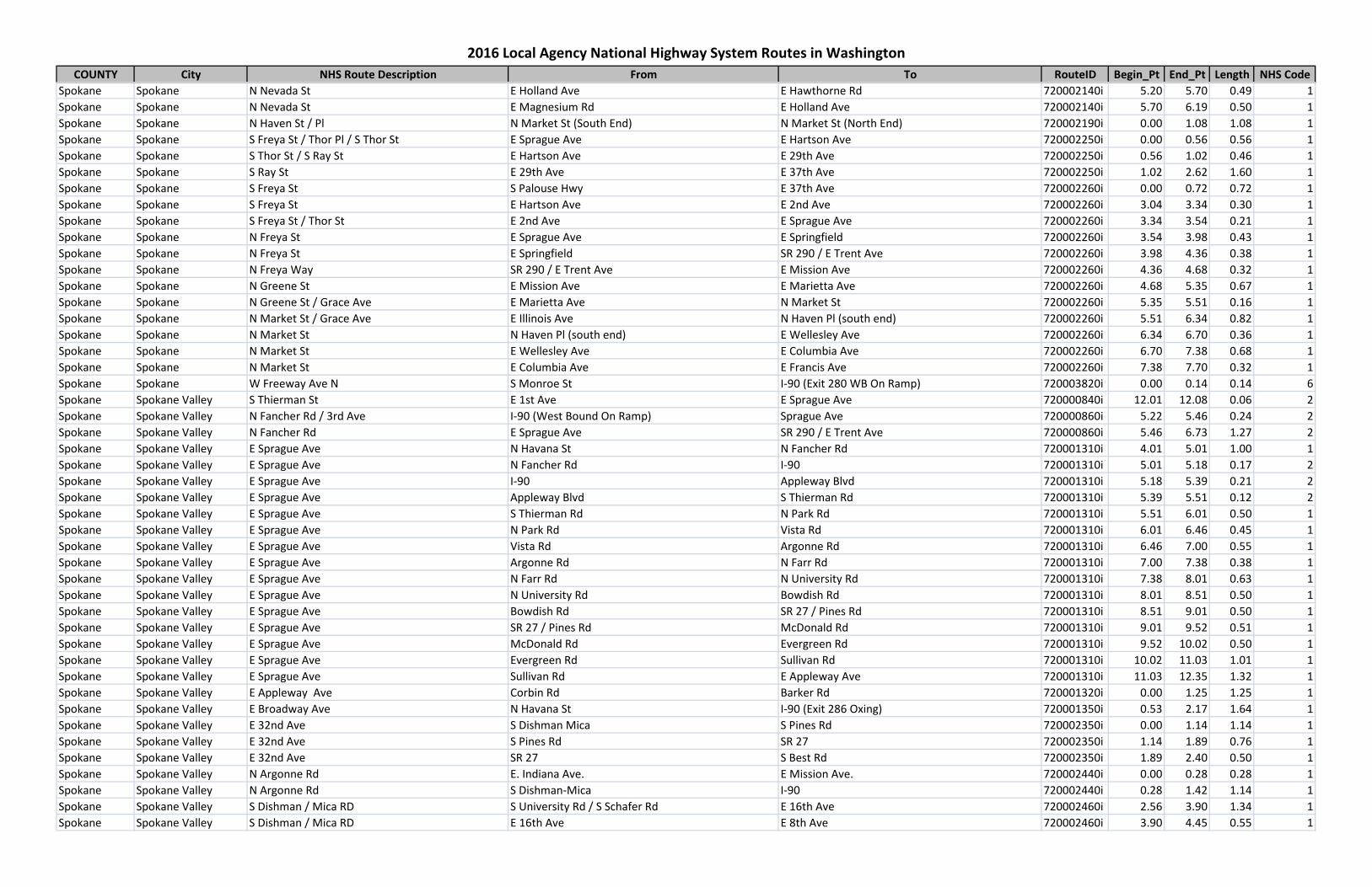
COUNTY City NHS Route Description From To RouteID Begin_Pt End_Pt Length NHS Code
2016 Local Agency National Highway System Routes in Washington
Spokane Spokane N Nevada St E Holland Ave E Hawthorne Rd 720002140i 5.20 5.70 0.49 1Spokane Spokane N Nevada St E Magnesium Rd E Holland Ave 720002140i 5.70 6.19 0.50 1Spokane Spokane N Haven St / Pl N Market St (South End) N Market St (North End) 720002190i 0.00 1.08 1.08 1Spokane Spokane S Freya St / Thor Pl / S Thor St E Sprague Ave E Hartson Ave 720002250i 0.00 0.56 0.56 1Spokane Spokane S Thor St / S Ray St E Hartson Ave E 29th Ave 720002250i 0.56 1.02 0.46 1Spokane Spokane S Ray St E 29th Ave E 37th Ave 720002250i 1.02 2.62 1.60 1Spokane Spokane S Freya St S Palouse Hwy E 37th Ave 720002260i 0.00 0.72 0.72 1Spokane Spokane S Freya St E Hartson Ave E 2nd Ave 720002260i 3.04 3.34 0.30 1Spokane Spokane S Freya St / Thor St E 2nd Ave E Sprague Ave 720002260i 3.34 3.54 0.21 1Spokane Spokane N Freya St E Sprague Ave E Springfield 720002260i 3.54 3.98 0.43 1Spokane Spokane N Freya St E Springfield SR 290 / E Trent Ave 720002260i 3.98 4.36 0.38 1Spokane Spokane N Freya Way SR 290 / E Trent Ave E Mission Ave 720002260i 4.36 4.68 0.32 1Spokane Spokane N Greene St E Mission Ave E Marietta Ave 720002260i 4.68 5.35 0.67 1Spokane Spokane N Greene St / Grace Ave E Marietta Ave N Market St 720002260i 5.35 5.51 0.16 1Spokane Spokane N Market St / Grace Ave E Illinois Ave N Haven Pl (south end) 720002260i 5.51 6.34 0.82 1Spokane Spokane N Market St N Haven Pl (south end) E Wellesley Ave 720002260i 6.34 6.70 0.36 1Spokane Spokane N Market St E Wellesley Ave E Columbia Ave 720002260i 6.70 7.38 0.68 1Spokane Spokane N Market St E Columbia Ave E Francis Ave 720002260i 7.38 7.70 0.32 1Spokane Spokane W Freeway Ave N S Monroe St I-90 (Exit 280 WB On Ramp) 720003820i 0.00 0.14 0.14 6Spokane Spokane Valley S Thierman St E 1st Ave E Sprague Ave 720000840i 12.01 12.08 0.06 2Spokane Spokane Valley N Fancher Rd / 3rd Ave I-90 (West Bound On Ramp) Sprague Ave 720000860i 5.22 5.46 0.24 2Spokane Spokane Valley N Fancher Rd E Sprague Ave SR 290 / E Trent Ave 720000860i 5.46 6.73 1.27 2Spokane Spokane Valley E Sprague Ave N Havana St N Fancher Rd 720001310i 4.01 5.01 1.00 1Spokane Spokane Valley E Sprague Ave N Fancher Rd I-90 720001310i 5.01 5.18 0.17 2Spokane Spokane Valley E Sprague Ave I-90 Appleway Blvd 720001310i 5.18 5.39 0.21 2Spokane Spokane Valley E Sprague Ave Appleway Blvd S Thierman Rd 720001310i 5.39 5.51 0.12 2Spokane Spokane Valley E Sprague Ave S Thierman Rd N Park Rd 720001310i 5.51 6.01 0.50 1Spokane Spokane Valley E Sprague Ave N Park Rd Vista Rd 720001310i 6.01 6.46 0.45 1Spokane Spokane Valley E Sprague Ave Vista Rd Argonne Rd 720001310i 6.46 7.00 0.55 1Spokane Spokane Valley E Sprague Ave Argonne Rd N Farr Rd 720001310i 7.00 7.38 0.38 1Spokane Spokane Valley E Sprague Ave N Farr Rd N University Rd 720001310i 7.38 8.01 0.63 1Spokane Spokane Valley E Sprague Ave N University Rd Bowdish Rd 720001310i 8.01 8.51 0.50 1Spokane Spokane Valley E Sprague Ave Bowdish Rd SR 27 / Pines Rd 720001310i 8.51 9.01 0.50 1Spokane Spokane Valley E Sprague Ave SR 27 / Pines Rd McDonald Rd 720001310i 9.01 9.52 0.51 1Spokane Spokane Valley E Sprague Ave McDonald Rd Evergreen Rd 720001310i 9.52 10.02 0.50 1Spokane Spokane Valley E Sprague Ave Evergreen Rd Sullivan Rd 720001310i 10.02 11.03 1.01 1Spokane Spokane Valley E Sprague Ave Sullivan Rd E Appleway Ave 720001310i 11.03 12.35 1.32 1Spokane Spokane Valley E Appleway Ave Corbin Rd Barker Rd 720001320i 0.00 1.25 1.25 1Spokane Spokane Valley E Broadway Ave N Havana St I-90 (Exit 286 Oxing) 720001350i 0.53 2.17 1.64 1Spokane Spokane Valley E 32nd Ave S Dishman Mica S Pines Rd 720002350i 0.00 1.14 1.14 1Spokane Spokane Valley E 32nd Ave S Pines Rd SR 27 720002350i 1.14 1.89 0.76 1Spokane Spokane Valley E 32nd Ave SR 27 S Best Rd 720002350i 1.89 2.40 0.50 1Spokane Spokane Valley N Argonne Rd E. Indiana Ave. E Mission Ave. 720002440i 0.00 0.28 0.28 1Spokane Spokane Valley N Argonne Rd S Dishman-Mica I-90 720002440i 0.28 1.42 1.14 1Spokane Spokane Valley S Dishman / Mica RD S University Rd / S Schafer Rd E 16th Ave 720002460i 2.56 3.90 1.34 1Spokane Spokane Valley S Dishman / Mica RD E 16th Ave E 8th Ave 720002460i 3.90 4.45 0.55 1
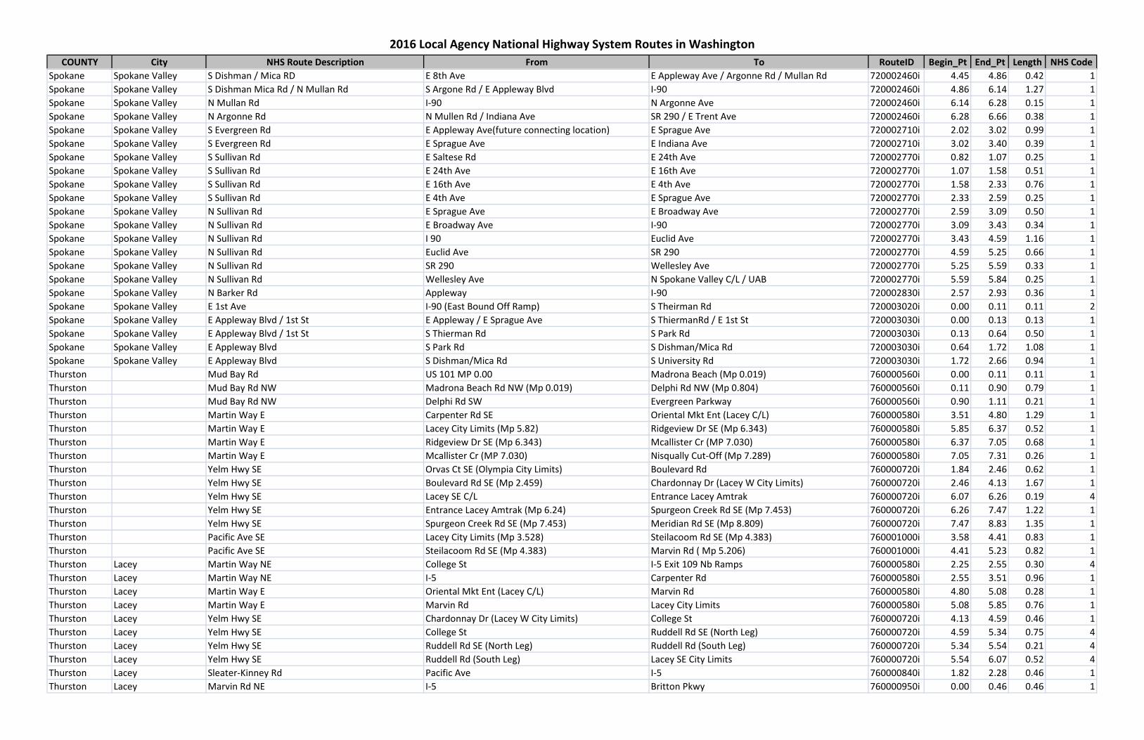
COUNTY City NHS Route Description From To RouteID Begin_Pt End_Pt Length NHS Code
2016 Local Agency National Highway System Routes in Washington
Spokane Spokane Valley S Dishman / Mica RD E 8th Ave E Appleway Ave / Argonne Rd / Mullan Rd 720002460i 4.45 4.86 0.42 1Spokane Spokane Valley S Dishman Mica Rd / N Mullan Rd S Argone Rd / E Appleway Blvd I-90 720002460i 4.86 6.14 1.27 1Spokane Spokane Valley N Mullan Rd I-90 N Argonne Ave 720002460i 6.14 6.28 0.15 1Spokane Spokane Valley N Argonne Rd N Mullen Rd / Indiana Ave SR 290 / E Trent Ave 720002460i 6.28 6.66 0.38 1Spokane Spokane Valley S Evergreen Rd E Appleway Ave(future connecting location) E Sprague Ave 720002710i 2.02 3.02 0.99 1Spokane Spokane Valley S Evergreen Rd E Sprague Ave E Indiana Ave 720002710i 3.02 3.40 0.39 1Spokane Spokane Valley S Sullivan Rd E Saltese Rd E 24th Ave 720002770i 0.82 1.07 0.25 1Spokane Spokane Valley S Sullivan Rd E 24th Ave E 16th Ave 720002770i 1.07 1.58 0.51 1Spokane Spokane Valley S Sullivan Rd E 16th Ave E 4th Ave 720002770i 1.58 2.33 0.76 1Spokane Spokane Valley S Sullivan Rd E 4th Ave E Sprague Ave 720002770i 2.33 2.59 0.25 1Spokane Spokane Valley N Sullivan Rd E Sprague Ave E Broadway Ave 720002770i 2.59 3.09 0.50 1Spokane Spokane Valley N Sullivan Rd E Broadway Ave I-90 720002770i 3.09 3.43 0.34 1Spokane Spokane Valley N Sullivan Rd I 90 Euclid Ave 720002770i 3.43 4.59 1.16 1Spokane Spokane Valley N Sullivan Rd Euclid Ave SR 290 720002770i 4.59 5.25 0.66 1Spokane Spokane Valley N Sullivan Rd SR 290 Wellesley Ave 720002770i 5.25 5.59 0.33 1Spokane Spokane Valley N Sullivan Rd Wellesley Ave N Spokane Valley C/L / UAB 720002770i 5.59 5.84 0.25 1Spokane Spokane Valley N Barker Rd Appleway I-90 720002830i 2.57 2.93 0.36 1Spokane Spokane Valley E 1st Ave I-90 (East Bound Off Ramp) S Theirman Rd 720003020i 0.00 0.11 0.11 2Spokane Spokane Valley E Appleway Blvd / 1st St E Appleway / E Sprague Ave S ThiermanRd / E 1st St 720003030i 0.00 0.13 0.13 1Spokane Spokane Valley E Appleway Blvd / 1st St S Thierman Rd S Park Rd 720003030i 0.13 0.64 0.50 1Spokane Spokane Valley E Appleway Blvd S Park Rd S Dishman/Mica Rd 720003030i 0.64 1.72 1.08 1Spokane Spokane Valley E Appleway Blvd S Dishman/Mica Rd S University Rd 720003030i 1.72 2.66 0.94 1Thurston Mud Bay Rd US 101 MP 0.00 Madrona Beach (Mp 0.019) 760000560i 0.00 0.11 0.11 1Thurston Mud Bay Rd NW Madrona Beach Rd NW (Mp 0.019) Delphi Rd NW (Mp 0.804) 760000560i 0.11 0.90 0.79 1Thurston Mud Bay Rd NW Delphi Rd SW Evergreen Parkway 760000560i 0.90 1.11 0.21 1Thurston Martin Way E Carpenter Rd SE Oriental Mkt Ent (Lacey C/L) 760000580i 3.51 4.80 1.29 1Thurston Martin Way E Lacey City Limits (Mp 5.82) Ridgeview Dr SE (Mp 6.343) 760000580i 5.85 6.37 0.52 1Thurston Martin Way E Ridgeview Dr SE (Mp 6.343) Mcallister Cr (MP 7.030) 760000580i 6.37 7.05 0.68 1Thurston Martin Way E Mcallister Cr (MP 7.030) Nisqually Cut-Off (Mp 7.289) 760000580i 7.05 7.31 0.26 1Thurston Yelm Hwy SE Orvas Ct SE (Olympia City Limits) Boulevard Rd 760000720i 1.84 2.46 0.62 1Thurston Yelm Hwy SE Boulevard Rd SE (Mp 2.459) Chardonnay Dr (Lacey W City Limits) 760000720i 2.46 4.13 1.67 1Thurston Yelm Hwy SE Lacey SE C/L Entrance Lacey Amtrak 760000720i 6.07 6.26 0.19 4Thurston Yelm Hwy SE Entrance Lacey Amtrak (Mp 6.24) Spurgeon Creek Rd SE (Mp 7.453) 760000720i 6.26 7.47 1.22 1Thurston Yelm Hwy SE Spurgeon Creek Rd SE (Mp 7.453) Meridian Rd SE (Mp 8.809) 760000720i 7.47 8.83 1.35 1Thurston Pacific Ave SE Lacey City Limits (Mp 3.528) Steilacoom Rd SE (Mp 4.383) 760001000i 3.58 4.41 0.83 1Thurston Pacific Ave SE Steilacoom Rd SE (Mp 4.383) Marvin Rd ( Mp 5.206) 760001000i 4.41 5.23 0.82 1Thurston Lacey Martin Way NE College St I-5 Exit 109 Nb Ramps 760000580i 2.25 2.55 0.30 4Thurston Lacey Martin Way NE I-5 Carpenter Rd 760000580i 2.55 3.51 0.96 1Thurston Lacey Martin Way E Oriental Mkt Ent (Lacey C/L) Marvin Rd 760000580i 4.80 5.08 0.28 1Thurston Lacey Martin Way E Marvin Rd Lacey City Limits 760000580i 5.08 5.85 0.76 1Thurston Lacey Yelm Hwy SE Chardonnay Dr (Lacey W City Limits) College St 760000720i 4.13 4.59 0.46 1Thurston Lacey Yelm Hwy SE College St Ruddell Rd SE (North Leg) 760000720i 4.59 5.34 0.75 4Thurston Lacey Yelm Hwy SE Ruddell Rd SE (North Leg) Ruddell Rd (South Leg) 760000720i 5.34 5.54 0.21 4Thurston Lacey Yelm Hwy SE Ruddell Rd (South Leg) Lacey SE City Limits 760000720i 5.54 6.07 0.52 4Thurston Lacey Sleater-Kinney Rd Pacific Ave I-5 760000840i 1.82 2.28 0.46 1Thurston Lacey Marvin Rd NE I-5 Britton Pkwy 760000950i 0.00 0.46 0.46 1
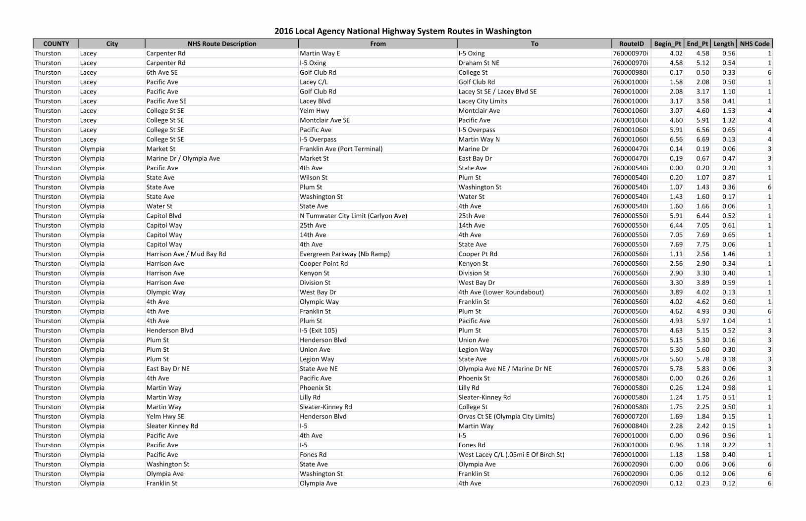
COUNTY City NHS Route Description From To RouteID Begin_Pt End_Pt Length NHS Code
2016 Local Agency National Highway System Routes in Washington
Thurston Lacey Carpenter Rd Martin Way E I-5 Oxing 760000970i 4.02 4.58 0.56 1Thurston Lacey Carpenter Rd I-5 Oxing Draham St NE 760000970i 4.58 5.12 0.54 1Thurston Lacey 6th Ave SE Golf Club Rd College St 760000980i 0.17 0.50 0.33 6Thurston Lacey Pacific Ave Lacey C/L Golf Club Rd 760001000i 1.58 2.08 0.50 1Thurston Lacey Pacific Ave Golf Club Rd Lacey St SE / Lacey Blvd SE 760001000i 2.08 3.17 1.10 1Thurston Lacey Pacific Ave SE Lacey Blvd Lacey City Limits 760001000i 3.17 3.58 0.41 1Thurston Lacey College St SE Yelm Hwy Montclair Ave 760001060i 3.07 4.60 1.53 4Thurston Lacey College St SE Montclair Ave SE Pacific Ave 760001060i 4.60 5.91 1.32 4Thurston Lacey College St SE Pacific Ave I-5 Overpass 760001060i 5.91 6.56 0.65 4Thurston Lacey College St SE I-5 Overpass Martin Way N 760001060i 6.56 6.69 0.13 4Thurston Olympia Market St Franklin Ave (Port Terminal) Marine Dr 760000470i 0.14 0.19 0.06 3Thurston Olympia Marine Dr / Olympia Ave Market St East Bay Dr 760000470i 0.19 0.67 0.47 3Thurston Olympia Pacific Ave 4th Ave State Ave 760000540i 0.00 0.20 0.20 1Thurston Olympia State Ave Wilson St Plum St 760000540i 0.20 1.07 0.87 1Thurston Olympia State Ave Plum St Washington St 760000540i 1.07 1.43 0.36 6Thurston Olympia State Ave Washington St Water St 760000540i 1.43 1.60 0.17 1Thurston Olympia Water St State Ave 4th Ave 760000540i 1.60 1.66 0.06 1Thurston Olympia Capitol Blvd N Tumwater City Limit (Carlyon Ave) 25th Ave 760000550i 5.91 6.44 0.52 1Thurston Olympia Capitol Way 25th Ave 14th Ave 760000550i 6.44 7.05 0.61 1Thurston Olympia Capitol Way 14th Ave 4th Ave 760000550i 7.05 7.69 0.65 1Thurston Olympia Capitol Way 4th Ave State Ave 760000550i 7.69 7.75 0.06 1Thurston Olympia Harrison Ave / Mud Bay Rd Evergreen Parkway (Nb Ramp) Cooper Pt Rd 760000560i 1.11 2.56 1.46 1Thurston Olympia Harrison Ave Cooper Point Rd Kenyon St 760000560i 2.56 2.90 0.34 1Thurston Olympia Harrison Ave Kenyon St Division St 760000560i 2.90 3.30 0.40 1Thurston Olympia Harrison Ave Division St West Bay Dr 760000560i 3.30 3.89 0.59 1Thurston Olympia Olympic Way West Bay Dr 4th Ave (Lower Roundabout) 760000560i 3.89 4.02 0.13 1Thurston Olympia 4th Ave Olympic Way Franklin St 760000560i 4.02 4.62 0.60 1Thurston Olympia 4th Ave Franklin St Plum St 760000560i 4.62 4.93 0.30 6Thurston Olympia 4th Ave Plum St Pacific Ave 760000560i 4.93 5.97 1.04 1Thurston Olympia Henderson Blvd I-5 (Exit 105) Plum St 760000570i 4.63 5.15 0.52 3Thurston Olympia Plum St Henderson Blvd Union Ave 760000570i 5.15 5.30 0.16 3Thurston Olympia Plum St Union Ave Legion Way 760000570i 5.30 5.60 0.30 3Thurston Olympia Plum St Legion Way State Ave 760000570i 5.60 5.78 0.18 3Thurston Olympia East Bay Dr NE State Ave NE Olympia Ave NE / Marine Dr NE 760000570i 5.78 5.83 0.06 3Thurston Olympia 4th Ave Pacific Ave Phoenix St 760000580i 0.00 0.26 0.26 1Thurston Olympia Martin Way Phoenix St Lilly Rd 760000580i 0.26 1.24 0.98 1Thurston Olympia Martin Way Lilly Rd Sleater-Kinney Rd 760000580i 1.24 1.75 0.51 1Thurston Olympia Martin Way Sleater-Kinney Rd College St 760000580i 1.75 2.25 0.50 1Thurston Olympia Yelm Hwy SE Henderson Blvd Orvas Ct SE (Olympia City Limits) 760000720i 1.69 1.84 0.15 1Thurston Olympia Sleater Kinney Rd I-5 Martin Way 760000840i 2.28 2.42 0.15 1Thurston Olympia Pacific Ave 4th Ave I-5 760001000i 0.00 0.96 0.96 1Thurston Olympia Pacific Ave I-5 Fones Rd 760001000i 0.96 1.18 0.22 1Thurston Olympia Pacific Ave Fones Rd West Lacey C/L (.05mi E Of Birch St) 760001000i 1.18 1.58 0.40 1Thurston Olympia Washington St State Ave Olympia Ave 760002090i 0.00 0.06 0.06 6Thurston Olympia Olympia Ave Washington St Franklin St 760002090i 0.06 0.12 0.06 6Thurston Olympia Franklin St Olympia Ave 4th Ave 760002090i 0.12 0.23 0.12 6
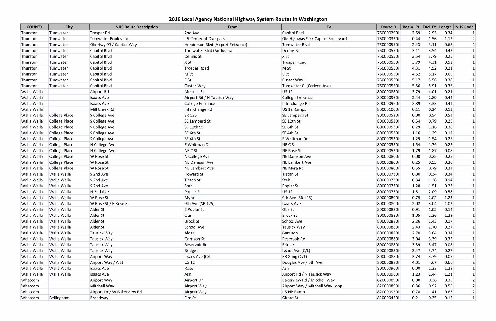
COUNTY City NHS Route Description From To RouteID Begin_Pt End_Pt Length NHS Code
2016 Local Agency National Highway System Routes in Washington
Thurston Tumwater Trosper Rd 2nd Ave Capitol Blvd 760000290i 2.59 2.93 0.34 1Thurston Tumwater Tumwater Boulevard I-5 Center of Overpass Old Highway 99 / Capitol Boulevard 760000330i 0.44 1.56 1.12 2Thurston Tumwater Old Hwy 99 / Capitol Way Henderson Blvd (Airport Entrance) Tumwater Blvd 760000550i 2.43 3.11 0.68 2Thurston Tumwater Capitol Blvd Tumwater Blvd (Airdustrial) Dennis St 760000550i 3.11 3.54 0.43 1Thurston Tumwater Capitol Blvd Dennis St X St 760000550i 3.54 3.79 0.25 1Thurston Tumwater Capitol Blvd X St Trosper Road 760000550i 3.79 4.31 0.52 1Thurston Tumwater Capitol Blvd Trosper Road M St 760000550i 4.31 4.52 0.21 1Thurston Tumwater Capitol Blvd M St E St 760000550i 4.52 5.17 0.65 1Thurston Tumwater Capitol Blvd E St Custer Way 760000550i 5.17 5.56 0.38 1Thurston Tumwater Capitol Blvd Custer Way Tumwater Cl (Carlyon Ave) 760000550i 5.56 5.91 0.36 1Walla Walla Airport Rd Melrose St US 12 800000880i 3.79 4.01 0.21 1Walla Walla Isaacs Ave Airport Rd / N Tausick Way College Entrance 800000960i 2.44 2.89 0.44 1Walla Walla Isaacs Ave College Entrance Interchange Rd 800000960i 2.89 3.33 0.44 1Walla Walla Mill Creek Rd Interchange Rd US 12 Ramps 800001000i 0.11 0.24 0.13 1Walla Walla College Place S College Ave SR 125 SE Lamperti St 800000530i 0.00 0.54 0.54 1Walla Walla College Place S College Ave SE Lamperti St SE 12th St 800000530i 0.54 0.79 0.25 1Walla Walla College Place S College Ave SE 12th St SE 6th St 800000530i 0.79 1.16 0.38 1Walla Walla College Place S College Ave SE 6th St SE 4th St 800000530i 1.16 1.29 0.12 1Walla Walla College Place S College Ave SE 4th St E Whitman Dr 800000530i 1.29 1.54 0.25 1Walla Walla College Place N College Ave E Whitman Dr NE C St 800000530i 1.54 1.79 0.25 1Walla Walla College Place N College Ave NE C St NE Rose St 800000530i 1.79 1.87 0.08 1Walla Walla College Place W Rose St N College Ave NE Damson Ave 800000800i 0.00 0.25 0.25 1Walla Walla College Place W Rose St NE Damson Ave NE Lambert Ave 800000800i 0.25 0.55 0.30 1Walla Walla College Place W Rose St NE Lambert Ave NE Myra Rd 800000800i 0.55 0.79 0.24 1Walla Walla Walla Walla S 2nd Ave Howard St Tietan St 800000730i 0.00 0.34 0.34 1Walla Walla Walla Walla S 2nd Ave Tietan St Stahl 800000730i 0.34 1.28 0.94 1Walla Walla Walla Walla S 2nd Ave Stahl Poplar St 800000730i 1.28 1.51 0.23 1Walla Walla Walla Walla N 2nd Ave Poplar St US 12 800000730i 1.51 2.09 0.58 1Walla Walla Walla Walla W Rose St Myra 9th Ave (SR 125) 800000800i 0.79 2.02 1.23 1Walla Walla Walla Walla W Rose St / E Rose St 9th Ave (SR 125) Isaacs Ave 800000800i 2.02 3.04 1.02 1Walla Walla Walla Walla Alder St E Poplar St Otis St 800000880i 0.91 1.05 0.14 1Walla Walla Walla Walla Alder St Otis Brock St 800000880i 1.05 2.26 1.22 1Walla Walla Walla Walla Alder St Brock St School Ave 800000880i 2.26 2.43 0.17 1Walla Walla Walla Walla Alder St School Ave Tausick Way 800000880i 2.43 2.70 0.27 1Walla Walla Walla Walla Tausick Way Alder Garrison 800000880i 2.70 3.04 0.34 1Walla Walla Walla Walla Tausick Way Garrison St Reservoir Rd 800000880i 3.04 3.39 0.35 1Walla Walla Walla Walla Tausick Way Reservoir Rd Bridge 800000880i 3.39 3.47 0.08 1Walla Walla Walla Walla Tausick Way Bridge Issacs Ave (C/L) 800000880i 3.47 3.74 0.27 1Walla Walla Walla Walla Airport Way Issacs Ave (C/L) RR X-ing (C/L) 800000880i 3.74 3.79 0.05 1Walla Walla Walla Walla Airport Way / A St US 12 Douglas Ave / 6th Ave 800000880i 4.01 4.67 0.66 2Walla Walla Walla Walla Isaacs Ave Rose Ash 800000960i 0.00 1.23 1.23 1Walla Walla Walla Walla Isaacs Ave Ash Airport Rd / N Tausick Way 800000960i 1.23 2.44 1.21 1Whatcom Airport Way Airport Dr Bakerview Rd / Mitchell Way 820000890i 0.00 0.36 0.36 2Whatcom Mitchell Way Airport Way Airport Way / Mitchell Way Loop 820000890i 0.36 0.92 0.55 2Whatcom Airport Dr / W Bakerview Rd Airport Way I-5 NB Ramp 820000950i 0.78 1.41 0.63 2Whatcom Bellingham Broadway Elm St Girard St 820000450i 0.21 0.35 0.15 1
COUNTY City NHS Route Description From To RouteID Begin_Pt End_Pt Length NHS Code
2016 Local Agency National Highway System Routes in Washington
Whatcom Bellingham 12th St Donovan Ave / SR 11 Harris Ave 820000460i 0.00 0.17 0.17 1Whatcom Bellingham 12th St/Finnegan Way/State St/Boulvard R Harris Ave Ivy St / Forest 820000460i 0.17 2.10 1.93 1Whatcom Bellingham State St Ivy St York St 820000460i 2.10 2.92 0.82 1Whatcom Bellingham N State St York St Iowa St 820000460i 2.92 3.40 0.49 1Whatcom Bellingham Iowa St James St I-5 820000460i 3.40 3.57 0.16 1Whatcom Bellingham Lakeway Dr Ellis St Lincoln St 820000470i 0.00 0.42 0.42 1Whatcom Bellingham Lakeway Dr Lincoln St Racine 820000470i 0.42 0.84 0.42 1Whatcom Bellingham Lakeway Dr Racine Yew St 820000470i 0.84 1.34 0.50 1Whatcom Bellingham Lakeway Dr Yew St Electric Ave 820000470i 1.34 2.03 0.68 1Whatcom Bellingham Meridian St Broadway Illinois St 820000480i 1.29 1.76 0.47 1Whatcom Bellingham Meridian St W Illinois St E Victor St 820000480i 1.76 2.17 0.41 1Whatcom Bellingham Meridian St E Victor St SqualicumPkwy 820000480i 2.17 2.33 0.16 1Whatcom Bellingham Meridian St Squalicum Pkwy Orchard Dr 820000480i 2.33 2.50 0.18 3Whatcom Bellingham Meridian St W Orchard Dr Mcleod Rd / I-5 820000480i 2.50 2.77 0.26 3Whatcom Bellingham Squalicum Pkwy Meridian St Roeder 820000490i 0.00 1.54 1.54 3Whatcom Bellingham Roeder Ave Squalicum Pkwy Bay St / Chestnut St 820000490i 1.54 3.03 1.48 3Whatcom Bellingham Chestnut St Bay St / Roeder Ave Cornwall Ave 820000490i 3.03 3.16 0.13 3Whatcom Bellingham Chestnut St Cornwall Ave Forrest St 820000490i 3.16 3.36 0.20 1Whatcom Bellingham Chestnut St Forrest St Ellis St 820000490i 3.36 3.72 0.36 1Whatcom Bellingham Holly St Ellis St Bay St 820000510i 0.00 0.60 0.60 1Whatcom Bellingham Holly St Bay St Broadway 820000510i 0.60 1.26 0.66 1Whatcom Bellingham Cornwall Ave W Pine / Port Terminal Access E Maple St 820000530i 0.25 0.75 0.49 3Whatcom Bellingham Cornwall Ave E Maple St E Chestnut St 820000530i 0.75 0.84 0.10 3Whatcom Bellingham Harris Ave 10th St Alaskan Ferry-Facility Entrance 820000670i 0.65 1.10 0.45 7Whatcom Bellingham Samish Way I-5 Ellis St 820000700i 0.00 0.67 0.67 1Whatcom Bellingham Ellis St Maple St Lakeway Dr 820000700i 0.67 0.94 0.27 1Whatcom Bellingham Prospect St / Dupont St W Champion St C St 820000700i 1.73 2.03 0.30 1Whatcom Bellingham Northwest Ave / Elm St / Dupont Ave N Side W Crk / Prospect St Maplewood Ave 820000700i 2.03 3.36 1.33 1Whatcom Bellingham Northwest Ave E Maplewood Ave I-5 (North Bound On/Off Ramps) 820000700i 3.36 4.26 0.90 1Whatcom Bellingham Forest Street State St / E Ivy St York Blvd 820000820i 0.00 0.96 0.96 1Whatcom Bellingham Donovan Ave / 10th St SR 11 / 12th St Harris Ave 820000840i 0.00 0.26 0.26 7Whatcom Bellingham Bay St / Prospect St W Chestnut St W Champion St 820000860i 0.00 0.15 0.15 1Whitman Pullman Terre View Dr. SR 270 / Main St Grimes Way (was Farm Way) 840000550i 0.00 0.59 0.59 2Whitman Pullman Terre View Drive Grimes Way (was Farm Way) Airport Entrance 840000550i 0.59 2.59 2.00 2Whitman Pullman Stadium Way SR 270/ Main St SR 27 / Grand St 840000570i 0.00 1.56 1.56 1Yakima Terrace Heights Dr Butterfield Rd N 33rd ST / University Parkway 860001880i 1.66 2.42 0.76 1Yakima Terrace Heights Dr N 33rd ST / University Parkway N 41st St 860001880i 2.42 2.92 0.50 1Yakima Terrace Heights Dr 41st St N Roza Hill Dr 860001880i 2.92 3.05 0.12 1Yakima Firing Center Rd I-82(North Bound Ramp) E Selah Rd 860002430i 0.00 0.06 0.06 1Yakima Firing Center Rd E Selah Rd Treatment Plant Rd 860002430i 0.06 0.46 0.40 1Yakima Firing Center Rd Treatment Plant Rd D St 860003510i 0.00 0.85 0.85 1Yakima Selah S 1st St Valleyview Ave E Naches Ave 860002200i 0.00 0.37 0.37 1Yakima Union Gap Valley Mall Blvd / Pioneer St 16th Ave S S 3rd Ave 860001530i 0.00 0.79 0.79 2Yakima Union Gap Valley Mall Blvd / Pioneer St S 3rd Ave 1st St / Main St 860001530i 0.79 2.23 1.43 2Yakima Union Gap E Valley Mall Blvd I-82(North Bound Ramp) 1st St / Main St 860001530i 2.23 2.58 0.36 2Yakima Union Gap Longfibre Ave W Valley Mall Blvd W Ahtanum Rd 860001583i 0.00 0.38 0.38 1
COUNTY City NHS Route Description From To RouteID Begin_Pt End_Pt Length NHS Code
2016 Local Agency National Highway System Routes in Washington
Yakima Union Gap Main St US 97 Union Gap S C/L 860001660i 0.00 0.31 0.31 1Yakima Union Gap Main St Union Gap S C/L E Washington St (Union Gap) 860001660i 0.31 0.74 0.42 1Yakima Union Gap Main St W Washington St (Union Gap) Ahtanum Rd 860001660i 0.74 1.47 0.73 1Yakima Union Gap Main St Ahtanum Rd Valley Mall Blvd 860001660i 1.47 1.93 0.46 1Yakima Union Gap Main St / S 1st St W Valley Mall Blvd S Old Town Rd 860001660i 1.93 2.17 0.24 1Yakima Yakima S 16th Ave W Washington Ave Nob Hill Blvd 860001540i 1.16 1.62 0.46 2Yakima Yakima S 16th Ave W Washington Ave W Nob Hill Blvd 860001540i 1.62 2.61 0.99 1Yakima Yakima S 16th Ave Nob Hill Blvd Yakima Ave 860001540i 2.61 3.43 0.83 1Yakima Yakima N 16th Ave Yakima Ave Lincoln Ave 860001540i 3.43 3.86 0.43 1Yakima Yakima N 16th Ave W Lincoln Ave Fruitvale Blvd 860001540i 3.86 4.49 0.63 1Yakima Yakima N 16th Ave Fruitvale Blvd River Rd 860001540i 4.49 4.87 0.38 1Yakima Yakima N 16th Ave River Rd US 12 WB On Ramp 860001540i 4.87 5.35 0.48 1Yakima Yakima W Washington Ave 16th Ave 24th Ave 860001560i 2.50 3.02 0.52 2Yakima Yakima W Washington Ave S 24th Ave S 40th Ave 860001560i 3.02 4.08 1.06 1Yakima Yakima E Nob Hill Blvd I-82 S 18th St 860001610i 0.00 0.20 0.20 1Yakima Yakima E Nob Hill Blvd S 18th St Fair Ave 860001610i 0.20 0.70 0.50 1Yakima Yakima E Nob Hill Blvd Fair Ave 1st St 860001610i 0.70 1.14 0.43 1Yakima Yakima W Nob Hill Blvd 1st St 3rd Ave 860001610i 1.14 1.74 0.60 1Yakima Yakima Nob Hill Blvd 3rd Ave 16th Ave 860001610i 1.74 2.73 1.00 1Yakima Yakima W Nob Hill Blvd 16th Ave 24th Ave 860001610i 2.73 3.24 0.50 1Yakima Yakima W Nob Hill Blvd 24th Ave 32nd Ave 860001610i 3.24 3.74 0.50 1Yakima Yakima W Nob Hill Blvd 32nd Ave 40th Ave 860001610i 3.74 4.23 0.50 1Yakima Yakima W Nob Hill Blvd S 40th Ave S 48th Ave 860001610i 4.23 4.73 0.49 1Yakima Yakima W Nob Hill Blvd S 48th Ave S 64th Ave 860001610i 4.73 5.76 1.03 1Yakima Yakima W Nob Hill Blvd S 64th Ave S 68th Ave 860001610i 5.76 6.04 0.28 1Yakima Yakima W Nob Hill Blvd S 68th Ave S 72nd Ave 860001610i 6.04 6.25 0.21 1Yakima Yakima S 1st St Old Town Rd Washington Ave (Yakima) 860001660i 2.17 2.57 0.40 1Yakima Yakima S 1st St Washington Ave (Yakima) Mead Ave 860001660i 2.57 3.11 0.55 1Yakima Yakima S 1st St Mead Ave Nob Hill Blvd 860001660i 3.11 3.73 0.61 1Yakima Yakima S 1st St Nob Hill Blvd Pacific Ave 860001660i 3.73 4.22 0.49 1Yakima Yakima S 1st St Pacific Ave Yakima Ave 860001660i 4.22 4.93 0.71 1Yakima Yakima N 1st St Yakima Ave Lincoln Ave 860001660i 4.93 5.21 0.27 1Yakima Yakima N 1st St Lincoln Ave I 82 / US-12 860001660i 5.21 6.61 1.40 1Yakima Yakima S 40th Ave W Washington Ave W Nob Hill Blvdd 860001680i 0.00 0.71 0.71 1Yakima Yakima N 40th Ave W Nob Hill Blvd Tieton Dr 860001680i 0.71 1.22 0.50 1Yakima Yakima N 40th Ave Tieton Dr W Lincoln Ave 860001680i 1.22 1.97 0.75 1Yakima Yakima N 40th Ave W Lincoln Ave Englewood Ave 860001680i 1.97 2.21 0.25 1Yakima Yakima N 40th Ave Englewood Ave Kern Way 860001680i 2.21 2.47 0.25 1Yakima Yakima N 40th Ave Kern Rd US 12 860001680i 2.47 3.21 0.74 1Yakima Yakima Summitview Ave Yakima Ave 16th Ave 860001720i 1.34 1.92 0.57 1Yakima Yakima Summitview Ave 16th Ave 40th Ave 860001720i 1.92 3.42 1.50 1Yakima Yakima Summitview Ave 40th Ave N 48th Ave 860001720i 3.42 3.92 0.50 1Yakima Yakima Summitview Ave N 48th Ave N 66th Ave 860001720i 3.92 5.06 1.14 1Yakima Yakima Summitview Ave N 66th Ave N 72nd Ave 860001720i 5.06 5.45 0.39 1Yakima Yakima Fruitvale Blvd N 40th Ave N 34Ave / River Rd 860001760i 0.00 0.39 0.39 1Yakima Yakima Fruitvale Blvd N 34Ave / River Rd N 16th Ave 860001760i 0.39 1.61 1.22 1
COUNTY City NHS Route Description From To RouteID Begin_Pt End_Pt Length NHS Code
2016 Local Agency National Highway System Routes in Washington
Yakima Yakima Fruitvale Blvd N 16th Ave N 5th Ave 860001760i 1.61 2.16 0.56 1Yakima Yakima Fair Ave S Fair Ave Lp E Martin Luther King Jr Blvd 860001780i 1.83 2.31 0.48 1Yakima Yakima Fair Ave Lp E Yakima Ave S Fair Ave 860001783i 0.00 0.10 0.10 1Yakima Yakima E Yakima Ave 1st St 6th St 860001880i 0.00 0.39 0.39 1Yakima Yakima E Yakima Ave 6th St 8th St 860001880i 0.39 0.53 0.15 1Yakima Yakima E Yakima Ave 8th St 18th St (Off Ramp) 860001880i 0.53 1.39 0.85 1Yakima Yakima E Yakima Ave / Terrace Heights Dr 18th St (Off Ramp) Butterfield Rd 860001880i 1.39 1.66 0.27 1Yakima Yakima 5th Ave N Yakima Ave Martin Luther King Jr Blvd 860001950i 0.66 0.85 0.18 1Yakima Yakima 5th Ave N Martin Luther King Jr Blvd Lincoln St 860001950i 0.85 0.94 0.09 1Yakima Yakima 5th Ave N Lincoln Ave Fruitvale Blvd 860001950i 0.94 1.55 0.61 1Yakima Yakima N 5th Ave Fruitvale Blvd I Street 860001950i 1.55 1.68 0.13 1Yakima Yakima I St W N 5th Ave N 1st St 860001950i 1.68 1.99 0.32 1Yakima Yakima E Lincoln Ave N Fair Ave 6th St 860001990i 0.00 0.35 0.35 1Yakima Yakima W Lincoln Ave 6th St Pierce Ave 860001990i 0.35 1.34 0.99 1Yakima Yakima W Lincoln Ave Pierce Ave 16th Ave 860001990i 1.34 1.84 0.50 1Yakima Yakima N 8th St E Yakima Ave Lincoln Ave 860002130i 0.18 0.46 0.27 1Yakima Yakima Pierce Ave Lincoln Ave Martin Luther King Jr Blvd 860002140i 0.00 0.11 0.11 1Yakima Yakima Yakima Ave W 7th Ave 1st St 860002150i 0.59 1.21 0.63 1Yakima Yakima Martin Luther King Jr Blvd Pierce Ave 1st Street 860002160i 0.00 0.63 0.63 1Yakima Yakima Martin Luther King Jr Blvd 1st St 8th St 860002160i 0.63 1.17 0.53 1Yakima Yakima Martin Luther King Jr Blvd 8th St S Fair Ave 860002160i 1.17 1.37 0.20 1Yakima Yakima 72nd Ave S Summitview Ave Tieton Dr 860002270i 0.00 0.49 0.49 1Yakima Yakima 72nd Ave S Tieton Dr Nob Hill Blvd 860002270i 0.49 0.99 0.50 1