2016 utah earthquake working group meetings …
TRANSCRIPT
1
2016 UTAH EARTHQUAKE WORKING GROUP MEETINGS UTAH QUATERNARY FAULT PARAMETERS WORKING GROUP
SUMMARY Wednesday, February 10, 2016
Utah Department of Natural Resources Building, Room 2000 1594 West North Temple, Salt Lake City, Utah
WELCOME AND INTRODUCTION
Steve Bowman (Utah Geological Survey [UGS]) called the 2016 Utah Quaternary Fault Parameters Working Group (UQFPWG) meeting to order at 8:15 a.m. After welcoming Working Group members and guests, Steve summarized the UQFPWG’s past activities and outlined the Working Group’s purpose and goals for the future.
UQFPWG Purpose and Goals
One of three standing committees created to help set and coordinate Utah’s earthquake-hazard research agenda.
Reviews ongoing paleoseismic research in Utah, and updates the Utah consensus slip-rate and
recurrence-interval database as necessary. Provides advice/insight regarding technical issues related to fault behavior in Utah and the Basin
and Range Province.
Identifies and prioritizes future Utah Quaternary fault paleoseismic investigations.
TECHNICAL PRESENTATIONS
The following presentations were made on current paleoseismic research and related activities in Utah, most presentations are available at http://geology.utah.gov/hazards/earthquakes-faults/utah-earthquake-working-groups/quaternary-fault-parameters/.
Active Faulting, Soil and Rock Type, and Groundwater Elevations Beneath Salt Lake City – Vp, Vs, and Reflection Images from a Seismic Land Streamer System: Lee Liberty, Boise State University
Late Holocene Earthquake Record at the Corner Canyon Site on the Salt Lake City Segment of
the Wasatch Fault Zone: Chris DuRoss, U.S. Geological Survey (USGS)
Preliminary Results from the Airport East Trench Site, Taylorsville Fault, West Valley Fault Zone: Adam Hiscock, UGS
New Insight into the Paleocene Cedar City-Parowan Monocline: Bob Biek, UGS
Field Investigations of Active Faulting in the Sevier Desert Region – Methods and Preliminary Results: Tim Stahl, University of Michigan, National Science Foundation Post-Doctoral Researcher
2
Revisiting Utah Quaternary Faults – East Canyon, Moab, Joes Valley, and Wasatch Fault Zone Segment Boundaries: Jim McCalpin, GEO-HAZ Consulting, Inc.
Updated Utah Geological Survey Surface-Fault-Rupture and Other Geologic-Hazard Investigation and Report Guidelines: William Lund, UGS, Emeritus
Characterization of Segmentation and Long-Term Slip Rates of Wasatch Front Fault Systems, Utah: Julia Howe, University of Utah, Graduate Student
Utah Quaternary Fault and Fold Database Status of Updates and New Web Application: Mike Hylland, UGS
New Utah Earthquake and Quaternary Fault Map: Steve Bowman, UGS
Paleoseismic Investigation within the Traverse Ridge Segment Boundary ‒ Initial Plans for Summer 2016 Field Work: Nathan Toke, Utah Valley University (UVU)
Pots Creek and Diamond Gulch Faults in Northeast Utah ‒ A Preliminary Evaluation: Joanna Redwine and Lucy Piety, U.S. Bureau of Reclamation
The Great Salt Lake Fault and Its Microbial Mounds: Susanne Janecke, Utah State University (USU)
UAV-Survey and Photogrammetry Produce LiDAR-Like DEM of Scarps in Logan, Utah: Susanne Janecke, USU, and Michael Bunds, Jeremy Andreini, and Jack Wells, UVU
New Data on Holocene Offsets and Slip Rates for the Oquirrh Fault from DEMs Made with Structure-from-Motion Methods: Michael Bunds, Jeremy Andreini, Michael Arnold, Kenneth Larsen, Andrew Fletcher,and Nathan Toke, UVU
Update on the Working Group on Utah Earthquake Probabilities (WGUEP) Report, Data Developed, and Outreach: Ivan Wong, AECOM (WGUEP Chair)
Basin and Range Province Seismic Hazard Summit III Summary: William Lund and Steve Bowman, UGS
TECHNICAL DISCUSSION ITEMS
No technical discussion items came before the Working Group at this year’s meeting.
UQFPWG 2017 FAULT INVESTIGATION PRIORITIES
In 2005, the UQFPWG recommended that 20 Quaternary faults/fault segments in Utah be investigated to “adequately characterize Utah’s earthquake hazard to a minimally acceptable level” (Lund, 2005). Since then, the Working Group has added an additional 11 faults/fault segments to the list: five in 2007, one in 2009, one in 2010, four in 2011, and three general recommendations regarding the five central segments of the Wasatch fault zone, fault zone mapping, and acquisition of high resolution imagery in 2012, 2014, 2015, respectively. A new priority to investigate the relation of salt tectonics to

3
some Utah Quaternary faults (for example, the Joes Valley fault zone, Gunnison fault, and the Levan segment of the Wasatch fault zone) was added this year (see table 1 below).
Table 2 lists faults and fault segments in the USGS National Seismic Hazard Maps or the UGS Hazus Utah fault database (Lund, 2014) not listed in table 1 that may warrant additional investigation. Figure 1 shows the faults and fault segments listed in tables 1 and 2. Table 3 lists the current status of paleoseismic investigations for Utah priority faults and fault segments identified by the UQFPWG as priorities for investigation. Note that faults or fault segments listed in table 3 as having received some level of paleoseismic investigation does not imply that all of the paleoseismic data necessary to fully characterize those faults or fault segments has been acquired; further investigation of those structures may be necessary.
The UQFPWG conducts an annual review of progress made toward investigating the faults/fault segments on the priority list. Based on that review, the Working Group establishes a short list of the highest priority faults and fault segments for future investigation. The list of highest priority faults and fault segments is published on the UGS website (http://geology.utah.gov/hazards/earthquakes-faults/utah-earthquake-working-groups/), which is then referenced by the USGS Earthquake Hazards Program in their annual External Research Support (National Earthquake Hazards Reduction Program [NEHRP]) request for proposals.
The Working Group’s highest priority list for 2017 includes (not in priority order):
1. Acquire new paleoseismic information to address data gaps for (a) the five central segments of the Wasatch fault zone, (b) the northern segment of the Oquirrh fault zone, (c) refining the latest Quaternary earthquake chronology for the Topliff Hills fault, and (d) the East and West Cache fault zones. Examples of paleoseismic data to be acquired include surface rupture extent, earthquake timing, displacement, and fault geometry.
2. Acquire earthquake timing information for the Utah Lake fault zone to investigate the relation of
earthquakes on that fault system to large earthquakes on the adjacent Provo segment of the Wasatch fault zone (coseismic or independent rupture, fault pairs?).
3. Use recently acquired LiDAR data to more accurately map the traces of the Wasatch, West
Valley, and Hurricane fault zones, and search for and map previously undiscovered mid-valley Quaternary faults.
4. Acquire high-resolution aerial imagery (LiDAR, Structure from Motion, etc.), and map high-risk
(chiefly urban) Utah hazardous faults to identify new paleoseismic trench sites.
5. Acquire and analyze information on salt tectonics and its relation to the Main Canyon fault, Sevier detachment/Drum Mountains fault zone, Bear River fault zone, Spanish Valley (Moab area), Joes Valley fault zone, Levan and Fayette segments of the Wasatch fault zone, Scipio Valley faults, and the Gunnison fault.
The Working Group’s other priority list for 2017 was modified by deleting the Cedar City-
Parowan monocline from priority 10, based on new geologic mapping of the structure by Bob Biek, UGS, and presented to the working group at this meeting. The other fault priorities were not changed.
Table 4 shows the 2017 highest priority fault and fault segment recommendations, table 5 shows the list of other priority faults and fault segment recommendations, and both tables show the current investigation status for all faults and fault segments identified by the UQFPWG as requiring additional

4
investigation. All of the faults/fault sections listed in table 2 remain priorities and should be considered for future investigation if a compelling case can be made for the need to acquire additional paleoseismic data.
WORKING GROUP PRODUCTS The final agenda, speaker presentations, and this summary document are available on the UQFPWG web page at http://geology.utah.gov/hazards/earthquakes-faults/utah-earthquake-working-groups/quaternary-fault-parameters/. Paleoseismic investigations that developed out of the UQFPWG meetings and published by the UGS are available in the Paleoseismology of Utah series at http://geology.utah.gov/hazards/technical-information/paleoseismology-of-utah-series/. Most of the USGS NEHRP funded investigations for Utah that were not published by the UGS are compiled in UGS Miscellaneous Publication 13-03 (http://files.geology.utah.gov/online/mp/mp13-03/mp13-03.pdf).
Utah Quaternary Fault and Fold Database
The UGS updated the Utah Quaternary Fault and Fold Database on July 1, 2015, incorporating new data and a complete review of previously published data through the end of 2013. Users of any Quaternary fault trace and related data acquired from the UGS or the Utah Automated Geographic Reference Center (AGRC) State Geographic Information Database (SGID) in the past are advised to use the updated database available from the AGRC SGID (http://gis.utah.gov/data/how-to-connect-to-the-sgid-via-sde/) as the SGID10.GEOSCIENCE.QuaternaryFaults feature class. This single, comprehensive feature class will be periodically updated as new/updated data become available (anticipated several times per year) and replaces the six previously available feature classes of variable completeness. A web map application for the database is available at http://geology.utah.gov/resources/data-databases/qfaults/.
REFERENCES Lund, W.R., 2005, Consensus preferred recurrence-interval and vertical slip-rate estimates – review of
Utah paleoseismic-trenching data by the Utah Quaternary Fault Parameters Working Group: Utah Geological Survey Bulletin 134, 109 p., online at http://ugspub.nr.utah.gov/publications/bulletins/ B-134.pdf.
Lund, W.R., 2014, Hazus loss estimation software earthquake model revised Utah fault database, updated
through 2013: Utah Geological Survey Open-File Report 631, 11 p., online at http://geology.utah.gov/online/ofr/ofr-631.pdf.
5
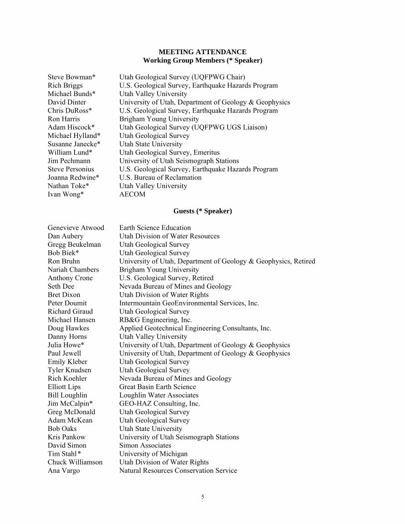
MEETING ATTENDANCE Working Group Members (* Speaker)
Steve Bowman* Utah Geological Survey (UQFPWG Chair) Rich Briggs U.S. Geological Survey, Earthquake Hazards Program Michael Bunds* Utah Valley University David Dinter University of Utah, Department of Geology & Geophysics Chris DuRoss* U.S. Geological Survey, Earthquake Hazards Program Ron Harris Brigham Young University Adam Hiscock* Utah Geological Survey (UQFPWG UGS Liaison) Michael Hylland* Utah Geological Survey Susanne Janecke* Utah State University William Lund* Utah Geological Survey, Emeritus Jim Pechmann University of Utah Seismograph Stations Steve Personius U.S. Geological Survey, Earthquake Hazards Program Joanna Redwine* U.S. Bureau of Reclamation Nathan Toke* Utah Valley University Ivan Wong* AECOM
Guests (* Speaker) Genevieve Atwood Earth Science Education Dan Aubery Utah Division of Water Resources Gregg Beukelman Utah Geological Survey Bob Biek* Utah Geological Survey Ron Bruhn University of Utah, Department of Geology & Geophysics, Retired Nariah Chambers Brigham Young University Anthony Crone U.S. Geological Survey, Retired Seth Dee Nevada Bureau of Mines and Geology Bret Dixon Utah Division of Water Rights Peter Doumit Intermountain GeoEnvironmental Services, Inc. Richard Giraud Utah Geological Survey Michael Hansen RB&G Engineering, Inc. Doug Hawkes Applied Geotechnical Engineering Consultants, Inc. Danny Horns Utah Valley University Julia Howe* University of Utah, Department of Geology & Geophysics Paul Jewell University of Utah, Department of Geology & Geophysics Emily Kleber Utah Geological Survey Tyler Knudsen Utah Geological Survey Rich Koehler Nevada Bureau of Mines and Geology Elliott Lips Great Basin Earth Science Bill Loughlin Loughlin Water Associates Jim McCalpin* GEO-HAZ Consulting, Inc. Greg McDonald Utah Geological Survey Adam McKean Utah Geological Survey Bob Oaks Utah State University Kris Pankow University of Utah Seismograph Stations David Simon Simon Associates Tim Stahl * University of Michigan Chuck Williamson Utah Division of Water Rights Ana Vargo Natural Resources Conservation Service
6
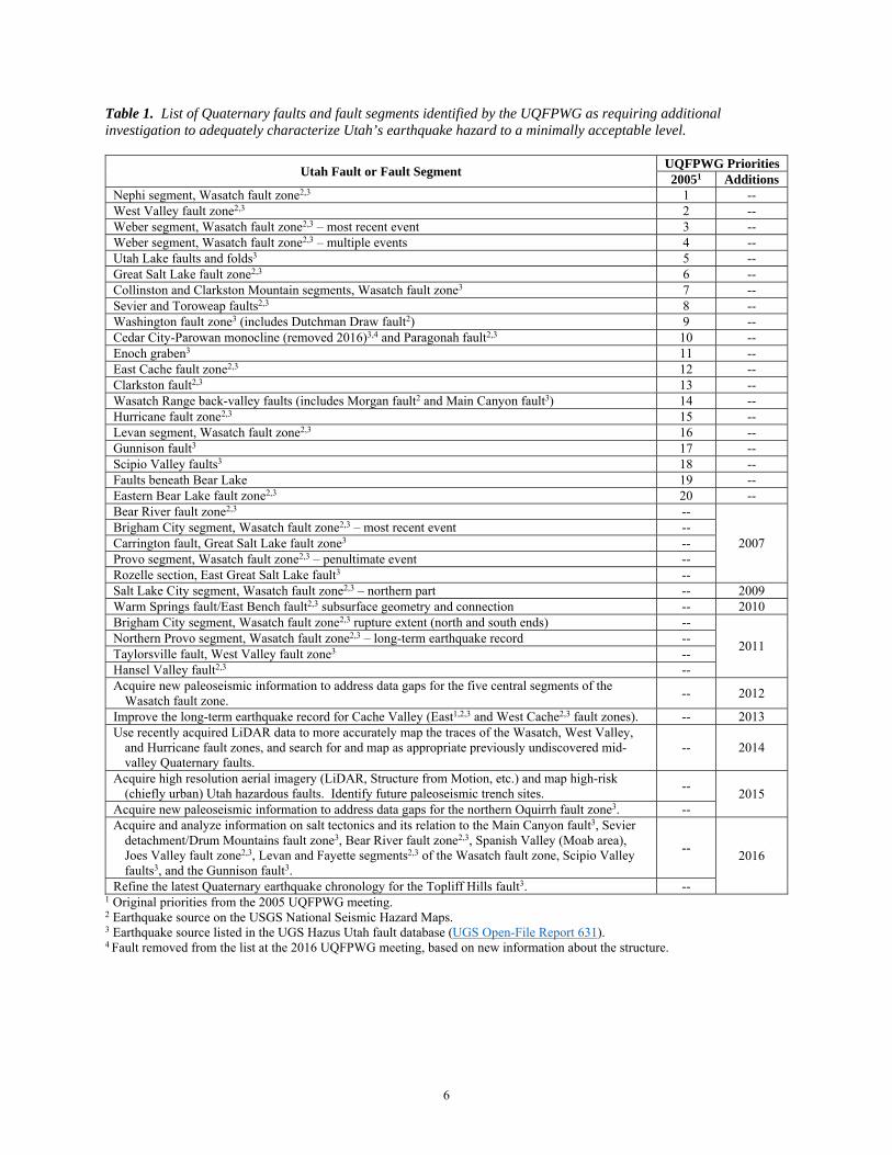
Table 1. List of Quaternary faults and fault segments identified by the UQFPWG as requiring additional investigation to adequately characterize Utah’s earthquake hazard to a minimally acceptable level.
Utah Fault or Fault Segment UQFPWG Priorities 20051 Additions
Nephi segment, Wasatch fault zone2,3 1 -- West Valley fault zone2,3 2 -- Weber segment, Wasatch fault zone2,3 – most recent event 3 -- Weber segment, Wasatch fault zone2,3 – multiple events 4 -- Utah Lake faults and folds3 5 -- Great Salt Lake fault zone2,3 6 -- Collinston and Clarkston Mountain segments, Wasatch fault zone3 7 -- Sevier and Toroweap faults2,3 8 -- Washington fault zone3 (includes Dutchman Draw fault2) 9 -- Cedar City-Parowan monocline (removed 2016)3,4 and Paragonah fault2,3 10 -- Enoch graben3 11 -- East Cache fault zone2,3 12 -- Clarkston fault2,3 13 -- Wasatch Range back-valley faults (includes Morgan fault2 and Main Canyon fault3) 14 -- Hurricane fault zone2,3 15 -- Levan segment, Wasatch fault zone2,3 16 -- Gunnison fault3 17 -- Scipio Valley faults3 18 -- Faults beneath Bear Lake 19 -- Eastern Bear Lake fault zone2,3 20 -- Bear River fault zone2,3 --
2007 Brigham City segment, Wasatch fault zone2,3 – most recent event -- Carrington fault, Great Salt Lake fault zone3 -- Provo segment, Wasatch fault zone2,3 – penultimate event -- Rozelle section, East Great Salt Lake fault3 -- Salt Lake City segment, Wasatch fault zone2,3 – northern part -- 2009 Warm Springs fault/East Bench fault2,3 subsurface geometry and connection -- 2010 Brigham City segment, Wasatch fault zone2,3 rupture extent (north and south ends) --
2011 Northern Provo segment, Wasatch fault zone2,3 – long-term earthquake record -- Taylorsville fault, West Valley fault zone3 -- Hansel Valley fault2,3 -- Acquire new paleoseismic information to address data gaps for the five central segments of the
Wasatch fault zone. -- 2012
Improve the long-term earthquake record for Cache Valley (East1,2,3 and West Cache2,3 fault zones). -- 2013 Use recently acquired LiDAR data to more accurately map the traces of the Wasatch, West Valley,
and Hurricane fault zones, and search for and map as appropriate previously undiscovered mid-valley Quaternary faults.
-- 2014
Acquire high resolution aerial imagery (LiDAR, Structure from Motion, etc.) and map high-risk (chiefly urban) Utah hazardous faults. Identify future paleoseismic trench sites.
-- 2015
Acquire new paleoseismic information to address data gaps for the northern Oquirrh fault zone3. -- Acquire and analyze information on salt tectonics and its relation to the Main Canyon fault3, Sevier
detachment/Drum Mountains fault zone3, Bear River fault zone2,3, Spanish Valley (Moab area), Joes Valley fault zone2,3, Levan and Fayette segments2,3 of the Wasatch fault zone, Scipio Valley faults3, and the Gunnison fault3.
-- 2016
Refine the latest Quaternary earthquake chronology for the Topliff Hills fault3. -- 1 Original priorities from the 2005 UQFPWG meeting. 2 Earthquake source on the USGS National Seismic Hazard Maps. 3 Earthquake source listed in the UGS Hazus Utah fault database (UGS Open-File Report 631). 4 Fault removed from the list at the 2016 UQFPWG meeting, based on new information about the structure.
7
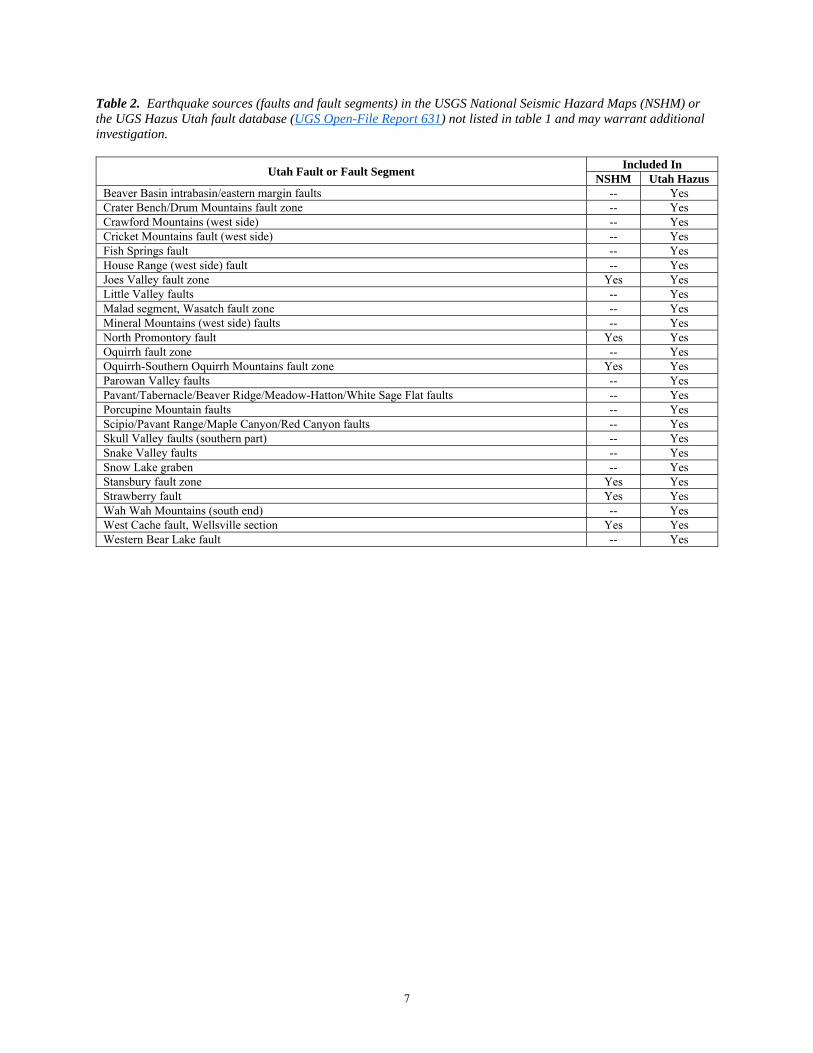
Table 2. Earthquake sources (faults and fault segments) in the USGS National Seismic Hazard Maps (NSHM) or the UGS Hazus Utah fault database (UGS Open-File Report 631) not listed in table 1 and may warrant additional investigation.
Utah Fault or Fault Segment Included In
NSHM Utah Hazus Beaver Basin intrabasin/eastern margin faults -- Yes Crater Bench/Drum Mountains fault zone -- Yes Crawford Mountains (west side) -- Yes Cricket Mountains fault (west side) -- Yes Fish Springs fault -- Yes House Range (west side) fault -- Yes Joes Valley fault zone Yes Yes Little Valley faults -- Yes Malad segment, Wasatch fault zone -- Yes Mineral Mountains (west side) faults -- Yes North Promontory fault Yes Yes Oquirrh fault zone -- Yes Oquirrh-Southern Oquirrh Mountains fault zone Yes Yes Parowan Valley faults -- Yes Pavant/Tabernacle/Beaver Ridge/Meadow-Hatton/White Sage Flat faults -- Yes Porcupine Mountain faults -- Yes Scipio/Pavant Range/Maple Canyon/Red Canyon faults -- Yes Skull Valley faults (southern part) -- Yes Snake Valley faults -- Yes Snow Lake graben -- Yes Stansbury fault zone Yes Yes Strawberry fault Yes Yes Wah Wah Mountains (south end) -- Yes West Cache fault, Wellsville section Yes Yes Western Bear Lake fault -- Yes

8
Figure 1. Faults included in the UGS Hazus Utah fault database, except removed the Cedar City-Parowan monocline and faults (see table 1; database updated through 2013, modified from UGS Open-File Report 631).

9
Table 3. Current status of paleoseismic investigations for Utah priority faults and fault segments identified by the UQFPWG as requiring additional investigation to adequately characterize Utah’s earthquake hazard to a minimally acceptable level.
Fault or Fault Segment UQFPWG Priority1
Investigations Status2,3 (as of 2/2016) Institution4
Nephi segment, Wasatch fault zone5,6 1 UGS Special Study 124 and 151
USGS SI Map 2966 UGS FTR Report
UGS/USGS
Granger fault, West Valley fault zone5,6 2 UGS Special Study 149 UGS/USGS Weber segment, Wasatch fault zone5,6 – most recent event 3 UGS Special Study 130 UGS/USGS Weber segment, Wasatch fault zone5,6 – multiple events 4 UGS Special Study 130 UGS/USGS
Utah Lake faults and folds6 5 UUGG FTR Report UUGG/
BYU Great Salt Lake fault zone5,6 6 UUGG FTR Report UUGG Collinston and Clarkston Mountain segments, Wasatch
fault zone6 7
UGS Special Study 121 Map: UGS Open-File Report 638
UGS
Sevier and Toroweap faults5,6 8 UGS Special Study 122 UGS Washington fault zone6 9 UGS Miscellaneous Publication 15-6 UGS East Cache fault zone5,6 12 USU FTR Report USU Wasatch Range back-valley faults
14 No activity --
Main Canyon fault6 UGS Miscellaneous Publication 10-5 USBR Hurricane fault zone5,6 15 UGS Special Study 119 UGS
Levan segment, Wasatch fault zone5,6 16 UGS Map 229
Map: UGS Open-File Report 640 UGS
Brigham City segment, Wasatch fault zone5,6 – most recent event
2007 UGS Special Study 142 UGS/USGS
Bear River fault zone5,6 2007 AGU Abstracts: 2012 and 2013
USGS ongoing USGS/UGS
Salt Lake City segment, Wasatch fault zone5,6 – north part 2009 UGS Special Study 149 UGS/USGS
Hansel Valley fault zone5,6 2011 McCalpin (1985), Robinson (1986),
McCalpin and others (1992) UUGG ongoing
UUGG
Nephi segment, Wasatch fault zone5,6 – long-term earthquake record
2012 UGS FTR Report UGS/USGS
Provo, Salt Lake City and Nephi segments, Wasatch fault zone5,6 segmentation
2012
Ongoing --
Flat, Maple, and Corner Canyons, and Alpine sites USGS work ongoing
UGS FTR Report USGS/UGS
Fort Canyon fault, Traverse Mountains salient Ongoing UVU Improve the long-term earthquake record for Cache
Valley (East and West Cache fault zones5,6). 2013
Evans and McCalpin (2012), no other activity
USU/GEO-HAZ
Using LiDAR to map portions of the Hurricane5,6, Wasatch5,6, and West Valley5,6 fault zones
2014 UGS Open-File Reports 638 and 640
Additional work ongoing. UGS
Acquire high resolution aerial imagery (LiDAR, Structure from Motion, etc.) and map high-risk (chiefly urban) Utah hazardous faults. Identify future paleoseismic trench sites.
2015 One proposal funded (3DEP), second
proposal not funded. UGS/State
of Utah
1 See table 1 for complete working group priority list. 2 FTR (Final Technical Report) to the USGS, Earthquake Hazards Program. 3 Click on URL links to investigation report files available online. 4 BYU (Brigham Young University), GEO-HAZ (GEO-HAZ Consulting, Inc.), USBR (U.S. Bureau of Reclamation), USGS
(U.S. Geological Survey, Earthquake Hazards Program), UGS (Utah Geological Survey), USU (Utah State University), UUGG (University of Utah Department of Geology & Geophysics), UVU (Utah Valley University).
5 Earthquake source on the USGS National Seismic Hazard Maps. 6 Earthquake source listed in the UGS Hazus Utah fault database (UGS Open-File Report 631).
10
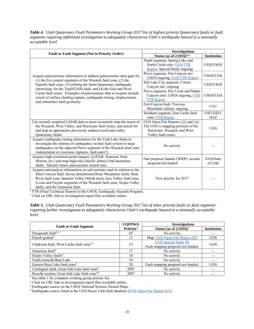
Table 4. Utah Quaternary Fault Parameters Working Group 2017 list of highest priority Quaternary faults or fault segments requiring additional investigation to adequately characterize Utah’s earthquake hazard to a minimally acceptable level.
Fault or Fault Segment (Not in Priority Order) Investigations
Status (as of 2/2016)1,2 Institution
Acquire paleoseismic information to address paleoseismic data gaps for (1) the five central segments of the Wasatch fault zone, (2) the Oquirrh fault zone, (3) refining the latest Quaternary earthquake chronology for the Topliff Hills fault, and (4) the East and West Cache fault zones. Examples of paleoseismic data to acquire include extent of surface-faulting rupture, earthquake timing, displacement, and subsurface fault geometry.
Nephi segment, Spring Lake and North Creek sites: UGS FTR Report, Special Study ongoing
UGS/USGS
Provo segment, Flat Canyon site: USGS ongoing, UGS FTR Report
USGS/UGS
Salt Lake City segment, Corner Canyon site: ongoing
UGS/USGS
Provo segment, Dry Creek and Maple Canyon sites: USGS ongoing, UGS FTR Report
USGS/UGS
Fort Canyon fault, Traverse Mountains salient: ongoing
UVU
Southern segment, East Cache fault zone: FTR Report
USU/GEO-HAZ
Use recently acquired LiDAR data to more accurately map the traces of the Wasatch, West Valley, and Hurricane fault zones, and search for and map as appropriate previously undiscovered mid-valley Quaternary faults.
UGS Open-File Reports 638 and 640 The UGS is mapping portions of the
Hurricane, Wasatch, and West Valley fault zones.
UGS
Acquire earthquake timing information for the Utah Lake faults to investigate the relation of earthquakes on that fault system to large earthquakes on the adjacent Provo segment of the Wasatch fault zone (independent or coseismic ruptures, fault pairs?).
No activity --
Acquire high resolution aerial imagery (LiDAR, Structure from Motion, etc.) and map high-risk (chiefly urban) Utah hazardous faults. Identify future paleoseismic trench sites.
One proposal funded (3DEP), second proposal not funded.
UGS/State of Utah
Acquire and analyze information on salt tectonics and its relation to the Main Canyon fault, Sevier detachment/Drum Mountains faults, Bear River fault zone, Spanish Valley (Moab area), Joes Valley fault zone, Levan and Fayette segments of the Wasatch fault zone, Scipio Valley faults, and the Gunnison fault.
New priority for 2017 --
1 FTR (Final Technical Report) to the USGS, Earthquake Hazards Program. 2 Click on URL link to investigation report files available online. Table 5. Utah Quaternary Fault Parameters Working Group 2017 list of other priority faults or fault segments requiring further investigation to adequately characterize Utah’s earthquake hazard to a minimally acceptable level.
Fault or Fault Segment UQFPWG Priority1
Investigations Status (as of 2/2016)2 Institution
Paragonah fault3,4 105 No activity -- Enoch graben4 11 Map: UGS Open-File Report 628 UGS
Clarkston fault, West Cache fault zone3,4 13 UGS Special Study 98
Fault mapping proposal not funded. UGS
Gunnison fault4 17 No activity -- Scipio Valley faults4 18 No activity -- Faults beneath Bear Lake 19 No activity -- Eastern Bear Lake fault zone4 20 Fault mapping proposal not funded. UGS Carrington fault, Great Salt Lake fault zone4 2007 No activity -- Rozelle section, Great Salt Lake fault zone4,6 2007 No activity --
1 See table 1 for complete working group priority list. 2 Click on URL link to investigation report files available online. 3 Earthquake source on the USGS National Seismic Hazard Maps. 4 Earthquake source listed in the UGS Hazus Utah fault database (UGS Open-File Report 631).

11
5 The Cedar City-Parowan monocline was removed from Priority 10 in the 2016 meeting, based on new information from geologic mapping in the area (UGS Map 270 and 2016 presentation file).
6 Previous highest priority fault or fault segment.