2018 tamc data collection training manual · 2018 tamc data collection ... michigan-specific...
TRANSCRIPT

© 2018 Center for Technology & Training
Manual prepared by Center for Technology & Training—Michigan Technological University on behalf of the Michigan Transportation Asset Management Council
2018 TAMC Data Collection Training Manual
2018 TAMC Data Collection Training Manual
i
CONTENTS
Introduction ................................................................................................................................. v
DATA COLLECTION REQUIREMENTS & GUIDELINES .................................. 1
TAMC DATA COLLECTION REGULATIONS ...................................................................... 3
Roads that Must be Rated ....................................................................................................... 3
Definition of “Federal-aid Eligible” ....................................................................................... 3
TYPES OF ROADS .................................................................................................................... 4
Asphalt .................................................................................................................................... 4
Concrete .................................................................................................................................. 4
Sealcoat ................................................................................................................................... 4
Brick ........................................................................................................................................ 5
Unpaved .................................................................................................................................. 5
Evaluating Paved Roads ............................................................................................................. 5
PASER Descriptors vs. TAMC Definitions............................................................................ 5
Michigan-specific Asphalt Road Rating Guide ...................................................................... 7
Michigan-specific Concrete Road Rating Guide .................................................................... 8
Michigan-specific Sealcoat Road Rating Guide ..................................................................... 9
Evaluating UnPaved Roads....................................................................................................... 11
IBR Scores vs. TAMC Definitions ....................................................................................... 11
RATING ROADS EFFECTIVELY ......................................................................................... 11
How to Rate Road Effectively .............................................................................................. 11
What to Assess to Rate Roads Effectively ............................................................................ 12
BOUNDARY SEGMENTS ...................................................................................................... 13
SPLITTING SEGMENTS ........................................................................................................ 14
Guidelines for Splitting Segments ........................................................................................ 14
Good Reasons for Splitting Segments .................................................................................. 14
Bad Reasons for Splitting Segments ..................................................................................... 15
SAFETY CONCERNS ............................................................................................................. 15
General Safety ....................................................................................................................... 15
Seating within the Vehicle .................................................................................................... 15
ii
DATA COLLECTION PROCEDURES ........................................................... 17
TAMC DATA COLLECTION DETAILS ............................................................................... 19
Federal-aid versus Non-Federal-aid Data Collection ........................................................... 19
Collection Timeline .............................................................................................................. 19
Rating Teams ........................................................................................................................ 19
Required Tools ...................................................................................................................... 20
Corrections for the Framework Map ..................................................................................... 20
Reimbursement ..................................................................................................................... 21
Working with Smaller Cities and Villages ........................................................................... 21
TAMC DATA COLLECTION FLOW .................................................................................... 23
DATA COLLECTION .................................................................................. 25
Step 1: Identify your TAMC/Federal-aid or local/non-Federal-aid network for data collection ............................................................................................................................... 27
Step 2: Export your network for use with the LDC .............................................................. 30
Step 3: Import the network into the Laptop Data Collector (LDC) ...................................... 39
Step 4: Connect the GPS to your laptop and begin collecting data ...................................... 40
Step 5: Export collected data from the LDC ......................................................................... 47
Step 6: Import the collected data to Roadsoft ....................................................................... 48
Step 7: Export TAMC data for the planning organization’s version of Roadsoft ................ 50
For Planning Organizations Only: Data Submission .................................. 51
Step 8: Import TAMC data from the local agency into the planning organization’s version of Roadsoft ........................................................................................................................... 53
Step 9: Export planning organization’s .xml file from Roadsoft ......................................... 55
TAMC Data Quality Control Guide ..................................................................................... 56
Step 10: Upload planning organization’s .xml file to the CSS’ Investment Reporting Tool 61
APPENDICES ............................................................................................ 63
Appendix A – PASER Michigan-Specific Cheat Sheet ........................................................... 65
Appendix B – IBR System™ Field Guide ................................................................................ 67
Appendix C – Michigan’s Regional Planning Organizations ................................................... 69
Appendix D – Michigan’s Metropolitan Planning Organizations ............................................ 70
Appendix E – New Midland Area Transportation Study (MATS) Boundary .......................... 71
Appendix F – TAMC’s Policy for collection of Roadway Surface Condition Data ................ 72
Appendix G – Framework Change Requests ............................................................................ 78

iii
Appendix H – Data Collection Timesheet ................................................................................ 81
Index ......................................................................................................................................... 83

iv
v
INTRODUCTION
According to Michigan’s Act 51 (P.A. 499 in 2002 and P.A. 199 in 2007), each local road agency must annually report the mileage and condition of the road and bridge system under their jurisdiction to the Michigan Transportation Asset Management Council (TAMC). To fulfill the requirement of this Act, the TAMC sets policies each year for road condition data collection and submission by road-owning agencies in Michigan.
The TAMC has adopted the Pavement Surface Evaluation and Rating (PASER) system for measuring conditions of paved roads in Michigan and the Inventory-based Rating (IBR) System™ for unpaved roads in Michigan. The PASER system, developed by the University of Wisconsin Transportation Information Center, is a visual survey method that provides a simple, efficient, and consistent method for evaluating the condition of paved roads. The IBR System™, developed by the Center for Technology & Training (CTT) through the support of the TAMC, provides a stable and implementable assessment method for unpaved roads (see the Inventory-based Rating System™ Manual for more information).
Part of the TAMC’s mission is to obtain accurate road condition data in order to provide a clear view of the overall condition of Michigan’s road network. The TAMC uses these ratings to communicate the condition of Michigan roads to the Michigan Legislature. At the local level, this data serves as a foundation upon which local agencies can build cost-effective pavement maintenance strategies.
The TAMC chose Roadsoft—a roadway management system for collecting, storing and analyzing data—for use in storing this road condition data and advancing its statewide pavement rating collection strategy. Roadsoft is funded through the Michigan Department of Transportation (MDOT) and developed, supported, and distributed by Michigan Technological University’s Center for Technology & Training
This manual describes the requirements and processes involved in collecting condition data for the TAMC. The TAMC works in conjunction with Michigan’s local agencies as well as with its planning organizations (POs)—both its regional and metropolitan (RPO and MPO, respectively)—to collect condition data. Although these POs operate under many different names and serve a variety of different areas, they all participate in coordinating and performing data collection for the TAMC. This manual details the tools and procedures for collecting road condition data. It also includes information on how to split segments, rate sealcoats, and double-check collected condition data in Roadsoft.

vi

vii


1
DATA COLLECTION REQUIREMENTS &
GUIDELINES

2
3
TAMC DATA COLLECTION REGULATIONS
According to Michigan’s Public Act 51 (P.A. 499 in 2002 and P.A. 199 in 2007), each local road agency must annually report the mileage and condition of the road and bridge system under their jurisdiction to the Michigan Transportation Asset Management Council (TAMC). This policy applies to three road network categories:
• Federal-aid-eligible paved public roads and streets, which should be evaluated using the PASER system
• Non-Federal-aid-eligible paved public roads and streets, which should be evaluated using the PASER system
• Federal-aid-eligible or non-federal-aid-eligible unpaved roads and streets, which should be evaluated using the IBR System™.
Road condition rating is eligible for reimbursement from the TAMC if the required training is attended and proper documentation is submitted at the end of the collection process (see Data Collection Procedures section for details).
Roads that Must be Rated
In a two-year cycle, all of an agency’s Federal-aid-eligible roads must be rated using the PASER system for paved roads and the IBR System™ for unpaved roads. Each rated road requires four categories of data:
Assessment Parameter Category How Parameter is Evaluated Surface type Asphalt, concrete, sealcoat, composite, brick PASER or IBR score PASER: 1-10; IBR: G, F, P on width, drainage, structure Number of lanes Number of through lanes and continuous left-turn lanes only Crew Crew members’ names (first and last name)
Definition of “Federal-aid Eligible”
According to Title 23 of the United States Code1, Federal-aid-eligible roads are “highways on the Federal-aid highway systems and all other public roads not classified as local roads or rural minor collectors.” This definition can be stated in terms of National Functional Classification (NFC), where the NFC is 1, 2, 3, 4, or 5 for rural/urban or 6 for urban only where one or both sides of the road are on or within an urban boundary (RU_L > 1 or RU_R > 1). NFC codes are defined as:
1 Subchapter E, 23 U.S.C. 470.103 (2003)

4
1 – Interstates 5 – Major Collectors 2 – Other Freeways 6 – Minor Collectors 3 – Other Principal Arterials 7 - Local 4 – Minor Arterials 0 or uncoded – not a certified public road RU_L | 1 Rural/Urban designation left RU_R | 1 Rural/Urban designation right
1 – Rural area 3 – Small urbanized area (50,000 to 199,999) 2 – Small urban area (5,000 to 49,999) 4 – Large urbanized area (200,000 or more)
For Federal-aid data collection, the council collects condition data based on the above definition of Federal-aid eligible so you will not be collecting condition data on Rural Minor Collectors. Using the Roadsoft query of “Federal Aid = True” will take this change into account and give you the correct network conforming to the current definition.
TYPES OF ROADS
Asphalt
Hot-mix asphalt is a pavement type with the top structural layer being HMA. Generally, a structural hot-mix asphalt layer has a thickness of 1.5 inches or more. This pavement should be rated using rating system outlined in the Asphalt PASER Manual and the Michigan-specific Asphalt Road Rating Guide on page 7.
Composite pavements should be rated with the asphalt rating system but should be inventoried as a composite pavement. A composite pavement is an old concrete pavement that has an asphalt overlay.
A chip seal or a sealcoat on top of an asphalt pavement should also be rated with the asphalt rating system. This type of pavement is not considered a sealcoat pavement because the asphalt below is considered the structural layer.
Concrete
A concrete pavement is a pavement composed of a riding surface of concrete. This pavement should be rated using the rating system outlined in the Concrete PASER Manual and the Michigan-specific Concrete Road Rating Guide on page 8.
Sealcoat
A sealcoat pavement is an unpaved road with a sealcoat (chip seal) surface treatment. There is no full-width structural layer of asphalt in a sealcoat pavement. This pavement should be rated with the modified Michigan sealcoat rating system, which uses a 1-to-10 scale. This pavement should
5
be rated using the rating system outlined in the Sealcoat PASER Manual and the Michigan-specific Sealcoat Road Rating Guide on page 9.
Brick
The rating scale in the Brick and Block PASER Manual is 1-2-3-4. To be consistent with other pavement rating scales, the brick and block scale must be doubled resulting in 2, 4, 6, and 8 as ratings while maintaining the original definitions from the manual. A rating of 10 is reserved for brick and block pavements that are in “like new” condition and less than one-year old.
Unpaved
An unpaved road has a gravel, dirt, or other surface that is often characterized by a rapidly changing condition. This type of road is evaluated using the Inventory-based Rating System™ Manual.
EVALUATING PAVED ROADS
For evaluating paved roads, Michigan uses three PASER manuals: Asphalt PASER Manual, Concrete PASER Manual, and Sealcoat PASER Manual. The PASER manual for brick, Brick and Block PASER Manual, is also used as brick is reported although it is not widely needed. These manuals can be found at http://www.ctt.mtu.edu/asset-management-resources or http://michiganltap.org/paser-resources.
However, the PASER system was created for use in Wisconsin and not for the Michigan TAMC. The Michigan TAMC defines road ratings differently and has some changes, exceptions, and/or exclusions to the information presented in these three PASER manuals. When using the PASER system in Michigan, data collectors need to be aware of these changes, which are detailed below. These changes provide simplified and uniform data collection and increases reporting accuracy to the Michigan Legislature.
PASER Descriptors vs. TAMC Definitions
Each rating in the PASER manuals includes written descriptors (excellent, very good,…failed, etc.) that are part of the rating category name and give an overall impression of the state of each rating. The PASER manuals’ descriptors are not based on any formal definition relating to the quality of the pavement. They should not be confused with the formal definitions of Good, Fair, and Poor that the Michigan TAMC has developed and uses for reporting. The original PASER descriptors and the TAMC definitions are as follows for asphalt and concrete pavements:

6
Rating PASER Descriptor TAMC Definition
10 & 9 Excellent
Good 8 Very Good
7 & 6 Good
Fair 5 Fair
4 Fair
Poor
3 Poor
2 Very Poor
1 Failed
The TAMC groups the 1-to-10 rating scale into three categories (Good 8-10, Fair 5-7, Poor 1-4) based upon a definition that relates to the type of work that is typically required for each rating grouping (routine maintenance, capital preventive maintenance, and structural improvement).
In TAMC nomenclature, roads that are considered “Good” have a PASER of 8, 9, or 10. This category includes roads that only require routine maintenance, that have been recently seal coated, or that are newly constructed. Routine maintenance is the day-to-day, regularly-scheduled, low-cost activities to prevent water from seeping into the surface. These activities include street sweeping, drainage clearing, gravel shoulder grading, and crack sealing. “Good” roads require little or no maintenance beyond routine maintenance.
Roads that are considered “Fair” have a PASER of 5, 6, or 7. Roads in this category still show good structural support but their surface is starting to deteriorate. Capital preventive maintenance (CPM) addresses pavement problems of “Fair” roads before the structural integrity of the pavement has been severely impacted. CPM is a planned set of cost-effective treatments applied to an existing roadway that slows further deterioration and that maintains or improves the functional condition of the system without significantly increasing the structural capacity. The purpose of CPM fixes is to protect the pavement structure, slow the rate of deterioration, and/or correct pavement surface deficiencies.
According to TAMC, roads that are considered “Poor” have a PASER of 1, 2, 3, or 4. These roads exhibit alligator cracking and rutting. Road rutting is evidence that the underlying structure is beginning to fail and it must be either rehabilitated with a fix like a crush and shape or totally reconstructed. “Poor” roads require structural improvement (SI) such as resurfacing or major reconstruction.

7
Michigan-specific Asphalt Road Rating Guide
Extent of Rutting In the Asphalt PASER Manual and the Revised 2013 edition of the Asphalt PASER Manual, the extent of rutting for PASER 4 should be revised to ½”-1” rutting and PASER 3 should be revised to rutting of 1”-2” for Michigan-specific data collection (see the table, Asphalt Road Rating Guide: Changes for Michigan-specific Assessment of the Extent of Rutting, below). Please note this in your Asphalt PASER Manual and refer to the PASER Cheat Sheet (see Appendix A) for additional information.
Asphalt Road Rating Guide: Changes for Michigan-specific Assessment of the Extent of Rutting
Asphalt PASER Manual Michigan-specific Asphalt Road Rating
PASER 4 < ½ inch-deep rutting
MI PASER 4 ½ –1 inch-deep rutting
Asphalt PASER Manual, Revised 2013 Michigan-specific Asphalt Road Rating
PASER 4 < ½ inch-deep rutting
MI PASER 4 ½ –1 inch-deep rutting
PASER 3 ½ –2 inch-deep rutting
MI PASER 3 1–2 inch-deep rutting
Extent of Block Cracking Because the descriptor “50% of the surface” is undefined for Michigan’s data collection, both versions of the asphalt PASER manual should be revised as follows: PASER 6—“Initial block cracking (6’-10’ Blocks)”, PASER 5—“Moderate block cracking (1’-5’ blocks)”, PASER 4 —“Severe block cracking (less than 1’ blocks)”, and PASER 3—“Severe block cracking (alligator)” (see the table, Asphalt Road Rating Guide: Changes for Michigan-specific Assessment of the Extent of Block Cracking, below) . Please note this in your Asphalt PASER Manual and refer to the PASER Cheat Sheet (see Appendix A) for additional information.
revise to
revise to
revise to

8
Asphalt Road Rating Guide: Changes for Michigan-specific Assessment of the Extent of Block Cracking
Asphalt PASER Manual Michigan-specific Asphalt Road Rating
PASER 6 First signs of block cracking
MI PASER 6 Initial block cracking (6’-10’ blocks)
PASER 5 Block cracking, up to 50% of the surface
MI PASER 5 Initial block cracking (1’-5’ blocks)
PASER 4 Block cracking, over 50% of the surface
MI PASER 4 Severe block cracking (< 1’ blocks)
PASER 3 Severe block cracking
MI PASER 3 Severe block cracking (alligator)
Pro-active Sealcoat Treatments on Asphalt PASER 9 The Asphalt PASER Manual has a condition benchmark of PASER 8 for “recent sealcoat” asphalt pavements. This guidance is meant to upgrade a pavement, not to downgrade it. If an agency chooses to perform a sealcoat treatment as pro-active preventive maintenance prior to a pavement exhibiting any distresses, then the Michigan-specific recommendation is to rate this road based on visible distress.
Michigan-specific Concrete Road Rating Guide
PASER 9 and Joint Rehabilitation In the Concrete PASER Manual on page 17, the bottom photograph includes the description “RATING 9 Recent joint rehabilitation. Like new condition.” This example should be crossed out or noted as an extremely unlikely situation due to the fact that, by the time a concrete pavement requires joint rehabilitation, the original concrete slabs are rarely in a “like new condition” (without any distresses).
revise to
revise to
revise to
revise to
9
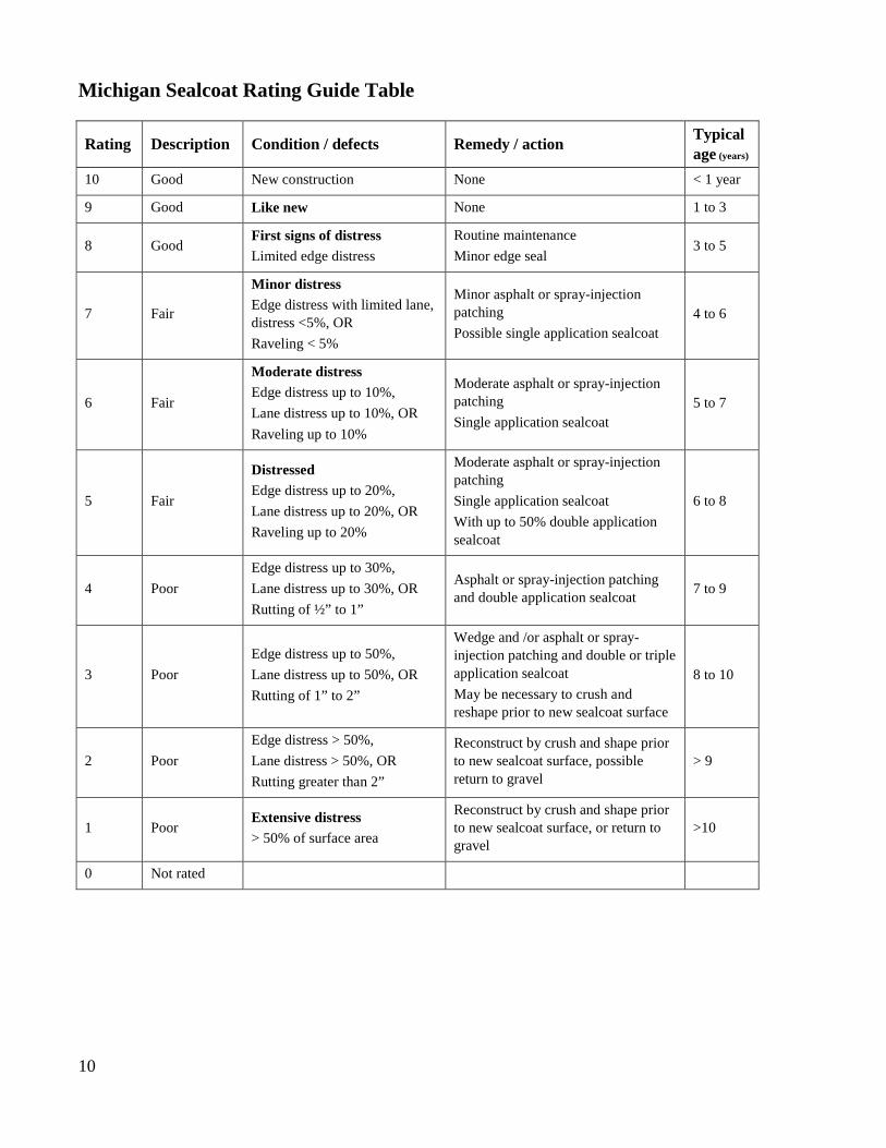
Michigan-specific Sealcoat Road Rating Guide
The PASER system rates a sealcoat road (sealcoat over a gravel base) on a scale of 1 to 5; however, the TAMC established their own rating system on a 1 to 10 scale. Thus, all surface types in the paved road network are rated on the same, standardized rating scale. In Michigan, the sealcoat scale is based on the relative percent of distress observed in the pavement; however, the Sealcoat PASER Manual should be used to help identify distress, but it should not be used for its rating scale.
Using a Percentage Approach The Michigan sealcoat scale assesses the percentage of distress over a cross section of the total length of the segment under consideration. The observed distresses are:
• Edge distress • Lane distress (including rutting) • Raveling
These percentages are not cumulative. If none of the observed surface distress percentages exceeds the upper limit of a rating description outlined in the sealcoat rating chart, then that description rating is your selection. For example, consider a cross section of the roadway segment: it can be 50 ft. long or 1-mile long. A sealcoat with a rating of 5 allows up to 20% raveling, 20% edge distress, or 20% lane distress. If your assessment yields 10% raveling, 5% edge distress and 20% lane distress, the rating is 5 because none of the distresses exceeds 20%. It is not a rating of 6 because the 20% lane distress exceeds the 10% criteria, and it is not a rating of 4 because edge distress and lane distress percentages do not exceed the 20% limit for 5. Cumulative total distress is irrelevant for this rating system.
Consult the table—Michigan Sealcoat Rating Guide Table—on the following page for specific rating criteria.
10
Michigan Sealcoat Rating Guide Table
Rating Description Condition / defects Remedy / action Typical age (years)
10 Good New construction None < 1 year
9 Good Like new None 1 to 3
8 Good First signs of distress Limited edge distress
Routine maintenance Minor edge seal
3 to 5
7 Fair
Minor distress Edge distress with limited lane, distress <5%, OR Raveling < 5%
Minor asphalt or spray-injection patching Possible single application sealcoat
4 to 6
6 Fair
Moderate distress Edge distress up to 10%, Lane distress up to 10%, OR Raveling up to 10%
Moderate asphalt or spray-injection patching Single application sealcoat
5 to 7
5 Fair
Distressed Edge distress up to 20%, Lane distress up to 20%, OR Raveling up to 20%
Moderate asphalt or spray-injection patching Single application sealcoat With up to 50% double application sealcoat
6 to 8
4 Poor Edge distress up to 30%, Lane distress up to 30%, OR Rutting of ½” to 1”
Asphalt or spray-injection patching and double application sealcoat 7 to 9
3 Poor Edge distress up to 50%, Lane distress up to 50%, OR Rutting of 1” to 2”
Wedge and /or asphalt or spray-injection patching and double or triple application sealcoat May be necessary to crush and reshape prior to new sealcoat surface
8 to 10
2 Poor Edge distress > 50%, Lane distress > 50%, OR Rutting greater than 2”
Reconstruct by crush and shape prior to new sealcoat surface, possible return to gravel
> 9
1 Poor Extensive distress > 50% of surface area
Reconstruct by crush and shape prior to new sealcoat surface, or return to gravel
>10
0 Not rated
11
EVALUATING UNPAVED ROADS
For evaluating unpaved roads, Michigan uses the Inventory-based Rating System™ Manual. This manual will be available at http://www.ctt.mtu.edu/asset-management-resources or http://michiganltap.org/paser-resources. The IBR Field Guide highlights the principles of rating unpaved roads using the IBR System™ (see Appendix B).
IBR Scores vs. TAMC Definitions
The overall 1-10 IBR score is meant to standardize the rating scale so that it is comparable to other TAMC rating scales. However, the Michigan TAMC uses the formal definitions of Good, Fair, and Poor as an evaluation of road condition, thereby assessing a road in terms of need for roadwork like routine maintenance, capital preventive maintenance, and/or structural improvement. These definitions do not apply to the IBR System™.
The IBR System™ evaluates unpaved road features in relation to a baseline condition for that feature. IBR System™ evaluation places a feature on a good-fair-poor gradient; while good, fair, and poor are simple designators, they do not relate the quality of the road feature to the road’s intended use but, instead, to the baseline condition of the feature itself. This evaluation is applied to three distinct unpaved road features that weight the road’s overall rating by the cost to get the features to a baseline good condition.
RATING ROADS EFFECTIVELY
How to Rate Road Effectively
Speed Rating roads at high speeds can cause inaccuracy. Reviews conducted by the CTT’s road rating trainers have shown that teams that view roadways at lower speeds are much more likely to rate them accurately. Rating roads at high speeds can cause distresses to be missed and ratings to be higher than appropriate.
Lighting Conditions Changes in lighting conditions and the time of day can influence how some distresses are perceived. Bright sunlight directly overhead may make surface texture defects or fine cracking hard to discern. Rating early in the morning or late in the afternoon on a sunny day while driving into the sun may also make it difficult to rate roads effectively. If lighting conditions are poor, slow down or stop to make sure that you are not overlooking any visual cues.

12
Trees cause shadows that can appear to be road distresses. Tree shadows on the road make for very difficult rating conditions. Options are to return to the location at a different time or drive at lower speeds.
Inclement Weather Both PASER and IBR are visual assessment systems. With the PASER system, trying to rate paved roads in the rain is ineffective. Road surfaces look different when they are wet—cracks look larger, puddles can hide distresses, and so forth. Teams should not rate roads when they are wet. However, with the IBR System™, features of an unpaved road are rated rather than the road’s condition. As long as the feature is visible (i.e., not obscured by tall grass or snow), roads can be rated.
Group Dynamics Teams need to be aware of group dynamics in their vehicles. Condition rating is supposed to be a group process. However, the process also needs to conform to TAMC procedures. Teams should read the PASER and IBR descriptions closely and refer to the reference sheets for clarification.
Road Ownership, Use or Importance Do not rate an important road less than the actual rating. Do not confuse a management decision with rating. Road ownership, use, or importance does not change its distress rating.
Road Construction Projects When rating a road currently under construction where the old pavement is gone, the road should be rated as if the construction were complete. Rate the existing pavement if construction limits are not established by road work (more than traffic control devices).
What to Assess to Rate Roads Effectively
Rate What You See Don’t anticipate upcoming condition data based on previous condition data. Rate what you see. The value of the actual rating is a usable record of road improvements and ratings for managing costs and extending service life.
Rate the Worst Lane If there is a difference in quality, select the worst lane for your rating.
13
Rate Distress, Not Ride Quality Just because a road rides well does not mean that it has no distresses in need of capital preventive maintenance or structural improvement. This is especially true on a road with rutting and cracking in the wheel path, both of which can cause rapid deterioration. Conversely, a concrete surface in relatively good condition with sealed transverse cracks often makes quite a bit of noise as tires pass over the expanded crack seal. More noise does not always mean severe distress. Do not let ride quality distort your ratings.
Make Careful Distress Observations on Light-colored Pavement Oxidized pavements can be very light and often look gray or off-white, which causes distresses to be less visible. Flat lighting on an oxidized pavement can also hinder visibility of distresses.
Measure Rutting It can be difficult to detect rutting when moving at high speeds on a sunny day. When initially learning to assess ruts, teams can quickly get a tangible assessment of the extent of rutting on a road—where it is practical and safe to do so—by using a six-foot aluminum T-bar (available at the PO’s office) in conjunction with a tape measure. It is the rating team’s decision to choose whether to measure rutting by physical assessment.
Paved Shoulders For paved shoulders, rate the pavement from edge line to edge line and omit the shoulder condition. Shoulders are not rated because they are often constructed differently than the traveled way; they typically have a thinner structural layer so deterioration is different.
BOUNDARY SEGMENTS
Boundary roads (roads that fall between jurisdictions) often have non-standard characteristics and splits on the framework basemap used by Roadsoft. As a result, it may be unclear which jurisdiction is responsible for rating a boundary road. To eliminate potential data collection issues when rating boundary roads, follow these two rules:
Rule 1: Follow the Data Collection Procedures section of this manual carefully. The steps for collecting and submitting TAMC data are laid out in a specific order to ensure that your rated roads are properly identified and tagged for TAMC/Federal-aid data collection.
Rule 2: Rating teams should rate all boundary roads in their data collection networks regardless of ownership or maintenance responsibilities.

14
SPLITTING SEGMENTS
If a team encounters an undocumented change in the surface type or layout of a road (such as number of lanes), they should create a split in the framework basemap used by Roadsoft to reflect the change. Although the framework basemap used by Roadsoft initially splits all street and road segments on an intersection-to-intersection basis (node to node) or by using Act 51 boundaries (township/city/county), agencies can add road segment splits to denote changes in surface types or conditions.
Rating teams should respect segment splits previously created within Roadsoft by local agencies. However, the following guidelines will help you decide if introducing new splits is warranted while collecting TAMC data.
Guidelines for Splitting Segments
• If the area in question has received rehabilitation or reconstruction separate from the framework segment from which it came, then the segment in question should be split from the framework segment into its own designated rating segment.
• Avoid splitting segments into lengths of less than ¼ mile.
Good Reasons for Splitting Segments
Change in Surface Type If the road surface changes (e.g., from asphalt to gravel, asphalt to chip seal, chip seal to gravel), then splitting a segment to reflect a change in surface type can ensure that the inventory collected is representative of the actual road conditions.
Number of Lanes Commercial or development activity may require the addition of through lanes or continuous left-turn lanes within a given framework segment. Splitting a segment to reflect this addition will ensure that Roadsoft’s lane mileage inventory reflects the true mileage.
Intersection as a Unique Facility Many intersections within a county/city system are extensions of segments, meaning their design, surface type, service life, and number of lanes is no different than the segment from which they stem. However, some intersections have significant changes in surface type and/or geometry. In these cases, it may be best to designate the intersection as a unique facility by making it a distinct segment.

15
Environmental Factors Environmental factors can have a significant impact on a segment of road. For example, regular flooding or exceptional frost heave can cause severe damage to the roadway. Although this type of deterioration is rare, these segments should be designated as their own segment if they are longer than a ¼ of a mile. This helps to isolate the area needing rehabilitation or reconstruction.
Bad Reasons for Splitting Segments
The following cases do not affect the network as a whole and, therefore, do not warrant segment splitting:
• Change in condition over a short stretch (e.g., 50 feet) • Short right or left turn bay • School zone • Traffic count segments
SAFETY CONCERNS
General Safety
During data collection, you will be merging in and out of traffic, slowing down, pulling off to the shoulder for team discussions, and so forth; always take safety precautions! Driving the team vehicle is not something to be taken lightly. All the vehicles must be equipped with a warning light bar. Warning garments should be worn by raters that get out of the vehicle to view distress better or to measure rutting better. Above all, be sure to comply with your employer’s warning garment and safety procedure requirements.
Seating within the Vehicle
The best configuration for a three-person team is the rater in the front passenger seat, and the data entry person in the back seat. If the data entry person sits in the front seat with a laptop, they could be injured by an airbag discharge and can be distracting to the driver.

16

17
DATA COLLECTION
PROCEDURES

18

19
TAMC DATA COLLECTION DETAILS
Federal-aid versus Non-Federal-aid Data Collection
The Michigan TAMC collects data for Michigan’s Federal-aid road network. In addition, the TAMC requests submission of data collected with or without reimbursement for Michigan’s non-Federal-aid road system. Submitting data sets for these two networks gives the TAMC a better understanding of Michigan road conditions. However, these two networks have different collection procedures by which you are to collect data in the Laptop Data Collector for import into Roadsoft; during the data submission process, both sets of collected data can be imported together into Roadsoft (Step 6), imported into the PO’s version of Roadsoft (Steps 7 and 8), and submitted to the TAMC (Steps 9 and 10).
Collection Timeline
• Data collection begins: April 1 of every year • Data collection completed by: Last Friday in November • Data submitted to the Center for Shared Solutions (CSS) by: First Friday in December
To schedule your Federal-aid data collection, contact your PO. See the maps in Appendix C, Appendix D, and Appendix E to determine your jurisdiction’s planning office. See http://miregions.com/michigan-planning-regions/ if you need contact information for an RPO or http://www.mtpa-mi.org/members.asp if you need contact information for an MPO.
Rating Teams
TAMC or Federal-aid data collection rating teams should be comprised of:
• one member from MDOT, • one member from the Act-51 jurisdiction’s RPO/MPO, and • one member from the jurisdiction being rated (County, City, or Village) .
The PO coordinating data collection must review the collected data before sending it to the CSS. This quality control procedure is described in detail in Step 9 of the data-collection submission process.
Local or non-Federal-aid data collection only requires:
• one trained person from the agency or their representative • along with an additional representative when reimbursement is being requested (see
Appendix F’s second page).

20
Required training sessions Anyone who participates in the annual data collection of the Federal-aid system and who influences the rating activity must attend training prior to rating. For PASER data collection, rater must attend one on-site PASER training in the same year the data collection occurs. In addition, raters who have never attended PASER training or who did not attend the previous year’s PASER training must attend one PASER webinar session in the current year. For IBR data collection, raters who have not attended IBR training during the past three years must attended one webinar session in the current year.
The TAMC has instituted a testing and certification program for PASER data collectors who attended PASER training and collected PASER data for multiple years. The certification allows experienced raters to opt out of training for the next year. The full certification/training requirement policy and a link to the TAMC policy is included in Appendix F. There is no certification for IBR data collectors.
Required Tools
Computer hardware • Laptop computer from PO • GPS from PO • Additional laptop computer from local agency (as backup and/or for local data collection)
Computer software and data sets Before you begin collecting road data for the data collection season, ensure that you are using the newest versions and the latest frameworks used by Roadsoft and Laptop Data Collector, which are released by April 1 of the collection year. Visit http://www.roadsoft.org/Downloads for the newest version or for Roadsoft updates. If you have any questions or concerns, please call Roadsoft support at (906) 487-2102. There are two different data sets for Roadsoft—the local agency’s data set and the PO’s data set.
Replacement vehicles If you need another vehicle, either use one from the county road commission or rent one. In the rare event that you need to rent a vehicle, the MDOT rater should check with the TAMC coordinator for the current procedure; the MDOT rater should be the signator and should purchase the extra insurance.
Corrections for the Framework Map
If a team suspects that they have discovered needed correction for their jurisdiction’s map, they should first place a short notation in the LDC memo field for that segment (select the Inventory

21
tab). Consistent use of a tag such as “correction” can simplify creating a Roadsoft report containing these errors and the road segments where they are located. This information can be passed on to the CSS for correction.
Next, a team should create a Framework Map Change Request (see Appendix G) and submit it through Roadsoft or by printing a PDF of the form and sending it to:
Joshua Ross Michigan Center for Shared Solutions Romney Building, 10th Floor 111 S. Capital Ave Lansing, Michigan 48933
You can also request changes by contacting Mr. Ross at (517) 373-7910 or [email protected].
Reimbursement
Data collection for Federal aid is reimbursable for qualified individuals. Non-Federal-aid collection reimbursement can be given if previously approved by the TAMC coordinator. Requests for prior approval to collect non-Federal-aid data for reimbursement and invoices for rating efforts (see Appendix H) should be submitted through your PO to:
Roger Belknap Michigan Department of Transportation PO Box 30050 425 W. Ottawa St. Lansing, MI 48909 [email protected]
Unpaved inventory collection on the non-Federal-aid system will not be reimbursed. See current TAMC policies for current collection and reimbursement rules.
Working with Smaller Cities and Villages
Smaller cities and villages are often enthusiastic about the data collection process. However, it can be time consuming to visit smaller communities (i.e., communities that have 10 or 20 miles of Federal-aid-eligible roads) in order to set up a Roadsoft network. If an agency has a limited number of miles in its jurisdiction, two options exist for including them in the data collection process.
In the latest versions of Roadsoft and the LDC, data collection exports from the LDC can be provided to small agencies as a means for transferring recently collected condition data that were collected using an export from the local agency version of Roadsoft. This option should only be used for small cities and villages with their permission because the historical road splits and historical data present in the small local agencies’ Roadsoft database will not be available to

22
assist in collection activities. Medium to large cities and villages should collect data using an export from the agency’s version of Roadsoft as you would with a county.
Another option for dealing with very small agencies is to provide them with a report (i.e., of the condition for the physical reference segment) and have them manually enter data in their version of Roadsoft.
Both options allow data collectors to use the collection networks they build at their road commission without having to stop and upload data for these small agencies. Data collection should be dealt with on a case-by-case basis.

23
TAMC DATA COLLECTION FLOW
The TAMC data collection flow for assessing a road network involves local agencies and POs. Data collection uses the Roadsoft software suite and the Laptop Data Collector at various steps in the process, and it ends with POs submitting data to the TAMC’s Investment Reporting Tool (IRT). The figure above illustrates this data collection flow. The steps in this figure correspond to the steps outlined in this section of the manual and are color-coded by the performing agency—blue for the local agency and/or the PO and purple for the PO—and by tool used—light blue for the local agency version of Roadsoft, medium blue for the Laptop Data Collector, purple for the PO’s version of Roadsoft, and teal for the IRT.
Keep in mind that creating a backup between Steps 5 and 6, signified by the green arrow ( ) above, is crucial: this backup file creates a save point that allows recovery of data from a previous save point or allows reverting of data to a previous save point. It is recommended that you save a copy of this file on an external backup device.

24

25
DATA COLLECTION

26
Make sure you use the local agency’s copy of Roadsoft at the road commission, city, or village for which you will be collecting data. The data collection process needs to start with the local agency’s Roadsoft data set, not with a PO’s version of Roadsoft. Collection teams should, therefore, use local data – not the PO’s data – as a starting point.
27
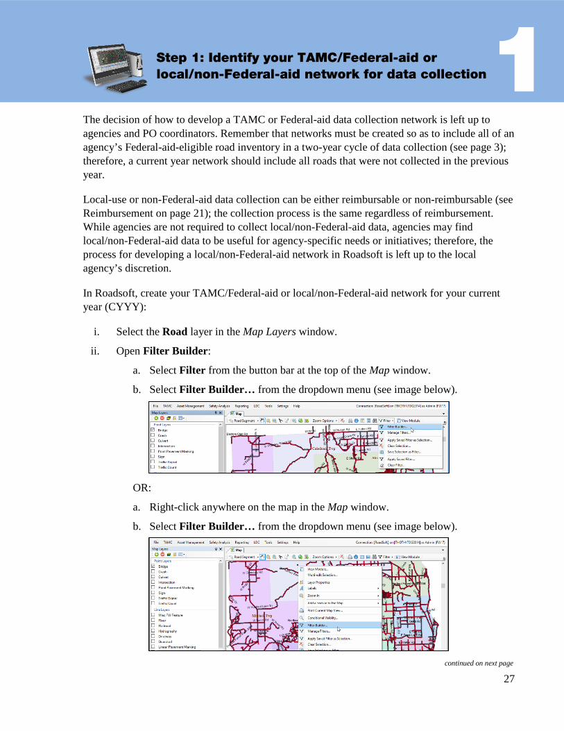
1 Step 1: Identify your TAMC/Federal-aid or local/non-Federal-aid network for data collection
The decision of how to develop a TAMC or Federal-aid data collection network is left up to agencies and PO coordinators. Remember that networks must be created so as to include all of an agency’s Federal-aid-eligible road inventory in a two-year cycle of data collection (see page 3); therefore, a current year network should include all roads that were not collected in the previous year.
Local-use or non-Federal-aid data collection can be either reimbursable or non-reimbursable (see Reimbursement on page 21); the collection process is the same regardless of reimbursement. While agencies are not required to collect local/non-Federal-aid data, agencies may find local/non-Federal-aid data to be useful for agency-specific needs or initiatives; therefore, the process for developing a local/non-Federal-aid network in Roadsoft is left up to the local agency’s discretion.
In Roadsoft, create your TAMC/Federal-aid or local/non-Federal-aid network for your current year (CYYY):
i. Select the Road layer in the Map Layers window.
ii. Open Filter Builder:
a. Select Filter from the button bar at the top of the Map window.
b. Select Filter Builder… from the dropdown menu (see image below).
OR:
a. Right-click anywhere on the map in the Map window.
b. Select Filter Builder… from the dropdown menu (see image below).
continued on next page

28
The Road Layer Filter Builder window will open.
iii. Add the criterion Federal-aid:
a. Select Federal-aid from the Field list.
b. Select equals (=) as the Operator.
c. For TAMC/Federal-aid data collection, select True as the Value.
OR: For local/non-Federal-aid data collection, select False as the Value.
d. Select Add.
iv. For TAMC/Federal-aid data collection, add a criterion of TAMC Collection Year <> PYYY (where PYYY should be your previous year) :
a. Select TAMC Collection Year from the Field list.
b. Select not equals (<>) as the Operator.
c. Select PYYY as the Value.
NOTE: If your PYYY value does not appear in the Value dropdown list, type the year into the Value textbox.
d. Select Add (see image below).
OR: For local/non-Federal-aid data collection, add any optional criteria that you want to use in defining your network.
v. Save this road layer filter:
a. Select Save from the button bar at the top of the Road Layer Filter Builder window (see image below).
The Save Filter window will open.
b. Enter a filter name in the Name textbox (see image below); an example of a filter name would be “CYYY [Type] Network”, where CYYY should be your current year and [Type] should be your network type (e.g., “TAMC”, “Local”, or “Non-Fed-Aid”) .
continued on next page

29
c. OPTIONAL: Enter a group name in the Group textbox (see image below) .
NOTE: Groups make it easier to organize your saved list of filters.
d. OPTIONAL: Select the Shared Filter option (see image below) .
NOTE: A shared filter allows others accessing your Roadsoft database on your agency’s computer network to be able to apply the filter.
e. Select Save As (see image below).
This filter creates your new TAMC/Federal-aid or local/non-Federal-aid network.
vi. Apply your new CYYY network as a selection:
a. Select Replace Selection (see image below) .
The Selection Information: Road window will populate with selection data.
vii. Examine your CYYY network on the map:
a. Visually verify the selected segments are appropriate for rating this year.
NOTE: For TAMC/Federal-aid collection, you should be collecting data for all roads not rated in PYYY; a full Federal-aid collection consists of PYYY data and CYYY data, which should include ratings 100 percent of Federal-aid-eligible road inventory (see page 3).
If you have any questions or issues creating your TAMC/Federal-aid or local/non-Federal-aid network for the current year, please refer to the Roadsoft Manual’s Use the Filter Builder help documentation (under Navigate the Map & Select Assets). Or, please call Roadsoft technical support at (906) 487-2102.

30
2 Step 2: Export your network for use with the LDC
There are two ways of exporting network data from Roadsoft for use in the LDC. The first option is TAMC Export, which allows you to gather surface type, road rating, and number of lanes, and then specifically tags your data to satisfy the TAMC data collection requirements. The second option is Local Use Export, which allows recording of more data but does not specifically tag your data for TAMC/Federal-aid data collection. Although both options can be used to collect road ratings, use the TAMC Export for TAMC data collection and use the Local Use Export option for other data collection efforts that require more than road rating and number of lanes. Agencies should choose the process that best fits their needs.
A. TAMC Export Option The TAMC Export option will automatically tag your data for TAMC submission/Federal-aid data collection. You can also use this option for local/non-Federal-aid collection; however, this option only allows you to gather rating, surface type, and number of lanes data.
In Roadsoft, export your TAMC/Federal-aid network for use with the LDC:
i. Open the Export to LDC window (see image below):
a. Select the TAMC menu from the main menu options (Roadsoft menu bar).
b. Select 1 - (County/City Does This) Export Network for LDC.
The Export to LDC window will open (see image below).
continued on next page

31
ii. Select the new TAMC/Federal-aid network defined in Step 1 that you wish to export:
a. Select Export Network in the Export to LDC window’s Choose Road Network for TAMC LDC Data Collection list.
A Select button will appear.
b. Select the Select button (see image above).
The Load Saved Filter window will open (see image below).
c. Locate the TAMC/Federal-aid network that you created in Step 1:
• Type the name in the search field (A in image below).
• OR: Scroll through the list until you locate your network (B in image below).
• OR: Select a group from the Group dropdown (C in image below), and scroll through list of remaining networks until you locate your network.
d. Select the network.
e. Select OK.
This will return you to the Export to LDC window (see image below).
continued on next page
A
B
C

32
NOTE: If you need to define or change a road layer filter, you can access the Road Layer Filter Builder at this point by selecting the Open Road Filter… link in the Export to LDC window (see image below). This will open the Road Layer Filter Builder window and you may proceed with building a filter using Steps 1.iii through 1.vi.
iii. Define an Export Path:
The Export Path is the location on your hard drive where you want to save the export file.
NOTE: Before proceeding, it is recommended that you create a folder specifically for storing your Roadsoft export files.
a. Select the folder icon ( button) to browse your hard drive for the location where you want the export file to be saved (see Note above).
OR: Type/paste your desired path into the textbox (see Note above).
iv. Save the export file to the location you specified:
a. Select Export.
b. Select OK to close the window confirming a successful export.
Roadsoft creates a file in the location you specified:
• RStoLDC_[jurisdiction]_[date]_[time].ldcz
v. Copy the .ldcz file to a CD, flash drive, or other portable storage device.
You will be transferring the .ldcz onto the laptop that has the LDC installed on it.
Proceed to Step 3. continued on next page
33
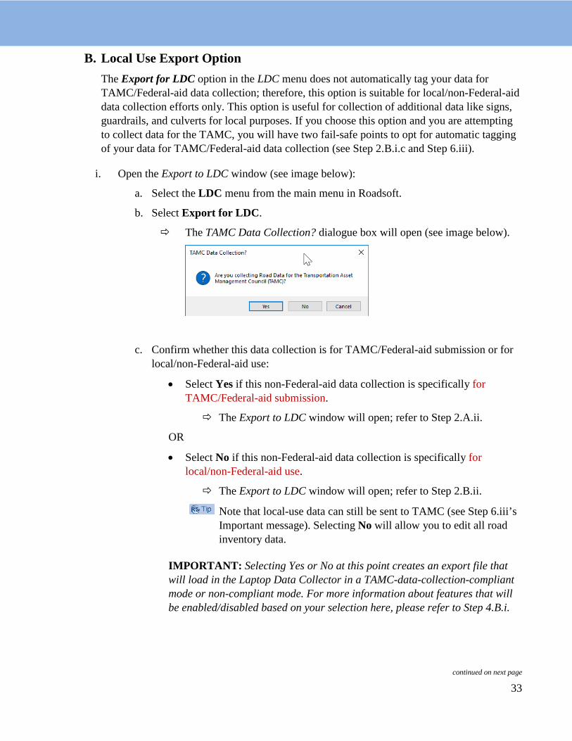
B. Local Use Export Option The Export for LDC option in the LDC menu does not automatically tag your data for TAMC/Federal-aid data collection; therefore, this option is suitable for local/non-Federal-aid data collection efforts only. This option is useful for collection of additional data like signs, guardrails, and culverts for local purposes. If you choose this option and you are attempting to collect data for the TAMC, you will have two fail-safe points to opt for automatic tagging of your data for TAMC/Federal-aid data collection (see Step 2.B.i.c and Step 6.iii).
i. Open the Export to LDC window (see image below):
a. Select the LDC menu from the main menu in Roadsoft.
b. Select Export for LDC.
The TAMC Data Collection? dialogue box will open (see image below).
c. Confirm whether this data collection is for TAMC/Federal-aid submission or for local/non-Federal-aid use:
• Select Yes if this non-Federal-aid data collection is specifically for TAMC/Federal-aid submission.
The Export to LDC window will open; refer to Step 2.A.ii.
OR
• Select No if this non-Federal-aid data collection is specifically for local/non-Federal-aid use.
The Export to LDC window will open; refer to Step 2.B.ii.
Note that local-use data can still be sent to TAMC (see Step 6.iii’s Important message). Selecting No will allow you to edit all road inventory data.
IMPORTANT: Selecting Yes or No at this point creates an export file that will load in the Laptop Data Collector in a TAMC-data-collection-compliant mode or non-compliant mode. For more information about features that will be enabled/disabled based on your selection here, please refer to Step 4.B.i.
continued on next page
34
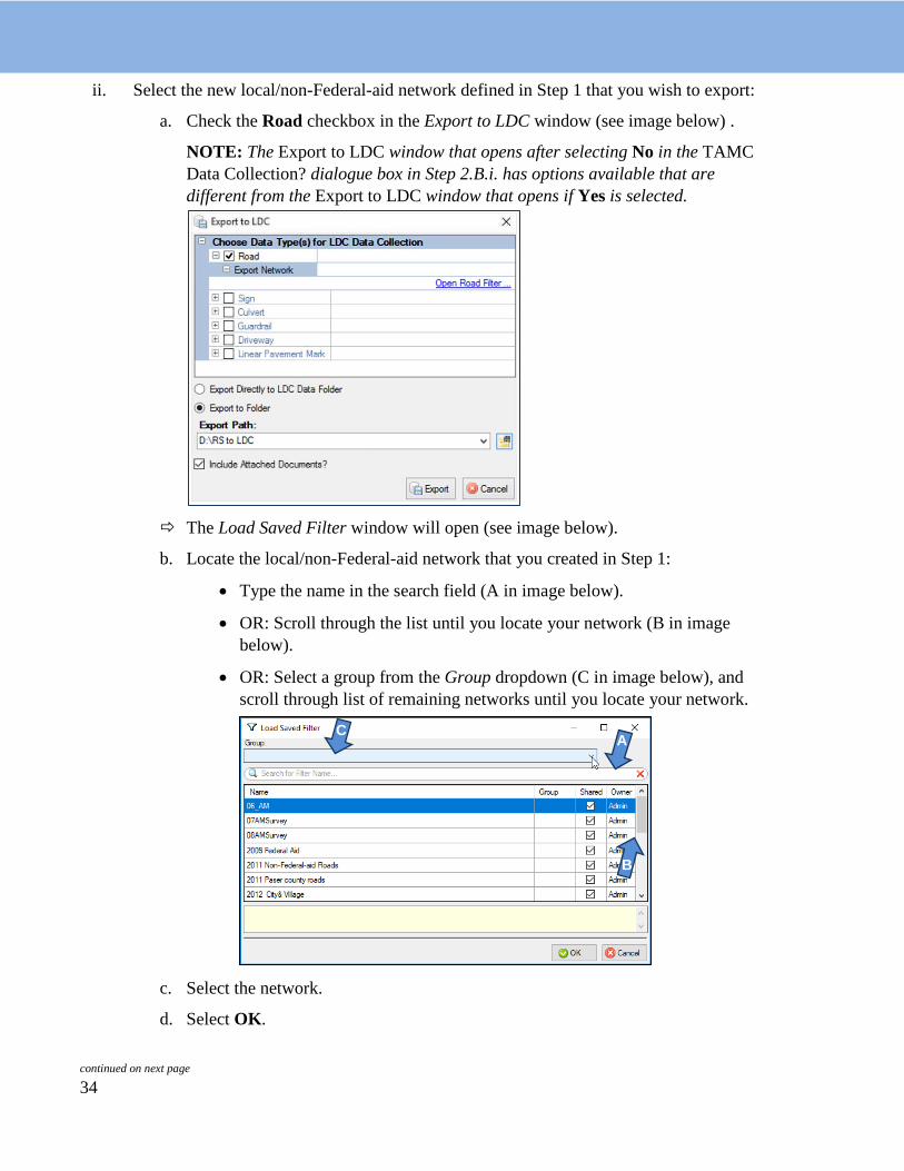
ii. Select the new local/non-Federal-aid network defined in Step 1 that you wish to export:
a. Check the Road checkbox in the Export to LDC window (see image below) .
NOTE: The Export to LDC window that opens after selecting No in the TAMC Data Collection? dialogue box in Step 2.B.i. has options available that are different from the Export to LDC window that opens if Yes is selected.
The Load Saved Filter window will open (see image below).
b. Locate the local/non-Federal-aid network that you created in Step 1:
• Type the name in the search field (A in image below).
• OR: Scroll through the list until you locate your network (B in image below).
• OR: Select a group from the Group dropdown (C in image below), and scroll through list of remaining networks until you locate your network.
c. Select the network.
d. Select OK. continued on next page
A
B
C

35
This will return you to the Export to LDC window (see image below).
NOTE: If you need to define or change a road layer filter, you can access the Road Layer Filter Builder at this point by selecting the Open Road Filter… link in the Export to LDC window (see image below). This will open the Road Layer Filter Builder window and you may proceed with building a filter using Steps 1.iii through 1.vi.
iii. Select any additional local/non-Federal-aid networks defined in Step 1 that you wish to export:
a. Check the checkbox to the left of the desired data type listed in the Export to LDC window.
The Export Network field will appear.
continued on next page
36
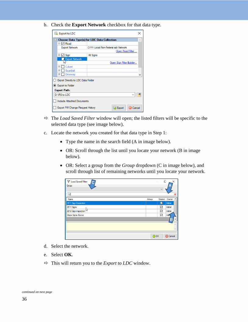
b. Check the Export Network checkbox for that data type.
The Load Saved Filter window will open; the listed filters will be specific to the selected data type (see image below).
c. Locate the network you created for that data type in Step 1:
• Type the name in the search field (A in image below).
• OR: Scroll through the list until you locate your network (B in image below).
• OR: Select a group from the Group dropdown (C in image below), and scroll through list of remaining networks until you locate your network.
d. Select the network.
e. Select OK.
This will return you to the Export to LDC window. continued on next page
A
B
C
37
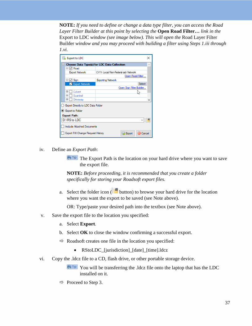
NOTE: If you need to define or change a data type filter, you can access the Road Layer Filter Builder at this point by selecting the Open Road Filter… link in the Export to LDC window (see image below). This will open the Road Layer Filter Builder window and you may proceed with building a filter using Steps 1.iii through 1.vi.
iv. Define an Export Path:
The Export Path is the location on your hard drive where you want to save the export file.
NOTE: Before proceeding, it is recommended that you create a folder specifically for storing your Roadsoft export files.
a. Select the folder icon ( button) to browse your hard drive for the location where you want the export to be saved (see Note above).
OR: Type/paste your desired path into the textbox (see Note above).
v. Save the export file to the location you specified:
a. Select Export.
b. Select OK to close the window confirming a successful export.
Roadsoft creates one file in the location you specified:
• RStoLDC_[jurisdiction]_[date]_[time].ldcz
vi. Copy the .ldcz file to a CD, flash drive, or other portable storage device.
You will be transferring the .ldcz file onto the laptop that has the LDC installed on it.
Proceed to Step 3.
38
Data collection teams receive a laptop computer and a GPS unit from their PO. This laptop will have the LDC installed on it. Note that changes to data will only be sent to the TAMC if they were collected in the LDC. Ratings and changes in ratings should be initially entered in the LDC (not in Roadsoft) or the data will not be reported.
It is advisable to have a second laptop in the vehicle just in case something goes wrong. Many county road commissions and cities now have laptop computers, which they can bring for backup purposes or for local-use-only data collection.

39
3 Step 3: Import the network into the Laptop Data Collector (LDC)
In the LDC, import your network for data collection:
i. Connect the portable storage device containing the export file to your laptop.
The export file is the .ldcz file saved to portable storage in Step 2.A.v. or 2.B.vi. by the local agency.
ii. Complete the Roadsoft Laptop Data Collector v[CYYY.MM] Login window:
a. Start the LDC.
The Roadsoft Laptop Data Collector v[CYYY.MM] Login window will open (see image below).
b. Enter the name(s) of the person/people rating in the appropriate field—MDOT, Region, or Local.
IMPORTANT: If you are collecting data for the TAMC/Federal-aid, a first and last name is required for each crew member.
c. Select a DB (database) by selecting the folder icon ( button) to locate the export file on the portable storage device.
If you want to change your database while inside the LDC, select File from the main menu and then select Change DB (Import Data from Roadsoft).
d. Select OK.
NOTE: Confirm database by reviewing database information and road data.
The exported network generated through Steps 1 and 2 will import into the LDC.

40
4 Step 4: Connect the GPS to your laptop and begin collecting data
A. Connect the GPS Complete the procedure below outside and free from buildings or other possible signal obstructions.
i. Open the LDC on the laptop.
ii. Connect GPS to your laptop using the serial or USB connection. Make sure your GPS device is turned off.
NOTE: If your GPS has an on/off switch, make sure your GPS device is turned off before connecting it to your computer.
If your GPS is on before connecting it, your mouse pointer may jump around erratically. If this happens, turn off your GPS, leave it connected, and restart your laptop.
iii. Turn on your GPS and wait for it to acquire a position (this could take a couple of minutes).
iv. Establish communication between the GPS and the LDC:
a. Select the GPS option from the main menu in the LDC.
b. Select Start/Stop GPS Connection.
c. Wait a few minutes for the GPS and the LDC to locate your current position.
The LDC’s GIS map will snap to the GPS position.
If your GPS fails to connect, wait several minutes and try to connect again. For additional assistance, please consult the Roadsoft Manual’s Connect a GPS help documentation (under Laptop Data Collector (LDC) > Getting Started). Or, please contact Roadsoft technical support if the problem persists.
NOTE: If you are on or near a road segment that is NOT part of the network that you imported into the LDC, the LDC will not snap to a segment on the map. Drive your vehicle toward a road that is part of the network so that the vehicle marker can snap to it. If this does not happen, restart the LDC or call Roadsoft technical support.
continued on next page

41
B. Collect data i. Allow the GPS to select road segment (see image below).
IMPORTANT: While collecting data, back up every hour or as often as conveniently possible. From the main LDC menu, select the File menu and then select Backup Database to create a data save point. If data collection spans multiple days, export the data every day and save a copy of the data file with a naming scheme of LDCtoRS_[jurisdiction]_[date]_[time].ldc2rs (inserting appropriate identifiers in place of bracketed text) to a CD or flash drive.
NOTE: When you select a segment, you will be able to view inventory data in the Inventory tab (see image below). If you selected Step 2.A. TAMC Export Option, you will not be able to save changes to the data in the Inventory tab while you are rating roads. If you selected Step 2.B. Local Use Export Option, you will be able to save changes to the data in the Inventory tab while you are rating roads.
continued on next page

42
NOTE: The History tab provides a history of PASER for the current segment (see image below). Viewing past PASER before rating a segment can influence the rating. If you selected Step 2.A. TAMC Export Option, the History tab’s grid will become visible after you submit a rating for the segment; this feature helps to avoid the influence of past ratings on current rating activities. If you selected Step 2.B. Local Use Export Option, you will be able to view historic PASER data while you are rating a segment.
ii. Rate the road segment using the PASER system or the IBR System™:
Use the following shortcut keys to enter data into the LDC’s Road window Rating tab:
Ctrl + S Toggle Surface Type Ctrl + +/- Zoom In/Out Ctrl + 0–9 PASER Ctrl + Arrow keys Pan the GIS Map Shift + Ctrl + 0–9 Number of Lanes Ctrl + Space bar Hold/Release Segment Ctrl + Enter Submit (save) Data Alt + S Split Segment
For a complete list of shortcut keys, select the Help menu and then select Shortcut Keys.
For paved roads:
a. Choose a surface type (see images below).
continued on next page
TAMC/Federal-aid network Local/non-Federal-aid network
TAMC/Federal-aid network Local/non-Federal-aid network

43
b. Enter the number of lanes (see images below).
c. Select a PASER score (see images below).
NOTE: If you selected Step 2.B. Local Use Export Option, you will be able to input treatment information and optional ratings for base condition, drain condition, and ride condition (see images below).
continued on next page
TAMC/Federal-aid network Local/non-Federal-aid network
TAMC/Federal-aid network Local/non-Federal-aid network
Local/non-Federal-aid road segment’s Local/non-Federal-aid road segment’s treatment type additional ratings

44
For unpaved roads:
BEFORE PROCEEDING: If you selected Step 2.B. Local Use Export Option, you may choose to collect either PASER or IBR data for your unpaved roads; if you elect to collect PASER for your gravel roads instead of IBR, proceed to Step 4.C. If you selected Step 2.A. TAMC Export Option, you must switch the LDC to the Unpaved Road Rating Mode; continue with this Step, 4.B.ii.d.
d. Select Settings from the main menu (see image below).
e. Select Road from the dropdown menu (see image above).
f. Select Unpaved Road Rating Mode from the Road flyout menu (see image above).
g. Select Inventory Based Rating from the Unpaved Road Rating Mode flyout menu (see image above).
A checkmark next to Inventory Based Rating or PASER will indicate the mode in which your LDC is set.
Unpaved roads may now be rated using the IBR System™.
h. Select IBR scores for Width, Drainage, and Structure (see images below).
continued on next page

45
C. Check for and Rate Unrated Segments
i. Verify that there are no unrated roads in your network:
a. Select the File option from the main menu.
b. Select Current DB Statistics.
c. Verify that the Total Miles Not Yet Rated field displays “0” (see image below).
If the field is “0”, you have completed the data collection process and may proceed to Step 5. Otherwise continue to Step 4.C.ii. in the ‘Check for and Rate Unrated Segments’ process.
ii. Rate any remaining unrated segments:
a. Select the File option from the main menu.
continued on next page
TAMC/Federal-aid network Local/non-Federal-aid network
46
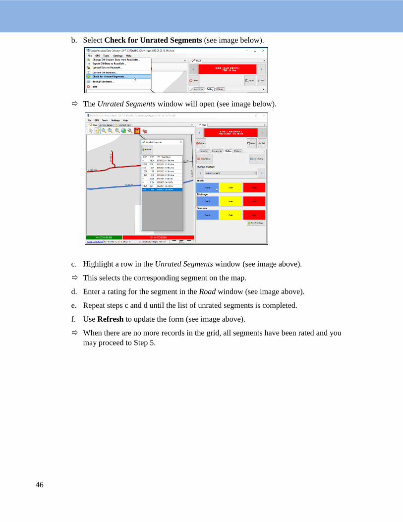
b. Select Check for Unrated Segments (see image below).
The Unrated Segments window will open (see image below).
c. Highlight a row in the Unrated Segments window (see image above).
This selects the corresponding segment on the map.
d. Enter a rating for the segment in the Road window (see image above).
e. Repeat steps c and d until the list of unrated segments is completed.
f. Use Refresh to update the form (see image above).
When there are no more records in the grid, all segments have been rated and you may proceed to Step 5.
47
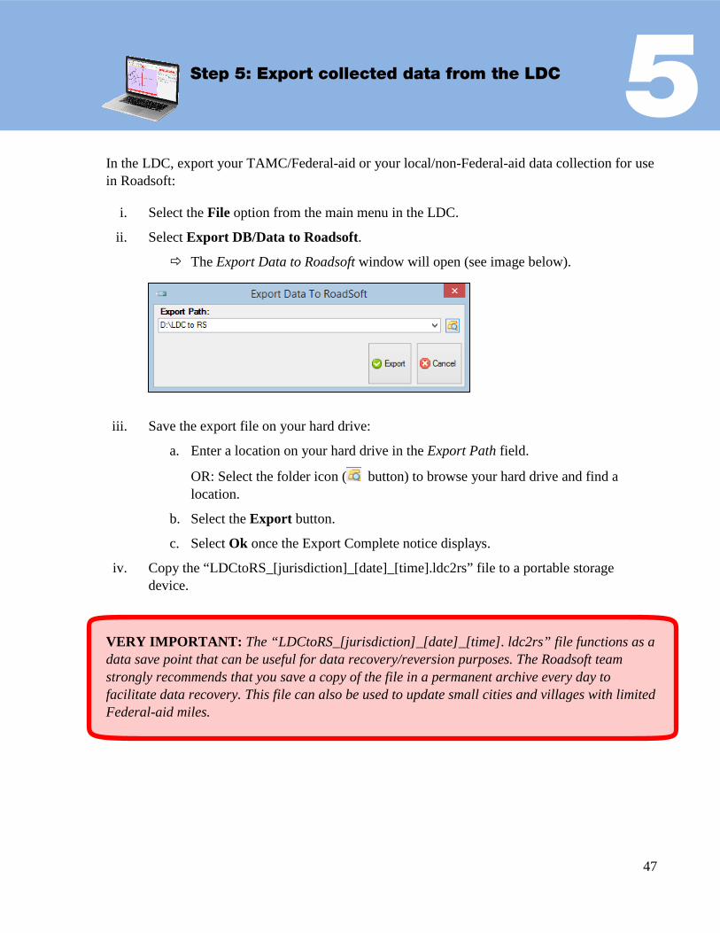
5 Step 5: Export collected data from the LDC
In the LDC, export your TAMC/Federal-aid or your local/non-Federal-aid data collection for use in Roadsoft:
i. Select the File option from the main menu in the LDC.
ii. Select Export DB/Data to Roadsoft.
The Export Data to Roadsoft window will open (see image below).
iii. Save the export file on your hard drive:
a. Enter a location on your hard drive in the Export Path field.
OR: Select the folder icon ( button) to browse your hard drive and find a location.
b. Select the Export button.
c. Select Ok once the Export Complete notice displays.
iv. Copy the “LDCtoRS_[jurisdiction]_[date]_[time].ldc2rs” file to a portable storage device.
VERY IMPORTANT: The “LDCtoRS_[jurisdiction]_[date]_[time]. ldc2rs” file functions as a data save point that can be useful for data recovery/reversion purposes. The Roadsoft team strongly recommends that you save a copy of the file in a permanent archive every day to facilitate data recovery. This file can also be used to update small cities and villages with limited Federal-aid miles.

48
6 Step 6: Import the collected data to Roadsoft
IMPORTANT: Before you import new data into Roadsoft, create a data save point for your existing Roadsoft database. To do so, select the Tools menu and then select Backup Roadsoft Database from the dropdown menu. Select a location where you would like to save your file using the file folder icon at the end of the Backup File field to set the location; select the Ok button. Then, select Create Backup.
i. Open the Import Data From LDC window (see image below):
a. Select the TAMC menu from the main menu in Roadsoft.
b. Select 2 - (County/City Does This) Import TAMC Data from LDC.
The Import Data From LDC window will open.
ii. Import your LDC data:
a. Select the Browse for LDC Export button.
b. Locate the “LDCtoRS_[jurisdiction]_[date]_[time].ldc2rs” file.
c. Select Open.
d. Select Import LDC Data.
The Import LDC Data dialogue box will open (see image below).
e. If you have not already created a backup of your Roadsoft data, select Yes; this will open the Roadsoft Database Manager and create a backup.
OR: If you have already created a backup of your Roadsoft data, select No.
If you selected Step 2.A TAMC Export Option, Roadsoft will automatically restart when the import process is complete. Proceed to Step 7.
OR: If you selected Step 2.B Local Use Export Option, the Submit Road Rating Data to TAMC? dialogue box will open (see image below). Continue to Step 6.iii.

49
continued on next page
IMPORTANT: If the network being imported was created using the Local Use Export Option process and you selected the No button in the TAMC Data Collection? dialogue box (see Step 2.B.i), two dialogue boxes come up to clarify whether the included data is to be submitted to TAMC: the Submit Road Rating Data to TAMC? dialogue box and the TAMC Rating Requirements dialogue box.
iii. The Submit Road Rating Data to TAMC? dialogue box requires Yes/No verification (see image below):
This dialogue box should not appear for Federal-aid submission; if it does, the Federal-aid network was set up incorrectly and was not created as a TAMC export.
a. Select Yes if you plan to submit the data to TAMC.
b. Select No if you do not want the data included in the TAMC data set export in Step 7.
iv. The TAMC Rating Requirements dialogue box will open if Yes was selected (see image below).
a. Select Yes or No as appropriate to reflect whether the data meets non-Federal-aid road PASER data collection requirements.
This will determine whether the data will be included in the TAMC data set export in Step 7.
Roadsoft will automatically restart when the import process is complete.

50
7 Step 7: Export TAMC data for the planning organization’s version of Roadsoft
i. Open the Export TAMC Data to Region dialogue box (see image below):
a. Select the TAMC menu from the main menu in Roadsoft.
b. Select 3 - (County/City Does This) Export TAMC Data to Region.
The Export TAMC Data to Region dialogue box will open.
ii. Define an Export Path:
The Export Path is the location on your hard drive where you want to save the export file.
a. Select the folder icon ( button) to browse your hard drive for the location where you want the export to be saved.
OR: Type/paste your desired export path into the textbox.
b. Select Export.
iii. Confirm the successfully completed report:
a. Select Ok when the export confirmation dialogue box opens.
Roadsoft will create a file named “TAMC_[jurisdiction]_[date]_[time].tamz” in the location you specified.
iv. Copy this .tamz file to a portable storage device.
This .tamz file will be sent to your PO for import into their Roadsoft database.

51
FOR PLANNING ORGANIZATIONS ONLY:
DATA SUBMISSION

52

53
8 Step 8: Import TAMC data from the local agency into the planning organization’s version of Roadsoft
NOTE: This step is not performed in the field; it should be performed at the PO office to import inspection data from individual agencies.
IMPORTANT: Before you import new data into Roadsoft, back up your existing Roadsoft database. To do so, open the Tools menu and then select Backup Roadsoft Database from the dropdown; select Create Backup. Select a location where you would like to save your file using the file folder icon at the end of the Backup File field to set the location; select the Ok button. Then, select Create Backup.
i. Open the Import TAMC Data From Local Jurisdiction dialogue box (see image below) in the PO’s Roadsoft database:
a. Select the TAMC menu.
b. Select 4 - (Region Does This) Import TAMC from County/City.
The Import TAMC Data From Local Jurisdiction dialogue box (see image below) will open.
ii. Find the local agency’s Roadsoft data collection that you wish to import:
a. Select the Browse For LDC Export button.
b. Locate the “TAMC_[jurisdiction]_[date]_[time].tamz” file.
c. Select Open.
d. Select the Import LDC Data button.
An import dialogue box will open.
continued on next page

54
iii. Create a backup of your Roadsoft data prior to importing:
a. Select the Yes in the import dialogue box to open the Roadsoft Database Manager and create a backup; proceed with importing your collected data.
OR: Select the No button to skip the backup and continue with the import.
Roadsoft will automatically restart when the import is complete.
NOTE: The Import TAMC Data from Local Jurisdiction dropdown lists up to the last four folders from which you imported. If this is the first time you are importing data, the screen will appear blank.

55
9Step 9: Export planning organization’s .xml file from Roadsoft
NOTE: Once your PO’s data are complete, export the PO’s .xml to the CSS.
i. Verify your PO’s data before proceeding:
a. Follow the steps in TAMC Data Quality Control Guide (see page 56).
ii. Open the Export TAMC File to Council dialogue box (see image below):
a. Select the TAMC menu from the main menu in Roadsoft.
b. Select 5 - (Region Does This) Export TAMC File to Council (Individual County Files).
The Export TAMC File to Council dialogue box will open (see image below).
NOTE: Do not use the standard Roadsoft .xml export procedure [which is File > Export layer to File (XML)] as the standard procedure is different than TAMC export.
iii. Define your export variables in the Export TAMC File to Council dialogue box:
a. Select the county you wish to export using the dropdown menu in the County field.
b. Define your Export Path:
• Select the folder button to the right of the Export Path field to browse your hard drive for the location where you want the export to be saved.
c. Select Export.
This will export the data to the specified export path. The filename that is created will contain the county and year of data. (e.g. AlconaCYYY.xml, where CYYY should be your current collection year).

56
TAMC Data Quality Control Guide It is important to ensure that your condition data are accurate and comprehensive. It is easiest to check for errors in data at the local and regional levels before submitting data to the TAMC. Data quality control can be performed by entering a series of queries into the Filter Builder in Roadsoft. The following steps will guide you through this process and ensure that your agency has a complete set of condition data.
NOTE: Changes to data will only be sent to the TAMC if they were collected in the LDC or hand-entered in the region version of Roadsoft. Rating and changes in ratings should be initially entered in the LDC (not in Roadsoft) or data will not be reported. Data entered into Roadsoft (rather than being collected in the field) will result in missing data when the final collection file is sent to the TAMC.
Step 1: Determine the total length of your network i. Open the Filter Builder either by clicking with your right mouse button on the map in
the Map window and selecting Filter Builder, or by selecting the map toolbar’s Filter button and selecting Filter Builder.
ii. In the Filter Builder window, select Open to open the Load Saved Filter window.
iii. Select your saved TAMC network for the current collection year and select the Ok button.
iv. Look at the bottom left of the Filter Builder window (see image below) and record the number of total Miles. You will use this number, along with additional criteria, to verify that your regional PASER data are correct.
continued on next page…
57
TAMC Data Quality Control Guide, continued
Step 2: Verify that your agency’s TAMC data are accurate Using the filter criteria provided in the Table of Quality Control Queries (next page), you will be able to detect missing or incorrect data by comparing the miles in a particular query against your original Miles (generated in Step 1, above).
In the Table of Quality Control Queries:
• Check: lists the potential error for which the criteria checks • Criteria: lists the criteria that need to be entered into the network and Filter Builder • Expected Output: lists the segments/mileage that should display at the bottom left of
the Filter Builder after adding the criteria • Troubleshooting: lists the most likely reason for not getting the expected outcome
and steps to take to fix/obtain any inaccurate/missing data.
Step 3: Spot-check number of lanes using the Roadsoft web integration tool
i. Create a legend for the number of lanes:
NOTE: In Legend Builder, adjustments to the color, size, and style of features are made on the map to indicate different types of data. For example, an applied legend can help to differentiate between asphalt and gravel pavement types by applying colors respective to each type to road segments. The Legend Builder is available for all modules with the exception of Traffic Signal and Intersection. For more information on using the legend builder, visit the Roadsoft Manual’s Using the Legend Builder video tutorial.
a. Make the Road layer visible and active.
b. Select the Show Legend button in the toolbar if the legend window is not open.
c. Select the Open Legend… button to open the Legend Builder window.
d. Select Lanes from the dropdown menu.
continued on next page…

58
TAMC Data Quality Control Guide, continued
Step 3: Spot-check number of lanes using the Roadsoft web integration tool, cont’d.
e. Select either Unique Values or Range Values using the radio buttons at the top of the Legend Builder window.
NOTE: Unique Values will allow you to assign different visual properties to each lane number. For example, “Lanes=0” on the map could be assigned a unique color, such as color red (see image below). Range Values will allow you to assign different visual properties for a range of lane number values. For example, all roads that have five to eight lanes could be assigned a unique color, such as blue (see image below).
f. Select an item in the Items list to define its properties.
g. Edit the properties in the Item Properties box until you are satisfied with the applied legend in the Preview box.
h. Repeat TAMC Data Quality Control Guide Steps 3.i.f and 3.i.g for all items in the Items list.
i. Select the Apply button when all items in the Items list have been edited.
The legend is now applied.
ii. Select a random road segment.
iii. Right-click on the map.
iv. Select Web Integration from the dropdown menu.
continued on next page…

59
TAMC Data Quality Control Guide, continued
Step 3: Spot-check number of lanes using the Roadsoft web integration tool, cont’d.
v. Select Open Location in Google Maps or Open Location in Bing Maps.
A web browser will open up a map of the location.
vi. Select the street view.
vii. Verify the correct number of lanes is assigned to the segment.
viii. Repeat TAMC Data Quality Control Guide Steps 3.i to 3.vii for additional segments.
continued on next page…
60
TAMC Data Quality Control Guide, continued
Table of Quality Control Queries Ensure you have recorded the miles within your TAMC network (Step 1, above) before you use the following table. When your miles are used in combination with these queries, these figures will help you verify the accuracy and completeness of the data you collected for TAMC.
Check Criteria Expected Output Troubleshooting
Check to see that all mileage in TAMC network have been rated
TAMC Collection Year = current year
Number of miles recorded in Step 1
There are segments that did not receive a rating. Missing rating data must be collected and entered in the LDC.
Check to see if all submitted segments have a valid surface type
TAMC Collection Year = current year
Surface Type <> Undefined
Number of miles recorded in Step 1
There are undefined roads in the network. Validate these segment types using the LDC.
Check to see if all submitted segments have a valid number of lanes
TAMC Collection Year = current year
Number of Lanes <= The highest number of lanes within your TAMC network
*An unusually high number of lanes in the drop down list could signify an error in entry
Number of miles recorded in Step 1
There are segments that have an invalid number of lanes. Segments with invalid lanes should be reviewed and corrected in the LDC.

61
Step 10: Upload planning organization’s .xml file to the CSS’ Investment Reporting Tool
The CSS collects road condition data for Public Act 499 reporting purposes. Therefore, regional or metropolitan planning agencies submit a Roadsoft XML export file containing condition data to the CSS on behalf of agencies within their jurisdiction.
i. Open your web browser (e.g., Microsoft Edge, Internet Explorer, Mozilla Firefox) and go to:
https://milogintp.michigan.gov/
ii. Log in using your user ID and password.
iii. Select Roadsoft Upload from the +Add dropdown menu.
continued on next page

62
iv. Upload the Roadsoft .xml export files for each agency in your region:
a. Choose the Browse… button associated with the File dialogue box.
b. Navigate to and select the .xml file you created in Step 9.
c. Optional: Enter any pertinent comments in the Comment box.
d. Select Upload to submit the data to the TAMC.
NOTE: You will also need to upload the GPS logs separately at this time.

63
APPENDICES

64

65
APPENDIX A – PASER MICHIGAN-SPECIFIC CHEAT SHEET
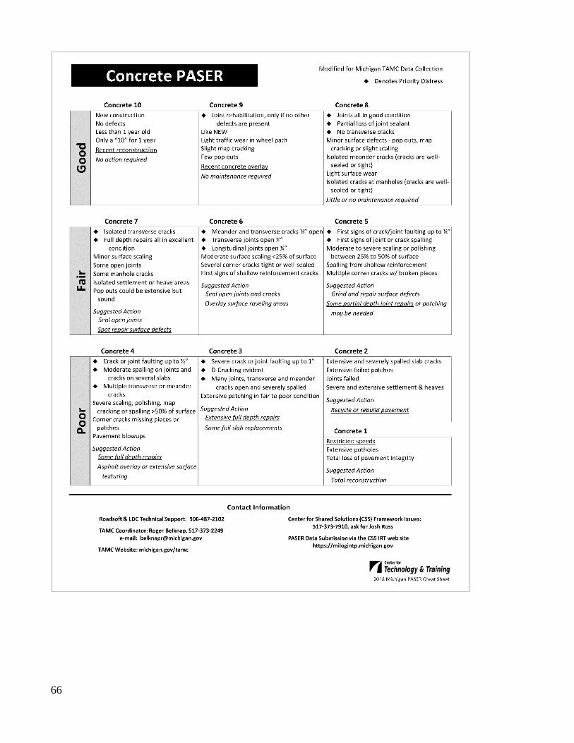
66
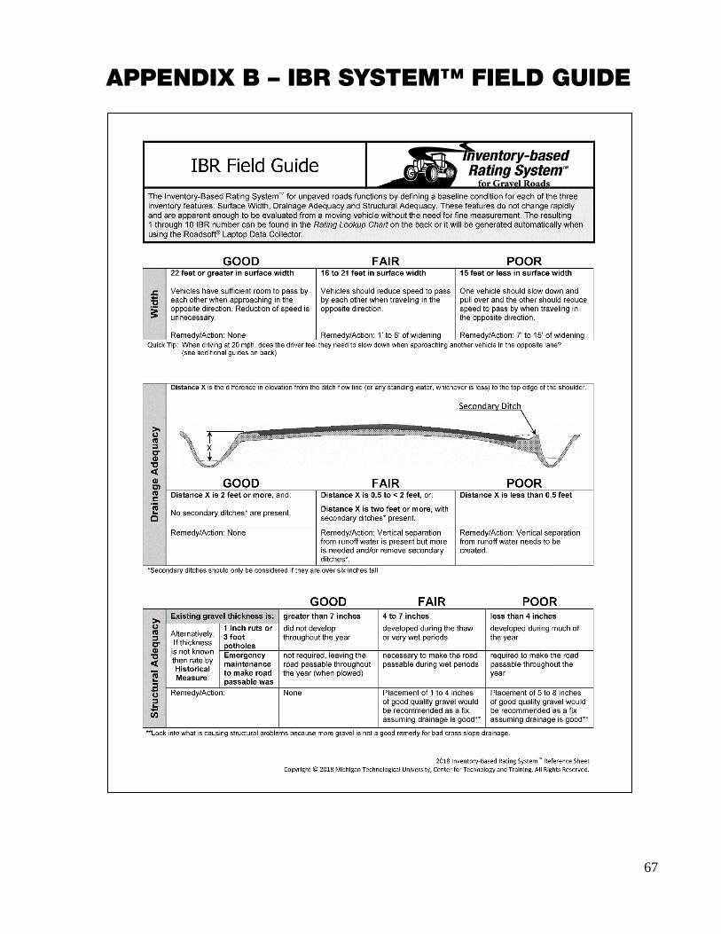
67
APPENDIX B – IBR SYSTEM™ FIELD GUIDE

68

69
APPENDIX C – MICHIGAN’S REGIONAL PLANNING ORGANIZATIONS

70
APPENDIX D – MICHIGAN’S METROPOLITAN PLANNING ORGANIZATIONS
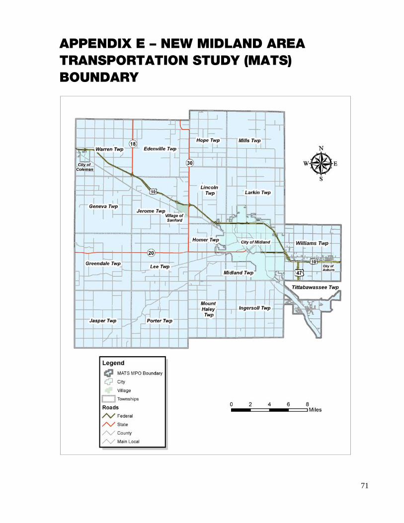
71
APPENDIX E – NEW MIDLAND AREA TRANSPORTATION STUDY (MATS) BOUNDARY

72
APPENDIX F – TAMC’S POLICY FOR COLLECTION OF ROADWAY SURFACE CONDITION DATA

73

74

75

76

77
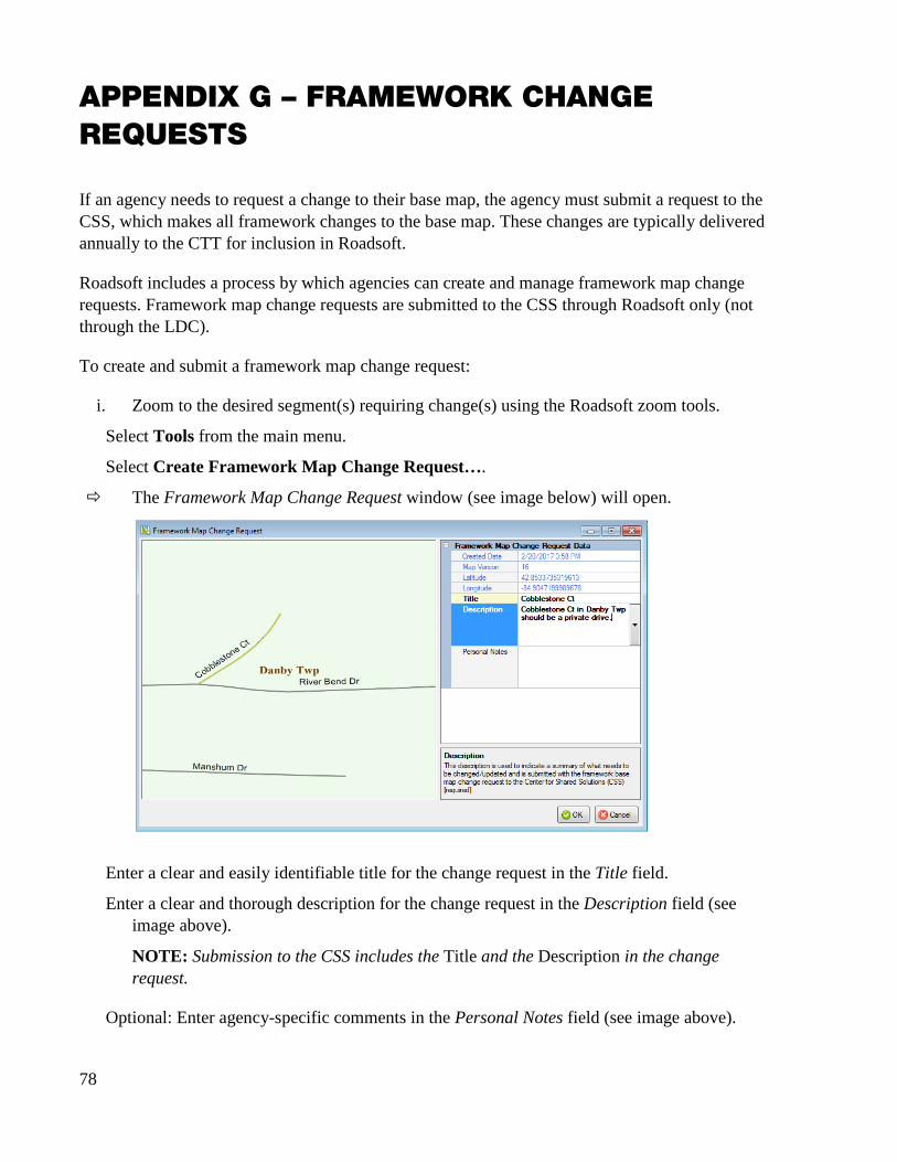
78
APPENDIX G – FRAMEWORK CHANGE REQUESTS
If an agency needs to request a change to their base map, the agency must submit a request to the CSS, which makes all framework changes to the base map. These changes are typically delivered annually to the CTT for inclusion in Roadsoft.
Roadsoft includes a process by which agencies can create and manage framework map change requests. Framework map change requests are submitted to the CSS through Roadsoft only (not through the LDC).
To create and submit a framework map change request:
i. Zoom to the desired segment(s) requiring change(s) using the Roadsoft zoom tools.
Select Tools from the main menu.
Select Create Framework Map Change Request….
The Framework Map Change Request window (see image below) will open.
Enter a clear and easily identifiable title for the change request in the Title field.
Enter a clear and thorough description for the change request in the Description field (see image above).
NOTE: Submission to the CSS includes the Title and the Description in the change request.
Optional: Enter agency-specific comments in the Personal Notes field (see image above).

79
NOTE: Submission to the CSS does not include the Personal Notes in the change request.
Select the OK button.
A new change request has now been created; it is not yet submitted.
Select Tools from the main menu.
Select Manage/Submit Framework Map Change Requests….
Select the desired framework change request from the list.
The Submit FW Change window (see image below) will open.
Enter your name, agency, and e-mail in the First Name, Last Name, Agency, and E-mail fields respectively.
Select the Submit button.
This will submit your new change request via e-mail to the CSS An example of the form that the CSS will receive is shown below.
If you have any questions or issues creating and submitting your framework map change request, please refer to the Roadsoft Manual’s Create Framework Map Change Request help documentation (under Roadsoft > Roads > Framework Map Change Request). Or, please call Roadsoft technical support at (906) 487-2102.
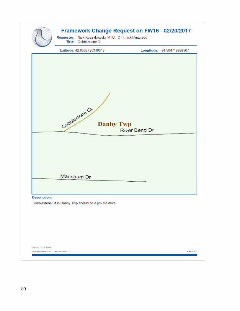
80
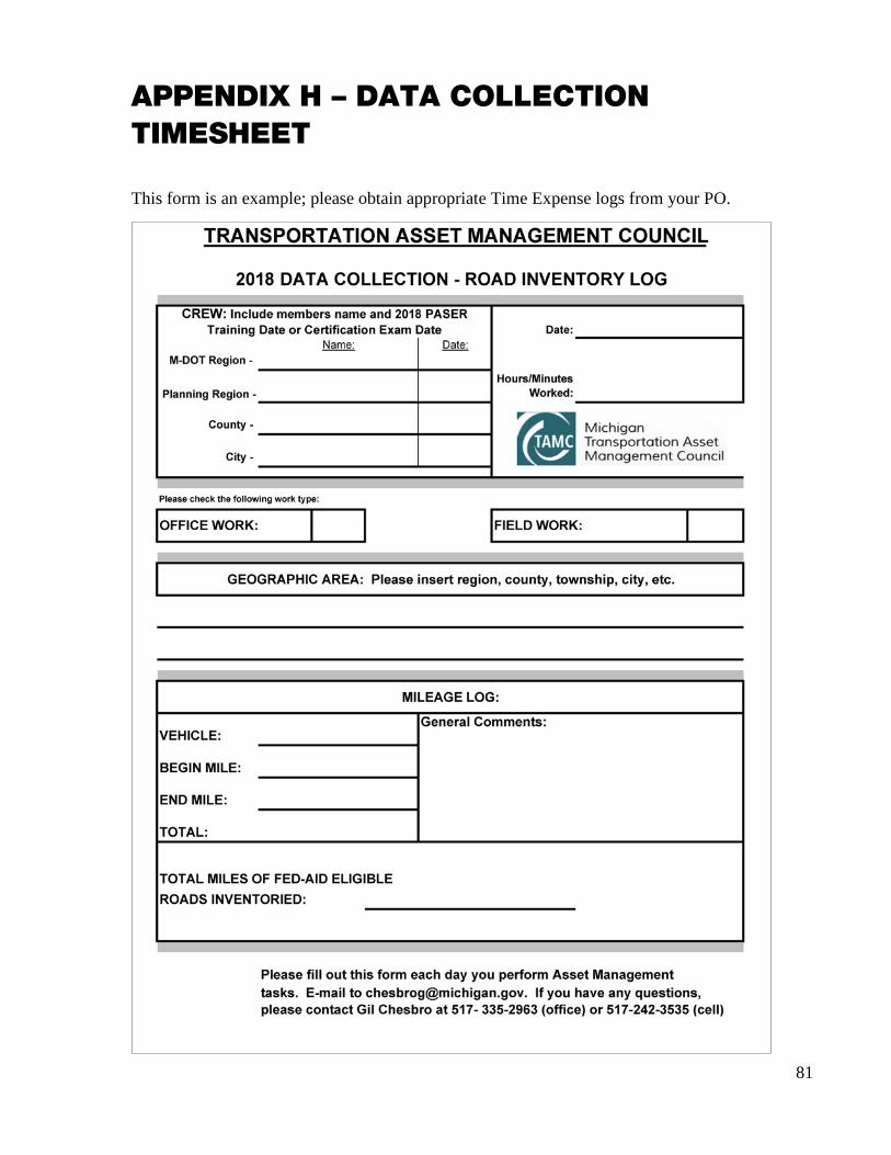
81
APPENDIX H – DATA COLLECTION TIMESHEET
This form is an example; please obtain appropriate Time Expense logs from your PO.

82

83
INDEX
A
Act 51 · See Public Act 51 alligator cracking · See Pavement distress asphalt · See Pavement Asphalt PASER Manual · See Pavement Surface Evaluation
and Rating – manual assessment parameter
capital preventive maintenance · 11 drainage · See Inventory-based Rating System IBR score · See Inventory-based Rating System number of lanes · See Number of lanes PASER · See Pavement Surface Evaluation and Rating routine maintenance · 11 structural adequacy · See Inventory-based Rating
System structural improvement · 11 surface type · See Surface type width · See Inventory-based Rating System
B
back up data second laptop · 38
block · See Pavement – brick block cracking · See Pavement distress boundary roads · See Boundary segments boundary segments · 13 brick · See Pavement Brick and Block PASER Manual · See Pavement Surface
Evaluation and Rating - manual bridge system · v, 3
condition · v, 3
C
capital preventive maintenance · See Pavement maintenance
Center for Shared Solutions · 19, 21, 55, 61, 78, 79 submit TAMC/Federal-aid network · See Data
submission Center for Technology & Training · v, 78
resources · 5 training · 11
certification · See Testing and certification certified public road, not · See NFC codes chip seal · See Pavement - sealcoat
cities, larger · See Data collection procedures – agencies, large
cities, smaller · See Data collection procedures – agencies, small
city rater · 19
composite · See Pavement computer · See Data collection - tools concrete · See Pavement Concrete PASER Manual · See Pavement Surface
Evaluation and Rating – manual county
rater · 19 CPM · See Capital preventive maintenance cracking · See Pavement distress, See Pavement distress crew · See Roadsoft CSS · See Center for Shared Solutions CSS Investment Reporting Tool · See Investment Reporting
Tool CTT · See Center for Technology & Training
D
data collection · v, 3, 4, 5, 21 culverts · 33 data submission · see Data submission guardrails · 33 identify network · See Data collection procedures issues · 13 physical reference segment · 22 quality control · See Quality control rating roads
construction · 12 group dynamics · 12 light-colored pavement · 13 lighting conditions · 11 oxidized pavement · 13 paved shoulder · 13 ride quality · 13 road importance · 12 road ownership · 12, 13 road use · 12 rutting · 13 speed · 11, 12 visible features · 12 weather · 11, 12 worst lane · 12
rating team local/non-Federal-aid · 19
84
TAMC/Federal-aid · 19 regulations · 3, 19 safety · 15
comply with requirements · 15 vehicle warning light bar · 15 warning garments · 15
signs · 33 timeline · 19
schedule collection · 19 tools
aluminum t-bar · 13 data sets · See Roadsoft – data – data sets GPS · 20, 38, 40, Also see LDC - GPS laptop computer · 20, 38 LDC · See LDC Roadsoft · See Roadsoft tape measure · 13
training · See Training Transportation Asset Management Council, for · 13, 14,
33, 49 vehicle · 20
seating · 15 data collection flow · See Data collection procedures –
data collection flow data collection procedures · 17, 25
agencies, medium to large · 22 agencies, small · 21, 47 back up data · See Save point backup file · 23 case-by-case basis · 22 collect data · 40, 41
additional data · 33 unrated roads · 45
collection networks, built at road commission · 22 collection networks, upload data from small agencies ·
22 data collection flow · 23 database selection · 39 export data from LDC · 47 export network for LDC · 30 GPS, connect · See LDC - GPS identify network · 27
TAMC/Federal-aid · 13, Also see Roadsoft – identify network
import local agency data into Planning Organization’s version of Roadsoft · 53
import network into LDC · 39, Also see LDC - import network
multiple days · 41 network
local/non-Federal-aid · 27, 33 TAMC/Federal-aid · 27, 29, 30, 33, 39
rule · 13 unpaved road data · 44
Data Collection Timesheet · 81
data collection,Transportation Asset Management Council, for · 13
data reporting to Michigan Legislature · 5 data submission · v
data from local agency · 53 export Planning Organization’s XML file from Roadsoft ·
55 export Roadsoft asset management data · 50 Federal-aid submission · 51 import data to Roadsoft · 48 import inspection data · 53 import local agency data into Planning Organization’s
version of Roadsoft · 53 Planning Organization version of Roadsoft · 53 send Planning Organization’s XML file to CSS · 61 send TAMC/Federal-aid network · 61 submit to TAMC · 19 timeline · 19 Transportation Asset Management Council, for · 13, 49 verify planning organization’s data · 55
data, historical · See Roadsoft dialogue box · Also see Window
File (IRT) · 62 Roadsoft
Export TAMC Data to Region · 50 Export TAMC File to Council · 55 import · 53, 54 Import LDC Data · 48 Import TAMC Data From Local Jurisdiction · 53, 54 Submit Road Rating Data to TAMC? · 48, 49 TAMC Data Collection? · 33, 34, 49 TAMC Rating Requirements · 49
E
edge distress · See Pavement distress edge seal · See Pavement maintenance environmental factors · See Splitting segments
F
Fair Inventory-based Rating System baseline condition · See
Inventory-based Rating System – baseline condition Transportation Asset Management Council definitions ·
See Transportation Asset Management Council Federal-aid-eligible network
agencies, small · See Data collection procedures – agencies, small
data collection · 4, 13, 19 data collection procedures · See Data collection
procedures definition · 4 paved · 3

85
rating team · 19 reimbursement · 21 training · See Training unpaved · 3 versus non-Federal-aid-eligible network data collection
· 19 field work · 53 framework map
correction · 20 error · 20 Framework Map Change Request · 21, 78, 80 Framework Map Change Request, submit in Roadsoft ·
See Roadsoft Framework Map Change Request, submit via mail · 21
Framework Map Change Request · See Framework map framework segments · See Splitting segments freeways · See NFC codes
G
Good Inventory-based Rating System baseline condition · See
Inventory-based Rating System – baseline condition Transportation Asset Management Council definitions ·
See Transportation Asset Management Council GPS unit · See Data collection - tools OR LDC - GPS gravel · See Unpaved roads
H
HMA · See Pavement – asphalt
I
IBR · See Inventory-based Rating System intersections · See Splitting segments interstates · See NFC codes Inventory-based Rating System · v, 3, 5, 11, 12
baseline condition · 11 fair · 11 good · 11 poor · 11
descriptions · 12 drainage adequacy · 3, 44 Field Guide · 11, 12, 67 manual
Inventory-based Rating System™ Manual · 11 manual, Inventory-based Rating System™ Manual · 5 rating · 42 road features · 11 score · 3, 11 structural adequacy · 3, 44 training · See Training
unpaved road data · 44 width · 3, 44
Investment Reporting Tool · 23 +Add · 61 GPS logs · 62 Upload · 62 upload XML export files · 62
IRT · See Investment Reporting Tool
J
jurisdiction · See Map Or Planning Organization – map
L
lane distress · See Pavement distress lanes · See Number of lanes, See Number of lanes laptop · See Data collection - tools Laptop Data Collector · See LDC ld · See Pd LDC · 19, 20, 21, 23, 30, 39, 40, 47
Backup Database · 41 Change DB—Import Data from Roadsoft · 39 Check for Unrated Segments · 46 Current DB Statistics · 45 data
changes in ratings · 38 collected in · 38 collection · 23 for unpaved roads · See Pavement Surface
Evaluation and Rating OR Inventory-based Rating System
database change · 39 select · 39
error notation · 20 error tag · 21 Export Data to Roadsoft window · 47 Export DB/Data to Roadsoft · 47 export network · 47 export path · 47 export, small agencies · 21 File menu · 39, 41, 45, 46, 47 GPS · 38, Also see Data collection - tools
connect · 40 troubleshooting · 40
GPS menu · 40 Help menu · 42 History tab · 42 import network · 39 Inventory tab · 21, 41 Inventory-based Rating · 44 laptop from PO · 38 ldc2rs file · 47, 48, Also see Roadsoft

86
ldcz file · 32, 37, 39, Also see Roadsoft ldcz file Rating tab · 42 Refresh · 46 released (date) · 20 Road window · 42, 46 Roadsoft export file
TAMC data-collection-compliant mode · 33 TAMC data-collection-non-compliant mode · 33
Roadsoft Laptop Data Collector v[CYYY.MM] Login window · 39
Settings menu · 44 shortcut keys · 42 Start/Stop GPS Connection · 40 tamz file · 53 Total Miles Not Yet Rated · 45 transferring to · 32, 37, 39 Unpaved Road Rating Mode · 44
Inventory-based Rating · 44 Pavement Surface Evaluation and Rating · 44
unrated roads · 45 Unrated Segments window · 46
ldc2rs file · See Roadsoft – ldc2rs file OR LDC – ldc2rs file ldcz file · See Roadsoft - ldcz file OR LDC-ldcz file left-turn lanes · See Number of lanes local · See NFC codes local network · See Non-Federal-aid-eligible network
M
major collectors · See NFC codes map
framework · See Framework map jurisdiction map · See Framework map Planning Organization · See Planning Organization –
map MDOT · See Michigan Department of Transportation Metropolitan Planning Organization · See Planning
Organization Michigan Department of Transportation · v, 21
rater · 19, 20 Michigan Local Technical Assistance Program
resources · 5, 11 Michigan Technological University · v Michigan Transportation Asset Management Council · See
Transportation Asset Management Council Michigan-specific Asphalt Road Rating Guide · See
Pavement Surface Evaluation and Rating – guide Michigan-specific Concrete Road Rating Guide · See
Pavement Surface Evaluation and Rating – guide Michigan-specific Sealcoat Road Rating Guide · See
Pavement Surface Evaluation and Rating – guide Michigan-specific TAMC definitions · See Transportation
Asset Management Council miles not yet rated · See LDC minor arterials · See NFC codes
minor collectors · See NFC codes MPO · See Planning Organization
N
National Functional Classification · 3 NFC codes · See NFC codes
network Federal-aid-eligible · See Federal-aid-eligible network local · See Non-Federal-aid-eligible network non-Federal-aid-eligible · See Non-Federal-aid-eligible
network NFC · See National Functional Classification NFC codes · 3
certified public road, not · 4 freeways · 4 interstates · 4 local · 3, 4 major collectors · 4 minor arterials · 4 minor collectors · 3, 4 principal arterials · 4 rural area · 4 rural/urban designation left · 4 rural/urban designation right · 4 uncoded · 4 urban area, small · 4 urbanized area, large · 4 urbanized area, small · 4
non-Federal-aid-eligible network data collection · 19
paved roads · 19 data collection procedures · See Data collection
procedures paved · 3 rating team · 19 reimbursement · 19, 21, 27 training · See Training unpaved · 3
number of lanes · 3, 14, 30, 42, 43, 59 change · 14, See Splitting segments continuous left-turn lanes · 3 spot check · 57, 58, 59 street view · See Roadsoft - web integration through lanes · 3
P
PASER · See Pavement Surface Evaluation and Rating PASER Data Quality Control Guide · 55 PASER manuals · See Pavement Surface Evaluation and
Rating – manual patching · See Pavement maintenance paved roads · 12, 42

87
evaluation · 5 Federal-aid-eligible · See Federal-aid-eligible network Federal-aid-eligible network · See Federal-aid-eligible
network non-Federal-aid data collection · See Non-Federal-aid-
eligible network pavement
asphalt · 3, 4, 5, 7, 8, 10, 14 hot-mix thickness · 4 overlay · 4
block · See Pavement – brick brick · 3, 5 composite · 3, 4 concrete · 3, 4, 5, 8, 13 maintenance strategies · v sealcoat · v, 3, 4, 5, 6, 9, 10
chip seal · 4, 14 proactive treatments · 8 rate · v rating, Michigan-specific · See Pavement Surface
Evaluation and Rating: sealcoat:Michigan-specific
shoulder condition · See Road condition pavement distress · 10
cracking · 11, 12, 13 alligator cracking · 6, 7 block cracking · 7, 8
edge distress · 9, 10 edge distress, limited · 10 lane distress · 9, 10 rating · 11 raveling · 9, 10 rutting · 6, 7, 9, 10, 13, 15
measure · See Data collection pavement maintenance
capital preventive maintenance · 6, 11, 13 crack seal · 6, 13 crush and shape · 10 drainage clearing · 6 edge seal · 10 joint rehabilitation · 8 patching · 10 rehabilitation · 15 routine maintenance · 6, 10, 11 shoulder grading · 6 street sweeping · 6 structural improvement · 6, 11, 13
pavement reconstruction · 6, 10, 14, 15 Pavement Surface Evaluation and Rating · v, 3, 4, 5, 8, 9, 12
asphalt · 4, 5 Michigan-specific · 7
brick · 5 Michigan-specific · 5
change in · 15 Cheat Sheet (Michigan-specific information) · 7, 12, 65 composite · 4
concrete · 4, 5, 8 Michigan-specific · 4, 8
data collection · See Data collection quality control · See Quality control
descriptors · 5, 6, 10, 12 guide
Michigan-specific Asphalt Road Rating Guide · 4 Michigan-specific brick and block rating scale · 5 Michigan-specific Concrete Road Rating Guide · 4 Michigan-specific Sealcoat Road Rating Guide · 5 PASER Data Quality Control Guide · See PASER Data
Quality Control Guide manual · 5, 7
Asphalt PASER Manual · 4, 7, 8 Brick and Block PASER Manual · 5 Concrete PASER Manual · 4 Sealcoat PASER Manual · 5
Michigan-specific · 5, 7, 8, See Pavement Surface Evaluation and Rating – guide
quality control · See PASER Data Quality Control Guide ratings · 5, 6, 7, 8, 9, 10, 42
viewing past PASER scores · See LDC History tab score · 42, 43 sealcoat · 4, 5, 9
Michigan Sealcoat Rating Guide · 10 Michigan-specific · 9
testing and certification · See Testing and certification training · See Training unpaved road data · 44
Planning Organization · v, 19, 20, 21, 23, 27, 38, 50, 51, 81 map
Michigan · 19 Michigan’s Regional POs · 69 Michigan's Metropolitan POs · 70 New Midland Area Transportation Study (MATS)
Boundary · 19, 71 Metropolitan · v, 19 office · 53 rater · 19 Regional · v, 19 Roadsoft database · 53
PO · See Planning Organization Policy for Collection of Roadway Surface Condition Data ·
See Transportation Asset Management Council Poor
Inventory-based Rating System baseline condition · See Inventory-based Rating System – baseline condition
Transportation Asset Management Council definitions · See Transportation Asset Management Council – definitions
principal arterials · See NFC codes Public Act 199 · v, 3 Public Act 499 · v, 3, 61 Public Act 51 · v, 3, 19
boundaries · 14

88
Q
quality control · 19, See PASER Data Quality Control Guide Table of Quality Control Queries · See Table of Quality
Control Queries
R
rating · 30 rating roads · See Data Collection raveling · See Pavement distress reconstruction · See Pavement reconstruction OR Splitting
segments Regional Planning Organization · See Planning Organization rehabilitation · See Pavement maintenance OR Splitting
segments reimbursement · 3
Federal-aid-eligible network · See Federal-aid-eligible network
non-Federal-aid data collection · Also see Non-Federal-aid-eligible network
road condition · v, 3, 14 collecting data · v condition of the road · v, 3, 6 data collection · See Data collection data submission · See Data submission evaluation · v measuring pavement conditions · v Michigan road conditions · 19 overall condition · v report · v, 3 shoulder condition · 13
road distresses · 12 road maintenance · See Pavement maintenance
crush and shape · 6 sealcoat treatment · 8
road surface changes · See Surface type OR Splitting segments
Roadsoft · v, 14, 19, 20, 21, 23, 32, 48, 78 1 - (County/City Does This) Export Data for LDC · 30 2 - (County/City Does This) Import TAMC PASER Data
from LDC · 48 3 - (County/City Does This) Export TAMC PASER Data to
Region · 50 4 - (Region Does This) Import TAMC PASER from
County/City · 53 5 - (Region Does This) Export TAMC File to Council
(Individual County Files) · 55 about · v adding criterion · See Roadsoft – identify network –
adding criterion back up database · 48, 53 Backup Roadsoft Database · 48, 53 Choose Road Network for TAMC LDC Data Collection
list · 31
Create Backup · 48, 53, 54 Create Framework Map Change Request · 78
help documentation · 79 create network · See Roadsoft - identify network crew · 3 data
changes in ratings entered in LDC · 38 changes to · 38 data sets · 20 local data · 26 manually entered · 22 Planning Organization · 26, 53
data collection · 23 database · 50
local agency · 26 Planning Organization · 26
error report · 21 export file · 33 Export for LDC · 33 export from local agency version · 21, 22 export network · 30
Local Use Export option · 30, 41, 42, 43, 44, 48, 49, Also see Window
TAMC Export option · 30, 31, 41, 42, 44, 48 TAMC/Federal-aid · 31
export path · 32, 37, 50, 55 Export TAMC Data to Region dialogue box · 50 Export TAMC File to Council dialogue box · 55
County field · 55 Export to LDC window · 30, 31, 32, 33, 34, 35, 36, 37
Export Network · 31 Export Network checkbox · 36 Open Road Filter link · 32, 35, 37 Road checkbox · 34
file to TAMC export procedure · 55 XML export file · 55, 61, 62
filter apply · 29 filter for network · 27, 28, 29 name · 28 replace selection · 29
Filter Builder · 27, 29, 56, 57 Filter Builder, Road Layer Filter Builder · 28, 32, 35, 37 framework basemap · 14
Framework Map Change Request · See Framework map
Framework Map Change Request window · 78 Framework Map Change Request, submit · 21 split · 13
historical data · 21 historical road splits · 21 identify network · 4, 21, 27, 29
adding criterion · 28 adding criterion, Field list · 28 adding criterion, Operator · 28
89
adding criterion, Value · 28 criterion · 28 local/non-Federal-aid · 27, 28 questions or issues · 29 TAMC/Federal-aid · 27, 28
Import Data From LDC window · 48 Import LDC Data dialogue box · 48 Import TAMC Data From Local Jurisdiction
Browse For LDC Export · 53 Import TAMC Data From Local Jurisdiction dialogue box
· 53, 54 lane mileage inventory · 14 lanes · 57 LDC menu · 33 ldc2rs file · 41, 47, 48, Also see LDC – ldc2rs file ldcz file · 32, 37, 39, Also see LDC ldcz file Legend Builder · 57
create legend · 57 Item Properties · 58 Items · 58 Range Values · 58 Unique Values · 58
Legend Builder window · 57 Open Legend · 57
Load Saved Filter window · 31, 34, 36, 56 Group dropdown · 31, 34
local agency database · 21 Local Use Export option · See Roadsoft – export
network – Local Use Export option locate network · 31, 34 main menu · 50, 78 Manage/Submit Framework Map Change Requests · 79 Map Layers window · 27 Map window · 27, 56 network, export · See Roadsoft - export network Open Location in Bing Maps · 59 Open Location in Google Maps · 59 planning organization version · 19, 50 released (date) · 20 Road layer · 27, 57 road layer filter · 28
change · 32 Road Layer Filter Builder window · 32, 35, 37 Roadsoft Database Manager · 48, 54 Save Filter window · 28
Group · 29 Shared Filter option · 29
Selection Information – Road window · 29 Show Legend · 57 Submit FW Change window · 79 Submit Road Rating Data to TAMC? dialogue box · 48,
49 support number · 20 tag data
for TAMC · 30 not automatic · 33
TAMC Data Collection? dialogue box · 33, 34, 49 TAMC Export option · See Roadsoft – export network –
TAMC Export option TAMC menu · 30, 48, 50, 53, 55 TAMC Rating Requirements dialogue box · 49 tamz file · 50, 53 technical support · 29, 40, 79 Tools menu · 48, 53, 78, 79 updates · 20 web integration
street view · 59 Web Integration · See Web Integration
Bing Maps · See Roadsoft – Open Location in Bing Maps
Google Maps · See Roadsoft – Open Location in Google Maps
xml file · See Roadsoft – file to TAMC Roadsoft split · See Splitting segments routine maintenance · See pavement maintenance RPO · See Planning Organization rural area · See NFC codes rural/urban designation
left · See NFC codes – rural/urban designation left right · See NFC codes – rural/urban designation right
rutting · See Pavement distress
S
save point · 41, 47, 48 school zone · See Splittng segments sealcoat · See Pavement Sealcoat PASER Manual · See Pavement Surface Evaluation
and Rating – manual segment
extensions · See Intersections shoulder · See Road condition split segments · v, See Splitting segments splitting segments · 14, 15
add · 14 distinct · 14 environmental factors · 15 framework segments · 14 guidelines · 14 historical road split · See Roadsoft intersections · 14 new splits · 14 node to node · 14 number of lanes, change · 14 PASER, change in · 15 previously created · 14 Public Act 51 boundaries · 14 reconstruction · 14 rehabilitation · 14 school zone · 15 surface type changes · 14

90
traffic count segments · 15 turn bay · 15
structural improvement · See Pavement maintenance submission · See Data submission surface type · 3, 14, 30, 42
change · 14 survey · v
T
Table of Quality Control Queries · 57, 60 TAMC · See Transportation Asset Management Council tamz file · See Roadsoft - tamz file testing and certification · 20
certification policy · 20 through lanes · See Number of lanes Title 23 of the United States Code · 3 Total Miles Not Yet Rated · See LDC traffic count segments · See Splitting segments training · 3
Federal-aid-eligible network requirements · 20 Inventory-based Rating System · 20
webinar session · 20 non-Federal-aid-eligible network requirements · 20 opt out · 20 PASER Certification/Training Requirement Policy · 20 Pavement Surface Evaluation and Rating · 20
on-site session · 20 requirements · 20 webinar session · 20
Transportation Asset Management Council · v, 3, 5, 6, 19 assessing road network · See Data collection
procedures – data collection flow coordinator · 20, 21 data collection · See Data collection data collection flow · See Data collection procedures –
data collection flow data submission · See Data submission definitions · 5, 6
Fair · 11 Good · 11 Michigan-specific · 11 Poor · 11
mission · v policy · 21, 72 Policy for Collection of Roadway Surface Condition Data
· 72 rating scales · 11 sealcoat rating · See Pavement Surface Evaluation and
Rating submit TAMC/Federal-aid network to CSS · See Data
submission testing and certification · See Testing and certification training policy · See Training
turn bay · See Splitting segments
U
U.S.C. · See Title 23 of United States Code uncoded · See NFC codes University of Wisconsin Transportation Information Center
· v unpaved roads · 3, 4, 5, 11, 12, 44
Federal-aid-eligible network · See Federal-aid-eligible network – unpaved
gravel · 5, 6, 9, 10, 14, 44 Inventory-based Rating System · See Inventory-based
Rating System – unpaved road data Pavement Surface Evaluation and Rating · See
Pavement Surface Evaluation and Rating – unpaved road data
urbanized area large · See NFC codes – urbanized area, large small · See NFC codes – urbanized area, small
V
vehicle safety · See Data collection – safety seating · See Data collection – vehicle – seating
village rater · 19
villages · See Data collection procedures – agencies, small visual survey · See survey
W
Web Integration · 58 window · Also see Dialogue box
Export to LDC · 37 LDC
Export Data to Roadsoft · 47 Road · 42, 46 Roadsoft Laptop Data Collector v[CYYY.MM] Login ·
39 Unrated Segments · 46
Roadsoft Export to LDC · 30, 31, 32, 33, 34, 35, 36 Framework Map Change Request · 78 Import Data From LDC · 48 Load Saved Filter · 31, 34, 36 Map · 27 Map Layers · 27 Road Layer Filter Builder · 28, 32, 35, 37 Save Filter · 28 Selection Information – Road · 29 Submit FW Change · 79

91
X
xml file · See Roadsoft – file to TAMC

92

93
The Center for Technology & Training is located on the campus of Michigan Technological University. Programs managed by the CTT include Michigan LTAP, Roadsoft, MERL, and the Bridge Load Rating Programs. The CTT’s mission is to develop technology and software, coordinate training, and conduct research to support the agencies that manage public infrastructure. For more information, visit www.ctt.mtu.edu.