2019 tide book · either the pilot boat new york or pilot boat new jersey will be “on station”...
TRANSCRIPT

TIDE BOOK
INFORMATIONPAGES
Sandy Hook Pilots
2019

NOTICE THIS PUBLICATION CONTAINS TIDE AND/OR TIDAL CURRENT PREDICTIONS AND ASSOCIATED INFORMATION PRODUCED BY AND OBTAINED FROM THE DEPARTMENT OF COMMERCE, NATIONAL OCEANIC AND ATMOSPHERIC ADMINISTRATIONS (NOAA), NATIONAL OCEAN SERVICE.
THESE PREDICTIONS ARE SUBJECT TO REVISION BY NOAA WITHOUT NOTICE. TIDES AND/OR TIDAL CURRENTS MAY VARY WITH WEATHER CONDITIONS. ALL INFORMATION CONTAINED IN THIS PUBLICATION IS OBTAINED FROM SOURCES BELIEVED TO BE RELIABLE.
WE DISCLAIM ANY AND ALLLIABILITY FOR ANY MISTAKES OR OMISSIONS IN ANY OF THE INFORMATION CONTAINED HEREIN. THE TIME OF TIDES SET FORTH IN THESE TABLES IS GIVEN IN ACTUAL LOCAL TIME (EITHER EASTERN STANDARD TIME OR DAYLIGHT SAVINGS TIME). PLEASE NOTE: SLACK WATER TIMES ARE AN ESTIMATE BASED ON PILOT OBSERVATIONS AND THEIR ACCURACY CANNOT BE GUARANTEED.
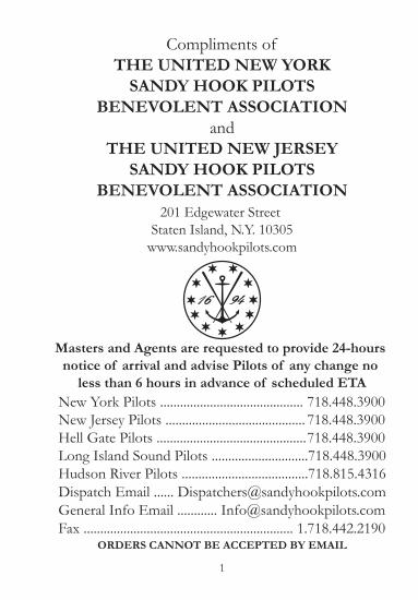
Compliments of
THE UNITED NEW YORKSANDY HOOK PILOTS
BENEVOLENT ASSOCIATIONand
THE UNITED NEW JERSEYSANDY HOOK PILOTS
BENEVOLENT ASSOCIATION201 Edgewater Street
Staten Island, N.Y. 10305www.sandyhookpilots.com
Masters and Agents are requested to provide 24-hours notice of arrival and advise Pilots of any change no
less than 6 hours in advance of scheduled ETANew York Pilots ........................................... 718.448.3900New Jersey Pilots .......................................... 718.448.3900Hell Gate Pilots ............................................. 718.448.3900Long Island Sound Pilots .............................718.448.3900Hudson River Pilots ......................................718.815.4316Dispatch Email ...... [email protected] Info Email ............ [email protected] ............................................................... 1.718.442.2190
ORDERS CANNOT BE ACCEPTED BY EMAIL
1

Contents
Arrival and Embarkation Information ...............................Pilot Ladder Requirements ...................................................Useful Telephone Numbers and Websites .........................Nautical Distances in the Port of NY/NJ .........................Principal Bridges in the Port of NY/NJ ............................East River and Long Island Sound Information ...............Hudson River Information ...................................................Increase in Draft due to pitch, heel or squat .....................Squat Table ..............................................................................Determining Air Draft ..........................................................Principal Light and Fog Signals in the Port of NY/NJ ...Ranges and Bearings in the Port of NY/NJ ......................Anchorages and Anchorage Regulations ............................Chartlets w/Terminal Information .....................................Common Conversion Factors and Metric Tables .............Percautionary Statement .......................................................Height of Tide at Any Time ................................................Velocity of Current at Any Time ........................................Tidal Differences and Constants .........................................Sandy Hook and Battery Tides ............................................Current Differences and Constants ....................................Narrows and Hell Gate Current Tables .............................Albany Tides ...........................................................................Metric Conversion Tables .....................................................2015 & 2016 Calendar ...........................................................Sunrise & Sunset Predictions for 2015 ...............................
Page34 - 56 - 78910 - 1112 - 13141516181920 - 2324 - 363738394041 - 4344 - 6768 - 6970 - 9394 - 105107 - 108130 - 131132 - 133
2

‘A’
WXBuoy
Nantucket Lane
Bar
nega
t Lan
e
NOT TO SCALENOT TO BE USED FOR NAVIGATION
Important Information Your Pilot Will Need It is imperative that you brief your pilot about any automatic engine monitoring systems that could potentially shut down or would significantly reduce the power of the main propulsion engine system without substantial warning. If possible, these systems should be overridden for transiting New York Harbor pilotage waters. Please advise your pilot if any unusual problem with the ship’s control or navigational systems have occurred in the last month.
Arrival and Pilot Embarkation at Ambrose Pilot StationThe Sandy Hook Pilots maintain a pilot vessel on station year round. Either the Pilot Boat New York or Pilot Boat New Jersey will be “On Station” and monitoring VHF channels 13, 16 and 73. Both vessels are equipped with AIS. Using a 53ft (16m) aluminum launch, the pilot will be embarked from this vessel. The pilot launch carries the same lights as the pilot boats on station.
Vessels approaching the Ambrose Pilot Station from sea should give the pilot boat a minimum of three hours advance notice. Vessels should make a second call to the pilot boat when they are one hour from the sea buoy. Pilot boarding side will be given at that time.
3

Pilot Ladder RequirementsDirection
of Wind
In case freeboard exceeds30 feet
1 - Rigging of the ladder, along with embarking and disembarking of pilot, must be under the supervision of a licensed officer.2 - The ladder must be made in one length and not consist of two lengths shackled or lashed together, and should be equipped with spreaders about 10 feet (3m) apart.3 - The area of the deck where the pilot boards must be well lighted and must be clear of obstructions to ensure a safe passage for the pilot.4 - Trailing lines or retrieving lines should not be attached to the lower ends of the ladder.5 - Ladders must be rigged well clear of water and discharge outlets and at a place near midship.6 - Vessels must comply with the new SOLAS Chapter V regulations.7 - Rig the ladder 1.5 meters above the water. A heaving line must be available.
Requirements:
4

DRIFT PENNANT
NEVER BIND LADDER TO GANGWAY SO TIGHT AS TO MAKE PLATFORM A HAZARDTO CLIMBING OR CAUSE LADDER STEPS TO BE UNEVEN. LADDERSHOULD EXTEND MINIMUM OF 3 METERS BELOW GANGWAY
NO
YESSTANCHIONS AND HANDRAILS ON PLATFORM
Pilot Ladder Requirements
5
PilotsSandy Hook Pilots Association………………....….....…..(718) 448-3900 Dispatch / Operational Issues : [email protected] General Information : [email protected] River Pilots Association .……………….....…..... (718) 815-4316 Long Island/Block Island Sound Pilots ……………….... (401) 847-9050 [email protected]
Tug CompaniesMoran Towing (VHF Ch. 7A)………………………........ (203) 442-2825McAllister Towing and Transportation (VHF Ch. 10)......... (718) 273-6300Hornbeck Offshore ………………………...…………... (718) 625-0743Reinauer (VHF Ch. 80A)……………………..…………. (718) 816-8167Bouchard Transportation (VHF Ch. 10)………………… (631) 390-4900Henry Marine Services (VHF Ch. 74)………………….... (718) 966-6193Weeks Marine…………………………………..……….. (908) 272-4010Harley Marine Services (VHF Ch. 79A)………………..... (718) 875-7000Kirby Marine (VHF Ch. 18A)………………….………... (718) 720-7207
Launch ServicesMiller’s Launch ………………………..………………... (718) 727-7303Reynold’s Launch……………………...……………….... (718) 981-2804
United States Coast GuardVessel Traffic Service (VTS) ………….………………… (718) 354-4088VTS Fax ……………………...………………………… (718) 354-4096First USCG District Bridges ………...………………….. (212) 668-7021
Regulatory/GovernmentalNYPD Harbor Unit …………………………………… (718) 765-4100National Weather Service ……………………………… (516) 924-0517Physical, Oceanographic Real Time System (PORTS) ….. (718) 815-9668
US Army Corp of EngineersTo report dangerous debris ………………...…………... (201) 333-1170
LinehandlersBayonne Line Boat Service ……………………………... (201) 436-8109
Useful Telephone Numbers
6
Bridge Phone NumbersLehigh Valley RR Bridge …………………….………...... (973) 690-2344Lincoln Highway ……………………………………….. (973) 589-5143Path Control ………………………………………….… (201) 216-6552Triple Bridges …………………………………………... (973) 690-2609Witt Penn Bridge ………………………...……….…….. (201) 795-0631Lower Hackensack Bridge ……………………….……. . (201) 714-2958Lower Hack Bridge Superintendent ……………....… . . . (973) 879-2967Raritan River Railroad Bridge ………………....…….…. . (973) 690-2344
Useful WebsitesUSCG Sector NY..................................http://homeport.uscg.mil/newyorkPort Authority:.........................................................................www.panynj.govNotice to Mariners..navcen.uscg.gov/?pagename=lnmDistrict®ion=1NY Marine Weather............................www.erh.noaa.gov/okx.marine.shtml
Tides and CurrentsPORTS..................tidesandcurrents.noaa.gov/ports/index.shtml?port=nyMaritime Center..................hudson.dl.stevens-tech.edu/maritimeforecast/
Bridge Air GapsVerrazano and Bayonne Bridge: http://www.tidesandcurrents.noaa.gov/ports.html
Seaman’s Institute118 Export St., Newark, NJ 07114(973) 589-5828www.seamanschurch.org
Seafarers and International House123 East 15th St., New York, NY 10003(212) 677-4800www.sihnyc.org
7

NameVerrazano Bridge....................................................................................................26 Buoy..................................................................................................................... off Pier #l Brooklyn Army Base......................................................................... off 35th Street Gowanus .....................................................................................Bayonne Terminal Dock.......................................................................................#28 Buoy Abeam ..................................................................................................off Entrance Atlantic Basin ................................................................................Channel junction off Battery ..............................................................................Pier #40 Abeam ....................................................................................................Turn off Bethlehem Steel, Hoboken..................................................................Passenger Ship Terminal.......................................................................................George Washington Bridge..................................................................................Pilot Station, Yonkers Abeam .............................................................................
off IMTT Con Hook.............................................................................................off Exxon Bayonne................................................................................................Howland Hook Container Terminal...................................................................Bayway......................................................................................................................Tremley Point C/S & BP Docks..........................................................................Rahway River...........................................................................................................Tufts Point...............................................................................................................
Bergen Point junction............................................................................................Port Eliz. Entrance.................................................................................................Port New'k. Entrance............................................................................................Tenaco Newark.......................................................................................................Koppers Koke.........................................................................................................
S.W. Spit Buoy Junction Chapel Hill ...................................................................Leonardo Dock.......................................................................................................Princess Bay.............................................................................................................Beacon #9...............................................................................................................Anaconda Dock Raritan River..............................................................................Hess Reserve Raritan River ..................................................................................Titanium Dock Raritan River ..............................................................................Perth Amboy Anchorage.......................................................................................off 6 Buoy Sewarren..............................................................................................off Beacon 14 Hess Pt. Reading..........................................................................Tufts Point...............................................................................................................Rahway River...........................................................................................................Bayway......................................................................................................................
Distances North Way from Ambrose Sea Buoy
UPPER BAY & HUDSON RIVER
KILL VAN KULL & ARTHUR KILL
NEWARK BAY
Distances South Way from Sandy Hook Scotland Buoy
13.6M15.5M16.2M17.5M17.5M17.9M19.3M19.3M21.3M23.9M24.5M29.4M35.1M
17.6M18.7M22.5M23.6M25.5M26.1M28.3M
21.0M22.9M23.7M25.0M28.5M
07.0M07.5M15.0M16.3M19.3M20.0M21.3M17.5M20.6M21.7M23.0M25.3M27.5M
Distance

Principal Bridges in the Port of New York
SYMBOLS: F - FIXED / SUS. - SUSPENSION / SW - SWING / V.L. - VERTICAL LIFT**(TRAVELING PLATFORM REDUCED CLEARANCE BY 15 FEET)
SPECIAL NOTATIONVessels navigating in the Vicinity of Rikers Island with a mast height of over 125 ft. should use
caution when crossing La Guardia Airport flight approaches. # 718-779-1220/nite 718-779-7901.
RARITAN RIVER
Dis-tance
1.21.52.55.35.67.37.5
12.4- -
9.6
11.5
3.5
6.26.3
14.6
3.53.7
5.25.86.06.46.5
5.76.16.86.86.87.1
2.6
2.64.0
Name orLocation
BrooklynManhattanWilliamsburgQueensboroughRoosevelt IslandTriboroughHell GateWhitestoneThrogsneck
Geo. Washington
Narrows
Bayonne
B. & O. R.R.Goethals
Newark Bay
Lehigh Valley R.R.
Lincoln HighwayPulaski SkywayPoint No Point
Lincoln HighwayPulaski SkywayPenn PassengerPenn FreightRoute 10 H’wayD.L. & W. R. R.
Victory BridgeThomas Edison Garden State Pkway.
Type ofBridge
Sus.Sus.Sus.
Sus.Sus.Sus.Sus.
Sus.
Sus.
F.
V. L.F.F.
F.V. L.
Sw.V. L.F.Sw.F.
V. L.F.V. L.V. L.V. L.V. L.
Sw.
Sw.F.F.
HorisontalClearance
1350’1200’1536’
900’403’
Unobstructed830’
2265’1711’
3169’
4000’
800’
500’617’675’
550’300’
100’300’520’103’319’
200’300’168’158’158’150’
N.S. 124’S.S. 125’
140’200’200’
Vert Clearanceat Mean H.W.
38.71M - 127’40.84M - 134’40.54M - 133’39.93M - 131’
42.06M - 138’40.84 - 134’41.15M - 135’42.06M - 138’
64.92M - 213’East 59.44M - 195’60.35M - 198’ Mid 2000’55.77M - 183’ at Piers
UNDER CONSTRUCTION
UNDER CONSTRUCTION43.59M - 143’
41.15M - 135’
7.62M - 25’
41.15 - 135’4.87M - 16’30.4M - 100’
41.15M - 135’
2.43M - 8’
8.53M - 28’41.15M - 135’41.15M - 135’
EAST RIVER

This is a listing of the various marine terminals, bridges and landmarks in relationship to each other, which a vessel will pass in transiting the East River. The mileage given is the distance for west-bound vessels from Execution Rocks to the Battery and for east-bound vessels from the Battery to Execution Rocks.
Vessels navigating in the vicinity of Rikers Island with a mast height of over 125' should use caution when crossing LaGuardia Airport flight approaches.
WestBound
Mileage
00.003.305.507.209.211.010.110.510.711.812.012.312.714.315.916.316.116.917.117.317.718.0 18.118.418.718.920.0
LONG ISLAND SOUND
Execution Rocks - Sands PointCity Island -Stepping Stones LT - Kings Pt. Throgs Neck Bridge - Fort Schuyler Bronx Whitestone Bridge Hunts Pt. - LaGuardia Airport Castle Oil & Orion Power - AstoriaOak Pt. - Castle Oil Bronx Tiffany St. 149th St., Cirillo Bros.- Cibro 138th St., Metropolitan Oil Wards Island Sewer Treatment Plant Hell Gate Railroad BridgeTriborough Bridge Hell Gate - Harlem Riv - Mill Rk. - Hallets Pt.Queensborough (59th St.) BridgeNational Cincrete, Long Island CityPepsi Cola, Long Island Green St. Lumber Term., Green PointNepco Oil Terminal, North 1st St. Amstar Sugar House, South 2nd St.Williamsburg Bridge Brooklyn Navy Yard Con Edison, Hudson Ave.Piers 42 & 36, East RiverManhattan BridgeBrooklyn BridgePiers 1 to 5, BrooklynBATTERY
Vertical Clearance
138’135’
134’138’
131’
133’
134’127’
Width
1711’2265’
830’Unlimited
900’
1536’
1200’1350’
EastBound
Mileage
20.016.714.512.810.811.009.909.509.308.208.007.707.305.704.605.003.903.102.902.702.302.001.901.601.301.100.0
10

East River and Long Island SoundDistance from Junction off Battery
Times of High & Low WaterOff Battery
Location
Bkly’n Navy Yard.......................
Poor House Flats........................
Pepsi Cola L. I. C.......................
Hell Gate......................................
Oak Point.....................................
Throgs Neck................................
City Island....................................
Execution Rocks.........................
Distance
02.6
3.75
05.2
07.5
10.0
15.0
17.5
20.4
Location
Northport.........................................
Bridgeport Entrance Buoys.........
Port Jefferson Sea Buoy...............
New Haven Sea Buoy...................
Northville.......................................
New London Entrance Buoys...
Montauk Channel.......................
Point Judith...................................
Distance
42.0
49.7
52.8
65.3
72.0
101.7
116.0
127.0
BatteryBklyn. Navy YardHell Gate - Hallets Pt.Port Morris - Stoney Pt.Hunts PointWillets PointExecution RocksBridgeportPort JeffersonNew Haven (City Dock)New London (State Pier)
H.W.0:00
+0:50+2:00+3:23+3:18+3:10+3:04+2:52+2:58+2:54+1:09
L.W.0:00
+0:35+2:04+3:46+3:45+3:30+3:22+2:50+2:53+2:47+1:15
Mean4.54.15.16.36.97.17.36.76.66.02.6
Spring5.44.96.17.48.18.38.67.77.66.93.1
Times of High & Low Water SlackOff Narrows
NarrowsHell GateThrogs NeckThe Race
H.W.0:00
+0:16+0:02+1:55
L.W.0:00
- 0:17- 1:24+1:30
Mean1.73.40.62.9
Spring2.04.60.83.5
11

Hudson River DraftsMaximum Air Draft - 132'
Upper Hudson River North of KingstonMaximum Draft - 30' (Fresh Water Draft)Vessels transiting the Upper Hudson River with drafts of27' to 30' must be set up for the correct stage of a rising tide.Daylight transits only north of Kingston.
Lower Hudson River South of KingstonMaximum Draft- 33' (Salt Water Draft)Vessels transiting the Lower Hudson River with drafts of31 ' to 33' must be set up for the correct stage of a rising tide.Daylight transits only north of Kingston.Vessels with a draft of 31' or less may transit the LowerRiver any time.
All vessel draft information is subject to existing weather conditionsat the time of transit.
Please call our Dispatchers for assistance in setting Hudson Rivertransits or with any other questions.
Hudson River Pilots - 718-815-4316. www.HudsonRiverPilots.com
Location
Hess Roseton
Milton
Poughkeepsie
Kingston
Saugerties
Hudson
Albany & Rensselaer
Location
Yonkers
Hastings
Irvington
Grassy Pt.
Tompkins Cove
Peekskill
Texaco Newburgh
Distance From Junction off Batteryto Locations on the Hudson River
Distances
15.5
18.5
21.5
33.0
35.5
38.0
52.5
Distances
55.5
64.0
65.5
78.5
86.5
100
124
12

Distances from New Yorkto Points on the Hudson River
Location Yonkers 15.5 18.0 Tarrytown and Nyack 24.0 27.5Ossining 28.5 32.5Haverstraw 32.5 37.0Stony Point 35.0 40.0Peekskill 38.0 43.5West Point 45.0 52.0Cold Spring 47.0 54.0Cornwall 49.5 57.0Hyde Park to Albany 52.0 Newburgh and Fishkill 52.5 60.5Yonkers to Hyde Park 56.0 Poughkeepsie 65.5 75.5Kingston 78.5 90.5Saugerties 86.5 99.5Catskill 96.0 110.5Hudson and Athens 100.0 115.0Coxsackie 105.5 121.5Stuyvesant 108.0 124.0New Baltimore 111.5 128.5Coeymans 113.0 130.0Castleton 116.5 134.0Albany & Rensselaer 124.0 142.5Troy & Watervliet 129.5 149.0Troy Lock 131.0 151.0
NauticalMiles
StatuteMiles
Note: Distances are measured to and between points inmidchannel abreast the various towns.
13

SQUAT
S(FEET) = Cb X V2
30
S = SINKAGE IN FEETCb = BLOCK COEFFICIENTV = SPEED IN KNOTS
In Shallow / Confined Waters Sinkage - 2 x S
INCREASE IN DRAFTDUE TO PITCH (IN FEET)
Length500’600’700’800’900’1000’
0.52.182.623.053.493.924.36
1.04.365.236.106.987.858.73
2.08.7210.4612.2113.9615.7017.45
Table assumes tipping center is at mid-point
INCREASE IN DRAFTDUE TO HEEL (IN FEET)(BEAM/2 X Sine of Angle)
Beam40’60’80’100’150’200’
51.742.613.484.356.548.72
103.475.216.958.6813.0217.36
14

BL
OC
K
CO
- E
F
0.50
0.55
0.60
0.65
0.70
0.75
0.80
0.85
0.90
0.95
1.00
5k.
0.8
0.9
1.0
1.1
1.1
1.2
1.3
1.4
1.5
1.6
1.6
6k.
1.2
1.3
1.4
1.5
1.7
1.8
1.9
2.0
2.1
2.2
2.4
7k.
1.6
1.8
1.9
2.1
2.3
2.4
2.6
2.7
2.9
3.1
3.2
8k.
2.1
2.3
2.5
2.7
2.9
3.1
3.4
3.6
3.8
4.0
4.2
9k.
2.7
2.9
3.2
3.5
3.7
4.0
4.3
4.5
4.8
5.0
5.3
10k.
3.3
3.6
3.9
4.3
4.6
4.9
5.2
5.6
5.9
6.2
6.6
11k. 4.0
4.4
4.8
5.2
5.6
6.0
6.4
6.7
7.1
7.5
7.9
12k.
4.7
5.2
5.7
6.1
6.6
7.1
7.6
8.0
8.5
9.0
9.4
13k.
5.5
6.1
6.7
7.2
7.8
8.3
8.9
9.4
10.0
10.5
11.1
14k.
6.4
7.1
7.7
8.4
9.0
9.6
10.3
10.9
11.6
12.2
12.9
15k.
7.4
8.1
8.9
9.6
10.3
11.1
11.8
12.5
13.3
14.0
14.8
SQU
AT
IN
FE
ET
15

Determining the Air Draft ofa Ship Not on Even Keel
HEIGHT OF THE MAST is the distance from the keel to the top of the mast. AIR DRAFT is the distance from the waterline to the top of the mast.
To determine the air draft of a ship not on even keel take the difference in draft fore and aft, DIVIDE by the Length Between Perpendiculars, TIMES the Distance from the deepest perpendicular to the mast. This is the increase in Air Draft above that determined by subtracting the deepest draft from the height of the mast.
600’150’
30’10’
20600
1501
5X =
OR30 - 10 = 20
(20 / 600 ) X 150 = 5 FEETActual air draft is 5 feet more than if
using deepest draft
16

Name Light Fog Signal
Scotland Lighted............................... Morse "A"..................... 1 Bl. ev. 30 sec.
Horn Buoy S............................................................................... Racon Signal M.
Sandy Hook Pt. Lt............................ Iso., W. 6 sec.................. 1 Str. ev. 10 sec.
Sandy Hook Lt.................................. FW
Romer Shoal Lt................................. Fl. (2) W. 15 sec............. 1 Bl. ev. 15 sec.
Emerg. Lt. - Fl. W. 6 sec.
when main Lt. exting.
West Bank Front Lt.......................... Iso., W. sector, 6 sec..... 2 Bl. ev. 20 sec.
Coney Island Lt................................. Fl. R. 5 sec
Verrazano Narrows Br ............................................................. 1 Bl. ev. 15 sec.
Robbins Reef Lt................................ Fl. G. 6 sec .................... 1 Bl. ev. 10 sec.
Gov. Is. Ext. Lt.................................. FR................................... 1 Bl. ev. 15 sec.
Gov. Is. Lt...........................................2 FR................................ 2 Bl. ev. 20 sec.
Outerbridge Crossing................................................................ 1 Bl. ev. 15 sec.
Hell Gate Lt. 15................................ Fl. G. 2.5 sec
N. Brothers Is. N. Lt. 9 .................... Fl. G. 4 sec
Whitestone Pt. Lt. 1.......................... F. G.
Throgs Neck Lt................................. F. R
Throgs Neck Bridge.................................................................. 2 Bl. ev. 20 sec.
Stepping Stones Lt............................Oc. G. 4 sec................... 1 Bl. ev. 15 sec.
Hart Island Lt. 46............................. Fl. R. 4 sec
Execution Rock Lt............................ Fl. W. 10 sec................... 1 Bl. ev.15 sec.
Principal Light and Fog Signals inthe Port of New York
18
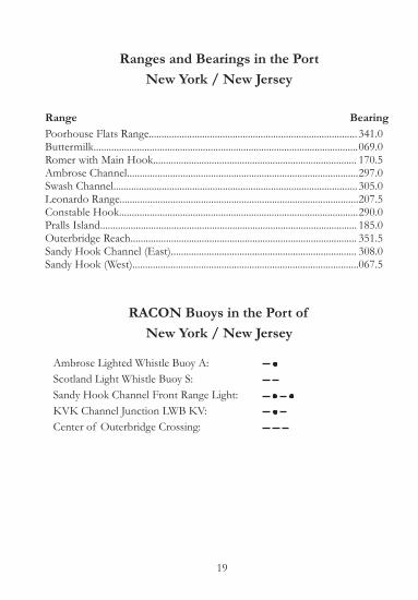
Ranges and Bearings in the PortNew York / New Jersey
Range BearingPoorhouse Flats Range.................................................................................. 341.0Buttermilk........................................................................................................ 069.0Romer with Main Hook................................................................................ 170.5 Ambrose Channel........................................................................................... 297.0Swash Channel................................................................................................ 305.0Leonardo Range.............................................................................................. 207.5Constable Hook.............................................................................................. 290.0Pralls Island..................................................................................................... 185.0Outerbridge Reach......................................................................................... 351.5Sandy Hook Channel (East)......................................................................... 308.0Sandy Hook (West)......................................................................................... 067.5
RACON Buoys in the Port ofNew York / New Jersey
Ambrose Lighted Whistle Buoy A: Scotland Light Whistle Buoy S: Sandy Hook Channel Front Range Light: KVK Channel Junction LWB KV: Center of Outerbridge Crossing:
19
$
Upper B ayThis compilation was created from the latestNOAA charts available at the time ( July 2007) .P roduced in cooperation with USGS and NOAA.For training and testing purposes only andNOT TO B E USED FOR NAVIGATION.
Name: _ _ _ _ _ _ _ _ _ _ _ _ _ _ _ _ _ _ _ _ _ _ _ _ _ _ _ _ _ _ _ _ _ _
SSN: _ _ _ _ _ _ _ _ _ _ _ _ _ _ _ _ _ _ _ _ _ _ _ _ _ _ _ _ _ _ _ _ _ _ _ _
Telephone: _ _ _ _ _ _ _ _ _ _ _ _ _ _ _ _ _ _ _ _ _ _ _ _ _ _ _ _ _ _
1 0 10.5
N autic al Mil es
‘28’8 7 6 5 4 3 Y
VW
U
TSRQ
PO
NMLK
J
I
H
G
E
F
DC
BA
5 4 3 2 1
9 8 7 6 5 4 3 2 1
‘3’‘26’
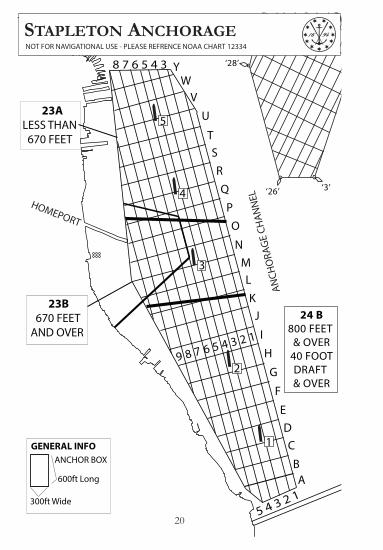
ANCHOR BOX
600ft Long
300ft Wide
GENERAL INFO 1
3
2
4
5
ANCH
ORA
GE
CHAN
NEL
24 B800 FEET
& OVER40 FOOTDRAFT & OVER
23B 670 FEET AND OVER
23A LESS THAN 670 FEET
HOMEPORT
STAPLETON ANCHORAGENOT FOR NAVIGATIONAL USE - PLEASE REFRENCE NOAA CHART 12334
20
$
Upper B ayThis compilation was created from the latestNOAA charts available at the time ( July 2007) .P roduced in cooperation with USGS and NOAA.For training and testing purposes only andNOT TO B E USED FOR NAVIGATION.
Name: _ _ _ _ _ _ _ _ _ _ _ _ _ _ _ _ _ _ _ _ _ _ _ _ _ _ _ _ _ _ _ _ _ _
SSN: _ _ _ _ _ _ _ _ _ _ _ _ _ _ _ _ _ _ _ _ _ _ _ _ _ _ _ _ _ _ _ _ _ _ _ _
Telephone: _ _ _ _ _ _ _ _ _ _ _ _ _ _ _ _ _ _ _ _ _ _ _ _ _ _ _ _ _ _
1 0 10.5
N autic al Mil es
‘3’‘26’
‘28’
A
B
C
D
E
F
H
IJ
K
LM
N
O
Q
R
S
TU
V
W
X
Y
Z
‘7’1312
1110
98765
43
1312
1110
98765
43
14 15 16 17 18
1 2
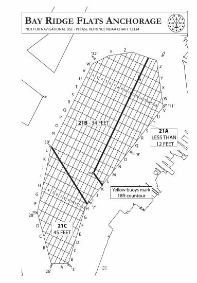
21B - 34 FEET 21A LESS THAN 12 FEET
21C45 FEET
Yellow buoys mark 18ft countour
‘30’
‘32’
‘9’
‘11’
BAY RIDGE FLATS ANCHORAGENOT FOR NAVIGATIONAL USE - PLEASE REFRENCE NOAA CHART 12334
G
B
C
D
F
G
H
I
J
K
L
N
O
Q
P
R
S
T
U
V
W
Y Z
21

$
Upper B ayThis compilation was created from the latestNOAA charts available at the time ( July 2007) .P roduced in cooperation with USGS and NOAA.For training and testing purposes only andNOT TO B E USED FOR NAVIGATION.
Name: _ _ _ _ _ _ _ _ _ _ _ _ _ _ _ _ _ _ _ _ _ _ _ _ _ _ _ _ _ _ _ _ _ _
SSN: _ _ _ _ _ _ _ _ _ _ _ _ _ _ _ _ _ _ _ _ _ _ _ _ _ _ _ _ _ _ _ _ _ _ _ _
Telephone: _ _ _ _ _ _ _ _ _ _ _ _ _ _ _ _ _ _ _ _ _ _ _ _ _ _ _ _ _ _
1 0 10.5
N autic al Mil es
2 3 4 5 6 7 8 9 10 11 12
A
B
C
D
E
F
G
H
I
J
K
L
MN
A
B
C
343°
ANCHOR BOX
600ft Long
300ft Wide
GENERAL INFO
25
GRAVESEND BAY ANCHORAGENOT FOR NAVIGATIONAL USE - PLEASE REFRENCE NOAA CHART 12402
22

Anchorages
Number19 Hudson River Naval Anchorage20 - A Liberty 20 - B North Side Bayonne Naval Terminal21 - B Red Hook Flats23 Staten Island24 Quarantine25 Gravesend Bay (Eastern Part)27 Sandy Hook44 Perth Amboy49 - C Gravesend Bay (Western Part)49 - G Leonardo
Locations
WHEN ANCHORED IN FEDERAL ANCHORAGE 20-A THROUGH 20-G, 21-A, 21-B, 21-C, 23-A AND 23-B, 24 OR 25 MUST COMPLY WITH THE FOLLOWING REQUIREMENTS:
COMMENCING AND COMPLETING THE
Anchorages Regulations
23

$
Upper B ayThis compilation was created from the latestNOAA charts available at the time ( July 2007) .P roduced in cooperation with USGS and NOAA.For training and testing purposes only andNOT TO B E USED FOR NAVIGATION.
Name: _ _ _ _ _ _ _ _ _ _ _ _ _ _ _ _ _ _ _ _ _ _ _ _ _ _ _ _ _ _ _ _ _ _
SSN: _ _ _ _ _ _ _ _ _ _ _ _ _ _ _ _ _ _ _ _ _ _ _ _ _ _ _ _ _ _ _ _ _ _ _ _
Telephone: _ _ _ _ _ _ _ _ _ _ _ _ _ _ _ _ _ _ _ _ _ _ _ _ _ _ _ _ _ _
1 0 10.5
N autic al Mil es
21B - 34 FEET
GLOBAL CONTAINER
TERMINAL BAYONNE
WE
NEATCAPE LIBERTY
CRUISE PORT
CLAREMONT
1
23
45
PHONE NUMBERSCLAREMONT TERMINAL 201.333.4300GLOBAL TERMINAL 201.451.5200 EXT:265
‘KV’
‘1’
‘2’
‘3’
‘6’
‘5’
‘28’
‘30’
‘5’
‘C’
‘32’
‘35’
‘33’
‘1’
‘2’
‘31’
‘2’
‘1’
PIER
HEAD C
HANNEL
TERMINAL CHANNEL
ANCH
ORA
GE C
HANN
EL
LIBERTY ISLANDSTATUE OF LIBERTY
MOT AUTOTERMINAL
UPPERBAY - WEST PARTNOT FOR NAVIGATIONAL USE - PLEASE REFRENCE NOAA CHART 12334
24

$
Upper B ayThis compilation was created from the latestNOAA charts available at the time ( July 2007) .P roduced in cooperation with USGS and NOAA.For training and testing purposes only andNOT TO B E USED FOR NAVIGATION.
Name: _ _ _ _ _ _ _ _ _ _ _ _ _ _ _ _ _ _ _ _ _ _ _ _ _ _ _ _ _ _ _ _ _ _
SSN: _ _ _ _ _ _ _ _ _ _ _ _ _ _ _ _ _ _ _ _ _ _ _ _ _ _ _ _ _ _ _ _ _ _ _ _
Telephone: _ _ _ _ _ _ _ _ _ _ _ _ _ _ _ _ _ _ _ _ _ _ _ _ _ _ _ _ _ _
1 0 10.5
N autic al Mil es
12
12
9B9A
87
65
32
‘9’
‘11’
‘A’‘32’
‘1’
‘35’
‘33’
‘2’
ANCH
ORA
GE C
HANN
EL
GOVERNORS ISLAND
MANHATTAN
DEEPWATER RANGE
BUTTERMILK CHANNEL
REDH
OO
K CHA
NN
EL
GOWANUS BAY
ERIEBASIN
BAY
RIDG
E FL
ATS
RED HOOKCONTAINER TERMINAL
BROOKLYN CRUISE
TERMINAL
UPPERBAY - EAST PARTNOT FOR NAVIGATIONAL USE - PLEASE REFRENCE NOAA CHART 12334
‘2’
‘3’‘1’
25

$Th
isco
mpi
latio
nw
ascr
eate
dfr
omth
ela
test
NO
AA
char
tsav
aila
ble
atth
etim
e(J
uly
2007
).Pr
oduc
edin
coop
erat
ion
with
USG
San
dN
OA
A.
Fort
rain
ing
and
test
ing
purp
oses
only
and
NO
TTO
BE
USE
DFO
RN
AVIG
ATIO
N.
Nam
e:__
____
____
____
____
____
____
____
____
SSN
:___
____
____
____
____
____
____
____
____
_
Tele
phon
e:__
____
____
____
____
____
____
____
Kill
van
Kul
l-R
obbi
nsR
eef
toEl
izab
ethp
ort
10
10.
5
Nau
tical
Mile
s
Bu
cke
ye
Ba
yon
ne
5c
Cement Dock
Gordon’s
TermIM
TT 5B
IMTT
Ba
yon
ne
IMTT
9T
IMTT
8St
an
da
rd T
an
k
Ba
yon
ne
Cit
y D
oc
k
BAYO
NN
E BR
IDG
EM
idd
le -
151
ft /
46.
02 m
Mo
ran’
s Ya
rd
Rein
au
er’
s Ya
rdPo
rt R
ich
mo
nd
Slu
dg
e D
oc
ks
Atl
an
tic
Sa
lt
Ca
de
ll’s
Ma
in Y
ard
Pen
n’s
Yard
Be
rge
n Po
int
Texa
s D
oc
k
CON
STAB
LE H
OOK R
EACH
BERG
EN P
OIN
T E
AST
REAC
H
6N
We
sto
f 1A
6S
IMTT
SEC
URI
TY
GO
RDO
NS
BUCK
EYE
BAYO
NN
E
201.
339.
4712
201.
437.
8300
201.
437.
1017
KIL
L V
AN
KU
LL
N
OT
FOR
NAV
IGAT
ION
AL
USE
- PL
EASE
REF
REN
CE N
OA
A C
HA
RT 1
2333
IMTT
26

$Th
isco
mpi
latio
nw
ascr
eate
dfr
omth
ela
test
NO
AA
char
tsav
aila
ble
atth
etim
e(J
uly
2007
).Pr
oduc
edin
coop
erat
ion
with
USG
San
dN
OA
A.
Fort
rain
ing
and
test
ing
purp
oses
only
and
NO
TTO
BE
USE
DFO
RN
AVIG
ATIO
N.
Nam
e:__
____
____
____
____
____
____
____
____
SSN
:___
____
____
____
____
____
____
____
____
_
Tele
phon
e:__
____
____
____
____
____
____
____
Kill
van
Kul
l-R
obbi
nsR
eef
toEl
izab
ethp
ort
10
10.
5
Nau
tical
Mile
s
Be
rge
n P
oin
t
Texa
s D
oc
k
GLOBAL C
ONTAIN
ER
TERM
INAL -
NEW
YORK
Mc
Alli
ste
r’s
Yard
Sca
ram
ix C
em
en
t
(Elm
Pa
rk)
Cle
an
Wa
ters
Ma
y’s
Ship
yard
Gre
at
Lake
s Ya
rd
Port
Ivo
ryK-
Sea
Ya
rd
1
2
3
Art
hu
r Kill
Ra
ilro
ad
Brid
ge
Ve
rt: U
p:1
35ft
/ 4
1.15
m D
ow
n: 3
1ft
/ 9.
44m
Go
eth
als
Brid
ge
Ve
rt: 1
37f /
41.
76m
Sho
ote
r’s
Isla
nd
Old
Ba
y D
raw
ELIZABETHPORT
CONSTRUCTION
MARIN
E
ELIZABETHPORT REACH
NO
RTH
OF
SHO
OTE
RS IS
LAN
D R
EACH
SOUTH O
F SHOOTERS
ISL
AN
D R
EACHREACH A: SOUTH REACH
HO
WLA
ND
HO
OK
718.
568.
1844
PLAZA FUEL DOCK
PH: 800.682.3855N
OR
TH
ER
N P
AR
T O
F A
RT
HU
R K
ILL
N
OT
FOR
NAV
IGAT
ION
AL
USE
- PL
EASE
REF
REN
CE N
OA
A C
HA
RT 1
2333
27

$Newark B ay -Hack ensack andP assaic Rivers
This compilation was created from the latestNOAA charts available at the time ( July 2007) .P roduced in cooperation with USGS and NOAA.For training and testing purposes only andNOT TO B E USED FOR NAVIGATION.
Name: _ _ _ _ _ _ _ _ _ _ _ _ _ _ _ _ _ _ _ _ _ _ _ _ _ _ _ _ _ _ _ _ _ _
SSN: _ _ _ _ _ _ _ _ _ _ _ _ _ _ _ _ _ _ _ _ _ _ _ _ _ _ _ _ _ _ _ _ _ _ _ _
Telephone: _ _ _ _ _ _ _ _ _ _ _ _ _ _ _ _ _ _ _ _ _ _ _ _ _ _ _ _ _ _
1 0 10.5
N autic al Mil es
98 96 94 92 9
0 8
8 8
6 8
4 8
2 8
0 7
8 7
6
52 54 56 58 60 62 64 68 70 72 74
5051 53 55 57 59 61 63
36 3
4 32
30
28 2
6 24
16 18 20 22
2 4 6 8 10 12 14
35 7 9 11 13 15 17 19 21 23 25
APM Terminal
Maher Terminal
PNCT
Hudson Tank
BP NewarkFAPS Building
NEW
ARK
BAY
Hudson Tank APM Terminal S/L Bus APM Terminal S/L Security Maher Terminal PNCT Van Iderstien
201.803.1166908.558.6138908.558.6163908.558.6161908.527.8200 Ext.4799973.522.2308973.465.1900 Ext.121
Seaman’sCenter
NEWARK BAYNOT FOR NAVIGATIONAL USE - PLEASE REFRENCE NOAA CHART 12333
28
19 21 23 25
16 18 20 22
$Newark B ay -Hack ensack andP assaic Rivers
This compilation was created from the latestNOAA charts available at the time ( July 2007) .P roduced in cooperation with USGS and NOAA.For training and testing purposes only andNOT TO B E USED FOR NAVIGATION.
Name: _ _ _ _ _ _ _ _ _ _ _ _ _ _ _ _ _ _ _ _ _ _ _ _ _ _ _ _ _ _ _ _ _ _
SSN: _ _ _ _ _ _ _ _ _ _ _ _ _ _ _ _ _ _ _ _ _ _ _ _ _ _ _ _ _ _ _ _ _ _ _ _
Telephone: _ _ _ _ _ _ _ _ _ _ _ _ _ _ _ _ _ _ _ _ _ _ _ _ _ _ _ _ _ _
1 0 10.5
N autic al Mil es
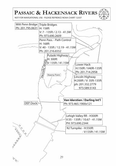
Pulaski HighwayH: 300ftV: 135ft / 41.15M
Penn Pass. - Path ControlH: 168ft V: 40 - 135ft / 12.19 - 41.15MPh: 201.216.6552
Lincoln HighwayH:200ft / V: 35ft-135ftph: 201.332.2779 973.589.5143
Triple Bridges H: 158ftV: 7 - 135ft / 2.13 - 41.5MPh: 973.690.2609
Lower HackH:150ft / V40ft-135ftPh: 201.714.2958
Witt Penn BridgePh: 201.795.0631
Van Iderstien / Darling Int’lPh: 973.465.1900x121DEP Dock
Lehigh Valley RR - H300ft V:35 - 135ft / 10.67 - 41.15MPH: 973.690.2344
92 9
0 8
8 8
6 8
4 8
2 8
0 7
8 7
6
52 54 56 58 60 62 64 68 70 72 74
51 53 55 57 59 61 63
36 3
4 32
30
28 2
6 24
Kearny Point
PASS
IAC
RIVE
R
NJ Turnpike - H:550ft - V:135ft / 41.15M
PASSAIC & HACKENSACK RIVERSNOT FOR NAVIGATIONAL USE - PLEASE REFRENCE NOAA CHART 12337
29

$
Arthur K ill North -Island of Meadowsto Eliz abethport
This compilation was created from the latestNOAA charts available at the time ( July 2007) .P roduced in cooperation with USGS and NOAA.For training and testing purposes only andNOT TO B E USED FOR NAVIGATION.
Name: _ _ _ _ _ _ _ _ _ _ _ _ _ _ _ _ _ _ _ _ _ _ _ _ _ _ _ _ _ _ _ _ _ _
SSN: _ _ _ _ _ _ _ _ _ _ _ _ _ _ _ _ _ _ _ _ _ _ _ _ _ _ _ _ _ _ _ _ _ _ _ _
Telephone: _ _ _ _ _ _ _ _ _ _ _ _ _ _ _ _ _ _ _ _ _ _ _ _ _ _ _ _ _ _
1 00.5
N autic al Mil es
1
2
3
‘24’
‘30’
‘32’
‘34’
‘36’
‘38’
‘43’GULFPORT RACKS
PHILLIPS 66 TERMINALPH: 908.523.6385/5000
BAYWAY BARGE DOCK
LINDEN POWERHOUSE
GRASSELLI HIGHWIRES165ft AT MAIN CHAN
NuSTAR LINDENPH: 908.862.5740
PRA
LLS
ISL
GRASSELLI TERMINAL
TREMLEY POINT
KMI CARTERETPh: 732.541.5161
CEDER POINT
ISL O
F M
EADOW
S
VISY PAPER PLANT
CITGO LINDENDock: 908.523.2309OPS: 908.523.2316
GOETHALS BRIDGEH: 617ftVERT: 137ft
PLAZA FUEL DOCK - YACHT FUEL DOCKPH: 800.682.3855Diesel, lube oil & portable water avail.Draft: 23' @ MLW
GU
LFPO
RT R
EACH
PRA
LLS
ISLA
ND
REA
CH
TREM
LEY
POIN
T RE
ACH
FRES
H K
ILLS
REA
CH
ARTHUR KILL NORTHNOT FOR NAVIGATIONAL USE - PLEASE REFRENCE NOAA CHART 12333
30

$
1 0 10.5
N autic al Mil es
Arthur K ill SouthThis compilation was created from the latestNOAA charts available at the time ( July 2007) .P roduced in cooperation with USGS and NOAA.For training and testing purposes only andNOT TO B E USED FOR NAVIGATION.
Name: _ _ _ _ _ _ _ _ _ _ _ _ _ _ _ _ _ _ _ _ _ _ _ _ _ _ _ _ _ _ _ _ _ _
SSN: _ _ _ _ _ _ _ _ _ _ _ _ _ _ _ _ _ _ _ _ _ _ _ _ _ _ _ _ _ _ _ _ _ _ _ _
Telephone: _ _ _ _ _ _ _ _ _ _ _ _ _ _ _ _ _ _ _ _ _ _ _ _ _ _ _ _ _ _
‘60’
‘2’
‘2’
‘4’
‘6’‘5’
‘A’‘B’
‘8’
‘10’
‘11’
‘12’
‘13’
‘14’‘14A’
‘15’
‘16’‘18’
‘20’‘17’
‘21’
OUTERBRIDGE CROSSINGV: 143ft / 43.59M
FERRYPOINT
WARDPOINT
TOTTENVILLE DRY DOCK
KMI OUTERBRIDGEPH: 732.826.1456
BUCKEYE PERTH AMBOYPH: 732.738.2000
KMI STATEN ISLANDPH: 718.966.2002
BUCKEYE PORT READINGPH: 732.692.5265
MOTIVA SEA WARRENSecurity: 732.855.3397Pump: 732.855.3267
SMOKING POINT
WITTE’S JUNK YARD
WAR
D P
OIN
T BE
ND
(WES
T)
OU
TERB
RID
GE
REAC
HPO
RT S
OCO
NY
REAC
H
PORT READING REACH
Tufts Pt
ARTHUR KILL SOUTHNOT FOR NAVIGATIONAL USE - PLEASE REFRENCE NOAA CHART 12331
31
$
Hudson River -B attery to days P ointThis compilation was created from the latestNOAA charts available at the time ( July 2007) .P roduced in cooperation with USGS and NOAA.For training and testing purposes only andNOT TO B E USED FOR NAVIGATION.
Name: _ _ _ _ _ _ _ _ _ _ _ _ _ _ _ _ _ _ _ _ _ _ _ _ _ _ _ _ _ _ _ _ _ _
SSN: _ _ _ _ _ _ _ _ _ _ _ _ _ _ _ _ _ _ _ _ _ _ _ _ _ _ _ _ _ _ _ _ _ _ _ _
Telephone: _ _ _ _ _ _ _ _ _ _ _ _ _ _ _ _ _ _ _ _ _ _ _ _ _ _ _ _ _ _
1 0 10.5
N autic al Mil es
76
64
59606162
575453
45
40
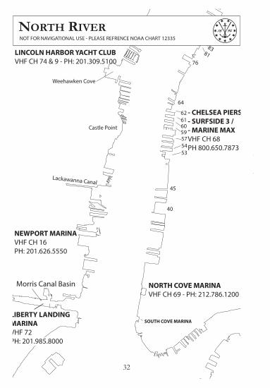
Morris Canal Basin
8483
81
86
Weehawken Cove
Castle Point
Lackawanna Canal
LINCOLN HARBOR YACHT CLUBVHF CH 74 & 9 - PH: 201.309.5100
NEWPORT MARINAVHF CH 16PH: 201.626.5550
- CHELSEA PIERS / - SURFSIDE 3 / - MARINE MAXVHF CH 68 PH 800.650.7873
NORTH COVE MARINAVHF CH 69 - PH: 212.786.1200
SOUTH COVE MARINALIBERTY LANDINGMARINA VHF 72PH: 201.985.8000
NORTH RIVERNOT FOR NAVIGATIONAL USE - PLEASE REFRENCE NOAA CHART 12335
32

$
Hudson River -B attery to days P ointThis compilation was created from the latestNOAA charts available at the time ( July 2007) .P roduced in cooperation with USGS and NOAA.For training and testing purposes only andNOT TO B E USED FOR NAVIGATION.
Name: _ _ _ _ _ _ _ _ _ _ _ _ _ _ _ _ _ _ _ _ _ _ _ _ _ _ _ _ _ _ _ _ _ _
SSN: _ _ _ _ _ _ _ _ _ _ _ _ _ _ _ _ _ _ _ _ _ _ _ _ _ _ _ _ _ _ _ _ _ _ _ _
Telephone: _ _ _ _ _ _ _ _ _ _ _ _ _ _ _ _ _ _ _ _ _ _ _ _ _ _ _ _ _ _
1 0 10.5
N autic al Mil es
94
92
90
88
86
84
MAN
HATT
AN
NORTH R
IVER
97
83
81
INTREPID SEA, AIR& SPACE MUSEUM
1
23
45
6
N. RIV. - PASSENGER TERMINALNOT FOR NAVIGATIONAL USE - PLEASE REFRENCE NOAA CHART 12335
33

$
East River -Southern P artThis compilation was created from the latestNOAA charts available at the time ( July 2007) .P roduced in cooperation with USGS and NOAA.For training and testing purposes only andNOT TO B E USED FOR NAVIGATION.
Name: _ _ _ _ _ _ _ _ _ _ _ _ _ _ _ _ _ _ _ _ _ _ _ _ _ _ _ _ _ _ _ _ _ _
SSN: _ _ _ _ _ _ _ _ _ _ _ _ _ _ _ _ _ _ _ _ _ _ _ _ _ _ _ _ _ _ _ _ _ _ _ _
Telephone: _ _ _ _ _ _ _ _ _ _ _ _ _ _ _ _ _ _ _ _ _ _ _ _ _ _ _ _ _ _
1 0 10.5
N autic al Mil es
PIER C
PIER D
PIER G
PIER J
PIER K
23
45
6
1112
1314
15
16
17
1920
DD1
DD2 DD3DD4 DD5
DD6
EAST RIVER
OLD BROOKLYN NAVY YARDNOT FOR NAVIGATIONAL USE - PLEASE REFRENCE NOAA CHART 12335
34

1 0 1 2 30.5
Nautical Miles$
This compilation was created from the latestNOAA charts available at the time ( July 2007) .P roduced in cooperation with USGS and NOAA.For training and testing purposes only andNOT TO B E USED FOR NAVIGATION.
Name: _ _ _ _ _ _ _ _ _ _ _ _ _ _ _ _ _ _ _ _ _ _ _ _ _ _ _ _ _ _ _ _ _ _
SSN: _ _ _ _ _ _ _ _ _ _ _ _ _ _ _ _ _ _ _ _ _ _ _ _ _ _ _ _ _ _ _ _ _ _ _ _
Telephone: _ _ _ _ _ _ _ _ _ _ _ _ _ _ _ _ _ _ _ _ _ _ _ _ _ _ _ _ _ _
Lower B ay
4W 4E3A
3
3
A13A
4
3A
22N
12N
2
E/S
SANDY HOOK BAY
LEONARDO, EARLE, NJNOT FOR NAVIGATIONAL USE - PLEASE REFRENCE NOAA CHART 12
35

GLOBAL TERMINALPH: 518.436.6565
PORT OF ALBANYPH: 518.463.8763SECURITY: 518.689.1388VHF CH 17 CARGILL
BUCKEYE ALBANYPH: 518.470.0243
PORT ALBANY VENTURESPH: 518.432.4276
PSE & GPH: 518.436.5028
INNOVATIVEPH: 518.729.4319
CITGOPH: 518.465.6517
APEX GLENMONTPH: 518.436.7942
IPTPH: 518.462.0120
GOLD BOND
BUCKEYE RENSSELAERPH: 518.436.0851
SPRAGUE PH: 518.463.6609
APEX RENSSELAER PH: 518.465.1557
GETTY PH:518.465.4735
TURNING BASIN
RENSSELAER SCRAP DOCK
P&M TERMINAL - COEYMANS :MORAN TOWING : - TUG MARIE J TURECAMONYS MARINE HIGHWAY :USCG SAUGERTIES : TROY LOCK :ALBANY SWING BRIDGE : ALBANY MARITIME MINISTRY :YANKEE DOODLE TAXI :YELLOW CAB :
518.756.2164203.442.2825
518.365.3305845.246.7612518.272.6442518.767.6268518.426.9153518.465.8188518.434.2222 / 8888
PHONE NUMBERSwww.HUDSONRIVERPILOTS.com
ALBANYNOT FOR NAVIGATIONAL USE - PLEASE REFRENCE NOAA CHART 12348

Common Conversion Factors and Metric Tables
Barrels (fuel oil). . . . . . . . . . . . . 42. Gallons (fuel oil)British Gallon . . . . . . . . . . . . . . 1.20094 U.S. GallonsCable . . . . . . . . . . . . . . . . . . . . . . 600.0 FeetCentimeters . . . . . . . . . . . . . . . 00.3937 InchesCubic Feet . . . . . . . . . . . . . . . . . 1728.0 Cubic InchesCubic Feet (fresh water) . . . . 62.5 Pounds Fresh WaterCubic Feet (sea water) . . . . . 64.0 Pounds Sea WaterFeet . . . . . . . . . . . . . . . . . . . . . . . 0.3048 MetersGallons . . . . . . . . . . . . . . . . . . . . 3.78533 LitersGallons of Water . . . . . . . . . . . 8.33 Pounds of WaterInches . . . . . . . . . . . . . . . . . . . . . 2.54 CentimetersKilograms . . . . . . . . . . . . . . . . . . 35.274 OuncesKilograms (KG) . . . . . . . . . . . . . 2.20462 Pounds1000 KG (1 metric ton) . . . . . . 0.98421 Long TonsIGlometers . . . . . . . . . . . . . . . . . 3281.0 FeetKnots . . . . . . . . . . . . . . . . . . . . . . 1.152 Miles Per HourLiters . . . . . . . . . . . . . . . . . . . . . . 0.2642 GallonsMeters . . . . . . . . . . . . . . . . . . . . 3.281 FeetMeters . . . . . . . . . . . . . . . . . . . . 1.0936 YardsMiles . . . . . . . . . . . . . . . . . . . . . . . 1.609 KilometersMiles (land) . . . . . . . . . . . . . . . . . 5280 FeetMiles (nautical) . . . . . . . . . . . . . 6080 FeetTons (long) 2,240 lbs. . . . . . . . 1.016047 Metric TonsTons (short) 2,000 lbs . . . . . . . 0.90718486 Metric TonsTons (long) Fresh Water . . . . . 35.84 Cubic Feet Fresh WaterTons (long) Sea Water . . . . . . . 35 Cubic Feet Sea WaterYards . . . . . . . . . . . . . . . . . . . . . . . 0.9144 MetersFahrenheit = 915 Centigrade + 32°Centigrade = (Fahrenheit - 32°) x 5/9
ME
TE
RS
1
2
3
4
5
6
7
8
9
1
0
11
12
1
3
14
15
FE
ET
6
1
2
18
24
3
0
36
4
2
48
To �nd diameter of a circle, multiply circumference by .31831.To �nd circumference of a circle, multiply diameter by 3.1416.To �nd area of a circle, multiply square of diameter by .7854.To �nd surface of a ball, multiply square of diameter by 3.1416.To �nd cubic inches of a ball, multiply cube of diameter by .5236.Doubling the diameter of a pipe increases its capacity four times.Double riveting is from 16 to 20 percent stronger than single.
1 Milliliter1 Centiliter1 Deciliter1 Dekaliter1 Hectoliter1 Kiloliter
METRIC CAPACITIES======
0.001 Liters 1 Millimeter0.01 Liters 1 Centimeter0.1 Liters 1 Decimeter10 Liters 1 Dekameter100 Liters 1 Hectometer1000 Liters 1 Kilometer
======
0.001 Meters0.01 Meters0.1 Meters10 Meters100 Meters1000 Meters
METRIC LENGTHS
BOW THRUSTER CONVERSIONKW. X 1.361 = Horsepower

PRECAUTIONARY STATEMENTThe tide figures used herein are based upon the National Ocean-ic and Atmospheric Administration tables, and we believe them to be accurate. They cannot, however, be guarateed because tides tend to vary with the weather conditions.
Other information herein is based upon sources deemed to be reliable and is believed to be correct but it is likewise not guaran-teed.
Effective October 28, 1991, the National Ocean Service (NOS) Tidal current charts - New York Harbor will be officially withdrawn from distribution. A recent evaluation shows that tidal currents determined from the New York Harbor charts, last revised in 1976, are not as accurate as those determined from more recent information published in the NOS Tidal Current Tables - Atlantic Coast of North America including Greenland. NOS plans no further revisions of the tidal current chart series.
PRECAUTIONARY NOTE - TIDAL CURRENTPREDICTIONS FOR NEW YORK HARBOR
Tidal currents at The Narrows, and at Hell Gate have been reported to deviate significantly from official predictions published by the National Ocean Service (NOS). Tidal currents in Arthur Kill and Kill Van Kull have also been reported to deviate significantly from prediction computed from table 2 values in the NOS Tidal Current Tables - Atlantic Coast of North America. Such reports cannot, at this time, be either confirmed or dismissed. Until NOS conducts a Quality Assur-ance Study for these locations, mariners should exercise caution and discretion in the use of published tidal current predictions for these locations.
38

h. m
.5
306
006
206
306
407
00
h. m
.0
110
120
130
130
130
14
h. m
.0
220
240
250
260
270
28
h. m
.0
330
360
380
390
400
42
h. m
.0
440
480
510
520
530
56
h. m
.0
551
001
031
051
071
10
h. m
.1
061
121
161
181
20
1 24
h. m
.1
171
241
291
311
331
38
h. m
.1
281
361
411
441
471
52
h. m
.1
391
481
541
572
002
06
h. m
.1
502
002
072
102
132
20
h. m
.2
012
122
192
232
272
34
h. m
.2
122
242
322
362
402
48
h. m
.2
232
362
452
492
533
02
h. m
.2
342
482
573
023
073
16
h. m
.2
453
003
103
153
203
30
Ft.
2.5
3.0
3.5
4.0
4.5
5.0
5.5
6.0
6.5
7.0
7.5
8.0
8.5
9.0
Ft.
0.0
0.0
0.0
0.0
0.0
0.0
0.0
0.0
0.0
0.0
0.0
0.0
0.0
0.0
Ft.
0.0
0.0
0.0
0.0
0.0
0.1
0.1
0.1
0.1
0.1
0.1
0.1
0.1
0.1
Ft.
0.1
0.1
0.1
0.1
0.1
0.1
0.1
0.1
0.2
0.2
0.2
0.2
0.2
0.2
Ft.
0.1
0.1
0.2
0.2
0.2
0.2
0.2
0.3
0.3
0.3
0.3
0.3
0.4
0.4
Ft.
0.2
0.2
0.2
0.3
0.3
0.3
0.4
0.4
0.4
0.5
0.5
0.5
0.6
0.6
Ft.
0.2
0.3
0.3
0.4
0.4
0.5
0.5
0.6
0.6
0.7
0.7
0.8
0.8
0.9
Ft.
0.3
0.4
0.4
0.5
0.6
0.6
0.7
0.8
0.8
0.9
1.0
1.0
1.1
1.2
Ft.
0.4
0.5
0.6
0.7
0.7
0.8
0.9
1.0
1.1
1.2
1.2
1.3
1.4
1.5
Ft.
0.5
0.6
0.7
0.8
0.9
1.0
1.1
1.2
1.3
1.4
1.5
1.6
1.8
1.9
Ft.
0.6
0.8
0.9
1.0
1.1
1.2
1.4
1.5
1.6
1.8
1.9
2.0
2.1
2.2
Ft.
0.7
0.9
1.0
1.2
1.3
1.5
1.6
1.8
1.9
2.1
2.2
2.4
2.5
2.7
Ft.
0.9
1.0
1.2
1.4
1.6
1.7
1.9
2.1
2.2
2.4
2.6
2.8
2.9
3.1
Ft.
1.0
1.2
1.4
1.6
1.8
2.0
2.2
2.4
2.6
2.8
3.0
3.2
3.4
3.6
Ft. 1.1
1.3
1.6
1.8
2.0
2.2
2.5
2.7
2.9
3.1
3.4
3.6
3.8
4.0
Ft.
1.2
1.5
1.8
2.0
2.2
2.5
2.8
3.0
3.2
3.5
3.8
4.0
4.2
4.5
HE
IGH
T O
F T
IDE
AT
AN
Y T
IME
Tim
e fr
om th
e ne
ares
t hig
h w
ater
or
low
wat
erD
urat
ion
Dur
atio
nC
orre
ctio
n to
hei
ght
Enter the table with the duration of rise or fall which most nearly agrees with the actual value and on that horizontal line find the time from the nearest high or low water which agrees most nearly with the corresponding actual difference. The correction sought is in the column directly below, on the line with the range of tide.
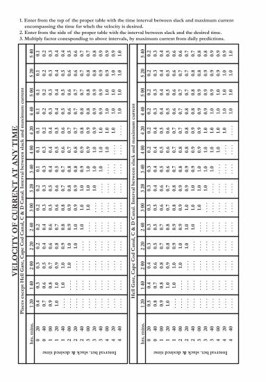
VE
LO
CIT
Y O
F C
UR
RE
NT
AT
AN
Y T
IME
Pla
ces
exce
pt H
ell G
ate,
Cap
e C
od C
anal
, C &
D C
anal
. Int
erva
l bet
wee
n sl
ack
and
max
imum
cur
rent
hrs. 0 0 1 1 1 2 2 2 3 3 3 4 4 4
Interval bet. slack & desired timem
ins.
20 40 00 20 40 00 20 40 00 20 40 00 20 40
1 20 0.4
0.7
0.9
1.0
. . .
.. .
. .
. . .
.. .
. .
. . .
.. .
. .
. . .
.. .
. .
. . .
.. .
. .
1 40 0.3
0.6
0.8
1.0
1.0
. . .
.. .
. .
. . .
.. .
. .
. . .
.. .
. .
. . .
.. .
. .
. . .
.
2 00 0.3
0.5
0.7
0.9
1.0
1.0
. . .
.. .
. .
. . .
.. .
. .
. . .
.. .
. .
. . .
.. .
. .
2 20 0.2
0.4
0.6
0.8
0.9
1.0
1.0
. . .
.. .
. .
. . .
.. .
. .
. . .
.. .
. .
. . .
.
2 40 0.2
0.4
0.6
0.7
0.8
0.9
1.0
1.0
. . .
.. .
. .
. . .
.. .
. .
. . .
.. .
. .
3 00 0.2
0.3
0.5
0.6
0.8
0.9
0.9
1.0
1.0
. . .
.. .
. .
. . .
.. .
. .
. . .
.
3 20 0.2
0.3
0.5
0.6
0.7
0.8
0.9
1.0
1.0
1.0
. . .
.. .
. .
. . .
.. .
. .
3 40 0.1
0.3
0.4
0.5
0.7
0.8
0.8
0.9
1.0
1.0
1.0
. . .
.. .
. .
. . .
.
4 00 0.1
0.3
0.4
0.5
0.6
0.7
0.8
0.9
0.9
1.0
1.0
1.0
. . .
.. .
. .
4 40 0.1
0.2
0.3
0.4
0.5
0.6
0.7
0.8
0.8
0.9
0.9
1.0
1.0
1.0
4 20 0.1
0.2
0.4
0.5
0.6
0.7
0.7
0.8
0.9
0.9
1.0
1.0
1.0
. . .
.
5 00 0.1
0.2
0.3
0.4
0.5
0.6
0.7
0.7
0.8
0.9
0.9
1.0
1.0
1.0
5 20 0.1
0.2
0.3
0.4
0.5
0.6
0.6
0.7
0.8
0.8
0.9
0.9
1.0
1.0
5 40 0.1
0.2
0.3
0.4
0.4
0.5
0.6
0.7
0.7
0.8
0.9
0.9
0.9
1.0
Hel
l Gat
e, C
ape
Cod
Can
al, C
& D
Can
al. I
nter
val b
etw
een
slac
k an
d m
axim
um c
urre
nt
hrs. 0 0 1 1 1 2 2 2 3 3 3 4 4 4
Interval bet. slack & desired time
min
s.20 40 00 20 40 00 20 40 00 20 40 00 20 40
1 20 0.5
0.8
0.9
1.0
. . .
.. .
. .
. . .
.. .
. .
. . .
.. .
. .
. . .
.. .
. .
. . .
.. .
. .
1 40 0.4
0.7
0.8
1.0
1.0
. . .
.. .
. .
. . .
.. .
. .
. . .
.. .
. .
. . .
.. .
. .
. . .
.
2 00 0.4
0.6
0.8
0.9
1.0
1.0
. . .
.. .
. .
. . .
.. .
. .
. . .
.. .
. .
. . .
.. .
. .
2 20 0.3
0.5
0.7
0.8
0.9
1.0
1.0
. . .
.. .
. .
. . .
.. .
. .
. . .
.. .
. .
. . .
.
2 40 0.3
0.5
0.7
0.8
0.9
0.9
1.0
1.0
. . .
.. .
. .
. . .
.. .
. .
. . .
.. .
. .
3 00 0.3
0.5
0.6
0.7
0.8
0.9
1.0
1.0
1.0
. . .
.. .
. .
. . .
.. .
. .
. . .
.
3 20 0.3
0.4
0.6
0.7
0.8
0.9
0.9
1.0
1.0
1.0
. . .
.. .
. .
. . .
.. .
. .
3 40 0.3
0.4
0.5
0.6
0.7
0.8
0.9
0.9
1.0
1.0
1.0
. . .
.. .
. .
. . .
.
4 00 0.2
0.4
0.5
0.6
0.7
0.8
0.8
0.9
0.9
1.0
1.0
1.0
. . .
.. .
. .
4 40 0.2
0.3
0.4
0.5
0.6
0.7
0.8
0.8
0.9
0.9
1.0
1.0
1.0
1.0
4 20 0.2
0.4
0.5
0.6
0.7
0.7
0.8
0.9
0.9
1.0
1.0
1.0
1.0
. . .
.
5 00 0.2
0.3
0.4
0.5
0.6
0.7
0.7
0.8
0.9
0.9
0.9
1.0
1.0
1.0
5 20 0.2
0.3
0.4
0.5
0.6
0.7
0.7
0.8
0.8
0.9
0.9
0.9
1.0
1.0
5 40 0.2
0.3
0.4
0.5
0.6
0.6
0.7
0.7
0.8
0.8
0.9
0.9
0.9
1.0
1. Enter from the top of the proper table with tbe time interval between slack and maximum current encompassing the time for wheh the velocity is desired.2. Enter from the side of the proper table with the interval between slack and the desired time.3. Multiply factor conespondiug to above intervals, by maximum current from daily predictions.
Tidal Differences & Other Constants on New York, NY
PLACE
POSITION
LAT. LONG.
NEW YORK
East River
NEW YORK and NEW JERSEYNew York Harbor
Hudson River*
* Values for the Hudson River above the George Washington Bridge are based uponaverages for the six months May to October period, when the fresh-water dischargeis a minimum.
DIFFERENCESTIME HEIGHT
Highwater
Lowwater
Highwater
Lowwater
40 47 73 55 + 2 59 + 3 45 + 1.4 0.040 47 73 56 + 2 04 + 2 07 + 0.5 0.040 47 73 56 + 1 52 + 1 34 + 0.1 0.040 46 73 56 + 1 49 + 1 28 + 0.2 0.040 46 73 57 + 1 34 + 1 13 - 0.1 0.040 45 73 58 + 1 07 + 0 48 - 0.3 0.040 44 73 57 + 1 22 + 0 56 - 0.5 0.040 43 73 55 + 1 34 + 1 07 - 0.4 0.040 44 73 58 + 1 12 + 1 06 - 0.4 0.040 44 73 58 + 1 06 + 1 01 - 0.5 0.040 43 73 58 + 0 59 + 0 45 - 0.5 0.040 43 73 58 + 0 56 + 0 41 - 0.5 0.040 42 73 58 + 0 32 + 0 22 - 0.3 0.040 42 74 00 + 0 17 + 0 10 - 0.3 0.0
40 38 74 02 - 0 20 - 0 21 0.0 0.040 39 74 04 - 0 17 - 0 15 - 0.1 0.040 41 74 06 - 0 15 - 0 05 - 0.1 0.040 40 74 01 - 0 15 - 0 12 - 0.2 0.040 42 74 01 - 0 07 - 0 03 - 0.2 0.040 42 74 01 Daily Predictions
40 43 74 02 + 0 11 + 0 10 - 0.2 0.040 43 74 01 + 0 14 + 0 13 - 0.2 0.040 45 74 01 + 0 21 + 0 19 - 0.3 0.040 45 74 01 + 0 21 + 0 19 - 0.3 0.040 46 74 01 + 0 28 + 0 26 - 0.4 0.040 47 74 00 + 0 31 + 0 29 - 0.4 0.040 49 73 58 + 0 41 + 0 38 - 0.6 0.040 51 73 57 + 0 50 + 0 46 - 0.7 0.0
h. m. h. m. feet feet’ ’N. W.
41

Tidal Differences & Other Constants on New York, NY
PLACE
POSITION
LAT. LONG.
NEW YORK
DIFFERENCESTIME HEIGHT
Highwater
Lowwater
Highwater
Lowwater
h. m. h. m. feet feet’ ’N. W.
Hudson River, continued
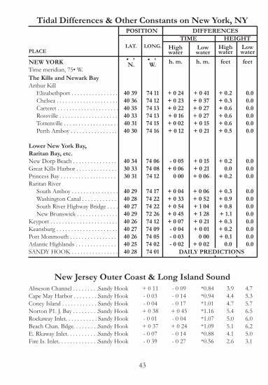
The Kills and Newark BayKill Van Kull
40 5340 5440 5641 0141 0541 1041 1241 1741 2441 3041 3541 4241 4741 5642 0442 1342 1542 39
40 3940 3940 3840 3940 3940 4040 4140 4440 4440 4740 51
40 4440 4840 5140 53
73 5673 5573 5473 5373 5273 5273 5873 5673 5774 0073 5773 5773 5773 5873 5673 5173 4873 45
74 0574 0574 0874 0874 1074 0874 0874 0774 1074 0974 07
74 0674 0474 0274 02
+ 1 02+ 0 49+ 1 13+ 1 33+ 1 49+ 1 57+ 2 03+ 2 28+ 3 20+ 3 46+4 04
+ 4 34+ 5 00+ 5 20+ 5 50+ 6 41+ 6 58
- 0 30- 0 08
+ 0 01+ 0 07+ 0 10- 0 02
+ 0 03 0 00
+ 0 26+ 0 04+ 0 53
+ 0 13+ 1 17+ 1 26+ 1 37
+ 0 56+ 0 49+ 1 13+ 1 43+ 1 57+ 2 17+ 2 28+ 3 03+ 3 40+ 4 03+ 4 28+ 4 46+ 5 12+ 5 34+ 6 04+ 6 58+ 7 12
- 0 18- 0 15
+ 0 08+ 0 06+ 0 21+ 0 15+ 0 21+ 0 22+ 0 55+ 0 43+ 2 00
+ 0 36+ 1 12+ 1 17+ 2 01
- 0.8- 0.7- 0.9- 1.2- 1.4- 1.5- 1.7- 1.4- 1.6- 1.6- 1.6- 1.4- 1.4- 1.0- 0.9- 0.8- 1.0
- 0.1- 0.1- 0.1
0.00.0
+ 0.5+ 0.5+ 0.7+ 0.5+ 0.9+ 0.5
+0.4+ 0.5+ 0.7+ 0.7
0.00.00.00.00.00.00.0
+ 0.3+ 0.3+ 0.2+ 0.1+ 0.1
0.0- 0.1- 0.2- 0.3- 0.4
0.00.00.00.00.00.00.00.00.00.00.0
0.00.00.00.0
DAILY PREDICTIONS
42
Tidal Differences & Other Constants on New York, NY
PLACE
POSITION
LAT. LONG.
NEW YORK
DIFFERENCESTIME HEIGHT
Highwater
Lowwater
Highwater
Lowwater
h. m. h. m. feet feet’ ’N. W.
40 3940 3640 3540 3340 3140 30
40 3430 3330 31
40 2940 2840 2740 2940 2640 2740 2640 2540 28
74 1174 1274 1374 1374 1574 16
74 0674 0874 12
74 1774 2274 2272 2674 1274 0974 0574 0274 01
+ 0 24+ 0 23+ 0 22+ 0 16+ 0 02+ 0 12
- 0 05+ 0 06
0 00
+ 0 04+ 0 33+ 0 54+ 0 45+ 0 07- 0 04- 0 03- 0 02
+ 0 41+ 0 37+ 0 27+ 0 27+ 0 15+ 0 21
+ 0 15+ 0 21+ 0 06
+ 0 06+ 0 52+ 1 04+ 1 28+ 0 21+ 0 01
0 00+ 0 02
+ 0.2+ 0.3+ 0.6+ 0.6+ 0.6+ 0.5
+ 0.20.0
+ 0.2
+ 0.3+ 0.9+ 0.8+ 1.1+ 0.3+ 0.2+ 0.1
0.0
0.00.00.00.00.00.0
0.00.00.0
0.00.00.00.00.00.00.00.0
The Kills and Newark BayArthur Kill
Lower New York Bay,Raritan Bay, etc.
Raritan River
DAILY PREDICTIONS
New Jersey Outer Coast & Long Island SoundSandy HookSandy HookSandy HookSandy HookSandy HookSandy HookSandy HookSandy Hook
+ 0 11- 0 03- 0 04+ 0 38- 0 01+ 0 37- 0 07- 0 39
- 0 09- 0 14- 0 17+ 0 45- 0 04+ 0 24- 0 14- 0 27
43

Current Differences and ConstantsReference Station - The Narrws
New York Lower Bay and Raritan Bay & RiverAmbrose Entrance . . . . . .Coney Is. Channel . . . . . . . The Narrows . . . . . . . . . . . . DAILY PREDICTIONSoff Sandy Hook Pt . . . .. . .S W Spit . . . . . . . . . . . . . . .Channel Seguine Pt. . . . . . Channel Seguine Pt. 34 . . .P. Amboy R.R. Br. . . . . . . .
Upper Bay & Hudson RiverBay Ridge Channel 15' . . .Bay Ridge Channel 36' . . Red Hook Channel . . . . . E. of Robbins Reef . . . . .I mi. W of Red Hook . . . .E. of Liberry . . . . . . . . . . NW of Battery . . . . . . . . . Grant's Tomb 16' . . . . . . . Grant's Tomb 18' . . . . . . .G. Washington Br . . . . . . . Riverdale . . . . . . . . . . . . . . Haverstraw . . . . . . . . . . . . Peekskill . . . . . . . . . . . . . . West Point . . . . . . . . . . . . Newburgh . . . . . . . . . . . . Poughkeepsie . . . . . . . . . . Kingston . . . . . . . . . . . . . . Hudson . . . . . . . . . . . . . . . Albany . . . . . . . . . . . . . . . . Troy . . . . . . . . . . . . . . . . . .
Min.BeforeFlood
h.m.
Max.Flood
h.m.
Min.Before
Ebb
h.m.
Max.Ebb
h.m.
Max.Flood
kts. deg.
Max.Ebb
kts.
TIME DIFFERENCES AVG. SP. / DIR.
PLACE
- 0 57- 1 21
- 1 51- 1 45- 2 02- 3 38- 2 12
- 0 58- 1 35- 1 03
+ 0 16+ 0 41+ 0 57+ 0 49+ 1 10+ 1 04+ 1 41+ 2 11+ 2 55+ 3 10+ 3 32+ 3 50+ 4 26+ 5 09+ 6 23+ 8 29
- 1 10- 0 44
- 1 55- 2 00- 2 50- 2 51- 2 25
- 1 26- 2 36- 0 44
+ 0 16+ 1 06+ 0 58+ 1 12+ 0 46+ 1 18+ 1 55+ 2 07+ 3 08+ 3 24+ 3 47+ 4 06+ 4 37+ 5 09+ 6 45+ 7 32
- 0 25- 0 24
- 1 30- 1 50- 0 48- 0 13- 1 15
+ 0 04- 0 50- 0 08
+ 0 02+ 0 47+ 0 56+ 1 22+ 1 42+ 1 58+ 1 50+ 2 02+ 3 13+ 3 33+ 3 51+ 4 03+ 4 21+ 4 54+ 6 20+ 6 46
- 0 07- 0 48
- 1 50- 1 42- 2 08- 2 24- 2 01
- 1 17- 0 09- 0 30
+ 0 24+ 0 52+ 0 59+ 2 18+ 2 06+ 1 27+ 2 08+ 2 32+ 3 26+ 3 42+ 4 04+ 4 21+ 4 49+ 5 19+ 6 15+ 7 47
1.61.1
2.00.60.70.50.9
1.00.61.01.31.31.41.41.61.81.61.40.80.81.00.91.11.31.60.3
303293
235263281285326
032037353016024031009024025020015355000010005005005030020
1.71.2
1.60.60.30.20.7
0.70.40.71.62.31.91.41.91.82.22.01.31.21.11.11.21.62.00.80.7
68

Current Differences and ConstantsReference Station - The Narrws
Kill Van Kull & Arthur KillW. New Brighton 15' . . . . . . .W. New Brighton 12' . . . . . . .Elizabeth port. . . . . . . . . . . .Carteret . . . . . . . . . . . . . . . . . Tufts Point . . . . . . . . . . . . . . .Tottenville 15' . . . . . . . . . . . . .Tottenville 32' . . . . . . . . . . . .
Newark Bay, Hackensack & Passaic RiversSouth Reach . . . . . . . . . . . . . Lincoln Hway. H. River . . . . Lincoln Hway. P. River. . . . . .
East River Reference Station Hell GateButtermilk Channel . . . . . . . . (See Caution Note)Brooklyn Bridge . . . . . . . . . . Corlears Hook . . . . . . . . . . . .Off Pier 67, 19th St. . . . . . .Hell Gate . . . . . . . . . . . . . . . . DAILY PREDICTIONSPort Morris . . . . . . . . . . . . . .Hunts Point SW of . . . . . . .Old Ferry Point . . . . . . . . . .
Caution: During the first 2 hours of flood in channel north of Governors Island, the current in the Hudson River is still ebbing, while during the first 1.5 hours of ebb in this channel the current in the Hudson is still flooding.
Min.BeforeFlood
h.m.
Max.Flood
h.m.
Min.Before
Ebb
h.m.
Max.Ebb
h.m.
Max.Flood
kts. deg.
Max.Ebb
kts.
TIME DIFFERENCES AVG. SP. / DIR.
PLACE
- 1 44- 2 00
+ 0 05- 0 18- 0 48- 1 14- 1 33
- 0 56- 0 06- 0 31
- 0 12
- 0 18- 0 05- 0 08
- 0 17+ 0 01- 0 34
- 2 08- 2 19- 0 09- 0 54- 0 44- 1 25- 1 05
- 1 45+ 0 12- 0 19
- 0 18
+ 0 08+ 0 12+ 0 08
+ 0 04- 0 10- 0 46
- 1 24- 1 38
+ 0 32+ 0 31- 0 24- 0 33- 0 48
- 0 51+ 0 47- 0 12
- 0 06
- 0 04- 0 01- 0 08
- 0 06+ 0 01- 0 10
- 1 43- 1 14
+ 0 04+ 0 29- 1 00- 1 23- 1 03
- 1 06- 0 14- 0 20
+ 0 18
- 0 07+ 0 10+ 0 07
- 0 12- 0 05- 1 27
1.31.31.40.91.21.00.6
0.70.90.6
1.8
2.92.71.8
1.51.71.7
262259090015109023026
031017009
050
046020355
054108076
1.91.41.10.81.21.10.5
0.70.80.5
2.4
3.52.91.9
1.21.31.0
69

Changes of Meters into Feet and Inches
3.03.13.23.33.43.53.63.73.83.9
4.04.14.24.34.44.54.64.74.84.9
5.05.15.25.35.45.55.65.75.85.9
6.06.16.26.36.46.56.66.76.86.9
7.07.17.27.37.4
09 1010 0210 0610 1011 0211 0611 1012 0212 0612 09
13 0113 0513 0914 0114 0514 0915 0115 0515 0916 01
16 0516 0917 0117 0417 0818 0018 0418 0819 0019 04
19 0820 0020 0420 0821 0021 0421 0822 0022 0422 08
22 1123 0323 0723 1124 03
METERS FEET
7.57.67.77.87.9
8.08.18.28.38.48.58.68.78.88.9
9.09.19.29.39.49.59.69.79.89.9
10.010.110.210.310.410.510.610.710.810.9
11.011.111.211.311.411.511.611.711.811.9
24 0724 1125 0325 0725 11
26 0326 0726 1127 0327 0627 1028 0228 0628 1029 02
29 0629 1030 0230 0630 1031 0231 0631 1032 0232 06
32 1033 0233 0633 0934 0134 0534 0935 0135 0535 09
36 0136 0536 0937 0137 0537 0938 0138 0538 0939 00
METERS FEET
12.012.112.212.312.412.512.612.712.812.9
13.013.113.213.313.413.513.613.713.813.9
14.014.114.214.314.414.514.614.714.814.9
15.015.115.215.315.415.515.615.715.815.9
16.016.116.216.316.4
39 0439 0840 0040 0440 0841 0041 0441 0842 0042 04
42 08 43 0043 0443 0844 0044 0344 0744 1145 0345 07
45 1146 0346 0746 1147 0347 0747 1148 0348 0748 11
49 0349 0649 1050 0250 0650 1051 0251 0651 1052 02
52 0652 1053 0253 0653 10
METERS FEET
16.516.616.716.816.9
17.017.117.217.317.417.517.617.717.817.9
18.018.118.218.318.418.518.618.718.818.9
19.019.119.219.319.419.519.619.719.819.9
20.020.120.220.320.420.520.620.720.820.9
54 0254 0654 0955 0155 05
55 0956 0156 0556 0957 0157 0557 0958 0158 0558 09
59 0159 0559 0960 0060 0460 0861 0061 0461 0862 00
62 0462 0863 0063 0463 0864 0064 0464 0865 0065 03
65 0765 1166 0366 0766 1167 0367 0767 1168 0368 07
METERS FEET
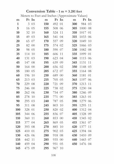
Conversion Table - 1 m = 3.281 feetMeters to Feet and Inches (Approximate Values)
m15101520253035404550556065707580859095100105110115120125130135140145
Ft3
163249658298
114131147164180196213229246262278295311328344360377393410426442459475
In030510030700051003080005100308000610030801061104080106110409
m150155160165170175180185190195200205210215220225230235240245250255260265270275280285290295
Ft492508524541557574590606623639656672689705721738754771787803820836853869885902918935951967
In010611040902071104090207000509020700051002070005100308000510
m300305310315320325330335340345350355360365370375380385390395400405410415420425430440450
Ft984
1000101710331049106610821099111511311148116411811197121312301246126312791295131213281345136113771394141014431476
In0308010610030801061103080106110409010611040902071104090704
108

130
Su
06132027
Mo
07142128
Tu0108152229
We0209162330
Th0310172431
Fr04111825
Sa05121926
January
February
March
April
May
June
Su
07142128
Mo0108152229
Tu0209162330
We03101724
Th04111825
Fr05121926
Sa06132027
July
August
September
October
November
December
2019
Su
03101724
Mo
04111825
Tu
05121926
We
06132027
Th
07142128
Fr01081522
Sa02091623
Su
0310172431
Mo
04111825
Tu
05121926
We
06132027
Th
07142128
Fr0108152229
Sa0209162330
Su
07142128
Mo0108152229
Tu0209162330
We03101724
Th04111825
Fr05121926
Sa06132027
Su
05121926
Mo
06132027
Tu
07142128
We0108152229
Th0209172330
Fr0310182431
Sa04111925
Su
0209162330
Mo
03101724
Tu
04111825
We
05121926
Th
06132027
Fr
07142128
Sa0108152229
Su
04111825
Mo
05121926
Tu
06132027
We
07142128
Th0108152229
Fr0209162330
Sa0310172431
Su0108152229
Mo0209162330
Tu03101724
We04111825
Th05121926
Fr06132027
Sa07142128
Su
06132027
Mo
07142128
Tu0108152229
We0209162330
Th0310172431
Fr04111825
Sa05121926
Su
03101724
Mo
04111825
Tu
05121926
We
06132027
Th
07142128
Fr0108152229
Sa0209162330
Su0108152229
Mo0209162330
Tu0310172431
We04111825
Th05121926
Fr06132027
Sa07142128

131
2020January July
Su Mo Tu We Th Fr Sa Su Mo Tu We Th Fr Sa1 2 3 4 1 2 3 45 6 7 8 9 10 11 5 6 7 8 9 10 1112 13 14 15 16 17 18 12 13 14 15 16 17 1819 20 21 22 23 24 25 19 20 21 22 23 24 25
26 27 28 29 30 31 26 27 28 29 30 31
February AugustSu Mo Tu We Th Fr Sa Su Mo Tu We Th Fr Sa
1 12 3 4 5 6 7 8 2 3 4 5 6 7 89 10 11 12 13 14 15 9 10 11 12 13 14 1516 17 18 19 20 21 22 16 17 18 19 20 21 2223 24 25 26 27 28 29 23 24 25 26 27 28 29
30 31March September
Su Mo Tu We Th Fr Sa Su Mo Tu We Th Fr Sa1 2 3 4 5 6 7 1 2 3 4 58 9 10 11 12 13 14 6 7 8 9 10 11 1215 16 17 18 19 20 21 13 14 15 16 17 18 1922 23 24 25 26 27 28 20 21 22 23 24 25 2629 30 31 27 28 29 30
April October
Su Mo Tu We Th Fr SaSu Mo Tu We Th Fr Sa
1 2 3 41 2 3
5 6 7 8 9 10 114 5 6 7 8 9 10
12 13 14 15 16 17 1811 12 13 14 15 16 17
19 20 21 22 23 24 2518 19 20 21 22 23 24
26 27 28 29 30 3125 26 27 28 29 30 31
May NovemberSu Mo Tu We Th Fr Sa Su Mo Tu We Th Fr Sa
1 2 1 2 3 4 5 6 73 4 5 6 7 8 9 8 9 10 11 12 13 1410 11 12 13 14 15 16 15 16 17 18 19 20 2117 18 19 20 21 22 23 22 23 24 25 26 27 2824 25 26 27 28 29 30 29 3031
June DecemberSu Mo Tu We Th Fr Sa Su Mo Tu We Th Fr Sa
1 2 3 4 5 6 1 2 3 4 57 8 9 10 11 12 13 6 7 8 9 10 11 1214 15 16 17 18 19 20 13 14 15 16 17 18 1921 22 23 24 25 26 27 20 21 22 23 24 25 2628 29 30 27 28 29 30 31
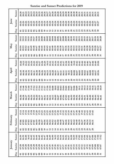
Janu
ary
Feb
ruar
yM
arch
Apr
ilM
ayJu
ne
Sunrise and Sunset Predictions for 2019
Day
Sunr
ise
Suns
etD
aySu
nris
eSu
nset
Day
Sunr
ise
Suns
etD
aySu
nris
eSu
nset
Day
Sunr
ise
Suns
etD
aySu
nris
eSu
nset
01 02 03 04 05 06 07 08 09 10 11 12 13 14 15 16 17 18 19 20 21 22 23 24 25 26 27 28 29 30 31
07:2
0 07
:20
07:2
0 07
:20
07:2
0 07
:20
07:2
0 07
:20
07:1
9 07
:19
07:1
9 07
:19
07:1
8 07
:18
07:1
8 07
:17
07:1
7 07
:16
07:1
6 07
:15
07:1
4 07
:14
07:1
3 07
:12
07:1
2 07
:11
07:1
0 07
:09
07:0
8 07
:08
07:0
7
16:3
9 16
:39
16:4
0 16
:41
16:4
2 16
:43
16:4
4 16
:45
16:4
6 16
:47
16:4
8 16
:49
16:5
0 16
:51
16:5
2 16
:54
16:5
5 16
:56
16:5
7 16
:58
16:5
9 17
:01
17:0
2 17
:03
17:0
4 17
:05
17:0
7 17
:08
17:0
9 17
:10
17:1
2
01 02 03 04 05 06 07 08 09 10 11 12 13 14 15 16 17 18 19 20 21 22 23 24 25 26 27 28
07:0
6 07
:05
07:0
4 07
:03
07:0
2 07
:01
06:5
9 06
:58
06:5
7 06
:56
06:5
5 06
:54
06:5
2 06
:51
06:5
0 06
:48
06:4
7 06
:46
06:4
4 06
:43
06:4
2 06
:40
06:3
9 06
:37
06:3
6 06
:34
06:3
3 06
:31
17:1
3 17
:14
17:1
5 17
:16
17:1
8 17
:19
17:2
0 17
:21
17:2
3 17
:24
17:2
5 17
:26
17:2
8 17
:29
17:3
0 17
:31
17:3
2 17
:34
17:3
5 17
:36
17:3
7 17
:38
17:4
0 17
:41
17:4
2 17
:43
17:4
4 17
:45
01 02 03 04 05 06 07 08 09 10 11 12 13 14 15 16 17 18 19 20 21 22 23 24 25 26 27 28 29 30 31
06:3
0 06
:28
06:2
7 06
:25
06:2
4 06
:22
06:2
0 06
:19
06:1
7 06
:16
06:1
4 06
:12
06:1
1 06
:09
06:0
7 06
:06
07:0
4 07
:03
07:0
1 06
:59
06:5
8 06
:56
06:5
4 06
:53
06:5
1 06
:49
06:4
8 06
:46
06:4
4 06
:43
06:4
1
17:4
6 17
:48
17:4
9 17
:50
17:5
1 17
:52
17:5
3 17
:54
17:5
5 17
:57
17:5
8 17
:59
18:0
0 18
:01
18:0
2 18
:03
19:0
4 19
:05
19:0
6 19
:07
19:0
8 19
:09
19:1
1 19
:12
19:1
3 19
:14
19:1
5 19
:16
19:1
7 19
:18
19:1
9
01 02 03 04 05 06 07 08 09 10 11 12 13 14 15 16 17 18 19 20 21 22 23 24 25 26 27 28 29 30
06:3
9 06
:38
06:3
6 06
:34
06:3
3 06
:31
06:3
0 06
:28
06:2
6 06
:25
06:2
3 06
:22
06:2
0 06
:19
06:1
7 06
:15
06:1
4 06
:12
06:1
1 06
:09
06:0
8 06
:07
06:0
5 06
:04
06:0
2 06
:01
06:0
0 05
:58
05:5
7 05
:56
19:2
0 19
:21
19:2
2 19
:23
19:2
4 19
:25
19:2
6 19
:27
19:2
8 19
:29
19:3
1 19
:32
19:3
3 19
:34
19:3
5 19
:36
19:3
7 19
:38
19:3
9 19
:40
19:4
1 19
:42
19:4
3 19
:44
19:4
5 19
:46
19:4
7 19
:48
19:4
9 19
:50
01 02 03 04 05 06 07 08 09 10 11 12 13 14 15 16 17 18 19 20 21 22 23 24 25 26 27 28 29 30 31
05:5
4 05
:53
05:5
2 05
:51
05:4
9 05
:48
05:4
7 05
:46
05:4
5 05
:44
05:4
3 05
:41
05:4
0 05
:39
05:3
8 05
:38
05:3
7 05
:36
05:3
5 05
:34
05:3
3 05
:32
05:3
2 05
:31
05:3
0 05
:30
05:2
9 05
:28
05:2
8 05
:27
05:2
7
19:5
2 19
:53
19:5
4 19
:55
19:5
6 19
:57
19:5
8 19
:59
20:0
0 20
:01
20:0
2 20
:03
20:0
4 20
:05
20:0
6 20
:07
20:0
8 20
:09
20:1
0 20
:10
20:1
1 20
:12
20:1
3 20
:14
20:1
5 20
:16
20:1
7 20
:17
20:1
8 20
:19
20:2
0
01 02 03 04 05 06 07 08 09 10 11 12 13 14 15 16 17 18 19 20 21 22 23 24 25 26 27 28 29 30
05:2
6 05
:26
05:2
6 05
:25
05:2
5 05
:25
05:2
4 05
:24
05:2
4 05
:24
05:2
4 05
:24
05:2
4 05
:24
05:2
4 05
:24
05:2
4 05
:24
05:2
4 05
:24
05:2
4 05
:24
05:2
5 05
:25
05:2
5 05
:26
05:2
6 05
:26
05:2
7 05
:27
20:2
0 20
:21
20:2
2 20
:23
20:2
3 20
:24
20:2
5 20
:25
20:2
6 20
:26
20:2
7 20
:27
20:2
8 20
:28
20:2
8 20
:29
20:2
9 20
:30
20:3
0 20
:30
20:3
0 20
:30
20:3
1 20
:31
20:3
1 20
:31
20:3
1 20
:31
20:3
1 20
:31

July
Aug
ust
Sept
embe
rO
ctob
erN
ovem
ber
Dec
embe
r
Sunrise and Sunset Predictions for 2019
Day
Sunr
ise
Suns
etD
aySu
nris
eSu
nset
Day
Sunr
ise
Suns
etD
aySu
nris
eSu
nset
Day
Sunr
ise
Suns
etD
aySu
nris
eSu
nset
01 02 03 04 05 06 07 08 09 10 11 12 13 14 15 16 17 18 19 20 21 22 23 24 25 26 27 28 29 30 31
05:2
8 05
:28
05:2
9 05
:29
05:3
0 05
:31
05:3
1 05
:32
05:3
2 05
:33
05:3
4 05
:35
05:3
5 05
:36
05:3
7 05
:38
05:3
8 05
:39
05:4
0 05
:41
05:4
2 05
:43
05:4
3 05
:44
05:4
5 05
:46
05:4
7 05
:48
05:4
9 05
:50
05:5
1
20:3
1 20
:31
20:3
0 20
:30
20:3
0 20
:30
20:2
9 20
:29
20:2
9 20
:28
20:2
8 20
:27
20:2
7 20
:26
20:2
6 20
:25
20:2
4 20
:24
20:2
3 20
:22
20:2
2 20
:21
20:2
0 20
:19
20:1
8 20
:17
20:1
6 20
:15
20:1
4 20
:13
20:1
2
01 02 03 04 05 06 07 08 09 10 11 12 13 14 15 16 17 18 19 20 21 22 23 24 25 26 27 28 29 30 31
05:5
2 05
:53
05:5
4 05
:55
05:5
6 05
:57
05:5
8 05
:59
06:0
0 06
:01
06:0
2 06
:02
06:0
3 06
:04
06:0
5 06
:06
06:0
7 06
:08
06:0
9 06
:10
06:1
1 06
:12
06:1
3 06
:14
06:1
5 06
:16
06:1
7 06
:18
06:1
9 06
:20
06:2
1
20:1
1 20
:10
20:0
9 20
:08
20:0
7 20
:05
20:0
4 20
:03
20:0
2 20
:01
19:5
9 19
:58
19:5
7 19
:55
19:5
4 19
:52
19:5
1 19
:50
19:4
8 19
:47
19:4
5 19
:44
19:4
2 19
:41
19:3
9 19
:38
19:3
6 19
:34
19:3
3 19
:31
19:3
0
01 02 03 04 05 06 07 08 09 10 11 12 13 14 15 16 17 18 19 20 21 22 23 24 25 26 27 28 29 30
06:2
2 06
:23
06:2
4 06
:25
06:2
6 06
:27
06:2
8 06
:29
06:3
0 06
:31
06:3
2 06
:33
06:3
4 06
:35
06:3
6 06
:37
06:3
8 06
:39
06:4
0 06
:41
06:4
2 06
:43
06:4
4 06
:45
06:4
6 06
:47
06:4
8 06
:49
06:5
0 06
:51
19:2
8 19
:26
19:2
5 19
:23
19:2
2 19
:20
19:1
8 19
:17
19:1
5 19
:13
19:1
2 19
:10
19:0
8 19
:07
19:0
5 19
:03
19:0
1 19
:00
18:5
8 18
:56
18:5
5 18
:53
18:5
1 18
:50
18:4
8 18
:46
18:4
5 18
:43
18:4
1 18
:40
01 02 03 04 05 06 07 08 09 10 11 12 13 14 15 16 17 18 19 20 21 22 23 24 25 26 27 28 29 30 31
06:5
2 06
:53
06:5
4 06
:55
06:5
6 06
:57
06:5
8 06
:59
07:0
0 07
:01
07:0
2 07
:03
07:0
4 07
:05
07:0
6 07
:08
07:0
9 07
:10
07:1
1 07
:12
07:1
3 07
:14
07:1
5 07
:16
07:1
8 07
:19
07:2
0 07
:21
07:2
2 07
:23
07:2
4
18:3
8 18
:36
18:3
5 18
:33
18:3
1 18
:30
18:2
8 18
:26
18:2
5 18
:23
18:2
2 18
:20
18:1
9 18
:17
18:1
5 18
:14
18:1
2 18
:11
18:0
9 18
:08
18:0
7 18
:05
18:0
4 18
:02
18:0
1 18
:00
17:5
8 17
:57
17:5
6 17
:54
17:5
3
01 02 03 04 05 06 07 08 09 10 11 12 13 14 15 16 17 18 19 20 21 22 23 24 25 26 27 28 29 30
07:2
6 07
:27
06:2
8 06
:29
06:3
0 06
:31
06:3
3 06
:34
06:3
5 06
:36
06:3
7 06
:39
06:4
0 06
:41
06:4
2 06
:43
06:4
4 06
:46
06:4
7 06
:48
06:4
9 06
:50
06:5
1 06
:52
06:5
4 06
:55
06:5
6 06
:57
06:5
8 06
:59
17:5
2 17
:51
16:5
0 16
:48
16:4
7 16
:46
16:4
5 16
:44
16:4
3 16
:42
16:4
1 16
:40
16:3
9 16
:38
16:3
8 16
:37
16:3
6 16
:35
16:3
4 16
:34
16:3
3 16
:33
16:3
2 16
:31
16:3
1 16
:30
16:3
0 16
:30
16:2
9 16
:29
01 02 03 04 05 06 07 08 09 10 11 12 13 14 15 16 17 18 19 20 21 22 23 24 25 26 27 28 29 30 31
07:0
0 07
:01
07:0
2 07
:03
07:0
4 07
:05
07:0
6 07
:07
07:0
8 07
:08
07:0
9 07
:10
07:1
1 07
:12
07:1
2 07
:13
07:1
4 07
:14
07:1
5 07
:15
07:1
6 07
:17
07:1
7 07
:17
07:1
8 07
:18
07:1
8 07
:19
07:1
9 07
:19
07:1
9
16:2
9 16
:28
16:2
8 16
:28
16:2
8 16
:28
16:2
8 16
:28
16:2
8 16
:28
16:2
8 16
:28
16:2
8 16
:28
16:2
9 16
:29
16:2
9 16
:30
16:3
0 16
:31
16:3
1 16
:31
16:3
2 16
:33
16:3
3 16
:34
16:3
5 16
:35
16:3
6 16
:37
16:3
7

134
Communication Numbers
Phone : (718) 448 - 3900 (N.Y. / N.J. / Hell Gate) (718) 815 - 4316 (Hudson River)
Fax : 1 - 718 - 442 - 2190
E-Mail Addresses : Dispatch or Operational : [email protected] Information : [email protected]
Day & Night
For Arrival, 24-hour ETA required, changes need to
be received no less than 6-hours before scheduled
arrival time. Updated Arrival and Departure
times greatly appreciated