2021 land lease auctions
TRANSCRIPT

2021 Land Lease AuctionsOct. 11 - Oct. 25
Mon Oct. 11 - 2:00 pmTexas Co. Fairgrounds
Guymon, OK
Tues Oct. 12 - 10:00 amWoodward Event Center
Woodward, OK Wed Oct. 13 - 10:00 amGarfield Co. Fairgrounds
Enid, OK
Tues Oct. 19 - 10:00 amComanche Co. Fairgrounds
Lawton, OK
Mon Oct. 18 - 10:00 amElk City Conv. Center
Elk City, OK
Wed Oct. 20 - 10:00 amPayne Co. Expo Center
Stillwater, OK
Mon Oct. 25 - 10:00 amShawnee Expo Center
Shawnee, OK
Mon Oct. 11 - 9:00 amCimarron Co. Fairgrounds
Boise City, OK

Notice of Invitation to Bid............................................................................................................................................................................Alfalfa County................................................................................................................................................................................................Beaver County................................................................................................................................................................................................Beckham County............................................................................................................................................................................................Blaine County.................................................................................................................................................................................................Caddo County.................................................................................................................................................................................................Canadian County...........................................................................................................................................................................................Cimarron County...........................................................................................................................................................................................Cleveland County...........................................................................................................................................................................................Comanche County.........................................................................................................................................................................................Cotton County...............................................................................................................................................................................................Ellis County....................................................................................................................................................................................................Garfield County..............................................................................................................................................................................................Grady County.................................................................................................................................................................................................Grant County.................................................................................................................................................................................................Harper County...............................................................................................................................................................................................Jackson County..............................................................................................................................................................................................Kay County.....................................................................................................................................................................................................Kingfisher County.........................................................................................................................................................................................Kiowa County.................................................................................................................................................................................................Lincoln County...............................................................................................................................................................................................Logan County.................................................................................................................................................................................................Major County.................................................................................................................................................................................................Noble County.................................................................................................................................................................................................Oklahoma County..........................................................................................................................................................................................Pawnee County...............................................................................................................................................................................................Payne County................................................................................................................................................................................................. Pottawatomie County....................................................................................................................................................................................Texas County..................................................................................................................................................................................................Tillman County..............................................................................................................................................................................................Washita County..............................................................................................................................................................................................Woods County................................................................................................................................................................................................Woodward County.........................................................................................................................................................................................General Information......................................................................................................................................................................................Contact Information......................................................................................................................................................................................Solar Addendum............................................................................................................................................................................................Assignment Fee Statement...........................................................................................................................................................................Double Cropping Definition..........................................................................................................................................................................
35566777111113141515151616171920212323242525262829313132323434353535
TABLE OF CONTENTS
This publication, printed by Dept. of Central Printing, is issued and authorized by the Commissioners of the Land Office. 8,500 copies have been printed at a cost of $4,420.00. Records in the Land Office are public records and as such are open for public inspection during office hours. The Publications Clearinghouse of the Oklahoma Department of Libraries has received electronic notification of the Uniform Resource Locator (URL) associated with this document.
AUCTION COVID STATEMENTAs the Oklahoma Commissioners of the Land Office (CLO) 2021 Ag Lease Land auctions near, the lead-up has been carefully thought through with you, our valued client, in mind.
CLO’s goal is to conduct live Ag Lease Land auctions closely resembling previous auctions as safely as possible. However, due to local and state laws, 2021 auctions might look and function slightly different. We will follow Centers for Disease Control (CDC) recommendations that are in effect at the time of the auction, which could require the use of masks and social distancing.
To further reduce risks, CLO will be auctioning Ag Lease Lands in county-by-county alphabetical order at each auction so that you can make plans to only attend for the county/counties of your choice. Please visit our website at WWW.CLO.OK.GOV for any updates to auction scheduling and notifications.
Page 2

NOTICE OF INVITATION TO BID AT PUBLIC AUCTION FOR SCHOOL LAND AGRICULTURAL LEASES
The Commissioners of the Land Office of the State of Oklahoma (“CLO”) invite bids on agricultural leases at public auction at the time and place shown on this brochure or as continued to such other place as may be announced at the time of auction.
A lease contract (“Lease”) shall be awarded upon the approval by CLO to the person(s) or entity(ies) bidding the highest annual cash rental. CLO reserves the right to reject any or all bids. CLO may refuse, in its sole discretion for any reason, to accept any bid on an agricultural lease. The party placing the bid must not have breached or be in default of any other lease made with CLO. Any person who disrupts or interferes with the proceedings, other potential bidders, or CLO representatives in the performance of their duty to achieve the best value for the lease, will be disqualified from placing a bid. Any lease obtained in violation of this provision is void. CLO retains ownership and the right to access all leased property.
CLO reserves the right to require financial disclosures and verification of the accuracy of any information provided. CLO may refuse to accept any bid or award any Lease where an interested party cannot show adequate verification or creditworthiness, as determined by the CLO. False or incorrect information will be cause for bid cancellation and the lease will be void at CLO’s discretion.
A bid less than the advertised minimum acceptable bid will not be considered.
On the date of auction, the successful bidder must pay fifty percent (50%) of the first year’s rent as deposit. Any bid of $500 or less must be paid in full. Failure to comply with the terms of this notice of invitation to bid will be cause for the cancellation of the award of the Lease and for the retention or value due of any deposit as liquidated damages. CLO retains the option to proceed to collect for the entire amount that would be owed under the Lease. Leases not executed on the date of the auction are to be returned to CLO not later than fifteen (15) days after the date of the auction. The balance of the bid rental, if any, is to be remitted on or before January 2, each year lease is in effect and before possession is taken of any part of the leased land. Lease payments must be mailed to: Commissioners of the Land Office, Lockbox Account, P.O. Box 248896, Oklahoma City, OK 73124-8896.
Corporate and business entities must be agricultural businesses under Okla. Stat. tit. 18, § 951 et seq. and must be able to show that at least 65% of total annual gross receipts are derived from farming or ranching income or from allowing others to extract minerals underlying the lands. Every entity must provide its officers and/or partners full names and addresses, printed in legible format on the lease, and a service agent address for notices. Every entity must be registered as agricultural with the Oklahoma Secretary of State and be in good standing and provide its Federal Employee ID number. A partner bidding for a partnership must be able to show their authority to contract and bind all members of the partnership. If bidding through an agent, the agent must show its name, address, and authority to sign the Lease as agent for the Lessee(s) and provide all necessary financial, contracting authority, verification, and contact information of the Lessee(s) to contract at auction. Successful bidders must provide each Lessee’s full name and Social Security number to execute a Lease with the CLO.
Improvements located on the leasehold property that are considered movable, without any manifest injury to the land, are to being removed or otherwise disposed of by the lawful owner(s). Any fences required by agreement or by operation of law shall be constructed and paid for by Lessee. Such improvements must be removed or disposed of within sixty (60) days of the expiration of the Lease. Upon removal, the property must be restored to its original condition. Improvements not removed within sixty (60) days after a breach, termination, or expiration of the Lease are considered abandoned and as such, are the exclusive property of the CLO. If there is a growing wheat crop on leased property, irrigation pumps and motors may be left in place until April 1 of the year following the expiration of the Lease. Possession and/or use of a well present upon the leased land will be surrendered to the new Lessee no later than April 5 following the expiration of the Lease term.
CONTINUED ON REVERSE...
Page 3

Improvements located on offered leasehold property considered not movable without manifest injury to the land (i.e. ponds, dams, terraces, water wells, waterways, and other conservation structures, etc.) are a permanent part of the land and are the exclusive property of CLO.
Irrigation permits may be issued to agricultural Lessees for the purpose of irrigating CLO Trust Lands. The permit fee shall be determined by the market value rental amount for irrigated acres for comparable deeded land. Term of the permit will be for one year.
All Leases are awarded subject to existing restrictions, reservations, easements, and all matters of record.
The Lease term will be specified in the auction notice and the Lease.
Small grains planted during the last year of the Lease may be harvested in the next year if the Lease is paid in full, but land must be surrendered immediately after harvest or not later than July 1, each year lease is in effect, whichever is sooner. Extensions may be granted at the discretion of CLO. In the event small grain crop is pastured out and not mechanically harvested, land shall be surrendered no later than June 1, or when cattle are removed, whichever is sooner, in the year following the expiration of the Lease term. If small grain is mowed and baled for hay, those acres must be surrendered when the bales are removed or no more than ten (10) days after baling, but no later than June 1, of that year. All pasture land, including water thereon, must be surrendered December 31st of the final year of the Lease.
The written Lease shall contain the terms and conditions of the agreement between the CLO and Lessee(s) and shall be subject to applicable rules and regulations of CLO and statutes of the State of Oklahoma now in force or hereafter adopted. All bidders are hereby notified to retain this page as it will be incorporated into the Lease.
By submitting a bid, the bidder acknowledges and accepts the terms and conditions of the Lease. In the event of a conflict between the terms contained herein and the terms contained in the Lease, the terms of the Lease shall prevail. Prospective bidders are responsible for inspecting the leasehold property and reviewing the Lease prior to the date of auction and for contacting the Farm Service Agency (FSA) office for allotments, applicable farm program requirements, and eligibility of entering leases into government farm programs after expiration of the lease contract and for complying with all highly erodible land (HEL) requirements.
To receive your FSA payments, FSA requires their records and agricultural lease(s) records match.
ANNOUNCEMENTS AND CORRECTIONS AT THE TIME OF AUCTION SUPERSEDE THIS NOTICE.
Dated this 13th day of August 2021.
Elliot ChambersSecretaryCommissioners of the Land Office
Page 4

ALFALFA COUNTY
Date/Time: 10/13/21 10:00 AM
Place: 111 W. Purdue Garfield County Fairgrounds Chisholm Trail Pavilion Enid, Oklahoma
ALL LEASE TERMS ARE FOR 5 YEARS UNLESS OTHERWISE INDICATED
Lease No Legal and Location Description
Est Cow
Units
Est Acres
Pasture
Est Acres Crop
Est Non
Usable Minimum
Annual Bid 101462 NE/4 SEC 16-28N-11WIM
(LESS IMPROVEMENTS) >>> From Burlington Co-op station, 2 1/2 miles East and 1/2 mile North to SE corner of property <<<
0 2.85 154.65 2.5 $8,400.00
101509 NE/4 SEC 16-23N-12WIM (LESS IMPROVEMENTS) >>> From West side of Aline, 1 1/2 miles West and 2 miles South to NE Corner of property <<<
4 41.97 118.03 0 $5,400.00
101510 SW/4 SEC 16-23N-12WIM (LESS IMPROVEMENTS) >>> From West side of Aline, 2 1/2 miles West and 2 1/2 miles South to NW corner of property <<<
9 108.84 51.16 0 $3,800.00
205267 LTS 1 & 2 & S/2NE/4 SEC 13-29N-10WIM >>> From Byron store, 6 miles North on Hwy 58, 4 miles East and 1/2 mile North to SE corner of property <<<
0 0 106.94 0 $3,200.00
205285 NW/4 SEC 13-24N-11WIM >>> From the McWillie elevator, West of Helena, 1 mile East on Hwy 45 and 1 1/2 mile North to SW corner of property <<<
12 160 0 0 $3,400.00
817089 NW/4 SEC 33-25N-9WIM >>> From Jet intersection of Hwys 38 & 64, 4 miles South to NW corner of property <<<
0 7.61 152.39 0 $8,100.00
817118 NW/4 SEC 33-26N-12WIM (LESS IMPROVEMENTS) >>> From Lambert, 4 1/2 miles West and 1/2 mile North to SW corner of property <<<
0 6.86 153.14 0 $8,400.00
BEAVER COUNTY
Date/Time: 10/11/21 2:00 PM
Place: West 5th & Sunset Lane Texas County Fairgrounds, Commercial Building Guymon, Oklahoma
ALL LEASE TERMS ARE FOR 5 YEARS UNLESS OTHERWISE INDICATED
Lease No Legal and Location Description
Est Cow
Units
Est Acres
Pasture
Est Acres Crop
EstNon Usable
Minimum Annual Bid
102169 W/2 SEC 36-2N-22ECM >>> , From Elmwood, 7 miles West and 1 mile South to NW corner of property <<<
14 320 0 0 $2,800.00
102177 E/2 SEC 16-3N-27ECM >>> , From Slapout, 8 miles North and 2 miles West to NE corner of property <<<
15 320 0 0 $3,000.00
102876 SE/4 SEC 2-3N-26ECM >>>
From Knowles, 9 miles south and 2 miles west to SE corner of property <<<
4 66.8 93.2 0 $3,000.00
102877 SW/4 SEC 3-3N-26ECM >>> From Knowles, 9 miles south and 3 1/2 miles west to SE corner of property <<<
2 45.9 114.1 0 $3,100.00
103129 NE/4 SEC 36-2N-22ECM >>> From Elmwood, 6 miles West and 1 mile South <<<
8 160 0 0 $1,600.00
103140 S/2 SEC 16-4N-27ECM (LESS IMPROVEMENTS) >>> From Gate, 6 miles West and 2 1/2 miles South to NW corner of property <<<
15 320 0 0 $2,900.00
103141 NE/4 SEC 36-5N-27ECM >>> From Gate, 3/4 mile North and 1 1/4 miles West to NE corner of property <<<
4 80.2 79.8 0 $3,200.00
103158 NW/4 & SE/4 SEC 16-1N-25ECM >>> From Elmwood, 7 miles East, 4 miles South and 1 mile East to NW corner of property <<<
12 320 0 0 $2,700.00
103192 SE/4 SEC 16-3N-22ECM >>> From Beaver, 8 miles West, 6 miles South and 1 mile West to SE corner of property <<<
4 79.4 80.6 0 $2,900.00
105216 NW/4 SEC 21-3N-23ECM >>> From Beaver, 5 miles South, 4 miles West and 1 mile South <<<
6 160 0 0 $1,300.00
206222 SE/4 SEC 18-6N-23ECM >>> From Forgan, 3 miles West and 5 miles North to SE corner of property <<<
7 160 0 0 $1,400.00
307517 LTS 1,2 & S/2NE/4 (EXCEPT PT OF NE/4 LYING WEST OF ABANDONED RAILROAD) SEC 4-5N-24ECM >>> , From Forgan, 2 miles East, 3 miles North, 1 1/2 miles East, then 1 mile South across private land to North side of property (Isolated) <<<
6 119.23 0 0 $1,200.00
307522 NW/4 & N/2SW/4 & SE/4SW/4 & SE/4 SEC 27-4N-27ECM >>> From Knowles, 8 miles South and 2 miles East and 1 1/4 miles North (SW part of property) <<<
24 440 0 0 $4,800.00
307629 NE/4 SEC 4-5N-24ECM (LYING WEST OF MK&T ABANDONED RAILROAD) >>> From Forgan, 2 miles East, 3 miles North, 1 1/2 miles East, then 1 mile South across private land to North side of property (Isolated) <<<
2 40 0 0 $400.00
613755 S/2NE/4 & E/2NW/4 SEC 32-6N-23ECM >>> From Forgan, 2 miles West, 3 miles North and 1 1/2 miles West to NE corner of property <<<
8 160 0 0 $1,600.00
Page 5
715125 S/2NE/4 & W/2SE/4 SEC 31-6N-26ECM (SUBJ TO .10 AC STCL 710073) >>> From Knowles, 6 miles West on Hwy 64, 3 miles North and 1/2 mile East to SW corner of property <<<
8 159.9 0 0 $1,600.00
715132 W/2SW/4 SEC 4 & SE/4NE/4 SEC 5-1N-27ECM >>> From Slapout, 3 miles West and 2 1/4 miles South to NE corner of West tract <<<
7 120 0 0 $1,300.00
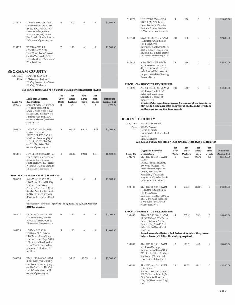
BECKHAM COUNTY
Date/Time: 10/18/21 10:00 AM
Place: 1016 Airport Industrial Elk City Convention Center Elk City, Oklahoma
ALL LEASE TERMS ARE FOR 5 YEARS UNLESS OTHERWISE INDICATED
Lease No Legal and Location Description
Est Cow
Units
Est Acres
Pasture
Est Acres Crop
Est Non
Usable Minimum
Annual Bid 103295 E/2SE/4 SEC 8-7N-26WIM
>>> From stoplight in Erick, 2 miles West, 4-1/2 miles South, 2 miles West, 3 miles South and 1 1/4 miles Southwest (West side of road) <<<
2 80 0 0 $400.00
104135 SW/4 SEC 25-9N-25WIM (SUBJ TO 9.62AC ESMT)(SUBJ TO 5AC RR R/W) >>> From stoplight in Erick, 3 1/2 miles East on Old Hwy 66 to NW corner of property <<<
3 82.22 63.16 14.62 $2,500.00
105131 SE/4 SEC 9-8N-22WIM >>> From Carter intersection of Hwys 55 & 34, 2 miles South on Hwy 34, 3/4 mile West and 1/2 mile South to NE corner of property <<<
4 66.32 92.34 1.34 $3,500.00
SPECIAL CONSERVATION REQUIREMENT:
105219 N/2NW/4 SEC 22-12N-21WIM >>> From Elk City intersection of West Country Club Blvd & North Randall Ave, 6 miles North to NW corner of property (Possible Recreational Use) <<<
4 80 0 0 $1,200.00
Chemically control mesquite trees by January 1, 2024. Contact RMS for details.
105371 NE/4 SEC 24-8N-25WIM >>> From Delhi, 6 miles West and 1 mile South to NE corner of property <<<
9 160 0 0 $2,200.00
105373 S/2SW/4 SEC 12 & E/2NW/4 SEC 13-10N-24WIM >>> From Sayre intersection of Hwys 283 & 152, 4 miles North and 3 miles West to East side of property (Both sides of road) <<<
5 160 0 0 $1,600.00
206254 NW/4 SEC 34-8N-22WIM (LESS IMPROVEMENTS) >>> From Carter stop sign, 6 miles South on Hwy 34 and 1/2 mile West to NE corner of property <<<
1 36.25 123.75 0 $3,700.00
511575 N/2NW/4 & SW/4NW/4
SEC 10-7N-26WIM >>> From Texola, 2 1/2 miles East and 8 miles South to NW corner of property <<<
4 120 0 0 $1,000.00
613744 SW/4 SEC 32-11N-22WIM (LESS IMPROVEMENTS) >>> From Sayre intersection of Hwys 283 & 152, 6 miles North on Hwy 283 and 4 1/2 miles East to SW corner of property <<<
10 160 0 0 $2,600.00
919016 NE/4 SEC 33-9N-24WIM >>> From Hext Exit on I-40, 2 miles South and 1/2 mile East to NW corner of property (Wildlife/Hunting Potential) <<<
8 160 0 0 $2,500.00
SPECIAL CONSERVATION REQUIREMENT:
919022 ALL OF SEC 33-8N-26WIM >>> From Texola, 2 1/2 miles East and 6 miles South to NE corner of property <<<
18 640 0 0 $4,500.00
Grazing Deferment Requirement-No grazing of the lease from May 1st to September 30th each year of the lease. No livestock on the lease during this time period.
BLAINE COUNTY
Date/Time: 10/13/21 10:00 AM
Place: 111 W. Purdue Garfield County Fairgrounds Chisholm Trail Pavilion Enid, Oklahoma
ALL LEASE TERMS ARE FOR 5 YEARS UNLESS OTHERWISE INDICATED
Lease No Legal and Location Description
Est Cow
Units
Est Acres
Pasture
Est Acres Crop
Est Non
Usable Minimum
Annual Bid 101375 SE/4 SEC 36-16N-10WIM
(LESS IMPROVEMENTS)(SUBJ TO 0.064 AC ESMT) >>> From Blaine/Kingfisher County line, between Kingfisher, Watonga & Hwy 33, 1 3/4 miles South (West side of Road) <<<
5 57.79 96.71 5.5 $5,100.00
101440 SE/4 SEC 16-13N-11WIM (LESS IMPROVEMENTS) >>> From Geary intersection of Hwys 270 & 281, 2 3/4 miles West and 1 3/4 miles South (West side of road) <<<
3 53.99 106.01 0 $4,600.00
SPECIAL CONSERVATION REQUIREMENT:
101448 SW/4 SEC 36-18N-11WIM (SUBJ TO 3 AC ESMT) >>> From Hitchcock, 1 mile East on Hwy 8 and 1 1/4 miles North (East side of road) <<<
4 77.9 79.1 3 $4,000.00
Cut all accessible Eastern Red Cedars at or below the ground before January 1, 2024. No stacking required.
101539 SE/4 SEC 36-16N-13WIM
>>> From Watonga intersection of Hwys 33 & 281, 7 miles West, 2 miles South and 3/4 mile East (North side of Road) <<<
6 111.8 44.2 4 $3,800.00
101541 SE/4 SEC 16-17N-13WIM (LESS 4.59 AC SOLD)(SUBJ TO 2.714 AC ESMT)(S) >>> From Eagle City, 3/4 mile North on Hwy 58 (West side of Hwy) <<<
4 69.27 86.14 0 $3,300.00
Page 6

101550 LT 3,4 & ALL THAT PART LYING E OF RR IN LT 7 (MAJOR CO) & LTS 5,6 & S/2SE/4 & ALL THAT PT LYING E OF RR IN S/2SW/4 (BLAINE CO) SEC 36-20N-13WIM (LESS 15 AC SOLD) >>> From Longdale, 2 miles North and 1/2 mile East to SW corner of property <<<
6 131.97 0 0 $2,000.00
CADDO COUNTY
Date/Time: 10/18/21 10:00 AM
Place: 1016 Airport Industrial Elk City Convention Center Elk City, Oklahoma
ALL LEASE TERMS ARE FOR 5 YEARS UNLESS OTHERWISE INDICATED
Lease No Legal and Location Description
Est Cow
Units
Est Acres
Pasture
Est Acres Crop
Est Non
Usable Minimum
Annual Bid 101271 NE/4 SEC 16-6N-9WIM
(LESS .014 AC STCL 106388) >>> From Section line road on South side of Laverty, 2 miles West, 1 mile North, 2 miles West and 1/4 mile South (West side of road) <<<
8 152 0 7.98 $2,300.00
101274 SE/4 SEC 16-6N-9WIM
(SUBJ TO 4 AC ESMT) >>> From Section line road on South side of Laverty, South of Verden, 2 miles West, 1 mile North, 2 miles West and 3/4 mile South (West side of road) <<<
10 151.5 0 8.5 $2,600.00
101434 NE/4 SEC 16-9N-11WIM
>>> From Binger intersection of Hwy 152 & Hwy 8/281, 3 miles South, 1 mile West, South into cattle guard (Right side of road) <<<
8 156 0 4 $2,100.00
101490 SE/4 SEC 36-7N-12WIM
>>> From Pine Ridge Cemetery, approx 6 miles South of Fort Cobb, 2 miles East and 1 1/4 miles North (West side of road) <<<
9 160 0 0 $2,600.00
106186 LTS 1,2 & E/2NW/4 SEC
31-7N-13WIM (LESS 2 AC SOLD) >>> From intersection of Hwys 9 & 58 on South side of Carnegie, 4 miles South on Hwy 58 and 3/4 mile West (South side of road) <<<
3 47.72 105.37 0 $4,700.00
FOUR YEAR LEASE TERM FOR LEASE 205223 ONLY
205223 E/2 SEC 13-5N-9WIM
(LESS 4.8 AC STCL 200061) >>> From county line, East of Cement on Hwy 277, 1 mile West, 1 mile South, 3/4 mile East (South side of road) <<<
14 294 15 6.2 $4,800.00
205227 SEC 13-6N-9WIM (LYING
NORTH OF CENTERLINE OF RAILROAD TRACK) >>> From Section line road on South side of Laverty, South of Verden, 1 mile West and 3/4 mile North (West side of road) <<<
19 348.99 0 15.97 $5,500.00
205231 SEC 13-6N-9WIM (LYING
SOUTH OF CENTERLINE OF RAILROAD TRACK) >>> , From Section line road on South side of Laverty, South of Verden, 1 mile West and 1/4 mile North (West side of road) <<<
14 259.07 0 15.97 $4,000.00
205232 NW/4 SEC 13-10N-9WIM
>>> From Grady/Caddo county line & Hwy 152, West of Minco, 1 mile North and 3/4 mile West (South side of road) <<<
5 93.48 66.52 0 $3,400.00
205261 N/2 SEC 13-9N-10WIM
>>> From intersection of Hwys 152 & 281, East of Binger, 2 miles South on Hwy 281 to Spring Creek Road and 2 3/4 miles East (South side of road) <<<
11 320 0 0 $4,100.00
205297 SW/4 SEC 13-8N-12WIM
(LESS 15 AC SOLD)(SUBJ TO .48 AC ESMT)(LESS IMPROVEMENTS) >>> From Albert, 2 miles South, 1 mile West and 2 3/4 miles South (East side of road) <<<
6 123.52 21 0.48 $2,600.00
CANADIAN COUNTY
Date/Time: 10/25/21 10:00 AM
Place: 1700 W Independence Shawnee Expo Center Shawnee, Oklahoma
ALL LEASE TERMS ARE FOR 5 YEARS UNLESS OTHERWISE INDICATED
Lease No Legal and Location Description
Est Cow
Units
Est Acres
Pasture
Est Acres Crop
EstNon Usable
Minimum Annual Bid
TWO YEAR LEASE TERM FOR LEASE 101368 ONLY
101368 LTS 1,2 & E/2SW/4 & SE/4 SEC 36-12N-10WIM >>> From Cherokee truck stop on I-40, 3 miles South, 2 miles East and 1 1/2 miles South to NE corner of lease <<<
21 290.74 0 0 $6,000.00
CIMARRON COUNTY
Date/Time: 10/11/21 9:00 AM
Place: Cimarron County Fairgrounds Boise City, Oklahoma
ALL LEASE TERMS ARE FOR 5 YEARS UNLESS OTHERWISE INDICATED
Lease No Legal and Location Description
Est Cow
Units
Est Acres
Pasture
Est Acres Crop
Est Non
Usable Minimum
Annual Bid 307093 S/2SE/4 SEC 6 & NW/4
SEC 8 & SW/4NE/4 SEC 18-5N-1ECM >>> From Kenton, 1 1/2 miles west <<<
5 277.11 0 2.89 $1,200.00
307282 W/2SW/4 SEC 5 &
SE/4SW/4 & SW/4SE/4 SEC 6 & LTS 1,2,3,4 & E/2W/2 & E/2 SEC 7 & ALL OF SEC 8 & W/2SW/4 SEC 9-5N-4ECM >>> From square in Boise City, 5 miles West and 14 miles North and West <<<
28 1526.63 0 0 $7,300.00
Page 7

715049 LT 3 SEC 7 & LTS 2,3,4 &
E/2 & SE/4NW/4 & E/2SW/4 SEC 18 & LTS 1,2 & NE/4 & NE/4NW/4 SEC 19 & NW/4 SEC 20-5N-5ECM >>> From Square in Boise City, 11 1/2 miles North and 2 miles West <<<
17 1024.17 0 0 $4,400.00
715088 THAT PART OF S/2S/2 &
THAT PART OF N/2 LYING E OF HWY 287 ESMT SEC 21 & NE/4NE/4 & NW/4NW/4 & S/2N/2 SEC 22 & NW/4NW/4 & NE/4SW/4 SEC 23 & S/2NW/4 & S/2 SEC 26 & THAT PART OF THE E/2 LYING E OF HWY 287 ESMT SEC 28 & ALL OF SEC 27-5N-5ECM (SUBJ TO 0.94 AC HWY ESMT)(LESS IMPROVEMENTS) >>> From Square in Boise City, 9 miles North <<<
35 1359.06 0 0.94 $8,800.00
715161 LOTS 1 & 2 & E/2NW/4
SEC 7-4N-5ECM >>> From Square in Boise City, 3 miles West on Hwy 325 and 6 1/2 miles North to SW corner of property <<<
3 142.24 0 0 $800.00
RANCH UNIT 1
307097 S/2S/2 SEC 14 & S/2NE/4 & E/2SW/4 & SE/4 SEC 15 & NW/4SW/4 & S/2SW/4 SEC 17 & E/2SW/4 SEC 18 & LTS 1,2,3,4 & E/2W/2 & E/2 SEC 19 & N/2NW/4 & SW/4NW/4 & SW/4 & N/2SE/4 & SW/4SE/4 SEC 20 & N/2 & E/2SW/4 & SE/4 SEC 21 & ALL OF SEC 22 & NE/4NE/4 & SE/4NW/4 & W/2NW/4 & SW/4 & N/2SE/4 SEC 23 & E/2NE/4 & SE/4 SEC 24-5N-1ECM (SUBJ TO 4 AC ESMT) >>> From Kenton, 2 miles East and 1 1/2 miles South, From PTCI Building in Kenton, 1 1/2 miles East on Hwy 325 on the south side of the road <<<
77 3716.59 0 6.09 $19,500.00
613077 E/2NE/4 & SW/4NE/4 &
NW/4NW/4 & S/2 SEC 26 & N/2NE/4 & SW/4NE/4 & W/2 & NW/4SE/4 SEC 27 & E/2 & E/2NW/4 & SW/4 SEC 28 & ALL OF SEC 29 & LTS 1, 2, 3 & E/2 & E/2NW/4 & NE/4SW/4 SEC 30 & N/2NE/4 SEC 31 & N/2 & N/2S/2 & SE/4SE/4 SEC 33 & S/2NE/4 & N/2NW/4 & SW/4NW/4 & NW/4SW/4 & N/2SE/4 & SW/4SE/4 SEC 34 & N/2NE/4 & NW/4 & NW/4SW/4 & W/2SE/4 SEC 35-5N-1ECM & LT 4 & SE/4SW/4 & S/2SE/4 SEC 18-5N-2ECM >>> , From Kenton, 2 miles East and 1 1/2 miles South <<<
73 3841.89 0 0 $18,200.00
106484 NW/4NE/4 SEC 16-5N-
1ECM >>> Kenton lies to the SW <<<
1 40 0 0 $200.00
205434 SE/4SE/4 SEC 13-5N-
1ECM >>> From Kenton, 3 1/2 miles East on Hwy 325 <<<
1 40 0 0 $200.00
101974 S/2NE/4 & SE/4SW/4 & E/2E/2SE/4 SEC 16 & N/2SW/4 & SW/4SW/4 SEC 28 & N/2SE/4 SEC 29-5N-1ECM >>> From Kenton, 2 miles East and 1 1/2 miles South, From the PTCI building in Kenton, 1/2 mile East to the NW/C of the lease <<<
8 360 0 0 $2,100.00
RANCH UNIT 1 TOTALS 160 7998.48 0 6.09 $40,200.00
RANCH UNIT 2
102051 ALL OF SEC 16-6N-4ECM >>> , From Square in Boise City, 14 miles North and 10 miles West <<<
17 640 0 0 $4,200.00
307277 SW/4NE/4 & S/2NW/4 &
SW/4 & NW/4SE/4 SEC 4 & SE/4SE/4 SEC 5-5N-4ECM & LT 1 SE/4 & LT 2 SW/4 SEC 8 & LT 1 SE/4 & LT 2 SW/4 SEC 9 & ALL OF SEC 17-6N-4ECM >>> From square in Boise City, 14 miles North and 11 miles West <<<
24 1043.59 0 0 $6,000.00
409105 LT 1 OF NW/4 SEC 30-6N-
4ECM >>> From square in Boise City, 14 miles North, 14 miles West and 1 1/2 miles South <<<
1 42.56 0 0 $200.00
613500 ALL OF SEC 20 & N/2 &
SW/4 & E/2SE/4 SEC 21 & E/2E/2 & NW/4 & N/2SW/4 & NW/4SE/4 SEC 28 & NE/4 & N/2NW/4 & SE/4NW/4 & E/2SW/4 & N/2SE/4 & SW/4SE/4 SEC 29 & LTS 2,4 & NE/4 & NE/4NW/4 & SE/4SW/4 & NE/4SE/4 & SW/4SE/4 SEC 30 & E/2NW/4 & SE/4 SEC 31 & N/2 & SW/4SW/4 & N/2SE/4 & SE/4SE/4 SEC 32 & W/2W/2 & NE/4SE/4 SEC 33-6N-4ECM >>> , From square in Boise City, 14 miles north and 9 miles West <<<
64 3445.16 0 0 $16,400.00
RANCH UNIT 2 TOTALS 106 5171.31 0 0 $26,800.00
RANCH UNIT 3
307383 ALL OF SEC 14,15, & NE/4 & E/2SE/4 & NW/4SE/4 SEC 21 & ALL OF SEC 22 & E/2 & N/2NW/4 & SW/4 SEC 23 & ALL OF SEC 24 & THAT PART OF THE NW/4NE/4 LYING EAST OF HWY 287 ESMT SEC 28-6N-5ECM >>> , From square in Boise City, 16 miles North <<<
89 3419.8 0 9.2 $22,200.00
205470 SEC 13-6N-5ECM >>> ,
From square in Boise City, 17 miles North and 3 miles East <<<
20 640 0 0 $5,100.00
102069 THAT PART OF SEC 16-
6N-5ECM LYING E OF HWY 287 ESMT >>> , From square in Boise City, 17 miles north <<<
7 313.5 0 0 $1,800.00
RANCH UNIT 3 TOTALS 116 4373.3 0 9.2 $29,100.00
Page 8
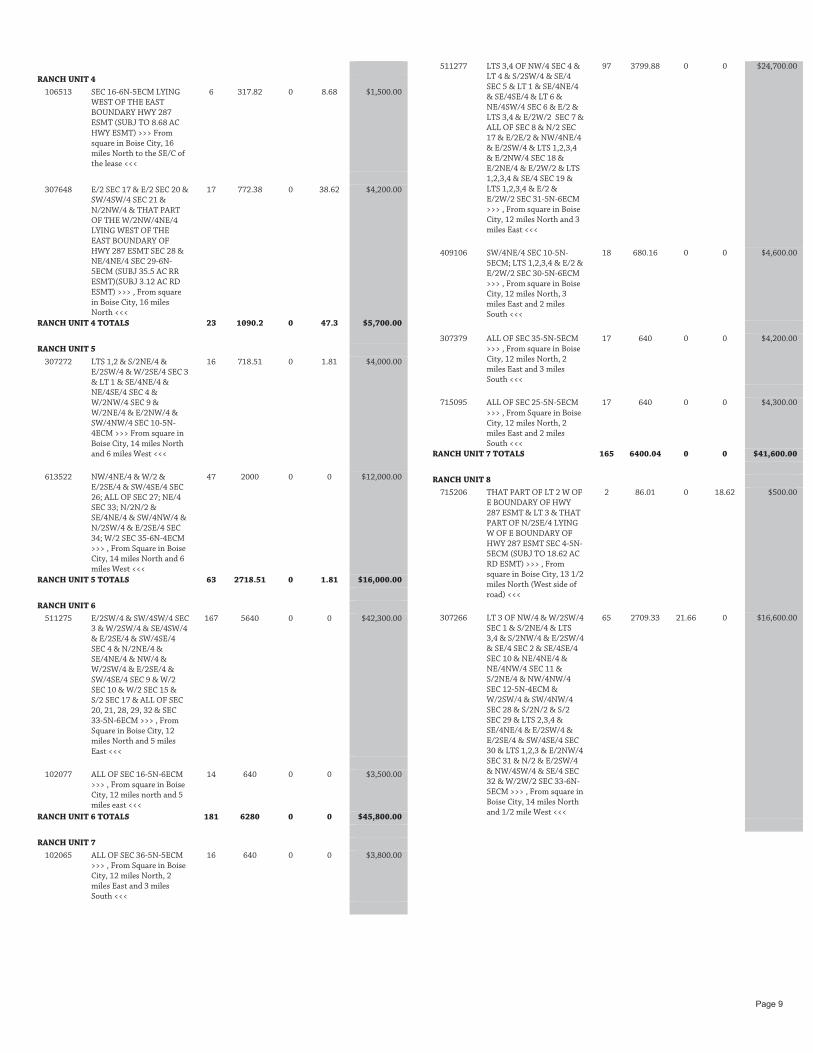
RANCH UNIT 4
106513 SEC 16-6N-5ECM LYING WEST OF THE EAST BOUNDARY HWY 287 ESMT (SUBJ TO 8.68 AC HWY ESMT) >>> From square in Boise City, 16 miles North to the SE/C of the lease <<<
6 317.82 0 8.68 $1,500.00
307648 E/2 SEC 17 & E/2 SEC 20 &
SW/4SW/4 SEC 21 & N/2NW/4 & THAT PART OF THE W/2NW/4NE/4 LYING WEST OF THE EAST BOUNDARY OF HWY 287 ESMT SEC 28 & NE/4NE/4 SEC 29-6N-5ECM (SUBJ 35.5 AC RR ESMT)(SUBJ 3.12 AC RD ESMT) >>> , From square in Boise City, 16 miles North <<<
17 772.38 0 38.62 $4,200.00
RANCH UNIT 4 TOTALS 23 1090.2 0 47.3 $5,700.00
RANCH UNIT 5
307272 LTS 1,2 & S/2NE/4 & E/2SW/4 & W/2SE/4 SEC 3 & LT 1 & SE/4NE/4 & NE/4SE/4 SEC 4 & W/2NW/4 SEC 9 & W/2NE/4 & E/2NW/4 & SW/4NW/4 SEC 10-5N-4ECM >>> From square in Boise City, 14 miles North and 6 miles West <<<
16 718.51 0 1.81 $4,000.00
613522 NW/4NE/4 & W/2 &
E/2SE/4 & SW/4SE/4 SEC 26; ALL OF SEC 27; NE/4 SEC 33; N/2N/2 & SE/4NE/4 & SW/4NW/4 & N/2SW/4 & E/2SE/4 SEC 34; W/2 SEC 35-6N-4ECM >>> , From Square in Boise City, 14 miles North and 6 miles West <<<
47 2000 0 0 $12,000.00
RANCH UNIT 5 TOTALS 63 2718.51 0 1.81 $16,000.00
RANCH UNIT 6
511275 E/2SW/4 & SW/4SW/4 SEC 3 & W/2SW/4 & SE/4SW/4 & E/2SE/4 & SW/4SE/4 SEC 4 & N/2NE/4 & SE/4NE/4 & NW/4 & W/2SW/4 & E/2SE/4 & SW/4SE/4 SEC 9 & W/2 SEC 10 & W/2 SEC 15 & S/2 SEC 17 & ALL OF SEC 20, 21, 28, 29, 32 & SEC 33-5N-6ECM >>> , From Square in Boise City, 12 miles North and 5 miles East <<<
167 5640 0 0 $42,300.00
102077 ALL OF SEC 16-5N-6ECM
>>> , From square in Boise City, 12 miles north and 5 miles east <<<
14 640 0 0 $3,500.00
RANCH UNIT 6 TOTALS 181 6280 0 0 $45,800.00
RANCH UNIT 7
102065 ALL OF SEC 36-5N-5ECM >>> , From Square in Boise City, 12 miles North, 2 miles East and 3 miles South <<<
16 640 0 0 $3,800.00
511277 LTS 3,4 OF NW/4 SEC 4 &
LT 4 & S/2SW/4 & SE/4 SEC 5 & LT 1 & SE/4NE/4 & SE/4SE/4 & LT 6 & NE/4SW/4 SEC 6 & E/2 & LTS 3,4 & E/2W/2 SEC 7 & ALL OF SEC 8 & N/2 SEC 17 & E/2E/2 & NW/4NE/4 & E/2SW/4 & LTS 1,2,3,4 & E/2NW/4 SEC 18 & E/2NE/4 & E/2W/2 & LTS 1,2,3,4 & SE/4 SEC 19 & LTS 1,2,3,4 & E/2 & E/2W/2 SEC 31-5N-6ECM >>> , From square in Boise City, 12 miles North and 3 miles East <<<
97 3799.88 0 0 $24,700.00
409106 SW/4NE/4 SEC 10-5N-5ECM; LTS 1,2,3,4 & E/2 & E/2W/2 SEC 30-5N-6ECM >>> , From square in Boise City, 12 miles North, 3 miles East and 2 miles South <<<
18 680.16 0 0 $4,600.00
307379 ALL OF SEC 35-5N-5ECM >>> , From square in Boise City, 12 miles North, 2 miles East and 3 miles South <<<
17 640 0 0 $4,200.00
715095 ALL OF SEC 25-5N-5ECM
>>> , From Square in Boise City, 12 miles North, 2 miles East and 2 miles South <<<
17 640 0 0 $4,300.00
RANCH UNIT 7 TOTALS 165 6400.04 0 0 $41,600.00
RANCH UNIT 8
715206 THAT PART OF LT 2 W OF E BOUNDARY OF HWY 287 ESMT & LT 3 & THAT PART OF N/2SE/4 LYING W OF E BOUNDARY OF HWY 287 ESMT SEC 4-5N-5ECM (SUBJ TO 18.62 AC RD ESMT) >>> , From square in Boise City, 13 1/2 miles North (West side of road) <<<
2 86.01 0 18.62 $500.00
307266 LT 3 OF NW/4 & W/2SW/4
SEC 1 & S/2NE/4 & LTS 3,4 & S/2NW/4 & E/2SW/4 & SE/4 SEC 2 & SE/4SE/4 SEC 10 & NE/4NE/4 & NE/4NW/4 SEC 11 & S/2NE/4 & NW/4NW/4 SEC 12-5N-4ECM & W/2SW/4 & SW/4NW/4 SEC 28 & S/2N/2 & S/2 SEC 29 & LTS 2,3,4 & SE/4NE/4 & E/2SW/4 & E/2SE/4 & SW/4SE/4 SEC 30 & LTS 1,2,3 & E/2NW/4 SEC 31 & N/2 & E/2SW/4 & NW/4SW/4 & SE/4 SEC 32 & W/2W/2 SEC 33-6N-5ECM >>> , From square in Boise City, 14 miles North and 1/2 mile West <<<
65 2709.33 21.66 0 $16,600.00
Page 9

307647 SE/4NW/4 & THAT PART
OF THE W/2SW/4NE/4 LYING WEST OF THE EAST BOUNDARY OF HWY 287 ESMT & E/2SW/4 & THAT PART OF THE W/2W/2SE/4 LYING WEST OF THE EAST BOUNDARY OF HWY 287 ESMT SEC. 28 & E/2W/2 & THAT PART OF THE W/2E/2 LYING WEST OF THE EAST BOUNDARY OF HWY 287 ESMT SEC 33-6N-5ECM (SUBJ TO 39.32 AC RR ESMT)(SUBJ TO 27.59 AC HWY ESMT) >>> , From square in Boise City, 14 miles North <<<
11 358.09 0 66.91 $2,300.00
613520 SE/4NW/4 SEC 12-5N-
4ECM; S/2 SEC 25; E/2 SEC 35-6N-4ECM >>> , From Square in Boise City, 14 miles North, 3 miles west and 1 mile North <<<
13 680 0 0 $3,200.00
715040 LT 4 & SW/4NW/4 SEC 4 &
LTS 1,2,3 SEC 5 & SE/4NE/4 & SW/4SW/4 & E/2SE/4 & SW/4SE/4 SEC 8 & ALL OF SEC 17-5N-5ECM (LESS 3.999 AC SOLD) >>> From Square in Boise City, 11 1/2 miles North and 1 mile West <<<
22 1010.01 22 0 $6,000.00
102055 ALL OF SEC 36-6N-4ECM
>>> , From Square in Boise City, 14 miles North and 2-1/2 miles West <<<
12 640 0 0 $3,200.00
RANCH UNIT 8 TOTALS 125 5483.44 43.66 85.53 $31,800.00
RANCH UNIT 9
307429 ALL OF SEC 27 & E/2NE/4 & E/2SW/4NE/4 & THAT PART OF THE W/2SW/4NE/4 LYING EAST OF HWY 287 ESMT & E/2SE/4 & E/2W/2SE/4 & THAT PART OF THE W/2W/2SE/4 LYING EAST OF HWY 287 ESMT SEC 28 & E/2E/2 & THAT PART OF THE W/2E/2 LYING EAST OF HWY 287 ESMT SEC 33 & ALL OF SEC 34-6N-5ECM >>> , From square in Boise City, 14 miles North <<<
35 1735 0 0 $8,700.00
715036 LTS 3,4 & S/2NW/4 &
N/2SW/4 SEC 3 & LT 1 & THAT PART OF LT 2 E OF HWY 287 ESMT & SE/4NE/4 & THAT PART OF N/2SE/4 LYING E OF HWY 287 ESMT SEC 4-5N-5ECM >>> From square in Boise City, 13 1/2 miles North <<<
9 375.57 0 0 $2,300.00
RANCH UNIT 9 TOTALS 44 2110.57 0 0 $11,000.00
RANCH UNIT 10
613055 LTS 1,2,3,4 & S/2NE/4 &
SE/4NW/4 & E/2SW/4 & SW/4SW/4 & SE/4 SEC 1 & LT 1 & SE/4NE/4 & W/2SW/4 & SE/4SW/4 & SW/4SE/4 SEC 2 & LTS 1,2,3,4 & S/2N/2 & SE/4 SEC 3-4N-1ECM & E/2 SEC 18 & LTS 2,3,4 & E/2 & SE/4NW/4 & E/2SW/4 SEC 19-4N-2ECM (LESS 2.1 AC STCL 613769) >>> From Boise City, 20 miles West and 4 miles North <<<
39 2111.97 0 2.1 $9,500.00
409067 E/2 SEC 10; E/2 & NW/4 &
W/2SW/4 SEC 11; N/2NE/4 & SW/4NE/4 & NW/4 & N/2SW/4 & NE/4SE/4 SEC 12; E/2 & S/2NW/4 & SW/4 SEC 14; E/2 SEC 15-4N-1ECM >>> From Boise City, 20 miles West, 6 miles North and 2 miles West <<<
41 2160 0 0 $10,300.00
307170 LTS 2,3,4,5,6,7 &
SE/4NE/4 & SE/4NW/4 & E/2SW/4 SEC 6 & LTS 1,3 & SW/4SE/4 SEC 7-4N-2ECM (SUBJ TO 77.37 AC ESMTS) >>> From square in Boise City, 20 miles West and 6 miles North <<<
11 363.1 0 77.37 $2,200.00
205431 NW/4NE/4 SEC 13-4N-
1ECM >>> From square in Boise City, 16 miles West, 4 miles North and 5 miles Northwest <<<
1 40 0 0 $200.00
RANCH UNIT 10 TOTALS 92 4675.07 0 79.47 $22,200.00
RANCH UNIT 11
511390 LTS 1,2 OF SEC 7 & LTS 1,2 OF SEC 8 & LTS 1,2 OF SEC 9 & ALL OF SEC 17 & E/2 & LTS 1,2,3,4 & E/2W/2 SEC 18 & E/2 & LTS 1,2,3,4 & E/2W/2 SEC 19 & SEC 20 & SEC 21 & N/2 & SW/4 SEC 28 & SEC 29 & SEC 32 & N/2 & N/2SW/4 & SE/4SW/4 & SE/4 SEC 33-6N-6ECM >>> , From Square in Boise City, 14 miles North and 5 miles East <<<
160 5650.84 0 0 $39,600.00
102085 ALL OF SEC 16-6N-6ECM >>> , From Square in Boise City, 14 miles North, 7 miles East and 2 miles North <<<
21 640 0 0 $5,100.00
RANCH UNIT 11 TOTALS 181 6290.84 0 0 $44,700.00
RANCH UNIT 12
102059 W/2E/2 & W/2 SEC 16-5N-5ECM (SUBJ TO 3.14 AC ESMT) >>> From Square in Boise City, 11 miles North <<<
13 480 0 0 $3,400.00
307649 E/2NE/4 & N/2NW/4 &
S/2 SEC 32-5N-5ECM & ALL OF SEC 33 & THAT PART OF SEC 34 LYING WEST OF HWY 287 ESMT EAST BOUNDARY (SUBJ TO 22.87 AC HWY ESMT)(SUBJ TO 29.53 AC RR ESMT) >>> , From Square in Boise City, 8 miles North <<<
24 1141.6 0 52.4 $5,700.00
Page 10

307367 SEC 34-5N-5ECM (LYING
EAST OF HWY 287 ESMT BOUNDARY)(SUBJ TO 36.99 AC HWY ESMT) >>> , From square in Boise City, 8 miles North <<<
14 566 0 0 $3,400.00
715026 SW/4 SEC 4 & LTS 1,2,3,4,5,6,7 & S/2NE/4 & SE/4NW/4 & E/2SW/4 & SE/4 SEC 6-4N-5ECM & SW/4NE/4 & E/2SW/4 (LESS 5 AC) & W/2SE/4 SEC 9 & W/2NE/4 & E/2E/2 SEC 20 & N/2 & THAT PART OF THE S/2S/2 & THAT PART OF THE N/2 LYING WEST OF EAST BOUNDARY HWY 287 ESMT SEC 21 & THAT PART OF THE E/2 LYING WEST OF THE EAST BOUNDARY HWY 287 ESMT & S/2NW/4 & NE/4NW/4 & SW/4 SEC 28 & E/2NE/4 & E/2SW/4 & SE/4 SEC 29-5N-5ECM (SUBJ TO 73.17 AC ESMT) >>> , From Square in Boise City, 9 miles North <<<
53 2440.31 0 73.17 $12,200.00
RANCH UNIT 12 TOTALS 104 4627.91 0 125.57 $24,700.00
CLEVELAND COUNTY
Date/Time: 10/25/21 10:00 AM
Place: 1700 W Independence Shawnee Expo Center Shawnee, Oklahoma
ALL LEASE TERMS ARE FOR 5 YEARS UNLESS OTHERWISE INDICATED
Lease No Legal and Location Description
Est Cow
Units
Est Acres
Pasture
Est Acres Crop
Est Non
Usable Minimum
Annual Bid 100003 NW/4 SEC 16-8N-1EIM
(SUBJ TO 2.65 AC ESMT) >>> Located at SE corner of intersection of Cedar Lane & 156th St (Hunting/Recreation Potential) <<<
8 160 0 0 $2,900.00
100004 W/2SW/4 SEC 16-8N-1EIM(SUBJ TO 1.12 AC ESMT) >>> Located at SE corner of Post Oak Road & 156th St (Hunting/Recreation Potential) <<<
3 80 0 0 $1,400.00
100006 W/2 SEC 36-8N-1EIM >>>
From intersection of McGuire Road & 180th St, 1 mile East to NW corner of property (Hunting/Recreation Potential) <<<
11 320 0 0 $5,400.00
100018 NW/4 SEC 16-10N-1EIM
(SUBJ TO 1.02 AC ESMT)(LESS IMPROVEMENTS) >>> From intersection of SE 104th St, 1 mile South on Peebly Rd to NW corner of property (Hunting/Recreation Potential) <<<
8 160 0 0 $2,800.00
100803 N/2SE/4 SEC 16-6N-1WIM
(LESS 1.6 AC SOLD) >>> From Lexington intersection of 96th St & Hwy 39, 1 1/2 miles South on 96th St to NE corner of property <<<
5 78.4 0 0 $1,700.00
100804 NW/4 SEC 16-8N-1WIM
>>> Located at SE corner of Cedar Lane & 84th St, approx 6 miles East and 1 mile South of intersection of Hwy 9 & Hwy 77 near Norman (Hunting/ Recreation Potential) <<<
8 160 0 0 $2,400.00
100806 LTS 1,2,3,4 & E/2E/2 SEC
36-8N-1WIM >>> From intersection of McGuire Rd & 120th St, 1/2 mile East to NW corner of property <<<
11 313.11 0 0 $3,900.00
100809 LTS 7,8 & W/2SW/4 SEC
36-8N-1WIM >>> SW corner of property is located on NE corner of 120th & Cemetery Rd (Recreation Potential) <<<
8 163.88 0 0 $2,500.00
100813 NW/4 SEC 16-10N-1WIM
(LESS 1.928 AC SOLD) >>> NW corner of property located at SE corner of Anderson Rd & SE 119th St <<<
7 158.07 0 0 $2,100.00
100931 NE/4 SEC 36-8N-2WIM
(LESS 1.44 AC SOLD) >>> NE corner located at SW corner of 60th St & McGuire Rd <<<
14 158.56 0 0 $4,300.00
100936 SE/4 SEC 16-10N-2WIM (LESS 2.3 AC STCL 105885) >>> SE corner located on NW corner of SE 134th & Air Depot <<<
10 157.7 0 0 $3,200.00
100937 E/2 SEC 36-10N-2WIM
>>> SW corner of property located 1/2 mile East of Douglas Blvd & Indian Hills Rd <<<
19 282.3 37.7 0 $7,900.00
100938 NW/4 SEC 36-10N-2WIM
(SUBJ TO 3.12 AC ESMT) >>> NW corner of property located at corner of Douglas Blvd & SE 164th St (Hunting/Recreation Potential) <<<
5 138 22 0 $2,600.00
100939 SW/4 SEC 36-10N-2WIM
(SUBJ TO 1.03 AC ESMT)(LESS 2 AC SOLD) >>> SW corner of property located at NE corner of Douglas Blvd & Indian Hills Rd (Hunting/Recreation Potential) <<<
6 144 14 0 $2,800.00
COMANCHE COUNTY
Date/Time: 10/19/21 10:00 AM
Place: 920 SW Sheridan Road Comanche County Fairgrounds Lawton, Oklahoma
ALL LEASE TERMS ARE FOR 5 YEARS UNLESS OTHERWISE INDICATED
Lease No Legal and Location Description
Est Cow
Units
Est Acres
Pasture
Est Acres Crop
Est Non
Usable Minimum
Annual Bid 101242 NE/4 SEC 16-2N-9WIM
>>> From intersection of Hwys 65 & 7, 4 miles East and 3 1/2 miles North to SE corner of property <<<
7 80 80 0 $4,500.00
Page 11

101243 NW/4 SEC 16-2N-9WIM
(LESS 2.5 AC SOLD)(LESS IMPROVEMENTS) >>> From intersection of Hwys 7 & 65, 3 miles East and 3 1/2 miles North to SW corner of property <<<
10 110.5 47 0 $4,400.00
101331 NW/4 SEC 36-1N-10WIM
(SUBJ TO .87 AC ESMT)(LESS IMPROVEMENTS) >>> From intersection of Hwys 65 & 7, 5 miles South to NW corner of property <<<
8 87.13 72 0.87 $4,300.00
101335 NW/4 SEC 16-2N-10WIM
(SUBJ TO .42 AC ESMT)(LESS 2.5 AC SOLD) >>> From intersection of Trail Rd & Hwy 7, 3 1/2 miles North to SW corner of property <<< SEE ATTACHED SOLAR ENERGY ADDENDUM
15 157.08 0 0.42 $4,200.00
101336 SW/4 SEC 16-2N-10WIM
(SUBJ TO .42 AC ESMT) >>> From intersection of Trail Rd & Hwy 7, 3 miles North to SW corner of property <<< SEE ATTACHED SOLAR ENERGY ADDENDUM
14 159.58 0 0.42 $4,100.00
101337 SE/4 SEC 16-2N-10WIM
(LESS 1.92 AC SOLD) >>> From intersection of Trail Rd & Hwy 7, 3 miles North and 1/2 mile East to SW corner of property <<< SEE ATTACHED SOLAR ENERGY ADDENDUM
16 158.08 0 0 $4,600.00
101341 SE/4 SEC 36-2N-10WIM
(SUBJ TO 9.05 AC ESMT) >>> From intersection of Hwys 65 & 7, 1/2 mile East to SW corner of property <<<
17 149.24 0 10.76 $4,600.00
101346 NE/4 SEC 36-3N-10WIM
(SUBJ TO 1.29 AC ESMT)(LESS IMPROVEMENTS) >>> From Sterling intersection of Hwys 65 & 17, 3 miles South, 1 mile West and 1 mile South to NE corner of property <<<
13 133.71 25 1.29 $4,300.00
101349 SE/4 SEC 36-3N-10WIM
(SUBJ TO 1.24 AC ESMT)(LESS 1 AC SOLD)(LESS IMPROVEMENTS) >>> From Sterling intersection of Hwys 65 & 17, 3 miles South, 1 mile West and 1 1/2 miles South on Hwy 65 to NE corner of property <<<
9 91.76 66 1.24 $4,500.00
101385 NW/4 SEC 16-1S-11WIM
(SUBJ TO .03 AC ESMT)(LESS IMPROVEMENTS) >>> From intersection of Hwy 277 & New Hope Road, 2 miles East to NW corner of property <<<
11 99.97 60 0.03 $4,900.00
101420 SW/4 SEC 36-2N-11WIM
(SUBJ TO 7.55 AC ESMT)(LESS .1 AC STCL 106248)(LESS 20 AC SOLD) >>> From intersection of SH 7 and SE 45th Street in Lawton, 1 mile East to SW corner of property <<< SEE ATTACHED SOLAR ENERGY ADDENDUM
2 14.35 118 7.55 $3,900.00
101522 SE/4 SEC 16-1N-13WIM
(LESS 2.15 AC SOLD)(LESS IMPROVEMENTS) >>> From intersection of Goodyear Blvd & Lee Blvd, 3 miles South and 3 miles West to SE corner of property <<<
9 89.85 68 0 $4,500.00
102692 SW/4 SEC 25-1N-15WIM >>> From Indiahoma, 7 miles south and 1 mile east to SE corner of property <<<
10 112 48 0 $4,500.00
105732 E/2NW/4 SEC 16-1N-
9WIM >>> From intersection of Hwys 65 & 7, 3 miles East and 2 miles South and 1/4 mile East to NW corner of property <<<
9 80 0 0 $2,300.00
106168 SW/4 SEC 23-1S-11WIM
>>> From intersection of Hwy 277 & New Hope Road, 4 miles East and 1 1/2 miles South to NW corner of property <<<
6 75 85 0 $5,000.00
106169 SW/4 SEC 15; NW/4 SEC
22 ALL IN 1S-11WIM >>> From intersection of Hwy 277 & New Hope Road, 2 miles East, 1 mile South to access road, and 1 mile East on access road to middle of West side of property (Land East of Cache Creek has no access) <<<
5 213 107 0 $4,400.00
106322 SE/4 SEC 33-2N-11WIM
(SUBJ TO 8.52 AC ESMT) >>> Located at NW corner of intersection of Hwy 7 & Flower Mound Rd <<<
7 71.48 80 8.52 $4,500.00
106323 N/2 & THAT PART OF
SE/4 LYING N OF S LINE OF RR ROW SEC 33-2N-12WIM (SUBJ TO 16.15 AC ESMT)(LESS 2.5 AC STCL 106325)(LESS 19.28 AC STCL 106326)(LESS 90 AC SOLD)(SUBJ TO STCL 106331, 106330, 106333 & 106376) >>> , Located between 52nd & 67th Street on South side of Gore Blvd (North of RR ROW) <<<
11 108.26 106 16.15 $5,600.00
205214 NE/4 SEC 13-3N-9WIM
(LESS IMPROVEMENTS) >>> From Sterling intersection of Hwys 65 & 17, 5 miles East and 1 mile South to NE corner of property <<<
11 142 18 0 $3,900.00
205216 SW/4 SEC 13-3N-9WIM
>>> From Sterling intersection of Hwys 65 & 17, 4 miles East and 1 1/2 miles South to NW corner of property <<<
13 101 59 0 $4,900.00
Page 12
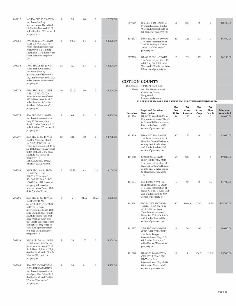
205217 N/2SE/4 SEC 13-3N-9WIM
>>> From Sterling intersection of Hwys 65 & 17, 5 miles East and 1 1/2 miles South to NE corner of property <<<
1 20 60 0 $2,200.00
205255 NW/4 SEC 13-3N-10WIM
(LESS 2.5 AC SOLD) >>> From Sterling intersection of Hwys 65 & 17, 1 mile South and 1 1/2 miles West to NE corner of property <<<
8 93.5 64 0 $4,300.00
205256 SW/4 SEC 13-3N-10WIM
(LESS IMPROVEMENTS) >>> From Sterling intersection of Hwys 65 & 17, 2 miles South and 1 1/2 miles West to SE corner of property <<<
12 122 38 0 $4,200.00
205272 SW/4 SEC 13-1S-11WIM
(LESS 2.5 AC SOLD) >>> From intersection of Hwy 277 & New Hope Road, 5 miles East and 1/2 mile South to NW corner of property <<<
10 101.5 56 0 $4,300.00
205273 SE/4 SEC 13-1S-11WIM
>>> From intersection of Hwy 277 & New Hope Road, 6 miles East and 1/2 mile South to NE corner of property <<<
7 69 91 0 $4,500.00
205277 SE/4 SEC 13-1N-11WIM (LESS 2 AC SOLD)(LESS IMPROVEMENTS) >>> From intersection of I-44 & SE 45th Street in Lawton, 2 miles East and 2 1/2 miles South to NE corner of property <<< SEE ATTACHED SOLAR ENERGY ADDENDUM
12 116 42 0 $4,700.00
205288 NE/4 SEC 13-1N-12WIM
(SUBJ TO 1.21 AC ESMT)(LESS 4.46 AC SOLD)(LESS 80 AC LTCL 206651) >>> NE corner of property is located at intersection of South 11th St & Coombs Rd <<<
0 12.33 62 1.21 $2,100.00
205291 SE/4 SEC 13-1N-12WIM
(LESS 99.734 AC SOLD)(SUBJ TO 36.74 AC ESMT) >>> From intersection of South 11th St & Coombs Rd, 1/2 mile South to access road that goes West, go West and just inside the fence follow the right-of-way fence to the South approximately 3/8 mile to NE corner of property <<<
0 2 21.52 36.74 $600.00
205632 NW/4 SEC 20-3N-10WIM
(SUBJ .48 AC ESMT) >>> From intersection of Trail Rd & Hwy 17, East of Elgin, 4 miles South and 1/2 mile West to NE corner of property <<<
6 58 102 0 $5,300.00
205645 SE/4 SEC 15-1N-13WIM
(LESS IMPROVEMENTS) >>> From intersection of Goodyear Blvd & Lee Blvd, 3 miles South and 2 miles West to SE corner of property <<<
9 99 61 0 $4,300.00
817222 N/2 SEC 8-1N-15WIM >>>
From Indiahoma, 2 miles West and 3 miles South to NE corner of property <<<
28 320 0 0 $8,100.00
817243 NW/4 SEC 33-1N-10WIM
>>> From intersection of Trail Rd & Hwy 7, 5 miles South to NW corner of property <<<
11 119 41 0 $4,400.00
817285 NE/4 SEC 33-1N-12WIM
>>> From intersection of I-44 & Hwy 36, 2 1/2 miles West and 1/2 mile North to SE corner of property <<<
7 83 77 0 $4,100.00
COTTON COUNTY
Date/Time: 10/19/21 10:00 AM
Place: 920 SW Sheridan Road Comanche County Fairgrounds Lawton, Oklahoma
ALL LEASE TERMS ARE FOR 5 YEARS UNLESS OTHERWISE INDICATED
Lease No Legal and Location Description
Est Cow
Units
Est Acres
Pasture
Est Acres Crop
Est Non
Usable Minimum
Annual Bid 101228 NE/4 SEC 16-4S-9WIM >>>
From intersection of Hwy 5 & Cotton/Jefferson county line, 1 mile South to NE corner of property <<<
16 160 0 0 $4,000.00
101229 NW/4 SEC 16-4S-9WIM
>>> From intersection of Hwy 5 & Cotton/Jefferson county line, 1 mile West and 1 mile South to NW corner of property <<<
12 160 0 0 $3,000.00
101230 S/2 SEC 16-4S-9WIM
(LESS IMPROVEMENTS) >>> From intersection of Hwy 5 & Cotton/Jefferson county line, 2 miles South to SE corner of property <<<
29 320 0 0 $7,300.00
101234 LTS 1, 2 OF NW/4 (IN
RIVER) SEC 16-5S-9WIM >>> From intersection of Hwys 70 & 65, 5 miles East and 2 miles South to NW corner of property <<<
5 40 0 9.6 $1,700.00
101314 N/2 & SW/4 SEC 36-3S-
10WIM (SUBJ TO 13.51 AC ESMT) >>> From Temple intersection of Hwys 5 & 65 1 mile South and 2 miles East to NW corner of property <<<
17 186.49 280 13.51 $13,500.00
101317 SE/4 SEC 36-3S-10WIM
(LESS IMPROVEMENTS) >>> From Temple intersection of Hwys 5 & 65, 2 miles South and 3 miles East to SE corner of property <<<
5 54 106 0 $4,600.00
101318 NE/4 SEC 16-4S-10WIM
(SUBJ TO 1.09 AC FOR HWY) >>> From intersection of Hwys 70 & 65, 4 miles North to NE corner of property <<<
0 4 154.91 1.09 $5,300.00
Page 13

101319 NW/4 SEC 16-4S-10WIM
>>> From intersection of Hwys 70 & 65, 4 miles North and 1 mile West to NW corner of property <<<
3 38 122 0 $4,800.00
101404 N/2 SEC 36-3S-11WIM >>>
From West Temple intersection of Hwys 5 & 5A, 1 mile South to NW corner of property <<<
5 73 247 0 $9,700.00
205235 NE/4 SEC 13-1S-10WIM
>>> From intersection of Hwys 65 & 53, East of Walters, 8 miles North and 2 miles East to NE corner of property <<<
5 40 120 0 $5,000.00
205236 NW/4 SEC 13-1S-10WIM
>>> From intersection of Hwys 53 & 65, East of Walters, 8 miles North and 1 mile East to NW corner of property <<<
6 53 107 0 $4,800.00
205238 SW/4 SEC 13-2S-10WIM
(LESS 2.5 AC SOLD) >>> From intersection of Hwys 53 & 65, East of Walters, 1 mile North and 1 mile East to SW corner of property <<<
3 21.5 136 0 $4,700.00
817091 NW/4 SEC 33-2S-10WIM
(LESS IMPROVEMENTS) >>> From intersection of Hwys 53 & 65, East of Walters, 2 miles West and 1 mile South to NW corner of property <<<
13 132 28 0 $3,700.00
817092 NW/4 SEC 33-3S-10WIM
(LESS IMPROVEMENTS) >>> From intersection of Hwys 5 & 65, West side of Temple, 3/4 mile South and 1/2 mile West to NE corner of property <<<
13 160 0 0 $3,100.00
817093 S/2 SEC 33-3S-10WIM (SUBJ TO 1.39 AC ESMT) >>> From intersection of Hwys 5 & 65, West side of Temple, 1 3/4 miles South to SE corner of property <<<
27 318.61 0 1.39 $6,600.00
817210 NW/4 SEC 32-4S-10WIM
(SUBJ TO 6.75 AC ESMT) >>> From intersection of Hwys 70 & 65, 1 1/2 miles West on US 70 to SE corner of property <<<
6 58.25 95 6.75 $4,900.00
ELLIS COUNTY
Date/Time: 10/12/21 10:00 AM
Place: 108 Temple Houston Drive Woodward Event Center Fairgrounds New Building Woodward, Oklahoma
ALL LEASE TERMS ARE FOR 5 YEARS UNLESS OTHERWISE INDICATED
Lease No Legal and Location Description
Est Cow
Units
Est Acres
Pasture
Est Acres Crop
Est Non
Usable Minimum
Annual Bid 101831 E/2 SEC 36-19N-22WIM
>>> From Harmon intersection on Hwy 51, 1 mile East, 5 miles South, 1 mile East, 1 mile South, 3 miles East, 1 mile North and 1 mile West to SE corner of property <<<
15 320 0 0 $4,300.00
101882 NW/4 SEC 16-18N-24WIM
>>> From Arnett intersection of Hwys 51 & 283, 7 miles South and 1/2 mile West across deeded land to SE corner of property (Limited Access) <<<
7 160 0 0 $1,700.00
101928 NW/4 & S/2 SEC 36-24N-
25WIM (LESS .23 AC STCL 106215) >>> From Shattuck intersection of Hwys 283 & 15, 16 1/2 miles North on Hwy 283, 2 1/2 miles East to SW corner of property <<<
19 479.77 0 0 $5,800.00
103100 SE/4 SEC 16-21N-23WIM
>>> From Fargo intersection of Hwy 15 and farm to market road, 6 miles South on paved road and 2 miles West to SE corner of property <<<
1 7.36 152.64 0 $4,000.00
103106 N/2 SEC 16-18N-26WIM
>>> From Arnett intersection of Hwys 283 & 51, 7 miles West, 5 1/2 miles South, 1 mile West, 1 mile South, 1 mile West, 2 miles South, 4 miles West and 1 1/2 miles North to SW corner of lease <<<
12 320 0 0 $3,500.00
103107 LTS 1,2,7,8 & S/2SW/4 SEC
36-20N-26WIM >>> From Shattuck intersection of Hwys 15 & 283, 4-1/2 miles South, 2 miles West, 3 miles South and 1/2 mile West to SE corner of property <<<
3 86.88 73 0 $2,800.00
205398 NW/4 SEC 13-24N-23WIM
>>> From Ft Supply, 3 miles West on Hwy 270 and 1 3/4 miles South to NW corner of property <<<
1 15.51 144.49 0 $4,000.00
205401 SE/4 SEC 13-24N-24WIM
(LESS IMPROVEMENTS) >>> From May intersection of Hwys 270 & 46, 5 miles South and 1 1/2 miles East to SW corner of property <<<
4 58.16 101.84 0 $3,800.00
205749 SW/4 SEC 13-24N-23WIM
>>> From Ft Supply, 3 miles West on Hwy 270 and 2 miles South to NW corner of property <<<
14 160 0 0 $3,800.00
409049 NW/4SW/4 SEC 24-23N-
25WIM >>> From Shattuck intersection of Hwys 283 & 15, 12 1/2 miles North on US 283, 2 1/2 miles East and 1/4 mile North to SW corner of property <<<
2 40 0 0 $400.00
817204 SE/4 SEC 33-24N-26WIM
>>> From Shattuck intersection of Hwys 15 & 283, 15 miles North, 5 1/2 miles West and 1 mile North <<<
9 160 0 0 $2,400.00
817267 N/2 & SE/4 SEC 33-24N-
25WIM (SUBJ TO 8.89 AC ESMT) >>> From Shattuck intersection of Hwys 283 & 15, 16 1/2 miles North on Hwy 283 to SW corner of SE/4 of property <<<
16 437.38 33.62 9 $6,000.00
Page 14

GARFIELD COUNTY
Date/Time: 10/13/21 10:00 AM
Place: 111 W. Purdue Garfield County Fairgrounds Chisholm Trail Pavilion Enid, Oklahoma
ALL LEASE TERMS ARE FOR 5 YEARS UNLESS OTHERWISE INDICATED
Lease No Legal and Location Description
Est Cow
Units
Est Acres
Pasture
Est Acres Crop
Est Non
Usable Minimum
Annual Bid 101072 SE/4 SEC 16-20N-4WIM
(LESS IMPROVEMENTS) >>> From Douglas, 2 1/2 miles East and 3 1/2 miles South to NE corner of property <<<
6 86.61 73.39 0 $4,200.00
101077 SW/4 SEC 16-22N-4WIM
>>> From South side of Garber, 3 miles South, 3 miles West and 1/2 mile South to NW corner of property <<<
5 86.48 73.52 0 $3,800.00
101078 SW/4 SEC 36-23N-4WIM
>>> From South Quick Trip on Hwy 74 in Garber, 1/2 mile South to NW corner of property <<<
1 14.52 145.48 0 $7,400.00
101105 NE/4 SEC 36-24N-5WIM
(LESS 1.44 AC SOLD) >>> From West side of Hunter, 1/2 mile West and 3 miles South to NE corner of property <<<
3 37.85 120.71 0 $6,400.00
101149 LTS 3,4,7,8 OF SW/4 SEC
16-24N-7WIM (LESS 7.97 AC SOLD) >>> From South side of Hillsdale, 1/2 mile South and 2 miles East to SW corner of property <<<
4 41.85 105.39 5 $5,600.00
101195 W/2 SEC 16-23N-8WIM
(SUBJ TO 2.98 AC ESMT) >>> From Carrier Post Office, 2 miles West to NE corner of property <<<
14 180.76 136.26 2.98 $9,400.00
101197 SW/4 SEC 36-23N-8WIM
(LESS 3.5 AC SOLD) >>> From Carrier Post Office, 1/2 mile East and 3 1/2 miles South on Hwy 132 to NW corner of property <<<
6 75.52 80.98 0 $4,900.00
205150 NE/4 SEC 13-23N-3WIM
(LESS IMPROVEMENTS) >>> From South Quick Trip in Garber, 6 miles East on blacktop road, 3 miles North and 1/2 mile East to NW corner of property <<<
5 44.53 115.47 0 $7,100.00
205170 SW/4 SEC 13-24N-5WIM
(LESS IMPROVEMENTS)(SUBJ TO LTCL 106481)(LESS 4 AC LTCL 209271) >>> From West side of Hunter, 1 1/2 miles West and 1/2 mile South to NW corner of property <<<
5 68.13 87.87 0 $5,400.00
205182 SW/4 SEC 13-23N-8WIM
>>> From Carrier Post Office, 1/2 mile East and 1/2 mile South to NW corner of property <<<
3 24.12 135.88 0 $7,700.00
817070 NW/4 SEC 33-22N-3WIM
(LESS 5 AC SOLD) >>> From North side of Covington, 2 1/2 miles North and 3 miles East to NW corner of property <<<
5 75.65 79.35 0 $4,000.00
817073 LTS 1,2,10,11 OF NW/4
SEC 33-20N-7WIM (LESS IMPROVEMENTS) >>> From Bison, 1 1/2 miles South and 3 1/2 miles West to NE corner of property <<<
5 58.75 101.23 0 $6,400.00
GRADY COUNTY
Date/Time: 10/19/21 10:00 AM
Place: 920 SW Sheridan Road Comanche County Fairgrounds Lawton, Oklahoma
ALL LEASE TERMS ARE FOR 5 YEARS UNLESS OTHERWISE INDICATED
Lease No Legal and Location Description
Est Cow
Units
Est Acres
Pasture
Est Acres Crop
Est Non
Usable Minimum
Annual Bid FOUR YEAR LEASE TERM FOR LEASE 104473 ONLY
104473 LTS 5,6,7 & 8 & W/2W/2
SEC 36-7N-8WIM >>> From West Chickasha intersection of Hwys 81 & 62, 2 1/2 miles West on Hwy 62 and 2 1/4 miles South to NW corner of lease <<<
11 135.11 66 0 $6,100.00
FOUR YEAR LEASE TERM FOR LEASE 817079 ONLY
817079 SW/4 SEC 33-7N-8WIM
(LESS 2.5 AC SOLD) >>> From Grady/Caddo county line in Verden, 1 mile East on Hwy 62, 4 miles South and 1 mile East to SW corner of property (North side of road) <<<
8 107.5 48 2 $4,000.00
GRANT COUNTY
Date/Time: 10/13/21 10:00 AM
Place: 111 W. Purdue Garfield County Fairgrounds Chisholm Trail Pavilion Enid, Oklahoma
ALL LEASE TERMS ARE FOR 5 YEARS UNLESS OTHERWISE INDICATED
Lease No Legal and Location Description
Est Cow
Units
Est Acres
Pasture
Est Acres Crop
Est Non
Usable Minimum
Annual Bid 101079 SW/4 SEC 16-25N-4WIM
(LESS IMPROVEMENTS) >>> From Salt Fork, 2 1/2 miles West to SE corner of property <<<
4 47.81 112.19 0 $4,900.00
101106 NE/4 SEC 16-27N-5WIM
>>> From Medford intersection of Hwys 81 & 11, 1/2 mile North to SE corner of property <<<
0 6.95 153.05 0 $7,700.00
101112 SE/4 SEC 16-29N-5WIM
(LESS IMPROVEMENTS) >>> From Renfrow, 4 miles West and 4 miles North to SE corner of property <<<
7 69.19 90.81 0 $6,100.00
101131 SW/4 SEC 16-28N-6WIM
>>> From Medford intersection of Hwy 11 & 81, 6 miles North and 6 1/2 miles West to SE corner of property <<<
5 51.84 108.16 0 $3,900.00
Page 15

101201 SW/4 SEC 16-27N-8WIM
>>> From Medford intersection of Hwys 11 & 81, 18 1/2 miles West to SE corner of property <<<
13 155 0 5 $3,300.00
205162 LTS 3,4 & S/2NW/4 SEC
13-29N-4WIM >>> From Renfrow, 3 miles East, 5 miles North and 1 mile East to NW corner of property <<<
0 5.47 133.46 0 $4,400.00
205171 S/2 SEC 13-28N-5WIM >>>
From Renfrow, 1 mile West and 1 1/2 miles South to NE corner of property <<<
7 99 221 0 $10,400.00
205184 NW/4 SEC 13-27N-8WIM
(SUBJ TO .799 AC ESMT) >>> From Medford intersection of Hwys 11 & 81, 16 miles West and 1/2 mile North to SW corner of property <<<
8 94.09 65.11 0.8 $4,900.00
HARPER COUNTY
Date/Time: 10/12/21 10:00 AM
Place: 108 Temple Houston Drive Woodward Event Center Fairgrounds New Building Woodward, Oklahoma
ALL LEASE TERMS ARE FOR 5 YEARS UNLESS OTHERWISE INDICATED
Lease No Legal and Location Description
Est Cow
Units
Est Acres
Pasture
Est Acres Crop
Est Non
Usable Minimum
Annual Bid 101811 SE/4 SEC 16-28N-21WIM
>>> From intersection of Hwy 64 &and Selman blacktop, 3 miles North and 1 1/2 miles East to SW corner of property <<<
4 49.7 110.3 0 $4,000.00
101869 S/2 SEC 16-28N-23WIM
(LESS IMPROVEMENTS) >>> From Buffalo intersection of Hwys 183 & 64, 2 1/4 miles North, 3 miles West and 1 mile North to SE corner of property <<<
12 190.3 129.7 0 $7,000.00
101897 SW/4 & W/2SE/4 & 19.78
AC IN E/2SE/4 SEC 16-27N-24WIM (SUBJ TO 3.04 AC ESMT) >>> From Laverne intersection of Hwys 64 & 283, 5 miles East to SW corner of property <<<
16 256.74 0 3.04 $3,200.00
101956 N/2 SEC 36-25N-26WIM
(LESS IMPROVEMENTS) >>> From Log Cabin corner, 3 miles West and 1 mile South to NE corner of property <<<
19 320 0 0 $3,800.00
101965 NW/4 SEC 36-29N-26WIM
(LESS 10.4 AC ESMT) >>> From Rosston, 2 miles West on Hwy 64 and 8 1/2 miles North on Hwy 283 to South side of property <<<
4 57.2 92.4 10.4 $3,900.00
102763 NE/4 SEC 8-26N-21WIM
>>> From Selman, 3 1/2 miles south and 1/2 mile east to NW corner of property <<<
6 91 69 0 $2,700.00
103092 NE/4 SEC 36-26N-22WIM
>>> From Selman, 5 miles South, 1 mile West and 2 miles South to NE corner of property <<<
3 44.9 115.1 0 $4,400.00
103095 NW/4 SEC 36-29N-24WIM
>>> From Hwy 283, 12 miles East on Ditch Valley Blacktop and 1 mile South on county road to NW corner of property <<<
9 160 0 0 $1,700.00
103096 E/2 SEC 36-28N-25WIM
(LESS IMPROVEMENTS) >>> From Rosston, 2 miles East, 3 miles North and 2 1/2 miles East to SW corner of property <<<
14 198.9 121.1 0 $5,500.00
103268 SW/4 SEC 32-26N-21WIM
(LESS IMPROVEMENTS) >>> From Selman, approx 8 miles South on Blacktop road and 1/2 mile West across private property (Isolated Tract-Limited Access) <<<
8 160 0 0 $1,500.00
104467 NE/4 SEC 36-28N-24WIM
(LESS IMPROVEMENTS) >>> From North Buffalo intersection of Hwys 64 & 183, 1 1/4 miles North and 6 miles West to NE corner of property <<<
5 73.9 86.1 0 $4,100.00
205373 W/2 & NE/4 SEC 13-25N-
21WIM >>> From the Harper/Woodward County line on Hwy 34, 1 mile West and approx 4 miles North to North side of property <<<
32 440.7 39.3 0 $8,000.00
817178 NE/4 SEC 33-28N-21WIM
(LESS 2.8 AC SOLD) >>> From intersection of Hwys 183 & 64, North of Buffalo, 9 miles East on Hwy 64 and 1/2 mile North to SE corner of property <<<
0 0.8 156.4 0 $5,300.00
817248 S/2 SEC 33-25N-20WIM
>>> From intersection of Harper/Woodward county line & Hwy 34, North of Woodward, 1 mile East to SW corner of property <<<
20 320 0 0 $4,000.00
817276 NW/4 SEC 33-29N-25WIM
(LESS IMPROVEMENTS) >>> From Rosston, 2 miles East, 10 miles North and 1 mile West to NE corner of property <<<
0 2 150.8 7.2 $5,500.00
JACKSON COUNTY
Date/Time: 10/19/21 10:00 AM
Place: 920 SW Sheridan Road Comanche County Fairgrounds Lawton, Oklahoma
ALL LEASE TERMS ARE FOR 5 YEARS UNLESS OTHERWISE INDICATED
Lease No Legal and Location Description
Est Cow
Units
Est Acres
Pasture
Est Acres Crop
Est Non
Usable Minimum
Annual Bid 101815 NW/4 SEC 36-1N-22WIM
>>> From Olustee, 3 miles SW on Hwy 44 and 1 mile South to NW corner of property <<<
0 4 156 0 $6,400.00
Page 16

101817 SE/4 SEC 16-2N-22WIM
(SUBJ TO 10.78 AC ESMT) >>> From Altus intersection of Hwys 44 & 62, 5 miles West to SE corner of property <<<
2 22.85 126.37 10.78 $4,200.00
101818 NW/4 SEC 36-2N-22WIM (LESS IMPROVEMENTS) >>> From Olustee, 3 miles North on Hwy 6, 3 miles West and 1/2 mile North to SW corner of property <<<
0 3 157 0 $6,900.00
101871 NE/4 SEC 16-1S-24WIM
(SUBJ TO 2.03 AC ESMT) >>> From NW corner of Eldorado, 3 miles West on Hwy 5 to NE corner of property <<<
1 21.66 136.31 2.03 $4,800.00
205399 SW/4 SEC 13-1S-24WIM
>>> From Eldorado, 1/2 mile West of SW corner of town to SE corner of property <<<
1 43.47 116.53 0 $3,900.00
919012 SE/4 SEC 33-1S-22WIM
>>> From SE corner of Eldorado, 2 miles East, 1 mile South, 6 miles East and 1 1/2 miles South to NW corner of property <<<
4 160 0 0 $2,100.00
SPECIAL LEASING CONDITIONS:
109423 W/2 SEC 16-01S-20WIM
>>> From Elmer General Store, 1.5 miles East to NW corner of property <<<
15 320 0 0 $7,700.00
Lease is available for immediate possession after 1st years rent is paid in full. Fences are owned by the CLO. Fences must be maintained by the lessee or they may be purchased from the CLO.
KAY COUNTY
Date/Time: 10/13/21 10:00 AM
Place: 111 W. Purdue Garfield County Fairgrounds Chisholm Trail Pavilion Enid, Oklahoma
ALL LEASE TERMS ARE FOR 5 YEARS UNLESS OTHERWISE INDICATED
Lease No Legal and Location Description
Est Cow
Units
Est Acres
Pasture
Est Acres Crop
Est Non
Usable Minimum
Annual Bid 100083 SE/4 SEC 16-26N-1EIM
(LESS 2.5 AC SOLD) >>> From intersection of Hwy 156 & new Hwy 60, West of Ponca City, 3 miles West and 2 1/2 miles North to SE corner of property (West side of road) <<<
3 29.5 128 0 $6,800.00
100088 NE/4 SEC 16-27N-1EIM
(LESS IMPROVEMENTS) >>> From intersection of Hwys 11 & 177 in Blackwell, 5 miles East and 1/2 mile North to SE corner of property (West side of road) <<<
3 39.8 120.2 0 $6,700.00
100096 E/2 SEC 16-28N-1EIM
(LESS 2.6 AC STCL 105804) >>> From Peckham, 1 mile West and 1 mile North to SE corner of property (West side of road) <<<
3 39.6 277.8 0 $14,900.00
100097 NW/4 SEC 16-28N-1EIM
(LESS IMPROVEMENTS) >>> From Peckham, 2 miles West and 1 1/2 miles North to NW corner of property (East side of road) <<<
4 46 114 0 $6,800.00
100100 NE/4 SEC 36-28N-1EIM
>>> From Newkirk stoplight 5 miles West, 1 mile South to NE corner of property <<<
4 62 98 0 $4,700.00
100106 SW/4 SEC 16-29N-1EIM
(LESS IMPROVEMENTS) >>> From Braman, 7 miles East on Braman Road and 4 miles North to SW corner of property (West side of road) <<<
7 80 80 0 $4,800.00
100107 SE/4 SEC 16-29N-1EIM
(LESS 5 AC SOLD) >>> From Braman, 8 miles East on Braman Road and 4 miles North to SE corner of property (East side of road) <<<
3 58.5 96.5 0 $4,200.00
100252 NE/4 SEC 36-29N-2EIM (LESS IMPROVEMENTS) >>> From stoplight in Newkirk, 5 miles North on Hwy 77 and 1/2 mile East to NW corner of property (South side of road) <<<
8 78 82 0 $6,400.00
100254 SW/4 SEC 36-29N-2EIM
(LESS 1 AC STCL 105629) >>> From stoplight in Newkirk, 4 miles North on Hwy 77, then 1/2 mile East to SW corner or property <<<
0 5 154 0 $8,000.00
100389 NW/4 SEC 36-27N-3EIM
(LESS .83 AC STCL 105922) >>> From intersection of Hwys 11 East & 77, 5 3/4 mile East, 1 mile North and 1 mile East to NW corner of property (South side of road) <<<
9 159.17 0 0 $2,800.00
100390 SW/4 SEC 36-27N-3EIM
(LESS 1.28 AC SOLD) >>> From intersection of Hwys 11 East & 77, North of Ponca City, 6 3/4 miles East to SW corner of property <<<
7 158.72 0 0 $2,200.00
THREE YEAR LEASE TERM FOR LEASE 100400 ONLY
100400 LTS 1,2 & S/2NE/4 & SE/4
SEC 16-29N-3EIM >>> From intersection of Hwy 77, North of Newkirk and the State line, East on State line county road for 3 3/8 miles to the NW corner of lease (South side of road) <<<
17 309.35 9.44 0 $4,500.00
100900 NE/4 SEC 16-26N-1WIM (LESS IMPROVEMENTS) >>> From intersection of Hwys 60 & 177, East of Tonkawa, 3 1/2 miles North and 1 mile West to NE corner of property (West side of road) <<<
4 45 115 0 $7,100.00
Page 17

100909 THAT PART OF NW/4
LYING WEST OF CHICKASKIA RIVER SEC 36-27N-1WIM (LESS 1.888 AC SOLD) >>> From intersection of Hwys 11 & 177 in Blackwell, 3 miles East on Hwy 11, 2 miles South and 1 mile West to NE corner of lease (Lease lies South and West) <<<
1 30.77 72 0 $3,700.00
100911 SW/4 (LESS ALL THAT
PART LYING NORTH & EAST OF THE CHICKASKIA RIVER CONT 37 AC) SEC 36-27N-1WIM >>> From intersection of Hwy 177 & Hubbard Rd, 1 mile East and 1 mile North to SW corner of property (East side of road) <<<
1 48 75 0 $4,000.00
100967 SE/4 SEC 16-25N-2WIM
>>> From Tonkawa intersection of I-35 & Fountain Road, 3 1/2 miles West and 1/2 mile South to NE corner of property <<<
3 81 79 0 $3,900.00
100968 NE/4 SEC 36-25N-2WIM
(LESS IMPROVEMENTS) >>> Located 1/2 mile West of I-35 on Fountain Road and 3 miles South to NE corner of property (West side of road) <<<
10 160 0 0 $2,800.00
100973 NW/4 SEC 16-26N-2WIM
>>> From Tonkawa intersection of Hwy 60 & I-35, 4 1/2 miles West and 2 1/2 miles North to SW corner of property (East side of road) <<<
9 160 0 0 $2,300.00
100975 SE/4 SEC 16-26N-2WIM
(LESS IMPROVEMENTS) >>> From Tonkawa intersection of Hwy 60 & I-35, 3 1/2 miles West and 2 miles North to SE corner of property (West side of road) <<<
3 51 109 0 $4,500.00
100988 S/2 SEC 16-28N-2WIM
(LESS IMPROVEMENTS) >>> From Braman intersection of Hwy 177 & Braman Road, 4 miles West and 1 1/2 miles South to NE corner of property (West side of road) <<<
7 108 212 0 $11,700.00
100995 LTS 3,4 & S/2NW/4 SEC 16-29N-2WIM (LESS IMPROVEMENTS) >>> From intersection of Hwy 177 & State line, 1 mile West to NE corner of property (South side of road) <<<
1 13.46 133 0 $7,300.00
100998 NE/4 SEC 36-29N-2WIM (SUBJ TO 2.63 AC ESMT)(LESS IMPROVEMENTS) >>> From intersection of I-35 & Hwy 177, North of Braman, 1/2 mile West and 1/2 mile North to SE corner of property (West side of road) <<<
5 99 61 0 $4,500.00
105695 SE/4 SEC 16-27N-3EIM
(LESS 5 AC SOLD) >>> From Kildare intersection of Hwys 11 & 77, 4 1/2 miles East to SW corner of property <<<
7 97 58 0 $3,400.00
106040 NE/4 SEC 14-26N-2WIM >>> From intersection of Hwys 60 & I-35, 1 1/2 miles West on Hwy 60 and 2 1/2 miles North on county road to SE corner of property (West side of road) <<<
3 48 112 0 $7,100.00
205013 SW/4 SEC 13-28N-1EIM (SUBJ TO 12 AC ESMT)(LESS IMPROVEMENTS) >>> From intersection of Hwy 77 & Peckham Road, 6 miles West and 1 mile North to SW corner of property (East side of road) <<<
3 56 104 0 $5,600.00
205029 NW/4 SEC 13-27N-2EIM
(SUBJ TO 5.94 AC ESMT) >>> From intersection of Hwy 77 & Kildare Road, West of Kildare, 1 mile East and 1/2 mile North to SW corner of property (East side of road) <<<
9 115.06 39 5.94 $4,000.00
205030 SW/4 SEC 13-27N-2EIM
(SUBJ TO 14.19 AC ESMT)(LESS 1 AC STCL 205031)(LESS 3.8 AC SOLD) >>> From intersection of Hwy 77 & Kildare Road, 1 mile East to SW corner of property (East side of road) <<<
4 51 91.01 14.19 $5,600.00
205032 N/2SE/4 & SE/4SE/4 SEC
13-27N-2EIM (LESS 7.95 AC SOLD) >>> From intersection of Hwy 11 & Kildare Road, 2 miles East to SE corner of property (North side of road) <<<
10 112.05 0 0 $2,500.00
205033 NE/4 & S/2 SEC 13-28N-
2EIM >>> From stoplight in Newkirk, 1 mile North and 1/4 mile East to SW corner of property (North side of road) <<<
15 167 313 0 $19,700.00
205034 NW/4 SEC 13-28N-2EIM
(LESS 6 AC SOLD)(LESS IMPROVEMENTS) >>> From Newkirk stoplight, 2 miles North and 1/2 mile East to NW corner of property (South side of road) <<<
4 45 109 0 $6,200.00
205135 SW/4 SEC 13-26N-2WIM
>>> From intersection of Hwy 60 & I-35 West of Tonkawa, 1 1/2 miles West and 2 miles North to SW corner of property (East side of road) <<<
2 24 136 0 $6,700.00
205137 E/2 SEC 13-27N-2WIM
(LESS 2.1 AC SOLD) >>> From intersection of I-35 & Hwy 11 West of Blackwell, 3/4 mile West to SE corner of property (North side of road) <<<
3 39.9 278 0 $16,100.00
Page 18

205139 SW/4 SEC 13-27N-2WIM
(LESS 2.09 AC STCL 209282) >>> From intersection of I-35 & Hwy 11, West of Blackwell, 1 1/4 miles West to SE corner of property (North side of road) <<<
0 4 153.91 0 $8,600.00
205144 SE/4 SEC 13-28N-2WIM
(LESS IMPROVEMENTS) >>> From intersection of Hwy 177 & Braman Road, 1 mile West and 1 1/2 miles South to NE corner of property (West side of road) <<<
1 23 137 0 $7,000.00
205145 LTS 1 & 2 (LESS THAT
PORTION OF LT 2 LYING WEST OF SHOO FLY CREEK) & S/2NE/4 AND SW/4NW/4 LYING EAST OF SHOO FLY CREEK SEC 13-29N-2WIM (LESS IMPROVEMENTS) >>> From intersection of I-35 & Hwy 177, 1/2 mile West and 3 1/2 miles North to SE corner of property (West side of road) <<<
9 118.72 41 0 $4,000.00
817012 SE/4 SEC 33-29N-2EIM
(LESS IMPROVEMENTS) >>> From Stoplight in Newkirk, 4 miles North and 1 mile West to SE corner of property (South side of road) <<<
4 60 100 0 $6,300.00
817017 NW/4 SEC 33-27N-3EIM
(LESS IMPROVEMENTS) >>> From intersection of Hwys 11 & 77, North of Ponca City, 3.7 miles East and 1/2 mile North to SW corner of property <<<
10 160 0 0 $2,500.00
817053 NE/4 SEC 33-27N-1WIM
(LESS IMPROVEMENTS) >>> From intersection of Hwy 177 & Hubbard Road, South of Blackwell, 2 miles North and 1 mile West to NE corner of property (South side of road) <<<
1 12 148 0 $7,600.00
817055 SW/4 SEC 33-28N-1WIM
(LESS IMPROVEMENTS) >>> From intersection of Hwys 11 & I-35, West of Blackwell, 1 1/2 miles East and 3 miles North to SW corner of property (East side of road) <<<
2 63 97 0 $5,700.00
817061 SE/4 SEC 33-25N-2WIM
>>> From intersection of I-35 & Fountain Road, 3 1/2 miles West and 3 1/2 miles South to NE corner of property (West side of road) <<<
1 22 133 5 $7,600.00
KINGFISHER COUNTY
Date/Time: 10/13/21 10:00 AM
Place: 111 W. Purdue Garfield County Fairgrounds Chisholm Trail Pavilion Enid, Oklahoma
ALL LEASE TERMS ARE FOR 5 YEARS UNLESS OTHERWISE INDICATED
Lease No Legal and Location Description
Est Cow
Units
Est Acres
Pasture
Est Acres Crop
Est Non
Usable Minimum
Annual Bid 101089 NW/4 SEC 16-15N-5WIM
(LESS 3.5 AC SOLD) >>> From Cashion intersection of Hwy 74F, 1 mile South, 4 miles West and 1/4 mile South (East side of road) <<<
2 31.66 124.84 0 $4,100.00
101094 NW/4 SEC 16-19N-5WIM
(LESS IMPROVEMENTS) >>> From Kingfisher/Logan county line on Hwy 51 East of Hennessey, 4 miles West and 3/4 mile North (East side of road) <<<
9 133.91 26.09 0 $3,600.00
101097 NW/4 SEC 36-19N-5WIM
(LESS IMPROVEMENTS) >>> From Kingfisher/Logan county line on Hwy 51 East of Hennessey, 1 mile West and 2 1/4 miles South (East side of road) <<<
5 57.73 102.27 0 $5,300.00
SPECIAL CONSERVATION REQUIREMENT:
101117 NW/4 SEC 16-16N-6WIM
(SUBJ TO 2.01 AC ESMTS)(LESS 1.26 AC SOLD) >>> From Kingfisher intersection of Hwys 33 & 81, 4 1/2 miles East on Hwy 33 and 3/4 mile North (East side of road) <<<
12 158.74 0 0 $4,300.00
Cut all accessible Eastern Red Cedars at or below the ground before January 1, 2024. No stacking required.
101118 SE/4 SEC 16-16N-6WIM
(SUBJ TO 1.03 AC ESMT)(LESS IMPROVEMENTS) >>> From Kingfisher intersection of Hwys 33 & 81, 5 1/2 miles East on Hwy 33 and 1/4 mile North (West side of road) <<<
4 75.72 83.25 1.03 $5,000.00
101145 W/2SE/4 SEC 16-18N-
7WIM >>> From Cimarron River Bridge, West of Dover, 3 1/2 miles North, 5/8 mile East (North side of road) <<<
0 1 79 0 $2,200.00
101146 E/2SE/4 SEC 16-18N-
7WIM >>> From Cimarron River Bridge, West of Dover, 3 1/2 miles North, 5/8 mile East (North side of road) <<<
9 80 0 0 $2,500.00
101190 NE/4 SEC 36-19N-8WIM
(LESS 2.34 AC STCL 105829) >>> From Hennessey intersection of Hwys 81 & 51, 2 miles South on Hwy 81 and 5 3/4 miles West (South side of road) <<<
1 15.59 142.07 0 $5,000.00
Page 19

101289 NW/4 SEC 16-18N-9WIM
>>> From intersection at Loyal, 5 miles North on blacktop road and 2 3/4 miles West (South side of road) <<<
5 124.94 35.06 0 $2,400.00
101290 SW/4 SEC 16-18N-9WIM
>>> From intersection in Loyal, 4 miles North on blacktop road and 2 3/4 miles West (North side of road) <<<
5 108.1 51.9 0 $2,900.00
KIOWA COUNTY
Date/Time: 10/18/21 10:00 AM
Place: 1016 Airport Industrial Elk City Convention Center Elk City, Oklahoma
ALL LEASE TERMS ARE FOR 5 YEARS UNLESS OTHERWISE INDICATED
Lease No Legal and Location Description
Est Cow
Units
Est Acres
Pasture
Est Acres Crop
Est Non
Usable Minimum
Annual Bid 101647 E/2 SEC 36-7N-16WIM
>>> From Gotebo intersection of Hwys 9 & 54, 3 miles South and 1 1/2 miles East to SW corner of property <<<
14 320 0 0 $3,500.00
101648 NW/4 SEC 36-7N-16WIM
>>> From Gotebo intersection of Hwys 54 & 9, 2 miles South and 1 mile East to NW corner of property <<<
3 72.11 87.89 0 $3,300.00
101649 SW/4 SEC 36-7N-16WIM
>>> From Gotebo intersection of Hwys 9 & 54, 3 miles South and 1 mile East to SW corner of property <<<
3 68.03 91.97 0 $3,300.00
101670 NW/4 SEC 36-2N-17WIM
>>> From South Snyder intersection of Hwys 62 & 183, 2 miles South and 1 mile East to NW corner of property <<<
2 34.3 125.7 0 $3,700.00
101675 NW/4 SEC 16-6N-17WIM >>> Near Hobart intersection of Hwys 183 & 9 West, 3 miles East on Ozark trail and 1 mile South to NW corner of property <<<
2 70.62 74.04 15.34 $3,200.00
101680 SW/4 SEC 16-7N-17WIM
(LESS IMPROVEMENTS)(SUBJ TO STCL 106482)(SUBJ TO 1.5 AC ESMT)(SUBJ TO 0.34 AC ESMT) >>> From intersection of Hwys 9 East & 183, 3 miles East to SW corner of property <<<
4 81.45 76.71 1.84 $3,400.00
101715 SW/4 SEC 16-3N-18WIM
(LESS IMPROVEMENTS) >>> From Mt Park, 2 miles North and 8 1/2 miles West (SW corner of property is diagonal across intersection from Centerville cemetery) <<<
0 6.87 153.13 0 $3,900.00
101745 NW/4 SEC 16-7N-19WIM
>>> From Lone Wolf intersection of Hwys 9 & 44, 7 miles North and 1 mile East to NW corner of property <<<
2 26.71 133.29 0 $5,100.00
102729 SE/4 SEC 18-4N-18WIM
(LESS IMPROVEMENTS) >>> From Roosevelt intersection of Hwys 183 & 19, 6 miles west and 2 1/2 miles south to NE corner of property <<<
2 31.12 128.88 0 $5,000.00
103151 SE/4 SEC 36-2N-17WIM
>>> From intersection of Hwys 183 & 62 South of Snyder, 3 miles South and 1-1/2 miles East to SW corner of property <<<
4 93.58 66.42 0 $2,900.00
106185 E/2SE/4 SEC 35-7N-
14WIM >>> From Carnegie intersection of Hwys 9 & 58, 4 miles South, 1 mile West, 1 mile South and 1 mile West to SE corner of property <<<
4 80 0 0 $1,000.00
205330 SW/4 SEC 13-3N-16WIM
>>> From intersection of Hwys 54 & 49, 1 mile East and 1/2 mile South to NW corner of property <<<
8 160 0 0 $1,900.00
205336 SE/4 SEC 13-6N-17WIM
>>> From intersection of Hwys 183 & 9 West near Hobart, 7 miles East on Ozark trail and 1 1/2 miles South to NE corner of property <<<
0 4 156 0 $5,800.00
205346 NE/4 SEC 13-7N-18WIM
(LESS IMPROVEMENTS)(SUBJ TO 0.23 AC ESMT) >>> From intersection of Hwys 183 & 9 East, 1 mile East on Hwy 9 and 1/2 mile North to SE corner of property <<<
3 49.73 110.04 0.23 $3,600.00
205349 SW/4 SEC 13-7N-
18WIM(SUBJ TO 1.88 AC ESMTS) >>> SW corner of property is at intersection of Hwys 9 East & 183 <<<
0 6.61 151.51 1.88 $3,900.00
205350 SE/4 SEC 13-7N-
18WIM(SUBJ TO 0.31 AC ESMT) >>> From intersection of Hwys 183 & 9 E, 1/2 mile East to SW corner of property <<<
3 53.33 106.36 0.31 $3,400.00
205669 NE/4 SEC 24-6N-17WIM
(LESS IMPROVEMENTS) >>> From intersection of Hwys 183 & 9 West, near Hobart, 7 miles East on Ozark trail and 2 miles South to NE corner of property <<<
2 43 117 0 $4,000.00
817141 N/2 SEC 33-6N-16WIM
>>> From intersection of Hwys 9 & 54 in Gotebo, 8 miles South and 1 mile West to NE corner of property <<<
5 122.54 197.46 0 $7,900.00
817145 W/2 SEC 33-7N-16WIM
>>> From intersection of Hwys 9 & 54 in Gotebo, 2 miles South and 1 1/2 miles West to NE corner of property <<<
9 220.56 0 99.44 $3,200.00
Page 20

817168 NE/4 & EAST 51.38 AC OF
NW/4 SEC 33-6N-20WIM (SUBJ TO 5.73 AC ESMT)(LESS 4 AC SOLD) >>> From intersection of Hwys 9 & 44 in Lone Wolf, 2 miles South on Hwy 44 and 3 1/4 miles West to NE corner of lease (Wildlife/Recreation Potential) <<<
8 192.39 9.26 5.73 $4,900.00
817227 NW/4 SEC 22 & SW/4 SEC
15-6N-16WIM >>> From intersection of Hwys 9 & 54 in Gotebo, 1 mile West and 5 1/2 miles South to NW corner of property <<<
8 182.31 137.69 0 $6,400.00
817229 N/2 SEC 21-6N-16WIM
(LESS IMPROVEMENTS) >>> From intersection of Hwys 54 & 9 in Gotebo, 1 mile West and 6 miles South to NE corner of property <<<
8 203.69 116.31 0 $5,800.00
817235 SE/4 SEC 22-6N-16WIM
(LESS IMPROVEMENTS)(SUBJ TO 3.73 AC ESMTS) >>> From intersection of Hwys 9 & 54 in Gotebo, 6 1/2 miles South to NE corner of property <<<
8 133.05 23.22 3.73 $2,700.00
817238 SE/4 SEC 28-6N-16WIM
>>> From intersection of Hwys 9 & 54 in Gotebo, 8 miles South and 1 mile West to SE corner of property <<<
2 31.64 128.36 0 $4,800.00
LINCOLN COUNTY
Date/Time: 10/25/21 10:00 AM
Place: 1700 W Independence Shawnee Expo Center Shawnee, Oklahoma
ALL LEASE TERMS ARE FOR 5 YEARS UNLESS OTHERWISE INDICATED
Lease No Legal and Location Description
Est Cow
Units
Est Acres
Pasture
Est Acres Crop
Est Non
Usable Minimum
Annual Bid 100158 NE/4 SEC 16-12N-2EIM
>>> From intersection of Hwys 62 & 102, North of McLoud, 1 1/2 miles North to SE corner of property (Hunting Potential) <<<
7 160 0 0 $2,200.00
100159 NW/4 SEC 16-12N-2EIM
>>> From intersection of Hwys 102 & 62, 1 mile West and 1 1/2 miles North to SW corner of lease (Hunting/Recreation Potential) <<<
7 160 0 0 $2,000.00
100164 E/2NW/4 SEC 36-12N-
2EIM >>> From intersection of Hwys 102 & 62, 1 mile South on Hwy 102 and 2 1/4 miles East to NW corner of property <<<
5 80 0 0 $1,400.00
100173 NE/4 SEC 36-13N-2EIM >>> From intersection of Hwys 62 & 177, 2 miles West on Hwy 62 and 3 1/2 miles North to SE corner of property (West side of road) <<<
7 160 0 0 $2,000.00
100183 NW/4 SEC 36-15N-2EIM
>>> From intersection of Hwys 177 & 66, 4 miles North on Hwy 177 and 1 1/2 miles West to NE corner of property <<<
7 160 0 0 $2,300.00
100186 SE/4 SEC 36-15N-2EIM
>>> From intersection of Hwys 177 & 66, 4 miles North on Hwy 177, 2 miles West, 1 mile South and 1/2 mile East to SW corner of property <<<
11 160 0 0 $3,100.00
100198 SW/4 SEC 36-17N-2EIM
(LESS IMPROVEMENTS) >>> From intersection of Hwys 177 & 105, 2 miles West on Hwy 105 and 2 miles North to SW corner of property <<<
8 160 0 0 $2,400.00
100308 SE/4 SEC 36-12N-3EIM
(LESS 5 AC S0LD) >>> From Meeker intersection of Hwys 62 & 18 2 miles West on Hwy 62 and 2 1/2 miles South to NE corner of property <<<
10 155 0 0 $2,800.00
100320 N/2SW/4 SEC 16-15N-
3EIM >>> From intersection of Hwys 105 & 177, North of Carney, 6 miles South on Hwy 177, 1 mile East and 1/2 mile South to NW corner of property <<<
6 80 0 0 $1,600.00
100342 SE/4 SEC 36-17N-3EIM
>>> From intersection of Hwys 18 & 105, South of Agra, 2 miles North on Hwy 18 and 3 miles West to SE corner of property <<<
9 160 0 0 $2,600.00
100436 NW/4 SEC 16-12N-4EIM
(SUBJ TO .59 AC ESMTS)(LESS 3.18 AC SOLD) >>> Meeker intersection of Hwys 18 & 62, 3/4 mile North on Hwy 18 to SW corner of property (East side of road) <<<
8 156.82 0 0 $2,500.00
100442 S/2 SEC 36-12N-4EIM
(LESS 5.29 AC STCL 106283) >>> From Meeker intersection of Hwys 62 & 18, 3 miles East on Hwy 62 and 2 1/2 miles South to NW corner of property (East side of road)(Hunting/Recreation Potential) <<<
17 314.71 0 0 $5,100.00
100454 NW/4 SEC 16-14N-4EIM
(SUBJ TO RR ESMT)(SUBJ TO 16.23 AC HWY ESMT)(LESS 20 AC SOLD)(LESS 2.64 AC STCL 109293) >>> NE corner of property located at intersection of Hwys 66 & 18 at South edge of Chandler (South side of Hwy 66 and West side of Hwy 18) <<<
7 123.77 0 13.59 $2,100.00
Page 21

100464 NE/4 SEC 36-14N-4EIM
>>> From intersection of Hwys 66 & 18 at Chandler, 2 miles South on Hwy 18, 3 3/4 miles East and 1 mile South to NE corner of property (South side of road) <<<
15 160 0 0 $4,400.00
100466 SE/4 SEC 36-14N-4EIM
(SUBJ TO 10 AC ESMT)(LESS IMPROVEMENTS) >>> From intersection of Hwys 66 & 18 at South edge of Chandler, 2 miles South, 3 3/4 miles East and 1 1/2 miles South to NE corner of property (West side of road)(Hunting/Recreation Potential) <<<
7 160 0 0 $2,200.00
100469 S/2NW/4 & N/2SW/4 SEC 16-15N-4EIM (LESS 1.58 AC SOLD) >>> From intersection of Hwys 66 & 18 in Chandler, 5 miles North on Hwy 18, 1/2 mile West and 1/4 mile North to SW corner of property <<<
10 158.42 0 0 $2,800.00
100472 S/2SW/4 SEC 16-15N-4EIM (LESS 1.1 AC SOLD)(LESS 4.13 AC STCL 106405) >>> From intersection of Hwys 66 & 18 in Chandler, 5 miles North on Hwy 18, 1/2 mile West to SW corner of property <<<
4 74.77 0 0 $1,400.00
100482 E/2SW/4 & SE/4 SEC 16-
16N-4EIM (LESS 3 AC SOLD)(SUBJ TO RD ESMT) >>> From intersection of Hwys 105 & 18, 1/2 mile South to NE corner of property <<<
21 237 0 0 $6,000.00
100577 NW/4 SEC 16-12N-5EIM
>>> From Meeker intersection of Hwys 18 & 62, 6 miles East on Hwy 62 and 1/2 mile North to SW corner of property (Hunting/Recreation Potential) <<<
7 160 0 0 $2,300.00
100584 NE/4 SEC 16-13N-5EIM
>>> From Prague intersection of Hwys 62 & 99, 8.5 miles North on Hwy 99 and 6 miles West to NE corner of property <<<
8 160 0 0 $2,300.00
100585 NW/4 SEC 16-13N-5EIM
(LESS 2.28 AC SOLD)(LESS .5 AC STCL 100055) >>> From Prague intersection of Hwys 99 & 62 8 1/2 miles North and 6 1/2 miles West to NE corner of lease <<<
6 137.22 20 0 $2,900.00
100591 SW/4 SEC 36-13N-5EIM
(LESS 2.42 AC STCL 109407) >>> From Prague intersection of Hwys 62 & 99, 3 miles West on Hwy 62 and 4 miles North to SW corner of property <<<
7 158.84 0 1.12 $2,100.00
SPECIAL CONSERVATION REQUIREMENT:
100601 THAT PART OF THE NE/4
LYING W OF THE CENTERLINE OF THE ATSF RR R/W SEC 16-15N-5EIM (LESS 2.5 AC SOLD) >>> From North edge of Davenport 5 miles North on blacktop and 1/4 mile West to NE corner of property (South side of road) <<<
7 77.5 0 0 $2,200.00
The lessee will be responsible for spraying blackberries and maintaining the open pastures to keep free from regrowth of Eastern Red Cedars where previously cleared.
FOUR YEAR LEASE TERM FOR LEASE 100607 ONLY
100607 N/2 & SW/4 SEC 36-15N-5EIM (SUBJ TO 16.22 AC ESMT) >>> From intersection of Hwys 66 & 99 in Stroud 3 miles West on Hwy 66 to NE corner of lease <<<
18 480 0 0 $6,100.00
100619 S/2SE/4 SEC 36-16N-5EIM
(LESS IMPROVEMENTS) >>> From intersection of Hwys 66 & 99 in Stroud, 5 1/2 miles North on Hwy 99, 3 miles West, 3/4 miles South to NE corner of property <<<
4 80 0 0 $1,300.00
100625 N/2 & SW/4 SEC 36-17N-
5EIM (LESS 13.61 AC SOLD)(LESS .344 AC STCL 106339) >>> , From intersection of Hwys 99 & 33, 5 miles South and 3 miles West to NE corner of lease <<<
23 466.05 0 0 $6,900.00
100686 LTS 1,2,3,4 & W/2W/2 SEC
36-12N-6EIM (LESS 1.24 AC STCL 109377) >>> From Prague intersection of Hwys 62 & 99, 1 3/4 miles South on Hwy 99 and 3 miles East to SW corner of property (East and North side of road) <<<
13 204.72 0 0 $3,900.00
100698 SW/4 & W/2SE/4 SEC 16-
14N-6EIM >>> , From Stroud intersection of Hwys 66 & 99 3 3/4 miles South on Hwy 99, 1 mile West and 1/2 mile South to NW corner <<<
8 240 0 0 $2,700.00
100702 NE/4 SEC 16-15N-6EIM
(LESS IMPROVEMENTS) >>> From intersection of Hwys 66 & 99 in Stroud, 2 1/2 miles North on Hwy 99 to NE corner of property <<<
13 160 0 0 $3,800.00
100706 LTS 1,2 & W/2NW/4 & LTS 3,4 & W/2SW/4 SEC 36-15N-6EIM (LESS 2.27 AC SOLD) >>> From Stroud intersection of Hwys 66 & 99 3/4 mile South on Hwy 99 and 2 miles East to NW corner of property <<<
17 245.53 0 0 $5,100.00
100710 S/2 SEC 16-16N-6EIM
(SUBJ TO .50 AC ESMT)(LESS 16.39 AC SOLD) >>> , From Stroud intersection of Hwys 66 & 99, 7 1/2 miles North on Hwy 99 to the SE corner of the property <<<
14 303.61 0 0 $4,200.00
Page 22

SPECIAL CONSERVATION REQUIREMENT:
100718 LTS 1 & 2 OF NW/4 & LTS
3 & 4 OF SW/4 SEC 36-17N-6EIM (LESS 5 AC STCL 105842) >>> From Stroud intersection of Hwys 66 & 99, 10 miles North on Hwy 99 and 2 miles East to SW corner of property (North & East side of road) <<<
11 160.56 0 0 $3,400.00
The lessee will remove Eastern Red Cedars from open pastures and along timberline and maintain for the duration of the lease.
102184 SW/4 SEC 20-13N-2EIM
>>> From intersection of Hwys 102 & 62, 6 miles North on Hwy 102 and 1 1/2 miles West to SE corner of property <<<
9 160 0 0 $2,800.00
SPECIAL CONSERVATION REQUIREMENT:
105527 W/2SE/4 SEC 16-15N-
4EIM >>> From Chandler intersection of Hwys 66 & 18, 5 miles North on Hwy 18 to SW corner of property <<<
4 80 0 0 $1,000.00
Lessee to cut Eastern Red Cedars at or below ground level from native grass pastures.
105748 SE/4 SEC 36-16N-3EIM
>>> From intersection of Hwys 18 & 105, 5 miles South on Hwy 18, 3 miles West and 1 mile North to SE corner of property <<<
11 160 0 0 $3,200.00
LOGAN COUNTY
Date/Time: 10/20/21 10:00 AM
Place: Community Building, Payne County Fairgrounds Stillwater, Oklahoma
ALL LEASE TERMS ARE FOR 5 YEARS UNLESS OTHERWISE INDICATED
Lease No Legal and Location Description
Est Cow
Units
Est Acres
Pasture
Est Acres Crop
Est Non
Usable Minimum
Annual Bid 100828 ALL OF SEC 16-15N-1WIM
>>> From Meridian, 4 miles South and 3 miles West to NE corner of property <<<
24 640 0 0 $9,500.00
100953 NW/4 SEC 36-16N-2WIM
>>> From intersection of I-35 & Seward Road, 2 1/2 miles East and 1 1/2 miles North to SW corner of property <<<
6 105.05 54.95 0 $4,200.00
100958 E/2 SEC 36-17N-2WIM
(LESS 2.27 AC SOLD)(SUBJ TO 2.5 AC ESMT) >>> From intersection of Hwys 33 & 105, approx 2 miles Northeast on Hwy 33 to SE corner of property <<<
15 258.42 56.82 2.5 $6,700.00
101022 SE/4 SEC 16-15N-3WIM
(LESS 1 AC SOLD) >>> From intersection of I-35 & Waterloo Road, 5 1/2 miles West and 3 miles North to SE corner of property <<<
9 135.26 23.74 0 $3,500.00
101065 NE/4 SEC 16-16N-4WIM
(SUBJ TO 10.51 AC HWY ROW)(LESS TO 3.30 AC STCL 109309)(LESS IMPROVEMENTS) >>> From intersection of Hwys 33 & 74, 2 miles West to NE corner of property (Property on both sides of Hwy 33) <<<
14 146.19 0 10.51 $4,400.00
101068 SW/4 SEC 36-17N-4WIM
>>> From Crescent intersection of Hwys 74 & 74C, 3 miles South, 1/2 mile East and 1/2 mile South to NW corner of property <<<
1 33.05 126.95 0 $4,800.00
101070 W/2SE/4 SEC 36-18N-
4WIM >>> From North edge of Crescent, 2 miles North and 1/2 mile East to SW corner of property <<<
1 10.7 69.3 0 $2,900.00
101071 E/2SE/4 SEC 36-18N-4WIM (LESS 5.01 AC STCL 105838) >>> From North edge of Crescent, 2 miles North and 1/2 mile East to SW corner of property <<<
7 74.99 0 0 $1,700.00
103008 E/2NW/4 &
E/2NW/4NW/4 & S/2NW/4NW/4NW/4 & NE/4NW/4NW/4NW/4 LESS 0.36 AC TRACT & E/2SW/4NW/4 & E/2W/2SW/4NW/4 LESS 2.4618 AC TRACT & N 66 FT OF SW/4NW/4NW/4 EAST OF OLD HWY 77 IN SEC 16-16N-2WIM (SUBJ TO .61 AC ESMT) (LESS IMPROVEMENTS)(LESS 4.3 AC STCL 103009)(LESS .87 AC STCL 105692)(LESS 1.6 AC STCL 105710) >>> Adjacent to Guthrie on East side of Division St at South edge of Guthrie <<<
7 134.82 0 0.61 $3,100.00
MAJOR COUNTY
Date/Time: 10/12/21 10:00 AM
Place: 108 Temple Houston Drive Woodward Event Center Fairgrounds New Building Woodward, Oklahoma
ALL LEASE TERMS ARE FOR 5 YEARS UNLESS OTHERWISE INDICATED
Lease No Legal and Location Description
Est Cow
Units
Est Acres
Pasture
Est Acres Crop
Est Non
Usable Minimum
Annual Bid 101378 NW/4 SEC 36-21N-10WIM
(LESS .77 AC STCL 105939) >>> From Ames, 2 1/2 miles West and 1/2 mile North to SW corner of property (Recreation/Hunting Potential) <<<
5 159.23 0 0 $4,000.00
101450 NE/4 SEC 36-22N-11WIM
(LESS IMPROVEMENTS) >>> From Ringwood, 4 miles West and 3 miles South to NE corner of property (Recreation/Hunting Potential) <<<
6 160 0 0 $3,200.00
Page 23

101451 SE/4 SEC 36-22N-11WIM
(LESS IMPROVEMENTS) >>> From Ringwood, 4 miles West and 3 1/2 miles South to NE corner of property <<<
3 89.83 70.17 0 $3,400.00
101623 E/2 SEC 16-22N-15WIM
(LESS 1.09 AC STCL 105979)(LESS IMPROVEMENTS) >>> From intersection of Hwys 281 & 412 (Bouse Jct), 5 miles East and 1 1/2 miles South to NE corner of property <<<
15 289.26 29.65 0 $3,500.00
205756 NE/4 SEC 13-20N-16WIM
>>> From Chester, 3 1/2 miles East to NW corner of property (Recreation/Hunting Potential) <<<
3 100.34 59.66 0 $2,800.00
817090 SW/4 SEC 33-21N-9WIM
(LESS IMPROVEMENTS) >>> From Ames, 1/2 mile East to SW corner of property <<<
6 83.05 74.17 2.78 $4,800.00
817127 NW/4 SEC 33-21N-14WIM
>>> From Chester, 10 miles East, 3 miles North and 1 1/2 miles East to NW corner of property <<<
7 107.18 52.82 0 $3,000.00
817128 S/2 SEC 33-21N-14WIM (LESS 1.57 AC STCL 817351) >>> From Chester, 10 miles East, 3 miles North, 1 1/2 miles East and 1/2 mile South to NW corner of property <<<
15 228.84 89.59 0 $5,400.00
NOBLE COUNTY
Date/Time: 10/20/21 10:00 AM
Place: Community Building, Payne County Fairgrounds Stillwater, Oklahoma
ALL LEASE TERMS ARE FOR 5 YEARS UNLESS OTHERWISE INDICATED
Lease No Legal and Location Description
Est Cow
Units
Est Acres
Pasture
Est Acres Crop
EstNon Usable
Minimum Annual Bid
100868 LTS 3,4,5,6 & S/2SE/4 & NE/4 SEC 36-20N-1WIM (LESS IMPROVEMENTS) >>> From Stillwater intersection of Hwys 51 & 86, 4 miles North and 1 1/2 miles East to NW corner of property <<<
19 244.25 75.75 0 $8,600.00
100869 NW/4 SEC 36-20N-1WIM
(LESS IMPROVEMENTS) >>> From Stillwater intersection of Hwys 51 & 86, 4 miles North and 1 mile East to NW corner of property <<<
8 102.75 57.25 0 $4,000.00
SPECIAL CONSERVATION REQUIREMENT:
100876 NE/4 SEC 36-21N-1WIM
>>> From Perry intersection of Hwys 64 & 86, 2 miles East and 2 miles South to NE corner of property <<<
9 160 0 0 $3,800.00
Successful bidder will be required to cut, at ground level or below, and stack the accessible cedar trees in the native grass portion of the pasture. Work shall be completed before Dec. 31, 2022. Contact Real Estate Management Specialist for details.
100886 NE/4 SEC 36-24N-1WIM
(LESS IMPROVEMENTS) >>> From intersection of Hwys 156 & 77, 3 miles South, 2 miles East and 1/2 mile North to SE corner of property <<<
6 59.17 100.83 0 $5,000.00
100887 NW/4 SEC 36-24N-1WIM
(LESS 1.29 AC SOLD) >>> From intersection of Hwys 77 & 156, 3 miles South, 1 mile East and 1/2 mile North to SW corner of property <<<
6 71.78 85.04 1.89 $4,400.00
100888 SW/4 SEC 36-24N-1WIM
(LESS 2.5 AC SOLD) >>> From intersection of Hwys 77 & 156, 3 miles South and 1 mile East to SW corner of property <<<
4 43.8 113.7 0 $5,000.00
100889 SE/4 SEC 36-24N-1WIM
(LESS IMPROVEMENTS) >>> From intersection of Hwys 77 & 156, 3 miles South and 1 1/2 miles East to SW corner of property <<<
8 107.45 52.55 0 $4,300.00
100962 SW/4 SEC 36-24N-2WIM
(LESS IMPROVEMENTS) >>> From intersection of Hwys 15 & I-35, 1 1/2 miles West and 1 1/2 miles South to NW corner of property <<<
4 49.2 110.8 0 $5,700.00
205103 S/2 SEC 13-21N-1WIM
(SUBJ TO 15.78 AC ESMT)(LESS IMPROVEMENTS) >>> From Perry intersection of Hwys 77 & 64, 1 1/8 miles East to SW corner of property <<<
11 109.34 194.88 15.78 $9,000.00
205105 NE/4 SEC 13-24N-1WIM
(LESS 2.46 AC SOLD) >>> From intersection of Hwys 77 & 156, 2 miles East and 1/2 mile North to SE corner of property <<<
4 41.65 115.89 0 $5,500.00
205107 SW/4 SEC 13-24N-1WIM
(SUBJ TO 1.26 AC ESMT) >>> From intersection of Hwys 77 & 156, 1 mile East to SW corner of property <<<
4 46.11 112.63 1.26 $5,500.00
205125 NE/4 SEC 13-24N-2WIM
>>> From intersection of Hwys 15 & I-35, 1/2 mile West and 1 1/2 mile North to SE corner of property <<<
4 48.59 106.41 5 $4,700.00
Page 24

OKLAHOMA COUNTY
Date/Time: 10/25/21 10:00 AM
Place: 1700 W Independence Shawnee Expo Center Shawnee, Oklahoma
ALL LEASE TERMS ARE FOR 5 YEARS UNLESS OTHERWISE INDICATED
Lease No Legal and Location Description
Est Cow
Units
Est Acres
Pasture
Est Acres Crop
Est Non
Usable Minimum
Annual Bid 100027 S/2SW/4 SEC 36-12N-
1EIM (LESS 3.3 AC SOLD)(SUBJ TO .32 AC ESMT)(SUBJ TO .54 AC ESMT) >>> From Harrah, 1 mile South on Harrah Road to SW corner of property (On East side of Harrah Road & North side of E Reno)(Wildlife Potential) <<<
5 75.84 0 0.86 $1,500.00
100823 W/2NW/4 SEC 16-14N-
1WIM (SUBJ TO 40.04 AC ESMTS)(LESS 7.16 AC SOLD) >>> Located at intersection of Coffee Creek Road/NE 220th & Anderson Road to NE corner of property (East side of Anderson Road & South side of Coffee Creek Road/NE 220th) <<<
3 26.8 6 40.04 $800.00
PAWNEE COUNTY
Date/Time: 10/20/21 10:00 AM
Place: Community Building, Payne County Fairgrounds Stillwater, Oklahoma
ALL LEASE TERMS ARE FOR 5 YEARS UNLESS OTHERWISE INDICATED
Lease No Legal and Location Description
Est Cow
Units
Est Acres
Pasture
Est Acres Crop
Est Non
Usable Minimum
Annual Bid 100535 E/2 SEC 36-22N-4EIM
(LESS IMPROVEMENTS) >>> From Pawnee, 1/2 mile West to East side of property <<<
10 235 85 0 $7,500.00
100538 NE/4 SEC 36-23N-4EIM
(LESS IMPROVEMENTS) >>> From intersection of Hwys 18 & 15, 1 mile West and 1 1/2 miles North to SE corner of property <<<
5 100 60 0 $3,500.00
100540 SW/4 SEC 36-23N-4EIM
(LESS 10 AC SOLD) >>> From intersection of Hwys 15 & 18, 2 miles West and 1 mile North to SW corner of property <<<
7 95 55 0 $3,300.00
100541 SE/4 SEC 36-23N-4EIM
(LESS IMPROVEMENTS) >>> From intersection of Hwys 15 & 18, 1 mile West and 1 mile North to SE corner of property <<<
7 95 65 0 $4,200.00
100649 NW/4 SEC 16-20N-5EIM
>>> From intersection of Hwy 18 & Cimarron Turnpike, 1/2 mile South to NW corner of property <<<
6 160 0 0 $2,300.00
100650 SW/4 SEC 16-20N-5EIM
(LESS 1.04 AC SOLD) >>> From intersection of Cimarron Turnpike & Hwy 18, 1 mile South to NW corner of property <<<
6 158.96 0 0 $2,200.00
100659 SE/4 SEC 16-21N-5EIM
(SUBJ TO 15 AC ESMT)(LESS IMPROVEMENTS) >>> From Pawnee intersection of Hwys 64 & 18, 1 3/4 miles South on Hwy 18 and 1/2 mile East to SW corner of property (Recreational Potential including 15 AC Lake) <<<
8 148 12 0 $3,300.00
100737 NE/4 & LTS 4 & 5 OF SE/4
SEC 36-20N-6EIM >>> From Jennings, 2 miles West and 1/2 mile South to NE corner of property <<<
11 239.14 0 0 $3,700.00
100738 NW/4 SEC 36-20N-6EIM
>>> From Jennings, 3 miles West and 1/2 mile South to NW corner of property (Wildlife Plentiful - Good Hunting) <<<
3 103 57 0 $3,900.00
100739 LTS 1,2,3 OF SW/4 SEC 36-
20N-6EIM >>> From Jennings, 3 miles West and 1 mile South to NW corner of property <<<
3 72.37 28 0 $2,300.00
100741 NE/4 SEC 16-21N-6EIM
>>> From intersection of Maramec Rd & Hwy 64, 1 mile East, 1 mile North and 1/2 mile East to NW corner of property <<<
7 160 0 0 $2,300.00
100758 SE/4 SEC 36-22N-6EIM
(LESS IMPROVEMENTS) >>> From intersection of Hwys 99 & 64 West of Cleveland, 2 miles West on Hwy 64 and 3 1/4 miles North to SE corner of property <<<
6 127 33 0 $2,600.00
100760 NW/4 SEC 16-20N-7EIM
(SUBJ TO 7.27 AC RR)(LESS 4.47 AC SOLD) >>> From Hallett, 1 mile South and 1/8 mile East to NW corner of property <<<
10 155.53 0 0 $3,100.00
100763 NW/4NW/4 & S/2NW/4 &
LTS 1 & 2 SW/4 SEC 36-20N-7EIM >>> From Terlton, 1 1/2 miles West and 1 mile South to NW corner of property <<<
4 187.74 0 0 $1,700.00
100771 W/2 SEC 36-21N-7EIM
(LESS IMPROVEMENTS) >>> From Cleveland intersection of Hwys 64 & 99, 2 miles West, 2 3/4 miles South and 1/2 mile West to NE corner of property <<<
18 320 0 0 $5,500.00
100773 SE/4 SEC 36-21N-7EIM
>>> From Cleveland intersection of Hwys 64 & 99, 2 miles West and 3 1/2 miles South to NE corner of property <<<
13 160 0 0 $4,100.00
100776 NE/4 SEC 16-20N-8EIM
>>> From Terlton, 1/2 mile East, 1 mile North, 2 miles East and 1/2 mile North to SE corner of property <<<
6 160 0 0 $1,900.00
Page 25

100777 NW/4 SEC 16-20N-8EIM
>>> From Terlton, 1/2 mile East, 1 mile North, 1 mile East and 1/2 mile North to SW corner of property <<<
5 160 0 0 $1,800.00
100778 SW/4 SEC 16-20N-8EIM
(LESS 5 AC SOLD)(LESS 1 AC STCL 109358) >>> From Terlton, 1 mile East, 1 mile North, and 1/2 mile East to SW corner of property <<<
4 154 0 0 $1,600.00
100780 NE/4 SEC 36-20N-8EIM
(SUBJ TO 18.88 AC HWY ESMT)(LESS 1.71 AC STCL 105846)(LESS 57.5 AC SOLD) >>> From intersection of Hwys 64 & 48, 3 1/2 miles South to NW corner of property <<<
4 81.99 0 18.8 $1,200.00
100781 NW/4 & LTS 1 & 2 SEC 36-
20N-8EIM (SUBJ TO 2.35 AC HWY ESMT)(LESS 1 AC STCL 105625)(LESS IMPROVEMENTS) >>> From intersection of Hwys 64 & 48, 3 1/2 miles South on Hwy 48 to NE corner of property <<<
8 234.28 0 0 $2,600.00
100790 SW/4 SEC 36-21N-8EIM
>>> From intersection of Hwys 64 & 99 in Cleveland, 5 miles Southeast on Hwy 64 to SW corner of property <<<
7 160 0 0 $2,100.00
205060 SE/4 SEC 13-21N-4EIM
>>> From intersection of Hwys 18 & 64, Southeast of Pawnee, 1/2 mile South, 2 miles West and 1/2 mile South to NE corner of property <<<
17 160 0 0 $5,300.00
205063 NE/4 SEC 13-23N-4EIM
(LESS 1.5 AC SOLD) >>> From intersection of Hwys 18 & 15, 5 miles North and 1 mile West to NE corner of property <<<
7 158.5 0 0 $2,200.00
205073 SW/4 SEC 13-22N-5EIM
>>> From Skedee statue, 1/4 mile South and 1 1/2 miles West to SE corner of property <<<
9 160 0 0 $2,700.00
205084 SE/4 SEC 13-21N-6EIM
>>> From intersection of Hwys 99 & 64 West of Cleveland, 2 miles West on Hwy 64 and 1/4 mile North to SE corner of property <<<
9 160 0 0 $2,900.00
205085 LTS 1,2,3 & SW/4NE/4 SEC
13-22N-6EIM (LESS IMPROVEMENTS) >>> From Blackburn, 1/2 mile West and 1/2 mile North to SW corner of property <<<
5 50.49 56.46 0 $4,200.00
205090 LTS 2,3,4 & SW/4NE/4 &
NE/4NE/4 SEC 13-21N-7EIM (LESS 26.11 AC SOLD) >>> From Cleveland intersection of Hwys 64 & 99, 2 miles West on Hwy 64 to SE corner of property <<<
2 153.19 0 0 $1,100.00
205091 SW/4 SEC 13-21N-7EIM
(LESS 1.92 AC STCL 206353)(SUBJ TO STCL 200047)(LESS 10.61 AC SOLD) >>> From Cleveland intersection of Hwys 64 & 99, 2 3/4 miles West on Hwy 64 to SW corner of property <<<
3 147.47 0 0 $1,100.00
817026 N/2SE/4 SEC 33-21N-
5EIM (LESS IMPROVEMENTS) >>> From intersection of Hwys 64 & 18, Southeast of Pawnee, 4 3/4 miles South, 1 mile East and 1/4 mile North to SE corner of property <<<
5 80 0 0 $1,600.00
817030 LTS 3,4,5,6 SEC 33-20N-
6EIM (LESS IMPROVEMENTS) >>> From Jennings, 1 1/2 miles South and 5 miles West to SE corner of property <<<
10 160.16 0 0 $2,900.00
817038 SW/4 SEC 33-21N-7EIM
(LESS 5 AC SOLD)(SUBJ TO 0.09 AC ESMT) >>> From Hallett, 1 mile North to SW corner of property <<<
9 155 0 0 $2,700.00
817040 21.85 AC IN N/2 SEC 33-
20N-8EIM (LESS 0.03 AC STCL 817311) >>> From Pawnee County line on Hwy 48, 3/4 mile North, 2 3/4 miles West to SE corner of property <<<
1 21.85 0 0 $200.00
817043 NE/4 SEC 33-21N-8EIM
(LESS 1.5 AC SOLD) >>> From Cleveland intersection of Hwys 64 & 99, 1/2 mile Southeast along Hwy 64 to Airport Road, 3 miles South on Airport Road and 1/2 mile East to NW corner of property <<<
4 158.5 0 0 $1,500.00
817045 S/2 SEC 33-21N-8EIM
(LESS 6.22 AC SOLD) >>> From Cleveland intersection of Hwys 64 & 99, 1/2 mile South to Airport Road and 3 1/2 miles South on Airport Road to NW corner of property <<<
10 313.78 0 0 $3,100.00
PAYNE COUNTY
Date/Time: 10/20/21 10:00 AM
Place: Community Building, Payne County Fairgrounds Stillwater, Oklahoma
ALL LEASE TERMS ARE FOR 5 YEARS UNLESS OTHERWISE INDICATED
Lease No Legal and Location Description
Est Cow
Units
Est Acres
Pasture
Est Acres Crop
Est Non
Usable Minimum
Annual Bid 100061 NW/4 SEC 16-18N-1EIM
>>> From Cimarron River Bridge North of Coyle, 4 miles North, 1 mile East and 1/2 mile North to SW corner of property <<<
9 160 0 0 $2,400.00
100065 NW/4 SEC 36-18N-1EIM
>>> From intersection of Hwys 33 & 177, 6 miles West and 1/2 mile North to SW corner of property <<<
3 72.5 87.5 0 $4,200.00
Page 26

100066 E/2SW/4 SEC 36-18N-
1EIM (SUBJ TO .92 AC ESMT)(SUBJ TO 6.78 AC ESMT)(LESS 5.09 AC SOLD) >>> From intersection of Hwys 177 & 33, 5 1/2 miles West to SE corner of property <<<
3 53.11 15.1 6.7 $1,600.00
100067 SE/4 SEC 36-18N-1EIM
(SUBJ TO .91 AC ESMT)(SUBJ TO 13.56 AC ESMT) >>> From intersection of Hwys 33 & 177, 5 miles West to SE corner of property <<<
3 62.93 82.6 14.47 $4,200.00
100195 SW/4 SEC 16-17N-2EIM
>>> From Perkins River Bridge, 3 1/2 miles West to the NE corner of the property <<<
4 60.3 99.7 0 $6,100.00
100209 NW/4 SEC 36-19N-2EIM
(SUBJ TO 3.8 AC HWY ESMT)(LESS 2.4 AC SOLD)(LESS .1 AC STCL 106187)(LESS .1 AC STCL 106270)(LESS .1 AC STCL 106290)(LESS 3.75 AC STCL 109359) >>> From intersection of Hwys 51 & 177 in Stillwater, 2 miles South to NW corner of property <<<
10 149.75 0 3.8 $3,500.00
100210 SW/4 SEC 36-19N-2EIM
(SUBJ TO 6.36 AC ESMT)(LESS 8.55 AC SOLD)(LESS 4.13 AC STCL 109341)(LESS IMPROVEMENTS)(SUBJ TO 4.431 AC ESMTS) >>> From intersection of Hwys 177 & 51, 2 1/2 miles South to NW corner of property <<<
8 140.96 0 6.36 $2,300.00
100214 SW/4 SEC 16-20N-2EIM
(LESS 1.15 AC STCL 105634) >>> From intersection of Hwys 177 & 51, 6 miles North and 2 1/2 miles West to SE corner of property (Hunting/Recreation Potential) <<<
7 158.85 0 0 $2,100.00
100219 SE/4 SEC 36-20N-2EIM
(SUBJ TO 9.64 AC ESMT)(LESS 26.0092 AC SOLD/EXCHANGED) >>> From intersection of Hwys 177 & 51, 3 miles North and 1/2 mile East to SW corner of property <<<
3 54.27 69.29 10.43 $3,700.00
100347 E/2 SEC 36-18N-3EIM
(SUBJ TO 5.3 AC ESMT)(LESS 3.26 AC STCL 106411)(LESS IMPROVEMENTS) >>> From intersection of Hwys 177 & 33, 6 1/2 miles East to SW corner of property <<<
23 311.44 0 5.3 $7,100.00
100348 NW/4 SEC 36-18N-3EIM
(LESS IMPROVEMENTS) >>> From intersection of Hwys 177 & 33, 6 miles East and 1/2 mile North to SW corner of property <<<
5 160 0 0 $2,300.00
SPECIAL CONSERVATION REQUIREMENT:
100354 NW/4 SEC 16-19N-3EIM
(LESS 8.87 AC SOLD) >>> From intersection of Hwys 51 & 177, 3 miles East and 1/2 mile North to SW corner of property <<<
7 151.13 0 0 $2,100.00
Lessee to clear small deciduous trees and Eastern Red Cedars, at or below ground level, from open native grass pastures.
100359 SW/4 SEC 36-19N-3EIM
(LESS 5 AC SOLD) >>> From intersection of Hwys 51 & 108 North, 3 miles South and 1/2 mile West to SE corner of property <<<
10 136.61 18.39 0 $4,500.00
100499 S/2 SEC 16-18N-4EIM
(LESS .05 AC STCL 100074)(LESS IMPROVEMENTS) >>> From Cimarron River Bridge North of Ripley, 1 mile East to SW corner of property <<<
11 196 0 123.95 $3,600.00
100720 NW/4 SEC 16-18N-6EIM
(LESS 2.8 AC SOLD) >>> From Hwy 51 & C Street in Yale, 1 mile East and 5 miles South to NW corner of property <<<
11 140.6 16.6 0 $3,500.00
100856 NE/4 SEC 36-18N-1WIM (LESS 2.67 AC STCL 105894) >>> From Coyle River Bridge, 1 mile North, 1 mile West and 1/2 mile North to SE corner of property <<<
4 55.74 101.59 0 $6,200.00
100858 SW/4 SEC 36-18N-1WIM (LESS IMPROVEMENTS) >>> From Coyle River Bridge, 1 mile North and 1 1/2 miles West to SE corner of property (Hunting/Recreation Potential) <<<
7 160 0 0 $2,600.00
105506 W/2SW/4 SEC 36-18N-1EIM (SUBJ TO .92 AC ESMT)(SUBJ TO 6.78 AC ESMT)(LESS 3.17 AC SOLD) >>> From intersection of Hwys 177 & 33, 5 3/4 miles West to SE corner of property <<<
1 20.1 49.03 7.7 $2,000.00
105734 W/2 SEC 16-20N-4EIM
(LESS 2.5 AC SOLD) >>> From intersection of Hwy 108 & Section line road at North edge of Glencoe, 2 miles East and 1 mile South to NW corner of property <<<
11 179.5 138 0 $7,000.00
205022 SW/4 SEC 13-20N-2EIM
(SUBJ TO 32.75 AC ESMT)(LESS .1 AC STCL 206640)(LESS 1.13 AC STCL 206582) >>> From intersection of Hwys 177 & 51, 6 miles North to SW corner of property <<<
8 126.02 0 32.75 $2,200.00
205023 SE/4 SEC 13-20N-2EIM
(SUBJ TO 23.45 AC ESMT)(LESS .1 AC STCL 206629)(LESS 2.38 AC SOLD) >>> From intersection of Hwys 177 & 51, 6 miles North and 1/2 mile East to SW corner of property <<<
5 111.17 23 23.45 $2,400.00
Page 27

205037 N/2 SEC 13-20N-3EIM
(SUBJ TO 6.02 AC ESMT)(LESS 3.67 AC SOLD)(LESS IMPROVEMENTS)(SUBJ TO 6.051 AC ESMTS) >>> From intersection of Hwys 51 & 108 North, 6 1/2 miles North to SE corner of property <<<
16 269.31 41 6.02 $6,000.00
205057 NW/4 SEC 13-20N-4EIM
(LESS 1.5 AC SOLD) >>> From intersection of Hwys 18 & 51, 4 miles West and 6 1/2 miles North to SW corner of property <<<
11 158.5 0 0 $3,000.00
205058 SW/4 SEC 13-20N-4EIM
(LESS 10 AC SOLD) >>> From intersection of Hwys 18 & 51, 4 miles West and 6 miles North to SW corner of property (Hunting/Recreation Potential) <<<
8 150 0 0 $2,400.00
POTTAWATOMIE COUNTY
Date/Time: 10/25/21 10:00 AM
Place: 1700 W Independence Shawnee Expo Center Shawnee, Oklahoma
ALL LEASE TERMS ARE FOR 5 YEARS UNLESS OTHERWISE INDICATED
Lease No Legal and Location Description
Est Cow
Units
Est Acres
Pasture
Est Acres Crop
Est Non
Usable Minimum
Annual Bid 100139 S/2 SEC 16-9N-2EIM (LESS
3.91 AC SOLD) >>> From intersection of Hwys 102 & 9, 3 miles West on Hwy 9 and 1/2 mile South to NW corner of property (Near Pink)(Hunting/Recreation Potential) <<<
19 316.09 0 0 $5,100.00
100141 N/2 & SW/4 SEC 36-9N-
2EIM (LESS .01 AC STCL 100013) >>> From intersection of Hwys 102 & 9, 3 miles South on Hwy 102 to NW corner of property (Hunting/Recreation Potential) <<<
22 479.9 0 0 $6,600.00
100148 W/2NE/4 & SE/4 SEC 36-
10N-2EIM (LESS 2.19 AC SOLD) >>> From intersection of Hwy 102 & Hardesty Road, 1 mile East to NE corner of lease (SW corner of intersection of Hardesty Road & Drummond Road near Bethel Acres) <<<
15 237.81 0 0 $4,600.00
100152 W/2SW/4 SEC 36-10N-
2EIM (SUBJ TO 1.03 AC ESMT)(SUBJ TO 1.5 AC ESMT) >>> From intersection of Hwy 102 & Hardesty Road, 1 mile South to SW corner of lease (North side of Waco Road) <<<
6 77.47 0 2.53 $1,800.00
100267 S/2 SEC 16-8N-3EIM >>> , From Hwy 59B in Macomb, 1 1/2 miles North and 1/2 mile East to NW corner of property (Hunting/Recreation Potential) <<<
18 320 0 0 $5,200.00
100273 NE/4 SEC 16-9N-3EIM
(LESS 30.18 AC SOLD)(LESS 6.496 AC STCL 109290) >>> From intersection of Hwys 102 & 9, 3 1/2 miles East on Hwy 9 to NW corner of property <<<
8 123.32 0 0 $2,100.00
100274 NW/4 SEC 16-9N-3EIM
(LESS 1.51 AC SOLD) >>> From intersection of Hwys 102 & 9, 3 miles East on Hwy 9 to NW corner of property <<<
10 158.49 0 0 $3,200.00
100276 SE/4 SEC 16-9N-3EIM
(LESS 5 AC SOLD) >>> From intersection of Hwys 102 & 9, 4 miles East on Hwy 9 and 1/2 mile South to NE corner of property (Hunting/Recreation Potential) <<<
10 155 0 0 $2,500.00
100277 NE/4 SEC 36-9N-3EIM
(LESS 2 AC SOLD) >>> From intersection of Hwys 9 & 177 East of Tecumseh, 5 miles South to Brooksville turn-off, approx 2 miles North on Old Hwy 18, and 1/8 mile East to NW corner of property (Hunting/Recreation Potential) <<<
8 158 0 0 $2,200.00
100279 S/2SW/4 SEC 36-9N-3EIM
(SUBJ TO 4.55 AC ESMT)(LESS 7.82 AC STCL 105787)(LESS 2.58 AC SOLD) >>> From intersection of Hwys 9 & 177 East of Tecumseh, 5 miles South to Brooksville turn-off, approx 1 mile North on Old Hwy 18 to South side of property <<<
4 69.6 0 0 $900.00
100280 S/2NW/4 & N/2SW/4
LYING WEST OF HWY SEC 36-9N-3EIM (LESS 4.01 AC STCL 105787)(LESS 3.32 AC SOLD) >>> From intersection of Hwys 9 & 177 East of Tecumseh, 5 miles South to Brooksville turn-off, approx 1 3/4 miles North on Old Hwy 18 to NE corner of property <<<
5 112.69 0 0 $1,500.00
100413 NE/4 SEC 16-8N-4EIM
(LESS 1 AC STCL 109256) >>> From intersection of Hwys 59B & 177 East of Macomb, 3 miles North on Hwy 177, 3 miles East and 1 mile South to NE corner of property <<<
8 159 0 0 $2,700.00
100420 SW/4 SEC 16-9N-4EIM
>>> From intersection of Hwys 177 & 9, East of Tecumseh, 1 1/2 miles East on Hwy 9 and 1/2 mile South to NW corner of property (Hunting/Recreation Potential) <<<
9 160 0 0 $2,700.00
Page 28
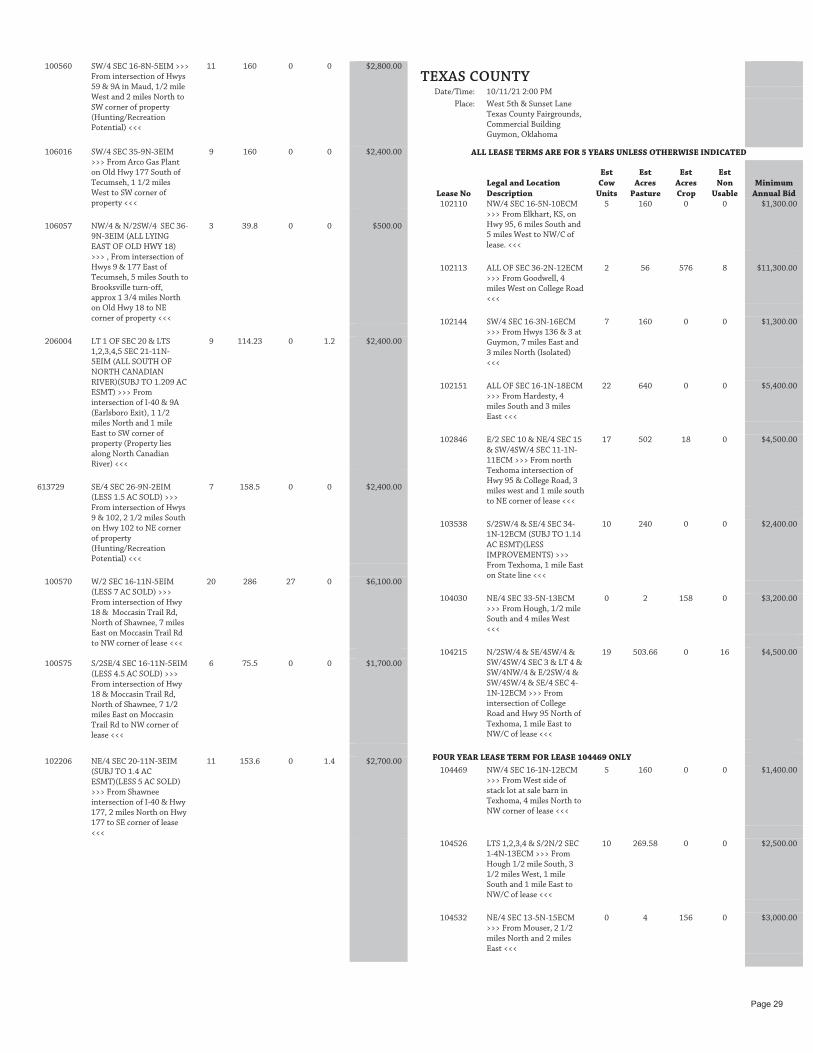
100560 SW/4 SEC 16-8N-5EIM >>>
From intersection of Hwys 59 & 9A in Maud, 1/2 mile West and 2 miles North to SW corner of property (Hunting/Recreation Potential) <<<
11 160 0 0 $2,800.00
106016 SW/4 SEC 35-9N-3EIM
>>> From Arco Gas Plant on Old Hwy 177 South of Tecumseh, 1 1/2 miles West to SW corner of property <<<
9 160 0 0 $2,400.00
106057 NW/4 & N/2SW/4 SEC 36-
9N-3EIM (ALL LYING EAST OF OLD HWY 18) >>> , From intersection of Hwys 9 & 177 East of Tecumseh, 5 miles South to Brooksville turn-off, approx 1 3/4 miles North on Old Hwy 18 to NE corner of property <<<
3 39.8 0 0 $500.00
206004 LT 1 OF SEC 20 & LTS 1,2,3,4,5 SEC 21-11N-5EIM (ALL SOUTH OF NORTH CANADIAN RIVER)(SUBJ TO 1.209 AC ESMT) >>> From intersection of I-40 & 9A (Earlsboro Exit), 1 1/2 miles North and 1 mile East to SW corner of property (Property lies along North Canadian River) <<<
9 114.23 0 1.2 $2,400.00
613729 SE/4 SEC 26-9N-2EIM
(LESS 1.5 AC SOLD) >>> From intersection of Hwys 9 & 102, 2 1/2 miles South on Hwy 102 to NE corner of property (Hunting/Recreation Potential) <<<
7 158.5 0 0 $2,400.00
100570 W/2 SEC 16-11N-5EIM
(LESS 7 AC SOLD) >>> From intersection of Hwy 18 & Moccasin Trail Rd, North of Shawnee, 7 miles East on Moccasin Trail Rd to NW corner of lease <<<
20 286 27 0 $6,100.00
100575 S/2SE/4 SEC 16-11N-5EIM
(LESS 4.5 AC SOLD) >>> From intersection of Hwy 18 & Moccasin Trail Rd, North of Shawnee, 7 1/2 miles East on Moccasin Trail Rd to NW corner of lease <<<
6 75.5 0 0 $1,700.00
102206 NE/4 SEC 20-11N-3EIM
(SUBJ TO 1.4 AC ESMT)(LESS 5 AC SOLD) >>> From Shawnee intersection of I-40 & Hwy 177, 2 miles North on Hwy 177 to SE corner of lease <<<
11 153.6 0 1.4 $2,700.00
TEXAS COUNTY
Date/Time: 10/11/21 2:00 PM
Place: West 5th & Sunset Lane Texas County Fairgrounds, Commercial Building Guymon, Oklahoma
ALL LEASE TERMS ARE FOR 5 YEARS UNLESS OTHERWISE INDICATED
Lease No Legal and Location Description
Est Cow
Units
Est Acres
Pasture
Est Acres Crop
Est Non
Usable Minimum
Annual Bid 102110 NW/4 SEC 16-5N-10ECM
>>> From Elkhart, KS, on Hwy 95, 6 miles South and 5 miles West to NW/C of lease. <<<
5 160 0 0 $1,300.00
102113 ALL OF SEC 36-2N-12ECM
>>> From Goodwell, 4 miles West on College Road <<<
2 56 576 8 $11,300.00
102144 SW/4 SEC 16-3N-16ECM
>>> From Hwys 136 & 3 at Guymon, 7 miles East and 3 miles North (Isolated) <<<
7 160 0 0 $1,300.00
102151 ALL OF SEC 16-1N-18ECM
>>> From Hardesty, 4 miles South and 3 miles East <<<
22 640 0 0 $5,400.00
102846 E/2 SEC 10 & NE/4 SEC 15
& SW/4SW/4 SEC 11-1N-11ECM >>> From north Texhoma intersection of Hwy 95 & College Road, 3 miles west and 1 mile south to NE corner of lease <<<
17 502 18 0 $4,500.00
103538 S/2SW/4 & SE/4 SEC 34-
1N-12ECM (SUBJ TO 1.14 AC ESMT)(LESS IMPROVEMENTS) >>> From Texhoma, 1 mile East on State line <<<
10 240 0 0 $2,400.00
104030 NE/4 SEC 33-5N-13ECM
>>> From Hough, 1/2 mile South and 4 miles West <<<
0 2 158 0 $3,200.00
104215 N/2SW/4 & SE/4SW/4 &
SW/4SW/4 SEC 3 & LT 4 & SW/4NW/4 & E/2SW/4 & SW/4SW/4 & SE/4 SEC 4-1N-12ECM >>> From intersection of College Road and Hwy 95 North of Texhoma, 1 mile East to NW/C of lease <<<
19 503.66 0 16 $4,500.00
FOUR YEAR LEASE TERM FOR LEASE 104469 ONLY
104469 NW/4 SEC 16-1N-12ECM
>>> From West side of stack lot at sale barn in Texhoma, 4 miles North to NW corner of lease <<<
5 160 0 0 $1,400.00
104526 LTS 1,2,3,4 & S/2N/2 SEC
1-4N-13ECM >>> From Hough 1/2 mile South, 3 1/2 miles West, 1 mile South and 1 mile East to NW/C of lease <<<
10 269.58 0 0 $2,500.00
104532 NE/4 SEC 13-5N-15ECM
>>> From Mouser, 2 1/2 miles North and 2 miles East <<<
0 4 156 0 $3,000.00
Page 29

104563 NW/4 SEC 8-4N-14ECM
>>> From Hough Elevators, 2 1/2 miles South <<<
6 160 0 0 $1,600.00
104572 NW/4 SEC 14-2N-13ECM
>>> From the college sign on Hwy 54 in Goodwell, 4 miles North <<<
6 160 0 0 $1,500.00
104585 W/2 SEC 15-1N-13ECM
>>> From the college sign on Hwy 54 in Goodwell, 3 miles South and 1/2 mile West to SE corner of lease <<<
12 320 0 0 $3,100.00
104599 NE/4 SEC 29-1N-12ECM
(SUBJ TO 4.52 AC ESMT) >>> From Texhoma county shop on Hwy 95, 1 mile North to the SW/C of the lease <<<
6 152.95 0 7.05 $1,300.00
104879 SE/4 SEC 27-2N-17ECM
>>> From Hardesty, 1 mile West and 1/2 mile South <<<
5 160 0 0 $1,400.00
104899 SE/4 SEC 35-4N-13ECM
>>> From intersection of Goodwell Road & Hwys 3 & 64, 1/2 mile East to the SW/C of the lease <<<
6 156.5 0 3.5 $1,500.00
104901 LTS 1, 2 & S/2NE/4 SEC 2-
5N-18ECM >>> , From Tyrone, 1 mile South <<<
0 2.98 155.16 1.02 $2,800.00
104959 LTS 1,2 & E/2NW/4 SEC
18-4N-15ECM & NE/4 SEC 13-4N-14ECM >>> From Hwy 136 & 64 North of Guymon, 4.5 miles North (lease is split by Hwy 136) <<<
0 4 305.68 0 $5,700.00
206056 NE/4 SEC 19-3N-15ECM
(SUBJ TO 1.4 AC ESMT) >>> From 24th St & East St in Guymon, 1/2 mile North (West side of street) <<<
5 160 0 0 $1,200.00
206321 LTS 1,2 & E/2NW/4 SEC
31-1N-12ECM >>> From West side of Texhoma Airport, 1/2 mile North to SW/C of the lease <<<
6 159.9 0 0 $1,500.00
307471 LTS 1,2 & SW/4NE/4 &
SW/4 SEC 1-3N-16ECM >>> From Optima, 4 miles East to the NE/C of the lease <<<
9 280.06 0 0 $2,400.00
307476 SE/4 SEC 6-3N-16ECM
LYING SOUTH OF CENTERLINE OF RR R/W (SUBJ TO 23.08 AC ESMT) >>> From Optima, 1 1/2 miles West to NE/C of lease <<<
2 46.92 0 23.08 $300.00
307632 LTS 1,2 & S/2NE/4 & SE/4
SEC 2-3N-16ECM (LESS .11 AC STCL 307637) >>> From Optima, 2 1/2 miles East to NW/C of the lease <<<
12 320.07 0 0 $2,900.00
409177 SE/4SW/4 & W/2SE/4 &
SE/4SE/4 SEC 15 & THAT PART OF NW/4 LYING NORTH & EAST OF ROAD SEC 22-1N-11ECM >>> , From Texhoma, 2 miles North, 4 miles West and 1/2 mile North <<<
8 266.5 0 0 $2,000.00
511492 W/2NW/4 SEC 29-1N-
19ECM >>> From Hardesty, 8 miles East and 6 miles South to the NW/C of the lease <<<
3 80 0 0 $800.00
511597 SW/4 SEC 2-1N-11ECM &
NW/4 & N/2SW/4 & NW/4SE/4 & SW/4NE/4 SEC 11-1N-11ECM >>> From intersection of College Road & Hwy 95 North of Texhoma, 3 miles West to NW/C of lease <<<
12 480 0 0 $3,100.00
613567 SECS 31,34,35 & N/2 SEC
32 & N/2 SEC 33-5N-10ECM >>> From 4 Corners 8 miles West, 8 miles North, 1 mile East and 1 mile South to the NW/C of the lease <<<
81 2430 130 0 $23,300.00
613758 LT 1 & S/2NE/4 SEC 2-4N-
15ECM >>> From Hooker, 10 miles West, 1 mile South and 1/2 mile West to the NW/C of the lease <<<
5 116.27 0 0 $1,300.00
409387 S/2SE/4 SEC 2-1N-17ECM
(LESS .21 AC ESMT) >>> From Hardesty, 3 miles south to the SE corner of the lease <<<
3 79.79 0 0.21 $600.00
519456 LT 3 & LT 4 & S/2NW/4
SEC 2-1N-11ECM >>> From Hwy 95 & County Road CC north of Texhoma, 2.5 miles west and ½ mile south to the NE/C of the lease <<<
0 4 155.66 0 $3,000.00
RANCH UNIT 13
102841 N/2NW/4 & SE/4NW/4 & NW/4NE/4 SEC 18-1N-12ECM >>> From intersection of Hwy 95 & College Road West of Goodwell, 2 miles South and 1/4 mile West to NE/C of the lease <<<
7 160.32 0 0 $1,800.00
106293 LTS 3 & 4 & E/2SW/4 SEC
7 & SW/4NW/4 SEC 18-1N-12ECM >>> From intersection of Hwy 95 & College Road, West of Goodwell, 2 miles South and 1/2 mile West to SW/C of the lease <<<
9 200.7 0 0 $2,200.00
RANCH UNIT 13 TOTALS 16 361.02 0 0 $4,000.00
Page 30

TILLMAN COUNTY
Date/Time: 10/19/21 10:00 AM
Place: 920 SW Sheridan Road Comanche County Fairgrounds Lawton, Oklahoma
ALL LEASE TERMS ARE FOR 5 YEARS UNLESS OTHERWISE INDICATED
Lease No Legal and Location Description
Est Cow
Units
Est Acres
Pasture
Est Acres Crop
Est Non
Usable Minimum
Annual Bid 101556 SE/4 SEC 16-1S-14WIM
>>> From South Chattanooga intersection of Hwys 5 & 36, 5 miles North and 1 mile East to SE corner of property <<<
2 43.01 116.99 0 $4,800.00
101585 ALL OF SEC 16-1S-15WIM
>>> From South Chattanooga intersection of Hwys 5 & 36, 5 miles West and 5 miles North to SE corner of property <<<
11 357.2 282.8 0 $10,900.00
101630 SW/4 SEC 36-1S-16WIM
>>> From intersection of Hwys 5 & 54, 3 miles East, 2 miles North and 1/2 mile West to SE corner of property <<<
0 5 155 0 $5,500.00
101632 W/2W/2NE/4 &
W/2E/2NW/4NE/4 & NW/4NE/4SW/4NE/4 & NW/4 SEC 16-1N-16WIM >>> , From Manitou intersection of Hwys 183 & 5C, 4 miles North and 4 miles East to NW corner of property <<<
5 174.23 38.27 0 $2,500.00
101633 SW/4 &
W/2W/2NW/4SE/4 SEC 16-1N-16WIM (LESS 20 AC SOLD) >>> From Manitou intersection of Hwys 183 & 5C, 4 miles North, 4 miles East and 1/2 mile South to NW corner of property <<<
3 101.32 48.68 0 $2,100.00
101713 NW/4 SEC 36-2N-18WIM
(LESS IMPROVEMENTS) >>> From South Snyder intersection of Hwys 62 & 183, 6 miles West, 2 miles South and 1 mile East to NW corner of property <<<
1 30.55 129.45 0 $5,200.00
101714 SW/4 SEC 36-2N-18WIM
(LESS 5 AC SOLD) >>> From South Snyder intersection of Hwy 62 & 183, 6 miles West, 3 miles South and 1 mile East to SW corner of property <<<
0 5.84 149.16 0 $5,600.00
102701 NE/4 SEC 34-1N-16WIM
>>> From Manitou intersection of Hwys 183 & 5C, 7 miles east and 1/2 mile north to SE corner of property <<<
6 160 0 0 $1,600.00
102702 NE/4 SEC 35-1N-16WIM
>>> From Manitou intersection of Hwys 183 & 5C, 8 miles east and 1/2 mile north to SE corner of lease <<<
6 160 0 0 $1,600.00
105990 NW/4 SEC 26-3S-15WIM
>>> From Grandfield intersection of Hwys 70 & 36, 4 miles West and 2 1/2 miles North to SW corner of property <<<
5 90.08 69.92 0 $3,800.00
106053 SW/4 SEC 26-3S-18WIM
LYING EAST OF HWY 183 (LESS & EXCEPT THE EAST 38 AC) (SUBJ TO 0.38 AC ESMT) >>> From intersection of Hwys 70 & 183 North of Davidson, 1 mile North to SW corner of property <<<
3 47.62 0 0.38 $700.00
205318 SEC 13-1S-15WIM (LESS
IMPROVEMENTS) >>> From intersection of Hwys 5 & 36 south of Chattanooga, 3 miles West and 5 miles North to SW corner of property <<<
15 422.12 217.88 0 $11,000.00
205323 N/2 SEC 13-1S-16WIM >>>
From intersection of Hwys 5 & 54 North of Hollister, 3 miles East and 6 miles North to NE corner of property <<<
7 157.98 162.02 0 $7,400.00
205328 NW/4 SEC 13-1N-16WIM
(LESS IMPROVEMENTS) >>> From Manitou intersection of Hwys 5C & 183, 4 miles North and 7 miles East to NW corner of property <<<
3 62.6 97.4 0 $3,700.00
817130 E/2 SEC 33-1S-15WIM >>>
From intersection of Hwys 5 & 36, South of Chattanooga, 5 miles West and 2 miles North to SE corner of property <<<
2 55.68 264.32 0 $9,500.00
817138 S/2 SEC 33-1S-16WIM
(LESS IMPROVEMENTS) >>> From intersection of Hwys 5 & 54 North of Hollister, 2 miles North to SE corner of property <<<
8 239.98 80.02 0 $5,000.00
817163 LTS 1,2,3,4 SEC 33-2S-
19WIM >>> From intersection of Hwys 183 & 70 North of Davidson, 1/2 mile West, 6 miles North and 6 1/2 miles West to SE corner of property <<<
5 118.7 0 0 $1,400.00
WASHITA COUNTY
Date/Time: 10/18/21 10:00 AM
Place: 1016 Airport Industrial Elk City Convention Center Elk City, Oklahoma
ALL LEASE TERMS ARE FOR 5 YEARS UNLESS OTHERWISE INDICATED
Lease No Legal and Location Description
Est Cow
Units
Est Acres
Pasture
Est Acres Crop
Est Non
Usable Minimum
Annual Bid 101654 LTS 1,2,3,4 NORTH OF
KIOWA TREATY LINE & LTS 1,2,3,4 SOUTH OF KIOWA TREATY LINE & S/2S/2 & N/2 SEC 36-8N-16WIM (LESS IMPROVEMENTS) >>> , From Gotebo intersection of Hwys 54 & 9, 3 miles North and 1 mile East to SW corner of property <<<
12 236.23 439.23 0 $20,000.00
Page 31
101687 SW/4 SEC 16-8N-17WIM
(SUBJ TO STCL 106482)(SUBJ TO 0.97 AC ESMT) >>> From Rocky intersection of Hwys 183 & 55, 3 miles East to SW corner of property <<<
3 59.52 95.51 4.97 $4,400.00
101688 NW/4 SEC 16-8N-17WIM (SUBJ TO STCL 106482)(LESS IMPROVEMENTS) >>> From Rocky intersection of Hwys 183 & 55, 3 miles East and 1/2 mile North to SW corner of property <<<
6 117.68 42.32 0 $3,100.00
101696 S/2N/2 SEC 36-9N-17WIM
(SUBJ TO 1 AC ESMT)(LESS IMPROVEMENTS) >>> From Rocky intersection of Hwys 183 & 55, 6 miles East and 4 miles North to NW corner of lease <<<
3 68.53 90.47 1 $3,300.00
101697 N/2S/2 SEC 36-9N-17WIM
(LESS IMPROVEMENTS)(SUBJ TO 3.28 AC ESMT) >>> From Rocky intersection of Hwys 183 & 55, 6 miles East and 3 1/4 miles North to South boundary of property (Road cuts through West end of property) <<<
3 60.88 95.84 3.28 $3,200.00
101727 NW/4 SEC 16-11N-18WIM
(LESS 5.58 AC STCL 106428) >>> From Burns Flat cotton gin, 5 miles North on Hwy 44, 4 miles East, 1 mile North and 1/2 mile West on trail road along the section line to NE corner of property <<<
4 154.42 0 0 $2,200.00
103128 SW/4 SEC 16-10N-18WIM(LESS 2.07 AC STCL 109462)(SUBJ TO 0.034 AC ESMT) >>> From Burns Flat cotton gin, 3 miles East and 1/2 mile South to NW corner of property <<<
6 155.9 0 2.03 $2,200.00
105353 S/2NE/4 & N/2SE/4 &
SE/4SE/4 SEC 33-9N-17WIM (LESS IMPROVEMENTS) >>> From Rocky intersection of Hwys 183 & 55, 2 miles East, 3 miles North and 2 miles East to SE corner of property <<<
4 77.73 119.27 3 $5,500.00
206081 SW/4 SEC 20-9N-16WIM
(LESS IMPROVEMENTS) >>> From Cordell intersection of Hwys 183 & 152, 3 1/2 miles East and 3 1/2 miles South to NW corner of property <<<
3 70.39 89.61 0 $3,100.00
206249 NE/4 SEC 1-8N-15WIM
>>> From Cowden, 2 miles West, 3 miles South and approx 1 mile East on trail road along the section line to NW corner of property <<<
6 160 0 0 $1,900.00
WOODS COUNTY
Date/Time: 10/12/21 10:00 AM
Place: 108 Temple Houston Drive Woodward Event Center Fairgrounds New Building Woodward, Oklahoma
ALL LEASE TERMS ARE FOR 5 YEARS UNLESS OTHERWISE INDICATED
Lease No Legal and Location Description
Est Cow
Units
Est Acres
Pasture
Est Acres Crop
Est Non
Usable Minimum
Annual Bid FOUR YEAR LEASE TERM FOR LEASE 101660 ONLY
101660 NW/4 SEC 16-25N-16WIM
>>> From Waynoka, 4 1/2 miles North and 2 1/2 miles West to NE corner of property <<<
10 160 0 0 $2,100.00
FOUR YEAR LEASE TERM FOR LEASE 101661 ONLY
101661 SW/4 SEC 16-25N-16WIM
>>> From Waynoka, 4 miles North and 3 miles West to SE corner of property <<<
12 160 0 0 $2,400.00
FOUR YEAR LEASE TERM FOR LEASE 817134 ONLY
817134 SE/4 SEC 33-25N-15WIM
(SUBJ TO 1.03 AC ESMT)(LESS IMPROVEMENTS) >>> From Waynoka, 1/2 mile East, 1/2 mile North and 3 miles East to SW corner of property <<<
10 160 0 0 $2,100.00
FOUR YEAR LEASE TERM FOR LEASE 817135 ONLY
817135 N/2 & SE/4 SEC 33-27N-15WIM >>> From Alva, 8 miles West and 1 mile South to NE corner of property <<<
6 158.9 321.1 0 $14,000.00
WOODWARD COUNTY
Date/Time: 10/12/21 10:00 AM
Place: 108 Temple Houston Drive Woodward Event Center Fairgrounds New Building Woodward, Oklahoma
ALL LEASE TERMS ARE FOR 5 YEARS UNLESS OTHERWISE INDICATED
Lease No Legal and Location Description
Est Cow
Units
Est Acres
Pasture
Est Acres Crop
Est Non
Usable Minimum
Annual Bid 101707 SE/4 SEC 16-22N-17WIM
>>> From Curtis Cemetery, 6 miles East, 3 miles South and 1/2 mile East to SW corner of property <<<
5 68.4 91.6 0 $3,500.00
101711 ALL OF SEC 36-24N-
17WIM >>> From Belva, 1/4 mile West and 1/4 mile North to SW corner of property <<<
15 619.4 20.6 0 $3,800.00
101755 NE/4 SEC 36-21N-20WIM
>>> From Sharon, 1 mile South and 2 1/2 miles East to NW corner of property <<<
7 76.5 83.5 0 $3,400.00
103003 N/2NW/4 SEC 17-22N-
17WIM >>> From Mooreland, 8-3/4 miles East on Hwy 15 and 3 miles South <<<
3 80 0 0 $600.00
104437 NW/4 SEC 36-21N-20WIM
>>> From Sharon, 1 mile South and 2 miles East to NW corner of property <<<
8 104.8 55.2 0 $3,200.00
Page 32

205368 SEC 13-20N-21WIM (LESS
IMPROVEMENTS) >>> From Sharon, 2 miles South, 2 1/2 miles West, 2 miles South to NE corner of property <<<
33 468.5 171.5 0 $10,500.00
409020 LTS 1,2,3 OF NW/4 (LESS
22.1 AC IN RIVER) & LT 4 OF SE/4 (ALL IN RIVER) SEC 11-26N-18WIM >>> From Freedom, 1/2 miles South <<<
3 79.6 0 0 $600.00
613008 SE/4NW/4 & E/2NE/4 & SW/4NE/4 SEC 11-22N-17WIM >>> From Mooreland, 12 3/4 miles East, 2 miles South, 1/2 mile East and 1/2 mile North (Isolated and poorly accessible tract) <<<
6 160 0 0 $1,100.00
715001 LTS 1,2,4 & SE/4NE/4 & NE/4SE/4 SEC 1-23N-17WIM >>> From Belva, 1/4 mile East and 1/4 mile North <<<
5 202.86 0 0 $900.00
715005 LTS 1 & 2 & S/2NE/4 SEC
3-24N-17WIM >>> From Mooreland, 10 miles North, 4 miles East, 1 mile North, 2 1/2 miles East, 1/2 mile South, 3 3/4 miles East and 1/2 mile North (Isolated/poorly accessible tract) <<<
4 185.33 0 0 $700.00
715057 S/2NW/4 SEC 24 & SW/4
& SW/4SE/4 SEC 25-24N-17WIM >>> From Belva, 1/4 mile East, 1/4 mile North and 1 mile North on pasture road (Isolated tract/Limited Access) <<<
4.5 280 0 0 $1,300.00
715155 NE/4NE/4 & SW/4NE/4 &
NW/4SE/4 SEC 22-24N-17WIM >>> From Quinlan, 1/2 mile North, 1/2 mile East, 3/4 mile Northeast, 3 3/4 miles North then Northeast on oil & gas and ranch road approximately 1 1/2 miles to West boundary of isolated and poorly accessible tract <<<
3 120 0 0 $500.00
817156 N/2 & LTS 1,2 OF SW/4 &
LTS 3,4 OF SE/4 SEC 33-20N-18WIM >>> From Mutual, 2 miles East and 4 miles South to NW corner of property <<<
15 259.24 208.5 0 $9,700.00
817159 N/2 & SE/4 SEC 33-22N-
18WIM (LESS IMPROVEMENTS) >>> From Curtis cemetery, 6 miles South to NW corner of property <<<
33 480 0 0 $6,700.00
817176 W/2 SEC 33-21N-21WIM
(LESS IMPROVEMENTS) >>> From Sharon, 7 miles West and 1 mile South to NW corner of property <<<
24 320 0 0 $5,000.00
Page 33

ALL LEASE TERMS ARE FIVE YEARS UNLESS OTHERWISE INDICATEDLease Information• The final bid price at the auction is the amount to be paid for each year of the contract. If the final bid for a lease is $1,000 for a 5-year
lease, the Lessee will pay a total of $5,000, $1,000 each year of the contract. • Checks are deposited immediately on the day of the auction.• Leases consisting of strictly pasture are to be relinquished to the new Lessee not later than January 1, 2022. If the lease contains
cropland with a growing small grain crop, then the Lessee prior to the auction and owner of the small grain crop has the right to graze the grain and relinquish the lease no later than June 1, 2022, or mechanically harvest the crop and relinquish the lease no later than July 1, 2022. Extensions of time to complete harvest of crops may be granted by the CLO.
• The CLO reserves the right to sell all or a portion of leased land at any time, as stated in paragraph 2.3 of the land lease contract. Lessees will be notified well in advance of the potential sale to ensure disruptions to the Lessee’s operation are minimized.
• Contact the CLO main office at 405-521-4000 or the relevant Real Estate Management Specialist for more information about specific leases. RMS contact information can be found on the back cover of this brochure.
Improvements • Improvements generally belong to the Lessee. Improvements must be removed or disposed of within 60 days after expiration of lease
contract. They may be sold to the new Lessee or removed by the former Lessee. The value of the improvements is established by the owner.
• Any fences required by agreement or by operation of law shall be constructed and paid for by Lessee. An Improvement Request must be approved before construction; fences then become the property of the Lessee.
Hunting• Lessees have the right to hunt and allow others to hunt on their lease. Lessees must maintain the responsibility to indemnify the Land
Office against all claims arising out of use of the Land as per Paragraph 3.6 of the lease contract.
Farming• Double cropping is not permitted on CLO lease lands. Please refer to page 21 of this brochure for more information on double cropping.
Contact your local Real Estate Management Specialist to determine, based on crop history, if a final crop is allowed. • Lessees are required to maintain tillage of cropland to maintain bases and protect the land from waste. Allowing excessive weeds to
grow on the cropland violate paragraph 4.5 of the lease contract by permitting waste on the property. • Permanent pastures may not typically be plowed for crop use. “Prior written permission from CLO will be required before any permanent
pastures are plowed out, timber cleared or cut, or any sod or sprigs are removed from lease,” according to paragraph 4.3.5 of the lease contract.
Ranching • The estimated cow units shown on the advertisement is a close estimate. Any adjustment in cow units requires written permission
from the Real Estate Management Specialist (RMS). If there is an abundance of grass on the leased property, the RMS may increase the number of cow units. In the instance that the grass is depleted too quickly, the number of animals allowed on the leased property may be reduced.
• One cow unit is equivalent to a cow and unweaned calf.
Conservation• The Land Office agrees to provide technical assistance to Lessees for preservation, conservation, and management of Trust lands.
Limited funds are available for special projects. Pre-construction approval must be obtained from the Land Office before CLO funds can be used for any project.
GENERAL INFORMATION
Visit our website at www.clo.ok.gov to sign up for E-mail updates from the CLO or to learn more about lease and sale information
Correspondence Address: Commissioners of the Land Office
204 N. Robinson, Suite 900 Oklahoma City, OK 73102
Send Payments to: Commissioners of the Land Office
Lockbox Account P.O. Box 248896
Oklahoma City, OK 73124-8896
Commissioners of the Land Office (405) 521-4000 or 1-888-35-LANDS (1-888-355-2637)
CONTACT INFORMATIONAgricultural Leases: [email protected]
Easements:[email protected]
Billing:[email protected]
Soil Conservation:[email protected]
Permits/Assignment/Improvements:[email protected]

SOLAR ADDENDUMSOLAR ENERGY ADDENDUM TO SURFACE AGRICULTURAL LEASE CONTRACT:
CLO and Lessee(s) hereby acknowledge that in accordance with Section 2.3. of this Lease Contract, the Leased Property is subject to a Solar Energy Ground Lease that was in effect prior to the execution and commencement of this Lease Contract. Such Solar Energy Ground Lease shall only be cause to terminate the Agricultural lease at CLO’s sole discretion.
CLO and Lessee(s) further hereby acknowledge that some, all or none of the Leased Property may be impacted or further impacted by the development of the Solar Energy Project covered by said Solar Energy Ground Lease.
CLO and Lessee(s) shall otherwise comply with Section 2.3. of this Lease Contract if the Solar Energy Project will impact some or all of the Leased Property.
LESSEE(S) HEREBY ACKNOWLEDGE THAT SECTION 2.4. OF THIS LEASE CONTRACT HAS BEEN RESTRICTED FOR THIS LEASE AND LESSEE(S) SHALL NOT RECOVER ANY CROP, IMPROVEMENT OR OTHER DAMAGES AS A RESULT OF THE SOLAR ENERGY PROJECT AND IS ENTERING INTO THIS LEASE CONTRACT WITH THAT UNDERSTANDING AND ASSUMES ALL RISK OF LOSS TO CROPS AND IMPROVEMENTS IF THE SOLAR ENERGY PROJECT IMPACTS SOME OR ALL OF THE LEASED PROPERTY.
ASSIGNMENT FEE STATEMENTPlease be advised that starting January 1, 2022, the Commissioners of the Land Office (CLO) will begin charging a $75.00 fee for assigning Ag Lease Contracts (Assignments).
It is imperative for bidders at the 2021 Fall Ag Lease Auctions to register with the proper name, address, and contact information in which they want the Lease Contract to be written and billed so that a subsequent Assignment is not required.
Request for Assignment forms can be found at clo.ok.gov.
Please email these to [email protected] or mail forms to: Commissioners of the Land OfficeREM Assignments Dept.204 N. Robinson, Ste. 900Oklahoma City, OK 73102
DEFINITION OF DOUBLE CROPPINGDouble cropping shall be defined as harvesting two or more crops from the same piece of land in the same crop year. Harvesting by machine or pasturing are one and the same. Only one (1) crop may be harvested per year of the contract. Five year contract -- five crops. See exception on green manure and leguminous crop.
Alfalfa or sudan-sorghum crosses may be cut more than once per calendar year.
Green manure or leguminous crops may be grown at any time in crop rotation. Bean or pea seed may be harvested. THese crops may not be baled for hay, cut for silage, or grazed by livestock.
Under certain conditions, double cropping may be permitted.
Double cropping may be permitted, if the supervisiong Real Estate Management Specialist determines that a change in the cropping system will protect the land from erosion, eliminate weed or insect problems, or the lessee desires to change rotation to fit his operation.
The supervising Real Estate Management Specialist shall make final determination of whether or not double cropping is permitted.
Crop year -- The amount of time between planting a selected crop and planting the same crop the next year.
Page 35

204 N R
obinson, Suite 900O
klahoma C
ity, OK
73102
PRESO
RTFIR
ST CLASS M
AIL
U.S. PO
STAG
E PAID
OK
LAH
OM
A CITY, O
K
LAN
D LEA
SE AUCTIO
N
Beaver and Texas CountiesMon | Oct 11 | 2:00 pm
Texas County Fairgrounds828 NW 4th St.
Guymon, OK 73942
Cimarron CountyMon | Oct 11 | 9:00 am
Cimarron County Fairgrounds1120 N Logan Ave.
Boise City, OK 73933
Ellis, Harper, Major, Woods, and Woodward CountiesTues | Oct 12 | 10:00 amWoodward Event Center
105 A Temple Houston Dr.Woodward, OK 73801
Alfalfa, Blaine, Garfield, Grant, Kay, and Kingfisher
CountiesWed | Oct 13 | 10:00 am
Garfield County Fairgrounds111 W Purdue Ave.
Enid, OK 73701
Beckham, Caddo, Kiowa, and Washita Counties
Mon | Oct 18 | 10:00 amElk City Conv. Center
1016 Airport IndustrialElk City, OK 73648
Comanche, Cotton, Grady, Jackson, and Tillman
CountiesTue | Oct 19 | 10:00 am
Comanche County Fairgrounds920 SW Sheridan Rd.
Lawton, OK 73505
Logan, Noble, Pawnee, and Payne Counties
Wed | Oct 20 | 10:00 amPayne County Expo Center
4518 Expo Cir E.Stillwater, OK 74075
Canadian, Cleveland, Lincoln, Oklahoma, and Pottawatomie CountiesMon | Oct 25 | 10:00 am
Shawnee Expo Center1700 W Independence
Shawnee, OK 74804
Greg Brownsworth(580) 248-1584 | [email protected], Cotton, Jefferson, and Stephens Counties
Robert Parrish(405) 886-4421 | [email protected]
Kay and Pawnee CountiesChris Foster
(405) 263-7912 | [email protected], Blaine, Custer, Dewey, Ellis, Kingfisher, and Roger Mills Counties
Starr Ryan(580) 393-2393| [email protected]
Alfalfa, Garfield, Grant, Logan, Major, and Noble CountiesSean Ison
(405) 208-2067| [email protected] and Payne Counties
Starr Ryan(580) 393-2393| [email protected]
Greer, Harmon, Jackson, Kiowa, Tillman, and Washita CountiesRoger Knauss
(580) 654-1190 | [email protected], Canadian, Cleveland, Garvin, Grady, McClain,
Oklahoma, and Pottawatomie CountiesCaleb Clinesmith
(580) 545-2059| [email protected] and Texas Counties
Trent Wildman(580) 766-2374| [email protected], Harper, Woods, and Woodward Counties
Commissioners of the Land OfficeReal Estate Management Specialists