2.2 existing cotter dam (history) - icon water
TRANSCRIPT
42 WATER SECURITY – MAJOR PROJECTS
FEBRUARY 2009
2.2 Existing Cotter Dam (history)
The promise of abundant water from the Cotter River was a key factor in the selection of Canberra as the
site for the federal capital of Australia. Prominent NSW Chief Engineer for Rivers, Water Supply and
Drainage, Ernest de Burgh, claimed that ‘the flow of the Cotter was twice as much as the water consumption
of 650,000 people in Sydney’.
Construction of the Cotter Dam, designed by Henry Connell, began in March 1912. The dam was a gravity
concrete structure, with a straight wall and an overshot spillway that sent water down the face of the wall.
The Cotter Dam was completed in 1915 to a height of 18.3m. A royal commission in 1917 criticised the cost
of the Cotter Dam’s construction, although the dam had not been constructed to its planned height of 30.5m,
and at £75,000 it cost less than was estimated.
Canberra’s growing post–World War II population meant an increased demand for water. In 1947–48 it was
decided to raise the dam to increase its storage capacity, and in 1949 work commenced. It was hampered by
faults in the old wall, and by a big flood in March 1950 that halted work for a month. By 1951 the dam had
been raised to 25.8m.
An access road constructed in the course of enlarging the Cotter Dam opened up the Cotter River area to
visitors, and contributed to its reputation as a beautiful natural setting and a key recreational area for the
growing city of Canberra.
Water from the Cotter Reservoir needed to be raised 250m to Mount Stromlo Reservoir, so that it could be
gravity-fed to Red Hill Reservoir.
The Cotter Pumping Station, comprising two single-storey buildings of rendered brick, was designed by the
architect of Old Parliament House and the Kingston Power Station, John Smith Murdoch. Construction of the
pumping station, began on the right bank of the Murrumbidgee River in 1914, and two Gwynne pumps were
ordered from the UK. By October 1918 the Cotter Pumping Station was pumping water to Mount Stromlo
Reservoir. At first the Cotter Pumping Station operated for only several days a month, but as Canberra’s
population grew, six more pumps were added—one in 1935, one in 1942, two in 1955, and two in 1963,
when a two-storey extension was built to accommodate their vertical orientation. The Cotter Pumping Station
was no longer required after water from Bendora and Corin reservoirs became available in 1967, and it did
not operate again until 2004, after the 2003 Canberra bushfires.
Water from the Cotter Reservoir travels to the Cotter Pumping Station through cast iron pipes running along
the left bank of the Cotter River to a tunnel on the left bank of the Murrumbidgee, through another tunnel
under the Murrumbidgee River, then up to the Cotter Pumping Station on the right bank of the river.
Construction of the tunnel was difficult, and it was regarded as a marvel of engineering at the time.
As a result of a revision of the flood hydrology of the Cotter River system in 1988 it was determined that an
upgrade of the existing Cotter Dam was required. This upgrade was as a consequence of the renewed
hydrology (information) that indicated that in the event of an Imminent Failure Flood on Cotter River, coupled
with the failure of the two upstream dams of Corin and Bendora, the existing Cotter Dam would fail.
In view of these findings and considering the age of the Cotter Dam (build in 1912), material deterioration
and inadequate capacity of its spillway, ACTEW undertook a program of remedial work in January 1999.
Upgrade works were aimed at improving the stability of the dam against extreme flooding scenarios and
earthquakes and consisted of replacing the top 1.8m of the dam with a reinforced concrete load distribution
beam and anchoring the dam to the rock foundation using 45 modern anchors. The remedial work was
undertaken at a cost of $5.5 million. The work was concluded prior to the commencement of any
investigations relating to the Enlarged Cotter Dam proposal (as described in section 1 of this report). This
expenditure and the resulting upgraded dam was considered in reviewing the options for the ACT’s next
water source, which was conceived in response to the protracted drought experienced in the ACT since
2001. The upgrading of the existing dam was one of more 30 options that were considered as potential
new water sources for the ACT. A more detailed review of the options considered is given in section 1 of
this report.

ENLARGEMENT OF THE COTTER RESERVOIR AND ASSOCIATED WORKS
ENVIRONMENTAL IMPACT STATEMENT 43
Figure 2.6 The Cotter Dam and the Reserve have been a recreational destination for generations of
Canberrans and visitors
Figure 2.7 Building the original Cotter Dam between 1912 and 1915–16

44 WATER SECURITY – MAJOR PROJECTS
FEBRUARY 2009
Figure 2.8 The Cotter Pumping Station in its original configuration, before a two-storey extension was built to
house the vertical pumps
Figure 2.9 The Cotter Dam after the wall was raised in 1951

ENLARGEMENT OF THE COTTER RESERVOIR AND ASSOCIATED WORKS
ENVIRONMENTAL IMPACT STATEMENT 45
Figure 2.10 Tunnel and pipeline to Cotter Pumping Station on the banks of the Murrumbidgee River
2.3 Project specifications
The Enlarged Cotter Dam proposal includes both the main dam and associated infrastructure as well as
works associated with site establishment and gaining of on-site materials.
2.3.1 Main dam, saddle dams and associated infrastructure
The project consists of a main dam located on the Cotter River in the Lower Cotter catchment, with two
saddle dams to the right abutment. The Full Supply Level of the reservoir will be approximately 550m AHD.
The dam will be approximately 80m high. Design optimisation is in progress to determine the preferred dam
configuration by comparing traditional spillway arrangements and gate combinations. The adjacent saddle
dams will be built to an approximate height of 11m and 16m. The main dam will be constructed of RCC and
the saddle dams will be constructed of earth and rock-fill if an appropriate source of clay material can be
identified (including onsite options). If this material cannot be economically sourced, then the saddle dams
may be constructed of RCC or a combination of earth rock fill with a conventional concrete face. This is yet
to be determined.

46 WATER SECURITY – MAJOR PROJECTS
FEBRUARY 2009
Figure 2.11 Artist’s impression of the Enlarged Cotter Dam
The dam outlet works will incorporate provision for drawing water from multiple depths in the reservoir. The
Enlarged Cotter Dam will also require valving and pumping arrangements to allow for a variety of water
extraction arrangements to respond to changing operational and environmental requirements. These
arrangements will require modifications to pipework and augmentation of existing pumping facilities at Cotter
Pumping Station. These modifications will enable:
•• A blend of Cotter Reservoir and Murrumbidgee River water to be treated at Mount Stromlo Water
Treatment Plant.
• 100 per cent of Cotter Reservoir water to be treated at Mount Stromlo Water Treatment Plant.
• 100 per cent of Murrumbidgee River water to be treated at Mount Stromlo Water Treatment Plant.
• Murrumbidgee River water to be used for Cotter River environmental flow via recirculation pipework.
• Cotter Reservoir water to be used for Cotter River environmental flow.
A small temporary dam and diversion culvert will be constructed between the existing dam and the new dam
to ensure that the existing dam remains operable throughout the construction period and for protection of the
work site. The location of a quarry to supply construction material for the main dam and associated saddle
dams has been identified to the south-west of the right abutment.
The design of the main engineering infrastructure is still to be finalised. A copy of the latest concept design is
included in Appendix D.

ENLARGEMENT OF THE COTTER RESERVOIR AND ASSOCIATED WORKS
ENVIRONMENTAL IMPACT STATEMENT 47
2.3.2 Associated works and on-site materials
In considering the logistics and materials requirement for constructing the main infrastructure ACTEW is
investigating opportunities to source and use onsite sources of rock, sand and clay. The location of the
quarry sites are shown in Figures 2.3 and 2.4.
The quarry will be developed to extract approximately 800,000 tonnes of rock for use in concrete and
pavement materials. ACTEW is actively investigating the opportunity to manufacture sand from materials
gained from this quarry to use or supplement the aggregate requirements for batching of both RCC and
conventional concrete. Pending the outcome of the crushing trials and suitability of materials manufactured
there may be a need to further import aggregate materials (including sand) as required.
Rock will be extracted from the quarry using conventional quarrying methods (including blasting). Rock from
the quarry will be crushed, graded and stockpiled within the construction area for use in batching operations
and other construction uses.
In the construction of the saddle dams core material is required to create a water proof entre. Early design
estimates indicate a requirement of approximately 50,000 m3 of clay. ACTEW is investigating opportunities to
source clay within the construction and inundation footprint of the Enlarged Cotter Dam. Desktop
assessment and surface investigations during field visits resulted in the identification of three potential clay
borrow areas (see Figure 2.4). Although the areas under consideration are approximately 11ha in total the
actual borrow area required is dependant on the results from detailed geotechnical investigations and the
usefulness of materials found. These studies are yet to be completed.
Sourcing clay will involve excavation utilising a selection of the following machinery – scrapers, excavators,
dozers. Useful material will be carted to the construction site by truck primarily along existing forestry access
tracks with a possible need to use short sections of Brindabella Road or Bullock Paddock Road. Where
required, tracks will be upgraded and widened to allow for the increased use and ensure that no adverse
impacts are created from sediment run-off into the catchment. It is anticipated that no upgrading of local
roads (Brindabella Road or Bullock Paddock Road) will be required.
Clay material gained will be stockpiled within the construction area (adjacent to the proposed saddle dams)
and treated prior to being placed. Treatment of clay material may involve drying out and the addition of a
benign material such as lime or bentonite.
The main driver for investigating and sourcing onsite materials (clay, sand and rock) stems directly from the
opportunities associated with reduced traffic impacts on public roads (less hauling of materials from off-site
sources) and associated reduction in wider noise and traffic safety impacts, reduction in emissions and
greenhouse gases emitted given the reduced haulage requirements and some economics of scale (Detail on
likely delivery requirements are at section 5.1).
The location of the quarry and borrow areas are dependant on finding useful materials but in considering
likely site opportunities ACTEW has been conscious of the likely impacts of these works on the environment.
The locations proposed have been chosen to be primarily within the inundation area of the future Enlarged
Cotter Dam to minimise their impacts on visual amenity, terrestrial flora and fauna, heritage and other
matters. The likely impacts of these structures are discussed under the relevant section of this EIS.
Stripping of the overburden at the main dam and saddle dam sites is expected to produce approximately
400,000m3 of spoil. This material will be stockpiled in separate topsoil and general material piles. This will
allow the re-use of topsoil for rehabilitation and other works during and at the end of the project.
Part of the rock that is to be removed from the construction sites may be suitable for use in the construction
of the engineering infrastructure and investigations are ongoing to confirm its re-use potential. This material
(if suitable) will be blended with the general stockpiles and used in the preparation of construction materials.
ACTEW is also investigating other opportunities for beneficial re-use of the general material. The
opportunities include upgrading and maintenance of haul roads and access roads, build-up and levelling of
construction and works areas, reshaping of landforms during rehabilitation of the construction site and/or
filling of erosions gullies in the inundation area or as determined in consultation with the land custodian

48 WATER SECURITY – MAJOR PROJECTS
FEBRUARY 2009
Parks, Conservation and Lands (PCL). Further details will be provided for consideration at the DA stage of
the project.
The use of these materials is also earmarked by expert consultants for the creation of artificial habitats for
both terrestrial and aquatic species. Any strategies that include use of this material outside the “Extent of
works” will be discussed with the land custodian PCL and the Environment Protection Authority (EPA) prior
to such work being undertaken.
2.3.3 Project scope
In summary, the scope of the works includes:
•• Detailed geotechnical investigation for all associated works (including main infrastructure, quarry and
borrow areas).
• Design and construction of the main dam, the spillway and the saddle dams.
• Design and construction of protection works; that is, flood diversion around site works.
• Design and construction of dam outlet works, including flow control valves, control instrumentation
and gauging.
• Establishment of temporary use the construction site including set out of site compounds, batching and
crushing plants, and erecting of all fencing. (Note that Figure 2.3 provides the latest construction site set-
out. This is yet to be optimised and may change depending on actual construction methodology chosen.
This will be finalised for the Development Assessment.).
• Design and construction of upgrade works required for site access routes, haul roads and forestry tracks.
• Development and implementation of a community and stakeholder engagement program and provision of
community education and visitors services.
• Investigation, design and installation of power supply and communications infrastructure (likely to be
wireless) to service construction and ongoing operational requirements.
• Design and installation of a system to mix the water in the reservoir to maintain water quality.
• Implementation of the Cotter Reservoir Fish Management Program, which includes a range of ecological
studies as well as artificial habitat design and construction.
• Assessment into and ultimately the decommissioning of the old Cotter Dam
• Vegetation clearance (as required) from within the inundation area (mainly large trees)
• Rehabilitation works as required
2.3.4 Project design
The project design will be based on environmental conditions, planning issues related to the local area and
its uses, technical matters such as geology, and ongoing operational requirements.
The design of the dam structure and outlet works will also take into account the appearance of the dam and
its integration into the local Cotter recreational area.
Design will also address the possible progressive impoundment of water during construction and ensure the
ability to meet ongoing abstraction license conditions, including mandated environmental flows.
Additional details of the proposed works are presented in Table 2.1.

ENLARGEMENT OF THE COTTER RESERVOIR AND ASSOCIATED WORKS
ENVIRONMENTAL IMPACT STATEMENT 49
Table 2.1 Details of the proposed works
Element Description of works
Main dam wall—RCC structure.
Integrate the dam wall aesthetically and thematically into the wider Cotter Precinct
landscape and recreational plan.
Dam axis to be located approximately 125m downstream of existing Cotter dam
wall. Final location subject to geological and geotechnical assessment regarding
the adequacy of abutment and foundation conditions.
Width of main dam approximately 260 m.
Height of main dam wall approximately 80 m.
Storage capacity of approximately 78GL (at 550.8 mAHD).
Access to top and base of dam wall, for maintenance personnel and the public (if
permitted).
Multi-level intake tower capable of drawing water down to 5 per cent of storage
capacity.
Main dam
Internal access to drainage and inspection galleries.
Provision of shutters, trash and fish screens and gantry cranes at the intake tower
and associated electrical works.
Provision of surveillance instrumentation of the dam structure including
piezometers, tilt meters, inclinometers and remote monitoring.
Power supply and communications to intake and outlet structures.
Mechanical and electrical
works, instrumentation and
power supply
Dam plug valve to permit draining of the dam reservoir.
Quarry site Investigation and analysis of the quarry site, including suitability, quantity and
proximity of in-situ material.
Clay borrow areas Investigation and analysis of clay borrow areas, including suitability, quantity and
proximity of in-situ material.
Saddle dams Two separate embankments preferentially constructed of earth/rock-fill.
Service spillway for floods, designed in response to risk assessment.
Overflow crest and apron for flood events designed in response to risk
assessment.
Energy dissipating structure.
Variable level intake capacity with an approximate range between 5ML/d and
1,200ML/d for environmental releases with the dam at 60 per cent full.
The pipework required for the delivery of raw water from the river discharge point
to the suction side of the existing tunnel be sized to 1,500 mm.
Manual and remote controlled valve operation.
Spillway, intake and outlet
Intake tower to allow environmental flows and town demand to be sourced from
separate levels within the water column.

50 WATER SECURITY – MAJOR PROJECTS
FEBRUARY 2009
Element Description of works
Online water quality sampling for dissolved oxygen, turbidity, and temperature at
intake tower valves. Ability to take physical samples from intake valve levels using
the online water quality system.
Trash racks and fish screens on the intake tower to prevent material being sucked
into river discharge valves and Cotter pumps. Motorised rake arm to clear debris
off the trash racks.
Heavy lift ability for maintenance of intake valves.
Low-level intake to access deep storage and allow for flushing.
Water supply and environmental release pipelines to be fitted with appropriate
meters to measure flow for operational and licence requirements.
The discharge point of the stilling basin to incorporate a river flow gauge (wide V
notch crest), to allow measurement of the flow below the dam, whether it be
overflow or environmental flow release.
Spillway flow measurement.
Provision of additional (and/or replacement of) mixers and de-stratifiers to
maintain water quality in larger reservoir (subject to findings of hydrodynamic
modelling).
Extended boat ramp to allow reservoir access over the full range of drawdown.
Mixers operation to be linked to weather station at the dam wall.
Implementation of fish habitat management plan.
Aquatic real-time management system building on hydrodynamic model.
Quarry and borrow sites to be left to agreed standard and profile. Preference for
the location of sites is below Full Supply Level for use as fish habitats.
Provision of river diversion works.
Design must consider implementation sequencing to permit continued operational
use during construction.
Upgrading and continuous management of access and forestry tracks used to
ensure protection of the catchment and water quality
Vegetation clearing (inside the extent of works and within the inundation area)
as required.
Decommissioning of the old Cotter Dam
Catchment and precinct
management
Revegetation and rehabilitation of affected land (in liaison with PCL)
Optimisation of the progressive impoundment of water taking account of the
continued operational use of the Cotter Dam, including access for ActewAGL
maintenance personnel for the duration of construction.
Obtain all construction works permits and approvals required to execute
the works.
Ability to meet ongoing abstraction licence conditions, including e-flows.
General construction
Relocation of existing services as necessary.

ENLARGEMENT OF THE COTTER RESERVOIR AND ASSOCIATED WORKS
ENVIRONMENTAL IMPACT STATEMENT 51
2.3.5 Design process
An alliance has been developed between the owner, the designer and the constructor of the proposed dam
to benefit from their collective experiences and to ensure constructability of the final design.
The design process will involve the following key aspects:
•• Undertaking hydraulic modelling of dam and spillway and assessment in accordance with
ANCOLD guidelines.
• Revising existing geotechnical investigations and defining the scope for additional investigations (including
dam site, foundation grouting, quarry, saddle dams, access roads).
• Assessing potential quarry materials and carry out physical and chemical analysis together with crushing
trials and preliminary RCC mix designs.
• Assessing the extent of foundation grouting and pinning requirements.
• Assessing main and saddle dam arrangement options for primary and/or auxiliary spillways.
• Developing internal drainage design (optimise the number and location of galleries, determine ventilation,
lighting and operational requirements).
• Undertaking dam stability analysis in accordance with ANCOLD guidelines for normal, unusual and
extreme load conditions.
• Developing diversion solutions (including flood risk control, materials, closure structure).
• Developing coffer dam designs (upstream and downstream coffer dams) including location, geometry,
height and materials.
• Reviewing options for fish-friendly design and construction of the main dam and coffer dam.
• Developing outlet tower and outlet works designs including mechanical, electrical and control.
• Developing a control and monitoring system for outlet.
• Developing solutions for access road and public viewing facilities.
• Developing a revised dam safety plan for the existing Cotter Dam during the construction phase.
• Developing a dam safety plan for the new dam while under construction and once commissioned.
• Carrying out hydraulic design for pipework and pumping infrastructure.
• Developing a decommissioning plan for the existing Cotter Dam.
• Developing a decommissioning plan for any obsolete pipework and pumping infrastructure.
The following technical standards have been adopted as minimum design standards for the project:
• ACTEW Water Supply and Sewerage Standards.
• ACTEW Greenhouse Gas Management Strategy.
• ActewAGL Water Division Drafting Standard.
• ANCOLD Design Guidelines.
• Dam Safety Code 2003 (Addendum to Utilities Act 2000).
• DSC NSW Requirements (Dam Safety Committee, New South Wales), specifically DSC 14.
• International Commission on Large Dams Design Guidelines.
• AP-G17/04: Pavement design guide—A guide to the structural design of road pavements.

52 WATER SECURITY – MAJOR PROJECTS
FEBRUARY 2009
•• AS 1428: Design for access and mobility.
• AS 3600: Concrete structures.
• AS 5100: Bridge design.
• AS ISO 13822–2005: Basis for design of structures—Assessment of existing structures.
• HB 36–1993: Building in bushfire prone areas—information and advice.
• HB 301–2001: Electrical installations—designing to the wiring rules.
Objective
To ensure the highest standard of design is adopted
Commitments
Specifications • The main dam will be constructed of RCC. The source of construction materials
including aggregate and clay will be sourced based on the most economical
acquisition option. The saddle dams will be constructed of earth and rock-fill. In the
event that these materials cannot be sourced economically, then the saddle dams
will be constructed of RCC or a combination of concrete and earth and rock-fill.
• The dam outlet works will incorporate provision for drawing water from multiple
depths in the reservoir.
• A small temporary dam and diversion culvert will be constructed between the
existing dam and the new dam to ensure that the existing dam remains operable
throughout the construction period and that the work site is protected.
Design • The design of all elements of the project will be based on environmental
conditions, planning controls, technical matters such as geology and ongoing
operational requirements.
• The design of the dam structure and outlet works will also take into account the
appearance of the dam and its integration into the local Cotter recreational area.
• Design will also address the progressive impoundment of water during construction
and ensure the ability to meet ongoing abstraction licence conditions, including
mandated environmental flows.
Costruction • Overburden material will be used within the extent of the works for beneficial
purposes or as determined in negotiations with the land custodian (Parks,
Conservation and Lands).
• Where necessary haul roads and forestry tracks will be upgraded.
2.3.6 Enlarged Cotter Dam and associated infrastructure design
The design process of major infrastructure, such as the Enlarged Cotter Dam, often includes a long design
program that aims to establish a design concept and design principles at an early stage that are then refined
over time as more information is gained. During this optimisation process the detailed design is further
enhanced by specific field and other investigations that further consider environmental constraints,
construction constraints, client requirements and other opportunities that may emerge.
This optimisation exercise often results in minor changes to the design as the design period concludes. The
design of the Enlarged Cotter Dam commenced in 2006 and is likely to continue to be optimised after the
lodgement of this EIS. When comparing the design that was provided to expert consultants in 2007 with the
design presented in the Draft EIS and in turn the final EIS, a number of minor differences can be seen in
both the design detail and construction site arrangement presented at various times. It is important to be
mindful that while the design details may have evolved the main design parameters (top water level, main
dam and saddle dams construction location and method, inundation area of the Enlarged Cotter Dam, and

ENLARGEMENT OF THE COTTER RESERVOIR AND ASSOCIATED WORKS
ENVIRONMENTAL IMPACT STATEMENT 53
extent of main construction area have remained fundamentally unaltered. Similarly the potential impacts and
risk associated with the project remain the same.
Since the submission of the Draft Enlarged Cotter Dam EIS to the ACT Planning and Land Authority
(ACTPLA) in November 2008 and public notification thereof, a number of modifications have been made to
the proposal. These changes are associated primarily with advice and concerns raised during the notification
period, but also reflect necessary changes to the proposal associated with new information that became
available since November 2008 relating to likely construction activities and methods as well as output from
design refinements. These changes further include specification of the proposal where new information
received since the submission of the Draft Enlarged Cotter Dam EIS now allows the proponent to choose
between matters that were presented as “options”. The main modifications to the proposal are:
•• Refinement in the arrangement of the construction methodology associated with choosing a preferred
quarry location and construction equipment.
• Removal of optional quarry location from the construction footprint. This area will now be available to
general construction activities.
• Minor change to the proposed construction site “Extent of works”. The change constitute a swap of a 9ha
area to reduce the visual impact of construction activities (response to notification representations).
• Inclusion of three proposed clay borrow areas located within the future inundation area of the Enlarged
Cotter Dam (response to notification representations).
• Minor changes to the design details of the main engineering infrastructure.
• Clarification is now provided on the likely amount of overburden to be generated from this proposal and its
likely re-use is discussed.
• Provision of more detailed quantities and volumes relating to some construction activities, traffic
and waste.
• Additional noise surveys have been commissioned to consider traffic noise, impacts from 24-hr operations
and blasting activities.
• General changes to provide clarification and more detailed information on matters raised by ACTPLA upon
their initial review of the draft EIS.
• Minor amendments to the technical assessments (included in this EIS as Appendices) as a result of
reviewing the assessments in light of representations and comments received.
• Additional technical assessments to provide more clarity on matters raised and assessment of the changes
made to the EIS.
Descriptions of these changes have been included in the relevant sections of this report. The proponent also
includes extracts of the latest design drawings to assist in the assessment of this proposal at Appendix D.
2.4 Construction details
2.4.1 Logistics
The Enlarged Cotter Dam will be constructed of RCC, which allows very high rates of concrete placement
over a relatively short duration (approximately 12 months). It is expected that concrete will be placed in the
dam at rates approaching 50,000m3 per month. It does not need detailed or complex placing procedures.
The process requires a sequence of resources similar to that outlined in Figure 2.12.

54 WATER SECURITY – MAJOR PROJECTS
FEBRUARY 2009
Figure 2.12 Construction cycle for main dam – Generic RCC construction process

ENLARGEMENT OF THE COTTER RESERVOIR AND ASSOCIATED WORKS
ENVIRONMENTAL IMPACT STATEMENT 55
2.4.2 Workforce and working hours
Workforce numbers will vary during stages of the project, but will peak during the construction of the new
dam. Approximately 140 personnel (per shift) will attend the site six days per week.
The workforce is expected to live in Canberra and travel to site for each shift. Shared travel arrangements
will be investigated to minimise traffic impacts.
The project will be constructed in three distinct stages; Stage 1, establishment and start up, June 2009 to
March 2010, Stage 2, main dam construction, March 2010 to September 2010, and Stage 3 completion
works, September 2010 to April 2011 (Refer to timeline description at section 2.4).
For Stages 1 and 3, general working hours will be Monday to Friday, 8 hours per day as well as
Saturdays. The spread of these hours will between 6.00 AM and 6.00 PM on weekdays and 7.00 AM to
4.00 PM on Saturdays. It is expected that overtime will be required and some weekend works to
complete tasks on time. It is expected that no work will be undertaken on Public Holidays and Roster
Days Off.
During Stage 1 the workforce will increase progressively to approximately 140 personnel that will work
the general hour shifts. Low impact (maintenance type) activities may be conducted on Sundays and public
holidays, if and when required.
Given the timing and complexity of the project, certain activities may need to be conducted outside general
working hours. The placement of RCC into the dam wall is a specialist activity that requires continuous
operation and this activity will drive a need to extend working hours.
It is proposed that special working hours are set to undertake Stage 2 activities including batching and
placement of RCC and conventional concrete in the construction of the main dam and associated
infrastructure. These activities will be undertaken 24 hours per day, 7 days per week. This work will be
undertaken in teams working 10 hour shifts, with shifts to be staggered throughout the days and weeks.
For Stage 2 the current expectation is that approximately 140 personnel will work during general
working hours and 50 personnel through night and week end shifts.
The proponent will seek specific approval for the variation in working hours to conduct Stage 2
activities. Work outside general working hours will only be conducted in accordance with a written
agreement between the proponent and the Territory and/or the appropriate government agency. Further
information on the likely noise impacts associated with 24-hour operations are included in section 5 of
this EIS.
Blasting work will only be conducted between 9 am and 5 pm Monday to Friday and between 9 am and
1 pm Saturday in accordance with an approved blasting plan. These times may be adjusted under
direction from the Territory, a government agency or the police for safety reasons or as required in the
blasting plan.
2.4.3 Plant logistics
Equipment will include:
•• Tracked dozers from D5 size through to D10.
• Front-end loaders, possibly four or five, on aggregate stockpiling and storage.
• At least seven off-highway trucks such as Caterpillar 769 or all terrain 35-tonne class to be used on both
foundation excavation and RCC placement.
• Site concrete batching plants to produce the RCC, including a twin 9 cubic metre tilt drum mixer, possibly
augmented by an additional smaller ‘wet’ batch plant.
• A separate ‘dry’ mix batch plant for site-batched concrete.
This equipment will be supported by a fully resourced on-site maintenance workshop with fuel storage,
boilermaker facilities and personnel able to carry out hydraulic and electrical repairs.

56 WATER SECURITY – MAJOR PROJECTS
FEBRUARY 2009
2.4.4 Site layout
The proposed site layout is presented in Figure 2.3. The proposed conveyor layout is presented in
Figure 2.13 and the tower crane layout is presented in Figure 2.14.
Key items identified in the figures are:
•• A substantial truck turning area, adjacent to the RCC batch plant, for flyash and cement deliveries.
• Working stockpiles of around 20,000 tonnes, which will contain around two or three days average
production.
• The crusher pad and raw quarry material stockpile, normally occupying a space of around 150m by 200m,
at the southern end of the work area.
• The efficient arrangement of the materials delivery road through the site, which takes into account safety
issues.
• The saddle dams that will be built when the RCC process is nearing completion.
• The linear delivery process starting at the crusher at the southern end of the site, feeding material to the
working stockpiles and then moving northwards to the RCC and conventional concrete batch plants. From
the RCC batch plant, the mix is loaded directly onto the RCC conveyor and sent to the dam embankment.
Figure 2.13 Delivery of roller compacted concrete to the dam via conveyor (concept)

ENLARGEMENT OF THE COTTER RESERVOIR AND ASSOCIATED WORKS
ENVIRONMENTAL IMPACT STATEMENT 57
Figure 2.14 Tower crane layout (concept)
2.4.5 Environmental management system
The construction works will be subject to a fully integrated and ISO 14001–aligned Environmental
Management System. This management system provides templates, guidelines and processes to ensure
consistency and legal compliance during the project.
To ensure minimum impact to both the immediate and surrounding environment, the approach to
environmental, natural and cultural heritage management will be to develop and implement a project-specific
Environmental Management Plan (EMP).
The EMP will cover impacts, constraints and mitigation measures during the site development, as well as
construction and will be prepared to meet the requirements of the Environmental Protection Authority.
An Operational Environmental Management Plan will be prepared separately to cover the impacts
associated with commissioning the Enlarged Cotter Dam and decommissioning the existing Cotter Dam.
A series of sub-plans will be attached to the EMP to address specific environmental issues associated with
each element of the project. The plans will describe the general practices and processes to comply with the
project obligations and implementation of site specific management tools. The development of the EMP will
be undertaken in consultation with relevant experts, stakeholders and regulatory authorities and will include
a peer review stage. The subplans will address planning approval requirements and are likely to include a
Heritage Management Plan, Sediment and Erosion Control Plan and the Fish Management Plan.
The EMP designates responsibility for the implementation of all environmental commitments and
recommendations.

58 WATER SECURITY – MAJOR PROJECTS
FEBRUARY 2009
To complement the EMP and associated subplans, environmental constraints drawing(s) and environmental
work method statements will be prepared to address construction methodologies that are considered
high-risk.
The environmental constraints drawings will form part of the EMP and will identify areas of environmental
significance around the Cotter Dam.
Key features to be included on the environmental constraints drawings may include:
•• Historical and Aboriginal heritage sites or areas of cultural significance.
• Waterways.
• Contaminated areas.
• Residents and other sensitive receivers.
• Significant flora and fauna habitat and remnant vegetation areas.
• Weed infested areas.
• Highly dispersive soils.
• Environmental monitoring sites.
Work method statements (WMSs) will be prepared for specific high-risk activities to ensure sound
environmental practices are implemented and to minimise the risk of environmental incidents or
system failures.
A WMS will be prepared for complex environmental control processes that do not follow common practice or
where the absence of such instructions could be potentially detrimental to the environment. For example, a
WMS would be prepared for:
• Works in waterways, for example, temporary crossings, bridge construction.
• Demolition or removal of heritage structures, for example during the decommissioning of the old Cotter
Dam structures.
• Removal and/or crushing of stockpiled materials.
• Sediment basin management including flocculation.
• Batch plant and quarry construction and operation.
WMSs will address:
• Risk assessment of the potential impacts due to construction activities.
• Mitigation measures to address the potential impacts.
• Processes for assessing the performance of the implemented control measures.
• Procedures for updating the control measures as the project develops.
• Emergency and incident response procedures.
Implementation of the EMP will include regular inspections and monitoring and training of project staff and
crews, including specific environmental awareness training where required. ACTEW will maintain a record of
compliance with the EMP on an environmental obligations register. A program of independent audits,
supplemented by internal audits and twice weekly inspections by the site-based environmental officer will
be established.
A project Safety and Environmental Committee will be established comprising the Environmental Team
Leader, elected workforce representatives, representative engineers, the Safety Team Leader and the
ENLARGEMENT OF THE COTTER RESERVOIR AND ASSOCIATED WORKS
ENVIRONMENTAL IMPACT STATEMENT 59
Construction Manager or delegated representative. The Committee will meet monthly or as required to
address safety and environmental issues and will have the opportunity to seek independent advice on
matters that arise.
2.4.6 Early Works
Subject to approval, the following early works may commence:
•• Survey.
• Acquisition of materials.
• Fencing.
• Drilling and test excavations.
• Excavation of small quantities of rock for off-site processing and testing.
• Seed collection.
• Development of trial fish habitats.
• Minor clearing (except where endangered ecological communities or threatened flora and fauna species
would be impacted).
• Establishment of compounds in generally cleared areas, highly disturbed or non-environmental sensitive
areas.
• Minor access roads.
• Noise mitigation measures.
• Other activities with minimal potential to impact the environment or community.
Objective
To minimise negative impacts during construction
Commitments
Construction process • The construction process will operate under a fully integrated and ISO 14001-aligned
Environmental Management System.
Construction
Environmental
Management Plan
• To ensure minimum impact to both the immediate and surrounding environment, a
project specific Environmental Management Plan (EMP) will be developed and
implemented to meet the requirements of the Environment Protection Authority.
• The EMP will cover impacts, constraints and mitigation measures during the site
development, as well as construction.
• Implementation of the EMP will include regular inspections and monitoring and
training of project staff and crews, including specific environmental awareness
training where required. ACTEW will maintain a record of compliance with the EMP
on an environmental obligations register. A program of independent audits,
supplemented by internal audits and twice weekly inspections by the site based
environmental officer will be established.
• To complement the EMP and associated sub-plans, Environmental Constraints
Drawing(s) and Work Method Statements (WMSs) will be prepared to address
construction methodologies that are considered high risk.
• The development of the EMP will be undertaken in consultation with relevant expert
stakeholders and regulatory authorities and will include a peer review stage.

60 WATER SECURITY – MAJOR PROJECTS
FEBRUARY 2009
Commitments
Site safety • A project Safety and Environmental Committee will be established comprising
Environmental Team Leader, elected workforce representatives, representative
engineers, the Safety Team Leader and the Construction Manager or delegated
representative. The committee will meet monthly or as required to address safety
and environmental issues and will have the opportunity to seek independent advice
on matters that arise.
Working hours • General working hours will be Monday to Friday, 8 hours per day and Saturdays.
The spread of these hours will between 6.00 AM and 6.00 PM on weekdays and
7.00 AM and 4.00 PM on Saturdays.
• The placement o f RCC will include work being conducted outside the general
working hours.
• Any working hours outside of general working hours will be negotiated with the
relevant authority.
• Out of hours operation will only be conducted inline with a written agreement
between ACTEW and the relevant agencies.
• Blasting work will only be conducted between 9 am and 5 pm Monday to Friday
and between 9 am and 1 pm Saturday in accordance with an approved blasting
plan.
Commissioning • An Operational Environmental Management Plan will be prepared separately to
cover the impacts associated with commissioning the Enlarged Cotter Dam and
decommissioning the existing Cotter Dam.
2.5 Operation
2.5.1 Existing Cotter Dam
There is a requirement to continue operation of the existing Cotter Dam throughout the construction period of
the Enlarged Cotter Dam. This requirement is primarily to ensure that the current habitats for threatened
species are retained throughout the construction phase. It also provides an environment in which to conduct
the fish management program that ACTEW is undertaking as part of the Enlarged Cotter Dam project (Refer
to section 6 of this EIS for details). The existing Cotter Dam forms an integral part of the water supply system
for Canberra and protection thereof is considered paramount.
During the construction of the Enlarged Cotter Dam it will be necessary to retain the capability of supplying
water, for both water supply to Mt Stromlo Water Treatment Plant and environmental flows to the Cotter
River from the existing reservoir. To achieve this it will be necessary to construct a means of delivering water
through the new dam from the existing dam. In addition to this, it will also be necessary to be able to pass
any spillway flows over the existing dam past the construction works.
Environmental flows will be managed throughout all three stages of works as follows:
Stage 1 – During the initial abutment and foundation excavation a nominal 3m diameter pipe will be laid in
the river channel and protected by a bed of clean fresh rock. The pipe will extend from the stilling basin of
the existing dam approximately 250m downstream. This pipe will be used to pass environmental flows and
any spillway flows up to about 1,700ML/d (20 m3/sec).
Stage 2 – Once the foundation excavation is complete and the RCC placement has commenced a pipe will
be embedded within the new dam wall at about the existing river bed level. This pipe will be used to pass
environmental flows downstream of the new dam. The existing outlet works will be used to control the flow
from the reservoir in the same manner as it is currently used.

ENLARGEMENT OF THE COTTER RESERVOIR AND ASSOCIATED WORKS
ENVIRONMENTAL IMPACT STATEMENT 61
Stage 3 – Once RCC placement has commenced any flood flows over the existing dam that exceed the
capacity of the pipe will be allowed to pass over the partially completed dam. Generally, there will be
sufficient warning of a flood event to allow the top surface of the dam to be cleared and all plant to be
relocated to higher ground. This level of overtopping will not affect the stability of the partially completed
structure.
With regard to the continuous supply of water to Canberra, two options are being considered:
Option 1 – Maintain the existing pipe system from the existing Cotter Dam to the Cotter Pump Station. The
existing pipeline will be maintained during the works and be diverted through and around the works as
required. Although details are yet to be finalised, it is likely that the existing pipeline will be maintained for
much of the foundation excavation and will be protected from rock fall as required. As the foundation
preparation approaches the location of the pipeline it will be relocated through a temporary diversion pipe
which will be run from upstream of the works connecting back into the existing pipeline downstream of the
works. This may require the water supply to be temporarily interrupted while the reconnections are made.
Continuous supply can be delivered during this period from the Bendora or Googong Dam sources.
Option 2 – Transfer water to the Cotter Pump Station via the Cotter River. This option allows water to be
delivered to the Canberra water supply by releasing water to the Cotter River at the toe of the existing dam
utilising the existing outlet works. This water will be transferred via a bypass around the construction works
using the diversion described above and released back to the Cotter River downstream from the works.
From here it will flow into the Murrumbidgee River. At the Cotter pump station the water will be captured by
the Murrumbidgee to Cotter intake which will return the water (through the Cotter pump station) into the
existing delivery system.
Impacts on the operation of the existing dam will be limited to the time when the height of the new dam
exceeds the height of the existing dam. While the new dam is lower than the existing dam full operational
access will be maintained. There may be short loss of access if the existing dam spills and floods the area
between the two dams. Depending on the size of the flood the access should be restricted for only a few
days per event.
Once the height of the new dam exceeds the height of the existing dam and a flood occurs it is unlikely that
the reservoir behind the partially built dam will be drawndown rapidly, instead the water will be retained for
water supply. In such a scenario there will be no access to the existing dam.
2.5.2 Enlarged Cotter Dam
Once constructed, the workforce, catchment management and other key operating parameters for the
Enlarged Cotter Dam will be similar to the operation of the existing dam. Notably, with the exception of the
inundation area, management requirements of the catchment will not change. The enlarged dam will play a
significant role in Canberra’s water supply system. Where the existing dam has until recently rarely been
used, the new dam will be actively operated as a water supply reservoir. In this role it will be regularly and
intentionally drawn down to ensure the capacity to capture additional inflows.
The key differences in operation between the existing and future reservoirs will be:
•• The more frequent extraction of water (and hence increased variability in water levels).
• The improved ability to manage the quality of the water drawn or released from the reservoir.
There will be two key environmental issues that relate to the ongoing operation of the Enlarged Cotter Dam
(beyond the construction period):
• The management of the habitat of threatened aquatic species.
• Release of flows downstream of the reservoir.
62 WATER SECURITY – MAJOR PROJECTS
FEBRUARY 2009
2.5.3 Threatened aquatic species
There are three threatened fish and one crayfish species present in the Cotter Reservoir and the Cotter
River that could potentially be negatively affected by the Enlarged Cotter Dam.
Macquarie Perch is the main species of concern, as the only sustainable population in the ACT is found in
the Cotter Reservoir and the Cotter River immediately upstream of the reservoir. Apart from the Cotter
Reservoir, small populations of Macquarie Perch are found in a number of other locations in the ACT region
(ACT Government, 2007c), including:
•• The Murrumbidgee River.
• The Queanbeyan River immediately upstream of Googong Reservoir (although this is a
remnant population).
Other populations of Macquarie Perch are located in the Murray–Darling Basin in Victoria and NSW
(Cadwallader, 1981; Ryan et al., 2003; Lintermans, 2007). Those locations include:
• The Mitta Mitta River.
• The upper reaches of the Lachlan and Murrumbidgee rivers.
• Burrinjuck Reservoir.
• Sevens Creek, Goulburn River.
The two main features of dam operation that may affect the aquatic habitat of threatened species are:
• The reservoir operating level (including frequency, timing and range of fluctuations).
• Flows downstream of the dam.
In order to provide an indication of likely operating levels, a computer model has been developed to take
into account the likely inflows and use of water from the reservoir. This computer model has been formulated
to provide the best balance between pumping and water treatment costs and minimising the risk of
water restrictions.
Under these operating rules, the Enlarged Cotter Dam will be allowed to spill if Googong, Corin and Bendora
reservoirs are more than 75 per cent full.
The model of the water supply system has been used to predict the water level fluctuations in the enlarged
Cotter Reservoir and the effect that the enlarged dam will have on downstream flows in the Cotter River. A
comparison between the operation of the existing dam and the proposed enlarged dam has been used to
examine:
• How long the Enlarged Cotter Dam will take to fill once construction is complete.
• How long it will take to fill to 1.5m below the top water level after construction is complete.
• After it has initially filled, the probability of the dam being drawn down to various levels below the top
water level.
• When the dam is drawn down beyond 1.5 m, how long that drawdown event will last.
• The probability distribution of flows downstream of the existing dam and the Enlarged Cotter Dam.
The modelling assumed:
• Inflows based on the worst-case 2030 climate change scenario, and with catchment yield reduction due to
the 2003 bushfires and potential future bushfire events.
• A demand for water based on the high population growth forecast sourced from the Australian Bureau of
Statistics, with a 25 per cent reduction in demand per capita by 2023.

ENLARGEMENT OF THE COTTER RESERVOIR AND ASSOCIATED WORKS
ENVIRONMENTAL IMPACT STATEMENT 63
•• Existing dam, infrastructure and supply optimisation rules in the base scenario.
• Construction of the 78GL Cotter Reservoir and the operating sequence described above in the Enlarged
Cotter Dam scenario.
• Use of the existing Cotter Pumping Station, with a capacity of 100ML per day, in both scenarios.
• Pumping of Murrumbidgee River water to the foot of the Cotter Dam to provide environmental flows in the
Cotter River between the dam and the confluence with the Murrumbidgee River in both scenarios.
• Currently approved infrastructure works plus the works associated with the proposed enlargement of the
Cotter Dam.
• A modelling period of 1 August 2008 to 31 March 2057.
• Initial levels in the reservoirs set to the level at 28 July 2008. The model is run from this date forwards.
The time that it takes for the enlarged reservoir to fill is an important consideration because during that time
flushing flows that might otherwise spill over the dam will be captured. The flows downstream of the dam
during the initial filling period will be limited to environmental flows. Figure 2.15 illustrates the probability of
the reservoir filling within a particular timeframe. The modelling indicates that there is:
• About a 16 per cent chance that the reservoir will fill within one year.
• About a 50 per cent chance that it will fill within two years.
• About a 70 per cent chance that it will fill within two and a half years.
• About a 90 per cent chance that it will fill within four and a half years.
Conversely, there is a 0.5 per cent chance that it will not reach the top water level (TWL) within 14 years.
Figure 2.15 Probability of time taken to initially fill the Enlarged Cotter Dam to TWL

64 WATER SECURITY – MAJOR PROJECTS
FEBRUARY 2009
After the initial filling period, the extent, duration and frequency of drawdown will impact on fish habitat within
the reservoir.
If the reservoir remains full or nearly full for substantial periods of time then there is a reasonable chance that
reed beds will establish close to the top water level. Reed beds around the existing reservoir provide
important daytime shelter for Macquarie Perch. However, as the reservoir is part of the water supply system,
it cannot be relied on to remain full and hence maintain the reed bed habitat. The importance of these reed
beds as fish habitat, and the potential to develop artificial habitat alternatives, is discussed in section 6.5.
Figure 2.16 indicates the amount of time the reservoir is expected to spend at particular levels. Based on the
operating scenario and assumptions described above, the modelling indicates that the reservoir will spend:
•• About 54 per cent of time full and spilling.
• About 63 per cent of time either full or within 1.5m of being full.
• About 92 per cent of time within 7m of being full.
Conversely, the reservoir is predicted to spend 4.1 per cent of time drawn down by more than 10m and 0.4
per cent of time drawn down by more than 20 m.
Figure 2.16 Probability of time at various levels after the initial filling
When the level in the reservoir is drawn down more than 1.5m it would potentially dry out any reed beds that
have established at the top water level, forcing fish in the reservoir to use artificial habitat. The modelling has
therefore investigated the likely duration of events when the dam is drawn down more than 1.5 m.
Figure 2.17 indicates the predicted duration of drawdown events beyond 1.5 m. The modelling indicates that
when the dam is drawn down more than 1.5m there is a:
• 9 per cent probability that the water level will return within the 1.5m line within one month.
• 27.7 per cent probability that it will return to within 1.5m of the top water level within four months.

ENLARGEMENT OF THE COTTER RESERVOIR AND ASSOCIATED WORKS
ENVIRONMENTAL IMPACT STATEMENT 65
•• 68.3 per cent probability that it will return within 1.5m 15 months.
• 91 per cent probability that it will return within 1.5m 35 months.
Conversely, there is a 3.2 per cent chance that a draw down event beyond 1.5m will last more than
60 months (5 years), and a 0.6 per cent chance that it will last more than 100 months (8.3 years).
Figure 2.17 Probability of duration of drawdown events greater than 1.5m below TWL of Enlarged
Cotter Dam
The fish management plan that is described in section 6.5 will provide information to guide the design of
artificial habitats and the modelled time spent at various levels of drawdown will guide the installation. For
example, even though the reservoir is expected to be drawn down by more than 10m for just 4.1 per cent of
the time, artificial habitats need to be built at this depth because at this water level the fish may be extremely
vulnerable to predation if no alternative cover is available.
After the reservoir initially fills, access by Macquarie Perch out of the reservoir to breeding habitats in the
river may also be compromised by drawdown. A 4km stretch of the Cotter River will be inundated as a result
of the Enlarged Cotter Dam. Sedimentation of this inundated stretch of river and subsequent partial drainage
events as a result of drawdown are likely to destroy existing spawning sites, requiring fish to move through
this area to access clean spawning beds further upstream. The inundation is also likely to prevent vegetation
growing in this stretch of the river. The annual spawning migration of Macquarie Perch from Cotter Reservoir
in search of suitable spawning sites will expose fish to increased levels of predation as they pass through
this relatively featureless section of the river. Although fish in healthy populations may not need to
successfully breed every year, the impact on a fragmented population may be greater. Measures to provide
shelter to migrating fish and potential management solutions are described in section 6.6.
2.5.4 Flows downstream of the dam
Compared to the flows downstream of the existing Cotter Dam, the Enlarged Cotter Dam will reduce the
downstream flows in the Cotter River. The change will be a result of the dam capturing more of the higher
flow events, more water being used from the reservoir for Canberra’s water supply and increased
environmental flows during times of extended drought.

66 WATER SECURITY – MAJOR PROJECTS
FEBRUARY 2009
The modelling also predicts that the long term average flow in the Cotter River downstream of the Cotter
Dam will be reduced from 2.9GL per month down to 2.6GL per month (a 10 per cent reduction).
Figure 2.18 shows the predicted flows downstream of both the existing and the Enlarged Cotter Dam. The
data indicates that:
•• During high flow events, the effect of the enlarged dam becomes relatively small.
• The flows between the 20 and 60 percentiles are reduced by the enlarged dam.
• The existing Cotter Dam can be expected to spill approximately 60 per cent of the time, while the enlarged
Cotter Dam is expected to spill approximately 50 per cent of the time.
• When the dam is not spilling, the environmental flow rules dictate the flows downstream of the dam.
• The low flows between the 86 and 95 percentiles will actually be increased by the enlarged dam.
• The lowest flows correspond to periods of water restrictions when reduced environmental flows are
permitted. Because the enlarged dam will reduce the amount of time that Canberra is subject to water
restrictions, it will also reduce the amount of time that the river downstream will be subject to reduced
environmental flows.
The minimum flow required in the river at any time is dictated by the environmental flow requirements
(summary provided in section 4.8; ACT Government, 2006a). Notwithstanding any of the predictions
described above ACTEW will at all times observe and meet the environmental flow requirements as set.
Environmental flows and special releases are continuously reviewed by the regulator and updated if and
when required.
Figure 2.18 Downstream of Cotter Dam flow duration curve for existing Cotter Dam and the Enlarged Cotter
Dam (2011–57)

ENLARGEMENT OF THE COTTER RESERVOIR AND ASSOCIATED WORKS
ENVIRONMENTAL IMPACT STATEMENT 67
Objective
To minimise negative impacts caused by the operation of the dam
Commitments
Operational rules • Operating rules will be established to ensure the best balance between pumping and
water treatment costs, minimising the risk of water restrictions and meeting
environmental objectives.
• Environmental flow requirements will continue to be met as set for the existing and
future reservoirs.
2.6 Decommissioning
The Enlarged Cotter Dam and associated water supply infrastructure will be designed for a life of more than
100 years. It is common practice that the operating components of the infrastructure (valves, piles and the
like) will require maintenance and will be upgraded over the lifetime of the dam. It is not considered that the
dam itself be decommissioned and demolished at any time into the future. The maintenance and upgrading
of dam components will be conducted as and when required and environmental and planning approval
obtained at the time.
The main focus of decommissioning planning and landscape restoration works for this project is therefore
focussed on the construction site and associated works area. The existing Cotter Dam will remain in situ and
will be inundated by the enlarged reservoir. No specific decommissioning requirements have been identified
at this time other to ensure that after decommission it does not retain the ability to act as a water retention
structure and that it will meet any heritage requirements.
At the end of construction, the quarry and borrow pit faces (both rock quarry and clay borrow areas) will be
left in a safe condition. A variety of methods to achieve this will be investigated and may include the use of
rock bunds, safety fences or backfilling of the faces. Where the disused quarry will be inundated by the new
reservoir, some rocky areas may provide additional fish habitat.
Other disturbed areas will include the rock crusher and storage areas, haul roads, saddle dams and the
concrete production area. On completion of the works these areas will be reshaped to provide more natural
landforms. The top surfaces will be ripped and planted.
A decommissioning plan will be developed as part of the detailed design of the project. It will detail how the
site will be shaped and rehabilitated on completion of construction. The aim of the plan will be to develop a
revised landscape post construction which blends with the existing landscape. This plan will include the
management of topsoil, flora and fauna, post-construction terrain, site facilities and access roads. By
developing this plan and implementing its requirements into the temporary and final design, the
decommissioning works can be completed at the earliest possible time. Early completion of
decommissioning works will result in better maintenance, and hence success, of the works, and a more
mature landscape at project completion.
68 WATER SECURITY – MAJOR PROJECTS
FEBRUARY 2009
Objective
To ensure minimal residual impact from the decommissioning of the construction works area
Commitments
Quarry At the end of construction the quarry faces will be left in a safe condition. A variety of
methods to achieve this will be investigated and may include the use of rock bunds,
safety fences or backfilling of the faces. Where the disused quarry will be inundated by
the new reservoir, some rocky areas may provide additional fish habitat.
General disturbed
areas
Other disturbed areas will include the rock crusher and storage areas, haul roads,
saddle dams and the concrete production area. Upon completion of the works these
areas will be reshaped to provide more natural landforms. The top surfaces will be
ripped and planted.
Decommissioning plan A decommissioning plan will detail how the site will be shaped and rehabilitated upon
completion of construction. This plan will include the management of topsoil, flora and
fauna, post-construction terrain, site facilities and access roads.
Existing dam The existing Cotter Dam will be left in situ, made safe, recorded by a historian and
inundated by the new reservoir.
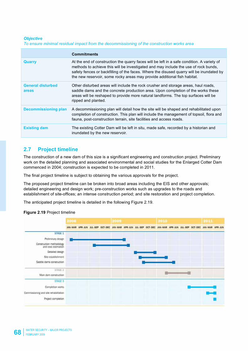
2.7 Project timeline
The construction of a new dam of this size is a significant engineering and construction project. Preliminary
work on the detailed planning and associated environmental and social studies for the Enlarged Cotter Dam
commenced in 2004; construction is expected to be completed in 2011.
The final project timeline is subject to obtaining the various approvals for the project.
The proposed project timeline can be broken into broad areas including the EIS and other approvals;
detailed engineering and design work; pre-construction works such as upgrades to the roads and
establishment of site-offices; an intense construction period; and site restoration and project completion.
The anticipated project timeline is detailed in the following Figure 2.19.
Figure 2.19 Project timeline

ENLARGEMENT OF THE COTTER RESERVOIR AND ASSOCIATED WORKS
ENVIRONMENTAL IMPACT STATEMENT 69
2.8 Compatibility with the principles of the Territory Plan
An EIS must include a statement about the proposal’s compatibility with the principles for environmental
sustainability in the Territory Plan1 (the Statement of Strategic Directions) as specified in Section 50 of the
Planning and Development Regulation 2008. This proposal is compatible with the principles for
environmental sustainability in the Territory Plan.
Further to this, the proposal is also compatible with all of the Principles for Sustainable Development in the
Statement of Strategic Directions, including the general principles and the principles for economic and social
sustainability.
The general and environmental sustainability principals from the Statement of Strategic Directions are
reproduced below. A statement about the compatibility of the project is presented against each principle.
2.8.1 General Principles
1.1 Planning processes and decisions will be focused on the combined achievement of economic vitality,
community wellbeing, and environmental quality. Broad community involvement will be a key element in the
pursuit of sustainable development, as will complementary regional strategies and agreements.
The Enlarged Cotter Dam proposal was chosen through a rigorous Government and ACTEW investigation
into the future options for water supply to Canberra (See section 1 of this document). These investigations
enjoyed a large community and stakeholder involvement and the project was chosen (among other reasons)
for its comparative performance against a range of criteria, including its compatibility with other local and
regional strategies. This EIS has been prepared to provide information on the proposal’s likely impact on the
environment and mitigation measures that may be adopted to reduce any potential impact. The outcome of
this investigation is a recommendation to move forward into the Development Application phase and further
towards the construction of the dam,
1.2 Matters of broader National Capital, metropolitan and regional significance will be carefully considered
when formulating Territory Plan policies and when making decisions about development proposals and
sequencing.
This is a matter to be assessed by ACTPLA in assessing the EIS. The proposal is fully compliant with the
requirements of the National Capital Plan and Territory Plan,
1.3 Economic, social and environmental objectives will be pursued in a balanced and integrated way, having
regard to both short-term and long-term factors, such that present needs can be met without prejudicing the
welfare of future generations, and without serious or irreversible loss of life-supporting natural resources or
damage to the environment.
A Socio-Economic Assessment has been prepared as part of the technical investigation supporting this
assessment. This study considered both short and long-term factors associated with the delivery of
sustainable water supply for the ACT and region. The findings of this study indicated that the proposed
Cotter Dam infrastructure needed to ensure a sustainable water supply for the ACT will provide numerous
beneficial impacts on the population of the ACT, social welfare and sustainable economic growth. Matters
relating to this are detailed in section 5 of this report.
1.4 Wherever appropriate, the broaderGLobal and regional context and potential cumulative impacts of
decisions will be taken into account. Where there are threats of serious or irreversible damage, lack of full
scientific certainty should not be used as a reason for failing to prevent environmental degradation.
This EIS investigates a broad range of both local and regional matters of interest and considers the potential
impacts associated therewith. The general recommendation of this EIS is that the proposed construction of
the Enlarged Cotter Dam (with appropriate mitigation and impact management measures) will not cause
irreversible, serious and preventable damage or environmental degradation.
11 Section 50 of the Planning and Development Regulation 2008.

70 WATER SECURITY – MAJOR PROJECTS
FEBRUARY 2009
2.8.2 Principles for Environmental Sustainability
1.5 Planning policies will seek to ensure the efficient use of all resources and to reduce consumption of non-
renewable resources. Waste minimisation, reuse and recycling will be encouraged, whilst energy-rating
and conservation measures will be applied wherever appropriate, particularly in transport, subdivision
planning, and building design and construction.
Many initiatives in design and construction methodology have been introduced to optimise the use of
materials, reduce the waste generated, and minimise the transport effort associated with this project. These
are described in section 5.1. Beyond this, a commitment has been made to make the operational
components of the project carbon neutral by reducing greenhouse gas emissions and trading carbon offsets.
The proposal is consistent with this principle.
1.6 The pattern of development is to reflect land capability constraints resulting from topography, soils,
geotechnical factors, drainage, natural hazards, microclimate and the sensitivity of ecosystems.
Particular attention will be given to the need to conserve soil, water and vegetation; maintain biological
diversity; safeguard important ecosystems and ecological processes; and provide and protect wildlife
corridors.
All of these considerations are discussed within this EIS, allowing informed assessment of the project.
Recommendations and commitments are made to ensure the conservation of valuable environmental
assets. The proposal is consistent with this principle.
1.7 Land and water resources will be planned in accordance with the principles of integrated catchment
management and water sensitive urban design. Policies will seek to protect identified environmental
values, whilst focusing on opportunities for multi-purpose use of resources. Special attention is to be
given to protecting sources of the Territory’s water supply and to maintaining environmental flows in
rivers and streams.
The purpose of this project is to improve the security of the Territory’s water supply while maintaining the
important environmental values of the waterways. The proposal is consistent with this principle.
1.8 Planning policies will provide for the sustainable management of rural areas, ensuring that rural lands
nominated for future urban development or other purposes can be retained in productive use and
properly managed for the time being. Appropriate activities to reduce net greenhouse gas emissions will
be encouraged.
This project will have minimal impact on rural lands in the ACT. The proposal is consistent with this principle.
1.9 Urban expansion will be contained in order to minimise impacts on valuable natural and rural areas.
Urban expansion is not a component of this project. The proposal is consistent with this principle.
1.10 Integrated land use and transport planning will seek to maximise accessibility and transport efficiency,
reduce energy consumption, support the preferred pattern of development, promote safety, safeguard
environmental quality, and minimise greenhouse gas emissions.
The concept of integrated land use and transport planning is relevant to suburban development projects and
does not apply to this project. The project has, however, been designed to minimise energy consumption,
promote safety, safeguard environmental quality and minimise and offset greenhouse gas emissions.
1.11 Policies for environmental planning and management will ensure amenity, minimise pollution, and
protect public health and safety.
The proposal is consistent with the policies described by this principle.

ENLARGEMENT OF THE COTTER RESERVOIR AND ASSOCIATED WORKS
ENVIRONMENTAL IMPACT STATEMENT 71
2.9 Objectives of the project
The objective of the project is to increase the security of Canberra’s water supply by providing increased
storage capacity. Further objectives have been developed relating to the potential impacts identified in the
Scoping Document. These objectives are described in Table 2.2, which also sets out the sections that deal
with those objectives in this document.
Table 2.2 Objectives of the project
Element Objectives Section
General • To comply with applicable legislation, approvals, permits, licences
and other project commitments.
• To minimise environmental impact during construction and
operation.
• To ensure that the development is consistent with the principles of
ecologically sustainable development.
2.3
Design To ensure that the highest standard of design is adopted. 2.3
Construction To minimise negative impacts during construction. 2.3
Operation To minimise negative impacts caused by the operation of the dam. 2.5
Decommissioning To ensure minimal residual impact during the decommissioning of
the construction works area.
2.6
Traffic and transport To maintain safety for all users on the public road network at
all times.
5.1
Water and stormwater • To maintain the operation of the existing Cotter Reservoir,
including environmental flows, during construction.
• To avoid excessive water use during construction.
• To avoid the release of polluted stormwater into the Cotter
Reservoir and the Cotter River.
5.1
Energy and utilities • To avoid excessive energy use during construction and operation.
• To avoid disruption to existing utilities.
5.1
Waste management To prevent the generation of unnecessary waste consistent with the
principles of the ‘No Waste by 2010 Strategy’ for the ACT.
5.2
Landscape character To minimise negative impacts on visual amenity. 5.3
Land use To minimise negative land use impacts and the area disturbed by
construction, and to return the land to public access as early
as possible.
5.3
Catchment To support the management of the Cotter catchment for water
supply purposes.
5.3
Erosion and sediment
control
To minimise the impacts of erosion and sediment on the water
quality in the Cotter River.
5.3
Water quality To maintain or improve water quality in the Enlarged Cotter Dam. 6.1
Cold-water pollution To prevent thermal pollution events. 6.2

72 WATER SECURITY – MAJOR PROJECTS
FEBRUARY 2009
Element Objectives Section
Greenhouse gas
emissions
To minimise the greenhouse gas emissions from the project. 5.5
Air quality • Minimise potential adverse air quality impacts on the environment
and the community.
• To prevent dust and other atmospheric emissions generated by
construction activities from causing a hazard or nuisance.
5.5
Lighting To maintain a safe working environment without excessive
lighting spill.
5.5
Noise and vibration To minimise the impact of blasting and construction noise and
vibration to protect the amenity of residents and recreational users,
and prevent damage to public utilities, structures and buildings
resulting from vibration.
5.5
Terrestrial flora and fauna • To minimise impact of construction on areas of native vegetation.
• To minimise the spread of weeds and exotic species.
• To successfully rehabilitate and enhance native vegetation areas
as measured against a pre-construction assessment.
6.3
Aquatic ecology To minimise the impact of construction and operation of the
Enlarged Cotter Dam on the aquatic ecology in the Cotter River.
6.4
Threatened fish • To establish fish management plans for threatened fish and
crayfish species.
• To maximise opportunities to enhance fish habitat through the
enhancement of edge boulder habitat before inundation.
6.5
Macquarie Perch
spawning
• To minimise disruption to the breeding cycle of Macquarie Perch
arising from enlarging the Cotter Dam.
6.6
Pests and pathogens To minimise the risk of introducing pests or pathogens to the Cotter
Reservoir through recreational use of the catchment area.
6.7
Alien fish To mitigate against expanded populations and upstream invasion of
alien fish species arising from enlarging the Cotter Dam.
6.8
Cultural heritage • To appropriately manage sites with cultural and heritage value.
• Maintain positive working relationships with Aboriginal
organisations and representatives.
6.9
Community consultation To provide the community with an opportunity to comment on the
plans to enlarge the Cotter Reservoir.
5.9
Public expectations To communicate clearly with the community to avoid
misunderstandings about the impacts on water supply.
6.10
Education To allow the community to experience education opportunities
associated with the construction of the enlarged dam.
5.9
Equity of supply To ensure that equitable access to clean water is maintained. 5.9
Recreation To maximise the potential of recreational amenity and visitor access
to the Cotter Reserve during and after the construction period.
6.11

ENLARGEMENT OF THE COTTER RESERVOIR AND ASSOCIATED WORKS
ENVIRONMENTAL IMPACT STATEMENT 73
Element Objectives Section
Health and wellbeing • To minimise impacts on the health and wellbeing of the
community during construction.
• To maintain community health through the provision of a more
reliable water supply.
5.10
Extreme storms To minimise the impact of extreme storms during construction. 5.12
Bushfire To minimise the impact of bushfires on water supply. 5.12
Human elements To reduce opportunities for and impacts of human error or
malicious act.
5.12
Hazard and risk To reduce the likelihood of dam failure. 5.12

ENLARGEMENT OF THE COTTER RESERVOIR AND ASSOCIATED WORKS
ENVIRONMENTAL IMPACT STATEMENT 75
3 EIS process and methodology
3.1 Background to EIS
The purpose of an EIS is to identify, predict and evaluate the biophysical, social, and other possible impacts
of a development proposal prior to planning decisions being made and mitigation measures implemented.
The aim of the assessment is to ensure that decision makers consider environmental impacts before
deciding whether to proceed with, modify or abandon a development proposal.
An EIS is a report that documents the information required to evaluate the impact of a project. It informs both
decision makers and the public of the measures, or reasonable alternatives, that would avoid or minimise
adverse impacts, enhance the quality of the environment or provide benefits to the community.
The purpose of undertaking the assessment and documenting it in an EIS is to:
•• Identify and assess the potential adverse and beneficial impacts of the project.
• Consider feasible alternative ways to carry out the project.
• Obtain input from the community and stakeholders about the project impacts and management.
• Assess the adequacy of management, monitoring, planning and other measures proposed to avoid,
minimise, mitigate or offset any adverse environmental impacts of the project.
• Inform consideration of a Development Application (DA).
At a minimum, the EIS should inform the decision maker about:
• Whether the project is consistent with relevant legislation and policies.
• Whether the project will meet relevant environmental protection performance standards.
• How judgments about the significance of impacts have been made, including:
– Performance against thresholds, standards or comparative projects.
– The adequacy and certainty of the information on which the assessment has been based.
• How the project will avoid, minimise, mitigate, offset or manage significant impacts.
• How acceptable the residual impacts or risks will be.
3.2 Statutory process
3.2.1 Requirement for the preparation of an EIS
The statutory requirement for the preparation of an EIS is described in the Planning and Development Act
2007 (the Act) and the Planning and Development Regulation 2008 (the Regulations). The following sections
of the Act apply:
• Section 123, which indicates that the impact track provisions of the Territory Plan apply to any proposal
listed in Schedule 4 of the Act.
• Schedule 4.2 item 3(a), which states that ‘… a proposal for construction of a dam that will be at least 10m
high, with a storage capacity of at least 20 000m3; …’ needs to be assessed in the impact track because of
the need for the development of an EIS.
• Section 127, which states that a DA for a development proposal in the impact track must include a
completed EIS in relation to the proposal.
• Section 212, which indicates that the proponent for a development proposal for which a completed EIS is
required may apply to ACTPLA for scoping of the EIS.
The following sections of the Regulations apply:

76 WATER SECURITY – MAJOR PROJECTS
FEBRUARY 2009
•• Section 50.1 requires a development proposal that is to be assessed under a bilateral agreement under
the Environment Protection and Biodiversity Conservation (EPBC) Act, to address the matters mentioned
in the EPBC Regulations 2000 Schedule 4. No bilateral agreement between the ACT and Commonwealth
exists in relation to assessment of development proposals under the EPBC Act and this section does not
apply in this instance.
• Section 50.2 sets out the list of information that must be included in an EIS for a development proposal.
The final scoping document, prepared by ACTPLA, includes all the matters listed in this section. This EIS
has been prepared in accordance with, and having regard to both Section 50 of the Regulations and the
final scoping document.
• Section 51 to 54 describes matters relating to the scoping of an EIS. The Final Scoping Document
(Appendix A of this EIS) has been prepared in accordance with the Requirements of the Act and
Regulations.
• Section 55 describes the criteria required by consultants for preparing an EIS. A full list of consultants that
contributed in the research, development and preparation of this EIS are included in the Preamble of this
document. All consultants were chosen on the basis of them providing demonstrable evidence of their
ability to undertake the work required in preparing this EIS.
• Part 4.2 related to matters around the establishment and procedures of an public enquiry if requested by
the minister as per Section 228 of the Act. This section has no relevance on the preparation of the draft or
final EIS documents.
3.2.2 Preparation of an EIS
Based on the statutory requirements above, the Enlarged Cotter Dam development proposal will be
assessed under the impact track and requires an EIS to be prepared.
The process for the preparation of an EIS (as described in the Act and Regulation) is:
• The proponent lodges a description of the proposal and requests an EIS scoping document from the
planning authority (the Act, s. 212).
• The planning authority prepares scoping documentation and circulates the documentation to those entities
defined in Section 51 of the Regulation.
• In this circulation the planning authority seeks input from agencies and stakeholders, and identifies
potentially significant environmental impacts that must be addressed in the EIS.
• The planning authority issues an EIS Scoping Document which forms the basis of the EIS to be prepared.
It specifies all the matters to be addressed in the EIS (r.54 of the Regulation). The purpose of scoping is to
ensure that the EIS is focused on those matters with the potential to cause a significant environmental
impact.
• The proponent prepares a draft EIS to address the requirements outlined in the scoping document and
lodges it with the planning authority.
• The draft EIS is put on public display by the planning authority with agencies, stakeholders and the wider
community given the opportunity to comment on the project, the possible impacts and the proposed
environmental controls.
• The proponent prepares a final EIS and a consultation report that responds to all of the issues raised
during public display.
• The EIS is considered by the planning authority and the Minister. There are opportunities for the authority
to seek responses to outstanding matters, or for the minister to call for an inquiry.
The EIS is completed when any of the following events occur:
• The Minister gives the planning and land authority a notice of no action in relation to the EIS.
• The Minister decides not to establish a panel to conduct an inquiry about the EIS.

ENLARGEMENT OF THE COTTER RESERVOIR AND ASSOCIATED WORKS
ENVIRONMENTAL IMPACT STATEMENT 77
•• The Minister has established an inquiry panel for the EIS and the panel has reported the results of the
inquiry.
• The time for reporting (section 230) has ended.
Once the EIS is deemed complete, the proponent may lodge a DA for the project with the completed EIS as
supporting documentation.
This process is depicted in Figure 3.1.
Figure 3.1 Flow chart for impact track approvals in the ACT

78 WATER SECURITY – MAJOR PROJECTS
FEBRUARY 2009
3.2.3 Statutory and other Approvals Required to Implement Project
The completion of an EIS (as per Section 209 of the Planning and Development Act 2007) provides the
proponent with the opportunity to lodge a DA in the Impact Track as described in the Act Section 123. The
application will be assessed as per the Statutory Requirements as described in Div 7.2 and 7.3 of the Act.
The DA will be placed on public display by ACTPLA (notified) for a minimum period of 15 days giving the
community the opportunity to comment on the final EIS incorporating outcomes and responses to previous
community consultation. The time for deciding a DA in the Impact Track is 30 working days (after the day
that the application is made) if no representations are made, or 45 working days in any other case.
The approval of the DA provides the proponent with the planning consent to construct the proposed works.
The Notice of Decision of an approval may include any conditions that ACTPLA consider important to be
fulfilled in acting on the decision. Conditions often relate to matters to be finalised immediately (within a set
timeframe eg 28 days), prior to construction commencing and/or prior to construction being completed.
The assessment of the DA and (when approved) Notice of Decision sets in train a number of other statutory
and non-statutory approvals/licences and certificates that will be required prior to construction commencing,
during and after construction has been completed. Table 3.1 provides a list of statutory approvals, licences
and certificates that the proponent will be required to obtain to allow the implementation of this proposal.
These additional approval requirements have been identified to ensure that the appropriate approvals and
the required timeframes for consideration are allowed for in the Enlarged Cotter Dam project schedule. This
approvals program further ensures that approvals are sought at the most appropriate time and that the
required information is available to ensure ease of assessment.
Completion of the EIS and subsequent DA approval does not remove the need to get approvals under other
legislation. These approvals can be sought in parallel, independently from each other.

ENLARGEMENT OF THE COTTER RESERVOIR AND ASSOCIATED WORKS
ENVIRONMENTAL IMPACT STATEMENT 79
Ta
ble
3.1
Lis
t o
f a
pp
rova
ls r
eq
uir
ed
Ap
pro
va
l
Le
gis
lati
on
A
uth
ori
ty
Re
qu
ire
d d
oc
um
en
tati
on
EIS
+ D
ev
elo
pm
en
t A
pp
lic
ati
on
A
CT
Pla
nn
ing
an
d D
eve
lop
me
nt
Act,
20
07
A
CT
PL
A
• R
eq
ue
st
for
Sco
pin
g
• D
raft
EIS
• F
ina
l E
IS
• D
A/s
EP
BC
Re
ffe
ral/
Ap
pro
va
l fo
r
Co
ntr
oll
ed
ac
tio
n
Co
mm
’th
En
viro
nm
en
tal P
rote
ctio
n a
nd
Bio
div
ers
ity C
on
se
rva
tio
n (
EP
BC
) A
ct
19
99
De
pa
rtm
en
t o
f E
nvir
on
me
nt,
Wa
ter,
He
rita
ge
an
d t
he
Art
s
• E
IS r
efe
rra
l
• P
ub
lic E
nvir
on
me
nta
l R
ep
ort
La
nd
an
d e
as
em
en
t a
cq
uis
itio
n
(If
req
uir
ed
wit
h E
IS)
AC
T P
lan
nin
g a
nd
De
ve
lop
me
nt
Act,
20
07
•
AC
T P
LA
,
• T
AM
S,
AC
T P
ark
s,
Co
nse
rva
tio
n a
nd
La
nd
s
DA
Co
tte
r R
oa
d,
Ha
ul
Ro
ad
, E
arl
y
wo
rks
DA
s
AC
T P
lan
nin
g a
nd
De
ve
lop
me
nt
Act,
20
07
A
CT
PL
A
DA
/s
Lic
en
ce
to
Ta
ke
Wa
ter
(op
era
tio
ns
) A
CT
Wa
ter
Re
so
urc
e A
ct,
20
07
T
AM
S,
En
vir
on
me
nt
Pro
tectio
n
Au
tho
rity
Lic
en
ce
ap
plic
atio
n
Ex
em
pti
on
fo
r L
ice
nc
e T
o T
ak
e W
ate
r
(fo
r c
on
str
uc
tio
n)
AC
T W
ate
r R
eso
urc
e A
ct,
20
07
T
AM
S,
En
vir
on
me
nt
Pro
tectio
n
Au
tho
rity
Le
tte
r fo
r e
xe
mp
tio
n/a
pp
lica
tio
n t
o
Ta
ke
Wa
ter
He
rita
ge
ap
pro
va
ls
AC
T H
eri
tag
e A
ct,
20
04
A
CT
He
rita
ge
Co
un
cil
Co
nse
rva
tio
n M
an
ag
em
en
t
Pla
n/L
ice
nce
to
Sa
lva
ge
Wa
terw
ay
Wo
rks
Lic
en
ce
A
CT
Wa
ter
Re
so
urc
e A
ct,
20
07
T
AM
S,
En
vir
on
me
nt
AC
T
Wa
terw
ay W
ork
s L
ice
nce
Ap
plic
atio
n
En
vir
on
me
nta
l A
uth
ori
sa
tio
n
(ex
tra
cti
on
of
ma
teri
al
(no
t w
ate
r) f
rom
a w
ate
rwa
y)
AC
T E
nvir
on
me
nt
Pro
tectio
n A
ct,
19
97
T
AM
S,
En
vir
on
me
nt
Un
it
En
vir
on
me
nta
l A
uth
ori
sa
tio
n
Ap
plic
atio
n
Ap
pro
va
l fo
r w
ork
s i
n t
he
MR
C
pu
bli
c l
an
d
Mu
rru
mb
idg
ee
Riv
er
Co
rrid
or
Ma
na
ge
me
nt
Pla
n 1
99
8
TA
MS
, A
CT
Pa
rks,
Co
nse
rva
tio
n a
nd
La
nd
s
Wri
tte
n P
erm
issio
n
CE
MP
ap
pro
va
l A
CT
Wa
ter
Re
so
urc
e A
ct,
20
07
T
AM
S,
En
vir
on
me
nt
Pro
tectio
n
Au
tho
rity
CE
MP
with
su
b-p
lan
s
80 WATER SECURITY – MAJOR PROJECTS
FEBRUARY 2009
3.3 The scoping document
The process of identifying potential environmental impacts is integral to the scoping of the EIS by ACTPLA.
Central to the assessment process is the consideration of whether the project is likely to cause any
significant impacts. The interpretation of significance is context dependent and relative to multiple elements
(eg spatial, temporal, cultural, ecological, social, economic and institutional).
The consideration of significance provides a means to determine the level of potential impact and hence
determine whether an item needs to be investigated in detail and assessed in the EIS.
In order to achieve a transparent and consistent outcome in determining the potentially significant matters a
risk-based analysis was undertaken. This enabled the Authority to evaluate the significance of the impact
based on best available information and consider the likelihood or probability of impact.
The risk assessment was based on the consequences of a given event and the likelihood of those
consequences occurring. The consequence of an event was defined as its impact on a population or
community. The likelihood of an event having an impact relates to the probability of it occurring and also the
level of certainty of the prediction.
The risk assessment, and its relationship with the EIS, is described in the simplified diagram below.
Figure 3.2 Scoping the environmental impacts

ENLARGEMENT OF THE COTTER RESERVOIR AND ASSOCIATED WORKS
ENVIRONMENTAL IMPACT STATEMENT 81
3.4 Potential environmental impacts
The following risks are identified in the Scoping Document provided by ACTPLA for the purposes of this EIS.
ACTPLA used a risk assessment process to determine which potential impacts should be deemed to be
potentially significant, and hence addressed in detail in the EIS.
Each potential impact was assigned a likelihood and consequence from the tables below. The likelihood of
the impact is described as ranging between remote and almost certain as per Table 3.2.
Table 3.2 Descriptions of likelihood for environmental impacts
Likelihood Description Probability Community attitude
Remote May occur in exceptional circumstances <1% Few people interested
Unlikely Not expected to occur in most circumstances 1–20% Some people affected
Possible May occur 21–49% Many people affected
Likely Probably will occur 50–85% Most people affected
Almost certain Expected to occur >85% Almost everyone affected
The potential consequences of an impact require a degree of subjective assessment as the impact may
consist of several elements as described in Table 3.3.
Table 3.3 Elements of consequence
Elements of consequence
Magnitude
Spatial The area over which the impact will occur, from a few square metres to the whole river basin.
Intensity The level of impact within the spatial area from a minor disruption to total destruction.
A low-intensity impact over a large area could be worse than a high-intensity impact in a
small area, depending upon other elements.
Temporal
Duration The length of time of the impact, from a single event to a permanent change
Timing Short-term events may create significant impacts if they occur often, they may also coincide
with particularly sensitive times in the receiving environment, such as breeding cycles.
Ecological
Values The quality of the receiving environment, generally identified through the declaration of
conservation areas or identification of protected species.
Sensitivity The capacity of the receiving environment to regenerate or adapt to the impact (resilience).
The sensitivity of an environment to a potential impact will require informed judgement.

82 WATER SECURITY – MAJOR PROJECTS
FEBRUARY 2009
Elements of consequence
Social
Number of
people
Number of people affected either directly or indirectly through lost opportunities for enjoyment
or other values such as equity or existence values.
Heritage The impact on known or possible items of cultural heritage value.
Political A measure of the likely political implications or level of community interest.
Economic
Economic Relates to the financial cost of the impact through lost productivity or the cost of remediation.
Each impact is described as having potential consequences ranging from minimal to catastrophic as
described in Table 3.4 below.
Table 3.4 Descriptions of consequence for environmental impacts
Consequence Minimal Minor Moderate Major Catastrophic
Magnitude
Spatial A single pool. A reach of river
or part of
catchment
Multiple reaches
Whole catchment
Multiple
Catchments
Whole of basin
Intensity Chronic/low
level
Behavioural,
lifespan or
condition effect
Acute impacts
on some
species
Acute/moderate.
Impact on
growth,
recruitment or
survival rates
Lethal impacts
on some
species
Lethal/extreme.
For individuals or
communities
Temporal
Duration Single incident
Transient event
Short-term
impact (single
generation)
Medium term Long-term effect
(multiple
generations)
Permanent
Timing
(periodic
events)
Occurs outside
breeding times
Occasional
interruption of
feeding or
breeding
Interrupts one life
cycle
Regularly
interrupts life
cycle
Permanent
interruption of
ecosystem cycle
Ecological
Values Previously
disturbed areas
Parkland Native flora or
fauna
Conservation
area or listed
species
Wilderness or
nationally
threatened
species
Sensitivity Will recover
completely
Will recover
with some
changes
Moderate change
to ecosystem
function
Significant
change to
ecosystem
function
Will not recover
ENLARGEMENT OF THE COTTER RESERVOIR AND ASSOCIATED WORKS
ENVIRONMENTAL IMPACT STATEMENT 83
Consequence Minimal Minor Moderate Major Catastrophic
Social
Number of
people
Some people
indirectly
affected
Some people
directly
affected, or
several
indirectly
Several people
directly affected,
or many
indirectly
Large number
of people
directly affected
Loss of life
Heritage
Considerations
Impact on
places or
objects
assessed below
significance
threshold
Impact on place
or objects with
limited levels of
significance or
minor impact
on significant
places or
objects
Substantial
degree of impact
on significant
places or objects
Major degree of
impact on
places or
objects with a
high level of
significance
Major degree of
impact on places
or objects with
an exceptional
level of
significance
Political Single negative
press article
Multiple
negative press
articles
Significant public
interest
Leads to an
inquiry
Change of
government
Economic
Minimal losses Several
thousands of
dollars in lost
revenue or
remediation
costs
Half a million
dollars in lost
revenue or
remediation
costs
A million dollars
in lost revenue
or remediation
costs.
Several million
dollars in lost
revenue or
remediation
costs
Based on the assessments of likelihood and consequence (as described above), ACTPLA assigned a risk
rating to each of the foreseeable impacts.
Table 3.5 below provides a matrix, with increased consequence across the top and increased likelihood
down the left side. The resulting risk rating increases diagonally from negligible at the top left (minimal
consequence and remote likelihood) to extreme at the bottom right (catastrophic consequences and almost
certain to occur)
Table 3.5 Risk assessment likelihood and consequence

84 WATER SECURITY – MAJOR PROJECTS
FEBRUARY 2009
The EIS is intended to focus on potentially significant environmental impacts and the risk assessment
process provided the tool used to determine those impacts to be addressed in the EIS.
ACTPLA has described all impacts with a risk rating of high or above as being potentially significant, and
hence requires them to be specifically addressed in the EIS.
The risks are listed in the order that they are addressed in this EIS. The Scoping Document numbers reflect
the order that they are identified in the Scoping Document.
Table 3.6 Identifies potential impacts and risk assessment (from ACTPLA Scoping Document, the full
scoping document is presented in Appendix A.).
Potential Impact
(ACTPLA scoping document)
Risk assessment Scoping
document
EIS reference
section
Likelihood Consequence Risk Signi-
ficant
Infrastructure 5.1
Transport – damage to roadways
by construction vehicles
Likely Minimal Low 23
Traffic – increased traffic, delays,
road safety, emergency service
delays
Likely Minor Medium 24
Water – excessive consumption
during consumption
Unlikely Minor Very low 26
Stormwater – pollution of
stormwater, inadequate flood
contingency plans
Unlikely Major Medium 27
Energy – excessive demand for
energy during construction and
operation
Possible Minor Low 25
Sewerage – inappropriate
management during construction
and operation
Unlikely Moderate Low 28

ENLARGEMENT OF THE COTTER RESERVOIR AND ASSOCIATED WORKS
ENVIRONMENTAL IMPACT STATEMENT 85
Potential Impact
(ACTPLA scoping document)
Risk assessment Scoping
document
EIS reference
section
Likelihood Consequence Risk Signi-
ficant
Material use and waste 5.2
Material – excessive use of raw
materials
Unlikely Minimal Negligible 29
Waste – excessive generation,
inappropriate reuse and disposal
Unlikely Minor Very low 30
Toxic/hazardous – inappropriate
handling
Unlikely Major Medium 31
Land values 5.3
Character – changes to visual
amenity
Likely Minimal Low 36
Land use – conflicts between
current and future land use,
during construction and operation
Likely Minor Medium 35
Land disturbance – loss of
vegetation and top soil
Unlikely Minor Very low 33
Geology – unstable ground,
failure event
Remote Moderate Very low 32
Soils and erosion – soils
disturbed, inundated,
unacceptable erosion
Possible Minor Low 34
Water resource values and impacts 5.4
Water quality – impacts within the
reservoir due to biological or
physical processes
Likely Moderate High 9 6.1
Groundwater – quality and
quantity of regional groundwater
Possible Minimal Very low 37
Cold-water pollution – due to
stratification
Possible Moderate Medium 5 6.2
Climate and air quality 5.5
Climate – microclimate changes
due to large body of water
Likely Minimal Low 38
Greenhouse gas – contribution to
greenhouse gas emissions during
construction and operation
Possible Minor Low 39

86 WATER SECURITY – MAJOR PROJECTS
FEBRUARY 2009
Potential Impact
(ACTPLA scoping document)
Risk assessment Scoping
document
EIS reference
section
Likelihood Consequence Risk Signi-
ficant
Air quality – dust/odour emissions
during construction and operation
Likely Minimal Low 40
Lighting – lighting of construction
and operational activities
Possible Minor Low 41
Noise/vibration – construction and
operational noise/vibration
Possible Minor Low 42
Terrestrial biodiversity and nature conservation 5.6
Native vegetation – impacts on
residual native vegetation
Almost
certain
Moderate Very high 11 6.3
Environmentally sensitive areas –
disturbance of protected or
sensitive areas
Almost
certain
Moderate Very high 10 6.3
Threatened species/communities
– introduction of threats to known
threatened species/communities
Possible Moderate Medium 43
Invasive species –
introduction/unintentional
encouragement of invasive
species
Possible Moderate Medium 44
Aquatic ecology 5.7
Aquatic biology – causing change
in the aquatic biology in the
reservoir or downstream
Likely Moderate High 12 6.4
Ecosystem impacts – caused by
changed flow regime below the
Cotter Reservoir
Almost
certain
Minor High 6 6.4
Impacts on endangered fish
species
Likely Major Very high 1 6.5
Destruction of Two-spined
Blackfish habitat
Possible Minor Low 16
Inundation and destruction of
Macquarie Perch spawning
habitat
Possible Major High 3 6.6
Introduction of pests or pathogens
through recreational use
Possible Major High 2 6.7
Upstream invasion of alien fish Possible Major High 7 6.8

ENLARGEMENT OF THE COTTER RESERVOIR AND ASSOCIATED WORKS
ENVIRONMENTAL IMPACT STATEMENT 87
Potential Impact
(ACTPLA scoping document)
Risk assessment Scoping
document
EIS reference
section
Likelihood Consequence Risk Signi-
ficant
species during construction of
new dam
Expanded populations of alien fish Likely Moderate High 4 6.8
Heritage 5.8
Places/objects – places or objects
diminished or destroyed
Unlikely Major Medium 45
Values – impacts on cultural
values
Likely Moderate High 13 6.9
Social 5.9
Consultation – poorly managed
community consultation
Unlikely Moderate Low 46
Level of interest – interest of
community/media not catered for
Unlikely Minor Low 47
Expectations misunderstanding
about impacts on water supply
and the need for future restrictions
or projects
Likely Moderate High 15 6.10
Education – opportunities for
education
Possible Minor Low 48
Equity – supply of water, access
to recreational opportunities
Unlikely Moderate Low 49
Recreation – loss of recreational
amenity
Likely Moderate High 14 6.11
Health 5.10
Water supply reliability – impacts
of construction and operation
Remote Major Medium 50
Water supply quality – impacts of
construction and operation
Likely Minor Medium 51.
Economic impacts 5.11
Water pricing – impact of project
on water pricing policy
Likely Minor Medium 52.
Cost–benefit analysis – project
generates a negative value
Unlikely Moderate Low 53.

88 WATER SECURITY – MAJOR PROJECTS
FEBRUARY 2009
Potential Impact
(ACTPLA scoping document)
Risk assessment Scoping
document
EIS reference
section
Likelihood Consequence Risk Signi-
ficant
Whole-of-system impacts 5.12
Extreme storm events Remote Major Low 18.
Protracted drought Unlikely Moderate Low 19.
Climate change—impact of
unavoidable climate change on
the project
Likely Moderate High 8. 6.12
Climate change Likely Moderate High 20. 6.12
Bushfire Likely Minor Medium 21.
Human error/malicious act Unlikely Major Medium 22.
Downstream impacts of
catastrophic dam failure or
emergency water release
Remote Minimal Negligible 17.
3.5 Potentially significant environmental impacts
The Scoping Document prepared by ACTPLA identifies the potentially significant impacts to be addressed.
The table of potentially significant impacts is reproduced below. This document assesses these in detail and
describes mitigation measures to address them.
The risks identified by ACTPLA in the Scoping Document are the uncontrolled risks. Once mitigation
measures are applied, as described in the relevant chapter of this EIS, the residual risk can be re-assessed.
The uncontrolled risks as assessed by ACTPLA and the residual risks as assessed by ACTEW are
presented in Table 3.7 below.

EN
LA
RG
EM
EN
T O
F T
HE
CO
TT
ER
RE
SE
RV
OIR
AN
D A
SS
OC
IAT
ED
WO
RK
S
EN
VIR
ON
ME
NT
AL IM
PA
CT
ST
AT
EM
EN
T
89
Table 3.7 Potentially significant impacts and residual risk assessment
Impact Scoping document assessment Section Residual risk assessment
Likelihood Consequence Risk Likelihood Consequence Risk
Water resource values and impacts
9. Water quality impacts within the
reservoir due to biological or physical
processes
Likely Moderate High 6.1 Unlikely Minor Very low
5. Cold-water pollution due to
stratification
Possible Moderate Medium 6.2 Remote Moderate Very low
Terrestrial biodiversity and nature conservation
10. Environmentally sensitive areas—
disturbance of protected or sensitive
areas
Almost
certain
Moderate Very high 6.3 Unlikely Moderate Low
11. Native vegetation—impacts on
residual native vegetation
Almost
certain
Moderate Very high 6.3 Almost certain Minimal Medium
Aquatic ecology
12. Aquatic biology—causing change in
the aquatic biology in the reservoir or
downstream
Likely Moderate High 6.4 Possible Moderate Medium
6. Ecosystem impacts caused by
changed flow regime below the Cotter
Reservoir
Almost
certain
Minor High 6.4 Unlikely Minor Very low
1. Impacts on endangered fish species Likely Major Very High 6.5 Unlikely Moderate Low
3. Inundation and destruction of
Macquarie Perch spawning habitat
Possible Major High 6.6 Unlikely Moderate Low

90
WA
TE
R S
EC
UR
ITY
– M
AJO
R P
RO
JE
CT
S
FE
BR
UA
RY
2009 V
2.0
Impact Scoping document assessment Section Residual risk assessment
Likelihood Consequence Risk Likelihood Consequence Risk
2. Introduction of pests or pathogens
through recreational use
Possible Major High 6.7 Possible Moderate Medium
4. Expanded populations of alien fish Likely Moderate High 6.8 Possible Minor Low
7. Upstream invasion of alien fish
species during construction of new dam
Possible Major High 6.8 Unlikely Moderate Low
Heritage
13. Values—impacts on cultural values Likely Moderate High 6.9 Unlikely Moderate Low
Social
15. Expectations of or misunderstanding
about impacts on water supply and the
need for future restrictions or projects
Likely Moderate High 6.10 Unlikely Minor Very low
14. Recreation loss of recreational
amenity
Likely Moderate High 6.11 Unlikely Minor Very low
Potential impacts on the project
8. Climate change—impact of
unavoidable climate change on the
project
Likely Moderate High 6.12 Unlikely Minor Very low
20. Climate change Likely Moderate High 6.12 Unlikely Minor Very low
ENLARGEMENT OF THE COTTER RESERVOIR AND ASSOCIATED WORKS
ENVIRONMENTAL IMPACT STATEMENT 91
4 Existing conditions
4.1 General
With the exception of a small area to the northwest, the catchment of the Cotter Reservoir is located wholly
within the ACT. The catchment covers approximately 50,000 ha of mostly sharply dissected terrain with a
mixture of sub-alpine, wet and dry sclerophyll forests, perched swamps and valley floor grasslands. The
primary use of the Cotter Catchment since the completion of the Cotter Dam in 1915 is as the water supply
for Canberra and Queanbeyan. Additional land uses have included grazing, forestry, mining and recreational
activities.
The Cotter catchment has been used for a wide range of land uses, many of which have resulted in
degradation of the landscape and subsequent reduction in water quality within the river systems. With the
exception of plantation forestry and some recreational activities, the remaining land use activities (recreation
and research) have only very minor impacts on the landscape and water quality as a whole. Plantation
forestry areas, though not a constraint to the expansion of the Cotter Reservoir, remain a degraded part of
the landscape.
Fire has been a part of the landscape of the Cotter Catchment since before European settlement with major
fires typically occurring during periods of drought. All significant fires within the catchment have resulted in
degradation of the landscape immediately after the fire event with subsequent loss in water quality.
PCL is the custodian and land manager of the Cotter Catchment and have adopted (among other
documents) the Lower Cotter Catchment Strategic Management Plan (ACT Government, 2007b). The
management plan aims to “Restore the lower Cotter catchment to a natural and stable condition that
supports the delivery of clean water and that also allows for a range of activities that are compatible with the
protection of water resources.” The plan recognises the importance of the Lower Cotter Catchment as a
water supply catchment for Canberra and sets out the framework for the management of the catchment and
activities therein in light of a number of strategic requirements, including domestic water supply.
The land immediately surrounding the existing Cotter Reservoir and Enlarged Cotter Dam are a combination
of Native vegetation, pine forest and revegetated land.
A detailed description of the Cotter Catchment is included at Appendix F. The Final Scoping Document
(Appendix A) requires that the EIS specifically describe the existing conditions under the following headings:
•• Climate.
• Geotechnical Conditions.
• Demographics.
• Demand for Water.
• Tenancy and Legal Land Description (Status of the Land).
• Legislative Context and other Statutory Documents (Commonwealth and Territory).
These matters are further are described below.
4.2 Climate
The Australian Capital Territory has a relatively dry continental climate with marked seasonal and diurnal
variations in temperature. As with the rest of Australia, the climate of Canberra is strongly influenced by a
band of high pressure systems located around theGLobe at about 30-40°S, known as the sub-tropical ridge.
As this region moves north and south with the sun, so there are different influences on the climate. During
the summer, the sub tropical ridge is located over southern Australia resulting in warm to hot conditions with
winds generally from the east through to the northwest. During winter this ridge is located across northern

92 WATER SECURITY – MAJOR PROJECTS
FEBRUARY 2009
Australia allowing the westerly winds and associated cold fronts to extend over southern Australia with colder
conditions.
At a latitude of 35.30°S and longitude of 149.20°E, Canberra Airport provides the location by which climatic
details have been collected in the ACT since 1939.
During this time, temperatures have ranged between -10°C and 42.2°C; the daily maximum often exceeds
30°C in summer. During the winter, temperatures are lower, and the higher parts of the mountains are often
covered with snow. The mean annual maximum temperature is 19.7°C and the mean annual minimum
is 6.5°C.
Figure 4.1 Average maximum and minimum temperatures for Canberra
January is the hottest month with a mean daily maximum temperature of 27.7°C and an average of 10 days
of 30°C or more with 2 days of 35°C or more. Canberra’s location being inland and elevated (around 580m
above mean sea level) often results in cool nights. The mean daily minimum temperature in January is
13.0°C. Canberra tends to get cooler easterly winds penetrating from the coast during many summer
evenings which can sometimes bring cloud along with moist air. With the warm to hot conditions during
summer and the effects of the nearby ranges, there is a distinct thunderstorm season during these months
and there are an average of 19 thunderstorm days between October and March compared to an annual
average of 23 days.
By contrast winters are cool to cold with generally westerly winds. Winter is also a time when Canberra can
experience clear, sunny days with light winds and a considerable number of frosts can occur. The
mean daily maximum for July, the coldest month, is 11.2 °C while the mean daily minimum is �0.2 °C.
Over the past 31 years the mean daily sunshine has been calculated at 7.7 hours. Fogs are common on
winter mornings.

ENLARGEMENT OF THE COTTER RESERVOIR AND ASSOCIATED WORKS
ENVIRONMENTAL IMPACT STATEMENT 93
Canberra is not considered a windy city with, on average, 25 days of strong winds a year. Late Winter/Spring
tends to be the windiest time with approximately half of these days (13 days) occurring in the 4 months
between August and November.
The maximum wind speed recorded in the ACT was 128km/h (24 November, 1957). The average annual
wind speed is considerably lower, 17.3km/h (recorded 3pm daily).
Figure 4.2 General wind direction and strength at Canberra Airport
Although it is fairly evenly distributed throughout the year, precipitation is somewhat less in the winter
(approximately 40 mm per month). The average annual precipitation since 1939 is 617.5 mm with the mean
number of rainy days over this same period being 72.5 days. Rainfall is much greater in the mountains,
averaging about 1,525 mm a year.
Rainfall across the ACT varies considerably, with much higher rainfall occurring in the ranges to the west of
the city and less rainfall to the east. During winter, the ranges tend to act as a barrier, and the city itself is in
a relative rain shadow.

94 WATER SECURITY – MAJOR PROJECTS
FEBRUARY 2009
Figure 4.3 Average monthly rainfall and number of rain days
Snow at Canberra is a rare occurrence, (only 1 to 2 recordings per annum on average) and most of the time
the snow melts very quickly. Snow tends to fall on the ranges to the west, and during winter this snow cover
can be readily visible from the city.
Average annual evaporation in Canberra is 1677 mm, however this can range from around 8 mm/day in
summer to as low as 1-2 mm/day in winter.
Due to the unreliable nature of local rainfall within the catchments, characterised by periods of drought and
flooding, large storage reservoirs are needed to ensure water supply.
ENLARGEMENT OF THE COTTER RESERVOIR AND ASSOCIATED WORKS
ENVIRONMENTAL IMPACT STATEMENT 95
Section 1 of this EIS provides more information regarding the recent rainfall history which is an important
consideration in determining the need for this proposal.
It is now widely accepted thatGLobal warming is occurring. Long-term studies of the climate confirm that the
increase inGLobal temperature observed since the mid 20th century is unusual. World experts consider it
‘very likely’ that this warming has been caused by emissions of greenhouse gases from human activities
(Intergovernmental Panel on Climate Change, 2007). This may mean that the climate record for Canberra,
which is based on the relatively recent past, no longer adequately represents current or future climate.
The CSIRO summarises the situation as follows:
The average surface air temperature of Australia increased by 0.7°C over the past century—
warming that has been accompanied by marked declines in regional precipitation, particularly
along the east and west coasts of the continent. These seemingly small changes have already had
widespread consequences for Australia. Unfortunately, even if all GHG emissions ceased today, the
Earth would still be committed to an additional warming of 0.2–1.0°C by the end of the century.
Yet the momentum of the world’s fossil fuel economy precludes the elimination of GHG emissions
over the near-term, and thus futureGLobal warming is likely to be well above 1°C. Analysis of future
emissions trajectories indicate that left unchecked, human GHG emissions will increase several fold
over the 21st century. As a consequence, Australia’s annual average temperatures are projected to
increase 0.4–2.0°C above 1990 levels by the year 2030, and 1–6°C by 2070. Average precipitation
in southwest and southeast Australia is projected to decline further in future decades. (Preston &
Jones, 2006)
The ACT Government has accepted the scientific evidence that the use of the planet and its resources has
already, and will continue to change our climate. In response to this, the Government released Weathering
the Change – the ACT Climate Strategy 2007-2025 in 2007 (See section 4.8 for a summary; ACT
Government, 2007d). The strategy provides an overview of the predicted impacts on the ACT and the
Government’s response to climate change. The strategy acknowledges the likelihood of increased
temperatures, more frequent and severe droughts, a decrease in rainfall and an increase in average summer
wind speeds. These are all major issues from a water supply perspective.
4.2.2 Climate variability
Climate variability is the natural variation of climate observed over time; it includes the familiar seasonal
variations, and the less familiar longer-term variations that climate experts are yet to fully understand.
Australia’s climate is highly variable in comparison with other countries; this is largely due to large scale and
long time-frame natural events such as the Pacific Decadal Oscillation, Inter-decadal Pacific Oscillation, and
El Niño Southern Oscillation.
The ACT has only 137 years of recorded historic climate data. Although this period of historic record covers
three major droughts, including the one at present, the ACT can reasonably expect to experience more
frequent or more severe wet or dry periods in the future than have been recorded to date. To address this
possibility, during the Future Water Options study, ACTEW ‘extended’ its historic climate record by using a
standard hydrological methodology to create a longer period of synthetic or stochastic climate data (Sinclair
Knight Merz, 2004).
The generated 10,000 years of stochastic climate data have equivalent average rainfall, evaporation and
variability characteristics to the historic record. The stochastic data also maintain the observed relationships
between rainfall and inflows at various sites, as well as the relationships between rainfall, inflow and
demand. However, the data set includes a greater range of climatic sequences, including more severe
drought events. Because the ‘period of historical record … may not represent the best picture of current
climatic conditions’ due to climate variability over time (Sinclair Knight Merz, 2004) a historic record of 26
years centred on 1990 was selected to generate the median stochastic data with variability based on the full
historic record. The generated stochastic climate data is referred to as the 1990 stochastic climate scenario.

96 WATER SECURITY – MAJOR PROJECTS
FEBRUARY 2009
4.2.3 Step change in climate
WhileGLobal warming progresses proportionally to the build-up of greenhouse gases in the atmosphere, it
can also result in rapid (‘step’) climate changes in a particular region. The reduction in rainfall and run-off
experienced in the Perth region in the past 30 years is often cited as an example of at least one step change
in climate.
It is possible that the recent drought represents a step change in climate for Canberra. The past 5 to 10
years represent the most severe long-term dry period in the 1871 to present extended historic record inflow
sequence. The past few years exhibit inflows that are consistently lower than average, with remarkably
similar low inflows from late summer to early winter. The average system inflows during the past 10 years
are also lower than the average inflows generated with 2030 stochastic data (data that incorporates the
expected 2030 climate change impacts and equates to 88GL per year compared to 105GL per year). On
average, a five-year period worse than the last five years would occur once every 19 years in the stochastic
data. Therefore, the last few years would be a drought even with predicted climate change. The inflows to
Googong reservoir during this period are especially low when compared to the historic record or the
stochastic data. The CSIRO climate change report (2003) comments that:
There is evidence of a shift in the last 20 years, with several locations (Michelago is an exception) near
to Canberra showing a small decline in rainfall and a decrease in interannual variability after the mid to
late 1980s. A similar shift has been well documented in the southwest of Western Australia.
The current drought has the lowest inflows over a long-term period, with 2006 producing the third lowest
inflows of any year on record, behind 1901 and 1982. The 1910s and 1940s also contain long-term droughts
where average inflow is only a little higher than the current period. Figure 4.5 shows the 2-year, 5-year and
10-year average total inflows to Canberra’s water supply system over the period of record. It is noteworthy
that the period from 1950 to 1980 exhibits some consistently high inflows that are not reproduced at other
times in the record. The inflows since 1980, including the current drought, appear relatively similar to the
1871–1950 portion of the period of record.
Figure 4.4 Moving average inflows to Corin, Bendora and Googong Reservoirs

ENLARGEMENT OF THE COTTER RESERVOIR AND ASSOCIATED WORKS
ENVIRONMENTAL IMPACT STATEMENT 97
The aspects of the local climate that are of relevance to this project relate to rainfall and runoff predictions
and their possible changes into the future. These are addressed in detail in section 6.2.
4.3 Geotechnical conditions
A major characteristic of the geomorphology of the Cotter Catchment is the wide range of rock types present
that include marine metasediments, volcanics and granitoids. The rocks of the Cotter consist of Ordovician
and Silurian igneous rocks and marine metasediments from the Adaminaby and Tidbinbilla groups
respectively, Silurian volcanics of the Uriarra and Paddy’s River volcanics, and Silurian to Devonian granitic
rocks. The Ordovician sediments and Devonian granites exist throughout most of the catchment with the
volcanics appearing exclusively within the lower catchment and mostly near the Cotter Reservoir.
Soils derived from these geological units are highly variable in both their physical and chemical properties
and also vary based on land use history. The volcanics are separated from the sedimentary and granitic
rocks by the Winslade fault which passes to the south of the Cotter Reservoir. Unconsolidated sediments
tend to be coarse sands and gravels and are found mainly within the existing creeks, rivers and reservoir
deltas. Finer silts are found in the damp and swampy areas.
A detailed description of the broader geology of the Lower Cotter Catchment is provided in Appendix F.
Preliminary site investigations were carried out in 2007 at the main dam and saddle dam sites and form the
basis of the current geological model for the expected subsurface conditions at the dam sites (Appendix F).
Difficult access conditions to the steep abutment slopes limited the scope of the investigations at the main
dam site to those areas that are accessible by foot and four-wheel drive vehicles.
The preliminary picture has been further completed by ACTEW conducting a range of further investigations
since 2007 that included geological mapping, the establishment of test pits and bore holes, material
sampling, chemical and physical testing of rock, percussion drilling and seismic survey works. More extensive site investigations were completed in 2008 using helicopters to lift small drill rigs onto the steep abutment slopes.
This work was a key recommendation of the Enlarged Cotter Dam Update Report 2007 (Appendix S). The
further investigations undertaken to date include the following work:
Main dam
•• Diamond cored boreholes: 16 diamond cored boreholes, comprising a total length of 948m of rock.
• Seismic refraction survey: 5 seismic refraction survey traverses, comprising a total length of 1160m
including both the main dam seismic line and a number of cross seismic lines.
Saddle dams
• Diamond cored boreholes: 7 diamond cored boreholes, comprising a total length of 544m of rock core.
• Trench excavations: two 21m long trench excavations to investigate the saddle dam foundation conditions
(one in each saddle).
Rock quarry sites
• Diamond cored boreholes: 15 diamond cored boreholes, comprising a total length of 726m of rock core.
• Percussion boreholes: 105 percussion boreholes, comprising a total length of 2,205m of drilling to retrieve
294 rock chip samples.
• Seismic refraction survey: 6 seismic refraction survey traverses, comprising a total length of 1,725m.
• Trial excavation: A trial excavation and rock extraction to a depth of 12m to determine composition and
characteristics of rock for onsite material source.
These investigations form the basis of the current geological model for the expected subsurface conditions at the dam sites.

98 WATER SECURITY – MAJOR PROJECTS
FEBRUARY 2009
All investigations to date have been reviewed by independent experts for quality and the appropriateness of
the extent of investigations performed. A detailed three dimensional geological model has been developed
for the dam abutments to better understand the extent of excavation required and quality of foundation rock.
The information gained from the investigations described above is being used to inform the detailed dam
design and construction methodology.
All three dam sites and the downstream reaches of the storage are located in the Walker Volcanics. Rock
samples from the dam sites have been classified as being mainly a porphyritic rhyolite. Overlying and to the
west of the Walker Volcanic Group and also transecting the storage area is the thin Tarpaulin Creek
Ashstone Member, which is a fine-grained bedded ashstone (Appendix F). The Uriarra Volcanics which
outcrop further to the west, underlies the remainder of the storage area. These are described as consisting
of dark grey to pink rhyodacite ignimbrite and air-fall tuff.
Aerial photographs indicate the presence of a number of well-defined linear gully features within the area of
the dam sites. These features suggest the presence of more fractured or weaker rock, which has eroded,
resulting in the development of stormwater drainage lines.
The main dam site is located within a river valley trending north-west/south-east with steep topography and
limited vegetation. The two saddle dam sites are located about 400m and 800m south-east of the main dam
site at low points on a ridge that will form the right abutment of the main dam. Ground slopes on the left
abutment are in the order of 45 degrees or steeper and on the right abutment slopes range between 35
degrees and 45 degrees. The topography associated with the saddle dams is undulating with slopes in the
order of 10 degrees to 30 degrees from horizontal. Bedrock exposure is common on the left abutment at the
main dam site, with only minor soil cover present. On the right abutment the exposure of bedrock is limited,
with larger areas of soil cover. Geographical mapping identified four major rock mass defect sets on the left
abutment and three sets on the right abutment. In both cases these rock mass defects have exercised
significant control on the stability of the slopes within the valley containing the main dam site. It is expected that intersections of these rock mass defects in the dam foundation will result in some rock mass movements during excavation. The foundation design and construction sequencing will need to cater for this potential.
The slopes at the saddle dam sites mostly have a thin soil cover. The gullies tend to include a higher
proportion of colluvial soil that has eroded from the adjacent slopes. Parts of these gullies are relatively
deeply incised.
The Winslade fault (located to the south and east of the proposed reservoir) at its closest point is about
700m from the dam sites (Detailed description in Appendix F). It does not transect the proposed inundation
area or any of the dam sites and as a result is not likely to have any impact on leakage from the storage. The
further geotechnical investigations (described above) included seismic hazard assessments that confirmed
the suitability of the site for this project.
Rock mass permeability testing has been carried out over selected depth intervals in the investigation
boreholes. The results of the permeability testing at the main dam site generally indicate a low rock mass
permeability with some moderate to high permeability in the weathered zone close to the ground surface, as
well as in isolated locations at depth. Leakage from the reservoir through the dam foundations will be
controlled by the injection of cement grout into any permeable fractures in the bed rock, to form an
impermeable barrier.
The investigations confirmed that a quarry located within the Walker Volcanics, about 700m west of the main
dam site will provide suitable materials for concrete aggregates, filter materials and rock-fill. Potential
borrows for the supply of impervious core for the saddle dams are still under investigation and are described
in section 2.3.
From a geological perspective the site is suitable for the type of dam proposed.

ENLARGEMENT OF THE COTTER RESERVOIR AND ASSOCIATED WORKS
ENVIRONMENTAL IMPACT STATEMENT 99
4.4 Demographics
Canberra is Australia’s national capital and its largest inland city. It is located 280km southwest of Sydney
and 650km north-east of Melbourne. With an estimated resident population at 30 September 2007 of
340,325 people. This represents an increase of 460 people (0.1 per cent) in the three months since 30 June
2007. The ACT Government’s primary policy document the Canberra Plan: towards our second century
(ACT Government, 2008c), has aspirations for the city to grow to approximately 500,000 people.
For the year ending 30 September 2007 the ACT population rose 1.5 per cent, matching the Australian
population rise of 1.5 per cent. The ACT's population increase includes a natural increase of 836 persons, a
net interstate migration loss of 587, and a net overseas migration gain of 211. Natural increase continues to
be the major contributor to population growth in the ACT.
The Canberra Plan examines the option of a higher growth rate scenario for the ACT and region based on
Australian Bureau of Statistics high-end forecasts leading to a population of 500,000 by 2032. This assumes
an annual net migration to the ACT and region of about 2,500, which includes retention of young people
following completion of tertiary training.
Two key points in historical population growth are:
•• Natural increase is by far the largest component of growth for the ACT.
• Volatile migration trends and Federal Government activity drive the swings in the Territory’s
population growth.
Population growth rates in the ACT have been less than national levels and the Australian Bureau of
Statistics estimates confirm a continued low growth scenario that is below the national average. Growth rates
for Canberra and region of around 2,000 to 2,500 per annum would represent a proportionate share of
Australian projected population trends of growth based on net immigration of about 80,000 to 110,000 per
annum but less than replacement fertility rates. These are the parameters necessary to provide for a stable
population base for Australia overall post 2025. Shortfalls in those figures for both Australia and for Canberra
would see an absolute decline in population and increasing aged dependency. For Canberra that decline
would occur by about 2050.
Adequacy and reliability of water supply could contribute to policies to achieve modest growth in the ACT
over the next 30 years or so and longer stability in population levels after that.
The extent of population dependent on the future water supply depends on future policy, particularly with
respect to the population outside Canberra and Queanbeyan. The inclusion of regional supply and
specifically to Yass in future water planning is recommended in Think water, act water (ACT
Government, 2004a).
As the authority responsible for delivering a reliable water supply to the region, ACTEW must ensure
adequate supply is available for the projected future population.
While the ACT Government and ACTEW are targeting reductions in per capita water usage of 25 per cent by
2023, that goal may not be easily achieved. In Future Dilemmas: Options to 2050 for Australia’s population,
technology, resources and environment (CSIRO, 2002) the CSIRO reports that per capita water
consumption tends to rise with increases in real income and with economic growth. The report indicates that
the growth in national water consumption was approximately 4 per cent per annum in the decade to 2001
and predicts that even with achievement of efficiencies in water use of in to order of 30 per cent, usage is
likely to double over the next 50 years for Australia as a whole.
The CSIRO estimates that in the longer term water demand per capita is expected to increase by 5 per cent
to 16 per cent per annum in response to warmer climates. The impact of water as a limiting resource for the
ACT and region could have a range of consequences, difficult to predict but characterised chiefly by human
reactions to uncertainty. The potential consequences may include:

100 WATER SECURITY – MAJOR PROJECTS
FEBRUARY 2009
•• Reduced diversity of employment.
• Increases in property pricing (If land development was restricted) and follow-on effect associated with
housing affordability and renting of accommodation.
• Spillover of demand for accommodation deferred to region and surrounding towns with consequential
implications for water demand in those places and likely continuing demand in Canberra for health,
education and like services.
• Reduction in Canberra’s competitiveness as a place in which to establish businesses which would lead to
a declining employment base and an even greater ageing and economic dependency for the population.
• Potential significant adjustments in government investment and outlays, (including its capacity to provide
essential social and community services), private sector investment and employment, and in household
decisions on location.
In current water system performance modelling, all ACT and Queanbeyan population projections begin from
the estimated 2004 water supply population of 360,431. As no further combined projections for Canberra and
Queanbeyan populations have been made since 2003, the numbers provided by the Chief Minister’s
Department are used.
A detailed suburb-by-suburb growth plan and discussion of the growth nodes is included in the ActewAGL
document ACT Population Forecast by Suburb 1998–2018. This forecast is based on key government
policies for urban growth and the ACT Government’s Land Supply Strategy (ACT Government, 2006b).
ACTEW’s Asset Management Plan 2008/09–2027/28 sets out the planning for capital works and the
operations and maintenance of the Canberra water supply, sewerage and reclaimed water system assets in
order to meet to the population projections.
Urban planning policies and trends also require consideration. This includes water efficient sub-division
design, block sizes and densities, and legislative intervention requiring the water efficiency measures in
dwelling design. ACTEW is working closely with relevant ACT Government agencies to ensure these trends
and policies are considered in the appropriate planning for water infrastructure.
4.5 Demand for water
Demand for water and the determining the likely future demand for water in Canberra is a complex matter.
As shown in the Socio-Economic Impact Assessment (Appendix O), increases in water demand are
commonly associated with population growth, increases in housing formation, economic growth and
increases in income. Although Canberra’s population growth rates are expected to be less than the national
average it will be a strong contributor of the likely increases in demand for water.
The Socio-Economic Impact Assessment (Appendix O) references the CSIRO Futures Report (CSIRO,
2002) and states that “…per capita water consumption tends to rise with increases in real income and with
economic growth”. Canberra’s affluent population is expected to demand more water than the average user.
The report further states that “… longer term water demand per capita is expected to increase by 5 per cent
to 16 per cent per annum in response to warmer climates…”, which is a clear indication that climate change
is expected to significantly contribute to Canberra’s future demand for water.
Currently the ACT uses about 65GL of water a year. This usage is out of approximately 494GL of ACT-
controlled water resources, 269GL of which is dedicated to environmental flows. This is based on long term
averages, and the last 7 years has seen a great reduction in use and flows.
Residents in detached houses account for more than half of Canberra’s consumption (see Figure 4.6). The
use of water by commercial users is mostly for workplaces but also for golf course watering and other
irrigation. Of the water used by government users, nearly one third is used for irrigation of parks, playing
fields and school grounds. Queanbeyan uses about 5GL of the water in the ‘Other’ group in Figure 4.5.

ENLARGEMENT OF THE COTTER RESERVOIR AND ASSOCIATED WORKS
ENVIRONMENTAL IMPACT STATEMENT 101
Figure 4.5 Water use distribution for Canberra and surrounds
The ACT Government has outlined a plan to permanently reduce potable water consumption in its Think
water, act water document. This document identified a target per capita reduction of 12 per cent by 2013 and
25 per cent by 2023.
It is intended that a variety of means be used to achieve these targets, including:
•• Education and advertising.
• Permanent water conservation measures.
• Effluent reuse.
• Stormwater harvesting.
• Rainwater tanks.
• Greywater reuse.
• Water efficient appliances and fittings.
• Leakage reduction.
• Government subsidised indoor and outdoor water tune-ups.
• A requirement for new developments to achieve a 40 per cent reduction in water use through water-
sensitive urban design.
• Ongoing pricing reforms.
It is predicted that demand management alone will achieve the 12 per cent target. Indeed, permanent water
conservation measures and a general increased awareness of the need for water conservation may well
have already delivered this saving.
Even with this saving it is expected that source substitution (for example, rainwater tanks, greywater reuse,
effluent reuse, stormwater harvesting) will be required to reach the 25 per cent reduction target. As source
substitution methods are relatively expensive, it is expected that the 12 per cent target by 2013 will be more
easily achieved than the 25 per cent target by 2023.
In April 2008 the Independent Competition and Regulatory Commission (ICRC) released its determination on
water prices for the period 1 July 2008 to 30 June 2013 (see section 5.11). The determination provides a
tariff structure that is based on forecast consumption by the customer base, but one that also provide price
signals for high water use. Further analysis over the regulatory period will be required to assess the

102 WATER SECURITY – MAJOR PROJECTS
FEBRUARY 2009
effectiveness of the price signals leading to behavioural change in terms of water usage. Full details on the
ICRC’s considerations leading to their decision are in Water and Wastewater Price Review – Final Report
and Price Determination (ICRC, 2008).
4.5.2 Permanent water conservation measures
Permanent water conservation measures were introduced in Canberra and Queanbeyan in November 2005.
However, they only applied for a year before temporary water restrictions were reintroduced. The component
of the permanent measures that has the most significant impact on consumption is limiting sprinkler and
other irrigation systems to the hours of 6 pm to 9 am, except during winter. This measure encourages garden
watering in the morning or evening when absorption rates are higher than in the middle of the day. The intent
behind the permanent measures is to discourage inefficient water use through means that should cause very
little inconvenience to the community.
The target reduction for the permanent measures was 8 per cent. A 23 per cent reduction in consumption
was observed during the year that they were introduced, relative to the pre water restriction consumption
pattern. However, this reduction is unlikely to be sustained in the long term because:
•• The permanent measures were applied after a severe drought. Awareness of water conservation was at a
very high level and many gardens that required high water use were adversely affected by the drought and
had not been re-established.
• Many users may be maintaining habits established during the water restrictions scheme, such as only
watering every second day. These patterns may not be maintained indefinitely.
Until the recent drought, very little information was available on how much consumption is reduced by water
restrictions. However, it is now possible to determine the consumption reduction associated with each water
restriction level. It has not been determined how much of the reduction is achieved by the water restriction
event itself and how much is achieved by the ongoing demand management program.
Table 4.1 shows the target and observed consumption reductions for the period from 1 November 2005 to 15
April 2008. As discussed above, the permanent water conservation measures period produced a larger than
expected reduction that can be attributed to a range of factors besides the measures themselves. Stage 2
and Stage 3 have also delivered significant water savings, but have narrowly failed to achieve the targets.
Table 4.1 Target of and observed reductions from water restrictions since November 2005
Restriction
level
Target reduction
relative to PWCM (%)
Target reduction relative to
period before restrictions (%)
Observed reduction relative to
period before restrictions (%)
PWCM* – 8 23
1 10 17 –
2 25 31 26
3 35 40 38
4 55 59 –
*PWCM—Permanent Water Conservation Measures.

ENLARGEMENT OF THE COTTER RESERVOIR AND ASSOCIATED WORKS
ENVIRONMENTAL IMPACT STATEMENT 103
4.5.3 Conclusions
All water resource modelling used in this EIS assumes that the ACT Government’s 25 per cent reduction
target will be met by 2023. It is assumes that the reduction will occur uniformly from 8 per cent achieved
in 2005.
ActewAGL, on behalf of ACTEW, will continue developing a Canberra End Use Model. The model is
designed to determine how water is used, the impact of water efficient devices, changes in water usage
behaviour and will thus inform water resources modelling and assist with investigating the means required to
meet the ACT Government demand reduction target.
Objective
Gain a greater understanding of water use in the ACT
Commitments
End use model ACTEW, through ActewAGL, will continue developing an effective Canberra End Use
Model.
4.6 The status of the land
All land within the project area is either unleased land owned by the ACT Government under the
custodianship of PCL or leased by ACTEW Corporation.
The following blocks of land, as described in Table 4.2 and Figure 4.6, may be directly affected by
the project:
Table 4.2 Blocks of land that may be affected by the project
District Block Land status Lessee/custodian
Coree 29 Unleased/public land/gazetted park TAMS – Environment
Coree 34 Unleased/public land TAMS – Environment
Coree 210 (35) Unleased/other assets TAMS – Forests
Paddys River 284 Unleased/public land TAMS – Environment
Paddys River 200 Unleased/public land TAMS – Environment
Paddys River 283 Unleased/public land TAMS – Environment
Paddys River 178 Unleased/public land TAMS – Environment
Paddys River 80 Unleased/public land TAMS – Environment
Paddys River 179 Unleased/public land TAMS – Environment
Paddys River 213 Unleased/other assets TAMS – Forests
Paddys River 323 Unleased/public land TAMS – Forests
Paddys River 322 Unleased/part public land TAMS – Forests/Environment
Coree 39 Unleased/public land TAMS – Environment
Cotter River 13 Unleased/public land TAMS – Environment
Cotter River 12 Unleased/other assets TAMS – Forests
Cotter River 18 Unleased/public land TAMS – Forests

104 WATER SECURITY – MAJOR PROJECTS
FEBRUARY 2009
Figure 4.6 Land potentially affected by the Enlarged Cotter Dam proposal

ENLARGEMENT OF THE COTTER RESERVOIR AND ASSOCIATED WORKS
ENVIRONMENTAL IMPACT STATEMENT 105
Land use in the area is consistent with uses permitted in the Territory Plan land use zones. The land that
may be affected is zoned as Mountains and Bushlands, and River Corridor, with overlays for Plantation
Forestry, Public Open Spaces and Parklands and the Protection of Water Supply.
There are three main sealed roads in the area. These roads are unleased public land under the
custodianship of TAMS—Roads. There are numerous unsealed service roads and access tracks in the area,
some of which are locked to restrict public access. Many former forestry roads and tracks in the catchment
that are no longer required are progressively being closed to all vehicles under an ACTEW-funded program.
A detailed report regarding the status of the land is presented in the KMR Land Status Report (Appendix E).
The report recommends that ACTEW should consider acquiring a form of tenure over parts of the land on
which the new dam and associated infrastructure will be constructed. The report stated that obtaining these
rights will ensure that ACTEW will be in a position to take any appropriate actions or measures necessary to
meet its responsibilities in relation to water supply. Failing this ACTEW will be subject to the policies,
preferences and practices of other Agencies and organisations who may not share these interests
and objectives.
ACTEW is aware that the establishment of Crown Leases over the land is not a requirement to proceed with
the Enlarged Cotter Dam proposal. The KMR advice is being investigated in parallel to the proposal for
construction of the Enlarged Cotter Dam project. ACTEW will approach the Territory at the appropriate time
once a decision has been made regarding preferred tenure of the land.
The Lower Cotter Catchment Strategic Management Plan (ACT Government, 2007b) sets a management
framework for the Lower Cotter Catchment. It acknowledges the Lower Cotter Catchment as an important
water supply catchment and provides a framework of objectives management principles and goals for the
management of the land and associated matters. The entire catchment is unleased territory land (owned by
the government) and as such the Lower Cotter Catchment provides a good management plan for this land.
The matter of land tenure over land that holds infrastructure will be investigated separately as there is no
impediment on progressing with the construction of the Enlarged Cotter Dam project on land owned by
the government.
Objective
To gain greater control over water infrastructure and assets
Commitments
Aquire Tenure ACTEW will investigate acquiring a form of tenure over parts of the land on which the
new dam and associated infrastructure will be constructed.
4.7 Commonwealth legislation
The statutory context for this project involves legislation at both the Commonwealth and Territory level.
Of particular relevance at the Commonwealth level are the following three Acts:
•• Australian Capital Territory (Planning and Land Management) Act 1998.
• Environment Protection and Biodiversity Conservation Act 1999.
• Water Act 2007.
A description of how each of these Acts applies to the project is presented below.
4.7.1 ACT (Planning and Land Management) Act 1998
The Australian Capital Territory (Planning and Land Management) Act 1988 establishes the National Capital
Authority as the Commonwealth government agency with responsibility to prepare and administer a National
Capital Plan, with the intention of representing the Commonwealth interest in the Territory.

106 WATER SECURITY – MAJOR PROJECTS
FEBRUARY 2009
National Capital Plan
The National Capital Plan sets out designated areas within the ACT within which the National Capital
Authority is responsible for approval of any development. The designated areas include the central national
area, the inner hills and the main avenues and approach routes. The proposal to enlarge the Cotter Dam
does not include any works within designated areas.
Outside the designated areas, ACTPLA has responsibility for approving DAs, but any approval must not be
inconsistent with the National Capital Plan.
The National Capital Plan identifies land use categories and policies for all land within the Territory. These
policies provide a framework for land use and development within which the territory operates. The relevant
land use policies for the Cotter Dam project are the river corridors and mountains and bushland policies,
both of which are subsets of the National Capital Open Space System (NCOSS) policy. The National Capital
Plan specifically refers to the Cotter Reservoir as domestic water supply for Canberra in Appendices F and G
The proposal for enlargement of the dam is in keeping with these statements.
National Capital Open Space System
The intention of NCOSS is to protect the nationally significant open space framework, visual backdrop and
landscape setting of the National Capital (ACT Government, 2002a). The relevant policies for
NCOSS include:
•• NCOSS will be planned in an integrated manner to protect its environmental qualities and promote a
continuum of natural and park-like settings for the National Capital.
• The natural and cultural resources of NCOSS shall be protected to provide educational, cultural and
recreational opportunities.
• Public utilities will be located in NCOSS only where technical, environmental and visual assessments
clearly demonstrate that the impacts on an area’s conservation and landscape values can be reduced to
an acceptable level.
• Within five kilometres of Mount Stromlo, development which may, through night-time illumination or
significant vibration, adversely affect the operation of the Mount Stromlo Observatory shall be referred to
the Australian National University for comment and reasonable steps shall be taken to mitigate adverse
impacts. The Cotter Pumping Station is within 5 kilometres of the Mount Stromlo Observatory but the dam
site is not.
The purpose of the river corridors policy is to protect and enhance the environmental quality, landscape
setting and the natural and cultural resources of the Murrumbidgee and Molonglo river corridors. The
National Capital Plan includes specific policies for river corridors which focus on maintaining environmental
qualities without precluding the construction of utility services.
Relevant Policies for river corridors include (ACT Government, 2002a):
• Corridors for the major rivers in the ACT will be protected from inappropriate development. The ecological
resources and environmental quality should be conserved and the character of their landscape retained
and reinforced.
• The streamflow and water quality of the rivers shall be protected from adverse external influences and
maintained in a manner which ensures compatibility between land uses, water uses and the environmental
character of the rivers and in accordance with criteria for the use of rivers and the protection of the aquatic
environment set out in National Capital Plan, Appendix E.
• The river corridors shall primarily provide a balanced range of recreational activities appropriate to the
characteristics of the river and adjacent land and in a manner that reinforces and protects them as
unified systems.
• Built facilities for use of the Murrumbidgee River shall provide for access at levels consistent with the
protection of their natural and cultural resources.

ENLARGEMENT OF THE COTTER RESERVOIR AND ASSOCIATED WORKS
ENVIRONMENTAL IMPACT STATEMENT 107
•• Cultural heritage resources and their landscape context will be protected from inappropriate uses
and development.
• Extraction of sand and gravel may be considered in order to maintain stream channel and flood plain
stability or to protect aquatic habitats and recreation areas and to control flooding.
• The range of uses permitted in the river corridors includes utility infrastructure.
River corridor land
Special requirements identified for the Murrumbidgee River corridor include the conservation of the natural
and cultural resources, and landscape and environmental qualities of the rivers while providing for a
balanced range of compatible secondary uses. Developments in this corridor must be in accordance to
general and specific policies set out in Appendix F of the National Capital Plan (ACT Government, 2002a).
The key objective for the Murrumbidgee River Corridor Policy Plan (Appendix F of the National Capital Plan)
is to conserve the essential landscape and environmental character of the river and its natural and cultural
values and to provide a balanced range of river and off-river recreation and other uses in a manner that
reinforces and protects the river corridor as a unified system.
Other important policies in Appendix F include:
• Nature conservation – To protect the ecological resources of the river and river corridor, preserving natural
areas in a relatively undisturbed state, maintaining a diversity of habitats, protecting significant natural sites
and native plants and animals, and sustaining the ecological integrity and continuity of the river system for
migrating fish and other wildlife populations.
• Landscape – To maintain and enhance the scenic and landscape character of the corridor and associated
areas, preserving that which is valuable and enhancing unsatisfactory areas; and to ensure that any
development is unobtrusive and compatible with its surroundings and the intrinsic landscape qualities of
the river corridor.
• Cultural heritage – To protect and conserve the cultural heritage resources, including their
landscape context.
These matters are specifically considered in sections 5 and 6 of this EIS.
Appendix F of the National Capital Plan includes policies relating to a range of uses. The use of recreation
land is identified in the Plan as the land that stands to be impacted upon by the Enlarged Cotter Dam.
With regard to recreation the policies include:
• Provision of opportunities for a balanced range of recreational activities appropriate to the characteristics of
the river and adjacent land.
• Provision to be made for a spectrum from low to high intensity recreation nodes, located to reduce
recreational growth pressures on natural and culturally sensitive areas and aquatic habitats.
• The established pattern of recreation to be retained and promoted for appropriate riverside activities with
provision for public access, water activities, picnicking, nature appreciation, scientific study, education
and interpretation.
• The intensity of development to be suited to the physical and ecological characteristics of the site, its
relationship to the NCOSS and the river system as a whole and to streamflow and water quality criteria.
• High-intensity riverside recreation nodes to be developed only in safe swimming areas where sandy
beaches occur and where the terrain is suitable for associated uses, vehicular access and parking. Such
nodes are already developed at Cotter, Casuarina Sands and Pine Island.
• Sites of cultural and natural significance to be defined and protected.

108 WATER SECURITY – MAJOR PROJECTS
FEBRUARY 2009
•• Future developments to include measures to protect stream beds, river banks and margins and restore
riverine vegetation.
• Kiosks and other commercial concessions to be provided only at high intensity recreation nodes, in
accordance with appropriate development and management conditions to be formulated.
• Other high intensity multi-use recreation areas to be developed away from the river to ease the pressure
on the river and natural areas.
The impact of the development on existing recreational facilities and the opportunity to establish new
recreation areas were identified as potentially significant in the scoping of the EIS and have been addressed
in section 6.11.
Mountains and bushland
The purpose of the policy for mountains and bushland is to maintain the visual backdrop to the National
Capital; to protect its nature conservation values and Canberra’s existing and future water supply, and to
develop appropriate tourist uses.
The specific policies focus on conserving the natural, cultural and wilderness values of the area for the
purposes of public appreciation, research and the protection of Canberra’s water supply. They specifically
state that the quality of water supply in the Cotter catchment is to be assured primarily by controls over
catchment uses while recognising the potential for low to medium intensity recreation in the lower Cotter
Reservoir catchment.
Special requirements are identified for the Namadgi National Park and adjacent areas in Appendix G of the
National Capital Plan. These special requirements include and are applicable to the catchment of the lower
Cotter Reservoir.
The policies included in Appendix G specifically include a Water Supply policy to protect the Cotter and
Gudgenby Catchments for Canberra's water supply so as to maintain or improve yield in terms of quality,
quantity and reliability. The quality of water supply in the Cotter Catchment to be assured primarily by
controls over Catchment uses rather than by the use of additional treatment. The restoration of the
catchment post 2003 has been conducted to support this policy.
With regards to the Lower (Cotter Reservoir) Sub-catchment the aim is to, in the short term, “… maintain
water quality to at least existing conditions. The only land uses to be permitted are those which will not lead
to any further deterioration of water quality. The immediate foreshore area to be closed to public access
when water is being taken from the Cotter Reservoir and for a short period beforehand to limit the risk to
water quality. Further consideration to be given to the longer term use and water treatment measures
appropriate to managing this sub-catchment.”
Regarding The “Figure 2” Area Policy Plan in Appendix G, the land that stands to be impacted upon is
identified as having Reservoirs, Nature Conservation and Pine Plantation land uses.
Regarding Nature Conservation land uses the in the Lower Cotter Catchment existing ecological values are
to be maintained and protected for public appreciation, research and education. Low level recreational usage
to be permitted compatible with environmental protection and long-term water quality objectives.
Recreational trails and interpretation facilities to be provided.
Regarding Reservoir land uses the existing Cotter Reservoir are to be reserved for Canberra water supply
specifically as a secondary storage for use either in the event of a failure of the Bendora or Googong
systems or to augment the primary water supply during periods of peak demand. Access to the dam is
permitted for sightseeing purposes.
Regarding Pine Plantations land uses within the Lower Cotter Catchment the existing pine plantations are to
be retained in the short to medium term as multiple-use areas for softwood production and recreation.
Longer term use to be subject to later review while the clearing of native vegetation to establish new pine
ENLARGEMENT OF THE COTTER RESERVOIR AND ASSOCIATED WORKS
ENVIRONMENTAL IMPACT STATEMENT 109
plantations will not to be permitted. Management practices of the plantations are to be designed to minimise
their impact on the quality of run-off to the water supply system.
The Enlarged Cotter Dam proposal supports the function of the Lower Cotter Catchment and existing Cotter
Reservoir as a water supply to Canberra. Associated works such as revegetation offsets and the like are in
keeping with the policies of Appendix G of the National Capital Plan. This EIS provides detailed information
on various matters that are of interest in light of the policies above. The EIS proposes numerous mitigation
and management measures that can be adopted to minimise the impact of the proposal.
Compliance with National Capital Plan
The proposal to enlarge the Cotter Dam has been developed to be consistent with the policies of the
National Capital Plan. The proponent has had direct discussions with the National Capital Authority
regarding this project and the National Capital Authority’s support for the proposal was voiced on all
occasions. This is further reinforced by their letter of support that was received during the notification period
of the Draft EIS (Included in Appendix N).
4.7.2 EPBC Act 1999 –– General requirements
The EPBC Act represents the national interest in biodiversity and environment protection. The EPBC Act
establishes a requirement for, and system of, environmental assessment and approval by the
Commonwealth for actions that may significantly affect matters of national environmental significance. If the
Commonwealth Environment Minister determines that an approval is required under the EPBC Act, the
proposed action is deemed to be a “controlled action” and must be assessed and approved before
being undertaken.
Matters of national environmental significance that are potentially relevant to this project include national
heritage places, threatened species and ecological communities and migratory species listed in the
EPBC Act.
A referral needs to identify the person proposing to take the action (ACTEW) and include a brief description
of the proposal, project location, the nature and extent of any potential impacts, and any proposed mitigation
measures.
The Minister for the Environment has 20 business days to make a decision and may make one of the
following rulings:
• The action is unacceptable—in which case the proponent may withdraw the referral, withdraw the proposal
and submit a modified proposal, or request that the Minister reconsider the decision.
• The proposal is a controlled action—the action is then subject to assessment and approval under the
EPBC Act.
• The action is not controlled, provided that the action is taken in accordance with a particular manner as
specified by the Minister.
• The proposal is not a controlled action—approval is not required if the action is taken in accordance with
the referral.
If the proposal is considered a controlled action, the project can be assessed on:
• Referral information—the department has 30 business days from the time the decision is made of the
assessment approach to finalise a recommendation report. This includes a 10-day public exhibition period
of a draft recommendation report.
• Preliminary documentation, EIS or public environment report—this assessment pathway involves public
exhibition phases and consideration of submissions in the preparation of final documentation. This
documentation is required to be prepared in accordance with the Requirements of the Act, Regulations
(Schedule 4) and any written guidelines provided to the proponent by the Commonwealth Minister for the
Department of Environment, Water, Heritage and the Arts (DEWHA).

110 WATER SECURITY – MAJOR PROJECTS
FEBRUARY 2009
•• Public inquiry—where an appointed commission conducts an inquiry and submits a report to the Minister.
• Accredited assessment—where bilateral agreements exist to accredit state or territory assessment
processes, or where an assessment process is accredited for the specific project.
The Minister makes a decision to approve the project, approve with conditions or not approve:
• Within 20 business days of receiving the recommendation report.
• Within 40 business days of receiving final documentation from the proponent for the preliminary, EIS or
public environmental report pathway.
• Within 40 business days of receiving an inquiry report for the public inquiry pathway.
• Within 30 business days of receiving an assessment report for the accredited assessment pathway.
In addition to the referral process and the need for formal assessment, an application for a permit must be
made under the EPBC Act to take or affect any listed species or community without breaching
protection clauses.
EPBC Referral to DEWHA
In October 2008, ACTEW referred the Enlarged Cotter Dam project to the Commonwealth Minister for
DEWHA as required under the EPBC Act 1999. In the referral documentation ACTEW advised the
Commonwealth that the project has the potential to impact on matters of national environmental significance.
ACTEW also advised DEWHA that it is progressing with ACT approvals under the Planning and
Development Act 2007 which requires the preparation of an EIS for all development proposals that are to be
assessed under the “Impact Track”. ACTEW included the Draft EIS (prepared pursuant to Section 216(2) of
the Planning and Development Act 2007) as part of the referral documentation.
DEWHA made a decision on 12 November 2008 that under Section 75 and Section 78 of the EPBC Act
1999 the construction of the Enlarged Cotter Dam project will be a “Controlled Acton” (as per the Notice of
Referral Decision and Designated Proponent – controlled action Decision on Assessment Approach EPBC
2008/4524). The relevant controlling provision is based on the decision that the project is “…likely to have a
significant impact on: Listed threatened species and communities (Sections 18 & 18A)”. The decision on the
assessment approach, is that the project will be assessed by Public Environment Report.
The cover letter that accompanied decision 2008/4524 further indicates that the decision only related to the
potential for significant impact on the specific matters protected by the Australian Government under Chapter
4 of the EPBC Act.
This decision triggers the requirement for the preparation of the Public Environment Report, public
notification of the document, revision and consideration of the proposal by the Commonwealth Minister for
DEWHA prior to construction commencing.
The next step is the determination of the Ministers Guidelines for the preparation of the Public Environment
Report. Schedule 4 of the EPBC Regulation 2000 provides an outline of matters required to be addressed in
the draft public environment report. The report will be prepared in accordance with these and the Minister’s
Guideline requirements.
Consideration of the proposal under the EPBC Act is a parallel, but separate and un-related approval to what
is required under the Planning and Development Act 2007, which is the basis for the preparation of this EIS.
Water Act 2007
On 3 March 2008 the Commonwealth’s Water Act 2007 came into effect. This legislation was enacted to
make provision for the management of water resources in the Murray-Darling Basin.
In this context it is important to address the Water Act 2007, even though its implications for the Enlarged
Cotter Dam are relatively limited compared to other legislation described above.

ENLARGEMENT OF THE COTTER RESERVOIR AND ASSOCIATED WORKS
ENVIRONMENTAL IMPACT STATEMENT 111
The relevant objects of the Act with respect to the Murray-Darling Basin (paraphrased below) are:
•• To enable the Commonwealth, in conjunction with the Basin States, to manage the Basin water resources
in the national interest.
• To give effect to relevant international agreements which may address the threats to the Basin’s water
resources.
• To provide for matters of national interest in relation to water resources, while optimising environmental,
economic and social outcomes.
• To ensure the return to environmentally sustainable levels of extraction for water resources that are over-
allocated or overused.
• To protect, restore and provide for the ecological values and ecosystem services of the
Murray-Darling Basin.
• To maximise the net economic returns to the Australian community from the use and management of the
Basin’s water resources.
To ensure that these objects are implemented, the Act and recent amendments have provided for the
creation of an independent Murray-Darling Basin Authority with the functions and powers needed to ensure
that Basin water resources are managed in an integrated and sustainable way. In December 2008 the
Authority replaced and absorbed all the functions of the former Murray-Darling Basin Commission.
For the Authority to carry out its functions, the Act requires it to prepare a strategic plan for the integrated
and sustainable management of water resources in the Basin. This plan is referred to as the Basin Plan,
and the Act stipulates that its contents must include:
• Limits on the amount of water that can be taken from the Basin.
• Management of surface and ground water resources on a sustainable basis.
• Identification of risks to basin water resources.
• An environmental watering plan to optimise environmental outcomes for the Basin.
• A water quality and salinity management plan and rules about trading of water rights in relation to Basin
water resources.
In March 2008 the Commonwealth and Basin States, including the ACT, agreed to a Memorandum of
Understanding in order to implement co-operative, efficient and effective governance arrangements in the
Murray-Darling Basin. Participants later signed an Intergovernmental Agreement on Murray-Darling Basin
Reform to give effect to the Memorandum of Understanding. Under the Intergovernmental Agreement,
governments committed to a new culture and practice of basin-wide management and planning, through new
structures and partnerships.
Given that the proposed Enlarged Cotter Dam and its associated activities are primarily related to
augmenting water storage capacity for the ACT, they are not likely to impact upon the objects of the Act or
Basin Plan, or contradict terms of the Intergovernmental Agreement. It can therefore be concluded that the
implications of the Water Act 2007 for the proposal are relatively limited (compared to the other legislation
described above).The concurrence of the Murray-Darling Basin Authority may be required in terms of
establishing additional storage capacity in the Cotter Reservoir.
Under the Murray Darling Basin Agreement, the ACT adheres to a Water Abstraction Cap of 42GL/year net.
This amount will not change as a result of the Enlarged Cotter Dam.
112 WATER SECURITY – MAJOR PROJECTS
FEBRUARY 2009
4.8 Territory legislation, management plans, guidelines and strategies
The statutory context for this project involves legislation at both the Commonwealth and Territory level.
All development projects within the ACT are required to have regard to and comply where applicable to the
total statute of the ACT (all legislation with associated sub-laws, regulations, notifiable and disallowable
instruments). Of particular relevance to the Enlarged Cotter Dam project are the following Acts:
•• Planning and Development Act 2007.
• Heritage Act 2004.
• Environment Protection Act 1997.
• Nature Conservation Act 1980.
• Water Resources Act 2007.
• Fisheries Act 2000.
• Building Act 2004.
• Utilities Act 2000.
• Water and Sewerage Act 2008.
• Tree Protection Act 2005.
• Native Title Act 1994.
• Fisheries Act 2000.
• Occupational Health and Safety Act 1989.
• Work Safety Act 2008.
A description of how each of these Acts applies to the project is presented below.
4.8.1 Planning and Development Act 2007
The Commonwealth, through the Australian Capital Territory (Planning and Land Management) Act 1998,
requires that the ACT Legislative Assembly make laws to establish a territory planning authority. The role of
the authority is to prepare and administer a plan in respect of all land within the ACT other than designated
areas, in a manner not inconsistent with the National Capital Plan.
This requirement is met by the Planning and Development Act 2007 and the territory planning authority
established by the Act is ACTPLA. ACTPLA is responsible for approving development in all areas of the
territory other than designated areas. In the case of areas where special requirements for non-designated
areas have been set out in the National Capital Plan, the territory planning authority is responsible for
approving development provided that the proposal is not inconsistent with the special requirements specified
in the plan.
In accordance with the Planning and Development Act, ACTPLA administers the Territory Plan. This is the
primary statutory planning document against which development proposals are assessed.
The Territory Plan identifies land zoning in all areas of the territory. The nature of the approval process
depends on the nature of the project and the zoning of the land that the project will affect.
DAs under the Act are assessed in one of three tracks of increasing complexity reflecting the nature of the
proposal. The three tracks are code, merit and impact.

ENLARGEMENT OF THE COTTER RESERVOIR AND ASSOCIATED WORKS
ENVIRONMENTAL IMPACT STATEMENT 113
Impact track assessment
Any proposed development may be escalated to the impact track assessment for various reasons. The
impact track applies to proposals that:
•• Are listed in a development table in the Territory Plan as requiring impact assessment.
• Would trigger an EIS.
• Are not foreseen in the development table.
• Are declared by the Planning Minister or the Minister for Public Health to be subject to impact track
assessment.
• Are declared by the Commonwealth Minister responsible for the EPBC Act to be controlled actions under
that Act but that may be assessed under the Planning and Development Act.
Schedule 4 of the Act identifies activities and processes that require an EIS. It includes “proposal for
construction of a dam that will be at least 10 metres high”. The proposal to enlarge the Cotter Dam therefore
will be assessed under the impact track.
All projects assessed under the impact track require an EIS (section 127), unless specifically exempted by
the Minister. ACTEW has not sought and the Minister has not granted exemption for this project.
Preparing an EIS
The process of preparing an EIS under the Planning and Development Act is mapped out partly in the Act
and partly in the regulations to that Act. The process is described in Chapter 3.
Land zoning
The land that will be impacted by the project includes the following non-urban zones under the Territory Plan:
• NUZ4—River Corridor Zone.
• NUZ5—Mountains and Bushland.
The construction of a water storage reservoir for the purposes of providing a water supply source is
considered to be a major utility installation according to the land use definitions in the Territory Plan.
The non-urban zones (NUZ4 and NUZ5) allow for major utility installation subject to merit track assessment.
In this case, however, due to the scale of the dam proposed, the project is escalated to the impact track for
assessment (Schedule 4 of the Act).
Planning and Development Regulations 2008
The Regulations (Part 4.1) provide the requirements associated with the preparation of the EIS
documentation and set out procedures for establishment, of an inquiry if required as per section 228 of the
Planning and Development Act 2007. This part of the regulations provides the requirements associated with:
• The minimum information list that is required in the EIS documentation.
• Requirements for ACTPLA and Agency input in relation to the preparation and referral of scoping
documents for an EIS (including timeframes that apply).
• Minimum contents for a Scoping document for an EIS.
• Criteria for consultants that may prepare an EIS.
Part 4.22 of the Regulations is interested in the makeup, appointment, assembly and constitution of inquiry
panels as per the Planning and Development Act (Section 228). This part further describes the format of and
general procedures to be followed by an inquiry.

114 WATER SECURITY – MAJOR PROJECTS
FEBRUARY 2009
4.8.2 Heritage Act 2004
The Heritage Act protects heritage items, Aboriginal places and objects and makes it an offence to diminish
or damage their significance without authorisation. A description of the heritage items in and around the
Enlarged Cotter Dam site is presented in section 6.9.
4.8.3 Environment Protection Act 1997
The Environment Protection Act establishes the Environment Protection Authority and a duty of care for the
environment that applies to people and business entities in the ACT.
Schedule 1 of the Act specifies activities that require environmental protection authorisations or agreements.
Under the Act some of the construction activities associated with the project will trigger the requirement for
such agreements or authorisations. Schedule 1, Class B includes construction activities and public
infrastructure not including pipelines. The necessary authorisation can be acquired in parallel with the
development approval.
4.8.4 Nature Conservation Act 1980
The Nature Conservation Act provides for the protection of native flora and fauna. It also provides for the
listing of species for protected status and the creation of reserve areas.
A licence is required for any disturbance to flora and fauna that is protected by this Act.
4.8.5 Water Resources Act 2007
The Water Resources Act has two relevant requirements. First, the Act sets out the licensing requirements to
take water in the ACT. Second, the Act requires specific permission to be sought before undertaking works
in a waterway.
With regard to licensing to take water, ACTEW will negotiate any needs directly with the ACT Government.
ACTEW already has licences to take water in the ACT and may or may not need to seek additional
permission.
With regard to seeking permission to undertake works within a waterway, this can be sought once the design
is resolved. While there is no statutory timeframe for obtaining this permission, the typical turnaround is
relatively short and could be undertaken while the DA is being assessed.
4.8.6 Building Act 2004
The Building Act applies to building work (including basic and specialist building work), site works and non-
structural work. The Act sets out requirements relating to building matters including building approvals,
commencement, undertaking and completion of building work, Building occupancy and building certification,
building work administration (building work inspection), building codes and recognised standards and liability.
The Enlarged Cotter Dam proposal is for the construction of three dams, which are exempt building work and
therefore do not require these approvals.
4.8.7 Utilities Act 2000
Section 3 of the Utilities Act 2000 stated the ICRC objects under this Act and includes: (numbering as per
the Act)
(a) To encourage the provision of safe, reliable, efficient and high quality utility services at
reasonable prices.
(d) To encourage long-term investment, growth and employment in utility service industries.
(e) To promote ecologically sustainable development in the provision of utility services.
(h) To ensure the Government’s programs about the provision of utility services are properly addressed.
The Utilities Act states in Section 11 that the Collection of water is a water service and that the infrastructure
associated the collection of water (Enlarged Cotter Dam) is part of the water network.

ENLARGEMENT OF THE COTTER RESERVOIR AND ASSOCIATED WORKS
ENVIRONMENTAL IMPACT STATEMENT 115
Part 4 of the Act makes provision for the establishment of industry codes that may set out “practices,
standards and other matters about the provision of a utility service”. Section 64 provides for the
establishment of technical codes (requirements) for a number of purposes including, “to ensure … that a
network facility (infrastructure) has particular design features, or meets performance requirements stated in a
relevant industry code”, and also “protecting private and public property and the environment”.
ACTEW has met with the ICRC and Technical Regulator (established under the Act) and agreed that given
that no industry and/or technical codes exists for the construction of dams within the ACT, that ACTEW will
adopt the NSW Dam Safety Code as a basis for design of the Enlarged Cotter Dam. This code will also form
the basis for assessment for the design in the DA stage of the proposal. Given the requirement for a full
impact track assessment under the Planning and Development Act 2007 it is considered that the
requirement for protection of the environment in the design, construction and operation of the proposed
infrastructure under this Act will be met once other planning and related approvals are met.
The Utilities Act provides powers to the Territory to enter and carry out work on land that is necessary for the
installation of territory network facilities. These powers include conducting surveys, taking soil and other
samples or investigations, removal of vegetation, construction and operation of plant and machinery,
earthworks, road construction and the like. These powers are subject to either the Executive having an
interest in the land or the owner/custodian agreeing to the action.
It is important to note that not withstanding the provisions of the Utilities Act, all requirements of other
legislation (including the Environment Protection Act 1997 and Planning and Development Act 2007) apply.
The Utilities Act 2000 (section 104) states that a utility may compulsorily acquire land (including an interest in
land) for the purpose of exercising functions under the Act. The acquisition must be in accordance with the
Land Acquisitions Act 1994.
4.8.8 Water and Sewage Act 2000
This Act applies to the installation of a chemical toilet, a flushing toilet that will or is intended to discharge into
a septic system or a connection to a septic system.
Although the Act does not directly apply to the construction of the Enlarged Cotter Dam and relating
infrastructure, it may apply to the installation of construction site amenities (eg site offices).
Approval for sanitary drainage, sanitary plumbing and water supply plumbing work is controlled under the Act
and may be subject to approval from the responsible utility and certifier. These approvals will be obtained as
part of the implementation of the EMP and prior to construction work commencing.
4.8.9 Tree Protection Act 2005
The main objects of the Tree Protection Act are to protect individual trees, the urban forest values in the
urban area that have exceptional qualities because of their natural and cultural heritage values or their
contribution to the urban landscape, including from impacts resulting from construction activity.
Section 7 states that the Act applies to trees on land in built-up urban areas, which are the areas of land
declared, in writing, by the Minister to be built-up urban areas. The Minister declared the Urban Area in
Notifiable Instrument 2007–246. The proposed construction site for the Enlarged Cotter Dam is located
outside the areas that have been declared by the Minister to be the Build-up Urban Area.
The Tree Protection Act 2005 therefore does not apply to the Enlarged Cotter Dam construction project and
there is no requirement to obtain approval for the removal of Regulated Trees in undertaking the
proposed project.
4.8.10 Native Title Act 1994
The main objects of this Act is to validate past acts invalidated because of the existence of native title and to
confirm existing rights to natural resources and access to waterways and public places.
This Act confirms the Territory’s existing right to natural resources, control of water ways and fishing access
(including public access). This conformation does not extinguish or impair native title rights or affect a

116 WATER SECURITY – MAJOR PROJECTS
FEBRUARY 2009
conferral of land or waters, or an interest in land or waters under a law that confers benefits only on
Aboriginal people or Torres Strait Islanders.
The Enlarged Cotter Dam proposal is unaffected by this Act.
4.8.11 Fisheries Act 2000
The objects of this Act are to conserve native fish species and their habitats; manage sustainably the
fisheries of the ACT, provide high quality and viable recreational fishing; and to cooperate with other
Australian jurisdictions in sustaining fisheries and protecting native fish species.
The Fisheries Act 2000 (the Act) emphasises protection of ACT native fish species through the introduction
of recreational angling rules on size and bag limits, fishing gear restrictions, fishing closures and for several
species, a closed season. The Act also makes ACT legislation consistent with the corresponding fisheries
legislation in NSW, thus minimising potential confusion when anglers cross the State/Territory border.
Under Section 13 of the Act Prohibited Waters are declared to protect vulnerable populations of fish or
significant fish habitats. These declared areas include the Cotter River and Reservoir above the Cotter Dam
wall up to the junction with Pierces Creek and are specifically closed to fishing to protect threatened fish
species such as Macquarie Perch, Trout Cod and Two-spined Blackfish.
With the enlargement of the Cotter Dam the new inundation area will include sections of the Cotter River
past the junction with Pierces Creek. In light of this it is recommended that the current declaration of the
Cotter reservoir and parts of the Cotter River as no-fishing areas be revised. ACTEW has adopted this
recommendation as a commitment.
4.8.12 Occupational Health and Safety Act 1989
The Occupational Health and Safety Act aims to secure the health, safety and welfare of employees at work,
to protect persons at or near workplaces from risks to health or safety arising out of the activities of
employees at work, to promote an occupational environment for employees that is adapted to their health
and safety needs; and to foster a cooperative consultative relationship between employers and employees
on the health, safety and welfare of employees at work.
The construction of the Enlarged Cotter Dam and ultimately the reservoir itself will provide workplaces for
employees and as such will be required to conform to the regulations of this Act. The Enlarged Cotter Dam
design includes consideration for the future safety of those required to physically operate the infrastructure.
The construction of the Enlarged Cotter Dam will be managed under an EMP which will include numerous
sub-plans, of which some focus on OHS and general site safety. These sub-plans will be developed to
comply with the requirements of the OHS Act. The EMP will be subject to approval by the relevant Agency
and will be implemented prior to construction work commencing.
4.8.13 Work Safety Act 2008
The Work Safety Act is a new act that is set to commence on 1 July 2009 (or earlier if so decided by the
Minister). This Act will have commenced by the time that the Enlarged Cotter Dam construction commences.
The objectives of this Act are to secure and promote work safety of people at work, eliminate risks to work
safety, protect people from the risks to work safety, promote a safe and healthy work environment, protect
people from injury and illness, foster cooperation and consultation between employers and workers, and
organisations representing employers and workers, provide a framework for continuous improvement and
progressively higher standards of work safety. These objectives are similar and complementary to those of
the OHS Act.
Similarly to the description above, the Enlarged Cotter Dam design includes consideration for the future
safety of those required to physically operate the infrastructure. The construction of the Enlarged Cotter Dam
will be managed under an EMP which includes numerous sub-plans, of which some are focussed on work
and general site safety. These sub-plans will be developed to comply with the requirements of the Work
Safety Act. The EMP will be subject to approval by the relevant Agency and will be implemented prior to
construction work commencing.

ENLARGEMENT OF THE COTTER RESERVOIR AND ASSOCIATED WORKS
ENVIRONMENTAL IMPACT STATEMENT 117
4.8.14 Management of public land
Under the Planning and Development Act, land within the ACT can be reserved as public land for various
purposes. Land that is reserved as public land is identified by an overlay on the Territory Plan. When land is
reserved as public land, the Planning and Development Act requires that a management plan be developed
and that the land be managed in accordance with that plan.
Both the Murrumbidgee River corridor and the lower Cotter catchment are identified as public land.
Murrumbidgee River Corridor
The Murrumbidgee River Corridor is managed by PCL in accordance with the Murrumbidgee River Corridor
Management Plan (ACT Government, 1998). On the subject of utilities, the plan has the following objectives:
•• To minimise any adverse effects on the corridor values resulting from utility installations or service
operations.
• To coordinate the operational requirements of utilities with the other management programs.
• To aid the legitimate operation of utilities and services.
• To maintain liaison between the Service and other authorities with operational responsibilities within
the corridor.
The Service (now PCL) will liaise with all utilities operating in the corridor, and seek to negotiate
management agreements with them, which will include:
• A precise description of facilities, works, operations and access routes covered by the agreement.
• Conditions for clearing vegetation and applying chemicals, such as herbicides.
• Requirements for soil conservation and rehabilitation works.
• Protection of natural and cultural heritage sites.
• Requirement for all staff, contractors and subcontractors to comply with the management plan and relevant
legislation such as the Nature Conservation Act.
• Responsibility for removal of equipment and installations that may no longer be required.
• Management procedures for continuing liaison and coordination of management operations.
Construction of any new utilities or service facilities will be subject to the provisions of the statutory planning
requirements plus the written agreement between the Service and the utility operator covering matters
outlined in the management plan.
Decisions about new or modified utilities will be based on the following criteria:
• There is no prudent or feasible alternative to its location within the corridor.
• Impacts on the landscape, natural and cultural environment and recreation opportunities, both within the
corridor and elsewhere, are minimised, and that a decision on the project is based on an appropriate
documentation and evaluation of such impacts, and of alternatives.
• Impacts on public health are considered and minimised.
• Sites of natural or cultural significance are not compromised, and disturbance to natural habitat areas
is minimised.
• Existing utility easements, locations or routes are used as far as possible.
• Soil cover and water quality will be protected during construction, and that long-term land rehabilitation and
management is provided for.
• Maintenance has been considered.

118 WATER SECURITY – MAJOR PROJECTS
FEBRUARY 2009
Lower Cotter Catchment
The catchment area for the Cotter Reservoir is managed by PCL in accordance with the Lower Cotter
Catchment Strategic Management Plan (ACT Government, 2007b). The mission statement of this plan is to:
Restore the lower Cotter Catchment to a stable condition that supports the delivery of clean water and
that also allows for a range of activities that are compatible with the protection of water resources.
The purpose of the management plan is to define land uses, strategic directions and management
objectives, and to provide a management framework to provide long-term stability of landscapes and security
of water quality and supply.
ACTEW and PCL (a department within TAMS) have been working together on remediation of the catchment,
improving roads and introducing erosion control measures and removing pine trees and replanting with
natives to meet the objective of the management plan.
Recreation within the catchment and in the reservoir has the potential to impact upon the quality of the water.
The management plan states, “Access to the Cotter Dam for water-based recreational activities will not be
permitted”; it also commits to developing a recreation strategy for the catchment.
The Lower Cotter Catchment recreation strategy (draft), July 2008, has been prepared by PCL. This strategy
recognises the intention to enlarge the Cotter Reservoir and develops recreation zones in the catchment that
are appropriate to maintain the water quality in the reservoir.
4.8.15 Important Government Policy
Weathering the Change –– The ACT Climate Change Strategy 2007––2025
Climate change is aGLobal issue and one that ACTEW Corporation is taking very seriously. Climate change
was one of the determining factors behind the decision to construct the Enlarged Cotter Dam.
The ACT Government in addressing climate change has devised a strategy that outlines the environmental,
social and economic effects of climate change and puts in place an initiative that will aide the community and
the Government in this regard. This strategy is described in the report entitled Weathering the Change - ACT
Climate Change Strategy 2007–2025.
Weathering the Change details CSIRO predictions on the impacts of climate change in the ACT region.
These include:
• Warmer temperatures in the future.
• Annual rainfall is expected to experience little change in the ACT, however the CSIRO predicts the ACT
region will experience:
– 4 to 12 per cent wetter conditions in summer and autumn.
– 2 to 12 per cent drier conditions in winter and spring.
– More intense storms.
• Droughts are likely to become more frequent and more severe.
• Average wind speeds are predicted to increase in summer, spring and winter while autumn is set for
weaker winds.
The report states that climatic changes will impact on all facets of life within the ACT region. Impacts on the
community and the natural environment may either be direct or indirect and as a result will cause a wide
range of social, economic and demographic disruptions.
The report further states that while climate change is a natural process, it has been subject to rapid
acceleration due to the increased emission of greenhouse gases. As a result scientists and some
governments around the world have been focused in an attempt to reduce greenhouse gases by 60 per cent
ENLARGEMENT OF THE COTTER RESERVOIR AND ASSOCIATED WORKS
ENVIRONMENTAL IMPACT STATEMENT 119
of emissions by 2050. With this reduction comes the aim to limit average global warming to 2°C. The report
outlines that any increase beyond this 2°C would cause irreversible changes.
ACT creates approximately 1.2 per cent of Australia’s emissions. On a global scale Australia is responsible
for only around one per cent of emissions. Although, only a small contributor, according to Weathering the
Change the ACT plans to act by pursuing a target of reducing greenhouse gas emissions by 60 per cent of
2000 levels by 2050.
In order to vigorously pursue this target, the ACT will respond by aiming to limit 2025 greenhouse gas
emissions to 2000 levels. Detailed action plans will be developed and issued at regular intervals throughout
the life of this strategy.
Four objectives have been developed for the strategy and action plans:
•• To be smarter in how we use resources.
• To design and plan our city to be more sustainable.
• To build our capacity to adapt to and manage the changes to climate that we are now beginning to face,
and possible future changes.
• To improve our understanding of climate change, its cause and effects, and how we need to respond.
These objectives are taken into account and ACTEW is striving to achieve this in all aspects of the
implementation of the future water security projects. The commitment to offset the Greenhouse Gas
Emissions associated with these projects is demonstration of its commitment to the Weathering the Change
strategy.
In delivering the projects ACTEW will develop action plans with specific targets and performance measures
in the periods; 2007–2011; 2012–2016; 2017–2020 and 2021–2025 to meet the Government Strategy
targets. Annual reports will also be provided on the progress to both the Government and the community.
The Weathering the Change report expresses that climate change is not an exact science and that although
climatic models can predict with some confidence increase in global temperatures over the next century,
predictions for future changes on regional levels are more difficult. It is strongly stated that a “lack of certainty
is not a good enough reason not to act”.
ACTEW has taken into account this report as an analysis of future climatic change and believes all projects
being undertaken are in line with the objectives outlined.
Draft Lower Cotter Catchment Recreation Strategy 2008
The Draft Lower Cotter Catchment Recreation Strategy 2008 is intended to compliment the vision of ‘Clean
Water, Healthy Landscapes’ detailed in the Lower Cotter Catchment Strategic Management Plan 2007. It
aims to facilitate sustainable and appropriate public use of the Lower Cotter Catchment while protecting
water quality.
The Recreation Strategy has been prepared in the context of the Planning and Development Act 2007 and
the Territory Plan which defines the Lower Cotter Catchment (outside Namadgi National Park) as public land
reserved for the protection of water supply. Within this area the management objectives are:
• To protect existing and future domestic water supply.
• To conserve the natural environment.
• To provide for public use of the area for education, research and low-impact recreation.
Within the Lower Cotter Catchment, zones are established according to management objectives and
compatible recreational activities will be defined.

120 WATER SECURITY – MAJOR PROJECTS
FEBRUARY 2009
The strategy recommends the provision of interpretive installations and signage to inform visitors and
residents of the land use, explain key aspects of land management and encourage appropriate
recreational behaviours.
The findings of this Strategy (initiated by ACTEW in conjunction with TAMS) has been used in developing a
range of Recreation options that are under consideration for inclusion into the Enlarged Cotter Dam works
program and are described in the EIS at section 6.11.
Draft ACT Heritage Guidelines 2007
The ACT Heritage Guidelines provide a consistent and accessible set of requirements to protect and
manage heritage places and heritage objects in the ACT in relation to development and other activities.
The Guidelines are based on legislation detailed in the Heritage Act 2004 which provides for the
conservation of heritage places and objects to create a lasting historic record for the community, and
operated under the provisions of the Act.
The Act also requires the creation of a Heritage Register, which is a detailed record of heritage places and
objects that is used in conjunction with the Heritage Guidelines to conserve the heritage significance of
heritage places.
The Heritage Guidelines apply to places or objects in the ACT which:
•• Are registered (including provisionally registered) in the Heritage Register.
• Have been nominated for provisional registration in the Heritage Register because they meet one or more
of the heritage significance criteria of the Act.
• In the case of an Aboriginal place or object, have been reported to the Heritage Council.
Investigations undertaken to inform the EIS recognise that heritage places and objects are irreplaceable
assets and in finite supply and it is in the community’s best interests to preserve their heritage values. To
ensure that heritage places and objects within the project area are managed appropriately ACTEW is
committed to satisfying the objectives of the ACT Heritage Guidelines.
The Enlarged Cotter Dam project will be impacting on listed, nominated and known Aboriginal heritage
places. Heritage considerations were listed as a matter of potential significance in the scoping of this EIS
and ACTEW commissioned a detailed heritage assessment to describe the likely impact of the project on
heritage places and recommend the appropriate actions to be taken. The findings of this assessment have
been prepared to meet the requirements of the Heritage Act and draft guidelines and are described at
section 6.9 and Appendix M of this report.
2007 Sustainable Community Attitudes Study
The Sustainable Community Attitudes Study was undertaken in 2007 on behalf of Sustainability Policies and
Programs, TAMS. The study combines qualitative and quantitative research to determine current community
perceptions on sustainability and environmental issues in the ACT.
Statistics were gathered from a cross section of Canberra residents on:
• Issues and concerns.
• Behaviours and motivations.
• Awareness of and attitudes to climate change.
• Awareness of and participation in government initiatives.
• Ownership and use of water and outdoor appliances.
• Ownership and use of household appliances.
• Transport issues.
• Animal ownership and behaviour.

ENLARGEMENT OF THE COTTER RESERVOIR AND ASSOCIATED WORKS
ENVIRONMENTAL IMPACT STATEMENT 121
The statistics show that Canberra is considered a clean, healthy, family orientated city with a country
atmosphere and four clearly defined seasons. There are, however several key issues the community feel the
ACT Government should address; water resources, education, public transport, health and housing all
feature predominately.
Canberrans themselves are shown to be particularly environmentally aware, with the majority taking steps to
reduce energy use, avoid plastic bags and limit water use. The vast majority believe that climate change is
happening, both globally and locally and feel they ‘have a personal responsibility to do the right thing’ to
minimise their contribution to the problem. They also feel the government should play a stronger role in
enforcing actions to reduce greenhouse gas emissions, though approximately half were unaware of the
government’s climate change initiatives which are already in place.
The Socio-Economic Impact Assessment (Appendix O), conducted as part of EIS investigations, builds on
the findings of the Sustainable Community Attitudes Study and includes information regarding the
communities’ attitude to sustainability (among other matters) as well as the full context of community values
as documented in various government policies and strategies. The Enlarged Cotter Dam proposal has been
designed taking these matters into account. This is apparent from the large community engagement program
that ACTEW commissioned as part of this project (refer to section 7 for more detail).
The ACTEW Community Engagement and Stakeholder Management program is responsible for educating
the community on the details of this project and providing the community an opportunity to express their
views. Encouraging Canberrans to engage with the project will help shape its outcomes and their feedback
will enable ACTEW to conserve the positive ideals identified in the Sustainable Community Attitudes Study.
The feedback provided by the community on the Enlarged Cotter Dam project is available in Appendix N.
Environmental Flow Guidelines 2006
Environmental flows are the flows in rivers and streams necessary to maintain aquatic ecosystems. The
2006 Environmental Flow Guidelines apply to all rivers and streams in the ACT and are enforced under the
Water Resource ACT 1998 to appropriately manage ACT water resources.
The Guidelines have been developed using up to date scientific information and are designed to mimic
natural river flows. In the ACT environmental flows are provided in one of two ways, either by releases or
spills from dams, or by putting restrictions on the volume of water that can be abstracted from rivers. The
volume of water available for abstraction is limited to the volume remaining after environmental flows have
been provided. Abstraction rules are also applied to ensure there is no adverse impact on rivers during
drought periods.
ACTEW is responsible for managing ACT water resources within the Guidelines to achieve a balance
between providing adequate supplies for domestic consumption and maintaining the health of the rivers. The
environmental flow requirements are built into the various abstraction and use licences held by ACTEW and
are continuously reviewed and amended (as required) by the Regulator. The Enlarged Cotter Dam will upon
completion have its own e-flow requirements that ACTEW will be required to observe. As described in
Section 2, 5 and 6 of this report the Enlarged Cotter Dam will allow greater control of environmental flow
releases, ensuring continued adherence to the Guidelines.
Water availability in the Murray ––Darling Basin Sustainable Yields Project
At the Murray-Darling Basin Water summit, convened by the Prime Minister on 7 November 2006, it was
agreed to “Commission the CSIRO to report progressively by the end of 2007 on sustainable yields of
surface and groundwater systems within the Murray-Darling Basin, including an examination of assumptions
about sustainable yields in light of changes in climate and other issues.”
As a result, the CSIRO has been contracted by the National Water Commission to report on current and
future water availability in the Murray-Darling Basin. The findings of this assessment are documented in the
report to the Australian Government from the CSIRO Murray-Darling Basin Sustainable Yields Project
October 2008.

122 WATER SECURITY – MAJOR PROJECTS
FEBRUARY 2009
The Sustainable Yields Project is a rigorous and detailed basin-scale assessment of the anticipated impacts
of climate change, catchment development and increasing groundwater extraction on the availability and use
of water resources. It represents the most comprehensive hydrologic modelling ever undertaken for the
entire Murray-Darling Basin and includes modelling of rainfall-runoff and groundwater recharge across the
entire Murray-Darling Basin. The information is linked to modelling of all major river systems and modelling
of the major groundwater systems of the Murray-Darling Basin and their connections to the surface
water system.
The Murrumbidgee region in southern NSW, is based around the Murrumbidgee River and covers 8.2 per
cent of the Murray-Darling Basin and has a population of approximately 500,000 people (27 per cent of the
Murray-Darling Basin total). The population is largely concentrated in the centres of Canberra, Wagga
Wagga, Griffith, Leeton and Hay. The major land use is dryland pasture used for livestock grazing. Dryland
cropping is a major enterprise and around 17 per cent of the region is covered with native vegetation. The
region uses over 22 per cent of surface water diverted for irrigation and urban use in the Murray-Darling
Basin and over 24 per cent of the groundwater used in the Murray-Darling Basin.
The study summarises a number of key findings for the Murrumbidgee region including:
•• Average surface water availability for the region under the historical climate is 4270GL/year. The relative
level of surface water use under current development is 53 per cent (2257GL/year) which represents an
extremely high level of development.
• If the recent climate (1997 to 2006) were to persist, average surface water availability would reduce by 30
per cent, diversions by 18 per cent and end-of-system flow by 46 per cent. The relative level of surface
water use would be 62 per cent.
• The best estimate of climate change by 2030 is less severe than the recent past. Average surface water
availability would reduce by 9 per cent, diversions by 2 per cent and end-of-system flow by 17 per cent.
It specifically states that “New South Wales and Australian Capital Territory urban water demand would be
met under … the dry or wet extreme 2030 climates”.
The findings of this report are consistent with the CSIRO climate change advice that was used in the Future
Water Options and Future Water Options review in 2005 and 2007 respectively. This information was used in
informing the Government in the lead-up to the October 2007 decision on the major water security projects.
Bush capital legacy
According to the draft plan for managing the natural resources of the ACT entitled, Bush Capital Legacy –
iconic city, iconic natural assets, the natural resources in the ACT are at risk. There are 39 plant and animal
species and two ecological communities that are either vulnerable or endangered. The threat to these
species, and others, is increased as the population of the ACT grows.
The Draft Plan for Managing the Natural Resources of the ACT “… defines the natural resources of the ACT
and brings together the aspirations for their retention in the landscape. It also links the future of natural
resources to the people who live with them, who benefit from them, and who take care of them on behalf of
all Australians” (ACT NRMC, p.3, 2008).
In comparison to world standards and higher than any other Australian city, Canberra has an extremely high
ecological footprint. In 2003/04 it was measured at 2.65 million hectares, 11 times its size. This management
plan is attempting to repair and maintain the natural environment that is deteriorating as a result of this
large footprint.
The plan lists issues of immediate concern in the ACT in relation to the deterioration of its natural
environment and resources. Targets have been set in response to these concerns and have been broken
into four categories of community, land, water and biodiversity. The implementation and progress of the
targets will be monitored, evaluated and reported on regularly with the plan itself reviewed every five years.
ENLARGEMENT OF THE COTTER RESERVOIR AND ASSOCIATED WORKS
ENVIRONMENTAL IMPACT STATEMENT 123
ACTEW in partnership with ActewAGL have reviewed this plan and are adhering to its own conservation
targets that run parallel to those outlined in Bush Capital Legacy – iconic city, iconic natural assets. The
preparation of this EIS is based on these principles. The proposed enlargement of Cotter Dam is in response
to the ongoing effects of climate change and is necessary in securing a natural resource for the future. To
complement this project ACTEW also has in place stringent demand management strategies to ensure the
community is water efficient.
The direct impact on species and ecological communities has been an important issue in the development of
this infrastructure proposal and is described in the expert assessment in section 6 and Appendices I and K.
Integrated Nature Conservation Plan
The Integrated Nature Conservation Plan is part of a program for A Sustainable Bush Capital in the new
Millennium. The Integrated Nature Conservation Plan, is an information system (web-based resource) that is
designed to provide an information service on nature conservation planning and management, statistics and
maps of threatened species and some nature conservation activities.
The project has been developed over a series of three stages. The first two stages focused on scoping the
requirements of the system and building an internal desktop application for the operational requirements of
Environment ACT. The third stage of the project makes the Integrated Nature Conservation Plan available
for public use.
The project has developed in consultation with an internal steering committee guiding the development of the
system and a Stakeholder Reference Group comprised of representatives from a range of community
groups, professional associations and NSW State Government agencies that have an interest in the
information contained in the Integrated Nature Conservation Plan.
ACTEW has commissioned expert environmental assessments from suitably qualified professionals to
consider the potential impact of this proposal. Their assessments were prepared in the context of ACT
legislation, Management Plans, guidelines and other information recourses. It is considered that these
assessments met the requirements of the legislation.
South-West ACT Rural Sub-catchment Plan 2003
The South-West ACT Rural Sub-Catchment is made up of the water sub-catchments of Paddys River,
Kambah and Tennent and the rural portions of Tharwa, Gudgenby and Nass water sub-catchments. Given
the close geographical and landuse relationships between these groups they are addressed as one in
this plan.
This plan has the goal of achieving “sustainable landuse and management, both ecologically and
economically, at the same time maximising productivity and amenity and conserving the land biological
resources of the area” (Southern Catchment Group Inc., 2003).
A range of objectives have been outlined. The focus is to sustain and manage resource use in the
catchment. Issues that have been highlighted to be managed include:
•• Weeds.
• Pests.
• Soil.
• Water quality.
• Vegetation.
Ongoing monitoring, collaboration and support with the ACT Natural Resource Management Council and
ACT Government aims to achieve the plan’s objectives and amend and improve it if necessary. Regular
reports on performance indicators and reviews are issued.
The proposed Enlarged Cotter Dam project is mainly located in the Cotter River Catchment (outside the area
of focus of the South West ACT Rural Sub-catchment Plan) and specifically in the Lower Cotter Catchment
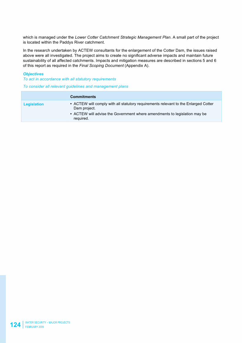
124 WATER SECURITY – MAJOR PROJECTS
FEBRUARY 2009
which is managed under the Lower Cotter Catchment Strategic Management Plan. A small part of the project
is located within the Paddys River catchment.
In the research undertaken by ACTEW consultants for the enlargement of the Cotter Dam, the issues raised
above were all investigated. The project aims to create no significant adverse impacts and maintain future
sustainability of all affected catchments. Impacts and mitigation measures are described in sections 5 and 6
of this report as required in the Final Scoping Document (Appendix A).
Objectives
To act in accordance with all statutory requirements
To consider all relevant guidelines and management plans
Commitments
Legislation • ACTEW will comply with all statutory requirements relevant to the Enlarged Cotter Dam project.
• ACTEW will advise the Government where amendments to legislation may be
required.

ENLARGEMENT OF THE COTTER RESERVOIR AND ASSOCIATED WORKS
ENVIRONMENTAL IMPACT STATEMENT 125
5 Potential environmental impacts
It should be noted that the potential impacts that are discussed in section 5 are not considered to be
potentially significant in the risk assessment developed for the Scoping Document (Appendix A). While
commitments are made to manage these potential impacts none of them are likely to have a bearing on
whether the Enlarged Cotter Dam project should proceed. The primary focus of the EIS, in accordance with
section 50 of the Planning and Development Regulations 2008 is the assessment of potentially significant
issues. These are discussed in section 6, as they may constitute a reason to significantly modify or abandon
the project.
The potential impacts discussed in section 5 are typically managed by normal industry and Australian
standards or good practice methodologies. Details of management procedures will be resolved as part of the
DA process, as part of the EMP or will be addressed through application for other necessary permits
and licences.
5.1 Infrastructure impacts
5.1.1 General assessment of Cotter Road –– Roads and traffic
ACTEW commissioned a traffic impact assessment (Appendix U) for the Enlarged Cotter Dam project to
consider the likely impacts on the road network that is proposed to be used for this projects and in particular
road impacts on Cotter Road associated with construction activities.
The main roads that are likely to be impacted upon by the Enlarged Cotter Dam project are Cotter Road,
Brindabella Road and Paddy’s River Road.
The assessment describes Cotter Road as a two-lane, single-carriageway road linking Canberra in the east
with Tharwa in the west. For most of its length, Cotter Road’s lane width is 3m each direction with no
shoulders. The posted speed limit along Cotter Road is generally 80km/hr with some reduced speed zones
of 60km/hr. The majority of its length is situated in unlit rural conditions except for the section from Streeton
Drive to Eucumbene Drive where it is situated in a semi-urban area and lighting is provided at the
intersections.
There are limited intersections from Eucumbene Drive to Camp Cottermouth but numerous rural driveways.
From Camp Cottermouth to Paddys River Road, Cotter Road has a steep winding alignment with two single-
lane bridge crossings at the Murrumbidgee River and the Cotter River. The crossing at the Murrumbidgee
River has actuated signals while the crossing at the Cotter River is uncontrolled.
Cotter Road is also the main access road to a number of sports/training, tourist and recreational sites and
provides access to a number of parks and camping areas which generate recreational traffic. Cotter Road is
also frequently used by a substantial number of local amateur and professional cyclists as a training route as
well as equestrian users along the section between the Uriarra Road and the Murrumbidgee River.
Brindabella Road is a two lane rural road which generally runs in the north-south direction from Cotter Road
to Uriarra Road at its northern end. The speed environment along Brindabella Road is generally 60km/hr,
with some reduced speed advisory signs due to the winding horizontal alignment.
Paddy’s River Road is a two lane rural road south of the Cotter Precinct that connects from Tidbinbilla Road
in the south and meets up with Cotter Road at its northern end.
The observed traffic volumes in January 2008 along Cotter Road at Streeton Drive are described in the
Figure 5.1.

126 WATER SECURITY – MAJOR PROJECTS
FEBRUARY 2009
Figure 5.1 Hourly traffic volumes Cotter Road (summer and winter)

ENLARGEMENT OF THE COTTER RESERVOIR AND ASSOCIATED WORKS
ENVIRONMENTAL IMPACT STATEMENT 127
The bi-directional peak morning traffic volume for this section of Cotter Road was observed to average
around 540 vehicles per hour on a weekday with the afternoon peak averaging 340 vehicles. From the traffic
counts, it is observed that the morning peak is attributable to vehicles travelling eastbound along Cotter
Road in the direction towards Canberra City while the afternoon peak is due mainly to traffic flow in the
westbound direction. Weekend traffic in both directions was observed to be slightly higher than weekday
traffic during the weekday off peak hours but remain low during the weekday peak hours. This is indicative of
weekday commuter traffic to and from the city centre with the corresponding peak hour travel representing
mainly business or work trips to and from the city.
Traffic volumes observed during the winter (July 2008) indicated increased weekend traffic on both directions
when compared to traffic volumes observed in the summer. The highest hourly volume recorded was 549
vehicles (Monday morning peak).
The 7-day average daily traffic observed at this location is about 2,600 vehicles a day during winter and
about 2,800 vehicles a day during summer. Peak hour volumes comprised approximately 18–20 per cent of
the total daily traffic.
The traffic volumes observed on Cotter Road in the vicinity of Mt Stromlo Road show that weekend traffic
volumes are generally higher than weekday traffic and the peak periods were observed to occur around
midday on a Sunday. The traffic profile differs from the traffic profile observed along Cotter Road at Streeton
Drive. Considering that the predominant land uses along Cotter Road to the west of Eucumbene Drive are
mostly for recreational use, this may be indicative of leisure and recreational trips mostly occurring on a
weekend.
The 7-day average daily traffic observed at Mt Stromlo Road was 1,200 vehicles per day. The average
weekday daily traffic was recorded to be 1,030 vehicles per day while the average weekend traffic was
recorded to be 1,900 vehicles per day. Peak hour volumes comprised approximately 9-10 per cent of the
total daily traffic.
The traffic profile observed along Cotter Road at Murrumbidgee Bridge showed the same trends as those
observed along Cotter Road at Mt Stromlo Road. Weekend traffic appeared to be higher than weekday traffic
for both the summer and the winter counts. Peak volumes were observed to occur mostly on a Sunday. The
average weekday daily traffic was recorded to be approximately 720 vehicles per day while the average
weekend daily traffic was recorded to be 1,200 vehicles per day. Similarly, the peak hour volumes comprise
9-10 per cent of the total daily traffic. Summer traffic movements are generally higher than winter.
Traffic counts during special events (eg Australia Day) showed that there is a significant increase in traffic
volumes on Cotter Road during a public holiday. When compared to normal day traffic, it is evident that the
volumes have increased by a factor of 2.5 during the peak hour and a factor of 3.5 for the daily weekday
traffic. When compared to normal weekend traffic, the traffic volumes on Australia Day were observed to be
almost doubled that of the average daily weekend traffic.
The AUSTROADS Guide to Traffic Engineering Practice - Part 2: Roadway Capacity (1988) indicates that
two-lane rural highways have a capacity of 2,800 passenger cars per hour total for both directions of flow,
under ideal conditions where there are no restrictive roadway, terrain or traffic conditions. However,
considering the prevailing roadway and traffic conditions along Cotter Road, it is estimated that the total
service flow rate could be around 1,400 passenger cars per hour total for both directions of flow.
AUSTROADS defines level of service (LOS) as a qualitative measure describing operational conditions
within a traffic stream. The volume and composition of traffic on a given road determines the level of
interaction between vehicles and is measured as its LOS. LOS decreases with increasing traffic volumes.
LOS A, LOS B, LOS C in a rural environment are all considered satisfactory.
The Traffic Assessment provides an assessment of the existing capacity of Cotter Road and found that
Cotter Road was operating at LOS C at the Streeton Drive monitoring point at all times (weekday and
weekends). The remainder of the road was operating at LOS A during weekdays and LOS B
during weekends.

128 WATER SECURITY – MAJOR PROJECTS
FEBRUARY 2009
In the context of the AUSTROADS Guide, Cotter Road is considered to have adequate capacity to
accommodate some additional traffic.
5.1.2 Cotter Road pavement rehabilitation project
TAMS is currently undertaking the Cotter Road Pavement Rehabilitation Project as part of their annual road
pavement resurfacing program for 2008/09. Works commenced in May 2008 and will take approximately
6–12 months to complete. The road works include the rehabilitation of the existing pavement on Cotter
Road, including lane widening, the extension of culverts and widening of shoulders at selected sections. The
upgrading will potentially address road safety issues with regard to below standard lane widths, lack of
shoulders, lack of safety barriers and the presence of hazards (ie culvert headwalls).
The Enlarged Cotter Dam project will benefit from these upgrades as it will improve the condition and safety
conditions along Cotter Road. ACTEW has been consulting with TAMS in relation to this program and has
provided input into the future use of the road during and post construction. (Refer to Chapter 7 and
Appendix U for details).
5.1.3 Traffic characteristics for Enlarged Cotter Dam
The main traffic generated through the construction phase would be from equipment and material deliveries,
such as:
•• Construction materials.
• Construction equipment and machinery.
• Specific components for the dams.
• Movement of construction personnel, including contractors, site labour force and supervisory personnel.
Light vehicle traffic
Light vehicle traffic is expected to use Cotter Road as the primary access. Light vehicle traffic will be
generated by:
• Workforce attendance of approximately 140 personnel on an ordinary hour shift.
• Workforce attendance of 50 personnel on night and weekend shifts (pending approval of specific working
hours).
• Trades vehicles attending the site for light fabrication and equipment servicing.
• Ambulance and emergency services.
Over the full construction period, the peak construction workforce is estimated to be approximately 190
persons (140 on day shift and 50 on night shift basis). Based on the characteristics of the Project route, it is
assumed there would be a typical car driver rate of 100 per cent. Application of this car driver rate to an
assumed worst case scenario workforce yields a traffic generation in the order of 140 light vehicles a day
initially and 190 light vehicles a day once 24-hour operation commences.
Heavy vehicle traffic
Heavy vehicle traffic will vary at each phase and will consist of:
• Delivery of earthmoving equipment such as bulldozers, off-highway haul trucks, front-end loaders, graders,
rollers, excavators and backhoes.
• Ready mixed concrete deliveries.
• Large quarrying equipment, including crushers, conveyors and screening plant plus generators to power
the crusher.
• Clay and sand deliveries.
• Cement and fly-ash deliveries.
• Progressive removal of equipment and construction equipment.

ENLARGEMENT OF THE COTTER RESERVOIR AND ASSOCIATED WORKS
ENVIRONMENTAL IMPACT STATEMENT 129
The number of vehicles per day will be primarily based upon the delivery of materials required at any given
stage of the project.
Oversized vehicles for construction equipment
It is anticipated that movements of oversized vehicles transporting large construction equipment will primarily
be during the initial stages of the project and towards the end. These oversized vehicles are expected to use
the secondary access routes described below.
Delivery of diesel fuel
In addition to the above, an option for onsite generation of electricity is being investigated which would
require the delivery of diesel fuel to the site. Should diesel fuel be required, it is estimated that a total of
10,000 litres a day would need to be delivered. A standard tanker can accommodate 35,000 litres and there
will be provision for onsite storage of 100,000 litres. Hence, it is estimated that deliveries of diesel fuel would
utilise 4 loads of fuel tankers for the initial delivery (or 1 load per day for four days) and 1 load every three
days for the entire duration of the construction.
5.1.4 Proposed construction access routes
There are primary and secondary access routes proposed for entry and exit to the construction site.
The primary access route will be via Cotter Road. Vehicles that meet normal width and loading standards,
including workforce and delivery vehicles, will pass over the existing bridges on the Murrumbidgee and
Cotter Rivers.
Secondary access routes will be via Point Hut Crossing or via Brindabella Road. These routes will be utilised
for oversized loads.
A traffic management drawing for the construction of the Enlarged Cotter Dam showing the access routes
and initial road upgrading is shown in Figure 5.2.