2.2.2 water quality final · 6hfwlrq hvwdeolvkhv d shuplw surjudp iru wkh glvfkdujh ri guhgjh ru...
TRANSCRIPT
Chapter 2 Affected Environment, Environmental Consequences, and Avoidance, Minimization, and/or Mitigation Measures
I-605/Katella Avenue Interchange Improvements 2.2.2-1 Initial Study/Environmental Assessment (IS/EA)
2.2.2 Water Quality and Storm Water Runoff 2.2.2.1 Regulatory Setting 2.2.2.1.1 Federal Requirements: Clean Water Act In 1972, Congress amended the federal Water Pollution Control Act, making the addition of pollutants to the waters of the United States (U.S.) from any point source1 unlawful unless the discharge is in compliance with a National Pollutant Discharge Elimination System (NPDES) permit. This act and its amendments are known today as the Clean Water Act (CWA). Congress has amended the act several times. In the 1987 amendments, Congress directed dischargers of storm water from municipal and industrial/construction point sources to comply with the NPDES permit scheme. The following are important CWA sections:
Sections 303 and 304 require states to issue water quality standards, criteria, and guidelines.
Section 401 requires an applicant for a federal license or permit to conduct any activity that may result in a discharge to waters of the U.S. to obtain certification from the state that the discharge would comply with other provisions of the act. This is most frequently required in tandem with a Section 404 permit request (see below).
Section 402 establishes the NPDES, a permitting system for the discharges (except for dredge or fill material) of any pollutant into waters of the U.S. Regional Water Quality Control Boards (RWQCBs) administer this permitting program in California. Section 402(p) requires permits for discharges of storm water from industrial/construction and municipal separate storm sewer systems (MS4s).
Section 404 establishes a permit program for the discharge of dredge or fill material into waters of the U.S. This permit program is administered by the U.S. Army Corps of Engineers (USACE).
The goal of the CWA is “to restore and maintain the chemical, physical, and biological integrity of the Nation’s waters.” The USACE issues two types of 404 permits: General and Individual. There are two types of General permits: Regional and Nationwide. Regional permits are issued for a general category of activities when they are similar in nature and cause minimal environmental effect. Nationwide permits are issued to allow a variety of minor project activities with no more than minimal effects. Ordinarily, projects that do not meet the criteria for a Regional or Nationwide Permit may be permitted under one of the USACE’s Individual permits. There are two types of Individual permits: Standard permits and Letters of Permission. For Individual permits, the USACE decision to approve is based on compliance with U.S. Environmental Protection Agency’s (U.S. EPA) Section 404 (b)(1) Guidelines (40 Code of Federal Regulations [CFR] Part 230), and whether the permit approval is in the public interest. The Section 404(b)(1) Guidelines (Guidelines) were developed by the U.S. EPA in conjunction with the USACE, and allow the discharge of dredged or fill material into the aquatic system (waters of the U.S.) only if there is
1 A point source is any discrete conveyance such as a pipe or a man-made ditch.

Chapter 2 Affected Environment, Environmental Consequences, and Avoidance, Minimization, and/or Mitigation Measures
I-605/Katella Avenue Interchange Improvements 2.2.2-2 Initial Study/Environmental Assessment (IS/EA)
no practicable alternative which would have less adverse effects. The Guidelines state that the USACE may not issue a permit if there is a least environmentally damaging practicable alternative (LEDPA) to the proposed discharge that would have lesser effects on waters of the U.S. and not have any other significant adverse environmental consequences. According to the Guidelines, documentation is needed that a sequence of avoidance, minimization, and compensation measures has been followed, in that order. The Guidelines also restrict permitting activities that violate water quality or toxic effluent2 standards, jeopardize the continued existence of listed species, violate marine sanctuary protections, or cause “significant degradation” to waters of the U.S. In addition, every permit from the USACE, even if not subject to the Section 404(b)(1) Guidelines, must meet general requirements. See 33 CFR 320.4. A discussion of the LEDPA determination, if any, for the document is included in the Wetlands and Other Waters section. 2.2.2.1.2 State Requirements: Porter-Cologne Water Quality Control Act California’s Porter-Cologne Act, enacted in 1969, provides the legal basis for water quality regulation within California. This act requires a “Report of Waste Discharge” for any discharge of waste (liquid, solid, or gaseous) to land or surface waters that may impair beneficial uses for surface and/or groundwater of the state. It predates the CWA and regulates discharges to waters of the state. Waters of the state include more than just waters of the U.S., like groundwater and surface waters not considered waters of the U.S. Additionally, it prohibits discharges of “waste” as defined, and this definition is broader than the CWA definition of “pollutant.” Discharges under the Porter-Cologne Act are permitted by Waste Discharge Requirements (WDRs) and may be required even when the discharge is already permitted or exempt under the CWA. The State Water Resources Control Board (SWRCB) and RWQCBs are responsible for establishing the water quality standards (objectives and beneficial uses) required by the CWA and regulating discharges to ensure compliance with the water quality standards. Details about water quality standards in a project area are included in the applicable RWQCB Basin Plan. In California, RWQCBs designate beneficial uses for all water body segments in their jurisdictions and then set criteria necessary to protect those uses. As a result, the water quality standards developed for particular water segments are based on the designated use and vary depending on that use. In addition, the SWRCB identifies waters failing to meet standards for specific pollutants. These waters are then state-listed in accordance with CWA Section 303(d). If a state determines that waters are impaired for one or more constituents and the standards cannot be met through point source or non-point source controls (NPDES permits or WDRs), the CWA requires the establishment of Total Maximum Daily Loads (TMDLs). TMDLs specify allowable pollutant loads from all sources (point, non-point, and natural) for a given watershed. 2.2.2.1.3 State Water Resources Control Board and Regional Water Quality Control
Boards The SWRCB administers water rights, sets water pollution control policy, and issues water board orders on matters of statewide application, and oversees water quality functions throughout the State by approving Basin Plans, TMDLs, and NPDES permits. RWCQBs are responsible for protecting beneficial uses of water resources within their regional jurisdiction using planning, permitting, and enforcement authorities to meet this responsibility.
2 The U.S. EPA defines “effluent” as “wastewater, treated or untreated, that flows out of a treatment plant,
sewer, or industrial outfall.”

Chapter 2 Affected Environment, Environmental Consequences, and Avoidance, Minimization, and/or Mitigation Measures
I-605/Katella Avenue Interchange Improvements 2.2.2-3 Initial Study/Environmental Assessment (IS/EA)
National Pollutant Discharge Elimination System (NPDES) Program Municipal Separate Storm Sewer Systems (MS4) Section 402(p) of the CWA requires the issuance of NPDES permits for five categories of storm water discharges, including Municipal Separate Storm Sewer Systems (MS4s). An MS4 is defined as “any conveyance or system of conveyances (roads with drainage systems, municipal streets, catch basins, curbs, gutters, ditches, human-made channels, and storm drains) owned or operated by a state, city, town, county, or other public body having jurisdiction over storm water, that is designed or used for collecting or conveying storm water.” The SWRCB has identified Caltrans as an owner/operator of an MS4 under federal regulations. Caltrans’ MS4 permit covers all Caltrans rights-of-way (ROW), properties, facilities, and activities in the State. The SWRCB or the RWQCB issues NPDES permits for five years, and permit requirements remain active until a new permit has been adopted. Caltrans’s MS4 Permit, Order No. 2012-0011-DWQ (adopted on September 19, 2012 and effective on July 1, 2013), as amended by Order No. 2014-0077-DWQ (effective July 1, 2014) and Order No. 2015-0036-EXEC (effective April 7, 2015) has three basic requirements:
1) Caltrans must comply with the requirements of the Construction General Permit (see
below);
2) Caltrans must implement a year-round program in all parts of the State to effectively control storm water and non-storm water discharges; and
3) Caltrans storm water discharges must meet water quality standards through implementation of permanent and temporary (construction) Best Management Practices (BMPs), to the maximum extent practicable, and other measures as the SWRCB determines to be necessary to meet the water quality standards.
To comply with the permit, Caltrans developed the statewide Storm Water Management Plan (SWMP) to address storm water pollution controls related to highway planning, design, construction, and maintenance activities throughout California. The SWMP assigns responsibilities within Caltrans for implementing storm water management procedures and practices as well as training, public education and participation, monitoring and research, program evaluation, and reporting activities. The SWMP describes the minimum procedures and practices Caltrans uses to reduce pollutants in storm water and non-storm water discharges. It outlines procedures and responsibilities for protecting water quality, including the selection and implementation of BMPs. The proposed project would be programmed to follow the guidelines and procedures outlined in the latest SWMP to address storm water runoff. Construction General Permit Construction General Permit (CGP), Order No. 2009-2009-DWQ (adopted on September 2, 2009 and effective on July 1, 2010), as amended by Order No. 2010-0014-DWQ (effective February 14, 2011) and Order No. 2012-0006-DWQ (effective on July 17, 2012). The permit regulates storm water discharges from construction sites that result in a Disturbed Soil Area (DSA) of one acre or greater, and/or are smaller sites that are part of a larger common plan of development. By law, all storm water discharges associated with construction activity where clearing, grading, and excavation result in soil disturbance of at least one acre must comply with the provisions of the General Construction Permit. Construction activity that results in soil disturbances of less than one acre is subject to this CGP if there is potential for significant water
Chapter 2 Affected Environment, Environmental Consequences, and Avoidance, Minimization, and/or Mitigation Measures
I-605/Katella Avenue Interchange Improvements 2.2.2-4 Initial Study/Environmental Assessment (IS/EA)
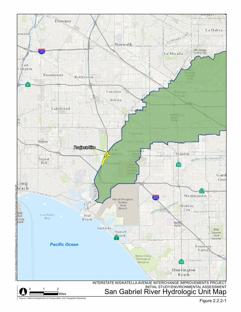
quality impairment resulting from the activity as determined by the RWQCB. Operators of regulated construction sites are required to develop Storm Water Pollution Prevention Plans (SWPPPs); to implement sediment, erosion, and pollution prevention control measures; and to obtain coverage under the CGP. The CGP separates projects into Risk Levels 1, 2, or 3. Risk levels are determined during the planning and design phases, and are based on potential erosion and transport to receiving waters. Requirements apply according to the Risk Level determined. For example, a Risk Level 3 (highest risk) project would require compulsory storm water runoff pH and turbidity monitoring, and before construction and after construction aquatic biological assessments during specified seasonal windows. For all projects subject to the permit, applicants are required to develop and implement an effective SWPPP. In accordance with Caltrans’s SWMP and Standard Specifications, a Water Pollution Control Program (WPCP) is necessary for projects with DSA less than one acre. Section 401 Permitting Under Section 401 of the CWA, any project requiring a federal license or permit that may result in a discharge to a water of the U.S. must obtain a 401 Certification, which certifies that the project would be in compliance with State water quality standards. The most common federal permits triggering 401 Certification are CWA Section 404 permits issued by the USACE. The 401 permit certifications are obtained from the appropriate RWQCB, dependent on the project location, and are required before the USACE issues a 404 permit. In some cases, the RWQCB may have specific concerns with discharges associated with a project. As a result, the RWQCB may issue a set of requirements known as WDRs under the State Water Code (Porter-Cologne Act) that define activities, such as the inclusion of specific features, effluent limitations, monitoring, and plan submittals that are to be implemented for protecting or benefiting water quality. WDRs can be issued to address both permanent and temporary discharges of a project. 2.2.2.2 Affected Environment A Water Quality Assessment Report (WQAR) was prepared for the proposed project in November 2017. This section is based on information contained within the WQAR. 2.2.2.2.1 Surface Streams Within the project area, there are three channels: Coyote Creek, Los Alamitos, and Katella Storm Drain Channel. These channels are tributary to the San Gabriel River. The San Gabriel River is located approximately 1,800 feet west of the project area. 2.2.2.2.2 Regional Hydrology The project area lies within the San Gabriel River hydrological unit (Anaheim Hydrologic Area) within Hydrologic Sub-Area (HSA) 845.61, where the project discharges to the Lower San Gabriel River watershed and ultimately into the Pacific Ocean; refer to Figure 2.2.2-1, San Gabriel River Hydrological Unit Map. The project area is under the jurisdiction of the Santa Ana RWQCB.
?b
%&l(Aì
Ab
AÆ
%&d(
AÔPacific Ocean
LOS ANGELES COUNTY
INTERSTATE 605/KATELLA AVENUE INTERCHANGE IMPROVEMENTS PROJECTINITIAL STUDY/ENVIRONMENTAL ASSESSMENTSan Gabriel River Hydrologic Unit Map
Figure 2.2.2-1° 0 1 2
Miles
9/22/2
017 J
N M:
\Mda
ta\15
5953
\MXD
\Sep
tembe
r 201
7\2.2.
2-1 S
an G
abrie
l Rive
r Hyd
rolog
ic Un
it Map
.mxd
AP
Source: California Department of Transportation, Esri Topographic Basemap
Project Site
Chapter 2 Affected Environment, Environmental Consequences, and Avoidance, Minimization, and/or Mitigation Measures
I-605/Katella Avenue Interchange Improvements 2.2.2-6 Initial Study/Environmental Assessment (IS/EA)
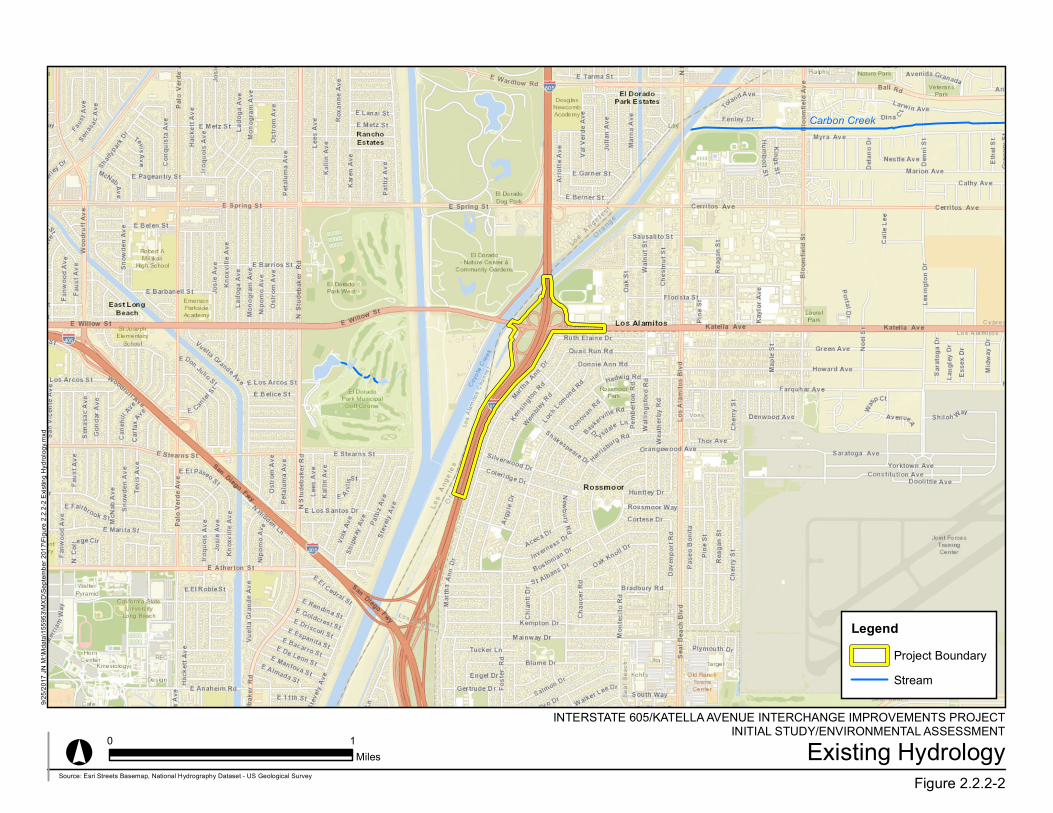
The watershed characteristics and beneficial uses of the Coyote Creek, Los Alamitos, and Katella Storm Drain Channels can be found in the Coyote Creek Watershed Management Plan. The proposed project falls within this area. The Coyote Creek Watershed drains into the San Gabriel River watershed. The other major creeks in the watershed include Brea Creek, Fullerton Creek, Carbon Creek, and Moody Creek. The watershed is highly urbanized and supplied by local and imported water sources. The wastewater is treated by several wastewater treatment facilities along the watershed. The Coyote Creek watershed is approximately 165 square miles and is composed of primarily urbanized residential, commercial, and industrial development. The drainage facilities are general concrete-lined or otherwise armored conveyance facilities with marginal aquatic or riparian habitats. 2.2.2.2.3 Local Hydrology The precipitation that falls in the proposed project boundary within Caltrans ROW is collected by the Caltrans drainage system and discharged into the adjoining City local drainage system. Within the proposed project boundaries, there are no groundwater resources. 2.2.2.2.4 Municipal Supply San Gabriel River and its major tributaries within the vicinity of the proposed project are man-made flood control channels that drain into urbanized alluvial and coastal plains. These channels flow through mainly concrete-lined structures in a heavily urbanized portion of the county. At the Alamitos Barrier, the surface water is then used for the engineered freshwater pressure ridge and seawater trough. This structure is designed to protect the Central Groundwater Basin of Los Angeles County (Central Basin) and the Orange County Groundwater Basin from seawater intrusion. 2.2.2.2.5 Groundwater Hydrology The Central Basin is located in the southeastern part of the Los Angeles Coastal Plain and is approximately 277 square miles. The Orange County Groundwater Basin is located in the northwestern part of the Orange County Coastal Plain and is approximately 350 square miles. The Central and Orange County Groundwater Basins boundaries are roughly separated by the Coyote Creek Channel. The groundwater in the basins are found in the Holocene and Pleistocene sediments at relatively shallow depths. There are limited areas available for surface recharge in the basins due to the Bellflower Aquiclude and areas with large amounts of fine soil material. These areas create an impermeable layer of soil that prevents downward movement of water and a perched groundwater table in some areas of the basins. The most significant area for surface recharge is found in the Whittier Narrows due to the availability of highly permeable soils. The basins primarily consist of thick accumulation of freshwater interbedded with marine and continental sand, silt, and clay deposits. The groundwater level in the project area is approximately 100 feet below sea level. There were no identified groundwater plumes in the vicinity of the project area. 2.2.2.2.6 Beneficial Uses A beneficial use identifies the ways that water can be used for the benefit of people and/or wildlife. Table 2.2.2-1, Beneficial Uses of Surface Water and Groundwater, below summarizes the beneficial uses of the receiving water body (Coyote Creek) as well as the groundwater

Chapter 2 Affected Environment, Environmental Consequences, and Avoidance, Minimization, and/or Mitigation Measures
I-605/Katella Avenue Interchange Improvements 2.2.2-7 Initial Study/Environmental Assessment (IS/EA)
resource (Orange Hydrological Sub-Area) in the project area. Figure 2.2.2-2, Existing Hydrology, shows the location of the receiving water body in relation to the proposed project.
Table 2.2.2-1: Beneficial Uses of Surface Water and Groundwater
Beneficial Use MUN AGR IND PROC GWR REC I REC II WARM COLD WILD
Surface Water Beneficial Uses Coyote Creek (within Santa Ana regional boundary)
- - - - - E E E - E
Groundwater Beneficial Uses Orange Hydrological Sub-Area
X X X X - - - - - -
Key: I = Intermittent Beneficial Use; E = Existing Beneficial Use; P = Potential Beneficial Use Notes: MUN Municipal and Domestic Supply GWR Ground Water Recharge AGR Agriculture Supply REC I Water Contact Recreation AQUA Aquaculture REC II Non-Contact Water Recreation FRSH Freshwater Replenishment WARM Warm Freshwater Habitat IND Industrial Service Supply WILD Wildlife Habitat RARE Preservation of Rare, Threatened, or Endangered Species Source: Water Quality Assessment Report, April 2017, Tables 4 (p. 19) and 7 (p. 21).
2.2.2.2.7 Impairments The CWA requires states to identify water bodies that are considered impaired, which means the water body does not meet water quality standards. Once a water body is listed as impaired, the State is required to develop a TMDL to address each pollutant causing the impairment. A TMDL defines how much of a pollutant load a water body can tolerate and still meet water quality standards. The TMDL is required to account for contributions from point sources (i.e., permitted discharges), as well as contributions from nonpoint sources, including natural background. TMDLs allocate allowable pollutant loads for each source and identify management measures that, when implemented, will assure that water quality standards are attained. Through the RWQCB basin planning process, TMDLs and TMDL implementation plans are adopted into an RWQCB’s Basin Plan. Coyote Creek is listed for Ammonia; Copper, Dissolved; Diazinon; Indicator Bacteria; Lead; Toxicity; and pH. San Gabriel River Reach 1 (Estuary to Firestone) is listed for pH and Coliform Bacteria. San Gabriel River Estuary is listed for Copper; Dioxin; Nickel; and Oxygen, Dissolved. Once a waterbody is designated as impaired, states must then place the water body onto a list, referred to as the “CWA Section 303(d) List of Water Quality Limited Segments.” On June 26, 2015, the United States Environmental Protection Agency (EPA) issued its final decision regarding the water bodies and pollutants added to California’s 303(d) List. This list, referred to as the California 2012 Integrated Report, replaces the 2010 California CWA 303(d) List. The 2012 Integrated Report includes a combined list of CWA Section 303(d) water bodies that are listed as not meeting water quality standards and Section 305(b) water bodies that identifies water bodies still requiring the development of a TMDL, those that have a completed a TMDL approved by EPA, and those that are being addressed by actions other than a TMDL (SWRCB, 2015).
INTERSTATE 605/KATELLA AVENUE INTERCHANGE IMPROVEMENTS PROJECTINITIAL STUDY/ENVIRONMENTAL ASSESSMENT
Existing HydrologyFigure 2.2.2-2
°
9/25/2
017 J
N M:
\Mda
ta\15
5953
\MXD
\Sep
tembe
r 201
7\Figu
re 2.2
.2-2 E
xistin
g Hyd
rolog
y.mxd
0 1Miles
LegendProject BoundaryStream
Carbon Creek
Source: Esri Streets Basemap, National Hydrography Dataset - US Geological Survey

Chapter 2 Affected Environment, Environmental Consequences, and Avoidance, Minimization, and/or Mitigation Measures
I-605/Katella Avenue Interchange Improvements 2.2.2-9 Initial Study/Environmental Assessment (IS/EA)
The Caltrans MS4 Permit (Order No. 2012-0011-DWQ, NPDES No. CAS000003) became effective on July 1, 2013, and contains TMDL compliance requirements that indicate that Caltrans shall comply with all TMDLs listed in Attachment IV. Per Attachment IV, TMDLs applicable to the I-605/Katella Avenue Interchange Improvements include:
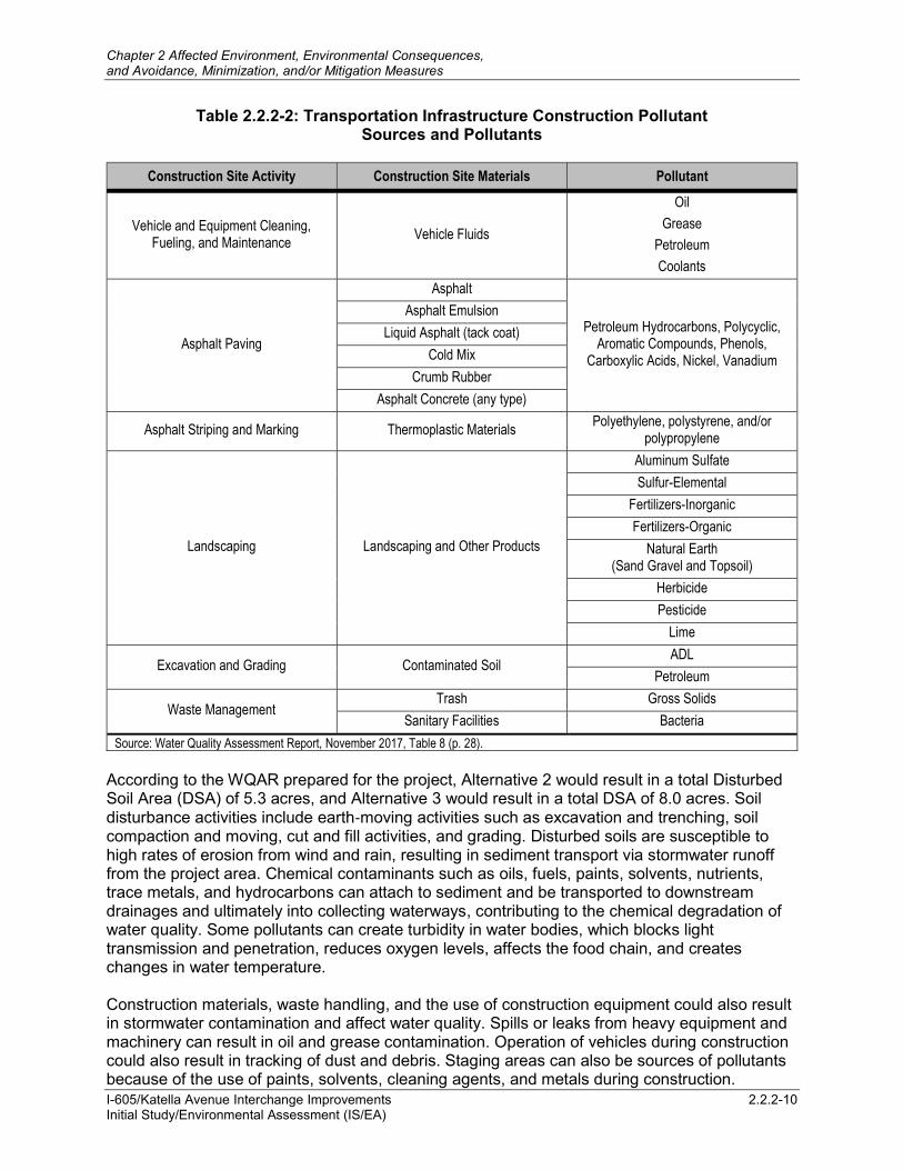
San Gabriel River and Impaired Tributaries – Metals, effective March 26, 2007 2.2.2.3 Environmental Consequences The project footprint for both Build Alternatives is similar; therefore, the discussion of Alternatives 2 and 3 below is combined into a single discussion of Build Alternatives, since implementation of either of the Build Alternative would result in similar impacts. 2.2.2.3.1 Temporary Impacts Alternative 1 (No-Build Alternative) Under the No-Build Alternative, none of the proposed project improvements would be implemented; therefore, no construction-related impacts to water quality or storm water runoff would occur. Alternatives 2 and 3 (Build Alternatives) Construction of either of the Build Alternatives would result in water quality impacts associated with the contribution of pollutants to receiving water bodies during the short-term construction process. These pollutants include sediment and silt associated with soil disturbance because of construction of the proposed improvements and chemical pollutants associated with the construction materials that are brought onto the project site. In addition, dewatering activities for excavations below the water table could result in the discharge of unsuitable and untreated water if discharged directly to the environment. If temporary excavations require dewatering, there is the potential of discharging pollutants (primarily by entraining silt and clay, but also from encountering chemicals and other contaminants) through release of construction water directly to the environment. These discharges will comply with the permit requirements of the Santa Ana RWQCB Order No. R8-2015-0004 (NPDES NO. CAG998001) and/or the Los Angeles RWQCB Order No. R4-2013-0095 (NPDES NO. CAG 994004). Potential pollutant sources, along with their associated pollutant typical for transportation infrastructure construction sites, are shown in Table 2.2.2-2, Transportation Infrastructure Construction Pollutant Sources and Pollutants, below.
Chapter 2 Affected Environment, Environmental Consequences, and Avoidance, Minimization, and/or Mitigation Measures
I-605/Katella Avenue Interchange Improvements 2.2.2-10 Initial Study/Environmental Assessment (IS/EA)
Table 2.2.2-2: Transportation Infrastructure Construction Pollutant Sources and Pollutants
Construction Site Activity Construction Site Materials Pollutant
Vehicle and Equipment Cleaning, Fueling, and Maintenance
Vehicle Fluids
Oil
Grease
Petroleum
Coolants
Asphalt Paving
Asphalt
Petroleum Hydrocarbons, Polycyclic, Aromatic Compounds, Phenols,
Carboxylic Acids, Nickel, Vanadium
Asphalt Emulsion
Liquid Asphalt (tack coat)
Cold Mix
Crumb Rubber
Asphalt Concrete (any type)
Asphalt Striping and Marking Thermoplastic Materials Polyethylene, polystyrene, and/or
polypropylene
Landscaping Landscaping and Other Products
Aluminum Sulfate
Sulfur-Elemental
Fertilizers-Inorganic
Fertilizers-Organic
Natural Earth (Sand Gravel and Topsoil)
Herbicide
Pesticide
Lime
Excavation and Grading Contaminated Soil ADL
Petroleum
Waste Management Trash Gross Solids
Sanitary Facilities Bacteria
Source: Water Quality Assessment Report, November 2017, Table 8 (p. 28).
According to the WQAR prepared for the project, Alternative 2 would result in a total Disturbed Soil Area (DSA) of 5.3 acres, and Alternative 3 would result in a total DSA of 8.0 acres. Soil disturbance activities include earth‐moving activities such as excavation and trenching, soil compaction and moving, cut and fill activities, and grading. Disturbed soils are susceptible to high rates of erosion from wind and rain, resulting in sediment transport via stormwater runoff from the project area. Chemical contaminants such as oils, fuels, paints, solvents, nutrients, trace metals, and hydrocarbons can attach to sediment and be transported to downstream drainages and ultimately into collecting waterways, contributing to the chemical degradation of water quality. Some pollutants can create turbidity in water bodies, which blocks light transmission and penetration, reduces oxygen levels, affects the food chain, and creates changes in water temperature. Construction materials, waste handling, and the use of construction equipment could also result in stormwater contamination and affect water quality. Spills or leaks from heavy equipment and machinery can result in oil and grease contamination. Operation of vehicles during construction could also result in tracking of dust and debris. Staging areas can also be sources of pollutants because of the use of paints, solvents, cleaning agents, and metals during construction.
Chapter 2 Affected Environment, Environmental Consequences, and Avoidance, Minimization, and/or Mitigation Measures
I-605/Katella Avenue Interchange Improvements 2.2.2-11 Initial Study/Environmental Assessment (IS/EA)
Pesticide use, including herbicides, fungicides, and rodenticides, associated with site preparation is another potential source of stormwater contamination. Larger pollutants, such as trash, debris, and organic matter, could also be associated with construction activities. As such, the discharge of stormwater may cause, or threaten to cause, violations of Water Quality Objectives (WQOs). These pollutants would occur in the stormwater discharges and non‐stormwater discharges and could potentially cause chemical degradation and aquatic toxicity in the receiving waters. In order to avoid and minimize these potential construction-related water quality impacts, project features (PF-WQ-1 and PF-WQ-2, described below) involving conformance with the requirements of the Caltrans statewide NPDES Storm Water Permit and development of a SWPPP would be implemented during construction. Implementation of these project features would minimize temporary effects related to water quality, and impacts would not be adverse. PF-WQ-1 NPDES Construction Requirements. The project would be required to comply
with the requirements of the National Pollutant Discharge Elimination System (NPDES) Permit for Construction Activities, Order No. 2009‐0009‐DWQ, as amended by 2010‐0014‐DWQ and 2012‐0006‐DWQ, NPDES No. CAS000002, as well as implementation of the standard Best Management Practices (BMPs) specified in Caltrans’ Storm Water Management Plan (Caltrans, 2003).
If dewatering is required, construction site dewatering shall comply with General Waste Discharge Requirements (WDRs) for Discharges to Surface Waters within the Santa Ana Region (Order No. R8-2015-0004, NPDES No. CAG998001) and/or the Los Angeles Region (Order No. R4-2013-0095, NPDES No. CAG 994004) and any subsequent updates to the permits at the time of construction. These Permits address temporary dewatering operations during construction. Dewatering BMPs shall be used to control sediment and pollutants, and the discharges shall comply with the WDRs issued by the Santa Ana Regional Water Quality Control Board (RWQCB) and/or the Los Angeles RWQCB.
PF-WQ-2 SWPPP. The project shall include development of a Storm Water Pollution
Prevention Plan (SWPPP) prepared in accordance with the requirements stated in the National Pollutant Discharge Elimination System (NPDES) General Permit, Waste Discharge Requirements (WDRs) for Discharges of Storm Water Runoff Associated with Construction Activities (Construction General Permit, Order Number 2009‐0009‐DWQ, as amended by 2010‐0014‐DWQ and 2012‐0006‐DWQ, NPDES Number CAS000002), or subsequent permit in effect at the time of construction. The SWPPP shall contain standard Best Management Practices (BMPs) that have demonstrated effectiveness at reducing stormwater pollution, and shall address all construction‐related activities, equipment, and materials that have the potential to affect water quality. All standard Construction Site BMPs shall follow the latest edition of the Storm Water Quality Handbooks, Construction Site BMPs Manual (Caltrans, May 2017) to control and minimize the impacts of construction‐related pollutants. The SWPPP shall include BMPs to control pollutants, sediment from erosion, stormwater runoff, and other construction‐related impacts. In addition, the SWPPP shall include implementation of specific stormwater effluent monitoring requirements based on the project’s risk level to ensure that the implemented BMPs are effective in preventing discharges from exceeding any of the water quality standards.
Chapter 2 Affected Environment, Environmental Consequences, and Avoidance, Minimization, and/or Mitigation Measures
I-605/Katella Avenue Interchange Improvements 2.2.2-12 Initial Study/Environmental Assessment (IS/EA)
2.2.2.3.2 Permanent Impacts Alternative 1 (No-Build Alternative) Under the No-Build Alternative, none of the proposed project improvements would be implemented; therefore, no increase in runoff flow velocities, volumes, or peak flow rates or water quality impacts would occur. Alternatives 2 and 3 (Build Alternatives) Operation of the either of the Build Alternatives would result in an increase in impervious surface area, which would result in an increase in stormwater runoff. Potential pollutants associated with the operation of transportation facilities include sediment from natural erosion; nutrients, such as phosphorus and nitrogen, associated with freeway landscaping; mineralized organic matter in soils; nitrite discharges from automobile exhausts and atmospheric fallout; litter; and metals from the combustion of fossil fuels, the wearing of brake pads, and corrosion of galvanized structures. According to the WQAR prepared for the project, Alternative 2 would result in a total impervious area of 2.37 acres, and Alternative 3 would result in a total impervious area of 2.54 acres. The project would incorporate project features to reduce potential permanent adverse impacts to water quality. PF-WQ-3 requires implementation of Design Pollution Prevention BMPs to minimize potential pollution discharges generated during the operational phase. Design Pollution Prevention BMPs are measures required under the Caltrans MS4 Permit that focus on reducing or eliminating runoff and controlling sources of pollutants during operation of the project. The incorporation of Design Pollution Prevention BMPs as required under the Caltrans MS4 Permit would meet the objective of maximizing vegetated surfaces, preventing downstream erosion, and stabilizing soil areas. The project would also implement standardized featuresPF-WQ-4 requires implementation of Treatment and Maintenance BMPs, as required under the Caltrans MS4 Permit. Water quality impacts would be minimized with implementation of PF-WQ-3 and F-WQ-4, and impacts would not be adverse. PF-WQ-3 Design Pollution Prevention BMPs. The project will conform to the
requirements of the Caltrans statewide National Pollutant Discharge Elimination System (NPDES) Storm Water Permit, Order No. 2012‐0011‐DWQ, NPDES No. CAS000003, adopted by the SWRCB on September 19, 2012, and any subsequent permit in effect at the time of construction. The project shall implement Design Pollution Prevention BMPs, as required under the Caltrans MS4 Permit, that focus on reducing or eliminating runoff and controlling sources of pollutants during operation of the project. The incorporation of Design Pollution Prevention BMPs as required under the Caltrans MS4 Permit shall meet the objective of maximizing vegetated surfaces, preventing downstream erosion, and stabilizing soil areas.
PF-WQ-4 Treatment and Maintenance BMPs. The project shall include an evaluation of
all nine Caltrans‐approved treatment BMPs and select the most efficient option in relation to the direct and indirect receiving water bodies associated with the project, in order to remove pollutants that have entered stormwater runoff. Caltrans‐approved Treatment BMPs shall be implemented consistent with the

Chapter 2 Affected Environment, Environmental Consequences, and Avoidance, Minimization, and/or Mitigation Measures
I-605/Katella Avenue Interchange Improvements 2.2.2-13 Initial Study/Environmental Assessment (IS/EA)
requirements of the Caltrans NPDES permit. To implement water quality controls that would minimize pollutant discharges during the operational phase, the project shall implement Maintenance BMPs that shall be ongoing throughout the lifespan of the facility.
2.2.2.4 Avoidance, Minimization, and/or Mitigation Measures No avoidance, minimization, and/or mitigation measures are required with adherence to the project features described above.

Chapter 2 Affected Environment, Environmental Consequences, and Avoidance, Minimization, and/or Mitigation Measures
I-605/Katella Avenue Interchange Improvements 2.2.2-14 Initial Study/Environmental Assessment (IS/EA)
This page intentionally left blank.