2.5 gin river basin - jica · 2009-05-12 · summary 19 2.5 gin river basin 2.5.1 basin overview...
TRANSCRIPT

Summary
19
2.5 Gin River Basin
2.5.1 Basin Overview
Gin River originates from the mountainous region in southern side of Sinharaja forest and runs through Tawalama, Neluwa and Agaliya and falls into sea at Gintota, Galle. The basin area of the river is 932 km2 with an average annual runoff of 1,268 MCM. The catchment has an estimated average annual rainfall of around 3,290 mm (Figure 15, Figure 16).
Source: JICA Study Team
Figure 15 Location map of Gin River Basin Inundation Area (May, 2003)
-10
-5
0
5
10
15
20
0 10 20 30 40 50 60 70
Chainage (km)
Elev
atio
n (m
- M
SL)
Longitudinal Bed Profile
Hydrometric Stations
Tributory ConfluencesTaw
alam
a
Agal
iya
Mab
en E
la
Div
itura
Ela
Gin
tota
Source: LHI
Figure 16 Longitudinal Profile of Gin River

Summary
20
2.5.2 Flood Management Master Plan for Gin River Basin
Structural Measures
Table 8 Proposed Major Structures in Master Plan (Gin River)
Kind of structure Major dimensions 1. New sluices 9 nos. 2. Rehabilitation of existing pumps 10 pump houses 3. Mound dike A=51,000 m2 (3 sites) Short Term Plan
4. Flood bund Left bank (L=8,360 m, H=5.4m) Right bank (L=7,620m, H=5.3m)
5. Flood bund (heightening) Left bank (L=8,360 m, H=6.6m), Right bank (L=7,620m, H=6.3m) Long Term Plan
6. New pump house 8 nos.
Non-structural Measures (to proceed in parallel with the short-term plan)
Table 9 Non-Structural Measures to be Promoted (Gin River)
Measures Major Items 1. Early warning and monitoring
system ・ 8 rain gauge stations ・ 5 hydrometric stations
2. Restriction of further development in urban area
・ Management and monitoring of land use ・ Prohibiting housing development in flood prone area ・ Flood zoning with hazard mapping,
3. Promotion of water-resistant architecture
・ Heightening of building foundation ・ Construction of column-supported ・ Housing, change to multi-storied housing ・ Water proofing of wall/housing materials, etc.
4. Promotion of flood fighting activities
・ Information dissemination in the communities ・ Evacuation to safer area, ・ Removal of properties in house/building, etc.
5. Resettlement ・ Mound dike 6. Institutional strengthening of
implementing agency ・ Consensus building for project implementation ・ Integration with urban development and land use
development plans Source: JICA Study Team

Summary
21
Figure 17 Proposed Flood Bunds in Gin River Basin (1/2)
Figure 17

Summary
22
Figure 18 Proposed Flood Bund in Gin River Basin (2/2)
Figu
re 1
8

Summary
23
2.6 Nilwala river basin
2.6.1 Basin Overview
The Nilwala River has catchment area of 960 km2 and its length is 78 km. The basin is located adjacent to the Gin River basin at south and is entirely in the wet zone of the country. The annual mean rainfall is approximately 2,890 mm. It varies from 2,000 mm at the coast to 4,500 mm in the upstream mountainous area. The river originates at 1,050 m msl near Deniyaya Hills and drops to 12 m msl within the first 36 km and reaches Pitabeddara. It has a gentle slope down to the sea in the last 42 km downstream reaches from Pitabeddara to Matara. Annual mean discharge to the sea has been estimated as 1,152 MCM. A plan of the Nilwala River is shown in Figure 19. A longitudinal profile of the Nilwala River is shown in Figure 20.
Source: JICA Study Team
Figure 19 Location Map of Nilwala River Basin and Inundation Area (May, 2003)
-10
-5
0
5
10
15
20
0 5 10 15 20 25 30 35 40 45
Chainage (km)
Elev
atio
n (m
- M
SL)
Longitudinal Bed Profile
Hydrometric Stations
Tributory Confluences
Pita
bedd
ara
Bopa
goda
Dig
ili E
la
Hul
anda
wa
Mat
ara Ki
ram
a O
ya
Source: Galle Regional Office of DOI and LHI
Figure 20 Longitudinal Profile of Nilwala River
Summary
24
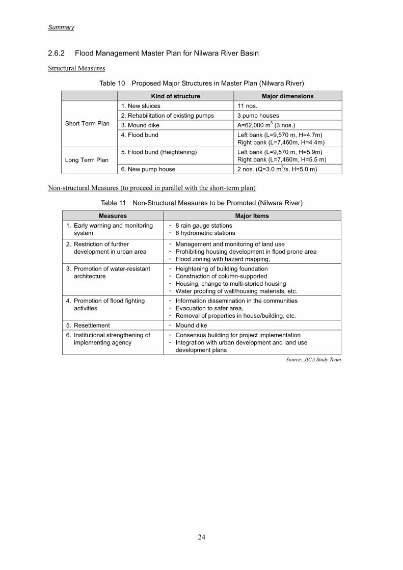
2.6.2 Flood Management Master Plan for Nilwara River Basin
Structural Measures
Table 10 Proposed Major Structures in Master Plan (Nilwara River)
Kind of structure Major dimensions 1. New sluices 11 nos. 2. Rehabilitation of existing pumps 3 pump houses 3. Mound dike A=62,000 m3 (3 nos.) Short Term Plan
4. Flood bund Left bank (L=9,570 m, H=4.7m) Right bank (L=7,460m, H=4.4m)
5. Flood bund (Heightening) Left bank (L=9,570 m, H=5.9m) Right bank (L=7,460m, H=5.5 m) Long Term Plan
6. New pump house 2 nos. (Q=3.0 m3/s, H=5.0 m)
Non-structural Measures (to proceed in parallel with the short-term plan)
Table 11 Non-Structural Measures to be Promoted (Nilwara River)
Measures Major Items 1. Early warning and monitoring
system ・ 8 rain gauge stations ・ 6 hydrometric stations
2. Restriction of further development in urban area
・ Management and monitoring of land use ・ Prohibiting housing development in flood prone area ・ Flood zoning with hazard mapping,
3. Promotion of water-resistant architecture
・ Heightening of building foundation ・ Construction of column-supported ・ Housing, change to multi-storied housing ・ Water proofing of wall/housing materials, etc.
4. Promotion of flood fighting activities
・ Information dissemination in the communities ・ Evacuation to safer area, ・ Removal of properties in house/building, etc.
5. Resettlement ・ Mound dike 6. Institutional strengthening of
implementing agency ・ Consensus building for project implementation ・ Integration with urban development and land use
development plans Source: JICA Study Team

Summary
25
Figure 21 Proposed Flood Bunds in Nilwala River Basin (1/3)
Figure 21
Summary
26
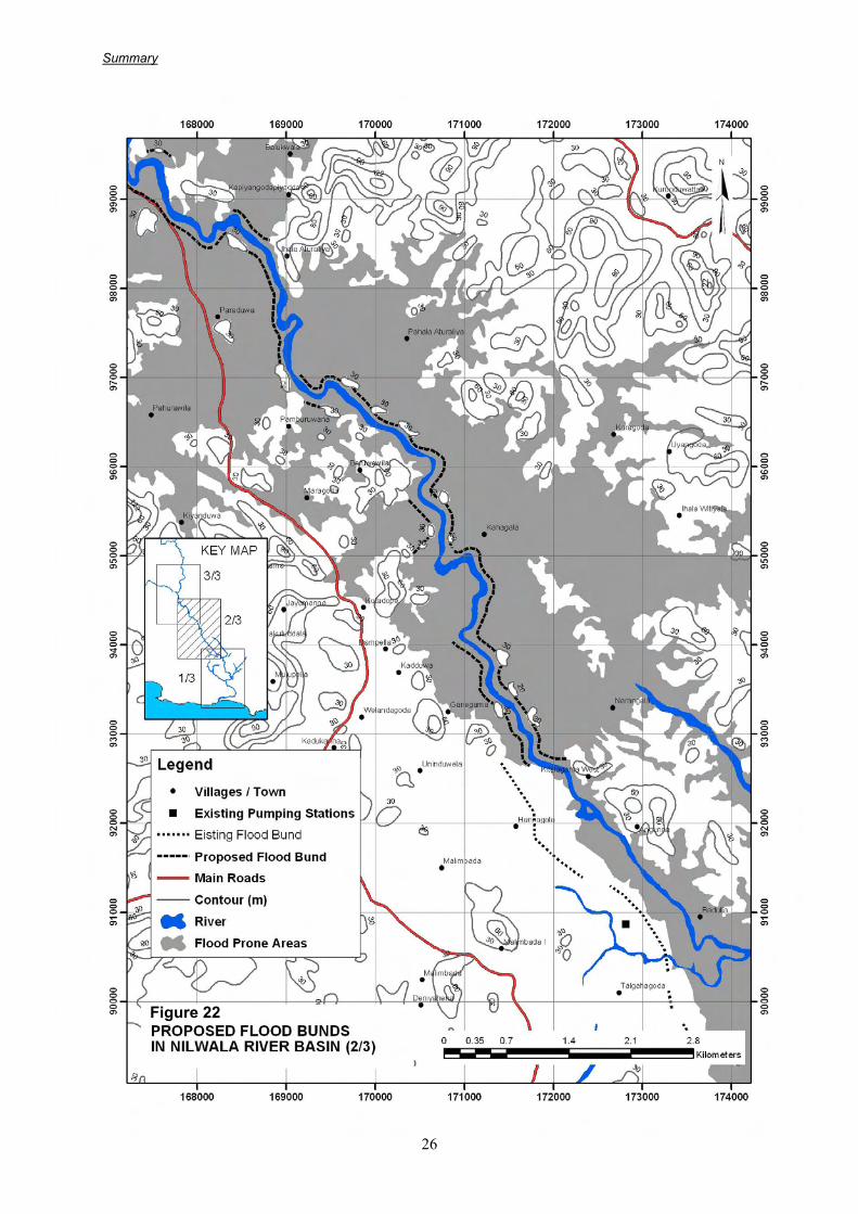
Figure 22 Proposed Flood Bunds in Nilwala River Basin (2/3)
Figure 22

Summary
27
Figure 23 Proposed Flood Bunds in Nilwala River Basin (3/3)
Figure 23

Summary
28
2.7 Action Plan for Priority Project
2.7.1 Selection of Priority Project
Priority River Basins
Kalu River Basin was selected as the priority river basin based on the evaluation results. Evaluation was made to compare the river basins from the viewpoints of economical, socio-environmental and technical aspects as well as the flood vulnerability (Table 12).
Table 12 Overall Evaluation for Selection of Priority Project
Criteria Kelani Kalu Gin Nilwala Economic analysis 1st 1st 4th 3rd Flood vulnerability 2nd 1st 3rd 4th Overall 2nd Priority Project 4th 3rd
Source: JICA Study Team
Urgent Rehabilitation Works of Existing Flood Management Structures
Aside from the Priority Project selected in the Kalu River basin, urgent implementation of repair/rehabilitation of the existing structures and non- structural measures are recommended and such requirement is rather high among Sri Lankan side. In view of this, the structural measures such as rehabilitation of existing sluice and pumping station and protection works for existing flood bunds and non-structural measures such as early warning system in Kelani, Gin and Nilwara river basins are also identified as priority works.
2.7.2 Priority Project in Kalu River Basin
Objective
The Project aims to protect the flood prone area along the Kalu River basin, in particular Ratnapura Municipality area and low lying area in Kalutara District, up to the protection level of 10-year probable flood.
Outline of Priority Project
Summary of the structural measures including installation of early warning equipment is presented in Table 13.
Table 13 Outline of Priority Project
Name of River Basin Selected Alternative Component of Structural Measures
Structural Measures Kalu River
Flood bund system
i) Flood bund in lower reach (L=21,355m) - left(L=9,625m, H=3.3m) - right(L=11,730m,H=3.2m) - new sluiceway (24 nos) ii) Flood bund in upper reach (L=6,400m) - earth levee (L=5,350m, H=2.1-3.5m), - concrete wall (L=1,050,H=3.1m) - new sluiceway (11 nos)
Non-structural Measures Kalu River
(1) Early warning monitoring system
(2) Restriction of further
・6 rain gauging stations ・3 hydrometric stations ・Management and monitoring of land use

Summary
29
Name of River Basin Selected Alternative Component of Structural Measures
development in urban area
(3) Promotion of water-resistant architecture
(4) Promotion of flood fighting
activities (5) Institutional strengthening
of implementing agency
・Prohibiting housing development in flood prone area ・Flood zoning with hazard mapping, ・Heightening of building foundation ・Construction of column-supported housing,
change to multi-storied housing ・Water proofing of wall/housing materials, etc. ・Information dissemination in the communities, ・Evacuation to safer area, ・Removal of properties in house/building, etc. ・Consensus building for project implementation ・Integration with urban development and land use development plans
Source: JICA Study Team
Project Cost Estimate
The project costs of the alternative cases of each basin are summarized below.
Table 14 Project Costs of Priority Project (unit: US$, thousand)
Amount Item FC LC Total
I. Construction cost A New sluice 3,003 1,153 4,157 B Ring levee (Ratnapura) 9,025 3,467 12,492 C Flood bund (short term) 8,954 3,020 11,974 D Early warning monitoring system 185 46 231 Sub Total 21,167 7,686 28,854 II. Land acquisition cost 0 17,920 17,920 III. Engineering service cost 3,175 1,153 4,328 IV. Administrative expenses 0 1,022 1,022 V. Price escalation 3,290 4,751 8,041 VI. Physical contingencies 2,434 2,778 5,212 VII. Tax and duty - 4,977 4,977
Grand Total 30,067 40,287 70,354 Source: JICA Study Team
Operation and Maintenance Cost
Operation and maintenance cost is 289,000 US$.
2.7.3 Implementation Schedule
The construction period of flood bunds in lower (Kalutara area) and upper reaches (Ratnapura area) is assumed 5 years respectively including detailed engineering design. Parallel construction of the two main civil works by dividing into two contract packages is assumed. The implementation schedule is shown in Figure 24.
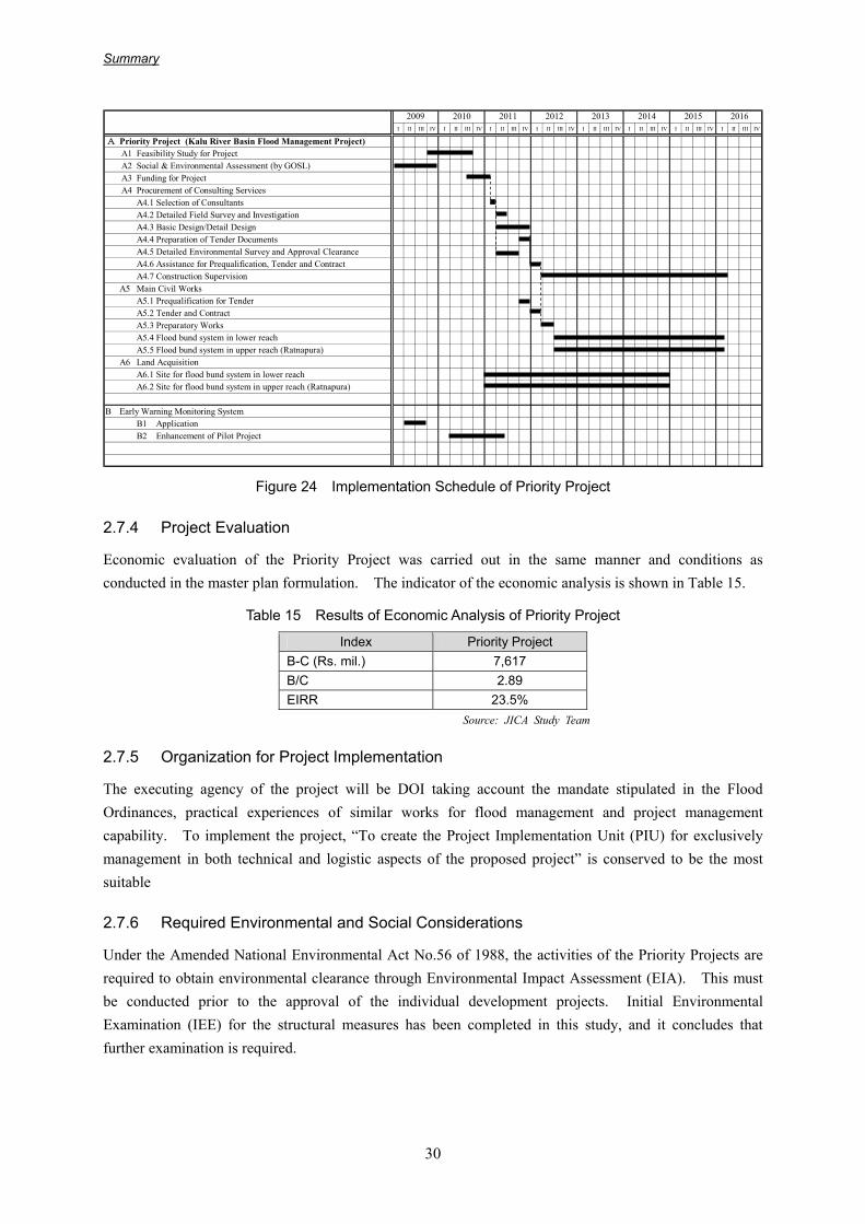
Summary
30
I II III IV I II III IV I II III IV I II III IV I II III IV I II III IV I II III IV I II III IV
A Priority Project (Kalu River Basin Flood Management Project)A1 Feasibility Study for ProjectA2 Social & Environmental Assessment (by GOSL)A3 Funding for ProjectA4 Procurement of Consulting Services
A4.1 Selection of ConsultantsA4.2 Detailed Field Survey and InvestigationA4.3 Basic Design/Detail DesignA4.4 Preparation of Tender DocumentsA4.5 Detailed Environmental Survey and Approval ClearanceA4.6 Assistance for Prequalification, Tender and ContractA4.7 Construction Supervision
A5 Main Civil WorksA5.1 Prequalification for TenderA5.2 Tender and ContractA5.3 Preparatory WorksA5.4 Flood bund system in lower reachA5.5 Flood bund system in upper reach (Ratnapura)
A6 Land AcquisitionA6.1 Site for flood bund system in lower reachA6.2 Site for flood bund system in upper reach (Ratnapura)
B Early Warning Monitoring SystemB1 ApplicationB2 Enhancement of Pilot Project
20162009 2014 20152010 2011 2012 2013
Figure 24 Implementation Schedule of Priority Project
2.7.4 Project Evaluation
Economic evaluation of the Priority Project was carried out in the same manner and conditions as conducted in the master plan formulation. The indicator of the economic analysis is shown in Table 15.
Table 15 Results of Economic Analysis of Priority Project
Index Priority Project B-C (Rs. mil.) 7,617 B/C 2.89 EIRR 23.5%
Source: JICA Study Team
2.7.5 Organization for Project Implementation
The executing agency of the project will be DOI taking account the mandate stipulated in the Flood Ordinances, practical experiences of similar works for flood management and project management capability. To implement the project, “To create the Project Implementation Unit (PIU) for exclusively management in both technical and logistic aspects of the proposed project” is conserved to be the most suitable
2.7.6 Required Environmental and Social Considerations
Under the Amended National Environmental Act No.56 of 1988, the activities of the Priority Projects are required to obtain environmental clearance through Environmental Impact Assessment (EIA). This must be conducted prior to the approval of the individual development projects. Initial Environmental Examination (IEE) for the structural measures has been completed in this study, and it concludes that further examination is required.

Summary
31
2.8 Recommendations for Flood Management
2.8.1 Common
• Implementation of integrated of water resources management; integration of water resources development and flood management
As mentioned in Chapter 1, the objective of this study is primarily to prepare flood management master plan in the selected four river basins as well as to prepare the Action Plan for Priority Project. Aside from the aspect of flood disaster mitigation, appropriate policy of water resources development and management are envisaged. In particular, integrated water resourced management, which aims at maximizing benefit of diverged usages of water resources with social and environmental consideration required in standards/guidelines concerned, is predominant international.
However, based on the scope of work of the Study for disaster management, the Study rather focuses on reduction of vulnerability to floods in order to formulate the Flood Management Master Plan. In the course of the Study, the Study Team discussed with DOI and responded to their requirement at maximum extent with mutual understandings on the importance of water resources development on the target river basins as emphasized by DOI.
In particular for the multipurpose dam schemes, which are recently under contemplating by DOI in the Study Area, are to be preliminarily assessed their possibility of implementation by the current Study. Therefore, it is recommended that further update of the proposed plan will be required in the integrated water resources development and management aspect.
• Strengthening of capability development for project management
In order to enable self-development of human resources with active interaction in the organization of DOI through project implantation, technical assistance will be still required especially for a large scale of development project. In addition, the manner of coordination with other related agencies and detailed methodologies for public consultation with stakeholders should be transferred for successful project management. In view of this, assistance of the Government of Japan will be effectively functioning in empowerment of management in administrative issues to achieve the objectives.
• Enhancement of technical capability (e.g. hydrological simulation, design of facility) for flood management
Transfer of technical knowledge on planning of flood management has been carried out for the counterpart personnel and technical staff in DOI in various phases throughout the current Study. In particular, process of master plan formulation including comparison of conceivable alternative measures, hydrological analysis, economic analysis of those alternatives and IEE concerned, etc. were discussed and explained in a series of counterpart meetings. However, the details on hydrological analysis and design of flood management structures are further demanded to be transferred at more practical levels through actual implementation of the proposed project.
• Improvement of accuracy in hydrological and hydraulic analyses including consolidating basic data such as topographic data and observed hydrological data, etc.
The current Study commenced with provisions that data/information available at present would be utilized at maximum extent without any large scale of field survey and investigations due to the budget

Summary
32
limitation for the Study. Therefore, the Study was undertaken based on this premise throughout the Study. In particular, the number and coverage of available river cross sections and longitudinal profiles of the four river basins are quite limited to estimate river channel capacity, inundation area and longitudinal water profile against probable flood discharges with certain accuracy. This will affect the reliability of hydraulic models for respective river basins and eventually appropriateness of the Master Plan.
In this sense, it is strongly recommended to carry out a full scale of river cross section survey including site topographic survey as required in the future study stage at approximate interval of 200 to 300 m with substantial coverage of the inundation area. Further, in order to link the information of river channel geometry with topographic coordinates on GIS, digital maps on 1:10,000 basis will be required. These will be prerequisite information in feasibility studies. However, they have not been prepared/published yet by the Survey Department except the Kelani (partially published in 1984 but not covered all areas). Therefore, close coordination between DOI and Survey Department is indispensable for further elaboration and updating of the proposed Master Plan.
• Improvement of data Management system of DOI
The Hydrologic Division supervised by the Director of Special Services and Training, DOI, is responsible to manage, store and observe the records (rainfall, water level and discharge, etc.). It is strongly recommended to accelerate to save the data in computer hard disk (or CD) from hand-written on papers, since the recorded papers have almost totally decayed in the hot and humid atmosphere over a long time. Such valuable data will not be able to be restored if the records become unreadable.
Further, it is strongly recommended to convert from water levels to discharges by means of rating curves without any delay after water level records reach the Division. In order to do this properly, updating of rating curves with changes of cross sections (after floods) is fundamentally required. This improvement is highly recommended to enhance the present data management system in DOI. Reliable discharge records are key information for appropriate flood management planning in any river basin.
• Updating the hydrological models established in the Study
The hydrological models were installed on the computers in Water Resources and Project Planning Branch, DOI with rainfall and discharge data collected through the Study. As hydrological and topographical information are accumulated, development of the models is recommended, because they will be strong tools for assessment of floods and inundation as well as planning of certain structural measures in the future. In this connection, a lot of staff has quit from the Department and so only very few staff can operate the computer software such as MIKE 11 for hydrological and hydraulic analysis. In order to realize the updating the model, training and education of the junior engineers will be prerequisite for sustainable management.
• Key Issues on Environmental and Social Consideration
As for implementation of the proposed priority project in the Kalu and Master Plans in other three river basins as proposed in the current study, the procedures specified in the Amended National Environmental Act No.56 of 1988 in Section 9.8 shall be taken. Toward implementation of the project in the Kalu River Basin, further investigation including analysis of affected issues and extent and study on mitigation measures will be required. In addition, the National Environmental Act specifies

Summary
33
dissemination of information to the public and consultation of stakeholder by the executing agency in order to secure accountability and transparency of implementation of the project. Since the Sri Lankan government has their own laws, the project needs to conduct environmental consideration and acquire permission for the project implementation in compliance with the laws.
• Institutional Strengthening of Irrigation Department (setting-up of Flood Management Sections)
The governmental organization for flood management in Sri Lanka is still vulnerable. In particular, it was clarified that non-existence of an organization having jurisdiction over flood management in DOI is major cause on lack of consistency of plans and delay of implementation through this study. Therefore, it is recommended to establish the department, which exclusively handles flood management (it is provisionally named as “Flood Management Department”) in DOI. The function of new department is described in Part V Chapter 6, Main Report in detail.
• Setting-up of River Basin Forum
In general, river improvement works take quite a long time and affect numerous business entities and land owners in the basin. The issues between upper and downstream areas, left and right bank sides will be derived from implementation of the project. In the target river basins, the downstream basin of the Kelani is divided into two districts of Colombo and Gampaha. Further, in the Kalu River basin lies on two districts of Kalutara and Ratnapura. In order to smoothly implement the project, a coordinator will be required, who can facilitate building of consensus among stakeholders. In the river basins belong to the first category in Japan, the river basin forum is set up and he takes the responsibility of coordinator.
In order to implement the Master Plan and Priority Project as proposed in this study, the opinions of the stakeholders shall be integrated in those plan and project if judged appropriate through consultation to the related agencies and local people concerned in the light of environmental consideration. As for a platform to transfer the information of the plan/project to the stakeholders and to facilitate building of consensus, setting-up of the river basin forum in individual four river basin is recommended. The objective of the forum is to be a “Coordinator” between inhabitants in the river basin and also between inhabitants and implementing agency. The members will be composed of representatives of high-level experts, local governments, related inhabitants and implementing agency, etc. Regarding the river basin forum in the Kalu River basin for implementing Priority Project, its role and members are described in Section 2.8.3.
• Strengthening of Engagement in Climate Change
The climate change, which is likely derived by increase of greenhouse gas, becomes to be serious all over the world. The Master Plan and Priority Project proposed in the current study does not involve the effect of climate change in the future. Therefore, the study on appropriateness of the dimensions of proposed plan and adaptation measures through further review of characteristics over the river basins is the issue from this time forward.

Summary
34
2.8.2 Kelani River Basin
• Early implementation of urgent works
Considering the current conditions of eroded bank slope and existing Minor Protection Structures proposed as the Urgent Works, earlier implementation can accrue benefit by means of reduction of perennial flood damage along the Kelani River. Since the Colombo Regional Office, DOI, is executing the restoring works of the existing structures to some extent, further verification of required component of repair and reconstruction works should be conducted.
• Hydrological and topographical analysis for available volume of the proposed flood retention retarding basin and institutional strengthening for protection of low-lying areas
Since the contour lines of topographic maps available for the Study are at 5.0 m intervals in the Kelani River basin, the potential volume for flood water storage was estimated approximately. In addition, certain areas cannot be expected to be used for the retarding basin due to the current reclamation and construction works of new buildings. Therefore, it is highly recommended that flood zoning and hazard mapping shall be prioritized including review of institutional strengthening of laws and regulations for conservation of vulnerable low and wet zones along the Kelani. For these purposes, topographic mapping with scale of 1:5,000 (required contour interval of 0.5 m) is required in the proposed area for retarding basins between Ambatale and Pugoda. However, the subject area will be nearly 5,000 ha, so spot leveling to supplement the present topographic maps will be more practical. Through the flood zoning activities, the available volume for flood retention in the candidate retarding basins should be updated with more detailed land use and topographic information.
• Early implementation of Non-structural measures
Priority of non-structural measures in the Kelani River basin is rather high compared with other three, because structural measures will need large finance and time for implementation. In addition, the Kelani is far beyond other three river basins in terms of population density. Therefore the non-structural measures as proposed in the master plan should be undertaken in earlier stage to reduce vulnerability to floods. In particular, it will take a long period for planning, designing and construction of flood retarding basins, and meanwhile urbanization and transforming to residential areas from unused land will be progressed at the candidate sites identified in this study. In order to restrict this movement and sustain the effect as natural retarding basins of floods, institutional strengthening such as monitoring of land development and stipulation of responsibility of implementing agency, etc. shall be accelerated.
• Urgent rehabilitation works of existing structures
As proposed in Section 2.7.1, the urgent works of MFPs and bank protection including minor flood bund is recommended to realize flood damage reduction benefit in the short term. In this connection, feasibility study should be conducted to further verify the economic viability of the project.
• Study on New Pumping Station
A study on new pumping station at Petiyagoda is underway by DOI. The details of design dimensions, extent of effect, construction cost and construction schedule, etc. require a review through field reconnaissance.

Summary
35
2.8.3 Kalu River Basin
• Early implementation of the Priority Project
In order to implement the Priority Project at early stage, feasibility study should be carried out in due course. As mentioned in Section 2.7, the Priority Project is expected to be implemented along with the proposed schedule.
• Forming Organization of Implementing Agency and Setting-up of River Basin Forum
In the scope of work for the Feasibility Study, a concrete study on the Project Implementation Unit is recommended to be involved and a preparatory study for setting-up of the river basin forum is proposed to facilitate building of consensus and smoothly implementing projects as a “Coordinator” by mainly DOI through cooperation with DMC. As a draft plan, the following members and role are recommended:
• Further consideration for possibility of Malwala Multipurpose Dam scheme for integrated water resources management
Multipurpose development of Malwala Dam is promising from water resources management aspect in the future (Chapter 4 of Part II, Main Report). However, the following factors should be further investigated and studied:
1) Geological conditions and preliminary design of dam and other appurtenant structures 2) Hydrological and hydraulic conditions along mainstream of the Kalu and Wey Ganga 3) Future demand projection of water supply on municipal, industrial, agricultural and hydropower
generation 4) Social and natural environmental impact by creating a large scale reservoir
In particular, it should be noted that resettlement action program (RAP) including compensation programs is required to prepare through stakeholder meetings and consultations in accordance with the domestic and donor’s Guidelines/Standards. In this context, social and baseline survey in the proposed reservoir area is fundamentally required by DOI prior to the planning of the resettlement.
• Incorporating the flood management concept to Ratnapura Urban Development Project
Urban development plan will be launched soon by UDA in Ratnapura (Chapter 4 of Part II, Main Report). In this respect, it is recommended that appropriate coordination with UDA and Municipal Office will be necessary. In particular, flood zoning and hazard mapping (one of non-structural measures) should involve cooperation with each other. Flood management concept should be substantially implanted in the development plan.
Kalu River Basin Forum
・Objective for foundation : To contribute in building consensus between stakeholders through realization of smooth implementation of flood protection measures
・Expected function : “Coordinator” between inhabitants in the river basin and/or between inhabitants and implementing agency (DOI)
・Composition of members : DOI (regional Offices in Kalutara and Ratnapura), DDMCU Kalutara and Ratnapura, local administrative organizations in Kalutara and Ratnapura area (Province, District, Division, Municipality, GN etc.), high-level experts, representatives of inhabitants and monks, etc.

Summary
36
• Dredging for prevention of river mouth closure in Kalutara
Monitoring of the river mouth should be continued by the Regional Office in Kalutara whether any change of river channel topography has occurred or not. Periodic sounding and survey of the river profile and cross section is recommended to judge the dredging works near the river mouth.
• Monitoring of adverse affect on drainage system caused by the South Expressway Project
Huge earth embankment with approximately 10 m height at certain sections along the route of South Expressway connecting Colombo with Matara is ongoing by dividing it into several stretches to undertake construction works in parallel. In this connection, it is primarily observed that the huge embankment will change the existing drainage conditions because it affects surface drainage in the vicinity.
Since the new Expressway crosses at yjr downstream area of the Gina and Nilwala River basins as well, the same situation as abovementioned in the Kalu can be anticipated in the future. Therefore, alignment of the flood bund and inland drainage improvement should be determined with due consideration of the location/alignment of the embankment of the ongoing road project.
2.8.4 Gin River Basin
• Early implementation of urgent works
Considering current status of the existing pumping stations, the Urgent Works are recommended to be implemented at an early stage. In particular, the sharp rise of oil and diesel prices seriously impacted the financial balance sheet of DOI. On the other hand, there are many similar old pumping stations in Japan that need to be repaired in an appropriate manner.
Due to such situation in Japan, manuals for renewal and rehabilitation of the gate and pumping facilities were prepared and published by the Ministry of Land, Reclamation and Transport. Since the manner of assessment of the facilities seems to be very effective and applicable to Sri Lanka, detailed assessment of replacement of such facilities should be conducted.
• Further consideration on hydrological/hydraulic and social aspects to address the people who are living in unprotected area
Mound dike scheme was recommended in the unprotected area. Site selection will be required through the discussions and consultation with the people who are frequently affected by floods. The proposed sites should be further examined from hydraulic and social point of views.
• Modernization/Rehabilitation of existing pumping stations
The existing 10 pumping stations in the Gin River basins, which have been constructed by the financial assistance of the Government of China, were utilized for approximately 30 years. Due to aged equipment with frequent stoppage of operation, drainage functioning has drastically deteriorated compared with the original plan. In particular, DOI is recently suffering from expenditure of operation cost of existing pumping stations. In order to cope with the current problem, renewal/rehabilitation of the existing equipment and appurtenant structures (pumps, gates, trash racks, cranes, electrical panels and indicators, etc.) are necessary.

Summary
37
• Monitoring of adverse affect on drainage system caused by the South Expressway Project
The same as the Kelani River basin monitoring of the captioned project is required to prevent further deterioration in the current drainage conditions in the residential area. .Because deterioration of drainage conditions in the area can be seen, careful monitoring by DOI is important to avoid flooding near the vicinity of the embankment.
2.8.5 Nilwala River Basin
• Early implementation of urgent works
The same method proposed in the Gin River can be applied in the Nilwala River as well. In order to reduce the heavy load of DOI in budget raising, early implementation of assessment of renewal is highly recommended.
• Study on gaps that is existing in the downstream reaches
A gap in the riverbed near the river mouth of the Nilwala can be seen. It is located about 2 km from the river mouth. French consultants verified the effectiveness of the dredging at river bottom at the gap (from river mouth to the Manahama bridge in Matara City) by their review and reconnaissance. However, in order to realize the project, stability of bridge pier and flood bund during floods shall be carefully examined. Therefore, verification of hydraulic feature under ordinary and flood conditions by means of additional river sectional survey will be essential.
• Detailed study on technical, environmental and social aspects for theTrans-basin Project at upstream area
The scheme of water trans basin from the Gin – Nilwala – Warawe is under study by DOI. The purpose of the project is to meet the water demand in agriculture, industry and municipal use in the future at Hambantota area. Since the area is promising to develop rapidly, harmonized development is required from technical and also social/environmental impact viewpoints.
The following table shows the responsible and implementing agency, priority and necessity of assistance for the abovementioned recommendations.
Table 16 Recommendations
No. Recommendation Responsible Organization
Implementing Organization
Schedule Necessity of Foreign
Assistance Common
(1) Water resources development and management
DOI DOI, DMC B Technical assistance to IWRM
(2) Strengthening of capacity building for project management
DOI DOI, DMC C Technical assistance to capacity building
(3)
Enhancement of technical capability for flood management
DOI DOI B Technical assistance on skills for flood management
Summary
38
No. Recommendation Responsible Organization
Implementing Organization
Schedule Necessity of Foreign
Assistance
(4)
Improvement of accuracy in hydrological and hydraulic analyses
DOI DOI B Technical assistance on skills for numerical analyses
(5) Improvement of data management system of DOI
DOI DOI C Technical Assistance on data base system
(6) Updating of hydrological models
DOI DOI B Technical assistance on skills for numerical analyses
(7) Environmental and social consideration
DOI DOI, CEB B Technical assistance for project implementation
(8)
Institutional strengthening of DOI (setting-up of Flood Management Department)
DOI DOI C Technical assistance on institutional strengthening
(9) Setting-up of River Basin Forum
DOI
DOI, DMC, local administrative organizations,
Inhabitants
B Technical assistance for consensus building
(10) Strengthening of engagement for climate change
DOI, DOM
DOI, DMC、UDA, CEB、Water Management
Board
C
Technical assistance to IWRM and disaster management in relation with climate change
Recommendation for Kelani River Basin
(1) Early implementation of Urgent Works
DOI DOI B Technical assistance on Feasibility Study
(2)
Availability of flood retention volume in proposed retarding basins
DOI DOI B Technical assistance to build basic information of retarding basin
(3) Promotion of Non-structural measures
DOI
DOI, UDA、RDA, SLLRDC, local administrative organizations
B Technical assistance for organization and institutional strengthening
(4) Urgent Rehabilitation Works of existing structures
DOI DOI, local
administrative organizations
B Technical assistance on Feasibility Study
(5) A study on new pumping facility
DOI
DOI, SLLRDC、
local administrative organizations
B Technical assistance in verification of cost-benefit relations, etc.
Recommendation for Kalu River Basin
(1) Early implementation of Priority Project
DOI DOI B Technical assistance in Feasibility Study
(2)
Forming organization of implementing agency and setting-up of river basin forum
DOI
DOI, DMC, local administrative organizations,
Inhabitants
B Technical assistance for securing accountability and consensus building

Summary
39
No. Recommendation Responsible Organization
Implementing Organization
Schedule Necessity of Foreign
Assistance
(3) Malwala multipurpose dam scheme
DOI
DOI, local administrative
organizations in Ratnapura、DMC、
GNs
B Technical assistance in various investigation and Feasibility Study
(4) Ratnapura urban development project
UDA UDA、DOI B Integration of urban development and flood protection plans
(5) River mouth closure in Kalutara
DOI
DOI、local administrative
organizations in Kalutara
C Technical assistance on treatment of river mouth
(6) Monitoring of South Expressway Project
DOI DOI B Technical assistance on drainage system
Recommendation for Gin River Basin
(1) Early implementation of Urgent Works
DOI DOI B Technical assistance in Feasibility Study
(2) Handling of people living in unprotected area
DOI DOI,
Inhabitants B
Technical assistance for handling of stakeholder meetings
(3)
Modernization/ rehabilitation of existing pumping stations
DOI DOI, local
administrative organizations
B Technical assistance on evaluation of gates and pumps
(4) Monitoring of South Expressway Project
DOI DOI, RDA B Technical assistance on drainage system
Recommendation for Nilwala River Basin
(1) Early implementation of Urgent Works
DOI DOI B Technical assistance in Feasibility Study
(2) Sounding of gaps in downstream reaches
DOI DOI B Technical assistance for hydraulic and stability analysis
(3) Trans-basin project at upstream reaches
DOI DOI B
Technical assistance on various investigation on feasibility of the dream project
A: within one year, B: within 2 years, C: within 5 years Source: JICA Study Team
Summary
40
CHAPTER 3 EARLY WARNING AND EVACUATION SYSTEM PLANNING
3.1 General
Although the GOSL recognizes the necessity of an EWE system and has conducted several meetings and workshops with related organizations, it has yet to prepare the necessary regulatory and implementation environment such as formulation of concrete guidelines and manuals, drafting of relevant laws, etc. Main reasons of this situation are as follows:
・ There are so many relevant, and sometimes redundant organizations with unclear mandates. ・ Inadequate capacity for forecasting ・ Lack of experience to operate the system such as issuance of warning and evacuation instruction,
emergency response during disaster situation, etc.
Objective of Component2 is to plan the Multi-Hazard (Flood, Sediment Disaster, Tsunami) EWE System by solving the above issues through the Pilot Project in Kelani and Kalu river basin. The plan includes recommendation for role allocation of related organizations, information flow and its tools. In addition to this, the procedure for Hazard Mapping, setting of warning criteria, and methods for O&M of the system and equipments are recommended.
3.2 Procedure of Planning
Procedure for Multi-Hazard EWE System planning is shown below.
Conceptual Planning
Information flow, methods of dissemination and role allocation of related organization from monitoring to warning issuance and to people’s evacuation were shown in the concept design and table after discussion with GOSL. This conceptual plan was the basis of following activities.
Implementation of Pilot Project
Based on the conceptual plan of EWE system, Flood EWE system for Kelani and Kalu was established as a pilot project. The pilot project consists of following activities:
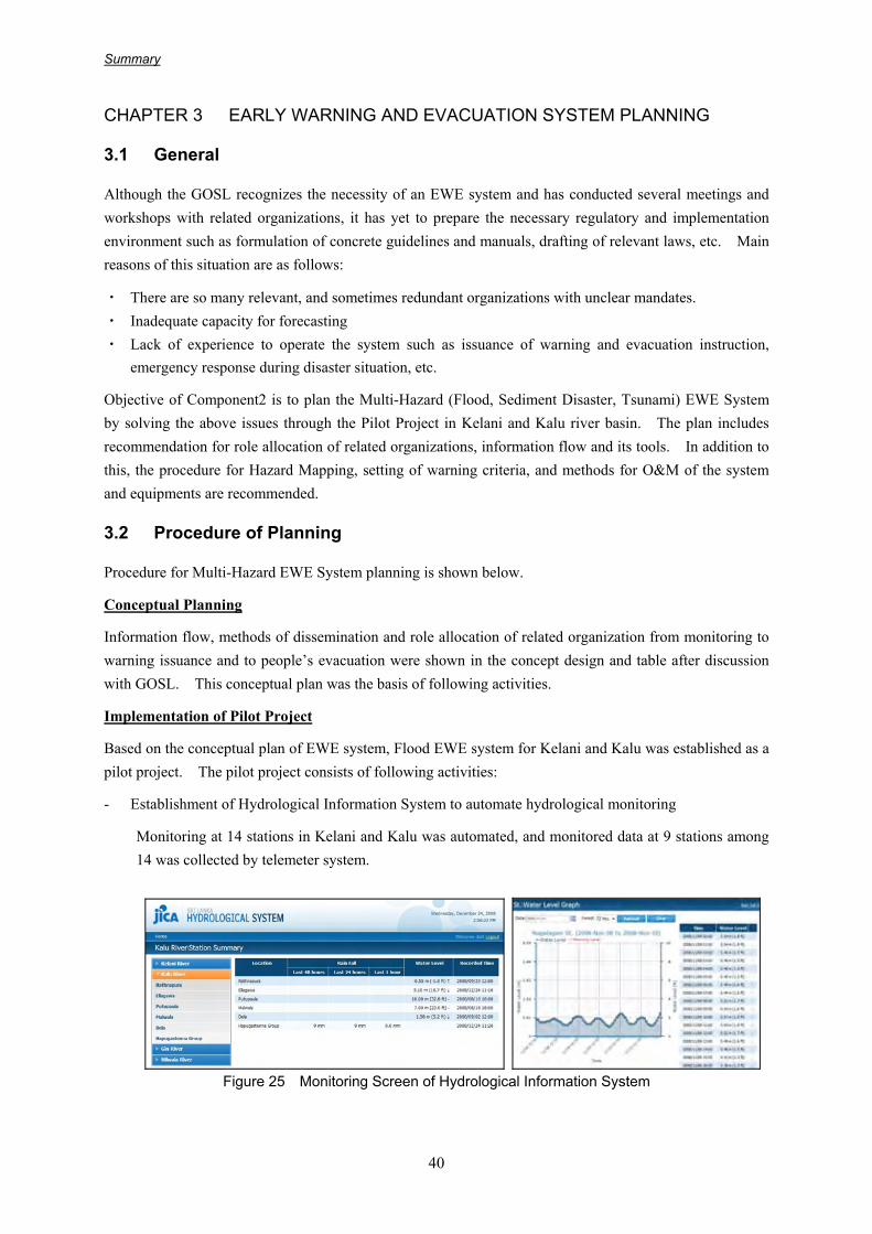
- Establishment of Hydrological Information System to automate hydrological monitoring
Monitoring at 14 stations in Kelani and Kalu was automated, and monitored data at 9 stations among 14 was collected by telemeter system.
Figure 25 Monitoring Screen of Hydrological Information System

Summary
41
- Establishment of Intra-Governmental Network to share information among related organizations
Intra-Governmental Network was installed to connect relevant 14 organizations through a dedicated line so that government officers of the concerned organizations can easily communicate whenever necessary. The connected organizations are: DMC, DOI, DOM, NBRO, Police, Media (SLBC and SLRC), and DDMCU (Colombo, Gampaha, Kegalle, Ratnapura, Kalutara, Galle and Matara).
- Recommendation of information dissemination method to people
PC and ADSL lines were provided to 3 DS offices: Kollonawa and Biyagama (Kelani river basin), and Ratnapura (Kalu river basin) to monitor the hydrological information system through the internet, and car mounted loud speaker was provided as a tool to disseminate information directly to people.
- System development from monitoring to warning issuance, information dissemination and sharing, evacuation instruction issuance and peoples evacuation, and implementation of disaster management exercise to trial the developed system
Information flow and concrete actions to be taken by each organization were described and illustrated in the “Exercise Manual”. Disaster Management Exercise were conducted three times during this Study to understand role allocation of each organization and to evaluate the planned system.
Figure 26 Exercise Manual (abstract) and Photo of Exercise
Review of Actual Events
Actual “Tsunami warning” was issued due to earthquake at Indonesia and flood disaster occurred due to heavy rainfall during this Study. These actual events were reviewed from the point of EWE system and issues and lessons were raised for system development.
Multi- Hazard EWE System Planning
Present conditions and issues of existing system were studied using the results of the above activities. Also, Multi-Hazard EWE System was planned with recommendation for implementation of the plan.

Summary
42
3.3 Issues on Present EWE system
Issues raised through the Study and based on the present conditions are summarized below.
Table 17 Issues of Present EWE System
Key Elements Issues Role Allocation - Role allocation for EWE system is not clear.
Risk Knowledge - Risk assessment and hazard mapping suitable for EWE system are not conducted for all
over Sri Lanka. - Detailed topographical map does not exist.
Monitoring & Warning Service
[Monitoring] - Short term monitoring (10 min. to 1 hour data) is not enough. (Flood and Landslide) - Number of monitoring station is not enough. (Flood and Landslide) - Monitored data is not opened to public. (Flood and Landslide) - Proper O&M of Hydrological Information System should be conducted. (Flood and
Landslide) - Proper O&M of realtime monitoring system should be conducted. (Flood and Landslide) [Warning Service] - Accurate weather, flood and landslide forecasting is difficult. (Flood and Landslide) - Timely flood warning issuance is difficult. (Flood) - Understandable warning criteria related to inundation area is not prepared. (Flood) - Accuracy of warning criteria should be improved. (Landslide) - Role allocation for issuing warning and evacuation instruction should be discussed.
(Tsunami) - Contents of warning message should be discussed. - Timing of warning cancellation should be discussed. - EWE system oriented by government cannot cover local disasters.
Dissemination & Communication
- Information should be disseminated in short time - Exercise is only for selected organizations and communities, and only for Kelani and Kalu
flood, and landslide. - Unstable communication during night time and holiday. - Unstable communication during emergency period. - Reliability of governmental information flow is low. - Suitable method for last mile communication is not established. - Proper O&M of Intra-Governmental Network should be conducted. - Proper O&M of Tsunami warning tower should be conducted. (Tsunami)
Response Capability
- Training program for EWE system is not enough. - Emergency Response Manual is not prepared for each organization. - Community level activities are only for selected communities and are not conducted
repeatedly. - Exercise is only for selected organizations and communities.
3.4 Multi-hazard EWE system
EWE System Plan is shown in the table below. Plan is divided into Short Term and Mid/Long Term Plan. Short Term Plan shall be conducted in 2 years, Mid Term Plan in 5 years, and Long Term Plan in 10 years.
Table 18 Short Term Plan
Category Plan
Role Allocation - Launching of Working Group for “Role Allocation” and signing agreement by related organizations
Flood - Identification of risky area and interview survey to people - Comparison of interview result and water level data of nearby gauging station
Landslide - Identification of risky area - Community hazard mapping
Risk knowledge
Tsunami - community hazard mapping

Summary
43
Category Plan
Common - Launching of Working Group for “Hazard Mapping” and signing agreement by related organizations
Rainfall - Preparation of action plan for accuracy improvement of rainfall forecasting with schedule of facility improvement
Flood (slow)
- New construction and automation of monitoring stations at Gin and Nilwala river
- Preparation of target water level for all stations of Kelani, Kalu, Gin and Nilwala
- Setting warning criteria for stations which has enough data, by correlation analysis of water level at upstream and water level at downstream
Flood (fast)
- Listing up of target areas and selection of priority area as model area - Installation of rain gauge and water level gauge at model area as pilot project
and start monitoring - Accumulation of data at model area - Setting warning criteria by correlation analysis of rainfall amount at upstream
and water level at downstream
Landslide
- Start manual monitoring of daily rainfall at all risky DS and GN offices - Installation of automatic rain gauge with telemeter system at priority DS and
GN offices - Collection of daily rainfall at nearby stations at the time of landslide - Upgrading warning criteria by correlation analysis of landslide occurrence and
daily rainfall - Start same analysis using hourly rainfall data according to installation
condition of rain gauge
Community EWE System
- Identification of target areas for Community level EWE system - Monitoring of community activities where system is installed during JICA
Study and expansion to other target areas - Launching of Working Group for “Monitoring Station and Equipments” and
singing agreement by related organizations - Launching of Working Group for “Information Disclosure”, and signing
agreement by related organizations
Monitoring & Warning Service
Common
- Launching of Working Group for “Warning Service” and signing agreement by related organizations
Dissemination & Communication
- Discussion on Information flow, equipments, and rule of O&M etc. in the Working Group for “Role Allocation”. And signing agreement by related organizations
Proper O&M
- Launching of following Working Groups and signing agreement by related organizations ・ Role Allocation ・ Hazard Mapping ・ Monitoring Station and Equipments ・ Information Disclosure ・ Warning Service ・ Disaster Management Exercise ・ Implementation Schedule
- Preparation of Emergency Response Manual - Periodical Implementation of Disaster Management Exercise
CD of Officers - Participation to meeting of Working Groups, preparation work of Emergency Operation Manual, Disaster Management Exercises, and Training Programs
CD of People - Continuous Community Activities - Implementation of Evacuation Drill and other exercise
Response Capability
CD of DMC - Implementation of EWE system plan by initiative of DMC

Summary
44
Table 19 Mid Term Plan
Category Plan
Flood - Identification of risky area and interview to people - Comparison with water level data of nearby gauging station
Landslide - Identification of risky area - Community hazard mapping
Risk knowledge
Tsunami - community hazard mapping
Flood (slow)
- Expansion of new construction and automation of monitoring stations to other rivers
- Preparation of target water level for all stations of Kelani, Kalu, Gin and Nilwala
- Setting warning criteria for stations which has enough data, by correlation analysis of water level at upstream and water level at downstream
Flood (fast)
- Expansion of installation of rain gauge and water level gauge to other target areas
- Expansion to other target areas according to the condition of installation of rain gauge and water level gauge, and condition of accumulation of data
Landslide
- Expansion of installation of automatic rain gauge with telemeter system to other DS and GN offices
- Collection of daily rainfall at nearby stations at the time of landslide - Upgrading warning criteria by correlation analysis of landslide occurrence
and daily rainfall - Start same analysis using hourly rainfall data according to installation
condition of rain gauge
Monitoring & Warning Service
Community EWE System
- Identification of target areas for Community level EWE system - Monitoring of community activities where system is installed during JICA
Study and expansion to other target areas
Table 20 Long Term Plan
Category Plan Flood - Flood simulation by using detailed topographical map and hydrological data Landslide - Upgrading community level hazard map by using detailed topographical map
Risk knowledge
Tsunami - Tsunami simulation
Flood (slow) - Expansion of new construction and automation of monitoring stations to other
rivers - Accumulation of data and expansion to other stations and other rivers
Flood (fast)
- Expansion of installation of rain gauge and water level gauge to other target areas
- Expansion to other target areas according to the condition of installation of rain gauge and water level gauge, and condition of accumulation of data
Monitoring & Warning Service
Landslide
- Expansion of installation of automatic rain gauge with telemeter system to other DS and GN offices
- Upgrading warning criteria by correlation analysis of landslide occurrence, short term rainfall and cumulative rainfall
Role allocation of each organization is proposed in the Table 21.

Summary
45
Tabl
e 21
R
ole
Allo
catio
n of
Eac
h O
rgan
izat
ion
Org
aniz
atio
n M
ain
Rol
e R
isk
Know
ledg
e M
onito
ring
& W
arni
ng S
ervi
ce
Dis
sem
inat
ion
& C
omm
unic
atio
nR
espo
nse
Cap
abili
ty
DM
C /
DD
MC
U
Coo
rdin
atio
n
- S
uppo
rt fo
r pre
para
tion
of
haza
rd m
ap
- C
olle
ctio
n of
dis
aste
r in
form
atio
n -
Adv
ice
to n
atio
nal a
nd d
istri
ct
leve
l org
aniz
atio
n (D
MC
) -
Adv
ice
to G
A a
nd lo
cal l
evel
or
gani
zatio
n(D
DM
CU
) -
Sup
port
for p
repa
ratio
n of
w
arni
ng c
riter
ia
- D
isse
min
atio
n of
dis
aste
r in
form
atio
n -
Ope
ratio
n an
d m
aint
enan
ce o
f di
ssem
inat
ion
and
com
mun
icat
ion
equi
pmen
ts
- C
oord
inat
ion
of N
atio
nal l
evel
or
gani
zatio
n (D
MC
) and
su
b-na
tiona
l lev
el o
rgan
izat
ion
(DD
MC
U)
- Pr
epar
atio
n of
em
erge
ncy
resp
onse
man
ual (
DM
C)
- Tr
aini
ng o
f nat
iona
l lev
el
orga
niza
tions
(DM
C) a
nd lo
cal
leve
l org
aniz
atio
n an
d co
mm
unity
peo
ple
(DD
MC
U)
GA
D
ecis
ion
Mak
ing
-
Issu
ance
of e
vacu
atio
n in
stru
ctio
n / o
rder
-
Con
voca
tion
of d
istri
ct le
vel
DM
com
mitt
ee
DS
/ G
N
Info
rmat
ion
Dis
sem
inat
ion
/ Col
lect
ion
- S
uppo
rt fo
r pre
para
tion
of
haza
rd m
ap
- C
olle
ctio
n of
dis
aste
r in
form
atio
n -
Sup
port
for p
repa
ratio
n of
w
arni
ng c
riter
ia
- D
isse
min
atio
n of
dis
aste
r in
form
atio
n -
Coo
rdin
atio
n of
loca
l lev
el
orga
niza
tion
(DS
) and
C
omm
unity
peo
ple
(GN
) -
Trai
ning
of l
ocal
leve
l or
gani
zatio
n an
d co
mm
unity
pe
ople
Polic
e
Info
rmat
ion
Dis
sem
inat
ion
/ Sup
port
of
Evac
uatio
n A
ctiv
ity
-
Col
lect
ion
of d
isas
ter
info
rmat
ion
- D
isse
min
atio
n of
dis
aste
r in
form
atio
n -
Sup
port
evac
uatio
n ac
tivity
Milit
ary
Sup
port
of
Evac
uatio
n A
ctiv
ity
-
Col
lect
ion
of d
isas
ter
info
rmat
ion
- D
isse
min
atio
n of
dis
aste
r in
form
atio
n -
Sup
port
evac
uatio
n ac
tivity
Med
ia
Info
rmat
ion
Dis
sem
inat
ion
- C
olle
ctio
n of
dis
aste
r in
form
atio
n -
Dis
sem
inat
ion
of d
isas
ter
info
rmat
ion
- S
uppo
rt ev
acua
tion
activ
ity
DO
I, D
OM
, N
BR
O e
tc.
Te
chni
cal
Sup
port
- Pr
epar
atio
n of
haz
ard
map
-
Mon
itorin
g ne
cess
ary
data
-
Prep
arat
ion
of w
arni
ng c
riter
ia
- Is
suan
ce o
f war
ning
- Te
chni
cal a
dvic
e to
DM
C a
nd
DD
MC
U
-
- Te
chni
cal s
uppo
rt fo
r tra
inin
g pr
ogra
m

Summary
46
Information flow is proposed in the following figure.
DMC
District Secretariat
Divisional Secretariat
GN
Police Command
Centre
DDMCU
Technical Organization
Media
Community People
Police Division
Police Station
District LevelTechnical
Organization
GN
Community People
Representativeof Community
Member of Committee
Member of Committee
Member of Committee
Figure 27 Information Flow (left: overall, right: from GN to community)
Tools planned for information dissemination are shown in the following figure.
DMC
District Secretariat
Divisional Secretariat
GN
Police Command
Centre
DDMCU
Technical Organization
Media
Community People
Police Division
Police Station
District LevelTechnical
Organization
Intra-Gov. Network, Tel, Fax
Tel / Fax
Tel / Fax
Tel
TelTel
TV /Radio
Radio System /Tel / Fax
Radio System /Tel / Fax
TelTsunamiTower
Figure 28 Equipment for Information Transfer
3.5 Conclusion and recommendation for Early Warning and Evacuation System
3.5.1 Conclusions
In Component 2, conceptual planning, pilot project implementation in Kelani and Kalu, and review of actual events were conducted. Based on these activities, Multi-Hazard EWE System was planned.
In the conceptual planning, issues on exiting system were clarified by collecting information and discussion with related organizations, and concept design of ideal EWE system was prepared.
In the pilot project, physical backup was conducted by installing Hydrological Information System and Intra-Governmental Network, and capacity development of officers in charge for disaster management was conducted through disaster management exercises three times.
During the study period for two and a half years, a tsunami warning was issued on September 2007 and this was the first time after Indian Ocean Tsunami disaster. Also, there were several flood disasters from April to July 2008 which were comparable in size to the flood in 2003. These actual events were the good

Summary
47
opportunities to evaluate and clarify the issues on planning EWE system.
Multi-Hazard EWE System was planned by five categories: “Role Allocation”, “Risk Knowledge”, “Monitoring & Warning Service”, “Dissemination & Communication” and “Response Capability”. Plans were divided into Short Term, Mid Term and Long Term. Concrete methods were described as much as possible for the short term plan and early implementation is expected.
3.5.2 Recommendations
The following three points were raised as the present issues in Section 3.1.
・ There are many relevant, and sometimes redundant organizations with unclear mandate. ・ Inadequate capacity for forecasting ・ Lack of experience to operate the system such as issuance of warning and evacuation instruction,
emergency response during disaster situation, etc.
For implementing Multi-Hazard EWE System Plan, implementation of the following activities is strongly recommended to address the above issues.
1) Signing Agreement on Role Allocation
It was found through the Study that officers in the related organizations can act properly if they are instructed in their roles and rules, especially through the disaster management exercise. Agreement on the role allocation is expected to be signed by Secretary or DG so that officers can carry out their roles responsibly.
2) Information Disclosure and Proper Warning Issuance
It is difficult to forecast disasters precisely, and its capacity shall be developed by accumulating data, installing equipments, and conducting simulation, etc. step by step in the future. On the other hand, disclosure of monitored data and warning issuance by the predefined warning criteria can be done at the present capacity level and must be done. Warnings should be issued before the disaster and should not be subjective. Working groups shall be established as soon as possible and discussion shall be made on what can be done, what cannot be done, and what kind of warning can be issued, etc. Also, rules at present and the action plans to improve the rules shall be prepared.
3) Periodical Implementation of Disaster Management Exercise
Disaster Management Exercise was conducted three times during this Study period. Implementation of exercise is meaningful not only from the point of capacity development of related organizations and their staff, and checking the usage of equipment, but also for reviewing the EWE system. Disaster Management Exercise shall be conducted at least once a month.
In addition to above recommendations, early implementation of the following activity is recommended for frequent flood disasters.
4) Establishment of Early Warning and Monitoring System for the Southern Western Four River Basins
Establishment of Early Warning and Monitoring System for the south western four river basins is selected as one of the projects with high priority in “Chapter 2: Flood Management Planning”. This

Summary
48
system shall be established as soon as possible by utilizing the experience of the pilot project in Kelani and Kalu river basins, because it takes time to reduce the flood damage by planned structural measures.
The following table shows the responsible and implementing agency, priority and necessity of assistance for the abovementioned recommendations.
Table 22 Recommendations
Recommendation
Responsible Organization
Implementing Organization
ScheduleNecessity of Foreign
Assistance
1 Signing Agreement on Role Allocation
DMC
DMC, Technical Organizations, Administrative Organizations, Ministry of Social Service, Police, Military, Media
A
2 Information Disclosure and Proper Warning Issuance
DMC
DMC, Technical Organizations, Administrative Organizations, Police, Military, Media
A
3 Periodic Implementation of Disaster Management Exercise
DMC
DMC, Technical Organizations, Administrative Organizations, Ministry of Social Service, Police, Military, Media, Officers from target area, etc.
A
4
Establishment of Early Warning and Monitoring System for the Southern Western Four River Basins
DOI DOI, DMC B~C
Financial assistance for purchasing equipments and establishing system / Technical assistance for defining warning criteria
A: within one year, B: within 2 years, C: within 5 years Source: JICA Study Team

Summary
49
CHAPTER 4 COMMUNITY-BASED DISASTER MANAGEMENT ACTIVITY
4.1 General
Community-Based Disaster Management (CBDM) Activity of this Study has been conducted in accordance with the flow described in Figure 29 in close cooperation with the DMC, as well as the technical counterpart organizations such as DOI and NBRO.
1. Community Survey (30 communities)
2. Selection of the Pilot Communities (15 communities)
3. Participatory Workshops in the 15 Pilot Communities - 1st WS: Leaning Disasters and Disaster Risk Management - 2nd WS: Town Watching for Disaster Reduction - 1st Joint WS: Sharing experiences in the 1st and 2nd workshops - 3rd WS: Establishment of Disaster Management Committee
4. CBDM Training Program for DS Officers (incl. GN) and Community Leaders in the 15 Pilot Communities
5. Community Activities for Disaster Risk Management - Small-scale Disaster Mitigation Program in Some Selected Communities - Training Program of First Aid for Disaster Mamagement Committee Members of the 15 Pilot Communities - School Disaster Awareness Workshop, and etc.
6. Evacuation Drill in the Pilot Communities (Community Drill or School Drill)
7. Development of Educational Tool with Handbook for CBDM Practitioners
Figure 29 Flow of the Activities of Community-Based Disaster Management
4.2 Community Activities
4.2.1 Selection of the Pilot Communities
The 15 pilot communities were selected based on the result of a preliminary survey on social condition, disaster situation, disaster risk management system in community and recommendation from DMC, DOI, and NBRO (Table 23).
Table 23 Selected 15 Pilot Communities for Community Activities
Type of Disasters Target Areas Target
Communities G.N.. Division District
Kittampahuwa Kittampahuwa Kolonnawa Colombo Kelani River basin
Malwana Town* Malwana Town Biyagama Gampaha Angammana Angammana Ratnapura Ratnapura Mudduwa Mudduwa Ratnapura Ratnapura
Flood
Kalu River basin
Ukwatta Ukwatta Dodangoda Kalutara

Summary
50
Type of Disasters Target Areas Target
Communities G.N.. Division District
Gin River basin Baddegama Baddegama Baddegama Galle Nilwala River basin Kadduwa Kadduwa Malimbada Matara
Kiribathgala Wanniyawatta Nivithigala Ratnapura Ratnapura District
Helauda Mahawala Ratnapura Ratnapura Niggaha Niggaha Bulathsinhala Kalutara
Sediment Disasters
Kalutara District Nagalakanda Kananvila-south Horana Kalutara Gandara South Gandara Devinuwara Matara
Matara District Kottegoda Suduwella Dickwella Matara Sinna Ullai Sinna Ullai Pothuvil Ampara
Tsunami Ampara District
3rd Section Vinayagapuram Thirukkovil Ampara
4.2.2 Community Participatory Workshops and Joint Seminars
Total of five community activities including community participatory workshops and evacuation drill were conducted in each pilot community, and joint seminars that representatives of the pilot communities and local government officers were invited were conducted as the CBDM activities of this Study as shown in Table 24.
Table 24 Summary of CBDM Activities
Program Date/ Main Target Participants Main Activities
First Community Workshop (in each of 15 pilot communities)
February 2008 40 community members G.N.
- Lectures on Disasters and Disaster Risk Management
- Group Work: DIG (Disaster Imagination Game)
Second Community Workshop (in each of 15 pilot communities)
May-June 2008 40 community members G.N.
- Town Watching (Field Survey) - Community-based Hazard Mapping - Discussion on the points to be improved for effective
disaster risk management
First Joint Workshop (in Colombo)
19 October 2008 Two representatives from each of the 15 pilot communities, DS officers including G.N.s in charge of the 15 pilot communities DM Coordinators
- Sharing Lessons Learned from First and Second Community Workshops
- Promoting Risk Communication Among the Actors Leading the Community Activities in Each of the 15 Pilot Communities
- Discussion on Practical and Appropriate Action Plan for Promoting Disaster Risk Management Activities in the Pilot Communities
- Discussion on Early Warning & Evacuation System Appropriate to Each Pilot Community
Third Community Workshop (in each of 15 pilot communities)
October-November 2008 40 community members G.N.
- Forming/Activating a GN Level Disaster Management Committee
- Discussion on Appropriate Early Warning & Evacuation System
- Discussion on Evacuation Drill
Training Program
15-16 July 2008 DS officers including G.N.s in charge of the 15 pilot communities Community leaders of the 15 pilot communities
- Session 1: Lectures on current disaster risk management in Sri Lanka
- Session 2: Risk communication among stakeholders using disaster management game “Crossroad”
- Session 3: Completion work of community-based hazard map
- Session 4: Discussion on importance of early warning
- Session 5: Development of action plan for their own communities
Summary
51
Program Date/ Main Target Participants Main Activities
Evacuation Drills in Comprehensive Disaster Management Exercises
(1) 26 February 2008 Kittampahuwa, Malwana Town, Angammana, Helauda (2) 16 October 2008 Mudduwa, Mahawela (Helauda), Wanniyawatta (Kiribathgala), Ukwatta, Kananvila South (Nagalakanda), Niggaha, Baddegama Town
Conducting Evacuation Drill - To make sure prompt and proper actions in case of
disasters, - To review the community’s disaster management
plan, especially the flow of prompt information dissemination to all the community members,
- To foster collaboration among community members, and
- To enhance disaster management capacities in communities.
4.2.3 Activities Conducted for Supporting the Community’s Efforts
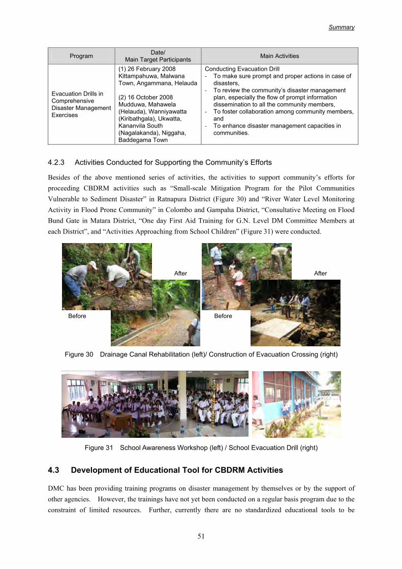
Besides of the above mentioned series of activities, the activities to support community’s efforts for proceeding CBDRM activities such as “Small-scale Mitigation Program for the Pilot Communities Vulnerable to Sediment Disaster” in Ratnapura District (Figure 30) and “River Water Level Monitoring Activity in Flood Prone Community” in Colombo and Gampaha District, “Consultative Meeting on Flood Bund Gate in Matara District, “One day First Aid Training for G.N. Level DM Committee Members at each District”, and “Activities Approaching from School Children” (Figure 31) were conducted.
Figure 30 Drainage Canal Rehabilitation (left)/ Construction of Evacuation Crossing (right)
Figure 31 School Awareness Workshop (left) / School Evacuation Drill (right)
4.3 Development of Educational Tool for CBDRM Activities
DMC has been providing training programs on disaster management by themselves or by the support of other agencies. However, the trainings have not yet been conducted on a regular basis program due to the constraint of limited resources. Further, currently there are no standardized educational tools to be
Before
After
Before
After

Summary
52
utilized in the CBDRM activities. Development of educational materials in more user-friendly format with utilized illustrations can attend to the needs of DMC and the public.
Considering above mentioned condition, an educational tool for the CBDM named “Fliptation (a combination word of flip chart and presentation)” was developed based on the experience in the JICA Study program. Main objectives of the development are to make CBDRM practitioners’ efforts easier and to ensure dissemination of appropriate knowledge about disaster mechanism by the standardized and easy-understandable educational tool. Further, Fliptation is suit for the on-site community activities because they are not require electricity or advanced presentation equipment. The composition and main contents of the “Fliptation” is as describes in Table 25.
Table 25 Composition and Main Contents of “Fliptation”
Theme Main Contents SpecificationCBDRM Activities - Outline of CBDRM Activities
- Importance of Knowing Risks - Community-based Hazard Mapping - Formation of Disaster Management
Committee - Disaster Management Drill - Disaster Risk Management Plan
Total 19 pages on A1 durable material
Mechanism of Disasters and Disaster Reduction - Volume 1: Flood - Volume 2: Sediment Disasters - Volume 3: Tsunami
- Mechanism of Disasters - Major Historical Disasters in Sri Lanka - Structural Measures to Mitigate Disaster
Damages - Non-structural Measures to Mitigate Adverse
Impact of Disasters
10 pages for each volume on A1 durable material
Figure 32 Developed “Fliptation” for CBDRM (CBDRM/Flood/Sediment Disasters/Tsunami)
4.4 Conclusions and Recommendations on CBDM Activities
All the planned community activities in the Study were completed without any big issues and problems in close cooperation with the counterpart organizations and concluded with tangible achievement. Persons involved in the activities could develop their capacities to deal with CBDRM activities at each of levels of their responsibilities. In the meanwhile, the following points could be reviewed and recommended for further improvement of CBDRM activities in Sri Lanka.

Summary
53
• Enhancing Capacities of Local Authorities and Local Bureaucracies for Sustainable CBDRM Activities
It was recognized that capacities of officers in Local Authorities and Local Bureaucracies for supporting CBDRM activities should be enhanced and the systems for dealing with disaster risk management activities in those government entities should be strengthened for sustainable CBDRM activities.
• Promotion of Activities which Needs Continuous Actions of Community Members for Ensuring Sustainability
Installation of observation equipments such as rain gauges or water level gauges could ensure community’s sustainable efforts for disaster risk management. DMC is currently planning to install rain gauges in more sediment disaster vulnerable communities based on successful examples including JICA Study program. Further promotion of those activities will be recommended.
• Encouraging More Active Involvement of Officers of Technical Organizations in CBDRM Activities
Involvement of technical organizations such as DOM, DOI, and NBRO in CBDRM activities could make the activities in communities more pragmatic and efficient. However, currently their involvement in the activities is limited. More active involvement of them should be encouraged.
• More Implementation of Community Evacuation Drill combined with Government-level Information Transfer Exercise
The drill combined with information transfer exercise at government level could considerably help community’s understanding of the flow of official early warning information. It is recommended to implement more this kinds of evacuation drills in the other disaster vulnerable areas.
• Promotion of Public Awareness through School Activities for Disaster Reduction
Raising awareness of school children has high possibility of facile expanding of the knowledge on disaster reduction to the wide range of communities. From the view point, it is highly evaluated DMC’s currently initiatives to support promotion of school safety program in the schools vulnerable to disasters. It is recommended to pay more attention to enhance teachers’ awareness and capacities to promote disaster reduction activities in the schools for ensuring the sustainability of their activities.
• Effective Utilization of Developed Educational Tool “Fliptation” for CBDRM
The educational tool “Fliptation” for CBDRM developed based on the experience in the Study will help more enhanced CBDRM activities. Effective utilization and periodical modification by DMC of the “Fliptation” is expected for promoting CBDRM activities of DMC and other related organizations.
• Formulation of Program To Make Effective Implementation of CBDRM Activities
Based on the experiences in the 15 pilot communities in the Study, it was examined that the factors such as active involvement of leaders and official endorsement of the program drove the implementation of the activities. It is important to consider the factors before initiating the activities.
The table below shows the responsible and implementing agency, proposed implementation period, and necessity of assistance for the abovementioned recommendations.

Summary
54
Table 26 Recommendation for Promoting CBDRM
Recommendation Responsible Organization
Implementing Agency
ScheduleNecessity of Foreign
Assistance
1a
Enhancing Capacities of Local Authorities and Local Bureaucracies for Sustainable CBDRM Activities: Regular Exercise
DMC
DMC, DDMCU, GA, DS, GN, Provincial/Urban and Municipal Council
A-B Technical assistance on the program development
1b
Enhancing Capacities of Local Authorities and Local Bureaucracies for Sustainable CBDRM Activities: Appointment of officers in charge of disaster risk management
DMC
GA, DS, GN, Provincial/Urban and Municipal Council
C
Technical assistance on coordination with relevant agencies and formulation of necessary laws/regulations
2
Promotion of Activities which Needs Continuous Actions of Community Members for Ensuring Sustainability (Installation of River & Rainfall Gauges)
DMC DMC in cooperation with DOI and NBRO
A
3
Encouraging More Active Involvement of Officers of Technical Organizations in CBDRM Activities: Establishment of Expert Group
DMC
DOM, DOI, DOM, NBRO Other Technical Organizations
B
Technical assistance on establishment of expert group, and program development
4
More Implementation of Community Evacuation Drill combined with Government-level Information Transfer Exercise
DMC
DMC, DOM, DOI, NBRO Other technical Organizations DDMCU, GA, DS, GN, Provincial/Urban and Municipal Council
A-B Technical assistance on effective information dissemination
5a
Promotion of Public Awareness through School Activities for Disaster Reduction: Training for Teachers
DMC
Ministry of Education in cooperation with DMC
B Technical assistance on training program development
5b
Promotion of Public Awareness through School Activities for Disaster Reduction: Lectures on Demand
DOI
DMC, DDMCU in cooperation with DOI, DOM and NBRO
B Technical assistance on program development
6
Effective Utilization of Developed Educational Tool “Fliptation” for CBDRM
DMC DMC, DDMCU in cooperation with DOI and NBRO
A
A: within one year, B: within 2 years, C: within 5 years Source: JICA Study Team
Summary
55
CHAPTER 5 CAPACITY DEVELOPMENT
5.1 Disaster Management Capacity at the beginning of the Study Sri Lanka Disaster Management Act is the basis for the disaster management framework in Sri Lanka and National Committee on Disaster Management (NCDM), Ministry for Disaster Management and Human Rights (MDMHR) and Disaster Management Centre (DMC) are the key organization of the disaster management in Sri Lanka.
DMC, Department of Irrigation (DOI), National Building Research Organization (NBRO), Department of Meteorology (DOM), District Secretariat (GA), District Disaster Management Coordination Unit (DDMCU), Divisional Secretariat (DS), Grama Niradari (GN), communities and media are concerned bodies for the Study implementation.
To start the capacity development (CD) activities, e capacities of target organizations at the beginning of the Study was summarized from the viewpoints of knowledge on disaster and disaster management, capacity for formulating plans, coordinating capacity with related organizations, response capacity and problem-solving and decision making capacity as shown in Table 27.
Table 27 Disaster Management Capacity for Selected Organizations
Knowledge/Capacity on Disaster Management Knowledge on Disaster Planning Coordinating Disaster Response
Problem-solving and Decision Making
DMC General knowledge
Certain extent but receive external input to prepare National DM Plan
Gradually increasing but has not reached the expected level
Through DDMCU Fewer experience in large scale disaster
Fewer experience, Insufficient human resources
DOI Enough technical knowledge
Certain extent but small amount of skilled personnel
Some experience in flood management
Some experience in flood management Site investigation during and after disasters
Fewer experience but limited requirement within their technical field
NBRO Enough technical knowledge
Certain extent but small amount of skilled personnel
Some experience in landslide management
Site investigation after disasters
Fewer experience but limited requirement within their technical field
DOM Enough technical knowledge
Certain extent but fewer skilled personnel
Some experience in weather forecast
Issue weather watch but no real time
Fewer experience but limited requirement within their technical field
DDMCU Insufficient level No experience Fewer
experience Fewer experience, Insufficient resources
Fewer experience, Insufficient human resources
Community Insufficient level No experience
Insufficient and spontaneous
Some experience, Insufficient resources
Insufficient but require very limited to solve local problem
Source: JICA Study Team
5.2 Capacity Development Activities Planning Capacity development plan that targets the counterparts and their organizations and selected communities in Component 3, was formulated with the CD goal of 1) At the end of the Study, an end-to-end early warning system established by the pilot project of this Study will be operating well, and 2) At the end of the Study, a flood management plan and flood warning plan is to be prepared/revised based on the resources from Sri Lanka.

Summary
56
Table 28 Capacity Development Planning for Selected Organizations
Individual Goals/Outputs Mode of Activity
DMC ・ Enhance capability as leading agency of disaster management ・ Enhance capacity on Coordination, decision-making and information
transfer
a), b), c), f) Overseas trainingTrainers Training for DDMCU
DOI
・ Enhance technical capabilities ・ Develop capability to revise the plan by conducting engineering analysis ・ Complete flood monitoring network and set up of flood warning criteria ・ Develop capability to issue warning without delay ・ Provide technical information on flood to community-based activity
a), b), c), f) Overseas training
NBRO
・ Enhance technical capabilities ・ Set warning criteria for landslide ・ Establish early warning system for landslide ・ Provide technical information on landslide to community-based activity ・ Obtain capacity to predict disaster event
a), b), c), f) Overseas training
DOM
・ Enhance technical capabilities ・ Develop capability to forecast hazardous weather based on past
experience ・ Develop ability to provide real-time based weather information to relevant
organizations including media in an understandable manner
a), b), c), f) Overseas training
DDMCU
・ Enhance DM capacity in total ・ Develop proper knowledge on hazard which happens in their place ・ Acquire proper knowledge on disaster management in mitigation,
preparedness and response ・ Timely transfer of proper disaster information in an understandable manner
b), c), d), e), f) Overseas trainingTrainers Training for Sub-National Gov. Organization
Sub-National Level Gov. Organization
・ Enhance DM capacity in total ・ Develop proper knowledge on hazard which happens in their place ・ Acquire proper knowledge on disaster management in mitigation,
preparedness and response ・ Transfer disaster information properly
c), d), e), f) Overseas training
Community
・ Enhance DM capacity in total ・ Acquire proper knowledge on disaster and their role in disaster
management ・ Ability to follow proper procedure in case of warning receive ・ Get ready in case of emergency ・ Formulate community-based disaster management organization ・ Coordinate community-based DM activity by themselves
c), d), e)
Media/ Society
・ Increasing involvement in disaster management ・ Allocate and achieve certain roles in disaster management ・ Transfer proper disaster information or forecast through the media in time ・ Allocate space for synoptic weather chart on newspaper or broadcast
synoptic weather chart regularly
b), c), e), f) MOU preparation
Note: a) Day-to- day working with Study Team, b) Counterpart meetings, c) Drills, d) Seminars, e) Workshops, f) Others Source: JICA Study Team
5.3 Capacity Development Activities
5.3.1 Seminars and Counterpart Meetings
The seminar for capacity development and the counterpart meetings were conducted three times and 18 times respectively.
5.3.2 Capacity Development Activity for Early Warning and Evacuation
Ensuring the effectiveness and sustainability of the proposed early warning and evacuation (EWE) system plan, the capacity development activities focusing on the enhancement of the planning capacity as well as the operational capacities, were conducted during the EWE system planning process by adapting a combined approach of “participatory planning process” and “exercise implementation”.
The DMC invited DOI, DOM, NBRO, Police, DDMCU, DS, GN and media to the participatory planning
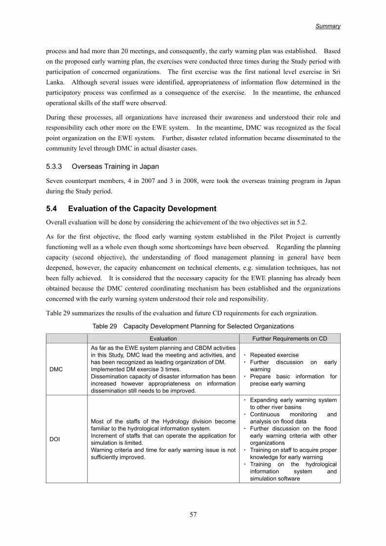
Summary
57
process and had more than 20 meetings, and consequently, the early warning plan was established. Based on the proposed early warning plan, the exercises were conducted three times during the Study period with participation of concerned organizations. The first exercise was the first national level exercise in Sri Lanka. Although several issues were identified, appropriateness of information flow determined in the participatory process was confirmed as a consequence of the exercise. In the meantime, the enhanced operational skills of the staff were observed.
During these processes, all organizations have increased their awareness and understood their role and responsibility each other more on the EWE system. In the meantime, DMC was recognized as the focal point organization on the EWE system. Further, disaster related information became disseminated to the community level through DMC in actual disaster cases.
5.3.3 Overseas Training in Japan
Seven counterpart members, 4 in 2007 and 3 in 2008, were took the overseas training program in Japan during the Study period.
5.4 Evaluation of the Capacity Development Overall evaluation will be done by considering the achievement of the two objectives set in 5.2.
As for the first objective, the flood early warning system established in the Pilot Project is currently functioning well as a whole even though some shortcomings have been observed. Regarding the planning capacity (second objective), the understanding of flood management planning in general have been deepened, however, the capacity enhancement on technical elements, e.g. simulation techniques, has not been fully achieved. It is considered that the necessary capacity for the EWE planning has already been obtained because the DMC centered coordinating mechanism has been established and the organizations concerned with the early warning system understood their role and responsibility.
Table 29 summarizes the results of the evaluation and future CD requirements for each orgnization.
Table 29 Capacity Development Planning for Selected Organizations
Evaluation Further Requirements on CD
DMC
As far as the EWE system planning and CBDM activities in this Study, DMC lead the meeting and activities, and has been recognized as leading organization of DM. Implemented DM exercise 3 times. Dissemination capacity of disaster information has been increased however appropriateness on information dissemination still needs to be improved.
・ Repeated exercise ・ Further discussion on early
warning ・ Prepare basic information for
precise early warning
DOI
Most of the staffs of the Hydrology division become familiar to the hydrological information system. Increment of staffs that can operate the application for simulation is limited. Warning criteria and time for early warning issue is not sufficiently improved.
・ Expanding early warning system to other river basins
・ Continuous monitoring and analysis on flood data
・ Further discussion on the flood early warning criteria with other organizations
・ Training on staff to acquire proper knowledge for early warning
・ Training on the hydrological information system and simulation software

Summary
58
Evaluation Further Requirements on CD
NBRO
The warning criteria have not decided in the Study and the early warning system for landslides has not completed yet but the community level warning system has been progressed. Warning can be issued relatively in time and frequency of warning is increased.
・ Continuous monitoring and analysis on landslide data for enhancing a capacity to issue landslide warning
・ Continue hazard/risk assessment・ Training on staff to acquire proper
knowledge for early warning
DOM
Real-time basis weather observation will be completed by the end of Feb. 2009. Capacity enhancement for forecasting weather based on the past experience is still not enough
・ Enhancing realtime observation capacity and forecasting capacity based on the realtime data
・ Analysis on the relationship between past disaster event and weather condition
DDMCU
Capacity of DDMCU, especially target areas for the Pilot Project has been enhanced in general. Increased awareness on community- based activities and an early warning system can be seen from their attitude. However, in view of appropriateness, information dissemination capacity is still not insufficient level.
・ Continue and expand the activities that have been done in the Study
・ Training to DM coordinators and his staffs to acquire proper knowledge on DM
・ Expand the Intra-Gov. Network to other DDMCU offices
Sub-National Level Gov. Organization
Capacity of officers who participated workshops / seminars and exercises considered to be remarkably enhanced, and they showed that have sufficient capacity to deal with a part of DM activity. However, due to small number of target organizations, capacity in general not so much enhanced in the Study.
・ Continue and expand the activities that have been done in the Study
・ Training to sub-national government officers to acquire proper knowledge on DM
Community
Knowledge and ability to cope with disaster in target communities are considered to be increased. Two landslide prone communities and two flood prone communities are started disaster mitigation activities by themselves. However, due to small number of target communities, capacity in general not so much enhanced in the Study.
・ Continue and expand the activities that have been done in the Study
・ Training to community leaders to acquire proper knowledge on DM
Media/ Society
Media people who attended the planning process and exercise of the Early Warning have got increased awareness on it, and appointed the focal point for disaster information dissemination. They have enough capacity to disseminate the information, if they have information in time. Discussion on the involvement of society other than media has not been taken place sufficiently. Community people show the different evacuation behavior based on their disaster experience.
・ Continue discussion on role of media/society in disaster management and how they can contribute
・ Continue disaster education
Source: JICA Study Team
5.5 Recommendations Based on the results and lessons learned from the capacity development activities that have taken place in this Study, the Study recommends the followings for further enhancement of disaster management capacity.
• Recruiting of Talented Personnel and Human Resources Development in DMC and DDMCU
Recruiting a Talented Personnel: DMC is still facing the shortage of skilled staff and instability of staffing. To acquire the personnel who can stay DMC and DDMCU for a longer period, reconsideration of the mode of recruiting/employing that includes the accommodating temporary transfer of qualified staff to DMC from other government sources is recommended.

Summary
59
Human Resources Development: DMC should establish its own human resources development program to have officials that meet the DMC requirements. In addition, cooperation with universities such as receiving internship students in DMC is also recommended to foster younger generation.
• Capacity Enhancement of Local Level Government Organizations
Local government organizations have to deal with local disasters, however, in many cases, their DM capacities are very weak. Thus the active implementation of CD activity targeting local government organizations is strongly recommended. To enhance the capacity, role definitions for officials regarding disaster management and the capacity enhancement of individual officials are required.
• Preparation and Consolidation of the Information related to Disaster Management Activities and its Sharing
To conduct disaster management activity in proper way, it is necessary to prepare and consolidate the basic information such as topographic map, weather and hydrological data, hazard map, etc. Therefore, these basic information should be prepared based on a standardized format.
• Focus on Disaster Forecast and Adaptation of Climate Change
The monitoring capacity of disaster information has considerably been enhanced. In addition to the further development of the realtime-based monitoring capacity, the implementation of activities for enhancing the capacity for forecasting and issuing the warning are recommended.
On the other hand, the “Climate Change” may have a possibility to aggravate damages of natural disasters. Therefore, it is necessary and important to evaluate the impact of the climate change on disasters that may happen in Sri Lanka, and to consider how to adapt on the climate change to mitigate the damages.
• Implementation of Continuous and Repeated Disaster Management Activity
It is observed that understanding of action that should taken by the staff and operational skills have been enhanced by the repeated exercises in this Study, and this confirms the importance of the repeated exercise. The community-based disaster management (CBDM) activity has just taken off after the continuous and repeated activity. Therefore, it is recommended that the activities should be continued in these communities after completion of the Study as well as the expansion of the CBDM activity to other areas.
• Stronger Cooperation with Concerned Organizations
Early Warning: The Study recommends establishing a place for discussions for promoting stronger cooperation for issuing the early warning. The discussion should cover the discussion on “which kind of information should be disclosed and shared”, and “how the organizations share the information to reduce the damage of disaster”.
Building Better Disaster Management Framework: The administrative framework that enables sharing and coordinating all disaster related information and measures among concerning organizations (not only the organizations directly involved in the disaster management activity but also the organizations for urban planning, and other sectors like the Ministry of Education) should be established. Schools are good and important forums to educate children about disasters and disaster management however it have

Summary
60
not fully functioned as expected. With close cooperation of the Ministry of Education, activities for allocation of roles for the schools and teachers, and enhancing school education programs should be carried out.
Promoting such disaster management framework, DMC should establish two separate working groups to discuss the coordinated information sharing and role of schools and teachers under the NDMCC (National Disaster Management Coordinating Committee), and prepare the agreement on it within one year period for starting concrete actions.
• Establishment of Flood Management Division
From the viewpoint of flood management, the organizational capacity of DOI is relatively weak. To strengthen its flood management capacity, establishment of a Flood Management Division in DOI is recommended. The Flood Management Division should have total responsibility on flood management from planning, design and implementation, to operation and maintenance. Also, the division should have the responsibility for flood early warning.
The following table shows the responsible and implementing agency, priority and necessity of assistance for the abovementioned recommendations.
Table 30 Recommendations
Recommendation Responsible Organization
Implementing Agency ScheduleNecessity of Foreign
Assistance
1
Recruiting of Talented Personnel and Human Resources Development in DMC and DDMCU
DMC DMC, DDMCU A~B Technical assistance on the development of training program
2
Capacity Enhancement of Local Level Government Organizations
DMC
DDMCU, GA, DS, GN Provincial/Urban and Municipal Council Police
A
3
Preparation and Consolidation of the Information related to Disaster Management Activities and its Sharing
DMC
DOM, DOI, NBRO Other technical Organizations Mn. of Environment Mn. of Education UDA, RDA, SLRDC Port Authority Survey Department, etc.
B
Technical assistance on standardization and ordering of required information
4
Focus on Disaster Forecast and Adaptation of Climate Change
DMC DOM, DOI, NBRO Other technical Organizations
A~B
Technical assistance on capacity development on disaster forecast and climate change
5
Implementation of Continuous and Repeated Disaster Management Activity
DMC DOM, DOI, NBRO DDMCU, GA, DS, GN Police, Community
A continuous

Summary
61
Recommendation Responsible Organization
Implementing Agency ScheduleNecessity of Foreign
Assistance
6 Stronger Cooperation with Concerned Organizations
DMC
DOM, DOI, NBRO Other technical Organizations Mn. of Environment Mn. of Education Survey Department UDA, RDA, SLRDC Port Authority Police, etc.
A
7 Establishment of Flood Management Division
DOI DMC C Technical assistance on institutional arrangement
A: within one year, B: within 2 years, C: within 5 years Source: JICA Study Team

Summary
62
CHAPTER 6 CONCLUSIONS AND RECOMMENDATIONS
6.1 Conclusion
In the wake of the recent large-scale disasters especially the Tsunami disaster in December 2004, the disaster management system in Sri Lanka has changed meaningfully. While four years have passed since the devastating tsunami disaster and the memories of this catastrophe are fading with time, the Government of Sri Lanka is strengthening disaster management administration, particularly the strengthening of DMC. The Study also has greatly contributed for the development of the capacity of disaster management in Sri Lanka.
The outcomes of the Study are as follows:
The flood management plans for four major river basins of Kelani, Kalu, Gin and Nilwara which are located in the wet zone of the South-Western part of Sri Lanka were formulated, with a detailed action plan for Kalu River which was selected as the priority river basin for urgent implementation.
Regarding the early warning and evaluation (EWE) system planning, the overall plan for the EWE is presented in this report. During the Study period, the Hydrological Information System with meteo-hydro monitoring and communication equipment were installed in the Kelani and Kalu rivers, and the Intra-Governmental Network was also established for information sharing as pilot project. In the planning process of the EWE system, the participatory planning process and the exercise implementation scheme was introduced for enhancing the planning capacity of concerned organizations, verifying the appropriateness of plan, and familiarizing people with the system. Disaster management exercises were conducted three times during the Study.
As part of the community level disaster management activities, the Study Team selected 15 disaster prone communities and conducted two and a half years continuous community-based disaster management (CBDM) activities including five workshop sessions in each community. Through the CBDM activities, community people produced a hazard map for their village, formed disaster management committees, and conducted evacuation exercises and other small-scale disaster management activities. Based on good practice and lessons learned through the CBDM activities, a handbook and educational materials called “Fliptation” (a combination word of flip chart and presentation) for further activities that will be carried out by the disaster management concerning organizations were prepared by the Study Team.
In addition to the above mentioned visible output, through the day-to-day work with Sri Lankan organizations in the planning process of the flood management plan and the early warning and evacuation plan, counterpart meetings, seminars, etc., the capacities for performing their task has been remarkably enhanced.
6.2 Recommendations The outcomes presented in the previous section were obtained through the Study. Continuous activities in the disaster management sector need to be carried out by incorporating these outcomes to the activities done by the Sri Lankan side to date.
For further promotion of the disaster management in Sri Lanka, the Study makes the following recommendations:

Summary
63
• Authorizing the plans presented in this Report and their early implementation (Responsible Organization: DMC, As early as possible)
First of all, immediate authorization of the plans proposed in the Study as national or government plans is strongly recommended since their benefits for local communities are large. It is also recommended that the organizations concerned take necessary actions such as budget allocation etc. for the implementation and implement the measures including structural measures in accordance with the proposed implementation plan.
It is recommended that future disaster management activities, especially the activities that require foreign capital and technical assistance, should be implemented as a package consisting of structure measures, CBDM, early warning and evacuation and others.
• Establishment of DMC's core areas and implementing focused activities in them (Responsible Organization: DMC)
About four years has passed from the establishment of Disaster Management Centre (DMC), the environment surrounding the DMC is changing. As mentioned in the previous sections, the DMC's function is gradually being enhanced’ however, their abilities are still limited to some extent. Therefore, DMC should establish core activity areas and focus their activity in them.
As the guiding and coordinating body, DMC should establish a disaster management platform for Sri Lanka especially focused on: 1) institutional framework, 2) coordination on the disaster management activities such as preparation of hazard maps, early warning system, disaster management exercise and implementation of structural measures, 3) community based disaster management, and 4) guiding of research and human resources development.
• Preparation, consolidation and sharing of the information related to the disaster management (Responsible Organization: DMC, Within 1 to 2 years)
It is a basic requirement to prepare, consolidate and share basic information related to disaster management (such as topographical maps, meteo-hydrological information, land use, etc., hazard maps, disaster records, disaster management plans and measures) and other required information for appropriate implementation and creating cooperation with concerned organizations for disaster management. The DMC should promote such activities.
Construction of a database for basic information and publishing an annual book on disaster management (a white paper for disaster management) are examples of promotional activities that DMC should lead. By publishing a general policy on disaster management, record of disasters that happened in the previous year, the measures taken to mitigate disasters, etc. in the white paper for disaster management, many kinds of information will be consolidated and can be shared, and consequently, it creates the recognition that DMC is the leading organization of disaster management system of Sri Lanka.
• Implementation of the structural measures (Responsible Organization, DOI, NBRO and other technical organizations, As early as possible depending on the allocated budget)
It is obviously important to implement the non-structural measures, such as early warning and community-based disaster management, for reducing damage; however these activities cannot prevent hazardous events. To create a safer living environment, external forces that cause the disasters should be addressed in certain level by the structural measures. Therefore, promotion of implementation of the

Summary
64
structural measures is also recommended.
In addition to the flood disaster that this report has already proposed structural measures for, it is strongly recommended that a plan for the structural measures for sediment disasters that cause many human casualties should be prepared, based on the geological investigation, monitoring and assessment of the risks at site, and implemented.
• Definition and designation of the disaster areas, conservation areas and public water body in written format (Responsible Organization, DOI, NBRO and other technical organizations, As early as possible depending on the allocated budget)
It is recommended to have a clear definition and designation of the disaster areas, conservation areas and public water body in written format. It is also recommended to prohibit and/or control the development activities in the area that are disaster prone. Such activities lead to appropriate land use from the disaster management viewpoint and are important as nonstructural measures. The required process includes identification of the disaster areas and public water bodies based on the existing land use and natural conditions, setting the boundaries for the areas, and publishing this material for the public.
• Incorporating disaster management into development and enforcement of Disaster Impact Assessment (DIA) (DMC with collaboration of other related organizations, Within 2 years)
Ensuring guidance or instruction to incorporate disaster management viewpoints into the development activities is recommended. This is also strongly recommended in the Hyogo Frame of Action (HFA) adapted at the United Nations World Conference on Disaster Reduction held at Kobe, Japan in January 2005.
It is also recommended to introduce the Disaster Impact Assessment (DIA) into all developments. Currently, Environmental Impact Assessment (EIA) is enforced to the development activity and it is practical that DIA be conducted together with EIA, especially for large-scale development.
• Promotion of cooperation among concerned organizations (Responsible Organization: DMC, As early as possible)
Many organizations are involved in the disaster management. For effective implementation of the proposed measures and recommendations presented in this report, close cooperation among the organizations concerned is indispensable, and it is also indispensable that the capacity enhancement of DCM as leading organization. For early realization of a safer society, building a good relationship among the organizations concerned, cooperation among them, and promoting implementation of disaster reduction measures are desirable.