25. vishvarupa, the universal form of -...
TRANSCRIPT
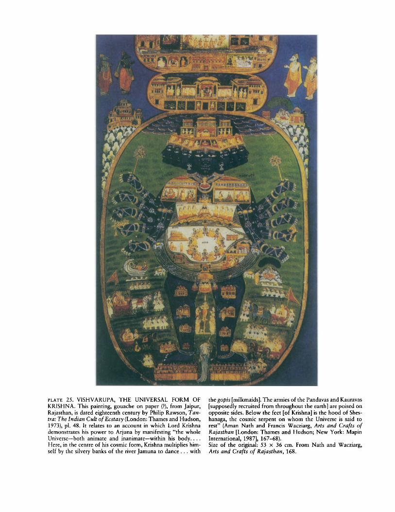
PLATE 25. VISHVARUPA, THE UNIVERSAL FORM OFKRISHNA. This painting, gouache on paper (?), from Jaipur,Rajasthan, is dated eighteenth century by Philip Rawson, T antra: The Indian Cult of Ecstasy (London: Thames and Hudson,1973), pI. 48. It relates to an account in which Lord Krishnademonstrates his power to Arjuna by manifesting "the wholeUniverse-both animate and inanimate-within his body....Here, in the centre of his cosmic form, Krishna multiplies himself by the silvery banks of the river Jamuna to dance ... with
the gopis [milkmaids]. The armies of the Pandavas and Kauravas[supposedly recruited from throughout the eanh] are poised onopposite sides. Below the feet [of Krishna] is the hood of Sheshanaga, the cosmic serpent on whom the Universe is said torest" (Aman Nath and Francis Wacziarg, Arts and Crafts ofRa;asthan [London: Thames and Hudson; New York: MapinInternational, 1987], 167-68).Size of the original: 53 x 36 em. From Nath and Wacziarg,Arts and Crafts of Ra;asthan, 168.
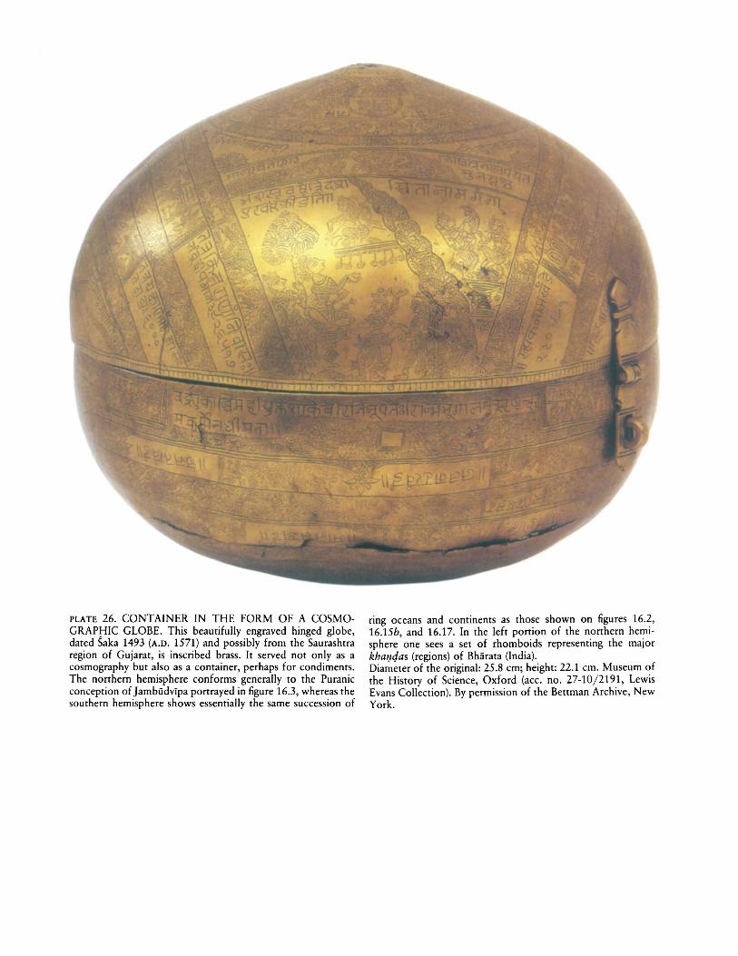
PLATE 26. CONTAINER IN THE FORM OF A COSMOGRAPHIC GLOBE. This beautifully engraved hinged globe,dated Saka 1493 (A.D. 1571) and possibly from the Saurashtraregion of Gujarat, is inscribed brass. It served not only as acosmography but also as a container, perhaps for condiments.The northern hemisphere conforms generally to the Puranicconception of Jambudvlpa portrayed in figure 16.3, whereas thesouthern hemisphere shows essentially the same succession of
ring oceans and continents as those shown on figures 16.2,16.15b, and 16.17. In the left portion of the northern hemisphere one sees a set of rhomboids representing the majorkhalJejas (regions) of Bhii.rata (India).Diameter of the original: 25.8 cm; height: 22.1 cm. Museum ofthe History of Science, Oxford (acc. no. 27-10/2191, LewisEvans Collection). By permission of the Bettman Archive, NewYork.
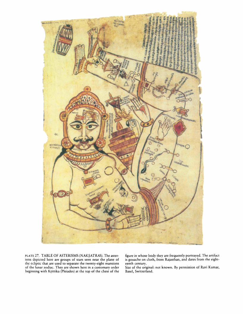
PLATE 27. TABLE OF ASTERISMS (NAKSATRAS). The asterisms depicted here are groups of stars seen near the plane ofthe ecliptic that are used to separate the twenty-eight mansionsof the lunar zodiac. They are shown here in a customary orderbeginning with Krittika (Pleiades) at the top of the chest of the
figure in whose body they are frequently ponrayed. The anifactis gouache on cloth, from Rajasthan, and dates from the eighteenth century.Size of the original: not known. By permission of Ravi Kumar,Basel, Switzerland.
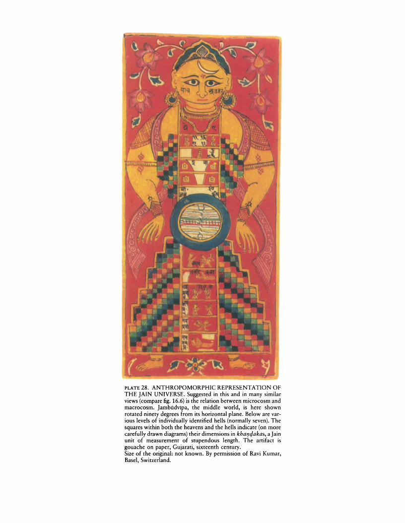
PLATE 28. ANTHROPOMORPHIC REPRESENTATION OFTHE JAIN UNIVERSE. Suggested in this and in many similarviews (compare fig. 16.6) is the relation between microcosm andmacrocosm. Jambudvlpa, the middle world, is here shownrotated ninety degrees from its horizontal plane. Below are various levels of individually identified hells (normally seven). Thesquares within both the heavens and the hells indicate (on morecarefully drawn diagrams) their dimensions in kha1J4akas, a Jainunit of measurement of stupendous length. The artifact isgouache on paper, Gujarati, sixteenth century.Size of the original: not known. By permission of Ravi Kumar,Basel, Switzerland.
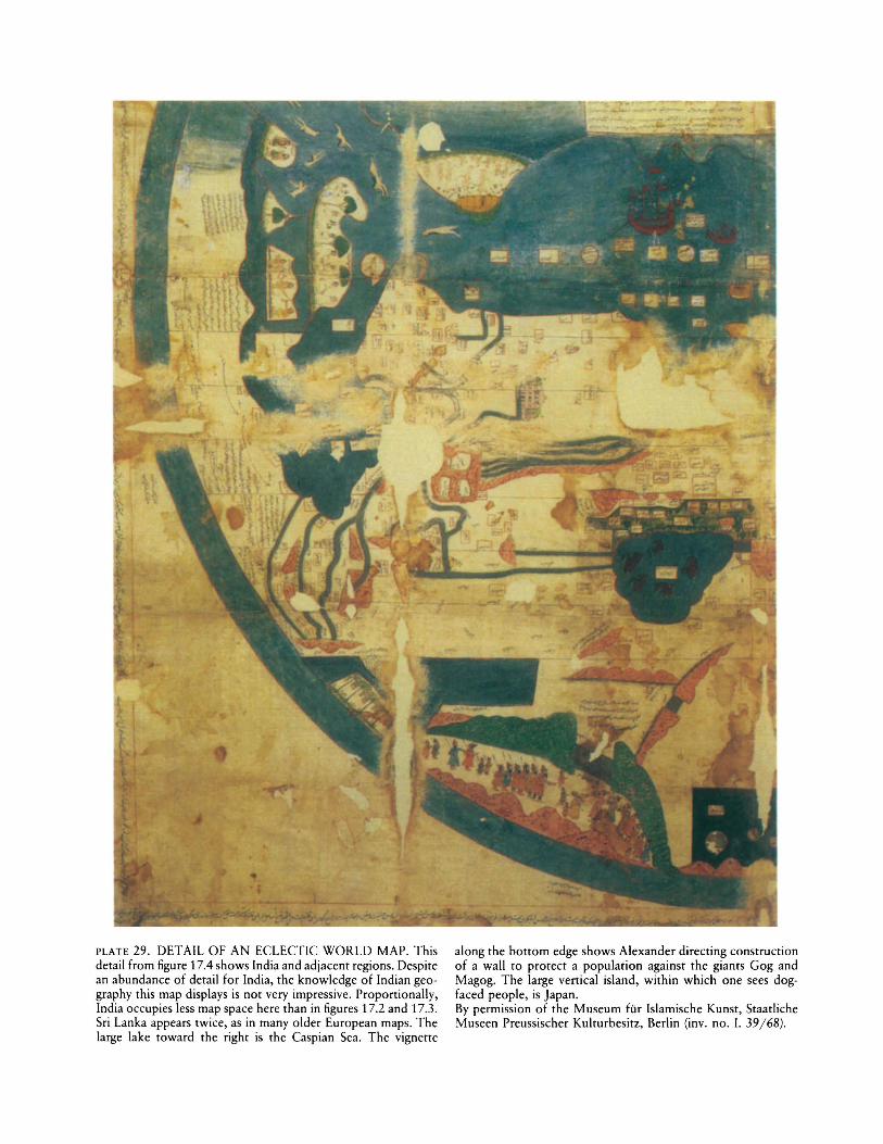
PLATE 29. DETAIL OF AN ECLECTIC WORLD MAP. Thisdetail from figure 17.4 shows India and adjacent regions. Despitean abundance of detail for India, the knowledge of Indian geography this map displays is not very impressive. Proportionally,India occupies less map space here than in figures 17.2 and 17.3.Sri Lanka appears twice, as in many older European maps. Thelarge lake toward the right is the Caspian Sea. The vignette
along the bottom edge shows Alexander directing constructionof a wall to protect a population against the giants Gog andMagog. The large vertical island, within which one sees dogfaced people, is Japan.By permission of the Museum fOr Islamische Kunst, StaatlicheMuseen Preussischer Kulturbesitz, Berlin (inv. no. I. 39/68).
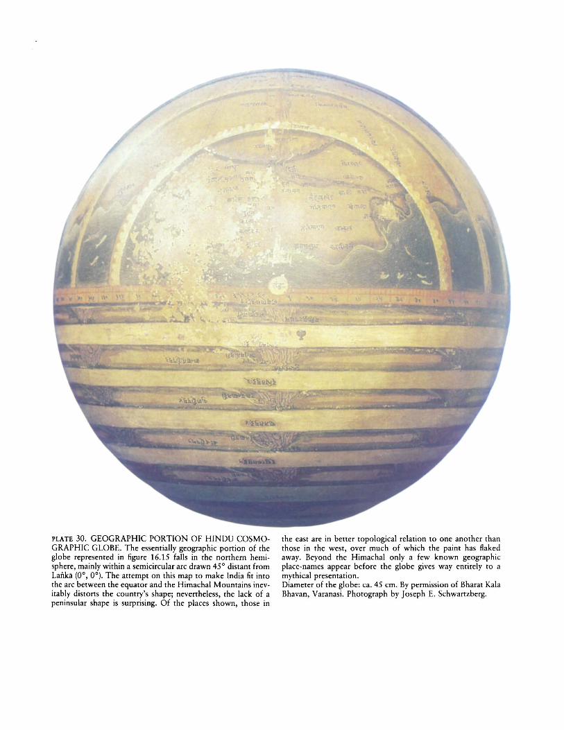
PLATE 30. GEOGRAPHIC PORTION OF HINDU COSMOGRAPHIC GLOBE. The essentially geographic portion of theglobe represented in figure 16.15 falls in the northern hemisphere, mainly within a semicircular arc drawn 45° distant fromLanka (0°, 0°). The attempt on this map to make India fit intothe arc between the equator and the Himachal Mountains inevitably distorts the country's shape; nevertheless, the lack of apeninsular shape is surprising. Of the places shown, those in
the east are in better topological relation to one another thanthose in the west, over much of which the paint has flakedaway. Beyond the Himachal only a few known geographicplace-names appear before the globe gives way entirely to amythical presentation.Diameter of the globe: ca. 45 cm. By permission of Bharat KalaBhavan, Varanasi. Photograph by Joseph E. Schwartzberg.
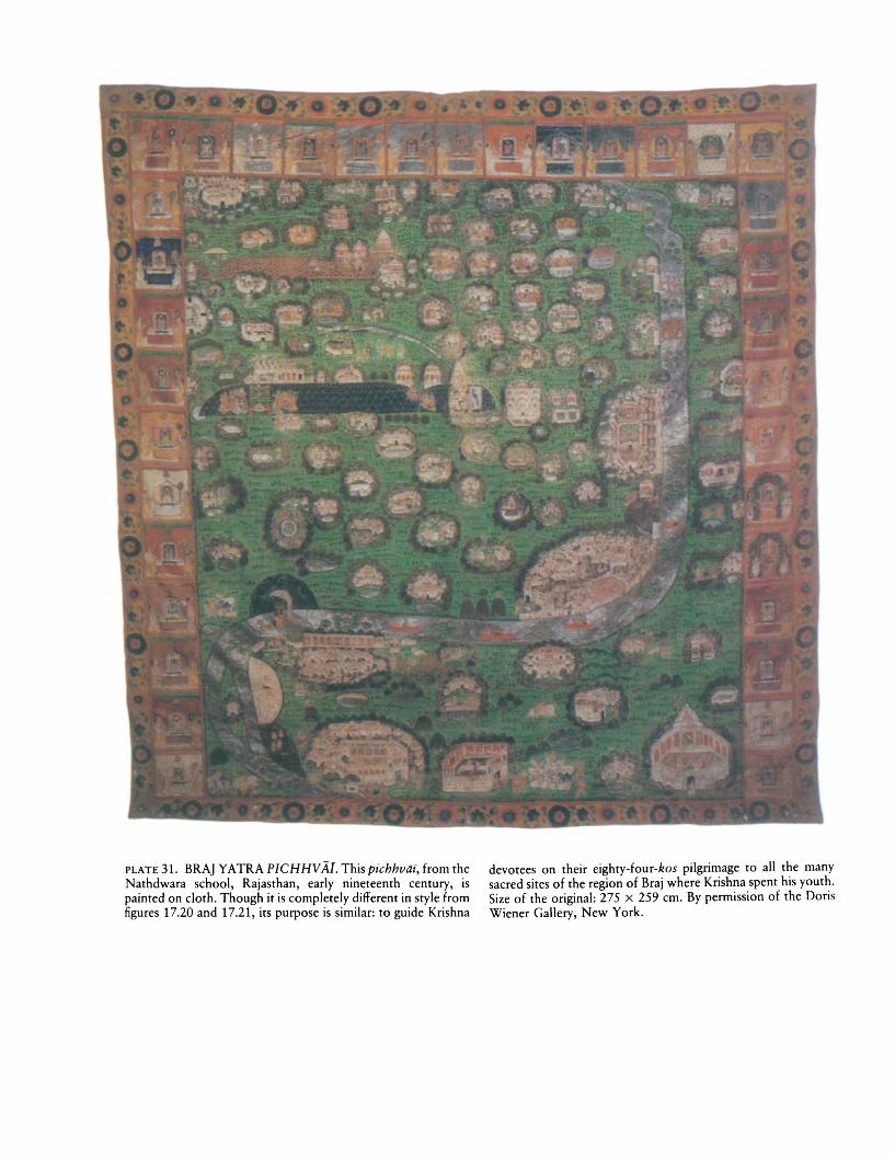
PLATE 31. BRA] YATRA PICHHVAI. This pichhviif, from theNathdwara school, Rajasthan, early nineteenth century, ispainted on cloth. Though it is completely different in style fromfigures 17.20 and 17.21, its purpose is similar: to guide Krishna
devotees on their eighty-four-kos pilgrimage to all the manysacred sites of the region of Braj where Krishna spent his youth.Size of the original: 275 x 259 cm. By permission of the DorisWiener Gallery, New York.
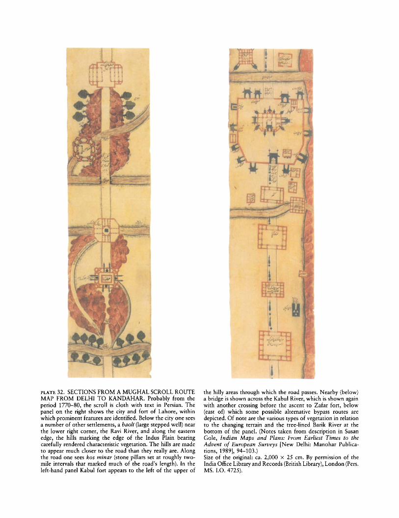
PLATE 32. SECTIONS FROM A MUGHAL SCROLL ROUTEMAP FROM DELHI TO KANDAHAR. Probably from theperiod 1770-80, the scroll is cloth with text in Persian. Thepanel on the right shows the city and fort of Lahore, withinwhich prominent features are identified. Below the city one seesa number of other settlements, a baoli (large stepped well) nearthe lower right corner, the Ravi River, and along the easternedge, the hills marking the edge of the Indus Plain bearingcarefully rendered characteristic vegetation. The hills are madeto appear much closer to the road than they really are. Alongthe road one sees kos minar (stone pillars set at roughly twomile intervals that marked much of the road's length). In theleft-hand panel Kabul fort appears to the left of the upper of
the hilly areas through which the road passes. Nearby (below)a bridge is shown across the Kabul River, which is shown againwith another crossing before the ascent to Zafar fort, below(east of) which some possible alternative bypass routes aredepicted. Of note are the various types of vegetation in relationto the changing terrain and the tree-lined Barik River at thebottom of the panel. (Notes taken from description in SusanGole, Indian Maps and Plans: From Earliest Times to theAdvent of European Surveys [New Delhi: Manohar Publications, 1989], 94-103.)Size of the original: ca. 2,000 x 25 em. By permission of theIndia Office Library and Records (British Library), London (Pers.MS. 1.0. 4725).
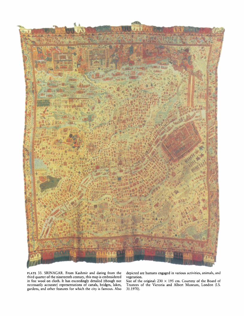
PLATE 33. SRINAGAR. From Kashmir and dating from thethird quarter of the nineteenth century, this map is embroideredin fine wool on cloth. It has exceedingly detailed (though notnecessarily accurate) representations of canals, bridges, lakes,gardens, and other features for which the city is famous. Also
depicted are humans engaged in various activities, animals, andvegetation.Size of the original: 230 x 195 cm. Courtesy of the Board ofTrustees of the Victoria and Albert Museum, London (I.S.31.1970).
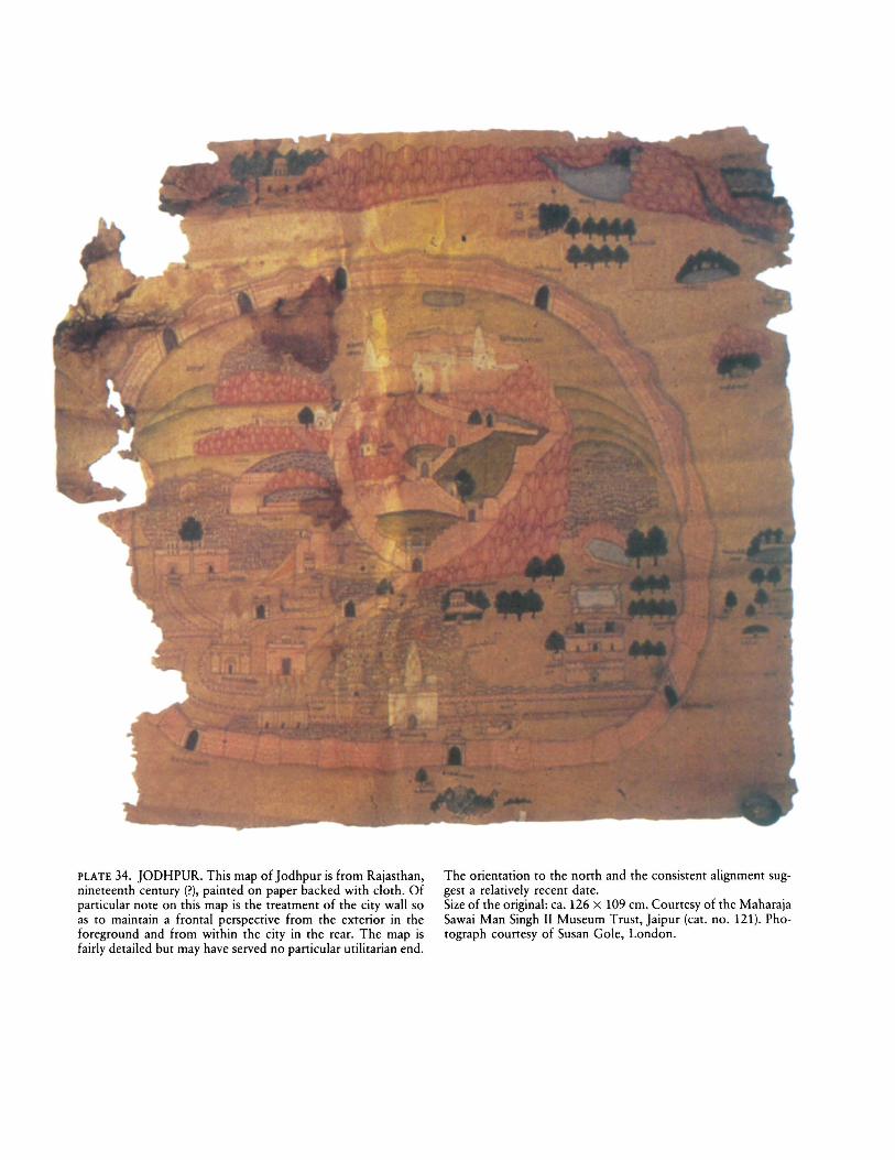
PLATE 34. JODHPUR. This map of Jodhpur is from Rajasthan,nineteenth century (?), painted on paper backed with cloth. Ofparticular note on this map is the treatment of the city wall soas to maintain a frontal perspective from the exterior in theforeground and from within the city in the rear. The map isfairly detailed but may have served no particular utilitarian end.
The orientation to the north and the consistent alignment suggest a relatively recent date.Size of the original: ca. 126 x 109 em. Courtesy of the MaharajaSawai Man Singh II Museum Trust, ]aipur (cat. no. 121). Photograph courtesy of Susan Gole, London.
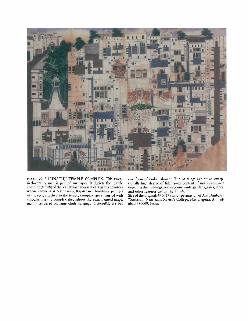
PLATE 35. SHRINATHJI TEMPLE COMPLEX. This twentieth-century map is painted on paper. It depicts the templecomplex (have/i) of the Vallabhacharya sect of Krishna devoteeswhose center is at Nathdwara, Rajasthan. Hereditary paintersof the sect, attached to the temple complex, are entrusted withembellishing the complex throughout the year. Painted maps,mainly rendered on large cloth hangings (pichhviUs), are but
one form of embellishment. The paintings exhibit an exceptionally high degree of fidelity-in content, if not in scale-indepicting the buildings, rooms, courtyards, gardens, gates, lanes,and other features within the have/i.Size of the original: 49 x 67 em. By permission of Amit Ambalal,"Sumeru," Near Saint Xavier's College, Navrangpura, Ahmadabad 380009, India.
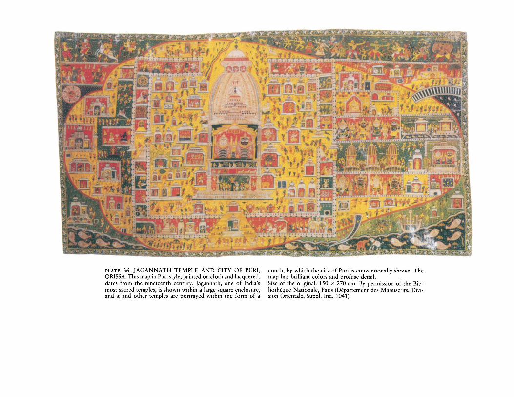
PLATE 36. JAGANNATH TEMPLE AND CITY OF PURl,ORISSA. This map in Puri style, painted on cloth and lacquered,dates from the nineteenth century. Jagannath, one of India'smost sacred temples, is shown within a large square enclosure,and it and other temples are portrayed within the form of a
conch, by which the city of Puri is conventionally shown. Themap has brilliant colors and profuse detail.Size of the original: 150 x 270 em. By permission of the Bibliotheque Nationale, Paris (Departement des Manuscrits, Division Orientale, Suppl. Ind. 1041).
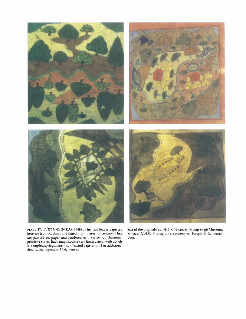
PLATE 37. TfRTHAS IN KASHMIR. The four tfrthas depictedhere are from Kashmir and dated mid-nineteenth century. Theyare painted on paper and rendered in a variety of charming,primitive styles. Each map shows a very limited area, with detailsof temples, springs, streams, hills, and vegetation. For additionaldetails, see appendix 17.6, item o.
Size of the originals: ca. 36.5 x 32 cm. Sri Pratap Singh Museum,Srinagar (2063). Photographs courtesy of Joseph E. Schwartzberg.

PLATE 38. A SIEGE AT BHIWAI FORT, SIKAR DISTRICT,RAJASTHAN. This lively depiction of a siege of a fort is Rajasthani, dating from the early nineteenth century, painted onpaper backed with cloth, with text in Dhundari. Troops ofvarious units are pictured in distinctive garb, trenches, ramparts,
siege tunnel, artillery, and flags are shown, and commanders arenamed.Size of the original: 123 x 168 em. Courtesy of the MaharajaSawai Man Singh II Museum Trust, Jaipur (cat. no. 48). Photograph courtesy of Susan Gole, London.
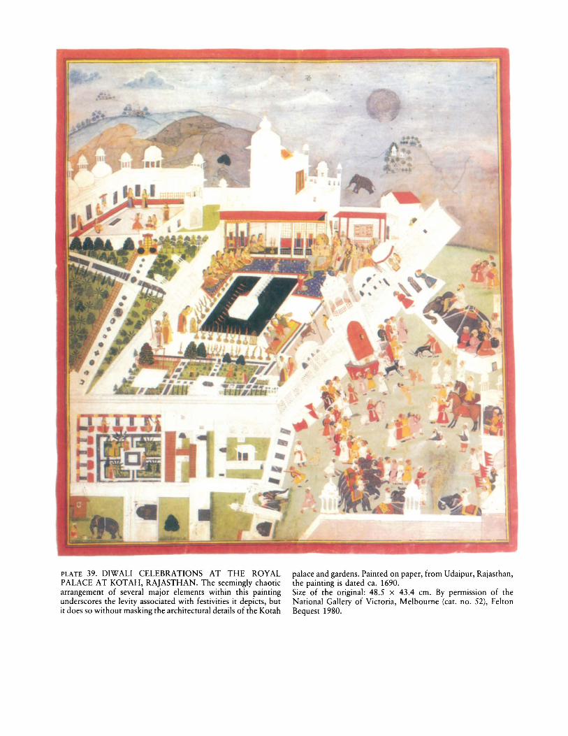
PLATE 39. D1WALI CELEBRATIONS AT THE ROYALPALACE AT KOTAH, RAJASTHAN. The seemingly chaoticarrangement of several major elements within this paintingunderscores the levity associated with festivities it depicts, butit does so without masking the architectural details of the Kotah
palace and gardens. Painted on paper, from Udaipur, Rajasthan,the painting is dated ca. 1690.Size of the original: 48.5 X 43.4 em. By permission of theNational Gallery of Victoria, Melbourne (cat. no. 52), FeltonBequest 1980.
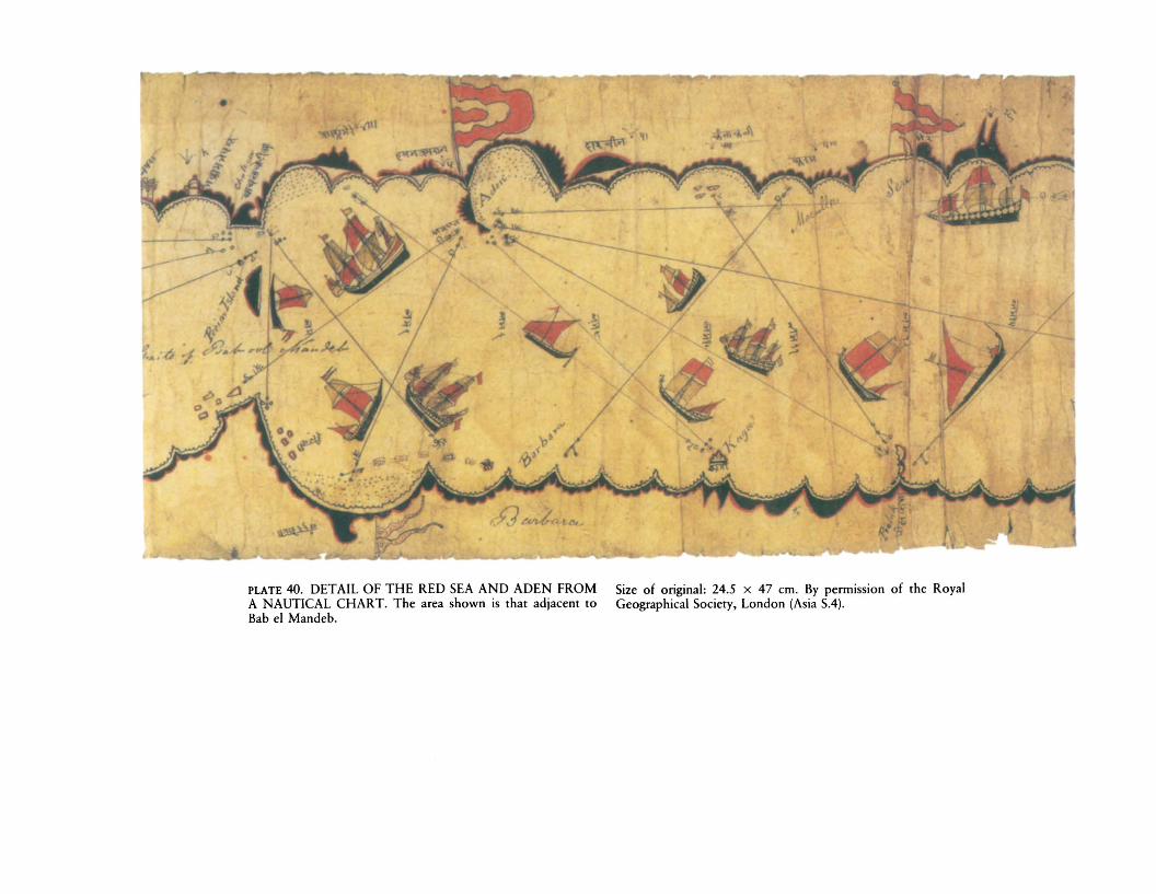
PLATE 40. DETAIL OF THE RED SEA AND ADEN FROMA NAUTICAL CHART. The area shown is that adjacent toBab e1 Mandeb.
Size of original: 24.5 X 47 em. By permission of the RoyalGeographical Society, London (Asia SA).