2nd report 1st copy
TRANSCRIPT

8/13/2019 2nd Report 1st Copy
http://slidepdf.com/reader/full/2nd-report-1st-copy 1/29
1
CONTENTS
1. INTRODUCTION
2. LITERATURE SURVEY SO FAR
2.1 IMPACTS OF SOLID WASTE ON HEALTH
2.2 WASTE DISPOSAL IN LANDFILLS
2.3 ESSENTIAL COMPONENTS OF LANDFILLS
2.4 PROBLEMS DUE TO LANDFILL SITING
2.5 LANDFILL SITE SELECTION
2.6 RELATIVE HAZARD ASSESSMENT SYSTEMS
2.7 GROUNDWATER VULNERABILITY
2.8 ROLE OF GIS
2.9 INDIAN PERSPECTIVE
3. IDENTIFICATION OF THE PROBLEM
4. AIM OF THE RESEARCH
5. METHODOLOGY
5.1 Why DRASTIC
5.2 STAGES OF WORK
6. SUMMARY
7. TIME SCHEDULE
REFERENCES

8/13/2019 2nd Report 1st Copy
http://slidepdf.com/reader/full/2nd-report-1st-copy 2/29
2
LIST OF FIGURES
1. Fig 1.Development of suitability index
2. Fig 2.Compacted flow chart
LIST OF TABLES
1. Table 1. Summary of various existing methods
8/13/2019 2nd Report 1st Copy
http://slidepdf.com/reader/full/2nd-report-1st-copy 3/29
3
1. INTRODUCTION
Modernization and progress has had its share of disadvantages and one of the main aspects of
concern is the pollution it is causing to the earth – be it land, air, and water. With increase in the
global population and the rising demand for food and other essentials, there has been a rise in the
amount of waste being generated daily by each household. This waste is ultimately thrown into
municipal waste collection centers from where it is collected by the area municipalities to be
further thrown into the landfills and dumps.
Landfill site selection is a complex process involving social, environmental and technical
parameters. Since it involves debatable issues, the most suitable site that is available has to be
chosen so that the evil effects to environment are minimal. Risk to human health is perhaps, the
most important factor to be considered for landfill siting. The aim of this work is to develop amethodology that can be used to rank suitability of landfill sites based on human health risk. If
existing landfill siting regulations in India are incorporated in this methodology, it can be applied
to any of the sites in India. For processing large quantities of spatial data, Geographical
information system (GIS) will be used.
2. LITERATURE SURVEY SO FAR
2.1 Impacts of solid waste on health
Organic domestic waste which undergoes degradation creates a favourable condition for the
growth of microbial population and becomes a serious threat to human health. Direct handling of
solid waste also results in various types of infectious and chronic diseases in case of waste
workers and rag pickers.
The population which gets affected by the unscientific disposal of solid waste includes – the
population in areas where there is no proper waste disposal method, especially the pre-school
children; waste workers; and workers in facilities producing toxic and infectious material, Therisk will be very high in case of population living close to a waste dump and the population who
is supplied with water supply which has contaminated either due to waste dumping or leakage
from landfill sites. Solid waste, if uncollected and undisposed, also increases risk of injury and
infection.
8/13/2019 2nd Report 1st Copy
http://slidepdf.com/reader/full/2nd-report-1st-copy 4/29
4
Exposure to hazardous waste, an even more problematic one, can affect human health. Children
are more vulnerable to these types of health problems. In fact, direct exposure can lead to
diseases through chemical exposure as the release of chemical waste into the environment maylead to chemical poisoning. Many studies have been carried out in different parts of the world to
establish a connection between health and hazardous waste.
Waste from agriculture and industries can also cause serious health risks. Other than this, if
hazardous waste and radio- active wastes from industries aren‟t ha ndled in separate sections, the
co-disposal of them with municipal waste can expose people to chemical and radioactive
hazards. Uncollected solid waste can also pollute runoff water, resulting in the formation of
stagnant water bodies that become the breeding ground of disease-causing mosquitoes andmicrobes. Waste dumping near a water source also causes contamination of the water body or the
ground water source. The risk of such a hazard increases if more people are using such polluted
water resources. Direct dumping of untreated waste in rivers, seas, and lakes results in
accumulation of toxic substances in the food chain, through the plants and animals that feed on
it.
Disposal of hospital and other medical waste requires special attention since this can
create major health hazards. This waste generated from the hospitals, health care centres, medical
laboratories, and research centers such as discarded syringe needles, bandages, swabs, plasters,
and other types of infectious waste are often disposed with the regular non-infectious waste.
Waste treatment and disposal sites can also create health hazards for the neighborhood.
Improperly operated incineration plants cause air pollution and improperly managed and
designed landfills attract all types of insects and rodents that spread disease. Ideally these sites
should be located at a safe distance from all human settlement. Landfill sites should be well lined
and walled to ensure that there is no leakage into the nearby ground water sources.
Recycling too carries health risks if proper precautions are not taken. Workers working
with waste containing chemical and metals may experience toxic exposure. Disposal of health-
care wastes require special attention since it can create major health hazards, such as Hepatitis B
and C, through wounds caused by discarded syringes. Rag pickers and others who are involved
8/13/2019 2nd Report 1st Copy
http://slidepdf.com/reader/full/2nd-report-1st-copy 5/29
8/13/2019 2nd Report 1st Copy
http://slidepdf.com/reader/full/2nd-report-1st-copy 6/29
6
landfill is designed to contain or store the wastes so that the exposure to human and environment
could be minimized (Nidhi, Misra and Shukla, 2011)
Landfills minimize the harmful impact of solid waste on the environment by the following
mechanisms (Fig. 17.3): (a) isolation of waste through containment; (b) elimination of polluting pathways; (c) controlled collection and treatment of products of physical, chemical and
biological changes within a waste dump – both liquids and gases; and (d) environmental
monitoring till the waste becomes stable (Ministry of Urban Development, India)
2.3 Essential components of landfills
The seven essential components of a MSW landfill are:
(a) A liner system at the base and sides of the landfill which prevents migration of leachate orgas to the surrounding soil.
b) A leachate collection and control facility which collects and extracts leachate from within
and from the base of the landfill and then treats the leachate.
(c) A gas collection and control facility (optional for small landfills) which collects and extracts
gas from within and from the top of the landfill and then treats it or uses it for energy recovery.
(d) A final cover system at the top of the landfill which enhances surface drainage, preventsinfiltrating water and supports surface vegetation.
(e) A surface water drainage system which collects and removes all surface runoff from the
landfill site.
(f) An environmental monitoring system which periodically collects and analyses air, surface
water, soil-gas and ground water samples around the landfill site.
(g) A closure and post-closure plan which lists the steps that must be taken to close and secure a
landfill site once the filling operation has been completed and the activities for long-term
monitoring, operation and maintenance of the completed landfill (Ministry of Urban
Development, India)
2.4 Problems due to landfill siting

8/13/2019 2nd Report 1st Copy
http://slidepdf.com/reader/full/2nd-report-1st-copy 7/29
7
Generally in India, MSW is disposed of in low lying areas without taking any precautions or
operational controls. Therefore, municipal solid waste is one of the major environmental
problems of Indian megacities. It involves activities associated with generation, storage,
collection, transfer and transport, processing and disposal of solid wastes. But, in most of the
Indian cities, the MSW Management system comprises four activities only, i.e., waste
generation, collection, transportation, and disposal (Ayub and Khan 2011). The management of
MSW requires proper infrastructure, maintenance and upgrade for all activities.
This becomes more expensive and complex because of the continuous and unplanned urban
growth. The difficulties associated with providing facilities and services up to the expectations of
urban centers are often imputed to the poor financial status of the managing municipal
corporations.
Most of the global MSW is dumped in non-regulated landfills and the generated methane is
emitted to the atmosphere. Methane, when escapes to atmosphere, has a global warming
potential that IPPC (U.S Energy Information Administration, 2003) estimates to be 23 times
greater than that of the same volume of carbon dioxide. Nowadays, there are modern landfills
which can capture and utilize landfill gas. The landfill gas is collected at source, cleaned up and
processed so that it can be used for electricity generation. In India, most of the landfills are not
designed to recover the gases for energy recovery but there are some ongoing project works on
methane capture (Ayub and Khan 2011)
Landfill Leachate can be toxic, acidic, and rich in organic acid groups. They can contain sulphate
ions as well as high concentration of common metal ions. It contains mixtures of many chemicals
having a potential risk to human health through penetrating into the ground water. Many
researchers have undertaken the studies on ground and surface water contamination.
Landfilling is environmentally acceptable if properly carried out. Unfortunately, if not carried
out to sufficiently high standards, landfilling has the potential to have an adverse impact on the
environment. This impact may be divided into short term impacts and long term impacts
(Department of Water Affairs & Forestry-South Africa 1998)
Short term impacts
8/13/2019 2nd Report 1st Copy
http://slidepdf.com/reader/full/2nd-report-1st-copy 8/29
8
Short term impacts include problems such as noise, flies, odor, air pollution, unsightliness and
windblown litter. Such nuisances are generally associated with a waste disposal operation and
should cease with the closure of the landfill.
Long term impacts
Long term impacts include problems such as pollution of the water regime and landfill gas
generation. Such problems are generally associated with incorrect landfill site selection, design,
preparation or operation and may persist long after the landfill site has been closed.
Summarizing the impacts, such dumps cause the following problems:
(a) Groundwater contamination through leachate
(b) Surface water contamination through runoff
(c) Air contamination due to gases, litter, dust, bad odor
(d) Other problems due to rodents, pests, fire, bird menace, slope failure, erosion etc.
The general objective of environmentally acceptable landfilling, therefore, is to avoid both short
and long term impacts and any degradation of the environment in which the landfill is located
(Ayub and Khan 2011).
2.5 Landfill Site selection
The major goal of the landfill site selection process is to ensure that the disposal facility is
located at the best location possible with little negative impact to the environment or to the
population. For landfill siting, a substantial evaluation process is needed to identify the best
available disposal location which meets the requirements of government regulations and best
minimizes economic, environmental, health, and social costs. Evaluation processes or
methodologies are structured to make the best use of available information and to ensure that the
results obtained are reproducible so that outcomes can be verified and defended (Siddiqui,
Everett and Vieux 1996)
MSW management is nowadays a difficult and complicated issue, mainly for the following
reasons:

8/13/2019 2nd Report 1st Copy
http://slidepdf.com/reader/full/2nd-report-1st-copy 9/29
9
• Collection and disposal is a major environmental problem related to human health, urban
environment quality, greenhouse effect and natural and urban landscape aesthetics.
• Nuisance -the significance of which is often subjective-caused by the passage of MSW
collection vehicles, the smells, the sight of landfill areas, the negative feelings from neighboringwith an MSW collection facility, the worry for potential public health risks and the not-in-my
backyard (NIMBY) syndrome understandably creates a negative social attitude towards MSW
treatment and landfilling. (Hadjibiros, Dermatas and Laspidou 2011)
A site may be technically and economically feasible yet may be opposed heavily by the
public. The “not in my back yard” (NIMBY) sentiment is high initially. However, with proper
discussion it can be overcome in some cases. Early assessment regarding how strong the NIMBY
sentiment is can significantly reduce the time and money spent on planning for a landfill sitewhich may not materialize. In many instances residents around a proposed site cooperate if the
landfill site owner‟s representative listens t o concerns of the area residents and considers those
concerns in designing and monitoring a site. Noise, dust, odor, increases in traffic volume, and
reduction in property value concern the area residents more than the fear of groundwater
contamination (Lee and Lee 2008).
On the other hand, in most developing and in some developed countries, MSW
management is nothing more than uncontrolled dumping. Discharge into a riverbed has been the
traditional way of getting rid of refuse for thousands of years. Environmental impacts used to be
tolerable when refuse mainly contained biodegradable organic matter, but are becoming
increasingly important with increasing waste volume, toxicity and non-degradability
(Hadjibiros, Dermatas and Laspidou,2011)
Selection of a landfill site usually comprises of the following steps, when a large number
(e.g. 4 to 8) landfill sites are available: (i) setting up of a location criteria; (ii) identification of
search area; (iii) drawing up a list of potential sites; (iv) data collection; (v) selection of few best-
ranked sites; (vi) environmental impact assessment and (vii) final site selection and land
acquisition. However, in municipalities where availability of land is limited, the selection
process may be confined to only one or two sites and may involve the following steps: (i) Setting
8/13/2019 2nd Report 1st Copy
http://slidepdf.com/reader/full/2nd-report-1st-copy 10/29
10
up of locational criteria; (ii) Data collection; (iii) Environmental impact assessment and (vi)
Final site selection (Lee and Lee,2008).
An effective technique for landfill siting should have the following characteristics (Lane et al.,
1983):
1. The technique should evaluate all land in a systematic and impartial way that can be
reasonably considered available for landfill.
2. The technique should clearly establish the relative suitability of land for absolute suitability or
minimum acceptable standards. These criteria or standards can vary from area to area depending
on different constraints on available land or different public concerns. The technique should
illustrate which lands are better or worse for sanitary landfills, rather than which lands are
suitable or unsuitable.
3. The technique should be practical and be based on commonly available information.
4. The technique should be adaptable to computerized analysis.
5. The technique should be designed to explain clearly and directly the analysis and results in a
format easily understandable by the officials and the general public.
Landfill is considered as an active installation that can produce emissions (Zamoranoaet.al, 2008). Various landfill siting techniques have been developed for this purpose. For
example, Lin and Kado (1998) developed a mixed-integer spatial optimization model based on
vector-based data to help decision makers find a suitable site within a certain geographic area.
Other researchers propose the use of multiple criteria analysis by itself or with GIS
(Kontos,Komilis and Halvadakis 2005 ). The use of artificial intelligence technology, such as
expert systems, can also be very helpful in solid waste planning and management. Fuzzy
inference systems have also been proposed.
A methodology called EVIAVE is developed by university of Granada and they used it
for the evaluation of an existing landfill site in Spain .They used cartographic raster modeling in
GIS for the work. EVIAVE is validated with landfills in Venezuela, Chile and Spain (Zamoranoa
8/13/2019 2nd Report 1st Copy
http://slidepdf.com/reader/full/2nd-report-1st-copy 11/29
11
et.al. 2008). Later, Abedinzadeh et.al (2013) applied this methodology for diagnosis of a landfill
in Iran.
Spatial models were generally constructed into a mixed-integer or non-linear
programming models. These models involve analysis of suitability of land parcels within an area,specification of objective functions by the analyst, and determination of candidate locations
which satisfy the constraints for continuity or compactness and other factors. Diamond and
Wright (1989) defined compactness as the square of the longest distance between any two points
within the selected zone divided by the area of the zone. Non-linear and integer multi objective
programming models were then applied to solve a land use problem. The non-linear property of
the model makes it difficult to solve by a computer. Wright et al. (1983) defined compactness as
the length of the perimeter of the selected zone divided by the area. Benabdallahand and Wright
(1992) used the same definition of compactness and a mixed-integer programming model to
analyze a multiple sub-region allocation problem with raster-based data. However, the large
number of variables and constraints used in their model make it difficult to solve. Although the
model is changed into a non-linear model to reduce the number of variables and constrains, the
solution obtained by the non-linear model may not be the global optimum.
Minor and Jacobs (1994) proposed an improved mix-integer model to find the landfill
site with best compactness and least cost from a set of irregularly shaped land parcels. Compared
to these previous models for raster-based data, model developed by Kado and Lin (1998) used
less variables and constraints.
2.6 Relative Hazard Assessment Systems
A number of relative hazard assessment systems for waste disposal sites have been
developed over the past three decades and reported in literature. Each one of these systems
evaluates the relative degree of hazard posed by a site to environment and human health
considering only the major parameters that describe the site quite substantially. Normally, waste
sites are evaluated for one or more of the following three hazard modes: 1) migration of
pollutants away from the site via groundwater, surface water, or air routes, or a combination
thereof, 2) fire and explosion potential, and 3) direct contact with hazardous substances. In most
of the systems, site ranking is based either on the combined score for various routes under
8/13/2019 2nd Report 1st Copy
http://slidepdf.com/reader/full/2nd-report-1st-copy 12/29
8/13/2019 2nd Report 1st Copy
http://slidepdf.com/reader/full/2nd-report-1st-copy 13/29
13
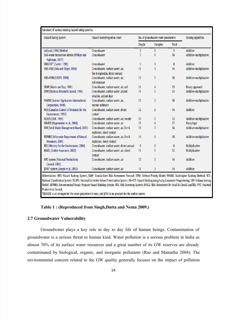
and RASCL evaluate 3 – 4 hazard migration routes, each one separately, and produce separate
scores for all the routes. The other systems such as SRAP, NCS, HR-FCP, NPC system, and
JENV system evaluate various routes concurrently and produce a composite score for all the
routes. In such systems, which do not produce separate scores for different routes, the
groundwater route score is calculated considering groundwater route parameters alone. This is
however, possible only in case of those systems that employ an additive algorithm to aggregate
their parameters. Such systems include NCS, NPC and JENV systems. In an additive algorithm,
it is easier to segregate and use the desired parameters to calculate aggregated score without
altering the scoring methodology structure. This is however, not possible in the case of the
systems such as SRAP and HR-FCP that employ a complex algorithm to aggregate site
parameters into the final site rank.
A system‟s ability to accurately evaluate a site hazard largely depends on the amount of
information taken into consideration for the hazard assessment. A system that considers more
info rmation about a site evaluates the site hazard more accurately. At the same time, a system‟s
acceptability among its potential users is greatly reduced if its data requirements are significant
and involve cost and time. Table 1 shows that the HRS-1990 and ERPHRS consider highest
number of 18 parameters each, whereas the LeGrand‟s method and DRASTIC consider only 5
and 8 parameters, respectively. As regards the ease of availability of data for different systems,
the parameters which can be determined easily i.e.by site walkover, visual survey, local
inhabitant survey, and regional maps of groundwater, soil type, geology etc., are considered
simple parameters; whereas the parameters whose determination involves field drilling and
sampling as well as laboratory testing and therefore, are much more difficult to obtain, are
considered as complex parameters. It is seen from Table 1 that among all systems, the Soil –
Waste Interaction Matrix uses highest number of 9 complex parameters, whereas RASCL uses
only 1 such parameter.
8/13/2019 2nd Report 1st Copy
http://slidepdf.com/reader/full/2nd-report-1st-copy 14/29
14
Table 1 : (Reproduced from Singh,Dutta and Nema 2009.)
2.7 Groundwater Vulnerability
Groundwater plays a key role in day to day life of human beings. Contamination of
groundwater is a serious threat to human kind. Water pollution is a serious problem in India as
almost 70% of its surface water resources and a great number of its GW reserves are already
contaminated by biological, organic, and inorganic pollutants (Rao and Mamatha 2004). The
environmental concern related to the GW quality generally focuses on the impact of pollution

8/13/2019 2nd Report 1st Copy
http://slidepdf.com/reader/full/2nd-report-1st-copy 15/29
15
and quality degradation on human health. Nearly two third of all ailments in India, such as
jaundice, cholera, diarrhea and dysentery, typhoid, etc. are caused by the consumption of
polluted water and these water-borne diseases claim nearly 1.5 million lives annually in the
country, which means three persons die every 10 minutes due to contaminated water (Ghazali
1992). Even today more than 90% of our rural population is primarily dependent on GW
(Chandrashekhar, Adiga, Lakshminarayana, Jagdeesha, and Nataraju 1999 ). The quality of
GW is as important as that of quantity because GW is the only source of drinking water in most
of urban areas of India. The drinking water quality in Indian cities has been deteriorating in
recent years mainly due to the high growth of population, unplanned growth of cities, mixed land
use patterns, no proper sewage system, and poor disposal of the wastewater both from household
as well as industrial activities. This has led to the pollution of shallow aquifers in and around
Indian cities in general (Rahman 2003).
GW pollution is nothing but artificially induced degradation of natural GW quality. In
contrast with surface water pollution, sub-surface pollution is difficult to detect, is even more
difficult to control, and may persist for years, decades, or even centuries (Todd, 1980). GW
vulnerability is a function of the geologic setting of an area, as this largely controls the amount of
time, i.e. the residence time of the GW that has passed since the water fell as rain, infiltrated
through the soil, reached the water table, and began flowing to its present location ( Prior,
Boekhoff, Howes, Libra, & VanDorpe 2003 ). In any given area, the GW within an aquifer, or
the GW produced by a well, has some vulnerability to contamination from human activities. This
concept exists since the 1960s, yet there is no standard definition of aquifer vulnerability. The
most common definition comes from Vrba and Zaporotec (1994 ), who described aquifer
vulnerability as a concept representing the intrinsic properties of aquifer systems as a function of
their sensitivity to human and natural activities.
Vulnerability mapping is defined as a technique for quantifying the sensitivity of the
resource to its environment, and as a practical visualization tool for decision-making. GW
vulnerability is also defined as the tendency and likelihood for general contaminants to reach the
water table after introduction at the ground surface (SNIFFER 2004). In fact the term
„„vulnerability of GW to contamination‟‟ was first used by Margat (1968). „„GW vulnerability‟‟
is used in the opposite sense to the term natural protection against contamination. GW
8/13/2019 2nd Report 1st Copy
http://slidepdf.com/reader/full/2nd-report-1st-copy 16/29
16
vulnerability to contamination was defined by the National Research Council (1993) as „„the
tendency or likelihood for contaminants to reach a specified position in the GW system after
introduction at some location above the uppermost aquifer.‟‟ Vowinkel, Clawges, Buxton,
Stedfast, and Louis (1996) defined vulnerability as sensitivity plus intensity, where „„intensity‟‟
is a measure of the source of contamination. Clearly, GW vulnerability is a function not only of
the properties of the GW flow system (intrinsic susceptibility) but also of the proximity of
contaminant sources, characteristics of the contaminant, and other factors that could potentially
increase loads of specified contaminants to the aquifer and (or) their eventual delivery to a GW
resource (Michael, Thomas, Michael, & Dennis 2005). As per US General Accounting Office
(GAO) (1991) hydro- geologic vulnerability is „„a function of geologic factors such as soil
texture and depth to GW.‟‟ Vulnerability is „„a function of these hydro -geologic factors, as well
as the pesticid e use factors that influence the site‟s susceptibility,‟‟ whereas risk „„incorporatesthe size of the population at risk from potential pesticide contamination, i.e. the number of
people who obtain their drinking water from GW in the area.‟‟ Vulnerability is distinct from
pollution risk; pollution risk depends not only on vulnerability but also on the existence of
significant pollutant loading entering the sub-surface environment (Margane 2003). It is
possible to have high aquifer vulnerability but no risk of pollution, if there is no significant
pollutant loading; and to have high pollution risk in spite of low vulnerability, if the pollutant
loading is exceptional. It is important to make clear the distinction between vulnerability and
risk. Leaching potential refers to the risk that soluble pesticides will be transmitted through the
soil to the GW reservoir (Huddleston 1996). Leaching potential depends on the soil
permeability, water table conditions, and hydraulic loading. A vulnerability assessment defines
the risk to an aquifer based on the physical characteristics of the vadose zone and aquifer and the
presence of potential contaminant sources. According to Foster (1987) , aquifer pollution
vulnerability is „„the intrinsic characteristics which dete rmine the sensitivity of various parts of
an aquifer to being adversely affected by an imposed contaminant load.‟‟ GW pollution risk is
„„the interaction between the natural vulnerability of the aquifer and the pollution loading that is,
or will be, applied on the sub- surface environment as a result of human activity.‟‟ (Rahman
2008)
8/13/2019 2nd Report 1st Copy
http://slidepdf.com/reader/full/2nd-report-1st-copy 17/29
17
2.7.1 Groundwater vulnerability assessment
There is no absolutely perfect methodology existing for ground water vulnerability
assessment, but different methods are developed by various groups of experts all over the world
considering various important factors affecting contaminant transport and groundwatercontamination. Those methods can be grouped under three major categories
i. Process based simulation model methods
ii. Empirical statistical methods
iii. Overlay and index methods
1. Process based simulation model methods
Process based simulation model methods are scientific methods which reckons relevant
processes regarding contaminant fate and transport. Using them, lethal threats for groundwater
can be identified and zoning of groundwater protection zones can be done .Among these
methods, Mathematical models are more accurate since they account for variation of
concentration along both space and time. But these are not commonly used for regional
groundwater flow modeling. MODFLOW is a common process based simulation modeling
software.
2. Empirical statistical methods
These methods use the probability theory by incorporating some uncertainty. Historically,
these methods are the least preferred ones because when the candidate site is a large one, the
complexity associated is also large. In these types of methods, vulnerability of an area is
expressed in terms of probability of contamination. It uses the known contamination distribution
of that geographic area. The disadvantages of these methods are,
i. Statistical methods are difficult to develop
ii. Once developed for a region, it can only be applied to regions with similar
environmental conditions.
3. Overlay and index methods
8/13/2019 2nd Report 1st Copy
http://slidepdf.com/reader/full/2nd-report-1st-copy 18/29
18
This is a simple method for measuring groundwater vulnerability. Combined maps of
parameters that are influential on contaminant transport are used. A numeric index is assigned to
each parameter and all such ratings are finally combined to get a vulnerability index. When
combining, the ratings are to be equal or will have weightages depending on the intensity of
influence.
This method of aquifer sensitivity mapping requires various properties and processes that
influence the contaminant transport from ground surface to groundwater. Variables used in
overlay and index based aquifer sensitivity mapping include depth to water table, groundwater
recharge, and soil as well as aquifer properties. These models combine sensitivity variable
ratings and contaminant properties, land use, management practices, etc. The algorithms
associated with these models are simple but large amount of spatial data can be processed using
them.
Some of the overlay and index methods are
1. DRASTIC
2. GOD
3. SINTACS
4. EPIK
DRASTIC is an empirical method developed by EPA in 1980 to evaluate ground water
pollution potential (Aller.et.al, 1987). DRASTIC is an acronym of seven parameters i.e. Depth
to groundwater, Net Recharge, Aquifer media, Soil Media, Topography, Impact of vadose zone
and Hydraulic conductivity. The higher the DRASTIC index, higher is the pollution potential.
Based on the value of index the sites can be rated as low, medium and high.
GOD is a rating system that assesses vulnerability by means of three variables-
groundwater occurrence G, overall lithology of aquifer, O and depth to groundwater, D.
Aquifer vulnerability system index (AVI) is an analogical relation or numerical method
that uses two parameters: the thickness of each sedimentary layer above the uppermost saturated
aquifer (d) and the estimated hydraulic conductivity (k) of each of these sedimentary layers. This
8/13/2019 2nd Report 1st Copy
http://slidepdf.com/reader/full/2nd-report-1st-copy 19/29
19
method does not consider ratings and/or weights. The index is determined from the relation
between the two parameters d and k.
EPIK is a parameter weighting and rating method especially developed for karst aquifers
to protect water supply sources (springs and wells). This method does not consider parametersdepending on time (I e rainfall, recharge,) but only the intrinsic parameters of the aquifer:
presence of epikarst (E), the characteristics of the protective cover (P), the infiltration conditions
(I) and the karst network development (K) (Ligi 2008)
2.8 Role of GIS
The use of maps containing various landfill selection criteria is a simple and common
method to determine landfill suitability. Generally, maps containing data such as geology, soils,
water quality, and floodplains are superimposed on one another to determine a final map of
landfill suitability. Low technology techniques consist of the use of manual overlays and hand
drawn maps in order to determine landfill suitability. Simple overlays can be produced with
tracing paper or acetate. However, low technology cartographic procedures are time consuming
and the accuracy of the final products depends on the cartographer.
Geographic Information Systems (GIS) are ideal for preliminary site selection studies
because it can manage large volumes of spatially distributed data from a variety of sources and
efficiently store, retrieve, analyze and display information (Siddiqui, Everett and Vieux 1996).
Using GIS for site selection not only increases the objectivity and flexibility but also ensures that
a large amount of spatial data can be processed in a short time. Relatively easy presentations of
GIS siting results are also one of the advantages (Lin and Kado 1998).
GIS in groundwater vulnerability assessment
With the growing recognition of the importance of underground water resources, efforts
are increasing to prevent, reduce, and eliminate GW pollution. The DRASTIC model can be a
valuable tool for identifying GW supplies that are vulnerable to contamination using basic
hydro-geologic variables believed to influence contaminant transport from surface sources to
GW (Kalinski, Kelly, Bogardi, Ehrman, & Yamamoto 1994). In India much work has been
done to test underground water for various trace and major elements. So far very few integrated
8/13/2019 2nd Report 1st Copy
http://slidepdf.com/reader/full/2nd-report-1st-copy 20/29
20
approaches have been used to assess vulnerability of water using a Geographical Information
System (GIS) approach and remotely sensed data. The first project involving the partial
automation of DRASTIC using GIS concepts was done at University of Kansas where Merchant,
Whittemore, Whistler, McElwee, and Wood (1987) and Merchant (1994) applied a
commercially available „„Erdas‟‟ software package to data compiled for Harvey Country,
Kansas. Kaplan, Meinhold, Anidu, and Hauptmann (1986) developed a GIS aimed at GW
management for Nassau and Suffolk counties on Long Island, New York. Hendrix and Buckley
(1986) used GIS technology for the study of water supply affected by naturally occurring radon
contamination in dolomite aquifers with a high probability of pollution of GW by surface
activity. DRASTIC consists of several components, the first of which is the designation of
mappable hydro-geologic parameters ( Aller, Bennet, Lehr, and Petty 1987).
2.9 Indian Perspective
In India, the waste produced from a city is managed by the corresponding corporations or
municipalities. Most of the proposed landfill sites end up as mere dumpsites and turn out to be
the darkest corner of the corporation. The emissions go unchecked . In Kerala , t here are sites like
Njeliyanparamba in Calicut Corporation where the surrounding population has been afflicted
with the ill-effects of landfill for years. One of the studies (Joone 2009 ) has shown that disposal
at the site has not been scientific in the past and has resulted in problems of groundwater
contamination and odour nuisance. Usually, the odour problem becomes intolerable during the
monsoon season. A plenty of social problems are faced by the surrounding people due to
nearness of the landfill (Joone 2009). There is a strong public opinion against the landfill.
However the process of landfilling is inevitable at present and the role of engineers is to optimize
the performance. The risk to human health has to be minimal by the siting. An attempt to make a
model based on human health risk is thus crucial for the current situation.
3. IDENTIFICATION OF THE PROBLEM
Considering previous literature, in some of the works there is an overlap between
ecological risk and human health risk. That increases the complexity of solution.

8/13/2019 2nd Report 1st Copy
http://slidepdf.com/reader/full/2nd-report-1st-copy 21/29
21
Most of the environmental hazards are hazardous to human beings too. They directly or
indirectly affect human health. So the risk can be evaluated from the human health perspective.
The anthropocentric nature of existing regulations makes the evaluation logical and simpler.
4. AIM OF THE RESEARCH
Aim of this work is to develop a model which can rank available landfill sites based on
suitability in terms of human health.
Objectives
1. To carry out a detailed study on landfill siting.
2. Compare different existing methods for landfill siting.
3. Development of a methodology that can rank the available sites based on landfillsuitability.
4. Development of a model for finding site suitability with software aid using the
developed methodology.
5. Validation of the model.
5. METHODOLOGY
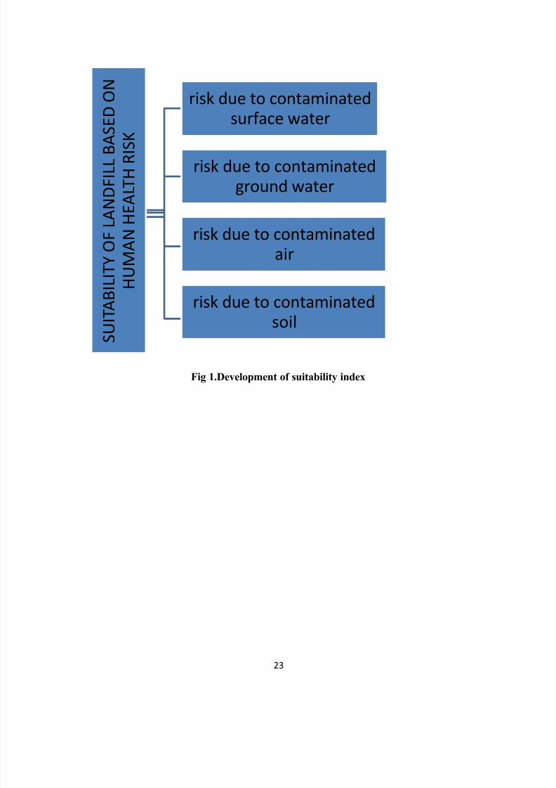
Methodology is based on development of a landfill suitability index- a numerical index
which can rank a site based on suitability for the installation of a landfill. „Suitability‟ means t he
quality of having the properties that are right for a specific purpose. Here it can be defined as the
quality of having minimal human health risk by the installation of a municipal solid waste
landfill.
There are several environmental components that may get affected by the emissions from
landfills and jeopardize human health and living. - Surface water, ground water, soil, air, etc.
Obviously, the suitability of the landfill is related inversely to the risk caused to the human
population by the contamination of each of the environmental components. Let Landfill
Suitability index be a numerical index which indicates how less is the risk caused to the
surrounding human population by the siting of the landfill. The contribution from each

8/13/2019 2nd Report 1st Copy
http://slidepdf.com/reader/full/2nd-report-1st-copy 22/29
22
environmental component depends upon exposure conditions. Then, to that numerical index,
there will be contributions of different intensities from each of the environmental component.
Some mathematical relations have to be developed between these and the existing legislations in
India for landfill siting (fig 1).
Geographical information systems software along with other software tools will be used
to develop the model. Collected data regarding Hazard and Exposure conditions in a sample site
can be used for application of the developed method.
The first objective of this work is to assess GW vulnerability to pollution in a shallow
aquifer using the DRASTIC GIS model in combination with hydro-geological data layers i.e.
Depth of water, net Recharge, Aquifer media, Soil media, Topography, Impact of vadose zone
and hydraulic conductivity.
5.1 Why DRASTIC?
Evaluating and comparing all the methods, 5 simple parameters and 3 complex
parameters are used in DRASTIC method and it uses simple additive scoring algorithm. The data
are easily available, so it proves to be suitable for Indian conditions. We have already seen in
table 1 of section 2.6, that DRASTIC can be used as an ultimate method for landfill site
selection. The disadvantage is it considers the groundwater component only. So, in this work,
DRASTIC will be used for assessing groundwater vulnerability part only.
8/13/2019 2nd Report 1st Copy
http://slidepdf.com/reader/full/2nd-report-1st-copy 23/29
23
Fig 1.Development of suitability index
S U I T A B I L I T Y O F L A N D F I L L B A S E D O N
H U
M A N H E A L T H R I S K
risk due to contaminatedsurface water
risk due to contaminatedground water
risk due to contaminatedair
risk due to contaminatedsoil

8/13/2019 2nd Report 1st Copy
http://slidepdf.com/reader/full/2nd-report-1st-copy 24/29
24
5.2 Stages of work
1) Literature review
2) Data collection
3) Definition of Variables4) Familiarization with modeling tools.
5) Incorporation of hazard and exposure conditions of
- Groundwater
- Surface water
- Air
- Soil
6) Correlation of variables to suitability index
7) Development of model.
8) Application of model to a sample site.
9) Draft preparation and thesis submission
Fig 2.Compacted flow chart
Data collection
Development of model
for ranking landfill sites
pplication of model
8/13/2019 2nd Report 1st Copy
http://slidepdf.com/reader/full/2nd-report-1st-copy 25/29
25
6. SUMMARY
The final functional element in the waste management system is waste disposal. Landfill has
been widely used for municipal solid waste (MSW) disposal all over the world. If not carried out
to sufficiently high standards, landfilling has the potential to have an adverse impact on the
environment. So the site selection for landfill is an important and complex process. The aim of
this work is to develop a methodology that can be used to rank the suitability of landfill sites
based on human health risk. Development of a model for landfill siting or evaluation will be
done with the aid of GIS. The application of this methodology will result in a Landfill Suitability
Index, which reflects the overall environmental impact of a landfill on its surroundings.
8/13/2019 2nd Report 1st Copy
http://slidepdf.com/reader/full/2nd-report-1st-copy 26/29
26
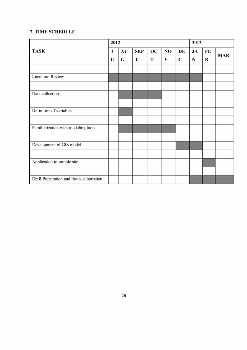
7. TIME SCHEDULE
TASK
2012 2013
J
U
AU
G
SEP
T
OC
T
NO
V
DE
C
JA
N
FE
B
MAR
Literature Review
Data collection
Definition of variables
Familiarization with modeling tools
Development of GIS model
Application to sample site
Draft Preparation and thesis submission
8/13/2019 2nd Report 1st Copy
http://slidepdf.com/reader/full/2nd-report-1st-copy 27/29
27
REFERENCES
1. Abedinzadeh,Niloofer, Farhmia Abedinzadeh, and Tooba Abedi. “Environmental
diagnosis by Eviave Methodology to Planning and Decision-Making for Municipal Waste
Landfills in Iran. ”,World Applied Sciences Journal 21.11 (2013): 1640-1650.
2. Ahsan,A., and M. Alamgir. “ Solid Waste Management Plan for Indian Mega Cities .”
Indian Journal of Environmental Protection , Vol. 19, No. 2,(1999) pp. 90-95.
3. Al-Jarrah,O., and H. Abu- Qdais. “ Municipal Solid Waste Landfill Siting Using
Intelligent System .” Waste Management Journal, 26 (3) (2006) 299 – 306.
4. Ayub,Sohail, and Afzal Hussain Khan. “ Landfill Practice in India: A Review. ” Journal of
Chemical and Pharmaceutical Research , 3(4) (2011):270-279.5. Benabdallah,Salah and J. Wright. “Multiple Subregion Allocation Models .” Urban
Planning Dev., ASCE 118(1992),24 – 40.
6. Charnpratheep,Krerkpong, Qiming Zhou, and Barry Garner. “Preliminary Landfill Site
Screening Using Fuzzy Geographical Information Systems. ” Waste Management and
Research 15(2)(1997), 197 – 215.
7. Bharti, Dattatraya, Isub Ali Sayyad, G. G. Gaikwad, D. R. Taikar and J. Dhore . “ Physico-Chemical Characteristics of Bore Well Water Quality. ” J. Chem. Pharm. Res,
3(2)(2011),922-927.
8. Dave1, R. S., S. D. Vedia, D.G. Acha rya, G.R. Jain and M.T. Machhar. “ Water Quality
Assessment Studies with Reference to Nitrate Contamination of Modasa Taluka of
Sabarkantha District (North Gujarat) . ” Chem. Pharm. Res, 3(1)(2011),238-241.
9. Department of Water Affairs & Forestry- South Africa. “Minimum R equirements for
Waste Disposal by Landfill. ” Second Edition.
10. Diamond, J. T., and J. R. Wright. “Efficient land allocation.” J. Urban Planning Dev.
ASCE 115 (2)(1989),81 – 96.
11. Energy Information Administration. “ Emissions of Greenhouse Gases in the United
States Comparison of Global Warming Potentials .” The IPCC‟s Second And Third
Assessment Reports,2003.
8/13/2019 2nd Report 1st Copy
http://slidepdf.com/reader/full/2nd-report-1st-copy 28/29
28
12. George,Ligi, “Evaluation of the Groundwater Vulnerability of Calicut Corporation using
DRASTIC method,GIS and MODFLOW” M Tech thesis, NIT Calicut,2008 .
13. Hadjibiros,Kimon, D. Dermatas, C. S. Laspidou. “ Municipal Solid Waste Management
And Landfill Site Selection In Greece: Irrationality Versus Efficiency. ” Global NEST
Journal, Vol 13, No 2, (2011),pp 150-161.
14. “Health impacts of solid waste”, accessed in 20/9/2013, http://edugreen.teri.res.in.
15. Joy,Joone. “Estimating the Overall Cost of a Landfill .” Post graduate dissertation,NIT
Calicut, Kerala, India,2009.
16. Kao,J. J.. “ Multifactor Spati al Analysis For Landfill Siting.” Journal of Environmental
Engineering 122 (10)(1996), 902 – 908.
17. Kontos,T.D., D.P. Komilis, C. P. Halvadakis, “Siting MSW Landfills with a Spatial
Multiple Criteria Analysis Methodology. ” Waste Management , 25 (2005)818 – 832.18. Lane, N., M. William ASCE, and McDonald R Robert. “ Land Suitability Analysis:
Landfill Siting. ” Journal of Urban Planning and Development 109, (1983),50.
19. Lee, Fred G., and Anne Jones Lee. “Guidance on the Evaluation of the Potential Impacts
of a Proposed Landfill” accessed in 19/8/2013 http://www.usda.gov/rus/water .
20. Lin,H. Y. , and J. J. Kado. 1998. “A Vector-Based Spatial Model for Landfill Siting ”
Journal of Hazardous Materials 58(1998),3 – 14.
21. Ministry of the Environment and Forests, Government of India. “Management of
Municipal Solid Wastes” accessed in 19/8/2013.
http://envfor.nic.in/legis/hsm/mswmhr.html.
22. Ministry of Urban Development,Government of India “Principles of Municipal Solid
Waste Management,chapter 2 and 17.” accessed in 19/8/2013. http://www.moud.gov.in.
23. Minor,S.D., and T. L. Jacobs. “ Optimal Land Allocation For Solid- And Hazardous-
Waste Landfill Siting. ” J. Environ. Eng., ASCE 1209(5 ) (1994) ,1095 – 1108.
24. Mor, S., K. Ravindra, A. D. Visscher, R. P. Dahiya, and A. Chandra. “Municipal Solid
Waste Characterization and its Assessment for Potential Methane Generation: A case
study ” Journal of Science of the Total Environment 2006, 371 (1)(2006) , 1 – 10.
25. Nidhi, S., S. N. Misra, and R. N. Shukla.2011. “Physico-Chemical and Bacteriological
Analysis of Water Quality under Different Environmental Conditions. ” J. Chem. Pharm.
Res. , , 3(2)(2011):162-167.
8/13/2019 2nd Report 1st Copy
http://slidepdf.com/reader/full/2nd-report-1st-copy 29/29
26. Raje, D.V., P. D. Wakhare, A. W. Dishpande, and A. D. Bhide . “ An Approach to
Access Level of Satisfaction of the Residents in Relation to SWM System .” India. Journal
of Waste Management and Research 19(2001),12 – 19.
27. Siddiqui, M. Z., J. W. Everett, and B. E. Vieux. “Landfill siting using Geographic
Information Systmes: a Demonstration. ” J. Environ. Eng .,122 (6)(1996), 515-523.
28. Telkapalliwar,N. G., and B. S hende. “ Studies on Some Physico-Chemical Parameters of
Bore Wells Water in Gondpipri Region (Maharashtra). ” J. Chem. Pharm.
Res., 3(1)(2011):176-179.
29. Turkar,S. S., D. Bharti, G. S. Gaikwad. “ Various Methods Involved in Waste Water
Treatment to Control Water Pollution. ” J. Chem. Pharm. Res., 3(2)(2011):58-65.
30. Vaillancourt, K., and J. P. Waaub. “Environmental Site Evaluation of Waste
Management Facilities Embedded into EUG_EENE Model: A Multi-Criteria Approach. ” European Journal of Operational Research, 139(2002) 436-448.
31. Wright, J., C. Revelle, J. Cohon , “A Multi-Objective Integer Programming Model For the
Land Acquisition Problem. ” Regional Sci. Urban Econ .,13 (1983) 31 – 53.
32. Zamoranoa, M., E. Molero, A. Hurtado, A. Grindlay and A. Ramos. “ Evaluation of a
municipal landfill site in Southern Spain with GIS-aided methodology .” Journal of
hazardous materials , 160 (2008) 473 – 481.
33. Rao, S. M., & Mamatha, P. (2004). Water quality in sustainable water
management.Current Science, 87(7), 942 – 947.
34.