3-9-53. manasota key zoning district overlay. (a) definitions. documents...1 3-9-53. – manasota...
TRANSCRIPT

1
3-9-53. – Manasota Key zoning district overlay.
(a) Definitions. When terms are defined both in this Section 3-9-53 and elsewhere in the
County Code, definitions for such terms in this subsection shall control. The following terms
shall have the meanings set forth in this subsection:
Advisory committee shall mean the Manasota and Sandpiper Key Advisory Committee
established by the board on October 12, 2004 pursuant to Resolution Number 2004-212.
Appurtenances shall mean something added to another, more important thing on a building
that is customarily incidental and subordinate to a principal building.
Building setback calculation shall mean the methodology used in the Overlay Code to
determine the stepped setback required from the property line for a building based on building
height and stepped setback calculation points.
Driveway shall mean a permeable surface designed for use by vehicles that connect a road
to a structure.
Driveway crossover shall mean that portion of a driveway located on a setback.
Height, Building or Structure in this Code shall mean the distance from 0 feet NGVD to the
top of the highest constructed element.
Highest constructed element shall mean the highest point of a building or the highest point of
any rooftop livable space or appurtenances thereto.
Manasota Key Overlay Code shall mean the Manasota and Sandpiper Key Zoning District
Overlay Code established by section 3-9-53 and as amended into the County Code.
Manasota Key shall mean the land located south of the Sarasota-Charlotte County line,
west of Sandpiper Key, north of Stump Pass Beach State Park and east of the Gulf of Mexico.
Manasota commercial general or MCG shall mean the commercial general zoning district
established by the overlay code.
Manasota commercial tourist or MCT shall mean the commercial tourist zoning district
established by the overlay code.
Manasota environmentally sensitive or MES shall mean the environmentally sensitive
zoning district established by the overlay code.
Manasota multifamily or MMF shall mean the multifamily zoning districts established by
the overlay code.

2
Manasota planned development or MPD shall mean the planned development zoning
district established by the Overlay Code.
Manasota single-family or MSF shall mean the single-family zoning district established by
the overlay code.
Maximum Building Height within the Manasota and Sandpiper Key Overlay District shall
mean the building height as measured from 0 feet NGVD to the top of the highest constructed
element.
Maximum Building Height Calculation means the height of a building measured from Zero
NGVD to the top of the highest constructed element which is the highest point of a building or
the highest point of any rooftop livable space or appurtenances thereto.
Minimum Finished Floor Elevation shall mean the lowest floor for which a building permit
may be issued which on Manasota Key in the A-Zones is the minimum lowest floor elevation;
and in the V-Zone (governed by Florida DEP seaward of the coastal construction control line) is
the least horizontal shore parallel structural member plus the thickness of the structure which for
this code shall be a vertical measurement of 2 feet from the lowest horizontal structural
member.
NGVD shall mean the National Geodetic Vertical Datum on the effective date of this
overlay.
Overlay code shall mean the Manasota and Sandpiper Key Zoning District Overlay Code
established by this section 3-9-53.
Peripheral Landscape Strip shall mean the required green open area of at least ten (10)
feet in width located immediately adjacent and parallel to all sides of the lot boundary that is free
of encroachments.
Plan shall mean the Manasota Community Plan as accepted by the board on September
21, 2004 and as it may be amended from time to time.
Rooftop livable space shall mean all usable areas upon or above the roof of a building
including but not limited to decks, swimming pools, walls, fences and railings.
Sandpiper Key shall mean the land area located south and west of the Intracoastal
Waterway, east of the Lemon Bay Channel and north of Manasota Key.
Setback shall mean the minimum horizontal distance between the road, rear or side lot
lines and the front, rear or side lines of the building.
Sidewalk shall mean a linear surface within and adjacent to or outside and alongside the
boundary of a public or private thoroughfare that is designed for use by pedestrians.

3
Structure shall mean any construction or any production or piece of work artificially built up
or composed of parts joined together in some definite manner. "Structure" includes "building,"
as well as other things constructed or erected on the ground, attached to something having
location on the ground or requiring construction or erection on the ground.
Structure height – See Height, structure above.
Walkway shall mean a linear surface utilized by pedestrians for passage over dunes and other
beach areas.
(b) Establishment; short title: The Manasota and Sandpiper Key Zoning District Overlay Code
is hereby established. The short title of this section shall be “Manasota Key Overlay Code.”
(c) Intent. The intent of the Manasota Key Overlay Code is to implement the goals, objectives,
and policies of the Manasota Key Community Plan to preserve and protect the existing low-
density development and to blend future development with it in an appropriate manner.
(d) Boundary. The area affected by the Manasota Key Overlay Code shall be the area depicted
as Manasota and Sandpiper Key on Smart Charlotte 2050 FLUM Series Map #9: Barrier Island
Overlay District.
(e) Applicability; conflict with other ordinances. The overlay code shall apply to
development and redevelopment on the islands together with all other matters referenced in the
overlay code. The terms development and redevelopment shall be construed liberally and shall
include any plat, special exception, variance, waiver, site plan approval, building or sign permit,
or any other official action of Charlotte County that has the effect of permitting development
and/or redevelopment or any application for any of the preceding matters. The overlay code
shall apply to the preceding matters notwithstanding the application of another provision(s) of
the County Code to said matters. Except where expressly provided herein, the terms of the
overlay code shall supersede and control in the event and to the extent of a conflict between the
overlay code and another provision of the County Code.
Zoning Districts
The following zoning districts are the only zoning districts permitted within the Manasota and
Sandpiper Key Overlay District and shall only be permitted in the Manasota and Sandpiper Key
Overlay District.

4
(1) Open Space & Rural Districts
Manasota Environmentally Sensitive (MES)
(2) Residential Districts
Manasota Single-Family 1 (MSF-1)
Manasota Single-Family 3.5 (MSF-3.5)
Manasota Single-Family 5 (MSF-5)
Manasota Multifamily 7.5 (MMF-7.5)
Manasota Multifamily 10 (MMF-10)
Manasota Multifamily 12 (MMF-12)
(3) Commercial Districts
Manasota Commercial General (MCG)
Manasota Commercial Tourist (MCT)
(4) Special Districts
Manasota Planned Development (MPD)
(f) Intent of Manasota and Sandpiper Key Overlay Districts:
(1) The intent of the MES district is to preserve and protect certain land and water areas which
have overriding ecological, hydrological, or physiographic importance to the public at large. It is
intended to preserve and protect open spaces, park lands, wilderness areas, marshlands,
watersheds and water recharge areas, scenic areas, beaches and native flora and fauna. It is
intended to allow limited public/private recreational/educational uses and their incidental
accessory uses and structures.
(2) The intent of the MSF district is to provide single-family residential dwellings and for other
uses normally associated with single-family residential dwellings. Nothing herein is intended to
prevent the grouping of lots or parcels for residential single-family uses.
(3) The intent of the MMF district is to provide low or medium-density residential districts with
emphasis on multifamily use. There are variations among the MMF districts in requirements
which include differing lot areas, width, yards and uses.
(4) The intent of MCG district is to provide areas in which the customary and traditional conduct
of trade, retail sales and commerce may be carried on without disruption by the encroachment
and intrusion of incompatible residential uses and protected from the adverse effects of
undesirable industrial uses.
(5) The intent of the MCT district is to permit the designation of suitable locations for and to
facilitate the proper development and use of land for the commercial provision of
5
accommodations and services for tourists and other visitors and short-term or seasonal
residents. The term "accommodations" is intended to include housing and various amenities,
including recreational facilities and local retail trade in goods and service both general and
specific to the locality/tourist attraction or principal activities. Areas designated MCT are
expected to be located near or adjacent to a tourist attraction such as Gulf beach frontage,
major public or private parks, and other recreational or scenic resources.
(6) The intent of the MPD district is to retain standards that maintain current densities and
zoning districts consistent with the goals of the Manasota Key Community Plan and provide
standards for new planned developments.
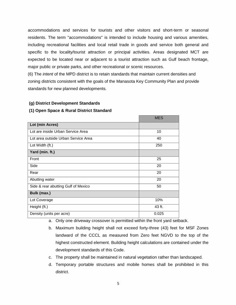
(g) District Development Standards
(1) Open Space & Rural District Standard
MES
Lot (min Acres)
Lot are inside Urban Service Area 10
Lot area outside Urban Service Area 40
Lot Width (ft.) 250
Yard (min. ft.)
Front 25
Side 20
Rear 20
Abutting water 20
Side & rear abutting Gulf of Mexico 50
Bulk (max.)
Lot Coverage 10%
Height (ft.) 43 ft.
Density (units per acre) 0.025
a. Only one driveway crossover is permitted within the front yard setback.
b. Maximum building height shall not exceed forty-three (43) feet for MSF Zones
landward of the CCCL as measured from Zero feet NGVD to the top of the
highest constructed element. Building height calculations are contained under the
development standards of this Code.
c. The property shall be maintained in natural vegetation rather than landscaped.
d. Temporary portable structures and mobile homes shall be prohibited in this
district.

6
(2) Residential District Standards
A. Single-family
MSF-1 MSF-3.5 MSF-5 Non-Conforming
lot (min)
Lot area (sq.ft.) 43,560 12,445 8,712 Less than 8,712
Lot Width (ft.) 125 80 70 Less than 70
Yard (min. ft.)
front 25 25 25 25
Side yard
(interior)
Stepped/10
See Below
Stepped/10
ft. See
Below
Stepped/10
See Below 10
Side Yard (street) 20 15 15 15
Rear yard
(interior)
Stepped/20
See Below
Stepped/20
ft. See
Below
Stepped/20
See Below 10
Rear Yard (street) 25 25 25 25
Abutting water
20/50GM
See Below
20/50GM
See Below
20/50GM
See Below
20/50GM
See Below
Peripheral
Landscape Strip 10 10 10 10
Bulk (max.)
Lot coverage 35% 35% 35% 35%
Height (ft.)
48/43
See Below
48/43
See Below
48/43
See Below
48/43
See Below
Density
(units/acre) 1 3.5 5 Same as District
a. Side interior setbacks shall be stepped back as a function of building height as
measured by the setback calculation provisions under the development
standards of this Code, but shall be no less than 10 feet.
b. Rear interior setbacks shall be stepped back as a function of building height as
measured by the setback calculation provisions under the development
standards of this Code, but shall be no less than 20 feet.
c. Side and rear yards that abut any water but the Gulf of Mexico shall be at least
20 feet, and those that abut the Gulf of Mexico (GM) shall be at least 50 feet.
7
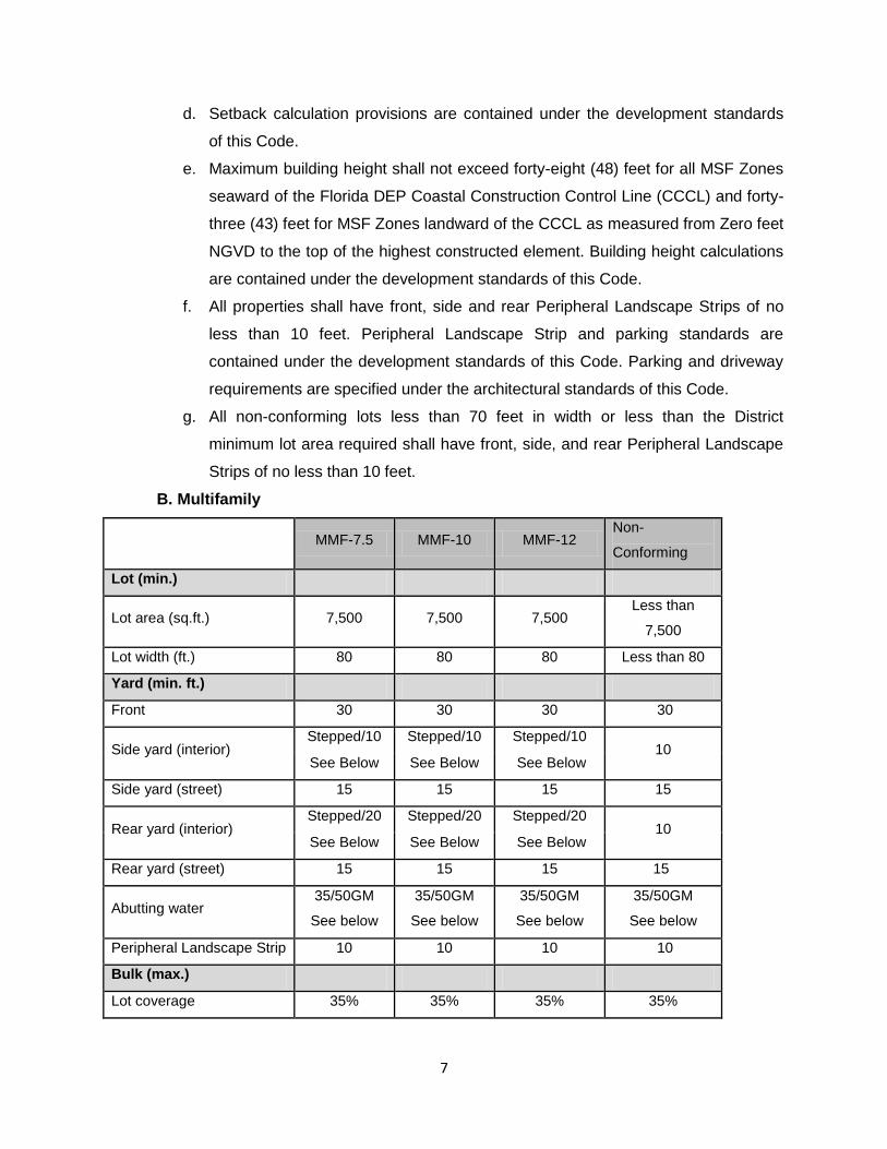
d. Setback calculation provisions are contained under the development standards
of this Code.
e. Maximum building height shall not exceed forty-eight (48) feet for all MSF Zones
seaward of the Florida DEP Coastal Construction Control Line (CCCL) and forty-
three (43) feet for MSF Zones landward of the CCCL as measured from Zero feet
NGVD to the top of the highest constructed element. Building height calculations
are contained under the development standards of this Code.
f. All properties shall have front, side and rear Peripheral Landscape Strips of no
less than 10 feet. Peripheral Landscape Strip and parking standards are
contained under the development standards of this Code. Parking and driveway
requirements are specified under the architectural standards of this Code.
g. All non-conforming lots less than 70 feet in width or less than the District
minimum lot area required shall have front, side, and rear Peripheral Landscape
Strips of no less than 10 feet.
B. Multifamily
MMF-7.5 MMF-10 MMF-12 Non-
Conforming
Lot (min.)
Lot area (sq.ft.) 7,500 7,500 7,500 Less than
7,500
Lot width (ft.) 80 80 80 Less than 80
Yard (min. ft.)
Front 30 30 30 30
Side yard (interior) Stepped/10 Stepped/10 Stepped/10
10 See Below See Below See Below
Side yard (street) 15 15 15 15
Rear yard (interior) Stepped/20 Stepped/20 Stepped/20
10 See Below See Below See Below
Rear yard (street) 15 15 15 15
Abutting water 35/50GM
See below
35/50GM
See below
35/50GM
See below
35/50GM
See below
Peripheral Landscape Strip 10 10 10 10
Bulk (max.)
Lot coverage 35% 35% 35% 35%
8
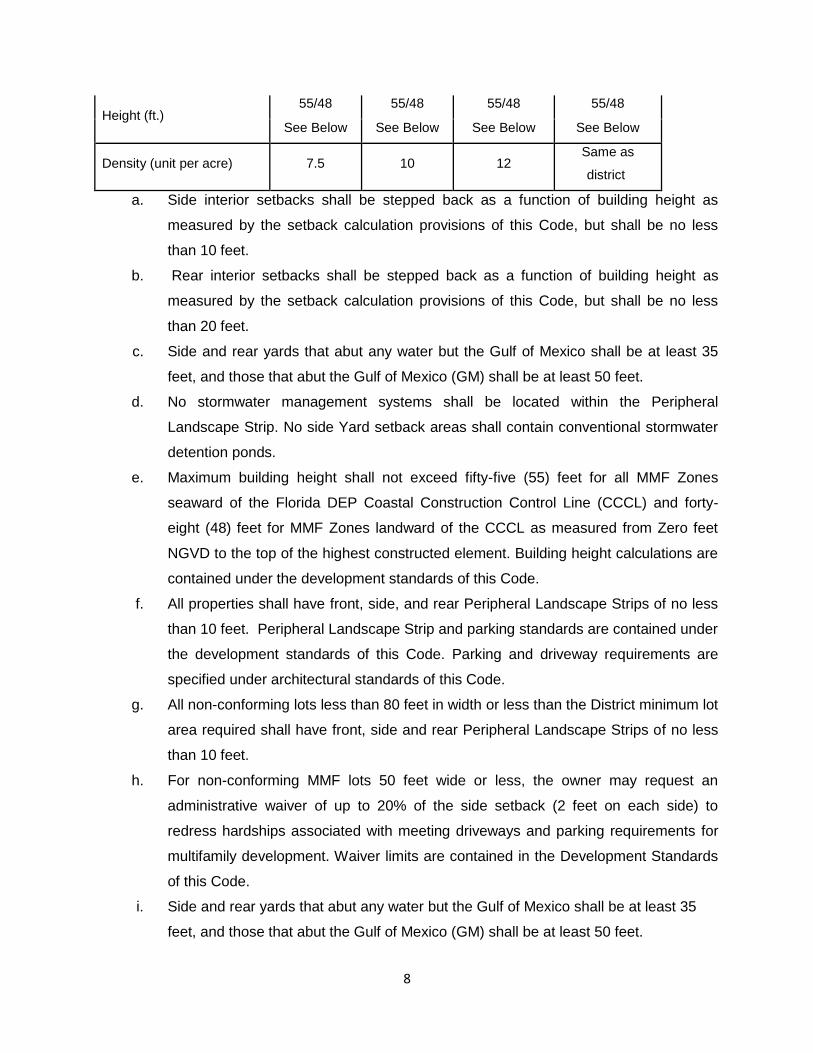
Height (ft.) 55/48 55/48 55/48 55/48
See Below See Below See Below See Below
Density (unit per acre) 7.5 10 12 Same as
district
a. Side interior setbacks shall be stepped back as a function of building height as
measured by the setback calculation provisions of this Code, but shall be no less
than 10 feet.
b. Rear interior setbacks shall be stepped back as a function of building height as
measured by the setback calculation provisions of this Code, but shall be no less
than 20 feet.
c. Side and rear yards that abut any water but the Gulf of Mexico shall be at least 35
feet, and those that abut the Gulf of Mexico (GM) shall be at least 50 feet.
d. No stormwater management systems shall be located within the Peripheral
Landscape Strip. No side Yard setback areas shall contain conventional stormwater
detention ponds.
e. Maximum building height shall not exceed fifty-five (55) feet for all MMF Zones
seaward of the Florida DEP Coastal Construction Control Line (CCCL) and forty-
eight (48) feet for MMF Zones landward of the CCCL as measured from Zero feet
NGVD to the top of the highest constructed element. Building height calculations are
contained under the development standards of this Code.
f. All properties shall have front, side, and rear Peripheral Landscape Strips of no less
than 10 feet. Peripheral Landscape Strip and parking standards are contained under
the development standards of this Code. Parking and driveway requirements are
specified under architectural standards of this Code.
g. All non-conforming lots less than 80 feet in width or less than the District minimum lot
area required shall have front, side and rear Peripheral Landscape Strips of no less
than 10 feet.
h. For non-conforming MMF lots 50 feet wide or less, the owner may request an
administrative waiver of up to 20% of the side setback (2 feet on each side) to
redress hardships associated with meeting driveways and parking requirements for
multifamily development. Waiver limits are contained in the Development Standards
of this Code.
i. Side and rear yards that abut any water but the Gulf of Mexico shall be at least 35
feet, and those that abut the Gulf of Mexico (GM) shall be at least 50 feet.
9
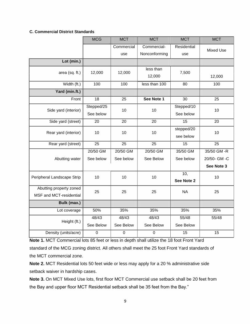
C. Commercial District Standards
MCG MCT MCT MCT MCT
Commercial
use
Commercial-
Nonconforming
Residential
use Mixed Use
Lot (min.)
area (sq. ft.) 12,000 12,000 less than
12,000 7,500
12,000
Width (ft.) 100 100 less than 100 80 100
Yard (min.ft.)
Front 18 25 See Note 1 30 25
Side yard (interior) Stepped/25
10 10 Stepped/10
10 See below See below
Side yard (street) 20 20 20 15 20
Rear yard (interior) 10 10 10 stepped/20
10 see below
Rear yard (street) 25 25 25 15 25
Abutting water
20/50 GM 20/50 GM 20/50 GM 35/50 GM 35/50 GM -R
See below See below See Below See below 20/50- GM -C
See Note 3
Peripheral Landscape Strip 10 10 10 10,
See Note 2 10
Abutting property zoned
MSF and MCT-residential 25 25 25 NA 25
Bulk (max.)
Lot coverage 50% 35% 35% 35% 35%
Height (ft.) 48/43 48/43 48/43 55/48 55/48
See Below See Below See Below See Below
Density (units/acre) 0 0 0 15 15
Note 1. MCT Commercial lots 85 feet or less in depth shall utilize the 18 foot Front Yard
standard of the MCG zoning district. All others shall meet the 25 foot Front Yard standards of
the MCT commercial zone.
Note 2. MCT Residential lots 50 feet wide or less may apply for a 20 % administrative side
setback waiver in hardship cases.
Note 3. On MCT Mixed Use lots, first floor MCT Commercial use setback shall be 20 feet from
the Bay and upper floor MCT Residential setback shall be 35 feet from the Bay.”

10
a. Manasota Commercial General (MCG)
i. Side yard interior setbacks shall be stepped back as a function of building height as
measured by the setback calculation provisions of this Code, but shall be no less than
25 feet.
ii. Side and rear yards that abut any water but the Gulf of Mexico shall be at least 20 feet,
and those that abut the Gulf of Mexico (GM) shall be at least 50 feet.
iii. Setbacks abutting property zoned Residential shall be equal to 25 feet.
iv. Setback calculation provisions are contained under the development standards of this
Code.
v. Maximum building height shall not exceed forty-eight (48) feet for all MCG Zones
seaward of the Florida DEP Coastal Construction Control Line (CCCL) and forty-three
(43) feet for MCG Zones landward of the CCCL as measured from Zero feet NGVD to
the top of the highest constructed element. Building height calculations are contained
under the development standards of this Code.
vi. All properties shall have front, side, and rear Peripheral Landscape Strips of no less than
10 feet. Peripheral Landscape Strip and parking standards are contained under the
development standards of this Code.
vii. All non-conforming MCG lots less than 100 feet in width or less than the District
minimum lot area required shall have front, side, and rear Peripheral Landscape Strips
of no less than 10 feet.
b. Manasota Commercial Tourist (MCT)
i. This district is a mixed-use district. Commercial and residential uses are permitted and
the site may be entirely commercial, entirely residential, or mixed use, using the
appropriate development standards.
ii. Setbacks
a) Side interior setbacks for residential uses shall be stepped back as a function of
building height as measured by the setback calculation provisions of this Code,
but shall be no less than 10 feet.
b) Rear interior setbacks for residential uses shall be stepped back as a function of
building height as measured by the setback calculation provisions of this Code,
but shall be no less than 15 feet.
c) Side and rear yards that abut any water but the Gulf of Mexico shall be at least
35 feet, and those that abut the Gulf of Mexico (GM) shall be at least 50 feet.

11
iii. Setbacks for MCT-Commercial and MCT-Mixed Use abutting property zoned Residential
shall be 25 feet.
iv. Setback calculation provisions are contained under the development standards of this
Code.
v. Maximum building height shall not exceed forty-eight (48) feet of structure height for
MCT-Commercial Districts seaward of the Coastal Construction Control Line; forty-three
(43) feet of structure height for MCT-Commercial Districts landward of the CCCL.
Maximum building height shall not exceed fifty-five (55) feet of structure height for MCT-
Residential and MCT-Mixed Use Districts seaward of the Coastal Construction Control
Line, and forty-eight (48) feet of structure height for MCT-Residential and MCT-Mixed
Use Districts landward of the CCCL. Height shall be measured from Zero feet NGVD to
the top of the highest constructed element. Building height calculations are contained
under the development standards of this Code.
vi. All properties shall have front, side, and rear Peripheral Landscape Strips of no less than
10 feet. Peripheral Landscape Strip and parking standards are contained under the
development standards of this Code. Parking requirements are specified under
Architectural standards of this Code.
vii. All non-conforming MCT-Commercial lots less than 100 feet in width and/or less than the
District minimum lot area required shall have front, side, and rear Peripheral Landscape
Strips of no less than 10 feet.
viii. All non-conforming MCT-Residential lots less than 80 feet in width or less than the
District minimum lot area required shall have front, side, and rear Peripheral Landscape
Strips of no less than 10 feet.
ix. All non-conforming MCT-residential lots shall be required to conform to the non-
conforming standards as set forth in this Code as they apply to MMF-12 development
standards.
x. For non-conforming MCT-residential lots 50 feet wide or less, the owner may request an
administrative waiver of up to 20% of the side setback (2 feet on each side) to redress
hardships associated with meeting driveways and parking requirements for multifamily
development. Waiver limits are contained in the Development Standards of this Code.
Special Purpose District
Manasota Planned Development Zoning and Land Uses (MPD)
Lot Requirements MPD

12
Lot (min.)
Lot area (sq. ft.) 150,000
Yard (min. ft.)
Front 40
Side, Rear or between structures Stepped/25 See Below
Abutting Lemon Bay Stepped/35 See Below
Abutting the Gulf of Mexico 50
Bulk (max.)
Lot coverage 35%
Floor Area Ratio 0.6
Building Height (ft.)
48 ft./43 ft. for land previously zoned MSF, and 55/48 ft.
for MMF and MCT-residential and MCT-Mixed Use.
See Below
Density No greater than existing lot density permitted
a. Setback calculation provisions are contained under the development standards of this Code.
b. Maximum building height shall not exceed forty-eight (48) feet for lands previously MSF Zones
seaward of the Florida DEP Coastal Construction Control Line (CCCL) and forty-three (43) feet
for MSF Zones landward of the CCCL. Maximum height shall not exceed fifty-five (55) feet for
lands previously MMF and MCT-Residential Zones seaward of the CCCL and forty-eight (48)
feet for MMF and MCT-Residential landward of the CCCL. MCT-Mixed Use developments shall
not exceed the fifty-five (55) seaward of the CCCL and forty-eight (48) feet landward of the
CCCL and shall include one floor of commercial use. Maximum height shall be measured from
Zero feet NGVD to the top of the highest constructed element. Building height calculations are
contained under the development standards of this Code.
c. Floor-area ratio shall be calculated excluding all submerged portions of the MPD site.
d. Lands subject to a MPD rezoning shall meet the minimum lot frontage for the most restrictive
zoning district applicable to the property prior to the rezoning to a MPD.
e. There shall be one (1) main point of access and one emergency entrance per contiguous land
rezoned to MPD.
f. Lands subject to a MPD rezoning shall be contiguous whenever possible. If said lands are not
contiguous, a twenty-five (25) foot MPD setback shall be applicable whenever the proposed
MPD abuts property not zoned MPD. Said MPD setback shall contain the uses and structures
permissible in the peripheral landscaping strip, as defined in this section. Front and rear yard
areas may contain pools or other accessory structures as set forth in the Overlay Code.
13
g. A minimum of twenty (20) percent of the entire MPD parcel shall be open space, which shall
include environmentally sensitive habitats and vegetated areas and shall not be encumbered by
an impervious surface. Easements and parking areas are not included in open space
calculations.
h. When the minimum MPD setbacks above conflict with other required setbacks, including coastal
construction control line (CCCL) regulations, and other applicable regulations, the enforceable
setback shall be that which results in a greater distance from property lines to structures.
i. Density bonuses. Density bonuses shall not be applicable in the Manasota and Sandpiper Key
Code.
j. Failure to obtain final approval for a MPD within 3 years with no extension from concept plan
approval may cause the County to initiate a rezoning of the property, which shall revert to the
zoning district back to its original designation.
k. Parking Requirements: i) All land coverings, including parking and circulation areas, must be
pervious. This requirement shall not apply to areas under the footprints of approved structures.
ii) parking standards are contained under the development standards of this Code. iii) Parking
areas shall be located on the same parcel as the proposed use. Parking shall not be a principal
use on any given parcel.
l. Principle Uses and Structures: Uses and structures permissible under the MPD district shall be
equivalent to those that would otherwise be permissible on the property or properties prior to
rezoning to a MPD. In no case shall multi-family dwellings replace single-family dwellings.
However, multi-family zones may be rezoned to single-family.
m. Accessory Uses and Structures: Uses and structures that are customarily accessory and clearly
incidental to the principal uses approved for the MPD are permissible in this district. Where a
MPD contains residential uses, noncommercial piers, docks and wharves are allowed. Such
marine structures shall be permitted according to County Code and a recommendation by the
Manasota and Sandpiper Key Advisory Committee.
n. MPD developments are subject to all other development and design standards contained in the
Overlay Code.
(h) Permitted Uses and Use Table
(1) The permitted uses in the Manasota and Sandpiper Key Overlay Districts are identified in the use table.
USE TABLE
USE
CATEGORIES
SPECIFIC USES MES MSF MMF MCG MCT

14
OPEN & RURAL
USES
Fishing, Fisheries, hatcheries, preserves SE
RESIDENTIAL
USES
Single family, detached, modular P P P
Manufactured home (DCA) P
Cluster Subdivision SE
Duplex P
Multifamily P P
PUBLIC & CIVIC
USES
Emergency Services SE SE SE P P
Public Building SE SE
Fish & WL mgt. area, nature preserve P
game preserve, public & private P
Outdoor Education facility P
Park, recreation facility, park office,
maintenance facility, playground, open
space
SE
Essential Services SE SE P P
COMMERCIAL
USES
Bed and Breakfast 1 or 2 bedroom SE P
Bed and Breakfast 3or more bedrooms P
Hotel, motel, inn P P
Beach clubs without food or sundry sales SE SE P P
Recreation, Indoor P
Recreation, Outdoor P
Recreation vehicle rental, non-motorized P SE
Restaurant P P
15
Bar, cocktail lounge, nightclub, tavern P P
General retail sales & service P SE
Real Estate Services & property
management
P P
Business services SE
Convenience Store P P
Liquor, package store SE SE
Pharmacy P
Specialty Shops (jewelry, gift, clothing,
accessories, etc.)
P P
(2) It is the intent of this section to restrict the allowable uses with the Overlay Code Districts to avoid
trip-generating traffic not related to residential and beach-related tourist uses on this small barrier strip.
(3) Public parks and recreational facilities shall only be allowed in the MES District by special exception
and only if restricted to meet the intent of the MES District.
(4) Paid parking shall be prohibited in MSF and MMF Districts. Leasing or rental of properties on the
islands for short-term parking or long-term storage of vehicles or trailers shall be prohibited. Multi-story
parking garage structures shall be prohibited in all Districts.
(5) Lodges or private clubs shall be prohibited in all Districts and beach clubs shall be allowed only
without food or sundry sales.
(6) Hotel/Motel/Inn uses may have commissary, coffee bar, continental breakfast and other services for
their guests.
(7) Sport marinas and Resort marinas shall be prohibited. However, leasing of dock space in the MCT
district only on lots adjacent to coastal waters not on the Gulf of Mexico is permitted as a special
exception with the following restrictions: no live-aboard dockage; no sale of fuel and lubricants; no
provisions, bait & tackle; no service buildings with laundry facilities, showers, toilets; no rental of
motorized watercraft; and no launching of boats from the site. A condition of the permit is adequate
parking for leased dock spaces.
(8) Unless specifically defined in the above use table, additional uses are prohibited.
(i) Development Review Procedure
(1) Prior to submitting an application to the County for any type of development, for a Special
Exception, or for a Variance, an applicant shall appear before the Manasota and Sandpiper Key
Advisory Committee at a regularly-scheduled public meeting of the Advisory Committee to review,

16
discuss, and receive recommendations from the Advisory Committee regarding the proposed
development’s consistency with the Manasota Key Community Plan and the portions of this Code
specifically applicable to the Manasota and Sandpiper Key Overlay Code. Such request for review shall
be accompanied by documentation required by the Advisory Committee to perform its review. At the
conclusion of the review, the Advisory Committee shall prepare written comments regarding the
proposed development with recommendations or notations, as appropriate, which shall be considered
by the County officials in their deliberations.
(2) All sketches, site plans, or other documentation submitted to the County as part of a development
application shall be consistent with any information submitted to the Advisory Committee for review,
except as such may be revised based upon recommendations made by the Advisory Committee.
(j) Development Standards. These development standards shall apply to all zoning districts within the
Manasota Key Overlay Code.
(1) Uniform Line of Construction. In order to maintain the uniform line of construction of major
structures within the Overlay District, no portion of a residential structure shall be located seaward of
this line, or of a line traced between the corners of the two nearest buildings along the Gulf of Mexico,
except as permitted by DEP.
(2) No-Fill Area. The entire Manasota and Sandpiper Key Overlay District is designated as a No-fill
Area, within which only pilings and stemwalls may be used for all construction, except the minimum
amount of fill necessary within the building footprint and for drainfields associated with on-site waste
treatment and disposal systems.
(3) Permeable Material. With the exception of fences and walls, all ground-level amenities such as
walkways, patios, new private roads, residential driveways, and all parking spaces outside of the
building footprint shall be constructed of permeable materials. Handicapped accessible routes when
required by ADA shall be exempt from this requirement.
(4) Bulk Limitations. No building shall be over 200 feet wide or long in any zoning district.
(5) Open Space/Reservation Area. All development within the Overlay District subject to Site Plan
Review shall include an open space/habitat reservation area equal to five percent of the total area of
the development. No financial contribution in lieu of reservation shall be permitted. Peripheral
Landscape Strips and setbacks may be counted as part of the open space habitat area unless the lot is
greater than one -quarter acre.
(6) Pilings for Structures.
a. Pilings shall conform to construction techniques authorized under the Florida Building Code.
17
b. Pilings for structures throughout Manasota and Sandpiper Key shall be augered into the ground, or
otherwise introduced through contemporary technologies that are shown to reduce the noise and
vibration in sufficient amount to meet the intent of this section.
c. If driving pilings into or onto the ground is proposed,
i) The developer must conduct a detailed geotechnical analysis of the property with a
certification from a geotechnical engineer that the proposed development activity will
have no adverse impacts to adjacent properties; and
ii) Show proof of minimum insurance policy coverage of $1 million per occurrence and $5
million aggregate.
iii) If pile driving is deemed appropriate, the Contractor shall be required to notify by mail
the owner of properties within 300 feet of the outer limits if the subject property and
document existing conditions of structures, prior to the planned development.
iv) The contractor must offer all properties within 300 feet an opportunity to have their
properties inspected by an engineer/inspector prior to pile driving at the builder’s
expense. The intent of this inspection is to create a record of conditions prior to work
occurring.
v) The contractor must also offer all properties within 300 feet an opportunity to have, at
builder’s expense, one on-site seismic reading during the pile driving. A permit to drive
piles (pile driving) will not be issued until the contractor of record provides to the county
by affidavit a list of property owners within 300 feet of the project and addresses along
with a receipt or other proof of mailing and completion of required inspections.
vi) The contractor of record or the owner-builder shall be the party responsible to insure that
the notification and offers have been made and that reasonable effort to comply with
these requirements has occurred. Records of these offers shall be maintained by the
contractor or owner-builder and be made available to the Building and Zoning Division.
vii) In addition, the Contractor shall be required to provide the county with an insurance
certificate showing that the contractor carries comprehensive general liability in the
amount of $1.5 million for each occurrence, and aggregate and property damage in the
amount of $5 million for each occurrence and the $5 million aggregate. For the purposes
of this Section, "pile driven" constitutes a work effort for driving, impact driving or
hammer driving of a pile or similar object into the ground used to support or reinforce
any structure or building including but not limited to treated timber piling, prestressed
concrete piling, steel piling, driven test piling, concrete sheet piling, steel sheet piling,
batter piles, anchor piles, dolphin piles, fender piles and guide piles.
18
viii) The contractor of record must complete an application for pile driving on the form
prescribed by the County. The application shall contain notice provisions, geotechnical
data, and insurance requirements as enumerated above.
ix) Notwithstanding the contents of this subsection, this restriction shall not be applicable to
pilings which are installed onto submerged lands as part of dockage or other marine
structures.
(7) Maximum Building Height, Maximum Stories and Maximum Building Height Calculation.
For the purpose of the Manasota Key Overlay Code, the maximum height of a building shall be
measured from Zero NGVD to the top of the highest constructed element.
a. Highest constructed element is the highest point of a building or the highest point of any rooftop
livable space or appurtenances thereto.
b. Rooftop livable space is all usable areas upon or above the roof of a building including but not
limited to decks, swimming pools, walls, fences and railings. Rooftop livable space shall be
calculated as the actual height of the railing, fence, wall or other rooftop structure.
c. Appurtenance includes but is not limited to ornamental fixtures and fittings and rooftop
equipment such as chimneys, antennas, cupolas, elevators, other mechanical or
communications equipment.
d. Only the following essential appurtenances shall be allowed above the rooftop or highest
constructed element on Manasota Key, to exceed the height cap for the property, in the MMF
and MCT-residential Zones associated with multi-family development: Stairs at no greater than
7 feet; elevator shafts at no greater than 4 feet; AC units at no greater than 4.5 feet; and
mechanical pipes no greater than 2 feet; and lightning rods no greater than 2 feet. These
appurtenances shall not be allowed on any facade. All appurtenances shall be located near the
center of the roof, behind a line of site. The “line of site” shall be 15 degrees from the street front
façade and 30 degrees from all other facades. For all essential appurtenances that exceed the
building height cap, there shall be a horizontal green space offset equal to the square footage of
the height of the appurtenance that protrudes above the highest constructed element times the
widest or longest dimension of the appurtenance. For example, if a stairway protrudes 7 feet
above the highest constructed element and is ten feet at its greatest width or length dimension,
the green space offset required shall be 70 square feet. The green space offset can be located
anywhere on the property outside the Peripheral Landscape Strip.
e. Maximum building height shall not exceed forty-eight (48) feet of structure height for MSF, MCG
and MCT-Commercial Districts seaward of the Coastal Construction Control Line; forty-three
(43) feet of structure height for MSF, MCG and MCT-Commercial Districts landward of the
19
Coastal Construction Control Line; fifty-five (55) feet of structure height for MMF, MCT-
Residential and MCT-Mixed Use Districts seaward of the Coastal Construction Control Line, and
Forty-eight (48) feet of structure height for MMF, MCT-Residential and MCT-Mixed Use Districts
landward of the Coastal Construction Control Line.
f. The maximum number of stories shall be no greater than three (3) stories over parking in MMF,
MCT-Residential and MCT-Mixed Use Zones; and no greater than two (2) stories over parking
in MSF, MCG, and MCT-Commercial Zones.
g. In unique circumstances, due to ground level or elevation requirements, the 48 foot NGVD
height limit may be exceeded such that a 35 foot building envelope may be met from finished
floor to the top of the roof on multi-family development projects landward of the CCCL.
h. In unique circumstances, where any portion of a building is located in two flood zones, one
being seaward of the CCCL, the seaward maximum height shall apply to the entire building.
i. There shall be a required green space off-set of one linear foot for each foot of structure height
in excess of fifty-two (52) feet in the MMF, MCT-Residential and MCT-Mixed Use Zones
seaward of the CCCL to be added in the front yard, in addition to the 10 foot Peripheral
Landscape Strip. For every foot of additional building height over 52 feet, there shall be a
horizontal foot of green space added to the entire width of the front yard immediately adjacent to
the 10 foot Peripheral Landscape Strip. For example, if a structure is built to the maximum
height of 55 feet, seaward of the CCCL, three feet of green space shall be added to the 10 foot
Peripheral Landscape Strip, resulting in a 13 foot green space setback along the entire width of
the front yard.
(8) Building Setback Calculation. The Manasota and Sandpiper Key Overlay District shall be
exempt from the requirements of the Waterfront Code. In the Overlay District, stepped setbacks shall
be required to preserve open vistas on Manasota and Sandpiper Keys by limiting the height and size of
structures in the Overlay District. The stepped setback was designed to eliminate the need for
variances tied to roof overhangs, balcony rails, and other side building features, as well as to allow
flexibility for architectural designs. For single family construction, gambrel and peaked roofs are
encouraged.
a. The following specific stepped setback requirements and calculations shall be applied:
i. Structures shall be set back from the property lines not less than the minimum required
yards in this Code. No structure shall be located within 50 feet of the shoreline of the Gulf
of Mexico. Structures shall be setback from other water bodies not less than the minimum
required by this Code.
20
ii. Stepped setbacks, regardless of actual building elevation required by the Federal
Emergency Management Agency (FEMA) or Florida Department of Environmental
Protection (FDEP), shall be calculated starting at two feet above the minimum finished floor
elevation to the top of the highest constructive element.
iii. Minimum Finished Floor Elevation (MFFE) shall mean the lowest floor for which a building
permit may be issued which on Manasota Key in the A-Zones is the minimum lowest floor
elevation; and in the V-Zone (governed by Florida DEP seaward of the coastal construction
control line) is the least horizontal shore parallel structural member plus the thickness of the
structure which for this code shall be a vertical measurement of 2 feet from the lowest
horizontal structural member.
iv. Setback distance shall be calculated by measuring the horizontal distance from the lot line
to the minimum setback at a specified height from two feet above the minimum finished
floor elevation (MFFE), as specified in the Table below:
Minimum Yard Setback (feet) Setback –Starting Point is 2 feet above MFFE
(Horizontal Setback Distance) (Vertical Height Stepped Setback Range)
Yard setback minimum 2 feet above MFFE to 21 feet above starting point
Yard setback min. plus 3 feet 21 Feet to 30 Feet above starting point
Yard setback min. plus 6 feet 30 Feet above starting point to maximum height cap
depending on the Zoning District and CCCL
v. No encroachments shall be allowed within the building setbacks as calculated herein,
except “guttered roof overhangs” and sunshades may extend two (2) feet into the
setbacks at each stepped setback. For multifamily development on lots 50 foot wide or
less, the stepped setback may be reduced to from 16 feet to 15 feet on one side only,
exclusively to accommodate an elevator shaft or stairwell.
vi. No building may be constructed seaward of the coastal construction control line unless a
permit has been issued by the State.
vii. All principle structures on the same development site, except single-story accessory
structures, shall have a minimum structure-to-structure setback equal to the height of the
taller structure. For this purpose, height of the structure being measured from finished
floor elevation to the peak of the roof. No structure shall exceed the maximum building
height limit in their zoning district.

21
Setback Calculation Methodology & Maximum Height Calculation Methodology
Landward of CCCL
STEPPED NGVD REQUIRED
SETBACK < Side Property Lines > SETBACK
CHANGE
POINT 48 NGHV
•
< > 16'
•
43 NVGD
EXAMPLE: 50 ft. wide lot
SF in MSF Zone & MF in MMF Zone
Starting Point 13' above 0 NGVD
Base Flood Elevation 11' above 0 NGVD
50 FOOT WIDE LOT
STARTING POINT: MFFE Plus 2 feet < > 10'
Calculation Method: 10 ft setback
11' BASE FLOOD ELEVATION Plus 2 feet
Property Landward CCCL - FEMA Base Flood Elevation
Maximum Height Method Structure Setback Method from MFFE
Max Ht. Setback Range
43' MSF Zone from O NVGD Landward of CCCL • 10 feet 2 ft above MFFE - 21 ft
48' MMF Zone from O NGVD landward of CCCL 0 NGVD 13 feet 21 ft-30 ft
Measured to the Highest Constructive Element 16 feet 30 ft - Max Ht.
MFFE-Minimum Fnished Floor Elevation
48'
21' 13'
30'
0' 13'
43'
Setback Calculation Methodology & Maximum Height Calculation Methodology
Seaward of CCCL
STEPPED NGVD REQUIRED
SETBACK < Side Property Lines > SETBACK
CHANGE
POINT
< >
55 NGVD
48 NGVD
EXAMPLE: 50 ft. wide lot
SF in MSF Zone & MF in MFF Zone
MFFE= 21.8 above 0 NGVD
Starting Point 23.8" above 0" NGVD
Seaward of CCCL
50 FOOT WIDE LOT
STARTING POINT: MFFE plus 2 feet < > 10'
Calculation Method: 10 ft setback
DEP-Shore Parallel Least Horizontal Member 19.8
M.F.F.EL. =2 ft above Least Horizontal Member-21.8
Maximum Height Method Structure Setback Method from MFFE
Max Ht. Setback Range
48' MSF Zone from O NVGD seaward of CCCL 10 feet 2 feet above MFFE- 21 ft
55' MMF Zone from O NGVD Seaward of CCCL 13 feet 21 ft-30 ft
Measured to the Highest Constructive Element 16 feet 30 ft - Max Ht.
MFFE-Minimum Fnished Floor Elevation
•
0 NGVD
21' 13'
30'
0' 23.8'
55'
48' •
• 16'

22
(9) Peripheral Landscape Strip. Peripheral Landscape Strips are required on all lots within the
Manasota Overlay District. All properties, conforming and nonconforming, shall have front, side interior
and rear interior Peripheral Landscape Strips of no less than ten (10) feet from the property line.
Peripheral Landscape Strips shall be located immediately adjacent and parallel to all sides of a lot
boundary. All Peripheral Landscape Strips shall be green open areas. No encroachments shall be
allowed within the ten (10) feet Peripheral Landscape Strip including but not limited to structures,
accessory structures, AC units, driveways, parking areas, pools and pool accessories, electrical
equipment, signage, and holding tanks. Neither a structure nor any portion thereof shall be erected or
shall encroach or overhang upon the required Peripheral Landscape Strip. The only exceptions shall
be:
a. Dune walkovers, sidewalks and driveway crossovers, where permissible.
b. Fences,
c. Guttered roof overhangs that may extend two (2) feet into the Peripheral Landscape Strip,
d. Sunshades that may extend two (2) feet into the Peripheral Landscape Strip.
e. For non-conforming multifamily lots 50 feet wide or less, the owner may request an
administrative waiver of up to 20% of the side setback (2 feet on each side) to redress
hardships associated with meeting driveways and parking requirements for multifamily
development. Waiver limits are as follows: No portion of the waiver areas shall be used for
habitable space, for an increase in building envelope of livable area from the first floor to the
highest constructed element or be permanently enclosed or roofed, and; the waiver request
must document need for additional space exclusively for parking and driveway use that does
not increase the livable space envelope and offers the least invasive design option
regarding encroachment into the side Peripheral Landscape Strips.
(10) Yard setbacks. Yard setbacks, greater than ten feet Peripheral Landscape Strip, shall be required
for structures based on zoning district minimum yard requirements, abutting properties, abutting water,
and building height requirement of the Overlay Code. No primary structures shall be allowed to
encroach within the greater yard building setback area, however appurtenances and mechanical
equipment for the primary structure, which are typically allowed within required yards may be located
within the greater yard setback. Accessory structures, parking, and driveways may be located within the
greater yard building setback area as long as County Codes and the Overlay Code district standards
and architectural standards are met.
11) Accessory Structures. No accessory structures shall be allowed within the ten (10) feet Peripheral
Landscape Strip. All accessory structures must conform to the side and rear setback requirements of
the appropriate zoning district. Detached permanent garages must conform to the front setback

23
requirements of the appropriate zoning district. All other accessory structures must be located behind
the leading edge of the living area of the principal structure. The only except is on lots 300 feet or
greater in depth which may have screened accessory structures located in front of the building façade
provided they are located at least 150 feet from the county right of way. Other accessory structure
requirements are contained under the Architectural Design Standards below. Multifamily developments
when permitted in any zoning district are permitted to contain a clubhouse, recreation room or similar
community room to serve the residents of the development.
(12) Nonconforming Lots. It is the intent of this section to specify provisions of the Overlay Code that
supersede the county nonconforming provisions and exceptions to Yards provisions and which sections
of the county code remain in place. It is also the intent to include provisions unique to nonconforming
lots in the Overlay boundary. Other than the administrative waiver provided for in this Overlay code, it
is the intent that all lots contain a 10 foot Peripheral Landscape Strip.
A) Within the Manasota and Sandpiper Key Overlay District, the provisions of the County Code
requiring a variance to build on a lot less than 5,000 square feet or less than 50 feet in width shall not
apply as long as the building conforms to the requirements for the zoning district in which the lot is
located.
B) The minimum side yard interior setbacks in all districts for conforming and nonconforming lots,
including lots less than 5,000 square feet shall be 10 feet. The only exception is provided for under the
administrative waiver procedure for MMF and MCT-residential lots in this Code. In these cases,
documentation shall be provided to indicate why the administrative waiver is warranted; and an
administrative variance shall be not granted in addition to the administrative waiver.
C) The variance provisions of the County Code under 3-9-6.1 provide for relief in hardship cases for
nonconforming lots in the Overlay Code. The administrative variance under 3-9-6.1 (g) shall not be
permitted for side yard variances which result in a side yard of less than 10 feet, and the provisions
contained in 3-9-10.c.5.c and 3-9-75(2) shall not apply when they would result in a side yard of less
than 10 feet.
(13) Parking Standards. For any residential development within the Overlay District, each residential
dwelling unit shall provide a minimum of two (2) spaces per unit. Multifamily developments shall provide
additional parking spaces for services and guests. Service parking requirements shall be the lowest
whole number that is greater than or equal to ten (10) percent of the number of units contained within
the multifamily project. Guest parking requirements shall be the lowest whole number that is greater
than or equal to twenty (20) percent of the number of units contained within the multifamily project. At
least one (1) of the guest parking spaces as required by this section shall be handicapped accessible.
Beach access points on the islands shall not be obstructed by parked cars or any other barriers.
24
Parking of unlicensed or unregistered automobiles, recreational vehicles, boats and/or trailers shall be
prohibited.
(14) Disaster Recovery. Following a natural disaster, as determined by the Board of County
Commissioners, multifamily developments that are nonconforming due to their density may be rebuilt
with no increase in square footage, so long as they comply with as many other development standards
of this Code as possible, while still allowing the overall pre-disaster density which existed to be
retained. In redevelopment of the site, first priority shall be given to establishing the Peripheral
Landscape Strip, to the greatest extent possible. Documentation shall be provided to indicate where a
particular development standard cannot be met.
(15) Underground utilities. Electrical wires that connect poles with structures shall be placed
underground.
(16) Spot ground elevations. The spot ground elevations for new development and for reconstruction
that exceeds fifty (50) percent of the replacement value of an existing structure shall be established
prior to any clearing of the site by a signed and sealed survey prepared by a surveyor licensed in
Florida. There shall be a minimum of one spot elevation per site, with additional spot ground elevations
provided at every one foot of elevation change within the site.
(k) Architectural Design Standards. These architectural design standards shall apply to all new
development within the Overlay District and to any alterations or additions to existing structures that
exceed 50 percent of the replacement value of the structure. These standards shall regulate the
appearance and constructive elements of structures and be used in addition to those expressed
elsewhere in this Code.
(1) Driveways and Parking Areas and Walkways/Sidewalks
a. No driveway shall exceed 24 feet in width where it connects with the roadway.
b. In MES and MSF Districts, only one (1) driveway crossing is permitted within the front yard
setback. In MMF Districts, one driveway crossing allowed every 300 feet within the front yard
setback.
c. New private roads and parking and driveways, and those where 50% of their area is repaired or
replaced shall be paved with crushed shell, stone, brick, or other permeable materials, in
accordance with the latest technology allowed by permitting districts, and in a manner that will
permit maximum water absorption.
d. Walkways are permitted within the Peripheral Landscape Strip only when they are necessary to
comply with the Americans with Disabilities Act. Asphalt paving is prohibited. This requirement
shall not apply to areas under the footprints of approved structures.
25
e. Stepping stones are permitted.
f. Driveways shall not encroach upon the side Peripheral Landscape Strip. Corner lots may have
one (1) driveway crossing off either street but not both.
g. Entry walkways shall be no greater than 4 feet in width and shall be constructed of shell, pavers,
or other permeable materials. On lots with moderate grade between the elevation of the
driveway and the entry door, low rise steps not to exceed four (4) feet in height (including
railing) shall be allowed so long as they do not encroach upon the 10 foot side Peripheral
Landscape Strip.
h. A single dune walkover per lot, where applicable, is permitted.
(2) Building and Facade Materials and Design
a. All facades, excluding doors, windows, and trim, shall be improved and constructed with one or
a combination of the following materials: i. Masonry, although unfinished and exposed concrete
block is prohibited; ii. Wood; iii. Stucco; iv. Vinyl.
b. No reflective materials are permitted on building facades.
c. All wall openings on traditional buildings, including but not limited to windows, doors, balconies,
and alcoves are required to have trim installed according to the following standards: a. Trim
shall resemble wood, masonry stone, stucco, or tile; b. Reflective finishes are prohibited.
d. All buildings shall have a clearly-defined entrance with numbers facing the street.
e. Garage doors shall be flush or recessed with the front facade or recessed so as not to dominate
the architectural design and appearance. Garage door height is limited to ten feet.
f. Roofs shall be constructed, maintained, and repaired according to the following standards:
g. Roofs shall be made of non-reflective materials. Skylights or other glass roof surfaces shall be
limited to 5% of the roof and not located on the front of the building.
ii. Roof materials shall resemble non-reflective metal, wooden shingles, “dimensional” asphalt
shingles, barrel tile, concrete tile, or slate.
iii. Flat roofs shall be exempt from all preceding roof material standards provided a parapet or
mansard wall is used to screen the roof and rooftop equipment. Parapets and mansard walls
must conform to the height limits.
(3) Architectural Accents
a. Chimneys must be vertical, and must conform to the height limits.
b. Awnings shall be permanently affixed and shall have a minimum clearance of eight feet above
any sidewalk and 18 feet above any driveway.
26
c. Gutters shall resemble or match the building trim or primary facade color. Gutters shall not
cause water to accumulate on neighboring properties or directly upon driveways, sidewalks, or
walkways.
d. The space between the first floor of a building and the ground shall be screened with lattice or
breakaway walls. Lattice or breakaway walls shall be used specifically to conceal
appurtenances placed below the first floor and the ground, and shall be the same pattern and
appearance as the outside of the structure, and shall be permanently affixed to the principal
structure and be constructed of vinyl or painted wood.
e. All structures shall post address numbers on the front façade in a location either by the entrance
or garage door, or signage easily visible and legible from the adjacent roadway.
f. Sunshades shall be permanently affixed and shall be retractable for use as hurricane shutters
providing they meet county and state code.
(4) Lighting Fixtures, Structures, and Elements
a. All outside lighting fixtures shall be installed consistent with the Sea Turtle Lighting standards.
b. Fixtures for lighting areas shall follow a consistent theme.
c. Light posts shall be installed consistent with the following standards:
i. Light posts shall be constructed and installed to resemble wood, polished concrete, or painted metal.
ii. Unfinished or unpainted metal and concrete surfaces and untreated wooden posts are prohibited.
iii. Light posts on private property shall not exceed 16 feet in height.
d. Outside lighting fixtures shall be installed to orient light downward and to provide glare reduction
optics and shielding features. No fixture shall direct light upward or onto adjacent property.
(Exemptions shall include small accent lights that are directed upward to softly illuminate
landscaping.)
e. Light globes shall not protrude below shades.
(5) Fencing and Walls
a. Chain link fencing is prohibited. Coated chain link fencing may be used to enclose tennis courts
and swimming pools, or as temporary security fencing for construction sites. In such cases, the
fence shall be replaced at the first signs of wear or rust. A coated chain link fence may also
include tennis fence netting.
b. Concrete block walls must be split-faced or finished, and capped. Unfinished concrete block is
prohibited.
c. Wood fences must be constructed of pressure-treated lumber to prevent deterioration and rot.

27
d. Solid walls and fences on or near the periphery of a lot must contain openings that may be used
by wildlife. These openings must be at least nine inches wide and six inches high and must be
located every 25 feet along the bottom of the fence or wall.
e. Fences and walls that abut a body of water shall not exceed four feet in height for portions that
extend beyond the building facade that faces the body of water.
f. Fences and walls shall not exceed six feet of height, measured from the finished grade of the
parcel.
g. Fences and wall forward of the front building facade shall not exceed four (4) feet in height.
(6) Accessory Structures. In addition to the accessory requirements contained under the
development standards above, accessory structures must meet the following architectural design
standards:
a. The total area of accessory structures shall not exceed one-half the footprint of the principal structure
or 1,000 square feet, whichever is greater, and shall not exceed the maximum lot coverage allowed by
zoning district when combined with area of the principal structure. Owners of lots greater than one acre
in area may apply for a Special Exception to exceed the maximum lot coverage standard.
b. Metal buildings or temporary structures such as awnings or carports are not permitted.
c. Garage or storage structures over 250 square feet in area must be compatible in appearance and
materials with the principal structure.
d. Sheds, gazebos, cabanas, and decks must be located behind the front building façade, and may not
be located within the Peripheral Landscape Strips. The only exception is on lots 300 feet or greater in
depth which may have screened accessory structures located in front of the building façade provided
they are located at least 150 feet from the county right of way.
e. Roofing materials must resemble or be complimentary to the materials used on the principal
structure.
f. Gazebos may not exceed 15 feet in height. All other accessory structures may not exceed ten feet in
height.
g. Swimming pools, hot tubs, spas, and other water features and their decks shall be installed and
constructed consistent with the following standards:
i. Swimming pools are limited to one vertical accessory including but not limited to slides and diving
boards. Vertical accessories shall not exceed eight feet in height. Swimming pools and pool equipment
shall not be located within the Peripheral Landscape Strips.
ii.Above-ground exterior swimming pools, hot tubs, and spas are prohibited. Exterior swimming pools,
hot tubs, and spas must be permanently installed in the ground or within a masonry foundation.
iii. Portable spas must be modified to conform to these standards.

28
h. Air conditioning and heating units must be installed consistent with the following standards:
i. Units must be screened from off-site view.
ii. Consideration must be given to avoid impacts to adjacent properties.
iii. Mechanical equipment shall be expressly prohibited from being considered for a variance or special
exception.
i. Pool equipment and propane tanks of 250 cubic feet or greater shall be screened from off-site view.
j. Miscellaneous accessory structures must be constructed consistent with the following standards:
k. Ramps, where required, must be concealed with landscaping to the greatest extent possible, and
must blend with the scale and architectural features of the structure.
l. No accessory structures shall be permitted within the 10 feet Peripheral Landscape Strip.
m. Above roof appurtenances on Commercial Buildings shall be screened from view.
(7) Commercial and Multifamily Buildings
In addition to the above architectural design standards, all commercial and multifamily buildings must
also conform to the following standards:
a. Primary building entrances must be oriented towards adjacent roadways.
b. Loading docks and delivery vehicle parking areas should be located to the rear and side of the
building. To the greatest extent possible, these elements should not be placed between the front
building facade and the roadway.
c. Drive-through facilities are prohibited.
(l) Signs Standards
(1) Applicability. These regulations are intended to complement the Charlotte County sign code and
address the limited amount of area available to promote the business on the keys.
(2) General Provisions for Signs on Manasota and Sandpiper Key.
a. Private and temporary signs shall not be placed in the roundabout nor shall they be placed on
any public right of way, including along Beach Rd, Gulf Blvd, or North Beach Road.
a. Single-faced signs shall be painted black on the back side.
b. Maximum height of monument signs shall be four (4) ft. above the crown of the road.
c. All temporary signs and flags shall be removed in the event of a tropical storm, hurricane and
flood warnings.
d. Flags shall not be placed in the public-right-of-way.
e. Murals and wall art shall not be calculated as sign area if they do not contain text or logos. All
wall art visible from the abutting or adjacent road right-of-way shall be reviewed for approval by

29
the Advisory Committee to ensure that wall art visible from the road shall be in character with
the coastal setting.
f. Two-sided signs with the same face on each side shall be calculated on only one side
g. Dedicatory tablets or memorial plaques setting forth the name or erection date of a building,
commemorating a person or persons and like uses shall be cast in metal or engraved in stone
or concrete or otherwise inscribed in or on a monumental material.
(3) Residential Signage
a. Single Family units and multifamily complex– one freestanding temporary yard sign that does
not exceed twelve (12) by eighteen (18) inches. Example: for garage or property sale, lease or
rent. An additional sign of 12x 18 inches which is located in their yard on a navigable body of
water shall be allowed facing the water.
b. One (1) sign denoting the architect, engineer or contractor for work under construction, not
exceeding four (4) square feet.
c. Multi-Family units shall be treated as a single unit with the exception of:
b. Multifamily developments may have one (1) community sign per three hundred (300) foot of
road right-of-way.
i. Community signs shall be monument signs, limited to four (4) foot in height and sixteen (16) square
feet in area. Community signs shall include eight (8) inch street numbers.
ii. Community signs may be two-sided providing each side is exactly the same and will count as only
one side for sign allocation, and shall not contain any form of advertising.
iii. Community signs shall not be located in the side Peripheral Landscape Strip area.
iv. Multifamily communities may have one (1) building wall or fence sign instead of a monument
sign. Wall and fence signs shall be limited to sixteen (16) square ft. and shall include the 8 inch street
numbers. Wall signs shall not be located above the peak of the roof or highest constructive element.
v. Vacant property may have one (1) sign of sixteen (16) square feet.
(4) Nonresidential Signage
a. Each unit is allowed a sign allocation of sixty (60) square feet. Monument signs are
preferred. Sign allocation may be flexible where monument signs are inappropriate due to
parking viability requirements.
b. Each unit is allowed one (1) monument primary sign not to exceed 25 square feet. Non-
residential primary signs shall include street numbers of eight (8) inches in height and may
contain movable lettering.
c. Monument primary signs may be two-sided providing each side is exactly the same and will
count as only one (1) side for sign allocation
30
d. Each unit may have one (1) building sign that does not rise above the peak of the roof or
highest constructive element. Building signs are limited to thirty-two (32) square feet per sign.
(5) Prohibited signs
a. Neon or flashing signs
b. Signs that emit an audible sound or visible matter such as smoke or steam
c. Billboards
d. Portable illuminated signs, whirling signs, animated signs, or wind signs.
e. Temporary signs placed on sidewalks or bike paths.
(6) Traffic or other directional, way finding or traffic control signs or devices erected by any federal,
state or local government shall be mounted on decorative poles and the back of the sign shall be
painted black. Whenever such signs are for the benefit of or upon request by private development the
sign and pole shall be paid by the project requesting or benefiting from the sign. Chanel poles are not
permitted.
p:wpdata\public\karen\ord\Manasota and Sandpiper Key Zoning and Overlay Ordinance.9-24-13.doc
LR2010-970