3. land use - chico.ca.us · issues and considerations ... experienced more expansive growth with...
TRANSCRIPT

3 . L A N D U S E
Chico General Plan 3-1
VISION
In 2030, Chico maintains its small-town character through sound planning and orderly
growth. The urban form is compact, with a clear distinction between the City and its
surrounding lands. The community enjoys a sustainable building pattern with green
development, efficient use of land, mixed-use developments, and a circulation system
supporting all modes of transportation. New neighborhoods have blended into and
strengthened the existing fabric of the community.
INTRODUCTION
The Land Use Element is the foundation of the General Plan, providing the policy basis for
decisions about where and how the City will grow and change over time.
Modern-day Chico began with a 290-acre street grid pattern that is now Downtown. Early
development included the CSU Chico campus, the Downtown core, and the surrounding
neighborhoods. The landscape, resources, topography, and amenities in and around Chico
have helped shape the community over time. Chico has come to be recognized as a regional
center for recreation, education, shopping, employment, and health services affording Chico
residents an excellent quality of life.
This element seeks to retain and enhance Chico’s qualities by guiding a sustainable land use
pattern. It estimates future housing and job needs, and identifies areas which are to grow and
change to meet these needs. It envisions greater integration of uses and a balance between
employment and residential uses, with more areas designated for mixed-use development.
1907 City of Chico Blueprint
3 . L A N D U S E
3-2 Chico General Plan
PLANNING FOR FUTURE NEEDS
As required by State law, the General Plan establishes a long-term plan for the physical
development of the community premised upon future housing and employment needs. This
section of the Land Use Element describes the projected housing and job needs for Chico in
2030, and summarizes how the Land Use Diagram accommodates those projections.
PROJECTED HOUSING AND JOB NEEDS IN 2030
Projected demand for housing and jobs has been based on a variety of factors, including
historic growth trends, demographic and economic conditions, and community objectives and
desires. These estimates provide targets for planning purposes.
Projected Population. Over the past forty years, Chico’s population has experienced
a steady growth rate, averaging an approximate two percent increase annually.
Assuming this growth rate continues, the City would need to accommodate 40,262
new residents and a City population of 139,713 by the year 2030. This estimated
population informed the General Plan Update process, and the Plan addresses the
needs of these new residents.
Projected Housing Needs. In terms of new housing, an estimated 16,376 additional
dwelling units would be required to accommodate a population of 139,713. The
future mix of dwelling unit types (single-family/multi-family) is assumed to be similar
to the City’s existing mix, with some housing units also provided in mixed-use
developments.
Projected Job Needs. Estimates of future job needs were based on several factors,
including the City’s economic health, job market trends, and local opportunities and
constraints. By the year 2030, it is estimated that Chico’s economy will have
expanded to produce 20,852 new jobs. Job estimates for five market sectors were
considered: retail, office, industrial, health, and other, such as agriculture and
construction.
Table LU-1 lists the housing and job needs estimated for 2030 and summarizes how the
General Plan Land Use Diagram exceeds the projected need. Additional land capacity
beyond the projected need provides a land supply buffer to address the fact that not all of the
identified land will be available for development at any given time based on landowner
willingness to sell or develop, site readiness, environmental constraints, market changes, and
other factors. For more detailed information about land use, housing, and job projections for
the Land Use Diagram, see Appendix D.
3 . L A N D U S E
Chico General Plan 3-3
TABLE LU-1 HOUSING AND JOBS PROJECTED FOR 2030 AND
PLANNED FOR GENERAL PLAN BUILD-OUT
Land Use
Needs Category
Projected 2030
Needs
Growth Potential
per Land Use
Diagram (1)
Growth Potential
beyond Projected
Need
Ho
usi
ng
Residential Units (2)
SF Residential
MF Residential
Mixed Use
16,376 units
9,007
7,369
21,495 units
8,689
10,835
1,970
5,119 units
(+31%)
Jo
bs
Job Sector
Retail
Office
Industrial
Health
Other
20,852 employees
4,943
3,935
3,371
5,079
3,524
25,582 employees
10,633
5,745
9,204 (includes health
and other)
4,730 employees
(+23%)
Notes:
(1) Values are from Tables LU-3 and LU-4.
(2) Single Family Residential includes the designations Very Low Density Residential, Low Density Residential, and
50% of Medium Density Residential. Multi Family Residential includes the other 50% of Medium Density Residential,
Medium-High Density Residential, High Density Residential, and Residential Mixed Use. Mixed Use includes the
designations Mixed Use Neighborhood Core, Commercial Mixed Use, Regional Commercial, Office Mixed Use, and
Industrial Office Mixed Use. The Special Mixed Use designation assumes a 34% Single Family, 53% Multi Family,
13% Mixed Use split (based on Meriam Park build-out assumptions).
ISSUES AND CONSIDERATIONS
This section of the element identifies and addresses primary land use issues raised during the
outreach efforts for the General Plan Update. Policy guidance is found in the goals, policies,
and actions section of this element. An explanation of specialized terms can be found in the
General Plan Glossary (Appendix A).
SUSTAINABLE AND BALANCED LAND USE
A significant land use issue is the manner in which projected housing and job needs are met
in light of the goal to create a sustainable land use pattern with a compact urban form that
relies on infill, redevelopment, and reuse, as well as several new growth areas. The Land Use
Diagram is intended to meet or exceed the projected housing and job needs by establishing an
appropriate mix and distribution of land uses. This element supports a balance between the
community’s economic, environmental, and social interests.

3 . L A N D U S E
3-4 Chico General Plan
DEFINED GROWTH AND CONSERVATION AREAS
Chico residents have asked for clearly defined growth and conservation areas. The issue is
not simply where growth will and will not occur, but how it will occur. Achieving a compact
urban form while maintaining traditionally lower density housing in existing neighborhoods
requires that new growth areas (Special Planning Areas and Opportunity Sites identified in
this Plan) support generally higher densities and intensities of development. Proper planning
in these areas will be critical. In addition, the Land Use Element designates Resource
Constraint areas to ensure continued protection of environmentally sensitive areas.
COMMUNITY DEVELOPMENT PATTERNS AND INTEGRATED USES
Chico's roots are found in a centralized urban core with a traditional development pattern and
a mix of uses on a small block grid street system. Over the last half century, Chico has
experienced more expansive growth with isolated or separated uses that are less connected to
each another and to the City's core. The Land Use Element calls for infill and redevelopment
of certain existing areas, and for new growth in Chico to integrate a complimentary mix of
uses with good connectivity and accessibility.
HEALTHY AND LIVABLE NEIGHBORHOODS
Neighborhoods in Chico play a significant role in
community identity and quality of life. The City is
interested in the development of new complete
neighborhoods and the preservation and revitalization of
its existing neighborhoods. A key issue for creating
complete neighborhoods is reconciling the desire for
local neighborhood shopping and services with the ability
for such businesses to succeed. The Land Use Element
addresses this issue by setting appropriate size guidelines
and identifying strategic locations for neighborhood
centers. In addition, this element supports continued
neighborhood planning and provides policies to guide
compatible infill development.
Chico's neighborhood plans are intended to: 1) articulate a clear vision for a neighborhood; 2)
provide guidance for future public improvements and capital projects within the
neighborhood plan area; and 3) serve as a focal point for citizen involvement in activities,
programs and projects to enhance the neighborhood. Initiatives and actions identified in a
neighborhood plan may result in the development of new policy, regulations, or design
guidelines, however, the neighborhood plans themselves do not serve as the policy
framework, land use standards, or design guidelines for neighborhood land use decisions.

3 . L A N D U S E
Chico General Plan 3-5
INFILL DEVELOPMENT
Infill development will play a large role in meeting future housing and job needs in Chico.
Successful infill can present challenges as it often occurs on smaller and more irregularly-
shaped parcels at densities higher than the adjacent development, and can require
infrastructure upgrades. These changes from existing conditions can often result in
neighborhood opposition. The two primary issues associated with infill development are
compatible density and design. Policies to encourage infill development and address
neighborhood compatibility have been in place since 1994, but these policies have not always
yielded desired results. The Land Use Element focuses on the issue of infill compatibility
from both a density and design perspective, and the issue is further addressed by policies in
the Community Design Element.
AIRPORT COMPATIBILITY
The Chico Municipal Airport and its surrounding industrial park is one of the City’s greatest
assets. Long-term viability of the airport is a high priority, both in terms of maintaining
Federal Aviation Administration certification for passenger service and accommodating new
and expanded industrial uses. An Airport Land Use Compatibility Plan (ALUCP) was
adopted by the Butte County Airport Land Use Commission (ALUC) in 2000, which resulted
in inconsistencies between Chico’s 1994 General Plan Land Use Diagram and the
Compatibility Plan. The City and the ALUC have worked together to arrive at a compatibility
determination for the 2030 General Plan Land Use Diagram. Policies in this element call for
establishing airport overlay zoning districts that closely mirror the safety, noise, and
compatibility standards in the ALUCP. The overlay districts will help reduce land use
conflicts near airports.
3 . L A N D U S E
3-6 Chico General Plan
RELATIONSHIP BETWEEN URBAN AND RURAL AREAS
The 2030 Vision calls for conserving viable
agricultural resources and other rural lands
surrounding the City. This will be achieved
by creating a more dense and compact urban
form, establishing urban growth limits, and
providing appropriate buffers and transitions
between urban and agricultural uses. Since
the City is not proposing new urban growth
into agricultural areas (except for the Bell-
Muir area, where a transition to residential
use is already underway), there are few
locations where a buffer or edge treatment
will need to be applied. Large undeveloped
areas adjacent to the Greenline, such as the
South Entler Special Planning Area, are
subject to master planning requirements
identified in this General Plan. Where buffers
are needed, this element encourages their
coincident use for trails, gardens, or other
appropriate open space uses.
GOOD GOVERNMENT PROCESS
Land use decisions can be controversial, resulting in community division and lengthy
proceedings. The processes which govern the use of land should be clear and objective.
Beginning with this Land Use Element, the documents that set the parameters for land use in
Chico must clearly and consistently support the General Plan Vision. In addition, coordination
and consultation among jurisdictions and special districts is essential to good government and
planning.
The Greenline is a boundary established
in 1982 by Butte County and the City of
Chico that separates the Chico urban area
from prime agricultural soils to the west.
Urban/Rural Interface
3 . L A N D U S E
Chico General Plan 3-7
MAJOR LAND USE COMPONENTS
This section of the element describes the primary land use components that were considered
in developing the Land Use Diagram and goals, policies and actions affecting land use in
Chico.
AREAS OF STABILITY, CHANGE, AND GROWTH
To establish a sustainable development trend for the community into the year 2030 and
beyond, the General Plan addresses three distinct areas of the City: areas of stability, areas of
potential change, and areas for new growth. These areas are described below, incorporated
into the Land Use Diagram, and supported by General Plan goals, policies, and actions.
Areas of Stability. Areas of stability are not anticipated to change substantially in
character, land use or development intensity. These areas are outside of the
Opportunity Sites and Special Planning Areas, and include most existing residential
neighborhoods, environmentally sensitive lands, open spaces, and designated parks.
Retaining stability in these areas is supported by policies in this element and others.
Areas of Potential Change. The General Plan identifies 15 Opportunity Sites that
have the highest infill and redevelopment potential in the City. These strategic areas
include underutilized transportation corridors, regional retail centers, areas in the
City’s core, and other residential, light industrial, and mixed-use areas that can
accommodate growth. Opportunity Sites provide for a mix of land uses supported by
policies intended to ensure gradual and thoughtful transformation over the next 20+
years.
New Growth Areas. The General Plan identifies 5 new growth areas to help meet the
City’s future housing and job needs. These areas are designated as Special Planning
Areas with conceptual land use plans, assumed development capacities, and policies
guiding their detailed master planning. The Special Planning Areas are to be
developed as connected and complete neighborhoods with a mix of housing types,
services, employment and shopping opportunities, parks, and open space.
DESIRED LAND USE PATTERNS
Compact Urban Development
Compact urban development is the efficient use of land with a strong integration of uses. A
compact urban form reduces the rate of farmland and habitat conversion. It makes efficient
use of existing infrastructure and public services; increases the viability of transit by adding
higher densities and intensities of development; puts more people near existing shops,
restaurants and other amenities, thereby reducing vehicle miles travelled and air pollution;

3 . L A N D U S E
3-8 Chico General Plan
and increases the liveliness of the community. A well-planned, quality built compact urban
form is the intent of the General Plan.
Infill and Redevelopment
The goal of accommodating future housing and job needs within a compact urban form
requires successful infill and redevelopment. It is important to focus infill and redevelopment
in the Downtown, along transit corridors, and at other key locations in the City. These areas
are identified on the Land Use Diagram and addressed in specific land use policies. In other
areas of the community, infill and redevelopment needs to be more closely scrutinized to
ensure compatibility with existing neighborhoods, as directed by policies in this and the
Community Design Element. Finally, there are also policies throughout the General Plan to
provide incentives to encourage infill and redevelopment.
Mixed Uses
Mixed use is the vertical or horizontal
integration of residential, commercial, office,
community or civic uses within the same
development. Integrating these uses can create
desirable places for people to live, work, shop,
and play. Mixed-use development supports the
City’s goal of a compact urban form and its
accompanying benefits. Mixed-use projects are
sometimes considered to be risky by developers
and lending institutions because their economic
success requires that all of the different uses
succeed. Construction costs for mixed-use
development can also exceed those for similar
sized, single-use buildings. Finally, for mixed-
use residential buildings, the lack of backyards or other private outdoor space makes this
housing option undesirable for some. To overcome some of these hurdles, the General Plan
offers incentives for vertical mixed use and includes several mixed-use land use designations
to allow, encourage, and sometimes require vertical or horizontal integration of uses.
Complete Neighborhoods
Complete neighborhoods promote livability and safety for residents of varied ages, incomes,
and cultural backgrounds. Chico supports the creation of new complete neighborhoods and
the enhancement of existing neighborhoods in keeping with the complete neighborhoods
concept. A neighborhood is not a single street or several blocks with similar housing types. A
neighborhood is a district or area with distinctive characteristics. Elements of a neighborhood
include:
A mix of housing types and prices;
Vertical Mixed Use

3 . L A N D U S E
Chico General Plan 3-9
Community gathering places such as neighborhood parks, open space/greenways,
public plazas, schools, or religious institutions;
Services and facilities such as schools, parks, small retail, restaurants, and community
centers conveniently located and often shared with one or more adjoining
neighborhoods;
Employment opportunities accessible by walking or public transportation;
An interconnected street network with short blocks and few cul-de-sacs;
Pedestrian, bicycle, transit, and roadway facilities that are connected to adjacent
neighborhoods and corridors;
Sustainable development that conserves resources; and
Extensive tree canopy and attractive landscaping.
The Conceptual Illustration of Neighborhoods, Corridors, and Centers and description of
Neighborhood Design on page 5-5 of the Community Design Element provide further details
about complete neighborhoods.
In July 2007, the City Council adopted a new General Plan designation, Special Mixed Use
(SMU), and a compatible Traditional Neighborhood Development (TND) zoning district.
The SMU designation and TND regulations are intended to create compact and complete
neighborhoods with defined neighborhood centers. Development in the SMU designated
areas should include a mixture of residential and non-residential land uses, a mixture of
housing types for a variety of household sizes, incomes, and stages in life, an interconnected
street network supporting a variety of transportation modes, public spaces, and a pedestrian-
friendly environment.
Housing Choices
Over the next 20 years, new development and redevelopment must include a range of
housing types and densities within neighborhoods to expand the range of housing choices.
The Land Use Diagram provides a range of residential designations with varying densities.
The policy framework for most designated Special Planning Areas (new growth areas)
requires the integration of single and multi-family residences.
INCENTIVES FOR DESIRED LAND USE PATTERNS
The City provides a range of incentives to encourage desired development. These incentives
include priority project processing, support for infrastructure upgrades in targeted areas,
deferral of development impact or permit fees, flexibility in development standards, and
density bonuses. The City works with businesses, landowners, and developers to determine
which incentives are appropriate for individual projects.
3 . L A N D U S E
3-10 Chico General Plan
In addition, the General Plan directs adoption of a tiered development fee program that varies
fees by development type, such as infill and newly annexed areas, recognizing that different
types of development have different impacts on City services and infrastructure needs. A
tiered fee program represents an effort by the City to offer incentives for the desired
development pattern of infill and redevelopment.
Finally, while the Chico Redevelopment Agency (RDA) is distinct from the City, its
activities are closely coordinated with City priorities. The RDA Five Year Implementation
Plan identifies criteria for RDA investment, including meeting General Plan goals such as
improving infrastructure, supporting infill, readying sites for investment, redeveloping the
Opportunity Sites, and developing mixed-use projects. The RDA possesses tools that can
serve as incentives for investment in desired development, including:
3 . L A N D U S E
Chico General Plan 3-11
Floor Area Ratio: floor area ratio
(FAR) expresses the intensity of
use on a lot. The FAR represents
the ratio between the total gross
floor area of all buildings on a lot
and the total land area of that lot.
For example, a 20,000 square foot
building on a 40,000 square foot
lot yields a FAR of 0.50. A 0.50
FAR describes a single-story
building that covers half of the lot,
or a two-story building covering
approximately one-quarter of the
lot.
LAND USE DESIGNATIONS AND DIAGRAM
LAND USE DESIGNATIONS
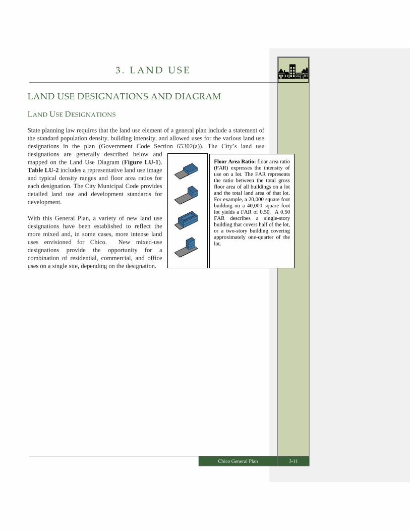
State planning law requires that the land use element of a general plan include a statement of
the standard population density, building intensity, and allowed uses for the various land use
designations in the plan (Government Code Section 65302(a)). The City’s land use
designations are generally described below and
mapped on the Land Use Diagram (Figure LU-1).
Table LU-2 includes a representative land use image
and typical density ranges and floor area ratios for
each designation. The City Municipal Code provides
detailed land use and development standards for
development.
With this General Plan, a variety of new land use
designations have been established to reflect the
more mixed and, in some cases, more intense land
uses envisioned for Chico. New mixed-use
designations provide the opportunity for a
combination of residential, commercial, and office
uses on a single site, depending on the designation.

3 . L A N D U S E
3-12 Chico General Plan
TABLE LU-2: LAND USE DESIGNATIONS AND DEVELOPMENT STANDARDS
Land Use
Image Land Use Designation Description
Allowed Density
(Dwelling Units/Acre)
Suggested Floor
Area Ratio (FAR)
Minimum
DU/AC
Maximum
DU/AC
Minimum
FAR
Maximum
FAR
Residential Designations
Very Low Density Residential
(VLDR) 0.2 2.0 N/A N/A
This designation can provide a smooth transition between the rural areas and more densely
developed neighborhoods, or be in “pockets” of development in carefully selected locations.
Low Density Residential (LDR) 2.1 7.0 N/A N/A
This designation represents the traditional single-family neighborhood with a majority of
single-family detached homes and some duplexes. This is the predominant land use category
of the City’s existing neighborhoods.
Medium Density Residential (MDR) 7.16.0 14.0 N/A N/A
This designation is generally characterized by duplexes, small apartment complexes, single-
family attached homes such as town homes and condominiums, and single-family detached
homes on small lots.
Medium-High Density Residential
(MHDR) 14.1 22.0 N/A N/A
This designation provides a transition between traditional single-family neighborhoods and
high density residential, and major activity or job centers. Dwelling types may include
townhouses, garden apartments, and other forms of multi-family housing.
High Density Residential (HDR) 20.0 70.0 N/A N/A
This designation represents the most urban residential category. The predominant style of
development is larger, multi-family housing complexes, including apartments and
condominiums.
Residential Mixed Use (RMU) 10.0 (1) 20.0 (1) N/A 2.5 (1)
This designation is characterized by predominantly residential development at medium to
high densities. It allows for commercial or office uses to be located on the same property,
either vertically or horizontally. It does not preclude development that is entirely residential,
but rather encourages a mix of uses. Additionally, other primary uses may be allowed by
right or with approval of a Use Permit, as outlined in the Municipal Code.
Commercial Designations
Neighborhood Commercial (NC) 6.0 (2) 22.0 0.20 1.5
This designation accommodates a mix of business, office, and residential uses that support
the needs of residents living in the surrounding neighborhoods. Allowable uses include small
grocery or drug stores, retail shops, and small-scale financial, business, personal services, and
restaurants. Horizontal or vertical mixed use is required on larger sites with this designation,
as specified in the Municipal Code.

3 . L A N D U S E
Chico General Plan 3-13
Land Use
Image Land Use Designation Description
Allowed Density
(Dwelling Units/Acre)
Suggested Floor
Area Ratio (FAR)
Minimum
DU/AC
Maximum
DU/AC
Minimum
FAR
Maximum
FAR
Commercial Mixed Use (CMU) 6.0 (2) 22.0 (3) 0.25 (3) 1.0 (3)
This designation encourages the integration of retail and service commercial uses with office
and/or residential uses. In mixed-use projects, commercial use is the predominant use on the
ground floor. This designation may also allow hospitals and other public/quasi-public uses.
Other uses may be allowed by right or with approval of a Use Permit, as outlined in the
Municipal Code.
Commercial Services (CS) N/A N/A 0.20 0.5
This designation provides sites for commercial businesses not permitted in other commercial
areas because they attract high volumes of vehicle traffic and may have adverse impacts on
other commercial uses. Allowable uses include automobile repair and services, building
materials, nurseries, equipment rentals, contractors' yards, wholesaling, storage, and similar
uses. Other retail and offices uses may be allowed, as outlined in the Municipal Code.
Regional Commercial (RC) 6.0 (2) 50.0 0.20 2.0
This designation provides sites for larger retail and service businesses that serve residents
from the City and the region. Mixed-use projects integrating office or residential uses are
allowed.
Office Mixed Use and Industrial Designations
Office Mixed Use (OMU) 6.0 (2,4) 20.0 (4) 0.30 2.0 (4)
This designation is characterized by predominantly office uses, but allows the integration of
commercial and/or residential uses. Other primary uses may be allowed by right or with
approval of a Use Permit, as outlined in the Municipal Code..
Industrial Office Mixed Use (IOMU) 7.0 (2) 14.0 0.25 1.5
This designation provides for a wide range and combination of light industrial and office
development. The designation is intended for the seamless integration of light industrial and
office uses with supporting retail and service uses. Offices may be developed in an office
park setting, but most office and light industrial development stands alone. Commercial and
other support services may be integrated vertically or horizontally, but the predominant use is
light industrial or office. Live-work uses may be permitted with special consideration for
compatibility with predominant uses.
Manufacturing and Warehousing
(M&W) N/A N/A 0.20 0.75
This designation provides for the full range of manufacturing, agricultural and industrial
processing, general service, and distribution uses. Other complimentary uses may be allowed
by right or with approval of a Use Permit, as outlined in the Municipal Code.
Public and Open Space Designations
Public Facilities and Services (PFS) N/A N/A 0 1.0
This designation includes sites for schools, hospitals, governmental offices, airports, and
other facilities that have a unique public character.

3 . L A N D U S E
3-14 Chico General Plan
Land Use
Image Land Use Designation Description
Allowed Density
(Dwelling Units/Acre)
Suggested Floor
Area Ratio (FAR)
Minimum
DU/AC
Maximum
DU/AC
Minimum
FAR
Maximum
FAR
Primary Open Space (POS) N/A N/A N/A N/A
This designation is intended to protect, in perpetuity, areas with sensitive habitats including
oak woodlands, riparian corridors, wetlands, creekside greenways, and other habitat for
highly sensitive species, as well as groundwater recharge areas and areas subject to flooding
that are not used for agriculture.
Secondary Open Space (SOS) N/A N/A N/A N/A
This designation includes land used for both intensive and non-intensive recreational
activities, such as parks, lakes, golf courses, and trails. Land within this category may also be
used for resource management, detention basins, agriculture, grasslands and other similar
uses.
Overlay and Special Designations
Resource Constraint Overlay (RCO) (5) (5) (5) (5)
This is an overlay designation that identifies areas with significant environmental resources
that result in development constraints. The RCO requires subsequent studies to determine the
exact location and the intensity of development that can take place in light of identified
constraints.
Special Mixed Use (SMU) 7.0 35.0 N/A N/A
This designation provides for development of walkable neighborhoods with a mix of
residential and nonresidential uses subject to approval of a regulating plan and circulation
plan consistent with the Traditional Neighborhood Development zoning district.
Special Planning Area (SPA) (6) (6) (6) (6)
This designation identifies areas for significant new growth that require subsequent
comprehensive planning. Horizontal or vertical mixed-use is required (except for the Bell-
Muir SPA). The General Plan includes a conceptual land plan for each SPA. Subsequent
planning efforts for each area shall be found to be in substantial compliance with relevant
SPA provisions and policies in the General Plan.
Table Notes:
1. When located Downtown or within a Corridor Opportunity Site, Residential Mixed Use has a minimum density of
15 dwelling units/acre, a maximum of 70 dwelling units per acre, and a maximum floor area ratio of 5.0.
2. If residential uses are incorporated horizontally, this minimum density should be met, but if integrated vertically,
there is no minimum density requirement.
3. When located Downtown or within a Corridor Opportunity Site, Commercial Mixed Use has a maximum of 60
dwelling units per acre, and a maximum floor area ratio of 5.0.
4. When located Downtown or within a Corridor Opportunity Site, Office Mixed Use has a maximum of 60 dwelling
units per acre, and a maximum floor area ratio of 5.0.
5. Allowable density and floor area ratio for the Resource Conservation Overlay designation shall be consistent with
the standards of the underlying land use designation.
6. Allowable density and floor area ratio in the Special Planning Areas shall be consistent with the standards of the
final land use designations identified for each site through subsequent master planning.

3 . L A N D U S E
Chico General Plan 3-15
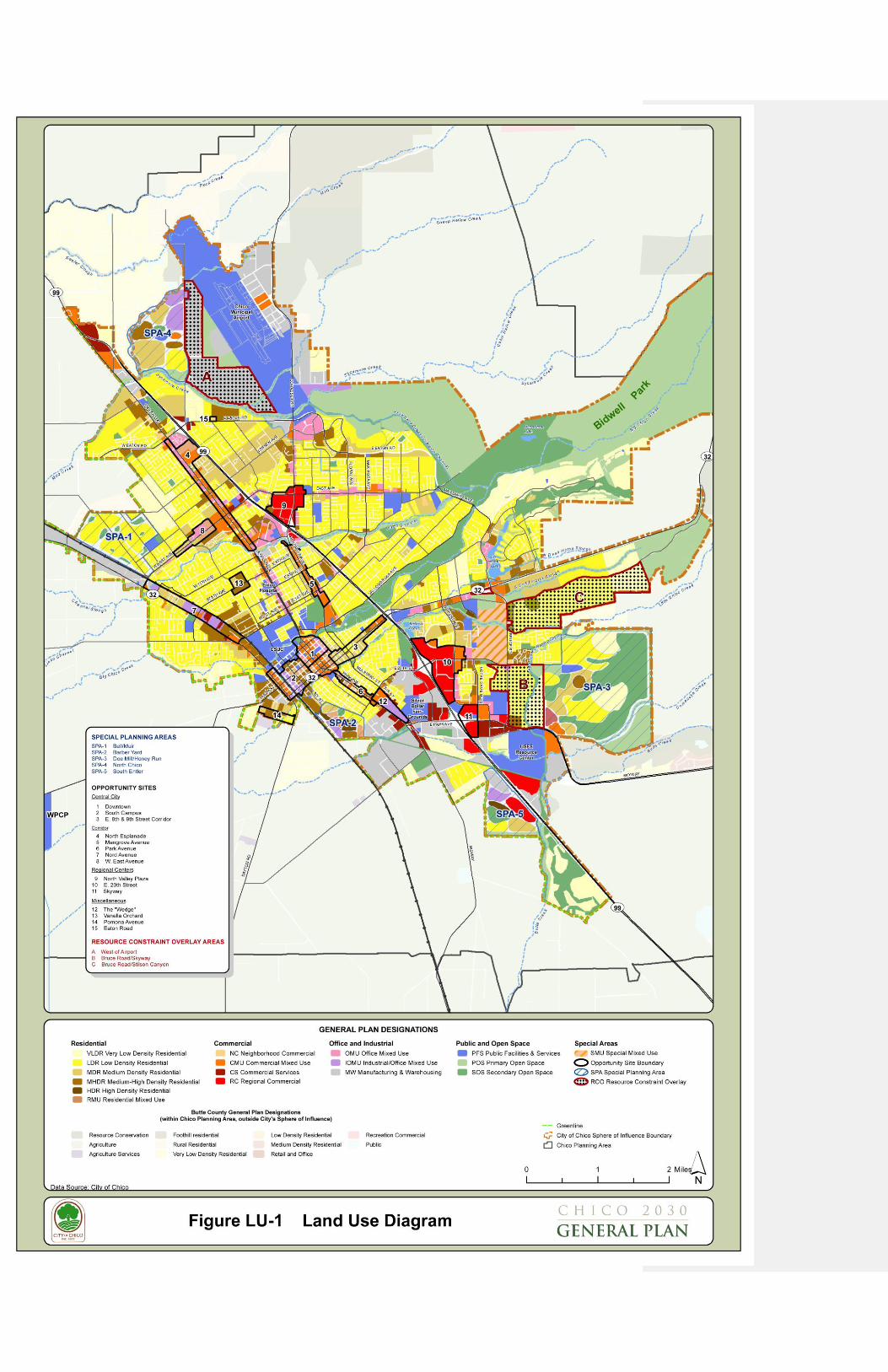
LAND USE DIAGRAM
The Land Use Diagram (Figure LU-1) illustrates the distribution of the land use designations
described above. In addition to identifying the land use designations, the Diagram highlights
three types of land as follows:
1. Special Planning Areas. The Land Use Diagram includes five Special Planning
Areas (SPAs). This designation identifies areas with significant new growth potential
and carries a requirement for subsequent planning prior to development. Within each
SPA, the City has identified a mix of desired land uses in the form of a conceptual
land plan. The conceptual land plans do not represent precise proportions or locations
for particular land uses. Detailed land use plans will be developed and refined as part
of subsequent, comprehensive planning of each area. SPAs are shown on the Land
Use Diagram with a dark outline, cross hatch lines, and labeled SPA-1 through SPA-
5.
2. Opportunity Sites. The Land Use Diagram identifies 15 sites that provide a greater
opportunity for change or improvement within the General Plan planning horizon.
These Opportunity Sites have parcel-specific land use designations as well as special
policy considerations. Opportunity Sites are shown on the Land Use Diagram with a
dark outline and labeled with numbers 1 through 15.
3. Resource Constraint Overlay. The Land Use Diagram identifies three areas with
sensitive biological resources that will constrain development. For these areas, the
City has applied an “overlay” designation to acknowledge the existence of the
identified constraints and set special policy requirements for subsequent study prior
to development. Resource Constraint Overlay areas are identified on the Land Use
Diagram by a dark outline with a dot fill pattern and labeled A through C.


3 . L A N D U S E
Chico General Plan 3-19
SPECIAL PLANNING AREAS
There are five areas on the Land Use Diagram (Figure LU-1) designated as Special Planning
Areas (SPA). The SPA designation identifies areas with significant new growth potential
that require more detailed subsequent land use planning in the form of a specific plan,
planned development, or other comprehensive plan. The SPAs were established based on
several criteria, including strategic location within the General Plan Planning Area, proximity
to services, ability to advance General Plan goals, compatibility with adjacent uses, and
environmental constraints. The SPAs are to be developed as connected and complete
neighborhoods with a mix of residential densities, employment opportunities, services, retail,
parks and open space. Subsequent planning will establish land use and circulation patterns
within the SPAs and consider infrastructure and financing issues. The five SPAs are:
Bell Muir
Barber Yard
Doe Mill/Honey Run
North Chico
South Entler
Appendix C includes a narrative description of the existing conditions and setting, a
conceptual land use plan, and an assumed development capacity for each SPA. The
conceptual land use plans include a collage of shapes with land use designations that were
selected to reflect the desired uses on the site, take into consideration existing conditions, and
accommodate projected housing and job needs. The shapes in the conceptual land use plans
do not determine the actual sizes or locations of future land uses. It is expected that the
ultimate proportional mix of uses will vary from what is depicted. The conceptual land use
plans identify the general mix of land uses to be included in the final land plans. General
Plan consistency findings for subsequent land use planning will rely on a determination of
substantial compliance with the written descriptions of land use concepts and development
capacity assumed for each SPA.
OPPORTUNITY SITES
The 15 Opportunity Sites are expected to be the focus of change and revitalization over the
next 20+ years. They are designated on the Land Use Diagram for mixed-use, higher-density
residential development, or other land uses compatible with the area’s existing or evolving
uses. Appendix B describes each Site and provides a vision for its transformation.
Opportunity Sites are categorized by general location as follows:
Central City Opportunity Sites. There are three Opportunity Sites in the City’s core
area. They include Downtown, South Campus, and the East 8th and 9th Street
Corridors.
3 . L A N D U S E
3-20 Chico General Plan
Corridor Opportunity Sites. There are five Opportunity Sites located along major
transit corridors outside of the City’s core area. They include North Esplanade,
Mangrove Avenue, Park Avenue, Nord Avenue, and East Avenue.
Regional Center Opportunity Sites. There are three Opportunity Sites located at
regional centers. They include North Valley Plaza, East 20th Street, and Skyway.
Other Opportunity Sites. There are four Opportunity sites located in other areas of
the City. They include The Wedge, Vanella Orchard, Pomona Avenue, and Eaton
Road.
Future requests for new development or redevelopment of property within these designated
Opportunity Sites shall be consistent with the identified Opportunity Site vision, development
parameters for the respective land use designation(s), and other applicable requirements of
the General Plan.
RESOURCE CONSTRAINT OVERLAY SITES
The Resource Constraint Overlay (RCO) designation acknowledges a reduced development
potential in areas with known significant environmental constraints compared to allowable
development potential based upon the underlying land use designation. The overlay
designation is applied to three areas:
A. West of the Airport
B. Bruce Road
C. Stilson Canyon
The boundaries of the three constraint sites are specified on the Land Use Diagram (Figure
LU-1) and on Figure LU-2. The most significant environmental constraints at these
locations are vernal pools, populations of Butte County meadowfoam (BCM), and habitat for
BCM.
Vernal pools are a unique ephemeral wetland feature that provide habitat for an array of
unique plant and animal species, many of which are protected by state and federal agencies.
One of the most sensitive vernal pool species is BCM, a state and federally listed endangered
plant species found only in limited areas within Butte County. Loss of habitat has been
identified as the primary threat to BCM, and the U.S. Fish and Wildlife Service Recovery
Plan for BCM calls for protecting 100 percent of known and newly discovered occurrences as
well as protecting 95 percent of the suitable habitat within the Chico region.
Environmental review for the 1994 General Plan update and research performed by the Butte
County Association of Governments (BCAG) in developing a Butte Regional Habitat
Conservation Plan were used in setting the locations of the three RCO sites.

3 . L A N D U S E
Chico General Plan 3-21
The RCO designation is applied in conjunction with an underlying land use designation.
Fifteen percent of the average development potential for the underlying land use designations
on the RCO sites was assumed in estimating the overall density and intensity of General Plan
build-out and to conduct environmental review for the General Plan, (consistent with the
development assumptions for the Land Use Diagram outlined in Appendix D). Land owners
of RCO parcels may conduct more detailed studies, including environmental review, and
coordinate with resource agencies to determine actual development potential. Such potential
may be more or less than the assumed 15 percent, but not more than the maximum
development potential allowed by the underlying land use designation.


3 . L A N D U S E
Chico General Plan 3-25
DEVELOPMENT POTENTIAL
This section estimates the full development potential of the General Plan Land Use Diagram.
To determine a probable build-out condition, the City estimated an average amount of
development for each land use designation within new growth areas (Special Planning Areas)
and areas of potential change (undeveloped infill and underutilized Opportunity Sites).
Details about the assumptions used to estimate development potential are provided in
Appendix D. The tables below summarize the estimated development potential by land use
designation (Table LU-3) and in terms of total housing and job numbers (Table LU-4).
Table LU-3 lists acreage, projected dwelling units, population, and non-residential square
footage for undeveloped (vacant) and a small portion of underutilized land within each of the
City’s land use designations. Population values were derived by multiplying the number of
dwelling units by an average of 2.4 persons per dwelling unit. The acreage totals include a
combination of estimated values from the five Special Planning Areas’ conceptual land use
plans and the specific values for vacant infill sites and underutilized land within the 15
designated Opportunity Sites.
3 . L A N D U S E
3-26 Chico General Plan
TABLE LU-3 DEVELOPMENT POTENTIAL OF THE 2030 LAND USE DIAGRAM
General Plan
Land Use
Designation
Acreage (1) Dwelling
Units Population
Non-
Residential
Square
Footage
VLDR 528 540 1,296 0
LDR 1209 4,887 11,729 0
MDR 494 4,816 11,558 0
MHDR 267 4,532 10,877 0
HDR 45 1,373 3,295 0
RMU 43 1,193 2,863 115,649
NC 3 0 0 28,217
MUNC 43 46 110 478,888
CMU 168 763 1,831 2,001,178
CS 24 0 0 295,495
RC 132 559 1,342 1,790,066
OMU 59 181 434 1,761,594
IOMU 186 105 252 2,462,328
M&W 368 0 0 5,473,458
PFS 206 0 0 45,000
POS 573 0 0 0
SOS 598 0 0 183,749
RCO (2) (2) (2) (2)
SMU 202 2,500 6,000 1,126,737
SPA (3) (3) (3) (3)
TOTAL 5,147 21,495 51.588 15,762,360
Notes:
(1) Acreage values were reduced to account for infrastructure, resources, and other constraints to development.
(2) Development potential of areas with the Resource Constraint Overlay is included in the underlying land use
designations.
(3) Development potential for the Special Planning Areas (SPAs) is included in the land use designations identified in
the conceptual land use plans for the SPAs.

3 . L A N D U S E
Chico General Plan 3-27
Table LU-4 provides total housing and job estimates for the General Plan build-out
condition, which is a combination of existing development conditions in 2008 and future
development assumptions (from Table LU-3) within the build-out Sphere of Influence.
TABLE LU-4 EXISTING, PLANNED, AND TOTAL BUILD OUT CONDITIONS
Housing and Job Factor Existing
Condition
Future Growth
Potential(1)
Total Build Out
Condition
Residential Units 41,438 21,495 62,933
Population 99,451 51,588 151,039
Total Square Footage 25,841,806 15,762,360 41,604,485
Commercial Square Feet 9,167,755 5,836,549 15,004,304
Office Square Feet 3,476,055 1,761,594 5,237,649
Industrial Square Feet 10,650,592 7,980,786 18,631,378
Other Square Feet 2,547,404 183,749 2,731,153
Total Employment 42,884 25,582 68,466
Commercial Employees 14,667 10,633 25,300
Office Employees 10,131 5,745 15,876
Industrial Employees 9,040 9,204 18,244
Other Employees 9,046 9,046
Notes:
(1) Values from Table LU-3. Other Employees are counted as Office or Industrial.
3 . L A N D U S E
3-28 Chico General Plan
GOALS, POLICIES, AND ACTIONS
GOAL LU-1 Reinforce the City’s compact urban form, establish urban growth
limits, and manage where and how growth and conservation will
occur.
GOAL LU-2 Maintain a land use plan that provides a mix and distribution of uses
that meet the identified needs of the community.
GOAL LU-3 Enhance existing neighborhoods and create new neighborhoods with
walkable access to recreation, places to gather, jobs, daily shopping
needs, and other community services.
GOAL LU-4 Promote compatible infill development.
GOAL LU-5 Support the transformation of designated Opportunity Sites with a
mix of uses.
GOAL LU-6 Comprehensively plan the Special Planning Areas to meet the City’s
housing and jobs needs.
GOAL LU-7 Protect the Chico Municipal and Ranchaero Airports, and promote
development in the Airport Industrial Park.
Goal LU-1: Reinforce the City’s compact urban form, establish urban growth
limits, and manage where and how growth and conservation will occur.
Policy LU-1.1 (Planning Area) – Support coordinated land use planning for the
Chico Planning Area.
Action LU-1.1.1 (Sphere of Influence) – Update the City’s Sphere of Influence
as depicted in the General Plan Land Use Diagram.
Action LU-1.1.2 (Coordinated Planning) – Consult with Butte County and
other entities, as appropriate, to facilitate a coordinated approach to land use
planning within the Planning Area.
Action LU-1.1.3 (Shared Responsibility Agreements) – Consider agreements
for critical planning topics and activities with Butte County and other agencies
and special districts.
Action LU-1.1.4 (Electronic Permitting) - Fully implement an electronic
permitting program for processing and record keeping of building, planning, and
engineering projects.
Cross reference S-4.3.4
Cross reference
OS-1.1.2 and SUS-2.2

3 . L A N D U S E
Chico General Plan 3-29
Policy LU-1.2 (Growth Boundaries/Limits) - Maintain long-term boundaries
between urban and agricultural uses in the west and between urban uses and the
foothills in the east, and limit expansion north and south to produce a compact
urban form.
Action LU-1.2.1 (Greenline) – Retain the Greenline.
Action LU-1.2.2 (Foothill Development) – Apply the City’s Foothill
Development Standards to projects in foothill areas.
Policy LU-1.3 (Growth Plan) - Maintain balanced growth by encouraging infill
development where City services are in place and allowing expansion into
Special Planning Areas.
Action LU-1.3.1 (Public Investment in Infrastructure) – When setting
priorities for public infrastructure spending, give particular attention to
improvements that will support development and redevelopment of the
designated Opportunity Sites.
Action LU-1.3.2 (Special Planning Area Studies) – Require public facility
financing plans, infrastructure phasing plans, and other studies as applicable in
connection with development applications for Special Planning Areas.
Action LU-1.3.3 (LAFCo Coordination) – Require that applications for sphere
of influence updates and annexations are consistent with Local Agency
Formation Commission requirements and include a conceptual plan for the
affected territory, including pre-zoning and a plan for infrastructure financing and
phasing.
Goal LU-2: Maintain a land use plan that provides a mix and distribution of
uses that meet the identified needs of the community.
Policy LU-2.1 (Planning for Future Housing and Jobs) - Maintain an adequate
land supply to support projected housing and job needs for the community.
Policy LU-2.2 (General Plan Monitoring and Reporting) - Regularly review and
report on implementation of the General Plan.
Action LU-2.2.1 (Annual Report) – Provide an annual report to the Planning
Commission and City Council on the following:
Status of the General Plan and progress in its implementation
Status of Sustainability Indicators
Cross reference CD-2.4
Cross reference CD-2.2
Cross reference
ED-1.4
Cross reference
ED-1.2
Cross reference
OS-5.1
3 . L A N D U S E
3-30 Chico General Plan
General Plan amendments
An evaluation of the year's development trends, current land supply, and the
ability to meet future needs.
Action LU-2.2.2 (Five-Year Review) – Provide a comprehensive General Plan
Review to the Planning Commission and City Council every five years, that
addresses the following:
Status of the General Plan and progress in its implementation
Status of Sustainability Indicators
General Plan amendments
An evaluation of development trends, current land supply (projected vs.
actual), market conditions, and the ability to meet future needs
The need for any policy changes to address the conclusions of the above
evaluation
Policy LU-2.3 (Sustainable Land Use Pattern) - Ensure sustainable land use
patterns in both developed areas of the City and new growth areas.
Action LU-2.3.1 (Provide Incentives) – To support desired development
patterns and economic development opportunities, continue the use of, and
expand as appropriate, City incentives, including but not limited to:
Priority project processing
Deferral of development impact or permit fees
Flexibility in development standards such as parking, setbacks, and
landscaping requirements
Density and intensity bonuses
Support for infrastructure upgrades
Action LU-2.3.2 (Allowed Uses) – Amend Maintain the Municipal Code to
reflect and implement the General Plan’s land use designations.
Action LU-2.3.3 (Encourage Mixed-Use Development) – Allow horizontal and
vertical mixed uses in the following land use designations:
Residential Mixed Use
Neighborhood Commercial
Commercial Mixed Use
Regional Commercial
Office Mixed Use
Industrial Office Mixed Use
Cross reference ED-1.3.1
Cross reference ED-1.2.1

3 . L A N D U S E
Chico General Plan 3-31
Action LU-2.3.4 (Require Mixed-Use) – Require horizontal or vertical mixed-
use in the following land use designations:
Special Mixed Use
Neighborhood Commercial sites two acres and larger
Special Planning Areas (with the exception of the Bell-Muir SPA)
Action LU-2.3.5 (Incentives for Vertical Mixed-Use) – Utilize City incentives
identified in Action LU-2.3.1 to support vertical mixed-use projects.
Action LU-2.3.6 (Increase Discretion of Large Format Retail) – Consider
mechanisms to increase City discretion regarding new or expanded large-format
retail uses.
Policy LU-2.4 (Land Use Compatibility) – Promote land use compatibility
through use restrictions, development standards, environmental review and
special design considerations.
Action LU-2.4.1 (Update Zoning Ordinance) – Establish Maintain zoning
districts, use regulations, development standards, and performance requirements
in the Municipal Code consistent with the General Plan.
Action LU-2.4.2 (Update Zoning Map) – Amend Maintain the Zoning Map to
be consistent with the General Plan Land Use Diagram.
Action LU-2.4.3 (Best Practices Manual) – Update the City's Best Practices
Manual.
Action LU-2.4.4 (Design Guidelines) – Maintain and update, as necessary, the
City’s Design Guidelines Manual.
Policy LU-2.5 (Open Space and Resource Conservation) – Protect areas with
known sensitive resources.
Action LU-2.5.1 (Resource Constraint Overlay) – For development proposals
on properties with the Resource Constraint Overlay, which highlights known
sensitive resource areas, land owners must conduct detailed environmental
studies, adhere to CEQA requirements, and coordinate with resource agencies to
determine actual development potential. Development proposals for a density or
intensity of use above that assumed for the purposes of General Plan projections
and the General Plan EIR will need to address impacts not evaluated as part of the
General Plan.
Cross reference OS-1.1.1
Cross reference CD-3.1.1

3 . L A N D U S E
3-32 Chico General Plan
Policy LU-2.6 (Agricultural Buffers) - Require buffering for new urban uses
along the City’s Sphere of Influence boundary adjacent to commercial crop
production. Landscaping, trails, gardens, solar arrays, and open space uses are
permitted within the buffer. Design criteria for buffers are as follows:
A minimum 100-foot-wide physical separation, which may include roadways,
pedestrian/bicycle routes, and creeks, between the agricultural use and any
habitable structure.
Incorporate vegetation, as may be needed, to provide a visual, noise, and air
quality buffer.
Policy LU-2.7 (General Plan Consistency Requirement) - Ensure consistency
between the General Plan and implementing plans, ordinances, and regulations.
Action LU-2.7.1 (General Plan Consistency Review) – Conduct a General Plan
review in conjunction with adoption of policy and regulatory documents to ensure
consistency with relevant provisions of the General Plan.
Policy LU-2.8 (Inconsistent Zoning) – In areas where zoning is not in
conformance with the General Plan, the property owner may develop consistent
with the existing zoning if no discretionary permit is required. If a discretionary
permit is requested, the property owner may either (1) develop consistent with
the existing zoning provided that it is determined by the approving body that the
project will not substantially interfere with the long-term development of the
area consistent with the General Plan, or (2) rezone the property consistent with
the General Plan in conjunction with the development application.
Goal LU-3: Enhance existing neighborhoods and create new neighborhoods with
walkable access to recreation, places to gather, jobs, daily shopping needs, and
other community services.
Policy LU-3.1 (Complete Neighborhoods) - Direct growth into complete
neighborhoods with a land use mix and distribution intended to reduce auto
trips and support walking, biking, and transit use.
Policy LU-3.2 (Neighborhood Serving Centers) - Promote the development of
strategically located neighborhood serving centers that incorporate commercial,
employment, cultural or entertainment uses and are within walking distance of
surrounding residents. Neighborhood center designations are Neighborhood
Commercial (NC) and Mixed Use Neighborhood Core (MUNC).
Cross reference
OS-5.2
Cross reference SUS-1.1

3 . L A N D U S E
Chico General Plan 3-33
Policy LU-3.3 (Neighborhood Services) - Recognize existing neighborhoods and
continue to facilitate the development ofsupport neighborhood-level planning
plans in partnership with residents and property owners to preserve and
enhance neighborhood character, identity, and livability.
Action LU-3.3.1 (Development of Neighborhood Plannings) – Facilitate and
encourage the participation of neighborhood groups and associations in the
preparation of neighborhood plans that articulate a vision for the
neighborhoodplanning process, and identify neighborhood priorities for future
public improvements and capital projects., and serve as a focal point for
neighborhood involvement in improvement projects.
Policy LU-3.4 (Neighborhood Enhancement) - Strengthen the character of
existing residential neighborhoods and districts.
Action LU-3.4.1 (Rehabilitation) – Provide flexibility in development standards
for building retrofits when doing so will advance Policy LU-4.2.
Action LU-3.4.2 (Improve Substandard Properties) – Continue the Housing
Rehabilitation Program to provide deferred-payment loans and grants to low-
income homeowners to improve their properties.
Action LU-3.4.3 (Code Enforcement) – Continue the City's Code Enforcement
efforts to preserve existing neighborhoods through the elimination of blight and
improvement of substandard housing.
Action LU-3.4.4 (Provision of Infrastructure) – Upgrade and provide
infrastructure in existing neighborhoods consistent with adopted neighborhood
plans as funding is available.
Goal LU-4: Promote compatible infill development.
Policy LU-4.1 (Promote Infill and Redevelopment) - Facilitate infill development
through education and the provision of infrastructure and services.
Action LU-4.1.1 (Education about the Benefits of Infill) - Provide community
education regarding the benefits of infill through the neighborhood planning
process and in the analysis, recommendations, and findings for infill development
projects and capital expenditures that support infill and redevelopment.
Action LU-4.1.2 (Tiered Fee Structure) – Adopt a tiered development fee
program that varies fees by development type and location in recognition of the
different impacts that various types of development have on City services and
infrastructure costs.
Cross reference CD-1.2.2
Cross reference ED-1.4.1
Cross reference
ED-1.2.2 and ED-1.2.3
Cross reference ED-1.4.2
Cross reference
CD-4.1
Cross reference DT-8.2
Cross reference
CIRC-4.2.2 and CD-4.1.1

3 . L A N D U S E
3-34 Chico General Plan
Policy LU-4.2 (Infill Compatibility) - Support infill development, redevelopment,
and rehabilitation projects that are compatible with surrounding properties and
neighborhoods.
Action LU-4.2.1 (Residential Infill Guidelines) – Amend the Design Guidelines
Manual to include residential infill guidelines that address compatibility between
new and existing development such as visual intrusion and massing within a
transition zone.
Action LU-4.2.2 (Mix of Dwelling Types) – Allow a mix of dwelling types
within all residential land use designations consistent with density requirements
and applicable design criteria.
Action LU-4.2.3 (Pre-Application Meetings) – For projects proposed on or
adjacent to residentially zoned property, which require a discretionary approval
by the Planning Commission or City Council, require applicants to have a pre-
application neighborhood meeting with interested parties in the respective
neighborhood to hear issues and consider input.
Policy LU-4.3 (Emphasis on Neighborhood Compatibility) – For residential infill
projects outside of Opportunity Sites and Special Planning Areas, maintaining
neighborhood character may take precedence over meeting density goals. It
may be necessary to limit project density, within the allowable density range, to
ensure compatibility.
Policy LU-4.4 (Positive Contributions) – Encourage infill development that
provides missing neighborhood elements, such as neighborhood retail, enhanced
architectural quality, and circulation improvements for pedestrians, bicycles
and vehicles, or that otherwise contributes positively to existing neighborhoods.
Goal LU-5: Support development and redevelopment of the designated
Opportunity Sites.
Policy LU-5.1 (Opportunity Sites) - Facilitate increased density and intensity of
development and revitalization in the following Opportunity Sites:
Central City Opportunity Sites - Downtown, South Campus, and East 8th and
9th Street Corridors.
Corridor Opportunity Sites - North Esplanade, Mangrove Avenue, Park
Avenue, Nord Avenue, and East Avenue.
Regional Center Opportunity Sites - North Valley Plaza, East 20th Street, and
Skyway.
Cross reference
CD-5.1
Cross reference CD-5.1.1
Cross reference
Appendix B
3 . L A N D U S E
Chico General Plan 3-35
Other Opportunity Sites - The Wedge, Vanella Orchard, Pomona Avenue, and
Eaton Road.
Action LU-5.1.1 (Incentives for Opportunity Site Development) – Utilize City
incentives identified in Action LU-2.3.1 to promote infill development,
redevelopment, rehabilitation, and mixed-use projects in the designated
Opportunity Sites.
Action LU-5.1.2 (Midpoint Density) – Require that projects within Corridor
Opportunity Sites and Downtown be developed at or above the midpoint of the
allowed density range (before Table LU-2 footnotes) unless one or more of the
following findings are made:
The proposed project does not include residential development.
Residences are integrated vertically in a mixed-use project.
Site considerations such as parcel size, configuration, environmental
resources, or other features make achieving the midpoint infeasible or
undesirable.
Infrastructure constraints make achieving the midpoint impractical.
Action LU-5.1.3 (Flexible Parking) – Amend Maintain standards in the
Municipal Code tothat allow flexibility for parking reductions and parking in
shared lots.
Action LU-5.1.4 (Streetscape Enhancement) – As part of future roadway
improvement projects in the Corridor Opportunity Sites, incorporate streetscape
enhancements such as bulb-outs, benches, wide and separated sidewalks, on-
street parking, public art, and street trees to improve the pedestrian environment
and serve as a catalyst for revitalization.
Action LU-5.1.5 (Redevelopment Partnerships) – Actively seek and support
partnerships between the City, property owners, and developers for
redevelopment in the Regional Center Opportunity Sites.
Goal LU-6: Comprehensively plan the Special Planning Areas to meet the City’s
housing and jobs needs.
Policy LU-6.1 (Special Planning Area Designation) – To meet the City’s growth
needs, support development in the following five Special Planning Areas:
Bell Muir
Barber Yard
Doe Mill/Honey Run
North Chico
South Entler
Cross reference
CD-5.1
Cross reference CD-2.3.3,
CIRC-4.2.2, and DT-3.5.1
Cross reference
CIRC-8.1.1, and DT-7.2.1

3 . L A N D U S E
3-36 Chico General Plan
Action LU-6.1.1 (Designation of Future Special Planning Areas) – Require an
amendment to the General Plan for a designation of a new Special Planning Area.
Action LU-6.1.2 (Amendment to Existing Special Planning Areas) – Require
an amendment to the General Plan Land Use Diagram and corresponding
conceptual land use plan for any significant change to a Special Planning Area
boundary.
Policy LU-6.2 (Special Planning Area Implementation) – Allow flexibility when
planning the Special Planning Areas in order to meet changing community
housing and jobs needs.
Action LU-6.2.1 (SPA Planning Requirements) – Require more detailed land
use planning in the form of a specific plan, planned development, or other
comprehensive plan for each Special Planning Area (SPA) prior to development
occurring on vacant land within an SPA. In addition to the Actions specific to
each SPA, subsequent land use planning shall:
Create a parcel-specific land use plan based on site, infrastructure, and
environmental analysis.
Include public facility financing plans, infrastructure phasing plans, and other
studies as applicable.
Include the provision of housing units affordable to very low, low, and/or
moderate income households within the SPA.
Include the range of uses identified on the SPA conceptual land use plan (a
conceptual land use plan is not intended to direct specific acreage or
organization of land uses, but is intended to depict the general mix of desired
land uses within the project area).
Have no significantly greater traffic, air quality, or noise impacts than those
analyzed in the General Plan environmental analysis (residential and non-
residential development assumptions for each SPA are provided in Appendix
C).
Be consistent with the corresponding text for the SPA found in Appendix C.
Action LU-6.2.2 (Bell Muir SPA Planning) – Plan the Bell Muir SPA with
primarily low density housing compatible with existing residential development
and ongoing agricultural uses in the area. Subsequent planning will:
Identify locations for community gardens or small-scale farms and develop
design guidelines and buffering requirements to address potential
incompatibilities.
Formatted: List Bullet, Space After: 6 pt

3 . L A N D U S E
Chico General Plan 3-37
Address infrastructure needs with particular attention to storm drainage and
circulation, including north-south connections to East Avenue and improved
access to State Route 32.
Develop special lighting and street standards appropriate for the rural
character of the area.
Action LU-6.2.3 (Barber Yard SPA Planning) - Plan the Barber Yard SPA
with a mix of low, medium and high residential densities, a neighborhood core or
commercial mixed-use center, office and light industrial uses, and parks and open
space. Subsequent planning will:
Address circulation with a focus on extending and improving existing streets
into the site that will distribute traffic on multiple streets, and improving
connectivity in order to reduce traffic impacts on the existing residential
neighborhood.
Incorporate adaptive reuse of existing buildings, where feasible.
Action LU-6.2.4 (Doe Mill/Honey Run SPA Planning) – Plan the Doe
Mill/Honey Run SPA with a broad range of housing types and densities
integrated with open space and recreational areas, supporting commercial
services, and public facilities. Subsequent planning will:
Address circulation with primary connections to the site via Skyway and E.
20th Street.
Incorporate accessible open space on the eastern portion of the SPA, a
community park, as well as neighborhood and mini parks.
Maintain open space by clustering development and providing open space
buffers on the northern, eastern, and southern edges of the SPA.
Include visual simulations to ensure that development is not visually intrusive
as viewed from lower elevations.
Incorporate special lighting standards to reduce impacts on the nighttime sky.
Address wildland fire considerations.
Action LU-6.2.5 (North Chico SPA Planning) - Plan the North Chico SPA with
a combination of residential densities and supporting commercial uses, along with
industrial and office uses. Subsequent planning will:
Address the Hicks Lane/Eaton Road/SR 99 intersection and include an
arterial roadway originating at Hicks Lane, extending to State Route 99.
Address Chico Municipal Airport overflight zone compatibility.
Cross reference CD -2.4.1
and OS-2.4.1
Cross reference
S-6.2
3 . L A N D U S E
3-38 Chico General Plan
Avoid FEMA-designated flood zones, or incorporate strategies that allow
development to occur in flood zones.
Action LU-6.2.6 (South Entler SPA Planning) - Plan the South Entler SPA
with regional and community commercial uses integrated with office and
industrial uses, a mix of residential densities, and open space. Subsequent
planning will:
Address circulation with a focus on the intersection at Southgate Avenue and
State Route 99 and providing multiple access points to the site.
Ensure that the SPA serves as a visually attractive “landmark” gateway at the
south end of the City with freeway visibility.
Preserve and/or provide trees along the borders of the SPA to provide a buffer
to adjacent agricultural uses and open space.
Avoid FEMA-designated flood zones, or incorporate strategies that allow
development to occur in flood zones.
Goal LU-7: Protect the Chico Municipal and Ranchaero Airports, and promote
development in the Airport Industrial Park.
Policy LU-7.1 (Airport Protection) - Safeguard the Chico Municipal and
Ranchaero Airports from intrusion by uses that could limit expansion of air
services, and prohibit development that poses hazards to aviation.
Action LU-7.1.1 (Airport Compatibility) – Amend Maintain the City’s
Municipal Code and Zoning Map to implement airport overflight zoning district
overlays, consistent with the boundaries and general policy direction contained
within the Butte County Airport Land Use Compatibility Plan, which address the
following:
Airport noise-related compatibility issues and noise-resistant construction
techniques.
Height limitations for both structures and landscaping.
Lighting, electrical interference, glare, or other issues which may endanger
the landing, takeoff, or maneuvering of aircraft.
Prohibition of incompatible land uses and limitations on the density and/or
intensity of land uses.
Infill compatibility criteria consistent with the 2005 agreement between the
City and the Butte County Airport Land Use Commission.
Action LU-7.1.2 (Avigation Easements) – Continue to require avigation
easements and deed notices for new development within the Airport Land Use
Compatibility Plan area.
Cross reference
CD-6.1
Cross reference
S-6.1 and S-6.2
Cross reference
N-1.1
Cross reference S-2.1 and
PPFS-6.5.4

3 . L A N D U S E
Chico General Plan 3-39
Action LU-7.1.3 (Airport Certification) – Maintain Federal Aviation Agency
Airport Certification of the Chico Municipal Airport for commercial passenger
traffic.
Policy LU-7.2 (Development in the Airport Vicinity) – Promote airport-related
and other compatible development in the Airport Industrial Park.