3.0 land use plan: precincts - dilgp.qld.gov.au · this precinct is comprised of three...
TRANSCRIPT

36 Northshore Hamilton Urban Development Area Development Scheme
3.0
Precinct 5: Waterfront Residential
Thisprecinctiscomprisedofthreesub-precincts.
Precinct outcomes
Theprecinctwillcontainmulti-unitdwellingsandapartmentsinmediumtohighdensityforms.Theprecinctadjoiningthegolfcoursecanaccommodatelowerdensityresidentialforms.
Residentialdesignmustbeofahighstandard,providingadequatesafety,privacy,comfortandresponsivenesstoBrisbane’ssubtropicalclimate.
Theprecinctmustaccommodatehighqualityparklandandpassiverecreationalareas.
Otheruses,suchassmallscaleshops,restaurantsandshorttermaccommodation,willsupportandrespectthepredominantresidentialamenityofthearea.
Allbuildingsmustaddressstreets,includingresidentialbuildingswhichmustprovideentrancestogroundfloorunits.
Opportunitiesformaximisingriverandcityviewsareencouragedthroughoutthisprecinct
Buildingedgetreatments,includinghighqualityprivateopenspacestrips,mustreinforcestreetscapes.
Significantvegetationistoberetainedunlessthereisademonstratedpublicbenefit.Ifpublicbenefitisdetermined,considerationwillbegiventominimisationoflossandmanagementofimpacts.
Preferred land uses
Thepreferredlandusesforprecinct5(unlessotherwisespecifiedinasub-precinct),are:
communityfacility
foodpremiseswherelocatedatgroundlevelandnotexceeding250m2GFApertenancy
homebasedbusiness
multipleresidential
otherresidential
shopwherelocatedatgroundlevelandnotexceeding250m2GFApertenancy.
Sub-precinct criteria
Figure 18: Precinct 5 - sub-precinct plan
Figure 19: Precinct 5 - building heights plan
Sub-precinct 5 (a): Riverfront Residential West
Sub-precinctprinciples
Developmentwithinthissub-precinctmustseektosharetheviewsoftheBrisbaneRiverandthecity.Buildingformsmustfrontallstreetswithbacksofbuildingslocatedcentrallywithinblocks.Theriverfrontresidentialareawillincorporatesignificantgreenspaceandurbanopenspaces,increasingtheassociationwiththeriverandprovidingsubstantialreliefwithinahighdensityenvironment.Builtedgesto
5(a)
5(b)5(c)
10
15
155
Land Use Plan: Precincts
Figure 17: Precinct 5
Precinct intent
TheWaterfrontResidentialPrecincthasbeenpositionedtotakeadvantageofthesignificantamenityprovidedbytheBrisbaneRiver.ItwillbethefocusformediumtohigherdensityresidentialformsthatfronttheBrisbaneRiverandprovideastrongedgetoMacarthurAvenue.
TheeasternareasoftheWaterfrontResidentialPrecinctwillcontainmediumandlowerdensityformsofresidentialdevelopment.Althoughpredominantlyresidentialinnature,othersuitableusessuchasshops,restaurantsandshort-termaccommodationwillbeencouragedinappropriatelocationswhereitcanbedemonstratedthattheywillnotprejudicethefunctionoftheadjoiningactivitynodes.Generouspublicspacealongtheriverwillensurethatitremainsanassetenjoyedbyallresidents,workersandvisitors.
37Northshore Hamilton Urban Development Area Development Scheme
3.0
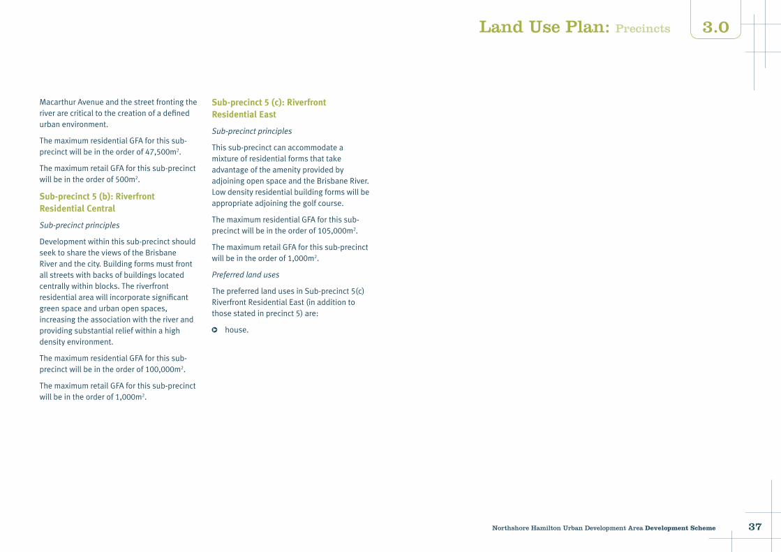
MacarthurAvenueandthestreetfrontingtheriverarecriticaltothecreationofadefinedurbanenvironment.
ThemaximumresidentialGFAforthissub-precinctwillbeintheorderof47,500m2.
ThemaximumretailGFAforthissub-precinctwillbeintheorderof500m2.
Sub-precinct 5 (b): Riverfront Residential Central
Sub-precinctprinciples
Developmentwithinthissub-precinctshouldseektosharetheviewsoftheBrisbaneRiverandthecity.Buildingformsmustfrontallstreetswithbacksofbuildingslocatedcentrallywithinblocks.Theriverfrontresidentialareawillincorporatesignificantgreenspaceandurbanopenspaces,increasingtheassociationwiththeriverandprovidingsubstantialreliefwithinahighdensityenvironment.
ThemaximumresidentialGFAforthissub-precinctwillbeintheorderof100,000m2.
ThemaximumretailGFAforthissub-precinctwillbeintheorderof1,000m2.
Sub-precinct 5 (c): Riverfront Residential East
Sub-precinctprinciples
Thissub-precinctcanaccommodateamixtureofresidentialformsthattakeadvantageoftheamenityprovidedbyadjoiningopenspaceandtheBrisbaneRiver.Lowdensityresidentialbuildingformswillbeappropriateadjoiningthegolfcourse.
ThemaximumresidentialGFAforthissub-precinctwillbeintheorderof105,000m2.
ThemaximumretailGFAforthissub-precinctwillbeintheorderof1,000m2.
Preferredlanduses
ThepreferredlandusesinSub-precinct5(c)RiverfrontResidentialEast(inadditiontothosestatedinprecinct5)are:
house.
Land Use Plan: Precincts
38 Northshore Hamilton Urban Development Area Development Scheme
3.0
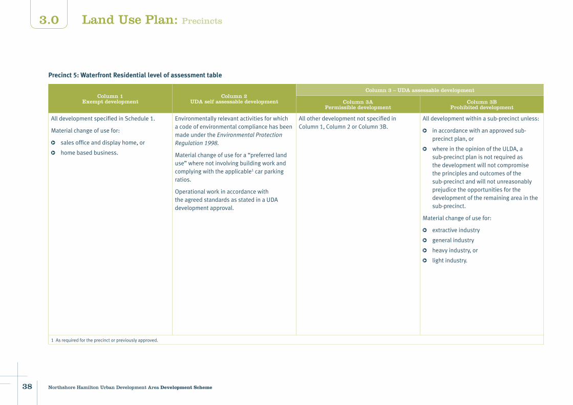
Precinct 5: Waterfront Residential level of assessment table
Column 1Exempt development
Column 2 UDA self assessable development
Column 3 – UDA assessable development
Column 3APermissible development
Column 3BProhibited development
AlldevelopmentspecifiedinSchedule1.
Materialchangeofusefor:
salesofficeanddisplayhome,or
homebasedbusiness.
EnvironmentallyrelevantactivitiesforwhichacodeofenvironmentalcompliancehasbeenmadeundertheEnvironmentalProtectionRegulation1998.
Materialchangeofusefora“preferredlanduse”wherenotinvolvingbuildingworkandcomplyingwiththeapplicable1carparkingratios.
OperationalworkinaccordancewiththeagreedstandardsasstatedinaUDAdevelopmentapproval.
AllotherdevelopmentnotspecifiedinColumn1,Column2orColumn3B.
Alldevelopmentwithinasub-precinctunless:
inaccordancewithanapprovedsub-precinctplan,or
whereintheopinionoftheULDA,asub-precinctplanisnotrequiredasthedevelopmentwillnotcompromisetheprinciplesandoutcomesofthesub-precinctandwillnotunreasonablyprejudicetheopportunitiesforthedevelopmentoftheremainingareainthesub-precinct.
Materialchangeofusefor:
extractiveindustry
generalindustry
heavyindustry,or
lightindustry.
1Asrequiredfortheprecinctorpreviouslyapproved.
Land Use Plan: Precincts

39Northshore Hamilton Urban Development Area Development Scheme
3.0
Development parameters
Building heightsrefertoFigure19:Precinct5-buildingheightsplan
5–15storeys
Setbacks FrontagesRetail:0metreswithuptofivemetresetbackatgroundforpublicactivatedspaces.Residential:threetofivemetres.Tower separation18metresbetweenresidentialbuildings.18metresbetweenresidentialandcommercialbuildings.Brisbane River Setback(fromthehighwatermark)20metresforallbuildings.Significant Vegetation10metresfromthehighwatermark.
Edge treatmentsrefertoMap4:Edgetreatments
Dominantbuiltformtobeatthecornersindicatedonedgetreatmentplan.30%offrontagesamaximumofthreestoreyswhereindicated.
ConnectionsrefertoMap5:Keyconnections
North/southconnectionsthroughtheeasternriverparktothewetlandparkintheNorthshoreLinksPrecinctmustbepromoted.Connectionsmustbereinforcedonthenorth/southstreetstopromoteaccessibilitytotheriver’sedge.East/westconnectionsalongthelinear,riversideopenspacemustbemaintainedandpromoted.
Open and civic space refertoMap6:Openandcivicspace
Networkpark.Destinationpark.Connectingpark.Civicspace.
New and upgraded roads refertoMap7:Proposednewroadsandroadupgrades
Newroads.Existingroadupgrade.Minorimprovements.
Car parking RefertoUDAwidedevelopmentcriteriaundersection3.8.
Land Use Plan: Precincts
40 Northshore Hamilton Urban Development Area Development Scheme
3.0
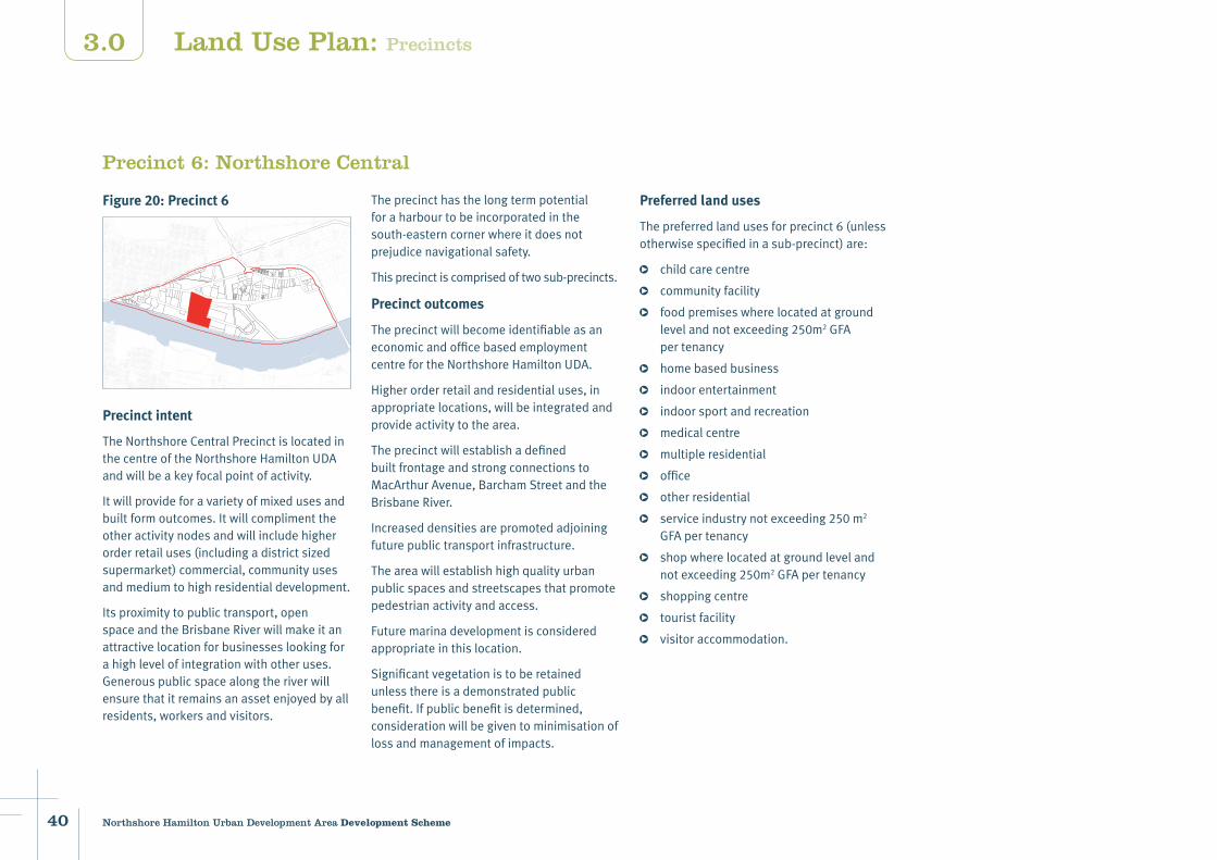
Figure 20: Precinct 6
Precinct intent
TheNorthshoreCentralPrecinctislocatedinthecentreoftheNorthshoreHamiltonUDAandwillbeakeyfocalpointofactivity.
Itwillprovideforavarietyofmixedusesandbuiltformoutcomes.Itwillcomplimenttheotheractivitynodesandwillincludehigherorderretailuses(includingadistrictsizedsupermarket)commercial,communityusesandmediumtohighresidentialdevelopment.
Itsproximitytopublictransport,openspaceandtheBrisbaneRiverwillmakeitanattractivelocationforbusinesseslookingforahighlevelofintegrationwithotheruses.Generouspublicspacealongtheriverwillensurethatitremainsanassetenjoyedbyallresidents,workersandvisitors.
Precinct 6: Northshore Central
Theprecincthasthelongtermpotentialforaharbourtobeincorporatedinthesouth-easterncornerwhereitdoesnotprejudicenavigationalsafety.
Thisprecinctiscomprisedoftwosub-precincts.
Precinct outcomes
TheprecinctwillbecomeidentifiableasaneconomicandofficebasedemploymentcentrefortheNorthshoreHamiltonUDA.
Higherorderretailandresidentialuses,inappropriatelocations,willbeintegratedandprovideactivitytothearea.
TheprecinctwillestablishadefinedbuiltfrontageandstrongconnectionstoMacArthurAvenue,BarchamStreetandtheBrisbaneRiver.
Increaseddensitiesarepromotedadjoiningfuturepublictransportinfrastructure.
Theareawillestablishhighqualityurbanpublicspacesandstreetscapesthatpromotepedestrianactivityandaccess.
Futuremarinadevelopmentisconsideredappropriateinthislocation.
Significantvegetationistoberetainedunlessthereisademonstratedpublicbenefit.Ifpublicbenefitisdetermined,considerationwillbegiventominimisationoflossandmanagementofimpacts.
Preferred land uses
Thepreferredlandusesforprecinct6(unlessotherwisespecifiedinasub-precinct)are:
childcarecentre
communityfacility
foodpremiseswherelocatedatgroundlevelandnotexceeding250m2GFApertenancy
homebasedbusiness
indoorentertainment
indoorsportandrecreation
medicalcentre
multipleresidential
office
otherresidential
serviceindustrynotexceeding250m2
GFApertenancy
shopwherelocatedatgroundlevelandnotexceeding250m2GFApertenancy
shoppingcentre
touristfacility
visitoraccommodation.
Land Use Plan: Precincts
41Northshore Hamilton Urban Development Area Development Scheme
3.0
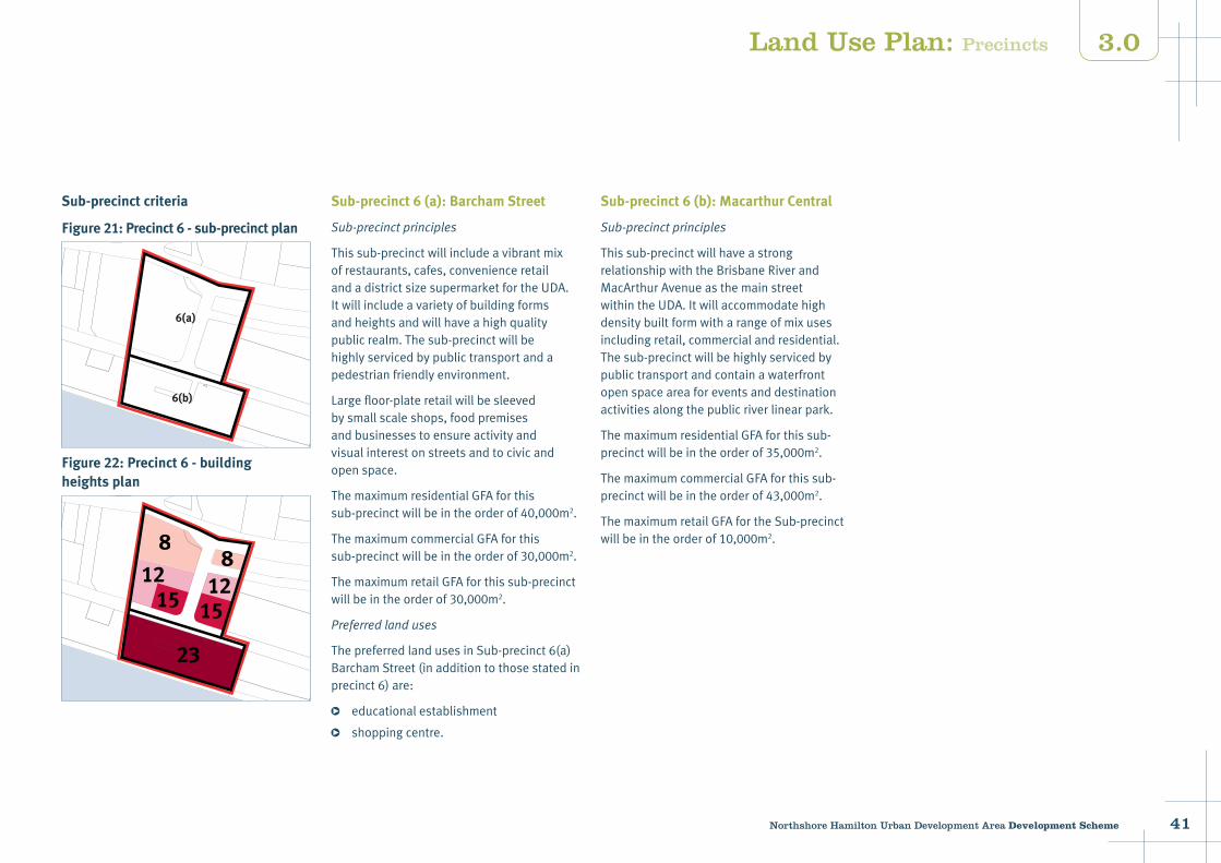
Sub-precinct criteria
Figure 21: Precinct 6 - sub-precinct plan
Figure 22: Precinct 6 - building heights plan
Sub-precinct 6 (a): Barcham Street
Sub-precinctprinciples
Thissub-precinctwillincludeavibrantmixofrestaurants,cafes,convenienceretailandadistrictsizesupermarketfortheUDA.Itwillincludeavarietyofbuildingformsandheightsandwillhaveahighqualitypublicrealm.Thesub-precinctwillbehighlyservicedbypublictransportandapedestrianfriendlyenvironment.
Largefloor-plateretailwillbesleevedbysmallscaleshops,foodpremisesandbusinessestoensureactivityandvisualinterestonstreetsandtocivicandopenspace.
ThemaximumresidentialGFAforthissub-precinctwillbeintheorderof40,000m2.
ThemaximumcommercialGFAforthissub-precinctwillbeintheorderof30,000m2.
ThemaximumretailGFAforthissub-precinctwillbeintheorderof30,000m2.
Preferredlanduses
ThepreferredlandusesinSub-precinct6(a)BarchamStreet(inadditiontothosestatedinprecinct6)are:
educationalestablishment
shoppingcentre.
6(a)
6(b)
23
8
128
121515
Land Use Plan: Precincts
Sub-precinct 6 (b): Macarthur Central
Sub-precinctprinciples
Thissub-precinctwillhaveastrongrelationshipwiththeBrisbaneRiverandMacArthurAvenueasthemainstreetwithintheUDA.Itwillaccommodatehighdensitybuiltformwitharangeofmixusesincludingretail,commercialandresidential.Thesub-precinctwillbehighlyservicedbypublictransportandcontainawaterfrontopenspaceareaforeventsanddestinationactivitiesalongthepublicriverlinearpark.
ThemaximumresidentialGFAforthissub-precinctwillbeintheorderof35,000m2.
ThemaximumcommercialGFAforthissub-precinctwillbeintheorderof43,000m2.
ThemaximumretailGFAfortheSub-precinctwillbeintheorderof10,000m2.
42 Northshore Hamilton Urban Development Area Development Scheme
3.0
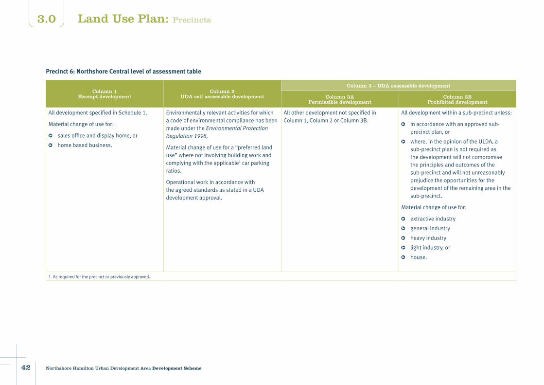
Precinct 6: Northshore Central level of assessment table
Column 1Exempt development
Column 2 UDA self assessable development
Column 3 – UDA assessable development
Column 3APermissible development
Column 3BProhibited development
AlldevelopmentspecifiedinSchedule1.
Materialchangeofusefor:
salesofficeanddisplayhome,or
homebasedbusiness.
EnvironmentallyrelevantactivitiesforwhichacodeofenvironmentalcompliancehasbeenmadeundertheEnvironmentalProtectionRegulation1998.
Materialchangeofusefora“preferredlanduse”wherenotinvolvingbuildingworkandcomplyingwiththeapplicable1carparkingratios.
OperationalworkinaccordancewiththeagreedstandardsasstatedinaUDAdevelopmentapproval.
AllotherdevelopmentnotspecifiedinColumn1,Column2orColumn3B.
Alldevelopmentwithinasub-precinctunless:
inaccordancewithanapprovedsub-precinctplan,or
where,intheopinionoftheULDA,asub-precinctplanisnotrequiredasthedevelopmentwillnotcompromisetheprinciplesandoutcomesofthesub-precinctandwillnotunreasonablyprejudicetheopportunitiesforthedevelopmentoftheremainingareainthesub-precinct.
Materialchangeofusefor:
extractiveindustry
generalindustry
heavyindustry
lightindustry,or
house.
1Asrequiredfortheprecinctorpreviouslyapproved.
Land Use Plan: Precincts
43Northshore Hamilton Urban Development Area Development Scheme
3.0
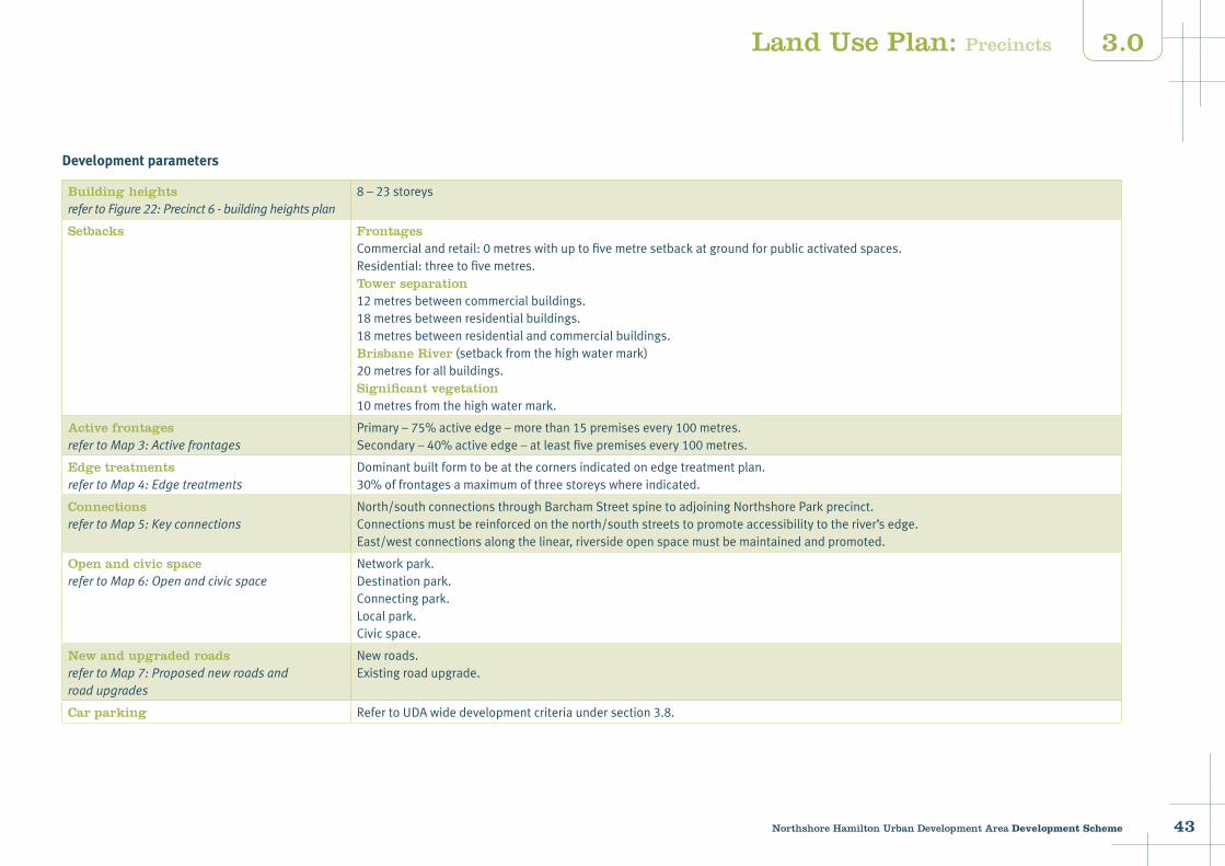
Development parameters
Building heightsrefertoFigure22:Precinct6-buildingheightsplan
8–23storeys
Setbacks FrontagesCommercialandretail:0metreswithuptofivemetresetbackatgroundforpublicactivatedspaces.Residential:threetofivemetres.Tower separation12metresbetweencommercialbuildings.18metresbetweenresidentialbuildings.18metresbetweenresidentialandcommercialbuildings.Brisbane River(setbackfromthehighwatermark)20metresforallbuildings.Significant vegetation10metresfromthehighwatermark.
Active frontagesrefertoMap3:Activefrontages
Primary–75%activeedge–morethan15premisesevery100metres.Secondary–40%activeedge–atleastfivepremisesevery100metres.
Edge treatmentsrefertoMap4:Edgetreatments
Dominantbuiltformtobeatthecornersindicatedonedgetreatmentplan.30%offrontagesamaximumofthreestoreyswhereindicated.
ConnectionsrefertoMap5:Keyconnections
North/southconnectionsthroughBarchamStreetspinetoadjoiningNorthshoreParkprecinct.Connectionsmustbereinforcedonthenorth/southstreetstopromoteaccessibilitytotheriver’sedge.East/westconnectionsalongthelinear,riversideopenspacemustbemaintainedandpromoted.
Open and civic space refertoMap6:Openandcivicspace
Networkpark.Destinationpark.Connectingpark.Localpark.Civicspace.
New and upgraded roads refertoMap7:Proposednewroadsandroadupgrades
Newroads.Existingroadupgrade.
Car parking RefertoUDAwidedevelopmentcriteriaundersection3.8.
Land Use Plan: Precincts
44 Northshore Hamilton Urban Development Area Development Scheme
3.0
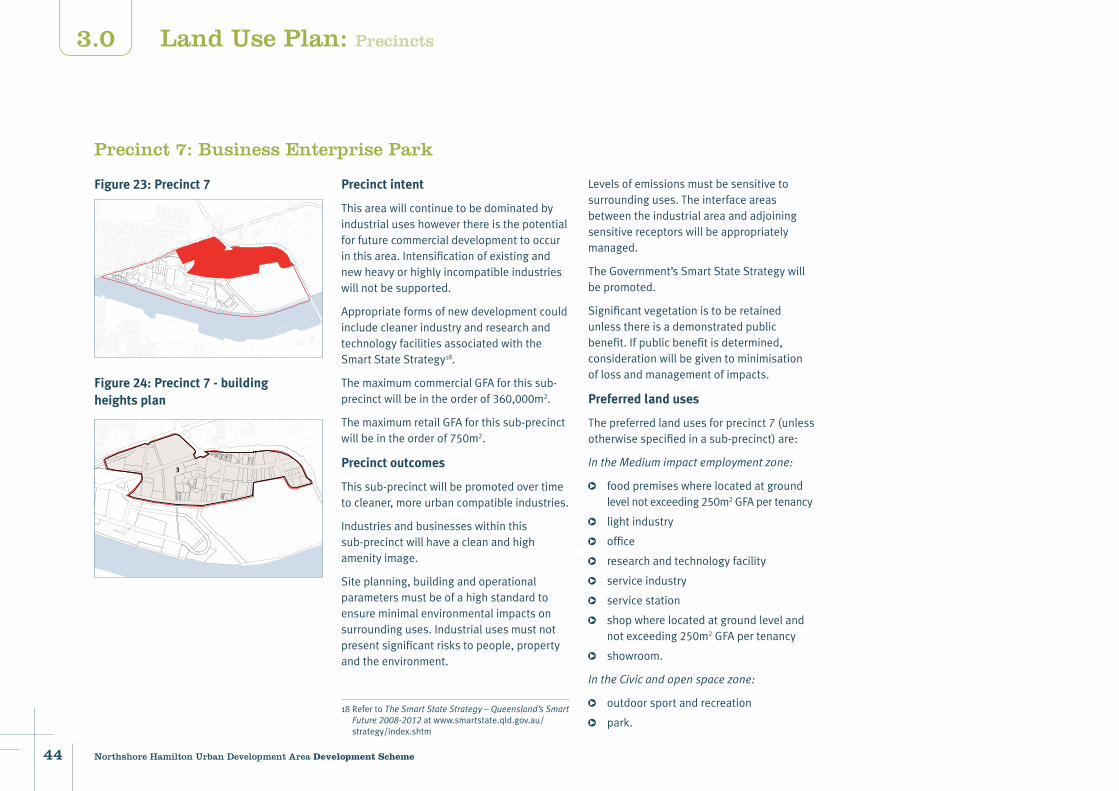
Precinct 7: Business Enterprise Park
Precinct intent
Thisareawillcontinuetobedominatedbyindustrialuseshoweverthereisthepotentialforfuturecommercialdevelopmenttooccurinthisarea.Intensificationofexistingandnewheavyorhighlyincompatibleindustrieswillnotbesupported.
AppropriateformsofnewdevelopmentcouldincludecleanerindustryandresearchandtechnologyfacilitiesassociatedwiththeSmartStateStrategy18.
ThemaximumcommercialGFAforthissub-precinctwillbeintheorderof360,000m2.
ThemaximumretailGFAforthissub-precinctwillbeintheorderof750m2.
Precinct outcomes
Thissub-precinctwillbepromotedovertimetocleaner,moreurbancompatibleindustries.
Industriesandbusinesseswithinthissub-precinctwillhaveacleanandhighamenityimage.
Siteplanning,buildingandoperationalparametersmustbeofahighstandardtoensureminimalenvironmentalimpactsonsurroundinguses.Industrialusesmustnotpresentsignificantriskstopeople,propertyandtheenvironment.
18RefertoTheSmartStateStrategy–Queensland’sSmartFuture2008-2012atwww.smartstate.qld.gov.au/strategy/index.shtm
Levelsofemissionsmustbesensitivetosurroundinguses.Theinterfaceareasbetweentheindustrialareaandadjoiningsensitivereceptorswillbeappropriatelymanaged.
TheGovernment’sSmartStateStrategywillbepromoted.
Significantvegetationistoberetainedunlessthereisademonstratedpublicbenefit.Ifpublicbenefitisdetermined,considerationwillbegiventominimisationoflossandmanagementofimpacts.
Preferred land uses
Thepreferredlandusesforprecinct7(unlessotherwisespecifiedinasub-precinct)are:
IntheMediumimpactemploymentzone:
foodpremiseswherelocatedatgroundlevelnotexceeding250m2GFApertenancy
lightindustry
office
researchandtechnologyfacility
serviceindustry
servicestation
shopwherelocatedatgroundlevelandnotexceeding250m2GFApertenancy
showroom.
IntheCivicandopenspacezone:
outdoorsportandrecreation
park.
3
Figure 24: Precinct 7 - building heights plan
Land Use Plan: Precincts
Figure 23: Precinct 7

45Northshore Hamilton Urban Development Area Development Scheme
3.0
Precinct 7: Business Enterprise Park level of assessment table
Column 1Exempt development
Column 2 UDA self assessable development
Column 3 – UDA assessable development
Column 3APermissible development
Column 3BProhibited development
AlldevelopmentspecifiedinSchedule1. EnvironmentallyrelevantactivitiesforwhichacodeofenvironmentalcompliancehasbeenmadeundertheEnvironmentalProtectionRegulation1998.
Materialchangeofusefora“preferredlanduse”wherenotinvolvingbuildingworkandcomplyingwiththeapplicable1carparkingratios.
OperationalworkinaccordancewiththeagreedstandardsasstatedinaUDAdevelopmentapproval.
AllotherdevelopmentnotspecifiedinColumn1,Column2orColumn3B.
Materialchangeofusefor:
communityfacilities
extractiveindustry
generalindustry
heavyindustry
house
multipleresidential
otherresidential,or
relocatablehomeandcaravanpark.
1Asrequiredfortheprecinctorpreviouslyapproved.
Development parameters
HeightsrefertoFigure24:Precinct7-buildingheightsplan
3storeys
Setbacks FrontagesKingsfordSmithDrive:threemetres(afterroadwidening).Commercial:0tothreemetres.Industrial:3-5metres.Significant vegetation10metresfromthehighwatermark.
ConnectionsrefertoMap5:Keyconnections
North/southconnectionstoNorthshoreLinksPrecinctandBrisbaneRiver.PossiblefutureconnectiontoGatewayMotorway.
New and upgraded roads refertoMap7:Proposednewroadsandroadupgrades
Newroads.Existingroadupgrade.
Carparking RefertoUDAwidedevelopmentcriteriaundersection3.8.
Roadwidening KingsfordSmithDriveRoadasperBrisbaneCityCouncilrequirements.FutureaccesstodevelopmentsiteswillnotbeobtaineddirectlyoffKingsfordSmithDrive.
Land Use Plan: Precincts
46 Northshore Hamilton Urban Development Area Development Scheme
3.0
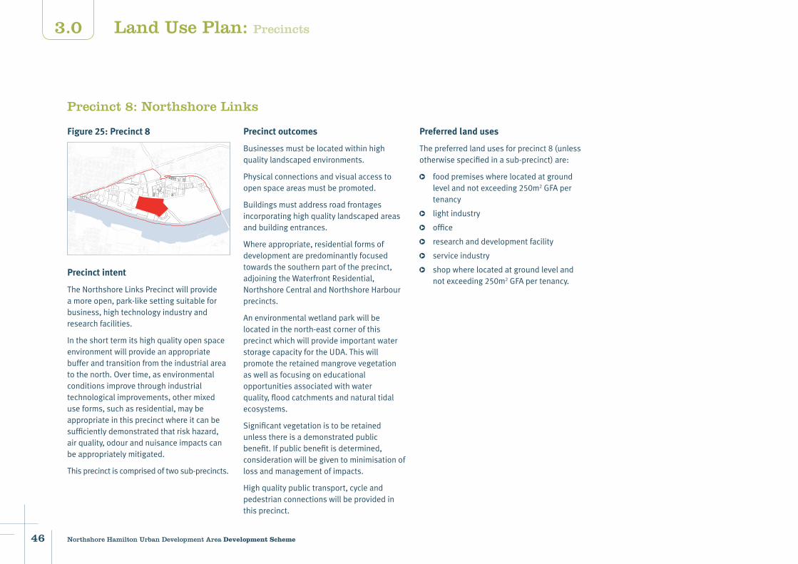
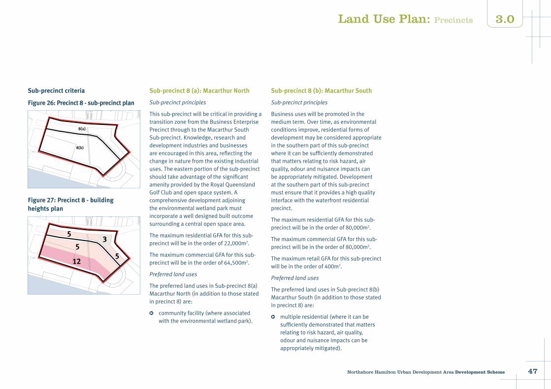
Precinct 8: Northshore Links
Precinct outcomes
Businessesmustbelocatedwithinhighqualitylandscapedenvironments.
Physicalconnectionsandvisualaccesstoopenspaceareasmustbepromoted.
Buildingsmustaddressroadfrontagesincorporatinghighqualitylandscapedareasandbuildingentrances.
Whereappropriate,residentialformsofdevelopmentarepredominantlyfocusedtowardsthesouthernpartoftheprecinct,adjoiningtheWaterfrontResidential,NorthshoreCentralandNorthshoreHarbourprecincts.
Anenvironmentalwetlandparkwillbelocatedinthenorth-eastcornerofthisprecinctwhichwillprovideimportantwaterstoragecapacityfortheUDA.Thiswillpromotetheretainedmangrovevegetationaswellasfocusingoneducationalopportunitiesassociatedwithwaterquality,floodcatchmentsandnaturaltidalecosystems.
Significantvegetationistoberetainedunlessthereisademonstratedpublicbenefit.Ifpublicbenefitisdetermined,considerationwillbegiventominimisationoflossandmanagementofimpacts.
Highqualitypublictransport,cycleandpedestrianconnectionswillbeprovidedinthisprecinct.
Preferred land uses
Thepreferredlandusesforprecinct8(unlessotherwisespecifiedinasub-precinct)are:
foodpremiseswherelocatedatgroundlevelandnotexceeding250m2GFApertenancy
lightindustry
office
researchanddevelopmentfacility
serviceindustry
shopwherelocatedatgroundlevelandnotexceeding250m2GFApertenancy.
Land Use Plan: Precincts
Figure 25: Precinct 8
Precinct intent
TheNorthshoreLinksPrecinctwillprovideamoreopen,park-likesettingsuitableforbusiness,hightechnologyindustryandresearchfacilities.
Intheshorttermitshighqualityopenspaceenvironmentwillprovideanappropriatebufferandtransitionfromtheindustrialareatothenorth.Overtime,asenvironmentalconditionsimprovethroughindustrialtechnologicalimprovements,othermixeduseforms,suchasresidential,maybeappropriateinthisprecinctwhereitcanbesufficientlydemonstratedthatriskhazard,airquality,odourandnuisanceimpactscanbeappropriatelymitigated.
Thisprecinctiscomprisedoftwosub-precincts.
47Northshore Hamilton Urban Development Area Development Scheme
3.0
Sub-precinct criteria
Figure 26: Precinct 8 - sub-precinct plan
Figure 27: Precinct 8 - building heights plan
Sub-precinct 8 (a): Macarthur North
Sub-precinctprinciples
Thissub-precinctwillbecriticalinprovidingatransitionzonefromtheBusinessEnterprisePrecinctthroughtotheMacarthurSouthSub-precinct.Knowledge,researchanddevelopmentindustriesandbusinessesareencouragedinthisarea,reflectingthechangeinnaturefromtheexistingindustrialuses.Theeasternportionofthesub-precinctshouldtakeadvantageofthesignificantamenityprovidedbytheRoyalQueenslandGolfClubandopenspacesystem.Acomprehensivedevelopmentadjoiningtheenvironmentalwetlandparkmustincorporateawelldesignedbuiltoutcomesurroundingacentralopenspacearea.
ThemaximumresidentialGFAforthissub-precinctwillbeintheorderof22,000m2.
ThemaximumcommercialGFAforthissub-precinctwillbeintheorderof64,500m2.
Preferredlanduses
ThepreferredlandusesinSub-precinct8(a)MacarthurNorth(inadditiontothosestatedinprecinct8)are:
communityfacility(whereassociatedwiththeenvironmentalwetlandpark).
8(a)
8(b)
53
55
12
Sub-precinct 8 (b): Macarthur South
Sub-precinctprinciples
Businessuseswillbepromotedinthemediumterm.Overtime,asenvironmentalconditionsimprove,residentialformsofdevelopmentmaybeconsideredappropriateinthesouthernpartofthissub-precinctwhereitcanbesufficientlydemonstratedthatmattersrelatingtoriskhazard,airquality,odourandnuisanceimpactscanbeappropriatelymitigated.Developmentatthesouthernpartofthissub-precinctmustensurethatitprovidesahighqualityinterfacewiththewaterfrontresidentialprecinct.
ThemaximumresidentialGFAforthissub-precinctwillbeintheorderof80,000m2.
ThemaximumcommercialGFAforthissub-precinctwillbeintheorderof80,000m2.
ThemaximumretailGFAforthissub-precinctwillbeintheorderof400m2.
Preferredlanduses
ThepreferredlandusesinSub-precinct8(b)MacarthurSouth(inadditiontothosestatedinprecinct8)are:
multipleresidential(whereitcanbesufficientlydemonstratedthatmattersrelatingtoriskhazard,airquality,odourandnuisanceimpactscanbeappropriatelymitigated).
Land Use Plan: Precincts
48 Northshore Hamilton Urban Development Area Development Scheme
3.0
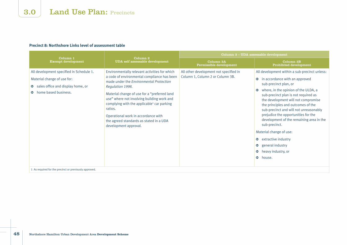
Precinct 8: Northshore Links level of assessment table
Column 1Exempt development
Column 2 UDA self assessable development
Column 3 – UDA assessable development
Column 3APermissible development
Column 3BProhibited development
AlldevelopmentspecifiedinSchedule1.
Materialchangeofusefor:
salesofficeanddisplayhome,or
homebasedbusiness.
EnvironmentallyrelevantactivitiesforwhichacodeofenvironmentalcompliancehasbeenmadeundertheEnvironmentalProtectionRegulation1998.
Materialchangeofusefora“preferredlanduse”wherenotinvolvingbuildingworkandcomplyingwiththeapplicable1carparkingratios.
OperationalworkinaccordancewiththeagreedstandardsasstatedinaUDAdevelopmentapproval.
AllotherdevelopmentnotspecifiedinColumn1,Column2orColumn3B.
Alldevelopmentwithinasub-precinctunless:
inaccordancewithanapprovedsub-precinctplan,or
where,intheopinionoftheULDA,asub-precinctplanisnotrequiredasthedevelopmentwillnotcompromisetheprinciplesandoutcomesofthesub-precinctandwillnotunreasonablyprejudicetheopportunitiesforthedevelopmentoftheremainingareainthesub-precinct.
Materialchangeofuse:
extractiveindustry
generalindustry
heavyindustry,or
house.
1Asrequiredfortheprecinctorpreviouslyapproved.
Land Use Plan: Precincts

49Northshore Hamilton Urban Development Area Development Scheme
3.0
Development parameters
Building heights
refertoFigure27:Precinct8-buildingheightsplan
3–12storeys
Edge treatments
refertoMap4:Edgetreatments
Dominantbuiltformtobeatthecornersindicatedonedgetreatmentplan.30%offrontagesamaximumofthreestoreyswhereindicated.
Setbacks FrontagesCommercial:0tothreemetres.Residential:threetofivemetres.Tower separation 12metresbetweencommercialbuildings.18metresbetweenresidentialbuildings.18metresbetweenresidentialandcommercialbuildings.Significant vegetation10metresfromthehighwatermark.
Connections
refertoMap5:Keyconnections
North/southconnectionstoBusinessEnterprisePrecinctandBrisbaneRiver.East/westconnectionstoadjoiningNorthshoreCentralPrecinct.Openspaceconnectionsbetweenwetlandparkandriversideparkland.
Open and civic space
refertoMap6:Openandcivicspace
Destinationpark.Connectingpark.Localpark.
New and Upgraded Roads
refertoMap7:Proposednewroadsandroadupgrades
Newroads.Existingroadupgrade.
Car parking RefertoUDAwidedevelopmentcriteriaundersection3.8.
Land Use Plan: Precincts
50 Northshore Hamilton Urban Development Area Development Scheme
3.0
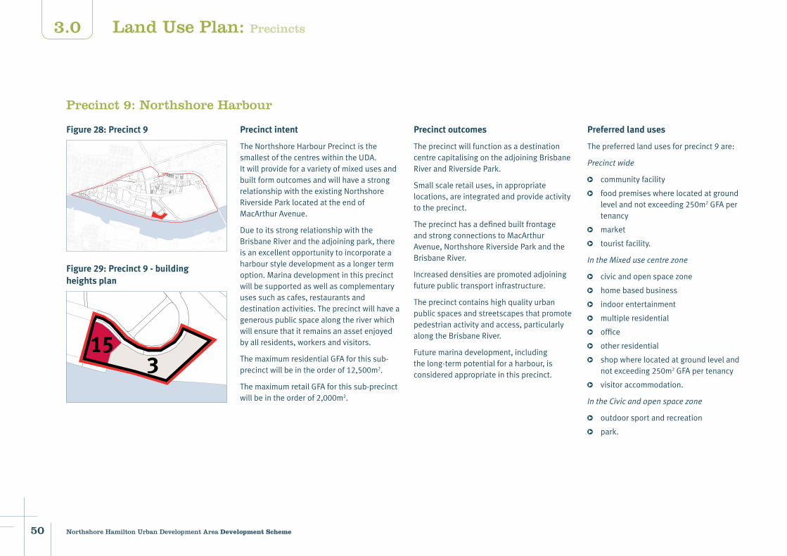
Figure 28: Precinct 9
Figure 29: Precinct 9 - building heights plan
Precinct 9: Northshore Harbour
Precinct intent
TheNorthshoreHarbourPrecinctisthesmallestofthecentreswithintheUDA.ItwillprovideforavarietyofmixedusesandbuiltformoutcomesandwillhaveastrongrelationshipwiththeexistingNorthshoreRiversideParklocatedattheendofMacArthurAvenue.
DuetoitsstrongrelationshipwiththeBrisbaneRiverandtheadjoiningpark,thereisanexcellentopportunitytoincorporateaharbourstyledevelopmentasalongertermoption.Marinadevelopmentinthisprecinctwillbesupportedaswellascomplementaryusessuchascafes,restaurantsanddestinationactivities.Theprecinctwillhaveagenerouspublicspacealongtheriverwhichwillensurethatitremainsanassetenjoyedbyallresidents,workersandvisitors.
ThemaximumresidentialGFAforthissub-precinctwillbeintheorderof12,500m2.
ThemaximumretailGFAforthissub-precinctwillbeintheorderof2,000m2.
Precinct outcomes
TheprecinctwillfunctionasadestinationcentrecapitalisingontheadjoiningBrisbaneRiverandRiversidePark.
Smallscaleretailuses,inappropriatelocations,areintegratedandprovideactivitytotheprecinct.
TheprecincthasadefinedbuiltfrontageandstrongconnectionstoMacArthurAvenue,NorthshoreRiversideParkandtheBrisbaneRiver.
Increaseddensitiesarepromotedadjoiningfuturepublictransportinfrastructure.
Theprecinctcontainshighqualityurbanpublicspacesandstreetscapesthatpromotepedestrianactivityandaccess,particularlyalongtheBrisbaneRiver.
Futuremarinadevelopment,includingthelong-termpotentialforaharbour,isconsideredappropriateinthisprecinct.
Preferred land uses
Thepreferredlandusesforprecinct9are:
Precinctwide
communityfacility
foodpremiseswherelocatedatgroundlevelandnotexceeding250m2GFApertenancy
market
touristfacility.
IntheMixedusecentrezone
civicandopenspacezone
homebasedbusiness
indoorentertainment
multipleresidential
office
otherresidential
shopwherelocatedatgroundlevelandnotexceeding250m2GFApertenancy
visitoraccommodation.
IntheCivicandopenspacezone
outdoorsportandrecreation
park.
153
Land Use Plan: Precincts

51Northshore Hamilton Urban Development Area Development Scheme
3.0
Precinct 9: Northshore Harbour level of assessment table
Column 1Exempt development
Column 2 UDA self assessable development
Column 3 – UDA assessable development
Column 3APermissible development
Column 3BProhibited development
AlldevelopmentspecifiedinSchedule1.
Materialchangeofusefor:
salesofficeanddisplayhome,or
homebasedbusiness.
EnvironmentallyrelevantactivitiesforwhichacodeofenvironmentalcompliancehasbeenmadeundertheEnvironmentalProtectionRegulation1998.
Materialchangeofusefora“preferredlanduse”wherenotinvolvingbuildingworkandcomplyingwiththeapplicable1carparkingratios.
OperationalworkinaccordancewiththeagreedstandardsasstatedinaUDAdevelopmentapproval.
AllotherdevelopmentnotspecifiedinColumn1,Column2orColumn3B.
Materialchangeofusefor
extractiveindustry
generalindustry
heavyindustry
lightindustry,or
house.
1Asrequiredfortheprecinctorpreviouslyapproved.
Land Use Plan: Precincts

52 Northshore Hamilton Urban Development Area Development Scheme
3.0
Development parameters
Building heights
refertoFigure29:Precinct9-buildingheightsplan
3–15storeys
Setbacks FrontagesCommercialandretail:0metreswithuptofivemetressetbackatgroundforpublicactivatedspaces.Residential:threetofivemetres.Tower separation18metresbetweenresidentialbuildings.18metresbetweenresidentialandcommercialbuildings.Brisbane River(setbackfromthehighwatermark)20metresforallbuildings.
Active frontages
refertoMap3:Activefrontages
Primary–75%activeedge–morethan15premisesevery100metres.
Edge treatments
refertoMap4:Edgetreatments
Dominantbuiltformtobeatthecornersindicatedonedgetreatmentplan.30%offrontagesamaximumofthreestoreyswhereindicated.
Connections
refertoMap5:Keyconnections
Connectionsmustbereinforcedonthenorth/southstreetstopromoteaccessibilitytotheriver’sedge.East/westconnectionsalongthelinear,riversideopenspacemustbemaintainedandpromoted.ThisincludesastrongconnectionfromtheprecincttotheadjoiningNorthshoreRiversidePark.
Open and civic space
refertoMap6:Openandcivicspace
Networkpark.Connectingpark.Civicspace.
New and upgraded roads
refertoMap7:Proposednewroadsandroadupgrades
Newroads.Existingroadupgrade.
Car parking RefertoUDAwidedevelopmentcriteriaundersection3.8.
Land Use Plan: Precincts

53Northshore Hamilton Urban Development Area Development Scheme
3.0
Figure 30: Precinct
Figure 31: Precinct 10 - building heights plan
Precinct 10: Royal Queensland Golf Club
Precinct intent
ThisprecinctcontainstheRoyalQueenslandGolfClubwhichisintendedtoremaininitscurrentform.Theexistingmangrovelinesdrainagesystemontheprecinct’swesternboundaryistobeprotected.
Precinct outcomes
Thegolfcourseusewillcontinue.
Significantvegetationistoberetainedunlessthereisademonstratedpublicbenefit.Ifpublicbenefitisdetermined,considerationwillbegiventominimisationoflossandmanagementofimpacts.
Preferred land uses
Thepreferredlandusesforprecinct10are:
club
foodpremisesnotexceeding250m2GFApertenancy
indoorsportandrecreation
outdoorsportandrecreation
shopnotexceeding250m2GFApertenancy.
3
Land Use Plan: Precincts
54 Northshore Hamilton Urban Development Area Development Scheme
3.0
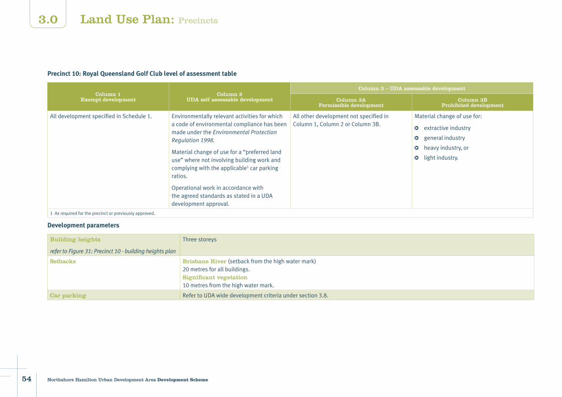
Precinct 10: Royal Queensland Golf Club level of assessment table
Column 1Exempt development
Column 2 UDA self assessable development
Column 3 – UDA assessable development
Column 3APermissible development
Column 3BProhibited development
AlldevelopmentspecifiedinSchedule1. EnvironmentallyrelevantactivitiesforwhichacodeofenvironmentalcompliancehasbeenmadeundertheEnvironmentalProtectionRegulation1998.
Materialchangeofusefora“preferredlanduse”wherenotinvolvingbuildingworkandcomplyingwiththeapplicable1carparkingratios.
OperationalworkinaccordancewiththeagreedstandardsasstatedinaUDAdevelopmentapproval.
AllotherdevelopmentnotspecifiedinColumn1,Column2orColumn3B.
Materialchangeofusefor:
extractiveindustry
generalindustry
heavyindustry,or
lightindustry.
1Asrequiredfortheprecinctorpreviouslyapproved.
Development parameters
Building heights
refertoFigure31:Precinct10-buildingheightsplan
Threestoreys
Setbacks Brisbane River(setbackfromthehighwatermark)20metresforallbuildings.Significant vegetation10metresfromthehighwatermark.
Car parking RefertoUDAwidedevelopmentcriteriaundersection3.8.
Land Use Plan: Precincts