3.10 land use and recreation - caltrain.commodernization+program/deir/3.10... · land use and...
TRANSCRIPT

Peninsula Corridor Joint Powers Board Settings, Impacts, and Mitigation Measures
Land Use and Recreation
3.10 Land Use and Recreation 1
This section characterizes potential project impacts on existing land use and recreation. For the 2 purposes of this section, the analysis generally considers land uses within 0.25 miles of the project 3 corridor from San Francisco to San Jose (2 miles south of Tamien Station). However, the focus of the 4 impact analysis is on existing land uses and recreational facilities directly adjacent to the Caltrain 5 right-of-way (ROW) or that cross the Caltrain ROW, such as bike paths. 6
The project corridor traverses the counties of San Francisco, San Mateo, and Santa Clara, extending 7 from downtown San Francisco to south of downtown San Jose. This corridor encompasses portions 8 of the following cities: San Francisco, Brisbane, South San Francisco, San Bruno, Millbrae, 9 Burlingame, San Mateo, Belmont, San Carlos, Redwood City, Atherton, Menlo Park, Palo Alto, 10 Mountain View, Sunnyvale, Santa Clara, and San Jose. Land uses in the corridor comprise the full 11 range of urban development, with a diverse mix of uses adjacent to the Caltrain corridor in some 12 locations, and more homogeneous industrial and commercial uses in others. The corridor includes 13 numerous areas of single- or multi-family residential uses, as well as a variety of recreational land 14 uses, that are directly adjacent to the Caltrain ROW. 15
As described in Section 2.5, Required Permits and Approvals, pursuant to SamTrans’ enabling 16 legislation (Public Utilities Code Section 103200 et seq.) and the 1991 Interstate Commerce 17 Commission's approval of the JPB acquisition of the Caltrain line, JPB activities within the Caltrain 18 ROW are exempt from local building and zoning codes and other land use ordinances. Thus, within 19 the Caltrain ROW, no impacts on land use or recreation are expected. Consequently, the focus of 20 analysis in this section is locations where project activities would occur outside the current Caltrain 21 ROW. 22
The project areas with permanent facilities outside the Caltrain ROW are as follows: 23
The two traction power substations (TPSs) in South San Francisco and San Jose could be outside 24 of the ROW along with underground duct banks connecting them to the Caltrain ROW and 25 overhead or underground duct banks connecting the TPS to the nearest PG&E substation. Each 26 of the TPSs would have three options. All three options in South San Francisco would be outside 27 of the ROW while two of the three options in San Jose would be outside of the ROW. 28
The overhead contact system (OCS) alignment would be installed slightly (perhaps several feet) 29 outside of the current ROW in an estimated 20 locations for a total length of approximately 30 9,300 feet. These areas would be acquired in fee (if on private land) or an easement would be 31 acquired (if on public land) for the OCS. 32
The electrical safety zone of 10 feet around the OCS alignment would extend outside of the 33 current ROW in an estimated 108 locations. The JPB would acquire electrical safety easements 34 from private landowners and public agencies to allow vegetation safety maintenance and to 35 maintain minimum clearances from buildings to the OCS. 36
Analysis of potential cumulative land use impacts on future projects proposed along the Caltrain 37 ROW or within the ROW are discussed in Chapter 4, Other CEQA-Related Analysis. 38
Peninsula Corridor Electrification Project EIR 3.10-1 February 2014 ICF 00606.12
Peninsula Corridor Joint Powers Board Settings, Impacts, and Mitigation Measures
Land Use and Recreation
3.10.1 Existing Conditions 1
3.10.1.1 Regulatory Setting 2
Land Use 3
This section presents relevant applicable land use and transportation plans. Please refer to 4 Appendix H, Land Use Information, for a list and discussion of all applicable plans for lands adjacent 5 to the project corridor. 6
MTC Transportation 2035 Plan 7
The MTC’s Transportation 2035 Plan for the San Francisco Bay Area (2035 Plan) specifies how 8 anticipated federal, state, and local transportation funds will be spent in the nine-county Bay Area 9 during the next 25 years. The vision for Transportation 2035 is to support a prosperous and globally 10 competitive Bay Area economy, provide for a healthy and safe environment, and promote equitable 11 mobility opportunities to all residents. Among the cornerstones of the new plan are a joint regional 12 planning initiative known as FOCUS, which provides incentives for cities and counties to promote 13 future growth near transit in already urbanized portions of the Bay Area. Caltrain transit operating 14 and capital improvements are included in the 2035 Plan. Improvements to San Mateo County and 15 Santa Clara County stations, such as upgrades/relocation of platforms, pedestrian tunnels, and 16 parking improvements, are also included (Metropolitan Transportation Commission 2009). 17
General Plans 18
California Government Code Section 65301 requires every city and county to adopt a general plan. 19 General plans lay out the pattern of future residential, commercial, industrial, agricultural, open 20 space, public, and recreational land uses within a community. Local jurisdictions implement their 21 general plans by adopting zoning, subdivision, grading, and other ordinances. Zoning identifies the 22 specific types of land uses or forms of development that may be allowed on a given site and 23 establishes the standards that are be imposed on new development. Zoning regulations vary from 24 jurisdiction to jurisdiction. Typical zoning standards address the density and size of structures, the 25 siting of structures relative to parcel boundaries, architectural design, and the percentage of 26 building coverage allowed relative to the overall square footage of a parcel. 27
As noted above, the permanent facilities outside the ROW would be in various cities along the 28 project corridor. Appendix H includes a description of all the applicable general plans for these 29 cities. 30
Specific, Area, and Precise Plans 31
A specific plan is a tool for the systematic implementation of a city or county general plan. A specific 32 plan effectively establishes a link between implementing policies of the general plan and the 33 individual development proposals in a defined area. Precise plans are flexible documents adopted by 34 some California cities to facilitate the use of innovative or unconventional urban planning 35 techniques. Area plans are plans that cover specific subareas of a community. Within these plans, 36 general policies contained in the general plan elements are made more precise as the policies relate 37 to specific parts of the city. 38
Peninsula Corridor Electrification Project EIR 3.10-2 February 2014 ICF 00606.12

Peninsula Corridor Joint Powers Board Settings, Impacts, and Mitigation Measures
Land Use and Recreation
The area of analysis overlaps with, or runs adjacent to, several adopted specific, area, or precise 1 plans that address land development in defined geographic areas within a jurisdiction. The plans 2 adjacent to the project corridor are listed in Appendix H. In addition, several plans that are adjacent 3 to the ROW are currently under review but not adopted, including the South San Francisco 4 Downtown Specific Plan, the San Antonio Precise Plan (Mountain View), the Lawrence Station Area 5 Plan (Sunnyvale), and the Peery Park Specific Plan (Sunnyvale). The Millbrae Station Area Specific 6 Plan, which includes the project corridor, was originally adopted in 1998 and is in the process of 7 being updated. 8
All options of TPS1 would be located in the South San Francisco East of 101 Area Plan, which covers 9 approximately 1,700 acres bounded by San Francisco Bay to the east, U.S. Highway 101 and the 10 Caltrain corridor to the west, the City of Brisbane to the north, and San Francisco International 11 Airport to the south (South San Francisco 1994). The overall goal is to recognize the unique 12 character of the East of 101 Area and to guide and relate development in a manner that protects and 13 enhances the area’s physical, economic, and natural resources, while also encouraging appropriate 14 development in the area. TPS1 Options 1 and 3, would be within areas with Planned Commercial 15 land use designations in the area plan. TPS1 Option 2 would be within an area designated as 16 Planned Industrial. 17
None of the options for TPS2 in the City of San Jose would be within an area covered by a specific, 18 area, or precise plan. There are no proposed specific, area, or precise plans adjacent to or 19 encompassing the options for TPS1 or TPS2. 20
Habitat Conservation Plans 21
Habitat conservation plans (HCPs) are voluntarily developed for ecologically sensitive areas in order 22 to fulfill the requirements of the Endangered Species Act and the California Natural Community 23 Conservation Planning (NCCP) Act. These plans address impact mitigation and contribute to the 24 recovery of endangered species while enhancing and restoring habitats and natural systems. 25
The Caltrain corridor runs adjacent to the San Bruno Mountain Habitat Conservation Plan in San 26 Mateo County, as described in Appendix H. In addition, the corridor bisects the northern portion of 27 the Santa Clara Valley Habitat Plan. The Santa Clara Valley Habitat Plan provides a framework for 28 promoting the protection and recovery of natural resources, including endangered species, while 29 streamlining the permitting process for development, infrastructure, and maintenance activities. 30 The Santa Clara Valley Habitat Plan allows Santa Clara County, the Santa Clara Valley Water District, 31 the Santa Clara Valley Transportation Authority (VTA) and the cities of Gilroy, Morgan Hill, and San 32 José (collectively, the local partners or permittees) to receive endangered species “take” permits for 33 activities and projects they conduct and under their jurisdiction (ICF International 2012). The TPS2 34 options, Paralleling Station (PS) 7, and the Caltrain ROW from Santa Clara to south of Tamien Station 35 are within the Santa Clara Valley Habitat Plan area. 36
3.10.1.2 Environmental Setting 37
Existing Land Uses in the Vicinity of the Caltrain Corridor 38
The primary land use in the Proposed Project area is the rail ROW itself, portions of which have 39 existed since the 1860s. Surrounding land uses include commercial, industrial, open space, mixed 40 use, and residential uses. Land uses in the vicinity of the proposed paralleling and switching stations 41
Peninsula Corridor Electrification Project EIR 3.10-3 February 2014 ICF 00606.12

Peninsula Corridor Joint Powers Board Settings, Impacts, and Mitigation Measures
Land Use and Recreation
and traction power substations are primarily industrial and commercial; however, at a few 1 locations, residential properties are adjacent to the existing ROW. 2
Land uses in the downtown San Francisco area of the Caltrain corridor are primarily urban and 3 industrial, with some retail, live/work loft, residential, and commercial uses. Between the 22nd 4 Street and Bayshore Station areas, land uses are primarily light industrial and warehouse with some 5 residential north of Paul Avenue. South of Paul Avenue to the Bayshore Station, there is a shift to a 6 more even distribution of light industrial and residential through Visitacion Valley, south of which 7 the primary use is light industrial. 8
There is primarily vacant land through the Brisbane lagoon area, with mainly light industrial and 9 warehouse uses and some residential and commercial uses through South San Francisco. San Bruno 10 presents a mixture of park/open space and low-density residential housing with some commercial 11 and light industrial uses. In Millbrae, the area to the west of the corridor is primarily commercial 12 and contains low-density businesses and residential uses. Industrial uses lie east of the ROW in 13 Millbrae. Transit-oriented development (TOD) uses surround the multi-modal Millbrae 14 Caltrain/BART station. 15
Land uses in the Burlingame segment of the corridor include commercial, residential, and industrial. 16 The tracks pass directly adjacent to Burlingame High School and Washington Park. Land use 17 adjacent to the Caltrain corridor within the City of San Mateo (from north to south) are commercial, 18 multi-family residential, neighborhood commercial, central business, office, service commercial, 19 manufacturing, and commercial. South of State Route (SR) 92 is the San Mateo County Event Center 20 and the under-construction Bay Meadows TOD project. Located on the other side of the tracks and 21 to the west of El Camino Real is Hillsdale Shopping Center. 22
The primary adjacent land uses within the City of Belmont are single-family residential and 23 commercial along the El Camino Real corridor. East and west1 of the San Carlos segment are single-24 family residential, local retail, and service/convenience commercial uses. Further to the east is U.S. 25 Highway 101 and predominantly industrial uses. The Redwood City segment provides a relatively 26 equal mix of residential, commercial, and industrial uses. 27
The land uses in the Town of Atherton along the corridor are low-density, single-family residential 28 and one park. Holbrook-Palmer Park is adjacent to the corridor, to the east. The land uses in Menlo 29 Park are general commercial and varying types of residential from medium-density apartment to 30 single-family suburban. Burgess Park is adjacent to the corridor in the vicinity of downtown Menlo 31 Park. El Palo Alto Park and El Camino Park are located adjacent to the Caltrain ROW as it enters Palo 32 Alto, beyond which is the Stanford Shopping Center and Stanford University to the west. Palo Alto 33 High School is located adjacent to the railroad corridor. The majority of the area within 0.25 miles of 34 the corridor in Palo Alto contains single-family residential units. 35
The City of Mountain View has general industrial, residential, public facility, and arterial commercial 36 uses adjacent to the project corridor. Rengstorff Park is located adjacent to ROW. The eastern 37 section of the corridor within the City of Sunnyvale is primarily industrial with low- to medium-38 density residential interspersed. Neighborhood shopping, general business, high-density residential, 39 and industrial residential uses are located to the west. Through the City of Santa Clara, the adjacent 40
1 Note that the Caltrain corridor generally runs in a north-south direction. Although some segments are oriented in a northwest-southeast direction, for sake of consistency, this section assumes that the corridor is north-south in all segments.
Peninsula Corridor Electrification Project EIR 3.10-4 February 2014 ICF 00606.12

Peninsula Corridor Joint Powers Board Settings, Impacts, and Mitigation Measures
Land Use and Recreation
uses consist of mixed use, moderate-density residential, and office/research and development. 1 Heavy industrial uses are located east of the railroad tracks, with light industrial, research and 2 development, and office uses located to the west. The San Jose International Airport is located 3 northeast of Santa Clara Station. 4
The College Park Station in San Jose is located near Bellarmine College Preparatory High School. The 5 SAP Center is adjacent to the Caltrain alignment just north of the San Jose Diridon Station. The 6 primary adjacent land uses in the City of San Jose are combined industrial/commercial, public park, 7 medium-low density to medium-density residential, light industrial, private recreation, campus 8 industrial, and the Coyote Valley Urban Reserve. Near Tamien Station is the Tamien Planned 9 Community, and farther to the south between the Capitol and Blossom Hill Stations is the 10 Communications Hill Planned Community. The main land uses in this planned community are single-11 family detached and attached residential, parks/play fields, heavy industrial, and combined 12 industrial/commercial. 13
Table 3.10-1, below summarizes the predominant land uses adjacent to the Caltrain corridor.14
Peninsula Corridor Electrification Project EIR 3.10-5 February 2014 ICF 00606.12

Peninsula Corridor Joint Powers Board Settings, Impacts, and Mitigation Measures
Land Use and Recreation
Table 3.10-1. Predominant Land Uses within 0.25 Miles of the Caltrain Corridor
City/Segment East/West of Corridor Predominant Land Usesa,b
San Francisco San Francisco 4th and King Station to 22nd Street Station
East Mixed use, residential, commercial, parks/open space, education/public/semi-public, industrial, commercial
West Mixed use, industrial, residential 22nd Street Station to Bayshore Station East Industrial, residential, education/public/semi-public West Industrial, residential Brisbane East Commercial, parks/open space West Commercial, parks/open space, residential South San Francisco East Commercial/industrial West Residential, commercial, industrial, mixed use San Bruno East Industrial, residential, commercial West Residential, commercial Millbrae East Parks/open space, industrial, residential, mixed use West Residential, commercial, mixed-use Burlingame North Burlingame border to Broadway Station East Mixed use (commercial/industrial) West Commercial, residential, parks/open space, education Broadway Station to south Burlingame border East Commercial, residential, mixed use West Commercial, residential San Mateo North San Mateo border to San Mateo Station East Residential, education West Residential, commercial, mixed use San Mateo Station to Hayward Park Station East Commercial, residential, industrial, education West Commercial, residential, mixed use, parks/open space Hayward Park Station to Hillsdale Station East Mixed use, commercial, residential, public space West Commercial, residential, mixed use Hillsdale Station to South San Mateo border East Residential, commercial, education West Commercial, mixed use, residential Belmont East Residential, commercial, education West Residential, commercial, mixed use, education San Carlos East Industrial, residential, commercial West Residential, commercial
Peninsula Corridor Electrification Project EIR 3.10-6 February 2014 ICF 00606.12
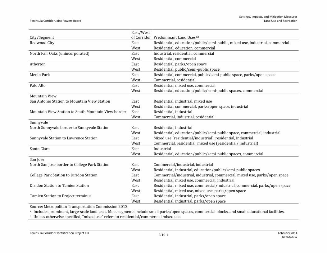
Peninsula Corridor Joint Powers Board Settings, Impacts, and Mitigation Measures
Land Use and Recreation
City/Segment East/West of Corridor Predominant Land Usesa,b
Redwood City East Residential, education/public/semi-public, mixed use, industrial, commercial West Residential, education, commercial North Fair Oaks (unincorporated) East Industrial, residential, commercial West Residential, commercial Atherton East Residential, parks/open space West Residential, public/semi-public space Menlo Park East Residential, commercial, public/semi-public space, parks/open space West Commercial, residential Palo Alto East Residential, mixed use, commercial West Residential, education/public/semi-public spaces, commercial Mountain View San Antonio Station to Mountain View Station East Residential, industrial, mixed use West Residential, commercial, parks/open space, industrial Mountain View Station to South Mountain View border East Residential, industrial West Commercial, industrial, residential Sunnyvale North Sunnyvale border to Sunnyvale Station East Residential, industrial West Residential, education/public/semi-public space, commercial, industrial Sunnyvale Station to Lawrence Station East Mixed use (residential/industrial), residential, industrial West Commercial, residential, mixed use (residential/ industrial) Santa Clara East Industrial West Residential, education/public/semi-public spaces, commercial San Jose North San Jose border to College Park Station East Commercial/industrial, industrial West Residential, industrial, education/public/semi-public spaces College Park Station to Diridon Station East Commercial/industrial, industrial, commercial, mixed use, parks/open space West Residential, mixed use, commercial, industrial Diridon Station to Tamien Station East Residential, mixed use, commercial/industrial, commercial, parks/open space West Residential, mixed use, mixed use, parks/open space Tamien Station to Project terminus East Residential, industrial, parks/open space West Residential, industrial, parks/open space Source: Metropolitan Transportation Commission 2012. a Includes prominent, large-scale land uses. Most segments include small parks/open spaces, commercial blocks, and small educational facilities. b Unless otherwise specified, “mixed use” refers to residential/commercial mixed use.
Peninsula Corridor Electrification Project EIR 3.10-7 February 2014 ICF 00606.12
Peninsula Corridor Joint Powers Board Settings, Impacts, and Mitigation Measures
Land Use and Recreation
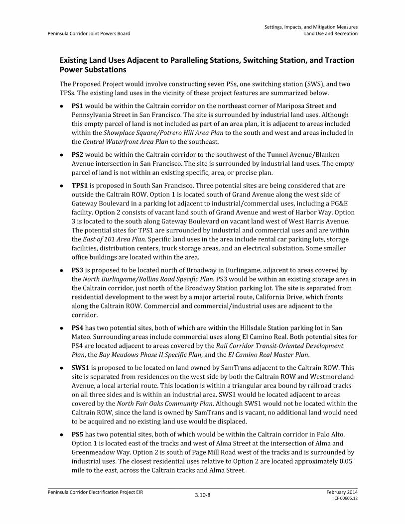
Existing Land Uses Adjacent to Paralleling Stations, Switching Station, and Traction Power Substations
The Proposed Project would involve constructing seven PSs, one switching station (SWS), and two TPSs. The existing land uses in the vicinity of these project features are summarized below.
PS1 would be within the Caltrain corridor on the northeast corner of Mariposa Street and Pennsylvania Street in San Francisco. The site is surrounded by industrial land uses. Although this empty parcel of land is not included as part of an area plan, it is adjacent to areas included within the Showplace Square/Potrero Hill Area Plan to the south and west and areas included in the Central Waterfront Area Plan to the southeast.
PS2 would be within the Caltrain corridor to the southwest of the Tunnel Avenue/Blanken Avenue intersection in San Francisco. The site is surrounded by industrial land uses. The empty parcel of land is not within an existing specific, area, or precise plan.
TPS1 is proposed in South San Francisco. Three potential sites are being considered that are outside the Caltrain ROW. Option 1 is located south of Grand Avenue along the west side of Gateway Boulevard in a parking lot adjacent to industrial/commercial uses, including a PG&E facility. Option 2 consists of vacant land south of Grand Avenue and west of Harbor Way. Option 3 is located to the south along Gateway Boulevard on vacant land west of West Harris Avenue. The potential sites for TPS1 are surrounded by industrial and commercial uses and are within the East of 101 Area Plan. Specific land uses in the area include rental car parking lots, storage facilities, distribution centers, truck storage areas, and an electrical substation. Some smaller office buildings are located within the area.
PS3 is proposed to be located north of Broadway in Burlingame, adjacent to areas covered by the North Burlingame/Rollins Road Specific Plan. PS3 would be within an existing storage area in the Caltrain corridor, just north of the Broadway Station parking lot. The site is separated from residential development to the west by a major arterial route, California Drive, which fronts along the Caltrain ROW. Commercial and commercial/industrial uses are adjacent to the corridor.
PS4 has two potential sites, both of which are within the Hillsdale Station parking lot in San Mateo. Surrounding areas include commercial uses along El Camino Real. Both potential sites for PS4 are located adjacent to areas covered by the Rail Corridor Transit-Oriented Development Plan, the Bay Meadows Phase II Specific Plan, and the El Camino Real Master Plan.
SWS1 is proposed to be located on land owned by SamTrans adjacent to the Caltrain ROW. This site is separated from residences on the west side by both the Caltrain ROW and Westmoreland Avenue, a local arterial route. This location is within a triangular area bound by railroad tracks on all three sides and is within an industrial area. SWS1 would be located adjacent to areas covered by the North Fair Oaks Community Plan. Although SWS1 would not be located within the Caltrain ROW, since the land is owned by SamTrans and is vacant, no additional land would need to be acquired and no existing land use would be displaced.
PS5 has two potential sites, both of which would be within the Caltrain corridor in Palo Alto. Option 1 is located east of the tracks and west of Alma Street at the intersection of Alma and Greenmeadow Way. Option 2 is south of Page Mill Road west of the tracks and is surrounded by industrial uses. The closest residential uses relative to Option 2 are located approximately 0.05 mile to the east, across the Caltrain tracks and Alma Street.
Peninsula Corridor Electrification Project EIR 3.10-8 February 2014 ICF 00606.12

Peninsula Corridor Joint Powers Board Settings, Impacts, and Mitigation Measures
Land Use and Recreation
PS6 has two potential sites, both of which would be within the Caltrain corridor in Sunnyvale. Option 1 is located to the east of the tracks and west of East Hendy Avenue, which separates the area from the residential neighborhoods to east. Option 2 is located to the southwest of Mathilda Avenue and West Evelyn Avenue within the northern portion of the Sunnyvale Station parking lot. This area consists of commercial uses. Option 2 is directly adjacent to areas covered by the Downtown Specific Plan to the east.
TPS2 is proposed in San Jose. Two out of the three potential sites outside of the Caltrain corridor are being considered. Option 1 is located on VTA property on Newhall Street. A PG&E substation is located directly across Newhall Street, north of Interstate 880 (I-880). Surrounding uses at this location are mostly industrial, with residential uses to the east. Option 2 is located west of Stockton Avenue and south of I-880. This site and its surroundings have industrial uses. Option 3 is on JPB property near the Caltrain Centralized Equipment Maintenance and Operations Facility (CEMOF) and is surrounded by industrial uses. All TPS2 options are located within the Santa Clara Valley Habitat Plan area.
PS7 is proposed to be constructed near Communications Hill in South San Jose. This site is located in the Caltrain ROW, south of Communications Hill Boulevard. The land use adjacent to the proposed location is parks (Kurte Park)/open space with new residential development located on Communications Hill. The site is adjacent to areas covered by the Communications Hill Specific Plan, as summarized in Appendix H, Land Use Information.
Existing Land Uses Where OCS Alignment or OCS Electrical Safety Zone Would Be Outside Caltrain ROW
The OCS alignment would be installed slightly (perhaps several feet) outside of the current ROW in an estimated 20 locations for a total length of approximately 9,300 feet. Approximately 7,100 feet of the OCS alignment would be installed several feet outside of the current ROW in 9 locations in adjacent road or rail rights of way in San Francisco, Millbrae, Redwood City, Mountain View, Santa Clara and San Jose. In addition, approximately 2,200 feet of OCS alignment in 11 locations would be installed several feet outside of the current ROW on adjacent commercial property in nine locations in Brisbane, Sunnyvale and San Jose.
The electrical safety zone of 10 feet around the OCS alignment would extend outside of the current ROW in adjacent road or rail rights of way in 46 locations in San Francisco, South San Francisco, San Bruno, Millbrae, San Mateo, Belmont, San Carlos, Redwood City, Palo Alto, Mountain View, Sunnyvale, Santa Clara, and San Jose. The electrical safety zone of 10 feet around the OCS alignment would extend outside of the current ROW in adjacent residential property (11 locations in Redwood City, Atherton, Palo Alto, Mountain View, Sunnyvale, Santa Clara and San Jose); commercial property (47 locations in San Francisco, Brisbane, San Bruno, Millbrae, Burlingame, San Mateo, Belmont, Redwood City, Menlo Park, Sunnyvale, Santa Clara, San Jose) and park areas (four locations in Redwood City, Atherton, Palo Alto, and Santa Clara). The four park locations are: Broadway-Arguello Park (Redwood City); Holbrook-Palmer Park (Atherton); Peers Park (Palo Alto); and Reed Street Dog Park (Santa Clara).
Recreation Facilities
Parks, recreation, and open space facilities are generally overseen by the parks and recreation departments of the cities through which the Caltrain corridor passes. These municipalities generally use planning documents, such as park master plans, to oversee the acquisition, preservation,
Peninsula Corridor Electrification Project EIR 3.10-9 February 2014 ICF 00606.12
Peninsula Corridor Joint Powers Board Settings, Impacts, and Mitigation Measures
Land Use and Recreation
improvement, maintenance, and expansion of local parklands and trail networks. Additionally, as described above, general plans of each jurisdiction include goals and policies addressing parks and recreational facilities. Other organizations, such as the San Francisco Bay Conservation and Development Commission and the Mid-Peninsula Open Space District, oversee parks, recreation and open space lands on a regional level and provide guidance on issues that transcend the authority of local jurisdictions.
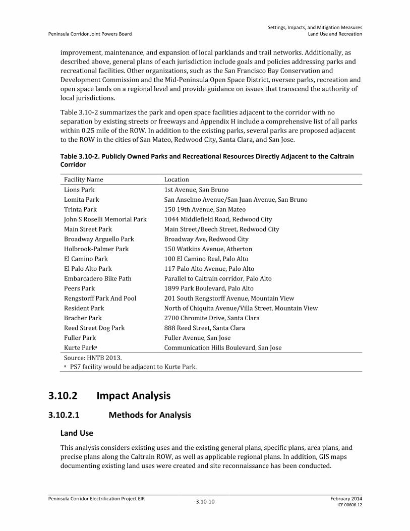
Table 3.10-2 summarizes the park and open space facilities adjacent to the corridor with no separation by existing streets or freeways and Appendix H include a comprehensive list of all parks within 0.25 mile of the ROW. In addition to the existing parks, several parks are proposed adjacent to the ROW in the cities of San Mateo, Redwood City, Santa Clara, and San Jose.
Table 3.10-2. Publicly Owned Parks and Recreational Resources Directly Adjacent to the Caltrain Corridor
Facility Name Location Lions Park 1st Avenue, San Bruno Lomita Park San Anselmo Avenue/San Juan Avenue, San Bruno Trinta Park 150 19th Avenue, San Mateo John S Roselli Memorial Park 1044 Middlefield Road, Redwood City Main Street Park Main Street/Beech Street, Redwood City Broadway Arguello Park Broadway Ave, Redwood City Holbrook-Palmer Park 150 Watkins Avenue, Atherton El Camino Park 100 El Camino Real, Palo Alto El Palo Alto Park 117 Palo Alto Avenue, Palo Alto Embarcadero Bike Path Parallel to Caltrain corridor, Palo Alto Peers Park 1899 Park Boulevard, Palo Alto Rengstorff Park And Pool 201 South Rengstorff Avenue, Mountain View Resident Park North of Chiquita Avenue/Villa Street, Mountain View Bracher Park 2700 Chromite Drive, Santa Clara Reed Street Dog Park 888 Reed Street, Santa Clara Fuller Park Fuller Avenue, San Jose Kurte Parka Communication Hills Boulevard, San Jose Source: HNTB 2013. a PS7 facility would be adjacent to Kurte Park.
3.10.2 Impact Analysis
3.10.2.1 Methods for Analysis
Land Use
This analysis considers existing uses and the existing general plans, specific plans, area plans, and precise plans along the Caltrain ROW, as well as applicable regional plans. In addition, GIS maps documenting existing land uses were created and site reconnaissance has been conducted.
Peninsula Corridor Electrification Project EIR 3.10-10 February 2014 ICF 00606.12

Peninsula Corridor Joint Powers Board Settings, Impacts, and Mitigation Measures
Land Use and Recreation
Recreation
In determining whether the Proposed Project would have a significant impact on parks and open spaces, this analysis considers recreational facilities within 0.25 mile of the Caltrain corridor. This assessment considers potential Project impacts on park design and physical conditions, existing vegetation, and how a park would be used while the Proposed Project is under construction and in operation.
3.10.2.2 Thresholds of Significance In accordance with Appendix G of the State CEQA Guidelines, the Proposed Project would be considered to have a significant effect if it would result in any of the conditions listed below.
Physically divide an established community.
Conflict with any applicable land use plan, policy, or regulation of an agency with jurisdiction over the project (including, but not limited to, a general plan, specific plan, local coastal program, or zoning ordinance) adopted for the purpose of avoiding or mitigating an environmental effect.
Conflict with any applicable habitat conservation plan or natural community conservation plan.
Increase the use of existing neighborhood and regional parks or other recreational facilities such that substantial physical deterioration of the facility would occur or be accelerated.
Include recreational facilities or require the construction or expansion of recreational facilities that might have an adverse physical effect on the environment.
As noted above, local land use plans are not applicable within the Caltrain ROW. Consequently, project activities that remain within the Caltrain ROW would not conflict with local land use plans, policies, or regulations.
3.10.2.3 Impacts and Mitigation Measures
Impact LUR-1 Physically divide an established community Level of Impact Less than significant
Construction
Community cohesion addresses the degree to which residents have a sense of belonging to their neighborhood or experience attachment to community groups and institutions as a result of continued association over time. Possible community cohesion impacts of a project include effects on interactions among persons and groups, whether certain people would be isolated from others, and the perceived impact on community quality of life.
The construction of OCS poles and wires within the existing ROW could involve short-term, temporary detours or street closures, which could separate an established community. However, these detours and closures would be temporary and would not significantly impact access to or from surrounding areas. In addition, the paralleling and switching stations and the traction power substations would be located either within or adjacent to the corridor, which would not divide an established community during construction. Consequently, construction impacts would be less than significant.
Peninsula Corridor Electrification Project EIR 3.10-11 February 2014 ICF 00606.12

Peninsula Corridor Joint Powers Board Settings, Impacts, and Mitigation Measures
Land Use and Recreation
Operation
The Proposed Project would primarily place new OCS poles and wires within the Caltrain ROW, with some portions of the OCS alignment located outside the Caltrain ROW. These facilities would be included within or adjacent to an existing, active commuter and freight rail corridor. Therefore, their operation would not constitute any new physical or psychological barriers that would divide, disrupt, or isolate neighborhoods, individuals, or community focal points in the corridor. Access across the ROW at existing roads and bike paths would be maintained under the Proposed Project. Although there would be some temporary delays to crossing the ROW during peak hours due to increased gate-down time at select at-grade crossings, which may result in a potential traffic impact (see Section 3.14, Transportation and Traffic), the increase in gate-down time during peak hours would not create an actual barrier between communities on either side of the Caltrain ROW.
The Proposed Project would place up to 10 traction power facilities (TPFs), consisting of two traction power substations, one switching station, and seven paralleling stations, along the corridor from San Francisco to San Jose. With the exception of the three TPS options in South San Francisco and two of the three TPS options in San Jose, these facilities would be within the Caltrain ROW. The two traction power substations would be located in areas of existing commercial and industrial development. Due to their relatively small size, and location within similar land uses, none of these facilities would have the potential to divide or disrupt an existing residential neighborhood or community. Therefore, operation of the Proposed Project would not divide an established community beyond existing conditions. The impact would be less than significant.
Impact LUR-2 Conflict with any applicable land use plan, policy, or regulation of an
agency with jurisdiction over the Proposed Project adopted for the purpose of avoiding or mitigating an environmental effect and compatibility with existing surrounding land uses
Level of Impact Less than significant
Construction and Operation
The Proposed Project would involve construction of OCS poles and wires primarily within the Caltrain ROW (with some OCS poles and wires outside the Caltrain ROW), 10 TPFs along the corridor, and new or improved bridge barriers.
The proposed TPFs would be constructed primarily within the Caltrain corridor and would be placed adjacent to areas zoned for industrial or commercial/office use, except for a few locations near residential areas. All three of the proposed TPSs in South San Francisco and two out of the three proposed TPSs in San Jose would be constructed outside of the ROW. However, in general, these facilities would be consistent with land use designations for each local jurisdiction and would not substantially impact surrounding land uses, as discussed in more detail below.
The OCS facilities would be primary constructed within the existing, active commuter and freight rail corridor. However, in some cases, the OCS alignment would be located just outside the Caltrain ROW on commercial property or in existing road and rail rights-of-way. While the OCS facilities would slightly encroach on adjacent property in a number of locations, as discussed below, the placement of OCS facilities in these areas would not require a change in existing land uses, nor substantially hinder future site development.
Peninsula Corridor Electrification Project EIR 3.10-12 February 2014 ICF 00606.12

Peninsula Corridor Joint Powers Board Settings, Impacts, and Mitigation Measures
Land Use and Recreation
Most of the electrical safety zone needed around the OCS facilities would be within the Caltrain ROW. However, in a number of areas, the electrical safety zone would be located in part or in whole outside the Caltrain ROW on residential or commercial property or in existing road and rail rights-of-way. The primary effect of placement of the electrical safety zone in these areas outside the Caltrain ROW would be the removal of existing vegetation and maintenance of an area clear of vegetation within 10 feet of the OCS alignment. In addition, establishment of the electrical safety would prevent future structural improvements within 6 feet of the OCS alignment. As discussed further below, the removal of vegetation would, in some cases, be a significant biological and aesthetic impact and mitigation is recommended to address these biological and aesthetics impacts. However, due to the limited area of effect on any particular parcel, the placement of the electrical safety zone and the land use constraints required for the zone would not be considered a significant land use impact because they would not result in displacement of current land use or substantial restrictions on future land uses.
Compatibility with Existing Land Uses
As shown in Table 3.10-3, construction and operation of the TPFs would be consistent with existing site and surrounding land uses.
Peninsula Corridor Electrification Project EIR 3.10-13 February 2014 ICF 00606.12

Peninsula Corridor Joint Powers Board Settings, Impacts, and Mitigation Measures
Land Use and Recreation
Table 3.10-3. Traction Power Facility Compatibility with Existing Land Uses
Traction Power Facility
City/ Jurisdiction Location and Existing Land Uses Land Use Compatibility
Paralleling Station 1 San Francisco Within Caltrain corridor to the west of the tracks. Vacant lot that is surrounded by industrial land uses.
Compatible. PS1 would be approximately 80 feet by 40 feet. Would be within ROW and consistent with the existing Caltrain operations and surrounding land uses.
Paralleling Station 2 San Francisco Within Caltrain corridor to the west of the tracks. Vacant lot that is surrounded by industrial land uses.
Compatible. PS2 would be approximately 80 feet by 40 feet. Would be within the ROW and consistent with the existing Caltrain operations and surrounding land uses.
Traction Power Substation 1, Option 1
South San Francisco
Outside of the Caltrain corridor to the east of the tracks, and to the west of Gateway Boulevard. Parking lot that is surrounded by commercial/industrial land uses. The ductbank from the ROW to this site would be placed on an existing rail spur. The connection to the PG&E substation would be directly to the north where there an existing PG&E substation.
Compatible. TPS1 would be approximately 150 feet by 200 feet. Although it would be outside of the existing ROW, TPS1 would be consistent with the height and bulk of the surrounding warehouse and light industrial buildings and consistent with the adjacent PG&E substation.
Traction Power Substation 1, Option 2
South San Francisco
Outside of the Caltrain corridor to the east of the tracks, and to the east of Gateway Boulevard. Vacant parcel that is surrounded by commercial/industrial land uses. The ductbank from the ROW to this site would be placed on an existing rail spur. The connection to the PG&E substation would be to the northwest where there an existing PG&E substation and require an underground or overhead crossing on Gateway Boulevard.
Compatible. TPS1 would be approximately 150 feet by 200 feet. Although it would be outside of the existing ROW, TPS1 would be consistent with the height, bulk and characteristics of the surrounding warehouse and light industrial buildings and the PG&E substation located across Gateway Boulevard. The addition of overhead connection to the PG&E substation (if underground ductbanks are not used) would be consistent with existing overhead transmission lines in the area.
Traction Power Substation 1, Option 3
South San Francisco
Outside of the Caltrain corridor to the east of the tracks, and to the south of Gateway Boulevard. Vacant parcel that is surrounded by commercial/ industrial land uses. The ductbank from the ROW to this site would be placed under Gateway Boulevard and an existing parking lot, and along an existing rail spur. The connection to the PG&E substation would be to the north where there an existing PG&E substation and would require either an underground ductbank or overhead transmission line along Gateway Boulevard.
Compatible. TPS1 would be approximately 150 feet by 200 feet. Although it would be outside of the existing ROW, TPS1 would be consistent with the height and bulk of the surrounding warehouse and light industrial buildings. The addition of overhead connection to the PG&E substation along Gateway Boulevard (if underground ductbanks are not used) would be consistent with existing overhead transmission lines in the area.
Peninsula Corridor Electrification Project EIR 3.10-14 February 2014 ICF 00606.12

Peninsula Corridor Joint Powers Board Settings, Impacts, and Mitigation Measures
Land Use and Recreation
Traction Power Facility
City/ Jurisdiction Location and Existing Land Uses Land Use Compatibility
Paralleling Station 3 Burlingame Within the Caltrain corridor to the west of the tracks. Adjacent to the Broadway parking lot within a storage area. Surrounded by residential land uses to the north and west and commercial land uses to the south.
Compatible. PS3 would be approximately 80 feet by 40 feet. Would be within 100 feet of residences to the west, but would be buffered by California Drive. PS3 would be within the ROW and consistent with the existing Caltrain operations and surrounding land uses.
Paralleling Station 4, Option 1
San Mateo Within the northern portion of the Hillsdale Station parking lot to the west of the corridor. Surrounded by commercial land uses.
Compatible. PS4 would be approximately 80 feet by 40 feet. Would be within the ROW and consistent with the existing Caltrain operations and surrounding land uses.
Paralleling Station 4, Option 2
San Mateo Within the southern portion of the Hillsdale Station parking lot to the west of the corridor. Surrounded by commercial land uses.
Compatible. PS4 would be approximately 80 feet by 40 feet. Would be within the ROW and consistent with the existing Caltrain operations and surrounding land uses.
Switching Station 1 San Mateo County (North Fair Oaks)
Within the Caltrain corridor to the east of the tracks. Parcel used as a storage facility. Surrounded by industrial land uses.
Compatible. SWS1 would be approximately 80 feet by 120 feet. Would be within the ROW and consistent with the existing Caltrain operations and surrounding land uses.
Paralleling Station 5, Option 1
Palo Alto Within the Caltrain corridor to the east of the tracks. Vacant parcel. Surrounded by residential land uses.
Compatible. PS5 would be approximately 80 feet by 40 feet. Would be within 100 feet of residences to the east, but would be buffered by Alma Street. PS5 would be within the ROW and consistent with the existing Caltrain operations and surrounding land uses.
Paralleling Station 5, Option 2
Palo Alto Within the Caltrain corridor to the west of the tracks. Vacant parcel. Adjacent to industrial and commercial land uses. Residential uses are separated from site by the Caltrain ROW and Alma Street.
Compatible. PS5 would be approximately 80 feet by 40 feet. Would be within 150 feet of residences to the east, but would be buffered by the ROW and Alma Street. PS5 would be within the ROW and consistent with the existing Caltrain operations and surrounding land uses.
Paralleling Station 6, Option 1
Sunnyvale Within the Caltrain corridor to the east of the tracks. Vacant parcel. Residential land uses to the east.
Compatible. PS6 would be approximately 80 feet by 40 feet. Would be within 100 feet of residences to the east, but would be buffered by East Hendy Avenue. PS6 would be within the ROW and consistent with the existing Caltrain operations and surrounding land uses.
Paralleling Station 6, Option 2
Sunnyvale Within the northern portion of the Sunnyvale Station parking lot to the west of the Caltrain corridor. Adjacent to commercial land uses.
Compatible. PS6 would be approximately 80 feet by 40 feet. Would be within 120 feet of residences to the east, but would be buffered by the Caltrain ROW. PS6 would be within the Caltrain station parking lot and consistent with the existing Caltrain operations and surrounding land uses.
Peninsula Corridor Electrification Project EIR 3.10-15 February 2014 ICF 00606.12

Peninsula Corridor Joint Powers Board Settings, Impacts, and Mitigation Measures
Land Use and Recreation
Traction Power Facility
City/ Jurisdiction Location and Existing Land Uses Land Use Compatibility
Traction Power Substation 2, Option 1
San Jose Outside of the Caltrain corridor to the east. Within an empty large industrial parcel. Surrounded by industrial and industrial/commercial land uses with PG&E substation (the PG&E substation is between Newhall Street and I-880). Route of ductbank to the Caltrain ROW would cross industrial/vacant land. Route of transmission line from PG&E substation would be directly across Newhall Street as site is adjacent to PG&E substation.
Compatible. TPS2 would be approximately 150 feet by 200 feet. Although it would be outside of the existing ROW, TPS2 would be consistent with the height and bulk of the surrounding warehouse buildings and existing land uses, including the PG&E substation. The addition of overhead connection to the PG&E station (if underground ductbanks are not used) would be consistent with existing overhead transmission lines in the area.
Traction Power Substation 2, Option 2
San Jose Outside of the Caltrain corridor to the east. Within an industrial parcel in current use. Surrounded by industrial land uses. Route of ductbank to the Caltrain ROW would cross industrial land. Route of transmission line from PG&E substation would be across I-880.
Compatible. TPS2 would be approximately 150 feet by 200 feet. Although it would be outside of the existing ROW, TPS2 would be consistent with the height and bulk of the surrounding warehouse buildings and existing land uses, including the nearby PG&E substation. Site is located on south side of an industrial parcel and is used for parking at present. Addition of TPS2 may displace existing industrial use on parcel.
Traction Power Substation 2, Option 3
San Jose Outside of the Caltrain corridor to the east. Within parking lot and vacant lot used by Caltrain as part of CEMOF. Surrounded by industrial land uses and railway lines.
Compatible. TPS2 would be approximately 150 feet by 200 feet. Would be within land owned by Caltrain. The building would be consistent with the height and bulk of the surrounding buildings. May displace some existing parking and use of the empty lot for temporary staging, but parking and staging can be accommodated on other parts of the facility.
Paralleling Station 7 San Jose Within the Caltrain corridor to the east of the tracks. Vacant parcel adjacent to Kurte Park. Surrounded by parks/open space land uses.
Compatible. PS7 would be approximately 80 feet by 40 feet. Would be within the ROW and consistent with the existing Caltrain operations and surrounding land uses.
Source for adjacent land use identification: Metropolitan Transportation Commission 2012.
Peninsula Corridor Electrification Project EIR 3.10-16 February 2014 ICF 00606.12

Peninsula Corridor Joint Powers Board Settings, Impacts, and Mitigation Measures
Land Use and Recreation
For the placement of OCS poles and establishment of an electrical safety zone, the current analysis 1 has not identified any locations where the Proposed Project would displace existing structures or 2 facilities. Vegetation clearance would be necessary on certain residential, commercial/industrial, 3 and road/rail ROW parcels but would not actually displace existing residential, commercial, 4 industrial, road or rail uses. Impacts on parks due to vegetation clearance are discussed separately 5 under Impact LUR-3 below. 6
Consistency with Local General Plans, Specific Plans, Area Plans, and Precise Plans 7
The Proposed Project would generally be consistent with the local plans and policies, including land 8 use designations and zoning, except for the TPS sites discussed below. The majority of the Proposed 9 Project, including OCS poles and wires, the paralleling stations, and the switching station, would be 10 located within the existing Caltrain ROW and would, therefore, not impact the adjacent land use 11 plans. Bridge barriers would be constructed or enhanced on existing roadway bridges across the 12 Caltrain alignment. Overbridge protection barriers would be 6.5 feet high above sidewalk or 13 pavement level and placed along the parapet of the bridge at least 10 feet from the closest energized 14 conductors crossing underneath. Although these barriers could result in visual impacts (as 15 discussed in Section 3.1, Aesthetics), they would be within existing transportation infrastructure and 16 would not conflict with local plans. 17
The TPS facilities would be constructed outside of the ROW in locations addressed by the South San 18 Francisco General Plan, the East of 101 Area Plan, and the Envision San Jose 2040 General Plan. No 19 plans that are currently being developed, but which are not yet adopted, would apply to the TPS 20 facilities. 21
TPS1 22
The three TPS1 options (Options 1, 2, and 3) in South San Francisco would be located in areas with 23 land use designations under the South San Francisco General Plan of Business Commercial (Options 24 1 and 3) and Business and Technology Park (Option 2) (City of South San Francisco 1999). These 25 areas are zoned Business Commercial (BC), Business Technology Park (BTP), and Freeway 26 Commercial (FC), respectively (City of South San Francisco 2011). Permitted uses in the Business 27 Commercial land use designation include administrative, financial, business, professional, medical 28 and public offices, research and development facilities, and visitor-oriented and regional 29 commercial activities. This designation accommodates campus-like environments for corporate 30 headquarters, research and development facilities, and offices. Permitted uses within the Business 31 and Technology Park designation include incubator-research facilities, testing, repairing, packaging, 32 publishing and printing, marinas, shoreline-oriented recreation, offices, and research and 33 development facilities. Warehousing and distribution facilities and retail are permitted as ancillary 34 uses only. Although the proposed TPS would not be compatible with the Business and Technology 35 Park designation, the existing land uses are more industrial and warehouse in nature. These uses 36 include rental car parking lots, storage facilities, distribution centers, truck storage areas, and an 37 electrical substation. Some smaller office buildings are located within the area. 38
The TPS1 facility options are in areas addressed by the East of 101 Area Plan. Options 1 and 3 would 39 be within areas designated as Planned Commercial and Option 2 would be in an area designated as 40 Light Industrial. Planned Commercial is intended to accommodate retail developments, office parks, 41 hotels, restaurants, and high-end offices. New development is controlled through development 42 standards and design guidelines to ensure compatibility between the allowed uses and the adjacent 43
Peninsula Corridor Electrification Project EIR 3.10-17 February 2014 ICF 00606.12

Peninsula Corridor Joint Powers Board Settings, Impacts, and Mitigation Measures
Land Use and Recreation
industrial areas. The Light Industrial land use category is intended to accommodate existing 1 industrial land uses and allow for a wide range of light industrial uses (City of South San Francisco 2 1994). 3
BC and BTP zoning districts in South San Francisco conditionally permit major utilities; however, FC 4 (Option 2) does not allow such uses. Under all TPS 1 options, the TPS would be constructed on either 5 vacant parcels or on existing surface parking lots within areas that are surrounded by industrial or 6 commercial uses. With the exception of TPS1 Option 2, all sites are zoned to allow utilities and 7 power generation facilities with conditional use permits. For TPS1 Option 2, JPB would need to seek 8 a zoning amendment for a traction power substation. While the proposed use would be in conflict 9 with existing zoning restrictions, the traction power substation would not be incompatible with the 10 surrounding uses and would not displace any existing land use. Placement of a traction power 11 substation at this location would preclude designated FC uses; however, regionally, the minimal loss 12 of developable commercial land (30,000 square feet) is not considered substantial enough to place 13 additional commercial development pressure on areas outside of urban areas that would otherwise 14 result in secondary environmental impacts. 15
TPS2 16
The locations for all three TPS2 options in San Jose are currently zoned Heavy Industrial (HI) with 17 land use designations of Combined Industrial Commercial (Option 1) and Transit Employment 18 Center (Options 2 and 3)(City of San Jose 2013a and 2013b). The Envision San Jose 2040 General Plan 19 designates the TPS2 sites as Combined Industrial Commercial (Option 1) and Transit Employment 20 Center (Options 2 and 3) (City of San Jose 2013b). Combined Industrial Commercial allows flexibility 21 for the development of a varied mixture of compatible commercial and industrial uses. The Transit 22 Employment Center designation is applied to areas planned for intensive job growth because of 23 their importance as employment districts and high degree of access to transit and other facilities 24 and services. Uses allowed in the Industrial Park designation are appropriate in the Transit 25 Employment Center designation, but with a focus on public transportation (City of San Jose 2011). 26 Power generation facilities are permitted with a conditional use permit in areas zoned as Heavy 27 Industrial (City of San Jose 2010). 28
Under all TPS2 options, the TPS would be constructed on either vacant parcels or on existing surface 29 parking lots within areas that are surrounded by industrial or commercial uses. All sites are zoned 30 to allow utilities and power generation facilities with conditional use permits. 31
OCS Poles and Electrical Safety Zone 32
The land use designations for the areas of OCS pole alignment and/or electrical safety zone outside 33 the ROW were reviewed and are presented in Appendix H, Land Use Information. As described 34 therein, the placement of these project facilities outside the ROW would be inconsistent in some 35 cases with designated land uses in local plans and policies. 36
The use of existing rail and road rights-of-way for OCS poles or the electrical safety zone would not 37 result in any inconsistency with land use policies and plans because these areas are designated to 38 support transportation purposes. The use of small portions of residential, commercial, and 39 industrial parcels for the OCS pole alignment or the electrical safety zone would be inconsistent in 40 areas designated for residential use, and possibly in some commercial and industrial areas. Thus, 41 OCS pole alignment or electrical safety zone encroachment would conflict in certain locations with 42 local land use plans and policies where rail or utility uses are prohibited. 43
Peninsula Corridor Electrification Project EIR 3.10-18 February 2014 ICF 00606.12

Peninsula Corridor Joint Powers Board Settings, Impacts, and Mitigation Measures
Land Use and Recreation
Because OCS pole alignment would encroach only an estimated 2 to 4 feet outside the Caltrain ROW, 1 OCS poles would not result in displacing current land uses. While these poles would preclude the 2 ability to build out some commercial and industrial parcels to the Caltrain ROW property line, given 3 the limited encroachment and the ability to use land under the wires for parking, walkways, low-4 lying landscaping and other ancillary uses, the limitations on land use due to the OCS pole alignment 5 would not be expected to displace commercial/industrial uses at all. Thus, although the OCS pole 6 alignment may be inconsistent with current land use plans or policies at certain locations, OCS poles 7 would not be expected to result in secondary environmental impacts related to plan or policy 8 inconsistency. 9
As noted above, the electrical safety zone encroachment outside the Caltrain ROW (usually less than 10 10 feet but in some cases up to 14 feet), would not result in displacement of current land uses. In 11 residential, commercial and industrial parcels, the electrical safety zone requirements would 12 preclude the ability to build out to the Caltrain ROW property line. The land within the electrical 13 safety zone will still be useable for parking, walkways, access, low-lying landscaping and other 14 ancillary uses. The limitations on land use within the safety zone would result in a limited loss of 15 land available for residential, commercial, or industrial structures and associated landscaping. As 16 evidenced by the Proposed Project’s effect on existing uses (i.e., no loss of structures or facilities), 17 development on affected parcels would remain largely feasible. Residential, commercial, or 18 industrial structures and facilities could be built with minor constraints on site development 19 directly adjacent to the Caltrain ROW. Given that the electrical safety zone encroachment is not 20 expected to substantially change the ability to use parcels for their designated residential, 21 commercial, or industrial uses in local plans and policies, the Proposed Project is not expected to 22 result in secondary environmental impacts related to the plan or policy inconsistency. 23
Impacts on parks due to vegetation clearance are discussed separately under Impact LUR-4 below. 24
Consistency with the MTC Transportation 2035 Plan 25
The Proposed Project is a key element in the MTC Transportation 2035 Plan by providing efficient 26 transit options to existing developed areas along the Peninsula. Caltrain has been supportive of TOD 27 development near its stations, such as the proposed San Carlos Transit Village. 28
Because OCS poles and the electrical safety zone would require very limited areas of land and would 29 not disrupt planned residential or mixed use developments, the Proposed Project would not hinder 30 future development of areas adjacent to Caltrain stations. Rather, by reducing noise and improving 31 air quality, the Proposed Project would create a more conducive environment for development of 32 land at or near Caltrain stations. As called for in Caltrain’s Strategic Plan, Caltrain plans to work 33 closely with adjoining communities as part of a partnership to improve coordination of land use and 34 transportation planning to increase Caltrain ridership. The Proposed Project is not expected to 35 increase development on the Peninsula and in the South Bay; however, reducing noise and 36 enhancing the transit experience may help to encourage planned transit-oriented development 37 around station locations. 38
Overall Consistency with Applicable Local Plans and Policies 39
CEQA requires that an EIR consider whether a proposed project may conflict with any applicable 40 land use plan, policy, or regulation that was adopted for the purpose of avoiding or mitigating an 41 environmental impact. This environmental determination under CEQA differs from the policy 42
Peninsula Corridor Electrification Project EIR 3.10-19 February 2014 ICF 00606.12
Peninsula Corridor Joint Powers Board Settings, Impacts, and Mitigation Measures
Land Use and Recreation
determination of whether a proposed project is consistent with a jurisdiction’s general plan, specific 1 plan, area plan, or precise plan. 2
Conflicts of a project with land use policies do not, in and of themselves, constitute significant 3 environmental impacts. Policy conflicts are considered environmental impacts only when they 4 would result in direct environmental effects. As discussed above, the Proposed Project would result 5 in several inconsistencies with local plans and policies, specifically, at the location of TPS1 Option 2, 6 and at certain locations of the OCS alignment and electrical safety zone outside rail or road ROW. 7 However, as evaluated above, the Proposed Project is not expected to displace existing or potential 8 future development and, thus, would not result in significant secondary environmental impacts as a 9 result of the inconsistencies with local land use plans and policies. Consequently, the Proposed 10 Project would have less-than-significant impacts related to consistency with local land use plans and 11 policies. 12 13
Impact LUR-3 Conflict with any applicable habitat conservation plan or natural community conservation plan
Level of Impact Less than significant
Construction 14
The Caltrain ROW is adjacent to the east of the San Bruno Mountain Habitat Conservation Plan (San 15 Bruno Mountain HCP). This plan promotes preservation of the existing diverse ecological values of 16 the mountain and limits habitat manipulation. Under the Proposed Project, OCS poles and wires 17 would be constructed adjacent to but not in the San Bruno Mountain HCP area. Construction would 18 occur within the Caltrain corridor and would not encroach on areas included in the San Bruno 19 Mountain HCP. Therefore, the construction of the Proposed Project features would not conflict with 20 the San Bruno Mountain HCP. 21
Proposed Project features within the City of San Jose would be located within the Santa Clara Valley 22 Habitat Plan. As explained above, this plan provides a framework for promoting the protection and 23 recovery of natural resources, including endangered species, while streamlining the permitting 24 process for planned development, infrastructure, and maintenance activities. OCS poles and wires, 25 TPS2, and PS7 would be constructed in areas covered by the Santa Clara Valley Habitat Plan. 26 Construction activities would occur within the Caltrain corridor, with the exception of TPS2 27 construction. However, the three proposed locations for TPS2 are located in urbanized, industrial 28 areas with limited habitat and no natural communities. None of the project area in Santa Clara 29 County is designated as preservation area in the Santa Clara Valley Habitat Plan. Consequently, the 30 construction of the Proposed Project features would not conflict with the Santa Clara Valley Habitat 31 Plan, resulting in a less-than-significant impact. 32
Operation 33
The Proposed Project would operate within the existing Caltrain corridor, which is highly developed 34 with little to no existing habitat. As described in Section 3.3, Biological Resources, the Proposed 35 Project would actually be a benefit to rare butterfly habitats protected by the San Bruno Mountain 36 HCP and the Santa Clara Habitat Plan because the Proposed Project would reduce nitrogen pollution 37 that has been having a deleterious effect on native plant habitats that support rare butterflies. As 38 discussed in Section 3.2, Air Quality, the use of electrified trains and the Proposed Project’s increased 39
Peninsula Corridor Electrification Project EIR 3.10-20 February 2014 ICF 00606.12

Peninsula Corridor Joint Powers Board Settings, Impacts, and Mitigation Measures
Land Use and Recreation
ridership would reduce nitrogen emissions associated with existing diesel trains and passenger 1 vehicles compared with both existing conditions and with future No Project conditions. 2
Consequently, operation of the Proposed Project would have a beneficial impact on the San Bruno 3 Mountain HCP and the Santa Clara Valley Habitat Plan. 4
5 Impact LUR-4 Increase the use of existing neighborhood and regional parks or other
recreational facilities such that substantial physical deterioration of the facility would occur or be accelerated
Level of Impact Potentially significant Mitigation Measures AES-2b: Apply aesthetic surface treatments to new infrastructure to and
provide screening vegetation at TPFs in sensitive visual locations BIO-5: Implement Tree Avoidance, Minimization, and Replacement Plan
Level of Impact with Mitigation
Less than significant
6
Construction 7
As shown in Table 3.10-2, a number of parks and open spaces are adjacent to the Caltrain ROW. 8
The proposed locations of the TPFs have been selected because they are mainly in industrial and 9 commercial areas, and generally away from parks and open spaces. No park or recreational facility 10 properties would need to be acquired for the placement of TPFs. Construction of TPFs and ancillary 11 facilities would not affect the accessibility of existing public parks or recreation facilities. The only 12 TPF directly adjacent to a park would be PS7, which would be located next to Kurte Park in San Jose. 13 However, the paralleling station would be within the project corridor and construction would not 14 affect users of the park or accessibility. 15
Several of these parks have existing trees and vegetation that may encroach onto the Caltrain ROW. 16 Currently, the JPB maintenance practice is to comply with California Public Utility Commission 17 requirements by pruning trees and other mature vegetation in adjacent parks that lean or hang over 18 into the Caltrain ROW and pose a potential safety hazard to train operations. Under the Proposed 19 Project, additional vegetation clearance may be necessary at four park locations where the electrical 20 safety zone would extend outside the current Caltrain ROW. This vegetation removal could have an 21 effect on park uses, park lands and park aesthetics. 22
Broadway-Arguello Park (Redwood City): This is a small parklet between Broadway Avenue 23 and the Redwood City Station. The only facilities in this park are two park benches and a limited 24 grassy area. There are several small trees on the edge of the park that do not presently block the 25 views of the Caltrain station and ROW. These trees that may need to be removed to 26 accommodate the Proposed Project’s electrical safety zone. As required by Mitigation Measure 27 BIO-5, JPB will provide on-site tree replacement (where feasible) for removed trees. Given the 28 limited facilities and use of this park, it should be feasible to plant additional trees slightly 29 farther away from the Caltrain station while allowing for park use. The area adjacent to the park 30 within the electrical safety zone could still be used for turf and park benches. 31
Holbrook-Palmer Park (Atherton): This park contains a variety of facilities and uses. A 32 baseball field, tennis courts, a paved walkway and vegetation are located near the Caltrain ROW. 33 Based on the current Proposed Project’s design, there would be a need to remove vegetation 34
Peninsula Corridor Electrification Project EIR 3.10-21 February 2014 ICF 00606.12

Peninsula Corridor Joint Powers Board Settings, Impacts, and Mitigation Measures
Land Use and Recreation
outside the ROW, perhaps up to approximately 10 feet in the park itself. The vegetation removal 1 would not require any change in the adjacent trail, baseball field or tennis court facilities. If 2 during final design, tree removal is determined to be unavoidable, Caltrain will work with the 3 Town of Atherton on tree replacement options. It appears feasible to plant additional trees 4 outside the electrical safety zone between the edge of the baseball field (on both sides of the 5 walkway) and the zone and between the tennis courts and the zone. Planting in this area would 6 replace visual screening that is provided by existing trees today without limiting park uses. 7
Peers Park (Palo Alto): This park contains a variety of facilities including tennis courts, a 8 children’s playground, picnic tables, and a basketball court along with a grassy open field. There 9 are trees along the perimeter of the park, including along the rail line. The park also includes the 10 “Challenger Grove,” which is a small grove of trees grown from seeds carried into space and 11 planted in the park as a commemoration honoring the crew of the Challenger Space Shuttle 12 disaster. Based on the current project design, there would be a need to remove vegetation 13 outside the ROW, perhaps up to approximately 10 feet in the park itself. The vegetation removal 14 would not require any change in any park facilities and the Challenger Grove would not be 15 affected. If during final project design tree removal is determined to be unavoidable, Caltrain 16 will work with the City of Palo Alto on tree replacement options. It appears feasible to plant 17 additional trees outside the electrical safety zone between the edge of the tennis court and the 18 rail line and outside the grassy area. Planting in this area would replace visual screening that is 19 provided by existing trees today without limiting park uses. 20
Reed Street Dog Park (Sunnyvale): This park is the only off-leash dog park in Sunnyvale and 21 provides several fenced areas for dogs. The electrical safety zone would be along the southern 22 edge of this park, which is barren and does not contain any facilities. The dog run areas are well 23 north of the Caltrain ROW and would be unaffected. No trees would need to be removed at this 24 park. If the southern part of the park within the electrical safety zone were proposed for park 25 use in the future, it could be used for a grassy area or walkways for human or canine use as long 26 as no elevated structures or vegetation were proposed. 27
Loss of vegetation at several of the parks noted above, if unmitigated, could result in loss of park use 28 areas, which could result in increased use of other park areas. However, as described above, 29 Mitigation Measure BIO-5 would require replacement of any removed trees, and it is feasible to 30 replace the visual screening function of frees that exists today in a way that is compatible with 31 Proposed Project design. Thus, with mitigation, the loss of vegetation would be a less-than-32 significant impact. 33
Operation 34
Operationally, the Proposed Project would only affect adjacent parks in relation to aesthetics, air 35 quality, noise, and vegetation maintenance. 36
PS7 would be adjacent to Kurte Park in San Jose. At this location, the prevailing views northward 37 from the park are of the grasslands on Communications Hill, a few scattered trees and the railroad 38 ROW. Although the PS7 facility would be small (40 by 80 feet), it would be an anomalous industrial 39 facility in a view largely dominated by grassland features (see Figure 3.1-17). As discussed in 40 Section 3.1, Aesthetics, this is considered a significant aesthetic impact. Mitigation Measure AES-2b 41 would require planting of trees between the park and PS7 to visually screen the lower portions of 42 the new paralleling station and require aesthetic treatment to help the facility blend in with 43 surroundings. With this mitigation, aesthetic impacts at this location would be less than significant. 44
Peninsula Corridor Electrification Project EIR 3.10-22 February 2014 ICF 00606.12

Peninsula Corridor Joint Powers Board Settings, Impacts, and Mitigation Measures
Land Use and Recreation
The new overhead OCS facilities would be visible from parks adjacent to the Caltrain ROW unless 1 intervening vegetation is particularly dense. In urbanized areas, the addition of overhead wires 2 similar to existing telephone and power lines would not change the visual character of areas 3 adjacent to urban parks. Further, the OCS system would be installed along the existing ROW, which 4 already has a transportation and industrial character. 5
As discussed in Section 3.2, Air Quality, the Proposed Project would lower overall air pollutant 6 emissions as well as diesel particulate matter emissions along the Caltrain ROW. This would 7 improve the ambient health conditions at adjacent parks for all park users. 8
As discussed in Section 3.11, Noise and Vibration, at most locations, the Proposed Project would have 9 less-than-significant noise impacts when taking into account the net effect of quieter train engines 10 combined with a slight increase in train horn noise with increased train service. At several areas 11 with existing high noise levels and nearby at-grade crossings (where horn noise would increase) 12 there would be moderate noise impacts. At some of the locations farther away from at-grade 13 crossings, overall noise levels should slightly decrease. Given that the existing conditions for parks 14 located along the Caltrain ROW include train noise, a minor increase in noise where it occurs would 15 not substantially change park use such that users would be diverted to other park areas and result 16 in degradation of those other park facilities due to higher use. 17
As discussed above, vegetation maintenance inside the Caltrain ROW is an existing activity. While 18 the area of vegetation maintenance would move outward to the edge of the ROW, after initial 19 vegetation removal for construction, the maintenance activity should be roughly similar to existing 20 vegetation maintenance. Thus, temporary noise of vegetation maintenance inside the Caltrain ROW 21 would have less-than-significant impacts on adjacent or nearby parks. Where vegetation 22 maintenance is required within the electrical safety zone in the four parks described above, it would 23 be more intrusive than vegetation maintenance than on the Caltrain ROW itself. Because the areas of 24 maintenance would be outside the areas of active park use and maintenance would occur for a 25 limited period of time in any one year, vegetation maintenance would have a less-than-significant 26 impact on park lands and park uses. 27
Thus, Proposed Project operations would not have a significant impact on parks and recreational 28 facilities related to physical deterioration of parklands. 29 30
Impact LUR-5 Include recreational facilities or require the construction or expansion of recreational facilities that might have an adverse physical effect on the environment
Level of Impact No Impact
Construction and Operation 31
The Proposed Project would not involve the construction or expansion of recreational facilities. As 32 discussed above, the Proposed Project would not result in the physical degradation of park or 33 recreational facilities that would displace recreational use that might result in the demand for new 34 recreational facilities. Therefore, the Proposed Project would have no impact on the physical 35 environment as a result of new recreational facilities. 36
Peninsula Corridor Electrification Project EIR 3.10-23 February 2014 ICF 00606.12
