31295000462068
DESCRIPTION
Volcanic sedimentation in Middel america TrenchTRANSCRIPT

RECENT AND ANCIENT VOLCANICLASTIC SEDIMENTATION
ON AN ACTIVE CONTINENTAL MALRGIN
by
RICHARD K. VESSELL, B.S., M.A.
A DISSERTATION
IN
GEOSCIENCES
Submitted to the Graduate Faculty of Texas Tech University in Partial Fulfillment of the Requirements for
the Degree of
DOCTOR OF PHILOSOPHY
Annroved
December, 1979
\n^'''0 TABLE OF CONTENTS
/ . .• - page
LIST OF TABLES IV
LIST OF FIGURES . v
INTRODUCTION 1
GEOLOGIC SETTING . . . . . . . 2
PART I: RECENT VOLCANICLASTIC SEDIMENTATION . . . 9
THE 1971 TO 1974 ERUPTION CLUSTER 10
General Statement . . . . 10
Airfall Ash 10
The 1974 Ash Blanket 15
Glowing Avalanches. . . . . . . . 20
Morphology and Volume 20
Glowing Avalanche Deposits . . . . . . . 25
SEDIMENTATION RESULTING FROM THE
REMOBILIZATION OF DEBRIS. . 29
General Statement 29
Debris Flows 50
General Statement 30
Morphology and Volume 30
Initiation of Debris Flows 32
Debris Flow Deposits 38
Flash Flood Flows 43
General Statement 43
Morphology and Volume 43
Flood Dynamics 5
Flood Deposits 50
ii
Fluvial Sedimentoloc^y 56
General Statement 56
Morphology 60
Stream Hydrology 62
Sediment Transport and Erosion Rates . . 65
Fluvial Deposits "1
Sedimentation Response to Eruptions 80
DISTINCTION OF VOLCANICLASTIC DEPOSITS. . . . 94
CONCLUSIONS 9"
PART II: ANCIENT VOLCANICLASTIC SEDIMENTATION . . 100
HOLOCENE SEDIMENTATION 101
General Statement 101
Holoeene Sedimentation Sequences 108
Holocene Stream Terraces 110
PLEISTOCENE SEQUENCES H I
TERTIARY VOLCANICLASTIC SEDIMENTATION . . . . 116
General Statement 116
Tertiary Lava and Voleanielastic Deposits . . 116
CONCLUSIONS 124
REFERENCES 126
111

LIST OF TABLES
Table Page
1 Volume of glowing avalanche debris deposited by the 1971 to 1974 eruption cluster 22
2 Volume of debris flow deposits formed subsequent to the 1971 to 1974 eruption cluster 33
3 Volume of flood deposits formed subsequent to the 1971 to 1974 eruption cluster 46
4 Flow characteristics of voleanielastic highland floods 49
• o •
5 Fluvial channel characteristics 61
6 Denudation rates for tephra deposited by the 1971 to 1974 eruption cluster 68
7 The voleanielastic sedimentation cycle observed at Fuego volcano subsequent to the 1971 to 1974 eruption cluster 89
8 Criteria for recognition of voleanielastic deposits 96
9 Styles of sedimentation characteristic of the proximal, intermediate, and distal portions of Holoeene voleanielastic fans 102
10 Styles of Tertiary voleanism and voleanielastic sedimentation 121
IV

LIST OF FIGURES
Figure Page
1 The Middle America are-trench system, . . .
cne
"O
2 Schematic cross-section of Guatemalan are-trench system 4
3 Map of the Guatemalan volcanic arc displaying the location of major vents 5
4 Cross-section of the Guatemalan arc-trench system based upon seismic reflection, refraction, and earthquake foci data, (From Seely et al., 19^4).. . . 7
5 Location map of major fluvial systems draining Fuego volcano 8
6 The 1974 eruption of Fuego volcano. Note 10 km ash column and associated glowing avalanches H
7 Isopach- map of airfall ash from the October 1974 eruption of Fuego volcano. . . 14
8 Step-wise integration technique for calculation of the volume of ejecta in the 1974 ash blanket 15
9 Thickness of airfall ash deposits with respect to downwind distance, 1974 eruption 15
10 Mean grain size of airfall ash deposits with respect to downwind distance, 1974 eruption i^
11 Sorting of airfall ash deposits with respect to downwind distance, 1974 eruption 18
12 Skewness of airfall ash deposits with respect to downwind distance, 19^4 eruption 19
13 1974 Airfall ash deposit 8 km downwind, . . 21
V

14 Aerial photograph of the El Pajal-San Jose glowing avalanche deposits . . . . 24
15 Map of glowing avalanche deposits from the 1971-1974 eruption cluster . . . . 26
16 Map of debris flow deposits from the 1971-1974 eruption cluster 31
17 Isohyete map of the distribution of annual rainfall in southern Guatemala . . . 35
18 Plot of rainfall intensity. Line is world maxima, points are Guatemalan storms 36
19 Plot of rainfall intensity, Sabana Grande 3-
20 1975 debris flow deposit 40
21 Parallel laminations formed along shear planes in the 1975 debris flow deposit 41
22 Map of the flood deposit formed on the Rio Pantaleon 44
23 Peak discharge with respect to drainage area. Line is world maxima, points are Guatemalan floods 48
24 Mean grain size of flood deposits with respect to distance 51
25 Maximum grain size of flood deposits with respect to distance 52
26 Sorting of flood deposits with respect to distance 53
27 Percentage of material larger than 2.5 cm in flood deposits with respect to distance 54
28 Proximal stream reach. Note paired stream terraces and coarse nature of deposits 5"
29 Intermediate stream reach. Channels are highly braided 58
VI

30 Distal stream reach. Coastal plain. Streams flow within a single stable channel 59
31 Rio Achiguate prior to the eruption cluster. Note sinuous morphology and flow within a single stable channel 63
32 Downstream flow parameters -Rio Achiguate 64
33 Flow regime diagram (after Vanoni, 1974). Points are stream gauge measurements on Guatemalan streams. Flow is generally in the antidune phase 66
34 Map displaying the location of stream gauge sites 67
35 Proximal stream deposit. Note lack of sorting, coarse grain size, and absence of structures :'2
36 Intermediate stream deposit. Note improvement in sorting and decrease in grain size 73
37 Downstream variation in sediment mean size, Guatemalan streams "5
38 Downstream variation in sediment sorting, Guatemalan streams :"6
39 Downstream variation in sediment skewness, Guatemalan streams 7"
40 Downstream variation in grain roundness, Guatemalan streams 78
41 Downstream variation in grain sphericity, Guatemalan streams 9
42 Phase I of the eruption cluster -airfall ash and glowing avalanche deposition S2
VI1

43 Phase II of the eruption cluster -reworking of ejecta into debris flow and flood deposits 83
44 Phase III of the eruption cluster - reworking of ejecta results in transition of sinuous streams to braided streams 85
45 Phase IV - Erosion of source eventually results in return of streams to sinuous phase 86
46 Volcanic activity at Fuego, 1520-1979. (Data from Rose, 1978 and Mooser et al., 1958) 88
47 Magnitude of volcanic eruptions with respect to time (1932-19''9) . (Data from Rose, 1978) 91
48 CxM plot of volcaniclasties from the eruption cluster. Area A includes most airfall deposits. Area DF includes distal fluvial deposits. Area PF includes proximal fluvial deposits. Area FF includes flood canyon deposits. Area M includes most mass flow deposits 92
49 Plot of sorting with respect to mean size for volcaniclasties from the eruption cluster. Area A includes airfall ash deposits (crosses). Area S includes stream laid sediments (triangles). Area F includes most stream flood deposits (open circles). Area M includes debris flow deposits (dots). Glowing avalanche (squares) deposits display no coherent relationship 95
50 Cross-sectional view of a Holocene sediment fan displaying spatial relation of environments lO-i
51 Proximal fan deposits consisting of airfall and glowing avalanche sediments ^^5
Vlll

52 Intermediate fan deposits dominated by flood debris (After Hunter, 1976). . . ,106
53 Distal fan deposits dominated by sandy braided fluvial deposits (after Greer, 1978) 10"
54 Geologic map of the central Guatemalan highlands and coastal plain 115
55 Oligoeene voleanielastic deposits exposed in fault blocks near the coastal plain (after Davies, 1978) 118
56 Tertiary intrusion near Fuego volcano 119
57 Map displaying types of Tertiary voleanism observed in Southern Guatemala 122
IX
INTRODUCTION
Voleanism along the active Guatemalan continental
margin is characterized by the explosive eruption of
intermediate magmas. These eruptions have generated
thick sequences of interstratifled lavas and volcani
clasties. Volcaniclasties consist of airfall and ashflow
pyroelastics as well as sediments formed from the rework
ing of these materials. These mantle the lower volcanic
slopes and fill flanking fore and retroare basins.
Volcaniclasties proximal to vents consist of grain
and matrix supported conglomerates deposited by glowing
avalanche, debris flow, and fluvial processes. More
distal deposits are comprised of sands and thin gravels
deposited in braided fluvial and deltaic environments.
Although the resulting voleanielastic strata provide
important and relatively complete records of are activity
(especially where old eruptive centers have been eroded
or buried) studies of volcanic terranes have largely
ignored voleanielastic materials. Thus, despite the
importance of these materials, distinction of the
genesis of various voleanielastic deposits, and the
deciphering of the information they contain concerning
the history of are development, remains an enigma.
The following study is devoted to a sedimentological
examination of voleanielastic deposits generated in
1

one portion of the Guatemalan volcanic arc. The emphasis
of this investigation is placed upon a description of
the 1971 to 1974 eruption cluster of Fuego volcano, the
most recent arc activity, and upon an examination of
the sedimentary processes operative in the aftermath of
the eruption cluster. Discriminative criteria, developed
from analysis of contemporary voleanielastic sediments,
are employed to reconstruct the distribution of ancient
sedimentary environments.
GEOLOGIC SETTING
Subduetion of the Coeos Plate beneath the Caribbean
Plate along the Middle America Trench has generated a
volcanic are-trench system stretching over 3000 km from
southern Mexico to Costa Rica along the Pacific coast
of Central America (Fig. 1). The arc-trench couplet
consists of a northwest-southeast trending belt of active
composite volcanoes, cinder cones, and domes traversing
Central America, paralleled 180 km to the southwest by
the treneh-subduction complex (Fig. 2).
The volcanic arc is dominated by a chain of strato-
volcanoes, the most active members of which lie along a
145 km trend in the central volcanic highlands of
Guatemala (Fig. 3). The cones, rising 3500 to 4200 meters
above the adjacent coastal plain, are separated by an
average distance of 28 km and range in volume from 20 to
60 km- .

Figure 1. The Middle America arc-trench system.

4
u
+-> I
u 03
03 1 — I
4-> CO
O
o
u
I
CO
c 'J
'J
i-i—I
U CO
OO

• '•:•:•:• * r t >•
>
i : : : f i>
T
N
>
- •
>
>.
• - - ^ '
>
>•
. • . . • ^ .
•>•.-.:
>•
.>. '
> •
>
• >
3 0 >
\
>
1
1 ^ I I • !
1 ' i
i !
'J
ZJ)
> N
•J)
• J
• J

6
Erosion and transport of materials from the arc
have resulted in the deposition of voleanielastic
sediments on the lower slopes of the cones and within a
90 km wide fore-are basin. This composite basin, which
formed in the late Cretaceous (Seely et al., 1974), has
been almost completely filled by a sequence of marine
and non-marine sediments approximately 15,000 m thick
(Fig. 4) (Seely et al., 1974). Rapid basin filling has
resulted in the progradation of continental deposits
some 45 km across the trough.
Major Holoeene sedimentation has involved the
construction of sediment aprons south of the are. The
major loci of contemporary voleanielastic sedimentation
lie within two stream systems originating on the slopes
of Fuego volcano. These tributary streams, which
head in deep canyons on the cone flanks, act as conduits
for glowing avalanches, and also convey debris flows
and flood surges to the lower volcanic slopes and coastal
plain (Fig. 5) . The following sections describe the
development of recent and ancient sediment aprons in
the forearc basin south of Fuego volcano.

7
MIDDLE AMERICA
I TRENCH
il 40
I 80-1
r S:i2o
O [ 160-1
[ lOO
SCALE = 40miles
Figure 4 Cross-section of the Guatemalan are-trench system based upon seismic reflection, refrac tion, and earthquake foci data. (From Seely et al., 1974).
8
.-y
LO
=/3
PART I - RECENT VOLCANICLASTIC SEDIMENTATION

THE 1971 TO 1974 ERUPTION CLUSTER ^^
General Statement
The 1971 to 1974 eruption cluster of Fuego volcano
constitutes the most recent of over sixty eruptive
events which have been documented since the Spanish
conquest. The cluster consisted of three discrete
events occurring on 14-15 September, 1971, 22 February -
3 March, 1973, and 10 October - 4 December, 1974. Each
event was characterized by a vulcanian pillar " - 10 km
high, accompanied by the emission of glowing avalanches
of varying size and intensity (Fig. 6).
Airfall ash from the three eruptions formed a
composite, lobate blanket west-south-west of the cone with
8 3 a total volume of approximately 3.7 x 10 m , ninety
percent of which was generated by the 1974 event. Repeated
glowing avalanches associated with these eruptions pro-8 3
duced deposits with a total volume of 1.8 x 10 m ,
which amounts to approximately 33 percent of the total
ejecta volume of the eruption cluster. These flows
formed fan and canyon fill deposits south, east, and
west of crater.
Airfall Ash
The 1971 to 19:'4 eruption cluster of Fuego volcano
consisted of three events which, together, comprise the

11
Figure The 1974 eruption of Fuego volcano. Note 10 km ash column and associated glowing avalanches.

largest emission of ejecta from the volcano during the
present century. The first eruption commenced at 2:45
P.M. on September 14, 1971 and ended 12 hours later.
This event resulted in the generation of an elongate ash
blanket west of the cone with a total volume of 7 x 10' 3
m . Seoraeeous basalt fragments up to 5 em in diameter
were blown more than 8 km from the vent while basalt
ash was deposited in 1 cm layers up to 160 km west of
the cone (Bonis and Salazar, 1974).
The second eruption commenced on February 22, 19^3
and ended on March 3. The strongest eruptions occurred
between February 25 and March 1, and on March 2 2 and 23.
This event was far smaller than the 1971 eruption,
producing only 6 x 10 m of ash. The 1 em isopach
for this eruption lies only 10 km downwind from the
vent (Bonis and Salazar, 1974).
The 1974 eruption was the largest event of the
cluster. Activity began at 4:00 A.M. on October 10, 19"4
and continued, with varying activity levels, until
December 4. The bulk of the activity occurred between
October 10 and October 23. Early emissions consisted
of small ash and glowing avalanche activity, glowing
avalanches traveling less than 3 km from the vent.
Larger ash and glowing avalanche emissions occurred
between October 14 and 18. The largest eruption, occur-
ring on October l''-18, generated 0.04 km" of ash in less
than 3 hours (Rose, et al., 1978).

The 1974 Ash Blanket ^
The 1974 eruption generated an immense ash blanket
downwind of the cone (Fig. 7). As this blanket is the
result of four separate events, each forming under differ
ent conditions, analysis of the volume of the blanket
requires a four step integration procedure (Fig. 8) (Rose
et al., 1973). While some uncertainty exists concerning
the volume of fine ash deposited far downwind, the ash
8 3 volume calculated by this method is 3 x 10 m .
The bulk of the 1974 airfall tephra consists of
ash and lapilli coarser than 0.125 mm. The coarsest,
thickest, and most poorly sorted deposits occur near the
vent while thin, fine, well sorted deposits of crystals
and shards occur far downwind.
Airfall deposits display an exponential decrease
in thickness downwind. Deposits range from 50 cm, 10
km downwind to 0.35 mm, 75 km downwind of the vent
(Fig. 9).
Mean grain size displays a similar exponential
decrease downwind from 5.4 mm near the vent to 0.15 mm
110 km downwind (Fig. 10). Sorting improves with distance
from 0.5(|) to -2.54) near the vent to 0.5(|) to -1.0(|) downwind
(Fig. 11). Skewness, varying from 1.00 to -l.Oq), dis
plays no coherent charge with distance (Fig. 12).
Airfall deposits occur in relatively thin, well
sorted units. They display non-erosive bases and are

14
Figure Isopach map of airfall ash from the October 1974 eruption of Fuego volcano.

1 5
lOQQO
h
r r
1000!
?>< -
«
o
IQO
L \
10 I I
\
e «
Q.O! 0.1
THICKNESS m
Figure 8. Step-wise integration technique for calculation of the volume of ejecta in the 1974 ash blanket.

16
(T LU
U
:s: o
50
^ 0 '
3 0 -
^ 20. CO C/) LLJ
lOH • \
20 30
OiSTANCc
40 1 ^
60 50
(KILOMETERS)
7 " V 30
Figure 9. Thickness of airfall ash deposits with respect to downwind distance, 1974 eruption

17
=HI MM,
5.Ci
Z < c
<
• j . r i -
2.0-
^ 1.0-
I*.
2C 4C 5C ow £C ::ir iCC IC
DISTANCE .KILCME^ErS)
Figure 10, Mean grain size of airfall ash deposits with respect to downwind distance, 1974 eruption.

18
PHI
2.0-
o 2 h-(T O 10
0.5-
• i
. •
"io 20 30 40 50 60 70 80 i o "
DISTANCE 'KILOMETE. S; VENT
100 110
Figure 11 . Sorting of airfall ash deposits with respect to downwind distance, 1974 eruption.

19
-;:. i -^ 00
CO CO
^ 0-^
u •:sl CO
-1 -
•
• • •
:iJ • ;
•
' 1
• • •
••
• •
I I
•
•
1 '
•
•
• • • •
9
-—1 r
•
«
—1
•
1 1 —
1
•
1 1 '
t 10 20 30 40 50 60 70 80 90 100 110
VENT DISTANCE (KILOMETERS)
Figure 12. Skewness of a i r f a l l f . ^ .^^^^^^fg- f ' e rup t ion respect to downwind d i s t ance , i^ ^ ciupux

20 draped over existing topographic features. Deposits
are internally laminated and devoid of xenolith blocks
(Fig. 13). Ash components include multi-vesicled
particles, free ferromagnesian and plagioelase crystals,
and shards. The relative abundance of these components
varies with grain size.
Glowing Avalanches
Each event comprising the 1971-1974 eruption cluster
at Fuego volcano consisted of the emission of an ash
column and associated glowing avalanches. Repeated
glowing avalanches flowed along topographic depressions
around the cone forming thick deposits. Flows travelled
a maximum distance of 7 to 9.5 km from the vent.
Individual flows were directed along various paths by
two 60 m deep notches in the crater wall and by the
location of deep ravines radiating from the core.
Morphology and Volume
Glowing avalanches associated with the 1971 to 19^4
eruptions produced deposits with a total volume of
1.8 X 10 m (Table 1). Two types of deposits occur,
1) open fans, which are developed east and west of the
crater on open volcano flanks, and 2) confined canyon
fills, which were deposited in seven, -50 m deep canyons
radiating to the south of the crater.

21
Figure 13. 1974 Airfall ash deposit 8 km downwind.

T o "U, a^^ 1. V01 urn e 0 f T i o -v i n a • avalanche debris ieno'
Dv the 1971 to 19-i C'--
•uption Cluster
GLOWT.\-G AVALANCHES
(1971 - 19-4)
i^epos It
La Seca
Taniluya
Ceniza
Trinidad
Las Canas
El Jute
Las Lajas
Honda
San Jose and El Pajal
Volume !"m"
3.9 X 10
1.3 X 10^
1.8 X 10''
0.4 X 10'
0.2 X 10^
3.3 X 10'
1.3 X 10
0.6 X 10'
O.i X 10'
Total 3 X . . ^

23
1) Open fan deposits -- Two open fan deposits are
recognizable in the study area, and they differ widely
in size. Deposits on the downwind (west) flank of the
cone (referred to as "La Playa", a composite of several
flows) produced a broad, lobate fan 1.1 km wide at its
greatest extent, 4.5 km long, and 4 to 18 meters thick.
The terminus of the fan lies 9.5 km from the crater.
Little deposition of material occurred high on the cone,
most fan deposition occurring on lower slopes of 7 to
14 percent. The morphology of the fan reflects not only
the subdued topography on the northwestern cone flank,
but also the fact that depressions which channeled the
early flows were filled and unable to confine repeated
flows.
The second open fan deposit, referred to as San
Jose, resulted from the coalescing of two flow deposits,
one following a shallow stream valley, Quebrada San Jose,
the other following a similar valley Quebrada El Pajal.
This fan was formed as glowing avalanches emerged from
a confining canyon on the upper cone and passed onto
the relatively poorly dissected lower slopes (Fig. 14).
The San Jose fan is 0.5 km in width, 3.75 km in length,
and 1.75 to 0.20 m in thickness. The distal end of the
fan lies 9 km from the crater. The fan rests on a slope
of ^ to 14 percent. Like the La Playa fan, the San Jose
deposits are composites of a number of flows which
occurred in each of the three eruptions.

24
Figure 14. Aerial photograph of the El Pajal-San Jose glowing avalanche deposits.

25 2) Confined canyon fill -- Avalanches also flowed
down seven, fifty to sixty meter deep canyons radiating
to the south of the crater (Fig. 15). Repeated flows
accumulated in these canyons forming deposits 15 to 45
meters thick, 0.1 to 0.2 km wide, and 5 to 6 km in
length. The flows deposited material up to 10 km from
the vent on slopes of 7 to 14 percent.
Two canyons, Las Lajas and El Jute, were the major
loci of deposition on the southeast flank on the cone.
These canyons, filled to overflowing, were the sites of
deposition of glowing avalanches in bodies 4.5 km long
and up to 0.35 km in width.
The total volume of material from the three eruptions
deposited as glowing avalanches (both in open fans and
8 3 confined canyons) was approximately 1.8 x 10 m . The
deposits of individual avalanches range from 0.3 to 7.4
7 3 X 10 m in volume. The total glowing avalanche volume
represents nearly one-third of the total ejecta volume
for the eruption cluster.
Glowing Avalanche Deposits
Glowing avalanche deposits from the 1971-19^4
eruptions occur both as thick (15-45 m) shoestring units
and as thinner (1-15 m) fans. Individual flow units
may be 0.3 to 3 m thick but are poorly defined. The
surfaces of these deposits are irregular consisting of
levees and channels. Fan deposits are convex in cross-
section while canvon avalanches have flat upper surfaces.

26
Figure 15. Map of glowing avalanche deposits from the 1971-1974 eruption cluster.

Glowing avalanche deposits consist of loose, uncon
solidated, uncompacted debris. They are structureless,
poorly stratified, and poorly sorted.
Andesite xenoliths comprise, on average, 8 percent
of the deposits, seoraeeous basalt clasts 12 percent, and
basaltic crystals and fragments 80 percent. Depending
upon the mix of boulders and clasts to crystals, mean
grain size of the deposits ranges from 8 mm (-3(j)) to
0.125 mm (3(J)) . Sorting varies from l(j) (well sorted) to
6.1(1) (very poorly sorted). Skewness ranges from 1.104)
(finely skewed) to -1.50 (coarsely skewed). No signifi
cant variations in these parameters occur downflow.
Clasts from glowing avalanche deposits have an
average sphericity of 0.77 and display little variance
from this value. No variation in grain sphericity
occurs downflow. Approximately 75 percent of the clasts
are spherical while approximately 15 percent are disc
shaped. Minor rod and bladed clasts also occur.
Clasts from glowing avalanche deposits display low
values of roundness, ranging from 0.25 to 0.40. No
significant change occurs downflow.
Approximately 8 percent of the total volume of
glowing avalanche deposits is comprised of pyroxene
andesite xenoliths from the Tertiary basement complex
directly underlying the volcano. The remaining portion
of the deposits consists of basaltic andesite clasts and

28
fragments as well as discrete olivine, pyroxene, and
feldspar crystals.
Grains in the range 2 mm - 0.125 mm consist
dominantly of feldspar rock fragments ranging from 83
percent in the coarse material to 57 percent in the fine.
Feldspar crystals vary from 5 percent to 22 percent over
the same grain size range. Pyroxene crystals, pyroxene
rock fragments, and olivine crystals and rock fragments
make up the remainder of the deposits. Within a given
size range there are no significant variations in
composition downflow.

29
Sedimentation Resulting From the Remobilization of Ejecta
General Statement
The 1971 to 1974 eruption cluster deposited more
ejecta onto the volcanic slopes than any event since
1932. The presence of such vast quantities of uncon
solidated debris on steep slopes, the lack of vegetative
cover, and intense seasonal rainfall combined to promote
the development of debris flows and flash floods.
Introduction of 1971 to 1974 ejecta into the upper
portions of the canyons produced an unstable mass whose
failure was triggered by excessive rainfall. Once
initiated, debris flow and flash flood processes trans
ported immense quantities of eruption materials downslope
producing sedimentation events far in excess of any
similar flows in recent times. Between 19^2 and 1975,
debris flows and floods sporadically eroded and trans
ported 10 to 61 percent of the glowing avalanche debris
from any one area, and formed fan deposits south and
southwest of the cone.
Continued reworking by fluvial processes resulted
in the introduction of large quantities of coarse debris
into stream systems. While pre-eruption streams are
mixed-load, entrenched, sinuous systems, post eruption
fluvial systems are rapidly aggrading and characterized
by extensive braiding and coarse bedload transport.
Rapid coastal progradation has resulted from the

30
deposition of this debris at the mouth of the Rio Achi
guate.
Debris Flows
General Statement
During the first two years following each event com
prising the eruption cluster, sedimentation proceeded on
the lower volcanic slopes by debris flow processes. These
phenomena sporadically eroded and transported glowing
avalanche debris to the lower cone and coastal plain
depositing it in stable fans.
Morphology and Volume
Relatively small debris flows were responsible for
the removal of ejecta from the La Playa, Las Lajas, Honda,
San Jose, and El Pajal glowing avalanche deposits and
transportation to the Pantaleon and Achiguate river
systems. These flows, 2 to 6 meters thick, were confined
within stream-head canyons or small ravines and did not
form extensive fans.
Three larger debris flow fans formed below the El
Jute, Ceniza, and Taniluya canyons (Fig. 16). Fan shaped
deposits accumulated where debris flows decelerated due to
increasing flow width and decreasing depth as flows emerged
from the confined feeder canyons onto the coastal plain.
Each of the three debris flow fans displays a
digitate morphology which is coincident with local topo
graphy. The fans are convex in cross-section, concave

31
.1'
3 -i km
SCALE
Figure 16. Map of debris flow deposits from the 1971-1974 eruption cluster.

.2 in longitudinal profile, and thin away from source. They
rest on stable slopes of 2 to 3 degrees, 5 to 10 km from
the termini of glowing avalanche deposits. The average
thickness of individual debris flow units is 1.75 m,
with flows attaining 4 meters in the feeder canyons and
0.2 meters at their distal edges.
Debris flows in 1972 and 1975 formed a digitate fan
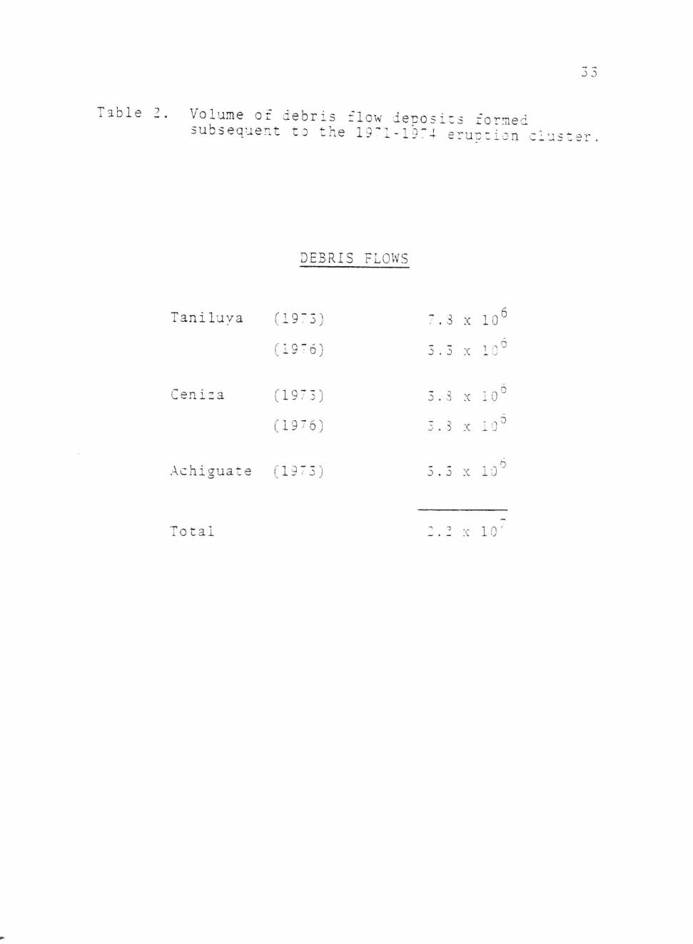
4 to 7 km long and 2 km wide at the mouth of the Tani
luya River Canyon. The 1972 deposit is comprised of
approximately 7.8 x 10^ m^ of debris and the 1975 flow
deposited approximately 3.3 x 10 m" of material. A
similar debris flow fan at the mouth of the nearby
Ceniza canyon consists of two flows emplaeed one atop
another. Both fans contain approximately 3.8 x 10 m"
of debris. The Ceniza fans are 6 km long and 0.8 km
wide. A third debris flow fan with a volume of 3.3 x
10 m formed in 1972 in the Achiguate River valley.
Debris flows formed three fans with a total volume
of approximately 2.2 x 10 m" (Table 2). This represents
a redistribution of 4.6 percent of the total eruption
products, and 12 percent of the total glowing avalanche
debris from the eruption cluster. The Taniluya deposits
contain 61 percent of the associated glowing avalanche
debris while the Ceniza and Achiguate fans contain 42
and 10 percent of their associated glowing avalanches.
Initiation of Debris Flows
Intense seasonal rainfall, steep slopes, lack of
J J)
T a b l e 2. Volume of d e b r i s flow d e i - o s i t s formed s u b s e q u e n t t o t h e i g ^ l - l Q " ! eruotion"^'. 1 u s t e r
DEBRIS FLOWS
Taniluya (19: 3) 7.3 x 10
(19-6) 3.3 X 1( ,.0
Ceniza (1975) 3.3 X 10
(1976) o X i. J
Achiguate (19 73) 3.3 X 10
Total 2.2 X 10'

34
vegetative cover, and vast quantities of unconsolidated
fine grained debris on the upper volcanic flanks combine
to promote the development of debris flows. Deposition
of glowing avalanche materials in canyons produces a
large mass of unconsolidated debris whose failure is
promoted by excessive rainfall. Once a geomorphie
threshold of instability is exceeded, debris flow pro
cesses transport ejecta downslope. Deposition of debris
occurs in response to rapid flow dissipation at the
mouths of the stream canyons.
The magnitude and character of these flows is closely
related to the temporal and spatial distribution of
rainfall on the volcanic slopes. Major storms, occurring
primarily between the months of May to October, are
generated by the rising and cooling of moist Pacific
air masses as they approach the orographic barrier of
the volcanic highlands (Fig. 17). These storms, often 2
concentrated over areas of less than 100 km , may
generate precipitation approaching world maxima in
intensity (Fig. 18).
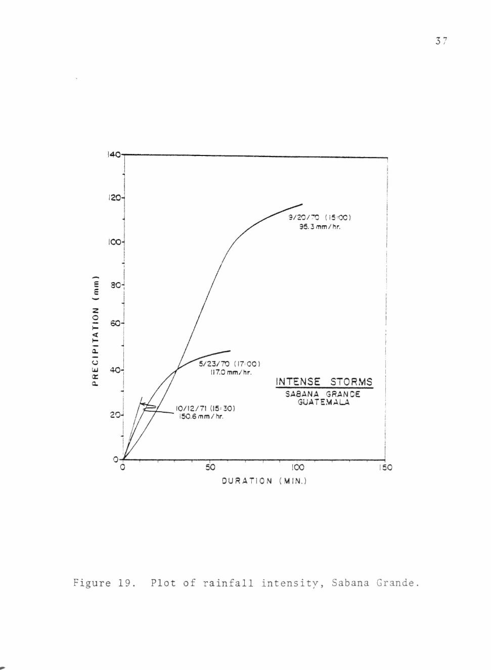
The storms yield their total load in a remarkably
short time period (Fig. 19). One event, occurring on
October 12, 1971 (15:30 hr) generated 25.1 mm of
rainfall on Fuego's southern flank within a 10 minute
period, an intensity of 150.6 mm/hr. A similar storm
produced 120 mm of rainfall at Sabana Grande on the

35
r.VuEGo'J / ( \ ^ . AGUA\
RIO GUACALATE
\
\
RIO ACHIGUATE
SAN , \ ^
I F I C O C E A N
- 2 ,
of the distribution of Fiaure 17. Isohyete map ot tne aisrriDuc^uu u. Figure 7^ rianfall in southern Guatemala

36
100
40
20
I 6 = 4
.--'
^ ^
^ ^
1
1 1
^^
<
»
0 e
-
/ ^
•
•
lO /•
i 1
• \
1 •*
1
1 «
•
) 12 24 MiN HRS
OURATiON
Figure 18. Plot of rainfall intensity. Line is world maxima, points are Guatemalan storms.
37
9/20/^0 (15^00) 95.3 mm/hr.
5/23/70 (I7-00) 117.0 mm/hr.
10/12/71 (15=30) 150.6 mm/hr.
NTENSE STORMS SA8ANA GRANDE
GUATEMALA
50 100
OURATION (MIN.)
150
Figure 19. Plot of rainfall intensity, Sabana Grande

38
southern volcanic flanks over a period of 100 minutes.
This storm was extremely localized as meteorogical
stations at Escuinta (13 km SE) and Amatitlan (25 km
east) received only 36.0 and 6.5 mm of precipitation
for the entire day (Anon., 1975).
Introduction of such vast quantities of water
into glowing avalanche sediments results in failure and
flowage of the debris. Saturation of debris with water
reduces intergranular friction and decreases the critical
thickness and slope angle required for flowage.
Observational evidence suggests that failure
occurs as a critical volume of water, introduced by
intense precipitation, is added to already saturated
debris. Failure is apparently developed at the snout
and in the center of glowing avalanche deposits.
Internal characteristics of flow deposits indicates
that the debris flows are semi-plastic, or Bingham,
substances which move as a mass in a laminar fashion.
Transport of coarse debris is promoted by the great
rheologic strength of the flow rather than by fluid
turbulence. Cessation of motion occurs due to fluid
expulsion and is related to decreasing slope and
dissipation of the flow below confining canyons.
Debris Flow Deposits
Debris flow deposits are structureless, poorly sorted,
poorlv stratified, poorly indurated masses of sediment.
39 Deposits consist of matrix supported units of boulders,
cobbles, and grains. Boulders up to 6 meters in diameter
occur within many deposits. These coarse particles
float within a matrix of finer rock fragments and
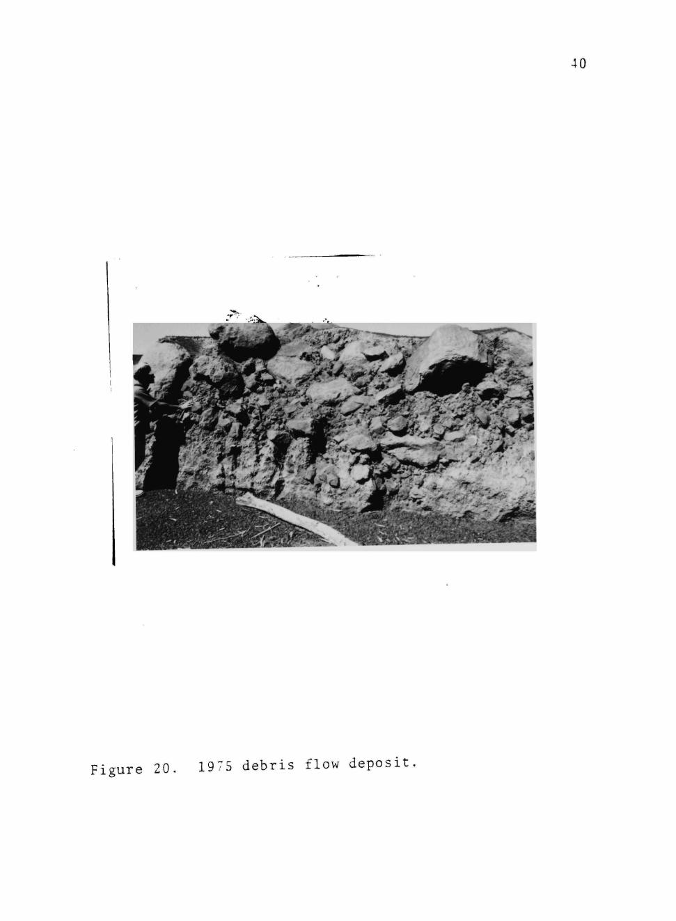
crystals (Fig. 20).
The bases of debris flow deposits are non-erosive.
Vegetation observed below deposits is matted but not
uprooted. Obstructions such as buildings or trees are
preserved with little damage within the flows. These
observations suggest that the motion of the debris flows
is laminar rather than turbulent. The laminar nature
of the flows is further indicated by parallel,
horizontal laminae which occasionally occur with deposits
(Fig. 21), These laminae formed along shear planes
within the flow.
Matrix material (grains smaller than 2.5 cm) com
prises 25 to 97 percent of the debris flow deposits.
Andesite xenolith blocks comprise an average of 8 percent
of the deposits while basalt grains larger than 2.5 cm
comprise 16 percent of the debris.
Debris flow deposits are coarse grained, 2 mm
(1.0(|)) to 8 mm (-3.0(|)), poorly sorted (4.3 to 5.1(|)),
and coarsely skewed (-0.11 to -.041(|)). Debris flow
deposits, though quite similar to the glowing avalanches,
are generally somewhat coarser, more poorly sorted, and
more coarsely skewed. No significant variations appear
40
' ' ' • ' • > - ; ^
Figure 20. 1975 debris flow deposit

41
Figure 21 Parallel laminations formed along shear planes in the 1975 debris flow deposit.

42 to occur downflow.
Debris flow deposits consist of spherical grains
with an average value of 0.69. Approximately 50 percent
of the grains are spherical, 30 percent are disc shaped,
13 percent are rod shaped, the remainder are bladed
(Hebberger, 1977).

Flash Flood Flows '^
General Statement
The southern flank of Fuego is an area characterized
by flash flooding resulting from short duration, high
intensity storms. Intense rainfall on the tephra
mantled slopes of the volcano is responsible for the
generation of sediment laden flows. These floods
sweep down canyons radiating from the cone, finally
dissipating on the coastal plain where large debris cones
form.
Morphology and Volume
Two fan shaped flood cones formed in response to
the 1971 to 1974 eruption cluster. These deposits
developed on slopes of 1 to 3 percent at locations
where streams draining the glowing avalanche and debris
flow deposits flow across the transition from the volcanic
highlands to the coastal plain.
Repeated large scale flash floods occurred during
the wet seasons following each eruption. A large flood
cone 4 km long, 2 km wide, and 1 to 2 m thick has formed
on the Rio Pantaleon, 29 km from the crater (Fig. 22).
This flood cone contains 1.2 x 10 m of debris. A
similar deposit 3 km long, 2 km wide and 1 to 2 km
thick with a total volume of 0.6 x 10' m" formed at the
coastal plain transition on the Rio Achiguate.

44
V. de Fuego 29 Km
3 km =3
SCALE
Figure 22. Map of the flood deposit formed on the Rio Pantaleon.

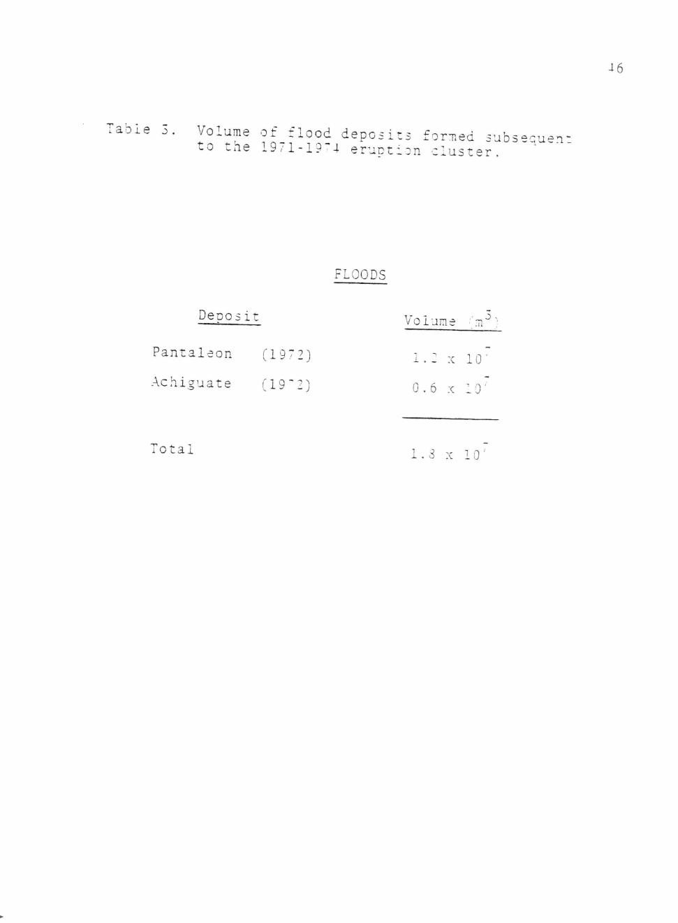
45 The two flood cones have a total volume of 1.8 x
7 3 10 m (Table 3). This represents 3 percent of the total
volume of ejecta and 10 percent of the total glowing
avalanche volume. The Pantaleon flood deposit contains
20 percent of the debris in its parent glowing avalanche.
The Achiguate fan contains 15 percent of its parent
deposit.
Flood Dynamics
The initiation of flash floods at Fuego volcano
is proceeded by intense rainfall localized on the upper
cone flanks. Three observed flows involved intense
storms on the cone while only minor rainfall occurred
less than 8 km away.
Once flooding is initiated, flow progresses rapidly
down the canyons to trunk drainages. Within the canyons,
flooding is announced by a small increase in stage fol
lowed within minutes by a bore 1 to 3 meters in height,
consisting of a turbulent mass of cobbles, boulders, and
sand. Most of this sediment is derived from glowing
avalanche deposits, and is related to failure of the
toe of these deposits as well as to stream erosion and
transport of debris.
Once the flood surge reaches the trunk drainage,
flow decreases in depth and velocity and increases in
width, often filling the entire river floodplain. The
The flow itself is highly turbulent, characterized bv
46
•bie 3. Volume of flood deposits forT.ed subs-qu-n to the 1971-19^4 eruption cluster.
FLOODS
Deoosit VniMn.^ '^3
Pantaleon (1972)
Total
Volume '.11"
1.2 X 10'
Achiguate (19^2) G.6 X 10
1.3 X 10'

47
the crashing of boulders in transport. Local scouring
may occur. Antidunes are observed.
Downflow, at the transition of the coastal plain
and volcanic highlands, the flood passes from confining
terraces onto the open coastal plain. Rapid flow dissi
pation and sedimentation occur. Flow occurs along both
existing drainages and as overbank sheetflow.
The floods are formed in basins with drainage areas 2
of 109 km or less. Flood intensities approach world
maxima (Fig. 23).
The observed durations of floods were less than 2
hours and the rise time for each varied from 10 to 20
minutes. Each flood formed on the cone flanks, quickly
sweeping down canyons radiating from the cone to major
drainages.
Indirect discharge measurements indicate that
observed flows had peak discharges of 140 to 3650 m /sec
(Table 4). Flood hydraulics vary along flow.
In stream reaches proximal to the cone, flows are
constricted and reach depths of up to 5 m. Movement
of boulders up to 3 m in diameter occurs. Flow is
supercritical.
Intermediate flow occurs within the trunk drainages.
Flooding may cover 300 m valley floors. Flow depths
range from 1 m to 5m.

48
100
OS .00
50 CO
m
E 20 «t:
10
_
—
• M i ^
y
z* —
_
1
•
1 1 1 1
•
y^m
•
•
#
1 1 1111
•
1
1 t
1
5 10 20 50 100
D R A I N A G E AREA (Mi^)
Figure 23. Peak discharge with respect to drainage area. Line is world maxima, points are Guatemalan floods.

J. 0
Table 4. Flow characteristics of volcanic highlar.-; floods.
Qmax = maximum discharge
Vmax = maximum velocity
Tc = largest boulder moved bv flow
F = Froude number
FLOOD CF.ARACTSRISTICS
DATE
9-24-71 10-17-72 6-26-73 8-24-75 5-19-76 6-13-76 7-1^-^6 -- ~) — — -I
7-13-77
BASIN
(km' )
109 109 109 13 96 96 10 43
109
DURATION
(min)
-
120 30
120 50 15 —
120
Qmax ' 3 , (m /sec)
590 525 495 150
2200 330 230 -00 1-0
Dmax
(m)
-
1.05 1.00 3.35 3.50 2.50 5.05 1.10
'7:nax
(m/sec)
^
-
4.35 5.00
6. 65 6.10 6.20 6.00
TC
(nun)
,
-
-
1500 2:'50 1130 3100 -150 1150
-
,
-
1.36 l.oO 1.3-1.1-1.23 0.38 1.83

50
As the flood emerges from confining canyons, flow
width increases, depth, velocity and shear stress rapidly
decrease resulting in the deposition of broad flood
fans on the coastal plain. Complete flow dissipation
occurs over a distance of 4 km.
Flood Deposits
Flood deposits consist of 1 to 2 m thick units of
boulder and cobble conglomerates and coarse sands.
Proximal deposits consist almost entirely of structure
less, poorly stratified, grain supported conglomerates
with occasional lenses of planar laminated coarse sands.
These units are similar to Scott Type braided river
deposits described by Miall (1979). Intermediate and
distal flood deposits display some structures and are
well stratified. Planar laminations and antidune gravel
lenses are visible. Cobble bed materials comprise 0 to
20 percent of these deposits.
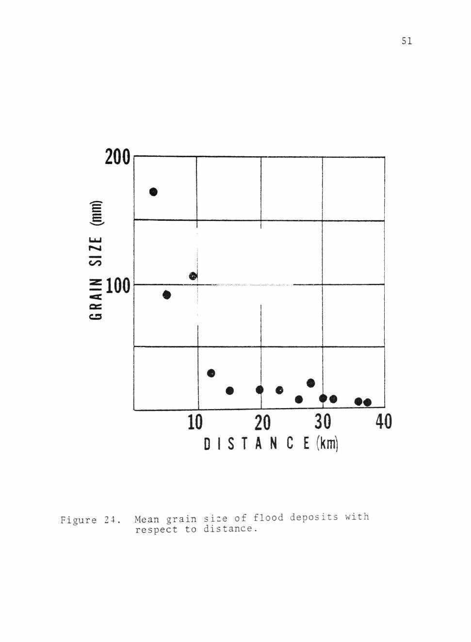
Sediment deposits within the canyons display a rapid
downflow decrease in mean size from 40 to 4.2 em (Fig. 24)
Maximum grain size decreases from 250 to :'0 mm (Fig. 25).
Sorting improves from 60 to 46 downflow (Fig. 26) as
a result of a decrease in boulder-cobble material from
50 to 20 percent (Fig. 27).
Fan deposits display a mean size decrease from 4.2
to 1.2 cm (Fig. 24) while maximum grain size decreases
51
200
siOO
#
«
•
•
• i ' • • • . * • • •
10 20 30 D I S T A N C E (km)
40
Figure 24. Mean grain size of flood deposits with respect to distance.

52
300
^ •
100
c^
50
10
10 20 30 DISTANCE(kni)
40
Figure 25 Maximum grain size of flood deposits with respect to distance.

3 J
5 -
3 -
CO
1 -
•
•
• ^
«
•
•
•
•
•
•
1
1
0 •
•
10 30
DISTANCE (km)
Figure 26. Sorting of flood deposits with respect to distance.

54
50
in 3 0 -
A
10-
t I
I 1
- • •
I •
[—-% •—
10
DISTANCE (km)
30
Figure ^7 Percentage of material larger than 2.5 em in flood deposits with respect to distance

55 from 30 to 8 mm (Fig. 25). Sorting improves from ^ to
3* (Fig. 26) as boulder and cobble size material decreases
in abundance from 20 to 4 percent (Fig. 27).

56 Fluvial Sedimentology
General Statement
Fuego volcano is drained by two major fluvial
systems (Fig. 5). To the west of the crater, the Rio
Pantaleon forms from three streams heading in deep
canyons on the upper volcanic slopes. South of the
crater, the Rio Achiguate forms from the union of three
tributaries, the Ceniza, Achiguate, and Guaealate which,
in turn, head in nine canyons on the volcanic slopes.
In its upper reaches, each stream system heads
in 20 to 60 meter deep canyons. Flow is intermittent
and supplied predominantly by groundwater derived from
heavy seasonal rainfall on the volcanic pile. In each
system, flow passes from the upper canyon reaches onto
deeply terraced, wide floodplains of the main tributary
streams, 7 to 10 km from the vent. Here, flow changes
abruptly from narrow channels into wide, braided outwash
plains confined within 70 to 300 m wide floodplains by
terraces (Fig. 28). Thirty km from the crater, flow
emerges onto the 30 km wide Pacific coastal plain, where,
beyond confining terraces, flow widens and a highly
braided channel complex forms. This braided complex
(Fig. 29) extends 20 to 25 km across the coastal plain
before it reverts to a single, narrow channel (Fig. 30).

Figure 28 Proximal stream reach. Note paired stream terraces and coarse nature o: deposits.

58
F i g u r e 29. l^l'SlrZim^ ''^^'- ^ -nels

59
Figure 30. Distal stream reach. Coastal plain Streams flow within a single stable channel.

u u . 60 Morphology
In upper, terraced stream reaches the active river
floodplain is 70 to 350 m wide and consists of scattered
boulders, cobbles, and coarse sand deposited by flash
flood flows. Boulders and cobbles comprise 50 to 80
percent of this material. Low stage flow occurs within
parabolic shaped braided channels incised into the
flood deposits. Although the stream pattern is braided,
flow generally occurs within a single dominant channel
with internal braid bars.
Downstream, below the confined reaches, the active
river floodplain increases in width to 100 to 410 m.
The floodplain is composed of coarse sand and scattered
cobbles. Flow occurs within numerous, unstable, wide,
shallow, parabolic shaped braid channels.
On the lower coastal plain, streams flow within
deep, stable, parabolic shaped straight single channels.
Occasional longitudinal sand bars occur within these
channels.
The channel sinuousity and braiding index of each
area have been evaluated. They are included in Table 5.
The morphology of the contemporary stream systems
contrasts dramatically with pre-eruption fluvial styles.
Aerial photogrpahs of the Achiguate and Pantaleon systems
demonstrate that during the 20 year period prior to the
eruption cluster, fluvial systems draining the volcano

61
Table 5
FLUVIAL CHANNEL CHARACTERISTICS
Location Sinuousity Braid Index
Pre-Eruption Proximal 1.22 0.4
Distal 1.68 0.0
Post-Eruption Proximal 1.04 2.1
Distal 1.07 0.8

62 were characterized by a deeply entrenched, sinuous
morphology (Fig. 31). The sinuosity characteristics of
these streams is evaluated in Table 5.
Schumm (1968) proposed that transitions of this type
are the result of climatic, discharge, slope, or sediment
load alterations. Sediment load alteration has occurred
within the Guatemalan system and is probably responsible
for the change in channel morphology. By Schumm's (1968)
classification, pre-eruption fluvial systems were mixed
load channels whose banks contained 5 to 20 percent
silt and clay. Present systems are bedload channels
with approximately 1 percent silt and clay in their
banks.
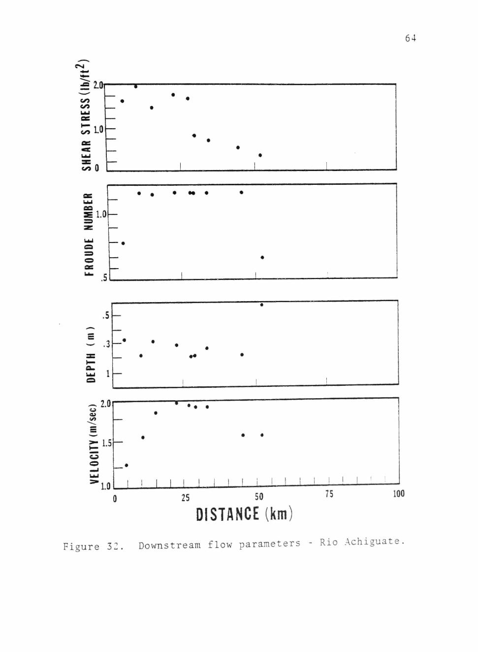
Stream Hydrology
Streams flowing from the volcanic highlands onto
the coastal plain display downflow variations in flow
characteristics. Figure 32 displays average flow para
meters for the Rio Achiguate system.
Bed shear stress, a measure of stream power,
decreases downflow from 2 lb/ft" near the cone to O.JO
Ib/ft^ at the coast. Froude number, a value represent
ing the ratio of inertial versus gravitational forces
within the flow is generally greater than one throughout
the system indicating that supercritical flow conditions
are common. Flow depth decreases from 0.31 m near the
cone to 0.19 m on the coastal plain before increasing to

63
Figure 31. Rio Achiguate prior to the eruption cluster. Note sinuous morphology and flow within a
a / single stable channel.
64
CNJ
LO
• « • • • •
^ 2 . 0
L5
LO
• •
• •
25 50
DISTANCE (km) 75 100
Figure 32. Downstream flow parameters - Rio Achiguate

65
0.6 m at the coast. Velocity increases downflow from
1.25 m/see to 2.0 m/sec in response to increasing dis
charge then decreases near the coast as channel area
increases.
The bed configurations of studied flows were
determined from calculations of Froude number and
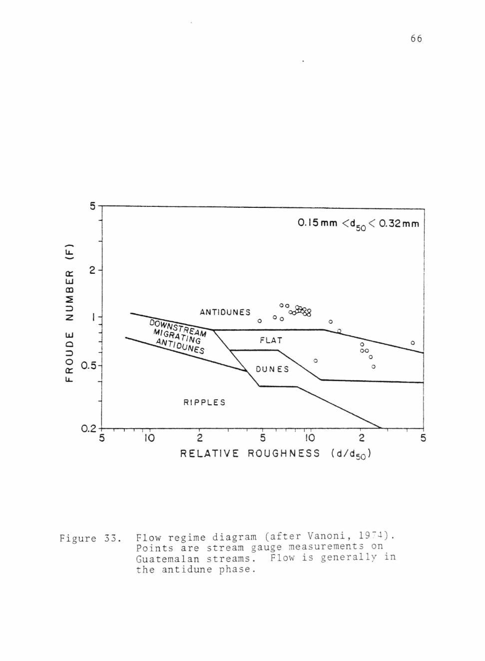
relative roughness. These were calculated from measured
stream parameters, and used in conjunction with Varoni's
(1974) regime diagrams (Fig. 33).
Seventy-five percent of the Froude number values
calculated in this fashion were greater than one. This
indicates that upper flow regime and transitional flow
conditions prevail from the cone to the sea. Plane bed
and antidune bed forms typify these flow conditions.
Sediment Transport and Erosion Rates
Sediment rating curves, constructed from suspended
and bedload stream gauge measurements, made at 10
locations (Fig. 34), were employed in conjunction with
measured discharges and available gauge station data to
compute the annual sediment yield from deposits of the
eruption cluster. The bulk of the material observed
in stream transport has its source in the loose, uncon
solidated canyon glowing avalanche deposits resulting
from the 1971-1974 eruptions of Fuego. Table 6 displays
the estimated volume of tephra present in various canyons
on the volcanic flanks.
66
0.15 mm <d5Q< 0.32mm
LLI
CQ
2 -
1- ANTIOUNES
Q 3 O
oo
Oo
FLAT
0,5
RIPPLES
0,2 -I—I—r—r-r-
10 T r
2 5 10 2 RELATIVE ROUGHNESS (d/djo)
igure 33. Flow regime diagram (after Vanoni, 19:"4). Points are stream gauge measurements on Guatemalan streams. Flow is generally in the antidune phase.

67
10 Km
SCALE
9 Sedim«nt Sampling Sit«
• I Streom G4uq* Measurements
R I O - * " ^ / PANTALEON*
RIO COYOLATE - PANTALEON
RIO GUACALATE
• v . AGUA
3IPICATE
C I F I C O C E A N
Figure 34. Map displaying the location of stream gauge sites.

Table 6. Denudation rates zo 3. " -^ "" f .
the 19^1-19^4 a T' 1 "f ' ruTDtion c l u s t e r
RATES OF DENUDATION OF TEPHRA - VOLCANO RJEGO
DEPOSIT VOLUME 0? TEPHRA IN DEPOSIT (m^)
MEASURED ANNUAL TIME TO EROSION RATE (m^) ERODE
San Jose -El Pajal
Honda, Agua, Las Lajas
El Jute
Trinidad
0.3 X 10 7
2.4 X 10
3.5 X 10'
1.8 X 10'
2.1 X 10"
i.9 X 10"
Noc Measured
Not: Measurea
-40 -r
-2^ vr
Ceniza 1.3 X 10' ^20 v:
lani^uya -Seca 5." X 10 9.2 X 10" -60 rr
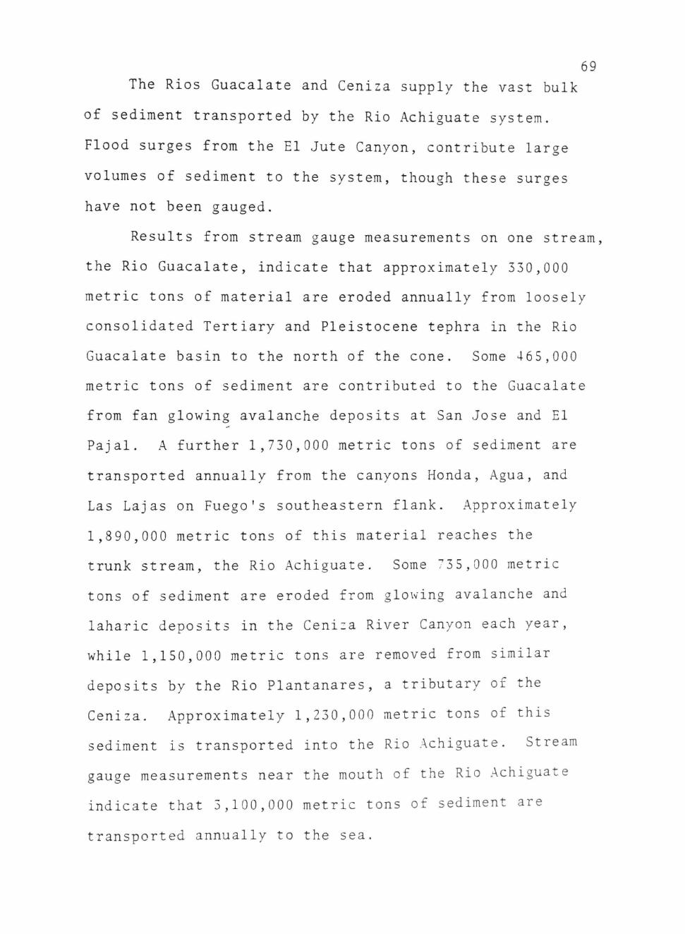
69 The Rios Guaealate and Ceniza supply the vast bulk
of sediment transported by the Rio Achiguate system.
Flood surges from the El Jute Canyon, contribute large
volumes of sediment to the system, though these surges
have not been gauged.
Results from stream gauge measurements on one stream,
the Rio Guaealate, indicate that approximately 330,000
metric tons of material are eroded annually from loosely
consolidated Tertiary and Pleistocene tephra in the Rio
Guaealate basin to the north of the cone. Some 465,000
metric tons of sediment are contributed to the Guaealate
from fan glowing avalanche deposits at San Jose and El
Pajal. A further 1,730,000 metric tons of sediment are
transported annually from the canyons Honda, Agua, and
Las Lajas on Fuego's southeastern flank. Approximately
1,890,000 metric tons of this material reaches the
trunk stream, the Rio Achiguate. Some 735,000 metric
tons of sediment are eroded from glowing avalanche and
laharic deposits in the Ceniza River Canyon each year,
while 1,150,000 metric tons are removed from similar
deposits by the Rio Plantanares, a tributary of the
Ceniza. Approximately 1,230,000 metric tons of this
sediment is transported into the Rio Achiguate. Stream
gauge measurements near the mouth of the Rio Achiguate
indicate that 3,100,000 metric tons of sediment are
transported annually to the sea.

70 A total of 4,040,000 metric tons of material are
thus eroded annually from the cone by the Achiguate
system. Of this sediment, approximately 1,330,000 metric
tons are deposited by the streams before they join the
Rio Achiguate, that is to say, at the coastal plain
transition. Studies indicate that the slightly more than
3 million metric tons of sediment transported to the coast
is carried by longshore currents to submarine canyons
heading near the channel mouth.
The Rio Pantaleon system erodes 1,730,000 metric
tons of sediment annually from the cone. Some 690,000
tons of this material are deposited at the coastal plain
transition, while 1,035,000 metric tons reach the
junction with the Rio Coyolate and the lower coastal
plain.
The data described above may be used to determine
erosion rates from the cone, as well as sedimentation
rates on the coastal plain and at the coast (Table 6).
From this data, it is evident that much of the loose
tephra from the eruption cluster may be eroded from the
cone within 20 to 30 years of eruption.
Calculations cited above do not take into account
the effect of vegetation which can root rapidly in the
tephra and reduce the amount of erosion produced by
overland flow. Because of this factor, erosion should

'1
decrease exponentially with time. Also the effects of
floods on erosion calculations have not been evaluated.
Fluvial Deposits
Fluvial deposits proximal to the cone are dominated
by flood units of the type discussed in the previous
section. Low flow sedimentation occurs within channels
cut through the flood debris. These deposits consist
of poorly sorted, poorly stratified units of coarse
sand and cobbles (Fig. 35). Parallel laminations and
occasional low angle planar cross beds formed by bar
slip-face migration are observed.
Downflow, 20 to 30 km from the vent, stream deposits
similar to those described from the Donjek River (Williams
and Rust, 1969) are predominant. Sediments consist of
coarse sand and occasional gravels (Fig. 36). These
units may occur within flood deposits. Sediments consist
of massive or crudely bedded gravel conglomerates,
shallow scour fill sands, solitary and grouped planar
cross-beds, and occasional small trough cross-beds.
Units of this type form by migration of linguoid bars,
ripples, and gravel bars.
Distal braided stream deposits are composed almost
entirely of coarse sand with occasional gravel. These
sediments are characterized by parallel laminations and
Planar cross-stratification formed by migration of
longitudinal bars.

Figure 35 Proximal stream deposit. Note lack of sorting, coarse grain size, and absence of structures.

Figure 36. Intermediate stream deposit improvement in grain size.
Note sorting and decrease in

The textural characteristics of fluvial deposits
proximal to the cone have been described in the previous
section dealing with flood deposits. Low flow deposits,
occurring as channel fills in the flood deposits,
consist of coarse sand and cobbles up to 100 mm in diame
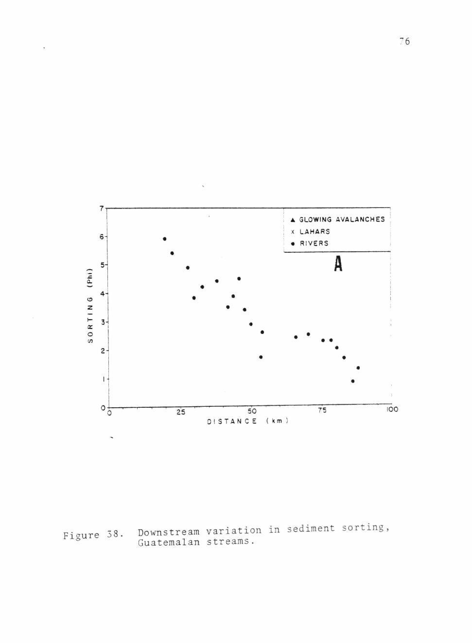
ter. Mean size decreases downstream from 40 to 2 cm
(Fig. 37) while sorting varies from 6.0(}) to 3.0(p
(Fig. 38). Sediments are coarsely skewed (Fig. 39).
Fluvial sediments in the intermediate region range
in mean grain size from 2.0 to 1.5 mm (Fig. 37). Sorting
varies from 3.04) to 2.0<}) (Fig. 33). Deposits are
coarsely skewed (-0.30(|) to -0.53(})) (Fig. 39).
Distal fluvial sediments are comparatively fine
grained and well sorted. Mean grain size decreases
downstream from 1.5 mm to 0.5 mm (Fig. 37) while sorting
improves from 2.04) to 0.90 (Fig. 38).
The roundness of fluvially transported clasts
increases downstream from 0.4 near the core to 0.8 at
the coast (Fig. 40). Sphericity values show no down
stream trend (Fig. 41).

75
400
300-
• GLOWING AVALANCHES
X LAHARS
• RIVERS
£ S
UJ
A
< IT
100-
25
• - • • • / ^ , • ^ f J i , . • • • t a
50 D I S T A N C E ( km)
75 100
Figure 37. Downstream variation in sediment mean size, Guatemalan streams.
CO
z
5-
4-
^ 3-1 IT O (fi
2^
1 I I - r -
25 I I I • f I 1
50
"6
A GLOWING AVALANCHES
X LAHARS
• RIVERS
A
• •
75 D I S T A N C E ( km )
100
Fiaure 38. Downstream variation in sediment sorting, ^ Guatemalan streams.

0.6T-
tn
•0.3i
-0.6
77
^ I • • RIVERS - 0.3^ •
I • GLOWING AVALANCHES | i ! ' X LAHARS i
!
B en <n 1 UJ
* 0^ • •
^ J
• • • •
• • •
0 25 50 75 100
D I S T A N C E ( km )
Figure 39. Downstream variation in sediment sorting " Guatemalan streams.

78
CO (n Ui z a z
o IT
0.3^
0.6-
0.4
0.2-
0^
A • •
• • •
• • • • •
A GLOWING AVALANCHES
X LAHARS
• RIVERS
25 50 DI STA N C E (km )
75 100
Figure 40. Downstream variation in grain roundness Guatemalan streams.

I.O
as
- 0.6 o
« I ^ 0.4 a.
0 2
6 • • • • • • • • • , ^ • • • • • •
A GLOWING AVALANCHES ;
X LAHARS I
I • RIVERS i
25 50 D I S T A N C E
75 100 (km
Figure 41. Downstream variation in grain spherieitv, Guatemalan streams.

80
SEDIMENTATION RESPONSE TO ERUPTIONS
Activity at Fuego volcano over the last 40 years
has consisted of 23 eruptions of widely differing
magnitude. Each eruption has resulted in the deposition
of pyroclastic debris on the cone flanks. Response to the
introduction of this material into the sedimentation
system has been varied.
Fifteen eruptions occurred at Fuego between 1932
and 1970. Two of these events (1957, 1962) were con
sidered to have produced significant volumes of ejecta
(Rose et al., 1978). Five produced glowing avalanches.
Despite the frequency of eruptive events throughout this
period, none appears to have resulted in the development
of large scale sedimentation effects such as those observed
following the 1971-1974 cluster. Although glowing
avalanche and debris flow deposits were formed during
this period, they appear to have been relatively small
and limited to the upper cone flanks. Examination of
aerial photographs indicates that during the period
1954-1970, fluvial sedimentation proceeded within
narrow, low sinuosity, entrenched stream systems.
Braided channels and flood cones were not generated.
Lack of coastal progradation in these vears suggests
that rates of fluvial sediment transport were low.

81 Studies of the eruptions of 1971, 1973, and 19"4
indicates that sedimentation proceeds in four distinct
phases (Table 7).
Phase 1
This phase is characterized by the deposition of
thick airfall ash and glowing avalanches on the volcanic
slopes and in canyons radiating from the cone (Fig. 42).
Phase 2
This phase is characterized by the generation of
debris flows and flash floods. These flows remobilized
the eruption debris, especially the glowing avalanche
deposits, and redistributed them to vast sediment fans
around the base of the cone during the first two years
following each erupt ion. (Fig. 43).
Phase 3
The third sedimentation phase is triggered by the
introduction of coarse debris into the stream systems
draining Fuego. This results in the transformation of
incised, sinuous channels to aggrading, braided systems.
Increased sediment transport produces rapid deltaic
progradation. (Fig . 44).
Phase 4
This phase, more properly referred to as the inter-
eruption period, is characterized by decreasing sediment
transport, and the return of the stream systems to sinuous

8 2
AIRFALL ASH
GLOWING AVAL. NCHE
Figure 42. Phase I of the eruption cluster -airfall ash and glowing avalanche deposition

83
figure 43, Phase II of , ^eworkina o%^^ ^^^Ption cluster - ^ ^lood ^e.^ittl' '^^° ^ebrirVow

84 conditions within the volcanic sedimentation system
require a rare, major event to trigger the fan forming
processes.
In fluvial sedimentary environments, thresholds
are formed by the shear stress required to initiate
particle motion within a flow. For example, in arid
fluvial systems, mass wasting processes introduce coarse
sediment into the heads of ephemeral streams whose
normal flows are incapable of producing the shear-stress
required to cause particle motion. It is only when
this threshold of particle motion is achieved that the
development of coarse fluvial deposits, characteristic
of the ephemeral stream beds in such areas, occurs.
These deposits cannot be reworked by normal processes
since they cannot generate threshold conditions. Thus
it is not the normal fluvial event, or even relatively
frequent floods, but rather rare super-floods which
are responsible for the fluvial geomorphology of arid
regions.
In a similar fashion a geomorphie threshold must
regulate the infrequent generation of voleanielastic
deposits. However, unlike the arid system, well over
3 meters of rainfall occurs on the southern flanks of
the volcano each year and fluvial events capable of
exceeding the shear stress threshold for coarse sediment
transport may occur several times within a single year.

8
AGGRADING
PHASE III
Figure 44. Phase III of the eruption cluster reworking of ejecta results m transition of sinuous streams to braided streams.

86
OEGRADING
PHASE IV
Figure 45. Phase IV - Erosion of source eventually
results in return of streams to sinuous phase.
8 Rather, in the volcanic system, it is the sporadic
introduction of debris into the system which constitutes
the threshold for generation of deposits. As noted
earlier, only large, rare events generate sufficient
ejecta to produce significant amounts of sedimentation.
This apparently reflects the fact that only rare,
large events produce the thick canyon glowing avalanche
deposits required to generate debris flow and flash
flood fans on the lower cone flanks.
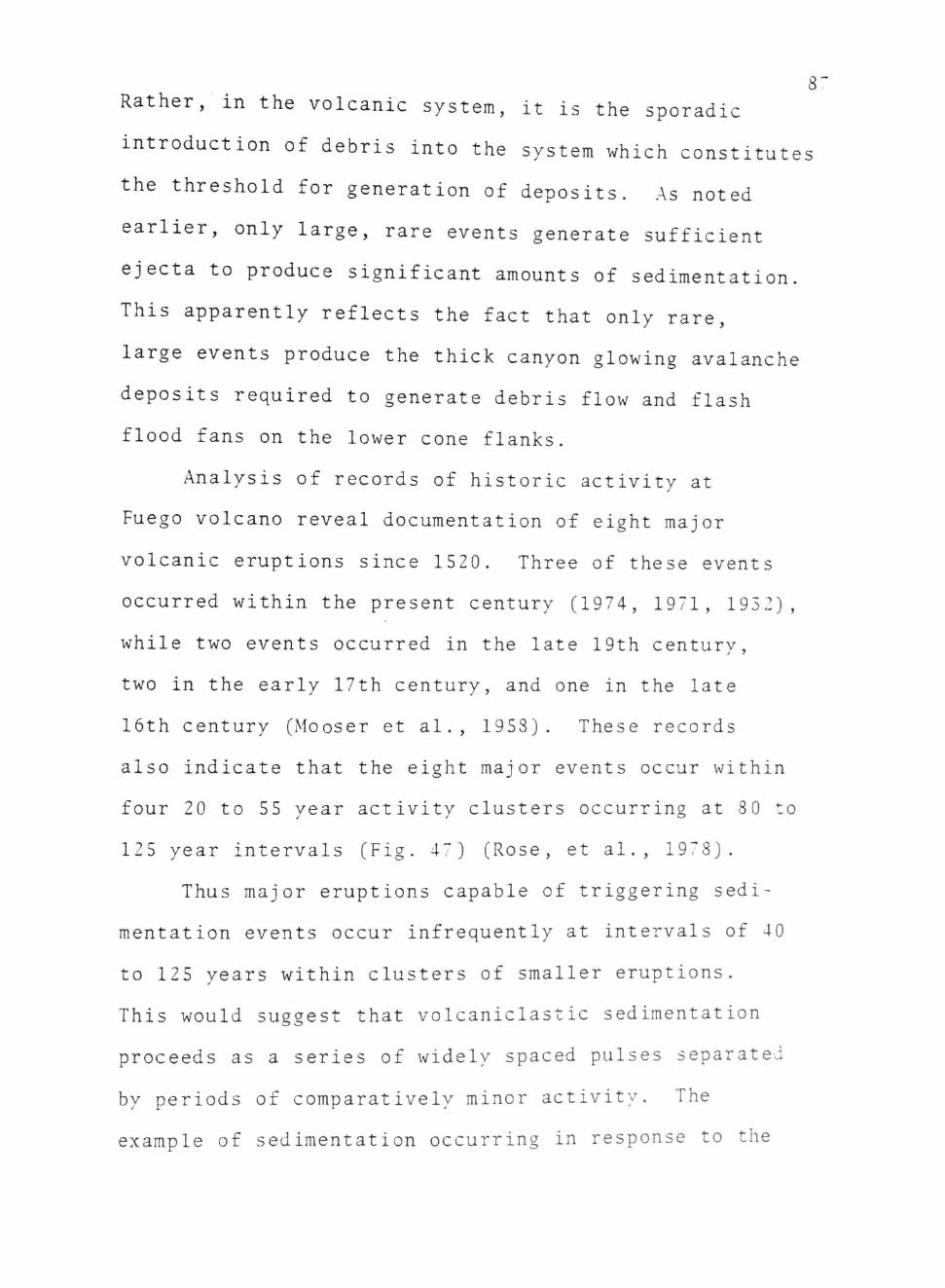
Analysis of records of historic activity at
Fuego volcano reveal documentation of eight major
volcanic eruptions since 1520. Three of these events
occurred within the present century (1974, 1971, 1952),
while two events occurred in the late 19th century,
two in the early 17th century, and one in the late
16th century (Mooser et al., 1958). These records
also indicate that the eight major events occur within
four 20 to 55 year activity clusters occurring at 80 to
125 year intervals (Fig. 47) (Rose, et al., 1978).
Thus major eruptions capable of triggering sedi
mentation events occur infrequently at intervals of 40
to 125 years within clusters of smaller eruptions.
This would suggest that voleanielastic sedimentation
proceeds as a series of widely spaced pulses separated
by periods of comparatively minor activity. The
example of sedimentation occurring in response to the

88
2 0 0 0 - 1
k j
1
1900 -
1
u
laoo
1 7 0 0
iSOO —
Vi
[ 5 0 0 -
M M A w O R ZR\JPT\OH L'JS r £ ^ 3
Figure 46. Volcanic activity at Fuego, 1520-1979. "[Sata from Rose,^978 and Mooser et al. ,
1958) .

89
VOLCANICLASTIC SEDIMENTATION CYCLE
PHASE TIME PROCESS
I 0 Airfall Glowing Avalanches
II -0-2 yr Debris Flows Floods
III = 0-20 yr Braided Fluvial Transport Delta Construction
IV >=i20 yr Stream Incision Delta Reworking
Table 7. The voleanielastic sedimentation cycle observed at Fuego volcano subsequent to the 1971-1974 eruption cluster.

90 low sediment transport, channels,(Fig. 45).
The four phases will probably occur within a time
period of 20 to 30 years.
This response of the sedimentation system to
volcanic eruptions of varying magnitude suggests that a
geomorphie threshold may exist within the system. Until
certain threshold conditions concerning type and quantity
of ejecta are exceeded, sedimentation proceeds at a very
low rate and several sedimentation processes are inactive.
A plot of eruption activity against time (Fig. 46)
on which the largest eruptions are rated 1 and the
smallest eruptions 5 demonstrates that the period between
1957 and 1977 was characterized by 19 events including
one 1 event, two 2 events, six 3 events, six 4 events,
and four 5 events. Each of the event ratings relates
to eruptions of a different order of magnitude. The 8 5
event rated 1 (1974) produced approximately 3 x 10 m of 3
ash. The event rated 2 (1971) produced 6 x 10 m
of ash (Bonis and Salazar, 1974) (roughly 20 percent of
the 1 event), while an event rated 3 (19: 3) generated
7 X 10^ m^ of ash (Bonis and Salazar, 1974) (2 percent
of the 1 event). Thus the more infrequent major event
produced approximately 2 orders of magnitude more ejecta
than events which occur with regularity. As the events
rated 3, 4, and 5 failed to produce significant
voleanielastic sedimentation, it is apparent that threshold

91
A
ca 4h •• V • - • - ^
I ' l l I I ! I I \ L
I960 1970
TIME yr
I I { I I I I I i - j
1980
Figure 47. Magnitude of volcanic eruptions with relpeet to time (1932-1979). (Data from Rose, 1978) .

92
10 0000 b-
FF
looooi PF
F i g u r e
!0
4 8 . CM cluster, deposits. deposits. deposits. depos its. deposits.
iOO ^ 0 0 ^
M iTiicrons plot of volcaniclasties from the eruption
\rea A includes most airfall _ ' \rea DF includes distal fluvial Area PF includes proximal fluvial Area FF includes flood canyon Area M includes most mass flow

93
7
vo
VI
MEAN I
rigure 49 Plot of sorting with respect to mean size
for volcaniclasties from the |ruption rlust-r Area A includes airfall ash deoosi?; (crosses). Area S includes stream laid sediments (triangles). Area . includes most stream flood aeposit._ (open circles). Area M includes debris , ow
deposits (dots). deoosits display
Glowing avalanche (squares) no coherent relationship.
94 1971 to 1974 eruption suggests that these pulses are
approximately twenty to thirty years in length.
DISTINCTION OF VOLCANICLASTIC DEPOSITS
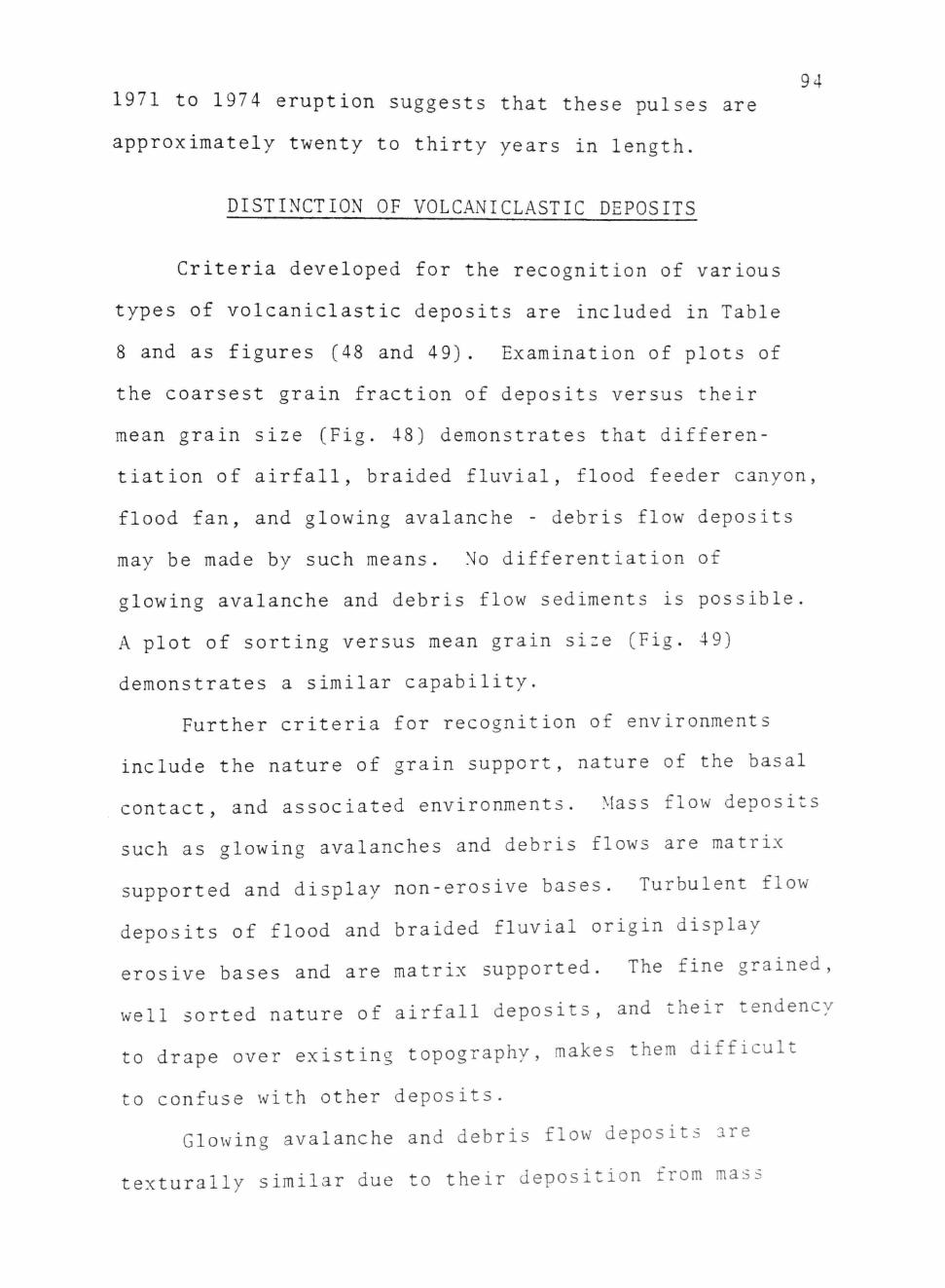
Criteria developed for the recognition of various
types of voleanielastic deposits are included in Table
8 and as figures (48 and 49). Examination of plots of
the coarsest grain fraction of deposits versus their
mean grain size (Fig. 48) demonstrates that differen
tiation of airfall, braided fluvial, flood feeder canyon,
flood fan, and glowing avalanche - debris flow deposits
may be made by such means. No differentiation of
glowing avalanche and debris flow sediments is possible.
A plot of sorting versus mean grain size (Fig. 49)
demonstrates a similar capability.
Further criteria for recognition of environments
include the nature of grain support, nature of the basal
contact, and associated environments. Mass flow deposits
such as glowing avalanches and debris flows are matrix
supported and display non-erosive bases. Turbulent flow
deposits of flood and braided fluvial origin display
erosive bases and are matrix supported. The fine grained,
well sorted nature of airfall deposits, and their tendency
to drape over existing topography, makes them difficult
to confuse with other deposits.
Glowing avalanche and debris flow deposits are
texturally similar due to their deposition from mass

95
flows. Differentiation of these deposits is conjectural
but may be based upon associated environments. Glowing
avalanche deposits are usually associated with thick
airfall ash deposits while debris flow deposits are
generally interbedded with and incised by braided fluvial
and flood deposits.

96
Base
Support
Grain Size
Sorting
Structures
Downflow Behavior
Associated Deposits
Table 8
VOLCANICLASTIC
Airfall Ash
Non-erosive
Grain Support
Sand and granule size particles
Well sorted
Laminated following topography
Grain size and thickness decrease. sorting may improve
Thick -Glowing avalanches Thin -Others
Glowing Avalanches
Non-erosive
Matrix Support
Boulders -sand size particles
Very poor-Well sorted
None
Thickness may decrease
Airfall ash Debris flows
DEPOSITS
Debris Flows
Non-erosive
Matrix Support
Boulder -sand size particles
Very poorly sorted
Faint parallel laminations
Thickness decreases
Glowing avalanches Flood and fluvial sediments
Flood Flows
Erosive
Grain Support
Boulders-sand size particles
Very poorly sorted
Proximal-no ne Distal-cross-bedded
Grain size and thickness decrease, sorting improves
Debris flows Braided fluvial
Braided Fluvial
Erosive
Grain Support
Gravel -sand size particles
Poor -well sorted
Structureless, parallel bedded, cross-bedded
Grain size decreases sorting improves
Flood
fans

9"
CONCLUSIONS
Sedimentation on the active Guatemalan continental
margin has involved deposition of thick sequences of
volcaniclasties in the forearc basin. Sedimentation is
sporadic in nature, occurring in response to infrequent,
major eruptions. At Fuego volcano such eruptions occur
within 20 to 55 year activity cycles separated by 40
to 125 year periods of inactivity. Voleanielastic
sedimentation pulses are triggered by large, rare
events which generate thick canyon glowing avalanche
deposits. Only eight such eruptions have occurred at
Fuego volcano over the last 500 years.
Once initiated, voleanielastic sedimentation
proceeds in four distinct phases.
Phase 1
This phase is characterized by the deposition of
thick airfall ash and glowing avalanches on the volcanic
slopes and in canyons radiating from the cone.
Phase 2
This phase is characterized by the generation of
debris flows and flash floods. These flows remobilize
eruption debris, especially the glowing avalanche deposits,
and redistributes them to vast sediment fans around the
base of the cone immediately following each eruption.

Phase 3 98
The third sedimentation phase is triggered by the
introduction of coarse debris into the stream systems
draining the arc. This results in the transformation of
incised, sinuous channels to aggrading, braided systems.
Increased sediment transport produces rapid deltaic
progradation.
Phase 4
This phase more properly referred to as the inter-
eruption period, is characterized by decreasing sediment
transport, and the return of the stream systems to
sinuous, low sediment transport channels.
The four phases probably occur within a time period
of 20 to 30 years.
In Guatemala repeated sedimentation cycles of this
type have resulted in the construction of vast sediment
fans stretching from the cone to the sea. These fans
have been constructed in the last 20,000 to 30,000 years.
The proximal portions of these fans consist of airfall
ash beds and 1-15 m thick units of matrix supported
conglomerate. Intermediate fan segments consist of
matrix and grain supported conglomerates, thin airfall
ash beds, and thick lenses of coarse sand. Distal fan
deposits grade from grain supported boulder conglomerates,
thin gravels, and coarse sands to structureless and cross
bedded sands.

99
Proximal fan sediments were deposited by airfall
and glowing avalanche processes. Intermediate fan sedi
ments represent deposits of debris flow, flash flood,
and airfall processes. Distal fan deposits were formed
in braided fluvial environments.

PART II - ANCIENT VOLCANICLASTIC SEDIMENTATI ON
100

HOLOCENE SEDIMENTATION
General Statement
Voleanielastic sediments from Holoeene eruption
clusters have been preserved in airfall ash blankets,
glowing avalanche fans, debris flow fans, flash flood
cones, braided fluvial deposits, and in prograding
deltaic environments,(Table 9).
Holocene deposits west of Fuego volcano consist
of 1 to 10 m thick beds of black to buff colored ash and
lapilli interpreted as representing airfall deposits
from eruption clusters generated over the last 30,000
years by Fuego, Agua, and Acatenango volcanoes. Similar
though thinner, deposits occur on the southern flanks
of Fuego suggesting that the dominant wind direction
throughout the Holoeene has been from the east.
The upper slopes of the volcano consist of steeply
dipping 1-10 m thick lava flows and interbedded 1-15
m thick beds of pyroclastic ash and cinders. Roughly
40 to 50 percent of the upper cone is comprised of lava.
Below 2100 m, the lower cone is composed of a
wide apron of Holoeene volcaniclasties stretching from
the upper slopes to the coastal plain. Sediment fans are
built around fault-bound blocks of Tertiary intrusive and
voleanielastic rock and along narrow (5 km wide) troughs,
30 km through the volcanic highlands to the coastal
101
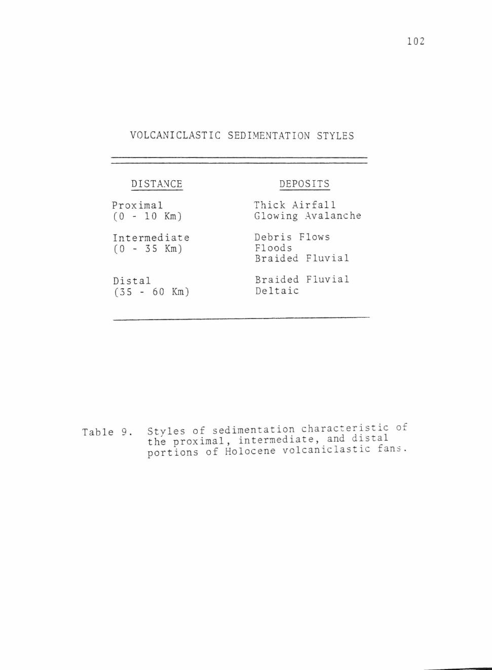
102
VOLCANICLASTIC SEDIMENTATION STYLES
DISTANCE DEPOSITS
Proximal Thick Airfall (0 - 10 Km) Glowing Avalanche
Intermediate Debris Flows (0 - 35 Km) Floods
Braided Fluvial
Distal Braided Fluvial (35 - 60 Km) Deltaic
Table 9. Styles of sedimentation characteristic of the proximal, intermediate, and distal portions of Holocene voleanielastic fans.

103
plain (Fig. 50). These sediment fans display a rapid
decrease in slope from 15 to 1 percent over a distance
of 35 km. The fans are dissected by 20 to 60 m deep
stream cut canyons which flow radially from the cone
to flanking drainages. These large trunk streams flow
within deeply entrenched, terraced valleys.
The proximal portions of the Holocene fans consist
of airfall ash beds and 1-15 m thick units of matrix
supported conglomerate. Intermediate fan segments
consist of matrix and grain supported conglomerates,
thin airfall ash beds, and thick lenses of coarse sand.
Distal fan deposits grade from grain supported boulder
conglomerates, thin gravels, and coarse sands to
structureless and cross bedded sands.
Comparison with modern voleanielastic deposits
suggests that the upper fan apron sediments represent
proximal airfall and glowing avalanche sediments (Fig.
51). In order to be preserved, the glowing avalanche
sediments were probably deposited as fans on the open
cone slopes or as massive deposits which completely
filled existing topography and eventually overflowed
confining canyons.
Conglomerates on the intermediate portions of the fan
display characteristics similar to contemporary deposits
formed by the reworking of ejecta (Fig. 52). Matrix
supported conglomerates were formed by debris flow pro-

104
Braided Fluvial
Figure 50 Cross-sectional view of a Holocene sediment fan displaying spatial relation of environments.

10
i" 'C^'j •-' ' -• '
'^-:Vs»?5>B^^ri^ - " > • ' " " •
£ •• .
>'-? ?* -?
3cifi^V:
1?^> '•-* it '••1S^
Figure 51. Proximal fan deposits consisting of airfall and glowing avalanche sediments.

106
Section 2
5m-
/ y /• / / / y / y ^ / / / / / / / / / / / / ^ y / y ' / /.' / / / / / / / / / / / / / / / / / / / / / / / / / / / / / / / / /
////// / / / y / / y / / / / / • / / / / y / y / / / / / / / / / / / / / / / / / / / / y / / / / / / • / • / y / / / y / / y
' / / / / y / y y y / y y y y y / / y y / y y / y / ^ y / / y / y y /,' y / / / / y y y / y y y y y y / y y y y / y / / /
y / / / •' ' y / y y y y y y y y y y y / y y y / y y y y ^ y y / y y / / y y ^ / y / y y y / y y y y y / / y / y y / / y / y / / y / y y y y <^ / y y / y y y y y y y
y y / y ^ / y y y / y y
y y y y y / y / y / / y y y y y y y / y y y y y y y / / / / y y y / / y / y y y y y / y / y y
y y
y y / y / y y y / / y / y y y ^ y y y y / / / / / y y / y / / y y y / y y y y y, / / y / / y / y y y / ^ y y y / j^ y y y / y / y y y y y y y y y y y y y y y y y. y / y y y. ^ / y y y. '' / / y y. / ^ y y y y y y y y
0 OQo-2?-(3 j a - o
P - O O O O 0<5 0 ( 7 '
^ • ^ ^
•CiJ (?• d-.
•O- VO:
i3-<;a o - ^ Q o - o j - i ?
o-<3-o-O'O ao-^-i^-a
Q.Q- O-Ci OOO-QO i
n meters
Figure 52. Intermediate fan deposi ts dominated bv flood debr is (a f te r Hunter, 19"6).

« 0
1-0 /
107
6-
.' • '_ ' ^ . . . n - . ••
r>- . ' • • • . . • • . . O. • • -
O . 3
a . • o o • o
• • •
• «
0 o « * a
Figure 53. Distal fan deposits dominated bv- sandv braiUed
fluvial deposits (after Greer, la »J•

eesses. Grain supported conglomerates represent deposi s
of flood channel and proximal braided fluvial origin.
Some sieve deposits may also occur. Coarse sand lenses
are of braided fluvial origin.
Sediments on distal portions of the fans are similar
to contemporary flash flood sediments, and consist of
boulder conglomerates and gravel deposits. Coarse
structureless, planar laminated, and cross-bedded sands
represent distal braided stream deposits (Fig. 53).
Holocene coastal plain sediments were deposited by
both braided and sinuous sand bed streams. Numerous
relict paleoehannel scars occur across this region.
These features attest to the variation in sedimentation
activity throughout the Holoeene. Sinuous channels
represent deposits of low activity periods. Braided
paleochannels represent depostis of high activity phases.
These channels fed prograding deltaic environments at
the coast. Remnant beach ridges present on the lower
coastal plain attest to rapid coastal progradation.
Shell middens discovered at Finca Arizona, 4 km from the
coast, occur within a site dated at approximately 2000
years B.P. (Shook, 1947). This suggests that Holocene
coastal progradation has occurred at a rate of approx
imately 2 km/1000 years.
Holoeene Sedimentation Sequences
The broad fan morphology of Holocene sediment aprons

109 results from the lateral migration of environments.
On the upper fan, lateral migration occurs as topographic
depressions are infilled. Subsequent glowing avalanche
and debris flows seek new depressions, abandoning old,
filled sedimentation paths. On the distal fan, lateral
migration involves headward erosion and stream capture
by developing drainages. Since migration occurs by
avulsion channel deposits are preserved. This avulsion
process is a response to the aggradation of a fan
segment. As the fans are convex in cross-section, avul
sion will eventually occur as stream flow is captured
by higher gradient fan channels.
Fan development also involves vertical changes
in depositional environments. This results from the
progradation of proximal over distal deposits as cone
construction proceeds.
Volcanic sediment aprons consist of the following
facies:
1) Proximal fan facies - consisting of matrix
and grain supported conglomerates, thick ash beds, and
coarse sarids. Coarse laminated sands and grain supported
conglomerates of fluvial origin are succeeded vertically
by matrix supported conglomerates formed by debris
flows and glowing avalanches. Lateral migration of
fluvial channels may result in the incision of fluvial
deposits into previously deposited sediments. Glowing

avalanche and debris flow deposits may occur within
channel scours.
2) Intermediate fan facies - consisting of matrix
supported and grain supported conglomerates, thin ash
beds, and coarse sands. Cone growth results in a
coarsening upward sequence in which coarse sands are
succeeded by grain supported, and eventually, matrix
supported conglomerates; Coarse sands with thin gravel
beds are deposits of braided fluvial origin. Grain
supported conglomerates are deposits of floods while
matrix supported conglomerates are debris flow deposits.
3) Distal fan facies - consisting of a coarsening
upward sequence of coarse sand and gravel resulting form
the progradation of flood debris over braided fluvial
sediments and coastal beach-barrier deposits. Distal
fan sediments display cross-cutting relationships
between braided and sinuous channel deposits.
Holoeene Stream Terraces
Major streams heading in the volcanic highlands are
characterized by the development of multiple terraces.
These terraces are most thoroughly developed in the
highlands and gradually disappear on the coastal plain.
These terrace sets appear to be related to continuing
vertical movement of Tertiary fault blocks. Repeated
fault motion has resulted in the generation of 2 to 3
paired terrace sets, formed by the downeutting of streams

Ill through their own alluvium.
The extremely deep cuts of the Madre Vieja,
Guaealate, and Michatoya Rivers, all of which pass
through the currently active volcanic chain to the inter
ior suggests that these systems may predate development
of the Quaternary stratocones. It is suggested that
these systems developed during the Pleistocene by head-
ward erosion of streams through the uplifting Tertiary
blocks. There is evidence to suggest that these
stream systems served as drainages for Pleistocene lakes
in the area of Atitlan, Antigua, and Amatitlan.
PLEISTOCENE SEQUENCES
Thiek units of Pleistocene ash and pumice were
deposited across Guatemala between 40,000 and 300,000
years B.P. (Koch and McLean, 1975). The bulk of these
Pleistocene deposits occur behind the arc of Quaternary
cones, although thin, highly eroded units occur on the
coastal plain.
In the highlands. Pleistocene deposits appear to
have formed by airfall and ashflow processes. Thin
fluvial and lacustrine sediments are also present.
Airfall tephra depsoits occur as drapes over eroded
Tertiary hills. Ash flow tuffs occur as thick sequences
in basins throughout the highlands. These basin deposits
consist of as many as five units composed of the sequen e

112 airfall tephra - ash flow tuff - lacustrine sediments -
capped by a paleosol (Koch and McLean, 19^5).
Pleistocene deposits on the coastal plain are far
thinner and outcrop in small deposits south of the
uplifted Tertiary blocks at the coastal plain transition.
These deposits occur over an erosional Tertiary
surface of low hills and consist of extremely poorly
sorted, structureless masses of pumice containing
subangular to rounded fragments of white pumice as well
as pebbles of granodiorite and monzonite. The Pleisto
cene units are as thiek as 20 meters at the coastal plain
transition and thin to the south, finally disappearing
2 to 18 km from the Tertiary blocks. Although no origin
has been assigned to these deposits it has been suggested
that they are reworked tephra rather than airfall or
ashflow units similar to those observed in the highlands.
Distribution of airfall and ashflow tephra was limited
north of the active stratovolcano are by prevailing
southerly winds.
The morphology of coastal plain Pleistocene deposits
suggests that they were emplaeed against, or in the lee,
of already uplifted Tertiary massifs. In a similar fash
ion, highland Pleistocene deposits near Lake .Amatitlan
form deposits against and within erosional hollows
in Tertiarv blocks. The absence of any Pleistocene
material atop the Tertiary massifs in these areas

113 suggests that the Tertiary units had already experienced
uplift prior to the emplacement of reworked Pleistocene
materials such as those found on the coastal plain and
near Lake Amatitlan.
The presence of uplifted Tertiary blocks suggests
a possible model for Pleistocene sedimentation on the
coastal plain. Pleistocene airfall and ashflow depos
ition may have been restricted to the highlands by the
presence of the uplifted Tertiary units which blocked
passage of these materials to the south. The uplift
of these units also had the effect of creating a restrict
ed basin between the Cordillera to the north and the
highland Tertiary massifs. This basin would have only
internal drainage as southward flowing streams would
have been cut off from highland sources by the presence
of the fault blocks. This may have led to the creation
of extensive lakes within the region. The presence of
large flat-floored basins north of the are, in fact,
points to the existanee of three such lakes at Atitlan,
Antigua, and Amatitlan during portions of the
Pleistocene.
The uplift of highland blocks created an elevational
difference of over 1000 meters between the highlands and
the downdropped coastal plain. This difference existed
over a distance of 15 to 20 km, a potential gradient
of 5 to 6 percent.

114
It is suggested that headward erosion of stream
systems (Madre Vieja, Guaealate, Michatoya) resulted
in an eventual breaching of the Tertiary massif barrier.
Evidence of this erosion exists today in the deeply
entrenched valleys cut by these streams to the highlands.
These high gradient streams would have acted as conduits
for the transference of water from the highland lakes
to the Pacific Ocean to the south. This may, in part,
explain the draining of ancient Lake Antigua and the
partial draining of Lake Amatitlan. Flow from the lakes
would have resulted in the transport of vast quantities
of Pleistocene lacustrine sediments to the coastal
plain along the course of the high gradient streams.
As these streams emerged onto the coastal plain rapid
flow dissipation at the base of the massifs resulted
in the generation of sediment cones of poorly sorted
pumice, some of which has been subsequently eroded by
recent fluvial systems.
The deep stream canyons cut by the major coastal
plain drainages remained as significant conduits for
sediment transfer. These wide cuts have served as the
major depocenters for Holoeene sediments derived from
the current stratovolcano complexes (Fig. 54).
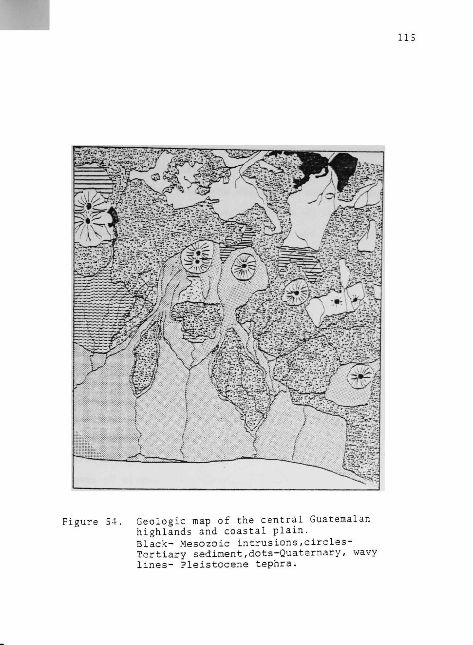
115
Figure 54 Geologic map of the central Guatemalan highlands and coastal plain. Black- Mesozoic intrusions,circles-Tertiary sediment,dots-Quaternary, wavy lines- Pleistocene tephra.

116
TERTIARY VOLCANICLASTIC SEDIMENTATION
General Statement
Voleanielastic sediments of Tertiary age are
exposed throughout the volcanic highlands of Guatemala
(Fig. 54). Williams (1960) assigned a late Miocene-Plio
cene age to these deposits and suggested that they were
produced by eruptions from widely dissiminated fissures.
The emplacement of these materials on an eroded late
Cretaceous surface suggested to Williams that no volcanic
activity had occurred in the highlands between the late
Cretaceous and late Tertiary.
The lack of radial dikes, eroded cones, or voleani
elastic sediments with quaquaversal dips suggested to
Williams that none of the vast voleanielastic deposits
were related to eruptions from large composite cones.
Such cones, in his opinion, have existed only within the
Quaternary.
The Tertiary landscape imagined by Williams was one
of broad plains and low plateaus formed by discharge of
lavas and glowing avalanches from fissures. Scattered
domes of viscous lava dotted the landscapes.
Tertiary Lava and Voleanielastic Deposits
Tertiary rocks exposed on the coastal plain of
Guatemala consist of poorly sorted, matrix supported
andesite boulder conglomerates, grain supported cobble-
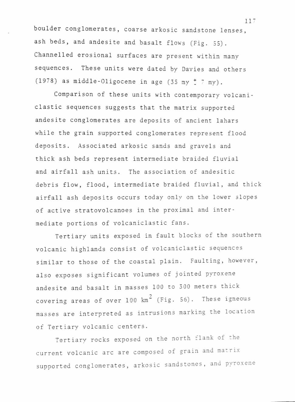
11"
boulder conglomerates, coarse arkosic sandstone lenses,
ash beds, and andesite and basalt flows (Fig. 55).
Channelled erosional surfaces are present within many
sequences. These units were dated by Davies and others
(1978) as middle-Oligocene in age (35 my t ' my).
Comparison of these units with contemporary voleani
elastic sequences suggests that the matrix supported
andesite conglomerates are deposits of ancient lahars
while the grain supported conglomerates represent flood
deposits. Associated arkosic sands and gravels and
thiek ash beds represent intermediate braided fluvial
and airfall ash units. The association of andesitic
debris flow, flood, intermediate braided fluvial, and thick
airfall ash deposits occurs today only on the lower slopes
of active stratovolcanoes in the proximal and inter
mediate portions of voleanielastic fans.
Tertiary units exposed in fault blocks of the southern
volcanic highlands consist of voleanielastic sequences
similar to those of the coastal plain. Faulting, however,
also exposes significant volumes of jointed pyroxene
andesite and basalt in masses 100 to 300 meters thick
covering areas of over 100 km^ (Fig. 56). These igneous
masses are interpreted as intrusions marking the location
of Tertiary volcanic centers.
Tertiary rocks exposed on the north flank of the
current volcanic arc are composed of grain and matrix
supported conglomerates, arkosic sandstones, and pyroxene

118
Oran luppertM coMM
01 DeuM«r \ FKnHSt
I . - J SuaKeHMontct ftM> »f
Sfoaeiionai eoniaei
Sharp w wmio* eonMCi
W ) t r •ro*!*'* com«ct
. ^.
F^
LEGEND
Groi'> support ef l OoutO*' on«
Motfii «uooort«d DouiOflf conyiomwott Lonor
&roir> tuoooritC coDbM and Orov«i congiomaroia Fiuwioi
Grom luooorivd 9row«t conoiom«rot« Ftwwiot
Shorp fo tro«*w« coniQct
MofOr • r o t m * ContQCT
Figure 55, Oligoeene v o l e a n i e l a s t i c deposi ts exposed in fau l t blocks near the_coasta l plain Cafter Davies et a l . , 1979).

119
Figure 56 Tertiary intrusion near Fuego volcano

1 0 dacite and andesite flow rock. These units grade north-""
ward into biotite rhyolite and rhyodacite lava with
quartz and sanadine phenocrysts interpreted by Williams
(1960) as flows marking the location of coalescing pelean
domes. In the northern portion of the volcanic highlands
these units pass into rhyolitic ash, coarse sandstone,
matrix supported rhyolitic conglomerates, and thiek
pumice deposits interpreted by Williams to represent
glowing avalanche, airfall ash, and fluvial deposits
derived from scattered domes. These deposits are rich in
hornblende, poor in pyroxene, and composed dominantly
of plagioelase (An.^). Lake deposits within these units
bear microfossils of Pliocene age.
Hence, Tertiary volcanic and voleanielastic rocks
exposed in southern Guatemala display a systematic
gradation in composition, age and origin from north to
south (Fig. 57, Table 10) . Rocks exposed on the coastal
plain, resemble contemporary arc products. They are
interpreted to represent reworked voleanielastic fan
deposits from middle-Tertiary composite volcanoes which
existed south of the current arc. This view is supported
by the identification of large igneous intrusions which
may represent parts of the old volcanic centers.
Rocks exposed in the highlands display a gradation
from andesite to dacite and finallv to rhyolite composition
with increasing distance to the north. Glowing avalanche
and airfall ash deposits predominate over reworked

TABLE 10
121
AREA AGE VOLCANOES FLOW ROCK VOLCANICLASTICS
Oligoeene and older
Composite Basalt Andesitic debris cones Pyroxene Andesite flows, airfall ash,
fluvial sands
Miocene Dacite domes, Composite cones
Andesite Pyroxene Dacite
Andesitic-dacitic debris flows, airfall ash, fluvial sands
Pliocene Pleistocene
Pelean domes
Rhyolite Pumice, Rhyolitic airfall and ash flow deposits .

122
V
/ /
/ <i
V 1
1
. o CO
c
'~3 <D > *-( 0) t/1
o e •y:
. ^ r- i
03 U
^ O >
>- 5H
0)
00
03 •
LO
o
zr.

123 volcaniclasties. These units, which are far younger
(Pliocene) than those exposed to the south, resemble
deposits formed by eruptions from domes and fissures
(Williams, 1960) .
The spatial relation of volcanic and voleanielastic
rocks of progressively younger age and less mafic
composition from south to north suggests that the Guate
malan arc has migrated and evolved through time as
progressively deeper portions of the under thrusting
Coeos Plate were subjected to anatecti'c melting. Examples
of similar activity have been cited by Dickenson (19:'5).
Thus, the history of Tertiary activity within the
Guatemalan are is far more complex than previously
imagined. The are appears to have been active since
at least the Oligoeene. Early voleanism resulted in the
construction of composite cones south of the current
arc. Emission of progressively lighter magmas occurred
due to arc migration culminating in the eruption of
rhyolite ash flows and lavas in the northern highlands
during the Pliocene. Thus Tertiary voleanielastic
strata deposited above the late Cretaceous unconformity
in southern Guatemala are diaehronous representing materials
deposited from different volcanoes as the are migrated
across the area.

124 CONCLUSIONS
The development of the Guatemalan volcanic arc
has been characterized by widely varying styles of
voleanism and voleanielastic sedimentation. Flow and
voleanielastic rocks of remarkably different compositions
have been generated by this activity.
Volcanic activity within the arc commenced in the
Oligoeene with the generation of composite cones in a
NW-SE trending arc located just south of the presently
active arc. Voleanielastic debris flow, flood, and
braided fluvial deposits together with scattered
pyroxene andesite intrusions and flows are all that
remain of this arc complex.
Miocene voleanism involved the generation of
andesite stratovolcanoes and dacite domes just north of
the present arc. Glowing avalanche, debris flow, and
fluvial sediments as well as dacite and andesite
intrusions and flows are the remnants of this period
of voleanism.
Pliocene and Pleistocene volcanic activity was
characterized by the emission of rhyolite pumice of ash
flow and airfall origin. These deposits mantle large
areas in the volcanic highlands north of the present
are. Pleistocene units on the coastal plain apparently
represent reworking of Pleistocene lacustrine sediments
by catastrophic flooding.

125
Construction of large composite cones characterizes
Quaternary volcanic activity. Immense voleanielastic
fans composed of airfall, glowing avalanche, debris flow,
flood, and braided fluvial deposits extend from the
cone to the sea. Construction of both cones and fans
has occurred over the last 20,000 to 30,000 years.
The Tertiary to recent history of Guatemalan
voleanism may represent retrograde migration of the arc
complex. As this occurred, progressively lighter magmas
were generated by melting of deeper portions of the down-
thrusting ocean plate. Progressively younger voleani
elastic sediments were deposited on the late Cretaceous
unconformity in a systematic fashion from south to
north as the arc migrated away from the subduetion
complex.

REFERENCES
Anon., 1975, Estudio Integral de los recursos hidraulicas del departmento de Escuintla, Institute Geografico Nacional, Gautemala,
Bonis, S.B., and Salazar, 0., 1974, The 1971 and 19'3 eruptions of volean de Fuego, Guatemala, and some socio-economic considerations for the volcanologist: Bull. Volcano., v. 37, p. 394-400.
Davies, D.K., Almon, W.R., Bonis, S.B., and Hunter, B.E., 1979, Deposition and diagenesis of Tertiary-Holocene volcaniclasties, Guatemala: SEPM Special Publication No. 26, p. 281-306.
Dickinson, W.R., 19:'3, Widths of modern are-trench gaps proportional to past duration of igneous activity in associated magmatic arcs: Jour. Geophvs. Research, V. 78, p. 3376-3389.
Greer, E.W., 1978, Sedimentation patterns of the Rio Achiguate delta system. Pacific coast, Guatemala: unpublished M.S. thesis, Texas Tech University, Lubbock, Texas, 127 pp.
Hebberger, J.J., 1977, Laharic and glowing avalanche sediments: Unpubl. M.A. Thesis, The University of Missouri, Columbia, 115 pp.
Hunter, B.E., 1976, Fluvial sedimentation on an active volcanic continental margin - Rio Guaealate, Guatemala: Unpubl. M.A. Thesis, The University of Missouri, Columbia, 135 pp.
Koch, A.J., and H. McLean, 1975, Pleistocene tephra and ash-fiow deposits in the volcanic highlands of Guatemala, Geol. Soc. .-\m. Bull., v. 56, 529-541.
Miall, A.D., 1979, Lithofacies types and vertical profile models in braided river deposits: a summary: in Miall, A.D. (ed.), Fluvial Sedimentologv: Canadian Soc. Petrol. Geol., Memoir 5, p. 59"-604.
Mooser, F., Meyer-Abich, H., andMcBriney, A.R., 1958, Catalogue of active volcanoes of the world, part VI, Central America: Napoli, International Association of Voleanology.
Rose, W.I., Jr., Bonis, S., Stoiber, R.E., Keller, M., and Biekford, T., 1973, Studies of volcanic ash from two recent Central American eruptions. Bull. Volcanol. 37, p. 338-364.
Rose, W.I., Jr.,Grant, N.K., Hahn, G.A., Lange, I.M., Powell, J.L., Easter, J., and DeGraff, J.M., 1977, The evolution of Santa Maria volcano, Guatemala, J. Geol. , V. 85, p. 63-87.
Rose, W.I., Jr., Anderson, A.T., Bonis, S.B., and Woodruff, L.G., 1978, The October 1974 basaltic tephra from Fuego volcano, Guatemala: description and history of the magma body. Jour. Volcano, and Geothermal REs., v. 4, p. 3-53.
Schumm, S.A., 1968, Speculations concerning paleohydrologic controls of terrestrial sedimentation: Geol. Soc. Am. Bull., V. 79, p. 1575-1588.
Seely, D.R., P.R. Vail, and G.G. Walton, 19: 4, Trench slope model, in. The geology of continental margins: New York, Springer-Verlag, p. 249-260.
Shook, E.M., 1947, Archaeological discovery at Finca Arizona, Guatemala: Carnegie Inst. Wash., Div. Historical Research, Notes on Middle American Archaeology and Ethnology, no. 57, Cambridge.
Williams, H. , 1960, Volcanic history of the Guatemalan highlands: University of Calfornia Publications in Geological Sciences, v. 38, no. 1, p. 1-86.
Williams, P.F., and Rust, B.R., 1969, The sedimentology of a braided river: J. Sediment. Petrol., v. 39, p. 649-679.
Vanoni, V.A., 1975, Sedimentation Engineering: Am. Soc. Civil Eng. Manual No. 54, 745 pp.
