3456 oneida street site record of decision (pdf)
TRANSCRIPT

Department of Environmental Conservation
Division of Environmental Remediation
Record of Decision
3456 Oneida Street Site State Superfund Project
Town of New Hartford, Oneida Co., New York Site Number 6-33-049
March 2010
New York State Department of Environmental Conservation DAVID A. PATERSON, Governor ALEXANDER B. GRANNIS, Commissioner


DECLARATION STATEMENT - RECORD OF DECISION
3456 Oneida Street Site State Superfund Project
Town of New Hartford, Oneida County, New York Site No. 6-33-049
Statement of Purpose and Basis The Record of Decision (ROD) presents the selected remedy for the 3456 Oneida Street site, a Class 2 inactive hazardous waste disposal site. The selected remedial program was chosen in accordance with the New York State Environmental Conservation Law, 6 NYCRR Part 375, and is not inconsistent with the National Oil and Hazardous Substances Pollution Contingency Plan of March 8, 1990 (40CFR300), as amended. This decision is based on the Administrative Record of the New York State Department of Environmental Conservation (the Department) for the 3456 Oneida Street site and the public=s input to the Proposed Remedial Action Plan (PRAP) presented by the Department. A listing of the documents included as a part of the Administrative Record is included in Appendix B of the ROD. Description of Selected Remedy Based on the results of the remedial investigation/feasibility study (RI/FS) for the 3456 Oneida Street site and the criteria identified for evaluation of alternatives, the Department has selected removal of soil and C&D debris to residential SCOs and sediment excavation. The components of the remedy are as follows: A. Response Actions:
1. A remedial design program will be implemented to provide the details necessary for the construction and monitoring of the remedial program.
2. Excavation and off-site disposal at a permitted facility of contaminated soil,
sediment and C&D debris from on-site areas (including the Trib and Ditch), as well as off-site areas including the Sauquoit Creek East Bank and two adjacent off-site properties where contamination has migrated. The areas to be excavated are shown on Figure 8. Confirmatory soil samples will be collected to assure the excavation allows for residential use of the site and surrounding areas. The areas to be excavated include:
(a) on-site soil and C&D debris where concentrations of SVOCs, PCBs or
metals exceed the Part 375-6.8(b) residential use SCOs. Based on the findings in the RI, excavation depths are anticipated to be 1 to 2 feet in most areas and as deep as 9 feet in the C&D area. The estimated volume
i

is approximately 2,900 cubic yards of soil and 5,550 cubic yards of C&D;
(b) soil/sediment from the on-site Ditch where concentrations of PCBs exceed the 1 ppm residential use SCOs. Excavation depths are anticipated to be 1 to 2 feet;
(c) the on-site Trib will be addressed, after further evaluation in the design, by
either: (1) excavating the sediments in the Trib where PCB levels exceed 0.1 ppm to a depth of 5 feet below grade. Deeper than 5 feet below grade PCBs greater than 1 ppm will be removed. The extent of the sediment excavation is estimated to be a 300 foot by 20 foot wide section of the Trib from the railroad track right of way to the confluence with Sauquoit Creek. The two existing culverted stream crossings along with any exposed or buried drums will be removed. The estimated removal volume is approximately 960 cubic yards; or (2) excavating the sediments in the Trib where PCB levels exceed 0.1 ppm to a depth of 5 feet below grade and relocating a portion of the Trib away from an existing residence/structure. This portion of the Trib will be moved to the north of the existing location, with final PCB levels in the soil where the new channel will be located not to exceed 0.1 ppm to a depth of 5 feet below grade. If this option is implemented, the PCB contaminated soil in the area of the existing channel which may be abandoned due to relocation, will be excavated to the residential use SCO for PCBs of 1 ppm;
(d) soil and sediment from the east bank of Sauquoit Creek where PCB levels exceed 0.1 ppm to a depth of 2 feet below grade. Deeper than 2 feet below grade the residential SCOs for soil will apply. Excavation will include removal of an estimated 120 linear foot by 20 foot wide section, beginning at the confluence of the Trib and extending downstream along the Sauquiot Creek. The excavation will extend horizontally from the near shore sediments to 5 feet beyond the top of stream bank. Excavation depth in the near shore sediments will be to mean low water stage (to the extent practicable). The estimated volume to be excavated is 135 cubic yards;
(e) soil from an adjacent off-site residential property located to the south of
the site, where PCB concentrations exceed the residential use SCO for PCBs. Excavation depths are anticipated to be 1 to 2 feet and the estimated soil volume to be removed is approximately 24 cubic yards; and
(f) soil from an adjacent off-site commercial property located to the north of
the site, where PCB concentrations exceed the residential use SCO for
ii

iii
PCBs. Excavation depths are anticipated to be 1 foot and the estimated soil volume to be removed is approximately 180 cubic yards.
3. Removal of the accumulated soil, sediment and other material from within storm
water catch basins located on the adjacent off-site commercial property where PCB concentrations are present. The estimated volume to be removed and disposed off-site at a permitted facility is 10 cubic yards.
4. The excavated areas will be restored as follows:
(a) the on-site and off-site excavation areas greater than 1 foot below grade
will be backfilled with soil meeting the lower of the residential use or the protection of groundwater SCOs. Backfill will be placed to match the existing grades and promote drainage. The off-site residential area will be restored with landscape shrubs and grass. Areas adjacent to the Trib and Sauquoit Creek that are currently vegetated will be reestablished. These areas will be restored with topsoil and a combination of native trees, shrubs, and application of riparian and upland seed mixtures;
(b) the on-site and off-site excavation areas to the north of the site 1 foot
below grade or less and not in residential or ecologically sensitive areas will be backfilled with gravel from a native source which is acceptable to the Department. The gravel will be placed to match the surrounding site contours and graded to promote drainage.
(c) the Ditch culvert will be removed and the ditch will be backfilled to match
surrounding grades in the same manner as other on-site excavation areas. The site will be graded to promote drainage and the final site grade will contain no drainage ditch; and
(d) the Trib (or the realigned Trib) and Sauquoit Creek East Bank will be
restored to original grade using natural stream bank restoration techniques to the extent practicable. Restoration will include bank stabilization using native plant species selected for terrestrial and aquatic habitats of the Trib and Sauquoit Creek East Bank. Natural stream bank restoration techniques will be specified in the remedial design. All remedial and restoration work will comply with the substantive requirements of Part 608. Soil and sediment backfill in these areas will meet applicable sediment criteria from the Department=s ATechnical Guidance for Screening Contaminated Sediments@ (January 1999) and contain no detectable concentrations of PCBs. Restoration of areas on the Trib which may be abandoned due to relocation will be restored as described in (a) above.
5. All restored areas will be monitored for a period of one year following the
Department=s determination of substantial completion of the site remediation by the contractor. During this time the restored areas will be inspected for erosion,

settlement and growth of plantings and grass. Areas will be repaired and restored as directed by the Department. Details of the inspection program will be developed in the remedial design. Induded in this period will be a sampling and analysis program for fish to establish a post-remediation baseline. The scope of the sampling and analysis program for fish will be developed during the remedial design and will be consistent with prior sampling.
6. Green remediation and sustainability efforts will be considered in the design and implementation ofthe remedy to the extent practicable, including:
• using renewable energy sources • reduce green house gas emissions • encourage low carbon technologies • conserve natural resources • increase recycling and reuse of clean materials • preserve open space and working landscapes
New York State Department of Health Acceptance
The New York State Department ofHealth (NYSDOH) concurs that the remedy selected for this site is protective of human health.
Declaration
The selected remedy is protective of human health and the environment, complies with State and Federal requirements that are legally applicable or relevant and appropriate to the remedial action to the extent practicable, and is cost effective. This remedy utilizes permanent solutions and alternative treatment or resource recovery technologies, to the maximum extent practicable, and satisfies the preference for remedies that reduce toxicity, mobility, or volume as a principal element.
Dale A. Desnoyers, Directo Date Division of Environmental Remediation
iv
RECORD OF DECISION 3456 Oneida Street Site State Superfund Project
Town of New Hartford, Oneida County, New York Site No. 6-33-049
March 2010
SECTION 1: SUMMARY AND PURPOSE OF THE PROPOSED PLAN The New York State Department of Environmental Conservation (the Department), in consultation with the New York State Department of Health (NYSDOH), has selected this remedy for the above referenced site. The disposal of hazardous waste at the site has resulted in threats to public health and the environment that are addressed by this remedy presented in this Record of Decision (ROD). The disposal of hazardous wastes at this site, as more fully described in Sections 5 of this document, have contaminated various environmental media. The remedy, discussed in detail in Section 8, is intended to attain the remedial action objectives identified for this site in Section 6 for the protection of public health and the environment. This ROD identifies the selected remedy, summarizes the other alternatives considered, and discusses the reasons for the selected remedy. The Department has selected a final remedy for the site after careful consideration of all comments received during the public comment period. The New York State Inactive Hazardous Waste Disposal Site Remedial Program (also known as the State Superfund Program) is an enforcement program, the mission of which is to identify and characterize suspected inactive hazardous waste disposal sites and to investigate and remediate those sites found to pose a significant threat to public health and the environment. The Department has issued this ROD in accordance with the requirements of New York State Environmental Conservation Law and Title 6 of the Official Compilation of Codes, Rules and Regulations of the State of New York, 6 NYCRR Part 375. SECTION 2: SITE DESCRIPTION AND HISTORY 2.1: Location and Description The 3456 Oneida Street Site is located adjacent to the Sauquoit Creek in the Village of Chadwicks, Town of New Hartford, Oneida County, New York. The site location is shown on Figure 1. The Site is comprised of an irregularly shaped 4.61 acre parcel of vacant commercial property immediately south of the former Willowvale Bleachery. The Site is currently vacant, a pole building and several temporary structures which are present on historical aerial photographs of the site have been removed in the last 15 years. The Site is located in a suburban area surrounded by residential, commercial and industrial development. The Site is bounded to the north by commercial and industrial businesses that occupy the former Willowvale Bleachery, to the east by an active rail line, to the south by a private residence and to the west by the Sauquoit Creek. The site is accessed from
3456 Oneida Street Site March 2010 RECORD OF DECISION Page 1

3456 Oneida Street Site March 2010 RECORD OF DECISION Page 2
Oneida Street to the northwest by way of a private driveway that includes a steel deck bridge over the Sauquoit Creek. The Site is generally level except for several areas of construction and demolition (C&D) disposal mostly on the southern portion of the site, and a steep bank of the Sauquoit Creek which runs along the western boundary of the site. It appears the site was historically a topographically low-lying area and that fill material was placed to accommodate commercial activities. The fill material is heterogeneous and contains soils ranging from clays to sands and gravels as well as C&D debris. Glacial till underlays the fill material at depths of approximately four to eight feet. Bedrock is present at depths of eight to twelve feet. Figure 2 presents an aerial photograph of the site showing the site boundary, elevation contours and primary surface water features. The primary surface water feature at the Site is Sauquoit Creek, which flows northerly and acts as the western boundary of the Site. From a wetlands area east of the Site, an Unnamed Tributary runs across the southern portion of the site from east to west and empties into Sauquoit Creek. A seasonally wet unnamed drainage ditch runs parallel to where the pole building use to be and then cuts west across the Site, draining into the Sauquoit Creek. Sauquoit Creek likely acts as the local discharge area for groundwater at and in the vicinity of the Site. Groundwater is present at the Site in the overburden aquifer at depths of one to eight feet. Groundwater flows west across the Site toward the Sauquoit Creek, and groundwater flow in the immediate vicinity of the Unnamed Tributary appears to be influenced by the Unnamed Tributary. Groundwater contours are shown on Figure 3. 2.2: Operational/Disposal History Starting around 1880, the 3456 Oneida Street Site was part of the former Willowvale Bleachery property although the Site was never developed as part of the bleachery. The bleachery operated until 1952. In 1955 the Site was purchased by the John Weeks Erecting Company. The northwest corner of the Site was part of a mill pond until around 1955 when the mill pond was filled in. The John Weeks Erecting Company conducted heavy millwright work and steel rigging activities at the Site until approximately 1979, when the Site was sold to Thomas (Sr.) and Rita Madden. The heavy millwright work and steel rigging activities continued into the early 1990's under the name of Central Steel Erecting Company. In 1994, following the closure of Central Steel Erecting Company, the Site itself was subdivided from the remaining portions of the former Willowvale Bleachery. The Site was subsequently transferred to Thomas J. Madden Jr., who in 2004 sold the Site to Valley Used Steel, Llc. Throughout its history the Site has generally been used for intermittent equipment storage and associated temporary structures. Currently all structures have been removed from the Site. Starting circa 1980, the site was reportedly used for cleaning of industrial machines containing PCB oils as well as unconfirmed discharge and dumping of fluids containing PCBs to the ground surface and Unnamed Tributary. Runoff generated from on-site cleaning activities discharged to a new on-site Mill Pond which was developed after 1957 and filled in 1988. During the time the Site was occupied by John Weeks Erecting Company and/or Central Steel Erecting it was reportedly also

3456 Oneida Street Site March 2010 RECORD OF DECISION Page 3
used for refuse disposal and landfilling which may have included pails and drums. The Site has also been used for C&D debris disposal which is evident by visual observation. 2.3: Remedial History As a result of identified hazardous waste disposal, the Department listed the site as a Class 2 site in the Registry of Inactive Hazardous Waste Disposal Sites in New York in March 2002. A Class 2 site is a site where hazardous waste presents a significant threat to the public health or the environment and action is required. The site remedial program is being performed by the Department under the state Superfund program. The following investigations and actions led to this remedial program. $ Throughout the mid-1990's the NYSDEC=s Division of Fish & Wildlife (DFW) conducted
several studies to evaluate the source of PCB impacts observed in fish in the Sauquoit Creek. The studies identified the Unnamed Tributary at the southern edge of the 3456 Oneida Street Site as a source of PCBs to the Sauquoit Creek.
$ In November 2001 the Department conducted a Preliminary Site Assessment (PSA). The
PSA confirmed the presence of hazardous waste at the Site based on concentrations of PCBs found in surface soils and sediments.
$ An Interim Remedial Measure (IRM) was completed in December 2007 which removed an
easily accessible area of PCB contaminated soil from the central portion of the site. The location of the IRM excavated area is shown on Figure 4.
$ A Remedial Investigation (RI) was completed by the Department under the state Superfund
program in November 2008. SECTION 3: LAND USE The Department may consider the current, intended, and reasonably anticipated future land use of the site and its surroundings when assessing nature and extent of contamination. For this site alternatives that may restrict the use of the site to commercial, restricted-residential or residential criteria as described in Part 375-1.8 (g) are being evaluated in addition to an unrestricted scenario. The 3456 Oneida Street site is zoned commercial and historically has been used only for commercial purposes. The only access to the Site is via a private steel deck bridge and public utilities do not service the Site. The site is bounded to the north by commercial and industrial development. The reasonably anticipated future use of the Site is commercial use. Therefore commercial land use SCGs were the most restrictive land use SCGs considered during the FS. Restricted-residential and residential SCGs were also considered with residential being the least restrictive land use SCGs considered. A comparison of the appropriate SCGs for the identified land use against the unrestricted use SCGs for the site contaminants is included in the Tables for the media being evaluated in section 5.1.2.
3456 Oneida Street Site March 2010 RECORD OF DECISION Page 4
SECTION 4: ENFORCEMENT STATUS Potentially Responsible parties (PRPs) are those who may be legally liable for contamination at a site. This may include past or present owners and operators, waste generators, and haulers. The Potentially Responsible Parties (PRPs) for the site, documented to date, include: Thomas Madden Jr., Valley Used Steel, LLC., Rita Madden and Central Steel Erecting Company. The PRPs for the site declined to implement a remedial program when requested by the Department. After the remedy is selected, the PRPs will again be contacted to assume responsibility for the remedial program. If an agreement cannot be reached with the PRPs, the Department will evaluate the site for further action under the State Superfund. The PRPs are subject to legal actions by the state for recovery of all response costs the state has incurred. SECTION 5: SITE CONTAMINATION A remedial investigation has been conducted to determine the nature and extent of contamination and to evaluate the alternatives for addressing the significant threats to human health and the environment. 5.1: Summary of the Remedial Investigation The purpose of the Remedial Investigation (RI) was to define the nature and extent of any contamination resulting from previous activities at the site. The RI was conducted between August 2006 and November 2008. The field activities and findings of the investigation are described in the RI Report. The following general activities are conducted during an RI: C Research of historical information, C Survey of residential water supply wells, C Geophysical survey to determine the lateral extent of wastes, C Test pits, soil borings, and monitoring well installations, C Sampling of waste, surface and subsurface soils, groundwater and soil vapor, C Sampling of surface water and sediment, and C Ecological and Human Health Exposure Assessments.
3456 Oneida Street Site March 2010 RECORD OF DECISION Page 5
5.1.1: Standards, Criteria, and Guidance (SCGs) The remedy must conform with promulgated standards and criteria that are directly applicable, or that are relevant and appropriate. The selection of a remedy must also take into consideration guidance, as appropriate. Standards, criteria and guidance are hereafter called SCGs. To determine whether the contaminants identified by the RI are present in soil, groundwater, surface water, and sediments at levels of concern, the data from the investigation were compared to the following SCGs: 1. Groundwater, drinking water, and surface water SCGs are based on the Department=s
AAmbient Water Quality Standards and Guidance Values@ (TOGS 1.1.1), AUse and Protection of Waters@ (6 NYCRR Part 608), and Part 5 of the New York State Sanitary Code.
2. Soil SCGs are based on the Soil Cleanup Objectives (SCOs) Tables found in 6 NYCRR Part
375-6.8. 3. Sediment SCGs are based on the Department=s ATechnical Guidance for Screening
Contaminated Sediments.@ Based on the RI results, in comparison to the SCGs and potential public health and environmental exposure routes, certain media and areas of the site require remediation. These are summarized in Section 5.1.2. More complete information can be found in the RI Report. 5.1.2: Nature and Extent of Contamination This section describes the findings of the Remedial Investigation. As described in the RI report, waste/ source materials were identified at the site and are impacting the soil, surface water and sediment.
Waste/Source Areas Wastes are defined in 6 NYCRR Part 375-1.2 (aw) and include solid, industrial and/or hazardous wastes. Source Areas are defined in 6 NYCRR Part 375-1.2 (au). Source areas are areas of concern at a site where substantial quantities of contaminants are found which can migrate and release significant levels of contaminants to another environmental medium. Waste material encountered at this site during the RI consisted of construction and demolition (C&D) debris. The C&D debris was likely derived from the demolition of off-site buildings to the north of the site which were formerly a part of the Willowvale Bleachery. C&D debris piles are located mostly on the southern portion of the site in four areas shown on Figure 2. The RI estimated that the site contains approximately 5,550 cubic yards of C&D debris and sampling indicated the debris exceeds unrestricted SCOs for SVOCs, PCBs and metals. Analytical sampling results of C&D debris are summarized in Table 2 along with other soil samples.

3456 Oneida Street Site March 2010 RECORD OF DECISION Page 6
The RI also identified a PCB source area at the Site. The source area consists of sediment within the Unnamed Tributary and soil within five feet of the Unnamed Tributary bank. The source area is contained within Area of Contamination (AOC) 2 depicted on Figure 4, and extends approximately one half the length of the Unnamed Tributary through the southeast portion of the site. The source area has a maximum PCB concentration of 7,200 parts per million (ppm) in sediment located at the outfall of the upstream culvert in the vicinity of a 55 gallon drum which is submerged in the Unnamed Tributary. The vertical extent of PCB contaminated sediment and soils over 50 ppm extends to at least a depth of 2 feet and may extend deeper.
The source area will be addressed in the remedy selection process. This section describes the findings for all environmental media that were evaluated. As described in the RI report, groundwater, soil, surface water, and sediment samples were collected to characterize the nature and extent of contamination. For each media a table summarizes the findings of the investigation. The table presents the range of contamination found at the site in the media and compare(s) the data with the applicable SCGs for the site. The contaminants are arranged into four categories; volatile organic compounds (VOCs), semivolatile organic compounds (SVOCs), pesticides/ polychlorinated biphenyls (PCBs) and inorganics (metals). For comparison purposes the SCGs are provided for each medium that allows for unrestricted use. For soil, if applicable, the restricted use SCGs identified in Section 3 are also presented.
Groundwater Groundwater samples were collected from eight shallow piezometers and five shallow monitoring wells installed to assess the impacts of site contaminants to groundwater throughout the site both up and down gradient of identified source area, soil, and sediment contamination. The locations of piezometers and monitoring wells are shown on Figure 3. Groundwater samples were analyzed for VOCs, SVOCs, PCBs and metals. Metals including iron, manganese, selenium, sodium, and thallium were detected in at least one groundwater sample in exceedence of SCGs. Table 1 includes a summary of groundwater data for constituents which exceeded SCGs. Several VOCs and SVOCs were detected at concentrations below SCGs. PCBs were not detected in groundwater at the site.
Table 1 - Groundwater Detected Constituents
Concentration Range Detected
(ppb)a SCGb
(ppb) Frequency of Exceeding SCG
Metals
Iron
322 - 18,600 300 8/8
Manganese
319 - 7,380 300 8/8
Selenium
11.5 - 19.4 10 8/8

a - ppb: parts per billion, which is equivalent to micrograms per liter, ug/L, in water.
Table 1 - Groundwater
Detected Constituents
Concentration Range Detected
(ppb)a SCGb
(ppb) Frequency of Exceeding SCG
Sodium
10,100 - 34,700 20,000 3/8
Thallium
ND - 15.8 10 6/8
b- SCG: Standard Criteria or Guidance - Ambient Water Quality Standards and Guidance Values (TOGs 1.1.1), 6 NYCRR Part 703, Surface water and Groundwater Quality Standards, and Part 5 of the New York State Sanitary Code. The metals observed above SCGs in groundwater were not found at significant levels in soils or wastes (no exceedences of residential SCOs in soils for any identified groundwater contaminants), are commonly associated with naturally occurring phenomenon and are not a concern at the levels observed. Therefore, the inorganic compounds found in groundwater are not considered site specific contaminants of concern. No site-related groundwater contamination of concern was identified during the RI/FS. Therefore, no remedial alternatives need to be evaluated for groundwater.
Soil Surface and subsurface soil samples were collected at the site during the RI. Additionally, surface soil samples were collected off-site from an adjacent residential property to the south of the site and surface and subsurface soil samples were collected off-site from an adjacent commercial property to the north of the site. Surface soil samples were collected at various depth intervals between 0 and 1 foot below grade with vegetation removed. A subset of surface soil samples were collected from 0 to 2 inches below grade with vegetation removed to assess direct human exposure. Subsurface soil samples were collected from a depth of 1 to 11 feet below grade. Subsurface soil sampling included sampling of C&D debris piles. Soil samples were analyzed for VOCs, SVOCs, PCBs and metals depending on location. During the initial phase of the RI, soil samples were collected and analyzed on-site for PCBs by immunoassay analysis. A subset of these soil samples were sent off-site for laboratory analysis. A total of 199 surface and subsurface soil samples were analyzed for PCBs and 58 surface and subsurface soil samples were analyzed for SVOCs. 24 subsurface soil samples were analyzed for metals. A total of 13 subsurface soil samples were collected from C&D debris piles and analyzed for VOCs, SVOCs, PCBs and metals. Table 2 compares the analytical results of soil samples to the unrestricted SCOs in Table 375-6.8(a) as well as residential SCOs in Table 375-6.8(b). Table 2 only includes results obtained from laboratory analysis. Contaminants in site soil samples exceeded the unrestricted SCOs for eight (8) SVOCs, nine (9) metals and total PCBs. All exceedences of unrestricted SCOs for SVOCs and metals were either found in C&D debris samples or were co-located with exceedences for total PCBs.
3456 Oneida Street Site March 2010 RECORD OF DECISION Page 7
3456 Oneida Street Site March 2010 RECORD OF DECISION Page 8
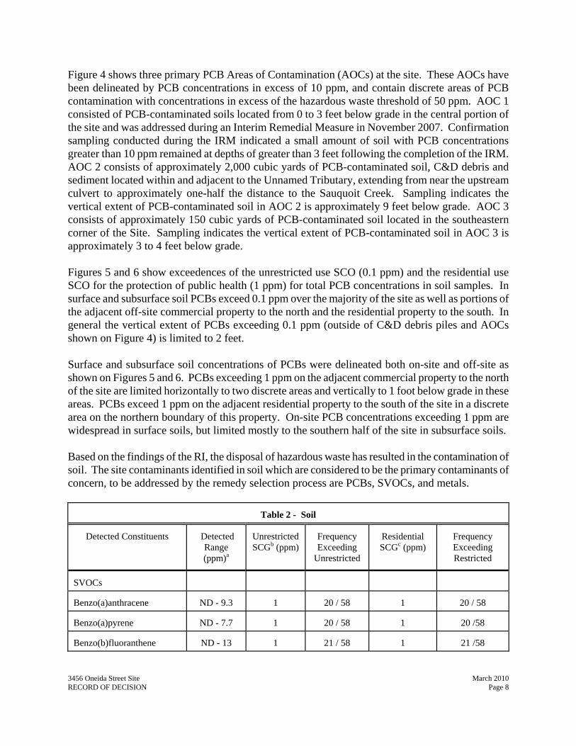
Figure 4 shows three primary PCB Areas of Contamination (AOCs) at the site. These AOCs have been delineated by PCB concentrations in excess of 10 ppm, and contain discrete areas of PCB contamination with concentrations in excess of the hazardous waste threshold of 50 ppm. AOC 1 consisted of PCB-contaminated soils located from 0 to 3 feet below grade in the central portion of the site and was addressed during an Interim Remedial Measure in November 2007. Confirmation sampling conducted during the IRM indicated a small amount of soil with PCB concentrations greater than 10 ppm remained at depths of greater than 3 feet following the completion of the IRM. AOC 2 consists of approximately 2,000 cubic yards of PCB-contaminated soil, C&D debris and sediment located within and adjacent to the Unnamed Tributary, extending from near the upstream culvert to approximately one-half the distance to the Sauquoit Creek. Sampling indicates the vertical extent of PCB-contaminated soil in AOC 2 is approximately 9 feet below grade. AOC 3 consists of approximately 150 cubic yards of PCB-contaminated soil located in the southeastern corner of the Site. Sampling indicates the vertical extent of PCB-contaminated soil in AOC 3 is approximately 3 to 4 feet below grade. Figures 5 and 6 show exceedences of the unrestricted use SCO (0.1 ppm) and the residential use SCO for the protection of public health (1 ppm) for total PCB concentrations in soil samples. In surface and subsurface soil PCBs exceed 0.1 ppm over the majority of the site as well as portions of the adjacent off-site commercial property to the north and the residential property to the south. In general the vertical extent of PCBs exceeding 0.1 ppm (outside of C&D debris piles and AOCs shown on Figure 4) is limited to 2 feet. Surface and subsurface soil concentrations of PCBs were delineated both on-site and off-site as shown on Figures 5 and 6. PCBs exceeding 1 ppm on the adjacent commercial property to the north of the site are limited horizontally to two discrete areas and vertically to 1 foot below grade in these areas. PCBs exceed 1 ppm on the adjacent residential property to the south of the site in a discrete area on the northern boundary of this property. On-site PCB concentrations exceeding 1 ppm are widespread in surface soils, but limited mostly to the southern half of the site in subsurface soils. Based on the findings of the RI, the disposal of hazardous waste has resulted in the contamination of soil. The site contaminants identified in soil which are considered to be the primary contaminants of concern, to be addressed by the remedy selection process are PCBs, SVOCs, and metals.
Table 2 - Soil
Detected Constituents
Detected Range (ppm)a
Unrestricted SCGb (ppm)
Frequency Exceeding
Unrestricted
Residential SCGc (ppm)
Frequency Exceeding Restricted
SVOCs
Benzo(a)anthracene
ND - 9.3 1 20 / 58 1
20 / 58
Benzo(a)pyrene
ND - 7.7 1 20 / 58 1
20 /58
Benzo(b)fluoranthene
ND - 13 1 21 / 58 1
21 /58

a - ppm: parts per million, which is equivalent to milligrams per kilogram, mg/kg, in soil;
Table 2 - Soil
Detected Constituents
Detected
Range (ppm)a
Unrestricted SCGb (ppm)
Frequency Exceeding
Unrestricted
Residential SCGc (ppm)
Frequency Exceeding Restricted
Benzo(k)fluoranthene
ND - 5.2 0.8 18 / 58 1
17 / 58
Chrysene
ND - 9.2 1 22 / 58 1
22 / 58
Dibenz(a,h)anthracene
ND - 1.5 0.33 13 / 58 0.33
13 / 58
Indeno(1,2,3-cd)pyrene
ND - 3.8 0.5 16 / 58 0.5
16 / 58
Phenol
ND - 1.3 0.33 1 / 58 100
0 / 58
Metals
Arsenic
2.2 - 44.4 13 16 / 24 16
11 / 24
Cadmium
ND - 3.4 2.5 1 / 24 2.5
1 / 24
Chromium
3.1 - 74.9 30 2 / 24 36
2 / 24
Copper
9.3 - 203 50 6 / 24 270
0 / 24
Lead
2.1 - 2,200 63 15 / 24 400
1 / 24
Manganese
252 - 1,690 1,600 1 / 24 2,000
0 / 24
Mercury
ND - 0.41 0.18 3 / 24 0.81
0 / 24
Nickel
5.4 - 1,220 30 4 / 24 140
1 / 24
Silver
ND - 4.6 2 3 / 24 36
0 / 24
Zinc
13.2 - 871 109 17 / 24 2,200
0 / 24
Pesticides/PCBs
Total PCBs
ND - 350 0.1 131 / 199 1
89 / 199
b - SCG: Part 375-6.8(a), Unrestricted Soil Cleanup Objectives. c - SCG: Part 375-6.8(b), Residential Soil Cleanup Objectives.
Surface Water Surface water samples were collected from locations upstream, adjacent to and downstream of the site within the Sauquoit Creek and the Unnamed Tributary (Trib) and analyzed for PCBs and SVOCs. No contaminants were detected in any of these samples, however the reporting limits for PCBs was higher than SCGs. A sampling technique known as passive-in-situ-chemical extraction sampling (PISCES) was conducted to approximate qualitatively the extent of PCB contamination in surface water. The 3456 Oneida Street Site March 2010 RECORD OF DECISION Page 9

3456 Oneida Street Site March 2010 RECORD OF DECISION Page 10
technique involved the use of diffusive samplers placed in surface water for a period of two weeks. PISCES sampling indicated the presence of PCBs in the surface water in the Trib, unnamed drainage ditch (Ditch), the Sauquoit Creek directly downstream from the confluence of the Trib, and storm water catch basins located on the adjacent off-site commercial property to the north. The presence of PCBs in surface water as indicated by PISCES sampling is consistent with exceedences of SCGs for PCBs in underlying sediments. Based on the findings of the RI, the presence of PCBs in sediment has likely resulted in the contamination of surface water. The site contaminants that are considered to be the primary contaminants of concern are PCBs. Mitigation of these impacts will be addressed by the remedy selection process.
Sediments Sediment samples were collected during the RI from the Ditch, Trib, Sauquoit Creek and catch basins on the adjacent commercial property to the north of the site. Sediment samples were collected from the Sauquoit Creek adjacent to the site as well as to the north (down gradient) and south (up gradient) of the site from depths ranging from 0 to 2 feet below grade, with the majority of samples collected between 0 and 6 inches. A summary of the analytical results is provided in Table 3.
Table 3 - Sediment
Detected Constituents
Range Detected (ppm)a Screening Valueb
(ppm)
Frequency Exceeding Screening
SVOCs
2-Methylnapththalene
ND - 0.46 0.126
2/37
Acenaphthene
ND - 0.87 0.518
1/37
Anthracene
ND - 3 0.396
2/37
Benzo(a)anthracene
ND - 4.1 0.0444
20/37
Chrysene
ND - 3.7 3.123
1/37
Dibenz(a,h)anthracene
ND - 0.45 0.449
1/37
Fluoranthene
ND - 10 3.774
1/37
Fluorene
ND - 2.1 0.0296
5/37
Naphthalene
ND - 0.34 0.111
2/37
Phenanthrene
ND - 11 0.444
5/37

3456 Oneida Street Site March 2010 RECORD OF DECISION Page 11
Table 3 - Sediment
Detected Constituents
Range Detected (ppm)a Screening Valueb
(ppm)
Frequency Exceeding Screening
Pyrene
ND - 7.3 3.556
1/37
Pesticides/PCBs
Total PCBs
ND - 7,200 0.0052
37/58
a - ppm: parts per million, which is equivalent to milligrams per kilogram, mg/kg, in sediment; b - SCG: Standards, criteria, and guidance values; New York Department of Environmental Conservation ATechnical Guidance for Screening Contaminated Sediments@. Uses site average 0.37 % Total Organic Carbon (TOC). Table 3 compares the analytical results of sediment samples to SCGs. Figure 7 presents concentrations of PCBs in sediments from on-site and adjacent off-site sampling locations. PCBs were not detected in sediment samples collected from the Sauquoit Creek either up gradient or down gradient of the site (not depicted on figure) nor were they detected in sediment samples collected from the Trib upstream of the site. PCBs exceeding SCGs were observed in the Ditch, Trib, Sauquoit Creek adjacent to the site and catch basins on the adjacent commercial property to the north of the site. As shown on Figure 7, the highest concentrations of PCB contamination in sediments are located in the Trib in the southeast corner of the site. Concentrations were observed as high as 7,200 ppm in this area in sediment, which is the highest concentration of PCBs in any soil or sediment sample collected from the site. Subsurface sediment sampling indicated PCBs exceeding SCGs may extend greater than 2 feet below grade. Concentrations of PCBs are present that exceed SCGs in sediments along the entire length of the Trib as it passes through the site. Sediment from the Trib has impacted Sauquoit Creek sediment in the vicinity of the Trib=s outlet to the Creek. PCB contamination in catch basins located on the off-site adjacent commercial property to the north of site are likely derived from overland runoff which transports surface soils from the site to the north. Concentrations of PCBs in these catch basins are less than 10 ppm. Concentrations of PCBs found in site sediments are several orders of magnitude greater than SCGs in most cases. PCB concentrations found in sediment exceed the hazardous waste threshold for PCBs of 50 ppm in the Trib. Exceedences of SCGs for SVOCs in sediment are characteristic of typical urban runoff and/or runoff from non-hazardous C&D debris piles. Most exceedences of SCGs for SVOCs in sediments are co-located with exceedences of SCGs for PCBs in sediments or near a storm water runoff outfall. Based on the findings of the RI, the disposal of hazardous waste has resulted in the contamination of sediment. The primary contaminant of concern which will drive the remediation of sediment to be addressed by the remedy selection process is PCBs.

3456 Oneida Street Site March 2010 RECORD OF DECISION Page 12
Soil Vapor Intrusion No soil vapor samples were collected as part of the RI. The RI Report found no evidence of VOC contamination in soils or groundwater in exceedence of unrestricted SCOs and the site contains no structures. Therefore evaluation of soil vapor intrusion is not required. 5.2: Interim Remedial Measures An interim remedial measure (IRM) is conducted at a site when a source of contamination or exposure pathway can be effectively addressed before issuance of the Record of Decision. Based on the initial results of the RI, an IRM was completed for Area of Contamination (AOC) 1 at this site in late 2007. The initial results of the RI indicated that AOC 1 consisted of soils with PCB concentrations greater than 10 ppm generally within 2 feet of the ground surface. Since contamination was present above the water table in an easily accessible area of the site, an IRM was deemed appropriate. The goal of the IRM was to remove PCB contaminated soil in AOC 1 with concentrations greater than 10 ppm. The IRM for AOC 1 was conducted between November 26, 2007 and December 6, 2007. The scope of the IRM was expanded based on confirmation sampling, extending to 3 feet below grade in most areas. A total of 400 cubic yards of soil was excavated and disposed of off-site at a permitted facility as hazardous waste. All horizontal confirmation samples met the 10 ppm goal, however one vertical confirmation sample contained concentrations of PCBs greater than 10 ppm at 3 feet below grade. Excavation was not conducted beyond 3 feet due to the presence of groundwater in the excavation. The excavated AOC 1 was backfilled with crushed stone and graded and compacted with common borrow material. 5.3: Summary of Human Exposure Pathways: This section describes the current or potential human exposures to persons at or around the site that may result from the site contamination. A more detailed discussion of the human exposure pathways can be found in the RI report Section 6.0 available at the document repository. An exposure pathway describes the means by which an individual may be exposed to contaminants originating from a site. An exposure pathway has five elements: [1] a contaminant source, [2] contaminant release and transport mechanisms, [3] a point of exposure, [4] a route of exposure, and [5] a receptor population. Contaminant release and transport mechanisms carry contaminants from the source to a point where people may be exposed. The exposure point is a location where actual or potential human contact with a contaminated medium may occur. The route of exposure is the manner in which a contaminant actually enters or contacts the body (e.g., ingestion, inhalation, or direct contact). The receptor population is the people who are, or may be, exposed to contaminants at a point of exposure.
3456 Oneida Street Site March 2010 RECORD OF DECISION Page 13
An exposure pathway is complete when all five elements of an exposure pathway exist. An exposure pathway is considered a potential pathway when one or more of the elements currently does not exist, but could in the future. A Health Advisory due to elevated levels of PCBs in brown trout has been issued for this portion of the Sauquoit Creek. The site is not fenced and there is evidence of trespassers on the property, who may come in contact with PCB contaminated soil and stream sediment.
5.4: Summary of Environmental Assessment This section summarizes the assessment of existing and potential future environmental impacts presented by the site. Environmental impacts may include existing and potential future exposure pathways to fish and wildlife receptors, wetlands, groundwater resources, and surface water. The Fish and Wildlife Impact Analysis (FWIA), which is included in the RI report, presents a detailed discussion of the existing and potential impacts the site poses to fish and wildlife receptors. The 3456 Oneida Street site is located adjacent to the Sauquoit Creek. The Sauquoit Creek is classified as Class C(T) water throughout its length. An unnamed tributary (the Trib) to the Sauquoit Creek runs through the southern portion of the site. The Trib enters the site via a culvert which passes beneath railroad tracks which run along the eastern border of the site. Sampling of sediment has identified the Trib as a source of PCBs to the Sauquoit Creek. There is currently an eat none restriction on trout caught in the Sauquoit Creek due to PCB contamination in fish tissue. The FWIA has identified ecological resources at or in the vicinity of the site which constitute an important component of the environment. The FWIA has determined that the ecological resource is impacted by contaminants in the soil of the site requiring the application of the SCO for the protection of ecological resources. The following environmental exposure pathways and ecological impacts have been identified: Sediment samples from the Trib and Sauquoit Creek contain PCBs above SCGs. Biota sampling in the Trib on site and in Sauquoit Creek at locations up stream, adjacent to and down stream of the site has identified concentrations of PCBs in forage fish and brown trout tissue in exceedence of SCGs. The highest concentrations of PCBs in fish tissue in the Sauquoit Creek were found adjacent to the 3456 Oneida Street site. Concentrations of PCBs in fish tissue in the Sauquoit Creek decreased steadily down stream of the site and decreased more rapidly upstream of the site. Site-related surface water impacts have also been identified. Groundwater resources at the site include an overburden aquifer present at depths of one to eight feet. Groundwater flows west across the Site toward the Sauquoit Creek and groundwater flow in the immediate vicinity of the Trib appears to be influenced by it. No site-related groundwater contamination has been identified.

3456 Oneida Street Site March 2010 RECORD OF DECISION Page 14
SECTION 6: SUMMARY OF THE REMEDIATION OBJECTIVES The objectives for the remedial program have been established through the remedy selection process stated in 6 NYCRR Part 375. The goal for the remedial program is to restore the site to pre-disposal conditions to the extent feasible. At a minimum, the remedy shall eliminate or mitigate all significant threats to public health and the environment presented by the contamination identified at the site through the proper application of scientific and engineering principles. The remedial objectives for this site are: Public Health Protection
Soil
$ Prevent ingestion/direct contact with contaminated soil.
Surface water $ Prevent surface water contamination which may result in fish advisories.
Sediment $ Prevent direct contact with contaminated sediments. $ Prevent sediment contamination which may result in fish advisories. Environmental Protection
Soil $ Prevent migration of contaminants that would result in groundwater or surface water
contamination.
Surface Water $ Prevent impacts to biota from ingestion/direct contact with surface water causing toxicity
and impacts from bioaccumulation through the aquatic food chain.
Sediment $ Prevent releases of contaminants from sediment that would result in surface water levels in
excess of ambient water quality criteria. $ Prevent impacts to biota from ingestion/direct contact with sediments causing toxicity and
impacts from bioaccumulation through the aquatic food chain.
SECTION 7: SUMMARY OF THE EVALUATION OF ALTERNATIVES To be selected the remedy must be protective of human health and the environment, be cost-effective, comply with other statutory requirements, and utilize permanent solutions, alternative technologies or resource recovery technologies to the maximum extent practicable. Potential remedial alternatives for the Site were identified, screened and evaluated in the 3456 Oneida Street Site FS report which is available at the document repositories established for this site.
3456 Oneida Street Site March 2010 RECORD OF DECISION Page 15
A summary of the remedial alternatives that were considered for this site is presented below. Cost information is presented in the form of present worth, which represents the amount of money invested in the current year that would be sufficient to cover all present and future costs associated with the alternative. This enables the costs of remedial alternatives to be compared on a common basis. As a convention, a time frame of 30 years is used to evaluate present worth costs for alternatives with an indefinite duration. This does not imply that operation, maintenance, or monitoring would cease after 30 years if remediation goals are not achieved. 7.1: Description of Remedial Alternatives The following alternatives were considered to address the contaminated media identified at the site as describe in Section 5:
Alternative 1: No Further Action The No Further Action Alternative recognizes the remediation of the site completed by the IRM(s) described in Section 5.2. This alternative leaves the site in its present condition and does not provide any additional protection of the environment. Alternative 2: AOC Removal, On-Site Consolidation and Capping of Soil and C&D Debris
to Commercial SCOs, Limited Sediment Excavation This alternative would include the excavation and off-site disposal at a permitted facility of approximately 2,700 cubic yards of contaminated material which includes all soil, C&D debris and sediment with PCB concentrations greater than or equal to 10 ppm. Sediment in the Trib from 0 to 3 feet below grade with PCB concentrations greater than 0.1 ppm and from 3 to 5 feet below grade with PCB concentrations greater than 1 ppm would be removed. On the east bank of the Sauquoit Creek sediment from 0 to 2 feet below grade with PCB concentrations greater than 0.1 ppm would also be excavated and disposed off-site at a permitted facility. On-site soil and C&D debris from 0 to 1 feet below grade with PCB concentrations greater than 1 ppm but less than 10 ppm as well as on-site soil and C&D debris in exceedence of commercial use SCOs for SVOCs or metals would be excavated, consolidated in an area of the site and then capped by a 1 foot thick soil cover which meets the Part 375 commercial use SCOs. Off-site soil on the adjacent residential property to the south of the site with PCB concentrations greater than 1 ppm would be excavated and consolidated underneath the on-site cap. Soil excavation and off-site disposal areas would be backfilled with soil meeting the lower of the commercial use or the protection of groundwater SCOs, or gravel from a native source. The Ditch would be removed and backfilled to match surrounding grades. The site would be graded to promote drainage and the final site grade would contain no drainage ditch. The Trib and the east bank of the Sauquoit Creek would be backfilled and restored using natural stream bank restoration techniques that comply with the substantive requirements of Part 608 and Part 663.
3456 Oneida Street Site March 2010 RECORD OF DECISION Page 16
An environmental easement would be placed on the site restricting use to commercial. A site management plan, requiring annual cover inspections, maintenance and periodic certification would be required by the environmental easement. The remedy could be implemented in less than a year. Present Worth: .................................................................................................................$2,979,000 Capital Cost: ....................................................................................................................$2,910,000 Annual Costs: (Years 1-30): ...........................................................................................................................$4,500
Alternative 3: AOC Removal, Partial Removal of Soil and C&D Debris to Commercial SCOs, Limited Sediment Excavation
Alternative 3 is the same as Alternative 2 with respect to soils and C&D debris with PCB concentrations greater than 10 ppm and excavation of the Trib. The east bank of Sauquoit Creek would be handled the same as Alternative 2. Alternative 3 differs from Alternative 2 with respect to soils and C&D debris with PCB concentrations less than 10 ppm. On-site soil from 0 to 1 feet below grade and C&D debris with PCB concentrations greater than 1 ppm would be excavated and disposed of off-site at a permitted facility. C&D debris with PCB concentrations less than 1 ppm and any soil in exceedence of commercial use SCOs for SVOCs or metals would be excavated, consolidated in an area of the site and then capped by a 1 foot thick soil cover which meets the Part 375 commercial use SCOs. Off-site soil on the adjacent residential property to the south of the site with PCB concentrations greater than 1 ppm would be excavated and disposed of off-site at a permitted facility. Alternative 3 follows the same procedure as Alternatives 2 with respect to backfill and restoration, although more backfill would be required due to the increased volume of excavation. The Ditch, the Trib and the east bank of the Sauquoit Creek would be backfilled and restored the same as Alternative 2. Alternative 3 is similar to Alternative 2 in terms of Institutional Controls. An environmental easement would be placed on the site restricting use to commercial. A site management plan, requiring annual cover inspections, maintenance and periodic certification would be required by the environmental easement. The remedy could be implemented in less than a year. Present Worth: .................................................................................................................$4,413,000 Capital Cost: ....................................................................................................................$4,350,000 Annual Costs: (Years 1-30): ...........................................................................................................................$4,100
Alternative 4: Removal of Soil and C&D Debris to Commercial SCOs, Sediment Excavation
Alternative 4 is the same as Alternative 3 with respect to soils and C&D debris with PCB concentrations greater than 10 ppm but differs from Alternative 3 in respect to the excavation of the
3456 Oneida Street Site March 2010 RECORD OF DECISION Page 17
Trib. For Alternative 4, sediment in the Trib from 0 to 5 feet below grade with PCB concentrations greater than 0.1 ppm would be excavated and disposed off-site at a permitted facility. The east bank of Sauquoit Creek would be handled the same as Alternative 3. Alternative 4 differs from Alternative 3 with respect to soils and C&D debris with PCB concentrations less than 10 ppm. Under Alternative 4 all on-site soil and C&D debris in exceedence of commercial use SCOs for PCBs, SVOCs or metals would be excavated and disposed of off-site at a permitted facility. Additionally, Alternative 4 includes excavation and off-site disposal at a permitted facility of off-site soil on the adjacent commercial property to the north of the site with PCB concentrations greater than 1 ppm as well as excavation and off-site disposal at a permitted facility of off-site sediment within storm drains on the adjacent commercial property to the north of the site with PCB concentrations greater than 0.1 ppm. Alternative 4 follows the same procedure as Alternative 3 with respect to backfill and restoration, although more backfill would be required due to the increased volume of excavation. The Ditch, the Trib and the east bank of the Sauquoit Creek would be backfilled and restored the same as Alternative 3. Alternative 4 is similar to Alternative 3 in terms of Institutional Controls. An environmental easement would be placed on the site restricting use to commercial. A site management plan, requiring periodic certification would be required by the environmental easement, though no cover inspection would be required as in Alternative 3. The remedy could be implemented in less than a year. Present Worth: .................................................................................................................$4,576,000 Capital Cost: ....................................................................................................................$4,515,000 Annual Costs: (Years 1-30): ...........................................................................................................................$4,000 Alternative 5: Removal of Soil and C&D Debris to Restricted-Residential SCOs, Sediment
Excavation Alternative 5 is the same as Alternatives 4 with respect to soils and C&D debris with PCB concentrations greater than 10 ppm and the excavation of the Trib. The east bank of Sauquoit Creek would be handled the same as Alternative 4. Alternative 5 differs from Alternative 4 with respect to soils and C&D debris with PCB concentrations less than 10 ppm. Under Alternative 5 all on-site soil and C&D debris in exceedence of restricted-residential use SCOs for PCBs, SVOCs or metals would be excavated and disposed of off-site at a permitted facility. Alternative 5 follows the same procedure as Alternative 4 with respect to backfill and restoration, although more backfill would be required due to the increased volume of excavation and backfill requirements are different. Soil excavation and off-site disposal areas would be backfilled with soil meeting the lower of the restricted-residential use or the protection of groundwater SCOs, or gravel
3456 Oneida Street Site March 2010 RECORD OF DECISION Page 18
from a native source. The Ditch, the Trib and the east bank of the Sauquoit Creek would be backfilled and restored the same as Alternative 4. Alternative 5 is similar to Alternative 4 in terms of Institutional Controls. An environmental easement would be placed on the site restricting use to restricted-residential. A site management plan, requiring periodic certification would be required by the environmental easement. The remedy could be implemented in less than a year. Present Worth: .................................................................................................................$4,679,000 Capital Cost: ....................................................................................................................$4,618,000 Annual Costs: (Years 1-30): ...........................................................................................................................$4,000 Alternative 6: Removal of Soil and C&D Debris to Residential SCOs, Sediment Excavation Alternative 6 is the same as Alternative 5 with respect to soils and C&D debris with PCB concentrations greater than 10 ppm and the excavation of the Trib. The east bank of Sauquoit Creek would be handled the same as Alternative 5. Alternative 6 differs from Alternative 5 with respect to soils and C&D debris with PCB concentrations less than 10 ppm. Under Alternative 6 all on-site soil and C&D debris in exceedence of residential use SCOs for PCBs, SVOCs or metals would be excavated and disposed of off-site at a permitted facility. Alternative 6 follows the same procedure as Alternative 5 in respect to backfill and restoration, although more backfill would be required due to the increased volume of excavation and backfill requirements are different. Soil excavation and off-site disposal areas would be backfilled with soil meeting the lower of the residential use or the protection of groundwater SCOs, or gravel from a native source. The Ditch, the Trib and the east bank of the Sauquoit Creek would be backfilled and restored the same as Alternative 5. Alternative 6 would not require Institutional Controls. The remedy could be implemented in less than a year. Capital Cost: ....................................................................................................................$4,637,000
Alternative 7: Restoration to Pre-Disposal Conditions This alternative achieves all of the SCGs discussed in Section 5.1.1 and soil meets the unrestricted soil clean up objectives listed in Part 375-6.8 (a). This alternative would include excavation and off-site disposal at a permitted facility of all on-site soil, on-site C&D Debris, and off-site soil on the adjacent residential property to the south of the site and the adjacent commercial property to the north of the site with concentrations of PCBs, SVOCs or metals in exceedence of unrestricted use SCOs. All sediment within and on the banks of the Trib, Sauquoit Creek, and storm drains on the
3456 Oneida Street Site March 2010 RECORD OF DECISION Page 19
adjacent commercial property to the north of the site with detectable concentrations of PCBs (approximately 0.03 ppm) would be excavated and disposed of off-site in a permitted facility. Soil excavation and off-site disposal areas would be backfilled with soil meeting the unrestricted use SCOs or gravel from a native source. The Ditch would be removed and backfilled to match surrounding grades. The site would be graded to promote drainage and the final site grade would contain no drainage ditch. The Trib and the Sauquoit Creek would be backfilled and restored using natural stream bank restoration techniques that comply with the substantive requirements of Part 608 and Part 663. Capital Cost: ....................................................................................................................$8,713,000 7.2 Evaluation of Remedial Alternatives The criteria to which potential remedial alternatives are compared are defined in 6 NYCRR Part 375, which sets forth the requirements for the remediation of inactive hazardous waste disposal sites in New York. A detailed discussion of the evaluation criteria and comparative analysis is included in the FS report. The first two evaluation criteria are termed Athreshold criteria@ and must be satisfied in order for an alternative to be considered for selection. 1. Protection of Human Health and the Environment. This criterion is an overall evaluation of each alternative=s ability to protect public health and the environment. 2. Compliance with New York State Standards, Criteria, and Guidance (SCGs). Compliance with SCGs addresses whether a remedy will meet environmental laws, regulations, and other standards and criteria. In addition, this criterion includes the consideration of guidance which the Department has determined to be applicable on a case-specific basis. The next six Aprimary balancing criteria@ are used to compare the positive and negative aspects of each of the remedial strategies. 3. Long-term Effectiveness and Permanence. This criterion evaluates the long-term effectiveness of the remedial alternatives after implementation. If wastes or treated residuals remain on-site after the selected remedy has been implemented, the following items are evaluated: 1) the magnitude of the remaining risks, 2) the adequacy of the engineering and/or institutional controls intended to limit the risk, and 3) the reliability of these controls. 4. Reduction of Toxicity, Mobility or Volume. Preference is given to alternatives that permanently and significantly reduce the toxicity, mobility or volume of the wastes at the site. 5. Short-term Impacts and Effectiveness. The potential short-term adverse impacts of the remedial action upon the community, the workers, and the environment during the construction and/or

3456 Oneida Street Site March 2010 RECORD OF DECISION Page 20
implementation are evaluated. The length of time needed to achieve the remedial objectives is also estimated and compared against the other alternatives. 6. Implementability. The technical and administrative feasibility of implementing each alternative are evaluated. Technical feasibility includes the difficulties associated with the construction of the remedy and the ability to monitor its effectiveness. For administrative feasibility, the availability of the necessary personnel and materials is evaluated along with potential difficulties in obtaining specific operating approvals, access for construction, institutional controls, and so forth. 7. Cost-Effectiveness. Capital costs and annual operation, maintenance, and monitoring costs are estimated for each alternative and compared on a present worth basis. Although cost-effectiveness is the last balancing criterion evaluated, where two or more alternatives have met the requirements of the other criteria, it can be used as the basis for the final decision. The costs for each alternative are presented in the Remedial Alternatives Cost Table 4.
Table 4
Remedial Alternative Costs
Remedial Alternative Capital Cost
($) Annual Costs
($) Total Present
Worth ($) 1. No Further Action $ 0 $ 0
$ 0
2. AOC Removal, Soil Capping to Commercial SCOs, Limited Sediment Excavation
$ 2,910,000 $ 4,500
$ 2,979,000
3. AOC Removal, Partial Soil Excavation to Commercial SCOs, Limited Sediment Excavation
$ 4,350,000 $ 4,100
$ 4,413,000
4. Soil Excavation to Commercial SCOs, Sediment Excavation
$ 4,515,000 $ 4,000
$ 4,576,000
5. Soil Excavation to Restricted-Residential SCOs, Sediment Excavation
$ 4,618,000 $ 4,000
$ 4,679,000
6. Soil Excavation to Residential SCOs, Sediment Excavation
$ 4,637,000 $ 0
$ 4,637,000
7. Restoration to Pre-Disposal Conditions
$ 8,713,000 $ 0
$ 8,713,000
3456 Oneida Street Site March 2010 RECORD OF DECISION Page 21
8. Land Use. When cleanup to pre-disposal conditions is determined to be infeasible, the Department may consider the current, intended, and reasonable anticipated future land use of the site and its surroundings in the selection of the soil remedy. The final criterion, Community Acceptance, is considered a Amodifying criterion@ and is taken into account after evaluating those above. It is evaluated after public comments on the Proposed Remedial Action Plan have been received. 9. Community Acceptance. Concerns of the community regarding the investigation, the evaluation of alternatives, and the PRAP have been evaluated. The responsiveness summary (Appendix A) presents the public comments received and the manner in which the Department addressed the concerns raised. In general, the public comments received were supportive of the selected remedy. SECTION 8: SUMMARY OF THE SELECTED REMEDY Based on the Administrative Record (Appendix B) and the discussion presented below, the Department has selected Alternative 6, Removal of Soil and C&D Debris to Residential SCOs and Sediment Excavation as the remedy for this site. The elements of this remedy are described at the end of this section. 8.1: Basis for Selection The selected remedy is based on the results of the RI and the evaluation of alternatives. Alternative 6 is selected because, as described below, it satisfies the threshold criteria and provides the best balance of the balancing criterion described in Section 7.2. It will achieve the remediation goals for the site by removing soil and C&D from the site in exceedence of residential SCOs and remediating and restoring the Trib and the East Bank of the Sauquoit Creek to prevent further exposure of site contaminants to fish & wildlife. Alternative 6 will effectively remediate site media to allow for residential use with no restrictions and could be achieved at a considerably lower cost than remediating the site to pre-disposal conditions (Alternative 7). Alternative 1 (No Further Action) does not provide any protection to public health and the environment and will not be evaluated further. Alternatives 6 and 7, by removing all soil and sediment contaminated above the residential and unrestricted SCOs respectively, meet the threshold selection criteria. Alternatives 2 through 5 would also comply with the threshold criteria but to a lesser degree. Alternatives 2, 3, and 4 remediate the site to commercial SCOs and Alternative 5 remediates the site to restricted-residential SCOs. Because Alternatives 2, 3, 4, 5, 6, and 7 satisfy the threshold criteria, the six balancing criteria are particularly important in selecting a final remedy for the site.
3456 Oneida Street Site March 2010 RECORD OF DECISION Page 22
Alternatives 2 through 7 would all have short-term impacts to the community, site workers and the environment during implementation. Implementation of proper health and safety procedures could mitigate these impacts. It is estimated that each alternative could be fully implemented in less than one year, at which time they will achieve the RAOs for soil and sediment. Alternatives 2 and 3 include the least disturbance of contaminated soil, sediments and C&D debris, and therefore present the least potential short-term impacts. Alternatives 4, 5, 6 and 7 result in more disturbance of sediments within the Trib, resulting in a slight increase in the potential for impacts. Alternative 7 requires a significant disturbance of the Sauquoit Creek and the site and results in the greatest potential for short-term impacts. Long-term effectiveness is best accomplished by those alternatives involving excavation and off-site disposal of contaminated soils and sediments (Alternatives 4 through 7). Alternatives 6 and 7 would provide the best long-term effectiveness because the alternatives do not require institutional controls. Alternative 5 requires an institutional control to limit use of the site to restricted-residential use, while Alternative 4 requires an institutional control to limit use of the site to commercial use. Alternatives 2 and 3 have a lower long-term effectiveness because of the use of a cap and consolidation area to contain PCB contaminated soil (engineering control). Alternatives 2 and 3 also require institutional controls which limit the use of the site to commercial. Alternatives 2 through 7 will all result in varying degrees in the reduction of mobility and volume of soil and sediment contamination at and in the vicinity of the Site through excavation and off-site disposal or on-site consolidation and capping. Alternatives 4 through 7 include excavation and off-site disposal of soil in exceedence of the applicable SCOs to meet RAOs. Alternative 3 includes a slightly smaller reduction of volume of contamination at the site than Alternatives 4, 5 and 6 and the use of a small cap to reduce the mobility of contamination. Alternative 2 includes a limited reduction in the volume of contamination at the site and the use of a larger cap to reduce the mobility of contamination. There will be limited technical issues in implementing Alternatives 2 through 6. Excavation, consolidation and capping are all standard engineering practices that are readily implementable. Under each of these alternatives the Trib and east bank of the Sauquoit Creek need to be diverted to allow for excavation of contaminated sediments. State or federal regulations for construction within a flood plain may complicate implementation of these alternatives. There will likely be greater technical issues with implementation of Alternative 7 (rerouting the Sauquoit Creek), with respect to excavation of sediment in the Sauquoit Creek. There are logistical issues in implementing Alternatives 2 through 5 as institutional controls are required in these alternatives to manage residual wastes/soils. The site owner would need to place an environmental easement on the site under these alternatives. Alternative 2 would be less expensive than Alternatives 3 through 7 because it includes the off-site disposal of a significantly smaller volume of PCB contaminated soil. Alternatives 3 through 6 all cost between $4.4 million and $4.7 million. Alternative 3 leaves a limited amount of SVOC and metal contaminated soil on the site, while Alternatives 4, 5 and 6 remove all site soil in exceedence of commercial, restricted-residential, and residential SCOs respectively. The difference in costs in achieving these different remediation goals is relatively small. Alternative 7 would be much more
3456 Oneida Street Site March 2010 RECORD OF DECISION Page 23
costly than Alternatives 2 through 6 because it includes the off-site disposal of a much greater quantity of PCB contaminated soil as well as excavation of sediment from the Sauquoit Creek. Alternatives 2, 3, 4 and 5 have annual costs associated with institutional and engineering controls. Alternatives 6 and 7 would have only capital costs and no annual costs. The current and reasonably anticipated future land use of the Site would be for commercial purposes. Alternatives 2 through 7 are compatible with the current and reasonably anticipated future land use. Alternative 5 would allow for potential future restricted-residential use of the Site. Alternatives 2 through 5 would include institutional controls to restrict site use and require continued monitoring and maintenance. Alternative 6 would allow for residential use and have no restriction on the site. Alternative 7 would return the site to pre-disposal conditions. The Department has selected Alternative 6 as the remedy for this site because it satisfies the threshold criteria and best satisfies the balancing criteria. Alternative 6 has comparable short-term impacts and implementability to all other alternatives considered. Alternative 6 provides for long-term effectiveness and reduction in mobility and volume because contamination is removed from the site and no restrictions are required. The cost of Alternative 6 is not significantly higher than Alternatives 3, 4 and 5 and Alternative 6 provides better protection of public health and the environment than Alternatives 3, 4 and 5. Alternatives 3, 4 and 5 also require restrictions on the future use of the site. Although Alternative 7 restores the site to pre-disposal conditions, it was not selected because the incremental cost is almost double of Alternative 6 and provides little added benefit. Alternative 7 will also cause greater short term impacts and be more difficult to implement than all other alternatives. Alternative 6 was selected as it provides a high level of protection, requires no institutional and engineering controls, and is cost effective. The estimated present worth cost to implement the remedy is $ 4,637,000. The cost to construct the remedy is estimated to be $ 4,637,000 and the estimated average annual costs is $ 0. 8.2: Elements of the Selected Remedy The elements of the selected residential use remedy with no site use restrictions are as follows: A. Response Actions:
1. A remedial design program will be implemented to provide the details necessary for the construction and monitoring of the remedial program.
2. Excavation and off-site disposal at a permitted facility of contaminated soil,
sediment and C&D debris from on-site areas (including the Trib and Ditch), as well as off-site areas including the Sauquoit Creek East Bank and two adjacent off-site properties where contamination has migrated. The areas to be excavated are shown on Figure 8. Confirmatory soil samples will be collected to assure the excavation allows for residential use of the site and surrounding areas. The areas to be excavated include:

3456 Oneida Street Site March 2010 RECORD OF DECISION Page 24
(a) on-site soil and C&D debris where concentrations of SVOCs, PCBs or metals exceed the Part 375-6.8(b) residential use SCOs. Based on the findings in the RI, excavation depths are anticipated to be 1 to 2 feet in most areas and as deep as 9 feet in the C&D area. The estimated volume is approximately 2,900 cubic yards of soil and 5,550 cubic yards of C&D;
(b) soil/sediment from the on-site Ditch where concentrations of PCBs exceed
the 1 ppm residential use SCOs. Excavation depths are anticipated to be 1 to 2 feet;
(c) the on-site Trib will be addressed, after further evaluation in the design, by
either: (1) excavating the sediments in the Trib where PCB levels exceed 0.1 ppm to a depth of 5 feet below grade. Deeper than 5 feet below grade PCBs greater than 1 ppm will be removed. The extent of the sediment excavation is estimated to be a 300 foot by 20 foot wide section of the Trib from the railroad track right of way to the confluence with Sauquoit Creek. The two existing culverted stream crossings along with any exposed or buried drums will be removed. The estimated removal volume is approximately 960 cubic yards; or (2) excavating the sediments in the Trib where PCB levels exceed 0.1 ppm to a depth of 5 feet below grade and relocating a portion of the Trib away from an existing residence/structure. This portion of the Trib will be moved to the north of the existing location, with final PCB levels in the soil where the new channel will be located not to exceed 0.1 ppm to a depth of 5 feet below grade. If this option is implemented, the PCB contaminated soil in the area of the existing channel which may be abandoned due to relocation, will be excavated to the residential use SCO for PCBs of 1 ppm;
(d) soil and sediment from the east bank of Sauquoit Creek where PCB levels exceed 0.1 ppm to a depth of 2 feet below grade. Deeper than 2 feet below grade the residential SCOs for soil will apply. Excavation will include removal of an estimated 120 linear foot by 20 foot wide section, beginning at the confluence of the Trib and extending downstream along the Sauquoit Creek. The excavation will extend horizontally from the near shore sediments to 5 feet beyond the top of stream bank. Excavation depth in the near shore sediments will be to mean low water stage (to the extent practicable). The estimated volume to be excavated is 135 cubic yards;

3456 Oneida Street Site March 2010 RECORD OF DECISION Page 25
(e) soil from an adjacent off-site residential property located to the south of the site, where PCB concentrations exceed the residential use SCO for PCBs. Excavation depths are anticipated to be 1 to 2 feet and the estimated soil volume to be removed is approximately 24 cubic yards; and
(f) soil from an adjacent off-site commercial property located to the north of
the site, where PCB concentrations exceed the residential use SCO for PCBs. Excavation depths are anticipated to be 1 foot and the estimated soil volume to be removed is approximately 180 cubic yards.
3. Removal of the accumulated soil, sediment and other material from within storm
water catch basins located on the adjacent off-site commercial property where PCB concentrations are present. The estimated volume to be removed and disposed off-site at a permitted facility is 10 cubic yards.
4. The excavated areas will be restored as follows:
(a) the on-site and off-site excavation areas greater than 1 foot below grade
will be backfilled with soil meeting the lower of the residential use or the protection of groundwater SCOs. Backfill will be placed to match the existing grades and promote drainage. The off-site residential area will be restored with landscape shrubs and grass. Areas adjacent to the Trib and Sauquoit Creek that are currently vegetated will be reestablished. These areas will be restored with topsoil and a combination of native trees, shrubs, and application of riparian and upland seed mixtures;
(b) the on-site and off-site excavations areas to the north of the site 1 foot
below grade or less and not in residential or ecologically sensitive areas will be backfilled with gravel from a native source which is acceptable to the Department. The gravel will be placed to match the surrounding site contours and graded to promote drainage.
(c) the Ditch culvert will be removed and the ditch will be backfilled to match
surrounding grades in the same manner as other on-site excavation areas. The site will be graded to promote drainage and the final site grade will contain no drainage ditch; and
(d) the Trib (or the realigned Trib) and Sauquoit Creek East Bank will be
restored to original grade using natural stream bank restoration techniques to the extent practicable. Restoration will include bank stabilization using native plant species selected for terrestrial and aquatic habitats of the Trib and Sauquoit Creek East Bank. Natural stream bank restoration techniques will be specified in the remedial design. All remedial and restoration work will comply with the substantive requirements of Part 608. Soil and sediment backfill in these areas will meet applicable

3456 Oneida Street Site March 2010 RECORD OF DECISION Page 26
sediment criteria from the Department=s ATechnical Guidance for Screening Contaminated Sediments@ (January 1999) and contain no detectable concentrations of PCBs. Restoration of areas on the Trib which may be abandoned due to relocation will be restored as described in (a) above.
5. All restored areas will be monitored for a period of one year following the
Department=s determination of substantial completion of the site remediation by the contractor. During this time the restored areas will be inspected for erosion, settlement and growth of plantings and grass. Areas will be repaired and restored as directed by the Department. Details of the inspection program will be developed in the remedial design. Included in this period will be a sampling and analysis program for fish to establish a post-remediation baseline. The scope of the sampling and analysis program for fish will be developed during the remedial design and will be consistent with prior sampling.
6. Green remediation and sustainability efforts will be considered in the design and
implementation of the remedy to the extent practicable, including:
C using renewable energy sources C reduce green house gas emissions C encourage low carbon technologies C conserve natural resources C increase recycling and reuse of clean materials C preserve open space and working landscapes
SECTION 9: HIGHLIGHTS OF COMMUNITY PARTICIPATION As part of the remedial investigation process, a number of Citizen Participation activities were undertaken to inform and educate the public about conditions at the site and the potential remedial alternatives. The following public participation activities were conducted for the site:
• Repositories for documents pertaining to the site were established.
• A public contact list, which included nearby property owners, elected officials, local media and other interested parties, was established.
• Several fact sheets were distributed and public meetings held throughout the RI/FS process.
• A public meeting was held on March 3, 2010 to present and receive comment on the PRAP.

3456 Oneida Street Site March 2010 RECORD OF DECISION Page 27
• A responsiveness summary (Appendix A) was prepared to address the comments received during the public comment period for the PRAP.
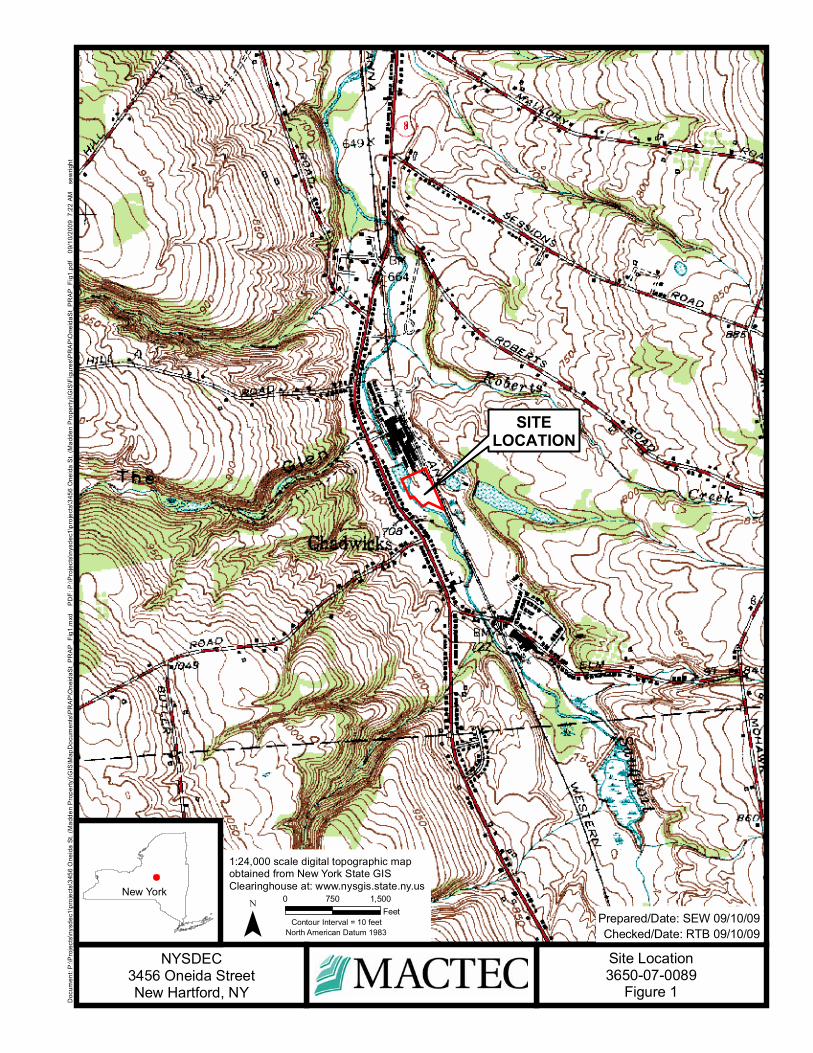
SITELOCATION
Checked/Date: RTB 09/10/09Prepared/Date: SEW 09/10/09¯
0 1,500750Feet
Doc
umen
t: P
:\Pro
ject
s\ny
sdec
1\pr
ojec
ts\3
456
One
ida
St. (
Mad
den
Pro
perty
)\GIS
\Map
Doc
umen
ts\P
RA
P\O
neid
aSt_
PR
AP
_Fig
1.m
xd
PD
F: P
:\Pro
ject
s\ny
sdec
1\pr
ojec
ts\3
456
One
ida
St.
(Mad
den
Pro
perty
)\GIS
\Fig
ures
\PR
AP
\One
idaS
t_P
RA
P_F
ig1.
09/
10/2
009
7:2
2 AM
s
ewrig
ht
NYSDEC3456 Oneida StreetNew Hartford, NY
Site Location3650-07-0089
Figure 1
New York
1:24,000 scale digital topographic mapobtained from New York State GISClearinghouse at: www.nysgis.state.ny.us
Contour Interval = 10 feetNorth American Datum 1983
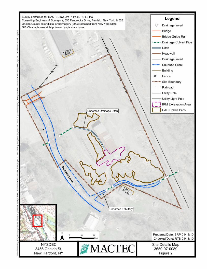
[
[
[[
[[
[[
[[
[[[
[
!(
!(
!(
!(
!(
!(
!(
!(
!(1 StoryFrame
1 Story
Brick
Checked/Date: RTB 01/13/10Prepared/Date: BRP 01/13/10
Doc
umen
t: P
:\Pro
ject
s\ny
sdec
1\pr
ojec
ts\3
456
One
ida
St.
(Mad
den
Pro
perty
)\GIS
\Map
Doc
umen
ts\P
RA
P\O
neid
aSt_
PR
AP
_Fig
2.m
xd
PD
F: P
:\Pro
ject
s\ny
sdec
1\pr
ojec
ts\3
456
One
ida
St.
(Mad
den
Pro
perty
)\GIS
\Fig
ures
\PR
AP
\Jan
uary
201
0\O
neid
aSt_
PR
AP
_Fig
2.pd
f 0
1/13
/201
0 9
:35
AM
b
rpet
ers
¯ 0 10050Feet
NYSDEC3456 Oneida St.
New Hartford, NY
Unnamed Tributary
Unnamed Drainage Ditch
Sauquoit Creek
Legend!( Drainage Invert
Bridge
Bridge Guide Rail
Drainage Culvert Pipe
Ditch
Headwall
Drainage Invert
Sauquoit Creek
Building
[ Fence
Site Boundary
Railroad
Utility Pole
Utility Light Pole
IRM Excavation Area
C&D Debris Piles
Survey performed for MACTEC by: Om P. Popli, PE LS PCConsulting Engineers & Surveyors, 555 Penbrooke Drive, Penfield, New York 14526Oneida County color digital orthoimagery (2003) obtained from New York State GIS Clearinghouse at: http://www.nysgis.state.ny.us
Site Details Map3650-07-0089
Figure 2

Checked/Date: RTB 09/15/09Prepared/Date: SEW 09/15/09
Doc
umen
t: P
:\Pro
ject
s\ny
sdec
1\pr
ojec
ts\3
456
One
ida
St.
(Mad
den
Pro
perty
)\GIS
\Map
Doc
umen
ts\P
RA
P\O
neid
aSt_
PR
AP
_Fig
3.m
xd
PD
F: P
:\Pro
ject
s\ny
sdec
1\pr
ojec
ts\3
456
One
ida
St.
(Mad
den
Pro
perty
)\GIS
\Fig
ures
\PR
AP
\Jan
uary
201
0\O
neid
aSt_
PR
AP
_Fig
3.pd
f 0
1/13
/201
0 9
:52
AM
b
rpet
ers
¯ 0 10050Feet
NYSDEC3456 Oneida St.
New Hartford, NY
Unnamed Tributary
Unnamed Drainage Ditch
Sauquoit Creek
[
[
[[
[[
[[
[[
[[[
[
!(
!(
!(
!(
!(
!(
!(
!(
!(1 StoryFrame
1 Story
Brick
691
692
693
694
69
695
694
693
692
690
690
691
!Ï
!Ï
!Ï
!Ï
!Ï
!Ï
!Ï
!Ï
!Ï
!Ï
!Ï
!Ï
!Ï
@A
@A
@A
@A
@A
MW-001elev: 689.77
MW-005elev: 694.20
MW-004elev: 696.56
MW-003elev: 694.96
MW-002elev: 694.71
PZ-006elev: 692.57
PZ-005elev: 691.30
PZ-003elev: 692.80
PZ-008
PZ-007
PZ-004
PZ-002
PZ-001
!( Drainage InvertBridgeBridge Guide RailDrainage Culvert PipeDitchHeadwallDrainage InvertSauquoit CreekBuilding
[ FenceSite BoundaryRailroadUtility PoleUtility Light Pole
Legend
@A Monitoring Wells
!Ï Peizometers (No Elevation)
!Ï Peizometers
Groundwater Contours
(Dashed where Inferred)
Direction of Groundwater Flow
Notes: Groundwater Elevations measured by MACTEC on 3/19/08.Survey performed for MACTEC by: Om P. Popli, PE LS PCConsulting Engineers & Surveyors, 555 Penbrooke Drive, Penfield, New York 14526Oneida County color digital orthoimagery (2003) obtained from New York State GIS Clearinghouse at: http://www.nysgis.state.ny.us
¯ 0 10050Feet
Checked/Date: RTB 01/13/10Prepared/Date: BRP 01/13/10
Groundwater Contours Map3650-07-0089
Figure 3

Checked/Date: RTB 09/15/09Prepared/Date: SEW 09/15/09
Doc
umen
t: P
:\Pro
ject
s\ny
sdec
1\pr
ojec
ts\3
456
One
ida
St.
(Mad
den
Pro
perty
)\GIS
\Map
Doc
umen
ts\P
RA
P\O
neid
aSt_
PR
AP
_Fig
4.m
xd
PD
F: P
:\Pro
ject
s\ny
sdec
1\pr
ojec
ts\3
456
One
ida
St.
(Mad
den
Pro
perty
)\GIS
\Fig
ures
\PR
AP
\Jan
uary
201
0\O
neid
aSt_
PR
AP
_Fig
4.pd
f 0
1/13
/201
0 1
1:07
AM
b
rpet
ers
¯ 0 10050Feet
NYSDEC3456 Oneida St.
New Hartford, NY
[
[
[[
[[
[[
[[
[[[
[
!(
!(
!(
!(
!(
!(
!(
!(
!(1 StoryFrame
1 Story
Brick
%C
ED
%C%C
%C
%C
%C
%C
%C%C
%C
%C
$B$B
$B
$B$B
"A
"A
"A"A"A
"A
"A
"A
%C
%C
ED
%C
ED
%C
%C%C
%C
%C
%C
%C
%C
$B
"A
"A
"A"A"A"A
"A"A
"A
%C%C%C
$B$B
$B$B $B $B
$B$B$B
$B
"A
"A"A
%C
%C%C%C
%C%C%C
%C
%C%C
%C
%C%C
%C
$B$B$B$B
$B$B$B
$B
$B$B
Sauquoit Creek
Sauquoit Creek
Unnamed Drainage Ditch
Unnamed Tributary
Area of Contamination 2
Area of Contamination 3
Survey performed for MACTEC by: Om P. Popli, PE LS PCConsulting Engineers & Surveyors, 555 Penbrooke Drive, Penfield, New York 14526Oneida County color digital orthoimagery (2003) obtained from New York State GIS Clearinghouse at: http://www.nysgis.state.ny.usContour Interval = 1 foot
Former Area of Contamination 1
!( Drainage Invert
Bridge
Bridge Guide Rail
Drainage Culvert Pipe
Ditch
Headwall
Drainage Invert
Sauquoit Creek
Building
[ Fence
Site Boundary
Railroad
Utility Pole
Utility Light Pole
Major Contours
Minor Contours
PCBs >= 10 mg/Kg
"A Soil Boring
$B Sediment
&D IRM Confirmation Sample
%C Surface Soil
ED Test Pit
LegendEstimated Extent of PCB Area of Contamination
IRM Excavation Area
(Former Area of Contamination 1)
C&D Debris Piles
¯ 0 10050Feet
Checked/Date: RTB 01/13/10Prepared/Date: BRP 01/13/10
Area of Contamination Map3650-07-0089
Figure 4

Checked/Date: RTB 09/15/09Prepared/Date: SEW 09/15/09
Doc
umen
t: P
:\Pro
ject
s\ny
sdec
1\pr
ojec
ts\3
456
One
ida
St.
(Mad
den
Pro
perty
)\GIS
\Map
Doc
umen
ts\P
RA
P\O
neid
aSt_
PR
AP
_Fig
5.m
xd
PD
F: P
:\Pro
ject
s\ny
sdec
1\pr
ojec
ts\3
456
One
ida
St.
(Mad
den
Pro
perty
)\GIS
\Fig
ures
\PR
AP
\Jan
uary
201
0\O
neid
aSt_
PR
AP
_Fig
5.pd
f 0
1/13
/201
0 1
1:15
AM
b
rpet
ers
¯ 0 10050Feet
NYSDEC3456 Oneida St.
New Hartford, NY
Sauquoit Creek
Sauquoit Creek
Unnamed Drainage Ditch
Unnamed Tributary
Survey performed for MACTEC by: Om P. Popli, PE LS PCConsulting Engineers & Surveyors, 555 Penbrooke Drive, Penfield, New York 14526Oneida County color digital orthoimagery (2003) obtained from New York State GIS Clearinghouse at: http://www.nysgis.state.ny.us
¯ 0 10050Feet
Checked/Date: RTB 01/13/10Prepared/Date: BRP 01/13/10
Extent of PCBs in Surface Soil and Sediment above SCGs
3650-07-0089Figure 5
LegendPCB Contamination < 1 ft bgsppm Range
>= 10
>= 1.0 <10
>= 0.1 <1.0
IRM Excavation Area
C&D Debris Piles
!( Drainage Invert
Bridge
Bridge Guide Rail
Drainage Culvert Pipe
Ditch
Headwall
Drainage Invert
Sauquoit Creek
Building
[ Fence
Site Boundary
Railroad
Utility Pole
Utility Light Pole

Checked/Date: RTB 09/15/09Prepared/Date: SEW 09/15/09
Doc
umen
t: P
:\Pro
ject
s\ny
sdec
1\pr
ojec
ts\3
456
One
ida
St.
(Mad
den
Pro
perty
)\GIS
\Map
Doc
umen
ts\P
RA
P\O
neid
aSt_
PR
AP
_Fig
6.m
xd
PD
F: P
:\Pro
ject
s\ny
sdec
1\pr
ojec
ts\3
456
One
ida
St.
(Mad
den
Pro
perty
)\GIS
\Fig
ures
\PR
AP
\Jan
uary
201
0\O
neid
aSt_
PR
AP
_Fig
6.pd
f 0
1/13
/201
0 1
1:14
AM
b
rpet
ers
¯ 0 10050Feet
NYSDEC3456 Oneida St.
New Hartford, NY
Sauquoit Creek
Sauquoit Creek
Unnamed Drainage Ditch
Unnamed Tributary
Survey performed for MACTEC by: Om P. Popli, PE LS PCConsulting Engineers & Surveyors, 555 Penbrooke Drive, Penfield, New York 14526Oneida County color digital orthoimagery (2003) obtained from New York State GIS Clearinghouse at: http://www.nysgis.state.ny.us
¯ 0 10050Feet
Checked/Date: RTB 01/13/10Prepared/Date: BRP 01/13/10
Extent of PCBs in Subsurface Soils and Sediment above SCGs
3650-07-0089Figure 6
LegendPCB Contamination >= 1 ft bgsppm Range
>= 10
>= 1.0 <10
>= 0.1 <1.0
IRM Excavation Area
C&D Debris Piles
!( Drainage Invert
Bridge
Bridge Guide Rail
Drainage Culvert Pipe
Ditch
Headwall
Drainage Invert
Sauquoit Creek
Building
[ Fence
Site Boundary
Railroad
Utility Pole
Utility Light Pole

Checked/Date: RTB 09/15/09Prepared/Date: SEW 09/15/09
Doc
umen
t: P
:\Pro
ject
s\ny
sdec
1\pr
ojec
ts\3
456
One
ida
St.
(Mad
den
Pro
perty
)\GIS
\Map
Doc
umen
ts\P
RA
P\O
neid
aSt_
PR
AP
_Fig
7.m
xd
PD
F: P
:\Pro
ject
s\ny
sdec
1\pr
ojec
ts\3
456
One
ida
St.
(Mad
den
Pro
perty
)\GIS
\Fig
ures
\PR
AP
\Jan
uary
201
0\O
neid
aSt_
PR
AP
_Fig
7.pd
f 0
1/13
/201
0 9
:55
AM
b
rpet
ers
¯ 0 10050Feet
NYSDEC3456 Oneida St.
New Hartford, NY
[
[
[[
[[
[[
[[
[[[
[
!(
!(
!(
!(
!(
!(
!(
!(
!(1 StoryFrame
1 Story
Brick
$B
$B
$B
$B$B
$B
$B
$B
$B
$B$B$B$B$B$B
$B$B$B$B$B$B$B
$B$B$B$B$B$B
$B$B$B$B$B$B$B
$B$B$B$B$B$B$B$B$B$B$B$B
$B$B$B$B$B$B
$B$B$B$B$B$B$B$B$B$B$B$B$B$B$B$B$B$B $B$B$B$B$B$B $B$B$B$B$B$B
$B$B$B$B$B$B$B$B$B$B$B$B$B$B$B$B$B$B$B$B$B$B$B$B$B
$B$B$B$B$B$B
$B$B$B$B$B$B$B$B$B$B$B$B $B$B$B$B$B$B
$B$B$B$B$B$B$B$B$B$B$B$B$B$B
$B$B$B$B$B$B$B$B$B$B$B$B$B$B
$B$B$B$B$B$B$B$B$B$B$B$B
$B$B$B$B$B$B$B
$B$B$B$B$B$B$B
$B$B
$B
$B$B $B
$B$B
$B
$B
$B$B $B $B
$B
$B
$B
$B$B$B
Sauquoit Creek
Sauquoit Creek
Unnamed Drainage Ditch
Unnamed Tributary
Survey performed for MACTEC by: Om P. Popli, PE LS PCConsulting Engineers & Surveyors, 555 Penbrooke Drive, Penfield, New York 14526Oneida County color digital orthoimagery (2003) obtained from New York State GIS Clearinghouse at: http://www.nysgis.state.ny.us
$B$B$B$B$B$B$B$B$B$B$B$B$B$B
$B$B$B$B$B$B$B$B$B$B$B$B$B$B
$B$B$B
$B
EDEDEDEDEDEDED
EDEDEDEDEDEDED
INSET
0 700350
Feet
LegendSediment Contamination
$B PCBs >= 50 mg/Kg
Sediment Contamination
$B PCBs >= 10 mg/kg < 50 mg/kg
Sediment Contamination
$B PCBs < 10 mg/Kg
Sediment Contamination
$B PCBs Non-Detect
ED Catch BasinSediment Sample
$B
Surface Water Sample Location
IRM Excavation Area
C&D Debris Piles
!( Drainage Invert
Bridge
Bridge Guide Rail
Drainage Culvert Pipe
Ditch
Headwall
Drainage Invert
Sauquoit Creek
Building
[ Fence
Site Boundary
Railroad
Utility Pole
Utility Light Pole
0 10050Feet Checked/Date: RTB 01/13/10
Prepared/Date: BRP 01/13/10
!(
INSET
Surface Water Sample Locations &Sediment Contamination
3650-07-0089Figure 7

Checked/Date: RTB 09/15/09Prepared/Date: SEW 09/15/09
Doc
umen
t: P
:\Pro
ject
s\ny
sdec
1\pr
ojec
ts\3
456
One
ida
St.
(Mad
den
Pro
perty
)\GIS
\Map
Doc
umen
ts\P
RA
P\O
neid
aSt_
PR
AP
_Fig
8.m
xd
PD
F: P
:\Pro
ject
s\ny
sdec
1\pr
ojec
ts\3
456
One
ida
St.
(Mad
den
Pro
perty
)\GIS
\Fig
ures
\PR
AP
\Jan
uary
201
0\O
neid
aSt_
PR
AP
_Fig
8.pd
f 0
1/13
/201
0 1
1:17
AM
b
rpet
ers
¯ 0 10050Feet
NYSDEC3456 Oneida St.
New Hartford, NY
Sauquoit Creek
Sauquoit Creek
Unnamed Drainage Ditch
Unnamed Tributary
Survey performed for MACTEC by: Om P. Popli, PE LS PCConsulting Engineers & Surveyors, 555 Penbrooke Drive, Penfield, New York 14526Oneida County color digital orthoimagery (2003) obtained from New York State GIS Clearinghouse at: http://www.nysgis.state.ny.us
¯ 0 10050Feet
Checked/Date: RTB 01/13/10Prepared/Date: BRP 01/13/10
Selected Remedy3650-07-0089
Figure 8
LegendAlternative 6
Extent of Area of Contamination to be Disposed of Off-Site
Extent of CD Debris to be Disposed of Off-Site
Extent of On-site Soil 0 to 1 feet bgs to be Disposed of Off-Site
Extent of On-Site Soil 0 to 2 feet bgs to be Disposed of Off-Site
Extent of Off-Site Commercial Soil to be Disposed of Off-Site
Extent of Residential Soil to be Disposed of Off-Site
Extent of Sediment to be Disposed of Off-Site
IRM Excavation Area
C&D Debris Piles
!( Drainage Invert
Bridge
Bridge Guide Rail
Drainage Culvert Pipe
Ditch
Headwall
Drainage Invert
Sauquoit Creek
Building
[ Fence
Site Boundary
Railroad
Utility Pole
Utility Light Pole


APPENDIX A
Responsiveness Summary


3456 Oneida Street RESPONSIVENESS SUMMARY PAGE A-1
RESPONSIVENESS SUMMARY
3456 Oneida Street Site State Superfund Project
Town of New Hartford, Oneida County, New York Site No. 6-33-049
The Proposed Remedial Action Plan (PRAP) for the 3456 Oneida Street site was prepared by the New York State Department of Environmental Conservation (the Department) in consultation with the New York State Department of Health (NYSDOH) and was issued to the document repositories on February 5, 2010. The PRAP outlined the remedial measure proposed for the contaminated soil, sediment, and surface water at the 3456 Oneida Street site. The release of the PRAP was announced by sending a notice to the public contact list, informing the public of the opportunity to comment on the proposed remedy. A public meeting was held on March 3, 2010, which included a presentation of the remedial investigation/feasibility study (RI/FS) for the 3456 Oneida Street site as well as a discussion of the proposed remedy. The meeting provided an opportunity for citizens to discuss their concerns, ask questions and comment on the proposed remedy. These comments have become part of the Administrative Record for this site. The public comment period for the PRAP ended on March 17, 2010. This responsiveness summary responds to all questions and comments raised during the public comment period. The following are the comments received, with the Department's responses: COMMENT 1: How deep is the contamination in the tributary? Is it deeper than 5 feet? RESPONSE 1: PCB contamination beneath the unnamed tributary has been documented to at least 2 feet in depth and likely extends deeper. Subsurface soils adjacent to the unnamed tributary were documented to contain PCB contamination to a depth of 9 feet. All contamination beneath the unnamed tributary will be addressed by the remedy. Sediment and soil with PCB levels greater than 0.1 ppm will be excavated to a depth of 5 feet and disposed of off-site. Soil deeper than 5 feet will be excavated if PCB levels are greater than 1 ppm and disposed of off-site. COMMENT 2: How large is the scope of this remedy for this site compared to other remediation projects in the state? Is this site and remedy considered large? RESPONSE 2: The remedy will cost approximately $4.6 million dollars, which is a significant expenditure. However, the site is a significant source of PCBs to Sauquoit Creek and addressing this source will improve the ecological habitat of the tributary and the fishing resource.
3456 Oneida Street RESPONSIVENESS SUMMARY PAGE A-2
COMMENT 3: Is groundwater at risk? If the remedy is not implemented for a few years, will the groundwater become contaminated? RESPONSE 3: No PCB or other site-related groundwater contamination was identified during the Remedial Investigation. Assuming site conditions stay the same until remediation commences, groundwater conditions in the immediate vicinity of the site are unlikely to change. COMMENT 4: How will water flowing in the unnamed tributary be managed as you excavate out the contaminated sediments? RESPONSE 4: The method by which contaminated sediment will be removed from the unnamed tributary for off-site disposal will be determined during the design of the remedy. The Department prefers to excavate the unnamed tributary area in dry conditions to minimize the potential for release of contamination during the remediation. To accomplish this, it is likely that the surface water from the unnamed tributary will be diverted around the excavation area through a temporary channel or culvert. COMMENT 5: Where will contaminated soil and sediment be disposed of off-site? RESPONSE 5: Site soils will be disposed of at an off-site waste disposal facility which has all applicable state and federal permits to manage the material from the site. The location of the off-site disposal facility will be selected by the construction contractor with the approval of the Department. COMMENT 6: Could the railroad line adjacent to the site be used to transport wastes from the site for off-site disposal? RESPONSE 6: The use of the railroad line adjacent to the site could be evaluated during the design phase of the project, however, it is our understanding that the railroad siding has not been used for many years and would need extensive work to make it serviceable. The most cost effective method to transport soil will likely be truck transportation. COMMENT 7: How long will it take to implement the remedy? RESPONSE 7: After the ROD is issued, the Department will contact potential responsible parties (PRPs) and provide them an opportunity to implement the remedy. It is anticipated that this process of negotiation with the PRPs may take 6 to 12 months. If an agreement cannot be reached with the PRPs, the Department will evaluate the site for further action under the State Superfund. The PRPs are subject to legal actions by the state for recovery of all response costs the state has incurred. Following this, it would likely take about12 months to design the project and 12 months to implement. This estimated schedule is tentative and may be subject to change. COMMENT 8: Following remediation can the site be developed for residential use? RESPONSE 8: Following implementation of the remedy there will be no restrictions on the site. Site media will be remediated to a level that will allow for residential use of the site. However,
3456 Oneida Street RESPONSIVENESS SUMMARY PAGE A-3
any future development will have to take into account local zoning laws. The site is currently zoned commercial by the Town of New Hartford. COMMENT 9: How long will it take until we can eat the brown trout in the Sauquoit Creek? RESPONSE 9: It is difficult to predict the length of time it will take for the levels of PCBs in brown trout to decrease to the point that the NYSDOH eat-none fish consumption advisory may be lifted. Although the Department’s remedial investigation did not identify any other sources of PCB contamination to the Sauquoit Creek in the immediate area of the site, there may be other sources of PCBs to the Sauquoit Creek outside of the study area. However, if this is the main source of PCB contamination to the Sauquoit Creek it would still be expected to take several years from the time the remedy is completed for the PCB concentration in the brown trout population to respond sufficiently for an adjustment of the advisory. COMMENT 10: Can the habitat of the unnamed tributary be improved for bait fish? RESPONSE 10: The remedy calls for the restoration of the unnamed tributary using natural stream restoration techniques which will restore the tributary to original grade and restore the ecological habitat of the stream channel to support fish. The design will include the habitat features that may benefit specific species of fish. COMMENT 11: Will the Department conduct a long term monitoring plan for the site? RESPONSE 11: The site remedy will achieve conditions such that no site management, which would include a long term monitoring plan, will be required. However given the impacts to the fish, following the completion of the remedy, sampling and analysis of biota, sediment and surface water will be conducted. Continued monitoring of brown trout in the Sauquoit Creek is expected as part of the Department’s state wide monitoring of fish contaminant levels and water quality. COMMENT 12: If a responsible party conducts the remediation will the Department provide oversight? RESPONSE 12: Yes, the Department will provide oversight of all aspects of the remedy. COMMENT 13: Who are the potentially responsible parties? Are they viable? Who will pay for the cleanup? RESPONSE 13: PRPs may include past or present owners and operators, waste generators, and haulers. The PRPs identified to date for the site include Thomas Madden Jr., Valley Used Steel, LLC., Rita Madden and the Central Steel Erecting Company. The PRPs for the site declined to implement a remedial investigation when requested by the Department. After the remedy is selected, the PRPs will again be contacted to assume responsibility for the remedial program. If an agreement cannot be reached with the PRPs, the Department will evaluate the site for further action under the State Superfund. The PRPs are subject to legal actions by the state for recovery of all response costs the state has incurred.

3456 Oneida Street RESPONSIVENESS SUMMARY PAGE A-4
COMMENT 14: I am concerned that there is an additional source of PCB contamination to the Sauquoit Creek besides the 3456 Oneida Street site. This additional source is from Mud Creek and Special Metals Corporation. What about the contamination from the site in Clayville, NY and the contamination coming from Mud Creek? Does this affect the Sauquoit Creek? RESPONSE 14: The potential for contamination from Special Metals Corporation to Mud Creek is currently being investigated under the Department’s Brownfield Cleanup Program. The Special Metals Corporation site in New Hartford, New York has been managed by the Department’s Division of Solid and Hazardous Materials for several years. Recently a portion of the Special Metals Site was accepted into the Department’s Brownfield Cleanup Program (BCP), as Site No. C633016. As a participant under the BCP, Special Metals Corporation is responsible for the investigation and remediation of contamination on and off their site. Currently, Special Metals Corporation is preparing work plans for a Remedial Investigation and an Interim Remedial Measure. The only hazardous waste disposal site the Department is aware of in Clayville, NY is the Ludlow’s Sand and Gravel Site. This site was remediated under the State Superfund program and is approximately ¾ of a mile from the Sauquoit Creek. The Remedial Investigation of this site did not indicate that contamination at the site had impacted the Sauquoit Creek. COMMENT 15: A sign should be placed on the Sauquoit Creek near the site to advise people not to consume brown trout caught in the creek. RESPONSE 15: Water bodies subject to fish consumption advisories are identified to all who receive a fishing license in New York State and this information is also publically available at: http://www.health.state.ny.us/environmental/outdoors/fish/fish.htm COMMENT 16: Is this the last public meeting for this site? RESPONSE 16: The purpose of the March 3, 2010 public meeting was to present the Proposed Remedial Action Plan, prior to the remedy selection in a Record of Decision. At this time no further public information meetings are planned, however the Department will continue to conduct citizen participation activities for this site during the design and implementation of the remedy. These efforts will include facts sheet, press releases and answering any questions received from the public. The Department will also consider additional public sessions in the future prior to the construction of the remedy, based on public interest. COMMENT 17: Please keep the New Hartford Town Board appraised of the developments as they occur, more specifically when the bids are awarded and at what point construction begins. RESPONSE 17: The New Hartford Town Board is included on the Department’s mailing list for this site. Additionally, the Department will consult with local officials during the design phase of the project as local input is necessary to determine utility hook ups, transportation routes, emergency response contacts, etc.
3456 Oneida Street RESPONSIVENESS SUMMARY PAGE A-5
COMMENT 18: The Department’s selected remedy is well thought out and the Department’s and NYSDOH’s pro-active efforts on this site are appreciated. Similar efforts are expected on other sites in this area. RESPONSE 18: The Department’s appreciates the public’s support and interest on this site and welcomes public comment on all sites subject to one of our remedial programs. Jack Leach submitted a letter dated March 3, 2010 which included the following comment: COMMENT 19: The Department received a letter to Commissioner Grannis which fully supported the remedy for the site and thanked Department staff for their efforts on this project. RESPONSE 19: Comment noted.


APPENDIX B
Administrative Record


Administrative Record
3456 Oneida Street Site State Superfund Project
Town of New Hartford, Oneida County, New York Site No. 6-33-049
1. “Proposed Remedial Action Plan for the 3456 Oneida Street site”, dated February 2010,
prepared by the Department. 2. Referral Memorandum dated January 31, 2005 for the design and implementation of a
Remedial Investigation/Feasibility Study (RI/FS), with Interim Remedial Measures (IRMs) as appropriate.
3. “Preliminary Site Assessment Report”, June 19, 2002, prepared by the Department. 4. “Remedial Investigation/Feasibility Study Work Plan”, May 31, 2006, prepared by MACTEC. 5. “Citizen Participation Plan”, June 2006, prepared by MACTEC. 6. “Final Remedial Investigation and Fish and Wildlife Impact Analysis Report”, September
2008, prepared by MACTEC. 7. “Final Interim Remedial Measure Completion Report For PCB-Impacted Soils”, September
2008, prepared by MACTEC. 8. “Final Feasibility Study Report”, July 2009, prepared by MACTEC.
Page B-1