3d laser measurement as part of an integrative … · 3d laser measurement as part of an...
TRANSCRIPT

3D Laser Measurement as Part of an Integrative Building Survey for the
Recording of Built Heritage
Irmengard MAYER | Gudrun STYHLER-AYDIN
Vienna University of Technology, Vienna, Austria
Abstract: The process of building archaeology is a complex interaction of various research and surveying
methods for the holistic analysis of a building in an interdisciplinary approach. For a contemporary building
survey, the knowledge of different survey methods reaching from the classical hand measurement to
tachometry, photogrammetry and the high tech method of 3D laser scanning is inevitable. Only the
combination of different survey methods enables a flexible and efficient work on site, which is an ongoing
process and has to be adapted object by object.
It is a tradition that interdisciplinary methods for building survey are applied und refined continuously, at the
Department of History of Architecture and Building Archaeology at the Vienna University of Technology. In
recent years, various methods of acquisition and usage of 3D scan data for architectural structures in the
frame of building archaeology analysis were developed within many projects of different scales. The
examples range from construction parts such as domes and vaults to single buildings as well as to urban
structures. The latest projects in Neusiedl am See, Austria (topochronological analysis of baroque cellars),
Tarragona, Spain (survey of the dome of a roman villa from a lifting platform), in the theatre of Ephesus,
Turkey (building archaeology of the entire existing structure of the auditorium), in the historic city center of
Jeddah, Saudi Arabia (building survey and documentation of traditional urban architecture as basis for
restoration work) show the manifold application fields of this successfully proven approach. This paper
explains the role of 3D laser scan raw data as a starting point for detailed architectural plans, sections, views
and volume studies as well as further documentation material such as catalogues and mappings.
Keywords: Building Archaeology, Building Survey, Survey Methods, 3D Laser Measurement
Introduction
A contemporary building survey, as part of the complex building archaeology, requires the knowledge of
different survey methods (e.g. hand measurement, tachometry, 3D laser scanning, etc.) with all their
advantages and disadvantages. Together with various research and surveying methods, it enables the
holistic understanding of a building. One of the main goals at the Department of History of Architecture and
Building Archaeology (head: Prof. Marina Döring-Williams) at the Vienna University of Technology (VUT) is
the application-based continuous development of interdisciplinary methods of building survey. A variety of
projects of different scales ask for different ways of acquisition such as photogrammetry, tachometry or 3D
laser scanning. The examples range from construction parts such as domes and vaults to single buildings
and to urban structures.

International Conference on Cultural Heritage and New Technologies | Vienna | 2012
2
The basis for every building archaeological research is an appropriate and precise measurement of the
existing structure. In most cases this will be a three dimensional measurement. Measurements for building
archaeology have to be detailed and show to deformations precisely, including the spatial formation,
structure and proportion as well as the stages of construction. Choosing the appropriate tool for the building
survey is one of the most important tasks and depends on the structure of the building, the used materials
and the complexity of the construction.
In the following, we will focus on the role of 3D laser scan raw data as a starting point for detailed
architectural plans and volume studies as well as further documentation material such as catalogues and
mappings.
Examples
Neusiedl am See, Austria
Survey: three days in June and November 2011
Postproscessing: December to May 2012
In close cooperation with the city archive of Neusiedl (Dr. Sepp Gmasz) and within the frame of several
student courses, the Department of History of Architecture and Building Archaeology of the VUT surveyed
three in structure and history different traditional residential houses. Additionally, 13, which are spread all
over Neusiedl, were surveyed for a further architectural historical analysis. The wine-growing-tradition in this
region reaches back into the 3rd century AD. The demand for wine increased during the centuries and
Neusiedl developed into an important international wine exporter which was also reflected in the local
architecture - especially in the traditional wine cellars. During the 1960ies, a lot of the facades of the
traditional houses were re-designed after the contemporary taste which resulted in the mistaken presumption
that most of the historic wine cellars had been destroyed. In a first architectural historical research wine
cellars dating back into the 17th century and even earlier were however discovered.

Mayer | Styhler-Aydin – 3D Laser Measurement as Part of an Integrative Building Survey
3
Fig. 1 – Cellar at Neusiedl am See (Austria), longitudinal sections with orthogonal projection of the point cloud (Katarina Josipovic)
The survey of the altogether 13 wine cellars targeted on a quick but precise documentation of the cellars
themselves as well as on the entrance situation from the street into the cellars. In order to achieve this, the
cellars were surveyed with a 3D Laser Scanner Z+F Imager 5006i. The first scan started in front of the street
facade of the respective building and went through the main entrance and maybe a courtyard to the entrance
of the cellar and finished in the cellar itself. For an allover orientation of the different cellars in the city of
Neusiedl natural targets on the street facades were measured with a Leica total station TCRM 1103.
Ground plans and sections were then generated out of the 3D scans. The sections were complemented by
orthogonal projections of the cellars which shall allow a detailed analysis of the masonry. This analysis will
enable the dating of the surveyed cellars and consequentially a topochronological map of Neusiedl. This will
be carried out in the future by an art historian specializing on traditional architecture in Lower Austria and
Burgenland.

International Conference on Cultural Heritage and New Technologies | Vienna | 2012
4
Late-antique cupola in Centcelles/Tarragona, Spain
Survey: September 2011
Postprocessing and analysis: October 2011 … still ongoing
Following the invitation of the Museu Nacional Arqueològic de Tarragona1 the 3D survey of the cupola was
performed in cooperation with the Austrian Academy of Sciences (Dr. Norbert Zimmermann), the University
of Münster (Prof. Dieter Korol), the University of Göttingen (Prof. Armin Arbeiter) and the German
Archaeological Institute in Madrid. Within 3 days the whole interior and exterior area surrounding the cupola
was surveyed including the cupola itself with its unique mosaics, the underground rooms (so-called crypt and
sub-crypt) as well as all adjacent buildings and rooms. Not only the geometrical documentation was
significant, but also a high quality texture of the late-antique mosaic of the cupola.
For the three dimensional survey itself the Image Laser Scanner Riegl VZ 4002 was used. To capture the
texture a Nikon D200 with a 14mm lens was mounted on top of the laser scanner. In order to guarantee a
good registration of the interior and exterior scans, a polygon track in and around the building was surveyed
with the help of the total station Leica TCRM 1103, from which most of the scanner targets were measured.
In order to achieve high resolution scans as well as a high quality texture of the cupola and the mosaics, the
Museu Nacional Arqueològic de Tarragona provided an electric elevating work platform for the interior and a
petrol powered platform for the exterior. For controlling the platform and the scanner one or two operators
were necessary on the platform itself. The main challenge was to avoid the vibrations resulting from the
unstable platform. This could only be achieved by absolute peace and the prevention of any movement
during the scanning process. Outside of the building gusty wind made working from the platform even more
difficult. Despite these problems, the scanning from an elevating work platform worked very well. Only one
scan showed deviations exceeding the desired result.
______
1 The 3D-survey of the cupola building was carried out with the kind permission of the director of the Museu Nacional Arqueològic de
Tarragaona, Dr. F. Tarrats.
2 We thank Riegl Laser Measurement Systems GmbH for providing the 3D laser scanner.

Mayer | Styhler-Aydin – 3D Laser Measurement as Part of an Integrative Building Survey
5
Fig. 2 – Late antique cupola of Centcelles (Spain), elevated work platform in the cupola (Irmengard Mayer)
The 3D point cloud was used to generate a textured polygon model showing the late-antique mosaic in high
resolution. The registered, optimized and cleaned point cloud also provided the geometry for 2D plans
(ground plan, longitudinal and cross sections). In a first step, the ground plan of the survey carried out in the
1950ies and 60ies was compared with the new plan generated from the 3D scans.3 The big advantage of a
survey with a laser scanner is the precise acquisition of an object in its three dimensional entirety because
one can create any desired section out of the available point cloud. The geometry of the cupola can be
analyzed at every height and every vertical section needed. Furthermore, a detailed analysis in three
dimensions helps to better understand an object and its construction history. Since the project is still going
on, further analyses of the geometry will be carried out in future, such as research of the laying direction of
the single tesserae of the mosaic.
______
3 forthcoming: I. Adenstedt - I. Mayer - N. Zimmermann, Die Vermessung der Villenanlage von Centcelles mittels 3D-Laserscanning, in:
A. Arbeiter – D. Korol (ed.), Akten der Internationalen Centcelles-Konferenz Madrid 2011, special volume Iberica archaeologica, Madrid
(in print)

International Conference on Cultural Heritage and New Technologies | Vienna | 2012
6
Fig. 3 – Late antique cupola of Centcelles (Spain), textured polygon modell (Irmengard Mayer)
Theatre of Ephesus, Turkey
Survey: summer campaigns 2003-2010
3D laser measurement: ca. 14 days 2004, 10 days 2008, 2 days 2009
The ruin of the ancient theatre of Ephesus, one of the largest theatres of Asia Minor, represents an important
monument in the field of theatre research. In the run up to the theatre`s planned reuse in its original function
as an events venue, a building archaeology project was conducted between 2003 and 2010 in order to
investigate the construction history of the theatre`s cavea. The cooperative project involved the Institute for
the Study of Ancient Culture at the Austrian Academy of Sciences (Dr. Peter Ruggendorfer), the Austrian
Archaeological Institute (Prof. Friedrich Krinzinger), and the Department of the History of Architecture and
Building Archaeology at the VUT (Prof. Marina Döring-Williams)4. In addition to scientific research, the
project faced the task of providing the foundations for the necessary restoration and consolidation of the
monument and its subsequent protection by means of a contour accurate building survey and analytical
documentation of the entire substance of the structure, including its modern alterations and additions.
______
4 At present, the project results are in preparation for publication.

Mayer | Styhler-Aydin – 3D Laser Measurement as Part of an Integrative Building Survey
7
Fig. 4 – Theatre of Ephesus (Turkey), 3D laser scan, point cloud (Irmengard Mayer)
In combining digital and manual architectural measurement methods, a particularly flexible and non-tactile
method of surveying was employed, which guaranteed the rapid registration of the cavea despite the
tremendous size of the theatre and its diverse levels of preservation.
For the digital measurement a motorized tachymeter Leica TCRM with the additional software “TOTAL”
(Tachymetrical Object-oriented Partially Automated Laser measuring)5 was applied. In doing so, the
tachymeter-precise accuracy is combined with an automatic scanning process, delivering contour-accurate
measurements in defined layers of the building, which can be used for the preparation of horizontal and
vertical sections. Furthermore, the terrestrial 3D Image Laser Scanner Riegl LMS Z420i was used. The
digital surveying framework measured by the mentioned instruments became the basis for the hand
drawings. The generated drafts were evaluated by the building archaeologists and completed to create
contour-accurate, stone-compatible drawings on a scale of 1:25 up to 1:50.
The data measured by the 3D laser scanner were used in three different ways. First, they became the main
digital source to document the seating area of the cavea. With elaborate arranged scanner positions the
specific geometry of the cavea could be used as an advantage for the further documentation process. The
stepped rising seating areas produce a density of points on the vertical part of the seating rows and a so
called “scan shadow” - that means no or less points - on the horizontal part. An orthoprojection delivered the
exact contour of every seating step and became the starting point for the ground plan. Detailed information
on blocks or parts of the marble cladding was drawn by hand (Döring-Williams and Liebich 2006).
The second task of the 3D laser measurement was to provide orthophotos of the facades. The outer facades
of the cavea have an irregular polygonal outline. According to this geometry, orthoprojections of the facades
were processed and used for the detailing by hand. The described method enabled us to document and
analyze the complex geometry of the ruined wall structure within a short time frame.
______
5 Developed by Ruhr-Universität Bochum (Germany). See http://www.ruhr-uni-bochum.de/geodaesie/ftotal.html.
International Conference on Cultural Heritage and New Technologies | Vienna | 2012
8
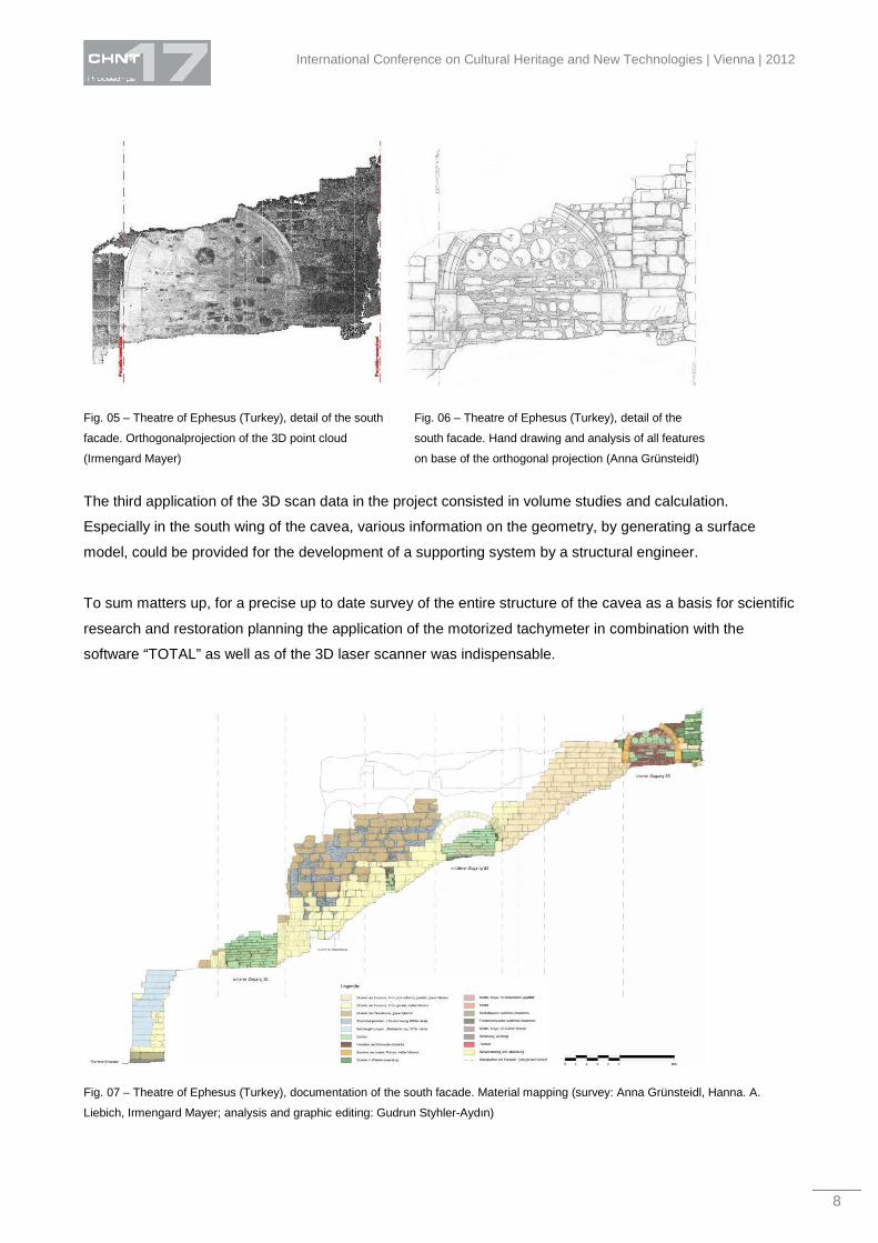
Fig. 05 – Theatre of Ephesus (Turkey), detail of the south
facade. Orthogonalprojection of the 3D point cloud
(Irmengard Mayer)
Fig. 06 – Theatre of Ephesus (Turkey), detail of the
south facade. Hand drawing and analysis of all features
on base of the orthogonal projection (Anna Grünsteidl)
The third application of the 3D scan data in the project consisted in volume studies and calculation.
Especially in the south wing of the cavea, various information on the geometry, by generating a surface
model, could be provided for the development of a supporting system by a structural engineer.
To sum matters up, for a precise up to date survey of the entire structure of the cavea as a basis for scientific
research and restoration planning the application of the motorized tachymeter in combination with the
software “TOTAL” as well as of the 3D laser scanner was indispensable.
Fig. 07 – Theatre of Ephesus (Turkey), documentation of the south facade. Material mapping (survey: Anna Grünsteidl, Hanna. A.
Liebich, Irmengard Mayer; analysis and graphic editing: Gudrun Styhler-Aydın)

Mayer | Styhler-Aydin – 3D Laser Measurement as Part of an Integrative Building Survey
9
The Al Nawar House, Jeddah, Saudi Arabia
Survey: October 2011
Postprocessing: November 2011 - February 2012
In a collaborative workshop on methods of building survey and building documentation, which was
conducted during 4 weeks in October and November 2011, teams of the King Abdul Aziz University in
Jeddah (Prof. Hisham Mortada) and the VUT (Dr. Ulrike Herbig) worked together on a detailed building
survey of the traditional architecure in the district of Al-Balad in Jeddah. Amongst others, the Al Nawar
House was chosen as an example of an ordinary residential building. It is situated in the heart of Al-Balad
and represents a traditional residential building type with some outstanding features. The general layout of
the structure seems characteristic for this kind of typology. Renovation work has not been done here recently
and the condition of the object gives a good insight into different stages of construction. Painted ceilings and
rich wall decoration in some of the rooms are outstanding features, which could be investigated separately.
Fig. 8 – Al Nawar House in Jeddah (Saudi Arabia), 3D point cloud (Irmengard Mayer)
The documentation of the Al Nawar House was conducted by means of a complete survey, in drawings and
photographs of all the components of the building, subsequent cataloguing of all parts of the building, and
indexing of the analyzed structural phenomena. Here again, a combination of digital and manual
architectural measurements for a particularly flexible and non-tactile method of surveying was used by the
International Conference on Cultural Heritage and New Technologies | Vienna | 2012
10
VUT team. Since the available time on site was limited, all necessary surveys were made more or less
simultaneously by different well-coordinated surveying teams.
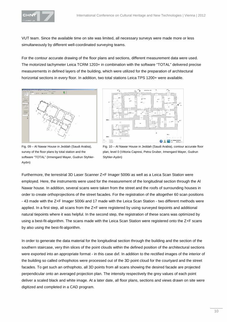
For the contour accurate drawing of the floor plans and sections, different measurement data were used.
The motorized tachymeter Leica TCRM 1203+ in combination with the software “TOTAL” delivered precise
measurements in defined layers of the building, which were utilized for the preparation of architectural
horizontal sections in every floor. In addition, two total stations Leica TPS 1200+ were available.
Fig. 09 – Al Nawar House in Jeddah (Saudi Arabia),
survey of the floor plans by total station and the
software “TOTAL” (Irmengard Mayer, Gudrun Styhler-
Aydın)
Fig. 10 – Al Nawar House in Jeddah (Saudi Arabia), contour accurate floor
plan, level 0 (Vittoria Capresi, Petra Gruber, Irmengard Mayer, Gudrun
Styhler-Aydın)
Furthermore, the terrestrial 3D Laser Scanner Z+F Imager 5006i as well as a Leica Scan Station were
employed. Here, the instruments were used for the measurement of the longitudinal section through the Al
Nawar house. In addition, several scans were taken from the street and the roofs of surrounding houses in
order to create orthoprojections of the street facades. For the registration of the altogether 60 scan positions
- 43 made with the Z+F Imager 5006i and 17 made with the Leica Scan Station - two different methods were
applied. In a first step, all scans from the Z+F were registered by using surveyed tiepoints and additional
natural tiepoints where it was helpful. In the second step, the registration of these scans was optimized by
using a best-fit-algorithm. The scans made with the Leica Scan Station were registered onto the Z+F scans
by also using the best-fit-algorithm.
In order to generate the data material for the longitudinal section through the building and the section of the
southern staircase, very thin slices of the point clouds within the defined position of the architectural sections
were exported into an appropriate format - in this case dxf. In addition to the rectified images of the interior of
the building so called orthophotos were processed out of the 3D point cloud for the courtyard and the street
facades. To get such an orthophoto, all 3D points from all scans showing the desired facade are projected
perpendicular onto an averaged projection plan. The intensity respectively the grey values of each point
deliver a scaled black and white image. At a later date, all floor plans, sections and views drawn on site were
digitized and completed in a CAD program.

Mayer | Styhler-Aydin – 3D Laser Measurement as Part of an Integrative Building Survey
11
Fig. 11 – Al Nawar House in Jeddah (Saudi Arabia), 3D point cloud with marked longitudinal section line (Irmengard Mayer)
According to the objective of the workshop, different categories of building survey and building
documentation were trained exemplarily. The architectural documentation of the Al Nawar House was
conducted as a contour-accurate building survey in the scale 1:50. It consists of the complete plan record
and is supplemented by a room book, various catalogues (for example the catalogue of features), the
material mapping and the mapping of damages. Altogether, the recent documentation work of the building
represents a basis for further research or planning.
Conclusion
For an up to date survey, the knowledge of different survey methods reaching from the classical hand
measurement to tachometry, photogrammetry and the high tech method of 3D laser scanning as well as their
advantages and disadvantages is absolutely essential. From our own experience especially the employment
of a so called “Intelligent Tachymeter” together with a 3D laser scanner is a highly approved combination for
an effective digital survey. Measuring by hand is time consuming, needs a very careful planning and much
experience to cover all needed aspects. The big advantage of a high tech survey is the very short time on
site, which very often meets the conditions in field work. On the other hand, it is very time consuming in the
post processing respectively the computing of the often very high amount of data needs a lot of time. But
since the contact time with the object is less by using high tech methods, the detailed information beyond
geometry is less dense and precise. While drawing by hand however, the draughtsman has to look very
carefully at the object and its details and collects information that is hard to get and understand in any other
way.
To sum matters up, only on the basis of an efficient and flexible combination of 3D laser scanning with other
survey methods, the precise documentation and analysis of large and complex architectural structures can
be done with an acceptable work and time effort.
International Conference on Cultural Heritage and New Technologies | Vienna | 2012
12
References DÖRING–WILLIAMS, M., LIEBICH, H.A. 2006: Das große Theater von Ephesos: Möglichkeiten und Grenzen der Laserscan-
Technologien in der Bauforschung, in: Riedel A. (ed.), Von Handaufmaß bis High Tech II., Mainz, Philipp von Zabern, p. 126 - 137
MAYER, I., ESSER, G., (2007): 3d-geometry and 3d-texture. Documenting early-Christian wall paintings at the Domitilla Catacomb in
Rome, in: Archäologie und Computer 2007 – Workshop 12: Kulturelles Erbe und Neue Technologien, Phoibos Verlag
MAYER, I., FERSCHIN P., et.al. (2011): Das Adlitzgrabenviadukt der Semmeringbahn virtuell dokumentiert, in: Heine K. (ed) Von
Handaufmaß bis High Tech III, Darmstadt, Philipp von Zabern, p. 109 - 115.
http://baugeschichte.tuwien.ac.at/site/2012/02/16/trabasa-traditional-architecture-recorded-by-means-of-building-archaeology-in-saudi-
arabia/ (2013.03.01)
Imprint:
Proceedings of the 17th International Conference on Cultural Heritage and New Technologies 2012 (CHNT 17, 2012)
Vienna 2013
http://www.chnt.at/proceedings-chnt-17/
ISBN 978-3-200-03281-1
Editor/Publisher: Museen der Stadt Wien – Stadtarchäologie
Editorial Team: Wolfgang Börner, Susanne Uhlirz
The editor’s office is not responsible for the linguistic correctness of the manuscripts.
Authors are responsible for the contents and copyrights of the illustrations/photographs..