3d model generation and visualization of archeological · pdf file · 2014-07-033d...
TRANSCRIPT

3D Model Generation and Visualization of
Archeological Remains in World Historical
Sites: Santiago Bastion (Wilhelmus), A
Famosa, Malacca.
Ismail Ma’arof, Mohd Saparina Ab Talib & Abd Manan Samad
Universiti Teknologi MARA (UiTM) Perlis, Arau, Perlis
Department of National Heritage, Kuala Lumpur
Universiti Teknologi MARA (UiTM) Malaysia, Shah Alam, Selangor
Commission No. 3
#
XXV International Federation of Surveyors
Congress, Kuala Lumpur, Malaysia, 16 – 21
June 2014
Presentation Outline
#
• Introduction
• Aim & Objective
• Methodology
• Results & Analysis
• Conclusion
XXV International Federation of Surveyors
Congress, Kuala Lumpur, Malaysia, 16 – 21
June 2014

Introduction
#
The three dimensional computer graphics and
visualization techniques have been used for wide range
of applications such as manufacturing, industrial design,
urban design, architecture, cultural heritage, 3D city
modeling and GIS.
XXV International Federation of Surveyors
Congress, Kuala Lumpur, Malaysia, 16 – 21
June 2014
Introduction
#
The use of three dimensional computer graphics andvisualization techniques using image based is becomingmore and more popular, because these techniquesvisualize more realistic object models than graphicbased object models.
According to El Hakim (1998) and Gruen (2012), a largeand complex 3D models data are required in mostapplication of 3D modeling and visualization.
XXV International Federation of Surveyors
Congress, Kuala Lumpur, Malaysia, 16 – 21
June 2014

Introduction
#
Photogrammetry and digital image processing techniques
play important role to make 3D modeling and visualization
technology with practicality and cost effective.
Table 1. Effectiveness for different method in heritage modeling (Cheong et al, 2011)
XXV International Federation of Surveyors
Congress, Kuala Lumpur, Malaysia, 16 – 21
June 2014
Aim & Objective
#
The aim of the study is to generate and to visualize3D model of archeological sites using image basedmodeling method. In specific, this study conductedin order to fulfil following objectives:-
� To identify and investigate an effectiveness of themodeling process.
� To perform visual interpretation analysis based ongenerated 3D model.
� To produce user friendly and multi-purpose outputs.
XXV International Federation of Surveyors
Congress, Kuala Lumpur, Malaysia, 16 – 21
June 2014

Study Area
#
The selected study area is A Famosa, Malacca which is
one of the World Heritage Sites in Malaysia. A’Famosa or
"The Famous" in Portuguese is a fortress located in
Melaka, Malaysia which is granted the status of World
Heritage Site by UNESCO in 2008.
Built in 1511, Once as part of a mighty fortress, this tiny
gate known as Porta de Santiago, one of the four main
gates of the famous Portuguese fortress. The fortress
consisted of long ramparts and four major towers.
XXV International Federation of Surveyors
Congress, Kuala Lumpur, Malaysia, 16 – 21
June 2014
Study Area
#
XXV International Federation of Surveyors
Congress, Kuala Lumpur, Malaysia, 16 – 21
June 2014

Study Area
#
Fig.1 : A famosa fortress remain sites
XXV International Federation of Surveyors
Congress, Kuala Lumpur, Malaysia, 16 – 21
June 2014
Study Area
#
Fig. 2
Wilhemus or Bastion Santiago Plan in
1784 (a) and 1792 (b)
(a) (b)
XXV International Federation of Surveyors
Congress, Kuala Lumpur, Malaysia, 16 – 21
June 2014

Study Area
#
Fig. 3: Photo of Wilhemus or Bastion Santiago, A Famosa, Malacca.
XXV International Federation of Surveyors
Congress, Kuala Lumpur, Malaysia, 16 – 21
June 2014
Methodology
#
Reconnaissance & Planning
• Topographic Surveying• Close-Range Photogrammetry (Terrestrial)• Model generation & Visualization
Fig.4
Control Survey for
Reference pointFig.5
Camera
Nikon
D80
XXV International Federation of Surveyors
Congress, Kuala Lumpur, Malaysia, 16 – 21
June 2014

Results & Discussion
#
• Photogrammetric Survey Data
• Digital Elevetion Model (DEM)
• 3D Model Generation
XXV International Federation of Surveyors
Congress, Kuala Lumpur, Malaysia, 16 – 21
June 2014
Results & Discussion (cont.)
#
• Terresterial photo Mosaics
Fig.6 Archeological site
Photographs
Fig.7 Perspective view of the
terresterial mosaics
XXV International Federation of Surveyors
Congress, Kuala Lumpur, Malaysia, 16 – 21
June 2014

#
Fig.8 Shows the camera location (below and black dots) and number of
overlapping photographs (coloured).
Results & Discussion (cont.)
XXV International Federation of Surveyors
Congress, Kuala Lumpur, Malaysia, 16 – 21
June 2014
#
Fig.9 Digital Elevation Model (DEM)
Results & Discussion (cont.)
XXV International Federation of Surveyors
Congress, Kuala Lumpur, Malaysia, 16 – 21
June 2014

#
Fig.10 Shows real scene photographs
Results & Discussion (cont.)
XXV International Federation of Surveyors
Congress, Kuala Lumpur, Malaysia, 16 – 21
June 2014
#
Fig. 11 Shows low density pre-processing the surface photo textured model
Results & Discussion (cont.)
XXV International Federation of Surveyors
Congress, Kuala Lumpur, Malaysia, 16 – 21
June 2014

#
Fig.12 Shows the results of the final processing 3D surface model
(compared to the real photos – below right)
Results & Discussion (cont.)
XXV International Federation of Surveyors
Congress, Kuala Lumpur, Malaysia, 16 – 21
June 2014
#
Fig.13 Close-up 3D surface model
Results & Discussion (cont.)
XXV International Federation of Surveyors
Congress, Kuala Lumpur, Malaysia, 16 – 21
June 2014
#
• Orthophoto Mosaics
Results & Discussion (cont.)
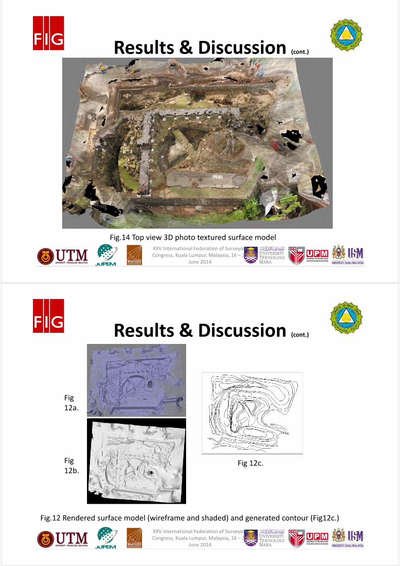
Fig.14 Top view 3D photo textured surface model
XXV International Federation of Surveyors
Congress, Kuala Lumpur, Malaysia, 16 – 21
June 2014
#
Results & Discussion (cont.)
Fig.12 Rendered surface model (wireframe and shaded) and generated contour (Fig12c.)
Fig
12a.
Fig
12b.Fig 12c.
XXV International Federation of Surveyors
Congress, Kuala Lumpur, Malaysia, 16 – 21
June 2014

#
Results & Discussion (cont.)
Fig.15 Control point distribution and target used (top photos)
XXV International Federation of Surveyors
Congress, Kuala Lumpur, Malaysia, 16 – 21
June 2014
#
• Orthophoto Mosaics
Results & Discussion (cont.)
Fig.16 Generated plan view of the archeological sites.
XXV International Federation of Surveyors
Congress, Kuala Lumpur, Malaysia, 16 – 21
June 2014

Conclusion
#
• 3D models of cultural heritage are best suited to give a clear
visualization of existing situation with an effective and practical
modeling process.
• Future situation after planned restoration project can be compared
with existing situation using 3D model of cultural heritage with
visual interpretation analysis.
• 3D model generation and visualization of cultural heritage has
potential for being new product in the area of documentation of
cultural heritage and planning of cultural heritage restorations.
XXV International Federation of Surveyors
Congress, Kuala Lumpur, Malaysia, 16 – 21
June 2014
Acknowledgment
Financial assistant form the Malaysian Peninsular Land Surveyor
Board (LJT); Research facilities and support from Pixelgrammetry
and Al-Idrisi Research Group (Pi_ALiRG); UiTM Research and
Management Institute (RMI-UiTM); Ministry of Higher Education
(MOHE); Centre of Studies Surveying Science and Geomatics,
Faculty of Architecture, Planning and Surveying, UiTM Shah
Alam; UiTM Perlis; Department of National Heritage;
Department of Survey and Mapping, Malaysia (JUPEM) are
greatly acknowledged.
#
XXV International Federation of Surveyors
Congress, Kuala Lumpur, Malaysia, 16 – 21
June 2014

Thank you for your
attention!
Universiti Teknologi MARA (UiTM) Perlis
0260, Arau, Perlis, MALAYSIA
Email: [email protected]
#
XXV International Federation of Surveyors
Congress, Kuala Lumpur, Malaysia, 16 – 21
June 2014