3d visualization and generalization - uni-stuttgart.de 285 3d visualization and generalization...
TRANSCRIPT
Sester 285
3D Visualization and Generalization
MONIKA SESTER, Hannover
ABSTRACT The growing number of 3D geodata sets and their upcoming availability in spatial data infrastructures and via web services brings about the question how these typically complex and large data sets can efficiently be visualized. There are basically two requirements that demand for an automatic generalization: firstly it allows the controlled data reduction and thus the representation of data in different levels of detail, secondly generalization helps to support the efficient communication of the important information by applying different generalization operation. In the paper, an overview and comparison of different approaches for 3D building generalization is given.
1. INTRODUCTION
A growing availability of 3D-data can be observed in recent years: raw 3D-data are being acquired using measuring techniques like Lidar or high resolution stereo imagery. Software packages for the reconstruction of 3D-objects, especially buildings, are available. They range from highly sophisticated (semi-) automatic tools like Inject (Förstner 1999), CC-Modeler (Grün et al., 2002), or ATOP (Brenner, 2005) to comfortable reconstruction tools like Sketch-Up that allows everybody to model his / her own buildings and publish them in the internet. Structures are available that these 3D-data sets can be distributed via web services in spatial data infrastructures. This increasing data availability is accompanied by a growing demand for 3D data by a variety of users (Altmaier & Kolbe, 2003). This raises the question, how this information is made available and efficiently communicated to those different applications and scenarios. Döllner (2007) proposes 3D-visualization as an interactive interface to geodata infrastructures. Different applications need 3D geodata in different representations – ranging from detailed architectural models to coarse block representations of whole cityscapes. Thus, in order to satisfy the variety of needs of different applications, different representations, especially different Levels of Detail (LoDs) of the 3D geodata have to be available. Besides serving different applications, this multi-scale information is also needed for the efficient transmission of the typically very large data sets through the internet. Especially for the visualization of 3D information on small mobile devices in the context of personal or car navigation, an efficient and adapted transmission of the relevant information from a central server is essential, as it is not possible to store all the information on the small device. These different LoDs can be automatically derived by generalization procedures. The paper first describes some requirements of 3D generalization, then presents approaches that have been developed in recent years, and gives a comparison of their functionality. A summary and outlook on open problems and future work conclude the paper.
2. REQUIREMENTS – DATA IN DIFFERENT LEVELS OF DETAIL (LODS)
The situation described in the previous chapter brings about a set of requirements. First of all, if interaction with the 3D-data is required – which is needed in most cases, the access to the data has to be in real-time. Facing the typically huge size of the data sets makes it evident, that the data
Photogrammetric Week '07 Dieter Fritsch (Ed.) Wichmann Verlag, Heidelberg, 2007
286 Sester
cannot be stored nor downloaded on a computer as a whole. A prominent example where image data is displayed is the virtual globe Google Earth. It is obvious, that these data cannot be downloaded and stored on our computers before visualization. In order to control and reduce the amount of data to be transferred and visualized, less detailed versions of the data are presented, when a large overview has to be depicted, only when zooming in, more details are incrementally loaded. Another requirement for generalization is more on a conceptual level: every application needs adapted pieces of information. Thus, depending on the application, information has to be selected, emphasized or even exaggerated in order to be quickly and efficiently communicated to a user. Thus, different applications and users require different ways of representing and visualizing 3D data, which mainly differ in the level of detail (LoD) of the representations and can be determined with the focus on:
1) Data reduction: generalization in order to reduce the amount of data to be transmitted, displayed and interacted with
2) Support of immediate cognition: generalization in order to emphasize or exaggerate important information and ignore the rest
Data reduction is mainly achieved using geometric simplification methods. For general object surfaces mesh simplification techniques from Computer Graphics can be applied (for a compre-hensive overview see e.g. Heckbert & Garland, 1997). Geometric simplification can be combined with texture projection to end up with a hybrid rendering (Wahl et al., 2005). Buchholz et al. 2006 describe a possibility to efficiently code 3D information in a parametric description. The 3D data are reconstructed in the client on-the-fly. This provides on the one hand a compact description of the data, and thus a limited data package to transmit, however, describes only a single LoD at a time. A direct transfer of the techniques from Computer Graphics to process semantically rich topo-graphic objects often is not possible, as these techniques mostly reduce the amount of data only based on geometric criteria – without taking semantics into account. Also, these techniques are mainly designed for reducing the amount of information in highly redundant data sets like object surfaces consisting of millions of points or triangles. 3D-buidings, however, mostly are already given in a compact representation without redundancy (e.g. a façade as one large plane, represented by four points; a reduction in the number of points of this façade will destroy the shape). In such cases structural and semantic simplification operations have to be applied. This requires, that the characteristic object properties are known and can be introduced and preserved in the generalization process. The second of the above mentioned goals definitely needs these semantic based methods from cartographic generalization: objects can be selected, classified, displayed using different graphical variables, or enhanced by enlarging them. Some of these methods are described in Sester (2006), where especially the possibility of modifying the geometry are investigated. Using abstract objects (templates or symbols) instead of the original object shape can lead to a more compact and simple representation ant thus a more efficient and direct communication of 3D objects. Another method is to overlay artificial information (virtual, augmented information) on top of the original data in order to highlight certain objects (e.g. Brenner et al., 2006). With the growing demand for 3D-city models, in recent years an advancement in the research in 3D building generalization can also be observed. On the one hand, there was a development triggered by a group in Germany, aiming at defining a standard for an ontology of buildings in different LoDs, called CityGML (Kolbe et al., 2005). This description comprises a categorization of LoDs 1 to 4, ranging from coarse building blocks (LoD1) via simple forms with roofs (LoD2) to detailed
Sester 287
building models (LoD3) and highly detailed architecture models with indoor representation (LoD4). They include geometric and semantic characteristics of these representations. This modeling does not include methods for the automatic derivation of the different levels of detail. However, there is also considerable research that aims at the development of methods for the automatic generalization of buildings, which will be reported on in this paper (for an overview see also Meng & Forberg, 2007).
3. AUTOMATIC GENERALIZATION OF BUILDINGS
3.1. Generalization of buildings in 2D
There are established techniques available for the generalization of 2D buildings. These techniques relate both to the simplification of individual buildings (e.g. Staufenbiel 1973, Lamy et al. 1999, Rainsford & Mackaness, 2001), and also to the generalization of groups of buildings (e.g. Regnauld 2001, Sester 2005). Generalization of buildings in large scales mainly aims at reducing the amount of detail in the ground plan using minimum required values like minimum length of a façade or minimum size of the building as criteria. In the generalization process certain characteristics of the buildings have to be preserved or even emphasized, e.g. rectangularity and parallelism or size. In an approach by Sester (2000) this is achieved in a two step procedure by firstly applying rules to remove the minimal forms; the rules can be rather simple (i.e. a mere intersection of neighbouring faces), as in a second step the preservation of the form and size constraints are enforced using an optimization process to adjust the form of the simplified building to the original form.
3.2. Generalization of buildings in 3D
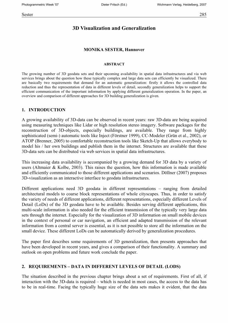
This approach has been extended to 3D by Kada (2002): he developed rules to remove too small structures in the 3D polyhedron. Similar to the 2D-case, complex structures have to be removed as a whole and not incrementally as it is usually done by 3D mesh-simplification techniques. After the application of the rules a simplified building is generated which is adapted to its original shape in an adjustment process. This approach mainly focuses on structures on the façade of the building. Forberg (2004) presents a method for 3D-generalization which is based on an intelligent shifting of parallel building planes. Taking the area of the planes into account, it is possibly to both simplify the shape and also do an size adjustment of the whole building. The distance between the parallel faces acts as a factor which controls the degree of simplification. As simplification using the parallel shifts only works for parallel structures, other methods have to be applied for non-orthogonal structures like the roofs. A set of rules has been set up for deciding, which part of the roof has to be rotated, i.e. forced to either become vertical or horizontal. For the generalization of the roofs, the size of an individual roof face is the control parameter to decide if it has to be rotated. Thiemann (2002) proposes an approach to decompose the whole generalization process into a segmentation, interpretation and generalization phase. In the first step, the building is decomposed into a convex polyhedron, from which objects “sticking out” have been cut and “holes” have been filled. This is achieved using an adapted version of the approach of Ribelles et al. (2001): a building given in boundary representation is recursively partitioned into a set of convex parts which can be stored as a cell complex in a CSG-tree. The recursive partitioning uses the object planes as potential splitting planes of the main object and extruding (bumps, peaks) and intruding (holes, notches) features (see Figure 1). A part will be cut off or filled, if it falls below a certain threshold concerning the relation of the size of the intersection and the intersecting plane. The remaining part
288 Sester
Figure 1: All potential splits that can be generated using the object faces: blue parts are extruding, red parts are holes. Only some of them are valid.
of the polyhedron is formed either by cutting off the extruding features or filling the intruding ones. In this way, a segmentation of the original building into its constituent parts can be achieved. In addition, the successive elimination or addition of features reflects an incremental creation process of the building. It also expresses a kind of incremental refinement, as small features are segmented early in the process and are therefore located close to the root of the tree, whereas the largest feature is stored in the deepest leaf (see also Section 3.3. ). The CSG-tree presents a hierarchical subdivision, however, as such is not exactly a generalization. A structurally similar approach has been proposed by Kada (2006). He also decomposes the whole building into cells that are generated by the individual planes. After that, he aggregates adjacent cells, if they are “filled” with building parts. This process would result in the same representation, however, Kada uses buffered cutting planes to determine the cells. In this way, approximately collinear planes are aggregated to form one plane. The size of the buffer is a direct measure of the degree of generalization. This method is subsequently applied first to the vertical faces and then to the oblique faces of the roof. It provides very convincing generalizations also of complex objects.
3.3. Continuous Generalization
The structure of the CSG-tree provides a natural sequence of features to be removed or filled in the generalization process. In order to provide a seamless representation from coarse to fine it makes no sense to store all the individual representations (as this would also imply high redundancy in adjacent representations); instead, only the changes that occur in geometry and topology when going from one representation level to the next have to be stored. This has been proposed by Brenner & Sester (2005) for the 2D-case. A set of so-called simple operations (SOs) has been defined describing changes in geometry and topology (like insertion or movement of a vertex). These simple operations can be combined to higher level elementary generalization operations (EGOs) that allow for more complex generalization operations. In this way, a sequence of individual SOs is generated that describe the process of starting with the most general representation of an object and incrementally refining it until the complete object representation is reached, or the user is satisfied with the current LoD. Thus, instead of describing fixed scales all representations of an object in all scales are generated. It could be shown that this approach can be applied for a whole set of generalization operations like point reduction, displacement and typification (Sester & Brenner, 2005).
Sester 289
3.4. Semantic based generalization
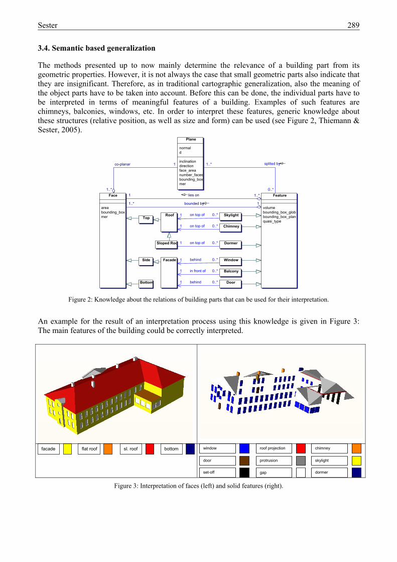
The methods presented up to now mainly determine the relevance of a building part from its geometric properties. However, it is not always the case that small geometric parts also indicate that they are insignificant. Therefore, as in traditional cartographic generalization, also the meaning of the object parts have to be taken into account. Before this can be done, the individual parts have to be interpreted in terms of meaningful features of a building. Examples of such features are chimneys, balconies, windows, etc. In order to interpret these features, generic knowledge about these structures (relative position, as well as size and form) can be used (see Figure 2, Thiemann & Sester, 2005).
0..*1 on top of
0..*1 on top of
0..*1 on top of
0..*1 behind
0..*1 behind
0..*1 in front of
0..*
1..* splited by
1..*1 lies on
11..* bounded by
1..*
1co-planar
Plane
normald
inclinationdirectionface_areanumber_facesbounding_boxmer
Face
areabounding_boxmer
Feature
volumebounding_box_globabounding_box_planequasi_type
Side
Top
Bottom
Roof
Facade
Balcony
Window
Door
Chimney
Skylight
Sloped Roo Dormer
Figure 2: Knowledge about the relations of building parts that can be used for their interpretation.
An example for the result of an interpretation process using this knowledge is given in Figure 3: The main features of the building could be correctly interpreted.
facade sl. roof flat roof bottom window
door protrusion
set-off
roof projection chimney
skylight
dormer gap
Figure 3: Interpretation of faces (left) and solid features (right).
290 Sester
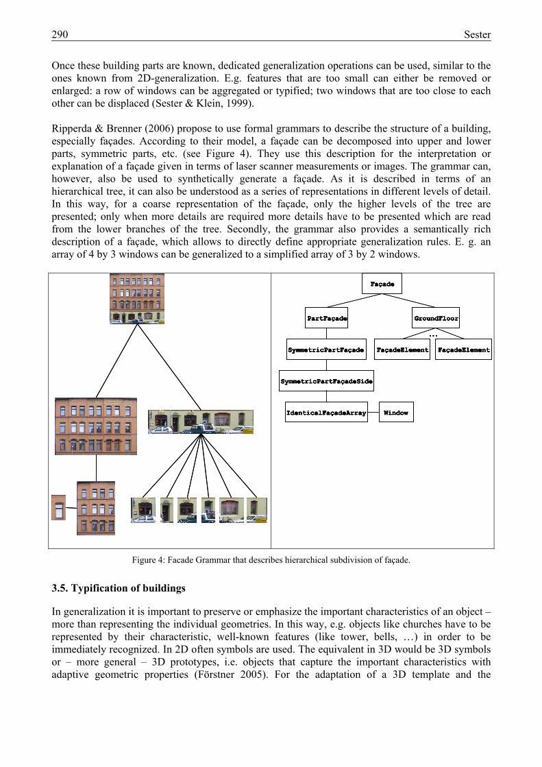
Once these building parts are known, dedicated generalization operations can be used, similar to the ones known from 2D-generalization. E.g. features that are too small can either be removed or enlarged: a row of windows can be aggregated or typified; two windows that are too close to each other can be displaced (Sester & Klein, 1999). Ripperda & Brenner (2006) propose to use formal grammars to describe the structure of a building, especially façades. According to their model, a façade can be decomposed into upper and lower parts, symmetric parts, etc. (see Figure 4). They use this description for the interpretation or explanation of a façade given in terms of laser scanner measurements or images. The grammar can, however, also be used to synthetically generate a façade. As it is described in terms of an hierarchical tree, it can also be understood as a series of representations in different levels of detail. In this way, for a coarse representation of the façade, only the higher levels of the tree are presented; only when more details are required more details have to be presented which are read from the lower branches of the tree. Secondly, the grammar also provides a semantically rich description of a façade, which allows to directly define appropriate generalization rules. E. g. an array of 4 by 3 windows can be generalized to a simplified array of 3 by 2 windows.
Figure 4: Facade Grammar that describes hierarchical subdivision of façade.
3.5. Typification of buildings
In generalization it is important to preserve or emphasize the important characteristics of an object – more than representing the individual geometries. In this way, e.g. objects like churches have to be represented by their characteristic, well-known features (like tower, bells, …) in order to be immediately recognized. In 2D often symbols are used. The equivalent in 3D would be 3D symbols or – more general – 3D prototypes, i.e. objects that capture the important characteristics with adaptive geometric properties (Förstner 2005). For the adaptation of a 3D template and the
Façade
IdenticalFaçadeArray Window
SymmetricPartFaçade
PartFaçade
SymmetricPartFaçadeSide
FaçadeElement
GroundFloor
FaçadeElement...
Façade
IdenticalFaçadeArray Window
SymmetricPartFaçade
PartFaçade
SymmetricPartFaçadeSide
FaçadeFaçade
IdenticalFaçadeArrayIdenticalFaçadeArray WindowWindow
SymmetricPartFaçadeSymmetricPartFaçade
PartFaçadePartFaçade
SymmetricPartFaçadeSideSymmetricPartFaçadeSide
FaçadeElement
GroundFloor
FaçadeElement...
FaçadeElementFaçadeElement
GroundFloorGroundFloor
FaçadeElementFaçadeElement...
Sester 291
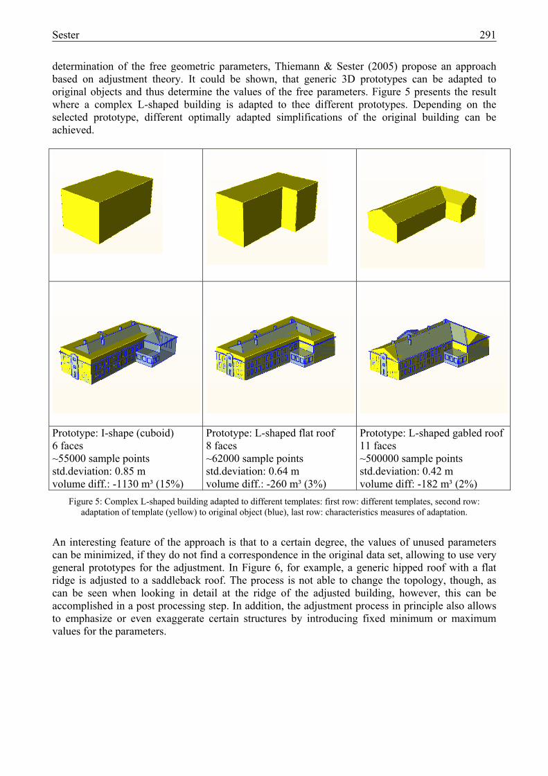
determination of the free geometric parameters, Thiemann & Sester (2005) propose an approach based on adjustment theory. It could be shown, that generic 3D prototypes can be adapted to original objects and thus determine the values of the free parameters. Figure 5 presents the result where a complex L-shaped building is adapted to thee different prototypes. Depending on the selected prototype, different optimally adapted simplifications of the original building can be achieved.
Prototype: I-shape (cuboid) 6 faces ~55000 sample points std.deviation: 0.85 m volume diff.: -1130 m³ (15%)
Prototype: L-shaped flat roof 8 faces ~62000 sample points std.deviation: 0.64 m volume diff.: -260 m³ (3%)
Prototype: L-shaped gabled roof 11 faces ~500000 sample points std.deviation: 0.42 m volume diff: -182 m³ (2%)
Figure 5: Complex L-shaped building adapted to different templates: first row: different templates, second row: adaptation of template (yellow) to original object (blue), last row: characteristics measures of adaptation.
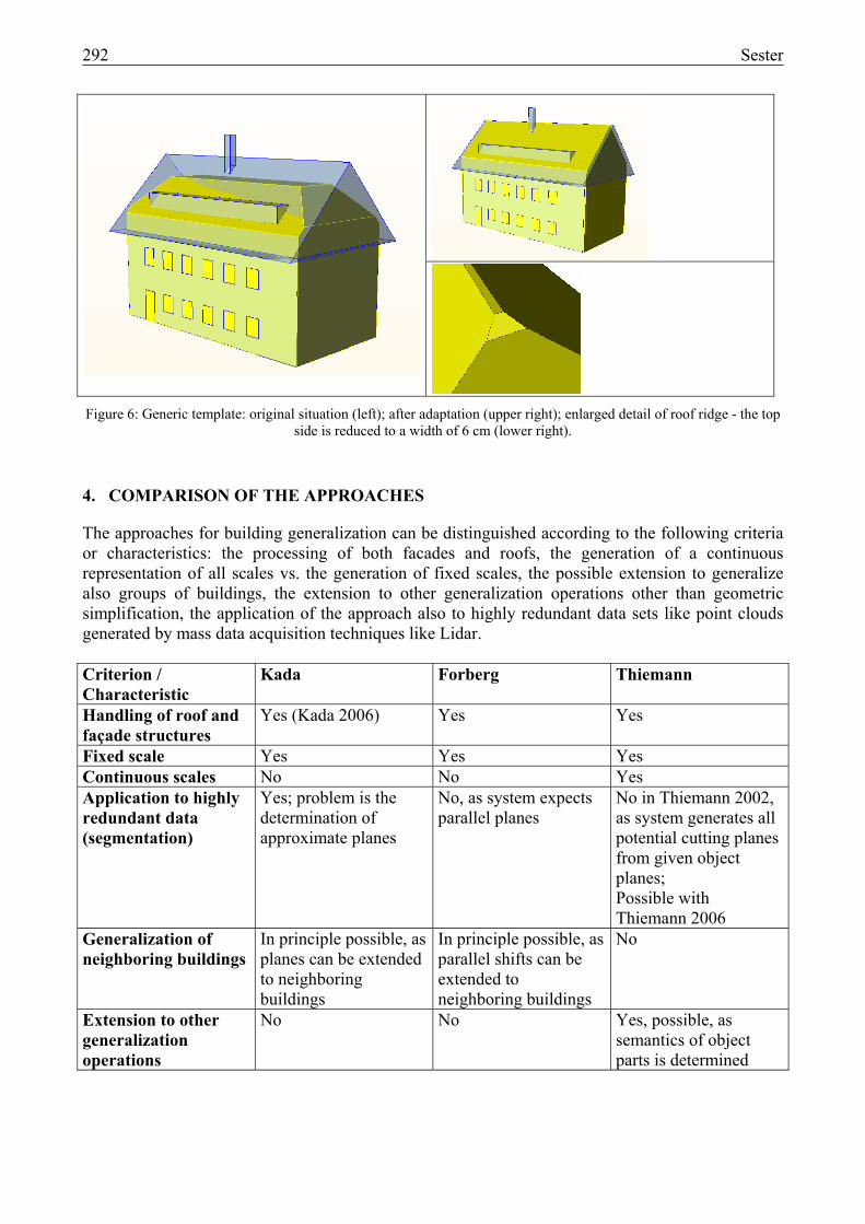
An interesting feature of the approach is that to a certain degree, the values of unused parameters can be minimized, if they do not find a correspondence in the original data set, allowing to use very general prototypes for the adjustment. In Figure 6, for example, a generic hipped roof with a flat ridge is adjusted to a saddleback roof. The process is not able to change the topology, though, as can be seen when looking in detail at the ridge of the adjusted building, however, this can be accomplished in a post processing step. In addition, the adjustment process in principle also allows to emphasize or even exaggerate certain structures by introducing fixed minimum or maximum values for the parameters.
292 Sester
Figure 6: Generic template: original situation (left); after adaptation (upper right); enlarged detail of roof ridge - the top side is reduced to a width of 6 cm (lower right).
4. COMPARISON OF THE APPROACHES
The approaches for building generalization can be distinguished according to the following criteria or characteristics: the processing of both facades and roofs, the generation of a continuous representation of all scales vs. the generation of fixed scales, the possible extension to generalize also groups of buildings, the extension to other generalization operations other than geometric simplification, the application of the approach also to highly redundant data sets like point clouds generated by mass data acquisition techniques like Lidar. Criterion / Characteristic
Kada Forberg Thiemann
Handling of roof and façade structures
Yes (Kada 2006) Yes Yes
Fixed scale Yes Yes Yes Continuous scales No No Yes Application to highly redundant data (segmentation)
Yes; problem is the determination of approximate planes
No, as system expects parallel planes
No in Thiemann 2002, as system generates all potential cutting planes from given object planes; Possible with Thiemann 2006
Generalization of neighboring buildings
In principle possible, as planes can be extended to neighboring buildings
In principle possible, as parallel shifts can be extended to neighboring buildings
No
Extension to other generalization operations
No No Yes, possible, as semantics of object parts is determined
Sester 293
5. SUMMARY AND OUTLOOK
The paper presented an overview on current approaches for the generalization of 3D data sets. In order to handle the typically high volume data sets, methods to present both details and overview are essential: when approaching from far away, a coarse visualization has to be given; coming closer more detailed information has to be provided in the small extent where the zooming took place. The adequate reduction of the information content has to be controlled by simplification or generalization methods. In this paper there was a concentration on buildings, which are objects with dedicated semantic and geometric characteristics that enforce certain properties to be preserved during generalization. Well established algorithms from Computer Graphics focus on the generalization of highly redundant data sets using geometric criteria and therefore can not directly be applied for structured topographic objects like buildings. Also, with these methods, only a simplification can be achieved, but no other generalization operations like enhancement. Several approaches for the automatic generalization of 3D topographic objects have been proposed in recent years. They allow the automatic generation of different LoDs, starting from a most detailed representation. Issues for future research include the development of other generalization functions in 3D like displacement or enhancement. A first approach in this direction has been proposed by Kremeike 2004, who developed a concept for enhancing roads in a digital landscape model. For groups of buildings, only very simple approaches like selective omission of some buildings are currently available, e.g., in Google Earth. More advanced recent approaches take context and scale into account to select which buildings to present (Omer et al. 2005). Another important generalization function is aggregation, especially the aggregation of building groups. The known approaches from 2D generalization cannot directly be transferred to 3D, especially when it comes to the aggregation and generalization of complex roof structures. Future research also has to concentrate on the further development of a process oriented approach, which allows to describe how objects in different representations are produced, instead of only storing the fix representations and forget about how they were generated. Based on such a flexible description, other problems in data handling will be easier to tackle: e.g. the updating problem.
6. REFERENCES
Altmaier, A. & Th. Kolbe, 2003. Applications and Solutions for Interoperable 3D Geo-Visualization. Proceedings Photogrammetric Week, University of Stuttgart, pp. 253-267.
Brenner, C., 2005. Building reconstruction from images and laser scanning, Int. Journal of Applied Earth Observation and Geoinformation, Theme Issue on "Data Quality in Earth Observation Techniques", 6(3-4), March 2005, Elsevier, 187-198.
Brenner, C. & Sester, M., 2005. Continuous Generalization for Small Mobile Displays, In: Next Generation Geospatial Information, Agouris & Croitoru (eds.), ISPRS Book Series, Taylor & Francis Group, London, 33-41.
Brenner, C. & Sester, M., 2005. Cartographic Generalization using Primives and Constraints, Proc. 22nd International Cartographic Conference, 9.-16.July 2005, La Coruña, Spain.
294 Sester
Brenner, C., Paelke, V., Haunert, J. & Ripperda, N., 2006. The GeoScope - A Mixed-Reality System for Planning and Public Participation, in: UDMS'06, Proc. of the 25th Urban Data Management Symposium, May 15-17, Aalborg, 2006 (CD-Rom).
Buchholz, H, J. Döllner, L. Ross & B. Kleinschmit, 2006. Automated Construction of Urban Terrain Models. In: Progress in Spatial Data Handling, 12th International Symposium on Spatial Data Handling, Springer 2006, pp. 547-562.
Döllner, J., 2006. Techniken und Strategien der Visualisierung komplexer Geodaten, in: 12. Münchner Fortbildungsseminar Geoinformationssysteme, 14.-16. 3. 2007, TU München.
Förstner, W., 1999. 3D City Models: Automatic and Semiautomatic Acquisition Methods. Proceedings Photogrammetric Week 2003, University of Stuttgart, pp. 291-303.
Förstner, W., 2005. Zur Definition von Prototypen, internal document.
Forberg, A., 2004. Generalization of 3D Building Data Based on a Scale-space Approach. International Archives of the Photogrammetry, Remote Sensing and Spatial Information Sciences, Volume XXXV, Part B, 194-199.
Grün, A., Steidler, F. & Wang, X., 2002. Generation and visualization of 3D-city and facility models using CyberCity Modeler, MapAsia, 8. August 2002.
Heckbert, P. and Garland, M., 1997. Survey of Polygonal Surface Simplification Algorithms. Multiresolution Surface Modeling Course SIGGRAPH ’97.
Kada, M., 2002. Automatic generalisation of 3D building models. Proceedings of the Joint International Symposium on Geospatial Theory, Processing and Applications, Ottawa, 2002.
Kada, M., 2006. 3D Building Generalization based on Half-Space Modeling. In: Proceedings of the ISPRS Workshop on Multiple Representation and Interoperability of Spatial Data, Hannover.
Kolbe, Th., G. Gröger & L. Plümer, 2005. CityGML – Interoperable Access to 3D City Models. In: Proceedings of the First International Symposium on Geo-Information for Disaster Management, Springer Verlag.
Kremeike, K., 2004. Generalization of dense Digital Terrain Models while enhancing important objects, Proceedings ISPRS Congress, Istanbul, 2004.
Lamy, S., Ruas, A., Demazeau, Y., Jackson, M., Mackaness, W. & Weibel, R., 1999. The Application of Agents in Automated Map Generalization, in: Proceedings of the 19th International Cartographic Conference of the ICA', Ottawa, Canada, CD-Rom.
Meng, L. & Forberg, A. (2007). 3D building generalization. Chapter 11, 211-232. In: Mackaness, W., Ruas, A. and Sarjakoski, T. (Eds): Generalization of Geographic Information: Cartographic Modelling and Applications, Elsevier, 2007.
Omer, I., K. Talmor and A. Roz, 2005. Knowledge-based Model Generalization for Truly Virtual Cities. In: Proceedings of the AGILE conference, Portugal.
Sester 295
Rainsford, D. & W. Mackaness, 2001. Template Matching in Support of Generalization of Rural Buildings, in: Proceedings of the Joint International Symposium on "GeoSpatial Theory, Processing and Applications" (ISPRS/Commission IV/SDH2002), Ottawa, Canada, July 8-12, 2002, CD-ROM, (2002).
Regnauld, N., 2001. Contextual Building Typification in Automated Map Generalization. Algorithmica, 30(2), pp. 312-333.
Ripperda, N. & Brenner, C., 2006. Reconstruction of Façade Structures Using a Formal Grammar and RjMCMC, in: Katrin Franke, Klaus-Robert Müller, Bertram Nickolay, Ralf Schäfer (Eds.), Pattern Recognition, Proceedings of the 28th DAGM Symposium, September, Berlin, pp. 750-759, 2006.
Sester, M., 2000. Generalization based on Least Squares Adjustment, in: ‘International Archives of Photogrammetry and Remote Sensing’, Vol. 33, ISPRS, Amsterdam, 2000.
Sester, M., 2005. Optimizing Approaches for Generalization and Data Abstraction, in: International Journal of Geographic Information Science, Vol. 19, Nr. 8-9, pp. 871-897, 2005.
Sester, M., 2006. Aktuelle Geodaten für aktuelle Entscheidungen, in: Kartographische Nachrichten, 56(1), Kirschbaum Verlag, Bonn, pp. 3-8. 2006.
Sester, M. & Brenner, C., 2004. Continuous Generalization for fast and smooth Visualization on small Displays, in: GIS-Geoinformationssysteme, 9, pp. 24-30, 2004.
Staufenbiel, W., 1973. Zur Automation der Generalisierung topographischer Karten mit besonderer Berücksichtigung großmaßstäbiger Gebäudedarstellungen, PhD thesis, Fachrichtung Vermessungswesen, Universität Hannover.
Thiemann, F., 2002. Generalization of 3D Building Data. In: "Geospatial Theory, Processing and Applications", IAPRS Vol. 34, Part 4, Ottawa, Canada, 2002.
Thiemann, F. & Sester, M., 2005. Interpretation of Building Parts from Boundary Representation, Workshop on Next Generation 3D City Models, Bonn.
Thiemann, F. & Sester, M., 2006. 3D-Symbolization Using Adaptive Templates, in: ISPRS Technical Commission II Symposium 2006, Vienna, Austria 12--14 July, 2006, pp. 49-54.
Wahl, R, M. Guthe & R. Klein, 2005. Identifying Planes in Point-Clouds for Efficient Hybrid Rendering, in: proceedings of The 13th Pacific Conference on Computer Graphics and Applications, October 2005.