3r – 205 agwmr 01 / 06 /...
TRANSCRIPT

3R – 205
AGWMR
01 / 06 / 2016

11153 Aurora Avenue TEL 515 253 0830 Des Moines, Iowa FAX 515 253 9592 50322-7904 www.mwhglobal.com
January 6, 2016
Mr. Glenn von Gonten New Mexico Oil Conservation Division 1220 South St. Francis Drive Santa Fe, NM 87505
RE: Groundwater Monitoring Report and Request for Site Closure K-31 Line Drip Site NMOCD Case No. 3RP-205-0 METER CODE: LD087 T25N, R6W, Sec16, Unit N
Mr. Glenn von Gonten:
On behalf of El Paso CGP Company (EPCGP), MWH has prepared this letter documenting well abandonment and plugging activities at the above-referenced location (Site). The well abandonment and plugging activities were completed, after the EPCGP closure request was accepted by the New Mexico Oil Conservation Division (NMOCD) in a letter dated June 19, 2015.
Well Abandonment and Plugging Activities
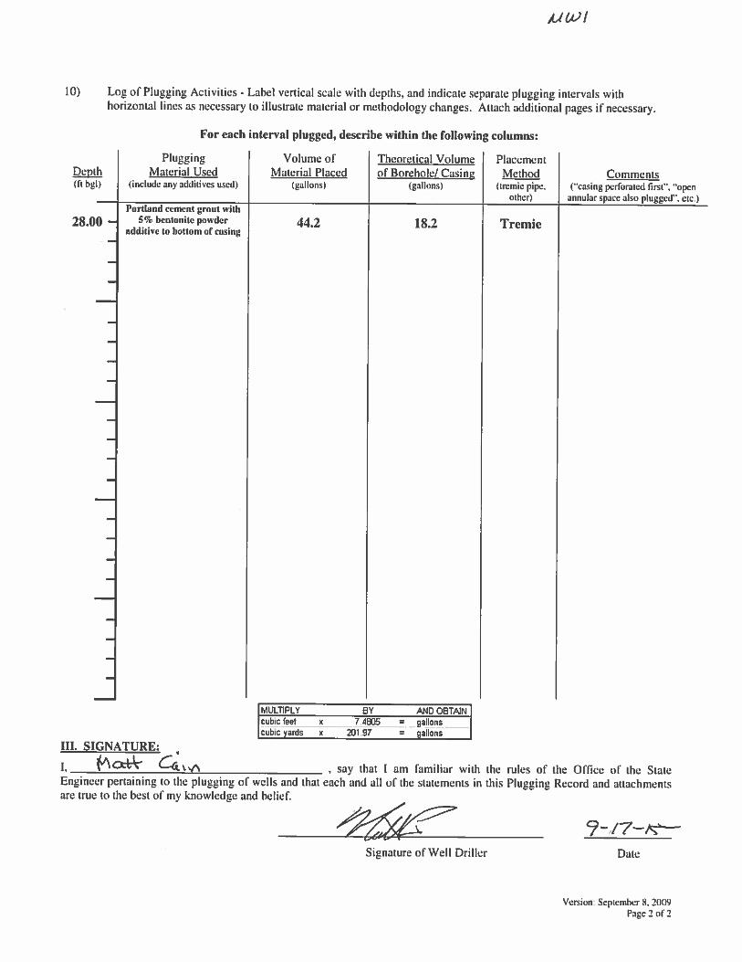
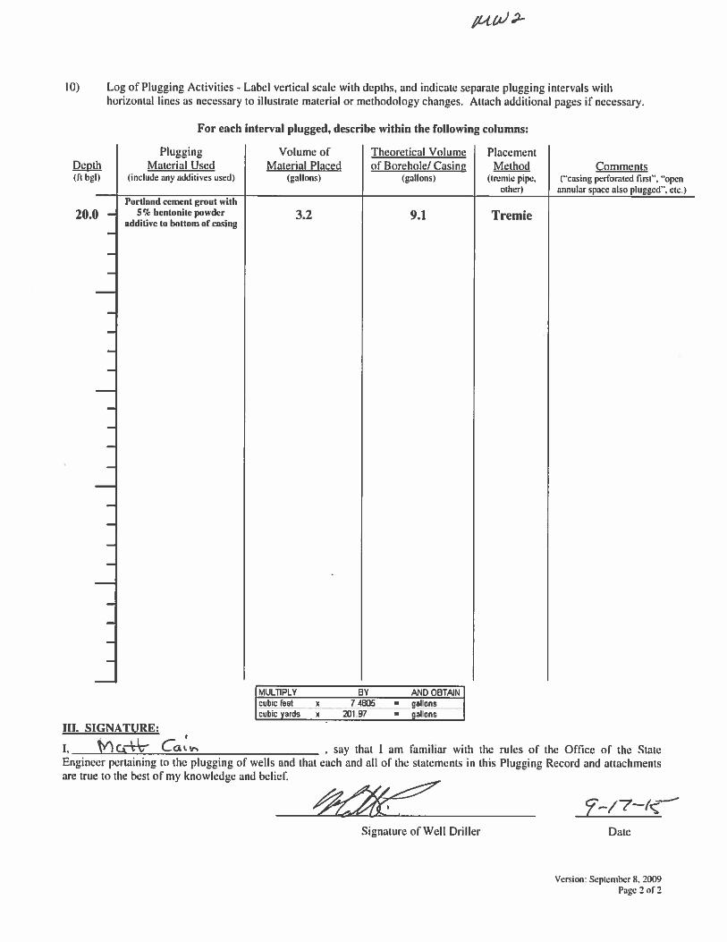
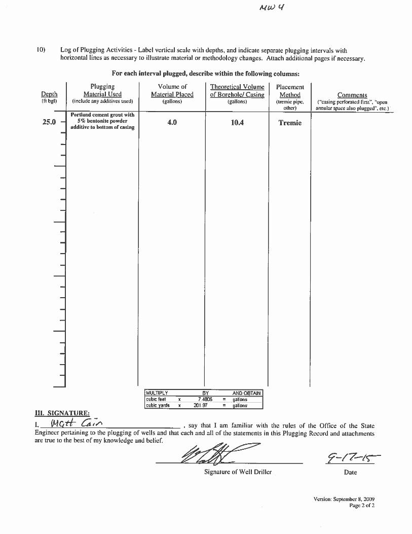
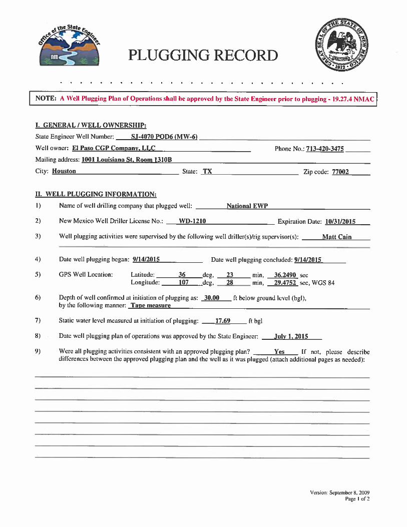
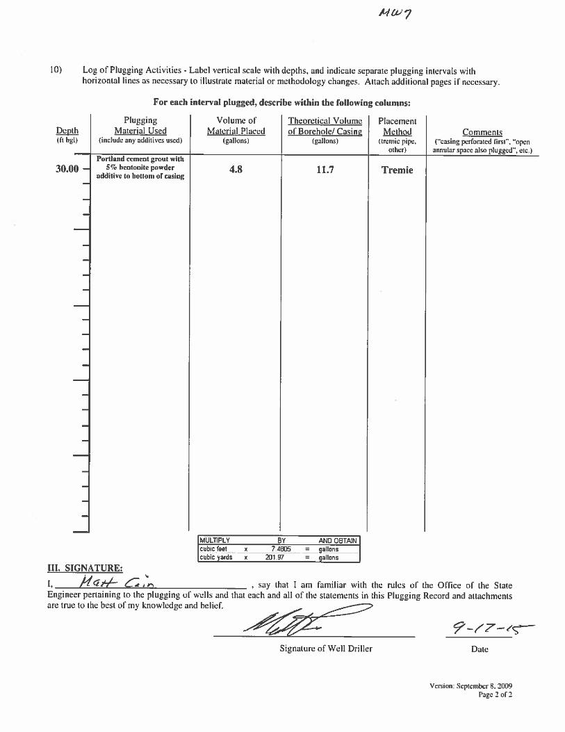
MWH retained the services of National Exploration, Wells & Pumps (EWP), a certified New Mexico well contractor, to abandon and plug nine monitoring wells, under the supervision of MWH, in accordance with Subsection C of 19.27.4.30 New Mexico Administrative Code (NMAC).
Documentation
A Water Well Plugging Record (Form WD-11) was completed for each well associated with the Site that was plugged and abandoned. WD-11 forms were signed by National EWP and submitted to the Office of the State Engineer (Appendix A). EPCGP has also relinquished the Water Easement W-229 (Appendix B). An updated Site Plan Map depicting the locations of the plugged and abandoned wells is included as Figure 1.

Mr. Glenn von Gonten Page 2 January 6, 2016
If you have comments or questions concerning this correspondence, please contact me at (515) 251-1005 or Joseph Wiley with EPCGP at (713) 420-3475.
Sincerely,
Clint Oberbroeckling Project Manager
/cwo:srv:vas Enclosures cc: Joseph Wiley, EPCGP
P:\Word Processing\KINDER MORGAN\EL PASO - NM\K-31 LINE DRIP\2016-01_Ltr-von Gonten-GW Site Closure Report (K-31 Line Drip).docx

FIGURE

S A GS A G
S A GS A G
S A G
SA
GS
AG
SA
GS
AG
SA
GS
AG
SA
GS
AG
SA
GS
AG
SA
GS
AG
SA
GS
AG
SA
GS
AG
SA
GS
AG
SA
GS
AG
SA
GS
AG
SA
G
:
Ä
@?
@?
@?
@?
@A
@A
@A
@A
@A
@?
!P
!P
&,
&,
&,
&;
&;
&;
&;
&;
&;
&;
&;
&;
AERIAL IMAGERY FROM GOOGLE EARTH; DATE 5/2/2013.
6305
6304
6303
6302
6301
MW-1MW-3
MW-2
MW-4
MW-5
IP-2
IP-1
SMA RBC BENCHMARKELEV 6301.77NAD 83 NAVD 88STATE PLANE COORDINATE SYSTEMNEW MEXICO CENTRAL
TELP
DOGLEG
MW-9
MW-6
MW-7
MW-8
L:\San Juan River Basin\SJRB GENERAL\GIS-NEW\_Deliverables_Exports\Figures_Maps\CANADA MESA #2\2015\K-31_ABANDONMENT.mxd
SAN JUAN RIVER BASINMONITORING AND REMEDIATIONRIO ARRIBA COUNTY, NEW MEXICO
K-31 LINE DRIPWELL ABANDONMENT SEPTEMBER 14, 2015
1
COCCLCCL12/11/2015ADATE REVIEWED BYDRAWN BYDESIGN BYREVISION
Figure No.:
PROJECT:
TITLE:
0 40 80
SCALE IN FEET£
LEGEND:APPROXIMATE GROUND SURFACECONTOUR AND ELEVATION, FEET
SMA BENCHMARK:
DRIP LINEÄ
MONITORING WELL ASSOCIATED WITH UNRELATED RELEASE@?
ACCESS ROAD
NATURAL GAS LINESAG
GEOPROBE BORING LOCATION&,
6301
ORC INJECTION POINT (2002)!P
MONITORING WELL ABANDONED SEPTEMBER 14, 2015&;

APPENDIX A


APPENDIX B


