4 marlow road, maidenhead, berkshire
TRANSCRIPT

4 Marlow Road, Maidenhead, Berkshire
An Archaeological Watching Brief
For Royal Borough of Windsor and Maidenhead
by Andrew Mundin
Thames Valley Archaeological Services Ltd
Site Code MRM 07/06
April 2007
i Thames Valley Archaeological Services Ltd, 47–49 De Beauvoir Road, Reading RG1 5NR
Tel. (0118) 926 0552; Fax (0118) 926 0553; email [email protected]; website : www.tvas.co.uk
Summary
Site name: 4 Marlow Road, Maidenhead, Berkshire Grid reference: SU 8852 8138 Site activity: Watching Brief Date and duration of project: 2nd–4th April 2007 Project manager: Steve Ford Site supervisor: Steve Hammond Site code: MRM 07/06 Area of site: c.1700 sq m Summary of results: No finds or features of archaeological interest were noted during this watching brief. Monuments identified: None. Location and reference of archive: The archive is presently held at Thames Valley Archaeological Services, Reading and will be deposited at Reading Museum in due course. This report may be copied for bona fide research or planning purposes without the explicit permission of the copyright holder Report edited/checked by: Steve Ford 20.04.07 Steve Preston 23.04.07

1
4 Marlow Road, Maidenhead, Berkshire An Archaeological Watching Brief
by Andrew Mundin
Report 07/06
Introduction
This report documents the results of an archaeological watching brief carried out at 4 Marlow Road,
Maidenhead, Berkshire (SU 8852 8138) (Fig. 1). The work was commissioned by Mr Mike Tatham on behalf of
the Royal Borough of Windsor and Maidenhead Building Services, Town Hall, St Ives Road, Maidenhead,
Berkshire, SL6 1RF.
Planning permission (app no 06/01210) has been granted by the Royal Borough of Windsor and
Maidenhead for the construction of a new large extension to the existing listed building on the site, subject to a
condition which required the implementation of a programme of archaeological work, in this case a watching
brief during intrusive groundworks.
This is in accordance with the Department of the Environment’s Planning Policy Guidance, Archaeology
and Planning (PPG16 1990), and the Royal Borough’s policies on archaeology. The field investigation was
carried out to a specification approved by Ms Mary O’Donoghue of Berkshire Archaeology, archaeological
advisers to the Royal Borough. The fieldwork was undertaken by Steve Hammond and Andrew Mundin between
the 2nd and 4th April 2007 and the site code is MRM 07/06.
The archive is presently held at Thames Valley Archaeological Services, Reading and will be deposited at
Reading Museum in due course.
Location, topography and geology
The site is located in the centre of Maidenhead, just to the north of the town centre, approximately 150m north of
the A4. Marlow Road runs along the western boundary of the site and Kidwells Park extends eastwards from the
buildings associated with the redevelopment of this park. The listed buildings (Grade II), which house the
Commonwealth War Graves Commission for the Royal Borough, are to be extended to fit with the existing
features of the building. The site was, most recently, utilized as gardens for the associated building. The
underlying geology consists of flood plain terrace river gravels (BGS 1990), which was encountered in all
exposed footing bases. The site lies approximately 31m above Ordnance Datum.

2
Archaeological background
In summary, the archaeological potential for the site is derived from the possible proximity to the course of a
Roman road indicated on both the First (1875) and Second Editions (1899) of Ordnance Survey mapping and
repeated in a map by Silver drawn in 1907 purporting to represent the town in 1830. The structure shows as a
broad linear earthwork in the park aligned roughly north-south. The significance and destination of this road, if it
exists, are unclear and it is not documented by Margary (1955; 1973) nor the Viatores (1964), nor is it shown in
the Tabula Imperii Romani (TIR 1983). The area of the site is shown as arable farmland on Rocque’s map of
1760. None of these omissions are proof that the road does not exist, but they do at least cast doubt on it.
Although a geophysical survey carried out in 2005 confirmed the presence of an earthwork, it did not reveal any
details about its structure or possible date (MT 2005). An archaeological watching brief carried out during Phase
1 of the refurbishment located a gravel layer corresponding with the earthwork, but failed to confirm that it was a
Roman road (Taylor 2005). An additional watching brief in the park failed to reveal any archaeological deposits
(Wallis 2006).
In general, Maidenhead lies within an area of East Berkshire which is relatively rich in archaeological finds
of prehistoric and Roman date although little is recorded for the locality of the park itself (Ford 1987).
Objectives and methodology
The purpose of the watching brief was to excavate and record any archaeological deposits affected by the
groundworks. This was to involve examination of all areas of intrusive groundworks, in particular any ground
reduction, and the digging of foundation trenches.
Results
Removal of topsoil to a depth of only 0.2m took place on the site prior to the laying of a mat comprising crushed
and rolled rubble (hard core). No ground reduction had effectively occurred to establish this mat.
The foundation trenches which were c. 0.6m wide except at the pad locations, were dug though this mat to
a depth generally of 0.8–1.1m. Beneath the rubble mat (c. 0.2m), this revealed an orange/brown sandy silt to a
depth of c. 0.7m with some gravel (subsoil) above orange brown sandy gravel. No buildings remains or
structures were noted over any exposed section. One service cut containing a live gas pipe was noted parallel to
the existing listed building at approximately 2.2m from its north-west elevation. No features of archaeological
interest were uncovered and no finds were recovered from the footings or the spoil heaps.
3
Conclusion
No artefacts or deposits of archaeological interest were revealed during this watching brief.
References BGS, 1990, British Geological Survey, 1:50000, Sheet 255, Drift Edition, Keyworth Ford, S, 1987, East Berkshire Archaeological Survey, Berkshire County Council Dept Highways and Planning
Occas Pap 1, Reading Margary, I D, 1955, Roman Roads in Britain, London Margary, I D, 1973, Roman Roads in Britain, (3rd edition), London MT, 2005, ‘Maidenhead, Kidwells Park, report of ground and resistivity survey over possible Roman road’.
Minas Tirith Ltd (Archaeological Survey), Marlow PPG 16, 1990, Archaeology and Planning, Dept of the Environment Planning Policy Guidance 16, HMSO Taylor, A, 2005, ‘Kidwells Park, Maidenhead, Berkshire, an archaeological watching brief’, Thames Valley
Archaeological Service report 05/13, Reading TIR, 1983, Tabvla Imperii Romani; Condate-Glevvum-Londinivm-Lvtetia, London Viatores, The, 1964, Roman Roads in the South East Midlands, London Wallis, S, 2006, ‘Kidwells Park, Maidenhead, Berkshire, an archaeological watching brief’, Thames Valley
Archaeological Service report 06/10, Reading

4 Marlow Road, Maidenhead, Berkshire, 2007Archaeological watching brief
Figure 1. Location of site within Maidenheadand Berkshire.
Reproduced from Ordnance Survey Pathfinder 1173 SU86/96 at 1:12500.
Ordnance Survey Licence 100025880
81000
82000
SU88000 89000
SITE
MRM 07/06
SITE83000
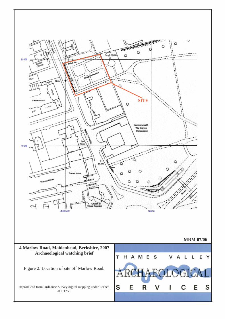
4 Marlow Road, Maidenhead, Berkshire, 2007Archaeological watching brief
Figure 2. Location of site off Marlow Road.
Reproduced from Ordnance Survey digital mapping under licence. at 1:1250.
81300
SITE
MRM 07/06
81400
SU88500 88600

MRM 07/06Figure 3. Location of grounds and areas observed during watching brief.
N4 Marlow Road, Maidenhead, Berkshire, 2007
0 25m
81350
81400
Marlow Road
Existing buildings
Spur House
SU88500 88550
Topsoil/overburdenstripped area
Foundation trenches observed
pipe
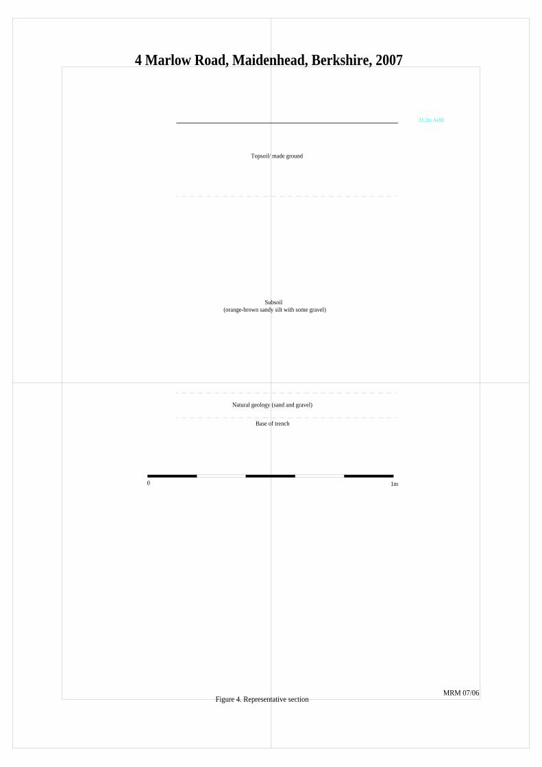
Figure 4. Representative section
0 1m
Subsoil(orange-brown sandy silt with some gravel)
Topsoil/ made ground
Natural geology (sand and gravel)
Base of trench
31.2m AOD
MRM 07/06
4 Marlow Road, Maidenhead, Berkshire, 2007