4.0 tier assessments 4.1 tier 1 assessment · pdf fileto be conservative, the department used...
TRANSCRIPT

15 Version 2.0 (3/18/2003)
4.0 TIER ASSESSMENTS 4.1 Tier 1 Assessment The purpose of a Tier 1 assessment is to gather enough information to determine if soils at a site are contaminated at a level that may pose a risk to human health and the environment. This information will also determine if the site can be considered for regulatory closure or if additional assessment or remediation is needed. A Tier 1 assessment must be performed during proper closure of regulated storage tanks and at other petroleum release sites. See section 3.1.4 for additional information regarding sudden/catastrophic releases. If detectable levels of petroleum contamination are measured during a property transaction or other Phase I Type assessment, the results must be reported to the department as a release. The Tier 1 assessment should be performed only after ensuring there are no immediate threats to human health or safety. For example, if there are petroleum vapors in a home or if a drinking water well has been impacted, these problems must be addressed before the Tier 1 assessment is performed. See Section 3.1 Situations where Immediate Action is Required, for additional information.
4.1.2 Tier 1 Action Levels for Petroleum Contaminated Soils The department has calculated Tier 1 Action Levels (See Table 4.1) to compare with the soil analytical results collected from petroleum sites. The Tier 1 Action Level for benzene in soil was calculated using a risk level of one excess incidence of cancer in a population of 100,000 people. Thus the Tier 1 Action Level for benzene in soil impacting the ground water is based on a lifetime cancer risk of 1:100,000 for a person drinking that water. To be conservative, the department used a hazard index of one to calculate the Tier 1 Action Levels for ethylbenzene, toluene and xylenes. The soil number for naphthalene was also calculated using a hazard index of one. The calculations assume the soil has impacted a drinking water supply at the source area and that someone is drinking the water. The Tier 1 Action Levels are concentrations for that constituent that can be present in the soil where leaching to the ground water may pose a risk to human health and the environment. These Tier 1 Action Levels pertain only to contamination in soil. The ground water exposure pathway is considered the most conservative pathway by the department. A ground water assessment will be required if soils in contact with, or in close proximity to the ground water contain chemicals of concern at or above the Tier 1 action levels. There are also circumstances where a ground water assessment will be required when soil contamination is below the Tier 1 action levels (See Chapter 6.0 for additional information). Identification and evaluation of othe r exposure pathways are discussed in Sections 4.1.5 and 4.2.

16 Version 2.0 (3/18/2003)
Table 4.1 Tier 1 Action Levels for Soils
Chemical of Concern Tier 1 Action Level1
Benzene 0.2 ppm Toluene 15 ppm
Ethylbenzene 10 ppm Xylenes 300 ppm
Naphthalene 25 ppm
1 Note: Refer to Appendix B for Recommended Analytical Methods. If the analytical screen for naphthalene measures >25 ppm, the analysis must be verified by GC/MS.
4.1.3 Total Petroleum Hydrocarbon Trigger Level In addition to the Tier 1 Action Levels, the department has identified a "trigger level" for total petroleum hydrocarbon concentrations. This "trigger level" is 500 parts per million (ppm) total petroleum hydrocarbons. This is intended to be a mechanism to require a more thorough evaluation of the site and is not intended to be a cleanup goal. If soil contamination is confirmed to contain 500 ppm or greater of total petroleum hydrocarbons, regardless if the contamination is removed, the department may require a Tier 2 Assessment be performed to determine if any completed or potentially completed exposure pathways are present. If excavation is performed and 500 ppm or greater of total petroleum hydrocarbons remains, a Tier 2 assessment may be required, which may include the installation of soil borings and ground water monitoring wells. However, if excavation removes all contamination greater than 500 ppm, the department may accept a limited Tier 2 assessment. Soil borings and monitoring wells may not be necessary if sufficient information is gathered showing no completed exposure pathways are present and ground water is not impacted above state standards. Information obtained during the Tier 1 assessment documenting site conditions may be sufficient to show a risk is not present. Refer to 4.1.5 for more information on Tier 1 requirements and Section 4.2 on how to conduct a Tier 2 assessment.
4.1.4 Sampling and Data Collection Soil sampling activities may be performed during tank closure, assessment activities, or during cleanup of petroleum release sites. The department requires soil samples for laboratory analysis be collected from locations most likely to be contaminated or from the areas with the highest field instrument reading. If detectable levels of contamination are present, the soil sample analytical results are compared to the Tier 1 Action Levels in Table 4.1. 4.1.4.1 Excavation Assessment For a Tier 1 assessment at a typical underground or aboveground storage tank site, the number of soil samples collected for proper tank abandonment depends upon the size of the tank, length of piping and number of dispensers (see Table 4.2). Also, see Section 5.1.2 Tank System Removal, for more information on tank abandonment procedures. The purpose of sampling during a tank
17 Version 2.0 (3/18/2003)
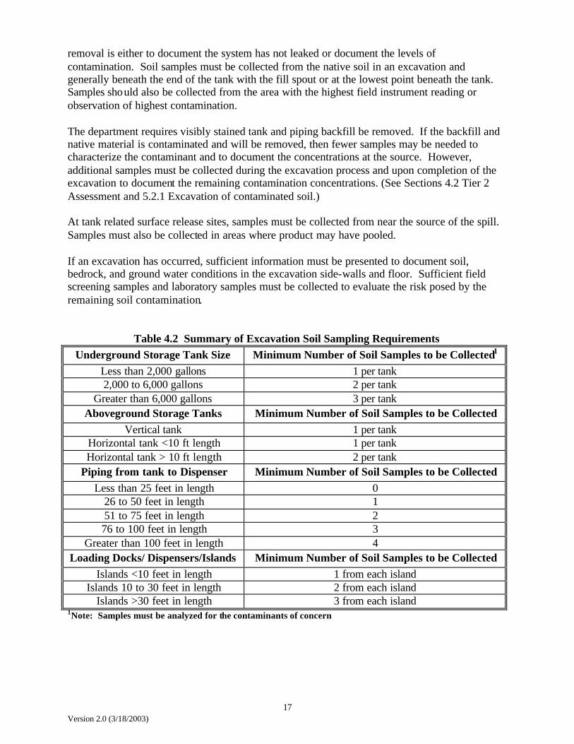
removal is either to document the system has not leaked or document the levels of contamination. Soil samples must be collected from the native soil in an excavation and generally beneath the end of the tank with the fill spout or at the lowest point beneath the tank. Samples should also be collected from the area with the highest field instrument reading or observation of highest contamination. The department requires visibly stained tank and piping backfill be removed. If the backfill and native material is contaminated and will be removed, then fewer samples may be needed to characterize the contaminant and to document the concentrations at the source. However, additional samples must be collected during the excavation process and upon completion of the excavation to document the remaining contamination concentrations. (See Sections 4.2 Tier 2 Assessment and 5.2.1 Excavation of contaminated soil.) At tank related surface release sites, samples must be collected from near the source of the spill. Samples must also be collected in areas where product may have pooled. If an excavation has occurred, sufficient information must be presented to document soil, bedrock, and ground water conditions in the excavation side-walls and floor. Sufficient field screening samples and laboratory samples must be collected to evaluate the risk posed by the remaining soil contamination.
Table 4.2 Summary of Excavation Soil Sampling Requirements Underground Storage Tank Size Minimum Number of Soil Samples to be Collected1
Less than 2,000 gallons 1 per tank 2,000 to 6,000 gallons 2 per tank
Greater than 6,000 gallons 3 per tank Aboveground Storage Tanks Minimum Number of Soil Samples to be Collected
Vertical tank 1 per tank Horizontal tank <10 ft length 1 per tank Horizontal tank > 10 ft length 2 per tank
Piping from tank to Dispenser Minimum Number of Soil Samples to be Collected Less than 25 feet in length 0
26 to 50 feet in length 1 51 to 75 feet in length 2 76 to 100 feet in length 3
Greater than 100 feet in length 4 Loading Docks/ Dispensers/Islands Minimum Number of Soil Samples to be Collected
Islands <10 feet in length 1 from each island Islands 10 to 30 feet in length 2 from each island
Islands >30 feet in length 3 from each island 1Note: Samples must be analyzed for the contaminants of concern

18 Version 2.0 (3/18/2003)
4.1.4.2 Soil Boring or Direct Push Soil Sampling A site assessment performed with a drill rig or other soil sampling equipment must collect representative soil samples to provide sufficient information to evaluate whether detectable levels of petroleum contamination are present. This work must be performed to determine if the contaminant concentrations pose a potential risk to human health and environment, and to determine if additional work may be required. At storage tank sites, soil borings or other soil samples must be placed as close to the suspected release source as possible. Soil samples must be collected from below the depth of the tank bottom, or at the interval with the highest field instrument reading, or indication of petroleum contamination. In some instances, more than one sample may be necessary to document site conditions. If the precise location of an underground tank is not known, it may be necessary to excavate to the top of the tank to determine the orientation of the tank. The placement and number of borings are dependent on the size, number, orientation of the tanks (Table 4.3) as well as the hydrogeologic conditions at the site. At surface release sites the soil borings must be located near the source of the spill or in areas where product may have pooled. Soil samples should be collected from the interval with the highest field instrument reading or observation of highest contamination. The depth of the soil borings depends on the geology, regional ground water fluctuations and field screening results as well as the proximity to the source of the release. The borings must be advanced to define the vertical extent of the contamination. If permeable material such as silt, sand or gravel is present at the site, the borings may be required to be advanced to the ground water. The department requires the borings to be advanced beyond the suspected release source to depths when the soil sample field screening results show no detectable concentrations above ambient background readings and no observable staining or indications of petroleum contamination.
Table 4.3 Summary of Soil Boring Requirements
Underground Storage Tank Size Minimum Number of Soil Borings to be Performed1
--- 1 boring per 100 square feet of tank basin
Aboveground Storage Tanks Minimum Number of Soil Borings to be Performed1
--- 1 boring per 100 square feet tank area Length of Piping from tank to Dispenser Minimum Number of Soil Borings to be
Performed1 Less than 25 feet 0
26 to 50 feet 1 boring per length 51 to 75 feet 2 boring per length 76 to 100 feet 3 boring per length
Greater than 100 feet 4 borings per length
Loading Docks/ Dispensers/Islands Minimum Number of Soil Borings to be Performed1
Islands <10 feet in length 1 boring per island Islands 10 to 30 feet in length 2 borings per island
Islands >30 feet in length 3 borings per island 1Note: Samples must be analyzed for the contaminants of concern 2Note: Assuming more than one tank per basin or area.
19 Version 2.0 (3/18/2003)
4.1.4.3 Ground Water Sampling If it appears that contaminated soil is in contact with ground water or may impact the ground water in the future, the department may require a Tier 2 assessment to include collection of ground water samples. Refer to Section 6.0 Guidance for Monitoring Well Installation & Ground Water Monitoring for additional information. 4.1.4.4 Soil Gas Sampling Soil gas sampling may be used as a screening tool during assessment work at release sites to provide information regarding the extent of the contamination in the soil or ground water. Confirmation soil boring and monitoring wells may be required to verify the results of the soil gas sampling. The soil gas sampling plan must be submitted to the department for approval.
4.1.5 Tier 1 Additional Information 1 1Note: When a release has been documented, additional information may be required to be submitted with the Tier 1 Assessment soil sampling data to properly evaluate site conditions. Initial assessment of a known release must provide information on the chemicals of concern and sources of contamination, receptors, exposure pathways, and exposure routes. This information must include, but may not be limited to the following: • Identify the location, depth and construction of receptors or other potential pathways on the
property and immediately adjacent to the property. • Identify potential receptors on the property and immediately adjacent properties, and
potential pathways that could transport the contaminants of concern from the source to the receptors. Where applicable, this information should include locations, depths, and construction.
• Describe known local or site-specific hydrogeologic conditions and soil conditions (some
examples are till, outwash, sand, clay, aquifer, non-aquifer, depth to ground water, ground water flow direction, aquifer thickness).
• Discuss the current and reasonably anticipated future use of the property, ground water,
surface water, and sensitive habitats where the release has occurred and the immediately adjacent properties.
• Discuss the potential for completed exposure pathways and impacts to receptors, such as
vapor impacts to buildings or utilities and nearby drinking water wells. If an immediate threat for impacts is found, field screening or air and water samples for laboratory analysis may be required.
A receptor is defined as persons, structures, utilities, surface water, ground water, or water supply wells that are or may be adversely affected by a petroleum release. Examples include water supply wells, basements of buildings, utilities, lakes, streams, wetlands, etc. A completed exposure pathway requires: 1) a source and mechanism for chemicals of concern to be released into the environment; 2) a transport medium such as air, soil, ground water, vapor migration through soils and utilities, for the chemicals of concern to move from the source to the receptor; 3) a point of potential contact of the receptor with the medium (points of exposure such as
20 Version 2.0 (3/18/2003)
drinking water wells); and 4) an exposure route or means of taking the chemical of concern into the body, such as ingestion or inhalation, or by dermal contact.
4.1.6 Source removal Sources of contamination (tanks, lines, dispensing islands and associated product saturated soil, contaminated backfill, and free phase product) must be removed if possible. The department is aware that in some cases it may not be possible or advisable to remove tanks and lines. In these cases, the department requires the tanks be permanently closed by removing all residual product from the tanks and product lines, filling the tanks with an inert material, and capping the product lines. Department approval must be granted prior to in-place abandonment. See Section 5.1 for further information. The department considers free product a source of contamination and as such must be removed. If free product is encountered during a Tier 1 assessment, the responsible person must conduct free product recovery to the maximum extent practicable in a manner such that the actions do not spread contamination into previously uncontaminated areas (ARSD 74:56:01:47). If free-product is identified, the department will require the responsible person conduct a Tier 2 assessment.
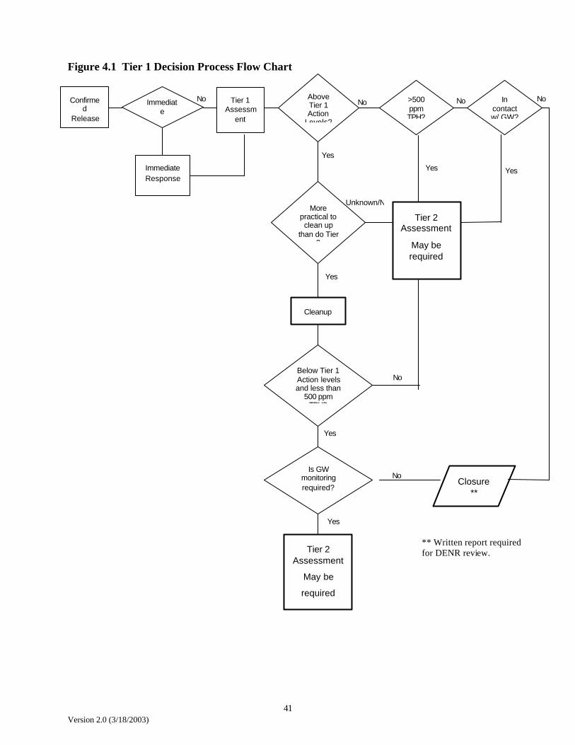
4.1.7 Decision process In a Tier 1 assessment, the point of exposure and the point of compliance are assumed to be located within close proximity to the source area or the area where the highest concentrations of the chemicals of concern have been identified. Concentrations of the chemicals of concern measured at the source area should be compared to the Tier 1 Action Levels in Table 4.1. If the concentrations of chemicals of concern exceed the levels in Table 4.1, then it may be necessary to implement a remedial action or conduct a Tier 2 assessment (See Figure 4.1). If excavation is performed and 500 ppm or greater of total petroleum hydrocarbons remains, a Tier 2 assessment may be required, which may include the installation of soil borings and ground water monitoring wells. However, if excavation removes all contamination greater than 500 ppm, the department may accept a limited Tier 2 assessment. Soil borings and monitoring wells may not be necessary if sufficient information is gathered showing no completed exposure pathways are present and ground water is not impacted above state standards. Information obtained during the Tier 1 assessment documenting site conditions may be sufficient to show a risk is not present. Refer to 4.1.5 for more information on Tier 1 requirements and Section 4.2 on how to conduct a Tier 2 assessment. The department will issue a closure letter if: 1) contaminant concentrations are less than Tier 1 Action levels; 2) the department is confident that the data support the conclusion that concentrations will not exceed risk levels in the future; and 3) any required ground water monitoring indicates standards were not exceeded. If the department is not confident the Tier 1 assessment data is representative of site conditions, additional assessment will be required before completing the Tier 1 evaluation. In addition, the department may require a monitoring plan (ground water and/or air monitoring) to collect data sufficient to conclude that concentrations will not exceed risk levels in the future.

21 Version 2.0 (3/18/2003)
If a decision is made to clean up the site to the Tier 1 Action Levels in Table 4.1, the department requires a corrective action plan be submitted for approval. If corrective action is implemented, the remedial action may consist of some combination of source removal, treatment and containment technologies, and engineering controls. Examples of these include excavation, soil venting, bioventing, air sparging, capping, pump and treat, and others. For further information see Section 5.0. If the decision is made to excavate soil concentrations to the Tier 1 Action Levels in Table 4.1, but insufficient information is available to determine the area of excavation, additional assessment may be required to define the excavation boundaries. If soil is removed from the excavation, soil analytical results must be provided to show the soil contaminant levels remaining in the side-walls and floor of the excavation. The responsible person may also choose to conduct a Tier 2 assessment (see Section 4.2) to collect site information and develop site specific target levels. Further Tier 2 assessment is warranted when: • The assumptions used to calculate the Tier 1 Action Levels are not representative of the
actual site conditions (for example, geology, exposure parameters, points of exposure, etc.); or
• Site specific target levels developed under further Tier 2 assessment will be significantly
different than the Tier 1 Action Levels in Table 1 or will significantly modify the remedial action activities; or
• Cost of performing a Tier 2 assessment and implementation of corrective action will be less
than the costs for corrective action to cleanup to the Tier 1 Action Levels. It should be noted that when a site is evaluated under higher Tiers, the level of protection to human health remains the same. The difference between a Tier 1 assessment and higher Tiers is that the higher Tiers require a site to be evaluated using site specific data, rather than the assumptions used to generate the numbers in Table 4.1. 4.2 Tier 2 Assessment A Tier 2 assessment is a risk-based analysis applying the direct exposure values established under a Tier 1 assessment at the point or points of exposure developed for a specific site and development of values for potential indirect exposure pathways at the point or points of exposure based on site-specific conditions. In Tier 2, the site is evaluated for exposure pathways and potential receptors (or point of exposure). (See Figure 4.2). A receptor is defined as persons, structures, utilities, surface water, groundwater, or water supply wells that are or may be adversely affected by a petroleum release. Examples include water supply wells, basements of buildings, utilities, lakes, streams, wetlands, etc. A completed exposure pathway requires: 1) a source and mechanism for chemicals of concern to be released into the environment; 2) a transport medium such as air, soil, ground water, vapor migration through soils and utilities, for the chemicals of concern to move from the source to the receptor; 3) a point of potential contact of the receptor with the medium (points of exposure such as drinking water wells); and 4) an exposure route or means of taking the chemical of concern into the body, such as ingestion or inhalation or by dermal contact (Figure 4.3).

22 Version 2.0 (3/18/2003)
For there to be an exposure to a chemical of concern, a mechanism to transport that chemical to a receptor must be present. Transport mechanisms include: • Wind erosion and atmosphere dispersion of particulates (for surficially contaminated soils); • Volatilization and atmospheric dispersion; • Volatilization and enclosed space accumulation; • Leaching and ground water transport of dissolved phase chemicals of concern; • Mobile free phase product migration; • Surface and storm water transport; and • Direct contact or ingestion of contaminated soils or water.
4.2.1 Tier 2 Look-up tables Look-up tables have been developed with risk numbers for the different exposure pathways, i.e., surface pathway, indoor air, and polyvinyl chloride (PVC) water lines. The existing Tier 1 Action Levels numbers were calculated for contaminated soil leaching into ground water assuming that someone would be drinking the water. A single site or release may have several potential pathways endangering human health in addition to the ground water ingestion pathway. We are also aware that not every site is situated over an aquifer or is classified as having the beneficial for drinking water. Therefore, the department has developed look-up tables to conservatively eliminate those potential exposure pathways that are not posing risk to human health or environment. These look-up tables are intended to be used as a first step in a Tier 2 assessment without performing additional fieldwork or using the RBCA software. 4.2.1.1 General Guidance on how to use look-up tables (surface soil, indoor air, waterlines) Implementing these look-up tables will require some changes in the way sites are assessed. Typically in the past, soil samples are collected from soil borings and excavations at the water table, from the interval with the highest PID reading or from the bottom of the excavation. Samples of affected surface soil (zero to 3.2 feet below ground surface) are usually not collected if more heavily contaminated soil is present in subsurface soil (greater than 3.2 feet below ground surface). It will be necessary to collect surface soil samples if PID readings from the surface soil exceed 50 ppm in order to use the Tier 2 Look-up tables. If contaminant concentrations in soil exceed Tier 1 Action Levels/500 ppm TPH: Complete the RBCA Site Conceptual Model Sheet (See Page 43, Figure 4.3), submit it as part of all reports,
• Identify source(s) (i.e., surface soil, subsurface soil, ground water) • Identify transport mechanism(s) (i.e., wind erosion, volatilization, leaching, ground water
transport)
23 Version 2.0 (3/18/2003)
• Identify exposure pathway(s) (i.e., direct contact, inhalation of vapors, ground water ingestion)
• Identify potential receptors (i.e., on-site commercial receptors, off-site residential receptors, environmental receptors)
Once the potential receptors and pathways are identified, consult the appropriate Look-Up Table to see which pathways are of concern.
• If contaminated soil is present between zero and 3.2 feet below the ground surface (surface soil); check the Surface Soil Look-Up Table to see if there is a potential risk from surface soil (residential/commercial, construction worker).
• If the contaminated surface soil is covered with asphalt or concrete, the surface soil pathway can be eliminated.
• If contaminated soil is present between zero and nine feet below ground surface, check the
Surface Soil Look-Up Table for construction workers to see if there is a potential risk to construction workers
• If contaminated soil OR contaminated ground water are under a building, check the appropriate Indoor Air Look-Up Table to see if there is a potential indoor air risk (see “Using Indoor Air Look-Up Tables” for additional guidance). If both contaminated soil AND contaminated ground water are under a building, do not use the lookup tables.
• If contaminated ground water exceeding ground water quality standards and/or soil exceeding Tier 1 Action Levels are in contact with a water line, regardless of the construction, collect a tap water sample.
• If the composition of the water line is unknown and the tap water sample is non-detect, it is likely the water line is NOT polyethylene (PE) or polybutylene (PB); compare ground water concentrations to the Water Line Look-up Table to see if there is a potential risk to the water line.
4.2.1.2 Guidance for Using Surface Soil Look-Up Table for Inhalation, Ingestion and Dermal Contact During a tank excavation:
• Collect sample from the tank bottom. The purpose of this sampling is to document the tank has not leaked.
• If PID readings from the sur face soil exceed 50 ppm, a surface soil sample must also be
collected.
• Soil samples must also be collected along the product lines and under the pump islands. During initial site assessment:
24 Version 2.0 (3/18/2003)
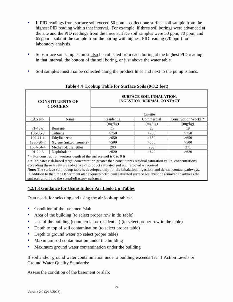
• If PID readings from surface soil exceed 50 ppm – collect one surface soil sample from the highest PID reading within that interval. For example, if three soil borings were advanced at the site and the PID readings from the three surface soil samples were 50 ppm, 70 ppm, and 65 ppm – submit the sample from the boring with highest PID reading (70 ppm) for laboratory analysis.
• Subsurface soil samples must also be collected from each boring at the highest PID reading in that interval, the bottom of the soil boring, or just above the water table.
• Soil samples must also be collected along the product lines and next to the pump islands.
Table 4.4 Lookup Table for Surface Soils (0-3.2 feet)
SURFACE SOIL INHALATION,
INGESTION, DERMAL CONTACT
CONSTITUENTS OF CONCERN
On-site
CAS No. Name Residential Commercial Construction Worker* (mg/kg) (mg/kg) (mg/kg)
71-43-2 Benzene 17 28 19 108-88-3 Toluene >750 >750 >750 100-41-4 Ethylbenzene >650 >650 >650 1330-20-7 Xylene (mixed isomers) >500 >500 >500 1634-04-4 Methyl t-Butyl ether 200 280 371
91-20-3 Naphthalene >620 >620 >620 * = For construction workers depth of the surface soil is 0 to 9 ft > = Indicates risk-based target concentration greater than constituents residual saturation value, concentrations exceeding these levels are indicative of product saturated soil and removal is required Note: The surface soil lookup table is developed only for the inhalation, ingestion, and dermal contact pathways. In addition to that, the Department also requires petroleum saturated surface soil must be removed to address the surface run off and the visual/olfactory nuisance. 4.2.1.3 Guidance for Using Indoor Air Look-Up Tables Data needs for selecting and using the air look-up tables:
• Condition of the basement/slab • Area of the building (to select proper row in the table) • Use of the building (commercial or residential) (to select proper row in the table) • Depth to top of soil contamination (to select proper table) • Depth to ground water (to select proper table) • Maximum soil contamination under the building • Maximum ground water contamination under the building If soil and/or ground water contamination under a building exceeds Tier 1 Action Levels or Ground Water Quality Standards: Assess the condition of the basement or slab:

25 Version 2.0 (3/18/2003)
• If the basement or slab is in poor condition, DO NOT use the look-up tables. Collect an air sample. Conduct additional assessment as necessary (this may include running the RBCA software using site specific information and the software default crack fraction)
• If the basement or slab is in good condition, use the look-up tables to evaluate the potential for vapor problems based on soil and ground water concentrations
• If concentrations exceed values on the look-up tables, collect an air sample. Conduct additional assessment as necessary (this may include running the RBCA software using site-specific information)
• If concentrations do not exceed values on the look-up tables, no additional assessment of indoor air is required
Note: The Look-Up tables are NOT to be used if both contaminated soil and ground water are under the building. If both soil exceeding Tier 1 Action Levels and ground water exceeding MCLs are under the building, use the RBCA software, and site specific information, to calculate potential risk. If the calculated risk exceeds the cancer or non-cancer target risk levels: Collect an air sample and perform additional assessment as necessary.
• If contamination/water table starts at 5 to less than 10 feet below ground surface – use Tables 4.6 or 4.11; if contamination/water table starts at 10 to less than 15 feet below ground surface – use Tables 4.7 or 4.12, etc.
• If contaminated soil (particularly product-saturated soil) or ground water are in direct contact with the basement wall – check the basement for contamination directly entering the basement through cracks, sumps, etc.
• At sand to clayey sand sites; if soil contamination is deeper than 15 feet and/or groundwater
is deeper than 20 feet and the concentrations exceed the values in the look-up tables, conduct site specific Tier 2 Assessment to determine if there is actually a vapor risk to the building.
• Use the analytical results from the soil boring/monitoring well closest to the building; if
more than one well near the building use the highest measured concentrations. • If more than one soil type is present at the site, use the look-up table column corresponding
to the coarsest-grained material. For example, if the site has interlayered sandy clay and silty sand, the correct screening value for the site is the one calculated for sand to clayey sand.
• The look-up tables can also be used to determine if there is potential for vapor problems if a structure is built on the site in the future.
• The top of soil contamination is the depth at which you first get PID readings greater than 10 ppm.
The RBCA software and the look-up tables assume the entire thickness of contaminated soil contains contamination at the concentrations measured in the sample from the highest PID reading. If contaminant concentrations exceed the values in the look-up table, additional

26 Version 2.0 (3/18/2003)
assessment may consist of collecting soil samples at discreet intervals through the thickness of contaminated soil (for example, every one foot; every two feet). These concentrations would be used to calculate a representative concentration for the contaminated soil (calculate a weighted average). The sampling requirements are: a minimum of three samples from the boring; and the interval between samples cannot be greater than five feet.
Table 4.5 Ground Water Volatilizing to Indoor Air (6 in. to less than 5 ft. deep)
*TABLE 4.5 - GROUND WATER SIX INCHES TO LESS THAN FIVE FEET BELOW GROUND SURFACE
Residential Building < 1,200 square feet Sand to Clayey Sand Sandy Silt to Clayey Silt Sandy Clay to Clay Benzene (mg/L) 1.8 1.8 2.1 Toluene (mg/L) 230 240 270 Ethyl Benzene (mg/L) **>170 **>170 **>170 Xylenes (mg/L) **>200 **>200 **>200 Naphthalene (mg/L) **>31 **>31 **>31 Methyl Tertiary Butyl Ether (mg/L) 19,000 19,000 19,000
Residential Building > 1,200 square feet Sand to Clayey Sand Sandy Silt to Clayey Silt Sandy Clay to Clay Benzene (mg/L) 2.1 2.2 2.5 Toluene (mg/L) 280 290 320 Ethyl Benzene (mg/L) **>170 **>170 **>170 Xylenes (mg/L) **>200 **>200 **>200 Naphthalene (mg/L) **>31 **>31 **>31 Methyl Tertiary Butyl Ether (mg/L) 23,000 23,000 23,000
Commercial Building < 1,200 square feet Sand to Clayey Sand Sandy Silt to Clayey Silt Sandy Clay to Clay Benzene (mg/L) 7.3 7.6 8.6 Toluene (mg/L) **>520 **>520 **>520 Ethyl Benzene (mg/L) **>170 **>170 **>170 Xylenes (mg/L) **>200 **>200 **>200 Naphthalene (mg/L) **>31 **>31 **>31 Methyl Tertiary Butyl Ether (mg/L) **>48,000 **>48,000 **>48,000
Commercial Building > 1,200 square feet Sand to Clayey Sand Sandy Silt to Clayey Silt Sandy Clay to Clay Benzene (mg/L) 8.9 9.3 10 Toluene (mg/L) **>520 **>520 **>520 Ethyl Benzene (mg/L) **>170 **>170 **>170 Xylenes (mg/L) **>200 **>200 **>200 Naphthalene (mg/L) **>31 **>31 **>31 Methyl Tertiary Butyl Ether (mg/L) **>48,000 **>48,000 **>48,000
• *Values in this table are NOT to be used if both contaminated soil and contaminated ground water are present under a building
• **">" indicates risk-based target concentration greater than constituent solubility value; concentrations exceeding these levels are indicative of free phase product and free product removal is required

27 Version 2.0 (3/18/2003)
Table 4.6 Ground Water Volatilizing to Indoor Air (5 ft. to less than 10 ft. deep)
*TABLE 4.6 - GROUND WATER FIVE FEET TO LESS THAN TEN FEET BELOW GROUND SURFACE
Residential Building < 1,200 square feet Sand to Clayey Sand Sandy Silt to Clayey Silt Sandy Clay to Clay Benzene (mg/L) 1.8 1.9 2.6 Toluene (mg/L) 230 240 340 Ethyl Benzene (mg/L) **>170 **>170 **>170 Xylenes (mg/L) **>200 **>200 **>200 Naphthalene (mg/L) **>31 **>31 **>31 Methyl Tertiary Butyl Ether (mg/L) 19,000 19,000 20,000
Residential Building > 1,200 square feet Sand to Clayey Sand Sandy Silt to Clayey Silt Sandy Clay to Clay Benzene (mg/L) 2.2 2.3 3.0 Toluene (mg/L) 280 300 390 Ethyl Benzene (mg/L) **>170 **>170 **>170 Xylenes (mg/L) **>200 **>200 **>200 Naphthalene (mg/L) **>31 **>31 **>31 Methyl Tertiary Butyl Ether (mg/L) 23,000 24,000 24,000
Commercial Building < 1,200 square feet Sand to Clayey Sand Sandy Silt to Clayey Silt Sandy Clay to Clay Benzene (mg/L) 7.3 7.8 11 Toluene (mg/L) **>520 **>520 **>520 Ethyl Benzene (mg/L) **>170 **>170 **>170 Xylenes (mg/L) **>200 **>200 **>200 Naphthalene (mg/L) **>31 **>31 **>31 Methyl Tertiary Butyl Ether (mg/L) **>48,000 **>48,000 **>48,000
Commercial Building > 1,200 square feet Sand to Clayey Sand Sandy Silt to Clayey Silt Sandy Clay to Clay Benzene (mg/L) 8.9 9.4 12 Toluene (mg/L) **>520 **>520 **>520 Ethyl Benzene (mg/L) **>170 **>170 **>170 Xylenes (mg/L) **>200 **>200 **>200 Naphthalene (mg/L) **>31 **>31 **>31 Methyl Tertiary Butyl Ether (mg/L) **>48,000 **>48,000 **>48,000
• *Values in this table are NOT to be used if both contaminated soil and contaminated ground water are present under a building
• **">" indicates risk-based target concentration greater than constituent solubility value; concentrations exceeding these levels are indicative of free phase product and free product removal is required
28 Version 2.0 (3/18/2003)
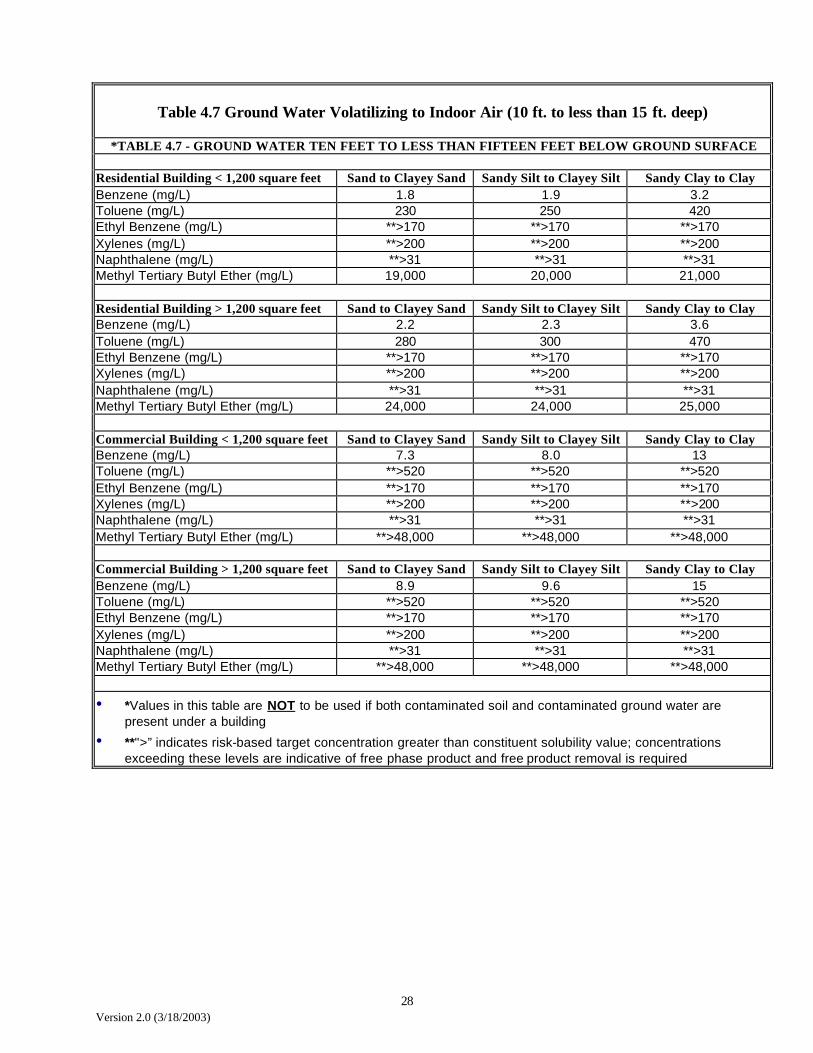
Table 4.7 Ground Water Volatilizing to Indoor Air (10 ft. to less than 15 ft. deep)
*TABLE 4.7 - GROUND WATER TEN FEET TO LESS THAN FIFTEEN FEET BELOW GROUND SURFACE
Residential Building < 1,200 square feet Sand to Clayey Sand Sandy Silt to Clayey Silt Sandy Clay to Clay Benzene (mg/L) 1.8 1.9 3.2 Toluene (mg/L) 230 250 420 Ethyl Benzene (mg/L) **>170 **>170 **>170 Xylenes (mg/L) **>200 **>200 **>200 Naphthalene (mg/L) **>31 **>31 **>31 Methyl Tertiary Butyl Ether (mg/L) 19,000 20,000 21,000
Residential Building > 1,200 square feet Sand to Clayey Sand Sandy Silt to Clayey Silt Sandy Clay to Clay Benzene (mg/L) 2.2 2.3 3.6 Toluene (mg/L) 280 300 470 Ethyl Benzene (mg/L) **>170 **>170 **>170 Xylenes (mg/L) **>200 **>200 **>200 Naphthalene (mg/L) **>31 **>31 **>31 Methyl Tertiary Butyl Ether (mg/L) 24,000 24,000 25,000
Commercial Building < 1,200 square feet Sand to Clayey Sand Sandy Silt to Clayey Silt Sandy Clay to Clay Benzene (mg/L) 7.3 8.0 13 Toluene (mg/L) **>520 **>520 **>520 Ethyl Benzene (mg/L) **>170 **>170 **>170 Xylenes (mg/L) **>200 **>200 **>200 Naphthalene (mg/L) **>31 **>31 **>31 Methyl Tertiary Butyl Ether (mg/L) **>48,000 **>48,000 **>48,000
Commercial Building > 1,200 square feet Sand to Clayey Sand Sandy Silt to Clayey Silt Sandy Clay to Clay Benzene (mg/L) 8.9 9.6 15 Toluene (mg/L) **>520 **>520 **>520 Ethyl Benzene (mg/L) **>170 **>170 **>170 Xylenes (mg/L) **>200 **>200 **>200 Naphthalene (mg/L) **>31 **>31 **>31 Methyl Tertiary Butyl Ether (mg/L) **>48,000 **>48,000 **>48,000
• *Values in this table are NOT to be used if both contaminated soil and contaminated ground water are present under a building
• **">” indicates risk-based target concentration greater than constituent solubility value; concentrations exceeding these levels are indicative of free phase product and free product removal is required

29 Version 2.0 (3/18/2003)
Table 4.8 Ground Water Volatilizing to Indoor Air (15 ft. to less 20 ft. deep)
*TABLE 4.8 - GROUND WATER FIFTEEN FEET TO LESS THAN
TWENTY FEET BELOW GROUND SURFACE
Residential Building < 1,200 square feet Sand to Clayey Sand Sandy Silt to Clayey Silt Sandy Clay to Clay Benzene (mg/L) 1.8 2.0 3.8 Toluene (mg/L) 230 260 490 Ethyl Benzene (mg/L) **>170 **>170 **>170 Xylenes (mg/L) **>200 **>200 **>200 Naphthalene (mg/L) **>31 **>31 **>31 Methyl Tertiary Butyl Ether (mg/L) 19,000 20,000 22,000
Residential Building > 1,200 square feet Sand to Clayey Sand Sandy Silt to Clayey Silt Sandy Clay to Clay Benzene (mg/L) 2.2 2.4 4.2 Toluene (mg/L) 280 310 **>520 Ethyl Benzene (mg/L) **>170 **>170 **>170 Xylenes (mg/L) **>200 **>200 **>200 Naphthalene (mg/L) **>31 **>31 **>31 Methyl Tertiary Butyl Ether (mg/L) 24,000 25,000 26,000
Commercial Building < 1,200 square feet Sand to Clayey Sand Sandy Silt to Clayey Silt Sandy Clay to Clay Benzene (mg/L) 7.3 8.1 16 Toluene (mg/L) **>520 **>520 **>520 Ethyl Benzene (mg/L) **>170 **>170 **>170 Xylenes (mg/L) **>200 **>200 **>200 Naphthalene (mg/L) **>31 **>31 **>31 Methyl Tertiary Butyl Ether (mg/L) **>48,000 **>48,000 **>48,000
Commercial Building > 1,200 square feet Sand to Clayey Sand Sandy Silt to Clayey Silt Sandy Clay to Clay Benzene (mg/L) 8.9 9.8 17 Toluene (mg/L) **>520 **>520 **>520 Ethyl Benzene (mg/L) **>170 **>170 **>170 Xylenes (mg/L) **>200 **>200 **>200 Naphthalene (mg/L) **>31 **>31 **>31 Methyl Tertiary Butyl Ether (mg/L) **>48,000 **>48,000 **>48,000
• *Values in this table are NOT to be used if both contaminated soil and contaminated ground water are present under a building
• **">” indicates risk-based target concentration greater than constituent solubility value; concentrations exceeding these levels are indicative of free phase product and free product removal is required

30 Version 2.0 (3/18/2003)
Table 4.9 Ground Water Volatilizing to Indoor Air (20 ft. and deeper)
*TABLE 4.9 - GROUND WATER TWENTY FEET BELOW GROUND SURFACE AND DEEPER
Residential Building < 1,200 square feet Sand to Clayey Sand Sandy Silt to Clayey Silt Sandy Clay to Clay Benzene (mg/L) 1.8 2.0 4.4 Toluene (mg/L) 230 260 **>520 Ethyl Benzene (mg/L) **>170 **>170 **>170 Xylenes (mg/L) **>200 **>200 **>200 Naphthalene (mg/L) **>31 **>31 **>31 Methyl Tertiary Butyl Ether (mg/L) 19,000 21,000 22,000
Residential Building > 1,200 square feet Sand to Clayey Sand Sandy Silt to Clayey Silt Sandy Clay to Clay
Benzene (mg/L) 2.2 2.4 4.8 Toluene (mg/L) 280 310 **>520
Ethyl Benzene (mg/L) **>170 **>170 **>170 Xylenes (mg/L) **>200 **>200 **>200
Naphthalene (mg/L) **>31 **>31 **>31 Methyl Tertiary Butyl Ether (mg/L) 24,000 25,000 27,000
Commercial Building < 1,200 square feet Sand to Clayey Sand Sandy Silt to Clayey Silt Sandy Clay to Clay
Benzene (mg/L) 7.3 8.3 18 Toluene (mg/L) **>520 **>520 **>520
Ethyl Benzene (mg/L) **>170 **>170 **>170 Xylenes (mg/L) **>200 **>200 **>200
Naphthalene (mg/L) **>31 **>31 **>31 Methyl Tertiary Butyl Ether (mg/L) **>48,000 **>48,000 **>48,000
Commercial Building > 1,200 square feet Sand to Clayey Sand Sandy Silt to Clayey Silt Sandy Clay to Clay
Benzene (mg/L) 9.0 9.9 20 Toluene (mg/L) **>520 **>520 **>520
Ethyl Benzene (mg/L) **>170 **>170 **>170 Xylenes (mg/L) **>200 **>200 **>200
Naphthalene (mg/L) **>31 **>31 **>31 Methyl Tertiary Butyl Ether (mg/L) **>48,000 **>48,000 **>48,000
• *Values in this table are NOT to be used if both contaminated soil and contaminated ground water are present under a building
• **">” indicates risk-based target concentration greater than constituent solubility value; concentrations exceeding these levels are indicative of free phase product and free product removal is required

31 Version 2.0 (3/18/2003)
Table 4.10 Soil Volatilizing to Indoor Air (Less than 5 ft. deep)
*TABLE 4.10 - TOP OF SOIL CONTAMINATION LESS THAN FIVE FEET BELOW GROUND SURFACE
Residential Building < 1,200 square feet Sand to Clayey Sand Sandy Silt to Clayey Silt Sandy Clay to Clay Benzene (mg/kg) 1.1 1.3 1.3 Toluene (mg/kg) 310 330 340 Ethyl Benzene (mg/kg) **>630 **>640 **>650 Xylenes (mg/kg) **>500 **>510 **>510 Naphthalene (mg/kg) **>620 **>620 **>620 Methyl Tertiary Butyl Ether (mg/kg) 3,300 5,200 5,800
Residential Building > 1,200 square feet Sand to Clayey Sand Sandy Silt to Clayey Silt Sandy Clay to Clay Benzene (mg/kg) 1.4 1.6 1.7 Toluene (mg/kg) 390 410 420 Ethyl Benzene (mg/kg) **>630 **>640 **>650 Xylenes (mg/kg) **>500 **>510 **>510 Naphthalene (mg/kg) **>620 **>620 **>620 Methyl Tertiary Butyl Ether (mg/kg) 4,000 6,500 7,100
Commercial Building < 1,200 square feet Sand to Clayey Sand Sandy Silt to Clayey Silt Sandy Clay to Clay Benzene (mg/kg) 4.7 5.3 5.6 Toluene (mg/kg) **>740 **>790 **>790 Ethyl Benzene (mg/kg) **>630 **>640 **>650 Xylenes (mg/kg) **>500 **>510 **>510 Naphthalene (mg/kg) **>620 **>620 **>620 Methyl Tertiary Butyl Ether (mg/kg) **>8,300 **>13,000 **>15,000
Commercial Building > 1,200 square feet Sand to Clayey Sand Sandy Silt to Clayey Silt Sandy Clay to Clay Benzene (mg/kg) 5.8 6.6 6.9 Toluene (mg/kg) **>740 **>790 **>790 Ethyl Benzene (mg/kg) **>630 **>640 **>650 Xylenes (mg/kg) **>500 **>510 **>510 Naphthalene (mg/kg) **>620 **>620 **>620 Methyl Tertiary Butyl Ether (mg/kg) **>8,300 **>13,000 **>15,000
• *Values in this table are NOT to be used if both contaminated soil and contaminated ground water are present under a building
• **">” indicates risk-based target concentration greater than constituent residual saturation value; concentrations exceeding these levels are indicative of product-saturated soil and soil removal is required

32 Version 2.0 (3/18/2003)
Table 4.11 Soil Volatilizing to Indoor Air (5 ft. to less than 10 ft. deep)
*TABLE 4.11 - TOP OF SOIL CONTAMINATION FIVE FEET TO
LESS THAN TEN FEET BELOW GROUND SURFACE
Residential Building < 1,200 square feet Sand to Clayey Sand Sandy Silt to Clayey Silt Sandy Clay to Clay Benzene (mg/kg) 1.1 1.3 1.8 Toluene (mg/kg) 310 340 450 Ethyl Benzene (mg/kg) **>630 **>640 **>650 Xylenes (mg/kg) **>500 **>510 **>510 Naphthalene (mg/kg) **>620 **>620 **>620 Methyl Tertiary Butyl Ether (mg/kg) 3,300 5,300 6,000
Residential Building > 1,200 square feet Sand to Clayey Sand Sandy Silt to Clayey Silt Sandy Clay to Clay Benzene (mg/kg) 1.4 1.6 2.1 Toluene (mg/kg) 390 420 530 Ethyl Benzene (mg/kg) **>630 **>640 **>650 Xylenes (mg/kg) **>500 **>510 **>510 Naphthalene (mg/kg) **>620 **>620 **>620 Methyl Tertiary Butyl Ether (mg/kg) 4,000 6,600 7,400
Commercial Building < 1,200 square feet Sand to Clayey Sand Sandy Silt to Clayey Silt Sandy Clay to Clay Benzene (mg/kg) 4.7 5.4 7.3 Toluene (mg/kg) **>740 **>790 **>790 Ethyl Benzene (mg/kg) **>630 **>640 **>650 Xylenes (mg/kg) **>500 **>510 **>510 Naphthalene (mg/kg) **>620 **>620 **>620 Methyl Tertiary Butyl Ether (mg/kg) **>8,300 **>13,000 **>15,000
Commercial Building > 1,200 square feet Sand to Clayey Sand Sandy Silt to Clayey Silt Sandy Clay to Clay Benzene (mg/kg) 5.8 6.7 8.6 Toluene (mg/kg) **>740 **>790 **>790 Ethyl Benzene (mg/kg) **>630 **>640 **>650 Xylenes (mg/kg) **>500 **>510 **>510 Naphthalene (mg/kg) **>620 **>620 **>620 Methyl Tertiary Butyl Ether (mg/kg) **>8,300 **>13,000 **>15,000
• *Values in this table are NOT to be used if both contaminated soil and contaminated ground water are present under a building
• **">” indicates risk-based target concentration greater than constituent residual saturation value; concentrations exceeding these levels are indicative of product-saturated soil and soil removal is required

33 Version 2.0 (3/18/2003)
Table 4.12 Soil Volatilizing to Indoor Air (10 ft. to less than 15 ft. deep)
*TABLE 4.12 - TOP OF SOIL CONTAMINATION TEN FEET TO LESS THAN FIFTEEN FEET BELOW GROUND SURFACE
Residential Building < 1,200 square feet Sand to Clayey Sand Sandy Silt to Clayey Silt Sandy Clay to Clay Benzene (mg/kg) 1.1 1.3 2.2 Toluene (mg/kg) 310 350 570 Ethyl Benzene (mg/kg) **>630 **>640 **>650 Xylenes (mg/kg) **>500 **>510 **>510 Naphthalene (mg/kg) **>620 **>620 **>620 Methyl Tertiary Butyl Ether (mg/kg) 3,300 5,400 6,300
Residential Building > 1,200 square feet Sand to Clayey Sand Sandy Silt to Clayey Silt Sandy Clay to Clay Benzene (mg/kg) 1.4 1.6 2.5 Toluene (mg/kg) 390 430 650 Ethyl Benzene (mg/kg) **>630 **>640 **>650 Xylenes (mg/kg) **>500 **>510 **>510 Naphthalene (mg/kg) **>620 **>620 **>620 Methyl Tertiary Butyl Ether (mg/kg) 4,000 6,700 7,600
Commercial Building < 1,200 square feet Sand to Clayey Sand Sandy Silt to Clayey Silt Sandy Clay to Clay Benzene (mg/kg) 4.7 5.6 9.2 Toluene (mg/kg) **>740 **>790 **>790 Ethyl Benzene (mg/kg) **>630 **>640 **>650 Xylenes (mg/kg) **>500 **>510 **>510 Naphthalene (mg/kg) **>620 **>620 **>620 Methyl Tertiary Butyl Ether (mg/kg) **>8,300 **>13,000 **>15,000
Commercial Building > 1,200 square feet Sand to Clayey Sand Sandy Silt to Clayey Silt Sandy Clay to Clay Benzene (mg/kg) 5.8 6.8 10 Toluene (mg/kg) **>740 **>790 **>790 Ethyl Benzene (mg/kg) **>630 **>640 **>650 Xylenes (mg/kg) **>500 **>510 **>510 Naphthalene (mg/kg) **>620 **>620 **>620 Methyl Tertiary Butyl Ether (mg/kg) **>8,300 **>13,000 **>15,000
• *Values in this table are NOT to be used if both contaminated soil and contaminated ground water are present under a building
• **">” indicates risk-based target concentration greater than constituent residual saturation value; concentrations exceeding these levels are indicative of product-saturated soil and soil removal is required
34 Version 2.0 (3/18/2003)
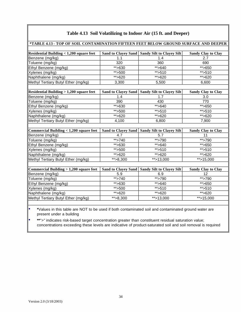
Table 4.13 Soil Volatilizing to Indoor Air (15 ft. and Deeper)
*TABLE 4.13 - TOP OF SOIL CONTAMINATION FIFTEEN FEET BELOW GROUND SURFACE AND DEEPER
Residential Building < 1,200 square feet Sand to Clayey Sand Sandy Silt to Clayey Silt Sandy Clay to Clay Benzene (mg/kg) 1.1 1.4 2.7 Toluene (mg/kg) 320 360 690 Ethyl Benzene (mg/kg) **>630 **>640 **>650 Xylenes (mg/kg) **>500 **>510 **>510 Naphthalene (mg/kg) **>620 **>620 **>620 Methyl Tertiary Butyl Ether (mg/kg) 3,300 5,500 6,600
Residential Building > 1,200 square feet Sand to Clayey Sand Sandy Silt to Clayey Silt Sandy Clay to Clay Benzene (mg/kg) 1.4 1.7 3.0 Toluene (mg/kg) 390 430 770 Ethyl Benzene (mg/kg) **>630 **>640 **>650 Xylenes (mg/kg) **>500 **>510 **>510 Naphthalene (mg/kg) **>620 **>620 **>620 Methyl Tertiary Butyl Ether (mg/kg) 4,100 6,800 7,900
Commercial Building < 1,200 square feet Sand to Clayey Sand Sandy Silt to Clayey Silt Sandy Clay to Clay Benzene (mg/kg) 4.7 5.7 11 Toluene (mg/kg) **>740 **>790 **>790 Ethyl Benzene (mg/kg) **>630 **>640 **>650 Xylenes (mg/kg) **>500 **>510 **>510 Naphthalene (mg/kg) **>620 **>620 **>620 Methyl Tertiary Butyl Ether (mg/kg) **>8,300 **>13,000 **>15,000
Commercial Building > 1,200 square feet Sand to Clayey Sand Sandy Silt to Clayey Silt Sandy Clay to Clay Benzene (mg/kg) 5.9 6.9 12 Toluene (mg/kg) **>740 **>790 **>790 Ethyl Benzene (mg/kg) **>630 **>640 **>650 Xylenes (mg/kg) **>500 **>510 **>510 Naphthalene (mg/kg) **>620 **>620 **>620 Methyl Tertiary Butyl Ether (mg/kg) **>8,300 **>13,000 **>15,000
• *Values in this table are NOT to be used if both contaminated soil and contaminated ground water are present under a building
• **">” indicates risk-based target concentration greater than constituent residual saturation value; concentrations exceeding these levels are indicative of product-saturated soil and soil removal is required
35 Version 2.0 (3/18/2003)
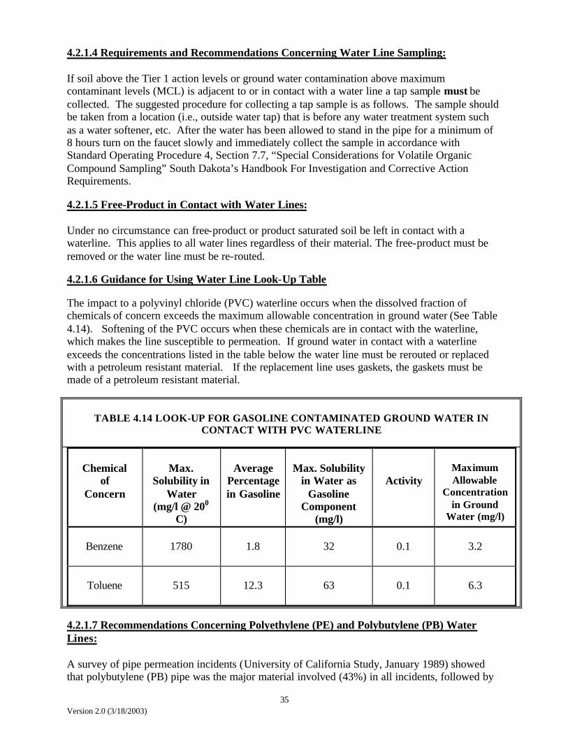
4.2.1.4 Requirements and Recommendations Concerning Water Line Sampling: If soil above the Tier 1 action levels or ground water contamination above maximum contaminant levels (MCL) is adjacent to or in contact with a water line a tap sample must be collected. The suggested procedure for collecting a tap sample is as follows. The sample should be taken from a location (i.e., outside water tap) that is before any water treatment system such as a water softener, etc. After the water has been allowed to stand in the pipe for a minimum of 8 hours turn on the faucet slowly and immediately collect the sample in accordance with Standard Operating Procedure 4, Section 7.7, “Special Considerations for Volatile Organic Compound Sampling” South Dakota’s Handbook For Investigation and Corrective Action Requirements. 4.2.1.5 Free-Product in Contact with Water Lines: Under no circumstance can free-product or product saturated soil be left in contact with a waterline. This applies to all water lines regardless of their material. The free-product must be removed or the water line must be re-routed. 4.2.1.6 Guidance for Using Water Line Look-Up Table The impact to a polyvinyl chloride (PVC) waterline occurs when the dissolved fraction of chemicals of concern exceeds the maximum allowable concentration in ground water (See Table 4.14). Softening of the PVC occurs when these chemicals are in contact with the waterline, which makes the line susceptible to permeation. If ground water in contact with a waterline exceeds the concentrations listed in the table below the water line must be rerouted or replaced with a petroleum resistant material. If the replacement line uses gaskets, the gaskets must be made of a petroleum resistant material.
TABLE 4.14 LOOK-UP FOR GASOLINE CONTAMINATED GROUND WATER IN
CONTACT WITH PVC WATERLINE
Chemical
of Concern
Max.
Solubility in Water
(mg/l @ 200 C)
Average
Percentage in Gasoline
Max. Solubility
in Water as Gasoline
Component (mg/l)
Activity
Maximum Allowable
Concentration in Ground
Water (mg/l)
Benzene
1780
1.8
32
0.1
3.2
Toluene
515
12.3
63
0.1
6.3
4.2.1.7 Recommendations Concerning Polyethylene (PE) and Polybutylene (PB) Water Lines: A survey of pipe permeation incidents (University of California Study, January 1989) showed that polybutylene (PB) pipe was the major material involved (43%) in all incidents, followed by

36 Version 2.0 (3/18/2003)
polyethylene (PE) pipe at 39%. The use of these materials for service line connections in the area of the survey was common. The prevalence of waterlines constructed of these materials in South Dakota has not been determined. The survey also showed that the dominant contaminants (89%) were petroleum products such a gasoline and diesel fuel.
The concern with these materials is that the contaminant enters the pipe by straight diffusion (Fickian), which means there is no physical change to the pipe, such a softening. A review of the California study also shows that pipe permeation can occur with low soil contaminant concentrations (i.e., less 0.05 ppm toluene, less than 0.2 ppm xylenes/ethylbenzene and less than 4.1 ppm benzene). In almost all the surveyed cases the PB and PE was either replaced by copper or the water service line was routed around the contamination. For the above reasons the Department does not feel it would be appropriate to develop look-up tables for PB or PE pipe. The development of a look-up table for gasoline constituent (i.e., benzene, toluene, ethylbenzene, and xylenes) contaminated soil in contact with PVC water line is not feasible because it is necessary to know more site-specific information than just the concentration of the contaminants in soil. It has been shown that the relative organic chemical concentration in the soil pores controls the permeation rate. This requires the soil to be analyzed in such a way that the relative organic chemical concentration in the soil pores can be predicted. In order to properly make this prediction site specific data such as soil organic carbon content, soil water content and soil porosity must be measured. For further discussion on the above analysis refer to the document published by the University of California at Berkeley on Permeation of Plastic Pipes by Organic Chemicals, pages 303-305.
4.2.2 Sampling and data collection As part of a Tier 2 assessment, the responsible person may be required to; 1) Define the vertical and horizontal extent of soil contamination exceeding Tier 1 action levels; 2) Define the extent of ground water contamination exceeding South Dakota ground water quality standards; 3) Collect samples at actual or potential points of exposure to quantify contaminant concentrations at the points of exposure; 4) Collect other site information needed to calculate Tier 2 Action Levels (if necessary); and 5) Use the RBCA software program to calculate Tier 2 Action Levels (if necessary). The sampling requirements for a Tier 2 assessment depend on the possible transport mechanisms and receptors. For example, if it is possible that a sewer line may be impacted by the release, that sewer should be screened for the presence of the chemicals of concern. In areas where a particular exposure pathway is not possible, sampling is not needed for that pathway. If receptors or pathways are present within the area of contamination but no exposure is possible, adequate documentation must be presented to support not collecting samples. 4.2.2.1 Soil sampling Soil samples must be collected at a depth consistent with the underground structures or utilities or at the ground water interface or at the highest field screening. In some instances, more than one sample may be necessary to document site conditions. Due to the heterogeneous nature of soils and bedrock care must be taken to adequately provide information about the site.

37 Version 2.0 (3/18/2003)
If surficial soils (soils at 0-3.2 feet in depth) are impacted, then samples must be collected from surface soils at the area of impact to determine the dermal, ingestion and inhalation risk. Sample collection depends on the extent of the contaminated area and the transport mechanisms that are present. If the area is capped by concrete, dispersion of particulates is probably not a concern. However, slab on grade buildings with shallow contamination must be assessed for the potential of vapors. Soil samples must be collected from at least six inches below grade. If subsurface soils (soils at 3.2 feet or greater in depth) are impacted, soil samples must be collected from subsurface soils if a potential receptor or a transport mechanism is present. The depth of soil borings depends on the geology, regional ground water fluctuations and field screening results as well as the proximity to the source of the release. Soil borings must be advanced to define the vertical extent of the contamination. If permeable material such as silt, sand or gravel is present at the site, the borings may be required to be advanced to the ground water. The department requires that borings be advanced beyond the suspected release source to a depth where the soil sample field screening results show no detectable concentrations above ambient and where no observable staining or indications of petroleum contamination are present. 4.2.2.2 Air sampling In a Tier 2 assessment, the department may require that any potentially impacted utilities be screened for vapors (See Appendix A). Basements that may be impacted by the release must be checked for the presence of petroleum vapors, and the occupants of the property must be contacted to determine if there have been petroleum vapors in the past. If field readings indicate petroleum vapors may be present, laboratory samples are required. Refer to Chapter 6 for additional information. 4.2.2.3 Ground water sampling While the ground water may not be a likely exposure route, such as in clayey till areas, the department believes it can be a significant transport mechanism in certain situations. Refer to Chapter 6.0 Monitoring requirements for additional information.
4.2.3 Developing site specific target levels Site specific cleanup levels and points of compliance may be developed for a site based on the completed exposure pathways. In a Tier 2 assessment, site specific target levels are developed based upon compliance points, exposure pathways and site specific data using simple mathematical modeling. Site specific target levels must be determined for the chemicals of concern for a completed or potentially completed pathway. For example, if ground water in a non-aquifer were contaminated above state ground water quality standards, it would not be necessary to develop a site specific soil cleanup number for that exposure pathway. If there were no other exposure pathways, there would not be a site specific cleanup number developed. The site would be monitored to ensure there were no other exposures. In addition, if an aquifer is impacted, the calculation of site specific target levels may be necessary, especially if a compliance point is used to protect for a current and future beneficial use of the aquifer. Under a Tier 2 assessment, a compliance point may be proposed (subject to departmental approval) when there are no receptors present on-site and there is a potential for receptors to be present off-site. A combination of assessment data and predictive modeling results may be
38 Version 2.0 (3/18/2003)
used to determine target source area concentrations that correspond to compliance point target levels. Compliance points may be located at property boundaries or between a source and receptor (with departmental approval). Periodic monitoring will be required when a compliance point is selected to ensure the assumptions used to determine the compliance point are correct. If there is a completed exposure pathway, either a site specific target level may be calculated or the site may be cleaned up to Tier 1 Action levels. The department will accept the methods presented in the ASTM Standard Guide for Risk Based Corrective Action at Petroleum Release Sites (E17-39) to determine site specific target levels, except for the methods presented that concern vapor intrusion into buildings and ambient air. The department does not believe these equations yield representative predictions, and prefers direct measurement of vapors for potentially impacted structures. The department will accept the use of the computer modeling system developed by Groundwater Services Inc., titled "Tier 1/Tier 2 RBCA Spreadsheet System". However, the original version 1.01 does not include baseline risk calculations for human exposure via soil or ground water volatilization to enclosed space and groundwater volatilization to ambient air exposure pathways. The latest version 1.2 does incorporate risk calculations for these pathways. Current owners of the original version can go to Groundwater Services web page at www.gsi-net.com and download a free updated version or call Groundwater Services at 713 663-6600. When modeling is used to determine a site specific target level, the department will require that a list of the assumptions and va lues used be included in the report. Other models may also be accepted based on department approval
4.2.4 Decision process If a complete exposure pathway is present, corrective action must be taken to reduce the risks to human health and the environment. Corrective actions may include remediation to reduce concentrations of chemicals of concern and engineering controls to reduce impacts or eliminate exposure pathways. If the department is not confident the Tier 2 assessment data is representative of site conditions, additional assessment will be required before completing the Tier 2 evaluation. In addition, the department may require a monitoring plan (ground water and/or air monitoring) to collect data sufficient to conclude that concentrations will not exceed risk levels in the future. If the concentrations of chemicals of concern in the soil at the point of compliance are less than the site specific target levels, and the department is confident that the data supports the conclusion that concentrations will not exceed target levels in the future, then no additional corrective action or assessment activities are necessary. The department may issue either a closure or No Further Action letter for that site. No Further Action Status will not be granted in certain aquifer situations. See Section 10.3 No Further Action Case Requirements.
4.2.5 Decision process to move to Tier 3 If the concentrations of chemicals of concern exceed the Tier 2 site specific target levels either the site must be remediated to those target levels, engineering controls must be used, or additional assessment must be performed to evaluate the site under Tier 3.

39 Version 2.0 (3/18/2003)
When deciding if the site should be remediated to Tier 2 levels or additional assessment should be performed, several factors should be taken into account. Further assessment and evaluation may be warranted when: • Site specific target levels developed under further tier evaluation (Tier 3) are likely to be
significantly different than the site specific target levels developed under Tier 2 or will significantly modify the remedial action activities; or
• The cost of remedial action to the Tier 2 site specific target levels would likely be greater
than the cost of the Tier 3 analysis and subsequent remedial action. • The assumptions used to calculate the Tier 2 action levels are not applicable to actual site
conditions. 4.3 Tier 3 Assessment In a Tier 3 assessment, site specific target levels for the source areas and the points of compliance are developed on the basis of more sophisticated statistical and contaminant fate and transport analysis, using site specific input parameters for both direct and indirect exposure scenarios. Source areas and the point of compliance site specific target levels are developed to correspond to concentrations of chemicals of concern at the point of compliance that are protective of human health. Tier 3 evaluations commonly involve collection of significant additional site information and completion of more extensive modeling efforts than required for either Tier 1 or Tier 2 evaluations. The department will consider any modeling effort beyond that described for Tier 2 as being a Tier 3 evaluation. (Note: The Department is in the process of developing criteria for conducting a limited Tier 3 assessment.)
4.3.1 Department Approval Prior to Tier 3 Assessment Prior to conducting a Tier 3 analysis, department approval must be obtained. To obtain department approval, the consultant or responsible party must know what model will be used and the data requirements for that model. The department will review the available information for that particular model and determine if it is appropriate for that site. The department may ask the consultant or the responsible party for more information regarding the model.
4.3.2 Sampling plan The sampling plan must be designed to obtain the information required by the model selected. The responsible person must submit the sampling plan to the department for approval.
4.3.3 Contractor review The department may contract with an outside consultant with expertise in modeling applications to review Tier 3 assessments. The cost of this review will be charged to the responsible party. The department will retain the authority to make the final decision regarding the necessity and type of remediation at the site.

40 Version 2.0 (3/18/2003)
4.3.4 Decision process If the concentrations at the source area and the points of compliance exceed the site-specific target levels developed during the Tier 3 assessment, corrective action must be taken to reduce the risks to human health. Acceptable forms of corrective action include remediation to reduce concentrations of chemicals of concern and engineering controls to reduce impacts or eliminate exposure pathways. If the concentrations of chemicals of concern in the soil are less than the site specific target levels developed for Tier 3, and the department is not confident that the data supports the conclusion that concentrations will not exceed target levels in the future, the department may require a monitoring plan (ground water or air monitoring) to collect data sufficient to conclude that concentrations will not exceed target levels in the future. If the concentrations of chemicals of concern in the soil at the point of compliance are less than the site specific target levels, and the department is confident that the data supports the conclusion that concentrations will not exceed target levels in the future, then no additional corrective action or assessment activities are necessary. The department may issue either a closure or No Further Action letter. No Further Action Status will not be granted in certain aquifer situations. See Section 10.3 No Further Action Case Requirements.
41 Version 2.0 (3/18/2003)
Figure 4.1 Tier 1 Decision Process Flow Chart
No
Unknown/No
Yes
Immediate Response
Confirmed
Release
No
Cleanup
Is GW monitoring required?
Tier 1 Assessm
ent
No
Yes
Yes
More practical to clean up
than do Tier 2
Immediate
Impacts?
Yes
No
Yes
Tier 2 Assessment
May be
required
Tier 2 Assessment
May be required
Closure **
Yes
No >500 ppm TPH?
No
Above Tier 1 Action
Levels?
Below Tier 1 Action levels and less than
500 ppm TPH?
In contact w/ GW?
** Written report required for DENR review.

42 Version 2.0 (3/18/2003)
Figure 4.2 Tier 2 Decision Process Flow Chart
No
No
No No Define extent
of soil contamination
to Tier 1 Action levels.
Define GW contamination to GW
Quality Standards.
Pathway Present?
**
Compliance Monitoring?
** Closure
Yes
Pathway completed? (Receptors
present or likely in the future)**
Yes
No Evaluate potential pathways
Yes
Assumptions confirmed completed
pathway present. **
Yes
No Aquifer?
**
No
Yes
Yes
Propose Corrective Action Plan (CAP), define site specific target levels
or go to Tier 3. **
GW monitoring required according to handbook. ***
GW concentrations exceed GW Quality Standards in source
area(s)?
Yes
No
GW concentrations
above GW Quality
Standards? **
Closure No
Inactive Closure
Yes
Corrective Action (clean-up, engineering controls or
monitored natural attenuation) and Compliance Monitoring.
***
Compliance monitoring shows impacted receptor or concentrations above
Tier 1, GW Quality Standards or Site Specific
Target Levels? **
No
Yes
Re-evaluate Corrective Action
Plan (CAP).
GW present?
**
Air monitoring required according to
handbook. ***
Pathway completed? (Receptors
present or likely in the future) **
Yes
** Written report required for DENR review. ***Monitoring reports required for DENR review, frequency to be determined after initial year of monitoring.
Define GW contamination to GW
Quality Standards and evaluate potential
pathways
Pathway Present?
**
Monitoring required according to handbook. ***
No
Yes
Tier 2 from
Figure 4.1

S O U T H D A K O T A D E N RR B C A S I T E C O N C E P T U A L M O D E L S H E E T
SITE NAME DATE COMPLETED DENR SPILL #
SITE LOCATION COMPLETED BY
Step 1 – Baseline Exposure: Fill in Box ( ���� ) to identify applicable sources, transport mechanisms, and receptors.Step 2 – Remedial Measures: Fill in shut-off valves ( ) to indicate removal / remedial action, containment measure, or institutional controls to be used to “shut off” exposure pathway.
PRIMARY SOURCES SECONDARY SOURCES TRANSPORT MECHANISMS EXPOSURE PATHWAY POTENTIAL RECEPTORS
��������Storage Tanks
��������Piping/ Pump Island
��������Handling
��������Transportation Accident
��������Vandalism
��������Transformer
��������Sump Waste
��������Drums
��������Other
On-Site ���� Residential ���� Commercial ���� Construction worker
On-Site ���� Residential ���� Commercial
Off-Site ���� Residential ���� Commercial
��������AffectedSurface Soil
(< 3.2 ft depth)���� Soil
Inhalation, Ingestion, orDermal Contact
(see surface soil lookuptable)
���� Volatilizationand Enclosed
SpaceAccumulation
���� Mobile FreeProduct
��������AffectedSubsurface Soil(> 3.2 ft depth)
��������DissolvedGround Water
Plume
��������FreePhase Product
���� Leaching andGround water
Transport
���� AirInhalation of Vapor
(see indoor air lookuptable)���� Air
Vapors in undergroundutilities
���� Ground WaterPotable Water Use
(see Mcl)
���� UtilitiesGround Water in contact
Impact to Water Line(see lookup table for water
lines)
���� Surface WaterRun off
(see surface soillookup table)
���� Surface WaterRecreational Use/Sensitive Habitat
���� UtilitiesSoil in contact
Impact to Water line(see lookup table for water
lines)