4.2. nexus between project construction / existence ... · soil erosion and slope instability along...
TRANSCRIPT
PROPOSED STUDY PLAN
Susitna-Watana Hydroelectric Project Alaska Energy Authority FERC Project No. 14241 Page 4-1 July 2012
4. GEOLOGY AND SOILS
This study plan will review the existing information on the Susitna-Watana Project (Project) area regarding geology and soils and gather additional information in order to define the geologic, geotechnical, seismic, and foundation conditions at the sites of Project works (e.g., dam, reservoir, access road, construction camps, and materials borrow sites). This information will be used to support development of the Project design, with an emphasis on minimizing risks to dam safety. In general, the study tasks will include field investigations, laboratory testing, review of existing studies, and engineering analyses to characterize site conditions, limitations, and constraints. The study will also identify impacts of Project construction and operation, such as soil erosion along the reservoir rim, slope stability, excavation, and spoil disposal, on environmental resources (e.g., oil, gas, and minerals).
4.1. Introduction
A Susitna Hydroelectric Project was proposed by the Alaska Power Authority (now the Alaska Energy Authority [AEA]) in the early 1980s. That project was to be composed of two major dams (the Watana Dam and Devils Canyon Dam) constructed in three stages. A draft Environmental Impact Statement was prepared by the Federal Energy Regulatory Commission (FERC), but the application was subsequently withdrawn. The current proposed Project dam is located at river mile 184, the same location as that of the previously proposed Watana Dam.
The Project will most likely include a high concrete arch dam constructed using roller compacted concrete (RCC) construction methods. The Project will also include a large reservoir, a spillway, cofferdams, diversion tunnels, integrated penstocks and powerhouse, construction and permanent housing, borrow and quarry areas, transmission lines, access roads, and staging and stockpile areas. Each of these features will have an impact on, or will be impacted by, geology and soils over the course of design, construction, and operation of the Project.
4.2. Nexus Between Project Construction / Existence / Operations and Effects on Resources to be Studied
The soil and geological characteristics of the Project area will affect Project design, construction, operation, and maintenance because the Project facility foundations are integral to the soil and rock features of the area and also will serve as raw materials for some project components. Also, Project design, construction, and operation, including the dam and reservoir, access road, transmission line, and construction camp/village, may affect geological resources by exposing soils and rock to new surface erosional forces and could change the stability of landscape features.
Considerations of geology and soil conditions in planning for Project construction, operation, and maintenance will include, but are not limited to:
Proper disposal of spoils from the excavations Geologic features in the foundation that may require additional excavation and
foundation treatment
PROPOSED STUDY PLAN
Susitna-Watana Hydroelectric Project Alaska Energy Authority FERC Project No. 14241 Page 4-2 July 2012
Identification of poor rock conditions or the presence of geologic features in the diversion tunnel excavation that may require support and/or lining (e.g., type and thickness)
Design of rock cut-slopes on the right abutment, particularly in the downstream portal area
Identification of seismic sources and design of structures for seismic loading Ice-filled discontinuities in the rock foundation beneath and in the abutments of the dam Design of cut-off walls in the cobble and boulder alluvium beneath the cofferdams Road, transmission tower footing, or camp foundation design to address subsidence due
to poor soil conditions or thawing soil Sediment load contributions due to glacial melt and possible surging glacier event
Potential impact mechanisms for soils and geologic features include:
Soil erosion from slope instability along the reservoir rim due to presence of fine-grained soils and thawing permafrost (discontinuous)
Seismic activity due to the deep, large reservoir Changes to river channel geomorphology based on reservoir operation Seepage through abutments just upstream of the dam causing piping and soil erosion Soil erosion and slope instability along access road cuts and stream/creek crossings
4.3. Resource Management Goals and Objectives
No Alaskan Native resource management goals have been identified other than the provisions identified under the Alaskan Native Claims Settlement Act (ANCSA) dealing with provision of access to mineral resources. FERC regulations under 18 CFR 4.41 require a report on the Geological and Soil Resources in the Exhibit E along with supporting design report to help demonstrate the proposed Project structures are safe and adequate to fulfill their stated functions.
4.4. Summary of Consultation with Agencies, Alaska Native Entities and Other Licensing Participants
Specific consultation regarding geology and soils study planning has been limited to informal discussion with Alaska Department of Natural Resources, Division of Geological and Geophysical Surveys during 2011 as part of planning the geotechnical investigations for the Project. Soil erosion and the potential for reservoir sedimentation and other issues have been discussed in technical work group meetings, and the aquatic aspects of sediments are being addressed in the geomorphology study. In FERC’s May 31, 2012 filing of requests for studies and comments on preliminary study plan, a geology and soils assessment study was requested. In addition Cook Inlet Region, Inc. (CIRI) has submitted a study request (filed May 30, 2012) for a minerals resource assessment that states that “CIRI owns or is entitled to receive conveyance of significant subsurface interests with the area that would be affected by the proposed Project”. Both the FERC and CIRI study requests correspond to AEA’s proposed geology and soils characterization study, and through this study plan AEA is attempting to meet the expectations and objectives of those study requests.

PROPOSED STUDY PLAN
Susitna-Watana Hydroelectric Project Alaska Energy Authority FERC Project No. 14241 Page 4-3 July 2012
4.5. Geology and Soils Characterization Study
4.5.1. General Description of the Proposed Study
The overall goals of this study are to conduct a geology and soils evaluation to define the existing geological conditions at the site and to develop design criteria to ensure that the proposed project facilities and structures would be safe and adequate to fulfill their stated functions. The general objectives of the study plan are to:
identify the existing soil and geologic features at the proposed construction site; determine the potential effects of project construction, operation, and maintenance
activities on the geology and soil resources (including mineral resources) in the project area including identification and potential applicability of protection, mitigation and enhancement (PM&E) measures;
identify known mineral resources and mineral potential of the Project area; and acquire soils and geologic information for use in the preparation of a supporting design
report that demonstrates that the proposed structures are safe and adequate to fulfill their stated functions.
The field investigation activities for each season will be coordinated with resource agencies, ANCSA Corporation landowners. A Geotechnical Exploration Program Work Plan (Work Plan) will be developed which outlines the field program information that will be needed for submitting applications and obtaining land access permits from applicable agencies and ANCSA Corporation landowners. The Work Plan will identify known impacts to geology and soil resources. FERC regulations require “evaluation of unconsolidated deposits, and mineral resources at the project site” 18 CFR 5.6(d)(3)(ii)(A). For the Exhibit E, AEA must provide a report on the geological and soil resources in the proposed project area and other lands that would be directly or indirectly affected by the proposed action and the impacts of the proposed project on those resources. This study report will provide the basis of the information needed for the Exhibit E.
4.5.2. Existing Information and Need for Additional Information
Extensive field investigations and studies were undertaken during the 1970s and 1980s for the Watana Dam Site to characterize the geologic, seismic, and foundation conditions for a different type of dam (earthfill embankment) with a much larger footprint and a higher normal mean reservoir operating level.
These studies include:
regional mapping of surficial deposits (rock and soil) using aerial photography and geologic reconnaissance (Acres 1982a);
studies of reservoir slope stability (Acres 1982a); subsurface explorations through geophysics, borings, test pits, and trenches (USACE
1975, USACE 1979, Acres 1982a, Acres 1982b, Harza-Ebasco 1983, Harza-Ebasco 1984);
preliminary evaluations of borrow and quarry sites (USACE 1978, Acres 1881, Acres 1982a);

PROPOSED STUDY PLAN
Susitna-Watana Hydroelectric Project Alaska Energy Authority FERC Project No. 14241 Page 4-4 July 2012
in-situ hydraulic testing of rock and soil (Acres 1982a, Acres 1982b, Harza-Ebasco 1983, Harza-Ebasco 1984);
instrumentation (groundwater and thermal observations [USACE 1979, Acres 1981, Acres 1982, Harza-Ebasco 1983, Harza-Ebasco 1984]);
laboratory testing of physical and strength properties of rock and soil (USACE 1979, Acres 1981, Acres 1982, Harza-Ebasco 1983, Harza-Ebasco 1984);
site-specific seismic hazard evaluations (WCC 1980, WCC 1982); evaluation of reservoir induced seismicity (RIS) (Harza-Ebasco 2005); and geology and soil resources (Harza-Ebasco 1985).
In summary, the following geotechnical investigations were performed prior to 2012:
geologic mapping drilling at the dam site, construction materials source areas, and in other geologic features
(i.e., relict channel near dam site) instrumentation monitoring (groundwater and temperature) seismic refraction test trenches and pits (Borrow Areas E) trenching of lineaments and faults
For this study, the existing information coupled with new field investigations and mapping analyses, this study will provide specific information on the properties of Project-site-specific rock and soil units that would be affected by the newly proposed Project.
4.5.3. Study Area
The study area will include the dam site area, reservoir area, construction material sources, tailwater downstream of the dam, access road and transmission line corridors, airport facilities, and construction camp and permanent village sites (Figure 1.2-1).
4.5.4. Study Methods
The study of geology and soils resources for supporting licensing and detailed design will include a number of components:
Develop understanding of geologic and foundation conditions for the dam site area and specifically for each of the project surface and underground components of the project;
Evaluate the mineral resource potential in the reservoir, dam and upland facilities areas; Evaluate major geologic features, rock structure, weathering/alteration zones, etc.; Delineate and characterize construction material sources for the dam and appurtenant
structures, access road, transmission line, and construction camp; and Evaluate the surficial geology and potential thawing of localized permafrost on reservoir
slope stability.
Review of Project Documentation
The existing documentation from the 1970s and 1980s will be brought into a geo-referenced, geotechnical databases to build new information on the earlier studies in digital formats.

PROPOSED STUDY PLAN
Susitna-Watana Hydroelectric Project Alaska Energy Authority FERC Project No. 14241 Page 4-5 July 2012
Regional Geologic Analysis and Mineral Resources Assessment
Existing published information, air photointerpretation and reconnaissance mapping, and new LiDAR survey data will be used update information about the regional geology, Quaternary geology, bedrock geology, geologic structure, seismicity and tectonics, mineral resources; determine siting of project component or structures; identify geologic features of significance; and assess potential impacts and mitigation measures to address impacts (e.g., erosion) on geology and soil resources and project construction. A survey of the mineral resources will be performed to assess mineral potential and mining activity in the impoundment area. The survey will entail mapping of known mineral deposits, identification of likely areas of mineral resources, field reconnaissance of specific areas of potential mineral potential, review of area mining claims, and analysis of mineral potential from boring and other sampling work done for the dam and other facilities undergoing geotechnical investigations. As recommended by CIRI, the BLM and USGS will be consulted in review of this study plan to determine the most appropriate methods and evaluation techniques are used for the mineral resource investigation.
Geologic and Geotechnical Investigation and Testing Program Development
The development of a geological and geotechnical exploration and testing program work plan for completion of geologic field studies for final design and ultimately for construction will be undertaken. Based on review of the existing data including previous geologic mapping, subsurface investigations and laboratory testing from the 1970s and 1980s, additional investigations and testing will be to:
o Evaluate major geologic features, rock structure, weathering/alteration zones, etc.; o Delineate and characterize construction material sources for the dam and
appurtenant structures, access road, and construction camp; o Determine the effects of discontinuous permafrost on the dam foundation and
abutments relative to foundation treatment, grouting and drainage, as well as reservoir slope stability;
o Evaluate the effect of project features on permafrost and periglacial features (thawing of permafrost), as well as the impact of these features on permanent structures, work camps, temporary construction areas, road corridors, transmission lines, etc.;
o Evaluate the need for, and potential sources of, borrow for ancillary facilities including structures, roads, and transmission lines;
o Evaluate potential waste stockpiles and storage sites including plans to help minimize the impact of these facilities on adjacent areas;
o Evaluate plans and methods for the reclamation of borrow area and quarry sites; o Evaluate the Project’s impact on geologic resources (oil, gas, and mineral claims
and patents) by reviewing existing state and federal databases, as well as readily available geologic maps and surveys; and
o Conduct a preliminary evaluation of the effect of the composition of soils in the project area on the construction, operation, and maintenance of the proposed project.
Field Geologic and Geotechnical Investigations
Geologic and geotechnical field investigations will be carried out in phases with portions of that work contributing to the report on geology and soils in 2013 and updates in 2014. The

PROPOSED STUDY PLAN
Susitna-Watana Hydroelectric Project Alaska Energy Authority FERC Project No. 14241 Page 4-6 July 2012
geotechnical investigations and testing being undertaken as part of the Project feasibility and design effort will include geologic mapping, drilling, sampling and in situ testing, test trenches, pump tests, test adit, laboratory testing, instrumentation monitoring, etc. A geotechnical exploration and testing program is planned for the 2012 season to investigate the dam foundation and a new quarry site for concrete aggregate material, installation and monitoring of geotechnical instrumentation, and reconnaissance geologic mapping.
Reservoir Triggered Seismicity
Seismic evaluations are being undertaken for the Project under a separate study (see Section 14) and will include the installation of a long-term earthquake monitoring system. The Geology and Soils Characterization study would contribute information to that study.
Reservoir Slope Stability Study
An assessment will be made of reservoir rim stability based on the geologic conditions in the reservoir area, particularly in the reservoir drawdown zone. Geologic information from the previous study on reservoir slope stability (1982) as well as mapping, geotechnical investigations and instrumentation monitoring will be used to assess the stability concerns of the reservoir rim. Key factors in this study are the planned reservoir level and anticipated range of drawdown, soil conditions, presence of permafrost, topography and slope conditions.
Geologic and Engineering Analysis
The analysis will identify and evaluate construction material sources to provide adequate quantities for construction, suitable alignments and foundation design for the access road, construction, permanent camps, and transmission lines; and identify re-use of excavated materials and/or disposal areas. The study will also assess the soil erosion potential along the transmission and road corridors along with other effects of design and construction on geology and soils, and identify the suitability of measures to minimize and mitigate impacts.
4.5.5. Consistency with Generally Accepted Scientific Practice
Studies, field investigations, laboratory testing, engineering analysis, etc. will be performed in accordance with general industry accepted scientific and engineering practices. The methods and work efforts outlined in this study plan are the same or consistent with analyses used by applicants and licensees and relied upon by the Commission in other hydroelectric licensing proceedings.
4.5.6. Schedule
The proposed study includes a limited field investigation program in 2012 for aerial photographic interpretation, reconnaissance geologic mapping, drilling, lineament analysis, installation of a long-term earthquake monitoring system, assessment of slope stability for the reservoir rim, and reservoir triggered seismicity study. For 2013-14, comprehensive investigations will focus on the dam site, reservoir area, and access road and transmission line corridors. Initial and Updated Study Reports explaining actions taken and information collected to date will be issued in December 2013 and 2014.

PROPOSED STUDY PLAN
Susitna-Watana Hydroelectric Project Alaska Energy Authority FERC Project No. 14241 Page 4-7 July 2012
4.5.7. Level of Effort and Cost
The study plan will involve a phased multiple year approach that will include field investigations from 2012 through 2014 with associated studies and engineering analysis. The estimated level of effort is estimated to be in excess of 3,500 hours plus expenses. The total costs of the study will be between an estimated $400,000 and $800,000 dollars. This work is part of a much larger geotechnical investigation program for the Project which will be undertaken through the engineering design activities.
4.5.8. Literature Cited
Acres, 1982a. Reservoir Slope Stability and Erosion Studies, Closeout Report. Final Draft. Prepared for Alaska Power Authority.
Acres. 1982b. Susitna Hydroelectric Project 1980-81 Geotechnical Report, Volumes 1 through 3. Prepared for Alaska Power Authority.
Acres. 1982c. Susitna Hydroelectric Project, 1982 Supplement to the 1980–81 Geotechnical Report. Prepared for Alaska Power Authority, Anchorage, Alaska.
Harza-Ebasco. 1983. Susitna Hydroelectric Project, Watana Development, 1983 Geotechnical Exploration Program. Volumes 1 and 2.
Harza-Ebasco. 1984. Susitna Hydroelectric Project, 1984 Geotechnical Exploration Program, Watana Dam Site. Final Report, Document 1734, Volumes 1 through 3.
Harza-Ebasco. 1985. Susitna Hydroelectric Project Draft License Application. Volume 12 Exhibit E Chapter 6. Geologic and Soil Resources.
U.S. Army Corps of Engineers (USACE). 1975. Hydroelectric Power and Related Purposes, Southcentral Railbelt Area, Alaska Upper Susitna River Basin. Department of the Army, Alaska District, Corps of Engineers. 12 December 1975.
USACE, 1979. Hydroelectric Power and Related Purposes, Supplemental Feasibility Report, Southcentral Railbelt Area, Alaska Upper Susitna River Basin. Department of the Army, Alaska District, Corps of Engineers. February 1979.
Woodward-Clyde Consultants Inc. (WCC). 1980. Interim Report on Seismic Studies for Susitna Hydroelectric Project. Prepared for Acres American Inc.
Woodward-Clyde Consultants. 1982. Final Report on Seismic Studies for Susitna Hydroelectric Project. Prepared for Acres American, Inc.
PROPOSED STUDY PLAN
Susitna-Watana Hydroelectric Project Alaska Energy Authority FERC Project No. 14241 Page 5-1 July 2012
5. WATER RESOURCES
5.1. Introduction
Operation of the Susitna-Watana Project (Project) is expected to change the water quality characteristics of the riverine portion of the drainage and the mainstem Susitna River reach inundated by the Project reservoir. This will affect flow, water depth, surface water elevation, channel characteristics, and sediment regimes. The potential effects of the Project on ice formation, surface and groundwater temperature and quality, mercury bioaccumulation, and geomorphology need to be carefully evaluated as part of the licensing process, since changes to these parameters can affect aquatic and riparian habitat quality, which can in turn affect fish populations, riparian-dependent species, and roads, bridges, structures, and recreation opportunities along the river corridor.
This section of the PSP describes the water resource studies that will be conducted to characterize and evaluate these effects. These studies will be subject to revision and refinements in consultation with licensing participants as part of the continuing study planning process identified in the ILP. The impact assessments will inform development of any necessary protection, mitigation, and enhancement measures to be presented in the draft and final License Applications.
An additional study is being proposed on Glacial and Runoff Changes in the Upper Susitna basin, in response to written requests from the National Marine Fisheries Service (NMFS), the U.S. Fish and Wildlife Service (USFWS), as well as other licensing participants. This study will research, describe, and quantify glacial retreat and runoff changes in the Upper Susitna Basin, and assess reasonably foreseeable impacts to the Project.
5.2. Nexus Between Project Construction / Existence / Operations and Effects on Resources to be Studied
Construction and operation of the Project have the potential to alter water chemistry, temperature, river flow, sedimentation, and ice processes in the Susitna River. Changes to these processes may affect channel morphology and aquatic habitat downstream of the Project site. Understanding existing conditions provides baseline information needed for predicting the likely extent and nature of potential changes to the river that may occur due to Project construction and operations.
For any hydropower project it is important to understand the variability of the discharge. On-going retreat of the glaciers feeding the Upper Susitna drainage, along with the anticipated long-life of the project, means that glacial retreat could have significant impacts to the ecosystem, economics of the Project, and proposed mitigation measures. These impacts from natural changes to the environment may be additive to impacts from the proposed dam. The effects will be varied and could include:
Glacial retreat can affect runoff contribution from glaciers that could result in reduced summertime stream flows.

PROPOSED STUDY PLAN
Susitna-Watana Hydroelectric Project Alaska Energy Authority FERC Project No. 14241 Page 5-2 July 2012
Decreased snowpack and glacial runoff combined with increased air temperatures could change the thermal regime of the Susitna River and affect fish and aquatic invertebrates.
Sedimentation changes could impact Project longevity and thus cost-benefit calculations for the reservoir. The rate of sedimentation is strongly tied to erosion processes, which may change as glacial ice becomes a smaller contribution to the total run-off.
An understanding of changes in the hydrologic regime (water timing, quantity, and quality) in combination with Project operations will inform post construction monitoring needs. This could include stream temperature measurements, assessment of fish habitat conditions under changing conditions, instream flow throughout the system to assess changes in flow contribution from tributaries, and stream temperature monitoring in the reservoir and downstream.
5.3. Resource Management Goals and Objectives
Water quality in the state is regulated by a number of state and federal regulations. This includes the Federal Clean Water Act (CWA), and the state of Alaska Title 18, Chapter 70, of the Alaska Administrative Code (18 AAC 70). Aquatic resources including fish and their habitats, and wildlife resources, are generally protected by a variety of state and federal mandates. In addition, various land management agencies, local jurisdictions, and non-governmental interest groups have specific goals related to their land management responsibilities or special interests. These goals are expressed in various statutes, plans, and directives.
In addition to providing information needed to characterize the potential Project effects, these water resources studies will inform the evaluation of possible conditions for inclusion in the Project license. These studies are designed to meet FERC licensing requirements and also to be relevant to recent, ongoing, and/or planned resource management activities by other agencies.
5.4. Summary of Consultation with Agencies, Alaska Native Entities and Other Licensing Participants
These study plans have been modified in response to comments from various agency reviewers, including the NMFS, the Alaska Department of Environmental Conservation, and the U.S. Fish and Wildlife Service (USFWS). Consultation on the study plan occurred during licensing participant meetings on April 6, 2012 and the June 14, 2012 Water Resources Technical Work Group (TWG). At the June TWG meeting, study requests and comments from the various licensing participants were presented, discussed and refinements determined to address agreed upon modifications to the draft study plans.
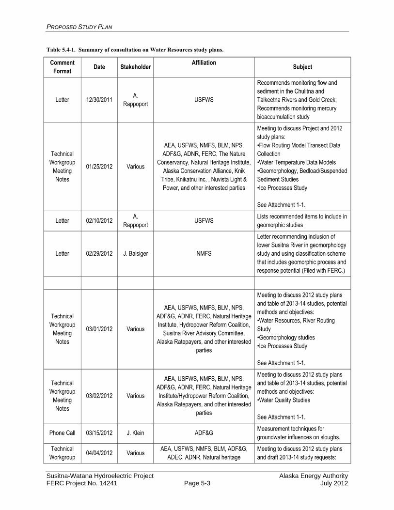
A summary of consultations relevant to water quality resources is provided in Table 5.4-1.
PROPOSED STUDY PLAN
Susitna-Watana Hydroelectric Project Alaska Energy Authority FERC Project No. 14241 Page 5-3 July 2012
Table 5.4-1. Summary of consultation on Water Resources study plans.
Comment Format
Date Stakeholder Affiliation
Subject
Letter 12/30/2011 A.
Rappoport USFWS
Recommends monitoring flow and sediment in the Chulitna and Talkeetna Rivers and Gold Creek; Recommends monitoring mercury bioaccumulation study
Technical Workgroup
Meeting Notes
01/25/2012 Various
AEA, USFWS, NMFS, BLM, NPS, ADF&G, ADNR, FERC, The Nature
Conservancy, Natural Heritage Institute, Alaska Conservation Alliance, Knik
Tribe, Knikatnu Inc, , Nuvista Light & Power, and other interested parties
Meeting to discuss Project and 2012 study plans: •Flow Routing Model Transect Data Collection •Water Temperature Data Models •Geomorphology, Bedload/Suspended Sediment Studies •Ice Processes Study See Attachment 1-1.
Letter 02/10/2012 A.
Rappoport USFWS
Lists recommended items to include in geomorphic studies
Letter 02/29/2012 J. Balsiger NMFS
Letter recommending inclusion of lower Susitna River in geomorphology study and using classification scheme that includes geomorphic process and response potential (Filed with FERC.)
Technical Workgroup
Meeting Notes
03/01/2012 Various
AEA, USFWS, NMFS, BLM, NPS, ADF&G, ADNR, FERC, Natural Heritage Institute, Hydropower Reform Coalition,
Susitna River Advisory Committee, Alaska Ratepayers, and other interested
parties
Meeting to discuss 2012 study plans and table of 2013-14 studies, potential methods and objectives: •Water Resources, River Routing Study •Geomorphology studies •Ice Processes Study See Attachment 1-1.
Technical Workgroup
Meeting Notes
03/02/2012 Various
AEA, USFWS, NMFS, BLM, NPS, ADF&G, ADNR, FERC, Natural Heritage Institute/Hydropower Reform Coalition,
Alaska Ratepayers, and other interested parties
Meeting to discuss 2012 study plans and table of 2013-14 studies, potential methods and objectives: •Water Quality Studies See Attachment 1-1.
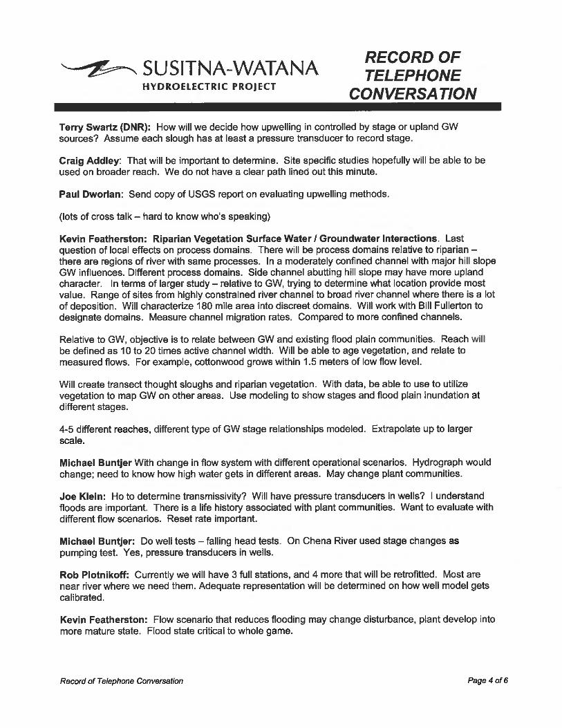
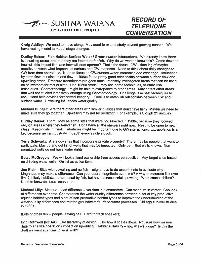
Phone Call 03/15/2012 J. Klein ADF&G Measurement techniques for groundwater influences on sloughs.
Technical Workgroup
04/04/2012 Various AEA, USFWS, NMFS, BLM, ADF&G,
ADEC, ADNR, Natural heritage Meeting to discuss 2012 study plans and draft 2013-14 study requests:
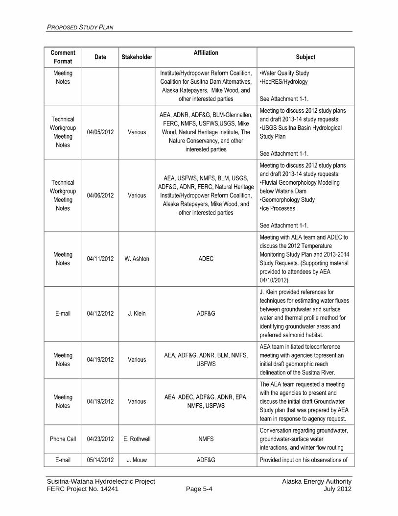
PROPOSED STUDY PLAN
Susitna-Watana Hydroelectric Project Alaska Energy Authority FERC Project No. 14241 Page 5-4 July 2012
Comment Format
Date Stakeholder Affiliation
Subject
Meeting Notes
Institute/Hydropower Reform Coalition, Coalition for Susitna Dam Alternatives, Alaska Ratepayers, Mike Wood, and
other interested parties
•Water Quality Study •HecRES/Hydrology See Attachment 1-1.
Technical Workgroup
Meeting Notes
04/05/2012 Various
AEA, ADNR, ADF&G, BLM-Glennallen, FERC, NMFS, USFWS,USGS, Mike Wood, Natural Heritage Institute, The
Nature Conservancy, and other interested parties
Meeting to discuss 2012 study plans and draft 2013-14 study requests: •USGS Susitna Basin Hydrological Study Plan See Attachment 1-1.
Technical Workgroup
Meeting Notes
04/06/2012 Various
AEA, USFWS, NMFS, BLM, USGS, ADF&G, ADNR, FERC, Natural Heritage Institute/Hydropower Reform Coalition, Alaska Ratepayers, Mike Wood, and
other interested parties
Meeting to discuss 2012 study plans and draft 2013-14 study requests: •Fluvial Geomorphology Modeling below Watana Dam •Geomorphology Study •Ice Processes See Attachment 1-1.
Meeting Notes
04/11/2012 W. Ashton ADEC
Meeting with AEA team and ADEC to discuss the 2012 Temperature Monitoring Study Plan and 2013-2014 Study Requests. (Supporting material provided to attendees by AEA 04/10/2012).
E-mail 04/12/2012 J. Klein ADF&G
J. Klein provided references for techniques for estimating water fluxes between groundwater and surface water and thermal profile method for identifying groundwater areas and preferred salmonid habitat.
Meeting Notes
04/19/2012 Various AEA, ADF&G, ADNR, BLM, NMFS,
USFWS
AEA team initiated teleconference meeting with agencies topresent an initial draft geomorphic reach delineation of the Susitna River.
Meeting Notes
04/19/2012 Various AEA, ADEC, ADF&G, ADNR, EPA,
NMFS, USFWS
The AEA team requested a meeting with the agencies to present and discuss the initial draft Groundwater Study plan that was prepared by AEA team in response to agency request.
Phone Call 04/23/2012 E. Rothwell NMFS Conversation regarding groundwater, groundwater-surface water interactions, and winter flow routing
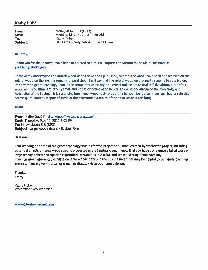
E-mail 05/14/2012 J. Mouw ADF&G Provided input on his observations of

PROPOSED STUDY PLAN
Susitna-Watana Hydroelectric Project Alaska Energy Authority FERC Project No. 14241 Page 5-5 July 2012
Comment Format
Date Stakeholder Affiliation
Subject
the role of large woody debris in the Susitna River
E-mail, phone call
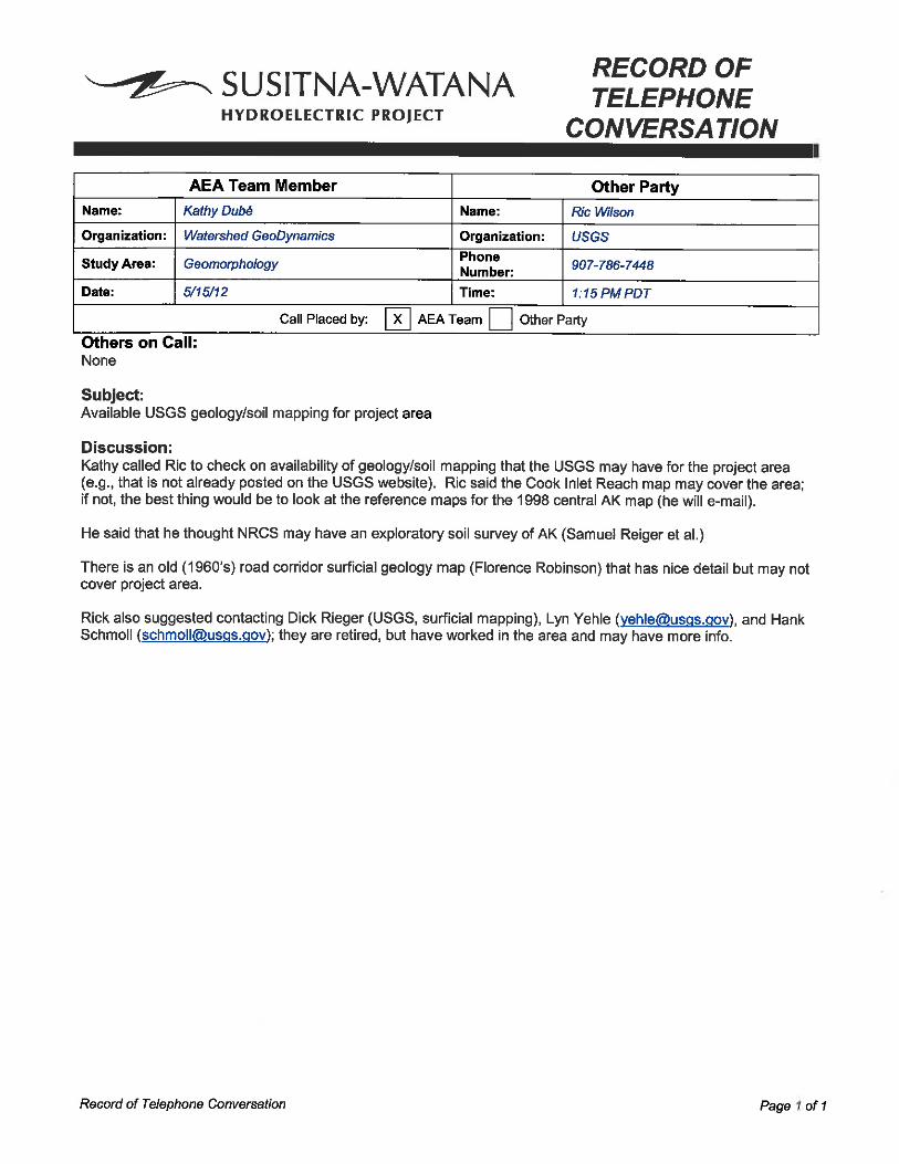
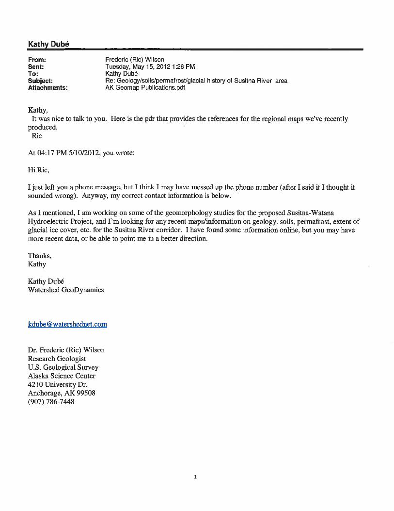
05/15/2012 R.Wilson USGS Provided information and contacts re: existing geologic mapping
Phone Call 05/17/2012 E. Rothwell NMFS Groundwater Study Plan Request Questions
Phone Call 05/17/2012 J. Klein ADF&G Groundwater Study Request Questions
Phone Call, Letter
05/18/2012, 05/23/2012
R. Henzey USFWS Groundwater Study Request Comments
Technical Workgroup
Meeting Notes
06/13/2012 Various
AEA, USFWS, NMFS, ADF&G, ADEC, ADNR, BLM, EPA, USGS, FERC,
Natural Heritage Institute/Hydropower Reform Coalition, Alaska Ratepayers, Coalition for Susitna Dam Alternatives
and other interested parties
Meeting to discuss draft 2013-14 study plans, licensing participant comments and licensing participant study requests: •Baseline Water Quality Study •Water Quality Modeling Study •Instream Flow and Groundwater-related Aquatic Habitat Studies •Riparian Instream Flow Study See Attachment 1-1.
Technical Workgroup
Meeting Notes
06/14/2012 Various
AEA, USFWS, BLM, NMFS, Coalition for Susitna River Dam Alternatives, EPA, ADF&G, ADNR, NPS, USGS,
Natural Heritage Institute/Hydropower Reform Coalition, FERC, and other
interested parties
Meeting to discuss draft 2013-14 study plans, licensing participant comments and stakeholder study requests: •Geomorphology and Fluvial •Geomorphology Modeling Studies •Ice Processes Study See Attachment 1-1.
E-mail, phone call
06/21/2012 R. Gerlach ADEC Background data and methods for previous mercury studies
E-mails 07/02/2012, 07/10/2012
J. Labenski ADNR
Correspondence regarding permit for water quality monitoring stations on State lands; changed a few site locations due to lack of private property access.
E-mail 07/10/2012 – 07/11/2012
D. Griffin ADNR
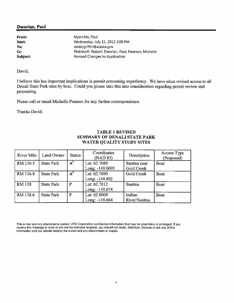
Correspondence regarding permit for water quality monitoring stations on Denali State Park lands; changed access to sites from helicopter to boat to expedite permit approval.

PROPOSED STUDY PLAN
Susitna-Watana Hydroelectric Project Alaska Energy Authority FERC Project No. 14241 Page 5-6 July 2012
5.5. Baseline Water Quality Study
5.5.1. General Description of the Proposed Study
The collective goal of the water quality studies is to assess the effects of the proposed Susitna-Watana Project (Project) operations on water quality in the Susitna River basin, which will inform development of any appropriate PM&E measures. Project operations are expected to change some of the water quality characteristics of the resulting riverine portion of the drainage once the dam is in place as well as the inundated area that will become the reservoir.
The objectives of the Baseline Water Quality Study are to:
Document historical water quality data and combine with data generated from this study. The combined data set will be used in the water quality modeling study to predict Project impacts under various operations (Section 5.6).
Add three years of current stream temperature and meteorological data to the existing data.
Develop a monitoring program to adequately characterize surface water physical, chemical, and bacterial conditions in the Susitna River within and downstream of the proposed Project area.
Measure baseline metals concentrations in sediment and fish tissue for comparison to state criteria.
Perform a pilot thermal imaging assessment of a portion of the Susitna River. If the pilot assessment is successful, it may be expanded to develop a detailed map of thermal refugia throughout the Project area.
5.5.2. Existing Information and Need for Additional Information
Historical water quality data available for the study area includes water temperature data, some general water quality data, and limited metals data primarily collected during the 1980s. Additional data has been recently collected at limited mainstem Susitna sites describing flow, in-situ, general, and metals parameters by United States Geological Survey (USGS). A data gap analysis was conducted for water quality and sediment transport in 2011 (URS 2011) summarizing mainstem and tributary data available.
A large-scale assessment of water quality conditions throughout the Susitna drainage has not been completed. The proposed overall assessment will be used to establish natural background water quality parameters. This need was identified in the Data Gap Analysis for Water Quality, URS 2011) that determined the spatial coverage of water quality characterizations, the time period during which water quality conditions were described, and specific data gaps that required further data collection to adequately evaluate the current status of water quality in the drainage. The following is a summary of existing water quality data:
Lower Susitna from Cook Inlet to the Susitna – Chulitna –Talkeetna confluence (River Mile 0-99)
Large amounts of data were collected in this reach during the 1980s. Very little data are available that describe current water quality conditions.
PROPOSED STUDY PLAN
Susitna-Watana Hydroelectric Project Alaska Energy Authority FERC Project No. 14241 Page 5-7 July 2012
Metals data are not available for the mouth of the Chulitna River. The influence of major tributaries (Chulitna and Talkeetna rivers) on Susitna River water quality conditions is unknown. There are no monitoring stations in receiving water at these mainstem locations.
Metals data are not available for the Skwentna River or the Yentna River. Continuous temperature data, general water quality data, and metals data are not available
for the Susitna River mainstem and sloughs potentially used for spawning and rearing habitat.
Middle Susitna River and tributaries from the Susitna – Chulitna–Talkeetna confluence to the mouth of Devil’s Canyon (River Mile 99-150)
The source(s) for metals detected at high concentrations in the mainstem Susitna River are unknown.
Current data reflects large spatial data gaps between upper river and the mid- to lower portion of the river.
Continuous temperature data are not available for Susitna River mainstem, tributary, and sloughs potentially used for spawning and rearing.
Middle Susitna River from Devil’s Canyon to the proposed Susitna-Watana Dam site (River Mile 150-184)
Temperature data are not available above and below most tributaries on the mainstem Susitna River.
Overall, very limited surface water data are available for this reach. Metals monitoring data do not exist or are limited. Concentrations of metals in sediment immediately below the proposed Project are
unknown. Metals in these sediments may become mobile once the Project begins operation.
Monitoring of Susitna River mainstem and sloughs (ambient conditions and metals) is needed for determining the potential for metal bioaccumulation in fishes.
Upper Susitna River including headwaters and tributaries above the proposed Susitna-Watana Dam site (River Mile 184-313)
Surface water and sediment analysis for metals are not available for the Susitna River mainstem, only for one tributary.
Information on concentrations of metals in media and current water quality conditions is needed to predict if toxics can be released in a reservoir environment.
Continuous temperature data are not available for Susitna River mainstem, tributary, and sloughs potentially used for spawning and rearing.
Water temperature monitoring was primarily done in the middle river portion of the Project area during the 1980s. The purpose for collection of this data was to model post-dam temperature conditions and to predict the potential for impact on thermal refugia for fish downstream of the proposed dam site. The current proposal includes expansion of the temperature monitoring effort to include the Project area from RM 10.1 to RM 233.4; encompassing both the lower end of the riverine portion of the Project area and above the proposed area of inundation by the reservoir.
PROPOSED STUDY PLAN
Susitna-Watana Hydroelectric Project Alaska Energy Authority FERC Project No. 14241 Page 5-8 July 2012
An expanded network of continuous temperature monitoring data and water quality data (including sediment, surface water, potentially pore water) collection is required for this project because
More information is needed to define existing thermal refugia throughout the Susitna drainage.
Limited information is available on natural, background conditions for water quality. It is unknown if seasonal patterns exist for select water quality parameters. Additional information is required for calibrating the water quality model to be used in
the water quality model (Section 5.6). More recent water quality data will be used for predicting reservoir conditions and predicting riverine conditions downstream of the proposed dam.
An expanded network of water quality and temperature monitoring sites is proposed from approximately RM 10 to RM 234. Monitoring sites are located at the same sites characterized during the 1980s studies, as well as additional sites. Monitoring of areas of the mainstem Susitna River or tributaries with high metals concentrations or temperature measurements (based on the Data Gap Analysis for Water Quality, URS 2011) will confirm previous observations and will describe the persistence of any water quality exceedances that might exist.
Locations in the mainstem Susitna River and tributaries where high metals concentrations were historically identified in surface water lack sediment analysis data to determine potential sources that can be mobilized. The linkage between sediment sources, mobilization into the water column (dissolved form), and the potential for bioaccumulation in fish tissue presents a human health concern with respect to mercury contamination. The consumption of mercury in fish tissue will be addressed by co-locating a limited number of surface water, sediment, and fish tissue monitoring sites (and sampling events) where there is the greatest likelihood for bioaccumulation. The proposed Project may have the potential to exacerbate bioaccumulation of toxics beyond that occurring under current conditions. The initial monitoring will identify select monitoring locations and media (e.g., surface water, pore water, and sediment) for sampling and suggest the need for more detailed, site-specific sampling if a potential risk from bioaccumulation is found.
The available historical data are not continuous over time or over spatial areas of the Susitna drainage. The discontinuities in the data record limit the opportunity for conducting a complete assessment of current water quality conditions that define natural background, the spatial extent of higher than expected concentrations of metals (and select parameters), and identification of source and timing of pollutant entry into the Susitna drainage. Expanding the data record beyond existing information will be used to develop a model of the proposed reservoir and for projecting water quality changes in the existing riverine system resulting from reservoir operations.
5.5.3. Study Area
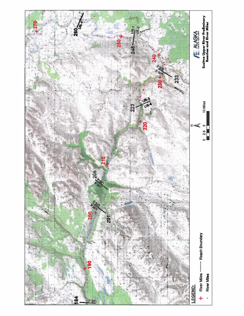
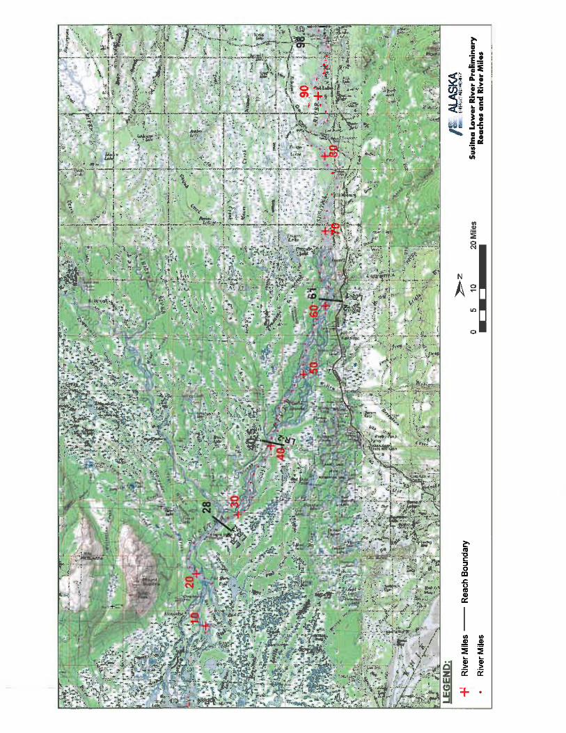
The study area includes the Susitna River and from RM 10.1 to RM 233.4, and select tributaries within the proposed transmission lines and access corridors. Water quality and water temperature data loggers will be installed at 39 sites identified in Table 5.5-1 and Figure 5.5-1 as part of the 2012 Baseline Water Quality Study. The lowermost boundary of the monitoring activity is above the area protected for Beluga whale activity.
PROPOSED STUDY PLAN
Susitna-Watana Hydroelectric Project Alaska Energy Authority FERC Project No. 14241 Page 5-9 July 2012
5.5.4. Study Methods
The Baseline Water Quality Study has several components that address needs for water quality modeling and for detecting the location and magnitude of water quality issues. This study plan has been modified in response to comments from various agency reviewers, including the National Marine Fisheries Service (NMFS) and the U.S. Fish and Wildlife Service (USFWS). Consultation on the study plan occurred during licensing participant meetings on April 6, 2012 and June 14, 2012 Water Resources Technical Work Group (TWG) June 14, 2012. At the June TWG meeting, study requests and comments from the various licensing participants were presented, discussed and refinements determined to address agreed upon modifications to the study plans (Table 5.4-1).
Data will be collected from multiple aquatic media including surface water, sediment, and fish tissue. The fish tissue collection will be conducted as part of Study Plan 7.5/7.6 (Study of Fish Distribution and Abundance in the Upper Susitna River and the Middle/Lower Susitna River, respectively). Tissue or whole fish samples will be collected in the mainstem Susitna River under Study Plan 7.5 and Study Plan 7.6 for use in analysis of potential for bioaccumulation. Continuous temperature monitoring will inform the predictive model on how the mainstem river and tributaries will respond to load-following from the dam and if changes in water quality conditions could affect aquatic life use and survival in the Project area. In addition, several other requirements of the 401 Water Quality Certification Process will be addressed with collection and description of additional data including the following:
conducting a water quality baseline assessment; description of how existing and designated uses are met; use of appropriate field methods and models; use of acceptable data quality assurance methods; scheduling of technical work to meet deadlines; and derivation of load calculations of potential pollutants (pre-Project conditions).
Two types of water quality monitoring activities will be implemented: 1) routine monitoring for characterizing water quality baseline conditions, and 2) a single, comprehensive survey for a larger array of parameters. Frequency of sampling water quality parameters varies by category and potential for mobilization and bioavailability. Most of the general water quality parameters and select metals will be sampled on a monthly basis since each parameter has been demonstrated to be present in one or both of surface water and sediment (URS 2011). An initial screening survey has been proposed for several other toxics that might be detected in sediment and tissue samples (Table 5.5-4). The single surveys for toxics in sediment, tissue, or water will trigger additional study for extent of contamination and potential timing of exposure if results exceed criteria or thresholds (e.g., LAETs, LC50s, etc.). The general list of water quality parameters and metals will be used in calibrating the water quality model (Section 5.6) in both a riverine and reservoir environment.
Twelve mainstem Susitna River monitoring sites are located below the proposed dam site and two mainstem sites above this location. Five sloughs will be monitored that represent a combination of physical settings in the drainage and that are known to support important fish-rearing habitat. Tributaries to the Susitna River will be monitored and include those contributing large portions of the lower river flow like the Talkeetna, Chulitna, Deshka, and Yentna rivers. A

PROPOSED STUDY PLAN
Susitna-Watana Hydroelectric Project Alaska Energy Authority FERC Project No. 14241 Page 5-10 July 2012
partial list of the remaining tributaries that will be monitored represent important spawning and rearing habitat for anadromous and resident fisheries and include: Gold Creek, Portage Creek, Tsusena Creek, Watana Creek, and Oshetna Creek. The operation of temperature monitoring sites will continue as part of water quality monitoring activities in 2013/2014. These sites were selected based on the following rationale:
Adequate representation of locations throughout the Susitna River and tributaries above and below the proposed dam site for the purpose of a baseline water quality characterization;
Location on tributaries where proposed access road-crossing impacts might occur during and after construction (upstream/downstream sampling points on each crossing);
Preliminary consultation with AEA and licensing participants including co-location with other study sites (e.g., instream flow, ice processes);
Access and land ownership issues; and Eight of the sites are mainstem monitoring sites that were previously used for SNTEMP
modeling in the 1980s. Thirty-one of the sites are Susitna River mainstem, tributary, or slough locations, most of which were monitored in the 1980s.
Monitoring sites are spaced at approximately 5 mile intervals so that the various factors that influence water quality conditions are captured and support the development (and calibration) of the water quality model. Frequency of sites along the length of the river is important for capturing localized effects from tributaries and from past and current human activity.
5.5.4.1. Water Temperature Data Collection
Water temperatures will be recorded in 15-minute intervals using Onset TidbiT v2 water temperature data loggers (or equivalent instrumentation). Data collection will occur between late June 2012 and the end of December 2012. Deployment and continuous temperature data logging will resume for each of the two following years (2013 and 2014) using the same apparatus and deployment strategy at all 39 sites. The TidbiT v2 (or equivalent) has a precision sensor for plus or minus 0.4 degrees Fahrenheit (°F) (0.2 degrees Celsius [°C]) accuracy over an operational range of -4 °F to 158 °F (-20 °C to 70 °C). Data readout is available in less than 30 seconds via an Optic USB interface.
To reduce the possibility of data loss, a redundant set of data loggers will be used at each site. In general, the two sets of sensors will be installed differently (depending on site characteristics). One logger will be inserted into the bottom of an 8.2-foot (2.5-meter) length of perforated steel pipe housing which is fastened to a large bank structure via clamps and rock bolts. The logger will be attached to a rope which allows it to be easily retrieved for downloads. The top pipe cap will contain a locking mechanism which can only be opened using the appropriate Allen key to prevent theft or vandalism. The second set of temperature loggers will be anchored to a concrete block and buoyed to record continuous bottom, mid, and surface temperature conditions throughout the water column (fewer temperature loggers may be deployed depending on site characteristics). The anchor block will be placed at a channel location that is accessible during routine site visits and will be attached with a steel cable to a post which is driven into the bank or to some other structure. The proposed installation procedures may require some alteration based on site specific conditions.
PROPOSED STUDY PLAN
Susitna-Watana Hydroelectric Project Alaska Energy Authority FERC Project No. 14241 Page 5-11 July 2012
The sensors will be situated in the river to record water temperatures which are representative of the mainstem or slough being monitored, avoiding areas of groundwater upwelling, unmixed tributary flow, direct sun exposure, and isolated pools that may affect the quality of the data.
The 2012 Instream Flow Study will install water-level loggers with temperature recording capability at several study sites that are yet to be determined. Where these study sites overlap the water temperature monitoring study sites (Figure 5.5-1), the water-level logger temperature sensors may be used. However, a redundant TidbiT v2 would be deployed at these sites for backup temperature recording.
5.5.4.2. Meteorological Data Collection
Meteorological (MET) data collection stations will be installed and/or upgraded at up to 8 locations during 2012 between RM 224 and RM 25.6. Table 5.5-2 lists the MET station locations. The exact location will depend on access and suitability of an appropriate site for installation.
The two MET stations near the Susitna-Watana Dam site need to be established at specific locations as requested by Project design engineers. The upland MET station will record snowfall data and precipitation. The upland MET station will be established at about the 2,300 foot elevation on the north side of the river, in the area of the proposed field camp. The near river site MET station will be located on the north abutment just above river level depending on suitability of location for establishing the structure.
Existing MET stations will be fitted with additional monitoring equipment to expand data collection that meets project needs and to use historical information collected from each of these sites (Table 5.5-2). Data records from other studies will be used, wherever available, to help generate information for the required parameters needed for construction of the water quality models (Section 5.7). The linkage between historical records and continuing data records may be used in evaluating the utility of 1980s temperature data for modeling.
MET stations are spatially distributed on the Susitna River from RM 25.8 to RM 224.0 and represent a range of distinct physical settings throughout the Project area. Data from these MET stations will be combined with data from three MET stations that will be installed in the upper Susitna basin by the Glacier and Runoff Changes Study (Section 5.11). Additional MET station sites may be necessary if current site placement is inadequate to represent the needs of water quality model development. Parameters measured by each of the MET stations will be compared with the nearest down-gradient site and evaluated for adequacy of representation of weather conditions in that reach. If data recorded between successive sites are distinctly different, then additional sites will be proposed so that weather descriptions for use in the water quality model calibration phase (Section 5.6) will be improved with greater detail.
5.5.4.2.1. MET Station Parameters
MET stations will collect parameters that support the activities of the engineering design team and the development of the water quality temperature model. Snow depth will be estimated from the precipitation gage with the onset of the winter season. Evapotranspiration is measurable within deciduous canopies; however, the MET Station placement will not be under vegetation canopies so that parameters (like wind speed, etc.) necessary for establishing conditions on the

PROPOSED STUDY PLAN
Susitna-Watana Hydroelectric Project Alaska Energy Authority FERC Project No. 14241 Page 5-12 July 2012
reservoir can be measured. The following is a comprehensive list of parameters required for use in this Project and will be measured by each of the MET stations:
Temperature (maximum, minimum, mean) Relative humidity Barometric pressure Precipitation Wind speed (maximum, minimum, mean) Wind direction Wind gust (maximum) Wind gust direction Solar degree days
5.5.4.2.2. MET Station Installation and Monitoring Protocol
Each MET station will consist of, at a minimum, a 10-foot (3-meter) tripod with mounted monitoring instrumentation to measure the parameters identified above (Figure 5.5-2). The station loggers will have sufficient ports and programming capacity to allow for the installation of instrumentation to collect additional MET parameters as required. Such installation and re-programming can occur at any time without disruption of the data collection program.
MET station installation is intended to provide instrumentation that will work continuously with little maintenance and produce high quality data through a telemetry system.
A Campbell Scientific CR1000 data logger will be used to record data. The archiving interval for all MET parameters will be 15 minutes, with a 2-year storage capacity. The MET station will be powered by a 12 Vdc 8 amp-hour battery and a 20-watt solar panel complete with charge regulator.
To protect the stations from wildlife intrusion and to discourage any potential vandalism, the stations will be protected by fencing as appropriate.
5.5.4.2.3. Satellite or Radio Telemetry Communications System
Real-time data will be downloaded from MET stations using satellite transmission or radio telemetry hardware. This will enable study staff to download, inspect, and archive the data as well as monitor station operational parameters for signs of problems without visiting the site. The communication will ensure that problems, if they occur, are resolved promptly to minimize data loss between service periods.
5.5.4.3. Baseline Water Quality Monitoring
The purpose of the Baseline Water Quality Study is to collect baseline water quality information that will support an assessment of the effects of the proposed Project operations on water quality in the Susitna River basin.
Baseline water quality collection can be broken into two components: in-situ water quality sampling and general water quality sampling. In-situ water quality sampling consists of on-site monthly measurements of physical parameters at fixed locations using field equipment. General water quality sampling will consist of monthly grab samples that will be sent to an off-site laboratory for analysis. The laboratory will have at a minimum, National Environmental

PROPOSED STUDY PLAN
Susitna-Watana Hydroelectric Project Alaska Energy Authority FERC Project No. 14241 Page 5-13 July 2012
Laboratory Accreditation Program (NELAP) Certification in order to generate credible data for use by state, federal, and tribal regulatory programs for evaluating current and future water quality conditions. In general, these samples represent water quality components that cannot be easily measured in-situ, such as metals concentrations, nitrates, etc.
Water quality data collection will be at the locations in bold in Table 5.5-1. The initial sampling will be expanded if general water quality, metals in surface water, or metals in fish tissue exceed criteria or thresholds. Additional contiguous sample sites will be visited on this list beginning the following sampling month wherever criteria or thresholds have been exceeded by individual parameters. This proposed spacing follows accepted practice when segmenting large river systems for development of Total Maximum Daily Load (TMDL) water quality models. Sampling during winter months will be focused on locations where flow data is currently collected (or was historically collected by the USGS) and will be used for water quality modeling (Section 5.7).
5.5.4.3.1 Monitoring Parameters
Water quality samples will be analyzed for several parameters reported in Table 5.5-3. Metals monitoring for total and dissolved fractions in surface water include the full set of parameters used by ADEC in fish health consumption screening. The creation of a reservoir and potential alteration of surface water downstream of the proposed dam site may change characteristics of groundwater in the upper and middle Susitna basin. The water quality parameters identified in Table 5.5-3 will address the influence surface water may have on adjoining groundwater supplies in the vicinity of each sampling site. Changes to groundwater quality may have an effect on drinking water supplies so several parameters included on the inorganic chemical contaminants list have been included as part of this sampling program (ADEC 2003). The criteria that will be used for comparison with sampling results are the drinking water primary maximum contaminant levels.
Additional parameters will be measured from all sites in a single survey that occurs during low water conditions (e.g., August/September) in the Susitna basin. The following is a list of pollutants for which Alaska Water Quality Standards has established water quality criteria (18 ACC 70.020(b)) for protecting designated uses in freshwater:
Continuous temperature monitoring program
— Temperature, already included as part of the continuous temperature monitoring program.
In-situ monitoring program
— pH, included as part of the monthly water quality sampling routine.
— Color, categorical observation.
— Residues, categorical assessment (floating solids, debris, sludge, deposits, foam, or scum).
General water quality program
— Dissolved gas, included in the monitoring program (Dissolved Oxygen).
— Dissolved inorganic substances (Total Dissolved Solids), included in monthly monitoring.

PROPOSED STUDY PLAN
Susitna-Watana Hydroelectric Project Alaska Energy Authority FERC Project No. 14241 Page 5-14 July 2012
— Turbidity, already included as part of the monthly water quality sampling routine.
— Toxic and other deleterious organic and inorganic, already included in monitoring for metals and mercury/methyl-mercury (organometals).
One time survey
— Fecal coliform bacteria, included in monthly monitoring.
— Sediment, already included in assessing mercury and other metals from sediments.
— Petroleum Hydrocarbons, oil, and grease, included in a one-time survey.
— Radioactivity; radionuclide concentrations to be generated from surface water samples.
— Toxic and other deleterious organic and inorganic, already included in monitoring for metals and mercury/methyl-mercury (organometals).
Water quality parameters above that do not exceed Alaska Water Quality Standards will not be collected in succeeding months; the exception are those parameters in Table 5.5-4 associated with monthly sample collection from surface water.
5.5.4.3.2 Sampling Protocol
Water quality grab samples will be collected during each site visit in a representative portion of the stream channel/water body, using methods consistent with Alaska State and EPA protocols for sampling ambient water and trace metal water quality criteria.
Mainstem areas of the river not immediately influenced by a tributary will be characterized with a single grab sample. Areas of the mainstem with an upstream tributary that may influence the nearshore zone or is well-mixed with the mainstem will be characterized by collecting samples at two locations: in the tributary and in the mainstem upstream of the tributary confluence. All samples will be collected from a well-mixed portion of the river/tributary.
These samples will be collected on approximately a monthly basis (4 samples from June to September) and used for calibrating the same model framework used for predicting temperature. The period for collecting surface water samples will begin at ice break-up and extend to beginning of ice formation on the river. Limited winter sampling (once in December, and again in March) will be conducted where existing or historic USGS sites are located. Review of existing data (URS 2011) indicated that few criteria exceedances occur with metals concentrations during the winter months. Initial assessment of this existing data suggests that samples be collected twice during the winter months for analysis of early and late season conditions. If the 2013 data sets suggest that metals and other general water quality parameters exceed criteria or thresholds then an expanded 2014 water quality monitoring program will be conducted to characterize conditions on a monthly basis throughout the winter months.
Water quality indicators like conductivity (specific conductance) has been suggested as a surrogate measure for transfer of metals from groundwater to surface water or in mobilization of metals within the river channel. Available USGS data from select continuous gaging stations will be reviewed for increases in specific conductance during monthly and seasonal intervals, and these results will be used to determine if further metals sampling is warranted during additional winter months.
PROPOSED STUDY PLAN
Susitna-Watana Hydroelectric Project Alaska Energy Authority FERC Project No. 14241 Page 5-15 July 2012
Water samples will be collected using an appropriate sample container upstream of any agitated water that has been mixed either by a boat or walking.
Variation of water quality in a river cross-section is often significant and is most likely to occur because of incomplete mixing of upstream tributary inflows, point-source discharges, or variations in velocity and channel geometry. It is possible that a flow-integrated sampling technique employed by USGS known as the equal width increment/equal transit rate (EWI) method (Edwards and Glysson 1988, Ward and Harr 1990) will be used. In this method, an isokinetic sampling device (a sampler that allows water to enter without changing its velocity relative to the stream) is lowered and raised at a uniform transit rate through equally-spaced vertical increments in the river cross-section. This can be done either by wading with hand-held samplers or from a boat using a winch mounted sampler, depending on river stage and flow conditions. The number of vertical increments used will differ between sites depending upon site specific conditions.
Additional details of the sampling methods will be provided in the Sampling and Analysis Plan (SAP) and the Quality Assurance Project Plan (QAPP) for this study.
In-Situ Water Quality Sampling. During each site visit, in-situ measurements of dissolved oxygen, pH, specific conductance, redox potential, turbidity, and water temperature will be made. A Hanna Instruments HI 98703 Portable Turbidity Meter will be used to measure turbidity, while a Hydrolab® datasonde (MS5) will be used to measure the remaining field parameters during each site visit. Continuous turbidity measurement may be conducted with the Hydrolab datasonde at select locations (e.g., former/current USGS sites where turbidity data is available from the 1980s) and operated during summer and winter conditions. The following list of former and current USGS mainstem Susitna River monitoring sites will be considered for continuous turbidity monitoring: Susitna Station, Sunshine, Gold Creek, Tsusena Creek, and near Cantwell. These locations have historic and current flow data that will be used in water quality modeling (Section 5.7) of effects on turbidity from Project operations. Standard techniques for pre- and post-sampling calibration of in-situ instrumentation will be used to ensure quality of data generation and will follow accepted practice. If calibration failure is observed during a site visit field data will be corrected according to equipment manufacturer’s instructions.
General Water Quality Sampling. Sampling will avoid eddies, pools, and deadwater. Sampling will avoid unnecessary collection of sediments in water samples, and touching the inside or lip of the sample container. Samples will be delivered to EPA approved laboratories within the holding time frame. Each batch of samples will have a separate completed chain of custody sheet. A field duplicate will be collected for 10 percent of samples (i.e., 1 for every 10 water grab samples). Laboratory quality control samples including duplicate, spiked, and blank samples will be prepared and processed by the laboratory.
Quality Assurance/Quality Control (QA/QC) samples will include field duplicates, matrix spikes, duplicate matrix spikes, and rinsate blanks for non-dedicated field sampling equipment. The results of the analyses will be used in data validation to determine the quality, bias and usability of the data generated.
Sample numbers will be recorded on field data sheets immediately after collection. Samples intended for the laboratory will be stored in coolers and kept under the custody of the field team at all times. Samples will be shipped to the laboratory in coolers with ice and cooled to approximately 4 °C. Chain of custody records and other sampling documentation will be kept in
PROPOSED STUDY PLAN
Susitna-Watana Hydroelectric Project Alaska Energy Authority FERC Project No. 14241 Page 5-16 July 2012
sealed plastic bags (Ziploc®) and taped inside the lid of the coolers prior to shipment. A temperature blank will accompany each cooler shipped. Packaging, marking, labeling, and shipping of samples will be in compliance with all regulations promulgated by the U. S. Department of Transportation in the Code of Federal Regulations, 49 CFR 171-177.
Water quality samples will be labeled with the date and time that the sample is collected and preserved/filtered (as appropriate), then stored and delivered to a state-certified water quality laboratory for analyses in accordance with maximum holding periods. A chain of custody record will be maintained with the samples at all times.
The state-certified laboratory will report (electronically and in hard copy) each chemical parameter analyzed with the laboratory method detection limit, reporting limit, and practical quantification limit. The laboratory will attempt to attain reporting detection limits that are at or below the applicable regulatory criteria and will provide all laboratory QA/QC documentation.
The procedures used for collection of water quality samples will follow protocols from Alaska Department of Environmental Conservation (ADEC) and the EPA Region 10 (Pacific Northwest). Water samples will be analyzed by a laboratory accredited by the ADEC or recognized under the NELAP. Water quality data will be summarized in a report with appropriate graphics and tables with respect to Alaska State Water Quality Standards (ADEC 2005) and any applicable federal standards.
Additional details of the sampling procedures and laboratory protocols will be included in the SAP and QAPP.
5.5.4.4. Sediment Samples for Mercury/Metals in the Reservoir Area
This task was designed to gather specific information on the distribution of Susitna River sediment contaminants of concern in potential source areas. In general, all sediment samples will be taken from sheltered backwater areas, downstream of islands, and in similar riverine locations in which water currents are slowed, favoring accumulation of finer sediment along the channel bottom. Samples will be analyzed for Total Metals, including aluminum, arsenic, cadmium, chromium, copper, iron, lead, mercury, nickel, selenium, and zinc. In addition, sediment size and total organic carbon (TOC) will be included to evaluate whether these parameters are predictors for elevated metal concentrations. Samples will be collected just below and above the proposed dam site. Additional samples will be collected near the mouth of tributaries near the proposed dam site, including Fog, Deadman, Watana, Tsusena, Kosina, Jay, and Goose creeks, and the Oshetna River. The purpose of this sampling will be to determine where metals, if found in the water or sediment, originate in the drainage. Toxics modeling will be conducted to address potential for bioavailability in resident aquatic life. Comparison of bioaccumulation of metals in tissue analysis with results from sediment samples will inform on potential for transfer mechanisms between source and fate.
Most of the contaminants of interest are typically associated with fine sediments, rather than with coarse-grained sandy sediment or rocky substrates. Therefore, the goal of the sampling will be to obtain sediments with at least 5 percent fines (i.e., particle size less than 0.0025 inches [63 micrometers], or passing through a #230 sieve). At some locations, however, larger-sized sediment may be all that are available.
PROPOSED STUDY PLAN
Susitna-Watana Hydroelectric Project Alaska Energy Authority FERC Project No. 14241 Page 5-17 July 2012
The sediment samples will be collected using an Ekman dredge or a modified Van Veen grab sampler. Sampling devices will be deployed from a boat. Samples may also be collected by wading into shallow near shore areas. To the extent possible, samples will consist of the top 6 inches (15 centimeters) of sediment. Comparison of results from the Susitna drainage will be made with other studies for Blue Lake, Eklutna Lake, and Bradley Lake when similar data are available and where physical settings are comparable.
5.5.4.5 Baseline Metals Levels in Fish Tissue
Two screening level tasks will be conducted. The first will be for methyl mercury in sport fish. Methyl mercury bioaccumulates and the highest concentrations are typically in the muscle tissue of adult predatory fish. Final determination of tissue type(s) for analysis will be coordinated with ADEC’s Division of Environmental Health and guidance on fish tissue sampling. Target fish species in the vicinity of the Susitna-Watana Reservoir will be Dolly Varden, Arctic grayling, whitefish species, burbot and resident rainbow trout. If possible, filets will be sampled from 7 adult individuals from each species. Body size targeted for collection will represent the non-anadromous phase of each species life cycle (e.g., Dolly Varden will be 3.5 to 5 inches [90 to 125 millimeters] total length to represent the resident portion of the life cycle). Collection times for fish samples will occur in late August and early September. Filet samples will be analyzed for methyl and total mercury.
Liver samples will also be collected from burbot and analyzed for mercury, methyl-mercury, arsenic, cadmium, and selenium.
Field procedures will be consistent with those outlined in applicable Alaska State and/or EPA sampling protocols (USEPA 2000). Clean nylon nets and polyethylene-gloves will be used during fish tissue collection. The species, fork length, and weight of each fish will be recorded. Fish will be placed in Teflon® sheets and into zipper-closure bags and placed immediately on ice. Fish samples will be submitted to a state-certified analytical laboratory for individual fish muscle tissue analysis. Results will be reported with respect to applicable Alaska State and federal standards.
Results from fish tissue analysis will also be used as a baseline for determining how the proposed Project may increase the potential of current metals concentrations to become bioavailable. The projected water conditions in the reservoir will be estimated and current results for metals concentrations re-evaluated for determining potential toxicities to resident and anadromous fish species. Detection of mercury in fish tissue and sediment will prompt further study of naturally occurring concentrations in soils and plants and how parent geology contributes to concentrations of this toxic in both compartments of the landscape. The focused study will estimate the extent and magnitude of mercury contamination so that an estimate of increased bioavailability might be made once the reservoir inundates areas where high concentrations of mercury are sequestered. Detectable concentrations of mercury may prompt additional sampling and analysis of tissues in the benthic macroinvertebrate community. The bio-magnification of mercury contamination from sediments and plants to the fish community may be facilitated through consumption of contaminated food sources like the benthic macroinvertebrates. Contamination of this component of a trophic level may also be a conduit for mercury biomagnification in waterfowl and other wildlife that consume this food source.
PROPOSED STUDY PLAN
Susitna-Watana Hydroelectric Project Alaska Energy Authority FERC Project No. 14241 Page 5-18 July 2012
5.5.4.6 Pilot Thermal Imaging Assessment of a Portion of the Susitna River
Thermal imagery of a portion of the Susitna River (e.g., 10 miles of the Middle River) will be collected in the 2012 season. Data from the thermal imaging will be ground-truthed and the applicability and resolution of the data will be determined in terms of identifying water temperatures and thermal refugia/upwelling. In coordination with the Instream Flow and fish studies, a determination will be made as to whether thermal imaging data will be applicable and whether or not additional thermal imagery will be collected during the 2013 field season to characterize river temperature conditions.
If the pilot study is successful, then a description of thermal refugia throughout the Project area can be mapped using aerial imagery calibrated with on-the-ground verification. The verification data will be collected at the same time as the aerial imagery (or nearly the same time) using the established continuous temperature monitoring network and additional grab sample temperature readings where there may be gaps, such as in select sloughs. The following elements are important considerations for data collection, specifications for data quality, and strategy for relating digital imagery and actual river surface water temperatures.
5.5.4.6.1 Radiant Temperature
Remotely sensed thermal images allow for spatially distributed measurements of radiant temperatures in the river. Radiant temperature measurements are made only on the surface layer of the water (top 4 inches [10 centimeters]). Temperature readings can vary depending on the amount of suspended sediment in the water and the turbidity of the water. Collection of data will occur near the end of October when the freeze begins and the contrast between cold surface water and warmer groundwater influence is accentuated. The suspended sediment and turbidity will be diminished during this period of the year when the glacial flour content in the water column is reduced from glacial meltwater.
5.5.4.6.2 Spatial Resolution
The key to good data quality is determining the pixel size of the thermal infra-red (TIR) sensor and how that relates to the near-bank environment. Best practice is 3 pure-water pixels (ensures that the digital image represented by any 3 contiguous pixels discriminates water from land). Very fine resolution (0.7 to 3.3 feet [0.2 to 1 meter]) imagery is best used to determine ground water springs and cold-water seeps. Larger pixels can be useful for determining characteristic patterns of latitude and longitude thermal variation in riverine landscapes.
5.5.4.6.3 Calibrating Temperature
Water temps change during the day, therefore measurements should occur near the same time each day and when water temp is most stable (early afternoon). Site selection for validation sampling will be determined by channel accessibility and where there is not known influences of tributaries, or seeps in the area. Hand-held ground imaging radiometers can provide validation as long as the precision is at least as good as that expected from airborne TIR measurements. Availability of historical satellite imagery for thermal analysis will be investigated. Historical thermal imagery may enable exploration of potential trends in water temperature both spatially and temporally.
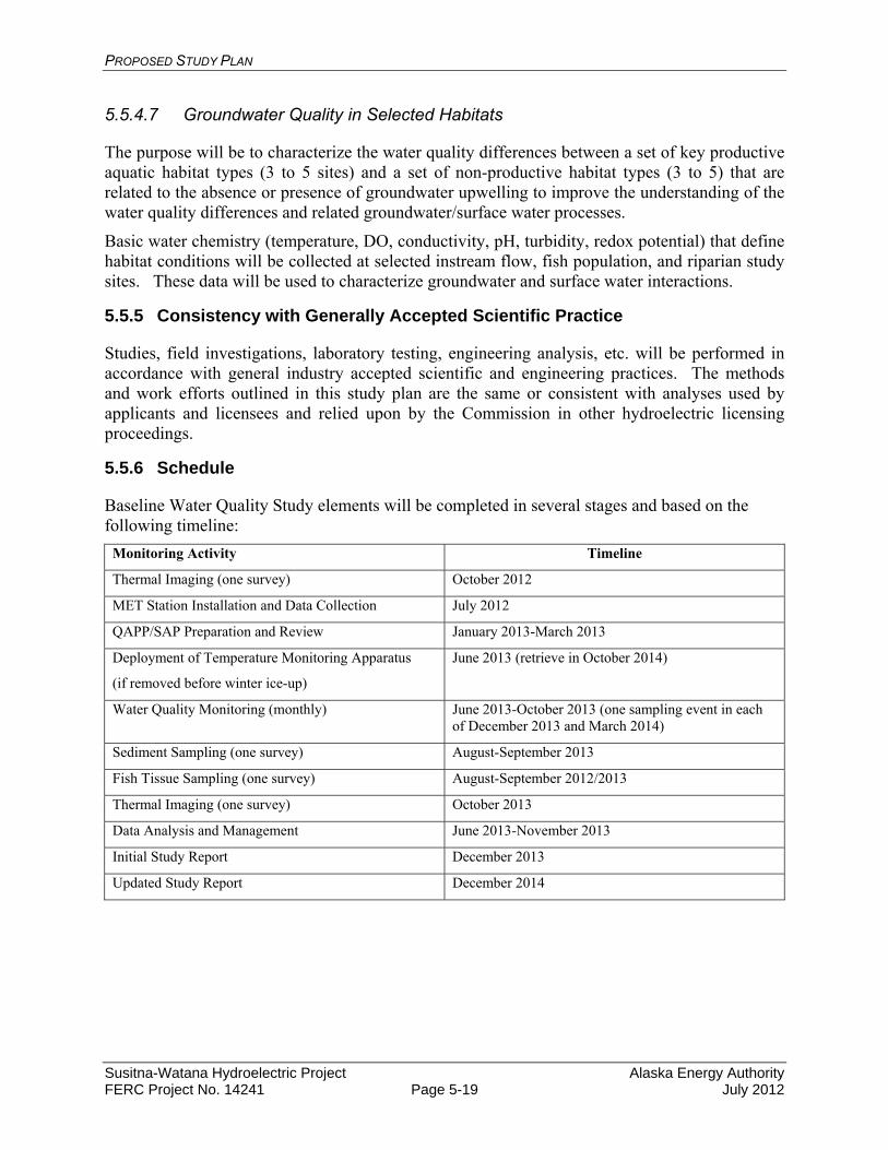
PROPOSED STUDY PLAN
Susitna-Watana Hydroelectric Project Alaska Energy Authority FERC Project No. 14241 Page 5-19 July 2012
5.5.4.7 Groundwater Quality in Selected Habitats
The purpose will be to characterize the water quality differences between a set of key productive aquatic habitat types (3 to 5 sites) and a set of non-productive habitat types (3 to 5) that are related to the absence or presence of groundwater upwelling to improve the understanding of the water quality differences and related groundwater/surface water processes.
Basic water chemistry (temperature, DO, conductivity, pH, turbidity, redox potential) that define habitat conditions will be collected at selected instream flow, fish population, and riparian study sites. These data will be used to characterize groundwater and surface water interactions.
5.5.5 Consistency with Generally Accepted Scientific Practice
Studies, field investigations, laboratory testing, engineering analysis, etc. will be performed in accordance with general industry accepted scientific and engineering practices. The methods and work efforts outlined in this study plan are the same or consistent with analyses used by applicants and licensees and relied upon by the Commission in other hydroelectric licensing proceedings.
5.5.6 Schedule
Baseline Water Quality Study elements will be completed in several stages and based on the following timeline:
Monitoring Activity Timeline
Thermal Imaging (one survey) October 2012
MET Station Installation and Data Collection July 2012
QAPP/SAP Preparation and Review January 2013-March 2013
Deployment of Temperature Monitoring Apparatus
(if removed before winter ice-up)
June 2013 (retrieve in October 2014)
Water Quality Monitoring (monthly) June 2013-October 2013 (one sampling event in each of December 2013 and March 2014)
Sediment Sampling (one survey) August-September 2013
Fish Tissue Sampling (one survey) August-September 2012/2013
Thermal Imaging (one survey) October 2013
Data Analysis and Management June 2013-November 2013
Initial Study Report December 2013
Updated Study Report December 2014
PROPOSED STUDY PLAN
Susitna-Watana Hydroelectric Project Alaska Energy Authority FERC Project No. 14241 Page 5-20 July 2012
5.5.7 Level of Effort and Cost
The estimated cost for the water quality baseline monitoring in the Susitna basin in 2013 and 2014 is approximately $1,500,000, not including the cost of the thermal imaging.
5.5.8 Literature Cited
Alaska Department of Environmental Conservation (ADEC). 2003. Alaska Water Quality Criteria Manual for Toxic and Other Deleterious Organic and Inorganic Substances. Alaska Department of Environmental Conservation: Division of Water. Juneau, Alaska. 51p.
Alaska Department of Environmental Conservation (ADEC). 2005. Water Quality Assessment and Monitoring Program. Alaska Department of Environmental Conservation: Division of Water. Juneau, Alaska. 58p.
Alaska Energy Authority (AEA). 2011. Pre-Application Document: Susitna-Watana Hydroelectric Project FERC Project No. 14241. Volume I of II. Alaska Energy Authority, Anchorage, AK. 395p.
Edwards, T.K., and D.G. Glysson. 1988. Field methods for measurement of fluvial sediment. U.S. Geological Survey Open-File Report 86-531, 118 p.
Ward, J.C., and C.A. Harr (eds.). 1990. Methods for collection and processing of surface-water and bed-material samples for physical and chemical analyses. U.S. Geological Survey Open-File Report 90-140, 71 p.
URS. 2011. AEA Susitna Water Quality and Sediment Transport Data Gap Analysis Report. Prepared by Tetra Tech, URS, and Arctic Hydrologic Consultants. Anchorage, Alaska. 62p.+Appendixes.
U.S. Environmental Protection Agency (USEPA). 2000. Guidance for Assessing Chemical Contaminant Data for use in Fish Advisories: Volume 1 Fish Sampling and Analysis, 3rd Edition. EPA-823-B-00-007. United States Environmental Protection Agency, Office of Water. Washington , D.C. 485p
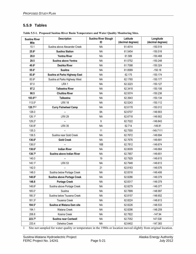
PROPOSED STUDY PLAN
Susitna-Watana Hydroelectric Project Alaska Energy Authority FERC Project No. 14241 Page 5-21 July 2012
5.5.9 Tables
Table 5.5-1. Proposed Susitna River Basin Temperature and Water Quality Monitoring Sites.
Susitna River Mile
Description Susitna River Slough ID
Latitude (decimal degrees)
Longitude (decimal degrees)
10.1 Susitna above Alexander Creek NA 61.4014 -150.519
25.83 Susitna Station NA 61.5454 -150.516
28.0 Yentna River NA 61.589 -150.468
29.5 Susitna above Yentna NA 61.5752 -150.248
40.63 Deshka River NA 61.7098 -150.324
55.01 Susitna NA 61.8589 -150.18
83.83 Susitna at Parks Highway East NA 62.175 -150.174
83.93 Susitna at Parks Highway West NA 62.1765 -150.177
97.0 LRX 1 NA 62.3223 -150.127
97.2 Talkeetna River NA 62.3418 -150.106
98.5 Chulitna River NA 62.5574 -150.236
103.02,3 Talkeetna NA 62.3943 -150.134
113.02 LRX 18 NA 62.5243 -150.112
120.72,3 Curry Fishwheel Camp NA 62.6178 -150.012
126.0 -- 8A 62.6707 -149.903
126.12 LRX 29 NA 62.6718 -149.902
129.23 -- 9 62.7022 -149.843
130.82 LRX 35 NA 62.714 -149.81
135.3 -- 11 62.7555 -149.7111
136.5 Susitna near Gold Creek NA 62.7672 -149.694
136.83 Gold Creek NA 62.7676 -149.691
138.01 -- 16B 62.7812 -149.674
138.63 Indian River NA 62.8009 -149.664
138.72 Susitna above Indian River NA 62.7857 -149.651
140.0 -- 19 62.7929 -149.615
140.12 LRX 53 NA 62.7948 -149.613
142.0 -- 21 62.8163 -149.576
148.0 Susitna below Portage Creek NA 62.8316 -149.406
148.82 Susitna above Portage Creek NA 62.8286 -149.379
148.8 Portage Creek NA 62.8317 -149.379
148.83 Susitna above Portage Creek NA 62.8279 -149.377
165.01 Susitna NA 62.7899 -148.997
180.31 Susitna below Tsusena Creek NA 62.8157 -148.652
181.33 Tsusena Creek NA 62.8224 -148.613
184.51 Susitna at Watana Dam site NA 62.8226 -148.533
194.1 Watana Creek NA 62.8296 -148.259
206.8 Kosina Creek NA 62.7822 -147.94
223.73 Susitna near Cantwell NA 62.7052 147.538
233.4 Oshetna Creek NA 62.6402 -147.383
1 Site not sampled for water quality or temperature in the 1980s or location moved slightly from original location.
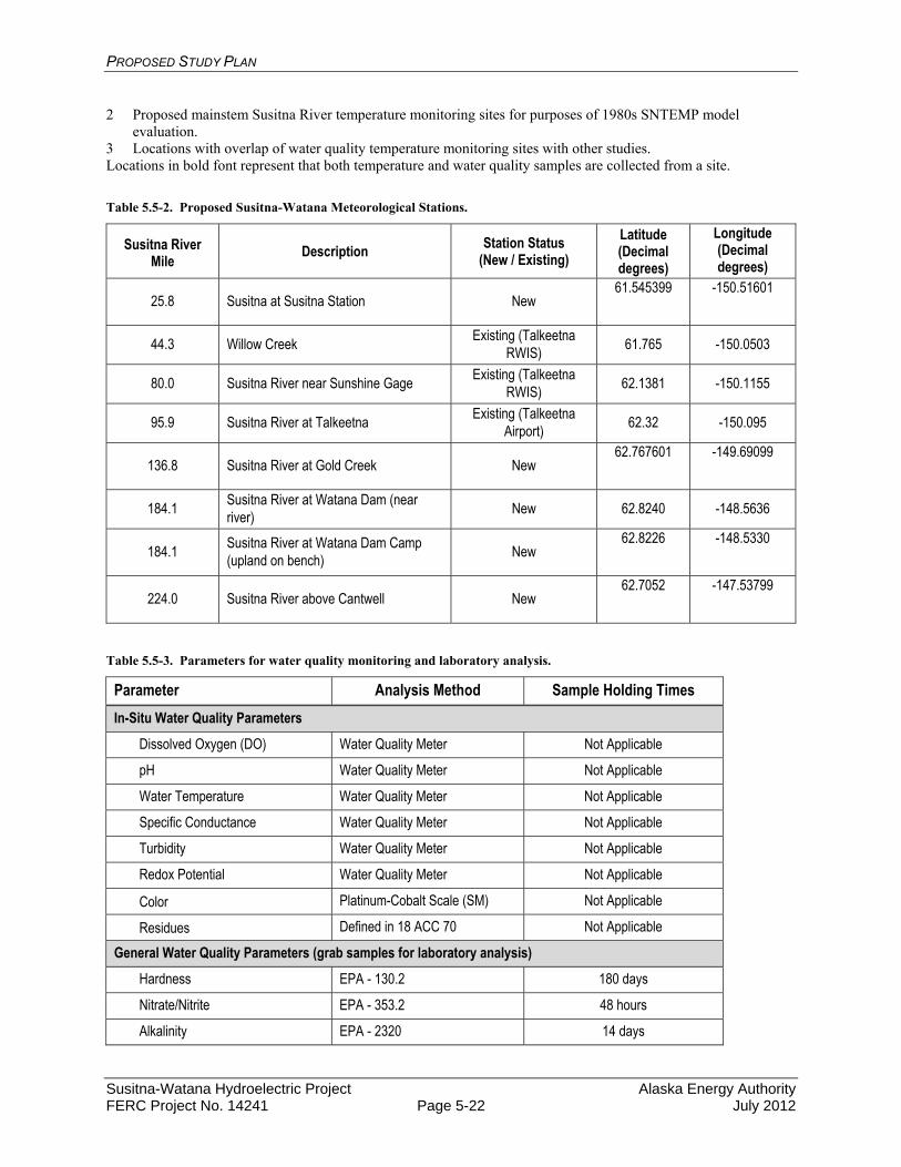
PROPOSED STUDY PLAN
Susitna-Watana Hydroelectric Project Alaska Energy Authority FERC Project No. 14241 Page 5-22 July 2012
2 Proposed mainstem Susitna River temperature monitoring sites for purposes of 1980s SNTEMP model evaluation.
3 Locations with overlap of water quality temperature monitoring sites with other studies. Locations in bold font represent that both temperature and water quality samples are collected from a site.
Table 5.5-2. Proposed Susitna-Watana Meteorological Stations.
Susitna River Mile
Description Station Status
(New / Existing)
Latitude (Decimal degrees)
Longitude (Decimal degrees)
25.8 Susitna at Susitna Station New 61.545399
-150.51601
44.3 Willow Creek Existing (Talkeetna
RWIS) 61.765 -150.0503
80.0 Susitna River near Sunshine Gage Existing (Talkeetna
RWIS) 62.1381 -150.1155
95.9 Susitna River at Talkeetna Existing (Talkeetna
Airport) 62.32 -150.095
136.8 Susitna River at Gold Creek New 62.767601
-149.69099
184.1 Susitna River at Watana Dam (near river)
New 62.8240 -148.5636
184.1 Susitna River at Watana Dam Camp (upland on bench)
New 62.8226
-148.5330
224.0 Susitna River above Cantwell New 62.7052
-147.53799
Table 5.5-3. Parameters for water quality monitoring and laboratory analysis.
Parameter Analysis Method Sample Holding Times
In-Situ Water Quality Parameters
Dissolved Oxygen (DO) Water Quality Meter Not Applicable
pH Water Quality Meter Not Applicable
Water Temperature Water Quality Meter Not Applicable
Specific Conductance Water Quality Meter Not Applicable
Turbidity Water Quality Meter Not Applicable
Redox Potential Water Quality Meter Not Applicable
Color Platinum-Cobalt Scale (SM) Not Applicable
Residues Defined in 18 ACC 70 Not Applicable
General Water Quality Parameters (grab samples for laboratory analysis)
Hardness EPA - 130.2 180 days
Nitrate/Nitrite EPA - 353.2 48 hours
Alkalinity EPA - 2320 14 days
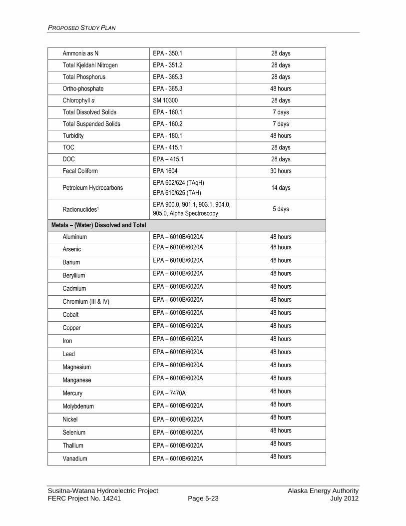
PROPOSED STUDY PLAN
Susitna-Watana Hydroelectric Project Alaska Energy Authority FERC Project No. 14241 Page 5-23 July 2012
Ammonia as N EPA - 350.1 28 days
Total Kjeldahl Nitrogen EPA - 351.2 28 days
Total Phosphorus EPA - 365.3 28 days
Ortho-phosphate EPA - 365.3 48 hours
Chlorophyll a SM 10300 28 days
Total Dissolved Solids EPA - 160.1 7 days
Total Suspended Solids EPA - 160.2 7 days
Turbidity EPA - 180.1 48 hours
TOC EPA - 415.1 28 days
DOC EPA – 415.1 28 days
Fecal Coliform EPA 1604 30 hours
Petroleum Hydrocarbons EPA 602/624 (TAqH)
EPA 610/625 (TAH) 14 days
Radionuclides1 EPA 900.0, 901.1, 903.1, 904.0, 905.0, Alpha Spectroscopy
5 days
Metals – (Water) Dissolved and Total
Aluminum EPA – 6010B/6020A 48 hours
Arsenic EPA – 6010B/6020A 48 hours
Barium EPA – 6010B/6020A 48 hours
Beryllium EPA – 6010B/6020A 48 hours
Cadmium EPA – 6010B/6020A 48 hours
Chromium (III & IV) EPA – 6010B/6020A 48 hours
Cobalt EPA – 6010B/6020A 48 hours
Copper EPA – 6010B/6020A 48 hours
Iron EPA – 6010B/6020A 48 hours
Lead EPA – 6010B/6020A 48 hours
Magnesium EPA – 6010B/6020A 48 hours
Manganese EPA – 6010B/6020A 48 hours
Mercury EPA – 7470A 48 hours
Molybdenum EPA – 6010B/6020A 48 hours
Nickel EPA – 6010B/6020A 48 hours
Selenium EPA – 6010B/6020A 48 hours
Thallium EPA – 6010B/6020A 48 hours
Vanadium EPA – 6010B/6020A 48 hours

PROPOSED STUDY PLAN
Susitna-Watana Hydroelectric Project Alaska Energy Authority FERC Project No. 14241 Page 5-24 July 2012
Zinc EPA – 6010B/6020A 48 hours
Metals –Sediment (Total)
Aluminum EPA - 200.7 180 days
Arsenic EPA - 200.7 180 days
Cadmium EPA - 200.7 180 days
Copper EPA - 200.7 180 days
Iron EPA - 200.7 180 days
Lead EPA - 200.7 180 days
Mercury EPA – 245.5 / 7470A 28 days
Zinc EPA - 200.7 180 days
Metals – Fish Tissue (Use EPA Sampling Method 1669)
Total Mercury EPA – 1631 7 days
Methylmercury EPA – 1631 7 days
Arsenic EPA - 1632, Revision A 7 days
Cadmium EPA - 1632 7 days
Selenium EPA - 1632 7 days
Note: List of Radionuclides suggested for analysis includes the following: Americium‐241; Cesium‐137; Lead‐210; Plutonium‐238, 239, 240; Potassium‐40; Radium‐226; Radium‐228; Strontium‐90; Thorium‐230, 232; Uranium‐234, 235, 238; Tritium Gross Alpha, Gross Beta
Table 5.5-4. List of water quality parameters and frequency of collection.
Parameter Task Frequency of Collection
In-Situ Water Quality Parameters
Dissolved Oxygen (DO) Baseline WQ and Sediment Each Sampling Event
pH Baseline WQ and Sediment Each Sampling Event
Water Temperature Baseline WQ and Sediment Each Sampling Event
Specific Conductance Baseline WQ and Sediment Each Sampling Event
Turbidity Baseline WQ and Sediment Each Sampling Event
Redox Potential Baseline WQ and Sediment Each Sampling Event
Color Baseline WQ (Visual) Monthly
Residues Baseline WQ (Visual) One Survey-summer
General Water Quality Parameters (grab samples for laboratory analysis)
Hardness Baseline WQ Monthly
Alkalinity Baseline WQ Monthly
Nitrate/Nitrite Baseline WQ Monthly
Ammonia as N Baseline WQ Monthly
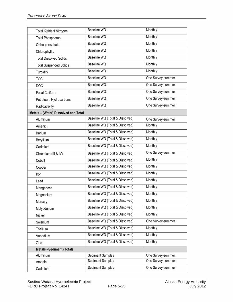
PROPOSED STUDY PLAN
Susitna-Watana Hydroelectric Project Alaska Energy Authority FERC Project No. 14241 Page 5-25 July 2012
Total Kjeldahl Nitrogen Baseline WQ Monthly
Total Phosphorus Baseline WQ Monthly
Ortho-phosphate Baseline WQ Monthly
Chlorophyll a Baseline WQ Monthly
Total Dissolved Solids Baseline WQ Monthly
Total Suspended Solids Baseline WQ Monthly
Turbidity Baseline WQ Monthly
TOC Baseline WQ One Survey-summer
DOC Baseline WQ One Survey-summer
Fecal Coliform Baseline WQ One Survey-summer
Petroleum Hydrocarbons Baseline WQ One Survey-summer
Radioactivity Baseline WQ One Survey-summer
Metals – (Water) Dissolved and Total
Aluminum Baseline WQ (Total & Dissolved) One Survey-summer
Arsenic Baseline WQ (Total & Dissolved) Monthly
Barium Baseline WQ (Total & Dissolved) Monthly
Beryllium Baseline WQ (Total & Dissolved) Monthly
Cadmium Baseline WQ (Total & Dissolved) Monthly
Chromium (III & IV) Baseline WQ (Total & Dissolved) One Survey-summer
Cobalt Baseline WQ (Total & Dissolved) Monthly
Copper Baseline WQ (Total & Dissolved) Monthly
Iron Baseline WQ (Total & Dissolved) Monthly
Lead Baseline WQ (Total & Dissolved) Monthly
Manganese Baseline WQ (Total & Dissolved) Monthly
Magnesium Baseline WQ (Total & Dissolved) Monthly
Mercury Baseline WQ (Total & Dissolved) Monthly
Molybdenum Baseline WQ (Total & Dissolved) Monthly
Nickel Baseline WQ (Total & Dissolved) Monthly
Selenium Baseline WQ (Total & Dissolved) One Survey-summer
Thallium Baseline WQ (Total & Dissolved) Monthly
Vanadium Baseline WQ (Total & Dissolved) Monthly
Zinc Baseline WQ (Total & Dissolved) Monthly
Metals –Sediment (Total)
Aluminum Sediment Samples One Survey-summer
Arsenic Sediment Samples One Survey-summer
Cadmium Sediment Samples One Survey-summer

PROPOSED STUDY PLAN
Susitna-Watana Hydroelectric Project Alaska Energy Authority FERC Project No. 14241 Page 5-26 July 2012
Copper Sediment Samples One Survey-summer
Iron Sediment Samples One Survey-summer
Lead Sediment Samples One Survey-summer
Mercury Sediment Samples One Survey-summer
Zinc Sediment Samples One Survey-summer
Metals – Fish Tissue (Use EPA Sampling Method 1669)
Total Mercury Fish Tissue Screening One Survey-late summer
Methyl-mercury Fish Tissue Screening One Survey-late summer
Arsenic Fish Tissue Screening One Survey-late summer
Cadmium Fish Tissue Screening One Survey-late summer
Selenium Fish Tissue Screening One Survey-late summer

PROPOSED STUDY PLAN
Susitna-Watana Hydroelectric Project Alaska Energy Authority FERC Project No. 14241 Page 5-27 July 2012
5.5.10 Figures
Figure 5.5-1. Proposed 2012 Stream Water Quality and Temperature Data Collection Sites for the Susitna-Watana Hydroelectric Project.
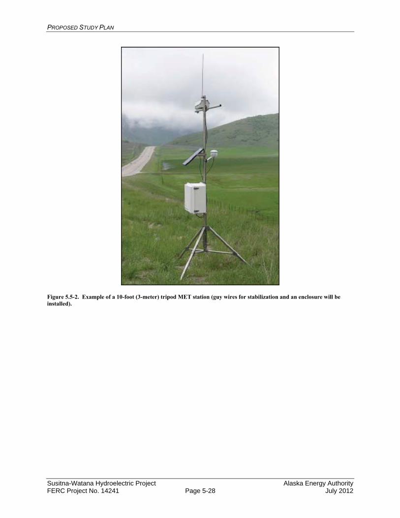
PROPOSED STUDY PLAN
Susitna-Watana Hydroelectric Project Alaska Energy Authority FERC Project No. 14241 Page 5-28 July 2012
Figure 5.5-2. Example of a 10-foot (3-meter) tripod MET station (guy wires for stabilization and an enclosure will be installed).
PROPOSED STUDY PLAN
Susitna-Watana Hydroelectric Project Alaska Energy Authority FERC Project No. 14241 Page 5-29 July 2012
5.6. Water Quality Modeling Study
5.6.1. General Description of the Proposed Study
5.6.1.1. Study Goals and Objectives
The collective goal of the water quality studies is to assess the impacts of the proposed Project operations on water quality in the Susitna River basin with particular reference to state water quality standards. Predicting the potential impacts of the dam and its proposed operations on water quality will require the development of a water quality model. The goal of the Water Quality Modeling Study will be to utilize the extensive information collected from the Baseline Water Quality Study to develop a model(s) in which to evaluate the potential impacts of the proposed Project and operations on various physical parameters within the Susitna River watershed.
There are a large number of water quality models available for use on the Susitna-Watana Project. Selection of the appropriate model is based on a variety of factors, including cost, data inputs, model availability, time, licensing participant familiarity, ease of use, and available documentation. Under the current study, a multi-dimensional model capable of representing reservoir flow circulation, temperature stratification, and dam operations among other parameters is necessary. The proposed model must account for water quality conditions in the proposed Susitna-Watana Reservoir, including temperature, dissolved oxygen (DO), suspended sediment and turbidity, chlorophyll a, nutrients, and metals; and water quality conditions in the Susitna River downstream of the proposed dam. The model must also simulate current Susitna River baseline conditions (in the absence of the dam) for comparison to conditions in the presence of the dam and reservoir.
The objectives of the Water Quality Modeling Study are as follows:
In consultation with licensing participants, identify an appropriate reservoir and river water temperature model for use with past and current monitoring data.
Using the data developed in Section 5.5 and 5.10, model water quality conditions in the proposed Susitna-Watana Reservoir, including (but not necessarily limited to), temperature, DO, suspended sediment and turbidity, chlorophyll a, nutrients, ice, and metals.
Model water quality conditions in the Susitna River from the proposed site of the Susitna-Watana Dam downstream, including (but not necessarily limited to), temperature, suspended sediment and turbidity, and ice processes (in coordination with the Ice Processes Study).
5.6.2. Existing Information and Need for Additional Information
In the 1980s, hydrologic and temperature modeling was conducted in the Susitna River basin to predict the effects of one or more dams on downstream temperatures and flows. The modeling suite used was called H2OBAL/SNTEMP/DYRESM. The modeling suite addressed temperature and had some limited hydrodynamic representation, but it lacked the ability to predict vertical stratification or local effects. In addition, the modeling suite lacked a water quality modeling component.
PROPOSED STUDY PLAN
Susitna-Watana Hydroelectric Project Alaska Energy Authority FERC Project No. 14241 Page 5-30 July 2012
Review of existing water quality and sediment transport data revealed several gaps that present challenges for calibrating a water quality model (URS 2011). Analysis of existing data was used to identify future studies needed to develop the riverine and reservoir water quality models and to eventually predict pre-Project water quality conditions throughout the drainage. Some general observations based on existing data are as follows:
Large amounts of data were collected during the 1980s. A comprehensive data set for the Susitna River and tributaries is not available.
The influence of major tributaries (Chulitna and Talkeetna rivers) on Susitna River water quality conditions is unknown. There are no monitoring stations in receiving water at these mainstem locations.
Continuous temperature data and seasonal water quality data are not available for the Susitna River mainstem and sloughs potentially used for spawning and rearing habitat.
Concentrations of water quality parameters including metals in sediment immediately below the proposed Project are unknown. Metals in these sediments may become mobile once the Project begins operation. Monitoring information in the immediate vicinity of the reservoir and riverine habitat will be important for developing two models (reservoir and riverine) and coupled for predicting expected water quality conditions below the proposed dam.
5.6.3. Study Area
Water quality samples will be collected and temperature data loggers will be installed at 39 sites identified in Table 5.6-1 and Figure 5.6-1 as part of the 2012 Baseline Water Quality Study. The study area begins at RM 10.1 and extends past the proposed dam site to RM 233.4. The lowermost boundary of the monitoring that will be used for developing and calibrating models is above the area protected for Beluga whale activity. Twelve mainstem Susitna River monitoring sites are located below the proposed dam site and two mainstem sites above this location for calibration of the models. Five sloughs will be included in the models and represent important fish-rearing habitat. Tributaries to the Susitna River will be monitored and include those contributing large portions of the lower river flow like the: Talkeetna, Chulitna, Deshka, and Yentna rivers. A partial list of the remaining tributaries that will be included in modeling and represents important spawning and rearing habitat for anadromous and resident fisheries include: Gold Creek, Portage Creek, Tsusena Creek, Watana Creek, and Oshetna Creek. These sites were selected based on the following rationale:
Adequate representation of locations throughout the Susitna River and tributaries above and below the proposed dam site;
Preliminary consultation with AEA and licensing participants including co-location with other study sites (e.g., instream flow, ice processes);
Access and land ownership issues; and
Eight of the sites are mainstem monitoring sites that were previously used for SNTEMP modeling in the 1980s. Thirty-one of the sites are Susitna River mainstem, tributary, or slough locations, most of which were also monitored in the 1980s.
PROPOSED STUDY PLAN
Susitna-Watana Hydroelectric Project Alaska Energy Authority FERC Project No. 14241 Page 5-31 July 2012
5.6.4. Study Methods
This section assesses potential water quality models and identifies key considerations for the selection of the appropriate modeling platform. In coordination with licensing participants, a final modeling platform will be selected and implemented.
For the current project, the model will need to be capable of simulating both river and reservoir environments. It must also be a multi-dimensional dynamic model that includes hydrodynamics, water temperature, water quality, and sediment transport modules and considers ice formation and breakup. Ice dynamics evaluated in the Ice Processes Study will be used to inform the water quality model. Ice formation and breakup will have a profound impact on hydrodynamics and water quality conditions in the reservoir and riverine sections of the basin. Ice cover affects transfer of oxygen to and from the atmosphere and this directly impacts the dissolved oxygen concentration at points along the water column. The output from the ice study (Section 5.10) will provide boundary conditions for the water quality model.
The model will be configured for the reservoir and internally coupled with the downstream river model. This will form a holistic modeling framework which can accurately simulate changes in the hydrodynamic, temperature, and water quality regime within the reservoir and downstream. A model for use in this study should feature an advanced turbulence closure scheme to represent vertical mixing in reservoirs, and be able to predict future conditions. Thus, it will be capable of representing the temperature regime within the reservoir without resorting to arbitrary assumptions about vertical mixing coefficients.
The model will need to have the ability to simulate an entire suite of water quality parameters, and the capacity for internal coupling with the hydrodynamic and temperature modeling processes. The model will be configured to simulate the impact of the proposed Project on temperature as well as DO, nutrients, algae, turbidity, TSS, and other key water quality features both within the reservoir and for the downstream river. This avoids the added complexity associated with transferring information among multiple models and increases the efficiency of model application.
Other important factors when selecting a water quality model include the following:
The model and code are easily accessible and are part of the public domain. The model is commonly used and accepted by EPA and other public regulatory agencies. The water quality model will be available for current and future use and remain available
for the life of the project and beyond (including upgraded versions). Model output can be compared to relevant ADEC water quality criteria (18 ACC
70.020(b)).
The following sections summarize the capabilities of models considered for use on this project.
5.6.4.1. H2OBAL/SNTEMP/DYRESM Model Review
The existing H2OBAL/SNTEMP/DYRESM model of the Susitna River basin is perhaps the most obvious candidate model to implement when assessing the effects of the originally proposed Project. The existing model was expressly configured to represent the unique conditions in the Susitna River basin. However, the modeling suite is limited to flow and temperature predictions. Hydrodynamics are simplified, and water quality is not addressed.
PROPOSED STUDY PLAN
Susitna-Watana Hydroelectric Project Alaska Energy Authority FERC Project No. 14241 Page 5-32 July 2012
The Arctic Environmental Information and Data Center (AEIDC) previously completed a study that examined the temperature and discharge effects if the proposed Project was completed and compared the effects to the natural stream conditions, without a dam and reservoir system (AEIDC 1983a). The study also assessed the downstream point at which post-project flows would be statistically the same as natural flows. Multiple models were used in the assessment: SNTEMP, a riverine temperature model, H2OBAL, a water balance program and DYRESM, a reservoir hydrodynamic model.
The simulation period covered the years 1968 through 1982. Only the summer period was simulated, using historical meteorological and hydrological data to represent normal, maximum and minimum stream temperature conditions, represented by the years 1980, 1977, and 1970, respectively (AEIDC 1983a). Post-project modifications were applied to these summer periods to compare natural conditions to post-project stream temperatures. Due to a lack of data, a monthly time-step was used in these summer condition simulations.
Mainstem discharges from the Susitna-Watana Dam site were estimated from statistically-filled streamflow data and the H2OBAL program, which computes tributary inflow on a watershed area-weighted basis. Post-project flows were predicted for both a one-dam scenario and a two-dam scenario using release discharge estimates from a reservoir operation schedule scenario in the FERC license application. Flows derived from H2OBAL were input into SNTEMP.
SNTEMP is a riverine temperature simulation model that can predict temperature on a daily basis and for longer time periods. This allows for the analysis of both critical river reaches at a fine scale and the full river system over a longer averaging period (AEIDC 1983b). SNTEMP was selected because it contains a regression model that can fill in data gaps in temperature records. This is useful because data records in the Susitna River watershed are sparse. SNTEMP can also be calibrated to adjust for low-confidence input parameters. SNTEMP outputs include average daily water temperatures and daily maximum and minimum temperatures.
SNTEMP contains several sub-models, including a solar radiation model that predicts solar radiation based on stream latitude, time of year, topography, and meteorological conditions (AEIDC 1983b). SNTEMP was modified to include the extreme shading conditions that occur in the basin by developing a monthly topographic shading parameter. Modifications were also made to represent the winter air temperature inversions that occur in the basin. Sub-models are also included for heat flux, heat transport, and flow mixing.
SNTEMP validation indicated that upper tributary temperatures were under-predicted (AEIDC 1983b). Most of the data for the tributaries were assumed or estimated, leading to uncertainty. Five key poorly defined variables were identified as possible contributors to the under-prediction of temperatures: stream flow, initial stream temperature, stream length, stream width and distributed flow temperatures. Distributed flow temperatures were highlighted as the most important of the five variables. During calibration, groundwater temperature parameters were adjusted to modify distributed flow and improve tributary temperature prediction.
Water temperatures are derived from USGS gages, but when data was lacking, SNTEMP computed equilibrium temperatures and then estimated initial temperatures from a regression model. AEIDC noted that the reliability of the regression models “restricts the accuracy of the physical process temperature simulations” (1983a). The level of confidence in the regression model varies by the amount of gage data available. Continuous data yielded higher confidence,
PROPOSED STUDY PLAN
Susitna-Watana Hydroelectric Project Alaska Energy Authority FERC Project No. 14241 Page 5-33 July 2012
while years with only grab sample data notably decreased the confidence in the predicted temperatures.
The DYRESM model is a one-dimensional, hydrodynamic model designed specifically for medium size reservoirs (Patterson, et al. 1977). The size limitation ensures that the assumptions of the model algorithm remain valid. DYRESM predicts daily temperature and salinity variations with depth and the temperature and salinity of off-take supply. The reservoir is modeled as horizontal layers with variable vertical location, volume, temperature and salinity. Mixing between layers is through amalgamation. Inflow and withdrawal are modeled by changes in the horizontal layer thickness and insertion or removal of layers, as appropriate. The model incorporates up to two submerged off-takes and one overflow outlet. Model output is on a daily time-step.
The DYRESM model was run to simulate the reservoir scenario for 1981 conditions (AEIDC 1983a). Other reservoir release temperature estimates were not available. The AEIDC report cautions that the results from 1981 may not be representative of other years due to annual variations in meteorology, hydrology, reservoir storage, and power requirements. The lack of reservoir release temperature data limited the simulation of downstream temperatures under operational conditions to one year. AEIDC noted that the “effort to delineate river reaches where post-project flows differ significantly from natural flows has been unsuccessful” (AEIDC 1983a). This was attributed in large part to the lack of estimates for the reservoir release temperatures. Additional data was needed to increase the predictive ability of SNTEMP.
Perhaps the biggest limitations of the existing H2OBAL/SNTEMP/DYRESM modeling suite are the lack of suitable data, simplified hydrology and the lack of a water quality component. Modeling is limited to discharge and temperature. Other issues that limit the suitability of the modeling suite for the Water Quality Modeling Study are the chronic under-prediction of upper tributary temperatures, and the inability to predict vertical stratification within the reservoir.
5.6.4.2. Other Modeling Approaches
Two other modeling approaches may provide better results than the previously used H2OBAL/SNTEMP/DYRESM model. These are discussed below.
5.6.4.3. Two-Dimensional Approach (Ce-Qual-W2)
The U.S. Army Corps of Engineers’ CE-QUAL-W2 model is a two-dimensional, longitudinal/vertical (laterally averaged), hydrodynamic and water quality model (Cole, et al. 2000). The model can be applied to streams, rivers, lakes, reservoirs, and estuaries with variable grid spacing, time-variable boundary conditions, and multiple inflows and outflows from point/nonpoint sources and precipitation.
The two major components of the model include hydrodynamics and water quality kinetics. Both of these components are coupled (i.e., the hydrodynamic output is used to drive the water quality output at every time-step). The hydrodynamic portion of the model predicts water surface elevations, velocities, and temperature. The water quality portion of the model can simulate 21 constituents including DO, suspended sediment, chlorophyll a, nutrients, and metals. A dynamic shading algorithm is incorporated to represent topographic and vegetative cover effects on solar radiation.
PROPOSED STUDY PLAN
Susitna-Watana Hydroelectric Project Alaska Energy Authority FERC Project No. 14241 Page 5-34 July 2012
5.6.4.4. Three-Dimensional Approach (EFDC)
The Environmental Fluid Dynamics Code (EFDC) model was originally developed at the Virginia Institute of Marine Science and is considered public domain software (Hamrick 1992). This model is now being supported by EPA. EFDC is a dynamic, three-dimensional, coupled water quality and hydrodynamic model. In addition to hydrodynamic, salinity, and temperature transport simulation capabilities, EFDC is capable of simulating cohesive and non-cohesive sediment transport, near field and far field discharge dilution from multiple sources, eutrophication processes, the transport and fate of toxic contaminants in the water and sediment phases, and the transport and fate of various life stages of finfish and shellfish. The EFDC model has been extensively tested, documented, and applied to environmental studies world-wide by universities, governmental agencies, and environmental consulting firms.
The structure of the EFDC model includes four major modules: (1) a hydrodynamic model, (2) a water quality model, (3) a sediment transport model, and (4) a toxics model. The water quality portion of the model simulates the spatial and temporal distributions of 22 water quality parameters including DO, suspended algae (3 groups), periphyton, various components of carbon, nitrogen, phosphorus and silica cycles, and fecal coliform bacteria. Salinity, water temperature, and total suspended solids are needed for computation of the 22 state variables, and they are provided by the hydrodynamic model. EFDC incorporates solar radiation using the algorithms from the CE-QUAL-W2 model.
5.6.4.5. Qualitative Comparison of Models
Table 5.6-2 presents an evaluation of the models’ applicability to a range of important technical, regulatory, and management considerations. Technical criteria refer to the ability to simulate the physical system in question, including physical characteristics/processes and constituents of interest. Regulatory criteria make up the constraints imposed by regulations, such as water quality standards or procedural protocol. Management criteria comprise the operational or economic constraints imposed by the end-user and include factors such as financial and technical resources. The relative importance of each consideration, as it pertains to the Project, are presented alongside the models’ applicability ratings. Although the evaluation is qualitative, it is useful in selecting a model based on the factors that are most critical to this project.
5.6.4.6. Technical Considerations
The following discussion highlights some of the key technical considerations for modeling associated with the Susitna-Watana Project and compares the ability of CE-QUAL- W2 and EFDC to address these considerations. For informational purposes, the H2OBAL/SYNTEMP/DYRESM modeling suite is also discussed in the technical considerations. Based on a review of the literature, some key factors that will likely be important in the modeling effort include:
1. Predicting vertical stratification in the reservoir when the dam is present; 2. Nutrient and algae representation; 3. Sediment transport; 4. Ability to represent metals concentrations; 5. Integration between temperature and ice dynamics models; and 6. Capability of representing local effects.
PROPOSED STUDY PLAN
Susitna-Watana Hydroelectric Project Alaska Energy Authority FERC Project No. 14241 Page 5-35 July 2012
5.6.4.6.1. Predicting Vertical Stratification
Both EFDC and CE-QUAL-W2 are equipped with turbulence closure schemes which allow prediction of temporally/spatially variable vertical mixing strength based on time, weather condition, and reservoir operations. Therefore, both are capable of evaluating the impact of dam/reservoir operations/climate change on reservoir stratification. In contrast, the existing H2OBAL/SYNTEMP/DYRESM model does not have the necessary predictive capability because vertical stratification is represented based on parameterization through calibration. Therefore, it cannot represent the response of vertical mixing features to the changes in external forces.
5.6.4.6.2. Nutrient and Algae Representation
Both EFDC and CE-QUAL-W2 are capable of simulating dynamic interactions between nutrients and algae in reservoirs and interactions between nutrients and periphyton in riverine sections. This is very important for addressing the potential impact of the proposed Project on water quality and ecology in the river. EFDC has better nutrient predictive capabilities due to its sediment diagenesis module, which simulates interactions between external nutrient loading and bed-water fluxes. EFDC is thus capable of predicting long-term effects of the proposed Project. CE-QUAL-W2 does not have such a predictive capability. The existing H2OBAL/SNTEMP/DYRESM modeling suite is not capable of representing nutrient and algae interactions.
5.6.4.6.3. Sediment Transport
EFDC is fully capable of predicting sediment erosion, transport, and settling/deposition processes. CE-QUAL-W2 has limited sediment transport simulation capabilities. It handles water column transport and settling; however, it is not capable of fully predicting sediment bed re-suspension and deposition processes. H2OBAL/SNTEMP/DYRESM is not capable of simulating sediment transport.
5.6.4.6.4. Ability to Represent Metals Concentrations
EFDC is fully capable of simulating fate and transport of metals in association with sediments in both rivers and reservoirs. CE-QUAL-W2 does not have a module to simulate metals; however, a simplified representation can be implemented using the phosphorus slot in the model and simple partitioning (to couple with its basic sediment transport representation). The H2OBAL/SNTEMP/DYRESM is not capable of addressing metals issues.
5.6.4.6.5. Integration between Temperature and Ice Dynamics Models
The CE-QUAL-W2 model has a coupled temperature-ice simulation module, which is of moderate complexity and predictive capability. EFDC has a slightly simpler ice representation which was previously applied to a number of Canadian rivers (e.g., Lower Athabasca River and the North Saskatchewan River in Alberta, Canada). Both models, however, can be coupled to external ice models with a properly designed interface to communicate temperature results. Fully predictive simulation within either model would require code modification to handle the interaction between temperature simulation, ice formation and transport, hydrodynamics simulation, and water quality simulation.
5.6.4.6.6. Capability of Representing Local Effects

PROPOSED STUDY PLAN
Susitna-Watana Hydroelectric Project Alaska Energy Authority FERC Project No. 14241 Page 5-36 July 2012
CE-QUAL-W2 is a longitudinal-vertical two-dimensional model; therefore, it is capable of resolving spatial variability in the longitudinal and vertical directions. It is not capable of representing high resolution local effects such as lateral discharge, areas impacted by secondary circulation, or certain habitat characteristic changes. EFDC is a three-dimensional model which can be configured at nearly any spatial resolution to represent local effects. H2OBAL/SNTEMP/DYRESM is a one-dimensional modeling suite and therefore has limited capability representing local effects.
5.6.4.7. Reservoir and River Downstream of Reservoir Modeling Approach
Reservoir modeling will focus on the length of the river from above the expected area of reservoir inundation to the proposed dam location. It will involve first running the initial reservoir condition. This initial condition represents current baseline conditions in the absence of the dam. Subsequently, the model will represent the proposed reservoir condition, when the dam is in place. The reservoir representation will be developed based on the local bathymetry and dimensions of the proposed dam. It is recommended that a three-dimensional model be developed for the proposed reservoir to represent the spatial variability in hydrodynamics and water quality in longitudinal, vertical and lateral directions. The model will be able to simulate flow circulation in the reservoir, turbulence mixing, temperature dynamics, nutrient fate and transport, interaction between nutrients and algae, sediment transport, and metals transport. The key feature that needs to be captured is water column stratification during the warm season and the de-stratification when air temperatures cool down. The capability of predictively representing the stratification/de-stratification period is of critical importance for evaluating the impact of the dam since this is the critical water quality process in the reservoir.
With the dam in place, the original river will be converted into a slow flowing reservoir; therefore, any sediment previously mobilized will likely settle in the reservoir, disrupting the natural sediment transport processes. Before the construction of the dam, primary production is likely driven by periphyton. After construction of the dam, periphyton will be largely driven out of existence due to deep water conditions typical of a reservoir environment. In lieu of periphyton, phytoplankton will likely be the dominant source of primary production of the ecological system with the dam in place. Nutrients from upstream will have longer retention in the reservoir, providing nutrient sources to fuel phytoplankton growth. All processes would need to be predictively simulated by both the reservoir model and the pre-reservoir river model for the same river segment.
Because the dam is not in place when the model is constructed, proper calibration of the model using actual reservoir data is not possible. To achieve reasonable predictions of water quality conditions in the proposed reservoir, a literature survey will be conducted to acquire parameterization schemes of the model. An uncertainty analysis approach will also be developed to account for the lack of data for calibration, therefore enhancing the reliability of reservoir model predictions.
Downstream of the proposed dam location, a river model will also be developed to evaluate the effects of the proposed Project. It is anticipated that the same model platform used for the reservoir model will be implemented for the river model (at a minimum the two models will be tightly coupled). The river model will be capable of representing conditions in both the absence and presence of the dam. The downstream spatial extent of this model is yet to be determined, but it is likely it will extend to shortly downstream of the Susitna-Talkeetna-Chulitna confluence

PROPOSED STUDY PLAN
Susitna-Watana Hydroelectric Project Alaska Energy Authority FERC Project No. 14241 Page 5-37 July 2012
(e.g., Sunshine USGS Gage). If water quality modeling indicates that water quality effects extend into the lower river downstream of the initial modeling effort, then, as appropriate, water quality modeling will extend farther downstream. This would require additional channel topography and flow data at select locations in order to develop a model for predicting water quality conditions under various Project operational scenarios.
Flow, temperature, TSS, DO, nutrients, turbidity (continuous at USGS sites & bi-weekly at additional locations required for calibrating the model), and chlorophyll-a output from the reservoir model will be directly input into the downstream river model. This will enable downstream evaluation of potential impacts of the proposed Project on hydrodynamic, temperature, and water quality conditions.
The river model will be calibrated and validated using available data concurrently with the initial reservoir condition model (representing absence of the dam). Output from the models will be used directly in other studies (e.g., Ice Processes, Productivity, and Instream Flow studies).
The model will be calibrated in order to simulate water quality conditions for load following analysis. Organic carbon content from inflow sources will be correlated with mercury concentrations determined from the Baseline Water Quality Study discussed in Section 5.5. Predicted water quality conditions established by Project operations and that promote methylation of mercury in the bioaccumulative form will be identified by location and intensity in both riverine and reservoir habitats. Water temperature modeling and routing of fluctuating flows immediately prior to and during ice cover development may be conducted with a separate thermodynamics based ice process model (e.g., CRISSP 1D).
5.6.5. Consistency with Generally Accepted Scientific Practice
Models will be the primary method used for predicting potential impacts to water quality conditions in both the proposed reservoir and the riverine portion of the Susitna basin. The models will be developed for each of the reservoir and riverine sections of the Susitna River and will be used to predict conditions resulting from Project operations under several operational scenarios. In the absence of a dam and data describing actual water quality conditions in the proposed reservoir, models are the only way to predict potential changes that may occur in the Susitna River from the presence of a dam. The 401 Water Quality Certification process includes the use of baseline assessment information and the use of models. The use of models is a scientifically accepted practice for predicting impacts to water quality and generating operational scenario outputs to inform the Project certification.
5.6.6. Schedule
The anticipated schedule for this work is presented below.
Modeling Activity Timeline
Coordination with water quality data collection and analysis On-going throughout modeling effort
Model Evaluation/Selection September 30, 2012
Model Calibration (Water Quality) June 2013-October 2013
Initial Study Report December 2013
Re-calibration adjustments June 2014-August 2014
PROPOSED STUDY PLAN
Susitna-Watana Hydroelectric Project Alaska Energy Authority FERC Project No. 14241 Page 5-38 July 2012
Verification runs July 2014-September 2014
Generate Results for Operational Scenarios July 2014 –November 2014
Updated Study Report December 2014
5.6.7. Level of Effort and Cost
The estimated cost for proposed water quality modeling effort in 2013 and 2014, including planning, model calibration and development, modeling various operational scenarios and reporting is approximately $1,050,000.
5.6.8. Literature Cited
Alaska Energy Authority (AEA), 2011. Pre-Application Document.
Arctic Environmental Information and Data Center (AEIDC). 1983a. Examination of Susitna River Discharge and Temperature Changes Due to the Proposed Susitna Hydroelectric Project – Final Report. Prepared by Arctic Environmental Information and Data Center Anchorage, AK. Submitted to Harza-Ebasco Susitna Joint Venture Anchorage, AK. Prepared for the Alaska Power Authority, Anchorage, AK.
AEIDC. 1983b. Stream Flow and Temperature Modeling in the Susitna Basin, Alaska. Prepared by Arctic Environmental Information and Data Center Anchorage, AK. Submitted to Harza-Ebasco Susitna Joint Venture Anchorage, AK. Prepared for the Alaska Power Authority, Anchorage, AK.
Cole, T.M. and S. A. Wells. 2000. CE-QUAL-W2: A two-dimensional, laterally averaged, Hydrodynamic and Water Quality Model, Version 3.0, Instruction Report EL-2000. US Army Engineering and Research Development Center, Vicksburg, MS.
Hamrick, J.M. 1992. A Three-Dimensional Environmental Fluid Dynamics Computer Code: Theoretical and Computational Aspects, Special Report 317. The College of William and Mary, Virginia Institute of Marine Science. 63 pp.
Patterson, John, J. Imberger, B. Hebbert, and I. Loh. 1977. Users Guide to DYRESM – A Simulation Model for Reservoirs of Medium Size. University of Western Australia, Nedlands, Western Australia.
URS. 2011. AEA Susitna Water Quality and Sediment Transport Data Gap Analysis Report. Prepared by Tetra Tech, URS, and Arctic Hydrologic Consultants. Anchorage, Alaska. 62p.+Appendixes.
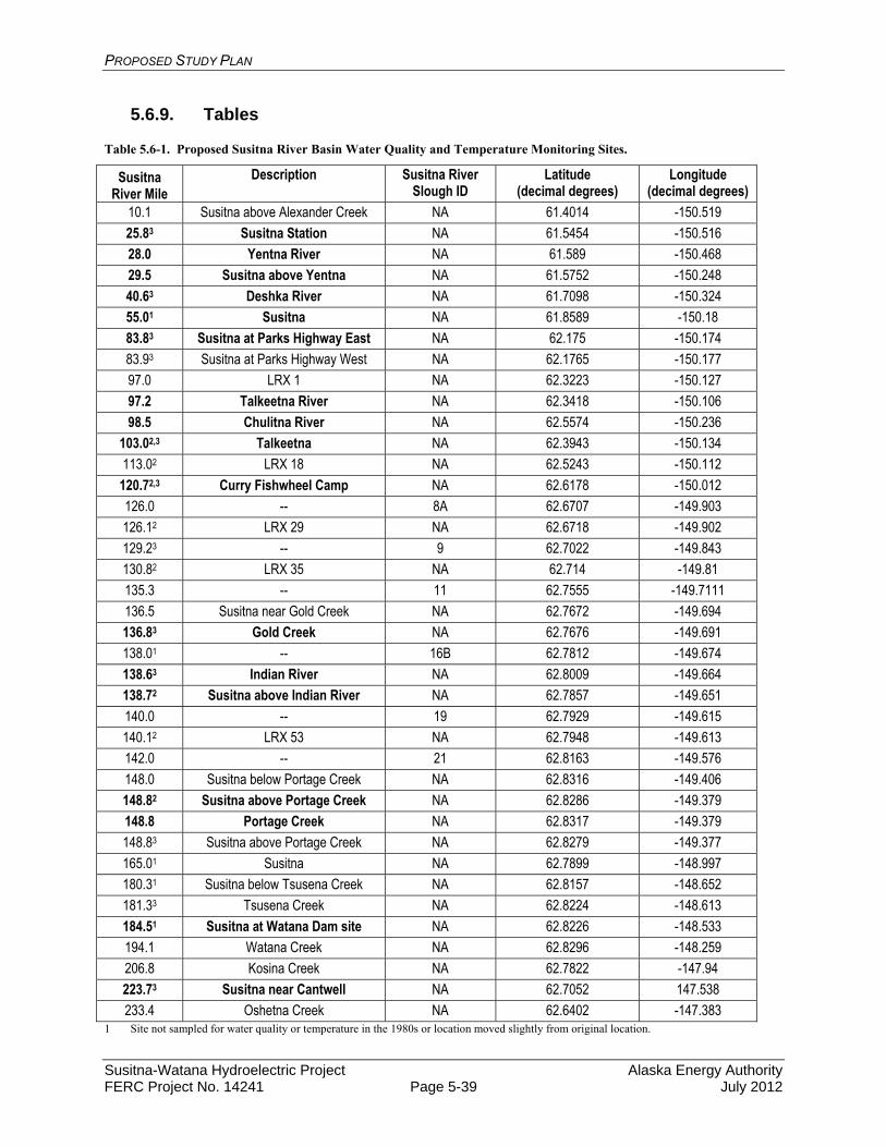
PROPOSED STUDY PLAN
Susitna-Watana Hydroelectric Project Alaska Energy Authority FERC Project No. 14241 Page 5-39 July 2012
5.6.9. Tables
Table 5.6-1. Proposed Susitna River Basin Water Quality and Temperature Monitoring Sites.
Susitna River Mile
Description Susitna River Slough ID
Latitude (decimal degrees)
Longitude (decimal degrees)
10.1 Susitna above Alexander Creek NA 61.4014 -150.519
25.83 Susitna Station NA 61.5454 -150.516
28.0 Yentna River NA 61.589 -150.468
29.5 Susitna above Yentna NA 61.5752 -150.248
40.63 Deshka River NA 61.7098 -150.324
55.01 Susitna NA 61.8589 -150.18
83.83 Susitna at Parks Highway East NA 62.175 -150.174
83.93 Susitna at Parks Highway West NA 62.1765 -150.177
97.0 LRX 1 NA 62.3223 -150.127
97.2 Talkeetna River NA 62.3418 -150.106
98.5 Chulitna River NA 62.5574 -150.236
103.02,3 Talkeetna NA 62.3943 -150.134
113.02 LRX 18 NA 62.5243 -150.112
120.72,3 Curry Fishwheel Camp NA 62.6178 -150.012
126.0 -- 8A 62.6707 -149.903
126.12 LRX 29 NA 62.6718 -149.902
129.23 -- 9 62.7022 -149.843
130.82 LRX 35 NA 62.714 -149.81
135.3 -- 11 62.7555 -149.7111
136.5 Susitna near Gold Creek NA 62.7672 -149.694
136.83 Gold Creek NA 62.7676 -149.691
138.01 -- 16B 62.7812 -149.674
138.63 Indian River NA 62.8009 -149.664
138.72 Susitna above Indian River NA 62.7857 -149.651
140.0 -- 19 62.7929 -149.615
140.12 LRX 53 NA 62.7948 -149.613
142.0 -- 21 62.8163 -149.576
148.0 Susitna below Portage Creek NA 62.8316 -149.406
148.82 Susitna above Portage Creek NA 62.8286 -149.379
148.8 Portage Creek NA 62.8317 -149.379
148.83 Susitna above Portage Creek NA 62.8279 -149.377
165.01 Susitna NA 62.7899 -148.997
180.31 Susitna below Tsusena Creek NA 62.8157 -148.652
181.33 Tsusena Creek NA 62.8224 -148.613
184.51 Susitna at Watana Dam site NA 62.8226 -148.533
194.1 Watana Creek NA 62.8296 -148.259
206.8 Kosina Creek NA 62.7822 -147.94
223.73 Susitna near Cantwell NA 62.7052 147.538
233.4 Oshetna Creek NA 62.6402 -147.383 1 Site not sampled for water quality or temperature in the 1980s or location moved slightly from original location.

PROPOSED STUDY PLAN
Susitna-Watana Hydroelectric Project Alaska Energy Authority FERC Project No. 14241 Page 5-40 July 2012
2 Proposed mainstem Susitna River temperature monitoring sites for purposes of 1980s SNTEMP model evaluation. 3 Locations with overlap of water quality temperature monitoring sites with other studies. Locations in bold font represent that both temperature and water quality samples are collected from a site.
Table 5.6-2. Evaluation of models based on technical, regulatory, and management criteria.
High Suitability Medium Suitability Low Suitability
Considerations Relative
Importance H2OBAL/SNTEMP/
DYRESM CE QUAL W2 EFDC
Technical Criteria Physical Processes:
advection, dispersion High
momentum High
compatible with external ice simulation models
High
reservoir operations High
predictive temperature simulation (high latitude shading)
High
Water Quality: total nutrient concentrations High
dissolved/particulate partitioning
Medium
predictive sediment diagenesis
Medium
sediment transport High
algae High
dissolved oxygen High
metals High Temporal Scale and Representation:
long term trends and averages Medium
continuous – ability to predict small time-step variability High
Spatial Scale and Representation: multi-dimensional
representation High
grid complexity - allows predictions at numerous locations throughout model domain
High
suitability for local scale analyses, including local discharge evaluation
Medium
Regulatory Criteria Enables comparison to AK criteria High
Flexibility for analysis of scenarios, including climate change High
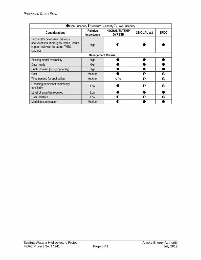
PROPOSED STUDY PLAN
Susitna-Watana Hydroelectric Project Alaska Energy Authority FERC Project No. 14241 Page 5-41 July 2012
High Suitability Medium Suitability Low Suitability
Considerations Relative Importance
H2OBAL/SNTEMP/DYRESM CE QUAL W2 EFDC
Technically defensible (previous use/validation, thoroughly tested, results in peer-reviewed literature, TMDL studies)
High
Management Criteria Existing model availability High
Data needs High
Public domain (non-proprietary) High
Cost Medium
Time needed for application Medium N/A
Licensing participant community familiarity Low
Level of expertise required Low
User interface Low
Model documentation Medium

PROPOSED STUDY PLAN
Susitna-Watana Hydroelectric Project Alaska Energy Authority FERC Project No. 14241 Page 5-42 July 2012
5.6.10. Figures
Figure 5.6-1. Proposed 2012 Stream Water Quality and Temperature Data Collection Sites for the Susitna-Watana Hydroelectric Project.
PROPOSED STUDY PLAN
Susitna-Watana Hydroelectric Project Alaska Energy Authority FERC Project No. 14241 Page 5-43 July 2012
5.7. Groundwater-related Aquatic Habitat Study
5.7.1. General Description of the Proposed Study
5.7.1.1. Study Goals and Objectives
The overall goal of the study is to understand the effects of the Project on groundwater and surface-water (GW/SW) interactions as they relate to habitat for aquatic species (e.g., fish, riparian vegetation) in the Susitna River. The study is designed to be a coordinated effort with other studies to help guide their data collection activities related to GW/SW interpretative goals. Outside of Objective 9 (below), this study itself does not include field activities; it will use existing information and the data collected by other studies to provide an overall understanding of watershed to local scale groundwater processes and GW/SW interactions.
The objectives of the study are as follows:
1. Synthesize historical data available for Susitna River groundwater and groundwater related aquatic habitat, including the 1980s and other studies;
2. Use available information to characterize the large-scale geohydrologic process-domains/terrain of the Susitna River (e.g., geology, topography, geomorphology, regional aquifers, shallow ground water aquifers, GW/SW interactions);
3. Assess the effect of Watana Dam/Reservoir on groundwater and groundwater related aquatic habitat in the vicinity of the dam;
4. Map groundwater influenced aquatic habitat (e.g., upwelling areas, springs);
5. Determine the GW/SW relationships of floodplain shallow alluvial aquifers at Riparian Instream Flow study sites;
6. Determine GW/SW relationships of upwelling/downwelling at Instream Flow Study sites in relation to spawning, incubation, and rearing habitat (particularly in the winter);
7. Characterize water quality (e.g., temperature, DO, conductivity, nutrients) of selected upwelling areas where groundwater is a primary determinant of fish habitat (e.g., incubation and rearing in side channels and sloughs, upland sloughs);
8. Characterize the winter flow in the Susitna River and how it relates to GW/SW interactions; and
9. Characterize the relationship between the Susitna River flow regime and shallow groundwater users (e.g., domestic wells).
5.7.2. Existing Information and Need for Additional Information
Various portions of the Susitna Watershed have had different scales of groundwater and GW/SW interaction studies reported. The lower Susitna Watershed is part of the geologic Susitna Basin (Kirschner, 1994) (Figure 5.7.1). This region has generally been referred to as the lower Susitna

PROPOSED STUDY PLAN
Susitna-Watana Hydroelectric Project Alaska Energy Authority FERC Project No. 14241 Page 5-44 July 2012
River. The major physiographic regions of the Susitna Watershed are described in Wahrhaftig (1994), and include the Alaska Range on northern portion of the watershed which also forms the watershed boundary in the headwaters of the watershed. The Talkeetna Mountains cross the central portion of the watershed and result in physiographic features such as Devils Canyon and Watana Canyon. The Upper Matanuska Valley covers the lower portion of the watershed, which is bounded on the downstream end by Cook Inlet. The watershed scale geology covers a range of highly metamorphic marine sedimentary formations, referred to as Flysch belts (Beikman, 1994) (Figure 5.7.2). There are also younger volcanic deposits in the middle portion of the watershed. The Susitna River flows out of the Talkeetna Mountains in the vicinity of Talkeetna, where it then flows through the Talkeetna sedimentary basin.
Hydropower-related studies in the Susitna Watershed during the 1980s included observations and monitoring of GW/SW interactions. These studies focused on river habitats such as sloughs that were determined to be important fish habitat. A large amount of physical hydrology data (e.g., stage-discharge relationships, main stage versus upwelling discharge, piezometers), water quality data (e.g., temperature), aquatic habitat and other observations were reported for various study sites.
Since the 1980s, various wells have been drilled for domestic water supply, mining exploration, oil and gas exploration and other activities associated with resource development or evaluations in the watershed.
A Groundwater-Related Aquatic Habitat Study is needed because riparian vegetation processes (recruitment, maintenance of existing vegetation) and fish habitat (spawning, incubation, and rearing) in the Susitna River are partially dependent on groundwater levels; GW/SW interactions (upwelling and downwelling), and water quality. In addition, shallow groundwater wells used by residents (e.g., domestic) may also be dependent on Susitna River GW/SW interactions.
The information developed in this study will be used for the affected environment and environmental effects portion (Exhibit E environmental report) of the Project license application and to determine what, if any, protection, mitigation, or enhancement measures may be appropriate for the Project license.
5.7.3. Study Area
The study areas related to groundwater processes primarily cover the Susitna River from the Parks Highway bridge (RM 84, located near USGS Gage on Susitna River at Sunshine) to an area just upstream of the dam (RM 184) for detailed studies. If hydrologic modeling shows the Project impact extends below RM 84, then the study area will be extended downstream to the point the simulation proposed Project operations do not indicate significant variations in hydrologic conditions. The review of background information and large-scale geohydrologic process-domains/terrain of the Susitna River cover the complete Susitna Watershed. This overview at a watershed scale is important for determining the boundary conditions affecting groundwater flow conditions along the river corridor.
5.7.4. Study Methods
The Groundwater Aquatic Habitat Study is divided into nine study components related to the study objectives outlined in Section 5.7.1.1: (1) Existing Data Synthesis, (2) Geohydrologic Process-Domains and Terrain; (3) Watana Dam / Reservoir, (4) Upwelling / Springs Broad-Scale
PROPOSED STUDY PLAN
Susitna-Watana Hydroelectric Project Alaska Energy Authority FERC Project No. 14241 Page 5-45 July 2012
Mapping, (5) Riparian Vegetation Dependency on GW/SW Interactions; (6) Fish Habitat GW/SW Interactions; (7) Water Quality in Selected Habitats, (8) Winter GW/SW Interactions, and (9) Shallow Groundwater Users. Each of the components and their related study methods are explained further in the following subsections. The methods described represent standard approaches for summarizing data and assessing the physical/biological processes related to groundwater and aquatic habitat.
5.7.4.1. Existing Data Synthesis
Data from prior Susitna River hydroelectric evaluations and other studies will be used to help develop a detailed reference source of available data to support the GW/SW interactions and processes related to potential project operations and design. The addition of the historical data will help provide a more thorough review of the GW/SW interactions and how they may change under the various Project operational designs. The use of existing information will also help meet the need for detailed analysis under the proposed Project timeframe. The specific steps of the data synthesis include;
Identify existing reports and data from the 1980s licensing effort, prior studies, and more recent studies that relate to GW/SW interactions and related aquatic habitat in the Susitna River.
Identify applicable geology, soils, and other geohydrologic references for the Susitna Watershed. Information collected by the Geology and Soils Study (Section 4.5.4). Water quality data will be provided by the Baseline Water Quality Study (5.6) for groundwater and surface water. Additional water quality data will be provided by Instream Flow Study historical information reviews.
Produce searchable and annotated bibliography of references and data sources for use by study teams and resource agencies.
Synthesize collected references and data with respect to the objectives of this study (e.g., understanding the potential impacts of the Project on GW/SW interactions and aquatic habitat).
5.7.4.2. Geohydrologic Process-Domains and Terrain
Project operations could have impacts along the river from the dam and reservoir location to below the confluences of the Chulitna and Talkeetna Rivers. Site specific studies will help characterize these influences for key aquatic habitat and riparian study areas. The
Define the significant geohydrologic units in the Susitna Basin that provide groundwater recharge to the mainstem and associated side channels and sloughs. ASTM standard D5979 will be used to help define the geohydrologic units (ASTM, 2008b).
Relate the geohydrologic units (e.g. bedrock, alluvial) to geomorphologic and riparian mapping units (process-domain river segments) in coordination with the Geomorphology and Instream Riparian Studies (Montgomery, 1999).
Define the groundwater regional scale to local flow systems in the mainstem reaches and the relationship with the process-domain river segments. Similar studies for the Tanana Watershed have been reported by Anderson, 1970. ASTM standard D6106 will be used to help characterize the groundwater aquifers relevant to Project proposed operations.
PROPOSED STUDY PLAN
Susitna-Watana Hydroelectric Project Alaska Energy Authority FERC Project No. 14241 Page 5-46 July 2012
Identify the relationship between the process-domain river segments and the planned intensive study areas to help transfer the analysis of potential Project affects on GW/SW interaction from the individual study areas back to the larger process-domain river segments.
5.7.4.3. Watana Dam/Reservoir
The construction and operations of the dam and supporting infrastructure may influence groundwater conditions downstream of the dam and the characteristics of the discontinuous permafrost conditions in the vicinity of Project operations. Variation in reservoir levels will result in transient head conditions on the upstream side of the dam. Project engineering programs and the Geology and Soils Study (Section 4.5) will provide information to help evaluate the groundwater conditions in the Project area and evaluate the potential for the groundwater impacts downstream of the dam.
Evaluate engineering geology information from the dam and reservoir area. Information will be used from the Geology and Soils Study (Section 4.5) and past geotechnical studies of the proposed dam location. This will include geologic well logs, pump tests, seismic data if available, permafrost information, water level records.
Coordinate with the engineering efforts and geomorphology and fluvial geomorphology modeling (Section 5.8, 5.9) studies to utilize existing data-collection programs and evaluate the need for additional data collection in the Project area to evaluate groundwater conditions.
Describe the pre-Project groundwater conditions at the Watana Dam and Reservoir vicinity.
Characterize the known permafrost and bedrock hydrogeology at the Watana Dam vicinity.
Develop conceptual GW/SW models of the pre-Project and post-Project conditions. Identify the key potential groundwater pathways for groundwater flow with the Project
(e.g., Deadman Creek drainage) and how the proposed dam construction designs will affect groundwater flow.
Evaluate the potential changes in the groundwater flow system as a result of Project operations.
5.7.4.4. Upwelling / Springs Broad-Scale Mapping
The proposed Project operations could impact ice formation and related GW/SW interactions. Broad-based mapping will be used to understand the pre-Project conditions and GW/SW interaction and relationships along the river corridor. This will help evaluate the potential spatial distribution of propose Project operations. The following methods will be used to map GW/SW interactions and upwelling during winter and summer seasons.
Aerial and GPS mapping of winter open leads, Spring 2012-Spring 2014 (Ice Processes Study (Section 5.10). Open leads from RM 0 to RM 250 will be mapped aerially or by satellite imagery and documented using GPS-enabled cameras. Leads will be classified by location (main channel, side channel, slough, tributary mouth) and type (thermal or velocity, where identifiable). The upstream and downstream limits of each open lead will be located using an Archer handheld mapping GPS or from orthophotographs, and the
PROPOSED STUDY PLAN
Susitna-Watana Hydroelectric Project Alaska Energy Authority FERC Project No. 14241 Page 5-47 July 2012
width of each lead will be estimated. Open leads in the Middle River will be compared with the location of open leads documented in 1984-1985 in the Middle River, as appropriate. To provide some context, air temperatures from 1984-1985 will be compared with air temperatures measured during the 2012-2013 and 2013-2014 winter seasons from the closest long term site with data covering both periods. GIS coverages of open leads will be developed. The general focus for ground water studies will cover the portion of the Susitna River from RM 84 (located near USGS Gage on Susitna River at Sunshine) to RM 184 (near the proposed dam location).
Aerial photography of the ice free period showing turbid and clear water habitat, summer 2012-Summer 2014 (Instream Flow Studies (Section 6.5)). Aerial photography at a range of flows from 5,000 cfs to 23,000 cfs will be collected in the Geomorphology and Instream Flow Studies to map geomorphic change and to document habitat surface area versus discharge. The aerial photography will be used to document turbid and clear water (i.e., groundwater influenced) habitats. Clearwater inflow from side drainages (e.g. Portage Creek), will be separated from those dominated by groundwater recharge (upwelling) to surface-water features.
In a study performed by Harza-Ebasco Susitna Joint Venture (1984) turbidity and concurrent, co-located sediment concentration measurements were collected under various flow conditions at three different locations on the Susitna River (near Cantwell, near Chase, and at Gold Creek). It was found that turbidity was well-correlated with suspended sediment concentration (r2 = 0.92). This suggests the potential Project impacts on turbidity in the Susitna may be assessed by determining potential Project impacts on suspended sediment concentrations.
Conduct a pilot thermal imaging assessment of a portion of the Susitna River, fall 2012 or during 2013 (Baseline Water Quality Study (Section 5.5). Thermal imagery of a portion of the Susitna River (e.g., 10 miles of the Middle River) will be collected. Data from the thermal imagery will be ground-truthed and the applicability and resolution of the data will be determined in terms of identifying water temperatures and thermal refugia/upwelling. The thermal imaging assessment will build on the similar studies reported in the 80s (Sandone and Estes, 1984) and evaluate the potential applications with current thermal imaging technology. In coordination with the Instream Flow and fish studies, a determination will be made as to whether additional thermal imaging data will be applicable and whether or not additional thermal imaging will be collected to characterize river temperature conditions. If the pilot study is successful, then a description of thermal refugia throughout the project area can be mapped using aerial imagery calibrated with on-the-ground verification.
Identify potential GW/SW interaction areas based on observations of spawning or rearing fish (Fish Population Studies (Section 7)). Where aggregations of spawning fish or rearing fish are observed from radio telemetry data, sonar, visual spawning surveys, or other sampling (electrofishing, seining) that potentially are related to groundwater upwelling, test whether or not upwelling is present by using temperature profiling techniques (e.g., measuring the vertical temperature profile or measuring the temperature along the bottom of the river along a transect).
Characterize the identified upwelling/spring areas at a reconnaissance level whether the identified upwelling/spring areas using the methods outlined above are likely either to be
PROPOSED STUDY PLAN
Susitna-Watana Hydroelectric Project Alaska Energy Authority FERC Project No. 14241 Page 5-48 July 2012
(1) main flow/stage dependent, (2) regional/upland groundwater dependent, or (3) mixed influence.
5.7.4.5. Riparian Vegetation Dependency on Surface-Water / Groundwater Interactions
Coordinate project activities with the Ice Processes (Section 5.10), Geomorphology (Section 5.8), Riparian (Section 9.6), and Instream Flow studies (Section 6). The work under this objective will be accomplished by the Riparian Instream Flow Study (Section 6.6).
Select representative intensive riparian vegetation study reaches suitable for the overlapping needs of the Ice Processes, Water Quality, Geomorphology, Botanical Riparian, and Instream Flow GW/SW studies. For example, the riparian instream flow, aquatic instream flow and water quality studies all need quantitative information regarding the relationship between river stage, upwelling areas and floodplain shallow aquifer groundwater levels. Field sampling GW/SW designs will be coordinated to accommodate the various study objectives.
Develop physical modeling studies of select intensive study reaches representative of Susitna Project Area riverine process-domains (Montgomery 1999). Physical models, including surface-water hydraulic (1-D and 2-D), geomorphic reach analyses, GW/SW interactions, and ice processes will be integrated such that physical process controls of riparian vegetation recruitment and establishment may be quantitatively assessed under both existing conditions and dam operation flow regimes.
Collect empirical data related to GW/SW interactions (e.g., piezometers, water levels, water temperature and conductivity, tracer studies). GW/SW interaction data will be collected at the intensive study reaches utilizing multiple transects of arrays of groundwater wells, piezometers and stage gages. Additional information, such as unfrozen volumetric soil-moisture content and soil temperature profiles will be measured to help understand the characteristics of active freeze/thaw processes and moisture transfer from infiltration and underlying dynamic groundwater tables in the soil horizon critical to riparian root zones. The GW/SW data will be used to quantify, and model, the relationship between floodplain shallow surface aquifers and floodplain plant community types.
Where appropriate, develop MODFLOW (USGS 2005 and USGS 2012) GW/SW interaction models of floodplain shallow alluvial aquifer and surface-water relationships. MODFLOW GW/SW interaction models will be used to model GW/SW relationships using empirical monitoring data collected at intensive study reach GW/SW monitoring stations. Similar approaches to understanding GW/SW interactions have been reported in Nakanishi and Lilly, 1998. ASTM standard D6170 will also be used to help determine the model code and approach used for analysis (ASTM, 2008b). ASTM standard D5981 will be used to help develop calibration goals and procedures for groundwater modeling efforts (ASTM, 2008c). Predictive models of groundwater response to dam operational flow regime will be developed from the empirically developed models.
Collect field data on riparian plant communities in coordination with Botanical Riparian Studies. Riparian floodplain plant community characterization and mapping at each
PROPOSED STUDY PLAN
Susitna-Watana Hydroelectric Project Alaska Energy Authority FERC Project No. 14241 Page 5-49 July 2012
intensive study reach will overlap in design with the Botanical Riparian Survey of the entire project study area. Some additional more intensive riparian plant community measurements concerning dendrochronology, soils and effective plant community rooting zones will be done in support of the riparian vegetation GW/SW interaction analyses. Riparian plant community characterization will follow the Botanical Riparian survey methods utilizing an Integrated Terrain Unit (ITU) approach (Jorgenson et. al. 2003) for mapping riparian habitats to Level IV of the Alaska Vegetation Classification (Viereck et al. 1992).
Develop integrated physical process and plant succession models in coordination with the Instream Flow, Geomorphology, Ice Processes and Botanical Riparian Study Teams. The riparian vegetation GW/SW interactions study approach and design will be integrated with the findings of the riparian plant community succession and geomorphology, ice processes physical processes modeling to characterize physical processes and riparian plant community relationships. The results of these studies will be used to assess (1) changes to physical processes due to dam operations, and (2) response of riparian plant communities to operations alterations of natural flow and ice processes regimes.
5.7.4.6. Aquatic Habitat Groundwater / Surface-Water Interactions
Coordinate project activities related to fish habitat with the Ice Processes, Instream Flow Riparian Study, Geomorphology Studies and Water Quality Study. The work under this objective will be accomplished by the Instream Flow Study. GW/SW interactions have been shown to strongly influence salmonid habitat use and biological functions including selection of spawning and rearing habitats, as well as egg/alevin survival. Understanding these interactions relative to fish will require close coordination with other studies focused on riverine processes that are likewise influenced by these interactions. The Instream Flow Program Lead and the Groundwater Aquatics Study Lead will work closely with other study leads (Fisheries, Ice, Geomorphology, Water Quality) to ensure the groundwater studies are fully integrated. Habitat mapping that incorporates groundwater affected aquatic habitat. This work will
expand on the results of the Upwelling/Springs Broad-Scale Mapping (Section 5.7.4.4) and will provide a more intensive evaluation of specific study sites identified as exhibiting GW/SW interactions. Selection of sites will be based in part on results of the upwelling/springs mapping tasks as well as results of previous investigations (e.g., 1980s studies) of certain sites that have indicated a groundwater influence. Study sites will be selected that are representative of different types of GW/SW /hyporheic flow connections including main and side channel (side slough) head, floodplain groundwater lateral flow, and direct groundwater upwelling. Sites will include those known (based on 1980s studies) to be used by fish, and to the extent identifiable, sites that exhibit groundwater influence but are not extensively used by fish. Consideration will also be given to completion of egg survival studies as a means to compare egg survival at these different locations. These studies will allow for a comparative assessment of groundwater related parameters and surface-flow linkages that are influencing fish use and will be important for characterizing other sites and expanding results from measured to unmeasured areas. A variety of techniques will be considered for implementation at each site with the final determination based on site specific characteristics. These will include installation of

PROPOSED STUDY PLAN
Susitna-Watana Hydroelectric Project Alaska Energy Authority FERC Project No. 14241 Page 5-50 July 2012
pressure transducers (mainstem – side channel – side slough – other) to assess linkages of surface flow to other habitats and potential groundwater influence, installation of piezometers to monitor/map GW/SW upwelling areas, installation of Mark VI standpipes to monitor hyporheic water quality (temperature and dissolved oxygen concentration), dye injection to trace surface-hyporheic flow paths, handheld Thermal Infrared Imaging (TIR), thermal profiling (including installation of a spatial array of temperature monitors at surface and subsurface points), and others. The selection will be made collaboratively with the Geomorphology, Riparian, Water Quality and Fisheries study leads.
Hydraulic unsteady flow routing to identify water-surface elevations. As noted in Figure 6.5-3 in Section 6.5, the mainstem flow routing model will serve to predict water-surface elevations under different flow conditions longitudinally throughout the length of the river below the Watana Dam site (RM 184). The model will thus be able to predict water surface elevations (WSEs) proximal to the intensive study sites noted above, as well as other areas identified as being groundwater influenced. The WSEs empirically measured in side channels, sloughs and groundwater wells installed in the floodplain at the intensive study sites can therefore be related to mainstem WSEs allowing for a detailed analysis of spatial and temporal changes in WSE under different operating conditions, including base load and load following scenarios.
HSC and HSI development that includes groundwater related parameters (upwelling / downwelling). Development of HSC and HSI will follow the general procedures outlined in the Instream Flow Study as noted under Section 6.5.4.4.1. Parameters specific to groundwater that will be measured where appropriate include turbidity, evidence of upwelling/downwelling currents, substrate characteristics, and water temperature. Other parameters may also be included. These parameters will be incorporated into the development of HSC type curves that reflect utilization of these parameters by fish. This work will be closely coordinated with the Fish Studies (Section 7).
Develop mainstem, side channel, slough habitat models that incorporate GW/SW related processes (main channel head, upwelling / downwelling) (Figure 6.5-2). An integral part of the SWIFS will be development of habitat-specific models that can be used in evaluating flow (and WSE) relationships between the mainstem river and other habitat types (including those influenced by groundwater), under different operational scenarios. These types of models (e.g., flow routing) are generally described in more detail in the Instream Flow Study (Section 6.5).
5.7.4.7. Water Quality in Selected Habitats
Water-quality characteristics are likely to vary with GW/SW interactions and potential impacts due to proposed Project operations. Coordinate project water-quality activities with the Instream Flow Riparian Study (Section 6.6), Geomorphology Studies (Section 5.8, 5.9) and Instream Flow Studies (Section 6.5). The work under this objective will be accomplished by the Baseline Water Quality Study (Section 5.5). The following methods will be used in coordination with the indicated studies to understand water quality characteristics and the variation between groundwater and surface water. This will help evaluate the potential changes in water quality related to GW/SW interactions and potential impacts related to proposed Project operations.

PROPOSED STUDY PLAN
Susitna-Watana Hydroelectric Project Alaska Energy Authority FERC Project No. 14241 Page 5-51 July 2012
At selected instream flow, fish population, and riparian study sites collect basic water chemistry (temperature, DO, conductivity, pH, turbidity, redox potential) that define habitat conditions and characterize GW/SW interactions (Section 5.5). For example, where possible, characterize differences between groundwater representative of regional groundwater conditions, groundwater in the mixing zone at the GW/SW interface (slough or river bed), and surface-water sources (sloughs and side channels).
Characterize the water quality differences between a set of key productive aquatic habitat types (3-5 sites) and a set of non-productive habitat types (3-5 sites) that are related to the absence or presence of groundwater upwelling to improve the understanding of the water-quality differences and related GW/SW processes. For example, use the Fish Population Study (Sections 7.5, 7.6, 7.9) results and coordinate with the Instream Flow Study (Section 6.5) to select paired productive and non-productive habitats (also see the second bullet in this section).
5.7.4.8. Winter Groundwater / Surface-Water Interactions
Winter GW/SW interactions are critical to aquatic habitat functions. Proposed Project operations will have an impact on the winter flow conditions of the mainstem and side channels and sloughs. The collection of hydrologic conditions (i.e. water levels, discharge, ice conditions) is critical to understanding current winter flow conditions and evaluating the potential impacts of Project operations. The following methods will be used to help measure and evaluate winter flow conditions and associated GW/SW interactions.
Measure water levels/pressure at the continuous gaging stations on the Susitna River during winter flow periods. Continuous gaging stations will be measuring water levels and temperature as part of the Instream Flow studies taking place. Water levels measured during full ice cover are generally referred to as water pressure and represent the hydrostatic head of the river. The Project is expected to increase average monthly flows in the Susitna River during the winter months, and this may have an impact on GW/SW interactions during that season.
Measure winter discharge measurements to help identify key sections of the mainstem with groundwater baseflow recharge to the river (upwelling). Winter discharge will be measured as part of the Instream Flow (Section 6) studies and in coordination with USGS winter measurement efforts at USGS gaging stations to identify winter gaining and losing reaches. These field activities will be closely coordinated with the Ice Process studies (Section 5.10).
In key study areas, measure channel/slough temperature profiles to help characterize the GW/SW interactions and temporal variations over the winter flow season.
5.7.4.9. Shallow Groundwater Users
There are a number of groundwater wells located in the Susitna River floodplain, which have demonstrated the interconnections between groundwater and surface water. The influence of proposed Project operations could change water levels and water quality water supply wells. A majority of the wells are expected to be private homeowner wells. The below methods will be
PROPOSED STUDY PLAN
Susitna-Watana Hydroelectric Project Alaska Energy Authority FERC Project No. 14241 Page 5-52 July 2012
used to evaluate the potential impacts of the Project on water supply wells in the area under potential impact by the Project.
Use the Alaska Department of Natural Resources Well Log Tracking System (WELTS) and the USGS Groundwater Site Inventory (GWSI) Database to map domestic and other water-supply wells along the Susitna River downstream of the proposed Watana Reservoir.
At a reconnaissance level stratify the wells by potential to be affected by the Susitna River flow regime (high, medium, and low) using factors such as depth and proximity to the Susitna River. Select a small number of representative wells with high potential to be affected by the Susitna River flow regime and monitor well levels and river stage. River stage information will come from correlations with the gaging stations measuring water levels that are part of the Instream Flow studies.
Based on the results from the well monitoring and an analysis of potential Project operations flow data, determine the potential effects of the Project on shallow groundwater wells and determine if additional monitoring of wells may be appropriate. ASTM method D6030 will be used to help address groundwater vulnerability (ASTM 2008).
5.7.5. Consistency with Generally Accepted Scientific Practice
The proposed study methodology was cooperatively developed with the assistance of science and technical experts from state and federal management agencies. The methods for data collection, data analysis, modeling, and interpretation are consistent with common scientific and professional practices. ASTM and USGS standards and practices will be used with each study component as applicable. Many of these technical experts have experience in multiple FERC licensing and relicensing proceedings. The scope of each of the studies is consistent with common approaches used for other FERC proceedings and reference specific protocols and survey methodologies, as appropriate.
5.7.6. Schedule
The groundwater study will occur in 2013 and 2014 study period. Coordination with other study groups will occur throughout the project period. The collection of information for the existing data synthesis will be initiated at the beginning of the study period and be completed by the end of summer 2013. The definition and development of geohydrologic process domains and terrains will take place in the same time period, to help guide other study design and field efforts during the summer of 2013.
Winter focus studies will begin with existing data collections activities started in 2012 and increase with the installation of data collection systems in study sites in early summer 2013. Data from water quality, instream flow and other studies will be provided after data quality assurance have been completed, normally within a month of data collection in the field. Coordination with each of the associated studies providing data will occur at the beginning of the study period and be part of the schedules for each study. Final study reporting will be complete in October 2014. The Initial Study Report will be issued in December, 2013 and the Updated Study Report will be issued in December, 2014.

PROPOSED STUDY PLAN
Susitna-Watana Hydroelectric Project Alaska Energy Authority FERC Project No. 14241 Page 5-53 July 2012
5.7.7. Level of Effort and Cost
The level of effort for the groundwater study objectives is primarily distributed in other studies. The groundwater study costs reflect the analysis of data collected in other studies. The study objectives and associated primary costs associated with each objective for the 2013-14 study period are:
5.7.4.1 - Existing Data Synthesis o Groundwater Study
5.7.4.2 - Geohydrologic Process-Domains and Terrain o Groundwater Study
5.7.4.3 - Watana Dam / Reservoir o Groundwater Study–analysis only o Engineering, Geology (Section 4.5), Geomorphology (Section 5.8, 5.9) studies
include field and data collection costs 5.7.4.4 - Upwelling / Springs Broad-Scale Mapping
o Groundwater Study–analysis only o Ice Processes (Section 5.10), Geomorphology (Section 5.8, 5.9), Instream Flow
(Section 6), Water Quality (Section 5.5, 5.6) studies include field and data collection costs
5.7.4.5 - Riparian Vegetation Dependency on Groundwater / Surface-Water Interactions o Groundwater Study–coordination and analysis only o Riparian Instream Study (Section 6.6) includes field and data collection costs
5.7.4.6 - Fish Habitat Groundwater / Surface-Water Interactions o Groundwater Study –coordination and analysis only o Instream Flow Study (Section 6) includes field and data collection costs
5.7.4.7 - Water Quality in Selected Habitats o Groundwater Study–coordination and analysis only o Water Quality (Section 5.5, 5.6), Instream Flow (Section 6) studies include field
and data collection costs 5.7.4.8 - Winter Groundwater / Surface-Water Interactions
o Groundwater Study–coordination and analysis only o Instream Flow Study (Section 6) includes field and data collection costs
5.7.4.9 - Shallow Groundwater Users o Groundwater Study
The groundwater study costs are estimated to be $500,000 to $850,000 beyond the data collection costs allocated throughout the studies mentioned above.
5.7.8. Literature Cited
Alaska Energy Authority, 2011. Susitna-Watana Hydroelectric Project, FERC Project No. 14241, Pre-Application Document, December.
Anderson, G.S., 1970, Hydrologic reconnaissance of the Tanana Basin, central Alaska, 4 sheets, scale 1:1,000,000.
ASTM, 2008, D6030 - 96(2008) Standard Guide for Selection of Methods for Assessing Groundwater or Aquifer Sensitivity and Vulnerability, ASTM, 9 pp.

PROPOSED STUDY PLAN
Susitna-Watana Hydroelectric Project Alaska Energy Authority FERC Project No. 14241 Page 5-54 July 2012
ASTM, 2008b, D5979 - 96(2008) Standard Guide for Conceptualization and Characterization of Groundwater Systems ASTM, 19 pp.
ASTM, 2008c, D5981 - 96(2008) Standard Guide for Calibrating a Groundwater Flow Model Application, ASTM, 19 pp.
ASTM, 2010, D6106 - 97(2010) Standard Guide for Establishing Nomenclature of Groundwater Aquifers, ASTM, 17 pp.
ASTM, 2010b, D6170 - 97(2010) Standard Guide for Selecting a Groundwater Modeling Code, ASTM, 19 pp.
Beikman, H.M., 1994, Geologic map of Alaska, in Plafker, George, and Berg, H.C., The Geology of Alaska: Geological Society of America, 1 sheet, scale 1:2,500,000.
Harza-Ebasco Susitna Joint Venture. 1984. Lower Susitna River Sedimentation Study Project Effects on Suspended Sediment Concentration, prepared for Alaska Power Authority, June.
Harza-Ebasco. 1985. Susitna Hydroelectric Project Draft License Application. Volume 12 Exhibit E Chapter 6. Geologic and Soil Resources
Jorgenson, M. T., J.E. Roth, M. Emers, S.F. Schlentner, D.K. Swanson, E.R. Pullman, J.S. Mitchell, and A.A. Stickney. 2003. An ecological land survey in the Northeast Planning Area of the National Petroleum Reserve–Alaska, 2002. ABR, Inc., Fairbanks, AK. 128 pp.
Kenneson, D.G. 1980. Surficial Geology of the Susitna-Chulitna River Area, Alaska, Part 1: Text, Susitna Basin Planning Background Report. Prepared for Land and Resource Planning Section Division of Research and Development, Alaska Department of Natural Resources, March 1980. 35 pp.
Kenneson, D.G. 1980. Surficial Geology of the Susitna-Chulitna River Area, Alaska, Part 2: Maps, Susitna Basin Planning Background Report. Prepared for Land and Resource Planning Section Division of Research and Development, Alaska Department of Natural Resources, March 1980. 27 pp.
Kirschner, C.E., 1994, Sedimentary basins in Alaska, in Plafker, George, and Berg, H.C., The Geology of Alaska: Geological Society of America, 1 sheet, scale 1:2,500,000.
Maddock, Thomas, III, Baird, K.J., Hanson, R.T., Schmid, Wolfgang, and Ajami, Hoori, 2012, RIP-ET: A riparian evapotranspiration package for MODFLOW-2005: U.S. Geological Survey Techniques and Methods 6-A39, 76 p.
Montgomery, D. 1999. Process domains and the river continuum. Journal of the American Water Resources Association 35 (2): 397-410.
Nakanishi, A.S., and Lilly, M.R., 1998, Estimate of aquifer properties by numerically simulating ground-water/surface-water interactions, Fort Wainwright, Alaska: U.S. Geological Survey Water-Resources Investigations Report 98-4088, 27 p.
R2 Resource Consultants, Inc. 2003. Baker River Project Relicensing (FERC No. 2150), Large Woody Debris Budget, Aquatic Resource Study A-20. Prepared by R2 Resource
PROPOSED STUDY PLAN
Susitna-Watana Hydroelectric Project Alaska Energy Authority FERC Project No. 14241 Page 5-55 July 2012
Consultants, Redmond, WA, prepared for Puget Sound Energy, Inc., Bellevue, WA. 105 pp.
R2 Resource Consultants, Inc. 2004. Baker River Project Relicensing (FERC No. 2150), Lower Baker Physical Habitat Mapping, Aquatic Resource Study A-02. Prepared by R2 Resource Consultants, Redmond, WA, prepared for Puget Sound Energy, Inc., Bellevue, WA. 105 pp.
Sandone, G., and C.C. Estes. 1984. Evaluations of the effectiveness of applying infrared imagery techniques to detect upwelling ground water. Chapter 10 in: C.C. Estes, and D.S. Vincent-Lang, editors. Aquatic habitat and instream flow investigations, May-October 1983. Susitna Hydro Aquatic Studies. Report No.3. Alaska Department of Fish and Game, Anchorage, Alaska. APA Document #1939.
U.S. Geological Survey. 2005, MODFLOW-2005, The U.S. Geological Survey modular ground-water model—the Ground-Water Flow Process: U.S. Geological Survey Techniques and Methods 6-A16.
Viereck, L.A., C.T. Dyrness, A.R. Batten, and K.J. Wenzlick. 1992. The Alaska Vegetation Classification. Pacific Northwest Research Station, U.S. Forest Service, Portland, OR. Gen. Tech. Rep. PNW-GTR-286. 278 pp.
Wahrhaftig, Clyde, 1994, Physiographic divisions of Alaska, in Plafker, George, and Berg, H.C., The Geology of Alaska: Geological Society of America, 1 sheet, scale 1:2,500,000.
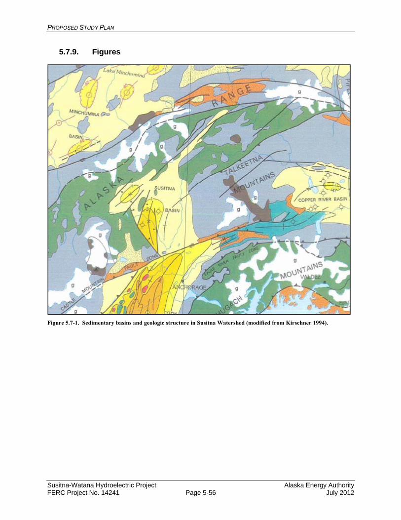
PROPOSED STUDY PLAN
Susitna-Watana Hydroelectric Project Alaska Energy Authority FERC Project No. 14241 Page 5-56 July 2012
5.7.9. Figures
Figure 5.7-1. Sedimentary basins and geologic structure in Susitna Watershed (modified from Kirschner 1994).
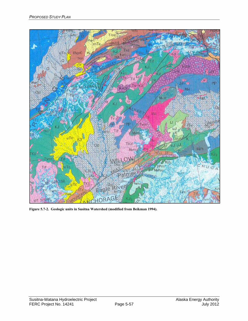
PROPOSED STUDY PLAN
Susitna-Watana Hydroelectric Project Alaska Energy Authority FERC Project No. 14241 Page 5-57 July 2012
Figure 5.7-2. Geologic units in Susitna Watershed (modified from Beikman 1994).
PROPOSED STUDY PLAN
Susitna-Watana Hydroelectric Project Alaska Energy Authority FERC Project No. 14241 Page 5-58 July 2012
5.8. Geomorphology Study
5.8.1. General Description of the Proposed Study
5.8.1.1. Study Goals and Objectives
The overall goal of the Geomorphology Study is to evaluate the effects of the Project on the geomorphology and dynamics of the Susitna River, which in turn will inform the analysis of potential project-induced impacts to channel formation processes and aquatic habitats. The results of this study, along with results of the Fluvial Geomorphology Study below Susitna-Watana Dam, will be used in combination with geomorphic principles and criteria/thresholds defining probable channel forms to predict the potential for alteration of channel morphology from Project operation. This information will be used to determine whether mitigation measures may be needed and, if so what those measures may be.
Specific objectives of this study can be summarized as follows:
Determine how the river system functions under existing conditions Determine how the current system forms and maintains a range of aquatic and
channel margin habitats Identify the magnitudes of changes in the controlling variables and how these will
affect existing channel morphology in the identified reaches downstream of the dam, and
Determine the likely changes to existing habitats through time and space
In order to achieve the study objectives the following analyses are required:
Geomorphically characterize the Project-affected river channels
Collect sediment transport data to supplement historical data to support the characterization of Susitna River sediment supply and transport (to be performed by USGS);
Empirically characterize Susitna River sediment supply and transport conditions;
Assess channel and study site stability/change (1980s versus current conditions);
Characterize the surface area versus flow relationships for riverine habitat types over a range of flows (e.g., 5,100 to 23,000 cubic feet per second [cfs]) in the Middle River;
Conduct a reconnaissance level geomorphic assessment of potential Project effects on the Lower River channel;
Conduct a reconnaissance level riverine habitat assessment of potential Project effects on the Lower River channel;
Characterize the proposed Watana Reservoir geomorphology (changes resulting from conversion of the channel/valley to a reservoir);
Assess potential issues related to large woody debris transport and recruitment; and
PROPOSED STUDY PLAN
Susitna-Watana Hydroelectric Project Alaska Energy Authority FERC Project No. 14241 Page 5-59 July 2012
Characterize geomorphic conditions at stream crossings along access road/transmission line alignments.
5.8.2. Existing Information and Need for Additional Information
An analysis of the Middle Susitna River reach geomorphology and how aquatic habitat conditions change over a range of stream flows was performed in the 1980s using aerial photographic analysis (Trihey & Associates 1985). The AEA Susitna Water Quality and Sediment Transport Data Gap Analysis Report (URS 2011) states that “if additional information is collected, the existing information could provide a reference for evaluating temporal and spatial changes within the various reaches of the Susitna River.” The gap analysis emphasizes that it is important to determine if the conditions represented by the data collected in the 1980s are still representative of current conditions and that at least a baseline comparison of current and 1980s-era morphological characteristics in each of the identified sub-reaches is required.
An analysis of the Lower River reach and how riverine habitat conditions change over a range of stream flows was performed in the 1980s using aerial photographic analysis (R&M Consultants Inc. and Trihey and Associates 1985a). This study evaluated the response of riverine aquatic habitat to flows in the Lower River reach between the Yentna River confluence (RM 28.5) and Talkeetna (RM 98) (measured at Sunshine gage near RM 84) ranging from 13,900 cfs to 75,200 cfs. The study also included an evaluation of the morphologic stability of islands and side channels by comparing aerial photography between 1951 and 1983. As with the Middle River information, it is important to determine if the conditions represented by the 1980s data are representative of current conditions. Such a comparison should include not only an identification of change, but should consider if the relative proportions of the various meso-habitat types have remained constant within a reach. If the relative proportions of the various meso-habitat types have remained constant in the various reaches, it provides a reasonable basis for using the 1980’s data.
Considerable information is available from a variety of sources that will support the development and execution of the Geomorphology Study. Much of the available information is from the 1980s studies associated with the earlier efforts to develop the Susitna Hydroelectric Project (FERC No. 7114). In some cases, the older information will need to be replaced or supplemented with newer information as the Susitna River is a dynamic system and historical data such as cross sections and aerial images in many areas will likely have changed considerably since they were collected in the 1980s. However, when compared with current information, these data provide valuable tools to understand the behavior and physical processes driving the geomorphology of the Susitna River. Comparability of the two sets of data will indicate that the fundamental relationships between channel form and fluvial process have remained constant and thus provide a basis for using the historical data. Additional data and analyses are needed to determine if historical data can be used to reflect current conditions and to address some of the data gaps identified for AEA Susitna Water Quality and Sediment Transport Data Gaps Analysis Report (URS 2011). A more specific description of existing information and the need for additional information for each geomorphology study component are provided in the appropriate sections below.
PROPOSED STUDY PLAN
Susitna-Watana Hydroelectric Project Alaska Energy Authority FERC Project No. 14241 Page 5-60 July 2012
5.8.3. Study Area
The study area for the Geomorphology Study is the Susitna River from its confluence with the Maclaren River (RM 260) downstream to the mouth at Cook Inlet (RM 0). The study area has been divided into three large-scale reaches:
Upper River: Maclaren River confluence (RM 260) downstream to the proposed Watana Dam site (RM 184).
Middle River: Proposed Watana Dam site (RM 184) downstream to the three rivers confluence (RM 98.5).
Lower River: Three rivers confluence (RM 98.5) downstream to Cook Inlet (RM 0).
Each of the 10 study components that make up the Geomorphology Study has a component-specific study area often related to the three large-scale reaches identified above. The study area and the reaches are shown on Figure 5.8-1. Identification of the study area that each study component addresses is provided in the discussion of each study component in Section 5.8.4, Study Methods.
5.8.4. Study Methods
The methods for each of the 10 Geomorphology Study components are presented in this section.
5.8.4.1. Study Component 1: Delineate Geomorphically Similar (Homogeneous) River Segments
The goal of the Delineate Geomorphically Similar (Homogeneous) River Segments study component is to geomorphically characterize the Project-affected river channels. This effort is being performed as part of the 2012 studies and is also described in the study plan for Aquatic Habitat and Geomorphic Mapping of the Middle River Using Aerial Photography. The study area is the length of the Susitna River from its mouth at Cook Inlet (RM 0), upstream to the proposed Watana Dam site (RM 184), and upstream of the proposed Watana Dam site, including the reservoir inundation zone and on upstream to the Maclaren River confluence. The tributary mouths along the Susitna River and in the reservoir inundation zone that may be affected by the Project are also included in the study area.
5.8.4.1.1. Existing Information and Need for Additional Information
This effort will support the understanding of the conditions in the Susitna River by applying a geomorphic classification system based on form and process. It will also support efforts by other studies, including the Instream Flow, Instream Flow Riparian, Fish and Ice Processes studies by providing a basis to stratify the river into reaches based on current morphology and their potential sensitivity to the Project. A delineation of the Susitna River into reaches was performed in the 1980s for the Middle River (Trihey & Associates 1985) and the Lower River (R&M Consultants, Inc. and Trihey & Associates 1985a).
PROPOSED STUDY PLAN
Susitna-Watana Hydroelectric Project Alaska Energy Authority FERC Project No. 14241 Page 5-61 July 2012
5.8.4.1.2. Methods
This effort consists of identification of a geomorphic classification systems and conducting the delineation of geomorphic reaches based on the identified classification system.
5.8.4.1.2.1. Identification and Development of Geomorphic Classification System
The first step in the geomorphic reach delineation effort will be the identification of the system to be used to classify and delineate the reaches. Classification of the river segments is required to provide a basis for communication among the various disciplines and for identifying relatively homogeneous river segments that can then be used as a basis for extrapolation of results and findings from more spatially-limited studies. Numerous river classifications exist (Leopold and Wolman 1957, Schumm 1963 and 1968 Mollard 1973, Kellerhals et al. 1976, Brice 1981, Mosley 1987, Rosgen 1994 and 1996, Thorne 1997, Montgomery and Buffington 1997, Vandenberghe 2001), but no single classification has been developed that meets the needs of all investigators. Several factors have prevented the achievement of an ideal geomorphic stream classification, and foremost among these has been the variability and complexity of rivers and streams (Mosley 1987, Juracek and Fitzpatrick 2003). Problems associated with the use of existing morphology as a basis for extrapolation (Schumm 1991) further complicates the ability to develop a robust classification (Juracek and Fitzpatrick 2003). For purposes of classifying the Susitna River, available classification systems will be reviewed, and it is anticipated that a specific system will be developed that borrows elements from several classifications systems. The classification scheme will consider both form and process. Development of this system will be coordinated with the Instream Flow, Instream Flow Riparian, Ice Processes, and Fish studies so it is consistent with their needs. These studies may require further stratification to identify specific conditions of importance to their efforts, in which case, these studies will further divide the river into subreaches. However, the overall reach delineations developed in the Geomorphology Study will be used consistently across all studies requiring geomorphic reach delineations.
5.8.4.1.2.2. Geomorphic Reach Delineation
The Lower River (RM 0 to RM 98), the Middle River (RM 98 to RM 184), and the Upper River to the Maclaren River confluence (RM 184 to RM 260) will be delineated into large-scale geomorphic river segments (a few to many miles) with relatively homogeneous characteristics, including channel width, entrenchment, ratio, sinuosity, slope, geology/bed material, single/multiple channel, braiding index, and hydrology (inflow from major tributaries) for the purposes of stratifying the river into study segments. Stratification of the river into relatively homogeneous segments will permit extrapolation of the results of sampled data at representative sites within the individual segments.
Because there are several studies that required a reach delineation for planning 2012 field activities, an initial delineation primarily based on readily available information (most recent high quality aerials, bed profile from the 1980s, geomorphic descriptions from the 1980s) was developed in April 2012. As additional information is developed, such as current aerial photographs and transects, the delineation will be refined and the various morphometric parameters will be included in the delineation. Coordination with the River Flow Routing Model Transect Data Collection Study will be conducted to obtain cross-section channel/floodplain

PROPOSED STUDY PLAN
Susitna-Watana Hydroelectric Project Alaska Energy Authority FERC Project No. 14241 Page 5-62 July 2012
data. Coordination with the Instream Flow Study, Instream Flow Riparian Study, Geomorphic Modeling Study, and Ice Processes Study will be conducted to ensure that the river stratification is conducted at a scale appropriate for those studies.
A reconnaissance-level site visit of the Susitna River will be conducted that will be coordinated with other studies to take advantage of scheduled boat and helicopter trips as well as opportunities to coordinate with other studies. The Study Lead, Geomorphology Lead and Sediment Transport Modeling Lead, the erosion Study Lead, and at least one other senior member of the Geomorphology Study team will participate in the reconnaissance trip. They will be joined by representatives from the Instream Flow Study, Instream Flow Riparian Study, Ice Processes Study, and Fish Study. The purpose of this site visit will be to provide key team members an overview of the river system. This will be extremely useful for all the Geomorphology Study components since it will permit team members to verify on the ground assessments that have been made from remotely sensed information.
5.8.4.1.2.3. Information Required
The following available existing information will be needed to conduct this study:
Historical aerial photographs,
Information on bed material size,
Location and extent of lateral and vertical geologic controls,
Drainage areas of major tributaries, and
Topographic mapping, including USGS survey quadrangle maps and LiDAR.
The following additional information will need to be obtained to conduct this study:
Current high resolution aerial photography,
Field observations made during a site reconnaissance,
Extended flow record for the Susitna River and tributaries being developed by USGS, and
Profile of the river (thalweg or water surface).
5.8.4.1.3. Study Products
The results of the Delineate Geomorphically Similar River Segments study component will be included in the Geomorphology Report. Information provided will include
A geomorphic classification system developed specifically for the Susitna River that considers both form and physical processes.
A delineation of the Susitna River into reaches of similar geomorphic characteristics, which has been coordinated with other relevant studies (Instream Flow, Riparian Instream Flow, Ice Processes, and Fish studies). The delineation will include broad large-scale reaches and further delineation into sub-reaches.

PROPOSED STUDY PLAN
Susitna-Watana Hydroelectric Project Alaska Energy Authority FERC Project No. 14241 Page 5-63 July 2012
Tables of morphometric parameters describing the physical characteristics of each sub-reach developed from the analysis of aerial photographs, LiDAR, bed profiles, bed material samples, geologic mapping, and transect surveys.
In addition, an ArcGIS shapefile will be provided with the following information:
Mapping of the large-scale reaches and sub-reaches overlaid on recent aerial photography and topographic mapping.
5.8.4.2. Study Components 2: Bedload and Suspended Load Data Collection at Tsusena Creek, Gold Creek, and Sunshine Gage Stations on the Susitna River and Chulitna River near Talkeetna
The goal of the Bedload and Suspended Load Data Collection at Tsusena Creek (RM 182), Gold Creek (RM 136), and Sunshine gage (RM 84) stations on the Susitna River and the Chulitna River near Talkeetna study component is to empirically characterize the Susitna River sediment supply and transport conditions. This effort is being performed by USGS. The effort described is for 2012 and may be modified in subsequent years based on experience gained from the 2012 work. The study covers the Susitna River from RM 84 (Sunshine Station) upstream to RM 182 (Tsusena Gage) and the Chulitna River near its confluence with the Susitna River. Figure 5.8-2 identifies the location of the study gages and other existing and historical USGS gages in the Susitna River basin.
5.8.4.2.1. Existing Information and Need for Additional Information
The collection of the data described in this study will supplement sediment transport data collected in the 1980s. The additional data are needed to determine if historical data can be used to reflect current conditions or if there have been shifts in the rating curves that might be related to climate change, glacial surges or other as yet unidentified causes and to address some of the data gaps identified in the Susitna Water Quality and Sediment Transport Data Gaps Analysis Report (URS 2011).
This study will provide information on current transport conditions and support assessment of Project effects on sediment supply. Sediment data derived from the gages will be used to provide sediment inputs at model boundaries. This information will be used by several study components in this study as well as the Fluvial Geomorphology Modeling below Watana Dam Study.
5.8.4.2.2. Methods
The following scope of work was provided by USGS:
Operate and maintain the stream gages;
Maintain datum at the site;
Record stage data every 15 minutes;
Make discharge measurements during visits to maintain the stage-discharge rating curve and to define the winter hydrograph;
Store the data in USGS databases;
PROPOSED STUDY PLAN
Susitna-Watana Hydroelectric Project Alaska Energy Authority FERC Project No. 14241 Page 5-64 July 2012
Collect at least five suspended sediment samples at Susitna River above Tsusena Creek, at Gold Creek, and at Sunshine; and the Chulitna River near Talkeetna during the year for concentration and size analysis;
Collect at least five bed material samples during the year at Susitna River above Tsusena Creek, at Gold Creek, and at Sunshine; and the Chulitna River near Talkeetna for bedload transport determination and size analysis;
Collect at least five bedload samples during the year at Susitna River at Gold Creek, Susitna River at Sunshine, Susitna River above Tsusena Creek, and the Chulitna River near Talkeetna for bedload transport determination and size analysis;
Operate and maintain the stream gages at the Susitna River near Denali and the Chulitna River near Talkeetna;
Operate a stage-only gage at a site upstream from Deadman Creek. Logistics at this site may preclude continuous operation or telemetry of the information; and
Compilation of suspended and bedload data, including calculation of sediment transport ratings and daily loads, in a technical memorandum delivered to AEA during federal fiscal year (FFY) 2013, and as early as March 2013, if possible. Provisional results from sampling will be available as soon as lab data are available. Provisional results from sediment load computations will be made available as soon as possible.
The bed load and suspended sediment data will be combined with existing rating curves to identify the differences and similarities between the historical and current data sets. This information will be used to evaluate whether the historical data sets are representative of current conditions in the Susitna River at Gold Creek and the Susitna River at Sunshine.
The sediment transport data available for the Chulitna and Talkeetna rivers will be reviewed. This will be accomplished using the sampling results collected in 2012 to help determine whether or not the historical rating curves are expected to be accurate. Because current data are not being collected on the Chulitna and Talkeetna rivers, this will primarily be accomplished by developing the mass balance of sediment above (Gold Creek data) and below (Sunshine data) three rivers to estimate the contributions from the Chulitna and Talkeetna rivers. The estimate based on the mass balance developed from the current data will be compared against estimates based on the historical Chulitna and Talkeetna sediment transport relationships. In addition, the historical Chulitna and Talkeetna sediment transport relationships and their applicability to current conditions will secondarily be evaluated comparing the historical versus new sediment rating curves at Gold Creek and at Sunshine (two locations where new data are being collected in 2012). Based on the results of the effort, a recommendation on whether or not additional sediment transport sampling is necessary in the Chulitna or Talkeetna rivers will be made.
5.8.4.2.3. Study Products
The results of the Bedload and Suspended Load Data Collection at Tsusena Creek, Gold Creek, and Sunshine gage stations study component will be included in the Geomorphology Report. Information provided will include:
Calculation of discharge, suspended sediment discharge, and bedload discharge;
PROPOSED STUDY PLAN
Susitna-Watana Hydroelectric Project Alaska Energy Authority FERC Project No. 14241 Page 5-65 July 2012
Tabulation of all discharge, suspended sediment, bedload, and bed material sampling results;
Data sheets reflecting field measurements;
Comparison of historical and 2012 sediment transport measurements to determine if historical sediment transport rating curves can be expected to accurately represent current conditions;
Narrative on data collection activities including description of methods, any difficulties encountered, and recommendations for potential future data collection in 2013;
Posting of near real-time stage and discharge data on the USGS website; http://waterdata.usgs.gov/ak/nwis/; and
Publication of the data in the USGS’s annual Water-Resources Data for the United States report (http://wdr.water.usgs.gov/).
In addition, an ArcGIS Shapefile will be provided with the following information:
Location of gage stations and measurement transects (if different from gage location).
5.8.4.3. Study Component 3: Sediment Supply and Transport Middle and Lower River
The objective of this task is to empirically characterize the sediment supply and transport conditions in the Susitna River between the proposed Watana Dam site (RM 184) and the Susitna Station Gage (RM 28). The Three Rivers Confluence (RM 98) separates the Middle River from the Lower River. The estimates for the Lower River Sediment Balance will be developed in 2012 as part of the Reconnaissance Level Geomorphic and Aquatic Habitat Assessment of Project Effects on Lower River Channel. The remaining efforts, which include Middle River Sediment Balance, Bed Material Mobilization, and Effective Discharge, will be conducted in 2013.
5.8.4.3.1. Existing Information and Need for Additional Information
Sediment transport data are available along the mainstem Susitna River and several of the major tributaries between the proposed Watana Dam site (RM 184) downstream to Susitna Station (RM 28) (URS 2011). The Project will reduce sediment supply to the reach of the Susitna River downstream from the dam, and will also alter the timing and magnitude of the flows that transport the sediment. Information provided in the Pre-Application Document (AEA 2011) suggests that peak flows may be reduced in magnitude and may occur later in the season. The results of this study component will provide the initial basis for assessing the potential for changes to the Middle River and Lower River sediment balance and the associated changes to geomorphology because it will permit quantification of the magnitude in the reduction of sediment supply below the dam. The studies will also support the Fluvial Geomorphology Modeling below Watana Dam Study through development of sediment supply information that will be required as input to the model.
PROPOSED STUDY PLAN
Susitna-Watana Hydroelectric Project Alaska Energy Authority FERC Project No. 14241 Page 5-66 July 2012
5.8.4.3.2. Methods
The methods are divided into five sections: (1) Middle River Sediment Balance, (2) Lower River Sediment Balance, (3) Characterization of Bed Material Mobilization, (4) Effective Discharge, and (5) Information Required.
The development of the sediment balances for the Middle River (RM 184 to RM 98) and the Lower River (RM 98 to RM 28) will consider various techniques to characterize the sediment supply to each reach, the sediment transport capacity through the reaches, and deposition/storage within the reaches. Sources of sediment supply are expected to include the mainstem Susitna River, contributing tributaries, and identified locations of mass wasting. Potential procedures to estimate sediment supply include the use of regional sediment supply relationships (e.g., regression equations based on watershed area) and calculation of differences in sediment loads between gaging stations. While it is recognized that the gages are spatially separated, the comparison of the loads at the gages will permit an assessment of whether there is significant storage or loss of sediment between gages. If the data indicate that there is little difference between the gages then it can be reasonably concluded that there is sufficient supply of sediment within the between gages reach to allow an assumption of transport capacity limitation rather than supply limitation. The sediment transport measurements collected by USGS, both historical and current, will be used to develop bedload and suspended load rating curves to facilitate translation of the periodic instantaneous measurements into yields over longer durations (e.g., monthly, seasonal, and annual). Since gradations of transported material will be available, the data will allow for differentiation of transport by size fraction. Previous studies have documented the potential for bias in suspended load rating curves due to scatter in the relationship between sediment concentration or load and flow (Walling 1977a). Part of the scatter is often caused by hysteresis in the sediment load versus discharge relationship, where the loads on the rising limb are higher than on the falling limb due to availability of material and coarsening of the surface layer during the high-flow portion of the hydrograph (Topping et al. 2010). Bias is also introduced in performing linear least-squares regressions using logarithmic transformed data and then back-transforming the predicted sediment loads to their arithmetic values (Walling 1977b, Thomas 1985, Ferguson 1986). The hysteresis effect can be accounted for by applying separate (or perhaps, shifting) rating curves through rising and falling limbs of flood hydrographs (Guy 1964, Walling 1974, Wright et al. 2010). The USGS Office of Surface Water (1992) endorsed the recommendations by Cohn and Gilroy (1991) to use the Minimum Variance Unbiased Estimator (MVUE) bias correction for normally distributed errors, or the Smearing Estimator (Duan 1983) when a non-normal error distribution is identified. Once the sediment measurements are available for review, the potential for bias in the sediment rating curves will be considered and addressed as appropriate.
The rating curves for the mainstem Susitna stations, for gaged tributary stations, and those developed for contributing ungaged areas between stations will be used to develop the sediment balance for the pre-Project hydrology for representative wet, average, and dry years and warm and cold Pacific Decadal Oscillation (PDO) phases (The inclusion of the warm and cold PDO phases was requested by NOAA-NMFS and USFWS in the May 31, 2012 study requests; the rationale for the request was discussed at the June 14, 2012 Water Resources TWG meeting and it was agreed that the PDO phases would be included in the suite of representative annual hydrologic conditions.). The sediment balance will be calculated based on the assumption that the sediment load in the Susitna River is currently in a state of equilibrium. To develop the
PROPOSED STUDY PLAN
Susitna-Watana Hydroelectric Project Alaska Energy Authority FERC Project No. 14241 Page 5-67 July 2012
sediment balance for the post-Project condition, the historical (pre-Project) sediment rating curve developed for the river immediately below the Watana Dam site (Tsusena Creek) will be reduced by 100 percent for the bedload and 90 percent for the suspended load on a preliminary basis. If the reservoir trap efficiency analysis discussed below indicates that a substantially different amount of sediment will pass through the reservoir, the sediment load curves will be adjusted accordingly.
5.8.4.3.2.1. Middle River Sediment Balance
The sediment balance for the Middle River between the proposed Watana Dam site (RM 184) and the Three Rivers Confluence (RM 98) will be estimated for wet, average, and dry years for both warm and cold PDO phases by integrating the sediment load curves over the respective hydrographs and comparing the resulting sediment inflows with the amount passing out the downstream end of each segment. Estimates of the contributions to the sediment supply from the Upper River identified mass wasting locations and contributing tributaries downstream of the dam will be an important aspect of this analysis. Potential procedures to estimate the Middle River sediment supply include the use of watershed area and regional sediment supply relationships and the determination of the differences on a seasonal or annual basis between the sediment loads estimated for the Susitna River at the Tsusena Creek and Gold Creek gage locations. Past USGS sediment data may be available for Indian River and Portage Creek, which could also be used to assist in the estimation of the Middle River sediment supply inputs. If data being collected by USGS for the Determine Bedload and Suspended Sediment Load by Size Fraction study at Tsusena Creek, Gold Creek, and Sunshine Gage Stations are available in time for this analysis, the 2012 data from Tsusena Creek will be compared to the 2012 Gold Creek data to estimate the sediment inflow between these two locations. This will allow development of a sediment rating curve from the 1985 data for the Susitna River at Tsusena Creek (representative of sediment transport at the Susitna-Watana dam site).
5.8.4.3.2.2. Lower River Sediment Balance
The Lower River Sediment Balance will depend on the sediment balance supply from the Middle River, as well as the supply from the Chulitna and Talkeetna rivers and other local tributaries along the reach. The total sediment load delivered to the Lower River under pre-Project conditions will be evaluated using the sediment rating curves developed from the historical data for the Sunshine and Susitna Station gaging stations and any new sediment transport collected by USGS under the Determine Bedload and Suspended Sediment Load by Size Fraction study at Tsusena Creek, Gold Creek, and Sunshine gage stations. The post-Project sediment supply from the Middle River will be taken from the Middle River analysis discussed above. The sediment transport rating curves at Gold Creek, Sunshine, and the Chulitna River will be used to determine the combined sediment contribution of the Talkeetna and other sediment inflows between Gold Creek and Sunshine. Moving downstream, the sediment rating curves at Sunshine, Yentna River, and Susitna Station can be used to determine the sediment contribution between Sunshine and Susitna Station.
5.8.4.3.2.3. Characterization of Bed Material Mobilization
The approximate discharge at which bedload transport begins in the Susitna River near the proposed dam and at selected locations in the Middle and Lower Rivers will be estimated using

PROPOSED STUDY PLAN
Susitna-Watana Hydroelectric Project Alaska Energy Authority FERC Project No. 14241 Page 5-68 July 2012
the USGS empirical sediment rating curves, incipient motion calculations (i.e., estimates of the critical discharge at which bed material begins to mobilize), and field observations. The resulting estimates of the critical discharge will be used to assess the frequency and duration of bed mobilization under the pre- and post-Project condition hydrology. This will be performed on both a monthly and annual basis at the selected locations for a range of flow years.
The concept of incipient motion as advanced by Shields (1936) relates the critical shear stress for particle motion (c) to the dimensionless critical shear stress (*c) and the unit weight of sediment (s), the unit weight of water (), and the median particle size of the bed material (D50). One key limitation of this relation is the specification of *c (often referred to as the Shields parameter), which can range by a factor of three (Buffington and Montgomery 1997). The large range in published values for *c is caused largely by the difficulty in defining and identifying when bed material motion actually begins. To work around this limitation, Parker (Parker et. al. 1982) defined a reference Shields stress (*r) that corresponds to a dimensionless transport rate W* = 0.002, corresponding to a very low, but measurable transport rate. For this relationship, W* is a function of the unit bed load and the total boundary shear stress, both of which are relatively simple parameters to calculate from field data if bed load and discharge measurements are included (In the NOAA-NMFS and USFWS Study Plan Requests, it was proposed that the bed material mobilization analysis be calibrated based on the use of tracers. This topic was discussed at the Water Resources TWG held on June 14, 2012. AEA’s Consultants indicated that the use of tracers in a large river such as the Susitna would not be practical due to the difficulty in locating the tracers after mobilization. Therefore, the use of tracers is not included in the proposed study plan.).
Bed material mobilization at various locations along the study reach will be characterized using the reference shear approach of Parker, following the methods of Mueller et al. (2005). Data collected by USGS, which will include the necessary series of coupled flow and bedload transport measurements, will be used to formulate a series of bedload rating curves. These curves will then provide a basis for estimating * that corresponds to a dimensionless transport rate W* = 0.002 for bed material mobilization.
5.8.4.3.2.4. Effective Discharge
The concept of effective discharge, as advanced by Wolman and Miller (1960), relates the frequency and magnitude of various discharges to their ability to do geomorphic work by transporting sediment. They concluded that events of moderate magnitude and frequency transport the most sediment over the long-term, and these flows are the most effective in forming and maintaining the planform and geometry of the channel. Andrews (1980) defined the effective discharge as “the increment of discharge that transports the largest fraction of the annual sediment load over a period of years.”
Alluvial rivers adjust their shape in response to flows that transport sediment. Numerous authors have attempted to relate the effective discharge to the concepts of dominant discharge, channel-forming discharge, and bankfull discharge, and it is often assumed that these discharges are roughly equivalent and correspond to approximately the mean annual flood peak (Benson and Thomas 1966, Pickup 1976, Pickup and Warner 1976, Andrews 1980 and 1986, Nolan et al. 1987, Andrews and Nankervis 1995). Quantification of the range of flows that transport the most sediment provides useful information to assess the current state of adjustment of the

PROPOSED STUDY PLAN
Susitna-Watana Hydroelectric Project Alaska Energy Authority FERC Project No. 14241 Page 5-69 July 2012
channel and to evaluate the potential effects of increased discharge and sediment delivery on channel behavior. Although various investigators have used only the suspended-sediment load and the total sediment load to compute the effective discharge, the bed-material load should generally be used when evaluating the linkage between sediment loads and channel morphology because it is the bed-material load that has the most influence on the morphology of the channel (Schumm 1963, Biedenharn et al. 2000).
For purposes of this study, the effective discharge will be computed for the Susitna River below Tsusena Creek, at Gold Creek, and at Sunshine. This will be performed by dividing the full range of flows at each location into at least 30 logarithmic classes (Biedenharn et al. 2000) and then computing the sediment transport capacity at the average discharge within each flow class using the previously described rating curves. The bed material transport in each flow class over the long-term will be determined by multiplying the individual transport rates by the corresponding flow duration, which is derived from mean daily flow duration curves. The effective discharge is the flow, or range of flows, where the incremental bed material transport is greatest. Effective discharges will be determined for both the pre- and post-Project conditions. If, as expected, the post-project value is lower than the pre-project value it provides an indication that the morphology of the channel will change since there is a reasonably well identified relationship between the effective discharge and the size of the channel.
5.8.4.3.2.5. Information Required
The following available existing information will be needed to conduct this study:
Current and historical aerial photographs;
Historical suspended sediment and bedload data for the Susitna River and contributing tributaries; and
Flow records for the Susitna River and contributing tributaries.
The following additional information will need to be obtained to conduct this study:
Suspended and bedload data for the Susitna River at Tsusena Creek and Gold Creek being performed by USGS;
Extended flow record for the Susitna River and gaged tributaries within the study area being developed by USGS;
Estimated flows for the ungaged tributaries within the study area;
Extended flow records for the Susitna River and tributaries being developed by USGS;
Collection of bed material samples throughout the Middle and Lower Rivers, as well as contributing tributaries;
Hydraulic conditions in the Susitna River from the Hydraulic Routing Model; and
Surveys of channel geometry for contributing tributaries to simulate hydraulic conditions.
5.8.4.3.3. Study Products
The results of the Sediment Supply and Transport Middle and Lower River study component will be included in the Geomorphology Report. Information provided will include
PROPOSED STUDY PLAN
Susitna-Watana Hydroelectric Project Alaska Energy Authority FERC Project No. 14241 Page 5-70 July 2012
Tabular and graphical summary of available discharge and sediment transport data;
Description of procedures used to develop sediment transport rating curves from suspended load and bedload data, including development of curves for specific sediment size-classes;
Graphical and numerical relationships for sediment discharge rating curves;
Narrative describing procedures used to perform effective discharge and bed mobilization calculations;
Determination of total sediment load delivered to the Susitna River for pre- and post-Project conditions (the latter based on preliminary assumption that 100 percent bedload and 90 percent of suspended load will be trapped behind the Project dam; this estimate can be refined if the trap efficiency analysis indicates substantially different results);
Estimate of Middle River sediment supply inputs from local tributaries and other sources;
Tabular and graphical representation and comparison of the duration and frequency of bed material mobilization in the Middle and Lower Rivers for pre- and post-Project conditions;
Estimates of the effective discharge for the pre- and post-Project conditions, and the likely effects on channel morphology; and
Estimates of the overall sediment transport balance along the reach and the likely effects on channel morphology, particularly with respect to aggradation/degradation trends and changes in braiding potential. In reaches with net sediment deficit, results from the bed mobilization analysis will also be considered in assessing degradation tendencies.
5.8.4.4. Study Component 4: Assess Geomorphic Change Middle and Lower Rivers
The goal of the Assess Geomorphic Change Middle and Lower Rivers study component is to compare existing and 1980s geomorphic feature data from aerial photo analysis to characterize the relative stability of the 1980s study sites and river morphology under unregulated flow conditions. The effort for the Middle River will be conducted in 2012 as part of the Aquatic Habitat and Geomorphic Mapping of the Middle River Using Aerial Photography study and for the Lower River as part of the Reconnaissance Level Geomorphic and Aquatic Habitat Assessment of Project Effects on Lower River Channel study. The study area extends from the mouth of the Susitna River (RM 0) at Cook Inlet to the proposed Watana Dam site (RM 184).
5.8.4.4.1. Existing Information and Need for Additional Information
An analysis of the Middle Susitna River reach geomorphology and how aquatic habitat conditions changed over a range of stream flows was performed in the 1980s using aerial photographic analysis (Trihey & Associates 1985). A similar analysis was performed for the Lower River (R&M Consultants, Inc. and Trihey and Associates 1985a). The1980s Lower River study also included an evaluation of the morphologic stability of islands and side channels by comparing aerial photography between 1951 and 1983. The AEA Susitna Water Quality and Sediment Transport Data Gap Analysis Report (URS 2011) states that “if additional information is collected, the existing information could provide a reference for evaluating temporal and

PROPOSED STUDY PLAN
Susitna-Watana Hydroelectric Project Alaska Energy Authority FERC Project No. 14241 Page 5-71 July 2012
spatial changes within the various reaches of the Susitna River.” The gap analysis emphasizes that it is important to determine if the conditions represented by the data collected in the 1980s are still representative of current conditions and that at least a baseline comparison of current and 1980s-era morphological characteristics in each of the identified subreaches is required.
Understanding existing geomorphic conditions and how laterally stable/unstable the channels have been over recent decades provides a baseline set of information needed to provide a context for predicting the likely extent and nature of potential changes that will occur due to the Project. Results of this study may also be used in the Instream Flow Riparian and Ice Processes studies to provide the surface areas of bars likely to become vegetated in the absence of ice-cover formation. This would be accomplished by evaluating the areas of exposed bars within river segments over a range of flows and developing exposed bar area-discharge curves that could then be used to assess the impacts of the Project flows on bar inundation by both flows and ice. Increases in areas that would be both inundation- and ice-free are likely to permit vegetation establishment and persistence.
5.8.4.4.2. Methods
This study component has been divided into the Middle and Lower Rivers since the available information differs. The analysis of geomorphic change will be conducted for a single representative discharge.
5.8.4.4.2.1. Middle River
Coordination will occur with AEA’s Spatial Data Contractor to digitize the riverine geomorphic features from RM 98 to RM 150 defined in the 1980s from hard copy maps found in the Middle River Assessment Report (Trihey & Associates 1985). The September 6, 1983 aerials flown at a flow of 12,500 cfs will be used for the historical condition. Each feature will be a polygon (without slivers). Geomorphic features that are visible between the 1980s and current images, including the main channel, side channels, the presence and extent of mid-channel bars, vegetated bar areas, and changes at tributary deltas will be digitized for a single representative flow. (Note: the AEA Spatial Data Contractor will complete the digitizing and develop associated metadata for the 1980s digitizing.) From RM 98 to RM 184 the geomorphic features at a single representative stream flow, currently identified as 12,500 cfs, on the 2012 aerial photographs will also be digitized and delineated using the orthorectified photography and ArcGIS software (each geomorphic feature will be a polygon without slivers. (Note: the Study Contractor will complete the digitizing and develop associated metadata for the 1980s digitizing.)
The information developed from digitizing the aerials will be used to analyze and compare the geomorphology for 1980s and current conditions. From RM 98 to RM 150, GIS software will be used to compare the 2012 versus 1980s total surface area associated with each geomorphic feature. Results will be compiled into tables and graphs, as appropriate, to show the difference in surface areas of the feature types between 2012 and the 1980s photography. The lead geomorphologist will provide training to ensure appropriate application of the geomorphic definitions. Since this 34-mile river segment below the proposed Watana Dam site (RM 150 to RM 184) was not analyzed in the 1980s, this portion of the river will undergo a new assessment
PROPOSED STUDY PLAN
Susitna-Watana Hydroelectric Project Alaska Energy Authority FERC Project No. 14241 Page 5-72 July 2012
(2012 photography only) that will not be compared to past studies. However, the methods for analyzing riverine geomorphic features will remain the same.
The change in channel planform over the length of the river (main channel location, side channel location, bars, channel and side channel width, channel and side channel location) will be qualitatively assessed between the 1980s and 2012. Reaches will be identified that are relatively stable versus those that are more dynamic. Reaches that would be most susceptible to channel change (e.g., width or planform change) with changes in the flow or sediment regime resulting from the Project or Project operations will be qualitatively identified since these are currently the most dynamic. Depending upon the results of the riverine geomorphic analysis, additional historical photographic analysis may be requested as part of future geomorphic studies, but this additional analysis is not included at this time. Additional analysis of historical aerial photographs and the corresponding flows that occurred between 1985 and 2012 could be pertinent if substantial changes in the riverine habitat types (surface area, locations, etc.) are identified during comparison of the 2012 and 1980s photography. While the long-term changes in river morphology are the result of a range of flows, if significant changes are identified between pairs of aerial photographs, review of the hydrologic record frequently identifies events that are more than likely to have been morphogenetically significant. This type of additional aerial photo analysis could provide more specific information on the flow magnitude(s) and other conditions (for example ice formation) that may cause substantial geomorphic channel adjustments. If additional analysis is identified, it will be performed as part of the 2103-2014 studies.
5.8.4.4.2.2. Lower River
The 36,600 cfs September 6, 1983 set of Lower River aerial photographs and current satellite images or aerial photographs will be obtained to compare historical and present-day channel planform and pattern from RM 28 to RM 99. Planform shifts of the main channel and side channels will be identified between the 1983 and current aerial photography. The three rivers confluence area is also a part of the analysis (extended to RM 99). Geomorphic features that are visible between the 1983 and current images, including the presence and extent of side channels, vegetated bar areas, and changes at tributary deltas will be mapped and characterized. In areas where the mainstem channel consists of a dynamic braid plain mostly void of stabilizing vegetation, the effort will be directed at defining the edges of the active channel rather than detailing the myriad of channels within the active area. Major sloughs and side channels along the lower river margins will be included in the digitizing effort.
The rest of the Lower River effort will be similar to the Middle River. The geomorphic change over the length of the river (main channel location, side channel location, bars, channel and side channel width, channel and side channel location) will be qualitatively assessed between the 1980s and current conditions. Reaches will be identified that are relatively stable versus those that are more dynamic. Reaches that would be most susceptible to channel change (e.g., width or planform change) with changes in the flow or sediment regime resulting from the Project or Project operations will be qualitatively identified. Depending upon the results of the riverine geomorphic analysis, additional historical photographic analysis may be requested as part of future geomorphic studies, but this additional analysis is not included at this time. Additional analysis of historical aerial photographs and the corresponding flows that occurred between 1985 and 2012 could be pertinent if substantial changes in the riverine habitat types (surface area,

PROPOSED STUDY PLAN
Susitna-Watana Hydroelectric Project Alaska Energy Authority FERC Project No. 14241 Page 5-73 July 2012
locations, etc.) are identified during comparison of the 2012 and 1980s photography. This type of additional aerial photo analysis could provide more specific information on the flow magnitude(s) and other conditions (for example ice formation) that may cause substantial geomorphic channel adjustments.
5.8.4.4.2.3. Information Required
The following available existing information will be needed to conduct this study:
Historical 1980s orthorectified aerial photographs for the Middle and Lower rivers.
The following additional information will be needed to conduct this study:
Obtain recent or develop 2012 orthorectified aerial photos (or satellite imagery) in the Middle and Lower Rivers at a flow similar to the historic aerials (12,500 cfs Middle River and 36,600 cfs Lower River; and
Acquire historic orthorectified aerial photos and digitized geomorphic features from the AEA Spatial Data Contractor (SDC) for the Middle and Lower Rivers for a single discharge.
5.8.4.4.3. Study Products
The results of the Assess Geomorphic Change Middle and Lower Rivers component will be included in the Geomorphology Report. Information provided will include:
Maps showing riverine geomorphic features outlined in the Middle River and Lower River for both the 1980s and 2012 for flows of 12,500 cfs and 36,600 cfs, respectively;
Maps showing the distribution of all riverine geomorphic features for both dates and for the Middle and Lower River reaches;
Overlay map of 1980s and 2102 riverine geomorphic features to assess the level of change in the channel morphology over the past three decades;
Tabular and graphical representation of the areas for each riverine geomorphic feature type by geomorphic sub-reaches within the Middle and Lower River reaches; and
Qualitative assessment of the level of geomorphic change for the lengths of the Middle River and Lower River reaches including identification of stable versus non-stable areas.
In addition, an ArcGIS Shapefile will be provided with the following information:
1980s orthorectified aerial imagery on GIS layer for the Middle and Lower River reaches; and
Digitized polygons for each riverine habitat feature type in the Middle and Lower River reaches.
5.8.4.5. Study Component 5: Riverine Habitat versus Flow Relationship Middle River
The goal of the Riverine Habitat Versus Flow Relationship Middle River study component is to develop existing and 1980s riverine habitat type area data over a range of flows to quantify riverine habitat versus surface area relationships. The study area extends from the three rivers
PROPOSED STUDY PLAN
Susitna-Watana Hydroelectric Project Alaska Energy Authority FERC Project No. 14241 Page 5-74 July 2012
area (RM 98) to the Watana Dam site (RM 184). Up to 20 study sites not exceeding 50 percent of the reach will be studied in the 2012 study, Aquatic Habitat and Geomorphic Mapping of the Middle River Using Aerial Photography. All or part of the remaining portion may be studied in 2103-2014, depending on the outcome and recommendations from the 2012 study as well as the selection of instream flow study sites.
5.8.4.5.1. Existing Information and Need for Additional Information
Understanding existing geomorphic conditions, how aquatic habitat changes over a range of stream flows, and how stable/unstable the geomorphic conditions have been over recent decades provides a baseline set of information needed to provide a context for predicting the likely extent and nature of potential changes that will occur due to the Project. Results of this study will also provide the basis for macro-habitat mapping to support the Instream Flow Study and will be used in the Ice Processes Study to provide the surface areas of bars likely to become vegetated in the absence of ice-cover formation.
5.8.4.5.2. Methods
New aerial photography obtained in 2012 will be combined with 1980s and other information to create a digital, spatial representation (i.e., GIS database) of riverine habitat. The result will be a quantification of the area of the riverine habitat types for three flow conditions for the historical 1980s condition and the current 2012 condition. The results will be presented as riverine habitat versus area relationships for the Middle River, reaches in the Middle River, and individual habitat study sites. Comparison between the results from the 1980s and 2012 can be made. The historical information will only be developed for the Reach from RM 98 to RM 150 as the delineation of habitat in the Devils Canyon section, RM 150 to RM 184, was not performed.
The methods for this study component have been divided into three tasks: aerial photography, digitize riverine habitat types, and riverine habitat analysis.
5.8.4.5.2.1. Aerial Photography
New (2012) color aerial photography of the Middle River (RM 98 to RM 184) at stream flows corresponding to those analyzed in the Trihey & Associates study (1985) (stream flow at the Gold Creek gage [15292000]) will be obtained to provide the foundation for the aquatic habitat and geomorphic mapping of the Middle River, as well as to provide a resource for other studies.
Three sets of aerial photography will be obtained in 2012 at the following approximate discharges: 23,000 cfs, 12,500 cfs, and 5,100 cfs. (Note: seven sets of aerial photographs were flown and evaluated in the 1985 study at the stream flows of 5,100 cfs, 7,400 cfs, 10,600 cfs, 12,500 cfs, 16,000 cfs, 18,000 cfs, and 23,000 cfs). If hydrologic conditions will not allow obtaining the aerials at 5,100 cfs in 2012, the lowest flow for which aerials can be obtained, either 7,400 cfs or 10,600 cfs, will be substituted.
Determination of the scale of the aerial photography (i.e., flying elevation) and the digital scan resolution will be coordinated with AEA’s Spatial Data Contractor, AEA, the Instream Flow Study Lead, and licensing participants. The Geomorphology Study Lead will coordinate with the Spatial Data Contractor who will both obtain (fly) the aerial photography and orthorectify the aerial photography.
PROPOSED STUDY PLAN
Susitna-Watana Hydroelectric Project Alaska Energy Authority FERC Project No. 14241 Page 5-75 July 2012
The flow record for the previous 10 years at the USGS Gold Creek gage will be reviewed. The river typically rises from about 2,000 cfs to over 15,000 cfs during the ice break-up period in late April to mid-May in a matter of a few days. Because of the influence of ice and ice break-up on water surface elevations during this period, it is unlikely that aerial photographs that allow a valid comparison with the 1980s habitat mapping can be collected in the spring. The river does not recede to 12,500 cfs until mid-August to mid-September and to 5,100 cfs until sometime in October. The river is intermittently in the 23,000 cfs range in the June through August timeframe. For developing the schedule, it is assumed that the orthorectified aerial photographs for 23,000 cfs will be available in August 1, 2012, aerials for 12,500 cfs will be available by October 15, 2102, and aerials for 5,100 cfs will be available by November 15, 2012. Analysis of riverine habitat for flows at which aerials are not obtained in 2012 will need to be completed in 2013-2104. Snowfall in the Project area for 2012 is close to an all-time record, and this may influence the timing and magnitude of the discharges this year. If it does not appear that the Susitna River will recede to 5,100 cfs prior to ice and/or snow cover becoming a potential issue with the quality of the photographs in the fall, a decision will be made to obtain aerial photographs for the low-flow discharge in 2012 at either 7,400 cfs or 10,600 cfs.
5.8.4.5.2.2. Digitize Riverine Habitat Types
The Geomorphology Study will coordinate with the Instream Flow Study, the Instream Flow Riparian Study, Ice Processes Study, and other pertinent studies to identify large-scale (typically many miles) aerial photography analysis study reaches for the riverine habitat digitizing. For this initial work, the number of study sites to be analyzed is assumed to not exceed 20 detailed study sites from the 1980s effort or more than 50 percent of the reach. In addition to consideration of habitat and geomorphic characteristics of the reach, a visual qualitative side-by-side comparison of the aerials will be performed to ensure that the selected reaches are also representative of the level of change that has occurred over the period of comparison. Aerial photography will be obtained for the entire reach so that additional areas may be digitized in the future if warranted.
Coordination will occur with AEA’s Spatial Data Contractor to digitize (within the aerial photography analysis study reaches) the riverine habitat types from RM 98 to RM 150 defined in the 1980s from hard copy maps found in the Middle River Assessment Report (Trihey & Associates 1985). Each habitat type must be a polygon (without slivers). The habitat types were classified into the following categories: main channel, side channel, side sloughs, upland sloughs, and tributary mouths.
Riverine habitat types for the identified study sites will be delineated and digitized from the 2012 aerials at each of the three stream flows used for the 1980s digitizing effort. Sites will include those identified for the 1980s digitization effort as well as up to six additional sites between RM 150 and RM 184, identified in coordination with the Instream Flow Study, the Riparian Instream Flow Study, Ice Processes Study, and other pertinent studies. The habitat types will be digitized from the orthorectified photography using ArcGIS software (each habitat type must be a polygon without slivers). Riverine habitat will be classified using the same classification categories used in the Trihey & Associates study (1985) main channel, side channel, side sloughs, upland sloughs, and tributary mouths. Note: the digitizing (and associated metadata) will be completed by Contractor during this study.

PROPOSED STUDY PLAN
Susitna-Watana Hydroelectric Project Alaska Energy Authority FERC Project No. 14241 Page 5-76 July 2012
5.8.4.5.2.3. Riverine Habitat Analysis
The information developed in the previous task will be used to develop relationships for riverine habitat versus flow for the specified reaches and habitat study sites. The relationships will be developed for both 1980s and 2012 aerials. The riverine habitat type surface area versus flow relationships between the 1980s and current conditions will be compared at both a site and reach scale to determine if changes in the relationships have occurred. The comparison can only be performed for a portion of the reach, since the 1980s study did not cover the entire Middle River.
From RM 98 to RM 150 GIS software will be used to compare the 2012 versus 1980s total surface area associated with each delineated riverine habitat type at each measured flow. Results will be compiled into tables and graphs, as appropriate, to show the difference in surfaces area of the feature types between 2012 and the 1980s photography and to show the change in riverine habitat types versus flow. To ensure accurate comparison to the 1980s data set, not only will the same approximate flows be compared, but the same definitions will be used for each of the riverine habitat features that are delineated (see above). The lead geomorphologist will provide training to ensure appropriate application of the habitat definitions.
Since the 34-mile river segment below the proposed Watana Dam site (RM 150 to RM 184) was not analyzed in the 1980s, this portion of the river will be a new assessment (2012 photography only) that will not be compared to past studies. However, the methods for analyzing riverine habitat types over the range of flows will remain the same as for the downstream reach (23,000 cfs, 12,500 cfs and 5,100 cfs). Because this reach has a high level of lateral and vertical control, the areas associated with riverine habitat types have likely experienced little change. Results of the study component Assess Geomorphic Change will determine whether there has been change in geomorphic features in this portion of the Middle River.
Habitat features will be compared and contrasted quantitatively and a qualitative assessment will be made of the similarity of the sites in 2012 compared to the 1980s in order to assess the stability of the study sites. A decision will also be made as to whether the remaining portions of the Middle River, beyond the original selected study sites analyzed in 2012, will be digitized and analyzed in 2013-2014.
5.8.4.5.2.4. Information Required
The following available existing information will be needed to conduct this study:
Historical 1980s orthorectified aerial photographs for the Middle River; and
USGS flow records for the past 10 years for the Susitna River at Gold Creek.
The following additional information will be needed to conduct this study:
Obtain (fly) 2012 orthorectified aerial photos in the Middle River at 5,100, 12,500, and 23,000 cfs (corresponds to 1980s flow); and
Acquire historical 1980s digitized riverine habitat features from the AEA Spatial Data Contractor (SDC) for the Middle River for flows of 5,100, 12,500, and 23,000 cfs.
PROPOSED STUDY PLAN
Susitna-Watana Hydroelectric Project Alaska Energy Authority FERC Project No. 14241 Page 5-77 July 2012
5.8.4.5.3. Study Products
The results of the Riverine Habitat Versus Flow Relationship Middle River component will be included in the Geomorphology Report. Information provided will include
Tabulation of the riverine habitat types versus flow on a reach and individual site basis for the 1980s and 2012 conditions;
Graphical representation of the riverine habitat type area versus flow relationships by reaches for both the 1980s and 2012 data; and
Assessment of the change and similarity in riverine habitat types between the 1980s and 2012 and conclusions on site stability to aid the Instream Flow Study in site selection and determination of the applicability of the 1980s data to represent current conditions.
In addition, an ArcGIS shapefile will be provided with the following information:
Orthorectified aerial imagery of the Middle River at 5,100 cfs, 12,500 cfs and 23,000 cfs;
Digitized polygons representing the 1980s riverine habitat types for the Middle River at 5,100 cfs, 12,600 cfs and 23,000 cfs from RM 98 to RM 150 (Middle River below Devils Canyon); and
Digitized polygons representing the current (2012) riverine habitat types for the Middle River at 5,100 cfs, 12,500 cfs and 23,000 cfs from RM 98 to RM 150 (Middle River below Devils Canyon) and RM 150 to 184 (Middle River in Devils Canyon and Above Devils Canyon).
5.8.4.6. Study Component 6: Reconnaissance Level Assessment of Project Effects on Lower River Channel
The goal of the Reconnaissance Level Assessment of Project Effects on Lower River Channel study component is to utilize comparison of pre- and post-Project flows and sediment transport conditions to estimate the likelihood for potential post-Project channel change in the Lower River. The study area for this effort is the Lower River from RM 98 to RM 0. This effort will be conducted in 2012 as part the Reconnaissance Level Geomorphic and Aquatic Habitat Assessment of Project Effects on Lower River Channel. The results of this effort will help determine what additional analysis of Project effects may be warranted in the Lower River for the 2013-2104 studies.
5.8.4.6.1. Existing Information and Need for Additional Information
An analysis of the Lower River reach and how riverine habitat conditions change over a range of stream flows was performed in the 1980s using aerial photographic analysis (R&M Consultants, Inc. and Trihey and Associates 1985a). This study evaluated the response of riverine aquatic habitat to flows in the Lower River reach between the Yentna River confluence (RM 28.5) and Talkeetna (RM 98) (measured at Sunshine gage [approximately RM 84]) ranging from 13,900 cfs to 75,200 cfs. The study also included an evaluation of the morphologic stability of islands and side channels by comparing aerial photography between 1951 and 1983.
PROPOSED STUDY PLAN
Susitna-Watana Hydroelectric Project Alaska Energy Authority FERC Project No. 14241 Page 5-78 July 2012
In another study, 13 tributaries to the lower Susitna River were evaluated for access by spawning salmon under existing and with proposed stream flows for the original hydroelectric project (Trihey and Associates 1985b). The study contains information regarding fish run timing, mainstem and tributary hydrology, and morphology. Based on the results of this study, it was concluded that passage for adult salmon was not restricted under natural flow conditions nor was it expected to become restricted under the proposed Project operations.
The AEA Susitna Water Quality and Sediment Transport Data Gap Analysis Report (URS 2011) states that “if additional information is collected, the existing information could provide a reference for evaluating temporal and spatial changes within the various reaches of the Susitna River.” The gap analysis emphasizes that it is important to determine if the conditions represented by the data collected in the 1980s are still representative of current conditions, and that at least a baseline comparison of current and 1980s morphological characteristics in each of the identified subreaches is required.
Results of this study will provide the initial basis for assessing the potential for changes to the Lower River reach morphology due to the Project. Additional studies will be planned for 2013-2014 if the results of this study identify a potential for important aquatic habitat and channel adjustments in response to the Project.
Issues associated with geomorphic resources in the Lower River reach for which information appears to be insufficient were identified in the PAD (AEA 2011), including
G16: Potential effects of reduced sediment load and changes to sediment transport as a result of Project operations within the Lower River.
F19: The degree to which Project operations affect flow regimes, sediment transport, temperature, water quality that result in changes to seasonal availability and quality of aquatic habitats, including primary and secondary productivity.
5.8.4.6.2. Methods
5.8.4.6.2.1. Stream Flow Assessment
Pre-Project and available post-Project hydrologic data will be compared. This will include a comparison of the monthly and annual flow duration curves (exceedance plots) and plots/tables of flows by month (maximum, average, median, minimum) for the Susitna River at the Sunshine and Susitna Station gaging stations. Additional hydrologic indicators may be used to further illustrate and quantify the comparison between pre- and post-Project stream flows. The pre-Project data analysis will include the extended record being prepared by USGS.
Using the extended record currently being prepared by USGS, a flood-frequency and flood-duration analysis for pre- and post-Project annual peak flows will be performed. The flood-frequency analysis will be performed using standard hydrologic practices and guidelines as recommended by USGS (1982).
5.8.4.6.2.2. Sediment Transport Assessment
The sediment transport data USGS has collected will be used to develop bedload and suspended load rating curves to facilitate translation of the periodic instantaneous measurements into yields over longer durations (e.g., monthly, seasonal, and annual). This information will be used to
PROPOSED STUDY PLAN
Susitna-Watana Hydroelectric Project Alaska Energy Authority FERC Project No. 14241 Page 5-79 July 2012
perform an overall sediment balance for both the suspended sediment load and the bed load. The development of this information will be performed in the Sediment Supply and Transport Middle and Lower River study (see Section 5.8.4.3).
5.8.4.6.2.3. Integrate Sediment Transport and Flow Results into Conceptual Framework
Prediction of project-induced changes to river morphology in an alluvial river is fundamentally based on the magnitudes and directions of change in the driving variables, hydrology and sediment supply. Initial, qualitative assessment of change can be based on Lane’s (1957) equality:
Qw.S~Qs.D50,
where Qw is the flow, S is the slope, Qs is the sediment transport and D50 is the median size of the bed material. A change in any one of the variables will require a change in the others to maintain the balance.
Use of the expansion of Lane’s relation by Schumm (1977) allows the response to the changes in driving variables to be expressed in terms of channel morphometric parameters such as channel width (b), depth (d), slope (S), meander wavelength (), width-depth ratio (F) and sinuosity (P). For example, a potential range of changes in response to the Project in the vicinity of the 3 Rivers confluence where flows will be reduced and sediment supply could be effectively increased could be expressed as follows;
Qw-, Qs
+ ~ b±, d-,±,S+,P-,F+
where + represents an increase, – represents a decrease and ± represents indeterminacy. Application of these qualitative relations assumes that the river is alluvial and that the form and characteristics of the channel are the result only of the interaction of the flows and the sediment load. Where non-fluvial factors such as bedrock outcrop or coarse-grained paleo-flood deposits limit the adjustability of the channel, the ability to predict the direction and magnitude of channel change in response to changes in the water and sediment load below dams is reduced (Miller 1995, Grant and Swanson 1995, Grant et al. 2003).
Using the data developed for the pre- and post-Project flood frequency, flood duration, and sediment load, the geomorphic response of the Susitna River in a conceptual framework along the longitudinal profile of the river system from the three rivers confluence through Lower River reach will be predicted. The conceptual framework developed by Grant et al. (2003) that relies on the dimensionless variables of the ratio of sediment supply below the dam to that above the dam and the fractional change in frequency of sediment transporting flows will be used to predict the nature and magnitude of the Lower River geomorphic response. Other analytical approaches may be considered to evaluate potential for geomorphic adjustments in the river reaches due to the Project. These may include an evaluation of morphologic changes based on changes to the degree and intensity of braiding using Germanoski’s (1989) modified braiding index (MBI) that has been used to predict channel responses to anthropomorphically–induced changes in Alaskan, glacial-fed rivers including the Toklat, Robertson, and Gerstle Rivers (Germanoski 2001). As demonstrated by Germanoski and Schumm (1993), Germanoski and Harvey (1993), and Harvey and Trabant (2006), the following are the expected directions of responses in the MBI values to significant changes in bed material gradation and sediment supply:
If the D50 increases and there is a supply of sediment then MBI increases;

PROPOSED STUDY PLAN
Susitna-Watana Hydroelectric Project Alaska Energy Authority FERC Project No. 14241 Page 5-80 July 2012
If the D50 increases and there is a significant decrease in the supply of sediment then MBI decreases;
If the bed aggrades then MBI increases; and
If the bed degrades then MBI decreases.
Specific MBI values for braided reaches of the Susitna River under existing conditions will be developed from aerial photography and the likely changes in values in response to the Project will be assessed. Prediction of the direction, if not the magnitude of changes will provide useful information for assessing likely Project impacts on in-stream habitats.
5.8.4.6.2.4. Information Required
The following available existing information will be needed to conduct this study:
Historical suspended sediment and bedload data for the Susitna River;
Flow records for the Susitna River; and
Characterization of bed material from previous studies.
The following additional information will need to be obtained to conduct this study:
Suspended and bedload data for the Susitna River at Tsusena Creek and Gold Creek being performed by USGS;
Extended flow record for the Susitna River and gaged tributaries within the study area being developed by USGS;
Channel morphologic data for existing conditions including, width, depth, width/depth ratios, and MBIs.
5.8.4.6.3. Study Products
The results of the Reconnaissance Level Assessment of Project Effects on Lower River Channel Sediment component will be included in the Geomorphology Report. Information provided will include
Pre- and post-Project comparison of hydrologic parameters for the Susitna River at Sunshine and at Susitna Station, including:
o Monthly and annual flow duration curves; o Annual peak flow frequency; and o Monthly flow statistics (maximum, average, median, minimum).
Summary of changes in sediment transport for pre- and post-Project conditions in the Lower River; and
Results of the assessment of anticipated Project effects on the Lower River based on the analytical framework in Grant et al. (2003) and other indicators of potential channel change such as the MBI by Germanoski (1989).
PROPOSED STUDY PLAN
Susitna-Watana Hydroelectric Project Alaska Energy Authority FERC Project No. 14241 Page 5-81 July 2012
5.8.4.7. Study Component7: Riverine Habitat Area versus Flow Lower River
The objective of the Riverine Habitat Area Versus Flow Lower River study component is to conduct a reconnaissance-level assessment of the potential for Project effects associated with changes in stage to alter Lower River riverine habitat. This effort will be conducted in 2012.
5.8.4.7.1. Existing Information and Need for Additional Information
An analysis of the Lower River reach and how riverine habitat conditions change over a range of stream flows was performed in the 1980s using aerial photographic analysis (R&M Consultants, Inc. and Trihey and Associates 1985a). This study evaluated the response of riverine aquatic habitat to flows in the Lower River reach between the Yentna River confluence (RM 28.5) and Talkeetna (RM 98) (measured at Sunshine gage at approximately RM 84) ranging from 13,900 cfs to 75,200 cfs. Results of this study will provide the initial basis for assessing the potential for changes to the Lower River reach morphology due to the Project. Additional studies will be planned for 2013-2014 if the results of this study and other studies identify a potential for important aquatic habitat and channel adjustments in response to the Project.
5.8.4.7.2. Methods
This study component is divided into three tasks: Riverine Habitat-Flow Relationship Assessment, Synthesis of the 1980s Aquatic Habitat Information, and Contingency Analysis to Compare Wetted Channel Area. The third task is optional and dependent on a determination if comparison of riverine habitat in the Lower River under pre- and post-Project flows is warranted for additional flow conditions.
5.8.4.7.2.1. Change in River Stage Assessment
A tabular and graphical comparison of the change in water surface elevations associated with the results of the pre- and post-Project stream flow assessment (above) will be developed using the stage-discharge relationships (rating curves) for the Sunshine and Susitna Station gaging stations. This comparison will include monthly and annual stage duration curves (exceedance plots) and plots/tables of stage by month (maximum, average, median, minimum). Additional parameters to describe and compare the pre- and post-Project water surface elevations may be performed. A graphical plot of a representative cross section at each gaging station will be developed with a summary of the changes in stage (water surface elevation) for the two flow regimes. If possible, the location of the active channel and the floodplain will also be identified on the cross section. Changes in stage will be related to exposure of bars through the previously developed bar area-discharge curves thereby providing the link between both vegetation and ice impact assessments. The stage change information will also be used to estimate and compare the areas of the various riverine habitat types for the existing and with-Project conditions over a range of flow frequencies.
The availability of USGS winter gage data with respect to discharge and ice elevation/thickness will be investigated. Coordination with the Documentation of Susitna River Ice Breakup and Formation Study will occur to obtain information on ice elevation/thickness, as appropriate. The potential need for an analysis of discharge effects on ice elevation will be identified and conducted, if feasible.

PROPOSED STUDY PLAN
Susitna-Watana Hydroelectric Project Alaska Energy Authority FERC Project No. 14241 Page 5-82 July 2012
5.8.4.7.2.2. Synthesis of the 1980s Aquatic Habitat Information
A synthesis/summary of the 1980s Response of Aquatic Habitat Surface Area to Mainstem Discharge Relationships in the Yentna to Talkeetna Reach of the Susitna River (R&M Consultants, Inc. and Trihey & Associates 1985a) will be provided. A synthesis/summary of the Assessment of Access by Spawning Salmon into Tributaries of the Lower Susitna River (R&M Consultants, Inc. and Trihey & Associates, 1985b) will also be provided. Data will be summarized with respect to the anticipated pre- and post-Project flow changes, where applicable (see Stream Flow Assessment section above).
5.8.4.7.2.3. Site Selection and Stability Assessment
Up to eight sites in the Lower River will be selected from the Yentna to Talkeetna reach map book (R&M Consultants, Inc. and Trihey and Associates 1985a) at the approximately 36,600 cfs flow at Sunshine Gage to study in 2012. These sites will be selected in coordination with the Instream Flow Study, the Instream Flow Riparian Study, the Ice Processes Study, and licensing participants. A side-by-side comparison of the sites using the 1983 36,600 cfs aerials and the most appropriate current aerials or satellite imagery will be performed to qualitatively assess site stability. Sites that have been substantially reworked by the Susitna River since the 1980s will not be selected for comparison of riverine habitat in the 1980s versus the present. Only sites that have been relatively stable during the period will be selected.
5.8.4.7.2.4. Aerial Photography Analysis, Riverine Habitat Study Sites (RM 28 to RM 98)
Using GIS and the September 6, 1983 aerials for the 36,600 cfs flow, mainstem and side channel riverine habitat will be digitized from the 1985 map book (R&M Consultants, Inc. and Trihey and Associates 1985a) for the selected sites. Each area associated with a habitat type will be a polygon (without slivers). To provide a comparison with current conditions, either recent satellite imagery at a flow similar to 36,600 cfs or aerials obtained in 2012 (if appropriate satellite imagery is not available) will be used to delineate the current wetted areas within the riverine and side-channel habitats for the selected sites.
The difference in wetted surface area of the main channel and side-channel riverine habitats (as defined in R&M Consultants, Inc. and Trihey & Associates 1985a ) will be compared between the 1983 and current conditions. The areas of the riverine habitat types, along with the Geomorphic Assessment of Channel Change subtask (see below) will be compared and contrasted quantitatively, and a qualitative assessment will be made of the similarity of the 1980s sites compared to the 2012 sites. The assessment of site stability will help determine the applicability of Lower River riverine habitat information developed in the 1980s to supplement information being developed in the current Project studies.
5.8.4.7.2.5. Optional: Additional Aerial Photography Analysis, Riverine Habitat Study Sites (RM 28 to RM 98)
Based on the results of the comparison of riverine habitat areas at the selected study sites for the Lower River and results of the Geomorphic Assessment of Channel Change subtask (see below), a determination of whether to perform a similar effort and comparison for up to two additional

PROPOSED STUDY PLAN
Susitna-Watana Hydroelectric Project Alaska Energy Authority FERC Project No. 14241 Page 5-83 July 2012
discharges will be made (discharges corresponding to the analysis of wetted habitat areas in the Lower River include 75,200 cfs, 59,100 cfs, 36,600 cfs, 21,100 cfs and 13,900 cfs). This decision will be made in coordination with the Instream Flow Study, Instream Flow Riparian Study, Ice Processes Study, Fish Study, and licensing participants. If the decision is made to analyze riverine habitat at two additional discharges, the flows will be selected and the associated habitat areas digitized from the 1985 map book. Satellite imagery at similar discharges or new aerial photographs will be obtained (if appropriate satellite imagery is not available). The riverine habitat types will be delineated and digitized on these images to represent the current condition. The difference in wetted surface area of the main channel and side channel riverine habitats will be compared between the 1983 and current conditions for the two additional discharges (The USFWS Study Plan Request included digitizing the riverine habitat types for three flows in the Lower River. This topic was discussed at the Water Resources TWG held on June 14, 2012. It was explained that the current proposal by AEA is to digitize riverine habitat for a single flow in 2012, then based on decisions on whether to continue detailed studies into the Lower River and how far those studies would be carried downstream, the optional aerial photo analysis identified in this task would be performed in 2013. The USFWS agreed at the meeting that this approach was appropriate.).
5.8.4.7.2.6. Information Required
The following available existing information will be needed to conduct this study:
Historical 1980s orthorectified aerial photographs for the Lower River; and
USGS flow record for the Sunshine and Susitna Station gages including measurement notes, rating curves, stage shifts, cross sections, and information on ice thickness.
The following additional information will need to be obtained to conduct this study:
Results of study component 4 Assess Geomorphic Change Middle and Lower Rivers.
5.8.4.7.3. Study Products
The results of the Riverine Habitat Area versus Flow Lower River component will be included in the Geomorphology Report. Information provided will include
Comparison of pre- and post-Project stage at the Susitna River at Sunshine and the Susitna Station gages associated with the flow duration curves (monthly and annual) and monthly statistics;
Summary of available USGS measurements of ice elevation/thickness to identify the need to perform analysis of the discharge effect on ice elevation;
Narrative describing the synthesis of the 1980s aquatic habitat versus flow relationships and the anticipated post-Project flow changes;
Identification, based on site stability, of up to eight sites in the Lower River for analysis of changes in riverine habitat area from the 1980s to the current condition at the selected flow; and
Results for the selected flow of the comparison of the riverine habitat areas, by type, for the selected sites for 1980s and current aerial imagery.
In addition, an ArcGIS Shapefile will be provided with the following information:
PROPOSED STUDY PLAN
Susitna-Watana Hydroelectric Project Alaska Energy Authority FERC Project No. 14241 Page 5-84 July 2012
Digitized polygons of the 1980s and current riverine habitat surface areas at the selected sites.
5.8.4.8. Study Component 8: Reservoir Geomorphology
The goal of the Reservoir Geomorphology study component is to characterize changes resulting from conversion of the channel and portions of the river valley to a reservoir. The study area extends from the proposed Watana Dam site (RM 184) upstream to include the reservoir inundation zone and the portion of the river potentially affected by backwater and delta formation in the river, which is currently assumed to correspond to approximately 5 miles above the reservoir maximum pool (at approximately RM 238). The proposed study area is shown in Figure 5.8-3. Specific objectives of this study component include
Estimate reservoir sediment trap efficiency and reservoir longevity;
Estimate the Susitna River and inflow tributary delta formation with respect to potential effects on upstream fish passage; and
Estimate erosion and beach formation in the Watana Reservoir drawdown zone and shoreline area.
5.8.4.8.1. Existing Information and Need for Additional Information
The construction and operation of the proposed Susitna-Watana Project will impound a reservoir for approximately 39 miles upstream from the dam. The reservoir will likely trap essentially all of the coarse sediment load and much of the fine sediment load that enters the impoundment from the upstream Susitna River. The coarse sediment load will form a delta at the head of the reservoir that will be re-worked by seasonal fluctuations of the reservoir elevation.
Similar to the mainstem Susitna River delta at the head of the reservoir, deltas of varying size will likely form where tributaries enter the reservoir. The amount and distribution of sediment deposits may impact the connectivity of the surface flows between the reservoir and the tributary channels, which may, in turn, block fish passage into the tributaries. The available information does not contain data describing the magnitude and size-distribution of the annual sediment loads from the tributaries that enter the reservoir, a potentially significant data gap.
Operation of the Project would result in seasonal and daily water-level fluctuations in Watana Reservoir, which will result in beach formation and erosion and/or mass wasting of soils within the impoundment. The results of the erosion potential portion of this study will provide information on the extent of these processes and the potential for alterations to Project operations or erosion control measures to reduce erosion and mass wasting.
5.8.4.8.2. Methods
The methods are divided into three areas: reservoir trap efficiency and sediment accumulation rates, delta formation, and reservoir erosion (In the Study Plan comments the NOAA-NMFS and the USFWS requested that a description of reservoir sediment removal procedures be included in the Geomorphology effort. At the Water Resources TWG meeting held June 14, 2012, AEA’s consultants indicated that there are no plans for removal of sediment deposited in the reservoir since no feasible procedures for accomplishing this on a large reservoir with a substantial
PROPOSED STUDY PLAN
Susitna-Watana Hydroelectric Project Alaska Energy Authority FERC Project No. 14241 Page 5-85 July 2012
permanent pool currently exist. The reservoir will have a finite life as a result of sedimentation and this will be estimated as part of the Reservoir Geomorphology study component.).
5.8.4.8.2.1. Reservoir Trap Efficiency and Sediment Accumulation Rates
Inflowing sediment loads from the mainstem Susitna River will be determined by integrating the bedload and suspended load equations developed for the Susitna River at Tsusena Creek over the extended hydrologic record for the Susitna River. Due to the short record at this station, the information collected at Vee Canyon and the bedload and suspended load data collected at Gold Creek will be used to further refine Tsusena sediment rating curves. The methods described in Empirically Characterize Susitna River Sediment Supply and Transport study component will be used to develop the incoming sediment load.
Sediment loading from the significant tributaries within the reservoir may also affect reservoir life. The reservoir tributary loading will be accounted for in the sediment load data collected for the Susitna River at Tsusena Creek. Similarly, if the sediment loading from the reservoir perimeter is substantial, it will be incorporated into the analysis. Potential additional sediment loading resulting from glacial surge will be investigated in the Glacial and Runoff Changes Study (Section 5.11.4.4 Analyze Potential Changes in Sediment Delivery to Watana Reservoir). If this investigation indicates that the increased sediment load can actually be delivered in substantial quantities to Watana Reservoir, more detailed analyses of the increased loading will be performed and a sediment loading scenario accounting for glacial surge will be added to the reservoir trap efficiency and sediment accumulation analysis. This would include an estimate of the reduction in reservoir life that could result from sediment loading associated with periodic glacial surges.
Due to the relatively large storage capacity of the proposed reservoir, it is reasonable to assume that all sand and coarser sediment size-fractions delivered to the reservoir will be trapped, while a substantial amount of the fine-grained, colloidal sediments associated primarily with glacial outwash will pass through the reservoir into the downstream river. When applied over a long-term horizon, the amount of trapped sediment can be used to evaluate the impacts of sedimentation on reservoir storage capacity. If the analysis indicates that a substantial amount of fine sediment will deposit in the reservoir, consolidation of the deposits will also be considered in the analysis. (Note that consolidation of sands and gravels is minimal.) Potential methods for estimating the trap efficiency of the fine sediment include the relationships from Einstein (1965) and Li and Shen (1975). The latter method may be the most appropriate because it accounts for the tendency of suspended particles to be carried upward in the water column due to turbulence. Estimates of the trap efficiency for the fine sediment will be made using the Brune (1953) method. The Brune (1953) method that was recommended by Strand and Pemberton (1987) for use in large or normally-ponded reservoirs (Morris et al. 2007) can be used to check the reasonableness of results obtained from the other methods, although this method does not provide means of separating the behavior of different particle sizes in the inflowing load. Chen (1975) may also be another method to check the reasonableness of the trap efficiency determination. The Churchill (1948) method is also commonly used to estimate reservoir trap efficiency; however, this method is more applicable for settling basins, small reservoirs and flood-retarding structures and should probably not be used for this study. The proposed methods will provide a basis for estimating the quantity of the various size fractions that either pass through or are trapped in the reservoir. If the initial analyses indicate that a more sophisticated
PROPOSED STUDY PLAN
Susitna-Watana Hydroelectric Project Alaska Energy Authority FERC Project No. 14241 Page 5-86 July 2012
approach is necessary to obtain reasonable trap efficiencies, consideration will be given to using a numerical model such as Environmental Fluid Dynamics Code (EFDC) (Hamrick 1992) model to refine the estimates.
5.8.4.8.2.2. Delta Formation
Estimation of the formation of deltas on the mainstem Susitna River and its tributaries as they enter the proposed Watana Reservoir will require estimation of sediment load. Although the USGS measurements in the Bedload and Suspended Load Data Collection at Tsusena Creek, Gold Creek, and Sunshine Gage Stations study component target three locations along the Susitna River, sediment transport estimates will be needed at additional locations, including ungaged tributaries. Because of the potential impacts on fish movement into the tributaries, ungaged tributaries that require study will be identified in coordination with the Fish Studies. In these locations, reconnaissance will be performed to characterize the sediment transport regime and to identify appropriate methods of calculating yields. In cases where bed material delivery to the proposed reservoir could produce deltas with the potential to affect upstream fish migration, surveys of tributary channel geometry and bed material gradations based on samples collected during the reconnaissance will be coupled with selected bed material transport functions to calculate sediment yield rating curves. Long-term flow hydrographs synthesized for the ungaged tributaries will be needed from other studies for each of the selected tributaries to calculate sediment yields. Alternate approaches to quantifying sediment yield, such as previous studies of regional sediment yields (Guymon 1974), may also be considered.
To estimate the development of the deltas, the sediment yield results can be coupled with the physical constraints imposed by Project operations (i.e., variation in lake levels) on the topset and foreset slopes of the deltas to simulate growth and development of deltas throughout the period of the license (USBR 1987, Morris and Fan 1998). The volume of sediments deposited will be distributed within the topographic constraints of the reservoir fluctuation zone identified for the period when mainstem and tributaries are delivering significant sediment load. Consideration will be given to which portion of the sediment load would form the delta deposits based on settling characteristics.
5.8.4.8.2.3. Reservoir Erosion
Erosion and mass wasting potential will be assessed within the reservoir fluctuation zone and along the shoreline for 100 vertical feet above the proposed full pool elevation. The following potential erosion processes will be evaluated:
Mass wasting;
Surface erosion from sheetwash;
Wave erosion (wind and boat wakes if motorized boat recreation is permitted);
Solifluction, freeze-thaw, and melting of permafrost;
Beach/bank development at full pool; and
Erosion by ice movement on the reservoir surface.
The following existing spatial data will be collected:

PROPOSED STUDY PLAN
Susitna-Watana Hydroelectric Project Alaska Energy Authority FERC Project No. 14241 Page 5-87 July 2012
Topography (LiDAR as available);
Geo-rectified aerial photography and recent stereo pairs to evaluate existing mass wasting sites;
Geologic and soil mapping, including work done for the Susitna Hydroelectric Project (Acres 1982) and subsequent mapping by USGS and the Alaska Division of Geologic and Geophysical Surveys. This task will be coordinated with the Geology and Soils study; and
Vegetation mapping; this task will be coordinated with the Botanical Resources study.
In addition, the following information will be obtained from other resource study leads:
Expected reservoir surface elevation fluctuations (seasonal, daily, maximum hourly lowering rate) from Project Operation study;
Expected motorized watercraft recreational use data (if any – from Recreation and Aesthetic Resource study);
Daily air temperature (maximum/minimum) and wind (speed, direction) data from Water Quality study; and
Expected ice development and movement within the reservoir from Ice Processes study.
The existing spatial data will be evaluated to determine if sufficient geologic and soil data are available to evaluate erosion and mass wasting potential. The mass wasting work will be coordinated with the Geology and Soils study and geotechnical investigations of the dam site and reservoir area that are planned under the geotechnical exploration and testing program. The geotechnical investigations for the dam site and reservoir will cover large deep rotational and block failures; the reservoir erosion study will cover shallow translational slides (added in response to FERC comment letter dated 31 May, 2012). The initial investigation will be completed by spring 2013. If additional soil/geologic mapping or data on soil characteristics are needed, field mapping and sample collection will occur during summer 2013 in coordination with the Geology and Soils, and geotechnical studies. This work could include mapping or collection of soil properties of interest in representative areas, including soil texture, depth, permafrost presence/absence, infiltration capacity, and cohesion.
The spatial data (topography, geology, soils, vegetation) will be used to prepare an erosion and mass wasting hazard map of the reservoir shoreline and inundation area. Areas with similar slope, soil, aspect, and potential wave fetch will be delineated. Areas above and below the full pool elevation will be mapped separately.
The erosion potential for representative erosion/mass wasting hazard polygons will be evaluated as follows:
Mass wasting – evaluate potential for mass wasting based on slope gradient, soil properties, and anticipated pore pressures/fluctuations. This work will be carried out in coordination with the geotechnical investigation of the dam site and reservoir area. A GIS-based model such as SHALSTAB may be used to analyze shallow translational slides if sufficient data exist;
PROPOSED STUDY PLAN
Susitna-Watana Hydroelectric Project Alaska Energy Authority FERC Project No. 14241 Page 5-88 July 2012
Surface erosion from sheetwash – estimate surface erosion potential using WEPP and/or RUSLE;
Wind (aeolian) erosion from exposed reservoir and delta surfaces and the floodplain downstream of Watana Dam will be evaluated using the USDA-NRCS WEQ (Wind Erosion Equation) or WEPS (Wind Erosion Production System) to provide information on dust production for the recreation and aesthetics studies (in response to request by USDOI-NPS in letter dated 24 May, 2012);
Wave erosion (wind and boat wakes if motorized boat recreation is permitted) – estimate erosive energy of waves based on methods in Finlayson (2006) and Sherwood (2006);
Solifluction, freeze-thaw, and melting of permafrost – evaluate potential based on soil properties, seasonal reservoir water elevations, and daily maximum/minimum temperatures;
Beach/bank development at full pool – use the beach development model in Penner (Penner 1993, Penner and Boals 2000); and
Erosion by ice movement on the reservoir surface – evaluate potential for ice erosion based on reservoir elevation and coordination with Ice Processes Study.
5.8.4.8.2.3.1. Bank and Boat Wave Erosion downstream of Watana Dam
It has been suggested that Project operations may cause increased bank erosion, cumulative to on-going erosion associated with boat waves, particularly during load-following operations (This effort was added based on requests from the agencies at the Water Resources TWG meeting on June 14, 2012). Load-following will primarily occur during the winter months when flows are relatively low (in the range of 5,000 cfs to 14,500 cfs). Boat activity is relatively infrequent (or not present due to ice conditions) during this period; thus, cumulative impacts of these two processes are very unlikely. Based on preliminary information, it appears that the lower portion of the bank that would be impacted by the load-following operations is well-armored with cobble-sized material; thus, additional erosion due to the load-following alone is unlikely. The Project may reduce flows and the associated river stage during the runoff period in late-spring and summer. During the initial phases of the study, data will be collected to assess the amount of armoring of the portion of the banks that will be impacted by load-following to assess whether or not bank erosion in this zone is likely. In addition, the bank material characteristics in the range of stages during the periods of frequent boat activity will be assessed under existing conditions and Project operations to determine if changes associated with the Project could cause an increase in bank erosion. If the information indicates the lower portion of the bank is not sufficiently armored and/or boat activity may cause an increase in erosion of the upper part of the bank, the magnitude of the potential effects will be investigated. Factors that may be considered include
The potential effects of rapid changes in stage, and the associated pore-water pressures on bank stability during the load-following period;
The typical wave climate and frequency of use of the types of boats that operate in the reach (it is assumed that the boat types and frequency of use will be available from the Recreation Studies); and
PROPOSED STUDY PLAN
Susitna-Watana Hydroelectric Project Alaska Energy Authority FERC Project No. 14241 Page 5-89 July 2012
The change in erosion potential associated with the boat waves due to the change in stage under Project operations during the period of primary boat activity.
5.8.4.8.3. Study Products
The results of the Reservoir Geomorphology component will be included in the Geomorphology Report. Information provided will include:
Determination of average annual trap efficiencies for sediment by general size characterization (clays, silts, sands, and gravels);
Estimate of average annual sediment loading to the reservoir from the potential primary sources including the upstream Susitna River, reservoir tributaries, and shoreline erosion;
Estimate of reservoir life based on extrapolation of the sedimentation rate;
Sediment outflow rating curves to serve as downstream supply for the Fluvial Geomorphology Modeling Study;
Discussion of the tributary delta formation processes and characterization of the estimated size, vertical extent, and morphology (topset and foreset slopes) of the deltas at the selected tributary mouths;
Discussion of potential erosion areas within the proposed reservoir, including erosion type, relative erosion potential, Project-related factors affecting erosion, and potential mitigation measures; and
Map showing reservoir erosion hazard areas (completed in coordination with the geology/soils and geotechnical studies).
In addition, an ArcGIS Shapefile will be provided with the following information:
Identification of all tributaries studied for potential tributary delta formation;
Estimated footprint of delta formation for the selected tributaries; and
Reservoir erosion hazard map units.
5.8.4.9. Study Component 9: Large Woody Debris
The goal of the Large Woody Debris study component is to assess the potential for Project construction and operations to affect the input, transport, and storage of large woody debris in the Susitna River. Specific objectives include
Evaluation of large woody debris recruitment in the Middle and Lower River channels (including upstream of Watana Reservoir);
Characterization of the presence, extent, and function of large woody debris downstream of the Watana Dam site; and
Estimation of the amount of large woody debris that will be captured in the reservoir and potential downstream effects of Project operation.
PROPOSED STUDY PLAN
Susitna-Watana Hydroelectric Project Alaska Energy Authority FERC Project No. 14241 Page 5-90 July 2012
The study area for the Large Woody Debris study component includes the Susitna River from the mouth (RM 0) upstream to the confluence with the Maclaren River (RM 260).
5.8.4.9.1. Existing Information and Need for Additional Information
The role of large woody debris in the development of channel morphology and aquatic habitat has been widely studied in meandering and anastomosing channels. Large wood and wood jams can create pool habitat, affect mid-channel island and bar development, and create and maintain anastomosing channel patterns and side channels (Abbe and Montgomery 1996 and 2003, Fetherston et al. 1995, Montgomery et al. 2003, Dudley et al. 1998). In addition, large wood can provide cover and holding habitat for fish and help create habitat and hydraulic diversity (summary in Durst and Ferguson 2000). Despite the wealth of large woody debris research, little is known of the role of large woody debris in the morphology and aquatic biology of braided, glacial rivers. Large woody debris may play a role in island formation and stabilization, as well as side channel and slough avulsion and bank erosion, although the role of large woody in altering hydraulics in the lower Susitna River may be limited due to the size of the river (J. Mouw, ADF&G, personal communication, May 14, 2012). Construction and operation of the Project has the potential to change the input, transport, stability, and storage of large woody debris downstream of the Watana Dam site by changes to the flow regime, ice processes, and riparian stand development, and interruption of wood transport through the reservoir. An assessment of the source, transport, and storage of large woody debris in the Susitna River and the role of large woody debris in channel form and aquatic habitat is needed to evaluate the magnitude of these effects. Construction and operation of the Susitna-Watana Project will likely alter large woody debris input and transport downstream of the Watana Dam site. An assessment of the source, transport, and storage of large woody debris in the Susitna River and the role of large woody debris in channel form and aquatic habitat would provide data on the current status of large wood in the river which, in conjunction with data from the studies of hydrology, geomorphology, riparian and aquatic habitat, and ice processes, would be used to determine the potential effects of Project operations on large wood resources. The information can also be used to determine whether protection, mitigation and enhancement (PM&E) measures, such as a large woody debris management plan and handling of wood that accumulates in the reservoir, are necessary.
5.8.4.9.2. Methods
Available recent and historic high-resolution aerial photography will be used to assess large woody debris characteristics in the Susitna River between the mouth and the Maclaren River. It is anticipated that large woody debris input, transport, and storage characteristics will vary along the length of the river. Four reaches have been initially delineated with distinct characteristics: downstream of the three rivers confluence; between the three rivers confluence and Devils Canyon; Devils Canyon; and upstream of Devils Canyon. However, the Geomorphically Similar River Segments delineated by the Aquatic Habitat and Geomorphic Mapping study will be used as a basis for final reach determination.
Large woody debris will be inventoried to the extent practical on the aerial photographs. Information regarding the sources of large woody debris, locations of large woody debris in the river channel, and the relationship of large woody debris to channel or slough habitat will be collected and correlated with bank erosion and riparian vegetation mapping from the
PROPOSED STUDY PLAN
Susitna-Watana Hydroelectric Project Alaska Energy Authority FERC Project No. 14241 Page 5-91 July 2012
geomorphology mapping and riparian habitat mapping studies to identify potential recruitment methods (Mouw 2011, Ott et al. 2001). If adequate historic aerial photographs are available, the stability of large wood pieces and jams between photo years will be assessed in representative areas of the river.
It is likely that not all wood will be able to be identified on the aerial photographs. As a supplement to large woody debris information obtained from aerial photographs, a reconnaissance assessment of large woody debris in the Susitna River will be made in coordination with aquatic/riparian habitat mapping in the summer of 2012. This assessment will be useful to direct more detailed field data collection in representative portions of the study area during the 2013-2014 study seasons. The objective of the 2013-2014 field studies will be to verify the large wood data collected from the aerial photographs and to provide more detailed field information on large wood input and storage. It is anticipated that the following types of large woody debris data will be collected as part of a field inventory of large wood in 2013-2014:
GPS location (to correlate with geomorphology, aquatic, and riparian habitat mapping from other studies);
Wood size class (based on diameter, length);
Root wad status of attachment;
Single piece, accumulation, or log jam;
Decay class;
Species if known;
Input mechanism if known (windthrow, bank erosion, ice processes, etc.);
Channel location (side; mid channel; side channel inlet, middle, outlet; associated with island or bar – and where on island or bar, etc.);
In wetted or bankfull channel or potential input (leaning over bankfull channel);
Function (scour pool, bar forming, island forming, side channel inlet protection, bank protection, aquatic cover, etc.); and
For log accumulations and jams: key piece size.
The aerial photograph and field inventories of large wood will be used to determine large wood input processes, large wood transport and storage, and how large wood is functioning in the Susitna River to influence geomorphic, riparian, and aquatic habitat processes. Based on estimated large wood input and transport upstream of the Watana Dam site, the potential effects of reservoir operation on trapping upstream large wood will be assessed. In addition, the potential for operation of the Project to alter large wood input and transport downstream of the dam site will be analyzed. The analysis will require coordination with other geomorphology component studies, and the sediment transport, ice processes, riparian habitat, aquatic habitat, and instream flow studies.
5.8.4.9.3. Study Products
The results of the large woody debris component will be included in the Geomorphology Report. Information provided will include

PROPOSED STUDY PLAN
Susitna-Watana Hydroelectric Project Alaska Energy Authority FERC Project No. 14241 Page 5-92 July 2012
Existing large woody debris input mechanisms and source areas;
Existing large woody debris loading by geomorphic zone;
Observations and discussion of how large woody debris is currently functioning in the Susitna River;
Discussion of potential for Project construction and operation to affect large woody debris input and transport in the Susitna River; and
Map showing current large woody debris loading.
In addition, an ArcGIS Shapefile will be provided with the following information:
Location of large woody debris mapped from aerial photographs and during field visits.
5.8.4.10. Study Component 10: Geomorphology of Stream Crossings along Transmission Lines and Access Alignments
The goal of the Geomorphology of Stream Crossings along Transmission Lines and Access Alignments study is to characterize the existing geomorphic conditions at stream crossings along access road/transmission line alignments and to determine potential geomorphic changes resulting from construction, operation, and maintenance of the roads and stream crossing structures.
5.8.4.10.1. Existing Information and Need for Additional Information
Development of the Watana Dam would require road transportation from either the Denali Highway or the railroad near Gold Creek or Chulitna to the dam site as well as a transmission line from the powerhouse to an existing transmission line intertie. Construction, use, and maintenance of the roads and transmission lines have the potential to affect stream geomorphology if stream crossing structures constrict flow or alter transport of sediment or large wood, or if sediment is delivered to the streams from erosion of the road prism.
Three different access/transmission alignments are currently being considered (Figure 5.8-4). The alignments are designated as Denali, Chulitna, and Gold Creek. The Alaska Department of Transportation/Public Facilities (ADOT&PF) evaluated potential access corridors, including the Denali and Chulitna options (HDR 2011). The analysis considered the number of stream crossings as one criterion, among many others, during the screening process, but a detailed analysis of the geomorphic effects of the stream crossings on bedload transport, large woody debris, and channel functions was not conducted.
A road in the Denali Alignment would cross Seattle Creek and Brushkana Creek, two major drainages within the Nenana River watershed and Deadman Creek within the Susitna River watershed. A road in this alignment would require a total of 15 stream crossings. A Gold Creek access alignment would require 23 stream crossings. The major streams that would be crossed by the Gold Creek access alignment include Gold Creek, Fog Creek, and Cheechako Creek. Smaller streams crossed include tributaries to Prairee and Jack Long creeks, and a number of unnamed tributaries to the Susitna River. A road in the Chulitna alignment would require about 30 stream crossings including the Indian River, and Thoroughfare, Portage, Devils, Tsusena, and Deadman creeks. The Chulitna alignment would also cross 10 small, unnamed tributaries of
PROPOSED STUDY PLAN
Susitna-Watana Hydroelectric Project Alaska Energy Authority FERC Project No. 14241 Page 5-93 July 2012
Portage Creek, three small tributaries of Devils Creek, seven smaller tributaries to the upper Susitna River, and two tributaries of Tsusena Creek. Construction of Project access roads and transmission lines would require stream crossing structures. Stream crossing structures have the potential to affect stream geomorphology by
Altering hydraulics upstream and downstream of the crossing if flow is constricted. This can lead to sediment deposition upstream of the crossing or bank erosion/channel incision downstream;
Altering migration of streams across a floodplain;
Inhibiting movement of large woody debris; and
Increasing sediment delivered to a stream if road erosion is occurring near stream crossings.
Data collected during this study would help to determine the potential for proposed stream crossings to affect stream hydraulics, morphology, sediment transport, and large woody debris transport. This analysis would also provide data needed for design of appropriate stream crossing structures and PM&E measures to minimize effects.
5.8.4.10.2. Methods
The following data would be obtained from existing sources:
Topography at stream crossings;
Aerial photography of stream crossings;
Crossing design – information on the culvert or bridge characteristics planned at each crossing will be obtained from Project engineering designs (HDR 2011 and subsequent reports); and
Road design – information on the proposed road prism in the vicinity of stream crossings will be obtained from Project engineering designs, including surfacing, gradient, expected traffic levels, and road prism width.
A field assessment of each stream crossing along routes being considered will be made during the summer of 2013. Fieldwork will be carried out in conjunction with the Aquatic Resources Study (Access Alignment, Transmission Alignment and Construction Area component), if possible. The following geomorphic information will be collected for each stream crossing:
Stream characteristics – gradient, wetted and bankfull width, and depth;
Substrate characteristics – existing substrate size and description of relative sediment loading (based on field evidence of fresh deposits, large gravel bars, etc.);
Existing large woody debris size and loading;
Geomorphic channel type (Rosgen classification is recommended by the USFS in their study request dated 31 May, 2012) and confinement;
Existing and potential for bank erosion will be measured or evaluated for a minimum of 100 feet upstream and downstream of each proposed crossing; and

PROPOSED STUDY PLAN
Susitna-Watana Hydroelectric Project Alaska Energy Authority FERC Project No. 14241 Page 5-94 July 2012
Potential for channel migration will be evaluated from aerial photographs if available, supplemented by field/aerial observations.
The potential effects of stream crossings on geomorphology will be analyzed based on stream characteristics and the proposed design of crossing structures. The evaluation will include
Channel morphology, sediment dynamics – the hydraulic characteristics and bedload transport capacity of existing channel and of proposed crossing structures will be estimated and compared. Guidelines in the existing stream crossing design MOU will be considered (ADOT&PF 2001);
Channel migration zone – the existing channel migration zone will be mapped for alluvial channels that show evidence of migration across the floodplain. Effects of proposed crossing structures on channel migration will be analyzed;
Large woody debris transport – potential effects on large woody debris transport will be evaluated based on channel crossing type and width. The potential for culvert plugging will be ranked based on observed large woody debris size in the stream and proposed culvert size; and
Erosion and delivery of road sediment to stream – erosion from any unpaved roads will be estimated using the WEPP or SEDMODL algorithms. Wind (aeolian) erosion from unsurfaced areas (roads, parking areas, airstrip, etc.) will be evaluated using the US EPA methodology (AP-42) to provide information on dust production for the recreation and aesthetics studies (This effort added in response to request by USDOI-NPS in letter dated 24 May, 2012).
5.8.4.10.3. Study Products
The results of the Geomorphology of Stream Crossings along Transmission Lines and Access Alignments component will be included in the Geomorphology Report. This will include a discussion of the potential effects of road/transmission alignments on
Channel migration zones (potential effects of crossings on stream and vice versa);
Channel aggradation/erosion upstream and downstream of crossing;
Blocking large woody debris transport; and
Increased turbidity/sediment input to streams.
5.8.5. Consistency with Generally Accepted Scientific Practice
The methods described for the geomorphology are similar to those used for other recent hydroelectric project licensing procedures and follow current scientific literature (see literature cited, section 5.8.8).
The geomorphic classification component will use a combination of the numerous river classifications that currently exist (Leopold and Wolman 1957, Schumm 1963 and 1968, Mollard, 1973, Kellerhals et al. 1976, Brice 1981, Mosley 1987, Rosgen 1994 and 1996, Thorne 1997, Montgomery and Buffington 1997, Vandenberghe 2001).
PROPOSED STUDY PLAN
Susitna-Watana Hydroelectric Project Alaska Energy Authority FERC Project No. 14241 Page 5-95 July 2012
The bedload and suspended load data collection component will be conducted by USGS using its currently accepted field methods.
The sediment supply and transport in the middle and lower river component will use published USGS sediment and flow data and USGS-endorsed correction factors to develop rating curves (Cohn and Gilroy 1992, Duan 1983). Bed mobilization and effective discharge will be computed using currently recognized methods (Mueller et. al. 2005, Biedenharn et al. 2000).
The geomorphic change analysis and habitat versus flow components will use geo-rectified aerial and satellite images to compare the river between years and flows. These methods are widely used to compare changes in river systems.
The reconnaissance level assessment of geomorphic change in the lower river will utilize published USGS flow and sediment data and the analytical framework developed by Grant et al (2003).
The reservoir geomorphology study will use several widely-accepted methods to calculate sediment trap efficiency (Churchill 1948, Brune 1953, Einstein 1965, Miller 1953, Lara and Pemberton 1965, Chen 1975). The delta formation study will use methods developed and applied at similar projects (e.g. Boundary Hydroelectric Project, FERC 2144) to analyze delta formation. Reservoir erosion will use models and analysis methods developed and widely used for either general erosion (e.g. SHALSTAB, WEPP/RUSLE) or for reservoir-based beach development (Penner 1993, Penner and Boals 2000).
The large woody debris study, large wood inventory will be based on widely-used methods (Shuett-Hames et al. 1999).
The geomorphology of stream crossings along transmission and access alignments will use guidelines from the existing stream crossing design MOU (ADOT&PF 2001) along with site-specific analyses of channel dynamics.
5.8.6. Schedule
The primary field effort is the USGS data collection effort (Study Component 2). It will be conducted in the late spring and summer of 2012. Provisional results of the data collection effort will be delivered to the other studies as soon as they are available from the lab during fall 2012. Suspended and bedload data, including calculation of sediment transport ratings and daily loads, will be compiled in a technical memorandum delivered early in FY 2013.
Performing the digitization of the 2012 aerial photography is dependent on the AEA SDC being able to fly the aerials at the appropriate discharge. The only portions of this effort that can be completed in 2012 are for flows for which the current aerial photographs are supplied in orthorectified format by November 15, 2012. The most critical discharge in regard to schedule is the 5,100 cfs since there are years when the Susitna at Gold Creek does not fall to this level until late October or early November.

PROPOSED STUDY PLAN
Susitna-Watana Hydroelectric Project Alaska Energy Authority FERC Project No. 14241 Page 5-96 July 2012
Table 5.8-1. Geomorphology Study implementation schedule
Study Component Field Effort Estimated Completion
1 Geomorphic River Segment Delineation NA Summer 2012
2 Sediment Data Collection Summer 2012 Summer 2012
3 Sediment Supply and Transport Assessment NA Sum 2012/ Fall 20131
4 Geomorphic Change Middle and Lower River NA Summer 2012
5 Riverine Habitat Middle River NA Winter 2012
6 Recon Assessment Lower River Project Effects Summer 2012 Summer 2012
7 Riverine Habitat Lower River NA Winter 2012
8 Reservoir Geomorphology Summer 2013 Spring 2014
9 Large Woody Debris Summer 2013 Summer 2014
10 Geomorphology of Stream Crossings Summer 2013 Summer 2104
11 Initial Study Report December 2013
12 Updated Study Report December 2014 1 Lower River sediment supply and transport to be completed in summer 2012, remainder of study component to be completed by fall 2013
5.8.7. Level of Effort and Cost
Initial planning level estimates of the costs to perform the components of the Geomorphology Study are provided in the table below. The total effort for the Geomorphology Study, including component 2 Sediment Data Collection to be performed by the USGS, is estimated to cost between approximately $1.2 million and $1.8 million.
Table 5.8-2. Geomorphology Study cost
Study Component Estimated Cost Range
1 Geomorphic River Segment Delineation $60k to $80k
2 Sediment Data Collection $400k to $550k
3 Sediment Supply and Transport Assessment $60k to $90k
4 Geomorphic Change Middle and Lower River $80k to $120k1
5 Riverine Habitat Middle River $200k to $300k1
6 Recon Assessment Lower River Project Effects $40k to $60k
7 Riverine Habitat Lower River $100k to $150k1
8 Reservoir Geomorphology $140k to $180k
G-1.9 Large Woody Debris $80k to $120k
G-1.10 Geomorphology of Stream Crossings $80k to $140k

PROPOSED STUDY PLAN
Susitna-Watana Hydroelectric Project Alaska Energy Authority FERC Project No. 14241 Page 5-97 July 2012
1 Includes acquisition of orthorectified aerial imagery
5.8.8. Literature Cited
Acres. 1982. Susitna Hydroelectric Project, Reservoir Slope Stability. Prepared for Alaska Power Authority, Anchorage, Alaska. March 1982.
Abbe, T.B., Montgomery, D.R. 1996. Large woody debris jams, channel hydraulics and habitat formation in large rivers. Regulated Rivers: Research & Management 12, 201–221.
Abbe, T.B., Montgomery, D.R. 2003. Patterns and processes of wood debris accumulation in the Queets River basin, Washington. Geomorphology 51, 81–107.
ADF&G/ADOT&PF. 2001. Memorandum of agreement between Alaska Department of Fish and Game and Alaska Department of Transportation and Public Facilities for the design, permitting, and construction of culverts for fish passage. Signed 8/7/2001.
Alaska Energy Authority (AEA). 2011. Pre-Application Document: Susitna-Watana Hydroelectric Project FERC Project No. 14241. December 2011. Prepared for the Federal Energy Regulatory Commission by the Alaska Energy Authority, Anchorage, Alaska.
Andrews, E.D., 1980. Effective and Bankfull Discharges of Streams in the Yampa River Basin, Colorado and Wyoming. Journal of Hydrology, 46(1980), pp. 311-330.
Andrews, E.D., 1986. Downstream Effects of Flaming Gorge Reservoir on the Green River, Colorado and Utah. Geological Society of American Bulletin, v. 97, August, pp. 1012-1023.
Andrews, E.D. and Nankervis, J.M., 1995. Effective discharge and the design of channel maintenance flows for gravel-bed rivers. American Geophysical Union, v. 89, pp. 151-164.
Benson, M.A. and Thomas, D.M., 1966. A definition of dominant discharge. Bulletin of the International Association of Scientific Hydrology 11, pp. 76-80.
Biedenharn, D.S., Copeland, R.R., Thorne, C.R., Soar, P.J., Hey, R.D., and Watson, C.C., 2000. Effective Discharge Calculation: A Practical Guide. Coastal and Hydraulics Laboratory, U.S. Army Engineer Research and Development Center, Vicksburg, Mississippi, ERDC/CHL TR-00-15, August.
Brice, J.C., 1981. Stability of relocated stream channels. Federal Highway Commission Report FHWA/RD-80/158, 177 p.
Brune, G.M. 1953. Trap efficiency of reservoirs. Transactions of the American Geophysical Union, Vol. 34(3). 407 – 418.
Buffington, J. M., and D. R. Montgomery (1997), A systematic analysis of eight decades of incipient motion studies, with special reference to gravel-bedded rivers, Water Resour. Res., 33, 1993–2029.
Chen, C.N. 1975. Design of sediment retention basins, Proceedings, National Symposium on Urban Hydrology and Sediment Control, University of Kentucky, pp. 58 – 68.
PROPOSED STUDY PLAN
Susitna-Watana Hydroelectric Project Alaska Energy Authority FERC Project No. 14241 Page 5-98 July 2012
Churchill, M.A. 1948. Discussion of “Analysis and Use of Reservoir Sedimentation Data” by L.C. Gottschalk. Proceedings of the Federal Interagency Sedimentation Conference, Denver Colorado. 139 – 140.
Cohn, T.A., and E.J. Gilroy. 1991. Estimating Loads from Periodic Records. U.S. Geological Survey Branch of Systems Analysis Technical Report 91.01. 81 p.
Collins, B.D., D.R. Montgomery, K.L. Fetherston, and T.B. Abbe. 2012. The floodplain large-wood cycle hypothesis: A mechanism for the physical and biotic structuring of temperate forested alluvial valleys in the North Pacific coastal ecoregion. Geomorphology 139–140:460–470
Duan, N. 1983. Smearing Estimate: A Nonparametric Retransformation Method. Journal of the American Statistical Association, Vol. 78(383): 605–610.
Dudley, S. J., J. C. Fischenich, and S. R. Abt. 1998. Effect of woody debris entrapment on flow resistance. Journal of the American Water Resources Association 34: 1189-1198.
Durst, J.D. and J. Ferguson. 2000. Large woody debris, an annotated bibliography, Compiled for the Region III Forest Practices Riparian Management Committee. Compiled for Alaska Dept. of Fish & Game, Habitat & Restoration Division.
Einstein, H.A. 1965. Final Report Spawning Grounds. University of California Hydrologic Engineering Laboratory. 16 pages, 2 tables, 10 figures.
Ferguson, R.I. 1986. River Loads Underestimated by Rating Curves. Water Resources Research, Vol. 22(1): 74–76.
Fetherston, K.L., Naiman, R.J., Bilby, R.E. 1995. Large woody debris, physical process, and riparian forest development in montane river networks of the Pacific Northwest. Geomorphology 13, 133–144.
Finlayson, D.P., 2006. The Geomorphology of Puget Sound Beaches. Ph.D. Dissertation, University of Washington, Seattle, WA. 216pp. Available at http://david.p.finlayson.googlepages.com/pugetsoundbeaches.
Grant, G.E. and F.J. Swanson. 1995. Morphology and processes of valley floors in mountain streams, Western Cascades, Oregon. In Natural and Anthropogenic Influences in Fluvial Geomorphology, AGU Geophysical Monograph 89, 83-102.
Grant, G.E., J.C. Schmidt, and S.L. Lewis. 2003. A geological framework for interpreting downstream effects of dams on rivers. AGU, Geology and Geomorphology of the Deschutes River, Oregon, Water Science and Application 7.
Germanoski, D., 1989. The effects of sediment load and gradient on braided river morphology. Unpublished Ph.D. dissertation, Colorado State University, Fort Collins, CO, 407 p.
Germanoski, D. and Harvey, M.D., 1993. Asynchronous terrace development in degrading braided channels. Physical Geography, v. 14(4), pp. 16-38.
Germanoski, D. and Schumm, S.A., 1993. Changes in braided river morphology resulting from aggradation and degradation. The Journal of Geology, v. 101, pp. 451-466.
PROPOSED STUDY PLAN
Susitna-Watana Hydroelectric Project Alaska Energy Authority FERC Project No. 14241 Page 5-99 July 2012
Germanoski, D., 2001. Bar Forming Processes in Gravel-bed Braided Rivers, with Implications for Small-scale Gravel Mining. In Anthony, D.J., Harvey, M.D., Laronne, J.B., and Mosley, M.P. (eds), Applying Geomorphology to Environmental Management, pp. 3-32.
Guy, H.P. 1964a. An Analysis of Some Storm-Period Variables Affecting Stream Sediment Transport. U.S. Geological Survey Professional Paper No. 462E.
Guymon, G.L. 1974. Regional Sediment Yield Analysis of Alaska Streams. ASCE Journal of the Hydraulics Division, Vol. 100(1). 41 – 51.
Hamrick, J.M. 1992. A Three-Dimensional Environmental Fluid Dynamics Computer Code: Theoretical and Computational Aspects, Special Report 317. The College of William and Mary, Virginia Institute of Marine Science. 63 pp.
Harvey, M.D. and Trabant, S.C., 2006. Evaluation of Bar Morphology, Distribution, and Dynamics as Indices of Fluvial Processes in the Middle Rio Grande. Abstract for Middle Rio Grande Endangered Species Collaborative Program, First Annual Symposium, Albuquerque, New Mexico, April.
HDR. 2011. Watana transportation access study, Project No. 82002. Draft report prepared for the Alaska Department of Transportation and Public Facilities. November 29, 2011.
Juracek, K.E. and Fitzpatrick, F.A., 2003. Limitation and implications of stream classification. Jour. of American Water Res. Assn, v. 83, no. 3, June, pp. 659-670.
Kellerhals, R., Church, M., and Bray, D.I., 1976. Classification and analysis of river processes. Jour. of Hydraulic Div. Proc. 102, pp. 813-829.
Koch, R.W. and G.M. Smillie. 1986. Bias in Hydrologic Prediction Using Log-Transformed Regression Models. Journal of the American Water Resources Association, Vol. 22: 717–723.
Lara, J.M., and E.L. Pemberton. 1965. Initial Unit Weight of Deposited Sediments. Proceedings of the Federal Interagency Sedimentation Conference, 1963. Miscellaneous Publication No. 970. USDA, Agriculture Research Service. Washington, D.C. 818 – 845.
Leopold, L.B. and Wolman, M.G., 1957. River channel patterns: Braided meandering and straight. U.S. Geol. Survey Prof. Paper 282-B, 47 p.
Li, R.M. and H.W. Shen, 1975. Solid Particle Settlement in Open-Channel Flow, ASCE J Hyd Div, V 101, NY7, pp 917-931.
Miller, A.J., 1995. Valley morphology and boundary conditions influencing spatial patterns of flood flow. In Natural and Anthropogenic Influences in Fluvial Geomorphology, AGU Geophysical Monograph 89, 57-82.
Miller, C.R. 1953. Determination of the Unit Weight of Sediment for Use in Sediment Volume Computations. U.S. Bureau of Reclamation. Denver, Colorado.
Mollard, J.D., 1973. Airphoto interpretation of fluvial features: Fluvial processes and sedimentation. Edmonton, Proceedings of Hydrology Symposium, Univ. Alberta, pp. 341-380.
PROPOSED STUDY PLAN
Susitna-Watana Hydroelectric Project Alaska Energy Authority FERC Project No. 14241 Page 5-100 July 2012
Montgomery, D.R. and Buffington, J.M., 1997. Channel-reach morphology in mountain drainage basins. Geological Survey America, Bulletin, v. 109, pp. 596-611.
Montgomery, D.R., Collins, B.D., Buffington, J.M., Abbe, T.B. 2003. Geomorphic effects of wood in rivers. In: Gregory, S.V., Boyer, K.L., Gurnell, A.M. (Eds.), The Ecology and Management of Wood in World Rivers. American Fisheries Society, Bethesda, MD, pp. 21–47.
Moore, K. K. Jones, and J. Dambacher. 2002. Methods for stream habitat surveys aquatic Inventories Project Natural Production Program: Oregon Department of Fish and Wildlife. Version 12.1, May 2002.
Morris, G.L., G. Annandale, and R. Hotchkiss, 2007. Reservoir Sedimentation, in Sedimentation Engineering, Processes, Measurements, Modeling and Practice, ASCE Manuals and Reports on Engineering Practice No 110, pp 579-612.
Morris, G.L. and J. Fan. 1998. Reservoir Sedimentation Handbook. McGraw-Hill Book Co. New York.
Mosley, M.P., 1987. The classification and characterization of rivers. In Richards, K. (ed), River Channels, Oxford, Blackwell, pp. 295-320.
Mouw, J. 2011. Hydrologic controls on the recruitment of riparian plants and the maintenance of flood plain wildlife habitat. Retrieved from Alaska Section of the American Water Resources Association 2011 Conference Proceedings Web site: http://www.awra.org/state/alaska/proceedings/2011abstracts/
Mueller, E. R., J. Pitlick, and J. M. Nelson (2005), Variation in the reference Shields stress for bed load transport in gravelbed streams and rivers, Water Resources Research, Vol 41, W04006, doi:10.1029/2004WR003692.
Nolan, K.M., Lisle, T.E., and Kelsey, H.M., 1987. Bankfull discharge and sediment transport in northwestern California. A paper delivered at Erosion and Sedimentation in the Pacific Rim, IAHS Publication No. 165, International Association of Hydrological Sciences, Washington, D.C.
Ott, R. A. M. A. Lee, W. E. Putman, O., K. Mason, G. T. Worum, and D. N. Burns. 2001. Bank erosion and large woody debris recruitment along the Tanana River, interior Alaska Report to: Alaska Department of Environmental Conservation Division of Air and Water Quality Prepared by: Alaska Department of Natural Resources Division of Forestry and Tanana Chiefs Conference, Inc. Forestry Program Project No. NP-01-R9. July 2001.
Parker, G., P. C. Klingeman, and D. G. McLean (1982), Bedload and size distribution in paved gravel-bed streams, J. Hydraul. Div. Am. Soc. Civ. Eng., 108(HY4), 544– 571.
Penner, L. A., R.G. Boals, 2000. A Numerical Model for Predicting Shore Erosion Impacts Around Lakes and Reservoirs, Canadian Dam Association, pp 75 – 84.
Penner, L. A., 1993. Shore Erosion and Slumping on Western Canadian Lakes and Reservoirs, A Methodology for Estimating Future Bank Recession Rates, Environment Canada, Monitoring Operations Division.
Pickup, G. and Warner, R.F., 1976. Effects of hydrologic regime on magnitude and frequency of dominant discharge. Journal of Hydrology, v. 29, pp. 51-75.
PROPOSED STUDY PLAN
Susitna-Watana Hydroelectric Project Alaska Energy Authority FERC Project No. 14241 Page 5-101 July 2012
Pickup, G., 1976. Adjustment of stream channel shape to hydrologic regime. Journal of Hydrology, v. 30, pp. 365-373.
R&M Consultants, Inc. and Trihey & Associates. 1985a. Response of Aquatic Habitat Surface Areas to Mainstem Discharge in the Yentna to Talkeetna Reach of the Susitna River. Prepared under contract to Harza-Ebasco, for Alaska Power Authority, document No. 2774, June.
R&M Consultants, Inc. and Trihey & Associates. 1985b. Assessment of access by spawning salmon into tributaries of the Lower Susitna River. Prepared under contract to Harza-Ebasco, for Alaska Power Authority, document No. 2775, June.
Rosgen, D.L., 1994. A classification of natural rivers. Catena. 22, pp. 169-199.
Trihey & Associates 1985. Response of Aquatic Habitat Surface Areas to Mainstem Discharge in the Talkeetna-To Devil Canyon Segment of the Susitna River, Alaska. Prepared under contract to Harza-Ebasco, for Alaska Power Authority, document No. 2945.
Schuett-Hames, D. A. E. Pleus, J. Ward, M. Fox, J. Light. 1999. TFW monitoring program method manual for the large woody debris survey. Timber Fish & Wildlife TFW-AM9-99-004. June 1999.
Schumm, S.A., 1963. A tentative classification of alluvial river channels. U.S. Geol. Survey Circ. 477, 10 p.
Schumm, S.A., 1968. River adjustment to altered hydrologic regimen, Murrumbidgee River and paleochannels, Australia. U.S. Geol. Survey Prof. Paper 598, 65 p.
Schumm, S.A., 1977. The Fluvial System. John Wiley & Sons, New York, 338 p.
Schumm, S.A., 1991. To Interpret the Earth. Cambridge Univ. Press, Cambridge, U.K., 133 p.
Shields, A., 1936. Application of similarity principles and turbulence research to bed load movement. California Institute of Technology, Pasadena; Translation from German Original; Report 167.
Sherwood, C., 2006. Demonstration Sediment-Transport Applets. Available at: http://woodshole.er.usgs.gov/staffpages/csherwood/sedx_equations/sedxinfo.html.
Strand, R.I. and E.L. Pemberton, 1987. Reservoir Sedimentation, U.S. Bureau of Reclamation, Design of Small Dams, Third Edition, Appendix A, pp 529-564.
Tetra Tech, URS, and Arctic Hydrologic Consultants. 2011. AEA Susitna Water Quality and Sediment Transport Data Gap Analysis Report. July 26.
Thomas, R.B. 1985. Estimating Total Suspended Sediment Yield with Probability Sampling. Water Resources Research, Vol. 21(9): 1381– 1388.
Thorne, C.R., 1997. Channel types and morphological classification. In Thorne, C.R., Hey, R.D., and Newson, M.D. (eds), Applied Fluvial Geomorphology for River Engineering and Management. Chichester, Wiley, pp. 175-222.
Topping, D.J., D M. Rubin, P. E. Grams, R. E. Griffiths, T. A. Sabol, N. Voichick, R. B. Tusso, K. M. Vanaman, and R. R. McDonald, 2010. Sediment Transport During Three Controlled-Flood Experiments on the Colorado River Downstream from Glen Canyon

PROPOSED STUDY PLAN
Susitna-Watana Hydroelectric Project Alaska Energy Authority FERC Project No. 14241 Page 5-102 July 2012
Dam, with Implications for Eddy-Sandbar Deposition in Grand Canyon National Park, U.S. Geological Survey, Open-File Report 2010-1128, 123 pp.
Trihey & Associates 1985. Response of Aquatic Habitat Surface Areas to Mainstem Discharge in the Talkeetna-To Devil Canyon Segment of the Susitna River, Alaska. Prepared under contract to Harza-Ebasco, for Alaska Power Authority, document No. 2945.
United States Bureau of Reclamation (USBR). 1987. Design of Small Dams. A Water Resources Technical Publication. U.S. Government Printing Office. Washington, D.C.
U.S. Geological Survey (USGS), 1982. Guidelines for determining flood flow frequency. Bulletin 17B, Hydrology Subcommittee, Interagency advisory committee on water data.
USGS. 1992. Recommendations for Use of Retransformation Methods in Regression Models Used to Estimated Sediment Loads [“The Bias Correction Problem”]. Office of Surface Water Technical Memorandum No. 93.08. December 31.
Vandenberghe, J., 2001. A typology of Pleistocene cold-based rivers. Quatern. Internl. 79, pp. 111-121.
Walling, D.E. 1974. Suspended Sediment and Solute Yields from a Small Catchment Prior to Urbanization. Institute of British Geographers Special Publication No. 6: 169–192.
Walling, D.E. 1977a. Limitations of the Rating Curve technique for Estimating Suspended Sediment Loads, with Particular Reference to British Rivers. In: Erosion and Solid Matter Transport in Inland Waters, Proceedings of Paris Symposium, July 1977. IAHS Publication No. 122: 34– 48.
Walling, D.E. 1977b. Assessing the Accuracy of Suspended Sediment Rating Curves for a Small Basin. Water Resources Research, Vol. 13(3): 531–538.
Wolman, M.G. and Miller, J.P., 1960. Magnitude and frequency of forces in geomorphic processes, Journal of Geology, vol. 68, no. 1, pp. 54-74.
Woodward-Clyde Consultants Inc. 1982. Final Report on Seismic Studies for Susitna Hydroelectric Project. Prepared for Acres American Inc.
Wright, S. A., D. J. Topping, D. M. Rubin, and T. S. Melis (2010), An approach for modeling sediment budgets in supply‐limited rivers, Water Resour. Res., 46, W10538, doi:10.1029/2009WR008600

PROPOSED STUDY PLAN
Susitna-Watana Hydroelectric Project Alaska Energy Authority FERC Project No. 14241 Page 5-103 July 2012
5.8.9. Figures
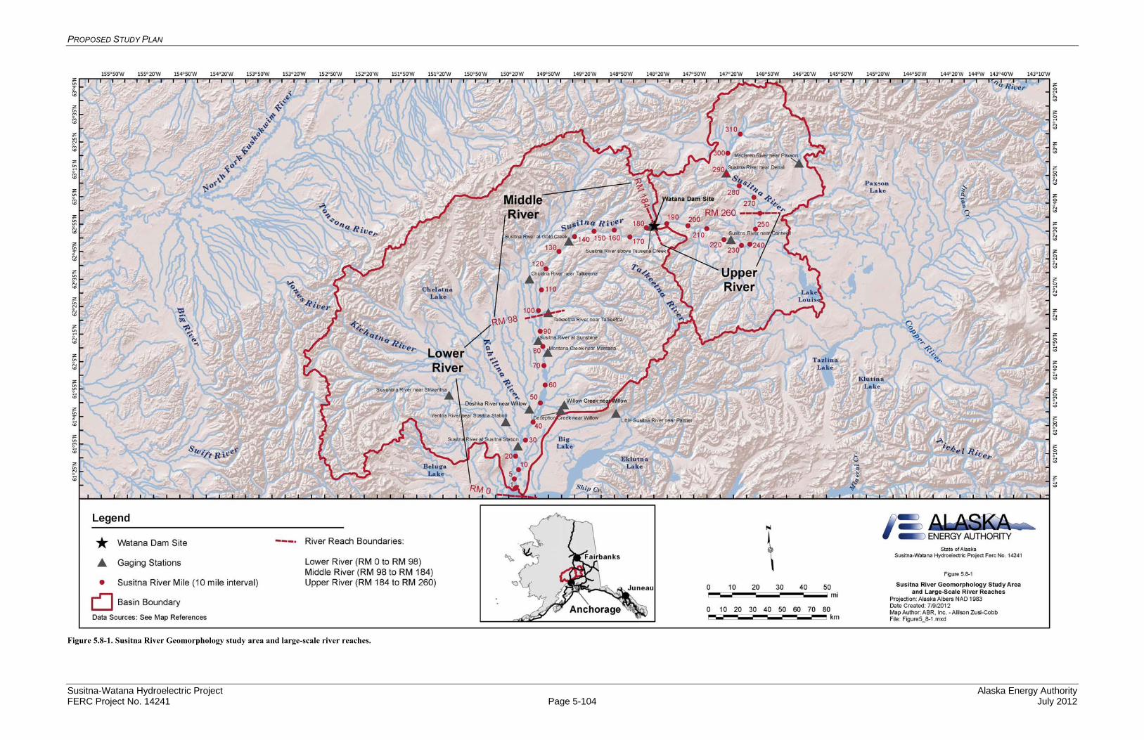
PROPOSED STUDY PLAN
Susitna-Watana Hydroelectric Project Alaska Energy Authority FERC Project No. 14241 Page 5-104 July 2012
Figure 5.8-1. Susitna River Geomorphology study area and large-scale river reaches.
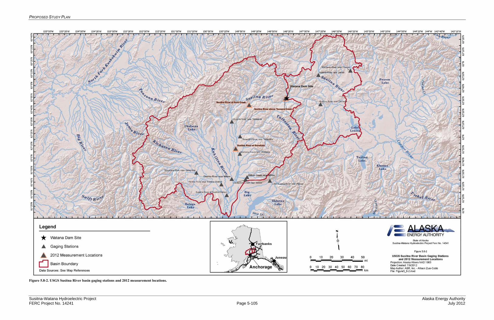
PROPOSED STUDY PLAN
Susitna-Watana Hydroelectric Project Alaska Energy Authority FERC Project No. 14241 Page 5-105 July 2012
Figure 5.8-2. USGS Susitna River basin gaging stations and 2012 measurement locations.

PROPOSED STUDY PLAN
Susitna-Watana Hydroelectric Project Alaska Energy Authority FERC Project No. 14241 Page 5-106 July 2012
Figure 5.8-3. Susitna-Watana Geomorphology Study reservoir geomorphology study area.
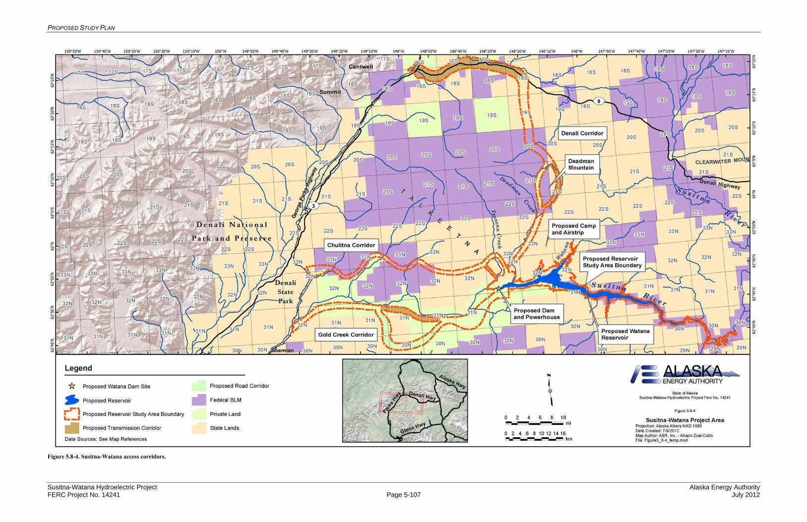
PROPOSED STUDY PLAN
Susitna-Watana Hydroelectric Project Alaska Energy Authority FERC Project No. 14241 Page 5-107 July 2012
Figure 5.8-4. Susitna-Watana access corridors.
PROPOSED STUDY PLAN
Susitna-Watana Hydroelectric Project Alaska Energy Authority FERC Project No. 14241 Page 5-108 July 2012
5.9. Fluvial Geomorphology Modeling below Watana Dam Study
5.9.1. General Description of the Proposed Study
The overall goal of the Fluvial Geomorphology Modeling below Watana Dam Study is to model the effects of the proposed Susitna-Watana Hydroelectric Project (Project) on the fluvial geomorphology of the Susitna River. More specifically, the purpose of the modeling study, along with the Geomorphology Study, is to assess the potential impact of the Project on the dynamic behavior of the river downstream of the proposed dam, with particular focus on potential changes in instream and riparian habitat. Whether the existing channel morphology will remain the same or at least be in “dynamic equilibrium” under post-Project conditions is a significant question in any instream flow study (i.e., Is the channel morphology in a state of dynamic equilibrium such that the distribution of habitat conditions will be reflected by existing channel morphology or will changes in morphology occur that will influence the relative distribution or characteristics of aquatic habitat over the term of the license? [Bovee 1982]). This key issue prompts four overall questions that must be addressed by the two Geomorphology Studies:
Is the system currently in a state of dynamic equilibrium? If the system is not currently in a state of dynamic equilibrium what is the expected
evolution over the term of the license? Will the Project affect the morphologic evolution of the Susitna River compared to pre-
Project conditions? If the Project will alter the morphology of the river what are the expected changes over
the term of the license?
The methods and results from the Geomorphology Study and the Fluvial Geomorphology Modeling Study will address these questions.
Specific objectives of this study are:
Model channel formation processes in the Susitna River downstream of the proposed Watana Dam site;
Estimate the potential for channel change for with-Project operations; and Coordinate with other studies to provide channel output data.
5.9.2. Existing Information and Need for Additional Information
Sediment transport issues downstream of Watana Dam are expected to stem from the influences of the regulated outflows and the deficit of sediment due to trapping in the reservoir. These issues are particularly important because fish resources have the greatest potential to be impacted by the Project, and most of the potential impacts would occur downstream of the Project (AEA 2010). The effect of altered flows on anadromous and resident fish habitats and their associated populations was the major focus of studies conducted in the 1980s (APA 1984). The major fish habitats are located in the Susitna River, side channels, side sloughs, upland sloughs, and tributary mouths (APA 1984).
Modeling of the hydraulics of the Susitna River below the previously proposed project, a necessary step in developing a sediment transport model, was performed in the 1980s. This work included development and application of one-dimensional HEC-2 hydraulic models to support
PROPOSED STUDY PLAN
Susitna-Watana Hydroelectric Project Alaska Energy Authority FERC Project No. 14241 Page 5-109 July 2012
the calculation of water-surface profiles and channel hydraulics (Acres 1983). The models represented the reach between Devils Canyon (Susitna RM 186.8) and Talkeetna (RM 99), excluding Devils Canyon (Susitna RM 162.1 to RM 150.2). The Aquatic Resources Data Gap Analysis (HDR 2011) indicates that sediment transport modeling of a portion of the Susitna River was also undertaken. Realizing the complexity of the sediment transport problem at the Chulitna River confluence, APA commissioned the Iowa Institute of Hydraulic Research to develop a quasi-steady, one-dimensional numerical model of sediment transport for the 14-mile reach of the Susitna River from the Chulitna confluence downstream to Sunshine Station (Holly 1985). The model was based on sediment transport data from 1981 and 1982, as the following years of data collection had not yet been completed. The topography was derived from 28 cross-sections (approximately 1 every ½ mile) measured by R&M Consultants and aerial photography (Ashton and R&M 1985). The model was still in development as of the writing of the 1985 report; however, the companion report, referenced in Holly (1985), was not found in the Susitna documentation.
The Aquatic Resources Data Gap Analysis (HDR 2011) indicates that channel equilibrium, an important macrohabitat variable, was not addressed in the APA Project instream flow study. The question of whether the existing channel morphology will remain the same, or at least be in “dynamic equilibrium”, once the proposed action is implemented is a significant question in an instream flow study. Instream flow versus habitat relationships developed for today’s river assumes that similar relationships will persist for the duration of the project, within a reasonably defined range of variability. In the case of the proposed Project instream flow study, the question is whether the river is currently in a state of equilibrium or disequilibrium. If it is in a state of disequilibrium, will the state be exacerbated or reversed as a result of the Project? If it is exacerbated or reversed, the impact of the Project cannot be assessed without estimating a post-Project channel configuration (Bovee et al. 1998). The same holds true if the river is currently in a state of equilibrium and shifts to disequilibrium for a significant period of time with the Project in place.
The AEA Susitna Water Quality and Sediment Transport Data Gap Analysis Report (URS 2011) concluded: “Numerical modeling of the sediment transport dynamics would provide a basis for comparing the changes in channel morphology and aquatic habitat associated with the proposed Project and the proposed operations.” The Fluvial Geomorphology Modeling below Watana Dam Study addresses the need to develop a sediment transport model of the Susitna River. It was also indicated in the Data Gap Analysis Report (URS 2011) that further quantification of the sediment supply and transport capacity would help identify the sensitivity of the channel morphology (and associated aquatic habitats) to the effects of the proposed Susitna-Watana Project. The report indicated that information on sediment continuity could provide a basis for evaluating whether the Susitna River below the Chulitna confluence would be at risk of aggradation, and if so, whether the magnitude would alter aquatic habitats and hydraulic connectivity to these habitats. URS (2011) also pointed out that side channels and sloughs are of particular importance to fisheries, and changes to the relationships between flow and stage at which the habitats are accessible could impact the fisheries. These relationships can be affected by not only flow distribution, but also changes in the bed elevations due to sediment transport processes. Other impacts to the sediment transport regime could affect the cleaning of spawning gravels, hyporheic flows through redds, groundwater inflows, and hydraulic connectivity for out migration to the main channel.

PROPOSED STUDY PLAN
Susitna-Watana Hydroelectric Project Alaska Energy Authority FERC Project No. 14241 Page 5-110 July 2012
A more specific description of existing information and the need for additional information for each modeling study component is provided in the appropriate subsections of Section 5.10.4, below.
5.9.3. Study Area
The potential study area is the portion of the Susitna River from Watana Dam (RM 184) downstream to its mouth at the Cook Inlet (RM 0). The downstream limit of the modeling effort will be determined based on results of the Geomorphology Study concerning the potential for the Project to affect channel morphology, and in coordination with other studies and the agencies. As a minimum, the study area for this effort includes the entire Middle River from the Watana Dam site (RM 184) downstream to the three rivers confluence area (RM 98). (Note: Modeling of Devils Canyon will not be performed because this reach is considered too dangerous to perform cross section and other surveys needed to develop the model. Devils Canyon will be assumed to be a stable, pass-through reach in terms of sediment transport due to the high level of bed rock control and steep gradient present in this reach).
The spatial extent of the Lower River modeling effort has not been determined; however, as a minimum the 1D modeling will be continued downstream into the Lower River to at least Sunshine Station (RM 84) (see below for a discussion of the 1D and 2D modeling approach). The decision on whether to continue the 1D modeling further downstream in the Lower River and whether detailed 2D modeling sites will be included in the Lower River will be made based on an assessment of the potential for the Project to affect channel morphology in this portion of the reach. An initial assessment of potential Project effects is being conducted in 2012 as part of the Geomorphology Study.
The results of this 2012 effort will be presented to and reviewed by the licensing participant to perform the first check-in as to whether the fluvial geomorphology modeling should be continued below RM 84. The second check-in of the downstream extent will be based on the 1D fluvial geomorphology modeling. If the results of the modeling effort show differences between existing and the modeled with-Project conditions that are beyond the range of natural variability then the 1D modeling will be continued further downstream in the Lower River. In addition, the need for adding 2D modeling sites in the Lower River will be determined through consultation with the licensing participants and other pertinent study leads (NOAA-NMFS and USFWS requested as a minimum the 1D modeling extend to Sunshine Station [study requests dated May 31, 2012]. Discussions at the TWG meeting on June 14, 2012 defined the process for evaluating further downstream extension of the modeling).
The 2D models will be used to evaluate the detailed hydraulic and sediment transport characteristics on smaller, more local scales where it is necessary to consider the more complex flow patterns to understand and quantify the issue(s). The 2D models will be applied to specific detailed study sites, within the selected 1D modeling area, that are representative of important habitat conditions and the various channel classification types. These sites will be chosen in coordination with the Instream Flow, Riparian Instream Flow, Ice Processes and Fish studies to facilitate maximum integration of available information among the studies. Sites will be chosen such that there is one 2D site for each geomorphic reach type (except Devils Canyon) and the sites will cover the range of riverine aquatic habitat types. At least one unstable site, likely representative of a braided channel reach, will be included in the 2D sites. 2D modeling will also be considered at the primary tributary deltas based on screening that considers the

PROPOSED STUDY PLAN
Susitna-Watana Hydroelectric Project Alaska Energy Authority FERC Project No. 14241 Page 5-111 July 2012
importance to the existing fishery and the potential for adverse project effects. 2D modeling is likely to include the Three Rivers Confluence area (the distribution of the 2D sites is based on the study requests submitted by NOAA-NMFS and USFWS on May 31, 2012 and discussions during the June 14, 2012 Water Resources TWG meeting).
5.9.4. Study Methods
The Fluvial Geomorphology Modeling below Watana Dam is divided into three study components:
Bed Evolution Model Development, Coordination, and Calibration, Model Existing and with-Project Conditions, and Coordination on Model Output.
Each of these components is explained further in the following subsections.
5.9.4.1. Study Component: Bed Evolution Model Development, Coordination and Calibration
The overall goal of the Bed Evolution Model Development, Coordination and Calibration study component is to develop a model that can simulate channel formation processes in the Susitna River downstream of Watana Dam.
5.9.4.1.1. Existing Information and Need for Additional Information
Modeling of hydraulics of the Susitna River below the proposed Project, a necessary step in developing a sediment transport model, was performed in the 1980s. One-dimensional HEC-2 hydraulic models were developed in the 1980s to support the calculation of water-surface profiles and channel hydraulics (Acres 1983). However, the 1980s effort did not include sediment transport modeling. Both 1D and 2D sediment transport models are required to characterize the bed evolution for both the existing and with Project conditions in the Susitna River. This study component involves the selection and development of the sediment transport models.
5.9.4.1.2. Methods
The Bed Evolution Model Development, Coordination and Calibration study component is divided into three tasks:
Development of Bed Evolution Modeling Approach and Model, Coordination with other Studies on Processes Modeled, and Calibration/Validation of the Model.
5.9.4.1.2.1. Development of Bed Evolution Model Approach and Model Selection
Development of the bed evolution model for a dynamic system such as the Susitna is a complex undertaking that requires considerable investigation and coordination. The work in the Lower and Middle River contained in the Geomorphology Study provides a considerable part of the required investigation. Based on the study results and input from the Reservoir Operations and Flow Routing Model Development, Instream Flow, Instream Flow Riparian, Ice Processes, and

PROPOSED STUDY PLAN
Susitna-Watana Hydroelectric Project Alaska Energy Authority FERC Project No. 14241 Page 5-112 July 2012
Fish studies, models will be developed that represent the physical processes that control the dynamic nature of the Susitna River, and that will provide other studies with the required information on the potential changes in the channel and floodplain for their analyses.
Some of the important steps in the development of the modeling approach and model are:
Review and understand available data,
Develop an understanding of the dominant physical processes and governing physical conditions in the study reach,
Coordinate with other studies to understand their perspective on system dynamics, and the physical features and processes that are important to their studies,
Identify an overall modeling approach that is consistent with the study goals, the constraints on information that is currently available or can practically be obtained, and the needs of the other studies ,
Identify a modeling approach that is consistent with the spatial and temporal scale of the area to be investigated,
Determine the spatial limits of the modeling effort,
Determine the time scales for the various models,
Review potential models and select a model(s) that meets the previously-determined needs and conditions,
Identify data needs and data gaps for the specific model and study area being investigated,
Collect the required data to fill data gaps,
Develop the model input,
Identify information to be used to calibrate and validate the model,
Perform initial runs and check basic information such as continuity for water and sediment, hydraulic conditions, magnitude of sediment transport, and flow distributions,
Collaborate with other studies on initial model results,
Refine model inputs,
Perform calibration and validation efforts, to include comparison of modeled water-surface elevations, in-channel hydraulic conditions (e.g., velocity and depth), sediment transport rates, and aggradation/degradation rates with available measured data,
Perform model runs for existing conditions to provide a baseline for comparison of with-Project scenarios,
Work with other studies to develop scenarios to evaluate the potential Project effects, and apply the model to those scenarios,
Coordinate with other studies to evaluate and define the appropriate format for presentation of the model results, and

PROPOSED STUDY PLAN
Susitna-Watana Hydroelectric Project Alaska Energy Authority FERC Project No. 14241 Page 5-113 July 2012
Develop and run additional scenarios, as necessary, based on results from the initial scenarios and identified project needs.
The following subsections outline the identified issues to be considered and summarize the development of the modeling approach, the model selection, and the model development.
Issues to be Considered: To develop the modeling approach, specific issues that need to be addressed have been identified. These specific issues have been further differentiated into reach-scale and local-scale issues since the scale influences the proposed approach.
Reach-Scale Issues: Reach-scale issues refer to aspects of the system that involve the overall behavior and general characteristics of the Susitna River over many miles. Each reach represents a spatial extent of the Susitna River that has a consistent set of fluvial geomorphic characteristics. Reach-scale issues include:
Historical changes in the system and the existing status with respect to dynamic equilibrium:
Changes in both the bed material (sand and coarser sizes) and wash (fine sediment) load sediment supply to the system due to trapping in Watana Reservoir.
Long-term balance between sediment supply and transport capacity and the resulting aggradation/degradation response of the system for pre- and post-Project conditions.
Changes in bed material mobility in terms of size and frequency of substrate mobilized due to alteration of the magnitude and duration of peak flows by the Project.
Project-induced changes in supply and transport of finer sediments that influence turbidity.
Potential for changes in channel dimensions (i.e., width and depth) and channel pattern (i.e., braiding versus single-thread or multiple-thread with static islands) due to the Project and the magnitude of the potential change.
Project-induced changes in river stage due to reach-scale changes in bed profile, channel dimensions, and potentially hydraulic roughness.
Local-Scale Issues: Local-scale issues refer to aspects of the system that involve the specific behavior and characteristics of the Susitna River at a scale associated with specific geomorphic and habitat features. Local-scale issues are addressed using a more detailed assessment over a smaller spatial area; however, these analyses must draw from and build upon the understanding and characterization of the system behavior as determined at the reach scale. Local-scale issues include:
Processes responsible for formation and maintenance of the individual geomorphic features and associated habitat types.
Potential changes in geomorphic features and associated aquatic habitat types that may result from effects of Project operation on riparian vegetation and ice processes.
Effects of changes in flow regime and sediment supply on substrate characteristics in lateral habitat units.

PROPOSED STUDY PLAN
Susitna-Watana Hydroelectric Project Alaska Energy Authority FERC Project No. 14241 Page 5-114 July 2012
Changes in upstream connectivity (breaching) of lateral habitats due to alteration of flow regime and possibly channel aggradation/degradation. These changes may induce further changes in the morphology of lateral habitats, including:
o Potential for accumulation of sediments at the mouth.
o Potential for accumulation of fines supplied during backwater connection with the main stem.
o Potential for changes in riparian vegetation that could alter the width of lateral habitat units.
Project effects at representative sites on the magnitude, frequency and spatial distribution of hydraulic conditions that control bed mobilization, sediment transport, sediment deposition and bank erosion.
Potential for change in patterns of bed load deposits at tributary mouths that may alter tributary access or tributary confluence habitat, as discussed below.
Tributary confluences are areas of interest for determining the potential Project effects on sediment transport and morphology. Modeling of tributary deltas is discussed as a separate topic from the mainstem.
Synthesis of Reach-Scale and Local-Scale Analyses: The final step in the effort will be the synthesis of the reach-scale and local-scale analyses to identify potential Project-induced changes in the relative occurrence of aquatic habitat types and associated surface area versus flow relationships. In addition to the results of the hydraulic and sediment transport modeling, this synthesis will require application of fluvial geomorphic relationships to develop a comprehensive and defensible assessment of potential Project effects. Examples of this type of integrated analysis that have been successfully performed by the project team include instream flow, habitat and recreation flow assessments to support relicensing of Slab Creek Dam in California; a broad range of integrated geomorphic assessments and modeling to assist the Platte River Recovery Implementation Program in Central Nebraska; and ongoing work to support the California Department of Water Resources and Bureau of Reclamation to design restoration measures for the San Joaquin River in the Central Valley of California downstream of Friant Dam.
Development of Modeling Approach: The proposed modeling approach considers the need to address both reach-scale and local-scale assessments and the practicality of developing and applying various models based on data collection needs, computational time, analysis effort and model limitations. Based on these considerations, an approach that uses 1D models to address reach-scale issues and 2D models to address local-scale issues is proposed. Considering the broad physical expanse of the Susitna River system, the general hydraulic and sediment transport characteristics of the various subreaches that make up the overall study area will be evaluated using 1D computer models and/or established hydraulic relationships. The 2D models will be used to evaluate the detailed hydraulic and sediment transport characteristics on smaller, more local scales where it is necessary to consider the more complex flow patterns to understand and quantify the issues. The 2D models will be applied to specific detailed study sites that are representative of important habitat conditions - the various channel classification types and selected primary tributaries. These sites will be chosen in coordination with the licensing
PROPOSED STUDY PLAN
Susitna-Watana Hydroelectric Project Alaska Energy Authority FERC Project No. 14241 Page 5-115 July 2012
participants and the Instream Flow, Riparian Instream Flow, Ice Processes and Fish studies to facilitate maximum integration of available information between the studies.
The proposed approach to integrating 1D modeling at the reach-scale and 2D modeling at the local–scale will provide the following advantages:
1D modeling will allow for efficient assessment of the hydraulic conditions and sediment transport balance over the length of the study reach downstream of Watana Dam.
The 1D model uses cross-sectional data that are being obtained as part of the Flow Routing and Instream Flow studies. (Note that some supplemental cross sections may be required for the 1D sediment transport model.)
The 1D model will provide the boundary conditions for the 2D model, including starting water-surface elevations and upstream sediment supply.
2D modeling applied at the detailed study sites that are also chosen for the Ice Processes and Riparian Instream Flow studies will allow for the fullest level of integration of these efforts, particularly as they relate to assessments of potential changes in channel width and pattern for this study.
2D modeling at the detailed study sites will provide an understanding of the hydraulic conditions and sediment transport processes that contribute to formation of individual habitat types.
2D modeling provides a much more detailed and accurate representation of the complex hydraulic interaction between the main channel and the lateral habitats than is possible with a 1D model.
Model Selection: Many computer programs are available for performing movable boundary sediment-transport simulations. The choice of an appropriate model for this study depends on a number of factors, including: 1) the level of detail required to meet the overall project objective(s), 2) the class, type, and regime of flows that are expected to be modeled, and 3) the availability of necessary data for model development and calibration. While 2D modeling would provide the most comprehensive assessment of hydraulic and sediment transport conditions in the study reach, the extent of required data, effort required for model development, and computational time required for execution to model the entire system make this impractical. Considering the very broad physical expanse of the overall Susitna River system, a one-dimensional (1D) computer model and/or engineering relationships that can be applied in a spreadsheet application is the most practical approach to modeling overall system behavior at the scale of the study reach. 2D modeling will then be used for evaluating the detailed hydraulic and sediment-transport characteristics that control the complex geomorphic features and habitat at the local scale. A variety of candidate models will be evaluated for application on the Susitna River. Potential candidate models for the 1D and 2D portions of the study are discussed below.
General Discussion of 1D Models: Most 1D movable boundary sediment-transport models are designed to simulate changes in the cross sectional geometry and river profile due to scour and deposition over relatively long periods of time. In general, the flow record of interest is discretized into a quasi-unsteady sequence of steady flows of variable discharge and duration. For each model time-step and corresponding discharge, the water-surface profile is calculated using the step-backwater method to compute the energy slope, velocity, depth, and other

PROPOSED STUDY PLAN
Susitna-Watana Hydroelectric Project Alaska Energy Authority FERC Project No. 14241 Page 5-116 July 2012
hydraulic variables at each cross section in the network. The sediment-transport capacity is then calculated at each cross section based on input bed material information and the computed hydraulics, and the aggradation or degradation volume is computed by comparing the transport capacity with the upstream sediment supply (i.e., the supply from the next upstream cross section for locations not identified as an upstream boundary condition). The resulting aggradation/degradation volume is then applied over the cross-section control volume (i.e., the sub-channel concept), and the shape of the cross section is adjusted accordingly. Because the sediment-transport calculations are performed by size fraction, the models are capable of simulating bed material sorting and armoring. The computations proceed from time-step to time-step, using the updated cross-sectional and bed material gradations from the previous time-step.
1D sediment-transport models should not be applied to situations where 2- and 3-dimensional flow conditions control the sediment-transport characteristics because they do not consider secondary currents, transverse movement and variation, turbulence, and lateral diffusion; thus, the models cannot simulate such phenomena as point bar formation, pool-riffle formation, and planform changes such as river meandering or local bank erosion. 1D models typically distribute the volume of aggradation or degradation across the entire wetted portion of the channel cross section after each time-step; thus, the effects of channel braiding are also not directly considered. 1D models are, however, useful in evaluating the general sediment-transport characteristics and overall sediment balance of a given reach, and they are also useful in providing boundary conditions for localized 2D models.
Potential 1D Models: 1D models that are being considered for this study include the Corps of Engineers HEC-RAS (version 4.1; USACE 2010a), the Bureau of Reclamations SRH-1D (version 2.8; Huang and Greimann, 2011), DHIs MIKE 11 (version 2011; DHI, 2011), and Mobile Boundary Hydraulics HEC-6T (version 5.13.22_08; MBH, 2008). A summary of each of these models, including potential benefits and limitations, are summarized in the following sections.
HEC-RAS: HEC-RAS, version 4.1.0 (USACE 2010a) is a publicly available software package developed by the Corps of Engineers to perform steady flow water surface profile computations, unsteady flow simulations, movable boundary sediment transport computations, and water quality analysis. HEC-RAS includes a Windows-based graphical user interface that provides functionality for file management, data entry and editing, river analyses, tabulation and graphical displays of input/output data, and reporting facilities. The sediment-transport module is capable of performing sediment-transport and movable boundary calculations resulting from scour and deposition over moderate time periods, and uses the same general computational procedures that were the basis of HEC-6 and HEC-6T (USACE 1993; MBH, 2010). In HEC-RAS, the sediment transport potential is estimated by grain size fraction, which allows for simulation of hydraulic sorting and armoring. This model is designed to simulate long-term trends of scour and deposition in streams and river channels that could result from modifying the frequency and duration of the water discharge and stage, sediment supply or direct modifications to channel geometry. Benefits of the HEC-RAS software include widespread industry acceptance, public availability, and ease of use. Potential limitations of the program include excessive computer run-times, file size output limitations, and the inherent problems associated with 1D modeling of aggradation and degradation by equal
PROPOSED STUDY PLAN
Susitna-Watana Hydroelectric Project Alaska Energy Authority FERC Project No. 14241 Page 5-117 July 2012
adjustment of the wetted portion of the bed that can result in unrealistic channel geometries.
SRH-1D: SRH-1D (Huang and Greimann 2011) is a publicly-available, mobile boundary hydraulic and sediment transport computer model for open channels that is capable of simulating steady or unsteady flow conditions, internal boundary conditions, looped river networks, cohesive and non-cohesive sediment transport (Ruark et al. 2011), and lateral inflows. The hydraulic and sediment transport algorithms in SRH-1D are similar to those in HEC-RAS 4.1 and HEC-6T except that it also includes the capability to perform fully-unsteady sediment transport simulations. Advantages of SRH-1D include robust algorithms for hydraulic conditions and sediment routing, including sediment sorting. Potential disadvantages include limited testing under a broad range of conditions outside the Bureau of Reclamation and the lack of graphical user interface that complicates data input and manipulation and display of output.
MIKE 11: Danish Hydraulic Institute’s (DHI) MIKE 11 is a proprietary software package developed for 1D dynamic modeling of rivers, watersheds, morphology and water quality. The model has the ability to solve the complete non-linear St. Venant equations (in only the streamwise direction) for open channel flow, so the model can be applied to any flow regime. MIKE 11 provides the choice of diffusive and kinematic wave approximation and performs simplified channel routing using either the Muskingum or Muskingum-Cunge methods. The program includes a module for simulating erosion and deposition of non-cohesive sediments. Advantages of MIKE 11 include its robust hydrodynamic capabilities (though not necessarily better than HEC-RAS), the user-friendly graphical interface and the reporting and presentation capabilities. Disadvantages primarily stem from the proprietary nature of this model and high cost of the software license.
HEC-6T: HEC-6T was written by William A. Thomas, former Chief of the Research Branch at the USACE Hydrologic Engineering Center (HEC). Mr. Thomas planned, designed, wrote and applied the publically available version of HEC-6; HEC-6T is a proprietary enhancement of the original version. HEC-6T is a DOS-based program that includes a Windows-based graphical user interface for input data manipulation and post-processing of simulation results. Limitations of this program include reduced capabilities for modeling numerous ineffective flow areas as compared to HEC-RAS 4.1 and limited capabilities of the graphical user interface. This software is relatively inexpensive: the fact that it is proprietary is not a significant limitation.
1D Model Selection Process and Initial Evaluation: Based on the above information and experience with these models, the Geomorphology Study team tentatively proposes to use HEC-6T for the reach-scale sediment transport analysis. This proposal is based on confidence gained that HEC-6T is capable of effectively and efficiently modeling the processes that are important for this scale of geomorphic analysis. The selection of the 1D (as well as the 2D) model will be coordinated with the other pertinent studies and the licensing participants. As part of the coordination process, a technical memorandum titled Fluvial Geomorphology Modeling (Tetra Tech 2012) was posted on the AEA website in May 2012. Specific model-selection criteria are identified in Table 5.9-1 along with an evaluation of each candidate model relative to the criteria.
Table 5.9-1. Evaluation of 1D Models
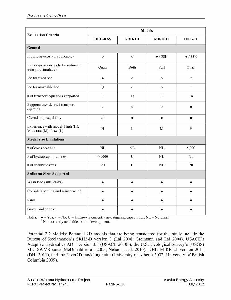
PROPOSED STUDY PLAN
Susitna-Watana Hydroelectric Project Alaska Energy Authority FERC Project No. 14241 Page 5-118 July 2012
Evaluation Criteria Models
HEC-RAS SRH-1D MIKE 11 HEC-6T
General
Proprietary/cost (if applicable) ○ ○ ● / $8K ● / $3K
Full or quasi unsteady for sediment transport simulation
Quasi Both Full Quasi
Ice for fixed bed ● ○ ○ ○
Ice for moveable bed U ○ ○ ○
# of transport equations supported 7 13 10 18
Supports user defined transport equation ○ ○ ○ ●
Closed loop capability ○1 ● ● ●
Experience with model: High (H); Moderate (M); Low (L)
H L M H
Model Size Limitations
# of cross sections NL NL NL 5,000
# of hydrograph ordinates 40,000 U NL NL
# of sediment sizes 20 U NL 20
Sediment Sizes Supported
Wash load (silts, clays) ● ● ● ●
Considers settling and resuspension ● ● ● ●
Sand ● ● ● ●
Gravel and cobble ● ● ● ●
Notes: ● = Yes; ○ = No; U = Unknown, currently investigating capabilities; NL = No Limit 1 Not currently available, but in development.
Potential 2D Models: Potential 2D models that are being considered for this study include the Bureau of Reclamation’s SRH2-D version 3 (Lai 2008; Greimann and Lai 2008), USACE’s Adaptive Hydraulics ADH version 3.3 (USACE 2010b), the U.S. Geological Survey’s (USGS) MD_SWMS suite (McDonald et al. 2005; Nelson et al. 2010), DHIs MIKE 21 version 2011 (DHI 2011), and the River2D modeling suite (University of Alberta 2002; University of British Columbia 2009).
PROPOSED STUDY PLAN
Susitna-Watana Hydroelectric Project Alaska Energy Authority FERC Project No. 14241 Page 5-119 July 2012
SRH-2D: The Bureau of Reclamation’s SRH-2D (Lai 2008) is a finite-volume, hydrodynamic model that computes water-surface elevations and horizontal velocity components by solving the depth-averaged St. Venant equations for free-surface flows in 2D flow fields. SRH-2D is a well-tested 2D model that can effectively simulate steady or unsteady flows and is capable of modeling subcritical, transcritical and supercritical flow conditions. The model uses an unstructured arbitrarily shaped mesh composed of a combination of triangular and quadrilateral elements. SRH-2D incorporates very robust and stable numerical schemes with a seamless wetting-drying algorithm that results in minimal requirements by the user to adjust input parameters during the solution process. A potential limitation of this software is that the mobile bed sediment transport module is currently not publically available; however, Tetra Tech has gained permission to use the sediment transport module on a number of other projects. Preliminary contact with the model developers indicates that permission would be granted for use in this study. This version of the model (Greimann and Lai 2008) includes a “Morphology” module that calculates bed load transport capacities at each model node based on user defined bed material sediment gradations but does not simulate routing of that sediment and related adjustments to the channel bed. SRH-2D also includes a second module that uses the capacities from the Morphology module to perform sediment-routing calculations and associated bed adjustments. Based on guidance from the model developers and confirmed by Tetra Tech’s use of the model for other studies, the maximum practical model size is about 16,000 elements, which could be a potential limitation in applying the model to larger-scale areas.
ADH: The USACE ADH program was developed by the Coastal and Hydraulics Laboratory (Engineer Research Development Center) to model saturated and unsaturated groundwater, overland flow, 3D Navier-Stokes flow, and 2D or 3D shallow-water, open-channel flow conditions. ADH is a depth-averaged, finite-element hydrodynamic model that has the ability to compute water-surface elevations, horizontal velocity components and sediment transport characteristics (including simulations to predict aggradation and degradation) for subcritical and supercritical free-surface flows in 2D flow fields. The ADH mesh is composed of triangular elements with corner nodes that represent the geometry of the modeled reach with the channel topography represented by bed elevations assigned to each node in the mesh. A particular advantage of the ADH mesh is the ability to increase the resolution of the mesh—and thereby the model accuracy—by decreasing the size of the elements during a simulation in order to better predict the hydraulic conditions in areas of high hydraulic variability. However, use of the adaptive mesh option often results in excessively long simulation run times (several days per run) that could be impractical for this study. Additionally, the wetting and drying algorithm in this model has significant numerical stability limitations when applied to shallow, near-shore flows that occur in rivers like the Susitna River. The model is publically available.
MD_SWMS Modeling Suite (FaSTMECH/SToRM): The USGS Multi-Dimensional Surface-Water Modeling System (MD_SWMS; McDonald et al. 2005) is a pre- and post-processing application for computational models of surface-water hydraulics. This system has recently been incorporated into iRIC, a public-domain software interface for river modeling distributed by the International River Interface Cooperative (iRIC) (Nelson et al. 2010). iRIC is an informal organization made up of academic faculty and

PROPOSED STUDY PLAN
Susitna-Watana Hydroelectric Project Alaska Energy Authority FERC Project No. 14241 Page 5-120 July 2012
government scientists whose goal is to develop, distribute and provide education for the software. iRIC consists of a graphical user interface (GUI) that allows the modeler to build and edit data sets, and provides a framework that links the GUI with a range of modeling applications. The GUI is an interactive 1D, 2D and 3D tool that can be used to build and visualize all aspects of computational surface-water applications, including grid building, development of boundary conditions, simulation execution and post-processing of the simulation results. The models that are currently included in iRIC include FaSTMECH (Flow and Sediment Transport with Morphologic Evolution of Channels) and SToRM (System for Transport and River Modeling) that were part of the MD-SWMS package, as well as NAYS, MORPHO2D, and a Habitat Calculator for assessing fish habitat under 2D conditions. Of these models, SToRM appears to be the most relevant for modeling the Susitna River for purposes of this project, primarily because it uses an unstructured triangular mesh (in contrast to the structured, curvilinear mesh required for FaSTMECH), and provides both steady-flow and unsteady-flow capability. NAYS is a fully unsteady, 2D model designed for a general, non-orthogonal coordinate system with sophisticated turbulence methods that can evaluate the unsteady aspects of the turbulence, and MORPHO2D is 2D model capable of analyzing the interactions between sediment transport and vegetation and between surface water and groundwater. Both NAYS and MORPHO2D were developed in Japan, and have not been widely used or tested in the U.S. The SToRM model blends some of the features of finite volumes and finite elements, and uses multi-dimensional streamline upwinding methods and a dynamic wetting and drying algorithm that allows for the computation of flooding. Subcritical, supercritical and transcritical flow regimes (including hydraulic jumps) can be simulated. The program includes advanced turbulence models and an automatic mesh refinement tool to better predict the hydraulic conditions in areas of high hydraulic variability. The most recent version of the SToRM model does not include the capability to model sediment-transport, but the program authors are currently working on implementing sediment-transport algorithms that may be available for use in this study (pers. Comm., Jonathon Nelson, USGS, June 18, 2012). MD_SWMS has been successfully applied to a number of rivers in Alaska, including the Tanana River near Tok (Conaway and Moran 2004) and the Copper River near Cordova (Brabets 1997); some of the modules are currently being validated using high-resolution scour data from the Knik River near Palmer.
MIKE 21: Developed by DHI, MIKE 21 is a proprietary modeling system for 2D free-surface flows that can be applied in rivers, lakes, coastal and ocean environments. It has the ability to simulate sediment transport and associated erosion and deposition patterns. The software includes a Windows-based GUI as well as pre- and post-processing modules for use in data preparation, analysis of simulation results and reporting modules that have graphical presentation capabilities. MIKE 21 has the ability to model a range of 2D mesh types that include Single Grid, Multiple Grid, Flexible Mesh, and Curvilinear Grid. The primary limitation to MIKE-21 is that is proprietary software and is relatively expensive as compared to other available software.
River2D Modeling Suite: River2D is a two-dimensional, depth-averaged finite-element hydrodynamic model developed at the University of Alberta and is publically available from the University. The River2D suite consists of four programs: R2D_Mesh,
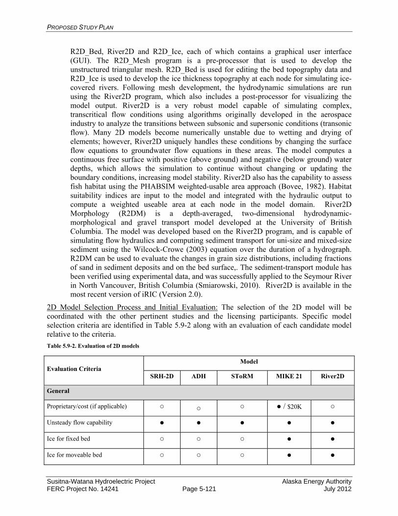
PROPOSED STUDY PLAN
Susitna-Watana Hydroelectric Project Alaska Energy Authority FERC Project No. 14241 Page 5-121 July 2012
R2D_Bed, River2D and R2D_Ice, each of which contains a graphical user interface (GUI). The R2D_Mesh program is a pre-processor that is used to develop the unstructured triangular mesh. R2D_Bed is used for editing the bed topography data and R2D_Ice is used to develop the ice thickness topography at each node for simulating ice-covered rivers. Following mesh development, the hydrodynamic simulations are run using the River2D program, which also includes a post-processor for visualizing the model output. River2D is a very robust model capable of simulating complex, transcritical flow conditions using algorithms originally developed in the aerospace industry to analyze the transitions between subsonic and supersonic conditions (transonic flow). Many 2D models become numerically unstable due to wetting and drying of elements; however, River2D uniquely handles these conditions by changing the surface flow equations to groundwater flow equations in these areas. The model computes a continuous free surface with positive (above ground) and negative (below ground) water depths, which allows the simulation to continue without changing or updating the boundary conditions, increasing model stability. River2D also has the capability to assess fish habitat using the PHABSIM weighted-usable area approach (Bovee, 1982). Habitat suitability indices are input to the model and integrated with the hydraulic output to compute a weighted useable area at each node in the model domain. River2D Morphology (R2DM) is a depth-averaged, two-dimensional hydrodynamic-morphological and gravel transport model developed at the University of British Columbia. The model was developed based on the River2D program, and is capable of simulating flow hydraulics and computing sediment transport for uni-size and mixed-size sediment using the Wilcock-Crowe (2003) equation over the duration of a hydrograph. R2DM can be used to evaluate the changes in grain size distributions, including fractions of sand in sediment deposits and on the bed surface,. The sediment-transport module has been verified using experimental data, and was successfully applied to the Seymour River in North Vancouver, British Columbia (Smiarowski, 2010). River2D is available in the most recent version of iRIC (Version 2.0).
2D Model Selection Process and Initial Evaluation: The selection of the 2D model will be coordinated with the other pertinent studies and the licensing participants. Specific model selection criteria are identified in Table 5.9-2 along with an evaluation of each candidate model relative to the criteria.
Table 5.9-2. Evaluation of 2D models
Evaluation Criteria Model
SRH-2D ADH SToRM MIKE 21 River2D
General
Proprietary/cost (if applicable) ○ ○ ○ ● / $20K ○
Unsteady flow capability ● ● ● ● ●
Ice for fixed bed ○ ○ ○ ● ●
Ice for moveable bed ○ ○ ○ ● ●

PROPOSED STUDY PLAN
Susitna-Watana Hydroelectric Project Alaska Energy Authority FERC Project No. 14241 Page 5-122 July 2012
Number of transport equations supported
4 2 ○1 10 2
Supports user defined transport equation ○ ● ○1 ● ○
Relative execution speed: Fast (F), Slow (S)
F S U F S
Model stability: High (H), Moderate (M), Low (L)
H M U H H
Experience with model: High (H), Moderate (M), Low (L)
H M L L M
Moveable boundary simulation ● ● ○1 ● ●
Grid Structure/Model Formulation
Finite element (FE)/ Finite Volume (FV)
FV FE FV/FE FV/FE FE
Grid structure: Flexible Mesh (FM) FM FM FM FM FM
Model Size Limitations
# of grid elements 16,000 Unlimited U Unlimited >100,000
Sediment Sizes Supported
Wash load (silts, clays) ○ ● ○1 ● ○
Considers settling ○ ● ○1 ● ○
Sand ● ● ○1 ● ●
Gravel and cobble ● ● ○1 ● ●
Notes: ● = Yes; ○ = No; U = Unknown, currently investigating capabilities; NL = No Limit 1 Not currently available, but in development.
Model Development: The manner in which the models are developed will depend on the model software programs that are ultimately selected for use. Regardless of the selected modeling software, the models will be developed in accordance with the software developers’ guidance and recommendations.
5.9.4.1.2.2. Coordination with other Studies
As previously discussed, it is envisioned that a combination of 1D and 2D sediment transport models will be used to assess potential changes in the aggradation/degradation behavior and related processes in the Susitna River downstream from Watana Dam due to the potential size and complexity of the system to be modeled. As a result, the current vision for the modeling approach is to use a reach-scale 1D model to evaluate the potential effects of the Project on the overall aggradation/degradation behavior of the study reach, and then use a series of
PROPOSED STUDY PLAN
Susitna-Watana Hydroelectric Project Alaska Energy Authority FERC Project No. 14241 Page 5-123 July 2012
representative, local-scale 2D models at key locations where the dynamic behavior of the channel and habitat cannot be adequately assessed using the 1D modeling approach. The 1D model will provide boundary conditions for the individual 2D models. Because of this modeling approach, it will be very important to coordinate with other studies since results from the detailed 2D model will only be available at specified locations that will be selected from the key locations identified by the Instream Flow, Instream Flow Riparian, Ice Processes and Fish study teams and in consultation with the licensing participants. It is anticipated that a minimum of four to six detailed mainstem 2D study sites will be identified with each representing a length of river on the order of one to several miles that includes a representation of each geomorphic reach (excluding Devils Canyon) and one unstable reach (likely a braided reach). The 2D sites will also include selected primary tributary confluences. Coordination among the studies will also be necessary to insure efficient collection of field data, since it is likely that a considerable amount of the data necessary for development and calibration of the 1D and 2D models will either be required for the other studies, or will be easily obtained along with data that will be required for those studies. For example, the Instream Flow Study will likely obtain velocity magnitude and direction, flow depth, and discharge measurements, the data from which would be very useful for calibration of the 2D models. It may also be possible to obtain subaqueous bed material data for the modeling by lowering a laser/video through the ice thickness transect holes that will be bored as part of the Ice Study when turbidity levels are expected to be low.
The temporal resolution for model execution will be selected to insure model stability and proper representation of important variability in flow conditions (e.g., daily fluctuations associated with load-following). The overall time-scale for model execution will also be an important factor. Because a key purpose of the 1D model will be to assess the long-term sediment balance in the study reach, this model will likely be executed for a continuous period of 50 years to represent the length of a FERC license. On the other hand, due to the computational requirements of the 2D model, much shorter time-periods will be evaluated.
Close coordination between the study leads and key study team members will be required throughout the model development process. It is important that all the study teams have an understanding of the capabilities and limitations of the models, the information that will be provided by the model, and the selection of the detailed study areas. This will be accomplished through frequent informal communication and more formal technical workgroup meetings. It is also recommend that the study leads and other key participants spend time together in the field to develop a practical understanding of each study’s needs.
5.9.4.1.2.3. Model Calibration and Validation
Calibration and validation of the models will be a stepwise process. First the hydraulic components of the models will be calibrated by adjusting roughness and loss coefficients to achieve reasonable agreement between measured and modeled water-surface elevations, and to the extent data are available, measured and modeled velocities. Discharges along the study reach will be obtained from the three USGS gages. These gages will also provide a continuous record of stages and water-surface elevations at the gage locations. These data will be supplemented with stage data from at least 10 pressure-transducer type water-level loggers that will be installed as part of various studies being conducted in the Middle and Lower River reaches. Water-levels measured during the cross section and bathymetric surveys will also be used to calibrate the models. In addition to water-surface elevations, the depths and velocities predicted by the 2D model should be compared with measured data at the detailed sites. As noted above, it is

PROPOSED STUDY PLAN
Susitna-Watana Hydroelectric Project Alaska Energy Authority FERC Project No. 14241 Page 5-124 July 2012
anticipated that these data will be collected for the Instream Flow Study at the same detailed sites at which the bed evolution model is being applied. Depending on the range of conditions and spatial coverage of the depth and velocity data from the Instream Flow Study, additional data may be needed for calibration specifically for this study. Specific calibration criteria will be established for both the 1D and 2D models during the model selection phase.
The sediment transport portions of both the 1D and 2D model will be first calibrated based on the available measured sediment transport data and the associated sediment rating curves for both bed load and suspended load. For coarse-grained rivers such as the Susitna River, the bed material load transport is dominant with respect to channel forming processes; however the fine-grained suspended load (i.e., wash load) may be important in evaluating the changes to other features including turbidity, instream habitat, side channels, sloughs and floodplains. The sediment transport model will also be validated, to the extent possible, by comparing modeled and measured (or if necessary, qualitatively observed) changes in bed elevations and bed material gradations from the Geomorphology Study, by making model runs for specific time-periods. This effort will include comparison of 1980s and current 2012 transect data if sufficient data are available.
5.9.4.1.2.4. Tributary Delta Modeling
Tributary confluences are areas of interest for determining the potential Project effects on sediment transport and morphology. Alteration of the mainstem flow regime has the potential to change the elevation at which tributary sediments are initially deposited since the main stem may be at a different stage when the tributaries are at peak flow. Additionally, the ability to mobilize and transport bed load delivered by tributaries may also be altered. Changes in the configuration of sediments deposited at the tributary confluences can affect the ability of fish to access the tributaries and the extent of clear water habitat associated with some tributary confluences. Modeling sediment transport and deposition processes at select tributary mouths will therefore be necessary.
The tributaries to be modeled will be determined in conjunction with the Instream Flow and Fish studies and the licensing participants based on fish use and the potential for Project effects. The Geomorphology Study will model a subset of tributary confluences with the Susitna River that represent the range of conditions among all of the tributaries. The selection of primary tributary deltas for 2D modeling will be based on screening that considers the importance of the existing fishery and potential adverse Project effects. Based on the discussion at the June 14, 2012 Water Resources TWG meeting, it is likely that the effort will include the Three Rivers Confluence area (Susitna, Talkeetna and Chulitna confluence). The selection of the tributary delta sites for 2D modeling will be coordinated with the other pertinent studies and in consultation with the licensing participants.
It is currently proposed that a model will be created for the tributary deltas that uses estimated bed load transport from the tributary, the topography and the bathymetry of the confluence, measurements of the characteristics of the tributary deposits, and the ability of the main stem in the area of the confluence to mobilize and transport those deposits. The approach will include field observations to characterize the sediment transport regime that will be used to identify appropriate methods of estimating bed load transport. Surveys of tributary channel geometry and sampling of bed material gradations will be coupled with an appropriate bed material transport function to calculate sediment yield rating curves. Hydrology synthesized for ungaged

PROPOSED STUDY PLAN
Susitna-Watana Hydroelectric Project Alaska Energy Authority FERC Project No. 14241 Page 5-125 July 2012
tributaries will be needed from other studies for each of the selected tributaries for this purpose as well as for the purpose of the flow routing models (summer ice-free model and winter ice-covered model). The yield and topography in the area of the expected delta along with the ability of the main stem to mobilize and transport the bed material will provide a basis for characterizing how Project operations would affect the formation of tributary deposits. At this time, it is envisioned that a relatively detailed 1D hydraulic model of the main stem in the vicinity of each tributary will provide sufficient hydraulic information to evaluate the potential for, and likely extent of, additional growth of the tributary deposits into the mainstem. For complex tributary confluences that are of particular interest to the instream flow studies, local-scale 2D models can be developed and applied to support the analysis.
5.9.4.1.2.5. Wintertime Modeling and Load-Following Operations
It is currently not proposed to execute the sediment transport models—either 1D or 2D—during, the winter period when flows are low and the bed material is not mobilized. However, if the Characterization of Bed Material Mobility component of the Geomorphology Study indicates that the bed material is mobilized during winter-time flows, including higher than existing flows due to load following, the sediment transport modeling will be extended to include the winter flow period. One winter operational issue of potential importance is the resuspension of fines sediments during load-following that could result in increased turbidity during the early portion of the otherwise clear water conditions during the winter months. To address this, an effort to model the resuspension of fines can be undertaken for the 1D model and the 2D model for the early portion of the winter period. This effort would include investigation of a controlled release to flush the fines from the system prior to commencement of winter load-following operations. Decisions on continuing the 1D and 2D modeling into the winter period will be made in consultation with the licensing participants and in coordination with the Instream Flow, Instream Flow Riparian, Ice Processes and Fish studies (this section on Wintertime Modeling and Load-Following Operations was added based on a study comment supplied by NOAA-NMFS in their May 31, 2012 study request, the Natural Resources Defense Council May 30, 2012 study request, and discussions on load-following and turbidity during the June 14, 2012 Water Resources TWG meeting.
5.9.4.1.2.6. Information Required
The following existing information will be needed to conduct this study:
Historical and current aerial photographs, Historical channel cross sections, LiDAR to develop sub-aerial topography and extend surveyed transects across the
floodplain, Flow records from USGS mainstem and tributary gages , and Historical bed material sample data.
A site reconnaissance of the study reach will be conducted prior to development of the sediment-transport models. This site reconnaissance will be carried out to observe and characterize the following:
PROPOSED STUDY PLAN
Susitna-Watana Hydroelectric Project Alaska Energy Authority FERC Project No. 14241 Page 5-126 July 2012
A site reconnaissance of the study reach will be conducted prior to development of the sediment-transport models. This site reconnaissance will be carried out to observe and characterize the following:
Hydraulic and geomorphic controls (natural and man-made) that will influence sediment-transport conditions,
Hydraulic roughness conditions along the main channel and in the overbanks, Variations in bed material size, The sediment-transport regime, and areas that appear to be in equilibrium, or are
aggradational or degradational, and In areas that are not in equilibrium, qualitatively assess the degree of erosion or
deposition.
Based on the above observations and information from the Geomorphology Study (see Section 5.9.4.1, above), the overall study reach will be subdivided into sediment-transport subreaches that have similar geomorphic characteristics, and are therefore, expected to have similar sediment transport characteristics for purposes of assessing the overall sediment balance along the study reach.
Beyond the general site reconnaissance, potential sites for local-scale 2D modeling will be identified and characterized, with particular focus on sites that have been previously identified by the other study teams as important to their particular focus areas. This assessment will involve mapping of the geomorphic features (side channels, sloughs, sub-aerial and subaqueous bars, floodplains, terraces, etc.). Specific data that will need to be collected to facilitate the 2D modeling includes a number of items that are in addition to the general observations made during the site reconnaissance discussed above. To develop the model geometry, detailed bathymetric surveying will be necessary. Surface and sub-surface bed material samples will be collected to characterize the gradation of the sediments. Data that can be used in the calibration of the model will also be required, including detailed velocity (magnitude and direction) mapping, depth mapping, water-surface elevation profiles, and discharge measurements.
A site reconnaissance and data collection effort will also be necessary for each of the key tributaries that have the potential to deliver significant quantities of sediment to the reach and/or are important to other study teams. The reconnaissance to these sites will be relatively detailed, because specific data will need to be collected, in addition to the general observations, to facilitate the modeling at the tributary mouths. Cross-sectional surveys of approximately six transects over a representative reach above the confluence will be necessary, with a spacing of about three- to five-times the active channel width. Surface and sub-surface bed material samples will be collected to characterize the gradation of the sediments along the reach, and will include at least one representative sample of the surface material on the fan.
In addition to the above information that will be collected during the site reconnaissance and detailed site visits, the following will need to be obtained to conduct this component of the modeling study:
Current channel transacts at a density sufficient to develop a 1D sediment transport model (it is anticipated that much of the required transect information will be collected as part of the Instream Flow Study),
Extended flow records for mainstem gages and major tributaries,

PROPOSED STUDY PLAN
Susitna-Watana Hydroelectric Project Alaska Energy Authority FERC Project No. 14241 Page 5-127 July 2012
Estimated flows from key ungaged tributaries that will be accounted for in the water and sediment inflows, and where potential development of tributary fans is to be evaluated,
Information describing the influence of ice processes on channel and floodplain morphology,
Information describing the influence of riparian vegetation on channel and floodplain morphology,
Information developed in the Geomorphology Study on channel changes that have occurred since the 1980s,
Information developed in the Geomorphology Study on the physical processes most important to accurately modeling the study reach, and
Input from the Instream Flow, Instream Flow Riparian, Ice Processes, and Fish studies to identify river segments for detailed modeling (2D),
The velocity and depth measurements collected by the Instream Flow Study to characterize habitat for calibrating the hydraulic model(s), and
Data collected on the distribution of flow between the main channel and lateral habitat to help calibrate the hydraulic portion of the 2D model.
5.9.4.1.3. Study Products
The products of this component of the modeling study will include:
1D hydraulic models that will be used to estimate sediment loading from each of the tributaries that supply significant volumes of bed load along the modeled reach,
A single, calibrated, 1D mobile-boundary sediment-transport model, or a series of models, that extend from the proposed dam to a yet-to-be determined downstream limit.
A number of calibrated 2D sediment-transport models for selected detailed study areas. Model calibration data and documentation. A report describing model calibration and application to existing conditions.
5.9.4.2. Study Component: Model Existing and with-Project Conditions
The goal of the Model Existing and with-Project Conditions study component is to provide a baseline and series of with-Project scenarios of future channel conditions for assessing channel change. The extent of the study area is the Susitna River downstream of Watana Dam, the specific downstream boundary of which will be determined in study component Bed Evolution Model Development, Coordination and Calibration.
5.9.4.2.1. Existing Information and Need for Additional Information
Once the 1D and 2D bed evolution models are developed in the previous study component, the model will be run for the existing condition (the Susitna River without Watana Dam in place) in order to establish a baseline for comparison to with Project model runs. The model will also be run for various Project scenarios to determine the potential effects of the Project on the fluvial geomorphology of the Susitna River.
PROPOSED STUDY PLAN
Susitna-Watana Hydroelectric Project Alaska Energy Authority FERC Project No. 14241 Page 5-128 July 2012
5.9.4.2.2. Methods
5.9.4.2.2.1. Existing Conditions – Base Case Modeling
The time period and representative hydrologic conditions to be assessed with the bed evolution model will be determined through coordination with the technical work group, based on the availability of data, study objectives and model limitations. The hydrologic inputs for the various with-Project scenarios will be obtained from the Reservoir and Flow Routing Study and the model run for flows representative of each scenario. It is currently envisioned that a 50 year, continuous period of record that represents the length of the FERC licensing period will be used for the 1D modeling, and shorter modeling periods will be used for the 2D model due to computational limitations. As previously indicated, the 1D model will be applied to address the analysis of reach-scale issues and the 2D model to address local-sale issues.
The shorter periods for the 2D model will include specific years or portions of annual hydrographs for selected years of wet, average and dry hydrologic conditions and warm and cold Pacific Decadal Oscillation (PDO) phases. Therefore, up to six annual hydrologic conditions will be considered. (The inclusion of the warm and cold PDO phases was requested by NOAA-NMFS and USFWS in the May 31, 2012 study requests; the rationale for the request was discussed at the June 14, 2012 Water Resources TWG meeting and it was agreed that the PDO phases would be included in the suite of representative annual hydrologic conditions.) Other scenarios might include rapid release of flows from an ice jam or larger flood events that are not contained in the period of the hydrologic record chosen for simulation.
Each run be subjected to a quality control process to ensure the appropriate data were used and model outputs are reasonable. Naming conventions for the model input and output files for the various scenario files will be applied so that files can be easily archived and retrieved in the future.
5.9.4.2.2.2. Future Conditions - with-Project Scenarios
In coordination with the other studies and licensing participants, the with-Project scenarios will be identified. Similar to the existing conditions, the with-Project scenarios will be modeled with both the 1D model to determine the reach-scale Project effect and the 2D model to determine the local-scale Project effects. The with-Project scenarios will be evaluated over the same time period as the existing conditions base case.
5.9.4.2.2.3. Synthesis of Reach-Scale and Local-Scale Analyses
In addition to the raw model output, the model results will be interpreted, and additional analysis applied as necessary to represent channel processes that are not directly represented in the modeling. The last step in the analysis effort involves the synthesis of the reach-scale and local-scale analyses to identify potential Project-induced changes in the relative occurrence of aquatic habitat types and associated surface area versus flow relationships. In addition to the results of the hydraulic and sediment transport modeling, this synthesis will require application of fluvial geomorphic relationships to develop a comprehensive and defensible assessment of potential Project effects. Examples of this type of integrated analysis that have been successfully performed by the project team include instream flow, habitat and recreation flow assessments to support relicensing of Slab Creek Dam in California; a broad range of integrated geomorphic
PROPOSED STUDY PLAN
Susitna-Watana Hydroelectric Project Alaska Energy Authority FERC Project No. 14241 Page 5-129 July 2012
assessments and modeling to assist the Platte River Recovery Implementation Program in Central Nebraska; and ongoing work to support the California Department of Water Resources and Bureau of Reclamation to design restoration measures for the San Joaquin River in the Central Valley of California downstream of Friant Dam.
5.9.4.2.2.4. Interaction with Other Studies
The Fluvial Geomorphology Modeling Study team will interact extensively with the Flow Routing, Instream Flow, Riparian Instream Flow, Ice Processes and Fish study teams. The types of interaction will vary depending on the specific study, but a considerable amount of physical data describing the system, including transects, topography/bathymetry, substrate characterization, aerial photography, and pre- and post-Project flows generally will be shared. Selection of joint sites for detailed studies will be an important aspect of the collaboration. By selecting commons sites, the potential for exchange of information between the study teams will be maximized and ensure that the most effective and extensive use of detailed study site data will occur.
Flow Routing Study: It is anticipated that the Flow Routing Study will provide the pre- and post-Project hydrology information for all studies, including the Fluvial Geomorphology Modeling Study. This hydrology information will include mainstem pre- and post-Project flows at various points along the study area and inflows for gaged and ungaged tributaries. This information is expected to be provided for the 50 year, extended flow record.
For the Fluvial Geomorphology Modeling effort the upstream boundary condition at RM 184 will be the existing condition or pre-Project daily flows from the extended flow record. For the post-Project condition, the upstream boundary condition will be the average daily releases from Watana Dam unless load-following scenarios are evaluated. In the latter case, the Project outflows will need to be on an hourly or possibly finer time increment. Estimated daily inflows from tributaries provided by the Flow Routing Study will be input along the length of the 1D sediment transport model and may be inputs to the localized 2D models depending on the location and specific issues to be addressed.
Instream Flow Study: For the Instream Flow Study, an assessment of whether the current channel geometry and substrate characterization used in evaluation of habitats will remain relatively unchanged over the period of the license under both the pre- and post-Project conditions will be important. The Geomorphology Studies will determine whether the channel morphology is in a state of dynamic equilibrium such that the distribution of habitat conditions over the timeframe of the license (assumed to be 50 years, corresponding to the maximum FERC licensing period) will be adequately reflected by existing channel morphology. If it is determined that the river is not in a state of dynamic equilibrium, the Geomorphology Studies will provide projections of the direction and magnitude of the changes. Changes in the relative occurrence of aquatic habitat types and the associated surface area versus flow relationships that may occur as a result of the Project will be an important outcome of these studies. As part of this evaluation, pre- and post-Project changes in channel dimensions (width and depth) and the proportion and distribution of geomorphic features and habitat types will be estimated for each of the reach types delineated using the channel classification system to be developed for the Susitna River. This will provide the Instream Flow Study with an important part of the information required to evaluate the post-Project effects on aquatic habitat. Other important information to be provided by the Fluvial Geomorphology Modeling study for the Instream Flow Study include:
PROPOSED STUDY PLAN
Susitna-Watana Hydroelectric Project Alaska Energy Authority FERC Project No. 14241 Page 5-130 July 2012
Identification of zones of substrate mobilization, deposition and scour at the reach scale for pre- and post-Project flow regimes.
Potential changes in lateral habitat connectivity due to aggradation and degradation. Pre- and post-Project changes in spatial and seasonal patterns of the fine sediment (wash
load) transport and the associated Project effects on turbidity. Changes in substrate composition in both the main channel and lateral habitats. Pre- and post-Project large woody debris (LWD) recruitment and transport.
Riparian Instream Flow Study: Riparian vegetation plays a large role in the development of islands and lateral habitats, primarily by protecting surfaces from erosion and promoting sediment deposition. Vegetation can also contribute to channel narrowing by encroaching onto bars and islands and riverward growth of banks through trapping of sediments. Conversely, changes in the flow regime and/or ice processes can alter riparian vegetation patterns, including the extent, species composition and age-classes; thus, there is a feedback mechanism between the two processes. As a result, the influence of riparian vegetation on the morphology of the Susitna River is an important consideration in these studies. The Riparian Instream Flow and Geomorphology studies need to be closely coordinated because of the interaction described above. The collaboration will begin with coordinated selection of the detailed study sites among the Riparian Instream Flow, Ice Processes and Geomorphology study teams. By working on the detailed study sites together the teams will develop an understanding of the interaction between the processes that are responsible for creation and maintenance of the islands and lateral habitats. Estimates of the ages of island and floodplain surfaces from the Riparian Instream Flow Study based on dendrochronology combined with the inundation results from the 2D modeling will greatly facilitate this effort by helping to identify rates of sediment deposition and reworking of these surfaces. Similarly, profiling of deposited sediments in the riparian corridor to identify the types of sediments that make up the floodplain will also contribute to the understanding of the physical processes and development of the functional model for linkage of the geomorphology, riparian vegetation and ice processes.
The results of the fluvial geomorphology model along with applicable geomorphic principles will be applied to interpret model results. Understanding of the geomorphology of the system will also be used to provide a reality check on the extent of changes indicated by the modeling.
Examples of the linkage between the Riparian Instream Flow Study and the fluvial geomorphology model include:
Altering Manning’s n-values to represent establishment (increased n) or removal (decreased n) of vegetation.
Application of shear stress parameter to determine the erodibility of banks and potential influence of vegetation.
Interpretation of flow and sediment transport patterns to determine areas of sediment deposition within and adjacent to vegetation.
More accurate water surface elevations from the local-scale 2D models than is provided by the 1D models for periods when the flows only partially inundate the riparian corridor.
Use of geomorphic threshold relationships to understand the potential for removal of vegetation by the flows and the potential for additional channel narrowing due to changes in the vegetation patterns.

PROPOSED STUDY PLAN
Susitna-Watana Hydroelectric Project Alaska Energy Authority FERC Project No. 14241 Page 5-131 July 2012
Ice Processes Study: Ice processes influence both the channel morphology and riparian vegetation. For example, ice can prevent vegetation from establishing on bars by annually shearing off or uprooting young vegetation. Similarly, ice can scour vegetation from the banks, increasing their susceptibility to erosion. In both examples these influences affect channel morphology. Ice jams can also directly influence the channel morphology by diverting flows onto floodplain where new channels can form, particularly when the downstream water surface elevations are low, allowing the return flows to headcut back into the floodplain. Ice can also move bed material that would normally not be mobilized by rafting large cobbles and boulders.
There will be close collaboration between the Geomorphology and Ice Process studies to identify the key physical processes that interact between the two. Working together to analyze the conditions at the detailed study sites will be a key part of this collaboration. A significant portion of the influences of ice processes on morphology are directly related to their effects on riparian vegetation. Additionally, influences of ice processes beyond the riparian vegetation issues that may be incorporated directly into the fluvial geomorphology modeling may include:
Simulating the effects of surges from ice jam breakup on hydraulics, sediment transport and erosive forces using unsteady-flow 2D modeling with estimates of breach hydrographs.
Simulating the effect of channel blockage by ice on the hydraulic and erosion conditions resulting from diversion of flow onto islands and the floodplain.
Use of the detailed 2D model output to assess shear stress magnitudes and patterns in vegetated areas, and the likelihood of removal or scouring.
Use of the detailed 2D model output to assess shear stress magnitudes and patterns in unvegetated areas, and the likelihood of direct scour of the boundary materials.
Fish Study: The primary interaction with the Fish Study will be in the selection of the sites for detailed study. Part of the selection process will consider the use of the specific sites as well as the types of habitat present at the site by target fish species. The local-scale 2D models can be used to evaluate instream habitat quality on a spatially-distributed basis rather than the cross-sectionally-based approach used in traditional Instream Flow Incremental Methodology (IFIM) studies.
5.9.4.2.2.5. Information Required
The following available existing information will be needed to conduct this study:
The calibrated existing conditions model(s) developed in the previous tasks, including the data used to develop them,
Extended flow records for mainstem gages and major tributaries for existing conditions, With-Project mainstem flows corresponding to the periods and locations in the extended
flow record. The with-Project sediment outflow rating curve from Watana Dam.
5.9.4.2.2.6. Study Products
The products of this component of the modeling study will include:
Results from the 1D mobile boundary sediment-transport model(s) that extend from the location of the proposed dam to a yet-to-be determined downstream limit.

PROPOSED STUDY PLAN
Susitna-Watana Hydroelectric Project Alaska Energy Authority FERC Project No. 14241 Page 5-132 July 2012
Results from the 2D sediment-transport models for selected detail study areas. A report describing the model runs, and interpreting the model results.
5.9.4.3. Study Component: Coordination on Model Output
The goal of the Coordination on Model Output is to provide necessary output to the various studies that will require determination of potential channel changes associated with the Project. The extent of the study area is the Susitna River downstream of Watana Dam, the specific downstream boundary of which will be determined in Bed Evolution Model Development, Coordination and Calibration study component.
5.9.4.3.1. Existing Information and Need for Additional Information
Several studies require the results of the Fluvial Geomorphology Modeling Study to conduct their efforts. These include the Instream Flow, Riparian Instream Flow, and Ice Processes Studies. The primary concern is whether the Project will affect aspects of the channel morphology including but not limited to substrate characteristics, cross-sectional geometry, and connectivity with lateral habitats.
5.9.4.3.2. Methods
Coordination with Instream Flow, Instream Flow Riparian, Ice Processes, Productivity, and Fish studies will be conducted to confirm information they will need with respect to potential impacts of the Project on bed evolution in-channel conditions under the various Project scenarios. Because of the detailed spatial nature of the information produced by the models, GIS will likely be an important tool for visually illustrating and conveying model results for use in the other studies.
The plan for transferring results in a manner that will facilitate efficient and effective use by other studies will require considerable effort. The details of the plan will be worked out as the overall modeling approach is developed in the technical work group meetings and through informal coordination with the respective study teams.
5.9.4.3.2.1. Information Required
The following available existing information will be needed to conduct this component of the modeling study:
Study plans for other studies
The following additional information will need to be obtained to conduct this component of the modeling study:
Locations of sites for other studies Lists of output required for other studies Output formats required for other studies Schedule dates for providing output
PROPOSED STUDY PLAN
Susitna-Watana Hydroelectric Project Alaska Energy Authority FERC Project No. 14241 Page 5-133 July 2012
5.9.4.3.3. Study Products
The products of this component of the modeling study will include summarized results from the 1D and 2D sediment-transport modeling in an appropriate format. Although the desired format is not known at this time, the formatted products could include the following:
Spreadsheets summarizing predicted hydraulic conditions (main channel velocity, hydraulic depth, energy gradient, shear stress, etc.) at various times during the 1D mobile boundary sediment-transport simulations.
Spreadsheets summarizing the sediment-transport results (bed profiles, aggradation/degradation volumes, changes in mean bed elevation, changes in the active (surface) and inactive (subsurface) gradation, etc.) at various times during the 1D mobile boundary sediment-transport simulations.
ArcGIS shapefiles representing the predicted hydraulic conditions (velocity magnitude and direction, water depth, shear stress magnitude and direction, etc.) at various times during the 2D modeling simulation at each of the detailed study sites.
ArcGIS shapefiles representing the sediment-transport results (predicted change in bed elevation, sediment size, etc.) at various times during the 2D modeling simulation at each of the detailed study sites.
5.9.5. Consistency with Generally Accepted Scientific Practice
A wide range of temporal scale processes, unknown initial and forcing conditions, unresolved heterogeneities, and unanticipated mechanisms make geomorphic prediction challenging and problems of scale important (Wilcock and Iverson, 2003). Fluvial geomorphologic analyses typically involve focusing on a variety of spatial scales at which landforms have characteristic features (Grant et al., 1990; Rosgen, 1996; Thomson et al., 2001). These scales generally reference the river channel width (W) due to the similarity of forms among systems of different absolute size that are governed by the same underlying processes (Pasternack, 2011). For example, the analysis could include an assessment at the watershed scale, river segment scale (103-104 W), morphologic or reach scale (100-101 W), and intensive local scale (10-1-100 W). As discussed in more detail below, the Geomorphology Modeling Study will require both reach-scale (1D modeling) and intensive local-scale (2D modeling) analyses. Synthesis of the reach-scale and local scale analyses will therefore be necessary to identify potential Project-induced changes in the relative occurrence of aquatic habitat types and associated surface area versus flow relationships. In addition to the results of the hydraulic and sediment transport modeling, this synthesis will require application of fluvial geomorphic relationships to develop a comprehensive and defensible assessment of potential Project effects. Examples of this type of integrated analysis that have been successfully performed by the project team include instream flow, habitat and recreation flow assessments to support relicensing of Slab Creek Dam in California; a broad range of integrated geomorphic assessments and modeling to assist the Platte River Recovery Implementation Program in Central Nebraska; and ongoing work to support the California Department of Water Resources and Bureau of Reclamation to design restoration measures for the San Joaquin River in the Central Valley of California downstream of Friant Dam.
PROPOSED STUDY PLAN
Susitna-Watana Hydroelectric Project Alaska Energy Authority FERC Project No. 14241 Page 5-134 July 2012
1D and 2D models are commonly used tools to assess hydraulic and sediment transport conditions in rivers18. The potential models that are described in the model selection section have been in use by the engineering and geomorphic community for many years (in some cases, many decades) for evaluating both existing/baseline conditions and predicting the likely effects of proposed changes in flow regime, sediment supply and other natural and anthropogenic factors. All of the proposed models have been developed using scientifically-sound relationships to describe the physical processes that are important to the analysis. The proposed modeling steps, that include initial reconnaissance to understand the study reach, field data collection to obtain quantitative information necessary to build the model inputs files, calibration steps to insure model results are consistent with field conditions, modifications to the model input to represent the range of potential future conditions, are commonly employed by practitioners and researchers. Results from the application of these types of models have provided significant technical basis for FERC licensing of numerous projects through the U.S. and similar licensing throughout the world.
1D Modeling at the Reach Scale: Potential 1D models that are being considered` for this study include the Corps of Engineers HEC-RAS (version 4.1; USACE 2010a), the Bureau of Reclamations SRH-1D (version 2.8; Huang and Greimann, 2011), DHIs MIKE 11 (version 2011; DHI, 2011a), and Mobile Boundary Hydraulics HEC-6T (version 5.13.22_08; MBH, 2008). Based on the above information and experience with these models, the Geomorphology Study team tentatively proposes to use HEC-6T for the reach-scale sediment transport analysis. This proposal is based on confidence gained that HEC-6T is capable of effectively and efficiently modeling the processes that are important for this scale of geomorphic analysis. HEC-6T has been successfully applied to model the sediment-transport conditions in a wide range of river systems for a variety studies. The study team is currently using the model to evaluate sediment augmentation for habitat restoration purposes in the Central Platte River in Nebraska (Tetra Tech, 2010). It was successfully used to evaluate the effects of seismic retrofit options for San Clemente Dam on sediment-transport through the reservoir and in the downstream Carmel River (Mussetter Engineering, Inc., 2008)
2D Modeling at the Local Scale: Potential 2D models that are being considered for this study include the Bureau of Reclamation’s SRH2-D version 3 (Lai 2008; Greimann and Lai 2008), USACE’s Adaptive Hydraulics (ADH) version 3.3 (USACE 2010b), the U.S. Geological Survey’s USGS’s MD_SWMS modeling suite (McDonald et al.; 2005 Nelson et al., 2010), DHIs MIKE 21 version 2011 (DHI 2011b) River2D modeling suite (University of Alberta 2002; University of British Columbia, 2009). The selection of the 2D model will be coordinated with the other pertinent studies and the licensing participants. In addition to the User’s Manuals that are available with each of the potential models, a number of standalone references are also available that provide guidance for development and application of the 2D models, or highlight successful application of 2D geomorphologic modeling. For example, Pasternack (2011) includes an entire chapter that provides instruction for 2D model development, and separate chapters for SRH-2D model execution and interpretation of SRH-2D model results. Conaway and Moran (2004) present successful application of MD_SWMS to modeling sediment-transport conditions in Alaskan rivers. MD_SWMS has also been successfully used to model sediment-
18 The March 2008 Edition of the American Society of Civil Engineers Journal of Hydraulic Engineering was entirely dedicated to the practice and challenges associated with sediment transport modeling.
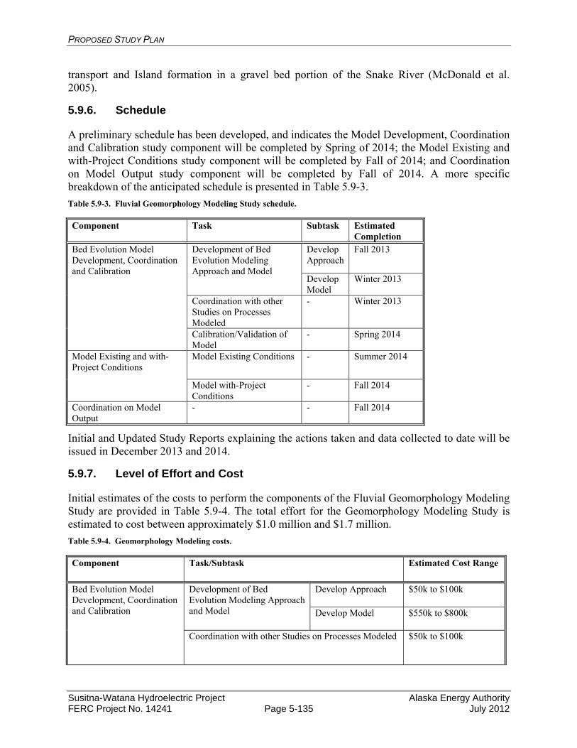
PROPOSED STUDY PLAN
Susitna-Watana Hydroelectric Project Alaska Energy Authority FERC Project No. 14241 Page 5-135 July 2012
transport and Island formation in a gravel bed portion of the Snake River (McDonald et al. 2005).
5.9.6. Schedule
A preliminary schedule has been developed, and indicates the Model Development, Coordination and Calibration study component will be completed by Spring of 2014; the Model Existing and with-Project Conditions study component will be completed by Fall of 2014; and Coordination on Model Output study component will be completed by Fall of 2014. A more specific breakdown of the anticipated schedule is presented in Table 5.9-3.
Table 5.9-3. Fluvial Geomorphology Modeling Study schedule.
Component Task Subtask Estimated Completion
Bed Evolution Model Development, Coordination and Calibration
Development of Bed Evolution Modeling Approach and Model
Develop Approach
Fall 2013
Develop Model
Winter 2013
Coordination with other Studies on Processes Modeled
- Winter 2013
Calibration/Validation of Model
- Spring 2014
Model Existing and with-Project Conditions
Model Existing Conditions - Summer 2014
Model with-Project Conditions
- Fall 2014
Coordination on Model Output
- - Fall 2014
Initial and Updated Study Reports explaining the actions taken and data collected to date will be issued in December 2013 and 2014.
5.9.7. Level of Effort and Cost
Initial estimates of the costs to perform the components of the Fluvial Geomorphology Modeling Study are provided in Table 5.9-4. The total effort for the Geomorphology Modeling Study is estimated to cost between approximately $1.0 million and $1.7 million.
Table 5.9-4. Geomorphology Modeling costs.
Component Task/Subtask Estimated Cost Range
Bed Evolution Model Development, Coordination and Calibration
Development of Bed Evolution Modeling Approach and Model
Develop Approach $50k to $100k
Develop Model $550k to $800k
Coordination with other Studies on Processes Modeled $50k to $100k
PROPOSED STUDY PLAN
Susitna-Watana Hydroelectric Project Alaska Energy Authority FERC Project No. 14241 Page 5-136 July 2012
Calibration/Validation of Model $100k to $200k
Model Existing and with-Project Conditions
Model Existing Conditions $125k to $200k
Model with-Project Conditions $125k to $200k
Coordination on Model Output $50k to $100k
5.9.8. Literature Cited
Acres. 1983a. Before the Federal Energy Regulatory Commission Application for License for Major Project Susitna Hydroelectric Project. Volume 5A, Exhibit E, Chapters 1 & 2. Prepared for Alaska Power Authority.
AEA. 2010. Railbelt Large Hydro Evaluation Preliminary Decision Document. Prepared by the Alaska Energy Authority (AEA).
APA. 1984. Susitna Hydroelectric Project Economic and Financial Update. Draft Report dated February 27, 1984. Prepared by the Alaska Power Authority (APA).
Ashton, William S., and R&M Consultants, Inc. 1985. Lower Susitna River Aggradation Study: Field Data Final Report. Anchorage, Alaska: Alaska Power Authority.
Bovee, K.B., 1982. A guide to stream habitat analysis using the instream flow incremental methodology. Instream Flow Information Paper No. 12. FWS/OBS-82/26. U.S. Fish and Wildlife Service, Office of Biological Services, Fort Collins, Colorado.
Bovee, K., B.L. Lamb, J.M. Bartholow, C.B. Stalnaker, J. Taylor, and J. Henriksen. 1998. Stream habitat analysis using the instream flow incremental methodology. U.S. Geological Survey, Biological Resources Division Information and Technology Report USGS/BRD-1998-0004.
Brabets, T.P, 1997, Geomorphology of the Lower Copper River, Alaska: U.S. Geological Survey Professional Paper 1581, 89 p.
Conaway, J.S., and Moran, E.H., 2004, Development and calibration of two-dimensional hydrodynamic model of the Tanana River near Tok, Alaska: U.S. Geological Survey Open-File Report 2004-1225, 22 p.
DHI, 2011a. MIKE 11 A modeling system for Rivers and Channels User Guide. December.
DHI, 2011b. MIKE 21 Flow Model Hydrodynamic Module User Guide. June.
Grant, G.E., Swanson, F.J., and Wolman, M.G., 1990. Pattern and origin of stepped-bed morphology in high-gradient streams, Western Cascades, Oregon. Geophysical Society of America Bulletin 102 (3), pp. 340-352.
Greimann, B. and Y. Lai, 2008. Two-Dimensional Total Sediment Load Model Equations, ASCE J Hyd Div, 134:8, pp. 1142-1146.
HDR 2011, Watana transportation access study, Project No. 82002. Draft report prepared for the Alaska Department of Transportation and Public Facilities. November 29, 2011.
PROPOSED STUDY PLAN
Susitna-Watana Hydroelectric Project Alaska Energy Authority FERC Project No. 14241 Page 5-137 July 2012
Holly, F.M., Jr., J.C. Yang, and M. Spasojevic, 1985. Numerical Simulation of Water and Sediment Movement in Multiply-Connected Networks of Mobile Bed Channels. Prepared for Harza-Ebasco Susitna Joint Venture. Iowa City, Iowa: The University of Iowa.
Huang, J., Greimann, B.P., and Bauer, T. Development and Application of GSTAR-1D, Federal Interagency Sedimentation Conference in Reno, NC, April 2-6.
Huang, J.V. and Greimann, B.P., 2011. SRH-1D 2.8 User’s Manual, Sedimentation and River Hydraulics – One Dimension, Version 2.8, U.S. Department of Interior, Bureau of Reclamation, Technical Service Center, Sedimentation and River Hydraulics Group. 227 p.
Lai, Y.G., 2008. SRH-2D version 2: Theory and User’s Manual, Sedimentation and River Hydraulics – Two-Dimensional River Flow Modeling, U.S. Department of Interior, Bureau of Reclamation, November, 113 p.
MBH Software, Inc., 2010. Sedimentation in Stream Networks (HEC-6T), User Manual, March 16, 388 pp.
Mobile Boundary Hydraulics, 2008. Sedimentation in Stream Networks (HEC-6T), User Manual, Version 5.13.22_08.
McDonald, R.R., Nelson, J.M., and Bennett, J.P., 2005, Multi-dimensional surface-water modeling system user’s guide: U.S. Geological Survey Techniques and Methods, 6-B2, 136 p.
McDonald, R., Nelson, J., Kinzel, P., and Conaway, J., 2005. Modeling Surface-Water Flow and Sediment Mobility with the Multi-Dimensional Surface-Water Modeling System (MD_SWMS). U.S. Geological Survey Fact Sheet 2005 – 3078, 6 p.
Mussetter Engineering, Inc., 2008. Flood Inundation Mapping, Flood Hazard Evaluation, and Downstream Impact Analysis of the Carmel River Reroute and Removal Option for the San Clemente Dam Seismic Retrofit Project, California. Prepared for California Coastal Conservancy and MWH Americas, Inc. February.
Nelson, J.M., Y. Shimizu, H. Takebayashi, and R.R. McDonald, 2010. The international river interface cooperative: public domain software for river modeling, 2nd Joint Federal Interagency Conference, Las Vegas, June 27 to July 1.
Parker, G., 1990. The “Acronym” series of Pascal programs for computing bed load transport in gravel rivers. University of Minnesota, St. Anthony Falls Hydraulic Laboratory, External Memorandum No. M-220.
Pasternack, G.B., 2011. 2D Modeling and Ecohydraulic Analysis. 158 p.
Rosgen, D.L., 1996. Applied River Morphology. Wildland Hydrology, Pagosa Springs.
Ruark, M., Niemann, J., Greimann, B., and Arabi (2011). “Method for Assessing Impacts of Parameter Uncertainty in Sediment Transport Modeling Applications,” Journal of Hydraulic Engineering, ASCE, Vol. 137, No. 6, pp. 623-636.
Smiarowski, A, 2010. The evaluation of a two-dimensional sediment transport and bed morphology model based on the Seymour River. Master Thesis, University of British Columbia.
PROPOSED STUDY PLAN
Susitna-Watana Hydroelectric Project Alaska Energy Authority FERC Project No. 14241 Page 5-138 July 2012
Tetra Tech, 2010. DRAFT Hydraulic and Sediment-transport Modeling for the Platte River Sediment Augmentation Feasibility Study, Nebraska. Prepared for the Platte River Recovery Implementation Program, September.
Tetra Tech, 2012. Technical Memorandum: Fluvial Geomorphology Modeling. Prepared for AEA. http://www.susitna-Watanahydro.org/documents/AEA_SuWa_FluvialModelingTechMemo20120518_Draft.pdf
Thomson, J.R., Taylor, M.P., Fryirs, K.A., and Brierley, G.J., 2001. A geomorphological framework for river characterization and habitat assessment. Aquatic Conservation-Marine and Freshwater Ecosystems 11 (5), pp. 373-389.
University of Alberta, 2002. River2D, two-dimensional depth averaged model of river hydrodynamics and fish habitat, introduction to depth averaged modeling and user's manual, September.
University of British Columbia, 2009. River2D – Morphology, R2DM, user manual for version 5.0, July
URS. 2011. AEA Susitna Water Quality and Sediment Transport Data Gap Analysis Report. Prepared by Tetra Tech, URS, and Arctic Hydrologic Consultants. Anchorage, Alaska. 62 p.+ Appendixes.
U.S. Army Corps of Engineers, 1993. HEC-6, Scour and Deposition in Rivers and Reservoirs, User’s Manual, Hydrologic Engineering Center, Davis, California.
U.S. Army Corps of Engineers, 2010a. HEC-RAS, River Analysis System. Users Manual, Version 4.1, Hydrologic Engineering Center, Davis, California.
U.S. Army Corps of Engineers, 2010b. Adaptive Hydraulics User Manual Version 3.3. U.S. Army Corps of Engineers Waterways Experiment Station, Vicksburg, Mississippi.
Wilcock, P.R. and Crowe, J.C., 2003. Surface-based transport model for mixed-size sediment. Journal of Hydraulic Engineering, ASCE, v. 129, no. 2, February, pp. 120-128.

PROPOSED STUDY PLAN
Susitna-Watana Hydroelectric Project Alaska Energy Authority FERC Project No. 14241 Page 5-139 July 2012
5.10. Ice Processes in the Susitna River Study
5.10.1. General Description of the Proposed Study
The ice processes study will further the understanding of natural ice processes in the Susitna River and provide a method to model/predict pre-Project and post-Project ice processes in the Susitna River. The study will provide a basis for impact assessment, which will inform the development of any necessary protection, mitigation, and enhancement measures. The study also will provide ice processes input data for other resource studies (e.g., fluvial geomorphology modeling, instream flow, instream flow riparian, groundwater).
5.10.1.1. Study Goals and Objectives
The overall goal of the ice processes study is to understand existing ice processes in the Susitna River and to model/predict both pre-Project and post-Project ice processes. The specific objectives are to
Document the timing, progression, and physical processes of freeze-up and breakup during 2012-2014 between the Oshetna River confluence (River Mile [RM] 233.4) and tidewater (RM 0)
Develop a modeling approach for assessing ice processes in the Susitna River Calibrate the model based on existing conditions Determine the potential effect of various Project operational scenarios on ice processes
downstream of Watana Dam Determine the extent of the open water reach Determine the changes in timing and ice-cover progression and ice thickness and extent. Provide observational data of existing ice processes and modeling results of post-Project
ice processes to the fisheries, instream flow, instream flow riparian, fluvial geomorphology, and groundwater studies
Thermal and ice modeling for the reservoir and the general thermal modeling for the river during the 5 months when ice is not present will be accomplished under the Water Quality Modeling Studies (Section 5.6). The output from this work will be used in the river ice processes studies.
5.10.2. Existing Information and Need for Additional Information
5.10.2.1. Existing Information
Ice affects the Susitna River for approximately seven months of the year, between October and May. When air and water temperatures drop below freezing, shelf ice grows along the banks of the river, and frazil ice begins accumulating in the water column and flowing downstream, eventually accumulating against ice bridges and solidifying into a solid cover (Ashton 1986). By mid-winter, much of the river is under a stable ice cover, with the exception of persistent open leads corresponding with warm upwelling water or turbulent, high-velocity flows. Flows generally drop slowly throughout the winter until snowmelt commences in April. During April and May, river stages rise and the ice cover weakens, eventually breaking into pieces and flushing downstream (Beltaos 2008). Ice jams are recurrent events in some reaches of the river that, if severe, can flood upstream and adjacent areas, drive ice overbank onto gravel bars and

PROPOSED STUDY PLAN
Susitna-Watana Hydroelectric Project Alaska Energy Authority FERC Project No. 14241 Page 5-140 July 2012
into sloughs and side channels, affect riparian vegetation, and threaten infrastructure, such as the Alaska Railroad and riverbank property.
Ice processes were documented between the mouth of the Susitna River (RM 0) and the proposed dam site (RM 184) between 1980 and 1985 (R&M Consultants, Inc. 1981, 1982, 1983, 1984, 1985). Both freeze-up and breakup progressions were monitored using aerial reconnaissance. Locations of ice bridges during freeze-up and ice jams during breakup were recorded each season. One winter, a time-lapse camera was installed in Devils Canyon to observe ice processes through the narrow, turbulent rapids. Additional ice data were collected to calibrate a model. These included ice thicknesses, top of ice elevations, air and water temperatures, slush ice porosity, and frazil density.
Other entities (National Weather Service, U.S. Geological Survey [USGS], and U.S. Army Corps of Engineers [USACE]) also have collected and compiled ice thickness, breakup, and freeze-up data for various locations on the river, although these data were not collected for the purpose of understanding the potential effects of the Project.
Freeze-up and melt-out processes in the Middle River (between Gold Creek and Talkeetna) were modeled using ICECAL, a numerical model developed by the USACE Cold Regions Research and Engineering Laboratory (CRREL) (Harza-Ebasco 1984). The model utilized the outputs from a temperature model developed for the river (SNTEMP) and empirical data on frazil production and ice-cover progression derived from observations. Both the Watana-only and Watana-Devils Canyon operations, as proposed in the 1980s, were modeled for a range of meteorological conditions. The results of the model included predictions of the extent of ice cover for cold, average, and warm winters; the timing of ice cover progression for this range; and the inundated area beneath the ice cover for selected cross-sections. Empirical data on frazil production and ice cover progression was used to estimate changes in ice cover progression up to Talkeetna. Reservoir ice was simulated using DYRESM and calibrated to conditions at Eklutna Lake (Harza-Ebasco 1986).
5.10.2.2. Additional Information Needs
The need for additional information beyond what was gathered and analyzed during the 1980s is driven by three factors: 1) the new proposed configuration of the Project and project operational scenarios; 2) advances in predictive models of winter flow regimes beyond what was available in the 1980s; and 3) the need to supplement previously documented observations of natural ice processes.
The Project consists of one dam that will be at a lower height and have a different configuration than the originally proposed project in the 1980s. The Preliminary Application Document (PAD) proposes an operational scenario that would release more water in the winter, with a potential for day-to-day fluctuations, as opposed to the 1980s proposal of constant flows. The ICECAL Model only simulated conditions between Talkeetna and Gold Creek and did not simulate flow fluctuations with a time-period shorter than one week; whereas, it is likely that daily flow fluctuations will be considered when determining project operations. The ICECAL model was largely an empirical data-driven model, rather than a dynamic predictive model, as is available today. A dynamic model will be able to simultaneously predict flow and temperature fluctuations downstream of the dam, as well as ice-cover progression.

PROPOSED STUDY PLAN
Susitna-Watana Hydroelectric Project Alaska Energy Authority FERC Project No. 14241 Page 5-141 July 2012
Ice bridging, leads, and ice jams are all influenced by channel geometry, and, in some cases, tributary mouth locations, and additional documentation of ice processes are needed to determine whether locations of these features and timing of ice cover progression are similar to conditions observed in the 1980s. In some locations, this geometry may have changed. In addition, in the 1980s, the location of frazil production early in the freeze up period varied significantly between study years. An assessment is needed to determine the importance of the Susitna River upstream and downstream of the proposed dam in frazil production for a range of meteorological conditions.
Finally, updated ice processes information is needed by the fisheries, instream flow, instream flow riparian, fluvial geomorphology, and groundwater studies.
5.10.3. Study Area
The ice processes observation study area includes the 234-mile segment of river between tidewater and the Oshetna River confluence (from RM 0 to RM 233.4). Observations of open leads, breakup progression, and freeze-up progression will be made in this area.
Predictive ice modeling, coupled with dynamic flow routing and temperature modeling, is planned for the Middle River between the proposed dam and the Three-Rivers Confluence near Talkeetna (from RM 184 to RM 100). There are currently no accepted models for predicting dynamic ice processes on complex braided channels, such as those found in the Lower Susitna River downstream of the Talkeetna; therefore, no modeling is planned for the 100-mile reach between tidewater and the Talkeetna River (from RM 0 to RM 100).
In order to calibrate and verify the model, ice thickness and top-of-ice elevations will be surveyed in the modeled reaches (RM 0 to RM 184).
5.10.4. Study Methods
5.10.4.1. Aerial Reconnaissance
Aerial reconnaissance and GPS mapping of ice features, including ice jams, ice bridges, frazil accumulations, and open leads during the breakup and freeze-up periods will be performed from tidewater to the Oshetna River confluence (from RM 0 to RM 233.4). The number of observations will vary depending on ice process conditions, but it is anticipated that approximately 10 reconnaissance trips per year will occur during breakup and 10 reconnaissance trips per year will occur during freeze-up in 2012, 2013, and 2014. The data collected will include geodatabases of ice features and open leads, georeferenced photographs, and videos of ice processes. Ice processes field observation standards follow those of EM-1110-2-1612, Ice Engineering, developed by the USACE (U.S. Army Corps of Engineers 2002).
5.10.4.2. Time-Lapse Camera Monitoring
Time-lapse camera monitoring of breakup and freeze-up will be done at locations corresponding to flow routing model instrumentation, key ice processes, and fish habitat locations. The selection of transects will be refined with input from the other resource studies (e.g., fluvial geomorphology, fisheries). The current locations of the time-lapse cameras for 2012 are:
RM 9.5 – Near Upper Tidal Influence
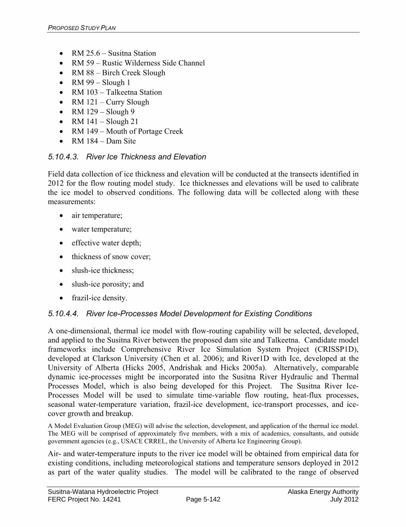
PROPOSED STUDY PLAN
Susitna-Watana Hydroelectric Project Alaska Energy Authority FERC Project No. 14241 Page 5-142 July 2012
RM 25.6 – Susitna Station RM 59 – Rustic Wilderness Side Channel RM 88 – Birch Creek Slough RM 99 – Slough 1 RM 103 – Talkeetna Station RM 121 – Curry Slough RM 129 – Slough 9 RM 141 – Slough 21 RM 149 – Mouth of Portage Creek RM 184 – Dam Site
5.10.4.3. River Ice Thickness and Elevation
Field data collection of ice thickness and elevation will be conducted at the transects identified in 2012 for the flow routing model study. Ice thicknesses and elevations will be used to calibrate the ice model to observed conditions. The following data will be collected along with these measurements:
air temperature;
water temperature;
effective water depth;
thickness of snow cover;
slush-ice thickness;
slush-ice porosity; and
frazil-ice density.
5.10.4.4. River Ice-Processes Model Development for Existing Conditions
A one-dimensional, thermal ice model with flow-routing capability will be selected, developed, and applied to the Susitna River between the proposed dam site and Talkeetna. Candidate model frameworks include Comprehensive River Ice Simulation System Project (CRISSP1D), developed at Clarkson University (Chen et al. 2006); and River1D with Ice, developed at the University of Alberta (Hicks 2005, Andrishak and Hicks 2005a). Alternatively, comparable dynamic ice-processes might be incorporated into the Susitna River Hydraulic and Thermal Processes Model, which is also being developed for this Project. The Susitna River Ice-Processes Model will be used to simulate time-variable flow routing, heat-flux processes, seasonal water-temperature variation, frazil-ice development, ice-transport processes, and ice-cover growth and breakup.
A Model Evaluation Group (MEG) will advise the selection, development, and application of the thermal ice model. The MEG will be comprised of approximately five members, with a mix of academics, consultants, and outside government agencies (e.g., USACE CRREL, the University of Alberta Ice Engineering Group).
Air- and water-temperature inputs to the river ice model will be obtained from empirical data for existing conditions, including meteorological stations and temperature sensors deployed in 2012 as part of the water quality studies. The model will be calibrated to the range of observed
PROPOSED STUDY PLAN
Susitna-Watana Hydroelectric Project Alaska Energy Authority FERC Project No. 14241 Page 5-143 July 2012
conditions in the reach, and an attempt will be made to match existing conditions observations taken in the 1980s, as well as ice thickness and elevation measurements taken in 2012 and 2013.
5.10.4.5. River Ice-Processes Model Projections for Proposed Conditions
For the Middle River, the calibrated ice-processes model will be used to model the proposed Project operational scenarios. The ice model will predict water temperature, ice cover formation and extent, and flow fluctuations (routing) between the proposed dam site and Talkeetna.
Input to the ice model will rely on flow releases from Watana Dam provided by the reservoir operations model and on water temperatures of the flow releases from Watana Dam provided by the reservoir water temperature model. Meteorological (MET) input data for the model will be obtained from MET stations being installed as part of the Water Quality Study.
The product of the proposed conditions models will be quantitative predictions of the extent and elevation of ice cover downstream of the dam; the timing and evolution of ice-cover progression under mild, moderate, and cold climate scenarios; and the timing of breakup for the proposed Project operation scenario.
5.10.4.6. Review and Compilation of Existing Cold-Regions Hydropower Project Operations and Effects
Hydropower projects in northern North America, especially Canada, and in other northern countries have operated on ice covered rivers for many decades (National Research Council of Canada 1990). Other river systems where ice-modeling has been completed include:
Peace River, Canada (Andrishak and Hicks 2005b)
Athabasca River, Canada (Katopodis and Ghamry 2005)
Ohio River, USA (Shen et al. 1991)
St. Clair River, USA (Kolerski and Shen 2010)
Romaine River, Canada (Thériault et al. 2010)
References to the effects of these hydropower operations on ice cover will be summarized, and, where relevant, study authors contacted to obtain additional information that may be relevant to the Susitna River. The product of this portion of the study will be a white paper summarizing these references.
5.10.5. Consistency with Generally Accepted Scientific Practice
The proposed ice processes studies including methodologies for data collection, analysis, modeling, field schedules, and study durations are consistent with generally accepted practice in the scientific community. The study plans were developed with the input of technical experts including USACE CRREL and the University of Alberta Ice Engineering Group.
5.10.6. Schedule
Field data will be collected as follows:
PROPOSED STUDY PLAN
Susitna-Watana Hydroelectric Project Alaska Energy Authority FERC Project No. 14241 Page 5-144 July 2012
Ice thickness and elevation data along transects will be collected between March 1 and April 1, 2013, and again between March 1 and April 1, 2014.
Open lead locations will be documented at the same time that ice thickness and elevation data are collected.
Breakup reconnaissance observations will be conducted between April 10 and May 15, 2013, and 2014.
Freeze-up reconnaissance observations will be conducted between October 1 and January 15, 2012, 2013, and 2014.
Continuous time-lapse camera data will be collected during the breakup and freeze-up periods.
Model selection will occur in 2012. Model development and calibration will occur continuously during 2013 and 2014. Preliminary modeling runs for existing conditions will be calibrated to 2012 and 2013 conditions by the end of 2013, and proposed operations scenarios will be run primarily in 2014. AEA will issue Initial and Updated Study Reports documenting actions taken to date in December 2013 and 2014, respectively.
5.10.7. Level of Effort and Cost
The level of effort for field work will depend on the data needs of the chosen model, and related disciplines such as fisheries, instream flow, riparian, geomorphology, and groundwater. Below is a rough estimate of costs associated with field documentation and model development in 2013-2014, which are the major components of the ice study.
Documentation of ice observations is anticipated to cost $1,000,000 for the 2013-2014 period (two breakups and one freeze-up, plus winter ice thickness and elevation surveys). Assuming a year-long modeling effort will be required, development and calibration of ice routines for the thermal and hydraulic model is anticipated to cost between $800,000 and $1.5 million. The cost will depend on the length of the modeled reach and the extent to which model code will need to be developed in order to adapt the model to the Susitna River. The low-end cost assumes that a pre-existing coupled hydraulic-ice model is used. The high-end cost assumes that comparable ice processes have to be ported over to a pre-existing hydrodynamic/hydraulic model.
5.10.8. Literature Cited
Andrishak, R. and F. Hicks, 2005, “River1D hydraulic flood routing model – Supplement 1 - thermal river modeling - model description and user’s manual.” Department of Civil and Environmental Engineering, University of Alberta.
Andrishak, R. and F. Hicks. 2005b. Impact of climate change on the Peace River thermal ice regime. Proc. 13th Workshop on River Ice, CGU – Hydrology Section, Comm. on River Ice Processes and the Env., Hanover, NH, p. 21-40.
Arctic Environmental Information and Data Center. 1984, "Assessment of the Effects of the Proposed Susitna Hydroelectric Project on Instream Temperature and Fishery Resources in the Watana to Talkeetna Reach." Draft Report for Harza-Ebasco for Alaska Power Authority.

PROPOSED STUDY PLAN
Susitna-Watana Hydroelectric Project Alaska Energy Authority FERC Project No. 14241 Page 5-145 July 2012
Ashton, George D., Editor. 1986. “River and lake ice engineering.” Water Resources Publications, Colorado.
Beltaos, Spyros, Editor, 2008. “River ice breakup.” Water Resources Publications, Colorado.
Chen, Fanghui, Hung Tao Shen, and Nimal C. Jayasundara. 2006. A one-dimensional comprehensive river ice model, Proceedings of the 18th IAHR International Symposium on Ice.
Ettema, Robert, 2008. “Ice effects on sediment transport in rivers.” Chapter 4 in Sedimentation Engineering Processes, Measurements, Modeling and Practice, ASCE Manuals and Reports on Engineering Practice No. 110.
Harza-Ebasco, 1984, "Instream Ice Calibration of Computer Model.” Document No. 1122. for Alaska Power Authority.
Harza-Ebasco, 1986, “Watana and Devil Canyon Reservoir Temperature/Ice and Suspended Sediment Study.” Document No. 3415 For Alaska Power Authority.
Hicks, F., 2005. “River1D hydraulic flood routing model – model description and user’s manual.” Department of Civil and Environmental Engineering, University of Alberta.
Katopodis, Chris, and Haitham Ghamry. 2005. Ice-covered hydrodynamic simulation: model calibration and comparisons for three reaches of the Athabasca River, Alberta, Canada. Proc. 13th Workshop on River Ice, CGU – Hydrology Section, Comm. on River Ice Processes and the Env., Hanover, NH, p. 455-469.
Kolerski, Tomasz, and Hung Tao Shen. 2010. St. Clair River Ice Jam Dynamics and Possible Effect on Bed Changes. 20th IAHR International Symposium on Ice, Lahti, Finland, June 14–18, 2010.
Liu, Lianwu, Hai Li and Hung Tao Chen. 2006. A two-dimensional comprehensive river ice model, Proceedings of the 18th IAHR International Symposium on Ice.
National Research Council of Canada, 1990. “Optimum operation of hydro-electric plants during the ice regime of rivers, a Canadian experience.” Associate Committee on Hydrology, Subcommitte on Hydraulics of Ice Covered Rivers.
Prowse, Terry D. and Joseph M. Culp, 2003. “Ice breakup: a neglected factor in river ecology.” Canadian Journal of Civil Engineering, Volume 30, pp 128-144.
R&M Consultants, Inc, 1981. "Ice Observations. 1980-81." for Acres American for Alaska Power Authority.
R&M Consultants, Inc. 1982a. "Winter 1981-82, Ice Observations Report." for Acres American for Alaska Power Authority.
R&M Consultants, Inc., 1982b, "Hydraulic and Ice Studies." for Acres American for Alaska Power Authority.
R&M Consultants. Inc.,1983. "Susitna River Ice Study. 1982-83." For Harza-Ebasco for Alaska Power Authority.
R&M Consultants, Inc., 1984. "Susitna River Ice Study, 1983-84," Draft Report for Harza-Ebasco for Alaska Power Authority.

PROPOSED STUDY PLAN
Susitna-Watana Hydroelectric Project Alaska Energy Authority FERC Project No. 14241 Page 5-146 July 2012
R&M Consultants, Inc., 1985. "Susitna River Ice Study, Final Report," Document No. 2747 for Harza-Ebasco for Alaska Power Authority.
Shen, Hung Tao, Goranka Bjedov, Steven F. Daly, and A.M. Wasantha Lal. 1991. Numerical Model for Forecasting Ice Conditions on the Ohio River, CRREL Report 91-16, U.S. Army Corps of Engineers, September 1991.
Steffler, Peter, and Julia Blackburn, 2002. River2D, two-dimensional depth averaged model of river hydrodynamics and fish habitat, introduction to depth averaged modeling and user's manual, September.
Thériault, Isabelle, Jean-Philippe Saucet, and Wael Taha. 2010. Validation of MIKE-Ice model simulating river flows in presence of ice and forecast changes to the ice regime of the Romaine River due to hydroelectric project. 20th IAHR International Symposium on Ice, Lahti, Finland, June 14–18, 2010.
U.S. Army Corps of Engineers, 2002, EM 1110-2-1612 Engineering and design, Ice Engineering. Department Of The Army. U.S. Army Corps of Engineers CECW-EH Washington, DC 20314-1000.

PROPOSED STUDY PLAN
Susitna-Watana Hydroelectric Project Alaska Energy Authority FERC Project No. 14241 Page 5-147 July 2012
5.11. Glacial and Runoff Changes Study
5.11.1. General Description of the Proposed Study
5.11.1.1. Study Goals and Objectives
Glaciers have generally retreated during the last century (Kaser et al. 2006, Meier et al. 2007), and glaciers in Alaska are currently subject to some of the highest glacial wastage rates on Earth (Arendt et al. 2002, Hock et al. 2009). Projections indicate that Alaskan glaciers may lose up to 60 percent of their current volume within the next 100 years (Radic and Hock 2011). Figure 5.11-1 provides an example of a glacier within the Upper Susitna Basin that has recently retreated.
Such changes will alter stream flow both in quantity and timing (Hock et al. 2005a). This is because glaciers temporarily store water as snow and ice during varying time scales with the release controlled by both climate and internal drainage (Jansson et al. 2003).
Typical characteristics of discharge from glacier dominated drainages include pronounced diurnal patterns and mid- to late summer high flows due to the dominance of glacier melt water over precipitation. Annual runoff from a glaciered basin strongly depends on glacier mass balance. During years of positive glacier net balance water is withdrawn from the annual hydrological cycle into glacier storage, and total stream flow is reduced. During years of negative glacier mass balance water is released from storage and total stream flow increases.
Glaciers also tend to dampen interannual streamflow variations, where melting variations tend to offset precipitation variations. As little as 10 percent glacierization in a hydrologic basin reduces year-to-year variability in precipitation to a minimum (Huber 2005). As glaciers retreat, total glacier runoff will initially increase but then be followed by a reduction in runoff as the mass of the glacier dwindles (Figure 5.11-2).
With a high fraction of ice cover in the drainage basin, the increases in runoff during glacial mass wasting events can temporarily exceed any other component of the water budget. Nevertheless, glaciers tend to be only crudely represented in hydrological modeling (Hock et al. 2005b). Hence, the watershed runoff response due to glacier retreat is not well understood.
The primary goal of this study is to analyze the potential impacts of glacial retreat on the Susitna-Watana Project (Project). Specifically, how could glacial retreat, along with associated changes to the climate, impact the flow of water into the proposed reservoir and water quality. Currently several glaciers flow down the southern flanks of the Alaska Range near 13,832-foot Mount Hayes to form the three forks of the upper Susitna River (Figure 5.11-3).
Glaciers in this area provide a significant portion of the total run-off within the upper Susitna drainage, and it is well documented that these glaciers are currently retreating (Molnia 2008). Given this trend, changes to the run-off represented by glacial melting may occur in the near future, and may impact the Project. Therefore, understanding how changes to the upper basin hydrology due to glacial retreat and climate change can affect Project operations is necessary to inform the evaluation of potential protection, mitigation and enhancement (PM&E) measures.
Specific objectives of the study are to:

PROPOSED STUDY PLAN
Susitna-Watana Hydroelectric Project Alaska Energy Authority FERC Project No. 14241 Page 5-148 July 2012
1) Review existing literature relevant to glacial retreat in Southcentral Alaska and the Susitna watershed. This information will summarize the current understanding of potential future changes in runoff. This will include estimates of the volume of run-off currently provided via mass wasting of glaciers and the time that such sources of run-off may continue, as well as trend analyses available in the historic record.
2) Develop a modeling framework that includes the effects of glacier wastage and glacier retreat on runoff in the Susitna basin, and estimate potential glacier mass changes until the year 2100.
3) Project future river runoff in the Susitna-Watana basin to the year 2100 using various climate projection scenarios.
4) Qualitatively assess the potential effects of climate change models on permafrost, vegetation, and runoff patterns, and adjust river runoff as appropriate for sensitivity analyses.
5) Summarize the results of this study in a Technical Report.
Modeling will rely on two existing models. Glacier response will be simulated using the glacier melt and runoff model by Hock (1999). Hydrological processes outside the glacier will be modeled using the Water Balance Simulation Model (WaSiM-ETH).
5.11.2. Existing Information and Need for Additional Information
Approximately 5 percent of the Upper Susitna River basin is covered by glaciers. Permafrost is generally discontinuous, although seasonal freeze and thaw cycles affect the entire basin. Long-term (less than 60 years) stream flow observations from the U.S. Geological Survey (USGS) are available at five locations in the basin: Denali, Cantwell, Gold Creek, Sunshine, and Susitna Station. While substantially smaller than the Yukon River basin, the Susitna River exports nearly half as much sediment as the Yukon River annually (Milliman and Meade 1983).
5.11.2.1. Existing information on glacial retreat in Alaska
The most comprehensive study to date was prepared by the USGS (Molnia 2008). This study has documented retreat on several key glacial contributors to the Upper Susitna River; however, additional study is needed to evaluate changes to precipitation, run-off, and evapotranspiration that may occur following glacial retreat. For example, as the glacier retreats the surface of the earth changes from ice, to bare ground, to shrubs, to forest. Each of these changes has implications for water quality and run-off volumes. Many of these transitions will occur during the expected life of the Project.
There has been extensive melting of glaciers and thawing of permafrost during the recent period. Statewide, Alaskan glaciers lost 10.1 cubic miles (41.9 cubic kilometers) of water per year, plus or minus 2.1 cubic miles (8.6 kilometers) of water per year, between 1962 and 2006 (Berthier et al. 2010). However, like temperature and precipitation, glacier ice loss is not uniform across wide areas; even while most glaciers in Alaska are losing mass, some have been growing (e.g., Hubbard Glacier in Southeast Alaska). Alaska glaciers with the most rapid loss are those terminating in sea water or lakes.
PROPOSED STUDY PLAN
Susitna-Watana Hydroelectric Project Alaska Energy Authority FERC Project No. 14241 Page 5-149 July 2012
5.11.2.2. Documented changes in climate
Scenarios Network for Alaska and Arctic Planning (SNAP) (2008) reported that Alaska has seen a statewide increase in temperatures of 2.69 degrees Fahrenheit (°F) since 1971. This has not been equal across the state. Statewide, Barrow displayed the greatest increase (4.16 °F) and Kodiak showed the least (0.87 °F). The U.S. Global Change Research Program (2009) reported that Alaska has experienced a 3.4 °F rise in average annual temperatures over the past 50 years, with an increase in winter temperatures of 6.4 °F. These increases in temperatures have led to other related changes in climate. For example, the average snow-free days have increased across Alaska by 10 days, and the number of frost free days has steadily increased in Fairbanks, Alaska (Figure 5.11-4).
Precipitation rates are generally increasing across the state. On the whole, Alaska saw a 10 percent increase in precipitation from 1949 to 2005, with the greatest increases recorded during winters (U.S. Climate Research Center 2009). However, this trend is very location-specific across Alaska. Figure 5.11-5 shows that while temperatures have increased in Talkeetna, mean annual precipitation has remained relatively constant. Responses to the increased precipitation levels can be offset in some locations by the increased temperatures and longer growing seasons, which have increased evapotranspiration rates, causing reductions in available moisture through changes to the precipitation-potential evapotranspiration (P-PET) ratio.
5.11.2.3. Projections of the future
The observed trends in temperature, precipitation, and snowpack are largely consistent with climate model projections for Alaska (Christensen et al. 2007, Karl et al. 2009). The magnitude of projected changes depends on many factors and will vary seasonally. Projected changes in climate will translate into hydrologic changes through alteration of rain and snowfall timing and intensity, evapotranspiration, and groundwater and surface flows. For example, precipitation is predicted to increase in the Susitna Basin, but this may be offset by an increase in evapotranspiration from warmer temperatures and a longer growing season. Milder winters could result in reductions in snowpack, since a higher percentage of precipitation would occur as rain. But given the elevation of the upper Susitna basin, increases in precipitation may simply result in increased seasonal snow storage, resulting in greater spring runoff.
For any hydropower project it is important to understand the variability of the discharge as it directly affects power generation.
Both air temperature and precipitation are currently predicted to increase over time in Alaska, including the southcentral region (SNAP 2011). Temperatures in this region are projected to increase over the coming decades at an average rate of about 1 oF per decade (SNAP 2011).
5.11.3. Study Area
The proposed study area is the Susitna River basin upstream of the proposed Watana Dam site.
5.11.4. Study Methods
The studies and study components to be conducted include the following components:

PROPOSED STUDY PLAN
Susitna-Watana Hydroelectric Project Alaska Energy Authority FERC Project No. 14241 Page 5-150 July 2012
Review existing literature relevant to Southcentral Alaska, the Susitna watershed, and glacial retreat, and document trends in the historic record.
Develop a modeling framework. Analyze changes in glacial systems, temperature, and precipitation, and their impacts on
watershed hydrology, including future runoff projections. The changes in runoff will be translated into time series data summarizing changed hydrology and temperature dynamics in the Susitna basin.
Qualitatively assess the potential effects of climate change models. Summarize results of this study in a Technical Report.
5.11.4.1. Review Existing Literature
Existing literature will be reviewed to summarize the current understanding of the rate and trend of glacial retreat and the contribution of glacial mass wasting to the overall flow of the Upper Susitna watershed. This will include trend analyses of glacial retreat, temperature, and precipitation.
Input data will include air temperature, precipitation, relative humidity, wind speed, and radiation data. These will be obtained in part from the Parameter-elevation Regressions on Independent Slopes Model (PRISM) dataset (OSU, 2012). PRISM is a unique knowledge-based system that uses point measurements of precipitation, temperature, and other climatic factors to produce continuous, digital grid estimates of monthly, yearly, and event based climatic parameters. To obtain daily and sub-daily data, a WGEN (Weather Generator) model will be used that provides daily values for precipitation, maximum temperature, minimum temperature, and solar radiation. The model accounts for the persistence of each variable, the dependence among the variables, and the seasonal characteristics of each variable (Richardson and Wright 1984). For reanalysis and present day assessment we will use the North America Regional Reanalysis (NARR), which was computed at NCEP and initially covers the period from 1979 to 2003. The highest resolution output is 20 miles (32 kilometers) every three hours. Where available, meteorological data will be used with hourly time resolution from the National Weather Service and from the Alaska-Pacific River Forecast Center, Anchorage.
5.11.4.2. Develop a Modeling Framework
The study will use the fully-distributed temperature index mass balance model by Hock (1999, 2003), that computes snow and ice melt and resulting runoff on hourly to annual time scales based on temperature and precipitation data. The model incorporates the effects of topography on melt by varying the degree-day factor according to potential direct solar radiation, which is computed from topography and solar geometry. The model converts mass changes into glacier geometry changes, and thus it is able to model the effects of a changing geometry on the mass balance.
The model has been used world-wide on many glaciers of different size and located in a wide range of climatic settings for a wide range of applications in different disciplines including basic and applied research, and ranging from providing the mass balance input to ice flow modeling on valley glacier and continental ice sheet scales (Schneeberger et al. 2001), predicting the response of glaciers and glacier discharge to future climate (Schuler et al. 2005a, de Woul et al. 2005), quantifying the risk for glacier outburst floods (Schuler et al. 2002, Huss et al. 2007), assessing

PROPOSED STUDY PLAN
Susitna-Watana Hydroelectric Project Alaska Energy Authority FERC Project No. 14241 Page 5-151 July 2012
the glacial history of empty cirques (Dühnforth and Anderson 2011), and reconstructing the mass balance history on a century time scale (Huss et al. 2008a). Applications have recently been broadened by using global climate data sets including output from global and regional climate model for impact studies (Hock et al. 2007). The model requires a digital elevation model (DEM), temperature, and precipitation data.
Data generated from the mass balance ice model will be input into the WaSiM-ETH to analyze the present and future runoff and soil water storage variations. WaSiM-ETH (Schulla 1997, Schulla and Jasper 2000) is a well-established tool for modeling the spatial and temporal variability of hydrological processes in complex basins ranging from less than 0.4 square mile (1 square kilometer) (Liljedahl et al. 2009) to more than 193,000 square miles (500,000 square kilometers) (Kleinn et al. 2005). It has been widely used by both research scientists and state agencies for water resources management. In total, WaSiM-ETH has been applied to more than 55 watersheds on all continents resulting in more than 120 publications documenting the wide range of applications that have led to constant improvement and refinement of the model.
WaSiM-ETH calculates evapotranspiration, snow accumulation, snow and glacier melt, runoff, interception, infiltration, soil water storage, and runoff, such as surface, interflow, and baseflow. Recently the model has been enhanced to include permafrost (Liljedahl et al., in prep). Minimum input data requirements include a digital elevation model, vegetation and soil maps, precipitation, and air temperature. Complementary inputs are wind speed, vapor pressure, and shortwave incoming radiation. Spatial interpolation of the meteorological input data may be applied along with corrections of precipitation and adjustment of radiation due to solar and local geometry. The model can be run with hourly to monthly time steps.
WaSiM-ETH includes a simple glacier melt model that describes the melt of firn, ice, and snow on glaciers as well as routing of the water through the glacier. The melt model is represented by an extended temperature index method including potential direct radiation (Hock 1999), and the water is routed through the glacier using three linear reservoirs (Hock and Noetzli 1997) to account for the different travel times for firn, snow, and ice storages. WaSiM-ETH is considered the ideal model for this project because:
the model is robust and has been successfully applied to many watersheds as evidenced by the extensive publication record;
WaSiM-ETH is a reasonable compromise between detailed physical basis and minimum data requirements and, therefore, suitable in data sparse regions such as Alaska;
WaSiM-ETH is a very suitable model to couple with a soil thermal regime model due to the implemented Richards equation, two dimensional (2-D) groundwater module, and the soil moisture evapotranspiration dynamics;
the model is coded in a modular way allowing easy adjustments and modifications in model formulations, and it can also easily be coupled to existing glacier models; and
the model is user-friendly and includes a very detailed model description and user manual facilitating use of the model code (Schulla 2012).
Although this approach has been shown to be highly efficient in modeling glacier runoff (Hock et al. 2005b) the model does not allow any changes in glacier firn extent, glacier geometry, and area, i.e., the glacier cannot retreat nor advance. Hence, the model will not be able to accurately predict the runoff changes due to expected glacier retreat as the reservoir of ice is depleted. Also, since the firn areas (i.e., the high reaching accumulation areas) are assumed constant in the
PROPOSED STUDY PLAN
Susitna-Watana Hydroelectric Project Alaska Energy Authority FERC Project No. 14241 Page 5-152 July 2012
current version, the model is not able to account for a faster runoff generation when firn areas decline and more bare ice becomes exposed at the surface. The glacier module will be enhanced by allowing for a time-variant firn area and by updating the glacier extent after each mass-balance year. This will be accomplished by volume-area scaling (Bahr et al. 1997, Radic et al. 2008). By accounting for glacier retreat/advance, the model will be able to represent changes in glacier volume and their effects on long-term river runoff.
Field data will be generated from locally installed meteorological stations (MET) stations to aid in downscaling the data from gridded climate products (see Water Quality Study, Section 5.5) The data will allow smaller scale climate variability to be accessed and guide determination of some model parameters (for example the temperature lapse rate).
Future hydrological simulations will be forced with the Max Planck Institute for Meteorology ECHAM5 model (3 hour time steps) and SNAP (daily) models. The SNAP dataset includes the years 1980-2099, with data downscaled to 2 kilometer grid cells. Future projections from SNAP are derived from a composition of the 5 best ranked General Circulation Models (out of 15 used by the Intergovernmental Panel on Climate Change [IPCC]) models for Alaska. Based on how closely the model outputs matched climate station data for temperature, precipitation, and sea level pressure for the recent past, their individual ranking order for overall accuracy in Alaska and the far north was as follows: 1) ECHAM5, 2) GFDL21, 3) MIROC, 4) HAD, and 5) CCCMA. The five-model composite uses mean values from the outputs of these models. Results from three emission scenarios (A2, A1B, and B2) are available from the SNAP website (http://www.snap.uaf.edu/home). Input parameters to the permafrost model within WASIM are spatial datasets of vegetation and soil thermal properties, which are specific for each vegetation and soil class and geographical area. The following datasets will be used:
Soils Map. This data set consists of a circumpolar map of dominant soil characteristics. The map, in Esri digital format, was created using the Northern and Mid-Latitude Soil Database. The map shows the dominant soil of the spatial polygon and also the proportion of polygon encompassed by the dominant soil or non-soil (Tarnocai et al. 2002). Additional data will come from a standardized global soil texture and water-holding capacities data set (Webb et al. 2000). When combined with the World Soil Data File (Zobler 1986), the result is a global data set with variations in physical properties throughout the soil profile.
Land cover map. Land cover will be estimated using Version 2.0 of the global land cover characteristics database. The USGS Earth Resources Observation System (EROS) Data Center, the University of Nebraska-Lincoln (UNL), and the Joint Research Centre of the European Commission have generated a 1-kilometer (0.6-mile) resolution global land cover characteristics data base for use in a wide range of environmental research and modeling applications. The dataset is derived from 1-kilometer (0.6-mile) Advanced Very High Resolution Radiometer (AVHRR) data spanning a 12-month period (April 1992-March 1993) and is based on a flexible database structure and seasonal land cover regions concepts (USGS 2012).
The models will primarily be calibrated and validated against existing river discharge records and glacier mass balance data. The model will be run over the period from 1960 to 2010. Future simulations will be forced by a suite of downscaled IPCC AR4 projection scenarios and, if available, the newer AR5 simulations. Assessment of changes in glacier mass and river runoff will be the primary focus, but detailed output from the WaSIM model, such as future permafrost

PROPOSED STUDY PLAN
Susitna-Watana Hydroelectric Project Alaska Energy Authority FERC Project No. 14241 Page 5-153 July 2012
an active layer and soil water storage, will also be analyzed. Change in streamflow will be analyzed on annual, seasonal, and single event time scales. Results will allow us to quantify the integrated glacier-hydrology responses to climate change for the Susitna basin.
5.11.4.3. Analyze Changes in Glacial Systems and their Impacts on Watershed Hydrology
The temperature and precipitation data will be used to provide a range of future scenarios for the Susitna River basin hydrologic regime that consider all inputs (glaciers, precipitation, temperature, permafrost, evaporation, and transpiration, etc.). This will be presented as a series of trendlines, showing the changes to various physical parameters (temperature, flow, water quality, etc.) over time. The results may be used to inform project analysis conducted in other studies. The uncertainty associated with the scenario analysis and downscaled temperature and precipitation projections will be incorporated into long-term planning and assessment by using scenario based sensitivity studies. It will also incorporate new information generated as part of the Geology and Soils (Section 4.0), Water Quality (Section 5.6), and Geomorphology (Section 5.8) studies.
5.11.4.4. Analyze Potential Changes in Sediment Delivery to Susitna-Watana Reservoir
Glacial surges have been reported for a number of Alaskan glaciers (Humphrey and Raymond 1994, Clarke et al. 1986), including those that are located in the Alaska Range. Glacial surges have been reported for the Susitna and West Fork Glaciers in the upper Susitna Basin (Harrison 1994). Suspended sediment loads as a result of a glacial surge on the Variegated Glacier were reported to increase significantly (Humphrey and Raymond 1994), and it has been suggested (R&M Consultants and Harrison 1981, Harrison, written communication, 2012) that the increased suspended sediment loads resulting from glacial surges might increase sediment delivery to the Susitna-Watana reservoir, thereby accelerating reservoir sedimentation. Unpublished sediment data at the West Fork Glacier, Denali Highway Bridge, and Gold Creek collected by Harrison and others (Harrison written communication, 2012) following the 1987-88 surge of the West Fork Glacier will be obtained and reviewed to determine whether the glacial surge produced significantly increased sediment loads at those locations. Given the order of magnitude variability in the measured suspended sediment loads in non-glacial surge periods (D. Meyer, USGS, personal communication, 2012) it is unlikely that the glacial surge impacts will be detectable. Further, the presence of about 50 miles of extensive braid plains between the termini of the upper Susitna basin glaciers and the head of the Susitna-Watana Reservoir is likely to buffer the impacts of any surge-related increase in sediment concentration at the reservoir. Sediment delivery to the Susitna-Watana Reservoir is unlikely to be supply-dependent.
An initial investigation of the potential loading of sediment from a glacial surge of the magnitude reported by Harrison (1994) and Humphrey and Raymond (1994) for the upper Susitna River basin glaciers will be developed. The potential for the increased loading from the surge to be actually delivered to the Susitna-Watana Reservoir will be investigated based on the sediment transport capacity of the reaches of the Susitna River upstream of the reservoir. If this investigation indicates that the increased sediment load can actually be delivered in substantial quantities to Watana Reservoir, more detailed analyses of the increased loading will be performed and a sediment loading scenario accounting for glacial surge will be added to the
PROPOSED STUDY PLAN
Susitna-Watana Hydroelectric Project Alaska Energy Authority FERC Project No. 14241 Page 5-154 July 2012
Reservoir Geomorphology study component of the Geomorphology Study. This would include an estimate of the reduction in reservoir life that could result from sediment loading associated with periodic glacial surges.
5.11.4.5. Qualitatively Assess the Potential Effects on Basin Hydrology
Changes in snowpack, temperature, and precipitation have been previous documented over time in the state (Christensen et al. 2007, Karl et al. 2009). The magnitude of future changes depends on many factors and will vary seasonally. Projected changes in climate will translate into hydrologic changes through alteration of rain and snowfall timing and intensity, evapotranspiration, and groundwater and surface flows.
The study will attempt to qualitatively evaluate the projected changes in precipitation, temperature, and evapotranspiration over the next 100 years in the upper Susitna basin. The assessment will look at a several possible cases to evaluate the sensitivity of glacial retreat and runoff changes to differing climatological inputs. This will include no change from current conditions, continuation of current warming trends, and adherence to various climatological scenarios such as SNAP (2011).
In addition to the temporal and spatial patterns, an estimate the various extreme precipitation indices will be performed. These indices will include consecutive wet days, consecutive dry days, maximum 1 day precipitation (Rx1Day), maximum 5 day precipitation (Rx5Day), total annual precipitation (PRECPTOT), and simple daily intensity index (SDII, annual total precipitation divided by the number of wet days in the year), and will be estimated using open source software. The impact of major extreme precipitation indices on flows will be studied.
5.11.4.6. Summarize Results in a Technical Report
The technical report will include a description of the assumptions made, models used, and other background information. Additionally this report will include an analysis of the impacts of past climate variability and trends and projections on the hydropower facilities.
5.11.5. Consistency with Generally Accepted Scientific Practice
Modeling will rely on two existing models. Glacier response will be simulated using the glacier melt and runoff model by Hock (1999). Hydrological processes outside the glacier will be modeled using WaSiM-ETH.
5.11.6. Schedule
The study elements will be completed in several stages and based on the following timeline summarized in Table 5.11-1.
Table 5.11-1. Glacial and Runoff Changes Study schedule.
Monitoring Activity Timeline
Review existing literature January to March 2013
Develop a Modeling Framework April to June 2013
PROPOSED STUDY PLAN
Susitna-Watana Hydroelectric Project Alaska Energy Authority FERC Project No. 14241 Page 5-155 July 2012
Analyze results June to November 2013
Initial Study Report issued December 2013
Updated Study Report issued December 2014
5.11.7. Level of Effort and Cost
The total estimated cost is $1,000,000.
5.11.8. Literature Cited
Arendt, A.A., K.A. Echelmeyer, W.D. Harrison, C.S. Lingle, and V.B. Valentine. 2002. Rapid wastage of Alaska glaciers and their contribution to rising sea level. Science 19 Vol. 297 no. 5580 pp. 382-386.
Bahr, D.B., M.F. Meier, and S.D. Peckham. 1997. The physical basis of glacier volume-area scaling. J. Geophys. Res., 102, 20, 355-20, 362.
Berthier, E., E. Schiefer, G. Clarke, B. Menounos, and F. Rémy. 2010. Contribution of Alaskan glaciers to sea-level rise derived from satellite imagery. Nature Geoscience, Volume 3, Issue 2, pp 92-95.
Christensen, J.H., B. Hewitson, A. Busioc, X. Gao Chen, I. Held, R. Jones, R.K. Kolli, W.T. Kwon, R. Laprise, V. Magana Rueda, L. Mearns, C.G. Menendez, J. Raisaned, A. Rinke, A. Sarr, and P. Whetton. 2007. Regional Climate Projection. In: Climate Change 2007: The Physical Science Basis. Contribution of Working Group I to the Fourth Assessment Report of the Intergovernmental Panel on Climate Change [Solomon, S. D., D. Qin, M. Manning, Z. Chen, M. Marquis, K.B. Averyt, M. Tignor, and H.L. Miller (eds.)]. Cambridge University Press, Cambridge, United Kingdom and New York, NY, USA.
Clarke, T.S., D. Johnson, and W.D. Harrison. 1986. Some aspects of glacier hydrology in the upper Susitna and Maclaren River Basins, Alaska. Proc. Symp. Cold Regions Hydrology, Univ. Alaska-Fairbanks. D. Kane (Ed) American Water Resources Association, Bethesda, MD, 329-337.
de Woul, M. and R. Hock. 2005. Static mass balance sensitivity of Arctic glaciers and ice caps using a degree-day approach. Annals of Glaciology 42, 217-224.
Dühnforth, M. and R. S. Anderson. 2011. Reconstructing the Glacial History of Green Lakes Valley, North Boulder Creek, Colorado Front Range Journal Arctic, Antarctic, and Alpine Research, University of Colorado. ISSN 1523-0430 (Print) 1938-4246 (Online) Issue Volume 43, Number 4 / November 2011 Pages 527-542.
Harrison, W.D. 1994. The 1987-88 surge of West Fork Glacier, Susitna Basin, Alaska. J. Glaciol., 40(135), 241-253.
Harrison, W.D. 2012. Effect of glacier surges on the sediment regime of the Susitna Basin. Submitted to Susitna-Watana Project (P-14241-000).

PROPOSED STUDY PLAN
Susitna-Watana Hydroelectric Project Alaska Energy Authority FERC Project No. 14241 Page 5-156 July 2012
Haufler, J.B., C.A. Mehl, and S. Yeats. 2010. Climate change: anticipated effects on ecosystem services and potential actions by the Alaska Region, U.S. Forest Service. Ecosystem Management Research Institute, Seeley Lake, Montana, USA.
Hock, R. and C. Noetzli. 1997. Areal mass balance and discharge modeling of Storglaciären, Sweden. Ann. Glaciol., 24, 211-217.
Hock, R. 1999. A distributed temperature index ice and snow melt model including potential direct solar radiation. Journal of Glaciology 45(149), 101-111.
Hock, R. 2003. Temperature index melt modeling in mountain regions. Journal of Hydrology 282(1-4), 104-115. doi:10.1016/S0022-1694(03)00257-9.
Hock, R. and P. Jansson. 2005a. Modeling glacier hydrology. In: Anderson, M.G. and J. McDonnell (Eds.). Encyclopedia of Hydrology Science, John Wiley & Sons, Ltd, Chichester, 4, 2647-2655.
Hock, R., P. Jansson, and L. Braun. 2005b. Modeling the response of mountain glacier discharge to climate warming. In: Huber, U.M., M.A. Reasoner, and H. Bugmann (Eds.): Global Change and Mountain Regions - A State of Knowledge Overview. Springer, Dordrecht. pp. 243-252.
Hock, R., V. Radić, and M. de woul. 2007. Climate sensitivity of Storglaciären, Sweden: an intercomparison of mass-balance models using ERA-40 re-analysis and regional climate model data. Annals of Glaciology, Volume 46, Number 1, October 2007, pp. 342-348(7).
Hock, R., M. de Woul, V. Radic, and M. Dyurgerov. 2009. Mountain glaciers and ice caps around Antarctica make a large sea-level rise contribution. Geophysics Research Letters, 36, L07501.
Huber, U.M., 2005. Global Change And Mountain Regions: An Overview of Current Knowledge. Springer Press, 650pp.
Humphrey, N.F. and C.F. Raymond. 1994. Hydrology, erosion and sediment production in a surging glacier: Variegated Glacier, Alaska, 1982-83. J. Glaciol., 40(136), 539-552.
Huss, M., A. Bauder, M. Werder, M. Funk, and R. Hock. 2007. Glacier-dammed lake outburst events of Gornersee, Switzerland. Journal of Glaciology, Volume 53, Number 181, March 2007, pp. 189-200(12).
Huss, M., A. Bauder, M. Funk, and R. Hock. 2008. Determination of the seasonal mass balance of four Alpine glaciers since 1865. Journal of Geophysical Research Vol. 113, 11 pp.
Jansson, P., R. Hock, and T. Schneider. 2003. The concept of glacier water storage - a review. J. Hydrol., 282(1-4), 116-129.
Karl, Thomas R., Jerry M. Melillo, and Thomas C. Peterson, (eds.). Global Climate Change Impacts in the United States, Cambridge University Press, 2009.
Kaser, G., J.G. Cogley, M. Dyurgerov, M.F. Meier, and A. Ohmura. 2006. Mass balance of glaciers and ice caps: Consensus estimates for 1961–2004. Geophys. Res. Lett., 33, L19501.
Kleinn, J., C. Frei, J. Gurtz, D. Luthi, P.L. Vidale, and C. Schär. 2005. Hydrologic simulations in the Rhine Basin driven by a regional climate model. J. Geophys. Res., 110(D0), 4102.
PROPOSED STUDY PLAN
Susitna-Watana Hydroelectric Project Alaska Energy Authority FERC Project No. 14241 Page 5-157 July 2012
Kyle, R.E. and T. Brabets. 2001. Water Temperature of Streams in the Cook Inlet Basin, Alaska, and Implications of Climate Change. USGS. Water-Resource Investigations Report 01- 4109.
Liljedahl, A.K., J. Schulla, and L.D. Hinzman. 2009. The first application and validation of the hydrologic model WaSiM-ETH at a watershed underlain by permafrost. Abstract C51A-461 American Geophysical Union Fall Meeting, December 14-18, San Francisco, CA, 2009.
Meier, M.F., M.B. Dyurgerov, U.K. Rick, S. O'Neel, W.T. Pfeffer, R.S. Anderson, S.P. Anderson, and A.F. Glazovsky. 2007. Glaciers dominate eustatic sea-level rise in the 21st century. Science, 317, 1064, doi: 10.1126/science.1143906.
Milliman, J. D., and R.H. Meade. 1983. World-wide delivery of river sediment to the oceans: Journal of Geology: v. 91, p. 1-21.
Molnia, B.F. 2008. Glaciers of North America -- Glaciers of Alaska, in Williams, R.S., Jr., and Ferrigno, J.G., eds., Satellite image atlas of glaciers of the world: U.S. Geological Survey Professional Paper 1386-K, 525 p.
Oregon State University, 2012. Parameter-elevation Regressions on Independent Slopes Model (PRISM) climate mapping system. Developed by Dr. Christopher Daly, PRISM Climate Group, Oregon State University. http://www.prism.oregonstate.edu/).
Radic, V., R. Hock, and J. Oerlemans. 2008. Analysis of scaling methods in deriving future volume evolutions of valley glaciers. Journal of Glaciology, 54(187), 601-612, 2008.
Radić, V. and R. Hock. 2011. Regional differentiated contribution of mountain glaciers and ice caps to future sealevel rise. Nature Geoscience, 4, 91-94, DOI: 10.1038/NGEO1052.
Richardson, C.W. and D.A. Wright. 1984. WGEN: A model for generating daily weather variables. USDA-ARS Bulletin No ARS-8. Washington, DC.
R&M Consultants, Inc. and W.D. Harrison. 1981. Alaska Power Authority Susitna hydroelectric project; Task 3 – hydrology; glacier studies. Report for Acres American Inc., Buffalo, NY.
Robinson, D.A. 1993. Monitoring northern hemisphere snow cover. Snow Watch '92: Detection Strategies for Snow and Ice. Glaciological Data Report, GD-25, 1-25.
Scenarios Network for Alaska and Arctic Planning (SNAP). 2011. Regional Climate Projections-Southcentral Alaska. Alaska Climate Change Adaptation Series. Available at: www .accap.uaf.edu/documents/4pg_ Climate Projections_ Statewide. pdf and www .accap.uaf.edu/documents/2pg_ ClimateProjections _Regional. pdf.
Schneeberger, C., O. Albrecht, H. Blatter, M. Wild, and R. Hock. 2001. Modeling the response of glaciers to a doubling in atmospheric CO2: a case study on Storglaciären, northern Sweden. Climate Dynamics 17, 825-834.
Schuler, T., U. Fischer, R. Sterr, R. Hock, and H. Gudmundson. 2002. Comparison of modeled water input and measured discharge prior to a release event: Unteraar–gletscher, Bernese Alps, Switzerland. Nordic Hydrology 33 (1), 27-46.
PROPOSED STUDY PLAN
Susitna-Watana Hydroelectric Project Alaska Energy Authority FERC Project No. 14241 Page 5-158 July 2012
Schuler, T., R. Hock, M. Jackson, H. Elvehøy, M. Braun, I. Brown, and I.O. Hagen. 2005. Distributed mass balance and climate sensitivity modeling of Engabreen, Norway. Annals of Glaciology 42,395-401.
Schulla, J. 2012. Model Description WaSiM (Water balance Simulation Model). Completely revised version 2012, last change May 01, 2012. Available at: http://www.wasim.ch/downloads/doku/wasim/wasim_2012_en.pdf
Tarnocai, C., J. Kimble, and J. Broll. 2003. Determining carbon stocks in Cryosols using the Northern and Mid-Latitudes Soil Database. Permafrost, Phillips, Springman & Arenson (eds.). Institute of Landscape Ecology, University of Muenster, Muenster, Germany.
U.S. Geological Survey (USGS), 2012. Global Land Cover Characterization Global Land Cover Characteristics Data Base Version 2.0. http://edc2.usgs.gov/glcc/globdoc2_0.php
U.S. Global Change Research Program. 2009. Global climate change impacts in the United States. Cambridge University Press, New York. http://downloads.globalchange.gov/usimpacts/pdfs/alaska.pdf
Webb, R.W., C.E. Rosenzweig, and E.R. Levine. 2000. Global Soil Texture and Derived Water-Holding Capacities. Data set. Available on-line [http://www.daac.ornl.gov] from Oak Ridge National Laboratory Distributed Active Archive Center, Oak Ridge, Tennessee, U.S.A. doi:10.3334/ORNLDAAC/548.
Zobler, L. 1986. A World Soil File for Global Climate Modeling. NASA Technical Memorandum # 87802. NASA Goddard Institute for Space Studies, New York, New York, U.S.A.
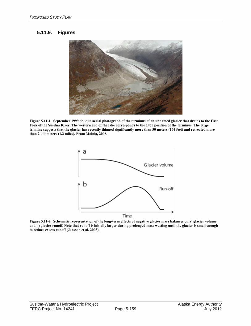
PROPOSED STUDY PLAN
Susitna-Watana Hydroelectric Project Alaska Energy Authority FERC Project No. 14241 Page 5-159 July 2012
5.11.9. Figures
Figure 5.11-1. September 1999 oblique aerial photograph of the terminus of an unnamed glacier that drains to the East Fork of the Susitna River. The western end of the lake corresponds to the 1955 position of the terminus. The large trimline suggests that the glacier has recently thinned significantly more than 50 meters (164 feet) and retreated more than 2 kilometers (1.2 miles). From Molnia, 2008.
Figure 5.11-2. Schematic representation of the long-term effects of negative glacier mass balances on a) glacier volume and b) glacier runoff. Note that runoff is initially larger during prolonged mass wasting until the glacier is small enough to reduce excess runoff (Jansson et al. 2003).
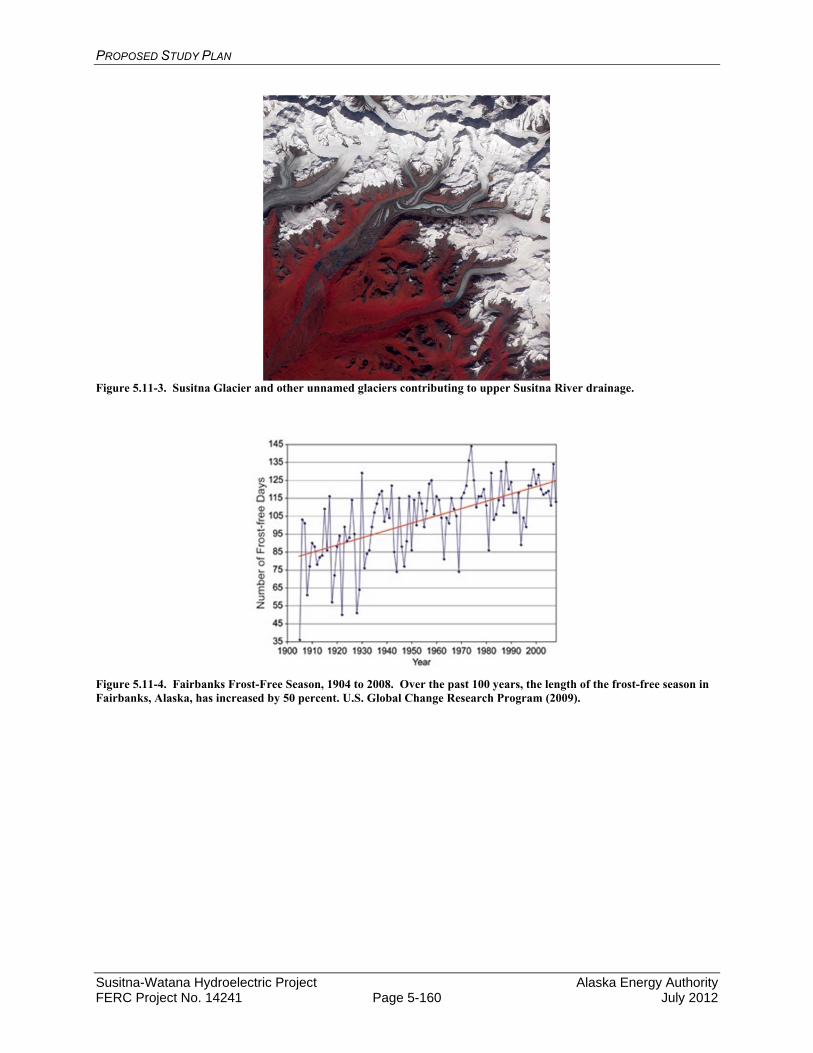
PROPOSED STUDY PLAN
Susitna-Watana Hydroelectric Project Alaska Energy Authority FERC Project No. 14241 Page 5-160 July 2012
Figure 5.11-3. Susitna Glacier and other unnamed glaciers contributing to upper Susitna River drainage.
Figure 5.11-4. Fairbanks Frost-Free Season, 1904 to 2008. Over the past 100 years, the length of the frost-free season in Fairbanks, Alaska, has increased by 50 percent. U.S. Global Change Research Program (2009).
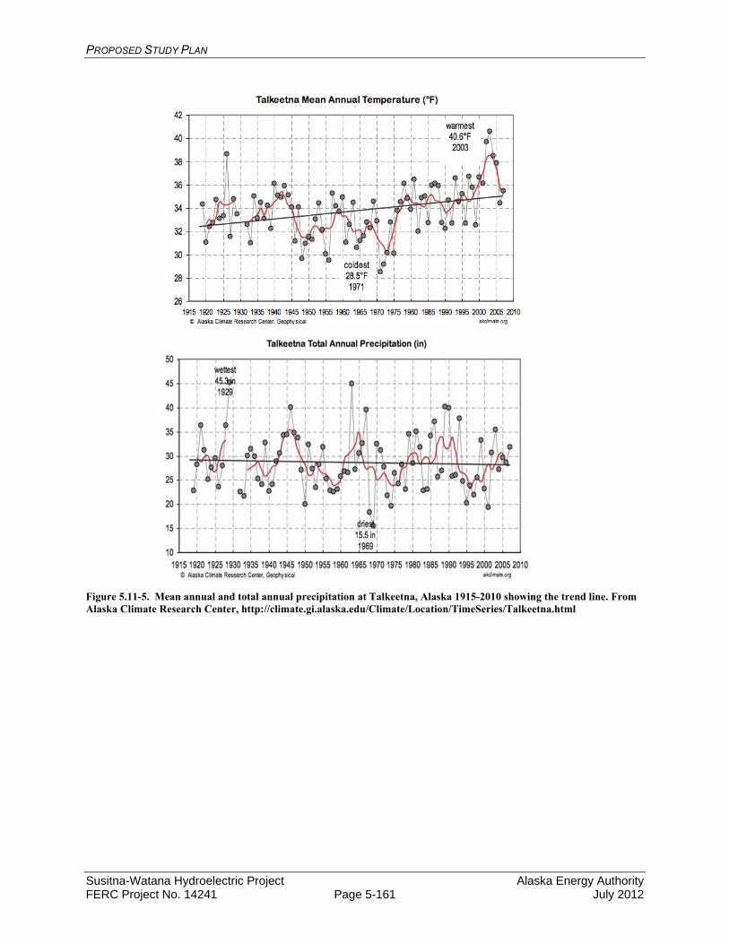
PROPOSED STUDY PLAN
Susitna-Watana Hydroelectric Project Alaska Energy Authority FERC Project No. 14241 Page 5-161 July 2012
Figure 5.11-5. Mean annual and total annual precipitation at Talkeetna, Alaska 1915-2010 showing the trend line. From Alaska Climate Research Center, http://climate.gi.alaska.edu/Climate/Location/TimeSeries/Talkeetna.html
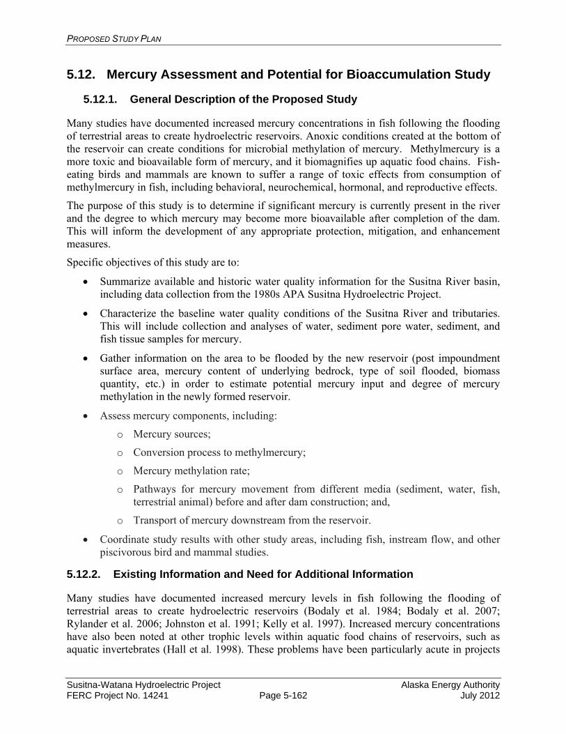
PROPOSED STUDY PLAN
Susitna-Watana Hydroelectric Project Alaska Energy Authority FERC Project No. 14241 Page 5-162 July 2012
5.12. Mercury Assessment and Potential for Bioaccumulation Study
5.12.1. General Description of the Proposed Study
Many studies have documented increased mercury concentrations in fish following the flooding of terrestrial areas to create hydroelectric reservoirs. Anoxic conditions created at the bottom of the reservoir can create conditions for microbial methylation of mercury. Methylmercury is a more toxic and bioavailable form of mercury, and it biomagnifies up aquatic food chains. Fish-eating birds and mammals are known to suffer a range of toxic effects from consumption of methylmercury in fish, including behavioral, neurochemical, hormonal, and reproductive effects.
The purpose of this study is to determine if significant mercury is currently present in the river and the degree to which mercury may become more bioavailable after completion of the dam. This will inform the development of any appropriate protection, mitigation, and enhancement measures.
Specific objectives of this study are to:
Summarize available and historic water quality information for the Susitna River basin, including data collection from the 1980s APA Susitna Hydroelectric Project.
Characterize the baseline water quality conditions of the Susitna River and tributaries. This will include collection and analyses of water, sediment pore water, sediment, and fish tissue samples for mercury.
Gather information on the area to be flooded by the new reservoir (post impoundment surface area, mercury content of underlying bedrock, type of soil flooded, biomass quantity, etc.) in order to estimate potential mercury input and degree of mercury methylation in the newly formed reservoir.
Assess mercury components, including:
o Mercury sources;
o Conversion process to methylmercury;
o Mercury methylation rate;
o Pathways for mercury movement from different media (sediment, water, fish, terrestrial animal) before and after dam construction; and,
o Transport of mercury downstream from the reservoir.
Coordinate study results with other study areas, including fish, instream flow, and other piscivorous bird and mammal studies.
5.12.2. Existing Information and Need for Additional Information
Many studies have documented increased mercury levels in fish following the flooding of terrestrial areas to create hydroelectric reservoirs (Bodaly et al. 1984; Bodaly et al. 2007; Rylander et al. 2006; Johnston et al. 1991; Kelly et al. 1997). Increased mercury concentrations have also been noted at other trophic levels within aquatic food chains of reservoirs, such as aquatic invertebrates (Hall et al. 1998). These problems have been particularly acute in projects

PROPOSED STUDY PLAN
Susitna-Watana Hydroelectric Project Alaska Energy Authority FERC Project No. 14241 Page 5-163 July 2012
from northern climates including Canada and Finland (Rosenberg et al. 1997). When boreal forests with large surface-area-to-volume ratios are flooded, substantial quantities of organic carbon and mercury stored in vegetation biomass (Grigal, 2003) and soils become inputs to the newly formed reservoir (Bodaly et al. 1984; Grigal, 2003; Kelly et al. 1997). This flooding accelerates microbial decomposition, causing high rates of microbial methylation of mercury.
Increases in methylmercury concentrations in reservoirs can last decades; fish mercury elevations have been documented for twenty to thirty years in some systems (Bodaly et al. 2007). Results from these studies may be used by the project proponent and environmental regulators to select the most appropriate mitigation strategies (Mailman et al. 2006) to reduce adverse impacts resulting from impaired water quality.
Historical mercury data from the study area are limited. Some samples were collected during previous studies of the APA Susitna Hydroelectric Project in the 1980s. This consisted of the collection of a water samples at Gold Creek (RM 136) in 1982. Total mercury was found to be 0.12 micrograms per liter (µg/L) in turbid, summer water, and 0.04 µg/L in the clear, winter water (AEIDC, 1985). The same results were found downriver at Susitna Station (RM 26).
Frenzel (2000) collected samples of sediment from the Deshka River, the Talkeetna River, and Colorado Creek and Costello Creek, which are tributaries to the Chulitna River. Mercury concentrations in the sediment were found to range from 0.04 to 0.46 µg/g, more than an order of magnitude. This suggests that mercury occurrence is strongly drainage specific. Additional samples were collected of Slimy Sculpin from the Deshka River, Talkeetna River, and Costello Creek. Mercury concentrations ranged from 0.08 µg/g at Talkeetna and Costello Creek, to 0.11 µg/g at the Deshka River.
Samples of fish tissue and sediment from the Deshka River and Costello Creek were speciated for metallic mercury and methylmercury. The results indicated that 19.54 percent of the mercury in the Deska River sediments was methylmercury. At Costello Creek only 0.02 percent of the mercury detected was found to be methylated. This study suggests, based on limited data, that mercury concentration varies significantly between separate drainages, and that methylation is also tributary specific. Previous studies (St. Louis et al, 1994) have shown that methylmercury occurrence is positively correlated with wetland density, and the Deshka River has significantly more wetlands in the drainage than other tributaries to the Susitna. Overall concentrations were also found to be positively correlated with the turbidity of the water. Very little mercury was found in filtered water samples.
These results are in agreement with the results from Krabbenhoft et al (1999). In nationwide mercury sampling, in a wide array of hydrological basins and wide array of environmental settings, wetland density was found to be the most important factor controlling methylmercury production. It was also found that methylmercury production appears proportional to total mercury concentrations only at low total mercury levels. Once total mercury concentrations exceed 1,000 nanograms per gram (ng/g), however, little additional methylmercury was observed to be produced. While atmospheric deposition was found to be the predominate source for most mercury, volcanic activity was a likely source of mercury at some sites. Sub-basins characterized as mixed agriculture and forested had the highest methylation efficiency, whereas areas affected by mining were found to be the lowest.
A more recent study has been done by the Alaska Department of Environmental Conservation (ADEC) Department of Environmental Health (ADEC 2012). ADEC is currently analyzing
PROPOSED STUDY PLAN
Susitna-Watana Hydroelectric Project Alaska Energy Authority FERC Project No. 14241 Page 5-164 July 2012
salmon (all five species) as well as other fresh water species for total mercury in the Susitna River drainages (Table 5.12-1). The State water quality standards for acute and chronic toxicity have not been exceeded to date.
5.12.3. Study Area
Water quality and sediment samples will be collected at the sites identified in Table 5.12-2. The study area begins at RM 10.1 and extends past the proposed dam site to RM 233.4. Tributaries to the Susitna River will be sampled and include those contributing large portions of the lower river flow such as the Talkeetna, Chulitna, Deshka, and Yentna rivers. Also included are smaller tributaries such as Gold, Portage, Tsusena, and Watana creeks, and Oshetna River. These sites were selected based on the following rationale:
Adequate representation of locations throughout the Susitna River and tributaries above and below the proposed dam site for the purpose of a baseline mercury characterization;
Location on tributaries where proposed access road-crossing impacts might occur during and after construction (upstream/downstream sampling points on each crossing);
Preliminary consultation with licensing participants including co-location with other study sites (e.g., instream flow, ice processes); and
Sites that are in the Susitna River mainstem, tributary, or slough locations, most of which were monitored in the 1980s.
5.12.4. Study Methods
This study was created to respond to comments from the National Marine Fisheries Service (NMFS) and the U.S. Fish and Wildlife Service (USFWS), among other licensing participants. Originally the study components described here were spread into several other sections of the overall study plan. They have been consolidated here to provide an overview of the proposed mercury assessment and bioaccumulation plans.
This study consists of five study components:
Summarize available/historical water quality information. Collect and analyze water, sediment, sediment pore water, and fish tissue samples for
mercury. Gather information on geology, soils, and vegetation in the area to be flooded by the new
reservoir.
Access mercury components, including:
o Mercury sources;
o Conversion process to methylmercury;
o Mercury methylation rate;
o Pathways for mercury movement from different media (sediment, water, fish, terrestrial animal) before and after dam construction; and,

PROPOSED STUDY PLAN
Susitna-Watana Hydroelectric Project Alaska Energy Authority FERC Project No. 14241 Page 5-165 July 2012
o Transport of mercury downstream from the reservoir.
Technical report on analytical results and mercury assessment.
Each of these study components is described in detail below.
5.12.4.1. Summary of available/historical water quality information
Existing literature will be reviewed to summarize the current understanding of the occurrence of mercury in the environment. This review will include a summary of 1980s APA Susitna Hydroelectric Project water quality studies, including data, and a summary of other cold regions hydroelectric projects regarding mercury issues.
5.12.4.2. Collection and analyses of water, sediment, sediment pore water, and fish tissue samples for mercury
Data will be collected from multiple aquatic media including surface water, sediment, and fish tissue. The collection of these samples will be handled as part of other media specific study plans. The work will be done as a single, comprehensive survey to determine the baseline concentrations of mercury in the watershed. The in-water mercury study methodology will be designed to meet the Clean Water Act 401 Water Quality Certification Process:
Conducting a water quality baseline assessment; How existing and designated uses are met; Use of appropriate field methods; Use of acceptable data quality assurance methods; Scheduling of technical work to meet deadlines; and Derivation of load calculations of potential pollutants (pre-Project conditions).
Mercury in water will be tested monthly during the summer since it has been shown to vary in concentrations throughout the year (Frenzel, 2000). An initial screening survey is proposed for mercury in sediment, sediment pore water, and tissue samples (Table 5.12-3). The following sections summarize the sampling efforts to be conducted in other studies.
5.12.4.3. Water
The purpose of the water sampling is to collect baseline water quality information to support an assessment of the effects of the proposed Project operations on water quality in the Susitna River basin. Monthly grab samples that will be sent to an off-site laboratory for analysis. The laboratory will have at a minimum, National Environmental Laboratory Accreditation Program (NELAP) Certification in order to generate credible data for use by regulatory agencies for evaluating current and future water quality conditions.
Water samples will be collected at the locations in bold on Table 5.12-2. The initial sampling may be expanded if significant methlymercury concentrations are found in the surface water, sediment pore water, sediment, or fish tissue. The proposed spacing of the sample locations follows accepted practice when segmenting large river systems for development of Total Maximum Daily Load (TMDL) water quality models. Water sampling during winter months will be focused on locations where flow data is currently collected (or was historically collected by the USGS).

PROPOSED STUDY PLAN
Susitna-Watana Hydroelectric Project Alaska Energy Authority FERC Project No. 14241 Page 5-166 July 2012
Water samples will be analyzed for the parameters reported in Table 5.12-4.
Grab samples will be collected during each site visit in a representative portion of the stream channel/water body, using methods consistent with Alaska State and EPA protocols for sampling ambient water and trace metal water quality criteria. Mainstem areas of the river not immediately influenced by a tributary will be characterized with a single grab sample. Areas of the mainstem with an upstream tributary that may influence the nearshore zone or is well-mixed with the mainstem will be characterized by collecting samples at two locations; in the tributary and in the mainstem upstream of the tributary confluence. All samples will be collected from a well-mixed portion of the river/tributary.
These samples will be collected on approximately a monthly basis (4 samples from June to September). The period for collecting surface water samples will begin at ice break-up and extend to beginning of ice formation on the river. Limited winter sampling (once in December, and again in March) will be conducted where existing or historic USGS sites are located. Review of existing data (URS 2011) indicated that few criteria exceedances occur with metals concentrations during the winter months. If the 2013 data sets suggest that mercury concentrations exceed criteria or thresholds then an expanded 2014 water quality monitoring program will be conducted to characterize conditions on a monthly basis throughout the winter months.
Variation of water quality in a river cross-section is often significant and is most likely to occur because of incomplete mixing of upstream tributary inflows, point-source discharges, or variations in velocity and channel geometry. It is possible that a flow-integrated sampling technique employed by USGS known as the equal width increment/equal transit rate (EWI) method (Edwards and Glysson, 1988; Ward and Harr, 1990) will be used. In this method, an isokinetic sampling device (a sampler that allows water to enter without changing its velocity relative to the stream) is lowered and raised at a uniform transit rate through equally-spaced vertical increments in the river cross-section. This can be done either by wading with hand-held samplers or from a boat using a winch mounted sampler, depending on river stage and flow conditions. The number of vertical increments used will differ between sites depending upon site specific conditions.
Sampling will avoid eddies, pools, and deadwater. Sampling will avoid unnecessary collection of sediments in water samples, and touching the inside or lip of the sample container. Samples will be delivered to EPA approved laboratories within the holding time frame. Each batch of samples will have a separate completed chain of custody sheet. A field duplicate will be collected for 10 percent of samples (i.e., 1 for every 10 water grab samples). Laboratory quality control samples including duplicate, spiked, and blank samples will be prepared and processed by the laboratory.
Quality Assurance/Quality Control (QA/QC) samples will include field duplicates, matrix spikes, duplicate matrix spikes, and rinsate blanks for non-dedicated field sampling equipment. The results of the analyses will be used in data validation to determine the quality, bias and usability of the data generated.
Sample numbers will be recorded on field data sheets immediately after collection. Samples intended for the laboratory will be stored in coolers and kept under the custody of the field team at all times. Samples will be shipped to the laboratory in coolers with ice and cooled to approximately 4° C. Chain of custody records and other sampling documentation will be kept in sealed plastic bags (Ziploc®) and taped inside the lid of the coolers prior to shipment. A

PROPOSED STUDY PLAN
Susitna-Watana Hydroelectric Project Alaska Energy Authority FERC Project No. 14241 Page 5-167 July 2012
temperature blank will accompany each cooler shipped. Packaging, marking, labeling, and shipping of samples will be in compliance with all regulations promulgated by the U. S. Department of Transportation in the Code of Federal Regulations, 49 CFR 171-177.
Water samples will be labeled with the date and time that the sample is collected and preserved/filtered (as appropriate), then stored and delivered to a state-certified water quality laboratory for analyses in accordance with maximum holding periods. A chain of custody record will be maintained with the samples at all times.
The state-certified laboratory will report (electronically and in hard copy) each chemical parameter analyzed with the laboratory method detection limit, reporting limit, and practical quantification limit. The laboratory will attempt to attain reporting detection limits that are at or below the applicable regulatory criteria and will provide all laboratory QA/QC documentation.
The procedures used for collection of water quality samples will follow protocols from ADEC and the EPA Region 10 (Pacific Northwest). Water samples will be analyzed by a laboratory accredited by the ADEC or recognized under the NELAP. Water quality data will be summarized in a report with appropriate graphics and tables with respect to Alaska State Water Quality Standards (ADEC 2005) and any applicable federal standards.
The results will be compared to the appropriate NOAA SQuiRT table, "Screening Quick Reference Table for Inorganics in water", to assess whether a metal level exceeds acute and/or chronic toxicity benchmarks for aquatic organisms.
Additional details of the sampling methods will be provided in the Sampling and Analysis Plan (SAP) and the Quality Assurance Project Plan (QAPP) for this study.
5.12.4.3.1. Sediment and Sediment Pore Water
In general, all sediment samples will be taken from sheltered backwater areas, downstream of islands, and in similar riverine locations in which water currents are slowed, favoring accumulation of finer sediment along the channel bottom. Samples will be analyzed for mercury (Tables 5.12-4 and 5.12-5). In addition, sediment size and total organic carbon (TOC) will be included to evaluate whether these parameters are predictors for elevated mercury concentrations. Samples will be collected just below and above the proposed dam site. Additional samples will be collected near the mouth of tributaries near the proposed dam site, including Fog, Deadman, Watana, Tsusena, Kosina, Jay, Goose creeks, and the Oshetna River. The purpose of this sampling will be to determine where metals, if found in the water or sediment, originate in the drainage.
Mercury occurrence is typically associated with fine sediments, rather than with coarse-grained sandy sediment or rocky substrates. Therefore, the goal of the sampling will be to obtain sediments with at least 5 percent fines (i.e., particle size <63 μm, or passing through a #230 sieve). At some locations, however, larger-sized sediment may be all that are available.
Surficial sediment sampling will be conducted with a Van Veen sampler lowered from a boat by a power winch. This sampling device collects high quality sediment samples from the top 4 to 6 inches of sediment (EPA 2001). For most sediment types, the Van Veen sampler is better than other sampling devices for reducing sample loss from debris blockage. The Van Veen sampler also minimizes surrounding water disturbance as the device is lowered through the water column, and collects high quality samples (EPA 2001). The support frame enhances the
PROPOSED STUDY PLAN
Susitna-Watana Hydroelectric Project Alaska Energy Authority FERC Project No. 14241 Page 5-168 July 2012
versatility of the Van Veen sampler, with features allowing the addition of weights (to increase penetration in compact sediments) or pads (to provide added bearing support in extremely soft sediments) (EPA 2001). It is commonly used in national and regional sediment monitoring programs including the National Oceanic and Atmospheric Administration (NOAA) National Status and Trends Program, the EPA Environmental Monitoring and Assessment Program, and the EPA National Estuary Program.
Three sediment samples will be collected per visit at each of the sites sampled. These three samples will be collected and analyzed separately to characterize the presence of metals and generate statistical summaries for site characterization. A photographic record of each sediment sample will be assembled from images of newly collected material.
Sediment sample collection will incorporate specific field methods that define high quality samples (from EPA 2001):
Sampler is not overfilled with sediment. Overlying water is present when the sampler is retrieved. Overlying water is clear, not turbid. At least 2 inches of sediment depth is collected. There is no evidence of incomplete closure of the sampling device.
If a sediment sample does not meet all of the above criteria, it will be discarded and another sample will be collected.
Sediment data will be compared to the appropriate NOAA SQuiRT table, "Screening Quick Reference Table for Inorganics in Freshwater Sediment", to assess whether a metal level exceeds acute and/or chronic toxicity benchmarks for aquatic organisms.
Sediment interstitial water, or pore water, is defined as the water occupying the space between sediment particles. Interstitial waters will be collected from sites as indicated in Table 5.12-2 and separated from sediments in the field house laboratory using a pump apparatus to draw pore water from each of the replicate samples. Filtering of samples will utilize a 0.45 µm pore size filter in both the lab and field apparatus. In some cases, pore water may be drawn from sediment samples in the field by using 100 milliliter (mL) syringes immersed in the dredge sample once a sediment sample is collected in a sample jar. These would be cases where sediment samples have slightly coarser particle sizes and pore water extraction in the field is possible. In other instances, where sediment samples have finer particle sizes requiring more time to draw samples for laboratory analysis; these samples will be transferred to the field laboratory for pore water extraction.
5.12.4.3.2. Fish Tissue
Methylmercury bioaccumulates and the highest concentrations are typically in the muscle tissue of adult predatory fish. Target fish species in the vicinity of the Susitna-Watana Reservoir will be Dolly Varden, Arctic grayling, stickleback, whitefish species, burbot and resident rainbow trout. If possible, filets will be sampled from seven (7) adult individuals from each species. For stickleback, whole fish samples will have to be used. Body size targeted for collection will represent the non-anadromous phase of each species life cycle (e.g., Dolly Varden; 90 mm – 125 mm total length to represent the resident portion of the life cycle). Collection times for fish
PROPOSED STUDY PLAN
Susitna-Watana Hydroelectric Project Alaska Energy Authority FERC Project No. 14241 Page 5-169 July 2012
samples will occur in late August and early September. Samples will be analyzed for methyl and total mercury (Tables 5.12-4 and 5.12-5).
Field procedures will be consistent with those outlined in applicable Alaska State and/or EPA sampling protocols (USEPA 2000). Clean nylon nets and polyethylene-gloves will be used during fish tissue collection. The species, fork length, and weight of each fish will be recorded. Fish will be placed in Teflon sheets and into zipper-closure bags and placed immediately on ice. Fish samples will be submitted to a state-certified analytical laboratory for individual fish muscle tissue analysis. Results will be reported with respect to applicable Alaska State and federal standards.
Detection of mercury in fish tissue and sediment will prompt further study of naturally occurring concentrations in soils and plants and how parent geology contributes to concentrations of this toxic in both compartments of the landscape. The focused study will estimate the extent and magnitude of mercury contamination so that an estimate of increased bioavailability might be made once the reservoir inundates areas where high concentrations of mercury are sequestered.
The bio-magnification of mercury contamination from sediments and plants to the fish community may be facilitated through consumption of contaminated food sources like benthic macroinvertebrates. Therefore elevated concentrations of mercury in fish tissue may prompt additional sampling and analysis of tissues in the benthic macroinvertebrate community. Contamination of this component of a trophic level may also be a conduit for mercury biomagnification in waterfowl and other wildlife that consume this food source.
5.12.4.4. Gather information on the area to be flooded by the new reservoir
Researchers have found a number of parameters associated with mercury levels in fish after a new reservoir is created. These parameters have been included in various studies to predict mercury levels in fish post-impoundment. Some studies have found that the primary source of mercury to new reservoirs was the inundated soils (Meister et al. 1979), especially the upper organic soil horizon which often has higher mercury levels than the lower inorganic soil layers (Bodaly et al. 1984). Underlying geology can also be important (Lockhart et al. 2005), if mercury-containing source rock is present, as occurs in some areas of Alaska (Gray et al. 2000). The type and quantity of vegetation in the area to be inundated has great influence on mercury input and methylation. Peat is a particularly large source of methylmercury to the system, because areas of poorly drained soil and wetlands enhance methylation of mercury (Grigal 2003).
Thus, to provide inputs for fish mercury uptake post-impoundment, data will be gathered for the following parameters within the area to be flooded:
Mercury content of terrestrial soils in the area to be flooded; Characterization of underlying geology in the area to be flooded, which assesses whether
the rock types contain leachable mercury; Characterization of type and amount of vegetative biomass to be inundated; Total inundation zone; and Quantitation of wetland area to be flooded.
This information will be derived from existing sources and studies. Much of this data will be generated during the geology and soils studies that are being performed as part of dam design.
PROPOSED STUDY PLAN
Susitna-Watana Hydroelectric Project Alaska Energy Authority FERC Project No. 14241 Page 5-170 July 2012
5.12.4.5. Pathway assessment of mercury into the reservoir, within the reservoir, and transport of mercury downstream from the reservoir
Assessment of the potential pathways for mercury will be based on readily available literature (Hydro-Quebec 1993; Johnston et al. 1991; Therriault and Schneider 1998), and additional mercury studies will be researched and evaluated, to ensure the most applicable methods are used to meet project needs.
The pathway assessment will incorporate both existing conditions, and conditions with the reservoir and dam in place. The reservoir representation will be developed based on the local bathymetry and dimensions of the proposed dam. The Water Quality Modeling Study (Section 5.6) provides for a three-dimensional model to be developed for the proposed reservoir to represent the spatial variability in hydrodynamics and water quality in longitudinal, vertical and lateral directions. The model will be able to simulate flow circulation in the reservoir, turbulence mixing, temperature dynamics, nutrient fate and transport, interaction between nutrient and algae, and potentially sediment and metal transport. The key feature that needs to be captured is the stratification of water column during summer and de-stratification during winter.
Downstream of the proposed dam location the water quality modeling will evaluate the effects of the proposed project on mercury concentrations. The river model will be capable of representing conditions in both the absence and presence of the dam. The downstream spatial extent of this model is yet to be determined, but it is likely it will extend to shortly downstream of the Susitna-Talkeetna-Chulitna confluence (e.g., Sunshine USGS Gage).
Organic carbon content from inflow sources along with pathway analyses will be used to correlate with mercury concentrations to predict the potential for methylation of mercury in riverine and reservoir habitats.
5.12.4.6. Technical report on analytical results and mercury assessment
The technical report will include a description of the study goals and objectives, assumptions made, sample methods, analytical results, models used, and other background information. Field data, laboratory report, and quality assurance information will be attached. Mercury will be modeled in the water and sediment for the reservoir and downstream. Output parameters will include quantitation of mercury inputs to the reservoir, an estimation of mercury methylation rates, mercury circulation among different media (fish, air, water, sediment, etc.), and bioabsorption and transfer. This will lead to an estimation of mercury levels within fish tissue after reservoir impoundment. Fish mercury concentrations will be estimated for a variety of fish species that are important either for human or animal consumption.
Coordination will occur with the instream flow, ice processes, productivity, and fish studies to obtain information needed to reflect the results of this study in the context of the various Project scenarios.
5.12.5. Consistency with Generally Accepted Scientific Practice
Field sampling practices proposed in this study are consistent with ADEC (2003, 2005); USGS (Ward and Harr, 1990); Edwards et al, 1988); and EPA (USEPA, 2000). Results will be compared to established NOAA cleanup levels (NOAA, 2012). Studies, field investigations, laboratory testing, engineering analysis, etc. will be performed in accordance with general

PROPOSED STUDY PLAN
Susitna-Watana Hydroelectric Project Alaska Energy Authority FERC Project No. 14241 Page 5-171 July 2012
industry accepted scientific and engineering practices. The methods and work efforts outlined in this study plan are the same or consistent with analyses used by applicants and licensees and relied upon by the Commission in other hydroelectric licensing proceedings.
The Clean Water Act Section 401 Water Quality Certification process includes a baseline assessment of mercury conditions and will determine if existing conditions will result in a potential for bioaccumulation. The monitoring strategy used in this study follows scientifically accepted practice for identifying impacts to water quality and will be used for Project certification. ADEC and the USGS are currently pursing similar sampling programs for fish tissue in the state (ADEC, 2012; Frenzel, 2000; and Krabbenhoft et al, 1999).
FERC has a long history of performing similar studies during hydroelectric permitting, including most recently at the Middle Fork American River Project (FERC Project No. 2079) in 2011; and Yuba County Water Agency Yuba River Development Project (FERC Project No. 2246)
5.12.6. Schedule
The study elements will be completed in several stages and based on the following timeline shown below.
Study Schedule
Monitoring Activity Timeline
QAPP/SAP Preparation and Review January 2013 – March 2013
Water Quality Monitoring (monthly) June 2013 - October 2013 (one sampling event in each of December 2013 and March 2014)
Sediment Sampling (one survey) August-September 2013
Fish Tissue Sampling (one survey) August - September 2012/2013
Data Analysis and Management June 2013 – November 2013
Initial Study Report December 2013
Updated Study Report December 2014
PROPOSED STUDY PLAN
Susitna-Watana Hydroelectric Project Alaska Energy Authority FERC Project No. 14241 Page 5-172 July 2012
5.12.7. Level of Effort and Cost
The following are costs associated with individual tasks for conducting mercury baseline monitoring in the Susitna basin for 2013/2014:
Planning ($60,000)
Monitoring ($300,000)
Data Analysis ($100,000)
Reporting ($100,000)
5.12.8. Literature Cited
Alaska Department of Environmental Conservation (ADEC), 2003. Alaska Water Quality Criteria Manual for Toxic and Other Deleterious Organic and Inorganic Substances. Alaska Department of Environmental Conservation: Division of Water. Juneau, Alaska. 51p.
ADEC, 2005. Water Quality Assessment and Monitoring Program. Alaska Department of Environmental Conservation: Division of Water. Juneau, Alaska. 58p.
ADEC, 2012. Mercury concentration in fresh water fish Southcentral Susitna Watershed. Personal communication with Bob Gerlach, VMD, State Veterinarian. June 2012.
Arctic Environmental Information and Data Center (AEIDC), 1985. Preliminary draft impact assessment technical memorandum, Volume 1. Main text.
Alaska Energy Authority (AEA), 2011. Pre-Application Document: Susitna-Watana Hydroelectric Project FERC Project No. 14241. Volume I of II. Alaska Energy Authority, Anchorage, AK. 395p.
Bodaly R.A., Hecky R.E., Fudge R.J.P., 1984. Increases in fish mercury levels in lakes flooded by the Churchill River Diversion, Northern Manitoba. Can. J. Fish. Aquat. Sci. 41:682-691.
Bodaly R.A., Jansen W.A., Majewski A.R., Fudge R.J.P., Strange N.E., Derksen A.J., Green D.J., 2007. Post impoundment time course of increased mercury concentrations in fish in hydroelectric reservoirs of Northern Manitoba, Canada. Arch. Environ. Con tam. Toxicol. 53:379-389.
Bodaly R.A., Beaty K.G., Hendzel L.H., Majewski A.R., Paterson M.J., Rolfhus K.R., Penn A.F., St. Louis V.L., Hall B.D., Matthews C.J.D., Cherewyk K.A., Mailman M., Hurley, J.P., Schiff S.L., Venkiteswaran J.J. (2004) Experimenting with hydroelectric reservoirs, Environmental Science & Technology, American Chemical Society. pp. 346A-352A.
Edwards, T.K., and D.G. Glysson. 1988. Field methods for measurement of fluvial sediment. U.S. Geological Survey Open-File Report 86-531, 118 p.
Frenzel, S.A., 2000. Selected Organic Compounds and Trace Elements in Streambed Sediments and Fish Tissues, Cook Inlet Basin, Alaska. USGS Water-Resources Investigations Report 00-4004. Prepared as part of the National Water-Quality Assessment Program.

PROPOSED STUDY PLAN
Susitna-Watana Hydroelectric Project Alaska Energy Authority FERC Project No. 14241 Page 5-173 July 2012
Gray J.E., Theodorakos P.M., Bailey E.A., Turner R.R., 2000. Distribution, speciation, and transport of mercury in stream-sediment, stream-water, and fish collected near abandoned mercury mines in southwestern Alaska, USA. Science of the Total Environment 260:21- 33.
Grigal D.F., 2003. Mercury sequestration in forests and peatlands: a review. Journal of Environmental Quality 32:393-405.
Hall B.D., Rosenberg D.M., Wiens A.P.,1998. Methylmercury in aquatic insects from an experimental reservoir. Can. J. Fish. Aquat. Sci. 55:2036-2047.
Hydro-Quebec. (1993) Grande-Baleine complex. Feasibility study. Part 2: Hydroelectric complex. Book 6: Mercury, Hydro-Quebec, Montreal, Quebec.
Johnston T.A., Bodaly R.A., Mathias J.A., 1991. Predicting fish mercury levels from physical characteristics of boreal reservoirs. Can. J. Fish. Aquat. Sci. 48:1468-1475.
Kelly C.A., Rudd J.W.M., Bodaly R.A., Roulet N.P., St. Louis V.L., Heyes A., Moore T.R., Schiff S., Aravena R., Scott K.J., Dyck B., Harris R., Warner B., Edwards G., 1997. Increases in fluxes of greenhouse gases and methylmercury following flooding of an experimental reservoir. Environmental Science & Technology 31:1334-1344.
Krabbenhoft, D.P., Wiener, J.G., Brumbaugh, W.G., Olson, M.L., DeWild, J.F., and Sabin, T.J., 1999, A national pilot study of mercury contamination of aquatic ecosystems along multiple gradients, in Morganwalp, D.W., and Buxton, H.T., eds., U.S. Geological Survey Toxic Substances Hydrology Program—Proceedings of the Technical Meeting, Charleston, South Carolina, March 8-12, 1999— Volume 2, Contamination of hydrologic systems and related ecosystems: U.S. Geological Survey Water-Resources Investigations Report 99-4018B, p. 147-162.
Lockhart W.L., Stem G.A., Low G., Hendzel M., Boila G., Roach P., Evans M.S., Billeck B.N., DeLaronde J., Friesen S., Kidd K.A., Atkins S., Muir D.C.G., Stoddart M., Stephens G., Stephenson S., Harbicht S., Snowshoe N., Grey B., Thompson S., DeGraff N., 2005. A history of total mercury in edible muscle of fish from lakes in northern Canada. Science of the Total Environment 351-352:427-463.
Mailman M., Stepnuk L., Cicek N., Bodaly R.A., 2006. Strategies to lower methylmercury concentrations in hydroelectric reservoirs and lakes: A review. Science of the Total Environment 368:224-235.
Meister J.F., DiNunzio J., Cox J.A., 1979. Source and level of mercury in a new impoundment. Journal of the American Water Works Association 71:574-576.
National Oceanic and Atmospheric Administration (NOAA), 2012. Screening Quick Reference Tables (SQuiRTs), National Oceanic and Atmospheric Administration, Office of Response and Restoration, http://response.restoration.noaa.gov/sites/default/files/SQuiRTs.pdf.
Rosenberg D.M., Berkes F., Bodaly R.A., Hecky R.E., Kelly C.A., Rudd J.W.M. (1997) Large scale impacts of hydroelectric development. Environ. Rev. 5:27-54.
Rylander L.D., Grohn J., Tropp M., Vikstrom A., Wolpher H., De Castro e Silva E., Meili M., Oliveira L.J. (2006) Fish mercury increase in Lago Manso, a new hydroelectric reservoir in tropical Brazil. Journal of Environmental Management 81:155-166.

PROPOSED STUDY PLAN
Susitna-Watana Hydroelectric Project Alaska Energy Authority FERC Project No. 14241 Page 5-174 July 2012
St. Louis, V. L., Rudd, J.W.M, Kelly, C.A., Beaty, K.G., Bloom, N.S. and Flett, R.J., 1994. The importance of wetlands as sources of methylmercury to boreal forest ecosystems. Can. J. Fish. Aquat. Sci. 51: 1065–1076.
Therriault T.W., Schneider D.C., 1998. Predicting change in fish mercury concentrations following reservoir impoundment. Environmental Pollution 101:33-42.
URS. 2011. AEA Susitna Water Quality and Sediment Transport Data Gap Analysis Report. Prepared by Tetra Tech, URS, and Arctic Hydrologic Consultants. Anchorage, Alaska. 62p.+Appendixes.
U.S. Environmental Protection Agency (USEPA). 2000. Guidance for Assessing Chemical Contaminant Data for use in Fish Advisories: Volume 1 Fish Sampling and Analysis, 3rd Edition. EPA-823-B-00-007. United States Environmental Protection Agency, Office of Water. Washington , D.C. 485p.
Ward J.C., Harr C.A., 1990. Methods for collection and processing of surface-water and bed material samples for physical and chemical analyses. U.S. Geological Survey Open-File Report 90-140. 71.
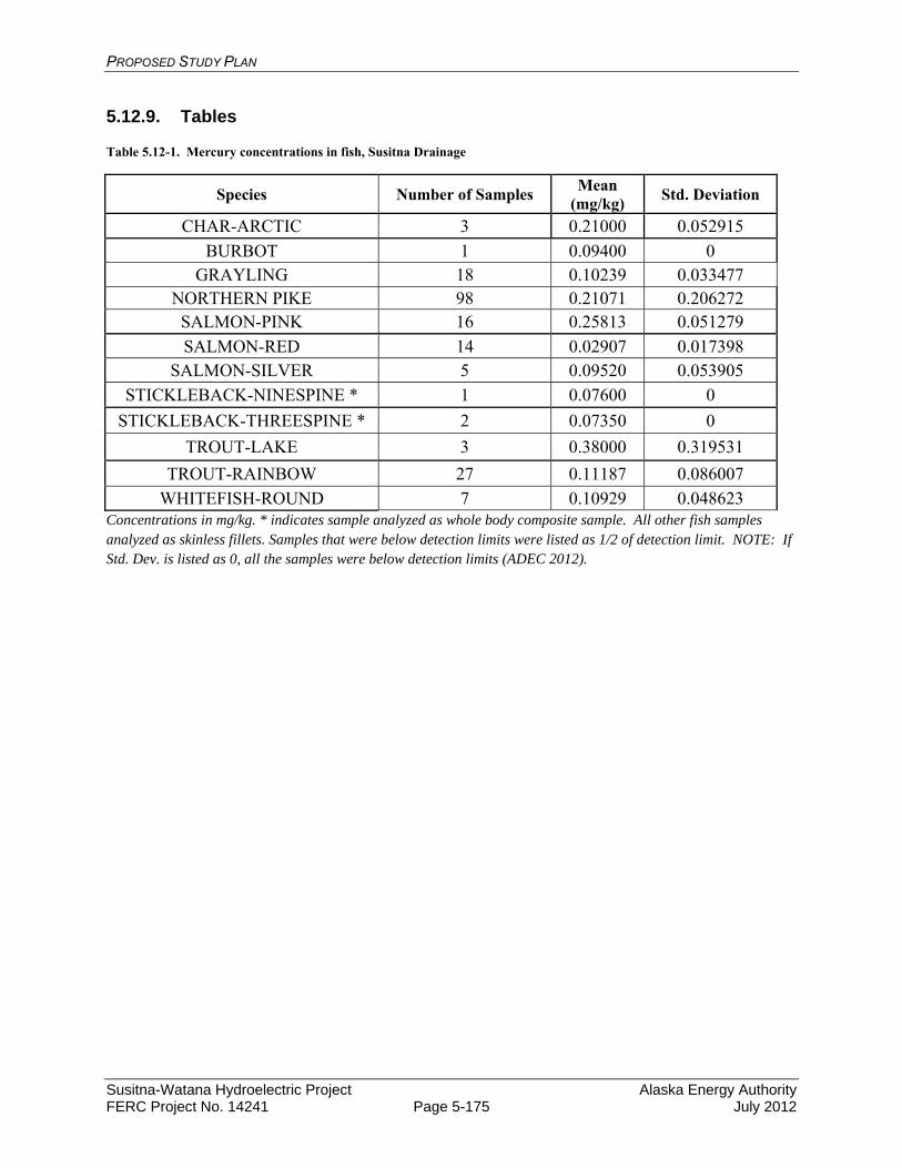
PROPOSED STUDY PLAN
Susitna-Watana Hydroelectric Project Alaska Energy Authority FERC Project No. 14241 Page 5-175 July 2012
5.12.9. Tables
Table 5.12-1. Mercury concentrations in fish, Susitna Drainage
Species Number of Samples Mean (mg/kg)
Std. Deviation
CHAR-ARCTIC 3 0.21000 0.052915
BURBOT 1 0.09400 0 GRAYLING 18 0.10239 0.033477
NORTHERN PIKE 98 0.21071 0.206272 SALMON-PINK 16 0.25813 0.051279
SALMON-RED 14 0.02907 0.017398 SALMON-SILVER 5 0.09520 0.053905
STICKLEBACK-NINESPINE * 1 0.07600 0
STICKLEBACK-THREESPINE * 2 0.07350 0
TROUT-LAKE 3 0.38000 0.319531
TROUT-RAINBOW 27 0.11187 0.086007
WHITEFISH-ROUND 7 0.10929 0.048623 Concentrations in mg/kg. * indicates sample analyzed as whole body composite sample. All other fish samples analyzed as skinless fillets. Samples that were below detection limits were listed as 1/2 of detection limit. NOTE: If Std. Dev. is listed as 0, all the samples were below detection limits (ADEC 2012).
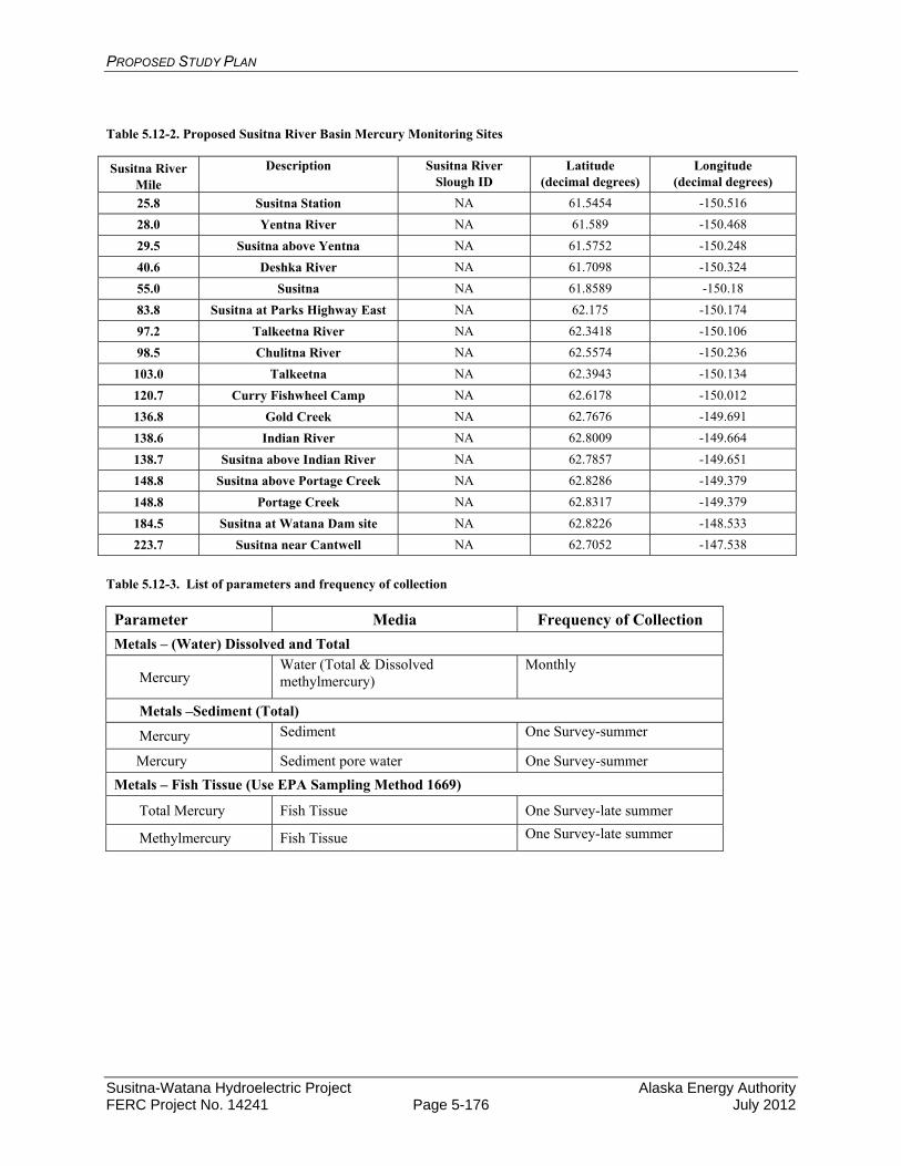
PROPOSED STUDY PLAN
Susitna-Watana Hydroelectric Project Alaska Energy Authority FERC Project No. 14241 Page 5-176 July 2012
Table 5.12-2. Proposed Susitna River Basin Mercury Monitoring Sites
Susitna River Mile
Description Susitna River Slough ID
Latitude (decimal degrees)
Longitude (decimal degrees)
25.8 Susitna Station NA 61.5454 -150.516
28.0 Yentna River NA 61.589 -150.468
29.5 Susitna above Yentna NA 61.5752 -150.248
40.6 Deshka River NA 61.7098 -150.324
55.0 Susitna NA 61.8589 -150.18
83.8 Susitna at Parks Highway East NA 62.175 -150.174
97.2 Talkeetna River NA 62.3418 -150.106
98.5 Chulitna River NA 62.5574 -150.236
103.0 Talkeetna NA 62.3943 -150.134
120.7 Curry Fishwheel Camp NA 62.6178 -150.012
136.8 Gold Creek NA 62.7676 -149.691
138.6 Indian River NA 62.8009 -149.664
138.7 Susitna above Indian River NA 62.7857 -149.651
148.8 Susitna above Portage Creek NA 62.8286 -149.379
148.8 Portage Creek NA 62.8317 -149.379
184.5 Susitna at Watana Dam site NA 62.8226 -148.533
223.7 Susitna near Cantwell NA 62.7052 -147.538
Table 5.12-3. List of parameters and frequency of collection
Parameter Media Frequency of Collection Metals – (Water) Dissolved and Total
Mercury Water (Total & Dissolved methylmercury)
Monthly
Metals –Sediment (Total)
Mercury Sediment One Survey-summer
Mercury Sediment pore water One Survey-summer
Metals – Fish Tissue (Use EPA Sampling Method 1669)
Total Mercury Fish Tissue One Survey-late summer
Methylmercury Fish Tissue One Survey-late summer
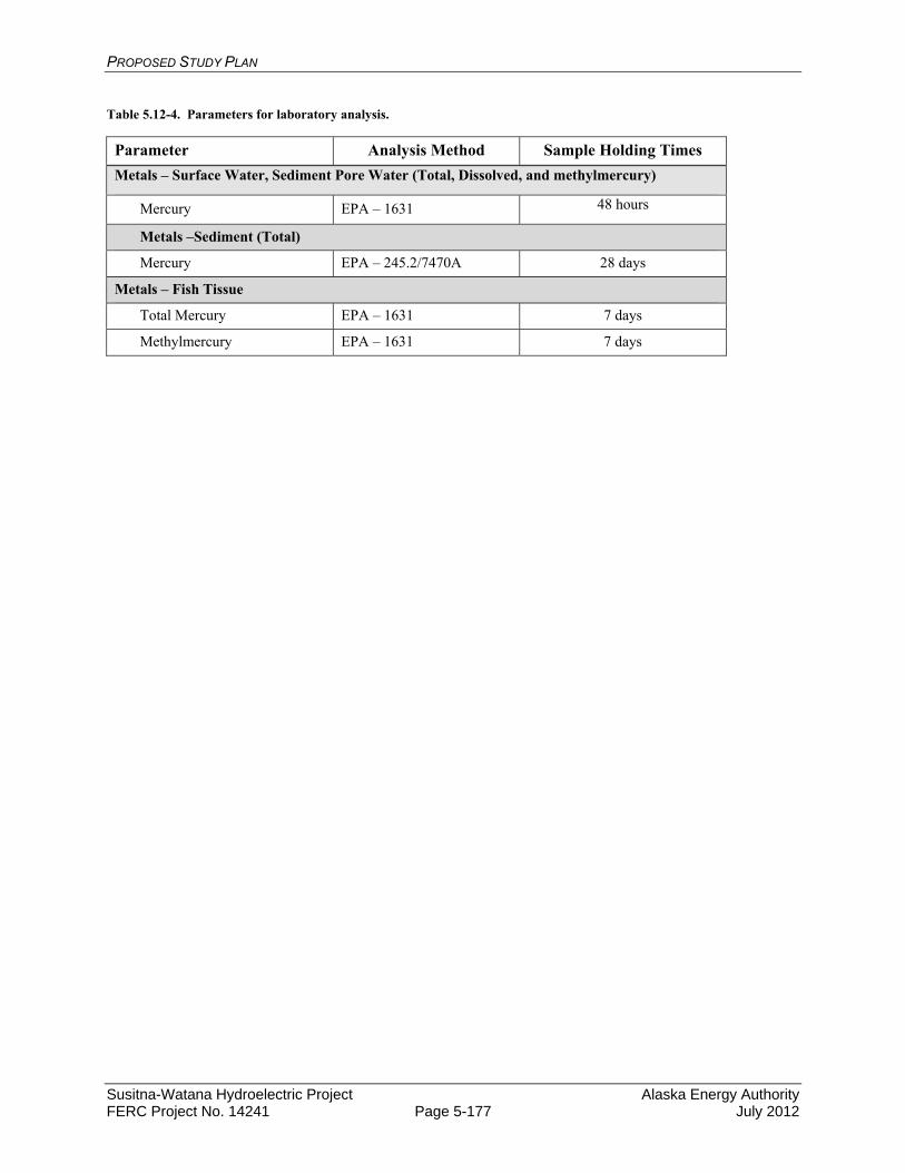
PROPOSED STUDY PLAN
Susitna-Watana Hydroelectric Project Alaska Energy Authority FERC Project No. 14241 Page 5-177 July 2012
Table 5.12-4. Parameters for laboratory analysis.
Parameter Analysis Method Sample Holding Times
Metals – Surface Water, Sediment Pore Water (Total, Dissolved, and methylmercury)
Mercury EPA – 1631 48 hours
Metals –Sediment (Total)
Mercury EPA – 245.2/7470A 28 days
Metals – Fish Tissue
Total Mercury EPA – 1631 7 days
Methylmercury EPA – 1631 7 days
PROPOSED STUDY PLAN
Susitna-Watana Hydroelectric Project Alaska Energy Authority FERC Project No. 14241 Page 5-178 July 2012
5.13. Attachments
ATTACHMENT 5-1. DOCUMENTATION OF CONSULTATION ON WATER RESOURCES STUDY PLANS
ATTACHMENT 5-1
DOCUMENTATION OF CONSULTATION ON WATER RESOURCES STUDY PLANS