4.5 marine biological resources
TRANSCRIPT

4. Environmental Setting, Impacts, and Mitigation Measures
4.5 Marine Biological Resources
CalAm Monterey Peninsula Water Supply Project 4.5-1 April 2015 Draft EIR
4.5 Marine Biological Resources
Sections Tables
4.5.1 Environmental Setting
4.5.2 Regulatory Framework
4.5.3 Impacts and Mitigation Measures
4.5-1 Special-Status Marine Species and Their Potential to Occur within the Study Area
4.5-2 Fish Species Present in Monterey Bay Managed Under Magnuson-Stevens Act
4.5-3 Application Regional and Local Land Use Plans and Policies Relevant to Marine Biological Resources
4.5-4 Summary of Impacts – Marine Biological Resources
4.5-5 Potential Effects of Varying Noise Levels to Fish and Marine Mammals
4.5-6 Summary of Alternative Permanent Threshold Shift and Temporary Threshold Shift Sound Levels from Dual Acoustic Threshold Noise Levels from Marine Mammals
4.5-7 Swimming Speeds of Plankton, Invertebrates and Larval Fish
4.5-8 Summary of International Brine Limits
4.5-9 Results from Studies on the Effects of Elevated Salinity on Marine Organism
4.5-10 Salinity and Temperature at the Depth of the MRWPCA Diffuser
4.5-11 Concentration of Un-Ionized Ammonia Allowed by Ocean Plan Objectives for Total Ammonia
Figures
4.5-1 Identified Seafloor Habitats in Study Area
This section addresses the potential for the Monterey Peninsula Water Supply Project (MPWSP or proposed project) to affect marine habitats and associated marine biological resources. The study area encompasses the locations of the proposed seawater intake slant wells and the existing Monterey Regional Water Pollution Control Agency (MRWPCA) outfall which is proposed to be utilized for the brine discharge (Figure 4.5-1). This section focuses on construction and operational impacts associated with the proposed subsurface slant wells and operational impacts associated with brine discharges. Applicable federal, state, and local regulations are identified. The analysis of brine discharge impacts relies on water quality information presented in Section 4.3, Surface Water Hydrology and Water Quality. Terrestrial biological resources, including marine birds, are discussed in detail in Section 4.6, Terrestrial Biological Resources.
References used in the preparation of this section include, but are not limited to, the following:
California Department of Fish and Game (CDFG), 2001. California’s Living Marine Resources: A Status Report.
State Water Resources Control Board (SWRCB), 2008. Scoping Document: Water Quality Control Policy on the Use of Coastal and Estuarine Waters for Power Plant Cooling. March 2008.
National Oceanic and Atmospheric Administration (NOAA) Environmental Sensitivity Index (ESI) maps of at-risk coastal resources in Central California
California Department of Fish and Wildlife (CDFW) Marine Region GIS Lab biological observational data http://www.dfg.ca.gov/marine/gis/downloads.asp

4. Environmental Setting, Impacts, and Mitigation Measures
4.5 Marine Biological Resources
CalAm Monterey Peninsula Water Supply Project 4.5-2 April 2015 Draft EIR
United States Fish and Wildlife Service (USFWS) Critical Habitat Portal http://ecos.fws.gov/crithab
California State University, Monterey Bay, Seafloor Mapping Lab Data Library http://seafloor.otterlabs.org/SFMLwebDATA_mb.htm#CMB-
4.5.1 Setting This section describes the regional oceanographic conditions and marine biological resources of Monterey Bay. The impact analysis presented in Section 4.5.3, below, focuses only on those resources located within the marine resources study area. For the purposes of this EIR, the marine resources study area encompasses the nearshore waters (within 5 miles from shore) of Monterey Bay and extends from the Salinas River in the north to the northern limits of Sand City in the south (Figure 4.5-1).
Three aspects of the project have the potential to adversely affect marine resources: (1) construction of the subsurface slant wells; (2) operation of the subsurface slant wells; and (3) operational discharges of brine generated by the MPWSP Desalination Plant via the MRWPCA existing ocean outfall. As discussed in Chapter 3, Project Description, the proposed slant wells would be located approximately 2 miles south of the Salinas River in the CEMEX active mining area in northern Marina. Up to 10 slant wells would be installed from the shore using a dual-wall, reverse-circulation, “Barber”–type drilling rig modified for angle (slant) wells. Each of the slant wells is planned to terminate beneath coastal dunes, sandy beach, or sandy subtidal (surf zone) habitats of Monterey Bay (Chapter 3, Project Description). The latter is further characterized as a high wave energy environment. The slant wells are projected to terminate approximately 200 to 220 feet below mean sea level (msl) and estimated to be 190-210 feet below the seafloor. The desalination process would generate an average of 13.98 million gallons per day (mgd) of brine that would be discharged via the existing MRWPCA ocean outfall. The outfall is currently, and would continue to be, used to discharge treated wastewater effluent from the MRWPCA Regional Wastewater Treatment Plant. The outfall terminates at the diffuser located approximately 2 miles offshore in 90 to 110 (MW) feet below sea level where a soft mud substrate predominates.
4.5.1.1 Regional Marine Biological Resources
Monterey Bay National Marine Sanctuary
The study area is located in the coastal area of the Monterey Bay National Marine Sanctuary (MBNMS), which was designated as a federally protected area in 1992. The MBNMS is managed by the National Oceanographic Atmospheric Administration (NOAA) and includes coastal waters from Marin to Cambria. The MBNMS includes 276 statute miles of shoreline, extends an average distance of 30 miles from shore, and encompasses 5,322 square miles of ocean (MBNMS, 2014b). The MBNMS was established for the purpose of research, education, public use, and resource protection. The MBNMS includes a variety of habitats that support extensive marine life.

!
ASR Injection/Extraction Wells (Proposed)
Terminal Reservoir and ASR Pump Station (Proposed)
Connection to Existing
Distribution System
MRWPCA OceanOutfall and Diffuser (Existing)
MRWPCARegional Wastewater
Treatment Plant (Existing)
Valley Greens Pump StationSite Option 1 (Proposed)
Mo n
t er
ey
Ba
y
MPWSP DesalinationPlant (Proposed)
CSIPPond (Existing)
!!
!
Reservation RdGe
neral
Jim
Moor
e B
lvd
La Salle Ave
Hilby AveDel Monte Blvd
C a r m e l R i v e r
Ryan Ranch-BishopInterconnection Improvements
(Proposed)Main System-Hidden Hills
Interconnection Improvements
S a l i n a s R i v e r
MontereyPeninsula
Airport
Carmel Valley Rd
Laur
elsGr
ade
S a n dC i t y
Valley Greens Pump StationSite Option 2 (Proposed)
!
Subsurface Slant Wells (Proposed)
Shelf Quaternary deltaic deposits overlainby a thick (greater than 3m) layer of other
unconsolidated Quaternary deposits
Unclassified Soft Substrate
Kelp Beds
Shelf Soft Substrate
M a r i n a
M o n t e r e y
S e a s i d e
P a c i f i cG r o v e
D e l R e y O a k s
ÄÅ1
ÄÅ218
ÄÅ183
ÄÅ1
ÄÅ68
ÄÅ68
SOURCE: CSUM; NOAA
Source Water Pipeline (Proposed)
Interconnection Improvements (Proposed)
Brine Discharge Pipeline (Proposed)
MRWPCA Ocean Outfall and Diffuser (Existing)
Desalinated Water Pipeline (Proposed)
Transmission Main (Proposed)
Transfer Pipeline (Proposed)
Monterey Pipeline (Proposed)
Salinas Valley Return Pipeline (Proposed)
ASR Conveyance Pipelinesand ASR Pump-to-Waste Pipeline (Proposed)
Marine Resources Study Area
habitats_projected
Subtidal (Benthic) HabitatsHard Substrate
Soft Substrate
Unclassified Soft Substrate
0 2
Miles
205335.01 Monterey Peninsula Water Supply Project
Figure 4.5-1Identified Seafloor Habitats in Study Area

4. Environmental Setting, Impacts, and Mitigation Measures
4.5 Marine Biological Resources
CalAm Monterey Peninsula Water Supply Project 4.5-4 April 2015 Draft EIR
This page intentionally left blank

4. Environmental Setting, Impacts, and Mitigation Measures
4.5 Marine Biological Resources
CalAm Monterey Peninsula Water Supply Project 4.5-5 April 2015 Draft EIR
Section 4.3, Surface Water Hydrology and Water Quality, describes the hydrology and water quality of Monterey Bay. Monterey Bay has three ocean climate seasons: upwelling, oceanic, and Davidson current (Pennington and Chavez, 2000). The upwelling period, typically occurring mid-February through November, is characterized by higher nutrient concentrations at the surface, where sunlight and stratification of the water column often lead to high primary production and chlorophyll values (see the discussion of pelagic habitat, below, for more details). During the oceanic period, which usually begins in mid-August and continues through mid-October, phytoplankton blooms are intermittent and primarily composed of small phytoplankton. Phytoplankton productivity is lowest in winter months and during the Davidson current period.
4.5.1.2 Existing Marine Habitats and Communities
Intertidal Habitats
The intertidal zone is located between the highest and lowest tide elevations. Intertidal zones along the central California coast include rocky shores, sandy beaches, tidal flats, and coastal marshes and tidal flats located within estuaries and lagoons. The intertidal zone in the marine resources study area is characterized by sandy beaches.
Sand and Gravel Beach Habitat
Sand and gravel beach communities are structured in part by grain size, slope of the beach, and wave energy. Intertidal beach communities are also subject to daily tidal changes that result in highly fluctuating physical regimes in temperature, salinity, and moisture content of the sand.
Various invertebrate animals live in the sand and in wracks of decaying seaweed and other detritus. These include crustaceans, cirolanid isopods, and mole crabs (Oakden and Nybakken, 1977). Polychaete worms, bivalves (i.e. clams, mussels, and scallops) are also regularly present, though typically in low abundances. In addition, there are numerous species of shorebirds that use these beaches such as sanderling, marbled godwit, and willet that feed at the waters edge, and western snowy plover and California least terns, both protected species that nest on these same beaches. Marine mammals, including California sea lions, harbor seals, and elephant seals, haul out on isolated beaches and sands spits. Southern sea otters (Enhydra lutris nereis) forage for crustaceans and bivalves in the surf zone during high tide. Sand dollars, worms, clams, crabs, and a variety of fish, including multiple species of surfperch, flatfish, rays, and sharks, inhabit or utilize the surf zone.
Pelagic (Open Water) Habitat
Pelagic habitat is found in the water column and is inhabited by planktonic organisms that float or swim in the water, as well as fish, marine birds, and marine mammals. Monterey Bay has a high level of phytoplankton primary production1 due to annual seasonal upwelling. Phytoplankton, the primary producers in the marine pelagic food web, are consumed by many species of zooplankton. In turn, the zooplankton support a variety of species, such as small schooling fish (e.g., sardine, herring) and baleen whales (Mysticeti).
1 Phytoplankton primary production refers to the growth rate of the phytoplankton community.
4. Environmental Setting, Impacts, and Mitigation Measures
4.5 Marine Biological Resources
CalAm Monterey Peninsula Water Supply Project 4.5-6 April 2015 Draft EIR
Seasonal blooms of phytoplankton regularly occur in Monterey Bay (Pennington and Chavez, 2000) when optimal conditions for each species (e.g. temperature, nutrient concentrations, salinity) develop. Some phytoplankton species, such as the dinoflagellate (Cochlodinium), produce toxins and can cause harmful algal blooms when they reproduce to very high densities (Kudela et al., 2008; Shahraki et al, 2013). A diatom (Pseudo-nitzschia) produces domoic acid, a neurotoxin that can bioaccumulate in the food chain and result in mortality in marine mammals, birds, and humans. This diatom is regularly associated with harmful algal blooms in Monterey Bay (Armstrong-Howard et al, 2007; Kudela et al, 2005).
Common zooplankton in Monterey Bay include small shrimp-like invertebrates (crustaceans) of the order Euphausiacea commonly known as krill. Large aggregations of euphausiids often precede the arrival of blue whales that come to feed on crustaceans at the edge of the Monterey Bay Submarine Canyon. Euphausiids feed on phytoplankton that grow after nutrient rich water has upwelled to the surface. Euphausiid species typically present in these groups are Euphausia pacifica, Thyanoessa spinifera, and Nyctiphanes simplex (Croll et al., 2005).
The nearshore phytoplankton and zooplankton communities of Monterey Bay support a diverse group (over 80 species) of fish, sharks and rays. These include flatfish such as halibut, sand dabs, flounder, turbot, and sole that are closely associated with sandy habitats, as well as surfperch, rockfish, gobies, and sculpins, which are normally associated with rocky habitats. Pelagic schooling fish include northern anchovy (Engraulis mordax), Pacific herring (Clupea pallasi), smelt (Osmeridae), Pacific sardine (Sardinops sagax), and silversides (Atherinidae). The close proximity of the Monterey Bay Submarine Canyon to the shoreline means that certain fish, sharks, and marine mammals that would normally be found predominantly in deeper offshore waters can also be frequent inhabitants of the nearshore pelagic environment.
The most common marine mammals observed in the nearshore coastal waters of Monterey Bay include the harbor seal (Phoca vitulina), California sea lion (Zalophus californianus), southern sea otter (Enhydra lutris nereis), the humpback whale (Megaptera novaengliae), California gray whale (Eschrichtius robustus), and the blue whale (Balaenoptera musculus). Other whale species, including the fin whale (Balaenoptera physalus), sperm whale (Physeter macrocephalus), North Pacific right whale (Eubalaena glacialis), and Sei whale (Balaenoptera borealis), have also been observed in Monterey Bay but their presence and occurrence is considered rare.
Subtidal (Benthic2) Habitats
Of the numerous benthic habitats described for Monterey Bay in the various databases surveyed for this document (see above), three are found within the study area (see Figure 4.5-1): soft substrate and hard substrate subtidal (submerged) benthic habitat, and cold water seeps.
Soft Substrate (Mud & Sand) Subtidal Habitat
The soft substrate subtidal habitat in the study area consists primarily of deltaic deposits from the Salinas River and other unclassified soft substrate. Physical processes, such as waves and currents,
2 Benthic refers to the sea bottom.

4. Environmental Setting, Impacts, and Mitigation Measures
4.5 Marine Biological Resources
CalAm Monterey Peninsula Water Supply Project 4.5-7 April 2015 Draft EIR
sort the sediment particles roughly by grain size so that there are onshore-offshore gradients in the fineness of sediments. The seafloor habitat located within the high-energy surf zone is characterized by coarse, mobile sands and contains a limited range and abundance of species commonly including flatfish, rays, shrimp, crabs, sand dollars, amphipods, clams, and large polychaete worms. Offshore, the seafloor sediment gradually changes to a finer mud composition with increasing percentages of silts and clays, as a result of decreasing wind-driven wave energy. As a result of the increased organic and silt/clay composition of the seafloor sediments, and decreased energy, the associated invertebrate and fish communities commonly inhabiting these areas increase substantially over the nearshore surf zone. The infaunal marine community typically consists of multiple species of polychaete and oligochaete worms, amphipods, cumaceans, isopods, ostracods, mollusks, decapods, gastropods, and ophiuroides. Common megabenthic epifauna include anemones, crabs, shrimp, gastropod snails, echinoderm sea stars, and sea pens. Many different fish species spend all or part of their life cycle in association with the seafloor. These species include flatfish, gobies, poachers, eelpouts, and sculpins, which all live in close association with the benthos during their sub-adult and adult life. Others, such as salmon, steelhead, smelt, sturgeon and other fish species, use the benthos for foraging.
This habitat area typically extends throughout most of the Monterey Bay and across the shelf with associated species composition and abundance changing gradually with depth. This habitat is not as physically dynamic as the nearshore sandy habitat and is normally not subject to large fluctuations in water quality parameters like salinity and temperature. However, this region is still subject to wave and current action, which sorts bottom sediments and removes organic material.
Hard Substrate Subtidal Habitat
Kelp noted in the NOAA habitat sensitivity maps examined for this analysis suggests the presence of a small area of rocky subtidal habitat (see Figure 4.5-1). Rocky areas provide habitat for a diverse group of organisms. More than 660 marine algae and kelp species are present in the rocky habitats of central California (Abbott and Hollenberg, 1976). Kelp forests occur in rocky subtidal areas and provide abundant microhabitats by virtue of their vertical structure. Kelp forests are capable of providing sufficient primary productivity (rate of formation of energy-rich organic compounds) to sustain the entire ecosystem. The growth requirements for kelp include light, relatively cool water, and high nutrients (primarily nitrates, phosphates, and some metals). In addition to macrophytes like giant kelp, (Macrocystis pyrifera) and bull kelp (Nereocystis spp.) that anchor on hard substrate, highly diverse invertebrate and fish assemblages also inhabit rocky areas. These include multiple species of bryozoans, anemones, shrimp, ectoprocts, solitary and branching corals, hydrocorals, sponges, scallops, crabs, tubeworms, tunicates, and fish, including rockfish (Sebastes), sculpins, lingcod, and greenlings.
Deepwater Cold Seeps
In the Monterey Bay region, cold water seeps support unique biological communities. Some of these seeps are associated with tectonic activity and hydrogen sulfide vents, while others are associated with outflow from freshwater aquifers (MBNMS, 2014a). Biological surveys of cold water seeps show that seep communities are composed of various faunal groups, including

4. Environmental Setting, Impacts, and Mitigation Measures
4.5 Marine Biological Resources
CalAm Monterey Peninsula Water Supply Project 4.5-8 April 2015 Draft EIR
obligate species3 (bacterial mats, Vesicomyidae, Solemyidae, and Thyasaridae bivalves, and vestimentiferan worms), potentially obligate species (columbellid gastropods, pyropeltid limpets, and an unclassified galatheid crab), and non-obligate species that utilize seep-derived production (anemones, brachyuran and galatheid crabs, gastropods, and soft corals), but are cosmopolitan in distribution (Barry et al., 1997). Obligate species derive all or most of their nutrition on chemosynthetic production by endosymbiotic4 bacteria. In vesicomyid clams, these endosymbionts are thiotrophic bacteria held in gill tissues. Deepwater cold seeps are located at depths greater than 3,000 feet (1,000 meters). There are no deepwater cold seeps within the marine resources study area.
4.5.1.3 Special-Status Marine Species
The high phytoplankton productivity of Monterey Bay and the Elkhorn Slough Estuary support numerous special-status mammals, birds, turtles, and fish. Special-status species include those species that are listed as federal or state endangered, threatened, proposed, and candidate species; and state or local species of concern. For the purposes of this analysis, special-status marine species include:
Marine species that are listed or proposed or are candidate species for listing as Threatened or Endangered by the USFWS pursuant to the Federal Endangered Species Act (FESA);
Marine species listed as Rare, Threatened, or Endangered by CDFW pursuant to the California Endangered Species Act (CESA);
Marine species managed and regulated under the Magnuson-Stevens Fishery Conservation and Management Act (Magnuson-Stevens Act or MSA);
Marine species protected under the Marine Mammals Protection Act (MMPA);
Marine species designated by CDFW as California Species of Concern; and
Marine species not currently protected by statute or regulation but considered rare, threatened, or endangered under CEQA (Section 15380).
Table 4.5-1 presents the FESA, CESA, and MMPA marine species found in Monterey Bay and their potential to occur within the marine resources study area. As discussed above, the marine resources study area encompasses the nearshore waters (within 5 miles from shore) of Monterey Bay, from the Salinas River in the north to the northern limits of Sand City in the south. The special-status marine species that have the highest risk of being adversely affected by project construction and operational activities include southern sea otter (Enhydra lutris nereis), Coho salmon (Oncorhynchus kisutch), and Chinook salmon (Oncorhynchus tshawytscha). The presence of these three species within the study area is briefly discussed below. Table 4.5-2 presents marine species managed under MSA that occur within the resource study area.
3 Obligate species almost always occur in the same place in the same environmental conditions. 4 Endosymbiotic refers to a type of symbiosis in which one organism lives inside the other, the two typically
behaving as a single organism.

4. Environmental Setting, Impacts, and Mitigation Measures
4.5 Marine Biological Resources
CalAm Monterey Peninsula Water Supply Project 4.5-9 April 2015 Draft EIR
TABLE 4.5-1 SPECIAL-STATUS MARINE SPECIES AND THEIR POTENTIAL TO OCCUR WITHIN THE STUDY AREA
Common Name Scientific Name Statusa Habitat Regional Occurrence Potential to Occur in Study Areab
Marine Mammals Southern Sea Otter Enhydra lutris nereis FT Top carnivore, or keystone species, of the nearshore
coastal zone, frequent in kelp forests. Year-round-Common
High. Otters are commonly found in Monterey Bay and within the study area.
Steller Sea Lion Eumetopias jubatus FT Occasional visitor in fall and winter, usually among the California sea lions on the Coast Guard jetty in Monterey harbor.
Seasonal-Occasional
Low. A small population breeds on Año Nuevo Island, just north of Monterey Bay.
Guadalupe Fur Seal
Arctocephalus townsendi
ST, FT Guadalupe fur seals breed along the eastern coast of Guadalupe Island, approximately 200 Kilometers west of Baja California. In addition, individuals have been sighted in the southern California Channel Islands, including two males who established territories on San Nicolas Island. Guadalupe fur seals have been reported on other southern California islands, and the Farallon Islands off northern California with increasing regularity since the 1980s.
Seasonal-Very Rare
Low.
Blue Whale Balaenoptera musculus
FE In Monterey Bay, blue whales often occur near the edges of the submarine canyon where krill tends to concentrate. Blue whales feed only on krill and are found in Monterey Bay between June and October, during times of high krill abundance. Blue whales begin to migrate south during November.
Seasonal-Common
Low. Regularly observed in Monterey Bay but mostly in deeper waters.
Humpback Whale Megaptera novaeangeliae
FE The central California population of humpback whales migrates from their winter calving and mating areas off Mexico to their summer and fall feeding areas off coastal California. Humpback whales occur in Monterey Bay from late April to early December.
Seasonal-Common
Moderate. Observed throughout Monterey Bay.
Fin Whale Balaenoptera physalus
FE Fin whales are more common farther from shore. Fin whales are occasionally encountered during the summer and fall in Monterey Bay and the surrounding waters.
Seasonal-Common
Low. Due to their occurrence mainly farther offshore in deeper waters, it is not likely they would be seen in the study area.
Sperm Whale Physeter macrocephalus
FE Sperm whales are found in many open oceans. Sperm whales live at the surface of the ocean but dive deeply to catch the giant squid.
Seasonal-Rare
Low. Offshore but mostly in deeper waters.

4. Environmental Setting, Impacts, and Mitigation Measures
4.5 Marine Biological Resources
CalAm Monterey Peninsula Water Supply Project 4.5-10 April 2015 Draft EIR
TABLE 4.5-1 (Continued)SPECIAL-STATUS MARINE SPECIES AND THEIR POTENTIAL TO OCCUR WITHIN THE STUDY AREA
Common Name Scientific Name Statusa Habitat Regional Occurrence Potential to Occur in Study Areab
Marine Mammals (cont.) North Pacific Right Whale
Eubalaena glacialis FE Seasonally migratory. They inhabit colder waters for feeding, and then migrate to warmer waters for breeding and calving. Although they may move far out to sea during their feeding seasons, right whales give birth in coastal areas.
Seasonal-Very Rare
Low.
Sei Whale Balaenoptera borealis
FE This species has been sighted in offshore waters throughout the latitudinal range of the MBNMS, though usually they occur seaward of the sanctuary’s western boundary. Sightings have become rare since the 1980s. Sei whales are observed generally in deep water habitats including along the edge of the continental shelf, over the continental slope, and in the open ocean.
Seasonal-Very Rare
Low.
Gray whale Eschrichtus robustus
FDL
Predominantly occur within the nearshore coastal waters of Monterey Bay. This species has been delisted under FESA but remains protected under MMPA.
Seasonal-Common
High. Occurring in coastal waters during late fall-winter southward migration and again late winter to early summer during their northward migration.
Marine Turtles Leatherback Sea Turtle
Dermochelys coriacea
FE Offshore pelagic environment. Seasonal-Occasional
Moderate. Leatherback sea turtles are most commonly seen between July and October, when the surface water temperature warms to 15-16° C and large jellyfish, the primary prey of the turtles, are seasonally abundant offshore.
Green Sea Turtle Chelonia mydas FE Green turtles primarily use three types of habitat: oceanic beaches (for nesting), convergence zones in the open ocean, and benthic feeding grounds in coastal areas.
Seasonal-Rare
Low. In the eastern Pacific, green turtles have been sighted from Baja California to southern Alaska but most commonly occur from San Diego south.
Olive Ridley Sea Turtle
Lepidochelys olivacea
FT The olive ridley is mainly a "pelagic" sea turtle, but has been known to inhabit coastal areas, including bays and estuaries.
Seasonal-Very Rare
Not Expected. In the eastern Pacific, the range of the Olive Ridley turtle extends from southern California to northern Chile.
Loggerhead Sea Turtle
Caretta caretta FT Loggerheads occupy three different ecosystems during their lives: the terrestrial zone, the oceanic zone (> 100 fathoms water depth), and the neritic one (< 100 fathoms water depth).
Seasonal-Very Rare
Low. In the U.S., most recorded sightings are of juveniles off the coast of California but occasional sightings are reported along the coasts of Washington and Oregon.

4. Environmental Setting, Impacts, and Mitigation Measures
4.5 Marine Biological Resources
CalAm Monterey Peninsula Water Supply Project 4.5-11 April 2015 Draft EIR
TABLE 4.5-1 (Continued)SPECIAL-STATUS MARINE SPECIES AND THEIR POTENTIAL TO OCCUR WITHIN THE STUDY AREA
Common Name Scientific Name Statusa Habitat Regional Occurrence Potential to Occur in Study Areab
Fish Chinook Salmon (winter-run)
Oncorhynchus tshawytscha
SE, FE Chinook salmon are anadromous and semelparous. This means that as adults, they migrate from a marine environment into the fresh water streams and rivers of their birth (anadromous) where they spawn and die (semelparous).
Seasonal Moderate to High. Chinook salmon are normally entering the Sacramento River from November to June and spawning from late-April to mid-August, with a peak from May to June. They inhabit nearshore coastal waters of Central California throughout the year, but especially during migration time.
Chinook Salmon (Central California Evolutionary Significant Unit)
Oncorhynchus tshawytscha
FT, SSC
Juvenile Chinook salmon may spend from 3 months to 2 years in freshwater before migrating to estuarine areas as smolts and then into the ocean to feed and mature. They prefer streams that are deeper and larger than those used by other Pacific salmon species.
Seasonal Low. Historically, the range extended from Oregon to the Ventura River in California, but presently does not appear to extend very far south of San Francisco Bay but into Monterey Bay. Chinook salmon in this ESU exhibit an ocean-type life history and use Monterey Bay waters for foraging.
Coho Salmon (Central California Evolutionary Significant Unit)
Oncorhynchus kisutch
ST, FT Coho salmon spend approximately the first half of their life cycle rearing and feeding in streams and small freshwater tributaries. Spawning habitat is small streams with stable gravel substrates. The remainder of the life cycle is spent foraging in estuarine and marine waters of the Pacific Ocean.
Seasonal Moderate to High. Historically, there was a run in the Pajaro and Salinas Rivers but not since the 1990s. Current runs exist in Waddell Creek, Scott Creek, San Lorenzo River, Soquel Creek, and Aptos Creek. In Monterey County, the only runs are two small runs in the Carmel and Big Sur Rivers.
Steelhead Trout (South Central Coast Evolutionary Significant Unit)
Onchorhynchus mykiss irideus
FT, SSC
Trout can be anadromous or freshwater resident (and under some circumstances, apparently yield offspring of the opposite form). Resident forms are usually called rainbow, or redband, trout. Those that are anadromous can spend up to 7 years in fresh water prior to smoltification, and then spend up to 3 years in salt water prior to first spawning.
Seasonal Moderate to High. This ESU occupies rivers from the Pajaro River in Santa Cruz County to (but not including) the Santa Maria River in Santa Barbara County.
Tidewater Goby Eucycloglobius newberryi
FE Despite the common name, this goby inhabits lagoons formed by streams running into the sea. The lagoons are blocked from the Pacific Ocean by sand bars, admitting salt water only during particular seasons, and so their water is brackish and cool. The tidewater goby prefers salinities of less than 10 parts per thousand (ppt) (less than a third of the salinity found in the ocean) and is thus more often found in the upper parts of the lagoons, near their inflow.
Seasonal Low. Seasonally present in Elkhorn Slough, Bennet Slough, and Salinas River.

4. Environmental Setting, Impacts, and Mitigation Measures
4.5 Marine Biological Resources
CalAm Monterey Peninsula Water Supply Project 4.5-12 April 2015 Draft EIR
TABLE 4.5-1 (Continued)SPECIAL-STATUS MARINE SPECIES AND THEIR POTENTIAL TO OCCUR WITHIN THE STUDY AREA
Common Name Scientific Name Statusa Habitat Regional Occurrence Potential to Occur in Study Areab
Fish (cont.) North American green sturgeon, Southern Distinct Population Segment (DPS)
Acipenser medirostris
FT Within the marine environment, the Southern DPS occupies coastal bays and estuaries from Monterey Bay to Puget Sound in Washington. Individuals occasionally enter coastal estuaries to forage.
Seasonal Low. There are very few data on green sturgeon presence in coastal waters. In 2006, an individual was entrained at the Moss Landing Power Plant intake. No other sightings or reported presence in other entrainment and fish studies have indicated a more than occasional presence.
White sharks Carcharodon carcharias
SSC White sharks have a global distribution, with a known concentration in the northeastern Pacific. Commonly inhabit coastal and shelf waters near seal or sea lion colonies. In California, important great white shark habitat occurs around Monterey bay, Gulf of the Farallons, and Cordell Bank National Marine Sanctuaries.
White shark populations are declining due to purposeful and incidental capture by fisheries, marine pollution, and coastal habitat degradation. A 2011 study estimated the sub-adult and adult population of white sharks in coastal California waters might represent approximately half of the total abundance of mature and sub-adult white sharks in the northeastern Pacific. CDFW has determined that the northeastern pacific population of the white shark is potentially threatened or endangered under the CESA and warrants further assessment.
Year-round Moderate to High. Great white sharks are present in coastal waters throughout the state and are known to frequent the coastal waters offshore of Elkhorn Slough.
a STATUS: FE=Federally Endangered, SE= State Endangered, FT=Federally Threatened, ST=State Threatened, SSC= Species of Special Concern, FDL=Federally Delisted
b POTENTIAL TO OCCUR: Not Expected = Not expected to occur. No suitable habitat within marine resources study area; study area outside currently known distribution or elevation range; no nearby documented occurrences or
nearby documented occurrences are historical only. Low = Low potential to occur: Potentially suitable habitat highly limited and/or of marginal quality; potentially suitable habitat present but species not documented nearby. Moderate = Moderate potential to occur: Low to moderate quality habitat present; species documented in the study area. High = High potential to occur: High quality suitable habitat present within study area; species documented in the project vicinity.
SOURCES: KLI, 2005; CDFG, 2001; MBNMS, 2014b; NOAA, 2014; CSUMB, 2014.

4. Environmental Setting, Impacts, and Mitigation Measures
4.5 Marine Biological Resources
CalAm Monterey Peninsula Water Supply Project 4.5-13 April 2015 Draft EIR
TABLE 4.5-2 FISH SPECIES PRESENT IN MONTEREY BAY MANAGED UNDER MAGNUSON-STEVENS ACT
Fisheries Management Plan Common Name Scientific Name
Life Stages Present
Potential to Occur in Study Area
Coastal Pelagic
Northern anchovy Engraulis mordax J, A High
Pacific sardine Sardinops sagax J, A Moderate-High
Jack mackerel Trachurus symmetricus A Moderate-High
Pacific mackerel Scomber japonicus A Moderate-High
Pacific herring Clupea pallasi J, A Moderate-High
Market squid Loligo opalescens A Moderate-High, when in season
Pacific Groundfish
English sole Parophrys vetulus J, A High
Sand sole Psettichthys melanostictus J Moderate-High
Rock sole Pleruonectes bilineatus J, A Moderate-High
Butter Sole Pleuronectes isolepsis J, A Moderate-High
Pacific sanddab Citharichthys sordidus J Moderate-High
Starry flounder Platichthys stellatus J, A Moderate-High
Diamond Turbot Hypsopsetta guttulata A Moderate-High
Ratfish Hydrolagus colliei A Moderate-High
Lingcod Ophiodon elongatus J, A Moderate-High
Brown rockfish Sebastes auriculatus A Moderate-High
Kelp rockfish Sebastes atrovirens A Moderate-High
Aurora rockfish Sebastes aurora L Moderate-High
Gopher rockfish Sebastes carnatus A Moderate-High
Splitnose rockfish Sebastes diploproa L Moderate-High
Yellowtail rockfish Sebastes flavidus A Moderate-High
Shortbelly rockfish Sebastes jordani L Moderate-High
Black rockfish Sebastes melanops A Moderate-High
Blue rockfish Sebastes mystinus A Moderate-High
Boccacio Sebastes paucispinis A Moderate-High
Grass rockfish Sebastes rastrelliger A Moderate-High
Juvenile & larval rockfish
Sebastes spp. J, L Moderate-High
Leopard shark Triakis semifasciata A, E Moderate-High, when in season
Spiny dogfish Squalus acanthias A, J, E Moderate-High
Cabezon Scorpaenichthys marmoratus
J Moderate-High
Pacific Coast Salmon
Chinook salmon Oncorhynchus tshawytscha
J, A Moderate-High, when in season
Coho salmon Oncorhynchus kisutch J, A Moderate-High, when in
season
Highly Migratory Species
Common thresher shark
Alopias vulpinus J, A Moderate-High
Shortfin mako shark Isurus oxyrinchus J, A Rare, Present in waters
deeper than 600 feet
Albacore tuna Thunnus alalunga J, A Moderate-High
Northern bluefin tuna Thunnus orientalis J Rare, Present in waters
deeper than 600 feet ACRONYMS: Life Stages- A = Adult, J = Juvenile, L = Larvae, E = Egg

4. Environmental Setting, Impacts, and Mitigation Measures
4.5 Marine Biological Resources
CalAm Monterey Peninsula Water Supply Project 4.5-14 April 2015 Draft EIR
Mammals
The special-status marine mammals that are most likely to occur in the resource study area include southern sea otter, humpback whale, California gray whale, and blue whale. Southern sea otter predominantly inhabits nearshore environments, where it dives to the sea floor to forage. It preys mostly on marine invertebrates such as sea urchins, mollusks, crustaceans, and fish. Humpback and blue whales are found throughout Monterey Bay and tend to concentrate in areas with abundant krill or anchovies where they can be observed feeding. The California gray whale, although no longer a federal and state-listed species, is one of the most commonly observed whales in Monterey Bay.
The stellar sea lion (Eumetopias jubatus) and Guadalupe fur seal (Arctocephalus townsendi) are not likely to occur in the study area but may occur seasonally in other parts of Monterey Bay. Similarly, the fin whale, sperm whale, North Pacific right whale, and the Sei whale are unlikely to occur within the study area but are seasonally seen farther offshore.
Birds
One special-status marine bird occurs in the study area. The California western snowy plover (Charadrius alexandrinus nivosus) and other marine and terrestrial birds potentially inhabiting the Study Area are discussed in Section 4.6, Terrestrial Biological Resources.
Turtles
Special-status marine turtles that have a probability of occurring seasonally in the study area include the leatherback sea turtle (Dermochelys coriacea), Green sea turtle (Chelonia myda), Olive Ridley sea turtle (Lepidochelys olivacea), and loggerhead sea turtle (Caretta caretta). Leatherback sea turtle are federally endangered and most commonly seen in Monterey Bay from July to October. Green sea turtles, Olive Ridley sea turtles, and loggerhead sea turtles are federally threatened species rarely seen in Monterey Bay. The green and loggerhead turtles have a low potential to occur within the study area; the leatherback turtle has a moderate potential to occur within the study area; and the Olive Ridley turtle is not expected to occur within the study area.
Fish
The special-status fish with the highest probability of occurring in the study area are Chinook salmon (Oncorhynchus tshawytscha), Coho salmon (Onchorhynchus kisutch), Steelhead trout (Onchorhynchus mykiss irideus) and white shark (Carcharodon carcharias). Chinook salmon, depending on the run, is state endangered or threatened, federally endangered or threatened and has a moderate to high potential to occur in the study area. Coho salmon is a state and federally threatened species that has a moderate to high potential to occur in the study area. Steelhead trout is a federally threatened species and a state species of special concern that has a moderate to high potential to occur in the study area. The tidewater goby is federally endangered and occurs seasonally in Elkhorn Slough but has a low potential to occur in the study area. White sharks, because of overfishing, pollution, and habitat loss have significantly declined in numbers in north and central California. CDFW is assessing whether the species should be listed as threatened under CESA and has identified the species as a species of special concern while studying its population.

4. Environmental Setting, Impacts, and Mitigation Measures
4.5 Marine Biological Resources
CalAm Monterey Peninsula Water Supply Project 4.5-15 April 2015 Draft EIR
Managed Fish Species
Under the Magnuson-Stevens Conservation and Management Act (discussed in Section 4.5-2, Regulatory Framework, below), NOAA Fisheries, the Fishery Management Councils, and all federal agencies are required to cooperatively protect “essential fish habitat” for commercially important fish species such as Pacific coast groundfish, three species of salmon, and five species of coastal pelagic fish and squid. Essential fish habitat includes waters and substrates that support fish spawning, breeding, feeding, and maturation. Fish species found in the coastal waters of Monterey Bay and in Elkhorn Slough Estuary protected by Fishery Management Plans prepared by regional Fishery Management Councils under the Magnuson-Stevens Act are listed in Table 4.5-2.
Commercial landings in the Monterey Ports (Monterey, Moss Landing, and Santa Cruz) indicate that in 2012 the major fish and invertebrates commercially harvested in Monterey Bay include northern anchovy, grenadier, California halibut, Pacific mackerel, assorted rockfish including blackgill, splitnose, and chillipepper, sablefish, Chinook salmon, white seabass, Pacific sardine, staghorn sculpin, sanddab, longnose skate, Dover sole, petrale sole, longspine thornyhead, shortspine thornyhead, albacore tuna, Dungeness crab, spot prawn, and squid (CDFW, 2014).
The most commonly landed recreational sport fishes in 2013 in central California and Monterey Bay were barred surfperch, assorted rockfish, including brown, black, copper, kelp, gopher, vermillion, yellowtail, and blue, calico surfperch, California lizardfish, Chinook salmon, Pacific mackerel, jacksmelt, northern anchovy, Pacific sanddab, silver surfperch, striped seaperch, walleye surfperch, sharks, and Dungeness crab (RECFIN, 2014).
4.5.1.4 Existing Marine Environment at the Proposed Intake and Existing Outfall Locations
Many marine organisms inhabit either the surface (i.e., epifaunal) or reside within (i.e., infaunal) seafloor sediments. In particular, two communities are organized along a gradient of wave-induced substrate motion that is observed from San Diego to Washington:
Crustacean zone: this shallower zone, characterized by strong water motion and sandy sediments, is occupied by small, mobile, deposit-feeding crustaceans, including sand-burrowing amphipods and surface-active cumaceans and ostracods. All can burrow into the loosely consolidated superficial sediments and flourish in wave-disturbed sand bottoms.
Polychaete zone: characterized by more stable, fine sand with a significant amount of mud, this deeper zone is dominated by polychaete worms living in relatively permanent tubes and burrows. Many other relatively sessile and suspension-feeding groups are also common here.
The width and depth limits of these two zones vary, depending on the strength of wave activity. Benthic fishes are less abundant in the crustacean zone than the polychaete zone. Fish diversity on the sandy seafloor is relatively low compared to adjacent hard substrate areas.

4. Environmental Setting, Impacts, and Mitigation Measures
4.5 Marine Biological Resources
CalAm Monterey Peninsula Water Supply Project 4.5-16 April 2015 Draft EIR
The slant well termini are within the crustacean zone and the MRWPCA’s existing ocean outfall and diffuser are in the polychaete zone. The marine communities inhabiting these zones are discussed in more detail below.
Proposed Subsurface Slant Wells
Up to 24.1 mgd of source water would be needed for the 9.6-mgd MPWSP Desalination Plant. The source water would be obtained from subsurface slant wells drilled from shore that terminate under the adjacent coastal dunes, sandy beach, or nearshore surf zone at an estimated depth below msl of 200 to 220 feet.
Coastal dune habitat and the associated natural community is described in detail in Section 4.6, Terrestrial Biological Resources. The intertidal beach area is inhabited by crustaceans, cirolanid isopods, and mole crabs (Oakden and Nybakken, 1977). Polychaete worms, and bivalves (i.e. clams, mussels, and scallops) are also regularly present, though typically in low abundances. In addition, there are numerous species of shorebirds that use these beaches such as sanderling, marbled godwit, and willet that feed at the water’s edge, and western snowy plover and California least terns, both protected species that nest on these same beaches.
The high-energy surf zone is predominantly populated by sand dollars, polychaete worms, shrimp and other arthropods, clams, crabs, and a variety of fish, including multiple species of surfperch, flatfish, rays, and sharks.
Marine mammals that may utilize the waters of the surf zone include California sea lions, harbor seals, and elephant seals. Southern sea otters also forage for crustaceans and bivalves in the surf zone during high tide.
Existing MRWPCA Ocean Outfall for Brine Discharges
The existing 60-inch-diameter MRWPCA outfall pipeline terminates at a 1,100-foot-long diffuser resting above the ocean floor at approximately 90 to 110 feet below sea level. The diffuser is equipped with 172 ports (120 ports are currently open and 52 are closed), each 2 inches in diameter and spaced 8 feet apart on alternating sides. Depending on the number of closed ports, the outfall and diffuser have a physical discharge capacity of between 66.5 and 94.6 mgd (Trussell Technologies, 2012). The outfall and diffuser are permitted to discharge up to 81.2 mgd in accordance with the Waste Discharge Requirements for the Monterey Regional Water Pollution Control Agency Treatment Plant (Order No. R3-2014-0013, NPDES Permit No. CA0048551) (RWQCB, 2014).
The habitat immediately surrounding the existing MRWPCA ocean outfall and diffuser is a high-energy sand and mud soft-substrate habitat. The diffuser lies approximately 3.5 miles southwest of the mouth of the Salinas River and is within the area affected by the sediment plume from the river. A long-term monitoring study of the ocean outfall (ABA Consultants, 1999) reported no effects from the outfall discharge on benthic communities, the biological accumulation of contaminants in tissue, and observations of the physical and chemical properties of the sediments and water column except close to the discharge. A community of tubiculous polychaetes (Diopatra ornata) was reported in a distinct band within 6 to 7 feet along the south side of the outfall resulting in a small

4. Environmental Setting, Impacts, and Mitigation Measures
4.5 Marine Biological Resources
CalAm Monterey Peninsula Water Supply Project 4.5-17 April 2015 Draft EIR
“artificial reef-like” community which appears to utilize the increased sediment stability provided by the outfall pipe. This occurrence increased the diversity and abundance of organisms near the outfall. The monitoring program also reported that the benthic community structure in the vicinity of the outfall shifted over time with a general increase in mobile epifauna and opportunistic species and a decrease in sessile species and their predators, which was consistent with patterns seen in other parts of Monterey Bay and not linked to the outfall (ABA Consultants, 1999). No recent studies of benthic communities have been performed in the vicinity of the outfall.
4.5.2 Regulatory Framework
4.5.2.1 Federal Regulations
Federal Endangered Species Act
Under the Federal Endangered Species Act (FESA), the Secretary of the Interior and the Secretary of Commerce jointly have the authority to list a species as threatened or endangered (16 United States Code [USC] 1533(c)). Multiple species of fish and marine mammals are listed by the USFWS under FESA, as discussed in Section 4.5.1.3.
Federal Regulation of Wetlands and Other Waters
The United States Army Corps of Engineers (USACE) and the United States Environmental Protection Agency (USEPA) regulate the discharge of dredged or fill material into waters of the United States, including wetlands, under Sections 404 and 401 of the Federal Clean Water Act. Projects that would result in the placement of dredged or fill material into waters of the United States require a Section 404 permit from the USACE. Some classes of fill activities may be authorized under General or Nationwide Permits if specific conditions are met. Nationwide permits do not authorize activities that are likely to jeopardize the existence of a threatened or endangered species listed or proposed for listing under the Federal Endangered Species Act. In addition to conditions outlined under each Nationwide Permit, project-specific conditions can be required by the USACE as part of the Section 404 permitting process. When a project’s activities do not meet the conditions for a Nationwide Permit, an Individual Permit may be issued.
Section 401 of the Clean Water Act requires that applicants obtain a USACE permit to obtain state certification that the activity associated with the permit will comply with applicable state effluent limitations and water quality standards. In California, water quality certification, or a waiver, must be obtained from the Regional Water Quality Control Board (RWQCB), for both Individual and Nationwide Permits.
The USACE also regulates activities in navigable waters under Section 10 of the Rivers and Harbors Act. The construction of structures, such as tidegates, bridges, or piers, or work that could interfere with navigation, including dredging or stream channelization, may require a Section 10 permit, in addition to a Section 404 permit if the activity involves the discharge of fill.
Finally, the federal government also supports a policy of minimizing “the destruction, loss, or degradation of wetlands.” Executive Order 11990 (May 24, 1977) requires that each federal

4. Environmental Setting, Impacts, and Mitigation Measures
4.5 Marine Biological Resources
CalAm Monterey Peninsula Water Supply Project 4.5-18 April 2015 Draft EIR
agency take action to minimize the destruction, loss, or degradation of wetlands and to preserve and enhance the natural and beneficial values of wetlands.
Magnuson-Stevens Fishery Conservation and Management Act
The Magnuson-Stevens Fishery Conservation and Management Act (Magnuson-Stevens Act or MSA) (16 U.S.C. Sections 18011884) of 1976, as amended in 1996 and reauthorized in 2007, is intended to protect fisheries resources and fishing activities within 200 miles of shore. Conservation and management of U.S. fisheries, development of domestic fisheries, and phasing out of foreign fishing activities are the main objectives of the MSA. The Magnuson-Stevens Act provided NOAA Fisheries with legislative authority to regulate U.S. fisheries in the area between 3 miles and 200 miles offshore and established eight regional fishery management councils that manage the harvest of the fish and shellfish resources in these waters.
The Magnuson-Stevens Act defines “essential fish habitat” as those waters and substrate that support fish spawning, breeding, feeding, or maturation. The Magnuson-Stevens Act requires that NOAA Fisheries, the regional fishery management councils, and federal agencies that take an action that may have an effect on managed fish species under MSA, identify essential fish habitat and protect important marine and anadromous fish habitat. The regional fishery management councils, with assistance from NOAA Fisheries, are required to develop and implement Fishery Management Plans. Fishery Management Plans delineate essential fish habitat and management goals for all managed fish species, including some fish species that are not protected under the MSA. Federal agency actions that fund, permit, or carry out activities that may adversely affect essential fish habitat are required under Section 305(b) of the MSA, in conjunction with required Section 7 consultation under FESA, to consult with NOAA Fisheries regarding potential adverse effects of their actions on essential fish habitat and to respond in writing to NOAA Fisheries’ recommendations.
Monterey Bay is designated as essential fish habitat under four Fishery Management Plans. These plans provide protection for Pacific groundfish, coastal pelagics, highly migratory species, and Pacific coast salmon (i.e. Chinook salmon and Coho salmon). A total of 37 commercially important fish and shark species are managed through these four Fishery Management Plans. Within the study area, coastal pelagics, some groundfish species, thresher sharks, and occasionally salmon are known to be present (Table 4.5-2).
Rivers and Harbors Appropriations Act of 1899
Section 10 of the Federal Rivers and Harbors Appropriations Act of 1899 (30 Stat. 1151, codified at 33 U.S.C. Sections 401, 403) prohibits the unauthorized obstruction or alteration of any navigable water (33 U.S.C. Section 403). Navigable waters under the Rivers and Harbors Appropriations Act are tidally influenced waters that are presently used, have been used in the past, or could be used in the future to transport interstate or foreign commerce (33 C.F.R. Section 3294). Activities that commonly require Section 10 permits include construction of piers, wharves, bulkheads, marinas, ramps, floats, intake structures, cable and pipeline crossings, and dredging and excavation.

4. Environmental Setting, Impacts, and Mitigation Measures
4.5 Marine Biological Resources
CalAm Monterey Peninsula Water Supply Project 4.5-19 April 2015 Draft EIR
Marine Mammal Protection Act
The Marine Mammal Protection Act of 1972 (MMPA), as amended in 1981, 1982, 1984, and 1995, establishes a federal responsibility for the protection and conservation of marine mammal species by prohibiting the “take” of any marine mammal. The MMPA defines “take” as the act of hunting, killing, capture, and/or harassment of any marine mammal, or the attempt at such. The Act also imposes a moratorium on the import, export, or sale of any marine mammals, parts, or products within the U.S. These prohibitions apply to any person in U.S. waters and to any U.S. citizen in international waters.
The primary authority for implementing the act belongs to the USFWS and NOAA Fisheries. The USFWS is responsible for the protection of sea otters, marine otters, walruses, polar bears, three species of manatees, and dugongs. NOAA is responsible for protecting pinnipeds (seals and sea lions) and cetaceans (whales and dolphins).
The MMPA, as amended, provides for the “incidental take” of marine mammals during marine activities (e.g. dredging, marine construction, boat racing, marine transport, recreational boating), as long as NOAA Fisheries finds the “take” would affect only a small number of individuals and would have a negligible impact on marine mammal species not listed under the FESA, would not result in the depletion of a regional population under the MMPA, and would not have an unmitigable adverse impact on subsistence harvests of these species. No permitted subsistence harvesting of whales or marine mammals occurs offshore central California.
Coastal Zone Management Act
The Coastal Zone Management Act (CZMA), enacted by Congress in 1972, is administered by NOAA’s Office of Ocean and Coastal Resource Management. The CZMA provides for management of the nation's coastal resources, including the Great Lakes, and balances economic development with environmental conservation. The CZMA outlines two national programs: the National Coastal Zone Management Program and the National Estuarine Research Reserve System. Thirty-four states have approved coastal management programs. The 34 coastal programs aim to balance competing land and water issues in the coastal zone, while estuarine reserves serve as field laboratories to provide a greater understanding of estuaries and how humans impact them. The overall program objectives of CZMA remain balanced to “preserve, protect, develop, and where possible, to restore or enhance the resources of the nation's coastal zone.”
Under Section 307 of the CZMA (16 USC Section 1456), activities that may affect coastal uses or resources that are undertaken by federal agencies, require a federal license or permit, or receive federal funding must be consistent with a state's federally approved coastal management program. California’s federally approved coastal management program consists of the California Coastal Act, the McAteer-Petris Act, and the Suisun Marsh Protection Act. The California Coastal Commission implements the California Coastal Act and the federal consistency provisions of the CZMA for activities affecting coastal resources outside of San Francisco Bay.

4. Environmental Setting, Impacts, and Mitigation Measures
4.5 Marine Biological Resources
CalAm Monterey Peninsula Water Supply Project 4.5-20 April 2015 Draft EIR
Clean Water Act
The Clean Water Act is described in Section 4.3, Surface Water Hydrology and Water Quality. Under the Clean Water Act, the USEPA seeks to restore and maintain the chemical, physical, and biological integrity of the nation’s waters by implementing water quality regulations. Section 4.3, Surface Water Hydrology and Water Quality, summarizes Sections 303(d) and 402(p) of the Clean Water Act. Section 303(d) requires states to identify impaired water bodies (i.e., 303(d) List of Impaired Water Bodies). In the study area, impaired water bodies that eventually drain into Monterey Bay include Elkhorn Slough, Moro Cojo Slough, Salinas Reclamation Canal, Tembladero Slough, Old Salinas River estuary, Salinas River, and Moss Landing Harbor. In addition, the nearshore waters of northern Monterey Bay are also on the 303(d) list. Section 402(p) requires National Pollutant Discharge Elimination System (NPDES) permits to control discharges of waste into waters of the United States and prevent the impairment of the receiving water for beneficial uses, which includes harm to marine biota. The Waste Discharge Requirements for the Monterey Regional Water Pollution Control Agency Treatment Plant (Order No. R3-2014-0013, NPDES Permit No. CA0048551) allow MRWPCA to discharge treated wastewater from the MRWPCA Regional Wastewater Treatment Plant to Monterey Bay via the existing outfall. This permit would need to be modified to cover brine discharges from the MPWSP Desalination Plant.
National Marine Sanctuary Program Regulations
NOAA has entered into a Memorandum of Agreement with the state of California, United States Environmental Protection Agency, and the Association of Monterey Bay Area Governments regarding the MBNMS regulations relating to water quality within state waters within the sanctuary (MBNMS, 2014c). With regard to permits, the MOA encompasses:
NPDES permits issued by the State of California under Section 13377 of the California Water Code
Waste Discharge Requirements (WDR) issued by the State of California under Section 13263 of the California Water Code.
The MOA specifies how the review process for applications for leases, licenses, permits, approvals, or other authorizations will be administered within State waters within the MBNMS in coordination with NPDES and WDR permitting processes.
The MBNMS implements the Water Quality Protection Program for the sanctuary and tributary waters. The program is a partnership of 28 local, state, and federal government agencies (MBNMS, 2014d). The program calls for education, funding, monitoring, and development of treatment facilities and assessment programs to protect water quality. The goal of the program is to enhance and protect the chemical, physical, and biological integrity of the sanctuary.
4. Environmental Setting, Impacts, and Mitigation Measures
4.5 Marine Biological Resources
CalAm Monterey Peninsula Water Supply Project 4.5-21 April 2015 Draft EIR
4.5.2.2 State Regulations
California Endangered Species Act
Under CESA, CDFW maintains lists of threatened and endangered species, candidate species, and species of special concern. Marine species that are protected by CESA and have the potential to occur in the study area are listed in Table 4.5-1.
Fish and Wildlife Code Sections 3503, 3511, 4700, 5050, and 5515
CESA listed endangered and threatened species may not be taken or possessed at any time without a permit from CDFW (Section 3511 Birds, Section 4700 Mammals, Section 5050 Reptiles and Amphibians, and Section 5515 Fish).
Marine Life Protection Act
Within California, most of the legislative authority over fisheries management is enacted within the Marine Life Protection Act. This law directs CDFW and the Fish and Game Commission to issue sport and commercial harvesting licenses, as well as license aquaculture operations. CDFW, through the commission, is the state’s lead biological resource agency and is responsible for enforcement of the state endangered species regulations and the protection and management of all state biological resources.
California Ocean Plan
The California Ocean Plan (Ocean Plan) the July 2014 and the March 2015 proposed amendment to the Ocean Plan are described in Section 4.3, Surface Water Hydrology and Water Quality. The Ocean Plan establishes water quality objectives and beneficial uses for waters of the Pacific Ocean adjacent to the California Coast (SWRCB, 2012). NPDES waste discharge permits set discharge limits that are required to prevent exceedances of the water quality objectives in the Ocean Plan. The proposed project would discharge into Monterey Bay and therefore is subject to all Ocean Plan water quality objectives and NPDES requirements. The most relevant objectives to this project include:
Marine communities, including vertebrate, invertebrate, and plant species shall not be degraded;
Waste management systems that discharge into the ocean must be designed and operated in a manner that will maintain the indigenous marine life and a healthy and diverse marine community; and
Waste discharged to the ocean must be essentially free of substances that will accumulate to toxic levels in marine waters, sediments or organisms.
The basis for water quality objectives established in the Ocean Plan is the protection of beneficial uses designated for each section of coastline by Regional Water Boards (see Table 4.3-2 in Section 4.3, Surface Water Hydrology and Water Quality). The designated beneficial uses relevant to marine resources in the Study Area are as follows:

4. Environmental Setting, Impacts, and Mitigation Measures
4.5 Marine Biological Resources
CalAm Monterey Peninsula Water Supply Project 4.5-22 April 2015 Draft EIR
Marine Habitat – Uses of water that support marine ecosystems including, but not limited to, preservation or enhancement of marine habitats, vegetation such as kelp, fish, shellfish, or wildlife (e.g., marine mammals, shorebirds).
Shellfish Harvesting – Uses of water that support habitats suitable for the collection of filter- feeding shellfish (e.g., clams, oysters, and mussels) for human consumption, commercial, or sport purposes. This includes waters that have in the past, or may in the future, contain significant shellfisheries.
Commercial and Sport Fishing – Uses of water for commercial or recreational collection of fish, shellfish, or other organisms including, but not limited to, uses involving organisms intended for human consumption or bait purposes.
Another relevant beneficial use is as follows:
Rare, Threatened, or Endangered Species – Uses of water that support habitats necessary, at least in part, for the survival and successful maintenance of plant or animal species established under state or federal law as rare, threatened, or endangered.
While not having been designated for coastal waters between Salinas River and Monterey Harbor, this beneficial use requires consideration here because it is known that southern sea otters forage in the study area.
4.5.2.3 Regional and Local Regulations
Table 4.5-3 describes the marine resources related regional and local land use plans, policies, and regulations relevant to the MPWSP that were adopted for the purpose of avoiding or mitigating an environmental effect. Also included in Table 4.5-3 is an analysis of project consistency with such plans, policies, and regulations. Where the analysis concludes the proposed project would not conflict with the applicable plan, policy, or regulation, the finding is noted and no further discussion is provided. Where the analysis concludes the proposed project may conflict with the applicable plan, policy, or regulation, the reader is referred to Section 4.5.3, Impacts and Mitigation Measures, for additional discussion.

4. Environmental Setting, Impacts, and Mitigation Measures
4.5 Marine Biological Resources
CalAm Monterey Peninsula Water Supply Project 4.5-23 April 2015 Draft EIR
TABLE 4.5-3APPLICABLE REGIONAL AND LOCAL LAND USE PLANS AND POLICIES RELEVANT TO MARINE BIOLOGICAL RESOURCES
Project Planning Region Applicable Plan
Plan Element/ Section Project Element Specific Goal, Policy, or Program
Relationship to Avoiding or Mitigating a Significant Environmental Impact
Project Consistency with Goals, Policies, and Programs
CCC Original Jurisdiction
California Coastal Act
Marine Environment
Subsurface Slant Wells, existing MRWPCA Ocean Outfall and Diffuser
Section 30230 Marine resources; maintenance
Marine resources shall be maintained, enhanced, and where feasible, restored. Special protection shall be given to areas and species of special biological or economic significance. Uses of the marine environment shall be carried out in a manner that will sustain the biological productivity of coastal waters and that will maintain healthy populations of all species of marine organisms adequate for long-term commercial, recreational, scientific, and educational purposes.
This policy is intended to preserve marine resources.
Consistent: Construction and operation of the subsurface slant wells would have no effect on marine resources. Sound generated by drilling operations would be greatly attenuated before reaching the water and the velocity of seawater pumped in through the intake wells would be so low that organisms would not be impinged on the seafloor. Operation of the brine discharge through the MRWPCA outfall would be managed to ensure that salinity and concentrations of other contaminants would remain within regulatory objectives and at levels known to be protective of marine organisms.
CCC Original Jurisdiction
California Coastal Act
Marine Environment
Subsurface Slant Wells, existing MRWPCA Ocean Outfall and Diffuser
Section 30231 Biological productivity; water quality
The biological productivity and the quality of coastal waters, streams, wetlands, estuaries, and lakes appropriate to maintain optimum populations of marine organisms and for the protection of human health shall be maintained and, where feasible, restored through, among other means, minimizing adverse effects of waste water discharges and entrainment, controlling runoff, preventing depletion of ground water supplies and substantial interference with surface water flow, encouraging waste water reclamation, maintaining natural vegetation buffer areas that protect riparian habitats, and minimizing alteration of natural streams.
This policy is intended to ensure that a healthy marine environment is maintained.
Consistent: There would be no releases of any drilling fluids or other man-made materials during drilling or operation of the subsurface slant wells and would not affect natural water clarity. The discharge of brine and associated contaminants through the MRWPCA outfall would include nothing that hadn’t come from the ocean in the source water. While the brine discharge would increase salinities within the Zone of Initial Dilution around the diffuser, management of the brine discharge would ensure that salinities outside the Zone of Initial Dilution would not exceed 2 ppt above ambient salinities, in accordance with the proposed amendment to the California Ocean Plan.
CCC Original Jurisdiction
California Coastal Act
Marine Environment
Subsurface Slant Wells, existing MRWPCA Ocean Outfall and Diffuser
Section 30232 Oil and hazardous substance spills
Protection against the spillage of crude oil, gas, petroleum products, or hazardous substances shall be provided in relation to any development or transportation of such materials. Effective containment and cleanup facilities and procedures shall be provided for accidental spills that do occur.
This policy is intended to ensure that hazardous substances do not enter the marine environment.
Consistent: Appropriate precautions would be taken in handling any petroleum or hazardous material during construction and operation of the subsurface slant wells to ensure that any spills would be contained onshore in the immediate vicinity of spillage. Operation of the Reverse Osmosis system would also ensure that any spills of petroleum or hazardous materials would be prevented from entering the brine discharge stream.
CCC Original Jurisdiction
California Coastal Act
Marine Environment
Subsurface Slant Wells, existing MRWPCA Ocean Outfall and Diffuser
Section 30233 Diking, filling or dredging; continued movement of sediment and nutrients
(a) The diking, filling, or dredging of open coastal waters, wetlands, estuaries, and lakes shall be permitted in accordance with other applicable provisions of this division, where there is no feasible less environmentally damaging alternative, and where feasible mitigation measures have been provided to minimize adverse environmental effects, and shall be limited to the following:
(l) New or expanded port, energy, and coastal-dependent industrial facilities, including commercial fishing facilities.
(4) Incidental public service purposes, including but not limited to, burying cables and pipes or inspection of piers and maintenance of existing intake and outfall lines.
(5) Mineral extraction, including sand for restoring beaches, except in environmentally sensitive areas.
This policy is intended to ensure that coastal construction does not harm the marine environment.
Consistent: The drilling and operation of the subsurface slant wells would not alter the contour or character of the seafloor or shoreline environment. Onshore construction on the beach could temporarily re-suspend local beach sand but such an effect would be temporary and the beach contour would return to normal when construction is completed. Accordingly, drilling and operation of the subsurface slant wells would not restrict the movement of sediments or nutrients. The discharge of brine through the MRWPCA outfall and diffuser would also have no effect on the movement of character of sediments or nutrients beyond that which might already due to the physical structure of the outfall.
CCC Original Jurisdiction
California Coastal Act
Marine Environment
Subsurface Slant Wells, existing MRWPCA Ocean Outfall and Diffuser
Section 30234.5 Economic, commercial, and recreational importance of fishing
The economic, commercial, and recreational importance of fishing activities shall be recognized and protected.
The policy is intended to ensure to the longevity of commercial and recreational fishing.
Consistent: The construction and operation of the subsurface slant wells would involve no changes to seafloor topography or overlying water quality. This means the project would produce no physical obstructions to fishing gear and have no effect on fish stocks. The concentrations of salts and contaminants in the brine discharge would be kept below those currently allowed for desalination systems and the existing MRWPCA municipal wastewater discharge, which would ensure no adverse effects on fish stocks.

4. Environmental Setting, Impacts, and Mitigation Measures
4.5 Marine Biological Resources
CalAm Monterey Peninsula Water Supply Project 4.5-24 April 2015 Draft EIR
This page intentionally left blank

4. Environmental Setting, Impacts, and Mitigation Measures
4.5 Marine Biological Resources
CalAm Monterey Peninsula Water Supply Project 4.5-25 April 2015 Draft EIR
4.5.3 Impacts and Mitigation Measures
4.5.3.1 Significance Criteria
Appendix G of the CEQA Guidelines does not include any recommended significance criteria specific to marine biological resources but several of those identified for biological resources are applicable to marine biota. For the purposes of this EIR, implementation of the proposed project would have a significant impact related to marine biological resources if it would:
Have a substantial adverse effect, either directly or through habitat modifications, on any species identified as a candidate, sensitive, or special-status species in local or regional plans, policies, or regulations, or by the CDFW or USFWS;
Conflict with the provisions of an adopted habitat conservation plan, natural community conservation plan, or other approved local, regional, or state habitat conservation plan; or
Interfere substantially with the movement of any native resident or migratory fish or wildlife species or with established native resident or migratory wildlife corridors, or impede the use of native wildlife nursery sites.
4.5.3.2 Approach to Analysis
Impacts to marine biological resources considered below are those that could arise from construction (e.g., slant well drilling) and operation of the MPWSP Desalination Plant (specifically, slant well operation and discharges of brine and associated contaminants to Monterey Bay). Construction impacts could involve noise disturbances to normal animal behavior or degradation of benthic habitats. Impacts from the operation of the slant wells could involve impingement of organisms against the seafloor or some alteration of nearshore sediments and the discharge of brine could involve excessive salinities causing toxicity or avoidance behavior, as well as increased concentrations of contaminants (see Section 4.3, Surface Water Hydrology and Water Quality). In all analyses, consideration of special-status species is given only to those with a moderate or high probability of occurring in the study area.
For the purposes of this EIR, the evaluation of whether the project would result in substantial adverse effects considers three principal factors:
• Magnitude and duration of the impact (e.g., substantial/not substantial);
• Rarity of the affected resource; and
• Susceptibility of the affected resource to disturbance.
The evaluation of significance must also consider the interrelationship of these three factors. For example, a relatively small magnitude effect on a state or federally listed species could be considered significant if the species is rare and highly susceptible to disturbance. Conversely, for a natural community that is not necessarily rare or sensitive to disturbance, such as soft substrate benthos, a much larger magnitude or longer duration of impact might be required to result in a significant impact. The marine resources study area (see Figure 4.5-1) is based on modeling of the short-term and long-term fates of the brine plume discharged from the MRWPCA outfall

4. Environmental Setting, Impacts, and Mitigation Measures
4.5 Marine Biological Resources
CalAm Monterey Peninsula Water Supply Project 4.5-26 April 2015 Draft EIR
(i.e., the extent of the plume), as well as the proposed location of slant well construction near the landfall of the MRWPCA outfall. The study area includes all areas below msl from just south of the Salinas River mouth to just north of Seaside and Sand City and out to approximately 330 feet water depth. The study area extends farther to the south from MRWPCA outfall than to the north because plume modeling indicated that the brine plume would move mostly to the south. Potential impacts on marine birds and birds that use the marine environment are evaluated in Section 4.6, Terrestrial Biological Resources.
Impacts to marine resources arising from construction activities would be limited to noise during slant well construction and were evaluated using scientific literature and other relevant data. The potential noise impacts to marine biological resources from slant drilling operations were based upon the reported sensitivities of marine organisms to frequency (pitch) and amplitude (decibel) and upon reported disturbances from other similar operations.
Impacts to marine resources arising from slant well operation and brine discharge were evaluated using scientific literature and other relevant reports, as well as modeling. The information sources included reports on the speeds of wave-induced and ambient ocean currents, the velocity of water being drawn through the seafloor to the Reverse Osmosis (RO) system, the results of toxicity tests and other experiments, as well as the recommendations of various commissions and working groups convened to set guidelines for desalination facilities. Ocean current and organism swimming speeds were compared to the anticipated speed of seafloor seawater intake into the subsurface slant wells to determine the probability of impingement of organisms and particulate material against the seafloor. Elevations in near-field and far-field salinities above ambient due to the brine discharge were evaluated using several models (see Section 4.3, Surface Water Hydrology and Water Quality) that predicted brine salinities at the edge of the zone of initial dilution (ZID) during three oceanographic seasons (Davidson, upwelling and oceanic) under generally prevailing water temperatures and salinities. Impacts due to potential exposure of humans or marine life to elevated concentrations of toxic substances relied on published toxicity data and the Ocean Plan water quality objectives that specify concentrations above which marine life and human health could be at risk. In cases where estimated concentrations are near or above Ocean Plan objectives, actual toxicity data were obtained from available sources. Conservative estimates of brine contaminant concentrations were made using ocean water data obtained from the Central Coast Long-term Environmental Assessment Network (CCLEAN, 911 Center Street, Suite A, Santa Cruz, CA 95060) and assumed the entire mass of contaminants in seawater drawn into the MPWSP Desalination Plant is concentrated and returned to the ocean in the brine. Potential impacts to marine organisms due to shear stress associated with the brine discharge through the MRWPCA outfall were also evaluated based upon the hydrodynamics of the current and proposed discharge scenarios.
The proposed MPWSP Desalination Plant would be constructed near the MRWPCA Regional Wastewater Treatment Plant. The plant would process seawater obtained through slant wells located in the CEMEX active mining area (See Chapter 3, Project Description, for further details). The slant wells would terminate offshore approximately 200 to 220 feet below mean sea level (estimated to be 190-210 feet below the seafloor), in the surf zone, where water is about 8 to

4. Environmental Setting, Impacts, and Mitigation Measures
4.5 Marine Biological Resources
CalAm Monterey Peninsula Water Supply Project 4.5-27 April 2015 Draft EIR
10 feet deep. Approximately 23.6 mgd would be processed by the plant to produce 9.6 mgd of potable water and 13.98 mgd of brine. The brine salinity would fluctuate seasonally according to variations in ambient salinity of the processed seawater. The brine would be discharged through the MRWPCA wastewater outfall with treated municipal wastewater effluent of volumes that would vary depending on the amount of influent coming into the plant and the amount of wastewater being reclaimed and distributed for agricultural irrigation.
4.5.3.3 Summary of Impacts
Table 4.5-4 summarizes the proposed project’s potential impacts and significance determinations related to marine biological resources.
TABLE 4.5-4 SUMMARY OF IMPACTS – MARINE BIOLOGICAL RESOURCES
Impacts Significance
Determinations
Impact 4.5-1: Result in substantial adverse effects on candidate, sensitive, or special-status marine species during construction. LS
Impact 4.5-2: Result in substantial interference with the movement of any native resident or migratory fish or wildlife species during construction. NI
Impact 4.5-3: Result in substantial adverse effects on candidate, sensitive, or special-status species during project operations. LSM
Impact 4.5-4: Result in substantial interference with the movement of any native resident or migratory fish or wildlife species during project operations. LSM
Impact 4.5-5: Conflict with the provisions of an adopted habitat conservation plan, natural community conservation plan, or other approved local, regional, or state habitat conservation plan. LS
NI = No Impact LS = Less than Significant impact, no mitigation required LSM = Less than Significant impact with Mitigation
4.5.3.4 Construction Impacts and Mitigation Measures
Impact 4.5-1: Result in substantial adverse effects on candidate, sensitive, or special-status marine species during construction. (Less than Significant)
The drilling of slant wells for seawater intake to the MPWSP Desalination Plant is the only construction activity proposed within the boundaries of the Marine Resources Study Area. Since this activity would be either onshore or located a significant distance below the seafloor (200 to 220 feet below msl and about 190 to 210 feet below the seafloor) in the surf zone, minor displacement of beach sands and noise from the drilling operation itself are the only possible construction effects on special-status species that have a moderate to high potential to occur in or inhabit the Marine Resources Study Area as identified in Table 4.5-1.
Onshore construction of the slant wells would result in the temporary displacement of beach sands in the immediate construction area. Since most of this construction activity would occur on

4. Environmental Setting, Impacts, and Mitigation Measures
4.5 Marine Biological Resources
CalAm Monterey Peninsula Water Supply Project 4.5-28 April 2015 Draft EIR
the back (inland) side of the dunes, it is unlikely any of these beach sands would be suspended into nearshore waters by breaking waves. However, if sand were suspended due to construction activities, it would be distributed along the beach by normal processes affecting littoral drift. Given the coarse grain size of the beach sands in the area, their suspension would not cause measurable increases in turbidity (see Section 4.3, Surface Water Hydrology and Water Quality). Furthermore, as described under Impact 4.3-1 in Section 4.3, Surface Water Hydrology and Water Quality, for all project facilities, mandatory compliance with the NPDES Construction General Permit requirements would involve implementation of erosion and stormwater control measures, which would prevent substantial adverse effects on water quality during construction. The impact to water quality associated with increased soil erosion and sedimentation during general construction activities would be less than significant for all project components. Based on this less-than-significant impact on water quality, the potential for impacts to candidate, sensitive, or special-status species including southern sea otters, humpback whales, gray whales, leatherback sea turtles, winter-run Chinook salmon, Coho salmon, steelhead trout, and white sharks due to increased turbidity or other adverse water quality impacts caused during construction of the subsurface slant wells would be less than significant, and no mitigation is necessary.
The directional drilling of the 30-inch-diameter slant wells can be expected to generate some subterranean noise that would transmit into seafloor sediments. As discussed in Chapter 3,Project Description, since most of the noise generating equipment remains on the land surface, the only down hole noise source is the cutter head and drilling fluid recirculating pump which is not expected to generate much noise. What little underground drilling or tunneling noise data that is available is for tunnel boring machines (TBM), which are used to dig large diameter transportation and water conveyance tunnels through mountains and underground. TBM equipment is fully located within the bore hole or tunnel and all noise generating equipment, including drilling motors, cutter heads, drilling fluid recirculating pumps, etc. are located within the tunnel as well. As a result, the noise generated from TBM operations can be expected to be substantially higher than that generated by the cutter head for the proposed project related slant wells.
The San Francisco Public Utilities Commission recently completed the drilling of a 5-mile-long, 9-foot-diameter tunnel under San Francisco Bay to transport drinking water from Hetch Hetchy, San Antonio, and Calaveras Reservoirs to customers on the Peninsula and in San Francisco. A TBM was used to drill the tunnel located approximately 125 feet below the San Francisco Bay seafloor. Based on calculations by Wilson, Ihrig, and Associates for the project, noise levels generated by normal cutting operations from the TBM inside the tunnel were expected to range between 122 to 129 decibels (dB) root-mean-square5, at a frequency of 30 to120 hertz (Hz), with
5 Root-mean-square: The square root of the average over a period of time of the square of the amplitude. The root-mean-square level is often used to correlate the effects of sound and vibration on humans and mammals. Decibels reported in this section are hydroacoustic (underwater) decibels. Unlike airborne decibels used in the analysis of Section 4.12, Noise and Vibration, which are referenced to 20 micro Pascals, all underwater sound levels are referenced to 1 micro Pascal. Consequently, underwater sound levels are typically 26 dB higher than airborne levels because of the different reference levels as well as an additional 34 A-weighted decibels (dBA) higher due to the higher impedance of water.

4. Environmental Setting, Impacts, and Mitigation Measures
4.5 Marine Biological Resources
CalAm Monterey Peninsula Water Supply Project 4.5-29 April 2015 Draft EIR
occasional peak levels at 134 dB at the bottom of the bay (Wilson Ihrig, and Associates, et al 2009). Wilson Ihrig, and Associates (2009) further estimated that TBM sounds would be expected to diminish through the water column to less than 120 dB at a distance of 70 feet from the San Francisco Bay seafloor immediately above the noise source, which is similar to the noise generated by normal, active harbors.
As discussed above, slant well drilling equipment only has the cutting head and fluid circulating pumps generating noise at depth, whereas the TBM and its power source are physically located within the tunnel. Second, the thickness of overlying sediments for the proposed project is greater than for the TBM operations under San Francisco Bay (i.e., 190 to 210 feet versus 125 feet in San Francisco Bay), which would act to further muffle transmitted noise. Noise attenuates through water-saturated sediments in proportion to the frequency of the sound waves (Hefner and Williams, 2004). If we assume a worst-case sound level would equal that generated by TBM (129 dB at 30 Hz) emitted in the shallowest slant well, the drilling noise would attenuate at the rate of approximately 2.5 dB per meter, potentially resulting in 144 dB of sound being attenuated through the overlying sediments and transmitted into the water column, where it would continue to dissipate, reaching a noise level of less than 120 dB in under 70 feet.
Scientific investigations on the potential effect of noise on fish indicate that sound levels below 183 to 187 dB do not appear to result in any acute physical damage or mortality to fish a (barotraumas) depending on their size (Dalen and Knutsen, 1986; Caltrans, 2009). A startle response in salmon has been documented at 140-160 dB (San Luis and Delta Mendota Water Authority and C.H. Hanson, 1996). Additionally, underwater noise levels greater than 160 dB are required to result in any behavioral effects on marine mammals (NOAA, 2013). Table 4.5-5 provides a summary of some known acute and sub-lethal effects of noise on fish and marine mammals. Table 4.5-6 additionally provides NOAA (2013) proposed alternative acute and sub-lethal effects of noise for different groupings of marine mammals.
Finally, any noise from the slant well drilling equipment that might reach the seafloor surface can be expected to be at or below ambient noise levels from the surf occurring over the slant well terminus locations. Measurements by Wilson et al (1997) found that underwater surf noise offshore of the former Fort Ord area in Monterey Bay, near the proposed slant well site, averaged 138 dB at 50 Hz and Farber et al (1997) made similar measurements for a North Carolina beach that ranged between 120-125 dB at 200 Hz. Consequently, any of the drilling noise reaching overlying ocean waters is expected to be below background noise levels and would not have an adverse effect on special-status species.
Based on the expected subsurface noise levels generated by the slant well drilling at the seafloor surface, potential background noise levels, and the noise levels required to cause acute or chronic harm to either special status fish species or marine mammals, the potential impact to candidate, sensitive, or special-status species including southern sea otters, humpback whales, gray whales, leatherback sea turtles, winter-run Chinook salmon, Coho salmon, steelhead trout, and white sharks due to undersea noise caused during construction of the subsurface slant wells would be less than significant and no mitigation is required.
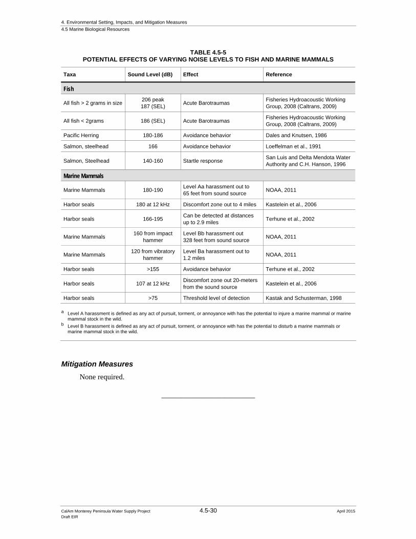
4. Environmental Setting, Impacts, and Mitigation Measures
4.5 Marine Biological Resources
CalAm Monterey Peninsula Water Supply Project 4.5-30 April 2015 Draft EIR
TABLE 4.5-5 POTENTIAL EFFECTS OF VARYING NOISE LEVELS TO FISH AND MARINE MAMMALS
Taxa Sound Level (dB) Effect Reference
Fish
All fish > 2 grams in size 206 peak 187 (SEL)
Acute Barotraumas Fisheries Hydroacoustic Working Group, 2008 (Caltrans, 2009)
All fish < 2grams 186 (SEL) Acute Barotraumas Fisheries Hydroacoustic Working Group, 2008 (Caltrans, 2009)
Pacific Herring 180-186 Avoidance behavior Dales and Knutsen, 1986
Salmon, steelhead 166 Avoidance behavior Loeffelman et al., 1991
Salmon, Steelhead 140-160 Startle response San Luis and Delta Mendota Water Authority and C.H. Hanson, 1996
Marine Mammals
Marine Mammals 180-190 Level Aa harassment out to 65 feet from sound source
NOAA, 2011
Harbor seals 180 at 12 kHz Discomfort zone out to 4 miles Kastelein et al., 2006
Harbor seals 166-195 Can be detected at distances up to 2.9 miles
Terhune et al., 2002
Marine Mammals 160 from impact
hammer Level Bb harassment out 328 feet from sound source
NOAA, 2011
Marine Mammals 120 from vibratory
hammer Level Ba harassment out to 1.2 miles
NOAA, 2011
Harbor seals >155 Avoidance behavior Terhune et al., 2002
Harbor seals 107 at 12 kHz Discomfort zone out 20-meters from the sound source
Kastelein et al., 2006
Harbor seals >75 Threshold level of detection Kastak and Schusterman, 1998
a Level A harassment is defined as any act of pursuit, torment, or annoyance with has the potential to injure a marine mammal or marine
mammal stock in the wild. b Level B harassment is defined as any act of pursuit, torment, or annoyance with has the potential to disturb a marine mammals or
marine mammal stock in the wild.
Mitigation Measures
None required.
_________________________

4. Environmental Setting, Impacts, and Mitigation Measures
4.5 Marine Biological Resources
CalAm Monterey Peninsula Water Supply Project 4.5-31 April 2015 Draft EIR
TABLE 4.5-6 SUMMARY OF ALTERNATIVE PERMANENT THRESHOLD SHIFT (PTS) AND
TEMPORARY THRESHOLD SHIFT (TTS) SOUND LEVELS FROM DUAL ACOUSTIC THRESHOLD NOISE LEVELS FOR MARINE MAMMALS
Numeric Levela
Hearing Group
PTS Onset (Received Level) TTS Onset (Received Level)
Impulsive Non-Impulsive Impulsive Non-Impulsive
Low-Frequency (LF) Cetaceans
(Baleen whales)
Source: All
230 dB peak &
187 dB SELcum
Source: NB > 10 kHz
230 dBpeak &
215 dB SELcum Source: All
224 dBpeak &
172 dB SELcum
Source: NB > 10 kHz
224 dBpeak &
195 dB SELcum
Source: All others
230 dBpeak &
198 dB SELcum
Source: All others
224 dBpeak & 178 dB SELcum
Mid-Frequency (MF) Cetaceans
(Dolphins, toothed whales, beaked whales, bottlenose dolphins)
Source: All
230 dBpeak &
204 dB SELcum
Source: NB > 3 kHz
230 dBpeak &
198 dB SELcum Source: All
224 dBpeak &
189 dB SELcum
Source: NB > 3 kHz
224 dBpeak &
178 dB SELcum
Source: All others
230 dBpeak &
215 dB SELcum
Source: All others
224 dBpeak &
195 dB SELcum
High-Frequency (HF) Cetaceans
(True porpoises, Kogia, river dolphins, cephalohynchid, Lageniorhynchus cruciger, and L. asustralis)
Source: All
201 dBpeak &
180 dB SELcum
Source: NB > 3 kHz
201 dB peak &
180 dB SELcum Source: All
195 dBpeak &
165 dB SELcum
Source: NB > 3 kHz
195 dBpeak &
160 dB SELcum
Source: All others
201 dBpeak &
199 dB SELcum
Source: All others
195 dBpeak &
179 dB SELcum
Phocid Pinnipeds
(True Seals) (Underwater)
Source: All
235 dB peak &
192 dB SELcum
Source: All
235 dBpeak & 1
97 dB SELcum
Source: All
229 dBpeak &
177 dB SELcum
Source: All
229 dBpeak & 183 dB SELcum
Otariid Pinnipeds
(Sea lions and fur seals) (Underwater)
Source: All
235 dBpeak &
215 dB SELcum
Source: All
235 dBpeak &
220dB SELcum
Source: All
229 dBpeak &
200 dB SELcum
Source: All
229 dBpeak &
206 dB SELcum
a Dual acoustic threshold levels: Use whichever [ SELcum or dB SELcum] exceeded first. These alternative acoustic threshold levels are
based on whether the sound pressure levels from the source are predominantly within the “M-weighting” component of the curve, or the EQL portion of the auditory weighting curve (i.e., below or above 3 kHz for MF and HF cetaceans and 10 kHz for LF cetaceans, respectively). Since pinniped auditory weighting functions are derived solely from the M-weighting function, the same exposure levels are used for all sound sources. They also are based on an assumption that the most common of impulsive sources (i.e., airguns, impact pile drivers, explosives) have the majority of their sound pressure level at low frequencies (i.e., within the M-weighted component of the curve for HF and MF cetaceans: below 3 kHz). If there were an impulsive source with the majority of its energy above 3 kHz, the proposed alternative criteria would need to be modified on a case-by-case basis. Note that acoustic threshold levels for impulsive or non-impulsive sources are based on characteristics at the source and not the receiver.
SOURCE: NOAA, 2013.

4. Environmental Setting, Impacts, and Mitigation Measures
4.5 Marine Biological Resources
CalAm Monterey Peninsula Water Supply Project 4.5-32 April 2015 Draft EIR
Impact 4.5-2: Result in substantial interference with the movement of any native resident or migratory fish or wildlife species during construction. (No Impact)
The marine habitats located adjacent to the beach and above the slant well terminus points are used by many resident and migratory fish and wildlife species including marine mammals, Chinook and Coho salmon, steelhead trout, sea turtles, sharks, and managed fish species under the MSA. As discussed above under Impact 4.5-1, the only construction activities for the proposed project that would occur or could have effects within the Study Area would involve onshore disturbance of beach sands during construction and noise associated with the drilling of slant wells for seawater intake to the RO system; therefore, these are the only construction activities that could affect the movement or migration of marine resources. The terminus points for the slant wells are located approximately 200 to 220 feet below msl and would not impede the movement of marine species. Moreover, any noise transmitted into the water from the slant well drilling equipment is estimated to be below ambient background levels in the surf zone and, therefore, would not be detectable. Therefore, no impact to the movement of any native resident or migratory fish or wildlife species would result.
Mitigation Measures
None required.
_________________________
4.5.3.5 Operation Impacts and Mitigation Measures
Impact 4.5-3: Result in substantial adverse effects on candidate, sensitive, or special-status species during project operations. (Less than Significant with Mitigation)
Potential Effects of Subsurface Slant Wells
One general concern about operations of desalination facilities is impingement of marine organisms during intake of seawater. Operation of the MPWSP Desalination Plant would involve pumping up to 24.1 mgd of water from subsurface slant wells that terminate 200 to 220 feet below msl under the surf zone. Subsurface intake wells are thought to eliminate this problem by utilizing a very broad surface of seafloor through which seawater is drawn at a slow rate (Foster et al, 2013). A Draft Staff Report prepared by the SWRCB in support of the proposed Ocean Plan amendment addressing desalination facilities notes:
Subsurface intakes collect water through sand sediment, which acts as a natural barrier to organisms and thus eliminates impingement and entrainment. (MWDOC 2010; Missimer et al. 2013; Hogan 2008; Pankratz 2004; Water Research Foundation 2011) This gives subsurface intakes a significant environmental advantage over surface water intakes because mitigation for surface intake entrainment will have to occur throughout the operational lifetime of the facility. (SWRCB, 2015)
To date, no known studies document the reduction in impingement and entrainment by subsurface intake wells in comparison to other intake types. Therefore, this analysis relies on the following assumptions to estimate the potential for impingement- and entrainment-related impacts. A

4. Environmental Setting, Impacts, and Mitigation Measures
4.5 Marine Biological Resources
CalAm Monterey Peninsula Water Supply Project 4.5-33 April 2015 Draft EIR
technical memo produced for the South Orange Coastal Desalination Project (Williams, 2010) calculated peak vertical infiltration rates of 0.000051 feet per second (ft/sec) (approximately 0.016 millimeters per second [mm/sec]). An alternative method was employed to estimate vertical infiltration rates during operation of the MPWSP Desalination Plant. It was conservatively assumed that the entire 24.1 mgd of seawater would be drawn through the seafloor directly above the termini of the subsurface slant wells, which are proposed to be distributed along 2,000 feet of shoreline and extend up to 500 feet offshore. There are 7.48 gallons per cubic foot, requiring 3,222,000 cubic feet of water to provide 24.1 mgd. With 1,000,000 ft2 of seafloor through which 3,222,000 cubic feet of water needs to be pumped each day, the vertical infiltration rate would have to be 3.222 feet/day, which equals 0.0000373 ft/sec (approximately 0.011 mm/sec), which is very similar to that estimated for the South Orange Coastal Desalination Project.
A comparison of published swimming speeds for plankton, larval invertebrates and larval fish reveals that it is highly unlikely that these small organisms would be impinged against the seafloor by vertical infiltration of seawater pumped into the MPWSP Desalination Plant. Studies of invertebrate plankton have found swimming speeds that substantially exceed the estimated vertical infiltration rate for the MPWSP Desalination Plant (see Table 4.5-7).
TABLE 4.5-7 SWIMMING SPEEDS OF PLANKTON, INVERTEBRATES AND LARVAL FISH
Source Organism Swimming Speeda
Franks (1992) Phytoplankton and Protozoa M = 0.2 mm/sec
Buskey et al (2002) Pelagic copepod M = 500 mm/sec
Browman et al (2011) Pelagic copepod M = 48.9mm/sec A = 34.3 mm/sec
Gallager et al (2004) Pelagic copepods and protozoa M = 12.9 mm/sec
Torres and Childress (1983) Euphausid R = 2.2 – 15.8 mm/sec
Chan et al (2013) Gastropod larvae R = 0.5 – 3.5 mm/sec
Paris et al (2013) Reef fish larvae A = 14.5 mm/sec
Humphrey (2011) Larval lake trout M = 150 – 250 mm/sec
Fisher (2005) Larval reef fishes R = 200 – 600 mm/sec a = M = Maximum reported swimming speed, A = Average reported swimming speed, R = Range of reported swimming speeds
Another concern for operation of the subsurface slants wells is the possibility that fine organic matter could be impinged against the seafloor causing a build up of organic matter and change the normal distribution of sediment grain size. The settlement of sediment particles is controlled by the size and density of the particles and the median grain size of ambient sediments is roughly proportional to local current speeds (Van Rijn, 2007; McCave, 2008). At current speeds >30 cm/sec, seafloor sediments would be very mobile and not retain fine particles (McCave, 2008). Various studies have documented that nearshore currents at the seafloor are dominated by the orbital velocities of waves. Graham et al (1997) estimated orbital velocities of ocean waters due to surface waves at three nearshore kelp forest sites around the Monterey Peninsula. Across

4. Environmental Setting, Impacts, and Mitigation Measures
4.5 Marine Biological Resources
CalAm Monterey Peninsula Water Supply Project 4.5-34 April 2015 Draft EIR
all three sites, orbital velocities ranged from approximately 0.5 m/sec to 2.8 m/sec. Wave orbital velocities attenuate due to friction against the seafloor as the waves near shore, and Weltmer (2003) measured orbital velocities near the seafloor in the surf zone off Sand City ranging approximately from 250 cm/sec to 600 cm/sec. Consequently, fine-grained material would not settle to the seafloor over the subsurface slant wells.
Therefore, impacts to candidate, sensitive, or special-status species including southern sea otters, humpback whales, gray whales, leatherback sea turtles, winter-run Chinook salmon, Coho salmon, steelhead trout, and white sharks due to operation of the subsurface slant wells would be less than significant and no mitigation is required.
Potential Effects of Elevated Salinity
The desalination process is expected to generate 13.98 mgd of brine that would be discharged via the MRWPCA ocean outfall. The outfall is currently used to discharge treated wastewater effluent from the MRWPCA Regional Wastewater Treatment Plant. The outfall terminates at the diffuser located approximately 1.7 miles offshore in 90 to 110 (MW) feet below sea level. The comingling and discharge of this brine could have an effect on special-status species that frequent the Marine Resources Study Area (see Table 4.5-1), especially bottom dwelling or foraging fish, such as MSA managed fish species and marine mammals that feed on benthic organisms such as the Southern sea otter and California gray whale. The discharged brine, if concentrated enough, could also result in the loss of foraging habitat if the benthic infauna and macrofauna populations declined.
Elevated salinity and subsequent degradation of the marine environment are among the major concerns associated with coastal desalination projects (Damitz et al, 2006). Numerous studies have been performed to evaluate the effects of elevated salinity on marine organisms, which have used different methods to test the sensitivity of various species. These studies have demonstrated that salinity effects are species-specific (Table 4.5-9). Review of published results from field surveys and laboratory experiments (Roberts et al, 2010) indicate no studies that examined the small salinity increases anticipated with the discharges of brine from the MPWSP Desalination Plant. Moreover, there were apparent contradictions among different studies. For example, one field experiment cited by Roberts et al (2010) indicated reduced survival, shoot production, and vigor of seagrass transplants at salinities at or above 39.2 ppt (4 percent above ambient), whereas a laboratory experiment found another species of seagrass to have greatest growth and production at a salinity of 42.5 ppt. Although seagrass is not found in the study area, these conflicting results exemplify the limited applicability of data from other areas.
Despite inconsistent results, these various studies have informed a recent report published by the Southern California Coastal Water Research Project (SCCWRP) (Jenkins et al, 2012). This report recommended an absolute salinity increase of less than 2 ppt above ambient salinity at the mixing zone boundary, or a 5 percent increase above ambient salinity at the mixing zone boundary, whichever is less. This recommendation is comparable to other international regulatory guidelines (see Table 4.5-8). Recent proposed amendments to the Ocean Plan (July 2014) have based regulations on an allowable salinity increase of less than 2 ppt at the ZID boundary. Consequently,

4. Environmental Setting, Impacts, and Mitigation Measures
4.5 Marine Biological Resources
CalAm Monterey Peninsula Water Supply Project 4.5-35 April 2015 Draft EIR
TABLE 4.5-8 SUMMARY OF INTERNATIONAL BRINE LIMITS
Region/Authority Salinity Limit Compliance Point Source
US EPA Increment ≤ 4 ppt NA NA
Carlsbad, CA Absolute ≤ 40 ppt 1,000 feet San Diego Regional Water Quality Control Board 2006
Huntington Beach, CA Absolute ≤ 40 pt salinity (expressed as discharge dilution ratio of 7.5:1)
1,000 feet Santa Ana Regional Water Quality Control Board 2012
Western Australia guidelines
Increment ≤ 5 ppt NA NA
Oakajee Port, Western Australia
Increment ≤ 1 ppt NA The Waters of Victoria State Environment Protection Policy
Perth, Australia/ Western Australia EPA
Increment ≤ 1.2 ppt and ≤ 0.8 ppt
50 m and 1,000 m Wec 2002
Sydney, Australia Increment ≤ 1 ppt 50–75 m ANZECC 2000
Gold Coast, Australia Increment ≤ 2 ppt 120 m GCD Alliance 2006
Okinawa, Japan Increment ≤ 1 ppt Mixing zone boundary
Okinawa Bureau for Enterprises
Abu Dhabi Increment ≤ 5 ppt Mixing zone boundary
Kastner 2008
Oman Increment ≤ 2 ppt 300 m Sultanate of Oman 2005 SOURCE: Jenkins et al, 2012
it is assumed that project-related discharges of brine resulting in salinities that are greater 2 ppt above ambient at the edge of the ZID would result in a significant impact. This incremental salinity increase limit is a conservative threshold for marine organisms, as none of the studies reviewed (see Table 4.5-9) found adverse effects on survival, growth, or behavior at salinities this low. Assuming seasonal variations in ambient salinities (see Section 4.3, Surface Water Hydrology and Water Quality), the highest anticipated ambient salinity of 33.8 ppt would occur in the upwelling season (Table 4.3-11). This peak ambient salinity would coincide with the most concentrated brine stream, when the brine discharge would not be combined with treated wastewater effluent from the MRWPCA Regional Wastewater Treatment Plant, resulting in the maximum salinity at the edge of the ZID of any scenario analyzed under Impact 4.3-5. Under this scenario, the maximum discharge salinity would be less than 35.4 at the edge of the ZID (~1.6 ppt above ambient).
The brine discharge modeling presented in Section 4.3, Surface Water Hydrology and Water Quality, indicates that the discharge of brine from the MPWSP Desalination Plant would exceed ambient salinities by less than 2 ppt, which would constitute a less than significant impact.
Therefore, impacts to candidate, sensitive, or special-status species including southern sea otters, humpback whales, gray whales, leatherback sea turtles, winter-run Chinook salmon, Coho salmon, steelhead trout, and white sharks due to discharge of brine would be less than significant.

4. Environmental Setting, Impacts, and Mitigation Measures
4.5 Marine Biological Resources
CalAm Monterey Peninsula Water Supply Project 4.5-36 April 2015 Draft EIR
TABLE 4.5-9 RESULTS FROM STUDIES ON THE EFFECTS OF ELEVATED SALINITY ON MARINE ORGANISMS
Author, Year Species Salinity Tested Results Comments
ABA, 1992 Dendraster excentricus (sand dollar)
33–48 ppt Lethal between 43–48 ppt Local sand-bottom species, “chronic effects to growth and reproduction as well as survival may be a better indication of (salinity) toxicity and (therefore) require a longer test”, report unavailable for this evaluation
Pantell, 1993 Menidia beryllina (inland silverside)
23:1 SF Bay water:Brine 20:1 POTW Effluent:Brine
Mortality observed at greater brine concentrations
Freshwater species, test salinities not reported
Skeletonema costatum (diatom)
23:1 SF Bay water:Brine 20:1 POTW Effluent:Brine
Growth effects observed at greater brine concentrations
Marine species, test salinities not reported
Bivalve larvae 23:1 SF Bay water:Brine 20:1 POTW Effluent:Brine
Development effects observed at greater brine concentrations
Species not specified, test salinities not reported
Citharichthys stigmaeus (sand dab)
23:1 SF Bay water:Brine 20:1 POTW Effluent:Brine
Mortality observed at greater brine concentrations
Local sand bottom species, test salinities not reported
Gross, 1957 Pachygrapsus (rock crab)
61 ppt 56 ppt
Lethal in 2 hours Survived >72 hours
Locally found, but only in rocky habitats
Emerita analoga (sand crab)
50 ppt 44 ppt
Lethal in 2 hours Survived >24 hours
Local sand bottom species
Olivella pycna (olive snail)
33–48 ppt Not lethal Local sand-bottom species, report unavailable for this evaluation
Iso et al, 1994 Venrupis philippinarum (little neck clams)
Various up 70 ppt Survived and behaved normally at 50 ppt, lethal at 60 ppt after 48 hours and at 70 ppt after 24 hours
Grown commercially in California
Pagrus major (sea bream)
Various up 70 ppt Survived well in 45 ppt, behaved normally at 40 ppt, >70 ppt lethal in 1 hour
Not found locally
Pseudopleuronectes yokohamae (marbled flounder)
Various up 70 ppt Egg hatching delayed but successful up to 60 ppt, larvae survived up to 50 ppt, 55 ppt lethal after 140 hours
Not found locally
McMillan and Mosely, 1967
Seagrass Up to 74 ppt Four species grew No seagrasses in vicinity of proposed project, reference unavailable for this review
Pillard et al, 1999
Mysidopsis bahia 43 ppt LC50 = 48 hours Estuarine species
Cyrpinidon variegates 70 ppt LC50 = 48 hours Estuarine species
Menidia beryllina 44 ppt LC50 = 48 hours Estuarine species

4. Environmental Setting, Impacts, and Mitigation Measures
4.5 Marine Biological Resources
CalAm Monterey Peninsula Water Supply Project 4.5-37 April 2015 Draft EIR
TABLE 4.5-9 (Continued) RESULTS FROM STUDIES ON THE EFFECTS OF ELEVATED SALINITY ON MARINE ORGANISMS
Author, Year Species Salinity Tested Results Comments
Voutchkov, 2006
Dendraster excentricus (sand dollar) 37–40 ppt
Survived for 5.5 months, no effects on growth or fertility
Local sand-bottom species, reference unavailable for this review
Strongylocentrotus purpuratus (purple urchin)
37–40 ppt Survived for 5.5 months, no effects on growth or fertility
Local, but only in rocky habitats, reference unavailable for this review
Haliotus rufescens (red abalone) 37–40 ppt
Survived for 5.5 months, no effects on growth or fertility
Rare locally, only found in rock habitats, reference unavailable for this review
Reynolds et al, 1976
Leuresthes tenuis (California grunion prolarvae)
41 ppt LC50 = 24 hours Southern California species
Leuresthes tenuis (larvae) 40 ppt LC50 = 18 hours Southern California species
SCCWRP, 1993
Macrocystis pyrifera spores (giant kelp)
43 ppt Germination and growth not affected Locally found, but not found for miles around the proposed project
Rhepoxynius abronius (amphipod)
38.5 ppt Survived 10 days Local
Strongylocentrotus purpuratus (purple urchin)
90:10 Seawater:Brine No effect on fertilization Local, but only in rocky habitats, test salinities not reported
Thessen et al, 2005
Pseudo-nitzschia spp. (diatom)
Up to 45 ppt 7 clones of 3 species grew up to 45 ppt Local, species of Pseudo-nitzschia cause domoic acid poisoning
SOURCE: ABA Consultants. 1992; Pantell, 1993; Gross, 1957; Iso et al, 1994; McMillan and Moseley, 1967; Pillard et al, 1999; Voutchkov, 2006; Reynolds et al, 1976; SCCWRP, 1993; Thessen et al, 2005.

4. Environmental Setting, Impacts, and Mitigation Measures
4.5 Marine Biological Resources
CalAm Monterey Peninsula Water Supply Project 4.5-38 April 2015 Draft EIR
Potential Effects of Other Brine Associated Contaminants
As described in Section 4.3, Surface Water Hydrology and Water Quality, a conservative approach was taken in estimating the concentrations of other contaminants in the brine discharge. It was assumed that the entire mass of contaminants in ocean water delivered to the MPWSP Desalination Plant through the subsurface slant wells would be present, and therefore concentrated, in the brine discharge (see Section 4.3.3.5, Operational Impacts and Mitigation Measures). Using the modeled dilutions of the brine and brine-with-wastewater discharges presented in Section 4.3.3.5, the concentrations of various contaminants in the brine were estimated at the edge of the ZID and compared to Ocean Plan water quality objectives (see Table 4.3-8). Contaminant concentrations in combined discharges of brine and treated wastewater also must be considered due to variations in initial dilution caused by mixing of hyper-saline brine and nearly “fresh” wastewater.
If not managed correctly, the concentrations of polychlorinated biphenyls (PCBs) in brine-only or brine-with-wastewater discharges could occasionally approach or exceed Ocean Plan objectives (see Section 4.3.3.5). Because PCBs are known carcinogens, the water quality objective in the Ocean Plan for PCBs is intended to protect human health. PCBs typically accumulate in lipids and are known to occur in progressively higher concentrations with each successive step up a food chain. Therefore, the water quality objective also has been set with appropriate safety margins to ensure they do not accumulate to unhealthy concentrations in biota that may be eaten by humans. This point is relevant to consideration of impacts due to discharge of contaminants in brine and MRWPCA wastewater.
Determining potential toxicity to marine organisms or humans from PCBs involves more than a simple comparison between edge-of-ZID concentrations and published scientific literature. In some cases, toxicity is largely due to specific portions of the measured contaminants.
The determination of PCB toxicity is also complicated by chemical differences among the various compounds that constitute PCBs. Total concentrations of PCBs include up to 209 different forms, called congeners, which differ from each other in the number and placement of chlorine atoms on the carbon atoms that form the two joined phenyl rings. Congeners with greater numbers of chlorine atoms are less water-soluble and more readily adsorbed to the surfaces of sediment particles than are congeners with fewer chlorine atoms. They are also more likely to be absorbed into lipid in animals exposed through consumption of PCBs in prey. The shapes of some PCB congeners are very similar to dioxins, which are among the most toxic compounds known. These dioxin-like PCBs also exhibit high toxicities, although less than for dioxins (Van den Berg et al, 2006). Industrial mixtures of PCBs were historically used that differed in the percentages of different congeners they contained. These mixtures were called aroclors and they were the compounds originally regulated by water quality objectives.
Early research on the toxicity of PCBs challenged test organisms with concentrations of aroclors in water (Koeman and Stasse-Wolthuis, 1978). Acute toxicities were highly variable among organisms, ranging from 51 percent mortality in immature pink shrimp after 15 days at 0.94 milligrams per liter (mg/L) of Aroclor 1254, to 100 percent mortality in adult pink shrimp

4. Environmental Setting, Impacts, and Mitigation Measures
4.5 Marine Biological Resources
CalAm Monterey Peninsula Water Supply Project 4.5-39 April 2015 Draft EIR
after 2 days at 100 mg/L of Aroclor 1254. Fifty percent of the amphipod Gammarus fasciatus died after 4 days at 10 mg/L of Aroclor 1248, whereas it took 10 days for 50 percent mortality is this species exposed to 5 mg/L of Aroclor 1248.
As more was learned about PCBs contamination, it became clear that the most serious effects of PCBs in the environment were not associated with acute toxicity, but with long-term chronic effects, such as endocrine disruption involving the liver, nervous system and kidneys (US Department of Health and Human Services, 2000). Moreover, specific congeners (McFarland and Clarke, 1989) were found to accumulate in the tissues of vertebrates, with increasing concentrations up each successive trophic level. It has been suggested that the PCB body burdens of killer whales along the coast of British Columbia pose health risks to the whales (Hickie at al, 2007). The accumulation of PCBs in the tissues of vertebrates is the reason that the Ocean Plan objective for PCBs was developed for the protection of human health. Although the acutely toxic concentrations of PCBs are relatively high and highly variable among species, due undoubtedly to variable concentrations of individual congeners in the test materials, the long-term accumulation of PCBs in animals and humans is of greater concern.
In Section 4.3, Surface Water Hydrology and Water Quality, the significance threshold for water quality impacts is exceedance of regulatory water quality objectives. For marine resources, a significant impact would occur if the proposed project would adversely affect marine life or humans by increasing concentrations of contaminants at the edge of the ZID to levels considered toxic. Although PCBs would not approach the concentrations or exposure durations shown to be acutely toxic, potential exceedance of their Ocean Plan objective could lead to significant impacts on marine resources.
As described in Section 4.3, Surface Water Hydrology and Water Quality an amendment to the Waste Discharge Requirements for the Monterey Regional Water Pollution Control Agency Treatment Plant (Order No. R3-2014-0013, NPDES Permit No. CA0048551) (MRWPCA NPDES Permit) (RWQCB, 2014) would be required prior to the implementation of the proposed project and operation of the MPWSP Desalination Plant. Any discharge from the operation of the MPWSP Desalination Plant to Monterey Bay through the MRWPCA outfall would be subject to the Amended MRWPCA NPDES Permit, which would incorporate the Ocean Plan water quality objectives for the protection of the beneficial uses of Monterey Bay and establish effluent limitations on the discharges under the proposed project with that goal. Section 4.3, Surface Water Hydrology and Water Quality also describes mitigation measures that would require testing of the source water entering the MPWSP Desalination Plant and the water quality of the resulting brine. Mitigation Measure 4.3-4 (Implement Measures to Avoid Exceeding Water Quality Objectives at the Edge of the ZID) requires CalAm to incorporate design features and operational measures at the MPWSP Desalination Plant to allow for treatment of the source water and/or brine to reduce constituent concentrations to water quality objective levels, and/or to allow for temporary storage of brine at the proposed 3 mg storage basin at the MPWSP Desalination Plant site (see Chapter 3, Project Description) and releases of brine with a controlled (higher) flow rate and/or greater rate of dilution with treated wastewater effluent in such a way that the brine-only and combined discharges would not exceed the Ocean Plan water quality objectives at the edge of the ZID. Such measures would be incorporated into the Amended MRWPCA NPDES

4. Environmental Setting, Impacts, and Mitigation Measures
4.5 Marine Biological Resources
CalAm Monterey Peninsula Water Supply Project 4.5-40 April 2015 Draft EIR
Permit to ensure compliance with the effluent limitations established by the RWQCB. After the Amended MRWPCA NPDES Permit is issued by the RWQCB, the regular monitoring and reporting activities would also be implemented as part of mandatory regulatory compliance.
In the case of ammonia, the toxicity level affecting marine resources can be studied through the chemical form in which it occurs. For example, in water, the ammonium ion (NH4
+) dissociates into un-ionized ammonia (NH3) and hydrogen ions. Measurements of ammonia concentrations in water include both the ionized and un-ionized forms, whereas the toxicity of ammonia is due mostly to the un-ionized portion (USEPA, 1989). Moreover, the equilibrium between ionized and un-ionized ammonia is subject to the effects of temperature, salinity, and pH. By applying estimates of ambient temperature, salinity, and pH to the ammonia water quality objective in the Ocean Plan, it is possible to compare the toxic portion of the allowable ammonia water quality objective with published results from toxicity tests to determine the safety margin provided by the Ocean Plan.
Temperature and salinity data used for the dilution modeling (Section 4.3, Surface Water Hydrology and Water Quality) indicate a range of values among the three oceanographic seasons considered (Table 4.5-10).
TABLE 4.5-10 SALINITY AND TEMPERATURE AT THE DEPTH OF THE MRWPCA DIFFUSER
(approximately 33 meters)
Season Salinity, ppt Temperature, ° C
Upwelling 33.84 10.37
Transition-Oceanic 33.50 11.22
Davidson 33.38 11.63
A long-term record of pH in Monterey Bay, which is available on the CeNCOOS website,6 indicates a downward trend accompanied by substantial temporal variation. The trendline suggests a current average pH of approximately 8.0. The percentage un-ionized ammonia in total ammonia was published for various ranges of salinity, temperature, and pH by Bower and Bidwell (1978). Using their table for salinities from 32 to 40 ppt, pH of 8.0 and temperatures of 10°, 11°, and 12° C, the percentages of total ammonia in the un-ionized form would be 1.44, 1.55 and 1.67, respectively. Applying those percentages to the Ocean Plan water quality objective indicates a range of allowable un-ionized ammonia between 0.0086 mg/L for the 6-month median in the upwelling season to 0.1002 mg/L for the instantaneous maximum in the Davidson season (Table 4.5-11).
6 http://www.cencoos.org/sections/conditions/changing_ocean.shtml

4. Environmental Setting, Impacts, and Mitigation Measures
4.5 Marine Biological Resources
CalAm Monterey Peninsula Water Supply Project 4.5-41 April 2015 Draft EIR
TABLE 4.5-11 CONCENTRATION OF UN-IONIZED AMMONIA ALLOWED BY OCEAN PLAN OBJECTIVES FOR
TOTAL AMMONIA
Season
Ocean Plan Objectives (total ammonia)
6-month median (0.6 mg/L)
Daily Maximum (2.4 mg/L)
Instantaneous Maximum(6.0 mg/L)
Upwelling (1.44% un-ionized) 0.0086 mg/L 0.03456 mg/L 0.0864 mg/L
Transition-Oceanic (1.55% un-ionized) 0.0093 mg/L 0.0372 mg/L 0.0930 mg/L
Davidson (1.67% un-ionized) 0.0100 mg/L 0.0401 mg/L 0.1002 mg/L
A survey of 12 published toxicity studies (USEPA, 1989) found acute toxicities (LC50 or EC50; concentrations at total ammonia ranging from 0.23 mg/L for juvenile mysid shrimp (Mysidopsis bahia) to 43 mg/L for adult eastern oysters (Crassostrea virginica). Most of the reported LC50 or EC50 values were <2 mg/L. Because un-ionized ammonia is not measured directly, but is calculated from total ammonia, pH, salinity, and temperature, the national criteria for ammonia consist of tables that set objectives for total ammonia based upon ambient pH, salinity and temperature. The USEPA’s 1989 Ambient Water Quality Criteria for Ammonia (Saltwater) states: “[S]altwater aquatic organisms should not be affected unacceptably if the four-day average concentration of un-ionized ammonia does not exceed 0.035 mg/L more than once every three years on the average and if the one-hour average concentration does not exceed 0.233 mg/L more than once every three years on the average. Because sensitive saltwater animals appear to have a narrow range of acute susceptibilities to ammonia, this criterion will probably be as protective as intended only when the magnitudes and/or durations of excursions are appropriately small” (USEPA, 1989).
In a study of embryonic development of purple sea urchins (Strongylocentrotus purpuratus), Greenstein et al (1995) exposed embryos to various concentrations of ammonia for 72 hours at 15° C during three separate experiments. Declines in the percentage of normal development began at concentrations of un-ionized ammonia greater than 0.035 mg/L, with precipitous declines above 0.045 mg/L. The EC50 for the three experiments was 0.057 mg/L. Consequently, more subtle effects than mortality, such as abnormal embryonic development, can appear in 72 hours at the same concentration of un-ionized ammonia prescribed by USEPA as a 4-day average limit to prevent mortality. Both the USEPA limit for 4-day average concentration and the SCCWRP EC50 for un-ionized ammonia are similar to the daily maximum Ocean Plan objective (Table 4.5-11). It can, therefore, be expected that excursions of total ammonia above the Ocean Plan daily maximum objective for more than 3 days could impair embryonic development of exposed invertebrate species. For marine resources, a significant impact would occur if the Project Variant would adversely affect marine life or humans by increasing concentrations of contaminants outside the ZID to levels considered toxic. Although the contaminants discussed here would not approach the concentrations or exposure durations shown to be acutely toxic, potential exceedance of their respective Ocean Plan objectives could lead to significant impacts on marine resources. However, with implementation of Mitigation Measure 4.3-4 (Implement Measures to Avoid Exceeding Water Quality Objectives at the Edge of the ZID), which

4. Environmental Setting, Impacts, and Mitigation Measures
4.5 Marine Biological Resources
CalAm Monterey Peninsula Water Supply Project 4.5-42 April 2015 Draft EIR
would be incorporated into the Amended MRWPCA NPDES Permit, the proposed project would not violate water quality standards or waste discharge requirements, or further degrade water quality, as a result of brine discharge from the operation of the MPWSP Desalination Plant. Therefore, with mitigation, impacts to candidate, sensitive, or special-status species including southern sea otters, humpback whales, gray whales, leatherback sea turtles, winter-run Chinook salmon, Coho salmon, steelhead trout, and white sharks due to discharge of brine-associated contaminants (i.e., PCBs and ammonia) would be less than significant.
Potential Effects of Brine Discharge Shear Stress
Some laboratory studies have reported damage to marine organisms caused by experimentally induced shear stress (Foster et al, 2013). Concern has been expressed that the jet velocities associated with desalination brine discharges could cause similar damage in the discharge environment (SWRCB, 2014). In the case of the MPWSP, such damage is highly unlikely. Modeling performed in support of a report submitted to the Water Board that examined entrainment effects from desalination projects (Foster et al, 2013) provided formulae for determining the spatial scales of turbulent eddies that occur at different discharge velocities. Higher strain rates and shear stresses are contained in smaller eddies. A discharge velocity of 2.9 m/sec (9.5 ft/sec) results in small eddies ranging from 0.03 mm to 0.56 mm at various locations in the discharge plume from the diffuser port to the edge of the plume at the ZID margin. A discharge velocity of 4.6 m/sec (15.1 ft/sec) results in small eddies ranging from 0.02 mm to 0.63 mm at various locations in the discharge plume from the diffuser port to the edge of the plume at the ZID margin. These discharge velocities closely approximate the minimum and maximum discharge velocities modeled for the MPWSP (see Section 4.3; i.e., 9.5 ft/sec and 15.2 ft/sec).7 Foster (2013) concludes that, at these very small eddy scales: “Overall, the area of high shear impacted by the diffusers is relatively small and transit times through this region relatively short. Thus, it seems reasonable to expect that, while the larvae that experience the highest shear will most likely experience lethal damage, the overall increase in mortality integrated over the larger area will be low.”
Therefore, impacts to candidate, sensitive, or special-status species including southern sea otters, humpback whales, gray whales, leatherback sea turtles, winter-run Chinook salmon, Coho salmon, steelhead trout, and white sharks, including juvenile stages, due to shear stress caused by the brine discharge would be less than significant and no mitigation is required.
7 With implementation of Mitigation Measure 4.3-4 (Implement Measures to Avoid Exceeding Water Quality Objectives at the Edge of the ZID) for combined discharges, the discharge velocity may increase above 15.2 ft/sec with increased discharge volumes of greater than 33.76 mgd. However, because the modeled PCB concentration at the edge of the ZID for the 33.76 mgd combined discharge met the Ocean Plan water quality objective (Table 4.3-8), it is unlikely that much, if any, additional discharge would be needed to meet Amended NPDES Permit requirements under this mitigation measure, and any potential increase in discharge volume and resultant velocity is expected to be minimal.

4. Environmental Setting, Impacts, and Mitigation Measures
4.5 Marine Biological Resources
CalAm Monterey Peninsula Water Supply Project 4.5-43 April 2015 Draft EIR
Mitigation Measures
Mitigation Measure 4.3-4 applies only to brine discharge from the MPWSP Desalination Plant.
Mitigation Measure 4.3-4: Implement Measures to Avoid Exceeding Water Quality Objectives at the Edge of the ZID.
(See Impact 4.3-4 in Section 4.3, Surface Water Hydrology and Water Quality, for the description.)
_________________________
Impact 4.5-4: Result in substantial interference with the movement of any native resident or migratory fish or wildlife species during project operations. (Less than Significant with Mitigation)
Potential Effects of Subsurface Slant Wells
As discussed for Impact 4.5-3, impingement of organisms or fine organic matter against the seafloor due to operation of the subsurface slant wells is highly unlikely. Therefore, operation of the subsurface slant wells would not interfere with the movement of any native resident or migratory fish or wildlife species and impacts would be less than significant and no mitigation is required.
Potential Effects of Elevated Salinity
As discussed under Impact 4.5-3, the desalination process is expected to generate 13.98 mgd of brine that would be discharged via the MRWPCA ocean outfall (Chapter 3, Project Description). The potential for elevated brine concentrations near or along the seafloor within the ZID could result in altering the movement of native resident or migratory fish or wildlife species through the small area where elevated salinities may occur. The results of the brine discharge modeling indicates that the discharge of brine from the MPWSP Desalination Plant would exceed ambient salinities by less than 2 ppt at the edge of the ZID which would constitute a less than significant impact. Therefore, substantial interference with the movement of any native resident or migratory fish or wildlife species during operations would be less than significant and no mitigation is required.
Potential Effects of Other Brine Associated Contaminants
As discussed for Impact 4.5-3, conservative assumptions about the concentrations of ocean contaminants in the desalination brine revealed no exceedances of the Ocean Plan due to PCB concentrations in the brine. However, the brine-with-wastewater discharges could exceed the Ocean Plan objective for PCBs and ammonia.
Although PCBs in discharges would not approach the concentrations or exposure durations shown to be acutely toxic, potential exceedance of the Ocean Plan objective could lead to significant impacts on marine resources. However, as shown in Table 4.3-8, the ambient PCB concentration in Monterey Bay is 0.00121, meaning that existing conditions do not meet the Ocean Plan water quality objective. While some of the discharge scenarios under the proposed
4. Environmental Setting, Impacts, and Mitigation Measures
4.5 Marine Biological Resources
CalAm Monterey Peninsula Water Supply Project 4.5-44 April 2015 Draft EIR
project would exceed the water quality objective for PCBs, none would equal or exceed the existing concentration in Monterey Bay. Therefore, under no discharge scenario would the proposed project degrade the existing water quality of Monterey Bay as measured by PCB concentration. Regardless, this analysis considers occasional exceedances of the Ocean Plan water quality objectives for PCBs to be a significant impact.
As discussed for Impact 4.5-3, the Amended MRWPCA NPDES Permit would incorporate water quality requirements that are informed by the Ocean Plan water quality objectives for the protection of the beneficial uses of Monterey Bay, including supporting marine life, and would establish effluent limitations on the discharges under the proposed project with that goal. Additionally, Mitigation Measure 4.3-4 (Implement Measures to Avoid Exceedances over Water Quality Objectives at the Edge of the ZID) would require CalAm to incorporate design features and operational measures at the MPWSP Desalination Plant to allow for treatment of the source water and brine to reduce constituent concentrations to water quality objective levels, and/or to allow for temporary storage of brine at the proposed 3 mg storage basin at the MPWSP Desalination Plant site (see Chapter 3, Project Description) and releases of brine with a controlled (higher) flow rate and/or greater rate of dilution with treated wastewater effluent in such a way that the brine-only and combined discharges would not exceed the Ocean Plan water quality objectives at the edge of the ZID. Therefore, through the permit amendment process and implementing the actions and measures identified, the proposed project would comply with the Ocean Plan water quality objectives and remain below toxic levels.
With implementation of the prescribed mitigation, discharges of PCBs and ammonia associated with the brine would not substantially interfere with the movement of any native resident or migratory fish or wildlife species during operations and the impact would be less than significant.
Potential Effects of Brine Discharge Shear Stress
As discussed for Impact 4.5-3, the velocity of the brine discharge for the project is expected to create small turbulent eddies ranging from approximately 0.02 mm to 0.63 mm that affect a small volume of water in the immediate vicinity of the discharge. Therefore, discharge velocities associated with the brine would not substantially interfere with the movement of any native resident or migratory fish or wildlife species during operations and the impact would be less than significant and no mitigation is required.
Mitigation Measures
Mitigation Measure 4.3-4 applies only to brine discharges from the MPWSP Desalination Plant.
Mitigation Measure 4.3-4: Implement Measures to Avoid Exceedances over Water Quality Objectives at the Edge of the ZID.
(See Impact 4.3-4 in Section 4.3, Surface Water Hydrology and Water Quality, for the description.)
_________________________

4. Environmental Setting, Impacts, and Mitigation Measures
4.5 Marine Biological Resources
CalAm Monterey Peninsula Water Supply Project 4.5-45 April 2015 Draft EIR
Impact 4.5-5: Conflict with the provisions of an adopted habitat conservation plan, natural community conservation plan, or other approved local, regional, or state habitat conservation. (Less than Significant)
As shown in Table 4.5-3, the proposed project is consistent with the applicable sections of the California Coastal Act, as follows:
30230 - Marine resources; maintenance,
30231 - Biological productivity; water quality,
30232 - Oil and hazardous substance spills,
30233 - Diking, filling or dredging; continued movement of sediment and nutrients,
30234 - Economic, commercial, and recreational importance of fishing.
The only construction activities for the proposed project that could have any potential effect on an adopted habitat conservation plan, natural community conservation plan, or other approved local, regional, or state habitat conservation plan within the Marine Resources Study Area would involve onshore disturbance of beach sands during construction and noise associated with the drilling of slant wells for seawater intake to the RO system. Although the waters and seafloor habitat located above the slant well terminus points are located within the Monterey Bay National Marine Sanctuary and areas covered by the California Coastal Act, the terminus points for the seawater intake slant wells are located approximately 200 to 220 feet below msl and are not expected to have any effect on either seafloor or water habitats and the marine biota inhabiting those habitats. Moreover, any noise transmitted into the water from the slant drilling equipment is not expected to be detectable and certainly less than ambient background levels at the surf zone.
Operation conflicts with an adopted habitat conservation plan, natural community conservation plan, or other approved local, regional, or state habitat conservation plan are not expected. As discussed for Impact 4.5-3, impingement of organisms or fine organic matter against the seafloor due to operation of the subsurface slant wells is unlikely. As discussed under Impact 4.5-3, the desalination process is expected to generate 13.98 mgd of brine that would be discharged via the MRWPCA ocean outfall (Chapter 3, Project Description). The potential for elevated brine concentrations near or along the seafloor for some area outside the ZID could result in loss of foraging habitat for marine invertebrates such as crabs, shrimps, and bottom feeding groundfish within the Monterey Bay National Marine Sanctuary if brine salinity concentrations are greater than 2ppt above ambient beyond the edge of the ZID. The results of the brine discharge modeling indicate that the discharge of brine from the MPWSP Desalination Plant would exceed ambient salinities by less than 2ppt, which would constitute a less than significant impact.
Therefore, conflict with the provisions of an adopted habitat conservation plan, natural community conservation plan, or other approved local, regional or state habitat conservation plan, including the California Coastal Act, essential fish habitat and the small area of kelp in the southern part of the study area, would be less than significant and no mitigation is required.
Mitigation Measures
None required.
_________________________

4. Environmental Setting, Impacts, and Mitigation Measures
4.5 Marine Biological Resources
CalAm Monterey Peninsula Water Supply Project 4.5-46 April 2015 Draft EIR
References – Marine Biological Resources ABA Consultants, 1992. Effects of Hyper-saline Water on Survival of Olivella pycna and
Dendraster excentricus, Report to EIP Associates, Pasadena, CA. 1992.
ABA Consultants, 1999. Analysis of MRWPCA Marine Outfall Benthic Monitoring Program, pp. 57. ABA Consultants, prepared for Monterey Regional Water Pollution Control Authority. 1999.
Abbott, I. A. and G. J. Hollenberg, 1976. Marine Algae of California. Stanford University Press, Stanford, CA, 1976.
Armstrong-Howard, M.D., Cochlan, W.P., Kudela, R.M., Ladizinsky, N. and Kudela, R.M., 2007. Nitrogenous Preference of Toxigenic Pseudo-Nitzschia Australis (Bacillariophyceae) From Field and Laboratory Experiments. Harmful Algae 6, 206-217. 2007.
Barry, J.P., Kochevar, R.E., Baxter, C.H, 1997. The Influence of Pore-Water Chemistry and Physiology on the Distribution of Vesicomyid Clams at Cold Seeps in Monterey Bay: Implications for Patterns of Chemosynthetic Community Organization. Limnol. Oceanogr. 42(2), 318 – 328. 1997.
Bower, C.E. and J. P. Bidwell, 1978. Ionization of Ammonia Seawater: Effect of Temperature, pH, and Salinity. J. Fish. Res. Board. Can., Vol. 35, 1978.
Browman, H.I., Yen, J., Fields, D.M., St-Pierre, JF., Skiftesvik, A.B., 2011 Fine-Scale Observations of the Predatory Behaviourof the Carnivorous Copepod Paraeuchaeta Norvegicaand the Escape Responses of their Ichthyoplankton Prey, Atlantic cod (Gadus morhua). Mar. Biol. 158:2653–2669. 2011.
Buskey, E.J., Lenz, P.H., Hartline, D.K., 2002. Escape Behavior of Planktonic Copepods in Response to Hydronamic Disturbances: High Speed Video Analysis. Marine Ecology Progress Series, 235:135–146. 2002.
California Department of Fish and Game (CDFG), 2001. California’s Living Marine Resources: A Status Report, December 2001.
California Department of Fish and Wildlife (CDFW), 2014. 2012 California Commercial Landings. Available online at: https://www.dfg.ca.gov/marine/landings/landings12.asp. Accessed December 18, 2014.
California Department of Transportation (Caltrans), 2009. Technical Guidance for Assessment and Mitigation of the Hydroacoustic Effects of Pile Driving on Fish. Final Report. Prepared for California Department of Transportation by ICF Jones & Stokes and Illingworth and Rodkin, Inc. February 2009. Available online at: http://www.dot.ca.gov/hq/env/bio/files/ Guidance_Manual_2_09.pdf.
California State University Monterey Bay (CSUMB), 2014. Data Library CMB- Monterey Peninsula- Pt Pinos to Shalebeds (habitat analysis in grid format) Available online at: http://seafloor.otterlabs.org/SFMLwebDATA_mb.htm#. Accessed December 11, 2014.
Chan, K.Y.K., Jiang, H., Padilla, D.K., 2013. Swimming Speed of Larval Snail Does Not Correlate with Size and Ciliary Beat Frequency. PLOS One, 8 (2):1–7. 2013.

4. Environmental Setting, Impacts, and Mitigation Measures
4.5 Marine Biological Resources
CalAm Monterey Peninsula Water Supply Project 4.5-47 April 2015 Draft EIR
Croll, D.A., Marinovic, B., Benson, S., Chavez, F.P., Black, N., Ternullo, R., and Tershy, B.R., 2005. From Wind to Whales: Trophic Links in a Coastal Upwelling System. Marine Ecology Progress Series 289:117-130, 2005.
Dalen, J. and G.M. Knutsen, 1986. Scaring Effects of Fish and Harmful Effects on Eggs, Larvae and Fry from Offshore Seismic Explorations.
Damitz, B., Furukawa, D., Toal, J., 2006. Desalination Feasibility Study for the Monterey Bay Region, pp. 158. Association of Monterey Bay Area Governments, 2006.
Fabre, J., and J. Wilson, 1997. Noise Source Level Density Due to Surf – Part II: Duck, NC. IEEE Journal of Oceanic Engineering, Vol. 22, No. 3. 1997.
Fisher, R. 2005 Swimming Speeds of Larval Coral Reef Fishes: Impacts on Self-Recruitment and Dispersal. Marine Ecology Progress Series. 285:223–232. January 15,2005.
Foster, M.S., G.G. Cailliet, J. Callaway, K.M. Vetter, P. Raimondi, P.J.W. Roberts, 2013. Desalination Plant Entrainment Impacts and Mitigation. Final report submitted to MarielaPaz Carpio-Obeso, Ocean Standards Unit, State Water Resources Control Board in fulfillment of Contract No. 11-074-270, Work Oder SJSURF 11-11-019. October 9, 2013.
Franks, P.J.S., 1992. Sink or Swim: Accumulation of Biomass at Fronts. Marine Ecology Progress Series. 82:1–12. February 28,1992.
Gallager, S.M., Yamazaki H., Davis, C.S., 2004 Contribution of Fine-Scale Vertical Structure and Swimming Behavior to Formation of Plankton Layers on Georges Bank. Marine Ecology Progress Series. 267:27–43. 2004.
Graham, M., Harrold, C., Lisin, S., Light, K., Watanabe, J., and M. Foster, 1997. Population Dynamics of Giant Kelp Macrocystis Pyrifera Along a Wave Exposure Gradient. Marine Ecology Progress Series, Vol. 148: 269-279. 1997.
Greenstein, D.J., Alzadjali, S., Bay, S.M., 1995. Toxicity of Ammonia to Pacific Purple Sea Urchin (Strongylocentrotus Purpuratus) Embroys, 1995.
Gross, W.J., 1957. An Analysis of Response to Osmotic Stress in Selected Decapod Crustacea. Biological Bulletin, Vol. 112: 43-62, 1957.
Hefner, B.T., Williams, K.L., 2004. Sound Speed and Attenuation Measurements in Unconsolidated Glass Bead Sediments Saturated with Viscous Pore Fluids. Report to Office of Naval Research, 800 N. Quincy St., Arlington, VA 22217. Contract Number N00014-02-0336. June 28, 2004.
Hickie, B.E., Ross, P.S., MacDonals, R.W., Ford, J.K.B., 2007. Killer Whales (Orcinus Orca) Face Protracted Health Risks Associated with Lifetime Exposure to PCBs. Environ Sci Technol, Vol 41, 6613-6619, 2007.
Humphrey, S.R.A., 2011. Analysis of the Larval Swimming Performance of two Great Lakes 8sh Species: Hydrodynamic and Genetic Effects on Swimming. Electronic Theses and Dissertations, 2011.
Iso, S., Suizu, S. and Maejima, A., 1994. The Lethal Effect of Hypertonic Solutions and Avoidance of Marine Organisms in Relation to Discharged Brine from a Desalination Plant, Desalination, Vol. 97, 389-399, 1994.

4. Environmental Setting, Impacts, and Mitigation Measures
4.5 Marine Biological Resources
CalAm Monterey Peninsula Water Supply Project 4.5-48 April 2015 Draft EIR
Jenkins, S., J. Paduan, P. Roberts, D. Schlenk, J. Weiss, 2012. Management of Brine Discharges to Coastal Waters; Recommendations of a Science Advisory Panel. Technical Report 694. Southern California Coastal Water Research Project, Coast Mesa, CA. March 2012.
Kastak, D. and R.J. Schusterman, 1998. Low-Frequency Amphibious Hearing in Pinnipeds: Methods, Measurements, Noise and Ecology. J. Acoust. Soc. of Am. 103 (4), April 1998. 2216-2226.
Kastlelein, R.A, S. Van Der Heul, W. C. Verboom, R. J. V. Triesscheijn, and N.V. Jennings, 2006. The Influence of Underwater Data Transmission Sounds on the Displacement of Captive Harbor Seals (Phoca vitulina). Marine Environmental Research 61: 19-39.
Kimball, G., Smith, L., and S. Broderius, 1978. Chronic Toxicity of Hydrogen Cyanide to the Bluegill, Transactions of the American Fisheries Society, 107:2, 341-345. 1978.
Kinnetic Laboratories, Incorporated (KLI), 2005. California American Water Monterey County Coastal Water Project Marine Biological Resources Phase II Report, 2005.
Koeman, J.H., Stasse-Wolthuis, M. 1978. Environmental Toxicology of Chlorinated Hydrocarbon Compounds in the Marine Environment of Europe. Commission of the European Communities, 1978.
Kudela, R., Pitcher, G., Probyn, T., Figueiras F., Moita, T., and V. Trainer, 2005. Harmful Algal Blooms in Coastal Upwelling Systems. Oceanography, 18, 2:184–197. 2005.
Kudela, R. M., J. P. Ryan, M. D. Blakely, J. Q. Lane, and T. D. Peterson, 2008. Linking the Physiology and Ecology of Cochlodinium to Better Understand Harmful Algal Bloom Events: A Comparative Approach, Harmful Algae, 7, 278– 292, 2008.
Loeffelman, P. H., D. A. Klinect, and J. H. Van Hassel, 1991. Fish Protection at Water Intakes Using a New Signal Development Process and Sound System. Proceedings of the International Conference on Hydropower, Denver, Colorado: Volume 1, pp. 355-365. July 24-26 1991.
McCave, I., 2008. Size Sorting During Transport and Deposition of Fine Sediments: Sortable Silt and Flow Speed. Developments in Sedimentology, Volume 60, 121- 142. 2008.
McFarland, V.A., Clarke, J., 1989. Environmental Occurrence, Abundance, and Potential Toxicity of Polychlorinated Biphenyl Congeners: Considerations for a Congener-Specific Analysis. Environmental Health Perspectives Vol. 81, pp 225-239, 1989.
McMillan, C., and F.N. Moseley, 1967. Salinity Tolerances of Five Marine Spermatophytes of Redfish Bay, Texas. Ecology 48:503-506. May1967.
Monterey Bay National Marine Sanctuary (MBNMS), 2014a. Cold Seep Communities; III. Cold Seeps in Monterey Bay. Available online at: http://montereybay.noaa.gov/sitechar/ cold3.html. Accessed December 11, 2014.
Monterey Bay National Marine Sanctuary (MBNMS), 2014b. Monterey Bay National Marine Sanctuary Overview. Available online at: http://montereybay.noaa.gov/. Accessed December 11, 2014.

4. Environmental Setting, Impacts, and Mitigation Measures
4.5 Marine Biological Resources
CalAm Monterey Peninsula Water Supply Project 4.5-49 April 2015 Draft EIR
Monterey Bay National Marine Sanctuary (MBNMS), 2014c. Sanctuary Laws & Regulations, revised May 8, 2014. Available online at: http://montereybay.noaa.gov/intro/mp/regs.html. Accessed September 18, 2008.
Monterey Bay National Marine Sanctuary (MBNMS), 2014d. Water Quality Protection Program Committee. Available online at: http://montereybay.noaa.gov/resourcepro/comm.html. Accessed February 5, 2015.
National Oceanic and Atmospheric Administration (NOAA), 2011. Taking and Importing Marine Mammals; Taking Marine Mammals Incidental to Coastal Commercial Fireworks Displays at Monterey Bay National Marine Sanctuary, CA. Federal Register Vol. 76. No. 98. Dated May 20, 2011.
National Oceanic and Atmospheric Administration (NOAA), 2013. Draft Guidance for Assessing the Effects of Anthropogenic Sound on Marine Mammals; Acoustic Threshold Levels for Onset of Permanent and Temporary Threshold Shifts. Draft published December 23, 2013.
National Oceanic and Atmospheric Administrations (NOAA), 2014. Environmental Sensitivity Index (ESI) Map Available online at: http://response.restoration.noaa.gov/maps-and-spatial-data/environmental-sensitivity-index-esi-maps.html. Accessed December 16, 2014.
Pantell, S., 1993. Chapter Three: Potential Environmental Impacts/Coastal Act Issues, in: S.M. Hansch and C.R. Oggins, Eds. Seawater Desalination in California, California Coastal Commission. Available online at: http://www.coastal.ca.gov/desalrpt/dchap3.html. Accessed February 8, 2007.
Paris, C.B., Atema, J., Irisson, J-O., Kingsford. Kingsford, M. Gerlach, G., Guigand, C.M., 2013. Reef Odor: A Wake Up Call for Navigation in Reef Fish Larvae. PLOS One. 8(8):1–8. 2013.
Pennington, J.T. and Chavez, F.P., 2000. Seasonal Fluctuations of Temperature, Salinity, Nitrate, Chlorophyll and Primary Production at Station H3/M1 Over 1989-1996 in Monterey Bay, California. Deep-Sea Research II 47, 947-973, 2000.
Pillard, D. A., D. L. DuFresne, J. E. Tietge, and J. M. Evans, 1999. Response of Mysid Shrimp (Mysidopsis Bahia), Sheepshead Minnow (Cyprinodon Variegatus), and Inland Silverside Minnow (Menidia beryllina) to Changes in Artificial Seawater Salinity. Environmental Toxicology and Chemistry, 18: 430-435, 1999.
Oakden, J., and J. Nybakken, 1977. Preliminary Baseline Studies of the Intertidal Sandy Beach at Moss Landing. 181-215. 1977.
RECFIN, 2014. Recreational Fisheries Information Network. Recreation Fish Landing Estimates. Available online at: http://www.recfin.org/estimates. Accessed December 15, 2014.
Regional Water Quality Control Board (RWQCB), 2014. Central Coast Region, Order No. R3-2014-0013, NPDES Permit No. CA0048551, Renewal of Waste Discharge Requirements for Monterey Regional Water Pollution Control Agency Wastewater Treatment System for Monterey Regional Water Pollution Control Agency (MRWPCA), Monterey County, 2014.
Reynolds, W. W., D. A. Thomson, and M.E. Casterlin, 1976. Temperature and Salinity Tolerances of Larval Californian Grunion, Leuresthes Tenius (Ayres): A Comparison with Gulf Grunion, L. Sardinia (Jenkins and Evermann). J. Exp. Mar. Biol. and Ecol. 24:73-82.

4. Environmental Setting, Impacts, and Mitigation Measures
4.5 Marine Biological Resources
CalAm Monterey Peninsula Water Supply Project 4.5-50 April 2015 Draft EIR
Cited in Graham, J.B. 2005. Marine Biological Considerations Related to the Reverse Osmosis Desalination Project at the Encina Power Plant, Carlsbad, CA, 1976.
Roberts, D.A., E.L. Johnson, and N.A. Knott, 2010. Impacts of Desalination Plant Discharges on the Marine Environment: A Critical Review of Published Studies. Water Research 44:18 5117-5128. October 2010.
Shahraki, J., Motallebi, A., and J. Pourahmad, 2013. Oxidative Mechanisms of Fish Hepatocyte Toxicity by the Harmful Dinoflagellate Cochlodinium Polykrikoides. Marine Environmental Research, June-July:87-88:52-60. 2013.
San Luis and Delta Mendota Water Authority and C.H. Hanson, 1996. Georgina Slough Acoustic Barrier Applied Research Project: Results of 1994 Phase II field tests. Interagency Ecological Program for the San Francisco Bay/Delta estuary. Technical Report 44. May 1996.
Southern California Coastal Water Research Project (SCCWRP), 1993. Toxic Effects of Elevated Salinity and Desalination Waste Brine, SCCWRP 1992-1993 Biennial Report. Available online at: http://www.sccwrp.org/pubs/annrpt/92-93/ar-14.htm. Accessed February 8, 2007.
State Water Resources Control Board (SWRCB), 2008. Scoping Document: Water Quality Control Policy on the Use of Coastal and Estuarine Waters for Power Plant Cooling, March 2008.
State Water Resources Control Board (SWRCB), 2012. Water Quality Control Plan – Ocean Waters of California. California Ocean Plan, 2012. Effective August 19, 2013
State Water Resources Control Board (SWRCB), 2014. Draft Staff Report Including the Draft Substitute Environmental Documentation, Amendment to the Water Quality Control Plan For Ocean Waters of California Addressing Desalination Facility Intakes, Brine Discharges, and the Incorporation of Other Nonsubstantive Changes. Division of Water Quality, State Water Resources Control Board, California Environmental Protection Agency. July 3, 2014.
State Water Resources Control Board (SWRCB), 2015. Draft Staff Report Including the Draft Substitute Environmental Documentation, Amendment to the Water Quality Control Plan For Ocean Waters of California Addressing Desalination Facility Intakes, Brine Discharges, and the Incorporation of Other Nonsubstantive Changes. Division of Water Quality, State Water Resources Control Board, California Environmental Protection Agency. March 20, 2015.
Terhune, J.M., C. L. Hoover, and S.R. Jacobs, 2002. Potential Detection and Deterrence Ranges of Harbor Seals of Underwater Acoustic Harassment Devices (AHD) in the Bay of Fundy, Canada. J. World Aqua. Soc. 33 (2) June 2002. 176-183.
Thessen, A.E., Dortch, Q., Parsons, M.L., Morrison, W., 2005. Effect of Salinity on Pseudo-Nitzschia Species (Bacillariophyceae) Growth and Distribution, Journal of Phycology, 41 (1), pp. 21-29, 2005.
Torres, J.J., Childress, J.J., 1983. Relationship of Oxygen Consumption to Swimming Speed in Euphausia pacifica. 1. Effects of Temperature and Pressure. Marine Biology. 74, 79–86. 1983.

4. Environmental Setting, Impacts, and Mitigation Measures
4.5 Marine Biological Resources
CalAm Monterey Peninsula Water Supply Project 4.5-51 April 2015 Draft EIR
Trussel Technologies, Inc., 2013 Technical Memorandum: MRWPCA Outfall Capacity, April 18, 2012.
U.S. Department of Health and Human Services, 2000. Toxicological Profile for Polychlorinated Biphenyls (PCBs), November 2000.
U.S. Environmental Protection Agency (USEPA), 1989. Ambient Aquatic Life Water Quality Criteria for Ammonia (Salt Water) – 1989. April 1989.
Van Rijn, L., 2007. Unified View of Sediment Transport by Currents and Waves. II: Suspended Transport. Journal of Hydraulic Engineering, 668-689. 2007.
Van de Berg, M., Birnbaum, L.S., Denison, M., De Vito, M., Farland, W., Feeley, M., Fielder, H., Hakansson, H., Hanberg, A., Haws, L., Rose, M., Safe, S., Schrenk, D., Tohyam, C., Tritscher, A., Tuomisto, J., Tysklind, M., Walker, N., Peterson, R.E., 2006. The 2005 World Health Organization Reevaluation of Human and Mammalian Toxic Equivalency Factor for Dioxins and Dioxin-Like Compounds, 2006.
Voutchkov, Nikolay, 2006. Innovative Method to Evaluate Tolerance of Marine Organisms, Desalination & Water Reuse Vol. 16/2, 2006.
Weltmer, M.A., 2003. Bedform Evolution and Sediment Transport Under Breaking Waves. M.S. Thesis, United State Navy Postgraduate School. March 2003.
Williams, D.E., 2010 South Orange Coastal Ocean Desalination Project – Vertical Infiltration Rate of Ocean Water Migrating Through the Seafloor in the Vicinity of the Slant Well Intake System. Memorandum to Richard E. Bell, Municipal Water District of Orange County, 10500 Ellis Avenue, Fountain Valley CA 92728. October 5, 2010.
Wilson, Ihrig, and Associates, 2009. Memorandum: Supplemental vibration information for wildlife evaluation, BDPL5 TBM-underwater noise. Prepared May 20, 2009 by Deborah Jue for Peter Boucher at ENTRIX. 2009.
Wilson, O.B., Steward, J.H., and Bourke, R.H., 1997. Noise Source Level Density Due to Surf – Part I: Monterey Bay, CA. IEEE Journal of Oceanic Engineering, Vol. 22, No. 3, July 1997.

4. Environmental Setting, Impacts, and Mitigation Measures
4.5 Marine Biological Resources
CalAm Monterey Peninsula Water Supply Project 4.5-52 April 2015 Draft EIR
This page intentionally left blank