5. grand region - michigan
TRANSCRIPT
MDOT Phase II SWMP April 2005
Page 5-1
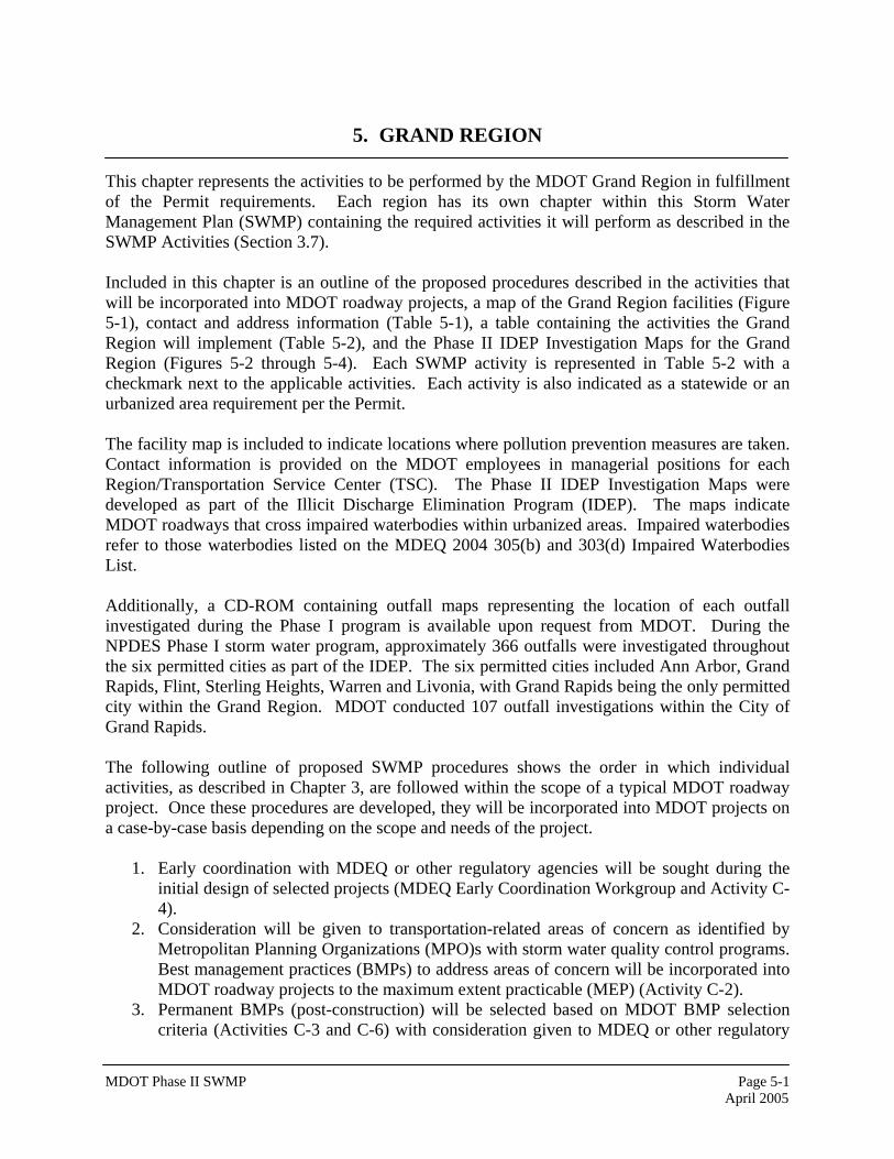
5. GRAND REGION This chapter represents the activities to be performed by the MDOT Grand Region in fulfillment of the Permit requirements. Each region has its own chapter within this Storm Water Management Plan (SWMP) containing the required activities it will perform as described in the SWMP Activities (Section 3.7). Included in this chapter is an outline of the proposed procedures described in the activities that will be incorporated into MDOT roadway projects, a map of the Grand Region facilities (Figure 5-1), contact and address information (Table 5-1), a table containing the activities the Grand Region will implement (Table 5-2), and the Phase II IDEP Investigation Maps for the Grand Region (Figures 5-2 through 5-4). Each SWMP activity is represented in Table 5-2 with a checkmark next to the applicable activities. Each activity is also indicated as a statewide or an urbanized area requirement per the Permit. The facility map is included to indicate locations where pollution prevention measures are taken. Contact information is provided on the MDOT employees in managerial positions for each Region/Transportation Service Center (TSC). The Phase II IDEP Investigation Maps were developed as part of the Illicit Discharge Elimination Program (IDEP). The maps indicate MDOT roadways that cross impaired waterbodies within urbanized areas. Impaired waterbodies refer to those waterbodies listed on the MDEQ 2004 305(b) and 303(d) Impaired Waterbodies List. Additionally, a CD-ROM containing outfall maps representing the location of each outfall investigated during the Phase I program is available upon request from MDOT. During the NPDES Phase I storm water program, approximately 366 outfalls were investigated throughout the six permitted cities as part of the IDEP. The six permitted cities included Ann Arbor, Grand Rapids, Flint, Sterling Heights, Warren and Livonia, with Grand Rapids being the only permitted city within the Grand Region. MDOT conducted 107 outfall investigations within the City of Grand Rapids. The following outline of proposed SWMP procedures shows the order in which individual activities, as described in Chapter 3, are followed within the scope of a typical MDOT roadway project. Once these procedures are developed, they will be incorporated into MDOT projects on a case-by-case basis depending on the scope and needs of the project.
1. Early coordination with MDEQ or other regulatory agencies will be sought during the initial design of selected projects (MDEQ Early Coordination Workgroup and Activity C-4).
2. Consideration will be given to transportation-related areas of concern as identified by Metropolitan Planning Organizations (MPO)s with storm water quality control programs. Best management practices (BMPs) to address areas of concern will be incorporated into MDOT roadway projects to the maximum extent practicable (MEP) (Activity C-2).
3. Permanent BMPs (post-construction) will be selected based on MDOT BMP selection criteria (Activities C-3 and C-6) with consideration given to MDEQ or other regulatory
MDOT Phase II SWMP April 2005
Page 5-2
agency input (Activity C-4) to the MEP. BMP selection will also be based on approved BMPs in the MDOT Drainage Manual and any Total Maximum Daily Load (TMDL) requirements (BMP Design and Maintenance Workgroup) (Activity C-5).
4. Maintenance requirements will be developed for new permanent BMPs (BMP Design and Maintenance Workgroup and Activity C-1).
5. Permanent BMPs will be properly installed and maintained following BMP selection (Activities C-6 and C-1).
6. Construction activities will be conducted under MDOT’s approved Soil Erosion and Sedimentation Control (SESC) Plan and the State of Michigan’s Permit by Rule.
7. The outfall labeling procedure will be implemented if new outfalls are planned. The consultant conducting outfall mapping will be notified that new outfalls are in place (Outfall Labeling Workgroup and Activity C-10).
8. Newly discovered outfalls will be identified and mapped (Outfall Mapping Workgroup and Activity I-5).
9. New flow control structures in urbanized areas will be reviewed and assessed for water quality benefits gained based on calculated pollutant removal rates (Activity C-11).
10. SWMP activities will be tracked and documented (Activity A-1). Examples include tracking the number of outfalls labeled and tracking maintenance activities through the Maintenance Activity Reporting System (MARS) (Program Assessment and Reporting Workgroup).
For specific roadway projects scheduled to be completed in the Grand Region, refer to MDOT’s 2005-2009 Five Year Transportation Program. The 2005-2009 Five Year Transportation Program is a report highlighting Michigan’s plan for preserving and improving its transportation network. The report describes the planned projects for each MDOT region. A link to the report is available on the MDOT Storm Water Management Web site. The 2005-2009 Five Year Transportation Program is currently underway and will limit the ability to implement new procedures not yet adopted by MDOT. Therefore, new procedures will be incorporated as they are adopted.
MDOT Phase II SWMP April 2005
Page 5-3
Figure 5-1 Grand Region Facilities Map
������
�����
������
���� ����
������
�������
������
���
���
�� ��
��
��
��
��
��
��
��
��
��
��
��
�
��
����
����
��
�
��
��
��
��
���
���
�
�
�
��
��
�� ���
�� ��
�� ��
��
��
��
���
���
��
���������� ����� ������
����
��������
�� !����
��"�������
#����$��
���%��
��&!'���(����$���
��%!������� ��$��
�����&
)���%���*��%���
������� �� �+��+�&�,��� -../
����
������
������
�������
��
��
�
�
������
������
���������&� ������
�� � ����
��
���� �����
�������
������ �''�&�
��%&�,� ������
����� ���� �����
�00 �����
���� �����
����� ���� ����� 1�����2������ #0�0 #� ��� ����� 3
�

MDOT Phase II SWMP April 2005
Page 5-4
Table 5-1 Grand Region Contact Information
Grand Region Office Region Engineer: Roger Safford Region Storm Water Coordinator: Steve Houtteman
1420 Front Avenue, N.W., Grand Rapids, MI 49504 Phone: 616-451-3091 FAX: 616-451-0707
Grand Rapids TSC Manager: Suzette Peplinski 1420 Front Ave., NW Grand Rapids, MI 49504
Phone: 616-451-3091 FAX: 616-451-0707
Howard City TSC Manager: Karl Koivisto 19153 W. Howard City-Edmore Rd. Howard City, MI 49329
Phone: 231-937-7780 FAX: 231-937-2281
Muskegon TSC Manager: Tim Judge 2225 Olthoff Drive Muskegon, MI 49444
Phone: 231-777-3451 FAX: 231-777-3621
For storm water-related concerns at the rest areas, the following individual should be contacted: Region Storm Water Coordinator: Steve Houtteman
Phone: 616-451-3091 FAX: 616-451-0707
Muskegon Rest Area 501 US-31 SB, Mile Marker 124
Muskegon County South bound on US-131, 0.5 mile south of White Lake Road Exit
Fruitport Rest Area 502 I-96 WB, Mile Marker 8
Ottawa County West bound on I-96, 1 mile beyond Exit 9 also called Spring Lake Exit
Walker Rest Area 503 I-96 EB, Mile Marker 25
Kent County
Rockford Rest Area 525 US-131 SB, Mile Marker 99
Kent County South bound on US-131, 1.5 miles north of Rockford Exit
Zeeland Rest Area 528 I-196 NB, Mile Marker 58
Ottawa County
Rothbury Rest Area 529 US-31 NB, Mile Marker 135
Oceana County North bound on US-31, 1.5 miles south of Rothbury Exit
Hart Rest Area 530 US-31 SB, Mile Marker 147
Oceana County
Portland Rest Area 531 I-96 WB, Mile Marker 79
Ionia County West bound on I-96, 1 mile east of Portland
MDOT Phase II SWMP April 2005
Page 5-5
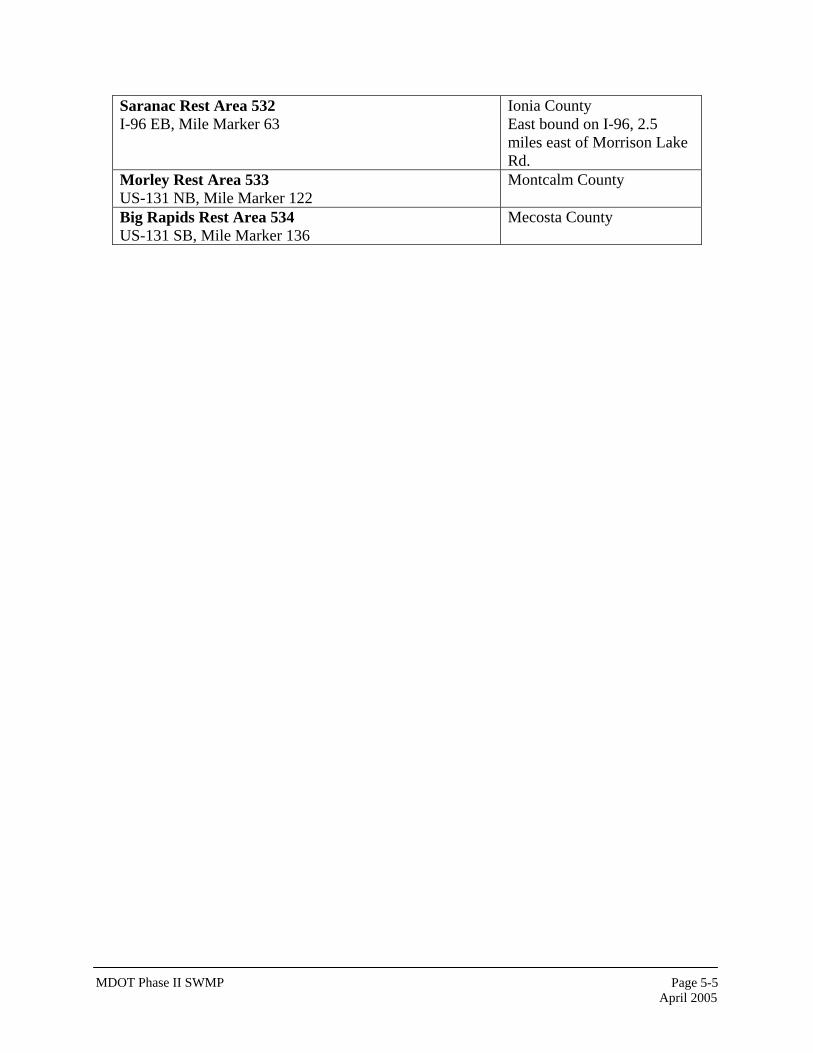
Saranac Rest Area 532 I-96 EB, Mile Marker 63
Ionia County East bound on I-96, 2.5 miles east of Morrison Lake Rd.
Morley Rest Area 533 US-131 NB, Mile Marker 122
Montcalm County
Big Rapids Rest Area 534 US-131 SB, Mile Marker 136
Mecosta County
MDOT Phase II SWMP April 2005
Page 5-6
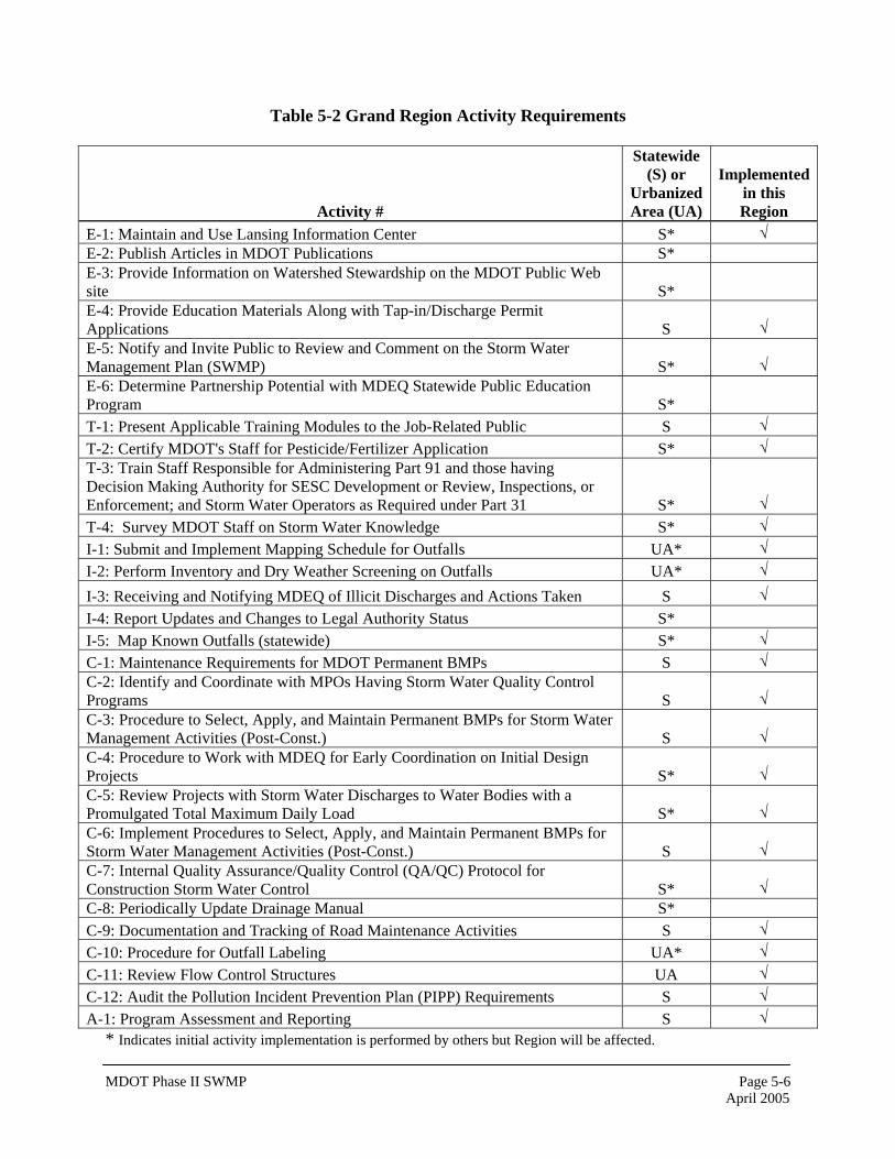
Table 5-2 Grand Region Activity Requirements
Activity #
Statewide (S) or
Urbanized Area (UA)
Implemented in this Region
E-1: Maintain and Use Lansing Information Center S* √ E-2: Publish Articles in MDOT Publications S* E-3: Provide Information on Watershed Stewardship on the MDOT Public Web site S* E-4: Provide Education Materials Along with Tap-in/Discharge Permit Applications S √ E-5: Notify and Invite Public to Review and Comment on the Storm Water Management Plan (SWMP) S* √ E-6: Determine Partnership Potential with MDEQ Statewide Public Education Program S* T-1: Present Applicable Training Modules to the Job-Related Public S √ T-2: Certify MDOT's Staff for Pesticide/Fertilizer Application S* √ T-3: Train Staff Responsible for Administering Part 91 and those having Decision Making Authority for SESC Development or Review, Inspections, or Enforcement; and Storm Water Operators as Required under Part 31 S* √ T-4: Survey MDOT Staff on Storm Water Knowledge S* √ I-1: Submit and Implement Mapping Schedule for Outfalls UA* √ I-2: Perform Inventory and Dry Weather Screening on Outfalls UA* √ I-3: Receiving and Notifying MDEQ of Illicit Discharges and Actions Taken S √ I-4: Report Updates and Changes to Legal Authority Status S* I-5: Map Known Outfalls (statewide) S* √ C-1: Maintenance Requirements for MDOT Permanent BMPs S √ C-2: Identify and Coordinate with MPOs Having Storm Water Quality Control Programs S √ C-3: Procedure to Select, Apply, and Maintain Permanent BMPs for Storm Water Management Activities (Post-Const.) S √ C-4: Procedure to Work with MDEQ for Early Coordination on Initial Design Projects S* √ C-5: Review Projects with Storm Water Discharges to Water Bodies with a Promulgated Total Maximum Daily Load S* √ C-6: Implement Procedures to Select, Apply, and Maintain Permanent BMPs for Storm Water Management Activities (Post-Const.) S √ C-7: Internal Quality Assurance/Quality Control (QA/QC) Protocol for Construction Storm Water Control S* √ C-8: Periodically Update Drainage Manual S* C-9: Documentation and Tracking of Road Maintenance Activities S √ C-10: Procedure for Outfall Labeling UA* √ C-11: Review Flow Control Structures UA √ C-12: Audit the Pollution Incident Prevention Plan (PIPP) Requirements S √ A-1: Program Assessment and Reporting S √
* Indicates initial activity implementation is performed by others but Region will be affected.
MDOT Phase II SWMP April 2005
Page 5-7
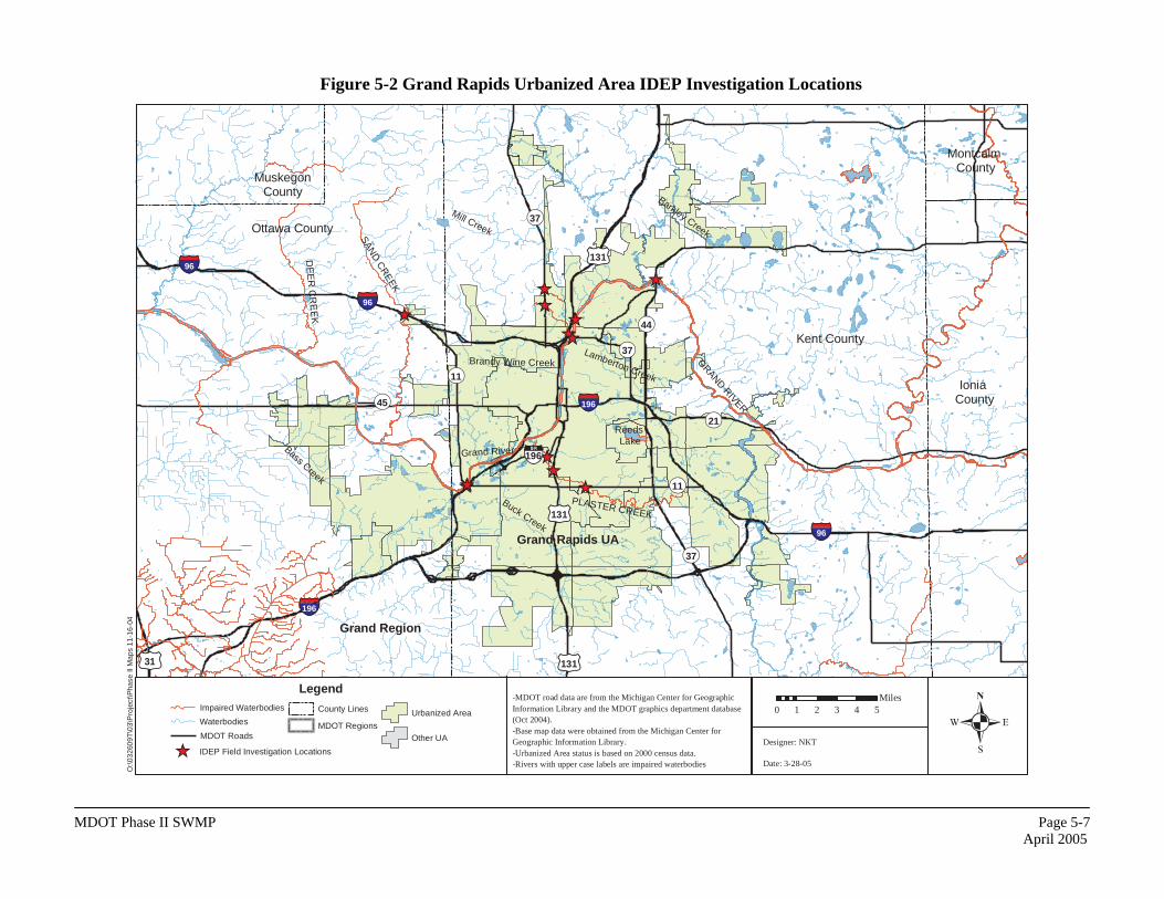
Figure 5-2 Grand Rapids Urbanized Area IDEP Investigation Locations
O:\0
3260
9T\0
3\P
roje
ct\P
hase
II M
aps
11-1
6-04
-MDOT road data are from the Michigan Center for Geographic Information Library and the MDOT graphics department database (Oct 2004). -Base map data were obtained from the Michigan Center for Geographic Information Library. -Urbanized Area status is based on 2000 census data. -Rivers with upper case labels are impaired waterbodies
��
��
����
����
��������
��
�����96
��31
���196
���196
���96
���96
��131
��131
��11
��37
��11
��45
��196
��37
��44
��37
��131
Brandy Wine Creek
PLASTER CREEKBuck Creek
Grand River
GRAND RIVER
Reeds Lake
SAND
CR
EEK
DE
ER
CR
EE
K
Bass Creek
Mill Creek
Barkley Creek
Lamberton Creek
Grand Region
Kent County
MuskegonCounty
Ottawa County
��21
Grand Rapids UA
Montcalm County
Ionia County
�0 1 2 3 4 5Miles
Designer: NKT
Date: 3-28-05�� IDEP Field Investigation Locations
LegendImpaired Waterbodies
Waterbodies
MDOT Roads
County Lines
MDOT Regions
Urbanized Area
Other UA
MDOT Phase II SWMP April 2005
Page 5-8
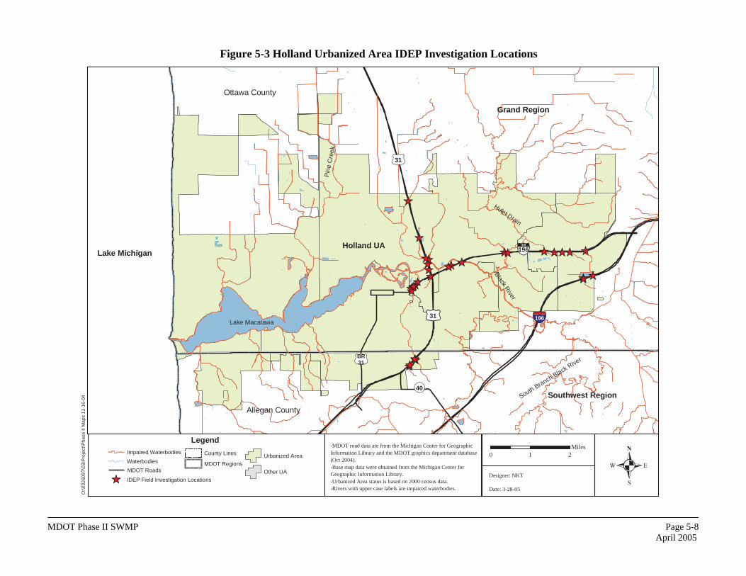
Figure 5-3 Holland Urbanized Area IDEP Investigation Locations
O:\0
3260
9T\0
3\P
roje
ct\P
hase
II M
aps
11-1
6-04
-MDOT road data are from the Michigan Center for Geographic Information Library and the MDOT graphics department database (Oct 2004). -Base map data were obtained from the Michigan Center for Geographic Information Library. -Urbanized Area status is based on 2000 census data. -Rivers with upper case labels are impaired waterbodies.
������
����������
��������������
������
��
��������
��
�� �� �� ��
��
��
��31 ���196
��BR31
��31
��196
��40
Lake MacatawaP
ine
Cre
ek
Black River
Hulet Drain
South Branch Black River
Grand Region
Ottawa County
Southwest Region
Allegan County
Holland UALake Michigan
�0 1 2
Miles
Designer: NKT
Date: 3-28-05�� IDEP Field Investigation Locations
LegendImpaired Waterbodies
Waterbodies
MDOT Roads
County Lines
MDOT Regions
Urbanized Area
Other UA
MDOT Phase II SWMP April 2005
Page 5-9
Figure 5-4 Muskegon Urbanized Area IDEP Investigation Locations
O
:\032
609T
\03\
Pro
ject
\Pha
se II
Map
s 11
-16-
04
-MDOT road data are from the Michigan Center for Geographic Information Library and the MDOT graphics department database (Oct 2004). -Base map data were obtained from the Michigan Center for Geographic Information Library. -Urbanized Area status is based on 2000 census data. -Rivers with upper case labels are impaired waterbodies.
��
��
�� ��
����
�� ��
��31
���96
��31
���96
���96
��104
��46
��120
��BR31
GRAND RIVER
MUSKEGON LAKE
Mona Lake
BLACK CREEK
LITTLE BLACK CREEK
BEAR LAKE
Spring Lake
RIO GRANDE CREEK
DE
ER
CR
EE
K
Norris Creek
Crockery
Creek
Cedar Creek
RYERSON CREEK
1
35
6
4
2a
Grand Region
Muskegon UA
Ottawa County
Muskegon County Newaygo County
Lake Michigan
�0 1 2 3 4Miles
Designer: NKT
Date: 11-18-04
�� IDEP Field Investigation Locations
LegendImpaired Waterbodies
Waterbodies
MDOT Roads
County Lines
MDOT Regions
Other UA
Urbanzied Area
MDOT Phase II SWMP April 2005
Page 5-10
THIS PAGE BLANK