5.4 mennonite settlement - manitoba · 5.4 mennonite settlement between 1874 and 1881, ... grain...
TRANSCRIPT

48
5.4.1 Above: Mennonite East and West ReservesThis map shows the areas in which the Mennonites settled in Manitoba, and the location of the farm-operator villages, which areknown to have existed in the 19th century. (Map Title. Mennonite Reserves of Manitoba, by John Warkentin, in Mennonite AgriculturalSettlements of Southern Manitoba, The Geographical Review Vol.49, No.3 1959. HRB Map # 030.)
5.4 Mennonite Settlement
Between 1874 and 1881, approximately 7,000 Mennonites from southern Russia made their way to thenewly established province of Manitoba. They left Russia when Czar Alexander II ended special privileges, grantedto them a century earlier by Catherine the Great, to entice members of this German-speaking Anabaptist group toestablish colonies in her newly-conquered, but largely empty, lands in the Crimea. The two main tenets of theMennonite religion are pacifism and baptism by choice. By the 1870s, however, the Czar had removed theirmilitary exemption, and began to exert control over Mennonite schools and institutions. They soon began lookingfor a new home.
To attract these industrious farmers to the prairies, the Canadian Government offered inducements by wayof exemption from military service, religious freedoms, and the granting of large tracts of land for their exclusivesettlement. An amendment to the Dominion Lands Act allowed them the privilege of settling in villages,circumventing the demand that each farmer had to reside upon his own homestead, a requirement whichguaranteed dispersal of settlement. The Mennonites were thus able to retain their distinctive "Strassendorf" orstreet villages. Like many other religious groups, they saw cohesion and religious solidarity as being dependentupon the settlement pattern of the group.
The Mennonites were granted two reserves in Manitoba: the first, in 1873, was an area of almost eighttownships east of the Red River; and the second, in 1876, was an area of seventeen townships west of the RedRiver. At the time of their arrival, the open prairie was not highly regarded by most of the existing Anglo settlers,who were dependent upon ample supplies of wood and running water. But to the Mennonites, experienced insteppe land farming, the open prairie was an attractive area in which to settle.
The initial contingent of Mennonites, who arrived in 1874, had the distinction of being the first largeEuropean block to immigrate to Manitoba; although Icelanders arrived right on their heels. Having been guaranteedby the government all the essential conditions of a happy settlement, the Mennonites went about re-creating ontheir land the commonwealth they had left behind in Russia. In all, they established 37 villages in the EastReserve, and about 50 in the West Reserve, although not all existed at one time, nor were all complete villages inthe true sense of the word. The stony soils and scrub bushland of the southern half of the East Reserve, inparticular, proved difficult to farm, and after 1876, a large number of Mennonite settlers transferred their homesteadclaims to the open prairie lands of the West Reserve.
When a Mennonite village was established, a group of twenty or so families would pool their homesteadsinto what became the village land, select a site for the village, and divide the land into arable, pasture, meadow andwoodland. Each land type was further divided into strips, and each family received a number of strips for theirpersonal use. By doing so, each family was assured of receiving a fair allocation of all land types at varyingdistances from the village. Stock could be herded in common, and the necessity of fencing cultivated strips wasthus avoided, while the social advantages of nucleated settlement were achieved. In almost all the villages, thehouses and barns were joined, recalling the Dutch origins of the group, where farms had to be built on man-mademounds to afford protection from flood waters. In the later Russian colonies, this compact form of settlement wasretained and refined to afford protection from nomadic bands of Tartars, which often threatened the Mennonitecolonies. In Manitoba, the villages most frequently consisted of a single street about half a mile long, withhousebarns lining one or both sides of the "Strassendorf" street, which was usually oriented along a creek bed toafford equal access to water for the village livestock.
Most of the villages in both the East and West reserves have disappeared over the years. Today, in theformer East Reserve, communities such as Kleefeld, New Bothwell, Grunthal and Blumenort are still in existence,but the traditional "Strassendorf" community plan no longer survives. Additionally, not a single example of thetraditional Mennonite housebarn unit survives on its original location. The Steinbach village became thecommercial centre for the East Reserve villages, and developed into a progressive and vibrant community, recentlyachieving 'city' status. While a handful of West Reserve villages are quite well preserved, and retain both the"Strassendorf" plan and surviving examples of the early housebarn units, Mennonite village life in the East Reserveis preserved solely at the Steinbach Mennonite Heritage Village Museum. This excellent museum developmentincludes several relocated structures set up to illustrate the early agricultural era, and the later blossomingcommercial era, of Steinbach's Mennonite heritage.
Sites noteworthy for their portrayal of Mennonite block settlement:1 - Community, street, and business placenames2 - Mennonite Village Museum3 - Historical cairns
5.0 Settlement Groups
5.4.2 Above: Arrival of first group of European SettlersThe first group of Mennonites to settle in the Canadian west arrived in Winnipeg in October 1874 aboard the Americansteamship "International". (Photo: Provincial Archives of Manitoba)

49
5.4.7 Above: Steinbach Street PlanPlan of the City of Steinbach. Note the lasting effects of the original village andfield-lot plan on the current community street plan. Some of the moreinteresting aspects of the current town plan include: the retention of the obliqueangle of the old main street; Steinbach Creek, part of which has been built overto create Elmdale Street, but with the curvilinear nature of the waterway stillintact; the grid street pattern following the oblique orientation of the original stripfields, and the contemporary-style residential bays and curved street patterns inthe "odd corner" areas of the original survey. The street plan for Steinbach, likeseveral of the nearby French communities, was not influenced by the presenceof a railway siding, but in this case, by its original traditional Mennonite farm-village survey pattern. (Map Title: City of Steinbach, Source: Province of Manitoba,Department of Highways and Transportation. HRB Map # 092d.)
5.4.6 Above: Steinbach Village and Field PlanMost settlers accepted the scattered farm pattern inherent in the section survey, but the Mennonites were permitted toestablish their traditional farm-operator villages, which characterized their Russian colonies. Twenty farmers lived in thevillage of Steinbach, tilled strips in the various parts of the village lands, and shared in the community pasture. Only theoutside boundaries of the village land pool were determined by the section survey. The original layout of Steinbach was inlots called Feuerstatten, 2 1/2 hectare (6 acre) strips about 70 meters (225 feet) wide running off a wide main street, whichhad been hacked out of the poplar bush. The strip-fields proved to be unsuited to mechanized farm practices, and by theturn of the century many of the East Reserve settlers began reverting to the original township-plan homesteads, causingmost of the farm villages to dissolve. (Map source: John Warkentin for article entitled Mennonite Agricultural Settlements of SouthernManitoba, in The Geographical Review Vol.49, No.3 1959. HRB Map # 059.)
5.4.5 Above: Mennonite LandingMennonite Memorial Landing Site cairn located at thejunction of the Red and Rat Rivers. There are severalsimilar cairns in the region commemorating Mennonitesettlement themes. (Photo: Historic Resources Branch)
5.0 Settlement Groups
5.4.3 Above: Mennonite Village c.1880A newspaper artist's depiction of a typical Mennonite farm village on the Manitoba prairie. Severalvillages in both the East and West Reserves possessed windmills for milling wheat into flour. The postsalong the trail marked the route during the winter months. (Photo: Provincial Archives of Manitoba.)
5.4.4 Left: Mennonite HousebarnA housebarn structure typical of the 1900-1925 period. Note the maturingtrees at the front of the lot, and the manure-based firebricks, called “MestSooden” drying in beehive shaped piles. Religious and cultural customsregarding community conformity dictated that all housebarns were to bethe same size and configuration. Such control over architectural stylesand village plans persisted well into the 1920s. (Photo: Mennonite HeritageCentre Archives.)

50
5.5 Ukrainian SettlementThe wooded bush country east of Emerson and just north of the U. S. border was settled in the 1896-
1905 era by Ukrainian immigrants from the Austrian provinces of Galicia and Bukovyna. At the time ofsettlement, these lands, to the east of the French river lots and south of the Mennonite East Reserve, werevacant apart from a few English-speaking ranchers and farmers on the western margins. The Ukrainians foundthe bush country to their taste because, despite its lack of long term potential for commercial agriculture, it didoffer a great deal to a peasant farmer. For the most part, poor peasant farmers were unable to develop land onthe open prairie because they lacked the capital to buy the equipment necessary for successful agriculture onthe open lands. In the bush country they had wood, water, and meadow at hand and access to a wide resourcebase – a formula good for short-term survival, but not the long run.
Although accustomed to village settlement in their homeland, Ukrainian settlers were prevented fromsettling together in villages by the requirements of the Dominion Lands Act which dictated that each settler hadto reside upon the claimed homestead land for three years before patent was granted. Villages such as Tolstoi(originally Oleskow), Vita (originally Shevchenko), and Gardenton were products of the railway and wereessentially railway-based service centres, rather than bona fide village settlements.
The Ukrainian community was by no means homogeneous at the time of settlement. It was divided onreligious grounds, which in turn often reflected point of origin of the settlers. The area south and east of Tolstoiwas predominately Bukovynian and Orthodox in affiliation. To the north and east, the Ukrainian community wasGalician (Halychyni) and Ukrainian Uniate or Greek Catholic in affiliation. Since the time of settlementintermixing of immigrants and a complicated history of religious organization has led to representation by boththe Ukrainian Orthodox and Greek Catholic churches in the Ukrainian settlements.
In terms of physical Ukrainian features, the most obvious elements are the distinctive churches,cemeteries, and a few (mostly abandoned) houses built in the Ukrainian traditional style. Ukrainian churches areeasily recognizable with their Byzantine onion-shaped domes (banyas), tripartite configuration and the separatefree-standing bell tower. The Orthodox churches are further distinguished by the presence of the Orthodoxcross. The interiors of these churches are rich in symbolism. Some of the more notable local churches include:Holy Ghost Ukrainian Orthodox Church at Tolstoi (1925); St. Michael's Ukrainian Orthodox Church (1899), westof Gardenton, which was the first Ukrainian Orthodox Church to be built in Canada, and now a national historicsite; and Holy Trinity Ukrainian Catholic Church (1911) near Stuartburn.
Gardenton, with a current population less than 50, is undoubtedly the Bukovynian capital of Manitoba, ifnot Canada. It is a small, declining, former railway service centre. The railway line was abandoned in the1960s and the village has since become the refuge of retired farmers from the district. Gardenton never had agrain elevator - few stations in this area did - as little grain was produced for export from the district. Mixedfarming always has been predominant in this area and farm income always has been supplemented by cuttingcordwood, digging "snakeroot” (seneca root), harvesting slough grass, the export of live frogs and morerecently, driving school buses and road maintenance work.
The settlers, who pioneered the district around Gardenton from 1896-1905, came from the Onut and Bridokdistricts of Bukovyna. In settlement they displayed a strong preference for settlement alongside their formerneighbours and kinfolk. It was not uncommon to find settlers grouped by family, families grouped by village, andvillages grouped by district, and so on. Thus the social geography of the western Ukraine at the turn of thecentury was replicated in microcosm in Manitoba.
Sites noteworthy for their portrayal of Ukrainian block settlement include:1 - St. Michael’s Ukrainian Greek Orthodox Church National Historic Site2 - Gardenton Museum3 - Inventory of 28 Ukrainian Churches located in the R.M.s of Stuartburn and Franklin
5.5.1 Right: Galician style homePhoto of the Ewanchuk house, Foley District, c1914.The hip-shaped thatch roof, the mud-plastered logwalls with whitewash finish, and the decorativecoloured band at the base of the house, are allcharacteristics of traditional Ukrainian domestic folkarchitecture. The two-room design, with theentranceway into the smaller left side room, is oneof the characteristics of the Galician regional style.(Photo: Provincial Archives of Manitoba.)
5.5.3 Right: Ukrainian Church ArchitectureView of Holy Trinity Ukrainian Catholic Church,Stuartburn, c1915. Ukrainian Catholic and GreekOrthodox churches were characterized by large-sizedroof domes. (Photo: Provincial Archives of Manitoba.)
5.0 Settlement Groups
5.5.2. Left: Bukovynian style homePhotograph of a typical Bukovynian- style Ukrainianhome. This style was characterised by a three-roomplan with central entranceway and a large 'top-heavy' roof. (Photo: Provincial Archives of Manitoba.)

51
5.0 Settlement Groups
5.5.9 Above: Interior, St. Michael’s Ukrainian Greek Orthodox Church.Many of the religious icons in St. Michael’s' Church were brought by the pioneers from the 'old country' whenthey immigrated. (Photo: Historic Resources Branch.)
5.5.4 Above: Historical Marker, Ukrainian SettlementPlaque located in the Overstoneville Cemetery honouring theUkrainian pioneers of the Tolstoi and Overstoneville district.(Photo: Historic Resources Branch.)
5.5.5 Above: St. Nicholas Ukrainian Greek Orthodox Church, Arbakka districtErected in 1939, the asphalt roofing and stucco exterior finish are typical construction materialsfor the period; while the cruciform plan, multi-domed roof are traditional design elements. Thestand-alone bell tower is characteristic of all Ukrainian churches and although strictly utilitarian,they often feature unusual and attractive designs. (Photo: Historic Resources Branch.)
5.5.6 Above: St. Michael’s Ukrainian Greek Orthodox ChurchConstructed in 1899, near Gardenton, St. Michael's is the oldest Ukrainian Greek Orthodox church inCanada, and is a protected provincial and national historic site. (Photo: Historic Resources Branch.)
5.5.8 Above: St. Elias Ukrainian Greek Orthodox Church; SirkoConstructed in 1906 of logs, and later sheathed with wood siding, this beautiful and unusual littlechurch is one of only two traditional Bukovynian-style churches remaining in Manitoba. The style ischaracterized by a steeply-pitched roof, semi-circular ends, and eaves supported by carvedcantilevered rafters. Note the original surviving log bell tower. (Photo: Historic Resources Branch.)
5.5.7 Above: Gardenton MuseumView of part of the artifact display area in the GardentonUkrainian Museum and Village. (Photo: Historic ResourcesBranch.)

52
5.6 German SettlementFredensthal was established by German immigrants, from settlements they had
established in southern Russia during the late 1700s. While the language and recent history wasfairly similar to that of the region's Mennonite settlers, these German-speaking pioneers were ofthe Lutheran faith, and did not live the secular, communal lifestyle that characterized the earlyMennonite settlers. This group first settled in the Gretna area west of the Red during the 1890s,where they worked as labourers and domestics for a few years to save money, and to becomeacclimatized to their new surroundings.
In 1896, the first few families from this group moved from Gretna to farms on the 'flats'east of Emerson. They were sponsored by a group of businessmen in Emerson, who providedlines of credit to the setters and convinced them to take up lands which had been abandoned byearlier Anglo settlers because of the frequent wet conditions in the area. The first municipaldrainage ditches were dug during the early 1880s, and by the mid 1890s the district's drainageproblems were significantly reduced. The 'flats' district also suffered from a lack of potable water.This problem was overcome when an underground spring was discovered four kilometres (2 1/2miles) south of Ridgeville. The Springbank Well, as it was called, was enlarged and improvedseveral times over, as the area became more settled and the district’s residents became morereliant upon this singular source of good clean water. Before the advent of dugouts to create awater supply, settlers came from as far as 16 kilometres (10 miles) away to haul water for theirstock.
Additional families made the move in the following years, and by 1903 the new settlementwas sufficiently large that a church was constructed. It was replaced by a larger structure in 1920,and replaced again a decade later when a tornado demolished the second structure. The firstschoolhouse was constructed in 1904, and housed a class of 75 pupils who were taught in theGerman language by the local pastor.
In 1901 the railroad passed through the settlement, and in 1902 a station house and Lakeof The Woods Milling Company grain elevator were built. A village store was opened in 1914, anda blacksmith shop in 1924. Due to the presence and influence of both Ridgeville and Emersonjust a few miles in either direction along the rail line Fredensthal never grew beyond this modestlevel. Currently, the presence of this community is marked by the Fredensthal cemetery andcairn, and a modern church structure. When the railway line was removed during the 1970s theFredensthal elevator was moved five miles west to the Pembina branch of the CPR and the newsiding was named West Fredensthal. With names such as Knutt, Schwark, Kreitz, Schultz,Weiss, Becker, and Schiebe still common in the area, the Fredensthal district still stands out asan island of German heritage within the larger Anglo-settled, southeastern section of the CrowWing Study Region.
5.0 Settlement Groups
5.6.1 Lutheran Pioneer MemorialDetail of cairn situated at the Fredensthal districtcemetery, located at SW 13-1-3E, approximately 8kilometres (5 miles) northeast of Emerson. (Photo:Historic Resources Branch.)
5.6.2 Fredensthal Highway sign(Photo: Historic Resources Branch.)

53
6.0 Infrastructure Development6.0 INFRASTRUCTURE DEVELOPMENTIn the Crow Wing Study Region the infrastructure landscape includes items such as trails, roads,
and highways, railway lines, drainage ditches and canals, river fords, ferries, and bridges. While notnormally considered as significant heritage resources, infrastructure components nevertheless can be quiteinteresting and appealing both historically and in appearance, and are quite often highly visible landmarkson the landscape. There are a variety of sites in the Crow Wing Study Region relating to infrastructuredevelopment which merit recognition, such as the route of the first railway line in Manitoba, and some ofthe earliest drainage projects on the prairies. Some of the more significant known sites related toinfrastructure development in the study region include:
6.1 Trail routes and remnants1. The Dawson Trail2. Ste. Anne Trail3. Mennonite East Reserve Trails4. Ste. Agathe Parish Trail
6.2 Railways1. Pembina Branch of the CPR
6.3 Bridges and Ferries1. St. Adolphe Ferry2. Dominion City Timber Truss Bridge3. Stuartburn Timber Truss Bridge4. Municipal bridge over South Branch Jordan River5. Municipal bridge over North Branch Jordan River6. Piney Road Bridge7. Senkiw Suspension Bridge
6.4 Drainage Canals1. Manning Canal2. Seine River Diversion3. Dominion City area drains
6.1 Settlement TrailsIn addition to the Pembina and Crow Wing fur-trade era trails, several other trails were established in
the study region during the settlement era; which in this part of Manitoba occurred from approximately 1870to 1900. The most significant of these settlement trails was undoubtedly the Dawson Trail. Its constructionwas proposed as early as 1858 to help facilitate settlement of the Canadian West, but ten years would passbefore work on it actually commenced. By the late 1870s, only ten years after its completion, the route hadlost its appeal as a settlement trail, since an easier passage via the United States, by railway and steamboat,became the preferred route. By 1881, the journey to Red River from eastern Canada could be made quitecomfortably by train on the CPR main line, which by that summer had reached the Red River valley.
The cartographic record shows several other trails, which were constructed and likely heavily used inthe decades prior to the development of the provincial road network after World War I. These include asurveyed trail developed during the early 1880s paralleling the east bank of the Red River and connectingthe newly incorporated communities of Winnipeg and Emerson, and often referred to as St. Mary’s Road. Analternate to the Dawson Road route to the Métis settlement at Ste. Anne des Chênes was also developedduring this period. It ran south of the Seine River and was commonly known as St. Anne’s Road. After theestablishment of the Mennonite East Reserve in 1874, the western portion of this route was extensively usedby the Mennonite settlers, who, from the Ile de Chênes area developed two new branches headingsoutheast, one to the village of Steinbach and the other to the village of Kleefeld. From these villages theMennonite trails branched again connecting several of the more prominent villages in the East Reserve. Anadditional, significant, settlement-era trail established in the study region was the Piney Road. From Ste.Anne it followed the south bank of the Seine River to Marchand and continued on, in a southeasterndirection, cross-country over the high ground of the Sandilands Forest Reserve to the hamlet of Piney nearthe American border. This settlement-era trail was used primarily to access the timber and firewoodresources of the southeasterly corner of the province. Being located largely outside of the study region, thistrail is not included in the following discussions, although it is worthy of mention; being a very well knownroute during its day.
6.1.1 The Dawson TrailThe most significant of the settlement-era trails in the study region was undoubtedly the Dawson Trail. This
trail was, in fact, the most westerly section of a longer, combination water and land route connecting what are nowThunder Bay and Winnipeg. The final 160 km (100 miles) of this route consisted of a wagon trail, referred to mostoften as the Dawson Trail, but also known by several other names, including the Dawson Road, Mr. Snow's Road,the Road to NW Angle of Lake of the Woods, The Great Highway, and other more-colourful, names. For ten yearsafter its completion in 1870, it was part of the only all-Canadian route to the prairies from eastern Canada. It isestimated that more than 3,500 settlers immigrated to western Canada using the Dawson route. Much of the easternsection of the Dawson Trail consisted of bone-jarring 'corduroy' road, made up of logs laid side by side. The final 60km (37 miles) or so followed the route of a much older trail, which connected the Métis settlement of St. Anne withFort Garry. The Dawson Trail was a notoriously difficult route, and it lost much of its traffic quite rapidly after therailway connection to St. Boniface from Minneapolis-St. Paul was completed in 1879. Portions continued to be usedfor local traffic, and for hunting and logging purposes, but gradually sections of it, particularly the eastern half,became abandoned and overgrown. Much of the western section of the Dawson Trail still exists as PR 207 and thissection has been designated by the Manitoba Highways as a Heritage Route. The Dawson Trail was a difficult trail touse, but in its brief history, many notable groups and individuals traversed it at least once, and in its day it wasundoubtedly a very well known and much-talked-about feature. (Map Title: Province of Manitoba and Part of the District ofKeewatin and North West Territory Shewing The Townships and Settlements Drawn from the Latest Gov. Maps, Surveys & Reports for ThePrairie Province, 1876. Source PAM #: H5 614.1 gbbd 1876. HRB Map #007.)

54
6.1.3 Right: East Reserve Mennonite TrailsMap of the Mennonite East Reserve in Manitoba showingthe villages and major settlement trails as they existed inthe district, c1880. Note that two of the trails join up withthe much older Ste. Anne's Trail, and also that the moreeasterly of these is erroneously labeled as the old DawsonRoad. Note also the aptly named “Gravel Ridge Road”follows the course of the old beach depicted in figure 6.1.4.(Map Title: Mennonite East Reserve Trails. Source: Mennonites inCanada 1786-1920 The History of a Separate People by Frank H.Epp, 1975, page 213. HRB Map #053.)
6.1.4 Left: Beach RidgesDetail from Canada Department of Mines map showingsurface deposits in Manitoba, 1931. This map clearlyshows Lake Agassiz beach ridges laid down acrossthe natural slope of the land (in red) creating areas ofsilt deposits behind them (blue - No.7). Also thedistinct transition line between the "Glacial Till Modifiedby Wave Action" (Green No.4) and the "Lake-Bed andFlood-Plain Deposits" to the west and north is noted.This same transition in surface deposits later wouldmark the transition from predominantly commercialcereal crop production to largely dairy and livestockproduction. (Map Title: Surface Deposits, ManitobaDepartment of Mines, 1931. Source: PAM, un-cataloguedmap "P2068, Map 254A". HRB Map #059.)
6.0 Infrastructure Development
6.1.2 Mennonite East Reserve Trails.
After the creation of the East Reserve and the arrival of 1,600 Mennonites in the areasouth of Ste. Anne in 1874, the Ste. Anne Trail became an integral extensionIn the Reserveof the Mennonite East Reserve Trail system, established. Almost immediately the settlersdeveloped a trail network connecting key villages in the Reserve to the Ste. Anne Trail in thearea of the original Ile des Chênes settlement. To the new settlers this was simply the“Winnipeg Trail”. Most notable among the four main branches of the East Reserve trails wasthe 25-km long “Gravel Ridge Road”. It connected Bergfeld in the southwest corner of theReserve, with Steinbach; passing through Grunthal and Schonsee along the way. For almostits entire length it ran atop a prominent gravel ridge, and thus was unencumbered by thelargely poorly drained and stony land in this area.
Today the only visible remnants of the roughly 200 km of trails development by theMennonites during the 1880s and 1890s are two intersections with the Ste. Anne Trail, locatedin the old Ile des Chênes river-lot settlement. Leading up to the intersections, from thesoutheast are two short sections of former trail. One is two, and other four, kilometres inlength.
In appearance, the settlement-era trails, like the older fur trade cart trails, were characterized by their direct “cross-country” nature, following the local height of land, river courses, and skirting the many low spots and marshes that dottedthe study region before the advent of land drainage programs. However, unlike most of the Hudson’s Bay Companytransport trails, which consisted of a wide series of ruts made by the “off-set” nature of hitching several carts one behindanother, the settlement-era trails tended to consist more of a simple three-rut path, made by the wagon wheels with a singlehorse-path between them. As the 27-metre (99-foot) road allowances located between each section of the township surveybegan to be developed, both the old HBC transport trails, and the newer settlement-trails, were increasingly diverted ontothe north-south, east-west survey grid. Currently, a few remnants of some of these old trails still survive, including majorsections of both the Dawson Trail (as PR 207); Ste. Anne's Road (as PR 210); and the 'Ste. Agathe Parish Trail/St. Mary’sRoad' (as PR 200 & PR 246).
In reviewing the routes of the early trails as plotted on the various source maps used in this study, it was apparentthat there is a direct correlation between many of the early trail routes and the surrounding physical landscape, which doesnot exist with the modern road network. This human/landform relationship is worth noting, and in simple terms, occurred asfollows: The Ste. Anne Road very clearly followed the high ground just beyond the southern edge of the “Great Marsh”.The Dawson Trail to Ste. Anne and beyond to Marchand followed the course of the Seine River; the Piney Road followedthe high ground of the Sandilands hills; the Ste. Agathe Road followed the Red River; and the Ridge Road followed aremnant beach ridge laid down by Lake Agassiz.
With the advent of large earth moving equipment in the 20th Century, the advantages of relating trails to physicalfeatures were largely lost. Low spots and marshy areas could be drained and they no longer needed to be skirted. Sinceroadways could now be built up on raised beds or “grades” above the surrounding landscape, the local height of land wasno longer significant. Also, with farming practices being steadily mechanized after 1900, entire quarter sections could easilybe cultivated as one large field. Landowners, therefore, increasingly came to view the old trails crossing their fields asobstacles to efficient farming practices and petitioned their government officials to close the old surveyed trails forcingtravellers to use the road allowance grid. Changing times gave way to new norms, and as with other aspects of the culturallandscape of the study region, the connection between transportation modes and routes and the physical landscape slowlybut steadily diminished.
55
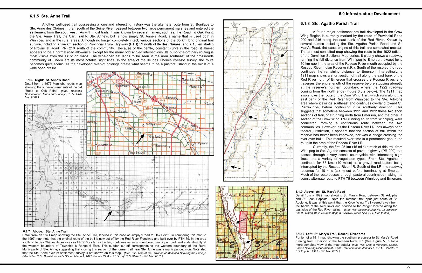
6.1.6 Right: St. Anne's RoadDetail from a 1977 Manitoba roads mapshowing the surviving remnants of the old“Road to Oak Point”. (Map: ManitobaConservation, Maps and Surveys, 1977. HRBMap #061.)
6.0 Infrastructure Development6.1.5 Ste. Anne Trail
Another well-used trail possessing a long and interesting history was the alternate route from St. Boniface toSte. Anne des Chênes. It ran south of the Seine River, passed between two large permanent marshes and entered thesettlement from the southwest. As with most trails, it was known by several names, such as, the Road To Oak Point,the Ste. Anne Trail, the Cart Trail to Ste. Anne’s, but is now simply St. Anne's Road, a name that is used both inWinnipeg and in the rural areas. Although no longer completely intact, various sections of the 65 km long original trailsurvive, including a five km section of Provincial Trunk Highway (PTH) 59 north of Ile des Chênes, and a 15 km stretchof Provincial Road (PR) 210 south of the community. Because of the gentle, constant curve in the road, it almostappears to be a normal road allowance, except for the many odd angled intersections. Its out-of-the-ordinary routing ismost visible from the air or on maps. The wide-open flat lands to be seen in the area southeast of the crossroadscommunity of Linden are its most notable sight lines. In the area of the Ile des Chênes river-lot survey, the routebecomes quite scenic, as the developed river-lot holdings create what seems to be a pastoral island in the midst of awide open prairie.
6.1.8 Ste. Agathe Parish Trail
A fourth major settlement-era trail developed in the CrowWing Region is currently marked by the route of Provincial Road200 and 246 along the east bank of the Red River. Known byseveral names including the Ste. Agathe Parish Road and St.Mary's Road, the exact origins of this trail are somewhat unclear.The earliest consulted map showing the route is the 1922 editionof the Dominion Sectional Map series. It clearly shows a roadwayrunning the full distance from Winnipeg to Emerson, except for a10 km gap in the area of the Roseau River mouth occupied by theRoseau River Indian Reserve (I.R.). South of the reserve the roadcontinues the remaining distance to Emerson. Interestingly, a1911 map shows a short section of trail along the east bank of theRed River north of Emerson that crosses the Roseau River, andtraverses the entire length of the reserve before stopping abruptlyat the reserve’s northern boundary, where the 1922 roadwaycoming from the north ends (Figure 6.3.2 below). The 1911 mapalso shows the route of the Crow Wing Trail, which runs along theeast bank of the Red River from Winnipeg to the Ste. Adolphearea where it swings southeast and continues overland toward St.Pierre-Jolys, before continuing in a southerly direction. Thissuggests that sometime between 1911 and 1922 these two shortsections of trail, one running north from Emerson, and the other, asection of the Crow Wing Trail running south from Winnipeg, wereconnected; forming a continuous route between the twocommunities. However, as the Roseau River I.R. has always beenfederal jurisdiction, it appears that the section of trail within thereserve has never been improved, nor was a bridge crossing theriver ever built. This resulted over time in a permanent gap in theroute in the area of the Roseau River I.R.
Currently, the first 25 km (15 mile) stretch of this trail fromWinnipeg to Ste. Agathe consists of paved highway (PR 200) thatpasses through a very scenic countryside with interesting sightlines, and a variety of vegetation types. From Ste. Agathe, itcontinues for 65 kms (40 miles) as a gravel road before beinginterrupted by the Roseau River I.R. South of the I.R. the roadwayresumes for 10 kms (six miles) before terminating at Emerson.Much of the route passes through pastoral countryside making it ascenic alternate route to PTH 75 between Winnipeg and Emerson.
6.1.7 Above: Ste. Anne TrailDetail from an 1871 map showing the Ste. Anne Trail, labeled in this case as simply “Road to Oak Point”. In comparing this map tothe 1997 map, note that the original route of the trail is now cut off by the Red River Floodway and built over by PTH 59. In the areasouth of Ile des Chênes its survives as PR 210 as far as Linden, continues as an un-numbered municipal road, and ends abruptly atthe western boundary of Township 8 Range 6 East. This sudden cut-off corresponds to the western boundary of the RuralMunicipality of Ste. Anne, suggesting that closing this section of the former trail near Ste. Anne was a municipal decision. Note alsothat the Ste. Anne river-lot settlement survey is not shown on this map. (Map Title: Map of the Province of Manitoba Showing the SurveysEffected in 1871. Dominion Lands Office, March 1, 1872. Source PAM: H5 614.1 bj 1871 State 2. HRB Map #010.)
6.1.10 Left: St. Mary's Trail, Roseau River areaPortion of a 1911 map showing the southern precursor to St. Mary's Roadrunning from Emerson to the Roseau River I.R. (See Figure 5.3.1 for amore complete view of the map detail.) (Map Title: Map of Manitoba, SpecialEdition Showing Disposition of Lands, Dept of Interior, January 1, 1911. PAM #: H7614.2 gbbd 1911. HRB Map #024.)
6.1.9 Above left: St. Mary's RoadDetail from a 1922 map showing St. Mary's Road between St. Adolpheand St. Jean Baptiste. Note the remnant trail spur just south of St.Adolphe. It was at this point that the Crow Wing Trail veered away fromthe banks of the Red River and headed to the "ridge” located along theeast side of the Red River valley. (Map Title: Sectional Map No. 23, EmersonSheet, March 1922 Source: Maps & Surveys Branch files. HRB Map #035d.)

56
#2
6.1.12 Below: Highway System Takes HoldDetail from a 1939 Manitoba Highways map showing, among other features,the route of the former Crow Wing Trail to St. Pierre being abandoned for acompletely new route, destined to become PTH 59. The main route to theOntario border, Highway No.1 at this time, was routed through Beausejour, justnorth of the study region. (MapTitle: 1939-40 Manitoba Highways Map Source: PAM#: H3 614.3 gmbd Series 3 1939-40. HRB Map #055.)
6.1.13 Above: Provincial Trunk HighwaysDetail from a 1951 Manitoba Highways map, showing, the ongoing development of PTH 12,or the “new” Piney Road. PTH 59 at this time ended at St. Malo. However, the beginning ofthe modern road system in the study region was clearly taking shape at this time.(Map Title: Manitoba Highways Map for 1951. Source: PAM 614.3 gmbd series 3 1951. HRB Map#056.)
6.1.11 Transition from Trails to Roadways
This detail from a 1928 Manitoba Roads Map (below) showing the road system insoutheastern Manitoba, illustrates the transition of the early cross-country trail network tothe new north-south/east-west road allowance grid. Noteworthy elements shown in themap include: 1. The route of the Dawson Trail from St. Boniface, which begins as a majorroadway, (Highway No.12), This is then downgraded to a minor roadway near Ste. Annedes Chênes, then downgraded further to a mere trail, before being dropped completely asa mapped route. 2. St. Anne's Road, just south of Highway 12, retains its original cross-country route for much of its eastern section, but the western half now has been divertedto the section grid. 3. Most interesting is the Mennonite Trail to Kleefeld which branchesoff St. Anne’s Road near Ile des Chênes in a southeasterly direction for about 10 km (6miles) before it, too, is diverted to the section grid. Here a series of 'steps' along the gridare created as it attempts to retain its original southeasterly direction. The map also showsthe old Ridge Road between Steinbach and Grunthal which is still largely in existence; asis the trail to Piney just to the east, and a section of the Crow Wing Trail between St. Maloand the St. Adolphe rail siding on the Pembina Branch of the CPR. Over time these formertrails continued to be closed or diverted to the section grid for all new roads were strictlygrid roads. In the years to follow, new municipal roads continued to follow the section grid.The routes of most of the more recently constructed provincial highways in the areautilized the most direct route, ignoring the section grid.(Map Title: Manitoba Roads Map 1928. Source: Historical Atlas of Manitoba, page 431. HRB Map#046.)
6.0 Infrastructure Development
#1
1
#2
#3
57
6.0 Infrastructure Development
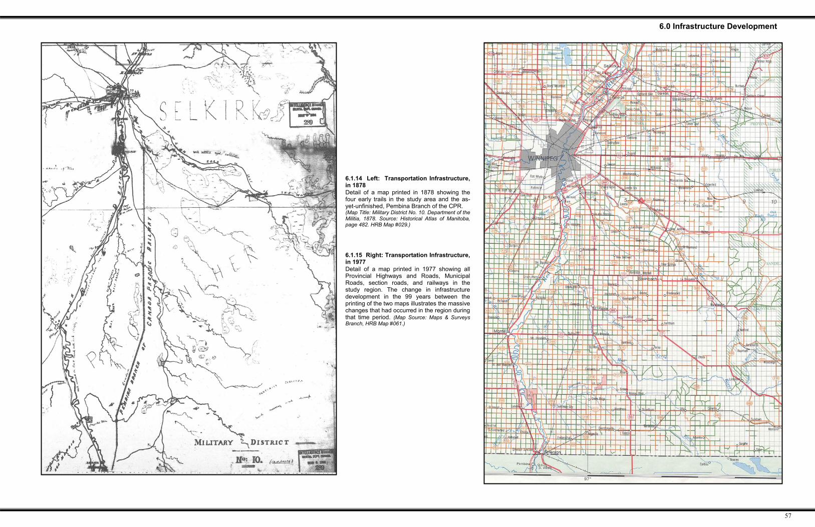
6.1.14 Left: Transportation Infrastructure,in 1878Detail of a map printed in 1878 showing thefour early trails in the study area and the as-yet-unfinished, Pembina Branch of the CPR.(Map Title: Military District No. 10. Department of theMilitia, 1878. Source: Historical Atlas of Manitoba,page 482. HRB Map #029.)
6.1.15 Right: Transportation Infrastructure,in 1977Detail of a map printed in 1977 showing allProvincial Highways and Roads, MunicipalRoads, section roads, and railways in thestudy region. The change in infrastructuredevelopment in the 99 years between theprinting of the two maps illustrates the massivechanges that had occurred in the region duringthat time period. (Map Source: Maps & SurveysBranch, HRB Map #061.)

58
6.0 Infrastructure Development6.2 Railways
During the latter part of the 19th and early decades of the 20th century, railways were THE vital link, and lifeline for theemerging settlements in Manitoba and the western provinces. To facilitate the rapid settlement and development of theCanadian prairies the Dominion Government encouraged the building of numerous branch lines to transport people and freight.The significance and impact of railways on rural districts remained paramount until the advent of all weather, high-speedhighway transportation during the late 1940s and early 1950s. Since then, trucking has increasingly overtaken the role initiallyplayed by the railways in hauling freight to and from rural Manitoba communities. Similar to other regions across Canada,many branch lines throughout Manitoba now have been abandoned and tracks removed.
The Crow Wing Study Region possessed three railway lines. The CPR Pembina Branch between St. Boniface andEmerson, begun in 1874 and completed in December of 1878, connects to American railway lines leading south toMinneapolis, Chicago, and other points in the American mid-west. It is significant, as it was the very first operating railway linein western Canada. The second is the Canadian Northern Railway's 'Sprague subdivision' line, which runs from Winnipegsoutheast to Rainy River, south of Lake-of-the-Woods in northwestern Minnesota, and then northeast to Thunder Bay, Ontario.It was begun in 1898 and completed in February 1902, and is currently part of Canadian National's 'southern' line to ThunderBay and points east. This line became known locally as the 'Muskeg Express' because of the wet and wooded territory which ittraversed, and for the millions of cords of firewood which came out of the woodland areas of southeastern Manitoba during theearly decades of the 20th century. The third railway line was CNR Ridgeville sub-division. It was constructed between 1903and 1907 and connected communities in the Stuartburn region with Emerson at its western terminus, and South Junction onthe Sprague branch line, at its eastern terminus. The Pembina and Sprague sub-divisions are currently still active due to theircontinuing 'main route' role. The Ridgeville branch line was abandoned and its tracks were removed during the 1980s.
In addition to these three branch lines, several short spur lines also existed in the area for a short time. In 1879, theCanadian Pacific Railway built spur tracks from Dominion City to what was known then as Greenridge, to mine the gravel tobuild the ballast or 'dump' for the Pembina branch line. The track carried trains of flat cars every half hour over the 14-kmdistance to the siding at Dominion City. The line operated until 1882 when it was removed. After the closure, most commercialgravel for railway construction in the region was obtained from pits in the Bird's Hill area, northeast of Winnipeg. There was asecond railway spur, on the north side of the Roseau River at Dominion City, which serviced a brickyard and a feed and flourmill. Bricks manufactured at this site were used in the construction of Winnipeg's well-known "gingerbread style" City Hall.When the brickyard folded and the mill burned down in 1884, the need for this spur disappeared and it, too, was removed. Athird spur line existed for a time in the Ste. Anne area. The reason for its construction is unknown; however, it is clearly shownin a 1909 map of the region (Figure 6.2.7). As with the Dominion City spurs, it too was short-lived and all visible traces of ithave now disappeared.
6.2.3 Above: Railways and siding locations in southeastern ManitobaThe numbers between the sidings indicate the distance in miles between sites. Ten miles was considered the maximum distancea farmer could travel with horse and wagon on a return trip in a single day; thus most sidings were less than ten miles apart.(Source: Canadian National Railways Synoptical History by A.B. Hopper and T. Kerarney, October 15, 1962. Copy in HRB files. HRB Map #094.)
6.2.1 Above: Pembina Branch during the 1950 floodApril 1950, the CPR "SOO Line" rail link is threatened at Emerson. Crews dumped thousands of yards of gravel along the track tomaintain the last line into Emerson. On April 30, 1950 the tracks gave way; train service was cut and not resumed until May 27, 1950.(Source: Arnaud Through the Years, 1974, by the Arnaud Historical Committee, page 336.)

59
6.2.7 Above: Railways & Post OfficesDetail from a 1909 postal route map showing railway lines in the region south of Winnipeg. Notethe short spur line in the Ste. Anne area. Two similar temporary spur-lines existed in theDominion City area for a short time. As with most other goods and services, the mail wasdistributed throughout the countryside by the railroads. The mail delivery routes are indicated onthis map in red and include the distance in miles between the various postal outlets. Note theethnic basis for most of the rural delivery routes. (Map Title: no title. Source: PAM, # H3 614.2 gmd1909 sheet 1. HRB Map 014.)
6.0 Infrastructure Development
6.2.4 Above: First LocomotiveThe Countess of Dufferin was the first locomotive used in western Canada. Retired in 1910, it is now housedin the Manitoba Railway Museum in Winnipeg. (Source: Arnaud Through the Years, 1974, by the Arnaud HistoricalCommittee, page 336.)
6.2.6. Above: Railways in the Red River Valley 1869-78(Source: A River Runs North, page 27. HRB Map #091.)
6.2.3 The CPR Pembina Branch.
The first operating railway in Manitoba, and thus all of western Canada, was not the transcontinental, whichcame to be known as the Canadian Pacific Railway, but rather the branch line built from the United States toPembina and completed late in 1878. Its construction was a prerequisite to the building of the CPR mainline,because it provided a supply route for the materials necessary to construct the western portion of thetranscontinental. The railroad ran from St. Boniface to Emerson and Pembina, connecting with the US railwayterminus at St. Vincent, Minnesota. The last spike on the railway was driven in the town site of present-dayDominion City, on December 3, 1878, and the first regular train to travel the new line arrived in St. Boniface oneweek later. The first locomotive on the line was the Countess of Dufferin, which was imported by riverboat andbarge by builder, Joseph Whitehead, to use in his contract to construct various sections of the Canadian PacificRailway in Manitoba. With the completion of the Pembina branch line a continuous rail link was establishedbetween Winnipeg and Eastern Canada. Consequently the Red River valley quickly filled with homesteadersand investors, and the entire region experienced a major economic boom. However, because the federalgovernment of the day levied a high import tariff to protect eastern manufacturers and suppliers, the Pembinabranch line was never able to become the vital economic link with Minneapolis and Chicago that it might havebeen, had free trade existed. By 1883, the boom had burst and the value of the line was reduced to that of justanother branch line.
Geography played an obvious role in the building of the CPR Pembina Branch line. The east side of theRed River was selected as the route of the railroad, over the more-settled west bank, for two reasons. First, theterminus of the American line running to St. Vincent, Minnesota approached the Red River from the southeast.As well, Mr. Whitehead's CPR mainline contract consisted of the section between Winnipeg and Kenora. Thus,by keeping all construction activity on the east side of the river he avoided the huge expense of having to bridgethe Red River. This was likely a very astute move, considering the expense and political fallout resulting fromthe first railway bridges over the Red in both Winnipeg and Emerson. Geography also played a role in selectingthe route between Emerson and St. Boniface. The fledgling community of Roseau Crossing (later known asPenza, and finally Dominion City) was apparently chosen as the site for crossing the Roseau River because theriver channel at that location was narrow with high, stable banks. Thus, constructing the approach and bridgespan was a relatively easy task compared to the other, wider, sections of the Roseau River ‘valley’. As well,after crossing the Roseau River, the railway was angled 8 km (5 miles) to the northeast before returning to itsdue north course, in order to avoid the low marshy land and many tributaries bordering the Marsh River.
An additional point of interest is the 45-km (28-mile) section of the Pembina branch located betweenDufrost and Grande Pointe. This section was deliberately constructed within the 99-foot (30-metre) roadallowance located between townships three and four east. To stay within the road allowance, it makes a slightroute adjustment at the second correction line. This appears to be the only instance in Manitoba where a railwayline was deliberately built upon section road allowance, at least for any considerable distance. As a result, theadjacent municipal roads along this stretch of track had to be routed through the middle of the adjacent sectionsrather than along the road allowance proper, resulting in some of the section roads in the area being only a halfmile apart (.8 km) instead of the usual full mile (1.6 km) between sections.
6.2.5 Above: Effect of the PembinaBranch on the local road network in theDufrost and Niverville areas. Note theroad development on the half-mile linesin areas adjacent to the track.
60
6.0 Infrastructure Development
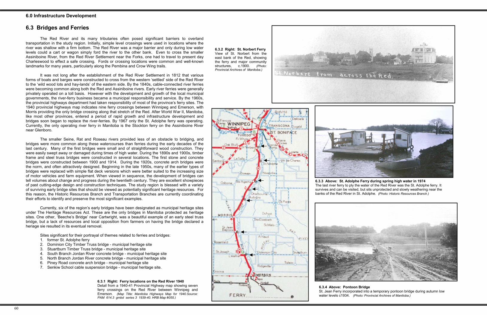
6.3.1 Right: Ferry locations on the Red River 1940Detail from a 1940-41 Provincial Highway map showing sevenferry crossings on the Red River between Winnipeg andEmerson. (Map Title: Manitoba Highways Map for 1940.Source:PAM 614.3 gmbd series 3 1939-40. HRB Map #055.)
6.3.3 Above: St. Adolphe Ferry during spring high water in 1974The last river ferry to ply the water of the Red River was the St. Adolphe ferry. Itsurvives and can be visited, but sits unprotected and slowly weathering near thebanks of the Red River in St. Adolphe. (Photo: Historic Resources Branch.)
6.3 Bridges and Ferries
The Red River and its many tributaries often posed significant barriers to overlandtransportation in the study region. Initially, simple level crossings were used in locations where theriver was shallow with a firm bottom. The Red River was a major barrier and only during low waterlevels could a cart or wagon simply ford the river to the other bank. Even to cross the smallerAssiniboine River, from the Red River Settlement near the Forks, one had to travel to present dayCharleswood to effect a safe crossing. Fords or crossing locations were common and well-knownlandmarks for many years, particularly along the Pembina and Crow Wing trails.
It was not long after the establishment of the Red River Settlement in 1812 that variousforms of boats and barges were constructed to cross from the western ‘settled’ side of the Red Riverto the ‘wild wood lots and hay-lands’ of the eastern side. By the 1840s, cable-connected river ferrieswere becoming common along both the Red and Assiniboine rivers. Early river ferries were generallyprivately operated on a toll basis. However with the development and growth of the local municipalgovernments, the river-ferry business became a municipal responsibility and service. By the 1960s,the provincial highways department had taken responsibility of most of the province’s ferry sites. The1940 provincial highways map indicates nine ferry crossings between Winnipeg and Emerson, withMorris providing the only bridge crossing along that stretch of the Red. After World War II, Manitoba,like most other provinces, entered a period of rapid growth and infrastructure development andbridges soon began to replace the river-ferries. By 1967 only the St. Adolphe ferry was operating.Currently, the only operating river ferry in Manitoba is the Stockton ferry on the Assiniboine Rivernear Glenboro.
The smaller Seine, Rat and Roseau rivers provided less of an obstacle to bridging, andbridges were more common along these watercourses than ferries during the early decades of thelast century. Many of the first bridges were small and of straightforward wood construction. Theywere easily swept away or damaged during times of high water. During the 1890s and 1900s, timberframe and steel truss bridges were constructed in several locations. The first stone and concretebridges were constructed between 1900 and 1914. During the 1920s, concrete arch bridges werethe norm, and often attractively designed. Beginning in the late 1950s, many of the earlier types ofbridges were replaced with simple flat deck versions which were better suited to the increasing sizeof motor vehicles and farm equipment. When viewed in sequence, the development of bridges cantell volumes about change and progress during the twentieth century. They are excellent showpiecesof past cutting-edge design and construction techniques. The study region is blessed with a varietyof surviving early bridge sites that should be viewed as potentially significant heritage resources. Forthis reason, the Historic Resources Branch and Transportation Branches are currently coordinatingtheir efforts to identify and preserve the most significant examples.
Currently, six of the region’s early bridges have been designated as municipal heritage sitesunder The Heritage Resources Act. These are the only bridges in Manitoba protected as heritagesites. One other, ‘Beeche’s Bridge’ near Cartwright, was a beautiful example of an early steel trussbridge, but a lack of resources and local opposition from farmers on having the bridge declared aheriage sie resulted in its eventual removal.
Sites significant for their portrayal of themes related to ferries and bridges:1. former St. Adolphe ferry2. Dominion City Timber Truss bridge - municipal heritage site3. Stuartburn Timber Truss bridge - municipal heritage site4. South Branch Jordan River concrete bridge - municipal heritage site5. North Branch Jordan River concrete bridge - municipal heritage site6. Piney Road concrete arch bridge - municipal heritage site7. Senkiw School cable suspension bridge - municipal heritage site.
6.3.2 Right: St. Norbert FerryView of St. Norbert from theeast bank of the Red, showingthe ferry and major communitystructures, c.1900. (Photo:Provincial Archives of Manitoba.)
6.3.4 Above: Pontoon BridgeSt. Jean Ferry incorporated into a temporary pontoon bridge during autumn lowwater levels c1934. (Photo: Provincial Archives of Manitoba.)
61
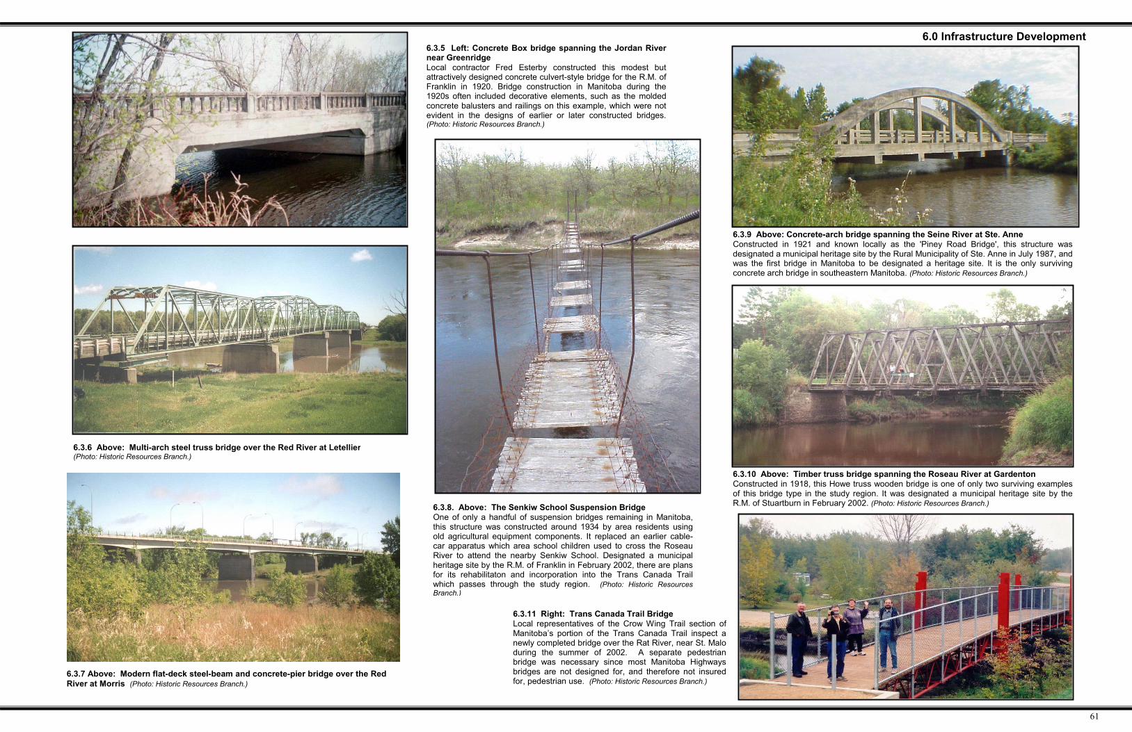
6.0 Infrastructure Development6.3.5 Left: Concrete Box bridge spanning the Jordan Rivernear GreenridgeLocal contractor Fred Esterby constructed this modest butattractively designed concrete culvert-style bridge for the R.M. ofFranklin in 1920. Bridge construction in Manitoba during the1920s often included decorative elements, such as the moldedconcrete balusters and railings on this example, which were notevident in the designs of earlier or later constructed bridges.(Photo: Historic Resources Branch.)
6.3.9 Above: Concrete-arch bridge spanning the Seine River at Ste. AnneConstructed in 1921 and known locally as the 'Piney Road Bridge', this structure wasdesignated a municipal heritage site by the Rural Municipality of Ste. Anne in July 1987, andwas the first bridge in Manitoba to be designated a heritage site. It is the only survivingconcrete arch bridge in southeastern Manitoba. (Photo: Historic Resources Branch.)
6.3.10 Above: Timber truss bridge spanning the Roseau River at GardentonConstructed in 1918, this Howe truss wooden bridge is one of only two surviving examplesof this bridge type in the study region. It was designated a municipal heritage site by theR.M. of Stuartburn in February 2002. (Photo: Historic Resources Branch.)6.3.8. Above: The Senkiw School Suspension Bridge
One of only a handful of suspension bridges remaining in Manitoba,this structure was constructed around 1934 by area residents usingold agricultural equipment components. It replaced an earlier cable-car apparatus which area school children used to cross the RoseauRiver to attend the nearby Senkiw School. Designated a municipalheritage site by the R.M. of Franklin in February 2002, there are plansfor its rehabilitaton and incorporation into the Trans Canada Trailwhich passes through the study region. (Photo: Historic ResourcesBranch.)
6.3.6 Above: Multi-arch steel truss bridge over the Red River at Letellier(Photo: Historic Resources Branch.)
6.3.7 Above: Modern flat-deck steel-beam and concrete-pier bridge over the RedRiver at Morris (Photo: Historic Resources Branch.)
6.3.11 Right: Trans Canada Trail BridgeLocal representatives of the Crow Wing Trail section ofManitoba’s portion of the Trans Canada Trail inspect anewly completed bridge over the Rat River, near St. Maloduring the summer of 2002. A separate pedestrianbridge was necessary since most Manitoba Highwaysbridges are not designed for, and therefore not insuredfor, pedestrian use. (Photo: Historic Resources Branch.)