6 biodiversity conservation through land use planning · 6 biodiversity conservation through land...
TRANSCRIPT
Directions Paper on the Integration of NRM and Land Use Planning
66
6 Biodiversity conservation through land use planning
6.1 Introduction
A detailed case study example is presented in this chapter, to demonstrate how a particular NRM issue - biodiversity conservation - can be addressed through the Western Australian land use planning system. EnviroPlanning has focused on biodiversity conservation in response to local government interest and concern about the extensive clearing of native vegetation in the South West, particularly clearing on the Swan Coastal Plain for urban development in Perth and Bunbury.
Most of the discussion in this chapter relates to the conservation of terrestrial biodiversity through land use planning in South West Western Australia. That is not to say that biodiversity in other areas of the State is less important, but the South West is internationally recognised for its biodiversity values and significant pressures for land development.
First in this chapter, biodiversity conservation is presented as a significant issue for Western Australia. Second, an overview of the main legislation, policies and responsibilities is presented to establish biodiversity as a relevant consideration in land use planning. Third, a summary of local government biodiversity conservation projects is presented, including discussion on the integration of local biodiversity strategies into local planning strategies. Finally, this chapter outlines opportunities and constraints for local governments to achieve effective biodiversity conservation outcomes through land use planning.
6.2 Biodiversity and its conservation
Biological diversity, or biodiversity, is a term used to describe the variety of nature. Biodiversity covers marine, terrestrial, subterranean and aquatic life and implies a highly complex system of interacting entities that occur over a range of temporal and geographic (from local to global) scales (DEC, 2006). The National Strategy for the Conservation of Australia’s Biological Diversity defines biodiversity as:
‘The variety of life forms - the different plants, animals and micro-organisms, the genes they contain, and the ecosystems they form. It is usually considered at three levels: genetic diversity, species diversity, and ecosystem diversity.’ (DEST, 1996)
6.2.1 Biodiversity and natural areas
The three levels of biodiversity – genes, species and ecosystems – are interrelated and interdependent. A population of a species is dependent on the genetic variation within it and its ecosystem for survival, and an ecosystem is dependent on the full variety of species that comprise it (Williams et al., 2001). Biodiversity increases when new genetic variation is produced, a new species evolves or an ecosystem forms; and it decreases when the genetic variation within a species decreases, a species becomes extinct or an ecosystem is lost (DEST, 1996).
Biodiversity is contained and conserved within natural areas. The term ‘natural area’ is used to describe any physical area that contains native species or ecological communities in a relatively
Directions Paper on the Integration of NRM and Land Use Planning
67
natural state and hence contains biodiversity (Del Marco et al., 2004). Natural areas can be areas of native vegetation, vegetated or open wetlands (lakes, swamps) or waterways (rivers, streams, creeks and estuaries), springs, rock outcrops, bare ground, caves, coastal dunes or cliffs (Del Marco et al., 2004). Natural areas are areas that have been naturally colonised by living organisms indigenous to that area, and so do not include rehabilitated areas because they do not contain the same level of biodiversity as a natural community that would have once been present in that area (Del Marco et al., 2004).
6.2.2 Biodiversity benefits
Humans are dependent on biological systems and processes for sustenance, health, well-being and enjoyment of life. Many people depend on biodiversity and other natural resources for their livelihoods. Outside the main population centres, most income is derived from agriculture, pastoralism, forestry and mining (Gole, 2006). These industries depend on biodiversity and other natural resources for long-term sustainability.
People living in cities also depend on biodiversity for their well-being. Natural areas provide the following benefits to the community:
• Ecosystemservices-maintainingairquality, soil fertility and water quality;
• Naturalresources-providingfood,medicines and industrial products;
• Educationandresearch-providingopportunities to learn and appreciate nature;
• Spacesforrecreationandinteractionwith nature - maintaining physical and psychological well-being;
• Culturalidentityandspirituality-maintaining human connections with nature.
Biodiversity also has intrinsic value, and many people believe that the present generation has a moral obligation to ensure that the diversity of life on Earth is sustained so that a healthy,
life-supporting planet is provided for future generations.
Surveys of community values and attitudes toward natural areas, undertaken by WALGA and individual local governments in Perth, have highlighted the importance of urban bushland to the local community. For more information, please refer to the Local Nature Spot project on WALGA’s website: www.walga.asn.au/about/policy/pbp/local_nature_spot_project.
6.2.3 Conservation values of Western Australia
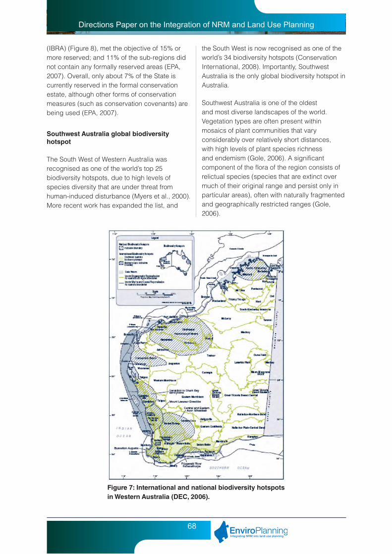
Western Australia’s rich biodiversity can be attributed to the State’s large area, which spans a huge range of geographical, soil and climatic conditions (EPA, 2007). Western Australia has eight of the 15 national biodiversity hotspots (refer to Figure 7), which are areas with many endemic species (species restricted to a certain area) that are experiencing high levels of stress. The hotspots were recognised by the Australian Government in 2003 to increase public awareness of the cost-effectiveness of strategic and timely action to conserve biodiversity (DEWHA, 2008). Information on the biodiversity values, threatening processes and management responses for each bioregion in Western Australia, compiled through the Australian Terrestrial Biodiversity Assessment (ANRA, 2002), is available from: www.anra.gov.au/topics/vegetation/assessment/wa.
There is no overall indicator of the condition of biodiversity, due to the complexities in measuring diversity and health at genetic, species and ecosystem scales (EPA, 2007). A useful surrogate measure for biodiversity is the extent of native vegetation types (e.g. vegetation complexes or vegetation associations) remaining, as a proportion of the original or ‘pre-European’ extent. Reservation of ecosystems can be used as an indicator, with the benchmark of 15% reservation being generally accepted for terrestrial bioregions (EPA, 2007). As of June 2005, only 20% of sub-regions in Western Australia, as defined by the Interim Biogeographic Regionalisation for Australia
Directions Paper on the Integration of NRM and Land Use Planning
68
(IBRA) (Figure 8), met the objective of 15% or more reserved; and 11% of the sub-regions did not contain any formally reserved areas (EPA, 2007). Overall, only about 7% of the State is currently reserved in the formal conservation estate, although other forms of conservation measures (such as conservation covenants) are being used (EPA, 2007).
Southwest Australia global biodiversity hotspot
The South West of Western Australia was recognised as one of the world’s top 25 biodiversity hotspots, due to high levels of species diversity that are under threat from human-induced disturbance (Myers et al., 2000). More recent work has expanded the list, and
Figure 7: International and national biodiversity hotspots in Western Australia (DEC, 2006).
the South West is now recognised as one of the world’s 34 biodiversity hotspots (Conservation International, 2008). Importantly, Southwest Australia is the only global biodiversity hotspot in Australia.
Southwest Australia is one of the oldest and most diverse landscapes of the world. Vegetation types are often present within mosaics of plant communities that vary considerably over relatively short distances, with high levels of plant species richness and endemism (Gole, 2006). A significant component of the flora of the region consists of relictual species (species that are extinct over much of their original range and persist only in particular areas), often with naturally fragmented and geographically restricted ranges (Gole, 2006).

Directions Paper on the Integration of NRM and Land Use Planning
69
Figure 8: Interim Biogeographic Regionalisation of Australia (DEWHA, 2007a).
Overall, about 40% of the pre-European settlement extent of native vegetation remains in the South West (EPA, 2007). The most extensively cleared sub-regions in Western Australia are located within the Southwest Botanical Province: western Avon Wheatbelt (8.6% of native vegetation remaining in 2006); eastern Avon Wheatbelt (18.6%); Dandaragan Plateau (28.9%); Western Mallee (32.8%); Lesueur Sandplain (40.9%); Perth (41.2%); Geraldton Hills (43%); and Recherche (48%) sub-regions (EPA, 2007). Consequently, these sub-regions have a higher proportion of threatened flora and ecological communities than other areas of the State (EPA, 2007).
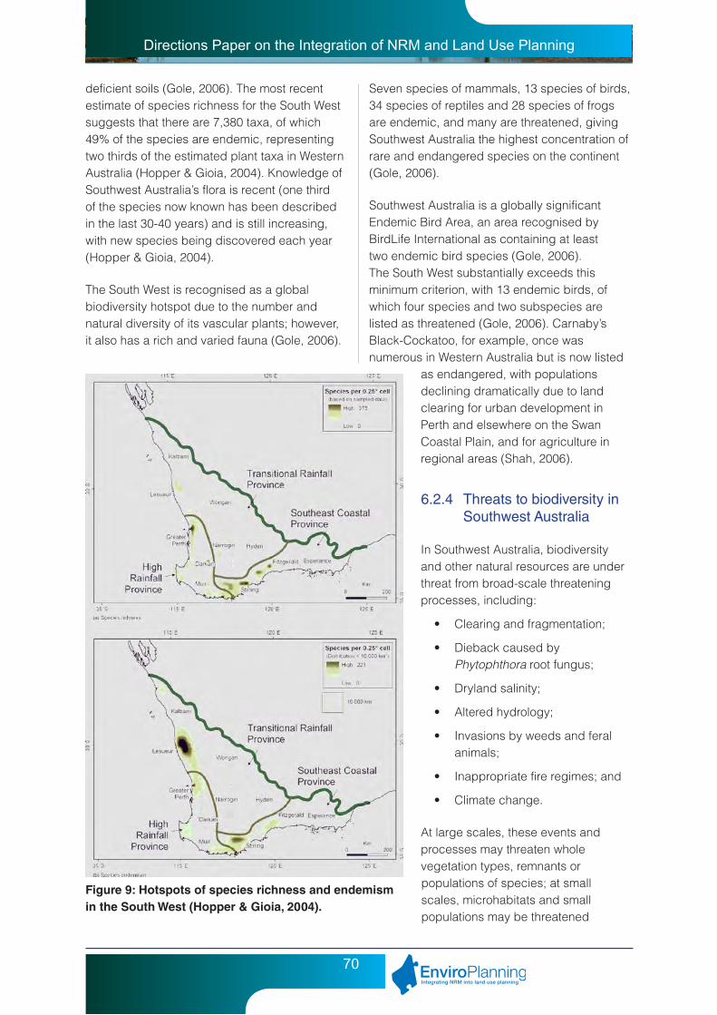
Within the global biodiversity hotspot are smaller floristic hotspots, or areas of exceptional plant diversity (Figure 9). Interestingly, the Swan Coastal Plain portion of the Perth Metropolitan Region is recognised as one of the areas containing extremely diverse floras (EPA, 2007).
The Swan Coastal Plain has high natural values, is the most populous and densely settled area of the State and, together with the Wheatbelt, is the most heavily cleared area of the State (EPA, 2006). Only 22% of the southern Swan Coastal Plain (i.e. the Swan Coastal Plain south of the Moore River) remains vegetated (EPA, 2006). It is estimated that 80% of wetlands on the Swan Coastal Plain have been lost or irreversibly degraded (EPA, 2004), and more than 97% of vegetation on the heavier, more fertile soils on the eastern side of the Swan Coastal Plain has been cleared (CALM, 1990).
Flora and fauna of Southwest Australia
Southwest Australia is characterised by a highly diverse flora – dominated by woody and herbaceous perennials such as myrtles (eucalypts, bottlebrushes and tea trees), proteas (banksias, grevilleas and dryandras), peas and wattles – that has evolved to cope with nutrient
Directions Paper on the Integration of NRM and Land Use Planning
70
deficient soils (Gole, 2006). The most recent estimate of species richness for the South West suggests that there are 7,380 taxa, of which 49% of the species are endemic, representing two thirds of the estimated plant taxa in Western Australia (Hopper & Gioia, 2004). Knowledge of Southwest Australia’s flora is recent (one third of the species now known has been described in the last 30-40 years) and is still increasing, with new species being discovered each year (Hopper & Gioia, 2004).
The South West is recognised as a global biodiversity hotspot due to the number and natural diversity of its vascular plants; however, it also has a rich and varied fauna (Gole, 2006).
Figure 9: Hotspots of species richness and endemism in the South West (Hopper & Gioia, 2004).
Seven species of mammals, 13 species of birds, 34 species of reptiles and 28 species of frogs are endemic, and many are threatened, giving Southwest Australia the highest concentration of rare and endangered species on the continent (Gole, 2006).
Southwest Australia is a globally significant Endemic Bird Area, an area recognised by BirdLife International as containing at least two endemic bird species (Gole, 2006). The South West substantially exceeds this minimum criterion, with 13 endemic birds, of which four species and two subspecies are listed as threatened (Gole, 2006). Carnaby’s Black-Cockatoo, for example, once was numerous in Western Australia but is now listed
as endangered, with populations declining dramatically due to land clearing for urban development in Perth and elsewhere on the Swan Coastal Plain, and for agriculture in regional areas (Shah, 2006).
6.2.4 Threats to biodiversity in Southwest Australia
In Southwest Australia, biodiversity and other natural resources are under threat from broad-scale threatening processes, including:
• Clearingandfragmentation;
• DiebackcausedbyPhytophthora root fungus;
• Drylandsalinity;
• Alteredhydrology;
• Invasionsbyweedsandferalanimals;
• Inappropriatefireregimes;and
• Climatechange.
At large scales, these events and processes may threaten whole vegetation types, remnants or populations of species; at small scales, microhabitats and small populations may be threatened

Directions Paper on the Integration of NRM and Land Use Planning
71
(Gole, 2006). Some of these threats (e.g. weed invasion) can be controlled, but other factors (e.g. climate change) exist outside the realm of the land manager’s control (Del Marco et al., 2004). Threats to biodiversity not only come from biological and physical processes, but also from institutional issues. Foremost amongst these problems is the failure to adequately value biodiversity in decision-making, and this is exacerbated by shortcomings in knowledge of biodiversity and the lack of commitment and capacity to manage ongoing threats (EPA, 2007).
Land clearing in Southwest Australia
Removal of native vegetation, both historic and current, is a major threatening process affecting biodiversity in Western Australia. It includes the traditional concept of clearing, but also involves other substantial damage to native vegetation (e.g. burning, overgrazing, and draining or flooding of land) which results in the removal of at least some native vegetation, and can result in degradation or loss of whole ecosystems (EPA, 2007). The loss of habitat area through clearing is currently the primary cause of declines in species and populations worldwide (Millennium Ecosystem Assessment, 2005).
Removal of native vegetation has obvious environmental implications, but it also has significant social and economic implications. In some parts of Western Australia (especially the Wheatbelt and parts of the Swan Coastal Plain), native vegetation has been cleared beyond safe ecological limits (EPA, 2007). Continued clearing will result in loss of biodiversity and extinctions, with fragmented habitats becoming more susceptible to climate change, disease, and invasion by weeds and introduced animals (EPA, 2007). Salinisation of land and inland waters, altered water regimes, soil erosion, eutrophication and increased greenhouse gas emissions are all direct consequences of clearing native vegetation (EPA, 2007).
Land clearing destroys biodiversity, resulting in the direct loss of plant and animal species and destruction of habitat. Removal of large areas
of native vegetation fragments the landscape, leaving behind small and unconnected remnants. Habitat fragmentation and associated degradation due to ‘edge effects’ (such as weed invasion) reduces habitat for individual species and isolates the species that live in an area. The ability of native animals and plants to disperse across landscapes is affected, as is the ability of populations to re-colonise areas after disturbance or mortality (Del Marco et al., 2004). This generally results in the continuing loss of species long after land is initially cleared (Gole, 2006).
Historically, widespread clearing occurred for development of intensive agriculture in the South West, namely wheat and sheep farming (EPA, 2007). Since the 1980s agricultural expansion has slowed and clearing controls have been enforced; but recent expansion of the wine and plantation industries has renewed clearing activity in small pockets of the South West (EPA, 2007). Most land clearing since the 1980s has been undertaken to accommodate population increases and associated demand for housing (EPA, 2007). Urban expansion has increased dramatically around Perth and other major regional centres on the South West coast (EPA, 2007). Continued loss of native vegetation in the Perth Metropolitan Region is forecast as many areas have been zoned urban in the planning system but have not yet been developed (EPA, 2007).
Land clearing for urban development is an increasing pressure on biodiversity in Southwest Australia, especially in the Perth Metropolitan Region and around other regional centres on the Swan Coastal Plain. In the City of Wanneroo, for example, 1,192 hectares of native vegetation was cleared between 2001 and 2005, representing around 30% of the total amount of native vegetation cleared within the Perth Metropolitan Region during this period (PBP, 2007). Outside of the metropolitan region, 40% of local governments in the South West have less than 15% of the pre-European extent of native vegetation remaining (Shepherd et al., 2001). Subdivision for rural-residential developments in these areas of the South West,

Directions Paper on the Integration of NRM and Land Use Planning
72
with the associated clearing for infrastructure, stocking and other mismanagement of land, is causing significant degradation of natural areas, often in already highly cleared landscapes.
6.2.5 Conservation planning in Southwest Australia
Biodiversity is conserved through the identification, retention, protection and management of natural areas. From a biodiversity point of view, protecting land from being cleared is more important than revegetating areas where native habitat has been lost (EPA, 2008), as it can take five to ten decades for soils, vegetation and wildlife to be brought back to sustainable levels (ABC, 2001).
The EPA has been particularly concerned with the identification and protection of regionally significant natural areas since its inception in 1972, when it set up the ‘Conservation Through Reserves’ Committee to study the provision of a set of reserves representing the major communities of natural ecosystems in 12 regions or ‘systems’ of Western Australia (EPA, 2006). The Systems reports were produced in the 1970s and early 1980s. Subsequently, the whole of Australia was divided into natural regions through IBRA (refer to Figure 8), which is now used to guide conservation planning.
EPA Guidance Statement No. 10 applies specifically to the System 6 area and the Swan Coastal Plain Bioregion portion of the System 1 area (refer to Section 6.4.4). The Swan Coastal Plain Bioregion is the focus for a large number of development proposals brought to the EPA for the assessment of their environmental impacts. To deal with these in a proactive manner, the EPA began an update of System 6 in 1994. The update focused on the southern Swan Coastal Plain, with the objective of reviewing the conservation recommendations for this region to take account of the more recent and much improved information available on flora and fauna. In 1996 this program was split, with priority given to the Perth Metropolitan Region of the Swan Coastal Plain through the Perth’s
Bushplan project, which was completed with the release of Bush Forever in 2000 (refer to Section 6.4.7).
Conservation planning is dependent on the availability of quality information on biodiversity, particularly at the regional scale. The EPA recognises there is a need for the update of the remainder of System 6 and part System 1 area to be completed, as non-metropolitan areas of the South West are under increasing pressure for urban development. An update of the remainder of the Swan Coastal Plain in the System 6 and System 1 areas is currently being undertaken through the Swan Bioplan project, which will greatly assist planning for biodiversity conservation in coastal areas south of Perth.
Role of land use planning in biodiversity conservation
Land use planning has an important role in achieving biodiversity conservation outcomes in Western Australia. As outlined in Section 6.2.3, extensive areas of native vegetation exist outside the formal conservation reserve system – areas referred to as ‘off-reserve’. Biodiversity conservation involves the retention, protection and management of natural areas in reserves and off-reserves, affecting both public and private land. The land use planning system can achieve conservation outcomes through the identification and protection of natural areas with significant biodiversity values, by directing development away from natural areas, and by controlling the impacts of land uses on these areas. These issues are further explored in Section 6.6, including opportunities to address biodiversity conservation through land use planning at the local government level.
Directions Paper on the Integration of NRM and Land Use Planning
73
6.3 Biodiversity conservation at the international and national scales
6.3.1 Convention on biological diversity
Biodiversity conservation is a global issue and is best confronted through multilateral cooperation (DEWHA, 2007b). Australia can take action to conserve its own biodiversity and contribute to the conservation and ecologically sustainable use of natural resources on a global scale (DEWHA, 2007b). In recognition of this, Australia is party to the Convention on Biological Diversity (CBD), an international treaty to sustain the rich diversity of life on Earth (SCBD, 2007). The CBD is a key agreement of the comprehensive strategy for sustainable development adopted by world leaders at the 1992 Earth Summit in Rio de Janeiro (SCBD, 2007). The CBD establishes three main goals: the conservation of biological diversity, the sustainable use of its components, and the fair and equitable sharing of the benefits from the use of genetic resources.
In April 2002, the parties to the CBD committed to achieve by 2010 a significant reduction of the current rate of biodiversity loss at the global, regional and national levels (SCBD, 2007). The 2010 Biodiversity Target is a strong international commitment to reduce the current rate of biodiversity loss. Land clearing and fragmentation is recognised as a major threat to biodiversity, so the Western Australian land use planning system can play a significant role in achieving the Australian Government’s commitments under the CBD.
6.3.2 Environment Protection and Biodiversity Conservation Act
The Environment Protection and Biodiversity Conservation Act 1999 (EPBC Act) is the Australian Government’s central piece of environmental legislation, which is administered by the Department of Environment, Water, Heritage and the Arts (DEWHA). The objectives of the EPBC Act include providing for the
protection of the environment (especially matters of national environmental significance), conserving Australian biodiversity, and providing a streamlined national environmental assessment and approvals process.
The EPBC Act aims to protect Australia’s biodiversity through:
• Identificationandlistingofspeciesandecological communities as threatened;
• Developmentofconservationadviceandrecovery plans for listed species and ecological communities;
• Developmentofaregisterofcriticalhabitat;
• Recognitionofkeythreateningprocesses;and
• Reducingtheimpactsoftheseprocessesthrough threat abatement plans.
The EPBC Act provides a legal framework for the protection and management of nationally and internationally important flora, fauna, ecological communities and heritage places, which are defined in the Act as matters of “national environmental significance”. These include World Heritage properties, National Heritage places, Ramsar wetlands, listed threatened species and ecological communities, and migratory species protected under international agreements.
Under the EPBC Act, a person who proposes to take an action which will have or is likely to have a significant impact on a matter of national environmental significance is responsible for referring the action to the Minister for the Environment, Heritage and the Arts for a decision as to whether an assessment is required. Information on the Federal Government’s environmental assessment process is available from www.environment.gov.au/epbc/assessments. It is important to note, however, that only three of the 1,504 decisions that have been assessed under the EPBC Act have led to approvals not being granted (DEH, 2005).

Directions Paper on the Integration of NRM and Land Use Planning
74
On 31 October 2008, the Minister for the Environment, Heritage and the Arts commissioned an independent review of the EPBC Act, in accordance with Section 522A of the Act which requires it to be reviewed every 10 years from its commencement. The independent review will assess the operation of the EPBC Act and the extent to which its objects have been achieved. Information on the independent review of the EPBC Act, including a discussion paper prepared by DEWHA and public submissions received, is available from: www.environment.gov.au/ epbc/review.
Relevance to land use planning in Western Australia
Currently, 339 flora taxa (12 extinct, 9 critically endangered, 207 endangered and 111 vulnerable), 118 fauna taxa (14 extinct, 4 critically endangered, 22 endangered and 78 vulnerable) and 16 ecological communities (all endangered) from Western Australia are listed under the EPBC Act. Of the extant taxa (still in existence), 313 flora taxa and 49 fauna taxa are endemic to Western Australia, and most are confined to the South West.
A bilateral agreement exists between the Commonwealth and Western Australian Government in respect to environmental impact assessment under the EPBC Act. The purpose of the agreement is to minimise the need for assessment under both the Commonwealth and State’s environmental legislation. The bilateral agreement for Western Australia, signed in 2002, means that the normal assessment processes under the EPBC Act will not apply to an action which is assessed by the EPA at the level of Public Environmental Review (PER) or Environmental Review and Management Programme (ERMP).
Details of heritage places, species, ecological communities and wetlands listed under the EPBC Act are available from www.environment.gov.au/epbc/about/lists.html. Important information from the online database relevant to land use planning includes the legal status, geographic distribution, population records,
preferred habitat, and survey guidelines for protected species (such as the Carnaby’s Black-Cockatoo and the Western Ringtail Possum in Southwest Australia). Mapping of core habitat for threatened species is being undertaken through a Federal program for areas under pressure for urban development from the Bunbury region southwards. This information will greatly assist land use planning, as it is difficult to plan for the protection of habitat when it has not been spatially defined.
6.3.3 National strategy for biodiversity conservation
The National Strategy for the Conservation of Australia’s Biological Diversity (the National Strategy) is the primary policy for the conservation of Australia’s biodiversity. It has been prepared in response to Article 6 of the Convention on Biological Diversity, which obliges all parties to develop and implement a National Biodiversity Strategy and Action Plans. Key components of the National Strategy include: 1) conservation of biodiversity across Australia; 2) integrating biodiversity conservation and NRM; 3) managing threatening processes; 4) improving knowledge; 5) involving the community; and 6) Australia’s international role.
The National Strategy adopts several principles as a basis for its objectives and actions, including:
• Biodiversityisbestconservedin-situ(initsnatural state);
• Thecausesofsignificantlossofbiodiversity should be anticipated, prevented and managed;
• Lackoffullknowledgeshouldnotbeanexcuse for postponing action to conserve biodiversity; and
• Acomprehensive,adequateandrepresentative (CAR) system of ecologically viable protected areas should be established and integrated with the management of biodiversity off-reserve.

Directions Paper on the Integration of NRM and Land Use Planning
75
Objective 1.5 ‘Strengthen off-reserve conservation of biological diversity’, Action 1.5.2 ‘Urban conservation’ of the National Strategy is particularly relevant to land use planning in Southwest Australia:
‘Promote the conservation of biological diversity in urban areas by:
a. encouraging retention of habitat;
b. improving strategic planning and infrastructure coordination so as to enhance the biological diversity of urban areas;
c. seeking ways of reducing fringe development and focusing future development on existing built-up areas in Australian cities;
d. encouraging action by local governments to retain and improve natural ecosystems and to use locally indigenous species for plantings in urban areas;
e. integrating biological diversity conservation considerations into relevant policies and programs such as the Building Better Cities program.’ (DEST, 1996)
Bush Forever and the Perth Biodiversity Project are two Western Australian initiatives (discussed further in Section 6.4.7 and 6.5) that aim to implement the National Strategy’s actions, relevant to the conservation of biodiversity in urban areas, through land use planning.
6.3.4 National targets for biodiversity conservation
The National Objectives and Targets for Biodiversity Conservation 2001-2005 (the National Targets) aim to:
• Preventclearingofecologicalcommunities with less than 30% of the original extent remaining;
• Protectarepresentativesampleofeachbioregion within the National Reserve System, Indigenous Protected Areas or private land managed for conservation under a conservation agreement;
• Recoverecologicalcommunitieswithlessthan 10% of the original extent remaining;
• Establisheffectiveincentivemechanismsto support the protection of biodiversity off-reserve; and
• Protectthreatenedspeciesandecologicalcommunities.
The 30% and 10% threshold levels (Figure 10) recognised by the National Targets are reflected in State government policy for Western Australia, and are therefore used to guide planning and decision making. EPA Position Statement No. 2 Environmental Protection of Native Vegetation in Western Australia acknowledges that: (i) 30% of the original extent of each vegetation type is regarded as the threshold level below which species loss appears to accelerate exponentially at an ecosystem level; and (ii) 10% of the original extent of each vegetation type is regarded as the level representing ‘endangered’.
Figure 10: Biodiversity loss in relation to native vegetation (Del Marco et al., 2004).

Directions Paper on the Integration of NRM and Land Use Planning
76
6.4 Legislative and policy framework for biodiversity conservation in WA
The basis for biodiversity conservation through land use planning in Western Australia is derived from a range of international agreements, Australian and State government legislation, and statutory and non-statutory policies and strategies at the national and State levels. The concept of biodiversity encompasses many different facets of the natural environment; thereby involving many different pieces of legislation and statutory and non-statutory policies of the EPA, the WAPC, and the State Government. The main Acts of Parliament and State government policies governing biodiversity conservation in Western Australia are outlined in the following sections.
6.4.1 Wildlife Conservation Act
The Wildlife Conservation Act 1950, administered by the DEC, provides for the protection of native flora and fauna in Western Australia. The Act gives protection against the “taking” of native flora and fauna, controls “dealings” in native flora and fauna, and specifies licensing requirements.
Listed threatened plants and animals appear in wildlife conservation notices, published annually by the Western Australian Government Gazette (EPA, 2007). Threatened plants and animals are ranked as ‘critically endangered’, ‘endangered’ or ‘vulnerable’, using criteria set out by the International Union for Conservation of Nature (EPA, 2007). Currently there are 379 threatened plant species (Declared Rare Flora) and 204 threatened animal species in Western Australia, and 14 plant species and 18 animal species are thought to be extinct or destroyed (EPA, 2007).
Whilst Western Australia’s threatened species are listed as threatened according to legislation, a non-statutory list will be maintained for threatened ecological communities (TECs)
until there is legislative change. The DEC’s Species and Communities Branch is custodian of databases providing distributional data on threatened species and communities. The DEC has been identifying and informally listing TECs for 13 years, and 173 ecological communities are currently entered into the DEC’s TEC database. Of these TECs, 21 have been endorsed by the Director of Nature Conservation as ‘critically endangered’, 17 as ‘endangered’, 28 as ‘vulnerable’, three as ‘presumed totally destroyed’, and the remainder are either awaiting endorsement as threatened or are allocated to one of five priority lists.
Proposed Biodiversity Conservation Act
It has been recognised for some time that the Wildlife Conservation Act, the principal Western Australian legislation relating directly to biodiversity conservation, is out of date and in need of reform (Government of Western Australia, 2002). The Government made a priority commitment prior to the last election to introduce modern biodiversity conservation legislation - a Biodiversity Conservation Bill to replace the Wildlife Conservation Act (Government of Western Australia, 2002). Despite releasing a consultation paper on this matter in 2002, the State Government is yet to introduce a Biodiversity Conservation Bill for Western Australia.
It is proposed that the Biodiversity Conservation Act will:
• Strengthenprotectionofidentifiedthreatened species, and extend this protection to threatened ecological communities;
• Ensurethatdecisionstospeciallyprotectspecies and ecological communities are made in accordance with clear statutory criteria and on the basis of advice from an independent, expert Threatened Species and Communities Scientific Committee;
• Placespecialrestrictionsonthecircumstances in which licences to harm threatened species or ecological communities can be granted;
Directions Paper on the Integration of NRM and Land Use Planning
77
• Improveenforcementmechanisms,including increased penalties and the power for the Minister for the Environment to issue conservation orders to ensure site specific protection of threatened species or ecological communities;
• Includecontrolsonenvironmentalpestsand weeds and more effective controls on the importation of species that may become pests or weeds;
• Providegreatlyincreasedpenaltiesforunauthorised exports of animals, and extend export controls to plants and other biota;
• ProvidethattheMinistermay,ontherecommendation of the Threatened Species and Communities Scientific Committee, list key threatening processes;
• Providethatonceakeythreateningprocess is listed, regulations may be made to control that threatening process, where it is impacting on biodiversity conservation; and
• Providestatutorybackingtonatureconservation covenants under which landholders can voluntarily protect the biodiversity on their land in perpetuity.
A particular goal of the State Government will be for the proposed new Biodiversity Conservation Act to meet criteria for accreditation to allow State implementation of relevant parts of the EPBC Act, which would provide for greatly simplified and more certain application of biodiversity conservation controls (Government of Western Australia, 2002).
6.4.2 Conservation and Land Management Act
The Conservation and Land Management Act 1984 (CALM Act), administered by the DEC, applies to all land under the control of the Conservation Commission including State forest, timber reserves, national parks, conservation parks, and nature reserves. These areas are specially protected under the Act, and are
recognised in the EPA’s policies, including those relating to land use planning.
The CALM Act establishes the Conservation Commission, which has a primary function of advising the Minister for the Environment on the development of policies for the conservation and management of biodiversity throughout the State. In the CALM Act, “biodiversity” means the variability among living biological entities and the ecosystems and ecological complexes of which those entities are a part, and includes diversity within and between native species, diversity of ecosystems, and diversity of other biodiversity components (including habitats, ecological communities, genes, and ecological processes).
Under the CALM Act, the DEC is responsible for the conservation and protection of flora and fauna throughout the State. The DEC is also responsible for research into the conservation and protection of flora and fauna, and the taxonomy of flora and introduced plants; and is required to promote and encourage rehabilitation of land and conservation of biodiversity throughout the State.
6.4.3 Environmental Protection Act
As outlined in Section 3.3.1 of this report, the Environmental Protection Act 1986 (EP Act) is the principal piece of legislation governing environmental protection in Western Australia. The EP Act is administered by the EPA, with support from the DEC. The main purposes of the EP Act are to: (i) establish the EPA; (ii) provide for conservation, preservation, protection, enhancement and management of the environment; and (iii) deal with prevention, control and abatement of pollution and environmental harm. In the EP Act, “environmental harm” means direct or indirect harm to the environment involving (among other things) removal or destruction of, or damage to native vegetation or the habitat of native vegetation or indigenous animals.
One of the key principles of the EP Act is the principle of the conservation of biological

Directions Paper on the Integration of NRM and Land Use Planning
78
diversity and ecological integrity. With respect to this principle, the EP Act provides for the assessment of environmentally significant projects by the EPA (Part IV), it contains provisions that protect native vegetation and allow for approved clearing activities (Part V Division 2), and it provides for “vegetation conservation notices” to be issued (Section 70).
Environmental impact assessment
Environmental impact assessment (EIA) of planning schemes and development proposals, as discussed in Section 4.3.2, has the potential to achieve significant outcomes for biodiversity conservation through land use planning.
Section 38 of the EP Act requires that all proposals likely to have a significant effect on the environment (such as subdivision or development of land that would result in clearing of natural area with high conservation significance) be referred to the EPA for assessment. Proposals that have environmental impacts that can be managed by enforceable requirements, or are in accordance with an assessed scheme that has had all environmental issues previously assessed, are not required to be referred to the EPA. The EPA may decide not to undertake formal assessment of a proposal referred to it because it is deemed that environmental impacts can be appropriately managed by other processes, including through the land use planning system.
Under Section 38 of the EP Act, the EPA may also assess a “strategic proposal”, which is a proposal that involves future stages that are likely to have a significant effect on the environment, or if implemented in combination with each other are likely to have a significant effect on the environment. Referral of a strategic proposal is usually by the proponent on a voluntary basis and is initiated through discussions with the EPA. The EPA has not yet assessed a land use planning related proposal as a strategic proposal; however, the opportunity exists for this to occur in the future.
In 1996, the EP Act was amended to introduce a requirement (under Section 48A) for the EPA to decide whether or not schemes referred to it are to be assessed. Section 48A of the EP Act applies to new regional and local planning schemes, and scheme amendments (e.g. rezoning of land from rural to urban, which would result in clearing of natural area with high conservation significance). In deciding the level of assessment, the EPA determines whether environmental impacts can be adequately managed through other processes, including through the land use planning system.
The EPA may decide to undertake a formal assessment where the scheme or amendment may result in a significant impact on the environment. The result of EIA is often a revised proposal and some environmental conditions which relate to the future development of the land. Where the impact of the scheme or amendment is not considered to be significant, or can be adequately managed through other processes, a formal assessment is not undertaken, but the scheme is deemed “assessed” (with or without advice). It must be noted that if a scheme is deemed assessed, it cannot be assessed again under Section 48A of the EP Act.
The majority of schemes and amendments are not formally assessed by the EPA, often because the amendments are small enough not to be considered to have a significant effect on the environment. Also, the EPA may not formally assess schemes or amendments because there is not enough information available at the time of rezoning regarding the future scale or forms of development for the impacts to be adequately assessed. In these instances, the EPA may “defer” consideration of particular factors until a later stage in the planning process.
Matters affecting the effectiveness of environmental impact assessment
As discussed in Section 4.3.2, there is a common misconception amongst planners that it is the sole or primary responsibility of the EPA to address NRM matters, including biodiversity
Directions Paper on the Integration of NRM and Land Use Planning
79
conservation, through the EIA process. The outcomes of EIA seem to be misinterpreted by planners in many situations, regardless of whether or not the EPA undertakes formal assessment of a scheme or proposal:
• IftheEPAassessesaschemeorproposal, planners often assume that all NRM issues have been addressed through environmental management commitments and do not need further attention through the land use planning process. For example, ‘Alkimos-Eglinton’ MRS Amendment 1029/33 was formally assessed by the EPA and resulted in a substantial amount of additional natural area being conserved in Parks and Recreation and Public Purposes reserves. Whilst this has improved biodiversity conservation through regional reservation, the local government may find it difficult to retain additional natural area at subsequent stages of the planning process as this was not recognised in the EPA’s recommendations. It has been suggested that improved wording of EPA recommendations could go some way towards addressing this issue in the future.
• IftheEPAdoesnotassessaschemeorproposal, planners often assume that the site subject to the proposed land use or development does not contain any significant natural features that need to be managed through the land use planning process. For example, ‘East Landsdale Precinct 64’ MRS Amendment 1089/33 was not formally assessed by the EPA. Unfortunately, the DEC/EPA provided only general advice on biodiversity considerations for the site. The retention and protection of under-represented vegetation complexes, threatened ecological communities and wetlands will need to be addressed through the structure planning process coordinated by the local government.
Key recommendations of this directions paper that aim to improve the role of EIA in land use planning in order to achieve NRM outcomes (including biodiversity conservation), include:
• EstablishajointapproachbytheEPAand the WAPC to address NRM matters through land use planning, by preparing and implementing a MoU to establish agreement on agency expectations, environmental planning priorities, and suitable environmental conditions and advice.
• Introducenewprocessestoimprovethe DPI’s consideration of NRM in land use planning, by developing and implementing a procedures manual for internal and external planning processes relevant to NRM.
• SupportimplementationofEPApolicyin land use planning, by promoting and allocating resources for implementation of EPA Guidance Statement No. 33.
Environmental advice
An alternative to EIA is the provision of advice by the EPA to the Minister for Environment, under Section 16(e) of the EP Act. This approach was adopted by the DEC/EPA, in conjunction with the DPI/WAPC, for the preparation of the Preston Industrial Park structure plan. A similar approach is now being employed for strategic environmental planning for the coastal strip between Dawesville (south of Mandurah) and Binningup (north of Bunbury), with scientific studies being funded through the EnviroPlanning Local Government Partnership Program.
Native vegetation protection and clearing
Under Part V Division 2 of the EP Act, the clearing of native vegetation in Western Australia is an offence unless a permit is held or a valid exemption applies. In making a decision on a clearing permit application, the DEC must have regard to the EP Act’s clearing principles, planning instruments, or other relevant matters. The clearing principles (contained in Schedule 5 of the EP Act) are:

Directions Paper on the Integration of NRM and Land Use Planning
80
‘Native vegetation should not be cleared if-
(a) it comprises a high level of biological diversity;
(b) it comprises the whole or a part of, or is necessary for the maintenance of, a significant habitat for fauna indigenous to Western Australia;
(c) it includes, or is necessary for the continued existence of, rare flora;
(d) it comprises the whole or a part of, or is necessary for the maintenance of, a threatened ecological community;
(e) it is significant as a remnant of native vegetation in an area that has been extensively cleared;
(f) it is growing in, or in association with, an environment associated with a watercourse or wetland;
(g) the clearing of the vegetation is likely to cause appreciable land degradation;
(h) the clearing of the vegetation is likely to have an impact on the environmental values of any adjacent or nearby conservation area;
(i) the clearing of the vegetation is likely to cause deterioration in the quality of surface or underground water; or
(j) the clearing of the vegetation is likely to cause, or exacerbate, the incidence of flooding.’
There are two classes of exemptions for clearing permits: (i) routine, day to day activities that have a low impact are exempted through the EnvironmentalProtection(ClearingofNativeVegetation)Regulations2004 (the Clearing Regulations); and (ii) Schedule 6 of the EP Act allows clearing that is a requirement of a written law or that is approved under another process where clearing impacts have been considered. The latter class of exemptions includes clearing in accordance with a subdivision approval,
development approval or planning approval that is consistent with an assessed scheme. These exemptions assume that clearing impacts were considered through the land zoning (scheme amendment) process. Therefore, it is imperative that local governments, the DPI/WAPC and the DEC/EPA seek to address biodiversity conservation through land use planning.
Notwithstanding the provisions set out under Schedule 6 of the EP Act, exemptions in the Clearing Regulations do not apply in environmentally sensitive areas (ESA). ESA are declared by notice under Section 51B of the EP Act. According to Regulation 6 of the Clearing Regulations, the following areas may be declared as ESA:
(a) a declared World Heritage property;
(b an area that is registered on the Register of the National Estate because of its natural values;
(c) a defined wetland and the area within 50 metres of the wetland;
(d) the area covered by vegetation within 50 metres of rare flora;
(e) the area covered by a threatened ecological community;
(f) a Bush Forever site, except to the extent to which may be cleared under a decision of the WAPC;
(g) the areas covered by the following policies -
(i) the Environmental Protection (GnangaraMoundCrownLand) Policy 1992;
(ii) the Environmental Protection (WesternSwampTortoise)Policy 2002;
(h) the areas covered by the Environmental Protection(SwanCoastalPlainLakes)Policy 1992;
(i) wetlands in the Environmental Protection (SouthWestAgriculturalZoneWetlands)Policy 1998;

Directions Paper on the Integration of NRM and Land Use Planning
81
(j) areas of fringing native vegetation covered by the Environmental Protection (SwanandCanningRivers)Policy1998.
The EP Act establishes offences in relation to unauthorised clearing of native vegetation, including “contravention of clearing permit conditions” (Section 51J), “unlawful clearing” (Section 51C) and “material or serious environmental harm” (Sections 50A and 50B). Responses to clearing offences include written warning, Supreme Court injunction preventing unlawful clearing from continuing, issue of a vegetation conservation notice, revocation or suspension of a clearing permit, or prosecution (with substantial financial penalty). Under Section 70 of the EP Act, for example, the DEC is able to issue a vegetation conservation notice to any land owner or occupier, in order to ensure that no unlawful clearing or further unlawful clearing is undertaken. If unlawful clearing has taken place, the vegetation conservation notice may require the landowner or occupier to repair any damage caused by the clearing, including the re-establishment and maintenance of vegetation to its pre-clearing condition. Importantly, the requirements of the vegetation conservation notice are bound to each successive owner or occupier of the land to which it relates.
A review of the State’s native vegetation clearing legislation (the EP Act and the Clearing Regulations) is currently being undertaken, with the aim of improving processes and environmental outcomes. Information on the review, as well as clearing permit application forms, guidelines, fact sheets, and the interactive Clearing Permit Reports System and Native Vegetation Map Viewer are available online at https://www.dec.wa.gov.au/management-and-protection/native-vegetation/index.html. The map viewer is a particularly useful tool for land use planning, as it displays the current declared ESA in Western Australia.
6.4.4 EPA policies on biodiversity conservation
Position on the protection of native vegetation in Western Australia
EPA Position Statement No. 2 Environmental Protection of Native Vegetation in Western Australia (PS2) provides an overview of the EPA’s position on the clearing of native vegetation in Western Australia, with particular reference to clearing within the ‘agricultural area’ (Figure 11). The EPA’s position is that clearing of native vegetation from agricultural areas in the South West should not continue, other than relatively small areas and where alternative mechanisms for biodiversity protection are addressed. In relation to clearing of native vegetation in other areas of the State, the EPA expects the State Government to take account of the principles and objectives of the National Strategy for the Conservation of Australia’s Biological Diversity prior to making decisions in relation to proposals.
The EPA’s position on protection of native vegetation relates to three key policy areas: (i) clearing in the agricultural area for agricultural purposes; (ii) clearing in the agricultural area where alternative mechanisms address biodiversity; and (iii) clearing in other areas of Western Australia. PS2 outlines key criteria being applied in States where clearing is still occurring, including: (i) 30% of the original extent of each vegetation type is regarded as the ‘threshold level’ below which species loss appears to accelerate exponentially at an ecosystem level; and (ii) 10% of the original extent of each vegetation type is regarded as the level representing ‘endangered’. PS2 also states that the Commonwealth has indicated that, for a State such as Western Australia with known and predictable salinity problems occurring within a very short time after clearing, it would be difficult to defend clearing in areas known to be susceptible to salinisation.
It is important to note that the major regional centres of Geraldton and Albany are included in the ‘agricultural area’ defined by the EPA. According to PS2, clearing in these areas

Directions Paper on the Integration of NRM and Land Use Planning
82
would only be supported by the EPA where alternative mechanisms address biodiversity. EnviroPlanning has provided funding through its Local Government Partnership Program to undertake regional flora and vegetation surveys for the Geraldton and Albany regions in 2008 and 2009. These projects aim to map and describe vegetation associations for the Geraldton and Albany regions, in order to assist the DPI/WAPC and local governments with land use planning, and the DEC/EPA with EIA of schemes and proposals that impact on native vegetation. The three key policy areas of the EPA’s position on protection of native vegetation are provided below.
Clearing in the agricultural area for agricultural purposes
• Furtherreductioninnativevegetationthrough clearing for agriculture cannot be supported.
• Allexistingremnantnativevegetationshould be protected from passive clearing.
• Allexistingremnantnativevegetationshould be actively managed by landholders and managers so as to maintain environmental values.
• Developmentofrevegetationstrategiesata landscape level, including provision of stepping stones, linkages and corridors of native vegetation, should be a priority.
• Non-nativedeep-rootedcropsshouldbeplanted on already cleared land.
Clearing in the agricultural area where alternative mechanisms address biodiversity
In exceptional circumstances, the EPA could consider supporting clearing in the agricultural area if:
• Theproposedlanduseaddressesalternative mechanisms for protecting biodiversity;
• Theareaproposedforclearingisrelatively small;
• Theproposaldemonstratesthatitmeets the basic elements of biodiversity conservation; and
• On-siteandoff-sitelanddegradationwould not be exacerbated.
Clearing in other areas of Western Australia
In assessing a proposal, the EPA’s consideration of biodiversity will include the following:
• Acomparisonofdevelopmentscenarios,or options, to evaluate protection of biodiversity, and demonstration that all reasonable steps have been taken to avoid disturbing native vegetation.
• Noknownspeciesofplantoranimalis caused to become extinct as a consequence of the development and the risks to threatened species are considered to be acceptable.
• Noassociationorcommunityofindigenous plants or animals ceases to exist as a result of the project.
• Therewouldbeanexpectationthata proposal would demonstrate that the vegetation removal would not compromise any vegetation type by taking it below the “threshold level” of 30% of the pre-clearing extent of the vegetation type.
• Whereaproposalwouldresultinareduction below the 30% level, the EPA would expect alternative mechanisms to be put forward to address the protection of biodiversity.
• Thereiscomprehensive,adequateand secure representation of scarce or endangered habitats within the project area and/or in areas which are biologically comparable to the project area, protected in secure reserves.
• Iftheprojectareaislarge,itshouldinclude a comprehensive and adequate network of conservation areas and linking corridors whose integrity and biodiversity is secure and protected.
• Theon-siteandoff-siteimpactsoftheproject are identified and the proponent demonstrates that these impacts can be managed.

Directions Paper on the Integration of NRM and Land Use Planning
83
Guidance for protection of native vegetation on the southern Swan Coastal Plain
EPA Guidance Statement No. 10 Level of Assessment for Proposals Affecting Natural Areas Within the System 6 Region and Swan Coastal Plain Portion of the System 1 Region (GS10) provides guidance for schemes and proposals potentially impacting on regionally significant natural areas within the System 6 Region and Swan Coastal Plain portion of the System 1 Region (Figure 12). GS10 was developed because the Swan Coastal Plain is the focus for the largest number of development proposals brought to the EPA for assessment of environmental impacts. Much of the Swan Coastal Plain is altered to such an extent that all remnant vegetation from many of the vegetation complexes is regionally significant and in need of retention and some level of protection (EPA, 2006). It is important to note that the quality of information on regional biodiversity, and the level of guidance provided by the EPA for biodiversity conservation, is not available for other areas of the State.
GS10 is concerned with proposals to clear or significantly impact on native vegetation or natural areas of regional significance, where this cannot be addressed under other
Figure 11: Western Australia’s agricultural area in EPA Position Statement No. 2 (EPA, 2000).
processes, such as applications for clearing of native vegetation managed under the EP Act. Locally significant natural areas, and areas covered by the Regional Forest Agreement for the South West Forest Region of Western Australia, are outside the scope of GS10. The EPA expects that schemes or proposals impacting on locally significant natural areas in System 6 and the Plain portion of System 1 will be dealt with in a manner that is consistent with the intent of the actions in Bush Forever regarding locally significant bushland.
According to GS10, ‘regionally significant natural areas’ include:
• theConservationEstate(underthecare and control of the Conservation Commission and managed by the DEC);
• System6recommendations(DCE,1983);
• SwanCoastalPlainportionofSystem1recommendations (DCE, 1976);
• BushForeversitesandvegetationcomplexes where 10% or less remains vegetated in the Bush Forever study area or 10% or less is protected for conservation purposes within the Bush Forever study area;
• otherregionallysignificantnaturalareasoutside the Bush Forever study area

Directions Paper on the Integration of NRM and Land Use Planning
84
(refer to strategy and criteria contained in Appendix 3 to GS10);
• wetlandsinA Directory of Important Wetlands in Australia (Environment Australia, 2001) or Conservation category wetlands identified in the DEC’s Geomorphic Wetlands Swan Coastal Plain dataset;
• areasidentifiedbytheEPAasThreatenedor Poorly Reserved Plant Communities outside the Bush Forever study area (EPA, 1994);
• areasclassifiedbyDECasTECs(English& Blyth, 1997 & 1999); and
• areascontainingthreatenedspecies.
There is a common misconception amongst planners, particularly in the Perth Metropolitan Region, that all regionally significant natural areas are ‘protected’ (in Bush Forever sites, Regional Parks or the Conservation Estate)
Figure 12: Area covered by EPA Guidance Statement No. 10 (EPA, 2006).
and all other natural areas are simply ‘locally significant’. The fact is many natural areas that exist outside protected areas (referred to as ‘local natural areas’) meet the State government’s criteria for regional significance. Local governments across the South West are developing local biodiversity strategies to improve the conservation of these local natural areas through land use planning processes.
GS10 states that the target for retention of 30% of the original extent of each vegetation type (established in the National Objectives and Targets for Biodiversity Conservation 2001-2005 and in EPA Position Statement No. 2) may be modified to a 10% target for ‘constrained areas’. The EPA defines constrained areas as urban, urban deferred and industrial zoned land, and land with development approvals in the Bush Forever study area (Swan Coastal Plain portion of the Perth Metropolitan Region) and the Greater Bunbury Region, but expects that these areas will be determined in conjunction
with the DPI. The modified target is problematic in that the proportion of constrained areas increases as additional land is zoned for urban or industrial purposes, so the amount of natural area to be retained decreases. Furthermore, some DEC officers have advised that it is generally accepted that Bush Forever meets the 10% target for Perth, despite the fact that Bush Forever failed to achieve the 10% protection target for all vegetation complexes (including vegetation complexes that have been cleared below 10% of the original extent on the eastern side of the Swan Coastal Plain, and vegetation complexes that exist mainly on private property so were not adequately protected through Bush Forever).

Directions Paper on the Integration of NRM and Land Use Planning
85
Environmental offsets
EPA’s policies on environmental offsets include Position Statement No. 9 Environmental Offsets, Guidance Statement No. 19 Environmental Offsets and Environmental Protection Bulletin No. 1 Environmental Offsets – Biodiversity. ‘Environmental offsets’ is the term used to describe a package of activities undertaken to counteract adverse environmental impacts arising from a development (EPA, 2008). Offsets should only be considered after all steps have been taken to avoid or minimise impacts from development. An environmental offset package may be considered where adverse residual environmental impacts are significant, but not significant enough to make the project unacceptable.
Activities associated with restoring and rehabilitating land directly impacted by development are considered to be necessary on-site environmental management requirements, whereas offset activities are usually undertaken outside the area where the impact occurs (i.e. off-site). Ideally, the environmental values of the offset site should be similar to those being impacted - a concept referred to as ‘like for like’.
In accordance with EPA policies, an environmental offset package should include ‘direct’ and ‘contributing’ offsets, in order to achieve a ‘net environmental benefit’. Suitable offset activities include:
• Directoffsets:restoration,rehabilitation,re-establishment, or acquiring land for conservation.
• Contributingoffsets:protection,removalof threats, management, education, research, or other activities.
‘Acquiring land for conservation’ (direct offset) and ‘protection’ (contributing offset) would seem to be two offset activities that are relevant to biodiversity conservation through land use planning. However, the policy definition of ‘acquiring land for conservation’ refers only to purchasing an offset and transferring the land title into the conservation estate. Also,
the definition of ‘protection’ in the EPA’s offset policies does not relate to the formal protection of land for conservation, but protecting the environment from threats or harm by using barriers or buffers to the offset site (e.g. through fencing of ecosystems). Therefore, the formal protection of land for conservation involving means other than transferring land into the conservation estate - such as reservation or zoning under a planning scheme, or conservation covenanting on private properties - are not explicitly recognised in the EPA’s offset policies.
It also appears that the EPA’s offset policies prioritise activities such as ‘rehabilitation’ and ‘re-establishment’ of degraded areas off-site (direct offsets) over the ‘management’ of intact natural areas (contributing offsets). Rehabilitation has limited benefit to biodiversity when compared with formal protection and management of intact natural areas. In order to improve outcomes from environmental offsets to clearing, it is suggested that local governments work towards the strategic identification of offset sites (e.g. through a local biodiversity strategy), which could potentially act to consolidate offset requirements for multiple projects into a few high-priority natural areas. It is also suggested that the DEC/EPA should broaden the application of its offset policies to achieve formal protection and management of intact natural areas ahead of rehabilitation of degraded land, by way of scheme reservation, zoning, covenanting and preparation and implementation of management plans.
Environmental guidance for planning and development
The protection of Western Australia’s biodiversity is one of the EPA’s priority areas of concern (EPA, 2008). The EPA’s broad principles for maintaining biodiversity and protecting native terrestrial vegetation and flora include:
• Avoidclearing;
• Maintainbiodiversityatsustainablelevels;
• Conservebiodiversityinsitu;
• Preventlossofbiodiversity;

Directions Paper on the Integration of NRM and Land Use Planning
86
• Prepareandimplementregionalstrategiesfor biodiversity protection;
• Protectecologicallinkages;
• Anticipatethreatstobiodiversity;and
• Reintroducenativevegetation.
Part B of EPA Guidance Statement No. 33 Environmental Guidance for Planning and Development (GS33) provides guidance for biodiversity conservation through land use planning. GS33 states the EPA’s objectives:
• Biodiversityconservation-tomaintainthe abundance, diversity, geographic distribution and productivity of all life forms through the avoidance or management of adverse impacts and improvement in knowledge.
• Floraandfauna-tomaintaintheabundance, diversity, geographic distribution and productivity of flora and fauna at the species and ecosystem levels through the avoidance or management of adverse impacts and through improvement in knowledge.
GS33 lists the natural areas that the EPA considers are of high conservation significance, including ‘critical environmental assets’ and ‘high value environmental assets’, that require a high level of protection in Western Australia. The EPA is unlikely to recommend the approval of projects that have significant adverse impacts on these natural areas:
• Stateandregionalconservationareas;
• Areaswhereclearingwouldbeatvariance with clearing principles (Schedule 5 EP Act);
• Ecologicalcommunities;
• Significantfloraandfauna;
• Wetlandsandbuffers;
• Riversandforeshores;
• Landscapeandlandforms;
• Naturalareasofheritagesignificance;and
• OthernaturalareasasacceptedbytheEPA.
GS33 recommends that structure plans, planning schemes and policies incorporate objectives to protect biodiversity, and include measures to protect high value natural areas and ensure appropriate management of natural resources outside conservation areas. GS33 also states that decision-making on subdivisions, land uses and developments should reflect any comprehensive and accredited strategies that address biodiversity protection, avoid unacceptable adverse impacts on regional and local biodiversity, and consider the revegetation of cleared land.
GS33 provides detailed advice and checklists on identifying, protecting and managing natural areas at each level of planning (broad scale, local area, and development). Although comprehensive, the information contained in GS33 may seem overwhelming to planners, even those with environmental science backgrounds. In particular, GS33 does not provide adequate guidance on determining priorities for environmental planning; rather, it provides advice on many different environmental considerations for land use planning. Regional strategic NRM planning workshops for each of the DPI planning regions (a recommended action of this directions paper) should assist in determining priority biodiversity assets and conservation issues, which can then be addressed through the preparation of planning strategies, schemes and structure plans.
Implications of EPA policies for land use planning
EnviroPlanning’s review of the State Planning Framework from an NRM perspective identified that, although the EPA has many policies, position statements and guidance statements on NRM, these documents mainly outline what the EPA considers to be important when making decisions through the EIA process. Since most planning and development proposals are not subject to EIA, the EPA’s policies have limited practical application to the planning and development approvals process. In order for EPA policy and position to be considered by the planning and development approvals system,

Directions Paper on the Integration of NRM and Land Use Planning
87
it needs to be incorporated into planning policies and strategies of the WAPC and local governments.
As outlined in Section 6.4.6, policies on biodiversity conservation consistent with the EPA’s position have been incorporated into the State Planning Framework; however, some gaps remain and should be addressed through future development and review of State planning policies and associated guidelines. Implementation of EPA and WAPC policy on biodiversity conservation will continue to be a challenge, unless there is a move toward establishing whole-of-government commitment and involvement in the issue, supported by adequate resources to integrate biodiversity considerations into land use planning at the regional and local levels.
6.4.5 Planning and Development Act
As outlined in Section 3.3.1, the Planning and Development Act 2005 (P&D Act) is the principal piece of legislation governing land use planning and development in Western Australia. The main purposes of the P&D Act are to: (i) establish the WAPC; (ii) provide for the preparation of State planning policies, region planning schemes, and local planning schemes; (iii) control subdivision and development; and (iv) provide for the acquisition of land. Each of the land use planning instruments has the ability to significantly influence the conservation of biodiversity in Western Australia (further discussed in Section 6.6).
The P&D Act establishes biodiversity as a valid planning consideration in Schedule 7 - Matters which may be dealt with by planning scheme, which incorporates provision for “preservation and conservation” matters, including:
‘(2) Theconservationofthenaturalenvironment of the scheme area including the protection of natural resources, the preservation of trees, vegetation and other flora and fauna, and the maintenance of ecological processes and genetic diversity.’
These matters apply to State planning policies (Section 26(3)), regional planning schemes (Section 34(2)), local planning schemes (Section 69(1)(b)), and conditions of subdivision (Section 138(2)).
Further provision for biodiversity conservation in the P&D Act relates to the preparation of State planning policy in Section 27 - Matters to which Commission is to have regard:
‘(b) conservationofnaturalorculturalresources for social, economic, environmental, ecological and scientific purposes’
Biodiversity conservation through land use planning
The P&D Act provides a strong legislative basis for biodiversity conservation, comparative to the State’s environmental legislation:
• UnliketheWildlifeConservationAct,theP&D Act is not limited to the consideration of threatened species, but provides for the preservation of any vegetation, flora and fauna and the maintenance of ecological processes and genetic diversity.
• Theprotectionofnativevegetationislimited under the EP Act and Clearing Regulations because clearing permits are not required where a planning, subdivision or development approval exists.
• Biodiversityconservationisnotlimitedto or dependent on the outcomes of environmental impact assessment by the EPA, but can be achieved through regional and local planning schemes and conditions of subdivision.
As discussed in Section 4.3.2, there is a common misconception amongst planners that the EPA is wholly or primarily responsible for addressing environmental matters, including biodiversity conservation, when considering land use planning proposals. However, the P&D Act includes biodiversity conservation as a valid planning consideration applicable to State planning policies, regional and local planning schemes, and conditions of
Directions Paper on the Integration of NRM and Land Use Planning
88
subdivision. Therefore, it is imperative that the DPI/WAPC and local governments improve land use planning processes in order to achieve biodiversity conservation outcomes in Western Australia.
6.4.6 State planning policies on biodiversity conservation
EnviroPlanning’s review of the State Planning Framework from an NRM perspective identified that biodiversity matters are addressed through the following policies:
• Protectionofbiodiversity:SPPs2and2.8,DC 3.4, Planning Bulletin 69.
• Preventingorlimitingvegetationclearing(and its effects on environmental values and hydrology): SPPs 2, 2.1, 2.5, 6.1 and 6.3.
• Protectionofhabitatfromdestructionandfragmentation: SPP 2, SPP 2.8.
• Preservation/enhancementofecologicalcorridors: SPPs 2 and 2.8, Planning Bulletin 69.
State Planning Framework Policy
The State Planning Policy No. 1 State Planning Framework Policy (SPP 1) provides the policy and strategy context for decision-making on land use and development in Western Australia. SPP 1 explicitly provides for biodiversity conservation through land use planning, stipulating that planning should contribute to a more sustainable future by:
• Promotingtheconservationofecologicalsystems and the biodiversity they support including ecosystems, habitats, species and genetic diversity;
• Assistingintheconservationandmanagement of natural resources to support environmental quality and sustainable development over the long term;
• Protectingareasandsiteswithsignificanthistoric, architectural, aesthetic, scientific
and cultural values from inappropriate land use and development;
• Adoptingariskmanagementapproachwhich aims to avoid or minimise environmental degradation and hazards; and
• Preventingenvironmentalproblemswhich might arise as a result of siting incompatible land uses close together.
Environment and Natural Resources Policy
Provisions for biodiversity conservation in the P&D Act are strengthened through State Planning Policies No. 2 Environment and Natural Resources Policy (SPP 2) and No. 2.8 Draft Bushland Policy for the Perth Metropolitan Region (SPP 2.8).
SPP 2 is the principal SPP dealing with the integration of NRM into land use planning. Part 5.5 of SPP 2 deals specifically with biodiversity conservation through land use planning, stating that:
Planning strategies, schemes and decision-making should:
(i) Considermechanismstoprotectareas of high biodiversity and conservation value;
(ii) Seektoavoidorminimiseanyadverse impacts, directly or indirectly, on areas of high biodiversity or conservation value as a result of changes in land use or development;
(iii) Assistinestablishingacomprehensive, adequate and representative conservation reserve system throughout the State;
(iv) Safeguardandenhancelinkagesbetween terrestrial and aquatic habitats which have become isolated, including the re-establishment of habitat corridors;
(v) Assistthereturnofareasofhighbiodiversity conservation values through mechanisms including

Directions Paper on the Integration of NRM and Land Use Planning
89
planning controls or conservation covenants;
(vi) Supporttheuseofmanagementplans to protect areas of high biodiversity conservation value in the long term.
SPP 2 defines ‘areas of high biodiversity and conservation value’ as including
• DECestate;
• BiosphereReserves;
• Landcontainingthreatenedfloraorthreatened ecological communities;
• Regionallysignificantvegetationidentifiedin Bush Forever (2000);
• Ramsarwetlands;
• WetlandslistedintheDirectoryofImportant Wetlands in Australia (2001);
• EPPlakes;
• WorldHeritagesites;and
• AreasformallyrecognisedbytheStateGovernment in management plans under the CALM Act, the Regional Forest Agreement 1999, regional planning strategies, EPA Systems reports, and other relevant plans and strategies.
It is important to note that SPP 2 does not provide for the conservation of ecological communities above the 10% and 30% thresholds (recognised by the Federal and State environmental agencies). These are, however, provided for in SPP 2.8 that deals specifically with bushland protection in the Perth Metropolitan Region. Nonetheless, many priority conservation areas that are identified in local biodiversity strategies, being prepared by local governments across the South West, comply with SPP 2’s definition of ‘areas of high biodiversity and conservation value’.
Draft Bushland Policy for the Perth Metropolitan Region
SPP 2.8 is a key commitment under Bush Forever, which aims to provide a statutory policy and implementation framework to address bushland protection and management issues in the Perth Metropolitan Region. The draft SPP was advertised for public comment in mid-2004, and is due to be finalised in early 2009.
SPP 2.8 provides policy measures for ‘Bush Forever Protection Areas’ (as mapped by the WAPC) and ‘Local Bushland’ (defined as all areas of native vegetation outside Bush Forever in the Perth Metropolitan Region). Part 5.3 ‘Local Bushland’ of SPP 2.8 states:
Local government should:
(i)Seektopreparealocalbushlandprotection strategy, which should:
(a) bepreparedaspartofawiderlocalbiodiversitystrategy(whichincludes an assessment of local natural areas, both vegetated and non-vegetated)orsimilar,wherepossible;
(b) bepreparedasacomponentofa wider local planning strategy and as part of a review of a local government town planning scheme; or independent of this review and the local planning strategy where there are significant issues and pressure for land use change;
(c) bebasedonagreedmetropolitan-wide guidelines;
(d) identifyandestablishprocessestoidentify locally significant bushland sites for protection and management based on environmental, social and economic criteria; while also recognising existing approvals and commitments;
(e) identifydecision-makingprocessesand include an implementation strategy to protect those sites recommended for protection and

Directions Paper on the Integration of NRM and Land Use Planning
90
management through a range of mechanisms;
(f) bepreparedinconsultationwithaffected landowners, the broader community, the WAPC and other relevant government agencies;
(g) excludetheConservationCommission of WA-managed conservation estate and Parks and Recreation reserves in the MRS; and
(h) beformallyconsideredandendorsed by Council and the WAPC.
(ii)Considertherecommendationsofalocal bushland protection strategy, biodiversity strategy or similar, that has been formally endorsed by Council and the WAPC, in the preparation of a local government town planning scheme and its amendments, including local planning strategies, local policies, zones and special control areas, as required.
SPP 2.8 states that proposals and decision-making should have regard to the protection of locally significant bushland sites recommended for protection and management as part of a local biodiversity strategy that has been formally endorsed by Council and the WAPC, or prior to formal endorsement of the strategy (as an interim measure) in agreement with the WAPC, relevant government agencies and the affected landowner.
SPP 2.8 also states that there is a general presumption against the clearing of bushland containing:
• Threatenedecologicalcommunitiesandspecies;
• Threatenedorpoorlyreservedplantcommunities;
• Declaredrarefloraorspeciallyprotectedfauna;
• Conservationcategorywetlandsandappropriate buffers;
• Vegetationcomplexesofwhichlessthan10% of the original extent remains;
• Riparianandestuarinefringingvegetation;and
• System6recommendationareasoutsidethe Swan Coastal Plain portion of the Perth Metropolitan Region.
Limitations of SPP 2.8
EnviroPlanning’s review of the State Planning Framework from an NRM perspective identified the following limitations of SPP 2.8:
• Thepolicyidentifiesappropriatesources of information to implement the recommendations of Bush Forever; however, limited information is provided to aid the consideration of local bushland via the planning system.
• Thepolicyishighlycomplexandiswrittenin technical terms. It is unlikely that this draft policy will be easily interpreted by junior planners. The information requirements to support applications are also complex and uncertain.
• Thereislimitedguidanceonhowtoachieve local biodiversity conservation apart from the recommendation to prepare a local bushland strategy and some additional broad measures.
• Theappendixcontainscriteriafornegotiated outcomes. It is recognised that these criteria are required to aid decision making where the land is not proposed for acquisition by the WAPC; however, there is no connection between the criteria and practical outcomes.
• Thepolicyisverycomplexandwould require training to facilitate its implementation by planning officers. It is also likely to require additional guidance for proponents to address all the steps and information necessary to support a proposal in or adjacent to a Bush Forever Protection Area. These reports are then likely to require specialist technical expertise to review.

Directions Paper on the Integration of NRM and Land Use Planning
91
Furthermore, SPP 2.8 does not explicitly recognise that some patches of ‘local’ bushland actually meet criteria for ‘regional’ significance, which may limit the ability of local governments to achieve local biodiversity conservation outcomes through land use planning.
State-wide planning guidance for vegetation protection
Although general policy guidance for biodiversity conservation exists in SPP 2, and more specific guidance for the Perth Metropolitan Region is provided in SPP 2.8, it is necessary for the WAPC to provide clearer policy direction for vegetation protection in other areas of the State. EnviroPlanning’s review of the State Planning Framework identified the need for a State-wide SPP on native vegetation to be prepared. A simple policy is recommended, with clear implementation guidelines for conservation of regional and locally significant natural areas across the State. It is suggested that the new SPP incorporates region-specific measures for biodiversity conservation, including those relevant to the Perth Metropolitan Region that are currently provided in draft SPP 2.8.
Specific guidance is also required for local biodiversity strategies - to assist local governments with preparation, the DPI with assessment, and the WAPC with endorsement. It is suggested that the following matters be addressed in planning guidance for local biodiversity strategies:
• Appropriatecontentandformatofalocalbiodiversity strategy, including clear explanation of what constitutes a ‘local bushland protection strategy’ (referred to in SPP 2.8);
• Definitionofthe‘agreedguidelines’for identifying significant local natural areas (referred to in SPP 2.8), which in practice are generally accepted as the Local Government Biodiversity Planning Guidelines published by WALGA (see Section 6.5.1);
• Mechanismsforconservinglocalnaturalareas through land use planning;
• Proceduresforintegratingthelocalbiodiversity strategy into the local planning strategy, scheme, policies and structure plans;
• Requirementsforstakeholderconsultation; and
• Processforconsiderationandendorsement of local biodiversity strategies by the WAPC, including situations where local biodiversity strategies may be considered and endorsed by the WAPC independent of the local planning strategy and scheme review.
It is suggested that the guidance for local biodiversity strategies be provided through the update of Planning Bulletin 69 (proposed review in 2009/10), and could also be incorporated into the proposed State-wide SPP on native vegetation and associated guidelines to the new SPP.
Recommended action:
• DevelopaState-wideSPPfornativevegetation.
6.4.7 State Government policies and strategies relevant to biodiversity conservation
State Planning Strategy
As outlined in Section 5.1.2, the State Planning Strategy (WAPC, 1997) contains a principle relating to ‘securing a high quality environment’. Linked to the environmental principle is a strategy to ‘prevent further loss in biodiversity’, and various actions relating to biodiversity conservation, including:
‘Promote the preparation of local conservation strategies by local government’ by giving greater emphasis to ‘retaining and managing urban bushland in the planning process and making provision for a representative reserve system in strategic plans’.

Directions Paper on the Integration of NRM and Land Use Planning
92
The State Planning Strategy also contains actions for each of the planning regions of Western Australia, linked to the ‘environment and resources’ principle and the strategy to ‘protect key environmental resource areas and cultural heritage’, for example:
Perth Region:
• Ensurethevaluesofurbanbushlandareconsidered in the development process.
Peel Region:
• Identifyareaswhichcouldbeprotectedas regional open space under statutory region schemes which might not otherwise be so protected, such as pockets of remnant vegetation.
South-West Region:
• Preventinappropriatesubdivisionanddevelopment within regionally significant landscapes.
Great Southern Region:
• Identifyenvironmentallysignificantareaswhich should have restricted surrounding land uses reflected in town planning schemes.
Network City
Network City is the State Government’s strategic plan for the Perth Metropolitan and Peel Regions (WAPC, 2004). Strategy 5-3 ‘Protect Biodiversity’ of Network City includes the following actions relevant to biodiversity conservation through land use planning:
• Establishtheregionalcontextwithinwhichplanning decisions are to be made by preparing regional biodiversity strategies that focus on ecological units, including: continued support in implementing the Perth Biodiversity Project and Bush Forever; supporting local incentive schemes for private land conservation including local rate relief as an incentive; supporting the creation of conservation zones and overlays in town planning schemes; and promoting biodiversity values in Crown reserves.
• ExtendBushForevertootherappropriateareas, as defined in the report on conservation reserves for Western Australia(System6);particularlyinareaswhere statutory region schemes assist or are proposed such as Peel and Bunbury.
• Implementthematicandgeographicprojects in support of the regional biodiversity strategies
• Supportpriorityenvironmentalrestorationinitiatives, including the implementation of the Swan Region Strategy for Natural ResourceManagement(andotherrelevantregionalNRMstrategies)byidentifying and applying funding to key projects currently not funded at federal, state or local levels but accords with the direction of Network City.
Other strategies and actions that relate to biodiversity conservation in Network City include:
Strategy 5-2
• Aspartofthetargetsettingprocessestablished at strategy 2-5, determine objectives, targets and management guidelines in partnership with industry and local government relating to matters such as heritage, water quality, energy efficiency, biodiversity, drainage, air quality and waste management/resource consumption.
Strategy 5-6
• Interlinkrecreationalareas,environmentalreserves, greenways and other natural open-space areas, so as to provide a continuous and meaningful greenway from the Moore River, through the heart of the city to Busselton.
Strategy 5-8
• Improvecoastalplanningandmanagement to maintain amenity and biodiversity values of Perth’s public foreshore reserve system.

Directions Paper on the Integration of NRM and Land Use Planning
93
Draft Biodiversity Conservation Strategy for WA
The State Government’s 2001 consultation paper on the proposed Biodiversity Conservation Act for Western Australia recognised that a Biodiversity Conservation Strategy needs to be adopted, in order to set objectives and targets that can guide the use of the biodiversity conservation legislation. In 2007, the State Government released A 100-year Biodiversity Conservation Strategy for Western Australia: BlueprinttotheBicentenaryin2029(Draft).
Key Strategic Direction No. 5 of the draft Biodiversity Conservation Strategy states that improved integration of biodiversity into various policies and legislation is required, and that planning (including planning for biodiversity, resource and land use planning) and institutional reforms should be undertaken. One of the primary actions of the Strategy relevant to land use planning is the development and implementation of ‘local government biodiversity action plans’, with a target of 25 of these plans to be prepared by local governments by 2010. The target appears ambitious and relies on funding and support being provided to local governments by WALGA’s biodiversity projects (refer to Section 6.5.1).
Urban Bushland Strategy
The State Government’s Urban Bushland Strategy 1995 identifies the need to conserve a target figure of not less than 10% of the original extent of each of the vegetation complexes (based on the Heddle et al. 1980 classification) contained within not less than five separate areas. The Urban Bushland Strategy applies to Perth and major regional urban centres in Western Australia.
The strategy aims to provide a framework to identify and assess the ecological significance of bushland within the Perth Metropolitan Region; establish criteria for determining the regional or local significance of bushland; protect regionally significant bushland through a recognised reserve system; protect locally
significant bushland through local government and community initiatives; secure a balance between bushland protection and appropriate development; and encourage sound land management by government and private landowners.
Key components of the Urban Bushland Strategy are:
• Strategicplanning-establishmentofan Urban Bushland Advisory Group to develop a regional bushland strategy and advise the WAPC on proposals to clear bushland;
• Coordination-establishmentofaninteragency Urban Bushland Advisory Service;
• Legislativeandpolicyreview-amendingthe CALM Act to provide legal protection to regional parks, and review policy to provide flexibility for retention of bushland and encouragement of local conservation incentives;
• Incentives-investigationofprivatelandconservation incentives through the System 6 review;
• Information-extensionofthePerthEnvironment Project to selected urban areas of Western Australia and review System 6; and
• Educationandguidelines-developmentof a weed information brochure, best practice notes, management plan guidelines, and a school bushland program.
The Urban Bushland Strategy established criteria for distinguishing between urban bushland of regional and local significance, which were based on the same factors assessed at regional and local scales (Table 4). The regionally significant areas are considered the best examples of their given type, and are therefore the focus for State Government efforts in urban bushland conservation. Local government was therefore given the responsibility for protecting ‘locally significant’ bushland. The Urban Bushland Strategy states

Directions Paper on the Integration of NRM and Land Use Planning
94
that local governments are to prepare Local Bushland Strategies or District Conservation Strategies and integrate these strategies into town planning schemes to have statutory effect. Importantly, this concept has since been incorporated into State planning policy on urban bushland conservation (SPP 2.8).
Bush Forever
Bush Forever is a whole-of-government initiative designed to identify, protect and manage regionally significant bushland on the Swan Coastal Plain portion of the Perth Metropolitan Region (Government of Western Australia, 2000). At the time of its release, Bush Forever was heralded as a significant conservation
Regionally significant Locally significant
*Example of regional vegetation type which is threatened or poorly reserved or a site with special value for flora or fauna conservation
One of the better examples of a local vegetation type
*Having considerable biodiversity or supports a population of Declared Rare Flora, priority listed flora or threatened fauna
Having biodiversity value but unlikely to include Declared Rare Flora. May include geographically significant species at the limit of their range.
*Vegetation in good condition or better. Threatened vegetation types may be regionally significant even if in poor condition.
Vegetation may be in poor condition but if poor, capable of regeneration.
*Usually greater than 20 ha but may be smaller in the case of threatened or poorly reserved vegetation types, or areas with special significance for other purposes.
Ideally greater than 4 ha but smaller areas may be of significance depending on how much remains in the locality.
Suitable for passive recreation by people from both within and beyond the locality.
Suitable for passive recreation by the local community.
Regional use or potential for scientific or educational study.
Use or potential for use by local schools.
Having cultural heritage values of a regional or greater significance.
Having local heritage value.
Regular shape is desirable unless the area functions as a significant corridor linking other remnants.
Shape not critical but remnant should be capable of ongoing management.
* denotes essential criteria for bushland to be regarded as regionally significant
initiative that would place Perth at the forefront of biodiversity conservation planning in metropolitan areas (Heath, 2006). Bush Forever fulfils the Government’s commitment to prepare a strategic plan for the conservation of bushland, as identified in the Urban Bushland Strategy, and also substantially meets the Government’s commitments to the National Strategy for the Conservation of Australia’s Biological Diversity, in that it seeks to establish a representative system of protected areas.
Bush Forever aims to protect 10% of the original extent of each ecological community (vegetation complex) on the Swan Coastal Plain portion of the Perth Metropolitan Region. The strategy identifies 287 sites containing 51,200 hectares
Table 4: Urban Bushland Strategy criteria for identifying regionally and locally significant bushland (Government of Western Australia, 1995).

Directions Paper on the Integration of NRM and Land Use Planning
95
of bushland for protection, equivalent to 18% of the original vegetation on the Swan Coastal Plain portion of the Perth Metropolitan Region (Government of Western Australia, 2000). Bush Forever sites were initially selected through a systematic conservation planning process (see Margules & Pressey, 2000) and then further refined with regard to wider social and economic values. That is to say, areas of Crown land that met the selection criteria were included as a starting point, and other areas (including private land) were identified following a cost-benefit analysis. The Western Australian Government has committed up to $100 million over 10 years towards the implementation of Bush Forever, primarily for land acquisition (Government of Western Australia, 2000).
Bush Forever represents an operational model for biodiversity conservation planning (see Knight et al., 2006). It identifies areas of regional conservation significance, setting out an implementation strategy and developing creative solutions for individual sites, with the aim of bringing greater certainty to planning, environmental and development approvals processes. The initiative has seven main implementation components:
• Administration,coordinationanddecision-making, including establishment of a Bush Forever Office and an interagency Bush Forever Advisory Group;
• AmendmentoftheMetropolitanRegionScheme (MRS) to introduce a Special Control Area and related provisions that give statutory protection to Bush Forever sites;
• PreparationofastatutoryStateplanningpolicy to guide bushland protection in Perth;
• Urbanbushlandmanagementthroughaformal advisory service;
• Localbushlandprotection,includingsupport for local governments to prepare local biodiversity strategies;
• Publicawarenessincludingdeliveryofinformation and education resources through established programs; and
• ABushForeverActionPlaninvolvingongoing auditing and review of new ecological information for the Swan Coastal Plain.
Limitations of Bush Forever
As a State Cabinet endorsed policy, Bush Forever carries considerable weight in planning and decision-making processes for the Perth Metropolitan Region (WAPC, 2008). However, some key problems of the initiative have been encountered, including:
• TheState’splanningagencyisprimarilyresponsible for the implementation of Bush Forever, which enables acquisition and protection of bushland, but limits effective on-ground management of sites;
• Cabinet’sallocationof$100milliontoBush Forever was insufficient to allow acquisition of all Bush Forever sites, and has therefore affected some private land owners;
• Someprivatepropertiesaredesignatedas Bush Forever sites but not conservation reserves, therefore preventing opportunities for government acquisition yet restricting use of land (UDIA, 2004);
• BushForeverfailedtoachievethe10%protection target for some vegetation complexes (mainly because it was too expensive or difficult), so the protection of some regionally significant natural areas is now the responsibility of local government;
• Thereisacommonmisconceptionamongst planners that all regionally significant natural areas have been identified and are protected through Bush Forever;
• FormalprotectionofBushForeversitesthrough an Amendment to the MRS and final endorsement of SPP 2.8 has not yet been achieved, despite advertising the proposed MRS Amendment and draft SPP for public comment in 2004;

Directions Paper on the Integration of NRM and Land Use Planning
96
• BushForeversitesreservedforParksandRecreation under the MRS are afforded a high level of protection, but other Bush Forever sites do not have the same statutory protection from incompatible land use or development;
• Stateandlocalgovernmentsareresponsible for on-ground management of Crown land (the majority of Bush Forever sites) so limited funding was allocated to the management of Bush Forever sites; and
• Limitedsupporthasbeenmadeavailableto local governments for planning the protection of natural areas outside Bush Forever sites (Del Marco et al., 2004).
Implementation of Bush Forever
MRS Amendment 1082/33 ‘Bush Forever and related lands’ was endorsed for public comment in 2004, supported by Planning Bulletin 69 ‘Proposed Bush Forever Protection Areas’. The MRS Amendment will identify Bush Forever Areas on the MRS map, including 94 additional sites to be designated for regional Parks and Recreation. The MRS Amendment will also make changes to Section 16(1)(a)(a) of the Scheme text regarding reserved land vested to or under management of a public authority, in order to provide greater protection of bushland in regional Parks and Recreation reserves. The MRS Amendment, as well as draft SPP 2.8, is scheduled for finalisation in 2009.
Continued commitment to funding for acquisition and ongoing management of designated sites, as well as education and awareness of stakeholders, landowners and the community, are seen as critical success factors to Bush Forever (Aha Consulting, 2006). It is suggested that a review of Bush Forever be undertaken, and clear direction be provided on how urban bushland conservation will be addressed by the WAPC post-2010.
EPA endorsement of Bush Forever
The EPA has provided advice to the Minister of the Environment on aspects of Bush Forever in accordance with Section 16(e) of the EP Act. The EPA’s preferred position is that Bush Forever be implemented in accordance with Perth’s Bushplan (the State Government strategy released for public comment as the precursor to Bush Forever). The EPA recognises that the interdepartmental Bush Forever Technical Coordination Group (BFTCG) will be responsible for Bush Forever’s implementation and that this will involve some negotiated planning outcomes. If a satisfactory outcome cannot be reached by the BFTCG, it is expected that referral to the EPA would occur.
The EPA recognises that the systematic identification of regionally significant natural areas, and the mechanisms to protect these areas, is proposed to be achieved through the update of the remainder of the System 6 and part System 1 area in a similar co-ordinated program to Bush Forever. The EPA is of the opinion, however, that sufficient information has been gathered to broadly identify a series of regionally important ecological linkages in the Greater Bunbury Region Scheme and adjoining areas (refer to Appendix 4 of EPA Bulletin 1108). WALGA’s South West Biodiversity Project, in conjunction with the DEC/EPA and other stakeholders, is in the process of mapping regional ecological linkages within the South West.
6.5 Local biodiversity conservation
Local biodiversity conservation has been public policy since 1995 with the release of the Urban Bushland Strategy, followed by Bush Plan in 1998 and Bush Forever in 2000. It is only since 2004, however, that local governments have become particularly concerned with this issue, following the release of the Local Government Biodiversity Planning Guidelines for the Perth Metropolitan Region.

Directions Paper on the Integration of NRM and Land Use Planning
97
Local biodiversity conservation involves the identification, retention, protection and management of ‘local natural areas’. SPP 2.8 refers to all bushland outside Bush Forever sites as ‘local bushland’ - this definition was broadened by WALGA’s Perth Biodiversity Project, to include other types of natural areas (e.g. wetlands, waterways, springs, rock outcrops, caves, coastal dunes and cliffs). The term ‘local natural area’ is used to define any natural area that exists outside the Conservation Estate, Regional Parks and Bush Forever sites (Del Marco et al., 2004).
Local natural areas are an essential component of biodiversity conservation in Southwest Australia. Protected natural areas could be seen to provide (in some cases) the minimum requirements or ‘skeleton’ for biodiversity conservation, while local natural areas could be seen to provide the ‘flesh’ that is required for the living system to function. The protection of local natural areas is important for three primary reasons (Del Marco et al., 2004):
• Tomaintainabasiclevelofnaturaldiversity – adding to and complementing protected areas, contributing towards the retention of 30% of the original extent where possible;
• Tobufferandprovideconnectivitybetween protected regionally significant natural areas; and
• Forbenefitsatthelocalcommunitylevel,including passive recreation, sense of place, amenity, and local environmental services (e.g. clean air and water, productive soil, etc.).
The conservation significance of local natural areas is determined through assessment against ecological criteria developed by State and local governments. ‘Regionally significant’ natural areas are defined as those natural areas that meet, in whole or in part, a range of criteria for regional significance (outlined in Appendix 3 of EPA Guidance Statement No. 10). ‘Locally significant’ natural areas are defined as local natural areas that have been field assessed by a suitable expert and meet at least one of the
Local Significance Criteria determined by a local government (Del Marco et al., 2004).
Local natural areas can have significant conservation value in their own right (Del Marco et al., 2004). In the Perth Metropolitan Region, many local natural areas may meet ecological criteria for regionally significant bushland but were not included in Bush Forever due to the socio-economic criteria and the minimum targets used (Del Marco et al., 2004). A major limitation of Bush Forever is that some very significant areas were not protected, while other areas that were not necessarily the best ecological examples but already had some level of protection were included in Bush Forever (Del Marco et al., 2004).
6.5.1 Local government biodiversity projects
Local government has a major role in the retention, protection and management of Western Australia’s biodiversity because it represents the level of government closest to the community; is responsible for the management of local reserves and other local government land; and is a key decision-maker in the land use planning system (Del Marco et al., 2004).
In 2001, local governments in the Perth Metropolitan Region were responsible for the management of at least 7,800 hectares of native vegetation, and required to make land use planning decisions with the potential to impact on more than 75,000 hectares of native vegetation considered to be local natural areas (Del Marco et al., 2004). Approximately 58,000 hectares of these local natural areas occurred on private land, with about 8,900 hectares zoned for intensive development under the Metropolitan Region Scheme (Del Marco et al., 2004).
The Perth Biodiversity Project (PBP) and the South West Biodiversity Project (SWBP) are two WALGA initiatives that support local governments in planning for the retention, protection and management of local natural areas in Southwest Australia (Figure 13). The

Directions Paper on the Integration of NRM and Land Use Planning
98
PBP commenced in 2001 and has been funded primarily through the Swan Catchment Council, while the SWBP commenced in 2006 and has been funded primarily by the South West Catchments Council. More information about the local government biodiversity projects is available from www.walga.asn.au/about/policy/pbp and www.walga.asn.au/about/policy/swbp.
A major output of the PBP was the 2004 publication of the Local Government Biodiversity Planning Guidelines for the Perth Metropolitan Region (the Local Government Biodiversity Planning Guidelines), which outline a process for the development of a ‘local biodiversity strategy’. In 2007 the SWBP produced the Local Government Biodiversity Planning Guidelines: Addendum to the South West Biodiversity Project Area, which update the Guidelines for use by local governments located in the South West NRM Region.
Local Government Biodiversity Planning Guidelines
The local biodiversity planning process outlined in the Local Government Biodiversity Planning Guidelines assists local governments to:
• Determinetheprotectionstatusofalllocally significant natural areas;
• Formalisepoliciesandprocessestoensure biodiversity considerations are integrated into the assessment of development proposals and construction activities;
• Provideincentivestoencourageprivateland conservation; and
• Planforthemanagementoflocalreservesand other local government land to conserve biodiversity.
The local biodiversity planning process consists of four phases:
1. Scoping the local biodiversity planning process by obtaining Council support for the process and a commitment to undertake preparation of a Discussion Paper.
2. Preparation of a Discussion Paper to inform the community and stakeholders of the ecological values of the remaining natural areas, and to develop a vision, objectives and targets for retention, protection and management of biodiversity.
3. Preparation of a Local Biodiversity Strategy including an action plan to guide the development of a local planning policy for biodiversity conservation, an incentives strategy for private land conservation, a plan for the management of local government land for biodiversity conservation, and formalisation of the protection status of locally significant natural areas.
4. Implementation of the Local Biodiversity Strategy through integration into Council processes, including amendment of the local planning scheme, application of the local planning policy, application of the incentives strategy for private land conservation, management of local government land, and monitoring and review of the strategy.
Local biodiversity conservation targets and criteria
One of the most important aspects of the local biodiversity planning process is the setting of targets for local biodiversity conservation. The local biodiversity conservation targets act to formalise the ecological criteria that the local government will use to determine which local natural areas are significant and therefore conservation priorities. The Local Government Biodiversity Planning Guidelines provide a standardised set of ecological criteria, based on those contained in Bush Forever. The criteria were developed by State government agencies and accepted by the EPA for the identification of regionally significant natural areas for a comprehensive, adequate and representative (CAR) system of conservation areas in the South West. The ecological criteria are grouped under the following themes:

Directions Paper on the Integration of NRM and Land Use Planning
99
Figure 13: Perth Biodiversity Project (left) and South West Biodiversity Project areas.
• Representationofecologicalcommunities(at the local and regional scales);
• Diversitywithinthenaturalarea;
• Rarityofspeciesandecologicalcommunities;
• Maintainingecologicalprocessesornatural systems; and
• Protectionofwetland,streamline,estuarine fringing and coastal vegetation.
The standardised criteria have been developed to enable each local government to contribute to regional biodiversity conservation targets, whilst preserving local (e.g. genetic) diversity and sense of place. The criteria challenge local governments to retain ecological communities above thresholds that help prevent the exponential loss of species and maintain ecosystem processes (30% of the original extent of each vegetation type), rather than at levels where communities are considered threatened (10% of the original extent of each vegetation type).
The Local Government Biodiversity Planning Guidelines also contain guidelines for planning the long-term viability of natural areas, which local governments should take into consideration in addition to the ecological criteria. The viability guidelines promote the following:
• Size–largenaturalareasaremoreviablethan small natural areas;
• Shape–compactnaturalareasaremoreviable than elongated natural areas;
• Perimetertoarearatio–regularlyconfigured natural areas have lower edge effects and greater core area than irregularly configured natural areas;
• Condition–naturalareasingoodcondition are more viable than degraded natural areas; and
• Connectivity–naturalareasincloseproximity to other natural areas are more viable than natural areas isolated from other natural areas.

Directions Paper on the Integration of NRM and Land Use Planning
100
Other factors impacting on the viability of natural areas include:
• Thetypeofvegetationanditsabilityto resist weed invasion and other disturbances;
• Surroundinglandusesandmanagementof land;
• Frequencyandintensityofmanagement(e.g. weed control) being undertaken.
Quantitative measures for determining the viability of natural areas are suggested in the Local Government Biodiversity Planning Guidelines; however, these should be carefully evaluated for their suitability for application in any particular local government area. An experienced environmental scientist familiar with the local government area could advise on appropriate minimum guidelines for natural area viability.
State government agency recognition of the Guidelines
As part of the State government’s commitment to implementation of Bush Forever, the DPI/WAPC and Department of Environment provided funding and in-kind support to the PBP to develop the Local Government Biodiversity Planning Guidelines.
In written correspondence to WALGA in 2004, the Chairman of the EPA and the Chief Executive of the Department of Environment acknowledged the following in relation to the Local Government Biodiversity Planning Guidelines:
• TheGuidelineshavedevelopedfromandadvance local biodiversity conservation policy beyond the approach developed in Bush Forever, reflecting the rapid advance in biodiversity conservation policy in recent years.
• TheGuidelinesdescribeaconsistentstaged process that can be used by local governments to establish biodiversity targets and criteria, then identify biodiversity values within their areas,
and use this information to integrate biodiversity conservation into planning and decision making processes.
• Preparationofalocalbiodiversitystrategywill be a challenging exercise for some local governments, particularly in the outer Perth Metropolitan Region, due to the large areas of bushland remaining and the development expectations existing in these areas. However, significant long-term social and ecological benefits would be achieved from protection of ecologically significant and viable natural areas.
• Localbiodiversitystrategieswillreducethe amount of uncertainty for landowners and planners, and make decision making easier.
• Generallyspeaking,theEPAwouldexpect that proposals that are consistent with a well prepared local biodiversity strategy developed in accordance to the Guidelines would be less likely to attract EPA assessment.
• TheEPAwillincorporatereferencetotheGuidelines in future policy where relevant, and include it into existing policy when reviewed.
Importantly, the EPA supported the Guidelines as an important initiative of the PBP; and the Department of Environment gave its ‘in principle’ endorsement of the Local Government Biodiversity Planning Guidelines, recommending them as a significant resource for strategic biodiversity conservation by local governments.
Local government progress in biodiversity planning
Each local government has a different capacity and approach to local biodiversity conservation. Local governments may rely on the advice of consultants for local biodiversity planning, or employ environmental planners who are responsible for developing and implementing local biodiversity strategies. Also, local governments may integrate biodiversity

Directions Paper on the Integration of NRM and Land Use Planning
101
conservation into local planning strategies and schemes (‘top-down’ approach), or address biodiversity conservation through structure planning (‘bottom-up’ approach).
The PBP has assisted several local governments in the Swan NRM Region with the development and implementation of local biodiversity strategies:
• TheTownofKwinana,theShireofKalamunda, the City of Wanneroo and the Shire of Chittering have released draft local biodiversity strategies for public consultation.
• TheCityofBayswater,theCityofBelmontand the Town of Bassendean have prepared a ‘collective local biodiversity strategy’ that focuses on the management of natural areas on local government land.
• TheShireofMundaringandtheCityof Rockingham will soon release draft local biodiversity strategies for public consultation.
• TheCityofArmadaleandtheCityof Joondalup recently commenced preparation of local biodiversity strategies.
• TheTownofKwinanawillsoonreleaseadraft natural areas local planning policy for public consultation.
• TheShireofMundaringdraftlocalbiodiversity strategy is guiding the preparation of the Shire’s local planning strategy and scheme.
• TheCityofWanneroo,theCityofRockingham and the Shire of Chittering intend to prepare or review their local planning strategies and schemes in order to implement their local biodiversity strategies.
The SWBP has assisted several local governments in the South West NRM Region with the development and implementation of local biodiversity strategies:
• TheSerpentine-JarrahdaleShireCouncilhas adopted its local biodiversity strategy and is undertaking preparation of a local
planning policy and incentives strategy for private land conservation.
• TheCityofMandurahisupdatingitslocalbiodiversity strategy in accordance with the Guidelines.
• TheCityofBunbury,theShireofBusselton and the Shire of Dardanup recently commenced preparation of local biodiversity strategies, which will guide preparation of these local governments’ local planning strategies and schemes.
• TheShireofAugusta-MargaretRiverhasprepared a draft local planning policy and scheme provisions to support private land conservation.
• TheShireofHarveywillsooncommencepreparation of a local biodiversity strategy.
6.5.2 Local biodiversity strategies
A local biodiversity strategy is a strategic plan for biodiversity conservation at the local government level. A local biodiversity strategy provides a process for assessing the ecological significance of local natural areas and for determining the protection of local natural areas by evaluating opportunities and constraints (Del Marco et al., 2004). The focus of a local biodiversity strategy is the retention, protection and management of significant local natural, as well as those natural areas under local government management identified in Bush Forever or forming part of Regional Parks (Del Marco et al., 2004).
By preparing a local biodiversity strategy, local government will fulfil the requirements of Federal and State government legislation and policies addressing biodiversity (Del Marco et al., 2004). Importantly, a local biodiversity strategy will assist local government to integrate biodiversity conservation into core business and early in the decision-making process (Del Marco et al., 2004).
Essentially, a local biodiversity strategy comprises two main components (Figure 14):

Directions Paper on the Integration of NRM and Land Use Planning
102
• ‘Landuseplanningtools’includingthelocal planning strategy, the local planning scheme, and a local planning policy; and
• ‘Landmanagementtools’includingalocalgovernment natural areas management strategy, and an incentives strategy for private land conservation.
Many local governments have prepared a draft local biodiversity strategy in the form of a discussion paper, which usually contains the following information:
• Contextforbiodiversityconservationinthelocal government area;
• Valueofbiodiversityassetsintermsof representation, diversity, rarity and function;
• Landuseplanningopportunitiesandconstraints to biodiversity conservation;
• Council’svisionandobjectivesforlocalbiodiversity conservation;
• Proposedtargetsforretention,protectionand management of local natural areas;
• Preferredscenarioforachievingthetargets across zonings and/or precincts;
• Potentialstrategiesormechanismsforlocal biodiversity conservation; and
• Actionplanforimplementingthelocalbiodiversity strategy.
Local Biodiversity Strategy
Land Use Planning Tools
Land Management Tools
Local Planning Scheme
Local Planning
Policy
Local Planning Strategy
Local Govt. Natural Areas Management
Strategy
Incentives Strategy for Private Land
Conservation
Figure 14: Land use planning and land management components of a local biodiversity strategy.
It is necessary for local governments to extract information from draft local biodiversity strategies (including the areas that will be affected, the proposed targets, and the mechanisms that will be used to achieve the targets in different areas) and present it in a way that is useful to the land use planning system. WALGA’s PBP and SWBP have worked in partnership with DPI’s EnviroPlanning Project to support local governments with the development and implementation of land use planning aspects of local biodiversity strategies. Further guidance on local biodiversity conservation through land use planning at the local government level is provided in Section 6.6.
Recommended action:
• ProvidesupporttoWALGAandlocalgovernmentsfortheintegrationoflocalbiodiversitystrategiesintolocalplanningstrategies,schemesandstructureplans.
Directions Paper on the Integration of NRM and Land Use Planning
103
Guidance for integrating local biodiversity into land use planning
Limited guidance is available for integrating biodiversity considerations and achieving conservation outcomes through land use planning at regional and local levels. SPP 2.8 provides for local governments to prepare local bushland protection strategies as part of wider local biodiversity strategies, and states that these should be implemented through local planning strategies, local planning schemes and local planning policies. However, limited guidance has been provided to local governments for the preparation of local biodiversity strategies suitable for integration into the land use planning system.
The Local Government Biodiversity Planning Guidelines provide some guidance on the preparation and application of a local planning policy, but do not outline the preferred format and content of a local biodiversity strategy, or describe how the local biodiversity strategy should be integrated into land use planning. Also, the Guidelines give little recognition to the central importance of the local planning scheme in controlling land use and development affecting local natural areas, or the role of the local planning strategy in guiding future changes to the scheme in order to achieve local biodiversity conservation.
The Local Government Biodiversity Planning Guidelines suggest that the local biodiversity strategy should be endorsed by Council and the WAPC, and that a local planning policy will be required to formalise the local biodiversity strategy for consideration in the land use planning system. However, it has been determined that the WAPC would not endorse a local biodiversity strategy per se; rather, relevant components of a local biodiversity strategy would be incorporated into a local planning strategy to be endorsed by the WAPC. Also, a local planning policy can only be prepared if provisions exist in the local planning scheme to support local biodiversity conservation. Hence, it may be necessary for the local government to amend its local planning scheme in order
to provide for implementation of the local biodiversity strategy through statutory planning decisions.
Despite the State’s environmental agency recommending that the Local Government Biodiversity Planning Guidelines be used by local governments to prepare local biodiversity strategies (refer to Section 6.5.1), it is unclear what roles the DEC and the EPA will have in supporting local biodiversity conservation, particularly in relation to:
• Assessmentandendorsementoflocalbiodiversity strategies; and
• Considerationoflocalbiodiversitystrategies in assessment, advice and decision making on clearing permit applications, EIA, and statutory land use planning referrals.
Without the strong support of the State’s environmental agency, local governments may find it difficult to negotiate with landowners and the DPI/WAPC on land use planning and development proposals affecting local natural areas identified in local biodiversity strategies.
Recommended action:
• ClarifytherolesofDECandEPAinsupportinglocalbiodiversityconservation,includingformalconsiderationandendorsementoflocalbiodiversitystrategies.

Directions Paper on the Integration of NRM and Land Use Planning
104
6.6 Opportunities for biodiversity conservation through land use planning
There are various opportunities for biodiversity conservation to be addressed through strategic and statutory planning at the regional and local levels. Importantly, biodiversity conservation should be addressed early in the land use planning process and carried through each stage of planning to on-ground management. Consideration should be given to the identification of significant natural areas and incorporation of relevant policies or provisions for biodiversity conservation in planning strategies, schemes and development plans at the regional and local levels (Figure 15).
It is a common misconception amongst NRM professionals that SPPs and local planning policies are the most important tools for achieving biodiversity conservation through land use planning. Planning policies provide important guidance, but planning schemes provide the statutory basis for decision making on land use, subdivision and development. Hence, provisions for biodiversity conservation must be incorporated into local planning schemes if effective biodiversity conservation outcomes are to be achieved.
Regional planning for biodiversity conservation
Planning for biodiversity conservation at the regional level allows for biodiversity values to be considered across the extent of a natural region (for example a biogeographic region, see Figure 7). Setting the scene for biodiversity conservation at the regional scale means that guidance is provided for later stages of the land use planning process, and is more likely to contribute towards achieving regional biodiversity conservation outcomes. Ideally, targets should reflect ecological requirements (see Margules & Pressey, 2000), but resources have largely not been available to undertake this
work at a regional level in Southwest Australia. Regional information on biodiversity is limited to the area of the Swan Coastal Plain south of Moore River, and the study area of the Regional Forest Agreement in the South West, which makes it difficult for State and local governments to effectively plan for biodiversity conservation in other areas of the State.
Regional planning initiatives that aim to address gaps in information for biodiversity conservation in Southwest Australia include:
• TheSouthWestAustraliaEcoregionInitiative (SWAEI), a systematic conservation planning project for the global biodiversity hotspot, funded by the Commonwealth and State governments and coordinated by WWF in partnership with the DEC and other agencies and organisations (for more information see www.swaecoregion.org).
• Regionalfloraandvegetationsurveysfor Geraldton and Albany, partly funded through the EnviroPlanning Local Government Partnership Program, which aim to map and describe regional vegetation associations to assist local government, the DPI/WAPC and the DEC/EPA with land use planning and environmental assessment.
• Aregionalbiodiversityconservationstrategy for Perth, a proposal of the Perth Region NRM (formerly Swan Catchment Council) that aims to assist local governments in and adjoining the metropolitan region with the preparation of local biodiversity strategies, and associated land use planning and decision making by local governments and the DPI/WAPC.
• TheSouthWestFramework,preparedby the DPI/WAPC to guide land use and development in the South West planning region, which includes strategies and actions relating to biodiversity conservation. Most notably, it sets an aspirational goal of “no net loss of native vegetation” for the South West planning region.

Directions Paper on the Integration of NRM and Land Use Planning
105
Local planning scheme • Reserve for conservation, parcels of Crown land containing significant natural areas. • Incorporate conservation zones and provisions to control land use and development.
Local planning policy • Provide guidance on matters of the local planning scheme relevant to
biodiversity conservation. • Incorporate local biodiversity strategy map (spatial plan) and actions (local
government-wide, zone-specific and area-specific policies).
District or local structure plan • Integrate biodiversity conservation into the development plan for the district or locality. • Identify significant local natural areas and incorporate provisions for conservation.
Local planning strategy • Provide for biodiversity conservation within the context of future growth for the local
government area. • Incorporate local biodiversity strategy map (spatial plan) and actions (local government-
wide, zone-specific and area-specific strategies). • Provide rationale for conservation reservation, zones and provisions of the local
planning scheme. • Provide direction for managing conflicts between conservation and development within
the local government area.
Subdivision plan • Identify significant local natural areas to be retained within the subdivision. • Incorporate conditions on subdivision to implement biodiversity conservation provisions.
Regional planning strategy • Provide for biodiversity conservation within the context of future growth of the region. • Identify regionally significant natural areas and incorporate policies for conservation. • Guide growth away from areas of high conservation value.
Regional planning scheme • Reserve regionally significant natural areas for parks and recreation purposes. • Ensure biodiversity is considered prior to rezoning land for urban or industrial uses.
Sub-regional structure plan • Integrate biodiversity conservation into the development plan for the sub-region. • Identify regionally significant natural areas and incorporate policies for conservation.
Figure 15: Biodiversity conservation should be addressed at different levels of land use planning.
Directions Paper on the Integration of NRM and Land Use Planning
106
• TheSouthernMetropolitanandPeelRegion Growth Strategy and Policy Framework, under preparation by the DPI/WAPC, which provides an excellent opportunity to incorporate biodiversity conservation into land use planning for the sub-region. EnviroPlanning is assisting the DPI with the integration of biodiversity considerations into a sub-regional structure plan and NRM plan for the sub-region.
• TheSouthWestRegionalEcologicalLinkages project, coordinated by the South West Biodiversity Project in partnership with the DEC, which aims to map natural areas comprising ecological linkages across Southwest Australia.
Regional and sub-regional strategies and plans may be prepared by the DPI/WAPC, to identify areas for future growth and guide more detailed land use planning by local governments. It is important for biodiversity considerations to be integrated into regional strategic planning processes, through the identification of regionally significant natural areas and incorporation of policies for conservation. Regional strategic planning provides important direction to local governments, so that biodiversity conservation can be addressed in the context of future growth in the local planning strategy.
As explained in Section 5.2.1, regional planning schemes control land use zoning and reservation in the Perth Metropolitan, Peel, and Greater Bunbury regions. Conservation of regionally significant natural areas may be achieved through reservation under the region schemes and acquisition by the State government for inclusion in the public reserves system. However, regional planning schemes probably have the most significant impact on biodiversity through the designation of areas for future land use (e.g. urban, industrial, rural), which determines the constraints and opportunities for conservation. Even prior to the rezoning of land, it may be difficult to achieve effective conservation outcomes if biodiversity
considerations have not been incorporated into previously prepared regional strategies or plans.
Changes to the region schemes (e.g. rezoning of land from Rural to Urban) are guided by regional strategic plans, such as the Southern Metropolitan and Peel Sub-regional Structure Plan, and the Greater Bunbury Structure Plan. Implementation of the WAPC’s recommendations and the environmental conditions for the Peel and Greater Bunbury Region Schemes (see below) would assist in achieving effective biodiversity conservation outcomes.
Peel Region Scheme
EPA Bulletin 994 contains advice and recommendations of the EPA in relation to the Peel Region Scheme (PRS). A key recommendation of the EPA was that a strategy to conserve regionally significant vegetation (a Natural Areas Strategy) be prepared and implemented by way of future amendment to the PRS, as a matter of priority. The EPA also endorsed the WAPC’s recommendations: that a System 6 update or “Bushplan” be prepared to determine which bushland areas should be reserved as Regional Open Space; that a Management Plan be prepared for the Peel Region Park as a matter of high priority; and that consideration be given to the preparation of a Strategic Waterways and Wetlands Resource Policy for the PRS. It is unclear whether any of these recommendations have been implemented in the eight years since the PRS was assessed by the EPA.
The environmental conditions for the PRS relevant to biodiversity conservation include: a requirement for biological survey to be undertaken prior to rezoning land where there is a potential to impact on regionally significant vegetation; and a requirement for preparation of environmental management plans to accompany rezoning or subdivision of land within the Lake Clifton catchment. It is assumed that the results of the biological survey would influence land use planning,

Directions Paper on the Integration of NRM and Land Use Planning
107
but this is not explicitly stated and may limit biodiversity conservation outcomes.
Bunbury Region Scheme
EPA Bulletin 1108 contains advice and recommendations of the EPA in relation to the Greater Bunbury Region Scheme (GBRS). As part of its formal assessment of the GBRS, the EPA prepared a Natural Areas Strategy to identify regionally significant natural areas for the Swan Coastal Plain portion of the scheme area. The EPA recognises that the following policy statements apply to the Greater Bunbury Region:
• Thegeneralprotectionofnativevegetation on the Swan Coastal Plain in the Greater Bunbury Region should be achieved through the preferential location of developments in cleared areas;
• Atleast10%ofthepre-clearingextentof each ecological community in the “Constrained Area” on the Swan Coastal Plain portion of the Greater Bunbury Region should be retained;
• Thereisapresumptionthatallareasof native vegetation containing TECs or vegetation of the major landform elements of which less than 10% currently remains on the Swan Coastal Plain will be retained and conserved in the Greater Bunbury Region; and
• Planningfortherestorationofecological communities and landscape rehabilitation should occur for areas between and around selected sequences of the small remaining patches of native vegetation on the eastern side of the Swan Coastal Plain in the Greater Bunbury Region.
The environmental conditions for the GBRS relevant to biodiversity conservation include: a requirement for environmental management plans to be prepared for all schemes, subdivisions and developments; additional
areas to be reserved for conservation under the region scheme; and a requirement for biological survey (including survey for threatened species and ecological communities) to be undertaken as part of a scheme amendment or application to subdivide or develop land that has the potential to impact on regionally significant native vegetation or fauna. The wording of EPA conditions for the GBRS is an improvement on those of the PRS. However, it is unclear whether these conditions are consistently applied through land use planning by the DPI/WAPC and local governments.
Local planning for biodiversity conservation
As explained in Section 5.3, the local planning scheme controls land use and development; the local planning strategy guides the way that the scheme will change over time; and local planning policies provide guidance on specific matters of the scheme. Ideally, biodiversity considerations should be incorporated into all of these planning tools, and the different tools should be used together to carry biodiversity conservation through each stage of the land use planning process.
Local governments must establish their specific conservation and development objectives before they determine how to best use the land use planning system to protect natural areas. A local government may simply incorporate provisions relating to biodiversity conservation into the local planning scheme; but the preparation of a local biodiversity strategy and integration into the local planning strategy provides a strong basis for decision making on future land use and development affecting local natural areas. Implementation of biodiversity conservation may continue to occur at the lot level via individual planning applications and subdivisions, but there should be a clear overall strategic plan for the conservation of local natural areas in terms of retention, formal protection, active management, and restoration or re-establishment.

Directions Paper on the Integration of NRM and Land Use Planning
108
6.6.1 Biodiversity in local planning strategies
As explained in Section 5.3, the local planning strategy is a key strategic planning document adopted by local government and endorsed by the WAPC. The local planning strategy sets out the general aims and intentions for future long-term growth and change (e.g. 10-15 years) for the local government area, and provides the rationale for the zones and other provisions of the local planning scheme. According to Clause 2.1 of the Model Scheme Text Provisions contained in the Town Planning Amendment Regulations 1999, determinations of the local government under the scheme are to be consistent with the local planning strategy, giving it special significance as a relevant consideration for local government, WAPC and the Minister for Planning in making planning decisions and for appeal bodies in determining appeals.
The local planning strategy places particular emphasis on appropriate use and development of land, and minimisation of potential land use conflicts within the local government area. Importantly, the local planning strategy provides an opportunity for an integrated approach to planning at the State and local levels, including consideration of social, environmental and economic aspects with links to the local government’s Corporate Plan.
Local biodiversity strategy component of local planning strategy
Local governments are being encouraged to prepare a local biodiversity strategy that includes:
• Amapthatclearlyidentifieslocalnatural areas that will be targeted for conservation on particular parcels of land, or within planning precincts or policy areas based on structure plans (refer to Figure 16 for an example); and
• Apolicytablethatoutlinesthelocalbiodiversity conservation targets applicable to different zones or areas of
the local government, and the strategies or mechanisms that will be used to achieve the targets in these zones or areas.
It is suggested that the local biodiversity strategy map could be prepared in accordance with the following process:
1. Potentially significant local natural areas – areas identified, through desktop assessment and rapid (e.g. drive-by) field assessment, as meeting essential criteria for conservation significance.
2. Planning constraints – areas already committed to development through zoning, subdivision potential and structure plans, and therefore cannot be, to a considerable extent, retained or protected for conservation.
3. Conservation opportunities – potentially significant local natural areas and planning constraints overlayed to identify areas that will be targeted for conservation.
It is expected that the local biodiversity strategy policy table would include ‘enabling’ strategies, such as the introduction of a conservation zone to the local planning scheme, as well as ‘area-specific’ strategies, such as the re-zoning of a particular area to allow for subdivision for conservation. It is suggested that the map and policy table would act as the ‘local bushland protection strategy’ referred to in SPP 2.8, as it would contain the most relevant components of the local biodiversity strategy to guide land use planning.
Ultimately, the local bushland protection strategy, natural area protection plan or similar, should identify which local natural areas are to be conserved and by which means. It may be necessary, therefore, to identify where certain zonings should or should not be applied in the future, as well as amendments to the local planning scheme that would be required to support implementation of the local biodiversity strategy.

Directions Paper on the Integration of NRM and Land Use Planning
109
Figure 16: Town of Kwinana draft natural area protection plan (top) and Shire of Chittering map of indicative sites of high conservation value.
Details on the quantitative and qualitative targets for local biodiversity conservation, and the preferred mechanisms for achieving the targets across the local government area, should be contained within a corresponding policy table. Local biodiversity conservation targets and implementation mechanisms should be practical and achievable, given the circumstances of current land zoning, subdivision or development potential, and the presence of structure plans (Figure 17).
Changes in land use (e.g. rezoning from General Rural to Rural Residential) may provide opportunities for enhanced biodiversity conservation outcomes, which might otherwise only have been achieved through voluntary uptake of private land conservation initiatives. On the other hand, previous planning decisions may limit opportunities for biodiversity conservation to voluntary conservation on small rural-residential lots, or management of remnant vegetation in public open space.
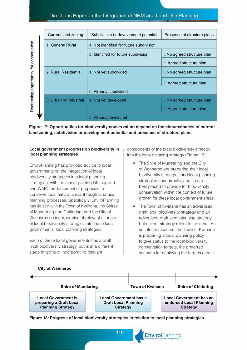
Directions Paper on the Integration of NRM and Land Use Planning
110
Current land zoning Subdivision or development potential Presence of structure plans
a. Not identified for future subdivision
i. No agreed structure plan
1. General Rural
b. Identified for future subdivision
ii. Agreed structure plan
i. No agreed structure plan a. Not yet subdivided
ii. Agreed structure plan
2. Rural Residential
b. Already subdivided
i. No agreed structure plan a. Not yet developed
ii. Agreed structure plan
3. Urban or Industrial
b. Already developed
De
cre
asi
ng o
pp
ort
un
ity fo
r co
nse
rva
tion
Figure 17: Opportunities for biodiversity conservation depend on the circumstances of current land zoning, subdivision or development potential and presence of structure plans.
Local government progress on biodiversity in local planning strategies
EnviroPlanning has provided advice to local governments on the integration of local biodiversity strategies into local planning strategies, with the aim of gaining DPI support and WAPC endorsement of proposals to conserve local natural areas through land use planning processes. Specifically, EnviroPlanning has liaised with the Town of Kwinana, the Shires of Mundaring and Chittering, and the City of Wanneroo on incorporation of relevant aspects of local biodiversity strategies into these local governments’ local planning strategies.
Each of these local governments has a draft local biodiversity strategy, but is at a different stage in terms of incorporating relevant
Local Government is preparing a Draft Local
Planning Strategy
Local Government has a Draft Local Planning
Strategy
Local Government has an endorsed Local Planning
Strategy
City of Wanneroo
Shire of Mundaring Town of Kwinana Shire of Chittering
Figure 18: Progress of local biodiversity strategies in relation to local planning strategies.
components of the local biodiversity strategy into the local planning strategy (Figure 18):
• TheShireofMundaringandtheCityof Wanneroo are preparing their local biodiversity strategies and local planning strategies concurrently, and so are best placed to provide for biodiversity conservation within the context of future growth for these local government areas.
• TheTownofKwinanahasanadvertiseddraft local biodiversity strategy and an advertised draft local planning strategy, but neither strategy refers to the other. As an interim measure, the Town of Kwinana is preparing a local planning policy to give status to the local biodiversity conservation targets, the preferred scenario for achieving the targets across
Directions Paper on the Integration of NRM and Land Use Planning
111
land zonings, and the local biodiversity strategy map (refer to Figure 16). The Town’s draft local planning strategy will need to be amended to incorporate relevant components of the local biodiversity strategy, and readvertised for public comment, prior to consideration and endorsement by the WAPC.
• TheShireofChitteringhasanendorsedlocal planning strategy and recently advertised its draft local biodiversity strategy. The local biodiversity strategy map identifies priority sites for conservation across the local government area (refer to Figure 16), which is useful for assessing planning applications. However, there are gross inconsistencies between the local biodiversity strategy and the local planning strategy. Some priority conservation sites are located in areas that have been identified in the local planning strategy for future development. The Shire, with assistance from the DPI, will be undertaking a review of its local planning strategy to address, amongst other things, the inconsistencies between biodiversity conservation and proposed future development.
All local governments, including those not preparing local biodiversity strategies, are being encouraged to address biodiversity conservation through the preparation of local planning strategies and review of local planning schemes. Examples of biodiversity considerations for the local planning strategy are provided below.
Background section:
Issues
• Nativevegetationextentandrepresentation of vegetation types
• Presenceandlocationsofthreatenedecological communities and rare/priority/significant species
• ProtectionstatusofnativevegetationonCrown land
• Existingandpotentialecologicallinkages
• Impactsofclearingregulationsandenvironmental impact assessment
• Impactsoffuturedevelopmentonbiodiversity conservation
• Protectionmeasuresforareasofsignificant native vegetation in each land use zone
• Componentsoflocalbiodiversitystrategy and associated planning implications
Strategy section:
Strategies
• Identifysignificantnaturalareasthroughland use planning processes.
• Facilitateastrategicapproachtothe protection and management of significant natural areas.
• Provideforappropriateformsofsubdivision/development in areas of high conservation value.
Local Government-Wide Actions
• Introduceaconservationreservationto the scheme and apply to significant areas of Crown land.
• Prepareandimplementamanagementstrategy for local government reserves.
• Prepareandadoptalocalplanningpolicy to guide local biodiversity conservation.
• Prepareandadoptanincentivesstrategy for private land conservation.
• Introduceaconservationzonetothescheme to allow subdivision of private land for conservation.
• Anyrezoningproposalthatimpactsonnatural areas will require an ecological assessment to be undertaken prior to rezoning, with the results of the ecological assessment to accompany the application for rezoning.
Directions Paper on the Integration of NRM and Land Use Planning
112
Area-Specific Actions
• InPrecinctA,retainXhectaresoflocal natural area via the following mechanisms:
- reservation and acquisition using development contributions
- public open space, including co-location with school site
- management agreement with Water Corp
- private land conservation in rural-residential area
6.6.2 Local planning schemes
The local planning scheme is local government’s primary statutory planning tool. There are many options for local governments to integrate biodiversity considerations into the local planning scheme, and it is important that each local government selects the most appropriate approach. Biodiversity conservation can be addressed in various parts of a scheme, primarily through the use of reserves, zones, and special control areas.
Reserves
Reservation of land is the most secure form of land use and tenure for biodiversity conservation, but it is also the most expensive. A local government may designate an area as a conservation reserve in the local planning scheme, which it must then acquire from the landowner. The process of designating and acquiring a conservation reserve is usually undertaken through structure planning and associated development contributions from land owners.
Most local natural areas exist in ‘parks and recreation’ reserves, which cater for a range of recreational uses that may be incompatible with biodiversity conservation (e.g. ovals and sports complexes). In these cases, a conservation reservation may be applied retrospectively to existing local government parks and recreation reserves containing native vegetation.
Zones
Land zoning is an important factor in determining opportunities for conserving biodiversity. It is very difficult to retain native vegetation in areas where intensive land use and development is permitted. The identification of priority local natural areas for conservation, in the local biodiversity strategy component of a local planning strategy, will assist in limiting the impact of land use change on native vegetation by guiding development away from these areas.
As outlined in Section 6.6.1 and depicted in Figure 17, there are limited opportunities to conserve natural areas on urban and industrial zoned land; and in these situations, biodiversity conservation is generally restricted to public open space and landscaping contributions. On the other hand, rural zones may provide for the conservation of large areas of native vegetation on private property; but in these situations, biodiversity conservation is largely voluntary, unless conditions can be imposed through a planning application (e.g. rezoning or subdivision). Opportunities for biodiversity conservation may arise through rezoning from General Rural to Rural Residential; however, conventional rural-residential subdivision has severe impacts on natural areas, due to the small size and regular configuration of lots, the dispersal of building envelopes, and the clearing and degradation associated with access ways, fence lines and fire breaks.
There is considerable scope for local governments to include provisions in local planning schemes to control land use in a way that minimises damage to native vegetation and promotes biodiversity conservation. Some of the most important matters to be addressed under the zoning provisions of local planning schemes (particularly for rural-residential zones) include:
• Subdivisiondesignthatminimisesclearing and fragmentation of native vegetation;
• Designationofbuildingenvelopes;
• Allclearingforbushfireprotectioncontained within designated building envelopes;
Directions Paper on the Integration of NRM and Land Use Planning
113
• Designationofstrategicfirebreaks;
• Minimisingaccessordrivewaysthatrequire additional clearing;
• Limitingfencingorminimisingclearingforfence lines (e.g. to 0.5 metre width);
• Excludingstockfromvegetatedareas;
• Designationofvegetationprotectionareasto control clearing;
• Preparationandimplementationofmanagement plans, especially weed control; and
• Bushrestorationincludingdirectseedingor revegetation with local native species.
Building envelopes or vegetation protection areas are particularly important tools for controlling clearing in rural-residential areas. It would be appropriate to use building envelopes to control clearing in situations where the entire lot is vegetated. Alternatively, vegetation protection areas may be used to control clearing on partly-vegetated lots. The most important consideration, however, is subdivision design to minimise clearing, degradation and fragmentation of natural areas on private property (refer to Section 6.6.4). In this regard, cluster subdivision and development in cleared or degraded areas is preferred over conventional rural-residential subdivision. The City of Wanneroo District Planning Scheme No. 2 contains a Rural Community Zone that provides for rural-residential development through conventional subdivision, or cluster-style strata-subdivision that rewards the proponent with an additional lot bonus.
Conservation zones provide for the formal protection of local natural areas on private property. A local government may introduce a conservation-type zone to its scheme, which it may then apply to private land with agreement from the land owner, usually in exchange for some form of privilege (such as a subdivision bonus, development concession, or rate rebate). Importantly, conservation zones provide for land to be actively managed for conservation purposes, usually through the requirement for a conservation covenant (refer to Section 6.6.7).
The Shire of Busselton Town Planning Scheme No. 20 provides for biodiversity conservation on private property within the Rural Residential, Rural Landscape, Conservation and Bushland Protection zones.
Special Control Areas
As explained in Section 5.3.2, a special control area (SCA) is a mechanism that is intended to deal with issues which overlap boundaries of zones and reserves. SCAs can place additional requirements to those of particular zones, in order to ensure land development is consistent with the purpose of the special control. SCAs can be shown on separate scheme maps or as overlays to the zoning map. It is particularly important that the boundaries of the SCA are accurate, clearly defined and relevant to the SCA provisions. Generally, a SCA is not appropriate for identification only, and the SCA provisions must serve a legitimate planning purpose. SCAs need to be used selectively and sparingly to avoid making the planning system overly complex.
The Model Scheme Text Guidelines include ‘Vegetation Protection’ as an example of a SCA that may be included in a local planning scheme. It should be noted, however, that a SCA does not provide formal protection to native vegetation; rather, the SCA provisions control development of land covered by the SCA. As such, a SCA should not be used to protect vegetation in areas where development is not currently permitted and therefore can not be ‘controlled’.
A local government could introduce a Vegetation Protection (or similar) SCA to the local planning scheme, in order to:
• Changethepermissibilityoflandusesunder zones or reservations (e.g. require approval for a land use or development proposal in a vegetation protection area that would otherwise be permitted in the zone);
• Specifyparticulardevelopmentstandardsand requirements (e.g. require approval for dwellings in a vegetation protection

Directions Paper on the Integration of NRM and Land Use Planning
114
area to ensure the construction of new buildings minimises the need for clearing for bush fire protection);
• Listparticularrequirementswhichshouldbe included with an application for planning approval (e.g. require provision of a vegetation management plan for any development in a vegetation protection area);
• Specifyrelevantgovernmentagenciesand public authorities which should be consulted on applications for planning approval (e.g. referral of development within a vegetation protection area to the DEC);
• Listrelevantconsiderationswhichthelocal government must consider before deciding on an application for planning approval (e.g. relevant SPPs, compatibility of use, appropriate management measures, and notices on title).
It may not be appropriate in all circumstances, however, to include a Vegetation Protection (or similar) SCA in a local planning scheme. Instead, certain provisions could be included under relevant zones to minimise impacts of development on native vegetation. Alternatively, it may be desirable to identify particular areas in the local planning strategy that accompanies a scheme. Such cases include where it is necessary to draw attention to the particular area (issue) as a relevant planning consideration, but where special planning controls are either unnecessary or undesirable. The Shire of Mundaring is exploring this option through its scheme review, whereby priority local natural areas are identified in the local planning strategy and addressed by reference in the local planning scheme. The level of confidence in the local natural area dataset is the main reason behind this approach.
General Development Requirements
Local planning schemes may include general development requirements relevant to biodiversity conservation, such as:
• Subdivisionplans(whichformpartof the scheme) to identify significant natural areas and outline measures for retention, and future subdivision to be in accordance with approved plans of subdivision.
• Guidelinesforbuildingenvelopes,setbacks, management plans and surveys;
• Clearingcontrolsandvegetationpreservation measures;
• Stockandweedmanagementprovisions;
• Requirementsforrehabilitationorrevegetation of degraded land.
Applications for Planning Approval
Local planning schemes may also require applications for planning approval affecting natural areas to be accompanied with relevant information, such as:
• Mapsshowingnativevegetation;
• Studiesonbiodiversityvalues;and
• Plansidentifyingsignificantnaturalareasand outlining measures for retention.
It is suggested that specific requirements for planning applications be addressed through the preparation of a local planning policy on biodiversity conservation.
6.6.3 Local planning policies
As explained in Section 6.6, it is a common misconception amongst NRM professionals that local planning policies are the most important tools for achieving biodiversity conservation through land use planning at the local level. Local planning policies are made under the local planning scheme but they do not form part of the scheme. Therefore, whilst local government

Directions Paper on the Integration of NRM and Land Use Planning
115
must have regard to local planning policies in making decisions under the scheme, they are not bound by the policies.
A local planning policy should provide guidance in exercising or informing discretion under the scheme; be consistent with any relevant State or regional planning policy and the local planning strategy; relate to a valid planning purpose and be based on proper planning principles; and be concise and clearly explain what the policy is and how it will influence decision making. Importantly, a local planning policy should only be prepared to provide guidance on matters of the scheme; so if a local planning scheme does not adequately provide for biodiversity conservation, it will be the local government’s imperative to review and amend its scheme in order to do so.
Importantly, the local planning policy on biodiversity conservation should contain the local government’s biodiversity conservation targets, the preferred scenario for achieving the targets across land zonings, and a map that identifies priority areas for conservation (refer to Section 6.6.1). In accordance with the Model Scheme Text, the following format is recommended for a local planning policy on biodiversity conservation (to be informed by the local biodiversity strategy, if available):
• Introductionandbackgroundexplainingthe reasons and purpose for the policy (e.g. benefits of conserving biodiversity; role of local government in biodiversity conservation; guiding principles for biodiversity conservation; conservation values of local government area) and its relationship to any State policies or other local policies.
• Objectivesofthepolicy(e.g.localgovernment’s objectives for biodiversity conservation; targets for representation of ecological communities and conservation of special features).
• Applicationofthepolicy,settingoutwhereand under what circumstances the policy applies (e.g. application of conservation targets to different zones and precincts or
policy areas; requirements for ecological information as part of development proposals; requirements for conservation plans to guide subdivision).
• Policystatementsinshort,succinctsentences, and any specific measures to implement the policy (e.g. future planning, design and development to be compatible with local biodiversity conservation targets; mechanisms available for local biodiversity conservation across zones; development incentives to achieve appropriate forms of subdivision and development; incentives for private land conservation).
• Referencetoanydecisionguidelines,supporting documents or other matters (e.g. guidelines for ecological assessment).
6.6.4 Structure plans and subdivision
Structure planning
The local planning strategy, local planning policy, or local planning scheme (e.g. under General Development Requirements) usually requires that certain studies be undertaken and that a plan be prepared to accompany an application for rezoning, subdivision or development of land. These plans may be referred to as district and local structure plans, detailed area plans, outline development plans, plans of subdivision, development plans, or similar; and are hereafter referred collectively as ‘structure plans’.
Structure plans show the general pattern of land uses in a particular area, and serve to guide the subdivision and development of land in accordance with the local planning scheme. A structure plan for an urban area, for example, would typically show the density of residential areas, locations of public open space and schools, and the alignment of the transport network. A structure plan for a rural-residential area would typically show the configuration of lots and roads and the location of building envelopes.

Directions Paper on the Integration of NRM and Land Use Planning
116
Ideally, structure plans should be prepared following the rezoning of land, at each subsequent stage of the planning process, to provide more detail on land use, subdivision and development (however, this is usually constrained by limited resources being available). It is suggested that biodiversity considerations be addressed in the structure planning process through the preparation of conservation plans as a component of the district structure plan (‘district conservation plan’), local structure plans (‘local conservation plans’), and other plans prior to subdivision. These conservation plans would be prepared following ecological assessment, and would apply local biodiversity conservation targets and strategies to specific proposal sites.
Structure planning provides a major opportunity for local governments to conserve local natural areas, through a process of negotiation with proponents and other stakeholders. Some schemes provide for additional scheme provisions to be added as a result of the structure planning process, while others simply apply zoning provisions to a particular development area. Importantly, structure plans must include statutory provisions relating to the conservation of local natural areas (which may then be converted to conditions on subdivision); otherwise, these areas are at risk of being cleared at subdivision.
Natural areas in public open space
Local reserves created through the subdivision process (under Section 20A of the Land Administration Act 1997) are issued with Management Orders to the care of a local government or State government agency. Ensuring that Management Orders reflect conservation purposes is an important part of local biodiversity conservation. This may be undertaken retrospectively for existing local reserves (via application to Landgate), or as part of the subdivision process for new reserves. If a structure plan identifies that a local natural area is to be retained within public open space, it is possible to require as a condition of subdivision that the reserve purpose on the Management
Order be designated as ‘conservation’ or ‘conservation and recreation’.
Subdivision design
Planning for the subdivision and development of land has rarely taken into consideration the retention of ‘viable’ natural areas (refer to Section 6.5.1), whether in public open space or rural-residential lots. The main reason for this is likely to be that, until recently, local biodiversity conservation has not been addressed early enough in the land use planning process. It appears that NRM professionals have concentrated too much attention on natural area retention at the subdivision stage, only to find that conditions on subdivision cannot be applied because provision has not been made in the local planning scheme or structure plan for the area.
The preparation of local biodiversity strategies, incorporation into local planning strategies and local planning policies, amendment to local planning schemes, and incorporation in structure plans, are all likely to be required in order to effect change at the subdivision level. Nonetheless, it is suggested that guidance be prepared on subdivision design to support local biodiversity conservation, with associated awareness raising and training of planners and environmental officers within local government, the DPI and private consultancies.
Subdivision for conservation
‘Subdivision for conservation’ is a term used to describe the subdivision of land for conservation, in accordance with Development Control Policy 3.4 Subdivision of Rural Land (DC 3.4). DC 3.4 provides for the subdivision of a single conservation lot (greater than 40 hectares and mostly vegetated) from its parent agricultural lot, without the need for rezoning to a conservation purpose. Section 4.8 ‘Conservation of biodiversity and natural heritage’ of DC 3.4 states that:
‘Conservation lots may be created to preserve significant environmental features and remnant vegetation provided that:

Directions Paper on the Integration of NRM and Land Use Planning
117
(a) Thevegetationhasbeenidentifiedandagreed as worthy of protection in an approved strategy, catchment plan, or a specific assessment carried out by an appropriate expert on behalf of the subdivider in accordance with the principles for clearing native vegetation contained in schedule 5 of the Environmental Protection Act 1986.
(b) TheDepartmentofEnvironmentandConservation, National Trust of Australia (WA)oranotherrelevantagencyhasprovided advice endorsing the suitability of the lot for the intended purpose of retaining environmental values including the adequacy of the area if it is less than 40 ha, and has provided in-principle agreement to administer the necessary conservation covenant.
(c) Generallyatleast85percentofthearea of the conservation lot has high environmental values or is covered by native or regenerated vegetation and/or wetland.
(d) Theproposedconservationlothasanappropriate shape having regard for the native vegetation, natural features, bush fire management, farm management and existing or proposed structures.
(e) Aconservationcovenantinperpetuitywith the Department of Environment and Conservation, the National Trust of Australia(WA)oranalternativeauthorityacceptable to the WAPC is registered on the certificate of title and that covenant includes provisions that:
(i) prohibitfurtherclearing(otherthanfor necessary land management requirements);
(ii) clearlydelineateabuildingenvelope and/or building exclusion area also shown on the subdivision plan; and
(iii)prohibitstockingoutsideanyexisting cleared area.
(f) Theremainingagriculturallot:
(i) hassufficientareatobecapableand suitable for agricultural use; and
(ii) retains,wherepractical,nativeor regenerated vegetation as an integral part of sustainable farming, provided that this does not result in the division of significant vegetation in order to include a portion of that vegetation in the agricultural lot.’
DC 3.4 does not provide for the creation of more than one conservation lot, and suggests that landowners wishing to create multiple conservation lots seek to do so through rezoning rural land to a conservation purpose (e.g. conservation themed rural-residential or rural-smallholdings), where conservation covenants and building envelopes can be specified. Guidance for this type of conservation subdivision is provided for the Leeuwin-Naturaliste Ridge policy area (refer to State Planning Policy 6.1 Leeuwin-Naturaliste Ridge, land use strategy 3.4 and 3.8), but is not provided for other areas of the Southwest Australia.
The Shires of Manjimup, Northampton and Augusta-Margaret River are initiating amendments to introduce conservation-type zones to their local planning schemes, in order to provide for the subdivision of multiple conservation lots in the rural area. These amendments would provide the ‘enabling provisions’ required to support subdivision of smaller conservation lots than is currently provided for under DC 3.4, in exchange for formal protection and management of natural areas under the local planning scheme and conservation covenants.
In order to streamline planning approvals processes and maximise conservation outcomes, local governments are encouraged to prepare a local biodiversity strategy or local bushland protection plan (which is then incorporated into the local planning strategy or local planning policy) to guide subdivision for
Directions Paper on the Integration of NRM and Land Use Planning
118
conservation in rural areas. The strategic plan would identify priority areas for conservation, which would assist landowners, local governments and the DPI/WAPC in assessing and determining applications.
6.6.5 Conservation covenants
Conservation covenants are important for achieving conservation of natural areas on private property, and may be used as an alternative or complementary mechanism to local planning schemes. A conservation covenant is a voluntary agreement between a landholder and an authorised body (such as a Covenant Scheme Provider) that aims to protect and enhance the natural values of certain land (DEWHA, 2009). The owner continues to own, use and live on the land while the natural values of an area are conserved by the landholder in partnership with the Covenant Scheme Provider (DEWHA, 2009). Importantly, the covenant is registered on the certificate of title for the land and binds all future landowners.
Conservation covenants are generally restrictive in nature in that they require the landowner not to undertake particular activities, such as clearing of native vegetation or stocking of animals. A restrictive covenant is an agreement which restricts a landowner in the use or enjoyment of their land (‘burdened land’) for the benefit of other land (‘benefited land’) or for the benefit of a public authority (no benefited land). The covenants can not be used to require the landowner to undertake positive actions (such as weed control or revegetation); however, covenanting programs assist landowners to prepare and implement management plans, which in some cases are made legally enforceable through a deed with the landowner and a caveat on the certificate of title.
In Western Australia, landowners can establish conservation covenants with the DEC, the National Trust, or the DAF’s Office of Soil and Land Conservation (refer to Table 5). The level of restriction on land use and development imposed by a conservation covenant varies
according to the covenanting organisation, the proposed development and the landowner’s circumstances.
Conservation covenants originated as voluntary agreements negotiated outside of the planning system; but in the last 20 years, conservation covenants have increasingly been used to protect natural areas as part of the consideration of subdivision and development proposals. Planning Bulletin 91 Estate Covenants: New Residential Subdivisions (WAPC, 2008) explains the concept of restrictive covenants and outlines their use in the planning system. The WAPC or local government may require an applicant to enter into a restrictive covenant (either with the WAPC, the local government or another public authority) as a condition of approval. The power for the WAPC to impose conditions of subdivision approval arises under Sections 138, 139, 143, 144, 148 and 151 of the P&D Act. Any power to impose conditions on development approval will generally be contained in the relevant local planning scheme.
Conservation covenants are only recognised by the planning system when they have resulted from a planning decision. Conservation covenants that have arisen out of planning decisions may be referred to as ‘conditional covenants’ because the covenant is made as a condition of planning or subdivision approval. Covenanting bodies are well prepared to enter into conditional covenants with landowners preparing proposals, and distinguish these from voluntary covenants. Some problems associated with conservation covenants have been identified by planners and covenanting agencies, namely:
• Landownerswhoarepartytoconditionalcovenants may be less inclined to appropriately manage their properties for conservation purposes than landowners who have entered into a conservation covenant voluntarily; and
• Planningdecisionsmadebylocalgovernments and the DPI/WAPC do not always take into account conservation covenants that have been created voluntarily.

Directions Paper on the Integration of NRM and Land Use Planning
119
Office of Soil and Land Conservation
National Trust of Australia (WA)
Department of Environment and
Conservation
Empowering legislation
Soil and Land Conservation Act 1945
National Trust of Australia (WA) Act 1964
Transfer of Land Act 1893
Scope for management
Can probably contain positive obligations relating to management
Restrictive in nature (with positive requirements through a deed and caveat)
Restrictive in nature
Lifespan Usually 30 years Variable, but preference for ‘in-perpetuity’
Variable, but preference for 'in-perpetuity'
Permanence Covenants cannot be revoked by agreement during their term, but could probably be revoked by court order or by the operation of a local planning scheme.
Can be revoked or varied by agreement, court order or operation of a local planning scheme.
Can be revoked or varied by agreement, court order or operation of a local planning scheme.
Enforcement Commissioner can apply for an injunction, or prosecute for breach. Neighbours whose land is damaged by breach may sue.
National Trust can enforce by injunction.
DEC can enforce by injunction.
Stewardship program and management advice
No Yes Yes
Preparation of management plan
No Yes (implementation of plan binding on landowner via deed)
Yes (implementation not binding)
Direct cost of conditional covenants to applicants (as at September 2007)
Total charges from covenanting body to landowner of $800 -$1600
$10,000 per lot charged by to landowner, part of which funds an ongoing stewardship program
$3000 (under review and may increase to similar amount as National Trust
Criteria for acceptance of sites
Criteria are minimal. SLCA 1945 provides that any landowner may set aside land under a covenant for the management and protection of vegetation. Prefer that area is several hectares in extent.
Criteria are moderate. Generally same as for DEC covenants but National Trust will often consider areas that may not have as high environmental value as that sought by DEC.
Criteria are moderate to high. Generally sites should have vegetation in good or better condition, preferably recognised by a local or regional biodiversity strategy or policy. Site should be sustainable in the long-term and require minimal positive management.
Table 5: Characteristics of the major conservation covenanting programs in Western Australia.

Directions Paper on the Integration of NRM and Land Use Planning
120
However, there are good reasons why appropriate zoning and covenants should be used together to protect natural areas, including:
• Thestrengthenedprotectioninthescheme and property title, given that the two mechanisms protect sites in different ways (referred to as the ‘belt and buckle’ approach);
• Theroleofschemesincontrollingdevelopment across a local government area;
• Theinvolvementandadvocacyofathird party with a conservation charter in covenants;
• Theenforceabilityandsignificantfinesforbreaches of the scheme; and
• Theadditionalenvironmentalexpertiseofcovenanting programs.
6.7 The future of biodiversity conservation through land use planning
The impacts of land development are widespread and long-lasting, so it is crucial that biodiversity considerations are adequately integrated and addressed in land use planning processes. However, despite the strong legislative and policy basis for biodiversity conservation in land use planning, extensive clearing of significant local natural areas occurs across Western Australia as a result of land use planning decisions.
The DEC, the EPA and the Minister for Environment play an important role in biodiversity conservation through land use planning, primarily through environmental impact assessment (EIA) of planning schemes and development proposals, and the assessment of applications to clear native vegetation. However, the focus of EIA on proposals that are likely to have the greatest environmental impact,
together with exemptions in the environmental legislation that allows land to be cleared if it has planning approval, means that environmental assessment processes are only able to go part way towards addressing the conservation of natural areas on private land. It is ultimately the responsibility of local governments, the DPI, the WAPC and the Minister for Planning, through administration of the planning system, to address biodiversity conservation in the context of sustainable use and development of land.
Many of the problems associated with the impact of land use, subdivision and development on natural areas cannot be attributed to the Western Australian planning system itself. In fact, compared with other States of Australia, Western Australia’s centralised planning system may provide for enhanced biodiversity conservation outcomes. For example, regional planning schemes in Southwest Australia provide for the reservation and acquisition of significant natural areas for parks and recreation purposes. However, the conservation of local natural areas (natural areas that exist outside of the regional reserve system) is not being adequately addressed in the application of the land use planning framework. The retention, protection and management of a system of local natural areas form an important component of biodiversity conservation in the global biodiversity hotspot of Southwest Australia. The conservation of local natural areas assists in maintaining native vegetation cover in the landscape, providing buffering and connectivity between reserves, to support the long term survival of genes, species and ecosystems.
Current State government policy suggests that planning for local biodiversity conservation is largely the responsibility of local governments. However, the availability of regional information on biodiversity assets and function, and integration of these considerations into strategic planning at the regional level is limited, which makes it difficult for individual local governments to effectively plan for local biodiversity conservation. Even though the planning legislation establishes biodiversity conservation

Directions Paper on the Integration of NRM and Land Use Planning
121
as a relevant consideration for State planning policies, planning schemes and conditions of subdivision, limited practical guidance or technical support is provided to local governments to address biodiversity through land use planning.
Over the past five years, local governments in the Perth (Swan) and South West NRM regions have received support from WALGA, the DEC and the DPI for the preparation and implementation of local biodiversity strategies. However, due to the time and effort required for the preparation of local biodiversity strategies in accordance with the WALGA guidelines, few resources have been made available to local governments for the integration of biodiversity considerations into local planning strategies, schemes and structure plans. It is therefore imperative that the process for preparation of biodiversity strategies and integration into the land use planning system be simplified and streamlined.
Opportunities exist for local biodiversity conservation to be addressed at all stages of land use planning. However, biodiversity considerations should be incorporated into the planning process as early as possible, and carried through each subsequent stage of planning. The future success of biodiversity conservation therefore depends on the improved knowledge, skills and commitment of State and local governments to address this important NRM issue through land use planning.
Directions Paper on the Integration of NRM and Land Use Planning
122
7 NRM and land use planning in peri urban regions
7.1 Introduction
Peri urban areas, which are the transition between urban and rural land, represent an important interface between NRM and land use planning, due to the significant NRM assets they contain and the diversity of land uses that they support. As the change from rural to urban use is usually irreversible, and the opportunities to achieve NRM outcomes in an urbanised environment are highly constrained, land use planning in peri urban areas is very important in achieving NRM outcomes. A lack of strategic rural land use planning, increasing pressure for rural residential development and decreasing water availability have been identified as key NRM land use planning issues in peri urban areas. Provision of clear policy direction for regional and rural land use planning and improving the capacity of local government to undertake rural land use planning at the local level have been identified as key factors in achieving improved NRM outcomes in peri urban areas.
Land uses in peri urban areas are heterogeneous, providing for a wide range of social, economic and environmental functions. Such functions include sources of raw materials and water, sites for major infrastructure, reservoirs of biological diversity, producers of high value agricultural goods, are often areas of great beauty and provide a refuge for people wanting to escape city living.
This diversity of land uses and functions in peri urban areas can result in a range of NRM issues arising from land use planning pressures such as rural residential development, subdivision and fragmentation of rural land and competing land uses. NRM issues in peri urban areas include water resource management,
maintenance of biodiversity, protection of agricultural land and basic raw materials, bush fire protection, stock management and biosecurity.
Peri urban areas have been identified at both a National and State level as a priority for NRM. At the National level, in 2006, the Natural Resource Management Ministerial Council endorsed a framework for future NRM programmes that recognised the need to better integrate peri urban planning issues into future NRM arrangements. At the State level, the recently released Draft State NRM Plan acknowledges planning and management of urban and peri-urban areas to mitigate adverse social and environmental impacts of rapid population growth, as one of six priority NRM outcomes for the State.
The key findings and recommendations made throughout this paper on integrating NRM and land use planning are probably most relevant to peri urban areas given that these areas represent a hot spot of speculative development pressures and NRM assets.
7.2 Level of guidance provided
SPP 1: State Planning Framework Policy (Variation No 2)
SPP 1 is significant in the context of planning for peri urban areas as it establishes the State Planning Framework that guides decision making on land use and development in WA. Local governments and the WAPC must have due regard to the State Planning Framework when preparing and assessing

Directions Paper on the Integration of NRM and Land Use Planning
123
planning schemes and making decisions on planning matters. Given peri urban areas often accommodate a diversity of land uses, which can sometimes lead to competing land use objectives, it is important to note that SPP 1 provides some guidance, although limited, on resolving conflicts between the policies, strategies or guidelines listed under the SPP.
SPP 2.5: Agricultural and Rural Land Use Planning
Given that peri urban areas were defined earlier as land that is the transition between urban and rural areas, SPP 2.5 is particularly important in guiding planning in peri urban areas. SPP 2.5 seeks to manage the impacts on agricultural land and natural resources arising from the location, pattern and timing of subdivision and development of rural land. Importantly the SPP establishes local planning scheme provisions for land zoned rural residential or rural small holdings aimed at providing consistency for controlling the planning and development of rural settlements. SPP 2.5 is currently being reviewed by the WAPC with the intention of providing greater direction on managing the interface between rural and urban settlement.
SPP 3: Urban Growth and Settlement
Similar to SPP 2.5, SPP 3 is particularly important in guiding planning for the transition from rural to urban use. SPP 3 seeks to facilitate sustainable patterns of urban growth and settlement by setting out the requirements of sustainable settlements and communities and the broad policy in accommodating growth and change.
7.2.1 Development Control Policies
Development control (DC) policies are the WAPC’s operational policies for dealing with the subdivision and development of land. Two of the more important DC policies in terms of their relevance to land use planning and NRM in peri urban areas include DC Policy 3.4 Subdivision of Rural Land and DC Policy 3.7 Fire Planning. It is important to note that the DC policies highlight
the importance of ensuring the subdivision of land is properly planned for and addressed through local planning strategies and schemes, if it is not then subdivision is generally not supported.
Development Control Policy 3.4 - Subdivision of rural land
This policy is important for planning in peri urban areas as it seeks to guide the subdivision of rural land to achieve the objectives of SPP 2.5; to protect agricultural land, plan for rural settlement, minimise land use conflict and manage natural resources. The policy states that in the absence of planned provision of closer settlement and more intensive agricultural uses, existing large rural lots be retained for traditional forms of farming and that the fragmentation of rural land through piecemeal, unplanned subdivision not be permitted. The policy requires that rural subdivision be properly planned for through the preparation of regional and local planning strategies and provided for in local planning schemes prior to subdivision.
Development Control Policy 3.7 - Fire Planning
The increase in rural subdivision and urban expansion in peri urban areas throughout WA has resulted in a greater number of people and facilities being located closer to and within bushland, nature and conservation reserves, and forests. Consequently DC Policy 3.7 was prepared to ensure that adequate fire protection for new subdivisions and related developments by proper strategic planning, good subdivisional layout, and development criteria which ensure the least possible exposure to damage by fire and the best possible response should fire occur.
7.2.2 Regional and Sub-regional Planning Strategies
Regional and sub-regional planning strategies are prepared to guide and coordinate government land use and infrastructure planning for those matters (for example protection of

Directions Paper on the Integration of NRM and Land Use Planning
124
natural resources, provision of regional open space and transport infrastructure) which can often only be planned for across areas greater than that of one local government. It is intended that regional and sub-regional planning strategies assist local government in preparing and implementing local planning strategies, schemes and other local planning and development matters. Owing to the environmental, social, cultural, economic and size differences associated with regional and sub-regional areas in WA, standard models of regional planning practice have been considered irrelevant or ineffective (WAPC, 1995). Regional and sub-regional planning strategies are considered particularly important in peri urban areas where it relates to addressing NRM issues such as water resources management or biodiversity conservation which are best addressed within a regional context.
Some of the regional strategies relevant to peri urban areas include the following:
• Network city (2004)
• Jandakot Land Use and Water Management Strategy (1995)
• Gnangara Land Use and Water Management Strategy (2001)
• Middle Helena Catchment Area Land Use and Water Management Strategy – Draft (2003)
• Leeuwin-Naturaliste Region Plan - Stage 1 (1988)
• Leeuwin-Naturaliste Region Plan - Stage 2 Draft (1988)
• Albany Regional Strategy (1994)
• Albany Residential Expansion Strategy (1994)
• Peel Regional Strategy (1994)
• Bunbury-Wellington Region Plan (1995)
• Central Coast Regional Strategy (1996)
• Shark Bay Regional Strategy (1997)
• Coastal and Lakelands Planning Strategy (1999)
• Geraldton Region Plan (1999)
• Goldfields - Esperance Regional Planning Strategy (2000) [incorporating the Kalgoorlie-Boulder Structure Plan (2000) and Esperance Structure Plan (2000)]
• Warren-Blackwood Regional Planning Strategy (2000)
• Avon Arc Sub-Regional Strategy (2001)
• Ningaloo Coast Regional Strategy Carnarvon to Exmouth (2004)
• Warren-Blackwood Rural Strategy (2004)
7.3 Land use planning issues in peri urban areas
As the change from rural to urban use is irreversible, rural land use planning has an important role in determining land use and development in peri urban areas so as to minimise NRM impacts. Planning responses in peri urban areas tend to be reactive rather than proactive as a consequence of limited strategic rural planning at the regional and local level.
Lack of strategic rural planning
At regional forums facilitated by EnviroPlanning throughout the State, local government planners expressed concerns about the inability of some regional planning strategies to provide adequate guidance and direction to local governments on planning to address issues such as managing urban growth, facilitating appropriate rural residential development, identifying priority agricultural land and significant environmental assets, when developing their local planning strategies. It was acknowledged that a lack of region specific guidance through State Planning Policies contributed to the ineffectiveness of regional planning strategies. A lack of strategic planning at regional and local levels creates a reliance on broad based State policy such as SPP 2.5 and DC policy 3.4 to address rural settlement planning and rural subdivision issues.

Directions Paper on the Integration of NRM and Land Use Planning
125
These policies in the absence of well prepared regional and local planning strategies can’t ensure a holistic consideration of regional and local NRM issues in rural land use planning decision making.
Whilst the importance of protecting agricultural land next to urban areas to ensure food security has long been recognised, an absence of long-term strategic planning to identify and protect high value agricultural land can contribute to speculative development pressures in peri urban areas.
Rural residential development
Sustainable settlement patterns and protection of agricultural land can often be compromised by rural residential development which seeks to provide for an alternative residential lifestyle within a rural setting through the creation of lots ranging in size from 1-4ha. In general, poorly planned rural residential development emanating from an absence of appropriate regional and local strategic planning tends to result in the inefficient use of land, fragmentation of biodiversity assets, high cost of basic services and transport and often compromises plans for townsite expansion as urban development is more difficult when land ownership is further fragmented.
Peri urban areas tend to have low populations and when they expand there is often a lack of funding to support the expansion of infrastructure and services such as transport networks, communications, electricity, sewerage, water facilities and treatment plants, as well as social infrastructure, such as schools, police and health services. The lack of funding to support expansion of infrastructure and services is further compounded by rural residential development often occurring without developers contributing to basic services including public open space, roads and community infrastructure, which has implications for the local government and the residents. In the absence of State and local government being able to provide essential infrastructure and services, the creation and management of
environmental infrastructure (e.g. bushland and foreshore reserves) is often not a priority.
SPP 3 Urban Growth and Settlement encourages a realistic approach to the allocation of rural residential land based on forecast estimates of demand for rural living not on the speculative development of land. Currently there is a vast stock of rural residential land on the fringe of the Perth Metropolitan Region and it is questionable whether the demand for such land actually warrants the amount of land that is either zoned or identified for rural residential development.
There is a tendency for rural residential development to be driven by local considerations (e.g. water availability and land capability) and property market demand rather than an economic driver such as a rural industry, which often results in the creation of commuter settlements. Commuter settlements are not self sufficient and rely on regional centres for employment and supply of goods and services.
Water availability and land capability
A lack of reticulated water in small town sites (such as Bindoon) has previously been used as an argument to justify rural residential development rather than clustered residential development which would be able to provide an adequate supply of water through rainwater tanks. Furthermore low land capability of rural land for agricultural production has also been used as justification for subdivision of rural land for rural residential development.
Subdivision/fragmentation of rural land
Policies for subdivision in rural areas are generally not achieving their original objectives as they are generically applied and tend not to respond to the characteristics and capability of individual areas. Subdivision of rural land is often justified on basis of individual land capability assessment and anecdotal evidence regarding the economic value of the agricultural land. This approach has proved problematic in recent years as the Department of Agriculture and Food no longer provides expert advice

Directions Paper on the Integration of NRM and Land Use Planning
126
to the WAPC on subdivision applications and appeals relating to rural land. Fragmentation of land is likely to result in the cumulative loss of productive agricultural land. The scale of development is also increasing so that the rural landscape can be transformed significantly where large land parcels are subdivided and developed in comparison to the usual few each year.
Lack of resources
There is a general lack of local government and State government resources for NRM and land use planning in peri urban regions. Often the demand for land use change and development in peri urban areas exceeds the resources to effectively plan and manage development and land use change in peri urban areas. There are very few environmental planners (or planning staff generally) and limited funding for NRM projects such as gathering of information (including mapping and GIS systems) to support strategic planning. Local government in peri urban areas also have a limited capacity to manage reserves that are vested to them as a result of land use planning processes, for example the ceding of foreshore reserves to local government where land adjacent to a waterway or wetland is subdivided.
Competing land uses
There is a need to ensure appropriate location of land uses so that the diversity of land uses can coexist appropriately. This is particularly relevant where extractive industries and landfill sites are proposed in sensitive environments or near sensitive land uses (e.g. residential development). Rural residential development on the fringes of urban areas can often contribute to land use conflict with land uses that provide services to urban areas such as sand pits, cattle yards and dog pounds etc. Such land uses are then accommodated further from the urban fringe to avoid the land use conflicts, which further accentuates the carbon footprint associated with accessing services provided by such land uses.
7.4 NRM issues within peri urban areas
The 2007 WA State of Environment Report (SoE) projects that Western Australia’s population will grow by 41% by 2031. Inevitably this will result in peri-urban areas throughout WA coming under increasing development pressure in order to support this growth.
As mentioned above, peri urban areas fulfil a wide range of social, economic and environmental functions. Urban and rural populations are highly dependent on peri urban areas for the supply of water, food, basic raw materials, sites for major infrastructure, areas for semi-rural living, recreation, tourism, biodiversity conservation and landscape protection. This diversity of functions, combined with increasing development pressure, can result in a range of issues being experienced as discussed below.
Water resource management
The lack of reticulated water in many areas puts pressure on groundwater and surface water resources. Agricultural practices have resulted in significant nutrients and sediment being conveyed to surface water systems, such as the Swan Canning and Peel Harvey estuaries. This has been exacerbated by limited or no setbacks along waterways from development in some areas. Impacts of groundwater drawdown are also putting pressure on sensitive ecosystems such as karst systems, wetlands and remnant vegetation including banksia woodlands. There is limited understanding of groundwater and surface water systems, outside of the swan coastal plain, which impedes appropriate decision making about water management and use, including identification and protection of public drinking water supply areas, use of septic tanks and alternative treatment systems. This also limits the ability to ensure development within floodways and floodplains is appropriate.
Directions Paper on the Integration of NRM and Land Use Planning
127
Maintenance of biodiversity
Clearing for agriculture has put pressure on areas of remnant vegetation. This is further threatened by the increasing residential and conventional rural residential subdivision (clearing for firebreaks, fence lines and building envelopes) and resultant fire management measures and the need for expanded infrastructure including roads. Sensitive environments are also threatened by climate change and groundwater drawdown. Wetlands are generally protected but often without upland vegetation.
Illegal firewood collection, illegal vehicular access from motor bikes and four wheel drives and the creation of recreational trails or facilities often results in a loss of native remnant vegetation and biodiversity in reserves through clearing, fragmentation, spread of dieback and erosion. Reserve management places additional pressure on under resourced councils, with often no means of purchasing and managing regional open space to maintain significant biodiversity values.
There is also often a lack of support for private land conservation. Whilst there are a number of services provided through DEC (e.g. Land for Wildlife), NRM regional groups (e.g. funding of biodiversity support officers based with catchment groups) and local governments (land care centres) that provide advice and support to land owners to assist with the management of natural areas on private land, there is a need to consider better coordination and expansion of such services.
Priority agricultural land
There is a need to protect agricultural areas in peri urban regions from rural residential development, subdivision and other competing land uses to ensure economic viability of the agricultural industry. The proximity of these areas to urban areas is a critical determinant in their ability to supply the metropolitan area and other regional centres with competitively priced fresh produce as well as their ability to reduce transport costs and resultant greenhouse gases.
The lack of security of agricultural land close to the urban areas is considered to be a barrier to the uptake of agricultural best management practices and furthermore it reduces the flexibility of agricultural industries to adapt to a changing climate and markets.
Local Governments are having difficulty in justifying the retention of land for agricultural purposes because areas of prime agricultural land have not been officially identified by the Department of Agriculture and Food. Where priority agricultural areas have been identified in the past there has been a tendency for them to directly correlate with areas of irrigated agriculture. Outside of irrigated agricultural areas little direction has been provided to identify priority agricultural areas particularly for the broad acre agricultural areas that fringe Perth and other regional centres from Geraldton to Esperance.
Basic raw materials
A ready supply of basic raw materials close to developing areas is essential to keep down the cost of land development and the price of housing. Many sites which would be suitable as sources of supply of basic raw materials occur in peri urban areas, often in locations where planning and environmental considerations preclude or severely constrain extraction. It is important therefore that the availability of basic raw material resources close to the Perth CBD and rapidly growing regional centres are identified and recognised by the planning system within a framework that allows decision-makers to make choices between often conflicting objectives of development and conservation.
Bush fire protection
Fire management is a key issue in the Darling Scarp. “Planning for Bush Fire Protection” guidelines significantly affect the viability of proposals, as they are regularly challenged, do not provide adequate guidance for High and Medium fire hazard assessment outcomes, and includes an assumption that landholders

Directions Paper on the Integration of NRM and Land Use Planning
128
can manage their properties to achieve prescribed fuel loads. Fire breaks impact the ability to conserve biodiversity through clearing and fragmentation. There is a need for whole of Government consistency of fire policy or guidance on how it should be implemented.
Stock management
Increasing numbers of hobby farms resulting from rezoning of rural land to rural residential or rural small holdings often contributes to increased number of livestock on properties. From a land management perspective a lot of rural residential and rural small holding properties particularly those that fringe Perth and other regional centres are purchased by those people that have little understanding of how to manage the properties, consequently issues associated with overgrazing, land degradation, nutrient management and fire management often arise.
Biosecurity
Landholders with limited land management experience and the increased presence of people and contractors, particularly where residential and industrial development is proposed, is resulting in the spread of diseases such as dieback, and pests and weeds.
7.5 Addressing land use planning issues in peri urban areas
Many of the issues resulting from rural land use planning especially where it relates to protection of agricultural land and planning for rural residential development could be resolved through a review and update of SPP 2.5 and DC policy 3.4 and provision of guidance to facilitate approaches to rural land use planning that are reflective of the information and expertise contained in State and local government. Whilst SPP 2.5 requires that subdivision of rural and agricultural land should be properly planned
through the preparation of regional and local planning strategies and provided for in local planning schemes prior to subdivision, the only guidance provided to support such an approach is that provided through the Guidelines for the preparation of a local rural strategy (1989). It is suggested that the guidelines be updated to provide guidance for the rural land use planning component of local planning strategies, with a focus on utilising existing regional scale land capability data held by DAFWA, along with other information such as prevailing lot sizes and the distance to market/settlement, to identify rural planning precincts. In a broad sense the rural planning precincts would identify land that has a high capability of supporting a diversity of land uses, land that has a low capability of supporting a diversity of land uses and land that may be suitable for rural residential development. A rural land use planning approach driven by local planning strategy development is consistent with DAFWA’s preference to support development of local planning strategies.
Local planning strategies provide an important opportunity to address NRM land use planning issues in peri urban areas. Given the varied environmental and planning capacity of local governments it is important that coordinated State agency support is provided to assist development of local planning strategies for peri urban areas that have high development pressures and high value environmental assets, within a regional context.
The Draft State NRM plan has identified ‘planning and management of urban and peri-urban areas to mitigate adverse social and environmental impacts of rapid population growth’ as one of the six priorities for the state. This presents a significant opportunity for the DPI and NRM agencies to seek funding for addressing the issues identified above.
Directions Paper on the Integration of NRM and Land Use Planning
129
8 Conclusion
The Western Australian land use planning system provides significant opportunities for achieving NRM outcomes by managing land use change and minimising the impacts of population growth and consumption. The Planning and Development Act 2005 provides for the consideration of NRM matters in land use decision making, and the State Planning Framework identifies the protection and enhancement of natural and cultural assets, as one of five key principles guiding planning decisions.
Opportunities exist for integrating NRM at all levels within the current land use planning framework but NRM considerations should be incorporated into the planning process as early as possible. At the regional level, significant opportunities exist to consider the natural extent and significance of environmental assets and the potential for cumulative impacts arising out of land use development. Consideration of NRM through regional planning can be further enhanced by improved coordination and strong involvement of State NRM agencies, local government and NRM regional groups in the identification of NRM land use planning priorities (areas of high development pressure and high environmental value), and collection and interpretation of environmental information for local level planning.
The local planning strategy and scheme provide the greatest opportunity for improving the integration of NRM into land use decision making. The local planning strategy provides the justification and rationale for the local planning scheme, which is the statutory arm of the strategy. Therefore if NRM considerations are engrained in the local planning strategy, and are translated into statutory considerations under the scheme, decision making must have regard to NRM.
Key to the effective integration of NRM into land use planning is the continued and improved coordination of agencies and organisations
involved in NRM and land use planning, with a particular need for improved support for local governments.
The recommended actions identified in this paper relate to three key themes that require attention;
1. Clear policy direction for integrating NRM into the Western Australian planning framework;
2. Whole of government involvement in NRM and land use planning; and
3. Local government support for integration of NRM into land use planning.
Implementation of the recommendations and actions proposed in the Directions Paper are largely dependent on the continuation of the EnviroPlanning project. Whilst there is currently no commitment by the Commonwealth or State Governments to fund EnviroPlanning beyond June 2009, the Draft State NRM Plan does recognise land use planning as an important tool for achieving NRM outcomes. The EnviroPlanning Project and its partners will continue to investigate funding opportunities to continue efforts to improve the integration of NRM into land use planning.

Directions Paper on the Integration of NRM and Land Use Planning
130
9 References
Aha Consulting (2006). Bush Forever Stakeholder Workshop: where have we been and where are we going? June 2006. Aha Consulting, Perth.
Australian Natural Resources Atlas (ANRA) (2002). Australian Terrestrial Biodiversity Assessment. Available from: <http://www.anra.gov.au/topics/vegetation/pubs/biodiversity/ bio_assess_contents.html>
Conservation International (2008). Biodiversity hotspots: Southwest Australia. Available from: <http://www.biodiversityhotspots.org/xp/hotspots/australia/Pages/default.aspx>
Del Marco, A., Taylor, R., Clarke, K., Savage, K., Cullity, J. & Miles, C. (2004). Local Government Biodiversity Planning Guidelines for the Perth Metropolitan Region, Western Australian Local Government Association, West Perth. Available from: <http://www.walga.asn.au/about/policy/pbp>
Department of Conservation and Environment (DEC) (1976 & 1983). Conservation Reserves for Western Australia as Recommended by the Environmental Protection Authority. Government of Western Australia, Perth.
Department of Conservation and Land Management (CALM) (1990). Wetlands Nominated by the Government of Western Australia, Australia for Inclusion on the List of Wetlands of International Importance: Ramsar Convention. Government of Western Australia, Como.
Department of Environment and Conservation (DEC) (2006). Draft - A 100-year Biodiversity Conservation Strategy for Western Australia; Phase One: Blueprint to the Bicentenary in 2029. Government of Western Australia, Perth.
Department of the Environment and Heritage (DEH) (2005). Practice Guide 1 – Prior authorisation and continuing use exemptions - Sections 43A and 43B. Commonwealth Government, Canberra.
Department of the Environment, Sport and Territories (DEST) (1996). National Strategy for the Conservation of Australia’s Biological Diversity. Commonwealth Government, Canberra. Available from: <http://www.environment.gov.au/biodiversity/publications/strategy>
Department of Environment, Water, Heritage and the Arts (DEWHA) (2007a). Maps: Australia’s bioregions. Available from: <http://www.environment.gov.au/parks/nrs/science/ bioregion-framework/ibra/index.html>
Department of Environment, Water, Heritage and the Arts (DEWHA) (2007b). Australia’s international role in conserving biodiversity. Available from: <http://www.environment.gov.au/biodiversity/international/index.html>
Department of Environment, Water, Heritage and the Arts (DEWHA) (2008). Biodiversity hotspots. Available from: <http://www.environment.gov.au/biodiversity/hotspots/index.html>
English, V. & Blyth, J. (1997) Identifying and Conserving Threatened Ecological Communities in the South West Botanical Province. Report to Environment Australia, Department of Conservation and Land Management, Perth.
English, V. & Blyth, J. (1999) ‘Development and Application of Procedures to Identify and Conserve Threatened Ecological Communities in the South West Botanical Province of Western Australia’, Pacific Conservation Biology, Vol. 5, pp.124-138.
Environment Australia (EA) (2001). Directory of Important Wetlands in Australia Third Edition. Environment Australia, Canberra.
Environmental Protection Authority (EPA) (2000). Position Statement No. 2: Environmental Protection of Native Vegetation in Western Australia - Clearing of Native Vegetation, with Particular Reference to the Agricultural Area. EPA, Perth.
Directions Paper on the Integration of NRM and Land Use Planning
131
Environmental Protection Authority (EPA) (2004). Position Statement No. 4: Environmental Protection of Wetlands. EPA, Perth.
Environmental Protection Authority (EPA) (2006). Guidance Statement No. 10: Guidance for the Assessment of Environmental Factors – Level of assessment for proposals affecting natural areas within the System 6 region and Swan Coastal Plain portion of the System 1 region. EPA, Perth.
Environmental Protection Authority (EPA) (2007). State of the Environment Report: Western Australia 2007. Western Australian Government, Perth. Available from: <http://www.soe.wa.gov.au>
Environmental Protection Authority (EPA) (2008). Environmental Protection Bulletin No. 1: Environmental Offsets – Biodiversity. EPA, Perth.
Gole, C. (2006). South West Ecological Region Initiative: Jewel of the Australian Continent. South West Ecological Region Initiative (SWAEI), WWF, Perth. Available from: <http://swaecoregion.org/about_us.asp>
Government of Western Australia (1995). Urban Bushland Strategy. Perth.
Government of Western Australia (2000). Bush Forever: Keeping the Bush in the City. WAPC, Perth. Available from: <http://www.wapc.wa.gov.au/Publications/660.aspx>
Government of Western Australia (2002). A Biodiversity Conservation Act for Western Australia: Consultation Paper, December 2002. Government of Western Australia, Perth. Available from: <http://www.dec.wa.gov.au/our-environment/biodiversity/proposed-biodiversity-conservation-act.html>
Heath, R. (2006). Will Bush Forever take forever? EDO News: Newsletter of the Environmental Defender’s Office WA (Inc.). Vol. 12, No. 3, September 2006. EDO WA, Perth.
Heddle, E.M., Loneragan, O.W. & Havel, J.J. (1980). ‘Vegetation of the Darling System’ in Atlas of Natural Resources, Darling System, Western Australia. Department of Conservation and Environment, Perth.
Hopper, S.D. & Gioia, P. (2004) ‘The southwest Australian floristic region: evolution and conservation of a global hot spot of biodiversity’, Annual Review of Ecology, Evolution, and Systematics. Vol. 35, pp. 623-630.
Knight, A.T., Cowling, R.M. & Campbell, B.M. (2006). An Operational Model for Implementing Conservation Action. Conservation Biology. Vol. 20, pp. 408-419.
Margules, C.R. & Pressey, R.L. (2000). Systematic conservation planning. Nature. Vol. 405, pp. 243-253. Available from: <http://www.ecology.uq.edu.au/docs/SoC_Brazil_2005/ Papers/Margules_and_Pressey_2000.pdf>
Millennium Ecosystem Assessment (2005). Current state and trends assessment: biodiversity. Available from: <http://www.millenniumassessment.org/en/Condition.aspx>
Myers, N., Mittermeier, C., de Fonseca, B. & Kent, J. (2000). ‘Biodiversity hotspots for conservation priorities’, Nature. Vol. 403, pp. 853–858.
Perth Biodiversity Project (PBP) (2007). Local Government Biodiversity Planning Guidelines: Addendum to Chapter 26, July 2007. WALGA, West Perth. Available from: <http://www.walga.asn.au/about/policy/pbp/lg_bio_planning_guide>
Shah, B. (2006). Conservation of Carnaby’s Black Cockatoo on the Swan Coastal Plain, Western Australia. Birds Australia WA Project Report. Available from: <http://www.birdswa.com.au/projects/carnaby/Carnabys.htm>
Secretariat for the Convention on Biological Diversity (SCBD) (2007). Convention on Biological Diversity: about the Convention. Available from: <http://www.cbd.int/convention/about.shtml>

Directions Paper on the Integration of NRM and Land Use Planning
132
Shepherd, D.P., Beeston, G.R. & Hopkins, A.J.M. (2001) Native Vegetation in Western Australia: Extent, Type and Status Resource Management Report 24. Department of Agriculture Western Australia, Perth.
Urban Development Institute of Australia, WA (UDIA) (2004). Submission on Draft Bushland Policy for the Perth Metropolitan Region Statement of Planning Policy 2.8 and Metropolitan Region Scheme Amendment No. 1082/33 – Bush Forever and Related Lands. Available from: <http://www.udiawa.com.au/upload/documents/submissions/UDIA%20Submission% 20Bushland%20SPP%20and%20MRS%20Amendment.pdf>
Western Australian Planning Commission (WAPC) (1997). State Planning Strategy: Final Report, December 1997. WAPC, Perth. Available from: <http://www.wapc.wa.gov.au/Publications/52.aspx>
Western Australian Planning Commission (WAPC) (2004). Network city: Community Planning Strategy for Perth and Peel – For Public Comment, September 2004. Available from: <http://www.wapc.wa.gov.au/Publications/273.aspx>
Williams, J., Read, C., Norton, A., Dovers, S., Burgman, M. & Anderson, H. (2001) Biodiversity, Australian State of the Environment Report. Department of Environment and Heritage, CSIRO Publishing, Canberra.

Directions Paper on the Integration of NRM and Land Use Planning
133
Appendix 1: Summary of local government partnership
Shire of Busselton - Local Environmental Planning Strategy.
As part of the South West of Western Australia, the Shire of Busselton is recognised as a global ‘Biodiversity Hotspot’. Vegetation clearing, tourism, changes in land use planning and residential development however, are placing significant pressure on these biodiversity values. With the population now exceeding 28,000 and set to grow at rates well above the State and National averages, the Shire of Busselton now faces the challenge to manage its growth sustainably whilst retaining its environmental status.
Further to the current social pressures in the South West, future climate change is expected to have a significant impact on the southern parts of Western Australia. It is likely that projected increases in temperature and reductions in rainfall will have severe implications for the social, environmental and economical aspects of the region. In preparation for these projected changes, the Busselton Shire has begun preparation of a local environmental planning strategy, with the assistance of $38,182 of funding that EnviroPlanning sourced from the South West Catchment Council.
The local environmental planning strategy once prepared will inform development of the Shire’s local planning strategy, by defining objectives, strategies and actions to address the planning implications associated with the protection of key environmental values.
Shire of Serpentine Jarrahdale - Mundijong/Whitby Environmental Structure Plan.
The urban expansion of the Mundijong/Whitby area has been identified in a number of strategies including the State Planning Strategy (1997) and Network City (2004). With a projected population increase from 14,000 to an estimated 60,000 by 2037, the Serpentine Jarrahdale Shire needs to be prepared for future development pressures. The Shire of Serpentine-Jarrahdale seeks to protect and enhance its rural character and environment by accommodating the projected growth principally within the existing urban footprint, maximising beneficial impacts of growth, and containing potential adverse impacts.
In light of the proposed urban expansion of the Mundijong/ Whitby area, the Shire is undertaking the development of a District Structure Plan. EnviroPlanning, with funding sourced from the South West Catchment Council, has provided $72,676 to support the development of the environmental component of the structure plan and assist its integration with other components of the structure plan through an enquiry by design workshop.
The environmental study of the Mundijong/Whitby study area highlights key environmental assets and issues within the study area, and outlines management requirements and planning mechanisms available to address key issues.

Directions Paper on the Integration of NRM and Land Use Planning
134
Shire of Mundaring - Local Biodiversity Strategy.
EnviroPlanning funding of $6500 is being utilised by the Shire of Mundaring to assist with the integration of relevant components of the Shire’s local biodiversity strategy into their local planning strategy. The Shire’s Local Biodiversity Strategy includes.
• Formalpoliciesandprocessestoensurebiodiversity considerations are integrated into assessment of development proposals and construction activities;
• Incentivestoencourageprivatelandconservation;
• Recommendationsforthevestingandmanagement of local reserves and other Local Government lands to conserve biodiversity.
It is expected that once relevant components of the biodiversity strategy are integrated into the local planning strategy, the local planning strategy will be promoted to other local governments as a leading example of strategic local biodiversity planning.
South East Avon Voluntary Regional Organisation of Councils - Local Planning Policy for tree farming in low rainfall areas.
Reduced rainfall and increasing degradation of traditional Wheatbelt farming lands has encouraged the establishment of low rainfall tree farms utilising native mallees and other species. Profits gained from the trees are only the beginning of the benefits, with the trees also proving useful for reducing erosion, carbon sequestration, production of oil and biomass products and water and salinity management. Maximising the benefits of low rainfall tree farms requires a thorough understanding of a diverse range of issues including; impacts on salinity, water cycling, clearing, biodiversity, transport requirements, traffic management, infrastructure needs, fire management, impacts on neighbouring properties through noise and spray drift, and changes in rural landscapes.
SEAVROC, an assemblage of councils including the Shires of Brookton, Beverley, York, Quairading and Cunderdin, have been provided $20,423 in funding from EnviroPlanning to support the production of a low rainfall tree farming local planning policy. The initial stage of the project involved the preparation of an issues paper outlining the opportunities and constraints for tree farming within the study area. The issues paper, through examining the existing legislative framework, industry requirements and land requirements for low rainfall tree crops, has informed development of the local planning policy. A draft local planning policy has been prepared for the 5 shires that seek to promote an efficient and consistent approach to the assessment of applications for tree crops across the SEAVROC region.
City of Wanneroo - Water Management Strategy.
The City of Wanneroo faces significant development pressures and is consistently challenged to achieve implementation of total water cycle management in existing and developing areas. To mitigate these pressures and assist integration of total water cycle management into land use planning, the City of Wanneroo is undertaking development of a water management strategy.
The City has been provided $66,200 in funding from EnviroPlanning to develop a water management strategy that addresses the entire local government area. Development of the water management strategy involves collation and analysis of existing information on water resources, development of objectives and identification of water planning precincts, and the eventual integration of this into the City’s local planning strategy.
The City of Wanneroo Water Management Strategy provides an important demonstration of the integration of total water cycle management and a case study for the implementation of the Better Urban Water Management Framework.

Directions Paper on the Integration of NRM and Land Use Planning
135
Shire of Chapman Valley - Moresby Range Land Use Management Plan.
The Moresby Range is a prominent feature within the Geraldton region and the broader northern agricultural region. It has high landscape values and forms a significant landscape backdrop to the Geraldton regional centre and key regional roads. Indigenous and non-indigenous cultures have recognised the importance of the range’s conservation value and its potential to become a unique recreational and environmental asset to the region. Fragmented land ownership, increasing development pressures, and the legacy of historical land clearing and management practices threaten the integrity of the range. For the values of the range to be protected and enhanced it was recognised that future development and land management activities needed to be based on a sound planning framework.
In recognition of these issues the Shire of Chapman Valley has sourced $45,455 in funding from EnviroPlanning and additional funds from the Wheatbelt Development Commission and the City of Geraldton-Greenough to assist preparation of the Moresby Range Detailed Land Use Management Plan. The land use management plan will define areas of high conservation and restoration value, assess public and private tenure, develop suitable development guidelines, and facilitate opportunities for acquisition of key areas of the Moresby Range for public purposes.
Albany Regional Flora and Vegetation Survey.
The City of Albany is experiencing demand for additional housing that needs to be carefully planned for to ensure that conservation values are adequately considered. Future land use planning within the City of Albany is somewhat constrained due to the absence of a detailed assessment of the native vegetation communities in the vicinity of Albany and no regional strategic framework against which
the biodiversity values of individual patches of native vegetation can be assessed.
EnviroPlanning has contributed $133,000 that has leveraged further investment by the Department of Environment and Conservation, City of Albany and South Coast NRM to undertake mapping of native vegetation communities in Albany and surrounding areas. Once mapping has been completed information will be analysed and interpreted to provide a regional context to assist decision making relating to development proposals that have the potential to impact on native vegetation in Albany and surrounding areas.
Geraldton Regional Flora and Vegetation Survey.
In 1999 the Department for Planning and Infrastructure produced the Geraldton Regional Plan to provide a regional framework for planning decisions in the area. It was acknowledged by the Environmental Protection Authority in its comments on the plan that a regional native vegetation survey was required for the Greater Geraldton Region (City of Geraldton and portions of the Shires of Greenough and Chapman Valley) to provide a regional context for decisions relating to development proposals that have potential to impact on native vegetation.
In response to the need for a regional native vegetation survey, EnviroPlanning has contributed $83,000 and leveraged further investment from the City of Geraldton-Greenough and Landcorp to assist collection, analysis and interpretation of information on flora and vegetation types.
The Geraldton Regional Flora and Vegetation Survey will be used to inform future land use and conservation planning across the study area. This information will be imperative for future use in structure planning by local governments, conservation planning by the DEC, and formal assessments of development proposals by the EPA.

Directions Paper on the Integration of NRM and Land Use Planning
136
Appendix 2: Regional land use forums summary report
Aims / Objectives
The aims of the EnviroPlanning Regional Land Use Forum were to:
• RaiseawarenessabouttheEnviroPlanninginitiative;
• Educateparticipantsonthelanduseplanning process;
• Facilitateinformationsharingandnetworking between State and Local Governments and NRM groups;
• HighlightopportunitiesforintegrationofNRM into land use planning in the region.
Background
Five regional land use forums and one information session were held during the months of February to June 2008 and these were held in locations which aligned with the natural resource management regions, these were:
Invitees were from a range of organisations including Local Government, State Government
Northern Agricultural Region - Geraldton
14th February 2008
Peri Urban Issues* - Perth
18th March 2008
Avon Region - Northam
14th May 2008
South Coast Region - Albany
23rd May 2008
South West Region - Bunbury
10th June 2008
Perth and Peel Information Session - Perth
19th June 2008
* the Peri Urban forum is covered in a separate report prepared by Shelley Shepherd of Essential Environmental Services
agencies, community groups, environmental groups and the public. The representation from planning and environmental professionals in local government across the regions varied significantly. The average attendance numbers for each forum was 25 participants.
The forums were advertised through the WALGA Environment News electronic newsletter as well as emailed to all local governments within the region and all members of the relevant local catchment council.
Forum Structure
The regional forums were one day in duration, from 8:45am to 4:00pm which provided the following:
• OverviewandbackgroundonEnviroPlanning and the WA planning system;
• OpportunitiesforintegratingNRMintoland use planning;
• Stateagency,localgovernmentandNRMregional groups roles and responsibilities in NRM and land use planning;
• Workshopsessionstoexploretheissuesof NRM and land use planning.
Each section was supported by a presentation(s) followed by question-answer time, as well as a workshop at the end of the day, to discuss in detail the issues, activities, limitations and proposals for integrating NRM into land use planning.
Presentations were provided by staff from the DPI EnviroPlanning Team, Department of Water, Department of Agriculture and Food, Department for Planning and Infrastructure as well as the relevant Catchment Council for the region, and a local government perspective from the region. The presentations aimed to give
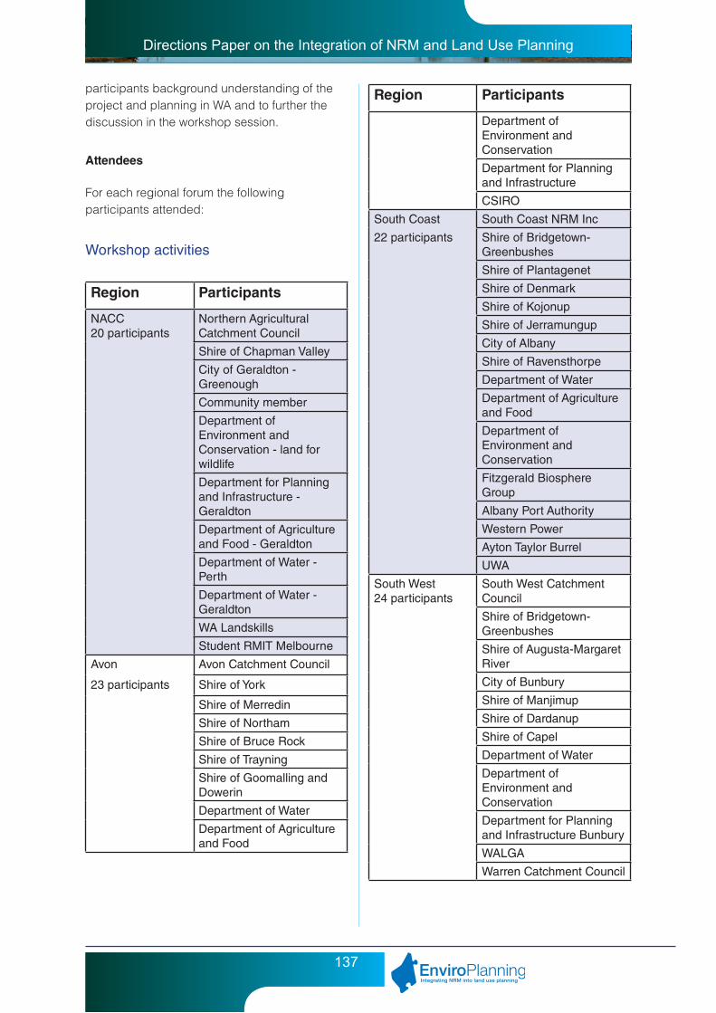
Directions Paper on the Integration of NRM and Land Use Planning
137
participants background understanding of the project and planning in WA and to further the discussion in the workshop session.
Attendees
For each regional forum the following participants attended:
Workshop activities
Region Participants
NACC20 participants
Northern Agricultural Catchment Council
Shire of Chapman Valley
City of Geraldton - Greenough
Community member
Department of Environment and Conservation - land for wildlife
Department for Planning and Infrastructure - Geraldton
Department of Agriculture and Food - Geraldton
Department of Water - Perth
Department of Water - Geraldton
WA Landskills
Student RMIT Melbourne
Avon Avon Catchment Council
23 participants Shire of York
Shire of Merredin
Shire of Northam
Shire of Bruce Rock
Shire of Trayning
Shire of Goomalling and Dowerin
Department of Water
Department of Agriculture and Food
Region Participants
Department of Environment and Conservation
Department for Planning and Infrastructure
CSIRO
South Coast South Coast NRM Inc
22 participants Shire of Bridgetown-Greenbushes
Shire of Plantagenet
Shire of Denmark
Shire of Kojonup
Shire of Jerramungup
City of Albany
Shire of Ravensthorpe
Department of Water
Department of Agriculture and Food
Department of Environment and Conservation
Fitzgerald Biosphere Group
Albany Port Authority
Western Power
Ayton Taylor Burrel
UWA
South West 24 participants
South West Catchment Council
Shire of Bridgetown-Greenbushes
Shire of Augusta-Margaret River
City of Bunbury
Shire of Manjimup
Shire of Dardanup
Shire of Capel
Department of Water
Department of Environment and Conservation
Department for Planning and Infrastructure Bunbury
WALGA
Warren Catchment Council
Directions Paper on the Integration of NRM and Land Use Planning
138
For each workshop session participants were requested to break out into tables with a mix of professional backgrounds including local government, agencies, catchment group representatives.
The first forum in NACC, the workshop session was held at the end of the day, the session focused on questions relating to NRM assets such as water, coast, biodiversity and asked:
• Whataretheassetmanagementissuesrelevant to land use planning?
• Whatdata,projectsandactivitiesarecurrently used for management of these assets in land use planning?
• Whatarethegaps/limitationstoachievingmanagement of these assets via land use planning?
• Whatprojects/programsareproposedtoimprove integration of asset management into land use planning?
The Avon forum participants in the afternoon workshop session were asked broader questions relating to NRM and land use planning:
• WhatarethekeyNRM-landuseplanningissues for the Avon Region.
• Whatarethewaystheseissuesarebeing addressed currently (think about the various mechanisms you use) - what is being done well and what needs improvement?
• Whatfutureapproachesareneeded(options / tools / support) for the better integration of NRM into land use planning?
For the final two forums (South Coast and South West) the workshop questions were adapted to reflect the feedback from the previous forums as well as the desire to obtain more specific answers from participants including detailed examples. For these reasons the South Coast and South West forums used the following questions:
• ConsideringthecurrentStatePlanningFramework - including state planning policies, development control policies, regional strategies, guidance statements
and current local schemes and strategies (the tools) - do you think it is adequate in terms of its flexibility and intent (objectives) to address NRM issues and assets? Think about flexibility, intent, wording, scale and implementation of these tools.
• Whatexperiencehaveyouhadwiththecurrent State Planning Framework not adequately addressing and ensuring positive NRM outcomes - please provide specific examples.
• AreState,Agency,localgovernmentand NRM regional group roles and responsibility in relation to addressing NRM issues and assets through land use planning clearly defined and understood?
If not for which agencies is further clarification of role and responsibilities required? What level of detail should be provided when defining or clarifying the roles or responsibilities of State Agencies to different stakeholders?
• ForwhichNRMthemesorissuesis availability of information a major limiting factor in addressing that issue through land use planning (top 3)? What information is required and how can access to it be best facilitated?
The South West Forum workshop session was incorporated into the day with one session in the morning and one after lunch in order to break up the presentations.
Workshop Outcomes
NACC
Interestingly from the Forum there was a strong identification that triple bottom line measures were needed to effectively integrate NRM into planning including true value placed on biodiversity, long term planning to reflect true costs and accountability.
Strongly evident from the workshop session was the concerns and limitations that are placed on local governments and catchment groups
Directions Paper on the Integration of NRM and Land Use Planning
139
through lack of resources - time, staff and money for programs. This combined with frustration with data that is difficult to obtain, incomplete, not centralised and often non-existent is placing boundaries on how far officers can implement NRM protection through planning.
Avon
From the Avon forum four strong themes emerged in relation to the issues of NRM and land use planning in the region, these were:
• Communication-lacking.
• Capacity-insufficient.
• Stateplanningframework-inadequate.
• Resourcing–insufficient.
The forum participants felt that there was:
• Lackofunderstandingoflanduseplanning in Perth (DPI / DEC) due to career pressures / experience shortages.
• PoorlyexpressedandconstructedSPP’s-open to interpretation.
• Accesstonetworks,advice,information-who / where / how.
• Resourcecapacity-howtoparticipateinthe process?
• Boundariesaredifferentforplanningandstate agencies.
• Needforimprovedcooperation,communication and resource sharing across local governments, particularly in the Avon River Catchment.
• Lackofintegrationbetweenlocalgovernment and state agencies.
South Coast
With a change in questions at the South coast forum in order to obtain more detailed answers from participants, the workshop revealed that:
• theStatePlanningFrameworkdidnotadequately integrated NRM into land use planning.
• thattherolesandresponsibilitiesofstate NRM agencies, NRM groups and local government in addressing NRM consultation through the different stages of the planning process are not clearly defined or understood.
• thekeyareasrequiringfurtherinformationare vegetation followed by water, climate change, land, biodiversity, buffer requirements.
More specifically, the participants felt that:
• StatePlanningFrameworkwasoutdated(NRM and climate change).
• Goodintentbutimplementationlacking.
• Regionalstrategy-noteffectiveandlacking relevance.
• Metro-centric,politicallydrivenandnotinnovative.
• Interpretation-useddifferently,notconsistent.
• Confusingandlackofawareness,lackofunderstanding.
• Periurbanplanningneededasopposedto urban planning.
• Lagtimes.
• Boundariesfortheregionsandplanningvary.
• Spatialscales.
• Objectivesdon’tfeedintolocallevels.
• Interpretationofdata.
• Significantconfusionwithchangingagencies - DEC / EPA / DOW.
• RoleofDepartmentofAgriculture-dothey address subdivisions or not?
• Internalissueswith‘redtape’preventingcommunication.
Specific examples provided by participants of good planning activities or those that did not achieve NRM outcomes included:
• CrystalPark,Ravensthorpe-ruralconservation estate - 1-4ha blocks with 3000m2 building envelope. Not much thought gone into allocation of envelopes.

Directions Paper on the Integration of NRM and Land Use Planning
140
• LittleGroveStructurePlan(CityofAlbany)protection of ridge in Mrs Piper, Jeffcott Street proposal.
South West
From the South West forum participants also felt that:
• TheStatePlanningFrameworkdidnotadequately integrate NRM into land use planning.
• Thattherolesandresponsibilitiesarenot clearly defined for NRM and land use planning in the region.
• Thekeyareasrequiringfurtherinformationare relating to GIS, resolution of data and ‘example planning’ that has been done well to reference.
The participants felt that there was:
• Notawholeofgovernmentresponsein the integration of NRM into land use planning.
• Localpoliciescreatedbylocalgovernment not supported by WAPC.
• Tooflexibleandtoospecific-needabalance.
• SomeSPP’sareworkingwell-eg.Leeuwin Ridge.
• Agencychangeoverandrestructurecausing confusion - DEC / EPA / DOW.
• DPIadviceandsignoffatwhatlevelisunknown.
• Regionalboundariesmakeitdifficulttoconsult and work together.
• Agenciesprovideconflictinganswers-eg. buffers.
• Organisationsownunderstandingislacking.
• NeedcommonGIStoeveryone.
• Trainingandeducationonusingdata.
• Resolutionofdataandscalesformappinginsufficient.
• Agenciesneedtocommunicatetheirstrategic direction on issues to local government.
Specific examples provided by participants of good planning activities or those that did not achieve NRM outcomes included:
• VasseNewtownConservationCategoryWetlands - not well done - wetlands overlooked and information lost, not on database. Also water sources not identified as required - acquired water through political process!
• PortGeographe-coastalplanningpolicynot applied - drainage, odour, sand movement all issues. Water allocation / aesthetic lake not considered up front. Over allocated area. Not consistent with other decisions on water for aesthetic reasons.
• VasseNetown-waterplanningnotcompleted upfront ...developers did not comply. Allocation insufficient but development happened. Ecological corridors not well done - eg. ocean to Preston in Bunbury. Planning policy not.
• GoodNRMexamples-subdivisionWindyHollow Estate Bridgetown - change in land use from rural to semi rural resulted in creek line improvements, vegetation linkages (private land / provisions).
• StonevilleinShireofMundaring-LSIPno.303 (local subdivision and infrastructure plan) - creek line reserves greater than 10%; lot design and building envelopes and road layout to protect remnant vegetation; improve corridor links.
• AugustaMargaretRiverShireCouncil- lot 24 Caves Road - Conservation Subdivision / rezoning - pristine bushland adjoining native reserves / DEC covenant (optional).
• badexamplefromAugustaMargaretRiverShire Council - lot 30 Gimble Road - lots too small; DEC unlikely willing to covenant with 5 lots; management plan conditional by local government.
• PortGeographeMarina-ShireofBusselton - bad.
• BoroniaHeights-Walpole-poorcompliance; acid sulfate soils not detected.

Directions Paper on the Integration of NRM and Land Use Planning
141
Overall
Overall feedback received from the workshop sessions from participants were that:
• Stateagencyorganisationsarelackingan understanding of their own role in the land use planning process.
• Thereissignificantconfusionoveragency roles and responsibilities with the restructures, amalgamations and changes that occur regularly.
• ThereisalackofunderstandingoftheState Planning Framework and how it can play a role in planning for NRM outcomes.
• InterpretationoftheStatePlanningframework (especially SPP’s) is varied according to which department and individual is consulted.
• Thevariationinplanning,NRMandstateagency boundaries make it difficult to consult and work together.
Feedback Forms
Feedback forms were completed by participants at the end of the forum to provide information to the EnviroPlanning project regarding success of the forum and any adaptations that may be required. The feedback is shown below.
Recommendations
The response from the forum participants was strongly supportive of further EnviroPlanning forums in the future to further opportunities for networking, learning about the planning process and the outcomes of the EnviroPlanning Directions paper.
The provision of further workshops and forums should be considered in light of the Directions Paper in December 2008.
0
10
20
30
40
50
60
70
80
90
100
EnviroPlanning forum feedback
succ
eede
din
del
iver
ing
on th
eaim
sof
the
For
um?
venu
e
food
and
beve
rage
orga
nisa
tion
and
form
at
Env
iroP
lann
ing
pres
enta
tions
Age
ncy
pres
enta
tions
Wor
ksho
p
Han
d-ou
ts/
faci
litat
ion
netw
orki
ng
unde
rsta
ndin
gha
s im
prov
ed
wor
ksho
p be
nefic
ial
in e
xplo
ring
oppo
rtun
ities
for
achi
evin
g N
RM
thro
ugh
land
use
pla
nnin
g?
Per
cent
age
Sat
isfa
ctio
n
Forum aspect
Midwest Avon South Coast South West Perth and Peel

Directions Paper on the Integration of NRM and Land Use Planning
142
Appendix 3: Review of the regional NRM strategies from a land use planning perspective
This report has been prepared as an initial component of EnviroPlanning (Natural Resource Management Land Use Planning Project), an Australian Government sponsored project funded through the Natural Heritage Trust. EnviroPlanning, a partnership project involving the Department for Planning and Infrastructure, Western Australian Planning Commission and the Western Australian Local Government Association, aims to improve the integration of Natural Resource Management (NRM) into land use planning. NRM for the purposes of EnviroPlanning is defined as “a process that seeks the best long-term outcomes for our land, water and air through controlling the interaction of society with the environment”.
The purpose of this report is to review the six Western Australian NRM Regional Strategies and associated Investment Plans to evaluate the effectiveness with which they acknowledge, guide, integrate and support the land use planning process in achieving NRM outcomes. Short papers specific to each NRM region have also been prepared and should be read in conjunction with this summary.
This report and the papers that have been prepared for each of the NRM regions are not intended to undermine the work that the NRM regions have undertaken in preparing and implementing their NRM regional strategies, rather explore the extent to which they have supported the integration of NRM into land use planning processes. It is acknowledged that the NRM regions through their strategies have taken the first initial step in recognising the linkage between NRM and land use planning. Furthermore it is acknowledged that the level of local government, DPI and WAPC engagement and involvement in the NRM regional process has been varied across the 6 NRM regions. This varied involvement of the key land use planning decision makers is a major contributing factor
that has influenced the effectiveness of the NRM regional strategies to acknowledge, guide, integrate and support the land use planning process in achieving NRM outcomes. Through the EnviroPlanning project it is hoped that the level of engagement and involvement of state and local government in supporting the NRM regions to improve the integration of NRM into land use planning will be further refined.
1. Overview of NRM Regional Strategies
NRM Regional Strategies were developed in response to a shift in the program delivery of NRM in Australia to a regional delivery model for the implementation of the National Action Plan for Salinity and Water Quality (NAP) and the second phase of the Natural Heritage Trust (NHT).
The regional delivery process is regulated through bilateral agreements between the Australian and State Governments that define the relationship between the Australian and State Governments for the delivery of regional funding and include information relating to management relationships, development of regional strategies, accreditation processes, regional investment plans and approval processes, funding arrangements and reporting and acquittal requirements.
56 NRM Regions were established across Australia with six NRM Regions being identified within Western Australia including the Avon, North Agricultural, Rangelands, South Coast, South West and Swan Regions. The size and nature of the six regions within Western Australia vary, with the Rangelands NRM Region being by far the largest covering over 90% of the state, whilst the majority of the States population is contained within the Swan and South West NRM regions.

Directions Paper on the Integration of NRM and Land Use Planning
143
Each of the Regions were required to develop a regional strategy based on a ‘whole of region’ approach to address significant natural resource management issues incorporating environmental, social and economic aspects. These regional strategies identify strategic, prioritised and achievable actions to address the range of NRM issues and achieve the regional targets. The strategies also form the basis of rolling investment plans that guide the delivery of funds within the region. Whilst the format and structure of the strategies varies between regions, each strategy sets out;
• theregionaltargetstobeachievedconsistent with the National Framework for NRM Standards and Targets;
• informationonhowtheplanwasdeveloped, including community consultation;
• theinformationbaseusedforplanning,including biophysical and socio-economic;
• proposedstrategiesandactivities,andjustification for their adoption;
• processesforassessingandmitigatingthe social and economic impact of achieving the objectives of the plan;
• implementationarrangements,includingidentification of responsibilities;
• informationonhowtheplanisconsistentwith other planning processes; and
• arrangementforreview,monitoringandevaluation.
Both the Australian and State Governments have accredited all six Regional NRM Strategies.
Definitions
Common terms used within the strategies and referred to in this review include;
AspirationalTargets – Long term targets which are aspirational statements about the desired condition of natural resources in the longer term (50 + years).
ResourceConditionTargets(RCTs) – Medium term targets (10-20 years) largely relating to resource condition, that set specific, timebound and measurable goals which progress towards meeting aspiration targets.
ManagementActionTargets(MATs) – Short term targets (1-5 years) designed to contribute towards progress of the longer term resource condition targets.
ManagementActions(MAs) – Steps required to meet management action targets.
2. Level of recognition and understanding of land use planning processes at State, regional and local levels
Land use planning has been widely recognised as a powerful and flexible tool through which Local and State government can consider and promote natural resource management matters in its decision-making processes. Recognition and understanding of the land use planning process is therefore integral when using this process to achieve natural resource management outcomes.
The level of recognition and understanding of land use planning processes varies greatly between the six NRM Regional Strategies. Understandably, the recognition and understanding is strongest in the Swan and South West Regional NRM strategies as these regions are experiencing the greatest population growth, land use change and development pressure, as compared with other regions. Both these strategies recognise the various stages of landuse planning at which NRM matters can

Directions Paper on the Integration of NRM and Land Use Planning
144
be considered and contain actions and targets specifically related to the land use planning process. Planning legislation and policy were also recognised as important considerations in the preparation of the Strategy.
The South Coast, Avon and Rangelands demonstrated a good to fair understanding, with the Northern Agricultural Region Strategy generally having a poor level of understanding of the land use planning process with limited recognition to the role of land use planning in NRM being given within the Strategy.
To improve the understanding of the role land use planning can play in NRM, a summary of the planning documents affecting each region, their status, and a brief indication of how they can contribute to implementing NRM Strategy actions would be a useful tool to be included within each of the strategies. Such a summary would also indicate which local governments in each region have operational local planning strategies, as some do not while other local governments are currently preparing local planning strategies. The summary could either be prepared as a supplementary document to guide implementation and the drawing up of future investment plans, or included in the Strategies themselves as part of any review of the strategies. Although some of the regions’ NRM Strategies have appendices that go some way towards doing this, none has a summary of how each individual planning tool can contribute to achieving NRM outcomes.
This summary of planning documents, in combination with recognition of the NRM issues relevant to land use planning and the planning mechanisms suitable for addressing these should indicate the potential of the land use planning system to achieve NRM outcomes.
3. Relevance and achievability of overarching objectives, resource condition targets, management action targets and management actions to land use planning
There are a number of shortcomings associated with most of the objectives, targets and actions of the NRM regional strategies that are relevant to land use planning. Specific objectives, targets and actions identified in the NRM regional strategies relevant to land use planning can be sourced from the accompanying papers specific to each NRM region. In general the following shortcomings and recommendations for addressing them were identified as common to most of the NRM regional strategies:
In some regions, the relevant Strategy’s recommendations (particularly both management action targets and management actions) are fairly limited, in absolute terms and/or in relation to the potential for the Strategies to make detailed recommendations about integrating NRM into the land use planning process. Probably only in the South West Region Strategy is the range of recommended targets and actions close to being sufficiently extensive. This concern is valid, notwithstanding the much more limited potential for land use planning to achieve NRM outcomes in broadacre agricultural or pastoral areas. A review of these recommendations should be made for the various Strategies, with implementation through the land use planning system in mind. The revised recommendations could be included in revised Strategies, or in supplementary documents to guide implementation.
Some of the management actions proposed in the NRM Regional strategies require the undertaking of activities or actions that are largely influenced by the actions of Local or State Government in terms of the legislative and policy frameworks that govern land use planning decision making processes. The following management actions provide such examples:

Directions Paper on the Integration of NRM and Land Use Planning
145
• Reviewlanduseplanningprocessand identify cleared land suitable for development
• Reviewdesigncodesfornewurbanareas
• Developrecommendationsforlocalandregional structure planning processes
• Developmechanismstopreferentiallylocate new developments on previously cleared land
• Changingnaturalresourceplanningprocesses to take into account climate change and variability
• Reviewingstatutoryplanningprocessestotake into account various NRM issues
• IncorporatingguidelinesonNRMissuesin local, regional and state planning processes
• ReviewingEnvironmentalProtectionPolicies and State Planning Policies.
Given that the NRM regional groups have no statutory powers or formerly recognised responsibilities for land use planning it will be impossible for them to achieve proposed actions (such as those above) without the cooperation and commitment of Local and State Government. None or very little detail is provided as to what progress or strategies are in place to foster cooperation and commitment of Local and State Government to such actions. Furthermore what role the NRM regional groups will fulfill or how they will support State or Local Government to undertake land use planning related management actions proposed in the strategies is generally absent. As suggested previously a review or audit of the management actions should be undertaken in conjunction with DPI and Local Governments to ascertain, roles and responsibilities, resources required and feasibility and achievability of the management actions.
Some of the targets, particularly Resource Condition Targets, had not been decided and set at the time of the release of some of the Strategies. Where these targets have now been determined, it is necessary to update the Strategies accordingly (or the summary of
their recommendations which is incorporated in new investment plans). If the determination of any of these targets is still outstanding, the targets should be determined as quickly as possible, given the length of time that has now elapsed since initial release of the Strategies, and the significant amounts of investment and expenditure taking place based on the Strategies.
Management Action Targets and Resource Condition Targets need to be unambiguous and easily measurable. Some of the MATs and RCTs from the various strategies should be rewritten accordingly.
Some of the targets are overambitious. This is usually because of the proposed time frame rather than the actual work required to meet the target. The targets need to be realistic, being cognisant of the resources available to local governments in particular, but also to state government agencies. Reviewing and amending legislation, policies, strategies and local planning schemes can be time-consuming and, particularly given the processes involved in amending statutory documents are necessarily lengthy. Such review and amendment of documents may also be seen by each local government or agency as a relatively low priority during a time of strong economic growth in the state and the difficulty many have in attracting and retaining experienced planning staff.
Some recommendations are made within a Strategy for a particular region that would impinge on other regions. One example is the recommendation in the South West’s Strategy that a State Planning Policy (SPP) on water sensitive urban design be prepared. Such an SPP would presumably be applicable throughout the state. Such recommendations may have merit, but it should be acknowledged in the relevant Strategy that there are jurisdictional issues and that this may affect the achievability of the targets.
The limits of the land use planning system in addressing NRM issues need to be recognised. For example, recommendations for local
Directions Paper on the Integration of NRM and Land Use Planning
146
planning schemes to address management issues relating to broadacre farming or pastoral operations would generally not be effective given the lack of change from one land use to another. This means applications for planning approval are rarely required, enforcement of any Scheme provisions relating to extensive agricultural use could be well beyond the planning resources and expertise available to rural and remote local governments.
4. Partnerships between Natural Resource Management regions and Local and State Government
All six NRM regional strategies recognise in some way the need for and importance of partnerships between the NRM “community” and local and State government, with comments to this effect in each strategy. However, the level of specific commitments to enhancing such partnership varies widely.
As alluded to in section 3. above, resources (actual officer/consultant time) and expertise (experience with both NRM issues and the land use planning system) are required to integrate consideration of NRM issues into strategic and statutory planning documents. There are three aspects to these requirements. Firstly, there are the resources and expertise required in the initial review and alteration of planning documents. Secondly, there is an ongoing requirement to ensure that those making land use planning decisions (on subdivisions, development applications, structure plans and rezoning proposals) are well informed with respect to whether the proposal is consistent or compliant with the NRM provisions in those planning documents. Thirdly some of the planning decisions (particularly subdivision and development applications) may result in conditions that require compliance monitoring (for example revegetation of a portion of land resulting from subdivision).
Regional NRM groups, State agencies and local governments need to explore and reach agreement on the best arrangements for
meeting the above requirements. Memoranda of Understanding or similar agreements, along with appropriate budget commitments, may then be necessary to ensure the agreements are acted on.
One issue that such Memoranda of Understanding or similar agreements could address is the commitment required from state and local government agencies to carry out recommendations (management actions) of the regional Strategies where these cannot occur without the relevant state and local government agencies’ support and actions. This has not been addressed in any significant detail in the various Strategies, with respect to processes or strategies to foster such cooperation and commitment from local and state government. It is also necessary to better clarify what role the NRM regional groups will fulfill and how they will support state or local government to undertake the land use planning related management actions proposed in the Strategies. A review or audit of the management actions should also be undertaken in, conjunction with DPI and local governments, to ascertain roles and responsibilities, resources required and the feasibility and achievability of the management actions.
Various models could be, and indeed are, used in addressing the issue of resourcing and appropriate expertise. Larger local governments and state government agencies with more of a land use planning function could and do employ specific officers to deal with environmental planning. However, for most of the smaller local governments, this would be impractical. Expertise could be made available as required to these local governments (and to any other stakeholders in the process requiring it) by officers within relevant state government agencies, or employed by regional NRM groups, or by regional organisations of Councils. Appropriate funding arrangements will be required. Programs for training local government planners, environmental officers or other staff in NRM, land use planning and the intersection between the two would have merit, but given the high turnover of staff in such

Directions Paper on the Integration of NRM and Land Use Planning
147
positions, such training may be required on a fairly regular, ongoing basis.
Information required by local governments and other decision makers does not only come in the form of verbal or written advice from technical officers. Commitments are also required to share Geographic Information System-based data and other forms of data on NRM issues between all relevant stakeholders. The NRM Shared Land Information Platform hosted by the Department of Agriculture and Food provides online access to most NRM datasets. However some of the datasets will require further analysis and interpretation to make them more useful for supporting land use planning decision making.
It is important to acknowledge that under the Environmental Protection Act, local planning schemes and local planning scheme amendments are referred to the Environmental Protection Authority (EPA) for a decision on the level of environmental assessment required. The underlying ethos behind this is that the suitability of particular land for proposed uses will be determined at the zoning stage, so that it is not necessary for all subsequent development and subdivision applications to be subject to environmental assessment. Because of this, there is to some extent a mindset among some local governments and other planning authorities that the consideration of environmental matters in the land use planning system is primarily or solely the responsibility of the EPA or the department working for it (now Department of Environment and Conservation). However, as the EPA/DEC are not resourced to carry out this entire role (and as it is clear from legislation and EPA draft Guidance Statement 33 that some consideration of environmental matters will be required of other decision makers in the planning system), it will be necessary for this mindset to be changed and for other stakeholders in the NRM process to accept responsibility for their part in ensuring NRM outcomes are achieved by the planning system.
5. Specific Natural Resource Management issues, targets or actions that could be addressed by the land use planning process
Provided below is a list of specific issues and recommendations that can be addressed by the land use planning process. Items on the list have been identified on the basis that available statutory or strategic land use planning mechanisms are, or should be, able to realistically contribute towards achieving the relevant NRM objective or target, though this does not infer that land use planning alone is sufficient to address most of the items. It should be noted that the significance of the contribution that land use planning can make will vary from item to item.
It should not be seen as exhaustive. Such a list, along with the land use planning mechanisms available to address each issue, target or action should be compiled for each NRM region and made available to local governments and other relevant stakeholders. This could be in the form of a “tool box” of options for using the planning system to address specific NRM issues. This data should be based on current and successful examples from across the state and also, where relevant, throughout Australia.
Some of the NRM issues and recommendations that can be addressed by land use planning include:
• Protectionoflandofagriculturalsignificance from urban and peri-urban encroachment
• Protectionofbasicrawmaterialsresources from urban and peri-urban encroachment
• Preventingorlimitingexposureofacidsulfate soils
• Rehabilitation,treatmentand/oravoidanceof contaminated sites
• Adaptationtosalinisationandrisinggroundwater levels
• Ensuringlandusereflectslandcapability

Directions Paper on the Integration of NRM and Land Use Planning
148
• Protectionofthequalityandquantityofground and surface water supply sources
• Protectionofwaterqualityandminimization of erosion through water sensitive urban design
• Minimisingeutrophicationandotherpollution of surface and groundwater
• Appropriatebuffersbetweendevelopmentand coastal, estuarine, and waterway foreshores
• Floodplainmanagement
• Protectionofwetlands
• Preventingorlimitinginappropriatemodification of waterways and surface runoff
• Protectionofbiodiversity
• Preventingorlimitingvegetationclearing(and its effects on environmental values and hydrology)
• Protectionofhabitatfromdestructionandfragmentation
• Preservationandenhancementofecological corridors
• Reductionofgreenhousegasemissions
• Reductionincardependencebytransportdemand management
• Accountingfornaturalvariabilityofshorelines in considering coastal development
• Accountingforsealevelriseandincreased storm surge arising from climate change in considering coastal development
• Protectionofcoastalhabitat,landformsand processes
• Protectionofairquality
• Preservationofareasofculturalheritagevalues
6. Land use planning mechanisms to resolve Natural Resource Management issues, targets or actions
Land use planning mechanisms can be broken into statutory and strategic mechanisms. Statutory planning is given effect primarily by regional and local planning schemes, in the allocation by zoning of land for different uses, the consideration of subsequent rezoning proposals, and the determination of development applications (and setting of any conditions of approval) in accordance with scheme provisions. Structure planning and subdivision of land are also statutory planning processes, governed partly by local planning schemes but also by Western Australian Planning Commission policy.
At a local government level, the most significant strategic planning instrument should be the local planning strategy, although for many local governments in Western Australia these are still being developed or have yet to be developed. A local planning strategy should give the medium to long term strategic direction for the local government with respect to land use planning, and should inform decision making under the corresponding local planning scheme(s). Thus, in considering a development application, a local government must have regard to background information, policy and guidance contained in the local planning strategy. Although opinion on the appropriate amount and level of detail in a local planning strategy varies, it is clear that local planning strategies have the potential to provide significant direction on addressing NRM issues and achieving NRM outcomes. Local planning policies adopted under a local government local planning scheme can also guide decision making under that scheme. At a state and regional level, State Planning Policies, a range of regional and sub-regional policies, strategies and structure plans, and Western Australian Planning Commission development control policies are all mechanism with the potential to be used to address NRM issues.

Directions Paper on the Integration of NRM and Land Use Planning
149
This section identifies land use planning mechanisms that can be used to resolve NRM issues and recommendations, identifying which mechanism(s) would be most appropriate in any case. As the list is not exhaustive, this does not exclude the use of other land use planning mechanisms to address the same issue. Land use planning mechanisms that can be used to resolve NRM issues and recommendations include:
• Identificationoflandofstateorregionalagricultural significance in the review of local planning strategies and schemes or separately.
• Protectionoflandofstateorregionalagricultural significance from inappropriate fragmentation and land use change by identification in local planning strategies, appropriate zoning and implementation of SPP 2.5 and DC 3.4.
• Identificationofbasicrawmaterialsresources and required buffers in appropriate policies and strategic planning documents, particularly local planning strategies.
• TheuseofappropriatezoningorSpecialControl Areas to secure basic raw materials resources and prevent intrusion of sensitive land uses into basic raw materials areas or their buffers.
• Identificationofacidsulfatesoilsinlocalplanning strategy mapping.
• UseofappropriatezoningorSpecialControl Areas to minimise risk of disturbance of acid sulfate soils. In this instance, appropriate zoning means a zoning such that those activities most likely to result in acid sulfate soil disturbance in a particular area are discretionary or not permitted (eg. subdivision for residential development).
• Schemeprovisionsdealingwithriskofexposing acid sulfate soils.
• Identificationof,appropriatezoningof, and Scheme provisions relating to contaminated sites. In this instance,
appropriate zoning means a zoning such that the range of permissible uses is limited to those which would be acceptable on the site, given the level and nature of contamination and the practicality of remediation. This does not imply that zoning should be used to excuse landowners from necessary site remediation, but recognises that, for instance, residential development might be an unacceptable ultimate use of some contaminated sites given the limitations of remediation.
• Considerationoftownsitesalinitymanagement plans in local planning schemes and amendments, subdivisions and development applications to prevent or minimise new development and infrastructure in areas threatened by salinisation and high watertables.
• IncorporationofSpecialControlAreasand Scheme provisions to give effect to townsite salinity management plans.
• Newzoningproposalsbasedonconsideration of land capability data, with such data possibly being incorporated into local planning strategies.
• Localplanningstrategyrecommendationsor Scheme provisions requiring land capability assessment prior to certain developments being carried out in certain areas.
• SpecialControlAreas,reservationandappropriate zoning of land and Scheme provisions to reflect Water Source Protection Plans.
• Schemeprovisions,localplanningstrategy or policy recommendations encouraging or requiring use of water sensitive design for new development or subdivision.
• Identificationofrequiredbufferstoforeshores and wetlands in strategies and policies, particularly local planning strategies, Scheme provisions and zone boundaries.
Directions Paper on the Integration of NRM and Land Use Planning
150
• AppropriatezoningorreservationandScheme provisions to protect buffers to foreshores and wetlands.
• Policies,SchemeprovisionsandSpecialControl Areas to ensure appropriate floodplain management and the prevention of inappropriate development within floodplains. Alternatively, floodplain mapping can be included in local planning strategies, with Scheme provisions referring to such mapping.
• Schemeprovisions,SpecialControlAreas,conservation zones, or subdivision or development incentives to control clearing and fragmentation of areas of significant biodiversity values.
• ParksandRecreation(orsimilar)reservation in statutory region schemes for areas of high conservation value, or reservation under local planning schemes.
• Requirementforplanningapprovalfordams.
• Identificationofecologicalcorridorsin local planning strategies and other strategic planning documents.
• SpecialControlAreasorSchemeprovisions protecting ecological corridors from clearing and/or inappropriate development.
• Schemeprovisionsincorporatingrevegetation conditions relating to ecological corridors, or more generally.
• ImplementationofStatePlanningPoliciesand Development Control Policies, regional planning strategies and strategic documents, local planning strategies and structure plans to achieve transport demand management, reduction of car dependence, viability of public transport, ease, safety and desirability of walking and cycling, mixed use development and appropriate integration of land use and transport.
• Sustainabilityassessment(perhapsusing checklists) for development and subdivision applications.
• ConsiderationofStateCoastalPlanningPolicy in all relevant new Schemes and amendments, local planning strategies and coastal structure plans and subdivisions.
• Identificationofculturalheritagevaluesin local planning strategies and other strategic planning documents.
• Heritageprecincts,SpecialControlAreas, use of Heritage Lists, transferable development rights and development incentives and other specific Scheme provisions to protect cultural heritage values.
7. Key Recommendations
Based on the review of the six NRM regional strategies, the following key recommendations are suggested for improving the effectiveness of the NRM regional strategies and associated investment plans to support the integration of NRM into land use planning processes:
1. Prepare a summary of the planning documents affecting the NRM region, their status and a brief explanation of how they can contribute to the resource condition targets, management action targets and actions of the NRM strategy.
2. Using section 5 and 6 of this review as a guide, identify from the NRM strategy those NRM issues, targets and actions relevant to land use planning and those land use planning mechanisms suitable for resolving the identified issues, targets and actions.
3. In consultation with DPI and local government define roles and responsibilities, resources required and feasibility and achievability of the management actions. It may be appropriate to formalise roles and responsibilities and allocation of resources through Memoranda of Understanding or similar.

Directions Paper on the Integration of NRM and Land Use Planning
151
4. Modify those land use planning related Resource Condition and Management Action targets to ensure that they are unambiguous and measurable
5. Acknowledge the limits of land use planning in addressing NRM issues, particularly in relation to broad acre farming or pastoral operations.
The NRM regions are encouraged to liaise with EnviroPlanning for further support and direction for addressing the above-mentioned recommendations. Furthermore EnviroPlanning will be using the information and recommendations contained in this report and the accompanying papers as the basis for delivering training aimed at improving the understanding and awareness of the NRM regional groups and their associated stakeholders of the opportunities to address NRM considerations through land use planning processes. Similarly EnviroPlanning will be using this report to facilitate an improved understanding by local and state government of the NRM regional process and the synergies between the NRM regional strategies and the land use planning responsibilities of local and state government.

Directions Paper on the Integration of NRM and Land Use Planning
152
Appendix 4: DPI organisational chart

Directions Paper on the Integration of NRM and Land Use Planning
153
Appendix 5: DEC administrative boundaries
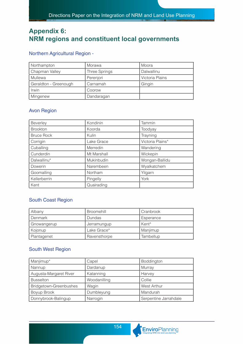
Directions Paper on the Integration of NRM and Land Use Planning
154
Appendix 6: NRM regions and constituent local governments
Northern Agricultural Region -
Northampton Morawa MooraChapman Valley Three Springs DalwallinuMullewa Perenjori Victoria PlainsGeraldton - Greenough Carnamah GinginIrwin CoorowMingenew Dandaragan
Beverley Kondinin TamminBrookton Koorda ToodyayBruce Rock Kulin TrayningCorrigin Lake Grace Victoria Plains*Cuballing Merredin WanderingCunderdin Mt Marshall WickepinDalwallinu* Mukinbudin Wongan-BalliduDowerin Narembeen WyalkatchemGoomalling Northam YilgarnKellerberrin Pingelly YorkKent Quairading
Albany Broomehill CranbrookDenmark Dundas EsperanceGnowangerup Jerramungup Kent*Kojonup Lake Grace* ManjimupPlantagenet Ravensthorpe Tambellup
Manjimup* Capel BoddingtonNannup Dardanup MurrayAugusta-Margaret River Katanning HarveyBusselton Woodanilling CollieBridgetown-Greenbushes Wagin West ArthurBoyup Brook Dumbleyung MandurahDonnybrook-Balingup Narrogin Serpentine Jarrahdale
Avon Region
South Coast Region
South West Region

Directions Paper on the Integration of NRM and Land Use Planning
155
Rockingham Fremantle ClaremontKwinana Melville NedlandsCockburn Canning PerthArmadale Belmont SubiacoGosnells Victoria Park CambridgeKalamunda South Perth VincentMundaring East Fremantle BayswaterSwan Mosman Park BassendeanJoondalup Peppermint Grove StirlingWanneroo Cottesloe
Wyndham - East Kimberley Derby - West Kimberley Halls CreekBroome East Pilbara Port HeadlandRoeburn Ashburton ExmouthCanarvon Upper Gascoyne MeekatharraWiluna Ngaanyatjarraku LavertonMenzies Kalgoorlie Boulder DundasCoolgardie Yilgarn* SandstoneLeonora Mount Magnet CueYalgoo Murchison Shark BayNorthampton*
Swan Region
Rangelands Region
(Those local government areas with a * next to their name indicates an area which is on the edge of a NRM region or they are involved in two regions).
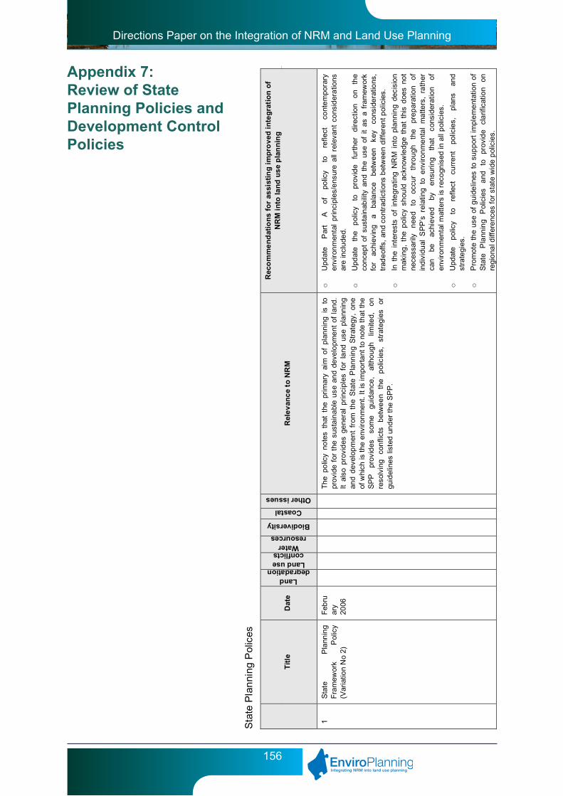
Directions Paper on the Integration of NRM and Land Use Planning
156
Appendix 7: Review of State Planning Policies and Development Control Policies
Sta
te P
lan
ning
Pol
ices
T
itle
D
ate
Land degradation
Land use conflicts
Water resources
Biodiversity
Coastal
Other issues R
ele
van
ce
to N
RM
Rec
om
me
nd
atio
ns
for
assi
stin
g i
mp
rov
ed i
nte
gra
tio
n o
f N
RM
in
to la
nd
us
e p
lan
nin
g
1 S
tate
P
lann
ing
F
ram
ewor
k P
olic
y (V
aria
tion
No
2)
Feb
ruar
y 20
06
The
po
licy
note
s th
at t
he p
rim
ary
aim
of
plan
ning
is
to
prov
ide
for
the
sus
tain
abl
e u
se a
nd
deve
lop
me
nt o
f la
nd.
It
also
pro
vid
es g
ene
ral
prin
cipl
es f
or l
and
use
pla
nnin
g
and
dev
elop
men
t fr
om t
he
Sta
te P
lann
ing
Str
ateg
y, o
ne
of
whi
ch is
the
env
iron
me
nt.
It is
impo
rta
nt t
o no
te th
at th
e
SP
P
prov
ides
so
me
guid
ance
, al
tho
ugh
limite
d,
on
re
solv
ing
co
nfli
cts
bet
we
en
the
p
olic
ies,
st
rate
gie
s or
gu
idel
ines
list
ed u
nd
er t
he S
PP
.
o
Upd
ate
P
art
A
of
polic
y to
re
flect
co
nte
mpo
rary
en
viro
nm
enta
l pr
inci
ples
/ens
ure
all
rele
van
t co
nsid
era
tions
ar
e in
clu
ded.
o
Upd
ate
the
pol
icy
to
prov
ide
furt
her
d
irect
ion
on
the
co
ncep
t of
sus
tain
abili
ty a
nd
the
use
of i
t as
a f
ram
ewor
k fo
r ac
hiev
ing
a ba
lanc
e be
twe
en
key
cons
ide
ratio
ns,
trad
eof
fs,
and
cont
rad
ictio
ns b
etw
een
diff
eren
t pol
icie
s.
o
In t
he
inte
rest
s o
f in
tegr
atin
g N
RM
int
o pl
ann
ing
deci
sio
n
mak
ing
, th
e p
olic
y sh
ould
ack
now
ledg
e th
at
this
doe
s no
t
nece
ssar
ily
nee
d to
oc
cur
thro
ugh
th
e pr
ep
arat
ion
of
ind
ivid
ual
SP
P’s
rel
atin
g t
o e
nviro
nm
ent
al
ma
tters
, ra
ther
ca
n be
ac
hiev
ed
by
ens
urin
g
that
co
nsid
erat
ion
of
envi
ron
men
tal m
atte
rs is
rec
ogn
ised
in a
ll p
olic
ies.
o
Upd
ate
pol
icy
to
refle
ct
curr
ent
po
licie
s,
plan
s an
d
stra
tegi
es.
o
Pro
mot
e th
e us
e o
f g
uide
lines
to
sup
por
t im
ple
me
ntat
ion
of
Sta
te
Pla
nnin
g P
olic
ies
and
to
pr
ovid
e cl
arif
icat
ion
on
re
gio
nal d
iffer
enc
es f
or s
tate
wid
e p
olic
ies.

Directions Paper on the Integration of NRM and Land Use Planning
157
T
itle
D
ate
Land degradation
Land use conflicts
Water resources
Biodiversity
Coastal
Other issues
Rel
ev
anc
e to
NR
M
Rec
om
me
nd
atio
ns
for
assi
stin
g i
mp
rov
ed i
nte
gra
tio
n o
f N
RM
in
to la
nd
us
e p
lan
nin
g
2
Env
iron
me
nt
and
N
atur
al
Res
our
ces
Pol
icy
June
20
03
The
pol
icy
has
thre
e ob
ject
ives
to:
o
inte
grat
e e
nviro
nm
ent
a
nd
natu
ral
reso
urce
m
ana
gem
ent
with
br
oade
r la
nd
use
plan
ning
an
d
deci
sion
-mak
ing;
o
prot
ect,
co
nse
rve
and
enha
nce
the
natu
ral
envi
ron
men
t; a
nd
o
pro
mo
te a
nd a
ssis
t in
the
wis
e a
nd
sust
aina
ble
use
an
d m
ana
gem
ent
of n
atur
al r
esou
rces
.
The
o
bjec
tives
pr
ovid
e
the
cont
ext
for
bro
ad
pol
icy
me
asur
es r
elat
ing
to w
ate
r re
sour
ces,
air
qual
ity,
soil
and
la
nd
qua
lity,
bi
odiv
ersi
ty,
agr
icul
tura
l la
nd
and
ra
nge
land
s, m
iner
als,
pe
tro
leu
m a
nd b
asic
raw
mat
eri
als,
m
arin
e re
sour
ces
and
aqua
cultu
re,
lan
dsca
pes
, gr
een
hous
e ga
s e
mis
sio
ns a
nd e
nerg
y e
ffici
ency
.
o
As
the
maj
ority
of
is
sues
co
vere
d by
S
PP
N
o.
2 ar
e
addr
esse
d in
m
ore
deta
il by
ot
her
S
PP
’s
(e.g
. W
ater
R
esou
rces
S
PP
2
.9,
Agr
icu
ltura
l a
nd
Ru
ral
Lan
d U
se
Pla
nnin
g S
PP
2.5
) th
ere
is p
oten
tial t
o co
nsid
er r
em
ova
l of
this
SP
P p
rovi
ded
the
follo
win
g is
un
dert
ake
n:
• B
roa
d pr
inci
ples
and
pol
icy
me
asur
es f
rom
thi
s S
PP
, w
here
no
t al
read
y in
clud
ed
in
the
Sta
te
Pla
nnin
g S
trat
egy
are
int
egr
ate
d as
pa
rt o
f an
y up
date
to
the
Sta
te P
lann
ing
Str
ateg
y
• D
evel
opm
ent
of
stat
e w
ide
SP
Ps
for
nat
ive
ve
geta
tion
and
bas
ic r
aw m
ate
ria
ls
• E
xpa
nd t
he s
cop
e of
SP
P 3
.4 N
atur
al
Haz
ard
s an
d D
isas
ters
to
in
clu
des
land
d
egra
dat
ion
ha
zard
s su
ch a
s sa
linity
an
d ac
id s
ulp
hat
e s
oils
o
The
Gu
idel
ines
for
th
is S
PP
tha
t ar
e b
eing
pre
pare
d w
ill s
till
be
rele
vant
as
a
n ov
era
ll g
uide
to
im
ple
me
ntin
g
envi
ron
men
tal c
onsi
der
atio
ns t
hro
ugh
oth
er S
PP
s.
o
Spe
cific
re
fere
nce
to C
limat
e C
han
ge i
s n
otic
eab
ly a
bsen
t fr
om
th
is S
PP
, co
nse
quen
tly i
t is
rec
om
me
nded
tha
t a
n
audi
t be
und
erta
ken
of t
he S
tate
Pla
nni
ng F
ram
ew
ork
to
ide
ntify
h
ow
clim
ate
chan
ge
miti
gatio
n an
d ad
apta
tion
m
eas
ures
ar
e cu
rren
tly
addr
esse
d,
with
a
view
to
co
nsol
idat
ing
and
addr
essi
ng g
aps
thro
ugh
int
egra
tion
of
addi
tiona
l cl
ima
te
chan
ge
miti
gat
ion
and
ad
apta
tion
m
eas
ures
into
exi
stin
g p
olic
ies.
2.1
P
eel-H
arv
ey
Coa
stal
P
lain
C
atc
hm
ent
P
olic
y
Feb
ruar
y 19
92
The
pol
icy
aim
s to
ens
ure
that
la
nd u
se c
hang
es w
ithin
th
e P
eel
Har
vey
Est
uar
y lik
ely
to c
aus
e e
nviro
nm
ent
al
dam
age
ar
e br
ough
t u
nder
pl
anni
ng
cont
rol
and
pr
eve
nted
. T
his
pol
icy
addr
esse
s th
e is
sues
of
inte
nsiv
e
agri
cultu
re,
con
nec
tion
to s
ewer
for
new
dev
elo
pm
ent
s,
rete
ntio
n o
f ve
geta
tion,
dra
ina
ge a
nd
wat
er s
upp
ly.
o
An
opp
ortu
nity
ex
ists
to
re
mov
e th
is
pol
icy
thro
ugh
in
tegr
atio
n o
f rel
evan
t ele
men
ts in
to e
xist
ing
SP
Ps:
• th
e co
mpo
nent
re
late
d to
a
gric
ultu
ral
ma
nage
men
t ca
n be
inc
orpo
rate
d in
to S
PP
2.5
un
der
spec
ial
prov
isio
ns r
elat
ing
to P
eel
Har
vey
Cat
chm
ent
• C
onte
nt
rela
ted
to t
he w
ater
ma
nage
men
t ca
n b
e
addr
esse
d u
nde
r S
PP
2.9

Directions Paper on the Integration of NRM and Land Use Planning
158
T
itle
D
ate
Land degradation
Land use conflicts
Water resources
Biodiversity
Coastal
Other issues
Rel
ev
anc
e to
NR
M
Rec
om
me
nd
atio
ns
for
assi
stin
g i
mp
rov
ed i
nte
gra
tio
n o
f N
RM
in
to la
nd
us
e p
lan
nin
g
2.2
Gna
ngar
a G
rou
ndw
ater
P
rote
ctio
n
Aug
ust
2005
T
he p
urpo
se o
f th
e po
licy
is t
o pr
eve
nt,
con
tro
l or
man
age
de
velo
pm
ent
a
nd
lan
d us
e ch
ange
s in
th
e G
nan
gara
gr
oun
dwa
ter
prot
ectio
n a
rea
that
ar
e lik
ely
to
caus
e
detr
ime
nta
l im
pact
s o
n gr
oun
dwat
er r
eso
urce
s. T
he f
ocus
is
on
prot
ectio
n of
the
gro
undw
ate
r re
sour
ce f
or h
um
an
us
e,
alth
ough
th
e en
viro
nm
ent
and
o
ther
us
es
are
ac
know
led
ged
in th
e ob
ject
ives
.
o
The
re
is
pot
entia
l to
re
mov
e th
is
polic
y th
roug
h
amal
gam
atin
g it
with
the
oth
er g
roun
dwa
ter
and
dri
nkin
g
wat
er s
upp
ly p
olic
ies
of S
PP
2.3
Jan
dak
ot G
rou
ndw
ater
P
rote
ctio
n
Po
licy
and
S
PP
2.
7
Pub
lic
Dri
nkin
g
Wat
er
Sou
rce
Po
licy.
Con
side
ratio
n sh
ould
als
o be
giv
en t
o th
e
amal
gam
atio
n o
f th
is p
olic
y, S
PP
2.3
an
d 2.
7 un
der
SP
P
2.9
Wat
er R
esou
rces
.
o
Pol
icy
me
asur
es f
or l
and
cap
abili
ty a
sses
sme
nt s
houl
d b
e
revi
ewed
to
refle
ct t
he c
apac
ity o
f ex
istin
g i
nfor
mat
ion
and
ex
pert
ise
with
in S
tate
and
loc
al g
over
nm
ent
to e
ffec
tivel
y ap
ply
land
ca
pa
bilit
y as
sess
me
nt
to
lan
d us
e p
lann
ing
de
cisi
ons.
2.3
Ja
ndak
ot
Gro
und
wat
er
Pro
tect
ion
Pol
icy
June
19
98
The
pur
pose
of
the
polic
y is
to
prev
ent
, co
ntr
ol o
r m
anag
e
deve
lop
me
nt
and
la
nd
use
cha
nges
in
th
e Ja
nda
kot
gro
undw
ate
r pr
otec
tion
are
a th
at
are
likel
y to
ca
use
de
trim
ent
al i
mpa
cts
on
gro
undw
ater
res
our
ces.
The
foc
us
is o
n pr
otec
tion
of t
he g
roun
dwa
ter
reso
urce
for
hu
ma
n
use,
al
thou
gh
the
envi
ron
men
t a
nd
oth
er
uses
ar
e
ackn
owle
dg
ed in
the
obje
ctiv
es.
o
The
re
is
pot
entia
l to
re
mov
e th
is
polic
y th
roug
h
amal
gam
atin
g it
with
the
oth
er g
roun
dwa
ter
and
dri
nkin
g
wat
er s
upp
ly p
olic
ies
of S
PP
2.2
Gna
ngar
a G
rou
ndw
ater
P
rote
ctio
n
Po
licy
and
S
PP
2.
7
Pub
lic
Dri
nkin
g
Wat
er
Sou
rce
Po
licy.
Con
side
ratio
n sh
ould
als
o be
giv
en t
o th
e
amal
gam
atio
n o
f th
is p
olic
y, S
PP
2.2
an
d 2.
7 un
der
SP
P
2.9
Wat
er R
esou
rces
.
o
Pol
icy
me
asur
es f
or l
and
cap
abili
ty a
sses
sme
nt s
houl
d b
e
revi
ewed
to
refle
ct t
he c
apac
ity o
f ex
istin
g i
nfo
rmat
ion
and
ex
pert
ise
with
in S
tate
and
loc
al g
over
nm
ent
to e
ffec
tivel
y ap
ply
land
ca
pa
bilit
y as
sess
me
nt
to
lan
d us
e p
lann
ing
de
cisi
ons.
2.4
Bas
ic R
aw M
ater
ials
Ju
ly
2000
T
he P
olic
y se
eks
to i
den
tify
the
loca
tion
and
ext
ent
of
know
n ba
sic
raw
m
ate
rial
s,
assi
st
pla
nnin
g d
ecis
ion
m
akin
g i
n re
spec
t to
ext
ract
ive
ind
ustr
y a
ppl
icat
ions
an
d
for
pro
posa
ls i
n th
e vi
cini
ty o
f ex
trac
tive
indu
stri
es a
nd
en
sure
th
e ex
trac
tion
of
basi
c ra
w
mat
eria
ls
doe
s n
ot
adve
rsel
y a
ffect
th
e en
viro
nm
ent.
The
p
olic
y cu
rre
ntly
on
ly c
over
s th
e P
erth
Met
rop
olita
n R
egio
n a
nd t
he
Sh
ires
of G
ingi
n, C
hitt
erin
g, N
orth
am
, M
urra
y, T
ood
yay
and
the
C
ity o
f M
and
ura
h.
o
Mak
e S
PP
Sta
te w
ide
o
Pro
vid
e sp
ecifi
c ad
vice
fo
r re
gio
ns
whe
re
dem
and
for
deve
lop
me
nt
exis
ts
(eg
Met
rop
olita
n R
egi
on
and
So
uth
W
est)
o
Est
ablis
h so
me
par
am
ete
rs f
or t
rad
eoffs
wh
ere
basi
c ra
w
ma
teri
als
con
flict
with
nat
ive
vege
tatio
n
o
Nee
ds t
o pr
ovid
e d
irect
ion
on
both
str
ateg
ic a
nd
reac
tive
ap
pro
ach
es
to
iden
tific
atio
n a
nd
extr
actio
n of
ba
sic
raw
m
ate
ria
ls. B
asic
Raw
mat
eria
ls s
trat
egy
sho
uld
be
pre
par
ed
to
iden
tify
pos
sib
le lo
catio
ns t
o so
urce
bas
ic r
aw m
ater
ials
.
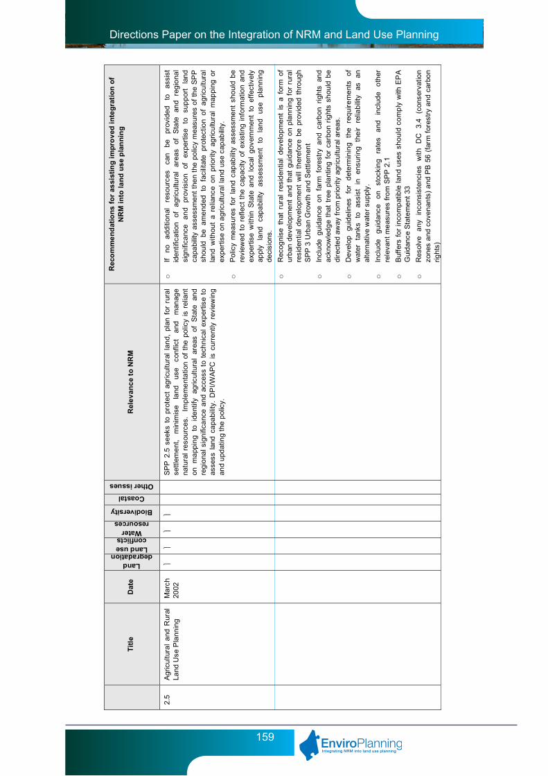
Directions Paper on the Integration of NRM and Land Use Planning
159
T
itle
D
ate
Land degradation
Land use conflicts
Water resources
Biodiversity
Coastal
Other issues
Rel
ev
anc
e to
NR
M
Rec
om
me
nd
atio
ns
for
assi
stin
g i
mp
rov
ed i
nte
gra
tio
n o
f N
RM
in
to la
nd
us
e p
lan
nin
g
2.5
Agr
icu
ltura
l a
nd R
ural
La
nd U
se P
lann
ing
Mar
ch
2002
S
PP
2.5
se
eks
to p
rote
ct a
gric
ultu
ral
lan
d, p
lan
for
rur
al
settl
eme
nt,
min
imis
e la
nd
use
conf
lict
and
m
anag
e
natu
ral
reso
urce
s.
Impl
em
ent
atio
n of
the
pol
icy
is r
elia
nt
on
ma
ppin
g to
id
ent
ify
agric
ultu
ral
area
s of
S
tate
an
d
reg
iona
l sig
nifi
canc
e a
nd a
cces
s to
tec
hni
cal
exp
ertis
e to
as
sess
lan
d ca
pabi
lity.
DP
I/WA
PC
is
curr
ent
ly r
evie
win
g
and
upd
atin
g th
e p
olic
y.
o
If no
a
dditi
onal
re
sour
ces
can
be
prov
ide
d to
as
sist
id
ent
ifica
tion
of
agr
icu
ltura
l ar
eas
of
Sta
te
and
reg
iona
l si
gnifi
canc
e a
nd
prov
isio
n of
ex
pert
ise
to
sup
por
t la
nd
ca
pabi
lity
asse
ssm
ent
the
n th
e po
licy
mea
sure
s o
f th
e S
PP
sh
ould
be
am
end
ed t
o fa
cilit
ate
prot
ectio
n o
f a
gric
ultu
ral
lan
d w
ithou
t a
relia
nce
on
prio
rity
ag
ricu
ltura
l m
appi
ng o
r ex
pert
ise
on
agr
icul
tura
l la
nd u
se c
apab
ility
.
o
Pol
icy
me
asur
es f
or l
and
cap
abili
ty a
sses
sme
nt s
houl
d b
e
revi
ewed
to
refle
ct t
he c
apac
ity o
f ex
istin
g i
nfor
mat
ion
and
ex
pert
ise
with
in S
tate
and
loc
al g
over
nm
ent
to e
ffec
tivel
y ap
ply
land
ca
pa
bilit
y as
sess
me
nt
to
lan
d us
e p
lann
ing
de
cisi
ons.
o
Rec
ogni
se t
hat
rur
al r
esid
entia
l de
velo
pm
ent
is
a fo
rm o
f ur
ban
dev
elop
me
nt a
nd t
hat
gu
idan
ce o
n p
lann
ing
for
rura
l re
sid
entia
l de
velo
pm
ent
will
th
eref
ore
be p
rovi
ded
th
roug
h
SP
P 3
Urb
an
Gro
wth
and
Set
tlem
ent
o
Incl
ude
gui
danc
e o
n fa
rm f
ores
try
an
d ca
rbon
rig
hts
and
ac
know
led
ge
that
tre
e p
lant
ing
for
car
bon
rig
hts
shou
ld b
e
dire
cte
d aw
ay fr
om
pri
orit
y ag
ricu
ltura
l are
as.
o
Dev
elop
gu
idel
ines
fo
r d
ete
rmin
ing
the
req
uire
me
nts
of
wat
er
tank
s to
as
sist
in
en
suri
ng
the
ir re
liabi
lity
as
an
al
tern
ativ
e w
ate
r su
pply
.
o
Incl
ude
gu
idan
ce
on
stoc
kin
g ra
tes
and
in
clud
e o
ther
re
leva
nt
me
asur
es fr
om
SP
P 2
.1
o
Buf
fers
for
inc
om
pat
ible
lan
d us
es s
houl
d co
mp
ly w
ith E
PA
G
uid
ance
Sta
tem
ent
33
o
Res
olve
a
ny
inco
nsis
tenc
ies
with
D
C
3.4
(c
onse
rvat
ion
zo
nes
and
cov
enan
ts)
and
PB
56
(far
m f
ores
try
and
carb
on
rig
hts)

Directions Paper on the Integration of NRM and Land Use Planning
160
T
itle
D
ate
Land degradation
Land use conflicts
Water resources
Biodiversity
Coastal
Other issues
Rel
ev
anc
e to
NR
M
Rec
om
me
nd
atio
ns
for
assi
stin
g i
mp
rov
ed i
nte
gra
tio
n o
f N
RM
in
to la
nd
us
e p
lan
nin
g
2.6
Sta
te
Coa
stal
P
lann
ing
Pol
icy
June
20
03
The
po
licy
appl
ies
to t
he
coas
t th
roug
hout
WA
an
d se
eks
to p
rote
ct c
oast
al v
alue
s, p
rovi
de p
ublic
acc
ess
to t
he
co
ast,
assi
st i
dent
ifica
tion
of a
reas
for
sus
tain
abl
e us
e of
th
e c
oast
for
ho
usin
g, t
our
ism
, re
cre
atio
n a
nd c
omm
erci
al
activ
ities
.
o
Wh
ere
a co
asta
l pla
nnin
g st
rate
gy h
as b
een
pre
pare
d af
ter
late
st g
azet
tal o
f S
PP
, th
at c
oast
al p
lann
ing
stra
tegy
sho
uld
ta
ke p
rece
den
ce o
ver
the
SP
P
o
Ref
ine
coa
stal
set
bac
ks t
o re
flect
lat
est
estim
ates
for
se
a
leve
l ris
e.
o
Coa
stal
vu
lner
abili
ty
stu
dy
is
req
uire
d
to
assi
st
furt
her
re
fine
men
t o
f co
asta
l set
back
s.
o
Est
ablis
h a
clea
r h
iera
rchy
a
nd
rela
tions
hip
b
etw
een
st
rate
gies
, m
ana
gem
ent p
lans
and
fore
shor
e p
lans
o
Rev
iew
def
initi
on o
f de
velo
pm
ent
nod
e as
it is
cur
ren
tly t
oo
br
oad
as
it
may
va
ry
from
a
grou
ping
of
re
cre
atio
nal
faci
litie
s to
an
urb
an a
rea
.
2.7
Pub
lic D
rink
ing
Wat
er
Sou
rce
Pol
icy
June
20
03
The
p
olic
y se
eks
to
ensu
re
that
la
nd
use
and
de
velo
pm
ent
with
in p
ublic
dri
nkin
g w
ater
sup
ply
area
s is
co
mpa
tible
w
ith
the
prot
ectio
n an
d lo
ng-t
erm
m
ana
gem
ent o
f wa
ter
reso
urce
s fo
r pu
blic
wa
ter
sup
ply.
o
Am
alg
am
ate
SP
P 2
.2 a
nd
2.3
un
der
this
SP
P a
nd
give
fu
rthe
r co
nsid
era
tion
to a
mal
gam
atio
n u
nder
SP
P 2
.9
2.8
Dra
ft B
ush
land
Pol
icy
for
the
Per
th
Me
tro
polit
an R
egi
on
July
20
04
The
po
licy
prov
ides
a f
ram
ewor
k fo
r th
e id
entif
icat
ion
and
pr
otec
tion
of
sig
nific
ant
bus
hla
nd
are
as
in
the
Per
th
Me
tro
polit
an R
egi
on.
o
A s
tate
wid
e na
tive
veg
etat
ion
polic
y sh
oul
d be
pre
par
ed
an
d in
clu
de
a se
ctio
n th
at
prov
ides
m
ent
ion
of
reg
ion
sp
ecifi
c pl
ans
such
as
Bus
h F
orev
er.
2.9
Wat
er R
eso
urce
s D
ece
mb
er
2006
The
po
licy
seek
s to
pro
tect
sig
nifi
cant
wat
er
reso
urce
s,
ma
inta
in
avai
labi
lity
of
wa
ter
in
a qu
antit
y a
nd
qua
lity
suita
ble
for
mee
ting
hum
an
and
biol
ogic
al r
equ
ire
me
nts
thro
ugh
its
sust
ain
abl
e u
se.
o
Con
side
r p
ossi
ble
am
alga
ma
tion
of
SP
Ps
2.2
, 2.
3 an
d 2.
7
unde
r th
is S
PP
o
Incl
ude
wa
ter
rela
ted
pol
icy
me
asur
es fr
om S
PP
2.1
o
Incl
ude
rel
eva
nt p
olic
y m
eas
ures
fro
m B
usse
lton
Wet
lan
ds
Con
serv
atio
n S
trat
egy
o
Dev
elop
men
t of
g
uide
lines
to
as
sist
im
ple
men
tatio
n o
f S
PP
. G
uid
elin
es
sho
uld
incl
ude
bet
ter
urb
an
wat
er
ma
nage
men
t fra
mew
ork
and
wet
land
buf
fers
o
Incl
ude
rec
ogni
tion
of t
he c
ultu
ral v
alue
s of
wat
er
reso
urce
s
2.1
0 S
wan
-Ca
nnin
g R
iver
S
yste
m
Dec
em
ber
20
06
The
po
licy
prov
ides
gu
idan
ce
reg
ard
ing
how
th
e
envi
ron
men
tal
valu
es
of
the
Sw
an
and
Ca
nnin
g R
iver
sy
stem
sh
ould
b
e co
nsid
ered
in
pl
anni
ng
dec
isio
n
mak
ing
.
o
The
driv
er f
or t
he p
repa
ratio
n of
th
e pr
ecin
ct p
lans
ne
eds
to
be
de
fine
d (e
.g.
no
furt
her
dev
elo
pm
ent
will
be
cons
ider
ed
in
th
e a
bse
nce
of a
pre
cinc
t pla
n).

Directions Paper on the Integration of NRM and Land Use Planning
161
T
itle
D
ate
Land degradation
Land use conflicts
Water resources
Biodiversity
Coastal
Other issues
Rel
ev
anc
e to
NR
M
Rec
om
me
nd
atio
ns
for
assi
stin
g i
mp
rov
ed i
nte
gra
tio
n o
f N
RM
in
to la
nd
us
e p
lan
nin
g
3 U
rba
n G
row
th
and
S
ettle
men
t M
arch
20
06
The
pol
icy
aim
s to
fac
ilita
te s
usta
ina
ble
pat
tern
s of
gro
wth
an
d se
ttle
men
t. It
id
ent
ifies
sp
ecifi
c o
bjec
tives
to
re
cog
nise
cl
imat
ic,
env
iron
me
ntal
, he
rita
ge
and
co
mm
uni
ty v
alue
s a
nd c
onst
rain
ts,
as w
ell
as r
educ
ing
en
ergy
, w
ater
and
tra
vel
dem
and.
In
its
cur
rent
sta
te t
he
S
PP
pr
ovid
es
no
new
p
olic
y ra
ther
re
itera
tes
and
in
terp
rets
ex
istin
g p
olic
y (e
.g.
net
wor
k ci
ty,
livea
ble
ne
ighb
ourh
ood
s, S
PP
2.5
). A
tte
mp
ts t
o a
ddre
ss u
rba
n
pla
nni
ng
issu
es t
hrou
ghou
t th
e S
tate
, bu
t pr
ovid
es li
mite
d
dire
ctio
n on
urb
an
plan
ning
in r
egi
onal
are
as.
o
Gui
dan
ce s
houl
d be
dev
elop
ed
to a
ssis
t pl
anni
ng f
or t
he
ex
pans
ion
of
urba
n ar
eas
an
d es
tabl
ish
me
nt o
f n
ew t
owns
th
rou
gh e
sta
blis
hing
a s
ettle
me
nt h
iera
rchy
tha
t in
clu
des:
• P
erth
Met
ropo
litan
Re
gion
• R
egio
nal C
ent
res
• R
ura
l Tow
ns
• R
ura
l far
min
g
• R
emot
e ab
orig
inal
co
mm
uni
ties
o
Rec
ogni
se
the
need
to
a
ddre
ss
per
i ur
ba
n (i
nter
face
be
twee
n ur
ban
and
rur
al l
and)
iss
ues
in
and
arou
nd P
erth
M
etr
opo
litan
Re
gion
and
oth
er R
egi
onal
Ce
ntre
s.
o
Rur
al
resi
den
tial
dev
elop
men
t sh
ould
be
ackn
owle
dg
ed a
s a
low
er
dens
ity
form
o
f ur
ban
dev
elo
pme
nt
that
sh
oul
d
occu
r a
djun
ct t
o a
n ur
ban
are
a.
o
Rur
al
resi
dent
ial
dev
elop
men
t sh
oul
d in
clu
de r
equi
rem
ent
s fo
r su
stai
nabl
e d
eve
lopm
ent
such
as
wa
ter
cons
erva
tion
, re
veg
etat
ion
and
use
of
alte
rnat
ive
ene
rgy
sour
ces
3.1
Res
iden
tial
Des
ign
C
odes
A
pril
2008
T
he
pur
pose
o
f th
e
R-C
odes
is
to
pr
ovid
e a
co
mpr
ehe
nsiv
e ba
sis
for
the
con
tro
l, th
rou
gh
loca
l go
vern
me
nt,
of r
esid
entia
l de
velo
pm
ent
thr
ough
out
WA
. O
ne o
f th
e o
bjec
tives
of
the
R-C
ode
s is
to
enco
urag
e
envi
ron
men
tally
sen
sitiv
e d
esig
n.
o
If no
t al
rea
dy in
corp
ora
ted
into
the
Na
tion
al b
uild
ing
cod
es,
the
R-C
odes
sho
uld
be r
evie
wed
to
intr
oduc
e p
erfo
rman
ce
base
d cr
iteri
a (s
uch
as
ener
gy
and
wat
er
cons
erva
tion/
effic
ienc
y) a
s a
way
of
incr
eas
ing
dens
ities
an
d e
nco
ura
ging
env
iron
me
ntal
ly s
ens
itive
des
ign
.
o
Tab
le 1
of
the
R-C
odes
sh
ould
be
revi
ewe
d as
it
supp
orts
hi
gh
er d
ens
ity f
or s
ingl
e dw
ellin
gs t
han
it
does
for
gro
upe
d
or m
ulti
ple
dwe
lling
s.
o
To
furt
her
re
duc
e sp
raw
l an
d en
cour
age
hig
her
de
nsity
de
velo
pm
ent
, e
ach
R
code
sh
ould
ha
ve
a m
inim
um
de
velo
pm
ent
de
nsity
.

Directions Paper on the Integration of NRM and Land Use Planning
162
T
itle
D
ate
Land degradation
Land use conflicts
Water resources
Biodiversity
Coastal
Other issues
Rel
ev
anc
e to
NR
M
Rec
om
me
nd
atio
ns
for
assi
stin
g i
mp
rov
ed i
nte
gra
tio
n o
f N
RM
in
to la
nd
us
e p
lan
nin
g
3.2
Pla
nnin
g fo
r A
bori
gin
al
Com
mun
ities
Aug
ust
2000
T
he p
olic
y ap
plie
s to
the
pla
nni
ng
and
dev
elop
men
t of
la
rge
per
ma
nen
t A
borig
inal
co
mm
uni
ties.
T
he
pol
icy
seek
s to
im
pro
ve t
he
stan
dar
d of
liv
ing
and
qu
ality
of
life
of
peo
ple
livin
g in
Abo
rigi
nal
co
mm
uni
ties.
Th
e p
olic
y in
its
cur
rent
for
m h
as l
ittle
dire
ct r
elev
anc
e to
NR
M b
ut h
as
pote
ntia
l to
be
tter
addr
ess
NR
M t
hrou
gh c
ons
ider
atio
n of
su
ch
issu
es
as
wa
ter
and
e
nerg
y co
nser
vatio
n,
reve
get
atio
n a
nd la
nd
use
buf
fers
.
o
Pro
vid
e gu
idan
ce o
n bu
ffer
s b
etw
een
lan
d us
e th
at h
ave
pote
ntia
l to
co
nflic
t w
ith
resi
den
tial
deve
lop
me
nt
(e.g
.
rub
bish
tip,
eff
luen
t dis
pos
al a
nd
gene
rato
r).
o
Enc
our
age
rev
eget
atio
n a
nd C
OA
G p
rinc
iple
s th
at s
uppo
rt
the
min
imis
atio
n of
e
ner
gy
and
w
ater
d
eman
d,
as
a
req
uire
me
nt t
o b
e co
nsid
ered
whe
n de
velo
ping
co
mm
unity
layo
ut p
lans
.
3.4
Nat
ural
H
azar
ds
and
D
isas
ters
A
pril
2006
T
he
purp
ose
of
the
pol
icy
is
to
enc
our
age
lo
cal
gove
rnm
ent
s to
a
dopt
a
syst
em
atic
a
ppro
ach
to
th
e
cons
ider
atio
n o
f n
atur
al
haza
rds
and
disa
ster
s as
par
t of
th
e p
lann
ing
and
app
rova
ls
proc
ess.
T
his
incl
ude
s co
nsid
erat
ion
of f
lood
ing,
sev
ere
stor
ms
and
cycl
ones
, st
orm
sur
ge,
coa
stal
ero
sion
, b
ush
fires
, la
nds
lides
an
d
oth
er
lan
d m
ove
me
nts
and
ear
thq
uake
s.
The
re
is
pote
ntia
l to
addr
ess
NR
M is
sues
suc
h as
sal
inity
an
d ac
id
sulfa
te s
oils
thr
ough
bro
ade
ning
the
sco
pe o
f th
e S
PP
.
o
Con
side
ratio
n sh
oul
d b
e g
iven
to
th
e in
clus
ion
of
acid
su
lfate
so
ils,
salin
ity
and
land
de
gra
datio
n as
n
atur
al
haza
rds.
3.6
Dra
ft
Dev
elo
pm
ent
C
ontr
ibut
ions
fo
r In
fras
truc
ture
May
20
08
The
pol
icy
sets
out
the
pri
ncip
les
and
co
nsid
era
tions
th
at
appl
y to
dev
elo
pm
ent
co
ntri
but
ions
for
the
pro
visi
on
of
infr
astr
uctu
re in
new
an
d es
tabl
ishe
d ur
ban
are
as.
o
Gui
dan
ce
thro
ugh
exa
mpl
es
coul
d b
e pr
ovid
ed
on
how
de
velo
per
cont
rib
utio
ns
have
be
en
used
to
pr
otec
t en
viro
nm
enta
l ass
ets.
4.1
Dra
ft
Sta
te
Ind
ustr
ial
Buf
fer
Pol
icy
July
20
04
The
pur
pos
e of
th
e p
olic
y is
to
prot
ect
indu
stry
an
d av
oid
co
nflic
t w
ith s
ensi
tive
lan
d us
es.
Env
iron
me
ntal
ass
ets
are
curr
ent
ly n
ot r
ecog
nise
d as
a s
ensi
tive
lan
d us
e.
o
Rec
ogni
se e
nvir
onm
ent
al a
sset
s as
a s
ens
itive
land
use
.
o
Cla
rify
an
d d
efin
e th
e ro
le
of
lan
d us
e p
lann
ing
in
dete
rmin
ing
buff
ers
4.2
Me
tro
polit
an
Cen
tres
P
olic
y S
tate
me
nt
for
the
Per
th M
etro
pol
itan
R
egio
n
Oct
ober
20
00
The
pri
ncip
le p
urp
ose
of t
he
polic
y is
to
prov
ide
a br
oad
re
gio
nal
pla
nnin
g fr
am
ew
ork
to c
oord
inat
e th
e lo
catio
n
and
dev
elo
pme
nt o
f re
tail
and
co
mm
erci
al a
ctiv
ities
in t
he
m
etr
opo
litan
re
gion
. It
is
mai
nly
conc
erne
d w
ith
the
lo
catio
n,
dis
trib
utio
n an
d br
oad
desi
gn
crite
ria.
It
is
thro
ugh
the
bro
ad d
esig
n gu
idel
ines
whe
re a
n o
ppo
rtu
nity
ex
ists
to
bette
r ad
dres
s N
RM
iss
ues
suc
h as
ene
rgy
and
w
ater
con
serv
atio
n.
o
Incl
ude
d
esig
n re
qui
rem
ent
s th
at
enc
oura
ge
wat
er
cons
erva
tion
(e.g
. ha
rves
ting
of
wa
ter
fro
m r
oof
to
sup
port
sh
oppi
ng c
ent
re w
ate
r re
qui
rem
ent
s fo
r ac
tiviti
es s
uch
as
clea
ning
an
d la
ndsc
api
ng)
and
en
ergy
con
serv
atio
n.

Directions Paper on the Integration of NRM and Land Use Planning
163
T
itle
D
ate
Land degradation
Land use conflicts
Water resources
Biodiversity
Coastal
Other issues
Rel
ev
anc
e to
NR
M
Rec
om
me
nd
atio
ns
for
assi
stin
g i
mp
rov
ed i
nte
gra
tio
n o
f N
RM
in
to la
nd
us
e p
lan
nin
g
4.3
P
oultr
y F
arm
s P
olic
y D
ece
mb
er
1998
The
p
olic
y pr
ovid
es
advi
ce
to
dete
rmin
e
rezo
nin
g,
subd
ivis
ion
and
d
eve
lopm
ent
a
pplic
atio
ns
for
pou
ltry
farm
s,
as
we
ll as
id
entif
ies
the
cons
ider
atio
ns
for
appl
icat
ions
in
thei
r vi
cini
ty.
The
mai
n N
RM
iss
ue
is i
n
rela
tion
to
odo
ur;
how
ever
noi
se,
dus
t a
nd v
isua
l im
pact
s ar
e al
so r
ele
vant
.
o
Cou
ld p
ossi
bly
rem
ove
this
pol
icy
and
incl
ude
und
er t
he
in
dus
tria
l b
uffe
rs S
PP
4.
1 t
hro
ugh
reco
gni
tion
of p
oultr
y fa
rms
as a
n ag
ricu
ltura
l ind
ustr
y.
5.2
Tel
eco
mm
uni
catio
ns
Infr
astr
uctu
re
Mar
ch
2004
T
he
pol
icy
prov
ides
a
fra
mew
ork
for
the
pre
para
tion,
as
sess
me
nt
and
dete
rmin
atio
n of
a
pplic
atio
ns
for
pla
nni
ng
appr
ova
l of
tele
com
mun
icat
ions
fac
ilitie
s. O
ne o
f th
e ob
ject
ives
of
the
pol
icy
is t
o m
inim
ise
dis
turb
anc
e to
th
e e
nviro
nm
ent
thr
ough
pro
visi
on
of t
elec
om
mu
nica
tions
in
fras
truc
ture
.
o
Incl
ude
re
quire
men
t for
no
net e
nvir
onm
enta
l im
pac
t
o
Rev
iew
th
e G
uid
elin
es f
or t
he
Loc
atio
n, S
iting
an
d D
esig
n
of
Tel
eco
mm
uni
catio
ns
Infr
astr
uctu
re,
wh
ich
supp
orts
im
plem
ent
atio
n of
th
e po
licy,
to
ensu
re t
hat
th
ey r
efle
ct
cont
empo
rary
env
iron
men
tal p
lann
ing
prin
cip
les.
6.1
Leeu
win
-Nat
ura
liste
R
idge
Po
licy
Janu
ary
2003
T
his
pol
icy
aim
s to
ach
ieve
cre
ativ
e, v
ital a
nd
sust
aina
ble
co
mm
uni
ties
livin
g in
ba
lanc
e w
ith e
con
om
ic d
eve
lop
me
nt
and
the
uni
que
lan
dsca
pe
and
env
iron
me
nta
l va
lues
of
the
polic
y ar
ea.
It
prov
ides
dir
ectio
n fo
r th
e co
nsid
era
tion
of
all
rele
vant
NR
M i
ssu
es.
Th
e p
olic
y is
co
nsid
ere
d a
go
od
exa
mp
le
of
the
typ
e o
f g
uida
nce
that
ca
n b
e
prov
ide
d th
roug
h re
gio
nal
pla
ns t
o ad
dres
s is
sues
th
at
occu
r ov
er m
ore
tha
n on
e lo
cal g
over
nm
ent
.
o
Pol
icy
stat
em
ent
2
.3
rela
ting
to
the
cle
arin
g of
n
ativ
e
vege
tatio
n sh
ould
be
revi
ew
ed
to e
nsu
re c
ompl
ianc
e w
ith
nativ
e ve
geta
tion
cle
arin
g pr
ovis
ions
of
the
Env
iro
nmen
tal
Pro
tect
ion
Act
o
Pol
icy
me
asur
es t
hat
re
late
to
soil
capa
bilit
y as
sess
men
t sh
ould
be
re
view
ed
to
refle
ct
the
cap
acity
o
f ex
istin
g
info
rmat
ion
and
ex
pert
ise
with
in
Sta
te
an
d lo
cal
gove
rnm
ent
to
e
ffec
tivel
y a
pply
la
nd/
soil
cap
abi
lity
asse
ssm
ent
to
land
use
pla
nni
ng d
ecis
ions
.
o
Rev
iew
Gui
delin
es t
o en
sure
tha
t th
ey r
efle
ct c
ont
em
pora
ry
envi
ron
men
tal p
lann
ing
prin
cipl
es.
6.3
Nin
galo
o C
oas
t A
ugus
t 20
04
The
p
olic
y p
rovi
des
guid
ance
o
n th
e su
stai
nabl
e
deve
lop
me
nt o
f th
e N
inga
loo
Co
ast,
wh
ich
incl
ude
s a
n
obje
ctiv
e to
“pr
eser
ve a
nd
pro
tect
th
e na
tura
l env
iron
me
nt
and
enh
ance
an
d re
habi
litat
e d
egra
ded
are
as w
ithin
th
e
envi
ron
men
t”.
It a
lso
con
tain
s gu
idin
g pr
inci
ples
, in
clud
ing
su
stai
nabl
e d
evel
opm
ent,
pro
tect
ion
of h
igh
cons
erva
tion
va
lues
an
d pr
otec
tion
of
bio
dive
rsity
. T
he
pol
icy
give
s st
atus
to
the
Nin
gal
oo C
oas
t R
egi
on S
tra
tegy
tha
t al
read
y ha
s st
atu
s th
rou
gh S
PP
1.

Directions Paper on the Integration of NRM and Land Use Planning
164
T
itle
D
ate
Land degradation
Land use conflicts
Water resources
Biodiversity
Coastal
Other issues
Rel
ev
anc
e to
NR
M
Rec
om
me
nd
atio
ns
for
assi
stin
g i
mp
rov
ed i
nte
gra
tio
n o
f N
RM
in
to la
nd
us
e p
lan
nin
g
M
etr
opo
litan
F
reig
ht
Net
wo
rk
(dra
ft)
and
R
oad
and
Ra
il T
rans
port
N
ois
e
(Dra
ft)
May
20
05
The
tw
o S
PP
s ar
e to
be
com
bine
d as
one
, w
ith t
he
aim
of
ide
ntify
ing
and
prot
ectin
g th
e fr
eig
ht r
oad
and
rail
netw
ork
as
wel
l as
m
inim
ise
the
adve
rse
imp
act
of
fre
ight
tr
ansp
ort
nois
e o
n ad
jace
nt
dev
elo
pmen
t. T
he
pol
icie
s se
ek to
min
imis
e a
dver
se e
nvir
onm
enta
l im
pact
s.
o
Incl
ude
re
quire
men
t fo
r no
ne
t e
nvir
onm
enta
l im
pac
t w
hen
lo
catin
g an
d de
velo
ping
fre
ight
ha
ndl
ing
faci
litie
s
o
Incl
ude
d
esig
n re
qui
rem
ent
s th
at
enc
oura
ge
wat
er
cons
erva
tion
(e.g
. ha
rves
ting
of
wa
ter
fro
m r
oof
to
sup
port
th
e f
reig
ht h
and
ling
cent
re w
ater
re
quire
men
ts f
or a
ctiv
ities
su
ch
as
cle
anin
g an
d la
ndsc
api
ng)
and
e
nerg
y co
nser
vatio
n.
N
etw
ork
City
(D
raft
) M
arch
20
06
The
aim
of
the
pol
icy
is t
o co
nfirm
the
sta
tus
of N
etw
ork
City
: C
om
mun
ity P
lan
nin
g S
trat
egy
for
Per
th a
nd P
eel,
Net
wo
rk
City
fr
am
ewor
k an
d ac
tion
plan
as
th
e
me
tro
polit
an p
lan
for
Per
th a
nd
Pe
el.
Net
wor
k C
ity h
as a
nu
mb
er
of
obje
ctiv
es
that
ha
ve
rele
vanc
e to
N
RM
in
clud
ing;
de
liver
ur
ban
grow
th
man
age
me
nt,
alig
n
tran
spor
t sy
stem
s an
d la
nd
use
to o
ptim
ise
acce
ssib
ility
an
d a
me
nity
, d
eliv
er a
n e
ner
gy e
ffici
ent
tran
spor
t sy
ste
m
and
prot
ect
and
en
han
ce
the
nat
ura
l e
nvir
onm
ent
an
d
open
spa
ces.
o
As
Net
wor
k C
ity s
uper
sede
s M
etro
pla
n, r
em
ove
ref
eren
ce
to M
erto
plan
in S
PP
1.

Directions Paper on the Integration of NRM and Land Use Planning
165
Dev
elo
pm
ent
Co
ntro
l Pol
icie
s
T
itle
D
ate
Land degradation
Land use conflicts
Water resources
Biodiversity
Coastal
Other issues
Rel
ev
anc
e to
NR
M
Rec
om
me
nd
atio
ns
for
assi
stin
g i
mp
rov
ed i
nte
gra
tio
n o
f N
RM
in
to la
nd
us
e p
lan
nin
g
1.1
Sub
divi
sion
of
Land
-
gene
ral p
rinc
iple
s Ju
ne
2004
T
he p
olic
y se
ts o
ut t
he
ge
nera
l pr
inci
ples
, w
hic
h w
ill b
e
used
by
the
WA
PC
in
dete
rmin
ing
app
lica
tions
for
th
e
subd
ivis
ion
of
land
. T
he
pol
icy
curr
ently
has
a n
um
ber
of
obje
ctiv
es,
but
non
e th
at
rela
te
spec
ifica
lly
to
envi
ron
men
tal
or
sust
aina
bilit
y ou
tco
mes
. F
rom
an
NR
M
pers
pec
tive
, th
e p
olic
y's
grea
test
re
leva
nce
is
that
it
req
uire
s su
bdi
visi
on
app
lica
tions
to
dem
onst
rate
:
o
sust
aina
ble
and
env
iron
me
ntal
ly r
esp
onsi
ve d
esig
n
o
crea
tion
of
a po
sitiv
e se
nse
of p
lace
and
id
entit
y ba
sed
on n
atu
ral a
nd c
ultu
ral a
sset
s.
o
Incl
ude
the
fo
llow
ing
obje
ctiv
es b
ase
d o
n th
e pr
inci
ples
of
the
'Na
tion
al P
lann
ing
Pri
ncip
les
for
Re
duci
ng
En
ergy
an
d
Wat
er
De
man
d th
roug
h L
and
Use
a
nd
Infr
astr
uctu
re
Des
ign'
:
• to
en
sure
a
n in
tegr
ate
d ap
pro
ach
to
subd
ivis
ion
de
sign
th
at
faci
litat
es
sust
ain
abl
e
dev
elo
pmen
t ou
tcom
es
and
ac
coun
ts
for
wh
ole
of
lifec
ycle
pr
oces
ses;
• to
fac
ilita
te s
ubd
ivis
ion
des
ign
tha
t re
duce
s th
e n
eed
to
tra
vel,
supp
orts
th
e us
e of
pub
lic t
rans
port
, cy
clin
g
and
wa
lkin
g a
nd
prom
otes
a
n e
nerg
y a
nd
wat
er
effic
ient
urb
an fo
rm;
• to
fac
ilita
te t
he
opt
imal
use
of
land
an
d ex
istin
g an
d
futu
re in
fras
truc
ture
ass
ets;
• to
en
sure
th
e su
stai
nabl
e us
e of
la
nd
suita
ble
fo
r pr
imar
y pr
oduc
tion
• to
e
nsur
e w
aste
a
nd
stor
m
wa
ter
is
effe
ctiv
ely
ma
nage
d an
d re
use
d
• to
ens
ure
that
all
lots
th
at a
re c
rea
ted,
are
ori
ent
ate
d
to m
axim
ise
sola
r p
assi
ve b
uild
ing
desi
gn
• to
e
nsur
e su
bdiv
isio
n d
esig
n fa
cilit
ates
ad
apta
tion
ov
er t
ime
(e.g
. fle
xibi
lity
exis
ts f
or i
ncre
ased
de
nsity
ar
oun
d pu
blic
tra
nsp
ort
node
s)
• In
trod
uce
prin
cip
le
of
inn
ovat
ive
sub
divi
sion
d
esig
n
tha
t is
g
uide
d by
p
erfo
rma
nce
base
d cr
iteria
to
ac
hiev
e be
tter
envi
ron
men
tal
and
d
eve
lopm
ent
outc
omes
.
• F
or
eas
e o
f re
fere
nce
an
d to
m
inim
ise
dupl
icat
ion
, gu
idan
ce o
n st
ruct
ure
pla
nnin
g sh
oul
d oc
cur
in o
ne
po
licy,
as
such
sec
tion
3.3
of t
he p
olic
y sh
ould
be
am
alga
mat
ed
with
br
oa
der
gui
danc
e o
n st
ruct
ure
pl
an
nin
g.

Directions Paper on the Integration of NRM and Land Use Planning
166
T
itle
D
ate
Land degradation
Land use conflicts
Water resources
Biodiversity
Coastal
Other issues
Rel
ev
anc
e to
NR
M
Rec
om
me
nd
atio
ns
for
assi
stin
g i
mp
rov
ed i
nte
gra
tio
n o
f N
RM
in
to la
nd
us
e p
lan
nin
g
1.2
Dev
elop
men
t co
ntro
l –
gen
eral
mea
sure
s A
ugus
t 20
04
The
pol
icy
sets
out
th
e ge
nera
l pri
ncip
les
tha
t w
ill b
e us
ed
by
th
e W
AP
C
in
its
det
erm
inat
ion
of
app
lica
tions
fo
r ap
prov
al
to c
om
me
nce
dev
elo
pme
nt i
n ar
eas
cov
ere
d by
th
e
Met
rop
olita
n R
egio
n S
che
me
a
nd
Pe
el
Reg
ion
S
che
me
. T
he
pol
icy
curr
ently
con
tain
s a
n o
bjec
tive
that
re
late
s to
pro
mo
ting
deve
lop
me
nt t
hat
is s
usta
inab
le a
nd
ap
pend
ix 2
rec
ogni
ses
that
th
e re
spo
nsib
le a
utho
rity
may
re
qui
re a
n en
viro
nme
nta
l stu
dy.
o
Incl
ude
obj
ectiv
es b
ase
d o
n p
rinci
ples
1-6
of
the
'Nat
iona
l P
lann
ing
Pri
ncip
les
for
Re
duci
ng
En
ergy
a
nd
Wat
er
Dem
and
thro
ugh
Lan
d U
se a
nd I
nfra
stru
ctur
e D
esig
n'
1.3
Str
ata
title
s S
epte
mb
er
2003
Thi
s p
olic
y pr
ovid
es g
uida
nce
for
the
use
and
app
rova
l of
S
trat
a T
itle
pro
pos
als.
It
mak
es
refe
renc
e to
la
nd
ca
pabi
lity
in r
ura
l ar
eas
for
on-
site
was
tew
ater
tre
atm
ent
sy
stem
s an
d th
e ne
ed
to
cons
ide
r ag
ricu
ltura
l ac
tivity
w
hen
dete
rmin
ing
a
ppro
pria
te
lot
size
s.
Alth
ough
n
ot
expl
icitl
y m
ent
ione
d in
the
po
licy,
th
ere
is a
n o
ppo
rtu
nity
fo
r st
rata
dev
elop
me
nts
to a
chie
ve b
iod
iver
sity
pro
tect
ion
ou
tcom
es
whe
re
area
s o
f re
mn
ant
vege
tatio
n ar
e
prec
lud
ed f
rom
dev
elop
men
t a
nd m
anag
ed a
s p
art
of t
he
st
rata
re
quire
men
ts.
o
Incl
ude
a
polic
y m
eas
ure
title
d 'S
tra
ta
Titl
es
for
Con
serv
atio
n'
tha
t p
rovi
des
dire
ctio
n on
th
e us
e of
str
ata
tit
les
for
faci
litat
ing
rete
ntio
n an
d m
anag
em
ent
of
nat
ura
l ar
eas
.
1.4
Fun
ctio
nal
Roa
d
Cla
ssifi
catio
n fo
r P
lann
ing
T
he p
olic
y es
tab
lish
es a
ro
ad c
lass
ifica
tion
syst
em
for
us
e in
pla
nni
ng
new
ro
ad n
etw
ork
s. T
he
rele
vanc
e of
th
e
polic
y to
N
RM
re
late
s to
its
p
ote
ntia
l to
pr
om
ote
al
tern
ativ
e fo
rms
of tr
ansp
ort.
o
Incl
ude
an
ob
ject
ive
bas
ed
on
prin
cipl
e 2
the
'Nat
iona
l P
lann
ing
Pri
ncip
les
for
Re
duci
ng
En
ergy
a
nd
Wat
er
Dem
and
thro
ugh
Lan
d U
se a
nd I
nfra
stru
ctur
e D
esig
n'
o
The
ro
ad h
iera
rchy
des
crib
ed i
n th
e po
licy
sho
uld
mak
e
links
to
and
pro
mot
e a
ltern
ativ
e fo
rms
of
tra
nspo
rt (
e.g
. pu
blic
tra
nsp
ort,
wal
kab
ility
and
cyc
le p
aths
)
o
Incl
ude
pol
icy
mea
sure
s th
at
max
imis
e re
sid
entia
l de
nsiti
es
aro
und
thos
e ro
ad
clas
sific
atio
ns th
at s
uppo
rt b
us r
oute
s
1.5
Bic
ycle
Pla
nnin
g
The
pol
icy
seek
s to
ens
ure
tha
t p
lan
nin
g pr
ovid
es f
or a
sa
fe a
nd
conv
enie
nt m
ove
me
nt o
f cy
clis
ts t
o en
cour
age
tr
ansf
er o
f jo
urne
y fr
om
car
to
bicy
cle.
The
pol
icy
has
rele
vanc
e to
N
RM
th
rou
gh
enco
ura
ging
a
mor
e
sust
aina
ble
form
of t
rans
por
t.
• In
clu
de p
olic
y m
easu
res
that
pro
vid
e:
• G
uid
ance
on
setb
acks
for
bik
e pa
ths
adj
acen
t to
riv
er
and
coas
tal
fore
sho
res
to p
rote
ct i
nfr
astr
uctu
re f
rom
st
orm
sur
ge
and
sea
leve
l ris
e.
• G
uid
ance
on
min
imu
m r
equi
rem
ent
s fo
r pr
ovis
ion
of
bicy
cle
park
ing
at e
nd o
f tr
ip f
acili
ties.
• G
uid
ance
on
re
tro
fittin
g ex
istin
g
urba
n ar
eas
with
cy
clin
g fa
cilit
ies.

Directions Paper on the Integration of NRM and Land Use Planning
167
T
itle
D
ate
Land degradation
Land use conflicts
Water resources
Biodiversity
Coastal
Other issues
Rel
ev
anc
e to
NR
M
Rec
om
me
nd
atio
ns
for
assi
stin
g i
mp
rov
ed i
nte
gra
tio
n o
f N
RM
in
to la
nd
us
e p
lan
nin
g
1.6
Pla
nnin
g to
su
ppor
t tr
ansi
t us
e a
nd t
rans
it or
ient
ed d
evel
opm
ent
Janu
ary
2006
T
he p
olic
y se
eks
to m
axim
ise
the
bene
fits
of a
n e
ffect
ive
an
d w
ell
use
d p
ublic
tr
ansp
ort
syst
em
by
pro
mot
ing
pl
an
nin
g a
nd d
eve
lop
me
nt o
utco
mes
tha
t w
ill s
usta
in a
nd
pu
blic
tr
ansp
ort
use,
a
nd
wh
ich
will
ac
hie
ve
the
mor
e
effe
ctiv
e in
tegr
atio
n of
la
nd
use
and
pu
blic
tr
ans
por
t in
fras
truc
ture
. T
he
pol
icy
has
re
leva
nce
to N
RM
thr
oug
h
enco
ura
ging
a m
ore
sus
tain
able
form
of
tra
nsp
ort.
• In
clu
de o
bje
ctiv
es b
ase
d on
prin
cipl
e 2
and
3 o
f th
e
'Nat
iona
l Pla
nnin
g P
rinc
iple
s fo
r R
educ
ing
Ene
rgy
and
W
ater
De
ma
nd t
hro
ugh
Land
Use
an
d In
fras
truc
ture
D
esig
n'
• In
clu
de p
olic
y m
easu
res
that
pro
vid
e
• G
uid
ance
on
ach
ievi
ng m
inim
um
res
ide
ntia
l de
nsiti
es f
or
tran
sit
prec
inct
s.
• G
uid
ance
on
co
nsid
erin
g en
viro
nme
nta
l va
lues
w
hen
pl
an
nin
g tr
ans
it or
ien
ted
deve
lop
me
nts.
1.7
Gen
era
l R
oad
P
lann
ing
June
19
98
The
p
olic
y pr
omot
es
pla
nnin
g of
ro
ad
net
wo
rks
that
m
axim
ise
effic
ienc
y, s
afet
y an
d a
me
nity
. T
he p
olic
y co
uld
ha
ve s
om
e m
inor
rel
evan
ce t
o N
RM
thr
ough
rec
ogn
isin
g
the
role
of
ro
ad
rese
rves
in
re
tain
ing
an
d su
ppor
ting
st
reet
tree
s.
• In
clu
de
an
obj
ectiv
e b
ased
on
pr
inci
ple
2 of
th
e
'Nat
iona
l Pla
nnin
g P
rinc
iple
s fo
r R
educ
ing
Ene
rgy
and
W
ater
De
ma
nd t
hro
ugh
Land
Use
an
d In
fras
truc
ture
D
esig
n'
• In
corp
orat
e g
uida
nce
on
the
wid
th o
f ro
ad
rese
rves
re
qui
red
to r
etai
n st
ree
t tre
es.
1.8
Can
al
esta
tes
and
ot
her
ar
tific
ial
wat
erw
ay
deve
lop
me
nts
Feb
ruar
y 19
99
The
pol
icy
sets
out
the
re
quire
men
ts f
or
asse
ssm
ent
an
d
appr
ova
l of
ca
nal
es
tate
de
velo
pm
ent
s,
art
ifici
al
wat
erw
ays,
har
bo
urs
and
ma
rinas
. T
he p
olic
y re
qui
res
a
rezo
nin
g o
f la
nd
befo
re d
eve
lopm
ent
of c
anal
s, a
rtifi
cia
l w
ater
way
s, h
arb
ours
an
d m
arin
as w
ill b
e su
ppo
rte
d. I
t ex
pect
ed
that
e
nviro
nm
ent
al
asse
ssm
ent
s of
su
ch
deve
lop
me
nts
will
occ
ur w
hen
the
sch
em
e is
am
ende
d.
- S
uppo
rt r
evie
w o
f th
e po
licy
- D
ue t
o th
e a
dver
se e
nvir
onm
enta
l im
pact
s an
d as
soci
ate
d
ongo
ing
ma
nage
men
t re
qui
rem
ent
s o
f ca
nals
and
art
ifici
al
wat
erw
ays
with
an
or
nam
ent
al
purp
ose,
th
ese
typ
es
of
deve
lop
me
nt s
hou
ld n
ot b
e s
uppo
rte
d
- P
olic
y on
Mar
inas
sho
uld
be
deve
lope
d
1.9
Am
endm
ents
to
th
e
Me
tro
polit
an
Reg
ion
S
che
me
Nov
em
ber
20
03
The
po
licy
outli
nes
the
proc
edu
re f
or p
roce
ssin
g m
ajor
an
d m
inor
a
me
ndm
ents
to
th
e M
etr
opo
lita
n R
egio
n
Sch
em
e.
The
pol
icy
reco
gnis
es t
he
role
of
the
EP
A in
th
e
sche
me
amen
dm
ent
pro
cess
.
1.1
0 Lo
catio
n an
d d
esig
n
of
free
way
se
rvic
e
cent
res
Aug
ust
2001
T
he p
olic
y ou
tlin
es t
he c
ircu
mst
anc
es a
nd
crite
ria
und
er
whi
ch
a fr
eew
ay
serv
ice
cent
re
may
b
e us
ed
and
de
velo
ped.
T
he
pol
icy
reco
gni
ses
that
ap
prov
al
fro
m
oth
er a
genc
ies
will
be
re
quire
d fo
r e
nvir
onm
enta
l m
atte
rs
such
as
gr
oun
dwa
ter
prot
ectio
n,
efflu
ent
disp
osal
, an
d
was
te d
isp
osa
l and
lan
dsca
pin
g.

Directions Paper on the Integration of NRM and Land Use Planning
168
T
itle
D
ate
Land degradation
Land use conflicts
Water resources
Biodiversity
Coastal
Other issues
Rel
ev
anc
e to
NR
M
Rec
om
me
nd
atio
ns
for
assi
stin
g i
mp
rov
ed i
nte
gra
tio
n o
f N
RM
in
to la
nd
us
e p
lan
nin
g
G
Gui
del
ines
for
lift
ing
of
urb
an d
efer
men
t Ju
ne
2000
T
he p
olic
y o
utlin
es p
roce
ss a
nd r
eq
uire
men
ts t
hat
nee
d
to b
e sa
tisfie
d b
efo
re l
and
can
be t
rans
ferr
ed f
rom
urb
an
de
ferr
ed
zone
to
th
e ur
ban
zo
ne.
Th
e po
licy
has
rele
vanc
e to
NR
M
thro
ugh
rec
ogni
sing
th
e ro
le
of t
he
E
PA
in
as
sess
ing
lan
d pr
opos
ed
to
be
zon
ed
urba
n
defe
rred
thr
ough
an
ame
ndm
ent
to
th
e re
gio
n sc
hem
e
and
thro
ugh
reco
gnis
ing
the
natu
ral
envi
ronm
ent
as a
n
issu
e th
at n
eeds
to
be a
ddre
ssed
thr
oug
h a
stru
ctur
e p
lan
pr
ior
to t
he li
fting
of
urba
n de
ferm
ent
.
• W
hils
t th
e fo
cus
of t
he
pol
icy
is o
n th
e lif
ting
of
urba
n
defe
rme
nt,
it is
imp
orta
nt
to n
ote
that
the
use
of
urba
n
defe
rred
zo
nin
g in
ci
rcu
mst
anc
es
whe
re
envi
ron
men
tal
issu
es
still
n
eed
to
be
reso
lved
is
co
nsid
ered
ina
ppro
pria
te a
s it
crea
tes
the
exp
ecta
tion
th
at
the
ent
ire l
and
are
a w
ill e
vent
ually
be
dev
elo
ped
fo
r ur
ban
uses
a
nd
the
opp
ortu
niti
es
to
prot
ecte
d
envi
ron
men
tal
asse
ts
are
lim
ited.
T
o g
uard
ag
ains
t un
rea
listic
dev
elo
pmen
t ex
pec
tatio
ns i
t is
con
sid
ere
d
mor
e ap
pro
pria
te t
hat
for
land
whe
re e
nvir
onm
ent
al
issu
es
hav
e n
ot
bee
n re
solv
ed,
th
e la
nd
sho
uld
re
mai
n ru
ral
zon
ed,
ra
ther
th
an
be
zone
d ur
ban
de
ferr
ed.
2.2
Res
iden
tial
subd
ivis
ion
July
20
03
The
p
olic
y es
tabl
ishe
s W
AP
C's
p
ositi
on
reg
ard
ing
re
sid
entia
l su
bdi
visi
on.
Th
ere
is p
oten
tial
for
the
polic
y to
ha
ve
gre
ater
re
leva
nce
to
NR
M
thro
ugh
pro
mot
ing
ap
pro
pria
te s
olar
ori
ent
atio
n o
f re
side
ntia
l lo
ts a
nd
wat
er
sens
itive
urb
an d
esig
n.
• In
clu
de o
bje
ctiv
es b
ase
d on
prin
cipl
e 2
and
3 o
f th
e
'Nat
iona
l Pla
nnin
g P
rinc
iple
s fo
r R
educ
ing
Ene
rgy
and
W
ater
De
ma
nd t
hro
ugh
Land
Use
an
d In
fras
truc
ture
D
esig
n'
2.3
Pub
lic o
pen
spac
e in
re
sid
entia
l are
as
May
20
02
The
po
licy
sets
out
th
e re
qui
rem
ent
s of
the
WA
PC
for
pu
blic
op
en
spac
e an
d th
e p
rovi
sion
of
la
nd
for
com
mu
nity
fac
ilitie
s in
res
ide
ntia
l ar
eas.
T
he
polic
y ha
s re
leva
nce
to N
RM
as
once
la
nd i
s zo
ned
for
res
iden
tial
deve
lop
me
nt;
ofte
n th
e on
ly
oppo
rtu
nity
to
re
tain
en
viro
nm
enta
l ass
ets
is th
roug
h p
ublic
op
en s
pace
.
• M
odi
fy t
hir
d ob
ject
ive
of t
he
polic
y to
rea
d 'to
pro
tect
an
d co
nser
ve b
ushl
and,
wet
land
s an
d fo
resh
ores
'.
2.4
Sch
ool
Site
s
Oct
ober
19
98
The
po
licy
sets
out
gen
eral
crit
eria
an
d d
esig
n st
and
ards
fo
r th
e p
rovi
sion
of
scho
ol s
ites
in r
esid
ent
ial
are
as.
Th
e
polic
y ha
s po
tent
ial
rele
vanc
e to
N
RM
th
roug
h
enco
ura
ging
sch
ool
site
s to
be
loca
ted
clos
e to
bus
hlan
d
to a
ssis
t e
nvir
onm
enta
l ed
ucat
ion
out
com
es.
Als
o th
e co
-lo
catio
n of
sch
ool f
acili
ties
with
oth
er c
omm
unity
fac
ilitie
s,
part
icul
arly
are
as f
or
activ
e re
crea
tion,
has
pot
entia
l to
fr
ee u
p p
ublic
ope
n sp
ace
for
prot
ectio
n o
f e
nviro
nm
ent
al
asse
ts.
• In
clu
de o
bjec
tives
bas
ed o
n p
rinc
iple
2,
3 an
d 5
of t
he
'N
atio
nal P
lann
ing
Pri
ncip
les
for
Red
ucin
g E
nerg
y an
d
Wat
er D
em
and
th
roug
h La
nd U
se a
nd
Infr
astr
uctu
re
Des
ign'
• U
pdat
e t
o re
flect
Liv
eabl
e N
eigh
bour
hood
s or
res
cind

Directions Paper on the Integration of NRM and Land Use Planning
169
T
itle
D
ate
Land degradation
Land use conflicts
Water resources
Biodiversity
Coastal
Other issues
Rel
ev
anc
e to
NR
M
Rec
om
me
nd
atio
ns
for
assi
stin
g i
mp
rov
ed i
nte
gra
tio
n o
f N
RM
in
to la
nd
us
e p
lan
nin
g
2.5
Spe
cial
re
sid
entia
l zo
nes
June
19
98
The
po
licy
sets
ou
t th
e re
quire
men
ts
for
spec
ial
resi
den
tial
zone
s to
allo
w f
or l
ots
of a
siz
e w
hich
off
er a
st
yle
of s
paci
ous
livin
g de
nsiti
es l
ower
th
en r
esid
entia
l de
velo
pm
ent
s b
ut h
igh
er t
han
th
ose
foun
d in
sp
ecia
l rur
al
zone
s.
Fro
m
an
NR
M
pers
pect
ive
spec
ial
resi
den
tial
zone
s ar
e a
n in
effe
ctiv
e f
orm
of
resi
den
tial
deve
lop
me
nt
as i
t pr
om
ote
s an
ine
ffici
ent
use
of l
and
and
reso
urce
s.
Thi
s fo
rm
of
low
de
nsity
re
sid
entia
l d
eve
lopm
ent
is
in
cons
iste
nt
with
th
e N
atio
nal
Pla
nnin
g P
rinc
iple
s fo
r R
educ
ing
Ene
rgy
and
Wa
ter
De
ma
nd t
hrou
gh L
an
d U
se
and
Infr
astr
uctu
re D
esig
n.
2.6
Res
iden
tial
Roa
d
Pla
nnin
g Ju
ne
1998
T
he
pol
icy
sets
ou
t th
e
WA
PC
's
req
uire
me
nts
for
the
pl
an
nin
g an
d d
esig
n o
f ro
ads
in r
esid
entia
l ar
eas
. T
he
po
licy
has
som
e re
leva
nce
to N
RM
thr
oug
h en
cour
agin
g
prov
isio
n of
acc
essi
ble
bus
rout
es a
nd
ped
estr
ian
and
cy
cle
netw
ork
s, t
hro
ugh
the
desi
gn
of r
oad
s fo
r re
sid
entia
l de
velo
pm
ent
.
• In
clu
de r
ecog
nitio
n th
at
the
des
ign
of r
esid
entia
l ro
ads
is a
n i
nteg
ral
par
t of
a m
ore
sus
tain
able
urb
an
wat
er
ma
nage
men
t sys
tem
.
• U
pdat
e to
ref
lect
Liv
eab
le N
eig
hbou
rho
ods
or r
esci
nd
G
The
D
esig
n an
d
Geo
me
tric
L
ayo
ut
of
Res
iden
tial R
oads
June
19
98
The
gu
idel
ines
pro
vide
su
gges
ted
desi
gn
crite
ria
for
eac
h
leve
l o
f ro
ad
hier
arch
y.
The
p
olic
y ha
s ve
ry
little
re
leva
nce
to N
RM
oth
er t
ha
n p
rovi
ding
gui
danc
e on
siz
e
stre
et
verg
es
so
that
th
ey
have
su
ffici
ent
sp
ace
to
acco
mm
od
ate
tree
s.
o
Upd
ate
to
refle
ct L
ivea
ble
Nei
ghbo
urho
ods
or r
esci
nd
G
The
pr
epar
atio
n of
lo
cal
stru
ctur
e pl
ans
for
urb
an
rele
ase
ar
eas
June
19
92
The
gui
delin
es p
rovi
de d
irec
tion
on
the
re
quire
men
ts t
hat
sh
ould
be
a
ddre
ssed
w
hen
pr
epar
ing
loca
l st
ruct
ure
pl
ans
. T
he
guid
elin
es h
ave
rele
vanc
e to
NR
M in
tha
t th
ey
prov
ide
gui
danc
e on
pub
lic o
pen
sp
ace,
env
iron
me
nta
l co
nsid
erat
ions
an
d st
orm
wat
er d
rain
age.
G
The
pre
par
atio
n, f
orm
an
d co
nte
nt
of
loca
l ho
usin
g st
rate
gies
Dec
em
ber
19
92
The
gu
idel
ines
pro
vide
a g
uid
e to
th
e fo
rm,
cont
ent
and
pr
oces
s o
f p
repa
rin
g a
loc
al h
ous
ing
stra
tegy
. A
ltho
ugh
pr
ovid
ing
limite
d di
rect
ion,
th
e gu
idel
ines
to
not
e th
e n
eed
to
pro
vid
e a
mo
re c
ont
ain
ed a
nd
ene
rgy
effic
ient
pat
tern
of
dev
elo
pm
ent
.
o
Upd
ate
to
refle
ct d
irect
ions
from
Net
wor
k C
ity
o
Incl
ude
obj
ectiv
es b
ase
d o
n pr
inci
ple
2 ,
3 ,
5, 6
and
7 o
f th
e 'N
atio
nal
Pla
nnin
g P
rinc
iple
s fo
r R
edu
cin
g E
ner
gy a
nd
W
ater
D
em
and
thro
ugh
Lan
d U
se
and
In
fras
truc
ture
D
esig
n'
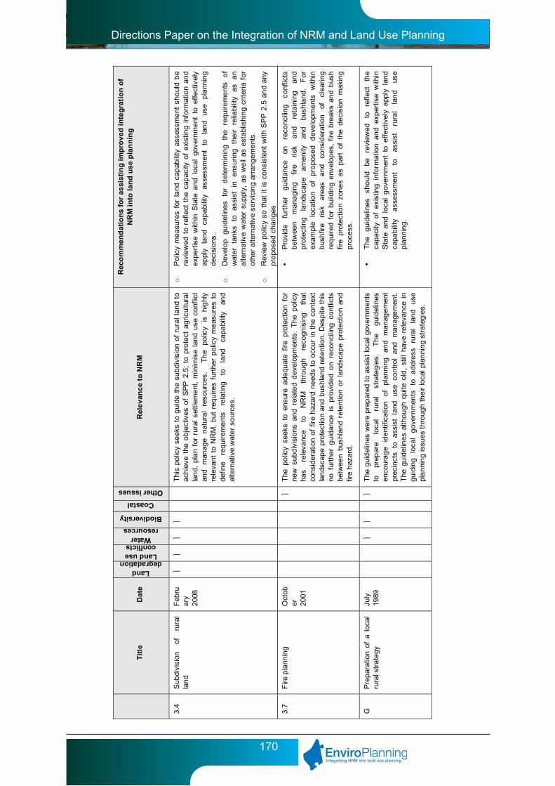
Directions Paper on the Integration of NRM and Land Use Planning
170
T
itle
D
ate
Land degradation
Land use conflicts
Water resources
Biodiversity
Coastal
Other issues
Rel
ev
anc
e to
NR
M
Rec
om
me
nd
atio
ns
for
assi
stin
g i
mp
rov
ed i
nte
gra
tio
n o
f N
RM
in
to la
nd
us
e p
lan
nin
g
3.4
Sub
divi
sion
of
ru
ral
lan
d F
ebru
ary
2008
Thi
s po
licy
seek
s to
gui
de t
he
subd
ivis
ion
of r
ural
lan
d to
ac
hiev
e th
e o
bjec
tives
of
SP
P 2
.5;
to p
rote
ct a
gric
ultu
ral
lan
d, p
lan
for
rura
l se
ttle
me
nt,
min
imis
e l
and
use
conf
lict
and
man
age
nat
ura
l re
sour
ces.
Th
e p
olic
y is
h
ighl
y re
leva
nt
to N
RM
, bu
t re
qui
res
furt
her
po
licy
me
asur
es t
o
defin
e re
qui
rem
ent
s re
latin
g to
la
nd
capa
bilit
y an
d
alte
rnat
ive
wat
er
sour
ces.
o
Pol
icy
me
asur
es f
or l
and
cap
abili
ty a
sses
sme
nt s
houl
d b
e
revi
ewed
to
refle
ct t
he c
apac
ity o
f ex
istin
g i
nfor
mat
ion
and
ex
pert
ise
with
in S
tate
and
loc
al g
over
nm
ent
to e
ffec
tivel
y ap
ply
land
ca
pa
bilit
y as
sess
me
nt
to
lan
d us
e p
lann
ing
de
cisi
ons.
.
o
Dev
elop
gu
idel
ines
fo
r d
ete
rmin
ing
the
req
uire
me
nts
of
wat
er
tank
s to
as
sist
in
en
suri
ng
the
ir re
liabi
lity
as
an
al
tern
ativ
e w
ater
sup
ply,
as
we
ll as
est
ablis
hin
g cr
iteri
a fo
r ot
her
alte
r nat
ive
serv
icin
g ar
rang
em
ent
s.
o
Rev
iew
pol
icy
so t
hat
it
is c
ons
iste
nt w
ith S
PP
2.5
an
d a
ny
pro
pose
d ch
ang
es
3.7
Fire
pla
nnin
g O
ctob
er
2001
The
po
licy
seek
s to
ens
ure
ade
quat
e fir
e pr
otec
tion
for
new
su
bdiv
isio
ns a
nd r
ela
ted
dev
elop
men
ts.
Th
e p
olic
y ha
s re
leva
nce
to
NR
M
thro
ug
h re
cogn
isin
g th
at
cons
ider
atio
n of
fir
e h
azar
d ne
eds
to o
ccur
in
the
cont
ext
lan
dsca
pe
pro
tect
ion
an
d b
ush
land
ret
entio
n. D
esp
ite t
his
no f
urth
er g
uid
ance
is
pro
vide
d o
n re
conc
ilin
g co
nflic
ts
betw
een
bush
lan
d re
tent
ion
or l
and
sca
pe p
rote
ctio
n an
d
fire
haz
ard
.
• P
rovi
de
furt
her
guid
ance
on
re
conc
iling
co
nflic
ts
betw
een
ma
nagi
ng
fire
risk
and
reta
inin
g an
d
prot
ectin
g la
ndsc
ape
a
me
nity
an
d bu
shla
nd.
For
ex
am
ple
loca
tion
of
pro
pose
d d
eve
lopm
ent
s w
ithin
bu
shfir
e ris
k ar
eas
and
co
nsid
era
tion
of
clea
rin
g
req
uire
d f
or b
uild
ing
env
elop
es,
fire
bre
aks
and
bus
h
fire
pro
tect
ion
zon
es a
s p
art
of t
he d
ecis
ion
mak
ing
pr
oces
s.
G
Pre
par
atio
n o
f a
loca
l ru
ral s
tra
tegy
Ju
ly
1989
T
he g
uid
elin
es w
ere
pre
par
ed t
o as
sist
loca
l gov
ern
me
nts
to
prep
are
loca
l ru
ral
stra
tegi
es.
Th
e g
uide
lines
en
cour
ag
e id
entif
icat
ion
of
plan
ning
an
d m
anag
em
ent
pr
ecin
cts
to
assi
st
land
us
e co
ntr
ol
and
m
ana
gem
ent.
T
he g
uid
elin
es a
ltho
ugh
qui
te o
ld,
still
hav
e re
leva
nce
in
guid
ing
lo
cal
gov
ernm
ents
to
a
ddre
ss
rura
l la
nd
use
pl
an
nin
g is
sues
thr
ou
gh t
hei
r lo
cal p
lan
ning
str
ateg
ies.
• T
he
gui
delin
es
sho
uld
be
revi
ewed
to
re
flect
th
e
capa
city
of
exis
ting
info
rmat
ion
and
exp
ertis
e w
ithin
S
tate
an
d lo
cal
gov
ernm
ent
to e
ffec
tivel
y a
pply
lan
d
capa
bilit
y as
sess
me
nt
to
assi
st
rura
l la
nd
use
pl
an
nin
g.

Directions Paper on the Integration of NRM and Land Use Planning
171
T
itle
D
ate
Land degradation
Land use conflicts
Water resources
Biodiversity
Coastal
Other issues
Rel
ev
anc
e to
NR
M
Rec
om
me
nd
atio
ns
for
assi
stin
g i
mp
rov
ed i
nte
gra
tio
n o
f N
RM
in
to la
nd
us
e p
lan
nin
g
G
Land
ca
pabi
lity
asse
ssm
ent
fo
r lo
cal
rura
l str
ate
gies
July
19
89
The
gu
idel
ines
wer
e de
velo
ped
to
info
rm g
over
nm
ent
and
la
nd
dev
elop
ers
of
the
De
part
men
t fo
r A
gric
ultu
re's
ge
nera
l m
etho
dolo
gy f
or l
and
capa
bilit
y as
sess
me
nt.
Th
e
guid
elin
es a
lso
prov
ide
a s
imp
lifie
d m
eth
odol
ogy
to a
ssis
t la
nd
capa
bilit
y as
sess
men
t fo
r lo
cal
rura
l st
rate
gies
. T
he
m
eth
odol
ogy
and
le
vel
of
info
rmat
ion
colle
ctio
n
enco
ura
ged
in
th
e
gui
delin
es
exce
eds
th
e ca
pac
ity
of
loca
l gov
ern
me
nt t
o co
llect
an
d in
terp
ret s
uch
info
rmat
ion.
R
ath
er t
han
focu
sing
on
gui
danc
e fo
r th
e co
llect
ion
of
lan
d ca
pabi
lity
info
rmat
ion,
gre
ate
r su
ppor
t an
d g
uida
nce
fo
r th
e us
e o
f ex
istin
g la
nd
cap
abili
ty in
form
atio
n to
ass
ist
rura
l lan
d us
e pl
anni
ng is
re
qui
red.
• T
he
gui
delin
es
sho
uld
be
revi
ewed
to
re
flect
th
e
capa
city
of
exis
ting
info
rmat
ion
and
exp
ertis
e w
ithin
S
tate
an
d lo
cal
gov
ernm
ent
to e
ffec
tivel
y a
pply
lan
d
capa
bilit
y as
sess
me
nt
to
assi
st
rura
l la
nd
use
pl
an
nin
g.
G
Rur
al-r
esid
entia
l de
velo
pm
ent
in
th
e
Per
th
Met
rop
olita
n
Reg
ion
July
19
92
The
gui
del
ines
pro
vid
e a
dvic
e re
gar
ding
the
loc
atio
n an
d
form
of
ru
ral
resi
de
ntia
l d
evel
opm
ent.
T
he
gui
delin
es
appe
ar r
edu
ndan
t as
no
refe
renc
e is
ma
de t
o th
em i
n th
e
curr
ent
vers
ions
of
SP
P 2
.5 a
nd D
C 3
.4 w
hic
h ar
e th
e
polic
ies
that
de
al w
ith r
ura
l res
iden
tial d
eve
lop
me
nt.
o
Del
ete
gui
delin
es
4.1
Ind
ustr
ial s
ubdi
visi
on
July
19
88
The
po
licy
prov
ides
gui
danc
e o
n th
e de
sig
n, s
hape
of
lo
ts,
roa
d la
yout
, se
rvic
ing
and
op
en s
pace
re
quir
em
ent
s fo
r th
e su
bdiv
isio
n o
f in
dust
ria
l la
nd.
T
he
polic
y ha
s re
leva
nce
to N
RM
as
ther
e is
pot
entia
l fo
r th
e po
licy
to
prov
ide
dire
ctio
n o
n e
nerg
y an
d w
ate
r co
nser
vatio
n
me
asur
es,
use
of P
OS
to
pro
tect
env
iron
men
tal
asse
ts
with
in
ind
ustr
ial
subd
ivis
ions
an
d pr
ovis
ion
of
buff
ers
betw
een
adja
cent
use
s.
o
Incl
ude
obj
ectiv
es b
ase
d on
pri
ncip
le 1
, 3
a
nd 5
of
the
'N
atio
nal
Pla
nni
ng
Pri
ncip
les
for
Red
ucin
g E
ner
gy
and
W
ater
D
em
and
thro
ugh
Lan
d U
se
and
In
fras
truc
ture
D
esig
n'
o
The
use
of
buf
fers
bet
wee
n th
e in
dus
tria
l la
nd a
nd
adj
acen
t la
nd
uses
sh
ould
be
com
patib
le w
ith S
PP
4.1
an
d E
PA
gu
idan
ce
4.2
Pla
nnin
g fo
r ha
zard
s an
d sa
fety
Ju
ne
1991
T
he p
olic
y pr
ovid
es g
uid
ance
in
pla
nnin
g to
pre
vent
th
e
occu
rre
nce
of
pot
entia
lly
haza
rdou
s ev
ents
an
d to
m
itig
ate
the
effe
cts
of a
ny s
uch
even
ts.
Th
e pr
inci
ples
of
risk
ma
nag
emen
t ca
n a
ppl
y to
nat
ura
l haz
ards
.
• U
pdat
e po
licy
to r
efle
ct C
onta
min
ate
d S
ites
Act
200
3
and
SP
P 3
.4
• C
onsi
dera
tion
shou
ld b
e gi
ven
to t
he i
nclu
sio
n of
aci
d
sulfa
te s
oils
, sa
linity
an
d la
nd
deg
rad
atio
n as
nat
ura
l ha
zard
s.

Directions Paper on the Integration of NRM and Land Use Planning
172
T
itle
D
ate
Land degradation
Land use conflicts
Water resources
Biodiversity
Coastal
Other issues
Rel
ev
anc
e to
NR
M
Rec
om
me
nd
atio
ns
for
assi
stin
g i
mp
rov
ed i
nte
gra
tio
n o
f N
RM
in
to la
nd
us
e p
lan
nin
g
G
Loca
l co
mm
erci
al
stra
tegi
es
Dec
em
ber
19
91
The
g
uide
lines
p
rovi
de
dire
ctio
n
on
dev
elo
ping
lo
cal
com
mer
cial
st
rate
gies
to
a
ddre
ss
such
m
atte
rs
as
the
si
ze a
nd
loca
tion
of s
hopp
ing
cen
tres
and
the
ir ro
le i
n
prov
idin
g f
or
a w
ide
ra
nge
of
co
mm
erci
al,
leis
ure
and
re
crea
tion
al a
nd
soci
al s
ervi
ces.
Th
roug
h m
odi
ficat
ion
the
gu
idel
ines
hav
e po
tent
ial
to b
ette
r ad
dres
s N
RM
iss
ues
such
as
ener
gy a
nd
wat
er c
ons
erva
tion.
o
Incl
ude
d
esig
n re
qui
rem
ent
s th
at
enc
oura
ge
wat
er
cons
erva
tion
(e.g
. ha
rves
ting
of
wa
ter
fro
m r
oof
to
sup
port
th
e S
hop
ping
cen
tres
wat
er r
equ
irem
ents
for
act
iviti
es s
uch
as
cle
anin
g a
nd la
nds
cap
ing)
an
d e
nerg
y co
nser
vatio
n.
5.3
Use
of
lan
d re
serv
ed
fo
r p
arks
an
d
recr
eatio
n
Dec
em
ber
19
99
The
pol
icy
prov
ides
adv
ice
on t
he
use
and
deve
lop
me
nt
of l
and
rese
rved
for
par
ks a
nd
recr
eat
ion
in t
he
MR
S a
nd
th
e pr
oces
s fo
r ob
tain
ing
deve
lop
me
nt
appr
oval
. T
he
po
licy
reco
gni
ses
that
th
e us
e an
d de
velo
pm
ent
of
lan
d
rese
rve
d fo
r p
arks
an
d re
cre
atio
n u
nder
the
MR
S s
hal
l be
re
stric
ted
to t
hat
wh
ich
is c
onsi
sten
t w
ith f
acili
tatin
g its
us
e fo
r re
cre
atio
nal
or
con
serv
atio
n p
urp
oses
.
o
Incl
ude
the
fo
llow
ing
polic
y m
eas
ures
o
Dev
elop
men
ts s
hou
ld b
e co
nsis
ten
t w
ith p
rinc
iple
s 1,
5 a
nd
6
of t
he
'Nat
iona
l P
lann
ing
Pri
ncip
les
for
Re
duci
ng
Ene
rgy
and
Wat
er D
em
and
thr
ough
La
nd
Use
and
Inf
rast
ruct
ure
D
esig
n'
o
Dev
elop
men
ts
in
rese
rves
th
at
have
a
cons
erva
tion
pu
rpos
e a
re c
ons
iste
nt w
ith t
he r
eser
ve m
ana
gem
ent p
lan.
6.1
Cou
ntry
co
asta
l pl
an
nin
g po
licy
June
19
89
The
po
licy
prov
ides
gen
era
l d
evel
opm
ent
requ
ire
me
nts
for
coas
tal
pla
nnin
g as
w
ell
as
spec
ific
gui
danc
e in
re
latio
n to
la
nd
use
prio
ritie
s,
lan
d te
nure
, ec
olo
gica
l co
nsid
erat
ions
inc
lud
ing
seal
lev
el r
ise,
vis
ual
am
enity
, la
nd
cap
abili
ty
and
se
tbac
ks,
soil
prot
ectio
n,
wat
er
qual
ity, a
cces
s a
nd f
ores
hor
e m
ana
gem
ent.
o
Coa
stal
set
bac
ks s
houl
d b
e re
view
ed t
o re
flect
pre
dic
ted
se
a le
vel r
ises
.
6.3
Pla
nnin
g co
nsid
erat
ions
in
th
e
me
tro
polit
an
reg
ion
fo
r so
urc
es
of
pub
lic
wat
er
sup
ply
and
se
nsiti
ve
wat
er
reso
urce
are
as
Aug
ust
1989
T
he
polic
y pr
ovid
es
advi
ce
on
how
p
lann
ing
sho
uld
ad
dres
s w
ate
r re
sour
ce i
ssue
s, w
ith a
foc
us o
n p
ublic
w
ater
su
pply
are
as,
but
als
o ot
her
area
s ha
vin
g p
artic
ular
w
ater
re
sour
ce
man
agem
ent
pr
obl
em
s an
d w
here
a
pr
opo
sal
is o
f a
sca
le l
ike
ly t
o im
pact
on
envi
ron
me
nta
lly
sign
ifica
nt
surf
ace
or
gro
und
wat
er
fea
ture
s su
ch
as
wet
lan
ds a
nd
river
s. T
he
polic
y ha
s b
een
succ
eede
d by
S
PP
s 2.
2, 2
.3,
2.7
and
2.9
and
the
be
tter
urb
an
wat
er
ma
nage
men
t fra
mew
ork.
o
Del
ete
pol
icy

Directions Paper on the Integration of NRM and Land Use Planning
173
Appendix 8: Local planning schemes – amendment process

Directions Paper on the Integration of NRM and Land Use Planning
174
Appendix 9: Draft guidance for the integration of natural resource management into local planning strategies
Introduction
Land use planning has been widely recognised as a powerful and flexible tool through which Local and State Government can consider and promote natural resource management (NRM) matters in its decision making process. The Local Planning Strategy (LPS) is one such planning tool that can provide a strategic level of influence over NRM matters.
A Local Planning Strategy is a strategic document that:
• Setsoutthelong-termplanningdirectionsfor the local government over a 10-15yr time frame;
• ProvidesamechanismforapplyingStateand regional planning policies at the local level; and
• Providestherationaleforproposedzonedand other provisions of the scheme.
The Local Planning Strategy provides a valuable strategic planning tool to guide decisions on development, subdivision and rezoning in a sustainable development framework. It places particular emphasis on appropriate use and development of land, and minimisation of potential conflict. As a strategic document, the local planning strategy has potential to be an important tool for implementing NRM priorities, provide planning policy settings are clearly defined in relation to proposed land use and development to ensure they deliver the NRM outcomes sought.
Guidance on the development of a Local Planning Strategy is currently provided within the Planning Schemes Manual. The ‘Guidance on the Format of Local Planning Strategies’ component of the manual, was developed
and released in July 2000, and provides a suggested format for achieving the objectives of a Local Planning Strategy. Further ‘draft’ guidelines have been prepared internally within DPI to provide tips and advice to help with all aspects of strategy preparation, from project planning, to preparation and consultation. This guidance builds on these two documents to provide additional guidance on the process of integrating natural resource management considerations into a local planning strategy. It is not intended to provide a separate process for the development of a local planning strategy, rather provide guidance on the stages of the current process at which natural resource management should be considered.
Methodology
The following five step process provides a guide to how consider NRM issues in the context of preparing a local planning strategy. The key to ensuring good outcomes are achieved through the local planning strategy is to understand the role of the document and ensuring NRM considerations are integrated into decision making and are not just considered outside of the planning context.
Step 1: Understanding Vision, Goals, Key Issues
The key to the successful integration of natural resource management into the local planning strategy is an understanding of the vision and goals of the Local Government in respect to its overall development.
The vision and goals define the desired future for an area, and the way land will be used to meet the expectations of the local government and the community. This guides the development
Directions Paper on the Integration of NRM and Land Use Planning
175
of the strategy and subsequently the priority setting of addressing NRM considerations. The strategies and actions that arise from the local planning strategy should be based on the future direction the local government wishes to take.
Key NRM issues, which may impact on the vision and goals of the Local Government should be raised at this initial stage.
Step 2: Collection of relevant data
A mistake commonly made in the preparation of local planning strategies is the collection of a range of information that is not necessarily relevant to the development of the strategy. It is important to determine what information is required based on the vision and goal setting exercise in step 1.
In collecting data, it is suggested that priorities for collecting NRM data be based on:
• Areasunderdevelopmentpressure
• Significantenvironmentalvaluesandassets
• Significantlandmanagementissues
A good test for determining whether information is of relevance, is to ask the question, Will the information be relevant to future decision making? It is not the purpose of a local planning strategy to include a ‘state of the environment’ report, and too much information can result in important information being ‘lost’. If the information is not relevant, leave it out.
It is recognised that in some circumstances, particularly outside the Swan Coastal Plain, information may not be available at the time of preparing the local planning strategy and resources limited for the collection of additional data. Where this is the case, the identification of gaps in data can be as important as the collection of data itself, as this can then translate into actions required to address this issue.
There are many sources of information from local knowledge, local environment plans, and
management plans, through to information held by relevant government agencies. To ensure relevant information is collected and nrm issues are considered in the development of the strategy, early consultation is encouraged. This will aid in the identification of priorities, information sources, and potential assistance that may be available to the local government.
The consultation process undertaken may vary between Local Governments and can be done through correspondence, interviews or through a cross agency workshop. Such a workshop can be particularly useful when there are a number of issues affecting areas under development pressure. In undertaking consultation it is important to ensure adequate lead time is given to the agencies and nrm groups, that the goals and vision of the Council are clearly articulated, and that the type of information being sought is specified.
When consulting with government agencies, the first point of call should be the regional office. A contact list for each of the agencies and other relevant NRM groups has been provided within Appendix_.
Step 3: Assess the implications for planning
This step links in closely with Step 2 and can be undertaken concurrently, as many of the implications for planning will be raised during consultation when seeking relevant information.
For each of the NRM issues/assets identified, the implications for planning and decision making in the context of the goals and vision of the Council need to be identified and assessed
For each identified issue/asset consider potential planning implications such as;
- managing the impact of development on the natural environment
- management of coastal development pressures
- Opportunities to enhance the natural environment

Directions Paper on the Integration of NRM and Land Use Planning
176
- Managing specific activities which impact on the environment
- Environmental sustainability objectives and measures including energy efficiency and recycling.
- The need to direct where development should or shouldn’t be located.
- Management requirements.
- The need for additional information.
Step 4: Data interpretation and objective setting
In this step the outcomes and the objectives in relation to NRM and land use planning that are being sought are set. This requires an analysis of the key NRM issues, the implications for planning and the opportunities and constraints of addressing NRM through the land use planning process. In setting objectives the following order of priority is recommended;
Priority 1 – addressing development pressure and the consideration of NRM factors in decision making.
Priority 2 – the ability to address land management issues
Essentially this step is about identifying what the local government wishes to achieve in relation to NRM matters, how this relates to other considerations within the strategy and what takes priority.
Step 5: Make recommendations for implementation
The last stage in the process is the development of the implementation plan, in other words the strategies and actions required to meet the desired outcomes determined in step 4. This section is the most vital in ensuring that NRM considerations are adequately integrated into future decision making.
Actions may include means of implementing strategies through the planning scheme (eg. Introducing scheme provisions, new zones,
special control areas, new policy), actions to address gaps in information/knowledge necessary to inform good decision making, actions required to be undertaken prior to future development being considered, as well as actions relating to seeking funding, liaising with relevant agencies and monitoring and evaluation.
Strategies and actions should be clear and useable and be justified through Steps 1 to 4. Consideration should also be given to the resources required to implement actions and the achievability of the actions.
Format/content
In general a local planning strategy will consist of two components, a background report and a strategy/implementation section. It is important that issues raised in the background component of the report are addressed within the strategy component, as it is the strategies and actions on which future decision making will be based.
A suggested format for a Local Planning Strategy is provided within the Model Schemes manual along with guidance on the elements that should be incorporated to meet the requirements of the model scheme text. A brief description of how consideration of natural resource management can be introduced into those elements is provided below.
Whatever the format chosen by the Local Government, the local planning strategy should be written in such a way so that it is clear what the objectives, strategies and actions are, in order to result in a plan which can be easily communicated and implemented.
State and regional planning context
The purpose of this element is to consider and interpret state and regional policy in the local context and identify plans and policies relevant to the local government area. Policy measures or recommendations that require further consideration or require some action at the local planning level should be identified.

Directions Paper on the Integration of NRM and Land Use Planning
177
Documents such as the State Sustainability Strategy, State Planning Strategy, State Planning Framework, and any relevant regional strategy or structure plan should be considered and elements relevant to NRM in the context of the strategy be drawn out.
There are a number of State Planning Policies that provide guidance on Natural Resource Management matters and how they should be considered within the planning framework, a summary of which have been included within Appendix _. Where relevant, these policies should be referenced and considered in the development of the local planning strategy.
Local government policy context
The Local Government Policy Context element allows a Local Government to incorporate aspects of their vision and management statement, the corporate plan and corporate objectives as well as significant local government policies and strategies relating to planning. Relevant local NRM plans that should be included may include a Local Environment Plan, Coastal Management Plans and any other plan that documents environmental issues of relevance to land use planning.
Profile and key issues
This element covers the key characteristics of the local government and the major influences on planning for the future, along with key issues that are required to be addressed by the strategy. In respect to NRM a brief overview of the issues that may be considered by a local government is provided under the issues section below. As mentioned above, this should not consist of a comprehensive state of the environment report, rather detail the key NRM issues of relevance to future decision making within the local government area. Early contact with environmental agencies can ensure key priorities are identified.
Strategic plan
The strategic plan is a spatial representation for future land use planning, development and conservation. It is important that key NRM assets and management requirements that have implications for planning be identified on the strategic plan including issues such as water source protection areas, areas subject to flooding, priority agricultural land and key resource areas.
Aims-strategies-actions
This element forms the implementation component of the Local Planning Strategy, and it is essential that NRM considerations are integrated into the decision making framework rather than just isolated in a separate environmental component. The results of Step 5 in the methodology above should be incorporated into this element.
Considerations
Where possible, NRM considerations should be integrated throughout all sections of the strategy and not solely within a separate ‘environmental’ strategy and actions section. The intent is to ensure that NRM considerations are made in all aspects of decision making. Issues that a local planning strategy may address and require some consideration of NRM include, but are not limited to:
Local government area wide
(Strategies and actions that apply across the whole of the Local Government area)
• TransportandInfrastructure
(Considerations may include sewerage disposal, transport corridors, rubbish disposal, energy supply, and water supply)
• SettlementPatterns
(Considerations may include existing and future settlement patterns, location of future urban expansion, land requirements)

Directions Paper on the Integration of NRM and Land Use Planning
178
• Economicactivity
(Considerations may include the need to protect primary industries, protection of significant agricultural land, mining activities, basic raw materials and tourism opportunities)
• Environment
(Considerations may include addressing land degradation, biodiversity conservation, reserve status)
• Heritage
(Considerations may include protection of natural heritage)
Precinct based
(Strategies and actions that may apply to a particular precinct within the Local Government area) These may include more development specific and area specific strategies and actions.
Directions Paper on the Integration of NRM and Land Use Planning
179
Appendix 10: Shire of Northampton local planning strategy extract
The Council may support rezoning of land to the Rural Conservation zone, outside of the Rangelands Planning Precinct, to facilitate subdivision of multiple ‘conservation’ lots where the applicant can demonstrate:
• Thevegetationhasbeenidentifiedand agreed worthy of protection in an approved strategy, catchment plan, or a specific assessment carried out by an appropriate expert on behalf of the subdivider taking into consideration the Principles for Clearing Native Vegetation contained in Schedule 5 of the Environmental Protection Act 1986;
• Thecreationoflotswillnotcreateanyadditional needs for the provision of government or community services;
• Theremnantvegetationwillbeprotectedthrough special provisions relating to the land addressing issues such as fire management, fencing, clearing controls, stock control and on-going management of bushland. These matters can be address holistically through an Environmental Management Plan.
• Theresultantlotswill;
- Be covered by a minimum of 85% remnant vegetation, wetland or significant natural feature unless the remaining portion of the parent lot is unviable for agricultural purposes or, in the case of innovative clustered survey strata subdivision, the area of native vegetation is protected under one common lot;
- Be provided with an adequate water supply for domestic purposes, land management and fire fighting;
- Have frontage to a constructed public road;
- Be connected to essential infrastructure including electricity and communications; and
- Have an identified building envelope situated to minimise additional clearing and be of a sufficient size and shape to cater for the construction of a single dwelling, outbuildings and fire hazard separation zone.
E. The creation of only one viable agricultural lot will be supported as a result of achieving a positive conservation outcome unless further subdivision complies with the minimum lot size requirements for that zone. This agricultural lot does not need to be rezoned to ‘Bushland Protection’.
Minimum lot sizes
Where the majority of the parent lot falls within 20 kilometres of the town centres of Northampton, Horrocks, Port Gregory or Binnu, as marked on Figure _ the following minimum lot sizes will apply:
• 1lotper40hawhereinnovativeclusterstyle survey strata subdivision is proposed; or
• 80hawheregreentitledsubdivisionisproposed.
Where the majority of the parent lots falls outside the 20kilometre radius of the Northampton, Horrocks, Port Gregory or Binnu town centres, as marked on Figure _, the following minimum lot sizes will apply:
- 1 lot per 80ha where cluster style survey strata subdivision is proposed; or
- 160 ha where green titled subdivision is proposed.
Lot yield will be calculated on the vegetated portion of the parent lot.