673636 - british columbia
TRANSCRIPT
673636
REPORT
on
THE ESTHER C L A I M GROUP
M I S S E Z U L A L A K E AREA
3IMILKAMEEK M I N I N G D I V I S I O N
t o r
DELKIRK M I N I N G L T J .
• • • • •
b y
R.VJ. PHENDLER, B.3c.» P.Eng.
Vancouver, E.C, August 6th, 1969.
•

mS h ^ \ Me ld ru ro^ J ^ ^ ^ H o u s e M r I
* ^ LU*L'
• < - ^ > r r t y A
t Alkali Lake
''Dang Rsiichlji.
10k
Maliood falls
' } pWdllenden
1-f X'v' - -V i - 7 McssiterW ' 1 , , , v n "
" \ Cotloiiwooddt 6
! f ™,™
A l t * , ' * .!'>
Dog C eek
\ -% > a > 7 % ? m & ^ . M r " v V
^^^^111,?^:. . e o M p a t t s y ' - f
JeJmortd\ „.„ ? * H 6 \ .»V>70 Mile House
9(1*
Vi i
TtttHlVitt
r=>' Big Bar Creek'
Illtml Lake \ North \
1- •-"v,-|3 Chinook
V.1 U M I
o
Barri&ra EI i iee wfjf, ^ - • • 4 4 ^ - \ K ™ H e Sft Q k i f ^ i Louis Creek
"V * \ M o h a * II I / Carqu i ieJ . I L , t e fefflVinsulla 1 t ( 1 ( ( ( r s * « - > « S e J a ^ E a "
lift •
A;,
-• ' ™ ' t - J i n Devine
'Mam Llbe t
tf'n *AttOH'
/ Hal Creek
l \ Sperrcps,
M upfii la!(i I'lW _ Dot
Kselefs
Lortftt Nicola
Canlo'd<
M e r r i t t tL. I95fl,
/\ a
Monte L a k e ! ^ B ^ . F a l k l a n d } / f V t l E n d e r b y i \ / f ' v . _ ! i 2 H i j j j j ^ r V i ^ J * 1 ^ Y '
A- f.ufrf I , V S — i isr in l
- • ]fW* . Hnrmrit. t , w r — ' ' 7/y?S>**~?m
l a w Ewhgs t a n d i n g Q ' Springs IQllllchenfi' />jUH'a> > ( OftOnnKnnj f ^ j p O y a m a t Mantthee P.
Lake Lake
] U W I nkt
iWinlield
Nortli Bend Mi ^ l o n B ;
-73 F t j t \ i r ' o
• J 4iVwdlihit ;
;',rV Sqiiamisri ntjiinii Bracrt ft|,Jjo
• --S|w?;iitiij
, Ghapnwis e|THi
I ' \ Okansgan Centred
" " • « - — > g . L , " " ~ . \ Wilson Ldg. A
Aspen Grove I {_ 4 ^ WS^-^C" Westbar
\ J ^ T ? e M n i « •JcCtilloch FeacrilanaV
Us
SS5USH3P fallS T-° ' Cheriyvi'le ?<""' '-
Whutxhuii
G ' i ^ i
tl — a JallieoeP . Oemuth
NortW '.li.ill.llB / j rttf ' ' k L a "
^ '] \ Choate
1 : i C r e ^ m H o p e
^iSuiTi'mer land
uttiB \ bis * // r-n-.-t-
Wh'le Mln J I V M * Mln I
c « :•. / AChristian /
Needies"
I S S ¥Ca( I ciS^Pentictoncarr^^^y^^^
/ • ./, \a^\ ^Princeton TO'.'5 N ^ - w W ^ ^ ^ ' V i f > ¥ ' i ,./cf i . ' B l a k e 4 n A l l e n f l r o « > g y f ^ % „ B 1 , jSe lverde i rA 1 i e >* " / V
A l l e n b y ^ ^ ^ ' A ^ ' ^ ' ^ f ^ ^ ^ ^ a l e i l B n ^
.*^'-a,?"*Wltlte" 3latno
mm **• -r !• H. N. . ' ferndaien VASHINGTON
Hedley.^r*^; "Copper M i l ,
\ 1 OK6HAOAN 'Oivtvurlen 1 y Snowy M
'UNITED S T A T E S
V ^ O k a i l a g a n Falls
. Oliver RhOTID
r ~ - . . : _ - - v ^ . ^ . L o d g 9 _ ^ i . ^ ^ - - ' :
V in Zandt C£MF 1 ? •
Araa tovfrrpd by I
iMt. Baker ^ v ^ c
u
D
[
u , T v k , ' | ' 1 °
_ J 5 > • " T ? l N e w h a l e m r f ^ - . D ( F L 6 ? 5 - '
i j ' ' " " Camp I ^PjWestbridge • y. ^ [ H ^ ^ S ^ ^ H o c M G'eenwoodrf
Osovoos 0
ldesjMilfi£Tj? T3i) * " fifif/lftr f'.' 1.-V " ft]i|*-~°g'^g— i , R . ^ ^ - ' ' • >*-
s?3?'$^-"-'F<$tf An^cht'i'wn « fMyr.castet I Midway
•S "' # ^ 0 r o v i l l B /cnesaw
Loomia'
• Grand X Forks 1
jWinthrop
*ige!es . .'.Townseno o?9 rArl ln g ton D a r r i n g t r^
r ° 0 ' v m p « , To Seattle
1 1 O
M A R Y S V I L L E TO - S E A T T L E 36 M I L E S \ MafjfsylMe j - \
Omak, Twisp"
Lake ) Chelan
Brewster i\
JOkatjogan FrcnkUi ftuoaci
Lah
TO Wenatchee
1 3 120° 1 4
S C A L E i r * 3 0 MiL£5
T A B L E OF CONTEOTS
SUMMARY, CONCLUSIONS AND RECOMMENDATIONS
SCOPE
LOCATION AND ACCESS
PROPERTY AND OWNERSHIP
HISTORY
GEOLOGY AND MINERALIZATION
RECOMMENDED WORK
ESTIMATED COSTS
LIST OF ILLUSTRATIONS
L o c a t i o n Map
Ge o l o g i c a l Map M i n e r a l 2ione
- 1 -
SUMMARY, CONCLUSIONS AND RECOMMENDATIONS
The t h i r t y - o n e Esther claims l i e t h i r t y m i l e s north of
P r i n c e t o n i n the M i s s e z u l a Lake area. They are e a s i l y a c c e s s i b l e by
a good g r a v e l road up Summers Creek V a l l e y from the I r i n c e t o n - M e r r i t t
Highway.
The area i s u n d e r l a i n by N i c o l a Group v o l c a n i c s which
are f a r from homogeneous. I n the immediate v i c i n i t y of the Shamrock
prospect, which l i e s w i t h i n the Esther c l a i m s , the rock i s medium-
grained f e l d s p a r porphyry which has been i n t e r p r e t e d as being a v o l
c anic f l o w b r e c c i a . To the e a s t , south and west are f i n e - g r a i n e d ,
dark green andesites c o n t a i n i n g disseminated sulphides.
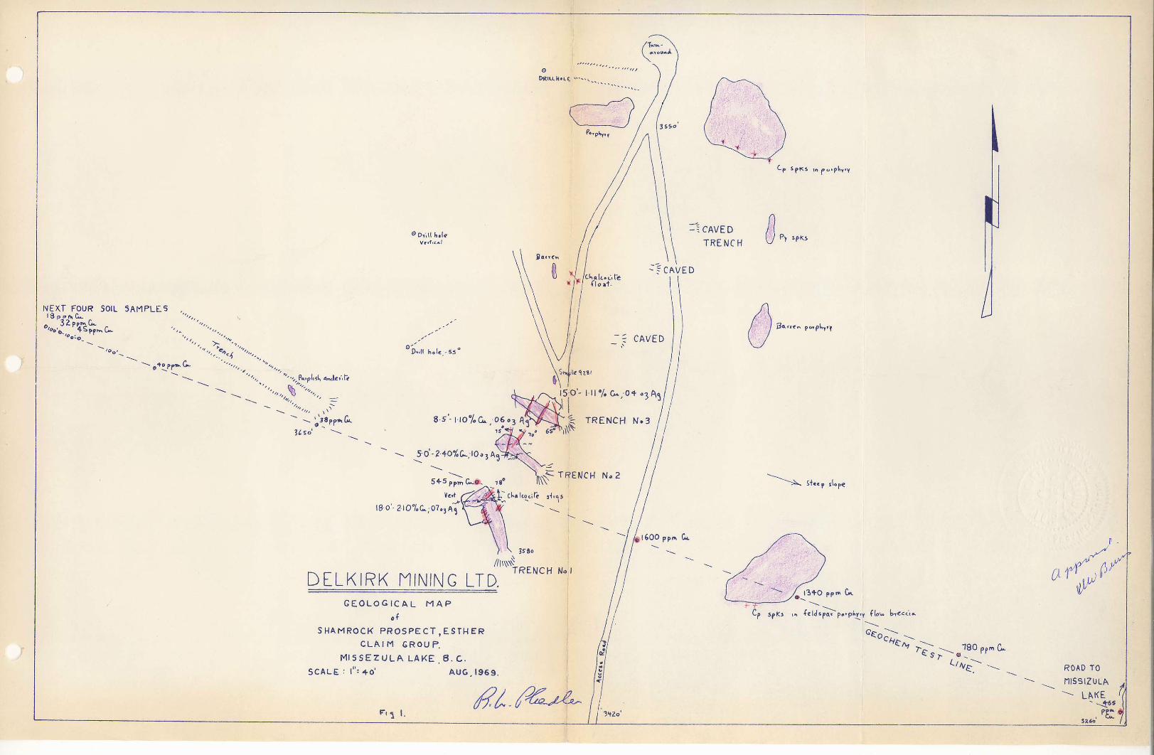
A m i n e r a l i z e d f r a c t u r e zone that s t r i k e s n o r t h e a s t e r l y
can be f o l l o w e d along s t r i k e i n three trenches f o r about eighty f e e t .
Old r e p o r t s mention s i x trenches that extend the zone f o r 250' but
some of these are caved. The f r a c t u r e zone measures up to 25' i n width
but m i n e r a l i z a t i o n i s confined to about 5 !-18'.
The i n t e n s i t y of the f r a c t u r i n g and the amount of
m i n e r a l i z a t i o n i s impressive. The f a c t that the prospect l i e s c l o s e
to thoroughgoing, n o r t h e r l y - s t r i k i n g f a u l t s that can be p r o j e c t e d
southward to the Copper Mountain area cannot be overlooked, although
t h i s i s no guarantee that s i m i l a r d e p o s i t s w i l l be discovered. No
i n t r u s i v e s s i m i l a r i n nature to the Copper Mountain i n t r u s i v e s have
been seen along t h i s f a u l t b e l t .
- 2 -
Recently taken chip samples i n d i c a t e that the p r e s e n t l y
v i s i b l e m i n e r a l i z a t i o n averages 1.63% Cu across 11.6'. Although
c h a l c o c i t e i s the p r i n c i p a l m i n e r a l , disseminated c h a l c o p y r i t e was
seen up to 250' to the northeast o f the trenches.
From ten samples taken by the w r i t e r f o r 900 1 across
the mineral zone, s o i l sampling would appear to be an e f f e c t i v e
method of o u t l i n i n g zones of i n t e r e s t . The property warrants ex
p l o r a t i o n and i t i s recommended that topographic mapping, p r o s p e c t i n g ,
geologic mapping, s o i l sampling, EM surveying and diamond d r i l l i n g
be c a r r i e d out. Estimated cost of t h i s program i s $20,000.
A f u r t h e r $40,000 should be provided to c a r r y on
a d d i t i o n a l diamond d r i l l i n g and t r e n c h i n g .
SCOPS
On J u l y 27th and 28th the mineral showings on the
Esther claims near M i s s e z u l a Lake were examined and the region geo
l o g i c a l l y mapped. This work was done by the w r i t e r accompanied by
Mr. JY'J. Murton.
LOCATION AMD ACCESS
The Esther claims l i e t h i r t y m i l e s north of r r i n c e t o n ,
B r i t i s h Columbia, at the south end of M i s s e z u l a Lake. Access i s by
good g r a v e l road from the .crinceton-Merritt Highway f o l l o w i n g the
Summers Creek V a l l e y f o r eighteen m i l e s .
E l e v a t i o n i s about 3000'; topography i s r e l a t i v e l y
steep and the timber growth moderate.
- 3 -
rRQr'ERTY AND Ov/NERSHIP
The t h i r t y - o n e Esther claims are owned j o i n t l y by
E. G a r r i s o n , Broorafield and W, Shropshire of P r i n c e t o n , B r i t i s h
Columbia. The c l a i m group i s p r e s e n t l y under o p t i o n to D e l k i r k Mining
L t d .
HISTORY
Although the area was p r i m a r i l y a p l a c e r mining r e g i o n ,
copper occurrences i n the rrinceton-Aspen Grove area are common. The
Esther claims cover a showing that was formerly known as the Shamrock,
In 1929 i t was reported that the m i n e r a l i z e d zone could be followed
f o r 1500 f e e t . S i x open cuts explored the zone and i n 1929 a small
shipment was made which i s reported to have c a r r i e d 5.78% copper.
L i t t l e i s known regarding more recent work on the
property but i t i s known that diamond d r i l l i n g was c a r r i e d out a few
years ago. No records concerning d r i l l hole l o c a t i o n s or r e s u l t s are
p r e s e n t l y a v a i l a b l e .
GEOLOGY AND MINERALIZATION
For f o r t y m i l e s north from Copper Mountain a zone
occurs along which copper prospects are numerous. I n the Aspen Grove
area c e r t a i n showings are i n o r c l o s e to lar g e g r a n i t i c bodies and
probably are r e l a t e d to them. Other d e p o s i t s , i n c l u d i n g the one under
c o n s i d e r a t i o n , occur i n f r a c t u r e s and as disseminated g r a i n s of chalco
p y r i t e , p y r i t e , b o r n i t e and c h a l c o c i t e w i t h i n N i c o l a v o l c a n i c rocks
of T r i a s s i c age. No i n t r u s i v e rocks are known to be r e l a t e d to them
and the only t h i n g they have i n common seems to be t h e i r occurrence
along the trend of f a u l t s up A l l i s o n V a l l e y and Summers Creek.
The Esther showing i s u n d e r l a i n by a r a t h e r coarse
grained r e d d i s h rock c o n t a i n i n g rounded fragments of f e l d s p a r porphyry.
T h i s rock has been i n t e r p r e t e d as a r a t h e r unusual flow b r e c c i a .
To the east and southeast of the mineral showing the N i c o l a v o l c a n i c s
are composed of p u r p l i s h b a s a l t s and medium-green andesites.
The r e d d i s h flow b r e c c i a i s i n t e r s e c t e d by a north
e a s t e r l y t r e n d i n g f r a c t u r e zone which i s m i n e r a l i z e d w i t h c h a l c o c i t e
and f i n e l y disseminated c h a l c o p y r i t e . The m i n e r a l i z e d bands w i t h i n
the f r a c t u r e zone are a s s o c i a t e d w i t h c a l c i t e s t r i n g e r s which trend
e i t h e r e a s t e r l y or n o r t h e r l y .
Although o l d records show that the zone was t r a c e a b l e
f o r 25C 1 i n s i x trenches, only three trenches are p r e s e n t l y a c c e s s i b l e
and these show the mineral zone to extend over a s t r i k e length of
80'. Disseminated c h a l c o p y r i t e was observed about 250' to the north
east i n s i m i l a r rock type.
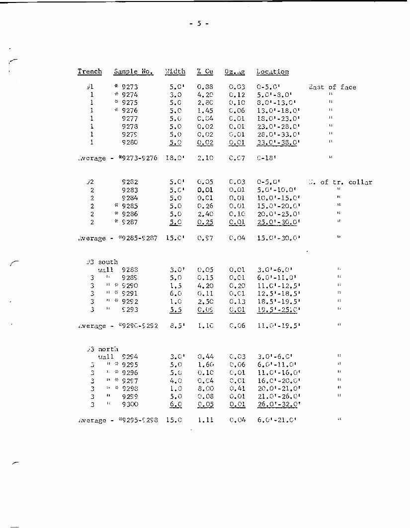
During the examination, 28 c h i p samples were taken
i n the three p r i n c i p a l trenches. R e s u l t s are as f o l l o w s :
- 5 -
Trench Sample No. Width % Cu L o c a t i o n
tfl * 9273 5 . 0 ' 0 . 8 8 0 . 0 3 0 - 5 . 0 ' Sast of 1 * 9274 3 .0 4 . 2 0 0 .12 5 . C - 3 . 0 ' it 1 * 9275 5 . 0 2 .80 0 . 1 0 8 . 0 ' - 1 3 . C li 1 * 9276 5 .0 1.45 0 .06 1 3 . 0 ' - 1 8 . 0 » i i 1 9277 5 .0 0 . 0 4 0 .01 1 8 . 0 ' - 2 3 . 0 ' ii 1 9278 5 . 0 0 . 0 2 0 .01 2 3 . 0 , - 2 8 . C , i l 1 9279 5 . 0 0 . 0 2 0 .01 2 8 . 0 ' - 3 3 . 0 » 1!
1 9280 5 .0 0 . 0 2 0 .01 3 3 . C - 3 8 . 0 ' I I
Average - *9273-9276 18.0' 2.10 0.C7 0-18' l!
>n 9282 5.0' 0.05 0.03 0-5.0 i ,J. of t r . 2 9283 5.C 0 . 0 1 0.01 5.0'- 10.0' 2 9284 5.0 0.01 0.01 10.0' -15.C 2 - 9285 5.0 0 . 2 6 0.01 15.0' -20.0' it 2 * 9286 5.0 2.40 0.10 20.0' -25.0' 2 * 9287 5.0 0.25 C.Ol 25.0' -30.0'
Average - *9285-9287 1 5 .C 0.97 0.04 15.0' -30.0' it
#3 south w a l l 9283 3.0» 0 . 0 5 0 .01 3 . 0 ' - 6 . 0 »
3 " 9289 5 .0 0 . 1 5 0 .01 6 . 0 ' - l l . 0 ' 3 n * 9290 1.5 4 .20 0 . 2 0 l l . C ' - 1 2 . 5 ! ' 3 " « 9291 6 . 0 0 .11 0 .01 ^ . s ' - i s . s 1
3 u 9292 1.0 2 .50 0 . 1 3 1 8 . 5 , - 1 9 . 5 I
3 9293 5 .5 COS C.Ol 1 9 . 5 ' - 2 5 ; 0 «
Average - *929C-9292 8 . 5 ' 1.10 C .06 1 1 . 0 ' - 1 9 . 5 '
,c3 north w a l l 9294 3 . 0 ' 0 . 4 4 0 . 0 3 3 . 0 ' - 6 . C
3 " -:" 9295 5 . 0 1.60 0 .06 6 . 0 ' - 1 1 . 0 ' :" 9296 5 . 0 0 . 1 0 0 .01 1 1 . 0 ' - 1 6 . 0
o u -; :" 9297 4 . 0 0 . 0 4 C.Ol 1 6 . C - 2 0 . 0 3 " -; • 9298 1.0 8 .00 0 .41 2 0 . 0 ' - 2 1 . 0 3 9299 5 . 0 0 . 0 8 0 .01 2 1 . 0 ' - 2 6 . 0 3 9300 6 . 0 0 . C 5 0 .01 2 6 . 0 ' - 3 2 . 0
Average - ' '9295-9298 15. C l . U 0 . 0 4 6 . 0 ' - 2 1 . 0 '
- 6 -
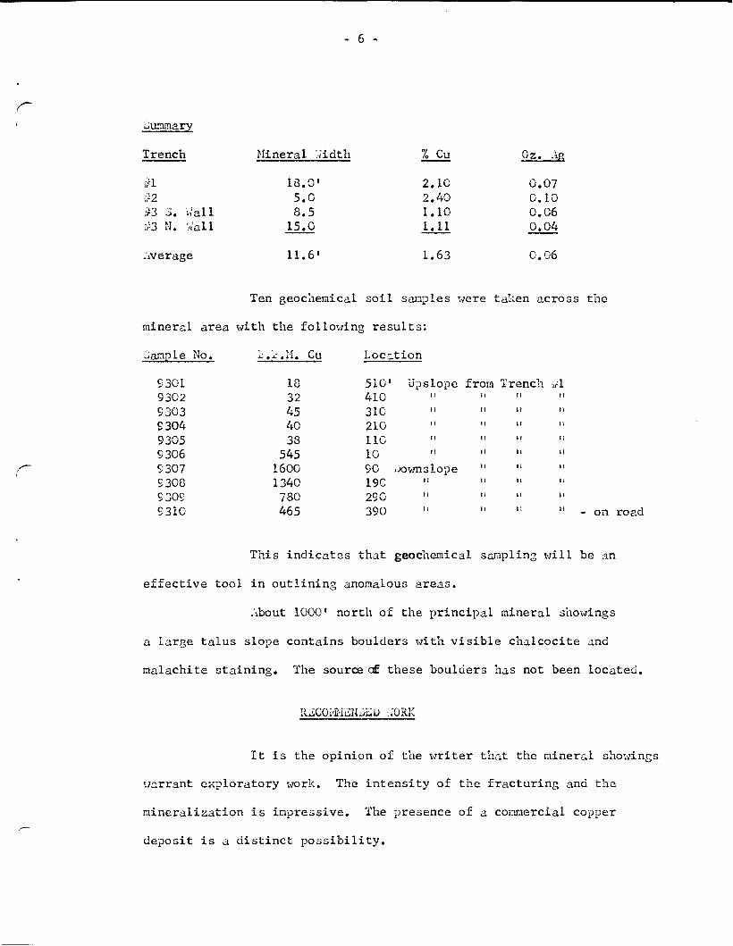
iummary
Trench M i n e r a l Width % Cu 0z. Ag
,/! 18.0' 2.10 0.07 #2 5.0 2.40 0.10 /r3 3 . w a l l 8.5 1.10 0.06 #3 N. Wall 15.0 1.11 0.04
Average 11.6' 1.63 0.06
Ten geochemical s o i l samples were taken across the
mineral area w i t h the f o l l o w i n g r e s u l t s :
Sample No. r .r.M. Cu L o c a t i o n
9301 18 510' Upsiope from Trench v\ 9302 32 410 I I i t M
9303 45 310 11 1 i U H
9304 40 210 I I 11 I I t l
9305 33 110 u I t I I I i
9306 545 10 I I 11 I I
9307 1600 90 Downslope I I I t I I
9308 1340 190 I I H I i
9309 780 290 I t 1 j 11 I I
9310 465 390 I t " 11 " - on road
This i n d i c a t e s that geochemical sampling w i l l be an
e f f e c t i v e t o o l i n o u t l i n i n g anomalous areas.
About 1000' north of the p r i n c i p a l mineral showings
a l a r g e t a l u s slope contains boulders w i t h v i s i b l e c h a l c o c i t e and
malachite s t a i n i n g . The source of these boulders has not been l o c a t e d .
RECOMMENDED WORK
I t i s the o p i n i o n o f the w r i t e r t h a t the mineral showings
warrant e x p l o r a t o r y work. The i n t e n s i t y of the f r a c t u r i n g and the
m i n e r a l i z a t i o n i s impressive. The presence of a commercial copper
deposit i s a d i s t i n c t p o s s i b i l i t y .
- 7 -
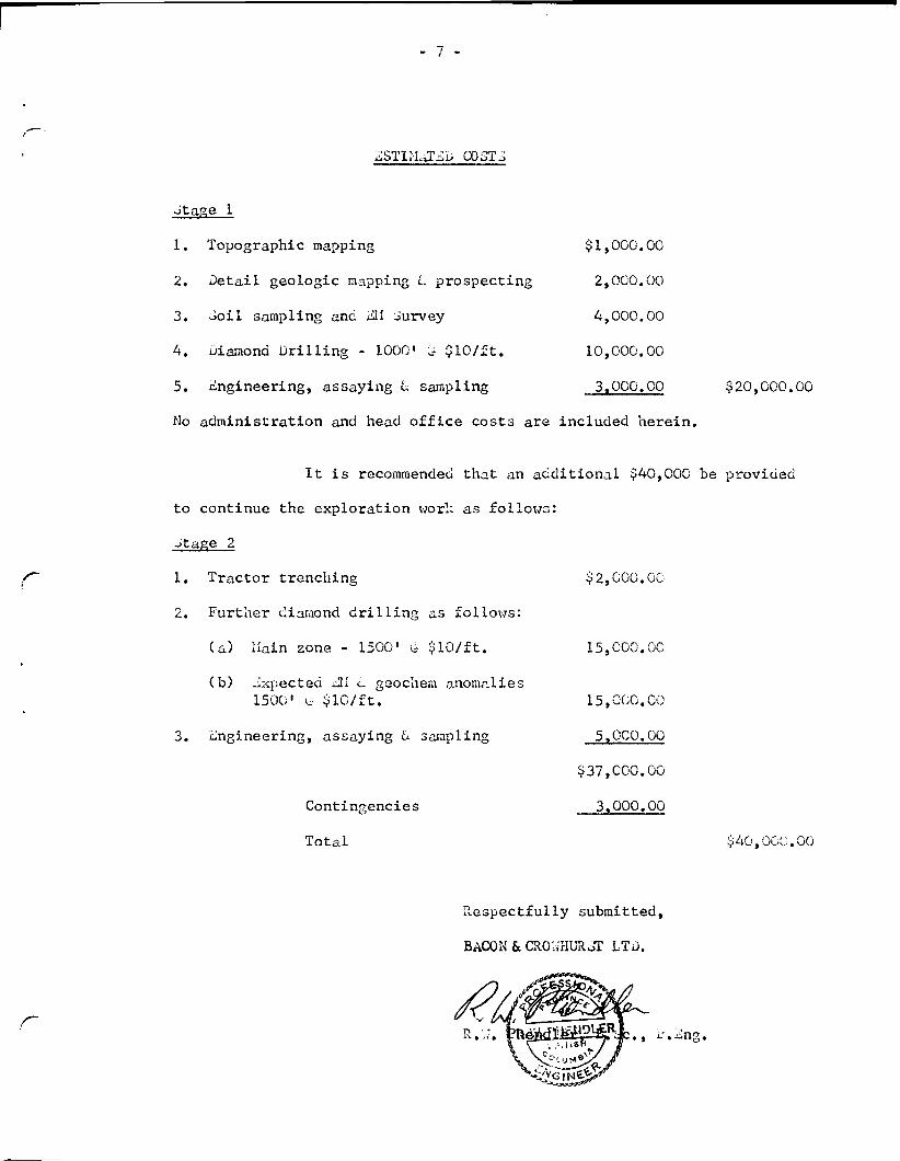
ESTIMATED COSTS
Stage 1
1. Topographic mapping $1,000.00
2, D e t a i l g e ologic mapping <u prospecting 2,000.00
3. S o i l sampling and EM Survey 4,000.00
4. diamond D r i l l i n g - 1000' S $10/ft. 10,000.00
5. Engineering, assaying & sampling 3,000.00 $20,000.00
No a d m i n i s t r a t i o n and head o f f i c e costs are included h e r e i n .
I t i s recommended that an a d d i t i o n a l $40,000 be provided
to continue the e x p l o r a t i o n work as f o l l o w s :
Stage 2
f~~ 1. T r a c t o r t r e n c h i n g $2,000 .00
2. Further diamond d r i l l i n g as f o l l o w s :
(a) Main zone - 1500' C- $10/ft. 15,000.00
(b) Expected EM L geochera anomalies
150C u- $10/ft. 15,000.00
3. Engineering, assaying & sampling 5,000.00
$37,000.00
Contingencies 3,000.00
T o t a l $40 ,000.00
R e s p e c t f u l l y submitted,
BACON & CR0v,THURST LTD.
r
NEXT FOUR SOIL S A M P L E S ,
D R I U M « L C .
- = C A V E D
T R E N C H
C A V E D
P .ll hoi* - S 5 *
8 5 - 1 1 0 % 0 6 « 3 A q > ^ ^ J ^ T R E N C H
50'-24O%(X;l0a3Ag
5 + 5 ^ i C ^ © . i8
¥e.t
I8 0'-2I07 DC;07. 3A^
TRENCH Na
D E L K I R K MINING LTD. G E O L O G I C A L M A P
of
S H A M R O C K P R O S P E C T , E S T H E R -
C L A I M G R O U P.
M I S S E Z U L A L A K E 6 . C -
S C A L E : l": 40' A U G . 1969.
T R E N C H No I
\ 1-
««p iiope
LV
7-~ \ T80 pom
ROAD TO
niSSiZULA L A K E
52