7 assessment of key issues - roads and maritime services€¦ · 7 assessment of key issues this...
TRANSCRIPT
Windsor Bridge Replacement 145 Environmental impact statement
7 Assessment of key issues This chapter provides an assessment of the key environmental issues for the project as identified in the Director General’s environmental assessment requirements and as per the relevant requirements of Schedule 2, Part 3 of the Environmental Planning and Assessment Regulation 2000.
For each key issue, the existing environment is described, the potential impacts (direct, indirect and cumulative) of the project during construction and operation are assessed, the influence of relevant planning matters are considered and proposed management and mitigation measures are described. The proposed management and mitigation measures in this chapter are collated in Chapter 10.
The assessments of key issues are supported by detailed investigations, which have been documented in the working papers in Volumes 2, 3 and 4. To the extent of any inconsistency between this main volume of the EIS and the working papers, the former prevails.
7.1 State and local historic heritage and maritime heritage This section presents the results of the assessment of State and local historic heritage impacts and maritime heritage impacts. The assessment is supported by detailed studies prepared by experienced and suitably qualified heritage consultants. The full details and results of the studies are documented in the following reports:
Historic Heritage Assessment and Statement of Heritage Impact (presented in Volume 2 - Working paper 1).
Maritime Archaeological Statement of Heritage Impact (presented in Volume 2 - Working paper 2).
The assessment has addressed the Director General’s requirements for State and local historic heritage and maritime heritage, as detailed in Table 7-1, as well as the relevant requirements of Schedule 2, Part 3 of the Environmental Planning and Assessment Regulation 2000.
Table 7-1 Director General’s requirements
Director General’s requirements Where addressed
The EIS must address the following specific matters: Heritage – including but not limited to:
impacts to State and local historic heritage (including archaeology, heritage items and conservation areas), in particular, impacts on the Thompson Square Conservation Area, heritage listed buildings and sites in the Thompson Square conservation area and the Windsor Bridge should be assessed.
Section 7.1.4
Where impacts to State or locally significant historic heritage items are identified, the assessment shall:
outline the proposed mitigation and management measures (including measures to avoid significant impacts and an evaluation of the effectiveness of the mitigation measures) generally consistent with the guidelines in the NSW Heritage Manual (1996).
Section 7.1.5 Section 7.4.4 Section 7.4.6

Windsor Bridge Replacement 146 Environmental impact statement
Director General’s requirements Where addressed
be undertaken by a suitably qualified heritage consultant(s) (note: where archaeological excavations are proposed the relevant consultant must meet the NSW Heritage Council’s Excavation Director criteria).
Volume 2- Working papers 1 and 2 and Section 7.1
include a statement of heritage impact for all heritage items (including significance assessment).
Volume 2 - Working papers 1 and 2 Section 7.1.3
consider impacts from vibration, demolition, archaeological disturbance, altered historical arrangements and access, landscape and vistas, and architectural noise treatment.
Section 7.1.4 and Section 7.5
develop an appropriate archaeological assessment methodology, including research design, to guide physical archaeological test excavations (terrestrial and maritime) and include the results of these excavations.
Section 7.1.2 and Volume 2 - working papers 1 and 2
7.1.1 Guidelines and methodology The study area The study area for the heritage assessment encompasses the project footprint but also includes adjoining sites within the immediate vicinity of the project. In assessing the potential heritage impact of the project, consideration was given to visual and vibration impacts that extend beyond the project footprint and the potential for any physical impacts on adjoining properties as a result of construction activity. The project footprint incorporates the existing Windsor bridge, its abutments and approaches, and areas on the northern and southern sides of the river (including the river banks) that would be disturbed by construction and operation of the project and demolition of the existing bridge. This includes the river channel and the banks of the river where maritime infrastructure is known to have been present.
State and local historic heritage assessment The historic heritage impact assessment was carried out in accordance with the NSW Heritage Manual (Heritage Office and DUAP, 1996).
An integrated program of historical research and site investigation was required to verify and extend the current understanding of the study area’s evolution and development through time. The purpose was to create an integrated understanding of the built and archaeological evidence and historical sources, in order to allow the full range of heritage significance to be accurately determined. To achieve this, the assessment included the following key elements:
Review of existing information, including statutory and non-statutory heritage registers.
Preparation of a detailed site history based on primary and secondary sources.
Site surveys.
Development of an archaeological research design.
Archaeological test excavation.
Detailed visual analysis.

Windsor Bridge Replacement 147 Environmental impact statement
Assessment of cultural heritage significance.
Preparation of a statement of heritage impact (SoHI) covering all items of heritage significance that have the potential to be impacted by the project (the SoHI is presented in Volume 2 - Working paper 1).
The visual analysis involved assessment of existing historic views and vistas and the potential impacts of the project on these heritage elements.
Existing information sources Information sources included primary historical documents such as land titles, published works, consultant reports, and reproductions of paintings, etchings, photographs, maps and plans. Current newspaper articles and historical articles were accessed online through the Trove database. Repositories used in preparing this report comprised:
Mitchell Library of the State Library of NSW.
State Records Office NSW (Globe Street, The Rocks and Kingswood).
Hawkesbury Library, Hawkesbury City Council, Local Studies Collection.
Sydney University Library.
National Library of Australia.
NSW Land and Property Information.
NSW Roads and Maritime Service Archives, including former Maritime NSW records.
Sydney Water Archives.
Department of Public Works Annual Reports.
Private collections.
The following databases and internet sources were also searched:
Trove, for newspaper articles.
National Heritage List.
Commonwealth Heritage List.
State Heritage Register.
State Heritage Inventory.
RMS Section 170 Heritage and Conservation Register (s170 Register).
Heritage Space for heritage listings including National Trust classifications.
Australian Heritage Places Inventory.
Heritage Schedule of the Hawkesbury Local Environmental Plan 2012. The assessment of the social significance of heritage sites was informed by recent community responses to the project as well as the recognition of the heritage significance of Thompson Square in the 1970s.

Windsor Bridge Replacement 148 Environmental impact statement
Site surveys The study area was surveyed on two occasions prior to the test excavation (21 December 2011 and 17 February 2012) and once after the test excavation (19 June 2012). Areas accessed during the site surveys were limited to those that were safe and for which owners consent was received. This excluded conducting a search for the “brick drain” mentioned in an 1815 contract for the wharf (see Section 7.1.3). The aim of the surveys was to understand the landscape within the study area including fabric, views and vistas. The study area was photographed to compare the current landscape with historical photographs.
Archaeological investigations The study area contains below-ground Aboriginal and historic archaeological evidence, and further archaeological evidence in the bed of the river. Three specialist archaeological consultants (Kelleher Nightingale, Biosis Research and Cosmos Archaeology) were engaged to carry out the necessary investigations. All had experience in integrating Aboriginal and historic archaeological investigations (see Volume 2 – Working papers 1, 2 and 3). As the boundaries between these archaeological domains are arbitrarily set by legislation the consultants were required to work closely to provide an integrated and comprehensive coverage. This section discusses the historic terrestrial and maritime archaeological investigations. Aboriginal heritage investigations are presented in Section 7.2.
Additional support was provided by specialist investigations, including archaeological remote sensing (University of Sydney), geomorphological assessment of soils (Mr Sam Player) and side-scan sonar of the riverbed (RMS Hydrographic Survey Branch).
Archaeological research design An archaeological research design was prepared in accordance with the DGRs, and was reviewed by the Heritage Branch, Office of Environment and Heritage, and Department of Planning and Infrastructure. The research design is presented in Appendix 2 of the Historic Heritage Assessment and SoHI (Volume 2 – Working paper 1). Aboriginal archaeological investigations and preliminary geotechnical work were also planned at the same time and the research design considered opportunities arising from these investigations.
The purpose of the research design was to provide a clear direction for archaeological investigation, based on a sound understanding of the site’s historical development and change through time.
The archaeological investigation was designed to maximise information yield with the smallest possible ground disturbance, in recognition of the potential significance of the resource, and the possibility that project approval may not be granted.Excavation took place on both the north and south side of the river. The size of the trenches varied considerably, the larger test trenches allowing for a clearer exposure of successive fill layers and fragmentary archaeological evidence. Trenching used a combination of hand and machine excavation by a team of experienced archaeologists under the supervision of the Principal Archaeologist.
Ground penetrating radar During preparation of the research design a remote sensing survey of part of the upper and lower parkland areas of Thompson Square was undertaken by the University of Sydney.

Windsor Bridge Replacement 149 Environmental impact statement
The remote sensing found a possible anomaly representing the former brick barrel drain in the northeastern corner of the park. Alternatively, if this followed natural site drainage it may represent either the original drainage line or disturbed ground and fill resulting from the drain’s construction. Some ground disturbance had taken place in the same vicinity with the construction of the Boat Club in the 1950s and its subsequent demolition in the 1960s.
North side of the river The archaeological research design and initial historical assessment identified the following archaeological potential for the northern side of the river:
Pre-settlement environment.
Evidence of first European settlement and modifications made to the environment for clearance and agriculture.
Farm buildings, farmhouse, fencing from 1794 grant (no site identified by historical research).
Inn that operated c.1839 – 1880s, including structures, fences, drains, landscape improvements, artefact scatters.
20th century turf farming and market gardening. With the possible exception of the inn, no target location was known for the archaeological remains. Six test pits were therefore co-located with test pits required for geotechnical assessment. The depth, size and location of the geotechnical test pits were considered sufficient to obtain a representative sample of the potential geological and archaeological features of the area.
The test pits were investigated by hand and mechanical excavation under the supervision of the principal archaeologist. Each of the pits measured about 3.0 x 0.5 metres and were excavated to a depth of about 3.0 metres.
The excavations did not reveal any structural remains of buildings, buried surfaces apart from a possible surface in test pit 4 (within the road reserve adjacent to Number 33 Old Wilberforce Road), and evidence of agricultural works such as plough marks or drainage ditches. Artefacts were limited to those of 20th century origin apart from a single earlier brick fragment in test pit 8 (within road reserve of Freemans Reach Road). Test pit 5 (within road reserve of the northern approach road to the existing bridge) revealed poured in situ concrete beams identical to those also seen on the southern side and considered to be part of the 1897 reconfiguration of the approaches to the raised bridge.
Overall the excavations indicated that the northern bank has been heavily affected by flooding, siltation and farming activity. It was concluded that the northern banks would be unlikely to contain useful archaeological evidence, and no further information on the location of specific targets was obtained.

Windsor Bridge Replacement 150 Environmental impact statement
South side of the river The archaeological research design and initial historical assessment identified the following development stages of the southern side of the river each having archaeological potential:
The pre-settlement environment.
Environmental damage and change from first European settlement onwards.
Clearing and the first buildings (store, guardhouse and wharf) from 1794 to 1795.
The first wharf of 1795 and a boat slip.
Tracks and paths, barracks, granaries, government buildings including domestic residences, a lock-up and Thompson’s first house and garden that date between 1795 and 1800.
Additional government buildings including a prison and a possible government wharf and tracks and paths dated between 1800 and 1810. Additional sites of substantial buildings and works are recognised to lie close to but outside the project footprint.
A wharf, roads, cuttings, a large brick barrel drain and possible secondary drains and large quantities of fill in Thompson Square from the period 1810 to about 1820. The potential for significant archaeological evidence in building allotments on the eastern, western and southern sides of Thompson Square outside the project footprint is also recognised.
New road surfaces, punt landings, a watch house/punt house on The Terrace from the period of around 1820 to 1840. Evidence of new government buildings on the eastern side of Thompson Square is also recognised but this is outside the project footprint.
The redevelopment of Thompson Square in the late 19th century including: An extension to Bridge Street on the eastern side of Thompson Square in its southern half from 1855 and in its northern half in 1874, of other road surfaces on the western side of Thompson Square and resurfacing of roads in the centre of Thompson Square, evidence of drains and other services, evidence of filling in the approach to the raised bridge level of 1897, lowering of some areas in Thompson Square and its roads from the later years of the nineteenth century; evidence of a summerhouse and pavilion in the reserves and fences along the roads and reserves.
Cutting along the western side of Thompson Square for the construction of a new approach to the bridge in 1934.
Artefact assemblages from all periods and services from the later part of the nineteenth century onwards.
Although Windsor is well-represented pictorially from around 1809, correlating descriptions of buildings with depicted buildings remains problematic. There is no certainty that other buildings known only from documentary records were not located within the project footprint. While Thompson Square forms only a portion of the original Government reserve area, and the project footprint a fraction of that, there remains a high probability that some buildings were situated within the project footprint.

Windsor Bridge Replacement 151 Environmental impact statement
The strategy to investigate the southern bank was therefore not focused on locating buildings from the historical record but to determine whether the maximum depths of ground disturbance or soil removal required for the project would impact on an intact archaeological profile or be confined to depths already disturbed for road works or services. To reliably determine this requires excavation of test pits to a sufficient extent that soils, fills, former surfaces and other archaeological features can be differentiated and understood. The stratigraphic information from the test pits was expected to broadly describe the archaeological resource within Thompson Square, but excavation was required to determine whether these could be dated or ascribed to particular origins or purpose. Lastly, the information potential of individual deposits, and the succession of deposits and activities needed to be understood to determine the impact to archaeological significance.
Two test pits were excavated, test pit 1 in Old Bridge Street, and test pit 2 in the car park adjacent The Terrace. Six test pits for Aboriginal archaeological investigations were also used to provide additional stratigraphic information and to help the understanding of broader landscape changes. Test excavations were carried out using a small excavator and a small team of archaeologists to manually clean surfaces, fragile deposits and features.
Test trench 1 – southern bank Test trench 1, measuring 3.9 x 4.1 metres was located about half way up Old Bridge Street. The predicted depth of impact in this location from construction is about one metre and this was used as the depth for terminating excavation. The upper surface was the road pavement of Old Bridge Street. This and its associated layers of compacted rubble measured up to 0.5 metres in depth. Below this depth a series of fragmentary deposits including some shallow excavations or depressions were found. Artefact material associated with these deposits included a small number of ceramics.
The excavation identified different phases of site activity from the natural soil profile to the present. At the base of the profile excavated was a sand layer that is typically found on the southern bank and in which other locations has been found to contain Aboriginal artefacts of probably considerable age. There was no original topsoil remaining as it had been removed by later activities, but there may be surviving microbiological evidence, such as pollens, that would provide clues to the pre-European environment.
The sand layer was overlain by a formed surface from the first half of the 19th century. This surface may have been intentionally filled but is more likely to have formed through natural accumulation of soil and artefact material over several decades. The artefacts are typical of domestic occupation – transfer printed pottery and food bone refuse and reflect the period between about 1830 to 1850, possibly earlier. The surface possibly reflects land-forming as early as around 1800, with the artefacts accumulating over perhaps a half century. The loss of surface evidence by later earthworks limits what can be interpreted from this small area.
Three large planting pits were also obvious and suggest deliberate landscaping, with smaller postholes that perhaps were for stakes to support younger trees. These were cut through at the same time, or even before the postholes. There was also a deep set square post hole from the same or earlier period. The artefacts associated with these excavations all date from the early to mid-19th century, indicating an established domestic presence in Thompson Square. The remains could be interpreted in a number of ways:

Windsor Bridge Replacement 152 Environmental impact statement
They could be part of Andrew Thompson’s garden allotment. The timber post might be part of the weatherboard house he lived in or even one of the former log granaries that, in the historical analysis, was discussed as a building adapted for use as a boathouse in the early years of the nineteenth century.
They could be part of the extended government reserve made after Thompson’s leasehold was absorbed into it after his death in 1810 and after it had been landscaped as is evident in several early nineteenth century images.
They could be part of a garden allotment that was formed to the north of the barracks and stables that occupied the edge of the allotment, recorded as early as 1831.
The garden was partially destroyed in 1855 by earthworks which probably formalised the extension of Windsor Road (now Bridge Street) from George Street, along the boundary of Thompson Square. It would have connected to the road to the wharf. A contractor was paid £35 for ‘cutting, carting and macadamizing’ a road to Windsor Wharf. No evidence of this macadam surface survived.
A service trench either associated with or post-dating the 1855 earthworks was covered by a road surface that has been dated to the mid 1880s. In 1885 there were reports that the roads on the eastern side of the Thompson Square were lowered by up to a metre to improve drainage, vehicular and pedestrian access. This work would account for the loss of the tar or bitumen that may have been used to seal the road in 1855 and any later pavement works between that year and 1885. There were few artefacts in this surface and none especially diagnostic but they dated from the later years of the nineteenth century or early years of the twentieth century.
The base of the current formation of Old Bridge Street was the third phase of road building surviving in the test pit. Again, underlying deposits were excavated to provide a level surface to build the new road from crushed sandstone fill overlain with concrete and asphalt.
The archaeological deposit reflects a succession of fills and cuts, all aimed at providing a better grade for roads from the ridge top to the river’s edge. The survival of even fragmentary remains of a surface associated with a domestic residence that appears to have extended into the formal boundary of Thompson’s Square, perhaps as late as the 1850s, demonstrates the value of the archaeology in this location. If nothing else, it shows that Macquarie’s earnest formalising of the townscape had to deal with the realities of occupancy that ignored property boundaries and clearly intruded into public space. Test trench 1 also demonstrated the very fragmented nature of the deposits.
Test trench 2 – southern bank Test trench 2, measuring 7.5 x 6.0 metres, was located in the car park adjacent to The Terrace. Construction impacts in this location was estimated to extend to a depth of 1.5 metres. As with test trench 1 modern road pavement was the uppermost part of the sequence. Underneath the modern road pavement a succession of compacted fills were found. While test trench 1 revealed the complexity of successive road construction, further down the slope test trench 2 displayed a simpler pattern of filling to produce a level grade near the river.

Windsor Bridge Replacement 153 Environmental impact statement
Only small areas of deposit pre-dating 1897 and the raising of the deck of Windsor bridge were able to be investigated. One deposit contained many rounded pebbles and gravels - the survey for the 1874 bridge construction suggests that such a surface was already present. Another early deposit was probably imported as fill. It was not possible to establish the extent of either of these deposits. They may or may not be representative of the earlier land surfaces but, as is usual in low areas, earlier deposits are capped by imported fill, and there is a higher likelihood that there has been little disturbance to lower, early deposits.
When Windsor bridge was raised by about 2.5 metres in 1897 the existing approach roads also needed to be elevated. Large quantities of fill were imported to raise the road. Into the top of these a series of parallel concrete beams, poured in situ, were revealed. These appear to have been used to stabilise the elevated road and embankment. They are identical to those found on the northern side of the river. They were covered by a smooth deposit of silty soil and then a coarser layer of fill was laid to create a surface to which the new clay and ironstone road servicing the raised bridge would bond.
Aboriginal archaeology test pits – South of the river The smaller test pits dug to investigate Aboriginal archaeology also usefully revealed post-settlement deposits and indicated how extensive modification of the study area had been.
The southernmost of these pits, in Thompson Square close to George Street, demonstrates that upper land surfaces in and around the excavation has been substantially removed, apparently in the twentieth century. The material in the fill used to level the site included artefacts from as late as the 1950s. The Windsor Town Improvement Society may have initiated some of the work in the 1930s but the later chronological spread suggests that there has been later cutting and filling at the southern end of the reserve. The deposit above the intact dune sand was homogenous and suggests that anything from the nineteenth century or earlier has been removed in this area.
The second Aboriginal archaeology test pit, in the traffic island in Bridge Street, south of test trench 1, also demonstrated extensive cutting and filling during the twentieth century, here more likely from the later part of the century. Nothing from the nineteenth century was found in this pit. The third test pit, near test trench 1, provided more evidence of twentieth century land forming from the later part of the century.
The fourth test pit, located close to the car park, also demonstrated the impact of twentieth century work but there was also evidence of nineteenth century fill and Aboriginal midden material. This midden material was estuarine shells that do not occur in the Hawkesbury. They also may be associated with shell-burning to produce lime, as can be seen in the mortar of some of Windsor’s historical buildings. The small sample suggests that fill has been brought from another site and used to reshape the surface of the reserve. The presence of the 1945 coin in the fill gives an approximate mid-twentieth century date for the work. This is consistent with the artefacts found in the other test pits. This soil was relatively free of artefacts except for a very small number of glass sherds. This is more likely to be a nineteenth century level.

Windsor Bridge Replacement 154 Environmental impact statement
In total the evidence from these four small pits indicates that the southern boundary of the study area has been extensively disturbed both within the road and the reserve. It suggests that a substantial program of reshaping the reserve was carried out in about the 1950s and it involved importing fill that contained both nineteenth century European material and Aboriginal midden material. This was used to shape the northern part of the lower reserve. At this time there is no archival evidence to support this conclusion. There is some evidence to suggest that intact nineteenth century levels might survive under this fill. This is consistent deposit found in both the Aboriginal archaeology test pit excavated at the northern end of the reserve and the small extension made to test trench 2.
In summary, test trench 2 and the Aboriginal archaeology test pits confirmed conclusions arising from test trench 1 - that the surface of Thompson Square has continually been modified over time by cutting and removal of deposits, and being reshaped by the addition of fill material. In the earlier period this fill could possibly have come from elsewhere in Thompson Square, but later on there is the appearance of exotic soil and stone, and possibly Aboriginal midden material. The tempo of the change, and its impact increased through time. This has resulted in the creation of a heavily dissected buried landscape. Early deposits will survive in small pockets next to late 20th century deposits. Their survival can be expected but the locations cannot be anticipated without also mapping the extent of major later disturbance.
Response to the research design The research design set out four key questions that assessed the significance and research potential of archaeological evidence within project’s footprint. A program of test excavation was considered an appropriate methodology given the unknown nature of the resource and likely impact of later site activities. The research design was based on a comprehensive historical review and consultation with stakeholder agencies. The evidence acquired from the work is discussed here in relation to those questions. Will the depths of excavation required for the several components of
the new bridge impact on levels that encompass intact archaeological resources?
The construction of the project would impact intact archaeological resources, particularly on the southern side of the river within Thompson Square. At the southern end of Thompson Square the evidence suggests that the 0.5 metre depth of required excavation would only impact levels that have been created in the 20th century (as well as levels of Aboriginal archaeology). However, the overall profile of Thompson Square is that the scope of works in the past cannot be determined from previews afforded by test pits and the potential for significant features and relics here cannot be ruled out. Further the impact of these twentieth century works is likely to have profound implications for interpreting remnant nineteenth or eighteenth century material. The full scope of those later works must be understood to enable the older material to be interpreted particularly with respect to dates.

Windsor Bridge Replacement 155 Environmental impact statement
Can the test pits provide a sample that can be used to establish a profile that generally characterises each part of the construction area and, thus, establish what the impacts of the proposed works will be on the integrity and significance of the archaeological resource?
Overall the test pits suggest that a deeper archaeological profile is likely to exist at the northern end of Thompson Square than at the southern end and that the northern side of the river is unlikely to have a complex profile. However, the excavations have also demonstrated that the processes of flooding, erosion and European land-forming are largely undocumented and unpredictable. The test pits have demonstrated that the depths of excavation required for the construction of the project would impact archaeological evidence of varying types along the full length of works. Will the profiles provide sufficient evidence to establish dates or
specific associations for archaeological evidence revealed in them? It is possible to establish some dates or general parameters for when most of the features found in the excavations have been created but undertaking larger excavations to establish the extent of features and their relationship could establish a better dating profile. At this time the evidence recovered from the trenches and pits encompasses a chronological span from about 1800 to about the 1970s. Is it possible to determine whether the impacts of land forming and the
provision of infrastructure have combined to effectively remove a substantial and significant archaeological resource?
At the southern end of the project footprint the developed profile does appear at least in part to have been substantially damaged and this might also be true to some extent in the reserves although the processes that have removed earlier twentieth and nineteenth century levels here are part of the development history of Thompson Square.
The principal outcome of the investigation is that archaeological evidence will survive at least in some areas to around 1800, possibly earlier. Both nineteenth and twentieth century works have removed some of this very early profile but the extent of that removal is impossible to predict.
On the northern river bank there is likely to be a less complex profile but it appears to be more intact as it has not been disturbed by recent developments. Both here and within Thompson Square the processes themselves have value in describing how those places have evolved in response to their respective historical uses. Understanding the scope of the processes of change is also critical to interpreting the elements that remain in the square with respect to what they were, when they were made and how they relate to each other. Archaeological resources potentially exist beneath all areas of the project footprint.

Windsor Bridge Replacement 156 Environmental impact statement
Visual analysis The visual setting of a place is a key component of its cultural heritage significance. How significant items are viewed and how they visually relate to each other and the surrounding landscape is crucial to cultural significance and sense of place.
A detailed visual analysis of historic views and vistas in the study area was carried out as part of the SoHI (refer to Appendix 1 of the SoHI in Volume 2 - Working paper 1). This assessment was aimed at identifying and determining the potential for impacts on existing historic views and vistas. Additional visual impact assessment, addressing the broader aspects of the visual impacts of the project, was undertaken as part of the Urban design and landscape working paper (see Volume 3 - Working paper 5).
To understand the culturally significant visual setting of the study area, the analysis involved two key steps: a search of publicly accessible archives for historical images (pictorial and photographic) of which fifty seven representative images dating from as early as 1809 through to 1959 were selected for the analysis and are presented in Appendix 1 of the SoHI; as part of the site surveys, specific attention was given to current views and vistas within the study area.
The review of historical images identified recurring vistas that were preferred by artists over a long period. These were from north of the river, facing back towards Windsor approximately along the central axis of Thompson Square. This provides a well-framed composition that features the river, usually with a few small vessels, the central square, and the densely built up ridge of Windsor. From 1874, the Windsor bridge frames the river, and after that Thompson Square begins to appear less barren. The ‘classic’ view of Windsor contains the river, developed Windsor, Thompson Square and the bridge as a compositional group that evolves, but remains preferred for its scenic qualities.
Assessment of cultural heritage significance Assessing the significance of heritage items provides an informed basis for which decisions on heritage management and development impacts can be made. In NSW, heritage assessment criteria are based on the significance values outlined in the Australia International Council on Monuments and Sites (ICOMOS) The Burra Charter (see Table 7-2) and built upon by the NSW Heritage Council criteria for grading of significance (see Table 7-2). This approach to heritage assessment has been adopted by cultural heritage managers and government agencies as the basis for best practice heritage management in Australia. An item or place can be considered to be of local or state significance if it meets one of the assessment criteria identified in Table 7-2. The grading criteria identified in Table 7-3 help to identify what it is about an item or place that makes it significant, as well as which aspects of an item or place reduce its significance. Once an item has been assessed against the criteria, a statement of heritage significance (statement of significance) is prepared. The statement of significance is a researched and ordered text that succinctly presents the significant attributes of an item and it forms the basis of management strategies for the item.
The data sheets (Volume 2 - Working paper 1) contain detailed assessments of significance, and apply the assessment criteria and grading of significance.

Windsor Bridge Replacement 157 Environmental impact statement
Table 7-2 NSW heritage assessment criteria (Burra Charter) Criterion Description Guidelines for inclusion
A An item is important in the course, or pattern, of NSW’s cultural or natural history (or at a local level)
Shows evidence of a significant human activity Is associated with a significant activity or historical phase Maintains or shows the continuity of a historical process or activity
B An item has strong or special association with the life or works of a person, or group of persons, of importance in NSW’s cultural or natural history (or at a local level)
Shows evidence of a significant human occupation Is associated with a significant event, person, or group of persons
C An item is important in demonstrating aesthetic characteristics and/or a high degree of creative or technical achievement in NSW (or at a local level)
Shows or is associated with, creative or technical innovation or achievement Is the inspiration for a creative or technical innovation or achievement Is aesthetically distinctive Has landmark qualities Exemplifies a particular taste, style or technology
D An item has strong or special association with a particular community or cultural group in NSW for social, cultural or spiritual reasons (or at a local level)
Is important for its associations with an identifiable group Is important to a community's sense of place
E An item has the potential to yield information that will contribute to an understanding of NSW’s cultural and natural history (or at a local level)
Has the potential to yield new or further substantial scientific and/or archaeological information Is an important benchmark or reference site or type Provides evidence of past human cultures that is unavailable elsewhere
F An item possesses uncommon, rare or endangered aspects of NSW’s cultural or natural history (or at a local level)
Provides evidence of a defunct custom, way of life or process Demonstrates a process, custom or other human activity that is in danger of being lost Shows unusually accurate evidence of a significant human activity Is the only example of its type Demonstrates designs or techniques of exceptional interest Shows rare evidence of a significant human activity or important to a community
G An item is important in demonstrating the principal characteristics of a class of NSW’s cultural or natural places; or cultural or natural environments (or at a local level)
Is a fine example of its type Has the principal characteristics of an important class or group of items Has attributes typical of a particular way of life, philosophy, custom, significant process, design, technique or activity Is a significant variation to a class of items Is part of a group which collectively illustrates a representative type Is outstanding because of its setting, condition or size Is outstanding because of its integrity or the esteem in which it is held.

Windsor Bridge Replacement 158 Environmental impact statement
Table 7-3 Grading of significance (NSW Heritage Council)
Grading Justification Status
Exceptional Rare or outstanding element directly contributing to an item’s local and State significance.
Fulfils criteria for local or state listing
High High degree of original fabric. Demonstrates a key element of the item’s significance. Alterations do not detract from the significance.
Fulfils criteria for local or state listing
Moderate Altered or modified elements. Elements with little heritage value, but which contribute to the overall significance of the item.
Fulfils criteria for local or state listing
Little Alterations may detract from the overall significance but its role, function, design or fabric can still be interpreted.
Does not fulfil criteria for local or state listing
Intrusive / Nil Damaging to the item’s heritage significance. Difficult to interpret.
Does not fulfil criteria for local or state listing
Source: Assessing Heritage Significance, NSW Heritage Office 2001.
Assessment of social significance Social significance refers to the importance of a place to a community for social, cultural or spiritual reasons. This value can be difficult to assess, especially in the context of a proposed development that is potentially unpopular with a particular part of the community. Assessment of social significance relies on people expressing their views about what a place means to them. The assessment of the social significance in this EIS has been made in consideration of community responses to and submissions on the project.
Maritime archaeological assessment The maritime archaeological assessment for this EIS was based on a previous maritime archaeological survey undertaken as part of preliminary investigation works for the project in 2008, and follow-up investigations undertaken in 2012. The maritime archaeological survey involved underwater and above water site inspections of two locations:
The location of the old wharf that was built around 1815 on the southern bank of the river, to the east of the current Windsor bridge.
The location of punt operations, including the punt landing point on the northern bank of the river.
For the underwater survey of the old wharf site, a series of transects were established in the general area of the former wharf to investigate if relics relating to the former wharf were present, or had the potential to be present on the riverbed. The search for the possible remains of the punt ramps and associated features was confined to the northern bank. No search was conducted on the southern bank as the river bed has been reclaimed and any remains of the punt ramp may be buried under the fill and the recently laid gabion walls.

Windsor Bridge Replacement 159 Environmental impact statement
The assessment undertaken in 2012 involved:
Review of relevant statutory and non-statutory heritage registers.
Review of all relevant maritime and historical archaeological and built heritage assessments that have been undertaken in the study area.
Review of the results of a side scan sonar survey of the river undertaken by RMS in June 2012.
Review of geotechnical data collected from the river channel during design investigations for the project in 2008 and 2012.
Assessment of the potential for maritime archaeological remains to be present within the project footprint.
A significance assessment for all known and potential archaeological remains within the maritime archaeological boundary of the study area.
Assessment of the potential impacts of the project on maritime archaeology.
Preparation of a maritime archaeological SoHI covering all items of maritime archaeological significance that have the potential to be impacted by the project.
The side scan sonar survey looked at a transect of the river within and immediately adjacent to the existing bridge and new bridge sites, with images of the riverbed collected using a mounted sonar unit attached to the rear of a survey vessel.
The maritime archaeological SoHI is included in Volume 2 - working paper 2. The SoHI was prepared in accordance with NSW Heritage Office guidelines and includes recommendations aimed at avoiding, minimising and mitigation impacts on maritime heritage.

Windsor Bridge Replacement 160 Environmental impact statement
7.1.2 Existing environment This section outlines the history of the study area since European settlement and identifies items of heritage significance.
Historical context - development of Windsor Windsor is one of the oldest towns in Australia as well as being one of the ‘Macquarie towns’1. It has evolved through several periods of economic and social change, and has developed a high public profile as a historic place.
History of European settlement European settlement of the place now known as Windsor dates to soon after the arrival of the First Fleet and the establishment of Sydney in 1780s and was driven by the need to produce more food for the growing colony in Sydney (Karskens, 2009). The first land grants in the area were issued in 1794 by Lieutenant Governor Grose, resulting in the establishment of 22 farms located primarily on the southern bank of the Hawkesbury River and the eastern bank of South Creek close to the Hawkesbury River confluence. Between April 1794 and the beginning of 1795, another 96 grants were made or promised, bringing a total of 118 promised grants in the first year of European settlement (Barkley-Jack, 2012). The first settlers called the place Green Hills, although Governor Grose called it Mulgrave Place. In 1801, five years after the allocation of the first land grants, over 600 people were living in the area.
The initial character of the settlement was influenced by its distance from Sydney and settlement incentives provided by the Governor. To encourage more settlement, Governor Grose offered convicts a reduction in their sentences if they took up farming in the district. Many of the new settlers were therefore ex-convicts, in addition to poor free settlers and soldiers (Karskens, 2009). Recent research has shown that the population in the first few years of settlement was 95 per cent ex-convict (Barkley-Jack, 2012). Changes to the settlement mix began to occur with the construction of a new track from Parramatta, which reduced the travel time between Sydney and the settlement from two days to eight hours (Karskens, 2009). River traffic also increased with the local construction of ships.
Settlement on the northern bank of the river commenced in the early 1790s with farms dispersed over a wide area. Much of the landscape was devoted to pastures or crop fields, with houses and out-buildings providing a focus for each farm.
Genesis of Thompson Square The initial character of Green Hills was more of a series of individual farms rather than a settlement with a focus. The first reliable plan of Green Hills, produced during the first year of settlement in 1794, did not extend as far east as the present day area of Thompson Square, inferring that this area had not yet been developed at this time.
In 1795, military officers came to the Hawkesbury to select land to farm. The character and purpose of the settlement changed significantly in the same year with the establishment of a wharf, store and small military garrison on the south side of the river to the west of the previously established area of Green Hills (Barkley-Jack, 2012). This establishment was the genesis of Thompson Square and the town of Windsor.
1 In November, 1810, Governor Macquarie set out to inspect the outer western Sydney districts, following the Hawkesbury and Nepean Rivers. Macquarie surveyed the available land and designated and named five settlements that would subsequently become known as the ‘Macquarie Towns’ – Windsor, Richmond, Castlereagh, Pitt Town and Wilberforce.

Windsor Bridge Replacement 161 Environmental impact statement
From 1795, the area associated with the wharf, store and military garrison became the focal point for the development of a government precinct, including almost all of the principal government buildings of the settlement. The government precinct that developed during this time was much larger than the present area of Thompson Square, extending east to Catherine Street, west to Baker Street and south to South Creek (Barkley-Jack, 2012).
In 1799, Andrew Thompson (for whom Thompson Square would later be named)2 was given one acre of land on a government reserve overlooking the river (LPI, Register of Grants Series 2). This lease bordered the eastern side of the area now known as Thompson Square and the conditions of the lease indicate that this area was already reserved for government purposes at this time. The position of his grant was described as bounded on the north by the Hawkesbury River and on all sides by ground reserved for the use of the Crown.
By the early 1800s, Thompson had acquired a farm on South Creek outside the main precinct. This became his principal home at Windsor and his lease on the square became the focus of his commercial activities, including the establishment of stores and workshops. With the river providing a direct link to Sydney, the area became a focus of commercial activity. A painting from 1809 shows clusters of buildings on the eastern and western sides of an area of open space, with a road running through the open space to what is likely to be the location of the first wharf (see Figure 7-1). Two of the buidlings in the painting are likely to be Thompson’s stores (see Figure 7-2).
Figure 7-1 Detail from George William Evans’ 1809 watercolour showing a boat in front of what is likely to be the wharf and its associated access track (circle shows approximate location of Thompson Square) Source: George William Evans 1809 “Watercolour Windsor” ML PXD 388 V3 Folio 7
2 Andrew Thompson was and is a legendary figure in the development of the Hawkesbury. An ex-convict he was widely acknowledged as a good and honest man who rose to be the colony’s first ex-convict magistrate. He was a personal friend of Governor Macquarie and much valued by him. For further information on Thompson see Australian Dictionary of Biography, Vol. 2.

Windsor Bridge Replacement 162 Environmental impact statement
Figure 7-2 Detail from George William Evans’ 1809 watercolour showing what are likely to be two of the store buildings (indicated by red arrow) Source: George William Evans 1809 “Watercolour Windsor” ML PXD 388 V3 Folio 7
The founding of Windsor In the early 1800s, Governor Macquarie selected five sites in the Hawkesbury–Nepean district for the creation of new towns to provide accommodation and services for settlers. In 1810, with its small government precinct and commercial area already established, the settlement of Green Hills was one of the five sites selected for a new town (Lachlan Macquarie: Tours of NSW and VDL 1810-1822: 6 December 1810 31). The completed plan for the new town, to be named Windsor, was signed by the governor in 1812. The plan involved integrating the new town with the already established government precinct and commercial area of Green Hills.
Each of the Macquarie towns were planned so as to include a large town square. For Windsor, the planned site of the large town square was the present site of McQuade Park. Given, however, that Green Hills already had an open space that functioned as a town square (being the open area between the government buildings and the river), Macquarie incorporated this area as a second town square into the town plan for Windsor. This second town square was named by Governor Macquarie as Thompson Square, in honour of the memory of Andrew Thompson (Lachlan Macquarie: Tour of NSW and VDL 1810-1822: 12 January 1811: 42-43).
Changes to Thompson Square and Windsor during the 1800s Between 1812 and 1813, the newly founded Thompson Square was physically changed so that it conformed more to the standard ideal of a town square (see Figure 7-3 and Figure 7-4). This included removing large numbers of buildings, leaving essentially only the most substantial buildings from the previous years of settlement, namely the stores, Government House, Thompson’s store, Thompson’s first small cottage, and the military barracks. New buildings were also constructed and old buildings renovated or adapted for new purposes (HRA Series 1 Volume 10; 690-1).
Around 1814, a new wharf was constructed at the northern end of Thompson Square to the east of the existing bridge, and a new ferry was introduced to provide a regular means of transport across the river (HRA Series 1 Volume 10; 690-1). In 1832, the privately operated ferry service was taken over by the Government and replaced by a cable punt located on the far western side of the square. With the wharf and the punt at the bottom of Thompson Square, the place became a focus of activity.

Windsor Bridge Replacement 163 Environmental impact statement
Up until the 1830s, Thompson Square retained a strong link with its genesis as a civic precinct, with the entire eastern side devoted to official purposes. In the 1830s, Thompson Square began to develop as a focal point for the local community and also became the site of a weekly market (The Australian, 7 December 1832). In the second half of the nineteenth century, the area of Thompson Square evolved into a residential and commercial precinct with the Macquarie Arms Hotel on one corner and houses of varying types along the western and eastern sides.
From the 1880s, however, the river began to silt up making navigation more difficult and shipping activity in Windsor gradually declined (Rosen, 1995). The demise of river trade resulted in a slowing of growth in the region and the population of Windsor began to decline. The Hawkesbury region and the regional centre of Windsor remained important, however, for agricultural production and the supply of food to Sydney, with the importance of this role confirmed by the opening of a railway in 1864. Nevertheless, as the river became more difficult to navigate and the railway gained in importance, Windsor went from being a rural settlement with autonomy to being dependent on its relationship with Sydney, and gradually lost its role as a port and market centre.
Figure 7-3 Historical overlay of Windsor (Meehan 1812)

Windsor Bridge Replacement 164 Environmental impact statement
Figure 7-4 Historical overlay of Windsor (Abbot 1831)
Construction of the bridge and southern approach road Between 1815 and 1874, the only way to cross the river from Windsor was by boat, with a ferry service operating from 1815 and a punt service operating from 1832. This changed dramatically in 1874 with the opening of a new bridge at the foot of Thompson Square.
The opening of the new bridge required changes to be made to the southern and northern approaches. The outcome of this work, apart from the road access, was the delineation of two reserves in the middle of Thompson Square that were later further defined by the same post and rail fencing that was used around the roads and on the bridge.
The bridge constructed in 1874 was a low level bridge and was frequently inundated by flood waters. In response to community demand, substantial construction works were undertaken to raise the bridge by eight feet (about 2.4 metres), with works commencing in 1896 (Windsor and Richmond Gazette, 26 September 1896). A temporary bridge was built to provide a river crossing while works on the main bridge were completed. The temporary bridge was located close to and upstream of the existing bridge and was in operation during October 1896 to March 1897. During the bridge work, Thompson Square was used as a temporary storage and work area.

Windsor Bridge Replacement 165 Environmental impact statement
The new high level bridge was completed in six weeks and opened in April 1897 (Windsor and Richmond Gazette, 3 April 1897). The approach road on the southern side of the river in Thompson Square needed to be raised to accommodate the new height of the bridge. These works continued well after the bridge was completed.
The 1900s saw the introduction of motor vehicles and many associated changes to roads, including further upgrades to the bridge. In 1921, the then wooden superstructure was replaced by reinforced concrete and the cross bracing was renewed in 1941. In 1934, a new southern approach road to the bridge was cut through Thompson Square to meet the requirements of motor traffic. Further road works in the 1940s and 1950s resulted in the present southern bridge approach arrangement.
The wharf that serviced the ferry crossing appears to have been demolished or fell into ruin in the 1940s or early 1950s. It is no longer visible in aerial images of 1955. Remnants of this structure can still be seen from the bridge. The punt was removed following initial construction of the bridge in 1874 and the old punt house was demolished in around 1904.
Changes to topography and landscape An understanding of topography and landscape is critical to cultural heritage assessment. Landform influences land use and development patterns, which in turn are influenced by the culture and values of people at that time. Changes made to the topography and landscape over time also determine the preservation of older features and archaeological deposits.
Previous archaeological investigations have revealed that Windsor and Thompson Square are underlain by a remnant ancient sand dune, created over 10,000 years ago at the end of last Ice Age (Austral Archaeology, 2009). The soil profile that overlies this sand dune is characterised by deep clays developed from the Wianamatta Group, Bringelly and Ashfield shales (Benson and Howell, 1995). Deep deposits of alluvial material (sediments, sands and gravel) occur close to the river, deposited over millennia and frequently added to by floods. These alluvial soils are highly fertile, which was a major driver for the early European settlement and agricultural development of the area.
The area of Thompson Square has undergone gradual topographic changes since European settlement. Early images of the area show a ridgeline high above the river with a steep and uneven descent to the waterline. By around 1807, the majority of land in the area of Thompson Square had been cleared and tracks had been formed down the slope and across the contours. A drawing made in 1813 shows a narrow sandy beach at the base of the slope, a feature that may have been instrumental in the choice of this particular site for settlement.
Early descriptions of the area indicate that it was once covered in a variety of vegetation, including areas of open woodland and forest, with denser vegetation along the levee banks of the river (Benson and Howell, 1995). Before the arrival of Europeans, the area now known as Thompson Square is likely to have been characterised by dense tree-cover. This vegetation was removed very soon after the arrival of Europeans in the 1790s to make way for buildings and allotments and to be used in construction.

Windsor Bridge Replacement 166 Environmental impact statement
Influence of the river and flooding The Hawkesbury River, while providing the fertile soils and boat access to Sydney that were instrumental in the early European settlement of the area, also shaped the region through its history of frequent floods. Floods influenced where and how European people settled, as well as the scale of development. By 1810, many of the original settlers had lost crops, homes and family members to floods, and consequently gave up their land grants. This meant that those willing to take risks and stay in the area could amalgamate several land grants.
Floods have been recorded since the first days of European settlement, with 41 major floods recorded between 1799 and 1965. Thompson Square was regularly flooded and there are marks on buildings recording the peak water levels. The highest flood on record occurred in 1867 when water reached over fifteen metres above the decking of the current bridge and only parts of the town remained above flood waters.
Flood events have been accompanied by river bank and floodplain erosion, with erosion problems made worse by the practice of widespread land clearing by the early European settlers. Widespread clearing for agriculture led to the loss of fields and property, while clearing along the river bank for boat access and wharf construction led to bank destabilization and collapse.
Flood damage and bank erosion issues continue to be a feature of the area today. On the southern side of the river close to the current wharf site, stone-filled gabions were used to stabilize the banks and the approaches to the southern side of the bridge after the 1990 flood. The flood of 1992 caused a severe landslip on the banks of the river at the northern approach to the bridge, resulting in the need for shoring of the bridge pylons and reinforcement of the river banks.
Interaction with Aboriginal people Before European settlement, the Hawkesbury region was home to a large Aboriginal population, supported by the river and the surrounding fertile land. There were two main Aboriginal language groups associated with the Hawkesbury: the Dharug and the Guringai. Evidence provided by rock carvings, paintings and archaeological sites indicates that Aboriginal people have been in the area for more than 13,000 years. The Burraberongal3 are the named group most closely associated with Windsor and Richmond in the period of early settlement.
Contact was made between Europeans and Aboriginal people during the initial exploration of the area by Governor Philip in 1791 and continued in the following years. Conflict with the new settlers in 1794 was gradual but intensified as the spread of settlement denied Aboriginal people access to resources and their spiritual areas. From 1796, troops were stationed in the area to provide protection for white settlers and to disperse and drive away the traditional owners. Just twenty years of European settlement saw the Aboriginal population substantially reduced as Aboriginal people left the area or were killed by disease or violent conflicts with Europeans (Dharug and Lower Hawkesbury Historical Society, 1987).
3 Also spelled Boorooberongal and other variations.

Windsor Bridge Replacement 167 Environmental impact statement
In 1889, an Aboriginal Reserve was established nearby at Sackville North, although the last of the remaining residents of this reserve are reported to have moved to La Perouse in the early years of the twentieth century (Barkley, 1994). In more recent times, the land on the northern side of the river within the project footprint was acquired by the Aboriginal Development Commission for use as a training farm in 1983 and it remained as such until it was sold in 1991 (LPI, CT Volume 3512 Folio 239). Aboriginal cultural heritage and archaeological resources are discussed in detail in Section 7-2 and Aboriginal working paper (Volume 2 working paper 3) of this EIS.
Existing historical heritage landscape The Thompson Square Conservation Area today represents a palimpsest of the past, starting with the first inhabitants that lived on and from the land there. The square retains archaeological evidence of pre-colonial use in the form of Aboriginal artefacts, as well as visible and archaeological evidence of early colonial life. A setting such as this is rare in an increasingly urbanised environment where constant changes are made to commercial and residential precincts. Rarer still, is the survival of such an early and legible historic landscape within the confines of the greater Sydney region.
Built environment The earliest surviving visible evidence of the settlement of Green Hills is in the location of the historic ferry wharf site and the Macquarie Arms Hotel. Remnants of one of the early timber wharfs are still also visible in the river bank on The Terrace.
The majority of the buildings overlooking the river that survived Macquarie's formalising of the Windsor town plan were demolished to make way for new buildings in the 1840s and 1860s. The Doctors House at 1-3 Thompson Square was built in 1844 and sits on the site of an earlier inn (see Figure 7-5). This is one of the landmark features within Thompson Square and (as with all other historical buildings within Thompson Square) is currently in use. Adjacent to the Doctors House is an early Victorian cottage, which in turn neighbours what is now the Hawkesbury Museum, built during the 1830s. Adjacent to the Museum, on the corner of Thompson Square and George Street, is the Macquarie Arms Hotel, which is also a major landmark feature.
The south side of George Street overlooking Thompson Square is lined with buildings of various dates and 19th century architectural styles, ranging from the early Victorian era (62 George Street) to the early Inter-War period (Hawkesbury Garage). All of the buildings facing Thompson Square from George Street have been upgraded and are used as commercial premises.
Facing Thompson Square from Old Bridge Street is a row of buildings that also represent the different architectural and historical phases of the place. The former School of Arts building at 14 Bridge Street, built in 1861, is on the site of one of the old government storehouses. This building is slightly slanted toward the square and is visible from all angles at the top part of the square, except where the view is blocked by trees.
Across the road at 10 Old Bridge Street is a good example of a two-storey Regency (c. 1856) building, which is now a music shop (downstairs) and residential premises (upstairs) and has been variously used in the past as a house, a school and a maternity hospital.
Next door at 6 Old Bridge Street is an 1860s house with stables (currently used as a solicitor’s office).

Windsor Bridge Replacement 168 Environmental impact statement
Next to it down the hill towards the river is 4 Old Bridge Street, built in the 1950s. Number 4 Old Bridge Street is a mid-century vernacular house built on brick piers and with verandas on two sides. It is included in the Thompson Square Conservation Area because it is almost certainly built over Andrew Thompson’s buildings and garden, which were incorporated into the government domain (as are numbers 6 and 10).
The fabric within the built environment that surrounds Thompson Square includes sandstock brick walls, sandstone, machined brick, stucco render on brick and timber slab outbuildings. The open space or reserve area of Thompson Square is framed on three sides by one and two-storey buildings, the earliest being officially opened in 1815 and the latest, an anomaly in the group, being built in the 1950s. All buildings are occupied and kept in good repair. On the river side (northern side) of the square, the existing Windsor bridge connects and integrates with the open space area and the still rural landscape to the north. From the north side of the river, Windsor bridge frames Thompson Square and connects it to the north bank.
Open space The open space area of Thompson Square comprises two small parkland areas (the upper and lower parkland areas), Old Bridge Street and the 1930s alignment of Bridge Street. This area has been part of an open public space since the town’s beginnings.
The open space area has been subject to numerous changes over the last 218 years, which have been recorded both visually and in documentation. These changes include extensive clearing of land during the early settlement period, development of a road leading down to the wharf, construction of brick drain through the square, and development of the bridge and southern bridge approach road (including the original construction in 1874 and subsequent upgrades).
Over time the nature of Thompson Square has changed from a very open and informal space, to a heavily vegetated one with clearly defined boundaries and levels. This change began in the 1880s when the parkland areas within Thompson Square were fenced and ornamental plantings were undertaken (see Figure 7-6). By the 1940s, the density of plantings, some of which appear to be self-seeded, had assumed an appearance not dissimilar to that present today, but contrasting considerably with the earlier images of Thompson Square from before the 1880s.
Thompson Square has been divided into upper and lower parkland areas since its early development, separated by a diagonal roadway to create an easier grade. A road generally down the alignment of Old Bridge Street is visible in historical drawings and photographs dating back to the early 1800s. Today, the upper and lower parkland areas are separated by Bridge Street, which provides the southern approach to the existing bridge.

Windsor Bridge Replacement 169 Environmental impact statement
Figure 7-5 Detail of Armstrong’s plan of the town in 1842 showing the stables on the eastern side of the Square and the inns and private properties on the western side and the commercial precinct at the southern end Source: Jack (2010)
Figure 7-6 1888 Windsor Bridge and Thompson Square Source: James Mills, ND Photograph, undated image of the square ML At Work and Play Image 04405

Windsor Bridge Replacement 170 Environmental impact statement
The greatest impact on the public open space area of Thompson Square to date has been the construction of the 1934 Bridge Street cutting, which is a visually intrusive addition to the landscape and almost certainly destroyed earlier archaeological evidence, such as sections of the brick drain that once ran through Thompson Square (see Figure 7-7). Not only did the 1934 road isolate (rather than just demarcate) the lower portion of the parkland from the upper parkland, further park landscaping obscured the earlier road that ran from George Street down to the wharf and bridge. The lower reserve is currently isolated from the commercial centre of Windsor by the busy bridge approach road and is consequently difficult to access. Additionally, the large number of trees within the parkland areas, and the proliferation of introduced vegetation on both banks of the river, obscure views to and from Thompson Square and disconnect the many historical elements of the area.
Figure 7-7 Thompson Square in 1929 before the final changes were made to the roads (JHHS 2011 No 2: 21).
Visual setting The earliest images of Windsor identified in this assessment are illustrations dating from 1809 to 1813. More than half of the historic images of the study area are views from the north side of the river towards Windsor, usually centred on Thompson Square. By comparison, just over one third of images look in the opposite direction from the south side of the river. Views from the north side of the river towards Windsor, and the area around Thompson Square in particular, have been highly valued over time. As an important public space within the town, and as a thoroughfare and meeting point for road and river traffic, images of Thompson Square and the area around it have been repeatedly used over time to represent the town of Windsor. This provides a well-framed composition that features the river, usually with a few small vessels, the central square, and the densely built upon ridge of Windsor.

Windsor Bridge Replacement 171 Environmental impact statement
It is also evident from the number of images that the bridge became a key landmark once it was built in 1874. The bridge features prominently in over two thirds of the images as the central subject. The landmark quality of the bridge would appear to derive from both its picturesque nature, which is partly owed to its location, as well as its importance as a connector between Windsor and the west. The ‘classic’ view of Windsor contains the river, developed Windsor, Thompson Square and the bridge as a compositional group that evolves, but remains preferred for its scenic qualities.
Current views and vistas Analysis of historic images shows that the amount of vegetation within Thompson Square and along the adjacent river banks has gradually increased since it was first cleared during the early period of European settlement. What was once an open clear area now contains substantial trees and vegetation that screen the buildings on each side of the square. As a result, opportunities that once existed for views to and from Thompson Square are now inhibited. The greatest impact of vegetation on views is on the northern bank of the river where dense weed growth now restricts views towards Windsor and limits access to the foreshore.
Within Thompson Square there are limited views through gaps in the trees towards the bridge, the river and beyond. The points which provide the most open and panoramic views are from the high terrace in front of the Doctors House overlooking the river, and from the ridgeline looking down the corridor of Old Bridge Street towards the river. Whereas the terrace in front of the Doctors House is easily accessible, the views down Old Bridge Street are mostly from within the road corridor, which is not easily accessible due to the roadway and the very poor pedestrian environment in this part of Thompson Square.
The other key views within Thompson Square are from within or from the edges of the Square towards the buildings on each side. The plantings within the square restrict these views to some degree. Additionally, the roadway cutting through the middle of the square and the poor pedestrian access from one side of the square alters the nature of views from the square to the surrounding buildings and the way in which these views are experienced. Specifically, the poor pedestrian access restricts the opportunity to experience dynamic and changing views while moving across the square (as opposed to static views from traffic free vantage points).
Significant views through time Some views to and from Thompson Square have remained constant through time. Views back to Thompson Square from Freemans Reach and across from the Doctors House are still possible, with few obvious changes to the landscape. The extent of views has, however, decreased as a result of the increase in plantings within Thompson Square and along the river banks.
One element that has remained visually prominent since it was constructed in the 1840s is the Doctors House. Whereas views to and from other significant buildings that frame Thompson Square (such as the Macquarie Arms Hotel and the Hawkesbury Museum) have progressively become obscured by vegetation, the Doctors House has remained a key visual feature due to both its scale and prominent position. The Doctors House is often framed in views and images of the existing bridge.
The existing bridge has also played a prominent role in visual images of Windsor since its construction. Being in a prominent location in a particularly sensitive historic precinct, and being the earliest bridge crossing of the Hawkesbury River, the existing bridge has become an important part of Windsor’s visual identity.

Windsor Bridge Replacement 172 Environmental impact statement
Listed heritage items and conservation areas Many items of historical heritage within and adjacent to the project study area are listed on statutory and non-statutory heritage registers in recognition of their significance. Details of these listings are provided below and summarised in Table 7-4. For the purposes of this report, individual properties have been allocated a site number and a site name, with the site names being generally consistent with names used in the relevant heritage listings. Many items, including the properties within and adjacent to Thompson Square, are subject to multiple heritage listings. Also identified in Table 7-4 is the heritage significance of each item based on previous assessments and statements of significance. Further detail on heritage significance is provided in Section 7.1.4 for items that would be impacted by the project. The heritage items identified in Table 7-4 are presented in Figure 7-8 (by ID number).

Windsor Bridge Replacement 173 Environmental impact statement
Table 7-4 Heritage items subject to statutory and non-statutory heritage listings
Site no. Name Address/ description Individual item listing Conservation area listing SHR = State Heritage Register; LEP = Hawkesbury LEP 2012; NT = National Trust; RNE = Register of the National Estate.
001 Thompson Square – Roads
Parts of Thompson Square, Bridge Street, Old Bridge Street, The Terrace and George Street.
LEP Part of I00126 RNE 3177
SHR #00126 (excluding cutting through Thompson Square) LEP C4 NT S10510
002 Thompson Square – Upper Parkland
Thompson Square, Lot 7007 DP 1029964.
LEP Part of I00126 NT S11456 and RNE 3167
SHR #00126 LEP C4 NT S11456 (reserves) and S10510 (precinct) under “Portion of land known as Thompson Square”
003 Thompson Square – Lower Parkland
1 Bridge Road, Lot 345 DP 752061. Also addressed as 3 Old Bridge Road and Thompson Square.
LEP Part of I00126 NT S11456) and RNE 3167
SHR #00126 LEP C4 NT S10510 under “Portion of land known as Thompson Square”
004 The Doctors House
1-3 Thompson Square; Lot B, DP 161643 and Lot 1, DP 196531
LEP Part of I00126 NT S11446 and RNE 3168
SHR #00126 LEP C4 NT S10510 – Thompson Square Precinct
005 House and Outbuilding at 5 Thompson Square
No. 5 Thompson Square; Lot 1, DP 7450356
SHR #00005 LEP Part of I00126 NT S11447 and RNE 3169
LEP C4 NT S10510 – Thompson Square Precinct
006 Hawkesbury Museum and Tourist Information Centre
No. 7 Thompson Square; Lot 1, DP 60716
LEP Part of I00126 NT S11448 and RNE 3170
SHR #00126 LEP C4 NT S10510 – Thompson Square Precinct
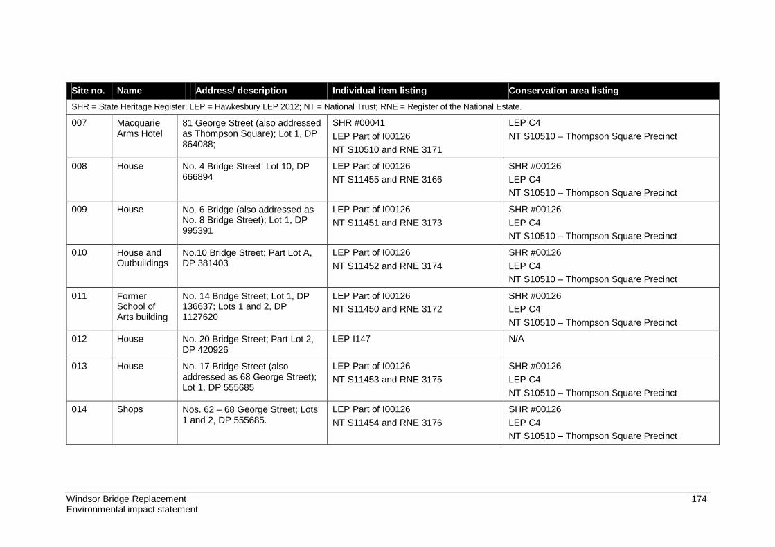
Windsor Bridge Replacement 174 Environmental impact statement
Site no. Name Address/ description Individual item listing Conservation area listing SHR = State Heritage Register; LEP = Hawkesbury LEP 2012; NT = National Trust; RNE = Register of the National Estate.
007 Macquarie Arms Hotel
81 George Street (also addressed as Thompson Square); Lot 1, DP 864088;
SHR #00041 LEP Part of I00126 NT S10510 and RNE 3171
LEP C4 NT S10510 – Thompson Square Precinct
008 House No. 4 Bridge Street; Lot 10, DP 666894
LEP Part of I00126 NT S11455 and RNE 3166
SHR #00126 LEP C4 NT S10510 – Thompson Square Precinct
009 House No. 6 Bridge (also addressed as No. 8 Bridge Street); Lot 1, DP 995391
LEP Part of I00126 NT S11451 and RNE 3173
SHR #00126 LEP C4 NT S10510 – Thompson Square Precinct
010 House and Outbuildings
No.10 Bridge Street; Part Lot A, DP 381403
LEP Part of I00126 NT S11452 and RNE 3174
SHR #00126 LEP C4 NT S10510 – Thompson Square Precinct
011 Former School of Arts building
No. 14 Bridge Street; Lot 1, DP 136637; Lots 1 and 2, DP 1127620
LEP Part of I00126 NT S11450 and RNE 3172
SHR #00126 LEP C4 NT S10510 – Thompson Square Precinct
012 House No. 20 Bridge Street; Part Lot 2, DP 420926
LEP I147 N/A
013 House No. 17 Bridge Street (also addressed as 68 George Street); Lot 1, DP 555685
LEP Part of I00126 NT S11453 and RNE 3175
SHR #00126 LEP C4 NT S10510 – Thompson Square Precinct
014 Shops Nos. 62 – 68 George Street; Lots 1 and 2, DP 555685.
LEP Part of I00126 NT S11454 and RNE 3176
SHR #00126 LEP C4 NT S10510 – Thompson Square Precinct
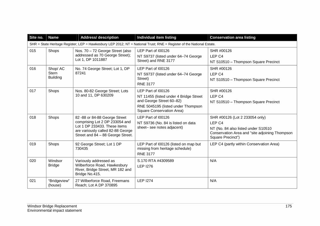
Windsor Bridge Replacement 175 Environmental impact statement
Site no. Name Address/ description Individual item listing Conservation area listing SHR = State Heritage Register; LEP = Hawkesbury LEP 2012; NT = National Trust; RNE = Register of the National Estate.
015 Shops Nos. 70 – 72 George Street (also addressed as 70 George Street); Lot 1, DP 1011887
LEP Part of I00126 NT S9737 (listed under 64–74 George Street) and RNE 3177
SHR #00126 LEP C4 NT S10510 – Thompson Square Precinct
016 Shop/ AC Stern Building
No. 74 George Street; Lot 1, DP 87241
LEP Part of I00126 NT S9737 (listed under 64–74 George Street) RNE 3177
SHR #00126 LEP C4 NT S10510 – Thompson Square Precinct
017 Shops Nos. 80-82 George Street; Lots 10 and 11, DP 630209
LEP Part of I00126 NT 11455 (listed under 4 Bridge Street and George Street 60–82) RNE 5045195 (listed under Thompson Square Conservation Area)
SHR #00126 LEP C4 NT S10510 – Thompson Square Precinct
018 Shops 82 -88 or 84-88 George Street comprising Lot 2 DP 233054 and Lot 1 DP 233433. These items are variously called 82-88 George Street and 84 – 88 George Street.
LEP Part of I00126 NT S9736 (No. 84 is listed on data sheet– see notes adjacent)
SHR #00126 (Lot 2 233054 only) LEP C4 NT (No. 84 also listed under S10510 Conservation Area and "site adjoining Thompson Square Precinct”)
019 Shops 92 George Street; Lot 1 DP 730435
LEP Part of I00126 (listed on map but missing from heritage schedule) RNE 3177
LEP C4 (partly within Conservation Area)
020 Windsor Bridge
Variously addressed as Wilberforce Road, Hawkesbury River, Bridge Street, MR 182 and Bridge No.415.
S.170 RTA #4309589 LEP I276
N/A
021 “Bridgeview” (house)
27 Wilberforce Road, Freemans Reach; Lot A DP 370895
LEP I274 N/A

Windsor Bridge Replacement 176 Environmental impact statement
Statutory listings There are 21 items within and adjacent to the project study area that are recognised as having State and/or local heritage significance (see Figure 7-8). These items are listed and protected under the following NSW legislation and statutory environmental planning instruments:
Heritage Act 1977 (Heritage Act).
Hawkesbury Local Environmental Plan 2012 (Hawkesbury LEP). There are currently no heritage items listed under Commonwealth legislation within or adjacent to the project study area. Thompson Square has, however, been nominated to the National Heritage Register for both a routine listing and an emergency listing. The nominations of the site to the National Heritage Register were received by the Australian Heritage Council in February 2012.
Items currently recognised as being of State heritage significance are listed and protected under the Heritage Act 1977. These include items listed on the State Heritage Register (SHR) and items listed on the Heritage and Conservation Register of a State government instrumentality in accordance with Section 170 of the Heritage Act 1977. The heritage schedule of the Hawkesbury LEP (Schedule 5 Environmental heritage) includes items of both State and local heritage significance.
There are three SHR listings within and adjacent to the study area:
Thompson Square Precinct (SHR item #001264) (see Figure 7-9).
Macquarie Arms Hotel (SHR item #00041).
House and Outbuilding at 5 Thompson Square (SHR item # 00005).
The Thompson Square Precinct SHR item (SHR item #00126) includes most of the properties within and surrounding Thompson Square, although two properties (Macquarie Arms Hotel and the House and outbuilding at 5 Thompson Square) are excluded from the Precinct item and listed as individual items. The main thoroughfare of Bridge Street, including the 1934 road between the kerbs down to where it meets The Terrace and Windsor Bridge, is also excluded from the SHR Thompson Square Precinct boundaries. An assessment of significance of the Thompson Square Conservation Area using the NSW heritage criteria is presented in the Working Paper. The assessment of significance concludes the Thompson Square Conservation Area to be State significant under all seven criteria and that its significance extends beyond the SHR boundary (refer to Section 7.1.3).
4 Referred to as “Thompson Square Conservation Area” on the Heritage Branch database.

Windsor
Wharf
Existin
g brid
ge to
be d
em
olish
ed
No. 4
No. 10
No. 6
No. 53
Replacement
bridge
The
Terrace
BR
IDG
E STREET
GEORGE S
TREET
BA
KER
STREET
GEORGE STREET
MACQ
UARIE S
TREET
BR
IDG
E ST
REET
��1
��22
��12
��11
��4
��25
��6
��8
��2
��7
��20
��23
��6
��17
��7
��5
��10
��9
��16
��3
��14
��13��15
��18
��19
��1
��26
��24
��1
Figure 7-8 | Heritage items within Thompson Square
GDA 1994 | MGA Zone 56
!
!
SYDNEY
WINDSOR
°0 50
Metres
1:1,500
Sinclair Knight Merz does not warrant that this document
is definitive nor free of error and does not accept liability
for any loss caused or arising from reliance upon
information provided herein.
A4
31/10/2012 | I:\NBIF\Projects\NB11459\Technical\GIS\GIS_Directory\ArcMap\EIS\NB11459_EIS_007_Heritage_ThompsonSq_r1v2.mxd
Sydney Spatial Team - Prepared by : DD
Checked by : JC
LEGEND
Concept design
Construction work zone
Cadastral boundary
Properties requiring flood mitigation works.
Works subject to further consultation with
and agreement from affected property owners.
Properties requiring noise mitigation works.
Works that are feasible and reasonable would
be subject to further consultation with and
agreement from affected property owners.
Works subject to further council and
stakeholder consultation
Heritage investigation
Heritage item
Listed heritage items
LEP/Draft LEP
s170 Register
State Heritage Register
Non-listed items
Known heritage item
Potential heritage item
Thompson Square
Conservation Area (SHR)
!11
Indicative only – subject to detailed design
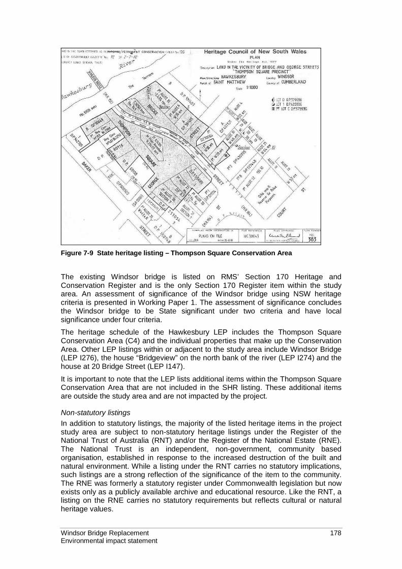
Windsor Bridge Replacement 178 Environmental impact statement
Figure 7-9 State heritage listing – Thompson Square Conservation Area The existing Windsor bridge is listed on RMS’ Section 170 Heritage and Conservation Register and is the only Section 170 Register item within the study area. An assessment of significance of the Windsor bridge using NSW heritage criteria is presented in Working Paper 1. The assessment of significance concludes the Windsor bridge to be State significant under two criteria and have local significance under four criteria.
The heritage schedule of the Hawkesbury LEP includes the Thompson Square Conservation Area (C4) and the individual properties that make up the Conservation Area. Other LEP listings within or adjacent to the study area include Windsor Bridge (LEP I276), the house “Bridgeview” on the north bank of the river (LEP I274) and the house at 20 Bridge Street (LEP I147).
It is important to note that the LEP lists additional items within the Thompson Square Conservation Area that are not included in the SHR listing. These additional items are outside the study area and are not impacted by the project.
Non-statutory listings In addition to statutory listings, the majority of the listed heritage items in the project study area are subject to non-statutory heritage listings under the Register of the National Trust of Australia (RNT) and/or the Register of the National Estate (RNE). The National Trust is an independent, non-government, community based organisation, established in response to the increased destruction of the built and natural environment. While a listing under the RNT carries no statutory implications, such listings are a strong reflection of the significance of the item to the community. The RNE was formerly a statutory register under Commonwealth legislation but now exists only as a publicly available archive and educational resource. Like the RNT, a listing on the RNE carries no statutory requirements but reflects cultural or natural heritage values.

Windsor Bridge Replacement 179 Environmental impact statement
Additional potential (unlisted) heritage items Additional items or properties that are considered to have potential heritage value but are not included on any statutory or non-statutory heritage registers have also been identified in this assessment. Unlisted items within the project study area are identified in Table 7-5. These items have also been assigned a site number and name for the purposes of this report and, apart from site number 31 and 32, are shown on Figure 7-8.
Table 7-5 Unlisted potential heritage items within the study area
Site no.
Site name Address/ description
022 Green Hills Wharf site c. 17951
Adjacent to upstream and downstream of southern abutment of existing Windsor bridge; within or directly adjacent to Lot 7011 DP 1030959 and Lot 7008 DP 1029964 respectively.
023 Government Wharf site c. 1815
1 Bridge Street; within or directly adjacent to Lot 7008 DP 1029964
024 Government House Wharf site c. 1800
Riverbank at the base of the former government house cottage within or directly adjacent to Lot 7008 DP 1029964
025 The Terrace Lot 7011 DP 1030959 (upstream of existing bridge); Lot 7008 DP 1029964 (downstream of existing bridge
026 River Bank – southern 1 the Terrace; part Lot 7011 DP 1030959
027 Northern river bank and turf farm
2 and 26 Wilberforce Road, Freemans Reach; Lot 2 DP 65136 and Lot 2 DP 1096472
028 Bridge approach – north side
Parts of Wilberforce Road and Freemans Reach Road
029 Turf farm 33 Wilberforce Road, Freemans Reach; Lot 1 DP 1096472. May have archaeological potential for "Settlers Arms"
030 Macquarie Park 1 Wilberforce Road, Freemans Reach; Lot 1 DP 226141 and Lot B DP 386334; not directly in project footprint
031 Terrestrial archaeological resources
Includes any potential sites that have not been identified in this report
032 Maritime archaeological resources1
Includes any potential sites that have not been identified in this or the maritime working paper.
1. Refer to discussion of maritime heritage below.
Hawkesbury Cultural Plan In May 2006, the Hawkesbury City Council commissioned the Hawkesbury Cultural Plan 2006-2011 in recognition of the role that culture plays in shaping the quality of life of the Hawkesbury. The purpose of developing the plan was to provide Council with the necessary information to effectively support cultural activities in the Hawkesbury region. Development of the plan involved collecting information from a number of sources, including via interviews and community workshops. The information collected indentified the following as key components of the area's identity and sense of place:

Windsor Bridge Replacement 180 Environmental impact statement
Hawkesbury River and the cultural landscape.
Heritage and history, including Aboriginal culture.
Rural amenity and lifestyle and the friendliness of the people.
Education facilities and support for learning.
Proximity to the city (Sydney central business district).
Arts and cultural facilities (eg Regional Gallery and Regional Museum) and the strength and experience of the area’s arts and cultural groups.
Maritime heritage
Maritime history A wharf was first constructed at the initial settlement corresponding to the present town of Windsor in 1795 (referred to as the c. 1795 wharf). This wharf supplied the early store and military garrison, and provided for transportation of crops out of the surrounding farms. The approximate location of the wharf is indicated in Figure 7-1.
A second wharf was built at Windsor around 1814 (referred to as the c.1814 wharf) and repaired in 1820 under the direction of Governor Macquarie. This wharf was located on the southern bank of the river to the east of the existing bridge and was present on the site until the late 1930s or early 1940s.
A private punt service started in 1815 using the c.1814 wharf as the southern bank landing and a point in the general location of the current bridge as the northern bank landing. In 1832, the punt was taken over and operated by the government. Around 1835, the punt was re-located upstream and a cabling system was installed for the crossing. The northern bank landing point for this punt crossing (referred to as the c.1835 punt crossing) was located just upstream of the existing bridge.
The bridge across the Hawkesbury River was built in 1874 with the punt service terminating soon after. A temporary bridge was constructed in 1896 for the raising of the main bridge across the Hawkesbury River. The temporary bridge was built in six weeks and is thought to have been located on the upstream side of the current bridge (although there in insufficient information available to confirm its location).
Results of the maritime heritage survey The targeted maritime heritage survey undertaken as part of preliminary investigations in 2008 identified archaeological remains associated with the second (c.1814) wharf. These comprised above and below water structural remains of the known wharf site.
The above water remains of the c.1814 wharf are present on the southern side of the river to the east of the existing bridge and west of the current wharf. The remains are present in two adjacent areas: the first consists of remnant timber beams and the second of a single pile. There are also remains of a retaining wall further to the east. Rock ballast, which may be associated with the c. 1795 wharf, was also found at the site.
A brief examination was made on the northern bank adjacent to and downstream of the bridge for any evidence of the c. 1835 punt landing site. Though there was evidence of a cutting, it angles towards the water ending at the base of the bridge abutment. This suggests that the cutting may have been made during the building of the bridge to assist in its construction. Thick vegetation precluded any detailed examination of the area.

Windsor Bridge Replacement 181 Environmental impact statement
An additional underwater survey was conducted in October 2012 to investigate anomalies identified in the side scan sonar survey. Near the northern bank between 35 and 60 metres downstream from the existing bridge the remains of a timber structure were identified. There is no pre-1890 historical evidence of a retaining wall being built in this area and it is possible that the remains were potentially transported into the area during previous flood events. The other anomalies were either natural features (eg. boulders, rock platform), tree debris or of modern origin (eg. shopping trolley).
Maritime archaeological potential The survival of artefacts and other archaeological deposits in a marine or riverine environment is dependent upon the natural and cultural processes that have occurred in the area. Natural processes in the Hawkesbury River, such as flooding and tidal movement, have resulted in sedimentation and erosion. Cultural influences, such as the demolition and removal of the former wharf, would have also influenced the extent and condition of archaeological remains.
Former Windsor wharf Based on the 2008 survey and the follow-up desktop assessment in 2012, the area within and immediately adjacent to the c.1814 wharf site is considered to have high maritime archaeological potential. Key factors that indicate the high archaeological potential of the site are the presence of rock ballast (which is likely to be associated with the earliest forms of the wharf and indicates that artefacts are likely to have survived despite major flooding events) and the confirmed presence of structural remains associated with the c.1815 wharf.
In addition to the identified structural remains associated with the c.1815 wharf, there are likely to be other structural remains and non-structural archaeological deposits associated with the functioning of the c.1795 and c.1814 wharves in the submerged area behind the southern riverbank. Potential structural remains would include materials associated with the construction, repair and maintenance of the wharf, such as the remains of piles below the ballast layer. The potential for the presence of submerged structural archaeological remains and non-structural maritime archaeological deposits is considered to be high in the location of the rock ballast and moderate for an area of up to five metres around the boundary of the ballast.
The archaeological potential of the wharf from the bank of the river landward is difficult to determine. There has been vegetation cover over this area and there is an uneven layer of fill extending up to one metre above the remains of the wharf. It is also known from the 1814 contract for the construction of the wharf that it included land (deadman) anchors as part of the construction. This suggests that other terrestrial elements associated with the wharf, such as timber decking, piles or other bracing components (like deadman anchors) may be present. The installation of the gabion wall in the 1990s may, however, have required some excavation or modification to the bank, which may have affected the terrestrial archaeological remains associated with the wharf.
The results of the maritime heritage assessment indicate that the archaeological remains of the c.1795 and c.1815 wharves are of State significance (see Table 7-6).

Windsor Bridge Replacement 182 Environmental impact statement
Former punt crossing There is considered to be only a limited potential for the presence of archaeological remains associated with the former punt crossing. Specifically, there is considered to be a moderate potential for archaeological remains associated with the c. 1835 punt landing on the northern side of the river upstream of the current bridge but a low potential for the presence of archaeological remains associated with the period of punt operation prior to 1835 and the route of the punt across the river. The only infrastructure that is likely to be present from pre-1835 operation is the cutting in the northern riverbank that appears on the early maps.
The remains associated with the c.1835 punt landing on the northern bank are anticipated to include infrastructural remains associated with the punt cable system. While structural and artefact remains may have been removed from the area by floods and scouring, cuttings made into the sandstone in this area are likely to have survived. A cutting or road surface associated with the former approach to the northern landing is still present.
From the historical record, particularly from photographic evidence, it is anticipated that any archaeological evidence of the northern bank punt landing point would be completely buried on the upstream side of the current bridge. The near-water and in-water remains of the punt would be very limited, however archaeological remains further up the bank on the northern side may have survived, such as some of the anchors or rugging lanyards that may have since been buried in reclamation. The archaeological potential within this area is considered to be moderate. Any archaeological remains associated with the punt would be of local significance (See Table 7-6).
7.1.3 Assessment of significance Assessments of the significance for all heritage items potentially impacted by the project were undertaken and are presented in detail in the relevant working papers (Volume 2 - working papers 1 and 2), using the assessment criteria and gradings shown in Tables 7-1 and 7-2. A summary statement of heritage significance is presented below. The results of the assessments of significance for heritage items that would be directly impacted by the project are presented in Table 7-6. While other heritage items would be potentially impacted by the project, these impacts would be indirect and mainly as a result of the change in the heritage vistas and values of the area.
Where an item has a provisional level of significance it means that should the relic exist, it is likely to be of the identified level of significance and the existence of the item has been identified through documentary sources. Where there is insufficient evidence to determine a level of significance it means that it is possible that relics may exist due to context but other evidence has not been found.
Summary statement of significance for the project Thompson Square is rare at a State level of significance for its historical, associative, research and social values. Some of the archaeological resource within Thompson Square and extending further south and north is also likely to be of state heritage significance, as are archaeological remains of the wharves within the body of the river. Windsor bridge is a State significant structure that is rare and has historical and technical significance. Each item has, through the historical association with the other, become part of the same landscape. Both Thompson Square and Windsor bridge contribute to state significant views of Windsor as a historic township.

Windsor Bridge Replacement 183 Environmental impact statement
Table 7-6 Summary of assessments of heritage significance for directly impacted heritage items
Criteria Thompson Square
Conservation Area
Windsor bridge Old punt site Green Hills Wharf (c. 1795)
Old Windsor Wharf (Govt.
wharf c. 1815)
Government House wharf (c.
1800)
Criterion A- An item is important in the course or pattern of NSW’s cultural or natural history (or the cultural or natural history of the local area)
State significance
State significance
Local significance
Provisional State significance
State significance
Provisional State significance
Criterion B- An item has strong or special association with the life or works of a person, or group of persons, of importance in NSW’s cultural or natural history (or the cultural or natural history of the local area)
State significance
Local significance
No significance Insufficient evidence to determine
State significance
Provisional State significance
Criterion C- An item is important in demonstrating aesthetic characteristics and/or a high degree of creative or technical achievement in NSW (or the local area)
State significance
State significance
No significance Insufficient evidence to determine
Insufficient evidence to determine
Insufficient evidence to determine
Criterion D- An item has strong or special association with a particular community or cultural group in NSW (or the local area) for social, cultural or spiritual reasons (or at a local level)
State significance
Local significance
Local significance
Insufficient evidence to determine
Insufficient evidence to determine
Insufficient evidence to determine

Windsor Bridge Replacement 184 Environmental impact statement
Criteria Thompson Square
Conservation Area
Windsor bridge Old punt site Green Hills Wharf (c. 1795)
Old Windsor Wharf (Govt.
wharf c. 1815)
Government House wharf (c.
1800)
Criterion E - An item has the potential to yield information that will contribute to an understanding of NSW’s cultural and natural history (or the cultural or natural history of the local area)
State significance
Local significance
Local significance
Provisional State significance
Local significance
Provisional State significance
Criterion F - An item possesses uncommon, rare or endangered aspects of NSW’s cultural or natural history (or the cultural or natural history of the local area)
State significance
No significance Local significance
Provisional State significance
State significance
Provisional State significance
Criterion G - An item is important in demonstrating the principal characteristics of a class of NSW’s cultural or natural places; or cultural or natural environments (or at a local level)
State significance
Local significance
No significance Insufficient evidence to determine
Insufficient evidence to determine
Insufficient evidence to determine

Windsor Bridge Replacement 185 Environmental impact statement
Social significance of Thompson Square5 The official significance of Thompson Square as a physical element of the town's colonial past was recognised first by the National Trust in 1975. This was followed by a Permanent Conservation Order being placed on the square in 1982 and transfer to the SHR in 1999.
The SHR listing for Thompson Square cites only “historical” and “aesthetic” values, and identifies it as “rare” in the overall significance assessment. Social values are not included in the listing. Similarly, when the National Trust first classified Thompson Square in 1975, the focus of the listing was on built fabric and the aesthetic values of the square and surrounding buildings. Social significance was not included.
Although social significance is not accounted for in the heritage listing of Thompson Square, its high level of social significance to the local and wider community is undisputed. Thompson Square has been the focus of community activities since its inception and began to receive increased attention by artists and visitors with an interest in history and historical landscapes from the 1920s onwards. The open space parklands of the square, in particular the upper parkland adjoining George Street, are still used by the public today for casual and organised outdoor activities. The existing uses contribute to the significance of Thompson Square as a place used by the people of Windsor.
A recent report commissioned by Hawkesbury City Council found that the cultural heritage of the region, which includes Aboriginal and historical heritage, is held in high esteem by the Hawkesbury community. Specifically, the Hawkesbury Cultural Plan, adopted by Council on 30 May 2006, found that the residents of the region have a strong interest in conserving the Hawkesbury’s cultural and built heritage. The Plan also found that the Windsor area represents a direct link through history to Australia’s colonial past and has a high concentration of families with links to European settlement.
Interestingly, although locals recognise the amenity value of the river, and the historical connections represented by Windsor Bridge and other sites, the focus has been almost exclusively on Thompson Square as the point of contention. Other elements such as Windsor bridge are identified as important, but at the general level ascribed to the entire historical township. A nomination to list Thompson Square on the National Heritage Register was recently submitted to the Department of Sustainability, Environment, Water, Population and Communities.
There has been considerable community consultation and opportunities for the community to provide feedback on the project (see Chapter 6). While there is support for the project from some parts of the community (especially residents in east Windsor), there is clear community opposition to the project from other parts of the community on the grounds of heritage impacts, as evidenced by banners hanging from balconies overlooking Thompson Square, articles published in the local newspaper, and submissions received on RMS' "Have your say" e-forum6. The Heritage Council is also opposed to the project for the “irrevocable” damage it will do to Windsor and Thompson Square” (refer to letter dated 28/10/2011 attached to the SoHI in Volume 2 - working paper 1).
5 For the purposes of this section, “Thompson Square” refers to the precinct area and includes all the buildings surrounding the reserves and all the roads within the space defined by the Hawkesbury River to the north, and the buildings facing inwards along Old Bridge Street, George Street and the Thompson Square roadway. This definition differs from the SHR listing for Thompson Square Conservation Area. 6 http://haveyoursay.nsw.gov.au/windsorbridge

Windsor Bridge Replacement 186 Environmental impact statement
Community opposition on heritage grounds is most strongly expressed by the “Community Action for Windsor Bridge” (CAWB) website7 and shop front, which provides a central location for information on both opposition to the project and the project-related activities undertaken by RMS and consultants. CAWB has created a petition for opposition to the project that, at 25 May 2012 had collected 6500 signatures for the Lower House of Representatives and 800 for the Upper House (the Senate). According to the website, by 29 June 2012, the petition for the Lower House of Representatives had gathered another 1800 signatures.
A rally to protest the project was organised by CAWB on 3 June 2012. The rally was advertised as a “Public Rally to Save Thompson Square” and had a number of speakers. The keynote speaker was Mr Jack Mundey, a significant individual in the conservation movement to save “The Rocks” from development and an influential campaigner on a number of social and industrial issues. Other non-resident participants included members of the Federation of Historical Societies Inc.
The magnitude of the community reaction to the project has been considerable. The structural integrity of the existing Windsor bridge has been identified as poor and, while the bridge is suitable for current use it requires regular inspection to ensure ongoing safety. If it deteriorates further (eg due to damage or flood) it could require closure at short notice and would need extensive rehabilitation works if it was to be used and maintained into the future. The residents of Windsor and communities across the Hawkesbury would be acutely aware of their reliance on secure access across the river, having been blocked by floods on numerous occasions. The opposition to the project, despite the clear community need for a new bridge to provide a safe and reliable river crossing, is a clear indication of the strength of concerns about heritage impacts.
It is clear that the social significance of the place far exceeds what would be expected in a local context. It is also clear that the local and broader community hold Thompson Square and Windsor bridge in high esteem. The socio-economic impacts of the project are discussed in Section 7.8.
7 http://cawb.weebly.com/

Windsor Bridge Replacement 187 Environmental impact statement
7.1.4 Potential impacts An integrated design approach, including specialist heritage input, was adopted for project development. This integrated approach has resulted in a project concept design that aims to minimise adverse impacts on the heritage values of Thompson Square and the overall landscape and aesthetic significance of Windsor. Some of the key design refinements that have been incorporated into the concept design are identified in Section 7.4.4.
Impacts to historic heritage would remain with the design refinement measures integrated into the project. The project would impact known items of heritage significance and would be likely to impact on unknown and potential items of heritage significance within the project footprint. Heritage impacts would also extend beyond the project footprint to affect views and vistas. Impacts would arise from the construction, demolition and operation of the project. Site numbers are found in Table 7-4 and Table 7-5.
Construction impacts would include:
Potential damage to heritage items and buildings due to vibration from construction activities (see Table 7-7).
Potential direct and indirect damage to known and unknown terrestrial and maritime archaeological resources.
Temporary visual impacts of construction sites and compounds.
The impact on Thompson Square and the northern bank during the removal and infilling of the approach roads to the existing bridge.
Temporary closure of Thompson Square parkland areas.
Potential demolition impacts would include:
Demolition of State heritage significant Windsor bridge.
Direct and indirect damage to unknown maritime archaeological resources.
Temporary visual impacts of construction sites and compounds.
Potential operational impacts would result from the final form of the project as well as potential impacts from traffic using the project and would include:
The visual impact of the whole project and its constitute elements such as the southern and northern approach roads, the intersections and the new bridge.
The visual and other amenity impacts from traffic using the project.
The impact on heritage values of Thompson Square Conservation Area of the landscaping and urban design features which would be provided as part the project.
The potential impacts of the project on listed and unlisted heritage items are summarised in Table 7-7. Further details of impacts are provided below. A more detailed assessment of impacts on individual heritage items is provided in Chapter 10 of Volume 2 - working paper 1. For the purposes of this discussion, the Thompson Square Conservation Area (SHR item #00126) is discussed as one item even though it corresponds to three site numbers in the register (site numbers 001 - 003) also detailed in Table 7-6.

Windsor Bridge Replacement 188 Environmental impact statement
The project would have actual physical impacts on two heritage items that are subject to statutory heritage listings:
Thompson Square Conservation Area (SHR item #00126), which is of State significance and listed on the SHR.
Windsor Bridge (RMS Section 170 Register item #4309589), which is of State heritage significance and listed on RMS’ Section 170 Register.
Four unlisted sites of maritime heritage significance would also be subject to direct physical impacts. Of the four, the first two in the list have been identified through documentary sources and have not been confirmed through physical evidence:
The Green Hills wharf site (c 1795, by the southern abutment of the existing bridge).
The Government House wharf site (c 1800).
The old wharf site (the Government Wharf site c. 1815).
The punt landing site.
Works associated with construction of the new bridge, demolition of the old bridge, river bank scour protection and reconnection of The Terrace have the potential to impact maritime archaeological relics at these sites, including the archaeological remains known to be present at the old wharf site. The archaeological remains of the wharfs are considered to be of State significance.
Works associated with reconnection of The Terrace also have the potential to disturb terrestrial archaeological relics.
In addition to the direct impacts on the fabric and curtilage of listed heritage items and direct impacts on archaeological relics and remains, vibration generated during construction of the project has the potential to result in physical impacts on six additional items, if appropriate environmental management measures are not implemented. These items are as follows:
House at 4 Bridge Street.
House at 6 Bridge Street.
House and Outbuildings at 10 Bridge Street.
Former School of Arts building.
Shops at 62-68 George Street.
The Doctors House. Environmental measures to address these impacts are identified in Section 7.1.5. The majority of identified listed heritage items and potential (currently unlisted) heritage items would also experience visual impacts as a result of the project (refer to Table 7-7).

Windsor Bridge Replacement 189 Environmental impact statement
Table 7-7 Potential heritage impacts on sites within the study area Explanatory note: "provisionally" in front of a level of significance means that should the relic exist, it is likely to be of that level of significance and the existence of the item has been identified through documentary sources.
"Undetermined" has been used where it is possible that relics may exist due to context but where other evidence has not been found.
Site no. Name Heritage listing Significance
Potential or known impact
on fabric
Potential or known impact on curtilage
Potential or known visual
impact
Potential construction
vibration impacts
001 Thompson Square – Roads
SHR (#00126 – excluding 1934 cutting) LEP (I526; C4)
State Yes Yes Yes Yes – high potential
002 Thompson Square – Lower parkland
SHR (#00126) LEP (I529; C4)
State Yes Yes Yes Yes – high potential
003 Thompson Square – Upper parkland
SHR (#00126) LEP (I524; C4)
State Yes Yes Yes Yes – high potential
004 The Doctors House SHR (#00126) LEP (I525; C4)
State No No Yes Yes: vibration-related impacts possible
during infilling Thompson Square
005 House and Outbuilding (5 Thompson Square)
SHR (#00005) LEP (I527; C4)
State No No Yes No
006 Hawkesbury Museum and Tourist Information Centre
SHR (#00126) LEP (I528; C4)
State No No Yes No
007 Macquarie Arms Hotel
SHR (#00041) LEP (I442; C4)
State No No Yes No

Windsor Bridge Replacement 190 Environmental impact statement
Site no. Name Heritage listing Significance
Potential or known impact
on fabric
Potential or known impact on curtilage
Potential or known visual
impact
Potential construction
vibration impacts
008 House (4 Bridge Street). The retaining wall and potential archaeological deposit within this property are the significant items.
SHR (#00126) LEP (I73; C4)
State Yes: Vibration-related during construction.
Sandstock brick wall particularly
sensitive.
No Yes Yes: vibration-related impacts possible –
high potential
009 House (6 Bridge Street)
SHR (#00126) LEP (I206; C4)
State Yes: Vibration-related during construction
No Yes Yes: vibration-related impacts possible –
high potential
010 House and Outbuildings (10 Bridge Street)
SHR (#00126) LEP (I253; C4)
State Yes: Vibration-related during construction
Yes: vibration-related impacts possible –
high potential
011 Former School of Arts building
SHR (#00126) LEP (I273; C4)
State Yes: Vibration-related during construction
No Negligible Yes: vibration-related impacts possible – moderate potential
012 Cottage (20 Bridge Street)
LEP (I147) Local No No No No
013 Cottage (17 Bridge Street)
SHR (#00126) LEP (I300; #C4)
State No No Negligible No
014 Shops (62-68 George Street)
SHR (#00126) LEP (I295; C4)
State Yes: Vibration-related during construction
No Yes – changes to Bridge and George Street
intersection
Yes: vibration-related impacts possible –
inspection not undertaken
015 Shops (70-72 George Street)
SHR (#00126) LEP (I400; C4)
State No No Yes No

Windsor Bridge Replacement 191 Environmental impact statement
Site no. Name Heritage listing Significance
Potential or known impact
on fabric
Potential or known impact on curtilage
Potential or known visual
impact
Potential construction
vibration impacts
016 AC Stern Building (74 George Street)
SHR (#00126) LEP (I400; C4)
State No No Yes No
017 Shops (80-82 George Street)
SHR (#00126) LEP (I402; C4)
State No No No No
018 Shops (84 & 88 George Street)
SHR (#00126) LEP (I479; C4)
State No No No No
019 Shops (92 George Street)
LEP (I485; #C4) State No No No No
020 Windsor Bridge S.170 (RTA #4309589) LEP (I276)
State Yes Yes Yes N/A
021 Bridgeview LEP (I274) Local No No Yes Yes
022 Green Hills Wharf c. 1795
Nil Provisionally State
Yes Yes No Yes
023 Government Wharf site c. 1815
Nil State Yes Yes No Yes
024 Government house wharf site c. 1800
Nil Provisionally State
Undetermined Possibly No N/A
025 The Terrace (west of Windsor Bridge)
Nil Undetermined Undetermined Undetermined Yes Yes
026 (old 24)
River bank – south bank (west of Windsor Bridge)
Nil Undetermined Undetermined Undetermined N/A N/A

Windsor Bridge Replacement 192 Environmental impact statement
Site no. Name Heritage listing Significance
Potential or known impact
on fabric
Potential or known impact on curtilage
Potential or known visual
impact
Potential construction
vibration impacts
027 (old 25)
North river bank and turf farm (east of Windsor Bridge)
Nil Undetermined Undetermined Undetermined N/A Undetermined
028 (old 26)
Existing Bridge Approach – north side
Nil No No Yes N/A No
029 (not numbered)
Turf farm (on Wilberforce Road – potential archaeological site)
Nil Undetermined Undetermined Undetermined No No
030 (old 28)
Macquarie Park Nil Potential State No No Low No
031 No numbers
Terrestrial archaeological resources not identified in this report
Nil Undetermined Undetermined Undetermined No Undetermined
032 No numbers
Maritime archaeological resources not identified in this or the maritime report (Cosmos Archaeology 2012)
Nil Undetermined Undetermined Undetermined No Undetermined

Windsor Bridge Replacement 193 Environmental impact statement
Thompson Square The project would have high physical and visual impacts on Thompson Square. In particular, the project would have potential impacts on:
State significant archaeological relics from the early settlement period.
Existing elements of Thompson Square, in particular the form of the Thompson Square parkland and landscaping.
Historic views and vistas and the setting of Thompson Square.
Building impacts due to vibration from construction and the installation of noise mitigation measures.
Impacts on archaeology
Major impacts would include disturbance and destruction of archaeological evidence from the early settlement period including:
Terrestrial archaeological resources related to 18th and early 19th century buildings and road alignments and land modification.
Land-based maritime archaeological resources related to the early wharf, the punt landing by the wharf, and the temporary bridge erected in 1897 (eg. retaining walls, deadman anchors).
Archaeological evidence in Thompson Square, Windsor Road and the northern bank in the 19th and 20th centuries in response to transport changes, land-use and reconfiguration of public space.
Test excavations undertaken in May 2012 in Thompson Square confirmed that archaeological resources survive beneath the existing roads and would be likely to present in other areas potentially disturbed by construction of the project including The Terrace and parkland areas. Some of this evidence relates to understanding the pattern of the earliest European settlement in Australia, which could be ranked as exceptional (see Table 7-4). Surviving archaeological sites of comparable age are restricted to a handful of locations in Sydney and Parramatta, and the first settlement sites in Norfolk Island and Tasmania. Pending more extensive archaeological investigation it is not possible to say how extensive the most significant deposits are or how well they have survived.
The design of the replacement bridge and approach roads considered impacts on relics and has minimised those impacts as far as practicable. However construction of the southern approach road and southern bridge abutments would result in a disturbance of a substantial area of land within Thompson Square – and therefore the impact on the archaeological resources in this area would be significant and unavoidable. While the actual area of Thompson Square disturbed by excavation can be minimised, partial disturbance would still result in the loss of archaeological resources and could fragment the contextual relationship between archaeological resources from different periods.
While maintaining archaeological resources in-situ would be the preferred method for preservation, this would not be possible in areas impacted by excavation works. Instead as discussed in Section 7.1.5, open area excavation would first be undertaken to expose, investigate, record and salvage archaeological resources. This would provide a greater understanding of the historical development of Thompson Square and contribute to the historical record of the region.

Windsor Bridge Replacement 194 Environmental impact statement
Impacts on form of Thompson Square parklands
The current form of the Thompson Square parkland is a product of the gradual evolution of Thompson Square as a civic area and as an area to provide access to the river. Although Thompson Square has been modified regularly since its establishment, it has retained its overall form of a large, open space sloping down to the river. The project would have both positive and negative impacts on the form of Thompson Square parkland and has the potential to impact its significance as the focal point of the conservation area listed on the State Heritage Register.
The construction of the existing southern approach road to the existing bridge through Thompson Square parkland in 1934 has been the most significant adverse impact on the character of Thompson Square to date. It increased the physical separation of the upper and lower parklands and would have also resulted in the destruction of many significant historical relics.
One of the benefits of the project would be the in-filling of the existing southern approach road through the Thompson Square parkland and the connection of the upper and lower parkland areas (which are currently separated by the road). The result would be a greater area of continuous parkland that would slope gently to The Terrace and the river.
In addition to improving the amenity and utility of the open space area for the public, the connection of the parkland areas would be a positive step toward consolidating the visual and spatial relationship of this element of Thompson Square by creating one large, cohesive space for a variety of community and recreational uses. Opportunities would also exist to include meaningful interpretation of the past, such as part of the earlier curved road alignment. The resulting form would be closer to the earliest colonial space prior to the creation of formalised roads. The original alignment of Old Bridge Street and the old alignments to the bridge and old wharf that are still visible in the existing landscape would, however, be permanently removed through the modifications within and adjacent to the square.
Physical impacts on any remaining archaeological relics in the immediate locality of the existing approach road would be negligible as the works would involve infilling rather than excavation.
The project would include the removal of some of the older trees in poor condition within the Thompson Square parkland and replacement with new trees. This would be an opportunity to improve the functionality and visual appearance of Thompson Square parkland.
Impacts on landscaping of Thompson Square parklands
From the 1880s Thompson Square has been subject to informal landscaping with the planting of trees, the erection of a pavilion, which was removed in the early twentieth century and arris rail fencing. The asymmetry and unstructured look of Thompson Square reinforced the informal design. More recently, the Pioneers Memorial and other features such as picnic tables and chairs were added.
The concept urban and landscape design for the project to date has respected the historical development of Thompson Square by promoting an informal landscape scheme that maintains the current character of Thompson Square and maintains the unstructured character of the parkland areas.

Windsor Bridge Replacement 195 Environmental impact statement
However, the project would permanently modify the form of the parkland areas. While the landscape concept design proposes an informal scheme with few hard-paved areas, an informal planting scheme and a gently terraced slope down to the river, the modifications required to create a single unified park and the introduction of the new elements of the project would change the setting, view, vistas and character of the lower park. The concept of an informal landscape would be carried through to the final landscape plan in consideration od the historical development of the area.
Impacts on historic views and vistas and the setting of Thompson Square
Impacts on the views, vistas and setting of Thomson Square from the project would have the greatest impact to the heritage significance of Thompson Square. These would be greater than any physical impacts resulting from construction and operation of the project.
The current setting of Thompson Square and the Windsor bridge is formed by the relationship of these existing elements to the wider landscape. The entry point at the George Street and Bridge Street intersection announces arrival to Windsor via Thompson Square from the south. On the north side of the river, as Wilberforce Road approaches the edge of the river, the eye is swept along the curving road and across the river via the alignment of the existing bridge, which forms a boundary, of sorts, encompassing first the Doctors House, then the other elements of the square.
The eastern side of Thompson Square, which currently comprises of a footpath, a local road and sections of parkland, would be converted into a three lane road, shared path and new local footpath for the new southern approach road. This would impact the setting of Thompson Square, which currently retains elements of its rural ambience during low traffic periods. It would also impact the relationship of the buildings that border the eastern side of the square to the reserves and western side of the square. A photograph of the existing view from the Doctors House of the existing bridge and location of the replacement bridge is presented in Figure 7-21.
While the visual impact of the new southern approach road has been minimised by matching its level with the levels of the existing landforms along the eastern site of Thompson Square, the most substantial impact would be the visual impact of traffic on the new southern approach road. The approach road to the existing bridge is within a cutting and vehicles using the approach road are generally not visible and therefore views across Thompson Square are generally not impacted by traffic. The project would bring the approach road and traffic almost level with these buildings, thereby creating a permanent visual impediment to views across Thompson Square.
The new southern approach road and bridge would also impact views from Thompson Square to the river and across to the northern bank. However the existing topography and vegetation currently impact these views in many locations, so the impact on views from the project would not be as significant.
The removal of the existing Windsor bridge and construction of the new bridge would also impact the view of the Thompson Square parkland from the northern bank. Specifically, it would modify the composition of the setting by introducing a focal point across the front of Thompson Square when viewed from anywhere east of Freemans Reach Road. It would also change the outlook from Thompson Square across to the northern bank. Windsor bridge has framed the extent of Thompson Square open space and allows it to continue across the expanse of water. The existing bridge also acts as a pointer, topped by the Doctors House, to Thompson Square when viewed from the northern bank. With the demolition of Windsor bridge the visual cues and linkage with Thompson Square would be lost.
Windsor Bridge Replacement 196 Environmental impact statement
From view points on the northern bank east of the intersection of Freemans Reach Road and Wilberforce Road, the replacement bridge would obscure parts of Thompson Square parkland, however generally all the buildings around Thompson Square would be visible.
The design of the project has considered the historical sensitivity of Thompson Square, its archaeological potential and the potential for adverse impacts on historical views and vistas and its setting. As a result, aspects of the project have changed considerably since it was first proposed. Two important decisions that have been guided by the heritage significance of Thompson Square are the height of the replacement bridge and the type of bridge and its associated method of construction. The height of the original bridge design would have totally obscured iconic views from Wilberforce Road to Thompson Square, views from Thompson Square across the river to the rural landscape of Wilberforce and Freemans Reach, and views from the eastern side of Thompson Square to the western side. The current design involves a lower level bridge, which has a reduced level of impact on views to and from Thompson Square. The current design would only partially obscure views to and from Thompson Square.
After consideration of a number of different bridge types (see Section 4.4), an incrementally launched bridge was selected. The bridge would be launched from the northern river bank which is a positive response to the significance of Thompson Square as the construction impacts and use of Thompson Square would be minimised. Additionally, from a visual perspective, an incrementally launched bridge allows the profile of the bridge to be minimised and the features of the bridge superstructure to be designed to reflect the sensitivities of the heritage vistas. A impression of the replacement bridge from the Doctors House is presented in Figure 7-22. Nevertheless, despite the high level of attention to detail in design, the replacement bridge, approach roads and roundabout on the northern bank would visually dominate the surrounding rural landscape and heritage vistas.
The urban design and landscaping working paper (Volume 3 - working paper 4) has identified appropriate concepts for future landscaping of Thompson Square and the open area on the northern side of the river. These concepts have been informed and guided by the heritage assessment.
There would be additional temporary visual impacts during construction from construction sites and compounds on the northern bank and near the current Windsor Wharf.
Building impacts due to vibration from construction and the installation of noise mitigation measures
The potential impact on heritage and non-heritage buildings from vibration associated with construction activities has been assessed as part of the Noise and vibration working paper (Volume 4 – working paper 6) and are summarised in Section 7.5. The assessment identified that there is the potential for certain construction activities to cause vibration levels exceeding relevant structural damage criteria at buildings immediately adjacent to the construction site. However, the potential impact and risk of vibration related impacts can be mitigated by exclusion zones around buildings for specific high vibration activities, adopting alternative low vibration construction techniques, building condition surveys and vibration monitoring.

Windsor Bridge Replacement 197 Environmental impact statement
Only one heritage building would require consideration for architectural noise mitigation, namely the upper floor of 10 Bridge Street. A qualified heritage architect was engaged to inspect the upper floor of 10 Bridge Street and recommend potential architectural treatments that provide noise mitigation while not impacting on the heritage values of the building. The heritage architect (CityPlan Heritage, 2012) recommended measures that could be implemented without resulting in a significant impact to the heritage values of the building.
Windsor bridge The existing Windsor bridge would be demolished due to its poor condition and its risk to the replacement bridge downstream. The existing bridge has been assessed to be of State significance and is listed as a heritage item on the RMS Heritage and Conservation Register and the Hawkesbury LEP. The current use of the bridge contributes to its significance as it continues to function as it was originally intended. Although the bridge superstructure was modified significantly through the removal of the timber deck and replacement with concrete girders, cross girders and deck, the original form of the bridge has been retained. Also of note is that the 1922 refurbishment was an early use of mass concrete and the construction methods where one lane was kept open, were unusual.
The demolition of the existing Windsor Bridge would be a loss to the cultural landscape of Windsor as it contributes to the historic character of the locality and is significant as an individual heritage item. Since it was built, it has featured in numerous photographs and is a component of the iconic image of Thompson Square as viewed from the northern bank as well as vistas across the river from Thompson Square.
The location of the bridge is thought to be the location of the c. 1795 wharf, the c.1814 punt wharf and the temporary bridge built for the 1897 modifications (raising the height of the existing Windsor bridge).
Rehabilitation of the bridge would be possible but would be costly and the bridge would still only have a limited life span.
“Bridgeview” at 27 Wilberforce Road and northern bank Bridgeview, a locally heritage listed residence is located adjacent to the project near the corner of Freemans Reach Road and Wilberforce Road. Bridgeview is a fine example of a Federation bungalow with landmark qualities and is visible from Thompson Square and from Wilberforce Road. Bridgeview would not be directly impacted by the construction of the project. The impacts would be predominantly to the visual landscape as the configuration of the roads on the northern bank have not changed for a century or more and the land uses are rural agricultural.
A dual lane roundabout would be constructed just south east of Bridgeview to service Macquarie Park, Freemans Reach Road, Wilberforce Road and the northern bridge approach road.
Design changes have been made with respect to reducing the visual impact of the proposed roundabout by lowering the original finished level by about one metre. However, the roundabout would still be a substantial structure and, with the feeder roads would create a substantial visual impact when viewed from Thompson Square. Views to and from Bridgeview would also be impacted negatively but would be reduced by landscaping to obscure the road from the house.
The archaeological sensitivity of this area is considered to be variable.
Archaeological monitoring of the geotechnical test pits suggests that evidence of landscape modifications survives, particularly around geotechnical test pit 5.

Windsor Bridge Replacement 198 Environmental impact statement
Concrete beams were discovered in this area and are similar to beams found on the southern bank. These beams are possibly infrastructure built in 1897 to raise and improve the level of the approach roads. Other infrastructure associated with raising the bridge in 1897, could be present in this area.
Historical records of development of the northern bank are scarce and those that were found contained little information on the location of structures. One of the earliest inhabitants of the region, Edward Whitton, lived and farmed somewhere in or close to the project footprint. Also, historical documents describe a hotel, the Squatters Arms, on the corner of Freemans Reach and Wilberforce Roads but do not clearly describe its location. This potential archaeological site has also been considered in the discussion of archaeological resources (see Volume 2 – working paper 1 – Appendix 3) and is included in the recommendations.
The archaeological resource on the northern bank is considered to be less complex with the possibility of substantial pockets surviving in discrete areas. The impact of the project on archaeological resources of significance is not considered to be as substantial on the northern bank, compared to the southern bank.
Maritime archaeology The project would have an impact on known and potential archaeological remains within the project footprint as follows:
Installation of the first in-water pier on the southern side of the river and the retaining wall and rock scour protection immediately in front of the southern bank would disturb and/or destroy known and potential archaeological remains associated with the former wharf.
Filling, landscaping and installation of rock scour on the upstream and northern side of the existing bridge may expose and impact cuttings made into the natural sandstone for the approach to the northern punt landing.
Former Windsor wharf
The design of the project has been undertaken in consultation with appropriately qualified maritime archaeological specialists. The results of this design and assessment process indicate that based on the project alignment there are no design options that would allow for the retention of the maritime archaeological remains present within the study area, particularly in the vicinity of the c.1814 wharf. The main element of the project that would impact the maritime archaeological remains of the c.1814 wharf is the necessary scour stabilisation work along the southern river bank.
Given that impacts of the project on maritime archaeological remains cannot be entirely avoided, an archaeological salvage excavation of the site would be undertaken.
Former punt crossing
The impacts on potential archaeological remains associated with the former punt crossing would be confined to the post c.1835 crossing when the punt was relocated upstream and a cable system was installed. The proposed works in this area would include filling for landscaping purposes, as well as excavation of areas where rock armor would be placed. This work is likely to expose any cuttings made for the approaches for the road then subsequently cover these cuttings in the process of filling and landscaping. The works are not likely to remove the historic road cuttings.

Windsor Bridge Replacement 199 Environmental impact statement
Archaeological remains or relics associated with the former cabling system are not expected to be present as the area has previously been exposed during flood events and no archaeological remains were observed during field survey. Furthermore, the proposed works (including removal of vegetation, infilling and landscaping) are not likely to remove any significant intact elements, if present.
Archaeological monitoring during construction is proposed for this area to enable any relics that are exposed to be recovered and recorded.
Residual impacts Environmental management measures are proposed to further minimise impacts to historic heritage (refer to Section 7.1.5). However following the application of these measures there would be residual significant impacts to historic heritage, both in fabric and heritage significance, as a result of the project. Further detail on residual heritage impacts can be found in Chapter 10 of Volume 2 - working paper 1. The impacts on heritage in relation to other impacts from the project are summarised in Chapter 11.
Windsor Bridge Replacement 200 Environmental impact statement
7.1.5 Environmental management measures
State and local heritage Thompson Square is rare at a State level of significance for its historical, associative, research and social values. Some of the archaeological resource within Thompson Square and extending further south and north is also likely to be of State heritage significance, as are archaeological remains of the wharfs within the body of the river. Windsor bridge is a State significant structure that is rare and has historical and technical significance. Each item has, through the historical association with the other, become part of the same landscape. Both Thompson Square and Windsor bridge contribute to state significant views of Windsor as a historic township. Design refinement measures have been included in the project to minimise impacts to historic heritage archaeology and vistas. These are described in Section 7.4.4 and assessed in Section 7.4.5. Environmental management measures are also proposed (see below) and further design and construction methodology improvements will continue to be investigated during the detailed design phase. Nevertheless, there would be residual significant impacts to historic heritage as a result of the project.
To avoid significant impacts on Thompson Square and the existing Windsor bridge would require selection of an alternative river crossing location and/or refurbishment of the existing Windsor bridge. These options were considered as part of options selection process detailed in Chapter 4 and did not meet as many of the project objectives and criteria in comparison to the project.
Environmental management measures for the project are presented in the following sections.
Visual impacts The project would impact the heritage setting, views and vistas of this area of Windsor and the Hawkesbury River. Section 7.4 identifies environmental management measures that were integrated into the design during development of the project that will reduce impacts on views and vistas. Table 7-10 identifies environmental management measures that will be implemented during the further development of the project. As well as the environmental management measures contained in Section 7.4.6 two additional environmental management measures are recommended:
During detailed design additional investigations will be undertaken to further reduce the size and visual impact of the roundabout at Freemans Reach Road and Wilberforce Road.
Opportunities to relocate above-ground utilities underground will be investigated during detailed design.
Measures will be undertaken to ensure that the landscape scheme for the Thompson Square parkland area retains its informal character.

Windsor Bridge Replacement 201 Environmental impact statement
Construction environmental management measures Environmental management measures will be required in and around construction sites to avoid inadvertent impacts to heritage items and large trees including:
Prior to construction dilapidation reports will be prepared as identified in Section 7.5.6 (generally receivers within 50 metres of piling, rock breaking and vibratory compaction activities). These will be undertaken in consultation with the relevant property owners.
Prior to commencing work on the project construction site all construction personnel will undergo a heritage induction which would contain information on heritage values and items in the area and on environmental management measures to minimise potential heritage impacts.
All heritage items within the study area will be clearly identified on construction plans to minimise the risk of inadvertent impacts.
Environmental management measures identified in Section 7.5.5 will be implemented to minimise vibration risks and impacts on heritage items.
Heritage items at risk of vibration impacts will be inspected and monitored periodically during construction to identify any construction-related impacts. If impacts are detected, work in the area will cease and appropriate environmental management measures will be implemented such as using alternative low vibration construction techniques.
Architectural noise environmental management measures for heritage listed buildings will be developed in agreement with property owners and installed by suitably qualified professionals.
Archaeological management While the project will seek to minimise areas of disturbance as much as possible, the project will directly disturb or quarantine archaeological resources within the project footprint and consequently, all areas impacted by the project would require archaeological environmental management. Consideration would be given to balancing the extent of the impact on the archaeology as a result of the archaeological investigations and the amount of information that could be recovered. As the history of Windsor goes back further than two centuries, an archaeological research design will be developed to meet best practice standards for the recovery of both Aboriginal and historic terrestrial and maritime archaeology, conducted as a single investigative process.
Impacts are also predicted where it is proposed that utilities will be installed along Bridge Street from Macquarie Street to the replacement bridge. Installation is likely to be by one of two methods: directional drilling or open trenching. Consideration has been given in these recommendations for managing impacts deriving from the installation of services along Bridge Street by minimising impacts.

Windsor Bridge Replacement 202 Environmental impact statement
Specific environmental management measures would include:
An integrated archaeological project and research design will be developed in consultation with heritage agency stakeholders. The research design will seek to investigate the project footprint and realise its archaeological potential. The archaeological project and research design will set out in detail the archaeological program, the research objectives and questions, and methods of analysis and dissemination of the results.
For Windsor bridge:
The 1874 bridge will be dismantled in a manner that allows its construction methods and evolution to be appropriately documented as an archival record prior to, and during its demolition.
For utilities installation:
Further consultation will be undertaken with utility providers to confirm the feasibility of reducing the number and size of trenches required for the installation of utilities.
Archival recording The changes to the surrounding landscape due to the project would be extensive. An archival record of the project footprint and the immediate vicinity will therefore be undertaken in accordance with Heritage Council guidelines for items of State significance, prior to, during and after completion of the project construction and demolition works. The Heritage Branch (on behalf of the Heritage Council), the Hawkesbury Museum and Hawkesbury City Council will be consulted on the level of appropriate archival recording. A social record of Thompson Square and the building of the replacement bridge will be undertaken to capture community views on the change to the environment.
Post-construction landscaping Landscaping and urban design principles have been used to guide the design of the project and rehabilitation of Thompson Square (see Sections 5.3, 7.4 and 7.6). It is essential that during the further development of the landscape and urban design for this project, due consideration is given to the archaeological potential of the project footprint, in particular Thompson Square and the immediate waterfront. Until an extensive archaeological excavation program is complete and the interpretation of the data has been prepared, the area within and surrounding Thompson Square, including the foreshore, will be considered to be archaeologically sensitive. In the first instance, any potential archaeological resource will be treated as if it is of State significance until additional investigation is undertaken to confirm its significance.
The preferred landscape design will be one that enhances significant aspects of Thompson Square and enables it to be interpreted as a historical civic space. One of the most significant aspects of Thompson Square is its setting, and the views and vistas to and from it. Historical views that are documented in Volume 2 - Working paper 1 – Appendix 1 provide the basis for both reinforcing the historical structure of the study area and addressing change and evolution within the open space and riverside settings. Whether directly alluded to through pictorial reminders, or just enhanced by vegetation reduction, the visual curtilage will become one of the strongest passive interpretative measures that can be applied. Additionally, the potential archaeological resource is also of significance, therefore any works proposed must take this into account.

Windsor Bridge Replacement 203 Environmental impact statement
The following environmental management measures will be implemented:
Consultation with Hawkesbury City Council, relevant heritage agencies and the community on the urban design and landscape concept for Thompson Square will be undertaken during the detailed design phase of the project.
The urban design landscaping principles and objectives will be used to further develop the detailed design of the project.
The concept of an informal landscape will be the basis of the final landscape plan for Thompson Sqaure.
Post-construction landscaping will be prioritised where it would provide residences and businesses with a visual buffer to the completed project.
Interpretation The project would provide the opportunity to include interpretive aspects to enhance the community's knowledge about the history of Windsor. The heritage reports prepared for this project (Volume 2 - Working papers 1 and 2) provide excellent sources of information for interpretive displays. Without limiting the scope of potential interpretation of heritage values, some ideas that have been successfully tried in other places are outlined below. These will be considered amongst others during development of the interpretation strategy and plan:
An interpretation strategy within the archaeological project plan and research design, will identify opportunities for public understanding and engagement with the archaeological investigation process. This will assess and recommend strategies such as those listed below which can be done prior to completion of the interpretation plan.
- Provide guided tours during archaeological excavations.
- Have elements of the post-excavation archaeological analysis such as artefact sorting take place in the Museum environment, potentially with public involvement.
- Cooperative interpretation opportunities with the Hawkesbury Museum.
An interpretation plan will be prepared based upon all of the heritage assessments to provide a framework for making information about the site's significance publicly accessible. The interpretive plan will be informed by the urban design and landscape strategy that is proposed for Thompson Square and will be guided by the following suggestions:
- Identification of particular vistas of historical significance or interest and ensuring these are maintained in the landscape and urban design strategy.
- Consideration of incorporating interpretation about Thompson Square, Windsor Bridge and Freemans Reach into the Great River Walk. For instance, historic views to Thompson Square from Freemans Reach could be included as a numbered interpretive display that incorporates historic Windsor and Green Hills into a leg of the Great River Walk. This way, the replacement bridge is crossed and becomes part of the story of Windsor.
- Inclusion of temporary and permanent interpretive displays in the Hawkesbury Museum that incorporate the pre-colonial landscape, the historic landscape, the environmental history such as floods and their effect on the geology and history of the place, based on the results of excavation.
- Preparation of papers on aspects of the investigations and their results for magazines and journals to a range of different audiences.

Windsor Bridge Replacement 204 Environmental impact statement
- Development of a virtual reality walk for different periods of time.
- Inclusion of heritage-based interpretative ideas as expressed in the landscape plan, including reflecting the river connection, incorporating shells and flood levels in finishes to the bridge abutments.
Re-use The existing Windsor bridge would be dismantled as part of the project. The potential reuse of components or materials from the bridge will be considered before demolition, along with kerb stones, soil, historic fills and other material recovered during construction. Consistent with RMS’ sustainability objectives consideration will be given to how those materials with heritage association may be reused either off-site or within the project.
Where possible, excess materials such as the iron piers on the existing Windsor bridge, would be re-used within the project. If re-use is not possible within the project, re-use opportunities off-site would be investigated. All components would be properly labelled with provenance.
Maritime archaeology The environmental management measures for maritime archaeology are as follows:
An above and below water maritime archaeological salvage excavation will be undertaken within the area considered to have a high potential to contain archaeological remains associated with the c.1814 wharf where impacts from the project are anticipated. This includes the area immediately behind the southern bank of the river within the impact footprint of the project. The salvage excavation will be conducted by a qualified maritime archaeologist in accordance with an appropriate research design. The research design will include, as a minimum, an excavation methodology, research questions and provisions for artefact analysis.
An archaeological excavation report will be prepared at the conclusion of the salvage excavation, and submitted to the Office of Environment and Heritage for their records.
The results of the excavation and artefact analysis will be used in on-site interpretation of the maritime history and heritage of the Windsor area.
Archaeological monitoring by a qualified archaeologist will be undertaken in conjunction with earthworks and landscaping on the northern side of the existing bridge in the general location of the c.1835 punt landing. Any archaeological remains or relics associated with the punt crossing will be recorded and/or salvaged.
An archaeological monitoring report will be prepared at the end of the monitoring works and submitted to the Office of Environment and Heritage for their records.