7. sustainable sites & buildings - geosmart...
TRANSCRIPT

Strategic Flood Risk Assessment Sustainable Sites and Buildings
Local Development Framework Supporting Documentation 7-1
7. SUSTAINABLE SITES & BUILDINGS Projections of future climate change indicate that more frequent short-duration high intensity rainfall and more frequent periods of long-duration rainfall of the type for the widespread floods of 2000 can be expected. Herefordshire was heavily affected by flooding in 1998, 2000 and 2007. Consequently, the future Local Development Framework must promote policies that recognise that:
• existing property and infrastructure may be subjected to increased frequency and/or depth of flooding in the future
• future development should lessen the hydraulic loading on underground and above ground surface water systems to minimise downstream risks
• future development should incorporate improved resilience to flood inundation where it is not feasible to locate it outside the floodplain
This Chapter summarises the current supportive best practices in sustainable drainage systems (SUDS) that could be applied in varying degrees within the provisional policies outlined in Chapter 9, and as a measure of last resort where buildings are inevitably placed in the fluvial floodplain, designs that can be implemented to improve either the flood resistance or flood resilience of new buildings
7.1 Hierarchy of Flood Management Measures In accordance with the Companion Guide to PPS 25 1, Table 5-1 – Hierarchy of Flood Risk Management Measures directs that the preferred sequential approach is to avoid placing development in flood-risk areas in the first place. In the wider planning context, this is often not possible although the LPA must justify its placements through the Sequential Test. Consequently, where some degree of flood risk is unavoidable, the risk can be reduced further by allocating development types that are more appropriate to the flood risk in question. Where avoidance or alteration to the development type is not feasible or appropriate, then measures of site resilience and building resilience must feature as part of the formal process of the sequential reduction in flood risk. Allocating new development sites to areas of least fluvial risk is only 50% of the sustainability test. New developments well outside the floodplain and not therefore themselves at risk of flooding may place significantly increased loading on receiving sewers and watercourses, sometimes many kilometres downstream of their location. Flood risk to downstream third-parties is thereby increased. This is a particularly significant risk associated with large sites draining to relatively small watercourses, which is a characteristic of a number of potential development sites within Herefordshire.

Strategic Flood Risk Assessment Sustainable Sites and Buildings
Local Development Framework Supporting Documentation 7-2
Hence appropriate and sustainable surface water drainage from new sites has a critical role to play in local flood risk management.
7.2 Government Future Vision for Surface Water The Government’s future vision for surface water 2 is to develop:
• More adaptable drainage systems delivering reduced flood risk, improved water quality, and decreasing burdens on the sewer system
• Better management of surface water drainage, allowing for the increased capture and reuse of water; slow absorption through the ground and more above-ground storage and routing of surface water separate from the foul sewer system
• Better public appreciation of the causes and consequences of surface water run-off and the actions we can all take to minimise the risks
“Those who increase the amount of impervious surface area, and therefore the speed and volume of run-off, do not face the full consequences of their actions. This does not always encourage responsible management of surface water. The system of charging for surface water drainage should be more transparent and reward organisations that place a smaller load on the surface water drainage system. We will consider whether funding for surface water drainage should be changed to better reflect the polluter pays principle.” 2 There should be a clear presumption within the Local Development Framework (LDF) in favour of sites that are able to deliver significant local reductions in runoff. Good surface water management will involve increased use of SUDS and surface water flow routes, through the design and planning of the whole urban fabric, as the capacity of the landscape to store and convey water is much greater than the below-ground system.
7.3 Implementation Difficulties with SUDS
7.3.1 Conflicting Agency Requirements Arrangements for managing surface water drainage are currently split between the Environment Agency, local authorities, water companies, and other agencies, with no one organisation having overarching responsibility. As a result, decisions about new drainage or development investments are often taken without a complete understanding of surface water risks and the most effective solutions, or optimum solutions are not implemented because the controlling Agency refuses to adopt the proposed structures. The nature of SUDS means that their implementation and management does not readily sit within established water industry structures. The major obstacles to their wider uptake and implementation have to do with ownership, maintenance and funding arrangements. The Government is now consulting

Strategic Flood Risk Assessment Sustainable Sites and Buildings
Local Development Framework Supporting Documentation 7-3
separately on options for resolving these barriers to take up, including options for ownership and adoption of SUDS across the main agencies involved in urban and land drainage. Whilst the industry vision of reducing runoff to green field rates or better is desirable it may not be widely accepted by all of the industry and typically it is driven by the Environment Agency, and resisted by the water companies. It is understood that Severn Trent Water is supportive of green-field runoff policy, however currently the implementation of SUDS is not a statutory requirement. However, under Planning Policy Statement (PPS) 1 - Delivering Sustainable Development, it is a requirement that regional planning bodies and local authorities should promote the use of SUDS for the management of run-off. LPAs should ensure that their policies and decisions on applications support and complement Building Regulations on sustainable rainwater drainage. These give priority to the use of infiltration drainage systems over first watercourses and then sewers. Some LPAs have statements within Local Development Frameworks and have complementary Supplementary Planning Documents to support the implementation of SUDS. However, this may be difficult to enforce where connection to the surface water system is easier and cheaper. The lack of policy or legislation supporting the long term ownership and maintenance responsibility for SUDS hinders the implementation of SUDS. DEFRA as part of the process to implement the WFD is currently looking at options to allocate the maintenance of SUDS and support implementation and it is possible that supporting legislation will be available in advance of 2015 3.
7.3.2 Adoption of SUDS To help overcome the specific problems of SUDS adoption, and as an interim measure, the National SUDS Working Group (NSWG) has developed an Interim Code of Practice for SUDS (NSWG, 2004). This code of practice is complemented by CIRIA publication C625 Model Agreements for SUDS, which provides a set of planning model agreements for use between those public organisations with statutory or regulatory responsibilities relating to SUDS. The Model Agreements are based on current legislation and the current planning system. The aim of the Model Agreements is to facilitate uptake of SUDS by providing a mechanism for maintenance. The model agreements developed for use with the Interim Code of Practice achieve this through the planning process, either as a planning obligation under Section 106 of the Town and Country Planning Act 1990, or as a condition attached to planning permission. Oxfordshire County Council and Oxfordshire Borough Council have nevertheless demonstrated that it is possible to implement and adopt widespread use of SUDS in their Local Development Framework without excessive difficulty.

Strategic Flood Risk Assessment Sustainable Sites and Buildings
Local Development Framework Supporting Documentation 7-4
7.3.3 Surface Water Management Plans The Government’s view is that the key to the consistent and successful implementation of SUDS for all development sites is inclusion of a sustainable drainage policy within regional and local development documents. This should be implemented with the collaboration of the Environment Agency and the sewerage undertaker (Welsh Water). In areas of intense development or locally complex drainage issues, it may be necessary to formulate a Surface Water Management Plan that has multi-agency engagement and support. Given the potential risks posed by surface water flooding around the country, the Government is now consulting separately on how to give Surface Water Management Plans a stronger role in coordinating development and investment planning. It sees local authorities in a central leadership role, with the Environment Agency advising on and potentially quality-assuring the plans. It is currently asking stakeholders for views on how local authorities and water companies can work together in preparing such plans and using them to guide investment decisions on solving local drainage, including options for above-ground storage and routing.
7.4 Sustainable Drainage Systems Defined
7.4.1 SUDS Management Train Sustainable Drainage Systems aim to mimic natural drainage processes and
remove pollutants from urban run-off at source. SUDS comprise a wide range of techniques, including green roofs, permeable paving, rainwater harvesting, swales, detention basins, ponds and wetlands. To realise the greatest improvement in water quality and flood risk management these components should be used in combination, often referred to as the SUDS Management Train.
SUDS objectives are to minimise the development impacts of quality as well as
quantity on the receiving drainage system, and to maximise amenity and biodiversity opportunities.
There are a wide range of structures and techniques for surface water drainage, which are considered more sustainable than conventional piped systems, because they can offer improvements in environmental water quality, reduced flood risk and amenity benefits. Carbon savings could also be significant, as it is estimated that around 6% of the energy consumed by water companies is used to pump and treat surface water. These measures seek to mimic natural drainage processes and reduce the impacts of urbanisation on downstream watercourses. These can operate at the level of individual properties (green roofs, water butts, soakaways in garden areas and porous paving of driveways), within neighbourhoods (swales, detention basins and porous paving of highways and large car-parks and at the strategic level through features such as large balancing ponds.

Strategic Flood Risk Assessment Sustainable Sites and Buildings
Local Development Framework Supporting Documentation 7-5
To mimic the natural runoff process as closely as possible, the hierarchy of techniques that should be considered in developing the management train is as follows:
1. Prevention – the use of good site design and housekeeping to minimise runoff and source pollution (rainwater harvesting, clean parking areas). Prevention policies should be included in the site management plan.
2. Source Control – control of runoff at or very near its source (e.g. green roofs, soakaways, filter strips, and pervious pavements)
3. Site Control – de-centralised management of water in a local area or site (e.g. runoff from large roofs and car-parks directed to infiltration zones, landscape ponds or detention basins)
4. Regional Control - strategic management of surface runoff with one or several sites contributing to a larger, centralised attenuation reservoir or wetland area.
7.4.2 Green-field Runoff Defined There is a mistaken view that excessive attenuation of site runoff to below that of the pre-development green-field is always beneficial. Restrictions of site runoff to e.g. “1 in 2 year green-field rate” or “2 l/s/ha”, (irrespective of the rainfall event magnitude) is a relatively common stipulation for attenuation control. In fact leading authorities on the subject have shown that this policy can be heavily counter-productive 4 at the catchment scale, which is now recognised as the appropriate scale for integrated surface water management plans and policies. Excessive attenuation (inevitably requiring small orifice controls) potentially leads to:
• Increased flood risk on the sequential watercourse downstream of the receiving watercourse if this river peaks later than the receiving watercourse
• Blockage of the outlet orifice, thereby causing a failure of the attenuation structure by overtopping, and hence complete failure of the local drainage (and flood management policy)
• A significantly increased risk that the attenuation facility (lagoon, pond or swale) has not emptied before it has to cope with a secondary event. In this case it fills again beyond its design capacity and effectively fails
In locations where significant attenuation (i.e. below green-field rates) IS a desirable and proven sustainable policy these risks may have to be accepted although they can be significantly reduced by over-sizing of the facilities in question OR by implementation of infiltration type systems so that a significant proportion of the volume returns to ground. In all other instances, (including those situations where it is not clearly established what the downstream risks may be) the safest and most appropriate

Strategic Flood Risk Assessment Sustainable Sites and Buildings
Local Development Framework Supporting Documentation 7-6
general option is to maintain the same runoff from the developed site as that for the green-field site for the same event. This is explicitly supported in the PPS 25 Companion Guide 1. For example, in a 2% Annual Equivalent Probability storm (1 in 50 equivalence), the site should be able to discharge at an equivalent of the 1 in 50 green-field runoff rate. This matching of the runoff curves is fundamentally important in maintaining the status quo in the absence of other information, and minimises the potential risk of increasing downstream risk as opposed to reducing it.
7.4.3 Designing for Exceedance All sewers that will subsequently be adopted by the sewerage undertaker must be designed and built in accordance with the requirements of Sewers for Adoption, Edition 6. This document provides guidance on suitable return periods for use in the design of sewerage systems for various development types. In general terms, sewers should be designed to ensure that no flooding occurs above ground level for events with a return-period in the range of 30 to 50 years, depending on the development type. A significant issue is that rainfall events that cause an exceedence of the adopted sewerage system are beyond the statutory responsibilities of the sewerage undertaker. This has been a major problem in the past, whereby EA development control Officers have requested that site runoff up to and including the 1% AEP event should not exceed green-field rates, but this is well beyond the capacity of most sewerage systems. For events with a return-period in excess of 30 to 50 years i.e. beyond the stipulations of Sewers for Adoption, Ed. 6, the solution inevitably lies with SUDS type drainage control, requiring especially consideration of the site drainage design in the very earliest stages. Surface flooding of open spaces such as landscaped areas or car parks is acceptable for short periods, but the layout and landscaping of the site should aim to route water away from any vulnerable property. No flooding of property should occur as a result of a 1% AEP storm event (including an appropriate allowance for climate change). In principle, a well-designed surface water drainage system should ensure that there is little or no residual risk of property flooding occurring during events well in excess of the return-period for which the sewer system itself is designed. This is called designing for event exceedence. Further guidance on this and designing safe and sustainable flood is provided in Designing for Exceedance in Urban Drainage – good practice 9.
7.4.4 Charging, Adoption and Maintenance Local Authorities, sewerage undertakers nor developers (via management companies) currently find the prospect of adopting SUDS attractive. Each fears the adoption of unfunded liabilities, principally because funding and costs are not tied together linked under the present funding arrangements.

Strategic Flood Risk Assessment Sustainable Sites and Buildings
Local Development Framework Supporting Documentation 7-7
There is no overt link between the public sewage infrastructure expenditure caused by, and downstream of, the connection to public sewer of a new development and the charges paid by the developer. Generally, reinforcement is funded by sewerage customers at large and the infrastructure charge on developers is a fixed, uniform amount. Neither are the environmental costs of flood risk and pollution reflected in any transactions. This is an issue that Government is actively seeking to address 2, 3, 10. It is likely that SUDS have a higher ongoing maintenance liability than conventional sewerage systems. The satisfactory performance of SUDS depends not only on good design but also adequate maintenance, and provision for this must be made from the outset. Planned maintenance operations are likely to be more intensive during the early establishment of balance ponds, and may include an initial de-silting on completion of construction (sand, silt and other construction waste may enter the SUDS whilst site construction is ongoing). Vegetated SUDS will require routine maintenance to control growth, ranging from regular grass cutting (swales and filter strips), to annual ‘meadow’ grass cutting (for basins) or longer term management of the vegetation in ponds. De-silting and disposal of sediment will be required at some stage to maintain storm water capacity (this may require consents from the Environment Agency and or the LPA). The developer and the LPA will need to agree who will be responsible for the on-going maintenance as a condition of planning consent. Responsibility for this may rest with the freeholder or a management company. The LPA are more likely to adopt SUDS assets if they are located within an open space where the public has access. A Section 106 Agreement will be required for the transfer of the SUDS asset to the Council, along with a management plan and an appropriate payment for future maintenance and management responsibilities.
7.4.5 Climate Change Considerations In making an assessment of the impacts of climate change on flooding from the land, rivers and sea as part of a flood risk assessment, the sensitivity ranges in Table 7-1 (extracted from PPS25 table B.2) may provide an appropriate precautionary response to the uncertainty about climate change impacts on rainfall intensities, river flow, wave height and wind speed. Sensitivity testing of the Flood Map produced by the Environment Agency, using the 20 per cent from 2025 to 2115 allowance for peak flows, suggests that changes in the extent of inundation are negligible in well-defined floodplains, but can be dramatic in very flat areas. However, changes in the depth of flooding under the same allowance will increase the probability (reduce the return period) of a given flood. This means that a site currently located within a lower risk zone (e.g. Zone 2 in PPS 25, Table D.1, Annex D) could in future be re-classified as lying within a higher risk zone (e.g. Zone 3). This in turn could have implications for the type of development that is appropriate according to its vulnerability to flooding. It will therefore be important that developers, their advisors and local authorities refer

Strategic Flood Risk Assessment Sustainable Sites and Buildings
Local Development Framework Supporting Documentation 7-8
to the current Flood Map and the SFRA when preparing and considering proposals.
Table 7-1 – Recommend Precautionary Sensitivity Ranges for Climate Change Effects
Source: DCLG, PPS 25, Table B.2 Developers should note that an appropriate precautionary response for new
development runoff is to attenuate the peak flow derived from the peak rainfall intensity + 20% for commercial uses, and + 30% for residential uses.
7.5 Sustainable Drainage Best Practice The single most authoritative source for SUDS design and implementation which should be cited in LDF policies is The SUDS Manual – 2007, CIRIA C697 which provides comprehensive guidance on every aspect of SUDS 5. A new Local Authority Network on Drainage and Flood Risk Management (Landform) has been established by CIRIA with support from the Environment Agency (http://www.ciria.org/landform) 6. The Environment Agency has also provided an outline guide for developers which recommends that SUDS should be cost-effectively designed to work with retained natural features such as ditches or ponds, and to form an integral part of hard and soft landscaped areas 7. In this way, they can contribute towards an attractive scheme that enhances the nature conservation and amenity value of the development, while also recycling the valuable water resource. Environment Agency (Wales) also hosts a comprehensive on-line guide to SUDS implementation and best practice in its region 8.

Strategic Flood Risk Assessment Sustainable Sites and Buildings
Local Development Framework Supporting Documentation 7-9
7.5.1 Appropriate Systems The choice of SUDS system will depend on a number of factors such as:
• the pollutants present in run-off
• the size of and drainage strategy for the catchment area
• the hydrology of the area and infiltration rate of the soil
• Groundwater Source Protection Zones or contaminated land.
Large-scale ponds and wetlands are generally more appropriate for sites larger than 5ha. Infiltration trenches, swales, filter strips and porous pavements are suitable for both large and small sites. The best drainage solution for a site will often incorporate a mix of mechanisms. Soil permeability can have a significant effect on selecting SUDS mechanisms. Infiltration techniques may not be effective if the infiltration rate is below 10mm/hr for the upper soil layers. Swales and ponds, working by a combination of filtration and infiltration, are more tolerant of poor soils. In highly permeable soils, wet ponds need to be lined. SUDS must be designed to avoid discharge to old mine workings where they exist. It is important for developers to establish the soil conditions and hydrology of their site at an early stage in the planning process. The results of such investigations should be provided to the planning authority with the proposals for a drainage system included with the planning application. On brown-field sites where there is a risk of environmental damage from land contamination, the use of infiltration-based solutions requires careful consideration. The focus must be to avoid mobilisation of contaminants. In these instances it may be more appropriate to utilise a contained form of rainwater attenuation and storage.

Strategic Flood Risk Assessment Sustainable Sites and Buildings
Local Development Framework Supporting Documentation 7-10
7.5.2 Example – Large scale rainwater harvesting
Source: © www.althon.co.uk/products
Typically water stored within the rainwater harvesting tank is pumped back into a building from a simple and shallow pump chamber, to a header tank normally situated within the roof space. The water can then be fed by gravity to supply any required facilities i.e. toilets, irrigation for landscaping etc. Providing there is sufficient annual rainfall, reusing water for flushing toilets and landscape watering could account for up to 50% of total water consumption.

Strategic Flood Risk Assessment Sustainable Sites and Buildings
Local Development Framework Supporting Documentation 7-11
7.5.3 Example – Permeable Pavements and Surfaces Source: Environment Agency – SUDS A Guide for Developers, 2003 And The Concrete Centre, www.concretecentre.com
Figure 7-1 – Underground block systems Underground cellular block type structure used predominantly for providing below ground surface water infiltration and soakaway systems. Source: © Hydro International, Stormcell system

Strategic Flood Risk Assessment Sustainable Sites and Buildings
Local Development Framework Supporting Documentation 7-12
7.5.4 Example – Swales and Basins
Source: Environment Agency – SUDS A Guide for Developers, 2003

Strategic Flood Risk Assessment Sustainable Sites and Buildings
Local Development Framework Supporting Documentation 7-13
7.5.5 Example – Pond and wetlands
Source: Environment Agency – SUDS A Guide for Developers, 2003 Source: Environment Agency (Wales) Figure 7-2 – Localised attenuation pond for new development

Strategic Flood Risk Assessment Sustainable Sites and Buildings
Local Development Framework Supporting Documentation 7-14
7.6 Building Flood Resilience Best Practice Flood resilient construction recognises that while planning policy aims to direct inappropriate development away from flood risk areas, some building in the floodplain will be necessary to maintain existing services and communities. Therefore, structures should be designed and constructed to keep people safe, reduce financial losses and speed up recovery. Experts predict that climate change could mean an increase in the prevalence of flooding as we experience milder, wetter winters and hotter drier summers. It is therefore important to construct new buildings in flood risk areas in a way that minimises flood damage. Flood resilience measures also have a role to play in ensuring the safety and robustness of necessary development. In all flood risk areas, a basic level of flood resistance and resilience will be achieved by following good building practice and complying with the requirements of the Building Regulations 2000 published by the Office of the Deputy Prime Minister (ODPM) (as was). However, flood proofing in this context refers to the use of specific measures to provide either:
• Flood resistance, or ‘dry proofing’, where flood water is prevented from entering the building. For example using flood barriers across doorways and airbricks, or raising floor levels OR
• Flood resilience, or ‘wet proofing’, accepts that flood water will enter the building and allows for this situation through careful internal design for example raising electrical sockets and fitting tiled floors. The finishes and services are such that the building can quickly be returned to use after the flood.
7.6.1 Improving the Flood Performance of New Buildings - Flood Resilient Construction (DCLG) This document (DCLG 2007) aims to provide guidance to developers and designers on how to improve the resilience of new properties in low or residual flood risk areas by the use of suitable materials and construction details. These approaches are appropriate for areas where the probability of flooding is low (e.g. Flood Zone 1 as defined by PPS 25) or areas where flood risk management or mitigation measures have already been put in place. The guidance is also useful to planners, building control officers and loss adjusters. The document provides a practical and easy-to-use step by step approach on the design and specification of new buildings (primarily housing) in low or residual flood risk areas in order to reduce the impacts of flooding it also makes recommendations for the construction of flood resistant and resilient buildings.
Strategic Flood Risk Assessment Sustainable Sites and Buildings
Local Development Framework Supporting Documentation 7-15
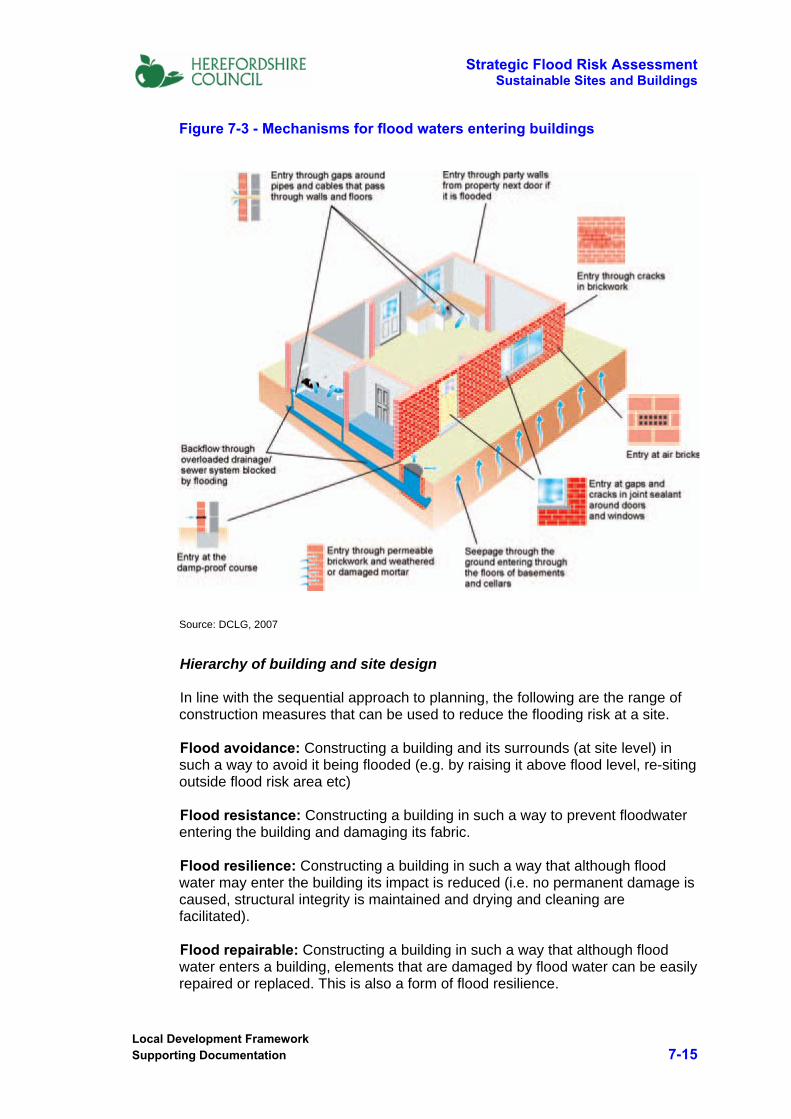
Figure 7-3 - Mechanisms for flood waters entering buildings
Source: DCLG, 2007
Hierarchy of building and site design In line with the sequential approach to planning, the following are the range of construction measures that can be used to reduce the flooding risk at a site. Flood avoidance: Constructing a building and its surrounds (at site level) in such a way to avoid it being flooded (e.g. by raising it above flood level, re-siting outside flood risk area etc) Flood resistance: Constructing a building in such a way to prevent floodwater entering the building and damaging its fabric. Flood resilience: Constructing a building in such a way that although flood water may enter the building its impact is reduced (i.e. no permanent damage is caused, structural integrity is maintained and drying and cleaning are facilitated). Flood repairable: Constructing a building in such a way that although flood water enters a building, elements that are damaged by flood water can be easily repaired or replaced. This is also a form of flood resilience.

Strategic Flood Risk Assessment Sustainable Sites and Buildings
Local Development Framework Supporting Documentation 7-16
The guidance is structured in 4 parts; Part 1 introduces the concepts of flooding and resilience, within the UK planning and building regulation systems and is particularly relevant to those with a limited knowledge of flooding and of the regulatory system. Part 2 deals with the design approaches to managing flood risk and is aimed to help designers, planners and building surveyors select appropriate design strategies. Part 3 gives guidance on flood resilient design and construction with Part 4 providing any other supporting documentation. Figure 7-4 shows drainage relief opening on a modern housing estate, and example of flood resistance.
Figure 7-4 - Drainage relief openings Source: DCLG, 2007

Strategic Flood Risk Assessment Sustainable Sites and Buildings
Local Development Framework Supporting Documentation 7-17
Figure 7-5 - Building Flood Management System
Source: © DCLG, 2007
Figure 7-5 demonstrates an alternative type of flood management system
whereby modifications to the building have been made. Other features that can be used to improve flood resilience are land boundary barriers such as watertight fences and gates
Figure 7-6 - Property boundary wall with lower sealed gate

Strategic Flood Risk Assessment Sustainable Sites and Buildings
Local Development Framework Supporting Documentation 7-18
Source: DCLG, 2007
Figure 7-7 – Watertight entrance gate
Source: DCLG, 2007
Figure 7-8 - Protected fence base with impermeable material
Source: DCLG, 2007

Strategic Flood Risk Assessment Sustainable Sites and Buildings
Local Development Framework Supporting Documentation 7-19
Figure 7-9 - General Advice under DCLG Flood Performance of New Buildings
Other general advice Ground supported floors are the preferred option and concrete slabs of at least 150mm thickness should be specified for non-reinforced construction. Hollow slabs are not suitable if the elements are not effectively sealed. Suspended floors may be necessary where ground supported floors are not suitable, namely in shrinkable/expanding soils (e.g. clay) or where the depth of fill is greater than 600mm. Uplift forces caused by flood water may affect the structural performance of a floor. Suspended floors are generally not recommended in flood-prone areas, for the following reasons: – the sub-floor space may require cleaning out following a flood, particularly a sewer flood. In order to aid this process and where accumulation of polluted sediment is expected, the sub-floor space should slope to an identified area and be provided with suitable access – if cleaning is required, floor finishes may need to be removed to provide access to the sub-floor space. Cheaper, sacrificial, finishes would be the best option. – the steel reinforcement in the concrete beams of ‘beam and block’ floors may be affected by corrosion and its condition may need to be assessed following repeated or prolonged floods. Suspended timber floors, particularly when including timber engineered joists, are not generally recommended in flood prone areas because most wooden materials tend to deform significantly when in contact with water and therefore may require replacement. Rapid drying can also cause deformation and cracking. Reinforced concrete floors are acceptable but may be prone to corrosion of any exposed steel in areas of prolonged flooding. Hardcore and blinding: good compaction is necessary to reduce the risk of settlement and consequential cracking. Damp Proof Membranes (d.p.m.) should be included in any design to minimise the passage of water through ground floors. Impermeable polythene membranes should be at least 1200 gauge to minimise ripping. Effective methods of joining membrane sections are overlaps of 300mm, and also taping (mastic tape with an overlap of 50mm minimum). Care should be taken not to stretch the membrane in order to retain a waterproof layer. Experience in Scotland has indicated that welted joints in the d.p.m. are an effective jointing solution. Insulation materials: Water will lower the insulation properties of some insulation materials. Floor insulation should be of the closed-cell type to minimise the impact of flood water. The location of insulation materials, whether above or below the floor slab, is usually based on either achieving rapid heating

Strategic Flood Risk Assessment Sustainable Sites and Buildings
Local Development Framework Supporting Documentation 7-20
of the building or aiming for more even temperature distribution with reduced risk of condensation. Insulation placed above the floor slab (and underneath the floor finish) rather than below would minimise the effect of flood water on the insulation properties and be more easily replaced, if needed. However, water entry may cause insulation to float (if associated with low mass cover) and lead to debonding of screeds. No firm guidance can be provided on best location for insulation where the primary source of flooding is from groundwater. For other types of flooding, placing insulation below the floor slab may be adequate but it is important to recognise that the characteristics of the insulation may be affected by the uplift forces generated by the flood water. Floor finishes: suitable floor finishes include ceramic or concrete-based floor tiles, stone, and sand/cement screeds. All tiles should be bedded on a cement-based adhesive/bedding compound and water resistant grout should be used. Concrete screeds above polystyrene or polyurethane insulation should be avoided as they hinder drying of the insulation material. Suitable materials for skirting boards include ceramic tiles and PVC. Ceramic tiles are likely to be more economically viable and environmentally acceptable. Floor sump: provision of a sump and small capacity automatic pump at a low point of the ground floor is recommended in cases where the expected probability of flooding in any one year is 20% or a frequency of flooding of more than once in five years (see Section 4). This system will help the draining process and speed up drying but it may only be effective for shallow depth flooding. The dimensions of the sump and its operational procedure would be calculated and agreed with the planning authority based on the predicted volumes of water to be drained. Services: under floor services using ferrous materials should be avoided.
Source: DCLG - 2007
7.6.2 Development and Flood Risk – Guidance for the Construction Industry (CIRIA C624) CIRIA has produced a detailed set of guidance and good practice that complements Policy Planning Statement 25. It outlines the process of Flood Risk Assessment and the need for the correct application with respect to development.
7.6.3 Development and Flood Risk – A Practice Guide Companion to PPS25 – (DCLG) Chapter 5 of this document contains a dedicated section to building and flood resilience. It incorporates good practice and certain guidelines that have to be maintained to complement compulsory building regulations.

Strategic Flood Risk Assessment Sustainable Sites and Buildings
Local Development Framework Supporting Documentation 7-21
7.7 Evidence Based Statements 1) New developments well outside the floodplain and not therefore themselves
at risk of flooding may place significantly increased loading on receiving sewers and watercourses, sometimes many kilometres downstream of their location. Flood risk to downstream third-parties is thereby increased. Hence appropriate and sustainable surface water drainage from new sites has a critical role to play in local flood risk management.
2) There should be a clear presumption within the Local Development Framework (LDF) in favour of sites that are able to deliver significant local reductions in runoff. Good surface water management will involve increased use of SUDS and surface water flow routes, through the design and planning of the whole urban fabric.
3) To help overcome the specific problems of SUDS adoption, and as an interim measure, the National SUDS Working Group has developed an Interim Code of Practice for SUDS. This code of practice is complemented by CIRIA publication C625 Model Agreements for SUDS, which provides a set of planning model agreements for use between those public organisations with statutory or regulatory responsibilities relating to SUDS.
4) The key to the consistent and successful implementation of SUDS for all development sites is inclusion of a sustainable drainage policy within regional and local development documents. This should be implemented with the collaboration of the Environment Agency and the sewerage undertaker (Welsh Water).
5) In areas of intense development or locally complex drainage issues, it may be necessary to formulate a Surface Water Management Plan that has multi-agency engagement and support. Development in and around Hereford is a prime example.
6) SUDS objectives are to minimise the development impacts of quality as well as quantity on the receiving drainage system, and to maximise amenity and biodiversity opportunities.
7) With regard to site runoff attenuation rates where it is not clearly established what the downstream risks may be, the safest and most appropriate general option is to maintain the same runoff from the developed site as that for the green-field site for the same event. For example, in a 2% Annual Equivalent Probability storm (1 in 50 year equivalent), the site should be able to discharge at an equivalent of the 1 in 50 green-field runoff rate.
8) It is important for developers to establish the soil conditions and hydrology of their site at an early stage in the planning process. The results of such investigations should be provided to the planning authority with the proposals for a drainage system included with the planning application.

Strategic Flood Risk Assessment Sustainable Sites and Buildings
Local Development Framework Supporting Documentation 7-22
9) A substantial amount of building resilience guidance is available from the Environment Agency, DCLG and BRE and some key examples have been demonstrated above. The guidance is not comprehensive with respect to design or cost. However the key references can provide good sources to where further information can be obtained.
10) Buildings at risk of flooding cannot be made 100% flood-proof. A combination of technologies may reduce the impacts of flooding, through good site management of surface water and building flood resistance through to building resilience.
7.8 Evidence Based Recommendations 1) Best practice industry guidance as summarised in this SFRA should be
adopted where possible
2) Timely and detailed consultation should take place to establish good practice benchmarks by meeting the minimum requirements but keeping ongoing sustainability objectives in mind.
3) Extra support to developers through Local Development Documents, planning guidance notes and standing advice will increase the take up and utilisation of flood resilient technologies.
4) In some cases modifications to existing policy and indeed future policy formulation through the Local Development Framework and Core Strategy may be required to comply with Government probable future guidance and planning directions, particularly with regard to Sustainable Drainage Systems.

Strategic Flood Risk Assessment Sustainable Sites and Buildings
Local Development Framework Supporting Documentation 7-23
7.9 References and Additional Resources The following published or web-based documentation has been referred to in the following sections, and may provide useful further reference material for the Local Development Framework. 1) Development and Flood Risk: A Practice Guide Companion to PPS25
'Living Draft' - A Consultation Paper, (DCLG, February 2007) http://www.communities.gov.uk/publications/planningandbuilding/developmentflood
2) Future Water – The Government’s Water Strategy for England, (HMSO, 2008) http://www.defra.gov.uk/environment/water/strategy
3) DEFRA Making Space for Water Programme – Theme HA2 – Urban Flood Risk and Integrated Drainage http://www.defra.gov.uk/environ/fcd/policy/strategy/ha2.htm
4) Faulkner, B.L. (1999) ‘The Control of Surface Water Runoff from new Development – UK National Policy in need of review?’ (Urban Water, Volume 1 (3), Elsevier).
5) The SUDS Manual 2007 – CIRIA C697 http://www.ciria.org/suds/publications.htm
6) Local Authority Network on Drainage and Flood Risk Management (Landform) (http://www.ciria.org/landform)
7) Sustainable Drainage Systems (SUDS) – A Guide for Developers (Environment Agency, 2003)
8) Sustainable Drainage Systems (SUDS) – An Introduction (Environment Agency, 2008) http://environment-agency.wales.gov.uk/business/444304/502508/464710/
9) Designing for Exceedance in Urban Drainage – good practice (CIRIA publication C635) http://www.ciria.org/acatalog/C635.html
10) DEFRA – Funding and Charging Arrangements for Sustainable Urban Drainage Systems (DEFRA, May 2007).
11) Impact Assessment – Permeable surfaces (DCLG, February 2008)
12) Improving the Flood Performance of New Buildings - Flood Resilient Construction (DCLG 2007)

Strategic Flood Risk Assessment Sustainable Sites and Buildings
Local Development Framework Supporting Documentation 7-24
13) Development and Flood Risk – Guidance for the Construction Industry (CIRIA C624).
14) Development and Flood Risk – A Practice Guide Companion to PPS25 – (DCLG 2007).

Strategic Flood Risk Assessment Emergency Response and Civil Contingency Planning
Local Development Framework Supporting Documentation 8-1
8. EMERGENCY RESPONSE AND CIVIL CONTINGENCY PLANNING
Under the Civil Contingencies Act 2004, Local Resilience Forums should ensure that risks from flooding are fully considered, especially including the resilience of infrastructure that will have to operate during floods. This knowledge should form the basis for preparing appropriate flood risk management and emergency response measures. This Chapter summarises the emergency response framework and an inventory of critical infrastructure within Herefordshire, and provides guidance to the LPA in respect of additional measures that may be required to enhance contingency planning in association with emergency services and infrastructure providers.
8.1 Current Emergency Response and Contingency Framework
8.1.1 Civil Contingencies Act 2004 The Civil Contingencies Act 2004 requires the Herefordshire Council as the Local Authority to take up civil protection duties and to ensure greater consistency and cooperation at the local level 1, 2. It establishes a clear set of roles and responsibilities for those involved in emergency preparation and response at a local level. The main duties are: 1. Co-operation - working with the other Category 1 and 2 emergency responders within the West Mercia Local Resilience Forum Information sharing - exchanging information and plans with other multi-agency responders.
2. Risk assessment - identifying potential hazards within the local context, assessing the risks and considering how the risks should be managed. 3. Emergency planning - maintaining and exercising plans for preventing emergencies; reducing, controlling or mitigating the effects of emergencies; and taking other action in the event of emergencies. 4. Business continuity management - co-coordinating the Authority's plans to ensure it can continue to perform essential functions in the event of an emergency. 5. Communicating with the public - advising the public of risks before and during an emergency. 6. Providing business continuity 'advice and assistance' to business and voluntary organisations.

Strategic Flood Risk Assessment Emergency Response and Civil Contingency Planning
Local Development Framework Supporting Documentation 8-2
8.1.2 Herefordshire Emergency Planning Unit Herefordshire Council Emergency Planning Unit (EPU) is responsible for coordination and planning for flood events. They liaise with the emergency services as well as the EA. The role of the Emergency Planning Unit (EPU) at other times is to prepare contingency plans, promote education and awareness and to respond to calls to queries or concern from the public.
8.1.3 Emergency Planning Exercises The EPU, EA and Emergency Services meet annually and undertake emergency planning exercises simulating a number of flood event scenarios. Information is fed back to each party and evaluated on performance and effectiveness. Modifications, if required, are then made to the contingency plans and placed into the overall Herefordshire Flood Plan. More sensitive locations, such as Hampton Bishop, have specific area flood warning and evacuation plan. Depending upon the magnitude and extent of the event there are different levels of responsibility amongst the key responders. Herefordshire EPU operates a 24-7-365 call out rota and warnings are fed directly into the relevant officer, the police and fire service then act accordingly with the same warnings. There is generally a coordinated team working approach however; the lead organisation for major events is the police and fire service. If there is extreme danger to life and an evacuation is required then the Fire Brigade take the lead but Police and EPU work very closely feeding information to operational field teams.
8.2 Critical Infrastructure Mapping The SFRA has conducted a desk-based outline appraisal to evaluate the number of key infrastructure assets throughout Herefordshire that may be at risk of inundation during a major flood event. The key infrastructure identified includes: Map colour code
• Command and Control • Medical Facilities • Evacuation and Assembly • Utilities • Fire Brigade Stations • Water • A & B Highways at risk of flood inundation ■ ■
As with all of the Critical Infrastructure GIS layers prepared for the SFRA, provision has been made to add an emergency telephone number into the database, and an Ordnance Survey based level of the asset. If obtained in

Strategic Flood Risk Assessment Emergency Response and Civil Contingency Planning
Local Development Framework Supporting Documentation 8-3
future this could be used to check the margin of safety (freeboard) that exists on the building or confirm the worst case depth of flooding that might arise. Use of the Info Tool in MapInfo makes it a simple and rapid process to click on a Critical Infrastructure asset to identify what it is. GIS layers have been prepared for each type of infrastructure as follows:
8.2.1 Command and Control This layer locates all buildings that may be used for command and control purposes in an emergency, specifically Police Stations, Fire Brigade Stations and Council Offices. Colour code Grey or Red. See HSFRA CI Command Control
8.2.2 Evacuation and Assembly This layer locates all community halls, schools and leisure centres that could be used for assembly and evacuation centres. Colour code Pink. See HSFRA CI Evacuation Assembly
8.2.3 Medical Facilities This layer locates all ambulance stations, hospitals and medical surgeries that could be used to provide emergency treatment. Colour code Green. See HSFRA CI Medical Facilities
8.2.4 Utilities This layer locates all essential utilities such as electricity sub-stations, telephone exchanges or water infrastructure relating to water supply, wastewater treatment or pumping stations. Colour code Black or Brown. See HSFRA CI Utilities
8.3 Strategic Critical Infrastructure Appraisal This section identifies and comments on high risk assets which are vulnerable to flooding, defined as falling within Flood Zone 3 or 2. Reference is also made to infrastructure where the highway to/from an asset may also be flooded, thereby compromising access to or effectiveness of the asset. The section is focused on the key Market Towns in order of population where infrastructure is likely to be most critical.
8.3.1 Highways Whilst an infrastructure asset may not itself be subject to flood risk, its effectiveness can be just as compromised if access to/from the asset is

Strategic Flood Risk Assessment Emergency Response and Civil Contingency Planning
Local Development Framework Supporting Documentation 8-4
prevented by excessive depths of floodwater on the highway(s). This is particularly so for the emergency service assets. There are a number of highways that are at risk from the effects of a flood event. Evidence Map 8-1 and Table 8-1 shows that a number of strategic trunk roads exist across the county and any one of these could be needed by the Emergency Services/Planners in the event of severe flooding. Under certain conditions some of these are indeed at risk themselves therefore identifying key priority points is an advantage to flood incident management.
Table 8-1 – Highways Affected by Flooding Asset Location Flood
Zone Depth
m Highway Flooded
A44 Worcester Rd 2 Yes A4103 2 Yes A438 Bush pit 2 Yes A417 Leadon Way 2 Yes A465 2 Yes A449 2 Yes
A4172 2 Yes A4112 New Rd 2 Yes A456 2 Yes A49 2 Yes
A438 Widemarsh Street 2 Yes A438 Eign Street 2 Yes A49 Edgar Street 2 Yes A49 Newtown Rd 2 Yes A44 3 Yes
A4103 3 Yes A438 3 Yes A417 3 Yes A465 3 Yes A449 3 Yes
A4172 3 Yes A4112 3 Yes A456 3 Yes A49 3 Yes
A438 3 Yes A438 3 Yes A49 3 Yes A49 3 Yes
B4347 2 Yes B4214 2 Yes B4203 2 Yes B4214 Bromyard Rd 2 Yes B4220 2 Yes B4224 Eign Rd 2 Yes B4234 Over Ross St 2 Yes B4222 2 Yes B4362 2 Yes
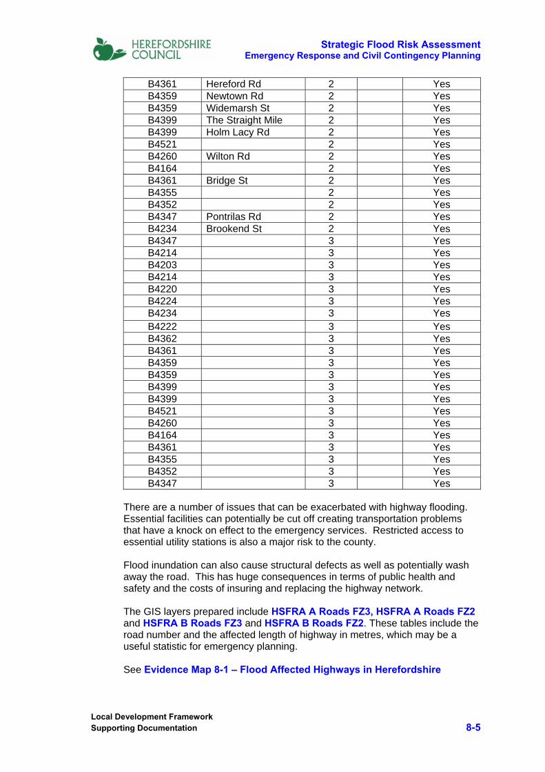
Strategic Flood Risk Assessment Emergency Response and Civil Contingency Planning
Local Development Framework Supporting Documentation 8-5
B4361 Hereford Rd 2 Yes B4359 Newtown Rd 2 Yes B4359 Widemarsh St 2 Yes B4399 The Straight Mile 2 Yes B4399 Holm Lacy Rd 2 Yes B4521 2 Yes B4260 Wilton Rd 2 Yes B4164 2 Yes B4361 Bridge St 2 Yes B4355 2 Yes B4352 2 Yes B4347 Pontrilas Rd 2 Yes B4234 Brookend St 2 Yes B4347 3 Yes B4214 3 Yes B4203 3 Yes B4214 3 Yes B4220 3 Yes B4224 3 Yes B4234 3 Yes B4222 3 Yes B4362 3 Yes B4361 3 Yes B4359 3 Yes B4359 3 Yes B4399 3 Yes B4399 3 Yes B4521 3 Yes B4260 3 Yes B4164 3 Yes B4361 3 Yes B4355 3 Yes B4352 3 Yes B4347 3 Yes
There are a number of issues that can be exacerbated with highway flooding. Essential facilities can potentially be cut off creating transportation problems that have a knock on effect to the emergency services. Restricted access to essential utility stations is also a major risk to the county. Flood inundation can also cause structural defects as well as potentially wash away the road. This has huge consequences in terms of public health and safety and the costs of insuring and replacing the highway network. The GIS layers prepared include HSFRA A Roads FZ3, HSFRA A Roads FZ2 and HSFRA B Roads FZ3 and HSFRA B Roads FZ2. These tables include the road number and the affected length of highway in metres, which may be a useful statistic for emergency planning. See Evidence Map 8-1 – Flood Affected Highways in Herefordshire

Strategic Flood Risk Assessment Emergency Response and Civil Contingency Planning
Local Development Framework Supporting Documentation 8-6
8.3.2 Hereford A significant number of essential critical infrastructure assets are at risk from the effects of a flood event in Hereford. Evidence Map 8-2 shows a number of critical infrastructure assets that are essential to the Hereford population that could be potentially inundated or cut off in the event of severe flooding. This infrastructure therefore needs to be protected.
Table 8-2 – Critical Infrastructure Affected in Hereford Asset Location Flood
Zone Depth
m Highway Flooding
Surgery Moorfield Rd 2 Yes Surgery King Street 2 Yes Surgery Greyfriars 2 Yes Electricity Substation Widemarsh 3 Yes Telephone Exchange
Barton 2 Yes
Sewage Treatment Works
Eign 3 Yes
Sewage Treatment Works
Rotherwas 3 Yes
Sewage Treatment Works
Fownhope 2 Yes
Evacuation & Assembly Point
Riverside School
2 Yes
Evacuation & Assembly Point
Hunderton & Belmont Community Centre
2 Yes
Evacuation & Assembly Point
St Martins Primary School
2 Yes
Evacuation & Assembly Point
Hinton Community Association
2 Yes
Evacuation & Assembly Point
Lord Scudamore Primary School
3 Yes
Evacuation & Assembly Point
Whitecross High School
3 Yes
See Evidence Map 8-2 – Critical Infrastructure in Hereford
Surgeries in Hereford serve the highest proportion of the County’s population. Around 50,000 people live in around the market/county town. Medical treatment is essential to health in emergency situations and therefore flood damaged buildings constitute an important risk to critical infrastructure. Provision would need to be found elsewhere and would stretch already vulnerable finite resources.
The risk to any of Hereford’s utilities is significant in several ways. The
electricity substation in the floodplain could affect continuity of supply and may possibly leave the city’s population without electricity. The significance of the
Strategic Flood Risk Assessment Emergency Response and Civil Contingency Planning
Local Development Framework Supporting Documentation 8-7
water and sewage pumping stations being affected could mean that a drinking water supply becomes contaminated and then suddenly there are public health issues to be encountered.
The risk to telecommunications means that vital services could be cut off from
the public and would need to be restored as quickly as possible. The implications of the evacuation and assembly points being affected could be
that suitable places of refuge may be unavailable therefore alternative emergency accommodation would need to be sought.
The Portfields Fire Station would appear to be cut off in a major flood event
from the southern and western parts of the city.
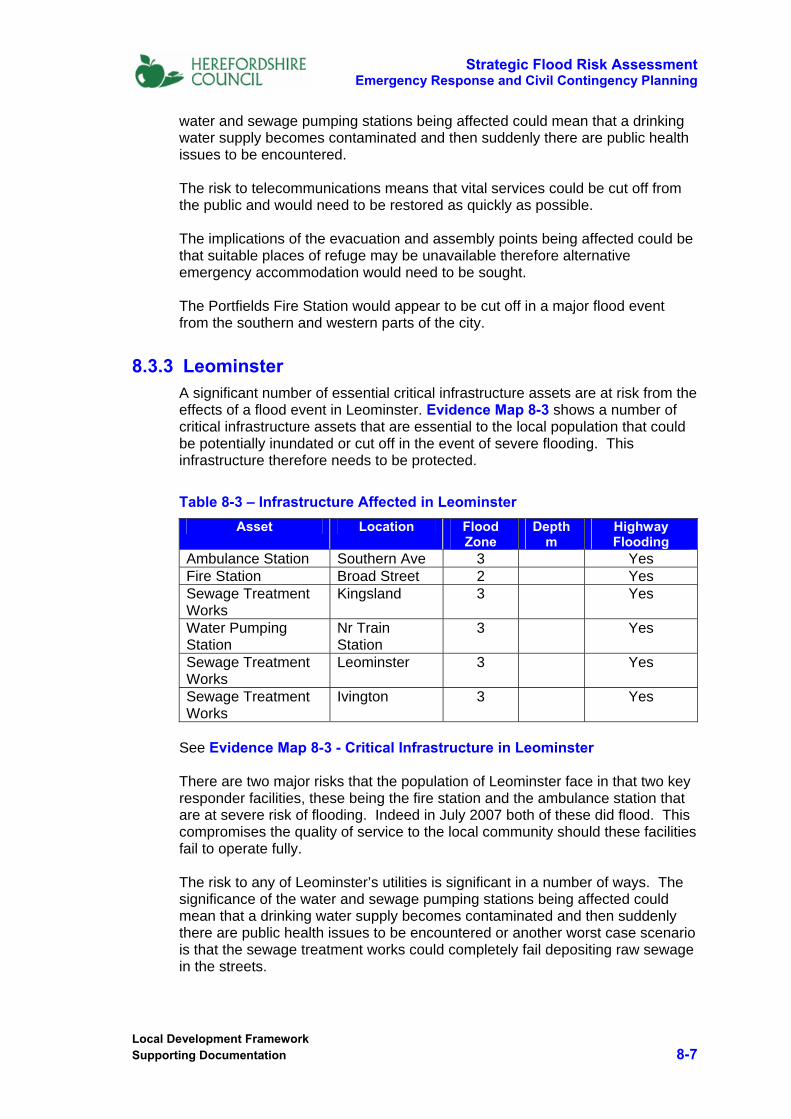
8.3.3 Leominster A significant number of essential critical infrastructure assets are at risk from the effects of a flood event in Leominster. Evidence Map 8-3 shows a number of critical infrastructure assets that are essential to the local population that could be potentially inundated or cut off in the event of severe flooding. This infrastructure therefore needs to be protected.
Table 8-3 – Infrastructure Affected in Leominster Asset Location Flood
Zone Depth
m Highway Flooding
Ambulance Station Southern Ave 3 Yes Fire Station Broad Street 2 Yes Sewage Treatment Works
Kingsland 3 Yes
Water Pumping Station
Nr Train Station
3 Yes
Sewage Treatment Works
Leominster 3 Yes
Sewage Treatment Works
Ivington 3 Yes
See Evidence Map 8-3 - Critical Infrastructure in Leominster
There are two major risks that the population of Leominster face in that two key responder facilities, these being the fire station and the ambulance station that are at severe risk of flooding. Indeed in July 2007 both of these did flood. This compromises the quality of service to the local community should these facilities fail to operate fully. The risk to any of Leominster’s utilities is significant in a number of ways. The significance of the water and sewage pumping stations being affected could mean that a drinking water supply becomes contaminated and then suddenly there are public health issues to be encountered or another worst case scenario is that the sewage treatment works could completely fail depositing raw sewage in the streets.

Strategic Flood Risk Assessment Emergency Response and Civil Contingency Planning
Local Development Framework Supporting Documentation 8-8
Figure 8-3 illustrates that in a major flood event Leominster is particularly vulnerable to being cut off in terms of highways. The only viable route into Leominster would be via the Cholstrey road from the west.
8.3.4 Ross-on-Wye Two essential critical infrastructure assets are at risk from the effects of a flood event in Ross-on-Wye. Evidence Map 8-4 and Table 8-4 show a number of critical infrastructure assets that are essential to the local population that could be potentially inundated or cut off in the event of severe flooding. This infrastructure therefore needs to be protected.
Table 8-4 – Critical Infrastructure Affected in Ross-on-Wye Asset Location Flood
Zone Depth
m Highway Flooding
Water Pumping Station
Wye Street 3 Yes
Sewage Treatment Works
Ross on Wye 2 Yes
See Evidence Map 8-4 - Critical Infrastructure in Ross-on-Wye The significance of the water and sewage pumping stations being affected could mean that a drinking water supply becomes contaminated and then suddenly there are public health issues to be encountered or another worst case scenario is that the sewage treatment works could completely fail depositing raw sewage around the streets. In a severe flood across the A40 from the Rudhall Brook, it is possible that Fire Brigade appliances or ambulances could not reach the north parts of the town.
8.3.5 Ledbury No essential critical infrastructure is at risk from the effects of a severe flood event in Ledbury. Evidence Map 8-3 shows that villages west of Ledbury might be cut off from emergency services in a major flood.
Table 8-5 – Critical Infrastructure Affected in Ledbury Asset Location Flood
Zone Depth
m Highway Flooding
NONE
See Evidence Map 8-5 - Critical Infrastructure in Ledbury

Strategic Flood Risk Assessment Emergency Response and Civil Contingency Planning
Local Development Framework Supporting Documentation 8-9
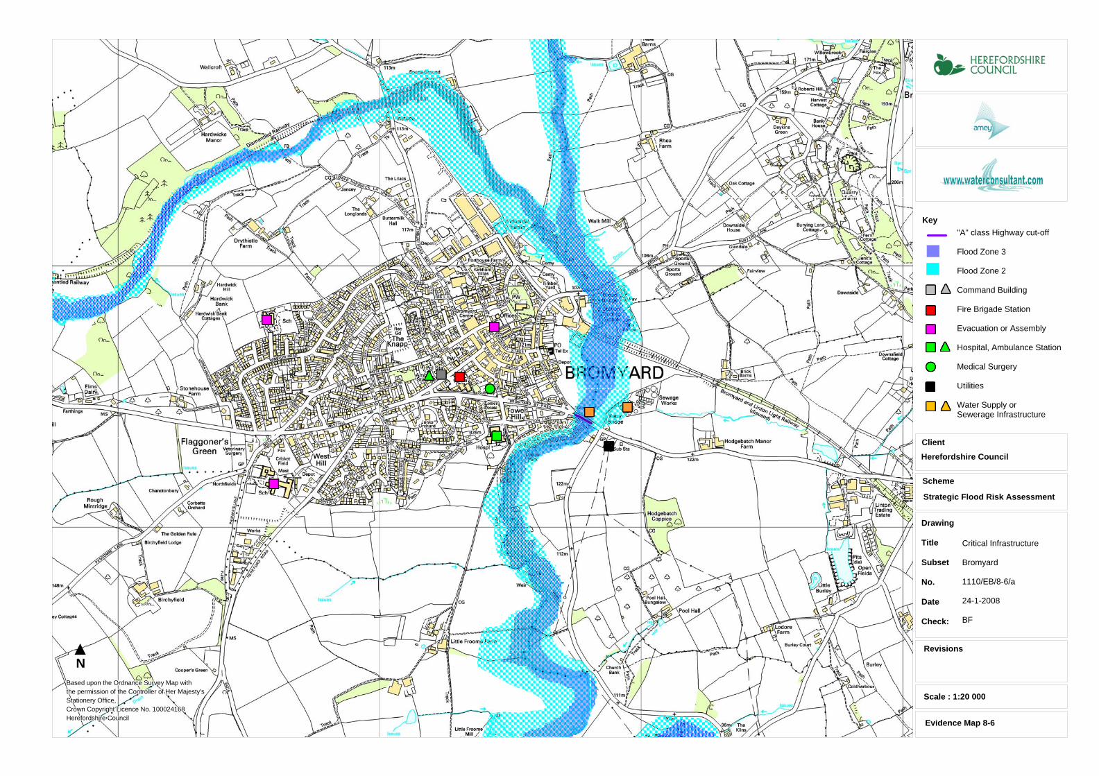
8.3.6 Bromyard No essential critical infrastructure is at risk from the effects of a severe flood event in Bromyard.
Table 8-6 – Critical Infrastructure Affected in Bromyard Asset Location Flood
Zone Depth
m Highway Flooding
Sewage P.S. Bromyard 3 Yes
See Evidence Map 8-6 - Critical Infrastructure in Bromyard
There are two water infrastructure assets close to the indicative flood outline and under future circumstances (such as upstream development or climate change) these could be susceptible to floods. The main water pumping station does fall into this category as in July 2007 it flooded although this may have been an equipment failure in the first instance.
8.3.7 Kington A significant number of essential critical infrastructure assets are at risk from the effects of a flood event in Kington. Evidence Map 8-7 and Table 8-7 show a number of critical infrastructure assets that are essential to the local population that could be potentially inundated or cut off in the event of severe flooding. This infrastructure therefore needs to be protected.
Table 8-7 – Critical Infrastructure Affected in Kington Asset Location Flood
Zone Depth
m Highway Flooding
Ambulance Station Kington 2 Yes Water Pumping Station
Bredwardine 3 Yes
Sewage Treatment Works
Bredwardine 3 Yes
Telephone Exchange
Kington 3 Yes
Sewage Treatment Works
Kington 3 Yes
See Evidence Map 8-7 - Critical Infrastructure in Kington The principal critical infrastructure risk for population of Kington is the medical facilities. The ambulance station is at risk of flooding, and other medical facilities such as the Cottage Hospital and surgeries also lie on the edge of the floodplain. These facilities must remain functional as human life may be endangered.

Strategic Flood Risk Assessment Emergency Response and Civil Contingency Planning
Local Development Framework Supporting Documentation 8-10
The significance of the water and sewage pumping stations being affected could mean that drinking water supply becomes contaminated and then suddenly there are public health issues that could be encountered or another worst case scenario is that the sewage treatment works could completely fail depositing raw sewage around the streets. The risk to telecommunications means that vital services could be cut off from the public and would need to be restored as quickly as possible. Kington’s greatest vulnerability is that its highways will be cut off from the north and south in a major flood event. Consequently, it may not be possible for emergency services to either leave or access the town.
8.4 Interactions with EA Catchment Flood Management Plan The SFRA has provided substantial evidence in support of flood risk to critical infrastructure assets. In line with the Pitt Report recommendations, the EA CFMP should recognise that critical infrastructure as well as property also merits detailed policy attention. Where critical infrastructure is shown to be vulnerable, the EA should make specific recommendations.
8.5 Evidence Based Statements 1) Under the Civil Contingencies Act 2004, Local Resilience Forums should
ensure that risks from flooding are fully considered, especially including the resilience of infrastructure that will have to operate during floods.
2) The SFRA has conducted a desk-based outline appraisal to evaluate the number of key infrastructure assets throughout Herefordshire that may be at risk of inundation during a major flood event.
3) There are a number of highways that are at risk from the effects of a flood event, and any one of these could be needed by the Emergency Services/Planners in the event of severe flooding. Under certain conditions some of these are indeed at risk themselves therefore identifying key priority points is an advantage to flood incident management.
4) A significant number of essential critical infrastructure assets are at risk from the effects of a flood event in Hereford.
5) A significant number of essential critical infrastructure assets are at risk from the effects of a flood event in Leominster. There are two major risks that the population of Leominster face in that two key responder facilities, these being the fire station and the ambulance station are at severe risk of flooding. This compromises the quality of service to the local community should these facilities fail to operate fully.

Strategic Flood Risk Assessment Emergency Response and Civil Contingency Planning
Local Development Framework Supporting Documentation 8-11
6) Two essential critical infrastructure assets are at risk from the effects of a flood event in Ross-on-Wye.
7) No essential critical infrastructure is at risk from the effects of a severe flood event in Ledbury. No essential critical infrastructure is at risk from the effects of a severe flood event in Bromyard.
8) A significant number of essential critical infrastructure assets are at risk from the effects of a flood event in Kington. The principal critical infrastructure risk for population of Kington is the medical facilities. The ambulance station is at risk of flooding, and other medical facilities such as the Cottage Hospital and surgeries also lie on the edge of the floodplain.
9) This knowledge should form the basis for preparing appropriate flood risk management and emergency response measures.
8.6 Evidence Based Recommendations 1) It is strongly recommended that the Emergency Planning Unit of
Herefordshire Council make use of the Critical Infrastructure GIS layers provided as part of the SFRA, with a view to identifying where such infrastructure is vulnerable.
2) Utilities identified as having critical assets in the floodplain should be systematically contacted by Herefordshire Council and queried as to their level of preparedness, contingency plans, and alternative facilities.

Strategic Flood Risk Assessment Emergency Response and Civil Contingency Planning
Local Development Framework Supporting Documentation 8-12
8.7 References and Additional Resources The following published or web-based documentation has been referred to in the following sections, and may provide useful further reference material for the Local Development Framework. 1) UK Resilience – Civil Contingencies Act 2004
www.ukresilience.gov.uk/preparedness/ccact.aspx
2) UK Resilience Home Page www.ukresilience.info
3) British Association of Public Safety Communications Officers BAPCO An independent, user led, professional members Association to promote, influence and advance the development and use of communications and information management systems for the safety and security of the public. http://www.bapco.org.uk
4) BAPCO Journal. On-line Journal of BAPCO with free access to information, free email subscription. www.bapcojournal.co.uk
Strategic Flood Risk Assessment Emergency Response and Civil Contingency Planning
Local Development Framework Supporting Documentation 8-13
Evidence Map 8-1 – Flood Affected Highways


Strategic Flood Risk Assessment Emergency Response and Civil Contingency Planning
Local Development Framework Supporting Documentation 8-14
Evidence Map 8-2 – Critical Infrastructure in Hereford


Strategic Flood Risk Assessment Emergency Response and Civil Contingency Planning
Local Development Framework Supporting Documentation 8-15
Evidence Map 8-3 – Critical Infrastructure in Leominster

!!!!!!!!!!!!!!!!!!!!!!!!!!!!!!!!!!!!!!!!!!!!!!!!!
!!!!!!!!!!!!!!!!!!!!!!!!!!!!!!!!!!!!!!!!!!!!!!!!!
2222222222222222222222222222222222222222222222222
!!!!!!!!!!!!!!!!!!!!!!!!!!!!!!!!!!!!!!!!!!!!!!!!!
2222222222222222222222222222222222222222222222222
!!!!!!!!!!!!!!!!!!!!!!!!!!!!!!!!!!!!!!!!!!!!!!!!!
!!!!!!!!!!!!!!!!!!!!!!!!!!!!!!!!!!!!!!!!!!!!!!!!!
!!!!!!!!!!!!!!!!!!!!!!!!!!!!!!!!!!!!!!!!!!!!!!!!!!!!!!!!!!!!!!!!!!!!!!!!!!!!!!!!!!!!!!!!!!!!!!!!!!
!!!!!!!!!!!!!!!!!!!!!!!!!!!!!!!!!!!!!!!!!!!!!!!!!
!!!!!!!!!!!!!!!!!!!!!!!!!!!!!!!!!!!!!!!!!!!!!!!!!
!!!!!!!!!!!!!!!!!!!!!!!!!!!!!!!!!!!!!!!!!!!!!!!!!
!!!!!!!!!!!!!!!!!!!!!!!!!!!!!!!!!!!!!!!!!!!!!!!!!
!!!!!!!!!!!!!!!!!!!!!!!!!!!!!!!!!!!!!!!!!!!!!!!!!
!!!!!!!!!!!!!!!!!!!!!!!!!!!!!!!!!!!!!!!!!!!!!!!!!!
2222222222222222222222222222222222222222222222222
Key"A" class Highway cut-off
Flood Zone 3
Flood Zone 2
Command Building
Fire Brigade Station
Evacuation or Assembly
Hospital, Ambulance Station
Medical Surgery
Utilities
Water Supply orSewerage Infrastructure
Drawing
Title
Subset
No.
Date
Check:
Revisions
Scale : 1:20 000
Evidence Map 8-3
Critical Infrastructure
Leominster
1110/EB/8-3/a
24-1-2008
BF
Client
Herefordshire Council
Scheme
Strategic Flood Risk Assessment
!!!!!!!!!!!!!!!!!!!!!!!!!!!!!!!!!!!!!!!!!!!!!!!!!
NBased upon the Ordnance Survey Map withBased upon the Ordnance Survey Map withBased upon the Ordnance Survey Map withBased upon the Ordnance Survey Map withBased upon the Ordnance Survey Map withBased upon the Ordnance Survey Map withBased upon the Ordnance Survey Map withBased upon the Ordnance Survey Map withBased upon the Ordnance Survey Map withthe permission of the Controller of Her Majesty'sthe permission of the Controller of Her Majesty'sthe permission of the Controller of Her Majesty'sthe permission of the Controller of Her Majesty'sthe permission of the Controller of Her Majesty'sthe permission of the Controller of Her Majesty'sthe permission of the Controller of Her Majesty'sthe permission of the Controller of Her Majesty'sthe permission of the Controller of Her Majesty'sStationery Office, Stationery Office, Stationery Office, Stationery Office, Stationery Office, Stationery Office, Stationery Office, Stationery Office, Stationery Office, Crown Copyright Licence No. 100024168Crown Copyright Licence No. 100024168Crown Copyright Licence No. 100024168Crown Copyright Licence No. 100024168Crown Copyright Licence No. 100024168Crown Copyright Licence No. 100024168Crown Copyright Licence No. 100024168Crown Copyright Licence No. 100024168Crown Copyright Licence No. 100024168Herefordshire CouncilHerefordshire CouncilHerefordshire CouncilHerefordshire CouncilHerefordshire CouncilHerefordshire CouncilHerefordshire CouncilHerefordshire CouncilHerefordshire Council
!!!!!!!!!!!!!!!!!!!!!!!!!!!!!!!!!!!!!!!!!!!!!!!!!
!!!!!!!!!!!!!!!!!!!!!!!!!!!!!!!!!!!!!!!!!!!!!!!!!
!!!!!!!!!!!!!!!!!!!!!!!!!!!!!!!!!!!!!!!!!!!!!!!!!
(((((((((((((((((((((((((((((((((((((((((((((((((
!!!!!!!!!!!!!!!!!!!!!!!!!!!!!!!!!!!!!!!!!!!!!!!!!
!!!!!!!!!!!!!!!!!!!!!!!!!!!!!!!!!!!!!!!!!!!!!!!!!
2222222222222222222222222222222222222222222222222
2222222222222222222222222222222222222222222222222
2222222222222222222222222222222222222222222222222

Strategic Flood Risk Assessment Emergency Response and Civil Contingency Planning
Local Development Framework Supporting Documentation 8-16
Evidence Map 8-4 – Critical Infrastructure in Ross-on-Wye

!!!!!!!!!!!!!!!!!!!!!!!!!!!!!!!!!!!!!!!!!!!!!!!!!
!!!!!!!!!!!!!!!!!!!!!!!!!!!!!!!!!!!!!!!!!!!!!!!!!
!!!!!!!!!!!!!!!!!!!!!!!!!!!!!!!!!!!!!!!!!!!!!!!!!!!!!!!!!!!!!!!!!!!!!!!!!!!!!!!!!!!!!!!!!!!!!!!!!!
!!!!!!!!!!!!!!!!!!!!!!!!!!!!!!!!!!!!!!!!!!!!!!!!!
!!!!!!!!!!!!!!!!!!!!!!!!!!!!!!!!!!!!!!!!!!!!!!!!!
!!!!!!!!!!!!!!!!!!!!!!!!!!!!!!!!!!!!!!!!!!!!!!!!!
!!!!!!!!!!!!!!!!!!!!!!!!!!!!!!!!!!!!!!!!!!!!!!!!!!((((((((((((((((((((((((((((((((((((((((((((((((((((((((((((((((((((((((((((((((((((((((((((((((((((
2222222222222222222222222222222222222222222222222
Key"A" class Highway cut-off
Flood Zone 3
Flood Zone 2
Command Building
Fire Brigade Station
Evacuation or Assembly
Hospital, Ambulance Station
Medical Surgery
Utilities
Water Supply orSewerage Infrastructure
Drawing
Title
Subset
No.
Date
Check:
Revisions
Scale : 1:20 000
Evidence Map 8-4
Critical Infrastructure
Ross-on-Wye
1110/EB/8-4/a
24-1-2008
BF
Client
Herefordshire Council
Scheme
Strategic Flood Risk Assessment
!!!!!!!!!!!!!!!!!!!!!!!!!!!!!!!!!!!!!!!!!!!!!!!!!
NBased upon the Ordnance Survey Map withBased upon the Ordnance Survey Map withBased upon the Ordnance Survey Map withBased upon the Ordnance Survey Map withBased upon the Ordnance Survey Map withBased upon the Ordnance Survey Map withBased upon the Ordnance Survey Map withBased upon the Ordnance Survey Map withBased upon the Ordnance Survey Map withthe permission of the Controller of Her Majesty'sthe permission of the Controller of Her Majesty'sthe permission of the Controller of Her Majesty'sthe permission of the Controller of Her Majesty'sthe permission of the Controller of Her Majesty'sthe permission of the Controller of Her Majesty'sthe permission of the Controller of Her Majesty'sthe permission of the Controller of Her Majesty'sthe permission of the Controller of Her Majesty'sStationery Office, Stationery Office, Stationery Office, Stationery Office, Stationery Office, Stationery Office, Stationery Office, Stationery Office, Stationery Office, Crown Copyright Licence No. 100024168Crown Copyright Licence No. 100024168Crown Copyright Licence No. 100024168Crown Copyright Licence No. 100024168Crown Copyright Licence No. 100024168Crown Copyright Licence No. 100024168Crown Copyright Licence No. 100024168Crown Copyright Licence No. 100024168Crown Copyright Licence No. 100024168Herefordshire CouncilHerefordshire CouncilHerefordshire CouncilHerefordshire CouncilHerefordshire CouncilHerefordshire CouncilHerefordshire CouncilHerefordshire CouncilHerefordshire Council
!!!!!!!!!!!!!!!!!!!!!!!!!!!!!!!!!!!!!!!!!!!!!!!!!
!!!!!!!!!!!!!!!!!!!!!!!!!!!!!!!!!!!!!!!!!!!!!!!!!
!!!!!!!!!!!!!!!!!!!!!!!!!!!!!!!!!!!!!!!!!!!!!!!!!
(((((((((((((((((((((((((((((((((((((((((((((((((
!!!!!!!!!!!!!!!!!!!!!!!!!!!!!!!!!!!!!!!!!!!!!!!!!
!!!!!!!!!!!!!!!!!!!!!!!!!!!!!!!!!!!!!!!!!!!!!!!!!
2222222222222222222222222222222222222222222222222
2222222222222222222222222222222222222222222222222
2222222222222222222222222222222222222222222222222

Strategic Flood Risk Assessment Emergency Response and Civil Contingency Planning
Local Development Framework Supporting Documentation 8-17
Evidence Map 8-5 – Critical Infrastructure in Ledbury

!!!!!!!!!!!!!!!!!!!!!!!!!!!!!!!!!!!!!!!!!!!!!!!!!
!!!!!!!!!!!!!!!!!!!!!!!!!!!!!!!!!!!!!!!!!!!!!!!!!
!!!!!!!!!!!!!!!!!!!!!!!!!!!!!!!!!!!!!!!!!!!!!!!!!
!!!!!!!!!!!!!!!!!!!!!!!!!!!!!!!!!!!!!!!!!!!!!!!!!
!!!!!!!!!!!!!!!!!!!!!!!!!!!!!!!!!!!!!!!!!!!!!!!!!
!!!!!!!!!!!!!!!!!!!!!!!!!!!!!!!!!!!!!!!!!!!!!!!!!
!!!!!!!!!!!!!!!!!!!!!!!!!!!!!!!!!!!!!!!!!!!!!!!!!
2222222222222222222222222222222222222222222222222((((((((((((((((((((((((((((((((((((((((((((((((((((((((((((((((((((((((((((((((((((((((((((((((((((
Key"A" class Highway cut-off
Flood Zone 3
Flood Zone 2
Command Building
Fire Brigade Station
Evacuation or Assembly
Hospital, Ambulance Station
Medical Surgery
Utilities
Water Supply orSewerage Infrastructure
Drawing
Title
Subset
No.
Date
Check:
Revisions
Scale : 1:20 000
Evidence Map 8-5
Critical Infrastructure
Ledbury
1110/EB/8-5/a
24-1-2008
BF
Client
Herefordshire Council
Scheme
Strategic Flood Risk Assessment
!!!!!!!!!!!!!!!!!!!!!!!!!!!!!!!!!!!!!!!!!!!!!!!!!
NBased upon the Ordnance Survey Map withBased upon the Ordnance Survey Map withBased upon the Ordnance Survey Map withBased upon the Ordnance Survey Map withBased upon the Ordnance Survey Map withBased upon the Ordnance Survey Map withBased upon the Ordnance Survey Map withBased upon the Ordnance Survey Map withBased upon the Ordnance Survey Map withthe permission of the Controller of Her Majesty'sthe permission of the Controller of Her Majesty'sthe permission of the Controller of Her Majesty'sthe permission of the Controller of Her Majesty'sthe permission of the Controller of Her Majesty'sthe permission of the Controller of Her Majesty'sthe permission of the Controller of Her Majesty'sthe permission of the Controller of Her Majesty'sthe permission of the Controller of Her Majesty'sStationery Office, Stationery Office, Stationery Office, Stationery Office, Stationery Office, Stationery Office, Stationery Office, Stationery Office, Stationery Office, Crown Copyright Licence No. 100024168Crown Copyright Licence No. 100024168Crown Copyright Licence No. 100024168Crown Copyright Licence No. 100024168Crown Copyright Licence No. 100024168Crown Copyright Licence No. 100024168Crown Copyright Licence No. 100024168Crown Copyright Licence No. 100024168Crown Copyright Licence No. 100024168Herefordshire CouncilHerefordshire CouncilHerefordshire CouncilHerefordshire CouncilHerefordshire CouncilHerefordshire CouncilHerefordshire CouncilHerefordshire CouncilHerefordshire Council
!!!!!!!!!!!!!!!!!!!!!!!!!!!!!!!!!!!!!!!!!!!!!!!!!
!!!!!!!!!!!!!!!!!!!!!!!!!!!!!!!!!!!!!!!!!!!!!!!!!
!!!!!!!!!!!!!!!!!!!!!!!!!!!!!!!!!!!!!!!!!!!!!!!!!
(((((((((((((((((((((((((((((((((((((((((((((((((
!!!!!!!!!!!!!!!!!!!!!!!!!!!!!!!!!!!!!!!!!!!!!!!!!
!!!!!!!!!!!!!!!!!!!!!!!!!!!!!!!!!!!!!!!!!!!!!!!!!
2222222222222222222222222222222222222222222222222
2222222222222222222222222222222222222222222222222
2222222222222222222222222222222222222222222222222

Strategic Flood Risk Assessment Emergency Response and Civil Contingency Planning
Local Development Framework Supporting Documentation 8-18
Evidence Map 8-6 – Critical Infrastructure in Bromyard
!!!!!!!!!!!!!!!!!!!!!!!!!!!!!!!!!!!!!!!!!!!!!!!!!
!!!!!!!!!!!!!!!!!!!!!!!!!!!!!!!!!!!!!!!!!!!!!!!!!
!!!!!!!!!!!!!!!!!!!!!!!!!!!!!!!!!!!!!!!!!!!!!!!!!
!!!!!!!!!!!!!!!!!!!!!!!!!!!!!!!!!!!!!!!!!!!!!!!!! !!!!!!!!!!!!!!!!!!!!!!!!!!!!!!!!!!!!!!!!!!!!!!!!!
!!!!!!!!!!!!!!!!!!!!!!!!!!!!!!!!!!!!!!!!!!!!!!!!!!!!!!!!!!!!!!!!!!!!!!!!!!!!!!!!!!!!!!!!!!!!!!!!!!
!!!!!!!!!!!!!!!!!!!!!!!!!!!!!!!!!!!!!!!!!!!!!!!!!
((((((((((((((((((((((((((((((((((((((((((((((((((
2222222222222222222222222222222222222222222222222
!!!!!!!!!!!!!!!!!!!!!!!!!!!!!!!!!!!!!!!!!!!!!!!!!!
Key"A" class Highway cut-off
Flood Zone 3
Flood Zone 2
Command Building
Fire Brigade Station
Evacuation or Assembly
Hospital, Ambulance Station
Medical Surgery
Utilities
Water Supply orSewerage Infrastructure
Drawing
Title
Subset
No.
Date
Check:
Revisions
Scale : 1:20 000
Evidence Map 8-6
Critical Infrastructure
Bromyard
1110/EB/8-6/a
24-1-2008
BF
Client
Herefordshire Council
Scheme
Strategic Flood Risk Assessment
!!!!!!!!!!!!!!!!!!!!!!!!!!!!!!!!!!!!!!!!!!!!!!!!!
NBased upon the Ordnance Survey Map withBased upon the Ordnance Survey Map withBased upon the Ordnance Survey Map withBased upon the Ordnance Survey Map withBased upon the Ordnance Survey Map withBased upon the Ordnance Survey Map withBased upon the Ordnance Survey Map withBased upon the Ordnance Survey Map withBased upon the Ordnance Survey Map withthe permission of the Controller of Her Majesty'sthe permission of the Controller of Her Majesty'sthe permission of the Controller of Her Majesty'sthe permission of the Controller of Her Majesty'sthe permission of the Controller of Her Majesty'sthe permission of the Controller of Her Majesty'sthe permission of the Controller of Her Majesty'sthe permission of the Controller of Her Majesty'sthe permission of the Controller of Her Majesty'sStationery Office, Stationery Office, Stationery Office, Stationery Office, Stationery Office, Stationery Office, Stationery Office, Stationery Office, Stationery Office, Crown Copyright Licence No. 100024168Crown Copyright Licence No. 100024168Crown Copyright Licence No. 100024168Crown Copyright Licence No. 100024168Crown Copyright Licence No. 100024168Crown Copyright Licence No. 100024168Crown Copyright Licence No. 100024168Crown Copyright Licence No. 100024168Crown Copyright Licence No. 100024168Herefordshire CouncilHerefordshire CouncilHerefordshire CouncilHerefordshire CouncilHerefordshire CouncilHerefordshire CouncilHerefordshire CouncilHerefordshire CouncilHerefordshire Council
!!!!!!!!!!!!!!!!!!!!!!!!!!!!!!!!!!!!!!!!!!!!!!!!!
!!!!!!!!!!!!!!!!!!!!!!!!!!!!!!!!!!!!!!!!!!!!!!!!!
!!!!!!!!!!!!!!!!!!!!!!!!!!!!!!!!!!!!!!!!!!!!!!!!!
(((((((((((((((((((((((((((((((((((((((((((((((((
!!!!!!!!!!!!!!!!!!!!!!!!!!!!!!!!!!!!!!!!!!!!!!!!!
!!!!!!!!!!!!!!!!!!!!!!!!!!!!!!!!!!!!!!!!!!!!!!!!!
2222222222222222222222222222222222222222222222222
2222222222222222222222222222222222222222222222222
2222222222222222222222222222222222222222222222222
Strategic Flood Risk Assessment Emergency Response and Civil Contingency Planning
Local Development Framework Supporting Documentation 8-19
Evidence Map 8-7 – Critical Infrastructure in Kington

!!!!!!!!!!!!!!!!!!!!!!!!!!!!!!!!!!!!!!!!!!!!!!!!!
2222222222222222222222222222222222222222222222222
!!!!!!!!!!!!!!!!!!!!!!!!!!!!!!!!!!!!!!!!!!!!!!!!!
!!!!!!!!!!!!!!!!!!!!!!!!!!!!!!!!!!!!!!!!!!!!!!!!!
2222222222222222222222222222222222222222222222222
!!!!!!!!!!!!!!!!!!!!!!!!!!!!!!!!!!!!!!!!!!!!!!!!!!!!!!!!!!!!!!!!!!!!!!!!!!!!!!!!!!!!!!!!!!!!!!!!!!
!!!!!!!!!!!!!!!!!!!!!!!!!!!!!!!!!!!!!!!!!!!!!!!!!
!!!!!!!!!!!!!!!!!!!!!!!!!!!!!!!!!!!!!!!!!!!!!!!!!!!!!!!!!!!!!!!!!!!!!!!!!!!!!!!!!!!!!!!!!!!!!!!!!!
((((((((((((((((((((((((((((((((((((((((((((((((((
2222222222222222222222222222222222222222222222222
!!!!!!!!!!!!!!!!!!!!!!!!!!!!!!!!!!!!!!!!!!!!!!!!!!((((((((((((((((((((((((((((((((((((((((((((((((((
Key"A" class Highway cut-off
Flood Zone 3
Flood Zone 2
Command Building
Fire Brigade Station
Evacuation or Assembly
Hospital, Ambulance Station
Medical Surgery
Utilities
Water Supply orSewerage Infrastructure
Drawing
Title
Subset
No.
Date
Check:
Revisions
Scale : 1:20 000
Evidence Map 8-7
Critical Infrastructure
Kington
1110/EB/8-7/a
24-1-2008
BF
Client
Herefordshire Council
Scheme
Strategic Flood Risk Assessment
!!!!!!!!!!!!!!!!!!!!!!!!!!!!!!!!!!!!!!!!!!!!!!!!!
NBased upon the Ordnance Survey Map withBased upon the Ordnance Survey Map withBased upon the Ordnance Survey Map withBased upon the Ordnance Survey Map withBased upon the Ordnance Survey Map withBased upon the Ordnance Survey Map withBased upon the Ordnance Survey Map withBased upon the Ordnance Survey Map withBased upon the Ordnance Survey Map withthe permission of the Controller of Her Majesty'sthe permission of the Controller of Her Majesty'sthe permission of the Controller of Her Majesty'sthe permission of the Controller of Her Majesty'sthe permission of the Controller of Her Majesty'sthe permission of the Controller of Her Majesty'sthe permission of the Controller of Her Majesty'sthe permission of the Controller of Her Majesty'sthe permission of the Controller of Her Majesty'sStationery Office, Stationery Office, Stationery Office, Stationery Office, Stationery Office, Stationery Office, Stationery Office, Stationery Office, Stationery Office, Crown Copyright Licence No. 100024168Crown Copyright Licence No. 100024168Crown Copyright Licence No. 100024168Crown Copyright Licence No. 100024168Crown Copyright Licence No. 100024168Crown Copyright Licence No. 100024168Crown Copyright Licence No. 100024168Crown Copyright Licence No. 100024168Crown Copyright Licence No. 100024168Herefordshire CouncilHerefordshire CouncilHerefordshire CouncilHerefordshire CouncilHerefordshire CouncilHerefordshire CouncilHerefordshire CouncilHerefordshire CouncilHerefordshire Council
!!!!!!!!!!!!!!!!!!!!!!!!!!!!!!!!!!!!!!!!!!!!!!!!!
!!!!!!!!!!!!!!!!!!!!!!!!!!!!!!!!!!!!!!!!!!!!!!!!!
!!!!!!!!!!!!!!!!!!!!!!!!!!!!!!!!!!!!!!!!!!!!!!!!!
(((((((((((((((((((((((((((((((((((((((((((((((((
!!!!!!!!!!!!!!!!!!!!!!!!!!!!!!!!!!!!!!!!!!!!!!!!!
!!!!!!!!!!!!!!!!!!!!!!!!!!!!!!!!!!!!!!!!!!!!!!!!!
2222222222222222222222222222222222222222222222222
2222222222222222222222222222222222222222222222222
2222222222222222222222222222222222222222222222222