7 the renaissance chart tradition in the …...the renaissance chart tradition in the mediterranean...
TRANSCRIPT

174
7 • The Renaissance Chart Tradition in the Mediterranean
Corradino Astengo
Introduction
Medieval nautical charts were adequate for the needs ofthe navigators of the day, who sailed the Atlantic andMediterranean coasts of Europe along well-establishedroutes that were in part determined by the nature of localwinds and currents and never led to ships’ losing sight ofland for more than two or three days.1 Yet in addition tobeing important working tools, these charts were also thedocuments that recorded the first achievements of At-lantic exploration, indicating newly discovered archipela-gos and the gradually emerging features of the coast ofAfrica. Ultimately, the conquest of the oceans made nav-igation by the stars a necessity, and thus indications of lat-itude—along with the equator and the Tropics—wereadded to the old rhumb line charts, gradually transform-ing them into flat gridded charts that, even though non-isogonic (and therefore inadequate to the needs of ocean-going navigators), would remain in use for more than acentury.2 From as early as the beginning of the sixteenthcentury, Portugal and Spain had public bodies—known,respectively, as the Casa da Mina and the Casa de la Con-tratación—responsible for drawing up these large nauti-cal world charts, which recorded each new geographicaldiscovery and thus made regular changes to the image ofthe world.3
Within the Mediterranean area itself, ships continuedto ply the same routes, and, for a century at least, the ship-ping trade suffered no ill effects from the opening of oceanroutes. Changes, however, were felt—especially duringthe course of the sixteenth century: merchant galleystended to disappear, and the large galleons gradually lostout to a significant number of small sailing ships thatmade frequent stops and carried all kinds of merchandise(clear proof of extended economic well-being in the area).4
The sixteenth and seventeenth centuries were also a pe-riod of almost uninterrupted war within the Mediter-ranean area, with not only such large-scale battles asthose of Djerba and Lepanto, but also continuous raids,skirmishes, and acts of piracy (the latter leading to ex-tensive patrols to protect merchant shipping). In such asituation, the need for expert navigators and adequateequipment was obvious. Sailing routes tended to hug the
coast, and thus sailing them required special techniquesand capacities—as Juan de Escalante de Mendoza recog-nized when he distinguished between sailors plottingcourses for coastlines (de costa y derrota) and those fordeep seas (de altura y escuadría), each group with theirown skills and aptitudes.5
For more than two centuries the large cities and smallerports of the Mediterranean continued the medieval tradi-tion of producing manuscript portolan charts and atlasesorganized around the distribution of wind rhumbs.6
These charts were generally produced in small familyworkshops; the traditional art of making charts and im-ages for navigation was handed down from generation to
Abbreviations used in this chapter include: Carte da navigar for Su-sanna Biadene, ed., Carte da navigar: Portolani e carte nautiche delMuseo Correr, 1318–1732 (Venice: Marsilio Editori, 1990).
1. John H. Pryor, Geography, Technology, and War: Studies in theMaritime History of the Mediterranean, 649–1571 (Cambridge: Cam-bridge University Press, 1988), 87–101.
2. Joaquim Bensaúde, L’astronomie nautique au Portugal à l’époquedes grandes découvertes, 2 vols. (Bern: M. Drechsel, 1912–17; reprintedAmsterdam: N. Israel and Meridian, 1967), and W. G. L. Randles, “Dela carte-portulane méditerranéenne à la carte marine du monde desgrandes découvertes: La crise de la cartographie au XVIe siècle,” inGéographie du monde au Moyen Age et à la Renaissance, ed. MoniquePelletier (Paris: Éditions du C.T.H.S., 1989), 125–31, esp. 128. The au-thor defines this change as a mariage contre nature.
3. David Turnbull, “Cartography and Science in Early Modern Eu-rope: Mapping the Construction of Knowledge Spaces,” Imago Mundi48 (1996): 5–24, esp. 7.
4. Fernand Braudel, The Mediterranean and the MediterraneanWorld in the Age of Philip II, 2 vols., trans. Siân Reynolds (New York:Harper and Row, 1972–73), 306 –12.
5. Juan de Escalante de Mendoza, Itinerario de navegación de losmares y tierras occidentales, 1575 (Madrid: Museo Naval, 1985), 47.
6. “Nonetheless, manuscript cartography continued to prosper; in-deed, judging from the material that has come down to us, one couldsay that it flourished as never before. Instead of demand dropping as aresult of the availability of printed maps, it increased. All that changedwas the character of such cartography.” Giuseppe Caraci, “Cimeli car-tografici sconosciuti esistenti a Firenze,” Bibliofilia 28 (1927): 31–50,esp. 48.
The term “portolan chart,” although vehemently avoided by somehistorians (see Patrick Gautier Dalché, “Portulans and the ByzantineWorld,” in Travel in the Byzantine World, ed. R. J. Macrides [Aldershot:Ashgate, 2002], 59–71, esp. 59), is used here to provide continuity fromits use in volume 1 of the History of Cartography series.

The Renaissance Chart Tradition in the Mediterranean 175
generation.7 And the charts these family workshops pro-duced reveal a real sense of continuity, with the Mediter-ranean maintaining its central position in the world evenafter the opening of the Atlantic and the waters beyond.Large world charts are rare and limited to the earlydecades of the sixteenth century. Generally, output com-prised numerous charts and atlases that, as in the MiddleAges, showed only the Mediterranean area8 and nauticalatlases that included only a small world chart or dedi-cated just a few small sheets to the oceans and continentsbeyond Europe while continuing to focus on the Mediter-ranean, which was covered by larger and more numerouscharts.
Charts of a single area—such as the Black Sea, theAegean, or the Adriatic—were also a rarity. The readerwas therefore given a picture of the Mediterranean as aunit; more than a simple, unified physical site with a com-mon climate, the area was portrayed as a common locusof human activity, a unit held together by a fine weave ofsea routes. And a key component here was less the sea it-self than the people who plied it—who, in spite of theconflicts and hostilities that riddled the region, did nothesitate to move from one place to another if that gavethem a better chance to practice their art or craft.9 Thiswas certainly true of cartographers, who during these twocenturies were continually on the move from oneMediterranean port to another in search of new patronsor customers. However, except in some very rare cases,this free movement did not lead to ready exchanges withcartographers charting other areas. For example, in Spainthere was a sharp separation between the cartography ofthe Casa de la Contratación, which focused on the NewWorld and the production of large world charts, and thework of the Catalan cartographers, who maintained thetraditional focus on the Mediterranean. The same thingcan be seen in France, with an equally sharp division be-tween the work of the so-called École du Ponent and thatof the cartographic workshops of Marseilles and Toulon:very few cartographers seem to have moved from oneschool to the other, switching their attention from theMediterranean to the Atlantic, or vice versa.10 This par-ticular feature of contemporary cartography suggests thata discussion of Mediterranean nautical charts should notdeal with them according to national groups but ratherlook at them as a whole, covering all the charts producedin the cities and ports of the Mediterranean (which, as wehave already seen, tended to focus their attention on thatsea alone).
The fact that a nautical chart or atlas was produced inone of these ports must have reassured possible customersas to its quality, and this may explain why there are tracesthat show cartographers frequently moving from one ofthese cities to another but not choosing to live and workin the cultural capitals of the day (e.g., Florence), where
they might have encountered many more potentialclients. The extensive mobility of Mediterranean cartog-raphers appears, in fact, to have been largely due to anunending search for better markets for their productsand, even more important, for more favorable workingconditions. Such conditions were often determined by thepolicies of local governments, which might vary from di-rect public control (leading to the creation of family mo-nopolies and the emigration of excluded talent) to a moreopen, laissez-faire regime (favoring new input of energyfrom outsiders).11
The period under discussion, the sixteenth and seven-teenth centuries, could be said to have opened with theso-called Map of Columbus (fig. 7.1) and to have closedwith Filippo Francini’s atlas of 1699. The former—whoseexact date and attribution are matters of debate12—undoubtedly comes from sometime around the end of thefifteenth century and the beginning of the sixteenth and isa perfect example of the transitional phase of Mediter-
7. Giovanna Petti Balbi, “Nel mondo dei cartografi: Battista Beccarimaestro a Genova nel 1427,” in Columbeis I (Genoa: Università di Ge-nova, Facoltà di Lettere, Istituto di Filologia Classica e Medievale,1986), 125–32.
8. Nordenskiöld popularized the phrase “area of the normal por-tolan,” indicating the geographic area described on portolan charts andrepresented on medieval nautical charts. It usually included the entireMediterranean, the Black Sea, and a small part of the Red Sea. The coastof the Atlantic varied, extending in the south to the Canaries and in thenorth to “Cabo Finisterre” or to Denmark, with complete representa-tion of Britain and in some cases southern Scandinavia (A. E. Norden-skiöld, Periplus: An Essay on the Early History of Charts and Sailing-Directions, trans. Francis A. Bather [Stockholm: P. A. Norstedt &Söner, 1897], 16 –17 and 45). We have chosen to use “area of theMediterranean,” meaning this larger geographic region.
9. Braudel, Mediterranean, 276. See also Alberto Tenenti, “Il sensodel mare,” in Storia di Venezia, vol. 12, Il mare, ed. Alberto Tenenti andUgo Tucci (Rome: Istituto della Enciclopedia Italiana, 1991), 7–76.
10. Among the exceptions one should mention there are, for example,Diogo Homem, who moved to Venice after a period of work in Lisbon,and Pierre Collin of St. Malo, who drew up an atlas in Marseilles in 1642.
11. This is why the chapter is divided according to centers of pro-duction rather than families of cartographers, which would have riskedreducing it to a mere list of names. In fact, once one goes beyond thetwo family dynasties of the Maggiolo and the Oliva, there are a host ofindividual cartographers (or, at most, father-son pairs) who are bestseen in reference to the place where they worked.
12. At the Cairo International Geography Conference, Charles de LaRoncière attributed an anonymous chart—(FrP1bis)—to ChristopherColumbus, claiming it must have been the very one the navigator usedto convince the Spanish sovereigns during the siege of Granada. Charlesde La Roncière, La carte de Christophe Colomb (Paris: Les ÉditionsHistoriques, Édouard Champion, 1924); idem, “La carte de ChristopheColomb,” in Congrès international de géographie, Le Caire, avril 1925:Compte rendu, 5 vols. (Cairo: L’Institut Français d’Archéologie Orien-tale du Caire pour la Société Royale d’Égypte, 1925–26), 5:79–83;idem, “Une carte de Christophe Colomb,” Revue des Questions His-toriques, 3d ser., 7 (1925): 27– 41; and idem, “Le livre de chevet et lacarte de Christophe Colomb,” Revue des Deux Mondes, 8th period, 5

176 The History of Renaissance Cartography: Interpretive Essays
ranean cartography, when it had to take account of theAtlantic: in fact, it not only covers the area of the Medi-terranean but also stretches south as far as the Zaire River(Congo) and west beyond the Atlantic archipelagos.However, it still shows the Septem Civitatum Insula—themythical Island of the Seven Cities—while the small circular mappamundi on the neck of the parchment con-tinues to reflect the Ptolemaic worldview and, thoughrecording the results of Bartolomeu Dias’s expedition,does not go beyond the tripartite division (the three con-tinents of the Old World) traditional in medieval cartog-raphy. Francini’s 1699 atlas (AW9),13 on the other hand,is a visually appealing work that is really a demonstration
(1931): 423– 40, esp. 432– 40. The scholar based his argument on a se-ries of factors, the most important of which was that the legend to thechart contains the solecism de ibi instead of inde—a form that the au-thor argues could be found only in a postil added by Columbus. How-ever, it is not found as infrequently as he assumed, given that it can alsobe found in the so-called Usodimare Letter: see Alberto Magnaghi,Precvrsori di Colombo? Il tentativo di viaggio transoceanico dei Ge-novesi Fratelli Vivaldi nel 1291 (Rome: Società Anonima Italiana ArtiGrafiche, 1935), 31 n. 5. The lively debate that followed involved anumber of Italian scholars: Roberto Almagià, “Una carta attribuita a
Cristoforo Colombo,” Rendiconti della R. Accademia Nazionale deiLincei: Classe di Scienze Morali, Storiche e Filologiche, 6th ser., 1(1925): 749–73; Giuseppe Caraci, “Una carta attribuita a Colombo,”Rivista Geografica Italiana 32 (1925): 280–87; idem, “Sulla data dellapretesa carta di Colombo,” in Atti del X Congresso Geografico Italiano(Milan, 1927), 1:331–35; Cesare de Lollis, “La carta di Colombo,” LaCultura, 1925–26, 749–75; and Camillo Manfroni, “La carta diColombo,” Rivista Marittima 58 (1925): 705–13. La Roncière’s claimwas heavily criticized and then discarded. However, in 1952 Destombesreturned to the question in Marcel Destombes, “Une carte interessantles études colombiennes conservée à Modène,” in Studi colombiani, 3vols. (Genoa: S.A.G.A., 1952), 2:479–87. His examination of ananonymous chart fragment in the Biblioteca Estense in Modena led himto point out several similarities between that work and the Paris chart,and finally to attribute both to Bartholomew Colombus. More recently,Pelletier has argued that one cannot rule out an attribution to the ad-miral or his brother, while Luzzana Caraci has argued that the chart wasproduced in an Italian workshop between the end of the fifteenth andthe beginning of the sixteenth century. Monique Pelletier, “Peut-on en-core affirmer que la BN possède la carte de Christophe Colomb?” Re-vue de la Bibliothèque Nationale 45 (1992): 22–25, and Ilaria LuzzanaCaraci, “A proposito della cosiddetta ‘carta di Colombo,’” in OrienteOccidente: Scritti in memoria di Vittorina Langella, ed. Filippo Bencar-dino (Naples: Istituto Universitario Orientale, 1993), 121– 47.
13. The code for this chart (AW9) is found in appendix 7.1, a pre-liminary list of manuscript charts and atlases made in Mediterraneanworkshops in the period 1500–1700.
fig. 7.1. THE MAP OF COLUMBUS. An anonymous, un-dated nautical chart produced toward the end of the fifteenthor the beginning of the sixteenth century. La Roncière identi-fies it as the map used by Christopher Columbus to outline hisproject of exploration to the Spanish sovereigns (Charles de La
Roncière, La carte de Christophe Colomb [Paris: Les ÉditionsHistoriques, Édouard Champion, 1924]).Size of the original: 70 � 110 cm. Photograph courtesy of theBNF (Rés. Ge AA 562).

The Renaissance Chart Tradition in the Mediterranean 177
of nothing other than cartography as an exercise in style.Hence, it can quite justly be considered symbolic of theend of this centuries-old type of cartography.
Extant Works
The number of sixteenth- and seventeenth-century nauti-cal charts and atlases that have survived to the presentday is almost four times as great as that of similar worksdating from the previous two centuries (see appendix 7.1for a complete list of charts of the Mediterranean in pub-lic collections, 1500–1700). Campbell has counted a to-tal of about 180 such charts from the Middle Ages, and,in spite of the difficulties in dating anonymous works thatfall on the borderline between the two periods, his list ap-pears to be as complete as possible.14 Things are very dif-ferent when one tries to list the works dating from thefirst two centuries of the modern period. The number ofthose in public collections alone exceeds 650—and, giventhat a number of works are scattered among numeroussmall museums and libraries (and some may therefore slipthrough the net), it is impossible to give an exact figure.15
There are also those in private collections; again, al-though we know there are at least one hundred, an exactfigure is impossible because of many collectors’ reluc-tance to advertise the treasures in their possession. Oneshould also bear in mind that, for some time now, at leastthree or four such charts have gone up for auction eachyear—and perhaps as many again change hands privately.
According to Campbell, the number of extant medievalcharts represents a small fraction of those actually pro-duced. Many of those used on board ship were ultimatelydestroyed by wear and tear, humidity, and saltwater, andmany of those consulted in the safety of dry land weredecimated by goldsmiths, tailors, gluemakers, and book-binders, who were all eager to recycle their parchment.16
The same would, of course, be true for the nautical chartsproduced in the early centuries of the modern period.However, it remains to be seen whether the output of thatperiod really was four times as great as that of the MiddleAges or—for some reason—the survival rate for theselater charts was much higher.
It is, in fact, possible that from the second half of thesixteenth century onward there was a gradual decline inthe output of those unadorned charts produced for ship-board use, which were simply thrown away when wornto tatters, and a proportional increase in the output ofdecorative charts, which may have had various purposesbut certainly remained ashore and were looked after withmore care. The trend toward small-volume merchantshipping meant there was practically no need for nauticalcharts of the Mediterranean as a whole; on short coastalvoyages from one port to another, what counted was thepersonal experience of captains and pilots.
At the same time, there was a sharp upturn in the num-ber of people buying ornamental charts. Although, as theannotations to these charts make clear, their purchaserswere often those who worked the sea, it seems highly un-likely that these decorative charts could have been usedfor actual navigation; not a single extant chart of thiskind bears traces of such use, and the large water stainson some of the surviving charts are not necessarily proofthat they were kept on board ship for a long time.17 In-deed, given that such stains are normally accompanied bymoth holes and the damage caused by rodents, they seemto indicate neglectful maintenance ashore rather than useon board a ship.18
The domestic conditions of the period—together withthe action of parasites and the inaction of men—form themain explanation for the disappearance of such works asthe “sailor’s chart,” which Baldassare Maggiolo sold toDon Carlo, second-born son of Prince Giovanni AndreaDoria, in 1592,19 or the entire output of Cornelio, Nicolò,and Cornelio II Maggiolo, who were the official cartog-raphers to the Republic of Genoa in the seventeenth cen-tury. The references in contemporary archives are theonly traces of these charts.20
The destruction of charts from both the medieval andearly modern periods has continued well into this century.During the bombing raids of the Second World War theBiblioteca Trivulziana in Milan lost two charts by JacopoRusso (dating from 1564 and 1588), plus charts by Mat-teo Prunes, Pierre Bernard, and Joan Oliva (dating from1594, 1623, and 1634, respectively). The Biblioteca Am-brosiana in the same city lost Vesconte Maggiolo’s 1524chart of the Mediterranean and his famous two-sheetworld chart of 1527.21 During the same period the Bayeri-
14. Tony Campbell, “Census of Pre-Sixteenth-Century PortolanCharts,” Imago Mundi 38 (1986): 67–94.
15. Corradino Astengo, Elenco preliminare di carte ed atlanti nauticimanoscritti: Eseguiti nell’area mediterranea nel periodo 1500–1700 econservati presso enti pubblici (Genoa: Istituto di Geografia, 1996).
16. Tony Campbell, “Portolan Charts from the Late Thirteenth Cen-tury to 1500,” in HC 1:371– 463, esp. 373. The following are onlysome of the numerous fragments of nautical charts that have been re-covered from book bindings: ItJ1, ItMn1, ItSs1, ItBr2, and ItSv2.
17. Compare John Coyne, “Hooked on Maps,” Mercator’s World 1,no. 4 (1996): 20–25, esp. 24, caption to the illustration.
18. That these now highly prized objects were not always held in greatregard by those who owned them can be seen from the 1563 atlas byJaume Olives that was purchased by the Biblioteca Ambrosiana in 1803(ItMi2ter): on the recto of the first folio, which has come away from theoriginal binding, an unknown hand has jotted down a few calculationsand also copied a recipe for cassia water.
19. Cornelio Desimoni, “Elenco di carte ed atlanti nautici di autoregenovese oppure in Genova fatti o conservati,” Giornale Ligustico diArcheologia, Storia e Belle Arti 2 (1875): 41–71, esp. 62–63.
20. Arturo Ferretto, “I cartografi Maggiolo oriundi di Rapallo,” Attidella Società Ligure di Storia Patria 52 (1924): 53–83, esp. 74 –82.
21. Paolo Revelli, “Cimeli cartografici di archivi di stato italiani dis-trutti dalla guerra,” Notizie degli Archivi di Stato 9 (1949): 1–3.

178 The History of Renaissance Cartography: Interpretive Essays
sches Armeemuseum in Munich lost all its early charts,including a 1511 work by Salvat de Pilestrina and ananonymous (probably Catalan) work generally datedfrom the beginning of the sixteenth century. More re-cently, a six-chart atlas by Julianus Graffingnia disap-peared from the Marseilles Bibliothèque Communale St.Charles some decades ago.22 Numerous works mentionedas being in private collections before 1940 have since dis-appeared: the Pietro Russo chart that Uzielli and Amat diS. Filippo mention as being in the collection of ConteMerenda of Forlì has been missing since the SecondWorld War,23 and the entire collection of the Florentinefamily of Orsini has disappeared without a trace.
However, there are also works that were long consid-ered lost but have suddenly come to light: the BaldassareMaggiolo chart that Desimoni and Uzielli and Amat di S.Filippo mentioned as being in the collection of an un-named private library in Ventimiglia reappeared after acentury as one of the lots at the Macoïr-Bailly auction inParis, while the Battista Agnese atlas mentioned byPlacido Zurla as being the property of Abbé Celotti wasdeclared by Wagner to have been lost and only recentlyhas been identified as the atlas that formerly belonged toPrince Lobanov Rostovski and is now in St. Petersburg(RP2).24 So there is perhaps hope that other works givenup as lost will eventually make their reappearance.
Customers and Patrons
Sometimes nautical charts and atlases were commis-sioned directly; but perhaps it was more usual for the car-tographic workshops to produce them at their own ex-pense, in the hope of subsequently finding a purchaser.That this practice was common is clear from those atlasesof Battista Agnese in which the framed section or scrollthat would have borne the owner’s coat of arms orheraldic device has been left blank. Wagner lists thirteensuch works, to which should be added the Ambraser At-las (AW1); the number is high enough to rule out any sug-gestion of mere coincidence.25 There are other atlases inwhich the recto of the second sheet has been left totallyblank, ready for a coat of arms or the inscription of theowner’s name.26 It is possible that even in cases wherethere is a coat of arms or name, these were added only af-ter the work had been purchased or received as a gift.
Yet for all their blanks, Agnese’s works are those thatprovide us with the most information on their illustriouspurchasers or recipients. One atlas—finely illuminatedand with a splendid turquoise-encrusted binding—bearsthe arms of Charles V on the last sheet;27 another containsnot only a portrait of the emperor and the coats of armsof Castile and Aragon but also the inscription “PhilippoCaroli Aug. F. optimo princ. Providentia,” and hence isheld to have been a gift from Charles to his son, the fu-
ture Philip II.28 A third Agnese atlas bears the English coatof arms in one scroll and in another a dedication to HenryVIII—“Henricus octavus dei gratia Angliae, Franciae etHiberniae rex fidei defensor”—while the inside backcover contains a setting for a small compass decoratedwith a wind rose (with the names given in English).29
Other works bear coats of arms or inscriptions revealingthat they were the property of such illustrious contempo-rary figures as Cosimo I de’ Medici (ItFi13); Alfonso IId’Este, Duke of Ferrara, Modena, and Reggio (ItBo11);and Admiral Gaspard de Coligny (FrC1), or of high-ranking prelates such as Heronimus Rouffault, Abbot of St. Vaast (USW1); Cardinal Guido Ascanio Sforza ofSanta Fiora (ItTo5); Sebastian, Archbishop of Mainz;30
and Adolph von Schaumburg, Archdeacon of Cologne.31
22. The work is signed “Julianus Graffingnia . . . 1568.” It would there-fore be the oldest nautical atlas compiled in Marseilles. See J. Albanès,Catalogue général des manuscrits des bibliothèques publiques de France:Départements-Tome XV, Marseille (Paris: E. Plon, Nourrit, 1892), 317.The news is also given in Marcel Destombes, “François Ollive et l’hy-drographie marseillaise au XVIIe siècle,” Neptunia 37 (1955): 12–16.
23. Gustavo Uzielli and Pietro Amat di S. Filippo, Mappamondi, cartenautiche, portolani ed altri monumenti cartografici specialmente italianidei secoli XIII–XVII (Rome: Società Geografica Italiana, 1882;reprinted Amsterdam: Meridian, 1967), 280.
24. RP2. Bibliothèque d’un Amateur et à divers: Voyages Atlas His-toire Généalogie . . . 7 novembre 1993 (Paris: B. Clavreuil, 1993), 29,item 133. See also Desimoni, “Elenco di carte,” 62; Uzielli and Amat diS. Filippo, Mappamondi, 154; Placido Zurla, Di Marco Polo e degli al-tri viaggiatori Veneziani (Venice: Giacomo Fuchs, 1818), 368; HenryRaup Wagner, “The Manuscript Atlases of Battista Agnese,” Papers ofthe Bibliographical Society of America 25 (1931): 1–110, esp. 99–100;and Battista Agnese, Vollständige Faksimile-Ausgabe des Portolan-Atlasdes Battista Agnese (1546) aus dem Besitz der Russischen Nationalbi-bliothek in St. Petersburg, ed. Arthur Dürst (Disentis: Desertina; Graz:Akademische Druck- u. Verlagsanstalt; Moscow: Avtor, 1993), includ-ing the supplement by Tamara P. Woronowa, Der Portolan-Atlas desBattista Agnese von 1546 aus der Russischen Nationalbibliothek SanktPetersburg, 25.
25. Wagner, “Manuscript Atlases.”26. The recto of the first folio was generally glued to the front board
of the binding. However, as we shall see, nautical atlases usually com-prised a series of double sheets, so it would be more correct to speak ofthe right half of the first double sheet.
27. The atlas once belonged to Baron Edmond Rothschild. See Wag-ner, “Manuscript Atlases,” 61–62.
28. USPo2. Wagner, “Manuscript Atlases,” 74, and V.A. Malte-Brun,“Note sur un Portulan donné par Charles-Quint à Philippe II,” Bulletinde la Société de Géographie 11 (1876): 625–31.
29. V7. Roberto Almagià, Monumenta cartographica Vaticana, 4vols. (Vatican City: Biblioteca Apostolica Vaticana, 1944 –55), 1:68,and Wagner, “Manuscript Atlases,” 77–78. Here again it is difficult tosay whether the work was commissioned or whether the coat of arms,dedication, and English names for the various winds were all added ata later stage.
30. Formerly in the collection of Conte Alex Mörner (Espelunda).Wagner, “Manuscript Atlases,” 87. The tome seems to have been givento the archbishop by Christopher Haller of Hallerstein.
31. Harff a/Erft, Schloss-Bibliothek. Wagner, “Manuscript At-lases,” 69.

The Renaissance Chart Tradition in the Mediterranean 179
Particular mention should be made of the atlas that Tom-maso Campeggio, Bishop of Feltre, gave to the famoushumanist Paolo Giovio, Bishop of Nocera, in 1541.32
Other atlases bear the crests of such aristocratic fami-lies as the Tron, Sommaja, Barberini, and Hohenlohe-Neuenstein—who may well have come into possession ofthem long after they were actually produced. As for thosecharts and atlases in which the scroll panel was left blank,one can either assume that they were bought by nonnoblefamilies or explain the absence of a heraldic device as theresult of mere negligence.
The Medici family seems to have been the owners of anumber of works by Francesco Ghisolfi, who is consid-ered to have been Agnese’s pupil.33 The Riccardiana atlas3616 (ItFi30) may bear an unidentified coat of arms onthe front cover (which is then repeated in the middle ofthe decorative border running down the left and rightsides of each page), but it is known to have belonged toCosimo I, who presented it as a gift to his son Francesco(as can be seen from the curious dedication in Latin play-
ing on the words Cosmo and Cosimo). Another Riccar-diana atlas, 3615 (ItFi29), however, has a Medici coat ofarms on its frontispiece—probably that of Cardinal Fer-dinand de’ Medici—while another (UKO8) bears aparted crest with the arms of the Medicis and the Houseof Austria and seems to have been one of the wedding giftsat the marriage of Francesco de’ Medici to Joanna (Gio-vanna) of Austria in 1565.34 One should also mention theatlas that bears the Doria coat of arms (fig. 7.2) and isclaimed to have been the property of Giovanni AndreaDoria.35 Finally, there is an atlas whose inside cover bearsa long autograph annotation by its owner Andrea Baldi(FrP20). This is dated 11 May 1560 from “li Gerbi”—and so was written the very day after the Christian fleetof Philip II of Spain conquered the island of Djerba.
Uzielli and Amat di S. Filippo mention a chart in theGalleria Colonna that was the work of the Ancona car-tographer Bartolomeo Bonomi (or Bonomini) and was, itis claimed, used by the admiral of the papal fleet, Mar-cantonio Colonna, during the Battle of Lepanto.36 How-ever, this appears to be a family legend, given that thischart of the central Mediterranean is nothing more thana single sheet from a complete nautical atlas;37 it appearsto have been framed in 1897 by a member of the Colonnafamily eager to commemorate the illustrious feats of hisancestor. The inscription to the chart makes it clear thatit was produced in Ancona, but the date is illegible; Uzielliand Amat di S. Filippo’s proposal of 1570 was perhapssuggested by a desire to link the chart even more closelywith the Battle of Lepanto, yet that date is totally unten-able. Nevertheless, the chart, though unlikely to havebeen used in that glorious undertaking, has probablybeen in the Colonna family since the sixteenth century. AsI have already mentioned, archive material records that in
fig. 7.2. COAT OF ARMS OF THE DORIA FAMILY. Nau-tical atlas attributed to Francesco Ghisolfi, second half of thesixteenth century.Size of the original: ca. 33 � 23 cm. Biblioteca Universitaria,Genoa (MSS. G. V. 32, fol. 2r). Authorization granted by theMinistero per i Beni e le Attività Culturali.
32. Sotheby’s, Sammlung Ludwig: Eight Highly Important Manu-scripts, the Property of the J. Paul Getty Museum, London, Tuesday 6thDecember 1988 at 11 AM (London: Sotheby’s, 1988), 76 –81.
33. Paolo Revelli, ed., Cristoforo Colombo e la scuola cartograficagenovese, 3 vols. (Genoa: Stabilimenti Italiani Art Grafiche, 1937), 2:407 and 423.
34. H. P. Kraus (firm), Fifty Mediaeval and Renaissance Manuscripts(New York, 1958): 109–11.
35. ItGe2. Giuseppe Piersantelli, L’atlante di carte marine diFrancesco Ghisolfi (Ms. della Biblioteca universitaria di Genova) e lastoria della pittura in Genova nel Cinquecento (Genoa: Edizioni de“L’Assicurazione e la Navigazione,” 1947), 8.
36. ItRo19. Uzielli and Amat di S. Filippo, Mappamondi, 146 and296, and Francesco Bonasera, La cartografia nautica anconetana (secoliXV–XVI) (Cagli: Ernesto Paleani, 1997), 221–24.
37. This fact would seem to further invalidate the tradition thatclaims it was used during the Battle of Lepanto. For the organizationand command of such an expedition it would undoubtedly have beenmore useful to have a chart of the whole Mediterranean (including theeastern area). The chart actually comes to an end in the very area wherethe battle was fought.

180 The History of Renaissance Cartography: Interpretive Essays
1592 Prince Giovanni Andrea Doria’s second son, Carlo,commissioned one “sailor’s chart” and two “navigatingcompasses” (probably two portolan charts) from Baldas-sare Maggiolo.38
Several works by the Cretan cartographer GiorgioSideri, known as Il Callapoda, bear the names and coatsof arms of illustrious figures. Examples are the 1561 chartthat belonged to “Ant. Calbo Duca C [of Candy]”(ItVe33) and the 1563 atlas owned by “Giovanni Michielconsigliere in Creta” (ItVe11), while Sideri’s 1562 atlas isinscribed as “appertaining to the noble Venetian family ofthe Emo for their passage to Constantinople” (UKL19).And the atlas produced in 1646 by Friar NicolòGuidalotti of Mondavio is dedicated to the knight Gio-vanni Soranzo, “knight and bailiff to the Venetian com-munity in Constantinople” (ItVe7).
Such dedications in manuscript works can be safelytaken to mean the atlas belonged to—or was actuallycommissioned by—the dedicatee. This is particularly truewhen a dedication is to an obscure figure such as “SignorGiovanni Tatti, fiorentino” (in Giovanni Battista Caval-lini’s “Teatro del Mondo Marittimo”); where the morefamous names are concerned, there is a chance that thecartographer was trying to mimic the contemporary trendin printed works. For example, Giovanni FrancescoMonno’s “Arte della vera navegatione” (a navigationaltreatise, portolano, and nautical atlas) bears a dedicationto Onorato II Grimaldi, but it does not appear to haveever actually belonged to that nobleman, while GuglielmoSaetone produced two copies of his “Stella guidante di pi-lotti e marinari” (a portolano and nautical atlas), dedi-cating both to Ippolito Centurione—even though he pre-sented only one of them to the great Genoese admiral andkept the other for himself.39
There are cases in which one can follow the chain ofchanging ownership. The 1583 atlas by Joan Martinespassed from “Charles Howard hig. Admyral of England,”to “W.L. Burghly” (William Cecil, Lord Burghley), then to“Charles Bailly gouverneur de la Bay d’udson,” and sub-sequently into the hands of the famous explorer “PierreEsprit Radisson” before becoming the property of a cer-tain “Morpin” and then returning to Radisson (USCh7).However, with the exception of the first annotation ofownership, all owners are continental and not near theMediterranean, which is rather puzzling.
The nautical chart that Joan Riczo Oliva drew up in1588 seems to have become the property of Giovanni Fa-soni, functionary of the ducal House of Savoy, in 1594,40
and one cannot rule out that it may have occasionallyserved some political-administrative purpose as well asbeing a source of geographical information. On the otherhand, a political-military purpose is clear in the nauticalchart of Sardinia drawn up by Joan Oliva in Leghorn(Livorno) in 1629 and in another chart of the island of
Elba that may be attributed to the same cartographer;both of them figure among the twenty-eight various mapsin a dossier put together for Cardinal Richelieu whenplans were being drawn up for an attack on Spanish ter-ritories within the Mediterranean.41
The first sheet of the five-chart atlas that Joan Olivadrew up in Messina in 1594 bears the inscription “I H SMar. / D.F. Luperçío de Arbizu / 1594” (USCh9)—andthus appears to have belonged to Luperzio Arbizu, knightof the Order of Malta, who the year before had takenover command of the galley Capitana.42 Given that thedate of the inscription of ownership coincides with that inwhich the work was produced, it seems likely that Arbizueither commissioned this splendid illuminated volumehimself or received it as a gift (fig. 7.3).
In effect, there are very few works that can be directlylinked to the Knights of Malta. Uzielli and Amat di S. Fi-lippo mention an anonymous four-chart atlas bearing theCross of Malta on a cardboard binding—possibly datingfrom the sixteenth century, this work was at the time in aprivate library (the Sola-Busca-Serbelloni)43—and thereis a six-chart atlas drawn up in Marseilles by AugustinRoussin that bears an elaborate coat of arms over a Mal-tese cross on the recto of the first sheet (USB1).
Charts and atlases bearing the cross of the Order ofSanto Stefano are more common. For two of these worksone can identify the knight who was their owner. OnPietro Cavallini’s 1676 atlas one reads “Del Cav I. F. P.Domenico Fabroni di pistoia, 1 Aprile 1676,”44 and in a1688 atlas by the same cartographer there is the inscrip-tion “This chart belongs to the knight Guglielmo Lan-franchi, Governor of His Highness’s fleet of Galleys.”45
38. Desimoni, “Elenco di carte,” 62–63.39. ItA1 and ItMi5. Gaetano Ferro, “L’Atlante portolanico di
Guglielmo Saetone conservato ad Albissola,” Bollettino della SocietàGeografica Italiana 94 (1957): 457–77.
40. Stefano Grande, “Attorno ad una nuova carta nautica di Gio-vanni Riczo Oliva,” Rivista Geografica Italiana 21 (1914): 481–96. Thechart was then in the possession of Carlo Pangella.
41. Tony Campbell, ed., “Chronicle for 1980,” Imago Mundi 33(1981): 108–14, esp. 112, and idem, “Chronicle for 1991,” ImagoMundi 44 (1992): 131– 40, esp. 137–38.
42. Codice Diplomatico del Sacro Militare Ordine Gerosolimitanooggi di Malta . . . , 2 vols. (Lucca: Salvatore e Giandomenico Mare-scandoli, 1733–37), 2: 278–79.
43. Uzielli and Amat di S. Filippo, Mappamondi, 263.44. Giuseppe Caraci, “Inedita Cartographica—I. Un gruppo di
carte e atlanti conservati a Genova,” Bibliofilia 38 (1936): 149–82,esp. 166 –67.
45. ItPi3. This was “the famous Pisan Knight of Santo Stefano whoplayed a leading role in the naval undertakings of the late seventeenthcentury.” Danilo Barsanti, “Le carte nautiche,” in Piante e disegni del-l’Ordine di S. Stefano nell’Archivio di Stato di Pisa, ed. Danilo Barsanti,F. Luigi Previti, and Milletta Sbrilli (Pisa: ETS Editrice, 1989), 161–66,esp. 166.

The Renaissance Chart Tradition in the Mediterranean 181
Such decorated works befitted the rank of aristocratsand knights, who may occasionally have taken them onboard ship in order to plan military maneuvers or simplyto have charts at hand on which they could follow thecourse plotted by captains and pilots. Nevertheless, weknow that similar charts and atlases belonged to sailorsof much humbler rank. “Property of ship’s master Gio-vanni Battista Montanaro” is the inscription on ananonymous chart (ItVe44), while another anonymouschart appears to have belonged to “Captain ClementeCorsamino d’arbisola” in 1603,46 and a plate in anotheratlas bears the announcement “And this book belongs toNicolo Canachi of the Island of San Gioana di Pattino,Ship’s Pilot” (which is then repeated in Greek).47 So thesetwo captains and a pilot all owned charts of the Mediter-ranean that were not intended for direct practical use asinstruments of navigation. Of course, this does not ruleout the possibility that in their working lives they may
have used similar charts—which were eventually de-stroyed through wear and tear—and kept these more el-egant copies as souvenirs of their time at sea.
Similarly, from the end of the sixteenth century on-ward, the group of landlubbers who possessed manu-script nautical charts and atlases extended beyond sover-eigns, princes, aristocrats, and clergy to include muchhumbler individuals who made various revealing and in-formative annotations to their new possessions. For ex-ample, in an anonymous seventeenth-century atlas the in-scription “1661, property of Giasinto Filippi” is followedby another reading “Obtained from the same out of cu-riosity” (USCh16), and an atlas attributed to Joan Mar-tines contains a curse on those who do not return thebook if it becomes misplaced and a promise of a reward(in wine) for those who do: “Blase Voulondet 1586—whoever finds this book will give it back to me, BlaseVoulondet, and if they will not return it god will punishthem, and if they do return it they will have much wine” (V14).
Thus it is clear that those owners or purchasers of chartswho can be identified with certainty are a very diversegroup. This seems to prove that the nautical charts of theMediterranean had lost their main functions as instru-ments of navigation48 and appealed to purchasers for anumber of secondary reasons. Indeed, these owners do notseem to have been particularly bothered if their charts andatlases were more than fifty years old—and therefore ap-parently obsolete. For example, a chart case that Crinò ar-gues was made around the middle of the seventeenth cen-tury for a Knight of Santo Stefano contained not only a1636 chart by Placido Caloiro e Oliva (Placidus Caloiro etOliva) (ItRo9), but also a 1561 chart by Jaume Olives(ItRo5) and 1561 and 1567 charts by Jacopo Maggiolo(Giacomo Maggiolo) (ItRo4 and ItRo6). It may seemstrange that the owner of the case kept three charts thatwere around seventy years old, but one should emphasizethat they are actually more accurate than the fourth, andlater, chart.49 The above-mentioned Battista Agnese atlasof around 1552, which had once belonged to Sebastian,
fig. 7.3. BINDING OF A NAUTICAL ATLAS WITH THECOAT OF ARMS OF THE KNIGHTS OF MALTA. 1594 at-las by Joan Oliva, which belonged to Luperzio de Arbizu,Knight of Malta.Size of the original: 38.8 � 25.5 cm. Photograph courtesy ofthe Newberry Library, Chicago (Ayer MS. Map 24).
46. ItMi2bis. A further note informs us that the atlas then passed intothe possession of Guglielmo Ludovico Porta of Turin, who from 1674to 1680 traveled the Mediterranean in the service of the Venetian Re-public, the Grand Duchy of Tuscany, and the Portuguese crown.
47. UKL2, attributed to Joan Martines.48. Although not confirmed by verifiable evidence, this can be sup-
posed to have been their principal function based on the names bywhich these products were identified: carte da navigar, cartae pro navi-gando, cartas de marear, etc.
49. According to Crinò, the client then commissioned a more recentchart—that by Placido Caloiro e Oliva—to make up for the out-of-datetoponymic information in the other three. Sebastiano Crinò, “Un astuc-cio della prima metà del secolo XVII con quattro carte da navigarecostruite per la Marina Medicea dell’Ordine di Santo Stefano,” RivistaMarittima 64, no. 2 (1931): 163–74, esp. 171–72.

182 The History of Renaissance Cartography: Interpretive Essays
Archbishop of Mainz, was in 1637 presented to the eleven-year-old Christina of Sweden by her tutor, who probablyheld it a fitting work from which a person of her rankmight learn geography. And another Agnese atlas, datingfrom slightly after 1545, was bought in 1643 by Duke Au-gust of Wolfenbüttel for the hefty sum of 200 ducats.50
This interest in precious maps regardless of their age maywell explain why Amerigo Vespucci paid 130 (or perhaps80) gold ducats for a 1439 chart by Gabriel de Valseca.51
It is also clear that, unlike world charts, the charts cov-ering the area of the Mediterranean were not subject toimportant changes and alterations.52 Hence, a more re-cent chart of the Mediterranean had no real advantagesover one dating from some years earlier; indeed, it was of-ten of poorer quality.
Materials
Like their medieval predecessors, the manuscript nauticalchartsandatlasesofthesixteenthandseventeenth centurieswere drawn on parchment, a precious material producedbyskilledartisansfromthehidesofcalves, sheep,goats,andmaybeevenrabbitsandpigs,usingalong and complexpro-cess that had not changed over the centuries.53
The two sides of a parchment were very different: theone that had been the outside of the animal’s hide was yellowish-brown in color and retained traces of the hairfollicles, while the one that had been the inner side of thehide was almost perfectly white and smooth. It was thisside that cartographers always chose for the tracing ofnautical charts.
A chart might use an entire hide, which was firsttrimmed of irregular segments. The resulting surface wasroughly rectangular in shape, though it tended to narrowtoward one side (forming what was known as the neck,the tongue, or the umbilicus). To the rough side was usu-ally fixed a wooden cylinder, decorated with two endpommels, around which the chart might then be wound,fastened in place by a ribbon passing through two smallparallel cuts made at the end of the neck. Very few of thecharts that have come down to us are wrapped aroundtheir original wooden cylinder, and of those extant chartseven fewer are today conserved in that form (they can bepreserved much better rolled out on a flat surface).54 Toconsult the chart, one unrolled it by gripping the nar-rowed end—or, as Caraci has suggested, one may evenhave hung the chart on a wall by the neck.55 However, itis much more likely that, even when not consulted at sea,the nautical chart was always spread out on a flat surfacefor consultation. As in the case of medieval charts (fromthe 1330 chart by Angelo Dalorto [Angelino Dulceto] on-ward), the neck of the charts of the sixteenth and seven-teenth centuries usually occupied the left side (if one takesthe upper edge to be north).
It is generally held that this protruding side of the chartgot its name from the fact that it actually correspondedto the neck of the animal from whose hide the parchmenthad been made. This may be true of earlier charts, but inthe sixteenth and seventeenth centuries this narrow sideis not only cut in a curved shape (which recalls the tradi-tional form) but may also be cut as a triangle or a trape-zoid. The fact that the neck had become a conventionalattribute of parchment charts is even clearer when onelooks at those charts made up of two skins joined togetheralong the longest side (for example, the 1561 chart by Ja-copo Maggiolo, ItGe9): here the two original necks onthe hides have been removed, and the left side of the chartis simply cut into a curved shape. There are even chartsin which the neck is actually another bit of parchmentstuck onto the main sheet, such as an anonymous seven-teenth-century chart (ItVe53).
Compared to medieval nautical charts, those of the six-teenth and seventeenth centuries show greater variety insize (fig. 7.4); the smallest is 40 by 20 centimeters56 and
50. GeW2. A sheet attached to the work bears the following words:“A book of maps and seacharts surveyed by hand on clean parchment,which given to Malta cost . . . 200 ducats.”
51. José María Martínez-Hidalgo, El Museo Marítímo de laDiputación de Barcelona ([Spain]: Silex, 1985), 90, and Julio Rey Pas-tor and Ernesto García Camarero, La cartografía mallorquina (Madrid:Departamento de Historia y Filosofía de la Ciencia, “Instituto LuisVives,” Consejo Superior de Investigaciones Científicas, 1960), 73.Compared to this sum, one can only describe as a pittance the 12 ducatsAlberto Cantino paid to an unknown Portuguese cartographer for thefamous world chart (Cantino wrote: “The said chart made for me inPortugal cost me twelve gold ducats”).
52. In the case of world charts, the demand for updated charts maywell have led some dishonest vendors to modify the date. This was thecase with the Vesconte Maggiolo world chart, which has disappearedwithout a trace: its original 1527 date was crudely altered to 1587, un-doubtedly to give the impression that it was up to date, showing all thelatest geographical discoveries.
53. Claudia Consoni, “La pergamena: Procedimenti esecutivi,” in Isupporti nelle arti pittoriche: Storia, tecnica, restauro, 2 vols., ed. Cor-rado Maltese (Milan: Mursia, 1990), 2:277–95, and Penny Jenkins,“Printing on Parchment or Vellum,” Paper Conservator 16 (1992): 31–39, esp. 31.
54. Among the few that are still rolled around their original cylinders,one should mention the 1622 chart by Giovanni Francesco Monno (Du-razzo-Giustiniani private library in Genoa), the anonymous chart ItBo14,the 1621 chart by Placido Caloiro e Oliva (ItNa5), and another anony-mous work in the same library (ItNa15)—all of them rather small in size.
55. Giuseppe Caraci, “La carta nautica del R. Archivio di Stato inParma,” Aurea Parma 21 (1937): 183–89.
56. This chart was made in 1622 by Giovanni Francesco Monno (seenote 54). Among other small-sized charts one should mention theanonymous seventeenth-century French chart in figure 7.4 (ItBo14), the1656 chart by Giovanni Battista Cavallini measuring 55 by 19.5 cen-timeters (UKGr21), another undated work by Cavallini measuring 43by 20 centimeters (ItRo17), the 1597 chart by Vicente Prunes measur-ing 54 by 17 centimeters (USNY17), and the 1621 chart by PlacidoCaloiro e Oliva measuring 50 by 20.5 centimeters (ItNa5).

The Renaissance Chart Tradition in the Mediterranean 183
the largest 222 by 132 centimeters.57 Particular mentionshould be made of the 1644 chart by Alberto de Stefano:measuring 160 by 80 centimeters, this is formed of six in-dividual parchments stuck together on a canvas backing,so it seems to have been originally intended to hang on awall (UKGr20). This wide variety in size reveals thatcharts were now losing their original function—giventhat outsized or undersized charts were obviously of nouse to actual navigators.
Rolled-up charts were probably kept in canvas coversor in special containers. Perhaps the only surviving ex-ample of a container is that shown in figure 7.5. The in-terior of this wooden cylinder, faced with elaborately-worked leather, is in fact divided into four smallercylinders of different lengths and diameters, each de-signed to hold one nautical chart. Under the lid (another
cylinder with a rounded end) there are four differentholes, so that each chart can be slid into its respectivecylinder.58 The container must date from around the pe-riod of the latest chart, that by Placido e Caloiro e Olivamade in 1636 (ItRo9), and gives us an idea of how suchdocuments were kept and, perhaps, how they were pre-pared for use on board ship.
However, there were different ways of storing nauticalcharts. For example, the 1535 chart by Vesconte Mag-giolo (ItTo2) is cut into two pieces and glued onto fourtablets that are fastened together in accordionlike folds(fig. 7.6); however, we have no way of knowing if this wasthe way they were originally mounted. There seems littledoubt that the odd mounting of the 1630 chart by Gio-vanni Battista Cavallini was original. Once in the collec-tion of the Counts Guidi of Volterra, this was, accordingto the description given by Magnaghi, glued onto threewooden tablets that folded on top of one another.59 How-ever, given that the back of the right tablet bore a chartof the Aegean, this work should more properly be con-sidered an atlas.60
Parchment was not always sold by the hide, but wassometimes sold in rectangular-cut sheets. Folded togethertwo or more times, these then formed folios, character-
fig. 7.4. SMALL NAUTICAL CHART. Anonymous seven-teenth-century nautical chart of the Mediterranean.
Size of the original: 17.7 � 54 cm. Photograph courtesy of theBiblioteca Universitaria, Bologna (Rot. 81).
fig. 7.5. CASE FOR NAUTICAL CHARTS. A container, inwood and finely worked leather, intended to hold four nauti-cal charts.Size of the original: length 84 cm; diameter 12.5 cm. Photo-graph courtesy of the Biblioteca Nazionale Centrale, Rome(Sez. Cartografia, Varia 5).
57. FrP59. It is a 1654 chart signed by Roussin (formed by four joinedsheets of parchment) that shows the area of the Mediterranean. Mea-surements of more than 200 by 100 centimeters are also found in thoserare nautical world charts produced in Italy—such as that now calledthe Pesaro world chart (ItPs2) or the Nicolò de Caverio world chart(FRP2), both dating from the early years of the sixteenth century.
58. Crinò, “Un astuccio,” 163–74.59. Alberto Magnaghi, “Carte nautiche esistenti a Volterra,” Rivista
Geografica Italiana 4 (1897): 34 – 40.60. Two 1627 nautical charts by Joan Oliva covering the same area
are also mounted in the same way to form a single object. (They are nowin private ownership in Portugal.)

184 The History of Renaissance Cartography: Interpretive Essays
ized by the regular alternation of double white and dou-ble yellowish-brown sheets. However, as in the case ofnautical charts, folio atlases were always drawn on thewhite face of the parchment. The sheets could be boundtogether at the margin (usually on the left side), but it wasmore usual for them to be folded vertically down themiddle, with the yellowish-brown recto of one doublesheet glued to the yellowish-brown verso of the next. Inthis way, all the undesired discolored pages were hidden,and the volume—normally consisting of a limited num-ber of charts—was made more robust and solid.
There are also examples of charts fixed onto backingso that they unfolded in the manner of an accordion: thisis the case with the 1555 (UKGr7) and 1556 (ItMa2) at-lases by Angelo Freducci (fig. 7.7) and a work in a privatecollection in Canada, which may be anonymous but isprobably the work of Giorgio Sideri and hence datable toaround the second half of the sixteenth century.
I should also mention a feature that is particularly no-ticeable in later works: though bound together along oneside, the sheets are not always of the same size (even ifthey are clearly all the work of the same cartographer).This is the case, for example, with an anonymous French
atlas, whose larger sheets are folded over so that they donot stick out of the volume (USCh17).
Naturally enough, the book binding and format wereoften changed, either to satisfy the tastes of the variousowners of the charts or simply for reasons of conserva-tion. Sometimes, however, one can be certain that the ex-tant work is in its original form: this is clear, for example,with a number of atlases by Battista Agnese that have typ-ical sixteenth-century bindings of two hard covers in nut- or red-colored morocco leather decorated with filletwork, arabesques, and six-lobed rosettes in gold—a com-bination that is, in effect, the trademark of one of themost prolific cartographic workshops of the sixteenthcentury.61
The leather binding of the previously mentioned 1594atlas by Joan Oliva is also very probably original, giventhat it bears the coat of arms of the Order of the Knightsof Malta (to which we know the first owner belonged)
fig. 7.6. NAUTICAL CHART OF THE MEDITERRANEANGLUED ONTO FOUR PANELS. Vesconte Maggiolo, Genoa,1535.
Size of the original: 2 sheets of 45.9 � 43 cm. Photographcourtesy of the Archivio di Stato, Turin (Corte, BibliotecaAntica, Jb. III 18).
61. Often a small compass was included inside the back board of thebinding. Wagner, however, cautions against using the binding to deter-mine the attribution of an anonymous work. Wagner, “Manuscript At-lases,” 6.

The Renaissance Chart Tradition in the Mediterranean 185
(USCh9). And the same conclusion can be drawn con-cerning all those atlases produced in Leghorn that stillbear the arms of the Order of the Knights of Santo Ste-fano on their front cover. Finally, I should mention thesplendid mosaic Florence-work in the leather bindings ofthe three atlases that are attributed to Francesco Ghisolfiand known to have belonged to members of the Medicifamily and the remarkable turquoise-encrusted binding ofthe previously mentioned atlas by Battista Agnese.62
Manufacture
In both the charts and atlases, part of the drawing mightwell be in lead pencil. This was the case, for example,with the large circle enclosing the central wind rose andbearing the sixteen peripheral wind roses—as can be seenin the first sheet of the 1512 atlas by Vesconte Maggiolo(where some of the pencil drawing of the circle is stillclearly visible) (ItPr2). This procedure is confirmed by theexplanation Martín Cortés gives of the drawing-up of anautical chart: after the drawing of two straight lines thatbisect each other at ninety degrees, “over the point wherethey bisect one must put the center and draw a circlenearly as wide as the whole chart, which is often drawnwith lead because it is easy to erase.”63
In the Braidense Atlas by Joan Martines, four sheetsstill bear clearly visible marks of the tracing of this largecircle (perhaps by a metallic point)—though here the pe-
ripheral wind roses the circle was intended to bear aremissing. And all the sheets of a Battista Agnese atlas(ItBo11) bear inscribed traces of a large double circle,with the inner circle bearing the wind roses (obviouslyomitted in the land maps). Therefore, it seems that all thesheets were prepared in the same way, irrespective of theirfinal purpose.
However, the order in which chartmakers carried outall the procedures involved in drawing up a chart is stilla matter of debate among scholars. Many claim thatcoastlines came first, followed by the indications of winddirections, while others claim the exact opposite. The factthat in the 1548 atlas by Vesconte Maggiolo (ItFi20) thereare two sheets bearing only wind directions—varying ac-cording to the schema used in drawing up the charts—suggests that the wind rhumbs were drawn first. However,these are not unfinished charts but explanatory drawingsand therefore do not tell us anything about the actual or-der in which cartographers worked.
In his chapter “De la composición de la carta demarear,” Martín Cortés suggests that first all the windrhumbs, both main and secondary, be traced in, and thentransparent paper and “carbon paper” be used to copythe coastlines from a padrón (master copy); he also men-tions that one can divide the original into a number of lit-tle squares if one needs to enlarge or reduce the image.64
Bartolomeo Crescenzio mentioned two other methods forcopying from an original: the first would have involvedstretching both parchments on a frame that was then heldagainst a light source to make tracing possible; the sec-ond, known as “pouncing,” involved the perforation ofthe coastline with “thin needles,” leaving a trace of pin-pricks on the new parchment that could be dusted withsoot in order to give a clear black outline to be reworkedin pen.65 The scholar criticizes these two methods as thesources of imprecision and error.
Electron microscope tests of four medieval nauticalcharts in the BL collection have revealed that in threecases the lines marking wind direction are beneath theothers indicating coastlines and place-names—and weretherefore obviously drawn first—while in the fourth caseit was not possible to identify the lowest level with cer-tainty. However, as Campbell has pointed out, the net-work of wind lines could not have been used as a frame-work for the copying—and possible reduction or
fig. 7.7. NAUTICAL ATLAS WITH ACCORDION-LIKEBINDING. Angelo Freducci, Ancona, 1556.Size of the original: 35 � 230 cm opened. Photograph cour-tesy of the Biblioteca Comunale, Mantua (MS. 646).
62. Corradino Astengo, “La produzione cartografica di FrancescoGhisolfi,” Annali di Ricerche e Studi di Geografia 49 (1993): 1–15,esp. 6 –7, and Wagner, “Manuscript Atlases,” 62.
63. Martín Cortés, Breve compendio de la esfera y del arte de nave-gar (Madrid: Editorial Naval, Museo Naval, 1990), 215.
64. Cortés, Breve compendio, 214 –27.65. Bartolomeo Crescenzio (Crescentio), Navtica Mediterranea
(Rome: Bartolomeo Bonfadino, 1602 and 1607).
186 The History of Renaissance Cartography: Interpretive Essays
enlargement—of the image, because their position withregard to the coastlines varies from chart to chart.66
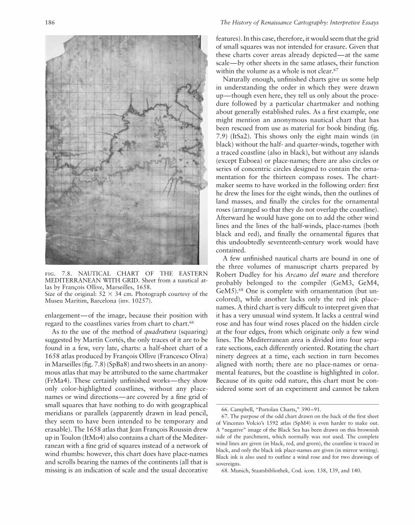
As to the use of the method of quadratura (squaring)suggested by Martín Cortés, the only traces of it are to befound in a few, very late, charts: a half-sheet chart of a1658 atlas produced by François Ollive (Francesco Oliva)in Marseilles (fig. 7.8) (SpBa8) and two sheets in an anony-mous atlas that may be attributed to the same chartmaker(FrMa4). These certainly unfinished works—they showonly color-highlighted coastlines, without any place-names or wind directions—are covered by a fine grid ofsmall squares that have nothing to do with geographicalmeridians or parallels (apparently drawn in lead pencil,they seem to have been intended to be temporary anderasable). The 1658 atlas that Jean François Roussin drewup in Toulon (ItMo4) also contains a chart of the Mediter-ranean with a fine grid of squares instead of a network ofwind rhumbs: however, this chart does have place-namesand scrolls bearing the names of the continents (all that ismissing is an indication of scale and the usual decorative
features). In this case, therefore, it would seem that the gridof small squares was not intended for erasure. Given thatthese charts cover areas already depicted—at the samescale—by other sheets in the same atlases, their functionwithin the volume as a whole is not clear.67
Naturally enough, unfinished charts give us some helpin understanding the order in which they were drawnup—though even here, they tell us only about the proce-dure followed by a particular chartmaker and nothingabout generally established rules. As a first example, onemight mention an anonymous nautical chart that hasbeen rescued from use as material for book binding (fig.7.9) (ItSa2). This shows only the eight main winds (inblack) without the half- and quarter-winds, together witha traced coastline (also in black), but without any islands(except Euboea) or place-names; there are also circles orseries of concentric circles designed to contain the orna-mentation for the thirteen compass roses. The chart-maker seems to have worked in the following order: firsthe drew the lines for the eight winds, then the outlines ofland masses, and finally the circles for the ornamentalroses (arranged so that they do not overlap the coastline).Afterward he would have gone on to add the other windlines and the lines of the half-winds, place-names (bothblack and red), and finally the ornamental figures thatthis undoubtedly seventeenth-century work would havecontained.
A few unfinished nautical charts are bound in one ofthe three volumes of manuscript charts prepared byRobert Dudley for his Arcano del mare and thereforeprobably belonged to the compiler (GeM3, GeM4,GeM5).68 One is complete with ornamentation (but un-colored), while another lacks only the red ink place-names. A third chart is very difficult to interpret given thatit has a very unusual wind system. It lacks a central windrose and has four wind roses placed on the hidden circleat the four edges, from which originate only a few windlines. The Mediterranean area is divided into four sepa-rate sections, each differently oriented. Rotating the chartninety degrees at a time, each section in turn becomesaligned with north; there are no place-names or orna-mental features, but the coastline is highlighted in color.Because of its quite odd nature, this chart must be con-sidered some sort of an experiment and cannot be taken
fig. 7.8. NAUTICAL CHART OF THE EASTERNMEDITERRANEAN WITH GRID. Sheet from a nautical at-las by François Ollive, Marseilles, 1658.Size of the original: 52 � 34 cm. Photograph courtesy of theMuseu Marítim, Barcelona (inv. 10257).
66. Campbell, “Portolan Charts,” 390–91.67. The purpose of the odd chart drawn on the back of the first sheet
of Vincenzo Volcio’s 1592 atlas (SpM4) is even harder to make out. A “negative” image of the Black Sea has been drawn on this brownishside of the parchment, which normally was not used. The completewind lines are given (in black, red, and green), the coastline is traced inblack, and only the black ink place-names are given (in mirror writing).Black ink is also used to outline a wind rose and for two drawings ofsovereigns.
68. Munich, Staatsbibliothek, Cod. icon. 138, 139, and 140.

The Renaissance Chart Tradition in the Mediterranean 187
as offering any clue to the normal procedures used bychartmakers.
Another anonymous nautical chart is totally withoutplace-names (ItVe19). As usual, the wind lines are markedin black, green, and red, while the coastline (limited to theeast central section of the Mediterranean) is traced inblack ink (with greenish-brown underlining). There arealso pen outlines for four small compass roses, plus a fifthlarger and much more elaborate rose—all of them cer-tainly intended for later decoration in vivid colors.
There is another anonymous chart of the same area, to-tally without ornamentation and with brown used to em-phasize the coastline alone (ItVe15). Only the black inkplace-names have been inscribed, while all the red inknames are missing (though the cartographer has left spaceto add them later).69
Another particularly interesting anonymous chart per-haps dates from the beginning of the seventeenth century(ItVe44). Richly decorated with compass roses and minia-tures of cities and various animals, the work, however, is
totally without place-names. This may well mean that thecoastal place-names in red and black were the last thingsadded to a chart—though this one example is hardlyenough to establish that this was the general rule. There isalso the possibility that this chart—entirely finished in allother respects—had left the cartographer’s workshop forthe studio of some expert or scholar who was responsiblefor inscribing the place-names, perhaps in Greek (some-
fig. 7.9. UNFINISHED NAUTICAL CHART ONCE USEDFOR BOOK BINDING. Anonymous seventeenth-centurynautical chart of the Mediterranean.
Size of the original: 38 � 59 cm. Photograph courtesy of theArchivio Vescovile, Savona.
69. Two other anonymous charts without red ink place-names havecome on the market: Lot 51 in the Sotheby’s auction of 21 April 1983and Lot 54 in the Christie’s auction of 7 December 1988. The descrip-tion of the latter points out that, though unfinished, the chart seems tohave been used on board a ship. Things are further complicated by ananonymous sixteenth-century Venetian chart (ItVe30), which containsonly a few place-names in red ink—except in the areas of the Adriatic,the Peloponnesus, and part of the Archipelago (where the usual blackink place-names are also found). This proves that the cartographer wasfollowing his own particular method; however, because the chart be-longed to the distinguished Venetian Dandolo family, it could have beena deliberate choice to give detailed information only on those areaswhere Venice had interests.

188 The History of Renaissance Cartography: Interpretive Essays
thing that was far from uncommon).70 However, onewould seem to be justified in claiming that the coloring ofdecoration and ornamentation was the last operation car-ried out before the addition of the cartographer’s signa-ture, together with the place and date of completion—though of course not all finished works are signed.71
As for atlases, it is more probable that each sheet wascompleted before being bound in a volume—even if thisgeneral rule seems to be contradicted by an anonymousatlas that Wagner, with many reservations, attributes toBattista Agnese.72 Not only is the traditional scroll in-tended for the owner’s coat of arms incomplete (with thepencil outline only partially inked in); there are also anumber of incompletely colored sheets and numerousgridded white sheets that have been left entirely blank.73
Similarly, doubts are raised by the previously mentioned1512 atlas by Vesconte Maggiolo (ItPr2), given that theblue used to color the Canary Islands on the fourth sheethas left a clear outline on the opposite page, suggestingthat the book was shut before the paint was dry. How-ever, these are only isolated cases from which one cannotgeneralize.
What does seem clear is that the individual charts in thevolumes must have been drawn on rectangles of parch-ment that had already been cut to size. Atlas charts weretherefore very different from those that were divided intosections—such as the previously mentioned Munichchart (GeM5) or an anonymous chart auctioned atChristie’s on 21 June 1989, which shows the Mediter-ranean divided up into six panels (there is absolutely noindication that these were then to be cut up and bound asa volume).74 As already mentioned, the last phase, for ei-ther individual charts or atlas sheets, was in all probabil-ity that of coloring and decorating. The brushes used topaint decorative figures, the backgrounds of the smallerislands, and the highlighting of coastlines were made withhairs of vair (squirrel fur) bound together, cut to variousshapes, and held in a handle made from a feather (oftena vulture feather).
In both charts and atlas sheets, the cartographer usedblack ink to trace the lines indicating the eight mainwinds, the coastlines, the outline of ornamental figures,and coastal place-names. This ink was made using ferroussulfide and finely ground oak nuts dissolved in rain wa-ter, vinegar, or wine, with gum Arabic used to thicken theresulting mixture. Red ink was used for the sixteen quar-ter-winds and the names of the most important coastal lo-cations. It was made using shavings of brazil wood in-fused in vinegar with gum Arabic, but it might also havebeen produced using cinnabar or red lead. Green ink,which the cartographer used to mark in the eight half-winds, is not mentioned in medieval or Renaissance trea-tises; one may assume it was made by diluting verdigris invinegar and then adding gum Arabic.
The pigments and binding agents used to make the ma-terials that cartographers used to color decoration, createbackground relief for smaller islands, and highlight coast-lines cannot have changed much from the medieval to theRenaissance period. Information on these technical as-pects can be gleaned not only from well-known medievaltreatises on the matter,75 but also from two Renaissanceworks: Giovanni Paolo Lomazzo’s Trattato dell’arte dellapittura (published in Milan in 1584)—a work that “takesup and completes recipes and mixtures from Cennini, Al-berti and Leonardo, complementing them with new mix-tures”—and Cristoforo Sorte’s Osservazioni sulla pittura(published in Venice in 1580)—in which, among otherthings, the author “deals with chorography.”76
The range of paints available was very wide, but itwould take an analysis of a great number of charts to es-tablish which paints were actually used by the variouscartographic workshops. One study has focused on Mar-tin Behaim’s famous globe, which, as it is drawn on parch-ment, allows one to suppose that the cartographer—Georg Holzschuher—used the same paints as those usedfor nautical charts. Analysis shows that the green wasproduced using verdigris, the red using cinnabar, thewhite using white lead, the blue using azurite, and the yel-low using ochre, with liquid gold and silver plus variousorganic colorants also used. Hence, no use was made ofthe more expensive pigments, such as malachite or lapislazuli, or of coloring agents formed by the mixture of dif-ferent ingredients.77
70. There are three known charts and two atlases that give all place-names in Greek: FrP36, ItL2, USNY1, GrA2, and the Nicolaus Vour-dopolos chart that was once in the Archives of the Guidi family inVolterra (Alberto Magnaghi, “L’Atlante manoscritto di Battista Agnesedella Biblioteca Reale di Torino,” Rivista Geografica Italiana 15 [1908]:65–77 and 135– 48).
71. That the inscription was added at the conclusion of the work isshown by the fact that it often includes a date that can refer only to theday on which the chart or atlas was completed. What is more, the longinscription in Jacopo Russo’s 1528 chart (UKBi1) is clearly squeezed inbetween two figures of saints, so it must have been written after theywere finished. See Roberto Almagià, “I lavori cartografici di Pietro e Ja-copo Russo,” Atti della Accademia Nazionale dei Lincei: RendicontiClasse di Scienze Morali, Storiche e Filologiche, 8th ser., 12 (1957):301–19, esp. pl. X.
72. USCh2. Wagner, “Manuscript Atlases,” 102.73. The anonymous atlas ItBe1 also seems to be unfinished. Gaetano
Ferro, “L’Atlante manoscritto della scuola di Battista Agnese conservatoa Bergamo,” Rivista Geografica Italiana 91 (1984): 501–20.
74. Indeed, the drawing in one panel runs over into the next panel.The chart could date from the end of the fifteenth century.
75. See David Woodward, “Medieval Mappaemundi,” in HC 1:286 –370, esp. 324.
76. Silvia Bordini, Materia e immagine: Fonti sulle tecniche della pit-tura (Rome: Leonardo–De Luca Editori, 1991), 59–60.
77. Bernd Hering, “Zur Herstellungstechnik des Behaim-Globus,” inFocus Behaim Globus, 2 vols. (Nuremberg: Germanisches Nationalmu-seums, 1992), 1:289–300, esp. 298–99.

The Renaissance Chart Tradition in the Mediterranean 189
So, even though we cannot be certain, it seems likelythat charts and atlas sheets also made use of low-cost pig-ments. However, detailed analysis might well bring outregional variations in the use of different pigments andalso reveal the use of new substances made availablethanks to geographical discoveries and contemporary de-velopments in decorative techniques.78
The production of manuscript nautical charts and at-lases must have required a great deal of time: for example,the inscription “a Kal Xbris ad Kal Maias 1646” revealsthat Friar Nicolò Guidalotti took five months to completehis atlas (ItVe7). However, that is the work of an amateurwho probably copied similar works by Placido Caloiro eOliva,79 so it does not tell us anything about the outputrate of a highly professional cartographic workshop suchas that of Battista Agnese (which in the year 1542, weknow, turned out completed atlases signed and dated 15May, [?] June, 28 June, and 25 September).80
Workshops, Individual Production, and Anonymous Charts
In discussing medieval cartography, Campbell warnsagainst blanket statements such as “No chartmaker everworked alone.”81 And two of the previously mentionedworks seem to bear out that in the sixteenth and seven-teenth centuries there were two possible systems of pro-duction: charts might have been turned out either by largeworkshops (where there was a certain division of labor)or as the occasional products of someone who earned hisliving in a different field.82 Only occasionally is the factthat charts or atlases were the fruit of a joint effort madeexplicit in the actual signature of the work (for example,in the 1525 chart cosigned by Vesconte Maggiolo andGiovanni Antonio Maggiolo, ItPr3). However, even here,given that four years later Vesconte would apply to theSenate for his sons Giovanni Antonio and Jacopo to beformally recognized as his fellow cartographers, the dou-ble signature may have had an ulterior motive: to demon-strate that the young man was a fully fledged assistantrather than a mere apprentice.
Similar problems are raised by the Leghorn-producedatlases signed jointly by Joan Oliva and Giovanni BattistaCavallini and by Giovanni Battista and Pietro Cavallini(in 1636 [USCh13] and 1654 [ItPr8], respectively). Giventhat in both cases the works date from approximately theearly career of the younger of the two cartographers con-cerned, it seems more likely that the double signatures areless the recognition of collaboration between teacher andpupil than the official presentation of the successor desig-nate—and therefore it cannot be ruled out that the at-lases in question were really the work of the older of thetwo. The situation is rather different when one looks atthe 1592 chart produced in Majorca and signed by Rei-
naut Barthollomiu de Ferrieros and Matteo Prunes (ItFi9).Caraci ruled out that Ferrieros may have simply been thechart’s owner and suggests that he may well have beenPrunes’s assistant—in which case the double signatureserved to make the chart appear more authoritative in theeyes of a potential purchaser.83
There are also atlases that are not the result of directcollaboration but merely consist of sheets produced bydifferent chartmakers and then bound together. Examplesof these are the atlas consisting of charts by Joan RiczoOliva and Baldassare Maggiolo (SpM8 and SpM9), onewith charts by António Sanches and Giovanni BattistaCavallini (NG4), and another with charts by François Ol-live and Augustin Roussin (ItTr3 and ItTr4). In thesecases, each chartmaker worked independently withoutever moving from his own workshop, and the fully fin-ished charts were bound together at a later date (perhapsat a much later date).
That a distinction was made between the work of achartmaker and that of a copyist is clear from the in-scription on a chart by Jacopo Russo: “Iacobus russusmessanensis me fecit in nobili civitate Messane anno DNI1563 per ioanes Antonio Talamo composta amen,”84
which clearly differentiates between the intellectual task
78. Catherine Hofmann, “‘Paincture & Imaige de la Terre’: L’enlu-minure de cartes aux Pays-Bas,” in Couleurs de la terre: Des mappe-mondes médiévales aux images satellitales, ed. Monique Pelletier (Paris:Seuil / Bibliothèque Nationale de France, 1998), 68–85.
79. Handwritten note by Marcel Destombes.80. These are USNY33, GeKa1, V6, and UKG1, respectively. Wagner
dates another four atlases without inscriptions (or with partially illegi-ble inscriptions) as produced in the year 1542. Wagner, “ManuscriptAtlases,” 64 –69.
81. Campbell, “Portolan Charts,” 429.82. Caraci claims that cartographers such as Joan Oliva and Vincenzo
Volcio—who seem to have been constantly on the move from oneMediterranean port to another—could have been sailors who workedas mapmakers during their long stop-overs in port (Giuseppe Caraci,“Gio. Batta e Pietro Cavallini e una pretesa scuola cartografica livor-nese,” Bollettino Storico Livornese, anno. 3, no. 4 [1939]: 380–88,esp. 385). However, the very opposite seems to be true—particularlyfor the likes of Oliva, whose work was so extensive and full it can havebeen produced only by a professional, and whose peregrinations fromcity to city ended with his settling permanently in Leghorn. So it seemspossible that a professional cartographer like Joan Oliva may havespent, for reasons unknown to us, some years of his life on board shipas a sailor or pilot. Obviously one can speak of “part-time” cartogra-phers when the author of a map himself gives his profession as otherthan cartography (this is the case, for example, with “ship’s captain”Guglielmo Saetone or “surgeon” Giovanni Francesco Monno).
83. Giuseppe Caraci, “A proposito di alcune carte nautiche della Bi-blioteca Nazionale di Parigi,” Estudis Universitaris Catalans 14 (1929):259–78, esp. 272–73.
84. Osvaldo Baldacci, Documenti geocartografici nelle Biblioteche enegli Archivi privati e pubblici della Toscana, vol. 3, Introduzione allostudio delle geocarte nautiche di tipo medievale e la raccolta della Bi-blioteca Comunale di Siena (Florence: Leo S. Olschki, 1990), 71 n. 1,and Almagià, “I lavori cartografici,” 306.

190 The History of Renaissance Cartography: Interpretive Essays
of cartography (fecit) and the manual one (composta). Inthis case, the hand that actually drew the chart belongednot to a member of the cartographer’s family or to an ap-prentice destined to become a cartographer in his ownright, but to a simple copyist, who limited himself to re-producing a given model.85
Scholars have recognized that at least within the moreimportant workshops there was a further division of la-bor. Baldacci refers to the presence of amanuenses anddraftsmen, but admits that our insufficient knowledge ofthe way such workshops were organized prevents us fromgoing any further.86 Campbell points out that a medievalilluminated manuscript was normally the work of a scribe,a rubricator, and at least one painter.87 Almagià seemedto confirm the extension of this practice to cartographywhen in his examination of an anonymous chart (V15bis)he found that the scribe had omitted the initial letter fromthe legends—presumably leaving the space to be filled inby a rubricist or a miniaturist—and that the actual ini-tials were a crude addition by a later hand trying to com-plete the unfinished text.88 The same conclusion might bereached in studying the previously mentioned chart thatlacks all the red ink place-names (ItVe15); however, an-other explanation for their absence might be that theamanuensis or cartographer who completed the place-names in black fully intended to go on to those in red, butfor some reason or another never did.
The work of an inexperienced worker would seem tobe the best explanation for the incomplete erasure of thelead pencil circle in the plate of Vesconte Maggiolo’s 1512atlas or the heavy tracing of the double circles in the sheetof the Battista Agnese atlas (ItBo11). Rosselló Verger ar-gues that the lines of the wind rhumbs must have beendrawn by apprentices.89 However, this claim is acceptableonly if one holds that the wind lines were always drawnin before the coastlines; otherwise there was the risk thatsome inexperienced trainee would ruin the just-completedwork of a master cartographer.
The presence of apprentices and specialized assistantssuch as draftsmen, amanuenses, and miniaturists in thelarger cartographic workshops perhaps throws some lighton the relation between signed and unsigned works, andhelps to explain why so many of the extant charts and at-lases are anonymous. On the basis of the material listed byUzielli and Andrews, Caraci calculates that some 36 to 38percent of all charts produced over the period from thethirteenth to the seventeenth century must have beenanonymous.90 Recently Baldacci raised the figure to ashigh as 60 percent.91 However, Caraci’s estimate seemsmore realistic, especially when one considers that a surveyof the extant material from the sixteenth and seventeenthcenturies puts anonymous works at around 40 percent ofthe total.92 Nevertheless, even Caraci’s figure is too highfor the absence of signatures to be explained by mere for-getfulness or chance. In many cases, it must have been in-
tentional and dictated by reasons that may not be imme-diately obvious.
In a workshop, only the master cartographer or mastercosmographer was in a position to sign a chart or atlasand thus underwrite its authenticity and reliability; how-ever, it is possible that apprentices and assistants pro-duced further copies that—precisely because they wereunsigned—sold at a lower price. Probably such copyingtook place when, in the absence of commissioned works,the alternative was to leave the workshop staff idle. Norcan one rule out that, once they had finished their ap-prenticeship, trainees drew up charts on the basis ofworkshop models and then sold them off—unsigned andundated—to buyers attracted by their bargain price.93 Soin effect the anonymous works are authorized or unau-thorized copies of the works drawn up in the main carto-graphic workshops.94
Of course, one cannot help wondering why so accom-plished a cartographer as Ghisolfi never signed any of theten atlases that are now attributed to him. And, while itis true that his works bear a certain resemblance to thoseof Agnese—so much so that Revelli did not hesitate to de-clare him Agnese’s pupil—it is hardly likely that the Do-ria or Medici families would have bought pirate or sec-ond-rate copies simply in order to save money.95 All in all,there is simply no convincing explanation for Ghisolfi’schoice of anonymity.
85. In the well-known Pizigani chart of 1367 the meanings of the twoterms seem to be opposite: compoxuit refers to the plotting and plan-ning of the chart, while fecit indicates the actual work of drawing it.Giuseppe Caraci, “A conferma del già detto: Ancora sulla paternitàdelle carte nautiche anonime,” Memorie Geografiche 6 (1960): 129–40, esp. 138–39.
86. Baldacci, Introduzione allo studio, 71–72.87. Campbell, “Portolan Charts,” 429.88. Almagià, Monumenta cartographica Vaticana, 1:33, 34 –35 n. 6.
It should be added that the chart Almagià dates as a fifteenth-centuryproduct of the Fra Mauro workshop, Caraci argues is a sixteenth-century work by one of the Freducci family of cartographers—in whichcase it would fall within the area covered by this study. Giuseppe Caraci,“The Italian Cartographers of the Benincasa and Freducci Families andthe So-Called Borgiana Map of the Vatican Library,” Imago Mundi 10(1953): 23– 49.
89. Vicenç M. Rosselló Verger, “Cartes i atles portolans de los col�lec-cions espanyoles,” in Portolans procedents de col�lecions espanyoles,segles XV-XVII: Catàleg de l’exposició organitzada amb motiu de la17a Conferència Cartogràfica Internacional i de la 10a Assemblea Ge-neral de l’Associació Cartogràfica Internacional (ICA/ACI), Barcelona,1995 (Barcelona: Institut Cartogràfic de Catalunya, 1995), 9–59,esp. 47. (Rosselló Verger’s article also appears in Spanish, French, andEnglish).
90. Giuseppe Caraci, “Di alcune carte nautiche anonime che si vor-rebbe attribuire a Girolamo da Verazzano,” L’Universo 39, no. 3(1959): 307–18 and no. 4 (1959): 437– 48, esp. 437.
91. Baldacci, Introduzione allo studio, 71.92. Astengo, Elenco preliminare.93. Caraci, “Di alcune carte nautiche anonime,” 439.94. Baldacci, Introduzione allo studio, 71.95. Revelli, Cristoforo Colombo, 2:407.

The Renaissance Chart Tradition in the Mediterranean 191
Comparison of individual workshops also reveals idio-syncratic differences: though only 30 percent of the worksnow considered to have come from the Agnese workshopare actually signed, the figure rises to more than 90 per-cent for the charts and atlases attributed to the Genoaworkshop of the Maggiolo family. It is possible that thisdifference is due to the fact that the former was an entirelyprivate workshop, while the latter was approved andprivileged—that is, in part subject to state control—andtherefore may have had a different way of working.
Collaboration in both large and small workshops maywell explain the extremely long working life of such car-tographers as Battista Agnese, Jacopo Russo, and JacopoMaggiolo. Perhaps the master’s pupils went on using hissignature after his death96 or else the aged master simplylimited himself to signing works turned out by his work-shop.97
Finally, there is the question of whether the actual nav-igation charts were signed or not. Given that these werelow-cost copies, one might be inclined to say no; however,since these charts were used on board ship, the guaranteeprovided by the cartographer’s signature would seem tohave been indispensable.98
A large workshop might draw on the services of a num-ber of amanuenses—and even nonprofessional cartogra-phers may have employed an amanuensis who alsoworked for others—so it is clear that handwriting offersno conclusive proof in identifying the author of a partic-ular anonymous work. Hence, one can no longer acceptthe claim of Destombes that while all other features—andthe drawing of coastlines, in particular—changed overtime, handwriting remained immutable and thereforeserves to identify the author of anonymous charts.99 Hereone has to agree with Caraci, who, after showing that thesame handwriting might be associated with different car-tographers (or that two distinct handwritings might beassociated with the same cartographer), argued thatscript was only one of a number of features, such as coastaloutline, structure, place-names, and decorative details,that the scholar must take into consideration if he wantshis identification of a chart’s author to carry any realweight.100
Technical Features: Rhumbs, Wind Roses, Scale
The systems of wind rhumbs used in the nautical chartsof the sixteenth and seventeenth centuries differ very lit-tle from those found in the charts of the late Middle Ages:around a central rose, generally showing thirty winds,sixteen peripheral wind roses (in which the number ofwinds might vary) lay along the circumference of a “hid-den circle.”101 Often, because of the elongated form of thechart, another wind rose might be added to the left orright of that circle. In one case, Alvise Gramolin’s 1624
chart of the Adriatic (ItVe47), the chart is so long and thinthat the system of rhumbs is actually halved: half a windrose is shown on one side of the chart, and nine periph-eral roses form a large semicircle around it. As in earliercenturies, a wider variety of schema can be found withinatlases. For example, there are sheets in which there isonly a central wind rose and no peripheral roses (Albertode Stefano’s 1645 atlas, UKL45) or in which the rhumbsare drawn only in the space within this hidden circle(Vesconte Maggiolo’s 1548 atlas).102
96. Almagià, “I lavori cartografici,” 313. The suggestion that the in-scription was sometimes added by an assistant rather than by the mas-ter cartographer himself is borne out by those cases in which the latter’sname is actually spelled incorrectly. For example, one atlas (ItVe13) issigned Baptista Palnese instead of Battista Agnese, and a chart (FrMa1)bears the name Joan Oliva alias Arizon instead of Joan Oliva aliasRiczo. It is hardly likely that such errors were made by someone writ-ing his own name.
97. Giuseppe Caraci, “Le carte nautiche del R. Istituto di Belle Artiin Firenze,” Rivista Geografica Italiana 37 (1930): 31–53, esp. 39.
98. The real—undecorated—navigation charts destined for use onboard ship have, obviously enough, not survived. However, the 1567chart by Jacopo Maggiolo does seem to have the characteristics of suchworking charts: it shows a limited area—the Sea of Liguria and thenorthern Tyrrhenian—on a large scale without any ornamentation, ifone excludes the miniature of Pisa (which may have been added laterand is certainly by a different hand). The chart is inscribed and signed,but given that it is the product of the official magister cartarum pro na-vigando (master of charts for sailing), whose workshop was approvedand privileged by the Republic of Genoa, the fact does not seem to beconclusive proof.
99. Marcel Destombes, “Nautical Charts Attributed to Verrazzano(1525–1528),” Imago Mundi 11 (1954): 57–66, esp. 59–60.
100. “Those with some experience of old nautical charts know verywell that the distinctive characteristics of a cartographer or a school ofcartographers generally include such features as drawing (the way thecoastlines are drawn and colored), frame of reference (lines of direction,wind roses, parallels, Tropics and/or Equator, or the ‘raya’ etc.), andscale—as well as the decorative or verbal elements included either in-side or outside the drawing (the former elements including such thingsas flags, standards, city views, figures of sovereigns, landscapes, animals,and legends, etc.; the latter including inscriptions, figures of theMadonna or saints, explanations of scale, drawings of ships, marinemonsters, and so on). In signed maps of certain attribution, these fea-tures usually occur with monotonous repetitivity, and though theymight change a little they never disappear altogether. It is as if they arean ingrained part of the personality or experience of a particular car-tographer, or one of the habitual characteristics of a certain school.”Caraci, “Di alcune carte nautiche anonime,” 313.
101. In the charts of Matteo Prunes and in the Vesconte Maggioloworld map (ItFa1), Baldacci identifies a whole series of innovations inthe gridwork, describing them as “inexplicable attempts at geometricalsymmetry.” However, looking more closely one sees these are really onlyapparent innovations: what looks like a new grid is actually the resultof the fact that the green-brown lines indicating the half-winds stand outmore than the black lines tracing the courses of the main winds (partlybecause they are drawn in more thickly, partly because they have fadedless). Baldacci, Introduzione allo studio, 38.
102. In all the sheets of this atlas (ItFi20) covering Europe and theMediterranean, both the network of rhumbs and the geographical out-lines are contained within the hidden circle, while the sheets depictingthe oceans follow the normal practice—with rhumbs and geographicaloutlines extending right to the edge of the sheet.

192 The History of Renaissance Cartography: Interpretive Essays
It has often been said that the compass roses were notjust decorative details designed to fill in empty spaces butrather an essential component of any nautical chart—given that their reproduction of the points of the compassmade coordinated use of chart and compass possible.103
In effect, however, the color-coded lines of the wind rosesalready formed the cognitive framework necessary for the alignment of the chart and actual plotting of a ship’scourse. This is borne out by the fact that the first knowncomplete compass rose occurs in the 1375 Catalan Atlas—that is, almost a century after the birth of nauticalchartmaking—and thereafter a number of charts contin-ued to do without one. What is more, it seems likely thatthe charts actually used on board ship never containedcompass roses.104 So their appearance seems to be directlylinked to the growing taste for cabinet nautical charts,which had either a didactic purpose or no nautical pur-pose at all. This would also explain their great variety insize and form and the lack of any clear color coding.However, given that compass roses did apparently havesome role in explaining the use or structure of nauticalcharts, I prefer to deal with them here rather than along with what were obviously decorative features andno more.
Winter claims that the design of compass roses is oneof the most important clues to identifying the workshopand date of many anonymous charts,105 but RossellóVerger doubts this, observing that “it would seem thatevery author, at every opportunity and on every singlepage, is trying to demonstrate that the combinations ofcircles, points, rules, letters, fleurs-de-lis, and colours . . .are simply infinite.”106 Campbell, for his part, acceptsthat compass roses are important in establishing the dateand place of production of nautical charts, but points outthat Winter’s research is flawed because it is based largelyon undated charts (which are clearly of little use in datingothers).107 In effect, what is needed is an exhaustive cata-log of compass roses, given that the table accompanyingWinter’s study reproduces only twenty-two—and onlyfour of those come from the period under examinationhere: those of Pilestrina 1511, Maggiolo 1512, Freducci1556, and an anonymous work now in Dijon that is con-sidered Portuguese. What is more, of the two types ofcompass roses normally used by the Maggiolos, Wintergives the less significant, the one which is more similar toother contemporary designs.108
In another work Winter suggests a division betweenItalian and Catalan compass roses on the basis of thesymbol used to indicate north—a blunted triangle orwedge in the former, a lily (often emerging outside therose) in the latter.109 The Catalan symbol is said to be ofPortuguese origin, while the Italian wedge (drawn withinthe circumference of the rose itself) is said to derive di-rectly from the face of the nautical compass. However,
one can find both symbols for north in the works of asingle cartographic workshop: the Maggiolo family ofcartographers (from Genoa) used the lily in small com-pass roses and the wedge in large, while the Catalan car-tographer Joan Martines seems to have followed the op-posite rule. Similarly, the same initials are used to identifythe six main winds—Greco, Scirocco, Ostro, Libeccio,Ponente, and Maestro (northeast, southeast, south, south-west, west, and northwest)—and a cross is used to indi-cate east, probably a reference to the location of Jerusalem,or even the site of the Garden of Eden.110
So without a full catalog one cannot establish generalrules, nor can the intricacy or sobriety of design be usedto distinguish between the Catalan and Italian compassroses of the sixteenth and seventeenth centuries.111 How-ever, there are some broad chronological guidelines: seventeenth-century roses are generally more numerous,larger, more gaudily colored, and less accurately drawnthan earlier ones. From the end of the sixteenth centuryonward, north was indicated almost exclusively by thesymbol of the lily, which got larger and larger until it be-gan to look like some sort of multicolored plume.112
103. “In order to find our way successfully, it is not enough just tohave a map. We need a cognitive schema, as well as practical masteryof way-finding, to be able to generate an indexical image of the terri-tory.” David Turnbull, Maps Are Territories, Science Is an Atlas: A Port-folio of Exhibits (Geelong, Australia: Deakin University Press, 1989), 51.
104. Rey Pastor and García Camarero claim that with time this sci-entific tool became a purely decorative feature; its total lack of functionis proved by the increase in size and number of the wind roses given.Rey Pastor and García Camarero, La cartografía mallorquina, 14.
105. Heinrich Winter, “A Late Portolan Chart at Madrid and LatePortolan Charts in General,” Imago Mundi 7 (1950): 37– 46, esp.37– 40.
106. Rosselló Verger, “Cartes i atles portolans,” 47.107. Campbell, “Portolan Charts,” 395.108. Vesconte, Jacopo, Giovanni Antonio, and Baldassare Maggiolo
use two different wind roses: a small eight-point rose and a larger whitedisk framed by a narrow ring on which a total of thirty-two points aremarked (eight of them identified by the initials or symbols of the eightmain winds).
109. Heinrich Winter, “On the Real and Pseudo-Pilestrina Maps andOther Early Portuguese Maps in Munich,” Imago Mundi 4 (1947): 25–27, esp. 25–26.
110. Giovanni Marinelli, review of La carta nautica di Conte Ot-tomanno Freducci d’Ancona conservata nel R. Archivio di Stato inFirenze, by Eugenio Casanova, Rivista Geografica Italiana 2 (1895):126 –28, esp. 128.
111. While the wind roses in Battista Agnese’s work are characterizedby a certain sobriety, those in the charts and atlases drawn up by an-other foreign cartographer at work in Venice—Giorgio Sideri, knownas Il Callapoda—are noteworthy for their complicated system of con-centric rings and the great taste shown in the combination of colors. Theroses in many of Joan Martines’s atlases, on the other hand, are gener-ally small, with a single external ring and the initials of the winds in-scribed in the inner disk.
112. Think, for example, of the work produced in Marseilles byFrançois Ollive toward the end of his career.

The Renaissance Chart Tradition in the Mediterranean 193
Unlike compass roses, scales are always given on thecharts in a rigidly codified form: invariably there was analternating sequence of white and dotted spaces (eachcorresponding to fifty miles), with the dotted spaces in-ternally divided into five short bars (each correspondingto ten miles).113 At most there might be a slight variationin the symbol used to highlight the alternation betweenthe larger spaces (sometimes it is a dot within a circle,sometimes a semicircle accompanied by two verticallines). The differences in style that have been highlightedby scholars involve not the scale itself but the ornamen-tal work containing it, which might be a simple frame, anunfurling banderole, or a complicated composition deco-rated with floral motifs.114 Generally, the scale is givenalong the top or bottom of the chart, though in some rarecases it might be along the right or left margin. In atlases,it is sometimes placed, without any containing scroll-work, diagonally at one or more corners of the chart (asin works by Battista Agnese) or else between two series ofparallel segments (as in Freducci’s charts).
Caraci has pointed out that in some of DomenicoVigliarolo’s charts the scale is laid out so the four com-ponents form the letter “M” (fig. 7.10)—a feature that,along with other significant details, made it possible forhim to identify the anonymous Borgiano VI chart (V16)as the work of the Calabrian cartographer.115 As in thecase of medieval charts, those of the period under discus-sion do not give any indication of the unit of measure ac-tually used in the scales. An exception is the previouslymentioned chart auctioned at Christie’s on 21 June 1989:this shows the Mediterranean in six different panels, eachone of which is to a different scale based on a local“mile,” and this variation seems to be the main reason forthe unusual form of the chart.116
Another exception seems to be the manuscript nauticalcharts drawn up in Genoa by Francesco Maria Levantoin the years 1661–62 and bound as a single volume some-time in the following century: the scales use Italian miles,
Dutch leagues, and English leagues.117 However, giventhat these works were derived from Dutch nautical charts,and the work of Anthonie Jacobsz. in particular, they can-not really be classified as belonging to the tradition ofMediterranean cartography.
As to the actual ratios of reduction used, there do notseem to have been many changes since the Middle Ages.Frabetti’s study, which covers ten portolan charts of thesixteenth and seventeenth centuries, shows that the ratiocan vary from 1:5,500,000 to 1:8,500,000.118 However,from atlas to atlas—or even between the sheets of a singleatlas—there were much more striking variations in scale.Rosselló Verger’s examination of the atlases in Spanish li-braries and museums revealed that for the westernMediterranean the most usual scale was 1:7,000,000,though there were wide variations.119
During the course of the sixteenth century, a scale oflatitude began to make its appearance in nautical chartsproduced in the Mediterranean area. This innovation, de-rived from Spanish work, is perhaps to be seen for thefirst time in two charts of the Atlantic: that by Conte diOttomanno Freducci (dated around 1514 –15) (ItFi7),which shows latitude from 60�N to 15�S, and the 1516chart by Vesconte Maggiolo (USSM1). From this time on-ward, a scale of latitude became an essential feature of allnautical world charts and oceanic charts, such as those inBattista Agnese’s atlases (which often also contain indica-tions of longitude). By the second half of the century, lat-itude was also being given in nautical charts of theMediterranean. The scale, which generally extended from10–15�N to 50–60�N, was given in the Atlantic just offthe coast of Europe or Africa and generally puts Gibral-tar at between 35� and 36�N. However, even later in thecentury, those charts that do not extend beyond Gibral-tar contain no indication of latitude, which shows thatsuch a scale was applied only to the oceans and not to the
fig. 7.10. INDICATIONS OF SCALE ARRANGED TOFORM THE LETTER “M.” Detail of a nautical chart of Italyby Domenico Vigliarolo, Palermo, 1577. (See also fig. 7.23.)Size of the detail: ca. 11.1 � 23.8 cm. Photograph courtesy ofthe Map Collection, Yale University Library, New Haven (*491577).
113. As one would expect, scale bars are usually not given in the nau-tical or terrestrial world charts included in nautical atlases. However, inthe three charts of the oceans that normally feature in Battista Agnese’satlases, which together form a sort of nautical world chart, there is ascale bar placed diagonally across one corner: it consists of a series ofclosely spaced dots and the legend “one hundred miles from dot to dot.”
114. Rosselló Verger, “Cartes i atles portolans,” 46 – 47.115. Giuseppe Caraci, “Le carte nautiche anonime conservate nelle
biblioteche e negli archivi di Roma,” Memorie Geografiche 6 (1960):155–245, esp. 167–93.
116. Tony Campbell, ed., “Chronicle for 1989,” Imago Mundi 42(1990): 120–32, esp. 128.
117. Durazzo-Giustiniani private library, Genoa.118. Pietro Frabetti, Carte nautiche italiane dal XIV al XVII secolo
conservate in Emilia-Romagna: Archivi e Biblioteche Pubbliche (Flor-ence: Leo S. Olschki, 1978). Obviously this is not the case with regionalnautical charts, such as that of the Aegean produced in 1601 by Vin-cenzo Volcio (ItBo4), in which Frabetti calculates the scale to be1:1,500,000.
119. Rosselló Verger, “Cartes i atles portolans,” 47.

194 The History of Renaissance Cartography: Interpretive Essays
Mediterranean Sea (further proof of the different tech-niques of navigation in these two different worlds, andthat those who applied them were well aware of the dif-ference). Hence, one might say that the scale of latitudeformed a sort of link between the enclosed sea and theopen ocean, a bridge linking the old ports of the Mediter-ranean and the rest of the world.
Often—as in Jacopo Russo’s 1563 chart—the scale oflatitude is given divided into two or three parts, probablyto facilitate its insertion in the chart as a whole; in fact,in the Russo chart the central section of the scale of lati-tude, from 34� to 48�N, is shifted to the right so as not tooverlap the large wind rose (SpV1).
The Nordenskiöld Collection contains a 1568 chart byDomingo Olives in which the scale of latitude is inter-rupted at 29�N, and the lower section, from 14� to 29�N,is rotated approximately five degrees counterclockwisewith respect to the upper section, running from 29� to62�N. According to Winter, this is a very early attempt to correct the usual rotation of the axis of the Mediter-ranean.120
The Axis of the Mediterranean
As is well known, in medieval charts the Mediterraneanis depicted with its axis rotated eight to ten degrees coun-terclockwise. Scholars have generally attributed this shiftto magnetic declination, or rather to the desire to makenorth as indicated on a chart coincide with north as indi-cated by a compass needle.121 However, it has also beenargued that the rotation is due to the difference in lengthbetween the two parallels supposedly used as the basesfor a trilateral grid,122 or simply to the cartographer’s de-sire to include within the rectangular parchment coun-tries such as Flanders and England, which would other-wise be excluded.123
Whatever the reason, the shift in the east-west axis ofthe Mediterranean remained practically unchangedthroughout the Middle Ages, with the rotation varyingbetween seven degrees and eleven degrees, fifteen minutes(that is, up to an entire rhumb). And in spite of the greatadvances in nautical knowledge made during the age ofthe great geographical discoveries, no correction wasmade to the discrepancy—as can be seen, for example,from the first large manuscript world charts, which, al-though extended to include all recently discovered lands,still show the Mediterranean with the usual medieval inclination.
However, the aberration in the axis of the sea does seemto have been corrected in a large anonymous world chartproduced by the Casa de la Contratación and donated toCardinal Giovanni Salviati. Dating perhaps from the years1526 –27, this work shows Gibraltar aligned with Creteand Cyprus for the first time. The same alignment can also
be seen in the large anonymous world chart known as theCastiglioni world chart and the world maps produced inSeville by Diogo Ribeiro in 1527 and 1529.124
Nevertheless, such changes seem to have gone unno-ticed by the cartographic workshops of the Mediter-ranean, which went on depicting the sea in the traditionalway. Even a cartographer like Vesconte Maggiolo, whowas very attentive to contemporary advances in geo-
120. Winter, “Late Portolan Chart,” 44 – 45. In fact, it is in no waycertain that this scale of latitude divided into two different segmentswith different inclinations was intended to correct the error in the ori-entation of the Mediterranean. That aim could have been achieved moreeffectively with two differently oriented scales placed in the Atlantic andthe eastern Mediterranean, respectively. It is therefore fairly probablethat this original scale of latitudes was intended to indicate a magneticvariation in the Atlantic.
121. A note on magnetic declination is to be found in a margin of theLeiden Universiteitsbibliotheek codex of Maricourt’s “Epistula de mag-nete,” which dates from the first half of the sixteenth century: “Notethat we must deviate the southern needle one point to the west in properuse [usus directorii]. And this must be on account of a deviation of thesouthern part to the east, since the southern part of the instrument lacksdivisions [markings]. Note that the magnetic stone or even the needlerubbed with the same stone does not directly point to the poles, but webelieve that the part that points to the south deviates somewhat to thewest, and we believe that the part that points to the north to the sameextent, deviates to the east.” Pierre de Maricourt (Petrus Peregrinus deMaricourt), Opera: Epistula de magnete, Nova compositio astrolabiiparticularis, ed. Loris Sturlese and Ron B. Thomson (Pisa: Scuola Nor-male Superiore, 1995), 53.
122. James E. Kelley, “Perspectives on the Origins and Uses of thePortolan Charts,” Cartographica 32, no. 3 (1995): 1–16, and JonathanT. Lanman, On the Origin of Portolan Charts (Chicago: Newberry Li-brary, 1987), 23.
123. David Woodward, personal communication, October 1992.124. See figures 30.25, 30.28, 30.29, and 30.30. In the legend, the fa-
mous cosmógrafo real explains the reasons for this modification andshows that he is fully aware of the difficulties caused for the cartogra-pher by the move from compass-based navigation to astronomical nav-igation, which necessarily meant introducing meridians and parallelsoriented to true north into wind rhumb maps and charts based on mag-netic north (see Randles, “La carte-portulan méditerranéenne”). Hiscorrection, therefore, is limited solely to the axis of the Mediterraneanin order to avoid excessive alterations to an already familiar picture.
To explain what he had done, Ribeiro wrote: “Note that the Levante,which we usually call what is contained inside the Strait of Gibraltar, issituated and laid down by its height [i.e. latitude], according to peoplewho have been in some of its parts and taken (the height of) the Sun;and in the rest I follow the cosmographers who have specially spokenof the latitude of some places; and the degrees of longitude in it cannotcorrespond to the parts which they measured in the equinoctial, by rea-son that the parallels are smaller, because in reality from Cairo to theRed Sea or from Damascus or Jerusalem to the Persian Sea there is verylittle distance, and it is made great here on account of the smallness ofthe parallels, as I have said; I have therefore considered this a lesser in-convenience than not to disproportion the sea and land of the Levanteagainst what is already established and conceived in the mind.” Quotedin Armando Cortesão and A. Teixeira da Mota, Portugaliae monumentacartographica, 6 vols. (Lisbon, 1960; reprinted, with an introductionand supplement by Alfredo Pinheiro Marques, Lisbon: Imprensa Na-cional–Casa da Moeda, 1987), 1:93 (brackets in original).

The Renaissance Chart Tradition in the Mediterranean 195
graphical knowledge, persisted in drawing his charts ofthe Mediterranean with the sea’s axis rotated some tendegrees counterclockwise and then transferred this errorto his large world charts—even though he based theseworks largely on Spanish and Portuguese sources.125
One should also remember that, according to recentstudies, it seems that while from 1300 to 1500 the east-ern bias of magnetic declination in the central Mediter-ranean was somewhere between eight and ten degreeseast, during the course of the sixteenth century this valuebegan to fall—so much so that it was around four de-grees in 1600, leveled out at zero degrees around 1650,and thereafter became a western bias.126 Around themiddle of the sixteenth century, the isogonal zero musthave passed along the coast of Palestine, while by the be-ginning of the seventeenth century it passed throughRhodes, and by the mid-seventeenth century it hadshifted to Sicily.127 Hence, the charts drawn up using thetraditional representation of the sea no longer corre-sponded with empirical compass readings.
An atlas attributed to Agnese, which should be datedaround 1543– 45,128 contains an interesting detail. The
fifth sheet (fig. 7.11), showing the eastern Mediterraneanwith the usual rotation, also contains two scales of lati-tude marked in black ink: the first runs from the NileDelta to the western tip of Cyprus and the second fromthe coast of the Marmarica to the eastern coast of Crete,with the readings starting from 31�—at two, almost per-fectly aligned, points on the African coast—and ending
fig. 7.11. NAUTICAL CHART OF THE MEDITERRA-NEAN WITH A SCALE OF LATITUDE. A sheet from an at-las attributed to Battista Agnese.
Size of the original: 24.5 � 35 cm. Photograph courtesy of theNewberry Library, Chicago (Ayer MS. Map 10).
125. Such as the 1527 world chart in Milan, Biblioteca Ambrosiana,which was destroyed during the bombing of the Second World War, orthat dated 1531 and now in a private collection.
126. The variations in magnetic declination over the centuries havebeen measured through studies of the lava flows of Etna. Ricardo CerezoMartínez, “Incidencia de la declinacion magnetica en el desarrollo de lacartografia portulana,” Quaderni Stefaniani 4 (1985): 97–128; Lan-man, Origin of Portolan Charts, 27–30; and Robert Bremner, “WrittenPortulans and Charts from the 13th to the 16th Century,” in FernandoOliveira e o Seu Tempo Humanismo e Arte de Navegar no renascimentoEuropeu (1450–1650): Actas da IX Reunião Internacional de Históriada Náutica e da Hidrografia [1998] (Cascais: Patrimonia, 2000), 345–620.
127. Woronowa, Der Portolan-Atlas des Battista Agnese, 29.128. USCh1. The work is listed as no. XXXVI in Wagner, “Manu-
script Atlases,” 76 –77.

196 The History of Renaissance Cartography: Interpretive Essays
at 35� at both islands, even if it is clear that Cyprus is far-ther north than Crete (the equal numerical reading fortheir latitude is possible thanks to the difference in thesegment lengths the two scales use to mark each degree).Though one cannot attribute this odd addition to theAgnese workshop, the writing is undoubtedly from thesixteenth century. So the author of this very early attemptto correct the inherited distortion in the cartographic rep-resentation of the Mediterranean had realized that Creteand Cyprus were aligned on the same parallel, but seemsto attribute the faulty picture given by the chart to an er-ror in calculating the distance between Damietta andCyprus, which resulted in the location of the island toofar to the north of the African coast. The same belief canbe seen in the portolano written by Barnardo Baroncelliaround twenty years later, which explicitly states thatCyprus is generally shown one hundred miles too farnorth, and that is why the pilots of many ships whothought they were heading for the island ended up on thecoast of Egypt: they were misled by the charts they wereusing.129 So it is clear that the distortion in cartographicrepresentations had been noted but was attributed to er-roneous calculation of distances within the easternMediterranean.
Hence, Domingo Olives’s 1568 chart and, even moreso, the 1586 atlas by Antonio Millo are of particular in-terest.130 The latter work, in fact, contains the first extantrepresentation of the Mediterranean with the shift in theaxis corrected and Gibraltar, Crete, and Cyprus shown asalmost perfectly aligned: the cartographer, aware of thedistortion, has not simply corrected it by changing thedistance between Cyprus and the African coasts but hasrotated the entire axis of the sea, moving the easternMediterranean and the Black Sea toward the south.131 Ascale of latitude along the left margin indicates thatGibraltar is 36�N and the two islands are 35�N—read-ings that are fairly close to modern values. This is the lat-est extant work by Millo, and it is strange that the cor-rection it contains is not included in other works by him,which date from only slightly earlier—for example, theatlas that dates from 1582–84 (ItRo8). Whatever the ex-planation for this, there can be no doubt that the changein the later work was certainly a novelty for those Vene-tians who purchased the chart, accustomed as they wereto the traditional medieval representation. Hence, the na-ture of the error and the way in which it should be cor-rected were already known to Mediterranean cartogra-phers before the appearance of the printed works byWillem Barents (Barentsz.) and Crescenzio that containedan explicit discussion of the problem.
In 1595 Cornelis Claesz. printed the Caertboek vandeMidlandtsche Zee by the famous navigator Willem Ba-rents in Amsterdam, and for the first time the pilots ofnorthern Europe were provided with a nautical chart of
the Mediterranean that met their requirements. The gen-eral chart of the sea, the work of the cartographer PetrusPlancius, may have been drawn up in the style of similarcharts being produced in southern European centers ofnautical cartography, but it corrects the axis shift in theMediterranean and shows Gibraltar, Crete, and Cyprusalmost perfectly aligned.132
Seven years later, in 1602, Bartolomeo Crescenzio’sNautica Mediterranea was published in Rome by Bar-tolomeo Bonfadino.133 The author states that he has per-sonally experienced the errors in traditional charts thanksto his period as a hydrographer on the galleys of the papalfleet (from 1588 to 1593) and other voyages made as a pas-senger and observer in the period 1594 –95.134 Crescenzioargues that magnetic declination was zero in the Azoresand rose gradually and uniformly from Gibraltar to the
129. Baroncelli wrote: “Mind that in the nautical charts this island islocated badly: it should be almost 100 miles further south, because it isbarely at 35� latitude, which I have often proved myself using the as-trolabe. Damiata, which lies exactly on a line south-north, is at 31 de-grees, which is a difference of only 4 degrees—that equals 280 miles—and charts give Cyprus as 390 miles from Damiata. And this is whymany ships have put to land between Rossetto and Damiata thinking,thanks to the charts, to be 100 miles away from where they actuallyare.” Sebastiano Crinò, “Metodi costruttivi ed errori nelle carte da na-vigare (A proposito di un gruppo di carte della Biblioteca Olschki),” Bi-bliofilia 34 (1932): 161–72; idem, “Portolani manoscritti e carte da na-vigare compilati per la Marina Medicea, I.—I portolani di BernardoBaroncelli,” Rivista Marittima 64 (supp. September 1931): 1–125; Si-monetta Conti, “Un’originale carta nautica del 1617 a firma di PlacidusCaloiro et Oliva,” Geografia 9 (1986): 77–86; idem, “Le carte nautiche‘doppie’ della famiglia Olives-Oliva,” in Momenti e problemi della geo-grafia contemporanea: Atti del Convegno Internazionale in onore diGiuseppe Caraci, geografo storico umanista (Rome: Centro Italiano pergli Studi Storico-Geografici, 1995), 493–510; and Corradino Astengo,“L’asse del Mediterraneo nella cartografia nautica dei secoli XVI eXVII,” Studi e Ricerche di Geografia 18 (1995): 213–37.
130. GeB2. Antonio Millo, Der Weltatlas des Antonio Millo von1586, commentary by Lothar Zögner (Süssen: Edition Deuschle, 1988).
131. Corradino Astengo, “La cartografia nautica mediterranea,” inL’Europa delle carte: Dal XV al XIX secolo, autoritratti di un Conti-nente, ed. Marica Milanesi (Milano: Mazzotta, 1990), 21–25, esp. 25.
132. Plancius is mentioned in the Latin legend: “ThalassographicaTabula totius Maris Mediterranei . . . A. P. Plancio.” This legend is alsogiven in Dutch, without any indication of the author’s name. There is apresentation copy of this chart, printed on parchment (as was the cus-tom in Holland with such works) and now in the Maritiem Museum,Rotterdam. C. Koeman, “Bibliographical Note,” in Caertboeck vandeMidlandtsche Zee, Amsterdam, 1595, by Willem Barents (Amsterdam:Theatrum Orbis Terrarum, 1970), V–XXI.
133. Osvaldo Baldacci, “Le carte nautiche e il portolano di Bar-tolomeo Crescenzio,” Atti della Accademia Nazionale dei Lincei: Ren-diconti Classe di Scienze Morali, Storiche e Filologiche, 8th ser., 4(1949): 601–35, esp. 607.
134. For example, he mentions how the cliff of La Sapientza, shownin maps as being on the same parallel as Cape Spartivento, was in factone quarter rhumb to the east toward the southwest, and also how hehad realized that this error was due to magnetic declination or what he calls “eastern bias” of the compass. Baldacci, “Le carte nautiche,”618–19.

The Renaissance Chart Tradition in the Mediterranean 197
eastern Mediterranean, reaching a maximum value of onerhumb, that is, eleven degrees, fifteen minutes, around theAntioch meridian. He proposes to correct this by rotatingthe axis eight degrees clockwise around the Azores as fixedcenter (this figure was calculated as the average for the dec-lination of the Mediterranean).135
The work is accompanied by a printed nautical chart,which dates from 1596136 but is the result of the applica-tion of the theories subsequently outlined in detail withinthe 1602 publication itself. The end result is a satisfactorychart, even if the very decision to use an average value forthe correction of the rotation means that the adjustmentwithin the eastern Mediterranean is still insufficient.
A manuscript nautical chart produced in Barcelona byGerolamo Costo goes to the opposite extreme: it actuallyrotates so far in the opposite direction that Cyprus isshown some distance to the south of Crete (ItGe14).Though this, the only extant work by the Genoese car-tographer, is undated, we do know that in 1605 Costotook over from Jacopo Maggiolo as the official magistercartarum pro navigando to the Republic of Genoa, hold-ing the post until his death in 1607; and since the magis-ter was required to live and work exclusively in Genoa,the Barcelona chart must date from before his appoint-ment (and perhaps from before the publication of Nau-tica Mediterranea).
Genoa was also where, in 1613, Giovanni FrancescoMonno produced a nautical chart bearing the followinginscription: “A chart of the Mediterranean purged of an-cient errors now with the correct latitude of places as wellas the strength of the winds” (ItGe16). The work has acorrected axis and a scale of latitude, running from 22 to52�N, that shows Gibraltar, Crete, Cyprus, and the NileDelta all correctly located. The same can be said ofMonno’s charts of 1622137 and 1629 (UKL39) and of thegeneral and individual charts illustrating his treatise “Artedella Vera Navigatione,” produced in 1633 (ItGe3).Though he does not explain the procedure he used to cor-rect the traditional error, Monno’s results are more thansatisfactory.
The problem was then tackled by the cartographerJoan Oliva, whose fifteen-chart atlas produced in Messinain 1614 (SpP6) contains two charts of the easternMediterranean drawn to slightly different scales. One ofthese uses the traditional medieval rotation of the axiscounterclockwise, and the other has a corrected axis(showing Crete and Cyprus aligned on the same parallel).Two almost identical sheets are to be found in Oliva’smuch more famous 1616 atlas, produced at eitherMessina or Leghorn.138
Proceeding in chronological order, one then comes tothe double nautical chart (fig. 7.12) produced in Leghornin 1618.139 This large parchment is divided into an upperhalf showing the area of the Mediterranean with the tra-
ditional medieval rotation of the axis and a lower sectionwith a corrected view of the Mediterranean basin; thus itis possible to compare the two directly. Both parts have a scale of latitude, and that in the lower chart shows the Straits of Gibraltar at 36�N; Crete at 35�30�N; andCyprus at 35�N (hence there has been excessive compen-sation in the eastern Mediterranean). It has been pointedout that in drawing the lower chart Oliva rotated the axisof the upper chart through an average nine degrees clock-wise, though the correction diminishes slightly from westto east; clearly this—rather than Crescenzio’s—repre-sented the generally held opinion as to the distribution ofmagnetic declination over the Mediterranean.140
Joan Oliva’s successor in the Leghorn cartographicworkshop was the Genoese cartographer Giovanni Bat-tista Cavallini, whose copious output is characterized bythe new schema for representing the Mediterranean. Asin the case of its predecessor, the correction of compasslines appears to be exaggerated so that Cyprus lies moreto the south than Crete, which proves the difficulty of as-sessing either the margin of error or the degree of localcartographic distortion. The most notable example is ofthe island of Cyprus, which is correctly oriented in tradi-tional charts but appears in modified charts as rotatedclockwise and erroneously turned from east to west.
In spite of the traditional conservatism of many car-tographers and seamen in general, the depiction of theMediterranean aligned with geographical north graduallybecame widespread and was taken up, for example, in the1644 chart by the Genoese Alberto de Stefano, whichbears the inscription “This chart was made to give a cor-
135. Baldacci, “Le carte nautiche,” 620–21, and Giovanni MariaMongini, Una singolare carta nautica “doppia” a firma di JoannesOliva (Livorno 1618) (Rome: Università di Roma, Facoltà di Lettere eFilosofia, Istituto di Geografia, 1975), 9.
136. Chartam Mediterraneam . . . ab antiquis erroribus purgatam . . .Romae anno a Virginis Partu 1596. Inventor Prothei. The “InventorProthei” is Crescenzio himself, who the previous year had devised thisrather odd multiuse instrument. Baldacci, “Le carte nautiche,” 605–7.A manuscript nautical chart by Crescenzio (FiH3) also dates from 1596.
137. Durazzo-Giustiniani private library, Genoa.138. ItFi34. Corradino Astengo, “L’Atlante nautico di Giovanni Bat-
tista Cavallini conservato presso il museo di storia della scienza diFirenze,” Quaderni Stefaniani 4 (1985): 139–56, esp. 151.
139. ItRi1. Mongini, Una singolare.140. Another example of the double depiction of the Mediterranean
can be found in a 1617 chart drawn up in Messina and signed byPlacido Caloiro e Oliva. Now in a private collection, this work is de-scribed in Conti, “Un’originale.” The layout is very similar—thoughnot identical—to that of a 1618 chart by Joan Oliva, but the work ismuch richer in decoration (this is a constant feature in the work ofPlacido Caloiro e Oliva, who was totally lacking in originality as a car-tographer, eschewing innovation in favor of simple adherence to mod-els that were already out of date). This led Conti to suggest that, judg-ing from the layout, the double chart of 1617 must be the work of JoanOliva—perhaps one he left unfinished, which was then completed andsigned by the other member of this famous family of cartographers.

198 The History of Renaissance Cartography: Interpretive Essays
rection of one rhumb.”141 The correction of the axis ofthe Mediterranean can also be seen in the works pro-duced by the Marseilles cartographic workshop, the lastto engage in Mediterranean cartography before it too ul-timately ceased production.142 Given that this feature be-came so frequent in seventeenth-century charts of the
fig. 7.12. DOUBLE NAUTICAL CHART OF THE MEDI-TERRANEAN. Joan Oliva, Leghorn, 1618.
Size of the original: 72.4 � 92.7 cm. Photograph courtesy of theBiblioteca Civica Gambalunga, Rimini (Manuscript Room).
142. In an atlas produced in Marseilles around 1620 (USB1), AugustinRoussin depicts the Mediterranean with the traditional medieval coun-terclockwise rotation; but in the left margin he gives a scale of latitudethat is inclined at an angle to the axis—and thus makes it possible to cor-rect it. However, the correction goes too far in the opposite direction: ifone rotates the entire chart so that the scale of latitude is aligned north-south, Crete and Cyprus are at around 35� north, which is roughly cor-rect, but Gibraltar ends up at 39�N, which is three degrees off.
During the period 1640–65 Marseilles was also home to François Ol-live, another member of the illustrious family of cartographers, whoprobably took over the workshop of Salvatore Oliva, who had been ac-tive in the first half of the century. François must have been particularlyprolific, given that there are more than thirty extant works that are ei-ther signed by or can be attributed to him with certainty (due to the un-mistakable rich style of the floral decoration and the predominance ofthe colors orange and green). Most of his charts show the Mediter-ranean with the usual medieval counterclockwise rotation. However, ata certain point in his career, the cartographer seems to have becomeaware of the error and tried to make empirical corrections—as one cansee in the large 1662 chart (FrP50) and the 1664 chart (FrP61). In bothworks, however, his correction of the inclination goes just a bit too far.Astengo, “L’asse del Mediterraneo,” 234.
141. UKGr20. The work bears the inscription “Navigation chart bythe hand of Alberto de Stefano, navigator of the noble city of Genoa,Year 1644.” Crinò, “Metodi costruttivi,” 161. Curiously enough, therotation of the Mediterranean is the same as that in a small atlas pro-duced by the same cartographer in Genoa in 1645—a work that oncebelonged to Baron Walckenaer and is now in the BL (UKL45).
For an interesting study on the BL’s acquisition of fifteenth-centurymanuscript charts from Venice through a Swedish private collector inFlorence, see Francis Herbert, “Jacob Graberg af Hemsö, the Royal Ge-ographical Society, the Foreign Office, and Italian Portolan Charts forthe British Museum,” in Accurata descriptio (Stockholm: Kungl. Bi-blioteket, 2003), 269–314.

The Renaissance Chart Tradition in the Mediterranean 199
Mediterranean, some scholars have used it as a criterionfor dating works without clear authorship.143
In 1661–62 Francesco Maria Levanto drew up a gen-eral chart of the Mediterranean and a number of regionalcharts that were subsequently bound together as a single-volume atlas.144 Here the clockwise rotation to correctthe traditional axis seems to pivot around Malta ratherthan Gibraltar or the Azores. Though good, the end re-sult is not entirely satisfactory, and Levanto himself seemsto have realized as much, given that in his nautical man-ual Specchio del Mare Mediterraneo (published in Genoain 1664) he recommends that pilots make more use of as-tronomical navigation. However, his work, entirely basedon material published in the Netherlands, can hardly beconsidered original.
In effect, all the Mediterranean cartographers made themistake of attempting to correct the distortion in chartson the basis of a contemporary—and, what is more, av-erage—value for magnetic declination, without takinginto consideration that it varied over time and space. Aprecise chart of the Mediterranean would be possible onlywhen new measurements were taken, no longer based ondirections and distance (that is, on navigational routes)but on the coordinates of various places (that is, on as-tronomical observations). Work on such new measure-ments began around 1680 and lay the basis for modernnautical charts of the Mediterranean.
Ornamental Features
Ornamental features are an important part of thesecharts, which were designed for a public of aristocrats,prelates, merchants, scholars, and rich bibliophiles (fig.7.13).145 It has been argued that, more than other fea-tures, decorative features may serve to identify the authorof an anonymous chart or at least establish its workshopof provenance; Caraci himself does not deny that onemight draw up a table of these aspects that facilitate iden-tification, giving more weight to those for which the au-thor was not bound by standard cartographic practiceand could give free rein to his own personal taste.146
However, he points out the need for caution here, becausea number of anonymous charts are fakes by people whoobviously tried to imitate such superfluous features. Bal-dacci makes the further point that richness of decorationdoes not necessarily help when it comes to establishingthe author or workshop that produced an anonymouschart, as it may well have been added much later.147
Similarly, the level of decoration within a single car-tographer’s work can vary according to the requirementsor financial means of the person commissioning a partic-ular chart or in response to market demands.148 Take, forexample, the two charts Joan Oliva produced in Leghornin the year 1624 (CeO1 and CeO2): one has only a num-
ber of compass roses, a representation of Golgotha withthe Cross (to indicate the position of Jerusalem), and afurther image of Christ on the Cross decorating the neckof the chart, while the other has not only the roses anddepiction of Golgotha but also the monogram “IHS” in-scribed within a rose (on the neck), two large roses withinwhich the two hemispheres are inscribed, thirty-fourminiatures of cities, and, within Africa, six animal figures.The scrolls containing the scales also vary, with flowingbanderoles in the former, elaborate multicolored framesin the latter. However, in spite of these necessary reserva-tions, an analysis of the decoration of nautical charts isclearly important, and it is regrettable that so far this as-pect has received only scant attention. A general index of these features (preferably illustrated) would be mostuseful.
During the course of the sixteenth century, the customof decorating the neck of the chart with a religious imagebecame the norm (it had first started around the middleof the previous century).149 Baldacci argues that crucifixes,Madonnas, and saints are the expressions of a typicallyMediterranean exuberance in religious faith; indeed, hegoes so far as to suggest that they are “a clear and con-fident declaration of Catholicism, in deliberate opposition
143. Winter, for example, concluded that an anonymous nauticalchart (SpM5) that had previously been held to be medieval was, in fact,from the seventeenth century because it contained a striking attempt tocorrect the inclination of the axis of the Mediterranean: “We can see atthe first glance that the mouth of the Nile is lower than the Strait ofGibraltar! The intention was, therefore, to correct the old, false orien-tation. In correct orientation the horizontal line representing the 36thparallel, cited above, must run to the south of the Bay of Iskanderun.Here, on this chart, it happens to appear as the central horizontal of thenet of lines, but it is found exactly as far to the north of the bay as itought to be to the south! The turn back to the right here made there-fore goes too far! Nevertheless the effort towards a correction has to beacknowledged as a step forward.” Winter, “Late Portolan Chart,” 43.
144. Durazzo-Giustiniani private library, Genoa.145. Probably the definition “purely ornamental features” is not to-
tally exact, given that many of them (miniature views of cities and de-pictions of sovereigns, plants, animals, and flags) complete the infor-mation given by the chart, even if with nonnautical details. They“provide geographical, general, physical, anthropological, and eco-nomic information for people who would have been interested in gen-eral political information on the countries of Europe and on the Asianand Africa nations bordering on the Mediterranean and the oceans.”Baldacci, Introduzione allo studio, 61.
146. Caraci, “Le carte nautiche anonime,” 171.147. Baldacci, Introduzione allo studio, 60.148. Decoration must have had a sizeable influence on the prices
charged for charts and atlases. According to Rey Pastor and García Ca-marero, “Each rose, each king, each ship and each monster, pushed upthe price” (La cartografía mallorquina, 14 n. 2).
149. Campbell points out that the 1464 chart by Petrus Roselli is thefirst in which the miniature of the Madonna and child appears, whilethe 1464 chart by Nicolò Fiorino bears only the monogram IHS (Camp-bell, “Portolan Charts,” 398).

to an increasingly widespread Protestantism.”150 What-ever the reason behind them, these religious images mostcommonly take the form of a Madonna and child, andwithin the wide variety of poses and styles there are somethat can be identified with one particular cartographer,family of cartographers, or workshop.
The Genoese cartographers Vesconte and Jacopo Mag-giolo seem to have favored an enthroned Virgin with theChrist child in her arms, while the other members of thefamily—Giovanni Antonio and Baldassare—representthe Virgin either standing or seated on a cloud as sheholds the Christ child. Images of the Blessed Virgin stand-ing on a crescent moon appear on the neck of some chartsby Jaume Olives and Joan Martines151 and in many of theworks of Giovanni Francesco Monno. The Madonna ofthe Letter, the object of particular veneration in Sicily, of-ten appears in the charts of the later members of the Olivafamily and in those produced by the Caloiro e Oliva fam-ily in Messina,152 while Vincenzo Volcio tended to preferan oval miniature of the Virgin holding the Christ childthat is enclosed within a richly decorated rectangular
frame.153 Baldacci has pointed out that the image that of-ten occurs in the charts of the Catalan Matteo Prunes—a standing Virgin holding the Christ child in her left armwhile in her right hand she holds a bunch of long-stemmed lilies—is very similar to that of the effigy ofNuestra Señora del Buen Suceso, which was venerated atPalma de Mallorca.154
Naturally enough, perhaps due to the express desire ofa client, a cartographer might opt for something otherthan his usual religious image. For example, Jacopo
200 The History of Renaissance Cartography: Interpretive Essays
fig. 7.13. EXAMPLE OF A RICHLY DECORATED NAUTI-CAL CHART OF THE MEDITERRANEAN. Giulio Petrucci,Pisa, 1571.
Size of the original: 62 � 93 cm. Photograph courtesy of theMuseo della Specola, Department of Astronomy–University ofBologna (inv. MdS-101).
150. Baldacci, Introduzione allo studio, 84. The saints accompany-ing the Madonna or the scene of the Crucifixion are figures such as SaintNicholas, Saint Clare, and Saint John.
151. Caraci, “Le carte nautiche anonime,” 199.152. Caraci, “Le carte nautiche anonime,” 205.153. Caraci, “Le carte nautiche anonime,” 200.154. The latter figure holds a scepter rather than a lily in her right
hand. Osvaldo Baldacci, La geocarta nautica pergamenacea catalano-sassarese [Biblioteca Universitaria di Sassari, MS. 248] (Rome: Pubbli-cazioni dell’Istituto di Geografia dell’Università di Roma “LaSapienza,” 1989), 25.

Russo generally uses full or half-figure images of Virginand child, often enclosed within a circle or a wind rose,but in his 1528 chart produced in Messina he includestwo unidentified male saints and depicts the Madonnaholding the child in her left arm while with a knotty clubin her right hand she beats off a demon that threatens asmaller-scale human figure clinging to her gown.155 It iscurious that though extremely unusual, this image alsoappears in a 1571 chart Matteo Prunes produced in Ma-jorca (ItGe11).
A blood-soaked Christ on the cross is rather commonin the charts of Joan and Francisco Oliva, and also ap-pears occasionally in other contemporary charts. Some-times the Crucifixion scene also includes the Virgin, MaryMagdalene, and Saint John.156 A curious variation on thistheme is to be found in an anonymous chart in the Bi-blioteca Apostolica Vaticana, which Caraci attributed toDomenico Vigliarolo: the neck is decorated with a Pietà,with the Virgin cradling her dead son at the foot of thecross.157
Religious images are less common in atlases. Wherethey do appear, they are sometimes a sort of frontispiece,usually occupying the entire recto of the second sheet(that is, the right half of the first double sheet). The com-positions here tend to be more complex, as in the scenesof the Crucifixion in the 1580 atlas by Joan Riczo Oliva(SpM8), the 1582 atlas by Joan Oliva (SpP5), and the1600 atlas by Vicente Prunes (SpBa6), or in that of theAnnunciation in the 1592 atlas by Joan Oliva (SpBa3).
Overall, these illustrations hardly reflect the painting ofthe period and are much closer to more popular religiousimages, such as an ex voto.158 Indeed, in later works—such as the 1639 atlas by Placido Caloiro e Oliva (ItVe21)and two anonymous atlases (ItGe5 and ItGe6)—theminiatures are actually popular religious prints just stuckonto the parchment and so should perhaps be consideredas expressing the religious piety of the owner rather thanthat of the cartographer.
Another equally important feature comprises the vari-ous small pictures of cities. Generally, these are economic,standardized representations of a city, an ideogram thatshows a defensive wall, a gateway, a few houses huddledtogether, and a few tall buildings (such as towers and belltowers) that give the image a certain upward thrust andthus convey the idea of prosperity and power.159 A blueline along the bottom of the drawing indicates that this isa coastal city—or, in the case of such cities as Avignonand Paris, which are far from the coast, the line may in-dicate a river.160 Along with these conventional represen-tations of cities there are also the more realistic views ofthe very important cities, incorporating one or two char-acteristic details that serve to identify them (fig. 7.14). Asearly as the second half of the fourteenth century, nauti-cal charts contained views of Genoa and Venice that were
recognizable—the former thanks to its curved harbor, itsquays, and the Lanterna (lighthouse), the latter thanks tothe square and bell tower of St. Mark’s. During the pe-riod under consideration here, there would also be rec-
The Renaissance Chart Tradition in the Mediterranean 201
155. UKBi1. The miniature is badly damaged, and thus Almagià wasmisled into interpreting it as showing Saint George fighting the dragon(Almagià, “I lavori cartografici,” 304).
156. As is the case, for example, in the chart drawn up in Pisa byGiulio Petrucci in 1571 (ItBo10).
157. V16. Caraci, “Le carte nautiche anonime,” 167–93.158. Caraci, “Le carte nautiche anonime,” 200 n. The ex voto, made
in response to a promise, is an artistic form typical of the Mediterraneanbasin. In general, such images are small paintings that contain religioussubject matter commissioned from modern artists or local artisans to bedonated to churches or sanctuaries to fulfill a promise made to theBlessed Virgin or a saint.
159. Paul Zumthor, La Mesure du monde: Représentation de l’espaceau Moyen Age (Paris: Éditions du Seuil, 1993), 122–24.
160. Rosselló Verger, “Cartes i atles portolans,” 27.
fig. 7.14. MINIATURE OF GENOA, WITH THE PORTAND THE LANTERNA. Detail from a sheet in a nautical at-las by Vesconte Maggiolo, Naples, 1512.Size of the original: 33.5 � 48 cm. Biblioteca Palatina, Parma(MS. Parm. 1614). By concession of the Ministero per i Beni ele Attività Culturali.

ognizable depictions of Marseilles (with its Vieux Portand the windmills above the old city), Barcelona (withMontjuic and its signaling tower), and Ragusa (with itsfortified harbor). Jerusalem was often identified by thedome of the temple and the three crosses of Calvary.
The style of these urban vignettes also varied somewhataccording to cartographer and workshop or even fromchart to chart by the same cartographer.161 For example,in a 1560 chart (ItVe39) Matteo Prunes shows Venice en-closed by a nonexistent wall, while in his 1578 chart(ItVe40) he still gives a rather fanciful account of the citybut does include the realistic detail of the piazzetta along-side the doge’s palace with its two columns.162
It is clear that these urban images were of no use tosailors; in fact, they are generally oblique aerial views andso do not even coincide with what one might see upon ap-proaching the city from the sea. What is more, the detailsgiven, such as the Lanterna, Montjuic, or St. Mark’s belltower, were so well known that they were indelibly fixedin the memory of each and every sailor. Thus, the picturesmust have served merely as general information—andalso as fill-ins that were pleasing to the eye. So as not tointerfere with the uninterrupted sequence of place-namesgiven along the coasts, maritime cities are actually de-picted inland, totally out of geographical context and ap-parently floating above the ground;163 in some ways theyrecall those relief models of cities held in the palms of pa-tron saints in medieval and Renaissance depictions. Lackof space also meant that important maritime centers suchas Messina,164 Naples, and Palermo were omitted, whileAncona and Rome, two cities that were important in thebusiness interests of the Benincasa family, make an ap-pearance (in two minuscule vignettes) only in the 1508chart by Andrea Benincasa. In contrast, the huge emptyspace of northwest Africa between the Gulf of Sidra andthe Gulf of Guinea was in Jacopo Maggiolo’s 1561 chartfilled with a good twenty-nine drawings of cities—mostof them imaginary.165
In sixteenth-century nautical charts, the urban vi-gnettes in Europe are aligned northward and those inAfrica southward, thus forming a mirror image on eitherside of the Mediterranean, while in those of the seven-teenth century (and in the work of the Oliva, Caloiro eOliva, and Cavallini families in particular) they all tendto be aligned westward, so that the neck of the chart hasto be facing upward if one is to see them properly—a factthat would seem to bear out Caraci’s claim that this neckwas used to hang nautical charts from the wall.166
Framed realistic views of cites are found in the 1620Marseilles atlas by Charlat Ambroisin. Along the upperedge of the chart showing the western Tyrrhenian Sea andthe Channel of Sicily are images of Palermo, Messina,Trapani, and Malta (La Valletta).167 However, the chartis not original but is a general copy of that in Willem Ba-
rents’s Nieuwe beschryvinghe ende caertboeck vandeMidlandtsche Zee. This custom of aligning views of citiesalong the margins of nautical charts undoubtedly camefrom Dutch wall maps and was also taken up in FrançoisOllive’s 1664 chart, the upper border of which bears vi-gnettes of Marseilles, La Ciotat, and Toulon, with thelower border bearing vignettes of Algiers, Tunis, Tripoli,and Alexandria (important ports of call for Marseillesshipping in that period).
As in the fourteenth and fifteenth centuries, multicol-ored flags were used to indicate cities and place-names ofspecial importance. Although the studies of earlier schol-ars have shown how the medieval flags were particularlyaccurate from a heraldic point of view, Campbell’s workhas raised questions about the claim that they were an in-dication of political allegiances that provided sailors witha source of precise information.168 During the course ofthe sixteenth and seventeenth centuries, these flags becamemuch more vague and repetitive, often using such franklyimaginary symbols as a host and chalice to indicateJerusalem (e.g., ItMi2bis) or a cockleshell to indicate San-tiago de Compostela,169 thus limiting themselves to giv-ing religious and cultural—but certainly not political—information. Much more care and detail can be seen inthe coats of arms used to identify the emergent states ofthe day.
The custom of emphasizing coastlines with differentcolors continued, and during the course of the seven-teenth century these colors not only became more vividbut also (as in the later Marseilles charts) served to indi-cate different historical regions. In line with a traditionthat undoubtedly dates from the medieval mappaemundi,the Red Sea is colored red, with a caesura to the norththat symbolizes the Jews’ passage out of Egypt. Riverdeltas and the less important islands are always fully col-ored using red, blue, green, and gold, while Majorca, for
202 The History of Renaissance Cartography: Interpretive Essays
161. Caraci, “Le carte nautiche anonime,” 173 n. 12.162. Giandomenico Romanelli, “Città di costa: Immagine urbana e
carte nautiche,” in Carte da navigar, 21–31.163. Romanelli, “Città di costa,” 21.164. There is, however, a detailed, realistic view of Messina in the
frontispiece to the 1596 atlas by Joan Oliva (SpM16).165. Probably the large depiction of Cairo sprawling along the banks
of the Nile, which can be found in the work of the Ancona cartogra-phers Conte di Ottommano Freducci and Rocco Dalolmo, is only sucha size (it is larger than the miniatures of Venice and Genoa put together)because of the space available. Baldacci, Introduzione allo studio, 113.
166. Caraci, “La carta nautica del R. Archivio di Stato in Parma,” 183.167. FrP37. In this case, these are not so much views as actual city
plans with perspective rendition of details—the whole realistically lo-cated in the surrounding territory.
168. “Many a Christian sailor would have ended up a galley slave hadhe relied on his chart to distinguish friend from foe.” Campbell, “Por-tolan Charts,” 401.
169. The shell against a red background appears in some charts byJaume Olives and Bartomeu Olives.

example, is generally in the colors of the House ofAragon: red and gold. The island of Rhodes is shown inred with the silver cross of the Knights Hospitaller ofJerusalem, and would go on being so even after the islandhad fallen to the Ottoman Turks, so that from the secondhalf of the sixteenth century to the end of the seventeenthcentury the same colors would be used for both Rhodesand Malta, the order’s new headquarters. A similar per-sistence can be seen in the depiction of Chios, which fellto the Turks in 1566 but was still shown with the Ge-noese symbol of a red cross on a white background. Ap-parently there was a certain reluctance to register theseterritorial defeats of Christianity as final.
The figure of the sovereign was another decorative fea-ture, though of no practical use to sailors and often outof date.170 Such figures are fairly common in the works ofPietro and Jacopo Russo, Vesconte and Jacopo Maggiolo,and Battista Agnese, as well as being sometimes found inworks by the Prunes, Oliva, Caloiro e Oliva, and Roussinfamilies. European monarchs are depicted either en-throned or standing alongside an escutcheon bearingtheir coat of arms, while African or Asian monarchs areshown seated on a carpet or cushion (often in front of anArabian-style pavilion). The African sovereigns are partlyimaginary: for example, the ruler of an area along thesouthern stretch of the Nile is given as Prester John, amythical medieval figure who would disappear from nau-tical charts only at the end of the sixteenth century.171
White spaces are filled with pictures of large ships,galleons, and carracks adorned with the flags of the ma-jor European powers as they crisscross the oceans withbillowing sails. In atlases, and those of the seventeenthcentury in particular, the ships within the Mediterraneanalso include galleons flying the flags of the religious or-ders of knights. Nevertheless, the drawings are so basicand generalized that they provide no real information onthe types of shipping actually being used at the time.
Generally there are no images of sea monsters, whichmay in part be due to contemporary confidence in man’sability to achieve dominion over the seas (the monsterswere a symbol of that terror of the unknown that the seahad inspired in previous centuries). Only in the laterworks of the two Cavallinis do such images make a reap-pearance, but here they are more fanciful than threaten-ing and include not only large whales but also sirens andthe horses drawing the chariot of Neptune.
The area of North Africa contains drawings of suchreal or imaginary animals as lions, elephants, camels,monkeys, ostriches, dragons, and unicorns. This type ofdecoration would become very common from the secondhalf of the sixteenth century onward, to fill in the whitespace left by the removal of the “Carena”—that erro-neous extension of the Atlas Mountains all the way fromMorocco to the Nile. Baldacci has pointed out that these
drawings are closer to the classical tradition than to theimages in medieval bestiaries and has also observed thatsome animal images tend to recur in the works of a par-ticular cartographer: for example, the figure of an ostrichwith a knotted neck appears frequently in the works ofMatteo Prunes.172
Other decoration might include the heads of wind-blowing putti, frames decorated with geometric motifs,stylized fronds or laurel leaves, or corner pieces andscrolls decorated with floral motifs. And, as the seven-teenth century progressed, the baroque taste for over-abundance made itself felt here as well. In effect, the va-riety is such that, in spite of the widespread practice ofcopying, it is practically impossible to find two charts thatare perfectly identical, even within the work of the samecartographer.
Numerous other ornamental features occur only ex-ceptionally, for example, the dividers decorating threesheets in the 1592 atlas by Joan Oliva (SpBa3), the astro-labe on the last sheet of the atlas attributed to FrancescoGhisolfi (fig. 7.15) (ItGe2), and the three pictures ofmythological subjects in the 1546 atlas by Battista Agnese(RP1).173 These illustrations helped to make the productsof cartographic workshops unique; and perhaps it is thisfeature that explains why the business of manuscript nau-tical cartography flourished in spite of competition fromprinted maps. In the studiolo or Wunderkammer of aprince, just as in the humbler dwellings of the bourgeoisie,the rare and the exclusive still occupied a place of honor.
Place-names
The works of the sixteenth and seventeenth centuries un-doubtedly bear out Campbell’s claim that place-namesare “the lifeblood of nautical charts.”174 Such names arean essential feature of all maps, but particularly of nauti-cal charts: not only do they form a key link with the oraltradition of seafolk, which is one of the bases on whichthey are constructed, but they also serve to link togetherchart and portolano (and thus make combined use ofthese two navigational instruments possible). However,perhaps even more important, place-names were the very
The Renaissance Chart Tradition in the Mediterranean 203
170. For example, Jacopo Maggiolo’s charts continued to have twofigures, for the Re de Rossia and the Re de Moscovia, when Ivan IV wasboth czar of Russia and duke of Muscovy.
171. Prester John was still being portrayed in a Jacopo Maggiolochart of 1602. However, the date does seem to have been altered.
172. Baldacci, Introduzione allo studio, 84, and idem, La geocartanautica, 21–22.
173. The three pictures show the departure of the Argonauts, the es-cape of Aeneas’s fleet from the storm and its heading for Carthage, andthe two Atlases.
174. Campbell, “Portolan Charts,” 415.

key whereby contemporary scholars and men of culturecould interpret the geographical information contained ina chart. Hence, the argument that place-names are, in ef-fect, an ornamental feature and, from a technical point ofview, are much less important than the tracing of coast-lines is totally unfounded.175
What was important was not the choice of place-namesor their correct spelling but rather their ordering in an ex-act sequence along the coast. It is this feature—morethan the precision of geographical details or of the net-work of wind rhumbs—that most strikes the observer.That cramped list of place-names, each written perpen-dicular to the coastline, is the essential characteristic ofnautical charts. This is how the Arab historian IbnKhaldun put it in his Prolegomeni: “All the countries thatare on the two shores of the Rumı Sea (the Mediter-ranean) are written on a sheet in the form they actuallyhave and in order of the position they occupy on theshores of the sea; together with these all the various placesfrom where the winds blow and the different directions of the winds are drawn in on the sheet, which navigators
call a kunbas, and which they use as the basis for theirvoyages.”176
Comparing the outline of the Italian peninsula as shownin two charts drawn up in Naples by Joan Riczo (aliasOliva) in 1587 and 1588 respectively, Caraci calculatedthat there were apparently inexplicable variations inaround 20 percent of the place-names given (though thetotal of such names was practically identical).177 Thoughthis would seem to be an exceptional case, even here thereare no errors in sequence or important omissions. It istherefore possible that when charting the Italian coastlinethe chartmaker had more place-names at his disposalthan actual space to write them, and so chose differentones on each occasion.
Caraci also observes that these late products also reveala certain care in keeping information up to date with con-temporary shipping. This would account for the fact thatin the charts of the second half of the sixteenth centuryand later about 20 to 30 percent of medieval place-nameson the Italian peninsula disappear,178 and 15 percent ofthe names given are those of ports and towns that eitherwere newly founded or had grown during the early mod-ern period (and, in some cases, are the names of smallbays that had acquired importance due to the increase invery low-tonnage shipping). Campbell questions this,pointing out a number of omissions in Kretschmer’s listof medieval place-names that Caraci uses as the basis forhis comparison; according to him, the new additions ac-count for only 6 percent of the total—but even that is notan entirely negligible figure.179
The name of a place might differ according to the na-tionality of the chartmaker, the source he used, or theplace in which he was working. Clearly there was a ten-dency to write at least some geographical names in one’sown language or dialect, and Rosselló Verger argues thatthe most serious errors occurred when the chartmaker (orhis amanuensis) understood (or thought he understood)the literal meaning of the original name and tried to trans-late it, causing nothing but confusion.180 What is more,frequent misspellings and distortions—above all in latercharts—go hand in hand with imprecise renditions of thecoastline and rather shabby decorative features.
Baldacci tries to explain these variations in place-names by suggesting that the copyists were illiterate and
204 The History of Renaissance Cartography: Interpretive Essays
fig. 7.15. NAUTICAL ASTROLABE. Sheet from an atlas at-tributed to Francesco Ghisolfi.Size of the original: ca. 33 � 23 cm. Biblioteca Universitaria,Genoa (MSS. G. V. 32). Authorization granted by the Ministeroper i Beni e le Attività Culturali.
175. Alberto Capacci, La toponomastica nella cartografia nautica ditipo medievale (Genoa: Università degli studi di Genova, Centro Inter-dipartimentale di Studi Geografici Colombiani, 1994), IX.
176. Quoted in Carlo Alfonso Nallino, “Un mappamondo arabo di-segnato nel 1579 da ‘Alî ibn Ahmad al-Sharafî di Sfax,” Bollettino dellaReale Società Geografica Italiana 53 (1916): 721–36, esp. 734.
177. Caraci, “Inedita Cartographica,” 169.178. Caraci, “Inedita Cartographica,” 170.179. Campbell, “Portolan Charts,” 422 n. 348.180. Rosselló Verger, “Cartes i atles portolans,” 24.

when transcribing what they could not actually read hadno qualms in altering it to fit the space available.181
Caraci, on the other hand, puts forward the idea that thecopyists and apprentices may well have written to dicta-tion rather than following a list of place-names.182
Overall, place-names refer either to coastal settlementsor to geographical features. In analyzing representations ofthe coast of the Mediterranean from Narbonne to Carta-gena, Rosselló Verger points out that more than 50 per-cent of these geographical features are headlands orpromontories, a figure that seems to apply to the wholearea of the Mediterranean: a headland was not only an ob-vious landmark for the sailor but often also provided safeharborage. He also points out that the names for physicalfeatures, such as promontories, bays, or the mouths ofrivers, are never given in red ink (that is, are never consid-ered of particular importance).183 This claim does not,however, hold for charts outside the area covered by hisstudy: in numerous works by Giorgio Sideri, Joan Mar-tines, Joan Oliva, and François Ollive, the cliff of La Sapi-entza—an important landmark for those making towardthe Greek port of Modon (Methone)—is indicated in redink. And in other charts, along the Atlantic coast of Africa,where settlements were few and far between, numerouspromontories, bays, and rivers are given in red.
Rosselló Verger also points out that between Narbonneand Cartagena there can be from three to six place-namesof less important settlements, hence written in black ink,between each pair of red ink names. This might lead oneto suppose the cartographers were aiming for a certainsymmetry and were therefore partially guided by aes-thetic considerations; but here again this distribution ofdifferently colored names does not apply in other areas:along the coast of Africa there are often long uninter-rupted sequences of names written in black, while on thecoast of Liguria or in the Adriatic one can find two ormore red ink names one after the other.184
The conservatism that was so clearly a feature of me-dieval nautical charts became even more pronounced dur-ing the sixteenth and seventeenth centuries, particularlywhere the names of important settlements were con-cerned. Leghorn, which first makes its appearance in a1426 chart by Battista Beccari,185 continued to be indi-cated in black ink throughout the first half of the six-teenth century, even though it had long supplanted PortoPisano (Pisa) in importance. Only in the second half of thecentury was its name given in red, though not always: inthe charts of Joan Martines and Battista Agnese it contin-ued to be indicated in black, while in the charts of Olives-Oliva the change to red seems to have become final.
On the other hand, all the charts in the period underdiscussion continued to use red ink to indicate Altologoand Palatia, which corresponded to the ancient Ephesusand Miletus. Both had enjoyed an economic boom underthe fourteenth-century emirates (thanks to dealings with
the Venetians, who established trading posts there). Butthey had then gone into irreversible decline when theywere taken by the Ottoman Turks at the beginning of thefifteenth century, and thereafter rapidly became insignifi-cant small towns. Nevertheless, this dramatic change intheir fortunes was not reflected in the nautical charts ofthe Mediterranean.
Contrary to the tendency in the medieval period, at thesame time as the scale of charts became larger in the six-teenth and seventeenth centuries, one sees an increase inthe number of towns named along the coastlines.186 Thisis clear, for example, in Jacopo Maggiolo’s 1567 nauticalchart of the Tyrrhenian Sea (fig. 7.16, ItRo6), which iscalculated to be to a scale of around 1:1,000,000.187
There are nearly three times as many place-names be-tween Nice and the river Magra as are found in Jacopo’s“standard” charts; then from Sarzana to Anzio, and inSardinia, they thin considerably, even if they remain a lit-tle more numerous than usual. Along the coastlines ofCorsica, the growth in the number of toponyms is evenmore notable, because they multiply by more than a fac-tor of six.188 The cartographer, therefore, seems to haveconcentrated on the coastal areas best known to him andserved by a lot of Genoese shipping.
The regional chart of the Aegean drawn up in Porto-ferraio by Volcio in 1595 is another that contains almostdouble the number of coastal place-names as the cartog-rapher’s usual charts,189 and the three regional charts ofthe Italian coast of the Tyrrhenian Sea in Giovanni Bat-tista Cavallini’s 1652 atlas (plate 6) contain three times asmany place-names as the same stretch of coast depictedin the atlas’s general chart of the Mediterranean.190 Gio-vanni Francesco Monno seems to have followed a differ-
The Renaissance Chart Tradition in the Mediterranean 205
181. Baldacci, Introduzione allo studio, 57.182. Caraci, “Cimeli cartografici sconosciuti esistenti a Firenze,” 50.183. Rosselló Verger, “Cartes i atles portolans,” 19.184. In the charts of Jacopo Maggiolo, for example, one often finds
“Arbenga” (Albenga), “Fina” (Finale), and “Nori” (Noli) written in redone after the other.
185. Campbell, “Portolan Charts,” 427 n. 381.186. Campbell, “Portolan Charts,” 421–22.187. Sebastiano Crinò, “Un astuccio,” 167. The chart shows only
the Sea of Liguria and a large part of Tyrrhenian, and it is almost totallywithout decoration; however, though there is not even the large minia-ture of the city of Genoa that was a sort of Maggiolo trademark, thereis a miniature of the city of Pisa (which could have been added at a laterdate).
188. From Nice to Sarzana there are seventy-seven in the large-scalechart (ItRo6) and twenty-seven in the “standard” version used for com-parison (ItRo4); from Sarzana to Anzio there are thirty-eight and thirty-one; in Corsica there are ninety-one and fourteen; in Sardinia there areforty-seven and thirty-two.
189. Arcipelago de Conpasso Largo. See Sotheby’s, Printed Booksand Maps: Comprising Greece, Turkey, the Middle East and other Sub-jects . . . , 30 June 1992, 1 July 1992, and 9 July 1992 (London:Sotheby’s, [1992]), 71, lot 501, today in a private collection in Greece.
190. “Teatro del Mondo Marittimo” (ItFi35).

ent procedure: in his nautical atlas of 1632191 the stan-dard charts are the four that combine to cover the area ofthe Mediterranean,192 while the overall chart of theMediterranean is much smaller than usual and thus re-quires him to cut nearly half of the place-names.193
The difficulty of including all the toponymic informa-tion from a source chart within the coastline of a newchart is clear in the case of the previously mentioned nau-tical chart that gives all place-names in Greek characters:the amanuensis, who was probably copying from aVenetian original, may well have been rather inexperi-enced and did not manage to get all the names in the rightposition; he therefore resorted to numbers, which arethen explained in legends that appear along the upper andlower borders of the chart.
It should also be pointed out that, in general, differ-ences in scale did not affect which cities and settlementswere chosen as important: the number of red ink namesdoes not vary at all (as in the case of Jacopo Maggiolo)or only slightly (as in the case of the other three previously
mentioned cartographers). One exception is to be foundin the 1661 atlas by Francesco Maria Levanto, where thelarge-scale chart of the Mediterranean has double thenumber of both black ink and red ink place-names as the standard general chart.194
Centers of Production
In all, there were some twenty centers of production fornautical charts of the Mediterranean, but in only eight ofthese could one speak of one or more permanent carto-graphic workshops (the output in the other centers was
206 The History of Renaissance Cartography: Interpretive Essays
fig. 7.16. LARGE-SCALE NAUTICAL CHART OF THETYRRHENIAN SEA. Jacopo Maggiolo, Genoa, 1567.
Size of the original: 66 � 46.9 cm. Photograph courtesy of theBiblioteca Nazionale Centrale, Rome (Nautical Charts, 5).
191. “Arte della Vera Navegatione” (ItGe3).192. The two nautical charts of 1613 (ItRo16) and 1629 (UKL39) are
at approximately the same scale.193. One work very similar in size and scale is the 1622 chart “Cos-
mographia ex operibus . . .” Durazzo-Giustiniani private library, Genoa.194. Durazzo-Giustiniani private library, Genoa.

very slim and was probably due to the temporary pres-ence of some cartographer who then moved elsewhere).As in the Middle Ages, the important centers were allcoastal cities: the traditional ports of Palma de Mallorca,Genoa, Venice, and Ancona were joined by Naples,Messina, Leghorn, and Marseilles (which enjoyed size-able growth during this period) (fig. 7.17).
palma de mallorca
Majorcan cartography enjoyed its heyday in the secondhalf of the fifteenth century, during the time of PetrusRoselli, but went into local stagnation and decline fromthe beginning of the sixteenth century—at the very timethere was a flourishing school of Majorcan cartographersat work in southern Italy. Suffering the results of Turkishoccupation of the eastern Mediterranean, the city ofBarcelona had tried to establish itself as a port for ship-ping from the New World, but attracted only a minimalpart of such trade. And from the second half of the cen-tury onward, the sea along the Catalan coast became in-creasingly insecure as Turkish and Barbary pirates, gen-erally based in Algeria, raided at will. This situationturned the even more exposed Balearic Islands into whatwas effectively an outpost of Christianity—a situationthat clearly seems to have influenced the development ofcartography.
At the beginning of the century, Salvat de Pilestrina(probably of Italian origin) was at work on Majorca, pro-ducing in 1511 and 1533 two charts of the Mediter-
ranean in Catalan style. The former, once in the collec-tion of the Munich Wehrkreisbücherei, was destroyed inthe Second World War and is known to us only throughProgel’s 1836 reproduction, which shows that it covereda vast area ranging from southern Scandinavia to CapeVerde.195 The latter, on the other hand, was limited to thecentral and western Mediterranean and does not extendbeyond Galicia and Morocco.196
In 1538 Bartomeu Olives was at work in Palma, producing two traditional nautical charts (ItVe1 andSpBa2)—the first known works by a member of theOlives-Oliva-Ollive family, which was of Majorcan origin(see appendix 7.2 for the Oliva and Caloiro e Oliva dy-nasty). However, the cartographer does not seem to havefound market conditions very favorable in his native cityand must have emigrated quite soon afterward: his 1552chart does not give the site of production but does men-tion the cartographer’s nationality (“malliorq.”)(USNY9bis), which was omitted as superfluous in the firsttwo charts actually produced “en Mallorques” but isgiven in all the subsequent works produced in Venice,Messina, and Palermo.
Matteo Prunes’s career started around the middle of thecentury. Given the volume and chronology of his output,
The Renaissance Chart Tradition in the Mediterranean 207
fig. 7.17. REFERENCE MAP OF THE MEDITERRANEAN.This map shows the places mentioned in this chapter. Theeight most important centers with their own workshops in thesixteenth and seventeenth centuries were Palma de Mallorca,
Genoa, Venice, Ancona, Naples, Messina, Leghorn, and Mar-seilles. Other places that produced charts included Barcelona,Toulon, Abisola, Porto Pisano, Siena, Portoferraio, Civitavec-chia, Palermo, Malta, Candia, Alessandria, and Safad.
195. BNF, Rés. Ge AA 563. See Ivan Kupcík, Münchner Portolan-karten: “Kunstmann I–XIII” und zehn weitere Portolankarten / Mu-nich Portolan Charts: “Kunstmann I–XII” and Ten Further PortolanCharts (Munich: Deutscher Kunstverlag, 2000), 124 –29.
196. SpT1. The anonymous nautical chart ItMa1 is also attributed toSalvat de Pilestrina—though not convincingly.

he must have been at the head of a fully fledged workshopthat was carried on by other members of the family. Allin all, there are a dozen extant charts signed by Prunes(fig. 7.18). Rather regularly distributed over a periodfrom 1553 to 1599, these charts are soberly decoratedand are all limited to the area of the Mediterranean.197
Baldacci, who attributes three large chart fragments(ItSs1) to Matteo Prunes, suggests that part of his outputwas unsigned.198
In 1581 Mateo Griusco was active in Palma. A cartog-rapher we know nothing about, he has left us only one,badly damaged, chart showing the Mediterranean basincomplete with a number of small city views—the largestof which is that of Venice.199
In 1592, toward the end of his career, Matteo Prunesproduced a chart in collaboration with Reinaut Berthol-lomiu de Ferrieros. Having ruled out the idea that Fer-rieros had simply commissioned the chart, Caraci arguesthat this cannot be an example of collaboration betweenmaster and pupil because Ferrieros’s signature precedesthat of Prunes. The precedence given seems to be intendedto enhance the authority of the chart, though one fails tounderstand why a cartographer who had been wellknown for forty years should need such guarantees—es-pecially when the chart is no different from his previousworks.200 The question is made even more mysterious bythe fact that this collaboration marks Ferrieros’s only ap-pearance in the history of cartography.
Prunes signed his last chart in 1599 (ItSi3) and, givenhis undoubtedly advanced age, must have died soon af-terward. In 1597, Vicente Prunes, whom we may supposewas Matteo’s son or grandson, though we have no defi-nite proof of this, had already produced a nautical chart
in Palma (USNY17), a work that is a clear echo of thework of the older Prunes, whose workshop Vicente musthave taken over. All in all, his extant output amounts tothree nautical charts and an atlas of the Mediterranean inwhich the first double sheets contain a depiction of thewestern hemisphere that is at least fifty years out of date(with North America linked to northern Europe and apart of the Mar del Sur shown to the west of the mythi-cal Isthmus of Giovanni da Verrazzano).201
Vicente’s last dated chart is from 1601. There is then agap of almost fifty years—that is, two generations—be-fore the next dated work by a member of the Prunes fam-ily: that produced by Juan Bautista Prunes in Palma diMallorca in 1649 (FrP45). The only extant works by an-other Prunes, Père Juan, are a three-sheet atlas producedin 1651 (ItCo2) and a signed but undated nautical chart(ItVe52).202 Thereafter, we lose all trace of this Majorcanworkshop, which we may assume continued over that al-most fifty-year gap between the last work of Vicente andthose of Juan Vicente and Père Juan, producing simple
208 The History of Renaissance Cartography: Interpretive Essays
fig. 7.18. NAUTICAL CHART OF THE MEDITER-RANEAN BY MATTEO PRUNES. Palma de Mallorca, 1571.
Size of the original: ca. 30.2 � 80.1 cm. Photograph courtesyof the Museo Navale di Pegli, Genoa (NIMN 4120).
197. FrP23, FrP24, ItCv1, ItFi9, ItGe11, ItSi2, ItSi3, ItVe39, ItVe40,SpM11, USW3, as well as the nautical chart once in the BibliotecaTrivulziana (Milan) but destroyed during the Second World War.
198. ItSs1. Baldacci, La geocarta nautica, 27.199. ItPr6. Mario Longhena, “Atlanti e carte nautiche del secolo XIV
al XVII conservati nella Biblioteca e nell’Archivio di Parma,” ArchivioStorico per le Provincie Parmensi 7 (1907): 135–78.
200. ItFi9. Caraci, “A proposito di alcune carte nautiche,” 272–73.201. ItGe13 and USNY17 as well as a chart in a private collection:
Alberto Capacci and Carlo Pestarino, “Una carta nautica inedita at-tribuibile a Vicente Prunes,” Rivista Geografica Italiana 91 (1984):279–313, esp. 285–311. The atlas of the Mediterranean is SpBa6.
202. Caraci, “A proposito di alcune carte nautiche,” 274 –76.

nautical charts at low cost—just as did the Maggioloworkshop in Genoa.203 However, the Prunes family mo-nopoly was not the result of an officially granted privilege,as was the case in Genoa, but appears to have been at-tributable to the scarcity of demand in a crisis-riddenmarket. The de facto nature of this monopoly seems to beconfirmed by the presence of Mateo Griusco, who mayeven have been a foreigner, and yet in the signature to hischart explicitly states that it was produced “in civitateMaioricarum” (ItPr6).
Chartmaking in Barcelona seems to have been entirelysporadic. After a long career spent working in Marseilles,Messina, Naples, and again in Marseilles, the presumablyaged Majorcan cartographer Jaume Olives moved thereto produce what would be his last works: a chart dated1571 (SpP4) and a nine-sheet atlas dated 1572 (FrV1).
We also know that at the very end of the sixteenth andthe beginning of the seventeenth century Gerolamo Costoof Sestri Ponente was at work in Barcelona. The chart heproduced (ItGe14) is now missing the fragment that borethe year but must date from before 1605, when Costo be-came official cartographer to the Republic of Genoa andtook up residence in that city.
genoa
Nautical cartography can hardly have flourished in fifteenth-century Genoa if in 1448 Agostino da Noli wasgranted exemption from certain taxes and duties becausehe was the only one in the city engaged in this activity.For the second half of the century, the only recordednames of cartographers are those of Bartolomeo Paretoand Albino Canepa, along with Grazioso Benincasa fromAncona, who is known to have been active in Genoa forabout two years.204
Probably it was this market situation that in the fol-lowing century favored the emergence of a system thatwas halfway between that applying in Spain and Portugal(where chartmaking was the province of state organiza-tions) and that prevailing in the other main ports of theMediterranean (where charts were produced in private,often family-run, workshops). In Genoa, in fact, chart-making remained a private enterprise but under a state-controlled monopoly; the result was that for about 150years the only cartographers in the city were the Mag-giolo family (fig. 7.19).
The founder of this veritable dynasty of cartographerswas Vesconte Maggiolo, born in Genoa to Jacopo Mag-giolo and Mariola de Salvo, probably around 1475.205
Nothing is known of his apprenticeship, which may havebeen passed in a Genoese workshop of which all trace hasbeen lost. His earliest extant work is probably the largeworld chart produced in Genoa, perhaps sometimearound 1504 (ItFa1).206 Thereafter, we know that by
1511 the cartographer was successfully at work in Naples.However, after taking Neapolitan citizenship and marry-ing a local woman, he moved back to Genoa around1518: Spotorno gives Doge Ottaviano Fregoso the creditfor having recalled to the city “excellent minds,” includ-ing “a certain . . . Visconte Maggiolo, famed for his skill
The Renaissance Chart Tradition in the Mediterranean 209
VESCONTE(ca. 1475–1551)
GIOVANNI ANTONIO(d. before 1600)
JACOPO(d. ca. 1605)
BALDASSARE(d. ca. 1605)
CORNELIO(d. 1614)
NICOLÒ(d. 1649)
GIOVANNI ANTONIO II(d. 1615)
CORNELIO II
fig. 7.19. THE MAGGIOLO FAMILY OF CARTOGRA-PHERS.
203. We also know of two loose sheets from an atlas that are signedby Michel Prunes but bear no date or indication of place of production(SpP9).
204. We also have the large world chart (FrP2) based on a Portuguesemodel and drawn up at the very beginning of the sixteenth century. It issigned by one Nicolò de Caverio of Genoa, who is otherwise unknownto us. However, there is no certain proof for the generally held beliefthat the work was actually produced in Genoa.
205. The exact date of his birth is not known. However, given thatthe division of the father’s estate took place in 1476, he must have beenborn before that date, but not much before, as he signed his last workin 1549 (Ferretto, “I cartografi”). All in all, we know of twenty-sixworks signed by Vesconte Maggiolo. These include the 1527 worldchart and the 1524 chart once in the Bibioteca Ambrosiana, Milan—both destroyed by bombs in the Second World War. One can also addthe anonymous chart USNH2; however, serious doubts remain aboutthe attribution of the atlas UKL7. Corradino Astengo, “Der genuesischeKartograph Vesconte Maggiolo und sein Werk,” Cartographica Hel-vetica 13 (1996): 9–17.
206. The inscription reads “ego vesconte de maiollo conpoxuy . ancCartam de anno dominj .1 5 4. die . VIII Juny in civitatem Janua.” Twosmall abrasions between the three numbers indicating the year suggestit must originally have read “.1.5.4.” However, this is not enough to re-solve the debate between scholars over the dating. Sebastiano Crinò,“Notizia sopra una carta da navigare di Visconte Maggiolo che si con-serva nella Biblioteca Federiciana di Fano,” Bollettino della SocietàGeografica Italiana 44 (1907): 1114 –21; Roberto Levillier, “Il Maiollodi Fano alla Mostra Vespucciana,” L’Universo 34 (1954): 956 –66;idem, “O planisfério de Maiollo de 1504: Nova prova do itinerário deGonçalo Coelho-Vespúcio, à Patagônia, em sua viagem de 1501–1502,” Revista de História 7, no. 26 (1956): 431– 40; Giuseppe Caraci,“Sulla data del Planisfero di Vesconte Maggiolo conservato a Fano,”Memorie Geografiche 3 (1956): 109–28; idem, “Amerigo Vespucci,Gonzalo Coelho e il Planisfero di Fano,” Memorie Geografiche 3(1956): 129–56; idem, “La produzione cartografica di Vesconte Mag-giolo (1511–1549) e il Nuovo Mondo,” Memorie Geografiche4 (1958): 221–89; idem, “Ancora sulla data del Planisfero di Fano,” Memorie Geografiche 6 (1960): 89–126; Guglielmo Cavallo,

in drawing up geographical maps and nautical charts.”207
In 1519, Vesconte was appointed magister cartarum pronavigando (official cartographer to the Republic); on topof any privately earned income, he was to receive astipend of one hundred lire a year with the one conditionthat he continue to live in the city and work exclusivelyfor Genoese interests.
A chart of 1525 bears the signatures of both Vesconteand Giovanni Antonio Maggiolo (ItPr3), who was prob-ably the cartographer’s eldest son and yet still a veryyoung apprentice. The aim was clearly to present theyoung man as fit to succeed his father, as duly happenedfour years later when in a ruling of 16 April 1529 the Sen-ate extended the privileges of Vesconte’s monopoly to in-clude his sons Jacopo and Giovanni Antonio (or only onethereof, should the other opt for a different profession).208
A few years later—perhaps thanks to sums raised bythe sale of family property in Rapallo and the undoubt-edly modest income from his work as a cartographer—Vesconte bought a house in the Molo district, a busy areawhere a number of artisans connected with shipping ac-tivities—sailmakers, oarmakers, ironsmiths, and coop-ers—had their homes and workshops. In this periodVesconte Maggiolo produced not only nautical charts ofthe Mediterranean but also two large world charts de-picting the entire world as it was known after the voyagesof Ferdinand Magellan and Giovanni da Verrazzano.209
Given the amount of time that must have been requiredto draw and decorate these works, they cannot haveearned a great deal of money for their author, who there-fore considered exploiting the opportunities offered bythe new technique of printing. Hence, on 11 April 1534in the presence of the notary Bernardo UsodimareGranello, a contract was drawn up committing “Magis-ter Vesconte, once called Jacob, a master chartmaker” tothe production of “a world map or a navigation chartcontaining the whole world” for “Laurentius LomelinusSorba notarius,” a well-known printer who in his turnundertook to “to have engraved woodblocks done.” Thisproject for a world chart consisting of a number ofprinted sheets glued onto canvas did not, however, cometo anything. We can only surmise that the cartographerintended to base his work on the world charts of 1527and 1531.210
In 1544 Vesconte’s son Jacopo obtained an annualsalary of one hundred lire from the Senate in exchange forhis undertaking to practice within Genoa the art learnedin his father’s workshop. However, the older man contin-ued to produce charts, and among his later works onethat merits special attention is the 1548 chart of theMediterranean (UKGr2), which is crammed with decora-tive features such a coats of arms, flags, real and imagi-nary animals, ships, sovereigns, and multicolored tents. Ithas been pointed out that some of these features seem to
have been printed on the chart and then colored in211—asure sign that the workshop was trying to cut costs.
The last extant work by Vesconte is a small four-sheetatlas that is dated as completed on 10 December 1549.212
We do not know when he died, but it must have been be-fore 19 March 1551, when in the inscription to a nauti-cal chart his son Jacopo declares himself “condam [sic forquondam] Vesconti.”213 That is the first extant worksigned by Jacopo. It is bound, together with three anony-mous charts of the Mediterranean and a chart of theAmericas dated 1592 and signed Thomas Hood, in thepreviously mentioned volume of manuscript charts pre-pared by Robert Dudley for his Arcano del mare.
As an official cartographer to the Republic, Jacopo lim-ited himself to the area of the Mediterranean—and hischarts are generally adorned with the same decorativemotifs as those used by his father—but showed no inter-est in the production of atlases or world charts. The oneexception is a 1561 chart (plate 7) that extends as farnorth as Scandinavia, as far south as the Gulf of Guinea,and as far west as the Azores (ItGe9). The white space leftin the area of the Sahara by the omission of the mountainrange of the Carena (which had previously been erro-neously added) is filled by a small world chart, for whichthe cartographer used various sources and not just his fa-ther’s work.
Jacopo seems to have been at work up to 1573, the yearof a rather sober chart without any of the usual decora-tive features (FrP17). Then, before he produced his lastextant work, which bears the date 1602 (ItMi2), there isan inexplicable twenty-nine year gap. However, there aresigns of abrasion around the numbers of the later date, so
210 The History of Renaissance Cartography: Interpretive Essays
ed., Cristoforo Colombo e l’apertura degli spazi: Mostra storico-cartografica, 2 vols. (Rome: Istituto Poligrafico e Zecca dello Stato, Li-breria dello Stato, 1992), 2:643– 47; and Astengo, “Der genuesischeKartograph.”
207. Giovanni Battista Spotorno, Storia letteraria della Liguria, 5vols. (Bologna: Forni, 1972), 4:282–83.
208. Ferretto, “I cartografi,” 68.209. The former, dated 1527, was in the Biblioteca Ambrosiana, Mi-
lan, but was destroyed in the Second World War; the latter, much lesswell known because it is in a private collection, dates from 1531.
210. After arguing that the Fano world chart dated from 1534, Crinòclaimed it must be the world chart that was produced for LorenzoLomellino (Crinò, “Notizia,” 1121). Apart from the question of thedate, the work was actually obsolete relative to the state of geographi-cal knowledge in 1535. On the contract, see George H. Beans, “SomeNotes from the Tall Tree Library,” Imago Mundi 7 (1950): 89–92,esp. 89.
211. Campbell, “Portolan Charts,” 391 n. 189.212. ItTr1. The chart sold at auction by Beussant-Lefèvre (on 29 No-
vember 1990) is probably of the same year—but the date has clearlybeen changed.
213. GeM3. Ferretto, “I cartografi,” 70, and Corradino Astengo, “Idiscendenti di Vesconte Maggiolo: Una dinastia di cartografi a Ge-nova,” Annali di Ricerche e Studi di Geografia 47 (1991): 59–71.

it may have been altered. This could be evidence that theaged Jacopo was no longer able to work and falsified adate so as to demonstrate the contrary, and thus go on re-ceiving his annual stipend of one hundred lire (which wasin fact last paid in his name in the year 1605).
Up to the last quarter of the sixteenth century, the mo-nopoly exercised by the Maggiolo family forced other Ge-noese cartographers to look elsewhere for work,214 but bythe end of the century, perhaps due to the advanced ageof Jacopo, the monopoly seems to have been less water-tight: there were not only two members of the Maggioloat work in the city, but also Carlo da Corte, author of achart dated 1592 (USCh8).
Just when Jacopo’s professional output started to thinout, his elder brother Giovanni Antonio,215 perhaps aftera period in which he dedicated himself to other activities,drew up three nautical charts in 1565, 1575, and 1578respectively. The place of production is not given on anyof these charts, so it could have been other than Genoa.However, one might explain this return to cartography asGiovanni Antonio’s attempt to secure the appointment ofone of his sons as Jacopo’s successor in the post of officialcartographer—though of course this remains nothingmore than a conjecture.
What is certain is that in the years immediately after-ward, Giovanni Antonio’s son, Baldassare, did producecharts, works that are very similar to those of his father,who favored a more sober style than did Vesconte and Ja-copo. In general, the decorative features in Baldassare’swork are reduced to a few coats of arms and a few minia-ture vignettes of coastal cities, while the large Arabian-style pavilions and inland cities disappear altogether.Similarly, the son’s signature is very similar to the father’s,with a long flourish in the “M” of the word “Maiolo”—always placed at the beginning of the second line—whichruns up to the “C” of “Carta”—always placed at the be-ginning of the first line.
The death of Giovanni Antonio must have occurred be-fore 1600, when Baldassare begins signing himself“Quondam Giovanni Antonio.” The son’s last work datesfrom 1605, and he must have died that same year—per-haps not long after his aged uncle Jacopo, who drew hisannual salary for the last time in 1605. For the vacant postof official cartographer, Cornelio Maggiolo was not evenconsidered, perhaps because he was thought too inexpe-rienced, and the appointment went to Gerolamo Costo ofSestri Ponente, who held it until his death in 1607.216
At this point the city patrician Antonio Canevari rec-ommended that the Senate appoint Cornelio Maggiolo,who had learned the art of cartography from his fatherand uncle, reaching a level that had enabled him to re-place the incapacitated uncle and produce works “usedby all Genoese sailors, but also by Florentines, Romans,French, Savoyards, and other nations.”217 However, the
suggestion was rejected because the Magistrato delleGalee (Magistrature of Shipping) did not give an opinionon Cornelio’s abilities.218
The application was re-presented in 1611, this timesuccessfully: the shipping authority observed that “atpresent one cannot find anyone, except Cornelio, whomakes navigation charts,”219 and so the Senate voted ac-cordingly. Clearly, during this four-year interval Corneliohad gone on producing charts as a private cartographer,now signing his works with his own name.
There seems no doubt that during the later years of Ja-copo’s life, when the workshop was effectively being runby Cornelio, the official output of the magister was lim-ited almost exclusively to navigation charts proper, totallywithout ornamentation and designed for use on boardship. It also seems that the market for such charts musthave been quite healthy, given Cornelio’s eagerness to ob-tain the official appointment. None of the works by himor his successors has come down to us, and hence we canassume that there was no longer a market in Genoa forluxury charts destined for library use.
During the course of the sixteenth century the city hadchanged: the fall of Chios in 1566 meant that Genoa hadlost the last of its outposts for trade with the East, andthereafter trading colonies were replaced by financialcolonies established in Spain, Milan, Venice, and numer-ous other cities. The fleet was reduced in size, and thecity’s merchants became bankers, with very little interestin the sea and nautical charts. Money and power wereconcentrated in the hands of only a few families, who pre-ferred to invest their money in the purchase of land inMontferrat and the Po Valley.
A document of 1612 reveals that Cornelio was still liv-ing in the house in the Molo district and, together with
The Renaissance Chart Tradition in the Mediterranean 211
214. Battista Agnese, for example, may have always declared himselfJanuensis, but he seems to have worked exclusively in Venice, while Ja-copo Scotto produced charts in Civitavecchia and Naples.
215. The question is complicated by the fact that Jacopo had a sonwho was also called Giovanni Antonio; but he died at an early age, leav-ing his father without male heirs. What is more, the cartographer de-clares himself to be quondam Visconte, and so could only have been Ja-copo’s brother.
216. His only extant work bears an illegible date, but was producedin Barcelona (ItGe14), that is, it was produced before his appointment(given that the magister was required to reside in Genoa).
217. Giuseppe Caraci, “A proposito dei cartografi Maggiolo,” Ri-vista Marittima 64 (1931): 236 –38, esp. 237.
218. According to Caraci, this proves that the younger man neversigned the works he produced in Jacopo’s workshop, which continuedto be sold under the signature—real or apocryphal—of the appointedmagister. Caraci, “A proposito dei cartografi Maggiolo,” 237–38.
219. Cornelio Desimoni, “Nuovi documenti riguardanti i cartografiMaggiolo,” Giornale Ligustico di Archeologia, Storia e Belle Arti 4(1877): 81–88, esp. 84.
his two sons, was engaged in the production of naviga-tion charts, compasses, and other nautical instruments.Two years later he died, and in 1615 his place was takenby his eldest son, Giovanni Antonio, who received a re-duced stipend of fifty lire a year. Six months after his ap-pointment he was murdered, and his position was takenby his brother Nicolò, only nineteen at the time.
The thirty-two years in which Nicolò ran the workshopcannot have been very prosperous if in 1644 he had to pe-tition the Senate for a stricter application of his monop-oly in order to prevent “foreign persons” from making orrepairing navigational charts, compasses, and hour-glasses.220 Just who these “foreign persons” were whomNicolò looked upon as unfair competition is difficult totell. It is unlikely that they included Giovanni FrancescoMonno, active between 1613 and 1642, who producedportolans, navigational treatises, and nautical charts.221
Very little is known about this figure, who claimed to befrom Monaco and defined himself as a surgeon.222 Sucha lowly profession, in the early modern period, is in starkcontrast with the erudition Monno often flaunts in hisworks, and with the precision and elegance of his prod-ucts—all of which seem to have been intended for im-portant clients (for example, Monno’s “Arte della VeraNavegatione,” a portolan, nautical atlas, and naviga-tional treatise all in one, was dedicated to Onorato IIGrimaldi and was clearly designed to teach the secrets ofthe art of navigation to a person of such rank). The in-come of the Maggiolo workshop, which produced muchmore modest objects, could not have been threatened bythe work of Monno.
The same could be said of Alberto de Stefano, a navi-gator who produced two works in Genoa, a large nauti-cal chart of six sheets glued onto canvas (UKGr20) and asmall fourteen-sheet atlas (UKL45), in the years 1644 and1645 respectively. Neither work could possibly have beendesigned for use on board ship.
Whatever the truth, when Nicolò died in 1649, his sonCornelio applied unsuccessfully to be appointed in hisplace. Payments for a magister cartarum pro navigando(master of charts for navigation) ceased after that year.Clearly, with the advent of printed charts the Republic ofGenoa felt such a figure had become unnecessary.
In the years 1661–62 Captain Francesco MariaLevanto drew up some nautical charts of the Mediter-ranean, which were later bound together in a single vol-ume.223 These sheets anticipate his Specchio del Mare,published in Genoa in 1664,224 which, like Monno’s “Artedella Vera Navegatione,” was a portolano, nautical atlas,and navigational treatise all in one. The lack of success ofthe later work225 may be due to its lack of originality,given that it was entirely dependent on similar Dutchpublications, particularly Anthonie Jacobsz.’s Niew grootStratesboeck, printed in Amsterdam in 1648.
The final figure in a local craft on the verge of extinc-tion was another sailor, Guglielmo Saetone of Albisola,who produced a manuscript portolano of the Mediter-ranean that contains five rather basic nautical charts. His“Stella guidante di pilotti e marinari,” known in twocopies, is dedicated to Admiral Ippolito Centurione, andit is not unlikely that Saetone served as a commander onone of his ships.226 The volumes were produced between1681 and 1683, when Saetone was more than sixty yearsold, and the more carefully worked of the two was prob-ably intended for the admiral himself (ItMi5), while theother undoubtedly remained in Saetone’s personal pos-session (ItA1). Produced in old age by a very experiencedsailor, this work may have had a practical intent, but itlooks more like a visual diary conjuring up memories oflong-past personal adventures and the places associatedwith them.
venice
The situation in Venice was very different, given thatthroughout the sixteenth century the Venetian Republicmanaged to maintain its trade routes in spite of the ex-pansion of the Ottoman empire. True, it had lost its mo-nopoly on trade with Alexandria and had abandoned thesystem of renting out a state fleet of galleys to private mer-chants (as a form of public subsidy to trade), yet the portcontinued to flourish throughout the century and at-tracted a large number of foreign technicians, includingcartographers.227
From the middle of the fifteenth century onward, theRepublic had instituted a number of magistratures orpublic offices whose authorities made wide use of maps in
212 The History of Renaissance Cartography: Interpretive Essays
220. Ferretto, “I cartografi Maggiolo,” 80–81.221. ItGe3, ItRo16, and UKL39, as well as the chart in the Durazzo-
Giustiniani private library, Genoa, and the copy of “Arte della VeraNavegatione” once in the Bibioteca dello Stato Maggiore della Marina,Rome, but now of unknown whereabouts.
222. Giuseppe Andriani, “La Liguria nel ‘Portolano’ di Giov.Francesco Monno (1633),” Atti della Società Ligustica di Scienze Na-turali e Geografiche 27 (1916): 71–116.
223. Durazzo-Giustiniani private library, Genoa.224. Dedicated to Gio. Battista Della Rovere, the work was printed
by Gerolamo Marino and Benedetto Celle and was available for sale atthe author’s workshop in Piazza Banchi.
225. However, Vincenzo Coronelli did include it in the 1698 AtlanteVeneto.
226. Elena Strada, “Di due sconosciuti atlanti nautici manoscritti diGuglielmo Saetone,” in Atti del XV Congresso Geografico Italiano,Torino 11–16 aprile 1950, 2 vols. (Turin: Industrie tipografico–EditriciRiunite, 1952), 2:787–90.
227. Jean Claude Hocquet, “Les routes maritimes du commerce véni-tien aux XVe et XVIe siècles,” Atti del V Convegno Internazionale diStudi Colombiani “Navi e Navigazione nei Secoli XV e XVI” Genova,26 –28 ottobre 1987 (Genoa: Civico Istituto Colombiano, 1990), 579–605.

the exercise of territorial control. However, there neverseems to have been a state workshop for the productionof nautical charts, nor did Venice adopt the Genoese sys-tem of relying on a private workshop subject to state con-trol. Nevertheless, numerous cartographers must havebeen at work in the city, as one can see from the extentof their output for the whole of the sixteenth century.228
Cartography in Venice does not seem to have been a fam-ily business as it was in other Mediterranean centers ofchartmaking, and there are no known dynasties of car-tographers based on the transmission of knowledge fromone generation to another. This may be partly due to thefact that, during the two centuries under study, almost allVenetian cartographers were foreigners, attracted by thepossibilities of earning wages in a market that was totallyfree and lacked monopolies or controls. This naturallysuggests that the situation was less clear-cut than else-where, with more coming and going and greater opennesstoward the foreign and the new.
Possible clients would undoubtedly have included thecity’s wealthy merchants, who no longer faced the perilsof the sea in person,229 but, like Shakespeare’s Solanio,230
would have wanted to be able to follow the course of theirmerchandise as it made its way to distant seas. The chartsmay also have been tools of learning for those Venetianpatricians who were obliged to take to the sea and par-ticipate in the Republic’s interminable war against piracy.But perhaps the interest in nautical charts and atlases cansimply be explained by what Tenenti calls “the sense ofthe sea,” that constant presence of the sea in Venetian art,literature, and day-to-day life.231 What is more, the mar-ket for these elegant objects would have been furtherswelled by the fact that Venice was beginning to establishitself as the main destination for travelers to Italy, at-tracting numerous rich foreigners eager to enjoy the city’sartistic wealth and cultural vivacity. Hence, throughoutthe sixteenth century Venice was an outward-looking city,a center of trade that also gathered in news and ideas andwas quick to welcome talent from other parts of theMediterranean.
Foremost among these talented outsiders one wouldhave to include Battista Agnese, who was a native ofGenoa—as he always declared in his signature on hischarts—but worked in Venice from the beginning of hisvery long career. What is strange is that practically noth-ing is known of the man whose personality and outputdominated the cartography of the sixteenth century; andwhat little we do know has to be deduced directly fromthe works themselves. Harrisse, who called Agnese a“very artistic cartographer,” identified some thirty-nineworks produced over the period 1536 –64; Kretschmersubsequently increased the number of atlases to fifty-fourand gave 1527 as the start of Agnese’s career, basing thedate on mention of an atlas of that year—reported by
Canale, Uzielli and Amat di S. Filippo, and Norden-skiöld—that subsequently proved to be unfounded.232
In 1928 Caraci drew attention to a chart bearing theinscription “Baptista Januensis f. Venetiis MCCCCCXIV[F] Julii” (GeW1), which he did not hesitate to attributeto Agnese and thus date the start of his career as early as1514.233 In response to the objection that this meant therewas a long and apparently inexplicable gap between thefirst known chart and the first atlas, he pointed out thata lot of extant Agnese works were undated and also thatat the beginning of his career the cartographer, a recentimmigrant to Venice, would certainly not have had a largeworkshop at his disposal and presumably had to work ona very limited scale. However, in his fundamental studyof Agnese atlases, Wagner does not even mention the firstchart and gives the atlas of 1536 as the cartographer’s firstwork (UKL11); though he does admit some undatedwork might be slightly earlier.234 Crone also rejects the at-tribution of the 1514 chart to Agnese—both because ofthe resultant gap between it and the next known workand because it would extend the cartographer’s workinglife to all of fifty years.235 Finally, Almagià confirmedCaraci’s attribution, claiming that the key features ofcoastline and place-names were undoubtedly Agnese’s,and therefore the work was a very early one.236 As for theseeming fifty-year career, he pointed out that the work-shop probably continued to turn out charts and atlases af-ter the death of Agnese himself.
The Renaissance Chart Tradition in the Mediterranean 213
228. Ugo Tucci, “La carta nautica,” in Carte da navigar, 9–19, andEmanuela Casti [Moreschi], “Cartografia e politica territoriale nella Re-pubblica di Venezia (secoli XIV–XVIII),” in La cartografia italiana(Barcelona: Institut Cartogràfic de Catalunya, 1993), 79–101.
229. Casti [Moreschi], “Cartografia e politica,” 85.230. “Salanio: Believe me, sir, had I such venture forth / The better
part of my affections would / Be with my hopes abroad. I should bestill / Plucking the grass to know where sits the wind, / Peering in mapsfor ports and piers and roads.” William Shakespeare, The Merchant ofVenice, act 1, sc. 1, ll. 15–19; see The Norton Shakespeare, ed. StephenGreenblatt et al. (New York: W. W. Norton, 1997), 1091.
231. Tenenti, “Il senso del mare.”232. Henry Harrisse, The Discovery of North America: A Critical,
Documentary, and Historic Investigation, with an Essay on the EarlyCartography of the New World, Including Descriptions of Two Hun-dred and Fifty Maps or Globes Existing or Lost, Constructed before theYear 1536 (London: Henry Stevens and Son, 1892), 626 –30, esp. 626;Konrad Kretschmer, “Die Atlanten des Battista Agnese,” Zeitschrift derGesellschaft für Erdkunde zu Berlin 31 (1896): 362–68; Michel-Giuseppe Canale, Storia del commercio, dei viaggi, delle scoperte e cartenautiche degl’ italiani (Genoa: Spese, 1866), 473; Uzielli and Amat di S.Filippo, Mappamondi, 113; and Nordenskiöld, Periplus, 65.
233. Giuseppe Caraci, “Di due carte di Battista Agnese,” RivistaGeografica Italiana 35 (1928): 227–34.
234. Wagner, “Manuscript Atlases.”235. G. R. Crone, “A Manuscript Atlas by Battista Agnese in the So-
ciety’s Collection,” Geographical Journal 108 (1946): 72–80, esp. 78.236. Roberto Almagià, “Una carta del 1514 attribuita a Battista
Agnese,” Rivista Geografica Italiana 56 (1949): 167–68.

Wagner listed sixty-eight atlases—four of which wereconsidered of dubious attribution—and in 1947 addedanother three.237 Since then, other atlases have come tolight.238 Wagner had briefly mentioned only two tradi-tional nautical charts,239 to which one should add theabove-mentioned work (GeW1) and six other anony-mous charts that can be attributed to Agnese with somedegree of certainty.240
Such a vast output poses serious problems of classifica-tion. Kretschmer tried to classify the atlases into threegroups on the basis of the size of the sheets, but the resultwas hardly convincing. Wagner, after rejecting a purelychronological division (because so many works are un-dated), also rejected Kretschmer’s criterion and one basedon the number of sheets in each atlas. He finally opted forthe geographical features of the atlases as criteria for clas-sification, thus dividing the works on the basis of a sortof natural development due to the progress being made inworld exploration. Wagner himself recognized that thesecriteria are not fully satisfactory because Agnese some-times returned to geographical notions he had previouslyabandoned (for example, the presentation of Yucatan asan island).241
The indicators Wagner chose were the appearance ofthe peninsula of California and the new outline of Scot-land, no longer shown as separate from England. As a re-sult of these, the atlases could be divided into three largegroups: Type 1—pre-Californian, from ca. 1535 to theend of 1541; Type 2—post-Californian, from ca. 1542 to1552; Type 3—Post-Californian, with a new map ofScotland, from ca. 1552 to 1564. These three large groupsare then spilt into lettered subdivisions, again based onchanging geographical representations, and thus providea full and complete classification of Agnese’s work.
Almost one-third of the atlases follow an identical se-quence, which make it possible to speak of “the BattistaAgnese standard atlas” or a Grundversion.242 Generally,the first sheet is occupied by an elaborate piece of scroll-work with an internal oval space that is either blank oralready contains the coat of arms of the person who com-missioned or bought the atlas. This is followed by anarmillary sphere, a zodiac calendar (often containing arepresentation of the Aristotelian-Ptolemaic system), anda table of solar declinations. Thereafter come three nau-tical charts of the oceans forming a complete nauticalworld chart, six charts of the area of the Mediterranean,and a world map in oval projection with equidistant par-allels showing the route taken by Magellan (a detail thatis a veritable trademark of all Agnese’s work).243
In 1542 an Atlantic hemisphere is added, normallywithout degrees of latitude or place-names. Then from1545 onward the atlases began to include not only a nau-tical chart of Italy and the Adriatic, but also a series ofwhat Wagner calls “land maps,” or rather “land maps in
portolan style”; these do not have dense series of coastalplace-names but show details of inland areas (generallyentirely colored in with green or yellow) while maintain-ing a characteristic feature of nautical charts: the systemof wind lines. The countries depicted are Italy and Dal-matia, Scandinavia, the Holy Land, Russia and Tartary,and Spain, while the map of Piedmont and Liguria can beconsidered a land map pure and simple, given that it doesnot contain wind lines. To these might sometimes beadded a historical map showing the world as known toPtolemy, and later would come the nautical–land maps ofthe main islands of the Mediterranean: Cyprus, Crete,Euboea, Lesbos, Chios, Rhodes, Malta, and Corsica, to-
214 The History of Renaissance Cartography: Interpretive Essays
237. Wagner, “Manuscript Atlases” (the four dubious atlases couldhave been produced by assistants after the death of the master cartog-rapher), and Henry Raup Wagner, “Additions to the Manuscript Atlasesof Battista Agnese,” Imago Mundi 4 (1947): 28–30.
238. Among which one should mention the Ambraser Atlas, AW1(Otto Mazal, ed., Ambraser Atlas, intro. Lelio Pagani [Bergamo: GraficaGutenberg, 1980]); the atlas in Bergamo, ItBe1 (Ferro, “L’Atlantemanoscritto della scuola di Battista Agnese,” 501–20); that formerlyowned by Estelle Doheny (Christie, Manson and Woods International,Inc., The Estelle Doheny Collection . . . Part II: Medieval and Renais-sance Manuscripts [2 December 1987] [New York: Christie, Mansonand Woods International, 1987], 111–14, which is signed and dated 5February 1544 and appears to have been purchased in 1546 by Maxi-milian of Burgundy); the anonymous atlas formerly owned by the GettyMuseum (Sotheby’s, Sammlung Ludwig, 76 –81, which seems to havebeen given to the humanist Paolo Giovio by Tommaso Campeggio,Bishop of Feltre, on 8 August 1541); that in Zurich, SwZ1 (ErnstGagliardi, Katalog der Handschriften der Zentralbibliothek Zürich, 2vols. [Zurich, 1931], 2:358–59); and that in St. Petersburg, RP1(Tamara P. Woronowa, “Der Portolan-Atlas des Battista Agnese von1546 in der Russischen Nationalbibliothek von Sankt Petersburg,” Car-tographica Helvetica 8 [1993]: 23–31).
239. ItCt1 and Biblioteca Crespi, Milan.240. ItPr1 (Caraci, “Di due carte,” 233–34, and idem, “La carta nau-
tica del R. Archivio di Stato in Parma”); ItTs1 (Giuseppe Caraci,“Cimeli cartografici esistenti a Trieste,” Archeografo Triestino 14[1928]: 161–74, which in fact Caraci does not directly attribute toAgnese, but points out that the chart is very close to a model used bythe cartographer); and also GeG1, FrP8, FrP9, and FrP10 (see MyriemFoncin, Marcel Destombes, and Monique de La Roncière, Cataloguedes cartes nautiques sur Vélin: Conservées au Département des Carteset Plans [Paris: Bibliothèque Nationale, 1963], 53–56). In addition, thelarge anonymous nautical world chart V2 reveals remarkable similari-ties with the three charts of the oceans in Agnese’s atlases, so they couldwell be attributed to him.
241. Kretschmer, “Die Atlanten,” 367, and Wagner, “Manuscript At-lases,” 46 –50. One can see this by comparing the atlas dated 5 Febru-ary 1544 (GeD1), in which the Yucatan is shown as a peninsula, withthat of 1 September 1543 (ItVe29), in which once again it is shown asan island.
242. “Agnese, Battista,” in Lexikon zur Geschichte der Kartographie,2 vols., ed. Ingrid Kretschmer, Johannes Dörflinger, and Franz Wawrik(Vienna: F. Deuticke, 1986), 1:5–6, esp. 5; Woronowa, “Der Portolan-Atlas”; and idem, Der Portolan-Atlas des Battista Agnese.
243. Magnaghi, “L’Atlante manoscritto,” 145– 46, and “Agnese,Battista,” in Enciclopedia Italiana di Scienze, Lettere ed Arti, 36 vols.(Rome: Istituto Giovanni Treccani, 1929–39), 1:898–99.

gether with one of the peninsula of the Peloponnesus.Those of the British Isles, Tuscany, northern Egypt, andFrance are purely land maps, as are the maps of Africaand of various parts of the New World. These latter mapsusually give not only latitude (shown in the left and rightmargin of the map) but also the equator and degrees oflongitude (at the bottom and top), and, given that the car-tographer has taken into account the varying lengths oflongitude at different latitudes, it seems clear that he de-rived these maps not from nautical charts but from aprinted map in globular or trapezoidal projection.244
There are also maps that appear only once: for ex-ample, those of the northern and southern hemispheres inpolar projection that can be found in the atlas dated1 July 1544 (SpM2) or the land map of Italy in the Ber-gamo Atlas, which is based on a very different prototypethan that of the nautical–land maps of Italy and Dalma-tia to be found in the other atlases.
Finally, there are the quite exceptional cases in whichentire sheets have been given over to veritable pictures, in-tended to further adorn a work clearly intended for somehigh-ranking client. Examples of these illustrations arethe picture of Atlas holding the world (in the atlas that be-longed to Charles V), the portrait of a young man receiv-ing the earthly globe from God (in the atlas Charles Vgave to his son Philip II), and two mythological scenesplus the curious depiction of two Atlases together—oneholding the globe while the other measures it (these latterscenes are the work of some unknown artist clearly in-spired by the style of Italian mannerism).245
According to Wagner, Agnese drew on various sourcesin his work of compilation: for the three charts of his nau-tical world chart it is argued that he used a padrón realproduced by the Casa de la Contratación (similar to thoseof Ribeiro); for his oval world map, the world map inBenedetto Bordone’s isolario and the tabulae novae in theprinted editions of Ptolemy’s Geography; and for his nau-tical land maps, various printed chorographical maps—most of them published in Venice.246
Even though not explicitly documented, Agnese’s linkswith Giovanni Battista Ramusio and Giacomo Gastaldiare clear, even if strictly one-way: Agnese borrowed with-out contributing anything new.247 But, as Magnaghipoints out, contemporary cartographers did not considerhis work of any scientific interest, and his name never ap-pears in the lists of sources for the great atlases drawn upin the last decades of the century.248 However, that hisworkshop enjoyed a certain international reputation isclear from the fact that a number of his atlases haveturned up in Germany, often in the libraries of castles andpalaces nowhere near the sea.
Among the cartographers who were in some waylinked to Agnese one should mention Francesco Ghisolfi,who is known to us by name only thanks to a sonnet in
his honor on the last page of an anonymous atlas (ItFi30).This, and another ten anonymous atlases by the samehand, appear to be Ghisolfi’s work.249
Wagner defines a group of seven atlases, including thatin the Riccardiana, as “the Gisolfo Group.”250 Thoughechoing Agnese’s work, these seven atlases differ in style,in their use of color, in their use of arabesqued frames foreach sheet, and in their replacement of all the Spanishplace-names—derived from the padrón real—with Ital-ian equivalents.251
Some further information on Ghisolfi’s work comesfrom Revelli, who attributes to him the anonymous ten-sheet atlas produced “for a personage of the princely fam-ily of the Doria.”252 The scholar emphasizes the close linkbetween the ornamental figures in Francesco Ghisolfi’ssheets and the painting of Perino del Vaga, who workedin Genoa in the service of Andrea Doria. He thereforesuggests that the cartographer, a pupil of Battista Agnese,was born in Genoa and spent most of his working lifethere.253
This total of eight atlases identified by Wagner andRevelli has recently increased thanks to the attribution
The Renaissance Chart Tradition in the Mediterranean 215
244. Wagner, “Manuscript Atlases,” 35.245. Wagner, “Manuscript Atlases,” 62; Malte-Brun, “Note sur un
Portulan,” 626; and Woronowa, Der Portolan-Atlas des BattistaAgnese, 9.
246. Wagner, “Manuscript Atlases,” 9–26 and 33–35, and Ma-gnaghi, “L’Atlante manoscritto,” 135– 48.
247. Marica Milanesi, introduction to the facsimile edition of AtlanteNautico di Battista Agnese 1553 (Venice: Marsilio, 1990), 13–17.
248. Magnaghi, “L’Atlante manoscritto,” 148 n. 1.249. One of these (FrP20) is mentioned by Henry Harrisse (Discov-
ery of North America, 630), who considers it a contemporary fake of aBattista Agnese atlas. However, in another part of the same work, Har-risse reveals his awareness of the figure of Francesco Ghisolfi, listing himamong those sixteenth-century cartographers who thought there was aland link between America and Asia. This information is taken fromWuttke, who, after examining the atlas in Florence, published the nameof its author, whom he erroneously described as a renowned construc-tor of globes. See Heinrich Wuttke, “Zur Geschichte der Erdkunde inder letzten Hälfte des Mittelalters: Die Karten der seefahrenden VölkerSüdeuropas bis zum ersten Druck der Erdbeschreibung des Ptolemäus,”Jahresberichte des Vereins für Erdkunde zu Dresden 2, nos. 6 –7 (1870):1–66, esp. 61.
250. Wagner, “Manuscript Atlases,” 45– 46 and 54. FrP20, ItFi29,ItFi30, ItNa2, MM1, USPo3, and USSM6.
251. The seven atlases are given in an appendix to the list of those byBattista Agnese, and numbered sixty-nine to seventy-five. Wagner claimsthat Ghisolfi’s atlases follow the schema of Agnese’s work exactly, withthe addition of one or more world maps in different “projections” thatgenerally show America linked to Asia, just as it appears in the printedworld chart Universale produced by Giacomo Gastaldi in 1546.
252. ItGe2. Revelli, Cristoforo Colombo, 2:407–8.253. Piersantelli suggests that Francesco Ghisolfi could have belonged
to the same family as the Buscarello de’ Ghisolfi who, at the end of thethirteenth century, spent many years in Persia at the court of the ArgunKhan and in 1292 led a Persian embassy to Rome, Paris, and London—passing through Genoa (Piersantelli, L’Atlante di carte marine).

to Ghisolfi of an eight-sheet atlas (USCh18), a twelve-sheet atlas (UKO8), and a nine-sheet atlas (AW6). Hence,Ghisolfi’s extant works now number eleven—all of themunsigned, undated, and with no indication of where theywere produced, and therefore all attributed to the car-tographer simply on the basis of Wagner’s criteria of style,decoration, and sequence of plates (plus, of course, thesonnet in ItFi30).
There are difficulties when it comes to determiningwhere Ghisolfi actually worked. If we accept that he wasAgnese’s pupil, he must have worked for some time inVenice, where his illustrious fellow citizen had his work-shop. But if one wants to see particular significance in thepresence of the Doria family crest in one atlas (ItGe2) andto emphasize the parallels between the ornamental fea-tures in many of his atlases and Genoese painting of thesixteenth century, one has to argue that at some point hereturned to work in his native city. However, there is alsothe fact that three of his atlases undoubtedly belonged tomembers of the Medici family, which suggests that hemay have worked in their employ in Florence itself.254
Nevertheless, there is no unquestionable evidence for thislast theory, and therefore, given Ghisolfi’s clear links withBattista Agnese, I have preferred to include him amongVenetian cartographers.
The most clearly distinguishing feature of Ghisolfi’swork is his use of a varying number of world charts in dif-ferent projections. In effect, the word is out of place here,because there is no real mathematical basis for the image;the cartographer has simply adapted his drawing of theknown world to a series of different frames that reflect thepossible forms of a true world chart.255 Hence, there is aclear didactic aim in these sheets, which served to makethe atlases more complete and varied, adapted to theneeds of different clients. As to information content, thereare no sizeable differences between the atlases of Agneseand those of Ghisolfi. The charts of the oceans and thoseof the area of the Mediterranean correspond fully, withsome partial variations in place-names.256
The oldest extant Ghisolfi atlas seems to be that inParis, which is so similar to Agnese’s work as to be mis-taken for a forgery. Thereafter his works begin to varymore, with the addition of world maps in different pro-jections, with the substitution of the three ocean charts bya single nautical world chart, with the introduction ofnew and original ornamental motifs, and, toward the endof his career, with the appearance of a complicated zodi-acal calendar.257
During the sixteenth century other foreign cartogra-phers were at work in Venice. These include GiovanniXenodocos, a native of Corfu, who is the author of an at-las dated 23 September 1520 and almost certainly pro-duced within Venice itself (given the use of dialect place-names and the very realistic and detailed portrayal of
St. Mark’s Square in the miniature of the city).258 Ac-cording to Berchet, the present atlas is formed of threecharts taken from a larger work.259 This volume, perhapsincomplete, is all that remains of the cartographer’s work.
There is much more extant work that can be attributedto Giorgio Sideri (Il Callapoda), who was a native ofCrete, where in 1537 he produced his first known work:a six-sheet atlas (ItVe12). Even if there is no indication inany of his subsequent works of where they were pro-duced, it is believed that sometime afterward the cartog-rapher moved to Venice: of his ten extant works, pro-duced between 1541 and 1565, a sizeable number arededicated to Venetian patricians. Unlike Battista Agnese,
216 The History of Renaissance Cartography: Interpretive Essays
254. H. P. Kraus, Mediaeval and Renaissance Manuscripts, 111.255. Besides the oval world chart, which is always present and in
some cases complete with an indication of the route followed by Ferdi-nand Magellan (as were the world charts in Agnese’s atlases), we alsohave a world map in two hemispheres and one in a hemisphere and twohalf-hemispheres. The most interesting are world charts in spherical seg-ments, which are not to be found in other works of this type and there-fore misled both Wuttke and then Revelli into believing that Ghisolfi ac-tually manufactured globes (Wuttke, “Zur Geschichte,” 61, and Revelli,Cristoforo Colombo, 2:408). In fact, here, too, there is no true mathe-matical basis for the work, so if one tried to fit the segments togetherone would have overlapping and blank spaces. What is more, Ghisolfidivided his world chart into a maximum of nine segments, while Hen-ricus Glareanus (D. Henrici Glareani poetæ lavreati De geographia libervnus [Basel, 1527]) had already shown sometime before that one neededa minimum of twelve segments to cover a sphere satisfactorily. The mostcommon form in Ghisolfi is that of eight half-segments (it appears in fiveatlases), while there is also a world chart in five segments—in which thecentral segment covers 120 degrees, exactly double each of the otherfour making up two side pairs—and other world charts in six and ninesegments (of 60 degrees and 40 degrees, respectively). Astengo,“Francesco Ghisolfi,” 11.
256. Overall, as Wagner pointed out, the geographical informationwould seem to echo that in Agnese’s atlases classified type 1D, whichare dated around 1539– 40. The scholar argues, however, that the atlasin San Marino derives from type 3 because it shows Yucatan as a penin-sula (though this—and all of Ghisolfi’s works—lacks a feature thatWagner himself said was characteristic of type 3 Agnese atlases—thenew outline for Scotland). However, the clear analogies cannot be takenas proof of a direct pupil-master relation, especially not in the sixteenthcentury, when plagiarism was so common. So there seems no true basisfor Wagner’s dating of the works on the strength of these features, giv-ing the Riccardiana and Providence atlases as around 1546/47, the SanMarino work as slightly later, and the atlas in Mexico City as datingfrom before 1546 (Wagner, “Manuscript Atlases”).
257. The Chicago and Vienna atlases contain an unusual zodiacal cal-endar that runs from the year 1580 to 1600. Hence, one can argue thatit cannot have been produced many years before that first date, nor af-ter 1584, when the introduction of the Gregorian calendar would havemade it obsolete in all Catholic countries. However, this is only flimsyproof, as the geographical sheets in the atlas could have been producedsome years before the calendar. Whatever the truth, the dates suggestedby Wagner have to be moved forward by at least ten or fifteen years.
258. ItVe24. Susanna Biadene, “Catalogo delle opere,” in Carte danavigar, 39–125, esp. 52–53.
259. Guglielmo Berchet, “Portolani esistenti nelle principali biblio-teche di Venezia,” Giornale della Marina 10 (1866): 1–10, esp. 1.

whose workshop, as we have seen, catered to an interna-tional clientele, Callapoda seems to have focused his at-tentions on local patrons.
Even though Callapoda’s output includes nauticalcharts in a sober style, his works are usually elaboratelydecorated and full of details concerning inland regions,often with a complete picture of its orography and hy-drography. There are also large variations in the area ac-tually represented—ranging from the whole of Europe,Africa, the Near East, and a large part of the New Worldcovered in one single large map to a large-scale renderingof the cartographer’s native Crete in a single nautical-chorographical chart. As well as the owner’s coat of arms,the atlases sometimes contain a large monogram of Christoccupying an entire sheet, and the sheets always have cor-ner pieces decorated with a special geometrical-floral de-sign that seems to be something of a Callapoda trademark.The nautical charts that cover the area of the Mediter-ranean are accompanied by a world chart and a series ofnautical land maps covering the continents and (on alarger scale) some of the islands of the Mediterranean.Very carefully produced, Callapoda’s works are, however,totally unoriginal, given that they are copied from variousmanuscript and printed sources. The world chart in the1562 atlas (UKL19) is taken directly from Gastaldi’s Del-l’Universale (1550), as is the map of the Americas in the1563 atlas (ItVe11) (though the world chart in doublecordiform projection is taken from Gerardus Mercator’s1538 world map). The nautical charts are clearly derivedfrom the work of the Ancona cartographers Benincasaand Freducci, as one can see from the shape of Ireland,the channel separating England and Scotland (with itscharacteristic bridge or node), and the caesura that elidesthe Aegean and thus enables the cartographer to get theeastern Mediterranean and the Black Sea on one chart.The link with the Benincasa family of cartographers ismade even clearer by the continuing reference to themythical islands of Antilia and Salvaga in the sheet of theAtlantic in the 1562 atlas and also in the 1560 chart(UKE1). And the curious accordion-style binding of An-gelo Freducci’s 1555 and 1556 atlases is reproduced in ananonymous atlas in a private collection in Canada, whichis undoubtedly by Callapoda.260 Examining a chart of1541, Ratti pointed out the striking similarities to ananonymous chart in the Biblioteca Apostolica Vaticana,261
which Almagià attributed to the workshop of Fra Mauro(and thus held to be a copy of a lost work by the Camal-dolese cartographer).262 However, given that Caraci sub-sequently argued that the BAV chart was produced in An-cona by one of the Freducci,263 here again Callapoda couldhave copied from an Ancona cartographer—and his linkwith Fra Mauro would be merely indirect.
In spite of the growing trade in printed maps and theavailability of such complete works as Ptolemy’s Geogra-
phy and Sebastian Münster’s Cosmography (both in var-ious editions), the market for manuscript charts and at-lases in Venice during the second half of the sixteenth cen-tury must have remained healthy, as it continued toattract a number of experts from outside. After havingworked for some time in his native Palma, the MajorcanBartomeu Olives is known to have produced a 1559 atlas(UKO1) and a 1562 chart in Venice,264 probably stoppingin the city for a few years on his way to continue his ca-reer in Messina and Palermo.
A much more significant arrival was that of the Por-tuguese Diogo Homem. Son of the well-known cartogra-pher Lopo Homem, he must have already taken up his fa-ther’s craft when in 1544 he was involved in a murder andexiled to Morocco. Taking advantage of his release on pa-role, he escaped to England, where he seems to have con-tinued working as a cartographer (though no chart fromthis period survives). Homem obtained a royal pardon in1547, but we do not know if he returned to Portugal orif the early part of his career continued in England or else-where, since his earliest extant works bear no indicationof where they were produced. We do know, however, thathe was active in Venice from 1568 to 1576, achieving acertain fame for himself, so much so that one of his nau-tical charts of the Mediterranean was engraved by PaoloForlani in 1569. Caraci suggests that he arrived in the cityin 1563, the year in which he begins to define himself as“lusitanus” when signing his works (a pointless detail ifhe was working in his native country), while Cortesãoand Teixeira da Mota argue that he was already in thecity in 1557, the year of his first known dated work.265
Until today, it was believed that the sole Venetian ac-tive in Venice in the sixteenth century was Antonio Millo,who in his later works is called “Armiragio al Zante” and
The Renaissance Chart Tradition in the Mediterranean 217
260. Joan Winearls, The Atlas as a Book, 1490 to 1900: Guide to anExhibition in the Thomas Fisher Rare Book Library, University ofToronto, 18 October 1993–14 January 1994 (Toronto: University ofToronto, 1993), 3.
261. Antonio Ratti, “A Lost Map of Fra Mauro Found in a SixteenthCentury Copy,” Imago Mundi 40 (1988): 77–85. Private collection:Gallerie Salamon Augustoni Algranti, Libri Antichi e Manoscritti (24October 1984); Christie, Manson and Woods, Valuable Travel, NaturalHistory Books and Atlases, 25 April 1990 (London: Christie, Mansonand Woods, 1990), 58–59. The map bears a crest and the initials F. Z.,which Ratti identifies as those of Francesco Zeno the Elder, commanderof a squadron of galleys.
262. Almagià, Monumenta cartographica Vaticana, 1:32– 40.263. Caraci, “Italian Cartographers.”264. Sold in London at Sotheby’s June sale. See Ian McKay, “Bids and
Pieces,” Mercator’s World 6 (2000): 58–62, esp. 62.265. Giuseppe Caraci, Tabulae geographicae vetustiores in Italia ad-
servatae: Reproductions of Manuscript and Rare Printed Maps, Editedand Explained, as a Contribution to the History of GeographicalKnowledge in the Period of the Great Discoveries, 3 vols. (Florence:Otto Lange, 1926 –32), 1:3–6, and Cortesão and Teixeira da Mota,Portugaliae monumenta cartographica, 2:7–11.

“Armiragio in Candia.” In a recent study, however, To-lias convincingly showed that Millo must have originallybeen a Greek from the island of “Milo,” listed in theGreek community of Venice.266 He is the author of an iso-lario, a portolano, a treatise on navigation, and nauticalcharts and atlases. His first known work is a nauticalchart of the area of the Mediterranean dated 1567, whichthe cartographer describes as a “cosmographus.” Nor-denskiöld also mentions a nautical world chart dated1582 that was in the BL collection;267 but all trace of thework seems to have been lost at the end of the nineteenthcentury. Another undated world chart, signed “AntoniusMillo fecit,” in which the areas of North America andAfrica are damaged, recently came onto the market andcan presumably be dated to around 1580,268 while ananonymous chart of the central and eastern Mediter-ranean is also attributed to Millo (AW7). However, thecartographer’s most important known works are twolarge-format atlases: the first was produced in the period1582–84 and contains twenty-three charts and maps(ItRo8); the second, dated 1586, contains a total of four-teen charts and maps and twenty-eight pages of explana-tory text (GeB2). Venetians’ nautical and land maps ofthe world as known at the time give a valuable summaryof their geographical knowledge at the end of the six-teenth century.
The influence of cartography and navigation as prac-ticed in the Venetian Republic269 can also be seen in theAegean islands that were once part of its dominion, forexample, in the work of Nicolaus Vourdopolos. A nativeof Patmos, this cartographer was probably a monk, giventhat he defines himself in one chart as a lector (a monas-tic position) and is known to us only through two nauti-cal charts. The first, once in the archives of the CountsGuidi of Volterra, shows only the eastern Mediterraneanand bears the date 1608;270 the second, signed but un-dated (FrP36), shows the whole of the Mediterranean (fig.7.20). In both works numerous place-names are simplyGreek transcriptions of Venetian originals, sure proof ofthe use of source material produced in Venice. The authorof these two charts has been identified as a monk of thesame name who, in 1609, signed a document in the Mon-astery of Saint John on Patmos,271 which is therefore as-sumed to be the place where the cartographic works wereproduced. I should also mention an anonymous atlas inGreek (ItL2) that bears numerous similarities to the chartin figure 7.20, particularly in the writing and decorativefeatures; it might, with some reservations, be attributed toVourdopolos. However, another anonymous Greek atlas(USNY1) seems to be by another hand and was perhapsproduced in Venice itself (the only city honored with a vi-gnette).272 Undoubtedly the city had a large Greek com-munity, and there were numerous Greek sailors and pi-
lots on the ships that used its port: indeed, a special por-tolano in Greek was published in Venice in 1573, the veryyear in which a treaty with the Turkish sultan reopenedthe ports of the East to Venetian trade.
But by the early years of the seventeenth century, theVenetian trading fleet had shrunk considerably; the prod-ucts being traded were carried mainly in foreign vessels,and the Venetian nobles showed less and less interest in commerce. Beleaguered by Muslim pirates and theUskoks273—as well as by legitimate competition from the traders of Ragusa, Marseilles, England, and theNetherlands—the port of Venice gradually turned froman international center of trade into an important regionaltrading post. This change can be seen in the cartographyof those years, with output tending to be limited to re-gional nautical charts covering only the Adriatic and theAegean, as one can see from the works produced between1612 and 1630 by Alvise Gramolin (fig. 7.21)274 or anundated work by Hieronimo Masarachi (USCh11). Theother extant works from this century are simply exercises
218 The History of Renaissance Cartography: Interpretive Essays
266. Tolias observes, moreover, that no Antonio Millo appearsamong the officials listed in the Venetian navy in the period under ex-amination and that the term armiragio or armiraglio (admiral) was alsoused to indicate an inspector of harbors or a head pilot. Some sourceslist the name of Antonio da Milo as an expert pilot. George Tolias, TheGreek Portolan Charts, 15th–17th Centuries: A Contribution to theMediterranean Cartography of the Modern Period, trans. Geoffrey Coxand John Solman (Athens: Olkos, 1999), 40– 41.
267. Nordenskiöld, Periplus, 67.268. Christie, Manson and Woods, Valuable Natural History and
Travel Books, Atlases and Maps, 25 October 1995 (London: Christie,Manson and Woods [1995]), 104.
269. The works produced by the Jewish cartographer Jehuda benZara, probably a native of Zara in Dalmatia, can also be seen as reflec-tions of the Venetian cultural environment of the day. He is known tohave produced two maps in the city of Alexandria, at the time fre-quented by Venetian ships: one in 1497 (now in the Biblioteca Apo-stolica Vaticana), the other in 1500 (USC1). A third map was producedin 1505 in Safad in Galilee (USNH1), where there was an importantcenter of study. Almagià, Monumenta cartographica Vaticana, andArthur Dürst, Seekarte des Iehuda ben Zara (Borgiano VII) 1497(Zurich: Belser, 1983).
270. Magnaghi, “Carte nautiche esistenti a Volterra.”271. Monique de La Roncière and Michel Mollat du Jourdin, Les
portulans: Cartes marines du XIIIe au XVIIe siècle ([Paris]: Nathan,1984), 243– 44; in English, Sea Charts of the Early Explorers, 13th to17th Century, trans. L. le R. Dethan (New York: Thames and Hudson,1984).
272. In addition to those already mentioned, there is another knownnautical chart in Greek. Sold in Milan by the Libreria Antiquaria UlricoHoepli in 1942, it was sold again in London in 1990 by Clive Burdenand bought by the Benaki Museum, Athens (GrA2). It appears to havebeen drawn in a Venetian-influenced environment, if not in Venice itself.
273. Dalmatian people devoted to piracy in the Adriatic.274. FrP38, ItVe2, and ItVe47, as well as the chart of the Aegean that
once belonged to Nicolò Barozzi (Uzielli and Amat di S. Filippo, Map-pamondi, 189).

in copying, for example, the 1669 chart by AdmiralMarco Fassoi275 or the 1646 atlas by Friar NicolòGuidalotti of Mondavio (ItVe7), or else simplified draw-ings with few place-names intended to illustrate suchmanuscript treatises on navigation as Gasparo Tentivo’s“Nautico Ricercato” (ItVe22 and USCh19). However, inthe seventeenth-century the city continued to attract theremaining experts of a craft on the wane, as one can seefrom the presence of the Marseilles cartographer JeanFrançois Roussin, who produced various charts and at-lases in Venice between 1660 and 1673276 before return-ing to Toulon and Marseilles to spend the last years of hisworking life. Venice was also probably the place wherethe Florentine Filippo Francini drew up the small atlasmentioned at the very beginning of this chapter, which issigned and dated 1699 but gives no indication of the placeof production: two of its six charts are dedicated to large-scale representations of the Adriatic, which remained un-der the dominion of the Venetian Republic (AW9).
The Renaissance Chart Tradition in the Mediterranean 219
fig. 7.20. NAUTICAL CHART OF THE MEDITERRA-NEAN BY NICOLAUS VOURDOPOLOS. Undated and withno indication of place of production.
Size of the original: 50 � 59 cm. Photograph courtesy of theBNF (MS. suppl. Grec 1094, fol. 1).
275. ItVe14 and ItVe55. What is more, the Huntington Library in San Marino, California, has a four-sheet atlas printed on parchmentand completed by hand that was produced in 1679 by one “MarchetoFassoi.”
276. FrMa5, FrP49, ItTo11, ItVe54, ItTr4, USNY31, and USSM14.277. Marina Emiliani, “Le carte nautiche dei Benincasa, cartografi
anconetani,” Bollettino della R. Società Geografica Italiana 73 (1936):485–510.
ancona
Cartography in Ancona began in the late fifteenth centurywith Grazioso Benincasa, author of numerous charts andatlases and one of the most important cartographers ofthe century. Though of a noble family that originated inGubbio, Grazioso differed from his relatives in that in-stead of taking up public office in his native city of An-cona, he spent the first part of his adult life on the seas,as a padrón de nave (ship’s captain).277 One importantrelic of this period is a portolano of the Adriatic, Aegean,

and Black Sea written sometime between 1435 and 1445,probably when the author was still at sea, as he com-ments: “Ports and land features are not taken from anymap, but given from direct experience as they appear tothe eyes.”278 After he had experienced twenty-five yearsof command, his life underwent radical change due to anincident that was quite common at the time: the captureof his ship by Genoese pirates. Having abandoned the sea,he dedicated himself to cartography, first in Genoa andthen for a long period in Venice, from which he madebrief visits to Rome and Ancona, and finally in his nativecity for the last years of his working life (his last signedwork dates from 1482, though we have no informationas to the actual year of his death). Just one of his six sons,Andrea, followed in the father’s footsteps, and even hededicated to cartography only the time left over from theperformance of duties arising from his various importantpublic offices. His three known works date from a widespan of time: the first, an atlas, dates from 1476; thencomes a chart in 1490 and another in 1508.279 All of theseare slavish copies of his father’s work, with absolutely noupdating of information:280 indeed, the last of Andrea’sworks still shows the legendary Atlantic islands of Antiliaand Selvagia.
However, in Ancona there was another full-time car-tographer: Conte di Ottomanno Freducci, the author ofvarious charts and atlases that date from the period1497–1539. A nautical chart in the Zentralbibliothek ofWeimar bearing a practically illegible inscription is one of the works attributed to Freducci, and its badly dam-aged date has been variously read as 1524, 1424, and1460. Kretschmer has no doubt about the attribution andsupports the third of these readings, while Errera acceptsthe second, and therefore rejects the attribution to Fre-ducci.281 Almagià, for his part, is inclined to accept thatthis is an early work of the cartographer, reading the dateas very close to 1497, the year for which his professionalactivity is first documented.282 Recently Baldacci has sug-gested that if the date on the Weimar chart is read as1460, this could be the work of a predecessor.283 How-ever, I should add that the “clearly medieval features
220 The History of Renaissance Cartography: Interpretive Essays
278. Ernesto Spadolini, “Il Portolano di Grazioso Benincasa,” Bi-bliofilia 9 (1907–8): 58–62, 103–9, 205–34, 294 –99, 420–34, and460–63.
279. V1. Arthur Dürst, Seekarte des Andrea Benincasa (BorgianoVIII) 1508 (Zurich: Belser, 1984).
280. Emiliani, “Le carte nautiche,” 488.281. Konrad Kretschmer, Die italienischen Portolane des Mittelalters:
Ein Beitrag zur Geschichte der Kartographie und Nautik (Berlin: E. S.Mittler und Sohn, 1909; reprinted Hildesheim: G. Olms, 1962), 147–48, and Carlo Errera, “Carte e atlanti di Conte di Ottomano Freducci,”Rivista Geografica Italiana 2 (1895): 237– 41.
282. Almagià, Monumenta cartographica Vaticana, 1: 60–61.283. Baldacci, Introduzione allo studio, 109.
fig. 7.21. NAUTICAL CHART OF THE ADRIATIC BYALVISE GRAMOLIN. Venice (?), 1624.Size of the original: 82 � 24 cm. Photograph courtesy of theMuseo Correr, Venice (Port. 44).

of the geographical information,” such as the inclusion ofthe Atlantic island of Antilia, which Errera cites as proofthat the work cannot be by Freducci,284 is not really rele-vant here, given that such features continued to be shownon a number of sixteenth-century charts. An attributionto Freducci therefore seems reasonable, with the date ad-justed accordingly.
In his career of more than forty years, Freducci pro-duced a number of nautical charts and atlases limited tothe area of the Mediterranean (fig. 7.22). One exceptionis a chart of the Atlantic that shows Western Europe alongwith part of the Mediterranean, Africa as far south as theGulf of Guinea, ample stretches of North America (fromNewfoundland to Florida), and Brazil in the southerncontinent. The chart is unusual in that it is drawn up us-ing two different scales, as one can see from the two scalebars given on the neck alongside the inscription: the scalefor the Old World is about 1:12,000,000, while that forthe New World is about 1:6,000,000. The inscription isclearly legible but incomplete, as part of the neck has beenremoved with a clean cut, apparently intended to removethe date. Casanova points out that the chart showsFlorida, discovered in 1513, but not the Mar del Sur,sighted the same year, and therefore deduces that it mustdate from very soon after that year, around 1514 –15.285
In reply, Caraci reiterates the point that a chart is not nec-essarily to be dated on the basis of the information it con-tains, especially if that information relates to Spanish orPortuguese discoveries, news of which was often delayedby their treatment as state secrets. He therefore arguesthat the chart was probably based on an obsolete modeland could be dated to around 1527–30.286
Support for this dating comes from the fact that thenautical atlases that form the bulk of Freducci’s outputfrom 1528 onward were based on a model from the pre-vious century: the order of the sheets, the drawing of thecoastlines, and the place-names all reflect the atlases ofGrazioso Benincasa, with no major alteration (apart from the exclusion of the legendary islands of Antilia andSalvagia).
From the period between Freducci’s last known work,an atlas of 1539, and the first known work of his son An-gelo, a chart of 1547, is a 1542 nautical chart by RoccoDalolmo, an Ancona cartographer who has left no otherextant work or biographical traces. The chart is very closeto the work of the Benincasa family and the elder Fre-ducci, including geographical information that is almosta century out of date,287 in particular with regard to theoutline of the British Isles, Scandinavia, and the Baltic,and in the charting of the major European rivers and themountain chains of Europe and Africa.
This chronological sequence, plus the stylistic similari-ties traced in the work of Grazioso Benincasa, Conte diOttomanno Freducci, Rocco Dalolmo, and finally Angelo
Freducci, might lead one to suppose that they succeededeach other as head of a single workshop (while AndreaBenincasa, having learned his father’s craft, dedicated hislife to public office and only occasionally worked as a car-tographer). However, this is nothing but a theory forwhich there is no concrete evidence except the simple factthat the market in Ancona must have been so modest thatit is unlikely that two or more cartographic workshopscould have survived there.
Angelo Freducci, who signs himself in his 1555 atlas asthe son of Conte Freducci, is known to have producedfour signed works (two charts and two atlases) between1547 and 1556 (BB2, UKGr7, ItMa2, and ItRo10) and isalso considered the author of another anonymous chart(UKGr4). Angelo Freducci’s sources are strikingly out of
The Renaissance Chart Tradition in the Mediterranean 221
fig. 7.22. SHEET FROM THE ATLAS BY CONTE DIOTTOMANNO FREDUCCI. Ancona, 1539.Size of the original: 45 � 35.5 cm. Photograph courtesy of theBiblioteca Comunale dell’Archiginnasio, Bologna (ex vetrinen. 1, tav. 2).
284. Errera, “Carte e atlanti,” 240.285. Eugenio Casanova, La carta nautica di Conte di Ottomanno
Freducci d’Ancona, conservata nel R. Archivio di Stato in Firenze (Flor-ence: Carnesecchi, 1894), 14.
286. Caraci, “Italian Cartographers,” 25–26.287. Baldacci, Introduzione allo studio, 109–13.

date: for example, the four maps of Asia in the atlasesseem to be based on the geographical knowledge con-tained in Fra Mauro’s 1459 world map. So here we seehow Angelo worked: denied access to news of the recentSpanish and Portuguese discoveries, he drew on a num-ber of sources by then obsolete to produce atlases thatcould still satisfy an Ancona market that was already en-tering a phase of premature decline. In fact, in 1532 thecity came under Papal rule and lost all independence as acommune, but neither the Roman nobility nor the officersof the Papal fleet seem to have commissioned any worksfrom the city’s cartographers. As for the chart Bar-tolomeo Bonomi drew up in Ancona, we have alreadyseen how Uzielli and Amat di S. Filippo’s dating of 1570and the claim that the work was actually used by Marc-antonio Colonna at the Battle of Lepanto are equally untenable.
Although Grazioso Benincasa worked for a short pe-riod in fifteenth-century Rome, the only other nauticalchart produced in the Eternal City appears to have beena 1596 work by Bartolomeo Crescenzio, which was un-doubtedly the model for the printed chart in his NauticaMediterranea.288
Civitavecchia was for some time the home of JacopoScotto, a Ligurian born in Levanto, who while there drewup a chart in 1589 and a nautical atlas in 1592. However,by 1593 he had already moved to Naples, perhaps insearch of better working conditions.
naples
In the sixteenth and seventeenth centuries, Naples wasone of the most populous cities in the Christian world,with a sizeable flow of immigrants who provided not onlymanual labor but also the skilled craft work involved inthe production of luxury items (among which one mightinclude nautical charts).
However, for the first half of the sixteenth century theonly cartographer known to have been at work in the cityis Vesconte Maggiolo, who lived there between 1511 and1516 and married a Neapolitan woman. His extantworks from that period comprise three charts of theMediterranean, two atlases (which show part of the NewWorld), and a nautical world chart dated 1516. This, hislast known Neapolitan work, covers roughly the samearea as the chart in Fano (ItFa1) and, in effect, reflects thestate of geographical knowledge in the very early years ofthe century.289
After Maggiolo’s return to Genoa, cartography inNaples seems to have come to a standstill for almost fiftyyears, in spite of the fact that the large-scale public worksprojects promoted by the viceroy Don Pedro de Toledohad further added to the prosperity of the city. Chart-making resumed with the arrival in Naples of the Major-
can Olives family, who subsequently Italianized theirname to Oliva.
We know that in 1563 Jaume Olives was already in thecity after having worked in Marseilles and, for a muchlonger period, in Messina. Given the scale of his outputin Naples, he must have opened some sort of workshopthere before returning to Marseilles (where his presenceis recorded in 1566) and then ended his career inBarcelona. His extant Neapolitan works comprise twocharts and two atlases (dated 1563), together with a chartof 1564, all of them covering the area of the Mediter-ranean. When Jaume left the city, his son Domingo stayedbehind, but he is known to us only through two chartsdated 1568, the signature of which makes the relationshipbetween the two cartographers clear (“Domingo filio demaistro Jaume Ollives mallorquin”).
1580 saw the beginning of Joan Riczo Oliva’s career,with an atlas signed “Joan Riczo alias Oliva figlio di mas-tro Dominico” and probably produced in his father’sworkshop.290 Comprising a total of seventeen charts cov-ering all of the known world, from southern California toKorea, this is undoubtedly the work of an expert cartog-rapher.291 There are five extant signed nautical charts byJoan Riczo Oliva that were produced in Naples between1587 and 1588; but in 1590 he seems to have moved toMessina, and thus the Olives family workshop closeddown.
Another cartographic product of the Kingdom ofNaples is a small 1574 atlas signed by Aloisio Cesani, whodeclares himself “ydruntinus,” that is, a native of Otranto.Even though no place of production is mentioned, it issafe to assume it was drawn up in Puglia (Apulia), as thebinding bears the coat of arms of the Gonzaga, princes ofMolfetta.292
Toward the end of the century, numerous cartogra-phers, some foreign, were at work in the city, though gen-erally only for short periods of time. An important figureis the Calabrian monk Domenico Vigliarolo from Stilo,who we know was in Palermo in 1577; it was there thathe produced a nautical chart (fig. 7.23). Two other charts,similarly limited to the Mediterranean area, seem to havebeen produced in 1580 in the city of Naples, whereVigliarolo had settled, dedicating himself to the study ofcosmography and navigation and working on the designof an instrument that would give an accurate reading oflongitude at sea. In 1581 he sent a letter to the king of
222 The History of Renaissance Cartography: Interpretive Essays
288. Nordenskiöld, Periplus, 68.289. Caraci, “Vesconte Maggiolo (1511–1549) e il Nuovo Mondo,”
249.290. Vladimiro Valerio, Società uomini e istituzioni cartografiche nel
Mezzogiorno d’Italia (Florence: Istituto Geografico Militare, 1993), 45.291. Bound together with the seventeen charts by Joan Riczo Oliva
are two by Baldassare Maggiolo dated 1588.292. Mario Longhena, “Atlanti e carte nautiche,” 171–73.

Spain in which he claims that his designs have been suc-cessful and offers to go to Seville and thence undertake avoyage to the Indies to test the instrument.293 Having ob-tained funds for the journey, he went to Seville anddemonstrated his invention, a solar clock paired with acompass to determine magnetic declination, at the Casade la Contratación. Based on the erroneous assumptionthat the variations in magnetic declination were regularover the surface of the earth, his instrument was simplyan advanced form of the brujula de variacion designed in1525 by the Seville pharmacist Felipe Guillén, and dif-fered from a similar device presented by a pilot of theCasa de la Contratación, Rodrigo Zamorano, merely inthat it allowed readings of the declination to be taken atany hour of the day or night (rather than only at dawnand dusk). During this period Sancho Gutiérrez, cosmó-grafo del rey, died, and Vigliarolo, in an attempt to ob-tain this prestigious appointment, presented a number ofcharts as proof of his ability (the duties of office would in-clude the drawing of nautical charts). Despite the opposi-tion of the piloto mayor, Alonso de Chaves, andZamorano (who wanted the post for himself), the Italiangot the job. A few years later, however, he returned toNaples, spending almost the whole of 1589 in the city,where he produced two charts that are signed with theHispanicized name Don Domingo de Villaroel and bearthe claim that their author is cosmographer to hismajesty.294 Having returned to Seville at the end of 1589,
Vigliarolo stayed there until 1596, when, having clashedwith Zamorano, who in the meantime had been ap-pointed piloto mayor, he moved to Bordeaux, where alltrace of him is lost.
Caraci is probably correct when he suggests that forsome years there was an official cosmographer to theKingdom of Naples, a post that Vigliarolo held before heleft for Spain. In effect, the cartographer Joan Martines,who had been at work in Messina for more than thirtyyears, moved to Naples around that time, and in 1590and 1591 produced works that he signed as cosmographodel rey. Hence, it seems safe to assume that he replacedVigliarolo after his departure.
1590 also saw the production of two atlases in Naples:the first, a six-sheet volume, is signed by Jacques Dou-saigo (UKGr10); the second, totaling four charts, is
The Renaissance Chart Tradition in the Mediterranean 223
fig. 7.23. NAUTICAL CHART OF THE MEDITERRA-NEAN BY DOMENICO VIGLIAROLO. Palermo, 1577.
Size of the original: 54 � 84 cm. Photograph courtesy of the MapCollection, Yale University Library, New Haven (*49 1577).
293. Cesáreo Fernández Duro, “Cartas de Marear: Las de Valseca,Viladestes, Oliva y Villarroel,” Boletín de la Sociedad Geográfica deMadrid 17 (1884): 230–37; Roberto Almagià, “Un cartografo e cos-mografo calabrese: Domenico Vigliarolo di Stilo,” Archivio Storico perla Calabria e la Lucania 12 (1942): 221–28; and idem, “Notizie su duecartografi calabresi,” Archivio Storico per la Calabria e la Lucania 19(1950): 27–34.
294. Besides the above-mentioned charts, there is also an extantseven-sheet atlas by Vigliarolo—one sheet of which covers the Atlanticcoast of North America. Caraci also attributes to him the anonymouschart known as Borgiano VI (V16). Caraci, “Le carte nautiche ano-nime,” 165–93.

224 The History of Renaissance Cartography: Interpretive Essays
signed by Jaime Dossaiga.295 Again it seems safe to as-sume that these were one and the same man, though wehave no other information about him. In 1593 the citywas home to Jacopo Scotto of Levanto (ItBo3) and Vin-cenzo Volcio of Ragusa; the latter then moved to Leghornbefore returning to Naples in the last years his career,around 1606 –7.
From 1601 to 1603 Joan Oliva was in the city on theperegrinations that, after a long period of work inMessina, would also take him to work in many otherMediterranean ports. However, there was an irreversibledecline in cartographic work from the beginning of theseventeenth century onward. In fact, as the century ad-vances, the only extant works are a chart dated 1615 andsigned Sebastiano Condina (ItVe5) and two charts of1622 and 1625, the work of a certain Annibale Impuccio(fig. 7.24).296 After that year, it would seem that no car-tographers were at work in Naples.
messina
Given its central geographical location, Messina turnedout to be a key Mediterranean city during the sixteenthand seventeenth centuries, its development resting not
only on its control of the Strait of Messina and the exportof Sicilian wheat, but also on its nearness to Naples, thepopulous economic capital of the area, and Malta, theChristian outpost against Turks and Barbary pirates. Infact, traffic through the Strait of Messina increased no-ticeably, as the unsafe conditions in the Channel of Sicilyled Christian ships carrying merchandise from the East tothe ports of Western Europe to choose a route that was,at least in theory, better protected against the incursionsof corsairs.
The fortification work initiated by Ferrante Gonzagaeventually enabled the city to act as a base for Spanish orallied fleets and to withstand possible attack by Turks orBarbary pirates. And it was from here that the Christianfleet would set sail for Lepanto and victory; so in 1571Messina was at the center of an event that, to contempo-raries, seemed decisive for the future of the world. Natu-
fig. 7.24. NAUTICAL CHART OF THE MEDITERRA-NEAN BY ANNIBALE IMPUCCIO. Naples, 1625.
Size of the original: 46 � 77 cm. Photograph courtesy of theBiblioteca Civica, Verona (MS. 2966).
295. Christie’s, New York, 8 October 1991, Lot 211. See Campbell,“Chronicle for 1991,” 138. This appears to be the atlas mentioned byUzielli and Amat di S. Filippo, which at the time was in private hands.The name of the cartographer, however, is given as Jaime De Ossaiga.Uzielli and Amat di S. Filippo, Mappamondi, 292.
296. The two charts are ItVr3 and ItVr4: the older covers theMediterranean, the more recent the Aegean.

The Renaissance Chart Tradition in the Mediterranean 225
rally enough, the constant presence of merchant shippingand navy galleys stimulated the growth of all those com-mercial and craft activities associated with the sea.
The first Messina cartographer known to us is PietroRusso, very few of whose maps survive. The only onebearing a perfectly legible signature is one apparentlycompleted in Messina in 1508 (SpBa1). A second chart,once the property of the noble family of Merenda of Forlì(who had inherited it from an ancestor in the Knights ofMalta), had a partly damaged inscription in which thedate was illegible, while a third chart (FrP5) bears an in-scription in which only a few letters are legible (however,these—together with comparison with the 1508 chart—are enough to confirm the attribution of the work).297 An-other anonymous chart (FrP6) can also be attributed toPietro Russo, though it too is badly damaged (it had fora time been used in the binding of the cartulary of an Avi-gnon notary).298 These few charts all cover the area of theMediterranean and were probably produced over a rathershort period of time—perhaps ten years or so. The in-scriptions tell us that the cartographer was also a nativeof Messina, so even though his style recalls that of Cata-lan cartographers, one can rule out that he came fromBarcelona or Majorca.
Russo was followed in his trade by his son Jacopo, whohas left us a large number of works spanning a period ofmore than sixty years. Archive documents reveal that inthe early part of his career Jacopo’s business premiseswere a barracha (shack), perhaps inherited from his fa-ther, which stood near the customs docks in the port dis-trict. The shack was subsequently demolished upon orderof the viceroy, perhaps because it got in the way of thework on the modernization and consolidation of the seadefenses. However, it was reconstructed, at the state’s ex-pense, in another part of the city in order to enable Ja-copo to continue working at a craft that was consideredof public importance.299
Jacopo’s extant works comprise fifteen charts and anautical atlas, all produced from 1520 to 1588, thoughthere are long gaps between these dates (most signifi-cantly from 1570 to 1588, the year of the last charts tobear Jacopo’s name).300 Given that a career lasting sixty-eight years is rather difficult to explain, it has been sug-gested that there were two cartographers of the samename, though there is absolutely no proof to confirm sucha theory.301 Almagià argued that after Jacopo Russo’sdeath his workshop must have gone on producing chartsin his name, with the inscription of the later works addedby a successor who had learned how to imitate Russo’shandwriting; it would be wrong to speak of faking here,when the main purpose was simply to indicate the work-shop of provenance. In support of this theory, Almagiàpoints out that the later charts are poorer in quality andtherefore undoubtedly the work of some successor.302
The 1521 atlas (ItMo2) is of particular interest: it con-tains twelve sheets covering not only the area of theMediterranean but also the coasts of Africa and Asia (asfar as Sumatra and the Malacca peninsula), and so in-cludes all the coastal areas known to Ptolemy and de-picted in contemporary printed versions of his work. Forhis coastlines Russo seems to have relied on Portuguesesources of some ten years earlier: in fact, while the out-line of Madagascar is fairly accurate, that of the island ofSumatra is totally invented. What is more, the cartogra-pher does not seem to have consulted a number ofsources, and the single model he did use is copied ratherlackadaisically, with frequent errors in transcription andthe duplication of place-names.303 Yet for all this, thework does form a veritable atlas, which was probablyproduced on commission. Around the middle of the cen-tury, perhaps due to the flourishing port, the presence ofa Spanish fleet and garrison, and the large numbers of al-lied warships visiting the city, the market in nauticalcharts and atlases was so healthy in Messina that othercartographic workshops opened in direct competitionwith that run by Russo.
The first known atlas by Joan Martines, one of themost prolific cartographers of the century, dates from1556; and he appears to have worked in the city right upto his departure for Naples in 1589. All in all, his extantworks total around thirty, with another fifteen unsignedworks also attributed to him.304
297. Almagià, “I lavori cartografici,” 302–3, and Foncin, Des-tombes, and La Roncière, Catalogue des cartes nautiques, 34 –35.
298. Foncin, Destombes, and La Roncière, Catalogue des cartes nau-tiques, 35–36.
299. Amelia Ioli Gigante, “Le officine di carte nautiche a Messina neisecoli XVI e XVII,” Archivio Storico Messinese, 3d ser., 30 (1979):101–13, esp. 102–3.
300. We know of three charts dated 1588. The first was once in theBiblioteca Trivulziana, Milan (Carlo Errera, “Atlanti e carte nautichedal secolo XIV al XVII conservati nelle biblioteche pubbliche e privatedi Milano,” Rivista Geografica Italiana 3 [1896]: 520–27, esp. 523–24) and was destroyed during the Second World War; the second wasonce the property of Conte Cittadella of Padua (Uzielli and Amat di S.Filippo, Mappamondi, 155–56); and the third is now in a private col-lection in Germany (Thomas Niewodniczanski, “Vorstellung zweier im16. Jahrhundert gefertigter Portolane,” in Das Danewerk in der Kar-tographiegeschichte Nordeuropas, ed. Dagmar Unverhau and KurtSchietzel [Neumünster: K. Wachholtz, 1993], 185–88, esp. 185). Giventhat the third is not the same size as the second, the third must be addedto the list of known works by Jacopo Russo.
301. E. T. Hamy, “Note sur une carte marine inédite de GiacomoRusso de Messine (1557),” Bulletin de Géographie Historique et De-scriptive, 1887, 167–78, and Pietro Amat di S. Filippo, “Recentiritrovamenti di Carte nautiche in Parigi in Londra ed in Firenze,” Bol-lettino della Società Geografica Italiana 25 (1888): 268–78, esp. 277.
302. Almagià, “I lavori cartografici,” 314.303. Almagià, “I lavori cartografici,” 312–13.304. Rey Pastor and García Camarero, La cartografía mallorquina,
101–18. Among the anonymous works that are generally attributed to

226 The History of Renaissance Cartography: Interpretive Essays
While Uzielli and Nordenskiöld held that Martines wasSicilian by birth, Codazzi argued that he was Catalan,pointing out the form of his signature, “Ioan Martines enMessina any,” followed by the date, which is very differ-ent from that of the Russo family (always written inLatin) and very similar to that of the early Olives, whowere Majorcans working in Messina.305 Cortesão num-bers him among Portuguese cartographers, but then, hav-ing totally ruled out that he was Italian, goes on to admitthe weakness of his own arguments and ends up accept-ing Codazzi’s suggestion that Martines was Catalan.306
Caraci starts from the a priori impossibility that Mar-tines was Portuguese, then looks at the place-names in hiswork, where a large number of Italian names are foundalongside Catalan and Majorcan forms; he argues thatthe latter are found due to the presence in Messina of aSpanish-speaking ruling class, to whom Martines wouldhave looked for possible patrons.307 What is more, in thelast works of his Naples period, which were long un-known to scholars, the cartographer actually describeshimself as “de Messina,” thus resolving the problem ofhis birthplace. Nevertheless, Caraci does not rule out thatthe Martines family may have had Majorcan or Catalanroots; indeed, he holds that to be more than probable.
Even though Martines produced a number of tradi-tional sea charts on a single sheet of parchment, the bulkof his work consists of atlases, often covering the wholeof the known world. Generally these contain a world mapin two hemispheres, usually accompanied by an inscrip-tion, and this, just like Agnese’s oval world map, forms asort of workshop trademark.308 Evolving slightly overtime, Martines’s world map draws on various models—from the work of Gastaldi to that of Ortelius.309 Accord-ing to Codazzi, the sheets covering the area of theMediterranean repeat a standard sixteenth-century Ma-jorcan model: the outlines for the British archipelago andthe Atlantic coasts of Africa are fairly up to date, but therest of the coastlines are based on models from the previ-ous century.310 Caraci tends to agree, arguing that themodel used by Martines and other cartographers inMessina originally came from Majorca and showed noadvance on charts more than one hundred years old.311
The situation with regard to the charts of the New Worldand Asia is rather different. Here the source material seemsto have been limited to printed charts, which changed overtime, from the plates in Gastaldi’s edition of Ptolemy’s Ge-ography (1548) to Paolo Forlani’s Il disegno del discopertodella Noua Franza (1565) and Mercator’s 1569 Nova etavcta orbis terrae descriptio . . . Only in the very last fewyears of his career, when Martines had been appointed ascosmographo del rey in Naples, did the cartographer alsodraw on unpublished Spanish and Portuguese sources, towhich he had access thanks to his position.312
In 1557, just after Martines had opened his own work-shop, Banet Panades, who declared himself “malloqui,”
drew up two nautical charts in Messina. He seems to havearrived in the city from Palermo, where he is known tohave produced one chart; yet apart from these threeworks we know nothing about this Majorcan, who seemsto have been an active cartographer for only a very shorttime. As was a certain Rossi, whose signature appears onjust one chart drawn up in Messina, in the year 1559.313
Over the same period, a much more relevant contribu-tion to cartography was made by the various members ofthe Olives family, originally from Majorca. The head ofthis veritable dynasty was Jaume, who signed all of hisworks as a “Mallorqui,” thus emphasizing his origins.We know nothing about his period of apprenticeship, butit is likely that he learned the rudiments of the art in Ma-jorca itself, because his first known work was producedin Marseilles in 1550, when the city had no known car-tographic workshop, let alone a school of cartography. In1552 he went to Messina, working there for a decade be-fore moving on to Naples, then back to Marseilles, andfinally to Barcelona. Nordenskiöld has suggested thatJaume was actually a sailor who supplemented his in-come by drawing charts during his long lay-offs in theports of the Mediterranean.314 Caraci not only acceptsthis hypothesis but suggests it could also be valid forsome other contemporary cartographers as the only con-vincing explanation for their continual moving around.315
However, Jaume’s movements from one port to anotherseem to have been not just the casual result of the avail-ability of work on board ship: they seem to follow a pre-cise itinerary from Majorca through Marseilles toMessina, then back again via Naples and Marseilles toBarcelona. Of course, in an era when land travel was dif-
Martines often figures a nautical chart of South America now in theNewberry Library (Ayer MS. 20); such an attribution must be false, be-cause the chart shows Le Maire Strait, which was discovered only in1616.
305. Angiolina Codazzi, “Di un atlante nautico di Giovanni Mar-tines,” L’Universo 3 (1922): 905– 43, esp. 906 –7.
306. Armando Cortesão, Cartografia e cartógrafos portugueses dosséculos XV e XVI (Contribuïção para um estudo completo), 2 vols. (Lis-bon: Edição da “Seara Nova,” 1935), 2:207–36. In his following work,Cortesão and Teixeira da Mota, Portugaliae monumenta cartographica,he does not mention Martines among Portuguese cartographers.
307. Giuseppe Caraci, “Il cartografo messinese Joan Martines e l’opera sua,” Atti della Reale Accademia Peloritana 37 (1935): 619–67.
308. The eighteen-sheet atlas presumed to date from 1578 (UKL27)contains three different world charts: one in plane projection, one in twohemispheres, and one divided into twelves spherical segments. Caraci,“Il cartografo messinese Joan Martines,” 630–32.
309. Caraci, “Il cartografo messinese Joan Martines,” 661.310. Codazzi, “Di un atlante nautico,” 917.311. Caraci, “Il cartografo messinese Joan Martines,” 659–60.312. Caraci, “Il cartografo messinese Joan Martines,” 663.313. Caraci excludes the possibility that this might be Jacopo Russo.
Caraci, “Le carte nautiche del R. Istituto,” 44 – 46.314. Nordenskiöld, Periplus, 65.315. Giuseppe Caraci, “Una carta nautica disegnata a Malta nel
1574,” Archivio Storico di Malta 1 (1930): 181–211.

The Renaissance Chart Tradition in the Mediterranean 227
ficult and dangerous, ships were the best way to get fromone port to another, and a cartographer of recognizedability would have had no difficulty in getting a berth(perhaps in exchange for his professional services).
Bartomeu Olives was just as restless as Jaume (thoughthe family relation between the two men cannot be es-tablished with certainty). We know that he was at workin Palma de Mallorca in 1538,316 but sometime after thishe must have emigrated, because in a chart of 1552, bear-ing no indication of place of production, he describeshimself as Majorcan (which would obviously have beenunnecessary if he had stayed on the island). In 1559 hewas in Venice, and then, from 1572, in Messina, wherehis steady output came to an end with a chart from1588.317 All of his charts of this latter period bear the in-scription “en Missina en el castillo del Salvador,” so theymust have been produced in the fortress built at the endof the port promontory to house the Spanish garrison.However, there are no features that distinguish theseworks from his other charts or those of his contempo-raries, hence nothing suggests that they were drawn upfor strictly military use. Nevertheless, there seems no rea-son to doubt that Bartomeu did work inside the fortress,and his explicit reference to the fact was probably dic-tated by a desire to give his works an official air, and thusestablish their quality in the eyes of possible clients.
Bartomeu’s extremely lengthy career of more than fiftyyears is rather puzzling because, unlike Battista Agnese, Ja-copo Russo, and Jacopo Maggiolo, Bartomeu had no size-able workshop that could carry on independently after hisdeath. However, that he was a professional cartographerand not a sailor who dedicated his spare time to drawingnautical charts seems to be borne out by the fact that hismovements were primarily dictated by the search for amarket for his wares. He may also have been looking forsome sort of official backing for his work, and this may ex-plain the long period in Messina that concludes his career.
Just as the professional activity of Bartomeu was com-ing to an end, Joan Riczo Oliva moved to Messina fromNaples. Claiming to be the son of Domingo (and there-fore the grandson of Jaume), he would draw up a fewnautical charts in the city over the period 1590–94 (fig.7.25). As he signed his works either “Joan Riczo aliasOliva” or “Joan Oliva alias Riczo,” Crinò argued that we
fig. 7.25. NAUTICAL CHART OF THE MEDITERRA-NEAN BY JOAN RICZO OLIVA. Messina, 1593.
Size of the original: 60 � 94 cm. Photograph © Jean Bernard,courtesyof theBibliothèqueMunicipale,Marseilles (MS.2081).
316. ItVe1. R. Albertini, “Di due carte nautiche rinvenute nel-l’Archivio della Ca’ Foscari ed esposte nel locale Laboratorio di Geo-grafia Economica,” in Atti del XVI Congresso Geografico Italiano,Padova-Venezia 20–25 aprile 1954 (Faenza: Stabilimento Grafico F.lliLega, 1955), 761–68.
317. A chart produced in Palermo (USNY9) bears a clearly falsifieddate; hence, it is not possible to establish when the cartographer was ac-tually in the city.

228 The History of Renaissance Cartography: Interpretive Essays
are really dealing with the work of two different cartog-raphers;318 whereas Caraci denied this, pointing out thatthe adverb alias meant that the man could be referred toby either name.319 It is likely that he adopted this alias todistinguish himself from another Joan Oliva who beganworking in Messina around the same time.
It is this likely presence of two cartographers in thesame city at the same time with the same name that hassometimes made scholars make the opposite mistake andconsider them one and the same person. For example, En-rile and Grande argue that they must have been on the ba-sis of the parallel dates and content of their work.320
Caraci argues that it is more reasonable to accept the dis-tinction between the two men that is made explicit in theinscriptions to their works, adding that Joan Riczo Olivamust have been slightly older than Joan Oliva and thattheir professional careers overlapped for only a relativelyshort period.321
Joan Oliva’s extant works total more than forty, andwe know that he spent an uninterrupted period inMessina from 1592 to 1599.322 Thereafter came a seriesof peregrinations that took him to Naples (1601–3), backto Messina (1606 –8), to Malta (1611) and Marseilles(1612–14), again to Messina (1614), and back to Mar-seilles (1615). Given the irregular pattern of his move-ments, they cannot really be considered part of an orga-nized plan, and therefore one might argue that Oliva wasa sailor who for fifteen-odd years only occasionally dedi-cated himself to cartography. It was only after 1618,when he finally settled in Leghorn, that he took up theprofession full time for the remainder of his life, produc-ing works that are often characterized by a number of in-novations, such as attempts to correct the distortion inthe axis of the Mediterranean, which clearly distinguishOliva from his contemporaries.
From 1594 to 1615 another Oliva, Francesco, was atwork in Messina; his ten or so extant works include alarge chart of the Atlantic Ocean,323 which was probablybased on a Portuguese original. Two works bear the sig-nature “Ioannes et Franciscus Oliva fratres,”324 thusthrowing more light on the complex web of family rela-tionships within this dynasty of cartographers. Othermembers of the family at work in Messina include aPlacido Oliva325 and a Brasito Olivo, whose only extanttraces are, respectively, a chart of 1615 and an atlas of1633 (ItVe6).
From a quantitative point of view, cartography in seventeenth-century Messina was dominated by PlacidoCaloiro e Oliva, who has left us some thirty-odd works,mainly charts and three-sheet or four-sheet atlases, pro-duced between 1617 and 1665.326 Derived rather clum-sily from antiquated models, these works rely less on car-tographic information than on showy and ill-executeddecoration. The area shown is always that of the Mediter-
ranean, even if, following a practice introduced byVesconte Maggiolo and occasionally adopted by JoanRiczo Oliva and Joan Oliva, there is a small westernhemisphere given on the neck of the parchment (again us-ing totally out-of-date geographical sources).327 Giventhat this latter feature serves no navigational purposes, itis clear that these late maps were concerned merely withthe presentation of basic geographical information for apublic that made very modest scientific demands and wasmore interested in the cachet of possessing a richly deco-rated object that had clearly required time-consumingwork by skilled craftsmen.
This was probably the period when Nicolò Romano wasat work. His two extant charts, one of the MediterraneanSea and the other of the Tyrrhenian Sea, were both pro-duced in Messina and are dated 1576, but, given that thedates are written in over an erasure, and the works them-selves are clearly in the style of the seventeenth century, itseems more than likely that they have been changed.
In Messina in 1673 Giovanni Battista Caloiro e Olivasigned his only known extant atlas. The following yearcame the revolt against Spanish rule, the ruthless repres-
318. Sebastiano Crinò, “Portolani manoscritti e carte da navigarecompilati per la Marina Medicea, III.—Tre Atlanti di carte da navigareinediti conservati nella Biblioteca dell’Istituto di Fisica di Arcetri(Firenze),” Rivista Marittima 65 (supp. November 1932): 1– 43,esp. 11–12.
319. Caraci, “Inedita Cartographica,” 162–63.320. Antonino Enrile, “Di un atlante nautico disegnato in Messina
nel 1596 da Giovanni Oliva,” Bollettino della Società Geografica Ita-liana 42 (1905): 64 –75, and Grande, “Attorno ad una nuova carta nautica.”
321. Caraci, “Cimeli cartografici sconosciuti esistenti a Firenze,” 38– 40.
322. One atlas bears the date 1582 (SpP5); but as the last three fig-ures have definitely been written in different ink to that used in the restof the inscription, it is highly likely that the date was falsified to makethe piece appear older than it is.
323. Richard Arkway, Inc., New York, brochure, 1995; the map is ina private collection.
324. FrP32. Gabriel Marcel, “Sur un portulan de la fin du seizièmesiècle, par Jean Oliva, document appartenant aux collections de la So-ciété,” Compte rendu des séances de la Société de géographie et de laCommission centrale, 1885, 396 – 400, and Foncin, Destombes, and LaRoncière, Catalogue des cartes nautiques, 101. The second was once inthe Biblioteca Borromeo, Milan; see Errera, “Atlanti e carte nautiche,”525–26.
325. Placido Oliva should not be confused with Placido Caloiro eOliva. Caraci, “Le carte nautiche del R. Istituto,” 46 – 47, and Simo-netta Conti, Una carta nautica inedita di Placidus Caloiro et Oliva del1657 (Rome: Università di Roma, Istituto di geografia dell’Università,1978).
326. In fact, the last chart signed Placido Caloiro e Oliva dates from1657, while the 1665 chart is simply signed Placido Caloiro; in this casethere is no reason for ruling out that they might be the same person.
327. Simonetta Conti, “Una particolaritá delle carte nautiche‘Oliva,’” in Esplorazioni geografiche e immagine del mondo nei secoliXV e XVI, ed. Simonetta Ballo Alagna (Messina: Grafo Editor, 1994),83–101.

The Renaissance Chart Tradition in the Mediterranean 229
sion of which severely undermined the port’s economyand undoubtedly sounded the death knell for its alreadytottering cartography business.
As for sixteenth- and seventeenth-century cartographicoutput in the other centers linked with Messina, it wasnegligible. We know of only three charts produced inPalermo, and these seem to have been created due to theoccasional presence of cartographers who were passingthrough: Banet Panades in 1556, Domenico Vigliarolo in1577, and Bartomeu Olives (date unknown, but almostcertainly before he settled in Messina in 1572).
Production in Malta was even more scanty: in 1574 ananonymous Majorcan cartographer produced a nauticalchart on the island, and in 1611 Joan Oliva produced an-other328 (probably during a short stay, given that this wasa period when he seems to have been continually on themove). Hence, it seems likely that the Knights of Maltaopted not to encourage the establishment of a local car-tographic workshop, and their purchases elsewhere—Messina, in particular—served to stimulate the output ofother local workshops.
leghorn
Under Duke Alessandro de’ Medici, work began on thebuilding of the Fortezza Vecchia, a project for the expan-sion and modernization of the port of Leghorn that wouldbe continued by Grand Duke Cosimo I, neglected byFrancesco, and then taken up again by Ferdinand I.329
And it was this latter ruler who not only ordered the con-struction of the external port, capable of taking the largestships of the day, but also passed legislation encouragingthe immigration of skilled labor regardless of nationality.
Exceptional in a period when intolerance and religiouspersecution were the norm in Catholic and Protestantcountries alike, these measures made a concrete contri-bution to the development and prosperity of Leghorn byattracting to the city Jewish bankers and merchants, En-glish and Dutch pilots and captains, and master joinersand navigators from all over the Mediterranean. Theguarantees of an undisturbed existence, together with theopportunities offered by the development of both the Tus-can mercantile fleet and the naval fleet of the Order ofSanto Stefano, brought to the city such cartographers asRobert Dudley, Vincenzo Volcio, Joan Oliva, and Gio-vanni Battista Cavallini.
The navy of the grand duchy, made up mostly of gal-leys, had proved its ability to patrol the coast and protectlocal traffic from Barbary pirates, but it had encounteredserious setbacks when taking part in more wide-rangingoperations, and—even worse—the incompetence andcowardice of its commanding officers had often been un-deniable.330 Cosimo I therefore hit on the idea of found-ing a religious fraternity of knights who would be re-
sponsible for protecting the Mediterranean against Turksand Barbary pirates; thus, in 1561 the Holy MaritimeOrder of the Knights of Saint Stephen, Pope and Martyr,was established, to be officially consecrated the followingyear in a magnificent ceremony during which the grandduke himself was appointed gran maestro.
The pilots on the order’s ships were proven profession-als, and the knights themselves certainly did not take tosea unversed in the art of sailing or in the various ship-ping routes between the ports of the Mediterranean: theirthree-year training program at the Palazzo della Carovanainvolved a course of geography, which must have in-cluded cartography, and their theoretical lessons wereamply backed up by frequent firsthand experience of thesea. Hence, it was probably due to the demand from thegrand dukes, the Knights of Santo Stefano, and the mer-chant sailors of Tuscany that one or more cartographicworkshops were set up in Leghorn during the late six-teenth century, a period when similar establishments inmost other Mediterranean cities were going into de-cline.331 A number of extant atlases and charts certainlybelonged to the Knights of Santo Stefano and must havebeen used in theoretical lessons of geography and navi-gation, in plotting actual routes, in planning attacks onthe ports and fortresses held by the Turks and Barbary pi-rates, or simply in the adornment of libraries.
As early as 1592, the Ragusa cartographer VincenzoVolcio drew up a nautical chart in Leghorn, even thoughfrom the inscription in a three-sheet atlas we know thatthe following year he was at work in Naples. Further ev-idence shows that in 1595 he was in Portoferraio332 andthen, at least in the period 1598–1601, was again inLeghorn (where he produced four charts known to us) be-fore returning to Naples (in the years 1606 –7). His pres-ence in Tuscany therefore seems to have been due to con-tinual peregrinations from one Mediterranean port toanother, and was in no way connected with the estab-lishment of a permanent cartographic workshop.333
328. Caraci, “Le carte nautiche del R. Istituto”; idem, “Una cartanautica disegnata a Malta”; and Rey Pastor and García Camarero, Lacartografía mallorquina, 141.
329. Dario Matteoni, Livorno (Rome: Laterza, 1985).330. Cesare Ciano, Santo Stefano per mare e per terra (Pisa: ETS,
1985).331. The work of the nonprolific Siena cartographer Giulio Petrucci
does not seem to have been directly linked with the requirements of theOrder of the Knights of Santo Stefano. He is known to have produceda chart, with an illegible date, in his home town of Siena (UKGr8) andthree other maps in Pisa over the period 1570–71 (ItBo10, ItMo3, andThe Map House, Cat. 1, 1988). Gino Bargagli Petrucci, “Le carte nau-tiche di Giulio Petrucci,” Bullettino Senese di Storia Patria 13 (1906):481–84.
332. Nautical chart of the Aegean, sold at auction by Christie’s on 25May 1990.
333. Mario Pinna, “Sulle carte nautiche prodotte a Livorno nei secoliXVI e XVII,” Rivista Geografica Italiana 84 (1977): 279–314, and

230 The History of Renaissance Cartography: Interpretive Essays
All in all, nineteen of Cavallini’s signed works are ex-tant, and all seem to have been produced in Leghorn (fig.7.26). Only the last, a chart of 1656 now the property ofthe Società Geografica Italiana, does not bear an indica-tion of the place of production, but there is no reason tosuppose it was drawn up elsewhere. One should also re-member that Crinò attributed an anonymous three-sheetatlas to Giovanni Battista Cavallini (ItFi8), even if Caraciproduced valid arguments for doubting such an attribu-tion and said the atlas should be considered sixteenth-century Catalan.336 However, the atlas fragment USNY3is probably by Cavallini. Comprising seven sheets show-ing the islands of the Mediterranean (Crete, Malta, Sicily,Sardinia, Corsica, Elba, and the Balearics) plus a worldchart (“Tipus orbis terrarum”), it has maintained its orig-inal binding of parchment, with corner decorations onlyon the spine. The front cover is the torn right half of amap of the island of Rhodes on which one can read thename of one of its owners: Charles Edwards Lester,American consul in Genoa around the middle of the nine-teenth century and a well-known collector of antiquemaps. When he came into possession of it, the first part,complete with inscription and date, must have alreadybeen missing, though we can assume that overall the at-las was very similar to one Cavallini produced in 1635(the world maps are almost identical, and different fromthose in later atlases). All in all, even if totally reliant onthe commissions and purchases of the Order of Santo Ste-fano, there is no doubt that the workshop under Cavallinicontinued to produce work of noteworthy quantity andquality.
In 1654, Giovanni Battista Cavallini followed the tra-ditional method of indicating a successor by signing athree-chart atlas along with one Pietro Cavallini, who wemay assume was his son (even if we have no evidence ofthe fact) (ItPr8). It is interesting to note that the correc-tion of the axis of the Mediterranean, which had been aconstant feature of Giovanni Battista’s work, does not ap-pear in this atlas, so one is inclined to attribute it to Pietroalone.
The extant work of this final exponent of the medievalart of making charts and signs for navigation totals sevensigned atlases, all produced in Leghorn between 1665 and1688. Perhaps “extant” is not the word to use here; whatis probably Cavallini’s finest work—a thirteen-sheet atlasof 1677 that was once in a private collection in Trieste—
The undated nautical chart signed by Giovanni Gero-lamo Sosuich, maybe of Dalmatian origin, was probablydrawn up around this time. Bearing no indication ofwhere it was produced, the chart was perhaps owned bya knight of Santo Stefano.334
After this, there was a long period when chartmakingin Leghorn seems to have come to a halt, starting up againaround 1616 with Joan Oliva. The date of his move is notcertain; we know only that he remained in Marseilles into1615 and in 1616 designed an atlas that bears no indica-tion of place of production. The presence of certain bluedecorative motifs with lilies might lead one to think ofMarseilles, but this has been ruled out by Pinna, who ar-gues that the decorative motifs could have been inspiredby the Medici family emblem (the atlas does bear a dedi-cation to the grand duke of Tuscany).335 Therefore, itseems that the work marks the beginning of Oliva’s pe-riod in Leghorn. Or one might argue that it was producedin Marseilles without indication of place or date becausethe cartographer intended to present it to a mighty pa-tron, and that he added the dedication and decorativemotifs only when the atlas was actually presented to thegrand duke in 1616; this theory is supported by similari-ties of this chart to a 1614 Messina atlas. Whatever thetruth, there seems no doubt that Oliva’s arrival inLeghorn took place around 1616.
So, after years of wandering around the Mediter-ranean, Joan Oliva ultimately settled in the Tuscan port,where he opened a cartographic workshop that producednumerous works between 1618 and 1643, of which sev-eral are extant. There is also an atlas that bears the in-scription “Giouanne Oliva in Lionri Año 1650” (ItPo1),which would mean that the cartographer’s career shouldbe extended a further seven years—which is hardly feasi-ble when one thinks that his earliest known work datesfrom 1582. However, study of this atlas reveals that itconsists of three rather crudely drawn sheets on paper, ina style that is only vaguely similar to that of Joan Oliva.By 1643, therefore, the cartographer must already havebeen of a grand old age. Nor should one forget that in1636 he put his name to an atlas also signed by GiovanniBattista Cavallini, thus making a sort of official presenta-tion of his successor (to whom he may at that momenthave handed on responsibility for running the carto-graphic workshop in Leghorn).
Though we know Cavallini worked uninterrupted inLeghorn from 1635 to 1656, the man remains a mysteri-ous figure. In the 1652 atlas “Il Teatro del Mondo Marit-timo” he declares that he is Genoese and signs his name“Giouan Batta Cauallini Genovese Geografico,” so onemight surmise that it was the Maggiolo family’s monop-oly over the production of navigation charts, compasses,and hourglasses that drove him to abandon his native cityand seek his fortune as a cartographer in Leghorn.
Osvaldo Baldacci, “Le carte nautiche del raguseo Vincenzo Volcio diDemetrio,” Studi Livornesi 3 (1988): 43–52.
334. ItPi2. Barsanti, “Le carte nautiche,” 162–64.335. Pinna, “Sulle carte,” 287–89.336. Crinò, “Tre Atlanti di carte da navigare,” 35, and Caraci, “Gio.
Batta,” 380–88.

The Renaissance Chart Tradition in the Mediterranean 231
customers for his wares among the Knights of Santo Ste-fano, as one sees from the annotations on the atlases of1676 and 1688. And this 1688 atlas, the latest of Pietro’sextant works and perhaps the very last atlas produced inLeghorn, may well give the usual slipshod outline ofWestern Europe and even Italy, yet it contains a muchmore detailed account of the East and the Aegean, the siteof the last naval campaigns involving the Knights of SantoStefano (the defense of Candia, the war between theTurks and the Holy Roman Empire, and the campaign inthe Peloponnesus).341 The third sheet, showing the east-ern Mediterranean, contains Pietro Cavallini’s firstknown attempt to correct the traditional distortion of thesea’s east-west axis by means of clockwise rotation (whichhe overdoes, and ends up showing Cyprus much farthersouth than Crete).
disappeared without a trace some time ago,337 and we donot know the present whereabouts of a two-sheet atlas of1676 that before the Second World War was in the col-lection of Commendatore Ernesto Bertollo in Genoa.338
To the five atlases still available one should also add anautical chart signed “ill [sic] Cavallini in Liuorno / Anno1678”; both style and year of production suggest that thisis the work of Pietro rather than Giovanni Battista. How-ever, I reject Guarnieri’s attribution to Pietro of theanonymous eight-chart nautical atlas (ItFi37):339 thoughpredating 1670, as one can see from the dedication toCosimo III, this is totally unlike Pietro’s work in bothcoastline and decorative features.
Generally, this last of Giovanni Battista Cavallini’sworks is held up as an example of the sharp decline in atradition of chartmaking that was over a century old.Caraci argues that no competent seaman would ever haveused such crude works, filled with mistakes, in which hesees “sloppiness and imprecision in the tracing of thecoastlines, distortion of even the least-accurate modelsavailable at the time, garbled and sometimes totally un-recognisable place-names, and frequent irrational trans-positions.” Even the decoration and coloring, whichclearly took precedence over the charts’ scientific content,are, according to the scholar, “vulgar and tasteless.”340
And yet, just like his predecessor Giovanni Battista,Pietro does not seem to have had any difficulty in finding
fig. 7.26. NAUTICAL CHART OF THE MEDITERRA-NEAN BY GIOVANNI BATTISTA CAVALLINI. Leghorn,1639.
Size of the original: 47 � 92 cm. Photograph courtesy of theSocietà Ligure di Storia Patria, Genoa.
337. Roberto Almagià, “Note intorno alla della tradizione car-tografia nautica a Livorno,” Rivista di Livorno 5 (1958): 304 –12.
338. Caraci, “Inedita Cartographica.”339. Giuseppe Gino Guarnieri, Le correnti del pensiero geografico
nell’antichità classica e il loro contributo alla cartografia nauticamedioevale, 2 vols. (Pisa: Gardini, 1968–69), 1:149.
340. Caraci, “Gio. Batta,” 386.341. Luciano Lenzi, “Le carte nautiche pisane dei Cavalieri di Santo
Stefano: L’Atlante nautico di Piero Cavallini: Proposte di una nuova let-tura,” Quaderni Stefaniani 4, supp. (1985): 41–61.

232 The History of Renaissance Cartography: Interpretive Essays
Mediterranean; among these were numerous cartogra-phers who settled in Marseilles in the hope of finding aflourishing market for their wares.
Destombes mentions a 1539 collection of charts signedand dated by Giacomo a Lagna Trapani and Nicolas Is-zoard as the first such collection produced in Marseilles,without giving information on its current location. Ac-cording to Destombes, the next cartographic work tocome out of Marseilles was a small 1568 atlas signed byJulianus Graffingnia.343 Albanès gives an accurate de-scription of this work comprising five charts, which to-gether cover the area of the Mediterranean, and a worldchart (perhaps of the Agnese type). The inscription on therecto of the first sheet is given as reading “JulianusGraffingnia conposuit hunc librum in nobbili civitatiMassiliae. Anno Domini 1568,” but we have no way of
One should point out that Joan Oliva had introducedthis correction in his post-1614 work, but that GiovanniBattista Cavallini had not incorporated it in his own un-til 1638, and, as we have seen, Pietro seems to have beenaware of it only right at the end of his career. Hence,Caraci appears to be right when he argues that Leghornnever had a veritable school of cartography, with knowl-edge handed down from master to apprentice.342 How-ever, there is no denying that the city did have a special-ized cartographic workshop whose fortunes were closelybounded up with those of the Knights of Santo Stefanoand thus came to an end when that order went into irre-versible decline.
marseilles
The status of Marseilles as a port town, like that ofLeghorn, increased greatly during the sixteenth century,largely due to trade with the East, and hence the city at-tracted professionals from the various other ports of the
fig. 7.27. NAUTICAL CHART OF THE MEDITERRA-NEAN BY “ANGELUS.” Marseilles, 1571.
Size of the original: 54 � 76 cm. Biblioteca Nazionale Cen-trale, Florence (Port. n. 6). By concession of the Ministero peri Beni e le Attività Culturali della Repubblica Italiana.
342. Caraci, “Gio. Batta.”343. Destombes, “François Ollive,” 13.

The Renaissance Chart Tradition in the Mediterranean 233
Messina, this atlas is the first extant example illustratingwhat would be the particular features of nautical cartog-raphy in Marseilles. Given the stylistic similarities, onemight identify the cartographer as the François Ollive(Francesco Oliva) who was active in Marseilles from 1650onward (who is not to be confused with the FrancescoOliva who worked in Messina from 1594 to 1615).
The oldest extant work by François Ollive of Marseillesis a five-sheet atlas that bears the inscription “FranciscusOliva me fecit in civitate Marsiliae anno 1650” (UKL46).In the same year he produced a three-sheet atlas (UKE2),while two years later he drew up the three nautical chartsthat are today bound together in a single atlas with ninecharts by Jean François Roussin (ItTr2 and ItTr3). Therefollowed a five-sheet atlas dated 1658 (SpBa8), a four-sheet atlas (SpBi2) and a three-sheet atlas (FrMa3), bothfrom 1661.348 There is also a small two-sheet atlas dated1659 and simply signed with the initials F. O. (ItVe8),which should undoubtedly be attributed to the same cartographer.
The works from the later part of the cartographer’s life,when he began to sign himself “François Ollive,”349 in-cluding the two 1662 charts (FrP48 and FrP50) and a1664 chart (plate 8, FrP61), are all richly decorated withcoats of arms, ships, animals, knights, monarchs, and cityviews framed in rectangular scrollwork. It should also bepointed out that in these later works the east-west axis of the Mediterranean has been corrected and Gibraltar,Crete, and Cyprus are almost aligned with each other—a sure sign that François Ollive took pains to keep hiswork up to date. There are also a surprising number ofanonymous charts and atlases that bear striking stylisticsimilarities to Ollive’s work. This suggests that his Mar-seilles workshop was unflaggingly productive, with chartsoften the work of apprentices.
During the same period, two member of the Roussinfamily, Augustin and Jean François, were at work in the
checking, because the manuscript seems to have disap-peared some time ago.344
Hence the nautical chart signed “Angelus me fecitmarssilia” (fig. 7.27) is of particular importance; it showsthe Mediterranean coastline plus the Black Sea, the At-lantic coast of Europe (up to “c. finistera” in Galicia), andthe coast of Africa (as far as “cauo ditto” in Morocco)(ItFi22). Destombes claims the existence of four atlasesbearing the same inscription and all dating from 1571–74.345 However, it has not been possible to trace theseworks, and we know nothing of “Angelus.”
Cartography in Marseilles during this period seems tohave depended largely on the Oliva family. One of the firstmembers of this dynasty, Jaume Olives, was already atwork in Marseilles in 1550, before moving on to Naplesand Messina and then returning to the city again in1566—ultimately passing on to Barcelona, where he pro-duced his last works. Three charts bear witness to hispresence in the French city; the first is inscribed “jaumeOllives mallorqui en marsela 1550 (USW2),” while theother two (USNY15 and ItVe42) are dated 1566.
The most prolific member of the family, Joan Oliva,went to Marseilles after working in Messina, Naples, andMalta; he remained there from 1612 to 1615, apart froma short stay in Messina in 1614,346 and then ultimatelymoved on to settle in Leghorn. The extant works of hisFrench period comprise two nautical charts and two at-lases. The first chart bears the inscription “Joannes Olivafecit in civitate Marseille 1612” (ItVe57), and was fol-lowed by a twelve-sheet atlas in 1613 (UKL37), a ten-sheetatlas in 1614 (ItNa4), and a nautical chart in 1615.347
The first member of the family who seems to haveworked exclusively in Marseilles was Salvatore Oliva,who produced six atlases there in the period between1619 and 1635. The earliest of these atlases in fact consists of two of his charts bound together with a muchlater chart signed by Estienne Bremond (USSM12 andUSSM13); it bears the inscription “Salvator Oliva fecit incivitate marsiliae, Anno 1619.” Thereafter came a seven-sheet (ItFi16) and a three-sheet (USCa1) atlas (both from1620), then three three-sheet atlases—two from 1631(ItVe18 and FrP40) and one from 1635 (FrP42).
One four-sheet atlas bears the signature “FranciscusCaloiro Oliva me fecit in civitate marsiliae anno domine1643” (UKL43). The four charts show the Adriatic, theAegean, the Atlantic coasts of Europe and Africa (fromScotland to Morocco) together with the western Mediter-ranean, and the central and eastern sections of theMediterranean. Rather inaccurate from a geographicalpoint of view, the charts are full of floral-type decorations(with the colors green and orange predominating), andthe fourth chart also includes a large view of Marseilles.While the works listed so far were in no way differentfrom the output of the cartographers in Majorca or
344. Albanès, Catalogue général, 317.345. Destombes, “François Ollive,” 13.346. In that same year, in fact, Joan Oliva produced and signed a
fifteen-sheet atlas in Messina (SpP6).347. Privately owned and conserved in a collection in the United
States.348. R. D. O. [Oldham], “Francesco Oliva the Younger,” Geograph-
ical Journal 77 (1931): 204 –5, and Dominique Jacobi, ed., Itinérairesde France en Tunisie du XVIe au XIXe siècle (Marseille: BibliothèqueMunicipale, 1995), 128–33.
349. To these one might add the large map in three sheets found inan old house in the Sarthe. The badly damaged inscription has beentranscribed as “Faict par moy François Ollive: Géographe de la Ville deMarseille en novembre 1646.” Not having been able to examine thework myself, I will simply put forward the suggestion that the mapcould date from much later—perhaps as late as 1664. It seems strangethat in 1646 the cartographer should have signed himself as FrançoisOllive, then use Franciscus Oliva from 1650 to 1661, and finally re-turned to François Ollive in 1662.

234 The History of Renaissance Cartography: Interpretive Essays
(FrP46). In 1661 we find him in Venice, where he wouldstay until 1673, leaving a total of six signed charts and at-lases. In 1674 he was back in Toulon, where he drew upa nautical chart (FrP47), and then in 1680 he was in Mar-seilles, where he completed his last extant work, a nauti-cal chart that may be attributed to him with reasonableconfidence even if it is simply signed “A marseille ParRoussin 1680” (SvS5).
Another family of Marseilles cartographers were theBremonds. The oldest member of the family, Estienne, isknown to us only through two nautical charts of theAegean, UKC2 and USSM13, the latter signed “Faict aMarseille par Estienne Bremond 1655” and subsequentlybound together with two 1619 charts by Salvatore Oliva(USSM12). There are other examples of such compositeatlases, for example, that formed of nine charts drawn up in Venice by Jean François Roussin in 1664 and thatformed of three charts drawn up in Marseilles by FrançoisOllive (ItTr3 and ItTr4), but in each case I would arguethat the compilation was the work of the owner of the in-dividual charts and not that of the cartographic work-shop. Jean André Bremond is known to us through twofive-sheet atlases dated 1669 (ItTs2) and 1670 (USW10),but there is also a two-sheet atlas of 1662 (ItMi4) and asingle chart of 1664 (FrP60), both signed simply “Bre-mond,” which may be attributed to him.
Like the Oliva-Ollive and the Roussin families, the Bre-mond family members were certainly professional car-tographers and probably worked in well-equipped work-shops situated near the port. Indeed, unlike Genoa, wherethe Maggiolo monopoly forced other chartmakers out ofthe market, Marseilles seems to have had such a healthyappetite for these valuable artifacts that there were anumber of independent artisans, perhaps ships’ pilots andcaptains, who drew up charts in their spare time. Manyof these figures are known to us through a single extantwork.
The nine-sheet atlas signed (in Italian) “I, Hercules oDoria, sailor, made this said book in Marseilles in theyear 1592 on the twentieth day of November” is particu-larly interesting (USPo4). Given that the inscription andthe name of the chartmaker are more than slightly puz-zling, I think it is worth recalling an interesting theory putforward in 1967 by Jeannette Black, then map curator atthe John Carter Brown Library at Providence.353 The
city. Although we do not know the exact relation betweenthem, we do know that Augustin was the older of the twoand was already at work in 1630, the year in which heproduced a three-sheet atlas signed “Augustinus Roussi-nus me fecit marsciliae anno Domini 1630” and contain-ing charts covering the Mediterranean, the Aegean, andthe western Mediterranean plus the Atlantic coasts of Eu-rope and Africa (FrMa2). A very similar atlas, sold at auc-tion by Christie’s on 20 June 1990, dates from the sameyear, and two other three-sheet atlases were produced in1633 (FrP41 and FrT1). There are also two signed butundated works: a three-sheet atlas (FiH6) and a six-sheetatlas (USB1), which is not limited to the area of theMediterranean but also covers the Americas, all of Eu-rope, and the west and east coasts of Africa (completewith Madagascar).350
There is also a three-sheet atlas signed “Faict à Toullonpar Roussin 1645”351 and a large nautical chart of theMediterranean signed “faict . . . Toullon p / Roussin /1654” (FrP59). It is difficult to establish whether these areby Augustin or by his successor Jean François, who wasactive between 1654 and 1680 and is known to have beenin Toulon from 1654 to 1658. The two works might beby Augustin, who, toward the end of his career, couldhave moved to Toulon, where his relation Jean Françoiscould have taken over from him. However, it seems to memore likely that these are early works by Jean Françoishimself, who may well have decided to set up his ownworkshop in a port where there was no competition andthen deliberately signed himself using only his surnamebecause he wanted his work to be mistaken for that of thebetter-known Augustin.
The earliest extant work that can definitely be attrib-uted to the later Roussin is a four-sheet atlas (ItMo4); theupper right corner of the third sheet bears the inscription“Faict a Toullon Par J.F. Roussin / 1658,” and in the up-per left corner there is a large realistic view of Toulon it-self (the only such miniature in the entire atlas). The workhas a curious feature that is also to be found in someother contemporary atlases, with the same area,352 in thiscase the Mediterranean, shown in two different ways:there is a traditional chart, complete with the network ofwind rhumbs and elaborate decoration (including largecompass roses), and a more spartan version, without or-namentation—except for three banderoles with thenames of the continents—and with a grid replacing thewind lines. The purpose of this second chart is not clear,because the horizontal and vertical lines forming the griddo not correspond to lines of longitude and latitude andare not labeled in any way.
Jean François Roussin’s subsequent career fits in withthe contemporary pattern of the wandering cartographer.First he moved to Marseilles, where in 1568 he completeda four-sheet atlas (ItTr2) and in 1569 a three-sheet atlas
350. USB1. E. H. [Edward Heawood], “An Unplaced Atlas of Au-gustin Roussin,” Geographical Journal 77 (1931): 160–61.
351. UKL50. “The Roussins as Chart-Makers,” Geographical Jour-nal 77 (1931): 398.
352. As in the five-sheet atlas produced by François Ollive in 1658(SpBa8) and the anonymous five-sheet atlas (FrMa4); in these works thesheets with grids bear no place-names.
353. Jeannette Black, “Interim Report on the Doran / O’Doria Por-tolan Charts and Atlas” (unpublished manuscript, dated 1967).

The Renaissance Chart Tradition in the Mediterranean 235
their owners to trace the course of their merchandise andshipping en route to the far-flung ports of the Mediter-ranean. As mentioned earlier, it was this sole use of nau-tical charts in Leghorn that meant that after the decline ofthe order of knights the city’s cartography trade went intorecession rather than branching out into new products.
In Marseilles, on the other hand, the decline in the de-mand for manuscript nautical charts was concomitantwith the birth of modern French hydrography. In 1680Jean-Baptiste Colbert would order systematic surveys ofthe coasts of Spain, Catalonia, and Provence;358 andaround the same time Henry Michelot would begin print-ing written portolani and working with Jean André Bre-mond on the production and sale of printed nauticalcharts of the Mediterranean, which were based not ontraditional models but on more up-to-date astronomicalobservations. Jean André’s work would be continued byLaurent Bremond, who was undoubtedly a relation and,in the early decades of the eighteenth century, was sellingprinted nautical charts “on the port at Reboul’s corner,”probably on the very same premises where Estienne andJean André had first set up shop—a perfect symbol of the continuity of development in the city’s cartographytrade.359
Conclusions
The history of nautical cartography in the Mediterraneanduring the sixteenth and seventeenth centuries can, there-fore, be described as that of a long twilight punctuated
scholar, who sadly died some years ago, mentions thepresence in the Sterling Memorial Library at Yale of achart inscribed (in Italian) “By me, Edmund Doran, Irish-man, in the year 1586 on the thirteenth day of June in thecity of London” and of another chart in the collection ofthe Marquis of Salisbury inscribed (also in Italian) “Madeby me, Hercules Doran, Italian, son of Edmund Doran,Irishman, on the twenty-second day of March 1586 in thecity of London.” So the theory is that Doran father andson both worked in London, and then the son Herculesmoved to Marseilles, where he changed his surname toDoria (which was undoubtedly a rather better-knownname in Mediterranean shipping circles). What remainsstrange is that the inscriptions in all three works—thetwo produced in London and the one in Marseilles—arein Italian. Another unique work is the five-sheet atlassigned “A Marseille par Charlat Ambrosin l’an 1620,”but we know nothing about the cartographer (FrP37).
In his work on the nautical charts in Milan libraries,Errera mentions another work then in the BibliotecaTrivulziana that bears the simple signature “1623. PierreBernard,” and, after pointing out the stylistic similaritiesto the work of Joan Oliva, he suggests that the author was one of the master cartographer’s apprentices in Marseilles.354
There is also a six-sheet atlas produced in Marseilles in1642 by Pierre Collin of Saint Malo (FrL1), who is aslightly less shadowy figure; we know that he ultimatelyreturned to Brittany and, in 1665, accompanied CharlesColbert on his tour of inspection along the coast of theEnglish Channel, then the following year drew up a large-scale chart of the island of Bréhat.355
Other singular works are the two-sheet atlas (ItBo7)signed “faict A Marseille Par Tropheme Vernier. AnneDomini 1679”356 and a nautical chart that bears a dam-aged and partially illegible signature including the phrase“a Marseille . . . T. Caulet” (the work must date from themiddle of the seventeenth century) (SwS1).
A number of charts and two- or three-sheet atlases cov-ering only the Mediterranean area may with some cer-tainty be attributed to Marseilles chartmakers, eventhough they bear no indication of the date or place oftheir production.357 Such works can be found in publicand private museums and libraries, as well as appearingwith a certain regularity in auction rooms or on theshelves of antique booksellers, yet very often they are sim-ply labeled as Catalan.
It appears that the main customers for these last prod-ucts of the manuscript cartographers of Provence wererich merchants and shipowners, and this would explainwhy the market developed around Marseilles rather thanToulon. The charts produced in Leghorn for the Knightsof Santo Stefano were used in planning raids against Bar-bary pirates, while these richly decorated charts enabled
354. Errera, “Atlanti e carte nautiche,” 526.355. Now in the BNF. Mollat and La Roncière, Les Portulans, 266.356. Pietro Frabetti, “Descrizione ed illustrazione di due atlanti nau-
tici manoscritti francesi del secolo XVII conservati presso la BibliotecaComunale dell’Archiginnasio,” L’Archiginnasio 82 (1987): 77–91,esp. 78.
357. For example, the anonymous five-sheet atlas USCh17 that con-tains not only four charts of parts of the Mediterranean at differentscales but also a large-scale land and nautical chart of Sicily completewith the following inscription: “The year one thousand two hundredeighty-two were The Sicilian Vespers when the French were killed andthey gave themselves to the King of Aragon.” The presence of a largeview of Marseilles in the final chart, showing the Golfe du Lion, is fur-ther proof that the atlas must have been produced in that city. The mapsare drawn on different-sized sheets of parchment that have then beenstuck onto cardboard and bound in a single volume. However, thisshould not lead one to think that the assembly was the work of themaps’ owner—perhaps many years later. In fact, a similar atlas—withonly four maps, but including an identical map of Sicily—was in 1936part of the collection of Gerolamo Bollo, where it was accurately stud-ied and described by Caraci (“Inedita Cartographica,” 167–69), whospeaks of the “author” in the singular. That work seems to have subse-quently been broken up for sale as separate pieces.
358. Destombes, “François Ollive,” 16.359. Laurent Bremond, Nouvelle carte generalle de la Mer Mediter-
ranée . . . sur le Port a Marseille au Coin de Reboul, 1725 (Marseille:Laurent Bremond, 1726).

236 The History of Renaissance Cartography: Interpretive Essays
maps for his information, often using such sources ex-tensively and uncritically. Seventeenth-century cartogra-phers such as Joan Oliva and Giovanni Battista Cavallini,who continued to produce atlases of the world or insert asmall world map in their charts of the Mediterranean,would consistently use geographical information that wasthree or four decades out of date.364
As for these charts’ depiction of the Mediterranean it-self, over time they centered more and more on the sea,yet not only was there no real increase in precision; therewas an actual drop in standards, with late works tracingcoastlines in a crude and rather inaccurate way.
Bartolomeo Crescenzio, Giovanni Francesco Monno,and to some extent Francesco Levanto each made an at-tempt to guarantee the survival of manuscript nauticalcharts as tools for teaching the art of navigation to an elitemade up of aristocrats. However, though they correctedthe axis of their charts, aligning them with true north andthus making them compatible with the techniques of as-tronomical navigation then being used throughout theoceans of the world, their attempts met with only modestsuccess.
The manuscript nautical charts produced in the portsof the Mediterranean had failed to move with the times.And even the timid attempts in Venice, Rome, and Genoato produce printed versions of these traditional productsdid not have the hoped-for result of increasing sales bycutting costs. In effect, such charts were destined to be re-placed not by a single rival but by a number of differentproducts, among which the various functions of the man-uscript chart were divided. As an instrument for naviga-tion or the teaching of navigation, they were replaced byprinted nautical charts and atlases based on geographical
with many flashes of brilliance. There is clearly somethingsurprising about this staying power and vitality in a situ-ation in which printed charts were increasingly availableand manuscript cartographers generally showed them-selves unable to adapt to the new needs of sailors and thechanging conditions of the market. Paradoxically, onecan argue that the survival of a nautical cartography basedon wind rhumbs was largely due to the fact that suchcharts gradually lost any practical purpose as navigationalaids and took on a number of secondary decorative anddidactic functions as geographical images.
However, the main function of these charts was not to-tally forgotten, as, even when the majority of those buy-ing them could no longer be described as sailors, theplaces of production for nautical charts and atlases con-tinued to be the main ports of the Mediterranean. Perhapsthe name of the city of provenance was so scrupulouslyindicated because possible purchasers took it as an evengreater guarantee of quality than the name of the cartog-rapher.
The decorative purpose of these charts meant that car-tographers increased the number of ornamental figures,and this, in spite of the consequent decline in quality, in-creased the time required for production and hence raisedcosts. Eventually there would simply be no more cus-tomers for such expensive manuscript charts, whichwould then disappear.360
The use of these charts as providers of geographical in-formation was particularly important during the six-teenth century. The small-scale world charts and atlasesby Vesconte Maggiolo and the atlases by the likes of Bat-tista Agnese and Giorgio Sideri were clearly intended asmeans of conveying geographical knowledge and not asnavigational tools. However, the distance of the centers ofproduction from the cities where the new voyages of ex-ploration were organized and their discoveries cata-loged—plus the fact that the great powers often treatedsuch discoveries as state secrets—finally meant that theflow of new information, the very lifeblood of cartogra-phy, dried up altogether.
Vesconte Maggiolo was undoubtedly the best informedof all sixteenth-century cartographers, perhaps due to thegood relations between Genoa and Spain, but his workdoes not reveal a process of continual and rapid updating(there were also long periods in which it stagnated andeven regressed).361 One gets the impression that the car-tographer’s access to information on the newest discover-ies was occasional and fortuitous and certainly not ex-tensive enough for him to do the necessary cross-checking;hence the perpetuation of certain errors and even the re-turn to ideas that were clearly out of date.362 The platesin Battista Agnese’s atlases lagged even further behind thetimes,363 and in the second half of the century GiorgioSideri was obliged to resort to contemporary printed
360. C. Koeman, “The Chart Trade in Europe from Its Origin toModern Times,” Terrae Incognitae 12 (1980): 49–64, esp. 50.
361. Caraci speaks of “fluctuations and contrasts that show how thevariations in his work in no way reflect what we know of the variousstages in the development of cartographical knowledge over the courseof the sixteenth century” (Caraci, “Vesconte Maggiolo (1511–1549) eil Nuovo Mondo,” 287).
362. The world chart held to date from 1504 already reflects the re-sults of Vespucci’s Portuguese voyage, whereas that of 1516 does notcontain any further step forward. The fanciful “Isthmus of Giovanni daVerrazzano” makes its appearance in the 1527 world chart, whichcomes two years before that drawn up by the brother of the discovererhimself, and Maggiolo would continue to follow the erroneous versionto the end of his days. The discovery of the Amazon River (Rio delleAmazzoni) was also promptly documented in the 1548 atlas.
363. Revelli, Cristoforo Colombo, 2: 405.364. Giovanni Battista Cavallini shows Le Maire Strait between Terra
del Fuego and Terra Australe Incognita for the first time in his 1652 at-las, when the insular nature of the Isla de los Estados had already beenestablished. In the same work, the chart of North America gets over theproblem posed by the configuration of California by simply depicting ittwice—once as a peninsula, once as an island.

The Renaissance Chart Tradition in the Mediterranean 237
were produced outside the Mediterranean area. By theend of the seventeenth century, a four hundred-year-oldtradition of manuscript nautical charts had come to anend, and all the small workshops turning out these craftproducts had disappeared.
coordinates (which were generally produced outside theMediterranean area by government agencies or privateentrepreneurs), and as ornamental objects or the meansfor conveying geographical knowledge, they were re-placed by large printed maps and atlases that, once again,

238
appendix 7.1 Charts of the Mediterranean in Public Collections, 1500–1700This preliminary list gives each manuscript chart and atlas an identifier based on the country and city where it is now held.For example, ItFi7 is number seven of the items preserved in Florence, Italy. The appendix includes the country, the name ofthe holding institution, the identifier, the author (when known), whether it is a chart (C) or an atlas (A) and the number ofsheets containing charts, the place of production, the date (if known), and the call number.
austria
Vienna, Österreichische NationalbibliothekAW1. [Battista Agnese] A121 [Venice] [16th cent.] Cod. Ser. n. 1630AW2. Battista Agnese A12 [Venice] [16th cent.] Cod. 623AW3. [Battista Agnese] A24 [Venice] [16th cent.] Cod. Ser. n. 12.879AW4. Giovanni Antonio Maggiolo C [Genoa] 1565 Cod. Ser. n. 2.665AW5. Joan Martines C Messina 1570 Cod. 365AW6. [Francesco Ghisolfi] A9 ? [16th cent.] Cod. 12.925AW7. [Antonio Millo] C [Venice] [16th cent.] K III 108.652AW8. Francesco Oliva A6 Messina 1614 Cod. 360AW9. Filippo Francini A7 [Venice] 1699 Cod. Ser. n. 12.685
belgium
Brussels, Royal Library of BelgiumBB1. Bartomeu Olives A4 Messina 1572 Manuscrit II 4622BB2. Angelo Freducci C Ancona 1547 II 292 CPBB3. Anonymous C2 [Venice] [16th cent.] MS. 17874
canada
Montreal, Musée David M. StewartCaM1. Vesconte Maggiolo C Genoa 1528
croatia
Dubrovnik, Muzej Dubrovackog PomorstvaCrD1. Placido Caloiro e Oliva A4 Messina 1649 MDP 154
Zagreb, Hrvatski Drzavni ArhivCrZ1. Anonymous3 A7 ? [16th cent.] DXVI-6
cyprus
Nicosia, Bank of Cyprus Cultural FoundationCyN1. [ Joan Oliva] A14 ? [17th cent.]
czech republic
Olomouc, Státní Vedecká Knihovna (State Resarch Library)CeO1. Joan Oliva C Leghorn 1624 MV 51789CeO2. Joan Oliva C Leghorn 1624 MV 51799CeO3. Jaume Olives A6 Naples 1563 II 33
denmark
Copenhagen, Kongelige BibliotekDK1. Joan Oliva C Messina [16th cent. ?]
1. Called the Ambraser Atlas.2. Nautical chart of the Adriatic inserted in a manuscript copy of the Isolario by Bartolomeo dalli Sonetti.3. Attributed by the curator, Ankica Pandzic, to Diogo Homem, Venice, ca. 1570.4. Loose nautical-terrestrial map of Cyprus from an atlas sold by W. Graham Arader III in 1985.

239
Helsingør, Handelds- og Søfartsmuseet pa KronborgDH1. [François Ollive ?] C [Marseilles ?] [17th cent.]DH2. Anonymous (Catalan) A2 ? [17th cent.]
finland
Helsinki, Helsingin Yliopiston Kirjasto, Slaavilainen Kirjasto—A. E. Nordenskiöld Kokoelmaa5
FiH1. Domingo Olives C Naples 1568FiH2. Vincenzo Volcio A3 Naples 1593FiH3. Bartolomeo Crescenzio C Rome 1596FiH4. Anonymous C ? [16th cent.]FiH5. Giovanni Battista Cavallini A3 Leghorn 1642FiH6. Augustin Roussin A3 Marseilles [17th cent.]
france
Chantilly, Musée et Château de Chantilly (Musée Condé)FrC1. [Battista Agnese] A106 [Venice] [16th cent.] 700 (1602)
Dijon, Bibliothèque MunicipaleFrD1. Anonymous C ? [16th cent.] MS. 550
Le Havre, Bibliothèque MunicipaleFrH1. [Bartomeu Olives ?] A13 ? [16th cent.] MS. 243
Lyons, Bibliothèque MunicipaleFrL1. Pierre Collin A6 Marseilles 1642
Marseilles, Bibliothèque Municipale Saint-CharlesFrMa1. Joan [Riczo ?] Oliva C Messina 1593 MS. 2081FrMa2. Augustin Roussin A3 Marseilles 1630 MS. 2100FrMa3. François Ollive A3 Marseilles 1661 MSS. 1663–1665FrMa4. [François Ollive] A5 [Marseilles ?] [17th cent.] MS. 2104FrMa5. Jean François Roussin A4 Venice 1660
Montpellier, Bibliothèque Interuniversitaire, Section MedecineFrMo1. [Battista Agnese] A17 [Venice] [16th cent.] H.70
Nice, Archives Départementales des Alpes MaritimesFrN1. Baldassare Maggiolo C Genoa 1589
Paris, Bibliothèque de l’ArsenalFrP1. Joan Martines A10 Messina 1582 MS. 8323
Paris, Bibliothèque Nationale de FranceFrP1bis. Anonymous7 C ? [15th /16th cent.] Rés. Ge AA 562FrP2. Nicolò de Caverio C [Genoa] [16th cent.] S. H. Archives n�1FrP3. Anonymous C8 [Genoa ?] [16th cent.] Rés. Ge D 7898FrP4. Anonymous C9 [Genoa ?] [16th cent.] Rés. Ge AA 567FrP5. P. R. [Pietro Russo] C Genoa 1511 Rés. Ge B 2126
5. These charts and atlases are described in A. E. Nordenskiöld, Periplus: An Essay on the Early History of Charts and Sailing-Directions,trans. Francis A. Bather (Stockholm: P. A. Norstedt & Söner, 1897); their presence in the library has been confirmed by the librarian, CeciliaRiska.
6. Atlas known as “Portulan de l’Amiral Coligny.”7. Called “di Colombo.”8. Nautical chart of the central Mediterranean.9. Nautical chart of the Aegean.
appendix 7.1 (continued)

240
FrP6. [Pietro Russo] C ? [16th cent.] Rés. Ge B 1425FrP7. Battista Agnese A10 Venice 1543 Rés. Ge FF 14410FrP8. [Battista Agnese] C [Venice] [16th cent.] Rés. Ge B 1134FrP9. [Battista Agnese] C [Venice] [16th cent.] Rés. Ge B 9945FrP10. [Battista Agnese] C [Venice] [16th cent.] Rés. Ge B 2131FrP11. [Battista Agnese] A10 [Venice] [16th cent.] MS. Latin 18249FrP12. Vesconte Maggiolo C Genoa 1547 Rés. Ge C 5084FrP13. [ Jacopo Maggiolo] C [Genoa] [16th cent.] Rés. Ge D 7897FrP14. Jacopo Maggiolo C Genoa 1563 S. G. Y 1704FrP15. Giorgio Sideri (Il Callapoda) C [Venice] 1565 Rés. Ge D 4497FrP16. Diogo Homem A7 Venice 1572 MS. Portugais 45FrP17. Jacopo Maggiolo C Genoa 1573 Rés. Ge B 2136FrP18. Diogo Homem A7 Venice 1574 Rés. Ge DD 2006FrP19. Joan Martines A7 Messina 1583 Rés. Ge DD 682FrP20. [Francesco Ghisolfi] A10 ? [16th cent.] Rés. Ge FF 14411FrP21. [ Joan Martines] A4 [Messina] [16th cent.] Rés. Ge FF 16119FrP22. Bartomeu Olives C Messina 1584 Rés. Ge B 1133FrP23. Matteo Prunes C Palma de 1586 Rés. Ge AA 570
MallorcaFrP24. Matteo Prunes C Palma de 1588 Rés. Ge C 5094
MallorcaFrP25. Domingo Villaroel C Naples 1589 Rés. Ge B 1149
(Domenico Vigliarolo)FrP26. Baldassare Maggiolo C Genoa 1592 Rés. Ge C 24091FrP27. Joan Riczo Oliva C Messina [16th cent.] Rés. Ge C 5095FrP28. Vincenzo Volcio C Leghorn 1598 Rés. Ge C 5095FrP29. Joan Oliva C Messina [16th cent. ?] S. G. Y 1705FrP29bis. Anonymous A7 [Venice ?] [16th cent. ?] Rés. Ge EE 5610FrP30. [Salvatore Oliva ?] C ? [17th cent.] Rés. Ge D 7884FrP31. Francesco Oliva C Messina 1603 Rés. Ge C 5093FrP32. Joan Oliva and Francesco C Messina [17th cent.] Rés. Ge C 5101
OlivaFrP33. [ Joan Oliva and Francesco C [Messina] [17th cent.] Rés. Ge C 5092
Oliva]FrP34. [ Joan Oliva] C ? [17th cent.] Rés. Ge C 5085FrP35. [ Joan Oliva] C10 ? [17th cent.] Rés. Ge C 9131FrP36. Nicolaus Vourdopolos C ? [17th cent.] MS. suppl. Grec 1094FrP37. Charlat Ambrosin A5 Marseilles 1620 Rés. Ge DD 2018FrP38. Alvise Gramolin C11 Venice ? 1622 Rés. Ge B 550FrP39. Placido Caloiro e Oliva C Messina 1631 Rés. Ge C 5098FrP40. Salvatore Oliva A3 Marseilles 1631 Rés. Ge D 7885/6/7FrP41. Augustin Roussin A3 Marseilles 1633 MS. Français 20122FrP42. Salvatore Oliva A3 Marseilles 1635 Rés. Ge D 7889/90/91FrP43. [Salvatore Oliva] A3 [Marseilles] [17th cent.] Rés. Ge DD 2007FrP44. Giovanni Battista Cavallini A2 Leghorn 1639 Rés. Ge DD 2019FrP45. Juan Bautista Prunes C Palma de 1649 Rés. Ge C 4616
Mallorca
10. Nautical chart of the Aegean.11. Nautical chart of the Aegean.
appendix 7.1 (continued)

241
FrP46. Jean François Roussin A3 Marseilles 1659 Rés. Ge DD 2022FrP47. Jean François Roussin C Toulon 1674 S.H. Archives n�44FrP48. François Ollive C Marseilles 1662 S.H. Archives n�43FrP49. Jean François Roussin A2 Venice 1669 Rés. Ge D 7893 (Ie II)FrP50. François Ollive C Marseilles 1662 Rés. Ge A 850FrP51. [François Ollive] A3 [Marseilles] [17th cent.] Rés. Ge FF 3596FrP52. [François Ollive] A4 [Marseilles] [17th cent.] Rés. Ge DD 2009FrP53. [François Ollive] A2 [Marseilles] [17th cent.] Rés. Ge DD 2010FrP54. [François Ollive] A2 [Marseilles] [17th cent.] Rés. Ge DD 2012FrP55. [François Ollive] C12 [Marseilles] [17th cent.] Rés. Ge D 6589FrP56. Anonymous A2 [Marseilles] [17th cent.] Rés. Ge DD 1008FrP57. Anonymous A6 [Marseilles] [17th cent.] Rés. Ge DD 2016
Paris, Musée National de la MarineFrP58. Vesconte Maggiolo C Genoa 1537 9 NA 24FrP59. [ Jean François ?] Roussin C Toulon 1654 9 NA 25FrP60. [ Jean André ?] Bremond C Marseilles 1664 9 NA 26FrP61. François Ollive C Marseilles 1664 9 NA 23
Toulouse, Bibliothèque MunicipaleFrT1. Augustin Roussin A3 Marseilles 1633 MS. 784
Valenciennes, Bibliothèque MunicipaleFrV1. Jaume Olives A9 Barcelona 1572 MS. 488
germany
Berlin, Staatsbibliothek zu Berlin Preußischer KulturbesitzGeB1. Domenico Vigliarolo C Naples 1580 Kart. F 40GeB2. Antonio Millo A14 Venice 1586 MS. Ham. 446GeB3. Joan Martines A14 Messina 1591 MS. Ham. 430GeB4. Anonymous C ? [16th cent.] Kart. 2862GeB5. Anonymous C ? [16th cent.] Kart. 13064GeB6. [Battista Agnese] A16 [Venice] [16th cent.] MS. Ham. 529GeB7. Anonymous C ? [17th cent.] Kart. T 301
Dresden, Sächsische LandesbibliothekGeD1. Battista Agnese A10 Venice 1544 Mscr. Dresd. F 140aGeD2. [Battista Agnese] A10 [Venice] [16th cent.] Mscr. Dresd. F 140bGeD3. Diogo Homem A22 Venice 1568 Mscr. Dresd. F 59a
Gotha, Forschungs- und LandesbibliothekGeGo1. Battista Agnese A12 Venice 1543 Memb. II 146
Göttingen, Niedersächsische Staats- und UniversitätsbibliothekGeG1. [Battista Agnese] C [Venice] [16th cent.] Cod. MS. Mapp. 9
Karlsruhe, Badische LandesbibliothekGeK1. Anonymous (Catalan) C ? [16th cent.] S 5
Kassel, Gesamhochschul-BibliothekGeKa1. Battista Agnese A11 Venice 1542 4� MS. hist. 6
Munich, Bayerische StaatsbibliothekGeM1. Vesconte Maggiolo A7 Genoa 1519 Cod. icon. 135
12. Nautical chart of the Aegean.
appendix 7.1 (continued)

242
GeM2. [Battista Agnese] A10 [Venice] [16th cent.] Cod. icon. 136GeM3. Jacopo Maggiolo C13 Genoa 1551 Cod. icon. 140 f. 80GeM4. Anonymous C ? [16th cent.] Cod. icon. 140 f. 81GeM5. Anonymous C ? [16th cent.] Cod. icon. 140 f. 83GeM6. Anonymous C ? [16th cent.] Cod. icon. 131
Munich, UniversitätsbibliothekGeM7. [Battista Agnese] A19 [Venice] [16th cent.] Cim. 18GeM8. Anonymous A4 ? [16th cent.] Cim. 20
Wolfenbüttel, Herzog August BibliothekGeW1. Battista [Agnese] C Venice 1514 Cod. Guelf. 100 Aug. 2�
GeW2. [Battista Agnese] A10 [Venice] [16th cent.] Cod. Guelf. 4. 1 Aug. 4�
greece
Athens, Benaki MuseumGrA1. Anonymous A2 [Marseilles] [17th cent.] 26733GrA2. Anonymous (Greek) C ? [16th /17th cent.]14 36215
ireland
Dublin, Trinity CollegeIrD1. Battista Agnese A11 Venice 1544 K 3.15, no. 917
italy
Albissola Marina, Palazzo del ComuneItA1. Guglielmo Saetone A515 [Albissola] 1682–83
Bergamo, Biblioteca Civica Angelo MaiItBe1. [Battista Agnese] A17 [Venice] [16th cent.] MA 557
Bologna, Archivio di StatoItBo1. Joan Oliva C Messina 1599 Port. 1599 Arch.,
Malvezzi Campeggi
Bologna, Biblioteca Comunale dell’ArchiginnasioItBo2. Conte di Ottomanno A6 [Ancona] 1539 Vetrine: n. 1
Freducci ItBo3. Jacopo Scotto A7 Naples 1593 Vetrine: n. 2ItBo4. Vincenzo Volcio C Leghorn 1601 Sala XVI degli Inc.ItBo5. Placido Caloiro e Oliva C Messina 1639 Sala XVI degli Inc.ItBo6. Placido Caloiro A6 Messina 1665 Vetrine: n. 7ItBo7. Trophème Vernier A2 Marseilles 1679 Sala XVI degli Inc.ItBo8. Anonymous (French) A2 [Marseilles] [17th cent.] Sala XVI degli Inc.
Bologna, Museo della SpecolaItBo9. Banet Panades C Palermo 1556 BibliotecaItBo10. Giulio Petrucci C Pisa 1571 Biblioteca
Bologna, Biblioteca UniversitariaItBo11. [Battista Agnese] A18 [Venice] [16th cent.] Cod. 997ItBo12. Placido Caloiro e Oliva C Messina 1622 Rot. 4
13. This chart, the two anonymous charts that follow, an anonymous Portuguese chart, and one signed by Thomas Hood are bound with themanuscript maps of Robert Dudley.
14. From the collection of Clive Burden.15. Five nautical charts are inserted in the portolan “Stella guidante di pilotti e marinari.”
appendix 7.1 (continued)

243
16. Fragment of a nautical chart found in a book’s binding.
appendix 7.1 (continued)
ItBo13. Placido Caloiro e Oliva A3 Messina 1641 Cod. 368ItBo14. Anonymous C ? [17th cent.] Rot. 81
Bordighera, Istituto Internazionale di Studi LiguriItBr1. Joan Martines C Naples 1590ItBr2. Anonymous C16 ? [16th cent. ?]
Brescia, Civica Biblioteca QuerinianaItBs1. [Battista Agnese] A10 [Venice] [16th cent.] Legato Martinengo
I.II, 24
Cagliari, Biblioteca del Consiglio Regionale della SardegnaItCa1. Jacopo Russo C Messina 1549ItCa2. Giovanni Antonio Maggiolo C [Genoa ?] 1575ItCa3. Joan Oliva C Leghorn 1522
Catania, Biblioteca Regionale UniversitariaItCt1. Battista Agnese C Venice 1562 MS. U. 85
Cava de’ Tirreni, Museo della Badia di CavaItCv1. Matteo Prunes C Palma de 1560
Mallorca
Cefalù, Fondazione Culturale MandraliscaItCe1. [Placido Caloiro e Oliva] A2 [Messina] [17th cent.]
Cortona, Biblioteca Comunale e dell’Accademia EtruscaItCo1. Joan Martines C Messina 1550 n. 100ItCo2. Père Juan Prunes C Palma de [17th cent.] n. 99
Mallorca
Fano, Biblioteca Comunale FedericianaItFa1. Vesconte Maggiolo C ? 1504
Fermo, Biblioteca ComunaleItFe1. Anonymous A4 ? [16th cent.] MS. 71
Florence, Accademia di Belle ArtiItFi1. Jacopo Russo C Messina 1532 n. 10ItFi2. Rossi ? C Messina 1559 n. 1ItFi3. Anonymous (maiorchino) C Malta 1574 n. 9ItFi4. Placido Caloiro e Oliva C Messina 1627 n. 8 bisItFi5. Pietro Cavallini A3 Leghorn 1665 n. 6
Florence, Archivio di StatoItFi6. Jacopo Russo C Messina 1520 Carte nautiche 12ItFi7. Conte di Ottomanno C Ancona [16th cent.] Carte nautiche 15
Freducci ItFi8. Anonymous A3 ? [16th cent.] Carte nautiche 16ItFi9. Reinaut Barthollomiu C Palma de 1592 Carte nautiche 14
de Ferrieros and Matteo MallorcaPrunes
ItFi10. Anonymous C ? [16th or Carte nautiche 1817th cent.]
ItFi11. Vincenzo Volcio C Naples 1607 Carte nautiche 19ItFi12. Placido Oliva C Messina 1615 Carte nautiche 21

244
Florence, Biblioteca Medicea LaurenzianaItFi13. Battista Agnese A11 Venice 1543 Med. Pal. 245ItFi14. [Battista Agnese] A26 [Venice] [16th cent.] Acq. e Doni 3ItFi15. Joan Martines C Messina 1568 Acq. e Doni 183ItFi16. Salvatore Oliva A7 Marseilles 1620 Conv. Soppr. 625ItFi17. Joan Oliva C Leghorn 1632 Acq. e Doni 247ItFi18. Anonymous A4 ? [17th cent.] Med. Pal. 246
Florence, Biblioteca MarucellianaItFi19. Anonymous A4 ? [17th cent.] MS. B.VII.26
Florence, Biblioteca Nazionale CentraleItFi20. Vesconte Maggiolo A15 Genoa 1548 Banco Rari 196ItFi21. Olives17 A5 ? 1564 Magl. XIII. 3ItFi22. “Angelus” C Marseilles 1571 Port. n. 6ItFi23. Baldassare Maggiolo C Genoa 1583 Port. n. 3ItFi24. [Battista Agnese] A10 [Venice] [16th cent.] Banco Rari 32ItFi25. Anonymous C ? [16th cent. ?] Port. n. 22ItFi26. Anonymous C ? [16th cent. ?] Port. n. 15ItFi27. Joan Oliva A12 Messina 1609 II-I-511ItFi28. [Giovanni Battista Cavallini] A4 [Leghorn] [17th cent.] Port. n. 4
Florence, Biblioteca RiccardianaItFi29. [Francesco Ghisolfi] A14 ? [16th cent.] Ricc. 3615ItFi30. [Francesco Ghisolfi] A15 ? [16th cent.] Ricc. 3616ItFi31. Bartomeu Olives C Messina 1588 Ricc. 3828ItFi32. Placido Caloiro e Oliva C Messina 1629 Ricc. 3829
Florence, Istituto e Museo di Storia della ScienzaItFi33. Jacopo Maggiolo C Genoa 1565ItFi34. Joan Oliva A16 ? 1616 Antico G.f. 25ItFi35. Giovanni Battista Cavallini A24 Leghorn 1652 Antico G.f. 35ItFi36. Anonymous A3 ? [17th cent.] Antico G.f. 40PRItFi37. Anonymous (Catalan) A8 ? [17th cent.] Antico G.f. 26
Genoa, Biblioteca Civica BerioItGe1. Jacopo Maggiolo C Genoa 1564
Genoa, Biblioteca UniversitariaItGe2. [Francesco Ghisolfi] A9 ? [16th cent.] MSS. G. V. 32ItGe3. Giovanni Francesco Monno A718 Genoa 1633 MSS. F. VII. 4ItGe4. Anonymous (Catalan) C ? [17th cent. ?] Vestibolo RariItGe5. Anonymous A4 ? [17th cent.] MSS. C. VII. 42ItGe6. Anonymous A3 ? [17th cent.] MSS. B. IX. 12
Genoa, Dipartimento di Scienze dell’Antichità e del Medioevo, Sezione di Studi Storici e GeograficiItGe7. Placido Caloiro e Oliva C Messina 1639
Genoa, Museo NavaleItGe8. Banet Panades C Messina 1557 Ex Castello d’AlbertisItGe9. Jacopo Maggiolo C Genoa 1561ItGe10. Joan Martines A4 Messina 1571
17. Signed with the family name only.18. Seven nautical charts inserted in the codex “Arte della Vera Navegatione.”
appendix 7.1 (continued)

245
ItGe11. Matteo Prunes C Palma de 1571 Ex Castello d’AlbertisMallorca
ItGe12. [Battista Agnese] A119 [Venice] [16th cent.]ItGe13. Vicente Prunes C Palma de 1601
Mallorca
Genoa, Palazzo Doria “del Principe”20
ItGe13bis. Giovanni Francesco Monno C Genoa 1613
Genoa, Società Ligure di Storia PatriaItGe14. Gerolamo Costo C Barcelona [17th cent.]ItGe15. Giovanni Battista Cavallini C Leghorn 1639
Gorizia, Biblioteca ProvincialeItGo1. Anonymous (Catalan) C21 ? [16th cent.] c. geogr. n. 234
Iesi, Biblioteca ComunaleItJ1. Anonymous C22 ? [16th cent.]
Lucca, Biblioteca StataleItL1. [Conte di Ottomanno C ? [16th cent.] MS. 2720
Freducci]ItL2. Anonymous (Greek) A6 ? [16th cent.] MS. 1898
Mantua, Biblioteca ComunaleItMa1. [Salvat de Pilestrina ?] C ? [16th cent.] MS. 1032ItMa2. Angelo Freducci A9 Ancona 1556 MS. 136
Milan, Biblioteca AmbrosianaItMi1. [Battista Agnese] A12 [Venice] [16th cent.] SP II. 34ItMi2. Jacopo Maggiolo C Genoa 1602 SP 11/18ItMi2bis. Anonymous A4 ? [16th cent.] SP II. 36ItMi2ter. Jaume Olives A4 Naples 1563 SP II. 37
Milan, Biblioteca Nazionale BraidenseItMi3. Joan Martines A5 Messina 1579 AG. XI. 61ItMi4. [ Jean André ?] Bremond A2 Marseilles 1662 AE. XIV. 13ItMi5. Guglielmo Saetone A523 [Albissola] 1682–83 AD. XVI. 10
Milan, Biblioteca Trivulziana e Archivio Storico CivicoItMi6. [Battista Agnese] A9 [Venice] [16th cent.] Cod. N. 2160ItMi7. Placido Caloiro e Oliva C Messina 1645 Perg. miniate n� 39
Modena, Biblioteca Estense e UniversitariaItMo1. Anonymous C24 ? [16th cent.] C. G. A. 5a. (1–2)ItMo2. Jacopo Russo A12 Messina 1521 a.O.3.15ItMo3. Giulio Petrucci C Pisa 1571 g.A.1.11ItMo4. Jean François Roussin A4 Toulon 1658 a.M.1.9ItMo5. Anonymous C ? [17th cent.] a.M.1.23ItMo6. Anonymous C ? [17th cent.] g.M.1.29
Monopoli, Archivio VescovileItMn1. Anonymous (Catalan) C ? [16th cent. ?]
19. Loose sheet depicting the Black Sea from an atlas.20. A private institution open to the general public.21. Two fragments of a nautical chart.22. Fragment of a nautical chart.23. Five nautical charts inserted in the portolan “Stella guidante de pilotti e Marinari.”24. Two fragments by different hands originally glued together but now restored, separated, and framed side by side in the same frame.
appendix 7.1 (continued)

246
Naples, Biblioteca Nazionale “Vittorio Emanuele III”ItNa1. [Battista Agnese] A25 [Venice] [16th cent.] MS. VIII.D.7ItNa2. [Francesco Ghisolfi] A11 ? [16th cent.] MS. VIII.D.6ItNa3. Jaume Olives C Messina 1559 MS. XII.D.98ItNa4. Joan Oliva A10 Marseilles 1614 MS. XII.D.72ItNa5. Placido Caloiro e Oliva C Messina 1621 MS. XV. AA. 9(4)ItNa6. Giovanni Battista Caloiro A425 Messina 1639– 42– 43 MS. XII.D.71
e OlivaItNa7. Placido Caloiro e Oliva C Messina 1647 MS. XV. AA.9(5)ItNa8. [Giovanni Battista Caloiro A3 [Messina] [17th cent.] MS. XII.D.70
e Oliva]ItNa9. Anonymous A3 ? [17th cent.] MS. XV.AA.9(1a–c)ItNa10. Anonymous A3 ? [17th cent.] MS. XV.AA.9(2a–c)ItNa11. Anonymous C326 ? [17th cent.] MS. XV.AA.9(6 –8)ItNa12. Anonymous C327 ? [17th cent.] MS. XV.AA.9(9–11)ItNa13. Anonymous C228 ? [17th cent.] MS. XV.AA.9(12–13)ItNa14. Anonymous (Catalan) A629 ? [16th cent.] MS. Branc. II. G. 16ItNa15. Anonymous C30 ? [17th cent.] MS. XV AA.9(3)
Palermo, Biblioteca ComunaleItPa1. Joan Oliva A4 Messina 1596 2 Qq H 225ItPa2. Anonymous A2 ? [17th cent.] 2 Qq H 226
Palermo, Società Siciliana di Storia PatriaItPa3. Placido Caloiro e Oliva C Messina 1638
Parma, Archivio di StatoItPr1. [Battista Agnese] C [Venice] [16th cent.]
Parma, Biblioteca PalatinaItPr2. Vesconte Maggiolo A4 Naples 1512 n. 1614ItPr3. Vesconte and Giovanni C Genoa 1525 n. 1623
[Antonio] MaggioloItPr4. Jacopo Russo C Messina 1540 n. 1615ItPr5. Aloisio Cesani A4 ? 1574 n. 1616ItPr6. Mateo Griusco C Palma de 1581 n. 1617
MallorcaItPr7. Joan Oliva C Messina 1608 n. 1618ItPr8. Giovanni Battista and
Pietro Cavallini A3 Leghorn 1654 n. 1619ItPr9. Anonymous C ? [17th cent.] n. 1620
Pavia, Biblioteca UniversitariaItPv1. Jaume Olives C Messina 1553 Sala MS
Perugia, Biblioteca AugustaItPe1. Conte di Ottomanno A5 [Ancona] 1512 MS. 2915 (1512)
Freducci
25. Only the chart dated 1643 could be the work of Giovanni Battista Caloiro e Oliva.26. Three loose charts of the Aegean Sea.27. Three loose charts of the Mediterranean.28. Two loose charts of the European and African Atlantic coasts.29. From the Biblioteca Bracacciana.30. Nautical chart of the eastern Mediterranean.
appendix 7.1 (continued)

247
Pesaro, Biblioteca e Musei OliverianaItPs1. Vesconte Maggiolo C Genoa 1536ItPs2. Anonymous C31 ? [16th cent.]
Piacenza, Biblioteca Comunale Passerini LandiItPc1. Joan Oliva A5 Leghorn 1522 MS. Com. 6
Pisa, Archivio di StatoItPi1. Juan Oliva C [Naples] 160[3] Dipl. SimonelliItPi2. Giovanni Girolamo Sosuich C ? [17th cent.] Dep. UpezzinghiItPi3. Pietro Cavallini A4 Leghorn 1688 S. Stefano n. 7638
Pisa, Biblioteca UniversitariaItPi4. Bartomeu Olives A11 Messina 1582 MS. 602
Poppi, Biblioteca Comunale “Rilliana”ItPo1. [ Joan Oliva ?] A3 Leghorn 1650 Coll. MS. n. 6
Rimini, Biblioteca Civica GambalungaItRi1. Joan Oliva C Leghorn 1618 Sala Manoscritti
Rome, Biblioteca AngelicaItRo1. [ Joan Martines] A20 [Messina] [16th cent.] MS. 1311ItRo2. Anonymous A3 ? [16th cent. ?] MS. 2384
Rome, Biblioteca Nazionale CentraleItRo3. Jacopo Russo C Messina 1535 Carte nautiche, 8ItRo4. Jacopo Maggiolo C Genoa 1561 Carte nautiche, 2ItRo5. Jaume Olives C Messina 1561 Carte nautiche, 3ItRo6. Jacopo Maggiolo C Genoa 1567 Carte nautiche, 5ItRo7. Diogo Homem C Venice 1569 Carte nautiche, 4ItRo8. Antonio Millo A23 [Venice] 1582–84 Carte nautiche, 6ItRo9. Placido Caloiro e Oliva C Messina 1636 Carte nautiche, 7
Rome, Biblioteca CasanatenseItRo10. Angelo Freducci C Ancona 1556 MS. 4866ItRo11. Jacopo Maggiolo C Genoa 1558 MS. 4865ItRo12. Placido Caloiro e Oliva C Messina 1657 MS. 4864ItRo13. Anonymous (French) A4 ? [17th cent.] MS. 468
Rome, Biblioteca VallicellianaItRo14. [ Jaume Olives ?] C [Messina ?] [16th cent.]ItRo15. Anonymous C ? [16th cent.]ItRo16 has been moved to Genoa; see ItGe13bis.
Rome, Società Geografica ItalianaItRo17. Giovanni Battista Cavallini C Leghorn [17th cent.]ItRo18. Anonymous C ? [17th cent.]
Rome, Galleria Colonna32
ItRo19. Bartolomeo Bonomi C33 Ancona [16th cent.](Bonomini)
Rovigo, Biblioteca dell’Accademia dei ConcordiItRv1. Anonymous A8 ? [16th cent. ?] MS. Silv. 182
31. The celebrated Pesaro world chart.32. A private institution open to the general public.33. Loose sheet from an atlas representing the central Mediterranean.
appendix 7.1 (continued)

248
ItRv2. Anonymous A4 ? [16th cent. ?] MS. Silv. 68ItRv3. Placido Caloiro e Oliva C Messina 1641 Senza coll.ItRv4. Placido Caloiro e Oliva C Messina 1643 Pergamene 304
Sassari, Biblioteca UniversitariaItSs1. Anonymous C ? [16th cent. ?] MS. 248
Savona, Biblioteca Civica “Barrili”ItSa1. Placido Caloiro e Oliva C Messina 1639
Savona, Archivio VescovileItSa2. Anonymous C ? [17th cent.]
Siena, Biblioteca Comunale degli IntronatiItSi1. Rocco Dalolmo C Ancona 1542 S.V.1ItSi2. Matteo Prunes C Palma de 1553 S.V.3
Mallorca ItSi3. Matteo Prunes C Palma de 1599 S.V.4
Mallorca ItSi4. Anonymous C ? [17th cent.] S.V.6ItSi5. Anonymous (Catalan) C ? [17th cent.] S.V.7
Turin, Archivio di StatoItTo1. Anonymous A4 ? 1529 J. b. II. 11ItTo2. Vesconte Maggiolo C Genoa 1535 J. b. III. 18ItTo3. Joan Martines A8 Messina 1566 J. b. II. 10ItTo4. Anonymous A4 ? [16th cent. ?] J. b. II. 7
Turin, Biblioteca RealeItTo5. [Battista Agnese] A12 [Venice] [16th cent.] MSS. Varia 115ItTo6. [Battista Agnese] A28 [Venice] [16th cent.] MSS. Varia 148ItTo7. Jacopo Russo C Messina 1565 O. XVI. 4ItTo8. Joan Martines A5 Messina 1586 MSS. Varia 165ItTo9. Anonymous A8 [Venice ?] [16th cent.] MSS. Varia 15ItTo10. [ Jean François Roussin ?] C [Marseilles ?] [17th cent.] MSS. Varia 194 bis 1ItTo11. Jean François Roussin A2 Venice 1673 MSS. Varia 194 bis 2ItTo12. Anonymous (French) A3 [Marseilles ?] [17th cent.] MSS. Varia 188ItTo13. Anonymous C ? [17th cent.] O. II. 80
Treviso, Biblioteca ComunaleItTr1. Vesconte Maggiolo A4 Genoa 1549 MS. 425ItTr2. Jean François Roussin A4 Marseilles 1658 MS. 1683ItTr3. François Ollive A334 Marseilles 1652 MS. 1562ItTr4. Jean François Roussin A9 Venice 1664 MS. 1562
Trieste, Musei Civici di Storia ed ArteItTs1. Anonymous C [Venice ?] [16th cent.] 434 GeItTs2. Jean André Bremond A5 Marseilles 1669 436 Ge
Trieste, Museo della Fondazione “Giovanni Scaramangà di Altomonte”ItTs4. Placido Caloiro e Oliva C Messina 1635 2850ItTs5. Anonymous C ? [16th cent.] 2851
34. Three charts bound together with nine charts made by Jean François Roussin.
appendix 7.1 (continued)

249
Venice, Università Ca’ Foscari di Venezia Biblioteca GeneraleItVe1. Bartomeu Olives C Palma de 1538
MallorcaItVe2. Alvise Gramolin C35 [Venice] 1612
Venice, Biblioteca Nazionale MarcianaItVe3. Jacopo Scotto C Civitavecchia 1589 It IV 8 � 10056ItVe4. Joannes Oliva C Messina 1599 It IV131 � 10083ItVe5. Sebastiano Condina C Naples 1615 It IV 505 � 10036ItVe6. Brasito Olivo A5 Messina 1633 It IV 126 � 5325ItVe7. Nicolò Guidalotti A4 [Venice] 1646 It IV 10 � 5062ItVe8. F. O. [François Ollive ?] A2 [Marseilles] 1659 It IV 183 � 5074ItVe9. Battista Agnese A12 Venice 1545 It IV 492 � 5120ItVe10. [François Ollive] C [Marseilles] [17th cent.] It IV 158 � 5073ItVe11. Giorgio Sideri A10 [Venice ?] 1563 It IV 148 � 5451ItVe12. Giorgio Sideri A6 Crete 1537 It IV 61 � 5323ItVe13. Battista Agnese36 A30 Venice 1554 It IV 62 � 5067ItVe14. Marco Fassoi C37 Venice 1675 It VII 343 � 10045ItVe15. Anonymous C [Venice ?] [16th cent. ?] It IV 506 � 10037ItVe16. [ Joan Martines] A2 [Messina ?] [16th cent.] It IV 559 � 5582ItVe17. Anonymous A8 ? [16th cent. ?] It VI 203 � 5631ItVe18. Salvatore Oliva A3 Marseilles 1631 It IV 528 � 8301
Venice, Museo della Fondazione Querini StampaliaItVe19. Anonymous C ? [17th cent. ?] Cl.III, Cod. LXIIIItVe20. Anonymous C ? [16th cent. ?] Cl.III, Cod. LXIVItVe21. Placido Caloiro e Oliva A4 Messina 1639 Cl.III, Cod. XItVe22. Gasparo Tentivo C38 [Venice ?] [17th cent.] Cl.III, Cod. XXII
Venice, Museo CorrerItVe23. Anonymous C [Venice ?] [16th cent.] Port. 30ItVe24. Giovanni Xenodocos A3 [Venice ?] 1520 Port. 29ItVe25. [Battista Agnese] A8 [Venice] [16th cent.] Port. 3ItVe26. [Battista Agnese] A10 [Venice] [16th cent.] Port. 31ItVe27. [Battista Agnese] A7 [Venice] [16th cent.] Port. 32ItVe28. [Battista Agnese] A14 [Venice] [16th cent.] Port. 2ItVe29. Battista Agnese A29 Venice 1553 Port. 1ItVe30. Anonymous C [Venice ?] [16th cent.] Port. 35ItVe31. Giorgio Sideri C [Venice] 1550 Port. 6ItVe32. Giorgio Sideri C39 [Venice] 1560 Port. 7ItVe33. Giorgio Sideri C [Venice] 1561 Port. 8ItVe34. Giorgio Sideri C40 [Venice] 1562 Port. 9ItVe35. [Giorgio Sideri] C [Venice] [16th cent.] Port. 33ItVe36. Jacopo Maggiolo C Genoa [16th cent.] Port. 15ItVe37. [Antonio Millo ?] A8 [Venice ?] [16th cent.] Port. 39ItVe38. [ Joan Martines] A7 [Messina] [16th cent.] Port.38
35. Nautical chart of the Aegean.36. The atlas is signed “Battista Palnese,” but it is without doubt the work of Agnese.37. Nautical chart of the Adriatic.38. Nautical chart inserted into the portolan “Il Nautico Ricercato.”39. Three fragments of one chart.40. Nautical-terrestrial map of the island of Crete.
appendix 7.1 (continued)

250
ItVe39. Matteo Prunes C Palma de 1560 Port. 20Mallorca
ItVe40. Matteo Prunes C Palma de 1578 Port. 19Mallorca
ItVe41. Jaume Olives C Naples 1563 Port. 17ItVe42. Jaume Olives C Marseilles 1566 Port. 18ItVe43. Bartomeu Olives C Messina 1584 Port. 16ItVe44. Anonymous C ? [17th cent. ?] Port. 34ItVe45. Anonymous C ? [17th cent. ?] Port. 36ItVe46. Anonymous A9 ? [17th cent. ?] Port. 37ItVe47. Alvise Gramolin C41 [Venice] 1624 Port.44ItVe48. Placido Caloiro e Oliva A6 Messina 1646 Port. 10ItVe49. Placido Caloiro e Oliva A5 Messina 1650 Port. 11ItVe50. Anonymous C ? [17th cent.] Port. 41ItVe51. Anonymous C ? [17th cent.] Port. 43ItVe52. Père Juan Prunes A3 Palma de 1651 Port. 21
MallorcaItVe53. Anonymous C ? [17th cent.] Port. 42ItVe54. Jean François Roussin A5 Venice [17th cent.] Port. 24ItVe55. Marco Fassoi C Venice 1669 Port. 14
Venice, Museo Storico NavaleItVe56. Francesco Oliva C Messina 1611ItVe57. Joan Oliva C Marseilles 1612ItVe58. Anonymous A4 [Marseilles ?] [17th cent.]
Verona, Biblioteca CapitolareItVr1. Jacopo Scotto A9 Civitavecchia 1592 Cod. CCCXL
Verona, Biblioteca CivicaItVr2. Jaume Olives C Messina 1552 MS. 1956ItVr3. Annibale Impuccio C Naples 1622 MS. 2967ItVr4. Annibale Impuccio C Naples 1625 MS. 2966ItVr5. [Placido Caloiro] e Oliva C Messina 1622 ex MS. 196
Vicenza, Biblioteca Civica BertolianaItVi1. Placido Caloiro e Oliva C Messina 1627ItVi2. Placido Caloiro e Oliva A3 Messina 1633ItVi3. Anonymous A3 ? [17th cent.]
Volterra, Biblioteca GuarnacciItVo1. Placido Caloiro e Oliva C Messina [17th cent.] C.N. 3 B.G.
japan
Kyoto, Geographical Museum—Kyoto UniversityJK1. Anonymous (French) A2 [Marseilles] [17th cent.]
Tenri, Tenri Central LibraryJT1. [Battista Agnese] A10 [Venice] [16th cent.]
41. Chart of the Adriatic.
appendix 7.1 (continued)

251
malta
Valletta, National MuseumMaV1. [Francesco Oliva] C [Messina] [17th cent.]
mexico
Mexico City, Sociedad Mexicana de Geografía y EstadísticaMM1. [Francesco Ghisolfi] A11 ? [16th cent.] Fondo reservado
the netherlands
Amsterdam, Nederlands ScheepvaartmuseumNA1. Vesconte Maggiolo C Naples 1515 A-817
The Hague, Nationaal Archief (formerly Algemeen Rijksarchief)NG1. Jacopo Russo C Messina 1533
The Hague, Koninklijke BibliotheekNG2. Conte di Ottomanno Freducci A5 [Ancona] 1524 133 A 4NG3. [Battista Agnese] A? [Venice] [16th cent.] 129 E 16NG4. Giovanni Battista Cavallini A942 Leghorn 1642 129 AQ 25
portugal
Lisbon, Sociedade de Geografia de LisboaPL1. [Battista Agnese] A9 [Venice] [16th cent.] 14-A-12
Lisbon, Instituto dos Arquivos Nacionais/Torre do TomboPl2. Anonymous (Catalan) C43 ? [17th cent. ?]
russia
St. Petersburg, Saltykov BibliothekRP1. Battista Agnese A13 Venice 1546
St. Petersburg, Archive Zentralaogo Kartografitscheskogo Proisvodstva Vojenno-morskogo FlotaRP2. Battista Agnese A11 Venice 1554
spain
Barcelona, Museu MarítimSpBa1. Pietro Russo C Messina 1508 Inv. 841SpBa2. Bartomeu Olives C Palma de 1538 Inv. 9796
Mallorca SpBa3. Joan Oliva A4 Messina 1592 Inv. 3233SpBa4. [ Jaume Olives ?] A244 ? [16th cent.] Inv. 10255–10256SpBa5. Anonymous C45 ? [16th cent.] Inv. 842SpBa6. Vicente Prunes A5 Palma de 1600 Inv. 4775
Mallorca SpBa7. Francesco Oliva C Messina 1615 Inv. 7569SpBa8. François Ollive A5 Marseilles 1658 Inv. 10257
42. Bound with seven charts of António Sanches (Lisbon, 1641).43. Two fragments of a nautical chart found in Cabeço de Vide; see Alfredo Pinheiro Marques, “Portolan Fragments Found in Portugal,”
Map Collector 65 (1993): 42– 44.44. Two loose sheets from an atlas.45. Loose sheet from an atlas.
appendix 7.1 (continued)

252
Barcelona, Arxiu Capitular de la S. E. Catedral BasilicaSpBa9. Anonymous C46 ? [16th cent.]
Bilbao, Sociedad BilbaínaSpBi1. Anonymous (Catalan) C47 ? [16th cent. ?] Port. n. 7SpBi2. François Ollive A448 Marseilles 1661 Port. nn. 1-2-3-4SpBi3. Anonymous (Catalan) C ? [17th cent.] Port. n. 5SpBi4. Anonymous (Catalan) C ? [17th cent.] Port. n. 6
Granada, Biblioteca Historica—Universidad de GranadaSpG1. Anonymous (French) A349 ? [17th cent.]
Madrid, Biblioteca NacionalSpM1. Vesconte Maggiolo C Genoa 1535 MSS. Res. 238 bisSpM2. Battista Agnese A13 Venice 1544 MSS. 176SpM3. Joan Martines A19 Messina 1587 MSS. Vit. 4-20SpM4. Vincenzo Volcio A4 Naples 1592 MSS. 17.818SpM5. Anonymous C ? [17th cent.] MSS. Vit. 4-21SpM6. Anonymous C ? [17th cent.] MSS. 12.680SpM7. Anonymous C ? [17th cent.] Res. 236 bis
Madrid, Palacio RealSpM8. Joan Riczo Oliva A17 Naples 1580 MS. 1271SpM9. Baldassare Maggiolo A250 ? 1588 MS. 1271
Madrid, Fundación Casa de AlbaSpM10. Joan Martines A7 Messina 1577
Madrid, Museo NavalSpM11. Matteo Prunes C Palma de 1563 PM-1
Mallorca SpM12. Joan Martines C Messina 1565 Coll. priv. (deposito)SpM13. Joan Martines A5 Messina 1570 Coll. priv. (deposito)SpM14. Anonymous C ? [17th cent.] Coll. priv. (deposito)
Madrid, Servicio Geográfico del EjércitoSpM15. Domingo Villaroel C Naples 1589 Mapas Hist. de Europa
(Domenico Vigliarolo) n� 297SpM16. Joan Oliva A11 Messina 1596 Atlas n� 13SpM17. Anonymous51 A5 ? [16th cent.] Atlas n� 1
Palma de Mallorca, Biblioteca VivotSpP1. Anonymous (Catalan) C ? [16th cent.]
Palma de Mallorca, Fundación Bartolome March ServeraSpP2. Jacopo Russo C Messina 1535SpP3. Jaume Olives C Naples 1564SpP4. Jaume Olives C Barcelona 1571SpP5. Joan Oliva A5 Messina 1582SpP6. Joan Oliva A15 Messina 1614SpP7. Joan Oliva C Leghorn 1620
46. Fragment of a nautical chart.47. Loose sheet from an atlas.48. Four loose sheets from an atlas.49. Three loose sheets from an atlas.50. Bound with the seventeen sheets of Joan Riczo Oliva.51. The name of Juan Ortis Valero, appearing on the first page, seems to indicate its owner.
appendix 7.1 (continued)

253
SpP8. Giovanni Battista Cavallini A3 Leghorn 1641SpP9. Michel Prunes A252 ? [17th cent.]
Toledo, Biblioteca Pública del EstadoSpT1. Salvat de Pilestrina C Palma de 1533 MS. 530
Mallorca
Valencia, Universitat de Valencia, Biblioteca General i HistoricaSpV1. Jacopo Russo C Messina 1563 MS. 896
sweden
Stockholm, RiksarkivetSvS1. Giorgio Sideri A8 [Venice] 1552 ? Skoklostersaml I,
fol.163SvS2. Anonymous A2 ? [17th cent.] Skoklostersaml.I,
fol.182
Stockholm, Kungliga Bibliotheket, Sveriges NationalbibliotekSvS3. [Battista Agnese] A10 [Venice] [16th cent.] Kartavd. Handrit.
vol. 24SvS4. Joan Oliva C Leghorn 1630 Kartavd. Handrir.
AB 50SvS5. [ Jean François] Roussin C Marseilles 1680 Kartavd. Handrit.
AB 50
Uppsala, UniversitetsbiblioteketSvU1. Anonymous C ? [16th cent. ?] Kartavd. Sjökartor.
Europa
switzerland
Lucerne, Staatsarchiv des Kantons LuzernSwL1. Anonymous (Catalan) C ? [16th cent.]SwL2. Anonymous (French) C ? [17th cent.]
St. Gall, Kantonsbibliothek (Vadiana)SwS1. Thomas Caulet C Marseilles [17th cent. ?] MS. 341SwS2. Anonymous (Catalan) A7 ? [16th cent. ?] HK 2 W 4
Zurich, ZentralbibliothekSwZ1. [Battista Agnese] A14 [Venice] [16th cent.] MS. C-48-704
turkey
Istanbul, Topkapi Sarayi Müzesi KütüphanesiTI1. Anonymous (French) A11 ? [17th cent. ?]
united kingdom
Belfast, Ulster MuseumUKBe1. [Battista Agnese] A6 [Venice] [16th cent.]
Birmingham, City of Birmingham Museum and Art GalleryUKBi1. Jacopo Russo C [Messina] 1528
Cambridge, Trinity College LibraryUKC1. Joan Martines C Messina 1584 R. 4.50
52. Two loose sheets from an atlas.
appendix 7.1 (continued)

254
Cambridge, Cambridge University LibraryUKC2. Estienne [Bremond] C53 [Marseilles] [17th cent.] MS. Plans 697
Edinburgh, National Library of ScotlandUKE1. Giorgio Sideri C [Venice] 1560 MS. 20995
Edinburgh, Edinburgh University LibraryUKE2. François Ollive A3 Marseilles 1650 MS. Dc. 1.40.
Glasgow, Hunterian MuseumUKG1. Battista Agnese A12 Venice 1542 Har. 38
(Greenwich) London, National Maritime MuseumUKGr1. Vesconte Maggiolo C Genoa 1546 N 32-9210C/G.230/1/
10 MS.UKGr2. Vesconte Maggiolo C Genoa 1548 N36-CC sup.
p.63/G.230:1/4 MS.UKGr3. [ Joan Martines] A13 [Mesna] [16th cent.] MS. 39-9926C/P25UKGr4. [Angelo Freducci] C [Ancona] [16th cent.] N39-9212C/G.230:
1/16 MS.UKGr5. Battista Agnese A25 Venice 1554 MS. 39-9922C/P24UKGr6. Battista Agnese A25 Venice 1555 MS. 33-9921C/P12UKGr7. Angelo Freducci A9 Ancona 1555 MS. 58-078/P36UKGr8. Giulio Petrucci C Siena [16th cent.] N 32-CC1, p.40/G.230:
1/11 MSUKGr9. Joan Martines A10 Messina 1572 MS. 33-9925C/P6UKGr10. Jacques Dousaigo A6 Naples 1590 MS. 36-9929C/P7UKGr11. Anonymous (Catalan) C ? [16th cent.] N39-699C/G.231:
1/1 MSUKGr12. Joan Oliva A6 Messina 1592 MA 39-9931C/P22UKGr13. Anonymous (French) A6 [Marseilles ?] [17th cent.] MS. 37-9934C/P11UKGr14. Francesco [Oliva] C Messina 1609 N51-1/G.230:1/16 MSUKGr15. Anonymous (French) A2 ? [17th cent.] MS. 37 9927C/P10UKGr16. Anonymous A4 ? [17th cent.] MS. 35-9937/P4UKGr17. Placido Caloiro e Oliva C Messina 1626 N 32 9216/G.230:
1/8 MS.UKGr18. Joan Oliva A454 Leghorn 1632 MS. 36 9930C/P5UKGr19. [ Joan Oliva] A6 [Leghorn] [17th cent.] MS. 33-9932C/P8UKGr20. Alberto de Stefano C Genoa 1644 N 32-9218/G.230:
1/14 MS.UKGr21. Giovanni Battista Cavallini C Leghorn 1656 MS. 37-152/P37
Liverpool, University of Liverpool LibraryUKLi1. Anonymous (Catalan) C ? [16th cent.] MS. F. 4. 17
London, British LibraryUKL1. [ Joan Martines] A4 ? [16th cent.] Add. MS. 9947UKL2. [ Joan Martines] A3 ? [16th cent.] Add. MS. 10134UKL3. Anonymous A3 ? [16th cent.] Add. MS. 17048UKL4. Anonymous C ? [16th cent.] Add. MS. 17539UKL5. [ Jacopo Russo] C [Messina ?] [16th cent.] Add. MS. 31318B
53. Jean Michel Massing, “Two Portolan Charts of the Mediterranean in Cambridge by Joan Martines and Estienne Bremond,” in Tributes inHonor of James H. Marrow: Studies in Painting and Manuscript Illumination of the Late Middle Ages and Northern Renaissance, ed. Jeffrey F.Hamburger and Anne S. Korteweg (London: Harvey Miller, 2006), 331–35.
54. Bound with two sheets of António Sanches (Lisbon, 1633).
appendix 7.1 (continued)

255
UKL6. Anonymous A4 ? [16th cent.] Eg. 767UKL7. [Vesconte Maggiolo] A18 [Genoa ?] [16th cent.] Eg. 2803UKL8. Vesconte Maggiolo C Genoa 1520 Eg. 2857UKL9. [Ottomanno Freducci ?] C [Ancona ?] 1529 Add. MS. 11548UKL10. [Battista Agnese] A7 [Venice] [16th cent.] Royal 14 C. 5UKL11. Battista Agnese A11 Venice 1536 Add. MS. 19927UKL12. Jacopo Russo C Messina 1537 Add. MS. 27471UKL12bis. Conte di Ottomanno A5 [Ancona] 1538 Add. MS. 22348
Freducci UKL13. [Battista Agnese] A11 [Venice] [16th cent.] Add. MS. 18154UKL14. [Battista Agnese] A14 [Venice] [16th cent.] Eg. 2854UKL15. Jaume Olives C Messina 1559 Add. MS. 21943UKL16. [ Joan Martines] A10 ? [16th cent.] Add. MS. 9814UKL17. Anonymous A10 ? [16th cent.] Eg. 2860UKL18. Jacopo Maggiolo C Genoa 1562 Add. MS. 9810UKL19. Giorgio Sideri A15 [Venice] 1562 Eg. 2856UKL20. Bartomeu Olives C ? 1563 Add. MS. 37632UKL21. Joan Martines C Messina 1564 Add. MS. 17540UKL22. Battista Agnese A8 Venice 1564 Add. MS. 25442UKL23. Joan Martines A7 Messina 1567 Add. MS. 15714UKL24. Jacopo Russo C Messina 1570 Eg. 2799UKL25. Diogo Homem C Venice 1570 Eg. 2858UKL26. Joan Martines A7 Messina 1578 Harl. 3489UKL27. Joan Martines A18 Messina [16th cent.] Harl. 3450UKL28. Joan Martines A6 Messina 1579 Add. MS. 22018UKL29. Joan Martines A7 Messina 1582 Add. MS. 5019UKL30. Joan Riczo Oliva C Naples 1587 Add. MS. 9811UKL31. Johannes Me Lisa C ? 1591 Eg. 988UKL32. Joan Oliva C Messina 1599 Add. MS. 24043UKL33. Anonymous A3 ? [17th cent.] Add. MS. 11549UKL34. Anonymous C ? [17th cent.] Eg. 3359UKL35. Anonymous (French) A17 [Marseilles ?] [17th cent.] K.Mar.IV.37UKL36. Anonymous C ? [17th cent.] Add. MS. 9813UKL37. Joan Oliva A10 Marseilles 1613 Eg. 819UKL38. Joan Oliva A2 Leghorn 1623 Eg. 2861UKL39. Giovanni Francesco Monno C Genoa 1629 Add. MS. 31319UKL40. Joan Oliva A20 Leghorn 1638 K.Mar.I.1UKL41. Giovanni Battista Cavallini A2 Leghorn 1642 Add. MS. 19976UKL42. Giovanni Battista Cavallini A6 Leghorn 1642 Add. MS. 22618UKL43. “Franciscus Caloiro Oliva” A4 Marseilles 1643 Add. MS. 15125UKL44. Giovanni Battista Cavallini A8 Leghorn 1644 Add. MS. 11765UKL45. Alberto de Stefano A14 Genoa 1645 Add. MS. 19511UKL46. François Ollive A5 Marseilles 1650 Add. MS. 17276UKL47. Pietro Cavallini A5 Leghorn 1669 Add. MS. 10133
London, Admiralty LibraryUKL48. [Battista Agnese] A? [Venice] [16th cent.] Va. 1UKL49. Joan Martines A6 Messina 1579 Va. 3UKL50. [Augustin ?] Roussin A3 Toulon 1645 Va. 2
appendix 7.1 (continued)

256
London, Lambeth Palace LibraryUKL51. [Battista Agnese] A12 [Venice] [16th cent.] 38, 4 to 199
London, Royal Geographical SocietyUKL52. [Battista Agnese] A13 [Venice] [16th cent.]UKL53. Anonymous (French) A255 [Marseilles ?] [17th cent.]UKL54 Anonymous (Italian) C56 ? [16th cent.]
Oxford, Bodleian Library, University of OxfordUKO1. Bartomeu Olives A5 Venice 1559 MS. Can. Ital. 143UKO2. Bartomeu Olives C Messina 1575 MS. C 2: 7 (23)UKO3. Anonymous A7 ? ? MS. Dance 390UKO4. [ Joan Martines] A4 ? [16th cent.] MS. Rawlinson B 256UKO5. [ Joan Martines] A9 ? [16th cent.] MS. Douce 391UKO6. [Battista Agnese] A7 [Venice] [16th cent.] MS. Can. Ital. 144UKO7. [Battista Agnese] A7 [Venice] [16th cent.] MS. Can. Ital. 142UKO8. [Francesco Ghisolfi] A12 ? [16th cent.] Broxb. 84.4/R1598UKO9. [Placido Caloiro e Oliva] A3 [Messina] [17th cent.] MS. Can. Ital. 140
united states of america
Arlington, University of Texas at Arlington LibraryUSA1. [Battista Agnese] C57 [Venice] [16th cent.] 85-283 @ 50/1
Boston, Boston Public LibraryUSB1. Augustin Roussin A6 Marseilles [17th cent.] MS. F. Fr. 180
Cambridge, Harvard College LibraryUSCa1. Salvatore Oliva A3 Marseilles 1620 MA 5315 620
Cambridge, Harvard University, Houghton LibraryUSCa2. Vesconte Maggiolo C Naples 1513 *51M-311 PF
Chicago, The Newberry LibraryUSCh1. [Battista Agnese] A6 [Venice] [16th cent.] Ayer MS. 10USCh2. [Battista Agnese] A15 [Venice] [16th cent.] Ayer MS. 12USCh3. [Battista Agnese] A9 [Venice] [16th cent.] Ayer MS. 13USCh4. Conte di Ottomanno A5 Ancona 1533 Ayer MS. 8
Freducci USCh5. Antonio Millo C [Venice] 1567 Ayer MS. 15USCh6. Domingo Olives C Naples 1568 Ayer MS. 16USCh7. Joan Martines A5 Messina 1583 Ayer MS. 21USCh8. Carlo da Corte C Genoa 1592 Ayer MS. 23USCh9. Joan Oliva A6 Messina 1594 Ayer MS. 24USCh10. Vincenzo Volcio C Leghorn 1595 Ayer MS. 25USCh11. Hieronimo Masarachi C ? [16th cent. ?] Novacco 2R1USCh12. Baldassare Maggiolo C Genoa 1600 Ayer MS. 27USCh13. Joan Oliva and Giovanni A6 Leghorn 1636 Ayer MS. 29
Battista CavalliniUSCh14. Placido Caloiro e Oliva A4 Messina 1641 Ayer MS. 33USCh15. Anonymous (Catalan) A2 ? [17th cent.] Ayer MS. 34USCh16. Anonymous (French) A13 [Marseilles ?] [17th cent.] Ayer MS. 11
55. Chart of Sicily.56. Chart of the eastern Mediterranean.57. Fragment of a sheet from an atlas.
appendix 7.1 (continued)

USCh17. Anonymous (French) A5 [Marseilles ?] [17th cent.] Ayer MS. 35USCh18. [Francesco Ghisolfi] A7 ? [17th cent.] Novacco 6 C 1USCh19. Gasparo Tentivo A458 Venice 1661 Novacco 7 C 1
Cincinnati, Hebrew Union College–Jewish Institute of Religion, Klau LibraryUSCi1. Jehuda ben Zara C Alessandria 1500
New Haven, Yale University, Beinecke Rare Book and Manuscript LibraryUSNH1. Jehuda ben Zara C Safad 1505 *30 cea 1505USNH2. [Vesconte Maggiolo ?] C [Genoa ?] [16th cent.] 1980. 156USNH3. Joan Riczo Oliva C Naples 15[??] *30 cea 1555USNH4. Jaume Olives C Naples 1563 *30 cea 1563USNH5. Joan Riczo Oliva C Naples [1587 ?] *49 cea 1587USNH6. Joan Riczo Oliva C Messina 1594 *49 cea 1594
New Haven, Yale University, Sterling Memorial LibraryUSNH7. Conte di Ottomanno A4 [Ancona] 1536 *49 + 1536
Freducci USNH8. Jacopo Maggiolo C Genoa 1553 *49. 1553USNH9. Domenico Vigliarolo C Palermo 1577 *49. 1577USNH10. Joan Riczo Oliva C Messina 1590 *49. 1590USNH11. Anonymous (Catalan) C59 ? [16th cent.] *32 cea 1550USNH12. Vincenzo Volcio C Leghorn 1601 *49 cea 1601USNH13. Joan Oliva A160 Leghorn 1643 *11. 1643USNH14. Anonymous (French) A161 [Marseilles ?] [17th cent.] *488. 1550USNH15. Anonymous (French) C [Marseilles ?] [17th cent.] Roll Map *49. 1600
New York, Brooklyn MuseumUSNY1. Anonymous (Greek) A7 ? [16th cent.] 36.203. 1-7
New York, Columbia University, Butler LibraryUSNY2. Joan Oliva A5 [Messina?] [16th or
17th cent.]
New York, Hispanic Society of AmericaUSNY4. Vesconte Maggiolo C Naples 1512 K33USNY5. Conte di Ottomanno C Ancona 1524 K24
Freducci USNY6. Conte di Ottomanno A5 Ancona 1537 K14
Freducci USNY7. [Battista Agnese] A14 [Venice] [16th cent.] K13USNY8. Anonymous (Catalan) C ? [16th cent.] K28USNY9. Bartomeu Olives C Palermo [16th cent.] K16USNY9bis. Bartomeu Olives C ? 1552 K34USNY10. [Pietro Cavallini] C [Leghorn] [17th cent.] K23USNY11. [Giovanni Battista A5 [Leghorn] [17th cent.] K47
Cavallini ?]62
USNY12. Joan Martines A7 [Messina] 1562 K20USNY13. Joan Martines A5 Messina 1582 K31USNY14. Jaume Olives A6 Naples 1563 K30
257
58. Four nautical charts inserted in the portolan “Il Nautico Ricercato.”59. Fragment of a nautical chart.60. Loose sheet (world chart) from an atlas.61. Loose sheet (Aegean Sea) from an atlas.62. Part of an atlas.
appendix 7.1 (continued)

258
USNY15. Jaume Olives C Marseilles 1566 K41USNY16. [Domenico Vigliarolo] A7 [Naples] [16th cent.] K18USNY17. Vicente Prunes C Palma de 1597 K29
Mallorca USNY18. Vincenzo Volcio C Leghorn 1600 K11USNY19. Baldassare Maggiolo C Genoa 1605 K12USNY20. Joan Oliva C Leghorn ? K8USNY21. Placido Caloiro e Oliva C Messina [17th cent.] K27USNY22. Giovanni Battista Cavallini C63 Leghorn 1637 K2USNY23. Giovanni Battista Cavallini A2 Leghorn 1643 K40USNY25. [Francesco Oliva and C [Messina] [17th cent.] K5
Joan Oliva]USNY26. [Francesco Oliva] A3 [Messina] [17th cent.] K21USNY27. [François Ollive] A3 [Marseilles] [17th cent.] K9USNY28. [François Ollive] A4 [Marseilles] [17th cent.] K10USNY29. [François Ollive] A3 [Marseilles] [17th cent.] K17USNY30. [François Ollive] A2 ?64 [Marseilles] [17th cent.] K25 e K26USNY31. Jean François Roussin A2 Venice 1673 K48
New York, New York Historical SocietyUSNY3. [Giovanni Battista A865 [Leghorn] [16th cent.]
Cavallini]
New York, New York Public LibraryUSNY32. [Battista Agnese] A15 [Venice] [16th cent.]
New York, Pierpont Morgan LibraryUSNY33. Battista Agnese A10 Venice 1542 M 507USNY34. [Battista Agnese] A10 [Venice] [16th cent.] M 506
Princeton, Princeton University LibraryUSPr1. Jaume Olives A ? Palma de [16th cent.] Grenville Kane Coll.
Mallorca
Portland (Maine), University of Southern Maine, Osher Map LibraryUSPl1. Bartomeu Olives C Messina 1583
Providence (Rhode Island), John Carter Brown Library, Brown UniversityUSPo1. Vesconte Maggiolo A10 Naples 1511USPo2. [Battista Agnese] A11 [Venice] [16th cent.]USPo3. [Francesco Ghisolfi] A12 ? [16th cent.]USPo4. Hercules [o] Doria A9 Marseilles 1592
San Marino (California), Huntington LibraryUSSM1. Vesconte Maggiolo C Naples 1516 HM452USSM2. Battista Agnese A10 Venice 1553 HM27USSM3. [Battista Agnese] A16 [Venice] [16th cent.] HM10USSM4. [Battista Agnese] A10 [Venice] [16th cent.] HM25USSM5. [Battista Agnese] A11 [Venice] [16th cent.] HM26USSM6. [Francesco Ghisolfi] A11 ? [16th cent.] HM28USSM7. Joan Oliva C Naples 1602 HM40
63. On the atlas one reads “Mapa de Hieronimo de Girava Tarraconensis Milano 1567.” The work, however, is certainly of a much laterdate, and in my opinion is the work of Giovanni Battista Cavallini.
64. Loose sheet from an atlas.65. Two fragments from the same atlas.
appendix 7.1 (continued)

259
USSM8. [Bartomeu Olives] A14 [Palma de [16th cent.] HM32Mallorca ?]
USSM9. [ Joan Martines] A14 [Messina] [16th cent.] HM33USSM10. Anonymous (Catalan) A2 [Palma de [16th cent.] HM42
Mallorca ?] USSM11. Anonymous (French) A6 [Marseilles ?] [17th cent.] HM34USSM12. Salvatore Oliva A266 Marseilles 1619 HM2515USSM13. Estienne Bremond A1 Marseilles 1655 HM31USSM14. Jean François Roussin A3 Venice 1661 HM37USSM15. Pietro Cavallini A6 Leghorn 1677 HM38
Washington, D.C., Library of CongressUSW1. [Battista Agnese] A10 [Venice] [16th cent.] Port. Ch. 5USW2. Jaume Olives C Marseilles 1550 Port. Ch. 6USW3. Matteo Prunes C Palma de 1559 Port. Ch. 7
MallorcaUSW4. [ Joan Oliva] A5 ? [16th cent.] Port. Ch. 8USW5. Jacopo Scotto A8 ? [16th cent.] Port. Ch. 11USW6. Anonymous C ? [16th cent.] Port. Ch. 12USW7. Anonymous C ? [16th cent.] Port. Ch. 13USW8. Placido [Caloiro e Oliva ?] C [Messina] [17th cent.] Port. Ch. 14USW9. Giovanni Battista Cavallini A2 Leghorn 1640 Port. Ch. 17USW10. Jean André Bremond A5 Marseilles 1670 Port. Ch. 19USW11. [Pietro ?] Cavallini C Leghorn 1678 Port. Ch. 20
vatican
Vatican City, Biblioteca Apostolica VaticanaV1. Andrea Benincasa C Ancona 1508 Borgiano VIIIV2. Anonymous C67 ? [16th cent.] Borgiano IIV3. Conte di Ottomanno Freducci A5 Ancona 1538 Borgiano XIIIV4. [Battista Agnese] A8 [Venice] [16th cent.] Cod. Vat. Lat. 7586V5. [Battista Agnese] A7 [Venice] [16th cent.] Cod. Barb. Lat. 4431AV6. Battista Agnese A11 Venice 1542 Cod. Palat. Lat 1886V7. [Battista Agnese] A10 [Venice] [16th cent.] Cod. Barb. Lat. 4357V7bis. [Battista Agnese] A10 [Venice] [16th cent.] Cod. Barb. Lat. 4313V8. Anonymous A10 [Venice ?] [16th cent.] Cod. Rossiano 214V9. [Bartomeu Olives] A14 ? [16th cent.] Cod. Urb. Lat. 283V10. Diogo Homem C [Venice ?] [16th cent.] Cod. Barb. Lat.4431BV11. [Diogo Homem] A7 [Venice ?] [16th cent.] Cod. Barb. Lat. 4394V12. Joan Martines C Messina 1586 Borgiano XV13. [ Joan Martines] A4 [Messina] [16th cent.] Cod. Urb. Lat. 1710V14. [ Joan Martines] A4 [Messina] [16th cent.] Cod. Vat. Lat. 8920V15. Anonymous C ? [16th cent.] Borgiano IVV15bis. Anonymous C ? [16th cent.] Borgiano VV16. Anonymous C ? [16th cent.] Borgiano VIV17. Vincenzo Volcio C Naples 1605 Cod. Vat. Lat. 14208V18. Anonymous C [Venice ?] [17th cent.] Borgiano IXV19. Anonymous C ? [17th cent.] Borgiano XIV20. Anonymous A5 ? [17th cent.] Cod. Vat. Lat. 9339
66. Bound together with the map/chart of Estienne Bremond.67. Nautical world chart. (continued)
appendix 7.1 (continued)

Index of CartographersBattista Agnese: AW1, AW2, AW3, FrC1, FrMo1, FrP8, FrP9, FrP10,
FrP11, FrP12, GeB6, GeD1, GeD2, GeG1, GeGo1, GeKa1,GeM2, GeM7, GeW1, GeW2, IrD1, ItBe1, ItBo11, ItBs1, ItCt1,ItFi13, ItFi14, ItFi24, ItGe12, ItMi1, ItMi6, ItNa1, ItPr1, ItTo5,ItTo6, ItVe9, ItVe13, ItVe25, ItVe26, ItVe27, ItVe28, ItVe29, JT1,NG3, PL1, RP1, RP2, SpM2, SvS3, SwZ1, UKBe1, UKG1,UKGr5, UKGr6, UKL10, UKL11 UKL13, UKL14, UKL22,UKL48, UKL51, UKL52, UKO6, UKO7, USA1, USCh1, USCh2,USCh3, USNY7, USNY32, USNY33 USNY34, USPo2, USSM2USSM3, USSL4, USSM5, USW1, V4, V5, V6, V7, V7bis
Charlat Ambroisin: FrP37
Andrea Benincasa: V1
“Angelus”: ItFi22
Bartolomeo Bonomi: ItRo19
Estienne Bremond: USSM13, UKC2
Jean André Bremond: FrP60, ItMi4, ItTs2, USW10
Placido Caloiro: ItBo6
“Franciscus Caloiro Oliva”: UKL43
Giovanni Battista Caloiro e Oliva: ItNa6, ItNa8
Placido Caloiro e Oliva: CrD1, FrP39, ItBo5, ItBo12, ItBo13, ItCe1,ItFi4, ItFi32, ItGe7, ItMi7, ItNa5, ItNa7, ItPa3, ItRo9, ItRo12,ItRv3, ItRv4, ItSv1, ItTs4, ItVe21, ItVe48, ItVe49, ItVi1, ItVi2,ItVo1, UKGr17, UKO9, USCh14, USNY21, USW8
Thomas Caulet: SwS1
Giovanni Battista Cavallini: FiH5, FrP44, ItFi28, ItFi35, ItGe15,ItRo17, ItPr8, NG4, SpP8, UKGr21, UKL41, UKL42, UKL44,USCh14, USNY11, USNY22, USNY23, USW9
Pietro Cavallini: ItFi5, ItPr8, ItPi3, UKL47, USNY10, USSM15,USW11
Nicolò de Caverio: FrP2
Aloisio Cesani: ItPr5
Pierre Collin: FrL1
Sebastiano Condina: ItVe5
Carlo da Corte: USCh8
Gerolamo Costo: ItGe14
Rocco Dalolmo: ItSi1
Hercules [o] Doria: USPo4
Jacques Dousaigo: UKGr10
Marco Fassoi: ItVe14, ItVe55
Reinaut Barthollomiu de Ferrieros: ItFi9
Filippo Francini: AW9
Angelo Freducci: BB2, ItMa2, ItRo10, UKGr4, UKGr7
Conte di Ottomanno Freducci: ItBo2, ItFi7, ItL1, ItPe1, NG2,UKL9, UKL12bis, USCH4, USNH7, USNY5, USNY6, V3
Francesco Ghisolfi: AW6, FrP20, ItFi29, ItFi30, ItGe2, ItNa2,MM1,UKO8, USCh18,USPo3,USSM6
Alvise Gramolin: FrP38, ItVe2, ItVe47
Mateo Griusco: ItPr6
Nicolò Guidalotti: ItVe7
Diogo Homem: FrP16, FrP18, GeD3, ItRo7, UKL25, V10, V11
Annibale Impuccio: ItVr3, ItVr4
Baldassare Maggiolo: FrP26, ItFi23, SpM9, USCh12, USNY19
Giovanni Antonio Maggiolo: AW4, ItCa2, ItPr3
Jacopo Maggiolo: FrP13, FrP14, FrP17, GeM3, ItFi33, ItGe1, ItGe9,ItMi2, ItRo4, ItRo6, ItRo11, ItVe36, UKL18, USNH8
Vesconte Maggiolo: CaM1, FrP12, FrP58, GeM1, ItFa1, ItFi20,ItPr2, ItPr3, ItPs1, ItTo2, ItTr1, NA1, SpM1, UKGr1, UKGr2,UKL7, UKL8, USCa2, USNH2, USNY4, USPo1, USSM1
Joan Martines: AW5, FrP1, FrP19, FrP21, GeB3, ItBr1, ItCo1,ItFi15, ItGe10, ItMi3, ItRo1,ItTo3, ItTo8, ItVe16, ItVe38, SpM3,SpM10, SpM12, SpM13, UKC1, UKGr3, UKGr9, UKL1, UKL2,UKL16, UKL21, UKL23, UKL26, UKL27, UKL28, UKL29,UKL49, UKO4, UKO5, USCh7, USNY12, USNY13, USSM9, V12,V13, V14
Hieronimo Masarachi: USCh11
Johannes Me Lisa: UKL31
Antonio Millo: AW7, GeB2, ItRo8, ItVe37, USCh5
Giovanni Francesco Monno: ItGe3, ItRo16, UKL39
Francesco Oliva: AW8, FrP31, FrP32, FrP33, ItVe56, MaV1, SpBa7,UKGr14, USNY25, USNY26
Joan Oliva: CeO1, CeO2, CyN1, DK1, FrP21, FrP32, FrP33, FrP34,FrP35, ItBo1, ItCa3,ItFi17, ItFi27, ItFi34, ItNa4, ItPa1, ItPr7,ItPc1, ItPi1, ItPo1, ItRi1, ItVe57, SpBa3, SpM16, SpP5, SpP6,SpP7, SvS4, UKGr12, UKGr18, UKGr19, UKL32, UKL37,UKL38, UKL40, USCh9, USNH13, USNY2, USNY20, USNY25,USSM7, USW4
Joan Riczo Oliva: FrMa1, FrP27, SpM8, UKL30, USNH3, USNH5,USNH6, USNH10
Placido Oliva: ItFi12
Salvatore Oliva: FrP30, FrP40, FrP42, FrP43, ItFi16, ItVe18, USCa1,USSM12
Olives: ItFi21
Bartomeu Olives: BB1, FrH1, FrP22, ItFi31, ItPi4, ItVe1, ItVe43,SpBa2, UKL20, UKO1, UKO2, USNY9, USPl1, USSM8, V9
Domingo Olives: FiH1, USCh6
Jaume Olives: CeO3, FrV1, ItMi2ter, ItNa3, ItPv1, ItRo5, ItRo14,ItVe41, ItVe42,ItVr2, SpBa4,SpP3, SpP4,UKL15, USNH4,USNY14, USNY15, USPr1, USW2
Brasito Olivo: ItVe6
François Ollive: DH1, FrMa3, FrMa4, FrP48, FrP50, FrP51, FrP52,FrP53, FrP54, FrP55, FrP61, ItTr3, ItVe8, ItVe10, SpBa8, SpBi2,UKE2, UKL46, USNY27, USNY28, USNY29, USNY30
Banet Panades: ItBo9, ItGe8
Giulio Petrucci: ItBo10, ItMo3, UKGr8
Salvat de Pilestrina: ItMa1, SpT1
Juan Bautista Prunes: FrP45
Matteo Prunes: FrP23, FrP24, ItCv1, ItFi9, ItGe11, ItSi2, ItSi3,ItVe39, ItVe40, SpM11, USW3
Michel Prunes: SpP9
(Père) Juan Prunes: ItCo2, ItVe52
Vicente Prunes: ItGe13, SpBa6, USNY17
Augustin Roussin: FiH6, FrMa2, FrP41, FrT1, UKL50, USB1
Jean François Roussin: FrMa5, FrP46, FrP47, FrP49, FrP59, ItMo4,ItTo10, ItTo11, ItTr2, ItTr4, ItVe54, SvS5, USNY31, USSM14,USW10
Jacopo Russo: ItCa2, ItFi1, ItFi6, ItMo2, ItPr4, ItRo3, ItTo7, NG1,SpP2, SpV1,UKBi1, UKL5, UKL12, UKL24
Pietro Russo: FrP5, FrP6, SpBa1
Guglielmo Saetone: ItA1, ItMi5
Giacomo Scotto: ItBo3, ItVe3, ItVr1, USW5
Giorgio Sideri (Il Callapoda): FrP15, ItVe11, ItVe12, ItVe31, ItVe32,ItVe33, ItVe34, ItVe35, SvS1, UKE1, UKL19
260
appendix 7.1 (continued)

Giovanni Girolamo Sosuich: ItPi2
Alberto de Stefano: UKGr20, UKL45
Gasparo Tentivo: ItVe22, USCh19
Trophème Vernier: ItBo7
Domenico Vigliarolo (Domingo Villaroel): GeB1, FrP25, SpM15,USNH9, USNY16
Vincenzo Volcio: FiH2, FrP28, ItBo4, ItFi11, SpM4, USCh10,USNH12, USNY10, V17
Nicolaus Vourdopolos: FrP36
Giovanni Xenodocos: ItVe24
Jehuda ben Zara: USC1, USNH1
Index by Place of ProductionAlbissola: ItA1, ItMi5
Alessandria: USCi1
Ancona: BB2, ItBo2, ItFi7, ItMa2, ItPe1, ItRo10, ItRo19, ItSi1,NG2, UKGr4, UKGr7, UKL9, UKL12bis, USCh4, USNH7,USNY6, USNY7, V1, V3
Barcelona: FrV1, ItGe14, SpP4
Civitavecchia: ItVe3, ItVr1
Crete: ItVe12
Genoa: AW4, CaM1, FrP2, FrP3, FrP4, FrP5, FrP12, FrP13, FrP14,FrP17, FrP26, FrP58, GeM1, GeM3, ItCa2, ItFi20, ItFi23, ItFi33,ItGe1, ItGe3, ItGe9, ItMi2, ItPr3, ItPs1, ItRo4, ItRo6, ItRo11,ItRo16, ItTo2, ItTr1, ItVe36, SpM1, UKGr1, UKGr2, UKGr20,UKL7, UKL8, UKL18, UKL39, UKL45, USCh8, USCh12,USNH2, USNH8, USNY19
Leghorn: CeO1,CeO2, FiH5, FrP28, FrP44, ItBo4, ItCa3, ItFi5,ItFi17, ItFi28, ItFi35, ItGe15, ItPr8, ItPc1, ItPi3, ItPo1, ItRi1,ItRo17, NG4, SpP7, SpP8, SvS4, UKGr18, UKGr19, UKGr21,UKL38, UKL40, UKL41, UKL42, UKL44, UKL47, USCh10,USCh13, USNH12, USNH13, USNY3, USNY10, USNY11,USNY18, USNY20, USNY22, USNY23, USSM15, USW9, USW11
Malta: ItFi3
Marseilles: DH1, FiH6, FrL1, FrMa2, FrMa3, FrMa4, FrP37,FrP40, FrP41, FrP42, FrP43, FrP46, FrP48, FrP50, FrP51, FrP52,FrP53, FrP54, FrP55, FrP56, FrP57, FrP60, FrP61, FrT1, GrA1,ItBo7, ItBo8, ItFi16, ItFi22, ItMi4, ItNa4, ItTo10, ItTo112, ItTr2,ItTr3, ItTs2, ItVe8, ItVe10, ItVe18, ItVe42, ItVe57, ItVe58, JK1,SpBa8, SpBi2, SvS5, SwS1, UKC2, UKE2, UKGr13, UKL35,UKL37, UKL43, UKL46, UKL53, USB1, USCa1, USCh16,USCh17, USNH14, USNH15, USNY15, USNY27, USNY28,USNY29, USNY30, USPo4, USSM11, USSM12, USSM13, USW2,USW10
Messina: AW5, AW8, BB1, CrD1, DK1, FrMa1, FrP1, FrP19, FrP21,FrP22, FrP27, FrP29, FrP31, FrP32, FrP33, FrP39, GeB3, ItBo1,ItBo5, ItBo6, ItBo12, ItBo13, ItCa1, ItCe1, ItCo1, ItFi1, ItFi2,ItFi4, ItFi6, ItFi12, ItFi15, ItFi27, ItFi31, ItFi32, ItGe7, ItGe8,ItGe10, ItMi3, ItMo2, ItNa3, ItNa5, ItNa6, ItNa7, ItNa8, ItPa1,ItPa3, ItPr4, ItPr7, ItPv1, ItPi4, ItRo1, ItRo3, ItRo5ItRo9, ItRo12,ItRo14, ItRv3, ItRv4, ItSv1, ItTo3, ItTo7, ItTo8, ItTs4, ItVe4,ItVe6, ItVe16, ItVe21, ItVe38, ItVe43, ItVe48, ItVe49, ItVe56,ItVr2, ItVr5, ItVi1, ItVi2, ItVo1, MaV1, NG1, SpBa1, SpBa3,SpBa7, SpM3, SpM10, SpM12, SpM13, SpM16, SpP2, SpP5,SpP6, SpV1, UKB1, UKC1, UKGr3, UKGr9, UKGr12, UKGr14,UKGr17, UKL5, UKL12, UKL15, UKL21, UKL23, UKL24,UKL26, UKL27, UKL28, UKL29, UKL32, UKL49, UKO2, UKO9,USCh7, USCh9, USCh14, USNH6, USNH10, USNY2, USNY12,USNY13, USNY21, USNY25, USNY26, USPl1, USSM9, USW8,V12, V13, V14
Naples: FiH1, FiH2, FrP25, GeB1, ItBo3, ItBr1, ItFi11, ItPr2, ItPi1,ItVe5, ItVe41, ItVr3, ItVr4, NA1, SpM4, SpM8, SpM15, SpP3,UKGr10, UKL30, USCa2, USCh6, USNH3, USNH4, USNH5,USNY4, USNY14, USNY16, USPo1, USSM1, USSM7, V17
Palermo: ItBo9, USNH9, USNY9
Palma de Mallorca: CeO3, FrP23, FrP24, FrP45, ItCv1, ItCo2, ItFi9,ItGe11, ItGe13, ItPr6, ItSi2, ItSi3, ItVe1, ItVe39, ItVe40, ItVe52,SpBa2, SpBa6, SpM11, SpT1, USNY17, USPr1, USSM8, USSM10,USW3
Pisa: ItBo10, ItMo3,
Rome: FiH3
Safad: USNH1
Siena: UKGr8
Toulon: FrP47, FrP59, ItMo4, UKL50
Venice: AW1, AW2, AW3, AW7, AW9, BB3, FrC1, Fr.Ma5, FrMo1,FrP7, FrP8, FrP9, FrP10, FrP11, FrP15, FrP16, FrP18, FrP38,FrP49, GeB2, GeB6, GeGo1, GeD1, GeD2, GeD3, GeG1, GeGo1,GeKa1, GeM2, GeM7, GeW1, GeW2, IrD1, ItBe1, ItBo11, ItBs1,ItCt1, ItFi13, ItFi14, ItFi24, ItGe11,ItMi1, ItMi6, ItNa1, ItPr1,ItRo7, ItRo8, ItTo5, ItTo6, ItTo9, ItTo11, ItTr4, ItTs1, ItVe2,ItVe7, ItVe9, ItVe11, ItVe13, ItVe14, ItVe15, ItVe22, ItVe23,ItVe24, ItVe25, ItVe26, ItVe27, ItVe28, ItVe29, ItVe30, ItVe31,ItVe32, ItVe33, ItVe34, ItVe35, ItVe37, ItVe47, ItVe54, ItVe55,JT1, NG3, PL1, RP1, RP2, SpM2, SvS2, SvS3, SwZ1, UKBe1,UKE1, UKG1, UKGr5, UKGr6, UKL10, UKL11, UKL13, UKL14,UKL19, UKL25, UKL48, UKL51, UKL52, UKO1, UKO6,UKO7,USA1, USCh1, USCh2, USCh3, USCh5, USCh19, USNY7,USNY31, USNY32, USNY33, USNY34, USPo2, USSM2, USSM3,USSM4, USSM5, USSM14, USW1, V4, V5, V6, V7, V7bis, V8,V10, V11, V18
261
appendix 7.1 (continued)

Bartomeu OlivesPalma de Mallorca 1538Venice 1559–62Messina 1572–88Palermo ?
Jaume OlivesMarseilles 1550Messina 1552–61Naples 1562–64Marseilles 1566Barcelona 1571–72
Domingo Olives (son of Jaume)Naples 1568
Joan Riczo Oliva (son of Domingo)Naples 1580–88Messina 1590–94
Joan OlivaMessina 1592–99Naples 1601–3Messina 1606 –8Malta 1611Marseilles 1612–14
Messina 1614Marseilles 1615Leghorn ca. 1616 – 43
Francisco Oliva (brother of Joan)Messina 1594 –1615
Placido OlivaMessina 1615
Salvator OlivaMarseilles 1619–35
Brasito OlivoMessina 1633
François OlliveMarseilles 1650–64
Placido Caloiro e OlivaMessina 1617–57
“Franciscus Caloiro Oliva”Marseilles 1643
Placido CaloiroMessina 1665
Giovanni Battista Caloiro e OlivaMessina 1673
appendix 7.2 Members of the Oliva and Caloiro e Oliva Dynasty with the Cities Where They Worked and the Years
262