7168
DESCRIPTION
http://www.ihdp.unu.edu/file/get/7168TRANSCRIPT

➤ Mountain regions represent about one fourth of the Earth’s terrestrial surface,provide goods and services to more than half of humanity and are in the nearby envi-
rons of approximately one fourth of the global population. Accordingly, they received
attention at the highest level during the 1992 United Nations Conference on Environ-
ment and Development (UNCED) in Rio de Janeiro with the inclusion of Chapter 13:
“Managing Fragile Ecosystems – Mountain Sustainable Development” in Agenda 21.
Together with the UN declaration of the year 2002 as the “International Year of
Mountains", these measures underscore the critical function of mountain ecosystems
in providing goods and services such as water resources, forest products, refugia for
threatened species, and unspoiled recreation areas for a rapidly growing and urbanized
world population. In order to address the consequences of global change in mountains
around the world, an initiative for collaborative research on global change and moun-
tain regions – the Mountain Research Initiative (MRI) – was developed and officially
launched in July 2001. This initiative aims to achieve an integrated multidisciplinary
➤ continued on page 2
C O N T E N T S
FO CUS:
MOUNTAINS
N E W S L E T T E R O F T H E I N T E R N A T I O N A L H U M A N D I M E N S I O N S P R O G R A M M E O N G L O B A L E N V I R O N M E N T A L C H A N G EUPDATEIH
DP
01/2002
GLOBAL CHANGE AND MOUNTAINSThe need for an integrated approach to address human security in
the 21st century | BY MEL REASONER, LISA GRAUMLICH, BRUNO MESSERLI
AND HARALD BUGMANN
W W W . I H D P . O R G
Phot
o:F.
Jäge
r
I H D P U p d a t e i s p u b l i s h e d b y t h e I n t e r n a t i o n a l H u m a n D i m e n s i o n s P r o g r a m m e o n G l o b a l E n v i r o m e n t a l C h a n g e ( I H D P ) , Wa l t e r - F l e x - S t r. 3 , 5 3 1 1 3 B o n n , G e r m a n y, V. i . S . d . P. : E l i s a b e t h D y c k
1 Global Change and Mountains |M. Reasoner, L. Graumlich,B. Messerli, H. Bugmann
5 MRI’s Implementation Plan
6 The Mountain Research Initiative | Interview with L. Graumlich
7 The Andes of Chile: Clash between Economic and Sustainable Development |H.I. Romero
10 Altai Mountain Knot: Between Conservation and Development – Syndromes of Globalisation |Y.P. Badenkov
13 Air Pollution Issues in the Rocky Mountains | K.A. Tonnessen
14 In Praise of Clumsiness:Understanding Man and Nature as a Single but Complex System |M. Thompson, M. Price
17 Papua New Guinea:Disadvantaged Communities in the Highlands | L. Hanson
18 Rehabilitation of Degraded Land: Land-use and Land-cover Change Impacts and Strategies in the Indian Himalaya Mountains |R.K. Maikhuri, K.S. Rao
19 Core Projects:• GECHS SSC Meets in Canada |M. Brklacich, A. Zurbrigg• IDGEC Network Initiative |S.A. Ebbin
20 Joint Projects:The Global Carbon Project |O.R. Young, D. Meyer Wefering
21 National Committees:Norway’s Global Change Research | N. Gornitzka
22 In Brief
23 Publications, Calendar
24 Contact Addresses
approach for observing, modelling and investigating global
change phenomena and processes in mountain regions,
including their impacts on ecosystems and socio-economic
systems (see page 5). The MRI has been formally endorsed
by IHDP, the Global Terrestrial Observing System (GTOS)
and four core projects of the International Geosphere-
Biosphere Programme (IGBP). It will involve close collabo-
ration between these organizations.
SCIENTIFIC RATIONALE FOR A FOCUS ON
MOUNTAIN RESEARCH
The strong altitudinal gradients in mountain regions
provide excellent opportunities to detect and analyse glob-
al change processes and phenomena. Meteorological,
hydrological, cryospheric and ecological conditions change
strongly over relatively short distances. Thus biodiversity
tends to be high, and characteristic sequences of ecosystems
and cryospheric systems are found along mountain slopes.
The boundaries between these systems experience shifts
due to environmental change and may be used as sensitive
indicators of forcing mechanisms. In addition, the higher
parts of many mountain ranges are not affected by direct
human activities, and consequently, they provide locations
where the environmental impacts of climate change alone
can be studied directly. Lastly, mountain regions are widely
distributed across the globe, from the Equator almost to the
poles and from oceanic to highly continental climates. This
global distribution provides opportunities for comparative
regional studies and for analyses of regional differentiation
of environmental change processes. Related to the changing
environmental conditions along mountain slopes, changes
also occur in socio-economic conditions, land-use and
land-management practices, resource exploitation and the
appeal of mountain regions for tourism.
STATE AND TRAJECTORIES OF MOUNTAIN REGIONS
Ten years ago, Chapter 13 of the Agenda 21 document
acknowledged the important role of global change issues in
mountain regions by pointing out that mountain environ-
ments are essential to the survival of the global ecosystem and
that many of them are experiencing rapid degradation. The
magnitude of these environmental problems has not abated
over the last decade, and in many cases, they have been
exacerbated by compounding issues. The traditional per-
ception that mountains represent pristine systems com-
pletely isolated from human impact and only marginally
connected to economic, political and cultural centres of
influence, is rapidly becoming outdated. For example, the
massive and widespread retreat of alpine glaciers highlights
the impact of global climate change at high elevations and
the consequences for lowland agriculture, hydroelectric
power, mitigation of natural hazards and eco-tourism (Fig.
1). Similarly, greater physical, administrative and market
integration of mountain and upland agriculture with main-
stream systems has fundamentally altered local resource
management strategies leading to resource use intensifica-
tion and overexploitation. Many mountain systems are
threatened by the increasingly global scale of both systemic
human impacts, which impact environments at global scale,
G L O B A L C H A N G E A N D M O U N T A I N Smountains
2 | I H D P N E W S L E T T E R 1 / 2 0 0 2
This issue of UPDATE, IHDP’s quarterly newsletter, is spe-
cial in several ways. Published since 1997, UPDATE has
gone through several phases of development. An impor-
tant step was the introduction of thematic issues in
2000. Since then, some of the major issues on IHDP’s
research agenda have been covered: Food, Carbon,
Water, Vulnerability, Governance, and Sustainability and
the Science/Policy Interface.
The focus of the present issue of UPDATE is “Mountains”, a
timely and appropriate theme. The United Nations
declared 2002 as the International Year of Mountains to
increase awareness of the global importance of mountain
ecosystems and the challenges faced by mountain people
and to stimulate long-term on-the-ground action.
We were therefore glad to accept a proposal by the
“Mountain Research Initiative” (MRI), which was estab-
lished under the umbrella of the International
Geosphere-Biosphere Programme, IHDP and the Global
Terrestrial Observing System, to produce a joint issue of
this newsletter, focusing on major mountain areas in the
world, human impacts on mountain systems and the
consequences for sustainable development. The authors
we were able to identify with MRI’s help are experts in
mountain research and have covered topics ranging
from the Andes to Papua New Guinea and from the
Himalaya to the Rocky Mountains. We hope that this
newsletter will be read by many participants at events
related to the International Year of Mountains and that
human dimensions research in this area will continue to
strengthen.
Another new feature of this newsletter is its design and
layout. After five years, we decided to present UPDATE in
a new “look”. There are also some changes in the struc-
ture of the newsletter. In this and future issues we are
publishing an interview with a personality in the field.
We are also giving more attention to contributions from
young researchers and are including at least two such
articles. In addition to the research articles, we will con-
tinue to publish news from core and joint projects and
reports from our National Committees, and are dedicat-
ing a page each to these topics. We hope that this will
keep our community informed about latest develop-
ments in IHDP project research and encourage National
Committees to continue their efforts in human dimen-
sions research in their own countries.
As I write this editorial, I am aware that IHDP itself will
also undergo changes in the coming months. In particu-
lar, the IHDP Scientific Committee meeting, which will
be held at the end of March, will be the last one to be
attended by Arild Underdal (Chair), Anne Whyte (Vice-
Chair) and Eckart Ehlers (Past Chair). Each of them has
served two three-year terms on the committee and with-
out their dedication, insights, guidance and enthusiasm,
IHDP would not be the success that it is today.
JILL JÄGER | IHDP Executive Director
E D I T O R I A L
➤

and cumulative ones, which operate at local scale but are
becoming globally pervasive. These systems are moving along
trajectories that couple high rates of environmental change in
fragile ecosystems with economies that are strongly depend-
ent on local environmental resources and limited in terms of
response capability. Over the next few decades, these impacts
will be compounded by globalisation processes that are like-
ly to be equally important as drivers of change in mountain
regions. The collective effect may significantly threaten the
ability of mountain regions to provide critical goods and
services, both to mountain inhabitants and to supply the
extra-regional demands of other communities.
THE LINK BETWEEN MOUNTAINS AND HUMAN
SECURITY
Human-water interactions are global change issues that
will become critical in coming decades. The global demand
for freshwater has increased at an alarming rate over the last
century, doubling that of population growth. This trend will
continue with more and more of the world’s rapidly expand-
ing population moving into urban areas. As a consequence,
the mountain ‘water towers of the world’ will undoubtedly
become even more important as sources of fresh water for
much of humanity. This dependence will be intensified by the
continued extraction of non-renewable water from lowland
aquifers and unsustainable waste management practices in
and around many conurbations.
Arid and semi-arid regions of the tropics and sub-trop-
ics, home to roughly half the world’s population, are prima-
rily represented by developing nations, where freshwater
withdrawals have quadrupled relative to the global popula-
tion growth rate over the last decade. Mountains in these
regions currently provide more than 80 to 90% of the water
resources to the surrounding lowlands for irrigation, drink-
ing water, industry and domestic use (Fig. 2). The area of
irrigated agricultural land increased by more that 40% glob-
ally over the last thirty years. In mountain regions, irriga-
tion abstractions have in many cases leapfrogged upslope,
leaving water deficits in surrounding lowland areas leading
to regional tensions. Moreover, all major river systems orig-
inate in mountain regions; the majority of these cross one
or more political boundaries over their course, thereby set-
ting the stage for international disputes. Considering that
approximately 60 to 70% of available freshwater is current-
ly used for food production, and that the complex and
volatile issue of food security is very likely to become para-
mount in the 21st century, the link between the impact of
environmental change on mountain water resources and
human security becomes clear. Consequently, reinforce-
ment of general human security in the 21st century will
require implementation of effective water management
strategies. These strategies must have the capacity to syn-
thesize input from both physical and social sciences in order
to track, anticipate and mitigate the impacts of global
change in mountain regions.
GLOBAL CHANGE RESEARCH AND MOUNTAINS IN THE
21ST CENTURY
As humanity and the planet Earth enter the 21st century, it
is clear that the relationship between the two must change.
We are rapidly approaching important crossroads that will
require tough choices to be made that balance the potential
costs of technical, economic, behavioural and policy respons-
es to environmental change. Significant tradeoffs will be nec-
essary because ‘business as usual’ is no longer an option for
most of the world’s ecosystems, and mountain ecosystems are
not an exception. However, mountain regions are exception-
al in that they provide a disproportionately large fraction of
the goods and services on which humanity has come to
depend. Further, the potential for destabilization of human
security from global change impacts in mountains is particu-
larly high because of the link between potential changes in
mountain water supply and ‘downstream’ populations that
rely upon this fundamental resource.
In order to face the challenging environmental issues of
the 21st century, a firm understanding of the consequences of
G L O B A L C H A N G E A N D M O U N T A I N Smountains
I H D P N E W S L E T T E R 1 / 2 0 0 2 | 3
Fig. 1. Morteratsch Glacier in the region ofBernina (Grisons, Eastern Swiss Alps)showing the retreat of the snout over thelast 150 years. The ‘1850’ trimline is clearlyvisible on the right-hand side of the glacier.Since ca. 1850, this glacier has lost approx-imately 15 percent of its area and 25 per-cent of its former length. The overallretreat from 1878 to 1998 accounts for atotal of 2 km with a mean annual retreatrate of approximately 17 m/y. This long-term average was markedly surpassed inrecent years; the glacier receded by 38.9 min 1999 and 29.6 m in 2000.Ph
oto:
M.M
aisc
h
global change in mountain regions will be essential and inte-
grative research approaches, such as the implementation
strategy of the MRI (see page 5), will be required to translate
scientific information into public awareness and effective
policy response. Physical scientists addressing these issues
cannot operate in isolation and will require close collabora-
tion with the social science community to effect the imple-
mentation of sound environmental management strategies.
The Amsterdam Declaration, signed by more than 800 scien-
tists at the joint IGBP/IHDP/WCRP Global Change Open
Science Conference “Challenges of a Changing Earth” in July
2001, states that the accelerating human transformation of
the Earth’s environment is not sustainable, and that a new
system of global environmental science is required that will
integrate across disciplines, environment and development
issues and the natural and social sciences. This is particularly
true for mountain regions, given the sensitive and complex
nature of the relationship between mountain environments
and the large number of people who inhabit and are depend-
ent upon them.
MEL REASONER is Project Officer at the MRI Coordination
Office in Bern, Switzerland;
[email protected]; www.mri.unibe.chLISA GRAUMLICH is Executive Director of the Big Sky
Institute for Science and Natural History, Montana State
University, Bozeman, MT, USA;
[email protected]; www.bsi.montana.eduBRUNO MESSERLI is Professor Emeritus at the Institute of
Geography, University of Bern, Switzerland;
[email protected] BUGMANN is with the Mountain Forest Ecology
Department of the Swiss Federal Institute of Technology,
Zurich, Switzerland
mountainsG L O B A L C H A N G E A N D M O U N T A I N S
4 | I H D P N E W S L E T T E R 1 / 2 0 0 2
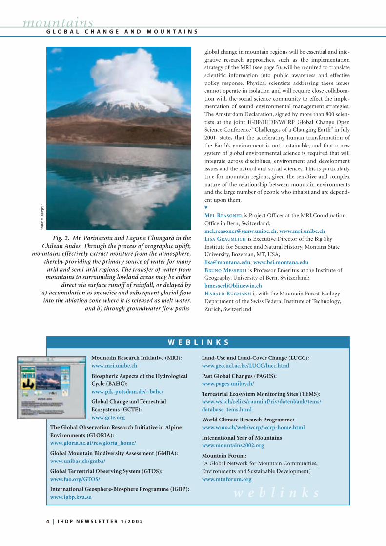
Fig. 2. Mt. Parinacota and Laguna Chungará in the Chilean Andes. Through the process of orographic uplift,
mountains effectively extract moisture from the atmosphere,thereby providing the primary source of water for many
arid and semi-arid regions. The transfer of water frommountains to surrounding lowland areas may be either
direct via surface runoff of rainfall, or delayed by a) accumulation as snow/ice and subsequent glacial flowinto the ablation zone where it is released as melt water,
and b) through groundwater flow paths.
Phot
o:M
.Gro
sjea
n
W E B L I N K S
Mountain Research Initiative (MRI):www.mri.unibe.ch
Biospheric Aspects of the HydrologicalCycle (BAHC):www.pik-potsdam.de/~bahc/
Global Change and TerrestrialEcosystems (GCTE):www.gcte.org
The Global Observation Research Initiative in AlpineEnvironments (GLORIA):www.gloria.ac.at/res/gloria_home/
Global Mountain Biodiversity Assessment (GMBA):www.unibas.ch/gmba/
Global Terrestrial Observing System (GTOS):www.fao.org/GTOS/
International Geosphere-Biosphere Programme (IGBP):www.igbp.kva.se
Land-Use and Land-Cover Change (LUCC):www.geo.ucl.ac.be/LUCC/lucc.html
Past Global Changes (PAGES):www.pages.unibe.ch/
Terrestrial Ecosystem Monitoring Sites (TEMS):www.wsl.ch/relics/rauminf/riv/datenbank/tems/database_tems.html
World Climate Research Programme:www.wmo.ch/web/wcrp/wcrp-home.html
International Year of Mountainswww.mountains2002.org
Mountain Forum:(A Global Network for Mountain Communities,
Environments and Sustainable Development)
www.mtnforum.org
w e b l i n k s
➤

ACTIVITY 1: Long-term monitoringand analysis of indicators of environ-mental change in mountain regionsThis element of the Initiative will focus on
mountain-specific indicators of environ-
mental change, which are sensitive to
changes in climate, atmospheric chem-
istry, radiation, and land use/land cover. A
set of four mountain-specific indicator
groups is considered:
1.1) Cryospheric indicators related to
snow conditions, glaciers, permafrost and
solifluction processes;
1.2) Terrestrial ecosystems, particularly
mountain plant communities and soils;
1.3) Freshwater ecosystems, in particular
high mountain streams and lakes;
1.4) Watershed hydrology, i.e. water bal-
ance components of high mountain
watersheds/headwater basins.
ACTIVITY 2: Integrated model-based studies of environ-mental change in different mountain regions
To achieve the overall goals of the Initiative, it is necessary
to develop a framework that permits the analysis and predic-
tion of hydrological and ecological characteristics and their
linkages with land use and climate at various spatial and tem-
poral scales. Accordingly, this Activity is organized around
the following:
2.1) Development of coupled ecological, hydrological and
land-use models for the simulation of land cover and land
surface processes in complex mountain landscapes;
2.2) Development of regional scale atmospheric models for
mountain regions;
2.3) Integrated analysis of environmental change in moun-
tain regions by means of fully coupled land-atmosphere
models or by qualitative assessments;
2.4) Regional scale mountain land experiment to support
the development, application and validation of the above
models.
ACTIVITY 3: Process studies along altitudinal gradientsand in associated headwater basins
Ecological and hydrological field studies and experiments
along altitudinal gradients and at sensitive sites can provide
invaluable data on potential responses of mountain ecosys-
tems to anthropogenically induced environmental change.
Research themes to be addressed within
this Activity include:
3.1) Development of indicators of
mountain ecosystem response to envi-
ronmental forcing factors to facilitate
process-related interpretation of histor-
ical and paleorecords;
3.2) Assessment of runoff generation
and flow path dynamics on steep hill
slopes and in headwater catchments;
3.3) The relationship between diversity
and ecosystem function, taking advan-
tage of the strong changes of diversity
along altitudinal gradients.
ACTIVITY 4: : Sustainable land use and natural resourcesmanagement
The overall objective of this Initiative is to evaluate and
enhance sustainable land, water, and resource management
strategies for mountain regions. Three priority areas are sug-
gested for assessment:
4.1) Changes in forest resources, with potential implications
for agriculture, rates of erosion and magnitude of floods,
and biodiversity;
4.2) Intensification and/or extensification of agriculture
(including grazing), with potential implications for food
security, rates of erosion and magnitude of floods, and bio-
diversity;
4.3) Changes in water resources due to factors such as
changing agricultural practices, increasing temporary or
permanent population, and/or increasing energy generation,
with implications for downstream water sup-
ply, energy availability, flooding, and sediment
transfer.
THE MRI IMPLEMENTATION PLAN has been
published in the Global Change Report Series
(IGBP Report 49, GTOS Report 28, IHDP
Report 13) and can be ordered free of charge
from the MRI Coordination Office, Bärenplatz
3, CH-3011 Bern, Switzerland, or downloaded
from www.mri.unibe.ch
M R I I M P L E M E N T A T I O N P L A Nmountains
MRI’S IMPLEMENTATION PLAN
➤
The ultimate objectives of the Mountain Research Initiative (MRI) are: a) to develop a strategy for detecting signals of
global environmental change in mountain environments; b) to define the consequences of global environmental change
for mountain regions as well as lowland systems dependent on mountain resources; and c) to make proposals towards
sustainable land, water and resource management for mountain regions at local to regional scales. To achieve the above
objectives, the research under the MRI is structured around four Activities, each of which is divided into a small number
of specific tasks.
Chinese Character for ”Mountains”
I H D P N E W S L E T T E R 1 / 2 0 0 2 | 5

➤ Lisa J. Graumlich is a leading figure in the MountainResearch Initiative (MRI). She is Executive Director of theBig Sky Institute for Science and Natural History atMontana State University, USA, and a member of theScientific Steering Committee of the IGBP/IHDP Projecton Land-Use and Land-Cover Change (LUCC).
Q: Dr. Graumlich, what is the overall objective of this ini-tiative?
The overall objective of the MRI is to evaluate and
enhance sustainable land, water and resource management
strategies for mountain regions in the context of global envi-
ronmental change. To achieve this objective, the MRI pro-
motes a high level of integration between physical, ecological,
social and economic scientists and practitioners. In essence,
we take advantage of our focus on mountain regions to cre-
ate links between the monitoring of, first, physical and bio-
logical processes; second, the modelling of critical human,
watershed and ecosystem processes; and third, the overall
sustainability of mountain resource systems. The MRI seeks
to assess current resource use strategies and develop alterna-
tive strategies that take into account the myriad ways in
which global change can alter the viability of traditional or
local resource management strategies.
Q: Millions of people all over the world spend their holidaysor recreational time in mountains. What are the impacts ofactivities such as winter and summer sports on mountainregions and mountain communities?
Mountains have always been a magnet to people in search
of adventure or the solace of wilderness. A consequence of
our improved transportation systems and increased spending
on recreation is that mountains, once a refuge for the very
hardy or the very wealthy, are now accessible to a large and
diverse array of tourists. The infrastructure to support
tourism, such as the construction of roads and the rapid
expansion of towns and villages, has a far greater impact on
mountain environments than the actual activity of the
tourists, for example skiing or camping. The expansion of
tourism often changes the traditional economic base from
subsistence activities or resource extraction activities to a
variety of service functions. In some regions, the rise of ‘eco-
tourism’ as an economic engine has had profound impacts on
the perceived value of biodiversity or forested watersheds.
Q: The MRI is structured around several activities; one ofthem addresses sustainable land use and natural resourcemanagement, including forests, agriculture and water. Let’sturn to the first one: forest resources.
The inaccessibility of mountains has meant that they are
often regions where deforestation has had relatively minor
impacts. However, increasingly mountain forests are chang-
ing in extent and composition under the combined influence
of climate change and regional management strategies. The
trajectory of change in montane forests is complicated. In
some regions, abandonment of marginal agricultural land
and/or 20th century suppression of fires have resulted in a
substantial expansion of forests. In other regions, increased
access and intensification of resource extraction have result-
ed in significant forest loss. In all cases, changes in forest
cover affects watershed processes, patterns of biodiversity,
and terrestrial carbon storage. The MRI seeks to understand
the consequences of changes in montane forests for a suite of
linked issues including sustainable harvesting techniques,
non-timber forest products, tourism, watershed protection,
conservation of biodiversity and carbon sequestration.
Q: Agricultural systems in mountains are often perceived asparticularly vulnerable to global change. Why is that so?
Mountain agriculture is a marvel of adaptation to a series
of challenges including short growing seasons, low soil fertil-
ity, limited accessibility and high cost of transport, and a lim-
ited opportunity for production gains associated with
increasing the scale of production. Clearly, warming temper-
atures and increasing carbon dioxide will increase productiv-
ity of many high elevation cropping systems. The focus of the
MRI is to place such changes into the context of increasing
intensification of agriculture in mountains and its implica-
tions for local food security. Such an analysis will require a
full understanding of the diverse interactions between cli-
mate and food production as well as the way in which factors,
such as access to irrigation or indigenous soil and water prac-
I N T E R V I E W
6 | I H D P N E W S L E T T E R 1 / 2 0 0 2
mountains
Three international global environmental change
programmes – IHDP, the International Geosphere-
Biosphere Programme (IGBP) and the Global
Terrestrial Observing System (GTOS) – have joined
forces to endorse an initiative that addresses areas
where the impacts of the rapidly changing global
environment are experienced particularly strongly:
mountain regions.
THE MOUNTAIN RESEARCH INITIATIVE
Phot
o:L.
Grau
mlic
h
I H D P N E W S L E T T E R 1 / 2 0 0 2 | 7
mountains
➤ More than 4.500 km in length, Chile is the longest coun-try in South America. It is dominated by the Andes Moun-
tains, which span arid subtropical, semi-arid Mediterranean,
temperate and subpolar climates. It is one of the most
dynamic and successfully emerging economies in the region.
The Atacama Desert, one of the driest places in the world,
and the Puna de Atacama, where rainfall is irregular and
scarce, are located in northern Chile (Fig. 1). Due to high
evaporation and low runoff, most of the streams that origi-
nate in the Andean source region disappear before they reach
the sea. In the inland core of the Atacama Desert, absolute
aridity and lack of runoff necessitate that water must be pro-
vided from underground sources. Important water bodies
are located in the surrounding highlands. Although indige-
nous people have occupied these areas for 10,000 years, the
previous lack of economic activity has allowed the installa-
tion of several nature conservation areas.
As a consequence of higher winter rainfall and snow accu-
mulation in the semi-arid region, several rivers connect the
Andes summits with the Pacific Ocean (Fig. 2). Along the
slopes and river floodplains, agricultural communities and
settlements have developed. These communities employ both
irrigated and non-irrigated traditional methods and take
advantage of high solar radiation.
Northern Chile is highly dependent upon the Andean
lowland-highlands spatial interactions. Without the support
of the Andean highland water towers that sustain glaciers,
salars, lakes, lagoons, wetlands and underground aquifers,
the survival of communities in this part of the country would
not be possible.
Recently mining operations in and around the Atacama
Desert have significantly added to the Chilean economy.
During the last twenty years, Chile increased its GNP almost
threefold. This opened its small economy, for nearly 14 mil-
lion inhabitants, to direct foreign capital investment, which
has been devoted mainly to an intensive outward-oriented
production of minerals and agricultural and forest products.
The resources are exclusively located in the mountain areas.
Chile’s per capita income is one of the highest in Latin
America. Poverty has been reduced to less than 20%, and the
country has been ranked highest of the developing countries
in the UN Human Development Index. Even during the 1998
Asian crisis and the subsequent recession, its annual eco-
nomic growth rate remained over 3 percent.
However, rapid economic and social growth does not nec-
essarily mean sustainable development for northern Chile.
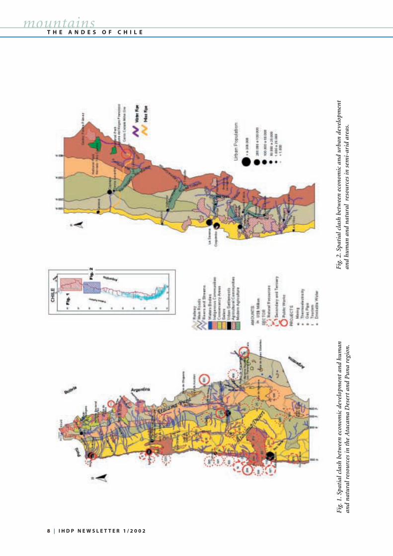
Fig. 1 shows the clash between high and lowland goals, eco-
nomic activities, and human and natural resources in and
THE ANDES OF CHILE:
CLASH BETWEEN ECONOMIC AND SUSTAINABLE
DEVELOPMENT
T H E A N D E S O F C H I L E
Chile is the longest country in South America and has one of the most successful emerging economies
in the region. However, rapid economic and social growth impact on its sustainable development. This
article investigates the clash between economic development and the use of human and natural
resources in northern Chile. | BY HUGO I. ROMERO
tices, may make production systems more or less vulnerable
to climatic variation.
Q: The 1998 Mountain Agenda refers to mountain regionsas “water towers for the 21st century”, as more than half ofthe world’s population relies on fresh water from mountainregions. What research is planned in this area?
Assessing the sustainability of water resources requires
integrated analyses of trends in supplies as well as demands.
The MRI hopes to integrate the work of other IGBP projects
on climate impacts on the hydrologic system with assess-
ments of the potential ways in which increasing population
and consumption may increase demands above levels of sup-
ply. The MRI also seeks to integrate our understanding of
how land-use and land-cover change may alter not only the
quantity of water but also the quality and/or timing of water
flow, which in turn has implications for such hazards as
floods.
Q: This Initiative is of specific interest to IHDP. What par-ticular links have been identified?
At present, the strongest link between the MRI and IHDP
is through the LUCC1 Core Project. Embedded within the
MRI science plans are several research strategies that derive
from the progress that has been made over the past decade in
the LUCC community, ranging from remote sensing tools to
integrated modelling strategies. The MRI Scientific Steering
Committee is also interested in strengthening the links with
the other IHDP Core Projects. In particular, the work of the
IDGEC2 group offers opportunities for collaboration on the
relative effectiveness of different institutional arrangements
in fostering sustainable natural resource management in
mountain regions. Similarly, we hope to form a stronger tie
to GECHS3 researchers, especially in terms of evaluating the
many factors affecting food security in mountain regions.
INTERVIEW BY ELISABETH DYCK➤
1 IGBP/IHDP Project on Land-Use and Land-Cover Change | 2 IHDP Project on Institutional Dimensions of Global Environmental Change | 3 IHDP Project onGlobal Environmental Change and Human Security
8 | I H D P N E W S L E T T E R 1 / 2 0 0 2
T H E A N D E S O F C H I L Emountains
Fig.
1.Sp
atia
l cla
sh b
etw
een
eco
nom
ic d
evel
opm
ent
and
hum
anan
d n
atu
ral r
esou
rces
in t
he A
taca
ma
Des
ert
and
Pu
na
regi
on.
Fig.
2.Sp
atia
l cla
sh b
etw
een
eco
nom
ic a
nd
urb
an d
evel
opm
ent
and
hum
an a
nd
nat
ura
l re
sou
rces
in s
emi-
arid
are
as.

I H D P N E W S L E T T E R 1 / 2 0 0 2 | 9
around the Atacama Desert and the Puna region. Some high-
lands of the Puna de Atacama, located above 3000 m eleva-
tion, are natural conservation areas, such as national parks,
natural reserves and specific sites to conserve flora and fauna.
The areas have protected ecosystems and water sources,
which feed a series of rivers and streams. They in turn are the
main water supply for lower-elevation mines, agricultural
oases and the increasing population of urban settlements
along the coast, e.g. Arica, Iquique, Tocopilla, and Anto-
fagasta.
Historically, herders and farmers from local indigenous
peoples (aymaras and atacameños) have occupied the high-
lands, using grasslands and small oases located around the
conservation areas. Their sustainable cultural-natural system
is now severely threatened by increasing water demands of
the lowland regions. In recent decades, transnational compa-
nies (Canada, USA, UK, South Africa, Luxembourg, Finland,
Australia, Japan, etc.) and national private and public com-
panies have invested a billion dollars in mining, energy, and
transport, such as in roads, railways, harbours, water and
mineral pipes, industries, and goods and services produced
in nearby cities. Today Chile supplies nearly 43% of the glob-
al demand for copper with an annual production of 4.5 mil-
lion tons.
This economic development threatens the sustainability
of both human and natural resources of the Andean water
towers. A new policy is needed to save the environmental
resources of this region that will require the participation of
the public and private sectors. A new transboundary organi-
sation, able to bridge the Argentinean, Bolivian and Chilean
Andes, becomes a real necessity.
In the semi-arid Mediterranean areas of Chile (Fig. 2), the
location of mines, traditional agricultural communities,
modern agricultural and trade companies, and urbanisation
is the main source of spatial and environmental conflict. The
Aldabarán gold mining project in the Copiapo valley by the
Canadian Cerro Casale company is an example of this high-
land-lowland clash. The project represents an investment of
US$ 1,430 million to put into production substantial gold
and copper reserves, offering 4,000 jobs during a project
lifespan of 18 years. A freshwater source is required for min-
eral production and transportation from Piedra Pomez. This
area is the recharge region for two national parks, Nevado
Tres Cruces and Laguna del Negro Francisco. Downstream,
11,700 ha of grasslands have been used traditionally by
“Kollas”, an indigenous community descendent from the
Titikaka´s Tiwanaku Empire, which has occupied the
Jorquera river tributary since the 19th century. Local commu-
nities have joined urban inhabitants of Copiapo city and
modern farmers, who produce and export table grapes for
American and European markets, to protect the supply and
quality of water from mineral pollution and shortages. The
mean annual rainfall in the Copiapo valley is less than 30
mm. Consequently, everything depends again upon the
Andes Mountain water towers.
Another tension between highland and lowland develop-
ment processes can be observed along the narrow valleys and
slopes of the Huasco, Elqui and Limari valleys (Fig. 2). There
are conflicting interests in this area between traditional agri-
cultural communities and modern farmers associated with
national and international fruit companies. Traditional com-
munities have occupied these areas since colonial times
because of an increase in winter rainfall. They have linked
highlands and lowlands by using the slopes for rainfed agri-
culture and livestock production and by irrigating crops
along the floodplains. Transhumance has been one of the
main adaptations to exploit the diverse ecological belts.
Modern outward-oriented agriculturists have purchased
most of the water rights, thereby forcing local communities
to emigrate. Once again, the price of economic success seems
to include social disturbance and degradation of the natural
environment.
HUGO I. ROMERO is Director of the Post-Graduate School
at the Department of Geography, University of Chile,
Santiago, Chile; [email protected]; www.uchile.cl
T H E A N D E S O F C H I L Emountains
➤
BY DEBRA MEYER WEFERING
➤ IHDP has recognized an increasing interest and need in
building a strong human dimensions network in Central and
Eastern Europe and Newly Independent Countries. In collab-
oration with the Center for Integrated Regional Assessment
(CIRA) and the Global Change System for Analysis, Research
and Training (START), IHDP has taken the initiative for
increased capacity building and international networking in
Central and Eastern Europe.
The SCENIC Initiative (Global Change Science in Central
and Eastern Europe and Newly Independent Countries) brings
together researchers to identify key issues of concern and the
next generation of leadership in research on the human
dimensions of global environmental change. Social scientists
from all fields are looking at ways to implement IHDP activi-
ties in the region, sharing initiatives from their countries and
building linkages for investigation of common issues. Key con-
cepts currently discussed include transition, adaptation, vulner-
ability, integrated assessment, and networking.
An electronic discussion group has been set up for SCENIC
to serve as a discussion forum and networking organisation in
bringing together HD researchers. Outputs of the group will
include the formulation of a focused research agenda for
SCENIC, development of formal proposals for research fund-
ing, joint publications, partnerships and collaborative proj-
ects, as well as regular workshops within the region.
Those interested in participating in future SCENIC
discussions should contact Debra Meyer Wefering at the
IHDP Secretariat ([email protected] or
+49 (0)228 734956); she is an International Science Project
Co-ordinator and responsible for IHDP activities within Central
and Eastern Europe at the IHDP Secretariat.
SCENIC: A NEW INITIATIVE FOR CENTRAL AND EASTERN EUROPE
➤
A L T A I M O U N T A I N K N O Tmountains
➤ In 1996 China [1] announced an ambitious developmentproject for the East-Central-Asian Economic Zone, incorpo-
rating China’s Xinjiang-Uygur Autonomous Region, regions
of Western Siberia (Russia), Eastern Kazakhstan and North
Western Mongolia. According to Chinese scientists, this
Asian region is expected to represent a world centre of eco-
nomic activity and development in the mid-21st century. The
railway transportation corridor, “the Great Eurasian Conti-
nental Bridge”, will represent the spine of this region. It will
connect to the Trans-Siberian railway in the North and to the
Silk Road in its new “railway” embodiment. The route will
traverse the transfrontier remote highlands of Central Altai,
the “ancient crown of Asia”, and will significantly change
local environments and the life of local people.
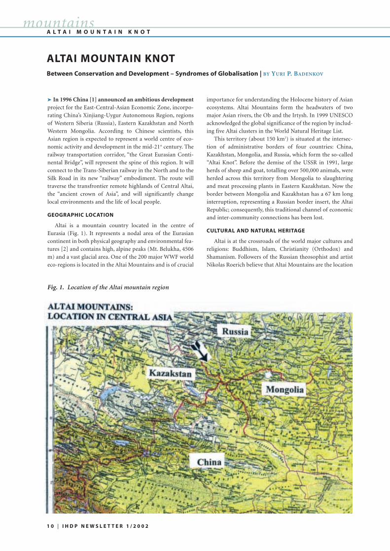
GEOGRAPHIC LOCATION
Altai is a mountain country located in the centre of
Eurasia (Fig. 1). It represents a nodal area of the Eurasian
continent in both physical geography and environmental fea-
tures [2] and contains high, alpine peaks (Mt. Belukha, 4506
m) and a vast glacial area. One of the 200 major WWF world
eco-regions is located in the Altai Mountains and is of crucial
importance for understanding the Holocene history of Asian
ecosystems. Altai Mountains form the headwaters of two
major Asian rivers, the Ob and the Irtysh. In 1999 UNESCO
acknowledged the global significance of the region by includ-
ing five Altai clusters in the World Natural Heritage List.
This territory (about 150 km2) is situated at the intersec-
tion of administrative borders of four countries: China,
Kazakhstan, Mongolia, and Russia, which form the so-called
“Altai Knot”. Before the demise of the USSR in 1991, large
herds of sheep and goat, totalling over 500,000 animals, were
herded across this territory from Mongolia to slaughtering
and meat processing plants in Eastern Kazakhstan. Now the
border between Mongolia and Kazakhstan has a 67 km long
interruption, representing a Russian border insert, the Altai
Republic; consequently, this traditional channel of economic
and inter-community connections has been lost.
CULTURAL AND NATURAL HERITAGE
Altai is at the crossroads of the world major cultures and
religions: Buddhism, Islam, Christianity (Orthodox) and
Shamanism. Followers of the Russian theosophist and artist
Nikolas Roerich believe that Altai Mountains are the location
ALTAI MOUNTAIN KNOTBetween Conservation and Development – Syndromes of Globalisation | BY YURI P. BADENKOV
Fig. 1. Location of the Altai mountain region
1 0 | I H D P N E W S L E T T E R 1 / 2 0 0 2

I H D P N E W S L E T T E R 1 / 2 0 0 2 | 1 1
mountains
of the mystical “Shambala”,
the sacred Buddhist coun-
try. The Altai region
attracted the attention of
the archaeological commu-
nity in recent decades with
the discovery of well-pre-
served 2,000-year-old
human mummies [3].
Pieces of silk cloth and
other artefacts found in
burial mounds [4] of Altai
indicate the presence of
cultural and human activi-
ties in the region during
ancient times. This leads to
an important conclusion:
nomads of the remote
mountain territories did
not live as closed isolated
communities. Rather, for long periods they were active in
trade and commerce with distant centres of lowland civilisa-
tions.
POPULATION
The Population of frontier regions is mostly represented
by traditional ethnic groups of semi-nomadic stockbreeders:
Kazakhs, Altais (Telenghets), Tuvins, Dyurbets and Uygurs
(Table 1). Some regions of Russia, Kazakhstan and China
have Russian populations, which migrated to the region in
the early and middle 19th century, fleeing religious persecu-
tion, and in search of the legendary belovodye (white
waters), the area of abundant resources that promised a life
of happiness and honesty. Many of these immigrants, star-
overs, held on to traditional orthodox beliefs and followed
strict behavioural patterns. In Altai, their settlement areas
were associated with mountain-forest ecosystems (Ust-Koksa
Region, Table 1).
The remote setting
and severe climate deter-
mine social conditions in
which the nomadic
stockbreeders live; the
Ukok Plateau has regis-
tered an absolute mini-
mum winter tempera-
ture of minus 60o C.
Kazakh shepherds live in
traditional yurta, or in
primitive cabins, which
lack even basic ameni-
ties. Hence, low life
expectancy, vitamin defi-
ciency, and diseases are
common.
Throughout the
region, the most pressing
issues are those typical
for the majority of the world mountain regions: poverty,
unemployment and outmigration. Many settlements and
campsites are without electricity and communication facili-
ties and are cut off from the rest of the world during winter.
Mountain frontier regions are marginal in two ways: 1) they
are located at the periphery of their states (except
Kazakhstan), and 2) they are socially and economically mar-
ginal, because they are the poorest among neighbouring
regions.
High biological, ecosystem and ethnic-cultural diversity
exists in these frontier regions. Many rare species, such as the
snow leopard, which attracts numerous environmental ini-
tiatives and the development of eco-tourism, are still to be
found. The challenge is to integrate regional economic and
social development projects and conservation of biological
diversity across the region. Strategies for sustainable devel-
opment and biodiversity conservation have been developed
at national levels, but are lacking the regional transboundary
Family of Kazakh shepherds near a seasonal cabin inJumaly Valley, Altai
A L T A I M O U N T A I N K N O T
Table 1. Population of frontier Altai regions
Kazakhstan
Kazakhstan
China
China
Mongolia
Russia
Russia
Katon-Karagai
Kurchum
Buerzsyan
Habahe
Bayan-Ulghi
Kosh-Agach
Ust-Koksa
13,200
22,200
10,400
8,400
46,000
19,800
12,900
48,300
51,600
56,000
64,000
74,500
16,600
18,300
Kazakhs, Russians
Kazakhs , Russians
Kazakhs , Hans, Uygurs, Mongols
Kazakhs, Hans, Hueiszi (Muslims)
Kazakhs, Tuvins, Mongols, Uryankhais
Kazakhs, Altais, Russians
Russians, Altais
COUNTRY ADMIN. UNIT AREAIN KM2
POPULATION ETHNIC GROUPS
Phot
o:Yu
.Bad
enko
v
perspective. Bilateral relations do not meet the needs of co-
operation at the international and the intercommunity level.
In 1998, the International Conference on “Strategic
Considerations on the Development of Central Asia” held in
Urumqi, Xinjiang, passed the “Altai Declaration (Protocol of
Intentions)”, which raised the issue of transboundary co-
operation concerning biodiversity conservation and sustain-
able development [5]. The Conference proposed the develop-
ment of the “Altai Convention on Regional Co-operation”
[6], including a proposal to create the “Transboundary
Biosphere Territory Altai”, comprising frontier territories of
four countries and protected territories within them. This
would form the frame territory, thereby meeting the princi-
ples of the Biosphere Reserves UNESCO/MAB Seville strate-
gy. The key objective of creating this international structure
is to establish legal and institutional mechanisms that inte-
grate interests of various stakeholders in the conservation of
biological diversity and in economic and regional develop-
ment.
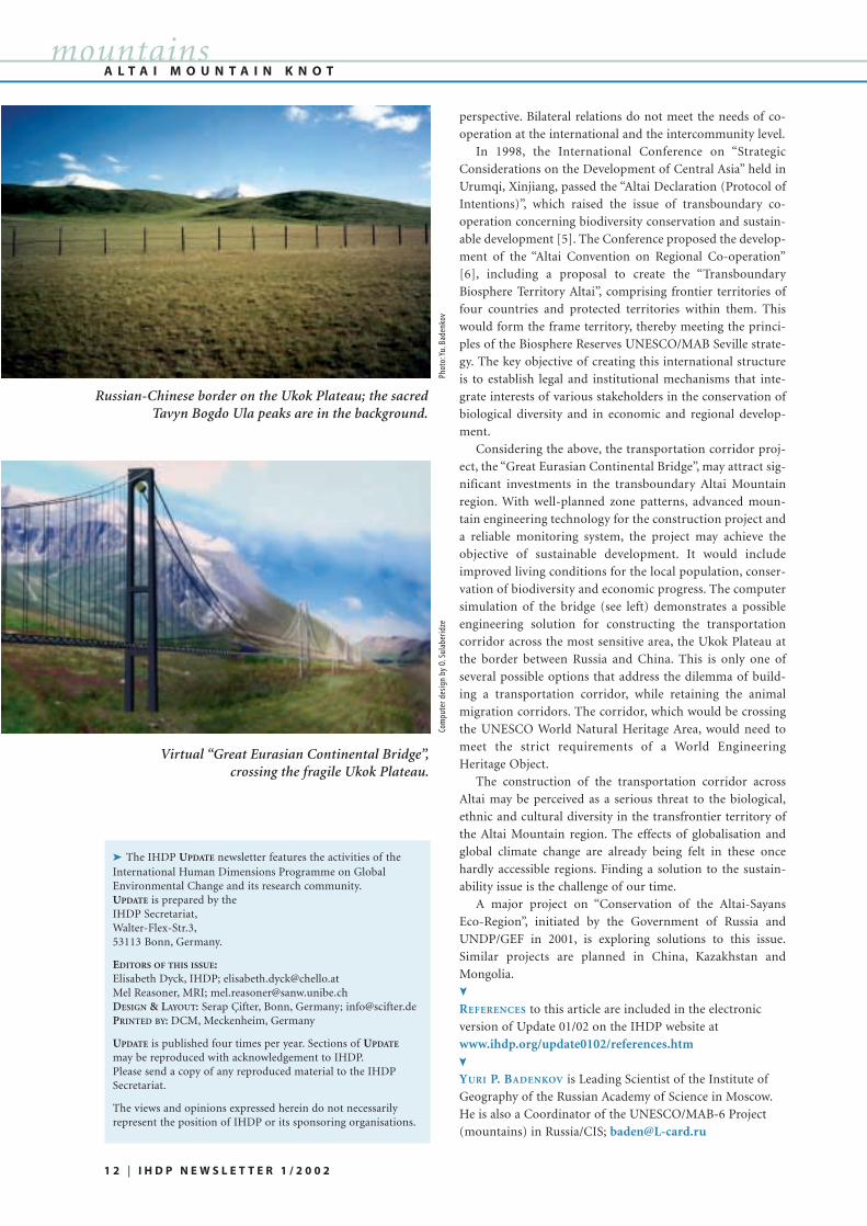
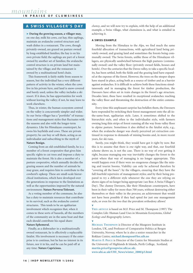
Considering the above, the transportation corridor proj-
ect, the “Great Eurasian Continental Bridge”, may attract sig-
nificant investments in the transboundary Altai Mountain
region. With well-planned zone patterns, advanced moun-
tain engineering technology for the construction project and
a reliable monitoring system, the project may achieve the
objective of sustainable development. It would include
improved living conditions for the local population, conser-
vation of biodiversity and economic progress. The computer
simulation of the bridge (see left) demonstrates a possible
engineering solution for constructing the transportation
corridor across the most sensitive area, the Ukok Plateau at
the border between Russia and China. This is only one of
several possible options that address the dilemma of build-
ing a transportation corridor, while retaining the animal
migration corridors. The corridor, which would be crossing
the UNESCO World Natural Heritage Area, would need to
meet the strict requirements of a World Engineering
Heritage Object.
The construction of the transportation corridor across
Altai may be perceived as a serious threat to the biological,
ethnic and cultural diversity in the transfrontier territory of
the Altai Mountain region. The effects of globalisation and
global climate change are already being felt in these once
hardly accessible regions. Finding a solution to the sustain-
ability issue is the challenge of our time.
A major project on “Conservation of the Altai-Sayans
Eco-Region”, initiated by the Government of Russia and
UNDP/GEF in 2001, is exploring solutions to this issue.
Similar projects are planned in China, Kazakhstan and
Mongolia.
REFERENCES to this article are included in the electronic
version of Update 01/02 on the IHDP website at
www.ihdp.org/update0102/references.htm
YURI P. BADENKOV is Leading Scientist of the Institute of
Geography of the Russian Academy of Science in Moscow.
He is also a Coordinator of the UNESCO/MAB-6 Project
(mountains) in Russia/CIS; [email protected]
A L T A I M O U N T A I N K N O T
1 2 | I H D P N E W S L E T T E R 1 / 2 0 0 2
mountains
Virtual “Great Eurasian Continental Bridge”,crossing the fragile Ukok Plateau.
Russian-Chinese border on the Ukok Plateau; the sacredTavyn Bogdo Ula peaks are in the background.
➤ The IHDP UPDATE newsletter features the activities of theInternational Human Dimensions Programme on GlobalEnvironmental Change and its research community.UPDATE is prepared by the IHDP Secretariat,Walter-Flex-Str.3,53113 Bonn, Germany.
EDITORS OF THIS ISSUE:Elisabeth Dyck, IHDP; [email protected] Reasoner, MRI; [email protected] & LAYOUT: Serap Çifter, Bonn, Germany; [email protected] BY: DCM, Meckenheim, Germany
UPDATE is published four times per year. Sections of UPDATE
may be reproduced with acknowledgement to IHDP.Please send a copy of any reproduced material to the IHDPSecretariat.
The views and opinions expressed herein do not necessarilyrepresent the position of IHDP or its sponsoring organisations.
➤
➤
Phot
o:Yu
.Bad
enko
vCo
mpu
ter d
esig
n by
O.S
ulab
erid
ze

R O C K Y M O U N T A I N S
I H D P N E W S L E T T E R 1 / 2 0 0 2 | 1 3
mountains
➤ The Rocky Mountains ofthe United States and Canada is
a major biogeographic region
and the source of freshwater
supplies for much of western
North America. Large tracts of
this mountain range are pro-
tected as parks and wilderness
areas in both countries. The
high-elevation alpine areas of
the Rockies have had minimal
disruption by human activities.
Yet there are threats to water
quality, natural ecosystems and
visitor enjoyment resulting from air pollution due to region-
al and global sources. The sensitivity of this region to air pol-
lution and deposition is largely due to the accumulation of
snow at high elevations and the rapid melting of seasonal
snowpacks in the spring.
Regional air pollutants of concern include visibility-
reducing particles, deposition of nitrogen and sulphur com-
pounds, and deposition of toxic air contaminants, such as
metals and organic compounds. The regional sources of air
pollutants include population centres in proximity to the
Rockies, such as Denver, Colorado, energy development and
power plants in Colorado, Utah, Wyoming, Montana, Idaho,
Alberta and British Columbia, and agricultural centres locat-
ed along the eastern margin of the Rockies. Global emissions
of air pollutants such as mercury, dioxin, pesticides and PCBs
result in deposition to high elevation areas due to the "cold
condensation" effect (that permits the distillation of volatile
chemicals as air masses are cooled while moving up in eleva-
tion).
Resources at risk from air pollution in the Rockies
include 1) the quality of water supplies for urban areas and
agriculture, 2) alpine ecosystems affected by acids and nutri-
ents, such as nitrogen, 3) fish species that can concentrate
organics and metals, making them unfit for human con-
sumption, and 4) scenic vistas degraded by particle pollution.
The connection between air pollution risk and climatechange could exacerbate effects to alpine regions of the
Rocky Mountains. The extent of snow-covered area, the ratio
of rain to snow that falls at high elevations, and the melting
of glaciers will all change the runoff patterns and water
chemistry of lakes and streams in the alpine zone. These cli-
mate changes may result in less runoff for downstream users
and may change the timing and quality of runoff needed to
preserve natural ecosystem processes, wildlife populations
and sport fisheries.
Research and long-term monitoring of both the air pol-
lution stressors and the ecosystem responses are needed to
allow resource managers to protect these important high-ele-
vation regions. One of the
most important variables
to measure is the seasonal
snowpack, both in terms of
the total snow water equiv-
alence and snow chemistry.
A network of snow sam-
pling sites is being meas-
ured annually along the
Continental Divide in the
US Rocky Mountains;
sponsors include the
National Park Service, the
US Forest Service and the
US Geological Survey. At maximum accumulation of snow-
packs in the spring, researchers visit 75 selected sites and dig
snowpits to estimate the total amount of moisture in the pack
and the chemical loading, with emphasis on sulphur and
nitrogen compounds emitted from power plants, automo-
biles and agricultural practices. Researchers in Canada have
focused their work on tracing the accumulation and runoff of
persistent organic pollutants in snowpacks and glaciers of
Alberta and British Columbia. In addition to tracking
changes in snow hydrology and chemistry both temporally
and spatially, we also need more research on the effects of air
pollution on water chemistry and biota. There is considerable
interest in the effect of air pollutants deposited at high eleva-
tions on sensitive aquatic biota such as
zooplankton, phytoplankton, fish and
amphibians.
The regulatory response to regional
and global air pollution effects on Rocky
Mountain ecosystems is complicated by
the multiple sources of air emissions and
the international dimensions of the prob-
lem. In the United States, the Environ-
mental Protection Agency and the states
are responsible for controlling sources of
air pollution. The Clean Air Act Amend-
ments of 1990 encourage the states to form
regional regulatory commissions to con-
trol air pollution from a multi-state area.
The control of metals and persistent
organic pollutants requires international
treaties, such as the recently approved
United Nations Convention on Persistent
Organic Pollutants.
KATHY A. TONNESSEN is Research Coordinator at the
National Park Service, School of Forestry of the University
of Montana, Missoula, MT, USA; [email protected];
www.forestry.umt.edu
AIR POLLUTION ISSUES IN THE ROCKY MOUNTAINSResearch and long-term monitoring of air pollution and ecosystem responses are needed to protect
these important high-elevation regions | BY KATHY A. TONNESSEN
Researcher transporting snow samples out of the back-country of Glacier National Park, Montana, USA
Researchers digging asnowpit in Glacier
National Park,Montana, USA, to
determine the watercontent and the snow
chemistry.
➤
Phot
o:K.
Tonn
esse
n
Phot
o:K.
Tonn
esse
n

➤ The classic assumption in both ecology and social scienceis that there is a one-way transition from state A to state B. In
ecology, the process of succession ensures that an initially
unstructured state of one huge niche filled with anarchic,
opportunistic and competitive organisms (the R-strategists),
is steadily transformed into a climax community: a struc-
tured and stratified arrangement of diversified niches, with
clearly defined inter-relationships between the species (the
K-strategists) that occupy them. In social science this pre-
dictable, linear and equilibrium-seeking model of change is
paralleled by a number of "grand theories" in which some
inexorable logic moves us all from mechanical to organic sol-
idarity (Durkheim), from Gemeinschaft to Gesellschaft
(Tönnies), from traditional to modern (Weber), from status
to contract (Maine), from capitalism to communism (Marx),
or, as modern theorists of institutions put it, from markets to
hierarchies (Williamson). Different "masters" may define
their A's and their B's differently, but all subscribe to a
twofold scheme and to some driving force that carries the
totality from A to B, such as rationalisation (Weber), internal
contradiction (Marx), or spiraling transaction costs
(Williamson).
These transitions, whether ecological or socio-cultural,
are all in the direction of more orderliness, more differentia-
tion, more connectedness, and more consistency, and once
they have gone as far as they can go in that direction, that is
that. In other words, these models of change end up making
change impossible. Of course something on the outside may
intervene and mess things up, thereby setting the whole thing
in motion once more. Left to themselves, these models get
ecosystems and socio-cultural systems from A to B and then
stop. Change, these models tell us, is a temporary phenome-
non.
There is clearly something less than satisfactory about
these models. They explain change by getting rid of it, and
they are increasingly incapable of making sense of what is
going on – but how can we do better? By understanding Man
and Nature as a single but complex system is our concise but
rather opaque answer: an answer we will now try to clarify by
looking at the social and ecological transactions that sustain
a Himalayan village.
ALWAYS LEARNING, NEVER GETTING IT RIGHT
Himalayan villagers parcel out their transactions with
their physical environment to four distinct solidarities, each
of which is characterised by a distinct management style.
Agricultural land, for instance, is privately owned whilst
grazing land and forests are communally owned. But grazing
land and forests do not suffer the "tragedy of the commons"
because transactions in their products are under the control
of a commons managing institution. Villagers appoint forest
guardians, erect a "social fence", a declared boundary, and
institute a system of fines, e.g. for those who allow their ani-
mals into the forest when access is forbidden.
Lacking any legal status, these commons managing
arrangements work well in the face-to-face setting of a village
and its physical resources. The transactions are regulated
within a framework that assumes that you can take only so
much from the commons, and that you can assess where the
line between so much and too much should be drawn. The
social construction inherent to this transactional realm is
that nature is bountiful within knowable limits. This, to make
a link with the ecological theories of C.S. (Buzz) Holling, is
the myth of Nature Perverse/Tolerant (Fig. 1).
Decisions on agricultural land are entirely in the hands of
individual owners, and fields can easily end up belonging to
the moneylenders. In recent years, when forests and grazing
lands have suffered degradation, villagers have responded by
shifting some of their transactions from one realm to the
other. They have allowed trees to grow on the banks between
their terraced fields, thereby reducing the pressure on the vil-
lage forest, and have switched to the stall-feeding of their ani-
mals, thereby making more efficient use of the forest and
grazing land and receiving manure. In other words, transac-
tions are parcelled out to the management styles that seem
appropriate. If circumstances change, some of those transac-
tions can be switched from one style to another.
Since they are subsistence farmers, whose aim is to
remain viable over generations, their transactions within
their local environment can be characterized as low risk, lowreward. During times when little farm work is to be done,
many villagers engage in trading expeditions or in migrant
labour in India. Trading expeditions are family-based and
family-financed, and highly speculative: high risk, highreward. So a farmer's individualized transactions, when
added together over a full year, constitute a nicely spread risk
portfolio. The attitude here is that "fortune favours the
brave"; opportunities are there for the taking. The idea of
nature is optimistic, expansive and non-punitive: NatureBenign (Fig. 1).
Social scientists in general, and institutional economists in
particular, would see these two realms as corresponding to
their classic distinction between hierarchies and markets. But
these do not exhaust the transactional repertoire of the
Himalayan villager. Some collectivised transactions do not
involve formal status distinctions, such as those between for-
est guardians and ordinary villagers that characterize the
hierarchical solidarity. Some individualized transactions are
marked by the absence of bidding and bargaining, an essen-
tial characteristic of the markets that are generated by the
individualist solidarity. The plurality, in other words, is four-
fold, not twofold.
In many parts of the Himalaya village autonomy is always
under threat, because powerful outside actors are laying
IN PRAISE OF CLUMSINESSUnderstanding Man and Nature as a single but complex system | BY MICHAEL THOMPSON
AND MARTIN F. PRICE
I N P R A I S E O F C L U M S I N E S S
1 4 | I H D P N E W S L E T T E R 1 / 2 0 0 2
mountains

claim to the forest resources that are vital to Himalayan farm-
ing systems. One very effective response to this external
threat has been the Chipko Movement. This is a grassroots
and highly egalitarian social movement, in which women,
who are largely responsible both for fodder gathering and
fuel wood collection, predominate. "Chipko" means "to
stick", and the Gandhian strategy is to physically hug the
trees, thereby preventing them from being appropriated.
More aggressive villagers actually chase the logging contrac-
tors out of the forest with their kukris (long curved knives).
As far as these threatening external transactions are con-
cerned, it is certainly not a case of "plenty more fish in the
sea", nor is there even a "safe limit" within which the com-
mercial extraction of timber would be sustainable. All exter-
nal predation is seen as catastrophic in its consequences.
Hence the spectacularly uncompromising collectivist
response of the tree-huggers, whose idea of nature is one in
which any perturbation of the present low-key regime is like-
ly to result in irreversible and dramatic collapse: NatureEphemeral (Fig. 1).
Finally, in every village there will always be people who
sneak produce from the forest, or who cannot go off on trad-
ing expeditions and manage not to be around when it's all
hands to the tree-hugging. These are the fatalists: people
whose transactions are dictated by the organisational efforts
of those who are not themselves fatalists. They live in a world
that is always doing things to them – sometimes pleasant,
sometimes unpleasant – and in which nothing that they do
seems to make much difference. "Why bother?" is their not
unreasonable response. In this world learning is not possible
and even if it were, there would be no way of benefiting from
it. The idea of nature is one in which things operate without
rhyme or reason: Nature Capricious (Fig. 1).
Completing the typology with these two solidarities –
egalitarianism and fatalism – makes some important differ-
ences. Change, in the conventional theory, is deterministic. If
you're knocked out of hierarchy you'll end up in the market,
and vice versa. But add in the other two solidarities and
change becomes indeterministic. Conventional theory treats
human systems as simple (linear, deterministic, insensitive to
initial conditions, equilibrium seeking and predictable); ours
treats them as complex (non-linear, indeterministic, sensitive
to initial conditions, far-from-equilibrium, and unpre-
dictable).
Simple systems are manageable because once we under-
stand enough about them, we can define some desirable state
of affairs – "sustainable development" is the current favourite
– and then steer the totality towards it. But this is not possi-
ble if the system is complex.
The interaction of human and natural systems, our
Himalayan village example suggests, is complex: ordered
(the four forms of social solidarity and their associated
styles of management spring eternal) but unpredictable (the
failure of any one of these styles inevitably results in the
success of one of the other three, but there is no way of
knowing which of those three it will be). If the system was
simple, you could write the relevant differential equations
and solve them for equilibrium conditions, but you cannot
do this with complex systems, because there are no equilib-
ria in them!
Treating what is in fact a complex system as a simple one
– by ignoring at least two of the solidarities, and then using
that model as a management guide – is therefore a recipe for
disaster or, at the very least, for surprises. Just because con-
ventional modelling is not the way to go, it does not follow
that there is nothing useful we can do. We can make ourselves
I N P R A I S E O F C L U M S I N E S S
I H D P N E W S L E T T E R 1 / 2 0 0 2 | 1 5
mountains
N AT U R E C A P R I C I O U SN AT U R E P E R V E R S E /
TO L E R A N T
N AT U R E B E N I G N N AT U R E E P H E M E R A L
H U M A N S’ I N T E R AC T I O N S W I T H T H E I R E N V I R O N M E N T
I N D I V I D UA L I S E D
R E S O U R C E S
CO L L E C T I V I S E D
R E S O U R C E S
HU
MA
NS
’IN
TE
RA
CT
ION
S W
ITH
O
NE
AN
OT
HE
R
SY
MM
ET
RIC
AL
TR
AN
SA
CT
ION
S
AS
YM
ME
TR
ICA
L
TR
AN
SA
CT
ION
S
Fig 1. The Myths of Nature and their associated ways of organizing. These pictures represent the cultural (ieimplicit and largely unquestioned) assumptions that underlie different management strategies. Nature Benign jus-tifies an individualistic laissez-faire approach. Nature Ephemeral, which states that the world is an unforgivingplace, requires us to ‘treat lightly on the Earth’: the egalitarian precautionary principle. Nature Perverse/Tolerantdirects us towards hierarchical approaches of statutory regulation and sustainable development. Finally, NatureCapricious highlights the good sense of fatalists: of not wasting time and money on things about we can do nothing.
clumsy, and we will now try to explain, with the help of an additional
example, a Swiss village, what clumsiness is, and what is entailed in
achieving it.
A SWISS EXAMPLE
Moving from the Himalaya to the Alps, we find much the same
fourfold allocation of transactions, with agricultural land being pri-
vately owned, and grazing land and sometimes the forests being com-
munally owned. The Swiss forests, unlike those of the Himalayan vil-
lagers, are physically sandwiched between the high pastures (commu-
nally owned) and the valley floor (privately owned fields, houses and
hotels). Over the centuries that the Davos valley, to take a specific local-
ity, has been settled, both the fields and the grazing land have expand-
ed at the expense of the forest. However, the trees on the steeper slopes
have stayed in place, acting both as a source of timber and as a barrier
against avalanches. It is difficult to achieve both these functions simul-
taneously and in managing the forest for timber production, the
Davosers have often set in train changes in the forest's age structure.
Decades later, these have resulted in exceptional avalanches reaching
the valley floor and threatening the destruction of the entire commu-
nity.
Every time this unpleasant surprise has befallen them, the Davosers
have responded by switching their forest management onto the all-in-
the-same-boat, egalitarian style. Later, it sometimes shifted to the
hierarchist style, and often to the individualist style, with farmers
owning long thin strips of forest running all the way from valley floor
to alpine pasture. Sometimes it also shifted to the fatalist style, e.g.,
when the avalanche danger was clearly perceived yet extraction con-
tinued in response to demands of mining booms and, in more recent
years, for ski runs.
Surely, you might think, they would have got it right by now. But
this is to assume that there is one right way, and that, our fourfold
scheme shows us, is not the case. There is no way of ever getting it
right, because managing one way inevitably changes the forest to the
point where that way of managing is no longer appropriate. This
would happen even if there were no exogenous changes like the min-
ing and tourist booms. Viability can only be achieved therefore by
“covering all the bases”: by the villagers, ensuring that they have the
full fourfold repertoire of management styles; and by their being pre-
pared to try a different style whenever the one they are relying on
shows signs of no longer being appropriate (see Box: A Swiss Villager's
Day). The clumsy Davosers, like their Himalayan counterparts, have
been in their valley for more than 700 years, without destroying either
themselves or their valley in the process; an achievement that would
not have been possible if they had opted for just one management
style, or even for the two that the prevalent orthodoxy allows!
THIS ARTICLE is based on M.F. Price and M. Thompson (1997) The
Complex Life: Human Land Uses in Mountain Ecosystems, Global
Ecology and Biogeography Letters.
MICHAEL THOMPSON is Director of the Musgrave Institute in
London, UK, und Professor of Comparative Politics at Bergen
University, Norway, where he is also a senior researcher in the
Rokkan Centre; [email protected] F. PRICE is Director of the Centre for Mountain Studies at
the University of Highlands & Islands, Perth College, Scotland;
www.uhi.ac.uk/UHI_News/winter_2000/p3.html
I N P R A I S E O F C L U M S I N E S Smountains
A S W I S S V I L L A G E R ’ S D AY
➤ During the growing season, a villager may,on one day, milk his cows, cut hay, thin saplings,
maintain an avalanche control structure and
wash dishes in a restaurant. The cows, though
privately-owned, are grazed on pasture owned
by long-established families; the hay is on his
own private field; the saplings are part of a forest
owned by another set of families; the avalanche
control structure is on private land but main-
tained by the village; and the restaurant is
owned by a multinational hotel chain.
This framework is fairly stable from season to
season, but the individual has a very different
pattern of activity in the winter, when the cows
live in his private byre, and land is snow-covered
and barely used, unless the valley includes a ski
resort. If it does, he has opportunities for work
without leaving the valley; if not, he may leave to
work elsewhere.
Thus, in winter, the human ecosystem centred
on the valley is concurrently simpler and wider.
So our Swiss villager has a “portfolio” of transac-
tions and management styles that fluctuates with
the seasons and also with the longer-term
dynamics. Like his Himalayan counterpart, he
owns his hayfields and cows. These are private
property; he can buy or sell them, acting as an
individualist and subscribing to the myth of
Nature Benign.Coming from an old-established family, he is a
member of a forest cooperative that gives him
specific rights to cut trees and imposes a duty to
maintain the forest. He is also a member of a
pasture cooperative, which annually decides the
grazing season and the number of animals he
may graze, and requires him to contribute to the
cowherd’s upkeep. These are small-scale hierar-
chical institutions, which have developed over
the generations in response to the limitations as
well as the opportunities imposed by the natural
environment: Nature Perverse/Tolerant.As a voting member of the commune, he also
has a duty to maintain resources that contribute
to its survival, such as the avalanche control
structures. This tends to be an egalitarian
involvement which recognizes that, when it
comes to these sorts of hazards, all the members
of the community are in the same boat and that
each should contribute his equal share:
Nature Ephemeral.Finally, as a dishwasher in a multinationally
owned restaurant, he is effectively a replaceable
fatalist. His involvement is necessary if the enter-
prise is to continue, but he has no interest in its
future, nor it in his, and he can be paid off at
any time: Nature Capricious.
1 6 | I H D P N E W S L E T T E R 1 / 2 0 0 2
➤
➤

➤ Next time you gaze over a worldatlas, run your finger from Southeast
Asia to the South Pacific. Midway along
this line and just south of the equator is
the nation of Papua New Guinea
(PNG). If your atlas shows altitude,
then you’ll notice the dominance of an
unusually high mountain range. With
numerous peaks over 4000 meters and
an equatorial glacier in nearby Irian
Jaya, this is the second highest moun-
tain range in the Southern hemisphere
after the Andes. Commonly referred to
as the highlands of PNG, the area is also
one of the cradles of human-environ-
ment relationships with several thou-
sand years of human settlement, cultur-
al development and agricultural inno-
vation.
Today, there are over two million
people living in the highland valleys. The
majority are semi-subsistence farmers
who survive on garden produce such as
sweet potato. Most people are very poor.
Sales of Arabica coffee and fresh food
earn an average of 50 Kina (15 US dollars) per person per
year. Health, education and information services are limited
and infrastructure has been in gradual decay since PNG
gained independence in 1975. The population has doubled
over the same period, leading to rapid agricultural intensifi-
cation and environmental degradation in many areas. The
problems continue. Increased tribal fighting, a decline in law
and order, land tenure disputes, political corruption and
administrative incompetence offer grim prospects for the
future. The highlands of PNG remain an important hotspot
for international assistance.
A five-year research project funded by the Australian
Agency for International Development and the Australian
Centre for International Agricultural Research has recently
developed methods that analyse a range of human-environ-
ment relationships throughout PNG. The research builds on
three nationwide field surveys – one of land use practices and
population, one of environmental resources and one of child
malnutrition. By combining selected data from these three
surveys, the project developed methods to assess and map
variations in land potential, agricultural pressure on land,
cash income, access to services and child malnutrition. When
this information is aggregated, it provides a powerful picture
of human disadvantage and vulnerability. Further compar-
isons with data on population change add a useful predictive
capability.
The complexity of the work is best
demonstrated by the method to assess
agricultural pressure on land. The first
stage determines land potential through
the classification of data on annual rain-
fall, rainfall seasonality, temperature,
light, slope gradient and soil type. The
second stage modifies land potential
values according to the type of agricul-
tural practices that are used to improve
productivity. These range from low-
input practices such as natural bush fal-
lows and burning, to high-input prac-
tices such as improved fallows, legume
rotations, composting, mounding,
drainage, soil-retention barriers and
tillage. The third stage determines agri-
cultural intensity according to the num-
ber of crops planted and the length of
the fallow period. The final stage identi-
fies mismatches between modified land
potential and agricultural intensity.
Areas with strong agricultural pressure
are those where very high intensity agri-
culture is practised on low potential
land, leading to various forms of environmental degradation,
declining crop yields, food shortages and high levels of child
malnutrition. In the worst cases, people in such areas are fur-
ther constrained by severe poverty and thus have few oppor-
tunities to improve their livelihoods.
There is a positive side. The highlands of PNG contain
some of the most productive land in the Asia-Pacific region.
The mountain valleys are inhabited by people with a compet-
itive work-oriented outlook, and they are located on the
doorstep of major Asian population centres. This creates
many opportunities for long-term agricultural development,
should there be a combined effort to make it happen.
The results of these methods have recently been published
in the Papua New Guinea Rural Development Handbook
(http://rspas-bookshop.anu.edu.au/). The book is designed
to assist international donors and non-government organiza-
tions with the identification of issues, development of policy
and prioritisation of rural development activities. While the
information presented in the book is specific to PNG, the
methods are generic and can be applied to other countries.
LUKE HANSON is senior author of the Papua New Guinea
Rural Development Handbook and researcher at the
Australian National University’s Research School of Pacific
and Asian Studies; [email protected];
www.anu.edu.au
P A P U A N E W G U I N E A
I H D P N E W S L E T T E R 1 / 2 0 0 2 | 1 7
young scientist research
Population pressure in some high-land valleys is forcing people into
remote uninhabited areas to makegardens
PAPUA NEW GUINEA:
DISADVANTAGED COMMUNITIES IN THE HIGHLANDSAn Australian research project analyses human-environment relationships in Papua New Guinea and
paints a powerful picture of people’s disadvantage and vulnerability | BY LUKE HANSON
Foto
:L.W
.Han
son
➤
➤ The Himalaya Mountains are extremely rich in biological
and cultural diversity, inhabited by traditional societies and
faced with serious threats of environmental degradation. An
increase in population pressure on this mountain region has
contributed to major changes in land-use and land-cover pat-
terns and a rapid depletion of natural resources.
People’s participation in an ecological restoration of
degraded lands or wastelands in the Himalaya is important for
sustainable development at a local, national, regional and glob-
al level (Maikhuri et al., 1997a,b; Rao et al., 1999). Although
numerous land restoration projects have been implemented in
the Himalaya Mountains, their impacts have been modest
because of lack of appropriate technologies, policies and imple-
mentation mechanisms.
Forestry on community managed degraded lands is report-
ed to have succeeded in some parts of Nepal [1], where the pol-
icy permits economic benefits from timber. There are also
examples of local initiatives to improve tree cover without any
financial support. Such responses are likely when forest
resources are extremely scarce, and people do not want to move
away for social, cultural and political reasons. In the Indian
Central Himalaya, outmigration to urban and industrial areas
due to resource scarcity is common. In some villages 76% of the
families migrated during the last few years [2, 3].
The failure of afforestation and reforestation efforts to
develop degraded lands in the Himalaya Mountains could be
attributed largely to the igno-
rance of people’s essential
needs and hence their non-
cooperation. People’s participa-
tion is now considered as a pre-
requisite to success of any land
rehabilitation effort in the
Himalaya. A reconciliation of
the interests of local communi-
ties (immediate tangible bene-
fits) and the global concern for
the ecology and biodiversity of
the region (long-term intangi-
ble benefits) is of utmost
importance for a sustainable rehabilitation of degraded lands.
The development of agro-forestry on degraded community
lands is one way to achieve land rehabilitation. Over a period of
10 years, covering villages of the Central Himalaya Mountains
at a mid and high altitude (1200 m and 2200-2500 m), the eco-
logical restoration of degraded community and forest lands was
developed and implemented on a small scale, using plots of 6
and 8 ha. This was evaluated in terms of economic and ecolog-
ical costs and benefits and built on people’s traditional knowl-
edge.
The rehabilitation framework and strategies comprised: i) asurvey of local perception and indigenous knowledge related to
degraded forest land rehabilitation; ii) analysing people’s per-
ceptions from the perspectives of other stakeholders and their
concerns; iii) discussing these perceptions with the people and
identifying possibilities for improvement based on scientific
knowledge; iv) facilitating consensus for an enhanced rehabili-
tation framework, and its implementation monitoring.
Afforestation and restoration can succeed where scarcity of
tree-based products threatens the livelihood of local communi-
ties, or where a policy provides monetary benefits to the local
communities. In the sparsely populated high altitude villages
and areas of the Indian Himalaya, where food, fodder and fuel-
wood are not scarce, local communities are granted rights to
use forest products for subsistence. However, the policy does
not allow profits from timber trade. Introducing non-timber
forest products that provide monetary benefits over short peri-
ods of time, such as temperate bamboo and medicinal herbs,
together with locally valued multipurpose trees could be anoth-
er rehabilitation option that would be ecologically sound and
acceptable to the people [4]. Fodder, fuelwood and timber from
degraded community lands would reduce the threats of degra-
dation to existing forests, improve the livelihood of the local
communities and bring global environmental benefits.
The practice and framework we developed for degraded
land rehabilitation is now widely accepted, particularly by the
locals. It has also been accepted as a major source of inspiration
for the Forest Department, policy makers, NGOs, environ-
mentalists, village institutions
and other government depart-
ments involved in develop-
ment. More research is required
to develop and cultivate species
that are ecologically and socio-
economically appropriate to
further improve the rehabilita-
tion framework presented here.
Considering the diversity of
ecosystems, indigenous knowl-
edge, and socio-economic con-
ditions in the mountains, a
rehabilitation strategy has to be
location-specific. There is a need for developing rehabilitation
models suited to diverse sets of ecological and socio-economic
conditions in the Himalaya Mountains.
REFERENCES to this article are included in the electronic
version of Update 01/02 on the IHDP website at
www.ihdp.org/update0102/references.htm
R.K. MAIKHURI and K.S. RAO are researchers at SDRE, G.B.
Pant Institute of Himalayan Environment and
Development, UA, India; [email protected];
REHABILITATION OF DEGRADED LAND Land-use and land-cover change impacts and strategies in the Indian Himalaya Mountains
BY R.K. MAIKHURI AND K.S. RAO
I N D I A N H I M A L A Y A M O U N T A I N S
1 8 | I H D P N E W S L E T T E R 1 / 2 0 0 2
young scientist research
➤ The Indian Himalaya Mountains extend over 2800 km and areinhabited by 70 million people and 49 million livestock. Forestscover only 17.8 million ha to meet their increasing demands.Deforestation and unsustainable land use are causing extensiveland degradation, affecting about half of the region. The IndianHimalaya encompasses 59 million ha of land, of which 7.3 millionha is degraded community land, 13.5 million ha are degradedgovernment forests, and 1.2 million ha are abandoned privateagricultural lands. Remote sensing surveys indicate that closedforests cover only 11% of the country, and only 40% of the IndianCentral Himalaya is forested. Land degradation not only threatensthe biodiversity of the Himalaya, one of the global biodiversityhot spots, but also has far reaching effects on the regional/globalclimate and hydrological process.
➤
➤

GECHS SSC MEETS
IN CANADA
BY MIKE BRKLACICH AND ANN ZURBRIGG
➤ In early December 2001 the Scientific SteeringCommittee (SSC) of the IHDP Project on Global
Environmental Change and Human Security
(GECHS) met in Victoria, Canada, to set priorities for
the coming year. Most importantly, the SSC con-
firmed its commitment to proceed with several signa-
ture projects and established its endorsement guide-
lines for GECHS projects. These guidelines will be
posted on the GECHS website at www.gechs.org and
will engage GECHS in new and expanded collabora-
tive research.
Signature Projects: the SSC agreed to develop a
project proposal on “Environment and Human
Security in Russia: New Dimensions of Insecurity
During a Transition Period” into a signature project,
to explore the potential for an associated workshop in
Moscow and to pursue funding opportunities.
Briefings in Washington and Ottawa will take place in
Spring 2002. Several SSC members have been involved
in discussions and workshops on initiatives on human
security and vulnerability to global environmental
change. The development of a signature project will
focus on strengthening the conceptual framework and
exploring the potential for a workshop in late 2002 or
early 2003. Funding sources for this project were dis-
cussed and will be pursued. In addition, the GECHS
Project will collaborate with the International Peace
Research Institute (PRIO) in the development of a
signature project on the role of natural resources in
civil conflicts as part of PRIO’s proposal for a Centre
of Excellence on Civil War.
GECHS will move forward in expanding its net-
work through a variety of approaches, including
workshops and endorsement of research projects. In
addition to the workshops associated with the signa-
ture projects, an intensive workshop focusing on one
or more GECHS themes remains on the agenda but
was deferred until 2003 or 2004. With the appoint-
ment of Mike Brklacich (based at Carleton University
in Ottawa) as Chair of the GECHS-SSC, the decision
was taken to move the International Project Office to
Ottawa in mid-2002. The next SSC meeting will be
held in late October or early November 2002 in
Moscow.
MIKE BRKLACICH is Chair of the Scientific Steering
Committee of the IHDP Project on Global
Environmental Change and Human Security
(GECHS); [email protected] ZURBRIGG is Project Manager, International
Project Office of the IHDP GECHS Project;
[email protected]; www.gechs.org
IDGEC NETWORK
INITIATIVE
BY SYMA ALEXI EBBIN
➤ Over 470 individuals from 55 different countries comprise theNetwork of the IHDP Project on the Institutional Dimensions of
Global Environmental Change (IDGEC). As Executive Officer of
IDGEC I have long wondered how best to catalyze this communi-
ty to enhance this mutually beneficial relationship between
Network members and the Project.
Since I began my job with IDGEC, I have undertaken several
initiatives to facilitate these objectives. I believe, however, that
there is more that we can do to enhance the relationship between
the IDGEC Project and the Network. To this end, the International
Project Office (IPO) of IDGEC is developing an initiative to pro-
vide our Network members with more tangible benefits and at the
same time derive benefits from the Network’s substantial expertise
and cutting-edge research.
The IPO has begun to develop some ideas on how to achieve
these aims:
➤ Have competitive calls for papers for our flagship workshops.
Papers could be selected on a competitive basis for presentation
at the flagship workshops; this would include travel expenses for
the presenter(s) selected.
➤ Establish an IDGEC summer fellowship, sponsoring a summer
fellow (pre- or post-doctoral) for a few weeks/months at the IPO.
➤ Develop a summer short course on IDGEC. The short course
could include various speakers and activities and perhaps con-
clude with a publishable manuscript. Participants could be select-
ed on a competitive basis.
➤ Develop a curriculum, textbook, teaching materials, instruc-
tor's items, etc. for a university course on IDGEC that could be
adopted and adapted at interested institutions.
➤ Convene IDGEC panels and workshops at various professional
conferences, such as the International Association for the Study
of Common Property (IASCP).
➤ Convene an IDGEC Open Science Conference.
➤ Develop thematically linked networks associated with the flag-
ship activities and crosscutting themes, such as has been done
with the Global Change and Terrestrial Ecosystems (GCTE) proj-
ect of IGBP. The Network's function is to develop common pro-
tocols, rapid transfer of information among the various groups
and projects in the Networks and organize workshops.
➤ Engage more actively with national research councils/global
change committees to mobilize relevant communities.
➤ Engage the policy community more in IDGEC endeavors by
inviting them to IDGEC workshops.
The IDGEC Network Initiative is still in the development phase,
and we are seeking input from Network members. If you have any
thoughts on these ideas or other views on how to enhance this rela-
tionship, please contact us at the IDGEC IPO.
SYMA ALEXI EBBIN is Executive Officer, International Project
Office of the IHDP Project on Institutional Dimensions of Global
Environmental Change (IDGEC); [email protected],
www.dartmouth.edu/~idgec
G E C H S / I D G E C
I H D P N E W S L E T T E R 1 / 2 0 0 2 | 1 9
core projects
➤
➤
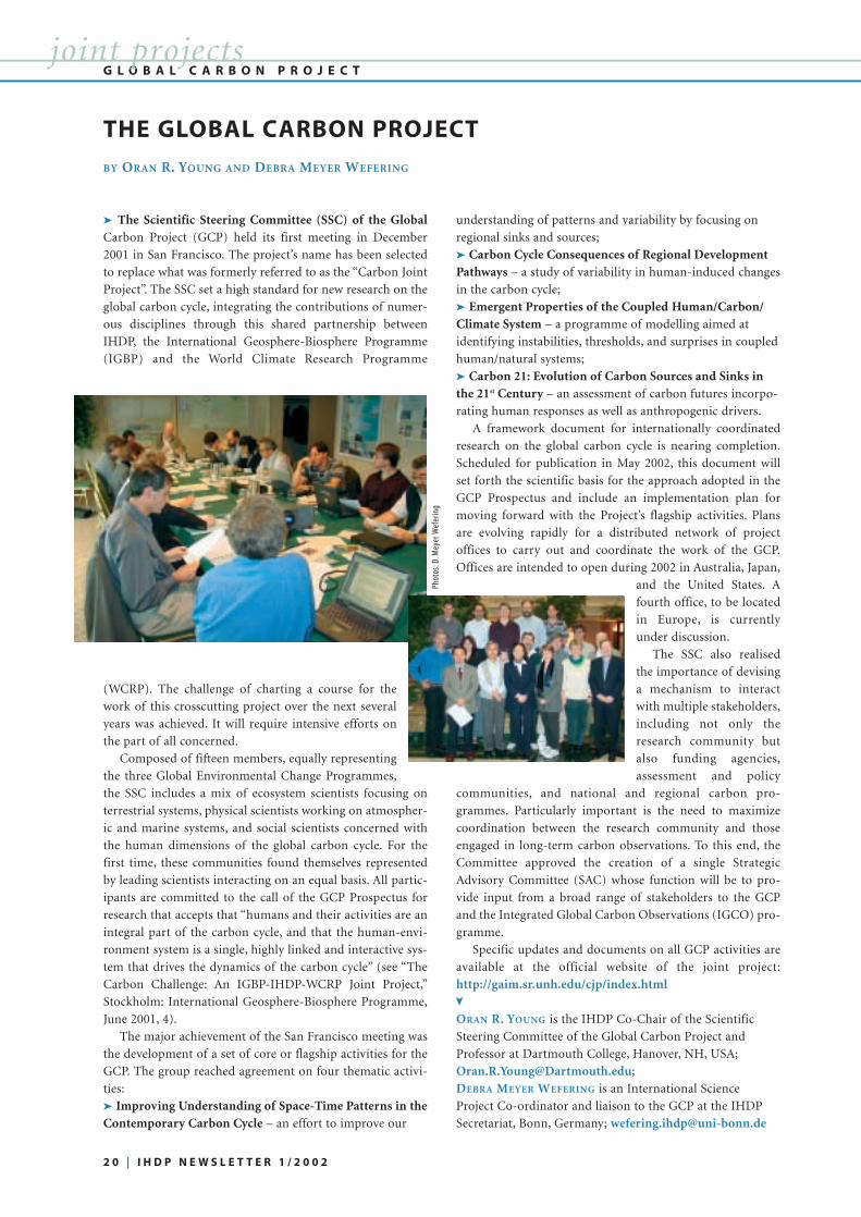
➤ The Scientific Steering Committee (SSC) of the GlobalCarbon Project (GCP) held its first meeting in December
2001 in San Francisco. The project’s name has been selected
to replace what was formerly referred to as the “Carbon Joint
Project”. The SSC set a high standard for new research on the
global carbon cycle, integrating the contributions of numer-
ous disciplines through this shared partnership between
IHDP, the International Geosphere-Biosphere Programme
(IGBP) and the World Climate Research Programme
(WCRP). The challenge of charting a course for the
work of this crosscutting project over the next several
years was achieved. It will require intensive efforts on
the part of all concerned.
Composed of fifteen members, equally representing
the three Global Environmental Change Programmes,
the SSC includes a mix of ecosystem scientists focusing on
terrestrial systems, physical scientists working on atmospher-
ic and marine systems, and social scientists concerned with
the human dimensions of the global carbon cycle. For the
first time, these communities found themselves represented
by leading scientists interacting on an equal basis. All partic-
ipants are committed to the call of the GCP Prospectus for
research that accepts that “humans and their activities are an
integral part of the carbon cycle, and that the human-envi-
ronment system is a single, highly linked and interactive sys-
tem that drives the dynamics of the carbon cycle” (see “The
Carbon Challenge: An IGBP-IHDP-WCRP Joint Project,”
Stockholm: International Geosphere-Biosphere Programme,
June 2001, 4).
The major achievement of the San Francisco meeting was
the development of a set of core or flagship activities for the
GCP. The group reached agreement on four thematic activi-
ties:
➤ Improving Understanding of Space-Time Patterns in theContemporary Carbon Cycle – an effort to improve our
understanding of patterns and variability by focusing on
regional sinks and sources;
➤ Carbon Cycle Consequences of Regional DevelopmentPathways – a study of variability in human-induced changes
in the carbon cycle;
➤ Emergent Properties of the Coupled Human/Carbon/Climate System – a programme of modelling aimed at
identifying instabilities, thresholds, and surprises in coupled
human/natural systems;
➤ Carbon 21: Evolution of Carbon Sources and Sinks inthe 21st Century – an assessment of carbon futures incorpo-
rating human responses as well as anthropogenic drivers.
A framework document for internationally coordinated
research on the global carbon cycle is nearing completion.
Scheduled for publication in May 2002, this document will
set forth the scientific basis for the approach adopted in the
GCP Prospectus and include an implementation plan for
moving forward with the Project’s flagship activities. Plans
are evolving rapidly for a distributed network of project
offices to carry out and coordinate the work of the GCP.
Offices are intended to open during 2002 in Australia, Japan,
and the United States. A
fourth office, to be located
in Europe, is currently
under discussion.
The SSC also realised
the importance of devising
a mechanism to interact
with multiple stakeholders,
including not only the
research community but
also funding agencies,
assessment and policy
communities, and national and regional carbon pro-
grammes. Particularly important is the need to maximize
coordination between the research community and those
engaged in long-term carbon observations. To this end, the
Committee approved the creation of a single Strategic
Advisory Committee (SAC) whose function will be to pro-
vide input from a broad range of stakeholders to the GCP
and the Integrated Global Carbon Observations (IGCO) pro-
gramme.
Specific updates and documents on all GCP activities are
available at the official website of the joint project:
http://gaim.sr.unh.edu/cjp/index.html
ORAN R. YOUNG is the IHDP Co-Chair of the Scientific
Steering Committee of the Global Carbon Project and
Professor at Dartmouth College, Hanover, NH, USA;
DEBRA MEYER WEFERING is an International Science
Project Co-ordinator and liaison to the GCP at the IHDP
Secretariat, Bonn, Germany; [email protected]
THE GLOBAL CARBON PROJECT
BY ORAN R. YOUNG AND DEBRA MEYER WEFERING
G L O B A L C A R B O N P R O J E C T
2 0 | I H D P N E W S L E T T E R 1 / 2 0 0 2
joint projects
➤
Phot
os:D
.Mey
er W
efer
ing

ORGANISING GLOBAL CHANGE RESEARCH – FROM
COMMITTEE TO ADVISORY PANEL
In 1997 the Research Council of Norway (RCN) estab-
lished a Norwegian Global Change Committee. Its main task
was to stimulate and co-ordinate Norwegian research related
to global environmental change and serve as a broker bet-
ween national and international research activities. Special
emphasis was given to co-operation with the international
global environmental change programmes and the Inter-
national Institute for Applied Systems Analysis (IIASA). In
2002, the Committee was reorganised into an interdiscipli-
nary advisory panel. Its tasks remain much the same, but
include the possibility of taking on new areas of responsibil-
ity.
INVENTORY OF GLOBAL CHANGE RESEARCH
In 2001 the Norwegian Committee compiled an inventory
of projects on global change research (GCR) that are funded
by the Research Council of Norway. GCR was defined as
research that can be considered relevant to the science agen-
da of the four major international global environmental
change programmes, DIVERSITAS, IGBP, IHDP and WCRP.
Projects of relevance to IHDP made up 23 % (or about US$
2.0 million) of the total amount spent by the Research
Council on GCR in 2001. The majority of these projects were
in the social sciences, mostly in the area of Industrial
Transformation (IT); other projects are related to Institutio-
nal Dimensions of Global Environmental Change (IDGEC)
and to Global Environmental Change and Human Security
(GECHS). Only few research activities of relevance to Land-
Use and Land-Cover Change (LUCC) were identified. The
findings of the inventory will assist the Council in its efforts
to increase Norwegian participation in the international GEC
programme activities.
GLOBAL CHANGE AND FOOD PROVISION – OSLO
WORKSHOP
In November 2001, a workshop organised by the Global
Change Committee on Global environmental and climate
change – consequences for food provision: international
research challenges for Norwegian research attracted much
attention. It will hopefully lead to new collaborative research
related to food production and climate change. John Ingram
from the NERC Centre for Ecology and Hydrology, UK, and
Executive Officer of the Joint Project on Global Environ-
mental Change and Food Systems (GECAFS), gave a very
interesting presentation on GECAFS and the many challenges
that lie ahead in implementing the project plan. Günther
Fischer and Mahendra Shah, both from IIASA, presented the
IIASA report Global Agro-ecolocical Assessment for Agriculture
in the 21st century, its main results and implications for
national and global policy formulation in this area. The
Norwegian participants, mostly researchers, but also repre-
sentatives from the Norwegian Agency for Development
Cooperation (NORAD) and some NGOs, were invited to
comment on how their own work might relate to GECAFS
and the IIASA project. International workshops, such as this
one, are a very useful mechanism to stimulate and increase
participation by national research groups in international
collaborative research.
CHALLENGES AHEAD
Much interesting research is underway in Norway that
would be highly relevant to IHDP, but there are no links to
any of the IHDP core projects. This issue was discussed in
June last year at a joint meeting of the Global Change
Committee and representatives of programme committees in
charge of national GEC-relevant programmes of the NRC. It
was agreed to develop more systematic relationships among
the Global Change Committee and the national programmes,
and also among the Research Council’s programmes, to
ensure cooperation between national and international
research initiatives and enhance funding possibilities for
interdisciplinary GEC research projects. As a priority in 2002,
mechanisms to implement this new agreement will be devel-
oped. We are very interested in learning from other National
Committees about their experiences: how do they succeed in
stimulating successful links between their own research and
funding systems and IHDP’s research activities?
NINA GORNITZKA is Senior Advisor at the Research Council
of Norway, Oslo, and the IHDP contact person in the
Norwegian Global Change Committee;
[email protected]; www.forskingsradet.no/english/
NORWAY’S GLOBAL CHANGE RESEARCH
BY NINA GORNITZKA
N O R W A Ynational committees
➤ This Directory includes final reports from seven National Human
Dimensions Committees, ie in Bolivia, Bulgaria, India, Ivory Coast,
Mexico and Vietnam, who received financial support within the IHDP
“Seed Grant” initiative to help them identify “who is doing what?” in
human dimensions research in their countries. IHDP funds a small
grants programme, which provides awards (limited to US$ 2,000 per
country) to groups of researchers from developing countries and tran-
sition economies to help establish a formal National HD Committee, or
to existing National HD Committees in developing countries and coun-
tries with economies in transition, in order to further build HD
research. The purpose is to facilitate the creation of new research net-
works, convening of national workshops and specific national human
dimensions research initiatives.
Free copies of the directory can be ordered from the IHDP Secretariat,
[email protected]; for more information about the IHDP Seed
Grant, visit www.ihdp.org/ihdp/NCs/HTML-Dateien/SeedMoney.html
Directory of Human Dimensions Research Activities, IHDP Seed Grant
Programme, Final Reports 1999-2000, edited by P. Pommerening, R.V.
Shaw and M. Gardner; IHDP, Bonn, Germany, October 2001.
DIRECTORY OF HD RESEARCH AVAILABLE NOW!
➤
➤
I H D P N E W S L E T T E R 1 / 2 0 0 2 | 2 1

IHDP AT BONN’S SALON INTERNATIONAL
➤ What do we know about the causes and
consequences of global environmental
change? Why is a coordinated international
research programme necessary? Interested in
hearing answers to these important questions,
some 70 guests followed an invitation by the
City of Bonn and the IHDP Secretariat and,
on 29 January 2002, attended the Salon
International. This is a monthly event
organised by the Office of the Lord Mayor
of Bonn and held at Bonn’s spectacular art
museum, to facilitate communication and
information exchange between the Bonn
and the international communities.
IHDP Executive Director Jill Jäger and
all members of the Secretariat team wel-
comed representatives from government
institutions, academia, the press and gener-
al public. In a short presentation on
“Humans and the Environment: Causes and
Consequences”, Jill Jäger described how
IHDP is responding to these challenges and
introduced key research activities. The fol-
lowing lively discussions and the many
questions asked by the audience were a
clear indication of the interest in IHDP’s
work. The event led to a better under-
standing of the important issues
addressed in IHDP’s research; it con-
tributed to increasing IHDP’s visibility
and establishing numerous contacts with
the Bonn communities.
N A T I O N A L H D C O M M I T T E E S
2 2 | I H D P N E W S L E T T E R 1 / 2 0 0 2
in brief
➤ IHDP’s sponsoring organisations, ICSU and ISSC, have
extended the terms of Arild Underdal (Norway) as Chair of
the IHDP Scientific Committee (SC), and of Anne V. Whyte(Canada) as Vice-Chair of the IHDP-SC, to 30 June 2002. The
term of SC member and Past Chair Eckart Ehlers (Germany)
has been extended to 31 December 2002.
Effective January 2002, Carl Folke (Sweden) has been
appointed as a member of the IHDP Scientific Committee for
a period of three years. The SC guides IHDP’s work and
research activities.
Carl Folke is based at Stockholm University, Sweden,
where he is the Director of the transdisciplinary Centre for
Research on Natural Resources and the Environment (CNM)
and Professor and Head of the Natural Resource Manage-
ment Division at the Department of Systems Ecology. Carl
has extensive experience in interdisciplinary collaboration
between natural and social
scientists, and has worked
with the social and economic
dimension of ecosystem
management and proactive
measures to avoid loss of
resilience. He has served as
adviser to the Swedish Go-
vernment on environmental
issues and collaborated with
several UN organisations on
issues like biodiversity, fresh-
water management, and sus-
tainable cities. He is also a scientific advisor to the Millen-
nium Ecosystem Assessment.
IHDP SCIENTIFIC COMMITTEE
Phot
o:C.
Folk
e
Deeply saddened we learned that Verónica Mera-
Orcés (Ecuador) died in an airline crash on January
28, 2002 at the border of Columbia and Ecuador.
She was a researcher at the International Center for
Tropical Agriculture in Quito, Ecuador.
Verónica was a participant in the International
Human Dimensions Workshop in 2000 and since
then had been one of our most active young scien-
tists in the IHDP network.
Our sympathies go to her family and friends.
In Memorian: Verónica Mera-Orcés (1965-2002 †)
Phot
os:E
.Dyc
k

MEETING CALENDAR
19-23 March – Los Angeles, California 98th Association of the American Geographers 2002
Annual Meeting “Landscape Fragmentation and the Analysis of Land-
Use/Land-Cover Change: From Pattern to Process” – Session
sponsored by the Spatial Analysis and Modelling, and the
Remote Sensing Specialty Groups
Contact: Darla Munroe, [email protected]
19-20 April – Müncheberg, Germany
International Workshop on SustainableDevelopment of Multifunctional LandscapesContact: www.zalf.de/landtom/meeting/workshop.htm
21 – 25 May – Bridgetown, Barbados
Conference and Workshop on Climate Variabilityand Change and their Health Effects in the CaribbeanContact: www.cpc.paho.org
3-14 June – Bonn, Germany by invitation
3rd International Human Dimensions Workshop:Human Dimensions of Urbanisation and the Transitionto SustainabilityContact: Maarit Thiem, [email protected]
June 5-7, 2002 – Wageningen University, The Netherlands
Conference on Risk and Uncertainty inEnvironmental and Resource Economics
Sponsored by the Netherlands HD Committee
Contact: www.sls.wageningen-ur.nl/me/conference.html
1-5 July – Moshi, Tanzania
International Conference to Mark the InternationalYear Of Mountains (IYM 2002)
organised by African Mountains Association
Contact: Prof. S. B. Misana: [email protected]
26 August – 4 September – Johannesburg, South Africa
World Summit on Sustainable Development (WSSD)Contact: Johannesburg Summit Secretariat, UnitedNations, [email protected], www.johannesburgsummit.org
29 August – 2 September – London, UK
International Conference on EnvironmentalCatastrophes and Recovery in the Holocene
Sponsored by PAGES and INQUA
Contact: www.brunel.ac.uk/depts/geo/Catastrophes/
29 October – 4 November – Bishkek, Kyrgyzstan
Bishkek Global Mountain Summit (BGMS)The International Advisory Board of the BGMS is co-
chaired by the Government of Kyrgyzstan and FAO; UNEP
has been designated the international technical secretariat
and is working closely with the Government of Kyrgyzstan to
organise the conference.
Contact: www.mediantics.com/mountainsummit/
I H D P N E W S L E T T E R 1 / 2 0 0 2 | 2 3
calendar / publications
Environmental Regime Effectiveness:Confronting Theory with Evidenceby Edward L. Miles, Arild Underdal, Steinar Andresen,
Jørgen Wettestad, Jon Birger Skjærseth, and Elaine M.
Carlin; MIT Press, Nov. 2001; 530 pp.
cloth ISBN 0-262-13394-6; paper ISBN 0-262-63241-1
This book examines why some international environ-
mental regimes succeed while others fail. Confronting
theory with evidence, and combining qualitative and
quantitative analysis, it compares fourteen case studies of
international regimes. It considers what effectiveness in a
regime would look like, what factors might contribute to
effectiveness, and how to measure the variables. It deter-
mines that environmental regimes actually do better
than the collective model of the book predicts. More
information at http://mitpress.mit.edu/0262133946
Ecology and Sustainable Developmentby P.S Ramakrishnan, National Book Trust, New Delhi,
India, 2001; 198 pp.
This book looks at the emerging paradigms in ecology
in the context of natural resource management that is
based on maintaining heterogeneity in the landscape.
Since traditional ecological knowledge plays an impor-
tant role, its integration into modern science has become
a necessity for ensuring community participation in nat-
ural resource management in the developing tropics.
AVISO – a policy bulletin on Global EnvironmentalChange and Human Security supported by the U.S.
Agency for International Development, Office of
Population; through a cooperative agreement with the
University of Michigan, Population Fellows Program; the
Woodrow Wilson Center, Environmental Change and
Security Project; the Canadian International
Development Agency; and with support from the
University of Victoria.
RECENT ISSUES:AVISO No. 10 (July 2001): ”Environmental Stress and
Human Security in Northern Pakistan” by R.A. Matthew;
AVISO No. 9 (June 2001): ”Russia: New Dimensions of
Environmental Insecurity” by V. Kotov and E. Nikitina;
available in English and Russian;
AVISO No. 8 (June 2001): ”Infectious Diseases and
Global Change: Threats to Human Health and Security”
by J. Eyles and R. Sharma.
Funding is now in place for Phase II of the AVISO bul-
letin with forthcoming issues on:
• Urbanization and global environmental change
• Environment, development and human rights
• Energy and human security.
AVISO is available at the GECHS website
(www.gechs.org) or from the GECHS Intern. Project
Office, University of Victoria, P.O.Box 1700, Victoria, BC,
Canada V8W 2Y2.
P U B L I C AT I O N | N E W B O O K S
M E E T I N G S / N E W B O O K S
➤
➤
IHDP SECRETARIAT
• IHDP Secretariat:Jill Jäger, Executive Director
Walter-Flex-Str. 3
53113 Bonn, Germany
Phone: +49-228-739050
Fax: +49-228-739054
www.ihdp.org
IHDP CORE PROJECTS
➤ GECHS
• Global EnvironmentalChange and Human Security c/o Ann Zurbrigg, Project Manager
GECHS International Project Office
University of Victoria
P.O. Box 1700
Victoria, B.C. V8W 2Y2, Canada
www.gechs.org
➤ IDGEC
• Institutional Dimensions ofGlobal Environmental Change c/o Syma Ebbin, Executive Officer
IDGEC International Project Office
6214 Fairchild, Dartmouth College,
Hanover, NH 03755, USA
www.dartmouth.edu/~idgec
➤ IT
• Industrial Transformation c/o Anna J. Wieczorek,
Executive Officer
IT International Project Office
Institute of Environmental Studies
De Boelelaan 1115
1081 HV Amsterdam
The Netherlands
www.vu.nl/ivm/research/ihdp-it/
➤ LUCC
• Land-Use and Land-CoverChange c/o Helmut Geist, Executive Officer
LUCC International Project Office
University of Louvain
Place L. Pasteur 3
1348 Louvain-la-Neuve, Belgium
www.geo.ucl.ac.be/LUCC
JOINT PROJECTS
➤ GECAFS
• Global EnvironmentalChange and Food Systems c/o John Ingram, Executive Officer
GECAFS International Project
Office,
NERC-Centre for Ecology &
Hydrology
Wallingford, OX 10 8BB, UK
www.gecafs.org
➤ GCP
• Global Carbon Projectc/o Kathy A. Hibbard, Interim
Executive Officer
University of New Hampshire
Morse Hall, Durham, NH 03824
USA
http://gaim.sr.unh.edu/cjp/
➤ Water
• Water Joint Projectc/o Sylvia Karlsson
IHDP Liaison Officer
IHDP Secretariat, Bonn, Germany
IHDP SCIENTIFIC COMMITTEE (SC)
➤ Chair
• Arild Underdal Rector, University of Oslo
P.O. Box 1097 Blindern
0317 Oslo, Norway
➤ Vice Chair
• Anne V. Whyte Mestor Associates Ltd.
751 Hamilton Road, Russell
Ontario, K4R 1E5 Canada
➤ Treasurer
• Carlo C. Jaeger Global Change and Social Systems
Department, Potsdam Institute for
Climate Impact Research, (PIK)
P.O. Box 60 12 03
14412 Potsdam, Germany
➤ Past-Chair
• Eckart Ehlers Institutes of Geography
University of Bonn
Meckenheimer Allee 166
53113 Bonn, Germany
➤ Members
• William C. ClarkJohn F. Kennedy School of
Government
Harvard University
79 Kennedy Street
Cambridge, MA 02138, USA
• Carl FolkeCentre for Research on Natural
Resources and the Environment
(CNM)
Stockholm University
10690 Stockholm, Sweden
• Gilberto C. GallopinRegional Adviser on Environmental
Policies, Economic Commission
for Latin America and the
Caribbean (ECLAC)
Casilla 179 D, Santiago, Chile
• Elinor OstromCenter for the Study of
Institutions, Population and
Environmental Change,
Indiana University
408 N. Indiana Ave.
Bloomington, IN 47408-3895, USA
• Xizhe PengInstitute of Population Research
Fudan University, 220 Handan
Road, Shanghai 200433, P. R. China
• P. S. RamakrishnanSchool of Environmental Sciences
Jawaharlal Nehru University
New Delhi 110067, India
• M.A. Mohamed SalihInstitute of Social Studies
P.O. Box 29776
2502 LT The Hague
The Netherlands
EX-OFFICO MEMBERSIHDP SCIENTIFICCOMMITTEE
➤ ICSU
• Gordon McBean Institute for Catastrophic Loss
Reduction, University of Western
Ontario, London, ON, Canada
➤ I S S C• Kurt Pawlik Institute for Psychology I
University of Hamburg, Germany
➤ DIVERSITAS
• Michel LoreauEcole Normale Superieure
Laboratoire d'Ecologie
Paris, France
➤ IGBP
• Guy Brasseur Max-Planck-Institute for
Meteorology
Hamburg, Germany
➤ START (alternating)
• Sulochana GadgilIndian Institute of Science
& Oceanic Sciences
Bangalore, India
• Graeme I. PearmanCSIRO Atmospheric Research
Aspendale, Australia
➤ WCRP
• Peter LemkeAlfred-Wegener-Institute
for Polar and Marine Research
Bremerhaven, Germany
➤ GECHS
• Michael Brklacich Carleton University
Ottawa, Canada
➤ IDGEC
• Oran R. Young Dartmouth College,
Hanover, NH, USA
➤ IT
• Pier Vellinga Dean, Faculty of Life and Earth
Sciences
Vrije Universiteit Amsterdam
The Netherlands
➤ LUCC
• Eric Lambin Dept. of Geography
University of Louvain
Louvain-la-Neuve, Belgium
SOCIAL SCIENCE LIAISON OFFICER
• João M. MoraisIGBP Secretariat
The Royal Swedish Academy of
Sciences, P.O. Box 50 005
10405 Stockholm, Sweden
C O N T A C T A D D R E S S E Saddresses
S U B S C R I P T I O N
➤ For a free subscription to
this newsletter, write to the
IHDP Secretariat at the
above address;
or send an e-mail to:
or subscribe online:
www.ihdp.org
Pri
nte
d o
n r
ecyc
led
pap
er
2 4 | I H D P N E W S L E T T E R 1 / 2 0 0 2