780-808 francesca drive residential project
TRANSCRIPT

780-808 Francesca Drive Residential Project
Initial Study – Mitigated Negative Declaration
prepared by
City of Walnut 21201 La Puente Road
P.O. Box 682 Walnut, California 91789
prepared with the assistance of
Rincon Consultants, Inc. 250 East First Street
Los Angeles, California 90012
October 2018

780-808 Francesca Drive Residential Project
Initial Study – Mitigated Negative Declaration
prepared by
City of Walnut 21201 La Puente Road
P.O. Box 682 Walnut, California 91789
prepared with the assistance of
Rincon Consultants, Inc. 250 East First Street
Los Angeles, California 90012
October 2018

This report prepared on 50% recycled paper with 50% post-consumer content.

Table of Contents
Initial Study – Mitigated Negative Declaration i
Table of Contents
Initial Study ............................................................................................................................................. 1 1. Project Title ......................................................................................................................... 1 2. Lead Agency Name and Address ......................................................................................... 1 3. Contact Person and Phone Number ................................................................................... 1 4. Project Location .................................................................................................................. 1 5. Existing Setting .................................................................................................................... 1 6. Project Sponsor’s Name and Address ................................................................................. 5 7. General Plan Designation .................................................................................................... 5 8. Zoning.................................................................................................................................. 5 9. Description of Project ......................................................................................................... 5 10. Required Approvals and Mitigation Measures ................................................................... 8 11. Surrounding Land Uses and Setting .................................................................................... 8 12. Other Public Agencies Whose Approval is Required .......................................................... 8
Environmental Factors Potentially Affected ........................................................................................... 9
Determination ........................................................................................................................................ 9
Environmental Checklist .......................................................................................................................11 1 Aesthetics ..........................................................................................................................11 2 Agriculture and Forestry Resources ..................................................................................17 3 Air Quality .........................................................................................................................19 4 Biological Resources ..........................................................................................................29 5 Cultural Resources ............................................................................................................37 6 Geology and Soils ..............................................................................................................45 7 Greenhouse Gas Emissions ...............................................................................................51 8 Hazards and Hazardous Materials ....................................................................................59 9 Hydrology and Water Quality ...........................................................................................63 10 Land Use and Planning ......................................................................................................69 11 Mineral Resources ............................................................................................................71 12 Noise .................................................................................................................................73 13 Population and Housing ....................................................................................................85 14 Public Services ...................................................................................................................87 15 Recreation .........................................................................................................................91 16 Transportation/Traffic ......................................................................................................93 17 Tribal Cultural Resources ..................................................................................................99 18 Utilities and Service Systems ..........................................................................................101 19 Mandatory Findings of Significance ................................................................................105
References ..........................................................................................................................................107 Bibliography ................................................................................................................................107 List of Preparers ..........................................................................................................................111

City of Walnut 780-808 Francesca Drive Residential Project
ii
Tables Table 1 Project Details ..................................................................................................................... 5
Table 2 Ambient Air Quality at the Monitoring Station ................................................................20
Table 3 SCAQMD Significance Thresholds .....................................................................................23
Table 4 SCAQMD LSTs for Construction Emissions ........................................................................24
Table 5 Estimated Construction Emissions ....................................................................................26
Table 6 Estimated Operational Emissions .....................................................................................27
Table 7 Construction Greenhouse Gas Emissions .........................................................................54
Table 8 Operational and Total Annual Emissions of Greenhouse Gases .......................................55
Table 9 Project Consistency with Applicable SCAG RTP/SCS Strategies ........................................55
Table 10 Sound Level Measurement Results ...................................................................................75
Table 11 Land Use Compatibility for Community Noise Environments ..........................................77
Table 12 Exterior Noise Standards...................................................................................................78
Table 13 Human Response to Different Levels of Ground-borne Vibration ...................................80
Table 14 Vibration Levels for Construction Equipment ...................................................................80
Table 15 Comparison of Existing and Existing plus Project Traffic Noise ........................................82
Table 16 Construction Noise Levels by Phase..................................................................................83
Table 17 Enrollment at School Serving the Project Site ..................................................................89
Table 18 Estimated Project Trip Generation ...................................................................................94
Table 19 Thresholds of Significance for Signalized Intersections ....................................................95
Table 20 Existing and Existing plus Project Significance Impacts ....................................................96
Table 21 Project Driveways Peak Hour Intersection Level of Service .............................................97
Table 22 Solid Waste Disposal Facilities ........................................................................................104
Figures Figure 1 Regional Location ................................................................................................................ 2
Figure 2 Plan Area Location .............................................................................................................. 3
Figure 3 View of Project Site at 808 Francesca Drive ....................................................................... 4
Figure 4 View of Project Site at 780 Francesca Drive ....................................................................... 4
Figure 5 780 Francesca Drive Site Plan ............................................................................................. 6
Figure 6 808 Francesca Drive Site Plan ............................................................................................. 7
Figure 7 View of Residences Along Nogales Street Looking South .................................................12
Figure 8 View of Residences Along Nogales Street Looking North .................................................12

Table of Contents
Initial Study – Mitigated Negative Declaration iii
Figure 9 View of Residences Along North Calaveras Drive .............................................................13
Figure 10 View of Residences Along North Calaveras Drive .............................................................13
Figure 11 View of Commercial Development Along Nogales Street Looking East ...........................14
Figure 12 View of Commercial Development Along Nogales Street Looking East ...........................14
Figure 13 Geologic Units and Paleontological Sensitivity in the Project Area ..................................41
Figure 14 Sound Level Measurement and Sensitive Receptor Locations .........................................76
Appendices Appendix A Air Quality/Greenhouse Gas Emissions Modeling Results
Appendix B Cultural Resource Records Search
Appendix C Geotechnical Engineering Investigation
Appendix D Noise Measurement and Analyses Data
Appendix E Traffic Impact Analysis
Appendix F Special-status Species List

City of Walnut 780-808 Francesca Drive Residential Project
iv
This page intentionally left blank

Initial Study
Initial Study – Mitigated Negative Declaration 1
Initial Study
1. Project Title 780-808 Francesca Drive Residential Project
2. Lead Agency Name and Address City of Walnut 21201 La Puente Road P.O. Box 682 Walnut, California 91789
3. Contact Person and Phone Number Chun-Chien Yang, Associate Planner (909) 348-0735
4. Project Location The project site encompasses approximately 3.23 acres and includes two parcels located at 780 Francesca Drive and 808 Francesca Drive, which are identified as Assessor Parcel Numbers (APNs) 8735-026-044 and 8735-026-050, respectively. Both parcels are located along the eastern side of Francesca Drive in the City of Walnut between Nogales Street to the south and Amar Road to the north. The two parcels are separated by an approximately 1.5 acre commercial center. Figure 1 shows the location of the project site in the region and Figure 2 shows the site in its neighborhood context.
5. Existing Setting The project site consists of two vacant, undeveloped parcels that have been previously disturbed and graded. Both parcels are covered with grasses and other small vegetation, and the lot located at 808 Francesca Drive has several mature trees located near the eastern boundary of the site. Trees in the backyards of the single family residences along North Calaveras Drive line the eastern boundaries of both parcels just outside of the property lines. Both parcels are bounded by single family residences to the east, multiple family residences to the west, and commercial development to the north and south. Figure 3 and Figure 4 include photos of the existing conditions of both sites.

City of Walnut 780-808 Francesca Drive Residential Project
2
Figure 1 Regional Location

Initial Study
Initial Study – Mitigated Negative Declaration 3
Figure 2 Plan Area Location

City of Walnut 780-808 Francesca Drive Residential Project
4
Figure 3 View of Project Site at 808 Francesca Drive
Figure 4 View of Project Site at 780 Francesca Drive

Initial Study
Initial Study – Mitigated Negative Declaration 5
6. Project Sponsor’s Name and Address Francesca Property LLC 18472 East Colima Rd., #222 Rowland Heights, California 91748
7. General Plan Designation Walnut Hills Mixed Use/Francesca Mixed Use Specific Plan
8. Zoning Heavy Commercial and Specific Plan Overlay Zone (C3-SP)
9. Description of Project The 780-808 Francesca Drive Residential Project (“proposed project” or “project”) involves development of a residential complex with 36 two-story single, duplex and triplex units on an approximately 3.23-acre site, which consists of two parcels located along Francesca Drive. The project includes attached two car garages and surface parking that provide 93 total parking spaces, private yards, and an internal circulation road. The southernmost parcel, located at 780 Francesca Drive, is 1.51 acres and would be developed with 17 duplex and triplex units with 43 parking spaces. The northernmost parcel, located at 808 Francesca Drive, is 1.72 acres and would be developed with 19 single, duplex, and triplex units with 48 parking spaces. Development at both sites would have a maximum height of 35 feet. Table 1 provides details of the proposed residences located at 780 and 808 Francesca Drive while Figure 5 and Figure 6 show the proposed development layout for each parcel.
Table 1 Project Details 780 Francesca Drive 808 Francesca Drive
Lot Area (sf) 65,772 74,927
Height (stories) 2 2
Residence (sf) 38,805 35,841
Singles No 1
Duplex 7 3
Triplex 1 4
Garage Parking (spaces) 34 38
Surface Parking (spaces) 9 10
Private Open Space (sf) 10,355 4,355
Set Backs
Front (ft) +10’ +10’
Side (ft) +7.5’ +7.5’
Rear (ft) +10’ +10’
Notes: sf = square feet; ft = feet

City of Walnut 780-808 Francesca Drive Residential Project
6
Figure 5 780 Francesca Drive Site Plan

Initial Study
Initial Study – Mitigated Negative Declaration 7
Figure 6 808 Francesca Drive Site Plan

City of Walnut 780-808 Francesca Drive Residential Project
8
Both parcels are currently covered with non-native grasses and other vegetation. All but one of the trees observed on-site are non-native ornamentals scattered along the eastern perimeter of the site. Native trees are present at low cover in the area. The project site contains one California walnut (Juglans californica) near the northeastern corner of the parcel at 808 Francesca Drive. Two coast live oaks (Quercus agrifolia) are located just off of the project site at the toe of the slope of the parcel at 780 Francesca Drive. The canopy of both trees extends slightly onto the project site. The California walnut and both coast live oaks are considered mature, with diameters greater than six inches and are protected by the City of Walnut Municipal Code (WMC) (Chapter 25-178, Ord. No. 03-05, § 1). While project activities do not propose to remove the trees, documentation of this avoidance may be required by the WMC (e.g., Chapters 25-178.9(f)(1)(a) and 25-178.10(c)). Construction and Grading
Construction of the proposed project is anticipated to occur over an approximately 18-month period. Construction phasing would include site preparation, grading, building construction, asphalt paving and architectural coating. Due to the underground geologic structure of the two sites, excavation activities would be required to install new concrete footing foundations to support the proposed structures. Although excavation would be required, excavated soils would be compacted and reused and no export would be required. A total of approximately 6,530 cubic yards (CY) of cut and fill soil would be utilized on-site for construction of the building pads and foundations.
Access and Parking Francesca Drive is the only street that provides access to both parcels. The proposed residences would each have access driveways from Francesca Drive that would lead to the internal streets within each parcel, providing access to the individual garages and surface parking.
10. Required Approvals and Mitigation Measures The following discretionary approvals are being requested from the City of Walnut:
Approval of a zone change to create a new Francesca Specific Plan over the existing Francesca 1.Mixed-use Specific Plan designation
Approval of a Specific Plan to establishes standards for the Francesca Specific Plan development 2. Adoption of the Mitigated Negative Declaration 3. Approval of a Tentative Tract Map, which encompasses the entire 3.23 acre project sites with 4.
access and utility easements for residential townhomes
11. Surrounding Land Uses and Setting The project site is located in a suburban area surrounded by single family residences to the east, multiple family residences to the west, and commercial uses to the north and south. The project parcels are on either side of the Walnut Hills Plaza Shopping Center. The closest open space area is Galster Wilderness Park, located approximately 0.5-mile northeast of the northernmost project site.
12. Other Public Agencies Whose Approval is Required The City of Walnut is the lead agency with responsibility for approving the proposed project. Approval from other public agencies is not required.
Environmental Factors Potentially Affected
Initial Study – Mitigated Negative Declaration 9
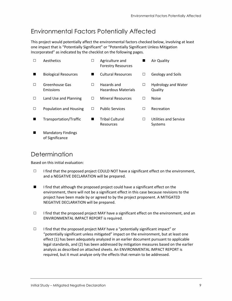
Environmental Factors Potentially Affected This project would potentially affect the environmental factors checked below, involving at least one impact that is “Potentially Significant” or “Potentially Significant Unless Mitigation Incorporated” as indicated by the checklist on the following pages.
□ Aesthetics □ Agriculture and Forestry Resources
■ Air Quality
■ Biological Resources ■ Cultural Resources □ Geology and Soils
□ Greenhouse Gas Emissions
□ Hazards and Hazardous Materials
□ Hydrology and Water Quality
□ Land Use and Planning □ Mineral Resources □ Noise
□ Population and Housing □ Public Services □ Recreation
■ Transportation/Traffic ■ Tribal Cultural Resources
□ Utilities and Service Systems
■ Mandatory Findings of Significance
Determination Based on this initial evaluation:
□ I find that the proposed project COULD NOT have a significant effect on the environment, and a NEGATIVE DECLARATION will be prepared.
■ I find that although the proposed project could have a significant effect on the environment, there will not be a significant effect in this case because revisions to the project have been made by or agreed to by the project proponent. A MITIGATED NEGATIVE DECLARATION will be prepared.
□ I find that the proposed project MAY have a significant effect on the environment, and an ENVIRONMENTAL IMPACT REPORT is required.
□ I find that the proposed project MAY have a “potentially significant impact” or “potentially significant unless mitigated” impact on the environment, but at least one effect (1) has been adequately analyzed in an earlier document pursuant to applicable legal standards, and (2) has been addressed by mitigation measures based on the earlier analysis as described on attached sheets. An ENVIRONMENTAL IMPACT REPORT is required, but it must analyze only the effects that remain to be addressed.


Environmental Checklist Aesthetics
Initial Study – Mitigated Negative Declaration 11
Environmental Checklist 1 Aesthetics
Potentially Significant
Impact
Less than Significant
with Mitigation
Incorporated
Less than Significant
Impact No Impact
Would the project:
a. Have a substantial adverse effect on a scenic vista? □ □ ■ □
b. Substantially damage scenic resources, including but not limited to, trees, rock outcroppings, and historic buildings within a state scenic highway? □ □ ■ □
c. Substantially degrade the existing visual character or quality of the site and its surroundings? □ □ ■ □
d. Create a new source of substantial light or glare that would adversely affect daytime or nighttime views in the area? □ □ ■ □
a. Would the project have a substantial adverse effect on a scenic vista?
Scenic vistas are panoramic public views that are found to be locally or regionally attractive. The City’s General Plan does not identify any designated scenic vistas in the City, but regards hillside areas and ridgelines as scenic resources. The nearest hillside area is Galstar Wilderness Park, located approximately 0.5-mile northeast of the northernmost project parcel. Partial views of the hills within this park are visible from North Calaveras Drive south of the project sites and from Francesca Drive along the northern boundary of the sites but are partially obstructed by intervening street trees and existing commercial and residential development. Neither of the project sites are visible from the park.
The proposed project involves development of 36 residential units on two parcels with a combined area of approximately 3.23 acres. As shown in Figure 3, Figure 4, and Figure 7 through Figure 12, the general area surrounding both parcels is flat and residences surrounding both project sites to the east and west have views of adjacent commercial and residential development. Landscaping, street trees, and existing development obstruct distant views given the flat topography of the area. As shown in Figure 7 through Figure 12, views near the project site consist primarily of one- and two-story residential development immediately east, west, and south of both project parcels, and one-story commercial development immediately to the north and to the south of both parcels. Neither of the parcels have views of the Galstar Wilderness Park due to existing commercial development that blocks these views, and the heights of the proposed residences within the project sites would

City of Walnut 780-808 Francesca Drive Residential Project
12
Figure 7 View of Residences Along Nogales Street Looking South
Figure 8 View of Residences Along Nogales Street Looking North

Environmental Checklist Aesthetics
Initial Study – Mitigated Negative Declaration 13
Figure 9 View of Residences Along North Calaveras Drive
Figure 10 View of Residences Along North Calaveras Drive

City of Walnut 780-808 Francesca Drive Residential Project
14
Figure 11 View of Commercial Development Along Nogales Street Looking East
Figure 12 View of Commercial Development Along Nogales Street Looking East

Environmental Checklist Aesthetics
Initial Study – Mitigated Negative Declaration 15
not affect existing street views of this park from surrounding residences as these views are already majorly obstructed. The proposed residences would be similar to other residences immediately surrounding the site in terms of height (two stories) and architectural style. Therefore, the proposed project would not significantly obstruct any scenic vistas or views of or from scenic resources in the City. Impacts would be less than significant.
LESS THAN SIGNIFICANT IMPACT
b. Would the project substantially damage scenic resources, including, but not limited to, trees, rock outcroppings, and historic buildings within a state scenic highway?
The California Scenic Highway System and the County of Los Angeles Scenic Highways Element indicate that no existing or proposed County or State scenic highways are located in the vicinity of either project site. The closest such highways are State Highway 39 (San Gabriel Canyon Road) north of the 210 freeway, State Highway 142 (Carbon Canyon Road) west of the 71 freeway, and State Highway 57 (the Orange freeway) south of the 60 freeway (California Department of Transportation 2011). Neither of the project parcels is visible from these freeways. Therefore, the project would not damage scenic resources along a state scenic highway.
LESS THAN SIGNIFICANT IMPACT
c. Would the project substantially degrade the existing visual character or quality of the site and its surroundings?
The proposed project involves development of 36 housing units on two parcels that are approximately 3.23 acres combined. Both of the parcels are currently graded to be flat undeveloped, and are covered with various grasses. All but one of the trees observed on-site are non-native ornamentals scattered along the eastern perimeter of the site. Native trees are present at low cover in the area. The project site contains one California walnut (Juglans californica) near the northeastern corner of the parcel at 808 Francesca Drive. Two coast live oaks (Quercus agrifolia) are located just off of the project site at the toe of the slope of the parcel at 780 Francesca Drive. The canopy of both trees extends slightly onto the project site. The California walnut and both coast live oaks are considered mature, with diameters greater than six inches and are protected by the City of Walnut Municipal Code (WMC) (Chapter 25-178, Ord. No. 03-05, § 1). While project activities do not propose to remove the trees, documentation of this avoidance may be required by the WMC (e.g., Chapters 25-178.9(f)(1)(a) and 25-178.10(c)). Therefore, the aesthetic impact visual character of trees on-site would be less than significant. Refer to the analysis in Section 4. Biological Resources, regarding the impacts to biological resources.
The residences would be constructed with architectural styles that would similar to the styles of surrounding single and multiple family residences. The residences would have a maximum height of two stories (35 feet) and would be similar in size and massing to adjacent multiple family development to the east along Francesca Drive. As a result, the proposed residences would generally match the character of other residences in the project site vicinity. Therefore, impacts to existing visual character and quality of the site would be less than significant
LESS THAN SIGNIFICANT IMPACT
City of Walnut 780-808 Francesca Drive Residential Project
16
d. Would the project create a new source of substantial light or glare which would adversely affect day or nighttime views in the area?
Development of the proposed residences would incorporate exterior lighting in the form of porch lights, driveway/garage lights, and other safety-related lighting (such as stairway lighting). This would add new sources of light within both project sites. However, the light sources would not substantially increase the overall levels of day or nighttime lighting as they would be similar to existing light levels already present from similar lighting sources on surrounding residential development. Further, no street lighting is currently included under the proposed project. Therefore, new light sources added by the proposed project would be consistent with existing day and nighttime lighting levels of the area.
The proposed residences would include windows that would add new sources of glare to the area. However, because the residences would be similar in size, massing, scale, and architectural style to other multiple family residences adjacent to the site, windows on the new residences would not substantially increase overall levels of glare and would only incrementally add to the existing levels of glare generated from windows on the other residences. Further, the proposed housing units would not generate substantially increased levels of shading as they would be of similar height to the existing multiple family residences adjacent to the project sites. Overall, because the proposed project would be generally similar in style, size, scale, and massing with similar light and window features, the residences would not generate substantial adverse impacts related to light and glare. Impacts would be less than significant.
LESS THAN SIGNIFICANT IMPACT

Environmental Checklist Agriculture and Forestry Resources
Initial Study – Mitigated Negative Declaration 17
2 Agriculture and Forestry Resources
Potentially Significant
Impact
Less than Significant
with Mitigation
Incorporated
Less than Significant
Impact No Impact
Would the project:
a. Convert Prime Farmland, Unique Farmland, Farmland of Statewide Importance (Farmland), as shown on maps prepared pursuant to the Farmland Mapping and Monitoring Program of the California Resources Agency, to non-agricultural use? □ □ □ ■
b. Conflict with existing zoning for agricultural use or a Williamson Act contract? □ □ □ ■
c. Conflict with existing zoning for, or cause rezoning of, forest land (as defined in Public Resources Code Section 12220(g)); timberland (as defined by Public Resources Code Section 4526); or timberland zoned Timberland Production (as defined by Government Code Section 51104(g))? □ □ □ ■
d. Result in the loss of forest land or conversion of forest land to non-forest use? □ □ □ ■
e. Involve other changes in the existing environment which, due to their location or nature, could result in conversion of Farmland to non-agricultural use or conversion of forest land to non-forest use? □ □ □ ■
a. Would the project convert Prime Farmland, Unique Farmland, Farmland of Statewide Importance (Farmland), as shown on the maps prepared pursuant to the Farmland Mapping and Monitoring Program of the California Resources Agency, to non-agricultural use?
b. Would the project conflict with existing zoning for agricultural use, or a Williamson Act contract?
c. Would the project conflict with existing zoning for, or cause rezoning of, forest land (as defined in Public Resources Code Section 12220(g)), timberland (as defined by Public Resources Code Section 4526), or timberland zoned Timberland Production (as defined by Government Code Section 51104(g))?
d. Would the project result in the loss of forest land or conversion of forest land to non-forest use?

City of Walnut 780-808 Francesca Drive Residential Project
18
e. Would the project involve other changes in the existing environment, which, due to their location or nature, could result in conversion of Farmland to non-agricultural use?
Based on the Department of Conservation’s Farmland Mapping and Monitoring Program and Williamson Act maps, neither of the project parcels nor adjacent properties are State-designated Farmland, enrolled in Williamson Act contracts, or support forest land or resources (California DOC, 2016a,b). The Plan Area is zoned as Heavy Commercial (C-3) and Specific Plan (SP) for the Francesca Mixed Use Specific Plan. The Specific Plan was adopted by the City in July 2014, and the proposed project would construct development anticipated under the adopted Specific Plan. Therefore, the site is not located on or adjacent to agricultural land or forest land and the proposed project would not involve any development that could result in the conversion of farmland to non-agricultural uses. The proposed project would have no impact with respect to conversion of farmland to non-agricultural use; conflict with existing agricultural zoning or Williamson Act contract; result in the loss of forest land or conversion of forest land to non-forest use; or other conversion of farmland to non-agricultural use. No impact would occur.
NO IMPACT

Environmental Checklist Air Quality
Initial Study – Mitigated Negative Declaration 19
3 Air Quality
Potentially Significant
Impact
Less than Significant
with Mitigation
Incorporated
Less than Significant
Impact No Impact
Would the project:
a. Conflict with or obstruct implementation of the applicable air quality plan? □ □ ■ □
b. Violate any air quality standard or contribute substantially to an existing or projected air quality violation? □ ■ □ □
c. Result in a cumulatively considerable net increase of any criteria pollutant for which the project region is non-attainment under an applicable federal or state ambient air quality standard (including releasing emissions which exceed quantitative thresholds for ozone precursors)? □ ■ □ □
d. Expose sensitive receptors to substantial pollutant concentrations? □ □ ■ □
e. Create objectionable odors affecting a substantial number of people? □ □ □ ■
The project site is located in the South Coast Air Basin (the Basin), which is under the jurisdiction of the South Coast Air Quality Management District (SCAQMD). The Basin is a 6,600-square-mile coastal plain bounded by the Pacific Ocean to the southwest and the San Gabriel, San Bernardino, and San Jacinto Mountains to the north and east. The Basin includes the non-desert portions of Los Angeles, Riverside, and San Bernardino Counties, and all of Orange County.
As the local air quality management agency, the SCAQMD is required to monitor air pollutant levels to ensure that State and federal air quality standards are met and, if they are not met, to develop strategies to meet the standards. Depending on whether or not the standards are met or exceeded, the Basin is classified as being in “attainment” or “nonattainment.” The primary criteria air pollutants regulated by state and federal standards include ozone, nitrogen dioxide, carbon monoxide, sulfur dioxide, particulate matter, and lead.
Existing Air Quality The Basin is a non-attainment area for federal standards for ozone, PM2.5, and lead, as well the State standards for ozone, PM10, and PM2.5. This non-attainment status in the basin is a result of several factors, the primary ones being the naturally adverse meteorological conditions that limit the dispersion and diffusion of pollutants; the limited capacity of the local airshed to eliminate air pollutants; and the number, type, and density of emission sources in the Basin. Thus, the Basin

City of Walnut 780-808 Francesca Drive Residential Project
20
currently exceeds several State and federal ambient air quality standards and is required to implement strategies to reduce pollutant levels to recognized acceptable standards.
The SCAQMD operates a network of air quality monitoring stations throughout the SCAB. The purpose of the monitoring stations is to measure ambient concentrations of pollutants and determine whether ambient air quality meets the California and federal standards. The monitoring station located closest to the project site is the Azusa station, located approximately 7.25 miles north of the project site. Table 2 indicates the number of days that each standard has been exceeded at the Azusa station.
Table 2 Ambient Air Quality at the Monitoring Station
Pollutant 2014 2015 2016
8 Hour Ozone (ppm), 8-Hr Average [2015] 0.092 0.96 0.106
Number of days of Federal exceedances (>0.070) 18 27 39
Ozone (ppm), Worst Hour 0.123 0.122 0.146
Number of days of State exceedances (>0.09 ppm) 11 21 30
Number of days of Federal exceedances (>0.112 ppm) 0 0 4
Nitrogen Dioxide (ppm) - Worst Hour (Federal Measurements) 0.070 0.071 0.074
Number of days of State exceedances (>.18 ppm) 0 0 0
Number of days of Federal exceedances (0.10 ppm) 0 0 0
Particulate Matter 10 microns, µg/m3, Worst 24 Hours 96.0 101.0 74.0
Number of days above Federal standard (>150 µg/m3) 0 0 0
Particulate Matter <2.5 microns, µg/m3, Worst 24 Hours 32.4 70.3 32.1
Number of days above Federal standard (>35 µg/m3) 0 2 0
Source: CARB, 2014, 2015, and 2016 Annual Air Quality Data Summaries available at http://www.arb.ca.gov/adam/topfour/topfour1.php
Data from the Azusa monitoring station.
Despite the current non-attainment status, air quality in the Basin has generally improved since the inception of air pollutant monitoring in 1976. This improvement is mainly due to lower- polluting on-road motor vehicles, more stringent regulation of industrial sources, and the implementation of emission reduction strategies by the SCAQMD. This trend toward cleaner air has occurred in spite of continued population growth1. As discussed in the 2012 Air Quality Management Plan (AQMP) for the SCAB as a whole:
“Despite this growth, air quality has improved significantly over the years, primarily due to the impacts of the region’s air quality control program … PM10 levels have declined almost 50% since 1990, and PM2.5 levels have also declined 50% since measurements began in 1999… the
1 These trends are shown in greater detail on SCAQMD’s website at: http://www.aqmd.gov/home/library/air- quality-data-studies/historic-ozone-air-quality-trends.

Environmental Checklist Air Quality
Initial Study – Mitigated Negative Declaration 21
only air monitoring station that is currently exceeding or projected to exceed the 24-hour PM2.5 standard from 2011 forward is the Mira Loma station in Western Riverside County. Similar improvements are observed with ozone, although the rate of ozone decline has slowed in recent years (SCAQMD 2013).”
As also discussed in the 2016 Air Quality Management Plan for the SCAB:
“Since the end of World War II, the Basin has experienced faster population growth than the rest of the nation. The annual average percent growth has slowed but the overall population of the region is expected to continue to increase through 2023 and beyond… Despite this population growth, air quality has improved significantly over the years, primarily due to the impacts of air quality control programs at the local, state and federal levels…. PM2.5 levels in the Basin have improved significantly in recent years. By 2013 and again in 2014 and 2015, there were no stations measuring PM2.5 in the Basin violating the former 1997 annual PM2.5 NAAQS (15.0 μg/m3) for the 3-year design value period with the filter-based federal reference method (FRM).5 On July 25, 2016 U.S. EPA finalized a determination that the Basin attained the 1997 annual (15.0 μg/m3) and 24-hour PM2.5 (65 μg/m3) NAAQS, effective August 24, 2016.”
Criteria Air Pollutants SCAQMD attains and maintains air quality conditions in the Basin through a comprehensive program of planning, regulation, enforcement, technical innovation, and promotion of the understanding of air quality issues. The clean air strategy of SCAQMD includes preparation of plans for attainment of ambient air quality standards, adoption and enforcement of rules and regulations concerning sources of air pollution, and issuance of permits for stationary sources of air pollution. SCAQMD also inspects stationary sources of air pollution and responds to citizen complaints; monitors ambient air quality and meteorological conditions; and implements programs and regulations required by the Clean Air Act (CAA), Clean Air Act Amendments (CAAA), and the California Clean Air Act (CCAA).
Sensitive Receptors Certain population groups are more sensitive to air pollution than others. Sensitive receptors include children, the elderly, and acutely ill and chronically ill persons, especially those with cardio-respiratory diseases. Sensitive land uses would include those locations where such individuals are concentrated, such as hospitals, schools, residences, and parks with active recreational uses. The sensitive receptors closest to the project site are the single-family and multi-family residences that surround the site. The proposed project would include development of 36 single, duplex, and triplex residential units in a residential community, which would also be sensitive receptors.
Methodology and Thresholds Project construction would generate short-term emissions and project operation would generate long-term emissions. Construction and operational project emissions were estimated using the California Emissions Estimator Model (CalEEMod) version 2016.3.2. Based on information provided by the project applicant, emissions were modeled assuming the following:
Land Use 1: Condo/Townhouse: 780 Francesca Drive: 17 residences 808 Francesca Drive: 19 residences

City of Walnut 780-808 Francesca Drive Residential Project
22
Land Use 2: Surface Parking Lot: 780 Francesca Drive: 9 spaces 808 Francesca Drive: 10 spaces
Construction of the proposed project is broken into three phases and would begin on March 4, 2019. Construction is estimated to last approximately 18 months and be completed on September 30, 2020.
Construction activities facilitated by both portions of the proposed project would generate diesel emissions and dust. Construction equipment that would generate criteria air pollutants includes excavators, graders, dump trucks, and tractors. Some of this equipment would be used during grading activities as well as when structures are constructed. It is assumed that all construction equipment used would be diesel-powered. The construction emissions associated with development of the proposed project were calculated using CalEEMod 2016.3.2 using construction phase duration and equipment used during each phase provided by the client. Construction emissions are analyzed using the regional thresholds established by the SCAQMD and published in the CEQA Air Quality Handbook.
The project would comply with SCAQMD Rule 403, which identifies measures to reduce fugitive dust and is required by enforcement authority SCAQMD, to be implemented at all construction sites located within the Basin. Therefore, the following conditions would be required to reduce fugitive dust in compliance with SCAQMD Rule 403. These are also required in the project’s Conditions of Approval.
Minimization of Disturbance. Construction contractors shall minimize the area disturbed by clearing, grading, earth moving, or excavation operations to the maximum extent feasible to prevent excessive amounts of dust.
Soil Treatment. Construction contractors should treat all graded and excavated material, exposed soil areas, and active portions of the construction site, including unpaved on-site roadways to minimize fugitive dust. Treatment shall include, but not necessarily be limited to, watering at least 3 times a day, application of environmentally safe soil stabilization materials, and/or roll compaction. Watering shall be done as often as necessary, and at least twice daily, preferably in the late morning and after work is done for the day.
Soil Stabilization. Construction contractors should monitor all graded and/or excavated inactive areas of the construction site at least weekly for dust stabilization. Soil stabilization methods, such as water and roll compaction, and environmentally safe dust control materials, shall be applied to portions of the construction site that are inactive for over four days. If no further grading or excavation operations are planned for the area, the area shall be seeded and watered until landscape growth is evident, or periodically (at least once daily) treated with environmentally safe dust suppressants, to prevent excessive fugitive dust.
No Grading During High Winds. Construction contractors should stop all clearing, grading, earth moving, and excavation operations during periods of high winds (20 miles per hour or greater, as measured continuously over a one-hour period).
Street Sweeping. Construction contractors should sweep all onsite driveways and adjacent streets and roads at least once per day, preferably at the end of the day, if visible soil material is carried over to adjacent streets and roads.

Environmental Checklist Air Quality
Initial Study – Mitigated Negative Declaration 23
The project would also need to comply with SCAQMD Rule 1113 regarding the use of low-volatile organic compound (VOC) architectural coatings.2 Rule 1113 requires architectural coatings to have a VOC content of 50 g/L or below.
Furthermore, the project would comply with SCAQMD Rule 402 which states that a person shall not discharge from any source whatsoever such quantities of air contaminants or other material which cause injury, detriment, nuisance, or annoyance to any considerable number of persons or to the public, or which endanger the comfort, repose, health or safety of any such persons or the public, or which cause, or have a natural tendency to cause, injury or damage to business or property. The provisions of this rule shall not apply to odors emanating from agricultural operations necessary for the growing of crops or the raising of fowl or animals.
Client provided information was used for construction phase lengths and construction equipment. Operational emissions associated with development were also estimated using CalEEMod. Operational emissions include mobile source emissions, energy emissions, and area source emissions. Mobile source emissions are generated by the increase in motor vehicle trips to and from the project site associated with operation of onsite development. Emissions attributed to energy use include electricity and natural gas consumption for space and water heating. Area source emissions are generated by landscape maintenance equipment, consumer products and architectural coating. To determine whether a significant regional air quality impact would occur, the increase in emissions was compared to the SCAQMD’s recommended regional thresholds for operational emissions.
The SCAQMD provides numerical thresholds to analyze the significance of a project’s construction and operational emissions to regional air quality. These thresholds are designed such that a project consistent with the thresholds would not have an individually or cumulatively significant impact to the Basin’s air quality. These thresholds are listed in Table 3.
Table 3 SCAQMD Significance Thresholds
Pollutant
Mass Daily Thresholds
Operation Thresholds (lbs/day)
Construction Thresholds (lbs/day)
NOX 55 100
ROG1 55 75
PM10 150 150
PM2.5 55 55
SOX 150 150
CO 550 550
Lead 3 3
1 Reactive Organic Gases (ROG) are formed during combustion and evaporation of organic solvents. ROG are also referred to as Volatile Organic Compounds (VOC)
Source: SCAQMD 2015
2 SCAQMD rules are enforced by SCAQMD and citizens can report non-compliance. Jurisdictions can also reinstate compliance in their conditions of approval.
City of Walnut 780-808 Francesca Drive Residential Project
24
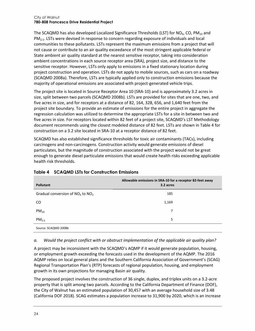
The SCAQMD has also developed Localized Significance Thresholds (LST) for NOX, CO, PM10 and PM2.5. LSTs were devised in response to concern regarding exposure of individuals and local communities to these pollutants. LSTs represent the maximum emissions from a project that will not cause or contribute to an air quality exceedance of the most stringent applicable federal or State ambient air quality standard at the nearest sensitive receptor, taking into consideration ambient concentrations in each source receptor area (SRA), project size, and distance to the sensitive receptor. However, LSTs only apply to emissions in a fixed stationary location during project construction and operation. LSTs do not apply to mobile sources, such as cars on a roadway (SCAQMD 2008a). Therefore, LSTs are typically applied only to construction emissions because the majority of operational emissions are associated with project-generated vehicle trips.
The project site is located in Source Receptor Area 10 (SRA-10) and is approximately 3.2 acres in size, split between two parcels (SCAQMD 2008b). LSTs are provided for sites that are one, two, and five acres in size, and for receptors at a distance of 82, 164, 328, 656, and 1,640 feet from the project site boundary. To provide an estimate of emissions for the entire project in aggregate the regression calculation was utilized to determine the appropriate LSTs for a site in between two and five acres in size. For receptors located within 82 feet of a project site, SCAQMD’s LST Methodology document recommends using the closest modeled distance of 82 feet. LSTs are shown in Table 4 for construction on a 3.2 site located in SRA-10 at a receptor distance of 82 feet.
SCAQMD has also established significance thresholds for toxic air contaminants (TACs), including carcinogens and non-carcinogens. Construction activity would generate emissions of diesel particulates, but the magnitude of construction associated with the project would not be great enough to generate diesel particulate emissions that would create health risks exceeding applicable health risk thresholds.
Table 4 SCAQMD LSTs for Construction Emissions
Pollutant Allowable emissions in SRA-10 for a receptor 82-feet away
3.2 acres
Gradual conversion of NOX to NO2 185
CO 1,169
PM10 7
PM2.5 5
Source: SCAQMD 2008b
a. Would the project conflict with or obstruct implementation of the applicable air quality plan?
A project may be inconsistent with the SCAQMD’s AQMP if it would generate population, housing, or employment growth exceeding the forecasts used in the development of the AQMP. The 2016 AQMP relies on local general plans and the Southern California Association of Government’s (SCAG) Regional Transportation Plan’s (RTP) forecasts of regional population, housing, and employment growth in its own projections for managing Basin air quality.
The proposed project involves the construction of 36 single, duplex, and triplex units on a 3.2-acre property that is split among two parcels. According to the California Department of Finance (DOF), the City of Walnut has an estimated population of 30,457 with an average household size of 3.48 (California DOF 2018). SCAG estimates a population increase to 31,900 by 2020, which is an increase
Environmental Checklist Air Quality
Initial Study – Mitigated Negative Declaration 25
of 1,443 persons (SCAG 2016b). As discussed in Section 13, Population and Housing, the addition of 36 new residences would generate a population increase of approximately 125 residents (0.4 percent) to 30,582, which would be within SCAG’s 2020 population forecast. According to the California Department of Finance (DOF), the current estimate for housing units in the City is 9,022 (California DOF 2018). SCAG estimates a housing increase to 9,800 by 2020, which is an increase of 778 housing units (SCAG 2016b). Therefore, construction of 36 housing units associated with the proposed project would not exceed SCAG’s 2020 housing units forecast. The proposed project would not result in a housing increase that would substantially alter air quality conditions in the south coast air basin and would be consistent with SCAQMD’s AQMP. Impacts would be less than significant.
LESS THAN SIGNIFICANT IMPACT
b. Would the project violate any air quality standard or contribute substantially to an existing or projected air quality violation?
c. Would the project result in a cumulatively considerable net increase of any criteria pollutant for which the project region is non-attainment under an applicable federal or state ambient air quality standard (including releasing emissions that exceed quantitative thresholds for ozone precursors)?
Construction Emissions Project construction would generate temporary air pollutant emissions. These emissions are associated with fugitive dust and exhaust emissions from heavy construction vehicles, as well as ROGs released during the application of architectural coatings. Grading, excavation, hauling, and site preparation would involve the greatest use of heavy equipment and generation of fugitive dust.
Table 5 summarizes the estimated maximum daily emissions of pollutants during construction on the project site. Construction emissions would not exceed SCAQMD regional thresholds or the applicable LSTs.

City of Walnut 780-808 Francesca Drive Residential Project
26
Table 5 Estimated Construction Emissions
Construction Phase
Estimated Maximum Daily Emissions (lbs/day)
ROG NOx CO SOx PM10 PM2.5
2019 Maximum lbs/day 7.5 67.4 41.6 <0.1 8.4 5.9
2020 Maximum lbs/day 6.8 41.3 38.6 <0.1 2.9 2.4
SCAQMD Thresholds 75 100.0 550 150.0 150.0 55.0
Threshold Exceeded? No No No No No No
Maximum On-site Emissions (lbs/day) 4.3 45.6 22.1 <0.1 6.7 4.6
Localized Significance Thresholds (LSTs) (on-site only) N/A 185.0 1,169.0 N/A 7.0 5.0
Threshold Exceeded? N/A No No N/A Yes Yes
See Appendix A for modeling details and CalEEMod results.
Notes: Emissions includes development of the 36 single, duplex, and triplex units under the proposed project aggregated from the two parcels emissions combined. Emissions presented are the highest of the winter and summer modeled emissions. Numbers may not add up due to rounding. Emission data is pulled from “mitigated” results, which include measures that will be implemented during project construction, such as watering of soils during construction as required under SCAQMD Rule 403.
Mitigation Measure Without mitigation, particulate matter (PM10 and PM2.5) would exceed the LSTs shown in Table 4. The following mitigation measure provided below, included in the SCAQMD CEQA Handbook, are therefore required. The implementation of the mitigation measures below would lower onsite particulate matter emissions to 6.7 lbs/day and 4.6 lbs/day, respectively, as shown in Table 5. Therefore, construction emissions would be less than significant with required mitigation.
AQ-1 Particulate Matter Apply non-toxic chemical soil stabilizers, according to manufacturers’ specifications, to all
inactive construction areas (previously graded areas inactive for ten days or more). Replace ground cover in disturbed areas as quickly as possible. Water active sites at least three times daily. Install wheel washers where vehicles enter and exit unpaved roads onto paved roads, or wash
off trucks and equipment leaving the site each trip.
Operational Emissions Operational emissions associated with project operation would include emissions associated with vehicle trips (mobile sources); natural gas and electricity use (energy sources); and landscape maintenance equipment, consumer products, and architectural coatings associated with on-site operational activities (area sources). As shown in Table 6, operational emissions would not exceed SCAQMD thresholds for any criteria pollutant. Therefore, operational emissions would have a less than significant impact on regional air quality.

Environmental Checklist Air Quality
Initial Study – Mitigated Negative Declaration 27
Table 6 Estimated Operational Emissions
Emissions Source
Estimated Maximum Daily Emissions (lbs/day)
ROG NOx CO SOx PM10 PM2.5
Area 10.3 0.8 21.3 <0.1 2.8 2.8
Energy <0.1 0.1 <0.1 <0.1 <0.1 <0.1
Mobile 0.6 3.2 8.6 <0.1 2.5 0.7
Total 11.0 4.1 29.9 <0.1 5.3 3.5
SCAQMD Thresholds 55.0 55.0 550.0 150.0 150.0 55.0
Threshold Exceeded? No No No No No No
See Appendix A for modeling details and CalEEMod results.
Notes: Operational emissions are shown from the 780 and 808 Francesca Drive parcels to include the development of the 36 single, duplex, and triplex units under the total proposed project. Emissions presented are the highest of the winter and summer modeled emissions. Numbers may not add up due to rounding.
As shown in Table 6, project operation emissions would not exceed SCAQMD significance thresholds for criteria air pollutants. Therefore, the project would not violate or contribute to a violation of an air quality standard and would not result in a cumulatively considerable net increase of any criteria air pollutant. These impacts would be less than significant.
LESS THAN SIGNIFICANT WITH MITIGATION INCORPORATED
d. Would the project expose sensitive receptors to substantial pollutant concentrations?
Certain population groups, such as children, the elderly, and people with health problems, are particularly sensitive to air pollution. Sensitive receptors are defined as land uses that are more likely to be used by these population groups and include health care facilities, retirement homes, school and playground facilities, and residential areas.
CARB’s Air Quality and Land Use Handbook: A Community Health Perspective (2005) recommends against siting sensitive receptors within 500 feet of a freeway, urban roads with 100,000 vehicles per day, or rural roads with 50,000 vehicles per day (CARB 2005). The primary concern with respect to heavy-traffic roadway adjacency is the long-term effect of TACs, such as diesel exhaust particulates, on sensitive receptors. The primary source of diesel exhaust particulates is heavy-duty trucks on freeways and high-volume arterial roadways. The project site is approximately 3-miles south of I-10 and 2.25-miles north of SR-60, which is outside of the 500-foot recommended distance. Further, the Circulation Element of the General Plan states that both Nogales Street (to the southwest of the project site) and Amar Road (to the north of the project site) are currently within acceptable levels of service and do not exceed local traffic capacities (City of Walnut 2018). Therefore, the proposed project would not introduce sensitive receptors within 500 feet of a freeway or of an urban road with 100,000 vehicles per day and would not expose sensitive receptors to substantial pollutant concentrations. Impacts would be less than significant.
LESS THAN SIGNIFICANT IMPACT

City of Walnut 780-808 Francesca Drive Residential Project
28
e. Would the project create objectionable odors affecting a substantial number of people?
The 1993 SCAQMD CEQA Air Quality Handbook identifies land uses associated with odor complaints. Single- and multi-family residences are not identified as land uses associated with odor complaints by SCAQMD and typically do not emit objectionable odors. Additionally, the proposed residences on-site would be consistent with other residences that surround the project site. Therefore, the project would not generate objectionable odors affecting a substantial number of people. There would be no impact.
NO IMPACT

Environmental Checklist Biological Resources
Initial Study – Mitigated Negative Declaration 29
4 Biological Resources
Potentially Significant
Impact
Less than Significant
with Mitigation
Incorporated
Less than Significant
Impact No Impact
Would the project:
a. Have a substantial adverse effect, either directly or through habitat modifications, on any species identified as a candidate, sensitive, or special status species in local or regional plans, policies, or regulations, or by the California Department of Fish and Wildlife or U.S. Fish and Wildlife Service? □ ■ □ □
b. Have a substantial adverse effect on any riparian habitat or other sensitive natural community identified in local or regional plans, policies, or regulations, or by the California Department of Fish and Wildlife or U.S. Fish and Wildlife Service? □ □ □ ■
c. Have a substantial adverse effect on federally protected wetlands as defined by Section 404 of the Clean Water Act (including, but not limited to, marsh, vernal pool, coastal, etc.) through direct removal, filling, hydrological interruption, or other means? □ □ □ ■
d. Interfere substantially with the movement of any native resident or migratory fish or wildlife species or with established native resident or migratory wildlife corridors, or impede the use of native wildlife nursery sites? □ □ ■ □
e. Conflict with any local policies or ordinances protecting biological resources, such as a tree preservation policy or ordinance? □ □ ■ □
f. Conflict with the provisions of an adopted Habitat Conservation Plan, Natural Community Conservation Plan, or other approved local, regional, or state habitat conservation plan? □ □ □ ■

City of Walnut 780-808 Francesca Drive Residential Project
30
The analysis presented in this section is based on a review of available information on biological resources in the project vicinity and a reconnaissance-level biological survey of the two separate parcels that comprise the project site. A Rincon biologist conducted the reconnaissance field survey for the proposed project on May 31, 2018 with a follow up visit on June 11, 2018. The purpose of the field surveys were to document the existing biological conditions at the project site, including plant and wildlife species, vegetation communities, and jurisdictional waters and wetlands. Based on the results of the survey and a review of available literature (e.g., California Natural Diversity Database [CNDDB]; California Native Plant Society [CNPS] online inventory; California Department of Fish and Wildlife [CDFW] special status species list; etc.), Rincon evaluated the potential for presence of sensitive species, jurisdictional waters and special status vegetation communities on the project site, and assessed the potential for impacts to these resources.
Regional and Project Site Setting The project site is located in a developed residential and commercial neighborhood in the city of Walnut, approximately three miles south of Interstate 10 and two miles north of California State Route 60. The surrounding area is comprised of a primarily urbanized landscape including a school located between the two parcels and residential areas immediately surrounding the two parcels. Moderately sized open areas of native habitat are situated approximately 0.5 mile from the site in the San Jose Hills, with the San Gabriel Mountains approximately nine miles to the north.
The project site is dominated by non-native grasses and is surrounded on all sides by existing residences and landscaped/ornamental vegetation. No structures are present on-site either parcel, though a concrete walkway is present along the eastern perimeter of the site along the toe of the slope. The project site is located approximately 0.5 mile south of Galster Wilderness Park, a local park with hiking trails and a relatively small area of open natural habitat, but is separated from this area by existing residential development with no direct connection to broad areas of natural habitat. Elevations on-site range from 588 to 600 feet above mean sea level (amsl).
Soils The project site contains loam soils in the Counterfeit-urban land complex, 10 to 35 percent slopes. The Counterfeit series consists of very deep soils that formed from human transported material and originated from material weathered from calcareous sedimentary rocks. Counterfeit soils are typically found on man-made terraces and risers. The soils can be well drained or poorly drained where heavily irrigated and compacted. Runoff is typically high and permeability is moderately slow to slow. These soils are typically used for recreation or commercial and residential development and support vegetation typically found in urban areas, including ornamental plants, lawns, trees, shrubs, and annual grasses (USDA 2017, 2018).
Vegetation The project site is dominated by non-native grasses, predominantly wild oat (Avena fatua) and Mediterranean grass (Schismus barbatus), with occasional occurrences of non-native weeds such as shortpod mustard (Hirschfeldia incana), Russian thistle (Salsola tragus), and castor bean (Ricinus communis) and native forbs such as bicolor lupine (Lupinus bicolor) and island morning glory (Calystegia macrostegia). Scattered trash and debris is present on-site along with recently cut tree stumps, which indicates that there are high to moderate levels of anthropogenic activities on-site.
All but one of the trees observed on-site are non-native ornamentals scattered along the eastern perimeter of the site. Non-native trees observed included fan palm (Washingtonia sp.), Peruvian

Environmental Checklist Biological Resources
Initial Study – Mitigated Negative Declaration 31
pepper tree (Schinus molle), eucalyptus (Eucalyptus sp.), and ornamental figs (Ficus elastica and Ficus benjamina). Native trees are present at low cover in the area. The project site contains one California walnut (Juglans californica) near the northeastern corner of the parcel at 808 Francesca Drive. Two coast live oaks (Quercus agrifolia) are located just off of the project site at the toe of the slope of the parcel at 780 Francesca Drive. The canopy of both trees extends slightly onto the project site. The California walnut and both coast live oaks are considered mature, with diameters greater than six inches.
Wildlife Habitat and Species The project site and surrounding area provide habitat for wildlife species that commonly occur in residential areas of the region (e.g., raccoon [Procyon lotor], striped skunk [Mephitis mephitis], and a variety of common avian species), but lacks connectivity with larger expanses of natural habitat that would allow for the sites to support most special status species. Wildlife species observed during the survey include common raven (Corvus brachyrhynchos), house finch (Haemorhous mexicanus), northern mockingbird (Mimus polyglottos), and mourning dove (Zenaida macroura).
Regulatory Setting Regulatory authority over biological resources is shared by federal, state, and local authorities under a variety of statutes and guidelines. Primary authority for general biological resources lies with the land use control and planning authority of local jurisdictions. The CDFW is a trustee agency for biological resources throughout the state under CEQA and also has direct jurisdiction under the Fish and Game Code of California. Under the State and Federal Endangered Species Acts, the CDFW and the U.S. Fish and Wildlife Service (USFWS) also have direct regulatory authority over species formally listed as Threatened or Endangered. The U.S. Army Corps of Engineers (USACE) has regulatory authority over specific biological resources, namely wetlands and waters of the United States, under Section 404 of the Federal Clean Water Act.
Plants or animals may be considered “special-status” due to declining populations, vulnerability to habitat change, or restricted distributions. Special-status species are classified in a variety of ways, both formally (e.g. State or Federally Threatened and Endangered Species) and informally (“Special Animals”). Species may be formally listed and protected as Threatened or Endangered by the CDFW or USFWS or as California Fully Protected (CFP). Informal listings by agencies include California Species of Special Concern (SSC) a broad database category applied to species, roost sites, or nests, or as USFWS Candidate taxa. CDFW and local governmental agencies may also recognize special listings developed by focal groups (i.e. Audubon Society Blue List, CNPS Rare and Endangered Plants, U.S. Forest Service regional lists).
While common birds are not designated as special-status species, destruction of their eggs, nests, and nestlings is prohibited by federal and state law. Section 3503.5 of the Fish and Game Code of California specifically protects birds of prey, and their nests and eggs against take, possession, or destruction. Section 3503 of the Fish and Game Code also incorporates restrictions imposed by the federal Migratory Bird Treaty Act (MBTA) with respect to migratory birds (which consists of most native bird species).
Trees regulated under the City’s municipal code are defined as Heritage and protected trees (collectively referred to as “Protected Trees”), denoted by their species or diameter at breast height (DBH; also known as “caliper”) as follows:

City of Walnut 780-808 Francesca Drive Residential Project
32
“Heritage Oak/Walnut tree” is defined as any tree measuring forty inches or more in circumference or, in the case of a multiple trunk tree, two or more trunks measuring thirty inches or greater in circumference, measured three feet above the natural grade surrounding such tree. In addition, the planning commission and/or city council may classify a tree, regardless of size, as a heritage oak/walnut tree if it is determined by a majority vote thereof that such tree has exceptional historic, aesthetics and/or prominence to the community.
“Tree” is defined as any oak tree of the genus Quercus including, but not limited to, Blue Oak (Quercus douglasii), California Black Oak (Quercus kelloggii), Valley Oak (Quercus lobata), California-Live Oak (Quercus agrifolia), Canyon Oak (Quercus chrysolepis), Interior Live Oak (Quercus wislizeni), Scrub Oak (Quercus Dumosa), and California Black Walnut (Juglans californica).
“Protected tree” is defined as any oak or walnut tree that measures a minimum of six inches in circumference at a point four and one-half feet off the ground measured from the base of the tree.(Ord. No. 03-05, § 1)
The WMC requires the “preservation of all healthy trees unless compelling reasons justify the removal of such trees. This policy shall apply to the removal, pruning, cutting and/or encroachment into the protected zone of the trees. The community development department shall have the primary and overall responsibility to administer, evaluate and monitor this policy to assure strict compliance” (Ord. No. 03-05, § 1). Chapter 25-178 of the Municipal Code specifies that “no person shall cut, prune, remove, relocate, endanger, damage or encroach into the protected zone of any tree within the city except in accordance with the conditions of a valid tree permit issued by the city” (Ord. No. 03-05, § 1).
a. Would the project have a substantial adverse effect, either directly or through habitat modifications, on any species identified as candidate, sensitive, or special status in local or regional plans, policies, or regulations, or by the California Department of Fish and Wildlife or the U.S. Fish and Wildlife Service?
Special-status Species Special-status species are those plants and animals listed, proposed for listing, or candidates for listing as Threatened or Endangered by the USFWS under the Federal Endangered Species Act (FESA); those considered “Species of Concern” by the USFWS; those listed or candidates for listing as Rare, Threatened, or Endangered by the CDFW under the California Endangered Species Act (CESA); animals designated as “Fully Protected” by the California Fish and Game Code (CFGC); animals listed as “Species of Special Concern” (SSC) by the CDFW; and CDFW Special Plants, specifically those with California Rare Plant Ranks (CRPR) of 1B, 2, 3, and 4 in the CNPS’s Inventory of Rare and Endangered Vascular Plants of California (CNPS 2018a). A list of special-status plant and animal species with potential to occur on-site was developed based on a review of a 5-mile radius search of the CNDDB (CDFW 2018) and the CNPS’s online Inventory of Rare and Endangered Vascular Plants of California (CNPS 2018a) (see Appendix F). The potential for each special-status species to occur on the project site was evaluated according to the following criteria.
Not Expected. Habitat on and adjacent to the project site is clearly unsuitable for the species requirements (foraging, breeding, cover, substrate, elevation, hydrology, plant community, site history, disturbance regime).

Environmental Checklist Biological Resources
Initial Study – Mitigated Negative Declaration 33
Low Potential. Few of the habitat components meeting the species requirements are present, and/or the majority of habitat on and adjacent to the project site is unsuitable or of very poor quality. The species is not likely to be found on the project site.
Moderate Potential. Some of the habitat components meeting the species requirements are present, and/or only some of the habitat on or adjacent to the project site is unsuitable. The species has a moderate probability of being found on the project site.
High Potential. All of the habitat components meeting the species requirements are present and/or most of the habitat on or adjacent to the project site is highly suitable. The species has a high probability of being found on the project site.
Present. Species is observed or has been recorded (e.g., CNDDB, other reports) on the project site recently (within the last 5 years).
Special-status Plants and Wildlife The CNDDB and CNPS database search yielded three special status plant and 15 wildlife species within a 5-mile radius of the project site. Of these, 14 wildlife species are not expected to occur on-site given the disturbed non-native grassland habitat, lack of suitable soils, absence of habitat connectivity, or other habitat factors. Only one species, western mastiff bat (Eumops perotis californicus), has the low potential of occurring on-site since there are some tall trees in the area (California fan palm and eucalyptus) that may be suitable for roosting. However, the surrounding areas are highly developed and disturbed with high levels of anthropogenic activity. In addition, the following three special status plant species are not expected to occur on-site due to a lack of suitable soils or habitats (disturbed, non-native grassland) on-site: Plummer’s mariposa-lily (Calochortus plummerae), CRPR 4.2; intermediate mariposa-lily (Calochortus weedii var. intermedius), CRPR 1B.2; and San Bernardino aster (Symphyotrichum defoliatum), CRPR 1B.2. Potential project impacts to non-listed species present or potentially present on-site would be less than significant considering the small size of the site in an urbanized context in which the existing populations would not be substantially reduced.
One mature California walnut tree and two coast live oak trees occur on the project site. Individuals of these native tree species greater than six inches in diameter are protected by the WMC and would require a permit for any impacts to them. Compliance with the WMC, as discussed below, would reduce potential impacts to a less than significant level.
Nesting Birds While common birds are not designated as special-status species, destruction of their eggs, nests, and nestlings is prohibited by federal and state law. The vegetation present on the project site could provide nesting habitat for common resident birds that were observed during the field survey. There are several large ornamental and native trees on the project site and adjacent properties that could provide potential habitat for nesting raptors, such as red-tailed hawk (Buteo jamaicensis). Project activities could directly (e.g., through vegetation removal) and indirectly (e.g., through construction noise and motion) affect nesting of these species which are protected under the MBTA and the CFGC. Implementation of Mitigation Measure BIO-1 would ensure compliance with the MBTA and CFGC, thereby reducing potential impacts to less than significant.
Mitigation Measure The following mitigation measure and compliance with the MBTA and CFGC requirements would be required to ensure impacts to nesting birds would be less than significant.

City of Walnut 780-808 Francesca Drive Residential Project
34
BIO-1 Nesting Birds To avoid disturbance of nesting and special-status birds, project activities, including but not limited to vegetation removal, ground disturbance, and construction and demolition, shall occur outside of the bird breeding season (February 1 through August 31). If construction must begin during the breeding season, a pre-construction nesting bird survey shall be conducted by a qualified City-approved biologist no more than seven days prior to initiation of ground disturbance and vegetation removal activities within all suitable nesting habitat located within the project site. If no nesting birds are found, construction may be initiated without impacts to nesting birds. If nests are found, the biologist shall determine a suitable buffer where no construction activities would occur. The distance will be determined by the biologist based on the species of bird to ensure that no direct or indirect impacts would occur. An avoidance buffer shall be determined and demarcated by the biologist with bright orange construction fencing, flagging, or other means to mark the boundary. All construction personnel shall be notified as to the existence of the buffer zone and to avoid entering the buffer zone during all project construction activities. The biologist shall monitor the nesting activity during construction, as needed, to verify that the buffer was adequately placed and that breeding is not compromised by construction. The buffer shall remain in place while the nest is active; project encroachment into the buffer shall only occur at the discretion of the qualified biologist.
LESS THAN SIGNIFICANT WITH MITIGATION INCORPORATED
b. Would the project have a substantial adverse effect on any riparian habitat or other sensitive natural community identified in local or regional plans, policies, or regulations, or by the California Department of Fish and Wildlife or U.S. Fish and Wildlife Service?
Plant communities are considered sensitive biological resources if they have limited distributions, have high wildlife value, include sensitive species, or are particularly susceptible to disturbance. CDFW ranks sensitive communities as "threatened" or "very threatened" and keeps records of their occurrences. The following sensitive natural communities occur within a 5-mile CNDDB search of the project site: California walnut woodland, southern coast live oak riparian forest, and walnut forest. None of these communities occur on the project site. Although one California black walnut and two coast live oaks occur on-site or adjacent to the site, there are not enough individuals, cover, or connectivity to habitat nearby to consider them a part of any of the sensitive communities listed above. In addition, neither parcel contains riparian habitat or other sensitive natural communities. Therefore, the project would have no impact on sensitive natural communities and mitigation is not required.
NO IMPACT
c. Would the project have a substantial adverse effect on federally protected wetlands as defined by Section 404 of the Clean Water Act (including, but not limited to, marsh, vernal pool, coastal, etc.) through direct removal, filling, hydrological interruption, or other means?
No federally protected wetlands or other water features that may be considered jurisdictional by the CDFW, USACE, or Regional Water Quality Control Board (RWQCB) are mapped (USFWS 2018c) or occur on the project site. Therefore, the project would have no impact on federally protected wetlands or other jurisdictional waters and no mitigation is required.
NO IMPACT

Environmental Checklist Biological Resources
Initial Study – Mitigated Negative Declaration 35
d. Would the project interfere substantially with the movement of any native resident or migratory fish or wildlife species or with established native resident or migratory wildlife corridors, or impede the use of native wildlife nursery sites?
The project site is located in a developed urban area and surrounded by urbanized uses in all directions, including roads and single family residences. Given the urban nature of the surroundings, neither parcel would function as a significant wildlife corridor or linkage, nor as a native wildlife nursery site. The project site is not located within a County of Los Angeles Regional Wildlife Linkage (County of Los Angeles 2014) or a CDFW Essential Habitat Connectivity Area. The nearest wildlife corridor as identified by the CDFW Essential Habitat Connectivity Area (CDFW 2018) occurs approximately nine miles to the north of the project site in the San Gabriel Mountains and would not be affected by implementation of the project. Therefore, the project would not affect wildlife movement. Impacts would be less than significant.
LESS THAN SIGNIFICANT IMPACT
e. Would the project conflict with any local policies or ordinances protecting biological resources, such as a tree preservation policy or ordinance?
Both project parcels are located in a fairly developed suburban area surrounded by residential and commercial structures. There is no native biological habitat on-site, and the only vegetation includes non-native grasses on both sites with a few mature trees located on the site. Two coast live oaks adjacent to the parcel located at 780 Francesca Drive have canopies that extend into the parcel and the parcel located at 808 Francesca Drive contains one California black walnut tree. All three trees are mature with diameters greater than six inches, and are protected by the WMC (Chapter 25-178, Ord. No. 03-05, § 1). Impacts to these trees without City approval would conflict with the WMC. While project activities do not propose to remove the trees or encroach into the tree protection zone (TPZ), documentation of this avoidance may be required by the WMC (e.g., Chapters 25-178.9(f)(1)(a) and 25-178.10(c)). Therefore, compliance with the WMC would reduce potential impacts to a less than significant level.
LESS THAN SIGNIFICANT IMPACT
f. Would the project conflict with the provisions of an adopted Habitat Conservation Plan, Natural Community Conservation Plan, or other approved local, regional, or state habitat conservation plan?
The project site is not subject to any Habitat Conservation or Natural Community Conservation Plans or approved local, regional, or state habitat conservation plans. Therefore, the project would not conflict with any adopted plans and no mitigation is required.
NO IMPACT

City of Walnut 780-808 Francesca Drive Residential Project
36
This page intentionally left blank.

Environmental Checklist Cultural Resources
Initial Study – Mitigated Negative Declaration 37
5 Cultural Resources
Potentially Significant
Impact
Less than Significant
with Mitigation
Incorporated
Less than Significant
Impact No Impact
Would the project:
a. Cause a substantial adverse change in the significance of a historical resource as defined in §15064.5? □ □ □ ■
b. Cause a substantial adverse change in the significance of an archaeological resource as defined in §15064.5? □ ■ □ □
c. Directly or indirectly destroy a unique paleontological resource or site or unique geological feature? □ ■ □ □
d. Disturb any human remains, including those interred outside of formal cemeteries? □ ■ □ □
This section provides an analysis of the project’s impacts on cultural resources, including historical, archaeological, and paleontological resources and human remains.
Background According to historical aerial photographs of the project site, neither parcel has ever been developed. The 1948 historic aerial photographs show the project site and surrounding vicinity as undeveloped, with sparse vegetation and what appears to be a natural drainage that travels northeast/southwest just north of the project site. According to the 1964 historic aerial, the project site resembles a cleared and disked agricultural field. By 1980, the project site was cleared and early stages of residential development are visible to the north and west with expansive commercial and residential development apparent throughout the vicinity surrounding the project site by 1995. Francesca Drive was constructed between 1980 and 1995 (NETRonline 2018.). The drainage west of the project site is depicted on the 1894 Pomona topographic map, and no structures exist in the project site or in the vicinity (United States Geological Survey 1894).
A search of the California Historical Resources Information System (CHRIS) at the South Central Coastal Information Center (SCCIC) located at the University of California, Fullerton was completed on May 29, 2018. The search was performed to identify all previously recorded cultural resources, as well as previously conducted cultural resources studies, within the project site and a half-mile buffer surrounding it. The CHRIS search included a review of the National Register of Historic Places, the California Register of Historical Resources (CRHR), the Office of Historic Preservation Historic Properties Directory, the California Inventory of Historic Resources, and the Archaeological Determinations of Eligibility list.

City of Walnut 780-808 Francesca Drive Residential Project
38
The SCCIC records search identified one previously recorded cultural resource (19-001066) within a half-mile buffer of the project site. Resource 19-001066 is a prehistoric site consisting of a lithic scatter that was identified along the edge of the half mile records search buffer. No historical resources were identified on or adjacent to the project site as a result of the records search (see Appendix B).
The SCCIC records search also identified seven previously conducted cultural resources studies that have been performed within a half-mile of the project site; two of these studies (LA-00559 and LA-10997) included the current project site. LA-00559 consisted of an archaeological resources survey for a 725 acre parcel in the City of Walnut resulting in the recordation of one archaeological site and number of associated stray finds concluding that the prehistoric use of the area is not clear. LA-10997 consists of a Draft Final Cultural Resources Assessment of approximately encompassing 12.4 miles and 3 tank locations for a reclaimed water backbone transmission project for the Upper San Gabriel Valley Water District. This study did not identify any previously or newly recorded cultural resources within the pipeline corridor or zones included in the project area.
a. Would the project cause a substantial adverse change in the significance of a historical resource as defined in §15064.5?
As discussed above, according to historical aerial photographs of the project site, the project site has never been developed. No structures are present on the project site or in the vicinity (United States Geological Survey 1894). Therefore, no impact with respect to historic resources would occur.
NO IMPACT
b. Would the project cause a substantial adverse change in the significance of an archaeological resource as defined in §15064.5?
d. Would the project disturb any human remains, including those interred outside of formal cemeteries?
Rincon Archaeologist Tricia Dodds, M.A., RPA, conducted a pedestrian field survey of the project site on June 5, 2018. The survey was conducted in northeast-southwest transects spaced 10 meters apart. In areas with exposed ground, the surface was examined for artifacts (e.g., flaked stone tools, tool-making debris, stone milling tools, ceramics, fire-affected rock), ecofacts (marine shell and bone), soil discoloration that might indicate the presence of a cultural midden, soil depressions, and features indicative of the former presence of structures or buildings (e.g., standing exterior walls, postholes, foundations) or historic debris (e.g., metal, glass, ceramics). The following describes the survey condition and results from each of the two parcels that comprise the project site.
780 Francesca Drive This parcel consists of a grass field surrounded by residences and commercial buildings and is bounded by a sidewalk and street on the west, commercial buildings on the north and south, and wrought iron fence with cement base on the east side that separates the field from residential backyards. Modern refuse, including beer cans and bottles, plastic debris, miscellaneous household refuse, asphalt and cement pieces, and automotive parts, were observed throughout the project site. On the eastern boundary of the parcel, a cement drainage runs the perimeter and components of a modern irrigation system were observed at this location. Surface coverage was approximately 90 % with tall dry grasses and vegetation obscuring ground visibility. The occurrence of modern

Environmental Checklist Cultural Resources
Initial Study – Mitigated Negative Declaration 39
refuse and vehicular disturbances suggest the area is highly disturbed. No cultural resources were identified at this location.
808 Francesca Drive This parcel consists of an open grass field and is bounded on the west by a sidewalk and street, on the north and south by commercial buildings, on the east by a wrought iron fence. Modern refuse including glass bottles, tires, clothing, and miscellaneous household debris was observed throughout the project site. The cement drainage observed at 780 Francesca continues through the eastern portion of this parcel and spans the length of the project site at both locations. Ground coverage is approximately 85% with tall grasses, mulch, and flowers obscuring surface visibility. Disturbances at this location include vehicular tracks running in various directions throughout the project site. No cultural resources were identified at this location.
Conclusions Despite the lack of visible cultural resources on the surface of the project site, cultural resources may be encountered during project-related development and ground-disturbing activities. Impacts would be significant if construction activities result in the destruction, damage, or loss of scientifically important cultural resources. The activities may include grading, excavation, or any other activity that disturbs the surface of the site.
Mitigation Measures The following mitigation measures would address the potentially significant impacts relating to the unanticipated discovery of archeological resources and human remains during project implementation. These measures would apply to all phases of project construction and would ensure that any significant resources present on-site are preserved. Implementation of Mitigation Measures CR-1 and CR-2 would reduce potential impacts to archeological resources and human remains to a less than significant level. These measures, which are presented below, would effectively mitigate the project’s impacts to these cultural resources through the recovery, identification, and curation of previously unrecovered resources.
CR-1 Unanticipated Discovery of Archaeological Resources If archaeological resources are encountered during ground-disturbing activities, work in the immediate area should be halted and an archaeologist meeting the Secretary of the Interior’s Professional Qualification Standards for archaeology (National Park Service 1983) should be contacted immediately to evaluate the find. If necessary, the evaluation may require preparation of a treatment plan and archaeological testing for CRHR eligibility. If the discovery proves to be CRHR eligible and cannot be avoided by the project, additional work, such as data recovery excavation, may be warranted to mitigate any significant impacts to historical resources.
CR-2 Unanticipated Discovery of Human Remains The discovery of human remains is always a possibility during ground-disturbing activities. If human remains are found, the State of California Health and Safety Code Section 7050.5 states that no further disturbance shall occur until the County Coroner has made a determination of origin and disposition pursuant to Public Resources Code Section 5097.98. In the event of an unanticipated discovery of human remains, the County Coroner must be notified immediately. If the human remains are determined to be prehistoric, the Coroner will notify the Native American Heritage

City of Walnut 780-808 Francesca Drive Residential Project
40
Commission, which will determine and notify a most likely descendant (MLD). The MLD shall complete the inspection of the site and provide recommendations for treatment to the landowner within 48 hours of being granted access.
LESS THAN SIGNIFICANT WITH MITIGATION INCORPORATED
c. Would the project directly or indirectly destroy a unique paleontological resource or site or unique geological feature?
Rincon evaluated the paleontological sensitivity of the geologic units that underlie the project area using the results of the paleontological locality search and review of existing information in the scientific literature concerning known fossils within those geologic units. Rincon submitted a request to the Natural History Museum of Los Angeles County (LACM) for a list of known fossil localities from the project area and immediate vicinity (i.e., localities recorded on the United States Geological Survey [USGS] Baldwin Park, 7.5-minute topographic quadrangle), reviewed fossil collections records from the University of California Museum of Paleontology (UCMP) online database, which contains known fossil localities in Los Angeles County, and reviewed geologic maps and relevant scientific literature.
Following the literature review and museum record search a paleontological sensitivity classification was assigned to the geologic units within the project area. The potential for impacts to significant paleontological resources is based on the potential for ground disturbance to directly impact paleontologically sensitive geologic units. The Society of Vertebrate Paleontology (SVP) (2010) has developed a system for assessing paleontological sensitivity and describes sedimentary rock units as having high, low, undetermined, or no potential for containing scientifically significant nonrenewable paleontological resources. This criterion is based on rock units within which vertebrate or significant invertebrate fossils have been determined by previous studies to be present or likely to be present.
Existing Conditions The project site is located in the San Jose Hills, north of the Whittier fault, and adjacent to the San Jose fault, along the margin between the Transverse Ranges and Peninsular Ranges geomorphic provinces of California (California Geological Survey 2002; Morton and Miller 2006).. The eastern San Jose Hills are characterized by the Glendora Volcanic Rocks of middle Miocene age and late Mesozoic-Cretaceous age quartz diorite plutonic rocks. The western and central San Jose Hills are dominated by Cenozoic shale, sandstone, and conglomerate terrestrial and marine sedimentary deposits (Morton and Miller 2006).
The project site vicinity is mapped at a scale of 1:100,000 by Morton and Miller (2006) and includes two (2) geologic units mapped at ground surface: the early Pliocene to late Miocene Puente Formation (Tpy) and Quaternary alluvial fan deposits of Holocene age (Qya3) (Figure 13). The early Pliocene to late Miocene Puente Formation (Tpy) is exposed in the area and is well exposed throughout the Los Angeles Basin and the San Jose Hills (where the unit is alternatively referred to as the Monterey Formation by Dibblee and Ehrenspeck [1991]). The Puente Formation is the temporal equivalent of the younger strata of the Monterey Formation and was named as a separate unit by Eldridge and Arnold (1907) for its type section in the Puente Hills. The Puente Formation is composed of deep marine, submarine fan, and turbiditic deposits, which consist of locally diatomaceous, well-bedded, light gray siltstone and shale; well-bedded, very fine- to very coarse-grained sandstone; and interbedded pebble conglomerate (Yerkes and Campbell 2005). The Yorba
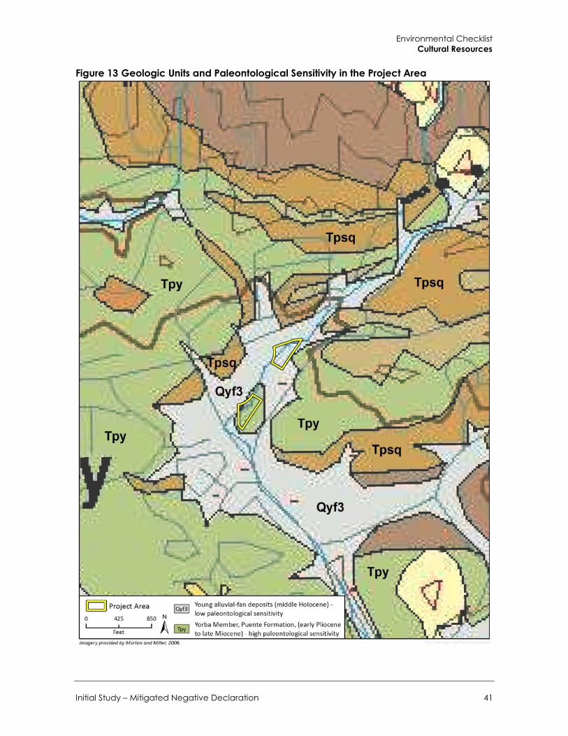
Environmental Checklist Cultural Resources
Initial Study – Mitigated Negative Declaration 41
Figure 13 Geologic Units and Paleontological Sensitivity in the Project Area

City of Walnut 780-808 Francesca Drive Residential Project
42
member is mapped with the project area and is composed of white to gray, thinly bedded, micaceous and siliceous siltstone and sandy siltstone, with subordinate pale gray limy concretions, and a turbidity current conglomerate in a fine-grained matrix (Morton and Miller 2006; Schoellhamer et al. 1954).
Numerous vertebrate localities have been documented from within the Puente Formation in Southern California, which yielded specimens of marine and terrestrial fauna, including whale, shark, bony fish, mastodon, rhinoceros, horse, rabbit, and rodent (PaleoBiology Database 2018). In addition, several invertebrate, plant, and microfossil localities were discovered within the Puente Formation, including specimens of insect, mollusk, sponge, algae, and foraminifera (Huddleston and Takeuchi 2006; UCMP online database 2018)..
Quaternary alluvial fan deposits of Holocene age (Qya3) are mapped in the project area where they unconformably overlie the Puente Formation. The Quaternary alluvial fan deposits are composed of moderately consolidated silt, sand, and pebble to boulder size gravel, with moderately dissected surfaces (Morton and Miller 2006). No previously recorded fossils have been documented in the Holocene alluvial fan deposits in the project area. Holocene-age alluvial deposits, particularly those younger than 5,000 years old, are generally too young to contain fossilized material (SVP 2010).
Locality Record Search A search of the paleontological locality records at the LACM resulted in no previously recorded fossil localities within the project boundaries; however, at least 18 vertebrate localities (LACM 7854-7859, 7871-7877, and 7930-7934) have been identified within the early Pliocene to late Miocene Puente Formation in the San Jose Hills immediately west of the project area. These localities yielded a suite of marine fish, including taxa of silversides (Atherinidae), bigscale (Scopelogadus), herrings (Ganolytes and Xyne grex), cod (Gadidae), lanterfish (Diaphus), croaker (Lompoquia), mackerel (Scombridae), deep sea smelt (Bathylagus), and viperfish (Chauliodus) (McLeod 2018). Depth of recovery was unreported.
Paleontological Sensitivity of the Project Area Based on a literature review and museum locality search, geologic units underlying the project area were determined have low to high paleontological sensitivity, in accordance with SVP (2010) guidelines (Figure 13). The Yorba member of the early Pliocene to late Miocene Puente Formation immediately underlies the southern portion of the parcel at 780 Francesca Drive and is considered to have a high paleontological sensitivity because the unit has proven to yield vertebrate fossils throughout eastern Los Angeles County. Quaternary alluvial fan deposits underlie most of the parcel at 808 Francesca Drive and a portion of the southern project parcel at 780 Francesca Drive and are determined to have a low paleontological sensitivity. As a result, the parcel at 780 Francesca Drive has a high potential for buried paleontological resources. Ground disturbing activities in previously undisturbed portions of the parcel at 780 Francesca Drive may result in significant impacts to paleontological resources. Impacts would be significant if construction activities result in the destruction, damage, or loss of scientifically important paleontological resources and associated stratigraphic and paleontological data.
Mitigation Measures The following mitigation measures would address the potentially significant impacts relating to the discovery of paleontological resources during project implementation and ground-disturbing activities. These measures would apply to all phases of project construction and would ensure that

Environmental Checklist Cultural Resources
Initial Study – Mitigated Negative Declaration 43
any significant fossils present on-site are preserved. Implementation of Mitigation Measures CR-3 and CR-4 would reduce potential impacts to paleontological resources to less than significant level through the recovery, identification, and curation of previously unrecovered fossils.
CR-3 Paleontological Monitoring Ground disturbing construction activities (including grading, trenching, drilling with an auger greater than 3 feet in diameter, and other excavation) in previously undisturbed geologic deposits with high paleontological sensitivity (i.e., the early Pliocene to late Miocene Puente Formation) for the parcel at 780 Francesca Drive shall be monitored by a qualified paleontologist on a full-time basis. Spot-checks or part-time monitoring shall be conducted in project areas underlain by Quaternary alluvial fan deposits to determine whether the underlying Puente Formation is being disturbed and impacted by project ground disturbance.
The duration and timing of the monitoring shall be determined by the qualified paleontologist. If the qualified paleontologist determines that full-time monitoring is no longer warranted, he or she may recommend reducing monitoring to periodic spot-checking or cease entirely. Monitoring would be reinstated if any new ground disturbances are required and reduction or suspension would need to be reconsidered by the qualified paleontologist.
CR-4 Fossil Discovery, Preparation, and Curation In the event that a paleontological resource is discovered, the qualified paleontologist shall have the authority to temporarily divert construction equipment around the find until it is assessed for scientific significance and collected. Typically, fossils can be safely salvaged quickly by a single paleontologist and not disrupt construction activity. In some cases, larger fossils (such as complete skeletons or large mammals) require more extensive excavation and longer salvage periods. In this case, the paleontologist shall have the authority to temporarily direct, divert or halt construction activity to ensure that the fossil(s) can be removed in a safe and timely manner.
Once salvaged, significant fossils shall be identified to the lowest possible taxonomic level, prepared to a curation-ready condition and curated in a scientific institution with a permanent paleontological collection (such as the Natural History Museum of Los Angeles County) along with all pertinent field notes, photos, data, and maps. The cost of curation is assessed by the repository and is the responsibility of the project owner.
At the conclusion of laboratory work and museum curation, a final report shall be prepared and shall include a summary of the field and laboratory methods, an overview of the project geology and paleontology, a list of taxa recovered (if any), an analysis of fossils recovered (if any) and their scientific significance, and recommendations. The report shall be submitted to the lead agency(s) for the project. If the monitoring efforts produced fossils, then a copy of the report shall also be submitted to the designated museum repository.
LESS THAN SIGNIFICANT WITH MITIGATION INCORPORATED

City of Walnut 780-808 Francesca Drive Residential Project
44
This page intentionally left blank.
Environmental Checklist Geology and Soils
Initial Study – Mitigated Negative Declaration 45
6 Geology and Soils
Potentially Significant
Impact
Less than Significant
with Mitigation
Incorporated
Less than Significant
Impact No Impact
Would the project have any of the following impacts?
a. Expose people or structures to potentially substantial adverse effects, including the risk of loss, injury, or death involving:
1. Rupture of a known earthquake fault, as delineated on the most recent Alquist-Priolo Earthquake Fault Zoning Map issued by the State Geologist for the area or based on other substantial evidence of a known fault □ □ □ ■
2. Strong seismic ground shaking □ □ ■ □ 3. Seismic-related ground failure,
including liquefaction □ □ ■ □
4. Landslides □ □ ■ □ 5. Result in substantial soil erosion or
the loss of topsoil □ □ ■ □ b. Be located on a geologic unit or soil that is
made unstable as a result of the project, and potentially result in on or offsite landslide, lateral spreading, subsidence, liquefaction, or collapse □ □ ■ □
c. Be located on expansive soil, as defined in Table 1-B of the Uniform Building Code, creating substantial risks to life or property □ □ ■ □
d. Have soils incapable of adequately supporting the use of septic tanks or alternative wastewater disposal systems where sewers are not available for the disposal of wastewater □ □ □ ■
Environmental Geotechnology Laboratory, Inc. (EGL) prepared a Geotechnical and Engineering Geological Investigation Report for each of the project sites in January 2007 (EGL 2007). EGL concluded that the proposed grading plans and structures would be safe from landslide, subsidence, and slippage hazards and that proposed construction would not affect the existing geologic stability

City of Walnut 780-808 Francesca Drive Residential Project
46
of either parcel provided that EGL’s recommendations for each project site are followed. The following is based on the information and analysis contained in the geotechnical reports, which are provided as Appendix C.
a.1. Expose people or structures to potential substantial adverse effects, including the risk of loss, injury, or death involving rupture of a known earthquake fault, as delineated on the most recent Alquist-Priolo Earthquake Fault Zoning Map issued by the State Geologist for the area or based on other substantial evidence of a known fault?
Neither of the project parcels are located in an Alquist-Priolo earthquake fault zone as defined by the State Geologist, nor are they located along a known fault (EGL 2007). The closest active fault with the potential for fault surface rupture is the San Jose Fault, located one mile to the northeast. No known fault lines cut through either of the sites (California Department of Conservation 2015). Therefore, proposed development would not be exposed to hazards associated with surface fault rupture. No impact would occur.
NO IMPACT
a.2. Expose people or structures to potential substantial adverse effects, including the risk of loss, injury, or death involving strong seismic ground shaking?
The project site is located in the highly seismic Southern California region where several fault systems are considered to be active or potentially active. Nearby active faults include the San Jose Fault and the Walnut Creek Fault (California Department of Conservation 2015). The project site may be subject to ground shaking in the event of an earthquake originating along one of the faults designated as active or potentially active in the vicinity of the sites. This hazard is common throughout California and the proposed development would pose no greater risk to public safety or destruction of property than is already present for the region.
As discussed in each geotechnical report for the parcels, neither parcel is located in an area expected to be subject to strong seismic activity. However, to reduce geologic and seismic impacts, the City regulates development through the requirements of the California Building Code (CBC). The purpose of the CBC is to establish minimum standards to safeguard the public health, safety, and general welfare through structural strength, means of egress, and general stability by regulating and controlling the design, construction, quality of materials, use and occupancy, location, and maintenance of all building and structures within its jurisdiction. The earthquake design requirements of the CBC take into account the occupancy category of the structure, site class, soil classifications, and various seismic coefficients. The CBC provides standards for various aspects of construction, including but not limited to excavation, grading, and earthwork construction, preparation of the site prior to fill placement, specification on fill materials and fill compaction and field testing, retaining wall design and construction, foundation design and construction, and seismic requirements. It includes provisions to address issues such as (but not limited to) construction on expansive soils and soil strength loss. In accordance with California law, project design and construction would be required to comply with provisions of the CBC. Because the project would comply with the CBC, impacts related to seismically induced ground shaking would be less than significant and the proposed project would not exacerbate ground shaking conditions.
LESS THAN SIGNIFICANT IMPACT

Environmental Checklist Geology and Soils
Initial Study – Mitigated Negative Declaration 47
a.3. Expose people or structures to potential substantial adverse effects, including the risk of loss, injury, or death involving seismic-related ground failure, including liquefaction?
Liquefaction is a condition that occurs when unconsolidated, saturated soils change to a near-liquid state during ground shaking. According to the geotechnical reports conducted for each parcel, no areas were identified as having the potential for surficial failures such as liquefaction (EGL 2007). Furthermore, due to the lack of existing permanent groundwater and relatively shallow bedrock underneath the project site, the potential for liquefaction was determined to be low (EGL 2007). Potential impacts associated with liquefaction would be less than significant
LESS THAN SIGNIFICANT IMPACT
a.4. Expose people or structures to potential substantial adverse effects, including the risk of loss, injury, or death involving landslides?
The geologic character of an area determines its potential for landslides. Steep slopes, the extent of erosion, and the rock composition of a hillside all contribute to the potential for slope failure and landslide events. In order to fail, unstable slopes need to be disturbed; common triggering mechanisms of slope failure include undercutting slopes by erosion or grading, saturation of marginally stable slopes by rainfall or irrigation; and, shaking of marginally stable slopes during earthquakes.
Both project parcels are located in a developed suburban area and are relatively flat. According the geologic reports for both parcels, neither parcel is located in a potentially seismic hazard area for earthquake-induced landslides as shown in the seismic hazard map for the Baldwin Park Quadrangle (EGL 2007). Existing slopes gradients vary from 2:1 or flatter. However, the northern and eastern portions of the parcel at 808 Francesca Drive have a slope height of approximately 42 feet, which would be partially excavated during project construction and would require installation of a retaining wall for building support. Slope stability analysis was conducted for this portion of the 808 Francesca Drive site under existing and proposed project conditions. The analysis determined that the slope is stable under existing seismic conditions, and would also be stable under development of the proposed project with implementation of deep soil removal and installation of concrete shoring. Furthermore, although neither parcel is expected to have permanent groundwater presence during construction, the geologic reports recommend that a project civil engineer or waterproofing specialist design wall subdrains and waterproofing systems to be installed along the perimeters of the building basements on both parcels to handle possible water levels during the wetter periods of the season during construction. For the parcel at 808 Francesca Drive, the geologic report also recommends that dewatering drainage galleries, interceptor drains, and well points or wells be installed around the perimeter of the proposed construction area prior to the deep removal phase. In addition, both reports recommend that the proposed project follow the provided recommendations regarding the placement of fill, slope construction, cut and fill of slopes, excavation, retaining walls, and foundation design (see Appendix ). With adherence to the procedures and recommendations provided in the geologic reports, impacts related to landslides would be less than significant.
LESS THAN SIGNIFICANT IMPACT

City of Walnut 780-808 Francesca Drive Residential Project
48
a.5. Would the project result in substantial soil erosion or the loss of topsoil?
Long-term and temporary erosion could occur during construction of the proposed project. Although the existing slope gradients within both project sites are primarily 2:1 or flatter and the existing compacted fill slopes are geologically stable under saturated conditions, both geologic reports confirm that all slopes will still be subject to surficial erosion and, therefore, should be protected from surface runoff by means of top-of-slope compacted earth berms or concrete interceptor drains. The reports further recommend landscaping of slopes with suitable plant material requiring minimal cultivation and irrigation water. Lastly, construction activity would be required to comply with the development standards set forth in Section 6-5.5 of WMC, which includes standards for mass grading and shaping of slopes.
Compliance with local regulatory requirements and with the recommendations provided in the geotechnical reports would reduce potential erosion impacts to less than significant levels.
LESS THAN SIGNIFICANT IMPACT
b. Would the project be located on a geologic unit or soil that is unstable as a result of the project, and potentially result in on- or off-site landslide, lateral spreading, subsidence, liquefaction, or collapse?
Subsidence is the sudden sinking or gradual downward settling of the Earth’s surface with little or no horizontal movement. Subsidence is caused by a variety of activities, which include, but are not limited to, withdrawal of groundwater, pumping of oil and gas from underground, the collapse of underground mines, liquefaction, and hydrocompaction. Lateral spreading is the horizontal movement or spreading of soil toward an open face. The potential for failure from subsidence and lateral spreading is highest in areas where the groundwater table is high and where relatively soft and recent alluvial deposits exist. Lateral spreading hazards may also be present in areas with liquefaction risks. As discussed under a.3, due to the lack of existing groundwater and relatively shallow bedrock the potential for liquefaction risk at either of the project sites was determined to be low. However, due to the presence of existing artificial fill, alluvial deposits, and severely weathered bedrock materials detected underneath both project sites, as well as the fact that geologic structures underneath both sites were determined to be geologically neutral to unfavorable, current geologic conditions for both project sites were found to not be suitable for foundation bearing. The geologic report provides recommended procedures for soil excavation and backfill to ensure that the proposed buildings meet current building code requirements, such as removing existing underlying soils and replacing with new compacted fill soils or bedrock. With implementation of the recommendations provided in the geotechnical reports, potential impacts would be less than significant.
LESS THAN SIGNIFICANT IMPACT
c. Would the project be located on expansive soil, as defined in Table 1-B of the Uniform Building Code, creating substantial risks to life or property?
Expansive soils are generally clays, which increase in volume when saturated and shrink when dried. According to the geologic reports for both parcels, the proposed building and retaining wall foundations are to be founded into medium-high to very high expansive earth materials (EGL 2007). To reduce potential foundation impacts, the reports recommend that all building footings be founded at a minimum depth of 18 inches below the lowest adjacent ground surface and founded into underlying competent bedrock or compacted fill, and that all continuous footings have hat least

Environmental Checklist Geology and Soils
Initial Study – Mitigated Negative Declaration 49
two No. 4 or No. 5 reinforcing bar placed at both the top and bottom of the footings. With implementation of the recommendations regarding foundation construction, impacts related to expansive soils would be less than significant.
LESS THAN SIGNIFICANT IMPACT
d. Would the project have soils incapable of adequately supporting the use of septic tanks or alternative wastewater disposal systems where sewers are not available for the disposal of wastewater?
Both project parcels would be connected to the local wastewater treatment system. Septic systems would not be used. No impact would occur.
NO IMPACT

City of Walnut 780-808 Francesca Drive Residential Project
50
This page intentionally left blank.
Environmental Checklist Greenhouse Gas Emissions
Initial Study – Mitigated Negative Declaration 51
7 Greenhouse Gas Emissions
Potentially Significant
Impact
Less than Significant
with Mitigation
Incorporated
Less than Significant
Impact No Impact
Would the project:
a. Generate greenhouse gas emissions, either directly or indirectly, that may have a significant impact on the environment? □ □ ■ □
b. Conflict with any applicable plan, policy, or regulation adopted for the purposes of reducing the emissions of greenhouse gases? □ □ ■ □
Climate change is the observed increase in the average temperature of the Earth’s atmosphere and oceans along with other substantial changes in climate (such as wind patterns, precipitation, and storms) over an extended period of time. Climate change is the result of numerous, cumulative sources of greenhouse gases (GHGs). GHGs contribute to the “greenhouse effect,” which is a natural occurrence that helps regulate the temperature of the planet. The majority of radiation from the Sun hits the Earth’s surface and warms it. The surface in turn radiates heat back towards the atmosphere, known as infrared radiation. Gases and clouds in the atmosphere trap and prevent some of this heat from escaping back into space and re-radiate it in all directions. This process is essential to supporting life on Earth because it warms the planet by approximately 60° Fahrenheit. Emissions from human activities since the beginning of the industrial revolution (approximately 250 years ago) are adding to the natural greenhouse effect by increasing the gases in the atmosphere that trap heat, thereby contributing to an average increase in the Earth’s temperature.
GHGs occur naturally and from human activities. Human activities that produce GHGs are the burning of fossil fuels (coal, oil and natural gas for heating and electricity, gasoline and diesel for transportation); methane from landfill wastes and raising livestock, deforestation activities; and some agricultural practices. GHGs produced by human activities include carbon dioxide (CO2), methane (CH4), nitrous oxide (N2O), hydrofluorocarbons (HFCs), perfluorocarbons (PFCs), and sulfur hexafluoride (SF6). The global warming potential (GWP) of these gases is expressed in terms of carbon dioxide equivalent (CO2e). CO2e represents the amount of CO2 that would have the equivalent global warming impact for each GHG. Since 1750, it is estimated that the concentrations of, CH4, and N2O in the atmosphere have increased over by 36 percent, 148 percent, and 18 percent respectively, primarily due to human activity. Emissions of GHGs affect the atmosphere directly by changing its chemical composition while changes to the land surface indirectly affect the atmosphere by changing the way in which the earth absorbs gases from the atmosphere. Potential impacts of global climate change in California may include loss of snow pack, sea level rise, more extreme heat days per year, more high ozone days, more large forest fires, and more drought years (California Energy Commission [CEC] 2009).

City of Walnut 780-808 Francesca Drive Residential Project
52
CEQA Guidelines provide regulatory direction for the analysis and mitigation of GHG emissions appearing in CEQA documents, while giving lead agencies the discretion to set quantitative or qualitative thresholds for the assessment and mitigation of GHGs and climate change impacts.
The City of Walnut has not adopted a Greenhouse Gas Reduction Plan, Climate Action Plan, or any other regulatory plan addressing greenhouse gas reduction targets at this time.
In guidance provided by the SCAQMD’s GHG CEQA Significance Threshold Working Group in September 2010, SCAQMD considered a tiered approach to determine the significance of residential and commercial projects. The draft tiered approach is outlined in meeting minutes dated September 29, 2010.
Tier 1. If the project is exempt from further environmental analysis under existing statutory or categorical exemptions, there is a presumption of less than significant impacts with respect to climate change. If not, then the Tier 2 threshold should be considered.
Tier 2. Consists of determining whether or not the project is consistent with a GHG reduction plan that may be part of a local general plan, for example. The concept embodied in this tier is equivalent to the existing concept of consistency in CEQA Guidelines Section 15064(h)(3), 15125(d) or 15152(a). Under this Tier, if the proposed project is consistent with the qualifying local GHG reduction plan, it is not significant for GHG emissions. If there is not an adopted plan, then a Tier 3 approach would be appropriate.
Tier 3. Establishes a screening significance threshold level to determine significance. The Working Group has provided a recommendation of 3,000 million tons (MT) of CO2e per year for mixed use and residential projects.
Tier 4. Establishes a service population threshold to determine significance. The Working Group has provided a recommendation of 4.8 MT of CO2e per year for land use projects.
The proposed project is not categorically exempt from environmental analysis and the City of Walnut does not have an adopted GHG reduction plan. While the CARB 2017 Scoping Plan establishes a 2030 target of a 40 percent reduction below 1990 statewide GHG emission levels, it does not directly apply to specific projects, nor is it intended to be used for project-level evaluations. Additionally, there are no qualitative thresholds of significance for the 2030 target. Therefore, Tier 3 would be the most applicable threshold where GHG emissions associated with the proposed project would be less than significant if total emissions are below SCAQMD’s 3,000 MT of CO2e per year recommended limit.
This analysis is based on the methodologies recommended by the California Air Pollution Control Officers Association (CAPCOA) CEQA and Climate Change (2008) white paper. The analysis focuses on CO2, N2O, and CH4 as these are the GHG emissions that on-site development would generate in the largest quantities.
Methodology CO2, CH4, and N2O emissions were calculated to identify the magnitude and nature of the project’s potential GHG emissions and environmental effects. The analysis focuses on CO2, CH4, and N2O because these make up 98.9 percent of all GHG emissions by volume (Intergovernmental Panel on Climate Change [IPCC] 2007) and are the GHG emissions that the project would emit in the largest quantities. Fluorinated gases, such as HFCs, PFCs, and SF6, were also considered for the analysis, but because the project is a residential development, the quantity of fluorinated gases would not be significant since fluorinated gases are primarily associated with industrial processes. Emissions of all

Environmental Checklist Greenhouse Gas Emissions
Initial Study – Mitigated Negative Declaration 53
GHGs are converted into their equivalent global warming potential (GWP) in MT CO2e. Small amounts of other GHGs (such as chlorofluorocarbons [CFCs]) would also be emitted. However, these other GHGs would not substantially add to the total GHG emissions. Calculations are based on the methodologies discussed in the California Air Pollution Control Officers Association (CAPCOA) CEQA and Climate Change white paper (CAPCOA 2008) and included the use of the California Climate Action Registry (CCAR) General Reporting Protocol (CCAR 2009).
Emissions associated with the proposed project were estimated using the California Emissions Estimator Model (CalEEMod) version 2016.3.2. Complete CalEEMod results and assumptions can be viewed in Appendix A.
Construction Emissions Although construction activity is addressed in this analysis, CAPCOA does not discuss whether any of the suggested threshold approaches adequately address impacts from temporary construction activity. As stated in the CEQA and Climate Change white paper, “more study is needed to make this assessment or to develop separate thresholds for construction activity” (CAPCOA 2008). In accordance with SCAQMD’s recommendation, GHG emissions from construction of the project are amortized over a 30-year period (the assumed life of the project) and added to annual operating emissions.
Construction of the proposed project would generate temporary GHG emissions primarily due to the operation of construction equipment and truck trips. Site preparation and grading typically generate the greatest amount of emissions due to the use of grading equipment and soil hauling. CalEEMod was used to estimate emissions associated with the construction period adjusted to reflect the clients proposed construction phasing plans. Complete results from CalEEMod and assumptions can be viewed Appendix A.
Operational Emissions CalEEMod provides operational emissions from the proposed project, which include CO2, N2O, and CH4. Emissions from energy use include emissions from electricity and natural gas use. The emissions factors for natural gas combustion are based on EPA’s AP-42, (Compilation of Air Pollutant Emissions Factors) and CCAR. Electricity emissions are calculated by multiplying the energy use times the carbon intensity of the utility district per kilowatt hour (CalEEMod 2016).
Emissions associated with area sources, including consumer products, landscape maintenance, and architectural coating were calculated in CalEEMod and utilize standard emission rates from CARB, USEPA, and district supplied emission factor values (CalEEMod 2016).
Emissions from waste generation were also calculated in CalEEMod and are based on the IPCC’s methods for quantifying GHG emissions from solid waste using the degradable organic content of waste (CalEEMod 2016). Waste disposal rates by land use and overall composition of municipal solid waste in California was primarily based on data provided by the California Department of Resources Recycling and Recovery (CalRecycle).
Emissions from water and wastewater use calculated in CalEEMod were based on the default electricity intensity from the CEC’s 2006 Refining Estimates of Water-Related Energy Use in California using the average values for Southern California.
For mobile sources, CO2 and CH4 emissions from vehicle trips to and from the project site were quantified using CalEEMod. Because CalEEMod does not calculate N2O emissions from mobile

City of Walnut 780-808 Francesca Drive Residential Project
54
sources, N2O emissions were quantified using the CCAR General Reporting Protocol (2009) direct emissions factors for mobile combustion (see Appendix A for calculations). The estimate of total daily trips associated with the project was based on CalEEMod defaults. Emission rates for N2O emissions were based on the vehicle fleet mix output generated by CalEEMod and the emission factors found in the CCAR General Reporting Protocol.
a. Would the project generate GHG emissions, either directly or indirectly, that may have a significant impact on the environment?
Neither the City nor SCAQMD has adopted a formal significance threshold for GHG emissions associated with non-stationary source projects. Consequently, for the purposes of this GHG analysis, impacts would be significant/cumulatively considerable if the proposed project’s GHG emissions would increase above existing baseline conditions by more than the GHG threshold identified above (i.e., 3,000 MT of CO2e per year).
As shown in Table 7, construction of the total proposed project would generate an approximate total of 768 metric tons (MT) of CO2e. Following the SCAQMD’s recommended methodology for amortizing construction emissions over a 30-year period (the assumed life of the project), construction of the proposed project would generate an estimated average of 25.6 MT CO2e per year.
Table 7 Construction Greenhouse Gas Emissions Year Emissions (MT CO2e)
2019 452.0
2020 316.0
Total 768.0
Total Amortized over 30 Years 25.6
See Appendix A for CalEEMod worksheets.
Operational Emissions Operational GHG emissions would be emitted due to energy use (electricity and natural gas), solid waste disposal, water use, project-generated trips, and area sources (consumer products, landscape maintenance equipment, and painting) associated with the project. Table 8 summarizes the long-term GHG emissions generated by project operation. The project’s operational GHG emissions are estimated to be 558 MT CO2e per year.

Environmental Checklist Greenhouse Gas Emissions
Initial Study – Mitigated Negative Declaration 55
Table 8 Operational and Total Annual Emissions of Greenhouse Gases
Emission Source Annual Emissions MT/yr CO2e)
Construction 25.6
Operational
Area 12.2
Energy 83.4
Solid Waste 8.3
Water 18.2
Mobile
CO2 and CH4 391.6
N2O 18.9
Total 558.2
Threshold 3,000
Exceeds Threshold? No
See Appendix A for CalEEMod worksheets. Values have been rounded.
Combined with amortized construction emissions, the project’s total GHG emissions would be approximately 558 MT CO2e per year, which is less than the 3,000 MT CO2e threshold. Therefore, project emissions would not be significant or cumulatively considerable.
LESS THAN SIGNIFICANT IMPACT
b. Would the project conflict with any applicable plan, policy, or regulation adopted for the purpose of reducing the emissions of greenhouse gases?
As discussed previously, the City of Walnut has not adopted a Greenhouse Gas Reduction Plan, Climate Action Plan, or any other regulatory plan addressing greenhouse gas reduction targets at this time. However, SCAG’s 2016-2040 RTP/SCS provides transportation and growth strategies to reduce regional GHG emissions (SCAG 2016a). Table 9 shows the project’s consistency with the applicable regional goals and policies. As demonstrated below, the project would be consistent with goals and policies to reduce GHG emissions set forth in the 2016-2040 SCAG RTP/SCS.
Table 9 Project Consistency with Applicable SCAG RTP/SCS Strategies Reduction Strategy Project Consistency
Land Use Actions and Strategies
Focus new growth around transit The 2016 RTP/SCS land use pattern reinforces the trend of focusing growth in the region’s High Quality Transit Areas (HQTAs). Concentrating housing and transit in conjunction concentrates roadway repair investments, leverages transit and active transportation investments, reduces regional life cycle infrastructure costs, improves accessibility, avoids greenfield development, and has the potential to improve public health and housing affordability. HQTAs provide
Consistent The proposed project would involve construction of a residential project within walking distance to several public resources including a local library, an elementary school, a public recreational park, and grocery stores and restaurants. Proximity of the residences to these uses would incentivize modes of transport, such as walking or biking, that reduce both VMT and GHG emissions from traveling to these uses.

City of Walnut 780-808 Francesca Drive Residential Project
56
Reduction Strategy Project Consistency households with alternative modes of transport that can reduce VMT and GHG emissions.
Plan for growth around livable corridors The Livable Corridors strategy seeks to create neighborhood retail nodes that would be walking and biking destinations by integrating three different planning components: 1. Transit improvements 2. Active transportation improvements (i.e.
improved safety for walking and biking) 3. Land use policies that include the
development of mixed-use retail centers at key nodes and better integrate different types of ritual uses.
Consistent The proposed project would be located in a residential area and in close proximity to public, residential, institutional, commercial, and recreational uses. The proposed project would enable development of a residential subdivision with a new access street and sidewalks bisecting the project site. The project site is walking distance from nearby libraries, schools, parks, retail stores, and restaurants. Therefore, the project would facilitate greater use of active transportation with installation of pedestrian sidewalks within the project site.
Provide more options for short trips 38 percent of all trips in the SCAG region are less than three miles. The 2016 RTP/SCS provides two strategies to promote the use of active transport for short trips. Neighborhood Mobility Areas are meant to reduce short trips in a suburban setting, while “complete communities” support the creation of mixed-use districts in strategic growth areas and are applicable to an urban setting.
Consistent The proposed project would involve construction of 36 residential structures. The project site is adjacent to other residential, as well as commercial, institutional, and recreational development. These uses are located along Francesca Drive to the west, Nogales Street to the south, and Amar Road to the north. As a result, the project site is within walking distance from nearby libraries, schools, parks, retail stores, and restaurants. As such, active transportation (i.e., biking and walking) would be available for accessibility to other uses in proximity to the project site. This would encourage use of active transportation for short trips and reduce vehicle trips.
Transportation Strategies
Preserve our existing transit system Ensuring that the existing transportation system is operating efficiently is critical for the success of HQTAs, Livable Corridors, and other land use strategies outlined in the 2016 RTP/SCS.
Consistent The project site is located in an area surrounded by existing development and the proposed project would be infill development. Planned construction is not expected to result in permanent roadblocks in areas with existing transit service.
Transit Initiatives
Develop first-mile/last-mile strategies on a local level to provide an incentive for making trips by transit, bicycling, walking, or neighborhood electric vehicle or other ZEV options.
Consistent The proposed project would involve construction of a residential project adjacent to or within walking distance of other commercial, public, residential, institutional, and recreational development. The project site is walking distance from nearby libraries, schools, parks, retail stores, and restaurants. In addition, the proposed project would include public sidewalks and a street for walking and bicycle transport. This would incentivize greater use of active transportation to access the project site and surrounding community.
Other Initiatives
Reduce emissions resulting from a project through implementation of project features, project design, or other measures. Incorporate design measures to reduce energy consumption and increase use of renewable energy.
Consistent The design and development of residential uses included in the proposed project would comply with CALGreen Building Standards, which includes measures to reduce emissions and energy consumption. The project would also comply with SCAQMD Rule 1113 that limits ROGs from building architectural coatings to 50 g/ L.
Source: SCAG 2016a
Environmental Checklist Greenhouse Gas Emissions
Initial Study – Mitigated Negative Declaration 57
As shown in Table 8, the project’s emissions would be less than the project-specific emissions threshold of 3,000 MT of CO2e per year. The project would not conflict with any State regulations intended to reduce GHG emissions statewide and would be consistent with applicable plans and programs designed to reduce GHG emissions, including the 2016-2040 SCAG RTP/SCS. Therefore, the project would not conflict with any plan, policy, or legislation related to GHG emissions. Impacts would be less than significant.
LESS THAN SIGNIFICANT IMPACT

City of Walnut 780-808 Francesca Drive Residential Project
58
This page intentionally left blank.
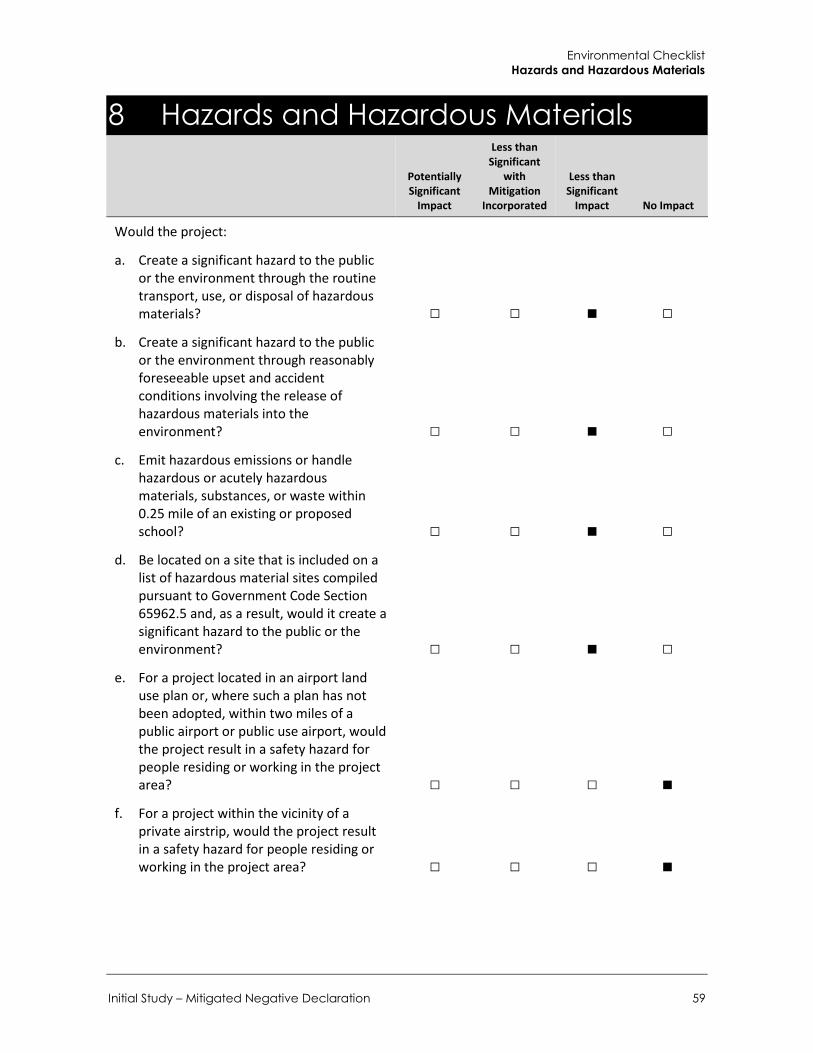
Environmental Checklist Hazards and Hazardous Materials
Initial Study – Mitigated Negative Declaration 59
8 Hazards and Hazardous Materials
Potentially Significant
Impact
Less than Significant
with Mitigation
Incorporated
Less than Significant
Impact No Impact
Would the project:
a. Create a significant hazard to the public or the environment through the routine transport, use, or disposal of hazardous materials? □ □ ■ □
b. Create a significant hazard to the public or the environment through reasonably foreseeable upset and accident conditions involving the release of hazardous materials into the environment? □ □ ■ □
c. Emit hazardous emissions or handle hazardous or acutely hazardous materials, substances, or waste within 0.25 mile of an existing or proposed school? □ □ ■ □
d. Be located on a site that is included on a list of hazardous material sites compiled pursuant to Government Code Section 65962.5 and, as a result, would it create a significant hazard to the public or the environment? □ □ ■ □
e. For a project located in an airport land use plan or, where such a plan has not been adopted, within two miles of a public airport or public use airport, would the project result in a safety hazard for people residing or working in the project area? □ □ □ ■
f. For a project within the vicinity of a private airstrip, would the project result in a safety hazard for people residing or working in the project area? □ □ □ ■
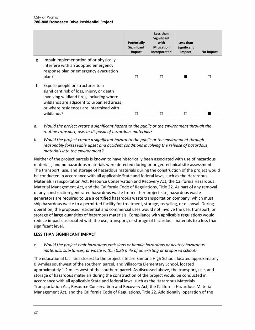
City of Walnut 780-808 Francesca Drive Residential Project
60
Potentially Significant
Impact
Less than Significant
with Mitigation
Incorporated
Less than Significant
Impact No Impact
g. Impair implementation of or physically interfere with an adopted emergency response plan or emergency evacuation plan? □ □ ■ □
h. Expose people or structures to a significant risk of loss, injury, or death involving wildland fires, including where wildlands are adjacent to urbanized areas or where residences are intermixed with wildlands? □ □ □ ■
a. Would the project create a significant hazard to the public or the environment through the routine transport, use, or disposal of hazardous materials?
b. Would the project create a significant hazard to the public or the environment through reasonably foreseeable upset and accident conditions involving the release of hazardous materials into the environment?
Neither of the project parcels is known to have historically been associated with use of hazardous materials, and no hazardous materials were detected during prior geotechnical site assessments. The transport, use, and storage of hazardous materials during the construction of the project would be conducted in accordance with all applicable State and federal laws, such as the Hazardous Materials Transportation Act, Resource Conservation and Recovery Act, the California Hazardous Material Management Act, and the California Code of Regulations, Title 22. As part of any removal of any construction-generated hazardous waste from either project site, hazardous waste generators are required to use a certified hazardous waste transportation company, which must ship hazardous waste to a permitted facility for treatment, storage, recycling, or disposal. During operation, the proposed residential and commercial uses would not involve the use, transport, or storage of large quantities of hazardous materials. Compliance with applicable regulations would reduce impacts associated with the use, transport, or storage of hazardous materials to a less than significant level.
LESS THAN SIGNIFICANT IMPACT
c. Would the project emit hazardous emissions or handle hazardous or acutely hazardous materials, substances, or waste within 0.25 mile of an existing or proposed school?
The educational facilities closest to the project site are Santana High School, located approximately 0.9-miles southwest of the southern parcel, and Villacorta Elementary School, located approximately 1.2 miles west of the southern parcel. As discussed above, the transport, use, and storage of hazardous materials during the construction of the project would be conducted in accordance with all applicable State and federal laws, such as the Hazardous Materials Transportation Act, Resource Conservation and Recovery Act, the California Hazardous Material Management Act, and the California Code of Regulations, Title 22. Additionally, operation of the

Environmental Checklist Hazards and Hazardous Materials
Initial Study – Mitigated Negative Declaration 61
proposed residential project would not involve the use or transport of large quantities of hazardous materials. Therefore, impacts related to hazardous emissions or materials affecting local schools would be less than significant.
LESS THAN SIGNIFICANT IMPACT
d. Would the project be located on a site included on a list of hazardous material sites compiled pursuant to Government Code Section 65962.5 and, as a result, would it create a significant hazard to the public or the environment?
The following databases and listings compiled pursuant to Government Code Section 65962.5 were checked (June 4, 2018) for known hazardous materials contamination at the project sites:
United States Environmental Protection Agency (U.S. EPA) Comprehensive Environmental Response, Compensation, and Liability Information System
(CERCLIS) / Superfund Enterprise Management System (SEMS)/Envirofacts database search
State Water Resources Control Board (SWRCB) GeoTracker search for leaking underground storage tanks (LUST) and other cleanup sites
Department of Toxic Substances Control (DTSC) Envirostor database for hazardous waste facilities or known contamination sites Cortese List of Hazardous Waste and Substances Sites
Neither of the project parcels is located on or adjacent to any known hazardous or contaminated sites. The EPA is retiring the CERCLIS database and is replacing it with SEMS. The SEMS database search did not produce any results associated with either of the project sites, indicating that both parcels are free of known hazards and contaminants (U.S. EPA 2018). Furthermore, a search of the Envirostor database did not identify any facilities or other cleanup sites within 1,000 feet of the project parcels (DTSC 2018).
According to GeoTracker, no Leaking Underground Storage Tank (LUST) cleanup site was located on either of the project sites (SWRCB 2018). There are three LUST cleanup sites within 1,000 feet of the project parcels. Two of the LUST sites have had completed cleanups and have been closed. The third LUST site has been designated as eligible for closure as of June 2018. Therefore, potential impacts related to hazardous material sites would be less than significant.
Neither of the project parcels appears on any lists of hazardous material sites, and the cleanups for the three LUST sites in the vicinity of the project site have either been completed or are eligible for closure after cleanup. Therefore, impacts related to hazardous material sites would be less than significant.
LESS THAN SIGNIFICANT IMPACT

City of Walnut 780-808 Francesca Drive Residential Project
62
e. For a project located within an airport land use plan or, where such a plan has not been adopted, within two miles of a public airport or public use airport, would the project result in a safety hazard for people residing or working in the project area?
f. For a project near a private airstrip, would it result in a safety hazard for people residing or working in the project area?
Neither of the project parcels is located in the vicinity of public or private airstrips. The closest airport is the El Monte Airport, located approximately nine miles northeast of the project sites. No impact would occur.
NO IMPACT
g. Would the project impair implementation of or physically interfere with an adopted emergency response plan or emergency evacuation plan?
The project applicant would be required to comply with applicable City codes and regulations pertaining to emergency response and evacuation plans maintained by the Los Angeles County Sherriff and Los Angeles County Fire Department. In addition, the proposed project would not involve the development of structures that could potentially impair implementation of or physically interfere with an adopted emergency response plan or emergency evacuation plan. Although construction activities associated with the project would not involve permanent street closures, the proposed landscaping and connection of utilities and other infrastructure may require temporary closure of lanes along Francesca Drive. However, any lane closures would occur temporarily during construction, and construction activities would be coordinated with the Los Angeles County Sheriff and Fire Departments to ensure that sufficient emergency response is maintained and alternate emergency access routes are established, if necessary. Potential impacts would be less than significant.
LESS THAN SIGNIFICANT IMPACT
h. Would the project expose people or structures to a significant risk of loss, injury, or death involving wildland fires, including where wildlands are adjacent to urbanized areas or where residences are intermixed with wildlands?
Both project parcels are undeveloped and located in a developed suburban area. Neither of the sites is located in a wildland fire hazard area as defined by the Department of Forestry and Fire Protection (CalFire 2007). No impact would occur.
NO IMPACT
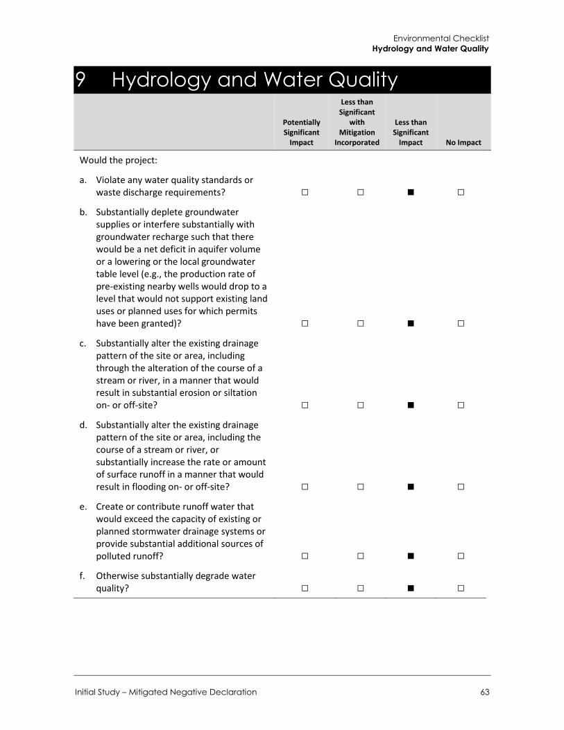
Environmental Checklist Hydrology and Water Quality
Initial Study – Mitigated Negative Declaration 63
9 Hydrology and Water Quality
Potentially Significant
Impact
Less than Significant
with Mitigation
Incorporated
Less than Significant
Impact No Impact
Would the project:
a. Violate any water quality standards or waste discharge requirements? □ □ ■ □
b. Substantially deplete groundwater supplies or interfere substantially with groundwater recharge such that there would be a net deficit in aquifer volume or a lowering or the local groundwater table level (e.g., the production rate of pre-existing nearby wells would drop to a level that would not support existing land uses or planned uses for which permits have been granted)? □ □ ■ □
c. Substantially alter the existing drainage pattern of the site or area, including through the alteration of the course of a stream or river, in a manner that would result in substantial erosion or siltation on- or off-site? □ □ ■ □
d. Substantially alter the existing drainage pattern of the site or area, including the course of a stream or river, or substantially increase the rate or amount of surface runoff in a manner that would result in flooding on- or off-site? □ □ ■ □
e. Create or contribute runoff water that would exceed the capacity of existing or planned stormwater drainage systems or provide substantial additional sources of polluted runoff? □ □ ■ □
f. Otherwise substantially degrade water quality? □ □ ■ □

City of Walnut 780-808 Francesca Drive Residential Project
64
Potentially Significant
Impact
Less than Significant
with Mitigation
Incorporated
Less than Significant
Impact No Impact
g. Place housing in a 100-year flood hazard area as mapped on a federal Flood Hazard Boundary, Flood Insurance Rate Map, or other flood hazard delineation map? □ □ ■ □
h. Place structures in a 100-year flood hazard area that would impede or redirect flood flows? □ □ ■ □
i. Expose people or structures to a significant risk of loss, injury, or death involving flooding, including that occurring as a result of the failure of a levee or dam? □ □ □ ■
j. Result in inundation by seiche, tsunami, or mudflow? □ □ □ ■
a. Would the project violate any water quality standards or waste discharge requirements?
e. Would the project create or contribute runoff water that would exceed the capacity of existing or planned stormwater drainage systems or provide substantial additional sources of polluted runoff?
f. Would the project otherwise substantially degrade water quality?
The proposed project would introduce new hardscape surfaces associated with the residential buildings and parking areas. However, the proposed design would also include landscaped open space areas and yard areas around the perimeters of the sites as well as within the sites, and would also include community garden areas, which would allow movement of storm water through the surface and add to groundwater recharge. Therefore, the proposed project would not significantly contribute to surface runoff from either parcel.
Section 21-67 of Article III of the WMC provides runoff regulations for existing land uses, stating that runoff from land uses, such as from irrigation purposes, “shall be minimized to the maximum extent practicable”. Section 21-68 of Article III provides runoff regulations from construction activities, requiring all construction to demonstrate possession of an National Pollution Discharge Elimination System (NPDES) construction permit, adherence to relevant best management practices (BMPs), and compliance with sediment controls from excavation activities and other construction waste. Furthermore, Section 21-80 of the WMC requires implementation of stormwater pollution control measures for development planning and construction activities, which apply to all development and redevelopment projects. Specifically, this section requires “construction activities and facility operations to comply with the current City municipal Statewide NPDES permit, lessen the water quality impacts of development by using smart growth practices, and integrate LID design principles to mimic predevelopment hydrologic conditions through infiltration, evapotranspiration, and rainfall

Environmental Checklist Hydrology and Water Quality
Initial Study – Mitigated Negative Declaration 65
harvest and use”. The LID design principles will be inclusive of the requirements provided in the City Standard Urban Stormwater Management Plan (SUSMP). The proposed project would be required to comply with the provisions set forth by these sections, as well as with the regulations under the NPDES Permit and obtain coverage under the State’s Construction General Permit. Therefore, project design features and compliance with the City and State requirements would reduce potential impacts to less than significant levels.
LESS THAN SIGNIFICANT IMPACT
b. Would the project substantially deplete groundwater supplies or interfere substantially with groundwater recharge such that there would be a net deficit in aquifer volume or a lowering or the local groundwater table level (e.g., the production rate of pre-existing nearby wells would drop to a level that would not support existing land uses or planned uses for which permits have been granted)?
Operation of the 36 proposed residences would increase on-site water demand compared to current undeveloped conditions. According to the CalEEMod results provided in Appendix A the proposed project would require approximately 10,137 gallons per day (gpd) or 11.35 acre feet per year (AFY). Walnut is served by four water suppliers: 1) Walnut Valley Water District; 2) Suburban Water Systems; 3) Golden State Water Company; and 4) Three Valleys Municipal Water District. Water service to the Project site would be provided by the Suburban Water Systems (Suburban) which serves approximately 170,000 people in the San Jose Hills District (District) and an estimated 30 percent of the population within the City of Walnut (City of Walnut 2018b). The General Plan Update and West Valley Specific Plan EIR concludes that per the 2015 Urban Water Management Plan (UWMP), the District has supplies to meet water needs in dry years. The District had a 2015 goal of 155 gallons per capita per day (gpcd) for the San Jose Hills area and the gpcd use was 119 in 2015. The District’s 2020 Urban Water Use Target is 169 gpcd. The City anticipates a citywide weighted gpcd of 169.8 by 2020 based on population projections. The City anticipates a citywide demand of 6.4 million gallons per day (gpd), or 7,200-acre feet annually, which represents a high-use scenario, which does account for low-water use techniques and increasing use of water reuse. The City anticipates that low-water use techniques and increasing use of water reuse will likely reduce the per capita use (City of Walnut 2018b). Therefore, the proposed project would not result in an exceedance of safe yield or a significant depletion of groundwater supplies. In addition, although the proposed project would increase the amount of paved surfaces within the project site (i.e. buildings, access roads, sidewalks), the proposed project would also include grass yards, planters, and landscaped open space that would allow the movement of stormwater through the surface and add to groundwater recharge. This would ensure that development of the proposed project would not reduce groundwater recharge and impacts related to groundwater would be less than significant.
LESS THAN SIGNIFICANT IMPACT
City of Walnut 780-808 Francesca Drive Residential Project
66
c. Would the project substantially alter the existing drainage pattern of the site or area, including through the alteration of the course of a stream or river, in a manner that would result in substantial erosion or siltation on- or off-site?
d. Would the project substantially alter the existing drainage pattern of the site or area, including the course of a stream or river, or substantially increase the rate or amount of surface runoff in a manner that would result in flooding on- or off-site?
The proposed project would not alter the course of any stream or river, but would change existing drainage flows on both parcels. The existing on-site drainage patterns for each site are currently uncontrolled. Development of the proposed project would cover approximately 58 percent of the lot at 780 Francesca Drive with impervious surfaces, and approximately 48 percent of the lot at 808 Francesca Drive. These alterations would change on-site drainage patterns and increase the volume of stormwater runoff from the site. However, a majority of both parcels would be landscaped, which would help reduce off-site flows and minimize potential erosion.
Construction of the proposed project would be required to comply with the federal Clean Water Act, including adherence to NPDES standards (Clean Water Act Section 402), which require implementation of a SWPPP for the elimination or reduction of non-stormwater discharges during project construction activities. NPDES compliance would ensure that BMPs for erosion, sedimentation, and flooding are implemented during project construction, thereby minimizing or avoiding adverse impacts. In addition, the proposed project would comply with WMC Section 21-80 “Stormwater pollution control measures for development planning and construction activities” and all sections of Article III “Storm Water and Urban Runoff Pollution Control,” as discussed under impacts a, e, and f of this section. Compliance with these requirements would reduce potential adverse impacts associated with drainage pattern alterations to a less than significant level. Alterations to the existing drainage patterns would not result in substantial erosion, siltation, or flooding on- or off-site.
LESS THAN SIGNIFICANT IMPACT
g. Would the project place housing in a 100-year flood hazard area as mapped on a federal Flood Hazard Boundary, Flood Insurance Rate Map, or other flood hazard delineation map?
h. Would the project place structures in a 100-year flood hazard area that would impede or redirect flood flows?
According to Federal Emergency Management Agency (FEMA) Flood Hazard Boundary of Flood Insurance Rate Map 06037C1695F, both project parcels are located in Flood Zone D, which is defined as an area where there are possible, but undetermined flood hazards because no analysis of flood hazards has been conducted (FEMA 2008). However, as shown in Figure PS-6 of the City of Walnut General Plan, there are no identified areas in the vicinity of the project site that are subject to flood risk (City of Walnut 2018a). Therefore, development of the proposed project would not be located in a 100-year flood hazard area, would not expose people or structures to significant flood hazards, and would not impede or redirect flood flows. Potential impacts would be less than significant.
LESS THAN SIGNIFICANT IMPACT

Environmental Checklist Hydrology and Water Quality
Initial Study – Mitigated Negative Declaration 67
i. Would the project expose people or structures to a significant risk of loss, injury, or death involving flooding, including that occurring as a result of the failure of a levee or dam?
Neither of the project parcels is adjacent to any bodies of water held by levees or within a dam inundation area (Walnut 2018). No impact would occur.
NO IMPACT
j. Would the project result in inundation by seiche, tsunami, or mudflow?
Seiches are large waves generated within enclosed bodies of water. Neither of the project parcels is located in proximity to any lakes or reservoirs. No inundation by seiche would occur. Tsunamis are tidal waves generated by fault displacement or major ground movement. No inundation by tsunami would occur given that the City is approximately 25 miles from the Pacific Ocean. Furthermore, neither of the project parcels is adjacent to any landslide/mudslide hazard zones (EGL 2007). No impact would occur and further.
NO IMPACT

City of Walnut 780-808 Francesca Drive Residential Project
68
This page intentionally left blank.

Environmental Checklist Land Use and Planning
Initial Study – Mitigated Negative Declaration 69
10 Land Use and Planning
Potentially Significant
Impact
Less than Significant
with Mitigation
Incorporated
Less than Significant
Impact No Impact
Would the project:
a. Physically divide an established community? □ □ □ ■
b. Conflict with any applicable land use plan, policy, or regulation of an agency with jurisdiction over the project (including but not limited to the general plan, specific plan, local coastal program, or zoning ordinance) adopted for the purpose of avoiding or mitigating an environmental effect? □ □ □ ■
c. Conflict with an applicable habitat conservation plan or natural community conservation plan? □ □ □ ■
a. Would the project physically divide an established community?
The two project parcels are located in a low-density residential area. The proposed project would develop the vacant parcels with 36 residences that would be compatible with the existing established residential communities surrounding the sites. The project would not involve construction of any new infrastructure (such as a new road) that would divide the surrounding area. Rather, the project would involve construction of access roads and driveways on each parcel to enable circulation. Therefore, development of the proposed project would not divide an established community but, rather, would contribute to and expand the residential community in the area. No impact would occur.
NO IMPACT
b. Would the project conflict with any applicable land use plan, policy, or regulation of an agency with jurisdiction over the project (including but not limited to the general plan, specific plan, local coastal program, or zoning ordinance) adopted for the purpose of avoiding or mitigating an environmental effect?
Both project parcels are currently within the Walnut Hills Mixed-Use District, designated for development of the Francesca Mixed-Use Specific Plan. According to the Land Use and Community Design Element of the City’s 2018 Updated General Plan, the Francesca Mixed-Use Specific Plan is one of eight focus areas within the Walnut Hills Mixed-Use District. The Walnut Hills Mixed-Use District allows for residential development in proximity to existing commercial uses, and seeks to maintain a balance of residential and commercial use with clear and well-designed pedestrian connections, public plazas, and green spaces. Within the Francesca Mixed-Use Specific Plan portion

City of Walnut 780-808 Francesca Drive Residential Project
70
of this District, parcels in this area are approved for condominiums and general, neighborhood, and retail commercial uses. As discussed under a, the proposed project involves development of a 36- unit residential complex and all development would occur within the boundaries of the Francesca Mixed-Use Specific Plan area. Therefore, development of the proposed project would be consistent with the current General Plan land use designation, and development would comply with City zoning standards, including maximum height limits, yards, and front and side setbacks. The proposed project would not conflict with any applicable land use plan, policy, or regulation, and no impact would occur.
NO IMPACT
c. Would the project conflict with an applicable habitat conservation plan or natural community conservation plan?
Neither of the project parcels is subject to any Habitat Conservation or Natural Community Conservation Plans or approved local, regional, or state habitat conservation plans. Therefore, the project would not conflict with any adopted plans and no mitigation is required.
NO IMPACT

Environmental Checklist Mineral Resources
Initial Study – Mitigated Negative Declaration 71
11 Mineral Resources
Potentially Significant
Impact
Less than Significant
with Mitigation
Incorporated
Less than Significant
Impact No Impact
Would the project:
a. Result in the loss of availability of a known mineral resource that would be of value to the region and the residents of the state? □ □ □ ■
b. Result in the loss of availability of a locally important mineral resource recovery site delineated on a local general plan, specific plan, or other land use plan? □ □ □ ■
a. Would the project result in the loss of availability of a known mineral resource that would be of value to the region and the residents of the state?
b. Would the project result in the loss of availability of a locally important mineral resource recovery site delineated on a local general plan, specific plan, or other land use plan?
The project sites and surrounding properties are part of a flat suburban community. The California Surface Mining and Reclamation Act of 1975 (SMARA) was enacted to promote conservation and protection of significant mineral deposits. According to the California Department of Conservation Mineral Land Classification Maps, the project site is located in an area with MRZ-1 designation, indicating that there is little to no likelihood for the presence of significant mineral deposits on-site (DOC 1983). In addition, according to the City’s General Plan Conservation, Open Space and Recreation Element, mining is neither a current nor anticipated land use in the City Walnut (City of Walnut 2018a). Because there are no known mineral resources on the project sites or in the vicinity of the sites, and because the proposed project would not involve mining operations, the project would have no impact on the availability or recovery of mineral resources.
NO IMPACT

City of Walnut 780-808 Francesca Drive Residential Project
72
This page intentionally left blank.

Environmental Checklist Noise
Initial Study – Mitigated Negative Declaration 73
12 Noise
Potentially Significant
Impact
Less than Significant
with Mitigation
Incorporated
Less than Significant
Impact No Impact
Would the project result in:
a. Exposure of persons to or generation of noise levels in excess of standards established in the local general plan or noise ordinance, or applicable standards of other agencies? □ □ ■ □
b. Exposure of persons to or generation of excessive groundborne vibration or groundborne noise levels? □ □ ■ □
c. A substantial permanent increase in ambient noise levels above those existing prior to implementation of the project? □ □ ■ □
d. A substantial temporary or periodic increase in ambient noise levels in the project vicinity above levels existing without the project? □ □ ■ □
e. For a project located in an airport land use plan or, where such a plan has not been adopted, within two miles of a public airport or public use airport, would the project expose people residing or working in the project area to excessive noise levels? □ □ □ ■
f. For a project near a private airstrip, would it expose people residing or working in the project area to excessive noise? □ □ □ ■
General Noise Background Noise level (or volume) is generally measured in decibels (dB) using the A-weighted sound pressure level (dBA). The A-weighting scale is an adjustment to the actual sound pressure levels to be consistent with that of human hearing response, which is most sensitive to frequencies around 4,000 Hertz (about the highest note on a piano) and less sensitive to low frequencies (below 100 Hertz).
Sound pressure level is measured on a logarithmic scale with the 0 dBA level based on the lowest detectable sound pressure level that people can perceive (an audible sound that is not zero sound

City of Walnut 780-808 Francesca Drive Residential Project
74
pressure level). Based on the logarithmic scale, a doubling of sound energy is equivalent to an increase of 3 dBA, and a sound that is 10 dBA less than the ambient sound level has no effect on ambient noise. Because of the nature of the human ear, a sound must be about 10 dBA greater than the ambient noise level to be judged as twice as loud. In general, a 3 dBA change in the ambient noise level is noticeable, while 1-2 dBA changes generally are not perceived. Quiet suburban areas typically have noise levels in the range of 40-50 dBA, while areas adjacent to arterial streets are typically in the 50 to 60+ dBA range. Normal conversational levels are usually in the 60 to 65 dBA range, and ambient noise levels greater than 65 dBA can interrupt conversations.
Noise from point sources, such from individual pieces of machinery, typically attenuates (or drop off) at a rate of 6 dBA per doubling of distance from the noise source. Noise levels from lightly traveled roads typically attenuate at a rate of about 4.5 dBA per doubling of distance. Noise levels from heavily traveled roads typically attenuate at about 3 dBA per doubling of distance. Noise levels may also be reduced by intervening structures. Generally, a single row of buildings between the receptor and the noise source reduces noise levels by about 5 dBA, while a solid wall or berm reduces noise levels by 5 to 10 dBA (Federal Transit Administration [FTA] 2006). The manner in which buildings in California are constructed generally provides a reduction of exterior-to-interior noise levels of approximately 20 to 25 dBA with closed windows (FTA 2006).
In addition to the instantaneous measurement of sound levels, the duration of sound is important since sounds that occur over a long period of time are more likely to be an annoyance or cause direct physical damage or environmental stress. One of the most frequently used noise metrics that considers both duration and sound power level is the equivalent noise level (Leq). The Leq is defined as the single steady A-weighted level that is equivalent to the same amount of energy as that contained in the actual fluctuating levels over a period of time (essentially, the average noise level). Typically, Leq is summed over a one-hour period. Lmax is the highest RMS (root mean squared) sound pressure level within the measurement period, and Lmin is the lowest RMS sound pressure level within the measurement period.
The time period in which noise occurs is also important since nighttime noise tends to disturb people more than daytime noise. Community noise is usually measured using Day-Night Average Level (Ldn), which is the 24-hour average noise level with a 10-dBA penalty for noise occurring during nighttime (10:00 PM to 7:00 AM) hours, or Community Noise Equivalent Level (CNEL), which is the 24-hour average noise level with a 5 dBA penalty for noise occurring from 7:00 PM to 10:00 PM and a 10 dBA penalty for noise occurring from 10:00 PM to 7:00 PM. Noise levels described by Ldn and CNEL typically do not differ by more than 1 dBA. In practice, CNEL and Ldn are often used interchangeably.
The relationship between peak hourly Leq values and associated Ldn/CNEL values depends on the distribution of traffic over the entire day. There is no precise way to convert a peak hourly Leq to Ldn/CNEL. However, in less heavily developed areas, such as suburban areas, the peak hourly Leq is often roughly equal to the daily Ldn/CNEL (California State Water Resources Control Board [SWRCB] 1999). The project site is located in a suburban area. Therefore, the peak hourly Leq at the project site would be roughly equal to the daily Ldn/CNEL value.
General Vibration Background Vibration refers to groundborne noise and perceptible motion. Vibration is a unique form of noise because its energy is carried through buildings, structures, and the ground, whereas noise is simply carried through the air. Thus, vibration is generally felt rather than heard. Some vibration effects can be caused by noise (e.g., the rattling of windows from passing trucks). This phenomenon is

Environmental Checklist Noise
Initial Study – Mitigated Negative Declaration 75
caused by the coupling of the acoustic energy at frequencies that are close to the resonant frequency of the material being vibrated. Typically, groundborne vibration generated by manmade activities attenuates rapidly as distance from the source of the vibration increases. The ground motion caused by vibration is measured as particle velocity in inches per second and is referenced as vibration decibels (VdB) in the U.S.
The background vibration velocity level in residential areas is usually around 50 VdB. The vibration velocity level threshold of perception for humans is approximately 65 VdB. A vibration velocity of 75 VdB is the approximate dividing line between barely perceptible and distinctly perceptible levels for many people. The range of interest is from approximately 50 VdB, which is the typical background vibration velocity level, to 100 VdB, which is the general threshold where minor damage can occur in fragile buildings. Most perceptible indoor vibration is caused by sources in buildings such as operation of mechanical equipment, movement of people, or the slamming of doors. Typical outdoor sources of perceptible groundborne vibration are construction equipment, steel wheeled trains, and traffic on rough roads.
Project Area Noise Conditions The primary off-site noise sources in the project area are motor vehicles (e.g., automobiles, buses, and trucks), particularly along Francesca Drive, Nogales Street, and Amar Road. Motor vehicle noise is a concern because it is characterized by a high number of individual events that often create sustained noise levels. Ambient noise levels would be expected to be highest during the daytime and rush hour unless congestion slows speeds substantially.
To determine ambient noise levels in the project area, four 15-minute sound level measurements were taken using an Extech ANSI Type II sound level meter during morning peak traffic hours between 7:30 AM and 9:05 AM on June 5, 2018 (refer to Appendix for sound measurement data). Measurement locations were selected based on the potential exposure of surrounding noise-sensitive receptors, generally single- and multi-family residences, to noise levels from construction and operation of the proposed project. See Figure 14 for the locations of sound measurements. Due to its placement between the 780 and 808 Francesca Drive project sites, Measurement 1 is considered representative of the ambient noise level in the vicinity of both sites. As shown in Table 10, the ambient noise level at the project site was measured at 55.0 dBA Leq.
Table 10 Sound Level Measurement Results
Measurement Location Sample Time
(AM)
Distance to Centerline of
Roadway (feet) Leq[15] (dBA)1
1 Francesca Drive, adjacent to multi-family residences 7:36 – 7:51 20 55.0
2 Nogales Street, adjacent to single-family residences 8:03 – 8:18 45 73.0
3 North Calaveras Drive, adjacent to single-family residences 8:26 – 8:41 20 54.1
4 Amar Road, adjacent to single-family residences 8:48 – 9:03 45 70.0
See Appendix D for noise monitoring data. See Figure 14 for a map of the sound measurement locations. 1 The equivalent noise level (Leq) is defined as the single steady A-weighted level that is equivalent to the same amount of energy as that contained in the actual fluctuating levels over a period of time (essentially, the average noise level). For this measurement, the Leq was over a 15-minute period (Leq[15]). Source: Rincon Consultants, field measurements on June 5, 2018, using ANSI Type II Integrating sound level meter

City of Walnut 780-808 Francesca Drive Residential Project
76
Figure 14 Sound Level Measurement and Sensitive Receptor Locations

Environmental Checklist Noise
Initial Study – Mitigated Negative Declaration 77
Regulatory Setting
California Noise Insulation Standards The Noise Insulation Standards of the California Building Code, contained in California Code of Regulations (CCR) Title 24, require that interior noise attributable to exterior noise sources not exceed a CNEL of 45 dBA in any habitable room with windows closed.
Walnut General Plan The Noise Element in the City’s General Plan, adopted in May 2018, addresses noise that affects the community, explores noise reduction, identifies noise exposure strategies, and establishes noise/land use compatibility standards that seek to minimize noise effects. Consistent with noise guidelines established by the California Office of Planning and Research (OPR) General Guidelines 2017, Table 11 shows the City’s noise criteria for determining land use compatibility with existing noise level exposures. As shown in Table 11, noise exposure levels up to 60 dBA CNEL are normally acceptable and noise exposure levels between 60 dBA and 75 dBA CNEL are conditionally acceptable for medium-density residential development.
Table 11 Land Use Compatibility for Community Noise Environments
Land Use Category
Community Noise Equivalent (dBA CNEL)
Normally Acceptable1
Conditionally Acceptable2
Normally Unacceptable3
Clearly Unacceptable4
Very Low-and Low-Density Residential <60 60-65 65-80 >80
Low Medium-Density Residential <60 60-70 70-80 >80
Medium-Density Residential <60 60-75 75-80 >80
Mixed Use <65 65-80 80-85 >85
Commercial <70 70-80 80-85 >85
Industrial <80 NA NA >80
Schools and Public Institutional <60 60-70 70-75 >75
Parks and Open Space <80 NA >80 NA
Notes: NA = Not Applicable 1 Specified land use is satisfactory, assuming buildings are of conventional construction. 2 New development should be undertaken only after detailed analysis of noise reduction requirements are made. 3 New development should be generally discouraged, if not, a detailed analysis of noise reduction requirements must be made. 4 New development should generally not be undertaken.
Source: Walnut 2018
The Noise Element also establishes the following policies that aim to maintain an environment with little excessive or harmful noise levels, which includes minimizing point-source and ambient noise as well as transportation-related noise:
Policy N-1.6: Stationary Noise Sources. Minimize stationary noise impacts on sensitive receptors, and require control of noise from construction activities, private developments/residences, landscaping activities, and special events.
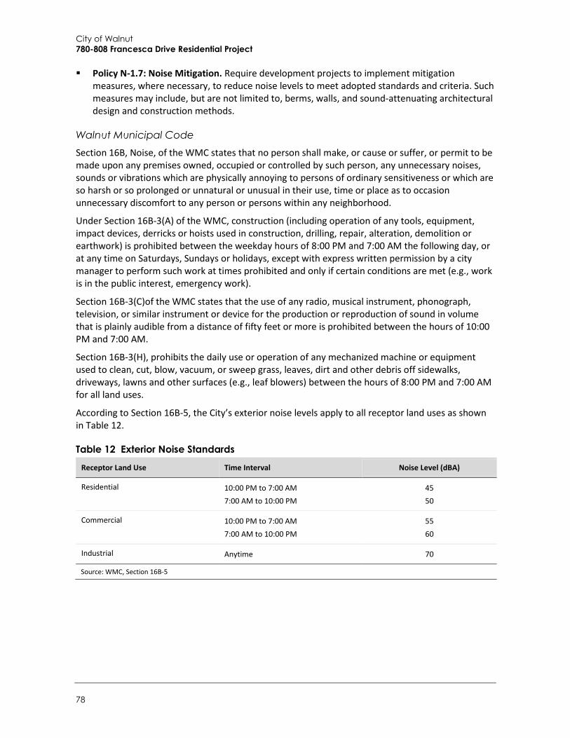
City of Walnut 780-808 Francesca Drive Residential Project
78
Policy N-1.7: Noise Mitigation. Require development projects to implement mitigation measures, where necessary, to reduce noise levels to meet adopted standards and criteria. Such measures may include, but are not limited to, berms, walls, and sound-attenuating architectural design and construction methods.
Walnut Municipal Code Section 16B, Noise, of the WMC states that no person shall make, or cause or suffer, or permit to be made upon any premises owned, occupied or controlled by such person, any unnecessary noises, sounds or vibrations which are physically annoying to persons of ordinary sensitiveness or which are so harsh or so prolonged or unnatural or unusual in their use, time or place as to occasion unnecessary discomfort to any person or persons within any neighborhood.
Under Section 16B-3(A) of the WMC, construction (including operation of any tools, equipment, impact devices, derricks or hoists used in construction, drilling, repair, alteration, demolition or earthwork) is prohibited between the weekday hours of 8:00 PM and 7:00 AM the following day, or at any time on Saturdays, Sundays or holidays, except with express written permission by a city manager to perform such work at times prohibited and only if certain conditions are met (e.g., work is in the public interest, emergency work).
Section 16B-3(C)of the WMC states that the use of any radio, musical instrument, phonograph, television, or similar instrument or device for the production or reproduction of sound in volume that is plainly audible from a distance of fifty feet or more is prohibited between the hours of 10:00 PM and 7:00 AM.
Section 16B-3(H), prohibits the daily use or operation of any mechanized machine or equipment used to clean, cut, blow, vacuum, or sweep grass, leaves, dirt and other debris off sidewalks, driveways, lawns and other surfaces (e.g., leaf blowers) between the hours of 8:00 PM and 7:00 AM for all land uses.
According to Section 16B-5, the City’s exterior noise levels apply to all receptor land uses as shown in Table 12.
Table 12 Exterior Noise Standards Receptor Land Use Time Interval Noise Level (dBA)
Residential 10:00 PM to 7:00 AM 7:00 AM to 10:00 PM
45 50
Commercial 10:00 PM to 7:00 AM 7:00 AM to 10:00 PM
55 60
Industrial Anytime 70
Source: WMC, Section 16B-5

Environmental Checklist Noise
Initial Study – Mitigated Negative Declaration 79
Sensitive Receptors Noise exposure goals for various types of land uses reflect the varying noise sensitivities associated with those uses. According to the City’s General Plan Noise Element, residences, hospitals, rest homes, long-term medical care facilities, libraries, churches, schools, and outdoor recreation areas are generally more sensitive to noise than commercial and industrial uses (Walnut 2018). The neighborhood surrounding the project area has a mix of residential, commercial, and retail land uses. Noise-sensitive land uses near the project area are shown in Figure 14 and consist of multi-and single-family residences east and west of the project area and Bright Star Montessori Academy (preschool) adjacent to the southern boundary of the 808 Francesca Drive project site. Single-family residences are also located approximately 420 feet south of the project area across Nogales Street, and approximately 400 feet north of the project area across Amar Road. In addition, the proposed residences would also be considered noise-sensitive receptors.
a. Would the project result in exposure of persons to or generation of noise levels in excess of standards established in the local general plan or noise ordinance, or applicable standards of other agencies?
Although CEQA does not require analysis of potential impacts of the environment on the proposed project, the following impact analysis of the ambient noise environment on future residents at the project is provided for informational purposes to disclose existing noise conditions in the project site vicinity. The proposed project’s construction and operational noise impacts on adjacent off-site noise-sensitive receptors are discussed under items b, c, and d, of this section.
The predominant source of noise on the 780 and 808 Francesca Drive parcels is traffic along Francesca Drive. The proposed residential development is a noise-sensitive receptor. Existing ambient sound levels were measured during a site visit on June 5, 2018 (see Table 10 for measurement results and Figure 14 for sound measurement locations in the site vicinity). As shown in Table 10, the ambient noise level at the project site is 55.0 dBA Leq. As shown in Table 15 under item c. of this section, the modeled existing ambient noise level in the project area is approximately 53 dBA CNEL.
According to the City’s noise standards shown in Table 11, ambient noise up to 60 dBA CNEL is normally acceptable for medium-density residential development. Therefore, the proposed residences would be exposed to normally acceptable noise. Furthermore, the manner in which buildings in California are constructed typically provides a reduction of exterior-to-interior noise levels of up to 25 dBA with closed windows (FTA 2006). Therefore, based on an exterior noise level up to 55 dBA CNEL, interior noise at would be approximately 30 dBA CNEL and compliant with the CCR Title 24 interior noise standard of 45 dBA CNEL. As such, the proposed project would not expose exterior residential uses to noise in exceedance of the City’s land use compatibility standards and residential interior noise would be compliant with CCR Title 24.
LESS THAN SIGNIFICANT IMPACT
b. Would the project result in exposure of persons to or generation of excessive groundborne vibration or groundborne noise levels?
Construction activity associated with the project would create groundborne vibration. Operation of the proposed project would not generate significant ground-borne vibration as residences would not require the use of heavy industrial machinery. Therefore, this analysis considers vibration impacts only from project construction. According to the FTA’s Transit Noise and Vibration Impact

City of Walnut 780-808 Francesca Drive Residential Project
80
Assessment, the background vibration velocity level in residential areas is usually around 50 VdB (FTA 2006). The vibration velocity level threshold of perception for humans is approximately 65 VdB. A vibration velocity level of 75 VdB is the approximate dividing line between barely perceptible and distinctly perceptible levels for many people. The range of interest is from approximately 50 VdB, which is the typical background vibration velocity level, to 100 VdB, which is the general threshold where minor damage can occur in fragile buildings. The general human response to different levels of groundborne vibration velocity levels is described in Table 13.
Table 13 Human Response to Different Levels of Ground-borne Vibration Vibration Velocity Level Human Reaction
65 VdB Approximate threshold of perception for many people.
75 VdB Approximate dividing line between barely perceptible and distinctly perceptible. Many people find that transportation-related vibration at this level is unacceptable.
85 VdB Vibration acceptable only if there are an infrequent number of events per day.
Source: FTA 2006, Table 7-1
To determine ground-borne vibration impacts, vibration was modeled at the nearest sensitive receptors, consisting of multi- and single-family residences and Bright Star Montessori Academy adjacent to the 780 and 808 Francesca Drive parcels. Single-family residences are also located approximately 420 feet south of the project area across Nogales Street and approximately 400 feet north of the project area across Amar Road. However, modeled vibration assumes that on-site construction activities would occur, on average, 50 feet from the project site boundary. Therefore, modeled distances between construction activity and sensitive receptors were 50 feet for adjacent single-family residences and Bright Star Montessori Academy, 120 feet for multi-family residences to the west across Francesca Drive, 450 feet for single-family residences to the north across Amar Road, and 470 feet for single-family residences to the south across Nogales Street.
Vibration levels were calculated at these sensitive receptors using the VdB of the highest impact pieces of equipment that would be used during project construction, which are the roller, dozer, and loading truck (see Table 16 under impact d). Table 14 lists ground-borne vibration levels from a roller, dozer, and loading truck at 50 feet, 120 feet, 450 feet, and 470 feet from the source.
Table 14 Vibration Levels for Construction Equipment Approximate VdB
Equipment 50 Feet 120 Feet 450 Feet 470 Feet
Roller 87 79 66 66
Dozer 80 72 59 59
Loading Truck 79 71 58 58
See Appendix D for vibration modeling data sheets.
As shown in Table 14, operation of a loaded truck, dozer, and roller would generate peak vibration levels of approximately 87 VdB at the nearest noise-sensitive receptors. Although vibration would exceed 75 VdB (the threshold between barely perceptible and distinctly perceptible) such events would be intermittent and relatively short in duration. According to Section 16B-3(A) of the WMC,

Environmental Checklist Noise
Initial Study – Mitigated Negative Declaration 81
construction activity is only permitted between 7:00 AM and 8:00 PM on weekdays, including Saturday, and is prohibited on Sundays and national holidays. Compliance with the City’s permitted hours of construction would ensure that adjacent noise-sensitive residential receptors are not disturbed by construction vibration during nighttime sleep hours. Furthermore, ground-borne vibration would not reach levels that could cause damage (100 VdB) to structures in the vicinity of the Plan Area. Therefore, impacts from vibration would be less than significant.
LESS THAN SIGNIFICANT IMPACT
c. Would the project result in a substantial permanent increase in ambient noise levels above levels existing without the project?
The proposed project would introduce 36 new residences to the project area, which would generate on-site operational noise and off-site traffic noise at nearby existing residences. The following discussion addresses each noise source separately.
On-site Operational Noise The primary on-site noise sources associated with operation of the proposed project would include vehicle circulation noise (e.g., engine startups, alarms, parking) associated with the on-site access roads, outdoor recreational noise in private yards, and use of landscaping equipment. However, the project site is located in an existing residential community and is surrounded by single- and multi-family residences, Bright Star Montessori Academy, and commercial uses. Therefore, the project site vicinity is already exposed to typical vehicle circulation noise and recreational noise associated with existing uses in the project vicinity. Operation of the proposed residences would not generate sources of noise that are new to the existing residential community.
Residential use of the project site would also be subject to the WMC noise standards provided in Section 16B. As shown in Table 12, Section 16B-5 of the WMC would prohibit the creation of noise that would cause the sound level at the surrounding noise-sensitive residences from exceeding 50 dBA between 7:00 AM and 10:00 PM and 45 dBA between 10:00 PM and 7:00 AM. In addition, Section 16B-3(C) of the WMC would prohibit the use of any sound producing device (e.g., radio, musical instrument, television) that would be audible at a distance of 50 feet or more between 10:00 PM and 7:00 AM. Furthermore, Section 16B-3(H) of the WMC would prohibit the daily use or operation of any landscaping equipment between 8:00 PM and 7:00 AM.
Because the proposed project would not add new sources of noise in the context of the surrounding community and these sources would be regulated by the City’s noise ordinance, on-site operational noise would not result in a substantial permanent increase in ambient noise levels. This impact would be less than significant.
Off-site Traffic Noise The dominant source of noise in the project area is traffic on nearby roadways, particularly Francesca Drive, Amar Road, and Nogales Street. The proposed project would generate new vehicle trips and increase traffic on area roadways. As discussed in Section 16, Transportation and Traffic, full buildout of both project sites would generate approximately 339 daily trips, including 27 trips during the morning peak hour and 36 trips during the afternoon peak hour. All vehicle trips would directly access Francesca Drive. To assess the effect of new vehicle trips on roadway noise, Francesca Drive, Amar Road, and Nogales Street were modeled under Existing and Existing plus Project conditions. As shown in Table 15, model calculations indicate an existing noise level of 53.2

City of Walnut 780-808 Francesca Drive Residential Project
82
dBA CNEL along Francesca Drive, 72.7 dBA CNEL along Amar Road, and 71.3 dBA CNEL along Nogales Street. The California Department of Transportation (Caltrans) indicates that modeled noise is generally reflective of measured vehicle noise if modeled noise is within 3 dBA of the peak-hour measurement (Caltrans 2013). Since modeled results are within 3 dBA of measured noise levels (see Table 10), the HUD DNL Calculator appropriately reflects existing traffic noise.
Table 15 compares existing and existing plus project-generated traffic noise. Since the City does not have a threshold for transportation noise, this analysis uses recommendations in the FTA’s Transit Noise and Vibration Impact Assessment (2006) as guidance to determine whether or not a change in traffic would result in a substantial permanent increase in roadway noise. Using the FTA criteria, a significant noise exposure increase is 5 dBA CNEL where the existing ambient noise level is between 50 and 55 dBA CNEL, and 1 dBA CNEL where the existing ambient noise level is between 70 and 75 dBA CNEL (FTA 2006). As shown in Table 15, project traffic would not generate an increase of traffic noise in excess of the applicable threshold. Therefore, the project’s impact on traffic noise would be less than significant.
Table 15 Comparison of Existing and Existing plus Project Traffic Noise
Roadway Segment
Noise Level (dBA, CNEL)
Existing [1]
Existing Plus Project
[2]
Change in Noise Level
[2] – [1]
Significance Threshold1 (dBA, CNEL) Significant
Francesca Drive between 780 and 808 Site Driveways
53.2 53.3 +0.1 5 No
Amar Road west of Francesca Drive 72.7 72.7 0.0 1 No
Nogales Street south of Francesca Drive 71.3 71.4 +0.1 1 No
See Appendix D for HUD DNL Calculator results. Results are rounded to the nearest decimal. 1 Based on FTA thresholds shown in
LESS THAN SIGNIFICANT IMPACT
d. Would the project result in a substantial temporary or periodic increase in ambient noise levels in the project vicinity above levels existing without the project?
Temporary noise levels caused by construction activity would be a function of the noise generated by construction equipment, the location and sensitivity of nearby land uses, and the timing and duration of noise-generating activities. Construction noise was estimated using the Federal Highway Administration (FHWA) Roadway Construction Noise Model (RCNM). The construction equipment included in RCNM are based on standard equipment assumptions for construction of the proposed project from CalEEMod (see Section 3, Air Quality, and Appendix A). To determine construction noise impacts, noise was modeled at the nearest noise-sensitive receptors, consisting of multi- and single-family residences adjacent to the 780 and 808 Francesca Drive project sites. Single-family residences are also located approximately 420 feet south of the project area across Nogales Street and approximately 400 feet north of the project area across Amar Road. As with the ground-borne vibration modeling, modeled construction noise assumes that on-site construction activities would occur, on average, 50 feet from the project site boundary in order to provide an overall estimate of average hourly construction noise.

Environmental Checklist Noise
Initial Study – Mitigated Negative Declaration 83
As discussed under item b of this section, construction activities would occur, on average, 50 feet from the project site boundary. Therefore, modeled distances between construction activity and sensitive receptors were 50 feet for adjacent single-family residences and Bright Star Montessori Academy, 120 feet for multi-family residences to the west across Francesca Drive, 450 feet for single-family residences to the north across Amar Road, and 470 feet for single-family residences to the south across Nogales Street. Table 16 shows the equipment assumed to be used during each construction phase, as well as the average hourly noise levels (dBA, Leq) at distances of 50 feet, 120 feet, 450 feet, and 470 feet from the source. Construction noise estimates are based on the assumption that multiple pieces of construction equipment would operate simultaneously, and do not account for the presence of intervening structures or topography, which could reduce noise at receptor locations. Therefore, the noise levels presented in Table 16 represent a reasonably conservative estimate of actual construction noise.
Table 16 Construction Noise Levels by Phase
Construction Phase Equipment
Approximate Leq, dBA
50 Feet 120 Feet 450 Feet 470 Feet
Site Preparation Tractors/Loaders/Backhoes (4), Dozers (3)
86 79 67 67
Grading Excavator, Tractors/Loaders/Backhoes (3), Grader, Dozer
86 78 67 66
Building Construction Crane, Forklifts (3), Tractor/Loader/Backhoe, Generator, Welder
89 81 70 69
Paving Cement and Motor Mixers (2), Paving Equipment (2), Paver, Rollers (2), Tractor/Loader/Backhoe
88 80 69 68
Architectural Coating Air Compressor 74 66 55 54
See Appendix D for RCNM data sheets and assumptions.
As shown in Table 16, construction would generate noise levels of up to an estimated 89 dBA Leq during construction of the project at the nearest noise-sensitive receptor. Project construction would result in a significant noise impact if construction activities occur outside the hours permitted by Section 16B-3(A) of the WMC (i.e., between 8:00 PM and 7:00 AM on weekdays, or at any time on Saturday, Sunday, or a public holiday). Because temporary construction activity would comply with WMC Section 16B-3(A), it would not expose receptors to construction noise during hours when people normally sleep. Therefore, although construction noise could be periodically disturbing to nearby receptors, impacts associated with construction noise would be less than significant.
LESS THAN SIGNIFICANT IMPACT
City of Walnut 780-808 Francesca Drive Residential Project
84
e. For a project located in an airport land use plan or, where such a plan has not been adopted, within two miles of a public airport or public use airport, would the project expose people residing or working in the project area to excessive noise levels?
f. For a project within the vicinity of a private airstrip, would the project expose people residing or working in the project area to excessive noise?
As discussed in Section 8, Hazards and Hazardous Materials, the project site is located approximately eight miles southwest of Brackett Field Airport in the City of La Verne and nine miles northeast of El Monte Airport in the City of El Monte. According to the County of Los Angeles Airport Land Use Commission (ALUC), the project site is outside the influence area of both airports (ALUC 2012). Although the project site would potentially be subject to occasional aircraft overflight noise, such occurrences would be intermittent and temporary. In addition, there are no private airstrips in the vicinity of the project site. Therefore, the project would not result in noise impacts related to airports for people residing or working at the project site and its vicinity. Impacts would not occur.
NO IMPACT

Environmental Checklist Population and Housing
Initial Study – Mitigated Negative Declaration 85
13 Population and Housing
Potentially Significant
Impact
Less than Significant
with Mitigation
Incorporated
Less than Significant
Impact No Impact
Would the project:
a. Induce substantial population growth in an area, either directly (e.g., by proposing new homes and businesses) or indirectly (e.g., through extension of roads or other infrastructure)? □ □ ■ □
b. Displace substantial amounts of existing housing, necessitating the construction of replacement housing elsewhere? □ □ □ ■
c. Displace substantial numbers of people, necessitating the construction of replacement housing elsewhere? □ □ □ ■
a. Would the project induce substantial population growth in an area, either directly (for example, by proposing new homes and businesses) or indirectly (for example, through extension of roads or other infrastructure)?
According to the California Department of Finance (DOF), the City of Walnut has an estimated population of 30,457 with an average household size of 3.48 persons (California DOF 2018). The Southern California Association of Governments (SCAG) estimates a population increase to 31,900 by 2020, which is an increase of 4.7 percent or 1,443 persons (SCAG 2016). Development of 36 new residential units would increase the existing population by approximately 125 residents (0.4 percent) to 30,582, which would be within SCAG’s 2020 population forecast. However, this is a conservative assumption as it is based on the City’s average household size of 3.48 persons. In addition, the current estimate for housing units in the City is 9,022 (California DOF 2018). SCAG estimates a housing increase to 9,800 by 2020, which is an increase of 8.6 percent, or 778 housing units (SCAG 2016). Construction of the proposed 36 housing units would represent an increase of 0.4 percent above the existing housing stock, which would not exceed SCAG’s 2020 housing units forecast. Therefore, the proposed project would not cause a substantial increase in population nor induce population growth. Impacts would be less than significant.
LESS THAN SIGNIFICANT IMPACT
City of Walnut 780-808 Francesca Drive Residential Project
86
b. Would the project displace substantial numbers of existing housing, necessitating the construction of replacement housing elsewhere?
c. Would the project displace substantial numbers of people, necessitating the construction of replacement housing elsewhere?
Because both parcels are currently undeveloped, the proposed project would not displace existing housing or people, and would not necessitate the construction of replacement housing elsewhere. No impact would occur.
NO IMPACT
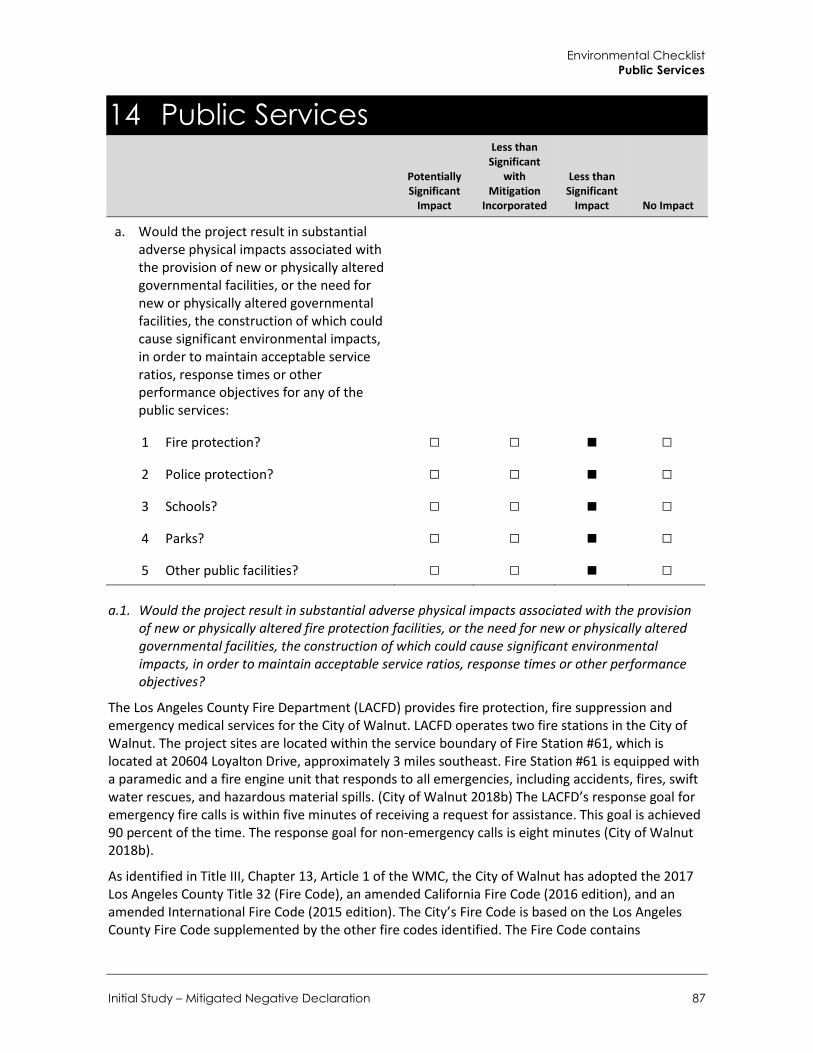
Environmental Checklist Public Services
Initial Study – Mitigated Negative Declaration 87
14 Public Services
Potentially Significant
Impact
Less than Significant
with Mitigation
Incorporated
Less than Significant
Impact No Impact
a. Would the project result in substantial adverse physical impacts associated with the provision of new or physically altered governmental facilities, or the need for new or physically altered governmental facilities, the construction of which could cause significant environmental impacts, in order to maintain acceptable service ratios, response times or other performance objectives for any of the public services:
1 Fire protection? □ □ ■ □
2 Police protection? □ □ ■ □
3 Schools? □ □ ■ □
4 Parks? □ □ ■ □
5 Other public facilities? □ □ ■ □
a.1. Would the project result in substantial adverse physical impacts associated with the provision of new or physically altered fire protection facilities, or the need for new or physically altered governmental facilities, the construction of which could cause significant environmental impacts, in order to maintain acceptable service ratios, response times or other performance objectives?
The Los Angeles County Fire Department (LACFD) provides fire protection, fire suppression and emergency medical services for the City of Walnut. LACFD operates two fire stations in the City of Walnut. The project sites are located within the service boundary of Fire Station #61, which is located at 20604 Loyalton Drive, approximately 3 miles southeast. Fire Station #61 is equipped with a paramedic and a fire engine unit that responds to all emergencies, including accidents, fires, swift water rescues, and hazardous material spills. (City of Walnut 2018b) The LACFD’s response goal for emergency fire calls is within five minutes of receiving a request for assistance. This goal is achieved 90 percent of the time. The response goal for non-emergency calls is eight minutes (City of Walnut 2018b).
As identified in Title III, Chapter 13, Article 1 of the WMC, the City of Walnut has adopted the 2017 Los Angeles County Title 32 (Fire Code), an amended California Fire Code (2016 edition), and an amended International Fire Code (2015 edition). The City’s Fire Code is based on the Los Angeles County Fire Code supplemented by the other fire codes identified. The Fire Code contains
City of Walnut 780-808 Francesca Drive Residential Project
88
regulations related to construction, maintenance and design of buildings and land uses. The proposed project would be required to adhere to all Fire Code requirements.
The proposed project would involve construction of 36 residential units on two sites surrounded by developed properties. The proposed project would increase development intensity on the project sites, which would incrementally increase demand for fire protection services. However, the proposed project is an infill development within the existing service area of the LACFD. As described under Section 13, Population and Housing, the proposed project would add an estimated 125 new residents to the City population, which is within the growth projections contained in the City’s General Plan. Additionally, neither parcel is located in a Fire Hazard Severity Zone and thus neither would be exposed to an increased risk of wildfires. (City of Walnut 2018a). The proposed project would not place an unanticipated burden on fire protection services and would therefore not affect response times or service ratios such that new or expanded fire facilities would be needed. Impacts would be less than significant.
LESS THAN SIGNIFICANT IMPACT
a.2. Would the project result in substantial adverse physical impacts associated with the provision of new or physically altered police protection facilities, or the need for new or physically altered police protection facilities, the construction of which could cause significant environmental impacts, in order to maintain acceptable service ratios, response times or other performance objectives?
The Los Angeles Sheriff’s Department provides law enforcement services to the City of Walnut through the East Patrol Division. Services include patrols, criminal investigations, traffic enforcement, accident investigation, and tactical teams (City of Walnut 2018b). The City is served by the Walnut/Diamond Sheriff Station, located at 21695 E. Valley Boulevard, approximately five miles southeast of the project sites. The Station serves both the City of Walnut, the City of Diamond Bar and the unincorporated communities of Rowland Heights and Covina Hills. Response times in the City of Walnut vary by the type of call: emergency calls average a response time of 4.2 minutes; priority calls average a response time of 8.1 minutes; and routine calls average a response time of 21.0 minutes (City of Walnut 2018b).
The proposed project would add an estimated 125 new residents to the City population. The proposed project would not be anticipated to cause substantially delayed response times, degraded service ratios or necessitate construction of new facilities, due to the relatively small size of the development and the location within an already developed and well served area. Impacts would be less than significant.
LESS THAN SIGNIFICANT IMPACT
a.3. Would the project result in substantial adverse physical impacts associated with the provision of new or physically altered schools, or the need for new or physically altered schools, the construction of which could cause significant environmental impacts, in order to maintain acceptable service ratios, response times or other performance objectives?
The project site is served by Rowland Unified School District (RUSD), which includes 11 K-6 elementary schools, three K-8 academies, two intermediate schools, and two high Schools, serving over 14,000 students. Additionally, through a permitting process, students from other communities are allowed to attend schools within RUSD (RUSD 2018a). Schools serving the project sites include Rorimer Elementary, located at 18750 E. Rorimer Street, which serves grades TK through 6, Giano
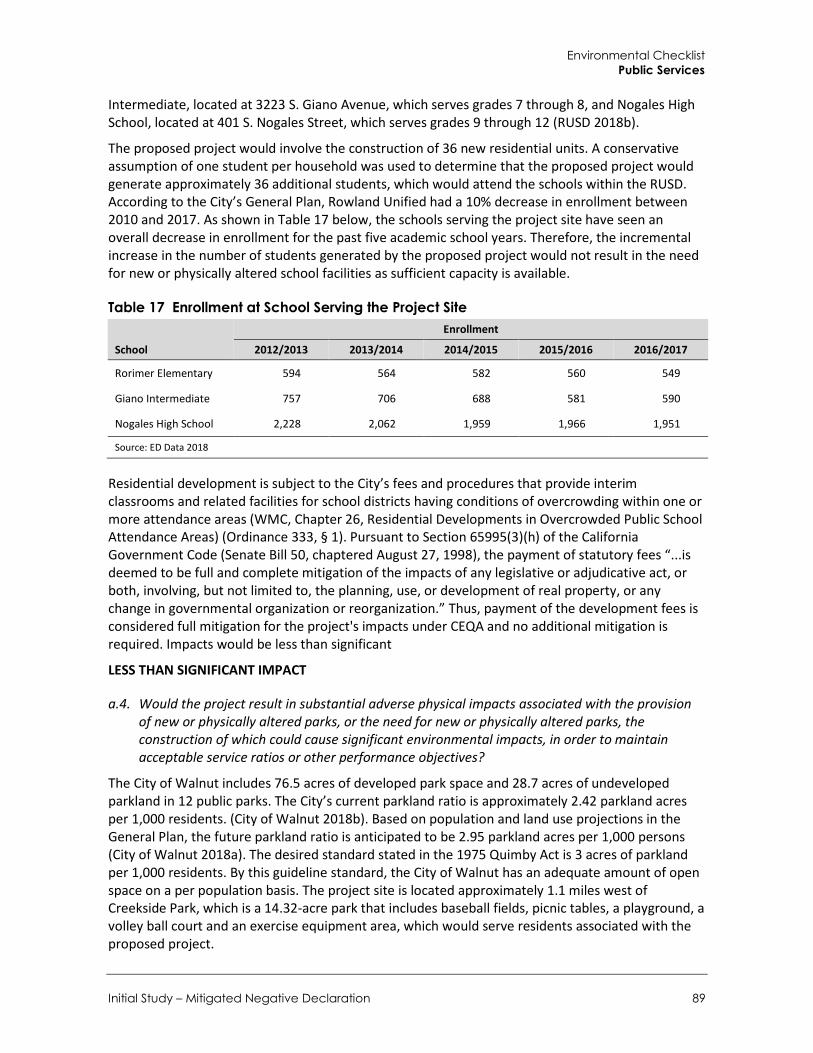
Environmental Checklist Public Services
Initial Study – Mitigated Negative Declaration 89
Intermediate, located at 3223 S. Giano Avenue, which serves grades 7 through 8, and Nogales High School, located at 401 S. Nogales Street, which serves grades 9 through 12 (RUSD 2018b).
The proposed project would involve the construction of 36 new residential units. A conservative assumption of one student per household was used to determine that the proposed project would generate approximately 36 additional students, which would attend the schools within the RUSD. According to the City’s General Plan, Rowland Unified had a 10% decrease in enrollment between 2010 and 2017. As shown in Table 17 below, the schools serving the project site have seen an overall decrease in enrollment for the past five academic school years. Therefore, the incremental increase in the number of students generated by the proposed project would not result in the need for new or physically altered school facilities as sufficient capacity is available.
Table 17 Enrollment at School Serving the Project Site
School
Enrollment
2012/2013 2013/2014 2014/2015 2015/2016 2016/2017
Rorimer Elementary 594 564 582 560 549
Giano Intermediate 757 706 688 581 590
Nogales High School 2,228 2,062 1,959 1,966 1,951
Source: ED Data 2018
Residential development is subject to the City’s fees and procedures that provide interim classrooms and related facilities for school districts having conditions of overcrowding within one or more attendance areas (WMC, Chapter 26, Residential Developments in Overcrowded Public School Attendance Areas) (Ordinance 333, § 1). Pursuant to Section 65995(3)(h) of the California Government Code (Senate Bill 50, chaptered August 27, 1998), the payment of statutory fees “...is deemed to be full and complete mitigation of the impacts of any legislative or adjudicative act, or both, involving, but not limited to, the planning, use, or development of real property, or any change in governmental organization or reorganization.” Thus, payment of the development fees is considered full mitigation for the project's impacts under CEQA and no additional mitigation is required. Impacts would be less than significant
LESS THAN SIGNIFICANT IMPACT
a.4. Would the project result in substantial adverse physical impacts associated with the provision of new or physically altered parks, or the need for new or physically altered parks, the construction of which could cause significant environmental impacts, in order to maintain acceptable service ratios or other performance objectives?
The City of Walnut includes 76.5 acres of developed park space and 28.7 acres of undeveloped parkland in 12 public parks. The City’s current parkland ratio is approximately 2.42 parkland acres per 1,000 residents. (City of Walnut 2018b). Based on population and land use projections in the General Plan, the future parkland ratio is anticipated to be 2.95 parkland acres per 1,000 persons (City of Walnut 2018a). The desired standard stated in the 1975 Quimby Act is 3 acres of parkland per 1,000 residents. By this guideline standard, the City of Walnut has an adequate amount of open space on a per population basis. The project site is located approximately 1.1 miles west of Creekside Park, which is a 14.32-acre park that includes baseball fields, picnic tables, a playground, a volley ball court and an exercise equipment area, which would serve residents associated with the proposed project.

City of Walnut 780-808 Francesca Drive Residential Project
90
The proposed project would generate an estimated 125 residents and would incrementally increase the demand for usage of existing parks in the City (see Section XV, Recreation). The proposed project would include 14,710 square feet of private open space. which would offset some demand on park and recreational facilities in the City. As the addition of 125 residents is within the growth projections anticipated in the City’s General Plan, and the City is well served by open space on a per population basis, the proposed project would not create unanticipated demand on city parks. Additionally, in accordance with the Quimby Act, the City assesses open space development fees for new residential development (WMC Chapter 23, Article III, Park Land Dedication or In Lieu Fees) (Ordinance No. 01-01, §§ 1, 2). These fees are intended to be used for the acquisition, improvement, and expansion of public parks and/or recreational facilities. The proposed project would be subject to park land dedication fees. Impacts would be less than significant.
LESS THAN SIGNIFICANT IMPACT
a.5. Would the project result in substantial adverse physical impacts associated with the provision of new or physically altered governmental facilities, or the need for new or physically altered governmental facilities, the construction of which could cause significant environmental impacts, in order to maintain acceptable service ratios, response times or other performance objectives for other public facilities?
Implementation of the proposed project would increase the local population by approximately 125 residents. The proposed project would contribute incrementally toward impacts to City public services and facilities such as storm drain usage (discussed in Section 9, Hydrology and Water Quality), public parks (discussed above in this section), solid waste disposal (discussed in Section 18, Utilities and Service Systems), water usage and wastewater disposal (discussed in more detail in Section XVII, Utilities and Service Systems), and libraries. The project’s contribution would be offset through payment of fees that are used to fund storm drain improvements, and school facility expansions, as well as by the project specific features described in the individual resource section analyses described in this Initial Study. Additionally, the proposed project would be served by the Walnut Library, which is located at 21155 La Puente Road, approximately four miles east of the project sites. In 2014, the library underwent a $1 million renovation which added a group study room, teen area, remodeled floor area, refurbished ADA-compatible restrooms, new furniture, and improved audio-visual equipment for special events (City of Walnut 2018a). Therefore, increased demand would be nominal and the expansion to the Walnut Library would continue to accommodate the needs of the residents. Impacts would be less than significant.
LESS THAN SIGNIFICANT IMPACT
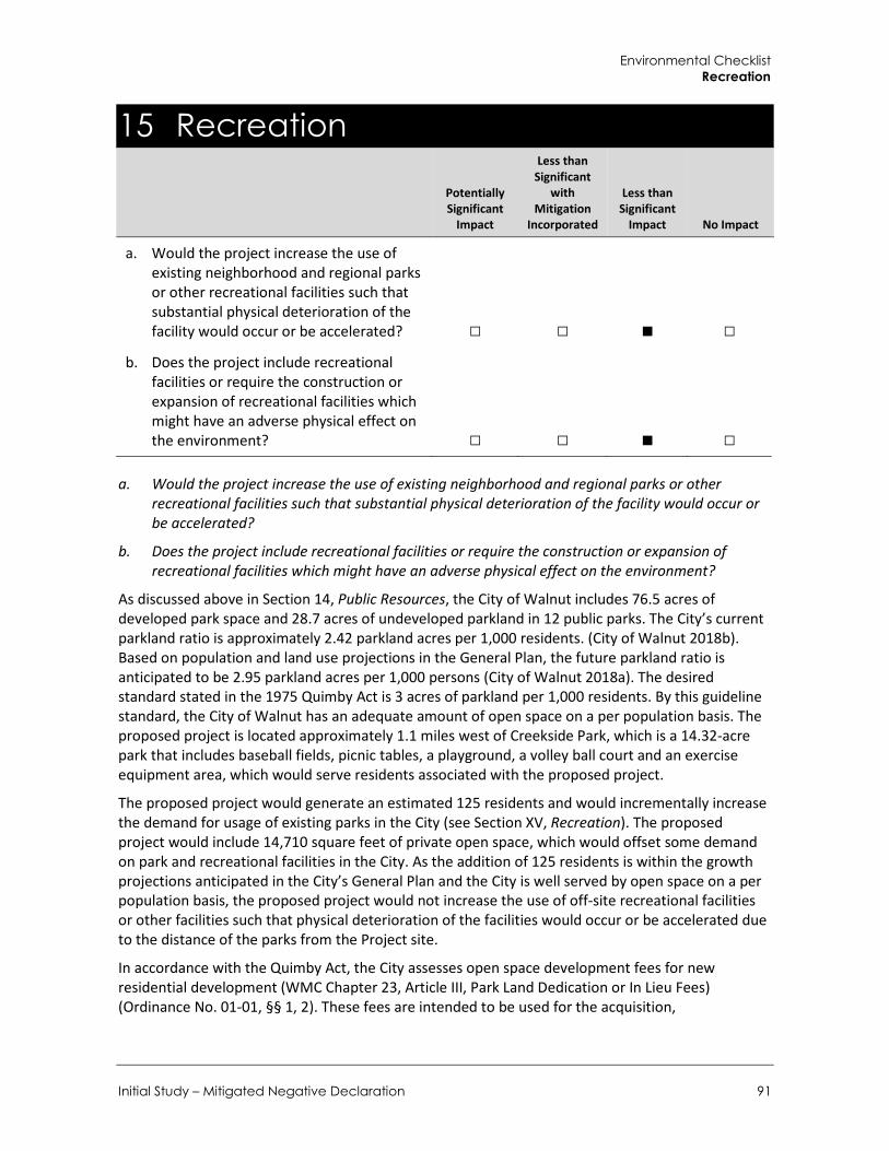
Environmental Checklist Recreation
Initial Study – Mitigated Negative Declaration 91
15 Recreation
Potentially Significant
Impact
Less than Significant
with Mitigation
Incorporated
Less than Significant
Impact No Impact
a. Would the project increase the use of existing neighborhood and regional parks or other recreational facilities such that substantial physical deterioration of the facility would occur or be accelerated? □ □ ■ □
b. Does the project include recreational facilities or require the construction or expansion of recreational facilities which might have an adverse physical effect on the environment? □ □ ■ □
a. Would the project increase the use of existing neighborhood and regional parks or other recreational facilities such that substantial physical deterioration of the facility would occur or be accelerated?
b. Does the project include recreational facilities or require the construction or expansion of recreational facilities which might have an adverse physical effect on the environment?
As discussed above in Section 14, Public Resources, the City of Walnut includes 76.5 acres of developed park space and 28.7 acres of undeveloped parkland in 12 public parks. The City’s current parkland ratio is approximately 2.42 parkland acres per 1,000 residents. (City of Walnut 2018b). Based on population and land use projections in the General Plan, the future parkland ratio is anticipated to be 2.95 parkland acres per 1,000 persons (City of Walnut 2018a). The desired standard stated in the 1975 Quimby Act is 3 acres of parkland per 1,000 residents. By this guideline standard, the City of Walnut has an adequate amount of open space on a per population basis. The proposed project is located approximately 1.1 miles west of Creekside Park, which is a 14.32-acre park that includes baseball fields, picnic tables, a playground, a volley ball court and an exercise equipment area, which would serve residents associated with the proposed project.
The proposed project would generate an estimated 125 residents and would incrementally increase the demand for usage of existing parks in the City (see Section XV, Recreation). The proposed project would include 14,710 square feet of private open space, which would offset some demand on park and recreational facilities in the City. As the addition of 125 residents is within the growth projections anticipated in the City’s General Plan and the City is well served by open space on a per population basis, the proposed project would not increase the use of off-site recreational facilities or other facilities such that physical deterioration of the facilities would occur or be accelerated due to the distance of the parks from the Project site.
In accordance with the Quimby Act, the City assesses open space development fees for new residential development (WMC Chapter 23, Article III, Park Land Dedication or In Lieu Fees) (Ordinance No. 01-01, §§ 1, 2). These fees are intended to be used for the acquisition,

City of Walnut 780-808 Francesca Drive Residential Project
92
improvement, and expansion of public parks and/or recreational facilities. The proposed project would be subject to park land dedication fees. Impacts would be less than significant.
LESS THAN SIGNIFICANT IMPACT

Environmental Checklist Transportation/Traffic
Initial Study – Mitigated Negative Declaration 93
16 Transportation/Traffic
Potentially Significant
Impact
Less than Significant
with Mitigation
Incorporated
Less than Significant
Impact No Impact
Would the project:
a. Conflict with an applicable plan, ordinance or policy establishing measures of effectiveness for the performance of the circulation system, taking into account all modes of transportation, including mass transit and non-motorized travel and relevant components of the circulation system, including but not limited to intersections, streets, highways, and freeways, pedestrian and bicycle paths, and mass transit? □ □ ■ □
b. Conflict with an applicable congestion management program, including, but not limited to level of service standards and travel demand measures, or other standards established by the county congestion management agency for designated roads or highways? □ □ ■ □
c. Result in a change in air traffic patterns, including either an increase in traffic levels or a change in location that results in substantial safety risks? □ □ □ ■
d. Substantially increase hazards due to a design feature (e.g., sharp curves or dangerous intersections) or incompatible use (e.g., farm equipment)? □ ■ □ □
e. Result in inadequate emergency access? □ ■ □ □ f. Conflict with adopted policies, plans, or
programs regarding public transit, bicycle, or pedestrian facilities, or otherwise substantially decrease the performance or safety of such facilities? □ □ ■ □

City of Walnut 780-808 Francesca Drive Residential Project
94
a. Would the project conflict with an applicable plan, ordinance or policy establishing a measure of effectiveness for the performance of the circulation system, taking into account all modes of transportation, including mass transit and non-motorized travel and relevant components of the circulation system, including but not limited to intersections, streets, highways, and freeways, pedestrian and bicycle paths, and mass transit?
Kunzman Associates, Inc. prepared the Traffic Impact Analysis (TIA) for the proposed project (Kunzman 2018; see Appendix E). According to the TIA, trip generation estimates for both project sites were based upon trip generation rates from the Institute of Transportation Engineers (ITE), 10th Edition Trip Generation Manual (2017). Because the proposed project consists of a combination of duplex and triplex units, project trips were calculated using the more conservative trip generation rates for single-family detached housing. As shown in Table 18, the 780 Francesca Drive component is forecast to generate approximately 160 daily trips, including 13 trips during the morning peak hour and 17 trips during the afternoon peak hour. The 808 Francesca Drive component is forecast to generate approximately 179 daily trips, including 14 trips during the morning peak hour and 19 trips during the afternoon peak hour. Overall, to the project would generate approximately 339 daily trips, including 27 trips during the morning peak hour and 36 trips during the afternoon peak hour.
Table 18 Estimated Project Trip Generation
Land Use Quantity Units1 ITE
Code2
Morning Peak Hour Afternoon Peak Hour
In Out Total In Out Total Daily
Trip Generation Rates
Single Family Detached Housing
1 DU 210 0.19 0.55 0.74 0.62 0.37 0.99 9.44
Trips Generated
780 Francesca Drive 17 DU 210 3 10 13 11 6 17 160
880 Francesca Drive 19 DU 210 4 10 14 12 7 19 179
Total Trips Generated 36 DU 7 20 27 23 13 36 339
See Appendix E for Traffic Impact Analysis. 1 DU = Dwelling Units 2 ITE Land use code for single-family detached housing.
Source: Trip Generation, 10th Edition, Institute of Transportation Engineers, (ITE) 2017.
Five key study intersections were selected for evaluation utilizing the Intersection Capacity Utilization (ICU) methodology for signalized intersections and the Highway Capacity Manual (HCM) for unsignalized intersections. The ICU methodology compares the volume of traffic using the intersection to the capacity of the intersection. The volume to capacity ratio is then correlated to a performance measure known as Level of Service (LOS) ranging from LOS A (free-flow conditions) to LOS F (extreme congestion and system failure). Similarly, the HCM methodology compares the volume of traffic using the intersection to the capacity of the intersection to calculate the delay associated with the traffic control at the intersection. The intersection delay is then correlated to an LOS performance measure. Of the five study intersections, two study intersections consist of the two proposed driveway intersections along Francesca Drive that would provide site access to the 780 Francesca Drive and 808 Francesca Drive parcels. Traffic impacts associated with the proposed driveways are discussed further in impact discussion d. Overall, the following listed intersections provide local access to the project site vicinity:

Environmental Checklist Transportation/Traffic
Initial Study – Mitigated Negative Declaration 95
Nogales Street (NS) at Amar Road (EW) 1. Nogales Street (NS) at Francesca Drive (EW) 2. Francesca Drive (NS) at Amar Road (EW) 3. Francesca Drive (NS) at 780 Site Driveway (EW) 4. Francesca Drive (NS) at 808 Site Driveway (EW) 5.
The following scenarios were evaluated for the previously listed intersections:
Existing Conditions 1. Existing plus Project Conditions 2.
Based on the County of Los Angeles Traffic Impact Analysis Report Guidelines (1997), the TIA determined that a project traffic impact at a signalized intersection would be significant if the project-related increase in the volume to capacity ratio equals or exceeds the thresholds shown in Table 19.
Table 19 Thresholds of Significance for Signalized Intersections Pre-Project Conditions
Level of Service (LOS) Volume/Capacity Project-Related Volume/Capacity Increase
C 0.71 – 0.80 0.04 or more
D 0.81 – 0.90 0.02 or more
E/F 0.91 – more 0.01 or more
See Appendix E for Traffic Impact Analysis.
Source: County of Los Angeles Traffic Impact Analysis Report Guidelines, 1997
A project traffic impact at an unsignalized intersection would be significant if the addition of project-generated trips is forecast to cause or worsen LOS E or F and a traffic signal is warranted based on the peak hour volume criteria established in the California Manual on Uniform Traffic Control Devices (CA MUTCD) (2014).
Existing and Existing plus Project Conditions The calculated LOS for the three off-site study intersections are shown in Table 20 for Existing and Existing plus Project conditions. The intersection turning movement volumes for Existing plus Project conditions were derived by adding project-generated trips to existing intersection turning movement volumes. As shown in Table 20, the study intersections currently operate at LOS D or better during the peak hours under Existing conditions, with the exception of Francesca Drive at Amar Road, which is currently operating at LOS F (minor street left turn movement only) during the morning and afternoon peak hours. Study intersections are projected to operate at LOS D or better during the peak hours under Existing plus Project traffic conditions, with the exception of Francesca Drive at Amar Road, which is project to continue operating at LOS F during the morning and afternoon peak hours. The need for a traffic signal at the currently unsignalized Francesca Drive/Amar Road intersection was also evaluated in the TIA using the Caltrans Warrant 3 Peak Hour traffic signal warrant analysis, as specified in the CA MUTCD. Based on the CA MUTCD peak hour traffic signal warrant, installation of a traffic signal is not warranted at the intersection of Francesca Drive and Amar Road.

City of Walnut 780-808 Francesca Drive Residential Project
96
Table 20 Existing and Existing plus Project Significance Impacts
Signalized Intersection
Peak Hour Volume/Capacity – LOS
Peak Hour Change in Volume/Capacity Without Project With Project
Morning Afternoon Morning Afternoon Morning Afternoon Significant
Impact?
Nogales Street (NS) at Amar Road (EW)
0.801 – D 0.859 – D 0.803 – D 0.862 – D +0.002 +0.003 No
Nogales Street (NS) at Francesca Drive (EW)
0.479 – A 0.496 – A 0.485 – A 0.502 – A +0.006 +0.006 No
Unsignalized Intersection
Peak Hour Delay (seconds/vehicle) – LOS
Los E or F?
Warrants Traffic Signal?
Without Project With Project
Morning Afternoon Morning Afternoon Significant
Impact?
Francesca Drive (NS) at Amar Road (EW)
100.4 – F 119.5 – F 111.1 – F 133.3 – F Yes No No
See Appendix E for Traffic Impact Analysis.
Although the study intersection of Francesca Drive/Amar Road is forecast to operate at LOS F under Existing plus Project conditions, the project impact would be less than significant because the peak hour traffic signal warrant is not satisfied per CA MUTCD criteria. In addition, the proposed project is forecast to result in no significant traffic impacts at existing signalized intersections. Impacts would be less than significant.
LESS THAN SIGNIFICANT IMPACT
b. Would the project conflict with an applicable congestion management program, including, but not limited to level of service standards and travel demand measures, or other standards established by the county congestion management agency for designated roads or highways?
The Los Angeles County Congestion Management Program (CMP) requires an analysis of all arterial segments and arterial monitoring intersections on the CMP roadway network where the project adds 50 or more peak hour trips. In addition, the CMP requires evaluation of all mainline freeway-monitoring locations where the project adds 150 or more peak hour trips. As shown in Table 18, both the 780 Francesca Drive and 808 Francesca Drive project sites are forecast to generate a combined estimated 27 trips during the morning peak hour and 36 trips during the afternoon peak hour. Therefore, it would not generate traffic exceeding CMP thresholds or otherwise conflict with the CMP. Impacts would be less than significant.
LESS THAN SIGNIFICANT IMPACT
c. Would the project result in a change in air traffic patterns, including either an increase in traffic levels or a change in location that results in substantial safety risks?
As discussed in Section 8, Hazards and Hazardous Materials, and Section 12, Noise, the nearest airports to the project site are the Brackett Field Airport, which is located approximately eight miles southwest of the project site, and El Monte Airport, which is located approximately nine miles northeast of the project site. According to the County of Los Angeles Airport Land Use Commission (ALUC), the project site is outside the influence area of both airports (ALUC 2012). Due to the

Environmental Checklist Transportation/Traffic
Initial Study – Mitigated Negative Declaration 97
distance to the nearest airports and two-story height of the proposed residences, the project would not present any impediments to air traffic patterns. No impact would occur.
NO IMPACT
d. Would the project substantially increase hazards due to a design feature (e.g., sharp curves or dangerous intersections) or incompatible use (e.g., farm equipment)?
e. Would the project result in inadequate emergency access?
The TIA prepared by Kunzman also analyzed the intersection LOS of the two proposed driveways that would provide access to the 780 Francesca Drive and 808 Francesca Drive parcels. Table 21 summarizes the intersection operations for the proposed driveways under Existing plus Project traffic conditions.
Table 21 Project Driveways Peak Hour Intersection Level of Service
Unsignalized Intersection
Peak Hour Delay (seconds/vehicle) – LOS
Morning Afternoon
780 Site Driveway (EW) 9.3 – A 9.9 – A
808 Site Driveway (EW) 9.2 – A 9.8 – A
See Appendix E for Traffic Impact Analysis.
As shown in Table 21, both project driveways are forecast to operation at an acceptable LOS under the presented conditions. As such, motorists entering and exiting the project site would be able to do so comfortably, safely, and without undue congestion. In addition, both project sites would be required to conform to traffic and safety regulations that specify adequate emergency access measures. Site development at 780 Francesca Drive and 808 Francesca Drive would be required to meet the standards set forth by the City of Walnut Fire Department and Police Department. In addition, the project does not include any permanent street closures or changes in traffic flow. Nonetheless, per the recommendations in the TIA, the following mitigation measures would be required to ensure that impacts associated with site-specific circulation and access are less than significant.
Mitigation Measures The following mitigation measures would ensure on-site circulation and access are less than significant.
TR-1 Site Boundary Improvements Francesca Avenue along the project site boundary should be constructed at its ultimate half-section width, including landscaping and parkway improvements in conjunction with development, or as otherwise approved by the City of Walnut Public Works Department.
TR-2 On-site and Site-adjacent Improvements All on-site and site-adjacent improvements, including traffic signing/striping and project driveways, should be constructed as approved by the City of Walnut Park Public Works Department.

City of Walnut 780-808 Francesca Drive Residential Project
98
TR-3 Sight Distance Standards Sight distance at project access points should comply with applicable City of Walnut/California Department of Transportation sight distance standards. The final grading, landscaping, and street improvement plans should demonstrate that sight distance standards are met.
LESS THAN SIGNIFICANT WITH MITIGATION INCORPORATED
f. Would the project conflict with adopted policies, plans, or programs regarding public transit, bicycle, or pedestrian facilities, or otherwise substantially decrease the performance or safety of such facilities?
The proposed project would introduce 36 new residences to the project area. Existing pedestrian, bicycle, and public transit facilities in the project area include a pedestrian sidewalk along the project site frontage on Francesca Drive, on-street bicycle lanes (Class II) along Amar Road and Nogales Street, and Foothill Transit Route 486 along Amar Road with stops at Nogales Street.
Construction of the proposed project would maintain existing sidewalks, and, if necessary, repair or reconstruct sidewalks along the projects western boundaries. In addition, construction activities would generally be restricted to the project site and would not interfere with public transit stops located along Amar Road. Furthermore, the City of Walnut does not have a local bicycle plan. While operation of the proposed project would potentially generate additional bicyclists in the area, it would be located in a developed community that already experiences bicycling as a form of alternate transportation. Therefore, the project would not conflict with adopted policies, plans, or programs regarding public transit, bikeways, or pedestrian facilities, and would not otherwise substantially reduce the performance or safety of such facilities. Impacts would be less than significant.
LESS THAN SIGNIFICANT IMPACT
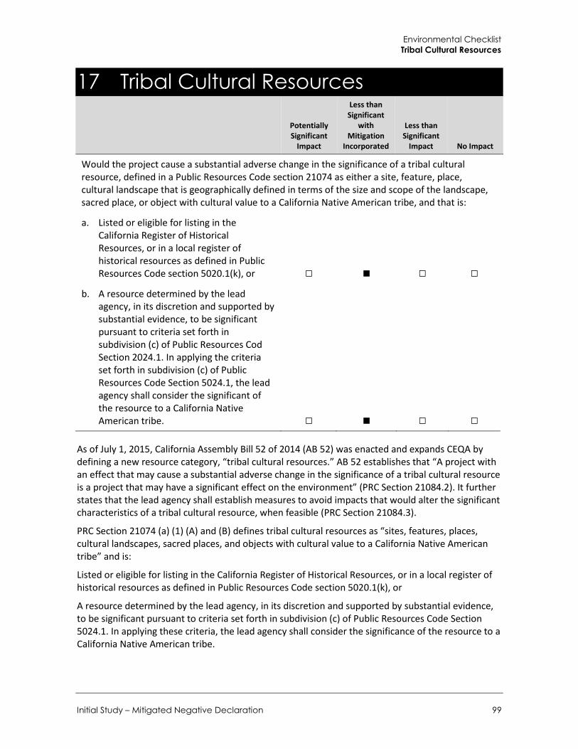
Environmental Checklist Tribal Cultural Resources
Initial Study – Mitigated Negative Declaration 99
17 Tribal Cultural Resources
Potentially Significant
Impact
Less than Significant
with Mitigation
Incorporated
Less than Significant
Impact No Impact
Would the project cause a substantial adverse change in the significance of a tribal cultural resource, defined in a Public Resources Code section 21074 as either a site, feature, place, cultural landscape that is geographically defined in terms of the size and scope of the landscape, sacred place, or object with cultural value to a California Native American tribe, and that is:
a. Listed or eligible for listing in the California Register of Historical Resources, or in a local register of historical resources as defined in Public Resources Code section 5020.1(k), or □ ■ □ □
b. A resource determined by the lead agency, in its discretion and supported by substantial evidence, to be significant pursuant to criteria set forth in subdivision (c) of Public Resources Cod Section 2024.1. In applying the criteria set forth in subdivision (c) of Public Resources Code Section 5024.1, the lead agency shall consider the significant of the resource to a California Native American tribe. □ ■ □ □
As of July 1, 2015, California Assembly Bill 52 of 2014 (AB 52) was enacted and expands CEQA by defining a new resource category, “tribal cultural resources.” AB 52 establishes that “A project with an effect that may cause a substantial adverse change in the significance of a tribal cultural resource is a project that may have a significant effect on the environment” (PRC Section 21084.2). It further states that the lead agency shall establish measures to avoid impacts that would alter the significant characteristics of a tribal cultural resource, when feasible (PRC Section 21084.3).
PRC Section 21074 (a) (1) (A) and (B) defines tribal cultural resources as “sites, features, places, cultural landscapes, sacred places, and objects with cultural value to a California Native American tribe” and is:
Listed or eligible for listing in the California Register of Historical Resources, or in a local register of historical resources as defined in Public Resources Code section 5020.1(k), or
A resource determined by the lead agency, in its discretion and supported by substantial evidence, to be significant pursuant to criteria set forth in subdivision (c) of Public Resources Code Section 5024.1. In applying these criteria, the lead agency shall consider the significance of the resource to a California Native American tribe.

City of Walnut 780-808 Francesca Drive Residential Project
100
AB 52 also establishes a formal consultation process for California tribes regarding those resources. The consultation process must be completed before a CEQA document can be certified. Under AB 52, lead agencies are required to “begin consultation with a California Native American tribe that is traditionally and culturally affiliated with the geographic area of the proposed project.” Native American tribes to be included in the process are those that have requested notice of projects proposed within the jurisdiction of the lead agency.
a. Would the project cause a substantial adverse change in the significance of a tribal cultural resource as defined in Public Resources Code 21074 that is listed or eligible for listing in the California Register of Historical Resources, or in a local register of historical resources as defined in Public Resources Code section 5020.1(k)?
b. Would the project cause a substantial adverse change in the significance of a tribal cultural resource as defined in Public Resources Code 21074 that is a resource determined by the lead agency, in its discretion and supported by substantial evidence, to be significant pursuant to criteria set forth in subdivision (c) of Public Resources Code Section 2024.1?
Tribal cultural resources are defined in Public Resources Code 21074 as sites, features, places, cultural landscapes, sacred places, and objects with cultural value to a California Native American tribe that are either:
Included or determined to be eligible for inclusion in the California Register of Historical Resources
Included in a local register of historical resources as defined in subdivision (k) of Section 5020.1
As part of the process of identifying cultural resources issues in or near the project site, Rincon contacted the Native American Heritage Commission (NAHC) to request a Sacred Lands File (SLF) search of the project area. The request was submitted on June 1, 2018. The NAHC responded on June 6, 2018 stating that the SLF search was returned with negative results. The NAHC also provided a consultation list of the tribes traditionally or culturally affiliated with the Plan Area. On September 13, 2018, the City sent letters inviting the tribes to consult with the City and requesting a response within 30 days of receipt as specified by AB 52. The City received a request for consultation from the Gabrieleño Band of Mission Indians – Kizh Nation on September 19, 2018. Consultation will be held on December 19, 2018. The outcome of the consultation will be disclosed in the Final IS-MND.
As discussed in Section 5, Cultural Resources, both parcels are currently vacant and covered with grasses and mulch with modern refuse throughout. Although it is not anticipated that intact tribal cultural resources are present in the project site, there is the potential for the recovery of buried cultural materials during project construction activities. Upon compliance with Mitigation Measures CR-1 and CR-2 in Section 5, Cultural Resources, potential impacts would be reduced to a less than significant level by providing a process for evaluating and, as necessary, avoiding impacts to any identified resources. Impacts would be less than significant with mitigation incorporated.
LESS THAN SIGNIFICANT WITH MITIGATION INCORPORATED
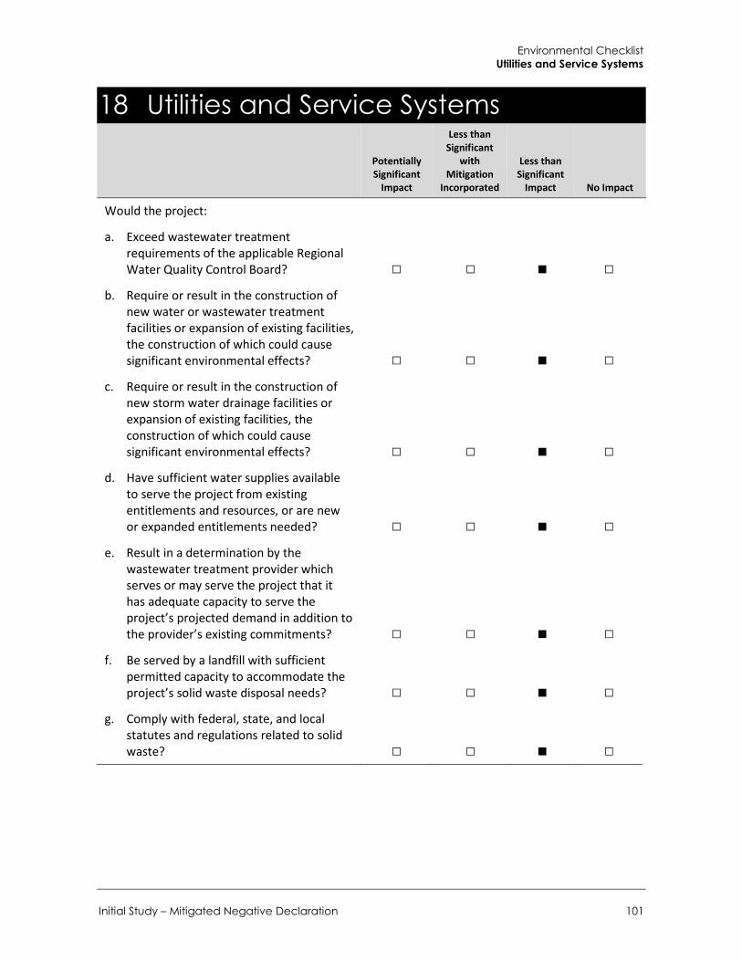
Environmental Checklist Utilities and Service Systems
Initial Study – Mitigated Negative Declaration 101
18 Utilities and Service Systems
Potentially Significant
Impact
Less than Significant
with Mitigation
Incorporated
Less than Significant
Impact No Impact
Would the project:
a. Exceed wastewater treatment requirements of the applicable Regional Water Quality Control Board? □ □ ■ □
b. Require or result in the construction of new water or wastewater treatment facilities or expansion of existing facilities, the construction of which could cause significant environmental effects? □ □ ■ □
c. Require or result in the construction of new storm water drainage facilities or expansion of existing facilities, the construction of which could cause significant environmental effects? □ □ ■ □
d. Have sufficient water supplies available to serve the project from existing entitlements and resources, or are new or expanded entitlements needed? □ □ ■ □
e. Result in a determination by the wastewater treatment provider which serves or may serve the project that it has adequate capacity to serve the project’s projected demand in addition to the provider’s existing commitments? □ □ ■ □
f. Be served by a landfill with sufficient permitted capacity to accommodate the project’s solid waste disposal needs? □ □ ■ □
g. Comply with federal, state, and local statutes and regulations related to solid waste? □ □ ■ □

City of Walnut 780-808 Francesca Drive Residential Project
102
a. Would the project exceed wastewater treatment requirements of the applicable Regional Water Quality Control Board?
b. Would the project require or result in the construction of new water or wastewater treatment facilities or expansion of existing facilities, the construction of which could cause significant environmental effects?
e. Would the project result in a determination by the wastewater treatment provider which serves or may serve the project that it has adequate capacity to serve the project’s projected demand in addition to the provider’s existing commitments?
The Los Angeles County Department of Public Works (LACDPW) operates and maintains the City’s wastewater infrastructure. The City of Walnut is a member of the Consolidated Maintenance District of Los Angeles County (CSMD). The collection system in the City consists of approximately 91 miles of sewer lines that discharge into the Los Angeles County Sanitation Districts’ (LACSD) facilities for treatment and disposal. The system treats approximately 510 million gallons per day (mgd) (City of Walnut 2018b).
Wastewater generated in the City is conveyed to the San Jose Creek Water Reclamation Facility WRF) in unincorporated Los Angeles County near Whittier. Wastewater flows that exceed the capacity of the San Jose Creek WRP are diverted to the Joint Water Pollution Control Plant in Carson. The San Jose Creek WRP has a treatment capacity for up to 100 mgd of wastewater and on average treats 64.6 mgd of wastewater. The Joint Water Pollution Control Plant has a treatment capacity for up to 400 mgd of wastewater and in 2015 treated approximately 259 mgd of wastewater (City of Walnut 2018b). Combined, these two facilities have capacity to treat 500 mgd and treat on average 323.6 mgd. Together, these two facilities have a remaining capacity to treat 176.4 mgd of wastewater.
According to CalEEMod (Appendix A), the 36-unit residential project would demand approximately 10,137 gallons of water per day. Assuming that wastewater generation is 80 percent of total water demand, the proposed project would generate approximately 8,110 gallons of wastewater per day. The project’s estimated wastewater would be about 0.5 percent of the remaining capacity at the San Jose Creek WRP and Joint Water Pollution Control Plan. As such, the proposed project would not generate wastewater such that the two facilities would become constrained. Therefore, impacts to wastewater facilities would be less than significant.
LESS THAN SIGNIFICANT IMPACT
c. Would the project require or result in the construction of new storm water drainage facilities or expansion of existing facilities, the construction of which could cause significant environmental effects?
Stormwater facilities are managed by the Los Angeles County Flood Control District (LACFCD). The proposed project would include permeable pavement which would allow stormwater infiltration and reduce impacts to off-site stormwater drainage facilities. As discussed in Section 9, Hydrology and Water Quality, the proposed project would comply with current NPDES and Los Angeles County MS4 permit regulations pertaining to the retention of erosion and detention of site runoff into storm drains and receiving waters, and include storm water Low Impact Development (LID) Best Management Practices (BMPs). Additionally, the WMC regulates the implementation of the LIDs and BMPs for projects in the City. Compliance with these requirements would reduce potential impacts to local stormwater drainage facilities to a less than significant level.
LESS THAN SIGNIFICANT IMPACT

Environmental Checklist Utilities and Service Systems
Initial Study – Mitigated Negative Declaration 103
d. Would the project have sufficient water supplies available to serve the project from existing entitlements and resources, or are new or expanded entitlements needed?
Walnut is served by four water suppliers: 1) Walnut Valley Water District; 2) Suburban Water Systems; 3) Golden State Water Company; and 4) Three Valleys Municipal Water District. Water service to the Project site would be provided by the Suburban Water Systems (Suburban), which serves approximately 170,000 people in the San Jose Hills District (District) and an estimated 30 percent of the population Walnut (City of Walnut 2018b). In 2017, Suburban utilized local groundwater for 83 percent of its supply and purchased treated surface water for the remainder of its drinking water from the Metropolitan Water District of Southern California (MWDSC) and the Covina Irrigating Company (CIC) (Suburban 2017). The General Plan Update and West Valley Specific Plan EIR conclude that per the 2015 Urban Water Management Plan (UWMP), the District has supplies to meet water needs in dry years. The District had a 2015 goal of 155 gallons per capita per day (gpcd) for the San Jose Hills area and the gpcd use was 119 in 2015. The District’s 2020 Urban Water Use Target is 169 gpcd. The City anticipates a citywide weighted gpcd of 169.8 by 2020 based on population projections. The City anticipates a citywide demand of 6.4 million gallons per day (gpd), or 7,200-acre feet annually, which represents a high-use scenario, which does not account for low-water use techniques and increasing use of water reuse . The City anticipates that low-water use techniques and increasing use of water reuse will likely reduce the per capita use (City of Walnut 2018b).
The Statewide Water Conservation Act of 2009 (Senate Bill X7-7), effective November 2009, requires a 20% reduction in per capita urban water use by 2020. The legislation requires urban water users to develop consistent water use targets and to use those targets in their UWMPs. SB X7-7 also requires certain agricultural water supplies to implement a variety of water conservation and management practices and to submit Agricultural Water Management Plans. Additionally, as a response to statewide drought, Governor Jerry Brown issued an Executive Order (EO) on April 1, 2015, requiring local agencies to reduce water usage by urban water suppliers by 25%. Although the State suspended its mandatory water restrictions in May of 2016, water conservation throughout the State is still encouraged. Additionally, the Districts serving the City implemented a mandatory water conservation program in response to the EO, which includes restrictions such as limiting irrigation hours, watering duration, and watering days (City of Walnut 2018b).
Assuming that water use is 120% of wastewater generation, the proposed project would use approximately 10,137 gallons of water per day, which equates to 11.35 AFY. Project demand is within the growth projections anticipated in the City’s General Plan and, as such, the demand associated with the proposed project has been accommodated within planned water supplies. As discussed above, as of 2015 gpcd for the San Jose Hills District area was 23 percent below the Urban Water Use Target of 155 gpcd. Therefore, water supplies would be adequate for the proposed project and impacts would be less than significant.
The proposed project would connect to the City’s water conveyance system, which would be adequate to serve the proposed project. Additionally, the proposed project would be required to comply with Section 25-174.4, Landscape Water Use Standards, of the WMC, which would regulate the water allowance and irrigation of landscape areas and Section 9B-1, California Green Building Code, of the WMC, which requires the installation of water conserving fixtures such as low flow toilets, urinals, showerheads and faucets, and efficient outdoor water use regulations, for residential uses. Therefore, the proposed project’s impact would be less than significant.
LESS THAN SIGNIFICANT IMPACT

City of Walnut 780-808 Francesca Drive Residential Project
104
f. Would the project be served by a landfill with sufficient permitted capacity to accommodate the project’s solid waste disposal needs?
g. Would the project comply with federal, state, and local statutes and regulations related to solid waste?
The proposed project has two components (construction and operation) that would result in the generation of solid waste. For purposes of this analysis, the estimated operational waste is used to determine the net increase in solid waste from the proposed project. Construction of the proposed project would also involve site preparation activities that would generate waste materials. However, construction would be temporary. Over 90 percent of solid waste generated in the City of Walnut is currently disposed of at two landfills including the Olinda Alpha Sanitary Landfill and the El Sobrante Landfill. Additionally, three landfills, which include the Sunshine Canyon Landfill, the Frank Bowerman Sanitary Landfill and the Azuza Land Reclamation County Landfill, each receive approximately 2 percent of solid waste from the City (City of Walnut 2018b). Table 22 summarizes the permitted daily throughput, estimated average waste quantities disposed, remaining capacity, and closure date for the two primary landfills serving the City. Combined, the two primary landfills serving the project site have an estimated remaining daily capacity of 8,660 tons per day.
Table 22 Solid Waste Disposal Facilities
Facility
Permitted Daily Disposal
(tons/day)
Average Daily Waste Quantities
Disposed (tons/day)
Estimated Remaining Daily
Capacity (tons/day)
Remaining Capacity and Life
Olinda Alpha Sanitary Landfill 8,000 6,891 1,109 19 million tons and 8 years
El Sobrante Landfill 16,054 8,503 7,551 141 million tons and 54 years
Source: County of Los Angeles 2017
According to CalEEMod (Appendix A), the proposed project would generate a net increase of 0.05 tons of solid waste per day. This estimate is conservative since it does not factor in any recycling or waste diversion programs. An estimated 0.05 ton of solid waste generated by the project would be approximately 0.0005 percent of the remaining daily capacity at the two landfills listed in Table 22. The proposed project would comply with federal, State, and local statutes and regulations related to solid waste, such as AB 939 and the Solid Waste Management Policy Plan. In addition, as shown in Table 22 there is adequate remaining daily landfill capacity in the region to accommodate project-generated waste. Impacts related to solid waste and waste facilities would be less than significant.
LESS THAN SIGNIFICANT IMPACT
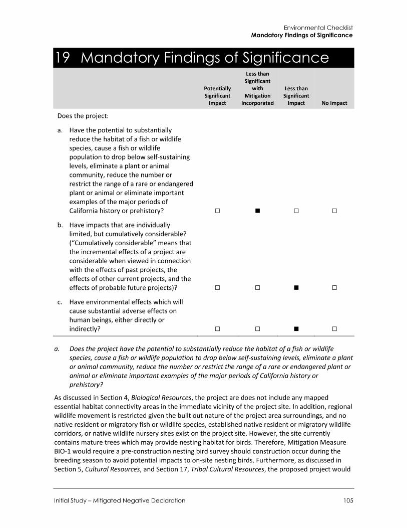
Environmental Checklist Mandatory Findings of Significance
Initial Study – Mitigated Negative Declaration 105
19 Mandatory Findings of Significance
Potentially Significant
Impact
Less than Significant
with Mitigation
Incorporated
Less than Significant
Impact No Impact
Does the project:
a. Have the potential to substantially reduce the habitat of a fish or wildlife species, cause a fish or wildlife population to drop below self-sustaining levels, eliminate a plant or animal community, reduce the number or restrict the range of a rare or endangered plant or animal or eliminate important examples of the major periods of California history or prehistory? □ ■ □ □
b. Have impacts that are individually limited, but cumulatively considerable? (“Cumulatively considerable” means that the incremental effects of a project are considerable when viewed in connection with the effects of past projects, the effects of other current projects, and the effects of probable future projects)? □ □ ■ □
c. Have environmental effects which will cause substantial adverse effects on human beings, either directly or indirectly? □ □ ■ □
a. Does the project have the potential to substantially reduce the habitat of a fish or wildlife species, cause a fish or wildlife population to drop below self-sustaining levels, eliminate a plant or animal community, reduce the number or restrict the range of a rare or endangered plant or animal or eliminate important examples of the major periods of California history or prehistory?
As discussed in Section 4, Biological Resources, the project are does not include any mapped essential habitat connectivity areas in the immediate vicinity of the project site. In addition, regional wildlife movement is restricted given the built out nature of the project area surroundings, and no native resident or migratory fish or wildlife species, established native resident or migratory wildlife corridors, or native wildlife nursery sites exist on the project site. However, the site currently contains mature trees which may provide nesting habitat for birds. Therefore, Mitigation Measure BIO-1 would require a pre-construction nesting bird survey should construction occur during the breeding season to avoid potential impacts to on-site nesting birds. Furthermore, as discussed in Section 5, Cultural Resources, and Section 17, Tribal Cultural Resources, the proposed project would

City of Walnut 780-808 Francesca Drive Residential Project
106
have a less than significant impact on unanticipated cultural resources, paleontological resources, and tribal cultural resources with implementation of Mitigation Measures CR-1 through CR-4, which would require adherence to existing local, State and federal regulations and specific monitoring procedures related to the discovery of any unanticipated cultural resources, paleontological resources, tribal cultural resources, and human remains during construction activity.
LESS THAN SIGNIFICANT WITH MITIGATION INCORPORATED
b. Does the project have impacts that are individually limited, but cumulatively considerable? (“Cumulatively considerable” means that the incremental effects of a project are considerable when viewed in connection with the effects of past projects, the effects of other current projects, and the effects of probable future projects)?
As concluded in Sections 1 through 18, the project would have no impact, a less than significant impact, or a less than significant impact with mitigation incorporated, with respect to all environmental issues considered in this document. Approximately nine single family residential projects and one multi-family residential project are planned or pending in the project vicinity. Cumulative impacts of several resource areas have been addressed in the individual resource sections, including Air Quality, Greenhouse Gases, Noise, and Transportation/Traffic (See CEQA Guidelines Section 15064(h)(3)). As discussed in Sections 1, Air Quality, and Section 7, Greenhouse Gas Emission, the proposed project would result in less than significant impacts associated with air quality and greenhouse gas emissions. Noise and traffic analyses both considered increases in traffic and traffic noise under Existing plus Project conditions and concluded that impacts would be less than significant. Some of the other resource areas (agricultural and mineral) were determined to have no impact in comparison to existing conditions. Therefore, the project would not contribute to cumulative impacts related to these issues. Other issues (e.g., geology, hazards, and hazardous materials) are by their nature project specific and impacts at one location do not add to impacts at other locations or create additive impacts. As such, cumulative impacts would be less than significant (not cumulatively considerable).
LESS THAN SIGNIFICANT IMPACT
c. Does the project have environmental effects which will cause substantial adverse effects on human beings, either directly or indirectly?
In general, impacts to human beings are associated with air quality, hazards and hazardous materials, and noise impacts. As detailed in analyses for air quality, hazards and hazardous materials, and noise, the proposed project would not result, either directly or indirectly, in adverse hazards related to air quality, hazardous materials or noise. Compliance with applicable rules, regulations, and recommended mitigation measures would reduce potential impacts on human beings to a less than significant level.
LESS THAN SIGNIFICANT IMPACT

References
Initial Study – Mitigated Negative Declaration 107
References
Bibliography Airport Land Use Commission (ALUC). 2012. Airports and Airport Influence Areas. Accessed June
2018 at: http://planning.lacounty.gov/assets/upl/project/ALUC_Airports_June2012_rev2d.pdf.
Beyer, L.A., McCulloh, T.H., Denison, R.E., Morin, R.W., Enrico, R.J., Barron, J.A., and Fleck, R.J. 2009. Post-Miocene Right Separation on the San Gabriel and Vasquez Creek Faults, with Supporting Chronostratigraphy, Western San Gabriel Mountains, California. U.S. Geological Survey Professional Paper 1759, 44 p.
Bjorklund, T. 2003. The Whittier Fault Trend: Cross Sections, Structure Maps, and Well Tops in the Major Oil Producing Area of the Northeastern Los Angeles Basin. American Association of Petroleum Geologists (AAPG), Search and Discovery Article #10038.
CalFire. 2007. Fire Hazard Severity Zones Map. Accessed June 2018. http://www.fire.ca.gov/fire_prevention/fire_prevention_wildland_statewide
California Air Pollution Control Officers Association (CAPCOA) 2008. CEQA and Climate Change: Addressing Climate Change through California Environmental Quality Act. Accessed June 2018 at: http://www.capcoa.org/wp-content/uploads/2012/ 03/CAPCOA-White-Paper.pdf.
California Air Resources Board (CARB). 2005. Air Quality Land Use Handbook: A Community Health Perspective, 2005, Accessed June 2018 at: https://www.arb.ca.gov/ch/handbook.pdf
____. 2014, 2015 & 2016. iADAM: Air Quality Data Statistics, Top 4 Measurements and Days Above the Standard. Accessed June 2018 at: http://www.arb.ca.gov/adam/topfour/topfour1.php
California Climate Action Registry (CCAR). 2009. General Reporting Protocol, Reporting Entity-Wide Greenhouse Gas Emissions, Version 3.1. Accessed June 2018 at: https://sfenvironment.org/ sites/default/files/fliers/files/ccar_grp_3-1_january2009_sfe-web.pdf).
California Energy Commission (CEC). 2009. Environmental Health and Equity Impacts from Climate Change and Mitigation Policies in California: A Review of the Literature. Accessed June 2018 at: http://www.energy.ca.gov/ 2009publications/CEC-500-2009-038/CEC-500-2009-038-D.PDF).
California Department of Finance (California DOF) 2018. E-5 Population and Housing Estimates for Cities, Counties, and the State, 2011-2018 with 2010 Census Benchmark. Accessed June 2018 at: http://www.dof.ca.gov/Forecasting/Demographics/Estimates/E-5/.
California Department of Fish and Wildlife (CDFW).2017. California Essential Habitat Connectivity Project: A Strategy for Conserving a Connected California.
____, 2018a. CDFW California Natural Diversity Data Base (CNDDB), RareFind V.5.
____, 2018b, Biogeographic Information and Observation System.
California Geological Survey (CGS). 2002. California Geomorphic Provinces, Note 36.
City of Walnut 780-808 Francesca Drive Residential Project
108
____.2018. BIOS Critical Habitat Mapper. Accessed May 2018. https://map.dfg.ca.gov/bios/
California Native Plant Society (CNPS) Inventory of Rare and Endangered Plants 9-Quad Search. Retrieved from http://www.rareplants.cnps.org/advanced.html (June 2018).
California Department of Transportation (Caltrans). 2013. Technical Noise Supplement to the Traffic Noise Analysis Protocol. Accessed June 2018 at: http://www.dot.ca.gov/hq/env/noise/pub/TeNS_Sept_2013B.pdf.
California State Water Resources Control Board (SWRCB). 1999. General Waste Discharge Requirements for Biosolids Land Application Draft Statewide Program EIR – Appendix G. Background Information on Acoustics. Accessed June 2018 at: http://www.waterboards.ca.gov/water_issues/programs/biosolids/deir/appendices/app_g.pdf.
Carnevale, G., Pietsch, T.W., Takeuchi, G.T., and Huddleston, R.W. 2008. Fossil Ceratioid Anglerfishes (Teleostei: Lophiiformes) from the Miocene of the Los Angeles Basin, California. Journal of Paleontology, v. 82, no. 5, p. 996-1008.
Carnevale, G., and Pietsch, T.W. 2009. The deep-sea anglerfish genus Acentrophryne (Teleostei, Ceratioidei, Linophrynidae) in the Miocene of California. Journal of Vertebrate Paleontology, v. 29, no. 2, p. 372-378.
City of Walnut. 2018a. General Plan 2018.
____. 2018b. General Plan Update and West Valley Specific Plan Environmental Impact Report (SCH No. 2017101010). Accessed June 2018. http://www.cityofwalnut.org/home/showdocument?id=11554
____.2017. Municipal Code. Accessed June 2018. http://qcode.us/codes/walnut/
County of Los Angeles. Department of Public Works. 2017. Countywide Integrated Waste Management Plan 2016 Annual Report. Accessed June 2018. https://dpw.lacounty.gov/epd/swims/ShowDoc.aspx?id=6530&hp=yes&type=PDF
____. 1997. Traffic Impact Analysis Report Guidelines. Accessed June 2018 at: http://dpw.lacounty.gov/traffic/traffic%20impact%20analysis%20guidelines.pdf.
____. Department of Regional Planning. 2014. Regional Habitat Linkages. Accessed May 2018. http://planning.lacounty.gov/assets/upl/project/gp_2035_2014-FIG_9-2_Regional_Wildlife_Linkages.pdf
Daviess, S.N., and Woodford, A.O. 1949. Geology of the northwestern Puente Hills, Los Angeles County, California. U.S. Geological Survey Oil and Gas Investigation, Preliminary Map 83.
Dibblee, T.W., and Ehrenspeck, H.E. 1999. Geologic map of the El Monte and Baldwin Park quadrangles, Los Angeles County, California. Dibblee Geological Foundation, Dibblee Foundation Map DF-69, scale 1:24,000.
DOC. 1983. Aggregate Resource Sectors Claremont-Upland P-C Region. Accessed June 2018. ftp://ftp.consrv.ca.gov/pub/dmg/pubs/sr/SR_143/PartVI/Plate_6-18.pdf
____. 2015. Fault Activity Map of California. Accessed May 2018. http://maps.conservation.ca.gov/cgs/fam/
____. 2016a. Los Angeles County Important Farmland 2016. Accessed May 2018. ftp://ftp.consrv.ca.gov/pub/dlrp/FMMP/pdf/2016/los16.pdf

References
Initial Study – Mitigated Negative Declaration 109
____.2016b. Los Angeles County Williamson Act FY 2015/2016. Accessed May 2018. ftp://ftp.consrv.ca.gov/pub/dlrp/wa/LA_15_16_WA.pdf
DTSC. 2018. Envirostor database. Accessed June 2018. https://www.envirostor.dtsc.ca.gov/public/map/?myaddress=780+francesca+Drive%2C+Walnut+CA+91789
ED Data. 2018. Rowland Unified. Accessed June 2018. http://www.ed-data.org/school/Los-Angeles/Rowland-Unified/
Environmental Geotechnology Laboratory, Inc. (EGL). 2007. Geotechnical and Engineering Geological Investigation Report.
Eldridge, G.H., and Arnold, R. 1907. The Santa Clara Valley, Puente Hills and Los Angeles oil districts, southern California. U.S. Geological Survey Bulletin, 309, 266 p.
Federal Transit Administration (FTA). 2006. Transit Noise and Vibration Impact Assessment. Accessed June 2018 at: https://www.transit.dot.gov/sites/fta.dot.gov/files/docs/FTA_Noise_and_Vibration_Manual.pdf.
FEMA. 2008. Flood Map 06037C1695F. Accessed June 2018. https://msc.fema.gov/portal/search?AddressQuery=780%20francesca%20drive%2C%20walnut#searchresultsanchor
Google Earth. 2018.
Historic Aerials. 2018. 780 Francesca Drive Walnut California. Available online, historicaerials.com. Accessed June 6, 2018.
Huddleston, R.W., and Takeuchi, G.T. 2006. A New Late Miocene Species of Sciaenid Fish, Based Primarily on an in situ Otolith from California. Bulletin of the Southern California Academy of Sciences, v. 105.
Intergovernmental Panel on Climate Change [IPCC], 2007: Summary for Policymakers. In: Climate Change 2007: The Physical Science Basis. Contribution of Working Group I to the Fourth Assessment Report of the Intergovernmental Panel on Climate Change [Solomon, S., D. Qin, M. Manning, Z. Chen, M. Marquis, K.B. Averyt, M. Tignor and H.L. Miller (eds.)]. Cambridge University Press, Cambridge, United Kingdom and New York, NY, USA
McLeod, Samuel A. 2018. Unpublished museum collections records. Natural History Museum of Los Angeles County.
Morton, D.M., and Miller, F.K. 2006. Geologic map of the San Bernardino and Santa Ana 30' x 60' quadrangles, California. U.S. Geological Survey, Open-File Report OF-2006-1217, scale 1:62,500.
National Geologic Map Database (NGMDB). 2018. Online database, http://ngmdb.usgs.gov/ngmdb/ngmdb_home.html, accessed June 2018.
NatureServe Explorer. 2018. NatureServe Explorer Data Search.
Norris, R.M., and Webb, R.W. 1990. Geology of California. John Wiley & Sons, New York.
Paleobiology Database. 2018. Fossilworks web-based portal, http://fossilworks.org and paleodb.org, accessed June 2018.

City of Walnut 780-808 Francesca Drive Residential Project
110
Rowland Unified School District (RUSD). 2018. About Us webpage. Accessed June 2018. https://www.rowlandschools.org/apps/pages/index.jsp?uREC_ID=30527&type=d&pREC_ID=24350
____.2018b. My School Locater. Accessed June 2018. http://locator.decisioninsite.com/?StudyID=104061
Schoellhamer, J.E., Kinney, D.M, Yerkes, R.F, and Vedder, J.G. 1954. Geologic map of the northern Santa Ana Mountains, Orange and Riverside Counties, California. U.S. Geological Survey Oil and Gas investigations Map OM 154.
Society of Vertebrate Paleontology (SVP). 2010. Standard Procedures for the Assessment and Mitigation of Adverse Impacts to Paleontological Resources. Society of Vertebrate Paleontology Impact Mitigation Guidelines Revision Committee.
South Coast Air Quality Management District (SCAQMD). 1993. CEQA Air Quality Handbook
_____. 2008a. Final Localized Significance Threshold Methodology. Published June 2003. Revised July 2008
_____. 2008b. Appendix C. Mass Rate LST Look Up Table. October 2009. Accessed June 2018. http://www.aqmd.gov/docs/default-source/ceqa/handbook/localized-significance-thresholds/appendix-c-mass-rate-lst-look-up-tables.pdf?sfvrsn=2
_____. 2010. Greenhouse Gas CEQA Significance Threshold Stakeholder Working Group Meeting #15: “Proposed Tier 3 Quantitative Thresholds – Option 1”. Accessed June 2018 at: http://www.aqmd.gov/ceqa/handbook/GHG/2010/sept28mtg/ghgmtg15-web.pdf
_____. 2013. Final 2012 Air Quality Management Plan. February 2013. Accessed June 2018. http://www.aqmd.gov/home/library/clean-air-plans/air-quality-mgt-plan/final-2012-air-quality-management-plan
____. 2016. NAAQS and CAAQS Attainment Status. http://www.aqmd.gov/docs/default-source/clean-air-plans/air-quality-management-plans/naaqs-caaqs-feb2016.pdf
Southern California Association of Governments (SCAG). 2016a. 2016 RTP/SCS. Accessed June 2018 at: http://scagrtpscs.net/Pages/FINAL2016RTPSCS.aspx
____. 2016b. RTP/SCS: Demographics and Growth Forecast Appendix. Accessed June 2018 at: http://scagrtpscs.net/Documents/2016/final/f2016RTPSCS_DemographicsGrowthForecast.pdf.
Suburban Water Systems (Suburban). 2017. 2017 Water Quality Report. Accessed June 2018. http://files.swwc.com/ca/ccr/ccr-sanjosehills-2017.pdf
SWRCB. 2018. GeoTracker Database. Accessed June 2018. https://geotracker.waterboards.ca.gov/map/?CMD=runreport&myaddress=780+Francesca+Drive%2C+Walnut%2C+CA+91789
Trip Generation, 10th Edition, Institute of Transportation Engineers, (ITE) 2017. [Document]
University of California Museum of Paleontology (UCMP). 2018. UCMP Online Database. http://ucmpdb.berkeley.edu, accessed June 2018.
United States Department of Agriculture (USDA) Web Soil Survey. Retrieved from https://websoilsurvey.sc.egov.usda.gov/App/WebSoilSurvey.aspx (June 2018)

References
Initial Study – Mitigated Negative Declaration 111
____, 2017a. USDA Watershed Boundary Dataset (WBD) Status Maps. Retrieved from https://www.nrcs.usda.gov/wps/portal/nrcs/detail/national/water/watersheds/dataset/?cid=nrcs143_021619 (June 2018)
United States Fish and Wildlife Service (USFWS). 2018a. Critical Habitat Portal. Available at https://fws.maps.arcgis.com/home/webmap/viewer.html?webmap=9d8de5e265ad4fe09893cf75b8dbfb77
____, 2018b. Information for Planning and Consultation (IPaC). Available at https://ecos.fws.gov/ipac/
____, 2018c. National Wetlands Inventory. Retrieved from https://www.fws.gov/wetlands/data/mapper.html (June 2018)
United States Geological Survey. 2018. USGS Historical Topographic Map Explorer Online
USEPA. 2018. SEMS database. Accessed June 2018. https://iaspub.epa.gov/enviro/efsystemquery.sems?fac_search=primary_name&fac_value=&fac_search_type=Beginning&postal_code=91789&location_address=780+francesca+Drive&add_search_type=Beginning2&city_name=Walnut&county_name=&state_code=&program_search=multi&report=basic&page_no=1&output_sql_switch=TRUE&database_type=SEMS
Walnut Valley Water District (WVWD). 2016. 2015 UWVP. Accessed June 2018. http://wvwd.com/images/stories/Stuff/2015%20UWMP.pdf
Yerkes, R.F., and Campbell, R.H. 2005. Preliminary geologic map of the Los Angeles 30´ x 60´ quadrangle, southern California. U.S. Geological Survey, Open-File Report OF-97-254, scale 1:100,000. List of Preparers
List of Preparers Rincon Consultants, Inc. prepared this IS-MND under contract to the City of Walnut. Persons involved in data gathering analysis, project management, and quality control are listed below.
RINCON CONSULTANTS, INC. Heather Clifford, Associate Paleontologist Jessica DeBusk, Principal Investigator, Paleontologist Susanne Huerta, AICP, Senior Environmental Planner, Project Manager Jennifer Kelley, Senior Environmental Planner Hannah Mize, Associate Environmental Planner Lindsay Porras, Associate Archaeologist Jamie Power, Planning Technician Joe Power, AICP CEP, Vice President, Principal-in-Charge Vanessa Villanueva, Associate Environmental Planner Beth Wilson, Associate Planner

City of Walnut 780-808 Francesca Drive Residential Project
112
This page intentionally left blank.