8. distribution clay m in rift sediments c a p odp l …
TRANSCRIPT

Barker, P.F., Camerlenghi, A., Acton, G.D., and Ramsay, A.T.S. (Eds.)Proceedings of the Ocean Drilling Program, Scientific Results Volume 178
8. DISTRIBUTION OF CLAY MINERALS
IN DRIFT SEDIMENTS ON THE CONTINENTAL RISE WEST OF THE ANTARCTIC PENINSULA, ODP LEG 178, SITES 1095 AND 10961
Claus-Dieter Hillenbrand2 and Werner Ehrmann3
ABSTRACT
The clay mineral compositions of upper Miocene to Quaternary sedi-ments recovered at Ocean Drilling Program (ODP) Leg 178, Sites 1095and 1096, from the continental rise west of the Antarctic Peninsulawere analyzed in order to reconstruct the Neogene and Quaternary Ant-arctic paleoclimate and ice dynamics. The clay mineral assemblages aredominated by smectite, illite, and chlorite. Kaolinite occurs only intrace amounts. Analysis of a surface-sample data set facilitates the as-signment of these clay minerals to particular source areas on the Ant-arctic Peninsula and, thus, the reconstruction of transport pathways. Inthe ODP cores, clay mineral composition cyclically alternates betweentwo end-member assemblages. One assemblage is characterized by<20% smectite and >40% chlorite. The other assemblage has >20%smectite and <40% chlorite. Illite fluctuates between 30% and 50%without a significant affinity to one end-member assemblage. By com-parison with a Quaternary sediment sequence from gravity corePS1565, the clay mineral fluctuations can be ascribed to glacial and in-terglacial periods, respectively. The cyclic changes in the clay mineralcomposition suggest that glacial–interglacial cycles, repeated ice ad-vances and retreats, and changes in the Antarctic ice volume were al-ready a main control of the global climate in late Miocene time.Throughout the late Neogene and Quaternary, the clay mineral recordsin the drift sediments exhibit only slight long-term changes predomi-nantly attributed to local changes in glacial erosion and supply of
1Hillenbrand, C.-D., and Ehrmann, W., 2001. Distribution of clay minerals in drift sediments on the continental rise west of the Antarctic Peninsula, ODP Leg 178, Sites 1095 and 1096. In Barker, P.F., Camerlenghi, A., Acton, G.D., and Ramsay, A.T.S. (Eds.), Proc. ODP, Sci. Results, 178, 1–29 [Online]. Available from World Wide Web: <http://www-odp.tamu.edu/publications/178_SR/VOLUME/CHAPTERS/SR178_08.PDF>. [Cited YYYY-MM-DD]2Alfred Wegener Institute for Polar and Marine Research, PO Box 120161, D-27515 Bremerhaven, Federal Republic of Germany. [email protected] of Leipzig, Institute for Geophysics and Geology, Talstrasse 35, D-04103 Leipzig, Federal Republic of Germany.
Initial receipt: 17 October 2000Acceptance: 3 April 2001Web publication: 2 July 2001Ms 178SR-224

C.-D. HILLENBRAND AND W. EHRMANNDISTRIBUTION OF CLAY MINERALS IN DRIFT SEDIMENTS 2
source rocks. The absence of clear long-term trends associated with ma-jor climatic or glaciological changes points to an onset of vast glaci-ation in the Antarctic Peninsula region before ~9 Ma and to relativestability of the Antarctic ice sheet since then.
INTRODUCTION
Scientific Objectives
The recent Antarctic ice sheet plays an important role in the globalclimate system by influencing the atmospheric and oceanic circulationof our planet (e.g., Barker et al., 1998). Very little, however, is knownabout the development of the Neogene Antarctic ice sheet and its im-pact on the environment. Until now, the Neogene glacial and climatichistory of Antarctica has been deduced mainly from proxy data ob-tained at low latitudes, such as oxygen isotopes, which were measuredon benthic foraminifers recovered from well-dated and complete ma-rine sedimentary sequences in the pelagic sea. However, the isotopedata are ambiguous because they record both the volume of the icesheets and the temperature of seawater (e.g., Abreu and Anderson,1998; Barker et al., 1999).
The behavior of the Cenozoic Antarctic ice sheet can best be studiedfrom sediments drilled in proximal glaciomarine settings, becausethere, direct evidence exists for ice advances and retreats through time.Such settings have been drilled in Prydz Bay and in the Ross Sea. How-ever, core recovery on the Prydz Bay shelf was very poor (Barron,Larsen, et al., 1989; Hambrey et al., 1991). Much better core recoverywas achieved by drilling on the continental shelf of McMurdo Sound inthe Ross Sea. Cores CIROS-1, CIROS-2, and MSSTS-1 recovered upperEocene to Quaternary sediments there (Barrett and Scientific Staff,1985; Barrett, 1986, 1989). More recent drilling off Cape Roberts in Mc-Murdo Sound also recovered upper Eocene to Quaternary sediments(Cape Roberts Science Team, 1998, 1999, 2000). However, dating wasproblematic for all cores from the shelf areas, and all proximal se-quences show evidence for long and repeated hiatuses.
The main objectives of Ocean Drilling Program (ODP) Leg 178 wereto recover and investigate complete high-resolution Neogene to Quater-nary sedimentary sequences at the Antarctic continental margin and,based on these studies, to reconstruct the evolution of the Antarctic icesheet and its influence on the global climate system over the past ~10m.y. The target area was the Bellingshausen Sea, west of the AntarcticPeninsula (Fig. F1). This paper contributes to the understanding of theglacial and climatic history by focusing on the clay mineral assemblagesin sediments recovered at ODP Sites 1095 and 1096 (Fig. F1). We use theclay minerals to reconstruct the provenance and transport paths of thesediments in response to glacial dynamics in the Antarctic Peninsula re-gion during both the present and late Neogene to Quaternary times.
The clay mineral types and proportions of the individual clay miner-als in marine sediments strongly depend on the climatic conditions onland and on the nature of the source rocks. Therefore, clay minerals arepredestined to be indicators of modifications in the environment andcontribute to the reconstruction of the climatic history as well as of sed-imentary processes (e.g., Chamley, 1989; Weaver, 1989). Clay mineralsin sediments from the Southern Ocean are predominantly of detrital or-igin (e.g., Piper and Pe, 1977; Barker, Kennett, et al., 1988; Setti et al.,
F1. Bathymetric map of the conti-nental margin west of the Antarc-tic Peninsula, p. 22.
Site 1095
Site 1096
AlexanderIsland
WeddellSea
Gra
ham
Lan
d
Ade
laid
eIs
land
DRIFT 4
DRIFT 5
DRIFT 6
DRIFT 7
BellingshausenSea
Mar
guer
ite
MargueriteBay
PS1565DRIFT 3
DRIFT 2
DRIFT 1
Bransfield Stra
it
BrabantIsland
PalmerLand
Site 1097
Deception
Trou
gh
MSH
250 km (at 65°S)
62°S
70°
68°
66°
64°
60°80°W 75° 70° 65°
AnversIsland
SouthShetlandIslands

C.-D. HILLENBRAND AND W. EHRMANNDISTRIBUTION OF CLAY MINERALS IN DRIFT SEDIMENTS 3
1997, 1998). Recent studies of sediment cores from the Antarctic conti-nental margin have demonstrated the value of clay mineral assem-blages for deciphering sediment provenance (e.g., Ehrmann et al., 1992;Petschick et al., 1996; Ehrmann, 1998a, 1998b, in press). Within theAntarctic Ocean, clay mineral assemblages also are good tracers for re-constructing the paleoceanography during Neogene and Quaternarytimes (e.g., Robert and Maillot, 1990; Hambrey et al., 1991; Ehrmannand Mackensen, 1992; Ehrmann et al., 1992; Diekmann et al., 1996;Ehrmann, 1998a).
Regional Setting
The Leg 178 sites were drilled along the continental margin in theBellingshausen Sea. This marginal sea in the Pacific sector of the South-ern Ocean is located between 60°W and 100°W and is bounded to thesoutheast by the Antarctic Peninsula (Fig. F1). Graham Land andPalmer Land, which constitute the mainland of the Antarctic Peninsula,are covered with an ice sheet of variable thickness, whereas the islandswest of the Antarctic Peninsula carry local ice caps. The ice drainsthrough valley glaciers and ice streams flowing perpendicular to theAntarctic Peninsula axis and away from the islands’ highlands, respec-tively. The glaciers and ice streams terminate at the coasts as floatingglacier tongues, ice cliffs, or small ice shelves (Keys, 1990). Icebergscalved into the Bellingshausen Sea drift with coastal currents across theshelf and slope before they are transferred into the clockwise-flowingAntarctic Circumpolar Current (ACC). The continental shelf west of theAntarctic Peninsula is up to 150 km wide (Fig. F1) and exhibits the typ-ical Antarctic shelf morphology characterized by general landward slop-ing and overdeepening to an average water depth of 450 m. The shelfcan be divided into three physiographic provinces: a mostly shallow in-ner-shelf province at ~200 m water depth, a mostly sediment-buried“mid-shelf high” (Fig. F1), and an extensive prograded outer shelf(Larter and Barker, 1989; Pudsey et al., 1994; Larter et al., 1997; Rebescoet al., 1998). Progradation is focused in discrete depositional centers(“lobes”). Broad troughs, like Marguerite Trough (Fig. F1), cross the in-ner shelf and the mid-shelf high and terminate between the lobes. Thetroughs are supposed to represent the paleo-pathways of thick,grounded ice streams (Pope and Anderson, 1992; Pudsey et al., 1994;Rebesco et al., 1998). The genesis and morphology of the shelf struc-tures are explained by a complex interaction of climatically inducederosion and sedimentation processes with isostatic and tectonic subsid-ence during Neogene and Quaternary times (Larter and Barker, 1991;Larter et al., 1997; Rebesco et al., 1998).
The upper continental slope is very steep beyond the lobes (up to17°) but more gentle beyond the glacial trough mouths (Vanneste andLarter, 1995; Rebesco et al., 1998). The lower slope is smooth (Larterand Cunningham, 1993). Dendritic tributary gullies, up to 1 km wideand 75 m deep, start at the foot of the slope below the lobes and con-verge into up to 5-km-wide and 150-m-deep meandering channels(Tomlinson et al., 1992; Rebesco et al., 1998). These deeply incisedmain channels are oriented perpendicular to the continental slope andcross the continental rise towards the Bellingshausen abyssal plain. Onthe upper continental rise, they flow around nine mound-shaped sedi-ment bodies interpreted as asymmetric drifts (Fig. F1) (Rebesco et al.,1996, 1997, 1998). The drifts are 100–300 km long, 50–100 km wide,and have an elevation of up to 900 m above the seafloor. Sediment

C.-D. HILLENBRAND AND W. EHRMANNDISTRIBUTION OF CLAY MINERALS IN DRIFT SEDIMENTS 4
waves, dunes, and levees associated with the main channels were re-ported from the lower continental rise (Tucholke, 1977). Deep-sea fanswith abyssal hills along their northern boundary cover the Belling-shausen abyssal plain (Vanney and Johnson, 1976; Tucholke, 1977;Wright et al., 1983; Anderson, 1990).
Sites 1095 and 1096 are located just within the Antarctic Zone of theSouthern Ocean. The Antarctic Zone is bounded by the Polar Front inthe north and by the southern boundary of the ACC in the south (Orsiet al., 1995). Because of seasonal sea ice coverage, open-water condi-tions prevail for only ~3 mo during spring and summer at Sites 1095and 1096 (Parkinson, 1994). Warm Circumpolar Deep Water (CDW) up-wells in the Bellingshausen Sea near the continental slope of the Ant-arctic Peninsula and intrudes onto the shelf underneath AntarcticSurface Water (AASW) (Talbot, 1988; Hofmann et al., 1996).
The circulation pattern on the shelf west of the Antarctic Peninsula isquite complex, with surface currents mainly toward the southwest. Hof-mann et al. (1996) and Smith et al. (1999) assume the existence of weakcyclonic gyres located in the Bransfield Strait, off Anvers Island, andnorth of Marguerite Bay. A slow southwest current adjacent to the coastof the Antarctic Peninsula and a northeast countercurrent farther off-shore are associated with these gyres. Northwest of the South ShetlandIslands, information regarding surface- and deep-water circulationalong the continental slope and rise is contradictory. Stationary hydro-graphic data by Orsi et al. (1995) suggest southwestward flow only ex-tending from the shelf edge down to ~2400 m water depth, whereascurrent measurements by Nowlin and Zenk (1988) indicate persistentlysouthwestward near-bottom flow along the continental margin downto ~4000 m water depth. No evidence for a slope current was foundwest of ~63°W (Hofmann et al., 1996; Whitworth III et al., 1998).
On the flanks of Drift 7 near Sites 1095 and 1096, Camerlenghi et al.(1997) detected a weak bottom-water flow over the upper continentalrise using two moored current meters. The measured current speed 8 mabove the seabed was an average of 6.2 cm/s and never exceeded 20 cm/s during the 10-mo measuring period. The direction of bottom-waterflow followed the bathymetric contours. Thus, the bottom current wasdirected to the west at the drift’s gentle northeastern side and towardthe continental slope at its southwestern flank. The potential tempera-ture of the bottom water is comparable to deep-water temperaturesmeasured at the South Shetland margin. The bottom water in this areais derived from Weddell Sea Deep Water (WSDW), which leaves theWeddell Sea through topographic gaps in the Scotia Ridge (Nowlin andZenk, 1988).
Geological Setting
The Antarctic Peninsula predominantly consists of calc-alkaline plu-tonic and volcanic rocks of a deeply eroded magmatic arc belonging tothe Andean Orogen. The magmatic arc formed from Late Jurassic to lateTertiary as a result of the subduction of proto-Pacific oceanic litho-sphere beneath the continental margin of Gondwana (Thomson et al.,1983; Davey, 1990; Elliot, 1997). Along the Pacific side of the AntarcticPeninsula, subduction ceased progressively northeastward with time, asoffset sections of spreading centers collided with the trench (e.g., Larterand Barker, 1991; Larter et al., 1997).
Magmatic activity associated with the Andean Orogeny started dur-ing the middle Triassic with vast intrusions of felsic to mafic plutonic

C.-D. HILLENBRAND AND W. EHRMANNDISTRIBUTION OF CLAY MINERALS IN DRIFT SEDIMENTS 5
rocks (“Antarctic Peninsula Batholith”) and continued until the Neo-gene. Thereby, centers of magmatic activity shifted both to the northand in a westerly direction (Thomson and Pankhurst, 1983; Pirrie,1991). Calc-alkaline volcanic rocks (“Antarctic Peninsula VolcanicGroup”) were extruded from the middle Jurassic to the Pliocene (Thom-son and Pankhurst, 1983; Smellie, 1990). Miocene to Holocene volcan-ism concentrated on offshore islands west of the Antarctic Peninsula aswell as east of northern Graham Land, thereby exhibiting alkaline affin-ities (Elliot, 1997; Smellie, 1999). Still-active volcanism occurs in thearea of the South Shetland Islands in response to the slow subduction ofPacific lithosphere beneath the northern Antarctic Peninsula at theSouth Shetland Trench and to the extension-related opening of theBransfield Strait as a backarc basin (Davey, 1990; Elliot, 1997; Smellie,1999).
The Andean Orogeny led to the development of a Jurassic to Creta-ceous accretionary complex exposed on Alexander Island (Macdonaldand Butterworth, 1990). Mesozoic forearc basins, which developed onthe Pacific flank of the Antarctic Peninsula, are exposed on several is-lands adjacent to Graham Land (Macdonald and Butterworth, 1990; El-liot, 1997). Forearc basin strata are also assumed to constitute much ofthe shelf (Larter et al., 1997). Middle Jurassic to Eocene backarc basinsformed in eastern Palmer Land and on islands east of Graham Land(Macdonald and Butterworth, 1990; Pirrie, 1991; Elliot, 1997). Theforearc and backarc basins were mainly filled with thick clastic and vol-canogenic marine to terrestrial sequences, which predominantly con-tain debris supplied from the magmatic arc rocks.
The pre-Jurassic basement of the magmatic arc includes deformedmetasedimentary and crystalline rocks of an older Paleozoic to Triassicconsuming plate margin (Thomson and Pankhurst, 1983; Elliot, 1997;Loske et al., 1998). The basement comprises upper Paleozoic to lowerMesozoic very low grade to greenschist facies sandstones and shalesthat are mainly exposed in northern Graham Land. Lower Paleozoicgranitoids and gneisses, which were affected by late Paleozoic/earlyMesozoic amphibolite facies metamorphic events, occur in scatteredoutcrops in southern Graham Land and Palmer Land (Elliot, 1997;Loske et al., 1998).
MATERIALS AND METHODS
Core Material and Sampling
During Leg 178, an almost complete upper Miocene to Quaternarysedimentary sequence with a thickness of 554 m was recovered at Site1095 on the distal flank of Drift 7. A complete and high-resolutionlower Pliocene to Quaternary sequence with a thickness of 673 m wasrecovered at Site 1096 near the crest of this drift (Fig. F1; Table T1). Atboth sites, the recovered sediments generally consist of thin-bedded,bioturbated to massive, diatom-bearing muds alternating with thick-bedded, terrigenous, mainly fine-grained laminites (Barker, Camer-lenghi, Acton, et al., 1999). The intervals with higher biogenic contentswere interpreted as hemipelagic sediments deposited during interglacialperiods, whereas the laminites were interpreted as distal turbidites andcontourites deposited during glacial periods (Barker, Camerlenghi, Ac-ton, et al., 1999). At distal Site 1095, turbidites are more abundant thanat drift-crest Site 1096. The presence of ice-rafted debris (IRD) through-
T1. Location, water depth, and core recovery, Sites 1095, 1096, and 1097, p. 29.

C.-D. HILLENBRAND AND W. EHRMANNDISTRIBUTION OF CLAY MINERALS IN DRIFT SEDIMENTS 6
out the Neogene and Quaternary sediments indicates that they were de-posited in a glaciomarine environment.
At Sites 1095 and 1096, multiple holes offset in depth were drilled toensure recovery of a continuous sedimentary sequence (Table T1). Alldepth information (in meters below sea floor [mbsf]) given for the holesdrilled at Sites 1095 and 1096 were recovery corrected and converted tometers composite depth (mcd) using the splices given by Barker, Camer-lenghi, Acton, et al. (1999). We note that use of the revised compositedepths given for Sites 1095 and 1096 by Barker (Chap. 6, this volume)does not influence our results significantly. Clay mineral assemblageswere analyzed on 192 samples from Site 1095 and 119 samples fromSite 1096 (Table T1), yielding an average sampling interval of 2.5 m forSite 1095 and 5.0 m for Site 1096. Corresponding average temporal res-olutions of our sample sets are 48 k.y for Site 1095 and 39 k.y for Site1096. We also analyzed 20 samples from Site 1097 in MargueriteTrough, from which a spot-cored Pliocene sequence of diamictons andglaciomarine muds was recovered (Fig. F1; Table T1) (Barker, Camer-lenghi, Acton, et al., 1999).
For characterization of regional clay mineral distribution patterns insurface sediments west of the Antarctic Peninsula, we used publisheddata from Petschick et al. (1996) and Diekmann et al. (2000). Clay min-eral data from gravity core PS1565, located at the seaward terminationof Drift 3 (Fig. F1), are presented to characterize changes in clay mineralassemblages during the last climatic cycle. These data have previouslybeen published by Hillenbrand (2000).
All raw data presented in this study are available from the PANGAEAdata bank of the Alfred Wegener Institute for Polar and Marine Re-search, Bremerhaven, Germany (http://www.pangaea.de).
Analytical Procedure
Sample preparation and clay mineral analyses followed methodsgiven in Ehrmann et al. (1992) and Petschick et al. (1996). Bulk-sedi-ment samples were oxidized and disaggregated by means of a 3%–10%H2O2 solution. After sieving the samples through a 2-mm and a 63-µmmesh, the clay fraction (<2 µm) was separated from the silt fraction insettling tubes (settling time based on Stokes’ Law). Dried gravel, sand,silt, and clay fractions were weighed, and then the relative proportionof the clay fraction was calculated. Clay (40 mg) was dispersed in an ul-trasonic bath and mixed with 1 mL of an internal standard consistingof a 1% MoS2 suspension. The samples were mounted as texturally ori-ented aggregates by rapidly filtering the suspension through a mem-brane filter of 0.15-µm pore width. The filter cakes were dried at 60°Cand mounted on aluminum tiles. They were exposed to ethylene glycolvapor at a temperature of 60°C for ~18 hr immediately before the X-rayanalyses. The measurements were conducted on an automated powderdiffractometer system Philips PW1700 with CoKα radiation (40 kV, 40mA). The samples were X-rayed in the range 2°–40°2θ with a scan speedof 0.02°2θ/s. Additionally, the range 28°–30.5°2θ was measured with astep size of 0.005°2θ in order to better resolve the (002) kaolinite peakand the (004) chlorite peak. The X-ray diffractograms were evaluated onan Apple Macintosh personal computer using the “MacDiff” (version4.0.5) software (freeware available from http://servermac.geolo-gie.uni-frankfurt.de/HomePage.html).

C.-D. HILLENBRAND AND W. EHRMANNDISTRIBUTION OF CLAY MINERALS IN DRIFT SEDIMENTS 7
This study concentrates on the main clay mineral groups smectite, il-lite, chlorite, and kaolinite. These clay minerals were identified by theirbasal reflections at ~17 Å (smectite), 10 and 5 Å (illite), 14.2, 7, 4.72,and 3.54 Å (chlorite), and 7 and 3.57 Å (kaolinite). Semiquantitativeevaluations of the mineral assemblages were made on the integratedpeak areas. The relative percentages of smectite, illite, chlorite, and ka-olinite were determined using empirically estimated weighting factors(Biscaye, 1964, 1965; Brindley and Brown, 1980). No effort was made toquantify mixed-layer clay minerals.
Stratigraphy
Age models for Sites 1095 and 1096 are based on the magnetostrati-graphic datums published in Barker, Camerlenghi, Acton, et al. (1999)using the timescale and polarity history nomenclature of Berggren et al.(1995). Ages for the individual samples were calculated by linear inter-polation between the datum levels. Computed linear sedimentationrates slightly differ from the sedimentation rates given by Barker, Cam-erlenghi, Acton, et al. (1999), because we refer the paleomagnetic agesto recovery-corrected composite depths. The age model for Site 1096was refined by including the Reunion Event (Chron 2r.1n), which wasidentified in Core 178-1096C-2H (G. Acton, pers. comm., 1999). At Site1095, we considered a hiatus within the upper Pliocene sedimentary se-quence as suggested in Barker, Camerlenghi, Acton, et al. (1999). Theshipboard paleomagnetic data indicate that this hiatus spans the earli-est Matuyama Chron (C2r) and the onset of the Olduvai Event (C2n).Assuming nondeposition or erosion for the corresponding time periodbetween 2.581 and 1.770 k.y., we calculated a linear sedimentation rateof 5.0 cm/k.y. for the late Gauss Chron (C2An.1n). This value agreeswell with the sedimentation rate of 4.8 cm/k.y. calculated for the sedi-ments deposited during the late Matuyama Chron.
RESULTS
Sites 1095 and 1096
All results are plotted against depth in Figures F2 and F3. The clayfraction (<2 µm) at Sites 1095 and 1096 in general varies between 30and 60 wt%. Only a few samples taken from coarser-grained turbiditeshave lower clay contents. The predominantly muddy grain size of theinvestigated sediments is shown by Pudsey (Chap. 12, Chap. 25, thisvolume), who used a silt/clay boundary at 4 µm.
The clay mineral assemblages are dominated by smectite, illite, andchlorite. Kaolinite occurs in minor concentrations (<5%), and its distri-bution is therefore not shown in Figures F2 and F3. At both sites, thesmectite concentration is highly variable, with values between 0% and50%. Illite fluctuates much less; concentrations are mainly 30% to 45%at Site 1095 and 30% to 55% at Site 1096. Chlorite concentrations are20% to 60% at both sites. Other minerals detected in the clay mineralfraction are quartz, plagioclase feldspar, K-feldspar, and amphibole.
F2. Distribution of smectite, illite, and chlorite, Site 1095, p. 23.
Dep
th (
mcd
)
Site 1095la
te
Plio
cene
early
Qua
tern
ary
late
Mio
cene
0
50
100
150
200
250
300
350
400
450
Clay (wt%) Smectite (%) Illite (%) Chlorite (%) Age0 20 40 60 80 20 40 0 20 40 0 20 40 600
F3. Distribution of smectite, illite, and chlorite, Site 1096, p. 24.
Site 1096
Dep
th (
mcd
)
Qua
tern
ary
early
Plio
cene
late
Plio
cene
AgeClay (wt%) Smectite (%) Illite (%) Chlorite (%)0 20 40 60 80 20 40 0 20 40 0 20 40 600
0
50
100
150
200
250
300
350
400
450
500
550

C.-D. HILLENBRAND AND W. EHRMANNDISTRIBUTION OF CLAY MINERALS IN DRIFT SEDIMENTS 8
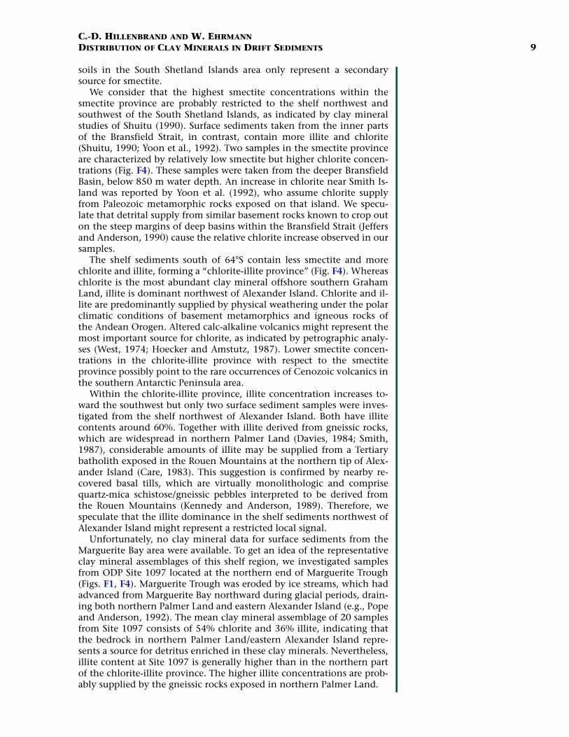
Site 1097 and Regional Clay Mineral Assemblagesin Surface Sediments
At Site 1097, smectite varies from 3% to 27%, illite from 31% to 41%,and chlorite from 41% to 63%. The fluctuations of clay minerals are in-dependent of the lithologies. Because of the very poor core recovery atSite 1097 and the limited number of samples, only the average claymineral composition in combination with the regional clay mineraldistribution in the surface sediments is presented (Fig. F4).
DISCUSSION
Provenance of Clay Mineral Assemblages
A prerequisite for the reconstruction of transport pathways is theidentification of specific source areas on the Antarctic Peninsula andthe adjacent islands. However, the heterogenous petrology of magmaticarc rocks and associated units as well as the extensive ice cover makethis identification difficult. The investigation of the clay mineral distri-bution in surface sediments of the Atlantic sector of the SouthernOcean reveals important clues for mapping specific clay mineralogicalsource areas. Clays supplied by the rocks exposed on the Antarctic Pen-insula represent a significant source for chlorite and smectite, which aretransported to the shelf break by surface currents and glaciomarine pro-cesses. There, chlorite and smectite are injected into the eastward-flow-ing ACC and then exported to the Atlantic sector (Petschick et al., 1996;Diekmann et al., 1996).
Continental Shelf
A detailed analysis of the clay mineralogical assemblages depositedon the shelf northwest of the Antarctic Peninsula reveals a varied pat-tern of clay mineralogical provenance. Smectite concentrations arehighest (>60%) in surface sediments in the far northeast (Fig. F4). Thisarea is referred to as the “smectite province.” Detrital and/or authigenicsmectite is probably supplied by Mesozoic volcanic arc rocks and by as-sociated volcano-sedimentary forearc basin strata exposed in GrahamLand, on the adjacent islands, and possibly within the shelf (Pirrie,1991; Petschick et al., 1996). Because these rock units, however, occuralong the whole axis of the Antarctic Peninsula, the smectite maximumoff northern Graham Land requires an additional source.
Potential further sources are the Cenozoic volcanic, pyroclastic, andvolcaniclastic deposits outcropping mainly on the South Shetland Is-lands, Brabant Island, and Anvers Island (Petschick et al., 1996; Hillen-brand, 2000). This is supported by a smectite content of 95% insediments near the active volcano on Deception Island (Fig. F4). In theSouth Shetland Islands area, submarine weathering of Cenozoic tephraand volcanic rocks producing smectite may play an important role(Petschick et al., 1996). Furthermore, some of the alkaline volcanics ex-posed in northern Graham Land and on the adjacent islands were ex-truded subglacially (e.g., Smellie and Skilling, 1994). This process isknown to represent a very effective mechanism for smectite formation.In contrast, authigenic smectite found in volcanogenic soils on theSouth Shetlands was shown to be produced by hydrothermal alterationrather than by chemical weathering (Blümel et al., 1985). Therefore,
F4. Clay mineral assemblages, p. 25.
Smectite
Illite
Kaolinite
Chlorite
Site 1095
Site 1096
AlexanderIsland
WeddellSea
Gra
ham
Lan
d
Ade
laid
eIs
land
DRIFT 5
DRIFT 6
DRIFT 7
BellingshausenSea
Mar
gu
erit
eTr
ou
gh
MargueriteBay
PS1565
DRIFT 4
DRIFT 3
DRIFT 2
DRIFT 1
PalmerLand
Smectiteprovince
prov
ince
Site 1097
Ch
lori
te-
illite
62°S
70°
68°
66°
64°
60°80°W 75° 70° 65°
250 km (at 65°S)
SM
Drill site ODP Leg 178
Gravity core site
Surface sample locationSeamount
C.-D. HILLENBRAND AND W. EHRMANNDISTRIBUTION OF CLAY MINERALS IN DRIFT SEDIMENTS 9
soils in the South Shetland Islands area only represent a secondarysource for smectite.
We consider that the highest smectite concentrations within thesmectite province are probably restricted to the shelf northwest andsouthwest of the South Shetland Islands, as indicated by clay mineralstudies of Shuitu (1990). Surface sediments taken from the inner partsof the Bransfield Strait, in contrast, contain more illite and chlorite(Shuitu, 1990; Yoon et al., 1992). Two samples in the smectite provinceare characterized by relatively low smectite but higher chlorite concen-trations (Fig. F4). These samples were taken from the deeper BransfieldBasin, below 850 m water depth. An increase in chlorite near Smith Is-land was reported by Yoon et al. (1992), who assume chlorite supplyfrom Paleozoic metamorphic rocks exposed on that island. We specu-late that detrital supply from similar basement rocks known to crop outon the steep margins of deep basins within the Bransfield Strait (Jeffersand Anderson, 1990) cause the relative chlorite increase observed in oursamples.
The shelf sediments south of 64°S contain less smectite and morechlorite and illite, forming a “chlorite-illite province” (Fig. F4). Whereaschlorite is the most abundant clay mineral offshore southern GrahamLand, illite is dominant northwest of Alexander Island. Chlorite and il-lite are predominantly supplied by physical weathering under the polarclimatic conditions of basement metamorphics and igneous rocks ofthe Andean Orogen. Altered calc-alkaline volcanics might represent themost important source for chlorite, as indicated by petrographic analy-ses (West, 1974; Hoecker and Amstutz, 1987). Lower smectite concen-trations in the chlorite-illite province with respect to the smectiteprovince possibly point to the rare occurrences of Cenozoic volcanics inthe southern Antarctic Peninsula area.
Within the chlorite-illite province, illite concentration increases to-ward the southwest but only two surface sediment samples were inves-tigated from the shelf northwest of Alexander Island. Both have illitecontents around 60%. Together with illite derived from gneissic rocks,which are widespread in northern Palmer Land (Davies, 1984; Smith,1987), considerable amounts of illite may be supplied from a Tertiarybatholith exposed in the Rouen Mountains at the northern tip of Alex-ander Island (Care, 1983). This suggestion is confirmed by nearby re-covered basal tills, which are virtually monolithologic and comprisequartz-mica schistose/gneissic pebbles interpreted to be derived fromthe Rouen Mountains (Kennedy and Anderson, 1989). Therefore, wespeculate that the illite dominance in the shelf sediments northwest ofAlexander Island might represent a restricted local signal.
Unfortunately, no clay mineral data for surface sediments from theMarguerite Bay area were available. To get an idea of the representativeclay mineral assemblages of this shelf region, we investigated samplesfrom ODP Site 1097 located at the northern end of Marguerite Trough(Figs. F1, F4). Marguerite Trough was eroded by ice streams, which hadadvanced from Marguerite Bay northward during glacial periods, drain-ing both northern Palmer Land and eastern Alexander Island (e.g., Popeand Anderson, 1992). The mean clay mineral assemblage of 20 samplesfrom Site 1097 consists of 54% chlorite and 36% illite, indicating thatthe bedrock in northern Palmer Land/eastern Alexander Island repre-sents a source for detritus enriched in these clay minerals. Nevertheless,illite content at Site 1097 is generally higher than in the northern partof the chlorite-illite province. The higher illite concentrations are prob-ably supplied by the gneissic rocks exposed in northern Palmer Land.

C.-D. HILLENBRAND AND W. EHRMANNDISTRIBUTION OF CLAY MINERALS IN DRIFT SEDIMENTS 10
Continental Rise
The clay mineral assemblages in surface sediments on the continen-tal rise offshore from the chlorite-illite province exhibit a clear enrich-ment in smectite (Fig. F4). At present, glaciogenic detritus derived fromthe Antarctic Peninsula and the adjacent islands is released into the seanear the coast and transported farther offshore by tidal and wind-driven circulation (e.g., Domack and Ishman, 1993; Ashley and Smith,2000). We consider terrigenous particles released in the Bransfield Straitnot relevant to sedimentation on the slope and rise because they areprobably carried to the northeast by a cyclonic current located withinthe strait (Hofmann et al., 1996). Fine-grained components of the gla-ciogenic detritus derived from the northwestern coasts of the South Sh-etlands as well as from the coasts in the chlorite-illite province,however, may travel across the shelf driven by currents. Thereby, circu-lation patterns on the shelf suggest meandering rather than straighttransport pathways to the shelf edge (Smith et al., 1999).
We expect clay-sized particles settling down through the water col-umn above the slope and rise offshore from the smectite province to betransported southwestward by the current regime measured there(Nowlin and Zenk, 1988). In contrast, fine-grained particles settlingdown above the continental slope west of 63°W, including those de-rived from the chlorite-illite province, may be deposited more or less insitu because of the lack of along-slope currents (Whitworth III et al.,1998). Offshore from Graham Land, intense erosional features reportedfrom the 16° steep upper continental slope by Vanneste and Larter(1995) may point to a still-recent activity of turbidity currents there. Weassume, however, that the possible supply of terrigenous detritus to therise by turbidity currents only plays a minor role at present.
Bottom-current regime on the upper continental rise is dominatedby general southwestward flow in the whole study area (Nowlin andZenk, 1988; Camerlenghi et al., 1997). Therefore, fine-grained particlessettling down to the upper rise offshore from the smectite province andfrom the chlorite-illite province are entrained into this bottom current.We expect at least some of the particles to be transported farther to thesouthwest before deposition. Consequently, the clay mineral assem-blage in the rise sediments offshore from the chlorite-illite provincecomprises higher amounts of smectite, which was injected into the bot-tom current at the continental rise offshore from the smectite province(Hillenbrand, 2000; Pudsey, 2000).
Glacial-Interglacial Cyclicity of Clay Mineral Assemblages during the Late Quaternary
Late Quaternary variations of clay mineral assemblages deposited atthe Antarctic Peninsula’s continental rise show a remarkable glacial–interglacial cyclicity with enhanced smectite concentrations during in-terglacial periods and high chlorite contents during glacials (Hillen-brand, 2000). At gravity core site PS1565, which is located offshorefrom the chlorite-illite province (Fig. F4), these variations are depictedfor the last 130 k.y. (Fig. F5). Smectite contents increase at the transi-tion between oxygen isotope Stages 6 and 5, are high during the earlyas well as late Stage 5, and decrease during Stages 4–2. Smectite in-creases again at the transition between Stages 2 and 1. Chlorite concen-trations mirror the smectite variations inversely, thereby reachingmaximum values during the late period of Stages 4–2, which possibly
F5. Clay and clay mineral con-tents, core PS1565, p. 26.
-
PS1565
1
2
4
5
6
Mar
ine
isot
ope
stag
e
Cor
e de
pth
(mbs
f)
Chlorite (%)Smectite (%) Illite (%)Clay (wt%)
10 402030 50 60 4020 604020 600
1
2
3
4
5
6
7
8
9
10
11

C.-D. HILLENBRAND AND W. EHRMANNDISTRIBUTION OF CLAY MINERALS IN DRIFT SEDIMENTS 11
represents the last glacial maximum. In contrast to the variations ofsmectite and chlorite, no clear correlation of the illite content with glo-bal climatic cycles is visible. The observed cyclicity in smectite-chloritefluctuations seems representative for the whole continental rise area be-tween Drifts 3 and 5 (Pudsey, 2000).
During interglacial periods, smectite is delivered from the smectiteprovince to site PS1565 by bottom-current transport along the conti-nental rise. The decrease of smectite during glacial periods may be ex-plained by two different mechanisms. The first is a consequence ofpreviously suggested climate-induced changes in depositional processeson the margin (e.g., Pudsey and Camerlenghi, 1998; Rebesco et al.,1998; Hillenbrand, 2000; Pudsey, 2000). During glacial periods,grounded ice streams advanced across the shelf of the chlorite-illiteprovince, eroded predominantly chlorite-rich detritus, and transportedthe debris seaward. The supply of eroded detritus to the outer shelf andthe shelf edge increased, particularly during glacial maxima, whengrounded ice streams had reached the shelf break. Rapid accumulationof unsorted debris near the shelf edge caused gravitational instabilities.These instabilities triggered slumps and slides on the upper slope,which turned into turbidity currents at the base of the slope. The tur-bidity currents cut channels into the upper continental rise and trans-ported most terrigenous detritus down to the lower rise and to theBellingshausen abyssal plain. Fine-grained particles within the suspen-sion cloud of the turbidity currents, however, were captured by thesouthwestward-flowing bottom current and were deposited at the driftsas well as in the adjacent rise areas. Consequently, the higher input ofdetritus derived from the chlorite-illite province into the bottom cur-rent during glacial periods resulted in a higher proportion of chloritewithin the clay mineral assemblage deposited at site PS1565. During theglacial–interglacial transitions, grounded ice streams retreated and thusthe supply of chlorite-enriched debris to the slope and rise decreased.
On the other hand, a weakening of bottom-current intensity duringglacial periods might have restricted the supply of smectite-rich detritusto the continental rise off southern Graham Land. The hypothesis of aglacial reduction in bottom-current strength may be supported by re-constructions of paleo-grounding lines in the Weddell Sea, indicatingthat no large ice shelves existed there during glacial maxima. Instead,grounded ice had advanced at least to the outer shelf (e.g., Bentley andAnderson, 1998). At the present time, dense bottom-water masses inthe Weddell Sea, which crucially contribute to the production of Wed-dell Sea Deep Water (WSDW) via mixing processes, are derived from su-per-cooled shelf waters forming beneath the large ice shelves (e.g., Orsiet al., 1993). Widely grounded ice on the Weddell Sea shelf during gla-cial times would have limited the formation of WSDW and weakenedbottom-water flow on the continental rise west of the Antarctic Penin-sula. Any glacial reduction of bottom-water flow should not only havereduced southwestward transport of smectite but also should havecaused a significant increase in deposition of clay-sized particles.
In core PS1565, there is only a weak correlation between changesin clay contents and variations of chlorite (Fig. F5). In principle, theproportion of the clay fraction does not reflect glacial–interglacial cy-clicity. More sophisticated grain-size analyses, which were carried outon the upper Quaternary sequences recovered at Sites 1095 and 1096by Pudsey (Chap. 12, Chap. 25, this volume) show a slight decrease ofthe clay fraction during interglacials. This decrease, however, may atleast be partly caused by an increase of silt-sized diatoms diluting the

C.-D. HILLENBRAND AND W. EHRMANNDISTRIBUTION OF CLAY MINERALS IN DRIFT SEDIMENTS 12
proportions of terrigenous clay. The diatoms were primarily supplied byvertical settling during interglacial times, independent of changes inbottom-current strength. Therefore, we suggest that glacial–interglacialcyclicity observed in the clay mineral assemblages deposited on thecontinental rise off southern Graham Land was predominantly con-trolled by changes in the supply of chlorite.
Neogene to Quaternary Clay Mineral Assemblagesin Sediments at Sites 1095 and 1096
Short-Term Variations
According to the existing age model, the stratigraphic sequence ofSite 1095 reaches back to ~9.3 Ma and that of Site 1096 to ~4.7 Ma.Throughout these intervals, the clay mineral composition is character-ized by major fluctuations of the individual clay minerals, particularlysmectite and chlorite. The clay mineral assemblages alternate betweentwo end-member assemblages (Figs. F6, F7). The first assemblage ischaracterized by smectite concentrations <20% and chlorite concentra-tions >40%. The second assemblage has smectite concentrations >20%and chlorite concentrations <40%. The illite concentrations in the sedi-ments recovered at Sites 1095 and 1096 are generally higher than ingravity core PS1565 because the ODP sites are located offshore from thesouthern part of the chlorite-illite province where illite is more abun-dant (Fig. F4). As in core PS1565 sediments, the illite fluctuations can-not be easily correlated with fluctuations in the other clay minerals.
In general, a very similar pattern in the clay mineral distribution tothat described in core PS1565 can be observed in the drill cores fromSites 1095 and 1096 if one takes into account the different sample spac-ing. The short-term cyclic changes in the clay mineral assemblages de-posited at Sites 1095 and 1096 occur throughout the late Neogene andQuaternary (Fig. F6) independent of changes in the clay contents. Thesmectite-poor assemblages are interpreted to indicate more glacial con-ditions, whereas smectite-rich assemblages may indicate more intergla-cial conditions (Fig. F7). We suppose that the short-term fluctuations ofclay mineral assemblages at Sites 1095 and 1096 were caused by the re-peated advance and retreat of grounded ice masses across the shelf ofthe Antarctic Peninsula, resulting from changes of Antarctic ice volume.
Antarctic ice volume changes are thought to have influenced the ox-ygen isotope record in benthic foraminiferal tests on Milankovitchtimescales since the early Pliocene (Shackleton, 1995; Barker et al.,1999). There is some debate, however, whether ice volume in Antarcticaalready fluctuated on orbital timescales during the late Miocene (Barkeret al., 1999). For the time interval between 7 and 5 Ma, benthic δ18Ofluctuations with the 41-k.y. period of orbital obliquity were reportedboth from Morocco (Hodell et al., 1994) and from the equatorial WestAtlantic (Shackleton and Hall, 1997). Whereas those from Moroccowere interpreted to be controlled, at least in part, by Antarctic ice vol-ume changes (Hodell et al., 1994), those from the Atlantic were as-sumed to exclusively reflect changes in deep-water temperatures(Shackleton and Crowhurst, 1997).
The pronounced short-term fluctuations in the clay mineral record atSite 1095 strongly suggest that Antarctic ice volume changes already oc-curred during the late Miocene. This might support the interpretationof Hodell et al. (1994). We consider, however, that our sample set fromSite 1095 yields too low a stratigraphic resolution for time-series analy-
F6. Variations in clay mineral composition, Sites 1095 and 1096, p. 27.
Site 1095
H I A T U S
A
Smectite (%) Illite (%) Chlorite (%)
Site 1096B
0 20 40 0 20 40 0 20 40 600
1
2
3
4
0
1
2
3
4
5
6
7
8
9
Age
(M
a)A
ge (
Ma)
0 20 40 0 20 40 0 20 40 60Smectite (%) Illite (%) Chlorite (%)
F7. Ternary plot of clay mineral composition, p. 28.
Illite
GlacialInterglacial
Smectite Chlorite(+ Kaolinite)
20% sm40% chl
Site 1096
Site 1095

C.-D. HILLENBRAND AND W. EHRMANNDISTRIBUTION OF CLAY MINERALS IN DRIFT SEDIMENTS 13
ses in the obliquity band. Moreover, the assumption of periodical ex-pansion and contraction of the Antarctic Peninsula ice cap may implythat the Antarctic ice sheet had reached a size to make it sensitive tosea-level changes, which might have been internally generated (Barkeret al., 1999).
Long-Term Variations
In contrast to other sedimentological parameters (e.g., the opalrecord) (Hillenbrand and Fütterer, Chap. 23, this volume), we observeonly weak long-term changes in the clay mineral assemblages depositedon the continental rise west of the Antarctic Peninsula. At Site 1095,smectite contents slightly increase at ~7.0 Ma and decrease at ~5.4 Ma,fluctuating afterward around a higher mean value than before ~7.0 Ma(Fig. F6A). Chlorite variations reflect this pattern inversely. The increaseof smectite roughly coincides with an intensification of Neogene volca-nism in the northern Antarctic Peninsula region (Smellie, 1990), whichultimately may have resulted in a greater supply of smectite-enrichedclay to Site 1095. A more pronounced intensification of volcanism inthe northern Antarctic Peninsula region, however, took place duringthe Pliocene and Pleistocene (Smellie, 1990). Therefore, we concludethat it is improbable that intensified late Neogene volcanism in thesmectite province represents the only cause for the slightly enhancedsmectite concentrations between ~7.0 and ~5.4 Ma.
Because grain-size distribution at Site 1095 gives no clear evidencefor a significant change in paleobottom-current strength during the lateMiocene (Pudsey, Chap. 12, this volume), we speculate that localchanges in glacial erosion linked to tectonic processes have contributedto the increase of smectite at Site 1095. The occurence of redepositedneritic diatoms in the drift sediments at Site 1095 points to a shallow-ing of the Antarctic Peninsula’s shelf between ~7.8 and ~6.2 Ma (M.Iwai, pers. comm., 1999). No global sea-level fall is known from thattime interval (e.g., Abreu and Anderson, 1998). Therefore, the sea-levellowstand recorded at Site 1095 must have been a consequence of localuplift, which probably resulted in an intensification of glacial erosionin the corresponding hinterland. South of 64°S, the Cenozoic subduc-tion of oceanic crustal segments below the Pacific margin of the Antarc-tic Peninsula had ceased at ~14.1 Ma, at the latest (Larter and Barker,1991; Larter et al., 1997). Uplift related to the ridge crest–trench colli-sion, which was concentrated on a relatively narrow zone on the shelf,lasted only for 1–4 m.y. (Larter and Barker, 1991; Larter et al., 1997).Thus, the chlorite-illite province should have been in subsidence since10 Ma and glacial erosion should have remained rather constant duringthe late Miocene.
In contrast, ridge-crest segments collided with the paleo-trench off-shore from Anvers Island and Brabant Island from 11.2 to 3.3 Ma andsubduction in the South Shetland Trench may still continue recently(Larter and Barker, 1991; Larter et al., 1997). Most collision ages offshorefrom the southern part of the smectite province date at ~6.6 Ma. We as-sume that in the southern smectite province, uplift processes related toridge crest–trench collision started already at ~7.8 Ma, causing a localsea-level lowstand. As a further consequence, glacial erosion of upliftedsmectite-bearing rocks intensified at 7.0 Ma. The strengthening of ero-sion resulted in an increased supply of detritus enriched in smectite tothe continental rise, where bottom currents carried the fine-grained de-bris southwestward to Site 1095. Subsidence in the southern part of the

C.-D. HILLENBRAND AND W. EHRMANNDISTRIBUTION OF CLAY MINERALS IN DRIFT SEDIMENTS 14
smectite province started only 1 Ma after the ridge crest–trench colli-sion. At ~6.2 Ma, continued subsidence and repeated advance ofgrounded ice masses during cold periods had deepened the shelf to awater depth in which benthic diatoms could not survive. Glacial ero-sion in the southern smectite province had weakened to the pre-upliftlevel at ~5.4 Ma, but intensified volcanism in the northern AntarcticPeninsula region during the late Neogene produced more smectite, sothat smectite supply to Site 1095 did not decrease to the mean value re-corded before ~7.0 Ma.
At Site 1096, illite contents slightly increase between ~1.5 and ~0.2Ma, whereas illite concentrations at Site 1095 remain rather constant(Fig. F6). This suggests that during most of the Quaternary, northern Al-exander Island, which represents the direct hinterland of Drift 7, was amore important source for fine-grained detritus supplied to Site 1096than northern Palmer Land/eastern Alexander Island. Indications forchanging contributions of local source areas within the southern chlo-rite-illite province may be derived from reconstructions of paleo ice-stream pathways on the shelf. Rebesco et al. (1998) inferred ice flow inMarguerite Trough during glacial periods exclusively in a northerly di-rection, indicating that glacial detritus from northern Palmer Land/eastern Alexander Island was predominantly supplied to the slope adja-cent to Drift 5. Bentley and Anderson (1998), in contrast, concludedfrom grounding zone wedges, which they found on the shelf northwestof Alexander Island, that ice streams also had spread out from Marguer-ite Trough to the outer shelf and the shelf break adjacent to Drifts 6 and7.
We suppose that throughout the late Neogene and Quaternary, gla-cial debris was delivered from the southern chlorite-illite province tothe outer shelf and the shelf edge via the ice stream pathways suggestedby Bentley and Anderson (1998). Between ~1.5 and ~0.2 Ma, however,the ice streams passing northern Alexander Island may have reachedthe shelf break adjacent to Drift 7 more often. This assumption is sup-ported by the relative age relationships between the grounding zonewedges found on the shelf. They indicate that grounded ice streams ad-vanced to the outer shelf during the last glacial maximum, whereasthey had reached the shelf edge during older glacial periods (Bentleyand Anderson, 1998). Moreover, detailed grain-size data show silty lay-ers to be more abundant at Site 1096 between ~1.7 Ma and ~100 ka(Pudsey, Chap. 25, this volume). These silty layers are interpreted asdistal turbidites (Barker, Camerlenghi, Acton, et al., 1999), which wereprobably triggered by more frequent advances of grounded ice streamsto the shelf break adjacent to Drift 7. The increased activity of turbiditycurrents at the continenal margin should have enriched the bottomcurrent on the rise with glacial debris enriched in illite. While the illite-rich detritus was predominantly deposited at proximal Site 1096, thebottom current supplied more fine-grained detritus derived from thenorthern part of the chlorite-illite province to the distal Site 1095.
Implications for Glacial History
In the late Neogene to Quaternary variations of clay mineral assem-blages at Sites 1095 and 1096, we do not recognize pronounced long-term changes caused by major glaciological or climatic changes. Thisstrongly suggests that the onset of vast glaciation on the Antarctic Pen-insula predates the late Miocene and that polar weathering conditionsprevailed on the Antarctic Peninsula throughout the last 9 m.y. Our

C.-D. HILLENBRAND AND W. EHRMANNDISTRIBUTION OF CLAY MINERALS IN DRIFT SEDIMENTS 15
suggestion is supported by the occurrence of IRD in upper Miocene sed-iments from the Bellingshausen Sea recovered both at Site 1095 and Site325, Deep Sea Drilling Project Leg 35 (Hollister, Craddock, et al., 1976)and by mineralogical and sedimentological evidence from continentalmargin deposits recovered in the Weddell Sea during ODP Leg 113(Kennett and Barker, 1990). These findings also indicate that majorcooling and glaciation had affected the Antarctic Peninsula region atleast since the late Miocene. Geochemical investigations carried out onsedimentary rocks point to a prevalence of glacial climatic conditionson the Antarctic Peninsula even since the early Oligocene (Dingle andLavelle, 1998). The buildup of large ice sheets in West Antarctica, in-cluding the Antarctic Peninsula ice cap, may have taken place at ~15Ma and contributed to a major eustatic sea-level drop (Abreu andAnderson, 1998), which is known to be caused by a significant increasein global ice volume (Lear et al., 2000). The clay mineral records in thedrift sediments on the Antarctic continental rise give no evidence formajor deglaciation events during the late Neogene (e.g., Webb and Har-wood, 1991), supporting the assumption that the Antarctic ice sheet asa whole had been quite stable since that time (Barker et al., 1999).
CONCLUSIONS
1. Clay mineral assemblages in surficial continental margin sedi-ments west of the Antarctic Peninsula consist of smectite, chlo-rite, and illite, with kaolinite occurring only in trace amounts.High smectite concentrations typify the shelf sediments offnorthern Graham Land, whereas chlorite and illite dominateshelf deposits offshore from the southern Antarctic Peninsula. Atthe continental rise, a bottom current transports smectite sup-plied from the northern Antarctic Peninsula to the southwest.
2. An upper Quaternary sediment sequence from site PS1565 com-prises an interglacial clay mineral assemblage with high smectiteamounts and a glacial assemblage characterized by enhancedchlorite concentrations. During glacial periods, chlorite-enriched detritus was supplied to the continental rise by gravita-tional downslope processes triggered by the advance ofgrounded ice streams to the shelf break.
3. Upper Miocene to Quaternary sediments recovered at continen-tal rise Sites 1095 and 1096 exhibit clay mineral fluctuationsalternating between two end-member assemblages. One assem-blage is characterized by <20% smectite and >40% chlorite. Theother assemblage has >20% smectite and <40% chlorite. The claymineral fluctuations are similar to those observed at site PS1565.We ascribe the short-term changes in clay mineral compositionat Sites 1095 and 1096 to repeated ice advances and retreatsacross the shelf west of the Antarctic Peninsula, reflecting gla-cial–interglacial cyclicity. We conclude that oscillations in Ant-arctic ice volume may have influenced the global climate alreadyduring the late Miocene.
4. Only slight long-term changes are observed in the clay mineralassemblages deposited at ODP Sites 1095 and 1096. A slight en-hancement of smectite contents between ~7.0 and ~5.4 Ma atSite 1095 may be a consequence of a higher smectite supplycaused by an intensification of volcanism in the northern Ant-arctic Peninsula region and by a strengthening of glacial erosion
C.-D. HILLENBRAND AND W. EHRMANNDISTRIBUTION OF CLAY MINERALS IN DRIFT SEDIMENTS 16
in northern Graham Land in response to local uplift associatedwith ridge crest–trench collision. An increase of illite at Site 1096between ~1.5 and ~0.2 Ma is probably caused by changes in thesupply of glacial debris from different source areas on the south-ern Antarctic Peninsula. The clay mineral assemblages depositedat Drift 7 point to an onset of vast glaciation in the AntarcticPeninsula region before 9 Ma but give no evidence for major de-glaciation events since then.
ACKNOWLEDGMENTS
We thank the crew and the Shipboard Scientific Party of Leg 178 fortaking samples for us and making this study possible. We wish to thankH. Grobe, H. Rhodes, and M. Seebeck for supporting our laboratorywork. Our paper benefited from constructive criticism by our colleaguesB. Diekmann, C. Pudsey, D. Fütterer, and T. Wolf-Welling. Furthermore,we thank A. Camerlenghi, C. Robert, and M. Setti for their helpful re-views of the manuscript. We gratefully acknowledge financial supportfrom the Deutsche Forschungsgemeinschaft.

C.-D. HILLENBRAND AND W. EHRMANNDISTRIBUTION OF CLAY MINERALS IN DRIFT SEDIMENTS 17
REFERENCES
Abreu, V.S., and Anderson, J.B., 1998. Glacial eustasy during the Cenozoic: sequencestratigraphic implications. AAPG Bull., 82:1385–1400.
Anderson, J.B., 1990. Sediments. In Glasby, G.P. (Ed.), Antarctic Sector of the Pacific,Elsevier Oceanogr. Ser., 51:187–206.
Ashley, G.M., and Smith, N., 2000. Marine sedimentation at a calving glacier margin.Geol. Soc. Am. Bull., 112:657–667.
Barker, P.F., Barrett, P.J., Camerlenghi, A., Cooper, A.K., Davey, F.J., Domack, E.W.,Escutia, C., Kristoffersen, Y., and O’Brien, P.E., 1998. Ice sheet history from Antarc-tic continental margin sediments: the ANTOSTRAT approach. Terra Antart., 5:737–760.
Barker, P.F., Barrett, P.J., Cooper, A.K., and Huybrechts, P., 1999. Antarctic glacial his-tory from numerical models and continental margin sediments. Palaeogeogr., Palae-oclimatol., Palaeoecol., 150:247–267.
Barker, P.F., Camerlenghi, A., Acton, G.D., et al., 1999. Proc. ODP, Init. Repts., 178 [CD-ROM]. Available from: Ocean Drilling Program, Texas A&M University, College Sta-tion, TX 77845-9547, U.S.A.
Barker, P.F., Kennett, J.P., et al., 1988. Proc. ODP, Init. Repts., 113: College Station, TX(Ocean Drilling Program).
Barrett, P.J. (Ed.), 1986. Antarctic Cenozoic history from the MSSTS-1 drillhole,McMurdo Sound. DSIR Bull. N.Z., 237:1–171.
———— (Ed.), 1989. Antarctic Cenozoic history from the CIROS-1 drillhole,McMurdo Sound. DSIR Bull. N.Z., 245:1–254.
Barrett, P.J., and Scientific Staff, 1985. Plio-Pleistocene glacial sequence cored atCIROS-2, Jerrar Fjord, McMurdo Sound. N.Z. Antarct. Rec., 6:8–19.
Barron, J., Larsen, B., et al., 1989. Proc. ODP, Init. Repts., 119: College Station, TX(Ocean Drilling Program).
Bentley, M.J., and Anderson, J.B., 1998. Glacial and marine geological evidence forthe ice-sheet configuration in the Weddell Sea–Antarctic Peninsula region duringthe Last Glacial Maximum. Antarct. Sci., 10:309–325.
Berggren, W.A., Kent, D.V., Swisher, C.C., III, and Aubry, M.-P., 1995. A revised Ceno-zoic geochronology and chronostratigraphy. In Berggren, W.A., Kent, D.V., Aubry,M.-P., and Hardenbol, J. (Eds.), Geochronology, Time Scales and Global StratigraphicCorrelation. Spec. Publ.—Soc. Econ. Paleontol. Mineral. (Soc. Sediment. Geol.),54:129–212.
Biscaye, P.E., 1964. Distinction between kaolinite and chlorite in recent sediments byX-ray diffraction. Am. Miner., 49:1281–1289.
————, 1965. Mineralogy and sedimentation of recent deep-sea clays in the Atlan-tic Ocean and adjacent seas and oceans. Geol. Soc. Am. Bull., 76:803–832.
Blümel, W.D., Emmermann, R., and Smykatz-Kloss, W., 1985. Vorkommen undEntstehung von tri-oktaedrischen Smektiten in den Basalten und Böden der König-Georg-Insel (S-Shetlands/West-Antarktis). Polarforschung, 55:33–48.
Brindley, G.W., and Brown, G. (Eds.), 1980. Crystal Structures of Clay Minerals andTheir X-ray Identification. Mineral. Soc. London Monogr., 5.
Camerlenghi, A., Crise, A., Pudsey, C.J., Accerboni, E., Laterza, R., and Rebesco, M.,1997. Ten-month observation of the bottom current regime across a sediment driftof the Pacific margin of the Antarctic Peninsula. Antarct. Sci., 9:426–433.
Cape Roberts Science Team (CRST), 1998. Initial report on CRP-1. Terra Antart., 5.————, 1999. Studies from the Cape Roberts Project, Ross Sea, Antarctica—Initial
report on CRP-2/2A. Terra Antart., 6(½).————, 2000. Studies from the Cape Roberts Project, Ross Sea, Antarctica: Initial
report on CRP-3. Terra Antart., 7.Care, B.W., 1983. The petrology of the Rouen Mountains, northern Alexander Island.
Brit. Antarct. Surv. Bull., 52:63–86.

C.-D. HILLENBRAND AND W. EHRMANNDISTRIBUTION OF CLAY MINERALS IN DRIFT SEDIMENTS 18
Chamley, H., 1989. Clay Sedimentology: Berlin (Springer-Verlag).Davey, F.J., 1990. Structure and tectonics. In Glasby, G.P. (Ed.), Antarctic Sector of the
Pacific, Elsevier Oceanogr. Ser., 51:125–154.Davies, T.G., 1984. The geology of part of northern Palmer Land. Brit. Antarct. Surv.
Sci. Rep., 103:46 pp.Diekmann, B., Kuhn, G., Rachold, V., Abelmann, A., Brathauer, U., Fütterer, D.K.,
Gersonde, R., Grobe, H., 2000. Terrigenous sediment supply in the Scotia Sea(Southern Ocean): Response to Late Quaternary ice dynamics in Patagonia and onthe Antarctic Peninsula. Palaeogeogr., Palaeoclimatol., Palaeoecol., 162:357–387.
Diekmann, B., Petschick, R., Gingele, F.X., Fütterer, D.K., Abelmann, A., Brathauer,U., Gersonde, R., and Mackensen, A., 1996. Clay mineral fluctuations in Late Qua-ternary sediments of the southeastern South Atlantic: implications for pastchanges of deep water advection. In Wefer, G., Berger, W.H., Siedler, G., and Webb,D.J. (Eds.), The South Atlantic: Present and Past Circulation: Berlin-Heidelberg(Springer), 621–644.
Dingle, R.V., and Lavelle, M., 1998. Late Cretaceous–Cenozoic climatic variations ofthe northern Antarctic Peninsula: new geochemical evidence and review. Palaeo-geogr., Palaeoclimatol., Palaeoecol., 141:215–232.
Domack, E.W., and Ishman, S., 1993. Oceanographic and physiographic controls onmodern sedimentation within Antarctic fjords. Geol. Soc. Am. Bull., 105:1175–1189.
Ehrmann, W., 1998a. Implications of late Eocene to early Miocene clay mineralassemblages in McMurdo Sound (Ross Sea, Antarctica) on paleoclimate and icedynamics. Palaeogeogr., Palaeoclimatol., Palaeoecol., 139:213–231.
————, 1998b: Lower Miocene and Quaternary clay mineral assemblages from CRP-1. Terra Antart., 5:613–619.
————, in press. Smectite content and crystallinity in sediments from CRP-2/2a,Ross Sea, Antarctica. Terra Antart.
Ehrmann, W.U., and Mackensen, A., 1992. Sedimentological evidence for the forma-tion of an East Antarctic ice sheet in Eocene/Oligocene time. Palaeogeogr., Palaeocli-matol., Palaeoecol., 93:85–112.
Ehrmann, W.U., Melles, M., Kuhn, G., and Grobe, H., 1992. Significance of clay min-eral assemblages in the Antarctic Ocean. Mar. Geol., 107:249–273.
Elliot, D.H., 1997. The planar crest of Graham Land, northern Antarctic Peninsula:possible origins and timing of uplift. In Barker, P.F., and Cooper, A.K. (Eds.), Geologyand Seismic Stratigraphy of the Antarctic Margin (Pt 2). Am. Geophys. Union, Antarct.Res. Ser., 71:51–73.
Hambrey, M.J., Ehrmann, W.U., and Larsen, B., 1991. Cenozoic glacial record of thePrydz Bay continental shelf, East Antarctica. In Barron, J., Larsen, B., et al., Proc.ODP, Sci. Results, 119: College Station, TX (Ocean Drilling Program), 77–132.
Hillenbrand, C.-D., 2000. Glaciomarine sedimentation on the continental margins of theAmundsen and Bellingshausen Seas, West Antarctica—indications for paleoenvironmen-tal changes during the Quaternary climatic cycles. Rep. Polar Res., 346: Bremerhaven(Alfred Wegener Institute for Polar and Marine Research).
Hodell, D.A., Benson, R.H., Kent, D.V., Boersma, A., and Rakic-El Bied, K., 1994. Mag-netostratigraphic, biostratigraphic, and stable isotope stratigraphy of an UpperMiocene drill core from the Salé Briqueterie (northwestern Morocco): a high-reso-lution chronology for the Messinian stage. Paleoceanography, 9:835–855.
Hoecker, G., and Amstutz, G.C., 1987. Petrographie der mesozoischen Magmatite imGebiet des Palmer Archipels (Antarktische Halbinsel) unter besonderer Berücksich-tigung von geochemisch-lagerstättenkundlichen Gesichtspunkten. Polarforschung,57:43–57.
Hofmann, E.E., Klinck, J.M., Lascara, C.M., and Smith, D.A., 1996. Water mass distri-bution and circulation west of the Antarctic Peninsula and Bransfield Strait. Ant-arct. Res. Ser., 70:61–80.

C.-D. HILLENBRAND AND W. EHRMANNDISTRIBUTION OF CLAY MINERALS IN DRIFT SEDIMENTS 19
Hollister, C.D., Craddock, C., et al., 1976. Init. Repts. DSDP, 35: Washington (U.S.Govt. Printing Office).
Jeffers, J.D., and Anderson, J.B., 1990. Sequence stratigraphy of the Bransfield Basin,Antarctica: implications for tectonic history and hydrocarbon potential. In St.John, B. (Ed.), Antarctica as an Exploration Frontier, Hydrocarbon Potential, Geology,and Hazards, Stud. in Geol., 31: Tulsa (American Association of Petroleum Geolo-gists), 13–29.
Kennedy, D.S., and Anderson, J.B., 1989. Glacial-marine sedimentation and Quater-nary glacial history of Marguerite Bay, Antarctic Peninsula. Quat. Res., 31:255–276.
Kennett, J.P., and Barker, P.F., 1990. Latest Cretaceous to Cenozoic climate and ocean-ographic developments in the Weddell Sea, Antarctica: an ocean-drilling perspec-tive. In Barker, P.F., Kennett, J.P., et al., Proc. ODP, Sci. Results, 113: College Station,TX (Ocean Drilling Program), 937–960.
Keys, J.R., 1990. Ice. In Glasby, G.P. (Ed.), Antarctic Sector of the Pacific, Elsevier Ocean-ogr. Ser., 51:95–123.
Larter, R.D., and Barker, P.F., 1989. Seismic stratigraphy of the Antarctic PeninsulaPacific margin: a record of Pliocene-Pleistocene ice volume and paleoclimate. Geol-ogy, 17:731–734.
————, 1991. Neogene interaction of tectonic and glacial processes at the Pacificmargin of the Antarctic Peninsula. In Macdonald, D.I.M. (Ed.), Sedimentation, Tec-tonics and Eustasy: Sea-level Changes at Active Margins. Spec. Publ. Int. Assoc. Sedi-mentol., 12:165–186.
Larter, R.D., and Cunningham, A.P., 1993. The depositional pattern and distributionof glacial-interglacial sequences on the Antarctic Peninsula Pacific Margin. Mar.Geol., 109:203–219.
Larter, R.D., Rebesco, M., Vanneste, L.E., Gamboa, L.A.P., and Barker, P., 1997. Ceno-zoic tectonic, sedimentary and glacial history of the continental shelf west of Gra-ham Land, Antarctic Peninsula. In Cooper, A.K., Barker, P.F., and Brancolini, G.(Eds.), Geology and Seismic Stratigraphy of the Antarctic Margin (Pt. 2). Antarct. Res.Ser., 71:1–27.
Lear, C.H., Elderfield, H., and Wilson, P.A., 2000. Cenozoic deep-sea temperatures andglobal ice volumes from Mg/Ca in benthic foraminiferal calcite. Science, 287:269–272.
Loske, W., Miller, H., and Töpfner, C., 1998. Sedimentary recycling of Palaeozoicgranitoids in the Antarctic Peninsula. Terra Antart., 5:201–207.
Macdonald, D.I.M., and Butterworth, P.J., 1990. The stratigraphy, setting and hydro-carbon potential of the Mesozoic sedimentary basins of the Antarctic Peninsula. InSt. John, B. (Ed.), Antarctica as an Exploration Frontier, Hydrocarbon Potential, Geology,and Hazards. Stud. in Geol., 31:101–125.
Nowlin, W.D., Jr., and Zenk, W., 1988. Westward bottom currents along the marginof the South Shetland island arc. Deep-Sea Res., 35:269–301.
Orsi, A.H., Nowlin Jr., W.D., and Whitworth III, T., 1993. On the circulation and strat-ification of the Weddell Gyre. Deep-Sea Res. I, 40:169–203.
Orsi, A.H., Whitworth III, T., and Nowlin Jr., W.D., 1995. On the meridional extentand fronts of the Antarctic Circumpolar Current. Deep-Sea Res. I, 42:641–673.
Parkinson, C.L., 1994. Spatial patterns in the length of the sea ice season in theSouthern Ocean, 1979–1986. J. Geophys. Res., 99:16327–16339.
Petschick, R., Kuhn, G., and Gingele, F., 1996. Clay mineral distribution in surfacesediments of the South Atlantic: sources, transport, and relation to oceanography.Mar. Geol., 130:203–229.
Piper, D.J.W., and Pe, G.G., 1977. Cenozoic clay mineralogy from D.S.D.P. holes onthe continental margin of the Australia-New Zealand sector of Antarctica. N. Z. J.Geol. Geophys., 20:905–917.
Pirrie, D., 1991. Controls on the petrographic evolution of an active margin sedimen-tary sequence: the Larsen Basin, Antarctica. In Morton, A.C., Todd, S.P., and

C.-D. HILLENBRAND AND W. EHRMANNDISTRIBUTION OF CLAY MINERALS IN DRIFT SEDIMENTS 20
Haughton, P.D.W. (Eds.), Developments in Sedimentary Provenance Studies, Geol. Soc.Spec. Publ. London, 57:231–249.
Pope, P.G., and Anderson, J.B., 1992. Late Quaternary glacial history of the northernAntarctic Peninsula’s western continental shelf: evidence from the marine record.In Elliot, D. H. (Ed.), Contributions to Antarctic Research III. Am. Geophys. Union,Antarct. Res. Ser., 57:63–91.
Pudsey, C.J., 2000. Sedimentation on the continental rise west of the Antarctic Penin-sula over the last three glacial cycles. Mar. Geol., 167:313–338.
Pudsey, C.J., Barker, P.F., and Larter, R.D., 1994. Ice sheet retreat from the AntarcticPeninsula shelf. Cont. Shelf Res., 14:1647–1675.
Pudsey, C.J., and Camerlenghi, A., 1998. Glacial-interglacial deposition on a sedi-ment drift on the Pacific margin of the Antarctic Peninsula. Antarct. Sci., 10:286–308.
Rebesco, M., Camerlenghi, A., and Zanolla, C., 1998. Bathymetry and morphogenesisof the continental margin west of the Antarctic Peninsula. Terra Antart., 5:715–725.
Rebesco, M., Larter, R.D., Barker, P.F., Camerlenghi, A., and Vanneste, L.E., 1997. Thehistory of sedimentation on the continental rise west of the Antarctic Peninsula. InBarker, P.F., and Cooper, A.K. (Eds.), Geology and Seismic Stratigraphy of the AntarcticMargin (Pt. 2). Am. Geophys. Union, Antarctic Res. Ser., 71:29–50.
Rebesco, M., Larter, R.D., Camerlenghi, A., and Barker, P.F., 1996. Giant sedimentdrifts on the continental rise of the Antarctic Peninsula. Geo-Mar. Lett., 16:65–75.
Robert, C., and Maillot, H., 1983. Paleoenvironmental significance of clay mineralog-ical and geochemical data, Southwest Atlantic, DSDP Legs 36 and 71. In Ludwig,W.J., Krasheninnikov, V.A., et al., Init. Repts. DSDP, 71: Washington (U.S. Govt.Printing Office), 317–343.
Setti, M., Lopez-Galindo, A., and Ben Aboud, A., 1997. XRD, SEM and TEM investiga-tions of smectites of the Core CIROS-1 (Ross Sea, Antarctica). Terra Antart., 4:119–125.
Setti, M., Marinoni, L., Lopez-Galindo, A., and Ben Aboud, A., 1998. TEM observa-tions and rare earth element analysis on the clay minerals of the CRP-1 Core (RossSea, Antarctica). Terra Antart., 5:621–626.
Shackleton, N.J., 1995. New data on the evolution of Pliocene climatic variability. InVrba, E.S., Denton, G.H., Partridge, T.C., and Burckle, L.H. (Eds.). Paleoclimate andevolution with emphasis on human origins: Yale (Yale University Press), 242–248.
Shackleton, N.J., and Crowhurst, S., 1997. Sediment fluxes based on an orbitallytuned time scale 5 Ma to 14 Ma, Site 926. In Shackleton, N.J., Curry, W.B., Richter,C., and Bralower, T.J. (Eds.), Proc. ODP, Sci. Results, 154: College Station, TX (OceanDrilling Program), 69–82.
Shackleton, N.J., and Hall, M.A., 1997. The late Miocene stable isotope record, Site926. In Shackleton, N.J., Curry, W.B., Richter, C., and Bralower, T.J. (Eds.), Proc.ODP, Sci. Results, 154: College Station, TX (Ocean Drilling Program), 367–373.
Shuitu, G., 1990. Clay minerals in the northwestern sea area of the Antarctic Penin-sula. Antarct. Res., 2:35–42.
Smellie, J.L., 1990. Graham Land and South Shetland Islands. In LeMasurier, W.E.,and Thomson, J.W. (Eds.), Volcanoes of the Antarctic Plate and Southern Oceans, Ant-arct. Res. Ser., 48:303–312.
————, 1999. Lithostratigraphy of Miocene–Recent, alkaline volcanic fields in theAntarctic Peninsula and eastern Ellsworth Land. Antarct. Sci., 11:362–378.
Smellie, J.L., and Skilling, I.P., 1994. Products of subglacial volcanic eruptions underdifferent ice thicknesses: two examples from Antarctica. Sediment. Geol., 91:115–129.
Smith, C.G., 1987. The geology of parts of the west coast of Palmer Land. Brit. Antarct.Surv. Sci. Rep., 112.
Smith, D.A., Hofmann, E.E., Klinck, J.M., and Lascara, C.M., 1999. Hydrography andcirculation of the West Antarctic Peninsula Shelf. Deep-Sea Res. I, 46:925–949.

C.-D. HILLENBRAND AND W. EHRMANNDISTRIBUTION OF CLAY MINERALS IN DRIFT SEDIMENTS 21
Talbot, M.H., 1988. Oceanic environment of George VI ice shelf, Antarctic Peninsula.Ann. Glaciol., 11:161–164.
Thomson, M.R.A., and Pankhurst, R.J., 1983. Age of Post-Gondwanian calc-alkalinevolcanism in the Antarctic Peninsula region. In Oliver, R.L., James, P.R., and Jago,J.B. (Eds.), Antarctic Earth Science: Cambridge (Cambridge University Press) 328–333.
Thomson, M.R.A., Pankhurst, R.J., and Clarkson, P.D., 1983. The Antarctic Penin-sula—a late Mesozoic–Cenozoic arc (review). In Oliver, R.L., James, P.R., and Jago,J.B. (Eds.), Antarctic Earth Science: Cambridge (Cambridge University Press) 289–294.
Tomlinson, J.S., Pudsey, C.J., Livermore, R.A., Larter, R.D., and Barker, P.F., 1992.GLORIA survey of the Pacific margin of the Antarctic Peninsula: tectonic fabricand sedimentary processes. In Yoshida, Y., Kaminuma, K., and Shiraishi, K. (Eds.),Recent Progress in Antarctic Earth Science: Tokyo (Terra Sci. Publ.), 423–429.
Tucholke, B.E., 1977. Sedimentation processes and acoustic stratigraphy in the Bell-ingshausen Basin. Mar. Geol., 25:209–230.
Vanneste, L.E., and Larter, R.D., 1995. Deep-tow boomer survey on the Antarctic Pen-insula Pacific margin: an investigation of the morphology and acoustic characteris-tics of Late Quaternary sedimentary deposits on the outer continental shelf andupper slope. In Cooper, A.K., Barker, P.F., and Brancolini, G. (Eds.), Geology and Seis-mic Stratigraphy of the Antarctic Margin. Am. Geophys. Union, Antarct. Res. Ser.,68:97–121.
Vanney, J.R., and Johnson, G.L., 1976. The Bellingshausen-Amundsen Basins (south-eastern Pacific): major sea-floor units and problems. Mar. Geol., 22:71–101.
Weaver, C.E., 1989. Clays, Muds, and Shales: New York (Elsevier), Dev. in Sedimentol.Ser., 44.
Webb, P.-N., and Harwood, D.M., 1991. Late Cenozoic glacial history of the RossEmbayment, Antarctica. In Cronin, T.M., and Dowsett, H.J. (Eds.), Pliocene Cli-mates. Quat. Sci. Rev., 10:215–223.
West, S.M., 1974. The geology of the Danco Coast, Graham Land. Brit. Antarct. Surv. Sci.Rep., 84.
Whitworth III, T., Orsi, A.H., Kim, S.-J., Nowlin Jr., W.D., and Locarnini, R.A., 1998.Water masses and mixing near the Antarctic Slope Front. In Jacobs, S., and Weiss,R. (Eds.), Ocean, Ice, and Atmosphere: Interactions at the Antarctic Continental Margin,Antarct. Res. Ser., 75:1–27.
Wright, R., Anderson, J.B., and Fisco, P.P., 1983. Distribution and association of sedi-ment gravity flow deposits and glacial/glacial-marine sediments around the conti-nental margin of Antarctica. In Molnia, B. F. (Ed.), Glacial-Marine Sedimentation:New York (Plenum), 265–300.
Yoon, H.I., Han, M.W., Park, B.K., Han, S.J., and Oh, J.K., 1992. Distribution, prove-nance, and dispersal pattern of clay minerals in surface sediments, BransfieldStrait, Antarctica. Geo-Mar. Lett., 12:223–227.

C.-D. HILLENBRAND AND W. EHRMANNDISTRIBUTION OF CLAY MINERALS IN DRIFT SEDIMENTS 22
Figure F1. Bathymetric map of the continental margin west of the Antarctic Peninsula (Rebesco et al., 1998)with locations of Sites 1095, 1096, and 1097 (solid circles) and of gravity core PS1565 (cross). SM = sea-mount, MSH = midshelf high.
Site 1095
Site 1096
AlexanderIsland
WeddellSea
Gra
ham
Lan
d
Ade
laid
eIs
land
DRIFT 4
DRIFT 5
DRIFT 6
DRIFT 7
BellingshausenSea
Mar
guer
ite
MargueriteBay
PS1565DRIFT 3
DRIFT 2
DRIFT 1
Bransfield Stra
it
BrabantIsland
PalmerLand
Site 1097
Deception
Trou
gh
MSH
250 km (at 65°S)
62°S
70°
68°
66°
64°
60°80°W 75° 70° 65°
AnversIsland
SouthShetlandIslands

C.-D. HILLENBRAND AND W. EHRMANNDISTRIBUTION OF CLAY MINERALS IN DRIFT SEDIMENTS 23
Figure F2. Percent distribution of the main clay mineral groups smectite, illite, and chlorite in sedimentsrecovered at Site 1095 plotted against composite depth.
Dep
th (
mcd
)
Site 1095
late
Plio
cene
early
Qua
tern
ary
late
Mio
cene
0
50
100
150
200
250
300
350
400
450
Clay (wt%) Smectite (%) Illite (%) Chlorite (%) Age0 20 40 60 80 20 40 0 20 40 0 20 40 600

C.-D. HILLENBRAND AND W. EHRMANNDISTRIBUTION OF CLAY MINERALS IN DRIFT SEDIMENTS 24
Figure F3. Percent distribution of the main clay mineral groups smectite, illite, and chlorite in sedimentsrecovered at Site 1096 plotted against composite depth.
Site 1096
Dep
th (
mcd
)
Qua
tern
ary
early
Plio
cene
late
Plio
cene
AgeClay (wt%) Smectite (%) Illite (%) Chlorite (%)0 20 40 60 80 20 40 0 20 40 0 20 40 600
0
50
100
150
200
250
300
350
400
450
500
550

C.-D. HILLENBRAND AND W. EHRMANNDISTRIBUTION OF CLAY MINERALS IN DRIFT SEDIMENTS 25
Figure F4. Clay mineral assemblages in surface sediments west of the Antarctic Peninsula based on data byPetschick et al. (1996) and Diekmann et al. (2000). For Site 1096 and gravity core PS1565, the clay mineralassemblages of the uppermost core sediments (0–1 cm below seafloor) are also shown. For Site 1097, themean clay mineral composition of all investigated samples is given. The clay mineral assemblage on theshelf in the northeast is characterized by high smectite contents (smectite province), whereas shelf sedi-ments farther in the southwest contain more chlorite and illite (chlorite-illite province). Surface sedimentsat the continental rise offshore from the chlorite-illite province are characterized by enhanced smectitecontents in respect to the deposits on the adjacent shelf.
Smectite
Illite
Kaolinite
Chlorite
Site 1095
Site 1096
AlexanderIsland
WeddellSea
Gra
ham
Lan
d
Ade
laid
eIs
land
DRIFT 5
DRIFT 6
DRIFT 7
BellingshausenSea
Mar
gu
erit
eTr
ou
gh
MargueriteBay
PS1565
DRIFT 4
DRIFT 3
DRIFT 2
DRIFT 1
PalmerLand
Smectiteprovince
prov
ince
Site 1097
Ch
lori
te-
illite
62°S
70°
68°
66°
64°
60°80°W 75° 70° 65°
250 km (at 65°S)
SM
Drill site ODP Leg 178
Gravity core site
Surface sample locationSeamount

C.-D. HILLENBRAND AND W. EHRMANNDISTRIBUTION OF CLAY MINERALS IN DRIFT SEDIMENTS 26
Figure F5. Clay content and contents of smectite, illite, and chlorite in upper Quaternary sediments ofgravity core PS1565 (Hillenbrand, 2000). Smectite contents exhibit maxima during the interglacial oxygenisotope Stages 5 and 1, and chlorite concentrations are highest during glacial Stages 6 and 4–2. Clay andillite contents show no significant trends.
-
PS1565
1
2
4
5
6
Mar
ine
isot
ope
stag
e
Cor
e de
pth
(mbs
f)
Chlorite (%)Smectite (%) Illite (%)Clay (wt%)
10 402030 50 60 4020 604020 600
1
2
3
4
5
6
7
8
9
10
11

C.-D. HILLENBRAND AND W. EHRMANNDISTRIBUTION OF CLAY MINERALS IN DRIFT SEDIMENTS 27
Figure F6. Temporal variations in the clay mineral composition of sediments from (A) Site 1095 and (B)Site 1096.
Site 1095
H I A T U S
A
Smectite (%) Illite (%) Chlorite (%)
Site 1096B
0 20 40 0 20 40 0 20 40 600
1
2
3
4
0
1
2
3
4
5
6
7
8
9
Age
(M
a)A
ge (
Ma)
0 20 40 0 20 40 0 20 40 60Smectite (%) Illite (%) Chlorite (%)

C.-D. HILLENBRAND AND W. EHRMANNDISTRIBUTION OF CLAY MINERALS IN DRIFT SEDIMENTS 28
Figure F7. Ternary plot of the clay mineral composition of the 192 investigated samples from Site 1095 andthe 119 investigated samples from Site 1096. Kaolinite occurs only in trace amounts and was added to thechlorite content. Clay mineral fluctuations at Sites 1095 and 1096 alternate between two end-member as-semblages. One assemblage is characterized by <20% smectite and >40% chlorite. The second assemblagehas >20% smectite and <40% chlorite.
Illite
GlacialInterglacial
Smectite Chlorite(+ Kaolinite)
20% sm40% chl
Site 1096
Site 1095

C.-D. HILLENBRAND AND W. EHRMANNDISTRIBUTION OF CLAY MINERALS IN DRIFT SEDIMENTS 29
Table T1. Location, water depth, and core recovery, Sites 1095, 1096,and 1097.
Hole Latitude LongitudeWater
depth (m)Core
recovery (m) AgeNumber
of samples
1095A 66°59.1′S 78°29.3′W 3853 554.06 late Miocene-Quaternary 1921095B
1096A 67°34.0′S 76°57.8′W 3164 673.27 early Pliocene-Quaternary 1191096B1096C
1097A 66°23.6′S 70°45.4′W 563 59.30 early Pliocene-?Quaternary 20