8602 argos 66 - argos · pdf filewe then moved on to lake magadini, a small, seasonal rain-fed...
TRANSCRIPT

Protecting biodiversity
#6
60 6 / 2 0 0 8
ARGOSf o r u m
CONTENTConserving Canada lynx with
satellite telemetry
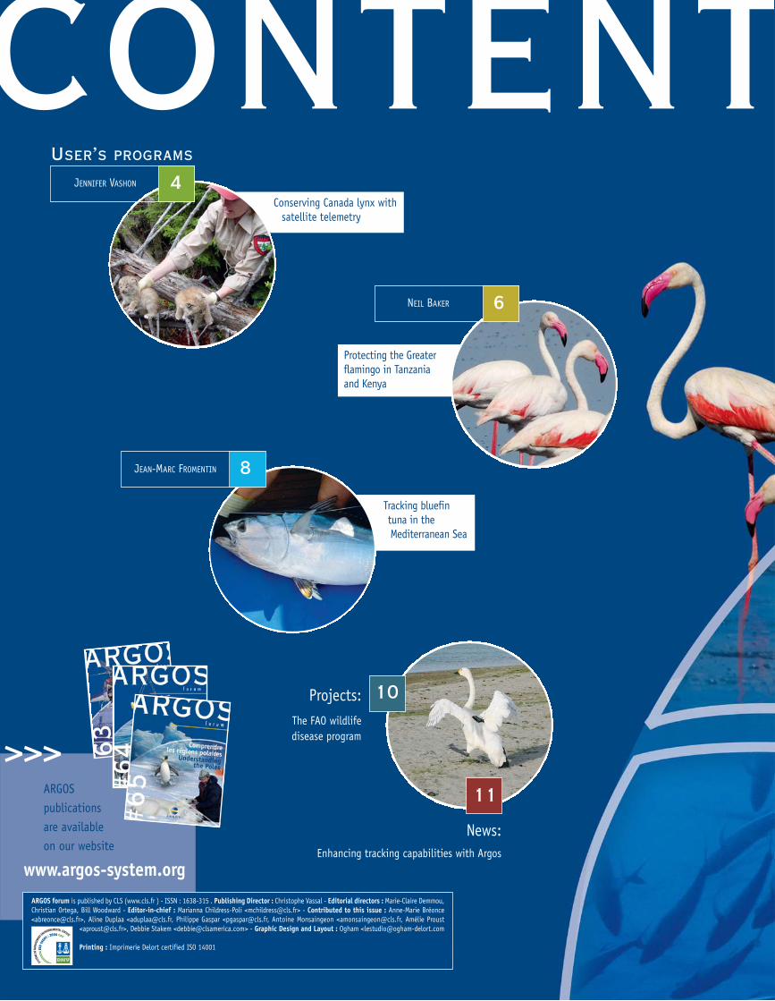
Projects:The FAO wildlifedisease program
ARGOS forum is published by CLS (www.cls.fr ) - ISSN : 1638-315 . Publishing Director : Christophe Vassal - Editorial directors : Marie-Claire Demmou,Christian Ortega, Bill Woodward - Editor-in-chief : Marianna Childress-Poli <[email protected]> - Contributed to this issue : Anne-Marie Bréonce<[email protected]>, Aline Duplaa <[email protected], Philippe Gaspar <[email protected], Antoine Monsaingeon <[email protected], Amélie Proust
<[email protected]>, Debbie Stakem <[email protected]> - Graphic Design and Layout : Ogham <[email protected]
Printing : Imprimerie Delort certified ISO 14001
11
10
ARGOS publications are available on our website
>>>
www.argos-system.org
USER’S PROGRAMS
JENNIFER VASHON 4
Protecting the Greaterflamingo in Tanzaniaand Kenya
NEIL BAKER 6
Tracking bluefin tuna in the Mediterranean Sea
JEAN-MARC FROMENTIN 8
News:Enhancing tracking capabilities with Argos
TSCritical ecosystem services, such as water
filtration, nutrient cycling, and pollination, are
threatened by the extensive and accelerating loss
of biodiversity. Most countries have endorsed the
Convention on Biological Diversity, collectively com-
mitting to achieve by 2010 a significant reduction of
the current rate of biodiversity loss at the global,
regional and national level.
The Argos system is providing scientists with
unique and tangible results that serve two impor-
tant roles in this effort. Most obvious is the knowl-
edge acquired about a species’ migratory habitat
requirements as they cross any number of political
jurisdictions. Less apparent, but of fundamental
importance, is the extensive international scientific communication that is cultivated by
Argos-based studies. Fostering scientific partnerships
worldwide promotes a foundation upon which inter-
national conservation policies can be informed,
developed and implemented. To this end, the Argos
system’s global perspective paves a crucial inter-national inroad toward curbing the world’s dimin-
ishing biodiversity.
DAVID DOUGLASUnited States Geological Survey,
Alaska Science Center
Printed on recycled paper
EDITORIAL
Conserving Canada lynx withsatellite telemetry
ARGOS
B y JENNIFER VASHON
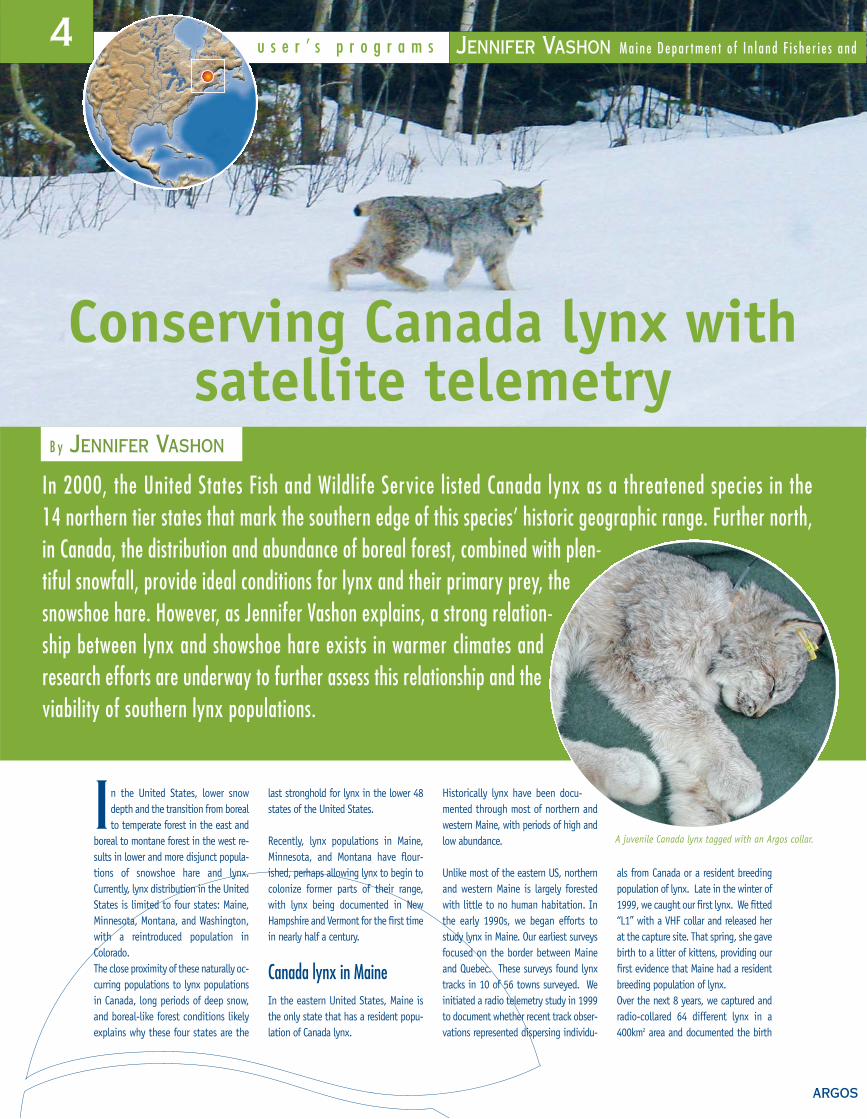
In the United States, lower snowdepth and the transition from borealto temperate forest in the east and
boreal to montane forest in the west re-sults in lower and more disjunct popula-tions of snowshoe hare and lynx.Currently, lynx distribution in the UnitedStates is limited to four states: Maine,Minnesota, Montana, and Washington,with a reintroduced population inColorado. The close proximity of these naturally oc-curring populations to lynx populationsin Canada, long periods of deep snow,and boreal-like forest conditions likelyexplains why these four states are the
last stronghold for lynx in the lower 48states of the United States.
Recently, lynx populations in Maine,Minnesota, and Montana have flour-ished, perhaps allowing lynx to begin tocolonize former parts of their range, with lynx being documented in NewHampshire and Vermont for the first timein nearly half a century.
Canada lynx in MaineIn the eastern United States, Maine isthe only state that has a resident popu-lation of Canada lynx.
Historically lynx have been docu-mented through most of northern andwestern Maine, with periods of high andlow abundance.
Unlike most of the eastern US, northernand western Maine is largely forestedwith little to no human habitation. Inthe early 1990s, we began efforts tostudy lynx in Maine. Our earliest surveysfocused on the border between Maineand Quebec. These surveys found lynxtracks in 10 of 56 towns surveyed. Weinitiated a radio telemetry study in 1999to document whether recent track obser-vations represented dispersing individu-
als from Canada or a resident breedingpopulation of lynx. Late in the winter of1999, we caught our first lynx. We fitted“L1” with a VHF collar and released herat the capture site. That spring, she gavebirth to a litter of kittens, providing ourfirst evidence that Maine had a residentbreeding population of lynx. Over the next 8 years, we captured andradio-collared 64 different lynx in a400km2 area and documented the birth
JENNIFER VASHON M a i n e D e p a r t m e n t o f I n l a n d F i s h e r i e s a n d
In 2000, the United States Fish and Wildlife Service listed Canada lynx as a threatened species in the 14 northern tier states that mark the southern edge of this species’ historic geographic range. Further north,in Canada, the distribution and abundance of boreal forest, combined with plen-tiful snowfall, provide ideal conditions for lynx and their primary prey, thesnowshoe hare. However, as Jennifer Vashon explains, a strong relation-ship between lynx and showshoe hare exists in warmer climates andresearch efforts are underway to further assess this relationship and theviability of southern lynx populations.
A juvenile Canada lynx tagged with an Argos collar.
4 u s e r ’ s p r o g r a m s
5
>>> Jennifer Vashon
>>> Jennifer Vashon is a wildlife
biologist with Maine Department
of Inland Fisheries and Wildlife (MDIFW).
Her work is focused on conserving
and managing Canada lynx and black
bear populations in Maine.
Radio telemetry studies using traditional
VHF techniques, as well as satellite
and GPS collars, provide information
on spatial ecology, habitat associations,
and population demographics.
This information is needed to monitor
the health of the populations
and identify appropriate
management actions.
The work presented here
is a collaborative effort
involving biologists with MDIFW and US
Fish and Wildlife Service and researchers
at the University of Maine.
5
f o r u m
of 37 litters. Much of the area is regener-ating conifer forest, and supports interme-diate snowshoe hare densities following arecent insect outbreak that defoliated mostof Maine’s spruce and fir. These conditionshave allowed the recent flourish in Maine’slynx population.
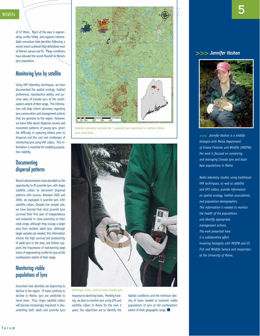
Monitoring lynx by satellite
Using VHF telemetry techniques, we havedocumented the spatial ecology, habitatpreferences, reproductive ability, and sur-vival rates of Canada lynx at the south-eastern extent of their range. This informa-tion will help inform decisions regardinglynx conservation and management actionsthat are germane to the region. However,we know little about dispersal success andmovement patterns of young lynx, giventhe difficulty in capturing kittens prior todispersal and the cost and challenges ofmonitoring lynx using VHF collars. This in-formation is essential for modeling popula-tion viability.
Documenting dispersal patterns
Recent advancements have provided us theopportunity to fit juvenile lynx with Argossatellite collars to document dispersal patterns with success. Between 2005 and2006, we equipped 6 juvenile lynx withsatellite collars. Despite low sample size,we have learned that most juvenile lynxsurvived their first year of independenceand remained in close proximity to theirnatal range, although they occupy a largerarea than resident adult lynx. Althoughlarger samples are needed, this informationmirrors the high survival and productivityof adult lynx in the area, and further sup-ports the importance of maintaining largetracts of regenerating conifer for lynx at thesoutheastern extent of their range.
Monitoring viable populations of lynx
Snowshoe hare densities are beginning todecline in the region. If hares continue todecline in Maine, lynx are predicted tomove more. Thus, Argos satellite collarswill become increasingly important in doc-umenting both adult and juvenile lynx
response to declining hares. Pending fund-ing, we plan to monitor lynx using GPS andsatellite collars in Maine for the next 2years. Our objectives are to identify the
habitat conditions and the minimum den-sity of hares needed to maintain viablepopulations of lynx at the southeastern extent of their geographic range.
W i l d l i f e
VHF/Argos collar, used to track Canada lynx.
Satellite telemetry locations for 7 subadult lynx monitored in northern Maine
from 2005-2007.

ARGOS
Protecting the Greater flamingo in Tanzania and Kenya
u s e r ’ s p r o g r a m s
An estimated 35,000 Greater flamingos, Phoenicopterus ruber roseu, live in Africa’s EasternRift Valley, from Ethiopia south through Kenya to northern Tanzania. The shallow lakebeds in this region provide the ideal ecosystem for this species. While the population is still quite numerous, their natural habitats are increasingly threatened.How can this enigmatic pink bird and its fragile ecosystem be spared the impacts of tourismand industrialization? Neil Baker explains.
NEIL BAKER Ta n z a n i a B i r d A t l a s
T he idea to use Argos to studythe natural habitats of Greaterflamingos in Africa’s Eastern
Rift Valley and contribute to theirconservation arose out of discussionswith colleagues from Max-Plank-Institutefür Ornithologie Vogelwarte Rodlfzell.
Our colleagues generously offered todonate three Argos transmitters fromtheir White Stork project for use inour study. Our study focuses on LakeManyara in northern Kenya.
While parts of Lake Manyara are pro-tected as part of the Lake ManyaraNational Park, much of the northern shal-lows where the flamingos feed occur out-side the park. As a result, flamingos aredisturbed by fishermen, tourists and birdcatchers (who catch birds for the exportmarket).
In March 2002, the bird catchers wereparticularly active, causing agitationamongst the Greater flamingos living atthe lake.
As a result, we were unable to catch one.Having learned that the bird catcherswere holding several Greater flamingos ina house nearby, we decided to negotiatewith them. We chose the largest andhealthiest adult male, named him Leo,Kiswahili for “Today”, and left him to tell the rest of his story.We then moved on to Lake Magadini, asmall, seasonal rain-fed alkaline lake be-tween Mounts Meru and Kilimanjaro andbarely 10 km from the Momella Lakeswithin Arusha National Park.
We captured two females there, Paola andJane, (one mature, one immature), inApril 2002.
The birds were tagged with battery powered satellite backpack transmitters.These were PTT-100 platform transmitterterminals (PTTs) from MicrowaveTelemetry (USA) weighing 45 g. Eachunit was programmed to emit a signal for12 hours duration at intervals of 192hours. The transmitter was attached tothe bird’s back as a backpack by a con-
© Jo
hn H
ills
6
7
f o r u m
tinuous strip of a 3.5 mm Teflon tape withthe 250 mm antenna angled backwards andfree. The transmitter plus harness weight of48 grams represented 1.75%, 2.06%and 2.34% of bodyweight respectively,well within the recommended limit of 5%.All three batteries lasted into 2004, provid-ing more than 24 months of data.
From Tanzania to Kenya and back again
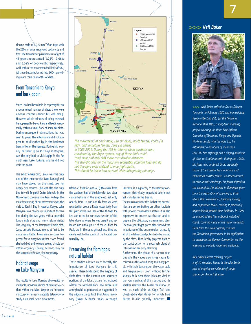
Since Leo had been held in captivity for anundetermined number of days, there wereobvious concerns about his well-being.However, within minutes of being releasedhe appeared to be walking and feeding nor-mally within a small flock of some 80 birds.During subsequent observations he wasseen to preen the antenna and did not ap-pear to be disturbed by it, the backpacktransmitter or the harness. During his jour-ney, he spent up to 418 days at Bogoria,was the only bird to visit Logipi in the farnorth near Lake Turkana, and he did notvisit the coast.
The adult female bird, Paola, was the onlyone of the three to visit Lake Burungi andmay have stayed on this small lake fornearly two months. She was also the onlybird to visit Empakai Crater lake within theNgorongoro Conservation Area. Perhaps themost interesting of her movements was thevisit to Rasini Bay in coastal Kenya. LakeManyara was obviously important to thisbird during the two years with a potentiallong single stay and many return visits.The long stay of the immature female bird,Jane, on Lake Manyara seems at first to bequite remarkable. Fixes were so close to-gether for so many weeks that it was fearedshe had died and we were seeing simple er-rors in accuracy. Equally, her long stay onthe Kenyan coast was also surprising.
Habitat usage on Lake Manyara
The results for Lake Manyara show quite re-markable individual choice of habitat selec-tion within the lake, despite the inherentinaccuracies in using satellite telemetry tostudy such small-scale movements.
Of the 45 fixes for Jane, 40 (88%) were fromthe southern half of the lake with two clearconcentrations in the southeast. Yet onlyone fix from 16 and one fix from 20 wererecorded for Leo and Paola respectively fromthis part of the lake. Ten of the 16 fixes forLeo are in the far northeast section of thelake, close to where he was caught and re-leased and although 17 of the 20 fixes forPaola are in the same general area they areclearly well to the south of the habitat pre-ferred by Leo.
Preserving the flamingo’s natural habitatThese studies allowed us to identify theimportance of Lake Manyara to thisspecies. These birds spend the majority oftheir time in the eastern and southernportions of the lake that are not includedwithin the National Park. The entire lakearea should be protected as suggested inthe national Important Bird Areas inven-tory (Baker & Baker 2002). Although
Tanzania is a signatory to the Ramsar con-vention this vitally important lake is notyet included in the treaty. The main reason for this is that the author-ities are concentrating on other habitatswith poorer conservation status. It is alsoexpensive to process ratification and toprepare the obligatory management plan.The two-year flight paths also showed theimportance of the entire region, as nearlyall of the lakes could potentially be visitedby the birds. That is why projects such asthe construction of a soda ash plant atLake Natron are very alarming. Furthermore, the threat of a tarmac roadthrough the valley also gives cause forconcern as this would bring too many peo-ple with their demands on the water tableand fragile soils. Even without furtherstudies, it is clear these lakes are vital tothe very survival of this species and itssmaller relative the Lesser flamingo, aswell as such birds as Cape Teal andChestnut-banded Plover for which LakeNatron is also globally important.
The movements of adult male, Leo (in blue), adult female, Paola (inred), and immature female, Jane (in green)in 2002-2004. During the 192 hr interval when positions werecalculated by the Argos system, any of these birds could (and most probably did) move considerable distances. The straight lines on the maps link sequential accurate fixes and donot therefore even pretend to map flight paths. This should be taken into account when interpreting the maps.
>>> Neil Baker
>>> Neil Baker arrived in Dar es Salaam,
Tanzania, in February 1980 and immediately
began collecting data for the fledgling
National Bird Atlas, a long-term mapping
project covering the three East African
Countries of Tanzania, Kenya and Uganda.
Working closely with his wife, Liz, he
established a database of more than
800,000 bird sightings and a ringing database
of close to 50,000 records. During the 1980s,
his focus was on forest birds, especially
those of the Eastern Arc mountains and
threatened coastal forests. As others arrived
to take up this challenge, his focus shifted to
the waterbirds. An interest in flamingos grew
from the frustration of knowing so little
about their movements, breeding ecology
and population levels, making it practically
impossible to protect their habitats. In 1994
he organized the first national waterbird
count, covering many of the major wetlands.
Data from this count greatly assisted
the Tanzanian government in its application
to accede to the Ramsar Convention on the
wise use of globally important wetlands.
Neil Baker’s latest tracking project
is of 10 Marabou Storks in the Nile Basin,
part of ongoing surveillance of target
species for Avian Influenza.
ARGOS
u s e r ’ s p r o g r a m s JEAN-MARC FROMENTIN I f r e m e r
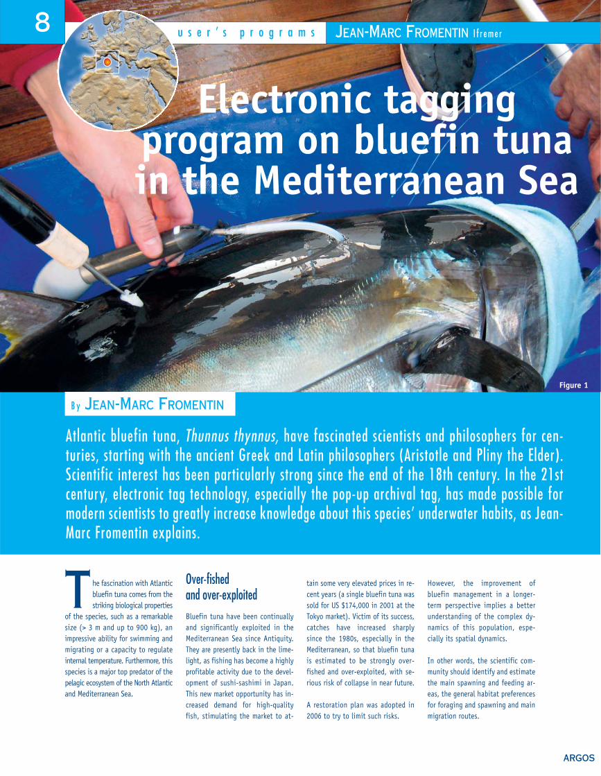
Electronic tagging program on bluefin tuna in the Mediterranean Sea
B y JEAN-MARC FROMENTIN
T he fascination with Atlanticbluefin tuna comes from thestriking biological properties
of the species, such as a remarkablesize (> 3 m and up to 900 kg), animpressive ability for swimming andmigrating or a capacity to regulateinternal temperature. Furthermore, thisspecies is a major top predator of thepelagic ecosystem of the North Atlanticand Mediterranean Sea.
Over-fished and over-exploitedBluefin tuna have been continuallyand significantly exploited in theMediterranean Sea since Antiquity. They are presently back in the lime-light, as fishing has become a highlyprofitable activity due to the devel-opment of sushi-sashimi in Japan. This new market opportunity has in-creased demand for high-qualityfish, stimulating the market to at-
tain some very elevated prices in re-cent years (a single bluefin tuna wassold for US $174,000 in 2001 at theTokyo market). Victim of its success,catches have increased sharply since the 1980s, especially in theMediterranean, so that bluefin tunais estimated to be strongly over-fished and over-exploited, with se-rious risk of collapse in near future.
A restoration plan was adopted in2006 to try to limit such risks.
However, the improvement ofbluefin management in a longer-term perspective implies a betterunderstanding of the complex dy-namics of this population, espe-cially its spatial dynamics.
In other words, the scientific com-munity should identify and estimatethe main spawning and feeding ar-eas, the general habitat preferencesfor foraging and spawning and mainmigration routes.
Atlantic bluefin tuna, Thunnus thynnus, have fascinated scientists and philosophers for cen-turies, starting with the ancient Greek and Latin philosophers (Aristotle and Pliny the Elder).Scientific interest has been particularly strong since the end of the 18th century. In the 21stcentury, electronic tag technology, especially the pop-up archival tag, has made possible formodern scientists to greatly increase knowledge about this species’ underwater habits, as Jean-Marc Fromentin explains.
8
Figure 1

f o r u m
Electronic tag technologyElectronic tag technology, especially thepop-up archival tag (see Figure 3), isone of the key technologies to do so.This technique emerged a decade agoand has been deployed on large fish,such as bluefin tuna and shark by severalUS teams. It consists in an archival tagthat may record water temperature,depth and light several times a day(which will be then used to calculate theaverage daily location of the fish). Thetag is fixed, through a tether, close bythe second dorsal fin of the fish and thusremains outside the fish’s body (i.e. inthe water column, see Figure 1). After aperiod set by the scientists (usually afew months to a year), the tag detachesand goes to the sea surface, where ittransmits the recorded data to the Argossatellites. The data is then relayed toscientists through the Argos system.
International programsPop-up archival tags are of particular in-terest for scientists as they are fishery-independent, i.e. there is no need for re-capture (usually done through fishing).The recorded information is then ana-lyzed in the laboratory, allowing us to
reconstruct the main behavior of thefish, especially its track, number and in-tensity of depths and preferential areas.
In 2005, the EU implemented theEuropean Tuna Tagging Program for aperiod of three years. In this framework, Ifremer has de-ployed 16 pop-up archival tags fromWildlife Telemetry on juvenile or youngadult bluefin tuna from the north-western Mediterranean Sea. The maininterest of this study is to get informa-tion from these young fish which havebeen poorly studied until now, espe-cially in the Mediterranean.
Tagging with sport fishermenTen tags have been deployed in 2007on fish of about 25 to 35 kg (and one
on a larger fish) from the coastal areaoff Marseille (France) in close collabo-ration with a sport fisherman fromCarry-le-Rouet, D. Lopuszanski. Amongthe 11 tags, 10 already popped-off andthe data are currently being analyzed. Pop-up times are highly variable, al-though the tagging technique hasbeen exactly the same, ranging between11 and 142 days. Some premature de-tachments are due to fishing, as indi-cated by Algerian recreational fisher-men who caught one fish equippedwith our tag. The map of the 10 pop-offlocations (see Figure 2) showed thatthe fish have spread out widely overthe whole western basin of theMediterranean. We expect interestingfeedback from the analysis of data fromthe four tags that stayed more thanthree months on the fish.
How it worksPop-up archival tags such as this can beattached to underwateranimals and used to measure watertemperature, depth and light. The tag detaches after a pre-determinedperiod, transmittingcollected data to scientists via the Argos satellites.
>>> Jean-Marc Fromentin
9
Pop-off locations of the 10 first Ifremer pop-up tags
>>>
>>> Dr. Jean-Marc Fromentin is a research
scientist at the Ifremer’s Centre de Recherche
Halieutique Méditerranéenne et Tropicale
(Mediterranean and Tropical Halieutic
Research Center), in Sète, France, where
he is responsible for research on Atlantic
bluefin tuna. His research focuses on
the spatio-temporal dynamics of this species
in relation to environmental and
anthropogenic forcing.
His research leads him to analyze historical
data, develop modelling approaches,
and carry out electronic tagging projects.
In addition to his research activities,
Dr. Fromentin is also involved
in stock assessment and management
and is Co-chairman of the Working Group
on Atlantic bluefin tuna for the International
Commission for the Conservation
of Atlantic Tunas (ICCAT).
Dr. Fromentin has been involved in a number
of national or European research programs
(as a researcher or a coordinator),
and mentors both doctoral and Master’s
students. He has published a number
of scientific and educational articles.
Figure 3
Figure 2

10 p r o j e c t s
ARGOS
In August 2006, a team of internationalscientists from the Food and AgricultureOrganization of the United Nations, Mongolian Academy of Sciences,Mongolian Wildlife Science Conservation Centre, U.S. Geological Survey (USGS)- Western Ecological Research Centre (WERC) and Alaska Science Centre,Wildlife Conservation Society (WCS) – Field Veterinary Program and GlobalAvian Influenza Network for Surveillance (GAINS), attached 70-gram solar-powered Argos GPS transmitters to ten wild whooper swans with backpackharnesses. The goal was to monitor the swans as they wing their waysouth from Mongolia, in an effort to understand the role wild birds mayplay in the spread of H5N1.
The importance of understanding the relationships between migrationecology and disease emergence globally has led FAO’s Wildlife DiseaseProgramme to deploy over 100 transmitters on 15 species of free rangingbirds in 2 locations in China (Qinghai and Poyang Lake), Kazakhstan,Nigeria, Malawi, and Mali with additional partner organisations includingCIRAD (Centre international de recherche en agriculture pour le dévelop-pement, in France), Wetlands International, USGS-Patuxent WildlifeResearch Centre, Chinese Academy of Sciences (Institute of Zoology,Computer Network Information Centre, and Wuhan Institute of Virology),University of New Hampshire (Complex Systems Research Centre), PoyangLakes and Qinghai Lakes National Nature Reserve, and NW Institute ofQinghai Plateau Biology.
Bird locations can be viewed at the following project web pages : http://wildbirds-ai.cirad.fr/ and http://www.werc.usgs.gov/ that alsoincludes access to the data in Google Earth format. The satellite trackingdata collected thanks to these projects will provide information that willnot only help scientists better understand and document links betweenwild birds and the spread of avian influenza, but that will also helpenhance conservation efforts through determining the non-breedingranges of birds and the mechanisms involved in long-distance migration.
Additional information about Avian Influenzaand wild birds can be obtained from the
FAO website : http://www.fao.org/avianflu/en/index.html the ScientificTask Force for Avain Influenza www.aiweb.info and theWCS-GAINS website http://www.gains.org.
© Sc
ott N
ewm
an
FocusDetermining If Linkages Exist Between Migration Ecology and Highly Pathogenic AvianInfluenza Outbreaks in East Asia
Whooper swans (Cygnus cygnus) breed on shallowlakes and slow-flowing rivers from Iceland to northeastSiberia, and they winter in areas extending from easternEurope to coastal China and Japan. This species drewsignificant attention after large numbers perished inMongolia and China in 2005 and 2006 from H5N1highly pathogenic avian influenza (HPAI). This HPAIstrain is extremely lethal to chickens and it has killedover 90 wild bird species and but has been difficult toisolate from healthy wild birds.
While it is known that the legal and illegal trade of poultryand poultry products, or unintentional movement of thevirus by humans are the primary sources of diseasemovement, the extent to which free-flying wild birdscontribute to sustaining and spreading the diseaseneeds to be determined. In certain instances, datasuggests that wild birds have been the source of diseasespread and movement. However, the extent of their invol-vement in maintaining and translocating virus has yetto be determined, and understanding the spatial andtemporal relationships between bird migration andHPAI outbreaks has been one of the main objectivesof a series of studies supported and implemented bythe Emergency Centre for Transboundary Animal Diseases(ECTAD), Wildlife Disease Programme at the Food andAgriculture Organisation of the United Nations (FAO)using Argos GPS transmitters.
SCOTT NEWMAN, I n t e r n a t i o n a l W i l d l i f e C o o r d i n a t o r, F o o d & A g r i c u l t u r e O r g a n i z a t i o n
The FAO’s Wildlife Disease Programme
TO LEARN MORE...
1) GPS positions delivered just like Argos locations
The new processing system allows for GPS positions in the data stream to be processedand delivered to users in the same formats as Argos locations. Previously, only certainpre-defined formats were processed. Today the processing system can handle a wide rangeof GPS formats, ensuring compatibility with the software provided by manufacturers oruser’s own software. We are currently working with Argos manufacturers to compile a completedatabase for GPS processing.
GPS positions are distributed on ArgosWeb’s colorful maps or exported to Google Earth.
2) Locating lost or damaged transmitters
Using a new algorithm, we combine data from several overlapping or close satellitepasses. This allows you to locate lost or damaged transmitters that send just one messageper satellite pass.Multipass locations are calculated by one of CLS’s experts, using data collected over thepast seven days.Please contact your User Services to subscribe to this service and recover expensivescientific material.
Accurate position determined from two satellite passes and four messages in total. In red, satellite pass 1. In blue, satellite pass 2.
3) Archival tag data processingfor underwater animals
In collaboration with the scientific community, CLS has actively contributed to theimprovement of light-based geolocation, and now offers archival data processingservices. These services are particularly suited for fisheries scientists and fieldbiologists who prefer to focus on the ecological interpretation of tag results ratherthan on the technicalities of tag data processing.Our tag data processing services include:• Direct data retrieval from Argos (for popup tags)• Optimal estimation of the animal's path (daily positions with estimated errors inlatitude and longitude)• Delivery of quality-controlled raw and processed data in a standard format
f o r u m
n e w s
Enhancing tracking capabilities with Argos
11
>>>
>>>
>>>
By combining sea surface temperature and bathymetry constraints
with an animal movement model, positioning errors can be reduced
(estimated positions in red and error ellipses in black)
▲▲
▲
© CL
S
© CL
S©
CLS
Argoscontacts worldwide
Headquarters:CLS/Argos Division8-10, rue HermèsParc Technologique du Canal31520 Ramonville Saint-Agne, FranceTel. + 33 (0) 5 61 39 47 20Fax + 33 (0) 5 61 39 47 97e-mail: [email protected]
Australia and South Pacific:SIT, Satellite Information TechnologyPTY-Ltd Suite 706, 1 Queens RoadMelbourne, VIC 3004, AustraliaTel. + 61 (0) 3 9863 9650Fax + 61 (0) 3 9863 9675e-mail: [email protected]
North America:CLS America, Inc.1441 Mc Cormick Drive, Suite 1050Largo, MD 20774, USATel. + 1 301 925 4411Fax + 1 301 925 8995e-mail: [email protected]
Japan: Cubic-I-LtdBluebell Building 7F2-15-9 Nishi GotandaShinagawa-kuTokyo 141-0031,JapanTel. + 81 (0)3 3779 5506Fax + 81 (0)3 3779 5783e-mail: [email protected]
Peru: CLS PerúJr. Trinidad Moran 639Lince, Lima, PeruTel. + 51 1 440 2717Fax + 51 1 421 2433e-mail: [email protected]
Chile: Cunlogan S.A.Almirante Señoret 70 of 74Valparaiso, ChileTel. + 56 32 25 28 43Fax + 56 32 25 72 94e-mail: [email protected]
Southeast Asia:PT CLS Argos IndonesiaAdhi Graha, It 17, Suite 1701JI Jend Gatot Subroto, Kav 56Kuningan Timur, SetiabudiJakarta Selatan, 12950, IndonesiaTel: + 62 215 264 266Fax: + 62 215 264 265e-mail: [email protected]
Korea: KL TradingRoom No. 328, Obelisk Bldg. 492-4Dapshimni-5 Dong, Dongdaemun-Gu Seoul, Korea 130-805Tel. + 82 2 2215 7134/5Fax + 82 2 2215 7136e-mail: [email protected]
Russia: ES-PAS15-73 Léningradskoe Chaussée125171 Moscow, RussiaTel: + 7 495 150 0332Fax: + 7 495 150 0332e-mail: [email protected]
Prin
ted
on re
cycle
d pa
per