$8,750,000 city of celina, texas, (a municipal …€¦ · · 2014-12-05nominee of the depository...
TRANSCRIPT

NEW ISSUE NOT RATED OFFICIAL STATEMENT DATED JUNE 18, 2014
In the opinion of Bond Counsel, interest on the Bonds will be excludable from gross income for purposes of federal income taxation under existing law, subject to the matters described under “TAX MATTERS” herein. See “TAX MATTERS – Tax Exemption” herein for a discussion of Bond Counsel’s opinion, including a description of certain alternative minimum tax consequences for corporations.
$8,750,000 CITY OF CELINA, TEXAS,
(a municipal corporation of the State of Texas located in Collin and Denton Counties) SPECIAL ASSESSMENT REVENUE BONDS, SERIES 2014
(CREEKS OF LEGACY PUBLIC IMPROVEMENT DISTRICT PHASE #1 PROJECT) Dated Date: June 1, 2014 Due: September 1, as shown on the inside cover Interest to Accrue from Date of Delivery
The City of Celina, Texas, Special Assessment Revenue Bonds, Series 2014 (Creeks of Legacy Public Improvement District Phase #1 Project) (the “Bonds”), are being issued by the City of Celina, Texas (the “City”). The Bonds will be issued in fully registered form, without coupons, in authorized denominations of $25,000 of principal amount and any integral multiple of $5,000 in excess thereof. The Bonds will bear interest at the rates set forth on the inside cover, calculated on the basis of a 360-day year of twelve 30-day months, payable on each March 1 and September 1, commencing September 1, 2014, until maturity or earlier redemption. The Bonds will be registered in the name of Cede & Co., as nominee of The Depository Trust Company (“DTC”), New York, New York. No physical delivery of the Bonds will be made to the beneficial owners thereof. For so long as the book-entry only system is maintained, the principal of and interest on the Bonds will be paid from the sources described herein by U.S. Bank National Association, as trustee (the “Trustee”), to DTC as the registered owner thereof. See “BOOK-ENTRY ONLY SYSTEM.”
The Bonds are being issued by the City pursuant to the Public Improvement District Assessment Act, Subchapter A of Chapter 372, Texas Local Government Code, as amended (the “PID Act”), an ordinance adopted by the City Council of the City (the “City Council”) on June 18, 2014, and an Indenture of Trust, dated June 1, 2014 (the “Indenture”), entered into by and between the City and the Trustee.
Proceeds of the Bonds will be used to provide funds for (i) paying a portion of the costs of the Phase #1 Projects, which consist of (a) Phase #1’s proportionate share of the costs of certain roadway, water, wastewater and drainage improvements that will benefit the entire Creeks of Legacy Public Improvement District (the “District”) and (b) the costs of the local infrastructure benefitting only Phase #1 (as defined herein) of the District, (ii) paying a portion of the interest on the Bonds during and after the period of acquisition and construction of the Phase #1 Projects, (iii) funding a reserve fund for the payment of principal of and interest on the Bonds, (iv) paying a portion of the costs incidental to the organization of the District, and (v) paying the costs of issuing the Bonds. See “THE PHASE #1 PROJECTS” and “APPENDIX A — Form of Indenture.” Capitalized terms not otherwise defined herein shall have the meanings assigned to them in the Indenture.
The Bonds, when issued and delivered, will constitute valid and binding special obligations of the City payable solely from and secured by the Pledged Revenues, consisting primarily of Phase #1 Assessments levied against assessable properties in Phase #1 of the District in accordance with a Service and Assessment Plan, all to the extent and upon the conditions described herein. The Bonds are not payable from funds raised or to be raised from taxation. See “SECURITY FOR THE BONDS.”
The Bonds are subject to redemption at the times, in the amounts, and at the redemption prices more fully described herein under the subcaption “DESCRIPTION OF THE BONDS — Redemption Provisions.”
The Bonds involve a degree of risk and are not suitable for all investors. See “BONDHOLDERS RISKS” and “SUITABILITY FOR INVESTMENT.” Prospective purchasers should carefully evaluate the risks and merits of an investment in the Bonds, should consult with their legal and financial advisors before considering a purchase of the Bonds, and should be willing to bear the risks of loss of their investment in the Bonds. The Bonds are not credit enhanced or rated and no application has been made for a rating on the Bonds.
THE BONDS ARE SPECIAL OBLIGATIONS OF THE CITY PAYABLE SOLELY FROM THE PLEDGED REVENUES AND OTHER FUNDS COMPRISING THE TRUST ESTATE, AS AND TO THE EXTENT PROVIDED IN THE INDENTURE. THE BONDS DO NOT GIVE RISE TO A CHARGE AGAINST THE GENERAL CREDIT OR TAXING POWER OF THE CITY AND ARE PAYABLE SOLELY FROM THE SOURCES IDENTIFIED IN THE INDENTURE. THE OWNERS OF THE BONDS SHALL NEVER HAVE THE RIGHT TO DEMAND PAYMENT THEREOF OUT OF MONEY RAISED OR TO BE RAISED BY TAXATION, OR OUT OF ANY FUNDS OF THE CITY OTHER THAN THE PLEDGED REVENUES, AS AND TO THE EXTENT PROVIDED IN THE INDENTURE. NO OWNER OF THE BONDS SHALL HAVE THE RIGHT TO DEMAND ANY EXERCISE OF THE CITY’S TAXING POWER TO PAY THE PRINCIPAL OF THE BONDS OR THE INTEREST OR REDEMPTION PREMIUM, IF ANY, THEREON. THE CITY SHALL HAVE NO LEGAL OR MORAL OBLIGATION TO PAY THE BONDS OUT OF ANY FUNDS OF THE CITY OTHER THAN THE PLEDGED REVENUES. SEE “SECURITY FOR THE BONDS.”
This cover page contains certain information for quick reference only. It is not a summary of the Bonds. Investors must read this entire Official Statement to obtain information essential to the making of an informed investment decision.
The Bonds are offered for delivery when, as, and if issued by the City and accepted by the Underwriter, subject to, among other things, the approval of the Bonds by the Attorney General of Texas and the receipt of the opinion of Fulbright & Jaworski LLP, a member of Norton Rose Fulbright, Bond Counsel, as to the validity of the Bonds and the excludability of interest thereon from gross income for federal income tax purposes. See “APPENDIX C — Form of Opinion of Bond Counsel.” Certain legal matters will be passed upon for the Underwriter by its counsel, Andrews Kurth LLP, and for the Developer by its counsel, Miklos, PLLC. It is expected that the Bonds will be delivered in book-entry form through the facilities of DTC on or about July 1, 2014.

MATURITIES, PRINCIPAL AMOUNTS, INTEREST RATES, PRICES, YIELDS, AND CUSIP NUMBERS
CUSIP Prefix: 15114(a)
$8,750,000 CITY OF CELINA, TEXAS,
(a municipal corporation of the State of Texas located in Collin and Denton Counties) SPECIAL ASSESSMENT REVENUE BONDS, SERIES 2014
(CREEKS OF LEGACY PUBLIC IMPROVEMENT DISTRICT PHASE #1 PROJECT)
$2,900,000 6.375% Term Bonds, Due September 1, 2028, Priced to Yield 6.375%; CUSIP 15114CAA2(a) (b) (c)
$1,450,000 6.625% Term Bonds, Due September 1, 2032, Priced to Yield 6.625%; CUSIP 15114CAB0(a) (b) (c)
$4,400,000 7.000% Term Bonds, Due September 1, 2040, Priced to Yield 7.000%; CUSIP 15114CAC8(a) (b) (c)
(a) CUSIP numbers are included solely for the convenience of owners of the Bonds. CUSIP is a registered trademark of the American
Bankers Association. CUSIP data herein is provided by CUSIP Global Services, managed by Standard & Poor’s Financial Services LLC on behalf of The American Bankers Association. This data is not intended to create a database and does not serve in any way as a substitute for the CUSIP Services. CUSIP numbers are provided for convenience of reference only. None of the City, the City’s Financial Advisor or the Underwriter takes any responsibility for the accuracy of such numbers.
(b) The Bonds are subject to redemption, in whole or in part, prior to stated maturity, at the option of the City, on any Interest Payment Date on or after September 1, 2022, at the redemption prices set forth herein under “DESCRIPTION OF THE BONDS — Redemption Provisions.”
(c) The Bonds are also subject to mandatory sinking fund redemption and extraordinary optional redemption as described herein under “DESCRIPTION OF THE BONDS — Redemption Provisions.”
i
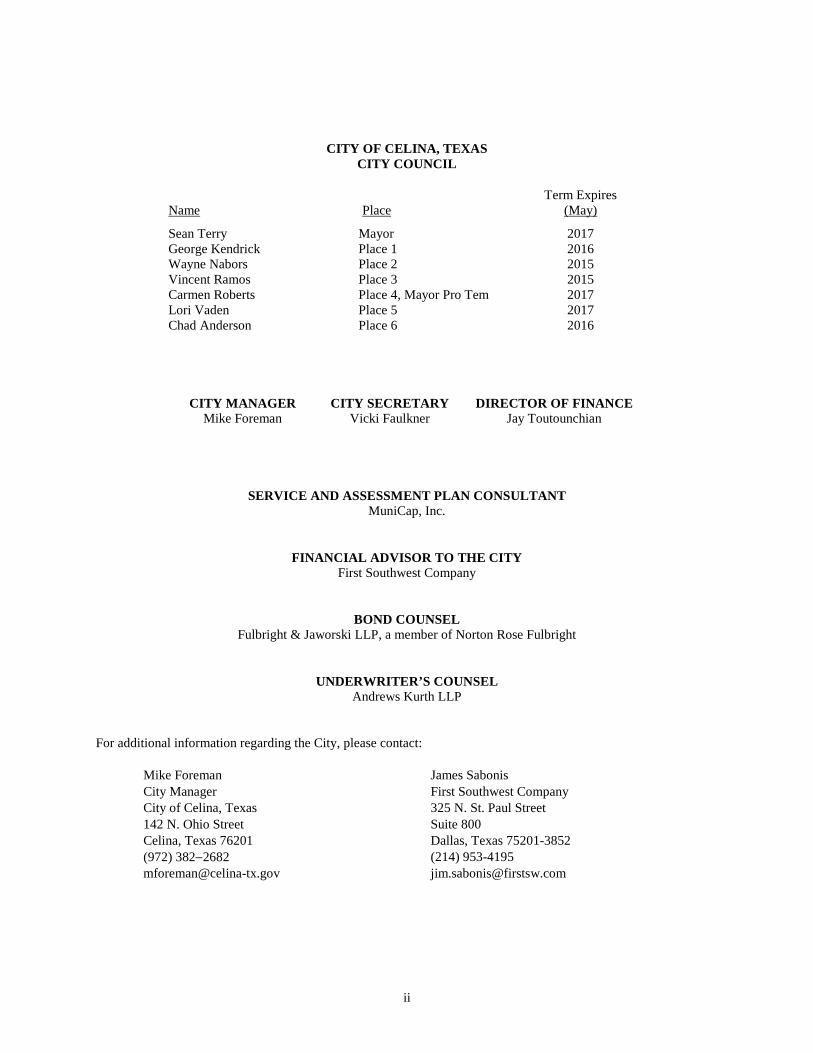
CITY OF CELINA, TEXAS CITY COUNCIL
Name
Place
Term Expires (May)
Sean Terry Mayor 2017 George Kendrick Place 1 2016 Wayne Nabors Place 2 2015 Vincent Ramos Place 3 2015 Carmen Roberts Place 4, Mayor Pro Tem 2017 Lori Vaden Place 5 2017 Chad Anderson Place 6 2016
CITY MANAGER CITY SECRETARY DIRECTOR OF FINANCE Mike Foreman Vicki Faulkner Jay Toutounchian
SERVICE AND ASSESSMENT PLAN CONSULTANT MuniCap, Inc.
FINANCIAL ADVISOR TO THE CITY First Southwest Company
BOND COUNSEL Fulbright & Jaworski LLP, a member of Norton Rose Fulbright
UNDERWRITER’S COUNSEL Andrews Kurth LLP
For additional information regarding the City, please contact:
Mike Foreman James Sabonis City Manager First Southwest Company City of Celina, Texas 325 N. St. Paul Street 142 N. Ohio Street Suite 800 Celina, Texas 76201 Dallas, Texas 75201-3852 (972) 382−2682 (214) 953-4195 [email protected] [email protected]
ii

REGIONAL LOCATION MAP OF THE DISTRICT
iii
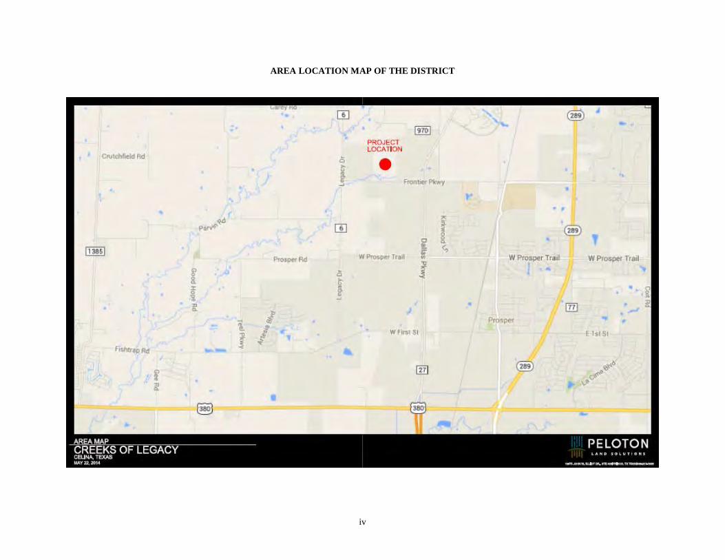
AREA LOCATION MAP OF THE DISTRICT
iv

MAP SHOWING BOUNDARIES OF PHASE #1 THROUGH PHASE #3 OF THE DISTRICT
v

NO DEALER, BROKER, SALESPERSON OR OTHER PERSON HAS BEEN AUTHORIZED BY THE CITY OR THE UNDERWRITER TO GIVE ANY INFORMATION OR MAKE ANY REPRESENTATIONS, OTHER THAN THOSE CONTAINED IN THIS OFFICIAL STATEMENT, AND IF GIVEN OR MADE, SUCH OTHER INFORMATION OR REPRESENTATIONS MUST NOT BE RELIED UPON AS HAVING BEEN AUTHORIZED BY EITHER OF THE FOREGOING. THIS OFFICIAL STATEMENT DOES NOT CONSTITUTE AN OFFER TO SELL OR THE SOLICITATION OF AN OFFER TO BUY AND THERE SHALL BE NO OFFER, SOLICITATION OR SALE OF THE BONDS BY ANY PERSON IN ANY JURISDICTION IN WHICH IT IS UNLAWFUL FOR SUCH PERSON TO MAKE SUCH OFFER, SOLICITATION OR SALE.
THE UNDERWRITER HAS REVIEWED THE INFORMATION IN THIS OFFICIAL STATEMENT IN ACCORDANCE WITH, AND AS PART OF, ITS RESPONSIBILITIES TO INVESTORS UNDER THE UNITED STATES FEDERAL SECURITIES LAWS AS APPLIED TO THE FACTS AND CIRCUMSTANCES OF THIS TRANSACTION. THE INFORMATION SET FORTH HEREIN HAS BEEN FURNISHED BY THE CITY AND OBTAINED FROM SOURCES, INCLUDING THE DEVELOPER, WHICH ARE BELIEVED BY THE CITY AND THE UNDERWRITER TO BE RELIABLE, BUT IT IS NOT GUARANTEED AS TO ACCURACY OR COMPLETENESS, AND IS NOT TO BE CONSTRUED AS A REPRESENTATION OF THE UNDERWRITER. THE INFORMATION AND EXPRESSIONS OF OPINION HEREIN ARE SUBJECT TO CHANGE WITHOUT NOTICE, AND NEITHER THE DELIVERY OF THIS OFFICIAL STATEMENT, NOR ANY SALE MADE HEREUNDER, SHALL, UNDER ANY CIRCUMSTANCES, CREATE ANY IMPLICATION THAT THERE HAS BEEN NO CHANGE IN THE AFFAIRS OF THE CITY OR THE DEVELOPER SINCE THE DATE HEREOF.
NEITHER THE CITY NOR THE UNDERWRITER MAKE ANY REPRESENTATION AS TO THE ACCURACY, COMPLETENESS, OR ADEQUACY OF THE INFORMATION SUPPLIED BY THE DEPOSITORY TRUST COMPANY FOR USE IN THIS OFFICIAL STATEMENT.
THE BONDS HAVE NOT BEEN REGISTERED UNDER THE SECURITIES ACT OF 1933, NOR HAS THE INDENTURE BEEN QUALIFIED UNDER THE TRUST INDENTURE ACT OF 1939, IN RELIANCE UPON EXEMPTIONS CONTAINED IN SUCH LAWS. THE REGISTRATION OR QUALIFICATION OF THE BONDS UNDER THE SECURITIES LAWS OF ANY JURISDICTION IN WHICH THEY MAY HAVE BEEN REGISTERED OR QUALIFIED, IF ANY, SHALL NOT BE REGARDED AS A RECOMMENDATION THEREOF. NONE OF SUCH JURISDICTIONS, OR ANY OF THEIR AGENCIES, HAVE PASSED UPON THE MERITS OF THE BONDS OR THE ACCURACY OR COMPLETENESS OF THIS OFFICIAL STATEMENT.
CERTAIN STATEMENTS INCLUDED OR INCORPORATED BY REFERENCE IN THIS OFFICIAL STATEMENT CONSTITUTE “FORWARD-LOOKING STATEMENTS” WITHIN THE MEANING OF THE UNITED STATES PRIVATE SECURITIES LITIGATION REFORM ACT OF 1995, SECTION 21E OF THE UNITED STATES EXCHANGE ACT OF 1934, AS AMENDED, AND SECTION 27A OF THE SECURITIES ACT. SUCH STATEMENTS ARE GENERALLY IDENTIFIABLE BY THE TERMINOLOGY USED SUCH AS “PLAN,” “EXPECT,” “ESTIMATE,” “PROJECT,” “ANTICIPATE,” “BUDGET” OR OTHER SIMILAR WORDS. THE ACHIEVEMENT OF CERTAIN RESULTS OR OTHER EXPECTATIONS CONTAINED IN SUCH FORWARD-LOOKING STATEMENTS INVOLVE KNOWN AND UNKNOWN RISKS, UNCERTAINTIES AND OTHER FACTORS WHICH MAY CAUSE ACTUAL RESULTS, PERFORMANCE OR ACHIEVEMENTS DESCRIBED TO BE MATERIALLY DIFFERENT FROM ANY FUTURE RESULTS, PERFORMANCE OR ACHIEVEMENTS EXPRESSED OR IMPLIED BY SUCH FORWARD-LOOKING STATEMENTS. THE CITY DOES NOT PLAN TO ISSUE ANY UPDATES OR REVISIONS TO THOSE FORWARD-LOOKING STATEMENTS IF OR WHEN ANY OF ITS EXPECTATIONS OR EVENTS, CONDITIONS OR CIRCUMSTANCES ON WHICH SUCH STATEMENTS ARE BASED OCCUR, OTHER THAN AS DESCRIBED UNDER “CONTINUING DISCLOSURE” HEREIN.
THE TRUSTEE HAS NOT PARTICIPATED IN THE PREPARATION OF THIS OFFICIAL STATEMENT AND ASSUMES NO RESPONSIBILITY FOR THE ACCURACY OR COMPLETENESS OF ANY INFORMATION CONTAINED IN THIS OFFICIAL STATEMENT OR THE RELATED TRANSACTIONS AND DOCUMENTS OR FOR ANY FAILURE BY ANY PARTY TO DISCLOSE EVENTS THAT MAY HAVE OCCURRED AND MAY AFFECT THE SIGNIFICANCE OR ACCURACY OF SUCH INFORMATION.
vi
TABLE OF CONTENTS
INTRODUCTION .................................................... 1
PLAN OF FINANCE ............................................... 2 Development Plan ............................................. 2 The Bonds.......................................................... 3
DESCRIPTION OF THE BONDS ........................... 4 General Description ........................................... 4 Redemption Provisions ...................................... 4
BOOK-ENTRY ONLY SYSTEM ........................... 6 SECURITY FOR THE BONDS ............................... 8
General .............................................................. 8 Pledged Revenues .............................................. 9 TIRZ Revenues May Reduce
Assessments ............................................. 10 Collection and Deposit of Assessments ........... 11 Unconditional Levy of Assessments ............... 11 Perfected Security Interest ............................... 12 Pledged Revenue Fund .................................... 12 Reserve Fund ................................................... 13 Prepayment Reserve Account of the
Reserve Fund ............................................ 13 Delinquency Reserve Account of the
Reserve Fund ............................................ 14 Administrative Fund ........................................ 14 Defeasance....................................................... 14 Events of Default ............................................. 15 Remedies in Event of Default .......................... 15 Restriction on Owner’s Actions ...................... 16 Application of Revenues and Other
Moneys After Event of Default ................ 17 Investment or Deposit of Funds ....................... 17
SOURCES AND USES OF FUNDS ...................... 19 DEBT SERVICE REQUIREMENTS .................... 20
OVERLAPPING TAXES AND DEBT .................. 21
ASSESSMENT PROCEDURES ............................ 22 General ............................................................ 22 Assessment Methodology ................................ 22 Collection and Enforcement of
Assessment Amounts ............................... 23 Assessment Amounts....................................... 24 Prepayment of Assessments ............................ 25 Priority of Lien ................................................ 25 Foreclosure Proceedings .................................. 25
THE CITY .............................................................. 26 Background ..................................................... 26 City Government ............................................. 26 Major Employers ............................................. 27 Surrounding Economic Activity ...................... 27
THE DISTRICT ..................................................... 28 General ............................................................ 28
Powers and Authority ...................................... 28
THE PHASE #1 PROJECTS .................................. 28 General ............................................................ 28 Ownership and Maintenance of
Improvements ........................................... 29
THE DEVELOPMENT .......................................... 29 Overview ......................................................... 30 Development Plan ........................................... 31 Phased Bonds .................................................. 32 Zoning/Permitting ........................................... 32 Environmental ................................................. 32 Utilities ............................................................ 33
THE DEVELOPER ................................................ 33 General ............................................................ 33 Description of the Developer ........................... 33 Executive Biography ....................................... 35 History and Financing of the District .............. 35
THE DEVELOPMENT CONSULTANTS ............ 36 Lenart Development Company, LLC .............. 36 Peloton Land Solutions, LLP........................... 36
THE SPECIAL ASSESSMENT CONSULTANT ........................... 37
APPRAISAL OF PROPERTY WITHIN THE DISTRICT .............................................................. 37
The Appraisal .................................................. 37 Value to Assessment Burden Ratio ................. 39
BONDHOLDERS’ RISKS ..................................... 40 Assessment Limitations ................................... 41 Risks Related to the Current Real Estate
Market ...................................................... 42 Competition ..................................................... 42 Loss of Tax Exemption ................................... 42 Bankruptcy ...................................................... 42 Direct and Overlapping Indebtedness,
Assessments and Taxes ............................ 43 Depletion of Reserve Fund .............................. 43 Hazardous Substance ....................................... 43 Regulation ....................................................... 43 100-Year Flood Plain ...................................... 44 Bondholders’ Remedies and
Bankruptcy ............................................... 44 No Acceleration ............................................... 45 Bankruptcy Limitation to Bondholders’
Rights ....................................................... 45 Management and Ownership ........................... 45 General Risks of Real Estate Investment
and Development ...................................... 45 Dependence Upon Developer .......................... 46 Agricultural Use Valuation and
Redemption Rights ................................... 46
vii
TAX MATTERS .................................................... 47 Tax Exemption ................................................ 47 Tax Accounting Treatment of Discount
and Premium on Certain Bonds ................ 48
LEGAL MATTERS ............................................... 49 Legal Proceedings ........................................... 49 Legal Opinions ................................................ 49 Litigation — The City ..................................... 50 Litigation — The Developer............................ 50
SUITABILITY FOR INVESTMENT .................... 50
ENFORCEABILITY OF REMEDIES ................... 50
NO RATING .......................................................... 51
CONTINUING DISCLOSURE .............................. 51 Compliance with Prior Undertakings .............. 51
UNDERWRITING ................................................. 51 REGISTRATION AND QUALIFICATION OF BONDS FOR SALE ............................................... 52
LEGAL INVESTMENT AND ELIGIBILITY TO SECURE PUBLIC FUNDS IN TEXAS ................. 52
INVESTMENTS .................................................... 52
INFORMATION RELATING TO THE TRUSTEE ...................................................... 54
SOURCES OF INFORMATION ........................... 55 General ............................................................ 55
Source of Certain Information ......................... 55 Experts ............................................................. 55 Updating of Official Statement ........................ 55
FORWARD-LOOKING STATEMENTS .............. 55
AUTHORIZATION AND APPROVAL ................ 56 APPENDIX A Form of Indenture APPENDIX B Form of Service and Assessment Plan APPENDIX C Form of Opinion of Bond Counsel APPENDIX D Form of Disclosure Agreements APPENDIX E Appraisal of the District APPENDIX F Form of Construction, Funding, and Acquisition Agreement APPENDIX G Estimated Tax Increment Revenue Contribution
viii

(THIS PAGE IS INTENTIONALLY LEFT BLANK.)

OFFICIAL STATEMENT
$8,750,000 CITY OF CELINA, TEXAS,
(a municipal corporation of the State of Texas located in Collin and Denton Counties) SPECIAL ASSESSMENT REVENUE BONDS, SERIES 2014
(CREEKS OF LEGACY PUBLIC IMPROVEMENT DISTRICT PHASE #1 PROJECT)
INTRODUCTION
The purpose of this Official Statement, including the cover page, inside cover and appendices hereto, is to provide certain information in connection with the issuance and sale by the City of Celina, Texas (the “City”), of its $8,750,000 aggregate principal amount of Special Assessment Revenue Bonds, Series 2014 (Creeks of Legacy Public Improvement District Phase #1 Project) (the “Bonds”).
PROSPECTIVE INVESTORS SHOULD BE AWARE OF CERTAIN RISK FACTORS, ANY OF WHICH, IF MATERIALIZED TO A SUFFICIENT DEGREE, COULD DELAY OR PREVENT PAYMENT OF PRINCIPAL OF AND/OR INTEREST ON THE BONDS. THE BONDS ARE NOT A SUITABLE INVESTMENT FOR ALL INVESTORS. See “SUITABILITY FOR INVESTMENT” and “BONDHOLDERS’ RISKS.”
The Bonds are being issued by the City pursuant to the Public Improvement District Assessment Act, Subchapter A of Chapter 372, Texas Local Government Code, as amended (the “PID Act”), the ordinance authorizing the issuance of the Bonds enacted by the City Council of the City (the “City Council”) on June 18, 2014 (the “Bond Ordinance”), and an Indenture of Trust, dated as of June 1, 2014 (the “Indenture”), entered into by and between the City and U.S. Bank National Association as trustee (the “Trustee”). The Bonds will be secured by assessments (“Phase #1 Assessments”) levied against assessable property located within Phase #1 (as described below) of the Creeks of Legacy Public Improvement District (the “District”) pursuant to a separate ordinance enacted by the City Council on June 18, 2014 (the “Assessment Ordinance”).
Reference is made to the Indenture for a full statement of the authority for, and the terms and provisions of, the Bonds. All capitalized terms used in this Official Statement that are not otherwise defined herein shall have the meanings set forth in the Indenture. See “APPENDIX A — Form of Indenture.”
Set forth herein are brief descriptions of the City, the District, the Assessment Ordinance, the Bond Ordinance, the Service and Assessment Plan (as defined herein), the Phase #1 Reimbursement Agreement (as defined herein), the Phase #1 Redemption Agreement (as defined herein), CTMGT Frontier 80, LLC, a Texas limited liability company (the “Developer”), its consultants, Peloton Land Solutions, Inc. and Lenart Development Company, LLC, (collectively, the “Developer Consultants”) and MuniCap, Inc. (the “Special Assessment Consultant”), together with summaries of terms of the Bonds and the Indenture and certain provisions of the PID Act. All references herein to such documents and the PID Act are qualified in their entirety by reference to such documents or such PID Act and all references to the Bonds are qualified by reference to the definitive forms thereof and the information with respect thereto contained in the Indenture. Copies of these documents may be obtained during the period of the offering of the Bonds from the Underwriter, Jefferies LLC, 300 Crescent Court, Suite 500, Dallas, Texas 75201, telephone number (972) 701-3037. The Form of Indenture appears in APPENDIX A and the Form of Service and Assessment Plan appears as APPENDIX B. The information provided under this caption “INTRODUCTION” is intended to provide a brief overview of the information provided in the other captions herein and is not intended, and should not be considered, fully representative or complete as to the subjects discussed hereunder.
1
PLAN OF FINANCE
Development Plan
The Developer’s plans consist of the development of the District in three phases beginning with the concurrent development of a portion of the major infrastructure to serve the entire District as well as local infrastructure to serve the initial phase (“Phase #1”) of the District. See “THE DEVELOPMENT – Development Plan”. The term "Phases #2-3" is used herein to describe all of the property within the District excluding Phase #1. The boundaries of the District and each of the planned phases are shown in the “MAP SHOWING BOUNDARIES OF PHASE #1 THROUGH PHASE #3 OF THE DISTRICT” on page v. Phase #1 of the District consists of the sections of the map labeled as “CADG Phase 1”, “First Texas Phase 1” and “Lennar Phase 1”, and Phases #2-3 of the District consists of the sections of the map labeled as “CADG Phase 2”, “First Texas Phase 2”,“Lennar Phase 2” and “CADG Phase 3”. In connection with development of the District and construction of the Phase #1 Projects (as defined below), an affiliate of the Developer has entered into certain Purchase and Sale Agreements, as amended, with First Texas Homes, Inc., a Texas corporation (“First Texas”) and Lennar Homes of Texas Land and Construction, Ltd., a Texas limited partnership (“Lennar”), which provide in part that First Texas shall construct the local infrastructure benefitting 160 single-family residential lots within “Pod 1” of the District (91 lots within Phase #1 and 69 lots within Phases #2-3) and Lennar shall construct the local infrastructure benefitting 198 single-family residential lots within the “Pod 2” of the District (115 lots within Phase #1 and 83 lots within Phases #2-3). The Developer will construct or caused to be constructed (1) all Major Improvements (as defined below) within the District, (2) the local infrastructure benefitting the remaining property within Phase #1 of the District not included in Pod 1 or Pod 2 (the “Phase #1 Remaining Development Area”), and (3) additional phase-specific local infrastructure benefitting Phase #2 of the District or Phase #3 of the District as is to be determined in greater detail in the future. The Developer anticipates that the conveyance of property within Pod 1 to First Texas and the conveyance of property within Pod 2 to Lennar will close on or about July 7, 2014, but no assurances can be made that such conveyances will close. If the Purchase and Sale Agreements with First Texas and Lennar do not close, the Developer is obligated under the Construction, Funding and Acquisition Agreement to construct the local improvements within Pod 1 and Pod 2 of the District. See “THE DEVELOPMENT – Development Plan”. Proceeds of the Bonds will be used primarily to finance (i) a portion of the costs of the Phase #1 Projects, which consist of (a) Phase #1’s proportionate share of the costs of certain roadway, water, wastewater and drainage improvements (the “Major Improvements”) that will benefit the entire District and (b) the costs of the local infrastructure benefitting only Phase #1 of the District, (ii) paying a portion of the interest on the Bonds during and after the period of acquisition and construction of the Phase #1 Projects, (iii) funding a reserve fund for the payment of principal of and interest on the Bonds, (iv) paying a portion of the costs incidental to the organization of the District, and (v) paying the costs of issuing the Bonds. The Bonds will be secured by Phase #1 Assessments on property within Phase #1 of the District. The portion of the Phase #1 Projects being financed with proceeds of the Bonds consists of a portion of Phase #1’s proportionate share of the costs of the Major Improvements and a portion of the costs of the local infrastructure benefitting Phase #1 only. See “THE PHASE #1 PROJECTS” and “SECURITY FOR THE BONDS.” The City will enter into a reimbursement agreement with the Developer (the “Phase #1 Reimbursement Agreement”) to finance costs of the Phase #1 Projects not paid with proceeds of the Bonds. The Bonds and the Phase #1 Reimbursement Agreement are both secured by the Phase #1 Assessments on property solely within Phase #1 of the District; however, the payment of debt service on the Bonds from the Phase #1 Assessments is superior in right to payment of obligations under the Phase #1 Reimbursement Agreement. A portion of the City’s obligations under the Phase #1 Reimbursement Agreement are expected to be financed through the issuance of additional bonds by the City (the “Additional Bonds”) and secured by Phase #1 Assessments previously securing the Phase #1 Reimbursement Agreement. The Developer anticipates that Additional Bonds will be issued in 2017 or 2018, as described in the Service and Assessment Plan. The total cost of such improvements to be financed by the issuance of Additional Bonds is forecasted to be approximately $7,208,112. See “SECURITY FOR THE BONDS – Additional Bonds” for a description of certain conditions precedent to the issuance of Additional Bonds and see “APPENDIX B – Form of Service and Assessment Plan – Table IV-A – Estimated Sources and Uses”.
2
The City will pay projects costs for the Phase #1 Projects from proceeds of the Bonds as follows: (a) the Developer will be reimbursed on a monthly basis for costs actually incurred in developing and constructing the Phase #1 Projects within the Phase #1 Remaining Development Area and (b) the Developer will be paid for costs actually incurred in developing and constructing the Phase #1 Projects within Pod 1 and Pod 2 of the District upon completion of such projects and dedication to, and acceptance by, the City of such projects. See “THE PHASE #1 PROJECTS – General” and “THE DEVELOPMENT – Development Plan”. At delivery of the Bonds, the Developer expects to advance funds in the approximate amount of $2,500,251 in order to pay for a portion of the costs of the Phase #1 Projects within the Phase #1 Remaining Development Area, and such amount shall be reimbursed to the Developer in the future pursuant to the Phase #1 Reimbursement Agreement. See “SOURCES AND USES OF FUNDS”. Concurrently with the issuance of the Bonds, the City will issue its $6,575,000 City of Celina, Texas, Special Assessment Revenue Bonds, Series 2014 (Creeks of Legacy Public Improvement District Phases #2-3 Major Improvement Project) (the “Phases #2-3 Major Improvement Bonds”) to finance a portion of Phases #2-3’s proportionate share of the cost of the Major Improvements. The Phases #2-3 Major Improvement Bonds will be secured by assessments on property in Phases #2-3 of the District only. See “MAP SHOWING BOUNDARIES OF PHASE #1 THROUGH PHASE #3 OF THE DISTRICT” on page v. The Developer expects to construct and install the portion of the Major Improvements benefiting Phases #2-3 not paid with proceeds of the Phases #2-3 Major Improvement Bonds (the “Phases #2-3 Remaining Major Improvements”) in 2017 or 2018. The total cost of the Phases #2-3 Remaining Major Improvements is forecasted to be approximately $2,432,169. The City expects to issue one or more series of phased bonds (collectively, the “Phased Bonds”) to finance the cost of such Phases #2-3 Remaining Major Improvements and the cost of local improvements benefitting Phases #2-3 of the District only. The estimated costs of the local improvements benefiting Phases #2-3 of the District will be determined as Phases #2-3 of the District are developed, and the Service and Assessment Plan will be updated to identify the Authorized Improvements to be constructed within Phases #2-3 of the District to be financed by each new series of Phased Bonds. Such Phased Bonds will be secured by separate assessments levied pursuant to the PID Act on assessable property within Phases #2-3 of the District. The Developer anticipates that Phased Bonds will be issued over an 8 year period, as described in the Service and Assessment Plan. See “THE DEVELOPMENT – Phased Bonds”. The Bonds, the Phases #2-3 Major Improvement Bonds, and any Phased Bonds issued by the City are separate and distinct issues of securities secured by separate assessments. Any Additional Bonds issued by the City will likewise be separate and distinct issues of securities and will be secured by the portion of the Phase #1 Assessments currently securing the Phase #1 Reimbursement Agreement. The Phases #2-3 Major Improvement Bonds and any future Additional Bonds or Phased Bonds to be issued by the City are not offered pursuant to this Official Statement.
The Bonds
Proceeds of the Bonds will be used primarily to finance (i) a portion of the costs of the Phase #1 Projects, which consist of (a) Phase #1’s proportionate share of the costs of the Major Improvements that will benefit the entire District and (b) the costs of the local infrastructure benefitting only Phase #1 of the District, (ii) paying a portion of the interest on the Bonds during and after the period of acquisition and construction of the Phase #1 Projects, (iii) funding a reserve fund for the payment of principal of and interest on the Bonds, (iv) paying a portion of the costs incidental to the organization of the District, and (v) paying the costs of issuing the Bonds. To the extent that a portion of the proceeds of the Bonds is allocated for the payment of the costs of issuance of the Bonds and less than all of such amount is used to pay such costs, the excess amount may, at the option of the City, be transferred to the Phase #1 Account of the Project Fund (both defined herein) or to the Principal and Interest Account of the Bond Fund to pay interest on the Bonds. See “THE PHASE #1 PROJECTS,” “APPENDIX A – Form of Indenture” and “SOURCES AND USES OF FUNDS.”
Payment of the Bonds is secured by a pledge of and a lien upon the Pledged Revenues, consisting primarily of Phase #1 Assessments to be levied against the assessable parcels or lots within Phase #1 of the District, all to the extent and upon the conditions described herein and in the Indenture. See “SECURITY FOR THE BONDS” and “ASSESSMENT PROCEDURES.” The Bonds shall never constitute an indebtedness or general obligation of
3
the City, the State or any other political subdivision of the State, within the meaning of any Constitutional provision or statutory limitation whatsoever, but the Bonds are limited and special obligations of the District payable solely from the Trust Estate as provided in the Indenture. Neither the faith and credit nor the taxing power of the City, the State or any other political subdivision of the State is pledged to the payment of the Bonds.
When compared to the estimated aggregate retail value of the taxable property in Phase #1 of the District ($23,090,000), the principal amount of the Bonds has an estimated value to assessment burden ratio of 2.64 to 1. However, since the appraisal of the District was performed, the number of single-family residential lots within Phase #1 of the District has increased from 416 lots to 427 lots. The Developer expects that this increase in the number of lots will result in an approximate 2.64% increase in the estimated aggregate retail value of the taxable property in Phase #1 of the District. See “APPRAISAL OF PROPERTY WITHIN THE DISTRICT – Value to Assessment Burden Ratio.”
DESCRIPTION OF THE BONDS
General Description
The Bonds will mature on the dates and in the amounts set forth in the inside cover page of this Official Statement. Interest on the Bonds will accrue from their date of delivery to the Underwriter and will be computed on the basis of a 360-day year of twelve 30-day months. Interest on the Bonds will be payable on each March 1 and September 1, commencing September 1, 2014 (each an “Interest Payment Date”), until maturity or prior redemption. U.S. Bank National Association is the initial Trustee, Paying Agent and Registrar for the Bonds.
The Bonds will be issued in fully registered form, without coupons, in authorized denominations of $25,000 of principal and any integral multiple of $5,000 in excess thereof (“Authorized Denominations”). Upon initial issuance, the ownership of the Bonds will be registered in the name of Cede & Co., as nominee for The Depository Trust Company, New York, New York (“DTC”), and purchases of beneficial interests in the Bonds will be made in book-entry only form. See “BOOK-ENTRY ONLY SYSTEM” and “SUITABILITY FOR INVESTMENT.”
Redemption Provisions
Optional Redemption. The City reserves the right and option to redeem the Bonds before their scheduled maturity dates, in whole or in part, on any Interest Payment Date on or after September 1, 2022, at the Redemption Prices show below (expressed as a percentage of principal amount), plus accrued interest to date of redemption:
Redemption Period Redemption Price September 1, 2022 through August 31, 2023 103% September 1, 2023 through August 31, 2024 102% September 1, 2024 through August 31, 2025 101% September 1, 2025 and thereafter 100%
See “SECURITY FOR THE BONDS — Pledged Revenues” for an explanation of the City’s expectations with respect to the periodic issuance of Additional Bonds.
Extraordinary Optional Redemption. The Bonds are subject to extraordinary optional redemption by the City prior to their scheduled maturity on the first day of any month after the required notice of redemption at a redemption price equal to 100% of the principal amount of the Bonds, or portions thereof, to be redeemed plus accrued interest to the redemption date from voluntary prepayments of Phase #1 Assessments by property owners (“Prepayments”), including related transfers to the Redemption Fund, or from unexpended proceeds transferred from the Project Fund as described in the Indenture. See “ASSESSMENT PROCEDURES — Prepayment of Assessments” for the definition and description of Prepayments. No redemption shall be made which results in a Bond remaining outstanding in a principal amount less than an Authorized Denomination. See “APPENDIX A — Form of Indenture.”
4
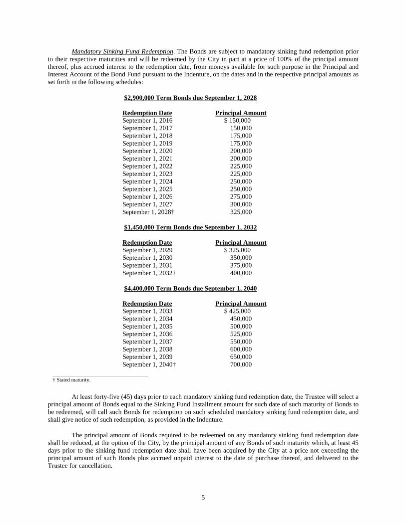
Mandatory Sinking Fund Redemption. The Bonds are subject to mandatory sinking fund redemption prior to their respective maturities and will be redeemed by the City in part at a price of 100% of the principal amount thereof, plus accrued interest to the redemption date, from moneys available for such purpose in the Principal and Interest Account of the Bond Fund pursuant to the Indenture, on the dates and in the respective principal amounts as set forth in the following schedules:
$1,450,000 Term Bonds due September 1, 2032
Redemption Date Principal Amount September 1, 2029 $ 325,000 September 1, 2030 350,000 September 1, 2031 375,000 September 1, 2032† 400,000
At least forty-five (45) days prior to each mandatory sinking fund redemption date, the Trustee will select a principal amount of Bonds equal to the Sinking Fund Installment amount for such date of such maturity of Bonds to be redeemed, will call such Bonds for redemption on such scheduled mandatory sinking fund redemption date, and shall give notice of such redemption, as provided in the Indenture.
The principal amount of Bonds required to be redeemed on any mandatory sinking fund redemption date shall be reduced, at the option of the City, by the principal amount of any Bonds of such maturity which, at least 45 days prior to the sinking fund redemption date shall have been acquired by the City at a price not exceeding the principal amount of such Bonds plus accrued unpaid interest to the date of purchase thereof, and delivered to the Trustee for cancellation.
$2,900,000 Term Bonds due September 1, 2028
Redemption Date Principal Amount September 1, 2016 $ 150,000 September 1, 2017 150,000 September 1, 2018 175,000 September 1, 2019 175,000 September 1, 2020 200,000 September 1, 2021 200,000 September 1, 2022 225,000 September 1, 2023 225,000 September 1, 2024 250,000 September 1, 2025 250,000 September 1, 2026 275,000 September 1, 2027 300,000 September 1, 2028† 325,000
$4,400,000 Term Bonds due September 1, 2040
Redemption Date Principal Amount September 1, 2033 $ 425,000 September 1, 2034 450,000 September 1, 2035 500,000 September 1, 2036 525,000 September 1, 2037 550,000 September 1, 2038 600,000 September 1, 2039 650,000 September 1, 2040† 700,000
† Stated maturity.
5

The principal amount of Bonds required to be redeemed on any mandatory sinking fund redemption date shall be reduced on a pro rata basis among Sinking Fund Installments for each maturity of Bonds by the principal amount of any Bonds which, at least 45 days prior to the mandatory sinking fund redemption date, shall have been redeemed pursuant to the optional redemption or extraordinary optional redemption provisions of the Indenture and not previously credited to a mandatory sinking fund redemption.
Notice of Redemption. Notice of any redemption shall be given by the Trustee at least thirty (30) days prior to the redemption date by giving written notice to the Owner of each Bond to be redeemed in whole or in part at the address shown on the Register by first-class mail, postage prepaid. Any such notice shall be conclusively presumed to have been duly given, whether or not the Owner receives such notice. Notice of redemption having been given as provided in the Indenture, the Bonds or portions thereof called for redemption shall become due and payable on the date fixed for redemption provided that funds for the payment of the redemption price of such Bonds to the date fixed for redemption are on deposit with the Trustee; thereafter, such Bonds or portions thereof shall cease to bear interest from and after the date fixed for redemption, whether or not such Bonds are presented and surrendered for payment on such date.
With respect to any optional redemption of the Bonds, unless the Trustee has received funds sufficient to pay the Redemption Price of the Bonds to be redeemed before giving of a notice of redemption, the notice may state that the City may condition redemption on the receipt of such funds by the Trustee on or before the date fixed for the redemption, or on the satisfaction of any other prerequisites set forth in the notice of redemption. If a conditional notice of redemption is given and such prerequisites to the redemption and sufficient funds are not received, the notice shall be of no force and effect, the City shall not redeem the Bonds and the Trustee shall give notice, in the manner in which the notice of redemption was given, that the Bonds have not been redeemed.
The City has the right to rescind any optional redemption or extraordinary optional redemption by written notice to the Trustee on or prior to the date fixed for redemption. Any notice of redemption shall be cancelled and annulled if for any reason funds are not available on the date fixed for redemption for the payment in full of the Bonds then called for redemption, and such cancellation shall not constitute an Event of Default under the Indenture. The Trustee shall mail notice of rescission of redemption in the same manner notice of redemption was originally provided.
Additional Provisions with Respect to Redemption. Bonds may be redeemed in part only in Authorized Denominations. If less than all of the Bonds are to be redeemed, the Bonds to be redeemed shall be selected by any method selected by the Trustee that results in a random selection, and treating each minimum Authorized Denomination of the Bonds as a single Bond for such purposes.
Upon surrender of any Bond in part, the Trustee, in accordance with the provisions of the Indenture, shall authenticate and deliver in exchange thereof a Bond or Bonds of like tenor, maturity and interest rate in an aggregate principal amount equal to the unredeemed portion of the Bond or Bonds so surrendered.
BOOK-ENTRY ONLY SYSTEM
This section describes how ownership of the Bonds is to be transferred and how the principal of, premium, if any, and interest on the Bonds are to be paid to and credited by The Depository Trust Company ("DTC"), New York, New York, while the Bonds are registered in its nominee name. The information in this section concerning DTC and the Book-Entry-Only System has been provided by DTC for use in disclosure documents such as this Official Statement. The City and the Underwriter believe the source of such information to be reliable, but neither the City nor the Underwriter takes responsibility for the accuracy or completeness thereof.
The City cannot and does not give any assurance that (1) DTC will distribute payments of debt service on the Bonds, or redemption or other notices, to DTC Participants, (2) DTC Participants or others will distribute debt service payments paid to DTC or its nominee (as the registered owner of the Bonds), or redemption or other notices, to the Beneficial Owners, or that they will do so on a timely basis or (3) DTC will serve and act in the manner described in this Official Statement. The current rules applicable to DTC are on file with the Securities and Exchange Commission, and the current procedures of DTC to be followed in dealing with DTC Participants are on file with DTC.
6
DTC will act as securities depository for the Bonds. The Bonds will be issued as fully-registered securities registered in the name of Cede & Co. (DTC’s partnership nominee) or such other name as may be requested by an authorized representative of DTC. One fully-registered security certificate will be issued for each maturity of the Bonds, each in the aggregate principal amount of such maturity, and will be deposited with DTC.
DTC, the world’s largest securities depository, is a limited-purpose trust company organized under the New York Banking Law, a “banking organization” within the meaning of the New York Banking Law, a member of the Federal Reserve System, a “clearing corporation” within the meaning of the New York Uniform Commercial Code, and a “clearing agency” registered pursuant to the provisions of Section 17A of the Securities Exchange Act of 1934. DTC holds and provides asset servicing for over 3.5 million issues of U.S. and non-U.S. equity issues, corporate and municipal debt issues, and money market instruments (from over 100 countries) that DTC’s participants (“Direct Participants”) deposit with DTC. DTC also facilitates the post-trade settlement among Direct Participants of sales and other securities transactions in deposited securities, through electronic computerized book-entry transfers and pledges between Direct Participants’ accounts. This eliminates the need for physical movement of securities certificates. Direct Participants include both U.S. and non-U.S. securities brokers and dealers, banks, trust companies, clearing corporations, and certain other organizations. DTC is a wholly-owned subsidiary of The Depository Trust & Clearing Corporation (“DTCC”). DTCC, is the holding company for DTC, National Securities Clearing Corporation and Fixed Income Clearing Corporation, all of which are registered clearing agencies. DTCC is owned by the users of its registered subsidiaries. Access to the DTC system is also available to others such as both U.S. and non-U.S. securities brokers and dealers, banks, trust companies, and clearing companies that clear through or maintain a custodial relationship with a Direct Participant, either directly or indirectly (“Indirect Participants”). DTC has a Standard & Poor’s rating of “AA+”. The DTC Rules applicable to its Participants are on file with the Securities and Exchange Commission.
Purchases of Bonds under the DTC system must be made by or through Direct Participants, which will receive a credit for the Bonds on DTC’s records. The ownership interest of each actual purchaser of each Bond (“Beneficial Owner”) is in turn to be recorded on the Direct and Indirect Participants’ records. Beneficial Owners will not receive written confirmation from DTC of their purchase. Beneficial Owners are, however, expected to receive written confirmations providing details of the transaction, as well as periodic statements of their holdings, from the Direct or Indirect Participant through which the Beneficial Owner entered into the transaction. Transfers of ownership interests in the Bonds are to be accomplished by entries made on the books of Direct and Indirect Participants acting on behalf of Beneficial Owners. Beneficial Owners will not receive certificates representing their ownership interests in Bonds, except in the event that use of the book-entry system for the Bonds is discontinued.
To facilitate subsequent transfers, all Bonds deposited by Direct Participants with DTC are registered in the name of DTC’s partnership nominee, Cede & Co., or such other name as may be requested by an authorized representative of DTC. The deposit of Bonds with DTC and their registration in the name of Cede & Co. or such other DTC nominee do not affect any change in beneficial ownership. DTC has no knowledge of the actual Beneficial Owners of the Bonds; DTC’s records reflect only the identity of the Direct Participants to whose accounts such Bonds are credited, which may or may not be the Beneficial Owners. The Direct and Indirect Participants will remain responsible for keeping account of their holdings on behalf of their customers.
Conveyance of notices and other communications by DTC to Direct Participants, by Direct Participants to Indirect Participants, and by Direct Participants and Indirect Participants to Beneficial Owners will be governed by arrangements among them, subject to any statutory or regulatory requirements as may be in effect from time to time. Beneficial Owners of Bonds may wish to take certain steps to augment the transmission to them of notices of significant events with respect to the Bonds, such as redemptions, tenders, defaults, and proposed amendments to the Bond documents. For example, Beneficial Owners of Bonds may wish to ascertain that the nominee holding the Bonds for their benefit has agreed to obtain and transmit notices to Beneficial Owners. In the alternative, Beneficial Owners may wish to provide their names and addresses to the registrar and request that copies of notices be provided directly to them.
Redemption notices shall be sent to DTC. If less than all Bonds of the same maturity are being redeemed, DTC’s practice is to determine by lot the amount of the interest of each Direct Participant of such maturity to be redeemed.
7
Neither DTC nor Cede & Co. (nor any other DTC nominee) will consent or vote with respect to Bonds unless authorized by a Direct Participant in accordance with DTC’s Procedures. Under its usual procedures, DTC mails an Omnibus Proxy to the City as soon as possible after the record date. The Omnibus Proxy assigns Cede & Co.’s consenting or voting rights to those Direct Participants to whose accounts Bonds are credited on the record date (identified in a listing attached to the Omnibus Proxy).
Principal, interest and all other payments on the Bonds will be made to Cede & Co., or such other nominee as may be requested by an authorized representative of DTC. DTC’s practice is to credit Direct Participants’ accounts upon DTC’s receipt of funds and corresponding detail information from the City or Paying Agent/Registrar, on the payment date in accordance with their respective holdings shown on DTC’s records. Payments by Participants to Beneficial Owners will be governed by standing instructions and customary practices, as is the case with securities held for the accounts of customers in bearer form or registered in “street name,” and will be the responsibility of such Participant and not of DTC nor its nominee, the Trustee, the Paying Agent/Registrar, or the City, subject to any statutory or regulatory requirements as may be in effect from time to time. Payment of principal, interest and payments to Cede & Co. (or such other nominee as may be requested by an authorized representative of DTC) is the responsibility of the Trustee, the Paying Agent/Registrar or the City, disbursement of such payments to Direct Participants will be the responsibility of DTC, and disbursement of such payments to the Beneficial Owners will be the responsibility of Direct and Indirect Participants.
DTC may discontinue providing its services as securities depository with respect to the Bonds at any time by giving reasonable notice to the City or the Trustee. Under such circumstances, in the event that a successor securities depository is not obtained, Bond certificates are required to be printed and delivered.
The City may decide to discontinue use of the system of book-entry transfers through DTC (or a successor securities depository). In that event, Bond certificates will be printed and delivered. Thereafter, Bond certificates may be transferred and exchanged as described in the Indenture.
The information in this section concerning DTC and DTC’s book-entry system has been obtained from sources that the City believes to be reliable, but none of the City, the City’s Financial Advisor or the Underwriter take any responsibility for the accuracy thereof.
NONE OF THE CITY, THE TRUSTEE, THE PAYING AGENT, THE CITY’S FINANCIAL ADVISOR OR THE UNDERWRITER WILL HAVE ANY RESPONSIBILITY OR OBLIGATION TO THE DTC PARTICIPANTS OR THE PERSONS FOR WHOM THEY ACT AS NOMINEE WITH RESPECT TO THE PAYMENTS TO OR THE PROVIDING OF NOTICE FOR THE DTC PARTICIPANTS, THE INDIRECT PARTICIPANTS OR THE BENEFICIAL OWNERS OF THE BONDS. THE CITY CANNOT AND DOES NOT GIVE ANY ASSURANCES THAT DTC, THE DTC PARTICIPANTS OR OTHERS WILL DISTRIBUTE PAYMENTS OF PRINCIPAL OF OR INTEREST ON THE BONDS PAID TO DTC OR ITS NOMINEE, AS THE REGISTERED OWNER, OR PROVIDE ANY NOTICES TO THE BENEFICIAL OWNERS OR THAT THEY WILL DO SO ON A TIMELY BASIS, OR THAT DTC WILL ACT IN THE MANNER DESCRIBED IN THIS OFFICIAL STATEMENT. THE CURRENT RULES APPLICABLE TO DTC ARE ON FILE WITH THE SECURITIES AND EXCHANGE COMMISSION, AND THE CURRENT PROCEDURES OF DTC TO BE FOLLOWED IN DEALING WITH DTC PARTICIPANTS ARE ON FILE WITH DTC.
SECURITY FOR THE BONDS
General
THE BONDS ARE SPECIAL OBLIGATIONS OF THE CITY PAYABLE SOLELY FROM THE PLEDGED REVENUES AND OTHER FUNDS COMPRISING THE TRUST ESTATE, AS AND TO THE EXTENT PROVIDED IN THE INDENTURE. THE BONDS DO NOT GIVE RISE TO A CHARGE AGAINST THE GENERAL CREDIT OR TAXING POWER OF THE CITY AND ARE PAYABLE SOLELY FROM THE SOURCES IDENTIFIED IN THE INDENTURE. THE OWNERS OF THE BONDS SHALL NEVER HAVE THE RIGHT TO DEMAND PAYMENT THEREOF OUT OF MONEY RAISED OR TO BE RAISED BY TAXATION, OR OUT OF ANY FUNDS OF THE CITY OTHER THAN THE PLEDGED REVENUES, AS AND TO THE EXTENT PROVIDED IN THE INDENTURE. NO OWNER OF THE BONDS SHALL HAVE THE RIGHT TO DEMAND ANY EXERCISE OF THE CITY’S
8

TAXING POWER TO PAY THE PRINCIPAL OF THE BONDS OR THE INTEREST OR REDEMPTION PREMIUM, IF ANY, THEREON. THE CITY SHALL HAVE NO LEGAL OR MORAL OBLIGATION TO PAY THE BONDS OUT OF ANY FUNDS OF THE CITY OTHER THAN THE PLEDGED REVENUES.
NOTWITHSTANDING THE FOREGOING, THE CITY HAS CREATED THE CELINA TAX INCREMENT REINVESTMENT ZONE NO. 2 (THE “TIRZ”) ACROSS THE DISTRICT AND INTENDS TO ENTER INTO AN AGREEMENT PRIOR TO DELIVERY OF THE BONDS WITH THE DEVELOPER, ITS SUCCESSORS AND ASSIGNS TO DEDICATE ANNUAL TAX INCREMENT REVENUES COLLECTED, WHICH TAX INCREMENT CONSISTS OF 47.63% OF THE INCREMENTAL INCREASED AD VALOREM TAX VALUE GENERATED WITHIN THE TIRZ, TO THE PAYMENT OF COSTS OF A PORTION OF THE MAJOR IMPROVEMENTS. SUCH TAX INCREMENT REVENUE, TO THE EXTENT AVAILABLE, IS EXPECTED TO BE USED BY THE CITY TO PAY PRINCIPAL OF AND INTEREST ON THE BONDS. ANY AMOUNT OF SUCH TAX INCREMENT REVENUE USED TO PAY PRINCIPAL OF AND INTEREST ON THE BONDS WILL RESULT IN A REDUCTION IN ANNUAL INSTALLMENTS OF PHASE #1 ASSESSMENTS BY A CORRESPONDING AMOUNT. SUCH TAX INCREMENT REVENUE IS NOT PLEDGED TO THE BONDS UNDER THE INDENTURE, AND SUCH TAX INCREMENT REVENUE IS NOT EXPECTED TO BE AVAILABLE TO PAY PRINCIPAL OF AND INTEREST ON THE BONDS UNTIL 2016. SEE “TIRZ REVENUES MAY OFFSET ASSESSMENTS” BELOW.
The principal of, premium, if any, and interest on the Bonds are secured by a pledge of and a lien upon the pledged revenues (the “Pledged Revenues”), consisting primarily of Phase #1 Assessments levied against the assessable parcels or lots within Phase #1 of the District and other funds comprising the Trust Estate, all to the extent and upon the conditions described herein and in the Indenture. Phase #1 contains approximately 120 acres, of which approximately 120 acres is expected to constitute Phase #1 Assessed Parcels. In accordance with the PID Act, the City has caused the preparation of a Service and Assessment Plan (as amended and supplemented, the “Service and Assessment Plan”), which describes the special benefit received by the property within the District, including Phase #1, provides the basis and justification for the determination of special benefit on such property, establishes the methodology for the levy of Assessments (including Phase #1 Assessments) and provides for the allocation of Pledged Revenues for payment of principal of, premium, if any, and interest on the Bonds. The Service and Assessment Plan is reviewed and updated annually for the purpose of determining the annual budget for improvements and the Annual Installments (as defined below) of Phase #1 Assessments due in a given year. The determination by the City of the assessment methodology set forth in the Service and Assessment Plan is the result of the discretionary exercise by the City Council of its legislative authority and governmental powers and is conclusive and binding on all current and future landowners within the District. See “APPENDIX B — Form of Service and Assessment Plan.”
Pledged Revenues
The City is authorized by the PID Act, the Assessment Ordinance and other provisions of law to finance the Phase #1 Projects by levying Phase #1 Assessments upon properties in Phase #1 of the District benefitted thereby. For a description of the assessment methodology and the amounts of Assessments anticipated to be levied in each phase of the District, see “ASSESSMENT PROCEDURES” and “APPENDIX B — Form of Service and Assessment Plan.”
Pursuant to the Indenture, Pledged Revenues are the sum of (i) the Assessment Revenue, less the amounts collected for Annual Collection Costs, (ii) moneys held in the Pledged Funds, and (iii) any additional revenues that the City may pledge to the payment of the Bonds and Additional Bonds. “Assessment Revenue” means monies collected by or on behalf of the City from any one or more of the following: (i) a Phase #1 Assessment, or an Annual Installment thereof, including any interest on such Phase #1 Assessment or Annual Installment thereof during any period of delinquency, (ii) a Prepayment, (iii) Delinquent Collection Costs and (iv) Foreclosure Proceeds. “Annual Installments” means each annual payment of the Assessments as shown on the Assessment Roll attached to the Service and Assessment Plan and related to the Bonds and the Phase #1 Projects; which Assessments and Annual Installments thereof include the 0.20% from the additional interest rate component of the Annual Installments authorized by Section 372.018(a) of the PID Act and collected on each annual payment for the prepayment reserve and the 0.30% from the additional interest rate component of the Annual Installments authorized by Section 372.018(a) of the PID Act and collected on each annual payment for the delinquency reserve as described in the Indenture and as defined and calculated in the Service and Assessment Plan or in any Annual Service Plan Update. The City will covenant in the Indenture that it will take and pursue all actions permissible under Applicable
9
Laws to cause the Phase #1 Assessments to be collected and the liens thereof to be enforced continuously. See “– Pledged Revenue Fund,” “APPENDIX A — Form of Indenture” and “APPENDIX B — Form of Service and Assessment Plan.”
The PID Act provides that the Phase #1 Assessments (including any reassessment, with interest, the expense of collection and reasonable attorney’s fees, if incurred) are a first and prior lien (the “Assessment Lien”) against the property assessed, superior to all other liens or claims, except liens and claims by the State of Texas (the “State”), counties, cities, school districts, or other municipalities for ad valorem taxes and are a personal liability of and charge against the owners of property, regardless of whether the owners are named. Pursuant to the PID Act, the Assessment Lien is effective from the date of the Assessment Ordinance until the Phase #1 Assessments are paid (or otherwise discharged), and is enforceable by the City Council in the same manner that an ad valorem property tax levied against real property may be enforced by the City Council. See “ASSESSMENT PROCEDURES” herein.
TIRZ Revenues May Reduce Assessments
The Assessments to be levied by the City according to the Assessment Ordinance and described in the Service and Assessment Plan are set at a level sufficient to fund a portion of the costs of the Phase #1 Projects in the approximate amount of $14,265,000. On May 22, 2014, the City created the TIRZ pursuant to Chapter 311, Texas Tax Code, as amended (the “TIRZ Act”), which TIRZ is coterminous with the District. Pursuant to Section 311.012(c) of the TIRZ Act, the tax increment base of the City is the total taxable value of all real property taxable by the City located in the TIRZ as of January 1, 2014, the year in which the TIRZ was designated as a reinvestment zone (the “Tax Increment Base”). Pursuant to Section 311.012(a) of the TIRZ Act, the City has set the amount of the “Tax Increment” for a year as 47.63% of property taxes levied, assessed, and collected by the City for that year on the Captured Appraised Value (defined below) of real property taxable by City and located in the Zone (the “Tax Increment”). Consistent with Section 311.012(b) of the TIRZ Act, the Captured Appraised Value of real property taxable by the City for a year is the total appraised value of all real property taxable by the City and located in the TIRZ for that year less the Tax Increment Base (the “Captured Appraised Value”). Currently, there are no other taxing units participating in the TIRZ.
Pursuant to the Development Agreement between the City and the Developer (the “Development Agreement”), which is expected to be executed by the City and the Developer prior to delivery of the Bonds, the City will agree to transfer from the tax increment fund a portion of Tax Increment collected each year to the Bond Pledged Revenue Account of the Bond Fund for the payment of a portion of the costs of the Major Improvements. Such Tax Increment revenue, if and when collected and transferred by the City, will be used to pay principal of and interest on the Bonds or other bonds issued by the City for the financing of the Major Improvements. Any amount of such Tax Increment revenue used to pay principal of and interest on the Bonds will result in a reduction in Annual Installments of Phase #1 Assessments by a corresponding amount. The term of the TIRZ is the earlier of (a) 27 years or (b) until Tax Increment revenue in the amount of $22,218,846 is collected and transferred by the City to pay the costs of Major Improvements as provided in the Development Agreement, Service and Assessment Plan, and Project and Finance Plan related to the TIRZ. SUCH TAX INCREMENT REVENUE IS NOT PLEDGED TO THE BONDS UNDER THE INDENTURE, MAY NOT BE CLAIMED BY BONDHOLDERS OF THE BONDS IF AN EVENT OF DEFAULT OCCURS, AND IS NOT EXPECTED TO BE AVAILABLE TO PAY PRINCIPAL OF AND INTEREST ON THE BONDS UNTIL 2016.
Attached to this Official Statement as APPENDIX G is the Estimated Tax Increment Revenue Contribution, which illustrates the estimated net debt service on the Bonds and the Phases #2-3 Major Improvement Bonds, taking into consideration the amount of tax increment revenue expected to be generated within the TIRZ. Pursuant to the Development Agreement, such forecasted contribution of Tax Increment revenue will result in a reduction in Annual Installments of Phase #1 Assessments and annual installments of assessments related to the Phases #2-3 Major Improvement Bonds by a corresponding amount. THE TAX INCREMENT REVENUE FORECASTS SHOWN IN APPENDIX G IS FOR ILLUSTRATIVE PURPOSES ONLY AND DOES NOT PROVIDE ASSURANCE THAT THE ANNUAL INSTALLMENTS OF PHASE #1 ASSESSMENTS WILL BE REDUCED. SUCH FORECASTS ARE DEPENDENT UPON THE DEVELOPER’S TIMELY DEVELOPMENT AND CONSTRUCTION OF THE PHASE #1 PROJECTS AND SALE OF LOTS WITHIN THE DISTRICT IN ACCORDANCE WITH THE DEVELOPER’S EXPECTATIONS, AND NO ASSURANCES CAN BE MADE THAT SUCH FORECASTS WILL BE REALIZED. See “The
10
DEVELOPMENT — EXPECTED BUILD-OUT SCHEDULE” and “— EXPECTED ABSORPTION BY LOT SIZE”.
Collection and Deposit of Assessments
The Phase #1 Assessments shown on the Phase #1 Assessment Roll, together with the interest thereon, shall first be applied to the payment of the principal of and interest on the Bonds as and to the extent provided in the Service and Assessment Plan and the Indenture.
The portion of the Phase #1 Assessments assessed to pay debt service on the Bonds, together with interest thereon, are payable in Annual Installments established by the Assessment Ordinance and the Service and Assessment Plan to correspond, as nearly as practicable, to the debt service requirements for the Bonds. An Annual Installment of a Phase #1 Assessment has been made payable in the Assessment Ordinance in each City fiscal year preceding the date of final maturity of the Bonds which, if collected, will be sufficient to first pay debt service requirements attributable to Phase #1 Assessments in the Service and Assessment Plan. Each Annual Installment is payable as provided in the Service and Assessment Plan and the Assessment Ordinance.
A record of the Phase #1 Assessments on each parcel, tract or lot which are to be collected in each year during the term of the Bonds is shown on the Assessment Roll. Sums received from the collection of the Phase #1 Assessments to pay the debt service requirements (including delinquent installments, Foreclosure Proceeds and penalties) and of the interest thereon shall be deposited into the Bond Pledged Revenue Account of the Pledged Revenue Fund, except that amounts received as Prepayments shall be deposited into the Redemption Fund.
Portions of the Annual Installments of Assessments collected to pay Annual Collection Costs and Delinquent Collection Costs shall be deposited in the Administrative Fund and shall not constitute Pledged Revenues.
Unconditional Levy of Assessments
The City will impose Phase #1 Assessments on the property within Phase #1 of the District to pay the principal of and interest on the Bonds scheduled for payment from Pledged Revenues as described in the Indenture and in the Service and Assessment Plan and coming due during each Fiscal Year. The Phase #1 Assessments shall be effective on the date of, and strictly in accordance with the terms of, the Assessment Ordinance. Each Phase #1 Assessment may be paid immediately in full or in periodic Annual Installments over a period of time equal to the term of the Bonds, which installments shall include interest on the Phase #1 Assessments. Pursuant to the Assessment Ordinance, interest on the Phase #1 Assessments will be calculated at the rate of interest on the Bonds plus 0.50%, calculated on the basis of a 360-day year of twelve 30-day months. Such rate may be adjusted as described in the Service and Assessment Plan. Each Annual Installment, including the interest on the unpaid amount of a Phase #1 Assessment, shall be calculated on September 1 and shall be due on October 1 of each year. Each Annual Installment together with interest thereon shall be delinquent if not paid prior to February 1 of the following year. The initial Annual Installments will be due on October 1, 2014, and will be delinquent if not paid prior to February 1, 2015.
As authorized by Section 372.018(b) of the PID Act, the City will calculate and collect each year while the Bonds are Outstanding and unpaid, commencing September 1, 2014, an Assessment to pay the annual costs incurred by the City in the administration and operation of Phase #1 of the District. The portion of each Annual Installment of a Phase #1 Assessment used to pay such annual costs shall remain in effect from year to year until all Bonds are finally paid or until the City adjusts the amount of the levy after an annual review in any year pursuant to Section 372.013 of the PID Act. The Assessments to pay annual expenses shall be due in the manner set forth in the Assessment Ordinance on October 1 of each year and shall be delinquent if not paid by February 1 of the following year. Such Assessments to pay expenses do not secure repayment of the Bonds.
There will be no discount for the early payment of Phase #1 Assessments.
11
Phase #1 Assessments, together with interest, penalties, and expense of collection and reasonable attorneys’ fees, as permitted by the Texas Tax Code, shall be a first and prior lien against the property assessed, superior to all other liens and claims, except liens or claims for State, county, city, school district or municipal ad valorem taxes and shall be a personal liability of and charge against the owner of the property regardless of whether the owners are named. The lien for Phase #1 Assessments and penalties and interest begins on the effective date of the Assessment Ordinance and continues until the Phase #1 Assessments are paid or until all Bonds are finally paid.
Failure to pay an Annual Installment when due shall not accelerate the payment of the remaining Annual Installments of the Phase #1 Assessments and such remaining Annual Installments (including interest) shall continue to be due and payable at the same time and in the same amount and manner as if such default had not occurred.
Perfected Security Interest
Chapter 1208, Texas Government Code, applies to the issuance of the Bonds and the pledge of the Pledged Revenues and such pledge is valid, effective, and perfected. The City will covenant in the Indenture that should Texas law be amended at any time while the Bonds are outstanding and unpaid, the result of such amendment being that the pledge of such revenues is subject to the filing requirements of Chapter 9, Texas Business & Commerce Code, in order to preserve to the registered owners of the Bonds a security interest in such pledge, the City will take such measures as it determines are reasonable and necessary to enable a filing of a security interest in said pledge to occur. See “APPENDIX A — Form of Indenture.”
Pledged Revenue Fund
The City has created under the Indenture a Pledged Revenue Fund to be held by the Trustee. On or about February 20th of each year while the Bonds are outstanding, and beginning in 2015, the City shall deposit or cause to be deposited the Pledged Revenues into the Pledged Revenue Fund. Specifically, the City shall deposit or cause to be deposited Assessment Revenues as follows: (a) first, to the Bond Pledged Revenue Account of the Pledged Revenue Fund in an amount sufficient to pay debt service on the Bonds next coming due, (b) second, deposited to the Reserve Account of the Reserve Fund in an amount necessary to cause the amount on deposit therein to equal the Reserve Fund Requirement, (c) third, to the Landowner Reimbursement Pledged Revenue Account of the Pledged Revenue Fund to pay and reimburse the Landowner for costs of Phase #1 Projects that have been paid from the Landowner Improvement Account of the Project Fund (under the Phase #1 Reimbursement Agreement), (d) fourth, to pay other costs of the Phase #1 Projects, and (e) fifth, to pay any other costs permitted by the PID Act. Moneys transferred to the Landowner Reimbursement Pledged Revenue Account shall not be a part of the Trust Estate and are not security for the Bonds.
From time to time as needed to pay the obligations relating to the Bonds, but no later than five business days before each Interest Payment Date, the Trustee shall withdraw from the Bond Pledged Revenue Account of the Pledged Revenue Fund, and transfer to the Principal and Interest Account of the Bond Fund, an amount, taking into account any amounts then on deposit in such Principal and Interest Account and any expected transfers from the Capitalized Interest Account to the Principal and Interest Account, such that the amount on deposit in the Principal and Interest Account equals the principal (including any Sinking Fund Installments) and interest due on the Bonds on the next Interest Payment Date.
If, after the foregoing transfers and any transfer from the Reserve Fund (as described under “Reserve Fund” below), there are insufficient funds to make the payments provided in the preceding paragraph, the Trustee shall apply the available funds in the Principal and Interest Account first to the payment of interest, then to the payment of principal (including any Sinking Fund Installments) on the Bonds.
The Trustee shall transfer Prepayments to the Redemption Fund as soon as practical after deposit of such amounts into the Pledged Revenue Fund.
The Trustee shall transfer Foreclosure Proceeds (which exclude Delinquent Collection Costs) first to the Reserve Fund to restore any transfers from the Reserve Fund made with respect to a Phase #1 Assessed Parcel to which the Foreclosure Proceeds relate, and second, to the Redemption Fund. Any Assessments remaining after
12
satisfying the foregoing payments may be used for any lawful purpose for which Assessments may be used under the PID Act.
Bond Fund
On each Interest Payment Date, the Trustee shall withdraw from the Principal and Interest Account and transfer to the Paying Agent/Registrar the principal (including any Sinking Fund Installments) and interest then due and payable on the Bonds, less any amount to be used to pay interest on the Bonds on such Interest Payment Date from the Capitalized Interest Account as provided in the Indenture.
Reserve Fund
Pursuant to the Indenture, a Reserve Account will be created within the Reserve Fund for the benefit of the Bonds and held by the Trustee and will be funded with proceeds of the Bonds in the amount of the Reserve Fund Requirement. Pursuant to the Indenture, the “Reserve Fund Requirement” for the Bonds shall be an amount equal to the least of (i) Maximum Annual Debt Service on the Bonds as of their date of issuance, (ii) 125% of average Annual Debt Service on the Bonds as of their date of issuance, and (iii) 10% of the proceeds of the Bonds; provided, however, that such amount shall be reduced by the amount of any transfers made in connection with an extraordinary optional redemption as described in the next following paragraph. Also, as a result of an optional redemption of the Bonds, the Reserve Fund Requirement shall be reduced by a percentage equal to the pro rata amount of Bonds redeemed by such optional redemption divided by the total amount of the Outstanding Bonds prior to such redemption. As of the date of delivery of the Bonds, the Reserve Fund Requirement equals $749,781.26.
If, on any Interest Payment Date, the amount on deposit in the Bond Fund is insufficient to pay the debt service on the Bonds due on such date, the Trustee shall, transfer any available funds on deposit first from the Delinquency Reserve Account (described below), second from the Reserve Account of the Reserve Fund, and third from the Prepayment Reserve Account, to the Bond Fund in the amount necessary to cure such deficiency. The Trustee shall determine the value of cash and investments on deposit in the Delinquency Reserve Account of the Reserve Fund as of September 30 of each year. In the event of an extraordinary optional redemption of the Bonds from the proceeds of a Prepayment, the Trustee, pursuant to written directions from the City, shall transfer from the Reserve Account to the Redemption Fund the amount specified in such directions, which shall be an amount equal to the difference between the Reserve Fund Requirement immediately prior to such extraordinary optional redemption, and the Reserve Fund Requirement immediately after such extraordinary optional redemption.
Prepayment Reserve Account of the Reserve Fund
Pursuant to the Indenture, a Prepayment Reserve Account will be created within the Reserve Fund and held by the Trustee for the benefit of the Bonds. The Trustee will transfer funds from the Pledged Revenue Fund to the Prepayment Reserve Account on a semi-annual basis until the amount on deposit therein is equal to the Prepayment Reserve Requirement. The Prepayment Reserve Requirement is $131,250.00. The City has allocated 0.20% from the additional interest rate component of the Annual Installments, authorized by Section 372.018(a) of the PID Act, to the Prepayment Reserve Account for such purpose. Once the Prepayment Reserve Requirement has accumulated in the Prepayment Reserve Account, all amounts in excess of the Prepayment Reserve Requirement shall be transferred by the Trustee first to the Delinquency Reserve Account in the event such account contains less than the Delinquency Reserve Requirement, or, if the Delinquency Reserve Account contains the Delinquency Reserve Requirement then to the Redemption Fund to redeem Bonds.. See “APPENDIX A – Form of Indenture” and “APPENDIX B – Form of Service and Assessment Plan.”
Money deposited in the Prepayment Reserve Account will be used and withdrawn by the Trustee for the purpose of making transfers to the Bond Fund, pursuant to, and at the times specified in, the Indenture to pay a portion of the accrued interest on Bonds being redeemed pursuant to an extraordinary optional redemption for Prepayments. The amount to be transferred shall be an amount, for each Prepayment, equal to the amount of any shortfall, after transfers from the Reserve Account of the Reserve Fund as described above and application of investment earnings on the Prepayment toward payment of accrued interest, in funds necessary to pay the principal amount plus accrued interest on such Bonds to be redeemed as a result of the Prepayment.
13
If, on any Interest Payment Date, the amount on deposit in the Bond Fund is insufficient to pay the debt service due on such date, and if there are not sufficient monies in the Delinquency Reserve Account and the Reserve Account of the Reserve Fund to cure such deficiency, the Trustee shall transfer from the Prepayment Reserve Account to the Bond Fund the amounts necessary to cure such deficiency.
Delinquency Reserve Account of the Reserve Fund
Pursuant to the Indenture, a Delinquency Reserve Account will be created within the Reserve Fund and held by the Trustee for the benefit of the Bonds. The Trustee will transfer funds from the Pledged Revenue Fund to the Delinquency Reserve Account on a semi-annual basis, until the amount on deposit therein is equal to the Delinquency Reserve Requirement. The Delinquency Reserve Requirement is $350,000.00. The City has allocated 0.30% from the additional interest rate component of the Annual Installments, authorized by Section 372.018(a) of the PID Act, to the Delinquency Reserve Account for such purpose. Once the Delinquency Reserve Requirement has been accumulated in the Delinquency Reserve Account, any amounts in excess of the Delinquency Reserve Requirement in the Delinquency Reserve Account shall be transferred by the Trustee to the Redemption Fund to redeem Bonds. See “APPENDIX A – Form of Indenture” and “APPENDIX B – Form of Service and Assessment Plan.”
If, on any Interest Payment Date, the amount on deposit in the Bond Fund is insufficient to pay the debt service on the Bonds due on such date, the Trustee shall transfer first from the Delinquency Reserve Account of the Reserve Fund second from the Reserve Account of the Reserve Fund, and third from the Prepayment Account of the Reserve Fund to the Bond Fund the amounts necessary to cure such deficiency. The Trustee shall determine the value of cash and investments on deposit in the Delinquency Reserve Account as of September 30 of each year.
Administrative Fund
The City has created under the Indenture an Administrative Fund held by the Trustee. Upon receipt, the City shall transfer to the Trustee, for deposit to the District Administration Account of the Administrative Fund, the portion of the Assessments and Annual Installments allocated to the payment of Annual Collection Costs and Delinquent Collection Costs as set forth in the Service and Assessment Plan. Pursuant to the Phase #1 Redemption Agreement, the Landowner shall deposit the lesser of either (1) $10,000 or (2) two times the amount of the property tax on the Property that is classified as agricultural in the current tax year, to be held in the Landowner Property Tax Account of the Administrative Fund under the terms of such agreement. Monies in the District Administration Account of the Administrative Fund may be used as directed by City Order for the purposes set forth in the Service and Assessment Plan, including payment of the Annual Collection Costs and Delinquent Collection Costs. See “APPENDIX B — Form of Service and Assessment Plan.” Moneys in the Landowner Property Tax Account of the Administrative Fund shall be held by the Trustee separate and apart from the other Funds created and administered under the Indenture and shall be released to the Developer as directed by City Order; provided, however, that the Trustee shall transfer to the Developer any amounts remaining in the Landowner Property Tax Account of the Administration Fund after the last Outstanding Bond is discharged regardless of whether a City Order directing such action is received. The Administrative Fund shall not be part of the Trust Estate and shall not be security for the Bonds.
Defeasance
All Outstanding Bonds shall prior to the Stated Maturity or redemption date thereof be deemed to have been paid and to no longer be deemed Outstanding if (i) in case any such Bonds are to be redeemed on any date prior to their Stated Maturity, the Trustee shall have given notice of redemption on said date as provided in the Indenture, (ii) there shall have been deposited with the Trustee either moneys in an amount which shall be sufficient, or Defeasance Securities the principal of and the interest on which when due will provide moneys which, together with any moneys deposited with the Trustee at the same time, shall be sufficient to pay when due the principal of and interest on of the Bonds to become due on such Bonds on and prior to the redemption date or maturity date thereof, as the case may be, (iii) the Trustee shall have received a report by an independent certified public accountant selected by the City verifying the sufficiency of the moneys or Defeasance Securities deposited with the Trustee to pay when due the principal of and interest on of the Bonds to become due on such Bonds on and prior to the redemption date or maturity date thereof, as the case may be, and (iv) if the Bonds are then rated, the Trustee
14
shall have received written confirmation from each rating agency then rating the Bonds that such deposit will not result in the reduction or withdrawal of the rating on the Bonds. Neither Defeasance Securities nor moneys so deposited with the Trustee nor principal or interest payments on any such Defeasance Securities shall be withdrawn or used for any purpose other than, and shall be held in trust for, the payment of the principal of and interest on the Bonds. Any cash received from such principal of and interest on such Defeasance Securities deposited with the Trustee, if not then needed for such purpose, shall be reinvested in Defeasance Securities as directed by the City maturing at times and in amounts sufficient to pay when due the principal of and interest on the Bonds on and prior to such redemption date or maturity date thereof, as the case may be. Any payment for Defeasance Securities purchased for the purpose of reinvesting cash as aforesaid shall be made only against delivery of such Defeasance Securities.
“Defeasance Securities” means Investment Securities then authorized by applicable law for the investment of funds to defease public securities. “Investment Securities” means those authorized investments described in the Public Funds Investment Act, Chapter 2256, Texas Government Code, as amended; and provided further investments and are, at the time made, included in and authorized by the City’s official investment policy as approved by the City Council from time to time. Under current State law, Investment Securities that are authorized for the investment of funds to defease public securities are (a) direct, noncallable obligations of the United States of America, including obligations that are unconditionally guaranteed by the United States of America; (b) noncallable obligations of an agency or instrumentality of the United States, including obligations that are unconditionally guaranteed or insured by the agency or instrumentality, and that, on the date the governing body of the City adopts or approves the proceedings authorizing the issuance of refunding bonds, are rated as to investment quality by a nationally recognized investment rating firm not less than “AAA” or its equivalent; and (c) noncallable obligations of a state or an agency or a county, municipality, or other political subdivision of a state that have been refunded and that, on the date the governing body of the City adopts or approves the proceedings authorizing the issuance of refunding bonds, are rated as to investment quality by a nationally recognized investment rating firm not less than “AAA” or its equivalent.
There is no assurance that the current law will not be changed in a manner which would permit investments other than those described above to be made with amounts deposited to defease the Bonds. Because the Indenture does not contractually limit such investments, Owners may be deemed to have consented to defeasance with such other investments, notwithstanding the fact that such investments may not be of the same investment quality as those currently permitted under State law. There is no assurance that the ratings for U.S. Treasury securities used as Defeasance Securities or that for any other Defeasance Security will be maintained at any particular rating category.
Events of Default
Each of the following occurrences or events constitutes an “Event of Default” under the Indenture:
(i) the failure of the City to deposit the Pledged Revenues to the Bond Pledged Revenue Account of the Pledged Revenue Fund;
(ii) the failure of the City to enforce the collection of the Phase #1 Assessments including the prosecution of foreclosure proceedings;
(iii) default in the performance or observance of any covenant, agreement or obligation of the City under the Indenture and the continuation thereof for a period of 90 days after written notice to the City by the Trustee, or by the Owners of at least 25% of the aggregate outstanding principal of the Bonds with a copy to the Trustee, specifying such default by the Owners of at least 25% of the Bonds at the time Outstanding requesting that the failure be remedied.
Remedies in Event of Default
Upon the happening and continuance of any Event of Default, the Owners of not less than 25% in aggregate outstanding principal amount of the Bonds then Outstanding may proceed against the City for the purpose of protecting and enforcing the rights of the Owners under the Indenture by action seeking mandamus or by other
15
suit, action, or special proceeding in equity or at law in any court of competent jurisdiction for any relief to the extent permitted by Applicable Laws including, but not limited to, the specific performance of any covenant or agreement contained in the Indenture, or injunction; provided, however, that no action for money damages against the City may be sought or will be permitted.
THE PRINCIPAL OF THE BONDS SHALL NOT BE SUBJECT TO ACCELERATION UNDER ANY CIRCUMSTANCES.
If the assets of the Trust Estate are sufficient to pay all amounts due with respect to all Outstanding Bonds Similarly Secured, in the selection of Trust Estate assets to be used in the payment of Bonds due in an Event of Default, the City shall determine, in its absolute discretion, and shall instruct the Trustee by City Order, which Trust Estate assets shall be applied to such payment and shall not be liable to any Owner or other Person by reason of such selection and application. In the event that the City shall fail to deliver to the Trustee such City Order, the Trustee shall select and liquidate or sell Trust Estate assets as provided in the following paragraph, and shall not be liable to any Owner, or other Person, or the City by reason of such selection, liquidation or sale.
Whenever moneys are to be applied pursuant to an Event of Default, irrespective of and whether other remedies authorized under the Indenture shall have been pursued in whole or in part, the Trustee may cause any or all of the assets of the Trust Estate, including Investment Securities, to be sold. The Trustee may so sell the assets of the Trust Estate and all right, title, interest, claim and demand thereto and the right of redemption thereof, in one or more parts, at any such place or places, and at such time or times and upon such notice and terms as the Trustee may deem appropriate and as may be required by law and apply the proceeds thereof in accordance with the provisions of the Indenture. Upon such sale, the Trustee may make and deliver to the purchaser or purchasers a good and sufficient assignment or conveyance for the same, which sale shall be a perpetual bar both at law and in equity against the City and all other Persons claiming such properties. No purchaser at any sale shall be bound to see to the application of the purchase money proceeds thereof or to inquire as to the authorization, necessity, expediency, or regularity of any such sale. Nevertheless, if so requested by the Trustee, the City shall ratify and confirm any sale or sales by executing and delivering to the Trustee or to such purchaser or purchasers all such instruments as may be necessary or, in the judgment of the Trustee, proper for the purpose which may be designated in such request.
Restriction on Owner’s Actions
No Owner shall have any right to institute any action, suit or proceeding at law or in equity for the enforcement of the Indenture or for the execution of any trust thereof or any other remedy thereunder, unless (i) a default has occurred and is continuing of which the Trustee has been notified in writing or of which it is deemed to have notice, (ii) such default has become an Event of Default and the Owners of 25% of the aggregate principal amount of the Bonds then Outstanding have made written request to the Trustee and offered it reasonable opportunity either to proceed to exercise the powers granted or to institute such action, suit or proceeding in its own name, (iii) the Owners have furnished to the Trustee indemnity as provided in the Indenture, (iv) the Trustee has for 90 days after such notice failed or refused to exercise the powers granted, or to institute such action, suit, or proceeding in its own name, (v) no direction inconsistent with such written request has been given to the Trustee during such 90-day period by the owners of a majority of the aggregate principal amount of the Bonds Similarly Secured then Outstanding, and (vi) notice of such action, suit, or proceeding is given to the Trustee; however, no one or more Owners of the Bonds shall have any right in any manner whatsoever to affect, disturb, or prejudice the Indenture by its, his or their action or to enforce any right thereunder except in the manner provided in the Indenture, and that all proceedings at law or in equity shall be instituted and maintained in the manner provided in the Indenture and for the equal benefit of the registered owners of all Bonds Similarly Secured then Outstanding. The notification, request and furnishing of indemnity shall, at the option of the Trustee, be conditions precedent to the execution of the powers and trusts of the Indenture and to any action or cause of action for the enforcement of the Indenture or for any other remedy thereunder.
Subject to provisions of the Indenture with respect to certain liabilities of the City, nothing in the Indenture shall affect or impair the right of any Owner to enforce, by action at law, payment of any Bond Similarly Secured at and after the maturity thereof, or on the date fixed for redemption or the obligation of the City to pay each Bond Similarly Secured issued thereunder to the respective Owners thereof at the time and place, from the source and in the manner expressed therein and in the Bonds Similarly Secured.
16
In case the Trustee or any Owners shall have proceeded to enforce any right under the Indenture and such proceedings shall have been discontinued or abandoned for any reason or shall have been determined adversely to the Trustee or any Owners, then and in every such case the City, the Trustee and the Owners shall be restored to their former positions and rights thereunder, and all rights, remedies and powers of the Trustee shall continue as if no such proceedings had been taken.
Application of Revenues and Other Moneys After Event of Default
All moneys, securities, funds and Pledged Revenues and the income therefrom received by the Trustee pursuant to any right given or action taken under the provisions of the Indenture with respect to Events of Default shall, after payment of the cost and expenses of the proceedings resulting in the collection of such amounts, the expenses (including Trustee’s counsel), liabilities, and advances incurred or made by the Trustee and the fees of the Trustee in carrying out the Indenture, be applied by the Trustee, on behalf of the City, to the payment of interest and principal or redemption price then due on Bonds, as follows:
(i) FIRST: To the payment to the registered owners entitled thereto all installments of interest then due in the direct order of maturity of such installments, and, if the amount available shall not be sufficient to pay in full any installment, then to the payment thereof ratably, according to the amounts due on such installment, to the registered owners entitled thereto, without any discrimination or preference; and
(ii) SECOND: To the payment to the registered owners entitled thereto of the unpaid principal of Outstanding Bonds, or redemption price of any Bonds which shall have become due, whether at maturity or by call for redemption, in the direct order of their due dates and, if the amounts available shall not be sufficient to pay in full all the Bonds due on any date, then to the payment thereof ratably, according to the amounts of principal due and to the registered owners entitled thereto, without any discrimination or preference.
In the event funds are not adequate to cure an Event of Default, the available funds will be allocated to the Bonds that are Outstanding in proportion to the quantity of Bonds that are currently due and in default under the terms of the Indenture.
Within ten (10) days of receipt of such good and available funds, the Trustee may fix a record and payment date for any payment to be made to Owners.
The restoration of the City to its prior position after any and all defaults have been cured, as provided above, shall not extend to or affect any subsequent default under the Indenture or impair any right consequent thereon.
Investment or Deposit of Funds
Money in any fund or account established pursuant to the Indenture (other than the Reserve Account) will be invested by the Trustee as directed by the City pursuant to a City Order filed with the Trustee at least two (2) days in advance of the making of such investment in time deposits or certificates of deposit secured in the manner required by law for public funds, or be invested in direct obligations of, including obligations the principal of and interest on which are unconditionally guaranteed by, the United States of America, in obligations of any agencies or instrumentalities thereof, or in such other investments as are permitted under the , the Public Funds Investment Act, Chapter 2256, Government Code, as amended (the “PFIA”) or any successor law, as in effect from time to time; provided that all such deposits and investments shall be made in such manner (which may include repurchase agreements for such investment with any primary dealer of such agreements) that the money required to be expended from any fund will be available at the proper time or times.
Obligations purchased as an investment of moneys in any fund or account established pursuant to the Indenture shall be deemed to be part of such fund or account, subject, however, to the requirements of the Indenture for transfer of interest earnings and profits resulting from investment of amounts in funds and accounts. Whenever in the Indenture any moneys are required to be transferred by the City to the Trustee, such transfer may be accomplished by transferring a like amount of permitted investments.
17
Additional Bonds
Proceeds of the Bonds will pay for a portion of the costs of the Phase #1 Projects. The City expects to issue Additional Bonds to finance the balance of the Phase #1 Projects not paid with proceeds of the Bonds. Such Additional Bonds will be secured by Phase #1 Assessments that initially secure the Phase #1 Reimbursement Agreement, and the pledge of such Phase #1 Assessments to secure the City’s payment obligations under the Phase #1 Reimbursement Agreement will be extinguished. Although the pledge of Phase #1 Assessments to secure the Phase #1 Reimbursement Agreement is subordinate to the pledge of Phase #1 Assessments to secure repayment of the Bonds, the pledge of Phase #1 Assessments to secure repayment of such Additional Bonds will be on parity with the pledge securing repayment of the Bonds. The Bonds and any Additional Bonds issued by the City are separate and distinct issues of securities.
The City reserves the right to issue Additional Bonds for any purpose permitted by the Act, including those described above, and in accordance with the conditions set forth below:
1. the City Representative shall certify that the City is not in default in the performance and observance of any of the terms, provisions and conditions applicable to the Town contained in the Indenture;
2. the Landowner, through an authorized representative, shall certify that the Landowner is not in default in the performance and observance of any of the terms, provisions and conditions applicable to the Landowner contained in the Construction Funding Agreement;
3. the Landowner shall provide the City with a certificate or report from an independent certified appraiser or appraisal firm (that may rely on County assessed value figures for the completed homes as to their value) that, assuming completion of the improvements to be financed with the proceeds of the Additional Bonds or with the funds withdrawn from the Landowner Improvement Account of the Project Fund, as applicable, (A) at least 300 single-family homes located within Phase #1 of the District have been completed; (B) in addition to the completed construction of at least 300 single-family homes, construction shall have commenced, or be completed, on at least another 30 single-family homes within Phase #1 of the District; (C) the appraised value of the property within Phase #1 of the District is equal to at least five (5) times the principal amount of the Outstanding Bonds Similarly Secured, taking into account the Additional Bonds to be issued, (B) the appraised value allocated to every Assessed Parcel within Phase #1 of the District is at least two and a half (2.5) times the portion of the principal amount of any Outstanding Bonds Similarly Secured, taking into account the Additional Bonds to be issued, that is allocated to each Assessed Parcel, and (C) the appraised value allocated to no more than fifty (50) Assessed Parcels within Phase #1 of the District are below three (3) times the portion of the principal amount of any Outstanding Bonds Similarly Secured, taking into account the Additional Bonds to be issued, that is allocated to each Assessed Parcel;
4. the principal of and interest on the Additional Bonds must be scheduled to be paid or mature on March 1 or September 1, or both, of the years in which each principal or interest are scheduled to be paid or mature; and
5. there shall be deposited to the Reserve Fund an amount equal to the Reserve Fund Requirement taking into account the outstanding Bonds Similarly Secured, and the Additional Bonds then proposed to be issued.
Additionally, the City has reserved the right to issue bonds secured by and payable from Pledged Revenues so long as such pledge is subordinate to the pledge of Pledged Revenues securing payment of the Bonds.
(REMAINDER OF PAGE IS INTENTIONALLY LEFT BLANK)
18
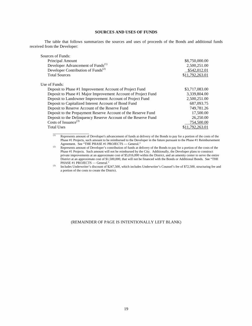
SOURCES AND USES OF FUNDS
The table that follows summarizes the sources and uses of proceeds of the Bonds and additional funds received from the Developer:
Sources of Funds: Principal Amount $8,750,000.00 Developer Advancement of Funds(1) 2,500,251.00 Developer Contribution of Funds(2) $542,012.01 Total Sources $11,792,263.01
Use of Funds:
Deposit to Phase #1 Improvement Account of Project Fund $3,717,083.00 Deposit to Phase #1 Major Improvement Account of Project Fund 3,339,804.00 Deposit to Landowner Improvement Account of Project Fund 2,500,251.00 Deposit to Capitalized Interest Account of Bond Fund 687,093.75 Deposit to Reserve Account of the Reserve Fund 749,781.26 Deposit to the Prepayment Reserve Account of the Reserve Fund 17,500.00 Deposit to the Delinquency Reserve Account of the Reserve Fund 26,250.00 Costs of Issuance(3) 754,500.00 Total Uses $11,792,263.01
(1) Represents amount of Developer's advancement of funds at delivery of the Bonds to pay for a portion of the costs of the
Phase #1 Projects, such amount to be reimbursed to the Developer in the future pursuant to the Phase #1 Reimbursement Agreement. See “THE PHASE #1 PROJECTS — General.”
(2) Represents amount of Developer’s contribution of funds at delivery of the Bonds to pay for a portion of the costs of the Phase #1 Projects. Such amount will not be reimbursed by the City. Additionally, the Developer plans to construct private improvements at an approximate cost of $5,016,000 within the District, and an amenity center to serve the entire District at an approximate cost of $1,500,000, that will not be financed with the Bonds or Additional Bonds. See “THE PHASE #1 PROJECTS — General.”
(3) Includes Underwriter’s discount of $247,500, which includes Underwriter’s Counsel’s fee of $72,500, structuring fee and a portion of the costs to create the District.
(REMAINDER OF PAGE IS INTENTIONALLY LEFT BLANK)
19
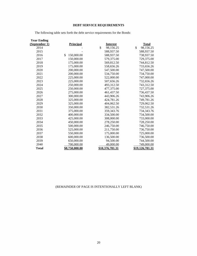
DEBT SERVICE REQUIREMENTS
The following table sets forth the debt service requirements for the Bonds:
Year Ending (September 1)
Principal
Interest
Total
2014 - $ 98,156.25 $ 98,156.25 2015 - 588,937.50 588,937.50 2016 $ 150,000.00 588,937.50 738,937.50 2017 150,000.00 579,375.00 729,375.00 2018 175,000.00 569,812.50 744,812.50 2019 175,000.00 558,656.26 733,656.26 2020 200,000.00 547,500.00 747,500.00 2021 200,000.00 534,750.00 734,750.00 2022 225,000.00 522,000.00 747,000.00 2023 225,000.00 507,656.26 732,656.26 2024 250,000.00 493,312.50 743,312.50 2025 250,000.00 477,375.00 727,375.00 2026 275,000.00 461,437.50 736,437.50 2027 300,000.00 443,906.26 743,906.26 2028 325,000.00 424,781.26 749,781.26 2029 325,000.00 404,062.50 729,062.50 2030 350,000.00 382,531.26 732,531.26 2031 375,000.00 359,343.76 734,343.76 2032 400,000.00 334,500.00 734,500.00 2033 425,000.00 308,000.00 733,000.00 2034 450,000.00 278,250.00 728,250.00 2035 500,000.00 246,750.00 746,750.00 2036 525,000.00 211,750.00 736,750.00 2037 550,000.00 175,000.00 725,000.00 2038 600,000.00 136,500.00 736,500.00 2039 650,000.00 94,500.00 744,500.00 2040 700,000.00 49,000.00 749,000.00 Total $8,750,000.00 $10,376,781.31 $19,126,781.31
(REMAINDER OF PAGE IS INTENTIONALLY LEFT BLANK)
20
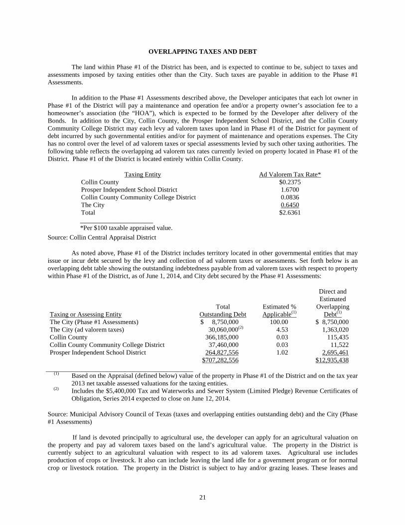
OVERLAPPING TAXES AND DEBT
The land within Phase #1 of the District has been, and is expected to continue to be, subject to taxes and assessments imposed by taxing entities other than the City. Such taxes are payable in addition to the Phase #1 Assessments.
In addition to the Phase #1 Assessments described above, the Developer anticipates that each lot owner in Phase #1 of the District will pay a maintenance and operation fee and/or a property owner’s association fee to a homeowner’s association (the “HOA”), which is expected to be formed by the Developer after delivery of the Bonds. In addition to the City, Collin County, the Prosper Independent School District, and the Collin County Community College District may each levy ad valorem taxes upon land in Phase #1 of the District for payment of debt incurred by such governmental entities and/or for payment of maintenance and operations expenses. The City has no control over the level of ad valorem taxes or special assessments levied by such other taxing authorities. The following table reflects the overlapping ad valorem tax rates currently levied on property located in Phase #1 of the District. Phase #1 of the District is located entirely within Collin County.
Taxing Entity Ad Valorem Tax Rate* Collin County $0.2375 Prosper Independent School District 1.6700 Collin County Community College District 0.0836 The City 0.6450 Total $2.6361 ______________________ *Per $100 taxable appraised value.
Source: Collin Central Appraisal District
As noted above, Phase #1 of the District includes territory located in other governmental entities that may issue or incur debt secured by the levy and collection of ad valorem taxes or assessments. Set forth below is an overlapping debt table showing the outstanding indebtedness payable from ad valorem taxes with respect to property within Phase #1 of the District, as of June 1, 2014, and City debt secured by the Phase #1 Assessments:
Taxing or Assessing Entity
Total Outstanding Debt
Estimated % Applicable(1)
Direct and Estimated
Overlapping Debt(1)
The City (Phase #1 Assessments) $ 8,750,000 100.00 $ 8,750,000 The City (ad valorem taxes) 30,060,000(2) 4.53 1,363,020 Collin County 366,185,000 0.03 115,435 Collin County Community College District 37,460,000 0.03 11,522 Prosper Independent School District 264,827,556 1.02 2,695,461 $707,282,556 $12,935,438
(1) Based on the Appraisal (defined below) value of the property in Phase #1 of the District and on the tax year 2013 net taxable assessed valuations for the taxing entities.
(2) Includes the $5,400,000 Tax and Waterworks and Sewer System (Limited Pledge) Revenue Certificates of Obligation, Series 2014 expected to close on June 12, 2014.
Source: Municipal Advisory Council of Texas (taxes and overlapping entities outstanding debt) and the City (Phase #1 Assessments)
If land is devoted principally to agricultural use, the developer can apply for an agricultural valuation on the property and pay ad valorem taxes based on the land’s agricultural value. The property in the District is currently subject to an agricultural valuation with respect to its ad valorem taxes. Agricultural use includes production of crops or livestock. It also can include leaving the land idle for a government program or for normal crop or livestock rotation. The property in the District is subject to hay and/or grazing leases. These leases and
21

lessees’ operations on the property allow the property to maintain its agricultural valuation. The Developer expects to terminate portions of these leases as construction of local improvements commences in each phase.
If land qualified for an agricultural valuation and the land use changes to a non-agricultural use, “rollback
taxes” are assessed for each of the previous 5 years in which the land received the lower agricultural valuation. The rollback tax is the difference between taxes paid on land’s agricultural value and the taxes that the land owner would have paid if the land had been taxed on a higher market value plus interest charged for each year from the date on which taxes would have been due.
If the land use changes to a non-agricultural use on only a portion of a larger tract, the land owner can
fence off the remaining land and maintain the agricultural valuation on the remaining land. In this scenario, the land owner would only be responsible for rollback taxes on that portion of the land where use changed and not the entire tract.
It is expected that rollback taxes will be paid by the Developer or purchasers from the Developer during development of Phase #1 of the District and prior to purchase of parcels or lots by homeowners.
ASSESSMENT PROCEDURES
General
As required by the PID Act, when the City determines to defray a portion of the costs of the Phase #1 Projects through Phase #1 Assessments, it must adopt a resolution generally describing the Phase #1 Projects and the land within Phase #1 of the District to be subject to Phase #1 Assessments to pay the cost therefor. The City has caused an assessment roll to be prepared (the “Assessment Roll”), which Assessment Roll will show the land within Phase #1 to be assessed, the amount of the benefit to and the Phase #1 Assessment against each lot or parcel of land and the number of Annual Installments in which the Phase #1 Assessment is divided. The Assessment Roll will be filed with the City Secretary and made available for public inspection. Statutory notice was given to the owners of the property to be assessed and a public hearing was conducted to hear testimony from affected property owners as to the propriety and advisability of undertaking the Phase #1 Projects and funding a portion of the same with Phase #1 Assessments. The City expects to proceed to levy the Phase #1 Assessments and adopt the Assessment Ordinance immediately prior to adopting the Bond Ordinance. After such adoption, the Phase #1 Assessments will become legal, valid and binding liens upon the property against which the Phase #1 Assessments are made.
Under the PID Act, the costs of Phase #1 Projects may be assessed by the City against the assessable property in Phase #1 of the District so long as the special benefit conferred upon the assessed property by the Phase #1 Projects equals or exceeds the Phase #1 Assessments. The costs of the Phase #1 Projects may be assessed using any methodology that results in the imposition of equal shares of cost on assessed property similarly benefited. The allocation of benefits and assessments to the benefitted land within Phase #1 of the District is presented in the Service and Assessment Plan, which should be read in its entirety. See “APPENDIX B — Form of Service and Assessment Plan.”
Assessment Methodology
The Service and Assessment Plan describes the special benefit to be received by each parcel of assessable property as a result of the Phase #1 Projects, provides the basis and justification for the determination that such special benefit exceeds the Phase #1 Assessments being levied, and establishes the methodology by which the City allocates the special benefit of the Phase #1 Projects to parcels in a manner that results in equal shares of costs being apportioned to parcels similarly benefited. As described in the Service and Assessment Plan, a portion of the costs of the Phase #1 Projects are being funded with proceeds of the Bonds, which are payable from and secured by Pledged Revenues, including the Phase #1 Assessment Revenues. As set forth in the Service and Assessment Plan, the benefits received by the Phase #1 Projects are currently spread among the existing parcels in Phase #1 of the District (the “Phase #1 Assessed Property”) based on the ratio (or Equivalent Unit Factor) of the Equivalent Units within Phase #1 of the District to the total Equivalent Units within the District. As the existing parcels are subsequently divided, the Phase #1 Assessments will be further apportioned pro rata based on the Equivalent Units of the newly
22
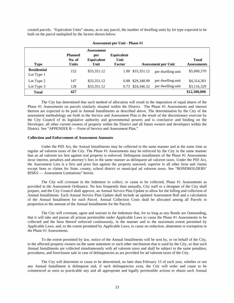
created parcels. “Equivalent Units” means, as to any parcel, the number of dwelling units by lot type expected to be built on the parcel multiplied by the factors shown below:
Assessment per Unit - Phase #1
Assessment Planned per Equivalent
No. of Equivalent Unit Total Type Units Unit Factor Assessment per Unit Assessments
Residential Lot Type 1
152
$33,351.12
1.00
$33,351.12
per dwelling unit
$5,069,370
Lot Type 2 147 $33,351.12 0.88 $29,348.99 per dwelling unit $4,314,301 Lot Type 3 128 $33,351.12 0.73 $24,346.32 per dwelling unit $3,116,329
Total 427 $12,500,000 The City has determined that such method of allocation will result in the imposition of equal shares of the
Phase #1 Assessments on parcels similarly situated within the District. The Phase #1 Assessments and interest thereon are expected to be paid in Annual Installments as described above. The determination by the City of the assessment methodology set forth in the Service and Assessment Plan is the result of the discretionary exercise by the City Council of its legislative authority and governmental powers and is conclusive and binding on the Developer, all other current owners of property within the District and all future owners and developers within the District. See “APPENDIX B — Form of Service and Assessment Plan.”
Collection and Enforcement of Assessment Amounts
Under the PID Act, the Annual Installments may be collected in the same manner and at the same time as regular ad valorem taxes of the City. The Phase #1 Assessments may be enforced by the City in the same manner that an ad valorem tax lien against real property is enforced. Delinquent installments of the Phase #1 Assessments incur interest, penalties and attorney’s fees in the same manner as delinquent ad valorem taxes. Under the PID Act, the Assessment Lien is a first and prior lien against the property assessed, superior to all other liens and claims except liens or claims for State, county, school district or municipal ad valorem taxes. See “BONDHOLDERS’ RISKS — Assessment Limitations” herein.
The City will covenant in the Indenture to collect, or cause to be collected, Phase #1 Assessments as provided in the Assessment Ordinance. No less frequently than annually, City staff or a designee of the City shall prepare, and the City Council shall approve, an Annual Service Plan Update to allow for the billing and collection of Annual Installments. Each Annual Service Plan Update shall include an updated Assessment Roll and a calculation of the Annual Installment for each Parcel. Annual Collection Costs shall be allocated among all Parcels in proportion to the amount of the Annual Installments for the Parcels.
The City will covenant, agree and warrant in the Indenture that, for so long as any Bonds are Outstanding, that it will take and pursue all actions permissible under Applicable Laws to cause the Phase #1 Assessments to be collected and the liens thereof enforced continuously, in the manner and to the maximum extent permitted by Applicable Laws, and, to the extent permitted by Applicable Laws, to cause no reduction, abatement or exemption in the Phase #1 Assessments.
To the extent permitted by law, notice of the Annual Installments will be sent by, or on behalf of the City, to the affected property owners on the same statement or such other mechanism that is used by the City, so that such Annual Installments are collected simultaneously with ad valorem taxes and shall be subject to the same penalties, procedures, and foreclosure sale in case of delinquencies as are provided for ad valorem taxes of the City.
The City will determine or cause to be determined, no later than February 15 of each year, whether or not any Annual Installment is delinquent and, if such delinquencies exist, the City will order and cause to be commenced as soon as practicable any and all appropriate and legally permissible actions to obtain such Annual
23

Installment, and any delinquent charges and interest thereon, including diligently prosecuting an action in district court to foreclose the currently delinquent Annual Installment. Notwithstanding the foregoing, the City shall not be required under any circumstances to purchase or make payment for the purchase of the delinquent Phase #1 Assessment or the corresponding Phase #1 Assessed Parcel.
The City will implement the basic timeline and procedures for Phase #1 Assessment collections and pursuit of delinquencies set forth in Exhibit C of the City’s Continuing Disclosure Agreement set forth in APPENDIX D and to comply therewith to the extent that the City reasonably determines that such compliance is the most appropriate timeline and procedures for enforcing the payment of delinquent Phase #1 Assessments.
A committee of not less than 25% of the Owners or Beneficial Owners may request a meeting with the City Manager of the City to discuss the City’s actions in pursuing the payment of any Phase #1 Assessment delinquencies in the event that (i) on or after March 1 in any year, based on Phase #1 Assessment revenues collected to such date and the available money on deposit in the various funds and accounts under the Indenture, money in the Reserve Account will be required to be used to pay all or a portion of the principal or interest payments to be made on the Bonds during such year, or (ii) in any year, the aggregate amount of delinquent payments of Phase #1 Assessments is more than five percent (5%) of aggregate amount of Phase #1 Assessments due in such year.
The City shall not be required under any circumstances to expend any funds for delinquent collection costs in connection with its covenants and agreements under the Indenture or otherwise other than funds on deposit in the Administrative Fund.
Annual Installments will be paid to the City or its agent. Annual Installments are due on October 1 of each year, and become delinquent on February 1 of the following year. In the event Phase #1 Assessments are not timely paid, there are penalties and interest as set forth below:
Date Payment Received
Cumulative Penalty
Cumulative Interest Total
February 6% 1% 7% March 7% 2% 9% April 8% 3% 11% May 9% 4% 13% June 10% 5% 15% July 12% 6% 18%
After July, the penalty remains at 12%, and interest increases at the rate of 1% each month. In addition, if
an account is delinquent in July, a 20% attorney’s collection fee may be added to the total penalty and interest charge. In general, property subject to lien may be sold, in whole or in parcels, pursuant to court order to collect the amounts due. An automatic stay by creditors or other entities, including governmental units, could prevent governmental units from foreclosing on property and prevents liens for post-petition taxes from attaching to property and obtaining secured creditor status unless, in either case, an order lifting the stay is obtained from the bankruptcy court. In most cases, post-petition Phase #1 Assessments are paid as an administrative expense of the estate in bankruptcy or by order of the bankruptcy court.
Assessment Amounts
Phase #1 Assessment Amounts. The maximum amounts of the Phase #1 Assessments have been established by the methodology described in the Service and Assessment Plan. The Phase #1 Assessments will be levied against the parcels comprising the Phase #1 Assessed Property as indicated on the Assessment Roll. See “APPENDIX B — Form of Service and Assessment Plan” and “APPENDIX F — Form of Construction, Funding, and Acquisition Agreement.”
Method of Apportionment of Phase #1 Assessments. For purposes of the Service and Assessment Plan, the City Council has determined that the Phase #1 Assessments shall be initially allocated to the Phase #1 Assessed Property based on the ratio (or Equivalent Unit Factor) of the Equivalent Units of each parcel to the total Equivalent Units within the District. As the existing parcels are subsequently divided, the Phase #1 Assessments will be further
24
apportioned pro rata based on the Equivalent Units of the newly created parcels. See “APPENDIX B — Form of Service and Assessment Plan.” See “ASSESSMENT PROCEDURES — Assessment Methodology.”
The total Phase #1 Assessments per Equivalent Unit with respect to the Bonds is $33,351.12. The Bonds are secured by a first lien on and pledge of Pledged Revenues, including the Phase #1 Assessments. See “SECURITY FOR THE BONDS” and “APPENDIX B — Form of Service and Assessment Plan.”
Prepayment of Assessments
Pursuant to the PID Act and the Indenture, the owner of any property assessed may voluntarily prepay (a “Prepayment”) all or part of any Phase #1 Assessment levied against any lot or parcel, together with accrued interest to the date of payment, at any time. Upon receipt of such Prepayment, such amounts will be applied towards the redemption or payment of the Bonds. Amounts received at the time of a Prepayment which represent a payment of principal, interest, or penalties on a delinquent installment of a Phase #1 Assessment are not to be considered a Prepayment, but rather are to be treated as payment of regularly scheduled Phase #1 Assessments.
Priority of Lien
The Phase #1 Assessments or any reassessment, the expense of collection, and reasonable attorney’s fees, if incurred, constitute a first and prior lien against the property assessed, superior to all other liens and claims except liens or claims for the State, county, school district or municipality ad valorem taxes, and are a personal liability of and charge against the owners of the property regardless of whether the owners are named. The lien is effective from the date of the Assessment Ordinance until the Phase #1 Assessment is paid, and may be enforced by the City in the same manner as an ad valorem tax levied against real property may be enforced by the City. The owner of any property assessed may pay the entire Phase #1 Assessment levied against any lot or parcel, together with accrued interest to the date of payment, at any time.
Foreclosure Proceedings
In the event of delinquency in the payment of any Annual Installment, , except for unpaid Assessments on homestead property (unless the lien associated with the assessment attached prior to the date the property became a homestead), the City is empowered to order institution of an action in state district court to foreclose the lien of such delinquent Annual Installment. In such action the real property subject to the delinquent Annual Installments may be sold at judicial foreclosure sale for the amount of such delinquent Annual Installments, plus penalties and interest.
Any sale of property for nonpayment of an installment or installments of a Phase #1 Assessment will be subject to the lien established for remaining unpaid installments of the Phase #1 Assessment against such property and such property may again be sold at a judicial foreclosure sale if the purchaser thereof fails to make timely payment of the non-delinquent installments of the Phase #1 Assessments against such property as they become due and payable. Judicial foreclosure proceedings are not mandatory. In the event a foreclosure is necessary, there could be a delay in payments to owners of the Bonds pending prosecution of the foreclosure proceedings and receipt by the City of the proceeds of the foreclosure sale. It is possible that no bid would be received at the foreclosure sale, and in such event there could be an additional delay in payment of the principal of and interest on Bonds or such payment may not be made in full. The City is not required under any circumstance to purchase or make payment for the purchase of the delinquent Phase #1 Assessment on the corresponding Phase #1 Assessed Property.
The City will covenant in the Indenture to take and pursue all actions permissible under Applicable Laws to cause the Phase #1 Assessments to be collected and the liens thereof enforced continuously, in the manner and to the maximum extent permitted by Applicable Laws, and to cause no reduction, abatement or exemption in the Phase #1 Assessments, provided that the City is not required to expend any funds for collection and enforcement of Phase #1 Assessments other than funds on deposit in the Administrative Fund. Pursuant to the Indenture, Foreclosure Proceeds (excluding Delinquent Collection Costs) constitute Pledged Revenues to be deposited into the Pledged Revenue Fund upon receipt by the City and distributed in accordance with the Indenture. See “APPENDIX A – Form of Indenture. ” See also “APPENDIX D – Form of Disclosure Agreements” for a description of the expected timing of certain events with respect to collection of the delinquent Phase #1 Assessments.
25
The City will create the Delinquency Reserve Account under the Indenture and will fund such account as provided in the Indenture. The City will not be obligated to fund foreclosure proceedings out of any funds other than in the Administrative Fund. If Pledged Revenues are insufficient to pay foreclosure costs, the owners of the Bonds may be required to pay amounts necessary to continue foreclosure proceedings. See “SECURITY FOR THE BONDS – Delinquency Reserve Account of the Reserve Fund,” “APPENDIX A – Form of Indenture” and “APPENDIX B – Form of Service and Assessment Plan.”
THE CITY
Background
The City is located in north central Collin and Denton Counties, 40 miles north of Dallas and 15 northwest of the City of McKinney. Access to the City is provided by State Highway 289 and Farm Road 455. The City covers approximately 1.7 square miles. The City’s location as part of the growing Dallas-Fort Worth Metroplex has resulted in rapid growth over the last several years. The City’s 2010 census population was 6,028. The City’s current population estimate is 8,600.
City Government
The City is a political subdivision and is a home rule municipality of the State of Texas, duly organized and existing under the laws of the State, including the City's Home Rule Charter. The City adopted a Home Rule Charter on May 12, 2007. The City operates under a Council/Manager form of government with a City Council comprised of the Mayor and six Council members who are elected for staggered three-year terms. The City Council formulates operating policy for the City while the City Manager is the chief administration officer.
The current members of the City Council and their respective expiration of terms of office are as follows:
Council Member Term Expires
(May) Sean Terry (Mayor) 2017 George Kendrick 2016 Wayne Nabors 2015 Vincent Ramos 2015 Carmen Roberts (Mayor Pro Tem) 2017 Lori Vaden 2017 Chad Anderson 2016
Mayor Terry is currently employed as an executive officer of an affiliate of the Developer. Mayor Terry has filed the requisite conflict waivers with the City. Mayor Terry has also abstained from all City Council deliberations and votes relating to the District and issuance of the Bonds.
The principal administrators of the City include the following:
Name Position Mike Foreman City Manager Vicki Faulkner City Secretary Jay Toutounchian Director of Finance
26
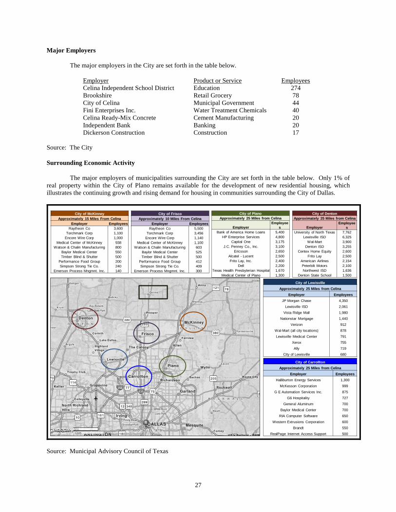
Major Employers
The major employers in the City are set forth in the table below.
Employer Product or Service Employees Celina Independent School District Education 274 Brookshire Retail Grocery 78 City of Celina Municipal Government 44 Fini Enterprises Inc. Water Treatment Chemicals 40 Celina Ready-Mix Concrete Cement Manufacturing 20 Independent Bank Banking 20 Dickerson Construction Construction 17
Source: The City
Surrounding Economic Activity
The major employers of municipalities surrounding the City are set forth in the table below. Only 1% of real property within the City of Plano remains available for the development of new residential housing, which illustrates the continuing growth and rising demand for housing in communities surrounding the City of Dallas.
City of McKinneyApproximately 15 Miles From Celina
Employer EmployeesRaytheon Co 3,600
Torchmark Corp 1,100Encore Wire Corp 1,000
Medical Center of McKinney 938Watson & Chalin Manufacturing 800
Baylor Medical Center 550Timber Blind & Shutter 500
Performance Food Group 200Simpson Strong Tie Co. 240
Emerson Process Mngmnt. Inc. 140
City of FriscoApproximately 10 Miles From Celina
Employer EmployeesRaytheon Co 5,500
Torchmark Corp 3,456Encore Wire Corp 1,140
Medical Center of McKinney 1,100Watson & Chalin Manufacturing 603
Baylor Medical Center 525Timber Blind & Shutter 500
Performance Food Group 412Simpson Strong Tie Co. 409
Emerson Process Mngmnt. Inc. 300
City of PlanoApproximately 25 Miles from Celina
EmployerEmployee
sBank of America Home Loans 5,400
HP Enterprise Services 4,800Capital One 3,175
J.C. Penney Co., Inc. 3,100Ericsson 2,650
Alcatel - Lucent 2,500Frito Lay, Inc. 2,400
Dell 2,200Texas Health Presbyterian Hospital 1,670
Medical Center of Plano 1,300
City of DentonApproximately 25 Miles from Celina
EmployerEmployee
sUniversity of North Texas 7,762
Lewisville ISD 6,325Wal-Mart 3,900
Denton ISD 3,255Centex Home Equity 2,600
Frito Lay 2,500American Airlines 2,154Peterbilt Motors 2,100Northwest ISD 1,636
Denton State School 1,500
City of LewisvilleApproximately 25 Miles from Celina
Employer EmployeesJP Morgan Chase 4,350
Lewisville ISD 2,061Vista Ridge Mall 1,980
Nationstar Mortgage 1,440Verizon 912
Wal-Mart (all city locations) 878Lewisville Medical Center 791
Xerox 755Ally 719
City of Lewisville 680
City of CarrolltonApproximately 25 Miles from Celina
Employer EmployeesHalliburton Energy Services 1,300
McKesson Corporation 999G E Automation Services Inc. 875
G6 Hospitality 727General Aluminum 700
Baylor Medical Center 700RIA Computer Software 650
Western Extrusions Corporation 600Brandt 550
RealPage Internet Access Support 500
Source: Municipal Advisory Council of Texas
27
THE DISTRICT
General
The PID Act authorizes municipalities, such as the City, to create public improvement districts within their boundaries or extraterritorial jurisdiction, and to impose assessments within the public improvement district to pay for certain improvements. The District was created by resolution of the City in accordance with the PID Act (the “Creation Resolution”) for the purpose of undertaking and financing, in phases, the cost of certain public improvements within the District, including the Phase #1 Projects, authorized by the PID Act and approved by the City Council that confer a special benefit on the portion of the District property being developed in a phase. The District is not a separate political subdivision of the State and is governed by the City Council. A map of the property within the District is included on page v hereof.
Powers and Authority
Pursuant to the PID Act, the City may establish and create the District and undertake, or reimburse a developer for the costs of, improvement projects that confer a special benefit on property located within the District, whether located within the City limits or the City’s extraterritorial jurisdiction. The PID Act provides that the City may levy and collect Assessments on property in the District, or portions thereof, payable in periodic installments based on the benefit conferred by an improvement project to pay all or part of its cost.
Pursuant to the PID Act and the Creation Resolution, the City has the power to undertake, or reimburse a developer for the costs of, the financing, acquisition, construction or improvement of the Phase #1 Projects. See “THE PHASE #1 PROJECTS.” Pursuant to the authority granted by the PID Act and the Creation Resolution, the City has determined to undertake the construction, acquisition or purchase of certain roadway, water, wastewater and drainage public improvements within Phase #1 of the District and outside of the District comprising the Phase #1 Projects and to finance a portion of the costs thereof through the issuance of the Bonds. The City has further determined to provide for the payment of debt service on the Bonds through Pledged Revenues. See “ASSESSMENT PROCEDURES” herein and “APPENDIX B — Form of Service and Assessment Plan.”
THE PHASE #1 PROJECTS
General
The Phase #1 Projects consist of (a) Phase #1’s proportionate share of the costs of the Major Improvements that will benefit the entire District and (b) the costs of the local infrastructure benefitting only Phase #1 of the District. See “THE DEVELOPMENT – Development Plan – Phase #1 Projects.” A portion of the costs of construction of the Phase #1 Projects will be funded with proceeds of the Bonds (such portion to consist of a portion of Phase #1’s proportionate share of the costs of the Major Improvements and a portion of the costs of the local infrastructure benefitting Phase #1 only). The balance of the costs of the Phase #1 Projects will be paid by the Developer under the terms of the Phase #1 Reimbursement Agreement between the Developer and the City pursuant to the PID Act and reimbursed with Phase #1 Assessment Revenues or the proceeds of Additional Bonds. See “SECURITY FOR THE BONDS – Additional Bonds.” The Phase #1 Projects will be dedicated to the City. The Developer is responsible for the completion of the construction, acquisition or purchase of the Phase #1 Projects, and the Developer or its designee will act as construction manager. The City will pay projects costs for the Phase #1 Projects from proceeds of the Bonds as follows: (a) the Developer will be reimbursed on a monthly basis for costs actually incurred in developing and constructing the Phase #1 Projects within the Phase #1 Remaining Development Area and (b) the Developer will be paid for costs actually incurred in developing and constructing the Phase #1 Projects within Pod 1 and Pod 2 of the District upon completion of such projects and dedication to, and acceptance by, the City of such projects. See “THE PHASE #1 PROJECTS – General” and “THE DEVELOPMENT – Development Plan”.
The Appraisal (as defined below) estimates that the value of the property within Phase #1 of the District after construction, acquisition or purchase of the Phase #1 Projects is $23,090,000. See “APPRAISAL OF PROPERTY WITHIN THE DISTRICT.” The cost of the Phase #1 Projects is expected to be approximately $14,265,000. A portion of such costs in the amount of $7,056,887 is expected to be paid with proceeds of the
28

Bonds. The balance of such costs is expected to be paid by (a) the City, according to the terms of the Phase #1 Reimbursement Agreement or the issuance of Additional Bonds and (b) the Developer, through a contribution of approximately $4,280,000 that will not be reimbursed by the City. At delivery of the Bonds, the Developer expects to advance funds in the approximate amount of $2,500,251 in order to pay for a portion of the costs of the Phase #1 Projects within the Phase #1 Remaining Development Area, and such amount shall be reimbursed to the Developer in the future pursuant to the Phase #1 Reimbursement Agreement. See “SOURCES AND USES OF FUNDS”.
The following table reflects the total expected costs of the Phase #1 Projects.
Type of Improvement Cost Road $2,665,000 Water 790,000 Sanitary Sewer 1,090,000 Storm Drainage 1,475,000 Soft Costs 2,508,639 Major Improvement Costs Allocated to Phase #1 5,736,361 Total Cost of Phase #1 Projects $14,265,000
Additionally, the Developer plans to construct certain private improvements at an approximate cost of $5,016,000 within the District (consisting of, among other improvements, street lights, electric and gas infrastructure, lot excavation, geotechnical engineering costs, retaining walls, screening walls, landscape, irrigation and entry features), and an amenity center to serve the entire District at an approximate cost of $1,500,000 (collectively, the “Private Improvements”), over the next two years (by the end of summer 2016). The costs of such Private Improvements is will be paid entirely by the Developer without reimbursement by the City.
The Development Agreement Development Agreement”) provides certain rules and regulations for design and construction of the Phase #1 Projects and the process for the development of all property within the District. As the District lies completely within the city limits of the City, the City’s zoning and subdivision regulations provide specific land use rules and regulations for the development of the property within the District. See “THE DEVELOPMENT – Zoning/Permitting”. The Development Agreement supplements those rules and regulations, provides the procedural process and timing for the establishment of the District, and outlines each party’s rights and obligations related to development of the property within the District.
Ownership and Maintenance of Improvements
The Phase #1 Projects will be dedicated to and accepted by the City and will constitute a portion of the City’s infrastructure improvements. The City will provide for the ongoing operation, maintenance and repair of the Phase #1 Projects constructed and conveyed, as outlined in the Service and Assessment Plan. The Private Improvements will be dedicated to and accepted by the HOA. The HOA will provide for the ongoing operation, maintenance and repair of the Private Improvements through the administration of a maintenance and operation fee and/or a property owner’s association fee to be paid by each lot owner within the District.
THE DEVELOPMENT
The following information has been provided by the Developer. Certain of the following information is beyond the direct knowledge of the City, the City’s Financial Advisor and the Underwriter, and none of the City, the City’s Financial Advisor or the Underwriter have any way of guaranteeing the accuracy of such information. The Developer has reviewed this Official Statement and warrants and represents that neither (i) the information under the caption “THE DEVELOPMENT” nor (ii) the information relating to the Developer’s plan for developing the land within the District (the “Development”) under the subcaption “BONDHOLDERS’ RISKS — Dependence on the Developer” contain any untrue statement of a material fact or omit to state any material fact necessary in order to make the statements made herein, in the light of the circumstances under which they are made, not misleading. At the time of delivery of the Bonds to the Underwriter, the Developer will deliver a certificate to this effect to the City and the Underwriter.
29
Overview
The Development is an approximately 322-acre master planned project located within the city limits of the City, on the corner of Legacy and Frontier Parkway. The Development is located approximately one mile east of the Dallas North Tollroad service extension. The City, located in the north-central region of the Dallas-Fort Worth-Arlington TX Metropolitan Statistical Area (the “DFW MSA”), is poised for significant growth as the overall DFW MSA continues its growth trajectory.
The Development is located in a fast growing development area situated directly between the City and the City of Prosper. Property within the District comprising the Development was acquired, or will be acquired, in a series of purchases between September 2013 and June 2014 by CADG Frontier 192, LLC, a Texas limited liability company and affiliate of the Developer (“Frontier 192”) as a long-term development to consist of residential land use. “THE DEVELOPER — History and Financing of the District” In addition, the Development will include a variety of parks, trails, amenity center and open space areas for its residents, and others, to enjoy. This combination will provide its residents a community environment in which to live. Furthermore, the Development is primarily located within the Prosper Independent School District.
The Developer develops infrastructure and community improvements (amenities, parks, trails, etc.) and sells residential lots to high-quality production homebuilders under lot takedown contracts. In addition, the Developer develops infrastructure needed to support various parcels of land within the District that can be sold to third party developers for commercial uses.
The Development is owned by the Developer and Frontier 192, and both the Developer and Frontier 192 are affiliates of Centurion American Custom Homes Inc. d/b/a Centurion American Development Group Inc. (“Centurion”), as described below in “THE DEVELOPER — Description of the Developer.” The Developer and the Development Consultants expect to complete the Development in several phases over a 7 year period, and the Developer’s current expectations regarding estimated home prices in Phase #1 of the District are as follows:
ESTIMATED HOME PRICES
Lot Size (Sq. Ft.) Quantity Base Lot Price Average Base Home Price 70 152 $80,500 $405,000 60 147 69,000 355,000 50 128 57,500 295,000
Total 427 The Developer’s current expectations regarding the build-out of the entire Development and sale of lots
therein are shown in the following tables. In addition to the Purchase and Sale Agreements with First Texas and Lennar, the Developer has previously entered into lot purchase agreements with certain homebuilders, Beazer Homes Texas, L.P. and RH of Texas Limited Partnership (an affiliate of Ryland Homes) for the purchase of 111 single-family lots and 110 single-family lots, respectively, within Phase #1 of the District. These purchase contracts for 221 lots, together with 91 lots within Phase #1 of the District purchased by First Texas and the 115 lots within Phase #1 of the District purchased by Lennar, provides that 427 out of the 427 total lots within Phase #1 of the District (or 100% of such lots) are under contract with homebuilders.
EXPECTED BUILD-OUT SCHEDULE
Phase Single-Family Lots Expected Infrastructure
Completion Date Expected Final
Sale Date 1 427 Q4 2015 Q2 2019 2 300 Q4 2018 Q1 2022 3 294 Q4 2021 Q1 2025
Total 1,021
30
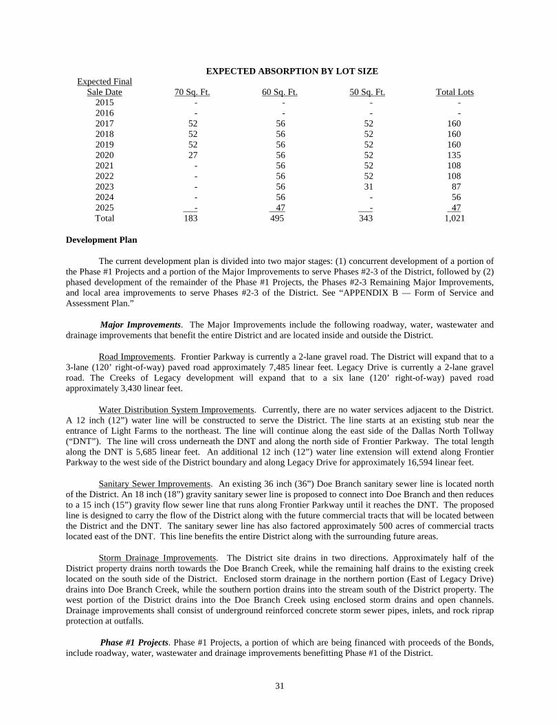
EXPECTED ABSORPTION BY LOT SIZE Expected Final
Sale Date 70 Sq. Ft. 60 Sq. Ft. 50 Sq. Ft. Total Lots 2015 - - - - 2016 - - - - 2017 52 56 52 160 2018 52 56 52 160 2019 52 56 52 160 2020 27 56 52 135 2021 - 56 52 108 2022 - 56 52 108 2023 - 56 31 87 2024 - 56 - 56 2025 - 47 - 47 Total 183 495 343 1,021
Development Plan
The current development plan is divided into two major stages: (1) concurrent development of a portion of the Phase #1 Projects and a portion of the Major Improvements to serve Phases #2-3 of the District, followed by (2) phased development of the remainder of the Phase #1 Projects, the Phases #2-3 Remaining Major Improvements, and local area improvements to serve Phases #2-3 of the District. See “APPENDIX B — Form of Service and Assessment Plan.”
Major Improvements. The Major Improvements include the following roadway, water, wastewater and drainage improvements that benefit the entire District and are located inside and outside the District.
Road Improvements. Frontier Parkway is currently a 2-lane gravel road. The District will expand that to a 3-lane (120’ right-of-way) paved road approximately 7,485 linear feet. Legacy Drive is currently a 2-lane gravel road. The Creeks of Legacy development will expand that to a six lane (120’ right-of-way) paved road approximately 3,430 linear feet.
Water Distribution System Improvements. Currently, there are no water services adjacent to the District. A 12 inch (12”) water line will be constructed to serve the District. The line starts at an existing stub near the entrance of Light Farms to the northeast. The line will continue along the east side of the Dallas North Tollway (“DNT”). The line will cross underneath the DNT and along the north side of Frontier Parkway. The total length along the DNT is 5,685 linear feet. An additional 12 inch (12”) water line extension will extend along Frontier Parkway to the west side of the District boundary and along Legacy Drive for approximately 16,594 linear feet.
Sanitary Sewer Improvements. An existing 36 inch (36”) Doe Branch sanitary sewer line is located north of the District. An 18 inch (18”) gravity sanitary sewer line is proposed to connect into Doe Branch and then reduces to a 15 inch (15”) gravity flow sewer line that runs along Frontier Parkway until it reaches the DNT. The proposed line is designed to carry the flow of the District along with the future commercial tracts that will be located between the District and the DNT. The sanitary sewer line has also factored approximately 500 acres of commercial tracts located east of the DNT. This line benefits the entire District along with the surrounding future areas.
Storm Drainage Improvements. The District site drains in two directions. Approximately half of the District property drains north towards the Doe Branch Creek, while the remaining half drains to the existing creek located on the south side of the District. Enclosed storm drainage in the northern portion (East of Legacy Drive) drains into Doe Branch Creek, while the southern portion drains into the stream south of the District property. The west portion of the District drains into the Doe Branch Creek using enclosed storm drains and open channels. Drainage improvements shall consist of underground reinforced concrete storm sewer pipes, inlets, and rock riprap protection at outfalls.
Phase #1 Projects. Phase #1 Projects, a portion of which are being financed with proceeds of the Bonds, include roadway, water, wastewater and drainage improvements benefitting Phase #1 of the District.
31
Road Improvements. All on-site areas will be served by 31-foot wide, concrete streets within 50’ right-of-ways. Onsite roads will include 4’ sidewalks within 9.5’ parkways.
Water Distribution System Improvements. A network of 8 inch (8”) water lines will be installed within the road right-of-way to serve Phase #1 of the District. The on-site water lines will be connected to water mains along Collector A and Collector B.
Sanitary Sewer Improvements. A network of 8 inch (8”) sanitary sewer line will be installed within the road right-of-way to serve Phase #1 of the District. The on-site sanitary lines will connect to sanitary sewer main lines along Collector A, Collector B, Frontier Parkway and Legacy Drive. The sanitary sewer main lines connect to an existing regional sewer line along Doe Branch located northwest of Phase #1 of the District.
Storm Drainage Improvements. The District site drains in two directions. Approximately half of the District property drains north towards the Doe Branch Creek, while the remaining half drains to the existing creek located on the south side of the District. Enclosed storm drainage in the northern portion (East of Legacy Drive) drains into Doe Branch Creek, while the southern portion drains into the stream south of the District property. The west portion of the District drains into the Doe Branch Creek using enclosed storm drains and open channels. Drainage improvements shall consist of underground reinforced concrete storm sewer pipes, inlets, and rock riprap protection at outfalls.
Proceeds of the Bonds will pay for a portion of the costs of the Phase #1 Projects. The City expects to issue Additional Bonds to finance the balance of the Phase #1 Projects not paid with proceeds of the Bonds. See “SECURITY FOR THE BONDS — Additional Bonds”.
Phased Bonds
The City expects to issue Phased Bonds to finance the cost of the Phases #2-3 Remaining Major Improvements and the cost of local improvements benefitting Phases #2-3 of the District. Such Phased Bonds will be secured by separate assessments levied pursuant to the PID Act on assessable property within Phases #2-3 of the District. The Developer anticipates that Phased Bonds will be issued over an 8 year period, as described in the Service and Assessment Plan.
The Bonds, any Additional Bonds issued by the City, the Phases #2-3 Major Improvement Bonds and any Phased Bonds issued by the City are separate and distinct issues of securities. The City reserves the right to issue Phased Bonds for any purpose permitted by the Act, including those described above.
Zoning/Permitting
The District is currently zoned under the City’s Planned Development District #46, enacted on February 11, 2014 by City Ordinance Number 2014-06 (“PD #46”). PD #46 allows certain commercial and residential uses and establishes guidelines pertaining to purpose, height, area, and setbacks for specific single-family residential lots. PD #46 also regulates design and development standards and specifications regarding neighborhood regulations and the HOA. Because the District lies within the city limits of the City, the City’s zoning and subdivision regulations control all aspects of development not specifically set forth in PD #46.
Environmental
A Phase One Environmental Site Assessment (a “Phase One ESA”) of approximately 170 acres of the District was completed on June 26, 2013. A second Phase One ESA of approximately 23 acres of the District was completed on August 26, 2013. A third Phase One ESA of approximately 105 acres of the District was completed on December 18, 2013. Based on the information presented in each of the Phase One ESAs, there was no evidence that the Development was under environmental regulatory review or enforcement action. The site reconnaissance, regulatory database review and historical source review revealed no evidence of recognized environmental conditions involving the site.
32
According to the website for the United States Fish and Wildlife Service, the Whooping Crane is an endangered species in Collin County and both the Whooping Crane and the Least Tern are endangered species in Denton County. The Developer is not aware of any endangered species located on District property.
Utilities
The City will provide both water and wastewater service to the District. The City purchases its water wholesale from the Upper Trinity Regional Water District, and the City maintains its own water distribution system and wastewater collection and treatment system. Both the City’s water distribution system and wastewater collection and treatment system currently have sufficient capacity to provide water and wastewater service to the District.
The Developer expects additional utilities to be provided by: (1) Phone/Data - AT&T; (2) Electric - CoServ Electric; (3) Cable - AT&T; and (4) Natural Gas - Atmos Energy.
THE DEVELOPER
The following information has been provided by the Developer. Certain of the following information is beyond the direct knowledge of the City, the City’s Financial Advisor and the Underwriter, and none of the City, the City’s Financial Advisor or the Underwriter have any way of guaranteeing the accuracy of such information. The Developer has reviewed this Official Statement and warrants and represents that neither (i) the information herein under the caption “THE DEVELOPER” nor (ii) the information relating to the Developer under the subcaption “BONDHOLDERS’ RISKS — Dependence on the Developer” contain any untrue statement of a material fact or omit to state any material fact necessary in order to make the statements made herein, in the light of the circumstances under which they are made, not misleading.
General
In general, the activities of a developer in a development such as the District include purchasing the land, designing the subdivision, including the utilities and streets to be installed and any community facilities to be built, defining a marketing program and building schedule, securing necessary governmental approvals and permits for development, arranging for the construction of roads and the installation of utilities (including, in some cases, water, sewer, and drainage facilities, as well as telephone and electric service) and selling improved lots and commercial reserves to builders, developers, or other third parties. The relative success or failure of a developer to perform such activities within a development may have a material effect on the security of the revenue bonds, such as the Bonds, issued by a public improvement district. A developer is generally under no obligation to a public improvement district, such as the District, to develop the property which it owns in a development. Furthermore, there is no restriction on the developer's right to sell any or all of the land which the developer owns within a development. In addition, a developer is ordinarily the major tax and assessment payer within a district during its development.
Description of the Developer
The Developer is an affiliate of Centurion and was created by Centurion for the purpose of managing and ultimately conveying property in the District to third parties, as described under the caption “THE DEVELOPMENT.” The Developer is a nominally capitalized limited partnership, the primary asset of which is unsold property within the District. The Developer will have no source of funds with which to pay Assessments or taxes levied by the City or any other taxing entity other than funds resulting from the sale of property within the District or funds advanced to the Developer by an affiliated party. The Developer’s ability to make full and timely payments of Assessments or taxes will directly affect the City’s ability to meet its obligation to make payments on the Bonds.
Since 1990, Centurion has developed over 10,000 single-family lots in dozens of communities surrounding North Texas. It has worked closely with investors, land-owners, financial institutions, and vendors to acquire over 15,000 acres of land inventory for a diverse mix of developments in size and scope. Centurion’s communities include amenities such as parks, golf courses, water parks themes, and hiking and biking trails. Over the past twenty
33
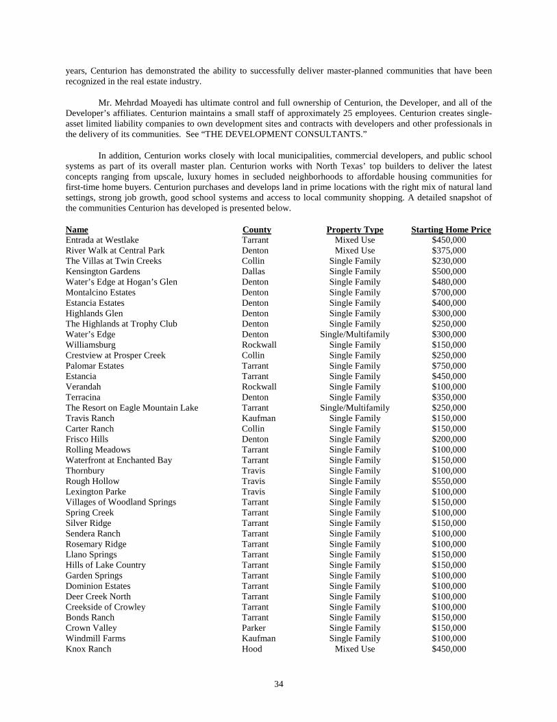
years, Centurion has demonstrated the ability to successfully deliver master-planned communities that have been recognized in the real estate industry.
Mr. Mehrdad Moayedi has ultimate control and full ownership of Centurion, the Developer, and all of the Developer’s affiliates. Centurion maintains a small staff of approximately 25 employees. Centurion creates single-asset limited liability companies to own development sites and contracts with developers and other professionals in the delivery of its communities. See “THE DEVELOPMENT CONSULTANTS.”
In addition, Centurion works closely with local municipalities, commercial developers, and public school systems as part of its overall master plan. Centurion works with North Texas’ top builders to deliver the latest concepts ranging from upscale, luxury homes in secluded neighborhoods to affordable housing communities for first-time home buyers. Centurion purchases and develops land in prime locations with the right mix of natural land settings, strong job growth, good school systems and access to local community shopping. A detailed snapshot of the communities Centurion has developed is presented below.
Name County Property Type Starting Home Price Entrada at Westlake Tarrant Mixed Use $450,000 River Walk at Central Park Denton Mixed Use $375,000 The Villas at Twin Creeks Collin Single Family $230,000 Kensington Gardens Dallas Single Family $500,000 Water’s Edge at Hogan’s Glen Denton Single Family $480,000 Montalcino Estates Denton Single Family $700,000 Estancia Estates Denton Single Family $400,000 Highlands Glen Denton Single Family $300,000 The Highlands at Trophy Club Denton Single Family $250,000 Water’s Edge Denton Single/Multifamily $300,000 Williamsburg Rockwall Single Family $150,000 Crestview at Prosper Creek Collin Single Family $250,000 Palomar Estates Tarrant Single Family $750,000 Estancia Tarrant Single Family $450,000 Verandah Rockwall Single Family $100,000 Terracina Denton Single Family $350,000 The Resort on Eagle Mountain Lake Tarrant Single/Multifamily $250,000 Travis Ranch Kaufman Single Family $150,000 Carter Ranch Collin Single Family $150,000 Frisco Hills Denton Single Family $200,000 Rolling Meadows Tarrant Single Family $100,000 Waterfront at Enchanted Bay Tarrant Single Family $150,000 Thornbury Travis Single Family $100,000 Rough Hollow Travis Single Family $550,000 Lexington Parke Travis Single Family $100,000 Villages of Woodland Springs Tarrant Single Family $150,000 Spring Creek Tarrant Single Family $100,000 Silver Ridge Tarrant Single Family $150,000 Sendera Ranch Tarrant Single Family $100,000 Rosemary Ridge Tarrant Single Family $100,000 Llano Springs Tarrant Single Family $150,000 Hills of Lake Country Tarrant Single Family $150,000 Garden Springs Tarrant Single Family $100,000 Dominion Estates Tarrant Single Family $100,000 Deer Creek North Tarrant Single Family $100,000 Creekside of Crowley Tarrant Single Family $100,000 Bonds Ranch Tarrant Single Family $150,000 Crown Valley Parker Single Family $150,000 Windmill Farms Kaufman Single Family $100,000 Knox Ranch Hood Mixed Use $450,000
34
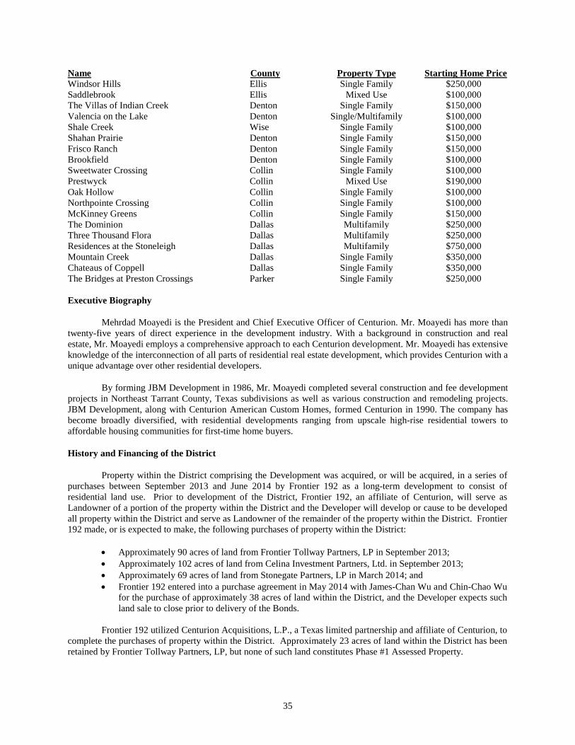
Name County Property Type Starting Home Price Windsor Hills Ellis Single Family $250,000 Saddlebrook Ellis Mixed Use $100,000 The Villas of Indian Creek Denton Single Family $150,000 Valencia on the Lake Denton Single/Multifamily $100,000 Shale Creek Wise Single Family $100,000 Shahan Prairie Denton Single Family $150,000 Frisco Ranch Denton Single Family $150,000 Brookfield Denton Single Family $100,000 Sweetwater Crossing Collin Single Family $100,000 Prestwyck Collin Mixed Use $190,000 Oak Hollow Collin Single Family $100,000 Northpointe Crossing Collin Single Family $100,000 McKinney Greens Collin Single Family $150,000 The Dominion Dallas Multifamily $250,000 Three Thousand Flora Dallas Multifamily $250,000 Residences at the Stoneleigh Dallas Multifamily $750,000 Mountain Creek Dallas Single Family $350,000 Chateaus of Coppell Dallas Single Family $350,000 The Bridges at Preston Crossings Parker Single Family $250,000
Executive Biography
Mehrdad Moayedi is the President and Chief Executive Officer of Centurion. Mr. Moayedi has more than twenty-five years of direct experience in the development industry. With a background in construction and real estate, Mr. Moayedi employs a comprehensive approach to each Centurion development. Mr. Moayedi has extensive knowledge of the interconnection of all parts of residential real estate development, which provides Centurion with a unique advantage over other residential developers.
By forming JBM Development in 1986, Mr. Moayedi completed several construction and fee development projects in Northeast Tarrant County, Texas subdivisions as well as various construction and remodeling projects. JBM Development, along with Centurion American Custom Homes, formed Centurion in 1990. The company has become broadly diversified, with residential developments ranging from upscale high-rise residential towers to affordable housing communities for first-time home buyers.
History and Financing of the District
Property within the District comprising the Development was acquired, or will be acquired, in a series of purchases between September 2013 and June 2014 by Frontier 192 as a long-term development to consist of residential land use. Prior to development of the District, Frontier 192, an affiliate of Centurion, will serve as Landowner of a portion of the property within the District and the Developer will develop or cause to be developed all property within the District and serve as Landowner of the remainder of the property within the District. Frontier 192 made, or is expected to make, the following purchases of property within the District:
• Approximately 90 acres of land from Frontier Tollway Partners, LP in September 2013; • Approximately 102 acres of land from Celina Investment Partners, Ltd. in September 2013; • Approximately 69 acres of land from Stonegate Partners, LP in March 2014; and • Frontier 192 entered into a purchase agreement in May 2014 with James-Chan Wu and Chin-Chao Wu
for the purchase of approximately 38 acres of land within the District, and the Developer expects such land sale to close prior to delivery of the Bonds.
Frontier 192 utilized Centurion Acquisitions, L.P., a Texas limited partnership and affiliate of Centurion, to
complete the purchases of property within the District. Approximately 23 acres of land within the District has been retained by Frontier Tollway Partners, LP, but none of such land constitutes Phase #1 Assessed Property.
35
In order to finance its development activities within the District, the Developer and its affiliates have entered into the following loans with certain lenders (each a “Development Lender”), each of which is secured by a lien on a portion of the real property within the District and improvements thereon owned by the Developer or its affiliates (each a “Development Loan”):
• $9,242,000 loan in September 2013 from United Development Funding IV, a Maryland real estate investment trust, currently outstanding in the amount of $8,277.190.58 and maturing on September 6, 2014;
• $3,000,000 loan in September 2013 from Chambers Bank, currently outstanding in the amount of 3,000,000 and maturing on March 6, 2015; and
• $2,290,000 loan in March 2014 from Chambers Bank, currently outstanding in the amount of 2,290,000 and maturing on September 5, 2015.
The PID Act provides that the Assessment Lien is a first and prior lien against the assessed property within Phase #1 and is superior to all other liens and claims except liens or claims for state, county, school district, or municipality ad valorem taxes. Additionally, at or prior to delivery of the Bonds, each Development Lender shall consent to and acknowledge the creation of the District, the levy of the Phase #1 Assessments and the subordination of the lien securing its respective Development Loan to the assessment liens on property within the District securing payment of the Phase #1 Assessments. As a result, the lien on the property within the District securing the Phase #1 Assessments will have priority over the liens on the property within the District securing the Development Loans.
THE DEVELOPMENT CONSULTANTS
Lenart Development Company, LLC
Lenart Development Company, L.L.C. (“Lenart”) is a real estate development and consulting firm focused primarily on single family and light commercial development. The firm provides fee development services for projects across the Dallas-Fort Worth Metroplex along with consulting services regarding entitlement, financing, special districts, construction, and due diligence.
Lenart was formed in November of 2006. Mr. Steve Lenart, the founder and manager of the company, has over twenty-one years of experience in the real estate development industry. Mr. Lenart’s experience encompasses all aspects of the business, including both homebuilding and development. He spent fourteen years with a “Big Three” public builder, where he held the executive positions of Director of Construction and then Land Division President. In his six years as Division President he managed all aspects of land and lot acquisition and development in the DFW area.
Lenart currently manages the development of over thirty residential developments in the Dallas-Fort Worth area. The projects vary from simple municipal jurisdictions to public improvement districts. The firm’s responsibilities include managing all of the day-to-day operations of the development. This includes site evaluation, plan review and management, contracting, and payment of contracts. The firm’s team of experienced project managers oversees the project subcontractors on a daily basis to effectively and efficiently deliver completed infrastructure and finished lots per approved plans. The firm also performs feasibility studies for projects along with entitlement, zoning, platting, and financial analysis.
Peloton Land Solutions, LLP
Peloton Land Solutions, LLP (“Peloton”) is a North Texas‐based consulting engineering firm with more than 75 professional engineers, planners, surveyors, environmental scientists, and support personnel. Peloton provides comprehensive services to municipal and private clients including: civil engineering, planning, surveying, landscape architecture, geographical information systems (GIS), and environmental science. Peloton’s engineering team includes over 20 Texas‐registered Professional Engineers (P.E.) who perform a full array of services, including roadway and utility design, drainage and storm water management, erosion control, storm water pollution control, and construction administration.
36
Mr. Shea Kirkman serves as a Principal for Peloton in the Dallas-Fort Worth area and is currently the office manager in the Frisco, Texas office. He oversees large scale land development and drilling programs across the United States for developers, homebuilders and energy companies. Mr. Kirkman’s responsibilities vary among projects and company initiatives, but include regional planning, mentoring fellow engineers, recruiting, plan review, value engineering, cost estimating, contract review and preparation, bidding and construction management. Mr. Kirkman has worked with various development companies most recently including Centurion, LGI Homes, Hanover, Newland, Gehan, Lennar, Hillwood, DR Horton, QuikTrip, EnerVest, Legend Natural Gas, Range Resources, Carrizo Oil & Gas, Exxon/XTO, Vantage Energy, Newark Energy, Beacon E&P, and Edge Resources.
THE SPECIAL ASSESSMENT CONSULTANT
Prior to delivery of the Bonds, the City will enter into an Agreement for administration of the District (the “MuniCap Agreement") with MuniCap, Inc. (“MuniCap”) to provide specialized services related to the administration of the District needed to support the issuance of the Bonds. The MuniCap Agreement will include seven general types of services provided by MuniCap: (i) administrative support services related to the Assessments, (ii) delinquency management, (iii) prepayment of Assessments, (iv) arbitrage rebate services, (v) continuing disclosure services, (vi) accounting and audit coordination, and (vii) IRS compliance monitoring.
MuniCap is a public finance consulting firm with a specialized consulting practice providing services related to the formation and administration of special tax and special assessment districts. MuniCap currently acts as the administrator for 136 special assessment and taxing districts in 17 states, including 14 public improvement districts in Texas (including the District).
APPRAISAL OF PROPERTY WITHIN THE DISTRICT
The Appraisal
General. Jackson Claborn, Inc. (the “Appraiser”), prepared an appraisal report for the City dated May 19, 2014, based upon a physical inspection of the District conducted on April 1, 2014 (the “Appraisal”). The Appraisal was prepared at the request of the City. The description herein of the Appraisal is intended to be a brief summary only of the Appraisal as it relates to Phase #1 of the District. The Appraisal is attached hereto as APPENDIX E and should be read in its entirety. The conclusions reached in the Appraisal are subject to certain assumptions, hypothetical conditions and qualifications, which are set forth therein. See “APPENDIX E — Appraisal of the District.”
Value Estimates. The Appraiser estimated the aggregate retail value of the fee simple interest in various tracts of land comprising Phase #1 of the District under the hypothetical condition that the Phase #1 Projects had been completed. See “THE PHASE #1 PROJECTS.” The Appraisal does not reflect the as-is condition of Phase #1 of the District as the Phase #1 Projects have not yet been constructed. Moreover, the Appraisal does not reflect the value of Phase #1 of the District as if sold to a single purchaser in a single transaction. See “APPENDIX E — Appraisal of the District.” References in the Appraisal, including those references below under “Extraordinary Assumptions and Hypothetical Conditions”, to lots within “Pod 1”, “Pod 2” and “Pod 3” of “Phase 1” are together equivalent to Phase #1 of the District, and references in the Appraisal to “Excess Land” within “Pod 1” through “Pod 6” are together equivalent to Phases #2-3 of the District.
The value estimate for the assessable property within Phase #1 of the District using the methodologies described in the Appraisal and subject to the limiting conditions and assumptions set forth in the Appraisal, as of May 19, 2014, is $23,090,000. However, since the Appraisal was performed, the number of single-family residential lots within Phase #1 of the District has increased from 416 lots to 427 lots. The Developer expects that this increase in the number of lots will result in an approximate 2.64% increase in the estimated aggregate retail value of the taxable property in Phase #1 of the District.
Extraordinary Assumptions and Hypothetical Conditions. The Appraisal is based upon a number of hypothetical conditions (factors that are known to be false but are presumed to be true for purposes of the appraisal), extraordinary assumptions (defined as assumptions, directly related to a specific assignment, which, if found to be
37

false, could alter the appraiser’s opinions or conclusions), ordinary assumptions, and certain limiting conditions. The hypothetical conditions and extraordinary assumptions which may affect the estimates as to value include, among others, the following:
• All information relative to the remaining developed and undeveloped property located within the District, including land areas, lot amounts, lot sizes, and other pertinent data that was provided by Pelotan Land Solutions (surveyors/engineers), the Developer, the City, and the Collin and Denton Central Appraisal Districts, is assumed to be correct. If it is found that this data is substantially different, the value found in the Appraisal could be affected.
• The valuations found in the Appraisal are subject to the City approving and authorizing the creation of the District to finance the costs of certain public improvements for the benefit of property in the district. Thus, as the District is developed with housing, the corresponding tax base increases to a level which allows bonds to be sold. Proceeds from the bond sales are then used to reimburse the developers for certain development expenses. The property in the District is proposed to be developed in approximately six phases (Pod 1 through Pod 6). Proceeds from the bond sales will finance improvements that benefit all of the property in the District and improvements that benefit each phase of the District as each phase is developed. Assessments will be imposed on all property in the District for the improvements that benefit the entire District and on the property in each phase for the public improvements to be provided for that phase. This has been assumed in the Appraiser’s valuation. If it is found that this data is substantially different, the value found in the Appraisal could be affected.
• The District is to be developed in multiple phases and will eventually contain a total of approximately 1,032 residential lots on a total of 321.48 gross acres within a master-planned residential development known as Creeks of Legacy. As proposed, the District will contain three typical lot sizes; 537 lots with 50’ frontages (50’ x 115’/130’ or 5,750 – 6,500 SF); 370 lots with 60’ frontages (60’ x 120’/130’ or 7,200 – 7,800 SF); and 156 lots with 70’ frontages (70’ x 120’/130’ or 8,400 - 9,100 SF). Phase 1 is planned on approximately 118 acres with a total of 416 single-family lots on portions of Pods 1, 2, and 3. Phase 1 is planned with 125 lots (30%) with 50’ frontages, 153 lots (37%) with 60’ frontages, and 138 lots (33%) with 70’ frontages. A brief summary of Phase 1, as proposed, is shown in the following table. It is assumed this information is correct. If it is found that the information supplied to the Appraiser is significantly different than the Appraiser’s assumptions, the Appraiser’s assignment results might be affected.
• The subject of the Appraisal also represents the excess land remaining within Pods 1, 2, and 3
after completion of Phase 1 development, as well as future phases of land within Pods 4, 5, and 6. The Appraiser’s “Prospective” opinions of value will be based upon the following acreage sizes and on the assumption that Phase #1 of the District is complete by April 1, 2015. Phase #1 development includes the interior streets and utilities for 416 single family lots on 118 acres within Pods 1, 2, and 3, as well as the completion of water, sewer, and storm drainage to the border of Pods 4, 5, and 6. Following is a summary of land sizes for the excess land within the six pods and planned as future phases:
38
o Pod 1 17.000 gross acres o Pod 2 19.000 gross acres o Pod 3 17.000 gross acres o Pod 4 35.000 gross acres o Pod 5 35.000 gross acres o Pod 6 35.000 gross acres
It is assumed this information is correct. If it is found that the information supplied to the Appraiser is significantly different than the Appraiser’s assumptions, the Appraiser’s assignment results might be affected.
• As the District represents a proposed construction project, the Appraisal contains prospective opinions of value. As such, the Appraiser assumed that the market conditions as discussed and considered within the Appraisal will be similar on the prospective valuation date. Further, the Appraiser cannot be held responsible for unforeseeable events that alter market conditions prior to this prospective effective date. The prospective market value date is approximately 12 months from the effective date of the Appraisal, due to the Development taking approximately 12 months to complete.
• Local and regional lending institutions appear to remain active within the District’s market for specific projects. Therefore, the Appraiser specifically assumes that the financial markets will continue to function in a competitive, efficient fashion. However, the Appraiser cannot be held responsible for unforeseeable events that alter market conditions.
Value to Assessment Burden Ratio
The primary security for the Bonds will consist of Pledged Revenues (which, in turn, primarily consist of the Annual Installments of the Phase #1 Assessments). Subject to the extraordinary assumptions and hypothetical conditions stated therein, the Appraisal sets forth the estimated aggregate retail value of the property subject to assessment within Phase #1 of the District to be $23,090,000. As noted above, the estimated aggregate retail value of the property within Phase #1 of the District assumes (among other matters) completion of the Phase #1 Projects, a portion of which will be financed with the proceeds of the Bonds. See “THE DEVELOPMENT.”
Set forth below for the purpose of illustration is the ratio derived from a comparison of the estimated value of property within Phase 1A of the District and the principal amount of the Bonds.
When compared to the estimated aggregate retail value of the taxable property in Phase #1 of the District ($23,090,000), the principal amount of the Bonds has an estimated value to assessment burden ratio of 2.64 to 1. However, the Developer expects that the increase in the number of lots within Phase #1 of the District subsequent to the Appraisal will result in an approximate 2.64% increase in the estimated aggregate retail value of the taxable property in Phase #1 of the District, which would result in an increase in the estimated value to assessment burden ratio.
In comparing the appraised value of the real property within Phase #1 of the District and the aggregate principal amount of the Bonds, it should be noted that only the real property upon which there is a delinquent Phase #1 Assessment can be foreclosed upon, and the real property within Phase #1 of the District cannot be foreclosed upon as a whole to pay delinquent Phase #1 Assessments of the owners of such parcels within the District unless all of the property is subject to a delinquent Phase #1 Assessment. In any event, individual parcels may be foreclosed upon separately to pay delinquent Phase #1 Assessments levied against such parcels.
Other public entities whose boundaries overlap those of the District currently impose ad valorem taxes on the property within the District and will likely do so in the future. Such entities could also impose assessment liens on the property within the District. Liens created on the property within the District through the levy of ad valorem taxes as well as liens created through the levy of the Phase #1 Assessments are a first and prior lien superior to all others. For example, construction loans may be obtained by the Developer or home loans may be obtained by ultimate homeowners. The deeds of trust securing such debt on property within the District, however, will be in a
39
junior position to ad valorem tax and assessment liens. See “OVERLAPPING TAXES AND DEBT” and “ASSESSMENT PROCEDURES.”
BONDHOLDERS’ RISKS
Before purchasing any of the Bonds, prospective investors and their professional advisors should carefully consider all of the risk factors described below which may create possibilities wherein interest may not be paid when due or that the Bonds may not be paid at maturity or otherwise as scheduled, or, if paid, without premium, if applicable. The following risk factors (which are not intended to be an exhaustive listing of all possible risks associated with an investment in the Bonds) should be carefully considered prior to purchasing any of the Bonds. Moreover, the order of presentation of the risks summarized below does not necessarily reflect the significance of such investment risks.
THE BONDS ARE SPECIAL OBLIGATIONS OF THE CITY PAYABLE SOLELY FROM THE PLEDGED REVENUES AND OTHER FUNDS COMPRISING THE TRUST ESTATE, AS AND TO THE EXTENT PROVIDED IN THE INDENTURE. THE BONDS DO NOT GIVE RISE TO A CHARGE AGAINST THE GENERAL CREDIT OR TAXING POWER OF THE CITY AND ARE PAYABLE SOLELY FROM THE SOURCES IDENTIFIED IN THE INDENTURE. THE OWNERS OF THE BONDS SHALL NEVER HAVE THE RIGHT TO DEMAND PAYMENT THEREOF OUT OF MONEY RAISED OR TO BE RAISED BY TAXATION, OR OUT OF ANY FUNDS OF THE CITY OTHER THAN THE PLEDGED REVENUES, AS AND TO THE EXTENT PROVIDED IN THE INDENTURE. NO OWNER OF THE BONDS SHALL HAVE THE RIGHT TO DEMAND ANY EXERCISE OF THE CITY’S TAXING POWER TO PAY THE PRINCIPAL OF THE BONDS OR THE INTEREST OR REDEMPTION PREMIUM, IF ANY, THEREON. THE CITY SHALL HAVE NO LEGAL OR MORAL OBLIGATION TO PAY THE BONDS OUT OF ANY FUNDS OF THE CITY OTHER THAN THE PLEDGED REVENUES.
The ability of the City to pay debt service on the Bonds as due is subject to various factors that are beyond the City’s control. These factors include, among others, (a) the ability or willingness of property owners within the District to pay Phase #1 Assessments levied by the City, (b) cash flow delays associated with the institution of foreclosure and enforcement proceedings against property within Phase #1 of the District, (c) general and local economic conditions which may impact real property values, the ability to liquidate real property holdings and the overall value of real property development projects, and (d) general economic conditions which may impact the general ability to market and sell the lots within the District, it being understood that poor economic conditions within the City, State and region may slow the assumed pace of sales of such lots.
The rate of development of the property in the District is directly related to the vitality of the residential housing industry. In the event that the sale of the lands within the District should proceed more slowly than expected and the Developer is unable to pay the Phase #1 Assessments, only the value of the lands, with improvements, will be available for payment of the debt service on the Bonds, and such value can only be realized through the foreclosure or expeditious liquidation of the lands within Phase #1 of the District. There is no assurance that the value of such lands will be sufficient for that purpose and the expeditious liquidation of real property through foreclosure or similar means is generally considered to yield sales proceeds in a lesser sum than might otherwise be received through the orderly marketing of such real property.
The Underwriter is not obligated to make a market in or repurchase any of the Bonds, and no representation is made by the Underwriter, the City or the City’s Financial Advisor that a market for the Bonds will develop and be maintained in the future. If a market does develop, no assurance can be given regarding future price maintenance of the Bonds.
The City has not applied for or received a rating on the Bonds. The absence of a rating could affect the future marketability of the Bonds. There is no assurance that a secondary market for the Bonds will develop or that holders who desire to sell their Bonds prior to the stated maturity will be able to do so.
40
Assessment Limitations
Annual Installments of Phase #1 Assessments are billed to property owners in Phase #1 in the District. Annual Installments are due and payable, and bear the same penalties and interest for non-payment, as for ad valorem taxes as set forth under “ASSESSMENT PROCEDURES” herein. Additionally, Annual Installments established by the Service and Assessment Plan correspond in number and proportionate amount to the number of installments and principal amounts of Bonds maturing in each year and the annual collection costs for such year. See “ASSESSMENT PROCEDURES” herein. The unwillingness or inability of a property owner to pay regular property tax bills as evidenced by property tax delinquencies may also indicate an unwillingness or inability to make regular property tax payments and Annual Installments of Phase #1 Assessment payments in the future.
In order to pay debt service on the Bonds, it is necessary that Annual Installments are paid in a timely manner. Due to the lack of predictability in the collection of Annual Installments in the District, the City has established a Reserve Account in the Reserve Fund, to be funded from the proceeds of the Bonds, to cover delinquencies. The Annual Installments are secured by the Assessment Lien. However, there can be no assurance that foreclosure proceedings will occur in a timely manner so as to avoid depletion of the Reserve Account and delay in payments of debt service on the Bonds. See “BONDHOLDERS’ RISKS — Remedies and Bankruptcy” herein.
Upon an ad valorem tax lien foreclosure event of a property within Phase #1, any Phase #1 Assessment that is also delinquent will be foreclosed upon in the same manner as the ad valorem tax lien (assuming all necessary conditions and procedures for foreclosure are duly satisfied). To the extent that a foreclosure sale results in insufficient funds to pay in full both the delinquent ad valorem taxes and the delinquent Phase #1 Assessments, the liens securing such delinquent ad valorem taxes and delinquent Phase #1 Assessments would likely be extinguished. Any remaining unpaid balance of the delinquent Phase #1 Assessments would then be an unsecured personal liability of the original property owner.
Based upon the language of Texas Local Government Code, § 372.017(b), case law relating to other types of assessment liens and opinions of the Texas Attorney General, the Assessment Lien as it relates to installment payments that are not yet due should remain in effect following an ad valorem tax lien foreclosure, with future installment payments not being accelerated. Texas Local Government Code § 372.018(d) supports this position, stating that an Assessment Lien runs with the land and the portion of an assessment payment that has not yet come due is not eliminated by foreclosure of an ad valorem tax lien.
The Assessment Lien is superior to any homestead rights of a property owner that were properly claimed after the adoption of the Assessment Ordinance. However, an Assessment Lien may not be foreclosed upon if any homestead rights of a property owner were properly claimed prior to the adoption of the Assessment Ordinance (“Pre-existing Homestead Rights”) for as long as such rights are maintained on the property. It is unclear under Texas law whether or not Pre-existing Homestead Rights would prevent the Assessment Lien from attaching to such homestead property or instead cause the Assessment Lien to attach, but remain subject to, the Pre-existing Homestead Rights.
Under Texas law, in order to establish homestead rights, the claimant must show a combination of both overt acts of homestead usage and intention on the part of the owner to claim the land as a homestead. Mere ownership of the property alone is insufficient and the intent to use the property as a homestead must be a present one, not an intention to make the property a homestead at some indefinite time in the future. As of the date of adoption of the Assessment Ordinance, no such homestead rights had been claimed. Furthermore, the Developer is not eligible to claim homestead rights and the Developer has represented that it owns all property within the District as of the date of the Assessment Ordinance. Consequently, there are and can be no homestead rights on the Assessed Parcels superior to the Assessment Lien and, therefore, the Assessment Liens may be foreclosed upon by the City.
Failure by owners of the parcels to pay Annual Installments when due, depletion of the Reserve Fund, delay in foreclosure proceedings, or the inability of the City to sell parcels which have been subject to foreclosure proceedings for amounts sufficient to cover the delinquent installments of Phase #1 Assessments levied against such parcels may result in the inability of the City to make full or punctual payments of debt service on the Bonds.
41
THE PHASE #1 ASSESSMENTS CONSTITUTE A FIRST AND PRIOR LIEN AGAINST THE PROPERTY ASSESSED, SUPERIOR TO ALL OTHER LIENS AND CLAIMS EXCEPT LIENS AND CLAIMS FOR STATE, COUNTY OR SCHOOL DISTRICT OR MUNICIPAL AD VALOREM TAXES AND IS A PERSONAL OBLIGATION OF AND CHARGE AGAINST THE OWNERS OF PROPERTY LOCATED WITHIN PHASE #1 OF THE DISTRICT.
Risks Related to the Current Real Estate Market
During recent years, the real estate market has experienced significant slowing of new home sales and new home closings due in part to the subprime mortgage crisis involving adjustable rate mortgages and other creative mortgage financing tools that allowed persons with higher credit risk to buy homes. The economic crisis that resulted from higher interest rates, at a time when many subprime mortgages were due to reset their interest rates, has served to reduce the availability of mortgages to many potential home buyers, making entry into the real estate market difficult. These downturns in the real estate market and other factors beyond the control of the Developer, including general economic conditions, may impact the timing of lot and home sales within the District. There have been reports of various public-private efforts to relieve the subprime mortgage crisis but as of yet no one can predict with certainty when the real estate market will rebound.
Competition
The housing industry in the Dallas-Fort Worth area is very competitive, and none of the Developer, the City, the City’s Financial Advisor or the Underwriter can give any assurance that the building programs which are planned will ever commence. The competitive position of the Developer in the sale of developed lots or of any other homebuilder in the construction and sale of single-family residential units is affected by most of the factors discussed in this section, and such competitive position is directly related to maintenance of market values in the District.
Loss of Tax Exemption
The Indenture contains covenants by the City intended to preserve the exclusion from gross income of interest on the Bonds for federal income tax purposes. As discussed under the caption “TAX MATTERS” herein, interest on the Bonds could become includable in gross income for purposes of federal income taxation, retroactive to the date the Bonds were issued, as a result of future acts or omissions of the City in violation of its covenants in the Indenture.
Tax legislation, administrative actions taken by tax authorities, or court decisions, whether at the Federal or state level, may adversely affect the tax-exempt status of interest on the Bonds under Federal or state law and could affect the market price or marketability of the Bonds. Any such proposal could limit the value of certain deductions and exclusions, including the exclusion for tax-exempt interest. The likelihood of any such proposal being enacted cannot be predicted. Prospective purchasers of the Bonds should consult their own tax advisors regarding the foregoing matters.
Bankruptcy
The payment of Phase #1 Assessments and the ability of the City to foreclose on the lien of a delinquent unpaid Phase #1 Assessment may be limited by bankruptcy, insolvency or other laws generally affecting creditors’ rights or by the laws of the State relating to judicial foreclosure. Although bankruptcy proceedings would not cause the Phase #1 Assessments to become extinguished, bankruptcy of a property owner in all likelihood would result in a delay in prosecuting foreclosure proceedings. Such a delay would increase the likelihood of a delay or default in payment of the principal of and interest on the Bonds, and the possibility that delinquent Phase #1 Assessments might not be paid in full.
42
Direct and Overlapping Indebtedness, Assessments and Taxes
The ability of an owner of property within the District to pay the Phase #1 Assessments could be affected by the existence of other taxes and assessments imposed upon the property. Public entities whose boundaries overlap those of the District currently impose ad valorem taxes on the property within the District and will likely do so in the future. Such entities could also impose assessment liens on the property within the District. The imposition of additional liens, or for private financing, may reduce the ability or willingness of the landowners to pay the Phase #1 Assessments.
Depletion of Reserve Fund
Failure of the owners of property within the District to pay the Phase #1 Assessments when due could result in the rapid, total depletion of the Reserve Fund prior to replenishment from the resale of property upon a foreclosure or otherwise or delinquency redemptions after a foreclosure sale, if any. There could be a default in payments of the principal of and interest on the Bonds if sufficient amounts are not available in the Reserve Fund. The Indenture provides that if, after a withdrawal from the Reserve Fund, the amount in the Reserve Fund is less than the Reserve Fund Requirement, the Trustee shall transfer an amount from the Pledged Revenue Fund to the Reserve Fund sufficient to cure such deficiency, as described under “SECURITY FOR THE BONDS — Reserve Fund” herein.
Hazardous Substance
While governmental taxes, assessments and charges are a common claim against the value of a parcel, other less common claims may be relevant. One of the most serious in terms of the potential reduction in the value that may be realized to the assessment is a claim with regard to a hazardous substance. In general, the owners and operators of a parcel may be required by law to remedy conditions relating to releases or threatened releases of hazardous substances. The federal Comprehensive Environmental Response, Compensation and Liability Act of 1980, sometimes referred to as “CERCLA” or “Superfund Act,” is the most well-known and widely applicable of these laws. It is likely that, should any of the parcels of land located in the District be affected by a hazardous substance, the marketability and value of parcels would be reduced by the costs of remedying the condition, because the purchaser, upon becoming owner, will become obligated to remedy the condition just as is the seller.
The value of the land within the District does not take into account the possible liability of the owner (or operator) for the remedy of a hazardous substance condition of the parcel. The City has not independently verified, and is not aware, that the owner (or operator) of any of the parcels within the District has such a current liability with respect to such parcel; however, it is possible that such liabilities do currently exist and that the City is not aware of them.
Further, it is possible that liabilities may arise in the future with respect to any of the land within the District resulting from the existence, currently, of a substance presently classified as hazardous but which has not been released or the release of which is not presently threatened, or may arise in the future resulting from the existence, currently, on the parcel of a substance not presently classified as hazardous but which may in the future be so classified. Further, such liabilities may arise not simply from the existence of a hazardous substance but from the method of handling it. All of these possibilities could significantly affect the value of a parcel that is realizable upon a delinquency.
See “THE DEVELOPMENT – Environmental” for discussion of previous Phase I ESAs performed on property within the District.
Regulation
Development within the District may be subject to future federal, state and local regulations. Approval may be required from various agencies from time to time in connection with the layout and design of development in the District, the nature and extent of public improvements, land use, zoning and other matters. Failure to meet any such
43
regulations or obtain any such approvals in a timely manner could delay or adversely affect development in the District and property values.
100-Year Flood Plain
Approximately 33.7 acres in the southern portion of the District are located within an official FEMA 100 year flood plain as shown on the current Federal Emergency Management Agency’s Flood Insurance Rate Map No. 48085C0115J, Collin County, Texas, effective June 2, 2009, Panel 115 of 600 (the “Flood Plain”). Portions of the Flood Plain will be reclaimed for the construction of roadways, utility infrastructure and residential lots. Once completed, no residential lots will be within the Flood Plain.
Bondholders’ Remedies and Bankruptcy
In the event of default in the payment of principal of or interest on the Bonds or the occurrence of any other Event of Default under the Indenture, and upon the written request of the owners of the Bonds of not less than a majority in principal amount of the Outstanding Bonds, the Trustee shall proceed to protect and enforce its rights and the rights of the owners of the Bonds under the Indenture by such suits, actions or special proceedings in equity or at law, or by proceedings in the office of any board or officer having jurisdiction, either for mandamus or the specific performance of any covenant or agreement contained therein or in aid or execution of any power granted or for the enforcement of any proper legal or equitable remedy, as the Trustee shall deem most effectual to protect and enforce such rights. The issuance of a writ of mandamus may be sought if there is no other available remedy at law to compel performance of the Bonds or the Indenture and the City’s obligations are not uncertain or disputed. The remedy of mandamus is controlled by equitable principles, so rests with the discretion of the court, but may not be arbitrarily refused. There is no acceleration of maturity of the Bonds in the event of default and, consequently, the remedy of mandamus may have to be relied upon from year to year. The owners of the Bonds cannot themselves foreclose on property within the District or sell property within the District in order to pay the principal of and interest on the Bonds. The enforceability of the rights and remedies of the owners of the Bonds further may be limited by laws relating to bankruptcy, reorganization or other similar laws of general application affecting the rights of creditors of political subdivisions such as the City. In this regard, should the City file a petition for protection from creditors under federal bankruptcy laws, the remedy of mandamus or the right of the City to seek judicial foreclosure of its Assessment Lien would be automatically stayed and could not be pursued unless authorized by a federal bankruptcy judge. See “BONDHOLDERS’ RISKS — Bankruptcy Limitation to Bondholders’ Rights” herein.
Any bankruptcy court with jurisdiction over bankruptcy proceedings initiated by or against a property owner within the District pursuant to the Federal Bankruptcy Code could, subject to its discretion, delay or limit any attempt by the City to collect delinquent Assessments, or delinquent ad valorem taxes, against such property owner.
In addition, in 2006, the Texas Supreme Court ruled in Tooke v. City of Mexia, 197 S.W.3d 325 (Tex. 2006) (“Tooke”) that a waiver of sovereign immunity must be provided for by statute in “clear and unambiguous” language. In so ruling, the Court declared that statutory language such as “sue and be sued”, in and of itself, did not constitute a clear and unambiguous waiver of sovereign immunity. In Tooke, the Court noted the enactment in 2005 of sections 271.151-.160, Texas Local Government Code (the “Local Government Immunity Waiver Act”), which, according to the Court, waives “immunity from suit for contract claims against most local governmental entities in certain circumstances.” The Local Government Immunity Waiver Act covers cities and relates to contracts entered into by cities for providing goods or services to cities. The City is not aware of any Texas court construing the Local Government Immunity Waiver Act in the context of whether contractual undertakings of local governments that relate to their borrowing powers are contracts covered by the Act. Because it is unclear whether the Texas legislature has effectively waived the City’s sovereign immunity from a suit for money damages in the absence of City action, the Trustee or the owners of the Bonds may not be able to bring such a suit against the City for breach of the Bonds or the Indenture covenants. As noted above, the Indenture provides that owners of the Bonds may exercise the remedy of mandamus to enforce the obligations of the City under the Indenture. Neither the remedy of mandamus nor any other type of injunctive relief was at issue in Tooke, and it is unclear whether Tooke will be construed to have any effect with respect to the exercise of mandamus, as such remedy has been interpreted by Texas courts. In general, Texas courts have held that a writ of mandamus may be issued to require public officials to perform ministerial acts that clearly pertain to their duties. Texas courts have held that a ministerial act is defined as a legal
44
duty that is prescribed and defined with a precision and certainty that leaves nothing to the exercise of discretion or judgment, though mandamus is not available to enforce purely contractual duties. However, mandamus may be used to require a public officer to perform legally-imposed ministerial duties necessary for the performance of a valid contract to which the State or a political subdivision of the State is a party (including the payment of monies due under a contract).
No Acceleration
The Indenture does not contain a provision allowing for the acceleration of the Bonds in the event of a payment default or other default under the terms of the Bonds or the Indenture.
Bankruptcy Limitation to Bondholders’ Rights
The enforceability of the rights and remedies of the owners of the Bonds may be limited by laws relating to bankruptcy, reorganization or other similar laws of general application affecting the rights of creditors of political subdivisions such as the City. The City is authorized under Texas law to voluntarily proceed under Chapter 9 of the Federal Bankruptcy Code, 11 U.S.C. 901-946. The City may proceed under Chapter 9 if it (1) is generally not paying its debts, or unable to meet its debts, as they become due, (2) desires to effect a plan to adjust such debts, and (3) has either obtained the agreement of or negotiated in good faith with its creditors, is unable to negotiate with its creditors because negotiation is impracticable, or reasonably believes that a creditor may attempt to obtain a preferential transfer.
If the City decides in the future to proceed voluntarily under the Federal Bankruptcy Code, the City would develop and file a plan for the adjustment of its debts, and the Bankruptcy Court would confirm the plan if (1) the plan complies with the applicable provisions of the Federal Bankruptcy Code, (2) all payments to be made in connection with the plan are fully disclosed and reasonable, (3) the City is not prohibited by law from taking any action necessary to carry out the plan, (4) administrative expenses are paid in full, (5) all regulatory or electoral approvals required under Texas law are obtained and (6) the plan is in the best interests of creditors and is feasible. The rights and remedies of the owners of the Bonds would be adjusted in accordance with the confirmed plan of adjustment of the City’s debt.
Management and Ownership
The management and ownership of the Developer and related property owners could change in the future. Purchasers of the Bonds should not rely on the management experience of such entities. There are no assurances that such entities will not sell the subject property or that officers will not resign or be replaced. In such circumstances, a new developer or new officers in management positions may not have comparable experience in projects comparable to the Development.
General Risks of Real Estate Investment and Development
Investments in undeveloped or developing real estate are generally considered to be speculative in nature and to involve a high degree of risk. The Development will be subject to the risks generally incident to real estate investments and development. Many factors that may affect the Development, as well as the operating revenues of the Developer, including those derived from the Development, are not within the control of the Developer. Such factors include changes in national, regional and local economic conditions; changes in long and short term interest rates; changes in the climate for real estate purchases; changes in demand for or supply of competing properties; changes in local, regional and national market and economic conditions; unanticipated development costs, market preferences and architectural trends; unforeseen environmental risks and controls; the adverse use of adjacent and neighboring real estate; changes in interest rates and the availability of mortgage funds to buyers of the homes to be built in the Development, which may render the sale of such homes difficult or unattractive; acts of war, terrorism or other political instability; delays or inability to obtain governmental approvals; changes in laws; moratorium; acts of God (which may result in uninsured losses); strikes; labor shortages; energy shortages; material shortages; inflation; adverse weather conditions; contractor or subcontractor defaults; and other unknown contingencies and factors beyond the control of the Developer. Furthermore, the operating revenues of the Developer may be materially
45
adversely affected if specific conditions in the lot purchase contracts are not met. Failure to meet the lot purchase contract’s conditions allows the applicable lot purchaser to terminate its obligation to purchase lots from the Developer and obtain its earnest money deposit back. See “THE DEVELOPMENT – Expected Build-Out Schedule” herein.
The Development cannot be initiated or completed without the Developer obtaining a variety of governmental approvals and permits, some of which have already been obtained. Certain permits are necessary to initiate construction of each phase of the Development and to allow the occupancy of residences and to satisfy conditions included in the approvals and permits. There can be no assurance that all of these permits and approvals can be obtained or that the conditions to the approvals and permits can be fulfilled. The failure to obtain any of the required approvals or fulfill any one of the conditions could cause materially adverse financial results for the Developer.
Dependence Upon Developer
The Developer and Frontier 192, as the owners of the majority of the parcels in the District, currently have the majority of the obligation for payment of the Phase #1 Assessments. The ability of the Developer to make full and timely payment of the Phase #1 Assessments will directly affect the ability of the City to meet its debt service obligations with respect to the Bonds. The sole assets of the Developer and Frontier 192 are land within the District, related permits and development rights and minor operating accounts. The source of funding for future land development activities and infrastructure construction to develop the remaining lots proposed for the District also consists of proceeds from Additional Bonds or Phased Bonds and proceeds of lot sales, as well as possible bank financing and equity contributions by the Developer. There can be no assurances given as to the financial ability of the Developer to advance any funds to the City to supplement revenues from the Phase #1 Assessments if necessary, or as to whether the Developer will advance such funds.
Moreover, the City will pay projects costs for the Phase #1 Projects from proceeds of the Bonds as follows: (a) the Developer will be reimbursed on a monthly basis for costs actually incurred in developing and constructing the Phase #1 Projects within the Phase #1 Remaining Development Area and (b) the Developer will be paid for costs actually incurred in developing and constructing the Phase #1 Projects within Pod 1 and Pod 2 of the District upon completion of such projects and dedication to, and acceptance by, the City of such projects. See “THE PHASE #1 PROJECTS – General” and “THE DEVELOPMENT – Development Plan”. There can be no assurances given as to the financial ability of the Developer to complete such improvements.
Agricultural Use Valuation and Redemption Rights
All of the acreage in the District is currently entitled to valuation for ad valorem tax purposes based upon its agricultural use. Under Texas law, an owner of land that is entitled to an agricultural valuation has the right to redeem such property after a tax sale for a period of two years after the tax sale by paying to the tax sale purchaser a 25% premium, if redeemed during the first year, or a 50% premium, if redeemed during the second year, over the purchase price paid at the tax sale and certain qualifying costs incurred by the purchaser. Although Phase #1 Assessments are not considered a tax under Texas law, the PID Act provides that the lien for Phase #1 Assessments may be enforced in the same manner as a lien for ad valorem taxes. This shared enforcement mechanism raises a possibility that the right to redeem agricultural valuation property may be available following a foreclosure of a lien for Phase #1 Assessments, though there is no indication in Texas law that such redemption rights would be available in such a case.
The Developer expects that the agricultural use valuations within Phase #1 of the District will be terminated in 2014, affecting tax rolls beginning in 2014.
At closing of the Bonds, the Developer and Frontier 192 will each execute an Agreement Regarding Conveyance of Right of Redemption and Waiver of Agricultural Valuation (a “Phase #1 Redemption Waiver Agreement”) with the City pursuant to which each of the Developer and Frontier 192 will convey to the Trustee for the benefit of the owners of the Bonds its right to redeem any agricultural valuation property and require any subsequent purchaser from the Developer or Frontier 192 to execute a similar conveyance. In addition, each of the Developer and Frontier 192 will deliver, and require any subsequent purchaser to deliver, into escrow with the
46
Trustee a waiver of agricultural valuation, which the Trustee will be authorized to release and file with the Collin County Tax Assessor/Collector in the event that the subsequent owner has not paid ad valorem taxes or the special assessments due in respect of agricultural valuation property within 60 days of their due date. Each Phase #1 Redemption Waiver Agreement will be enforceable by the Trustee on behalf of the owners of the Bonds. Although each Phase #1 Redemption Waiver Agreement is intended to protect the City and the bondholders against potential redemption rights of the Developer or Frontier 192 in the context of a foreclosure proceeding, because there is currently no case law with respect to waiver of redemption rights or an agricultural valuation, it is unclear whether the Phase #1 Redemption Waiver Agreement is enforceable under Texas law.
Because the enforceability of a Phase #1 Redemption Waiver Agreement is not certain, as additional protection against the occurrence of a tax sale for non-payment of ad valorem taxes and the associated risk of redemption rights arising, the Developer and Frontier 192 will each pay to the Trustee prior to delivery of the Bonds, and maintain at all times while there exists property in Phase #1 of the District that is entitled to valuation based on its agricultural use, an amount equal to the estimated ad valorem taxes assessed against agricultural valuation property to become due in the next two years. Such funds will be held by the Trustee and used to pay delinquent ad valorem taxes on agricultural valuation property and thereby potentially avoid the possibility of a sale for non-payment of ad valorem taxes and the associated risk of redemption rights arising. In the event such funds are used to pay delinquent ad valorem taxes, the Developer or Frontier 192 will be required to replenish such funds previously held by the Trustee. A proportionate amount of such deposit will be returned to the Developer or Frontier 192 upon termination of agricultural valuation.
TAX MATTERS
Tax Exemption
The delivery of the Bonds is subject to the opinion of Bond Counsel to the effect that interest on the Bonds for federal income tax purposes (1) will be excludable from gross income, as defined in section 61 of the Internal Revenue Code of 1986, as amended to the date of such opinion (the “Code”), pursuant to section 103 of the Code and existing regulations, published rulings, and court decisions, and (2) will not be included in computing the alternative minimum taxable income of the owners thereof who are individuals or, except as hereinafter described, corporations. Bond Counsel’s opinion is reproduced as APPENDIX C. The statutes, regulations, rulings, and court decisions on which such opinion is based are subject to change.
Interest on the Bonds owned by a corporation will be included in such corporation’s adjusted current earnings for purposes of calculating the alternative minimum taxable income of such corporation, other than an S corporation, a qualified mutual fund, a real estate investment trust, a real estate mortgage investment conduit, or a financial asset securitization investment trust (“FASIT”). A corporation’s alternative minimum taxable income is the basis on which the alternative minimum tax imposed by Section 55 of the Code will be computed.
In rendering the foregoing opinions, Bond Counsel will rely upon representations and certifications of the City made in a certificate dated the date of delivery of the Bonds pertaining to the use, expenditure, and investment of the proceeds of the Bonds and will assume continuing compliance by the City with the provisions of the Indenture subsequent to the issuance of the Bonds. The Indenture contains covenants by the City with respect to, among other matters, the use of the proceeds of the Bonds and the facilities financed therewith by persons other than state or local governmental units, the manner in which the proceeds of the Bonds are to be invested, the periodic calculation and payment to the United States Treasury of arbitrage “profits” from the investment of proceeds, and the reporting of certain information to the United States Treasury. Failure to comply with any of these covenants may cause interest on the Bonds to be includable in the gross income of the owners thereof from the date of the issuance of the Bonds.
Bond Counsel’s opinion is not a guarantee of a result, but represents its legal judgment based upon its review of existing statutes, regulations, published rulings and court decisions and the representations and covenants of the City described above. No ruling has been sought from the Internal Revenue Service (the “IRS”) with respect to the matters addressed in the opinion of Bond Counsel, and Bond Counsel’s opinion is not binding on the IRS. The IRS has an ongoing program of auditing the tax-exempt status of the interest on tax-exempt obligations. If an audit of the Bonds is commenced, under current procedures the IRS is likely to treat the City as the “taxpayer,” and the owners of the Bonds would have no right to participate in the audit process. In responding to or defending an audit
47
of the tax-exempt status of the interest on the Bonds, the City may have different or conflicting interests from the owners of the Bonds. Public awareness of any future audit of the Bonds could adversely affect the value and liquidity of the Bonds during the pendency of the audit, regardless of its ultimate outcome.
Except as described above, Bond Counsel expresses no other opinion with respect to any other federal, state or local tax consequences under present law, or proposed legislation, resulting from the receipt or accrual of interest on, or the acquisition or disposition of, the Bonds. Prospective purchasers of the Bonds should be aware that the ownership of tax-exempt obligations such as the Bonds may result in collateral federal tax consequences to, among others, financial institutions, life insurance companies, property and casualty insurance companies, certain foreign corporations doing business in the United States, S corporations with subchapter C earnings and profits, individual recipients of Social Security or Railroad Retirement benefits, individuals otherwise qualifying for the earned income tax credit, owners of an interest in a FASIT, and taxpayers who may be deemed to have incurred or continued indebtedness to purchase or carry, or who have paid or incurred certain expenses allocable to, tax-exempt obligations. Prospective purchasers should consult their own tax advisors as to the applicability of these consequences to their particular circumstances.
Existing law may change to reduce or eliminate the benefit to bondholders of the exclusion of interest on the Bonds from gross income for federal income tax purposes. Any proposed legislation or administrative action, whether or not taken, could also affect the value and marketability of the Bonds. Prospective purchasers of the Bonds should consult with their own tax advisors with respect to any proposed or future changes in tax law.
Tax Accounting Treatment of Discount and Premium on Certain Bonds
The initial public offering price of certain Bonds (the "Discount Bonds") may be less than the amount payable on such Bonds at maturity. An amount equal to the difference between the initial public offering price of a Discount Bond (assuming that a substantial amount of the Discount Bonds of that maturity are sold to the public at such price) and the amount payable at maturity constitutes original issue discount to the initial purchaser of such Discount Bond. A portion of such original issue discount allocable to the holding period of such Discount Bond by the initial purchaser will, upon the disposition of such Discount Bond (including by reason of its payment at maturity), be treated as interest excludable from gross income, rather than as taxable gain, for federal income tax purposes, on the same terms and conditions as those for other interest on the Bonds described above under "Tax Exemption." Such interest is considered to be accrued actuarially in accordance with the constant interest method over the life of a Discount Bond, taking into account the semiannual compounding of accrued interest, at the yield to maturity on such Discount Bond and generally will be allocated to an initial purchaser in a different amount from the amount of the payment denominated as interest actually received by the initial purchaser during the tax year.
However, such interest may be required to be taken into account in determining the alternative minimum taxable income of a corporation, for purposes of calculating a corporation's alternative minimum tax imposed by Section 55 of the Code, and the amount of the branch profits tax applicable to certain foreign corporations doing business in the United States, even though there will not be a corresponding cash payment. In addition, the accrual of such interest may result in certain other collateral federal income tax consequences to, among others, financial institutions, life insurance companies, property and casualty insurance companies, S corporations with subchapter C earnings and profits, individual recipients of Social Security or Railroad Retirement benefits, individuals otherwise qualifying for the earned income tax credit, owners of an interest in a FASIT, and taxpayers who may be deemed to have incurred or continued indebtedness to purchase or carry, or who have paid or incurred certain expenses allocable to, tax-exempt obligations. Moreover, in the event of the redemption, sale or other taxable disposition of a Discount Bond by the initial owner prior to maturity, the amount realized by such owner in excess of the basis of such Discount Bond in the hands of such owner (adjusted upward by the portion of the original issue discount allocable to the period for which such Discount Bond was held) is includable in gross income.
Owners of Discount Bonds should consult with their own tax advisors with respect to the determination of accrued original issue discount on Discount Bonds for federal income tax purposes and with respect to the state and local tax consequences of owning and disposing of Discount Bonds. It is possible that, under applicable provisions governing determination of state and local income taxes, accrued interest on Discount Bonds may be deemed to be received in the year of accrual even though there will not be a corresponding cash payment.
48
The initial public offering price of certain Bonds (the "Premium Bonds") may be greater than the amount payable on such Bonds at maturity. An amount equal to the difference between the initial public offering price of a Premium Bond (assuming that a substantial amount of the Premium Bonds of that maturity are sold to the public at such price) and the amount payable at maturity constitutes premium to the initial purchaser of such Premium Bonds. The basis for federal income tax purposes of a Premium Bond in the hands of such initial purchaser must be reduced each year by the amortizable bond premium, although no federal income tax deduction is allowed as a result of such reduction in basis for amortizable bond premium. Such reduction in basis will increase the amount of any gain (or decrease the amount of any loss) to be recognized for federal income tax purposes upon a sale or other taxable disposition of a Premium Bond. The amount of premium which is amortizable each year by an initial purchaser is determined by using such purchaser's yield to maturity.
Purchasers of the Premium Bonds should consult with their own tax advisors with respect to the determination of amortizable bond premium on Premium Bonds for federal income tax purposes and with respect to the state and local tax consequences of owning and disposing of Premium Bonds.
LEGAL MATTERS
Legal Proceedings
Delivery of the Bonds will be accompanied by the unqualified approving legal opinion of the Attorney General to the effect that the Bonds are valid and legally binding obligations of the City under the Constitution and laws of the State, payable from the proceeds of the Pledged Revenues and, based upon their examination of a transcript of certified proceedings relating to the issuance and sale of the Bonds, the legal opinion of Bond Counsel, to a like effect.
Fulbright & Jaworski LLP, a member of Norton Rose Fulbright, serves as Bond Counsel to the City. Andrews Kurth LLP serves as Underwriter’s Counsel. The legal fees paid to Bond Counsel and Underwriter’s Counsel are contingent upon the sale and delivery of the Bonds.
Legal Opinions
The City will furnish the Underwriter a transcript of certain certified proceedings incident to the authorization and issuance of the Bonds. Such transcript will include a certified copy of the approving opinion of the Attorney General of Texas, as recorded in the Bond Register of the Comptroller of Public Accounts of the State, to the effect that the Bonds are valid and binding special obligations of the City. The City will also furnish the legal opinion of Bond Counsel, to the effect that, based upon an examination of such transcript, the Bonds are valid and binding special obligations of the City under the Constitution and laws of the State. The legal opinion of Bond Counsel will further state that the Bonds, including principal of and interest thereon, are payable from and secured by a pledge of and lien on the Pledged Revenues. Bond Counsel will also provide a legal opinion to the effect that interest on the Bonds will be excludable from gross income for federal income tax purposes under Section 103(a) of the Code, subject to the matters described above under the caption “TAX MATTERS,” including the alternative minimum tax consequences for corporations. A copy of the opinion of Bond Counsel is attached hereto as “APPENDIX C — Form of Opinion of Bond Counsel.”
Except as noted below, Bond Counsel did not take part in the preparation of the Official Statement, and such firm has not assumed any responsibility with respect thereto or undertaken independently to verify any of the information contained therein, except that, in its capacity as Bond Counsel, such firm has reviewed the information describing the Bonds in the Official Statement under the captions or subcaptions “PLAN OF FINANCE — The Bonds” (except for the last paragraph thereof), “DESCRIPTION OF THE BONDS,” “SECURITY FOR THE BONDS,” “ASSESSMENT PROCEDURES” (except for the subcaptions “Assessment Methodology” and “Assessment Amounts”), “THE DISTRICT,” “TAX MATTERS,” “LEGAL MATTERS — Legal Proceedings,” “LEGAL MATTERS — Legal Opinions,” “SUITABILITY FOR INVESTMENT,” “CONTINUING DISCLOSURE OF INFORMATION” (except for the subcaption “Compliance with Prior Undertakings”), “REGISTRATION AND QUALIFICATION OF BONDS FOR SALE,” “LEGAL INVESTMENTS AND ELIGIBILITY TO SECURE PUBLIC FUNDS IN TEXAS” and APPENDIX A and such firm is of the opinion that the information relating to the Bonds, the Bond Ordinance, the Assessment Ordinance and the Indenture contained
49
therein fairly and accurately describes the laws and legal issues addressed therein and, with respect to the Bonds, such information conforms to the Bond Ordinance, the Assessment Ordinance and the Indenture.
The various legal opinions to be delivered concurrently with the delivery of the Bonds express the professional judgment of the attorneys rendering the opinions as to the legal issues explicitly addressed therein. In rendering a legal opinion, the attorney does not become an insurer or guarantor of that expression of professional judgment, of the transaction opined upon, or of the future performance of the parties to the transaction. Nor does the rendering of an opinion guarantee the outcome of any legal dispute that may arise out of the transaction.
Litigation — The City
At the time of delivery and payment for the Bonds, the City will certify that, except as disclosed herein, there is no action, suit, proceeding, inquiry or investigation, at law or in equity, before or by any court, regulatory agency, public board or body, pending or overtly threatened against the City affecting the existence of the District, or seeking to restrain or to enjoin the sale or delivery of the Bonds, the application of the proceeds thereof, in accordance with the Indenture, or the collection or application of Phase #1 Assessments securing the Bonds, or in any way contesting or affecting the validity or enforceability of the Bonds, the Assessment Ordinance, the Indenture, any action of the City contemplated by any of the said documents, or the collection or application of the Pledged Revenues, or in any way contesting the completeness or accuracy of this Official Statement or any amendment or supplement thereto, or contesting the powers of the City or its authority with respect to the Bonds or any action of the City contemplated by any documents relating to the Bonds.
Litigation — The Developer
At the time of delivery and payment for the Bonds, the Developer will certify that, except as disclosed herein, there is no action, suit, proceeding, inquiry or investigation, at law or in equity, before or by any court, regulatory body, public board or body pending, or, to the best knowledge of the Developer, threatened against or affecting the Developer wherein an unfavorable decision, ruling or finding would have a material adverse effect on the financial condition or operations of the Developer or its general partner or would adversely affect (1) the transactions contemplated by, or the validity or enforceability of, the Bonds, the Indenture, the Bond Ordinance, the Service and Assessment Plan, the Construction, Funding, and Acquisition Agreement, the Phase #1 Redemption Waiver Agreement or the Bond Purchase Agreement, or otherwise described in this Official Statement, or (2) the tax-exempt status of interest on the Bonds (individually or in the aggregate, a “Material Adverse Effect”). Additionally, Mr. Mehrdad Moayedi and his affiliated entities have been and are parties to pending and threatened litigation related to their commercial and real estate development activities. Such litigation occurs in the ordinary course of business and is not expected to have a Material Adverse Effect.
SUITABILITY FOR INVESTMENT
Investment in the Bonds poses certain economic risks. See “BONDHOLDERS’ RISKS”. The Bonds are not rated by any nationally recognized municipal securities rating service. No dealer, broker, salesman or other person has been authorized by the City or the Underwriter to give any information or make any representations, other than those contained in this Official Statement, and, if given or made, such other information or representations must not be relied upon as having been authorized by either of the foregoing. Additional information will be made available to each prospective investor, including the benefit of a site visit to the City and the opportunity to ask questions of the Developer, as such prospective investor deems necessary in order to make an informed decision with respect to the purchase of the Bonds.
ENFORCEABILITY OF REMEDIES
The remedies available to the owners of the Bonds upon an event of default under the Indenture are in many respects dependent upon judicial actions, which are often subject to discretion and delay. See “BONDHOLDERS’ RISKS — Remedies and Bankruptcy.” Under existing constitutional and statutory law and judicial decisions, including the federal bankruptcy code, the remedies specified by the Indenture and the Bonds may not be readily available or may be limited. The various legal opinions to be delivered concurrently with the
50
delivery of the Bonds will be qualified, as to the enforceability of the remedies provided in the various legal instruments, by limitations imposed by bankruptcy, reorganization, insolvency or other similar laws affecting the rights of creditors and enacted before or after such delivery.
NO RATING
No application for a rating on the Bonds has been made to any rating agency, nor is there any reason to believe that the City would have been successful in obtaining an investment grade rating for the Bonds had application been made.
CONTINUING DISCLOSURE
Pursuant to Rule 15c2-12 of the Securities and Exchange Commission (the “Rule”), the City, the Trustee and the Developer will enter into Continuing Disclosure Agreements (each a “Disclosure Agreement”), for the benefit of the owners of the Bonds (including owners of beneficial interests in the Bonds), to provide, by certain dates prescribed in the Disclosure Agreement, certain financial information and operating data relating to the City, the Development, the District and the Developer and certain information regarding the Phase #1 Projects and other projects within the District that will be financed by the Bonds and/or the Developer (the “Reports”). The specific nature of the information to be contained in the Reports is set forth in “APPENDIX D — Form of Disclosure Agreements.” Under certain circumstances, the failure of the City or the Developer to comply with its obligations under the Disclosure Agreement constitutes an event of default thereunder. Such a default will not constitute an event of default under the Indenture, but such event of default under the Disclosure Agreement would allow the owners of the Bonds (including owners of beneficial interests in the Bonds) to bring an action for specific performance.
Each of the City and the Developer has agreed to update information and to provide notices of certain specified events only as provided in the Disclosure Agreement. Neither the City nor the Developer has agreed to provide other information that may be relevant or material to a complete presentation of its financial results of operations, condition, or prospects or agreed to update any information that is provided in this Official Statement, except as provided in the Disclosure Agreement. Neither the City nor the Developer make any representation or warranty concerning such information or concerning its usefulness to a decision to invest in or sell the Bonds at any future date. Each of the City and the Developer disclaims any contractual or tort liability for damages resulting in whole or in part from any breach of the Disclosure Agreement or from any statement made pursuant to the Disclosure Agreement.
Compliance with Prior Undertakings
Due to an administrative oversight, the City did not make its 2009 Continuing Disclosure Filing, due March 31, 2010, consisting of its 2009 Audited Financial Statements and Annual Financial Information and Operating Data, until December 22, 2010. The City filed a Notice of Failure to File Disclosure on December 22, 2010 with respect to such filing. In addition, the ratings on municipal bond insurers have changed with frequency at various times in recent years and information about such changes has been publicly reported. While notices of certain rating downgrades of bond insurers were filed by the City on EMMA, no assurances can be made that all City filings with respect to changes in the ratings of municipal bond insurers have been made as required by the Rule or the City’s prior continuing disclosure undertakings. The City has implemented additional policies and procedures to ensure that it fully complies with its continuing disclosure undertakings made under the Rule in the future.
UNDERWRITING
Jefferies LLC (the “Underwriter”) has agreed to purchase the Bonds from the City at a purchase price of $8,502,500.00 (the par amount of the Bonds, less an underwriting discount of $247,500.00, which includes Underwriter’s Counsel’s fee of $72,500.00). The Underwriter’s obligations are subject to certain conditions precedent and if obligated to purchase any of the Bonds the Underwriter will be obligated to purchase all of the Bonds. The Bonds may be offered and sold by the Underwriter at prices lower than the initial offering prices stated
51
on the inside cover page hereof, and such initial offering prices may be changed from time to time by the Underwriter.
REGISTRATION AND QUALIFICATION OF BONDS FOR SALE
The sale of the Bonds has not been registered under the Federal Securities Act of 1933, as amended, in reliance upon the exemption provided thereunder by Section 3(a)(2); and the Bonds have not been qualified under the Securities Act of Texas in reliance upon various exemptions contained therein; nor have the Bonds been qualified under the securities acts of any other jurisdiction. The City assumes no responsibility for qualification of the Bonds under the securities laws of any jurisdiction in which the Bonds may be sold, assigned, pledged, hypothecated or otherwise transferred. This disclaimer of responsibility for qualification for sale or other disposition of the Bonds shall not be construed as an interpretation of any kind with regard to the availability of any exemption from securities registration provisions.
LEGAL INVESTMENT AND ELIGIBILITY TO SECURE PUBLIC FUNDS IN TEXAS
The PID Act and Section 1201.041 of the Public Security Procedures Act (Chapter 1201, Texas Government Code, as amended) provide that the Bonds are negotiable instruments and investment securities governed by Chapter 8, Texas Business and Commerce Code, as amended, and are legal and authorized investments for insurance companies, fiduciaries, trustees, or for the sinking funds of municipalities or other political subdivisions or public agencies of the State. With respect to investment in the Bonds by municipalities or other political subdivisions or public agencies of the State, the PFIA requires that the Bonds be assigned a rating of at least “A” or its equivalent as to investment quality by a national rating agency. See “NO RATING” above. In addition, the PID Act and various provisions of the Texas Finance Code provide that, subject to a prudent investor standard, the Bonds are legal investments for state banks, savings banks, trust companies with capital of one million dollars or more, and savings and loan associations. The Bonds are eligible to secure deposits to the extent of their market value. No review by the City has been made of the laws in other states to determine whether the Bonds are legal investments for various institutions in those states. No representation is made that the Bonds will be acceptable to public entities to secure their deposits or acceptable to such institutions for investment purposes.
The City made no investigation of other laws, rules, regulations or investment criteria which might apply to such institutions or entities or which might limit the suitability of the Bonds for any of the foregoing purposes or limit the authority of such institutions or entities to purchase or invest in the Bonds for such purposes.
INVESTMENTS
The City invests its funds in investments authorized by Texas law in accordance with investment policies approved by the City Council. Both Texas law and the City’s investment policies are subject to change.
Under Texas law, the City is authorized to make investments meeting the requirements of the PFIA, which currently include (1) obligations, including letter of credit, of the United States or its agencies and instrumentalities, (2) direct obligations of the State or its agencies and instrumentalities; (3) collateralized mortgage obligations directly issued by a federal agency or instrumentality of the United States, the underlying security for which is guaranteed by an agency or instrumentality of the United States; (4) other obligations, the principal and interest of which is guaranteed or insured by or backed by the full faith and credit of, the State or the United States or their respective agencies and instrumentalities, including obligations that are fully guaranteed or insured by the Federal Deposit Insurance Corporation or by the explicit full faith and credit of the United States; (5) obligations of states, agencies, counties, cities, and other political subdivisions of any state rated as to investment quality by a nationally recognized investment rating firm not less than A or its equivalent; (6) bonds issued, assumed or guaranteed by the State of Israel; (7) certificates of deposit and share certificates meeting the requirements of the PFIA that are issued by or through an institution that either has its main office or a branch office in Texas, and are guaranteed or insured by the Federal Deposit Insurance Corporation or the National Credit Union Share Insurance Fund, or are secured as to principal by obligations described in clauses (1) through (6) or in any other manner and amount provided by law for City deposits, or are invested by the City through a broker or depository institution that has its main office or a branch office in the State and otherwise meet the requirements of the PFIA, (8) fully collateralized repurchase agreements that have a defined termination date, are fully secured by a combination of cash and obligations
52
described in clause (1), and are placed through a primary government securities dealer or a financial institution doing business in the State, (9) certain bankers’ acceptances with the remaining term of 270 days or less, if the short-term obligations of the accepting bank or its parent are rated at least A-l or P-1 or the equivalent by at least one nationally recognized credit rating agency, (10) commercial paper with a stated maturity of 270 days or less that is rated at least A-1 or P-1 or the equivalent by either (a) two nationally recognized credit rating agencies or (b) one nationally recognized credit rating agency if the paper is fully secured by an irrevocable letter of credit issued by a U.S. or state bank, (11) no- load money market mutual funds registered with and regulated by the Securities and Exchange Commission that have a dollar weighted average stated maturity of 90 days or less and include in their investment objectives the maintenance of a stable net asset value of $1 for each share, and (12) no-load mutual funds registered with the Securities and Exchange Commission that have an average weighted maturity of less than two years, invest exclusively in obligations described in this paragraph, and are continuously rated as to investment quality by at least one nationally recognized investment rating firm of not less than “AAA” or its equivalent. If specifically authorized in the authorizing document, bond proceeds may be invested in guaranteed investment contracts that have a defined termination date and are secured by obligations of the United States or its agencies and instrumentalities in an amount at least equal to the amount of bond proceeds invested under such contract, other than the prohibited obligations described in the next succeeding paragraph.
The City may invest in such obligations directly or through government investment pools that invest solely in such obligations provided that the pools are rated no lower than “AAA” or “AAA-m” or an equivalent by at least one nationally recognized rating service. The City may also contract with an investment management firm registered under the Investment Advisers Act of 1940 (15 U.S.C. Section 80b-1 et seq.) or with the State Securities Board to provide for the investment and management of its public funds or other funds under its control for a term up to two years, but the City retains ultimate responsibility as fiduciary of its assets. In order to renew or extend such a contract, the City must do so by order, ordinance, or resolution. The City is specifically prohibited from investing in: (1) obligations whose payment represents the coupon payments on the outstanding principal balance of the underlying mortgage-backed security collateral and pays no principal; (2) obligations whose payment represents the principal stream of cash flow from the underlying mortgage-backed security and bears no interest; (3) collateralized mortgage obligations that have a stated final maturity of greater than 10 years; and (4) collateralized mortgage obligations the interest rate of which is determined by an index that adjusts opposite to the changes in a market index.
Political subdivisions such as the City are authorized to implement securities lending programs if (i) the securities loaned under the program are 100% collateralized, a loan made under the program allows for termination at any time and a loan made under the program is either secured by (a) obligations that are described in clauses (1) through (6) of the first paragraph under this subcaption, (b) irrevocable letters of credit issued by a state or national bank that is continuously rated by a nationally recognized investment rating firm not less than “A” or its equivalent, or (c) cash invested in obligations that are described in clauses (1) through (6) and (10) through (12) of the first paragraph under this subcaption, or an authorized investment pool; (ii) securities held as collateral under a loan are pledged to the governmental body, held in the name of the governmental body and deposited at the time the investment is made with the City or a third party designated by the City; (iii) a loan made under the program is placed through either a primary government securities dealer or a financial institution doing business in the State; and (iv) the agreement to lend securities has a term of one year or less.
Under Texas law, the City is required to invest its funds under written investment policies that primarily emphasize safety of principal and liquidity; that address investment diversification, yield, maturity, and the quality and capability of investment management; and that includes a list of authorized investments for City funds, the maximum allowable stated maturity of any individual investment, the maximum average dollar-weighted maturity allowed for pooled fund groups, methods to monitor the market price of investments acquired with public funds, a requirement for settlement of all transactions, except investment pool funds and mutual funds, on a delivery versus payment basis, and procedures to monitor rating changes in investments acquired with public funds and the liquidation of such investments consistent with the PFIA. All City funds must be invested consistent with a formally adopted “Investment Strategy Statement” that specifically addresses each funds’ investment. Each Investment Strategy Statement will describe its objectives concerning: (1) suitability of investment type, (2) preservation and safety of principal, (3) liquidity, (4) marketability of each investment, (5) diversification of the portfolio, and (6) yield.
53
Under Texas law, City investments must be made “with judgment and care, under prevailing circumstances, that a person of prudence, discretion, and intelligence would exercise in the management of the person’s own affairs, not for speculation, but for investment, considering the probable safety of capital and the probable income to be derived.” At least quarterly the investment officers of the City shall submit an investment report detailing: (1) the investment position of the City, (2) that all investment officers jointly prepared and signed the report, (3) the beginning market value, the ending market value and the fully accrued interest for the reporting period of each pooled fund group, (4) the book value and market value of each separately listed asset at the beginning and end of the reporting period, (5) the maturity date of each separately invested asset, (6) the account or fund or pooled fund group for which each individual investment was acquired, and (7) the compliance of the investment portfolio as it relates to: (a) adopted investment strategy statements and (b) state law. No person may invest City funds without express written authority from the City Council.
Under Texas law the City is additionally required to: (1) annually review its adopted policies and strategies; (2) adopt a rule, order, ordinance or resolution stating that it has reviewed its investment policy and investment strategies and records any changes made to either its investment policy or investment strategy in the respective rule, order, ordinance or resolution; (3) require any investment officers’ with personal business relationships or relatives with firms seeking to sell securities to the City to disclose the relationship and file a statement with the Texas Ethics Commission and the City Council; (4) require the registered principal of firms seeking to sell securities to the City to: (a) receive and review the City’s investment policy, (b) acknowledge that reasonable controls and procedures have been implemented to preclude investment transactions conducted between the City and the business organization that are not authorized by the City’s investment policy (except to the extent that this authorization is dependent on an analysis of the makeup of the City’s entire portfolio or requires an interpretation of subjective investment standards), and (c) deliver a written statement attesting to these requirements; (5) perform an annual audit of the management controls on investments and adherence to the City’s investment policy; (6) provide specific investment training for the officers of the City; (7) restrict reverse repurchase agreements to not more than 90 days and restrict the investment of reverse repurchase agreement funds to no greater than the term of the reverse repurchase agreement; (8) restrict the investment in no-load mutual funds in the aggregate to no more than 15% of the entity’s monthly average fund balance, excluding bond proceeds and reserves and other funds held for debt service; (9) require local government investment pools to conform to the new disclosure, rating, net asset value, yield calculation, and advisory board requirements; and (10) at least annually review, revise, and adopt a list of qualified brokers that are authorized to engage in investment transactions with the City.
INFORMATION RELATING TO THE TRUSTEE
The City has appointed U.S. Bank National Association, a national banking association organized under the laws of the United States, to serve as Trustee. The Trustee is to carry out those duties assignable to it under the Indenture. Except for the contents of this section, the Trustee has not reviewed or participated in the preparation of this Official Statement and assumes no responsibility for the contents, accuracy, fairness or completeness of the information set forth in this Official Statement or for the recitals contained in the Indenture or the Bonds, or for the validity, sufficiency, or legal effect of any of such documents.
Furthermore, the Trustee has no oversight responsibility, and is not accountable, for the use or application by the City of any of the Bonds authenticated or delivered pursuant to the Indenture or for the use or application of the proceeds of such Bonds by the City. The Trustee has not evaluated the risks, benefits, or propriety of any investment in the Bonds and makes no representation, and has reached no conclusions, regarding the value or condition of any assets or revenues pledged or assigned as security for the Bonds, the technical or financial feasibility of the project, or the investment quality of the Bonds, about all of which the Trustee expresses no opinion and expressly disclaims the expertise to evaluate.
Additional information about the Trustee may be found at its website at www.usbank.com. Neither the information on the Trustee’s website, nor any links from that website, is a part of this Official Statement, nor should any such information be relied upon to make investment decisions regarding the Bonds.
54
SOURCES OF INFORMATION
General
The information contained in this Official Statement has been obtained primarily from the City’s records, the Developer and its representatives and other sources believed to be reliable. In accordance with its responsibilities under the federal securities law, the Underwriter has reviewed the information in this Official Statement in accordance with, and as part of, its responsibilities to investors under the federal securities laws as applied to the facts and circumstances of the transaction, but the Underwriter does not guarantee the accuracy or completeness of such information. The information and expressions of opinion herein are subject to change without notice, and neither the delivery of this Official Statement or any sale hereunder will create any implication that there has been no change in the financial condition or operations of the City or the Developer described herein since the date hereof. This Official Statement contains, in part, estimates and matters of opinion that are not intended as statements of fact, and no representation or warranty is made as to the correctness of such estimates and opinions or that they will be realized. The summaries of the statutes, resolutions, ordinances, indentures and engineering and other related reports set forth herein are included subject to all of the provisions of such documents. These summaries do not purport to be complete statements of such provisions and reference is made to such documents for further information.
Source of Certain Information
The information contained in this Official Statement relating to the description of the Phase #1 Projects generally and, in particular, the information included in the sections captioned “THE PHASE #1 PROJECTS,” “THE DEVELOPMENT,” “THE DEVELOPER,” “BONDHOLDERS’ RISKS” (only as it pertains to the Developer and the Development) and “LEGAL MATTERS — Litigation — The Developer” has been provided by the Developer.
Experts
The information regarding the Service and Assessment Plan in this Official Statement has been provided by MuniCap, Inc. and has been included in reliance upon the authority of such firm as experts in the field of development planning and finance.
The information regarding the Appraisal in this Official Statement has been provided by Jackson Claborn, Inc., and has been included in reliance upon the authority of such firm as experts in the field of the appraisal of real property.
Updating of Official Statement
If, subsequent to the date of the Official Statement, the City learns, through the ordinary course of business and without undertaking any investigation or examination for such purposes, or is notified by the Underwriter, of any adverse event which causes the Official Statement to be materially misleading, and unless the Underwriter elects to terminate its obligation to purchase the Bonds, the City will promptly prepare and supply to the Underwriter an appropriate amendment or supplement to the Official Statement satisfactory to the Underwriter; provided, however, that the obligation of the City to so amend or supplement the Official Statement will terminate when the City delivers the Bonds to the Underwriter, unless the Underwriter notifies the City on or before such date that less than all of the Bonds have been sold to ultimate customers; in which case the City’s obligations hereunder will extend for an additional period of time (but not more than 90 days after the date the City delivers the Bonds) until all of the Bonds have been sold to ultimate customers.
FORWARD-LOOKING STATEMENTS
Certain statements included or incorporated by reference in this Official Statement constitute “forward-looking statements” within the meaning of the United States Private Securities Litigation Reform Act of 1995, Section 21e of the United States Securities Exchange Act of 1934, as amended, and Section 27A of the Securities
55
Act. Such statements are generally identifiable by the terminology used such as “plan,” “expect,” “estimate,” “project,” “anticipate,” “budget” or other similar words.
THE ACHIEVEMENT OF CERTAIN RESULTS OR OTHER EXPECTATIONS CONTAINED IN SUCH FORWARD LOOKING STATEMENTS INVOLVE KNOWN AND UNKNOWN RISKS, UNCERTAINTIES AND OTHER FACTORS WHICH MAY CAUSE ACTUAL RESULTS, PERFORMANCE OR ACHIEVEMENTS DESCRIBED TO BE MATERIALLY DIFFERENT FROM ANY FUTURE RESULTS, PERFORMANCE OR ACHIEVEMENTS EXPRESSED OR IMPLIED BY SUCH FORWARD-LOOKING STATEMENTS. THE CITY DOES NOT PLAN TO ISSUE ANY UPDATES OR REVISIONS TO THOSE FORWARD-LOOKING STATEMENTS IF OR WHEN ANY OF ITS EXPECTATIONS, OR EVENTS, CONDITIONS OR CIRCUMSTANCES ON WHICH SUCH STATEMENTS ARE BASED OCCUR, OTHER THAN AS DESCRIBED UNDER “CONTINUING DISCLOSURE” HEREIN.
AUTHORIZATION AND APPROVAL
In the Bond Ordinance, the City Council will approve the form and content this Official Statement, and the City Council has authorized this Official Statement to be used by the Underwriter in connection with the marketing and sale of the Bonds.
56

(THIS PAGE IS INTENTIONALLY LEFT BLANK.)

(THIS PAGE IS INTENTIONALLY LEFT BLANK.)

APPENDIX A
FORM OF INDENTURE

(THIS PAGE IS INTENTIONALLY LEFT BLANK.)

71476765.11/10706668
INDENTURE OF TRUST
By and Between
CITY OF CELINA, TEXAS
and
U.S. BANK NATIONAL ASSOCIATION, as Trustee
DATED AS OF JUNE 1, 2014
SECURING
$8,750,000 CITY OF CELINA, TEXAS,
SPECIAL ASSESSMENT REVENUE BONDS, SERIES 2014 (CREEKS OF LEGACY PUBLIC IMPROVEMENT DISTRICT
PHASE #1 PROJECT)
Appendix A - Page 1
TABLE OF CONTENTS
Page
71476765.11/10706668 i
ARTICLE I DEFINITIONS, FINDINGS AND INTERPRETATION ............................................... 4
Section 1.1. Definitions. ................................................................................................. 4 Section 1.2. Findings. .................................................................................................. 11 Section 1.3. Table of Contents, Titles and Headings. .................................................. 11 Section 1.4. Interpretation. ........................................................................................... 11
ARTICLE II THE BONDS .......................................................................................................... 11 Section 2.1. Security for the Bonds. ............................................................................ 11 Section 2.2. Limited Obligations. ................................................................................. 12 Section 2.3. Authorization for Indenture....................................................................... 12 Section 2.4. Contract with Owners and Trustee. ......................................................... 12
ARTICLE III AUTHORIZATION; GENERAL TERMS AND PROVISIONS REGARDING THE BONDS ...................................................................................................... 12
Section 3.1. Authorization. ........................................................................................... 12 Section 3.2. Date, Denomination, Maturities, Numbers and Interest. .......................... 13 Section 3.3. Conditions Precedent to Delivery of Bonds. ............................................ 13 Section 3.4. Medium, Method and Place of Payment. ................................................. 14 Section 3.5. Execution and Registration of Bonds. ...................................................... 15 Section 3.6. Ownership. ............................................................................................... 15 Section 3.7. Registration, Transfer and Exchange. ..................................................... 16 Section 3.8. Cancellation. ............................................................................................ 17 Section 3.9. Temporary Bonds. ................................................................................... 17 Section 3.10. Replacement Bonds. ............................................................................... 17 Section 3.11. Book-Entry Only System. ......................................................................... 18 Section 3.12. Successor Securities Depository: Transfer Outside Book-Entry-
Only System. ........................................................................................... 19 Section 3.13. Payments to Cede & Co. ......................................................................... 19
ARTICLE IV REDEMPTION OF BONDS BEFORE MATURITY ............................................... 19 Section 4.1. Limitation on Redemption. ....................................................................... 19 Section 4.2. Mandatory Sinking Fund Redemption. ..................................................... 19 Section 4.3. Optional Redemption. .............................................................................. 20 Section 4.4. Extraordinary Optional Redemption. ........................................................ 21 Section 4.5. Partial Redemption. ................................................................................. 21 Section 4.6. Notice of Redemption to Owners. ............................................................ 21 Section 4.7. Payment Upon Redemption. .................................................................... 22 Section 4.8. Effect of Redemption. .............................................................................. 22
ARTICLE V FORM OF THE BONDS ........................................................................................ 22 Section 5.1. Form Generally. ....................................................................................... 22 Section 5.2. CUSIP Registration. ................................................................................. 23 Section 5.3. Legal Opinion. .......................................................................................... 23
ARTICLE VI FUNDS AND ACCOUNTS ................................................................................... 23 Section 6.1. Establishment of Funds and Accounts..................................................... 23 Section 6.2. Initial Deposits to Funds and Accounts. ................................................... 25
Appendix A - Page 2
TABLE OF CONTENTS
Page
71476765.11/10706668 ii
Section 6.3. Pledged Revenue Fund. .......................................................................... 25 Section 6.4. Bond Fund. .............................................................................................. 26 Section 6.5. Project Fund. ........................................................................................... 27 Section 6.6. Redemption Fund. ................................................................................... 28 Section 6.7. Reserve Fund. ......................................................................................... 28 Section 6.8. Rebate Fund: Rebate Amount. ................................................................ 30 Section 6.9. Administrative Fund. ................................................................................ 31 Section 6.10. Investment of Funds. ............................................................................... 31 Section 6.11. Security of Funds. .................................................................................... 32 Section 6.12. Reimbursement Fund. ............................................................................. 32
ARTICLE VII COVENANTS ...................................................................................................... 32 Section 7.1. Confirmation of Assessments. ................................................................. 32 Section 7.2. Collection and Enforcement of Assessments. ......................................... 32 Section 7.3. Against Encumbrances. ........................................................................... 33 Section 7.4. Records, Accounts, Accounting Reports. ................................................ 33 Section 7.5. Covenants to Maintain Tax-Exempt Status. ............................................. 33
ARTICLE VIII LIABILITY OF CITY ............................................................................................ 37 ARTICLE IX THE TRUSTEE ..................................................................................................... 38
Section 9.1. Trustee as Registrar and Paying Agent ................................................... 38 Section 9.2. Trustee Entitled to Indemnity ................................................................... 38 Section 9.3. Responsibilities of the Trustee. ................................................................ 38 Section 9.4. Property Held in Trust. ............................................................................. 39 Section 9.5. Trustee Protected in Relying on Certain Documents. .............................. 39 Section 9.6. Compensation. ......................................................................................... 40 Section 9.7. Permitted Acts. ........................................................................................ 40 Section 9.8. Resignation of Trustee. ............................................................................ 40 Section 9.9. Removal of Trustee.................................................................................. 40 Section 9.10. Successor Trustee. .................................................................................. 41 Section 9.11. Transfer of Rights and Property to Successor Trustee. ........................... 41 Section 9.12. Merger, Conversion or Consolidation of Trustee. .................................... 42 Section 9.13. Trustee To File Continuation Statements. ............................................... 42 Section 9.14. Accounts, Periodic Reports and Certificates. ........................................... 42 Section 9.15. Construction of Indenture......................................................................... 42
ARTICLE X MODIFICATION OR AMENDMENT OF THIS INDENTURE ................................. 43 Section 10.1. Amendments Permitted. .......................................................................... 43 Section 10.2. Owners’ Meetings. ................................................................................... 43 Section 10.3. Procedure for Amendment with Written Consent of Owners. .................. 43 Section 10.4. Effect of Supplemental Indenture. ........................................................... 44 Section 10.5. Endorsement or Replacement of Bonds Issued After Amendments. ....... 44 Section 10.6. Amendatory Endorsement of Bonds. ....................................................... 45 Section 10.7. Waiver of Default ..................................................................................... 45 Section 10.8. Execution of Supplemental Indenture. ..................................................... 45
ARTICLE XI DEFAULT AND REMEDIES ................................................................................. 45 Section 11.1. Events of Default. .................................................................................... 45 Section 11.2. Immediate Remedies for Default. ............................................................ 46
Appendix A - Page 3
TABLE OF CONTENTS
Page
71476765.11/10706668 iii
Section 11.3. Restriction on Owner’s Action. ................................................................. 46 Section 11.4. Application of Revenues and Other Moneys After Default. ...................... 47 Section 11.5. Effect of Waiver........................................................................................ 48 Section 11.6. Evidence of Ownership of Bonds. ............................................................ 48 Section 11.7. No Acceleration. ...................................................................................... 49 Section 11.8. Mailing of Notice. ..................................................................................... 49 Section 11.9. Exclusion of Bonds. ................................................................................. 49
ARTICLE XII GENERAL COVENANTS AND REPRESENTATIONS ....................................... 49 Section 12.1. Representations as to Pledged Revenues............................................... 49 Section 12.2. Accounts, Periodic Reports and Certificates. ........................................... 50 Section 12.3. General. ................................................................................................... 50
ARTICLE XIII SPECIAL COVENANTS ..................................................................................... 50 Section 13.1. Further Assurances; Due Performance. .................................................. 50 Section 13.2. Other Obligations or Other Liens; Additional Bonds. ............................... 50 Section 13.3. Books of Record. ..................................................................................... 51
ARTICLE XIV PAYMENT AND CANCELLATION OF THE BONDS AND SATISFACTION OF THE INDENTURE ............................................................. 52
Section 14.1. Trust Irrevocable. ..................................................................................... 52 Section 14.2. Satisfaction of Indenture. ......................................................................... 52 Section 14.3. Bonds Deemed Paid. ............................................................................... 52
ARTICLE XV MISCELLANEOUS ............................................................................................. 53 Section 15.1. Benefits of Indenture Limited to Parties. .................................................. 53 Section 15.2. Successor is Deemed Included in All References to Predecessor. ......... 53 Section 15.3. Execution of Documents and Proof of Ownership by Owners. ................ 53 Section 15.4. Waiver of Personal Liability...................................................................... 53 Section 15.5. Notices to and Demands on City and Trustee. ........................................ 54 Section 15.6. Partial Invalidity. ....................................................................................... 55 Section 15.7. Applicable Laws. ...................................................................................... 55 Section 15.8. Payment on Business Day. ...................................................................... 55 Section 15.9. Counterparts. ........................................................................................... 55
EXHIBIT A Form of Bond ......................................................................................... A-1
Appendix A - Page 4

71476765.11/10706668
INDENTURE OF TRUST
THIS INDENTURE, dated as of June 1, 2014 is by and between the CITY OF CELINA, TEXAS (the “City”), and U.S. Bank National Association, as trustee (together with its successors, the “Trustee”). Capitalized terms used in the preambles, recitals and granting clauses and not otherwise defined shall have the meanings assigned thereto in Article I.
WHEREAS, a petition was submitted by the Petitioners (defined herein) and filed with the City Secretary of the City (the “City Secretary”) pursuant to the Public Improvement District Assessment Act, Texas Local Government Code, Chapter 372, as amended (the “PID Act”), requesting the creation of a public improvement district located in the extraterritorial jurisdiction of the City to be known as the Creeks of Legacy Public Improvement District (the “District”); and
WHEREAS, the petition contained the signatures of the owners of taxable property representing more than fifty percent of the appraised value of taxable real property liable for assessment within the District, as determined by the then current ad valorem tax rolls of the Collin Central Appraisal District and Denton Central Appraisal District, and the signatures of property owners who own taxable real property that constitutes more than fifty percent of the area of all taxable property that is liable for assessment by the District; and
WHEREAS, on April 29, 2014, after due notice, the City Council of the City (the “City Council”) held the public hearing in the manner required by law on the advisability of the improvement projects and services described in the petition as required by Sec. 372.009 of the PID Act and on April 29, 2014, the City Council made the findings required by Sec. 372.009(b) of the PID Act and, by Resolution No. 2014-17R, adopted by a majority of the members of the City Council, authorized the District in accordance with its finding as to the advisability of the improvement projects and services; and
WHEREAS, on May 2, 2014, the City published notice of its authorization of the District in the Celina Record, a newspaper of general circulation in the City and the extraterritorial jurisdiction of the City; and
WHEREAS, no written protests of the District from any owners of record of property within the District were filed with the City Secretary within 20 days after May 2, 2014; and
WHEREAS, on May 22, 2014, the City Council by Resolution 2014-22R made findings and determinations relating to the Costs of certain Authorized Improvements and directed City staff to (i) prepare a proposed assessment roll as required by Section 372.016(a) of the PID Act, (ii) file said proposed assessment roll with the City Secretary and to make it available for public inspection as required by Section 372.016(b), (iii) publish such notice as required by Section 372.016(b) of the PID Act, and (iv) prepare a service and assessment plan in accordance with Sections 372.13 and 372.14 of the PID Act; and
WHEREAS, the City Council, pursuant to Section 372.016(b) of the PID Act, published notice of a public hearing in a newspaper of general circulation in the City and in the extraterritorial jurisdiction of the City to consider the proposed “Assessment Roll” and the “Service and Assessment Plan” and the levy of the “Assessments” on property in the District; and
Appendix A - Page 5
Indenture of Trust 71476765.11/10706668 2
WHEREAS, the City Council, pursuant to Section 372.016(c) of the PID Act, mailed notice of the public hearing to consider the proposed Assessment Roll and the Service and Assessment Plan and the levy of Assessments on property in the District to the last known address of the owners of the property liable for the Assessments; and
WHEREAS, the City Council convened the hearing on June 11, 2014, and at such public hearing all persons who appeared, or requested to appear, in person or by their attorney, were given the opportunity to contend for or contest the proposed Assessment Roll and the Assessments, and to offer testimony pertinent to any issue presented on the amount of the Assessment, the allocation of Costs, the purposes of the Assessment, the special benefits of the Assessment, and the penalties and interest on annual installments and on delinquent annual installments of the Assessment, and then the City Council recessed such public hearing until June 18, 2014; and
WHEREAS, on June 18, 2014, the City Council reconvened the public hearing first opened on June 11, 2014 as referenced above, and all persons who appeared, or requested to appear, in person or by their attorney, were also given the opportunity to contend for or contest the proposed Assessment Roll and the Assessments, and to offer testimony pertinent to any issue presented on the amount of the Assessment, the allocation of Costs, the purposes of the Assessment, the special benefits of the Assessment, and the penalties and interest on annual installments and on delinquent annual installments of the Assessment, and there were no written objections or evidence submitted to the City Secretary in opposition to the Service and Assessment Plan, the allocation of Costs, the Assessment Roll, and the levy of the Assessments; and
WHEREAS, the City Council closed the hearing, and, after considering all written and documentary evidence presented at the hearing, including all written comments and statements filed with the City, and
WHEREAS, on June 18, 2014, the City approved and accepted the Service and Assessment Plan in conformity with the requirements of the PID Act and adopted the Assessment Ordinance and therein levied the Assessments; and
WHEREAS, the City Council hereby finds and determines that the Assessment Roll and the Service and Assessment Plan should be approved and that the Assessments should be levied as provided in the Service and Assessment Plan and the Assessment Roll; and
WHEREAS, the City Council is authorized by the PID Act to issue its revenue bonds payable from the Assessments for the purpose of (i) paying a portion of the Costs of the Phase #1 Projects, (ii) paying a portion of the interest on the Bonds during and after the period of acquisition and construction of the Phase #1 Projects, (iii) funding a reserve fund for payment of principal and interest on the Bonds, (iv) paying a portion of the costs incidental to the organization of the District, and (v) paying costs of issuance; and
WHEREAS, the City Council now desires to issue revenue bonds, in accordance with the PID Act, such bonds to be entitled “City of Celina, Texas, Special Assessment Revenue Bonds, Series 2014 (Creeks of Legacy Public Improvement District Phase #1 Project)” (the “Bonds”), such Bonds being payable solely from the Assessment Revenue and other funds pledged under this Indenture to the payment of the Bonds and for the purposes set forth in the preamble of this Indenture; and
WHEREAS, the Trustee has agreed to accept the trusts herein created upon the terms set forth in this Indenture;
Appendix A - Page 6
Indenture of Trust 71476765.11/10706668 3
NOW, THEREFORE, the City, in consideration of the foregoing premises and acceptance by the Trustee of the trusts herein created, of the purchase and acceptance of the Bonds by the Owners thereof, and of other good and valuable consideration, the receipt and sufficiency of which are hereby acknowledged, does hereby GRANT, CONVEY, PLEDGE, TRANSFER, ASSIGN, and DELIVER to the Trustee for the benefit of the Owners, a security interest in all of the moneys, rights and properties described in the Granting Clauses hereof, as follows (collectively, the “Trust Estate”):
FIRST GRANTING CLAUSE
The Pledged Revenues, as herein defined, but excluding any moneys held in the Landowner Improvement Account of the Project Fund, and all moneys and investments held in the Pledged Funds, including any contract or any evidence of indebtedness related thereto or other rights of the City to receive any of such moneys or investments, whether now existing or hereafter coming into existence, and whether now or hereafter acquired, but excluding any moneys held in the Landowner Improvement Account of the Project Fund; and
SECOND GRANTING CLAUSE
Any and all other property or money of every name and nature which is, from time to time hereafter by delivery or by writing of any kind, conveyed, pledged, assigned or transferred, to the Trustee as additional security hereunder by the City or by anyone on its behalf or with its written consent, and the Trustee is hereby authorized to receive any and all such property or money at any and all times and to hold and apply the same subject to the terms thereof;
TO HAVE AND TO HOLD the Trust Estate, whether now owned or hereafter acquired, unto the Trustee and its successors or assigns;
IN TRUST NEVERTHELESS, upon the terms and trusts herein set forth for the benefit of all present and future Owners of the Bonds from time to time issued under and secured by this Indenture, and for enforcement of the payment of the Bonds in accordance with their terms, and for the performance of and compliance with the obligations, covenants, and conditions of this Indenture;
PROVIDED, HOWEVER, that if and to the extent Assessments have been prepaid, the lien on real property associated with such Assessment prepayment shall be released from the Trust Estate and shall no longer constitute a part of the Trust Estate;
PROVIDED, FURTHER, HOWEVER, if the City or its assigns shall well and truly pay, or cause to be paid, the principal or Redemption Price of and the interest on all the Bonds at the times and in the manner stated in the Bonds, according to the true intent and meaning thereof, then this Indenture and the rights hereby granted shall cease, terminate and be void; otherwise this Indenture is to be and remain in full force and effect;
THIS INDENTURE FURTHER WITNESSETH, and it is expressly declared, that all Bonds issued and secured hereunder are to be issued, authenticated, and delivered and the Trust Estate hereby created, assigned, and pledged is to be dealt with and disposed of under, upon and subject to the terms, conditions, stipulations, covenants, agreements, trusts, uses, and purposes as hereinafter expressed, and the City has agreed and covenanted, and does hereby agree and covenant, with the Trustee and with the respective Owners from time to time of the Bonds as follows:
Appendix A - Page 7
Indenture of Trust 71476765.11/10706668 4
ARTICLE I
DEFINITIONS, FINDINGS AND INTERPRETATION
Section 1.1. Definitions.
Unless otherwise expressly provided or unless the context clearly requires otherwise in this Indenture, the following terms shall have the meanings specified below:
“Account” means any of the accounts established pursuant to Section 6.1 of this Indenture.
“Additional Bonds” means the additional parity bonds authorized to be issued in accordance with the terms and conditions prescribed in Section 13.2(c) of this Indenture.
“Administrative Fund” means that Fund established by Section 6.1 and administered pursuant to Section 6.9 hereof.
“Administrator” means an employee or designee of the City who shall have the responsibilities provided in the Service and Assessment Plan, this Indenture, or any other agreement or document approved by the City related to the duties and responsibilities of the administration of the District.
“Annual Collection Costs” mean the following actual or budgeted costs, as applicable, related to the annual collection costs of outstanding Assessments paid in installments, including the costs or anticipated costs of: (i) issuing, refunding or refinancing bonds, (ii) computing, levying, collecting and transmitting the Assessments (whether by the City, the Administrator or otherwise), (iii) remitting the Assessments to the Trustee, (iv) the City, the Administrator and Trustee (including legal counsel) in the discharge of their duties, (v) complying with arbitrage rebate requirements, (vi) complying with securities disclosure requirements, and (vii) the City in any way related to the collection of the Assessments in installments, including, without limitation, the administration of the District, maintaining the record of installments, payments and reallocations and/or cancellations of Assessments, and the repayment of the Bonds, including, without limitation, any associated legal expenses, the reasonable costs of other consultants and advisors and contingencies and reserves for such costs as deemed appropriate by the City Council. Assessments collected to pay Annual Collection Costs that are collected and not expended for actual Annual Collection Costs shall be carried forward and applied to reduce Annual Collection Costs in subsequent years to avoid the over-collection of Annual Collection Costs.
“Annual Debt Service” means, for each Bond Year, the sum of (i) the interest due on the Outstanding Bonds in such Bond Year, assuming that the Outstanding Bonds are retired as scheduled (including by reason of Sinking Fund Installments), and (ii) the principal amount of the Outstanding Bonds due in such Bond Year (including any Sinking Fund Installments due in such Bond Year).
“Annual Installment” means, with respect to each Assessed Parcel, each annual payment of the Assessments as shown on the Assessment Roll attached to the Service and Assessment Plan as Appendix G and related to the Bonds and the Phase #1 Projects; which annual payment includes the 0.20% additional interest collected on each annual payment of the Assessments for the prepayment reserve and the 0.30% additional interest rate collected on each annual payment of the Assessments for the delinquency reserve as described in Section 6.7 herein and as defined and calculated in the Service and Assessment Plan or in any Annual Service Plan Update.
Appendix A - Page 8
Indenture of Trust 71476765.11/10706668 5
"Annual Service Plan Update" means the annual review and update of the Service and Assessment Plan required by the PID Act and the Service and Assessment Plan.
“Applicable Laws” means the PID Act, and all other laws or statutes, rules, or regulations, and any amendments thereto, of the State of Texas or of the United States, by which the City and its powers, securities, operations, and procedures are, or may be, governed or from which its powers may be derived.
“Assessed Parcel” means each respective parcel of land located within Phase #1 of the District against which an Assessment is levied by the Assessment Ordinance in accordance with the Service and Assessment Plan.
“Assessment Ordinance” means Ordinance No. 2014-26 adopted by the City Council on June 18, 2014, that levied the Assessments on the Assessed Parcels.
"Assessment Revenue" means monies collected by or on behalf of the City from any one or more of the following: (i) an Assessment levied against an Assessed Parcel, or Annual Installment payment thereof, including any interest on such Assessment or Annual Installment thereof during any period of delinquency, (ii) a Prepayment, (iii) Delinquent Collection Costs, and (iv) Foreclosure Proceeds.
“Assessment Roll” means the Assessment Roll attached as Appendix G to the Service and Assessment Plan or any other Assessment Roll in an amendment or supplement to the Service and Assessment Plan or in an Annual Service Plan Update, showing the total amount of the Assessment against each Assessed Parcel related to the Phase #1 Projects, as updated, modified, or amended from time to time in accordance with the terms of the Service and Assessment Plan and the PID Act.
“Assessments” means the aggregate assessments shown on the Assessment Roll. The singular of such term means the assessment levied against an Assessed Parcel as shown on the Assessment Roll, subject to reallocation upon the subdivision of an Assessed Parcel or reduction according to the provisions of the Service and Assessment Plan and the PID Act.
“Authorized Denomination” means $25,000 and any integral multiple of $5,000 in excess thereof.
"Authorized Improvements" means those public improvements described in Section III of the Service and Assessment Plan and Section 372.003 of the PID Act, constructed and installed in accordance with the Service and Assessment Plan or an Annual Service Plan Update for the benefit of the Assessed Parcels.
“Bond” means any of the Bonds.
“Bond Counsel” means Fulbright & Jaworski LLP or any other attorney or firm of attorneys designated by the City that are nationally recognized for expertise in rendering opinions as to the legality and tax-exempt status of securities issued by public entities.
“Bond Date” means the date designated as the initial date of the Bonds by Section 3.2(a) of this Indenture.
“Bond Fund” means the Fund established pursuant to Section 6.1 and administered as provided in Section 6.4.
Appendix A - Page 9

Indenture of Trust 71476765.11/10706668 6
“Bond Ordinance” means Ordinance No. 2014-29 adopted by the City Council on June 18, 2014 authorizing the issuance of the Bonds pursuant to this Indenture.
“Bond Year” means the one-year period beginning on October 1 in each year and ending on September 30 in the following year.
"Bonds” means the City's bonds authorized to be issued by Section 3.1(a) of this Indenture entitled “City of Celina, Texas, Special Assessment Revenue Bonds, Series 2014 (Creeks of Legacy Public Improvement District Phase #1 Project)”.
“Bonds Similarly Secured” means, collectively, any Outstanding Bonds or Additional Bonds.
“Business Day” means any day other than a Saturday, Sunday or legal holiday in the State of Texas observed as such by the City or the Trustee.
“Certification for Payment” means a certificate executed by an engineer, construction manager or other person or entity acceptable to the City, as evidenced by the signature of a City Representative, specifying the amount of work performed and the cost thereof, presented to the Trustee to request funding for Costs from money on deposit in the Project Fund.
“City Certificate” means a certificate signed by the City Representative and delivered to the Trustee.
“City Order” means written instructions by the City, executed by a City Representative.
“City Representative” means any official or agent of the City authorized by the City Council to undertake the action referenced herein.
“Closing Date” means the date of the initial delivery of and payment for the Bonds.
“Code” means the Internal Revenue Code of 1986, as amended, including applicable regulations, published rulings and court decisions.
“Construction Funding Agreement” means the "Phase #1 Construction, Funding and Acquisition Agreement" between the City and the Landowner relating to the Bonds, dated as of June 18, 2014, which provides for the appointment, levying and collection of Assessments, the construction of the Phase #1 Projects, the maintenance of the Phase #1 Projects, the issuance of bonds and other matters related thereto.
“Costs” means the costs of the Authorized Improvements, including the Phase #1 Projects and the Major Improvement Projects.
“Defeasance Securities” means Investment Securities then authorized by applicable law for the investment of funds to defease public securities.
“Delinquency Reserve Requirement” means an amount equal to $350,000 which will be funded from revenues received from the payment of Assessments deposited to the Pledged Revenue Fund.
Appendix A - Page 10
Indenture of Trust 71476765.11/10706668 7
“Delinquent Collection Costs” means the costs related to the foreclosure on an Assessed Parcel and the costs of collection of a delinquent Assessment, including penalties and reasonable attorney’s fees actually paid, but excluding amounts representing interest and penalty interest.
"Developer" means CTMGT Frontier 80, LLC, a Texas (including its successors and assigns).
"Development Agreement" means the "Development Agreement" between the City, the Developer, and the governing body of the "Celina Tax Increment Reinvestment Zone No. 2", dated as of June 18, 2014 which provides for the development of property within the District, the creation of the District and a tax increment reinvestment zone, the construction and financing of the Authorized Improvements and other matters related thereto.
“Designated Payment/Transfer Office” means (i) with respect to the initial Paying Agent/Registrar named in this Indenture, the transfer/payment office located in St. Paul, Minnesota, or such other location designated by the Paying Agent/Registrar and (ii) with respect to any successor Paying Agent/Registrar, the office of such successor designated and located as may be agreed upon by the City and such successor.
“DTC” shall mean The Depository Trust Company of New York, New York, or any successor securities depository.
“DTC Participant” shall mean brokers and dealers, banks, trust companies, clearing corporations, and certain other organizations on whose behalf DTC was created to hold securities to facilitate the clearance and settlement of securities transactions among DTC Participants.
“Foreclosure Proceeds” means the proceeds, including interest and penalty interest, received by the City from the enforcement of the Assessments against any Assessed Parcel or Assessed Parcels, whether by foreclosure of lien or otherwise, but excluding and net of all Delinquent Collection Costs.
“Fund” means any of the funds established pursuant to Section 6.1 of this Indenture.
“Indenture” means this Indenture of Trust as originally executed or as it may be from time to time supplemented or amended by one or more indentures supplemental hereto and entered into pursuant to the applicable provisions hereof.
“Independent Financial Consultant” means any consultant or firm of such consultants appointed by the City who, or each of whom: (i) is judged by the City, as the case may be, to have experience in matters relating to the issuance and/or administration of the Bonds; (ii) is in fact independent and not under the domination of the City; (iii) does not have any substantial interest, direct or indirect, with or in the City, or any owner of real property in the District, or any real property in the District; and (iv) is not connected with the City as an officer or employee of the City, but who may be regularly retained to make reports to the City.
“Initial Bonds” means the Initial Bonds as set forth in Exhibit A to this Indenture.
Appendix A - Page 11
Indenture of Trust 71476765.11/10706668 8
“Interest Payment Date” means the date or dates upon which interest on the Bonds is scheduled to be paid until their respective dates of maturity or prior redemption, such dates being on March 1 and September 1 of each year, commencing September 1, 2014.
“Investment Securities” means those authorized investments described in the Public Funds Investment Act, Texas Government Code, Chapter 2256, as amended; and provided further investments are, at the time made, included in and authorized by the City’s official investment policy as approved by the City Council from time to time.
“Landowner” means CADG Frontier 192, LLC, a Texas limited liability company (including its successors and assigns).
"Major Improvement Projects" means the Authorized Improvements which will benefit all of the property within the District and are more particularly described in Section III.B of the Service and Assessment Plan.
“Maximum Annual Debt Service” means the largest Annual Debt Service for any Bond Year after the calculation is made through the final maturity date of any Outstanding Bonds.
“Outstanding” means, as of any particular date when used with reference to Bonds, all Bonds authenticated and delivered under this Indenture except (i) any Bond that has been canceled by the Trustee (or has been delivered to the Trustee for cancellation) at or before such date, (ii) any Bond for which the payment of the principal or Redemption Price of and interest on such Bond shall have been made as provided in Article IV, and (iii) any Bond in lieu of or in substitution for which a new Bond shall have been authenticated and delivered pursuant to Section 3.10 herein.
“Owner” means the Person who is the registered owner of a Bond or Bonds, as shown in the Register, which shall be Cede & Co., as nominee for DTC, so long as the Bonds are in book-entry only form and held by DTC as securities depository in accordance with Section 3.11 herein.
“Paying Agent/Registrar” means initially the Trustee, or any successor thereto as provided in this Indenture.
“Person” or “Persons” means any individual, corporation, partnership, limited liability company, joint venture, association, joint-stock company, trust, unincorporated organization or government or any agency or political subdivision thereof.
“Petitioners” means collectively, the Landowner, James-Chan Wu, and Chin-Chao Wu, owners of real property within the District.
"Phase #1" means the initial phase to be developed within the District and further identified and described in the Service and Assessment Plan.
"Phase #1 Projects" means the Authorized Improvements which will benefit Assessed Parcels more particularly described in Section III.C of the Service and Assessment Plan plus a proportional share of costs for the Major Improvement Projects allocable to Phase #1.
"Phase #1 Reimbursement Agreement" means the "Phase #1 Reimbursement Agreement" between the City and the Landowner dated as of June 18, 2014 which provides for the reimbursement of costs to the Landowner from the Reimbursement Fund for funds withdrawn from the Landowner Improvement Account of the Project Fund and used to pay costs of Phase #1 Projects.
Appendix A - Page 12
Indenture of Trust 71476765.11/10706668 9
"Phases #2 – 3" means the phases to be developed within the District subsequent to Phase #1 and further identified and depicted in Section II and Appendix A of the Service and Assessment Plan or in any Annual Service Plan Update.
"Phase #2 - 3 Assessed Parcel" means each respective parcel of land located within Phases #2 - 3 of the District against which an Assessment is levied in accordance with the assessment roll relating to Phases #2 – 3 attached as Appendix F to the Service and Assessment Plan.
"Phases #2 – 3 Major Improvement Bond Indenture" means the Indenture of Trust dated as of June 1, 2014 between the City and U.S. Bank National Association, securing the City's bonds entitled "City of Celina, Texas, Special Assessment Revenue Bonds, Series 2014 (Creeks of Legacy Public Improvement District Phases #2 – 3 Major Improvement Project)".
"Phases #2 – 3 Major Improvement Bonds Project Fund" means the project fund established under Section 6.1 of the Phases #2 – 3 Major Improvement Bond Indenture for payment of the Costs of Major Improvement Projects allocable to Phases #2 - 3
“PID Act” means Texas Local Government Code, Chapter 372, Improvement Districts in Municipalities and Counties, Subchapter A, Public Improvement Districts, as amended.
“Pledged Funds” means the Pledged Revenue Fund, the Bond Fund, the Project Fund (but excluding the Landowner Improvement Account), the Reserve Fund, and the Redemption Fund.
“Pledged Revenue Fund” means that fund established pursuant to Section 6.1 and administered pursuant to Section 6.3 herein.
“Pledged Revenues” means the sum of (i) Assessment Revenue less the Annual Collection Costs, (ii) the moneys held in any of the Pledged Funds, and (iii) any additional revenues that the City may pledge to the payment of Bonds and Additional Bonds.
“Prepayment” means the payment of all or a portion of an Assessment before the due date thereof.
“Prepayment Reserve Requirement” means an amount equal to $131,250 which will be funded from revenues received from the payment of Assessments deposited to the Pledged Revenue Fund.
“Project Fund” means that fund established pursuant to Section 6.1 and administered pursuant to Section 6.5 herein.
“Purchaser” means the initial purchaser of the Bonds.
“Rebate Amount” has the meaning set forth in section 1.148-1(b) of the Regulations.
“Rebate Fund” means that fund established pursuant to Section 6.1 and administered pursuant to Section 6.8 herein.
“Record Date” means the close of business on the fifteenth (whether or not a Business Day) day of the month next preceding an Interest Payment Date.
Appendix A - Page 13
Indenture of Trust 71476765.11/10706668 10
“Redemption Fund” means that fund established pursuant to Section 6.1 and administered pursuant to Section 6.6 herein.
“Redemption Prices” means, when used with respect to any Bond or portion thereof, the redemption prices shown in Section 4.3 of this Indenture.
“Register” means the register specified in Article III of this Indenture.
“Reimbursement Fund” means that fund established pursuant to Section 6.1 and administered pursuant to Section 6.12 herein.
“Reserve Fund” means that fund established pursuant to Section 6.1 and administered in Section 6.7 herein.
“Reserve Fund Obligations” means cash or Investment Securities.
“Reserve Fund Requirement” means the least of: (i) Maximum Annual Debt Service on the Bonds Similarly Secured as of the date of issuance, (ii) 125% of average Annual Debt Service on the Bonds Similarly Secured as of the date of issuance, or (iii) 10% of the proceeds of the Bonds Similarly Secured; provided, however, that such amount shall be reduced by the amount of any transfers made pursuant to subsections (c) and (d) of Section 6.7; and provided further that as a result of an optional redemption pursuant to Section 4.3, the Reserve Fund Requirement shall be reduced by a percentage equal to the pro rata principal amount of Bonds Similarly Secured redeemed by such optional redemption divided by the total principal amount of the Outstanding Bonds Similarly Secured prior to such redemption. As of the date of delivery of the Bonds, the Reserve Fund Requirement is $749,781.26 which is an amount equal to Maximum Annual Debt Service on the Bonds Similarly Secured as of the date of issuance.
“Service and Assessment Plan” means the document, including the Assessment Roll, as amended, which is attached as Exhibit A to the Assessment Ordinance.
“Sinking Fund Installment” means the amount of money to redeem or pay at maturity the principal of Bonds payable from such installments at the times and in the amounts provided in Section 4.2 herein.
“Stated Maturity” means the date the Bonds, or any portion of the Bonds, as applicable are scheduled to mature without regard to any redemption or prepayment.
“Supplemental Indenture” means an indenture which has been duly executed by the City Representative pursuant to an ordinance adopted by the City Council and which indenture amends or supplements this Indenture, but only if and to the extent that such indenture is specifically authorized hereunder.
“Tax Certificate” means the Certificate as to Tax Exemption delivered by the City on the Closing Date for the Bonds setting forth the facts, estimates and circumstances in existence on the Closing Date which establish that it is not expected that the proceeds of the Bonds will be used in a manner that would cause the interest on such Bonds to be included in the gross income of the Owners thereof for Federal income tax purposes.
“Trust Estate” means the Trust Estate described in the granting clauses of this Indenture.
Appendix A - Page 14
Indenture of Trust 71476765.11/10706668 11
“Trustee” means U.S. Bank National Association, Dallas, Texas, and its successors, and any other corporation or association that may at any time be substituted in its place, as provided in Article IX, such entity to serve as Trustee and Paying Agent/Registrar for the Bonds.
Section 1.2. Findings. The declarations, determinations and findings declared, made and found in the preamble
to this Indenture are hereby adopted, restated and made a part of the operative provisions hereof.
Section 1.3. Table of Contents, Titles and Headings. The table of contents, titles, and headings of the Articles and Sections of this Indenture
have been inserted for convenience of reference only and are not to be considered a part hereof and shall not in any way modify or restrict any of the terms or provisions hereof and shall never be considered or given any effect in construing this Indenture or any provision hereof or in ascertaining intent, if any question of intent should arise.
Section 1.4. Interpretation. (a) Unless the context requires otherwise, words of the masculine gender shall be
construed to include correlative words of the feminine and neuter genders and vice versa, and words of the singular number shall be construed to include correlative words of the plural number and vice versa.
(b) Words importing persons include any individual, corporation, limited liability company, partnership, joint venture, association, joint stock company, trust, unincorporated organization or government or agency or political subdivision thereof.
(c) Any reference to a particular Article or Section shall be to such Article or Section of this Indenture unless the context shall require otherwise.
(d) This Indenture and all the terms and provisions hereof shall be liberally construed to effectuate the purposes set forth herein to sustain the validity of this Indenture.
ARTICLE II
THE BONDS
Section 2.1. Security for the Bonds.
The Bonds, as to both principal and interest, are and shall be equally and ratably secured by and payable from a first lien on and pledge of the Trust Estate.
The lien on and pledge of the Pledged Revenues shall be valid and binding and fully perfected from and after the Closing Date, which is the date of the delivery of this Indenture, without physical delivery or transfer of control of the Pledged Revenues, the filing of this Indenture or any other act; all as provided in Texas Government Code, Chapter 1208, as amended, which applies to the issuance of the Bonds and the pledge of the Pledged Revenues granted by the City under this Indenture, and such pledge is therefore valid, effective and perfected. If Texas law is amended at any time while the Bonds are Outstanding such that the pledge of the Pledged Revenues granted by the City under this Indenture is to be subject to the filing requirements of Texas Business and Commerce Code, Chapter 9, as amended, then in order to preserve to the registered owners of the Bonds the perfection of the security interest in
Appendix A - Page 15
Indenture of Trust 71476765.11/10706668 12
said pledge, the City agrees to take such measures as it determines are reasonable and necessary under Texas law to comply with the applicable provisions of Texas Business and Commerce Code, Chapter 9, as amended, and enable a filing to perfect the security interest in said pledge to occur.
Section 2.2. Limited Obligations. The Bonds are special and limited obligations of the City, payable solely from and
secured solely by the Trust Estate, including the Pledged Revenues and the Pledged Funds; and the Bonds shall never be payable out of funds raised or to be raised by taxation or from any other revenues, properties or income of the City.
Section 2.3. Authorization for Indenture.
The terms and provisions of this Indenture and the execution and delivery hereof by the City to the Trustee have been duly authorized by official action of the City Council of the City. The City has ascertained and it is hereby determined and declared that the execution and delivery of this Indenture is necessary to carry out and effectuate the purposes set forth in the preambles of this Indenture and that each and every covenant or agreement herein contained and made is necessary, useful or convenient in order to better secure the Bonds and is a contract or agreement necessary, useful and convenient to carry out and effectuate the purposes herein described.
Section 2.4. Contract with Owners and Trustee.
(a) The purposes of this Indenture are to establish a lien and the security for, and to prescribe the minimum standards for the authorization, issuance, execution and delivery of, the Bonds and to prescribe the rights of the Owners, and the rights and duties of the City and the Trustee.
(b) In consideration of the purchase and acceptance of any or all of the Bonds by those who shall purchase and hold the same from time to time, the provisions of this Indenture shall be a part of the contract of the City with the Owners, and shall be deemed to be and shall constitute a contract among the City, the Owners, and the Trustee.
ARTICLE III
AUTHORIZATION; GENERAL TERMS AND PROVISIONS REGARDING THE BONDS
Section 3.1. Authorization.
The Bonds are hereby authorized to be issued and delivered in accordance with the Constitution and laws of the State of Texas, including particularly the PID Act, as amended. The Bonds shall be issued in the aggregate principal amount of $8,750,000 for the purpose of (i) paying a portion of the Costs of the Phase #1 Projects, (ii) paying a portion of the interest on the Bonds during and after the period of acquisition and construction of the Phase #1 Projects, (iii) funding a reserve fund for payment of principal and interest on Bonds, (iv) paying a portion of the costs incidental to the organization of the District, and (v) paying the costs of issuance.
Appendix A - Page 16

Indenture of Trust 71476765.11/10706668 13
Section 3.2. Date, Denomination, Maturities, Numbers and Interest. (a) The Bonds shall be dated June 1, 2014 (the “Bond Date”) and shall be issued in
Authorized Denominations. The Bonds shall be in fully registered form, without coupons, and shall be numbered separately from R-1 upward, except the Initial Bond, which shall be numbered T-1.
(b) Interest shall accrue and be paid on each Bond from the later of the date of initial delivery of the Bonds or the most recent Interest Payment Date to which interest has been paid or provided for, at the rate per annum set forth below until the principal thereof has been paid on the maturity date specified below or otherwise provided for. Such interest shall be payable semiannually on March 1 and September 1 of each year, commencing September 1, 2014 computed on the basis of a 360-day year of twelve 30-day months.
(c) The Bonds shall mature on September 1 in the years and in the principal amounts and shall bear interest as set forth below:
Year Principal Amount Interest Rate
**** ********** ****** 2028 $ 2,900,000 6.375% **** ********* ******
2032 1,450,000 6.625% **** ********* ******
2040 4,400,000 7.000%
(d) The Bonds shall be subject to mandatory sinking fund redemption, optional redemption, and extraordinary optional redemption prior to maturity as provided in Article IV herein, and shall otherwise have the terms, tenor, denominations, details, and specifications as set forth in the form of Bond set forth in Exhibit A to this Indenture.
Section 3.3. Conditions Precedent to Delivery of Bonds.
The Bonds shall be executed by the City and delivered to the Trustee, whereupon the Trustee shall authenticate the Bonds and, upon payment of the purchase price of the Bonds, shall deliver the Bonds upon the order of the City, but only upon delivery to the Trustee of:
(a) a copy of the executed Assessment Ordinance; (b) a copy of the executed Bond Ordinance; (c) a copy of the executed Phases #2 – 3 Major Improvement Bond Indenture; (d) a copy of the executed Development Agreement; (e) a copy of the executed Construction Funding Agreement; (f) a copy of the executed Phase #1 Reimbursement Agreement; and (g) a copy of this Indenture executed by the Trustee and the City; and
(h) a City Certificate directing the authentication and delivery of the Bonds, describing the Bonds to be authenticated and delivered, designating the purchasers to whom the Bonds are to be delivered, stating the purchase price of the Bonds and stating that all items required by this Section are therewith delivered to the Trustee in form and substance satisfactory to the City.
Appendix A - Page 17

Indenture of Trust 71476765.11/10706668 14
Section 3.4. Medium, Method and Place of Payment.
(a) Principal of and interest on the Bonds shall be paid in lawful money of the United States of America, as provided in this Section.
(b) Interest on the Bonds shall be payable to the Owners thereof as shown in the Register at the close of business on the relevant Record Date; provided, however, that in the event of nonpayment of interest on a scheduled Interest Payment Date, and for thirty (30) days thereafter, a new record date for such interest payment (a “Special Record Date”) will be established by the Trustee, if and when funds for the payment of such interest have been received from the City. Notice of the Special Record Date and of the scheduled payment date of the past due interest (the “Special Payment Date,” which shall be fifteen (15) days after the Special Record Date) shall be sent at least five (5) Business Days prior to the Special Record Date by United States mail, first class postage prepaid, to the address of each Owner of a Bond appearing on the books of the Trustee at the close of business on the last Business Day preceding the date of mailing such notice.
(c) Interest on the Bonds shall be paid by check, dated as of the Interest Payment Date, and sent, first class United States mail, postage prepaid, by the Paying Agent/Registrar to each Owner at the address of each as such appears in the Register or by such other customary banking arrangement acceptable to the Paying Agent/Registrar and the Owner; provided, however, the Owner shall bear all risk and expense of such other banking arrangement.
(d) The principal of each Bond shall be paid to the Owner of such Bond on the due date thereof, whether at the maturity date or the date of prior redemption thereof, upon presentation and surrender of such Bond at the Designated Payment/Transfer Office of the Paying Agent/Registrar.
(e) If the date for the payment of the principal of or interest on the Bonds shall be a Saturday, Sunday, legal holiday, or day on which banking institutions in the city where the Designated Payment/Transfer Office of the Paying Agent/Registrar is located are required or authorized by law or executive order to close, the date for such payment shall be the next succeeding day that is not a Saturday, Sunday, legal holiday, or day on which banking institutions are required or authorized to close, and payment on such date shall for all purposes be deemed to have been made on the due date thereof as specified in Section 3.2 of this Indenture.
(f) Unclaimed payments of amounts due hereunder shall be segregated in a special account and held in trust, uninvested by the Paying Agent/Registrar, for the account of the Owner of the Bonds to which such unclaimed payments pertain. Subject to any escheat, abandoned property, or similar law of the State of Texas, any such payments remaining unclaimed by the Owners entitled thereto for two (2) years after the applicable payment or redemption date shall be applied to the next payment or payments on such Bonds thereafter coming due and, to the extent any such money remains after the retirement of all Outstanding Bonds, shall be paid to the City to be used for any lawful purpose. Thereafter, none of the City, the Paying Agent/Registrar, or any other Person shall be liable or responsible to any holders of such Bonds for any further payment of such unclaimed moneys or on account of any such Bonds, subject to any applicable escheat law or similar law of the State of Texas.
Appendix A - Page 18
Indenture of Trust 71476765.11/10706668 15
Section 3.5. Execution and Registration of Bonds.
(a) The Bonds shall be executed on behalf of the City by the Mayor or Mayor Pro Tem and City Secretary, by their manual or facsimile signatures, and the official seal of the City shall be impressed or placed in facsimile thereon Such facsimile signatures on the Bonds shall have the same effect as if each of the Bonds had been signed manually and in person by each of said officers, and such facsimile seal on the Bonds shall have the same effect as if the official seal of the City had been manually impressed upon each of the Bonds.
(b) In the event that any officer of the City whose manual or facsimile signature appears on the Bonds ceases to be such officer before the authentication of such Bonds or before the delivery thereof, such manual or facsimile signature nevertheless shall be valid and sufficient for all purposes as if such officer had remained in such office.
(c) Except as provided below, no Bond shall be valid or obligatory for any purpose or be entitled to any security or benefit of this Indenture unless and until there appears thereon the Certificate of Trustee substantially in the form provided herein, duly authenticated by manual execution by an officer or duly authorized signatory of the Trustee. It shall not be required that the same officer or authorized signatory of the Trustee sign the Certificate of Trustee on all of the Bonds. In lieu of the executed Certificate of Trustee described above, the Initial Bond delivered at the Closing Date shall have attached thereto the Comptroller’s Registration Certificate substantially in the form provided herein, manually executed by the Comptroller of Public Accounts of the State of Texas, or by her duly authorized agent, which certificate shall be evidence that the Initial Bond has been duly approved by the Attorney General of the State of Texas, is a valid and binding obligation of the City, and has been registered by the Comptroller of Public Accounts of the State of Texas.
(d) On the Closing Date, one Initial Bond representing the entire principal amount of all Bonds, payable in stated installments to the Purchaser, or its designee, executed with the manual or facsimile signatures of the Mayor or Mayor Pro Tem and the City Secretary, approved by the Attorney General, and registered and manually signed by the Comptroller of Public Accounts, will be delivered to the Purchaser or its designee. Upon payment for the Initial Bond, the Trustee shall cancel the Initial Bond and deliver to DTC on behalf of the Purchaser one registered definitive Bond for each year of maturity of the Bonds, in the aggregate principal amount of all Bonds for such maturity, registered in the name of Cede & Co., as nominee of DTC.
Section 3.6. Ownership.
(a) The City, the Trustee the Paying Agent/Registrar and any other Person may treat the Person in whose name any Bond is registered as the absolute owner of such Bond for the purpose of making and receiving payment as provided herein (except interest shall be paid to the Person in whose name such Bond is registered on the relevant Record Date) and for all other purposes, whether or not such Bond is overdue, and neither the City nor the Trustee, nor the Paying Agent/Registrar, shall be bound by any notice or knowledge to the contrary.
(b) All payments made to the Owner of any Bond shall be valid and effectual and shall discharge the liability of the City, the Trustee and the Paying Agent/Registrar upon such Bond to the extent of the sums paid.
Appendix A - Page 19

Indenture of Trust 71476765.11/10706668 16
Section 3.7. Registration, Transfer and Exchange.
(a) So long as any Bond remains Outstanding, the City shall cause the Paying Agent/Registrar to keep at the Designated Payment/Transfer Office a Register in which, subject to such reasonable regulations as it may prescribe, the Paying Agent/Registrar shall provide for the registration and transfer of Bonds in accordance with this Indenture. The Paying Agent/Registrar represents and warrants that it will file and maintain a copy of the Register with the City, and shall cause the Register to be current with all registration and transfer information as from time to time may be applicable.
(b) A Bond shall be transferable only upon the presentation and surrender thereof at the Designated Payment/Transfer Office of the Paying Agent/Registrar with such endorsement or other evidence of transfer as is acceptable to the Paying Agent/Registrar. No transfer of any Bond shall be effective until entered in the Register.
(c) The Bonds shall be exchangeable upon the presentation and surrender thereof at the Designated Payment/Transfer Office of the Paying Agent/Registrar for a Bond or Bonds of the same maturity and interest rate and in any Authorized Denomination and in an aggregate principal amount equal to the unpaid principal amount of the Bond presented for exchange. The Trustee is hereby authorized to authenticate and deliver Bonds exchanged for other Bonds in accordance with this Section.
(d) The Trustee is hereby authorized to authenticate and deliver Bonds transferred or exchanged in accordance with this Section. A new Bond or Bonds will be delivered by the Paying Agent/Registrar, in lieu of the Bond being transferred or exchanged, at the Designated Payment/Transfer Office, or sent by United States mail, first class, postage prepaid, to the Owner or his designee. Each transferred Bond delivered by the Paying Agent/Registrar in accordance with this Section shall constitute an original contractual obligation of the City and shall be entitled to the benefits and security of this Indenture to the same extent as the Bond or Bonds in lieu of which such transferred Bond is delivered.
(e) Each exchange Bond delivered in accordance with this Section shall constitute an original contractual obligation of the City and shall be entitled to the benefits and security of this Indenture to the same extent as the Bond or Bonds in lieu of which such exchange Bond is delivered.
(f) No service charge shall be made to the Owner for the initial registration, subsequent transfer, or exchange for a different Authorized Denomination of any of the Bonds. The Paying Agent/Registrar, however, may require the Owner to pay a sum sufficient to cover any tax or other governmental charge that is authorized to be imposed in connection with the registration, transfer, or exchange of a Bond.
(g) Neither the City nor the Paying Agent/Registrar shall be required to issue, transfer, or exchange any Bond or portion thereof called for redemption prior to maturity within forty-five (45) days prior to the date fixed for redemption; provided, however, such limitation shall not be applicable to an exchange by the Owner of the uncalled principal balance of a Bond.
Appendix A - Page 20
Indenture of Trust 71476765.11/10706668 17
Section 3.8. Cancellation.
All Bonds paid or redeemed before scheduled maturity in accordance with this Indenture, and all Bonds in lieu of which exchange Bonds or replacement Bonds are authenticated and delivered in accordance with this Indenture, shall be cancelled, and proper records shall be made regarding such payment, redemption, exchange, or replacement. The Paying Agent/Registrar shall dispose of cancelled Bonds in accordance with the records retention requirements of the Trustee.
Section 3.9. Temporary Bonds.
(a) Following the delivery and registration of the Initial Bond and pending the preparation of definitive Bonds, the proper officers of the City may execute and, upon the City’s request, the Trustee shall authenticate and deliver, one or more temporary Bonds that are printed, lithographed, typewritten, mimeographed or otherwise produced, in any denomination, substantially of the tenor of the definitive Bonds in lieu of which they are delivered, without coupons, and with such appropriate insertions, omissions, substitutions and other variations as the officers of the City executing such temporary Bonds may determine, as evidenced by their signing of such temporary Bonds.
(b) Until exchanged for Bonds in definitive form, such Bonds in temporary form shall be entitled to the benefit and security of this Indenture.
(c) The City, without unreasonable delay, shall prepare, execute and deliver to the Trustee the Bonds in definitive form; thereupon, upon the presentation and surrender of the Bond or Bonds in temporary form to the Paying Agent/Registrar, the Paying Agent/Registrar shall cancel the Bonds in temporary form and the Trustee shall authenticate and deliver in exchange therefor a Bond or Bonds of the same maturity and series, in definitive form, in the Authorized Denomination, and in the same aggregate principal amount, as the Bond or Bonds in temporary form surrendered. Such exchange shall be made without the making of any charge therefor to any Owner.
Section 3.10. Replacement Bonds.
(a) Upon the presentation and surrender to the Paying Agent/Registrar of a mutilated Bond, the Trustee shall authenticate and deliver in exchange therefor a replacement Bond of like tenor and principal amount, bearing a number not contemporaneously outstanding. The City or the Paying Agent/Registrar may require the Owner of such Bond to pay a sum sufficient to cover any tax or other governmental charge that is authorized to be imposed in connection therewith and any other expenses connected therewith.
(b) In the event that any Bond is lost, apparently destroyed or wrongfully taken, the Trustee, pursuant to the applicable laws of the State of Texas and in the absence of notice or knowledge that such Bond has been acquired by a bona fide purchaser, shall authenticate and deliver a replacement Bond of like tenor and principal amount bearing a number not contemporaneously outstanding, provided that the Owner first complies with the following requirements:
(i) furnishes to the Paying Agent/Registrar satisfactory evidence of his or her ownership of and the circumstances of the loss, destruction or theft of such Bond;
Appendix A - Page 21
Indenture of Trust 71476765.11/10706668 18
(ii) furnishes such security or indemnity as may be required by the Paying Agent/Registrar and the Trustee to save them and the City harmless;
(iii) pays all expenses and charges in connection therewith, including, but not limited to, printing costs, legal fees, fees of the Trustee and the Paying Agent/Registrar and any tax or other governmental charge that is authorized to be imposed; and
(iv) satisfies any other reasonable requirements imposed by the City and the Trustee.
(c) After the delivery of such replacement Bond, if a bona fide purchaser of the original Bond in lieu of which such replacement Bond was issued presents for payment such original Bond, the City and the Paying Agent/Registrar shall be entitled to recover such replacement Bond from the Person to whom it was delivered or any Person taking therefrom, except a bona fide purchaser, and shall be entitled to recover upon the security or indemnity provided therefor to the extent of any loss, damage, cost, or expense incurred by the City, the Paying Agent/Registrar or the Trustee in connection therewith.
(d) In the event that any such mutilated, lost, apparently destroyed or wrongfully taken Bond has become or is about to become due and payable, the Paying Agent/Registrar, in its discretion, instead of issuing a replacement Bond, may pay such Bond if it has become due and payable or may pay such Bond when it becomes due and payable.
(e) Each replacement Bond delivered in accordance with this Section shall constitute an original additional contractual obligation of the City and shall be entitled to the benefits and security of this Indenture to the same extent as the Bond or Bonds in lieu of which such replacement Bond is delivered.
Section 3.11. Book-Entry Only System.
The Bonds shall initially be issued in book-entry-only form and shall be deposited with DTC, which is hereby appointed to act as the securities depository therefor, in accordance with the letter of representations from the City to DTC. On the Closing Date the definitive Bonds shall be issued in the form of a single typewritten certificate for each maturity thereof registered in the name of Cede & Co., as nominee for DTC.
With respect to Bonds registered in the name of Cede & Co., as nominee of DTC, the City and the Paying Agent/Registrar shall have no responsibility or obligation to any DTC Participant or to any Person on behalf of whom such a DTC Participant holds an interest in the Bonds. Without limiting the immediately preceding sentence, the City and the Paying Agent/Registrar shall have no responsibility or obligation with respect to (i) the accuracy of the records of DTC, Cede & Co. or any DTC Participant with respect to any ownership interest in the Bonds, (ii) the delivery to any DTC Participant or any other Person, other than an Owner, as shown on the Register, of any notice with respect to the Bonds, including any notice of redemption, or (iii) the payment to any DTC Participant or any other Person, other than an Owner, as shown in the Register of any amount with respect to principal of, premium, if any, or interest on the Bonds. Notwithstanding any other provision of this Indenture to the contrary, the City and the Paying Agent/Registrar shall be entitled to treat and consider the Person in whose name each Bond is registered in the Register as the absolute owner of such Bond for the purpose of payment of principal of, premium, if any, and interest on Bonds, for the purpose of giving notices of redemption and other matters with respect to such Bond, for the purpose of
Appendix A - Page 22
Indenture of Trust 71476765.11/10706668 19
registering transfer with respect to such Bond, and for all other purposes whatsoever. The Paying Agent/Registrar shall pay all principal of, premium, if any, and interest on the Bonds only to or upon the order of the respective Owners as shown in the Register, as provided in this Indenture, and all such payments shall be valid and effective to fully satisfy and discharge the City’s obligations with respect to payment of principal of, premium, if any, and interest on the Bonds to the extent of the sum or sums so paid. No Person other than an Owner, as shown in the Register, shall receive a Bond certificate evidencing the obligation of the City to make payments of amounts due pursuant to this Indenture. Upon delivery by DTC to the Paying Agent/Registrar of written notice to the effect that DTC has determined to substitute a new nominee in place of Cede & Co., and subject to the provisions in this Indenture with respect to interest checks or drafts being mailed to the registered owner at the close of business on the relevant Record Date, the word “Cede & Co.” in this Indenture shall refer to such new nominee of DTC.
Section 3.12. Successor Securities Depository: Transfer Outside Book-Entry-Only System.
In the event that the City determines that DTC is incapable of discharging its responsibilities described herein and in the letter of representations from the City to DTC, the City shall (i) appoint a successor securities depository, qualified to act as such under Section 17(a) of the Securities and Exchange Act of 1934, as amended, notify DTC and DTC Participants of the appointment of such successor securities depository and transfer one or more separate Bonds to such successor securities depository; or (ii) notify DTC and DTC Participants of the availability through DTC of certificated Bonds and cause the Paying Agent/Registrar to transfer one or more separate registered Bonds to DTC Participants having Bonds credited to their DTC accounts. In such event, the Bonds shall no longer be restricted to being registered in the Register in the name of Cede & Co., as nominee of DTC, but may be registered in the name of the successor securities depository, or its nominee, or in whatever name or names Owners transferring or exchanging Bonds shall designate, in accordance with the provisions of this Indenture.
Section 3.13. Payments to Cede & Co.
Notwithstanding any other provision of this Indenture to the contrary, so long as any Bonds are registered in the name of Cede & Co., as nominee of DTC, all payments with respect to principal of, premium, if any, and interest on such Bonds, and all notices with respect to such Bonds shall be made and given, respectively, in the manner provided in the blanket letter of representations from the City to DTC.
ARTICLE IV
REDEMPTION OF BONDS BEFORE MATURITY
Section 4.1. Limitation on Redemption.
The Bonds shall be subject to redemption before their scheduled maturity only as provided in this Article IV.
Section 4.2. Mandatory Sinking Fund Redemption. (a) The Bonds are subject to mandatory sinking fund redemption prior to their
maturity and will be redeemed by the City in part at the Redemption Price from moneys
Appendix A - Page 23
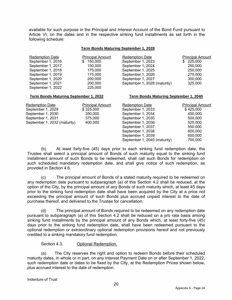
Indenture of Trust 71476765.11/10706668 20
available for such purpose in the Principal and Interest Account of the Bond Fund pursuant to Article VI, on the dates and in the respective sinking fund installments as set forth in the following schedule:
Term Bonds Maturing September 1, 2028
Redemption Date Principal Amount Redemption Date Principal Amount September 1, 2016 $ 150,000 September 1, 2023 $ 225,000 September 1, 2017 150,000 September 1, 2024 250,000 September 1, 2018 175,000 September 1, 2025 250,000 September 1, 2019 175,000 September 1, 2026 275,000 September 1, 2020 200,000 September 1, 2027 300,000 September 1, 2021 200,000 September 1, 2028 (maturity) 325,000 September 1, 2022 225,000
Term Bonds Maturing September 1, 2032 Term Bonds Maturing September 1, 2040
Redemption Date Principal Amount Redemption Date Principal Amount September 1, 2029 $ 325,000 September 1, 2033 $ 425,000 September 1, 2030 350,000 September 1, 2034 450,000 September 1, 2031 375,000 September 1, 2035 500,000 September 1, 2032 (maturity) 400,000 September 1, 2036 525,000
September 1, 2037 550,000 September 1, 2038 600,000 September 1, 2039 650,000 September 1, 2040 (maturity) 700,000
(b) At least forty-five (45) days prior to each sinking fund redemption date, the Trustee shall select a principal amount of Bonds of such maturity equal to the sinking fund installment amount of such Bonds to be redeemed, shall call such Bonds for redemption on such scheduled mandatory redemption date, and shall give notice of such redemption, as provided in Section 4.6.
(c) The principal amount of Bonds of a stated maturity required to be redeemed on any redemption date pursuant to subparagraph (a) of this Section 4.2 shall be reduced, at the option of the City, by the principal amount of any Bonds of such maturity which, at least 45 days prior to the sinking fund redemption date shall have been acquired by the City at a price not exceeding the principal amount of such Bonds plus accrued unpaid interest to the date of purchase thereof, and delivered to the Trustee for cancellation.
(d) The principal amount of Bonds required to be redeemed on any redemption date pursuant to subparagraph (a) of this Section 4.2 shall be reduced on a pro rata basis among sinking fund installments by the principal amount of any Bonds which, at least forty-five (45) days prior to the sinking fund redemption date, shall have been redeemed pursuant to the optional redemption or extraordinary optional redemption provisions hereof and not previously credited to a sinking mandatory fund redemption.
Section 4.3. Optional Redemption.
(a) The City reserves the right and option to redeem Bonds before their scheduled maturity dates, in whole or in part, on any Interest Payment Date on or after September 1, 2022, such redemption date or dates to be fixed by the City, at the Redemption Prices shown below, plus accrued interest to the date of redemption.
Appendix A - Page 24
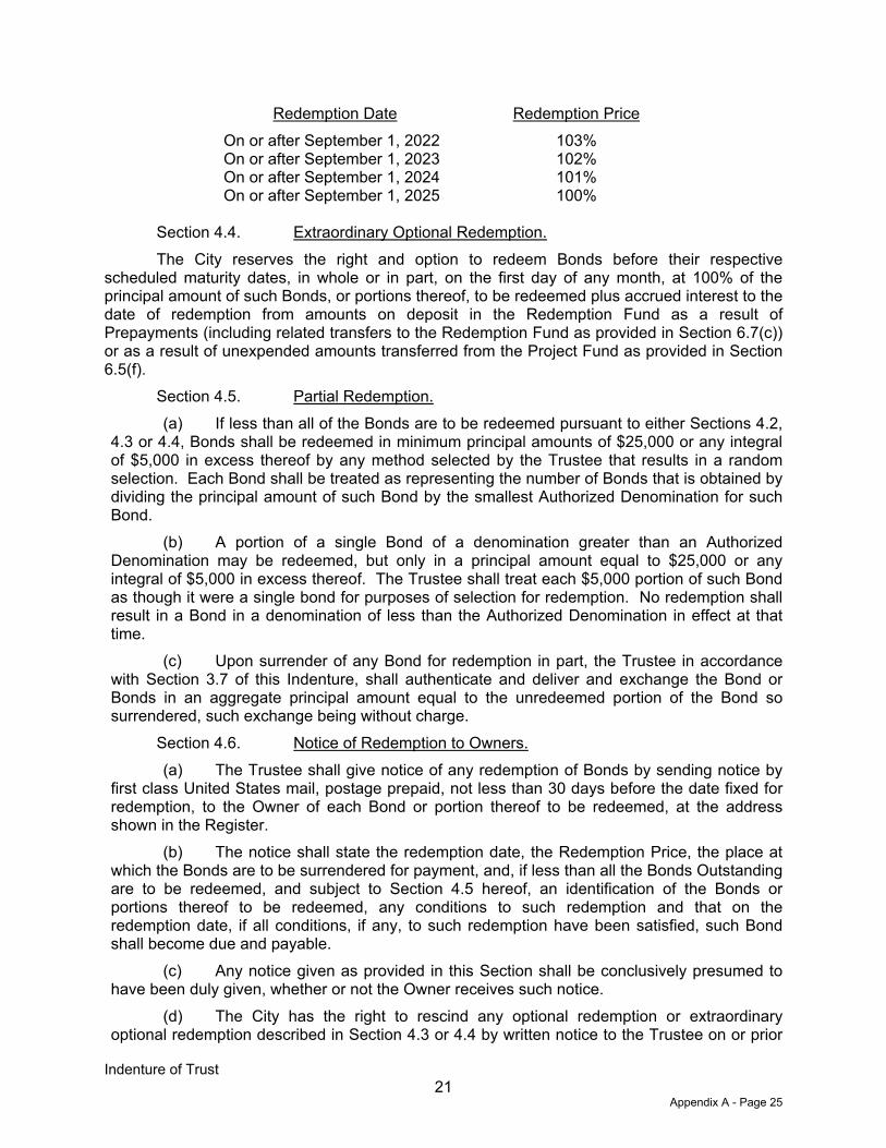
Indenture of Trust 71476765.11/10706668 21
Redemption Date Redemption Price On or after September 1, 2022 103% On or after September 1, 2023 102% On or after September 1, 2024 101% On or after September 1, 2025 100%
Section 4.4. Extraordinary Optional Redemption. The City reserves the right and option to redeem Bonds before their respective
scheduled maturity dates, in whole or in part, on the first day of any month, at 100% of the principal amount of such Bonds, or portions thereof, to be redeemed plus accrued interest to the date of redemption from amounts on deposit in the Redemption Fund as a result of Prepayments (including related transfers to the Redemption Fund as provided in Section 6.7(c)) or as a result of unexpended amounts transferred from the Project Fund as provided in Section 6.5(f).
Section 4.5. Partial Redemption. (a) If less than all of the Bonds are to be redeemed pursuant to either Sections 4.2,
4.3 or 4.4, Bonds shall be redeemed in minimum principal amounts of $25,000 or any integral of $5,000 in excess thereof by any method selected by the Trustee that results in a random selection. Each Bond shall be treated as representing the number of Bonds that is obtained by dividing the principal amount of such Bond by the smallest Authorized Denomination for such Bond.
(b) A portion of a single Bond of a denomination greater than an Authorized Denomination may be redeemed, but only in a principal amount equal to $25,000 or any integral of $5,000 in excess thereof. The Trustee shall treat each $5,000 portion of such Bond as though it were a single bond for purposes of selection for redemption. No redemption shall result in a Bond in a denomination of less than the Authorized Denomination in effect at that time.
(c) Upon surrender of any Bond for redemption in part, the Trustee in accordance with Section 3.7 of this Indenture, shall authenticate and deliver and exchange the Bond or Bonds in an aggregate principal amount equal to the unredeemed portion of the Bond so surrendered, such exchange being without charge.
Section 4.6. Notice of Redemption to Owners. (a) The Trustee shall give notice of any redemption of Bonds by sending notice by
first class United States mail, postage prepaid, not less than 30 days before the date fixed for redemption, to the Owner of each Bond or portion thereof to be redeemed, at the address shown in the Register.
(b) The notice shall state the redemption date, the Redemption Price, the place at which the Bonds are to be surrendered for payment, and, if less than all the Bonds Outstanding are to be redeemed, and subject to Section 4.5 hereof, an identification of the Bonds or portions thereof to be redeemed, any conditions to such redemption and that on the redemption date, if all conditions, if any, to such redemption have been satisfied, such Bond shall become due and payable.
(c) Any notice given as provided in this Section shall be conclusively presumed to have been duly given, whether or not the Owner receives such notice.
(d) The City has the right to rescind any optional redemption or extraordinary optional redemption described in Section 4.3 or 4.4 by written notice to the Trustee on or prior
Appendix A - Page 25
Indenture of Trust 71476765.11/10706668 22
to the date fixed for redemption. Any notice of redemption shall be cancelled and annulled if for any reason funds are not available on the date fixed for redemption for the payment in full of the Bonds then called for redemption, and such cancellation shall not constitute an Event of Default under the Indenture. The Trustee shall mail notice of rescission of redemption in the same manner notice of redemption was originally provided.
(e) With respect to any optional redemption of the Bonds, unless the Trustee has received funds sufficient to pay the Redemption Price of the Bonds to be redeemed before giving of a notice of redemption, the notice may state the City may condition redemption on the receipt of such funds by the Trustee on or before the date fixed for the redemption, or on the satisfaction of any other prerequisites set forth in the notice of redemption. If a conditional notice of redemption is given and such prerequisites to the redemption and sufficient funds are not received, the notice shall be of no force and effect, the City shall not redeem the Bonds and the Trustee shall give notice, in the manner in which the notice of redemption was given, that the Bonds have not been redeemed.
Section 4.7. Payment Upon Redemption. (a) The Trustee shall make provision for the payment of the Bonds to be redeemed
on such date by setting aside and holding in trust an amount from the Redemption Fund or otherwise received by the Trustee from the City and shall use such funds solely for the purpose of paying the Redemption Price on the Bonds being redeemed.
(b) Upon presentation and surrender of any Bond called for redemption at the designated corporate trust office of the Trustee on or after the date fixed for redemption, the Trustee shall pay the Redemption Price on such Bond to the date of redemption from the moneys set aside for such purpose.
Section 4.8. Effect of Redemption. Notice of redemption having been given as provided in Section 4.6 of this Indenture, the
Bonds or portions thereof called for redemption shall become due and payable on the date fixed for redemption provided that funds for the payment of the principal amount plus accrued unpaid interest on such Bonds to the date fixed for redemption are on deposit with the Trustee; thereafter, such Bonds or portions thereof shall cease to bear interest from and after the date fixed for redemption, whether or not such Bonds are presented and surrendered for payment on such date.
ARTICLE V
FORM OF THE BONDS
Section 5.1. Form Generally.
(a) The Bonds, including the Registration Certificate of the Comptroller of Public Accounts of the State of Texas, the Certificate of the Trustee, and the Assignment to appear on each of the Bonds, (i) shall be substantially in the form set forth in Exhibit A to this Indenture with such appropriate insertions, omissions, substitutions, and other variations as are permitted or required by this Indenture, and (ii) may have such letters, numbers, or other marks of identification (including identifying numbers and letters of the Committee on Uniform Securities Identification Procedures of the American Bankers Association) and such legends and endorsements (including any reproduction of an opinion of counsel) thereon as, consistently herewith, may be determined by the City or by the officers executing such Bonds, as evidenced by their execution thereof.
Appendix A - Page 26
Indenture of Trust 71476765.11/10706668 23
(b) Any portion of the text of any Bonds may be set forth on the reverse side thereof, with an appropriate reference thereto on the face of the Bonds.
(c) The definitive Bonds shall be typewritten, printed, lithographed, or engraved, and may be produced by any combination of these methods or produced in any other similar manner, all as determined by the officers executing such Bonds, as evidenced by their execution thereof.
(d) The Initial Bond submitted to the Attorney General of the State of Texas may be typewritten and photocopied or otherwise reproduced.
Section 5.2. CUSIP Registration.
The City may secure identification numbers through the CUSIP Service Bureau Division of Standard & Poor’s Corporation, New York, New York, and may authorize the printing of such numbers on the face of the Bonds. It is expressly provided, however, that the presence or absence of CUSIP numbers on the Bonds shall be of no significance or effect as regards the legality thereof; and, none of the City, the Trustee, or the attorneys approving said Bonds as to legality are to be held responsible for CUSIP numbers incorrectly printed on the Bonds. The Trustee may include in any redemption notice a statement to the effect that the CUSIP numbers on the Bonds have been assigned by an independent service and are included in such notice solely for the convenience of the Owners of the Bonds and that neither the City nor the Trustee shall be liable for any inaccuracies of such numbers.
Section 5.3. Legal Opinion.
The approving legal opinion of Bond Counsel may be printed on or attached to each Bond over the certification of the City Secretary of the City, which may be executed in facsimile.
ARTICLE VI
FUNDS AND ACCOUNTS
Section 6.1. Establishment of Funds and Accounts.
(a) Creation of Funds. The following Funds are hereby created and established under this Indenture:
(i) Pledged Revenue Fund; (ii) Bond Fund; (iii) Project Fund; (iv) Reserve Fund; (v) Redemption Fund; (vi) Rebate Fund; (vii) Administrative Fund; and (viii) Reimbursement Fund.
Appendix A - Page 27
Indenture of Trust 71476765.11/10706668 24
(b) Creation of Accounts.
(i) The following Accounts are hereby created and established under the Bond Fund:
(A) Capitalized Interest Account; and (B) Principal and Interest Account
(ii) The following Accounts are hereby created and established under the Reserve Fund:
(A) Reserve Account; (B) Prepayment Reserve Account; and (C) Delinquency Reserve Account
(iii) The following Accounts are hereby created and established under the Project Fund:
(A) Phase #1 Improvement Account;
(B) Phase #1 Major Improvement Account;
(C) Landowner Improvement Account; and
(D) Costs of Issuance Account
(iv) The following Accounts are hereby created and established under the Pledged Revenue Fund:
(A) Bond Pledged Revenue Account; and
(B) Landowner Reimbursement Pledged Revenue Account.
(v) The following Accounts are hereby created and established under the Administrative Fund:
(A) Landowner Property Tax Account; and
(B) District Administration Account.
(c) Each Fund and Account created within such Fund shall be maintained by the Trustee separate and apart from all other funds and accounts of the City. The Pledged Funds shall constitute trust funds which shall be held in trust by the Trustee as part of the Trust Estate solely for the benefit of the Owners of the Bonds.
(d) Interest earnings and profit on each respective Fund and Account established by this Indenture shall be applied or withdrawn for the purposes of such Fund or Account as specified below.
Appendix A - Page 28

Indenture of Trust 71476765.11/10706668 25
Section 6.2. Initial Deposits to Funds and Accounts. (a) The proceeds from the sale of the Bonds shall be paid to the Trustee and
deposited or transferred by the Trustee as follows: (i) to the Capitalized Interest Account of the Bond Fund: $687,093.75; (ii) to the Reserve Account of the Reserve Fund: $749,781.26; (iii) to the Prepayment Reserve Account of the Reserve Fund: $17,500.00; (iv) to the Delinquency Reserve Account of the Reserve Fund: $26,250.00; (v) to the Costs of Issuance Account of the Project Fund: $507,000.00; (vi) to the Phase #1 Improvement Account of the Project Fund:
$3,446,077.00; and (vii) to the Phase #1 Major Improvement Account of the Project Fund:
$3,068,797.99. (b) Funds received from the Landowner or other sources on the Closing Date
pursuant to the terms of the Phase #1 Reimbursement Agreement in the amount of $2,500,251.00 shall be deposited to the Landowner Improvement Account of the Project Fund.
(c) Funds received from the Landowner in the amount of $542,012.01 on the Closing Date shall be deposited by the Trustee as follows:
(i) $271,006.00 to the Phase #1 Improvement Account of the Project Fund; and
(ii) $271,006.01 to the Phase #1 Major Improvement Account of the Project Fund.
(d) Funds received from the Landowner on the Closing Date in the amount of the lesser of either (1) $10,000 or (2) two times the amount of the property tax on the Property that is classified as agricultural in the current tax year shall be deposited to the Landowner Property Tax Account of the Administrative Fund.
Section 6.3. Pledged Revenue Fund. (a) On or about February 20 of each year while the Bonds are Outstanding and
beginning in year 2015, the City shall deposit or cause to be deposited the Pledged Revenues into the Pledged Revenue Fund. Specifically, the City shall deposit or cause to be deposited Assessment Revenues as follows: (i) first, to the Bond Pledged Revenue Account of the Pledged Revenue Fund in an amount sufficient to pay debt service on the Bonds next coming due, (ii) second to the Reserve Account of the Reserve Fund in an amount to cause the amount in the Reserve Account to equal the Reserve Fund Requirement, (iii) third to the Landowner Reimbursement Pledged Revenue Account of the Pledged Revenue Fund to pay and reimburse the Landowner for costs of Phase #1 Projects that have been paid from the Landowner Improvement Account of the Project Fund (pursuant to the terms of the Phase #1 Reimbursement Agreement), (iv) fourth to pay other costs of the Authorized Improvements, and (v) fifth to pay other costs permitted by the PID Act. Moneys transferred to the Landowner Reimbursement Pledged Revenue Account shall not be a part of the Trust Estate and are not security for the Bonds.
(b) From time to time as needed to pay the obligations relating to the Bonds, but no later than five (5) Business Days before each Interest Payment Date, the Trustee shall withdraw from the Bond Pledged Revenue Account and transfer to the Principal and Interest
Appendix A - Page 29

Indenture of Trust 71476765.11/10706668 26
Account of the Bond Fund, an amount, taking into account any amounts then on deposit in such Principal and Interest Account and any expected transfers from the Capitalized Interest Account to the Principal and Interest Account, such that the amount on deposit in the Principal and Interest Account equals the principal (including any Sinking Fund Installments) and interest due on the Bonds on the next Interest Payment Date.
(c) Subject to the provisions of the Phase #1 Reimbursement Agreement, from time to time as needed to pay the obligations relating to costs of Phase #1 Projects that are paid with funds withdrawn from the Landowner Improvement Account of the Project Fund the Trustee shall withdraw from the Landowner Reimbursement Pledged Revenue Account and transfer to the Reimbursement Fund such amount needed to reimburse the Landowner for funds withdrawn from the Landowner Improvement Account of the Project Fund used to fund costs of Phase #1 Projects.
(d) If, after the foregoing transfers and any transfer from the Reserve Fund as provided in Section 6.7 herein, there are insufficient funds to make the payments provided in paragraph (b) above, the Trustee shall apply the available funds in the Principal and Interest Account first to the payment of interest, then to the payment of principal (including any Sinking Fund Installments) on the Bonds.
(e) The Trustee shall deposit Prepayments to the Pledged Revenue Fund and as soon as practicable after such deposit shall transfer such Prepayments to the Redemption Fund.
(f) The Trustee shall deposit Foreclosure Proceeds to the Pledged Revenue Fund and as soon as practicable after such deposit shall transfer Foreclosure Proceeds first to the Reserve Fund to restore any transfers from the Reserve Fund made with respect to the Assessed Parcel or Assessed Parcels to which the Foreclosure Proceeds relate, and second, to the Redemption Fund.
(g) After satisfaction of the requirement to provide for the payment of the principal and interest on the Bonds and to fund any deficiency that may exist in the Reserve Fund and to fund any obligations due to Landowner with funds deposited to the Reimbursement Fund, the City may direct the Trustee by City Order to apply Assessments for any lawful purposes permitted by the Act for which Assessments may be paid.
(h) Any Assessments remaining after satisfying the foregoing payments may be used for any lawful purpose for which Assessments may be used under the PID Act.
Section 6.4. Bond Fund.
(a) On each Interest Payment Date, the Trustee shall withdraw from the Principal and Interest Account and transfer to the Paying Agent/Registrar the principal (including any Sinking Fund Installments) and interest then due and payable on the Bonds, less any amount to be used to pay interest on the Bonds on such Interest Payment Date from the Capitalized Interest Account as provided below.
(b) If amounts in the Principal and Interest Account are insufficient for the purposes set forth in paragraph (a) above, the Trustee shall withdraw from the Reserve Fund amounts to cover the amount of such insufficiency. Amounts so withdrawn from the Reserve Fund shall be deposited in the Principal and Interest Account and transferred to the Paying Agent/Registrar.
(c) Moneys in the Capitalized Interest Account shall be used for the payment of interest on the Bonds on the following dates and in the following amounts:
Appendix A - Page 30
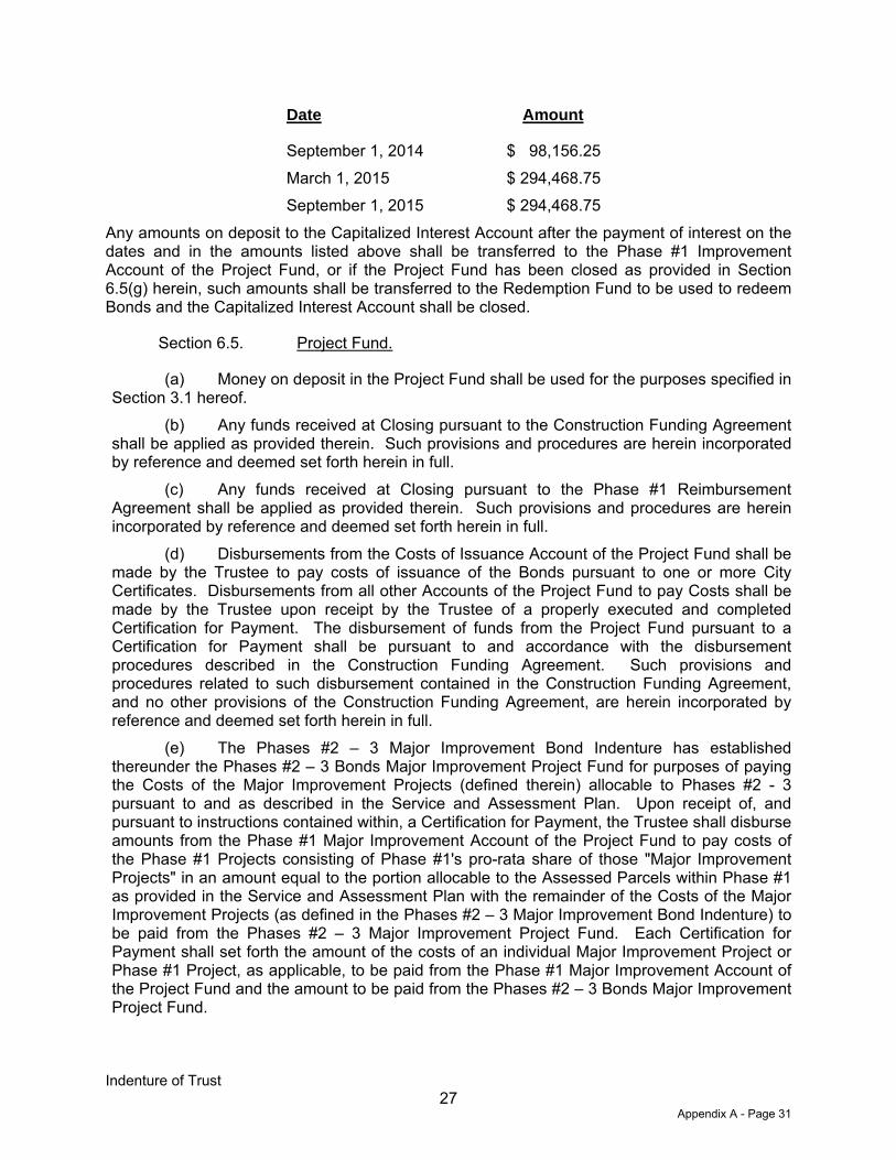
Indenture of Trust 71476765.11/10706668 27
Date Amount
September 1, 2014 March 1, 2015 September 1, 2015
$ 98,156.25 $ 294,468.75 $ 294,468.75
Any amounts on deposit to the Capitalized Interest Account after the payment of interest on the dates and in the amounts listed above shall be transferred to the Phase #1 Improvement Account of the Project Fund, or if the Project Fund has been closed as provided in Section 6.5(g) herein, such amounts shall be transferred to the Redemption Fund to be used to redeem Bonds and the Capitalized Interest Account shall be closed.
Section 6.5. Project Fund.
(a) Money on deposit in the Project Fund shall be used for the purposes specified in Section 3.1 hereof.
(b) Any funds received at Closing pursuant to the Construction Funding Agreement shall be applied as provided therein. Such provisions and procedures are herein incorporated by reference and deemed set forth herein in full.
(c) Any funds received at Closing pursuant to the Phase #1 Reimbursement Agreement shall be applied as provided therein. Such provisions and procedures are herein incorporated by reference and deemed set forth herein in full.
(d) Disbursements from the Costs of Issuance Account of the Project Fund shall be made by the Trustee to pay costs of issuance of the Bonds pursuant to one or more City Certificates. Disbursements from all other Accounts of the Project Fund to pay Costs shall be made by the Trustee upon receipt by the Trustee of a properly executed and completed Certification for Payment. The disbursement of funds from the Project Fund pursuant to a Certification for Payment shall be pursuant to and accordance with the disbursement procedures described in the Construction Funding Agreement. Such provisions and procedures related to such disbursement contained in the Construction Funding Agreement, and no other provisions of the Construction Funding Agreement, are herein incorporated by reference and deemed set forth herein in full.
(e) The Phases #2 – 3 Major Improvement Bond Indenture has established thereunder the Phases #2 – 3 Bonds Major Improvement Project Fund for purposes of paying the Costs of the Major Improvement Projects (defined therein) allocable to Phases #2 - 3 pursuant to and as described in the Service and Assessment Plan. Upon receipt of, and pursuant to instructions contained within, a Certification for Payment, the Trustee shall disburse amounts from the Phase #1 Major Improvement Account of the Project Fund to pay costs of the Phase #1 Projects consisting of Phase #1's pro-rata share of those "Major Improvement Projects" in an amount equal to the portion allocable to the Assessed Parcels within Phase #1 as provided in the Service and Assessment Plan with the remainder of the Costs of the Major Improvement Projects (as defined in the Phases #2 – 3 Major Improvement Bond Indenture) to be paid from the Phases #2 – 3 Major Improvement Project Fund. Each Certification for Payment shall set forth the amount of the costs of an individual Major Improvement Project or Phase #1 Project, as applicable, to be paid from the Phase #1 Major Improvement Account of the Project Fund and the amount to be paid from the Phases #2 – 3 Bonds Major Improvement Project Fund.
Appendix A - Page 31
Indenture of Trust 71476765.11/10706668 28
(f) If the City Representative determines in his or her sole discretion that amounts then on deposit in the Phase #1 Improvement Account of the Project Fund or the Phase #1 Major Improvement Account of the Project Fund are not expected to be expended for purposes of the Project Fund due to the abandonment, or constructive abandonment, of the Phase #1 Projects or Major Improvement Projects, as the case may be, such that, in the opinion of the City Representative, it is unlikely that the amounts in the Phase #1 Improvement Account of the Project Fund or the Phase #1 Major Improvement Account of the Project Fund will ever be expended for the purposes of the Project Fund, the City Representative shall file a City Certificate with the Trustee which identifies the amounts then on deposit in the Phase #1 Improvement Account of the Project Fund or the Phase #1 Major Improvement Account of the Project Fund that are not expected to be used for purposes of the Project Fund. If such City Certificate is so filed, the amounts on deposit in the Phase #1 Improvement Account of the Project Fund or the Phase #1 Major Improvement Account of the Project Fund shall be transferred to the Redemption Fund to redeem Bonds on the earliest practicable date after notice of redemption has been provided in accordance with the Indenture.
(g) In making any determination pursuant to this Section, the City Representative may conclusively rely upon a certificate of an Independent Financial Consultant.
(h) Upon the filing of a City Certificate stating that all Phase #1 Projects have been completed and that all Costs of the Phase #1 Projects have been paid, or that any such Costs are not required to be paid from the Phase #1 Improvement Account of the Project Fund or the Phase #1 Major Improvement Account of the Project Fund pursuant to a Certification for Payment, the Trustee (i) shall transfer the amount, if any, remaining within the Project Fund to the Bond Fund, (ii) shall transfer any remaining amount in the Landowner Improvement Account of the Project Fund to the Landowner and (iii) the Project Fund shall be closed.
(i) Upon a determination by the City Representative that all costs of issuance of the Bonds have been paid, any amounts remaining in the Costs of Issuance Account shall be transferred to another Account in the Project Fund and used to pay Costs or to the Principal and Interest Account of the Bond Fund and used to pay interest on the Bonds, as directed by the City in a City Certificate filed with the Trustee, and the Costs of Issuance Account shall be closed.
Section 6.6. Redemption Fund.
(a) The Trustee shall cause to be deposited to the Redemption Fund from the Bond Pledged Revenue Account of the Pledged Revenue Fund an amount sufficient to redeem Bonds as provided in Sections 4.3 and 4.4 on the dates specified for redemption as provided in Sections 4.3 and 4.4. Amounts on deposit in the Redemption Fund shall be used and withdrawn by the Trustee to redeem Bonds as provided in Article IV.
Section 6.7. Reserve Fund.
(a) The City agrees with the Owners of the Bonds to accumulate, and when accumulated maintain in the Reserve Fund, an amount equal to not less than the Reserve Fund Requirement. All amounts deposited in the Reserve Fund shall be used and withdrawn by the Trustee for the purpose of making transfers to the Principal and Interest Account of the Bond Fund as provided in this Indenture. The Trustee will transfer from the Bond Pledged Revenue Account of the Pledged Revenue Fund to the Prepayment Reserve Account on March 1 and September 1 of each year, commencing March 1, 2015, an amount equal to .20% of the interest rate component of the Annual Installments in the Prepayment Reserve Account.
Appendix A - Page 32

Indenture of Trust 71476765.11/10706668 29
Once the Prepayment Reserve Requirement has accumulated in the Prepayment Reserve Account, all amount in excess of the Prepayment Reserve Requirement shall be transferred by the Trustee first to the Delinquency Reserve Account in the event such account contains less than the Delinquency Reserve Requirement, or, if the Delinquency Reserve Account contains the Delinquency Reserve Requirement then to the Redemption Fund to redeem Bonds as provided in Article IV. The Trustee shall also deposit from the Bond Pledged Revenue Account of the Pledged Revenue Fund to the Delinquency Reserve Account on March 1 and September 1, commencing March 1, 2015, an amount equal to .30% of the interest rate component of the Annual Installments. Once the Delinquency Reserve Requirement has been accumulated in the Delinquency Reserve Account, any amounts in excess of the Delinquency Reserve Requirement in the Delinquency Reserve Account shall be transferred by the Trustee to the Redemption Fund to redeem Bonds as provided in Article IV.
(b) Whenever a transfer is made from the Reserve Fund to the Bond Fund due to a deficiency in the Bond Fund, the Trustee shall provide written notice thereof to the City, specifying the amount withdrawn and the source of said funds.
(c) Whenever Bonds are to be redeemed with the proceeds of Prepayments pursuant to Section 4.4, a proportionate amount in the Reserve Account of the Reserve Fund shall be transferred on the Business Day prior to the redemption date by the Trustee to the Redemption Fund to be applied to the redemption of the Bonds. The amount so transferred from the Reserve Account of the Reserve Fund shall be equal to a percentage of the amount of the Bonds redeemed with such percentage equal to the lesser of: (i) the amount required to be in the Reserve Account of the Reserve Fund, as a percentage of the Outstanding Bonds prior to the redemption, and (ii) the amount actually in the Reserve Account of the Reserve Fund, as a percentage of the Outstanding Bonds prior to the redemption. If after such transfer, and after applying investment earnings on the Prepayment toward payment of accrued interest, there are insufficient funds to pay the principal amount plus accrued and unpaid interest on such Bonds to the date fixed for redemption of the Bonds to be redeemed as a result of such Prepayment, the Trustee shall transfer an amount equal to the shortfall from the Prepayment Reserve Account to the Redemption Fund to be applied to the redemption of the Bonds.
(d) Whenever, on any Interest Payment Date, or on any other date at the written request of a City Representative, the amount in the Reserve Account exceeds the Reserve Fund Requirement, the Trustee shall provide written notice to the City Representative of the amount of the excess. Such excess shall be transferred to the Principal and Interest Account to be used for the payment of interest on the Bonds on the next Interest Payment Date in accordance with Section 6.4 hereof, unless within thirty days of such notice to the City Representative, the Trustee receives a City Order instructing the Trustee to apply such excess: (i) to pay amounts due under Section 6.8 hereof, (ii) to the Administrative Fund in an amount not more than the Annual Collection Costs for the Bonds, or (iii) to the Project Fund if such application and the expenditure of funds is expected to occur within three years of the date hereof.
(e) Whenever, on any Interest Payment Date, or on any other date at the written request of the City Representative, the amount in the Prepayment Reserve Account exceeds the Prepayment Reserve Requirement, the Trustee shall provide written notice to the City of the amount of the excess. The amount of such excess on deposit in the Prepayment Reserve Account shall then be transferred by the Trustee first to the Delinquency Reserve Account in the event such account contains less than the Delinquency Reserve Requirement, or, if the
Appendix A - Page 33
Indenture of Trust 71476765.11/10706668 30
Delinquency Reserve Account contains the Delinquency Reserve Requirement then to the Redemption Fund to redeem Bonds as provided in Article IV.
(f) Whenever, on any Interest Payment Date, or on any other date at the written request of the City Representative, the amount in the Delinquency Reserve Account exceeds the Delinquency Reserve Requirement, the Trustee shall provide written notice to the City of the amount of the excess. The amount of such excess on deposit in the Delinquency Reserve Account shall then be transferred by the Trustee to the Redemption Fund to redeem Bonds as provided in Article IV.
(g) Whenever, on any Interest Payment Date, the amount on deposit in the Bond Fund is insufficient to pay the debt service on the Bonds Similarly Secured due on such date, the Trustee shall transfer first from the Delinquency Reserve Account of the Reserve Fund, second from the Reserve Account of the Reserve Fund and third from the Prepayment Reserve Account to the Bond Fund the amounts necessary to cure such deficiency. The Trustee shall determine the value of cash and investments on deposit in the Delinquency Reserve Account as of September 30 of each year.
(h) At the final maturity of the Bonds Similarly Secured, the amount on deposit in the Reserve Account, the Prepayment Reserve Account and the Delinquency Reserve Account shall be transferred to the Redemption Fund and applied to the payment of the principal of the Bonds Similarly Secured.
(i) If, after a Reserve Fund withdrawal, the amount on deposit in the Reserve Account of the Reserve Fund is less than the Reserve Fund Requirement, the Trustee shall transfer from the Pledged Revenue Fund to the Reserve Account of the Reserve Fund the amount of such deficiency, in accordance with Section 6.3.
(j) If the amount held in the Reserve Fund together with the amount held in the Bond Fund and Redemption Fund is sufficient to pay the principal amount and of all Outstanding Bonds Similarly Secured on the next Interest Payment Date, together with the unpaid interest accrued on such Bonds Similarly Secured as of such Interest Payment Date, the moneys shall be transferred to the Redemption Fund and thereafter used to redeem all Bonds Similarly Secured as of such Interest Payment Date.
Section 6.8. Rebate Fund: Rebate Amount.
(a) There is hereby established a special fund of the City to be designated “City of Celina, Texas, Rebate Fund” (the “Rebate Fund”) to be held by the Trustee in accordance with the terms and provisions of this Indenture. Amounts on deposit in the Rebate Fund shall be used solely for the purpose of paying amounts due the United States Government in accordance with the Code.
(b) In order to assure that Rebate Amount is paid to the United States rather than to a third party, investments of funds on deposit in the Rebate Fund shall be made in accordance with the Code and the Tax Certificate.
(c) The Trustee conclusively shall be deemed to have complied with the provisions of this Section and Section 7.5(h) and shall not be liable or responsible if it follows the instructions of the City and shall not be required to take any action under this Section and Section 7.5(h) in the absence of written instructions from the City.
Appendix A - Page 34

Indenture of Trust 71476765.11/10706668 31
(d) If, on the date of each annual calculation, the amount on deposit in the Rebate Fund exceeds the Rebate Amount, the City may direct the Trustee, pursuant to a City Order, to transfer the amount in excess of the Rebate Amount to the Bond Fund.
Section 6.9. Administrative Fund.
(a) The City shall deposit or cause to be deposited to the District Administration Account of the Administrative Fund the amounts collected each year to pay Annual Collection Costs and Delinquent Collection Costs.
(b) Moneys in the District Administration Account of the Administrative Fund shall be held by the Trustee separate and apart from the other Funds created and administered hereunder and used as directed by a City Order solely for the purposes set forth in the Service and Assessment Plan.
(c) Moneys in the Landowner Property Tax Account of the Administrative Fund shall be held by the Trustee separate and apart from the other Funds created and administered hereunder and shall be released to the Landowner as directed by City Order; provided, however, that the Trustee shall transfer to the Landowner any amounts remaining in the Landowner Property Tax Account of the Administration Fund after the last Outstanding Bond is discharged regardless of whether a City Order directing such action is received.
Section 6.10. Investment of Funds.
(a) Money in any Fund established pursuant to this Indenture shall be invested by the Trustee as directed by the City pursuant to a City Order filed with the Trustee at least two (2) days in advance of the making of such investment in time deposits or certificates of deposit secured in the manner required by law for public funds, or be invested in direct obligations of, including obligations the principal and interest on which are unconditionally guaranteed by, the United States of America, in obligations of any agencies or instrumentalities thereof, or in such other investments as are permitted under the Public Funds Investment Act, Texas Government Code, Chapter 2256, as amended, or any successor law, as in effect from time to time; provided that all such deposits and investments shall be made in such manner (which may include repurchase agreements for such investment with any primary dealer of such agreements) that the money required to be expended from any Fund will be available at the proper time or times. Such investments shall be valued each year in terms of current market value as of September 30. For purposes of maximizing investment returns, to the extent permitted by law, money in such Funds may be invested in common investments of the kind described above, or in a common pool of such investment which shall be kept and held at an official depository bank, which shall not be deemed to be or constitute a commingling of such money or funds provided that safekeeping receipts or certificates of participation clearly evidencing the investment or investment pool in which such money is invested and the share thereof purchased with such money or owned by such Fund are held by or on behalf of each such Fund. If necessary, such investments shall be promptly sold to prevent any default.
(b) Obligations purchased as an investment of moneys in any Fund shall be deemed to be part of such Fund or Account, subject, however, to the requirements of this Indenture for transfer of interest earnings and profits resulting from investment of amounts in Funds and Accounts. Whenever in this Indenture any moneys are required to be transferred by the City to the Trustee, such transfer may be accomplished by transferring a like amount of Investment Securities.
Appendix A - Page 35
Indenture of Trust 71476765.11/10706668 32
(c) The Trustee and its affiliates may act as sponsor, advisor, depository, principal or agent in the acquisition or disposition of any investment. The Trustee shall not incur any liability for losses arising from any investments made pursuant to this Section. The Trustee shall not be required to determine the suitability or legality of any investments.
(d) Investments in any and all Funds and Accounts may be commingled in a separate fund or funds for purposes of making, holding and disposing of investments, notwithstanding provisions herein for transfer to or holding in or to the credit of particular Funds or Accounts of amounts received or held by the Trustee hereunder, provided that the Trustee shall at all times account for such investments strictly in accordance with the Funds and Accounts to which they are credited and otherwise as provided in this Indenture.
(e) The Trustee will furnish the City monthly cash transaction statements which include detail for all investment transactions made by the Trustee hereunder; and, unless the Trustee receives a written request, the Trustee is not required to provide brokerage confirmations so long as the Trustee is providing such monthly cash transaction statements.
Section 6.11. Security of Funds.
All Funds heretofore created or reaffirmed, to the extent not invested as herein permitted, shall be secured in the manner and to the fullest extent required by law for the security of public funds, and such Funds shall be used only for the purposes and in the manner permitted or required by this Indenture.
Section 6.12. Reimbursement Fund.
Money on deposit in the Reimbursement Fund shall be used to reimburse the Landowner for funds withdrawn from the Landowner Improvement Account of the Project Fund and used to pay costs of Phase #1 Projects as provided in the Phase #1 Reimbursement Agreement. When all amounts due to the Landowner to reimburse it for the funds withdrawn from the Landowner Improvement Account of the Project Fund have been paid to the Landowner, whether through Assessments received and applied in accordance with the Service and Assessment Plan or an Annual Service Plan Update or through the proceeds of Additional Bonds, no further deposits shall be made to the Reimbursement Fund and the Reimbursement Fund shall be closed.
ARTICLE VII
COVENANTS
Section 7.1. Confirmation of Assessments.
The City hereby confirms, covenants, and agrees that, in the Assessment Ordinance, it has levied the Assessments against the respective Assessed Parcels from which the Pledged Revenues will be collected and received.
Section 7.2. Collection and Enforcement of Assessments.
(a) For so long as any Bonds are Outstanding and amounts are due the Landowner to reimburse it for its funds it has contributed to pay costs of the Phase #1 Projects, the City covenants, agrees and warrants that it will take and pursue all actions permissible under Applicable Laws to cause the Assessments to be collected and the liens thereof enforced
Appendix A - Page 36
Indenture of Trust 71476765.11/10706668 33
continuously, in the manner and to the maximum extent permitted by Applicable Laws, and, to the extent permitted by Applicable Laws, to cause no reduction, abatement or exemption in the Assessments.
(b) The City will determine or cause to be determined, no later than February 15 of each year, whether or not any Annual Installment is delinquent and, if such delinquencies exist, the City will order and cause to be commenced as soon as practicable any and all appropriate and legally permissible actions to obtain such Annual Installment, and any delinquent charges and interest thereon, including diligently prosecuting an action in district court to foreclose the currently delinquent Annual Installment. Notwithstanding the foregoing, the City shall not be required under any circumstances to purchase or make payment for the purchase of the delinquent Assessment or the corresponding Assessed Parcel.
Section 7.3. Against Encumbrances.
(a) The City shall not create and, to the extent Pledged Revenues are received, shall not suffer to remain, any lien, encumbrance or charge upon the Pledged Revenues, other than that specified in Section 9.6 of this Indenture, or upon any other property pledged under this Indenture, except the pledge created for the security of the Bonds Similarly Secured, and other than a lien or pledge subordinate to the lien and pledge of such property related to the Bonds Similarly Secured.
(b) So long as Bonds Similarly Secured are Outstanding hereunder, the City shall not issue any bonds, notes or other evidences of indebtedness other than the Bonds secured by any pledge of or other lien or charge on the Pledged Revenues or other property pledged under this Indenture, other than a lien or pledge subordinate to the lien and pledge of such property related to the Bonds Similarly Secured.
Section 7.4. Records, Accounts, Accounting Reports.
The City hereby covenants and agrees that so long as any of the Bonds or Outstanding Bonds or any interest thereon remain outstanding and unpaid, and the obligation to the Landowner to reimburse it for funds it has contributed to pay costs of the Authorized Improvements remain outstanding and unpaid, it will keep and maintain a proper and complete system of records and accounts pertaining to the Assessments. The Trustee and holder or holders of any Bonds or any duly authorized agent or agents of such holders shall have the right at all reasonable times to inspect all such records, accounts, and data relating thereto, upon written request to the City by the Trustee or duly authorized representative, as applicable. The City shall provide the Trustee or duly authorized representative, as applicable, an opportunity to inspect such books and records relating to the Bonds during the City’s regular business hours and on a mutually agreeable date not later than thirty days after the City receives such request.
Section 7.5. Covenants to Maintain Tax-Exempt Status.
(a) Definitions. When used in this Section, the following terms shall have the following meanings:
“Closing Date” means the date on which the Bonds are first authenticated and delivered to the initial purchasers against payment therefor.
Appendix A - Page 37

Indenture of Trust 71476765.11/10706668 34
“Code” means the Internal Revenue Code of 1986, as amended by all legislation, if any, effective on or before the Closing Date.
“Computation Date” has the meaning set forth in section 1.148-1(b) of the Regulations.
“Gross Proceeds” means any proceeds as defined in section 1.148-1(b) of the Regulations, and any replacement proceeds as defined in section 1.148-1(c) of the Regulations, of the Bonds.
“Investment” has the meaning set forth in section 1.148-1(b) of the Regulations.
“Nonpurpose Investment” means any investment property, as defined in section 148(b) of the Code, in which Gross Proceeds of the Bonds are invested and which is not acquired to carry out the governmental purposes of the Bonds.
“Regulations” means any proposed, temporary or final Income Tax Regulations issued pursuant to sections 103 and 141 through 150 of the Code, and 103 of the Internal Revenue Code of 1954, which are applicable to the Bonds. Any reference to any specific Regulation shall also mean, as appropriate, any proposed, temporary or final Income Tax Regulation designed to supplement, amend or replace the specific Regulation referenced.
“Yield” of (1) any Investment has the meaning set forth in section 1.148-5 of the Regulations; and (2) the Bonds has the meaning set forth in section 1.148-4 of the Regulations.
(b) Not to Cause Interest to Become Taxable. The City shall not use, permit the use of, or omit to use Gross Proceeds or any other amounts (or any property the acquisition, construction or improvement of which is to be financed directly or indirectly with Gross Proceeds) in a manner which if made or omitted, respectively, would cause the interest on any Bond to become includable in the gross income, as defined in section 61 of the Code, of the owner thereof for federal income tax purposes. Without limiting the generality of the foregoing, unless and until the City receives a written opinion of counsel nationally recognized in the field of municipal bond law to the effect that failure to comply with such covenant will not adversely affect the exemption from federal income tax of the interest on any Bond, the City shall comply with each of the specific covenants in this Section.
(c) No Private Use or Private Payments. Except as permitted by section 141 of the Code and the Regulations and rulings thereunder, the City shall at all times prior to the last Stated Maturity of Bonds:
(i) exclusively own, operate and possess all property the acquisition, construction or improvement of which is to be financed or refinanced directly or indirectly with Gross Proceeds of the Bonds, and not use or permit the use of such Gross Proceeds (including all contractual arrangements with terms different than those applicable to the general public) or any property acquired, constructed or improved with such Gross Proceeds in any activity carried on by any person or entity (including the
Appendix A - Page 38
Indenture of Trust 71476765.11/10706668 35
United States or any agency, department and instrumentality thereof) other than a state or local government, unless such use is solely as a member of the general public; and
(ii) not directly or indirectly impose or accept any charge or other payment by any person or entity who is treated as using Gross Proceeds of the Bonds or any property the acquisition, construction or improvement of which is to be financed or refinanced directly or indirectly with such Gross Proceeds, other than taxes of general application within the City or interest earned on investments acquired with such Gross Proceeds pending application for their intended purposes.
(d) No Private Loan.
(i) Except to the extent permitted by section 141 of the Code and the Regulations and rulings thereunder, the City shall not use Gross Proceeds of the Bonds to make or finance loans to any person or entity other than a state or local government. For purposes of the foregoing covenant, such Gross Proceeds are considered to be “loaned” to a person or entity if: (1) property acquired, constructed or improved with such Gross Proceeds is sold or leased to such person or entity in a transaction which creates a debt for federal income tax purposes; (2) capacity in or service from such property is committed to such person or entity under a take-or-pay, output or similar contract or arrangement; or (3) indirect benefits, or burdens and benefits of ownership, of such Gross Proceeds or any property acquired, constructed or improved with such Gross Proceeds are otherwise transferred in a transaction which is the economic equivalent of a loan.
(ii) The City covenants and agrees that the levied Assessments will meet the requirements of the “tax assessment loan exception” within the meaning of section 1.141-5(d) of the Regulations on the date the Bonds are delivered and will ensure that the Assessments continue to meet such requirements for so long as the Bonds are outstanding hereunder.
(e) Not to Invest at Higher Yield. Except to the extent permitted by section 148 of the Code and the Regulations and rulings thereunder, the City shall not at any time prior to the final Stated Maturity of the Bonds directly or indirectly invest Gross Proceeds in any Investment (or use Gross Proceeds to replace money so invested) if, as a result of such investment, the Yield from the Closing Date of all Investments acquired with Gross Proceeds (or with money replaced thereby), whether then held or previously disposed of, exceeds the Yield of the Bonds.
(f) Not Federally Guaranteed. Except to the extent permitted by section 149(b) of the Code and the Regulations and rulings thereunder, the City shall not take or omit to take any action which would cause the Bonds to be federally guaranteed within the meaning of section 149(b) of the Code and the Regulations and rulings thereunder.
(g) Information Report. The City shall timely file the information required by section 149(e) of the Code with the Secretary of the Treasury on Form 8038-G or such other form and in such place as the Secretary may prescribe.
(h) Rebate of Arbitrage Profits. Except to the extent otherwise provided in section 148(f) of the Code and the Regulations and rulings thereunder:
Appendix A - Page 39

Indenture of Trust 71476765.11/10706668 36
(i) The City shall account for all Gross Proceeds (including all receipts, expenditures and investments thereof) on its books of account separately and apart from all other funds (and receipts, expenditures and investments thereof) and shall retain all records of accounting for at least six years after the day on which the last outstanding Bond is discharged. However, to the extent permitted by law, the City may commingle Gross Proceeds of the Bonds with other money of the City, provided that the City separately accounts for each receipt and expenditure of Gross Proceeds and the obligations acquired therewith.
(ii) Not less frequently than each Computation Date, the City shall calculate the Rebate Amount in accordance with rules set forth in section 148(f) of the Code and the Regulations and rulings thereunder. The City shall maintain such calculations with its official transcript of proceedings relating to the issuance of the Bonds until six years after the final Computation Date.
(iii) As additional consideration for the purchase of the Bonds by the Purchasers and the loan of the money represented thereby and in order to induce such purchase by measures designed to insure the excludability of the interest thereon from the gross income of the owners thereof for federal income tax purposes, the City shall, pursuant to a City Order, direct the Trustee to transfer to the Rebate Fund from the funds or subaccounts designated in such City Order and direct the Trustee to pay to the United States from the Rebate Fund the amount that when added to the future value of previous rebate payments made for the Bonds equals (i) in the case of a Final Computation Date as defined in Section 1.148-3(e)(2) of the Regulations, one hundred percent (100%) of the Rebate Amount on such date; and (ii) in the case of any other Computation Date, ninety percent (90%) of the Rebate Amount on such date. In all cases, the rebate payments shall be made at the times, in the installments, to the place and in the manner as is or may be required by section 148(f) of the Code and the Regulations and rulings thereunder, and shall be accompanied by Form 8038-T or such other forms and information as is or may be required by Section 148(f) of the Code and the Regulations and rulings thereunder.
(iv) The City shall exercise reasonable diligence to assure that no errors are made in the calculations and payments required by paragraphs (ii) and (iii), and if an error is made, to discover and promptly correct such error within a reasonable amount of time thereafter (and in all events within one hundred eighty (180) days after discovery of the error), including payment to the United States of any additional Rebate Amount owed to it, interest thereon, and any penalty imposed under Section 1.148-3(h) of the Regulations.
(i) Not to Divert Arbitrage Profits. Except to the extent permitted by section 148 of the Code and the Regulations and rulings thereunder, the City shall not, at any time prior to the earlier of the Stated Maturity or final payment of the Bonds, enter into any transaction that reduces the amount required to be paid to the United States pursuant to Subsection (h) of this Section because such transaction results in a smaller profit or a larger loss than would have resulted if the transaction had been at arm’s length and had the Yield of the Bonds not been relevant to either party.
(j) Elections. The City hereby directs and authorizes the Mayor, Mayor Pro Tem, City Manager, Assistant City Manager, Director of Finance, or City Secretary, individually or jointly, to make elections permitted or required pursuant to the provisions of the Code or the
Appendix A - Page 40
Indenture of Trust 71476765.11/10706668 37
Regulations, as they deem necessary or appropriate in connection with the Bonds, in the Tax Certificate or similar or other appropriate certificate, form or document.
ARTICLE VIII
LIABILITY OF CITY
The City shall not incur any responsibility in respect of the Bonds or this Indenture other than in connection with the duties or obligations explicitly herein or in the Bonds assigned to or imposed upon it. The City shall not be liable in connection with the performance of its duties hereunder, except for its own willful default or act of bad faith. The City shall not be bound to ascertain or inquire as to the performance or observance of any of the terms, conditions covenants or agreements of the Trustee herein or of any of the documents executed by the Trustee in connection with the Bonds, or as to the existence of a default or event of default thereunder.
In the absence of bad faith, the City may conclusively rely, as to the truth of the statements and the correctness of the opinions expressed therein, upon certificates or opinions furnished to the City and conforming to the requirements of this Indenture. The City shall not be liable for any error of judgment made in good faith unless it shall be proved that it was negligent in ascertaining the pertinent facts.
No provision of this Indenture, the Bonds, the Assessment Ordinance, or any agreement, document, instrument, or certificate executed, delivered or approved in connection with the issuance, sale, delivery, or administration of the Bonds (the “Bond Documents”), shall require the City to expend or risk its own general funds or otherwise incur any financial liability (other than with respect to the Pledged Revenues and the Annual Collection Costs) in the performance of any of its obligations hereunder, or in the exercise of any of its rights or powers, if in the judgment of the City there are reasonable grounds for believing that the repayment of such funds or liability is not reasonably assured to it.
Neither the Owners nor any other Person shall have any claim against the City or any of its officers, officials, agents, or employees for damages suffered as a result of the City’s failure to perform in any respect any covenant, undertaking, or obligation under any Bond Documents or as a result of the incorrectness of any representation in, or omission from, any of the Bond Documents, except to the extent that any such claim relates to an obligation, undertaking, representation, or covenant of the City, in accordance with the Bond Documents and the PID Act. Any such claim shall be payable only from Pledged Revenues or the amounts collected to pay Annual Collection Costs on deposit in the Administrative Fund. Nothing contained in any of the Bond Documents shall be construed to preclude any action or proceeding in any court or before any governmental body, agency, or instrumentality against the City or any of its officers, officials, agents, or employees to enforce the provisions of any of the Bond Documents or to enforce all rights of the Owners of the Bonds by mandamus or other proceeding at law or in equity.
The City may rely on and shall be protected in acting or refraining from acting upon any notice, resolution, request, consent, order, certificate, report, warrant, bond, or other paper or document believed by it to be genuine and to have been signed or presented by the proper party or proper parties. The City may consult with counsel with regard to legal questions, and the opinion of such counsel shall be full and complete authorization and protection in respect of any action taken or suffered by it hereunder in good faith and in accordance therewith.
Appendix A - Page 41
Indenture of Trust 71476765.11/10706668 38
Whenever in the administration of its duties under this Indenture the City shall deem it necessary or desirable that a matter be proved or established prior to taking or suffering any action hereunder, such matter (unless other evidence in respect thereof be herein specifically prescribed) may, in the absence of willful misconduct on the part of the City, be deemed to be conclusively proved and established by a certificate of the Trustee, an Independent Financial Consultant, an independent inspector or City Manager or other person designated by the City Council to so act on behalf of the City, and such certificate shall be full warrant to the City for any action taken or suffered under the provisions of this Indenture upon the faith thereof, but in its discretion the City may, in lieu thereof, accept other evidence of such matter or may require such additional evidence as to it may seem reasonable.
In order to perform its duties and obligations hereunder, the City may employ such persons or entities as it deems necessary or advisable. The City shall not be liable for any of the acts or omissions of such persons or entities employed by it in good faith hereunder, and shall be entitled to rely, and shall be fully protected in doing so, upon the opinions, calculations, determinations, and directions of such persons or entities.
ARTICLE IX
THE TRUSTEE
Section 9.1. Trustee as Registrar and Paying Agent
The Trustee is hereby designated and agrees to act as Registrar and Paying Agent for and in respect to the Bonds.
Section 9.2. Trustee Entitled to Indemnity
The Trustee shall be under no obligation to institute any suit, or to undertake any proceeding under this Indenture, or to enter any appearance or in any way defend in any suit in which it may be made defendant, or to take any steps in the execution of the trusts hereby created or in the enforcement of any rights and powers hereunder, until it shall be indemnified to its satisfaction against any and all costs and expenses, outlays, and counsel fees and other reasonable disbursements, and against all liability except as a consequence of its own negligence or willful misconduct. Nevertheless, the Trustee may begin suit, or appear in and defend suit, or do anything else in its judgment proper to be done by it as the Trustee, without indemnity, and in such case the Trustee may make transfers from the Pledged Revenue Fund or the District Administration Account of the Administrative Fund to pay all costs and expenses, outlays, and counsel fees and other reasonable disbursements properly incurred in connection therewith and shall be entitled to a preference therefor over any Bonds Outstanding hereunder.
Section 9.3. Responsibilities of the Trustee.
The recitals contained in this Indenture and in the Bonds shall be taken as the statements of the City and the Trustee assumes no responsibility for the correctness of the same. The Trustee makes no representations as to the validity or sufficiency of this Indenture or the Bonds or with respect to the security afforded by this Indenture, and the Trustee shall incur no liability with respect thereto. Except as otherwise expressly provided in this Indenture, the Trustee shall have no responsibility or duty with respect to: (i) the issuance of Bonds for value; (ii) the application of the proceeds thereof, except to the extent that such proceeds are received by it in its capacity as Trustee; (iii) the application of any moneys paid to the City or
Appendix A - Page 42
Indenture of Trust 71476765.11/10706668 39
others in accordance with this Indenture, except as to the application of any moneys paid to it in its capacity as Trustee; or (iv) any calculation of arbitrage or rebate under the Code.
The duties and obligations of the Trustee shall be determined by the express provisions of this Indenture, and the Trustee shall not be liable except for the performance of such duties and obligations as are specifically set forth in this Indenture.
The Trustee shall not be liable for any action taken or omitted by it in the performance of its duties under this Indenture, except for its own gross negligence or willful misconduct. In no event shall the Trustee be liable for incidental, indirect, special or consequential damages in connection with or arising from this Indenture for the existence, furnishing or use of the Authorized Improvements.
Section 9.4. Property Held in Trust.
All moneys and securities held by the Trustee at any time pursuant to the terms of this Indenture shall be held by the Trustee in trust for the purposes and under the terms and conditions of this Indenture.
Section 9.5. Trustee Protected in Relying on Certain Documents.
The Trustee may rely upon any order, notice, request, consent, waiver, certificate, statement, affidavit, requisition, bond, or other document provided to the Trustee in accordance with the terms of this Indenture that it shall in good faith reasonably believe to be genuine and to have been adopted or signed by the proper board or Person or to have been prepared and furnished pursuant to any of the provisions of this Indenture, or upon the written opinion of any counsel, architect, engineer, insurance consultant, management consultant, or accountant believed by the Trustee to be qualified in relation to the subject matter, and the Trustee shall be under no duty to make any investigation or inquiry into any statements contained or matters referred to in any such instrument. The Trustee may consult with counsel, who may or may not be Bond Counsel, and the opinion of such counsel shall be full and complete authorization and protection in respect of any action taken, suffered, or omitted to be taken by it in good faith and in accordance therewith.
Whenever the Trustee shall deem it necessary or desirable that a matter be proved or established prior to taking or suffering any action under this Indenture, such matter may be deemed to be conclusively proved and established by a City Certificate, unless other evidence in respect thereof be hereby specifically prescribed. Such City Certificate shall be full warrant for any action taken or suffered in good faith under the provisions hereof, but in its discretion the Trustee may in lieu thereof accept other evidence of such fact or matter or may require such further or additional evidence as it may deem reasonable. Except as otherwise expressly provided herein, any request, order, notice, or other direction required or permitted to be furnished pursuant to any provision hereof by the City to the Trustee shall be sufficiently executed if executed in the name of the City by the City Representative.
The Trustee shall not be under any obligation to see to the recording or filing of this Indenture, or otherwise to the giving to any Person of notice of the provisions hereof except as expressly required in Section 9.13 herein.
Appendix A - Page 43
Indenture of Trust 71476765.11/10706668 40
Section 9.6. Compensation.
Unless otherwise provided by contract with the Trustee, the Trustee shall transfer from the Administrative Fund, from time to time, reasonable compensation for all services rendered by it hereunder, including its services as Registrar and Paying Agent, together with all its reasonable expenses, charges, and other disbursements and those of its counsel, agents and employees, incurred in and about the administration and execution of the trusts hereby created and the exercise of its powers and the performance of its duties hereunder, subject to any limit on the amount of such compensation or recovery of expenses or other charges as shall be prescribed by specific agreement, and the Trustee shall have a lien therefor on any and all funds at any time held by it hereunder prior to any Bonds Outstanding. None of the provisions contained in this Indenture shall require the Trustee to expend or risk its own funds or otherwise incur financial liability in the performance of any of its duties or in the exercise of any of its rights or powers, if in the judgment of the Trustee there are reasonable grounds for believing that the repayment of such funds or liability is not reasonably assured to it. If the City shall fail to make any payment required by this Section, the Trustee may make such payment from any moneys in its possession under the provisions of this Indenture and shall be entitled to a preference therefor over any Bonds Outstanding hereunder.
Section 9.7. Permitted Acts.
The Trustee and its directors, officers, employees, or agents may become the owner of or may in good faith buy, sell, own, hold and deal in Bonds and may join in any action that any Owner of Bonds may be entitled to take as fully and with the same rights as if it were not the Trustee. The Trustee may act as depository, and permit any of its officers or directors to act as a member of, or in any other capacity with respect to, the City or any committee formed to protect the rights of holders of Bonds or to effect or aid in any reorganization growing out of the enforcement of the Bonds or this Indenture, whether or not such committee shall represent the holders of a majority in aggregate outstanding principal amount of the Bonds.
Section 9.8. Resignation of Trustee.
The Trustee may at any time resign and be discharged of its duties and obligations hereunder by giving not fewer than 30 days’ notice, specifying the date when such resignation shall take effect, to the City and each Owner of any Outstanding Bond. Such resignation shall take effect upon the appointment of a successor as provided in Section 9.10 and the acceptance of such appointment by such successor.
Section 9.9. Removal of Trustee.
The Trustee may be removed at any time by (i) the Owners of at least a majority of the aggregate outstanding principal of the Bonds by an instrument or concurrent instruments in writing signed and acknowledged by such Owners or by their attorneys-in-fact, duly authorized and delivered to the City, or (ii) so long as the City is not in default under this Indenture, the City. Copies of each such instrument shall be delivered by the City to the Trustee and any successor thereof. The Trustee may also be removed at any time for any breach of trust or for acting or proceeding in violation of, or for failing to act or proceed in accordance with, any provision of this Indenture with respect to the duties and obligations of the Trustee by any court of competent jurisdiction upon the application of the City or the Owners of not less than 10% of the aggregate outstanding principal of the Bonds.
Appendix A - Page 44
Indenture of Trust 71476765.11/10706668 41
Section 9.10. Successor Trustee.
If the Trustee shall resign, be removed, be dissolved, or become incapable of acting, or shall be adjudged a bankrupt or insolvent, or if a receiver, liquidator, or conservator of the Trustee or of its property shall be appointed, or if any public officer shall take charge or control of the Trustee or of its property or affairs, the position of the Trustee hereunder shall thereupon become vacant.
If the position of Trustee shall become vacant for any of the foregoing reasons or for any other reason, a successor Trustee may be appointed within one year after any such vacancy shall have occurred by the Owners of at least twenty-five percent (25%) of the aggregate outstanding principal of the Bonds by an instrument or concurrent instruments in writing signed and acknowledged by such Owners or their attorneys-in-fact, duly authorized and delivered to such successor Trustee, with notification thereof being given to the predecessor Trustee and the City.
Until such successor Trustee shall have been appointed by the Owners of the Bonds, the City shall forthwith appoint a Trustee to act hereunder. Copies of any instrument of the City providing for any such appointment shall be delivered by the City to the Trustee so appointed. The City shall mail notice of any such appointment to each Owner of any Outstanding Bonds within 30 days after such appointment. Any appointment of a successor Trustee made by the City immediately and without further act shall be superseded and revoked by an appointment subsequently made by the Owners of Bonds.
If in a proper case no appointment of a successor Trustee shall be made within 45 days after the giving by any Trustee of any notice of resignation in accordance with Section 9.8 herein or after the occurrence of any other event requiring or authorizing such appointment, the Trustee or any Owner of Bonds may apply to any court of competent jurisdiction for the appointment of such a successor, and the court may thereupon, after such notice, if any, as the court may deem proper, appoint such successor and the City shall be responsible for the costs of such appointment process.
Any successor Trustee appointed under the provisions of this Section shall be a commercial bank or trust company or national banking association (i) having a capital and surplus and undivided profits aggregating at least $50,000,000, if there be such a commercial bank or trust company or national banking association willing and able to accept the appointment on reasonable and customary terms, and (ii) authorized by law to perform all the duties of the Trustee required by this Indenture.
Each successor Trustee shall mail, in accordance with the provisions of the Bonds, notice of its appointment to the Trustee, any rating agency which, at the time of such appointment, is providing a rating on the Bonds and each of the Owners of the Bonds.
Section 9.11. Transfer of Rights and Property to Successor Trustee.
Any successor Trustee appointed under the provisions of Section 9.10 shall execute, acknowledge, and deliver to its predecessor and the City an instrument in writing accepting such appointment, and thereupon such successor, without any further act, deed, or conveyance, shall become fully vested with all moneys, estates, properties, rights, immunities, powers, duties, obligations, and trusts of its predecessor hereunder, with like effect as if originally appointed as Trustee. However, the Trustee then ceasing to act shall nevertheless,
Appendix A - Page 45
Indenture of Trust 71476765.11/10706668 42
on request of the City or of such successor, execute, acknowledge, and deliver such instruments of conveyance and further assurance and do such other things as may reasonably be required for more fully and certainly vesting and confirming in such successor all the rights, immunities, powers, and trusts of such Trustee and all the right, title, and interest of such Trustee in and to the Trust Estate, and shall pay over, assign, and deliver to such successor any moneys or other properties subject to the trusts and conditions herein set forth. Should any deed, conveyance, or instrument in writing from the City be required by such successor for more fully and certainly vesting in and confirming to it any such moneys, estates, properties, rights, powers, duties, or obligations, any and all such deeds, conveyances, and instruments in writing, on request and so far as may be authorized by law, shall be executed, acknowledged, and delivered by the City.
Section 9.12. Merger, Conversion or Consolidation of Trustee.
Any corporation or association into which the Trustee may be merged or with which it may be consolidated or any corporation or association resulting from any merger, conversion or consolidation to which it shall be a party or any corporation or association to which the Trustee may sell or transfer all or substantially all of its corporate trust business shall be the successor to such Trustee hereunder, without any further act, deed or conveyance, provided that such corporation or association shall be a commercial bank or trust company or national banking association qualified to be a successor to such Trustee under the provisions of Section 9.10, or a trust company that is a wholly-owned subsidiary of any of the foregoing.
Section 9.13. Trustee To File Continuation Statements.
If necessary, the Trustee shall file or cause to be filed, such continuation statements as are delivered to the Trustee by the City, or on behalf of the City, and which may be required by the Texas Uniform Commercial Code, as from time to time in effect (the “UCC”), in order to continue perfection of the security interest of the Trustee in such items of tangible or intangible personal property and any fixtures as may have been granted to the Trustee pursuant to this Indenture in the time, place and manner required by the UCC.
Section 9.14. Accounts, Periodic Reports and Certificates.
The Trustee shall keep or cause to be kept proper books of record and account (separate from all other records and accounts) in which complete and correct entries shall be made of its transactions relating to the Funds and Accounts established by this Indenture and which shall at all times be subject to inspection by the City, and the Owner or Owners of not less than 10% in principal amount of any Bonds then Outstanding or their representatives duly authorized in writing.
Section 9.15. Construction of Indenture.
The Trustee may construe any of the provisions of this Indenture insofar as the same may appear to be ambiguous or inconsistent with any other provision hereof, and any construction of any such provisions hereof by the Trustee in good faith shall be binding upon the Owners of the Bonds.
Appendix A - Page 46
Indenture of Trust 71476765.11/10706668 43
ARTICLE X
MODIFICATION OR AMENDMENT OF THIS INDENTURE
Section 10.1. Amendments Permitted.
This Indenture and the rights and obligations of the City and of the Owners of the Bonds may be modified or amended at any time by a Supplemental Indenture, except as provided below, pursuant to the affirmative vote at a meeting of Owners of the Bonds, or with the written consent without a meeting, of the Owners of at least fifty-one percent (51%) of the aggregate principal amount of the Bonds then Outstanding. No such modification or amendment shall (i) extend the maturity of any Bond or reduce the interest rate thereon, or otherwise alter or impair the obligation of the City to pay the principal of, and the interest and any premium on, any Bond, without the express consent of the Owner of such Bond, or (ii) permit the creation by the City of any pledge or lien upon the Pledged Revenues superior to or on a parity with the pledge and lien created for the benefit of the Bonds (except as otherwise permitted by Applicable Laws or this Indenture), or reduce the percentage of Bonds required for the amendment hereof. Any such amendment may not modify any of the rights or obligations of the Trustee without its written consent.
This Indenture and the rights and obligations of the City and of the Owners may also be modified or amended at any time by a Supplemental Indenture, without the consent of any Owners, only to the extent permitted by law and only for any one or more of the following purposes:
(i) to add to the covenants and agreements of the City in this Indenture contained, other covenants and agreements thereafter to be observed, or to limit or surrender any right or power herein reserved to or conferred upon the City;
(ii) to make modifications not adversely affecting any Outstanding Bonds in any material respect;
(iii) to make such provisions for the purpose of curing any ambiguity, or of curing, correcting or supplementing any defective provision contained in this Indenture, or in regard to questions arising under this Indenture, as the City and the Trustee may deem necessary or desirable and not inconsistent with this Indenture, and that shall not adversely affect the rights of the Owners of the Bonds; and
(iv) to make such additions, deletions or modifications as may be necessary or desirable to assure exemption from federal income taxation of interest on the Bonds.
Section 10.2. Owners’ Meetings.
The City may at any time call a meeting of the Owners of the Bonds. In such event the City is authorized to fix the time and place of said meeting and to provide for the giving of notice thereof, and to fix and adopt rules and regulations for the conduct of said meeting.
Section 10.3. Procedure for Amendment with Written Consent of Owners.
The City and the Trustee may at any time adopt a Supplemental Indenture amending the provisions of the Bonds or of this Indenture, to the extent that such amendment is permitted by
Appendix A - Page 47

Indenture of Trust 71476765.11/10706668 44
Section 10.1 herein, to take effect when and as provided in this Section. A copy of such Supplemental Indenture, together with a request to Owners for their consent thereto, shall be mailed by first class mail, by the Trustee to each Owner of Bonds from whom consent is required under this Indenture, but failure to mail copies of such Supplemental Indenture and request shall not affect the validity of the Supplemental Indenture when assented to as in this Section provided.
Such Supplemental Indenture shall not become effective unless there shall be filed with the Trustee the written consents of the Owners as required by this Indenture and a notice shall have been mailed as hereinafter in this Section provided. Each such consent shall be effective only if accompanied by proof of ownership of the Bonds for which such consent is given, which proof shall be such as is permitted by Section 11.6 herein. Any such consent shall be binding upon the Owner of the Bonds giving such consent and on any subsequent Owner (whether or not such subsequent Owner has notice thereof), unless such consent is revoked in writing by the Owner giving such consent or a subsequent Owner by filing such revocation with the Trustee prior to the date when the notice hereinafter in this Section provided for has been mailed.
After the Owners of the required percentage of Bonds shall have filed their consents to the Supplemental Indenture, the City shall mail a notice to the Owners in the manner hereinbefore provided in this Section for the mailing of the Supplemental Indenture, stating in substance that the Supplemental Indenture has been consented to by the Owners of the required percentage of Bonds and will be effective as provided in this Section (but failure to mail copies of said notice shall not affect the validity of the Supplemental Indenture or consents thereto). Proof of the mailing of such notice shall be filed with the Trustee. A record, consisting of the papers required by this Section 10.3 to be filed with the Trustee, shall be proof of the matters therein stated until the contrary is proved. The Supplemental Indenture shall become effective upon the filing with the Trustee of the proof of mailing of such notice, and the Supplemental Indenture shall be deemed conclusively binding (except as otherwise hereinabove specifically provided in this Article) upon the City and the Owners of all Bonds at the expiration of ninety (90) days after such filing, except in the event of a final decree of a court of competent jurisdiction setting aside such consent in a legal action or equitable proceeding for such purpose commenced within such sixty-day period.
Section 10.4. Effect of Supplemental Indenture.
From and after the time any Supplemental Indenture becomes effective pursuant to this Article X, this Indenture shall be deemed to be modified and amended in accordance therewith, the respective rights, duties, and obligations under this Indenture of the City and all Owners of Bonds Outstanding shall thereafter be determined, exercised and enforced hereunder subject in all respects to such modifications and amendments, and all the terms and conditions of any such Supplemental Indenture shall be deemed to be part of the terms and conditions of this Indenture for any and all purposes.
Section 10.5. Endorsement or Replacement of Bonds Issued After Amendments.
The City may determine that Bonds issued and delivered after the effective date of any action taken as provided in this Article X shall bear a notation, by endorsement or otherwise, in form approved by the City, as to such action. In that case, upon demand of the Owner of any Bond Outstanding at such effective date and presentation of his Bond for that purpose at the designated office of the Trustee or at such other office as the City may select and designate for
Appendix A - Page 48
Indenture of Trust 71476765.11/10706668 45
that purpose, a suitable notation shall be made on such Bond. The City may determine that new Bonds, so modified as in the opinion of the City is necessary to conform to such Owners’ action, shall be prepared, executed, and delivered. In that case, upon demand of the Owner of any Bonds then Outstanding, such new Bonds shall be exchanged at the designated office of the Trustee without cost to any Owner, for Bonds then Outstanding, upon surrender of such Bonds.
Section 10.6. Amendatory Endorsement of Bonds.
The provisions of this Article X shall not prevent any Owner from accepting any amendment as to the particular Bonds held by such Owner, provided that due notation thereof is made on such Bonds.
Section 10.7. Waiver of Default
With the written consent of at least fifty-one percent (51%) in aggregate principal amount of the Bonds then Outstanding, the Owners may waive compliance by the City with certain past defaults under the Indenture and their consequences. Any such consent shall be conclusive and binding upon the Owners and upon all future Owners.
Section 10.8. Execution of Supplemental Indenture.
In executing, or accepting the additional trusts created by, any Supplemental Indenture permitted by this Article or the modification thereby of the trusts created by this Indenture, the Trustee shall receive, and shall be fully protected in relying upon, an opinion of counsel addressed and delivered to the Trustee and the City stating that the execution of such Supplemental Indenture is permitted by and in compliance with this Indenture. The Trustee may, but shall not be obligated to, enter into any such Supplemental Indenture which affects the Trustee's own rights, duties and immunities under this Indenture or otherwise.
ARTICLE XI
DEFAULT AND REMEDIES
Section 11.1. Events of Default.
Each of the following occurrences or events shall be and is hereby declared to be an “Event of Default,” to wit:
(i) The failure of the City to deposit the Pledged Revenues to the Bond Pledged Revenue Account of the Pledged Revenue Fund;
(ii) The failure of the City to enforce the collection of the Assessments including the prosecution of foreclosure proceedings; and
(iii) Default in the performance or observance of any covenant, agreement or obligation of the City under this Indenture and the continuation thereof for a period of ninety (90) days after written notice to the City by the Trustee, or by the Owners of at least 25% of the aggregate outstanding principal of the Bonds with a copy to the Trustee, specifying such default by the Owners of at least 25% of the Bonds at the time Outstanding requesting that the failure be remedied.
Appendix A - Page 49
Indenture of Trust 71476765.11/10706668 46
Section 11.2. Immediate Remedies for Default.
(a) Subject to Article VIII, upon the happening and continuance of any of the Events of Default described in Section 11.1, the Owners of at least 25% of the Bonds then Outstanding, may proceed against the City for the purpose of protecting and enforcing the rights of the Owners under this Indenture, by action seeking mandamus or by other suit, action, or special proceeding in equity or at law, in any court of competent jurisdiction, for any relief to the extent permitted by Applicable Laws, including, but not limited to, the specific performance of any covenant or agreement contained herein, or injunction; provided, however, that no action for money damages against the City may be sought or shall be permitted.
(b) THE PRINCIPAL OF THE BONDS SHALL NOT BE SUBJECT TO ACCELERATION UNDER ANY CIRCUMSTANCES.
(c) If the assets of the Trust Estate are sufficient to pay all amounts due with respect to all Outstanding Bonds Similarly Secured, in the selection of Trust Estate assets to be used in the payment of Bonds due under this Article, the City shall determine, in its absolute discretion, and shall instruct the Trustee by City Order, which Trust Estate assets shall be applied to such payment and shall not be liable to any Owner or other Person by reason of such selection and application. In the event that the City shall fail to deliver to the Trustee such City Order, the Trustee shall select and liquidate or sell Trust Estate assets as provided in the following paragraph, and shall not be liable to any Owner, or other Person, or the City by reason of such selection, liquidation or sale.
(d) Whenever moneys are to be applied pursuant to this Article XI, irrespective of and whether other remedies authorized under this Indenture shall have been pursued in whole or in part, the Trustee may cause any or all of the assets of the Trust Estate, including Investment Securities, to be sold. The Trustee may so sell the assets of the Trust Estate and all right, title, interest, claim and demand thereto and the right of redemption thereof, in one or more parts, at any such place or places, and at such time or times and upon such notice and terms as the Trustee may deem appropriate and as may be required by law and apply the proceeds thereof in accordance with the provisions of this Section. Upon such sale, the Trustee may make and deliver to the purchaser or purchasers a good and sufficient assignment or conveyance for the same, which sale shall be a perpetual bar both at law and in equity against the City, and all other Persons claiming such properties. No purchaser at any sale shall be bound to see to the application of the purchase money proceeds thereof or to inquire as to the authorization, necessity, expediency, or regularity of any such sale. Nevertheless, if so requested by the Trustee, the City shall ratify and confirm any sale or sales by executing and delivering to the Trustee or to such purchaser or purchasers all such instruments as may be necessary or, in the judgment of the Trustee, proper for the purpose which may be designated in such request.
Section 11.3. Restriction on Owner’s Action.
(a) No Owner shall have any right to institute any action, suit or proceeding at law or in equity for the enforcement of this Indenture or for the execution of any trust thereof or any other remedy hereunder, unless (i) a default has occurred and is continuing of which the Trustee has been notified in writing, (ii) such default has become an Event of Default and the Owners of 25% of the aggregate principal amount of the Bonds then Outstanding have made written request to the Trustee and offered it reasonable opportunity either to proceed to exercise the powers hereinbefore granted or to institute such action, suit or proceeding in its
Appendix A - Page 50

Indenture of Trust 71476765.11/10706668 47
own name, (iii) the Owners have furnished to the Trustee indemnity as provided in Section 9.2 herein, (iv) the Trustee has for ninety (90) days after such notice failed or refused to exercise the powers hereinbefore granted, or to institute such action, suit, or proceeding in its own name, (v) no direction inconsistent with such written request has been given to the Trustee during such 90-day period by the registered owners of a majority of the aggregate principal amount of the Bonds Similarly Secured then Outstanding, and (vi) notice of such action, suit, or proceeding is given to the Trustee; however, no one or more Owners of the Bonds shall have any right in any manner whatsoever to affect, disturb, or prejudice this Indenture by its, his or their action or to enforce any right hereunder except in the manner provided herein, and that all proceedings at law or in equity shall be instituted and maintained in the manner provided herein and for the equal benefit of the registered owners of all Bonds Similarly Secured then Outstanding. The notification, request and furnishing of indemnity set forth above shall, at the option of the Trustee, be conditions precedent to the execution of the powers and trusts of this Indenture and to any action or cause of action for the enforcement of this Indenture or for any other remedy hereunder.
(b) Subject to Article VIII, nothing in this Indenture shall affect or impair the right of any Owner to enforce, by action at law, payment of any Bond Similarly Secured at and after the maturity thereof, or on the date fixed for redemption or the obligation of the City to pay each Bond Similarly Secured issued hereunder to the respective Owners thereof at the time and place, from the source and in the manner expressed herein and in the Bonds.
(c) In case the Trustee or any Owners shall have proceeded to enforce any right under this Indenture and such proceedings shall have been discontinued or abandoned for any reason or shall have been determined adversely to the Trustee or any Owners, then and in every such case the City, the Trustee and the Owners shall be restored to their former positions and rights hereunder, and all rights, remedies and powers of the Trustee shall continue as if no such proceedings had been taken.
Section 11.4. Application of Revenues and Other Moneys After Default.
(a) All moneys, securities, funds and Pledged Revenues and the income therefrom received by the Trustee pursuant to any right given or action taken under the provisions of this Article shall, after payment of the cost and expenses of the proceedings resulting in the collection of such amounts, the expenses (including its counsel), liabilities, and advances incurred or made by the Trustee and the fees of the Trustee in carrying out this Indenture, during the continuance of an Event of Default, notwithstanding Section 11.2 hereof, shall be applied by the Trustee, on behalf of the City, to the payment of interest and principal or Redemption Price then due on Bonds Similarly Secured, as follows:
FIRST: To the payment to the registered owners entitled thereto all installments of interest then due in the direct order of maturity of such installments, and, if the amount available shall not be sufficient to pay in full any installment, then to the payment thereof ratably, according to the amounts due on such installment, to the registered owners entitled thereto, without any discrimination or preference; and
SECOND: To the payment to the registered owners entitled thereto of the unpaid principal of Outstanding Bonds Similarly Secured, or Redemption Price of any Bonds Similarly Secured which shall have become due, whether at maturity or by call for redemption, in the direct order of their due dates and, if the amounts
Appendix A - Page 51
Indenture of Trust 71476765.11/10706668 48
available shall not be sufficient to pay in full all the Bonds Similarly Secured due on any date, then to the payment thereof ratably, according to the amounts of principal due and to the registered owners entitled thereto, without any discrimination or preference.
Within ten (10) days of receipt of such good and available funds, the Trustee may fix a record and payment date for any payment to be made to Owners pursuant to this Section 11.4.
(b) In the event funds are not adequate to cure any of the Events of Default described in Section 11.1, the available funds shall be allocated to the Bonds Similarly Secured that are Outstanding in proportion to the quantity of Bonds Similarly Secured that are currently due and in default under the terms of this Indenture.
(c) The restoration of the City to its prior position after any and all defaults have been cured, as provided in Section 11.3, shall not extend to or affect any subsequent default under this Indenture or impair any right consequent thereon.
Section 11.5. Effect of Waiver.
(a) No delay or omission of the Trustee, or any Owner, to exercise any right or power accruing upon any default shall impair any such right or power or shall be construed to be a waiver of any such default or an acquiescence therein; and every power and remedy given by this Indenture to the Trustee or the Owners, respectively, may be exercised from time to time and as often as may be deemed expedient.
Section 11.6. Evidence of Ownership of Bonds.
(a) Any request, consent, revocation of consent or other instrument which this Indenture may require or permit to be signed and executed by the Owners of Bonds may be in one or more instruments of similar tenor, and shall be signed or executed by such Owners in person or by their attorneys duly appointed in writing. Proof of the execution of any such instrument, or of any instrument appointing any such attorney, or the holding by any Person of the Bonds shall be sufficient for any purpose of this Indenture (except as otherwise herein expressly provided) if made in the following manner:
(i) The fact and date of the execution of such instruments by any Owner of Bonds or the duly appointed attorney authorized to act on behalf of such Owner may be provided by a guarantee of the signature thereon by a bank or trust company or by the certificate of any notary public or other officer authorized to take acknowledgments of deeds, that the Person signing such request or other instrument acknowledged to him the execution thereof, or by an affidavit of a witness of such execution, duly sworn to before such notary public or other officer. Where such execution is by an officer of a corporation or association or a member of a partnership, on behalf of such corporation, association or partnership, such signature guarantee, certificate, or affidavit shall also constitute sufficient proof of his authority.
(ii) The ownership of Bonds and the amount, numbers and other identification and date of holding the same shall be proved by the Register.
(b) Except as otherwise provided in this Indenture with respect to revocation of a consent, any request or consent by an Owner of Bonds shall bind all future Owners of the
Appendix A - Page 52
Indenture of Trust 71476765.11/10706668 49
same Bond Similarly Secured in respect of anything done or suffered to be done by the City or the Trustee in accordance therewith.
Section 11.7. No Acceleration.
In the event of the occurrence of an Event of Default under Section 11.1 hereof, the right of acceleration of any Stated Maturity is not granted as a remedy hereunder and the right of acceleration under this Indenture is expressly denied.
Section 11.8. Mailing of Notice.
Any provision in this Article for the mailing of a notice or other document to Owners shall be fully complied with if it is mailed, first class postage prepaid, only to each Owner at the address appearing upon the Register.
Section 11.9. Exclusion of Bonds.
Bonds owned or held by or for the account of the City will not be deemed Outstanding for the purpose of consent or other action or any calculation of Outstanding Bonds provided for in this Indenture, and the City shall not be entitled with respect to such Bonds to give any consent or take any other action provided for in this Indenture.
ARTICLE XII
GENERAL COVENANTS AND REPRESENTATIONS
Section 12.1. Representations as to Pledged Revenues.
(a) The City represents and warrants that it is authorized by Applicable Laws to authorize and issue the Bonds, to execute and deliver this Indenture and to pledge the Pledged Revenues in the manner and to the extent provided in this Indenture, and that the Pledged Revenues are and will be and remain free and clear of any pledge, lien, charge, or encumbrance thereon or with respect thereto prior to, or of equal rank with, the pledge and lien created in or authorized by this Indenture except as expressly provided herein.
(b) The City shall at all times, to the extent permitted by Applicable Laws, defend, preserve and protect the pledge of the Pledged Revenues and all the rights of the Owners and the Trustee, under this Indenture against all claims and demands of all Persons whomsoever.
(c) The City will take all steps reasonably necessary and appropriate, and will direct the Trustee to take all steps reasonably necessary and appropriate, to collect all delinquencies in the collection of the Assessments and any other amounts pledged to the payment of the Bonds to the fullest extent permitted by the Act and other Applicable Laws.
(d) To the extent permitted by law, notice of the Annual Installments shall be sent by, or on behalf of the City, to the affected property owners on the same statement or such other mechanism that is used by the City, so that such Annual Installments are collected simultaneously with ad valorem taxes and shall be subject to the same penalties, procedures, and foreclosure sale in case of delinquencies as are provided for ad valorem taxes of the City.
Appendix A - Page 53
Indenture of Trust 71476765.11/10706668 50
Section 12.2. Accounts, Periodic Reports and Certificates.
The Trustee shall keep or cause to be kept proper books of record and account (separate from all other records and accounts) in which complete and correct entries shall be made of its transactions relating to the Funds and Accounts established by this Indenture and which shall at all times be subject to inspection by the City, and the Owner or Owners of not less than 10% in principal amount of any Bonds then Outstanding or their representatives duly authorized in writing.
Section 12.3. General.
The City shall do and perform or cause to be done and performed all acts and things required to be done or performed by or on behalf of the City under the provisions of this Indenture.
ARTICLE XIII
SPECIAL COVENANTS
Section 13.1. Further Assurances; Due Performance.
(a) At any and all times the City will duly execute, acknowledge and deliver, or will cause to be done, executed and delivered, all and every such further acts, conveyances, transfers, and assurances in a manner as the Trustee shall reasonably require for better conveying, transferring, pledging, and confirming unto the Trustee, all and singular, the revenues, Funds, Accounts and properties constituting the Pledged Revenues, and the Trust Estate hereby transferred and pledged, or intended so to be transferred and pledged.
(b) The City will duly and punctually keep, observe and perform each and every term, covenant and condition on its part to be kept, observed and performed, contained in this Indenture.
Section 13.2. Other Obligations or Other Liens; Additional Bonds.
(a) The City reserves the right, subject to the provisions contained in this Section 13.2, to issue obligations under other indentures, assessment ordinances, or similar agreements or other obligations which do not constitute or create a lien on the Trust Estate and are not payable from Pledged Revenues.
(b) The City will not create or voluntarily permit to be created any debt, lien or charge on the Trust Estate, and will not do or omit to do or suffer to be or omitted to be done any matter or things whatsoever whereby the lien of this Indenture or the priority hereof might or could be lost or impaired; and further covenants that it will pay or cause to be paid or will make adequate provisions for the satisfaction and discharge of all lawful claims and demands which if unpaid might by law be given precedence over or any equality with this Indenture as a lien or charge upon the Pledged Revenues or Pledged Funds; provided, however, that nothing in this Section shall require the City to apply, discharge, or make provision for any such lien, charge, claim, or demand so long as the validity thereof shall be contested by it in good faith, unless thereby, in the opinion of Bond Counsel or counsel to the Trustee, the same would endanger the security for the Bonds.
Appendix A - Page 54
Indenture of Trust 71476765.11/10706668 51
(c) The City reserves the right to issue Additional Bonds for any purpose permitted by the Act and in accordance with the conditions set forth below:
(i) the City Representative shall certify that the City is not in default in the performance and observance of any of the terms, provisions and conditions applicable to the City contained in the Indenture;
(ii) the Landowner, through an authorized representative, shall certify that the Landowner is not in default in the performance and observance of any of the terms, provisions and conditions applicable to the Landowner contained in the Construction Funding Agreement;
(iii) the Landowner shall provide the City with a certificate or report from an independent certified appraiser or appraisal firm that, assuming completion of the improvements to be financed with the proceeds of the Additional Bonds or with the funds withdrawn from the Landowner Improvement Account of the Project Fund, as applicable, (A) at least 300 single-family homes located within Phase #1 of the District have been completed; (B) in addition to the completed construction of at least 300 single-family homes, construction shall have commenced, or be completed, on at least another 30 the single-family homes within Phase #1 of the District; (C) the appraised value of the property within Phase #1 of the District is equal to at least five (5) times the principal amount of the Outstanding Bonds Similarly Secured, taking into account the Additional Bonds to be issued, (B) the appraised value allocated to every Assessed Parcel within Phase #1 of the District is at least two and a half (2.5) times the portion of the principal amount of any Outstanding Bonds Similarly Secured, taking into account the Additional Bonds to be issued, that is allocated to each Assessed Parcel, and (C) the appraised value allocated to no more than fifty (50) Assessed Parcels within Phase #1 of the District are below three (3) times the portion of the principal amount of any Outstanding Bonds Similarly Secured, taking into account the Additional Bonds to be issued, that is allocated to each Assessed Parcel;
(iv) the principal of and interest on the Additional Bonds must be scheduled to be paid or mature on March 1 or September 1, or both, of the years in which each principal or interest are scheduled to be paid or mature; and
(v) there shall be deposited to the Reserve Fund an amount equal to the Reserve Fund Requirement taking into account the outstanding Bonds Similarly Secured, and the Additional Bonds then proposed to be issued.
Section 13.3. Books of Record.
(a) The City shall cause to be kept full and proper books of record and accounts, in which full, true and proper entries will be made of all dealing, business and affairs of the City, which relate to the Pledged Revenues, the Pledged Funds, and the Bonds.
(b) The Trustee shall have no responsibility with respect to the financial and other information received by it pursuant to this Section 13.3 except to receive and retain same, subject to the Trustee’s document retention policies, and to distribute the same in accordance with the provisions of this Indenture. Specifically, but without limitation, the Trustee shall have no duty to review such information, is not considered to have notice of the contents of such
Appendix A - Page 55
Indenture of Trust 71476765.11/10706668 52
information or a default based on such contents, and has no duty to verify the accuracy of such information.
ARTICLE XIV
PAYMENT AND CANCELLATION OF THE BONDS AND SATISFACTION OF THE INDENTURE
Section 14.1. Trust Irrevocable.
The trust created by the terms and provisions of this Indenture is irrevocable until the Bonds secured hereby are fully paid or provision is made for their payment as provided in this Article.
Section 14.2. Satisfaction of Indenture.
If the City shall pay or cause to be paid, or there shall otherwise be paid to the Owners, principal of and interest on all of the Bonds, at the times and in the manner stipulated in this Indenture, and all amounts due and owing with respect to the Bonds have been paid or provided for, then the pledge of the Trust Estate and all covenants, agreements, and other obligations of the City to the Owners of such Bonds, shall thereupon cease, terminate, and become void and be discharged and satisfied. In such event, the Trustee shall execute and deliver to the City copies of all such documents as it may have evidencing that principal of and interest on all of the Bonds has been paid so that the City may determine if the Indenture is satisfied; if so, the Trustee shall pay over or deliver all moneys held by it in the in Funds and Accounts held hereunder to the Person entitled to receive such amounts, or, if no Person is entitled to receive such amounts, then to the City.
Section 14.3. Bonds Deemed Paid. All Outstanding Bonds shall prior to the Stated Maturity or redemption date thereof be
deemed to have been paid and to no longer be deemed Outstanding if (i) in case any such Bonds are to be redeemed on any date prior to their Stated Maturity, the Trustee shall have given notice of redemption on said date as provided herein, (ii) there shall have been deposited with the Trustee either moneys in an amount which shall be sufficient, or Defeasance Securities the principal of and the interest on which when due will provide moneys which, together with any moneys deposited with the Trustee at the same time, shall be sufficient to pay when due the principal of and interest on of the Bonds to become due on such Bonds on and prior to the redemption date or maturity date thereof, as the case may be, (iii) the Trustee shall have received a report by an independent certified public accountant selected by the City verifying the sufficiency of the moneys or Defeasance Securities deposited with the Trustee to pay when due the principal of and interest on of the Bonds to become due on such Bonds on and prior to the redemption date or maturity date thereof, as the case may be, and (iv) if the Bonds are then rated, the Trustee shall have received written confirmation from each rating agency that such deposit will not result in the reduction or withdrawal of the rating on the Bonds. Neither Defeasance Securities nor moneys deposited with the Trustee pursuant to this Section nor principal or interest payments on any such Defeasance Securities shall be withdrawn or used for any purpose other than, and shall be held in trust for, the payment of the principal of and interest on the Bonds. Any cash received from such principal of and interest on such Defeasance Securities deposited with the Trustee, if not then needed for such purpose, shall, be reinvested in Defeasance Securities as directed in writing by the City maturing at times and in amounts sufficient to pay when due the principal of and interest on the Bonds on and prior to
Appendix A - Page 56
Indenture of Trust 71476765.11/10706668 53
such redemption date or maturity date thereof, as the case may be. Any payment for Defeasance Securities purchased for the purpose of reinvesting cash as aforesaid shall be made only against delivery of such Defeasance Securities.
ARTICLE XV
MISCELLANEOUS
Section 15.1. Benefits of Indenture Limited to Parties.
Nothing in this Indenture, expressed or implied, is intended to give to any Person other than the City, the Trustee and the Owners, any right, remedy, or claim under or by reason of this Indenture. Any covenants, stipulations, promises or agreements in this Indenture by and on behalf of the City shall be for the sole and exclusive benefit of the Owners and the Trustee.
Section 15.2. Successor is Deemed Included in All References to Predecessor.
Whenever in this Indenture or any Supplemental Indenture either the City or the Trustee is named or referred to, such reference shall be deemed to include the successors or assigns thereof, and all the covenants and agreements in this Indenture contained by or on behalf of the City or the Trustee shall bind and inure to the benefit of the respective successors and assigns thereof whether so expressed or not.
Section 15.3. Execution of Documents and Proof of Ownership by Owners.
Any request, declaration, or other instrument which this Indenture may require or permit to be executed by Owners may be in one or more instruments of similar tenor, and shall be executed by Owners in person or by their attorneys duly appointed in writing.
Except as otherwise herein expressly provided, the fact and date of the execution by any Owner or his attorney of such request, declaration, or other instrument, or of such writing appointing such attorney, may be proved by the certificate of any notary public or other officer authorized to take acknowledgments of deeds to be recorded in the state in which he purports to act, that the Person signing such request, declaration, or other instrument or writing acknowledged to him the execution thereof, or by an affidavit of a witness of such execution, duly sworn to before such notary public or other officer.
Except as otherwise herein expressly provided, the ownership of registered Bonds and the amount, maturity, number, and date of holding the same shall be proved by the Register.
Any request, declaration or other instrument or writing of the Owner of any Bond shall bind all future Owners of such Bond in respect of anything done or suffered to be done by the City or the Trustee in good faith and in accordance therewith.
Section 15.4. Waiver of Personal Liability.
No member, officer, agent, or employee of the City shall be individually or personally liable for the payment of the principal of, or interest or any premium on, the Bonds; but nothing herein contained shall relieve any such member, officer, agent, or employee from the performance of any official duty provided by law.
Appendix A - Page 57

Indenture of Trust 71476765.11/10706668 54
Section 15.5. Notices to and Demands on City and Trustee.
(a) Except as otherwise expressly provided in this Indenture, all notices or other instruments required or permitted under this Indenture, including any City Certificate or City Order, shall be in writing and shall be telexed, cabled, delivered by hand, mailed by first class mail, postage prepaid, or transmitted by facsimile or e-mail and addressed as follows:
If to the City: City of Celina, Texas 142 North Ohio Celina, Texas 75009 Attn: Director of Finance
If to the Trustee or the Paying Agent/Registrar: U.S. Bank National Association
13737 Noel Road, Suite 800, Dallas, TX 75240 Attn: Corporate Trust Services
Any such notice, demand, or request may also be transmitted to the appropriate party by
telegram or telephone and shall be deemed to be properly given or made at the time of such transmission if, and only if, such transmission of notice shall be confirmed in writing and sent as specified above.
Any of such addresses may be changed at any time upon written notice of such change given to the other party by the party effecting the change. Notices and consents given by mail in accordance with this Section shall be deemed to have been given five Business Days after the date of dispatch; notices and consents given by any other means shall be deemed to have been given when received.
(b) The Trustee shall mail to each Owner of a Bond notice of (i) any substitution of the Trustee; or (ii) the redemption or defeasance of all Bonds Outstanding.
(c) The Trustee agrees to accept and act upon instructions or directions pursuant to this Indenture sent by unsecured e-mail, facsimile transmission or other similar unsecured electronic methods, provided, however, that the City shall provide to the Trustee an incumbency certificate listing designated persons authorized to provide such instructions, which incumbency certificate shall be amended whenever a person is to be added or deleted from the listing. If the City elects to give the Trustee e-mail or facsimile instructions (or instructions by a similar electronic method) and the Trustee in its discretion elects to act upon such instructions, the Trustee’s understanding of such instructions shall be deemed controlling. The Trustee shall not be liable for any losses, costs or expenses arising directly or indirectly from the Trustee’s reliance upon and compliance with such instructions notwithstanding such instructions conflict or are inconsistent with a subsequent written instruction. The City agrees to assume all risks arising out of the use of such electronic methods to submit instructions and directions to the Trustee, including without limitation the risk of the Trustee acting on unauthorized instructions, and the risk of interception and misuse by third parties.
Appendix A - Page 58
Indenture of Trust 71476765.11/10706668 55
Section 15.6. Partial Invalidity.
If any Section, paragraph, sentence, clause, or phrase of this Indenture shall for any reason be held illegal or unenforceable, such holding shall not affect the validity of the remaining portions of this Indenture. The City hereby declares that it would have adopted this Indenture and each and every other Section, paragraph, sentence, clause, or phrase hereof and authorized the issue of the Bonds pursuant thereto irrespective of the fact that any one or more Sections, paragraphs, sentences, clauses, or phrases of this Indenture may be held illegal, invalid, or unenforceable.
Section 15.7. Applicable Laws.
This Indenture shall be governed by and enforced in accordance with the laws of the State of Texas applicable to contracts made and performed in the State of Texas.
Section 15.8. Payment on Business Day.
In any case where the date of the maturity of interest or of principal (and premium, if any) of the Bonds or the date fixed for redemption of any Bonds or the date any action is to be taken pursuant to this Indenture is other than a Business Day, the payment of interest or principal (and premium, if any) or the action need not be made on such date but may be made on the next succeeding day that is a Business Day with the same force and effect as if made on the date required and no interest shall accrue for the period from and after such date.
Section 15.9. Counterparts.
This Indenture may be executed in counterparts, each of which shall be deemed an original.
[remainder of page left blank intentionally]
Appendix A - Page 59
71476765.11/10706668
IN WITNESS WHEREOF, the City and the Trustee have caused this Indenture of Trust to be executed all as of the date hereof.
CITY OF CELINA, TEXAS
By: _______________________________, CARMEN ROBERTS, Mayor Pro Tem
Attest:
________________________________ VICKI FAULKNER, City Secretary
[CITY SEAL]
Approved as to Form:
_________________________________ ROBERT D. DRANSFIELD, Fulbright & Jaworski, LLP Bond Counsel to the City
U.S. BANK NATIONAL ASSOCIATION, as Trustee
By: _______________________________ Authorized Officer
Signature Page to Indenture of Trust relating to
CITY OF CELINA, TEXAS, SPECIAL ASSESSMENT REVENUE BONDS, SERIES 2014
(CREEKS OF LEGACY PUBLIC IMPROVEMENT DISTRICT PHASE #1 PROJECT)
Appendix A - Page 60
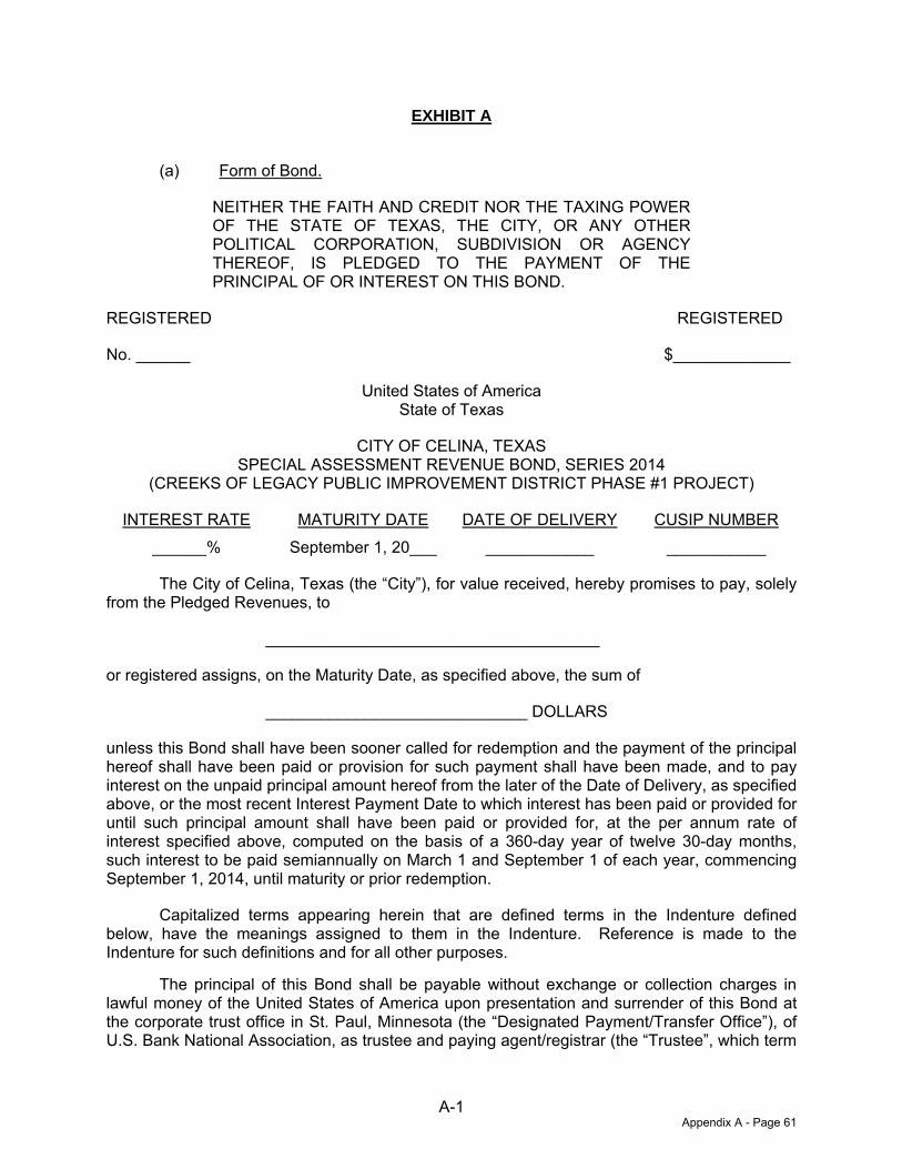
71476765.11/10706668 A-1
EXHIBIT A
(a) Form of Bond.
NEITHER THE FAITH AND CREDIT NOR THE TAXING POWER OF THE STATE OF TEXAS, THE CITY, OR ANY OTHER POLITICAL CORPORATION, SUBDIVISION OR AGENCY THEREOF, IS PLEDGED TO THE PAYMENT OF THE PRINCIPAL OF OR INTEREST ON THIS BOND.
REGISTERED REGISTERED
No. ______ $_____________
United States of America State of Texas
CITY OF CELINA, TEXAS SPECIAL ASSESSMENT REVENUE BOND, SERIES 2014
(CREEKS OF LEGACY PUBLIC IMPROVEMENT DISTRICT PHASE #1 PROJECT)
INTEREST RATE MATURITY DATE DATE OF DELIVERY CUSIP NUMBER ______% September 1, 20___ ____________ ___________
The City of Celina, Texas (the “City”), for value received, hereby promises to pay, solely from the Pledged Revenues, to
_____________________________________
or registered assigns, on the Maturity Date, as specified above, the sum of
_____________________________ DOLLARS
unless this Bond shall have been sooner called for redemption and the payment of the principal hereof shall have been paid or provision for such payment shall have been made, and to pay interest on the unpaid principal amount hereof from the later of the Date of Delivery, as specified above, or the most recent Interest Payment Date to which interest has been paid or provided for until such principal amount shall have been paid or provided for, at the per annum rate of interest specified above, computed on the basis of a 360-day year of twelve 30-day months, such interest to be paid semiannually on March 1 and September 1 of each year, commencing September 1, 2014, until maturity or prior redemption.
Capitalized terms appearing herein that are defined terms in the Indenture defined below, have the meanings assigned to them in the Indenture. Reference is made to the Indenture for such definitions and for all other purposes.
The principal of this Bond shall be payable without exchange or collection charges in lawful money of the United States of America upon presentation and surrender of this Bond at the corporate trust office in St. Paul, Minnesota (the “Designated Payment/Transfer Office”), of U.S. Bank National Association, as trustee and paying agent/registrar (the “Trustee”, which term
Appendix A - Page 61
Indenture of Trust 71476765.11/10706668 A-2
includes any successor trustee under the Indenture), or, with respect to a successor trustee and paying agent/registrar, at the Designated Payment/Transfer Office of such successor. Interest on this Bond is payable by check dated as of the Interest Payment Date, mailed by the Trustee to the registered owner at the address shown on the registration books kept by the Trustee or by such other customary banking arrangements acceptable to the Trustee, requested by, and at the risk and expense of, the Person to whom interest is to be paid. For the purpose of the payment of interest on this Bond, the registered owner shall be the Person in whose name this Bond is registered at the close of business on the “Record Date,” which shall be the fifteenth day of the month next preceding such Interest Payment Date; provided, however, that in the event of nonpayment of interest on a scheduled Interest Payment Date, and for 30 days thereafter, a new record date for such interest payment (a “Special Record Date”) will be established by the Trustee, if and when funds for the payment of such interest have been received from the City. Notice of the Special Record Date and of the scheduled payment date of the past due interest (the “Special Payment Date,” which shall be 15 days after the Special Record Date) shall be sent at least five Business Days prior to the Special Record Date by United States mail, first class postage prepaid, to the address of each Owner of a Bond appearing on the books of the Trustee at the close of business on the last Business Day preceding the date of mailing such notice.
If a date for the payment of the principal of or interest on the Bonds is a Saturday, Sunday, legal holiday, or a day on which banking institutions in the city in which the Designated Payment/Transfer Office is located are authorized by law or executive order to close, then the date for such payment shall be the next succeeding Business Day, and payment on such date shall have the same force and effect as if made on the original date payment was due.
This Bond is one of a duly authorized issue of assessment revenue bonds of the City having the designation specified in its title (herein referred to as the “Bonds”), dated June 1, 2014 and issued in the aggregate principal amount of $8,750,000 and issued, with the limitations described herein, pursuant to an Indenture of Trust, dated as of June 1, 2014 (the “Indenture”), by and between the City and the Trustee, to which Indenture reference is hereby made for a description of the amounts thereby pledged and assigned, the nature and extent of the lien and security, the respective rights thereunder to the holders of the Bonds, the Trustee, and the City, and the terms upon which the Bonds are, and are to be, authenticated and delivered and by this reference to the terms of which each holder of this Bond hereby consents. All Bonds issued under the Indenture are equally and ratably secured by the amounts thereby pledged and assigned. The Bonds are being issued for the purpose of (i) paying a portion of the Costs of the Phase #1 Projects, (ii) paying a portion of the interest on the Bonds during and after the period of acquisition and construction of the Phase #1 Projects, (ii) funding a reserve fund for payment of principal and interest on Bonds, (iv) paying a portion of the costs incidental to the organization of the District, and (v) paying the costs of issuing the Bonds.
The Bonds are limited obligations of the City payable solely from the Pledged Revenues as defined in the Indenture. Reference is hereby made to the Indenture, copies of which are on file with and available upon request from the Trustee, for the provisions, among others, with respect to the nature and extent of the duties and obligations of the City, the Trustee and the Owners. The Owner of this Bond, by the acceptance hereof, is deemed to have agreed and consented to the terms, conditions and provisions of the Indenture.
Notwithstanding any provision hereof, the Indenture may be released and the obligation of the City to make money available to pay this Bond may be defeased by the deposit of money and/or certain direct or indirect Defeasance Securities sufficient for such purpose as described in the Indenture.
Appendix A - Page 62
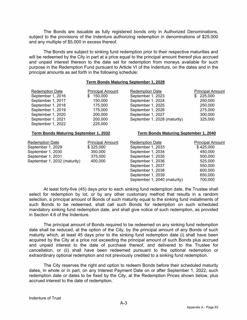
Indenture of Trust 71476765.11/10706668 A-3
The Bonds are issuable as fully registered bonds only in Authorized Denominations, subject to the provisions of the Indenture authorizing redemption in denominations of $25,000 and any multiple of $5,000 in excess thereof.
The Bonds are subject to sinking fund redemption prior to their respective maturities and will be redeemed by the City in part at a price equal to the principal amount thereof plus accrued and unpaid interest thereon to the date set for redemption from moneys available for such purpose in the Redemption Fund pursuant to Article VI of the Indenture, on the dates and in the principal amounts as set forth in the following schedule:
Term Bonds Maturing September 1, 2028
Redemption Date Principal Amount Redemption Date Principal Amount September 1, 2016 $ 150,000 September 1, 2023 $ 225,000 September 1, 2017 150,000 September 1, 2024 250,000 September 1, 2018 175,000 September 1, 2025 250,000 September 1, 2019 175,000 September 1, 2026 275,000 September 1, 2020 200,000 September 1, 2027 300,000 September 1, 2021 200,000 September 1, 2028 (maturity) 325,000 September 1, 2022 225,000
Term Bonds Maturing September 1, 2032 Term Bonds Maturing September 1, 2040
Redemption Date Principal Amount Redemption Date Principal Amount September 1, 2029 $ 325,000 September 1, 2033 $ 425,000 September 1, 2030 350,000 September 1, 2034 450,000 September 1, 2031 375,000 September 1, 2035 500,000 September 1, 2032 (maturity) 400,000 September 1, 2036 525,000
September 1, 2037 550,000 September 1, 2038 600,000 September 1, 2039 650,000 September 1, 2040 (maturity) 700,000
At least forty-five (45) days prior to each sinking fund redemption date, the Trustee shall select for redemption by lot, or by any other customary method that results in a random selection, a principal amount of Bonds of such maturity equal to the sinking fund installments of such Bonds to be redeemed, shall call such Bonds for redemption on such scheduled mandatory sinking fund redemption date, and shall give notice of such redemption, as provided in Section 4.6 of the Indenture.
The principal amount of Bonds required to be redeemed on any sinking fund redemption date shall be reduced, at the option of the City, by the principal amount of any Bonds of such maturity which, at least 45 days prior to the sinking fund redemption date (i) shall have been acquired by the City at a price not exceeding the principal amount of such Bonds plus accrued and unpaid interest to the date of purchase thereof, and delivered to the Trustee for cancellation, or (ii) shall have been redeemed pursuant to the optional redemption or extraordinary optional redemption and not previously credited to a sinking fund redemption.
The City reserves the right and option to redeem Bonds before their scheduled maturity dates, in whole or in part, on any Interest Payment Date on or after September 1, 2022, such redemption date or dates to be fixed by the City, at the Redemption Prices shown below, plus accrued interest to the date of redemption.
Appendix A - Page 63
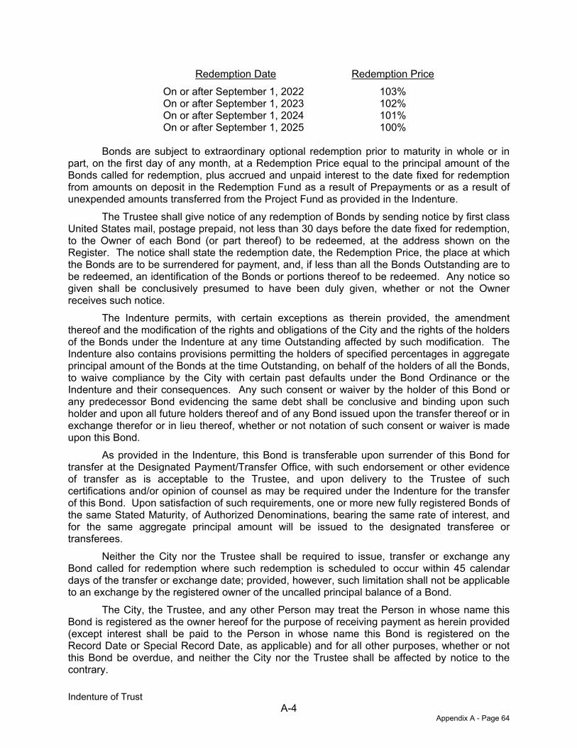
Indenture of Trust 71476765.11/10706668 A-4
Redemption Date Redemption Price On or after September 1, 2022 103% On or after September 1, 2023 102% On or after September 1, 2024 101% On or after September 1, 2025 100%
Bonds are subject to extraordinary optional redemption prior to maturity in whole or in
part, on the first day of any month, at a Redemption Price equal to the principal amount of the Bonds called for redemption, plus accrued and unpaid interest to the date fixed for redemption from amounts on deposit in the Redemption Fund as a result of Prepayments or as a result of unexpended amounts transferred from the Project Fund as provided in the Indenture.
The Trustee shall give notice of any redemption of Bonds by sending notice by first class United States mail, postage prepaid, not less than 30 days before the date fixed for redemption, to the Owner of each Bond (or part thereof) to be redeemed, at the address shown on the Register. The notice shall state the redemption date, the Redemption Price, the place at which the Bonds are to be surrendered for payment, and, if less than all the Bonds Outstanding are to be redeemed, an identification of the Bonds or portions thereof to be redeemed. Any notice so given shall be conclusively presumed to have been duly given, whether or not the Owner receives such notice.
The Indenture permits, with certain exceptions as therein provided, the amendment thereof and the modification of the rights and obligations of the City and the rights of the holders of the Bonds under the Indenture at any time Outstanding affected by such modification. The Indenture also contains provisions permitting the holders of specified percentages in aggregate principal amount of the Bonds at the time Outstanding, on behalf of the holders of all the Bonds, to waive compliance by the City with certain past defaults under the Bond Ordinance or the Indenture and their consequences. Any such consent or waiver by the holder of this Bond or any predecessor Bond evidencing the same debt shall be conclusive and binding upon such holder and upon all future holders thereof and of any Bond issued upon the transfer thereof or in exchange therefor or in lieu thereof, whether or not notation of such consent or waiver is made upon this Bond.
As provided in the Indenture, this Bond is transferable upon surrender of this Bond for transfer at the Designated Payment/Transfer Office, with such endorsement or other evidence of transfer as is acceptable to the Trustee, and upon delivery to the Trustee of such certifications and/or opinion of counsel as may be required under the Indenture for the transfer of this Bond. Upon satisfaction of such requirements, one or more new fully registered Bonds of the same Stated Maturity, of Authorized Denominations, bearing the same rate of interest, and for the same aggregate principal amount will be issued to the designated transferee or transferees.
Neither the City nor the Trustee shall be required to issue, transfer or exchange any Bond called for redemption where such redemption is scheduled to occur within 45 calendar days of the transfer or exchange date; provided, however, such limitation shall not be applicable to an exchange by the registered owner of the uncalled principal balance of a Bond.
The City, the Trustee, and any other Person may treat the Person in whose name this Bond is registered as the owner hereof for the purpose of receiving payment as herein provided (except interest shall be paid to the Person in whose name this Bond is registered on the Record Date or Special Record Date, as applicable) and for all other purposes, whether or not this Bond be overdue, and neither the City nor the Trustee shall be affected by notice to the contrary.
Appendix A - Page 64
Indenture of Trust 71476765.11/10706668 A-5
The City has reserved the right to issue Additional Bonds on the terms and conditions specified in the Indenture.
NEITHER THE FULL FAITH AND CREDIT NOR THE GENERAL TAXING POWER OF THE CITY OF CELINA, TEXAS, COLLIN COUNTY, TEXAS, DENTON COUNTY, TEXAS OR THE STATE OF TEXAS, OR ANY POLITICAL SUBDIVISION THEREOF, IS PLEDGED TO THE PAYMENT OF THE BONDS.
IT IS HEREBY CERTIFIED AND RECITED that the issuance of this Bond and the series of which it is a part is duly authorized by law; that all acts, conditions and things required to be done precedent to and in the issuance of the Bonds have been properly done and performed and have happened in regular and due time, form and manner, as required by law; and that the total indebtedness of the City, including the Bonds, does not exceed any Constitutional or statutory limitation.
IN WITNESS WHEREOF, the City Council of the City has caused this Bond to be executed under the official seal of the City.
________________________________ Mayor Pro Tem, City of Celina, Texas
________________________________ City Secretary, City of Celina, Texas
[City Seal]
(b) Form of Comptroller’s Registration Certificate.
The following Registration Certificate of Comptroller of Public Accounts shall appear on the Initial Bond:
REGISTRATION CERTIFICATE OF COMPTROLLER OF PUBLIC ACCOUNTS
OFFICE OF THE COMPTROLLER § OF PUBLIC ACCOUNTS § REGISTER NO.__________________ § THE STATE OF TEXAS §
I HEREBY CERTIFY THAT there is on file and of record in my office a certificate to the effect that the Attorney General of the State of Texas has approved this Bond, and that this Bond has been registered this day by me.
WITNESS MY SIGNATURE AND SEAL OF OFFICE this _____________________
__________________________________ Comptroller of Public Accounts of the State of Texas
[SEAL]
Appendix A - Page 65
Indenture of Trust 71476765.11/10706668 A-6
(c) Form of Certificate of Trustee.
CERTIFICATE OF TRUSTEE
It is hereby certified that this is one of the Bonds of the series of Bonds referred to in the within mentioned Indenture.
U.S. BANK NATIONAL ASSOCIATION, Dallas, Texas, as Trustee
DATED: ___________________
By:__________________________ Authorized Signatory
(d) Form of Assignment.
ASSIGNMENT
FOR VALUE RECEIVED, the undersigned hereby sells, assigns, and transfers unto (print or typewrite name, address and zip code of transferee): __________________________________________________________________________ __________________________________________________________________________ _________________________________________________________________________
(Social Security or other identifying number: ______________________) the within Bond and all rights hereunder and hereby irrevocably constitutes and appoints _______________________ attorney to transfer the within Bond on the books kept for registration hereof, with full power of substitution in the premises.
Date: ________________ _____________________________________
Signature Guaranteed By: NOTICE: The signature on this Assignment must correspond with the name of the registered owner as it appears on the face of the within Bond in every particular and must be guaranteed in a manner acceptable to the Trustee.
_______________________________ _______________________________
Authorized Signatory
Appendix A - Page 66
Indenture of Trust 71476765.11/10706668 A-7
(e) The Initial Bond shall be in the form set forth in paragraphs (a) through (d) of this Exhibit A, except for the following alterations:
(i) immediately under the name of the Bond the heading “INTEREST RATE” and “MATURITY DATE” shall both be completed with the expression “As Shown Below,” and the reference to the “CUSIP NUMBER” shall be deleted;
(ii) in the first paragraph of the Bond, the words “on the Maturity Date specified above” shall be deleted and the following will be inserted: “on September 1 in each of the years, in the principal installments and bearing interest at the per annum rates set forth in the following schedule:
Years Principal Installments Interest Rates”
(Information to be inserted from Section 3.2(c) hereof); and
(iii) the Initial Bond shall be numbered T-1.
Appendix A - Page 67

(THIS PAGE IS INTENTIONALLY LEFT BLANK.)

APPENDIX B
FORM OF SERVICE AND ASSESSMENT PLAN

(THIS PAGE IS INTENTIONALLY LEFT BLANK)
CREEKS OF LEGACY
PUBLIC IMPROVEMENT DISTRICT
SERVICE AND ASSESSMENT PLAN
JUNE 18, 2014
MuniCap v 2.4
Appendix B - Page 1

CREEKS OF LEGACY PUBLIC IMPROVEMENT DISTRICT
SERVICE AND ASSESSMENT PLAN
Table of Contents
Section I Plan Description and Defined Terms 1 Section II Property Included in the PID 8 Section III Description of Authorized Improvements 9 Section IV Service Plan 13 Section V Assessment Plan 17 Section VI Terms of the Assessments 25 Section VII Assessment Roll 30 Section VIII Miscellaneous Provisions 32
List of Appendix
Appendix A The PID Map
Appendix B Estimated Costs of the Authorized Improvements Appendix C Diagrams of the Authorized Improvements Appendix D Lot Types and Equivalent Units Appendix E Allocation of Assessments Appendix F Phases #2–3 Major Improvement Assessment Roll
Appendix G Phase #1 Assessment Roll
MuniCap v2.4
Appendix B - Page 2
1
Section I PLAN DESCRIPTION AND DEFINED TERMS
A. Introduction
On April 29, 2014 (the “Creation Date”) the City Council of the City of Celina, Texas (the "City") passed and approved Resolution No. 2014-17R approving and authorizing the creation of the Creeks of Legacy Improvement District (the “PID”) to finance the costs of certain public improvements for the benefit of property in the PID (the “Authorized Improvements”), all of which is located within the City of Celina. The property in the PID is proposed to be developed in approximately three phases, and the PID will finance public improvements for each phase as each phase is developed. Assessments will be imposed on the all property in the PID for the public improvements that benefit the entire PID and on the property in each phase for the public improvements to be provided for that phase. Chapter 372 of the Texas Local Government Code, the "Public Improvement District Assessment Act” (as amended, the “PID Act”), governs the creation and operation of public improvement districts within the State of Texas. The Creeks of Legacy Public Improvement District Service and Assessment Plan (the "Service and Assessment Plan") has been prepared in accordance with the PID Act and specifically Sections 372.013, 372.014, 372.015 and 372.016, which address the requirements of a service and assessment plan and the assessment roll. According to Section 372.013 of the PID Act, a service plan “must cover a period of at least five years and must also define the annual indebtedness and the projected costs for improvements. The plan shall be reviewed and updated annually for the purpose of determining the annual budget for improvements.” The service plan is described in Section IV of this Service and Assessment Plan. Section 372.014 of the PID Act requires that “an assessment plan must be included in the annual service plan.” The assessment plan is described in Section V of this Service and Assessment Plan. Section 372.015 of the PID Act requires that “the governing body of the municipality or county shall apportion the cost of an improvement to be assessed against property in an improvement district.” The method of assessing the Authorized Improvement Costs and apportionment of such costs to the property in the PID is included in Section V of this Service and Assessment Plan. Section 372.016 of the PID Act requires that “after the total cost of an improvement is determined, the governing body of the municipality or county shall prepare a proposed assessment roll. The roll must state the assessment against each parcel of land in the district, as determined by the method of assessment chosen by the municipality or county under this subchapter.” The Assessment Rolls for the PID are included as Appendix F and G of this Service and Assessment Plan. The Assessments as shown on the Assessment Roll are based on the method of assessment and apportionment of costs described in Section V of this Service and Assessment Plan.
Appendix B - Page 3
2
B. Definitions Capitalized terms used herein shall have the meanings ascribed to them as follows: “Actual Cost(s)” means, with respect to an Authorized Improvement, the demonstrated, reasonable, allocable, and allowable costs of constructing such Authorized Improvement, as specified in a Certification for Payment that has been reviewed and approved by the City. Actual Cost may include (a) the costs for the design, planning, financing, administration, management, acquisition, installation, construction and/or implementation of such Authorized Improvement, including general contractor construction management fees, if any, (b) the costs of preparing the construction plans for such Authorized Improvement, (c) the fees paid for obtaining permits, licenses or other governmental approvals for such Authorized Improvement, (d) the costs for external professional costs associated with such Authorized Improvement, such as engineering, geotechnical, surveying, land planning, architectural landscapers, advertising, marketing and research studies, appraisals, legal, accounting and similar professional services, taxes (property and franchise) (e) the costs of all labor, bonds and materials, including equipment and fixtures, incurred by contractors, builders and material men in connection with the acquisition, construction or implementation of the Authorized Improvements, (f) all related permitting, zoning and public approval expenses, architectural, engineering, legal, and consulting fees, financing charges, taxes, governmental fees and charges (including inspection fees, County permit fees, development fees), insurance premiums, miscellaneous expenses, and all advances and payments for Administrative Expenses. Actual Costs include general contractor’s fees in an amount up to a percentage equal to the percentage of work completed and accepted by the City or construction management fees in an amount up to five percent of the eligible Actual Costs described in a Certification for Payment. The amounts expended on legal costs, taxes, governmental fees, insurance premiums, permits, financing costs, and appraisals shall be excluded from the base upon which the general contractor and construction management fees are calculated. “Administrator” means the employee or designee of the City, identified in any indenture of trust relating to the Bonds or in any other agreement approved by the City Council, who shall have the responsibilities provided for herein. “Administrative Expenses” mean the administrative, organization, maintenance and operation costs associated with, or incident to, the administration, organization, maintenance and operation of the PID, including, but not limited to, the costs of: (i) creating and organizing the PID, including conducting hearings, preparing notices and petitions, and all costs incident thereto, including engineering fees, legal fees and consultant fees, (ii) the annual administrative, organization, maintenance, and operation costs and expenses associated with, or incident and allocable to, the administration, organization, and operation of the PID, (iii) computing, levying, billing and collecting Assessments or the Annual Installments thereof, (iv) maintaining the record of installments of the Assessments and the system of registration and transfer of the Bonds, (v) paying and redeeming the Bonds, (vi) investing or depositing of monies, (vii) complying with the PID Act and codes with respect to the Bonds, (viii) the Trustee fees and expenses relating to the Bonds, including reasonable fees, (ix) legal counsel, engineers, accountants, financial advisors, investment bankers or other consultants and advisors, and (x) administering the construction of the Authorized Improvements. Administrative Expenses do not include payment of the actual
Appendix B - Page 4

3
principal of, redemption premium, if any, and interest on the Bonds. Administrative Expenses collected and not expended for actual Administrative Expenses shall be carried forward and applied to reduce Administrative Expenses in subsequent years to avoid the over-collection of amounts to pay Administrative Expenses. “Annual Installment” means, with respect to each Parcel, each annual payment of: (i) the Assessments, as shown on the Assessment Rolls attached hereto as Appendix F and Appendix G, as applicable, or in an Annual Service Plan Update, and calculated as provided in Section VI of this Service and Assessment Plan, (ii) the prepayment reserve described in Section IV of this Service and Assessment Plan, and (iii) the delinquency reserve. “Annual Service Plan Update” has the meaning set forth in the second paragraph of Section IV of this Service and Assessment Plan. “Assessed Property” means the property that benefits from the Authorized Improvements to be provided by the PID on which Assessments have been imposed as shown in the Assessment Roll, as the Assessment Roll is updated each year by the Annual Service Plan Update. Assessed Property includes Parcels within the PID other than Non-Benefited Property. “Assessment” means an assessment levied against a Parcel imposed pursuant to an Assessment Ordinance and the provisions herein, as shown on any Assessment Roll, subject to reallocation upon the subdivision of such Parcel or reduction according to the provisions herein and the PID Act. An Assessment for a Parcel consists of the Annual Installments to be collected in all years and includes the Assessments including those collected to pay Administrative Expenses and interest on all Assessments. “Assessment Ordinance” means an Assessment Ordinance adopted by the City Council approving the Service and Assessment Plan (including amendments or supplements to the Service and Assessment Plan) and levying the Assessments. “Assessment Revenues” mean the revenues actually received by or on behalf of the City from the collection of Assessments. “Assessment Roll” means, as applicable, the Phases #2 – 3 Assessment Roll, the Phase #1 Assessment Roll, an Assessment Roll for Phases #2 - 3 of development or any other Assessment Roll in an amendment or supplement to this Service and Assessment Plan or in an Annual Service Plan Update. “Authorized Improvements” mean those public improvements described in Appendix B of this Service and Assessment Plan and Section 372.003 of the PID Act, constructed and installed in accordance with this Service and Assessment Plan, and any future updates and/or amendments. “Authorized Improvement Costs” mean the actual or budgeted costs, as applicable, of all or any portion of the Authorized Improvements, as shown in Appendix B. “Bonds” mean any bonds issued by the City in one or more series and secured in whole or in part by the Assessment Revenues.
“Certification for Payment” means the certificate to be provided by the Developer, or his Appendix B - Page 5
4
designee, to substantiate the Actual Cost of one or more Authorized Improvements. “ “City” means the City of Celina, Texas. “City Council” means the duly elected governing body of the City.
“Delinquent Collection Costs” mean interest, penalties and expenses incurred or imposed with respect to any delinquent installment of an Assessment in accordance with the PID Act and the costs related to pursuing collection of a delinquent Assessment and foreclosing the lien against the Assessed Property, including attorney’s fees. “Developer” means CADG Frontier 192, LLC, a Texas limited liability company. “Equivalent Units” mean, as to any Parcel the number of dwelling units by lot type expected to be built on the Parcel multiplied by the factors calculated and shown in Appendix D attached hereto. “Future Phases” means Phases that are fully developed after Phase #1, as such areas are generally depicted in Appendix A. The Future Phases are subject to adjustment and are shown for example only. “Homeowner Association Property” means property within the boundaries of the PID that is owned by or irrevocably offered for dedication to, whether in fee simple or through an exclusive use easement, a home owners’ association. “Lot” means a tract of land described as a “lot” in a subdivision plat recorded in the official public records of Denton County, Texas. “Lot Type” means a classification of final building lots with similar characteristics (e.g. commercial, light industrial, multifamily residential, single family residential, etc.), as determined by the Administrator and confirmed by the City Council. In the case of single family residential lots, the Lot Type shall be further defined by classifying the residential lots by the estimated final average home value for each lot as of the date of the recorded subdivision plat, considering factors such as density, lot size, proximity to amenities, view premiums, location, and any other factors that may impact the average home value on the lot, as determined by the Administrator and confirmed by the City Council. “Lot type 1” means lots identified as such on the Assessment Roll, being lots with approximately 7,700 square feet size and a lot width of 70 feet, which may be referred to as such in PD #46. “Lot type 2” means lots identified as such on the Assessment Roll, being lots with approximately 6,600 square feet size and a lot width of 60 feet, which may be referred to as such in PD #46. “Lot type 3” means lots identified as such on the Assessment Roll, being lots with approximately 5,500 square feet size and a lot width of 50 feet, which may be referred to as such in PD #46. “Major Improvements” or “MI” mean the Authorized Improvements which benefit all Assessed Property within the PID and are described in Section III.B.
Appendix B - Page 6
5
“Non-Benefited Property” means Parcels that accrue no special benefit from the Authorized Improvements, including Homeowner Association Property, Public Property and easements that create an exclusive use for a public utility provider. Property identified as Non-Benefited Property at the time the Assessments (i) are imposed or (ii) are reallocated pursuant to a subdivision of a Parcel, is not assessed. Assessed Property converted to Non-Benefited Property, if the Assessments may not be reallocated pursuant to the provisions herein, remains subject to the Assessments and requires the Assessments to be prepaid as provided for in Section VI. E. 2. “Parcel” or “Parcels” means a parcel or parcels within the PID identified by either a tax map identification number assigned by the Denton Central Appraisal District or Collin Central Appraisal District for real property tax purposes or by lot and block number in a final subdivision plat recorded in the real property records of Denton County or Collin County. “Phase” means one or more Parcels within the PID that will be developed in the same general time period. The Parcels within a Phase will be assessed in connection with the issuance of Phased PID Bonds for Authorized Improvements (or the portion thereof) designated in an update to this Service and Assessment Plan that specially benefit the Parcels within the Phase. “Phase #1” means the initial Phase to be developed, identified as “Phase #1” and generally shown in Appendix A, as specifically depicted and described as the sum of all Parcels shown in Appendix G. “Phase #1 Assessed Property” means all Parcels within Phase #1 other than Non-Benefited Property and shown in the Phase #1 Assessment Roll against which an Assessment relating to the Phase #1 Improvements is levied. “Phases #1 Assessment Revenues” mean the actual revenues received by or on behalf of the City from the collection of Assessments levied against Phase #1 Assessed Property, or the Annual Installments thereof, for the Phase #1 Improvements. “Phase #1 Assessment Roll” means the document included in this Service and Assessment Plan as Appendix G, as updated, modified or amended from time to time in accordance with the procedures set forth herein and in the PID Act, including updates prepared in connection with the issuance of Bonds or in connection with any Annual Service Plan Update. "Phase #1 Bonds" mean collectively the Phase #1A Bonds and the Phase #1B Bonds to be issued by the City to finance the Phase #1 Improvements. “Phase #1 Improvements” mean (i) the pro rata portion of the Major Improvements allocable to Phase #1, and (ii) the Authorized Improvements which only benefit Phase #1 Assessed Property and are described in Section III.C.
“Phase #1A Bonds” mean those certain "City of Celina, Texas, Special Assessment Revenue Bonds, Series 2014 (Creeks of Legacy Improvement District Phase #1 Project)" that are secured primarily by Phase #1 Assessment Revenue. “Phase #1B Bonds” mean the bonds to be issued subsequent to the Phase #1A Bonds to finance the remaining costs of the Phase #1 Improvements and that will be secured primarily by Phase #1
Appendix B - Page 7
6
Assessment Revenue. “Phased PID Bonds” mean bonds issued to fund Authorized Improvements (or a portion thereof) in a Phase. In connection with the Phased PID Bonds, Assessments will be levied only on Parcels located within the Phase in question. “Phases #2 - 3” mean the property within the PID excluding Phase #1 which is to be developed subsequent to Phase #1 and generally depicted in Appendix A of this Service and Assessment Plan or any Annual Service Plan Update.
“Phases #2 - 3 Assessed Property” means, for any year, all Parcels within the PID other than (a) Non-Benefited Property, and (b) Parcels within Phase #1. “Phases #2 - 3 Major Improvements” mean (i) the pro rata portion of the Major Improvements allocable to Phases #2 - 3 and are described in Section III.C.
“Phases #2 - 3 Major Improvement Assessment Revenues” mean the revenues actually received by or on behalf of the City from the collection of Assessments levied against Phases #2 - 3 Assessed Property, or the Annual Installments thereof, for the Major Improvements. “Phases #2 - 3 Major Improvement Assessment Roll” means the document included in this Service and Assessment Plan as Appendix F, as updated, modified or amended from time to time in accordance with the procedures set forth herein and in the PID Act, including updates prepared in connection with the issuance of Bonds or in connection with any Annual Service Plan Update.
“Phases #2 – 3 Major Improvement Bonds” mean those certain "City of Celina, Texas, Special Assessment Revenue Bonds, Series 2014 (Creeks of Legacy Improvement District Phases #2 – 3 Major Improvement Project)" that are secured primarily by Phases #2 - 3 Major Improvement Assessment Revenues. “PID” has the meaning set forth in Section I.A of this Service and Assessment Plan. “PID Act” means Texas Local Government Code Chapter 372, Public Improvement District Assessment Act, Subchapter A, Public Improvement Districts, as amended. “PD #46” means Planned Development District, #46 passed and approved by the City pursuant to Ordinance No 2014-06 dated as of February 11, 2014. “Prepayment Costs” mean interest and expenses to the date of prepayment, plus any additional expenses related to the prepayment, reasonably expected to be incurred by or imposed upon the City as a result of any prepayment of an Assessment. “Public Property” means property within the boundaries of the PID that is owned by or irrevocably offered for dedication to the federal government, the State of Texas, Denton County, the City, a school district or any other public agency, whether in fee simple or through an exclusive use easement. “Reimbursement Agreement” means each Reimbursement Agreement by and between the City and the Developer in which the Developer agrees to fund the Actual Costs of certain Authorized
Appendix B - Page 8

7
Improvements and the City agrees to reimburse the Developer for the Actual Costs of those Authorized Improvements funded by the Developer with interest as permitted by the Act. “Service and Assessment Plan” means this Service and Assessment Plan prepared for the PID pursuant to the PID Act, as the same may be amended from time to time. “TIRZ No. 2” means the Tax Increment Reinvestment Zone No. 2, City of Celina, Texas.
“TIRZ Credit” means, for each Parcel, the prorated amount of TIRZ Revenues calculated pursuant to Section VI (B) of this Service and Assessment Plan. “TIRZ Ordinance” means an ordinance adopted by the City Council authorizing the use of TIRZ Revenues for project costs under the Tax Increment Financing Act, Texas Tax Code, Chapter 311, as amended, relating to the Authorized Improvements as provided for in the Tax Increment Reinvestment Zone No. 2 Project Plan and Financing Plan (including amendments or supplements thereto). “TIRZ Revenues” mean, for each year, the amounts paid by the City from the TIRZ No. 2 tax increment fund pursuant to the TIRZ Ordinance to reduce an Annual Installment, as calculated each year by the Administrator in collaboration with the City, in accordance with Section VI.B of this Service and Assessment Plan. “Trust Indenture” means an indenture of trust, ordinance or similar document setting forth the terms and other provisions relating to the Bonds, as modified, amended, and/or supplemented from time to time. “Trustee” means the fiscal agent or trustee as specified in the Trust Indenture, including a substitute fiscal agent or trustee.
Appendix B - Page 9
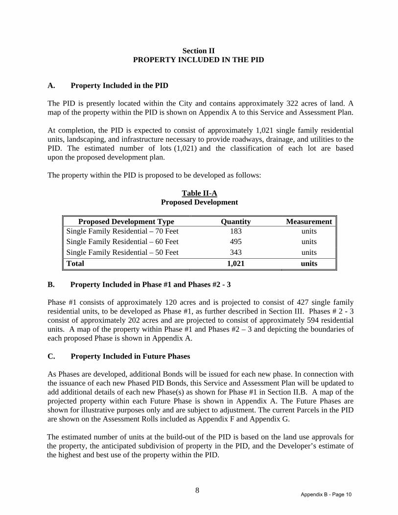
8
Section II PROPERTY INCLUDED IN THE PID
A. Property Included in the PID The PID is presently located within the City and contains approximately 322 acres of land. A map of the property within the PID is shown on Appendix A to this Service and Assessment Plan. At completion, the PID is expected to consist of approximately 1,021 single family residential units, landscaping, and infrastructure necessary to provide roadways, drainage, and utilities to the PID. The estimated number of lots (1,021) and the classification of each lot are based upon the proposed development plan. The property within the PID is proposed to be developed as follows:
Table II-A Proposed Development
Proposed Development Type Quantity Measurement
Single Family Residential – 70 Feet 183 units Single Family Residential – 60 Feet 495 units Single Family Residential – 50 Feet 343 units Total 1,021 units
B. Property Included in Phase #1 and Phases #2 - 3 Phase #1 consists of approximately 120 acres and is projected to consist of 427 single family residential units, to be developed as Phase #1, as further described in Section III. Phases # 2 - 3 consist of approximately 202 acres and are projected to consist of approximately 594 residential units. A map of the property within Phase #1 and Phases #2 – 3 and depicting the boundaries of each proposed Phase is shown in Appendix A. C. Property Included in Future Phases As Phases are developed, additional Bonds will be issued for each new phase. In connection with the issuance of each new Phased PID Bonds, this Service and Assessment Plan will be updated to add additional details of each new Phase(s) as shown for Phase #1 in Section II.B. A map of the projected property within each Future Phase is shown in Appendix A. The Future Phases are shown for illustrative purposes only and are subject to adjustment. The current Parcels in the PID are shown on the Assessment Rolls included as Appendix F and Appendix G. The estimated number of units at the build-out of the PID is based on the land use approvals for the property, the anticipated subdivision of property in the PID, and the Developer’s estimate of the highest and best use of the property within the PID.
Appendix B - Page 10
9
Section III DESCRIPTION OF THE AUTHORIZED IMPROVEMENTS
A. Authorized Improvement Overview Section 372.003 of the PID Act defines the improvements that may be undertaken by a municipality or county through the establishment of a public improvement district, as follows:
372.003. Authorized Improvements
(a) If the governing body of a municipality or county finds that it promotes the interests of the municipality or county, the governing body may undertake an improvement project that confers a special benefit on a definable part of the municipality or county or the municipality’s extraterritorial jurisdiction. A project may be undertaken in the municipality or county or the municipality’s extraterritorial jurisdiction.
(b) A public improvement may include:
(i) landscaping;
(ii) erection of fountains, distinctive lighting, and signs;
(iii) acquiring, constructing, improving, widening, narrowing, closing, or rerouting of sidewalks or of streets, any other roadways, or their rights-of way;
(iv) construction or improvement of pedestrian malls;
(v) acquisition and installation of pieces of art;
(vi) acquisition, construction, or improvement of libraries;
(vii) acquisition, construction, or improvement of off-street parking facilities;
(viii) acquisition, construction, improvement, or rerouting of mass transportation facilities;
(ix) acquisition, construction, or improvement of water, wastewater, or drainage
facilities or improvements;
(x) the establishment or improvement of parks;
(xi) projects similar to those listed in Subdivisions (i)-(x);
(xii) acquisition, by purchase or otherwise, of real property in connection with an authorized improvement;
(xiii) special supplemental services for improvement and promotion of the district,
including services relating to advertising, promotion, health and sanitation, water and wastewater, public safety, security, business recruitment, development, recreation, and cultural enhancement; and
Appendix B - Page 11
10
(xiv) payment of expenses incurred in the establishment, administration and operation of the district.
After analyzing the public improvement projects authorized by the PID Act, the City has determined that the Authorized Improvements as described in Appendix B and shown on the diagram included as Appendix C should be undertaken by the City for the benefit of the property within the PID. B. Description of Estimated Costs of Major Improvements The Major Improvements benefit the entire PID. The costs of the Major Improvements are allocated proportionally throughout the entire PID, excluding Non-Benefited Property, in a manner that anticipates planned development of the PID based on the Equivalent Units as calculated and shown in Appendix D using the planned lot types and anticipated number of lots. The Major Improvements descriptions are presented below as provided by the project engineer. The costs of the Major Improvements are shown in Table III-A. The costs shown in Table III-A are estimates and may be revised in Annual Service Plan Updates, including such other improvements as deemed necessary to further improve the properties within the PID. Road Improvements: Frontier Parkway is currently a 2-lane gravel road. The Creeks of Legacy development will expand that to a 3-lane (120’ right-of-way) paved road approximately 7,485. Legacy Drive is currently a 2-lane gravel road. The Creeks of Legacy development will expand that to a six lane (120’ right-of-way) paved road approximately 3,430 linear feet. Water Distribution System Improvements: Currently, there are no water services adjacent to the development. A twelve (12”) inch water line will be constructed to serve the development. The line starts at an existing stub near the entrance of Light Farms to the northeast. The line will continue along the east side of the Dallas North Tollway (DNT). The line will cross underneath the DNT and along the north side of Frontier Parkway. The total length along the DNT is 5,685 linear feet. An additional 12 inch water line extension will extend along Frontier Parkway to the west side of the Creeks of Legacy boundary and along Legacy Dr for approximately 16,594 linear feet. Sanitary Sewer Improvements: An existing thirty six (36”) inch Doe Branch sanitary sewer line is located north of the development. An eighteen (18”) inch gravity sanitary sewer line is proposed to connect into Doe Branch and then reduces to a fifteen (15”) inch gravity flow sewer line that runs along Frontier Parkway until it reaches the DNT. The proposed line is designed to carry the flow of the development along with the future commercial tracts that will be located between the development and the DNT. The sanitary sewer line has also factored approximately 500 acres of commercial tracts located east of the DNT. This line benefits the entire development along with the surrounding future areas.
Appendix B - Page 12
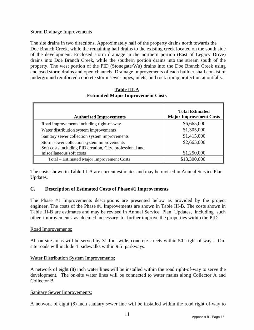
11
Storm Drainage Improvements The site drains in two directions. Approximately half of the property drains north towards the Doe Branch Creek, while the remaining half drains to the existing creek located on the south side of the development. Enclosed storm drainage in the northern portion (East of Legacy Drive) drains into Doe Branch Creek, while the southern portion drains into the stream south of the property. The west portion of the PID (Stonegate/Wu) drains into the Doe Branch Creek using enclosed storm drains and open channels. Drainage improvements of each builder shall consist of underground reinforced concrete storm sewer pipes, inlets, and rock riprap protection at outfalls.
Table III-A Estimated Major Improvement Costs
Authorized ImprovementsTotal Estimated
Major Improvement Costs Road improvements including right-of-way Water distribution system improvements Sanitary sewer collection system improvements Storm sewer collection system improvements Soft costs including PID creation, City, professional and miscellaneous soft costs
$6,665,000 $1,305,000 $1,415,000 $2,665,000
$1,250,000
Total – Estimated Major Improvement Costs $13,300,000
The costs shown in Table III-A are current estimates and may be revised in Annual Service Plan Updates. C. Description of Estimated Costs of Phase #1 Improvements The Phase #1 Improvements descriptions are presented below as provided by the project engineer. The costs of the Phase #1 Improvements are shown in Table III-B. The costs shown in Table III-B are estimates and may be revised in Annual Service Plan Updates, including such other improvements as deemed necessary to further improve the properties within the PID. Road Improvements: All on-site areas will be served by 31-foot wide, concrete streets within 50’ right-of-ways. On-site roads will include 4’ sidewalks within 9.5’ parkways. Water Distribution System Improvements: A network of eight (8) inch water lines will be installed within the road right-of-way to serve the development. The on-site water lines will be connected to water mains along Collector A and Collector B. Sanitary Sewer Improvements: A network of eight (8) inch sanitary sewer line will be installed within the road right-of-way to
Appendix B - Page 13
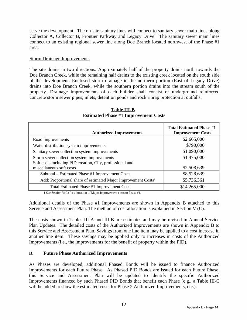
12
serve the development. The on-site sanitary lines will connect to sanitary sewer main lines along Collector A, Collector B, Frontier Parkway and Legacy Drive. The sanitary sewer main lines connect to an existing regional sewer line along Doe Branch located northwest of the Phase #1 area. Storm Drainage Improvements The site drains in two directions. Approximately half of the property drains north towards the Doe Branch Creek, while the remaining half drains to the existing creek located on the south side of the development. Enclosed storm drainage in the northern portion (East of Legacy Drive) drains into Doe Branch Creek, while the southern portion drains into the stream south of the property. Drainage improvements of each builder shall consist of underground reinforced concrete storm sewer pipes, inlets, detention ponds and rock riprap protection at outfalls.
Table III-B Estimated Phase #1 Improvement Costs
Authorized Improvements
Total Estimated Phase #1 Improvement Costs
Road improvements Water distribution system improvements Sanitary sewer collection system improvements Storm sewer collection system improvements Soft costs including PID creation, City, professional and miscellaneous soft costs
$2,665,000 $790,000
$1,090,000 $1,475,000
$2,508,639
Subtotal – Estimated Phase #1 Improvement Costs Add: Proportional share of estimated Major Improvement Costs1
$8,528,639 $5,736,361
Total Estimated Phase #1 Improvement Costs $14,265,000 1 See Section V(C) for allocation of Major Improvement costs to Phase #1.
Additional details of the Phase #1 Improvements are shown in Appendix B attached to this Service and Assessment Plan. The method of cost allocation is explained in Section V (C). The costs shown in Tables III-A and III-B are estimates and may be revised in Annual Service Plan Updates. The detailed costs of the Authorized Improvements are shown in Appendix B to this Service and Assessment Plan. Savings from one line item may be applied to a cost increase in another line item. These savings may be applied only to increases in costs of the Authorized Improvements (i.e., the improvements for the benefit of property within the PID). D. Future Phase Authorized Improvements As Phases are developed, additional Phased Bonds will be issued to finance Authorized Improvements for each Future Phase. As Phased PID Bonds are issued for each Future Phase, this Service and Assessment Plan will be updated to identify the specific Authorized Improvements financed by such Phased PID Bonds that benefit each Phase (e.g., a Table III-C will be added to show the estimated costs for Phase 2 Authorized Improvements, etc.).
Appendix B - Page 14
13
Section IV SERVICE PLAN
A. Sources and Uses of Funds The PID Act requires the service plan to cover a period of at least five years. The service plan is required to define the annual projected costs and indebtedness for the Authorized Improvements undertaken within the PID during the five year period. It is anticipated that it will take approximately 12 months to construct the Major Improvements to be financed with the Phases #2 - 3 Major Improvement Bonds and approximately 12 months for the Phase #1 Improvements to be constructed. At some point after all or a portion of the Major Improvements and Phase #1 Improvements are constructed, Phase #2 will begin development. After Phase #2 is developed, it is anticipated that Phase #3 will begin development, and so on, with each Future Phase to be subsequently developed corresponding to the Service and Assessment Plan to be updated with that development. The estimated Actual Costs for Major Improvements and Phase #1 Improvements plus costs related to the issuance of the Bonds, in one or more series, for the Major Improvements and Phase #1 Improvements and payment of expenses incurred in the establishment, administration and operation of the PID is $24,413,055 as shown in Table IV-A. The service plan shall be reviewed and updated at least annually for the purpose of determining the annual budget for Administrative Expenses, updating the estimated Authorized Improvement costs, and updating the Assessment Roll(s). Any update to this Service and Assessment Plan is herein referred to as an “Annual Service Plan Update.” Table IV-A summarizes the sources and uses of funds required to construct the Major Improvements to be financed with the Phases #2 - 3 Major Improvement Bonds and Phase #1 Improvements, establish the PID, and issue the Phase #1 PID Bonds and Phases #2 – 3 Major Improvement Bonds. The sources and uses of funds shown in Table V-A shall be updated each year in the Annual Service Plan Update to reflect any budget revisions and Actual Costs. As Future Phases are developed in connection with the issuance of Phased PID Bonds, this Service and Assessment Plan will be amended (e.g. Table IV-A will be amended to add Phase #2, etc.). Bonds to finance the Major Improvements and Phase #1 Improvements are expected to be issued starting in 2014. Table IV-A shows the sources and uses of the Bonds.
Appendix B - Page 15
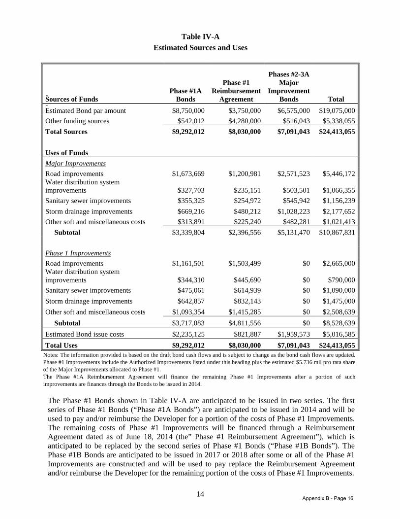
14
Table IV-A
Estimated Sources and Uses
Sources of Funds Phase #1A
Bonds
Phase #1 Reimbursement
Agreement
Phases #2-3A Major
Improvement Bonds Total
Estimated Bond par amount $8,750,000 $3,750,000 $6,575,000 $19,075,000 Other funding sources $542,012 $4,280,000 $516,043 $5,338,055 Total Sources $9,292,012 $8,030,000 $7,091,043 $24,413,055 Uses of Funds Major Improvements Road improvements $1,673,669 $1,200,981 $2,571,523 $5,446,172 Water distribution system improvements $327,703 $235,151 $503,501 $1,066,355 Sanitary sewer improvements $355,325 $254,972 $545,942 $1,156,239 Storm drainage improvements $669,216 $480,212 $1,028,223 $2,177,652 Other soft and miscellaneous costs $313,891 $225,240 $482,281 $1,021,413 Subtotal $3,339,804 $2,396,556 $5,131,470 $10,867,831 Phase 1 Improvements Road improvements $1,161,501 $1,503,499 $0 $2,665,000 Water distribution system improvements $344,310 $445,690 $0 $790,000 Sanitary sewer improvements $475,061 $614,939 $0 $1,090,000 Storm drainage improvements $642,857 $832,143 $0 $1,475,000 Other soft and miscellaneous costs $1,093,354 $1,415,285 $0 $2,508,639 Subtotal $3,717,083 $4,811,556 $0 $8,528,639 Estimated Bond issue costs $2,235,125 $821,887 $1,959,573 $5,016,585 Total Uses $9,292,012 $8,030,000 $7,091,043 $24,413,055
Notes: The information provided is based on the draft bond cash flows and is subject to change as the bond cash flows are updated. Phase #1 Improvements include the Authorized Improvements listed under this heading plus the estimated $5.736 mil pro rata share of the Major Improvements allocated to Phase #1. The Phase #1A Reimbursement Agreement will finance the remaining Phase #1 Improvements after a portion of such improvements are finances through the Bonds to be issued in 2014.
The Phase #1 Bonds shown in Table IV-A are anticipated to be issued in two series. The first series of Phase #1 Bonds (“Phase #1A Bonds”) are anticipated to be issued in 2014 and will be used to pay and/or reimburse the Developer for a portion of the costs of Phase #1 Improvements. The remaining costs of Phase #1 Improvements will be financed through a Reimbursement Agreement dated as of June 18, 2014 (the” Phase #1 Reimbursement Agreement”), which is anticipated to be replaced by the second series of Phase #1 Bonds (“Phase #1B Bonds”). The Phase #1B Bonds are anticipated to be issued in 2017 or 2018 after some or all of the Phase #1 Improvements are constructed and will be used to pay replace the Reimbursement Agreement and/or reimburse the Developer for the remaining portion of the costs of Phase #1 Improvements.
Appendix B - Page 16
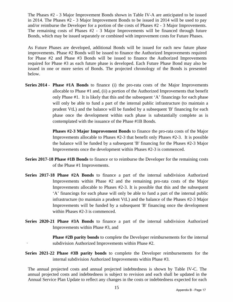
15
The Phases #2 - 3 Major Improvement Bonds shown in Table IV-A are anticipated to be issued in 2014. The Phases #2 - 3 Major Improvement Bonds to be issued in 2014 will be used to pay and/or reimburse the Developer for a portion of the costs of Phases #2 - 3 Major Improvements. The remaining costs of Phases #2 - 3 Major Improvements will be financed through future Bonds, which may be issued separately or combined with improvement costs for Future Phases. As Future Phases are developed, additional Bonds will be issued for each new future phase improvements. Phase #2 Bonds will be issued to finance the Authorized Improvements required for Phase #2 and Phase #3 Bonds will be issued to finance the Authorized Improvements required for Phase #3 as each future phase is developed. Each Future Phase Bond may also be issued in one or more series of Bonds. The projected chronology of the Bonds is presented below.
Series 2014 - Phase #1A Bonds to finance (i) the pro-rata costs of the Major Improvements allocable to Phase #1 and, (ii) a portion of the Authorized Improvements that benefit only Phase #1. It is likely that this and the subsequent ‘A’ financings for each phase will only be able to fund a part of the internal public infrastructure (to maintain a prudent VtL) and the balance will be funded by a subsequent 'B' financing for each phase once the development within each phase is substantially complete as is contemplated with the issuance of the Phase #1B Bonds.
Phases #2-3 Major Improvement Bonds to finance the pro-rata costs of the Major Improvements allocable to Phases #2-3 that benefit only Phases #2-3. It is possible the balance will be funded by a subsequent 'B' financing for the Phases #2-3 Major Improvements once the development within Phases #2-3 is commenced.
Series 2017-18 Phase #1B Bonds to finance or to reimburse the Developer for the remaining costs of the Phase #1 Improvements.
Series 2017-18 Phase #2A Bonds to finance a part of the internal subdivision Authorized Improvements within Phase #2 and the remaining pro-rata costs of the Major Improvements allocable to Phases #2-3. It is possible that this and the subsequent ‘A’ financings for each phase will only be able to fund a part of the internal public infrastructure (to maintain a prudent VtL) and the balance of the Phases #2-3 Major Improvements will be funded by a subsequent 'B' financing once the development within Phases #2-3 is commenced.
Series 2020-21 Phase #3A Bonds to finance a part of the internal subdivision Authorized Improvements within Phase #3, and
Phase #2B parity bonds to complete the Developer reimbursements for the internal subdivision Authorized Improvements within Phase #2.
Series 2021-22 Phase #3B parity bonds to complete the Developer reimbursements for the internal subdivision Authorized Improvements within Phase #3.
The annual projected costs and annual projected indebtedness is shown by Table IV-C. The annual projected costs and indebtedness is subject to revision and each shall be updated in the Annual Service Plan Update to reflect any changes in the costs or indebtedness expected for each
Appendix B - Page 17
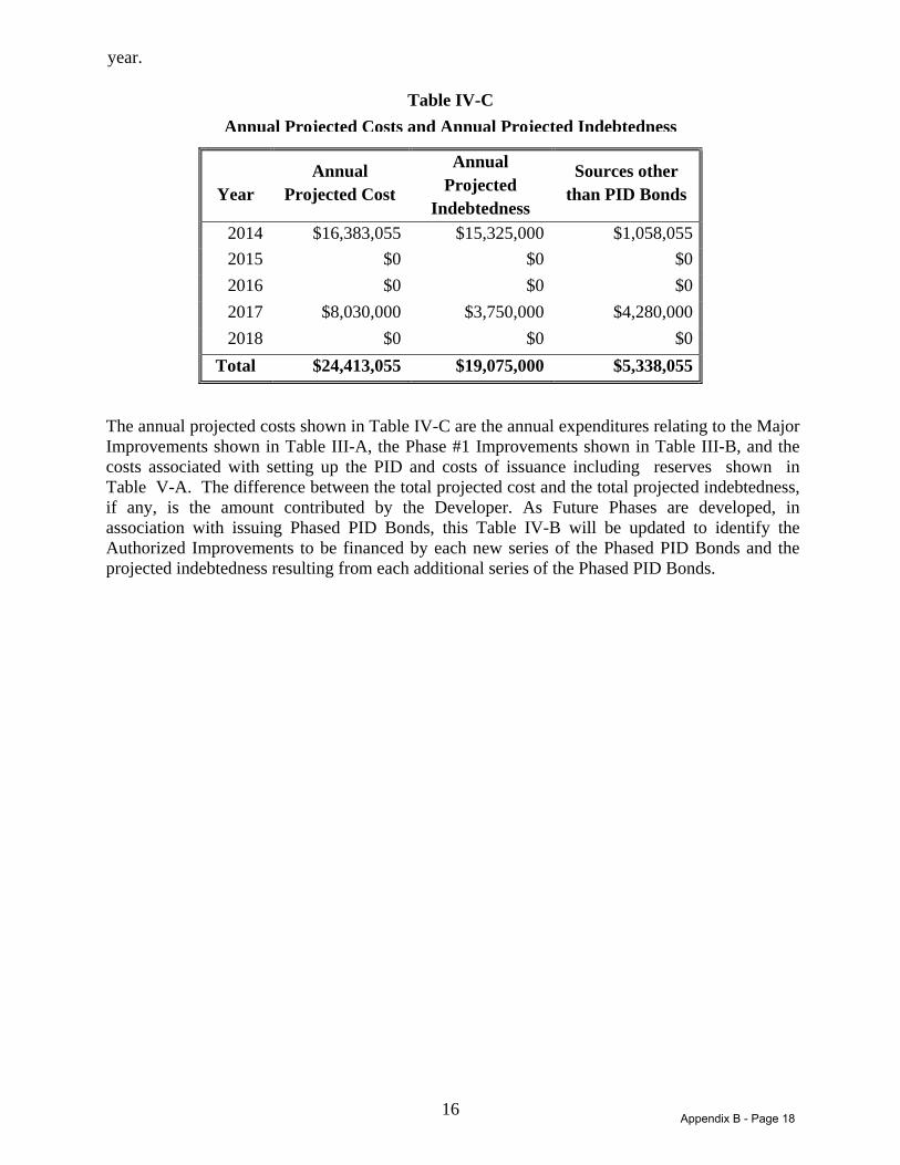
16
year.
Table IV-C Annual Projected Costs and Annual Projected Indebtedness
Year Annual
Projected Cost
Annual Projected
Indebtedness
Sources other than PID Bonds
2014 $16,383,055 $15,325,000 $1,058,055 2015 $0 $0 $0 2016 $0 $0 $0 2017 $8,030,000 $3,750,000 $4,280,000 2018 $0 $0 $0
Total $24,413,055 $19,075,000 $5,338,055
The annual projected costs shown in Table IV-C are the annual expenditures relating to the Major Improvements shown in Table III-A, the Phase #1 Improvements shown in Table III-B, and the costs associated with setting up the PID and costs of issuance including reserves shown in Table V-A. The difference between the total projected cost and the total projected indebtedness, if any, is the amount contributed by the Developer. As Future Phases are developed, in association with issuing Phased PID Bonds, this Table IV-B will be updated to identify the Authorized Improvements to be financed by each new series of the Phased PID Bonds and the projected indebtedness resulting from each additional series of the Phased PID Bonds.
Appendix B - Page 18
17
Section V ASSESSMENT PLAN
A. Introduction The PID Act requires the City Council to apportion the costs of the Authorized Improvements on the basis of special benefits conferred upon the property because of the Authorized Improvements. The PID Act provides that the costs of the Authorized Improvements may be assessed: (i) equally per front foot or square foot; (ii) according to the value of the property as determined by the governing body, with or without regard to improvements on the property; or (iii) in any other manner that results in imposing equal shares of the cost on property similarly benefited. The PID Act further provides that the governing body may establish by ordinance or order reasonable classifications and formulas for the apportionment of the cost between the municipality and the area to be assessed and the methods of assessing the special benefits for various classes of improvements. The proposed bond issuance program entails a series of bond financings that are intended to finance the public infrastructure required for the development. This financing will necessarily be undertaken in phases to coincide with the private investment and development of the Authorized Improvements. Following the initial Phase #1A Bonds and the Phases #2 – 3 Major Improvement Bonds to be issued in 2014 and the Phase #1B Bonds, subsequent financings are to be issued over the upcoming decade as the three subsequent phases (Phases #2 and #3) of the development are gradually constructed. The purpose of this gradual issuance of bonds in phases is to mirror the actual private development of the Authorized Improvements. The Bonds to be issued are most prudently and efficiently utilized when directly coinciding with construction of public infrastructure needed for private development that is to occur once the infrastructure is completed; it is most effective to issue the Bonds when the infrastructure is needed, not before. Furthermore, there is no economic advantage, and several disadvantages, to issuing debt and encumbering property within the PID prior to the need for the Authorized Improvements.
Additionally, phased issuance of debt will maintain a prudent value to lien ("VtL") within the financing program. In order to maintain a prudent VtL, the initial issuance of bonds for a specific set of Authorized Improvements may not fund the entire desired level of public infrastructure because the property value is not high enough to support the entire debt load at the VtL chosen for the development. In that case, the Developer will need to fund the additional infrastructure costs with cash at closing. This cash investment by the Developer for certain Authorized Improvements can be reimbursed by a subsequent parity lien bond financing, secured by the same special assessments, once the assessed property is partially or fully developed and the value has increased sufficiently to permit the issuance of the additional bonds in a prudent fashion. For example, the Phase #1A Bonds to be issued to finance a portion of the Phase #1 Improvements, including the pro-rata costs of the Major Improvements allocable to Phase #1 Assessed Property, followed by a second parity lien issuance of bonds (the Phase #1B Bonds) demonstrates this analysis. For purposes of this Service and Assessment Plan, the City Council has determined that the costs of the Major Improvements and Phase #1 Improvements shall be allocated as described below:
1. The Major Improvement and Phase #1 Improvement costs shall be allocated on the basis of the relative value of Parcels once such property is developed, and that such
Appendix B - Page 19

18
method of allocation will result in the imposition of equal shares of the costs of the Authorized Improvements to Parcels similarly benefited.
2. The City Council has concluded that larger more expensive homes are likely to be built on the larger lots, and that larger more expensive homes are likely to make greater use of and receive greater benefit from the Authorized Improvements. In determining the relative values of Parcels, the City Council has taken in to consideration (i) the type of development (i.e., residential, commercial, etc.), (ii) single-family lot sizes and the size of homes likely to be built on lots of different sizes, (iii) current and projected home process provided by the Developer, (iv) the Authorized Improvements to be provided and the estimated costs, and (v) the ability of different property types to utilize and benefit from the improvements.
3. The Assessed Property is classified into different Lot Types as described in Appendix D based on the type and size of proposed development on each Parcel.
4. Equivalent Units are calculated for each Lot Type based on the relative value of each Lot Type.
5. The Major Improvement costs are proportionally allocated to the Phases #2 – 3 Assessed Property and the Phase #1 Assessed Property based on the ratio of total Equivalent Units estimated for the Phases #2 - 3 Assessed Property and the Phase #1 Assessed Property.
6. The Phases #2 - 3 Assessed Property’s proportional share of the costs for the Major Improvements is allocated to each Parcel within the Phases #2 – 3 Assessed Property based on the total Equivalent Units estimated for each Parcel.
7. The Phase #1 Improvement costs (including Phase #1 Assessed Property’s proportional share of the costs of the Major Improvements) are allocated to each Parcel within the Phase #1 Assessed Property based on the total Equivalent Units estimated for each Parcel.
Table V-A provides the estimated allocation of costs of the Authorized Improvements constituting Major Improvements and Phase #1 Improvements. At this time it is impossible to determine with absolute certainty the amount of special benefit each Parcel within Future Phases will receive from internal subdivision Authorized Improvements that will benefit each individual phase and that are to be financed with Phased PID Bonds. Therefore, at this time Parcels will only be assessed for the special benefits conferred upon the Parcel because of the Major Improvements and Phase #1 Improvements. In connection with the issuance of Phased PID Bonds and/or execution of related reimbursement agreements, this Service and Assessment Plan will be updated to reflect the special benefit each Parcel of Assessed Property within a Future Phase receives from the specific Authorized Improvements funded with those Phased PID Bonds issued with respect to that Future Phase. Prior to assessing Parcels located within Future Phases in connection with issuance of Phased PID Bonds, each owner of the Parcels to be assessed must acknowledge that the Authorized Improvements to be financed confer a special benefit on their Parcel and must consent to the imposition of the Assessments to pay for the Actual Costs of such Authorized Improvements. This section of this Service and Assessment Plan currently (i) describes the special benefit received by each Parcel within the PID as a result of the Major Improvements and Phase #1 Improvements, (ii) provides the basis and justification for the determination that this special benefit exceeds the amount of the Assessments to be levied on the Phase #1 Assessed Property and Phases #2 – 3 Assessed Property for such improvements, and (iii) establishes the methodologies by which the City Council allocates and reallocates the special benefit of the Major Improvements and Phase #1 Improvements to Parcels in a manner that results in equal shares of the Actual Costs of such improvements being apportioned to Parcels similarly
Appendix B - Page 20
19
benefited. The determination by the City Council of the assessment methodologies set forth below is the result of the discretionary exercise by the City Council of its legislative authority and governmental powers and is conclusive and binding on the Developer and all future owners and developers of the Assessed Property. As Future Phases are developed, in connection with the issuance of Phased PID Bonds this Service and Assessment Plan will be updated based on the City’s determination of the assessment methodology for each Future Phase. B. Special Benefit Assessed Property must receive a direct and special benefit from the Authorized Improvements, and this benefit must be equal to or greater than the amount of the Assessments. The Authorized Improvements are provided specifically for the benefit of the Assessed Property. The Authorized Improvements (more particularly described in line-item format in Appendix B to this Service and Assessment Plan) and the costs of issuance and payment of costs incurred in the establishment of the PID shown in Table IV-A are authorized by the Act. These improvements are provided specifically for the benefit of the Assessed Property.
Each owner of the Assessed Property has acknowledged that the Authorized Improvements confer a special benefit on the Assessed Property and has consented to the imposition of the Assessments to pay for the Actual Costs associated therewith. Each of the owners is acting in its interest in consenting to this apportionment and levying of the Assessments because the special benefit conferred upon the Assessed Property by the Authorized Improvements exceeds the amount of the Assessments. The public improvements provide a special benefit to the Assessed Property as a result of the close proximity of these improvements to the Assessed Property and the specific purpose of these improvements of providing infrastructure for the Assessed Property. In other words, the Assessed Property could not be used in the manner proposed without the construction of the Authorized Improvements. The Authorized Improvements are being provided specifically to meet the needs of the Assessed Property as required for the proposed use of the property. The Assessments are being levied to provide the Authorized Improvements that are required for the highest and best use of the Assessed Property (i.e., the use of the property that is most valuable, including any costs associated with that use). Highest and best use can be defined as “the reasonably probable and legal use of property, which is physically possible, appropriately supported, financially feasible, and that results in the highest value.” (Dictionary of Real Estate Appraisal, Third Edition.) The Authorized Improvements are expected to be required for the proposed use of the Assessed Property to be physically possible, appropriately supported, financially feasible, and maximally productive. The Developer has evaluated the potential use of the property and has determined that the highest and best use of the property is the use intended and the legal use for the property as described in Section II of this Service and Assessment Plan. The use of the Assessed Property as described herein will require the construction of the Authorized Improvements. The special assessments will repay financing that is on advantageous terms, as the Bonds issued to finance the public improvements will pay interest that is exempt from federal income tax. As a result, all other terms being equal (e.g., maturity, fixed vs. variable rate, credit quality), the tax- exempt bonds will have a lower interest rate than debt that is not tax-exempt. The Bonds also
Appendix B - Page 21

20
have a longer term than other available financings and may either be repaid or assumed by a buyer at the buyer’s option. As a result of these advantageous terms, the financing provided by the PID is the most beneficial means of financing the Authorized Improvements. Each owner of the Assessed Property will ratify, confirm, accept, agree to and approve; (i) the determinations and finding by the City Council as to the special benefits described in this Service and Assessment Plan and the Assessment Ordinance; (ii) the Service and Assessment Plan and the Assessment Ordinance, and (iii) the levying of Assessments on the Assessed Property. Use of the Assessed Property as described in this Service and Assessment Plan and as authorized by the PID Act requires that Authorized Improvements be acquired, constructed, installed, and/or improved. Funding the Actual Costs of the Authorized Improvements through the PID has been determined by the City Council to be the most beneficial means of doing so. As a result, the Assessments result in a special benefit to the Assessed Property, and this special benefit exceeds the amount of the Assessment. This conclusion is based on and supported by the evidence, information, and testimony provided to the City Council. In summary, the Assessments result in a special benefit to the Assessed Property for the following reasons:
1. The Authorized Improvements are being provided specifically for the use of the Assessed Property, are necessary for the proposed best use of the property and provide a special benefit to the Assessed Property as a result;
2. The Developer has consented to the imposition of the Assessments for the purpose of
providing the Authorized Improvements and the Developer is acting in its interest by consenting to this imposition;
3. The Authorized Improvements are required for the highest and best use of the property; 4. The highest and best use of the Assessed Property is the use of the Assessed Property that
is most valuable (including any costs associated with the use of the Assessed Property); 5. Financing of the costs of the Authorized Improvement through the PID is determined to
be the most beneficial means of providing for the Authorized Improvements; and, 6. As a result, the special benefits to the Assessed Property from the Authorized Improvements will be equal to or greater than the Assessments.
C. Allocation of Costs to Assessed Property
The Major Improvements will provide a special benefit to all property in the PID. Accordingly, the estimated Major Improvement costs must be allocated throughout all Assessed Property in the District. Table V-A summarizes the allocation of estimated costs for each Major Improvement. The costs shown in Table V-A are estimates and may be revised in Annual Service Plan Updates, but the related Assessment may not be increased. Phase #1 is projected to contain 427 residential units. As shown in Appendix D, the total Equivalent Units for Phase #1 is calculated as 374.80. Phases #2 – 3 are projected to contain 594 residential units resulting in a total of 494.19 Equivalent Units as shown in Appendix D. The Total projected Equivalent Units in the PID is, therefore, calculated to be 868.99 (i.e., 374.80 + 494.19 = 868.99). As a result, 43.13 percent of the estimated costs of Major Improvements (i.e. 374.80 ÷ 868.99 = 43.13%) are allocated to the Phase #1 Assessed Property and 56.87 percent of
Appendix B - Page 22
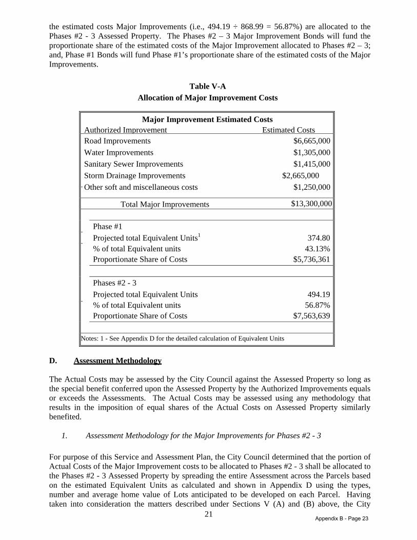
21
the estimated costs Major Improvements (i.e., 494.19 ÷ 868.99 = 56.87%) are allocated to the Phases #2 - 3 Assessed Property. The Phases #2 – 3 Major Improvement Bonds will fund the proportionate share of the estimated costs of the Major Improvement allocated to Phases #2 – 3; and, Phase #1 Bonds will fund Phase #1’s proportionate share of the estimated costs of the Major Improvements.
Table V-A Allocation of Major Improvement Costs
Major Improvement Estimated Costs Authorized Improvement Estimated Costs Road Improvements $6,665,000 Water Improvements $1,305,000 Sanitary Sewer Improvements $1,415,000 Storm Drainage Improvements $2,665,000 Other soft and miscellaneous costs $1,250,000
Total Major Improvements $13,300,000
Phase #1 Projected total Equivalent Units1 374.80 % of total Equivalent units 43.13% Proportionate Share of Costs $5,736,361
Phases #2 - 3 Projected total Equivalent Units 494.19 % of total Equivalent units 56.87% Proportionate Share of Costs $7,563,639
Notes: 1 - See Appendix D for the detailed calculation of Equivalent Units
D. Assessment Methodology The Actual Costs may be assessed by the City Council against the Assessed Property so long as the special benefit conferred upon the Assessed Property by the Authorized Improvements equals or exceeds the Assessments. The Actual Costs may be assessed using any methodology that results in the imposition of equal shares of the Actual Costs on Assessed Property similarly benefited.
1. Assessment Methodology for the Major Improvements for Phases #2 - 3
For purpose of this Service and Assessment Plan, the City Council determined that the portion of Actual Costs of the Major Improvement costs to be allocated to Phases #2 - 3 shall be allocated to the Phases #2 - 3 Assessed Property by spreading the entire Assessment across the Parcels based on the estimated Equivalent Units as calculated and shown in Appendix D using the types, number and average home value of Lots anticipated to be developed on each Parcel. Having taken into consideration the matters described under Sections V (A) and (B) above, the City
Appendix B - Page 23
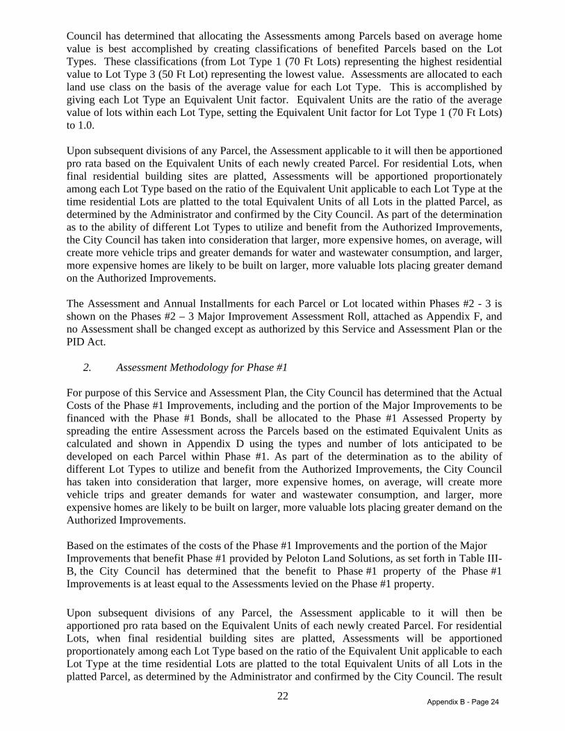
22
Council has determined that allocating the Assessments among Parcels based on average home value is best accomplished by creating classifications of benefited Parcels based on the Lot Types. These classifications (from Lot Type 1 (70 Ft Lots) representing the highest residential value to Lot Type 3 (50 Ft Lot) representing the lowest value. Assessments are allocated to each land use class on the basis of the average value for each Lot Type. This is accomplished by giving each Lot Type an Equivalent Unit factor. Equivalent Units are the ratio of the average value of lots within each Lot Type, setting the Equivalent Unit factor for Lot Type 1 (70 Ft Lots) to 1.0. Upon subsequent divisions of any Parcel, the Assessment applicable to it will then be apportioned pro rata based on the Equivalent Units of each newly created Parcel. For residential Lots, when final residential building sites are platted, Assessments will be apportioned proportionately among each Lot Type based on the ratio of the Equivalent Unit applicable to each Lot Type at the time residential Lots are platted to the total Equivalent Units of all Lots in the platted Parcel, as determined by the Administrator and confirmed by the City Council. As part of the determination as to the ability of different Lot Types to utilize and benefit from the Authorized Improvements, the City Council has taken into consideration that larger, more expensive homes, on average, will create more vehicle trips and greater demands for water and wastewater consumption, and larger, more expensive homes are likely to be built on larger, more valuable lots placing greater demand on the Authorized Improvements. The Assessment and Annual Installments for each Parcel or Lot located within Phases #2 - 3 is shown on the Phases #2 – 3 Major Improvement Assessment Roll, attached as Appendix F, and no Assessment shall be changed except as authorized by this Service and Assessment Plan or the PID Act.
2. Assessment Methodology for Phase #1 For purpose of this Service and Assessment Plan, the City Council has determined that the Actual Costs of the Phase #1 Improvements, including and the portion of the Major Improvements to be financed with the Phase #1 Bonds, shall be allocated to the Phase #1 Assessed Property by spreading the entire Assessment across the Parcels based on the estimated Equivalent Units as calculated and shown in Appendix D using the types and number of lots anticipated to be developed on each Parcel within Phase #1. As part of the determination as to the ability of different Lot Types to utilize and benefit from the Authorized Improvements, the City Council has taken into consideration that larger, more expensive homes, on average, will create more vehicle trips and greater demands for water and wastewater consumption, and larger, more expensive homes are likely to be built on larger, more valuable lots placing greater demand on the Authorized Improvements. Based on the estimates of the costs of the Phase #1 Improvements and the portion of the Major Improvements that benefit Phase #1 provided by Peloton Land Solutions, as set forth in Table III-B, the City Council has determined that the benefit to Phase #1 property of the Phase #1 Improvements is at least equal to the Assessments levied on the Phase #1 property.
Upon subsequent divisions of any Parcel, the Assessment applicable to it will then be apportioned pro rata based on the Equivalent Units of each newly created Parcel. For residential Lots, when final residential building sites are platted, Assessments will be apportioned proportionately among each Lot Type based on the ratio of the Equivalent Unit applicable to each Lot Type at the time residential Lots are platted to the total Equivalent Units of all Lots in the platted Parcel, as determined by the Administrator and confirmed by the City Council. The result
Appendix B - Page 24
23
of this approach is that each final residential Lot within a recorded subdivision plat with similar values will have the same Assessment, with larger, more valuable Lots having a proportionately larger share of the Assessments than smaller, less valuable Lots. As part of the determination as to the ability of different Lot Types to utilize and benefit from the Authorized Improvements, the City Council has taken into consideration that larger, more expensive homes, on average, will create more vehicle trips and greater demands for water and wastewater consumption, and larger, more expensive homes are likely to be built on larger, more valuable lots placing greater demand on the Authorized Improvements. The Assessment and Annual Installments for each Parcel or Lot located within Phase #1 is shown on the Phase #1 Assessment Roll, attached as Appendix G, and no Assessment shall be changed except as authorized by this Service and Assessment Plan or the PID Act. Appendix E shows the detailed calculation of the Assessment per Equivalent Unit and the Assessment for each Lot type.
3. Assessment Methodology for Future Phases When any given Future Phase is developed, and Phased PID Bonds for that Future Phase are to be issued, this Service and Assessment Plan will be amended to determine the assessment methodology that results in the imposition of equal shares of the Actual Costs on Assessed Property similarly benefited within that Phase.
E. Assessments The Assessments for the Phase #1 Bonds and the Phases #2 – 3 Major Improvement Bonds will be levied on each Parcel according to the Phases #2 – 3 Major Improvement Assessment Roll and the Phase #1 Assessment Roll, attached hereto as Appendix F and Appendix G, respectively. The Annual Installments for the Phases #2 – 3 Major Improvement Bonds and the Phase #1 Bonds will be collected at the time and in the amounts shown on the Phases #2 – 3 Major Improvement Assessment Roll and the Phase #1 Assessment Roll, respectively, subject to any revisions made during an Annual Service Plan Update. F. Administrative Expenses The cost of administering the PID and collecting the Annual Installments shall be paid for on a pro rata basis by each Parcel based on the amount of Assessment levied against the Parcel. The Administrative Expenses shall be collected as part of and in the same manner as Annual Installments in the amounts shown on the Assessment Roll, which may be revised based on actual costs incurred in Annual Service Plan Updates. G. Prepayment Reserve Pursuant to the PID Act, the interest rate for Assessments may exceed the actual interest rate per annum paid on the related Bonds by no more than one half of one percent (0.50%). The interest rate used to determine the Assessments is one half of one percent (0.50%) per annum higher than the actual rate paid on the Bonds, with up to 0.20% allocated to fund the associated interest charged between the date of prepayment of an Assessment and the date on which Bonds are prepaid and up to 0.30% allocated to fund a delinquency reserve account as described below. The prepayment reserve shall be funded until it reaches ___% of the outstanding Bonds as stipulated in the Bond documents. Once the prepayment reserve is funded in full, any additional interest collected shall be allocated to fund delinquent payments as described in H below.
Appendix B - Page 25
24
H. Delinquency Reserve The City has allocated up to 0.30% of the interest rate component of the Annual Installments to offset any possible delinquent payments. The additional reserve shall be funded up to 4% of the outstanding Bonds, but in no event will the annual collection, together with the Prepayment reserve, be more than 0.50% of the outstanding Bonds. The City may allocate up to 0.50% of the interest rate component of the Annual Installments to pay for Administrative Expenses, improvement costs, any other use that benefits the Assessed Property or reduce the Assessments, as determined by the City Council. I. TIRZ Credit
Pursuant to the TIRZ Ordinance, the City has agreed to use TIRZ Revenues (the 47.63% of the property tax increment collected and deposited into the TIRZ No. 2 tax increment fund) generated from each Parcel to offset a portion of such Parcel’s PID assessments (the "TIRZ Credit"). The Annual Installment for each Parcel shall be calculated by taking into consideration any TIRZ Credit applicable to the Parcel. The TIRZ Credit applicable to each Parcel shall be calculated as described under Section VI (B) of this Service and Assessment Plan.
Appendix B - Page 26
25
Section VI TERMS OF THE ASSESSMENTS
A. Amount of Assessments and Annual Installments for Parcels Located within Phases #2 - 3 The Assessment and Annual Installments for each Assessed Property located within Phases #2 - 3 are shown on the Phases #2 – 5 Major Improvement Assessment Roll, attached as Appendix F, and no Assessment shall be changed except as authorized by this Service and Assessment Plan and the PID Act. The Annual Installments shall be collected in an amount sufficient to pay principal and interest on the Phases #2 – 5 Major Improvement Bonds, to fund the prepayment reserve and delinquency reserve described in Section V, to cover Administrative Expenses of Phases #2 - 3. B. Amount of Assessments and Annual Installments for Parcels Located Within Phase #1 The Assessment and Annual Installments for each Assessed Property located within Phase #1 is shown on the Phase #1 Assessment Roll, attached as Appendix G, and no Assessment shall be changed except as authorized by this Service and Assessment Plan and the PID Act. The Annual Installments shall be collected in an amount sufficient to pay principal and interest on the Phase #1 Bonds, to fund the prepayment reserve and delinquency reserve described in Section V, and to cover Administrative Expenses of Phase #1. The Annual Installment for each Parcel shall be calculated by taking into consideration any TIRZ Credit applicable to the Parcel. The TIRZ Credit for each Parcel shall be calculated using the following formula:
A = B x (C ÷ D)
Where the terms have the following meanings:
A = the TIRZ Credit amount for a Parcel B = the total TIRZ Revenues collected for the preceding year C = the total Equivalent Unit of the Parcel D = the total Equivalent Units of all Parcels
The TIRZ Revenues collected in any given year shall be used to calculate the TIRZ Credit in the following year (i.e., TIRZ Revenues collected in 2015 shall be used to calculate the TIRZ Credit applicable to Annual Installments to be collected in 2016). TIRZ Credits shall be calculated for those Parcels that are subject to Assessments by the PID. The total TIRZ Revenues collected from all Parcels in each Phase shall be used to calculate the TIRZ Credit applicable to each Parcel within the Phase based on the above formula. The total TIRZ increment amount generated by all Phase #1 Assessed Property will be divided by the total Equivalent Units in Phase #1 to determine the TIRZ credit applicable to each Phase #1 Assessed Property. The total TIRZ increment amount generated by all Phases #2 - 3 Assessed Property will be divided by the total Equivalent Units in Phases #2 - 3 Assessed Property to determine the TIRZ credit applicable to each Phases #2 - 3 Assessed Property. The Equivalent Units to be used for the calculation of the TIRZ Credit shall be determined by the Administrator based on the information available to the
Appendix B - Page 27
26
Administrator at the time of such calculations. C. Amount of Assessments and Annual Installments for Parcels Located Within Future
Phases As Future Phases are developed, this Service and Assessment Plan will be amended to determine the Assessment and Annual Installments for each Assessed Property located within Future Phases (e.g., an Appendix will be added as the Assessment Roll for Phase 2, etc.). The Assessments shall not exceed the benefit received by the Assessed Property. D. Reallocation of Assessments 1. Subdivision Upon the subdivision of any Parcel, the Assessment for the Parcel prior to the subdivision shall be reallocated among the new subdivided Parcels according to the following formula:
A = B x (C ÷ D)
Where the terms have the following meanings:
A = the Assessment for each new subdivided Parcel B = the Assessment for the Parcel prior to subdivision C = the estimated Equivalent Units to be built on each new subdivided Parcel D = the sum of the estimated Equivalent Units to be built on all of the new subdivided
Parcels The calculation of the estimated number of units to be built on a Parcel shall be performed by the Administrator and confirmed by the City Council based on the information available regarding the use of the Parcel. The estimate as confirmed shall be conclusive. The number of units to be built on a Parcel may be estimated by net land area and reasonable density ratios. The sum of the Assessments for all newly subdivided Parcels shall equal the Assessment for the Parcel prior to subdivision. The calculation shall be made separately for each newly subdivided Parcel. The reallocation of an Assessment for a Parcel that is a homestead under Texas law may not exceed the Assessment prior to the reallocation and to the extent the reallocation would exceed such amount, it shall be prepaid by such amount by the party requesting the subdivision of the Parcels. Any reallocation pursuant to this section shall be reflected in an Annual Service Plan Update approved by the City Council. 2. Consolidation Upon the consolidation of two or more Parcels, the Assessment for the consolidated Parcel shall be the sum of the Assessments for the Parcels prior to consolidation. The reallocation of an Assessment for a Parcel that is a homestead under Texas law may not exceed the Assessment prior to the reallocation and to the extent the reallocation would exceed such amount, it shall be prepaid by such amount by the party requesting the consolidation of the Parcels. Any reallocation pursuant to this section shall be reflected in an Annual Service Plan Update
Appendix B - Page 28

27
approved by the City Council.
E. Mandatory Prepayment of Assessments 1. If a Parcel subject to Assessments is transferred to a party that is exempt from the payment of the Assessment under applicable law, or if an owner causes a Parcel subject to Assessments to become Non-Benefited Property, the owner of such Parcel shall pay to the City the full amount of the principal portion of the Assessment on such Parcel, plus all Prepayment Costs, prior to any such transfer or act. 3. The payments required above shall be treated the same as any Assessment that is due and owing under the Act, the Assessment Ordinance, and this Service and Assessment Plan, including the same lien priority, penalties, procedures, and foreclosure specified by the Act. F. Reduction of Assessments
1. If after all Authorized Improvements to be funded with a series of Bonds have been completed and Actual Costs for such Authorized Improvements are less than the Actual Costs used to calculate the Assessments securing such series of Bonds, resulting in excess Bond proceeds being available to redeem Bonds of such series, then the Assessment securing such series of Bonds for each Parcel of Assessed Property shall be reduced by the City Council pro rata such that the sum of the resulting reduced Assessments for all Assessed Properties equals the actual reduced Actual Costs and such excess Bond proceeds shall applied to redeem Bonds of such series. The Assessments shall not be reduced to an amount less than the related outstanding series of Bonds. If all of the Authorized Improvements are not completed, the City may reduce the Assessments in another method if it determines such method would better reflect the benefit received by the Parcels from the Authorized Improvements completed. 2. If all the Authorized Improvements are not undertaken, resulting in excess Bond proceeds being available to redeem Bonds, then the Assessments and Annual Installments for each Parcel shall be appropriately reduced by the City Council to reflect only the amounts required to repay the Bonds, including interest on the Bonds and Collection Costs, and such excess Bond proceeds shall be applied to redeem Bonds. The City Council may reduce the Assessments and the Annual Installments for each Parcel (i) in an amount that represents the Authorized Improvements provided for each Parcel or (ii) by an equal percentage calculated based on Equivalent Units, if determined by the City Council to be the most fair and practical means of reducing the Assessments for each Parcel, such that the sum of the resulting reduced Assessments equals the amount required to repay the Bonds, including interest on the Bonds and Collection Costs. The Principal Portion of the Assessment for each Parcel shall be reduced pro rata to the reduction in the Assessments for each Parcel such that the sum of the resulting reduced Principal Portion of the Bonds is equal to the outstanding principal amount of the Bonds. G. Payment of Assessments 1. Payment in Full (a) The Assessment for any Parcel may be paid in full at any time. Such payment shall include all Prepayment Costs. If prepayment in full will result in redemption of Bonds, the payment amount shall be reduced by the amount, if any, of interest through the date of
Appendix B - Page 29
28
redemption of Bonds and reserve funds applied to the redemption under the Trust Indenture, net of any other costs applicable to the redemption of Bonds. (b) If an Annual Installment has been billed prior to payment in full of an Assessment, the Annual Installment shall be due and payable and shall be credited against the payment-in-full amount. (c) Upon payment in full of the Assessment and all Prepayment Costs, the City shall deposit the payment in accordance with the Trust Indenture; whereupon, the Assessment shall be reduced to zero, and the owner’s obligation to pay the Assessment and Annual Installments thereof shall automatically terminate. (d) At the option of the owner, the Assessment on any Parcel plus Prepayment Costs may be paid in part in an amount sufficient to allow for a convenient redemption of Bonds as determined by the Administrator. Upon the payment of such amounts for a Parcel, the Assessment for the Parcel shall be reduced, the Assessment Roll shall be updated to reflect such partial payment, and the obligation to pay the Annual Installment for such Parcel shall be reduced to the extent the partial payment is made. 2. Payment in Annual Installments The PID Act provides that an Assessment for a Parcel may be paid in full at any time. If not paid in full, the PID Act authorizes the Assessment to be paid in installments and additionally allows the City to collect interest, administrative expenses and other authorized charges in installments. An Assessment for a Parcel that is not paid in full will be collected in Annual Installments each year in the amounts shown on the Assessment Roll, as updated as provided for herein, which include interest, Administrative Expenses, and payments required for the Prepayment Reserve and Delinquency Reserve. Payment of the Annual Installments shall commence with tax bills mailed after the initial issuance of Bonds. Each Assessment shall be paid with interest of no more than the lesser of (i) the actual interest rate paid on the Bonds and (ii) 9.79 percent per annum. The Phases #2 - 3 Assessment Roll sets forth for each year the Annual Installment for each Parcel based on Bond interest rates of 6.75%, 7.25% and 7.625% for the Phases #2 - 3 Bonds due in 2024, 2032 and 2040, respectively, and additional interest at the rate of 0.5% for administrative expenses, Prepayment Reserve and Delinquency Reserve. The Phase #1 Assessment Roll sets forth for each year the Annual Installment for each Parcel based on Bond interest rates of 6.375%, 6.625% and 7.00% for the Phases #1A Bonds due in 2028, 2032 and 2040, respectively, Phase #1 Reimbursement Agreement interest rates of 7.79% for years 1 through 5 and 6.79% for years 6 through 31 and additional interest at the rate of 0.5% for administrative expenses, Prepayment Reserve and Delinquency Reserve. Furthermore, the Annual Installments may not exceed the amounts shown on the Assessment Rolls. The Assessment Rolls, updated with the actual interest rates on the Bonds, are shown as Appendix F and Appendix G. The Annual Installments shall be reduced to equal the actual costs of repaying the Bonds and actual Administrative Expenses (as provided for in the definition of such term), taking into consideration any other available funds for these costs, such as interest income on account balances.
Appendix B - Page 30
29
The City reserves and shall have the right and option to refund the Bonds in accordance with Section 372.027 of the PID Act. In the event of such refunding, the Administrator shall recalculate the Annual Installments, and if necessary, may adjust, or decrease, the amount of the Annual Installments so that total Annual Installments of Assessments will be produced in annual amounts that are required to pay the refunding bonds when due and payable as required by and established in the ordinance and/or the indenture authorizing and securing the refunding bonds, and such refunding bonds shall constitute Bonds for purposes of this Service and Assessment Plan. F. Collection of Annual Installments No less frequently than annually, the Administrator shall prepare, and the City Council shall approve, an Annual Service Plan Update to allow for the billing and collection of Annual Installments. Each Annual Service Plan Update shall include an updated Assessment Roll and a calculation of the Annual Installment for each Parcel. Administrative Expenses shall be allocated among Parcels in proportion to the amount of the Annual Installments for the Parcels. Each Annual Installment shall be reduced by any credits applied under the applicable Trust Indenture, such as capitalized interest, interest earnings on any account balances, and any other funds available to the Trustee for such purpose, including any existing deposits for a prepayment reserve. Annual Installments shall be collected by the City in the same manner and at the same time as ad valorem taxes and shall be subject to the same penalties, procedures, and foreclosure sale in case of delinquencies as are provided for ad valorem taxes of the City. The City Council may provide for other means of collecting the Annual Installments to the extent permitted under the PID Act. The Assessments shall have lien priority as specified in the Act. Any sale of property for nonpayment of the Annual Installments shall be subject to the lien established for the remaining unpaid Annual Installments against such property and such property may again be sold at a judicial foreclosure sale if the purchaser thereof fails to make timely payment of the non-delinquent Annual Installments against such property as they become due and payable.
Appendix B - Page 31

30
Section VII THE ASSESSMENT ROLL
A. Major Improvement Area Assessment Roll
Each Parcel within Phases #2 - 3 has been evaluated by the City Council (based on the concept plan, developable area, proposed Homeowner Association Property and Public Property, the Major Improvements, best and highest use of land, and other development factors deemed relevant by the City Council) to determine the Assessed Property within each Parcel.
Phases #2 – 3 Major Improvement Assessed Property will be assessed for the special benefits conferred upon the property as a result of the Major Improvements. Table IV-A summarizes the $7,091,043 in special benefit received by Phases #2 - 3 from a portion of the Major Improvements, the pro rata costs of the PID formation, and issuance costs for the proposed Phases #2 – 3 Major Improvement Bonds. The amount of Phases #2 – 3 Major Improvement Bonds is $6,575,000, which is equal to the benefit received by Phases #2 – 3 Major Improvement Assessed Property, and as such the total Assessment for all Assessed Property within Phases #2 - 3 is $6,575,000 plus annual Administrative Expenses. The Assessment for each Parcel of Assessed Property within the Phases #2 - 3 is calculated based on the allocation methodologies described in Section V.D of this Service and Assessment Plan. The Phases #2 – 3 Major Improvement Assessment Roll is attached hereto as Appendix F. B. Phase #1 Assessment Roll Phase #1 Assessed Property will be assessed for the special benefits conferred upon the property as a result of the Phase #1 Improvements that benefit Phase #1, which include a proportionate share of the Major Improvements allocable to Phase #1. Table IV-A summarizes the $17,322,012 in special benefit received by Phase #1 Assessed Property from the Phase #1 Improvements that benefit Phase #1, including the proportionate share of the Major Improvements allocable to Phase #1, the pro rata costs of the PID formation, and Bond issuance costs. The amount of Phase #1 Bonds is $12,500,000, which is equal to the benefit received by Phase #1 Assessed Property, and as such the total Assessment for all Assessed Property within Phase #1 is $12,500,000 plus annual Administrative Expenses and other authorized charges. The Assessment for each Parcel of Assessed Property within Phase #1 is calculated based on the allocation methodologies described in Section V.D of this Service and Assessment Plan. The Phase #1 Assessment Roll is attached hereto as Appendix G. C. Future Phase Assessment Roll As Future Phases are developed, this Service and Assessment Plan will be updated to determine the Assessment for each Parcel located within Future Phases (e.g., an Appendix will be added as the Assessment Roll for Phase #2, etc.). D. Annual Assessment Roll Updates The Administrator shall prepare, and shall submit to the City Council for approval, annual updates to the Phases #2 – 3 Major Improvement Assessment Roll and Phase #1 Assessment Roll
Appendix B - Page 32
31
in conjunction with the Annual Service Plan Update to reflect the following matters, together with any other changes helpful to the Administrator or the City and permitted by the PID Act: (i) the identification of each Parcel (ii) the Assessment for each Parcel of Assessed Property, including any adjustments authorized by this Service and Assessment Plan or in the PID Act; (iii) the Annual Installment for the Assessed Property for the year (if the Assessment is payable in installments); and (iv) payments of the Assessment, if any, as provided by Section VI.H of this Service and Assessment Plan. Once Bonds are issued, the Assessment Rolls shall be updated, which update may be done in the next Annual Service Plan Update, to reflect any changes resulting from the issuance of the Bonds. This update shall reflect the actual interest on the Bonds on which the Annual Installments shall be paid, any reduction in the Assessments, and any revisions in the Actual Costs to be funded by the Bonds and Developer funds.
Appendix B - Page 33
32
Section VIII MISCELLANEOUS PROVISIONS
A. Administrative Review The City may elect to designate a third party to serve as Administrator. The City shall notify Developer in writing at least thirty (30) days in advance before appointing a third party Administrator. To the extent consistent with the Act, an owner of an Assessed Parcel claiming that a calculation error has been made in the Assessment Roll(s), including the calculation of the Annual Installment, shall send a written notice describing the error to the City not later than thirty (30) days after the date any amount which is alleged to be incorrect is due prior to seeking any other remedy. The Administrator shall promptly review the notice, and if necessary, meet with the Assessed Parcel owner, consider written and oral evidence regarding the alleged error and decide whether, in fact, such a calculation error occurred. If the Administrator determines that a calculation error has been made and the Assessment Roll should be modified or changed in favor of the Assessed Parcel owner, such change or modification shall be presented to the City Council for approval to the extent permitted by the Act. A cash refund may not be made for any amount previously paid by the Assessed Parcel owner (except for the final year during which the Annual Installment shall be collected or if it is determined there are sufficient funds to meet the expenses of the PID for the current year), but an adjustment may be made in the amount of the Annual Installment to be paid in the following year. The decision of the Administrator regarding a calculation error relating to the Assessment Roll may be appealed to the City Council. Any amendments made to the Assessment Roll(s) pursuant to calculation errors shall be made pursuant to the PID Act. The decision of the Administrator, or if such decision is appealed to the City Council, the decision of the City Council shall be conclusive as long as there is a reasonable basis for such determination. This procedure shall be exclusive and its exhaustion by any property owner shall be a condition precedent to any other appeal or legal action by such owner. B. Termination of Assessments
Each Assessment shall be extinguished on the date the Assessment is paid in full, including unpaid Annual Installments and Delinquent Collection Costs, if any. After the extinguishment of an Assessment and the collection of any delinquent Annual Installments and Delinquent Collection Costs, the City shall provide the owner of the affected Parcel a recordable “Notice of the PID Assessment Termination”. C. Amendments Amendments to the Service and Assessment Plan can be made as permitted or required by the PID Act and under Texas law. The City Council reserves the right to the extent permitted by the PID Act to amend this Service and Assessment Plan without notice under the PID Act and without notice to property owners of Parcels:
Appendix B - Page 34

33
(i) to correct mistakes and clerical errors; (ii) to clarify ambiguities; and (iii) to provide procedures for the collection and enforcement of Assessments, Prepayment Costs, Collection Costs, and other charges imposed by the Service and Assessment Plan. D. Administration and Interpretation of Provisions The City Council shall administer the PID, this Service and Assessment Plan, and all Annual Service Plan Updates consistent with the PID Act, and shall make all interpretations and determinations related to the application of this Service and Assessment Plan unless stated otherwise herein or in the Trust Indenture, such determination shall be conclusive. E. Severability If any provision, section, subsection, sentence, clause or phrase of this Service and Assessment Plan or the application of same to an Assessed Parcel or any person or set of circumstances is for any reason held to be unconstitutional, void or invalid, the validity of the remaining portions of this Service and Assessment Plan or the application to other persons or sets of circumstances shall not be affected thereby, it being the intent of the City Council in adopting this Service and Assessment Plan that no part hereof or provision or regulation contained herein shall become inoperative or fail by reason of any unconstitutionality, voidness or invalidity of any other part hereof, and all provisions of this Service and Assessment Plan are declared to be severable for that purpose. If any provision of this Service and Assessment Plan is determined by a court to be unenforceable, the unenforceable provision shall be deleted from this Service and Assessment Plan and the unenforceable provision shall, to the extent possible, be rewritten to be enforceable and to give effect to the intent of the City.
Appendix B - Page 35

Appendix A
The PID MAP
Appendix B - Page 36

DA
LL
AS N
OR
TH T
OLL
WA
Y
COLLECTOR "A"
FRONTIER PARKWAY (120' ROW)
LE
GA
CY D
RIV
E (120' R
OW)
LEGEND
OPEN SPACE
495 LOTS @ 60's (49%)
183 LOTS @ 70's (18%)
1021 TOTAL LOTS
343 LOTS @ 50's (33%)
(± 303 ACRES) STONEGATE/WU AND FRONTIER TOTALS
31 LOTS @ 70's (16%)
188 TOTAL LOTS
57 LOTS @ 60's (21%)
277 TOTAL LOTS
140 LOTS @ 50's (50%)
622 TOTAL LOTS
140 LOTS @ 50's (23%)
157 TOTAL LOTS
LENNAR BOUNDARY
FIRST TEXAS BOUNDARY
CADG BOUNDARY
1
1
1
1
2
3
4
5
6
7
8
9
10
11
12
13
14
15
16
17
18
19
20
21
22
23
1
2
3
4
5
6
7
8
9
10
11
12
13
14
15
16
17
18
19
20
21
22
23
24
25
26
27
1
2
3
78 9 10 11 12
13141516
17
18
19
20
1
24
25
26
27
28
29
30
31
45
6
2 34
56
7
8
9
10
11
12
13
14
20212223242526
2728
29
30
3132
33
34
35
36
37
38
39
40
41
42
2
3
4
5
6
7
8
9
10
11
12
13
14
15 16 17 18
19202122
23
24
25
26
27
28
29
30
31
6
7
8
9
10
11
12
13
14
15
16
2 3 4 5 6 7
891011121314
2
3
4
5
6
7
8
9
10
11
12
13
14
15
16
17
18
1920
21
22
23
24
25
26
27
28
29
30313233
34
35
36
37
38
39
40
414243444546474849
50 51 52 53 54 55 56 57
58
59
6061626364656667
68 69 70 71 72 73 74 75
76
77
78
79
80
8182838485
1
2
3
4
5
67
8
9
101112
13 14 15 16 17 18 19 20 21
1
2
3
4
5
12 13 14 15 16 17 18 19 20 21 22 23 24 25 26 27 28
29
30
31
32
33
34
35
36
37
38
1
2
3
4
5
6 7 8 9 10 11
1213
14
15
1 23
4
5
6
7
8
9
10
11
12
13
14
15
16
17
18
19
20
21
22
23
24
25
26
27
28
29
3031
32333435
1
1
2
34 5 6 7 8 9
10111213141516171819
2021
22
2 3 4 5 6
7
8
9
10
1112131415
1617
18
1
2
3
4
5
6
7
8
9
1011
12
13
14
15
16
17
18
19
20
21
22
1
2
3
4
5
6
7
8
9
1011 12 13 14 15 16 17 18 19
23
4
5
6
7
8
9
10
11
12
13
14
15
16
17
18
19
20
21
22
23
24
25
26
30
31
32
33
34
35
36
37
38
39
40
41
42
43
44
45
46
47
48
49
50
51
52
53
54
55
56
57
58
59
60
61
62
63
64
65
66
67
6869 70
1
2
3
4 5
6
7
89
10
11
12
13
14
15
16
17
18
19
20
21
22
23
24
25
26
27
28
29
30
31
32
33
34
35
3637
38
39
40
41
4243
44
45
46
47
1
2
3
4
56 7
89
10
11
12
13
14
15
16
17
18
19
20
21
22
23
24
26
27
28
29
30
31
32
33
34
35
36
37
38
39
40
41
42
43
44
1
2
3
4
5
6
7
8
9
10
11
12
13
14
15
16
17
18
19
20
1
2
3 4
5
67
89
1
2
3
4
5
6
7
8
9
10
11
12
13
14
15
16
17
18
19
20
21
22
1
23
45
6 7
8
9
10
11
12
13
14
15
16
17
18
19
20
21
22
23
24
25
36 37 3839
1
2
3
4
5
6
7
8
910
11 12 13 1415
16 17
18
19
20
21
22
23
24
2526
27
28
29
30
31
32
33
34
35
36
37
1
2
3
4
5
6
7
8
9
10
11
12
13
14
15
16
17
18
1
2
3456789
1011 12 13
14
1
2
3
45678910
111213141516
17
18
19
20
21
22
23
24
25
26
27
2829 30 31 32 33 34 35
123456
7
89
1011 12
13
14
1516
171819
1234
5678910
11 12 13 14 15 16 17 18 19 2021 22 23
123456
7
8
9
10
11 12 1314
1516
1718 19
20 2122 23 24 25 26 27 28 29 30 31 32 33 34 35 36 37 38 39 40
1
1
12 3 4
5
6
7
8
9
10
111213141516
1718192021
22
23
24
25
26
27
28
293031
3233
2345678
910
11
12
13 14 15 16 1718
19 20 21 22
123456
7
8
9
10
11
12
13
14
1516
17
18
19
20
21
22
23
24
25
234
5
6
7
8
9
10
11
12
13
14
15
16
17
18 19 20 21 22 23 24 25 26 27 28 29 30 31
3233343536373839
40
41
43
44 45 4647 48 49 50 51 52 53 54 55 56
1 2 3 4 56 7 8 9
10 11 12
13
14
15
16
17
18
183 LOTS @ 70's (29%)
157 LOTS @ 60's (84%)
± 1.6 ACRESAMENITY CENTER
± 1.8 ACRESAMENITY CENTER
OPEN SPACE
OPEN SPACE
OPEN SPACE
OPEN SPACE
OPEN SPACE
OPEN SPACE
(50 ACRES)
LENNAR
(42 ACRES)
FIRST TEXAS
(79 ACRES)
CADG
(31 ACRES)
LENNAR
31 LOTS @ 70's (27%)
PHASE 1 LEGEND
(24 ACRES)
FIRST TEXAS
39 LOTS @ 70's (43%)
(63 ACRES)
CADG
PD LOT TYPE 2 (60's)
PD LOT TYPE 3 (70's)
PD LOT TYPE 1 (50's)
124 LOTS @ 50's (58%)
80 LOTS @ 70's (38%)
84 LOTS @ 60's (73%)
115 TOTAL LOTS
91 TOTAL LOTS
52 LOTS @ 60's (57%)
8 LOTS @ 60's (4%)
CONCEPT PLAN
CREEKS OF LEGACYCELINA, TEXAS
PHASE LINES
(EAST OF LEGACY)
CREEKS OF LEGACY TOTALS
CO
LLE
CT
OR "B
"
COLLEC
TO
R "C
"
OPEN SPACE
25
45
14
15
AMENITY CENTER
MODEL HOME
85 LOTS @ 60's (54%)
72 LOTS @ 70's (46%)
299 LOTS @ 60's (48%)
42
1
OPEN SPACE
80 LOTS @ 70's (29%)
2 LOTS @ 70's (22%)
3 LOTS @ 60's (33%)
(2 ACRES)
MODEL HOMES
9 TOTAL LOTS
4 LOTS @ 50's (44%)
212 TOTAL LOTS
MAY 23, 2014
3.32 ac
OPEN SPACE
2.01 ac
6.74 ac
1.36 ac
2.68 ac
1.48 ac
0.45 ac
1.46 ac
OPEN SPACE (± 28 ACRES)
OPEN SPACE (± 21 ACRES)
10875 JOHN W. ELLIOT DR., STE 400 FRISCO, TX 75033 469-213-1800
(70')
1
(70')
2
(60')
3
(50')
4(50')
5
6 (50')
(50')
7
(60')
8
(60')
9
Appendix B - Page 37

Appendix B
ESTIMATED COSTS OF AUTHORIZED IMPROVEMENTS
Appendix B - Page 38
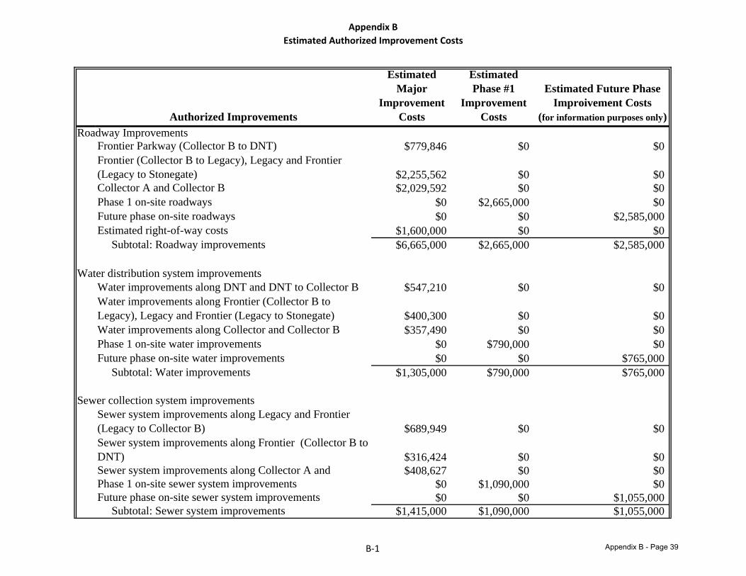
Appendix BEstimated Authorized Improvement Costs
Authorized Improvements
Estimated Major
Improvement Costs
Estimated Phase #1
Improvement Costs
Estimated Future Phase Improivement Costs
(for information purposes only)Roadway Improvements
Frontier Parkway (Collector B to DNT) $779,846 $0 $0Frontier (Collector B to Legacy), Legacy and Frontier (Legacy to Stonegate) $2,255,562 $0 $0Collector A and Collector B $2,029,592 $0 $0Phase 1 on-site roadways $0 $2,665,000 $0Future phase on-site roadways $0 $0 $2,585,000Estimated right-of-way costs $1,600,000 $0 $0 Subtotal: Roadway improvements $6,665,000 $2,665,000 $2,585,000
Water distribution system improvementsWater improvements along DNT and DNT to Collector B $547,210 $0 $0Water improvements along Frontier (Collector B to Legacy), Legacy and Frontier (Legacy to Stonegate) $400,300 $0 $0Water improvements along Collector and Collector B $357,490 $0 $0Phase 1 on-site water improvements $0 $790,000 $0Future phase on-site water improvements $0 $0 $765,000 Subtotal: Water improvements $1,305,000 $790,000 $765,000
Sewer collection system improvementsSewer system improvements along Legacy and Frontier (Legacy to Collector B) $689,949 $0 $0Sewer system improvements along Frontier (Collector B to DNT) $316,424 $0 $0Sewer system improvements along Collector A and $408,627 $0 $0Phase 1 on-site sewer system improvements $0 $1,090,000 $0Future phase on-site sewer system improvements $0 $0 $1,055,000 Subtotal: Sewer system improvements $1,415,000 $1,090,000 $1,055,000
B‐1 Appendix B - Page 39
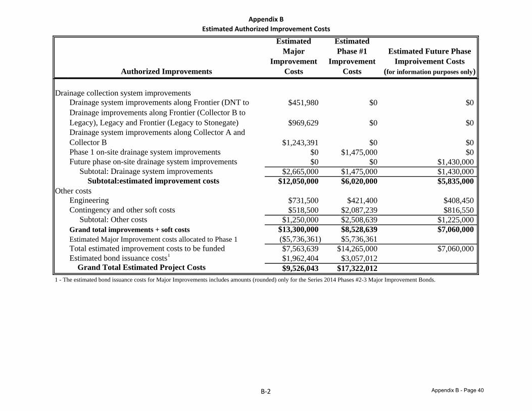
Appendix BEstimated Authorized Improvement Costs
Authorized Improvements
Estimated Major
Improvement Costs
Estimated Phase #1
Improvement Costs
Estimated Future Phase Improivement Costs
(for information purposes only)
Drainage collection system improvementsDrainage system improvements along Frontier (DNT to $451,980 $0 $0Drainage improvements along Frontier (Collector B to Legacy), Legacy and Frontier (Legacy to Stonegate) $969,629 $0 $0Drainage system improvements along Collector A and Collector B $1,243,391 $0 $0Phase 1 on-site drainage system improvements $0 $1,475,000 $0Future phase on-site drainage system improvements $0 $0 $1,430,000 Subtotal: Drainage system improvements $2,665,000 $1,475,000 $1,430,000 Subtotal:estimated improvement costs $12,050,000 $6,020,000 $5,835,000
Other costsEngineering $731,500 $421,400 $408,450Contingency and other soft costs $518,500 $2,087,239 $816,550 Subtotal: Other costs $1,250,000 $2,508,639 $1,225,000Grand total improvements + soft costs $13,300,000 $8,528,639 $7,060,000Estimated Major Improvement costs allocated to Phase 1 ($5,736,361) $5,736,361Total estimated improvement costs to be funded $7,563,639 $14,265,000 $7,060,000Estimated bond issuance costs1 $1,962,404 $3,057,012 Grand Total Estimated Project Costs $9,526,043 $17,322,012
1 - The estimated bond issuance costs for Major Improvements includes amounts (rounded) only for the Series 2014 Phases #2-3 Major Improvement Bonds.
B‐2 Appendix B - Page 40
Appendix C
DIAGRAMS OF THE AUTHORIZED IMPROVEMENTS
Appendix B - Page 41
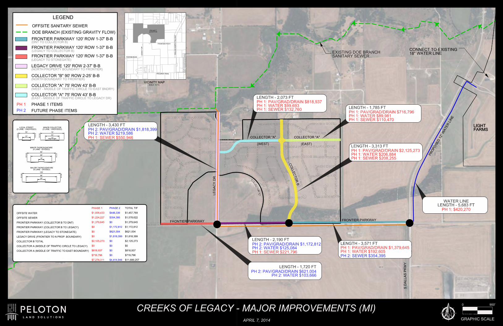
S D
ALL
AS P
KW
Y
120'
96'
24'
R.O.W
R.O.W
90'
68'
18'
R.O.W
R.O.W
75'
43'
R.O.W
50'
31' R.O.W
R.O.W
12'
(3 LANE - UNDIVIDED)MINOR COLLECTOR
(2 LANE - UNDIVIDED)LOCAL STREET
(4 LANE - DIVIDED)MINOR THOROUGHFARE
(6 LANE - DIVIDED)MAJOR THOROUGHFARE
LE
GA
CY D
R
PR
OP
OSE
D 1
2"
WATE
R LIN
E
18" WATER LINECONNECT TO EXISTING
COLLECTOR "A"
FRONTIER PARKWAY
FARMSLIGHT
0 900'
GRAPHIC SCALE
LEGEND
FARMSLIGHT
FRONTIER PARKWAY 120' ROW 1-37' B-B
FRONTIER PARKWAY 120' ROW 1-37' B-B
FRONTIER PARKWAY 120' ROW 1-37' B-B
LEGACY DRIVE 120' ROW 2-37' B-B
(LEGACY TO STONEGATE)
DOE BRANCH (EXISTING GRAVITY FLOW)
(DNT TO COLLECTOR B)
(NORTH BOUNDARY TO FRONTIER)
COLLECTOR "A" 75' ROW 43' B-B
COLLECTOR "A" 75' ROW 43' B-B
B R
OT
CE
LL
OC
(NORTH PROPERTY BOUNDARY TO FRONTIER)
FRONTIER PARKWAY
VICINITY MAPSCALE : N.T.S.
DA
LL
AS N
OR
TH T
OLL
WA
Y
FRONTIER PKWY
LE
GA
CY D
R
PROSPER TRAIL
PARVIN ROAD
COLLECTOR "B" 90' ROW 2-25' B-B
LOCATIONPROJECT
(WEST - MIDDLE OF TRAFFIC CIRCLE TO EAST BNDRY)
(EAST - MIDDLE OF TRAFFIC CIRCLE TO LEGACY DR)
(LEGACY TO COLLECTOR B)
COLLECTOR "A"
(WEST) (EAST)
OFFSITE SANITARY SEWER
PHASE 1 ITEMS
FUTURE PHASE ITEMS
COLLECTOR A (MIDDLE OF TRAFFIC TO EAST BOUNDARY)
COLLECTOR A (MIDDLE OF TRAFFIC CIRCLE TO LEGACY)
COLLECTOR B TOTAL
LEGACY DRIVE (FRONTIER TO N PROP. BOUNDARY)
FRONTIER PARKWAY (LEGACY TO STONEGATE)
FRONTIER PARKWAY (COLLECTOR B TO LEGACY)
FRONTIER PARKWAY (COLLECTOR B TO DNT)
OFFSITE SEWER
OFFSITE WATER
$11,689,257
$719,796
$818,937
$0
$2,125,273
$1,818,399
$621,004
$1,172,812
$1,379,645
$1,578,622
$1,457,769
TOTAL TIF
$7,274,311
$716,796
$818,937
$0
$2,125,273
$0
$0
$0
$1,379,645
$1,224,227
$1,009,433
PHASE 1
$4,414,946
$0
$0
$0
$0
$1,818,399
$621,004
$1,172,812
$0
$354,395
$448,336
PHASE 2
N
CREEKS OF LEGACY - MAJOR IMPROVEMENTS (MI)
APRIL 7, 2014
EXISTING DOE BRANCH SANITARY SEWER
C
OLLEC
TO
R "C
"
LENGTH - 1,785 FT
PH 1: PAV/GRAD/DRAIN $716,796PH 1: WATER $89,981PH 1: SEWER $110,470
LENGTH - 3,313 FT
PH 1: PAV/GRAD/DRAIN $2,125,273PH 1: WATER $206,884PH 1: SEWER $208,255
WATER LINELENGTH - 5,683 FT
PH 1: $420,270
LENGTH - 2,073 FT
PH 1: PAV/GRAD/DRAIN $818,937PH 1: WATER $99,693PH 1: SEWER $132,760
LENGTH - 3,571 FT
PH 1: PAV/GRAD/DRAIN $1,379,645PH 1: WATER $192,605
PH 2: SEWER $354,395PH 1: SEWER $221,796
LENGTH - 2,190 FT
PH 2: PAV/GRAD/DRAIN $1,172,812PH 2: WATER $125,084
LENGTH - 3,430 FT
PH 2: PAV/GRAD/DRAIN $1,818,399PH 2: WATER $219,586
PH 1: SEWER $550,946
PH 1
PH 2
PH 2: PAV/GRAD/DRAIN $621,004PH 2: WATER $103,666
LENGTH - 1,720 FT
Appendix B - Page 42

Appendix D
LOT TYPES AND EQUIVALENT UNITS
Appendix B - Page 43
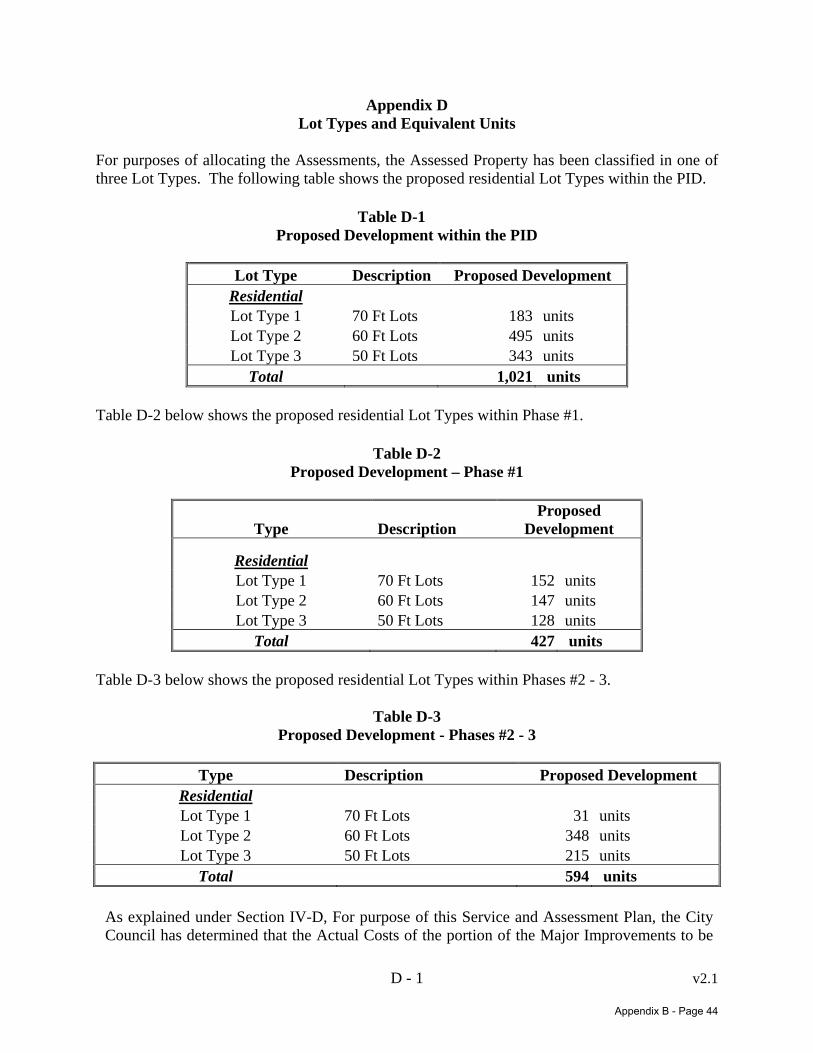
D - 1 v2.1
Appendix D Lot Types and Equivalent Units
For purposes of allocating the Assessments, the Assessed Property has been classified in one of three Lot Types. The following table shows the proposed residential Lot Types within the PID.
Table D-1 Proposed Development within the PID
Lot Type Description Proposed Development
Residential Lot Type 1 70 Ft Lots 183 units Lot Type 2 60 Ft Lots 495 units Lot Type 3 50 Ft Lots 343 units
Total 1,021 units Table D-2 below shows the proposed residential Lot Types within Phase #1.
Table D-2 Proposed Development – Phase #1
Type Description Proposed
Development
Residential Lot Type 1 70 Ft Lots 152 units Lot Type 2 60 Ft Lots 147 units Lot Type 3 50 Ft Lots 128 units
Total 427 units Table D-3 below shows the proposed residential Lot Types within Phases #2 - 3.
Table D-3
Proposed Development - Phases #2 - 3
Type Description Proposed Development Residential Lot Type 1 70 Ft Lots 31 units Lot Type 2 60 Ft Lots 348 units Lot Type 3 50 Ft Lots 215 units
Total 594 units
As explained under Section IV-D, For purpose of this Service and Assessment Plan, the City Council has determined that the Actual Costs of the portion of the Major Improvements to be
Appendix B - Page 44
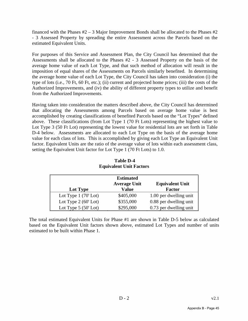
D - 2 v2.1
financed with the Phases #2 – 3 Major Improvement Bonds shall be allocated to the Phases #2 - 3 Assessed Property by spreading the entire Assessment across the Parcels based on the estimated Equivalent Units.
For purposes of this Service and Assessment Plan, the City Council has determined that the Assessments shall be allocated to the Phases #2 - 3 Assessed Property on the basis of the average home value of each Lot Type, and that such method of allocation will result in the imposition of equal shares of the Assessments on Parcels similarly benefited. In determining the average home value of each Lot Type, the City Council has taken into consideration (i) the type of lots (i.e., 70 Ft, 60 Ft, etc.); (ii) current and projected home prices; (iii) the costs of the Authorized Improvements, and (iv) the ability of different property types to utilize and benefit from the Authorized Improvements.
Having taken into consideration the matters described above, the City Council has determined that allocating the Assessments among Parcels based on average home value is best accomplished by creating classifications of benefited Parcels based on the “Lot Types” defined above. These classifications (from Lot Type 1 (70 Ft Lots) representing the highest value to Lot Type 3 (50 Ft Lot) representing the lowest value for residential lots are set forth in Table D-4 below. Assessments are allocated to each Lot Type on the basis of the average home value for each class of lots. This is accomplished by giving each Lot Type an Equivalent Unit factor. Equivalent Units are the ratio of the average value of lots within each assessment class, setting the Equivalent Unit factor for Lot Type 1 (70 Ft Lots) to 1.0.
Table D-4
Equivalent Unit Factors
Lot Type
Estimated Average Unit
Value Equivalent Unit
Factor Lot Type 1 (70' Lot) $405,000 1.00 per dwelling unit Lot Type 2 (60' Lot) $355,000 0.88 per dwelling unit Lot Type 5 (50' Lot) $295,000 0.73 per dwelling unit
The total estimated Equivalent Units for Phase #1 are shown in Table D-5 below as calculated based on the Equivalent Unit factors shown above, estimated Lot Types and number of units estimated to be built within Phase 1.
Appendix B - Page 45
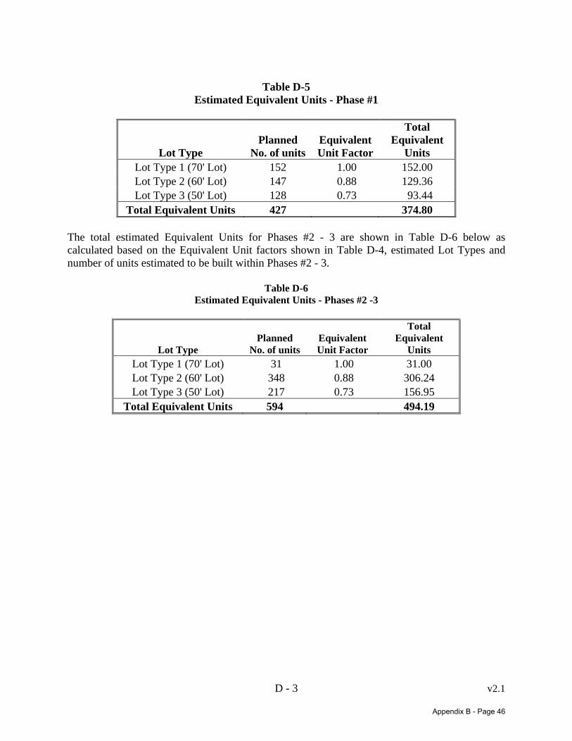
D - 3 v2.1
Table D-5
Estimated Equivalent Units - Phase #1
Lot Type Planned
No. of units Equivalent Unit Factor
Total Equivalent
Units Lot Type 1 (70' Lot) 152 1.00 152.00 Lot Type 2 (60' Lot) 147 0.88 129.36 Lot Type 3 (50' Lot) 128 0.73 93.44
Total Equivalent Units 427 374.80 The total estimated Equivalent Units for Phases #2 - 3 are shown in Table D-6 below as calculated based on the Equivalent Unit factors shown in Table D-4, estimated Lot Types and number of units estimated to be built within Phases #2 - 3.
Table D-6
Estimated Equivalent Units - Phases #2 -3
Lot Type Planned
No. of unitsEquivalent Unit Factor
Total Equivalent
Units Lot Type 1 (70' Lot) 31 1.00 31.00 Lot Type 2 (60' Lot) 348 0.88 306.24 Lot Type 3 (50' Lot) 217 0.73 156.95
Total Equivalent Units 594 494.19
Appendix B - Page 46

Appendix E
ALLOCATION OF ASSESSMENTS
Appendix B - Page 47
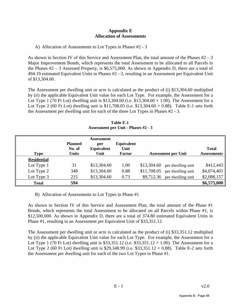
E - 1 v2.0
Appendix E Allocation of Assessments
A) Allocation of Assessments to Lot Types in Phases #2 - 3
As shown in Section IV of this Service and Assessment Plan, the total amount of the Phases #2 – 3 Major Improvement Bonds, which represents the total Assessment to be allocated to all Parcels in the Phases #2 – 3 Assessed Property, is $6,575,000. As shown in Appendix D, there are a total of 494.19 estimated Equivalent Units in Phases #2 - 3, resulting in an Assessment per Equivalent Unit of $13,304.60. The Assessment per dwelling unit or acre is calculated as the product of (i) $13,304.60 multiplied by (ii) the applicable Equivalent Unit value for each Lot Type. For example, the Assessment for a Lot Type 1 (70 Ft Lot) dwelling unit is $13,304.60 (i.e. $13,304.60 × 1.00). The Assessment for a Lot Type 2 (60 Ft Lot) dwelling unit is $11,708.05 (i.e. $13,304.60 × 0.88). Table E-1 sets forth the Assessment per dwelling unit for each of the three Lot Types in Phases #2 - 3.
Table E-1 Assessment per Unit - Phases #2 - 3
Type
Planned No. of Units
Assessment per
Equivalent Unit
Equivalent Unit
Factor Assessment per Unit Total
AssessmentsResidential Lot Type 1 31 $13,304.60 1.00 $13,304.60 per dwelling unit $412,443Lot Type 2 348 $13,304.60 0.88 $11,708.05 per dwelling unit $4,074,401Lot Type 3 215 $13,304.60 0.73 $9,712.36 per dwelling unit $2,088,157
Total 594 $6,575,000
B) Allocation of Assessments to Lot Types in Phase #1 As shown in Section IV of this Service and Assessment Plan, the total amount of the Phase #1 Bonds, which represents the total Assessment to be allocated on all Parcels within Phase #1, is $12,500,000. As shown in Appendix D, there are a total of 374.80 estimated Equivalent Units in Phase #1, resulting in an Assessment per Equivalent Unit of $33,351.12. The Assessment per dwelling unit or acre is calculated as the product of (i) $33,351.12 multiplied by (ii) the applicable Equivalent Unit value for each Lot Type. For example, the Assessment for a Lot Type 1 (70 Ft Lot) dwelling unit is $33,351.12 (i.e. $33,351.12 × 1.00). The Assessment for a Lot Type 2 (60 Ft Lot) dwelling unit is $29,348.99 (i.e. $33,351.12 × 0.88). Table E-2 sets forth the Assessment per dwelling unit for each of the two Lot Types in Phase #1.
Appendix B - Page 48
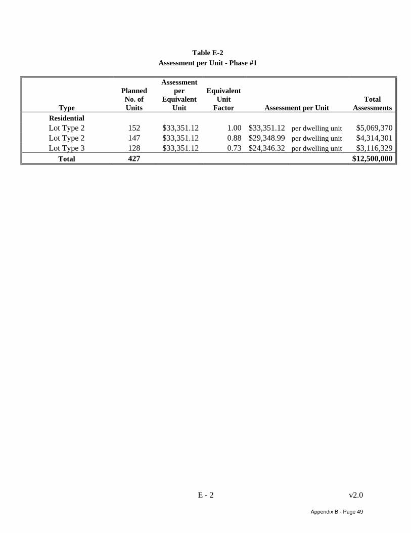
E - 2 v2.0
Table E-2 Assessment per Unit - Phase #1
Type
Planned No. of Units
Assessment per
Equivalent Unit
Equivalent Unit
Factor Assessment per Unit Total
AssessmentsResidential Lot Type 2 152 $33,351.12 1.00 $33,351.12 per dwelling unit $5,069,370Lot Type 2 147 $33,351.12 0.88 $29,348.99 per dwelling unit $4,314,301Lot Type 3 128 $33,351.12 0.73 $24,346.32 per dwelling unit $3,116,329
Total 427 $12,500,000
Appendix B - Page 49

F ‐
Appendix F
ASSESSMENT ROLL –Phases #2-3 Assessed Property
Appendix B - Page 50
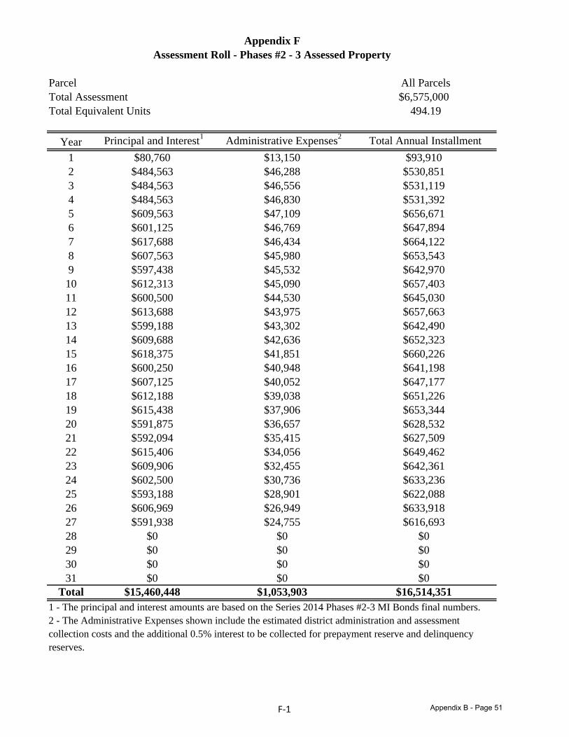
Parcel All ParcelsTotal Assessment $6,575,000Total Equivalent Units 494.19
Year Principal and Interest1 Administrative Expenses2 Total Annual Installment1 $80,760 $13,150 $93,9102 $484,563 $46,288 $530,8513 $484,563 $46,556 $531,1194 $484,563 $46,830 $531,3925 $609,563 $47,109 $656,6716 $601,125 $46,769 $647,8947 $617,688 $46,434 $664,1228 $607,563 $45,980 $653,5439 $597,438 $45,532 $642,97010 $612,313 $45,090 $657,40311 $600,500 $44,530 $645,03012 $613,688 $43,975 $657,66313 $599,188 $43,302 $642,49014 $609,688 $42,636 $652,32315 $618,375 $41,851 $660,22616 $600,250 $40,948 $641,19817 $607,125 $40,052 $647,17718 $612,188 $39,038 $651,22619 $615,438 $37,906 $653,34420 $591,875 $36,657 $628,53221 $592,094 $35,415 $627,50922 $615,406 $34,056 $649,46223 $609,906 $32,455 $642,36124 $602,500 $30,736 $633,23625 $593,188 $28,901 $622,08826 $606,969 $26,949 $633,91827 $591,938 $24,755 $616,69328 $0 $0 $029 $0 $0 $030 $0 $0 $031 $0 $0 $0
Total $15,460,448 $1,053,903 $16,514,3511 - The principal and interest amounts are based on the Series 2014 Phases #2-3 MI Bonds final numbers.2 - The Administrative Expenses shown include the estimated district administration and assessment collection costs and the additional 0.5% interest to be collected for prepayment reserve and delinquencyreserves.
Appendix FAssessment Roll - Phases #2 - 3 Assessed Property
F‐1 Appendix B - Page 51
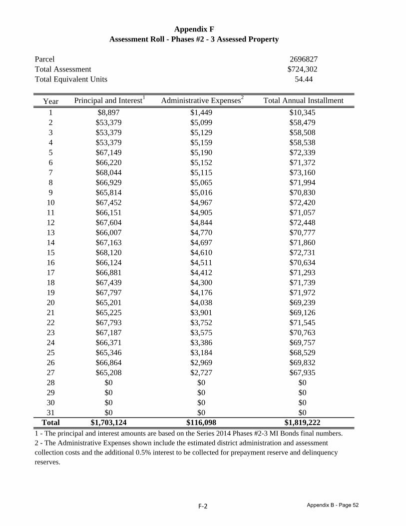
Parcel 2696827Total Assessment $724,302Total Equivalent Units 54.44
Year Principal and Interest1 Administrative Expenses2 Total Annual Installment1 $8,897 $1,449 $10,3452 $53,379 $5,099 $58,4793 $53,379 $5,129 $58,5084 $53,379 $5,159 $58,5385 $67,149 $5,190 $72,3396 $66,220 $5,152 $71,3727 $68,044 $5,115 $73,1608 $66,929 $5,065 $71,9949 $65,814 $5,016 $70,83010 $67,452 $4,967 $72,42011 $66,151 $4,905 $71,05712 $67,604 $4,844 $72,44813 $66,007 $4,770 $70,77714 $67,163 $4,697 $71,86015 $68,120 $4,610 $72,73116 $66,124 $4,511 $70,63417 $66,881 $4,412 $71,29318 $67,439 $4,300 $71,73919 $67,797 $4,176 $71,97220 $65,201 $4,038 $69,23921 $65,225 $3,901 $69,12622 $67,793 $3,752 $71,54523 $67,187 $3,575 $70,76324 $66,371 $3,386 $69,75725 $65,346 $3,184 $68,52926 $66,864 $2,969 $69,83227 $65,208 $2,727 $67,93528 $0 $0 $029 $0 $0 $030 $0 $0 $031 $0 $0 $0
Total $1,703,124 $116,098 $1,819,2221 - The principal and interest amounts are based on the Series 2014 Phases #2-3 MI Bonds final numbers.2 - The Administrative Expenses shown include the estimated district administration and assessment collection costs and the additional 0.5% interest to be collected for prepayment reserve and delinquencyreserves.
Appendix FAssessment Roll - Phases #2 - 3 Assessed Property
F‐2 Appendix B - Page 52
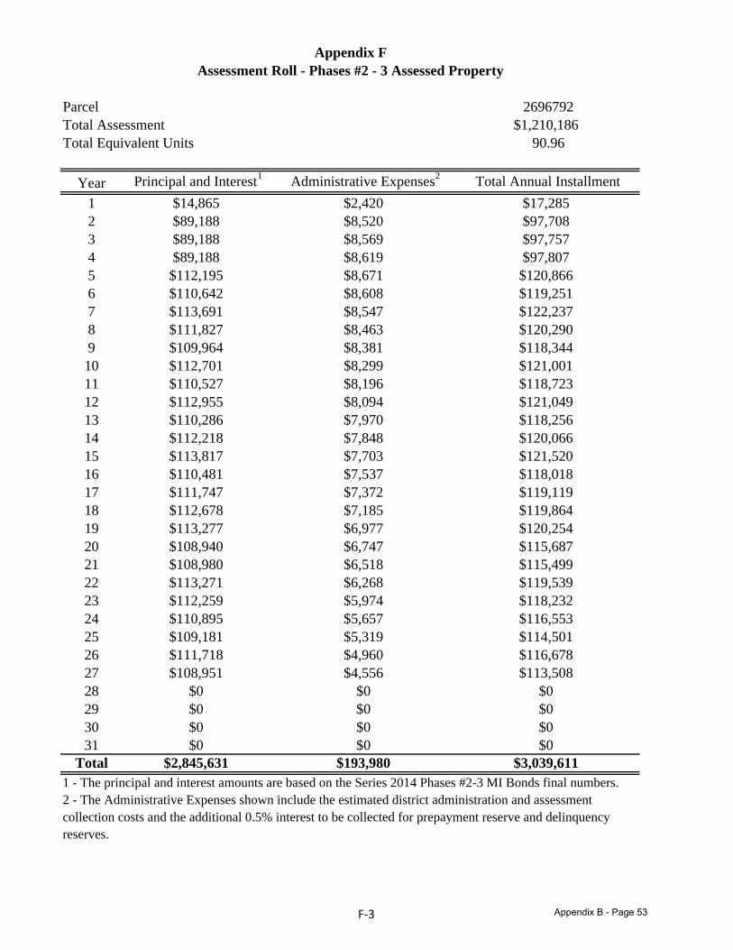
Parcel 2696792Total Assessment $1,210,186Total Equivalent Units 90.96
Year Principal and Interest1 Administrative Expenses2 Total Annual Installment1 $14,865 $2,420 $17,2852 $89,188 $8,520 $97,7083 $89,188 $8,569 $97,7574 $89,188 $8,619 $97,8075 $112,195 $8,671 $120,8666 $110,642 $8,608 $119,2517 $113,691 $8,547 $122,2378 $111,827 $8,463 $120,2909 $109,964 $8,381 $118,34410 $112,701 $8,299 $121,00111 $110,527 $8,196 $118,72312 $112,955 $8,094 $121,04913 $110,286 $7,970 $118,25614 $112,218 $7,848 $120,06615 $113,817 $7,703 $121,52016 $110,481 $7,537 $118,01817 $111,747 $7,372 $119,11918 $112,678 $7,185 $119,86419 $113,277 $6,977 $120,25420 $108,940 $6,747 $115,68721 $108,980 $6,518 $115,49922 $113,271 $6,268 $119,53923 $112,259 $5,974 $118,23224 $110,895 $5,657 $116,55325 $109,181 $5,319 $114,50126 $111,718 $4,960 $116,67827 $108,951 $4,556 $113,50828 $0 $0 $029 $0 $0 $030 $0 $0 $031 $0 $0 $0
Total $2,845,631 $193,980 $3,039,6111 - The principal and interest amounts are based on the Series 2014 Phases #2-3 MI Bonds final numbers.2 - The Administrative Expenses shown include the estimated district administration and assessment collection costs and the additional 0.5% interest to be collected for prepayment reserve and delinquencyreserves.
Appendix FAssessment Roll - Phases #2 - 3 Assessed Property
F‐3 Appendix B - Page 53

Parcel 2697055Total Assessment $358,160Total Equivalent Units 26.92
Year Principal and Interest1 Administrative Expenses2 Total Annual Installment1 $4,399 $716 $5,1162 $26,396 $2,521 $28,9173 $26,396 $2,536 $28,9324 $26,396 $2,551 $28,9475 $33,205 $2,566 $35,7716 $32,745 $2,548 $35,2937 $33,647 $2,529 $36,1778 $33,096 $2,505 $35,6009 $32,544 $2,480 $35,02410 $33,354 $2,456 $35,81111 $32,711 $2,426 $35,13712 $33,429 $2,395 $35,82513 $32,640 $2,359 $34,99814 $33,211 $2,323 $35,53415 $33,685 $2,280 $35,96416 $32,697 $2,231 $34,92817 $33,072 $2,182 $35,25418 $33,348 $2,127 $35,47419 $33,525 $2,065 $35,59020 $32,241 $1,997 $34,23821 $32,253 $1,929 $34,18222 $33,523 $1,855 $35,37823 $33,223 $1,768 $34,99124 $32,820 $1,674 $34,49425 $32,313 $1,574 $33,88726 $33,063 $1,468 $34,53127 $32,245 $1,349 $33,59328 $0 $0 $029 $0 $0 $030 $0 $0 $031 $0 $0 $0
Total $842,177 $57,409 $899,5861 - The principal and interest amounts are based on the Series 2014 Phases #2-3 MI Bonds final numbers.2 - The Administrative Expenses shown include the estimated district administration and assessment collection costs and the additional 0.5% interest to be collected for prepayment reserve and delinquencyreserves.
Appendix FAssessment Roll - Phases #2 - 3 Assessed Property
F‐4 Appendix B - Page 54
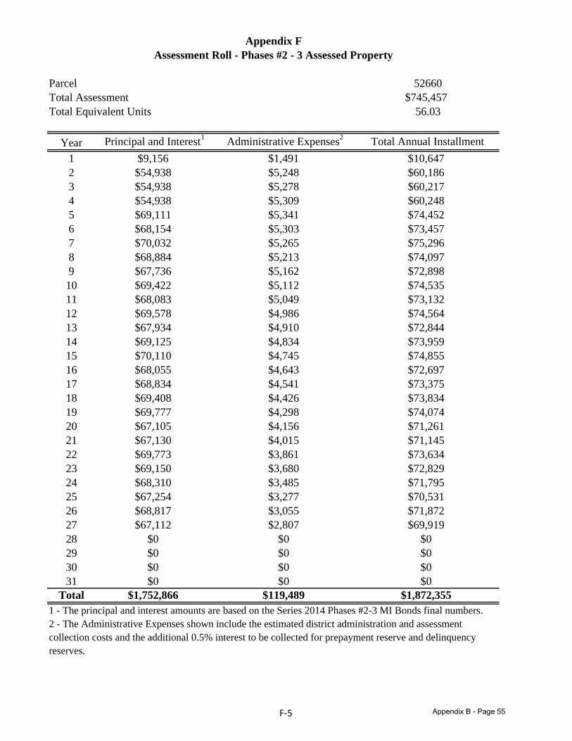
Parcel 52660Total Assessment $745,457Total Equivalent Units 56.03
Year Principal and Interest1 Administrative Expenses2 Total Annual Installment1 $9,156 $1,491 $10,6472 $54,938 $5,248 $60,1863 $54,938 $5,278 $60,2174 $54,938 $5,309 $60,2485 $69,111 $5,341 $74,4526 $68,154 $5,303 $73,4577 $70,032 $5,265 $75,2968 $68,884 $5,213 $74,0979 $67,736 $5,162 $72,89810 $69,422 $5,112 $74,53511 $68,083 $5,049 $73,13212 $69,578 $4,986 $74,56413 $67,934 $4,910 $72,84414 $69,125 $4,834 $73,95915 $70,110 $4,745 $74,85516 $68,055 $4,643 $72,69717 $68,834 $4,541 $73,37518 $69,408 $4,426 $73,83419 $69,777 $4,298 $74,07420 $67,105 $4,156 $71,26121 $67,130 $4,015 $71,14522 $69,773 $3,861 $73,63423 $69,150 $3,680 $72,82924 $68,310 $3,485 $71,79525 $67,254 $3,277 $70,53126 $68,817 $3,055 $71,87227 $67,112 $2,807 $69,91928 $0 $0 $029 $0 $0 $030 $0 $0 $031 $0 $0 $0
Total $1,752,866 $119,489 $1,872,3551 - The principal and interest amounts are based on the Series 2014 Phases #2-3 MI Bonds final numbers.2 - The Administrative Expenses shown include the estimated district administration and assessment collection costs and the additional 0.5% interest to be collected for prepayment reserve and delinquencyreserves.
Appendix FAssessment Roll - Phases #2 - 3 Assessed Property
F‐5 Appendix B - Page 55

Parcel 52644Total Assessment $265,028Total Equivalent Units 19.92
Year Principal and Interest1 Administrative Expenses2 Total Annual Installment1 $3,255 $530 $3,7852 $19,532 $1,866 $21,3983 $19,532 $1,877 $21,4094 $19,532 $1,888 $21,4205 $24,570 $1,899 $26,4696 $24,230 $1,885 $26,1167 $24,898 $1,872 $26,7708 $24,490 $1,853 $26,3439 $24,082 $1,835 $25,91710 $24,681 $1,818 $26,49911 $24,205 $1,795 $26,00012 $24,737 $1,773 $26,50913 $24,152 $1,745 $25,89814 $24,576 $1,719 $26,29415 $24,926 $1,687 $26,61316 $24,195 $1,651 $25,84617 $24,472 $1,614 $26,08718 $24,676 $1,574 $26,25019 $24,807 $1,528 $26,33520 $23,858 $1,478 $25,33521 $23,866 $1,428 $25,29422 $24,806 $1,373 $26,17923 $24,584 $1,308 $25,89324 $24,286 $1,239 $25,52525 $23,910 $1,165 $25,07526 $24,466 $1,086 $25,55227 $23,860 $998 $24,85828 $0 $0 $029 $0 $0 $030 $0 $0 $031 $0 $0 $0
Total $623,186 $42,481 $665,6671 - The principal and interest amounts are based on the Series 2014 Phases #2-3 MI Bonds final numbers.2 - The Administrative Expenses shown include the estimated district administration and assessment collection costs and the additional 0.5% interest to be collected for prepayment reserve and delinquencyreserves.
Appendix FAssessment Roll - Phases #2 - 3 Assessed Property
F‐6 Appendix B - Page 56
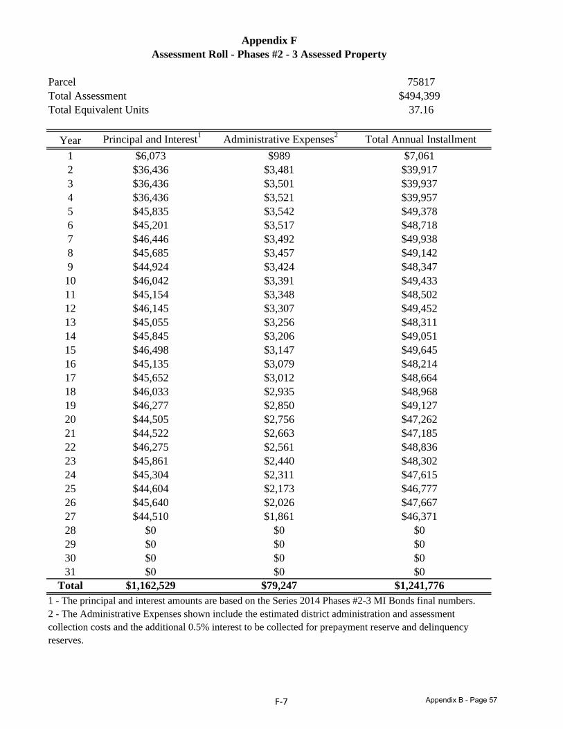
Parcel 75817Total Assessment $494,399Total Equivalent Units 37.16
Year Principal and Interest1 Administrative Expenses2 Total Annual Installment1 $6,073 $989 $7,0612 $36,436 $3,481 $39,9173 $36,436 $3,501 $39,9374 $36,436 $3,521 $39,9575 $45,835 $3,542 $49,3786 $45,201 $3,517 $48,7187 $46,446 $3,492 $49,9388 $45,685 $3,457 $49,1429 $44,924 $3,424 $48,34710 $46,042 $3,391 $49,43311 $45,154 $3,348 $48,50212 $46,145 $3,307 $49,45213 $45,055 $3,256 $48,31114 $45,845 $3,206 $49,05115 $46,498 $3,147 $49,64516 $45,135 $3,079 $48,21417 $45,652 $3,012 $48,66418 $46,033 $2,935 $48,96819 $46,277 $2,850 $49,12720 $44,505 $2,756 $47,26221 $44,522 $2,663 $47,18522 $46,275 $2,561 $48,83623 $45,861 $2,440 $48,30224 $45,304 $2,311 $47,61525 $44,604 $2,173 $46,77726 $45,640 $2,026 $47,66727 $44,510 $1,861 $46,37128 $0 $0 $029 $0 $0 $030 $0 $0 $031 $0 $0 $0
Total $1,162,529 $79,247 $1,241,7761 - The principal and interest amounts are based on the Series 2014 Phases #2-3 MI Bonds final numbers.2 - The Administrative Expenses shown include the estimated district administration and assessment collection costs and the additional 0.5% interest to be collected for prepayment reserve and delinquencyreserves.
Assessment Roll - Phases #2 - 3 Assessed PropertyAppendix F
F‐7 Appendix B - Page 57
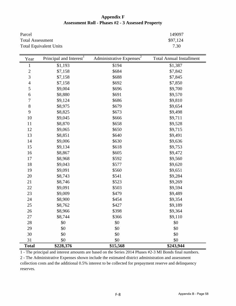
Parcel 149097Total Assessment $97,124Total Equivalent Units 7.30
Year Principal and Interest1 Administrative Expenses2 Total Annual Installment1 $1,193 $194 $1,3872 $7,158 $684 $7,8423 $7,158 $688 $7,8454 $7,158 $692 $7,8505 $9,004 $696 $9,7006 $8,880 $691 $9,5707 $9,124 $686 $9,8108 $8,975 $679 $9,6549 $8,825 $673 $9,49810 $9,045 $666 $9,71111 $8,870 $658 $9,52812 $9,065 $650 $9,71513 $8,851 $640 $9,49114 $9,006 $630 $9,63615 $9,134 $618 $9,75316 $8,867 $605 $9,47217 $8,968 $592 $9,56018 $9,043 $577 $9,62019 $9,091 $560 $9,65120 $8,743 $541 $9,28421 $8,746 $523 $9,26922 $9,091 $503 $9,59423 $9,009 $479 $9,48924 $8,900 $454 $9,35425 $8,762 $427 $9,18926 $8,966 $398 $9,36427 $8,744 $366 $9,11028 $0 $0 $029 $0 $0 $030 $0 $0 $031 $0 $0 $0
Total $228,376 $15,568 $243,9441 - The principal and interest amounts are based on the Series 2014 Phases #2-3 MI Bonds final numbers.2 - The Administrative Expenses shown include the estimated district administration and assessment collection costs and the additional 0.5% interest to be collected for prepayment reserve and delinquencyreserves.
Appendix FAssessment Roll - Phases #2 - 3 Assessed Property
F‐8 Appendix B - Page 58
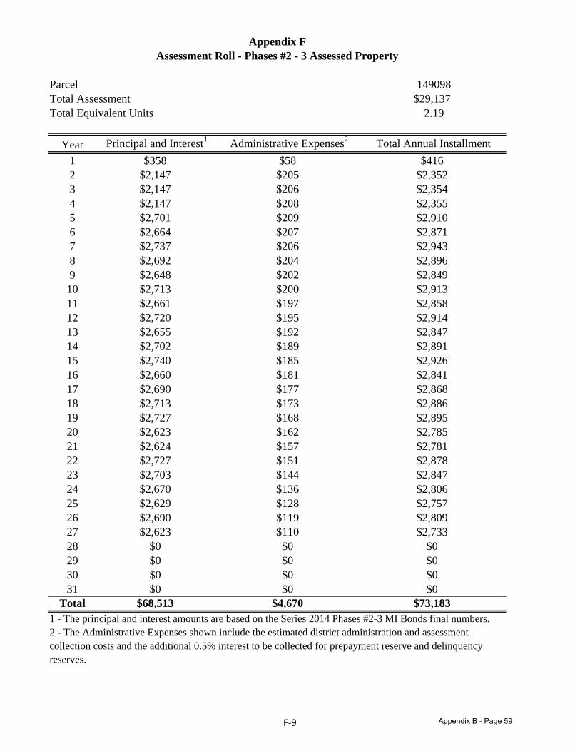
Parcel 149098Total Assessment $29,137Total Equivalent Units 2.19
Year Principal and Interest1 Administrative Expenses2 Total Annual Installment1 $358 $58 $4162 $2,147 $205 $2,3523 $2,147 $206 $2,3544 $2,147 $208 $2,3555 $2,701 $209 $2,9106 $2,664 $207 $2,8717 $2,737 $206 $2,9438 $2,692 $204 $2,8969 $2,648 $202 $2,84910 $2,713 $200 $2,91311 $2,661 $197 $2,85812 $2,720 $195 $2,91413 $2,655 $192 $2,84714 $2,702 $189 $2,89115 $2,740 $185 $2,92616 $2,660 $181 $2,84117 $2,690 $177 $2,86818 $2,713 $173 $2,88619 $2,727 $168 $2,89520 $2,623 $162 $2,78521 $2,624 $157 $2,78122 $2,727 $151 $2,87823 $2,703 $144 $2,84724 $2,670 $136 $2,80625 $2,629 $128 $2,75726 $2,690 $119 $2,80927 $2,623 $110 $2,73328 $0 $0 $029 $0 $0 $030 $0 $0 $031 $0 $0 $0
Total $68,513 $4,670 $73,1831 - The principal and interest amounts are based on the Series 2014 Phases #2-3 MI Bonds final numbers.2 - The Administrative Expenses shown include the estimated district administration and assessment collection costs and the additional 0.5% interest to be collected for prepayment reserve and delinquencyreserves.
Appendix FAssessment Roll - Phases #2 - 3 Assessed Property
F‐9 Appendix B - Page 59
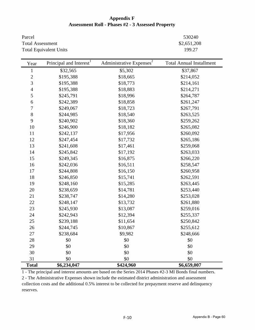
Parcel 530240Total Assessment $2,651,208Total Equivalent Units 199.27
Year Principal and Interest1 Administrative Expenses2 Total Annual Installment1 $32,565 $5,302 $37,8672 $195,388 $18,665 $214,0523 $195,388 $18,773 $214,1614 $195,388 $18,883 $214,2715 $245,791 $18,996 $264,7876 $242,389 $18,858 $261,2477 $249,067 $18,723 $267,7918 $244,985 $18,540 $263,5259 $240,902 $18,360 $259,26210 $246,900 $18,182 $265,08211 $242,137 $17,956 $260,09212 $247,454 $17,732 $265,18613 $241,608 $17,461 $259,06814 $245,842 $17,192 $263,03315 $249,345 $16,875 $266,22016 $242,036 $16,511 $258,54717 $244,808 $16,150 $260,95818 $246,850 $15,741 $262,59119 $248,160 $15,285 $263,44520 $238,659 $14,781 $253,44021 $238,747 $14,280 $253,02822 $248,147 $13,732 $261,88023 $245,930 $13,087 $259,01624 $242,943 $12,394 $255,33725 $239,188 $11,654 $250,84226 $244,745 $10,867 $255,61227 $238,684 $9,982 $248,66628 $0 $0 $029 $0 $0 $030 $0 $0 $031 $0 $0 $0
Total $6,234,047 $424,960 $6,659,0071 - The principal and interest amounts are based on the Series 2014 Phases #2-3 MI Bonds final numbers.2 - The Administrative Expenses shown include the estimated district administration and assessment collection costs and the additional 0.5% interest to be collected for prepayment reserve and delinquencyreserves.
Appendix FAssessment Roll - Phases #2 - 3 Assessed Property
F‐10 Appendix B - Page 60

G ‐ 1
Appendix G
ASSESSMENT ROLL – Phase #1 Assessed Property
Appendix B - Page 61
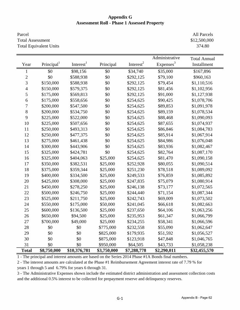
Parcel All ParcelsTotal Assessment $12,500,000Total Equivalent Units 374.80
Appendix GAssessment Roll - Phase 1 Assessed Property
Year Principal1 Interest1 Principal Interest2Administrative
Expenses3Total Annual Installment
1 $0 $98,156 $0 $34,740 $35,000 $167,8962 $0 $588,938 $0 $292,125 $79,100 $960,1633 $150,000 $588,938 $0 $292,125 $79,454 $1,110,5164 $150,000 $579,375 $0 $292,125 $81,456 $1,102,9565 $175,000 $569,813 $0 $292,125 $91,000 $1,127,9386 $175,000 $558,656 $0 $254,625 $90,425 $1,078,7067 $200,000 $547,500 $0 $254,625 $89,853 $1,091,9788 $200,000 $534,750 $0 $254,625 $89,159 $1,078,5349 $225,000 $522,000 $0 $254,625 $88,468 $1,090,09310 $225 000 $507 656 $0 $254 625 $87 655 $1 074 93710 $225,000 $507,656 $0 $254,625 $87,655 $1,074,93711 $250,000 $493,313 $0 $254,625 $86,846 $1,084,78312 $250,000 $477,375 $0 $254,625 $85,914 $1,067,91413 $275,000 $461,438 $0 $254,625 $84,986 $1,076,04814 $300,000 $443,906 $0 $254,625 $83,936 $1,082,46715 $325,000 $424,781 $0 $254,625 $82,764 $1,087,17016 $325 000 $404 063 $25 000 $254 625 $81 470 $1 090 15816 $325,000 $404,063 $25,000 $254,625 $81,470 $1,090,15817 $350,000 $382,531 $25,000 $252,928 $80,055 $1,090,51418 $375,000 $359,344 $25,000 $251,230 $78,518 $1,089,09219 $400,000 $334,500 $25,000 $249,533 $76,859 $1,085,89220 $425,000 $308,000 $25,000 $247,835 $75,079 $1,080,91421 $450,000 $278,250 $25,000 $246,138 $73,177 $1,072,56522 $500,000 $246,750 $25,000 $244,440 $71,154 $1,087,34423 $525,000 $211,750 $25,000 $242,743 $69,009 $1,073,50224 $550,000 $175,000 $50,000 $241,045 $66,618 $1,082,66325 $600,000 $136,500 $25,000 $237,650 $64,106 $1,063,25626 $650,000 $94,500 $25,000 $235,953 $61,347 $1,066,79927 $700,000 $49,000 $25,000 $234,255 $58,341 $1,066,59628 $0 $0 $775,000 $232,558 $55,090 $1,062,64729 $0 $0 $825,000 $179,935 $51,592 $1,056,52730 $0 $0 $875,000 $123,918 $47,848 $1,046,76531 $0 $0 $950,000 $64,505 $43,733 $1,058,238
Total $8,750,000 $10,376,781 $3,750,000 $7,288,778 $2,290,011 $32,455,5701 - The principal and interest amounts are based on the Series 2014 Phase #1A Bonds final numbers.2 - The interest amounts are calculated at the Phase #1 Reimbursement Agreement interest rate of 7.79 % for years 1 through 5 and 6 79% for years 6 through 31years 1 through 5 and 6.79% for years 6 through 31.3 - The Administrative Expenses shown include the estimated district administration and assessment collection costsand the additional 0.5% interest to be collected for prepayment reserve and delinquency reserves.
G‐1 Appendix B - Page 62
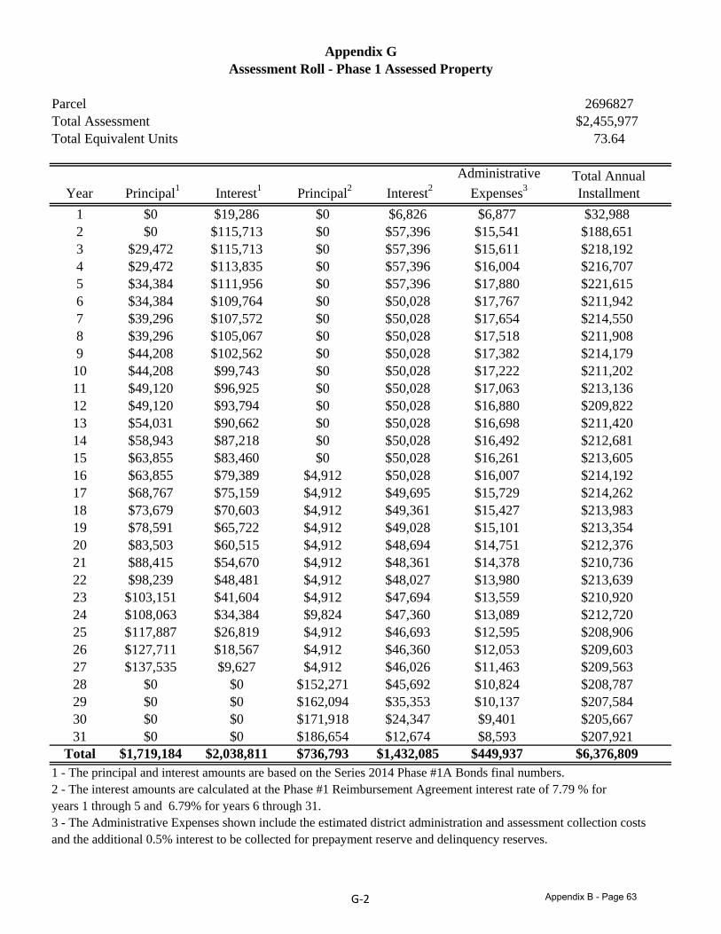
Parcel 2696827Total Assessment $2,455,977Total Equivalent Units 73.64
Appendix GAssessment Roll - Phase 1 Assessed Property
Year Principal1 Interest1 Principal2 Interest2Administrative
Expenses3Total Annual Installment
1 $0 $19,286 $0 $6,826 $6,877 $32,9882 $0 $115,713 $0 $57,396 $15,541 $188,6513 $29,472 $115,713 $0 $57,396 $15,611 $218,1924 $29,472 $113,835 $0 $57,396 $16,004 $216,7075 $34,384 $111,956 $0 $57,396 $17,880 $221,6156 $34,384 $109,764 $0 $50,028 $17,767 $211,9427 $39,296 $107,572 $0 $50,028 $17,654 $214,5508 $39,296 $105,067 $0 $50,028 $17,518 $211,9089 $44,208 $102,562 $0 $50,028 $17,382 $214,17910 $44 208 $99 743 $0 $50 028 $17 222 $211 20210 $44,208 $99,743 $0 $50,028 $17,222 $211,20211 $49,120 $96,925 $0 $50,028 $17,063 $213,13612 $49,120 $93,794 $0 $50,028 $16,880 $209,82213 $54,031 $90,662 $0 $50,028 $16,698 $211,42014 $58,943 $87,218 $0 $50,028 $16,492 $212,68115 $63,855 $83,460 $0 $50,028 $16,261 $213,60516 $63,855 $79,389 $4,912 $50,028 $16,007 $214,19216 $63,855 $79,389 $4,912 $50,028 $16,007 $214,19217 $68,767 $75,159 $4,912 $49,695 $15,729 $214,26218 $73,679 $70,603 $4,912 $49,361 $15,427 $213,98319 $78,591 $65,722 $4,912 $49,028 $15,101 $213,35420 $83,503 $60,515 $4,912 $48,694 $14,751 $212,37621 $88,415 $54,670 $4,912 $48,361 $14,378 $210,73622 $98,239 $48,481 $4,912 $48,027 $13,980 $213,63923 $103,151 $41,604 $4,912 $47,694 $13,559 $210,92024 $108,063 $34,384 $9,824 $47,360 $13,089 $212,72025 $117,887 $26,819 $4,912 $46,693 $12,595 $208,90626 $127,711 $18,567 $4,912 $46,360 $12,053 $209,60327 $137,535 $9,627 $4,912 $46,026 $11,463 $209,56328 $0 $0 $152,271 $45,692 $10,824 $208,78729 $0 $0 $162 094 $3 3 3 $10 13 $20 8429 $0 $0 $162,094 $35,353 $10,137 $207,58430 $0 $0 $171,918 $24,347 $9,401 $205,66731 $0 $0 $186,654 $12,674 $8,593 $207,921
Total $1,719,184 $2,038,811 $736,793 $1,432,085 $449,937 $6,376,8091 - The principal and interest amounts are based on the Series 2014 Phase #1A Bonds final numbers.2 - The interest amounts are calculated at the Phase #1 Reimbursement Agreement interest rate of 7.79 % for years 1 through 5 and 6 79% for years 6 through 31years 1 through 5 and 6.79% for years 6 through 31.3 - The Administrative Expenses shown include the estimated district administration and assessment collection costsand the additional 0.5% interest to be collected for prepayment reserve and delinquency reserves.
G‐2 Appendix B - Page 63
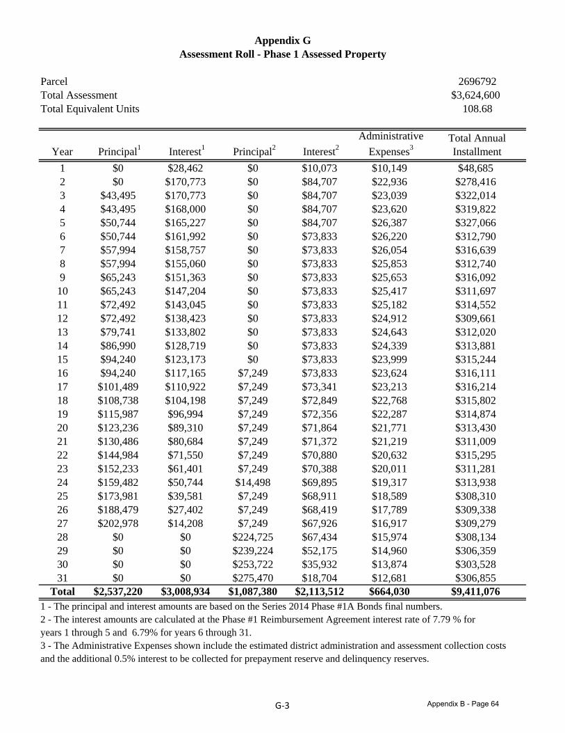
Parcel 2696792Total Assessment $3,624,600Total Equivalent Units 108.68
Appendix GAssessment Roll - Phase 1 Assessed Property
Year Principal1 Interest1 Principal2 Interest2Administrative
Expenses3Total Annual Installment
1 $0 $28,462 $0 $10,073 $10,149 $48,6852 $0 $170,773 $0 $84,707 $22,936 $278,4163 $43,495 $170,773 $0 $84,707 $23,039 $322,0144 $43,495 $168,000 $0 $84,707 $23,620 $319,8225 $50,744 $165,227 $0 $84,707 $26,387 $327,0666 $50,744 $161,992 $0 $73,833 $26,220 $312,7907 $57,994 $158,757 $0 $73,833 $26,054 $316,6398 $57,994 $155,060 $0 $73,833 $25,853 $312,7409 $65,243 $151,363 $0 $73,833 $25,653 $316,09210 $65 243 $147 204 $0 $73 833 $25 417 $311 69710 $65,243 $147,204 $0 $73,833 $25,417 $311,69711 $72,492 $143,045 $0 $73,833 $25,182 $314,55212 $72,492 $138,423 $0 $73,833 $24,912 $309,66113 $79,741 $133,802 $0 $73,833 $24,643 $312,02014 $86,990 $128,719 $0 $73,833 $24,339 $313,88115 $94,240 $123,173 $0 $73,833 $23,999 $315,24416 $94,240 $117,165 $7,249 $73,833 $23,624 $316,11116 $94,240 $117,165 $7,249 $73,833 $23,624 $316,11117 $101,489 $110,922 $7,249 $73,341 $23,213 $316,21418 $108,738 $104,198 $7,249 $72,849 $22,768 $315,80219 $115,987 $96,994 $7,249 $72,356 $22,287 $314,87420 $123,236 $89,310 $7,249 $71,864 $21,771 $313,43021 $130,486 $80,684 $7,249 $71,372 $21,219 $311,00922 $144,984 $71,550 $7,249 $70,880 $20,632 $315,29523 $152,233 $61,401 $7,249 $70,388 $20,011 $311,28124 $159,482 $50,744 $14,498 $69,895 $19,317 $313,93825 $173,981 $39,581 $7,249 $68,911 $18,589 $308,31026 $188,479 $27,402 $7,249 $68,419 $17,789 $309,33827 $202,978 $14,208 $7,249 $67,926 $16,917 $309,27928 $0 $0 $224,725 $67,434 $15,974 $308,13429 $0 $0 $239 224 $ 2 1 $14 960 $306 3 929 $0 $0 $239,224 $52,175 $14,960 $306,35930 $0 $0 $253,722 $35,932 $13,874 $303,52831 $0 $0 $275,470 $18,704 $12,681 $306,855
Total $2,537,220 $3,008,934 $1,087,380 $2,113,512 $664,030 $9,411,0761 - The principal and interest amounts are based on the Series 2014 Phase #1A Bonds final numbers.2 - The interest amounts are calculated at the Phase #1 Reimbursement Agreement interest rate of 7.79 % for years 1 through 5 and 6 79% for years 6 through 31years 1 through 5 and 6.79% for years 6 through 31.3 - The Administrative Expenses shown include the estimated district administration and assessment collection costsand the additional 0.5% interest to be collected for prepayment reserve and delinquency reserves.
G‐3 Appendix B - Page 64
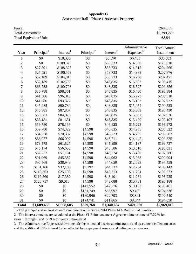
Parcel 2697055Total Assessment $2,299,226Total Equivalent Units 68.94
Appendix GAssessment Roll - Phase 1 Assessed Property
Year Principal1 Interest1 Principal2 Interest2Administrative
Expenses3Total Annual Installment
1 $0 $18,055 $0 $6,390 $6,438 $30,8832 $0 $108,328 $0 $53,733 $14,550 $176,6103 $27,591 $108,328 $0 $53,733 $14,615 $204,2664 $27,591 $106,569 $0 $53,733 $14,983 $202,8765 $32,189 $104,810 $0 $53,733 $16,738 $207,4716 $32,189 $102,758 $0 $46,835 $16,633 $198,4157 $36,788 $100,706 $0 $46,835 $16,527 $200,8568 $36,788 $98,361 $0 $46,835 $16,400 $198,3849 $41,386 $96,016 $0 $46,835 $16,273 $200,51010 $41 386 $93 377 $0 $46 835 $16 123 $197 72210 $41,386 $93,377 $0 $46,835 $16,123 $197,72211 $45,985 $90,739 $0 $46,835 $15,974 $199,53312 $45,985 $87,807 $0 $46,835 $15,803 $196,43013 $50,583 $84,876 $0 $46,835 $15,632 $197,92614 $55,181 $81,651 $0 $46,835 $15,439 $199,10715 $59,780 $78,133 $0 $46,835 $15,223 $199,97216 $59,780 $74,322 $4,598 $46,835 $14,985 $200,52216 $59,780 $74,322 $4,598 $46,835 $14,985 $200,52217 $64,378 $70,362 $4,598 $46,523 $14,725 $200,58718 $68,977 $66,097 $4,598 $46,211 $14,442 $200,32519 $73,575 $61,527 $4,598 $45,899 $14,137 $199,73720 $78,174 $56,653 $4,598 $45,586 $13,810 $198,82121 $82,772 $51,181 $4,598 $45,274 $13,460 $197,28622 $91,969 $45,387 $4,598 $44,962 $13,088 $200,00423 $96,568 $38,949 $4,598 $44,650 $12,693 $197,45824 $101,166 $32,189 $9,197 $44,337 $12,254 $199,14325 $110,363 $25,108 $4,598 $43,713 $11,791 $195,57326 $119,560 $17,382 $4,598 $43,401 $11,284 $196,22527 $128,757 $9,013 $4,598 $43,088 $10,731 $196,18828 $0 $0 $142,552 $42,776 $10,133 $195,46129 $0 $0 $1 1 49 $33 09 $9 490 $194 33629 $0 $0 $151,749 $33,097 $9,490 $194,33630 $0 $0 $160,946 $22,793 $8,801 $192,54031 $0 $0 $174,741 $11,865 $8,044 $194,650
Total $1,609,458 $1,908,685 $689,768 $1,340,684 $421,220 $5,969,8161 - The principal and interest amounts are based on the Series 2014 Phase #1A Bonds final numbers.2 - The interest amounts are calculated at the Phase #1 Reimbursement Agreement interest rate of 7.79 % for years 1 through 5 and 6 79% for years 6 through 31years 1 through 5 and 6.79% for years 6 through 31.3 - The Administrative Expenses shown include the estimated district administration and assessment collection costsand the additional 0.5% interest to be collected for prepayment reserve and delinquency reserves.
G‐4 Appendix B - Page 65
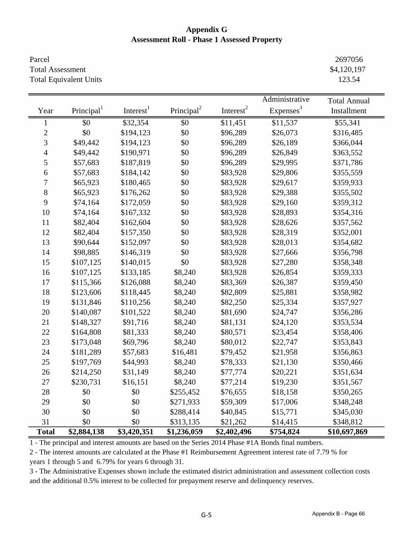
Parcel 2697056Total Assessment $4,120,197Total Equivalent Units 123.54
Assessment Roll - Phase 1 Assessed PropertyAppendix G
Year Principal1 Interest1 Principal2 Interest2Administrative
Expenses3Total Annual Installment
1 $0 $32,354 $0 $11,451 $11,537 $55,3412 $0 $194,123 $0 $96,289 $26,073 $316,4853 $49,442 $194,123 $0 $96,289 $26,189 $366,0444 $49,442 $190,971 $0 $96,289 $26,849 $363,5525 $57,683 $187,819 $0 $96,289 $29,995 $371,7866 $57,683 $184,142 $0 $83,928 $29,806 $355,5597 $65,923 $180,465 $0 $83,928 $29,617 $359,9338 $65,923 $176,262 $0 $83,928 $29,388 $355,5029 $74,164 $172,059 $0 $83,928 $29,160 $359,31210 $74 164 $167 332 $0 $83 928 $28 893 $354 31610 $74,164 $167,332 $0 $83,928 $28,893 $354,31611 $82,404 $162,604 $0 $83,928 $28,626 $357,56212 $82,404 $157,350 $0 $83,928 $28,319 $352,00113 $90,644 $152,097 $0 $83,928 $28,013 $354,68214 $98,885 $146,319 $0 $83,928 $27,666 $356,79815 $107,125 $140,015 $0 $83,928 $27,280 $358,34816 $107,125 $133,185 $8,240 $83,928 $26,854 $359,33316 $107,125 $133,185 $8,240 $83,928 $26,854 $359,33317 $115,366 $126,088 $8,240 $83,369 $26,387 $359,45018 $123,606 $118,445 $8,240 $82,809 $25,881 $358,98219 $131,846 $110,256 $8,240 $82,250 $25,334 $357,92720 $140,087 $101,522 $8,240 $81,690 $24,747 $356,28621 $148,327 $91,716 $8,240 $81,131 $24,120 $353,53422 $164,808 $81,333 $8,240 $80,571 $23,454 $358,40623 $173,048 $69,796 $8,240 $80,012 $22,747 $353,84324 $181,289 $57,683 $16,481 $79,452 $21,958 $356,86325 $197,769 $44,993 $8,240 $78,333 $21,130 $350,46626 $214,250 $31,149 $8,240 $77,774 $20,221 $351,63427 $230,731 $16,151 $8,240 $77,214 $19,230 $351,56728 $0 $0 $255,452 $76,655 $18,158 $350,26529 $0 $0 $2 1 933 $ 9 309 $1 006 $348 24829 $0 $0 $271,933 $59,309 $17,006 $348,24830 $0 $0 $288,414 $40,845 $15,771 $345,03031 $0 $0 $313,135 $21,262 $14,415 $348,812
Total $2,884,138 $3,420,351 $1,236,059 $2,402,496 $754,824 $10,697,8691 - The principal and interest amounts are based on the Series 2014 Phase #1A Bonds final numbers.2 - The interest amounts are calculated at the Phase #1 Reimbursement Agreement interest rate of 7.79 % for years 1 through 5 and 6 79% for years 6 through 31years 1 through 5 and 6.79% for years 6 through 31.3 - The Administrative Expenses shown include the estimated district administration and assessment collection costsand the additional 0.5% interest to be collected for prepayment reserve and delinquency reserves.
G‐5 Appendix B - Page 66

(THIS PAGE IS INTENTIONALLY LEFT BLANK.)

(THIS PAGE IS INTENTIONALLY LEFT BLANK.)

APPENDIX C
FORM OF OPINION OF BOND COUNSEL

(THIS PAGE IS INTENTIONALLY LEFT BLANK)
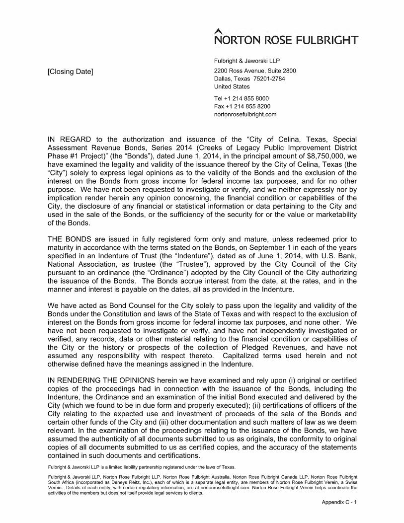
71483916.1
Fulbright & Jaworski LLP 2200 Ross Avenue, Suite 2800 Dallas, Texas 75201-2784 United States
Tel +1 214 855 8000 Fax +1 214 855 8200 nortonrosefulbright.com
Fulbright & Jaworski LLP is a limited liability partnership registered under the laws of Texas.
Fulbright & Jaworski LLP, Norton Rose Fulbright LLP, Norton Rose Fulbright Australia, Norton Rose Fulbright Canada LLP, Norton Rose Fulbright South Africa (incorporated as Deneys Reitz, Inc.), each of which is a separate legal entity, are members of Norton Rose Fulbright Verein, a Swiss Verein. Details of each entity, with certain regulatory information, are at nortonrosefulbright.com. Norton Rose Fulbright Verein helps coordinate the activities of the members but does not itself provide legal services to clients.
[Closing Date]
IN REGARD to the authorization and issuance of the “City of Celina, Texas, Special Assessment Revenue Bonds, Series 2014 (Creeks of Legacy Public Improvement District Phase #1 Project)” (the “Bonds”), dated June 1, 2014, in the principal amount of $8,750,000, we have examined the legality and validity of the issuance thereof by the City of Celina, Texas (the “City”) solely to express legal opinions as to the validity of the Bonds and the exclusion of the interest on the Bonds from gross income for federal income tax purposes, and for no other purpose. We have not been requested to investigate or verify, and we neither expressly nor by implication render herein any opinion concerning, the financial condition or capabilities of the City, the disclosure of any financial or statistical information or data pertaining to the City and used in the sale of the Bonds, or the sufficiency of the security for or the value or marketability of the Bonds.
THE BONDS are issued in fully registered form only and mature, unless redeemed prior to maturity in accordance with the terms stated on the Bonds, on September 1 in each of the years specified in an Indenture of Trust (the “Indenture”), dated as of June 1, 2014, with U.S. Bank, National Association, as trustee (the “Trustee”), approved by the City Council of the City pursuant to an ordinance (the “Ordinance”) adopted by the City Council of the City authorizing the issuance of the Bonds. The Bonds accrue interest from the date, at the rates, and in the manner and interest is payable on the dates, all as provided in the Indenture.
We have acted as Bond Counsel for the City solely to pass upon the legality and validity of the Bonds under the Constitution and laws of the State of Texas and with respect to the exclusion of interest on the Bonds from gross income for federal income tax purposes, and none other. We have not been requested to investigate or verify, and have not independently investigated or verified, any records, data or other material relating to the financial condition or capabilities of the City or the history or prospects of the collection of Pledged Revenues, and have not assumed any responsibility with respect thereto. Capitalized terms used herein and not otherwise defined have the meanings assigned in the Indenture.
IN RENDERING THE OPINIONS herein we have examined and rely upon (i) original or certified copies of the proceedings had in connection with the issuance of the Bonds, including the Indenture, the Ordinance and an examination of the initial Bond executed and delivered by the City (which we found to be in due form and properly executed); (ii) certifications of officers of the City relating to the expected use and investment of proceeds of the sale of the Bonds and certain other funds of the City and (iii) other documentation and such matters of law as we deem relevant. In the examination of the proceedings relating to the issuance of the Bonds, we have assumed the authenticity of all documents submitted to us as originals, the conformity to original copies of all documents submitted to us as certified copies, and the accuracy of the statements contained in such documents and certifications.
Appendix C - 1
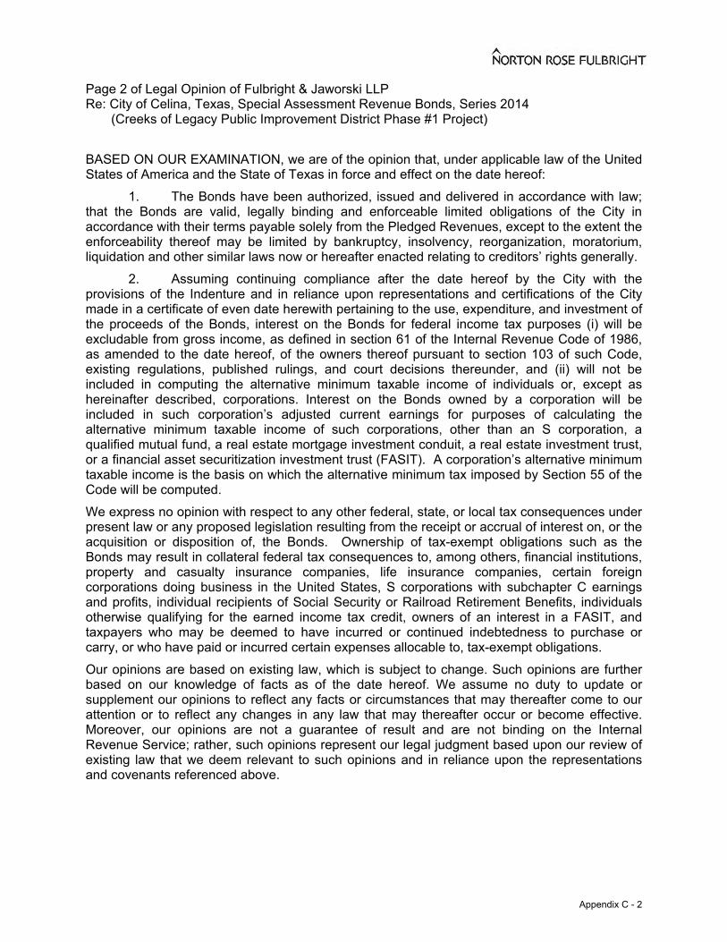
Page 2 of Legal Opinion of Fulbright & Jaworski LLP Re: City of Celina, Texas, Special Assessment Revenue Bonds, Series 2014 (Creeks of Legacy Public Improvement District Phase #1 Project)
71483916.1
BASED ON OUR EXAMINATION, we are of the opinion that, under applicable law of the United States of America and the State of Texas in force and effect on the date hereof: 1. The Bonds have been authorized, issued and delivered in accordance with law; that the Bonds are valid, legally binding and enforceable limited obligations of the City in accordance with their terms payable solely from the Pledged Revenues, except to the extent the enforceability thereof may be limited by bankruptcy, insolvency, reorganization, moratorium, liquidation and other similar laws now or hereafter enacted relating to creditors’ rights generally. 2. Assuming continuing compliance after the date hereof by the City with the provisions of the Indenture and in reliance upon representations and certifications of the City made in a certificate of even date herewith pertaining to the use, expenditure, and investment of the proceeds of the Bonds, interest on the Bonds for federal income tax purposes (i) will be excludable from gross income, as defined in section 61 of the Internal Revenue Code of 1986, as amended to the date hereof, of the owners thereof pursuant to section 103 of such Code, existing regulations, published rulings, and court decisions thereunder, and (ii) will not be included in computing the alternative minimum taxable income of individuals or, except as hereinafter described, corporations. Interest on the Bonds owned by a corporation will be included in such corporation’s adjusted current earnings for purposes of calculating the alternative minimum taxable income of such corporations, other than an S corporation, a qualified mutual fund, a real estate mortgage investment conduit, a real estate investment trust, or a financial asset securitization investment trust (FASIT). A corporation’s alternative minimum taxable income is the basis on which the alternative minimum tax imposed by Section 55 of the Code will be computed. We express no opinion with respect to any other federal, state, or local tax consequences under present law or any proposed legislation resulting from the receipt or accrual of interest on, or the acquisition or disposition of, the Bonds. Ownership of tax-exempt obligations such as the Bonds may result in collateral federal tax consequences to, among others, financial institutions, property and casualty insurance companies, life insurance companies, certain foreign corporations doing business in the United States, S corporations with subchapter C earnings and profits, individual recipients of Social Security or Railroad Retirement Benefits, individuals otherwise qualifying for the earned income tax credit, owners of an interest in a FASIT, and taxpayers who may be deemed to have incurred or continued indebtedness to purchase or carry, or who have paid or incurred certain expenses allocable to, tax-exempt obligations. Our opinions are based on existing law, which is subject to change. Such opinions are further based on our knowledge of facts as of the date hereof. We assume no duty to update or supplement our opinions to reflect any facts or circumstances that may thereafter come to our attention or to reflect any changes in any law that may thereafter occur or become effective. Moreover, our opinions are not a guarantee of result and are not binding on the Internal Revenue Service; rather, such opinions represent our legal judgment based upon our review of existing law that we deem relevant to such opinions and in reliance upon the representations and covenants referenced above.
Appendix C - 2

(THIS PAGE IS INTENTIONALLY LEFT BLANK.)

(THIS PAGE IS INTENTIONALLY LEFT BLANK.)

APPENDIX D
FORM OF DISCLOSURE AGREEMENTS

(THIS PAGE IS INTENTIONALLY LEFT BLANK)

DAL:893489.8
CITY OF CELINA, TEXAS, SPECIAL ASSESSMENT REVENUE BONDS, SERIES 2014
(CREEKS OF LEGACY PUBLIC IMPROVEMENT DISTRICT PHASE #1 PROJECT)
CONTINUING DISCLOSURE AGREEMENT OF THE ISSUER
This Continuing Disclosure Agreement dated as of June 1, 2014 (this “Disclosure Agreement”) is executed and delivered by and between the City of Celina, Texas (the “Issuer”) and U.S. Bank National Association (the “Dissemination Agent”) with respect to the Issuer’s “Special Assessment Revenue Bonds, Series 2014 (Creeks of Legacy Public Improvement District Phase #1 Project)” (the “Bonds”). The Issuer and the Dissemination Agent covenant and agree as follows:
SECTION 1. Purpose of the Disclosure Agreement. This Disclosure Agreement is being executed and delivered by the Issuer and the Dissemination Agent for the benefit of the Owners (as hereinafter defined) and beneficial owners of the Bonds. Unless and until a different filing location is designated by the MSRB or the SEC, all filings made by the Dissemination Agent pursuant to this Agreement shall be filed with the MSRB through EMMA (defined below).
SECTION 2. Definitions. In addition to the definitions set forth above and in the Indenture of Trust dated as of June 1, 2014, relating to the Bonds (the “Indenture”), which apply to any capitalized term used in this Disclosure Agreement unless otherwise defined in this Section, the following capitalized terms shall have the following meanings:
“Administrator” shall mean the employee or designee of the City, identified in any indenture of trust or relating to the Bonds, the District’s Service and Assessment Plan, or any other agreement or document approved by the Issuer related to the duties and responsibilities of the administration of the District.
“Annual Financial Information” shall mean annual financial information as such term is used in paragraph (b)(5)(i) of the Rule and specified in Sections 4(b) through (g) of this Disclosure Agreement.
“Annual Issuer Report” shall mean any Annual Bond Disclosure Report provided by the Issuer pursuant to, and as described in, Sections 3 and 4 of this Disclosure Agreement.
“Developer” shall mean CTMGT Frontier 80, LLC, a Texas limited liability company, and its successors and assigns.
“Disclosure Agreement of Developer” shall mean the Continuing Disclosure Agreement of the Developer dated as of June 1, 2014 executed and delivered by the Developer and the Dissemination Agent.
“Disclosure Representative” shall mean the Director of Finance of the Issuer or his or her designee, or such other officer or employee as the Issuer, may designate in writing to the Dissemination Agent from time to time.
Appendix D - Page 1

2 DAL:893489.8
“Dissemination Agent” shall mean the Trustee, or any successor Dissemination Agent designated in writing by the Issuer and which has filed with the Trustee a written acceptance of such designation.
“District” shall mean the Creeks of Legacy Public Improvement District.
“EMMA” shall mean the Electronic Municipal Market Access System available on the internet at http://emma.msrb.org.
“Fiscal Year” shall mean the calendar year from October 1 through September 30.
“Listed Events” shall mean any of the events listed in Section 5(a) of this Disclosure Agreement.
“MSRB” shall mean the Municipal Securities Rulemaking Board or any other entity designated or authorized by the SEC to receive reports pursuant to the Rule.
“Owner” shall mean the registered owner of any Bonds.
“Participating Underwriter” shall mean Jefferies LLC and its successors and assigns.
“Phase #1” shall mean the first phase of the development within the District.
“Rule” shall mean Rule 15c2-12 adopted by the Securities and Exchange Commission under the Securities Exchange Act of 1934, as the same may be amended from time to time.
“SEC” shall mean the United States Securities and Exchange Commission.
“Tax-exempt” shall mean that interest on the Bonds is excluded from gross income for federal income tax purposes, whether or not such interest is includable as an item of tax preference or otherwise includable directly or indirectly for purposes of calculating any other tax liability, including any alternative minimum tax liability.
“Trustee” shall mean U.S. Bank National Association, or any successor trustee pursuant to the Indenture.
SECTION 3. Provision of Annual Bond Disclosure Reports.
(a) The Issuer shall cause and hereby directs the Dissemination Agent to, not later than six months after the end of the Issuer’s Fiscal Year, commencing with the Fiscal Year ending September 30, 2014, provide or cause to be provided to the MSRB, in the electronic or other form required by the MSRB, an Annual Issuer Report provided to the Dissemination Agent which is consistent with the requirements of Section 4 of this Disclosure Agreement. In each case, the Annual Issuer Report may be submitted as a single document or as separate documents comprising a package and may include by reference other information as provided in Section 4 of this Disclosure Agreement; provided that the audited financial statements of the Issuer, if prepared and when available, may be submitted separately from the balance of the Annual Issuer Report, and later than the date required in this paragraph for the
Appendix D - Page 2

3 DAL:893489.8
filing of the Annual Issuer Report if audited financial statements are not available by that date; provided further, however, that the Annual Financial Information must be submitted not later than six months after the end of the Issuer’s Fiscal Year. If the Issuer’s Fiscal Year changes, it shall give notice of such change in the same manner as for a Listed Event under Section 5(d). All documents provided to the MSRB shall be accompanied by identifying information as prescribed by the MSRB.
(b) The Issuer shall or shall cause the Dissemination Agent to:
(i) determine the filing address or other filing location of the MSRB each year prior to filing the Annual Issuer Report on the date required in subsection (a);
(ii) file the Annual Issuer Report (excluding the audited financial statements of the Issuer, if any, which shall be filed by the Issuer or the Dissemination Agent upon receipt from the Issuer) containing or incorporating by reference the information set forth in Section 4 hereof; and
(iii) if the Issuer has provided the Dissemination Agent with the completed Annual Issuer Report and the Dissemination Agent has filed such Annual Issuer Report with the MSRB, then the Dissemination Agent shall file a report with the Issuer certifying that the Annual Issuer Report has been provided pursuant to this Disclosure Agreement, stating the date it was provided and that it was filed with the MSRB
SECTION 4. Content of Annual Issuer Reports. The Annual Issuer Report for the Bonds shall contain or incorporate by reference, and the Issuer agrees to provide or cause to be provided to the Dissemination Agent, the following:
(a) If prepared and when available, the audited financial statements of the Issuer for the most recently ended Fiscal Year, prepared in accordance with generally accepted accounting principles applicable from time to time to the Issuer. If audited financial statements of the Issuer are not available by the date required by Section 3(a), the Issuer shall provide the Annual Financial Information not later than such date.
(b) Tables setting forth the following information, as of the end of such Fiscal Year:
(i) For the Bonds, the maturity date or dates, the interest rate or rates, the original aggregate principal amount and principal amount remaining Outstanding.
(ii) The amounts in the funds and accounts securing the Bonds.
(c) Updates to the information in the Service and Assessment Plan (“SAP”) as most recently amended or supplemented, including any changes to the methodology for levying the Assessments in Phase #1.
(d) The total amount of Annual Installments, delinquent Annual Installments, Foreclosure Proceeds and prepaid Assessments collected during the immediate preceding billing period (generally, October 1 of the preceding calendar year through January 31 of the current calendar year).
Appendix D - Page 3
4 DAL:893489.8
(e) The total amount of Annual Installments assessed and collected during such Fiscal Year, together with the amount of delinquent Assessments collected and Assessments prepaid during such Fiscal Year.
(f) The principal and interest paid on the Bonds during the most recent Fiscal Year and the minimum scheduled principal and interest required to be paid on the Bonds in the next Fiscal Year.
(g) A description of any amendment to this Disclosure Agreement and a copy of any restatements to the Issuer’s audited financial statements.
See Exhibit B hereto for a form for submitting the information set forth in the preceding paragraph. The City has designated MuniCap, Inc. as the initial Administrator. The Administrator, and if no Administrator is designated, City staff, shall prepare the Annual Financial Information.
Any or all of the items listed above may be included by specific reference to other documents, including disclosure documents of debt issues of the Issuer, which have been submitted to and are publicly accessible from the MSRB. If the document included by reference is a final offering document, it must be available from the MSRB. The Issuer shall clearly identify each such other document so included by reference.
SECTION 5. Reporting of Significant Events.
(a) Pursuant to the provisions of this Section 5, each of the following is a Listed Event with respect to the Bonds:
1. Principal and interest payment delinquencies.
2. Non-payment related defaults, if material.
3. Unscheduled draws on debt service reserves reflecting financial difficulties.
4. Unscheduled draws on credit enhancements reflecting financial difficulties.
5. Substitution of credit or liquidity providers, or their failure to perform.
6. Adverse tax opinions, the issuance by the IRS of proposed or final determinations of taxability, Notices of Proposed Issue (IRS Form 5701-TEB) or other material notices or determinations with respect to the tax status of the Bonds, or other material events affecting the tax status of the Bonds.
7. Modifications to rights of Owners, if material.
8. Bond calls, if material.
9. Defeasances.
10. Release, substitution, or sale of property securing repayment of the Bonds, if material.
Appendix D - Page 4

5 DAL:893489.8
11. Rating changes.
12. Bankruptcy, insolvency, receivership or similar event of the Issuer.
13. The consummation of a merger, consolidation, or acquisition of the Issuer, or the sale of all or substantially all of the assets of the Issuer, other than in the ordinary course of business, the entry into a definitive agreement to undertake such an action or the termination of a definitive agreement relating to any such actions, other than pursuant to its terms, if material.
14. Appointment of a successor or additional trustee under the Indenture or the change of name of a trustee, if material.
For these purposes, any event described in the immediately preceding paragraph (12) is considered to occur when any of the following occur: the appointment of a receiver, fiscal agent, or similar officer for the Issuer in a proceeding under the United States Bankruptcy Code or in any other proceeding under state or federal law in which a court or governmental authority has assumed jurisdiction over substantially all of the assets or business of the Issuer, or if such jurisdiction has been assumed by leaving the existing governing body and officials or officers in possession but subject to the supervision and orders of a court or governmental authority, or the entry of an order confirming a plan of reorganization, arrangement, or liquidation by a court or governmental authority having supervision or jurisdiction over substantially all of the assets or business of the Issuer.
Whenever the Issuer obtains knowledge of the occurrence of a Listed Event, the Issuer shall promptly notify the Dissemination Agent in writing and the Issuer shall direct the Dissemination Agent to file a notice of such occurrence with the MSRB. The Dissemination Agent shall file such notice no later than the Business Day immediately following the day on which it receives written notice of such occurrence from the Issuer. Any such notice is required to be filed within ten (10) Business Days of the occurrence of such Listed Event.
Additionally, the Issuer shall notify the MSRB, in a timely manner, of any failure by the Issuer to provide annual audited financial statements or unaudited financial information as required under this Disclosure Agreement. See Exhibit A hereto for a form for submitting “Notice To MSRB of Failure To File.”
Any notice under the preceding paragraphs shall be accompanied with the text of the disclosure that the Issuer desires to make, the written authorization of the Issuer for the Dissemination Agent to disseminate such information as provided herein, and the date the Issuer desires for the Dissemination Agent to disseminate the information (which date shall not be more than ten (10) Business Days after the occurrence of the Listed Event or failure to file).
In all cases, the Issuer shall have the sole responsibility for the content, design and other elements comprising substantive contents of all disclosures. In addition, the Issuer shall have the sole responsibility to ensure that any notice required to be filed under this Section 5 is filed within (10) Business Days of the occurrence of the Listed Event.
(b) The Dissemination Agent shall, within three (3) Business Days of obtaining actual knowledge of the occurrence of any Listed Event with respect to the Bonds, notify the Disclosure Representative of such Listed Event. The Dissemination Agent shall not be required to file a notice of
Appendix D - Page 5
6 DAL:893489.8
the occurrence of such Listed Event with the MSRB unless and until it receives written instructions from the Disclosure Representative to do so. It is agreed and understood that the duty to make or cause to be made the disclosures herein is that of the Issuer and not that of the Trustee or the Dissemination Agent. It is agreed and understood that the Dissemination Agent has agreed to give the foregoing notice to the Issuer as an accommodation to assist it in monitoring the occurrence of such event, but is under no obligation to investigate whether any such event has occurred. As used above, “actual knowledge” means the actual fact or statement of knowing, without a duty to make any investigation with respect thereto. In no event shall the Dissemination Agent be liable in damages or in tort to the Participating Underwriter, the Issuer or any Owner or beneficial owner of any interests in the Bonds as a result of its failure to give the foregoing notice or to give such notice in a timely fashion.
(c) If in response to a notice from the Dissemination Agent under subsection (b), the Issuer determines that the Listed Event under number 2, 7, 8, 10, 13, or 14 of subparagraph (a) above is not material under applicable federal securities laws, the Issuer shall promptly notify the Dissemination Agent and the Trustee (if the Dissemination Agent is not the Trustee) in writing and instruct the Dissemination Agent not to report the occurrence pursuant to subsection (d).
(d) If the Dissemination Agent has been instructed by the Issuer to report the occurrence of a Listed Event, the Dissemination Agent shall immediately file a notice of such occurrence with the MSRB.
SECTION 6. Termination of Reporting Obligations. The obligations of the Issuer and the Dissemination Agent under this Disclosure Agreement shall terminate upon the legal defeasance, prior redemption or payment in full of all of the Bonds, when the Issuer is no longer an obligated person with respect to the Bonds, or upon delivery by the Disclosure Representative to the Dissemination Agent of an opinion of nationally recognized bond counsel to the effect that continuing disclosure is no longer required. So long as any of the Bonds remain Outstanding, the Dissemination Agent may assume that the Issuer is an obligated person with respect to the Bonds until it receives written notice from the Disclosure Representative stating that the Issuer is no longer an obligated person with respect to the Bonds, and the Dissemination Agent may conclusively rely upon such written notice with no duty to make investigation or inquiry into any statements contained or matters referred to in such written notice. If such termination occurs prior to the final maturity of the Bonds, the Issuer shall give notice of such termination in the same manner as for a Listed Event with respect to such series of Bonds under Section 5(d).
SECTION 7. Dissemination Agent. The Issuer may, from time to time, appoint or engage a Dissemination Agent or successor Dissemination Agent to assist it in carrying out its obligations under this Disclosure Agreement, and may discharge such Dissemination Agent, with or without appointing a successor Dissemination Agent. If at any time there is not any other designated Dissemination Agent, the Issuer shall be the Dissemination Agent. The initial Dissemination Agent appointed hereunder shall be the Trustee.
SECTION 8. Amendment; Waiver. Notwithstanding any other provisions of this Disclosure Agreement, the Issuer and the Dissemination Agent may amend this Disclosure Agreement (and the Dissemination Agent shall not unreasonably withhold its consent to any amendment so requested by the Issuer), and any provision of this Disclosure Agreement may be waived, provided that the following conditions are satisfied:
Appendix D - Page 6
7 DAL:893489.8
(a) If the amendment or waiver relates to the provisions of Sections 3(a), 4, or 5(a), it may only be made in connection with a change in circumstances that arises from a change in legal requirements, change in law, or change in the identity, nature or status of an obligated person with respect to the Bonds, or the type of business conducted;
(b) The undertaking, as amended or taking into account such waiver, would, in the opinion of nationally recognized bond counsel, have complied with the requirements of the Rule at the time of the delivery of the Bonds, after taking into account any amendments or interpretations of the Rule, as well as any change in circumstances; and
(c) The amendment or waiver either (i) is approved by the Owners of the Bonds in the same manner as provided in the Indenture for amendments to the Indenture with the consent of Owners, or (ii) does not, in the opinion of nationally recognized bond counsel, materially impair the interests of the Owners or beneficial owners of the Bonds.
In the event of any amendment or waiver of a provision of this Disclosure Agreement, the Issuer shall describe such amendment in the next related Annual Issuer Report, and shall include, as applicable, a narrative explanation of the reason for the amendment or waiver and its impact on the type (or in the case of a change of accounting principles, on the presentation) of financial information or operating data being presented by the Issuer. In addition, if the amendment relates to the accounting principles to be followed in preparing financial statements, (i) notice of such change shall be given in the same manner as for a Listed Event under Section 5(d), and (ii) the Annual Issuer Report for the year in which the change is made should present a comparison (in narrative form and also, if feasible, in quantitative form) between the financial statements as prepared on the basis of the new accounting principles and those prepared on the basis of the former accounting principles. No amendment which adversely affects the Dissemination Agent may be made without its prior written consent (which consent will not be unreasonably withheld or delayed).
SECTION 9. Additional Information. Nothing in this Disclosure Agreement shall be deemed to prevent the Issuer from disseminating any other information, using the means of dissemination set forth in this Disclosure Agreement or any other means of communication, or including any other information in any Annual Issuer Report or notice of occurrence of a Listed Event, in addition to that which is required by this Disclosure Agreement. If the Issuer chooses to include any information in any Annual Issuer Report or notice of occurrence of a Listed Event in addition to that which is specifically required by this Disclosure Agreement, the Issuer shall have no obligation under this Disclosure Agreement to update such information or include it in any future Annual Bond Disclosure Report or notice of occurrence of a Listed Event.
SECTION 10. Default. In the event of a failure of the Issuer to comply with any provision of this Disclosure Agreement, the Dissemination Agent may (and, at the request of any Participating Underwriter or the Owners of at least 25% aggregate principal amount of Outstanding Bonds, shall, upon being indemnified to its satisfaction as provided in the Indenture), or any Owner or beneficial owner of the Bonds may, take such actions as may be necessary and appropriate to cause the Issuer, as the case may be, to comply with its obligations under this Disclosure Agreement. A default under this Disclosure Agreement shall not be deemed an Event of Default under the Indenture with respect to the Bonds, and the sole remedy under this Disclosure Agreement in the event of any failure of the Issuer to comply with this Disclosure Agreement shall be an action to mandamus or specific performance. A
Appendix D - Page 7
8 DAL:893489.8
default under this Disclosure Agreement by the Issuer shall not be deemed a default under the Disclosure Agreement of Developer by the Developer, and a default under the Disclosure Agreement of the Developer by the Developer shall not be deemed a default under this Disclosure Agreement by the Issuer.
SECTION 11. Duties, Immunities and Liabilities of Dissemination Agent. The Dissemination Agent shall not have any duty with respect to the content of any disclosures made pursuant to the terms hereof. The Dissemination Agent shall have only such duties as are specifically set forth in this Disclosure Agreement, and no implied covenants shall be read into this Disclosure Agreement with respect to the Dissemination Agent. To the extent permitted by law, the Issuer agrees to hold harmless the Dissemination Agent, its officers, directors, employees and agents, but only with funds to be provided by the Developer or from Assessments collected from the property owners in Phase #1 of the District, against any loss, expense and liabilities which it may incur arising out of or in the exercise or performance of its powers and duties hereunder, including the costs and expenses (including attorneys’ fees) of defending against any claim of liability, but excluding liabilities due to the Dissemination Agent’s negligence or willful misconduct; provided, however, that nothing herein shall be construed to require the Issuer to indemnify the Dissemination Agent for losses, expenses or liabilities arising from information provided to the Dissemination Agent by the Developer or the failure of the Developer to provide information to the Dissemination Agent as and when required under the Disclosure Agreement of Developer. The obligations of the Issuer under this Section shall survive resignation or removal of the Dissemination Agent and payment in full of the Bonds. Nothing in this Disclosure Agreement shall be construed to mean or to imply that the Dissemination Agent is an “obligated person” under the Rule. The Dissemination Agent is not acting in a fiduciary capacity in connection with the performance of its respective obligations hereunder. The fact that the Dissemination Agent may have a banking relationship with the Issuer or any person with whom the Issuer contracts in connection with the transaction described in the Indenture, apart from the relationship created by the Indenture or this Disclosure Agreement, shall not be construed to mean that the Dissemination Agent has actual knowledge of any event described in Section 5 above, except as may be provided by written notice to the Dissemination Agent pursuant to this Disclosure Agreement.
The Dissemination Agent may, from time to time, consult with legal counsel of its own choosing in the event of any disagreement or controversy, or question or doubt as to the construction of any of the provisions hereof or their respective duties hereunder, and the Dissemination Agent shall not incur any liability and shall be fully protected in acting in good faith upon the advice of such legal counsel. UNDER NO CIRCUMSTANCES SHALL THE DISSEMINATION AGENT OR THE ISSUER BE LIABLE TO THE OWNER OR BENEFICIAL OWNER OF ANY BOND OR ANY OTHER PERSON, IN CONTRACT OR TORT, FOR DAMAGES RESULTING IN WHOLE OR IN PART FROM ANY BREACH BY THE ISSUER OR THE DISSEMINATION AGENT, RESPECTIVELY, WHETHER NEGLIGENT OR WITHOUT FAULT ON ITS PART, OF ANY COVENANT SPECIFIED IN THIS DISCLOSURE AGREEMENT, BUT EVERY RIGHT AND REMEDY OF ANY SUCH PERSON, IN CONTRACT OR TORT, FOR OR ON ACCOUNT OF ANY SUCH BREACH SHALL BE LIMITED TO AN ACTION FOR MANDAMUS OR SPECIFIC PERFORMANCE. THE DISSEMINATION AGENT IS UNDER NO OBLIGATION NOR IS IT REQUIRED TO BRING SUCH AN ACTION.
SECTION 12. Assessment Timeline. The basic expected timeline for the collection of Assessments and the anticipated procedures for pursuing the collection of delinquent Assessments is
Appendix D - Page 8
9 DAL:893489.8
set forth in Exhibit C which is intended to illustrate the general procedures expected to be followed in enforcing the payment of delinquent Assessments.
SECTION 13. No Personal Liability. No covenant, stipulation, obligation or agreement of the Issuer or Dissemination Agent contained in this Disclosure Agreement shall be deemed to be a covenant, stipulation, obligation or agreement of any present or future council members, officer, agent or employee of the Issuer or Dissemination Agent in other than that person's official capacity.
SECTION 14. Severability. In case any section or provision of this Disclosure Agreement, or any covenant, stipulation, obligation, agreement, act or action, or part thereof made, assumed, entered into, or taken thereunder or any application thereof, is for any reasons held to be illegal or invalid, such illegality or invalidity shall not affect the remainder thereof or any other section or provision thereof or any other covenant, stipulation, obligation, agreement, act or action, or part thereof made, assumed, entered into, or taken thereunder (except to the extent that such remainder or section or provision or other covenant, stipulation, obligation, agreement, act or action, or part thereof is wholly dependent for its operation on the provision determined to be invalid), which shall be construed and enforced as if such illegal or invalid portion were not contained therein, nor shall such illegality or invalidity of any application thereof affect any legal and valid application thereof, and each such section, provision, covenant, stipulation, obligation, agreement, act or action, or part thereof shall be deemed to be effective, operative, made, entered into or taken in the manner and to the full extent permitted by law.
SECTION 15. Sovereign Immunity. The Dissemination Agent agree that nothing in this Disclosure Agreement shall constitute or be construed as a waiver of the Issuer’s sovereign or governmental immunities regarding liability or suit.
SECTION 16. Beneficiaries. This Disclosure Agreement shall inure solely to the benefit of the Issuer, the Dissemination Agent, the Participating Underwriter and the Owners and the beneficial owners from time to time of the Bonds, and shall create no rights in any other person or entity. Nothing in this Disclosure Agreement is intended or shall act to disclaim, waive or otherwise limit the duties of the Issuer under federal and state securities laws.
SECTION 17. Dissemination Agent Compensation. The Issuer shall pay or reimburse the Dissemination Agent, but only with funds to be provided by the Developer or from Assessments collected from the property owners in Phase #1 of the District, for its fees and expenses for the Dissemination Agent’s services rendered in accordance with this Disclosure Agreement.
SECTION 18. Governing Law. This Disclosure Agreement shall be governed by the laws of the State of Texas.
SECTION 19. Counterparts. This Disclosure Agreement may be executed in several counterparts, each of which shall be an original and all of which shall constitute but one and the same instrument.
[remainder of page left blank intentionally]
Appendix D - Page 9
SIGNATURE PAGE OF CONTINUING DISCLOSURE AGREEMENT (PHASE #1) DAL:893489.8
CITY OF CELINA, TEXAS By: Mayor Pro-Tem
Appendix D - Page 10

SIGNATURE PAGE OF CONTINUING DISCLOSURE AGREEMENT (PHASE #1) DAL:893489.8
U.S. BANK NATIONAL ASSOCIATION (as Dissemination Agent) By: Authorized Officer
Appendix D - Page 11
A-1 DAL:893489.8
EXHIBIT A
NOTICE TO MSRB OF FAILURE TO FILE ANNUAL ISSUER REPORT
Name of Issuer: City of Celina, Texas Name of Bond Issue: Special Assessment Revenue Bonds, Series 2014
(Creeks of Legacy Public Improvement District Phase #1 Project) Date of Delivery: ______________, 20__
NOTICE IS HEREBY GIVEN that the City of Celina, Texas, has not provided an Annual Issuer Report with respect to the above-named bonds as required by the Continuing Disclosure Agreement dated June 1, 2014, between the Issuer and U.S. Bank National Association, as dissemination agent. The Issuer anticipates that the Annual Issuer Report will be filed by ________________.
Dated: _________________
U.S. Bank National Association, on behalf of the City of Celina, Texas (as Dissemination Agent) By: Title:
cc: City of Celina, Texas
Appendix D - Page 12

B-1 DAL:893489.8
EXHIBIT B
CITY OF CELINA, TEXAS, SPECIAL ASSESSMENT REVENUE BONDS, SERIES 2014
(CREEKS OF LEGACY PUBLIC IMPROVEMENT DISTRICT PHASE #1 PROJECT)
ANNUAL BOND DISCLOSURE REPORT*
Delivery Date: __________, 20__
TRUSTEE
Name: U.S. Bank National Association Address: _________________________________________ City: _________________________________________ Telephone: _________________________________________ Contact Person: _________________________________________
BONDS OUTSTANDING
CUSIP Number
Maturity Date
Interest Rate
Original Principal Amount
Outstanding Principal Amount
Outstanding Interest Amount
INVESTMENTS
Fund/ Account Name
Investment Description Par Value Book Value Market Value
_________________________ *Excluding Audited Financial Statements of the Issuer
Appendix D - Page 13
B-2 DAL:893489.8
ASSETS AND LIABILITIES OF PLEDGED TRUST ESTATE
Bonds (Principal Balance) ___________________ Funds and Accounts [list] ___________________ TOTAL ASSETS ___________________
LIABILITIES
Outstanding Bond Principal ___________________ Outstanding Program Expenses (if any) ___________________ TOTAL LIABILITIES ___________________
EQUITY
Assets Less Liabilities ___________________ Parity Ratio ___________________
Form of Accounting � Cash � Accrual � Modified Accrual
ITEMS REQUIRED BY SECTION 4(c) - (g) [Insert a line item for each applicable listing]
Appendix D - Page 14
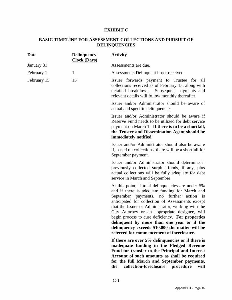
C-1 DAL:893489.8
EXHIBIT C
BASIC TIMELINE FOR ASSESSMENT COLLECTIONS AND PURSUIT OF DELINQUENCIES
Date Delinquency Clock (Days)
Activity
January 31 Assessments are due.
February 1 1 Assessments Delinquent if not received
February 15 15 Issuer forwards payment to Trustee for all collections received as of February 15, along with detailed breakdown. Subsequent payments and relevant details will follow monthly thereafter.
Issuer and/or Administrator should be aware of actual and specific delinquencies
Issuer and/or Administrator should be aware if Reserve Fund needs to be utilized for debt service payment on March 1. If there is to be a shortfall, the Trustee and Dissemination Agent should be immediately notified.
Issuer and/or Administrator should also be aware if, based on collections, there will be a shortfall for September payment.
Issuer and/or Administrator should determine if previously collected surplus funds, if any, plus actual collections will be fully adequate for debt service in March and September.
At this point, if total delinquencies are under 5% and if there is adequate funding for March and September payments, no further action is anticipated for collection of Assessments except that the Issuer or Administrator, working with the City Attorney or an appropriate designee, will begin process to cure deficiency. For properties delinquent by more than one year or if the delinquency exceeds $10,000 the matter will be referred for commencement of foreclosure.
If there are over 5% delinquencies or if there is inadequate funding in the Pledged Revenue Fund for transfer to the Principal and Interest Account of such amounts as shall be required for the full March and September payments, the collection-foreclosure procedure will
Appendix D - Page 15
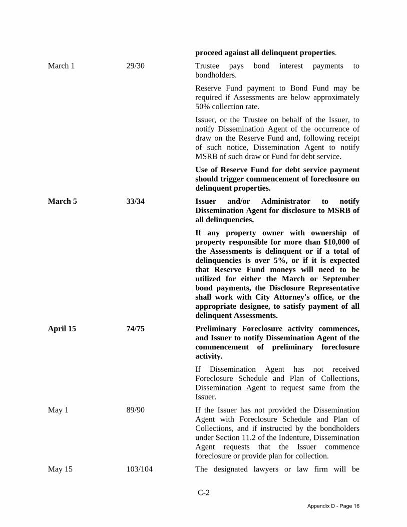
C-2 DAL:893489.8
proceed against all delinquent properties.
March 1 29/30 Trustee pays bond interest payments to bondholders.
Reserve Fund payment to Bond Fund may be required if Assessments are below approximately 50% collection rate.
Issuer, or the Trustee on behalf of the Issuer, to notify Dissemination Agent of the occurrence of draw on the Reserve Fund and, following receipt of such notice, Dissemination Agent to notify MSRB of such draw or Fund for debt service.
Use of Reserve Fund for debt service payment should trigger commencement of foreclosure on delinquent properties.
March 5 33/34 Issuer and/or Administrator to notify Dissemination Agent for disclosure to MSRB of all delinquencies.
If any property owner with ownership of property responsible for more than $10,000 of the Assessments is delinquent or if a total of delinquencies is over 5%, or if it is expected that Reserve Fund moneys will need to be utilized for either the March or September bond payments, the Disclosure Representative shall work with City Attorney's office, or the appropriate designee, to satisfy payment of all delinquent Assessments.
April 15 74/75 Preliminary Foreclosure activity commences, and Issuer to notify Dissemination Agent of the commencement of preliminary foreclosure activity.
If Dissemination Agent has not received Foreclosure Schedule and Plan of Collections, Dissemination Agent to request same from the Issuer.
May 1 89/90 If the Issuer has not provided the Dissemination Agent with Foreclosure Schedule and Plan of Collections, and if instructed by the bondholders under Section 11.2 of the Indenture, Dissemination Agent requests that the Issuer commence foreclosure or provide plan for collection.
May 15 103/104 The designated lawyers or law firm will be
Appendix D - Page 16

C-3 DAL:893489.8
preparing the formal foreclosure documents and will provide periodic updates to the Dissemination Agent for dissemination to those bondholders who have requested to be notified of collections progress. The goal for the foreclosure actions is a filing by no later than June 1 (day 120/121).
June 1 120/121 Foreclosure action to be filed with the court.
June 15 134/135 Issuer notifies Trustee and Dissemination Agent of Foreclosure filing status. Dissemination Agent notifies bondholders.
July 1 150/151 If bondholders and Dissemination Agent have not been notified of a foreclosure action, Dissemination Agent will notify the Issuer that it is appropriate to file action.
Appendix D - Page 17
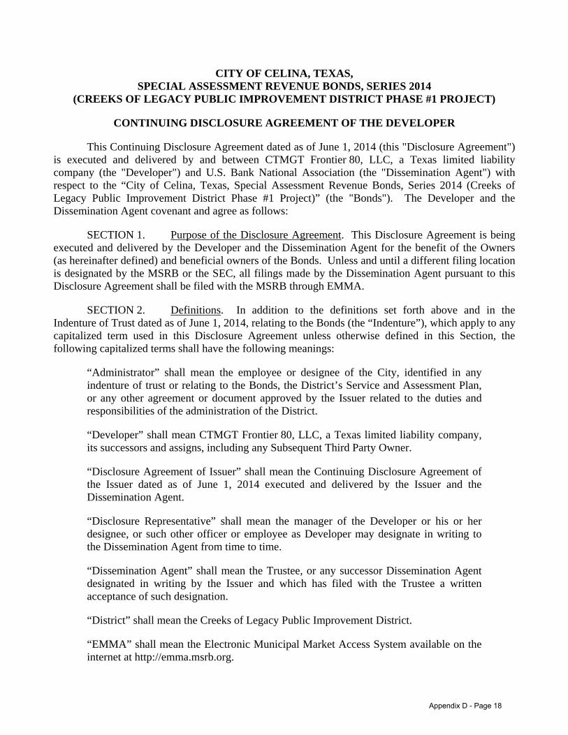
DAL:893491.6
CITY OF CELINA, TEXAS, SPECIAL ASSESSMENT REVENUE BONDS, SERIES 2014
(CREEKS OF LEGACY PUBLIC IMPROVEMENT DISTRICT PHASE #1 PROJECT)
CONTINUING DISCLOSURE AGREEMENT OF THE DEVELOPER
This Continuing Disclosure Agreement dated as of June 1, 2014 (this "Disclosure Agreement") is executed and delivered by and between CTMGT Frontier 80, LLC, a Texas limited liability company (the "Developer") and U.S. Bank National Association (the "Dissemination Agent") with respect to the “City of Celina, Texas, Special Assessment Revenue Bonds, Series 2014 (Creeks of Legacy Public Improvement District Phase #1 Project)” (the "Bonds"). The Developer and the Dissemination Agent covenant and agree as follows:
SECTION 1. Purpose of the Disclosure Agreement. This Disclosure Agreement is being executed and delivered by the Developer and the Dissemination Agent for the benefit of the Owners (as hereinafter defined) and beneficial owners of the Bonds. Unless and until a different filing location is designated by the MSRB or the SEC, all filings made by the Dissemination Agent pursuant to this Disclosure Agreement shall be filed with the MSRB through EMMA.
SECTION 2. Definitions. In addition to the definitions set forth above and in the Indenture of Trust dated as of June 1, 2014, relating to the Bonds (the “Indenture”), which apply to any capitalized term used in this Disclosure Agreement unless otherwise defined in this Section, the following capitalized terms shall have the following meanings:
“Administrator” shall mean the employee or designee of the City, identified in any indenture of trust or relating to the Bonds, the District’s Service and Assessment Plan, or any other agreement or document approved by the Issuer related to the duties and responsibilities of the administration of the District.
“Developer” shall mean CTMGT Frontier 80, LLC, a Texas limited liability company, its successors and assigns, including any Subsequent Third Party Owner.
“Disclosure Agreement of Issuer” shall mean the Continuing Disclosure Agreement of the Issuer dated as of June 1, 2014 executed and delivered by the Issuer and the Dissemination Agent.
“Disclosure Representative” shall mean the manager of the Developer or his or her designee, or such other officer or employee as Developer may designate in writing to the Dissemination Agent from time to time.
“Dissemination Agent” shall mean the Trustee, or any successor Dissemination Agent designated in writing by the Issuer and which has filed with the Trustee a written acceptance of such designation.
“District” shall mean the Creeks of Legacy Public Improvement District.
“EMMA” shall mean the Electronic Municipal Market Access System available on the internet at http://emma.msrb.org.
Appendix D - Page 18
2 DAL:893491.6
“Fiscal Year” shall mean the calendar year from October 1 through September 30.
“Issuer” shall mean the City of Celina, Texas.
“Listed Events” shall mean any of the events listed in Section 4(a) of this Disclosure Agreement.
“MSRB” shall mean the Municipal Securities Rulemaking Board or any other entity designated or authorized by the SEC to receive reports pursuant to the Rule.
“Owner” shall mean the registered owner of any Bonds.
“Participating Underwriter” shall mean Jefferies LLC and its successors and assigns.
“Phase #1” shall mean the first phase of development within the District.
“Quarterly Improvement Implementation Report” shall mean any Quarterly Improvement Implementation Report provided by the Developer pursuant to, and as described in, Section 3 of this Disclosure Agreement.
“Rule” shall mean Rule 15c2-12 adopted by the Securities and Exchange Commission under the Securities Exchange Act of 1934, as the same may be amended from time to time.
“SEC” shall mean the United States Securities and Exchange Commission.
“Subsequent Third Party Owner” shall have the meaning assigned to such term in Section 3(d) of this Disclosure Agreement.
“Trustee” shall mean U.S. Bank National Association, or any successor trustee pursuant to the Indenture.
SECTION 3. Quarterly Improvement Implementation Reports.
(a) The Developer shall provide, or cause to be provided, at its cost and expense, to the Dissemination Agent, on or before each March 30, June 30, September 30 and December 30 (beginning September 30, 2014), a Quarterly Improvement Implementation Report containing the information described in this Section 3, and the Dissemination Agent shall provide such information to the MSRB within fifteen (15) calendar days of its receipt thereof. The Developer shall provide, or cause to be provided, such Quarterly Improvement Implementation Report during the period from the delivery of the Bonds until such time as the Developer is no longer responsible for the payment of Annual Installments of Assessments equal to at least 20% of the total Annual Installments of Assessments for any year. Such Quarterly Improvement Implementation Report shall include:
(i) Statement with respect to the Developer or any affiliate of the Developer as to the status of development loans and any permanent financing with respect to any development undertaken by the Developer in Phase #1 not financed with Bond proceeds, including loan
Appendix D - Page 19
3 DAL:893491.6
balance, existence of deeds of trust or other similar encumbrances against the property within Phase #1, existence of any default and remaining term;
(ii) Statement as to available funds to complete Phase #1 development under construction as contemplated (both Bond financed and non-Bond financed development undertaken by the Developer or any affiliate of the Developer);
(iii) Status of parcel and/or lot sales from the Developer to any other party by type and average pricing, as well as anticipated future absorption sales;
(iv) A statement as to material changes, if any, in the form, organization or controlling ownership of the Developer;
(v) The status of any governmental approvals (other than customary home building permits required after a delivery of a finished lot) required for completion of Phase #1 Improvement within Phase #1;
(vi) Any information regarding the Phase #1 Improvements or other information as may be reasonably requested by the Issuer relating to the ability of the Developer or any affiliate of the Developer to fulfill its obligations under the Indenture or the SAP;
(vii) Written notification of any significant zoning or land use entitlement changes or any other matter that would have a material adverse impact on land values within Phase #1, development of potential of lands within Phase #1 or the likelihood of the timely payment of the Assessments levied on land or parcels owned by the Developer; and
(viii) Any changes to the land use designation for the property in Phase #1 that might negatively impact its development for those purposes identified in the final SAP, as the same may be amended and supplemented from time to time.
(b) Additionally, the Developer shall provide or cause to be provided filings as follows:
(i) The number, dollar amount, and property type (e.g., developed lots, undeveloped pads, parcels, raw land) under contract with wholesale purchasers and the name of each such purchaser;
(ii) A listing of any Subsequent Third Party Owners (defined below) representing at least twenty percent (20%) of the Assessments, the amount of the levy of Assessments against such Subsequent Third Party Owner, and the percentage of such Assessments relative to the entire levy of Assessments;
(iii) For each residential home builder, on a per quarter and running total basis, (A) the number of residential units for which construction has begun, (B) the number of residential units for which construction has been completed, and (C) the number of residential units which have been sold to end users and the average sales price therefor;
(iv) For each residential home builder, the estimated date of completion for all residential units expected to be constructed in Phase #1.
Appendix D - Page 20
4 DAL:893491.6
(v) Coordinate with the Administrator to prepare, the amount of Assessments delinquent greater than six months, one year and two years, and, if delinquencies amount to more than five percent (5%) of aggregate amount of Assessments due in any year, a list of property owners whose Assessments are delinquent.
(vi) Coordinate with the Administrator to prepare, the amount of delinquent Assessments by Fiscal Year: (1) which are subject to institution of foreclosure proceedings (but as to which such proceedings have not been instituted); (2) which are currently subject to foreclosure proceeding which have not been concluded; (3) which have been reduced to judgment but not collected; (4) which have been reduced to judgment and collected; and (5) the result of any foreclosure sales of assessed property if the assessed property represents more than three percent (3%) of the total amount of Assessments.
(c) With respect to the Project Fund for the Phase #1 Improvements, the Developer shall provide or cause to be provided filings as follows:
(i) With respect to the design-engineering and the Project Fund for the Phase #1 Improvements, the Developer will establish an accounting and budgeting system that will show:
(ii) Total expected costs for design and engineering to be completed after delivery of the Bonds;
(iii) Total expected construction budget;
(iv) Construction budget allocated to progress “Milestones;”
(v) Forecast construction “Milestones” of progress;
(vi) Forecast completion date; and
(vii) Forecast Issuer acceptance date.
The Developer shall prepare, within ninety (90) days of the issuance of the Bonds, a schedule reflecting the points listed above for each of the Phase #1 Improvements within the District to be funded by the Bond proceeds. Monthly design and construction expenditure progress reports, reflecting the points listed above, will be summarized by the Developer on a quarterly basis to reflect the progress and conformance with the overall project budget. These quarterly summaries will be filed with the Dissemination Agent. Budget overruns in excess of $250,000 per quarter or delays of greater than sixty (60) days will be highlighted and explained and the Developer shall include a plan to remedy the situation.
(d) If the Developer sells, assigns or otherwise transfers ownership of real property in Phase #1 to a third party, which results in such third party owning property representing at least twenty percent (20%) of the total Annual Installments of the Assessments first coming due after such transfer of ownership (a “Subsequent Third Party Owner”), the Developer shall require such Subsequent Third Party Owner to comply with the Developer’s disclosure obligations hereunder with respect to such acquired real property for so long as such Subsequent Third Party Owner is the owner of property
Appendix D - Page 21
5 DAL:893491.6
representing at least twenty percent (20%) of the total of Annual Installments of the Assessments next coming due. The Developer shall deliver to the Dissemination Agent, a written acknowledgement from each Subsequent Third Party Owner, acknowledging its obligations under this Disclosure Agreement.
SECTION 4. Event Reporting Obligations of Developer.
(a) Whenever the Developer or an affiliate of the Developer obtains actual knowledge of the occurrence of one or more of the following events, the Developer shall notify, or cause such affiliate to notify, the Dissemination Agent of such occurrences and the Dissemination Agent shall immediately report and file a notice of such event with the MSRB. Any such notice is required to be filed within ten (10) business days of the occurrence:
(i) Failure to pay any real property taxes or Assessments levied within Phase #1 on a parcel owned by the Developer, or an affiliate of the Developer;
(ii) Material damage to or destruction of any development or improvements, including the authorized improvements within Phase #1;
(iii) Material default by the Developer or any affiliate of the Developer on any loan with respect to the development or permanent financing of Phase #1 of the District development undertaken by the Developer or any affiliate of the Developer;
(iv) Material default by the Developer or any affiliate of the Developer on any loan secured by property within Phase #1 owned by the Developer or any affiliate of the Developer;
(v) The bankruptcy filing of the Developer or of any affiliate of the Developer or any determination that the Developer or any affiliate of the Developer is unable to pay its debts as they become due;
(vi) The consummation of a merger, consolidation, or acquisition of the Developer, or the sale of all or substantially all of the assets of the Developer, other than in the ordinary course of business, the entry into a definitive agreement to undertake such an action or the termination of a definitive agreement relating to any such actions, other than pursuant to its terms, if material.
(vii) The filing of any lawsuit with claim for damage, in excess of $1,000,000 against the Developer or any affiliate of the Developer which may adversely affect the completion of Phase #1 development or litigation which would materially adversely affect the financial condition of the Developer or any affiliate of the Developer; and
(viii) Any change in the legal structure, chief executive officer or controlling ownership of the Developer or any affiliate of the Developer.
For purposes of Sections 3 and 4, the term “affiliate” shall mean an entity that owns property within Phase #1 and is controlled by, controls, or is under common control of the Developer.
Appendix D - Page 22
6 DAL:893491.6
Any notice under the preceding paragraph shall be accompanied with the text of the disclosure that the Developer desires to make, the written authorization of the Developer for the Dissemination Agent to disseminate such information as provided herein, and the date the Developer desires for the Dissemination Agent to disseminate the information (which date shall not be more than ten (10) Business Days after the occurrence of the Listed Event).
In all cases, the Developer shall have the sole responsibility for the content, design and other elements comprising substantive contents of all disclosures. In addition, the Developer shall have the sole responsibility to ensure that any notice required to be filed under this Section 4 is filed within ten (10) Business Days of the occurrence of the Listed Event.
(b) If the Dissemination Agent has been instructed by the Developer to report the occurrence of a Listed Event, the Dissemination Agent shall file a notice of such occurrence with the MSRB within one (1) Business Day of its receipt of such written instructions from the Developer.
SECTION 5. Termination of Reporting Obligations.
(a) The obligations of the Developer, including any Subsequent Third Party Owner, and the Dissemination Agent under this Disclosure Agreement shall terminate (i) upon the legal defeasance, prior redemption or payment in full of all of the Bonds or (ii) when the Developer, including any Subsequent Third Party Owner, is no longer responsible for the payment of Annual Installments of Assessments equal to at least 20% of the total Annual Installment of Assessments for any year.
(b) At such time that the Developer, including any Subsequent Third Party Owner, is no longer responsible for payment of Annual Installments of Assessments equal to at least 20% of the total Annual Installments of Assessment for any year, the District Administrator shall provide written notice to the Developer that no party is responsible for the payment of Annual Installments of Assessments equal to at least 20% of the total Annual Installment of Assessments for any year (the “Termination Notice”). The Developer shall immediately provide, or cause to be provided, the Termination Notice to the Dissemination Agent, and the Dissemination Agent shall provide such Termination Notice to the MSRB within ten (10) Business Days of its receipt thereof.
SECTION 6. Dissemination Agent. The Issuer may, from time to time, appoint or engage a Dissemination Agent or successor Dissemination Agent to assist it in carrying out the Developer’s obligations under this Disclosure Agreement, and may discharge such Dissemination Agent, with or without appointing a successor Dissemination Agent. If at any time there is not any other designated Dissemination Agent, the Issuer shall be the Dissemination Agent. The initial Dissemination Agent appointed hereunder shall be the Trustee.
SECTION 7. Amendment; Waiver. Notwithstanding any other provisions of this Disclosure Agreement, the Developer and the Dissemination Agent may amend this Disclosure Agreement (and the Dissemination Agent shall not unreasonably withhold its consent to any amendment so requested by the Developer), and any provision of this Disclosure Agreement may be waived, provided that the following conditions are satisfied:
(a) If the amendment or waiver relates to the provisions of Sections 3(a) or 4, it may only be made in connection with a change in circumstances that arises from a change in legal requirements,
Appendix D - Page 23
7 DAL:893491.6
change in law, or change in the identity, nature or status of the Developer, or the type of business conducted; and
(b) The amendment or waiver either (i) is approved by the Owners of the Bonds in the same manner as provided in the Indenture for amendments to the Indenture with the consent of Owners, or (ii) does not, in the opinion of nationally recognized bond counsel, materially impair the interests of the Owners or beneficial owners of the Bonds. No amendment which adversely affects the Dissemination Agent may be made without its prior written consent (which consent will not be unreasonably withheld or delayed).
SECTION 8. Additional Information. Nothing in this Disclosure Agreement shall be deemed to prevent the Developer from disseminating any other information, using the means of dissemination set forth in this Disclosure Agreement or any other means of communication, or including any other information in addition to that which is required by this Disclosure Agreement. If the Developer chooses to include any information in any Quarterly Report or notice of occurrence of a Listed Event in addition to that which is specifically required by this Disclosure Agreement, the Developer shall have no obligation under this Disclosure Agreement to update such information or include it in any future notice of occurrence of a Listed Event.
SECTION 9. Default. In the event of a failure of the Developer to comply with any provision of this Disclosure Agreement, the Dissemination Agent may (and, at the request of any Participating Underwriter or the Owners of at least 25% aggregate principal amount of Outstanding Bonds, shall, upon being indemnified to its satisfaction as provided in the Indenture), or any Owner or beneficial owner of the Bonds may, take such actions as may be necessary and appropriate to cause the Developer to comply with its obligations under this Disclosure Agreement. A default under this Disclosure Agreement shall not be deemed an Event of Default under the Indenture with respect to the Bonds, and the sole remedy under this Disclosure Agreement in the event of any failure of the Developer to comply with this Disclosure Agreement shall be an action to mandamus or specific performance. A default under this Disclosure Agreement by the Developer shall not be deemed a default under the Disclosure Agreement of Issuer by the Issuer, and a default under the Disclosure Agreement of the Issuer by the Issuer shall not be deemed a default under this Disclosure Agreement by the Developer.
SECTION 10. Duties, Immunities and Liabilities of Dissemination Agent. The Dissemination Agent shall not have any duty with respect to the content of any disclosures made pursuant to the terms hereof. The Dissemination Agent shall have only such duties as are specifically set forth in this Disclosure Agreement, and no implied covenants shall be read into this Disclosure Agreement with respect to the Dissemination Agent. To the extent permitted by law, the Developer agrees to hold harmless the Dissemination Agent, its officers, directors, employees and agents, against any loss, expense and liabilities which it may incur arising out of or in the exercise or performance of its powers and duties hereunder, including the costs and expenses (including attorneys’ fees) of defending against any claim of liability, but excluding liabilities due to the Dissemination Agent’s negligence or willful misconduct. The obligations of the Developer under this Section shall survive resignation or removal of the Dissemination Agent and payment in full of the Bonds. Nothing in this Disclosure Agreement shall be construed to mean or to imply that the Dissemination Agent is an “obligated person” under the Rule. The Dissemination Agent is not acting in a fiduciary capacity in connection with the performance of its respective obligations hereunder. The fact that the
Appendix D - Page 24
8 DAL:893491.6
Dissemination Agent may have a banking relationship with the Developer or any person with whom the Developer contracts in connection with the transaction described in the Indenture, apart from the relationship created by this Disclosure Agreement, shall not be construed to mean that the Dissemination Agent has actual knowledge of any event described in Section 4 above, except as may be provided by written notice to the Dissemination Agent pursuant to this Disclosure Agreement. The Dissemination Agent shall not in any event incur any liability with respect to (i) any action taken or omitted to be taken in good faith upon advice of legal counsel given with respect to any question relating to duties and responsibilities of the Dissemination Agent hereunder, or (ii) any action taken or omitted to be taken in reliance upon any document delivered to the Dissemination Agent and believed to be genuine and to have been signed or presented by the proper party or parties.
The Dissemination Agent may, from time to time, consult with legal counsel of its own choosing in the event of any disagreement or controversy, or question or doubt as to the construction of any of the provisions hereof or their respective duties hereunder, and the Dissemination Agent shall not incur any liability and shall be fully protected in acting in good faith upon the advice of such legal counsel. UNDER NO CIRCUMSTANCES SHALL THE DISSEMINATION AGENT OR THE DEVELOPER BE LIABLE TO THE OWNER OR BENEFICIAL OWNER OF ANY BOND OR ANY OTHER PERSON, IN CONTRACT OR TORT, FOR DAMAGES RESULTING IN WHOLE OR IN PART FROM ANY BREACH BY THE DEVELOPER OR THE DISSEMINATION AGENT, RESPECTIVELY, WHETHER NEGLIGENT OR WITHOUT FAULT ON ITS PART, OF ANY COVENANT SPECIFIED IN THIS DISCLOSURE AGREEMENT, BUT EVERY RIGHT AND REMEDY OF ANY SUCH PERSON, IN CONTRACT OR TORT, FOR OR ON ACCOUNT OF ANY SUCH BREACH SHALL BE LIMITED TO AN ACTION FOR MANDAMUS OR SPECIFIC PERFORMANCE. THE DISSEMINATION AGENT IS UNDER NO OBLIGATION NOR IS IT REQUIRED TO BRING SUCH AN ACTION.
SECTION 11. No Personal Liability. No covenant, stipulation, obligation or agreement of the Developer or Dissemination Agent contained in this Disclosure Agreement shall be deemed to be a covenant, stipulation, obligation or agreement of any present or future officer, agent or employee of the Developer or Dissemination Agent in other than that person’s official capacity.
SECTION 12. Severability. In case any section or provision of this Disclosure Agreement, or any covenant, stipulation, obligation, agreement, act or action, or part thereof made, assumed, entered into, or taken thereunder or any application thereof, is for any reasons held to be illegal or invalid, such illegality or invalidity shall not affect the remainder thereof or any other section or provision thereof or any other covenant, stipulation, obligation, agreement, act or action, or part thereof made, assumed, entered into, or taken thereunder (except to the extent that such remainder or section or provision or other covenant, stipulation, obligation, agreement, act or action, or part thereof is wholly dependent for its operation on the provision determined to be invalid), which shall be construed and enforced as if such illegal or invalid portion were not contained therein, nor shall such illegality or invalidity of any application thereof affect any legal and valid application thereof, and each such section, provision, covenant, stipulation, obligation, agreement, act or action, or part thereof shall be deemed to be effective, operative, made, entered into or taken in the manner and to the full extent permitted by law.
SECTION 13. Beneficiaries. This Disclosure Agreement shall inure solely to the benefit of the Developer, the Dissemination Agent, the Participating Underwriter, and the Owners and the
Appendix D - Page 25
9 DAL:893491.6
beneficial owners from time to time of the Bonds, and shall create no rights in any other person or entity. Nothing in this Disclosure Agreement is intended or shall act to disclaim, waive or otherwise limit the duties of the Issuer under federal and state securities laws.
SECTION 14. Dissemination Agent Compensation. The Developer shall pay or reimburse the Dissemination Agent for its fees and expenses for the Dissemination Agent’s services rendered in accordance with this Disclosure Agreement.
SECTION 15. Governing Law. This Disclosure Agreement shall be governed by the laws of the State of Texas.
SECTION 16. Counterparts. This Disclosure Agreement may be executed in several counterparts, each of which shall be an original and all of which shall constitute but one and the same instrument.
[remainder of page left blank intentionally]
Appendix D - Page 26

SIGNATURE PAGE OF CONTINUING DISCLOSURE AGREEMENT (PHASE #1) DAL:893491.6
U.S. BANK NATIONAL ASSOCIATION (as Dissemination Agent) By: Authorized Officer
Appendix D - Page 27
SIGNATURE PAGE OF CONTINUING DISCLOSURE AGREEMENT (PHASE #1) DAL:893491.6
CTMGT FRONTIER 80, LLC, a Texas limited liability company By: Centamar Terras, LLC, a Texas limited liability company its Manager
By: CTMGT, LLC, a Texas limited liability company its Manager and Member
By: Name: Mehrdad Moyedi Title: Manager and Member
Appendix D - Page 28

(THIS PAGE IS INTENTIONALLY LEFT BLANK.)

(THIS PAGE IS INTENTIONALLY LEFT BLANK.)

APPENDIX E
APPRAISAL OF THE DISTRICT

(THIS PAGE IS INTENTIONALLY LEFT BLANK)
APPRAISAL REPORT OF
Creeks of Legacy - Phase I Part of a Future Multiphase Residential Development
To Be Located at the Northeast and Northwest Quadrants ofFrontier Parkway and Legacy Drive
Celina, Denton County, Texas
Prepared For:
JEFFERIES, LLC Mr. Mark Curran
Managing Director 300 Crescent Court, Suite 500
Dallas, Texas 75201
Mr. Mike Foreman City Manager City of Celina
142 N. Ohio Street Celina, Texas 75009
Prepared By:
JACKSON CLABORN, INC. Real Estate Consulting and Appraisal Services
5800 W. Plano Parkway, Suite 220 Plano, Texas 75093
Appendix E - Page 1
Headquarters: 5800 W. Plano Parkway Suite 220 Plano, Texas 75093 (972) 732-0051 FAX (972) 733-1403
Jackson Claborn, Inc. Real Estate Consulting and Appraisal Services
Plano, Texas www.jacksonclaborn.com
Jimmy H. Jackson, MAI David Ray, SRAAllen W. Gardiner, SRA
May 19, 2014
Mr. Mark Curran Mr. Mike Foreman Jefferies, LLC City Manager Managing Director City of Celina 300 Crescent Court, Suite 500 142 N. Ohio Street Dallas, Texas 75201 Celina, Texas 75009
RE: Appraisal Report of three pods of proposed single-family lots and six pods of future phases of excess land within the project known as Creeks of Legacy, a planned residential development to be located at Frontier Parkway and Legacy Drive, City of Celina, Collin/Denton Counties; D-255-C; JCI File No. 1403200
Dear Mr. Curran and Mr. Foreman:
At your request and authorization, Jackson Claborn, Inc. has prepared an Appraisal Report of the market value in the above-referenced real property. The subject was physically inspected on April 1, 2014. The date of the report is May 19, 2014.
Per the request of the client, we have provided the fee simple estate values for the subject property as follows:
Prospective Value of 88 lots in Pod 1, Phase I, Creeks of Legacy, “As If Improved As Proposed" as of April 1, 2015
Prospective Value of 115 lots in Pod 2, Phase I, Creeks of Legacy, “As If Improved As Proposed" as of April 1, 2015
Prospective Value of 213 lots in Pod 3, Phase I, Creeks of Legacy, “As If Improved As Proposed" as of April 1, 201
Prospective value of Pod 1, 17.000 acres of Excess Land, “As If Improved As Proposed" as of April 1, 2015
Prospective value of Pod 2, 19.000 acres of Excess Land, “As If Improved As Proposed" as of April 1, 2015
Appendix E - Page 2
Mr. Curran and Mr. Foreman May 19, 2014 Page Two
Prospective value of Pod 3, 17.000 acres of Excess Land, “As If Improved As Proposed" as of April 1, 2015
Prospective value of Pod 4, 36.000 acres of Excess Land, “As If Improved As Proposed" as of April 1, 2015
Prospective value of Pod 5, 36.000 acres of Excess Land, “As If Improved AsProposed" as of April 1, 2015
Prospective value of Pod 6, 34.000 acres of Excess Land, “As If Improved As Proposed" as of April 1, 2015
Data, information, and calculations leading to the value conclusion are incorporated in the report following this letter. The report, in its entirety, including all assumptions and limiting conditions, is an integral part of, and inseparable from, this letter. Any special assumptions and limiting considerations are noted in Section 2 of this report. Your attention is directed to these "General Assumptions and Limiting Conditions" which are part of this report. We suggest that you thoroughly read and familiarize yourself with these, since the appraisal is based upon these assumptions.
The following report sets forth the most pertinent data gathered, the techniques employed, and the reasoning leading to the opinion of value. The analyses, opinions, and conclusions were developed based upon, and this report has been prepared in conformance with, our interpretation of the guidelines and recommendations set forth in the Uniform Standards of Professional Appraisal Practice (USPAP) and the requirements of the Code of Professional Ethics and Standards of Professional Appraisal Practice of the Appraisal Institute.
Based upon an inspection of the property and the information and analysis provided in the following report, it is our opinion that the “Prospective Value” of the fee simple interest in the subject’s 88 single-family lots on Pod 1 within Creeks of Legacy, Phase 1 “As If Improved, As Proposed" on April 1, 2015 will be:
FIVE MILLION TWO HUNDRED THIRTY THOUSAND DOLLARS ($5,230,000)
It is our opinion that the “Prospective Value” of the fee simple interest in the subject’s 115 single-family lots on Pod 2 within Creeks of Legacy, Phase 1 “As If Improved, As Proposed" on April 1, 2015 will be:
SIX MILLION FIVE HUNDRED FIFTY THOUSAND DOLLARS ($6,550,000)
Appendix E - Page 3

Mr. Curran and Mr. Foreman May 19, 2014 Page Three
It is our opinion that the “Prospective Value” of the fee simple interest in the subject’s 213 single-family lots on Pod 3 within Creeks of Legacy, Phase 1 “As If Improved, As Proposed" on April 1, 2015 will be:
ELEVEN MILLION THREE HUNDRED TEN THOUSAND DOLLARS ($11,310,000)
It is our opinion that the “Prospective Value” of the fee simple interest in the subject’s Pod 1 (17.000 acres of excess land) “As If Improved, As Proposed" on April 1, 2015 will be:
TWO MILLION FIVE HUNDRED THIRTY THOUSAND DOLLARS ($2,530,000)
It is our opinion that the “Prospective Value” of the fee simple interest in the subject’s Pod 2 (19.000 acres of excess land) “As If Improved, As Proposed" on April 1, 2015 will be:
THREE MILLION FIFTEEN THOUSAND DOLLARS ($3,015,000)
It is our opinion that the “Prospective Value” of the fee simple interest in the subject’s Pod 3 (17.000 acres of excess land) “As If Improved, As Proposed" on April 1, 2015 will be:
TWO MILLION THREE HUNDRED EIGHTY THOUSAND DOLLARS ($2,380,000)
It is our opinion that the “Prospective Value” of the fee simple interest in the subject’s Pod 4 (36.000 acres of excess land) “As If Improved, As Proposed" on April 1, 2015 will be:
FOUR MILLION EIGHTY THOUSAND DOLLARS ($4,080,000)
It is our opinion that the “Prospective Value” of the fee simple interest in the subject’s Pod 5 (36.000 acres of excess land) “As If Improved, As Proposed" on April 1, 2015 will be:
THREE MILLION SIX HUNDRED THIRTY THOUSAND DOLLARS ($3,630,000)
Appendix E - Page 4
Mr. Curran and Mr. Foreman May 19, 2014 Page Four
It is our opinion that the “Prospective Value” of the fee simple interest in the subject’s Pod 6 (34.000 acres of excess land) “As If Improved, As Proposed" on April 1, 2015 will be:
FOUR MILLION EIGHTY THOUSAND DOLLARS ($4,080,000)
It must be noted that our opinions of value are subject to the following extraordinary assumptions and hypothetical conditions. In addition, within the confines of our extraordinary assumptions and hypothetical conditions shown below, we may also have included scope of work issues which may or may not necessarily be extraordinary assumptions and hypothetical conditions, yet could contribute to and influence our assignment results:
All information relative to the remaining developed and undeveloped property located within the Creeks of Legacy PID, including land areas, lot amounts, lot sizes, and other pertinent data that was provided by Pelotan Land Solutions (surveyors/engineers), Centurion American (developer), the City of Celina, and the Collin and Denton Central Appraisal Districts, is assumed to be correct. If it is found that this data is substantially different, the value found herein could be affected.
The valuations found herein are subject to the City of Celina approving and authorizing the creation of “Creeks of Legacy Public Improvement District” to finance the costs of certain public improvements for the benefit of property in the district. Thus, as the district is developed with housing, the corresponding tax base increases to a level which allows bonds to be sold. Proceeds from the bond sales are then used to reimburse the developers for certain development expenses. The property in the district is proposed to be developed in approximately six phases (Pod 1 through Pod 6). Proceeds from the bond sales will finance improvements that benefit all of the property in the district and improvements that benefit each phase of the district as each phase is developed. Assessments will be imposed on all property in Creeks of Legacy PID for the improvements that benefit the entire PID and on the property in each phase for the public improvements to be provided for that phase. This has been assumed in our valuation. If it is found that this data is substantially different, the value found herein could be affected.
Appendix E - Page 5
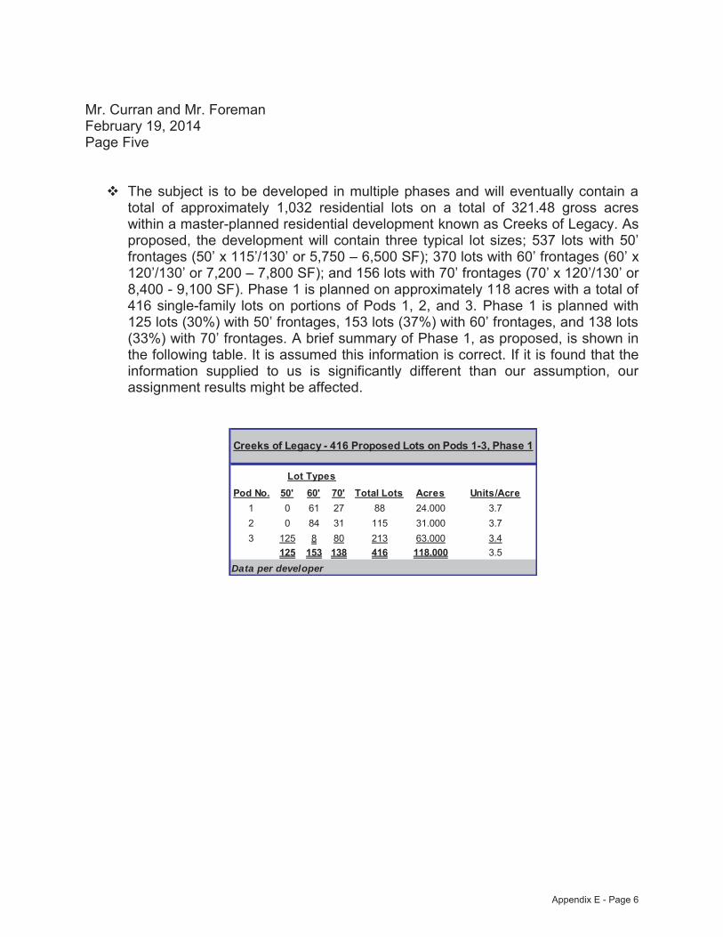
Mr. Curran and Mr. Foreman February 19, 2014 Page Five
The subject is to be developed in multiple phases and will eventually contain a total of approximately 1,032 residential lots on a total of 321.48 gross acres within a master-planned residential development known as Creeks of Legacy. As proposed, the development will contain three typical lot sizes; 537 lots with 50’ frontages (50’ x 115’/130’ or 5,750 – 6,500 SF); 370 lots with 60’ frontages (60’ x 120’/130’ or 7,200 – 7,800 SF); and 156 lots with 70’ frontages (70’ x 120’/130’ or 8,400 - 9,100 SF). Phase 1 is planned on approximately 118 acres with a total of 416 single-family lots on portions of Pods 1, 2, and 3. Phase 1 is planned with 125 lots (30%) with 50’ frontages, 153 lots (37%) with 60’ frontages, and 138 lots (33%) with 70’ frontages. A brief summary of Phase 1, as proposed, is shown in the following table. It is assumed this information is correct. If it is found that the information supplied to us is significantly different than our assumption, our assignment results might be affected.
Pod No. 50' 60' 70' Total Lots Acres Units/Acre1 0 61 27 88 24.000 3.72 0 84 31 115 31.000 3.73 125 8 80 213 63.000 3.4
125 153 138 416 118.000 3.5
Creeks of Legacy - 416 Proposed Lots on Pods 1-3, Phase 1
Data per developer
Lot Types
Appendix E - Page 6
Mr. Curran and Mr. Foreman May 19, 2014 Page Six
The subject of this report also represents the excess land remaining within Pods 1, 2, and 3 after completion of Phase 1 development, as well as future phases of land within Pods 4, 5, and 6. Our “Prospective” opinions of value will be based upon the following acreage sizes and on the assumption that Phase I is complete by April 1, 2015. Phase I development includes the interior streets and utilities for 416 single family lots on 118 acres within Pods 1, 2, and 3, as well as the completion of water, sewer, and storm drainage to the border of Pods 4, 5, and 6.Following is a summary of land sizes for the excess land within the six pods and planned as future phases:
Pod 1 17.000 gross acres Pod 2 19.000 gross acres Pod 3 17.000 gross acres Pod 4 35.000 gross acres Pod 5 35.000 gross acres Pod 6 35.000 gross acres
It is assumed this information is correct. If it is found that the information supplied to us is significantly different than our assumption, our assignment results might be affected.
As the subject represents a proposed construction project, this report contains prospective opinions of value. As such, we have assumed that the market conditions as discussed and considered within this report will be similar on the prospective valuation date. Further, we cannot be held responsible for unforeseeable events that alter market conditions prior to this prospective effective date. The prospective market value date is approximately 12 months from the effective date of this appraisal, due to the development taking approximately 12 months to complete.
Local and regional lending institutions appear to remain active within the subject’s market for specific projects. Therefore, we specifically assume that the financial markets will continue to function in a competitive, efficient fashion. However, we cannot be held responsible for unforeseeable events that alter market conditions.
Appendix E - Page 7

Mr. Curran and Mr. Foreman May 19, 2014 Page Seven
Jackson Claborn, Inc. does not authorize the out-of-context quoting from or partial reprinting of this Appraisal Report. Further, neither all nor any part of this report shall be disseminated to the general public by the use of media for public communication without the prior written consent of the appraiser signing this report.
Please refer to the attached Appraisal Report, plus exhibits, for documentation of these value opinions contained herein. It has been a pleasure to assist you in this assignment. If you have any questions concerning the analysis, or if Jackson Claborn, Inc. can be of further service, please contact us.
Respectfully submitted,
JACKSON CLABORN, INC.
Ernest E. Gatewood, III Jimmy H. Jackson, MAI Vice President - Commercial Division President/CEO TX-1324355-G TX-1324004-G Expiration: December 31, 2014 Expiration: November 30, 2014 [email protected] [email protected]
Shelley M. Sivakumar Staff Appraiser TX-1333354-L Expiration: February 29, 2016 [email protected]
Appendix E - Page 8
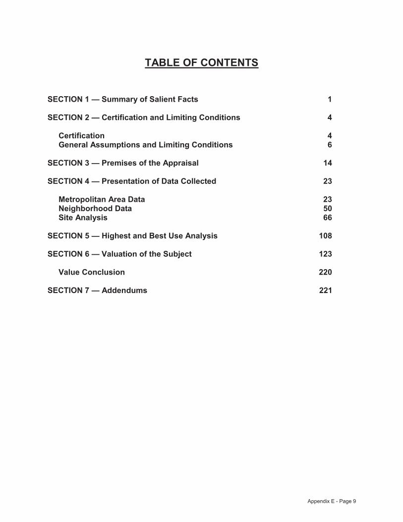
TABLE OF CONTENTS
SECTION 1 — Summary of Salient Facts 1
SECTION 2 — Certification and Limiting Conditions 4
Certification 4 General Assumptions and Limiting Conditions 6
SECTION 3 — Premises of the Appraisal 14
SECTION 4 — Presentation of Data Collected 23
Metropolitan Area Data 23Neighborhood Data 50Site Analysis 66
SECTION 5 — Highest and Best Use Analysis 108
SECTION 6 — Valuation of the Subject 123
Value Conclusion 220
SECTION 7 — Addendums 221
Appendix E - Page 9
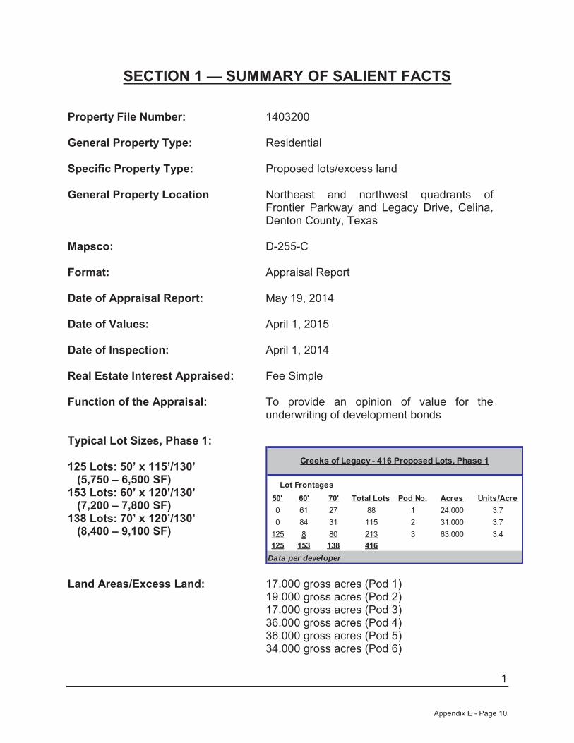
1
SECTION 1 — SUMMARY OF SALIENT FACTS
Property File Number: 1403200
General Property Type: Residential
Specific Property Type: Proposed lots/excess land
General Property Location Northeast and northwest quadrants of Frontier Parkway and Legacy Drive, Celina,Denton County, Texas
Mapsco: D-255-C
Format: Appraisal Report
Date of Appraisal Report: May 19, 2014
Date of Values: April 1, 2015
Date of Inspection: April 1, 2014
Real Estate Interest Appraised: Fee Simple
Function of the Appraisal: To provide an opinion of value for the underwriting of development bonds
Typical Lot Sizes, Phase 1:
125 Lots: 50’ x 115’/130’(5,750 – 6,500 SF)
153 Lots: 60’ x 120’/130’(7,200 – 7,800 SF)
138 Lots: 70’ x 120’/130’(8,400 – 9,100 SF)
50' 60' 70' Total Lots Pod No. Acres Units/Acre0 61 27 88 1 24.000 3.70 84 31 115 2 31.000 3.7
125 8 80 213 3 63.000 3.4125 153 138 416
Creeks of Legacy - 416 Proposed Lots, Phase 1
Data per developer
Lot Frontages
Land Areas/Excess Land: 17.000 gross acres (Pod 1)19.000 gross acres (Pod 2)17.000 gross acres (Pod 3)36.000 gross acres (Pod 4)36.000 gross acres (Pod 5)34.000 gross acres (Pod 6)
Appendix E - Page 10
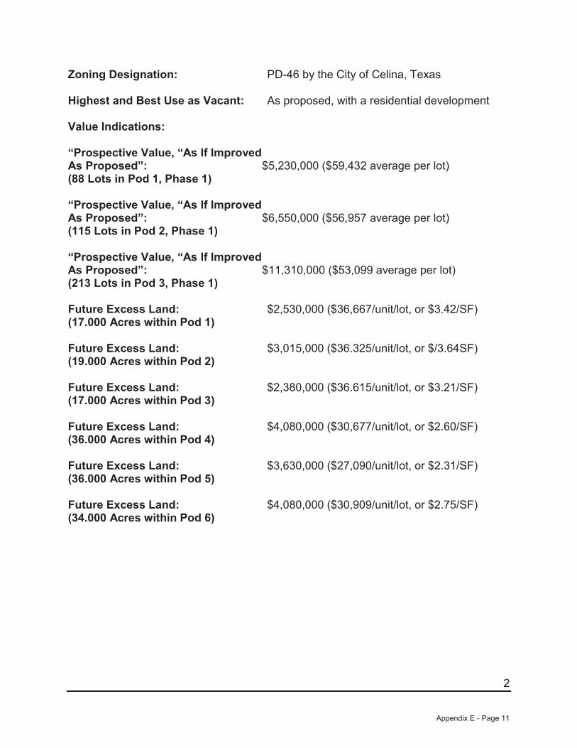
2
Zoning Designation: PD-46 by the City of Celina, Texas
Highest and Best Use as Vacant: As proposed, with a residential development
Value Indications:
“Prospective Value, “As If ImprovedAs Proposed”:(88 Lots in Pod 1, Phase 1)
$5,230,000 ($59,432 average per lot)
“Prospective Value, “As If ImprovedAs Proposed”:(115 Lots in Pod 2, Phase 1)
$6,550,000 ($56,957 average per lot)
“Prospective Value, “As If ImprovedAs Proposed”:(213 Lots in Pod 3, Phase 1)
$11,310,000 ($53,099 average per lot)
Future Excess Land: (17.000 Acres within Pod 1)
$2,530,000 ($36,667/unit/lot, or $3.42/SF)
Future Excess Land: (19.000 Acres within Pod 2)
$3,015,000 ($36.325/unit/lot, or $/3.64SF)
Future Excess Land: (17.000 Acres within Pod 3)
$2,380,000 ($36.615/unit/lot, or $3.21/SF)
Future Excess Land: (36.000 Acres within Pod 4)
$4,080,000 ($30,677/unit/lot, or $2.60/SF)
Future Excess Land: (36.000 Acres within Pod 5)
$3,630,000 ($27,090/unit/lot, or $2.31/SF)
Future Excess Land: (34.000 Acres within Pod 6)
$4,080,000 ($30,909/unit/lot, or $2.75/SF)
Appendix E - Page 11

3
Marketing Periods:
88 Lots in Pod 1, Phase 1 30.5± months to sellout of 88 lots after a 12-month construction period
115 Lots in Pod 2, Phase 1 36.0± months to sellout of 115 lots after a 12-month construction period
213 Lots in Pod 3, Phase 1 46.7± months to sellout of 213 lots after a 12-month construction period
Exposure Periods: Six to 12 months as bulk sale of lotsSix to 12 months as vacant land
Market Observations: The neighborhood is situated in close proximity to one of the fastest growing suburban communities of the Dallas/Fort Worth Metroplex and is readily accessible to various employment centers. Schools, hospitals, neighboring shopping, recreation area, and cultural activities are in the immediate area or located nearby. Single-family, multifamily, and retail development should continue in the general area. Development by both the private and public sector along with sound land-use planning will help provide orderly development within the neighborhood in the future as the neighborhood becomes more mature. No adverse influences or conditions were noted that would affect values within the neighborhood. Thus, the future long-term outlook for the general area appears to be promising.
Appendix E - Page 12
4
SECTION 2 — CERTIFICATION AND LIMITING CONDITIONS We certify to the best of our knowledge and belief:
The statements of fact contained in this report are true and correct.
The reported analyses, opinions, and conclusions are limited only by the reported assumptions and limiting conditions and our personal, impartial and unbiased professional analyses, opinions, and conclusions.
We have no present or prospective interest in or bias with respect to the property that is the subject of this report and have no personal interest in or bias with respect to the parties involved with this assignment.
Our engagement in this assignment was not contingent upon developing or reporting predetermined results. Furthermore, this appraisal assignment was not based upon a requested minimum valuation, a specific valuation, or the approval of a loan.
Our compensation for completing this assignment is not contingent upon the development or reporting of a predetermined value or direction in value that favors the cause of the client, the amount of the value opinion, the attainment of a stipulated result, or the occurrence of a subsequent event directly related to the intended use of this appraisal.
Our analyses, opinions, and conclusions were developed, and this report has been prepared, in conformity with requirements of the State of Texas and also conforms to the requirements of the Financial Institutions Reform, Recovery, and Enforcement Act of 1989 (FIRREA).
The reported analysis, opinions, and conclusions were developed, and this report has been prepared in conformity with the requirements of the Code of Professional Ethics and Standards of Professional Appraisal Practice of the Appraisal Institute.
The use of this report is subject to the requirements of the Appraisal Institute relating to review by its duly authorized representatives.
As of the date of this report, Jimmy H. Jackson, MAI has completed the requirements of the continuing education program of the Appraisal Institute.
As of the date of this report, Ernest E. Gatewood, III has completed the Standards and Ethics Education Requirements for Practicing Affiliates of the Appraisal Institute.
Appendix E - Page 13
5
Ernest E. Gatewood, III has made a personal inspection of the property that is the subject of this report. Jimmy H. Jackson, MAI and Shelley M. Sivakumar have not made a personal inspection of the property that is the subject of this report.
We have performed two previous appraisals regarding portions of the property that is the subject of this report within the three-year period immediately preceding acceptance of this assignment.
No one provided significant real property appraisal assistance to the persons signing this report.
Ernest E. Gatewood, III and Jimmy H. Jackson, MAI are currently certified in the State of Texas, and Shelley M. Sivakumar is currently licensed in the State of Texas. Ernest E. Gatewood, III, Jimmy H. Jackson, MAI, and Shelley M. Sivakumar have completed the continuing education requirements set forth with the State of Texas.
Although other appraisers may be contacted as a part of our routine market research investigations, absolute client confidentiality and privacy are maintained at all times with regard to this assignment without conflict of interest.
Ernest E. Gatewood, III, Jimmy H. Jackson, MAI, and Shelley M. Sivakumar are in compliance with the Competency Provision in the USPAP as adopted in FIRREA 1989 and have sufficient education and experience to perform an appraisal of the subject property.
Ernest E. Gatewood, III Jimmy H. Jackson, MAI Vice President - Commercial Division President/CEO TX-1324355-G TX-1324004-G Expiration: December 31, 2014 Expiration: November 30, 2014 [email protected] [email protected]
Shelley M. Sivakumar Staff Appraiser TX-1333354-L Expiration: February 29, 2016 [email protected]
Appendix E - Page 14
6
GENERAL ASSUMPTIONS AND LIMITING CONDITIONS
Information Used
No responsibility is assumed for accuracy of information furnished by others or from others, including the client, its officers and employees, or public records. We are not liable for such information or for the work of contractors, subcontractors and engineers. The comparable data relied upon in this appraisal has been confirmed with one or more parties familiar with the transaction unless otherwise noted; all are considered appropriate for inclusion to the best of my factual judgment and knowledge.
Certain information upon which the opinions and values are based may have been gathered by research staff working with the appraiser. Names, professional qualifications and extent of their participation can be furnished to the client upon request.
Legal, Engineering, Financial, Structural/Mechanical, Hidden Components, Soil
No responsibility is assumed for matters legal in character or nature, nor matters of survey, nor of any architectural, structural, mechanical or engineering nature. No opinion is rendered as to the legal nature or condition of the title to the property, which is presumed to be good and marketable. The property is appraised assuming it is free and clear of all mortgages, liens or encumbrances, unless otherwise stated in particular parts of this report.
The legal description is presumed to be correct, but we have not confirmed it by survey or otherwise. We assume no responsibility for the survey, any encroachments or overlapping or other discrepancies that might be revealed thereby.
We have inspected, as far as possible by observation, the land and improvements thereon; however, it was not possible to personally observe conditions beneath the soil or hidden structural, or other components, or any mechanical components within the improvement; as a result, no representation is made herein as to such matters unless otherwise specifically stated. The market value opinion assumes that no such conditions exist that would cause a loss of value. We do not warrant against the occurrence of problems arising from any of these conditions. It is assumed that there are no hidden or unapparent conditions to the property, soil, subsoil or structures, which would render them more or less valuable. No responsibility is assumed for any such conditions or for any expense or engineering to discover them. All mechanical components are assumed to be in operating condition standard for the properties of the subject's type. If applicable, the condition of the heating, cooling, ventilation, electric and plumbing equipment is considered to be commensurate with the condition of the balance of the improvements, unless otherwise stated. No judgment is made as
Appendix E - Page 15

7
to the adequacy of insulation, engineering or energy efficiency of the improvements or equipment.
Information relating to the location or existence of public utilities has been obtained through verbal inquiry to the appropriate utility authority, or has been ascertained from visual evidence. No warranty has been made regarding the exact location or capacities of public utility systems. Subsurface oil, gas or mineral rights were not considered in this report unless otherwise stated.
Legality of Use
The appraisal is based on the premise that there is or will be full compliance with all applicable Federal, State and local environmental regulations and laws, unless otherwise stated in the report; and that all appropriate zoning, building and use regulations and restrictions of all types have been or will be complied with and required licenses, consent, permits or other authority, whether local, State, Federal and/or private, have been or can be obtained or renewed for the use intended and considered in the opinion of value.
Component Values
The distribution of the total valuation of this report between land and improvements applies only under the proposed program of utilization. The separate valuations of land and buildings must not be used in conjunction with any other appraisal, and are invalid if so used.
A report related to an estate that is less than the whole fee simple estate applies only to the fractional interest involved. The value of this fractional interest, plus the value of all other fractional interests, may or may not equal the value of the entire fee simple estate considered as a whole.
A report relating to the geographic portion of a larger property applies only to such geographic portion and should not be considered as applying with equal validity to other portions of the larger property or tract. The value for such geographic portions, plus the value of all other geographic portions, may or may not equal the value of the entire property or tract considered as a single entity.
All valuations in the report are applicable only under the estimated program of the highest and best use and are not necessarily appropriate under other programs of use.
Appendix E - Page 16
8
Auxiliary and Related Studies
No environmental or impact studies, special market study or analysis, highest and best use analysis study or feasibility study has been requested or made by us unless otherwise specified in this report or in my agreement for services. I reserve the unlimited right to alter, amend, revise or rescind any of these statements, findings, opinions, values, estimates or conclusions upon any subsequent study or analysis or previous study or analysis that subsequently becomes available to us.
Dollar Values, Purchasing Power
The opinion of value and the costs used herein are as of the date of the opinion of value. All dollar amounts are based on the purchasing power and price of the United States dollar as of the date of opinion of value.
Inclusions
Furnishings and equipment or business operations, except as otherwise specifically indicated, have been disregarded, with only the real estate being considered.
Proposed Improvements Conditioned Value
For the purpose of this appraisal, on- or off-site improvements proposed, if any, as well as any repairs required, are considered to be completed in a good and workmanlike manner according to information submitted and/or considered by us. In cases of proposed construction, the report is subject to change upon inspection of the property after construction is complete. The opinion of value, as proposed, is as of the date shown, as if completed and operating at levels shown and projected.
Value Change, Dynamic Market Influences
The opinion of value is subject to change with market changes over time. Value is highly related to interest rates, exposure, time, promotional effort, supply and demand, terms of sale, motivation and conditions surrounding the offering. The opinion of value considers the productivity and relative attractiveness of the property both physically and economically in the marketplace.
The opinion of value in this report is not based in whole or in part upon race, color or national origin of the present owners or occupants of the properties in the vicinity of the property appraised.
Appendix E - Page 17
9
In the event this appraisal includes the capitalization of income, the opinion of value is a reflection of such benefits and my interpretation of income and yields and other factors which were derived from general and specific market information. Such opinions of value are made as of the date of the opinion of value. As a result, they are subject to change, as the market is dynamic and may naturally change over time. The date upon which the opinion of value applies is only as of the date of valuation, as stated in the letter of transmittal. The appraisal assumes no responsibility for economic or physical factors occurring at some later date which may affect the opinion stated herein.
An appraisal is the product of a professionally trained person, but nevertheless is an opinion only, and not a provable fact. As a personal opinion, a valuation may vary between appraisers based upon the same facts. Thus, the appraiser warrants only that the value conclusions are his best opinion as of the date ofvaluation. There are no guaranties, either written or implied, that the property would sell for the expressed opinion of value.
Sales History
Unless otherwise stated, the appraiser has not reviewed an abstract of title relating to the subject property. No title search has been made, and the reader should consult an attorney or title company for information and data relative to the property ownership and legal description. It is assumed that the subject title is marketable, but the title should be reviewed by legal counsel. Any information given by the appraiser as to a sales history is information that the appraiser has researched; to the best of our knowledge, this information is accurate, but not warranted.
Management of the Property
It is assumed that the property which is the subject of this report will be under prudent and competent ownership and management over the entire life of the property. If prudent and competent management and ownership are not provided, this would have an adverse effect upon the value of the property appraised.
Confidentiality
We are not entitled to divulge the material (evaluation or valuation) content of this report and analytical findings or conclusions, or give a copy of this report to anyone other than the client or his designee, as specified in writing, except as may be required by the Appraisal Institute, as they may request in confidence for ethic enforcement, or by a court of law with the power of subpoena.
Appendix E - Page 18
10
All conclusions and opinions concerning the analyses as set forth herein are prepared by the appraisers whose signatures appear. No change of any item in the report shall be made by anyone other than the appraiser, and the firm shall have no responsibility if any such unauthorized change is made.
Whenever our opinion herein with respect to the existence or absence of fact is qualified by the phrase or phrases "to the best of our knowledge", "it appears" or "indicated", it is intended to indicate that, during the course of our review and investigation of the property, no information has come to our attention which would give us actual knowledge of the existence or absence of such facts.
The client shall notify the appraiser of any error, omission or invalid data herein within 10 days of receipt and return of the report, along with all copies, to the appraiser for corrections prior to any use whatsoever. Neither our name nor this report may be used in connection with any financing plans which would be classified as a public offering under State or Federal Security Laws.
Copies, Publication, Distribution, Use of Report
Possession of this report, or any copy thereof, does not carry with it the right of publication, nor may it be used for other than its intended use. The physical report remains the property of the firm for the use of the client, with the fee being for the analytical services only. This report may not be used for any purpose by any person or corporation other than the client or the party to whom the report is addressed. Additional copies may not be made without the written consent of an officer of the firm, and then only in its entirety.
Neither all nor any part of the contents of this report shall be conveyed to the public through advertising, public relations effort, news, sales or other media without my prior written consent and approval of the client.
It has been assumed that the client or representative thereof, if soliciting funds for his project, has furnished to the user of this report complete plans, specifications, surveys and photographs of land and improvements, along with all other information which might be deemed necessary to correctly analyze and appraise the subject property.
Trade Secrets
The information found within this report was obtained from Jackson Claborn, Inc. or related companies and/or its individuals and consists of "trade secrets and commercial or financial information" which is privileged and confidential. Notify the appraisers signing the report or an officer of Jackson Claborn, Inc. of any request to reproduce this report in whole or in part.
Appendix E - Page 19
11
Testimony, Consultation, Completion of Contract for Appraisal Services
A contract for appraisal, consultation or analytical services is fulfilled and the total fee is payable upon completion of the report. The appraisers or those assisting in the preparation of the report will not be asked or required to give testimony in court or hearing because of having made the appraisal in full or in part, nor will they be asked or required to engage in post appraisal consultation with client or third parties except under separate and special arrangement and at an additional fee.
Any subsequent copies of this appraisal report will be furnished on a cost plus expenses basis, to be negotiated at the time of request.
Limit of Liability
Liability of the firm and the associates is limited to the fee collected for preparation of the appraisal. There is no accountability or liability to any third party.
Fee
The fee for this appraisal or study is for the service rendered, and not for time spent on the physical report. The acceptance of the report by the client takes with it the agreement and acknowledgement that the client will pay the negotiated fee, whether said agreement was verbal or written. The fee is in no way contingent on the value opinion.
Special Conditions of Appraisal Report
All information relative to the remaining developed and undeveloped property located within the Creeks of Legacy PID, including land areas, lot amounts, lot sizes, and other pertinent data that was provided by Pelotan Land Solutions (surveyors/engineers), Centurion American (developer), the City of Celina, and the Collin and Denton Central Appraisal Districts, is assumed to be correct. If it is found that this data is substantially different, the value found herein could be affected.
Appendix E - Page 20
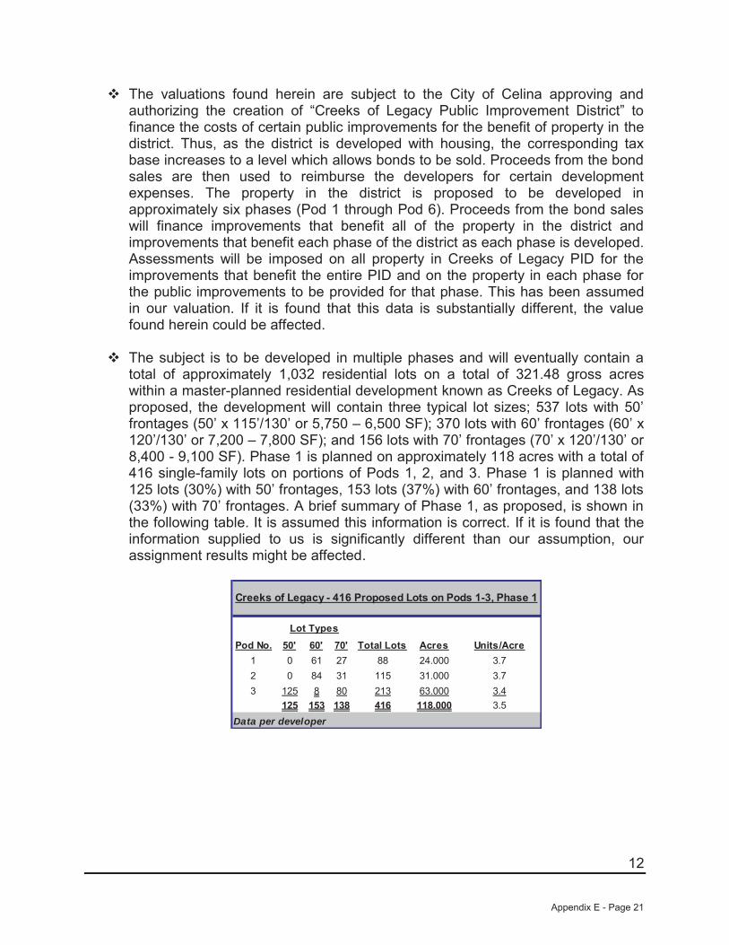
12
The valuations found herein are subject to the City of Celina approving and authorizing the creation of “Creeks of Legacy Public Improvement District” to finance the costs of certain public improvements for the benefit of property in the district. Thus, as the district is developed with housing, the corresponding tax base increases to a level which allows bonds to be sold. Proceeds from the bond sales are then used to reimburse the developers for certain development expenses. The property in the district is proposed to be developed in approximately six phases (Pod 1 through Pod 6). Proceeds from the bond sales will finance improvements that benefit all of the property in the district and improvements that benefit each phase of the district as each phase is developed. Assessments will be imposed on all property in Creeks of Legacy PID for the improvements that benefit the entire PID and on the property in each phase for the public improvements to be provided for that phase. This has been assumed in our valuation. If it is found that this data is substantially different, the value found herein could be affected.
The subject is to be developed in multiple phases and will eventually contain a total of approximately 1,032 residential lots on a total of 321.48 gross acres within a master-planned residential development known as Creeks of Legacy. As proposed, the development will contain three typical lot sizes; 537 lots with 50’ frontages (50’ x 115’/130’ or 5,750 – 6,500 SF); 370 lots with 60’ frontages (60’ x 120’/130’ or 7,200 – 7,800 SF); and 156 lots with 70’ frontages (70’ x 120’/130’ or 8,400 - 9,100 SF). Phase 1 is planned on approximately 118 acres with a total of 416 single-family lots on portions of Pods 1, 2, and 3. Phase 1 is planned with 125 lots (30%) with 50’ frontages, 153 lots (37%) with 60’ frontages, and 138 lots (33%) with 70’ frontages. A brief summary of Phase 1, as proposed, is shown in the following table. It is assumed this information is correct. If it is found that the information supplied to us is significantly different than our assumption, our assignment results might be affected.
Pod No. 50' 60' 70' Total Lots Acres Units/Acre1 0 61 27 88 24.000 3.72 0 84 31 115 31.000 3.73 125 8 80 213 63.000 3.4
125 153 138 416 118.000 3.5
Creeks of Legacy - 416 Proposed Lots on Pods 1-3, Phase 1
Data per developer
Lot Types
Appendix E - Page 21
13
The subject of this report also represents the excess land remaining within Pods 1, 2, and 3 after completion of Phase 1 development, as well as future phases of land within Pods 4, 5, and 6. Our “Prospective” opinions of value will be based upon the following acreage sizes and on the assumption that Phase I is complete by April 1, 2015. Phase I development includes the interior streets and utilities for 416 single family lots on 118 acres within Pods 1, 2, and 3, as well as the completion of water, sewer, and storm drainage to the border of Pods 4, 5, and 6.Following is a summary of land sizes for the excess land within the six pods and planned as future phases:
Pod 1 17.000 gross acres Pod 2 19.000 gross acres Pod 3 17.000 gross acres Pod 4 35.000 gross acres Pod 5 35.000 gross acres Pod 6 35.000 gross acres
It is assumed this information is correct. If it is found that the information supplied to us is significantly different than our assumption, our assignment results might be affected.
As the subject represents a proposed construction project, this report contains prospective opinions of value. As such, we have assumed that the market conditions as discussed and considered within this report will be similar on the prospective valuation date. Further, we cannot be held responsible for unforeseeable events that alter market conditions prior to this prospective effective date. The prospective market value date is approximately 12 months from the effective date of this appraisal, due to the development taking approximately 12 months to complete.
Local and regional lending institutions appear to remain active within the subject’s market for specific projects. Therefore, we specifically assume that the financial markets will continue to function in a competitive, efficient fashion. However, we cannot be held responsible for unforeseeable events that alter market conditions.
Appendix E - Page 22

14
SECTION 3 — PREMISES OF THE APPRAISALPurpose of Appraisal
The purpose of this appraisal is to provide an opinion of the market values of the fee simple interest of the prospective market value “as if improved as proposed”. This includes values for the proposed developed lots within Pods 1, 2, and 3 as well as the excess land within Pods 1 – 6 upon the completion of Phase I) under the reporting requirements of the Uniform Standards of Professional Appraisal Practice (USPAP), as defined by the Appraisal Foundation.
Competency of Appraisers
The appraisers' specific qualifications are included within this report. These qualifications serve as evidence of their competence for the completion of this appraisal assignment in compliance with the competency provision contained within the Uniform Standards of Professional Appraisal Practice as promulgated by the Appraisal Standards Board of the Appraisal Foundation. The appraisers' knowledge and experience, combined with their professional qualifications, are commensurate with the complexity of this assignment based on the following:
Professional experience Educational background and training Business, professional, academic affiliations and activities
The appraisers have previously provided consultation and opinion of values for various types of similar properties in Texas.
Scope of Assignment and Reporting Process
This Appraisal is reported in an “Appraisal Report” format which is intended to comply with the reporting requirements set forth under Standards Rule 2-2 (a) of the Uniform Standards of Professional Appraisal Practice of The Appraisal Foundation. The scope of this appraisal has been to collect, confirm, and report data. Other general market data and conditions have been considered.
It is noted that the scope of work is stated throughout the report. The appraisal is based on the information gathered by the appraiser from public records, other identified sources, inspection of the subject property and neighborhood, and selection of comparable sales, listings, and/or rentals within the subject market area.
Any inspection noted herein included the property being appraised as well as the neighborhood in which it is located. During the inspection, an inventory of the property attributes was collected based on visual observation. The purpose of any sketch, plans, building/unit layout, etc. provided is to best determine a reasonable estimation of the size and/or improvement layout of the subject and other notable improvements. This
Appendix E - Page 23
15
information is for referencing purposes only and may not accurately reflect the size, scale, and/or location of the improvement. A survey and/or architect should be relied upon for these purposes. (NOTE: The term “inspection” should not be construed to be a professional engineer’s report concerning the condition of the building, structural integrity, or condition of any mechanical items. If the client has concerns of this type, a professional engineer’s inspection and report are recommended. That type of inspection is beyond the scope of work of this assignment and the professional abilities of a certified appraiser. This inspection is made only for observation of property attributes).
The scope of this Appraisal Report has been to collect, confirm, and report data, while other general market data and conditions have been considered. Consideration and research has been performed regarding the subject property's zoning and surrounding improvements and neighborhood. We have investigated public records for the property's zoning, flood hazard area classification, and property tax assessor's records for attributes of the property. We have also investigated the subject’s quality and condition with available market participants to the sale (i.e., broker, owner, seller, buyer, tenant, etc.) and stated the current use of the subject. Consideration of the highest and best use of the land and property as vacant and improved (if applicable) has been analyzed.
If applicable to the assignment, we have collected and analyzed the following as necessary to the assignment:
Researched cost estimates from published and recognized data sources and applied recognized depreciation estimates which would lead to the completion of the Cost Approach.
Researched comparable rents of similar improved properties, made acomparative analysis which would lead to completion of market rent and the Income Approach to Value.
Researched the subject’s historical income and expenses, published and recognized data sources, as well as comparable data of competing properties’ historical income and expenses to project future income and expenses for the subject property which would lead to completion of the Income Approach to Value.
Researched comparable sales, recognized and published data sources, as well as utilized recognized appraisal techniques to arrive at a supportable capitalization rate and/or discount rate which would lead to completion of the Income Approach to Value.
Researched comparable sales of similar improved and vacant land properties and made a comparative analysis which would lead to completion of the Sales Comparison Approach to Value as improved and/or as vacant land.
Appendix E - Page 24

16
The original source of the comparables is described in the Data Source section of the market grid along with the source of confirmation, if available. The original source is presented first. The sources and data are considered reliable. When conflicting information was provided, the source deemed most reliable has been used. Data believed to be unreliable was not included in the report or used as a basis for the value conclusion. Data obtained during the search for comparables was obtained through recognized private sources as well as public sources (i.e., CoStar, Inc, Multiple Listing Service, LoopNet, Roddy Report, ALN Online, local appraisal districts, county records, etc.) as well as conversations and research with area market participants. It is noted that Texas is a "non-disclosure" state and sales prices are not a part of public record. As Texas is a "non-disclosure state," buyers and sellers of real property are under no legal obligation to disclose prices of transactions. For this reason, although there may have been numerous other actual sales, those included herein are not only deemed most relevant, but are those upon which reliable sale price data are available.
Based on location of comparables as well as client requirements, the comparables may or may not have been inspected. However, significant research was performed on each comparable through various data sources (i.e., tax records, aerial mapping systems, city websites and office resources, county websites and office resources, etc.). The extent of research performed was dependent on the complexity of the assignment and detail needed to adequately represent the comparable. Hence, we have relied upon best and common practices in verifying comparable data utilized herein and have assumed it to be accurate and reliable.
In reporting the data collected and analyzed, we have summarized the scope of work used to develop the appraisal as well as summarized the information analyzed, the appraisal methods and techniques employed, and the reasoning that supports the analyses, opinions, and conclusions. Any exclusions of the sales comparison approach, cost approach, or income approach have been explained. We have also stated the use of the property existing as of the date of value and provided an opinion of highest and best use. We have also summarized the support and rationale for that opinion. The data and analysis found herein is summarized. Adequate data and analysis was provided to give the user an explanation of our thought and rationale. It is noted that more detailed information may be available in our work files that was relied upon to arrive at analysis and conclusions contained in this report.
The appraiser performed the appraisal in conformity with the Uniform Standards of professional Appraisal Practice and Title XI of the Financial Institutions Reform, Recovery, and Enforcement Act of 1989, as amended (12 U.S.C. 3331 et seq.), and any implementing regulations in effect at the time the appraiser signs the appraiser's certification. Hence, the contents of this report and the analysis presented herein is written in an effort to comply and meet all applicable Title XI of the Financial Institutions Reform, Recovery, and Enforcement Act of 1989, as amended (12 U.S.C. 3331 et seq.) regulations and guideline requirements. However, it is noted that much of these guidelines do not deal directly with the appraisal process and that in the normal course of business we are not expected to be an expert in all of these guidelines.
Appendix E - Page 25
17
Definition of Value
We have been asked to appraise the market value of the subject, which is defined by The Appraisal Foundation in the Uniform Standards of Professional Appraisal Practice, and the Code of Federal Regulators under Chapter 12 C.F.R. Part 34.42(g) as follows:
The most probable price which a property should bring in a competitive and open market under all conditions requisite to a fair sale, the buyer and seller each acting prudently and knowledgeably, and assuming the price is not affected by undue stimulus. Implicit in this definition is the consummation of a sale as of a specified date and the passing of title from seller to buyer under conditions whereby:
Buyer and seller are typically motivated;
Both parties are well informed or well advised, and each acting in what they consider their own best interests;
A reasonable time is allowed for exposure in the open market;
Payment is made in terms of cash with U.S. dollars or in terms of financial arrangements comparable thereto; and
The price represents the normal consideration for the property sold unaffected by special or creative financing or sales concessions granted by anyone associated with the sale. 1
Property Rights
The property ownership rights appraised in this appraisal are those known as “fee simple”.
Fee Simple Interest
“Absolute ownership unencumbered by any other interest or estate; subject to the four powers of government. The four powers of government are eminent domain, escheat, police power, and taxation”.2
1 12 C.F.R. Part 34.42 (g) and The Dictionary of Real Estate Appraisers 5th Edition, the Appraisal Institute, Chicago, Illinois (U.S. 2010) 2 Ibid.
Appendix E - Page 26
18
Prospective Market Value
“A forecast of the value expected at a specified future date. A prospective value opinion is most frequently sought in connection with real estate projects that are proposed, under construction, or under conversion to a new use, or those that have not achieved sellout or a stabilized level of long-term occupancy at the time the appraisal report is written”.
Intended Use of Appraisal
It is our understanding that the intended use of the appraisal is to provide an opinion of value for the underwriting of development bonds.
Intended User of Appraisal
The intended user of this appraisal assignment is identified as Jefferies, LLC and the City of Celina. No one other than the stated and specifically identified intended user should rely upon the estimate of value or any other conclusions contained in this appraisal report. Prohibited users include any participants from equity participation and/or debt structured participation, as well as present or future purchasers/lessees or sellers/lessors of the subject property. Jackson Claborn, Inc. assumes no liability to any and all unnamed third party non-intended users who attempt to rely upon this appraisal report for any purposes.
Date of Opinion of Value
The market value opinions presented in this report are applicable as of April 1, 2015.
Date of Property Inspection
The subject property was physically inspected by Ernest E. Gatewood, III on April 1, 2014.
Appendix E - Page 27

19
Identification of the Property
The subject is part of an original assemblage of noncontiguous multiple tracts of vacant land totaling 321.480 acres which is planned to be developed as a residential subdivision known as Creeks of Legacy.
Location: Northeast and northwest quadrants of Frontier Parkway and Legacy Drive, Celina, Denton County, Texas
Current Owners of Record and Tax Parcel Summary:
Acct. No. Ownership Total Acres2696827 CADG Frontier 192 LLC 60.31802696792 CADG Frontier 192 LLC 53.6820963773 Frontier Tollw ay Partners LP 21.76502697056 CTMGT Frontier 80 LLC 38.28302697055 CTMGT Frontier 80 LLC 42.4180530240 Stonegate Partners-Legacy LP 68.5235149097 CADG Frontier 192, LLC 0.6222149098 CADG Frontier 192, LLC 0.555352660 James C. Wu 18.887875817 James C. Wu 9.444752644 James C. Wu 6.9000
Totals 321.400
COLLIN/DENTON COUNTIES
Denton Central Appraisal District
*Per Collin Central Appraisal District and
Legal Descriptions: Being 321.48 acres situated in the William Davenport Survey, Abstract No. 262, the F. D. Gray Survey, Abstract No. 361, Collin County, Texas and being in the J. McKinn Survey, Abstract No. 889, the William Phillips Survey, Abstract No. 1029 and the A. Thomasson Survey, Abstract No. 1265, Denton County, Texas
Appendix E - Page 28
20
History of the Property
The Uniform Standards of Professional Appraisal Practice requires a statement of the sales history of the subject property for the three years prior to the appraisal date. The subject property is currently an assemblage of four property owners, two of which are controlled by the same entity, with the other two either under contract or under negotiations to purchase. In September of 2013, approximately 192.767 gross acres was purchased for a total reported price of $7,670,000, or $39,789 per gross acre with another 22.767 acres purchased for 932,000, or $$40,936 per gross acre. Furthermore, another 69.7 acres was purchased for $4,321,462 or $62,000 per gross acre in March of 2014. All of the former owners have/had owned the properties for over three years prior to the sale. Approximately 35.000 acres are under contract to purchase at a price of $1,575,000, or $45,000 per gross acre. The assemblage has since been assembled, rezoned, engineered, and is in the process of being placed within a PID. As such, the acquisition prices do not reflect the current values of the assembled property. It is also noted that portions of the assemblage are contracted to resale. Approximately 50 acres are under contract to Lennar Homes at $5,375,000 while 41 acres are under contract to First Texas Homes for $4,100,000. Finally, Beazer Homes has signed a contract to purchase future developed lots at $1,150 per front foot (72, 50 foot lots) in Phase 1, $1,250 per front foot (66, 50 foot lots) in Phase 2. Ryland Homes has also signed a contract to purchase future developed lots at $1,150 per front foot (21, 50 foot lots, 8, 60 foot, and 43, 70 foot) in Phase 1, $1,250 per front foot (28, 50 foot lots and 38, 60 foot) in Phase 2.
Appraisal Analysis and Report Type
The Appraisal Standards Board controls the process of making an appraisal of a parcel of real estate. The Board issues rules and guidelines from which all appraisals and resulting reports are made. The process of administration of those rules and guidelines is addressed to the Real Estate Appraiser Commission of each respective state. The Appraisal Standards Board issues the rules and guidelines in the form of a document update published each year by The Appraisal Foundation. That document is entitled “The Uniform Standards of Professional Appraisal Practice” (USPAP). The analysis process is composed of several distinctive steps that appraisers follow to gain a thorough understanding of the property and factors that affect its value. There are two types of reports. They are: Appraisal Report and Restricted Appraisal Report. The following definitions have been adopted for each type of report:
Appraisal Report: A written report prepared under Standards Rule 2-2 (a) Restricted Appraisal Report: A written report prepared under Standards Rule
2-2 (b)
This appraisal of the subject has been presented in the form of an Appraisal Report, which is intended to comply with the reporting requirements set forth under Standards Rule 2-2 (a) of the USPAP.
Appendix E - Page 29
21
Exposure Time
Exposure time is the estimated length of time the property would have been offered prior to a hypothetical market value sale on the effective date of appraisal. It is a retrospective estimate based upon an analysis of recent past events, assuming a competitive and open market. It assumes not only adequate, sufficient, and reasonable time but also adequate, sufficient, and reasonable marketing effort. Exposure time is therefore interrelated with appraisal conclusion of value.
An estimate of exposure time is not intended to be a prediction of a date of sale or a simple one-line statement. Instead, it is an integral part of the appraisal analysis and is based upon one or more of the following:
statistical information about days on the market
information gathered through sales verification
interviews of market participants.
The reasonable exposure period is a function of price, time, and use. It is not an isolated estimate of time alone. Exposure time is different for various types of real estate and under various market conditions.
In consideration of these factors, we have analyzed the following:
exposure periods of comparable sales revealed during the course of this appraisal;
macroeconomic exposure times for the subject property type across the subject MSA and the entire United States as published in multiple articles and websites.
knowledgeable real estate professionals.
Based upon the foregoing analysis, an exposure time of six to 12 months is reasonable, defensible, and appropriate. This exposure time assumes the subject would have been competitively priced and aggressively promoted within the market area.
Appendix E - Page 30
22
Marketing Time
Marketing time is the period a prospective investor would forecast to sell the subject property immediately after the date of value, at the value opinion. The marketing time is an estimate of the number of months it will require to sell the subject from the date of value, into the future. The anticipated marketing time is essentially a measure of the perceived level of risk associated with the marketability, or liquidity, of the subject property. The marketing time estimate is based upon the data used in estimating the reasonable exposure time, in addition to an analysis of the anticipated changes in market conditions following the date of appraisal. The future price for the subject (at the end of the marketing time) may or may not equal the value opinion found herein. The future price depends upon unpredictable changes in the physical real estate, demographic and economic trends, real estate markets in general, supply/demand characteristics for the property type, and many other factors.
Based upon the premise that present market conditions are the best indicators of future performance, a prudent investor will forecast that, under the conditions described above, the subject will require a marketing time of approximately six to 12 months for the excess land and the following marketing time periods to sell-out of all 416 proposed lots within Phase I.
88 Lots in Pod 1, Phase 1 30.5± months to sellout of 88 lots after a 12-month construction period
115 Lots in Pod 2, Phase 1 36.0± months to sellout of 115 lots after a 12-month construction period
213 Lots in Pod 3, Phase 1 46.7± months to sellout of 213 lots after a 12-month construction period
Appendix E - Page 31
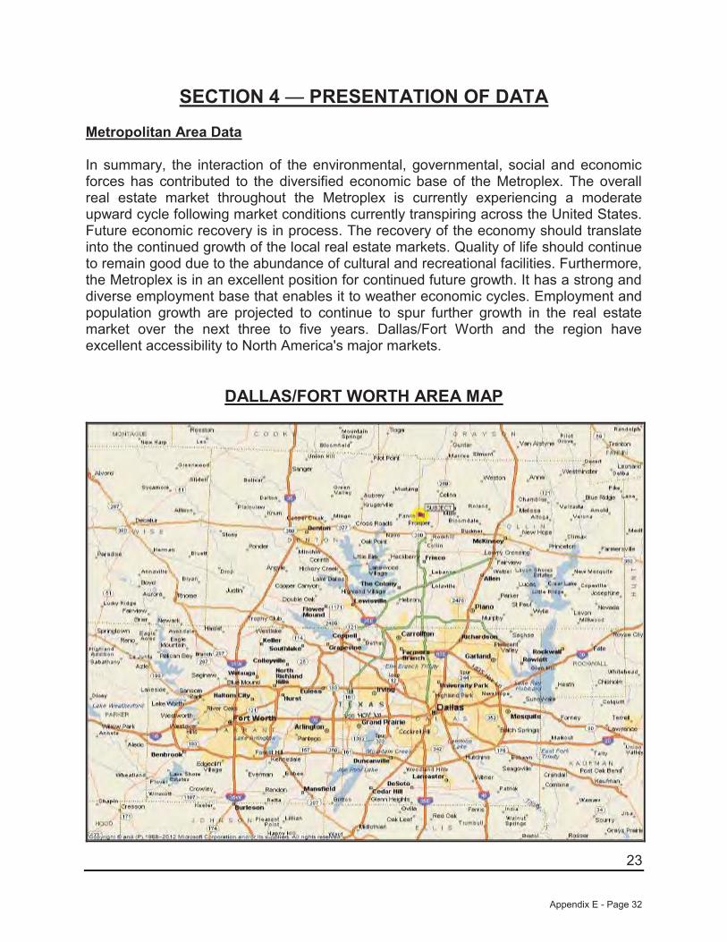
23
SECTION 4 — PRESENTATION OF DATA Metropolitan Area Data
In summary, the interaction of the environmental, governmental, social and economic forces has contributed to the diversified economic base of the Metroplex. The overall real estate market throughout the Metroplex is currently experiencing a moderate upward cycle following market conditions currently transpiring across the United States. Future economic recovery is in process. The recovery of the economy should translate into the continued growth of the local real estate markets. Quality of life should continue to remain good due to the abundance of cultural and recreational facilities. Furthermore, the Metroplex is in an excellent position for continued future growth. It has a strong and diverse employment base that enables it to weather economic cycles. Employment and population growth are projected to continue to spur further growth in the real estate market over the next three to five years. Dallas/Fort Worth and the region have excellent accessibility to North America's major markets.
DALLAS/FORT WORTH AREA MAP
Appendix E - Page 32
24
Appendix E - Page 33
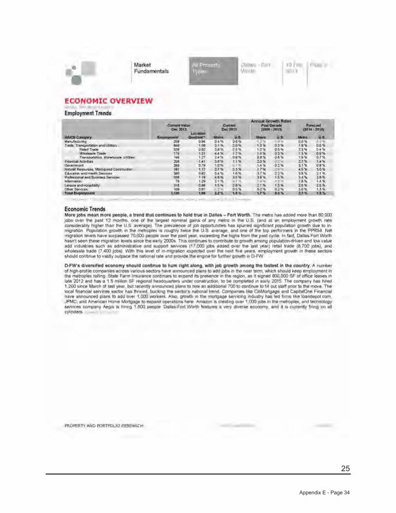
25
Appendix E - Page 34
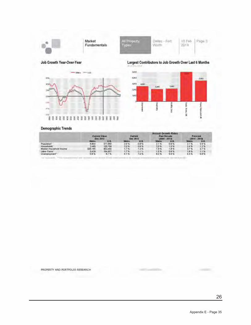
26
Appendix E - Page 35
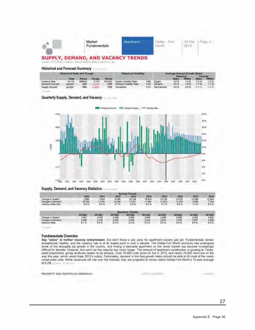
27
Appendix E - Page 36

28
Appendix E - Page 37
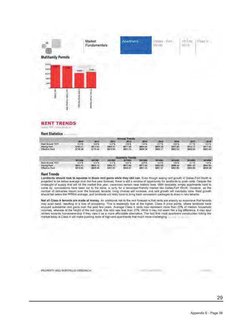
29
Appendix E - Page 38
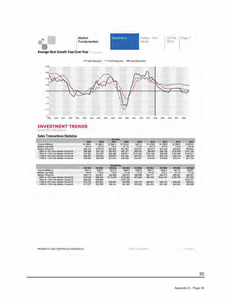
30
Appendix E - Page 39
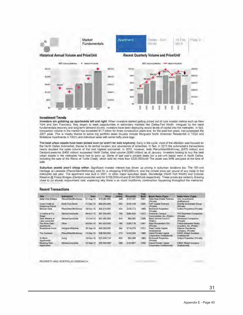
31
Appendix E - Page 40
32
Appendix E - Page 41
33
Appendix E - Page 42

34
Appendix E - Page 43
35
Appendix E - Page 44
36
Appendix E - Page 45
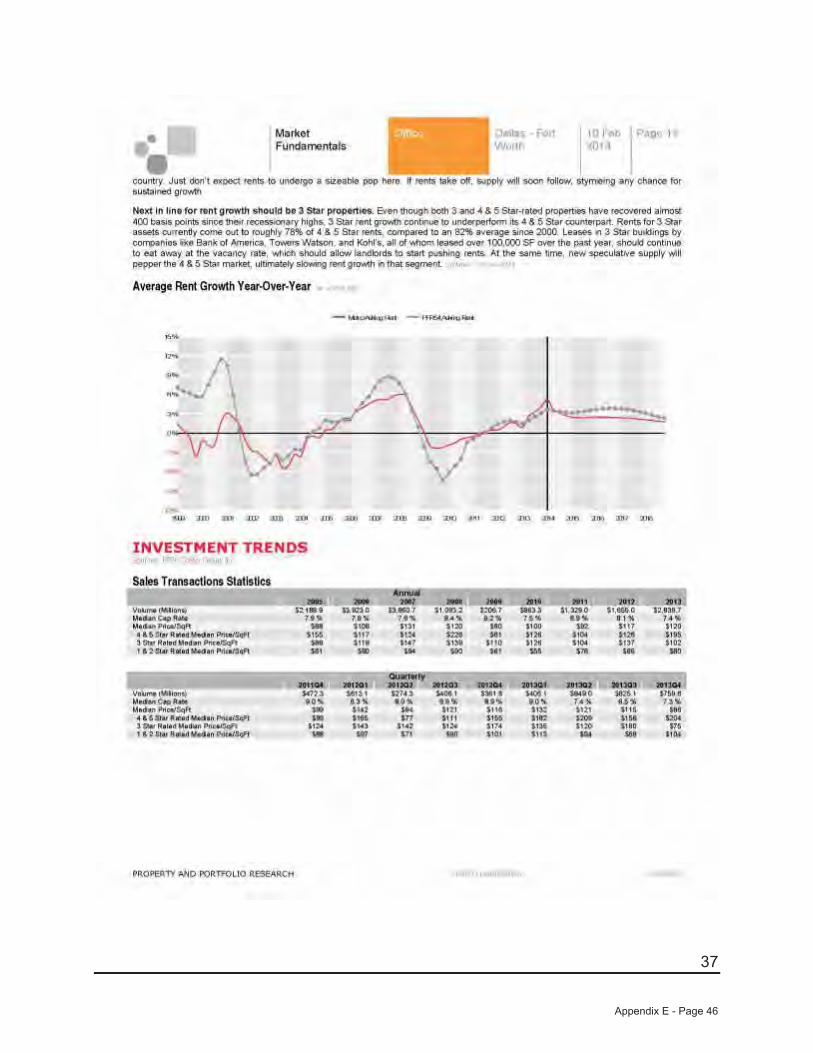
37
Appendix E - Page 46
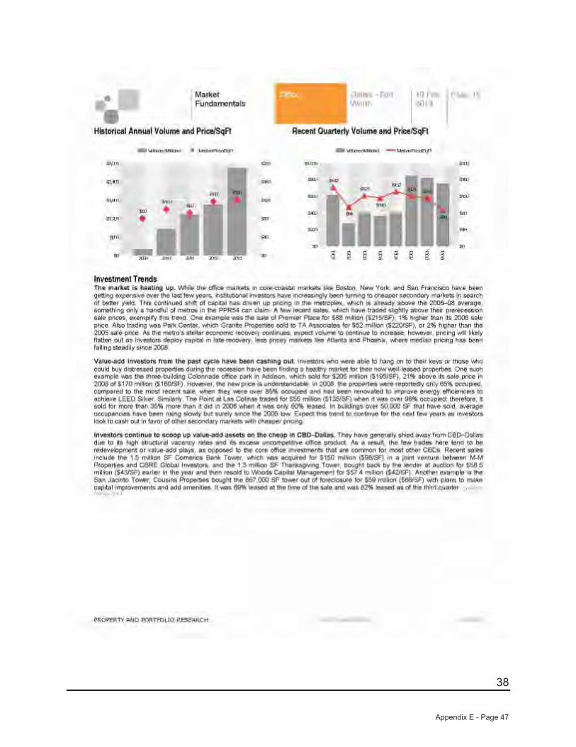
38
Appendix E - Page 47

39
Appendix E - Page 48
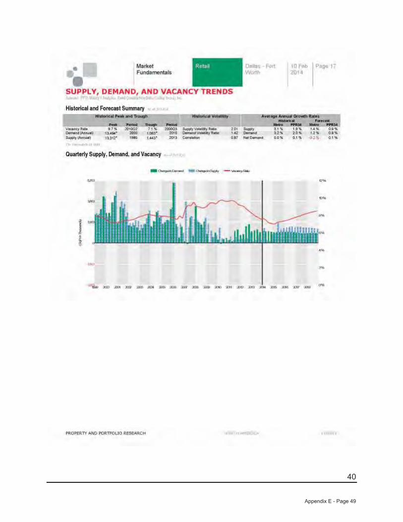
40
Appendix E - Page 49
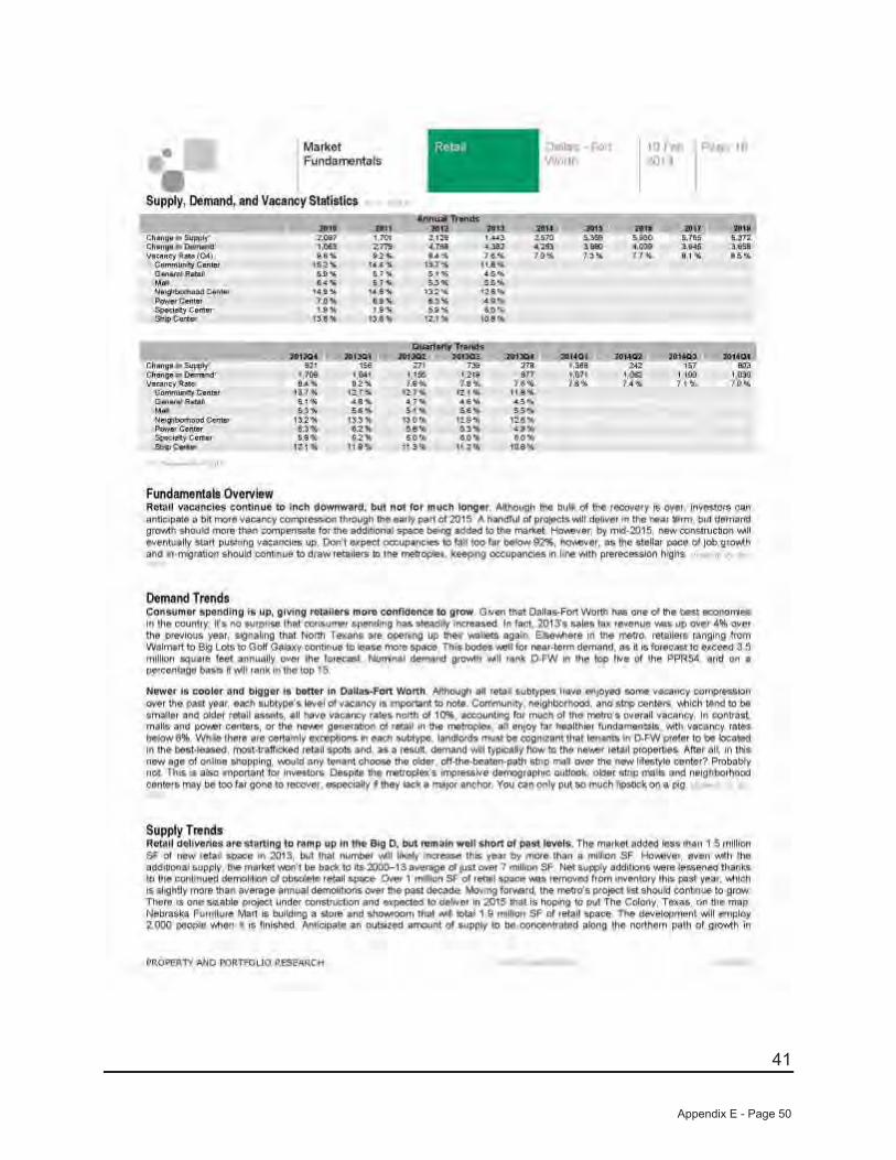
41
Appendix E - Page 50
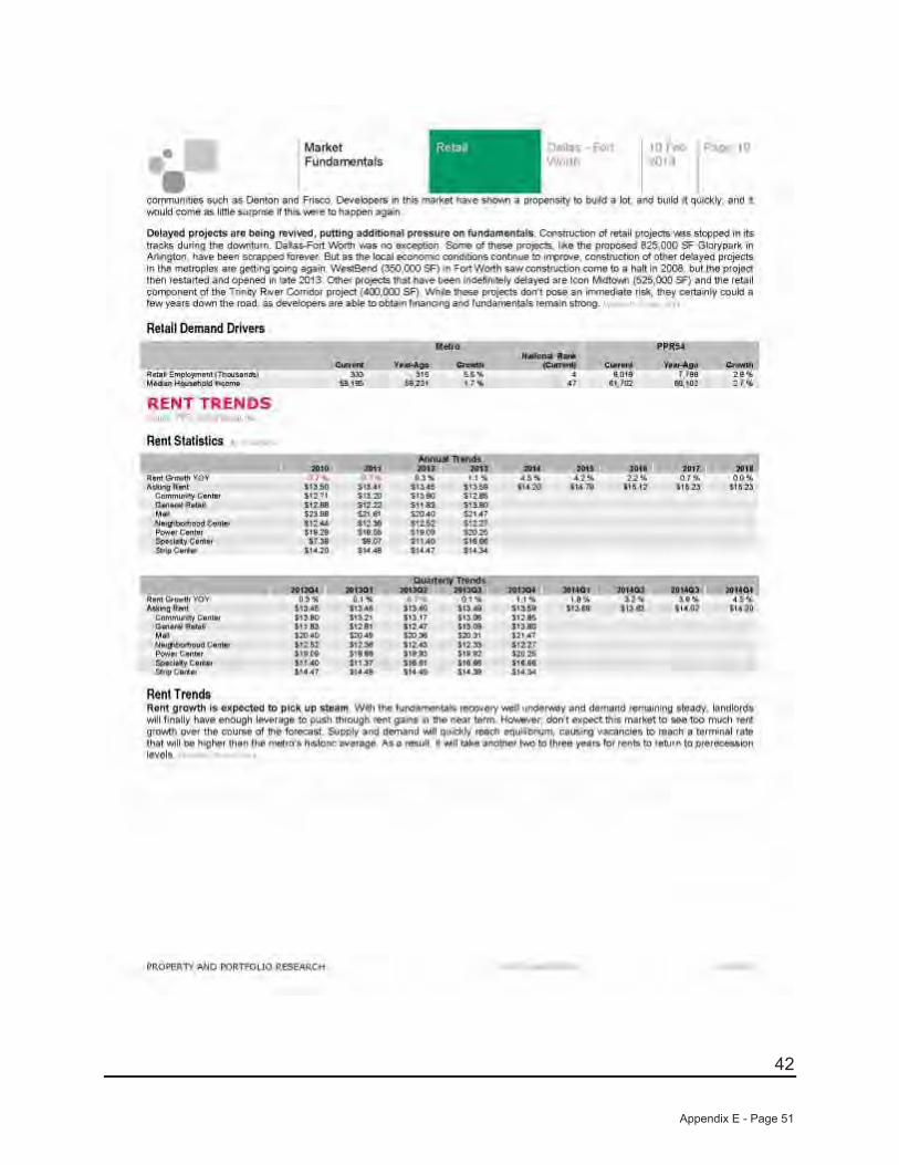
42
Appendix E - Page 51
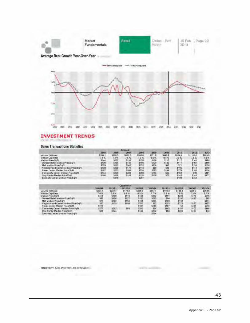
43
Appendix E - Page 52
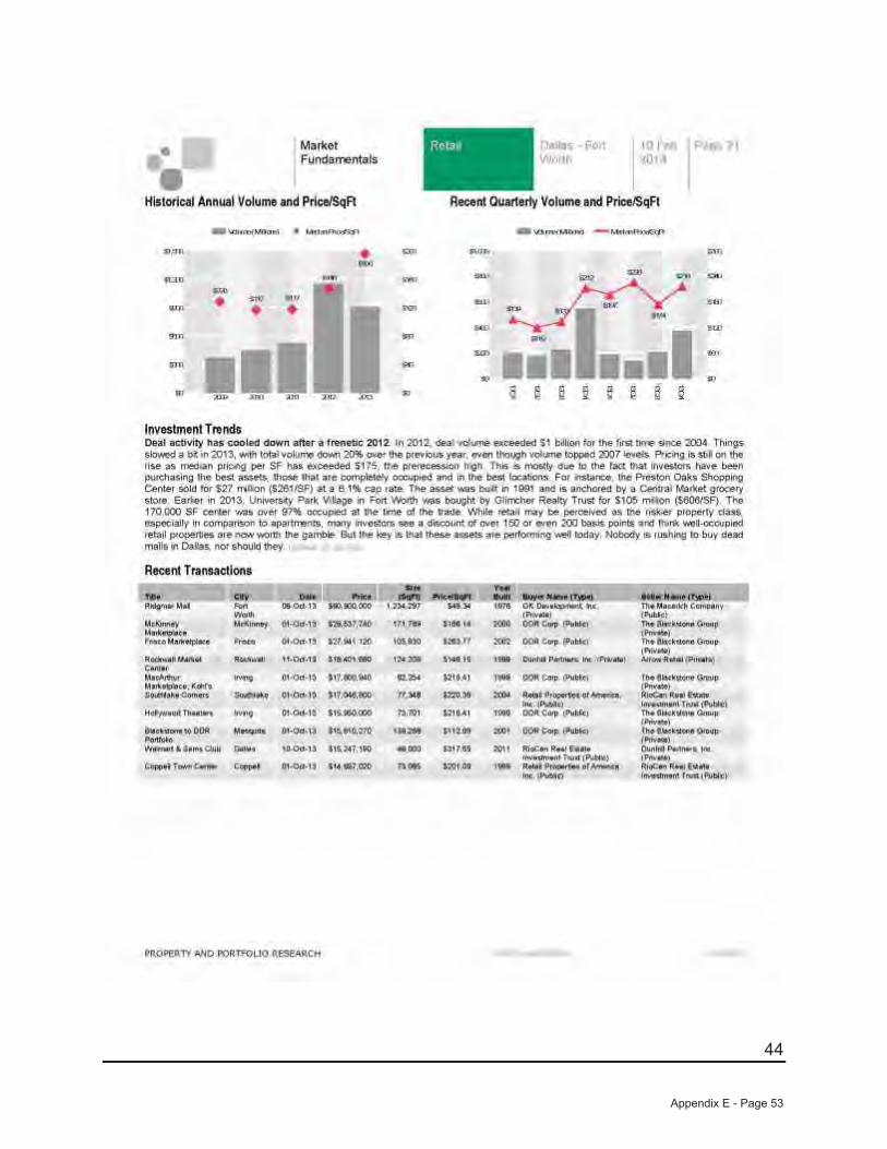
44
Appendix E - Page 53

45
Appendix E - Page 54
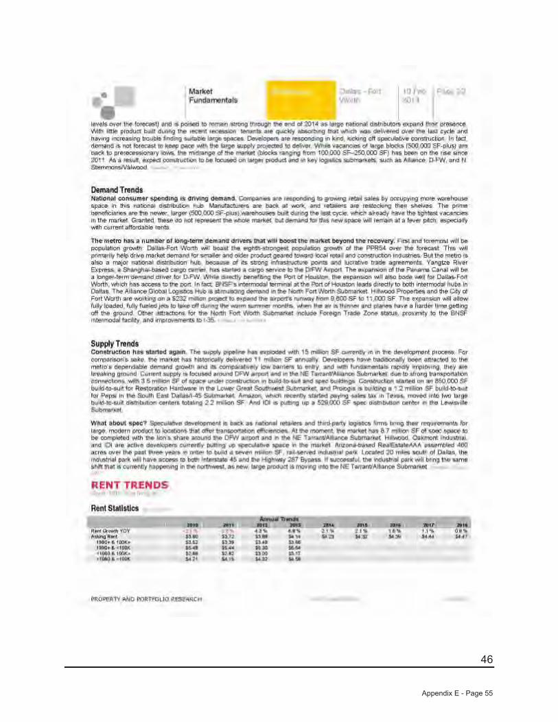
46
Appendix E - Page 55
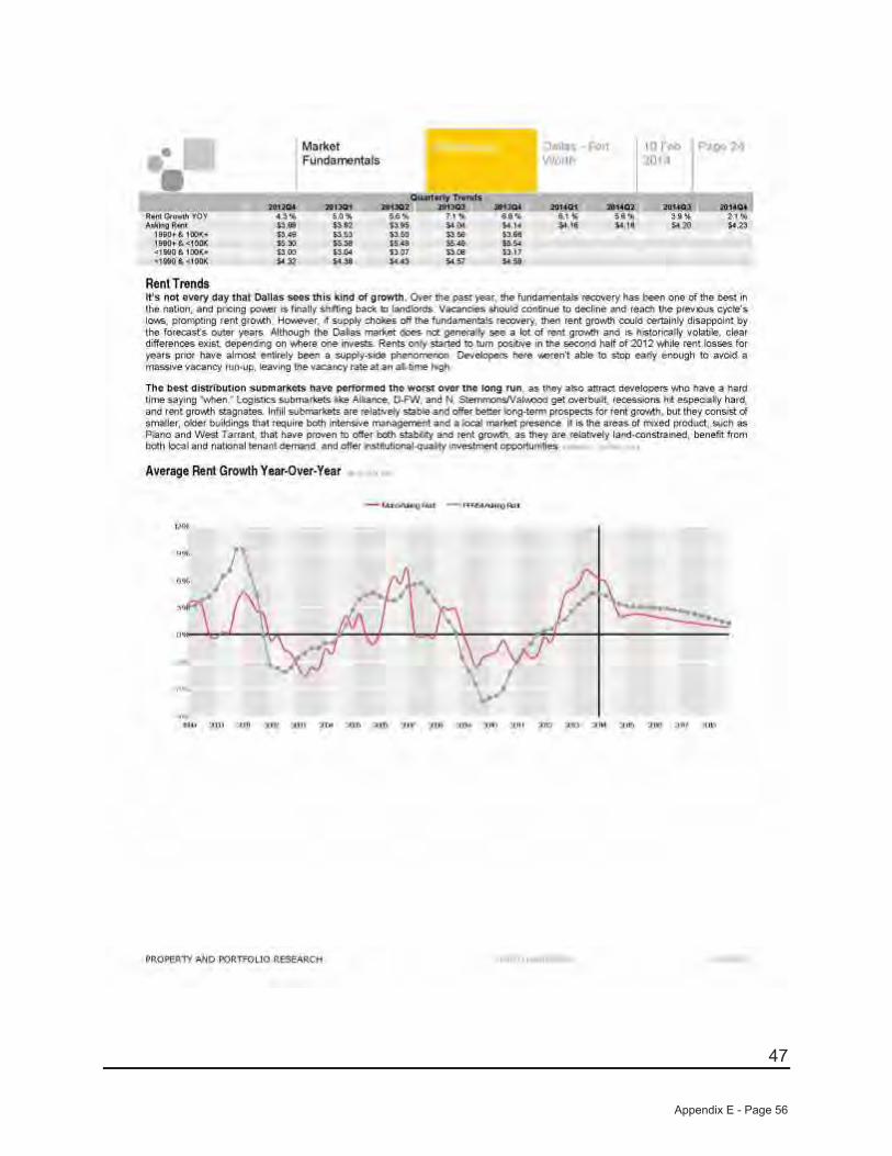
47
Appendix E - Page 56
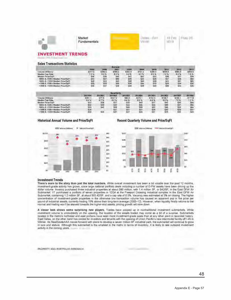
48
Appendix E - Page 57
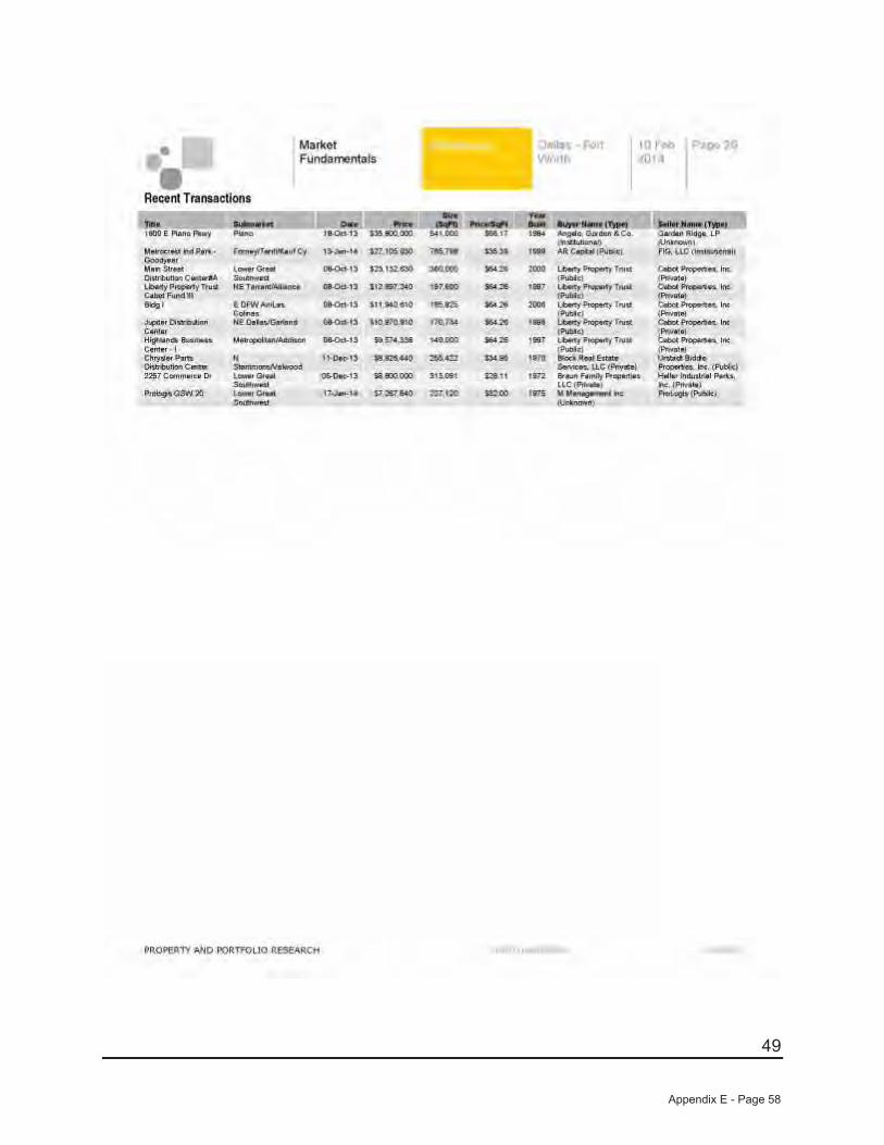
49
Appendix E - Page 58
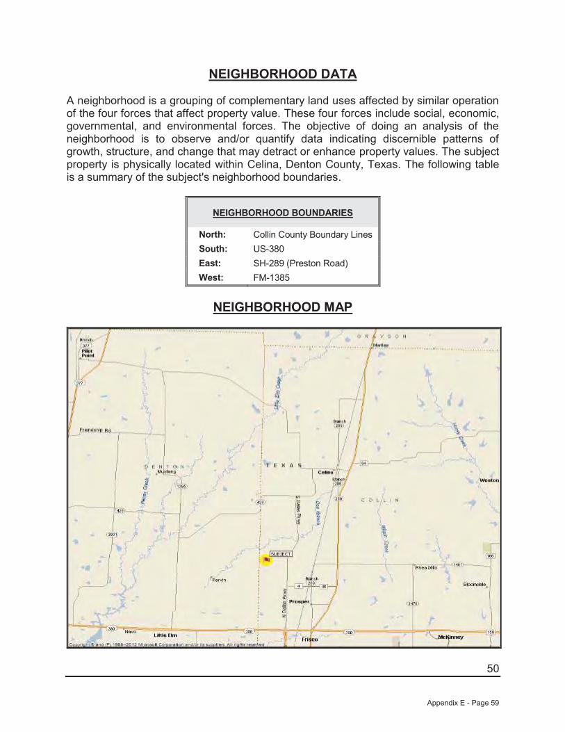
50
NEIGHBORHOOD DATA
A neighborhood is a grouping of complementary land uses affected by similar operation of the four forces that affect property value. These four forces include social, economic, governmental, and environmental forces. The objective of doing an analysis of the neighborhood is to observe and/or quantify data indicating discernible patterns of growth, structure, and change that may detract or enhance property values. The subject property is physically located within Celina, Denton County, Texas. The following table is a summary of the subject's neighborhood boundaries.
NEIGHBORHOOD BOUNDARIES
North: Collin County Boundary LinesSouth: US-380East: SH-289 (Preston Road)West: FM-1385
NEIGHBORHOOD MAP
Appendix E - Page 59
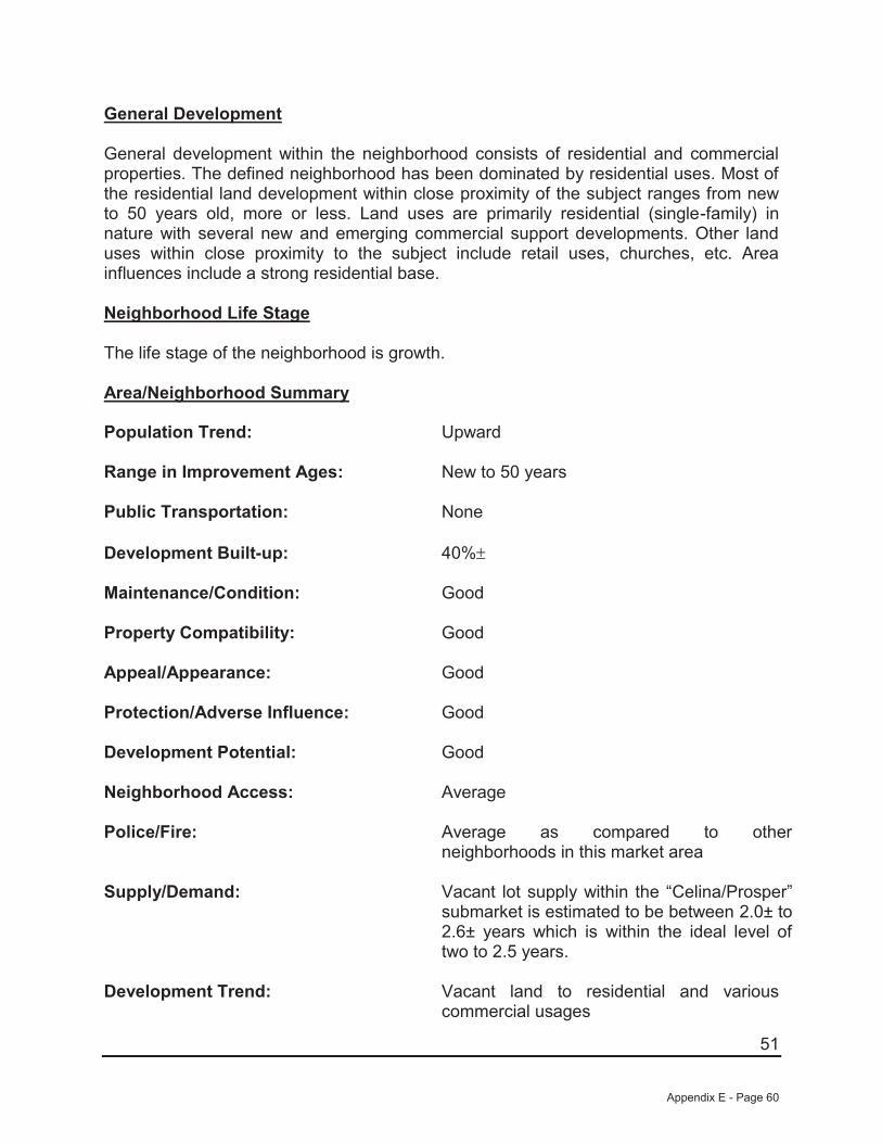
51
General Development
General development within the neighborhood consists of residential and commercial properties. The defined neighborhood has been dominated by residential uses. Most of the residential land development within close proximity of the subject ranges from new to 50 years old, more or less. Land uses are primarily residential (single-family) in nature with several new and emerging commercial support developments. Other land uses within close proximity to the subject include retail uses, churches, etc. Area influences include a strong residential base.
Neighborhood Life Stage
The life stage of the neighborhood is growth.
Area/Neighborhood Summary Population Trend: Upward
Range in Improvement Ages: New to 50 years
Public Transportation: None
Development Built-up: 40%
Maintenance/Condition: Good
Property Compatibility: Good
Appeal/Appearance: Good
Protection/Adverse Influence: Good
Development Potential: Good
Neighborhood Access: Average
Police/Fire: Average as compared to other neighborhoods in this market area
Supply/Demand: Vacant lot supply within the “Celina/Prosper” submarket is estimated to be between 2.0± to 2.6± years which is within the ideal level of two to 2.5 years.
Development Trend: Vacant land to residential and various commercial usages
Appendix E - Page 60
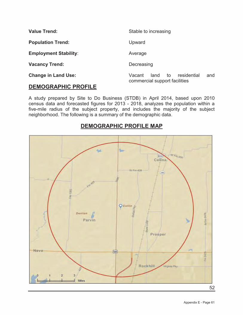
52
Value Trend: Stable to increasing
Population Trend: Upward
Employment Stability: Average
Vacancy Trend: Decreasing
Change in Land Use: Vacant land to residential and commercial support facilities
DEMOGRAPHIC PROFILE
A study prepared by Site to Do Business (STDB) in April 2014, based upon 2010 census data and forecasted figures for 2013 - 2018, analyzes the population within a five-mile radius of the subject property, and includes the majority of the subject neighborhood. The following is a summary of the demographic data.
DEMOGRAPHIC PROFILE MAP
Appendix E - Page 61
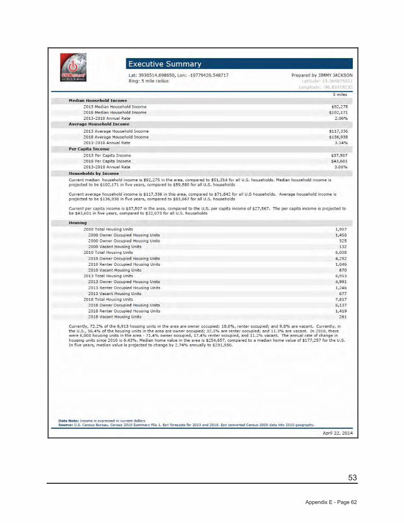
53
Appendix E - Page 62
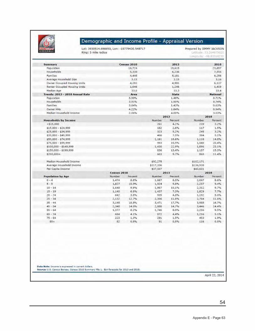
54
Appendix E - Page 63
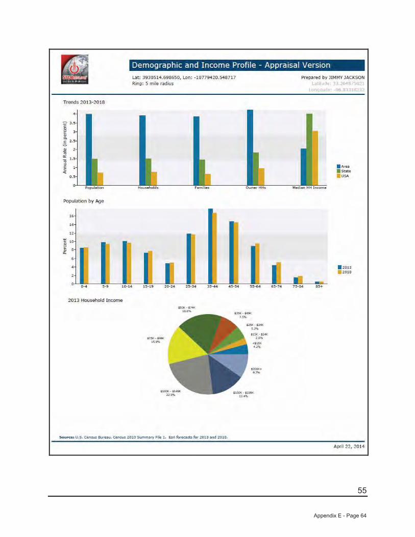
55
Appendix E - Page 64
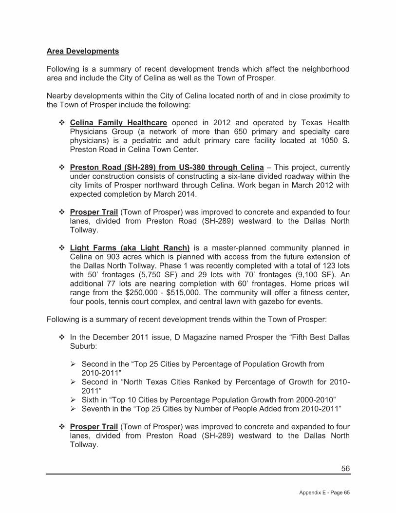
56
Area Developments
Following is a summary of recent development trends which affect the neighborhood area and include the City of Celina as well as the Town of Prosper.
Nearby developments within the City of Celina located north of and in close proximity to the Town of Prosper include the following:
Celina Family Healthcare opened in 2012 and operated by Texas Health Physicians Group (a network of more than 650 primary and specialty care physicians) is a pediatric and adult primary care facility located at 1050 S. Preston Road in Celina Town Center.
Preston Road (SH-289) from US-380 through Celina – This project, currently under construction consists of constructing a six-lane divided roadway within the city limits of Prosper northward through Celina. Work began in March 2012 with expected completion by March 2014.
Prosper Trail (Town of Prosper) was improved to concrete and expanded to four lanes, divided from Preston Road (SH-289) westward to the Dallas North Tollway.
Light Farms (aka Light Ranch) is a master-planned community planned in Celina on 903 acres which is planned with access from the future extension of the Dallas North Tollway. Phase 1 was recently completed with a total of 123 lots with 50’ frontages (5,750 SF) and 29 lots with 70’ frontages (9,100 SF). An additional 77 lots are nearing completion with 60’ frontages. Home prices will range from the $250,000 - $515,000. The community will offer a fitness center, four pools, tennis court complex, and central lawn with gazebo for events.
Following is a summary of recent development trends within the Town of Prosper:
In the December 2011 issue, D Magazine named Prosper the “Fifth Best Dallas Suburb:
Second in the “Top 25 Cities by Percentage of Population Growth from 2010-2011”Second in “North Texas Cities Ranked by Percentage of Growth for 2010-2011”Sixth in “Top 10 Cities by Percentage Population Growth from 2000-2010”Seventh in the “Top 25 Cities by Number of People Added from 2010-2011”
Prosper Trail (Town of Prosper) was improved to concrete and expanded to four lanes, divided from Preston Road (SH-289) westward to the Dallas North Tollway.
Appendix E - Page 65
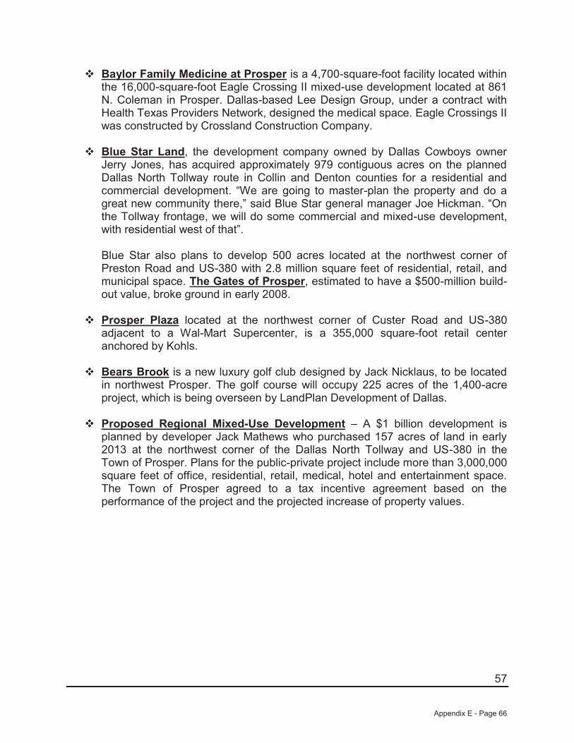
57
Baylor Family Medicine at Prosper is a 4,700-square-foot facility located within the 16,000-square-foot Eagle Crossing II mixed-use development located at 861 N. Coleman in Prosper. Dallas-based Lee Design Group, under a contract with Health Texas Providers Network, designed the medical space. Eagle Crossings II was constructed by Crossland Construction Company.
Blue Star Land, the development company owned by Dallas Cowboys owner Jerry Jones, has acquired approximately 979 contiguous acres on the planned Dallas North Tollway route in Collin and Denton counties for a residential and commercial development. “We are going to master-plan the property and do a great new community there,” said Blue Star general manager Joe Hickman. “On the Tollway frontage, we will do some commercial and mixed-use development, with residential west of that”.
Blue Star also plans to develop 500 acres located at the northwest corner of Preston Road and US-380 with 2.8 million square feet of residential, retail, and municipal space. The Gates of Prosper, estimated to have a $500-million build-out value, broke ground in early 2008.
Prosper Plaza located at the northwest corner of Custer Road and US-380 adjacent to a Wal-Mart Supercenter, is a 355,000 square-foot retail center anchored by Kohls.
Bears Brook is a new luxury golf club designed by Jack Nicklaus, to be located in northwest Prosper. The golf course will occupy 225 acres of the 1,400-acre project, which is being overseen by LandPlan Development of Dallas.
Proposed Regional Mixed-Use Development – A $1 billion development is planned by developer Jack Mathews who purchased 157 acres of land in early 2013 at the northwest corner of the Dallas North Tollway and US-380 in the Town of Prosper. Plans for the public-private project include more than 3,000,000 square feet of office, residential, retail, medical, hotel and entertainment space. The Town of Prosper agreed to a tax incentive agreement based on the performance of the project and the projected increase of property values.
Appendix E - Page 66

58
Windsong Ranch (aka Three Stones/Mahard Ranch/Prosper Ranch) is a $1.2 billion master-planned community located north of US-380 between FM-423 and Fields Road (future Teel Parkway) and approximately 2.5 miles west of the Dallas North Tollway in Prosper, Texas. The 2,030±-acre development is projected to eventually include 3,500 single-family homes featuring 50 acres of park land, hike/bike trails and multiple lighted sports fields. The community is also to include a three-building amenity complex which includes a community coffee shop, marketing center, outdoor gathering spaces, poolside pavilion with fireplace, a fitness center/exercise room, play areas, lap pool, and resort-style pool overlooking the lake. Anticipated homebuilders for Windsong Ranch includeHighland Homes, Darling Homes, Drees Homes, and Huntington Homes. Home prices are expected to range from $250,000 to $500,000. Phase 1A is currently under construction with a total of 152 single-family lots with typical lot dimensions of 60’/70’ x 130’ (7,800 SF – 9,100 SF) with completion scheduled for early 2014.
Following is information relative to the Collin County bus service, as well as an update on the northern extension of the Dallas North Tollway:
Collin County Area Regional Transit – CCART: CCART is the rural and urban bus service for Collin County. CCART offers a curb to curb transit service within Collin County for the cities of Plano, Frisco, Allen, Wylie, Farmersville, Melissa, Prosper, Princeton, Celina, Anna, Blue Ridge, Josephine, Nevada, Fairview, Lucas, Murphy, and Lavon.
Dallas North Tollway Northern Extension, Phase 4A/4B/5A when complete isexpected to extend the “Tollway” northward from US-380 an additional 18 miles into Grayson County (to FM-121) providing a link from the Dallas Central Business District and cities located within Dallas, Collin, Denton, and Grayson counties. The NTTA Board approved the schematic design and environmental evaluation in June 2011 for the Phase 4A/4B/5A extension project. The extension will be a limited access toll road with six main lanes and four frontage road lanes. A scope of work is currently under development, which includes corridor analysis, initial toll feasibility and environmental analysis. A summary of the current progress report and a map of the extension follow:
Appendix E - Page 67
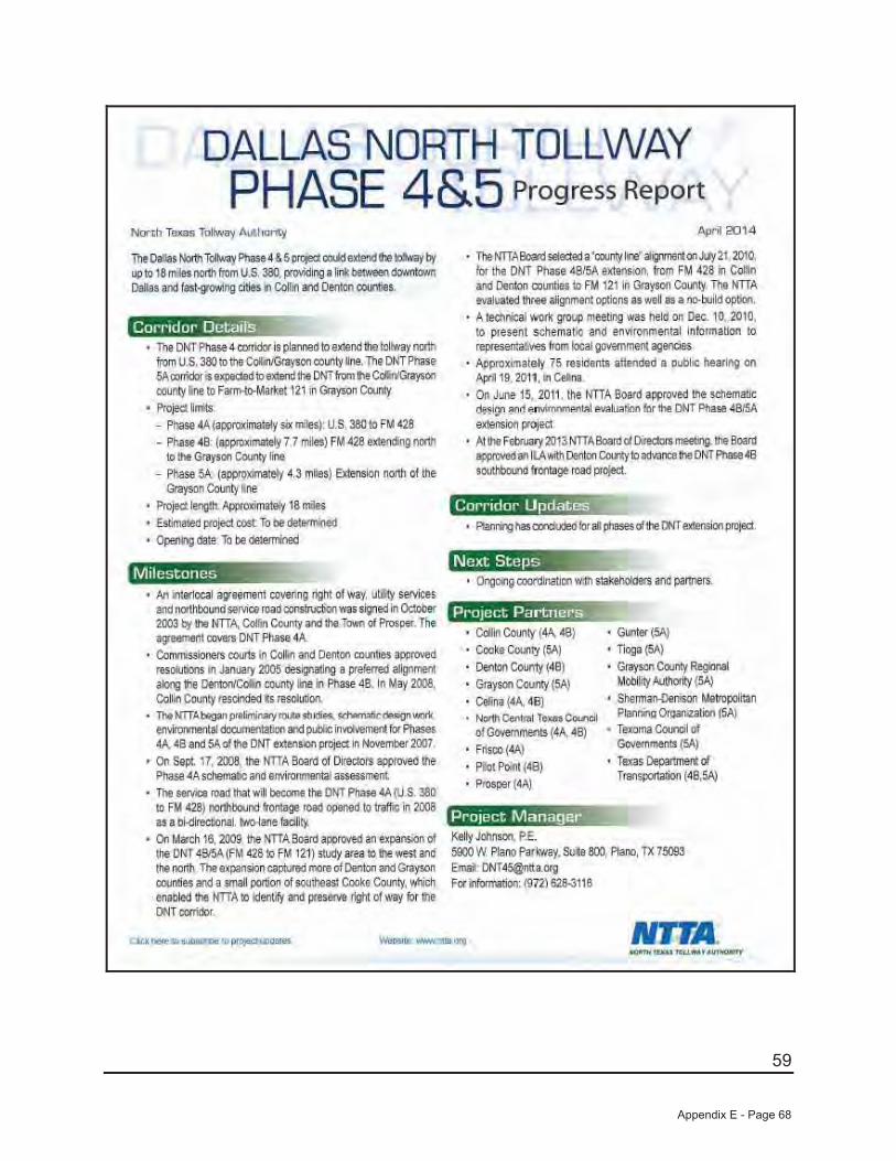
59
Appendix E - Page 68
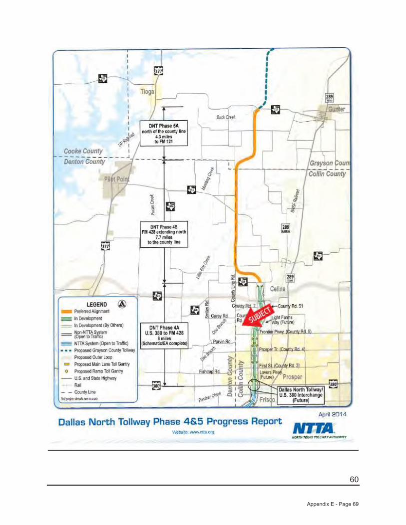
60
Appendix E - Page 69
61
Conclusion
The subject neighborhood is located in the northern central sector of Collin County. Celina is a small bedroom community which borders the Town of Prosper and is approximately 30 miles north of the Dallas CBD and approximately 30 miles northeast of the Dallas/Fort Worth International Airport. The future long-term outlook for the general area appears to be promising with substantial public and private investments in the form of schools, roads, and other public services. The steady development in and around the subject neighborhood provides attractive environs for future development.
Appendix E - Page 70

62
CREEKS OF LEGACY MASTER PLAN – OVERALL LOT LAYOUT
Appendix E - Page 71
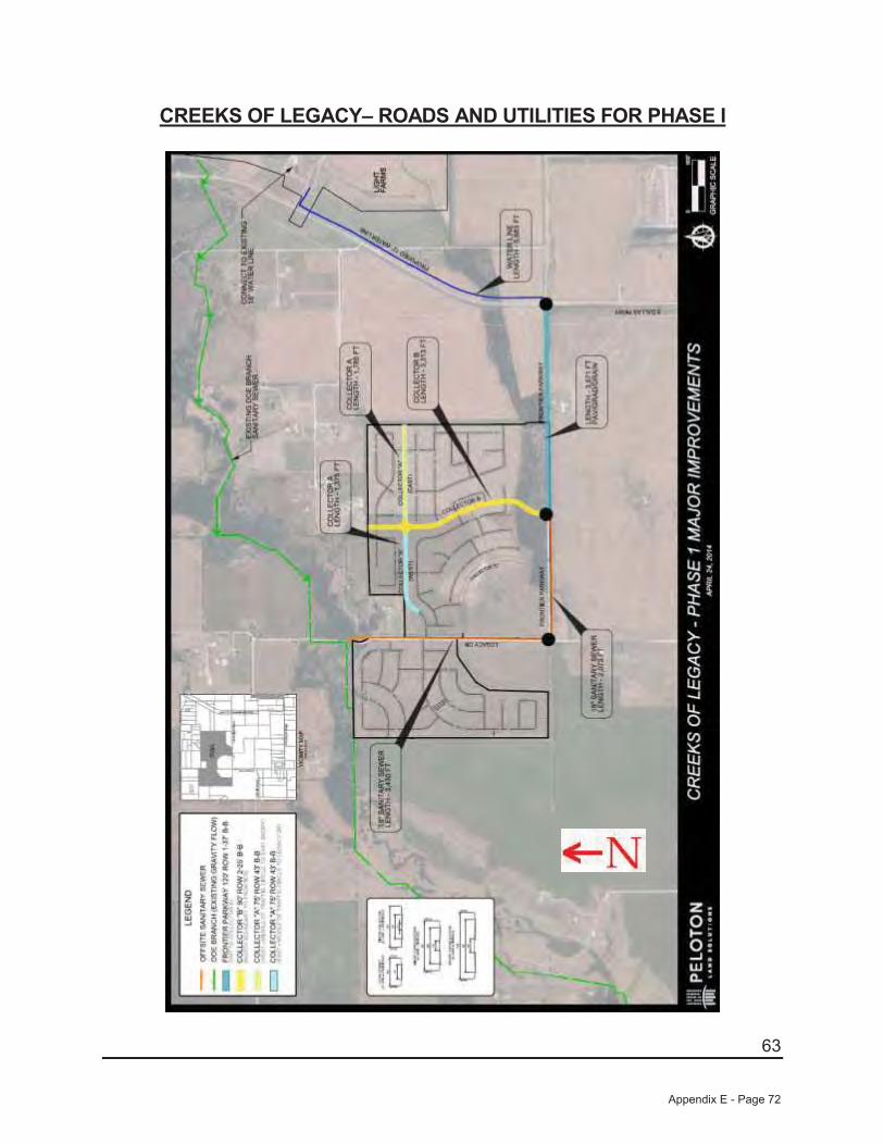
63
CREEKS OF LEGACY– ROADS AND UTILITIES FOR PHASE I
Appendix E - Page 72
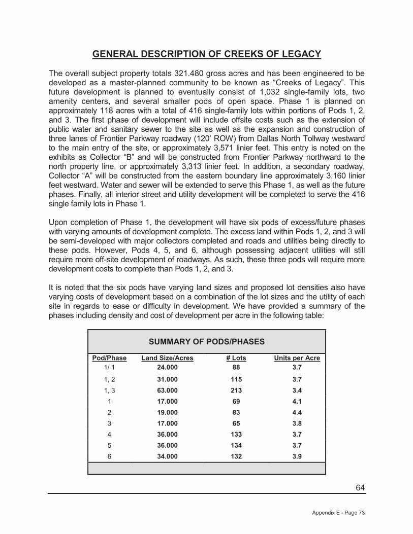
64
GENERAL DESCRIPTION OF CREEKS OF LEGACY
The overall subject property totals 321.480 gross acres and has been engineered to be developed as a master-planned community to be known as “Creeks of Legacy”. This future development is planned to eventually consist of 1,032 single-family lots, two amenity centers, and several smaller pods of open space. Phase 1 is planned on approximately 118 acres with a total of 416 single-family lots within portions of Pods 1, 2, and 3. The first phase of development will include offsite costs such as the extension of public water and sanitary sewer to the site as well as the expansion and construction of three lanes of Frontier Parkway roadway (120’ ROW) from Dallas North Tollway westward to the main entry of the site, or approximately 3,571 linier feet. This entry is noted on the exhibits as Collector “B” and will be constructed from Frontier Parkway northward to the north property line, or approximately 3,313 linier feet. In addition, a secondary roadway, Collector “A” will be constructed from the eastern boundary line approximately 3,160 linier feet westward. Water and sewer will be extended to serve this Phase 1, as well as the future phases. Finally, all interior street and utility development will be completed to serve the 416single family lots in Phase 1.
Upon completion of Phase 1, the development will have six pods of excess/future phases with varying amounts of development complete. The excess land within Pods 1, 2, and 3 will be semi-developed with major collectors completed and roads and utilities being directly to these pods. However, Pods 4, 5, and 6, although possessing adjacent utilities will still require more off-site development of roadways. As such, these three pods will require more development costs to complete than Pods 1, 2, and 3.
It is noted that the six pods have varying land sizes and proposed lot densities also have varying costs of development based on a combination of the lot sizes and the utility of each site in regards to ease or difficulty in development. We have provided a summary of the phases including density and cost of development per acre in the following table:
SUMMARY OF PODS/PHASES
Pod/Phase Land Size/Acres # Lots Units per Acre1/ 1 24.000 88 3.7
1, 2 31.000 115 3.71, 3 63.000 213 3.41 17.000 69 4.12 19.000 83 4.43 17.000 65 3.84 36.000 133 3.75 36.000 134 3.76 34.000 132 3.9
Appendix E - Page 73
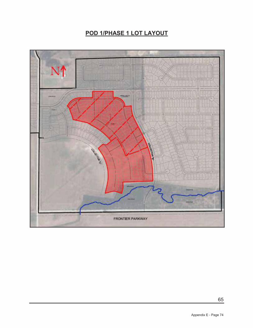
65
POD 1/PHASE 1 LOT LAYOUT
Appendix E - Page 74
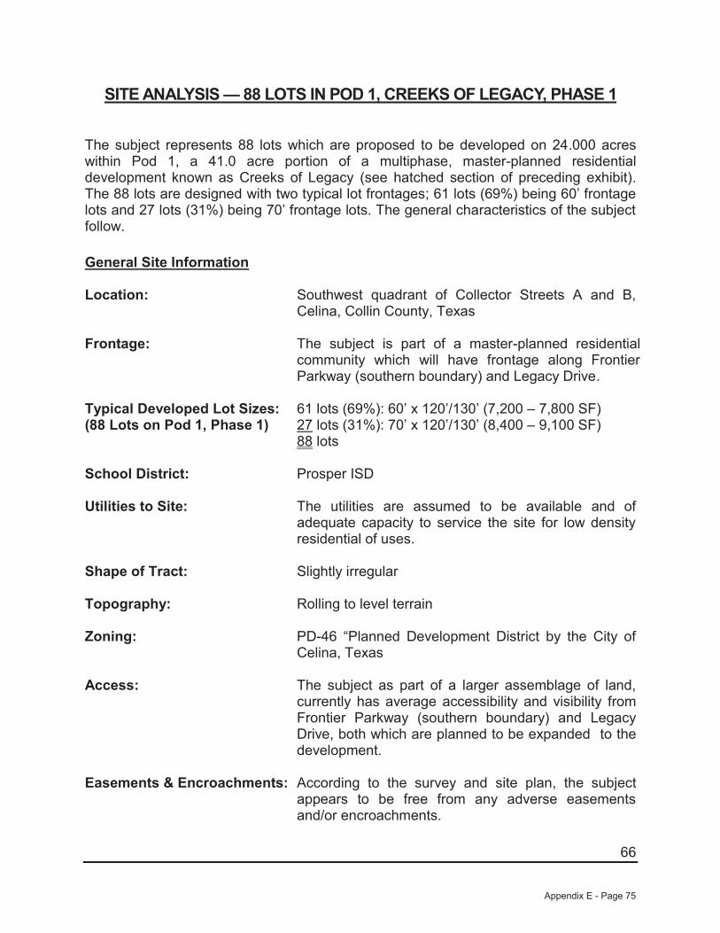
66
SITE ANALYSIS — 88 LOTS IN POD 1, CREEKS OF LEGACY, PHASE 1
The subject represents 88 lots which are proposed to be developed on 24.000 acres within Pod 1, a 41.0 acre portion of a multiphase, master-planned residential development known as Creeks of Legacy (see hatched section of preceding exhibit).The 88 lots are designed with two typical lot frontages; 61 lots (69%) being 60’ frontage lots and 27 lots (31%) being 70’ frontage lots. The general characteristics of the subject follow.
General Site Information
Location: Southwest quadrant of Collector Streets A and B, Celina, Collin County, Texas
Frontage: The subject is part of a master-planned residential community which will have frontage along Frontier Parkway (southern boundary) and Legacy Drive.
Typical Developed Lot Sizes:(88 Lots on Pod 1, Phase 1)
61 lots (69%): 60’ x 120’/130’ (7,200 – 7,800 SF)27 lots (31%): 70’ x 120’/130’ (8,400 – 9,100 SF)88 lots
School District: Prosper ISD
Utilities to Site: The utilities are assumed to be available and of adequate capacity to service the site for low density residential of uses.
Shape of Tract: Slightly irregular
Topography: Rolling to level terrain
Zoning: PD-46 “Planned Development District by the City of Celina, Texas
Access: The subject as part of a larger assemblage of land, currently has average accessibility and visibility from Frontier Parkway (southern boundary) and Legacy Drive, both which are planned to be expanded to the development.
Easements & Encroachments: According to the survey and site plan, the subject appears to be free from any adverse easements and/or encroachments.
Appendix E - Page 75

67
Surface Drainage: Appears adequate
Soils: A soil analysis for the site has not been provided for the preparation of this appraisal. In the absence of a soil report, it is a specific assumption that the site has adequate soils to support the highest and best use.
Subsurface Conditions: It is assumed that there are no hidden or unapparent conditions to the property, soil, or subsoil, which would render them more or less valuable. Subsurface oil, gas, or mineral rights were not considered in this report unless otherwise stated.
Nuisances and Hazards: No nuisances or hazards were noted that would adversely affect the use of the property.
Adjacent Uses: North: Vacant land/Open space South: Vacant land/Open space East: Vacant land/Open space West: Vacant land/Open space
Street Improvements: Collector Street A is a proposed four-lane interior road providing east/west access within the development.
Collector Street B is planned as a four-lane interior road providing north/south access within the development.
Proposed Site Improvements: The subject represents 88 residential lots on 24.000 acres within Pod 1, Phase 1 of a planned multiphase, master-planned residential community to be known as Creeks of Legacy. Access to the 88 lots will be provided from the proposed Collector Streets A and B. The 88 lots are designed as front-entry lots. This phase of development will offer greenbelt areas with access to the nearby planned Amenity Center. Also, Pod 1 will be developed with concrete streets with curbs, gutters and sidewalks. Street lights will also be installed within this phase of development.
Flood Designation: The subject is located on FEMA Panel 48085C0115J dated June 2, 2009 found on the following page.According to this map, none of the subject’s Pod 1,Phase 1 is located within a floodplain area.
Appendix E - Page 76

68
FLOOD MAP
Appendix E - Page 77

69
Conclusions: Overall, Pod 1, Phase 1 is well suited for single-family residential development. All utilities are assumed to be available and there will be no easements, restrictions,or encumbrances that appear to negatively affect the value or marketability of the subject’s 88 proposed residential lots.
Appendix E - Page 78
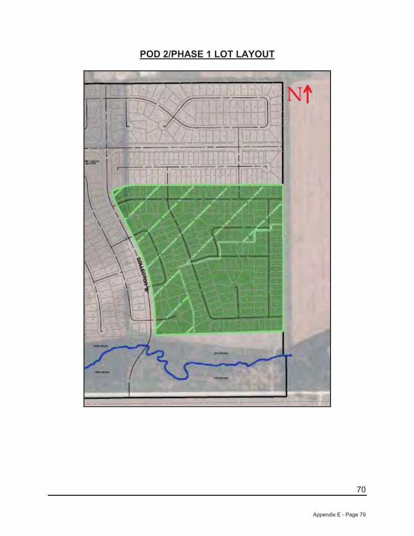
70
POD 2/PHASE 1 LOT LAYOUT
Appendix E - Page 79

71
SITE ANALYSIS — 115 LOTS IN POD 2, CREEKS OF LEGACY, PHASE 1
The subject represents 115 lots which are proposed to be developed on 31.000 acres within Pod 1, a 50.0 acre portion of a multiphase, master-planned residential development known as Creeks of Legacy (see hatched section of preceding exhibit). The 115 lots are designed with two typical lot frontages; 84 lots (73%) being 60’ frontage lots and 31 lots (27%) being 70’ frontage lots. The general characteristics of the subject follow.
General Site Information
Location: East side of Collector Street B, north of Frontier Parkway, Celina, Collin County, Texas
Frontage: The subject is part of a master-planned residential community which will have frontage along Frontier Parkway (southern boundary) and Legacy Drive.
Typical Developed Lot Sizes:(115 Lots on Pod 1, Phase 1)
84 lots (73%): 60’ x 120’/130’ (7,200 – 7,800 SF)31 lots (27%): 70’ x 120’/130’ (8,400 – 9,100 SF)115 lots
School District: Prosper ISD
Utilities to Site: The utilities are assumed to be available and of adequate capacity to service the site for low density residential of uses.
Shape of Tract: Slightly irregular
Topography: Rolling to level terrain
Zoning: PD-46 “Planned Development District by the City of Celina, Texas
Access: The subject as part of a larger assemblage of land, currently has average accessibility and visibility from Frontier Parkway (southern boundary) and Legacy Drive, both which are planned to be expanded to the development.
Easements & Encroachments: According to the survey and site plan, the subject appears to be free from any adverse easementsand/or encroachments.
Surface Drainage: Appears adequate
Appendix E - Page 80
72
Soils: A soil analysis for the site has not been provided for the preparation of this appraisal. In the absence of a soil report, it is a specific assumption that the site has adequate soils to support the highest and best use.
Subsurface Conditions: It is assumed that there are no hidden or unapparent conditions to the property, soil, or subsoil, which would render them more or less valuable. Subsurface oil, gas, or mineral rights were not considered in this report unless otherwise stated.
Nuisances and Hazards: No nuisances or hazards were noted that would adversely affect the use of the property.
Adjacent Uses: North: Vacant land/Open space South: Vacant land/Open space East: Vacant land/Open space West: Vacant land/Open space
Street Improvements: Collector Street BA is planned as a four-lane interior road providing north/south access within the development.
Frontier Parkway is planned to be extended to provide east/west access to this portion of the development.
Proposed Site Improvements: The subject represents 115 residential lots on 31.000 acres within Pod 2, Phase 1 of a planned multiphase, master-planned residential community to be known as Creeks of Legacy. Access to the 115 lots will be provided from the proposed Collector Street B as well as from Frontier Parkway. The 115 lots are designed as front-entry lots. This phase of development fronts a large greenbelt area along the southern boundary and is in close proximity to the nearby planned Amenity Center. Also, Pod 2 will be developed with concrete streets with curbs, gutters and sidewalks. Street lights will also be installed within this phase of development.
Flood Designation: The subject is located on FEMA Panel 48085C0115J dated June 2, 2009 found on the following page. According to this map, none of the subject’s Pod 2, Phase 1 is located within a floodplain area.
Appendix E - Page 81

73
FLOOD MAP
Appendix E - Page 82
74
Conclusions: Overall, Pod 2, Phase 1 is well suited for single-family residential development. All utilities are assumed to be available and there will be no easements, restrictions, or encumbrances that appear to negatively affect the value or marketability of the subject’s 115 proposed residential lots.
Appendix E - Page 83

75
POD 3/PHASE 1 LOT LAYOUT
Appendix E - Page 84

76
SITE ANALYSIS — 213 LOTS IN POD 3, CREEKS OF LEGACY, PHASE 1
The subject represents 213 lots which are proposed to be developed on 63.000 acres within Pod 3, an 80.0 acre portion of a multiphase, master-planned residential development known as Creeks of Legacy (see hatched section of preceding exhibit). The 213 lots are designed with three typical lot frontages; 125 lots (59%) being 50’ frontage lots, eight lots (4%) being 60’ frontage lots, and 80 lots (37%) being 70’ frontage lots. The general characteristics of the subject follow.
General Site Information
Location: Northwest, northeast, and southeast corners of Collector Streets A and B, Celina, Collin County, Texas
Frontage: The subject is part of a master-planned residentialcommunity which will have frontage along Frontier Parkway (southern boundary) and Legacy Drive.
Typical Developed Lot Sizes:(213 Lots on Pod 3, Phase 1)
125 lots (59%): 50’ x 115’/130’ (5,750 – 6,500 SF)8 lots (4%): 60’ x 120’/130’ (7,200 – 7,800 SF)
80 lots (37%): 70’ x 120’/130’ (8,400 – 9,100 SF213 lots
School District: Prosper ISD
Utilities to Site: The utilities are assumed to be available and of adequate capacity to service the site for low density residential of uses.
Shape of Tract: Slightly irregular
Topography: Rolling to level terrain
Zoning: PD-46 “Planned Development District by the City of Celina, Texas
Access: The subject as part of a larger assemblage of land, currently has average accessibility and visibility from Frontier Parkway (southern boundary) and Legacy Drive, both which are planned to be expanded to the development.
Easements & Encroachments: According to the survey and site plan, the subject appears to be free from any adverse easements and/or encroachments.
Appendix E - Page 85
77
Surface Drainage: Appears adequate
Soils: A soil analysis for the site has not been provided for the preparation of this appraisal. In the absence of a soil report, it is a specific assumption that the site has adequate soils to support the highest and best use.
Subsurface Conditions: It is assumed that there are no hidden or unapparent conditions to the property, soil, or subsoil, which would render them more or less valuable. Subsurface oil, gas, or mineral rights were not considered in this report unless otherwise stated.
Nuisances and Hazards: No nuisances or hazards were noted that would adversely affect the use of the property.
Adjacent Uses: North: Vacant land/Open space South: Vacant land/Open space East: Vacant land/Open space West: Vacant land/Open space
Street Improvements: Collector Street A is a proposed four-lane interior road providing east/west access within the development.
Collector Street B is planned as a four-lane interior road providing north/south access within thedevelopment.
Proposed Site Improvements: The subject represents 213 residential lots on 63 acres within Pod 3, Phase 1 of a planned multiphase, master-planned residential community to be known as Creeks of Legacy. Access to the 213 lots will be provided from the proposed Collector Streets A and B. The 213 lots are designed as front-entry lots. This phase of development will offer greenbelt areas with access to the nearby planned Amenity Center. Also, Pod 3 will be developed with concrete streets with curbs, gutters and sidewalks. Street lights will also be installed within this phase of development.
Flood Designation: The subject is located on FEMA Panel 48085C0115J dated June 2, 2009 found on the following page. According to this map, none of the subject’s Pod 1, Phase 1 is located within a floodplain area.
Appendix E - Page 86

78
FLOOD MAP
Appendix E - Page 87

79
Conclusions: Overall, Pod 3, Phase 1 is well suited for single-family residential development. All utilities are assumed to be available and there will be no easements, restrictions, or encumbrances that appear to negatively affect the value or marketability of the subject’s 213 proposed residential lots.
Appendix E - Page 88

80
POD 1 EXCESS LAND
Appendix E - Page 89
81
SITE ANALYSIS —POD 1 EXCESS LAND
The subject represents the remaining 17.000 acres of land after completion of the 88 lots which are proposed to be developed on 24.000 acres within Pod 1, a 41.0 acre portion of a multiphase, master-planned residential development known as Creeks of Legacy (see hatched section of preceding exhibit). The 17.000 acres are designed to eventually be developed with two typical lot frontages; 44 lots (64%) being 60’ frontage lots and 25 lots (36%) being 70’ frontage lots. The general characteristics of the subject follow.
General Site Information
Location: West side of Collector Street B, north of Frontier Parkway, Celina, Collin County, Texas
Frontage: The subject is part of a master-planned residential community which will have frontage along Frontier Parkway (southern boundary) and Legacy Drive.
Land Size: 17.000 acres
School District: Prosper ISD
Utilities to Site: The utilities are assumed to be available and of adequate capacity to service the site for low density residential of uses.
Shape of Tract: Slightly irregular
Topography: Rolling to level terrain
Zoning: PD-46 “Planned Development” District by the City of Celina, Texas
Access: The subject as part of a larger assemblage of land, currently has average accessibility and visibility from Frontier Parkway (southern boundary) and Legacy Drive, both which are planned to be expanded to the development.
Easements & Encroachments: According to the survey and site plan, the subject appears to be free from any adverse easements and/or encroachments.
Surface Drainage: Appears adequate
Appendix E - Page 90
82
Soils: A soil analysis for the site has not been provided for the preparation of this appraisal. In the absence of a soil report, it is a specific assumption that the site has adequate soils to support the highest and best use.
Subsurface Conditions: It is assumed that there are no hidden or unapparent conditions to the property, soil, or subsoil, which would render them more or less valuable. Subsurface oil, gas, or mineral rights were not considered in this report unless otherwise stated.
Nuisances and Hazards: No nuisances or hazards were noted that would adversely affect the use of the property.
Adjacent Uses: North: Vacant land/Open space South: Vacant land/Open space East: Vacant land/Open space West: Vacant land/Open space
Street Improvements: Collector Street B is planned as a four-lane interior road providing north/south access within the development.
Proposed Site Improvements: Upon completion of Phase 1 development this site will have access from Collector Road “B” as well as two additional entry points from the adjacent developed portion of POD 1. This site will also have full and direct access to public water and sewer.
Flood Designation: The subject is located on FEMA Panel 48085C0115J dated June 2, 2009 found on the following page. According to this map, none of the subject’s Pod 1 (excess land), is located within a floodplain area.
Conclusions: Overall, the excess land within Pod 1 is well suited for single-family residential development. All utilities are assumed to be available and there will be noeasements, restrictions, or encumbrances that appear to negatively affect the value or marketability of the subject.
Appendix E - Page 91
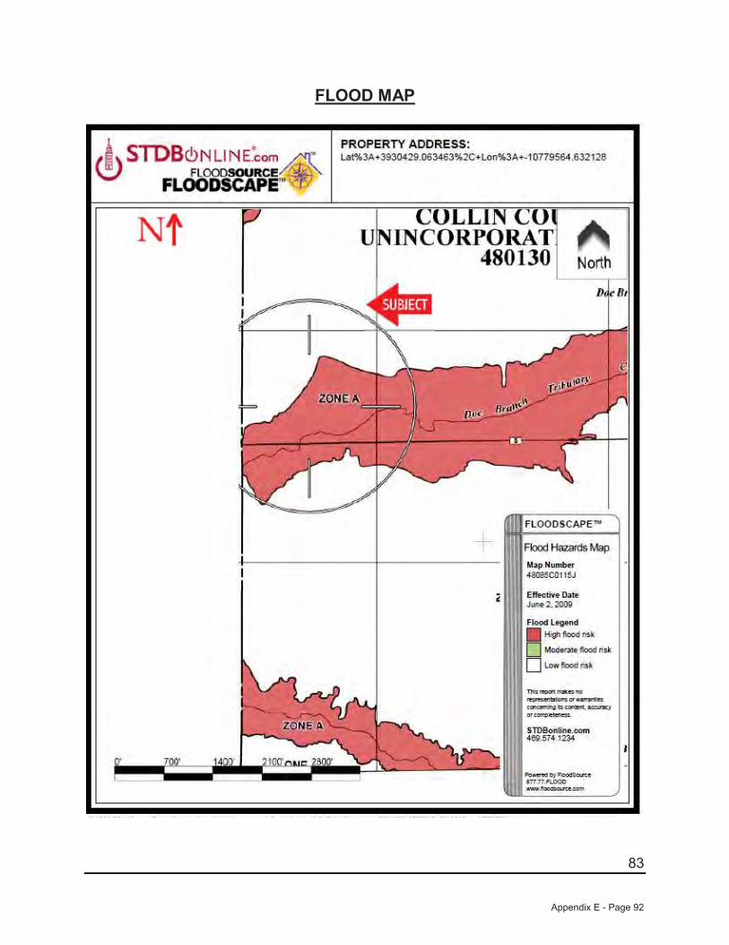
83
FLOOD MAP
Appendix E - Page 92
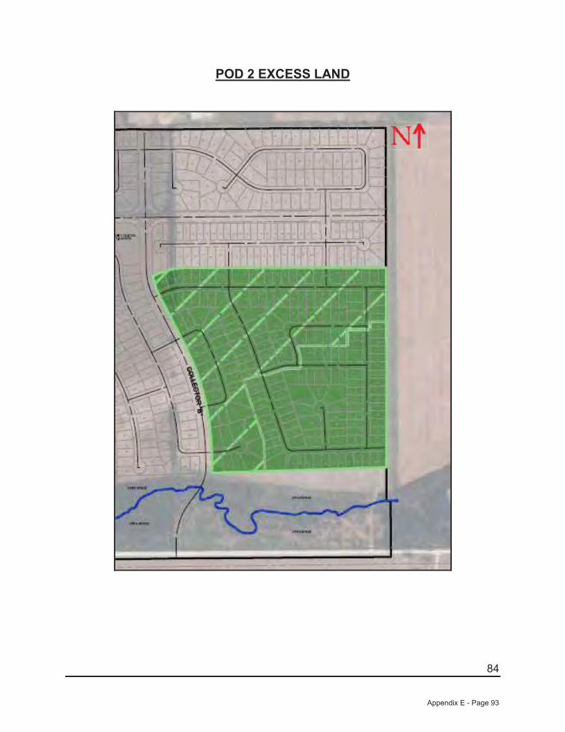
84
POD 2 EXCESS LAND
Appendix E - Page 93
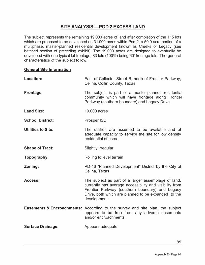
85
SITE ANALYSIS —POD 2 EXCESS LAND
The subject represents the remaining 19.000 acres of land after completion of the 115 lots which are proposed to be developed on 31.000 acres within Pod 2, a 50.0 acre portion of a multiphase, master-planned residential development known as Creeks of Legacy (see hatched section of preceding exhibit). The 19.000 acres are designed to eventually be developed with one typical lot frontage; 83 lots (100%) being 60’ frontage lots. The general characteristics of the subject follow.
General Site Information
Location: East of Collector Street B, north of Frontier Parkway, Celina, Collin County, Texas
Frontage: The subject is part of a master-planned residential community which will have frontage along Frontier Parkway (southern boundary) and Legacy Drive.
Land Size: 19.000 acres
School District: Prosper ISD
Utilities to Site: The utilities are assumed to be available and of adequate capacity to service the site for low density residential of uses.
Shape of Tract: Slightly irregular
Topography: Rolling to level terrain
Zoning: PD-46 “Planned Development” District by the City of Celina, Texas
Access: The subject as part of a larger assemblage of land, currently has average accessibility and visibility from Frontier Parkway (southern boundary) and Legacy Drive, both which are planned to be expanded to the development.
Easements & Encroachments: According to the survey and site plan, the subject appears to be free from any adverse easements and/or encroachments.
Surface Drainage: Appears adequate
Appendix E - Page 94
86
Soils: A soil analysis for the site has not been provided for the preparation of this appraisal. In the absence of a soil report, it is a specific assumption that the site has adequate soils to support the highest and best use.
Subsurface Conditions: It is assumed that there are no hidden or unapparent conditions to the property, soil, or subsoil, which would render them more or less valuable. Subsurface oil, gas, or mineral rights were not considered in this report unless otherwise stated.
Nuisances and Hazards: No nuisances or hazards were noted that would adversely affect the use of the property.
Adjacent Uses: North: Vacant land/Open space South: Vacant land/Open space East: Vacant land/Open space West: Vacant land/Open space
Street Improvements: Collector Street B is planned as a four-lane interior road providing north/south access within the development.
Proposed Site Improvements: Upon completion of Phase 1 development this site will have access from three entry points form the adjacent developed portion of POD 2. This site will also have full and direct access to public water and sewer.
Flood Designation: The subject is located on FEMA Panel 48085C0115J dated June 2, 2009 found on the following page. According to this map, none of the subject’s Pod 2 (excess land), is located within a floodplain area.
Conclusions: Overall, the excess land within Pod 1 is well suited for single-family residential development. All utilities are assumed to be available and there will be noeasements, restrictions, or encumbrances that appear to negatively affect the value or marketability of the subject.
Appendix E - Page 95

87
FLOOD MAP
Appendix E - Page 96

88
POD 3 EXCESS LAND
Appendix E - Page 97

89
SITE ANALYSIS —POD 3 EXCESS LAND
The subject represents the remaining 17.000 acres of land after completion of the 213 lots which are proposed to be developed on 63.000 acres within Pod 3, a 80.0 acre portion of a multiphase, master-planned residential development known as Creeks of Legacy (see hatched section of preceding exhibit). The 17.000 acres are designed to eventually be developed with two typical lot frontages; 16 lots (25%) being 50’ frontage lots and 49 lots (75%) being 60’ frontage lots. The general characteristics of the subject follow.
General Site Information
Location: South side of Collector Street A, west of Frontier Parkway, Celina, Collin County, Texas
Frontage: The subject is part of a master-planned residential community which will have frontage along Frontier Parkway (southern boundary) and Legacy Drive.
Land Size: 17.000 acres
School District: Prosper ISD
Utilities to Site: The utilities are assumed to be available and of adequate capacity to service the site for low density residential of uses.
Shape of Tract: Slightly irregular
Topography: Rolling to level terrain
Zoning: PD-46 “Planned Development” District by the City of Celina, Texas
Access: The subject as part of a larger assemblage of land, currently has average accessibility and visibility from Frontier Parkway (southern boundary) and Legacy Drive, both which are planned to be expanded to the development.
Easements & Encroachments: According to the survey and site plan, the subject appears to be free from any adverse easements and/or encroachments.
Surface Drainage: Appears adequate
Appendix E - Page 98

90
Soils: A soil analysis for the site has not been provided for the preparation of this appraisal. In the absence of a soil report, it is a specific assumption that the site has adequate soils to support the highest and best use.
Subsurface Conditions: It is assumed that there are no hidden or unapparent conditions to the property, soil, or subsoil, which would render them more or less valuable. Subsurface oil, gas, or mineral rights were not considered in this report unless otherwise stated.
Nuisances and Hazards: No nuisances or hazards were noted that would adversely affect the use of the property.
Adjacent Uses: North: Vacant land/Open space South: Vacant land/Open space East: Vacant land/Open space West: Vacant land/Open space
Street Improvements: Collector Street A is planned as a four-lane interior road providing east/west access within the development.
Proposed Site Improvements: Upon completion of Phase 1 development this site will have access from Collector Road “A” as well as three additional entry points from the adjacent developed portion of POD 1. Furthermore, this site will eventually have access from Legacy Drive upon completion of future phases of development. This site will also have full and direct access to public water and sewer.
Flood Designation: The subject is located on FEMA Panel 48085C0115J dated June 2, 2009 found on the following page. According to this map, none of the subject’s Pod 3 (excess land), is located within a floodplain area.
Conclusions: Overall, the excess land within Pod 3 is well suited for single-family residential development. All utilities are assumed to be available and there will be noeasements, restrictions, or encumbrances that appear to negatively affect the value or marketability of the subject.
Appendix E - Page 99

91
FLOOD MAP
Appendix E - Page 100
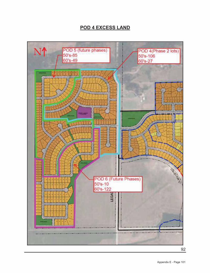
92
POD 4 EXCESS LAND
Appendix E - Page 101

93
SITE ANALYSIS —POD 4 EXCESS LAND
The subject represents the remaining 36.000 acres of land after completion of the 416 lots which are proposed to be developed on 118.000 acres within Phase 1 of a multiphase, master-planned residential development known as Creeks of Legacy. The 36.000 acres are designed to eventually be developed with two typical lot frontages; 106 lots (80%) being 50’ frontage lots and 27 lots (20%) being 60’ frontage lots. The general characteristics of the subject follow.
General Site Information
Location: West side of Legacy Drive, north of Frontier Parkway, Celina, Collin County, Texas
Frontage: The subject is part of a master-planned residential community which will have frontage along Frontier Parkway (southern boundary) and Legacy Drive.
Land Size: 36.000 acres
School District: Prosper ISD
Utilities to Site: The utilities are assumed to be available and of adequate capacity to service the site for low density residential of uses.
Shape of Tract: Slightly irregular
Topography: Rolling to level terrain
Zoning: PD-46 “Planned Development” District by the City of Celina, Texas
Access: The subject as part of a larger assemblage of land, currently has average accessibility and visibility from Frontier Parkway (southern boundary) and Legacy Drive, both which are planned to be expanded to the development.
Easements & Encroachments: According to the survey and site plan, the subject appears to be free from any adverse easements and/or encroachments.
Surface Drainage: Appears adequate
Appendix E - Page 102

94
Soils: A soil analysis for the site has not been provided for the preparation of this appraisal. In the absence of a soil report, it is a specific assumption that the site has adequate soils to support the highest and best use.
Subsurface Conditions: It is assumed that there are no hidden or unapparent conditions to the property, soil, or subsoil, which would render them more or less valuable. Subsurface oil, gas, or mineral rights were not considered in this report unless otherwise stated.
Nuisances and Hazards: No nuisances or hazards were noted that would adversely affect the use of the property.
Adjacent Uses: North: Vacant land/Open space South: Vacant land/Open space East: Vacant land/Open space West: Vacant land/Open space
Street Improvements: Legacy Drive will be a two lane gravel road on date of valuation providing north/south access to the development.
Proposed Site Improvements: Upon completion of Phase 1 development this site will have access from Legacy Drive, a gravel road. However, this site will also have full and direct access to public water and sewer.
Flood Designation: The subject is located on FEMA Panel 48085C0115J dated June 2, 2009 found on the following page. According to this map, none of the subject’s Pod 4 (excess land), is located within a floodplain area.
Conclusions: Overall, the excess land within Pod 4 is well suited for single-family residential development. All utilities are assumed to be available and there will be noeasements, restrictions, or encumbrances that appear to negatively affect the value or marketability of the subject.
Appendix E - Page 103

95
FLOOD MAP
Appendix E - Page 104

96
POD 4 EXCESS LAND
Appendix E - Page 105

97
SITE ANALYSIS —POD 5 EXCESS LAND
The subject represents the remaining 36.000 acres of land after completion of the 416 lots which are proposed to be developed on 118.000 acres within Phase 1 of a multiphase, master-planned residential development known as Creeks of Legacy. The 36.000 acres are designed to eventually be developed with two typical lot frontages; 85 lots (63%) being 50’ frontage lots and 49 lots (37%) being 60’ frontage lots. The general characteristics of the subject follow.
General Site Information
Location: West of Legacy Drive, north of Frontier Parkway, Celina, Collin County, Texas
Frontage: The subject is part of a master-planned residential community which will have frontage along Frontier Parkway (southern boundary) and Legacy Drive.
Land Size: 36.000 acres
School District: Prosper ISD
Utilities to Site: The utilities are assumed to be available and of adequate capacity to service the site for low density residential of uses.
Shape of Tract: Slightly irregular
Topography: Rolling to level terrain
Zoning: PD-46 “Planned Development” District by the City of Celina, Texas
Access: The subject as part of a larger assemblage of land, currently has average accessibility and visibility from Frontier Parkway (southern boundary) and Legacy Drive, both which are planned to be expanded to the development.
Easements & Encroachments: According to the survey and site plan, the subject appears to be free from any adverse easements and/or encroachments.
Surface Drainage: Appears adequate
Appendix E - Page 106
98
Soils: A soil analysis for the site has not been provided for the preparation of this appraisal. In the absence of a soil report, it is a specific assumption that the site has adequate soils to support the highest and best use.
Subsurface Conditions: It is assumed that there are no hidden or unapparent conditions to the property, soil, or subsoil, which would render them more or less valuable. Subsurface oil, gas, or mineral rights were not considered in this report unless otherwise stated.
Nuisances and Hazards: No nuisances or hazards were noted that would adversely affect the use of the property.
Adjacent Uses: North: Vacant land/Open space South: Vacant land/Open space East: Vacant land/Open space West: Vacant land/Open space
Street Improvements: On date of valuation the subject will have no direct road frontage. However, access will be through the plat to Legacy Drive which will be a two lane gravel road on date of valuation providing north/south access to just east of the development.
Proposed Site Improvements: Upon completion of Phase 1 development this site will have access from Legacy Drive, a gravel road. However, this site will also have full and direct access to public water and sewer.
Flood Designation: The subject is located on FEMA Panel 48085C0115J dated June 2, 2009 found on the following page. According to this map, none of the subject’s Pod 5 (excess land), is located within a floodplain area.
Conclusions: Overall, the excess land within Pod 5 is well suited for single-family residential development. All utilities are assumed to be available and there will be noeasements, restrictions, or encumbrances that appear to negatively affect the value or marketability of the subject.
Appendix E - Page 107

99
FLOOD MAP
Appendix E - Page 108
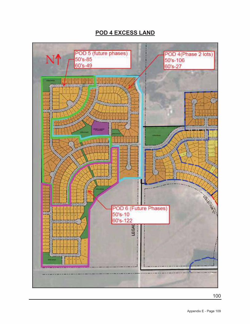
100
POD 4 EXCESS LAND
Appendix E - Page 109

101
SITE ANALYSIS —POD 6 EXCESS LAND
The subject represents the remaining 34.000 acres of land after completion of the 416 lots which are proposed to be developed on 118.000 acres within Phase 1 of a multiphase, master-planned residential development known as Creeks of Legacy. The 34.000 acres are designed to eventually be developed with two typical lot frontages; 10 lots (8%) being 50’ frontage lots and 122 lots (92%) being 60’ frontage lots. The general characteristics of the subject follow.
General Site Information
Location: West side of Legacy Drive, north of Frontier Parkway, Celina, Collin County, Texas
Frontage: The subject is part of a master-planned residential community which will have frontage along Frontier Parkway (southern boundary) and Legacy Drive.
Land Size: 36.000 acres
School District: Prosper ISD
Utilities to Site: The utilities are assumed to be available and of adequate capacity to service the site for low density residential of uses.
Shape of Tract: Slightly irregular
Topography: Rolling to level terrain
Zoning: PD-46 “Planned Development” District by the City of Celina, Texas
Access: The subject as part of a larger assemblage of land, currently has average accessibility and visibility from Frontier Parkway (southern boundary) and Legacy Drive, both which are planned to be expanded to the development.
Easements & Encroachments: According to the survey and site plan, the subject appears to be free from any adverse easements and/or encroachments.
Surface Drainage: Appears adequate
Appendix E - Page 110
102
Soils: A soil analysis for the site has not been provided for the preparation of this appraisal. In the absence of a soil report, it is a specific assumption that the site has adequate soils to support the highest and best use.
Subsurface Conditions: It is assumed that there are no hidden or unapparent conditions to the property, soil, or subsoil, which would render them more or less valuable. Subsurface oil, gas, or mineral rights were not considered in this report unless otherwise stated.
Nuisances and Hazards: No nuisances or hazards were noted that would adversely affect the use of the property.
Adjacent Uses: North: Vacant land/Open space South: Vacant land/Open space East: Vacant land/Open space West: Vacant land/Open space
Street Improvements: Legacy Drive will be a two lane gravel road on date of valuation providing north/south access to the development.
Proposed Site Improvements: Upon completion of Phase 1 development this site will have access from Legacy Drive, a gravel road. However, this site will also have full and direct access to public water and sewer.
Flood Designation: The subject is located on FEMA Panel 48085C0115J dated June 2, 2009 found on the following page. According to this map, none of the subject’s Pod 6 (excess land), is located within a floodplain area.
Conclusions: Overall, the excess land within Pod 6 is well suited for single-family residential development. All utilities are assumed to be available and there will be noeasements, restrictions, or encumbrances that appear to negatively affect the value or marketability of the subject.
Appendix E - Page 111
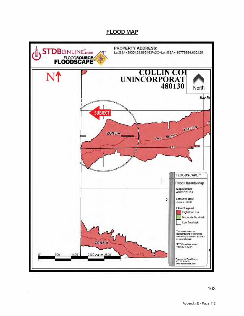
103
FLOOD MAP
Appendix E - Page 112
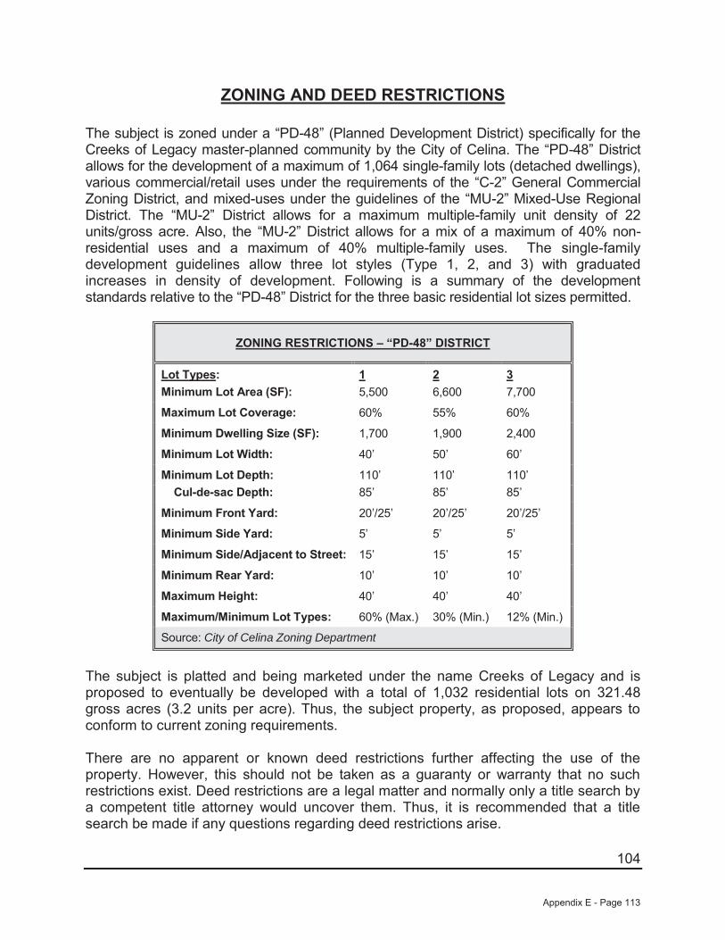
104
ZONING AND DEED RESTRICTIONS
The subject is zoned under a “PD-48” (Planned Development District) specifically for the Creeks of Legacy master-planned community by the City of Celina. The “PD-48” District allows for the development of a maximum of 1,064 single-family lots (detached dwellings),various commercial/retail uses under the requirements of the “C-2” General Commercial Zoning District, and mixed-uses under the guidelines of the “MU-2” Mixed-Use Regional District. The “MU-2” District allows for a maximum multiple-family unit density of 22 units/gross acre. Also, the “MU-2” District allows for a mix of a maximum of 40% non-residential uses and a maximum of 40% multiple-family uses. The single-family development guidelines allow three lot styles (Type 1, 2, and 3) with graduated increases in density of development. Following is a summary of the development standards relative to the “PD-48” District for the three basic residential lot sizes permitted.
ZONING RESTRICTIONS – “PD-48” DISTRICT
Lot Types:Minimum Lot Area (SF):
15,500
26,600
37,700
Maximum Lot Coverage: 60% 55% 60%
Minimum Dwelling Size (SF): 1,700 1,900 2,400
Minimum Lot Width: 40’ 50’ 60’
Minimum Lot Depth: 110’ 110’ 110’Cul-de-sac Depth: 85’ 85’ 85’
Minimum Front Yard: 20’/25’ 20’/25’ 20’/25’
Minimum Side Yard: 5’ 5’ 5’
Minimum Side/Adjacent to Street: 15’ 15’ 15’
Minimum Rear Yard: 10’ 10’ 10’
Maximum Height: 40’ 40’ 40’
Maximum/Minimum Lot Types: 60% (Max.) 30% (Min.) 12% (Min.)
Source: City of Celina Zoning Department
The subject is platted and being marketed under the name Creeks of Legacy and is proposed to eventually be developed with a total of 1,032 residential lots on 321.48 gross acres (3.2 units per acre). Thus, the subject property, as proposed, appears to conform to current zoning requirements.
There are no apparent or known deed restrictions further affecting the use of the property. However, this should not be taken as a guaranty or warranty that no such restrictions exist. Deed restrictions are a legal matter and normally only a title search by a competent title attorney would uncover them. Thus, it is recommended that a title search be made if any questions regarding deed restrictions arise.
Appendix E - Page 113
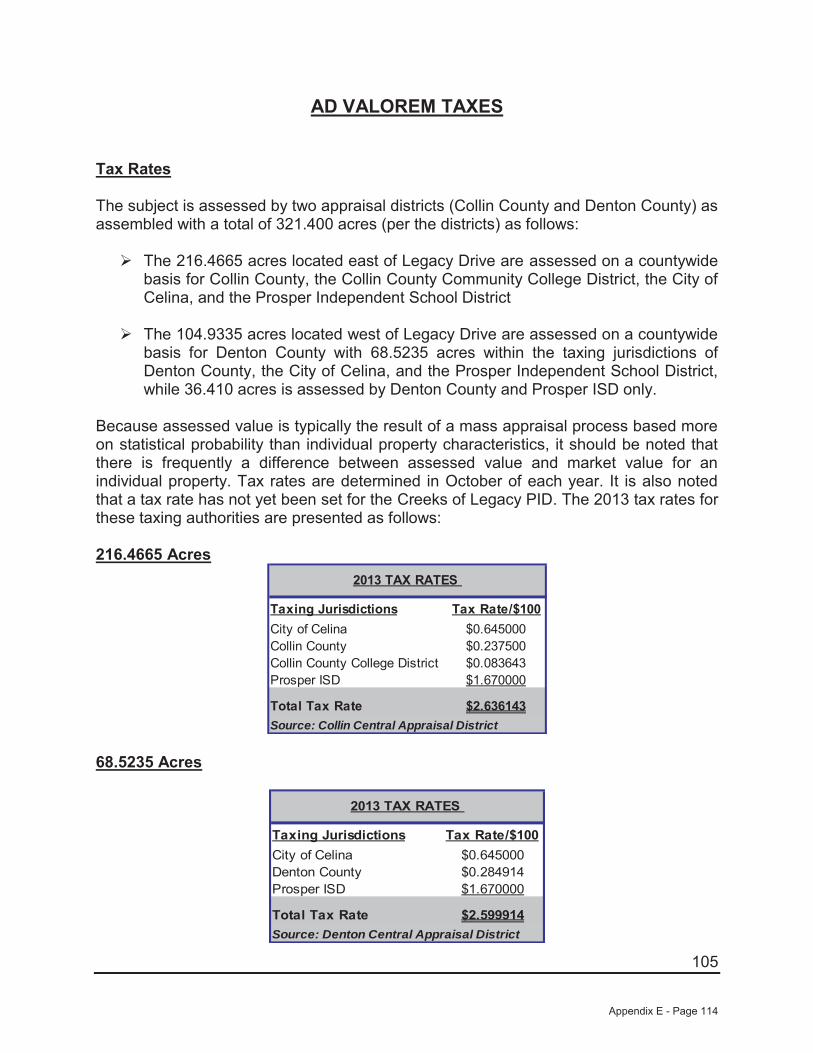
105
AD VALOREM TAXES
Tax Rates
The subject is assessed by two appraisal districts (Collin County and Denton County) as assembled with a total of 321.400 acres (per the districts) as follows:
The 216.4665 acres located east of Legacy Drive are assessed on a countywide basis for Collin County, the Collin County Community College District, the City of Celina, and the Prosper Independent School District
The 104.9335 acres located west of Legacy Drive are assessed on a countywide basis for Denton County with 68.5235 acres within the taxing jurisdictions of Denton County, the City of Celina, and the Prosper Independent School District, while 36.410 acres is assessed by Denton County and Prosper ISD only.
Because assessed value is typically the result of a mass appraisal process based more on statistical probability than individual property characteristics, it should be noted that there is frequently a difference between assessed value and market value for an individual property. Tax rates are determined in October of each year. It is also noted that a tax rate has not yet been set for the Creeks of Legacy PID. The 2013 tax rates for these taxing authorities are presented as follows:
216.4665 Acres
Taxing Jurisdictions Tax Rate/$100City of Celina $0.645000Collin County $0.237500Collin County College District $0.083643Prosper ISD $1.670000
Total Tax Rate $2.636143
2013 TAX RATES
Source: Collin Central Appraisal District
68.5235 Acres
Taxing Jurisdictions Tax Rate/$100City of Celina $0.645000Denton County $0.284914Prosper ISD $1.670000
Total Tax Rate $2.599914
2013 TAX RATES
Source: Denton Central Appraisal District
Appendix E - Page 114

106
36.410 Acres
Taxing Jurisdictions Tax Rate/$100Denton County $0.284914Prosper ISD $1.670000
Total Tax Rate $1.954914
2013 TAX RATES
Source: Denton Central Appraisal District
Tax Liability
In Texas, real property is required by law to be assessed at 100% of its estimated market value with assessments made as of the first day of each year and submitted to the public each April. The final values are certified each June. The subject is currently assessed under 11 individual account numbers (see Addenda) as a total of 321.400 gross acres of vacant land with the following 2013 certified assessments:
Acct. No. Ownership Total Acres 2013 Assessments Ag. Exempt Total Tax Rate/$100 2013 Taxes Ag. Exempt Taxes2696827 CADG Frontier 192 LLC 60.3180 N/A N/A $2.636143 N/A N/A2696792 CADG Frontier 192 LLC 53.6820 N/A N/A $2.636143 N/A N/A963773 Frontier Tollw ay Partners LP 21.7650 $3,411,900 $21,268 $2.636143 $89,943 $5612697056 CTMGT Frontier 80 LLC 38.2830 N/A N/A $2.636143 N/A N/A2697055 CTMGT Frontier 80 LLC 42.4180 N/A N/A $2.636143 N/A N/A530240 Stonegate Partners-Legacy LP 68.5235 $3,124,799 $13,705 $2.599914 $81,242 $356149097 CADG Frontier 192, LLC 0.6222 $12,444 $124 $1.954914 $243 $2149098 CADG Frontier 192, LLC 0.5553 $11,106 $111 $1.954914 $217 $252660 James C. Wu 18.8878 $777,585 $3,778 $1.954914 $15,201 $7475817 James C. Wu 9.4447 $388,825 $1,889 $1.954914 $7,601 $3752644 James C. Wu 6.9000 $284,309 $1,625 $1.954914 $5,558 $32
Totals 321.400 $8,010,968 $42,500 $200,005 $1,064
COLLIN/DENTON COUNTY CENTRAL APPRAISAL DISTRICT'S ASSESSMENTS
As shown, the 2013 assessments on four accounts totaling 194.701 acres were not provided by the Collin Central Appraisal District as these parcels were part of a larger tract of land in tax year 2013. As such, the total 2013 assessments for the assemblage of 126.699 acres equates to $8,010,968 (an overall average assessment of $63,228/acre). Based on the comparable land sales found within this report, it appears that the appraisal district has significantly under-valued the subject as vacant land.
The estimated taxes for the subject’s as 416 developed single-family lots within Phase 1 on portions of Pods 1, 2, and 3 will be based upon our market value opinions as noted within the discounted cash flow statements within this report.
Appendix E - Page 115

107
Roll Back Taxes
It is also important to note that all of the subject property is presently taxed under an agricultural exemption. As such, upon development, the developer of the site is liable for five years of back real estate taxes plus interest annually. This is considered typical of properties located in growth corridors such as the subject. As such, the roll back tax payments are considered in our valuation.
Appendix E - Page 116
108
SECTION 5 — HIGHEST AND BEST USE ANALYSIS
The principle of highest and best use is defined:
Highest and best use is a market-driven concept which identifies the most profitable and competitive use for which a property can be used. It is defined by The Appraisal of Real Estate, Thirteenth Edition as:
The reasonable and probable use of vacant land and or an improved property, which is physically possible, appropriately supported, financially feasible, and that results in the highest value.
The four criteria the highest and best use must meet are legal permissibility, physical possibility, financial feasibility, and maximum profitability.
Permissible Use (Legal) - what uses are permitted by zoning and deed restrictions on the site in question?
Possible Use - to what uses is it physically possible to put the site in question?
Feasible Use - which possible and permissible uses will produce any net return to the owner of the site?
Highest and Best Use - among the feasible uses, which use will produce the highest net return or the highest present worth?
The use which is the highest and best use of the property must be physically possible, legally permissible, financially feasible, and maximally productive. Following is a discussion of these factors.
Physically Possible
The physical aspects of the site dictate the first constraint imposed on the possible use of the property. Size, location within a given block, topography, and availability of utilities are the most important physical determinants of the highest and best use of a site. Furthermore, the subject, with road frontage along both future Legacy Road and Frontier Road, and being 321.48 gross acres in size, is sufficient to allow a wide range of development and most allowed uses could be physically placed on the site without any unreasonable hindrance.
Appendix E - Page 117

109
Legally Permissible
Potential legal restrictions that apply to the subject include public (zoning) and private restrictions (deed restrictions, easements, etc.). As discussed, the subject is zoned under a “PD-48” (Planned Development District) specifically for the Creeks of Legacy master-planned community by the City of Celina. The “PD-48” District allows for the development of a maximum of 1,064 single-family lots (detached dwellings), various commercial/retail uses under the requirements of the “C-2” General Commercial Zoning District, and mixed-uses under the guidelines of the “MU-2” Mixed-Use Regional District. The “MU-2” District allows for a maximum multiple-family unit density of 22 units/gross acre. Also, the “MU-2” District allows for a mix of a maximum of 40% non-residential uses and a maximum of 40% multiple-family uses. The single-family development guidelines allow three lot styles (Type 1, 2, and 3) with graduated increases in density of development.
Financially Feasible and Maximally Productive
When analyzing the financially feasible and maximally productive use of the site, all of the uses that are both physically possible and legally permissible must be considered. For the subject, the primary potential use is considered to be residential development. As mentioned, the subject is located in an area not zoned. Thus, an important factor affecting development of the subject is the surrounding land usage. The neighborhood is predominantly vacant land that is being developed into single-family residential uses with supportive commercial/retail facilities. The immediate area surrounding the subject is residential in nature.
During the past decade, residential real estate market has seen many positive changes. With the steady increase in multifamily residential rental rates, coupled with the steady decrease in interest rates and the large numbers pertaining to job growth, there has been a trend of individuals choosing to purchase homes rather than to rent apartments and multifamily housing. Furthermore, with the decline in the availability of vacant developable land, population growth has quickly expanded into the suburban areas of the Dallas/Fort Worth area. As such, the proposed absorption of single-family home lots in the subject’s neighborhood will be analyzed using historical absorption data provided by Residential Strategies, Inc., a locally recognized information provider, as well as information obtained from area market participants and developers. It is important to note that our absorption data is based on historical trends. Inasmuch as we are forecasting an economy for this area that is at least equal to recent trends, using these historical trends is felt to be quite justifiable. The subject development is physically located within the City of Celina in close proximity to the Town of Prosper in the far northwestern area of Collin County and the far southeastern area of Denton County, Texas. In addition, the subject development is located within the Prosper Independent School District. Therefore, data obtained from Residential Strategies as of First Quarter 2014 for the combined “Celina/Prosper” submarkets, which includes the subject, will be analyzed. A summary of the details are as follows:
Appendix E - Page 118
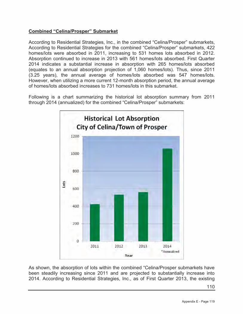
110
Combined “Celina/Prosper” Submarket
According to Residential Strategies, Inc., in the combined “Celina/Prosper” submarkets,According to Residential Strategies for the combined “Celina/Prosper” submarkets, 422 homes/lots were absorbed in 2011, increasing to 531 homes lots absorbed in 2012. Absorption continued to increase in 2013 with 561 homes/lots absorbed. First Quarter 2014 indicates a substantial increase in absorption with 265 homes/lots absorbed (equates to an annual absorption projection of 1,060 homes/lots). Thus, since 2011(3.25 years), the annual average of homes/lots absorbed was 547 homes/lots.However, when utilizing a more current 12-month absorption period, the annual average of homes/lots absorbed increases to 731 homes/lots in this submarket.
Following is a chart summarizing the historical lot absorption summary from 2011 through 2014 (annualized) for the combined “Celina/Prosper” submarkets:
As shown, the absorption of lots within the combined “Celina/Prosper submarkets have been steadily increasing since 2011 and are projected to substantially increase into 2014. According to Residential Strategies, Inc., as of First Quarter 2013, the existing
Appendix E - Page 119
111
supply of available housing is currently within ideal levels in the combined “Celina/Prosper” submarket areas. The number of vacant developed lots in the “Celina/Prosper” area has increased due to demand from a low of 896 lots in Third Quarter 2012 to its current level of 1,436 lots as of First Quarter 2014. Based upon the Residential Strategies, Inc. absorption figures of the past 3.25 years, there is currently a 32±-months (1,436 lots 547 lots = 2.6±-years) total supply of existing lots available in the combined “Celina/Prosper” submarkets. This total supply is considered to be near the upper end of the optimum supply range of 2.0 to 2.5 years. However, when utilizing the more current 12-month absorption average of 731 home/lots, the total supply of existing lots available in the subject’s market decreases significantly to 24±-months (1,436 lots ÷ 731 lots/year = 2.0±-years), which is at the lower end of the optimum supply level of existing lots in the market area.
Thus, the total lot supply within the combined “Celina/Prosper” submarkets is estimated to be between 2.0± to 2.6± years. Currently, this total lot supply is considered to be within optimum supply levels. However, taking into consideration that new developments require a typical 12-month construction period, with increasing demand and dwindling lot supply, it appears that additional lot product in the combined “Celina/Prosper” submarkets is feasible at the current time.
Having determined the feasibility of new lot construction in the subject’s submarket, ourresidential analysis will not narrow to specific competing subdivisions in the subject’s submarket area to determine the projected time of absorption for the subject’s proposed lots. This analysis will be shown individually as 50’, 60’ and 70’ frontage lots in order to determine the absorption time frame for each specific lot frontage.
Subject Summary
As discussed, the subject represents the following proposed lots to be located within a master-planned development known as Creeks of Legacy:
50' 60' 70' Total Lots Pod No. Acres Units/Acre0 61 27 88 1 24.000 3.70 84 31 115 2 31.000 3.7
125 8 80 213 3 63.000 3.4125 153 138 416
Creeks of Legacy - 416 Proposed Lots, Phase 1
Data per developer
Lot Frontages
As such, the following subdivisions presented for comparison are believed to more accurately reflect the potential demand/absorption for the subject’s 416 proposed lots(125 lots with 50’ frontages; 153 lots with 60’ frontages; and 138 lots with 70’ frontage lots) as proposed. The similarities considered to be most important are lot size, home
Appendix E - Page 120
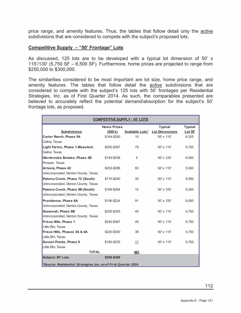
112
price range, and amenity features. Thus, the tables that follow detail only the active subdivisions that are considered to compete with the subject’s proposed lots.
Competitive Supply – “50’ Frontage” Lots
As discussed, 125 lots are to be developed with a typical lot dimension of 50’ x115’/130’ (5,750 SF – 6,500 SF). Furthermore, home prices are projected to range from $250,000 to $300,000.
The similarities considered to be most important are lot size, home price range, and amenity features. The tables that follow detail the active subdivisions that are considered to compete with the subject’s 125 lots with 50’ frontages per Residential Strategies, Inc. as of First Quarter 2014. As such, the comparables presented are believed to accurately reflect the potential demand/absorption for the subject’s 50’ frontage lots, as proposed.
Home Prices Typical TypicalSubdivisions (000's) Available Lots* Lot Dimensions Lot SF
Carter Ranch, Phase 5A $164-$200 15 55' x 115' 6,325Celina, TexasLight Farms, Phase 1-Bluestem $255-$357 79 50' x 115' 5,750Celina, Texas
Glenbrooke Estates, Phase 2B $193-$238 5 50' x 120' 6,000Prosper, TexasArtesia, Phase 4C $203-$289 83 50' x 110' 5,500Unincorporated, Denton County, Texas
Paloma Creek, Phase 7C (South) $170-$240 35 50' x 110' 5,500Unincorporated, Denton County, Texas
Paloma Creek, Phase 9B (South) $169-$264 14 50' x 105' 5,250Unincorporated, Denton County, Texas
Providence, Phase 6A $156-$224 91 50' x 120' 6,000Unincorporated, Denton County, Texas
Savannah, Phase 8B $255-$355 45 50' x 115' 5,750Unincorporated, Denton County, Texas
Frisco Hills, Phase 1 $240-$367 45 50' x 115' 5,750Little Elm, TexasFrisco Hills, Phases 3A & 4A $220-$300 38 50' x 115' 5,750Little Elm, TexasSunset Pointe, Phase 8 $185-$235 11 50' x 115' 5,750Little Elm, Texas
TOTAL 461Subject: 50' Lots $250-$300
*Source: Residential Strategies, Inc. as of First Quarter 2014
COMPETITIVE SUPPLY - 50' LOTS
Appendix E - Page 121
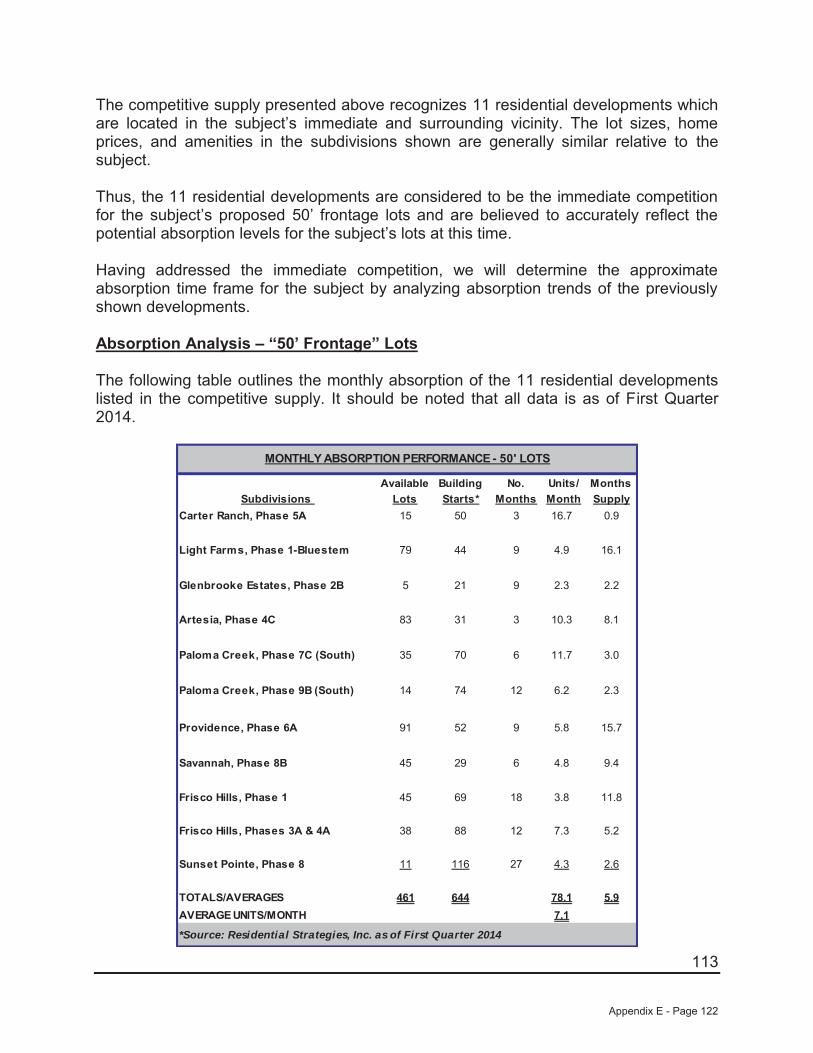
113
The competitive supply presented above recognizes 11 residential developments which are located in the subject’s immediate and surrounding vicinity. The lot sizes, home prices, and amenities in the subdivisions shown are generally similar relative to the subject.
Thus, the 11 residential developments are considered to be the immediate competition for the subject’s proposed 50’ frontage lots and are believed to accurately reflect the potential absorption levels for the subject’s lots at this time.
Having addressed the immediate competition, we will determine the approximate absorption time frame for the subject by analyzing absorption trends of the previously shown developments.
Absorption Analysis – “50’ Frontage” Lots
The following table outlines the monthly absorption of the 11 residential developments listed in the competitive supply. It should be noted that all data is as of First Quarter 2014.
Available Building No. Units/ MonthsSubdivisions Lots Starts* Months Month Supply
Carter Ranch, Phase 5A 15 50 3 16.7 0.9
Light Farms, Phase 1-Bluestem 79 44 9 4.9 16.1
Glenbrooke Estates, Phase 2B 5 21 9 2.3 2.2
Artesia, Phase 4C 83 31 3 10.3 8.1
Paloma Creek, Phase 7C (South) 35 70 6 11.7 3.0
Paloma Creek, Phase 9B (South) 14 74 12 6.2 2.3
Providence, Phase 6A 91 52 9 5.8 15.7
Savannah, Phase 8B 45 29 6 4.8 9.4
Frisco Hills, Phase 1 45 69 18 3.8 11.8
Frisco Hills, Phases 3A & 4A 38 88 12 7.3 5.2
Sunset Pointe, Phase 8 11 116 27 4.3 2.6
TOTALS/AVERAGES 461 644 78.1 5.9AVERAGE UNITS/MONTH 7.1
*Source: Residential Strategies, Inc. as of First Quarter 2014
MONTHLY ABSORPTION PERFORMANCE - 50' LOTS
Appendix E - Page 122

114
Based on the number of available lots and average absorption per month, the 461 lots remaining within these 11 residential developments indicate only a 5.9 -month supply (0.5± years). This appears to be representative of a severe under-supply of lots within the subject’s projected price/lot size range. Additionally, it is also important to note that at the absorption rates presented, nine of the 11 residential developments presented are projected to be sold out within 11.8± months, which is near the projected time of completion for the subject’s lots (12± months). Thus, it is reasonable that the subject,upon completion, may capture a portion of the demand that these projects currently enjoy.
Overall, the 11 residential developments indicate an absorption range of 2.3 units to 16.7 units per month, with an overall average of 7.1 units per month. To summarize, it is important to note the following facts:
Nine of the 11 residential developments presented are projected to be sold out within 11.8± months near the projected time of completion for the subject (12± months).
The subject’s competitive supply is considerably under-supplied with only a 5.9±month-supply of developed lots.
The overall lot supply within the combined “Celina/Prosper” submarkets is estimated to be between 2.0± to 2.6± years which is within the optimum lot supply levels. However, as the subject lots will not be completed for approximately one year±, at the current absorption averages, the lot supply is projected to drop below equilibrium levels.
Absorption Projection – 50’ Frontage Lots
Thus, the preceding data supports a projected absorption on a semi-annual basis for the subject’s lots with 50’ frontages at 7.0 units per month. Our projected absorption per month is near the competitive supply average and is considered reasonable based on the lot supply and demand levels within the subject’s combined “Celina/Prosper” submarket areas. It is noted all of the subject’s 125 proposed lots with 50’ frontages are platted within Pod 3.
Appendix E - Page 123
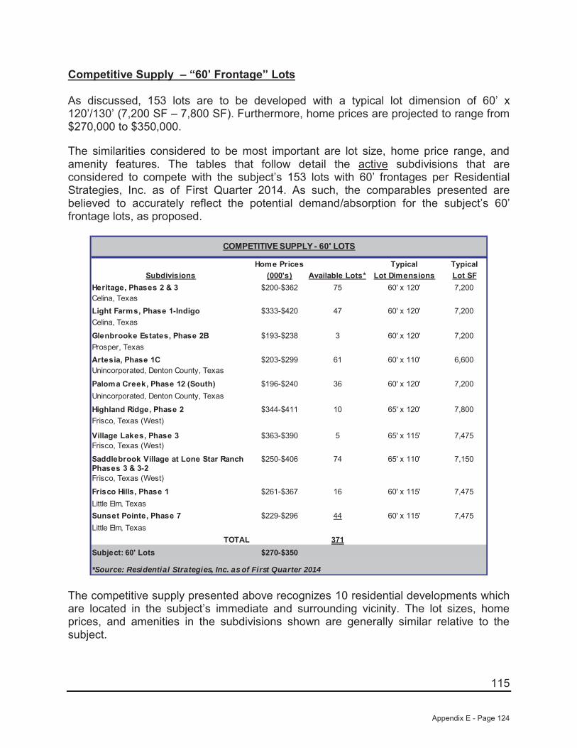
115
Competitive Supply – “60’ Frontage” Lots
As discussed, 153 lots are to be developed with a typical lot dimension of 60’ x120’/130’ (7,200 SF – 7,800 SF). Furthermore, home prices are projected to range from $270,000 to $350,000.
The similarities considered to be most important are lot size, home price range, and amenity features. The tables that follow detail the active subdivisions that are considered to compete with the subject’s 153 lots with 60’ frontages per Residential Strategies, Inc. as of First Quarter 2014. As such, the comparables presented are believed to accurately reflect the potential demand/absorption for the subject’s 60’ frontage lots, as proposed.
Home Prices Typical TypicalSubdivisions (000's) Available Lots* Lot Dimensions Lot SF
Heritage, Phases 2 & 3 $200-$362 75 60' x 120' 7,200Celina, TexasLight Farms, Phase 1-Indigo $333-$420 47 60' x 120' 7,200Celina, Texas
Glenbrooke Estates, Phase 2B $193-$238 3 60' x 120' 7,200Prosper, TexasArtesia, Phase 1C $203-$299 61 60' x 110' 6,600Unincorporated, Denton County, Texas
Paloma Creek, Phase 12 (South) $196-$240 36 60' x 120' 7,200Unincorporated, Denton County, Texas
Highland Ridge, Phase 2 $344-$411 10 65' x 120' 7,800Frisco, Texas (West)
Village Lakes, Phase 3 $363-$390 5 65' x 115' 7,475Frisco, Texas (West)
Saddlebrook Village at Lone Star Ranch $250-$406 74 65' x 110' 7,150Phases 3 & 3-2Frisco, Texas (West)
Frisco Hills, Phase 1 $261-$367 16 60' x 115' 7,475Little Elm, TexasSunset Pointe, Phase 7 $229-$296 44 60' x 115' 7,475Little Elm, Texas
TOTAL 371Subject: 60' Lots $270-$350
COMPETITIVE SUPPLY - 60' LOTS
*Source: Residential Strategies, Inc. as of First Quarter 2014
The competitive supply presented above recognizes 10 residential developments which are located in the subject’s immediate and surrounding vicinity. The lot sizes, home prices, and amenities in the subdivisions shown are generally similar relative to the subject.
Appendix E - Page 124
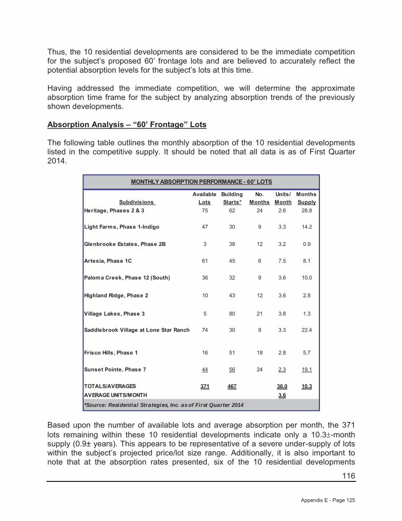
116
Thus, the 10 residential developments are considered to be the immediate competition for the subject’s proposed 60’ frontage lots and are believed to accurately reflect the potential absorption levels for the subject’s lots at this time.
Having addressed the immediate competition, we will determine the approximate absorption time frame for the subject by analyzing absorption trends of the previously shown developments.
Absorption Analysis – “60’ Frontage” Lots
The following table outlines the monthly absorption of the 10 residential developments listed in the competitive supply. It should be noted that all data is as of First Quarter 2014.
Available Building No. Units/ MonthsSubdivisions Lots Starts* Months Month Supply
Heritage, Phases 2 & 3 75 62 24 2.6 28.8
Light Farms, Phase 1-Indigo 47 30 9 3.3 14.2
Glenbrooke Estates, Phase 2B 3 38 12 3.2 0.9
Artesia, Phase 1C 61 45 6 7.5 8.1
Paloma Creek, Phase 12 (South) 36 32 9 3.6 10.0
Highland Ridge, Phase 2 10 43 12 3.6 2.8
Village Lakes, Phase 3 5 80 21 3.8 1.3
Saddlebrook Village at Lone Star Ranch 74 30 9 3.3 22.4
Frisco Hills, Phase 1 16 51 18 2.8 5.7
Sunset Pointe, Phase 7 44 56 24 2.3 19.1
TOTALS/AVERAGES 371 467 36.0 10.3AVERAGE UNITS/MONTH 3.6
*Source: Residential Strategies, Inc. as of First Quarter 2014
MONTHLY ABSORPTION PERFORMANCE - 60' LOTS
Based upon the number of available lots and average absorption per month, the 371 lots remaining within these 10 residential developments indicate only a 10.3 -month supply (0.9± years). This appears to be representative of a severe under-supply of lots within the subject’s projected price/lot size range. Additionally, it is also important to note that at the absorption rates presented, six of the 10 residential developments
Appendix E - Page 125
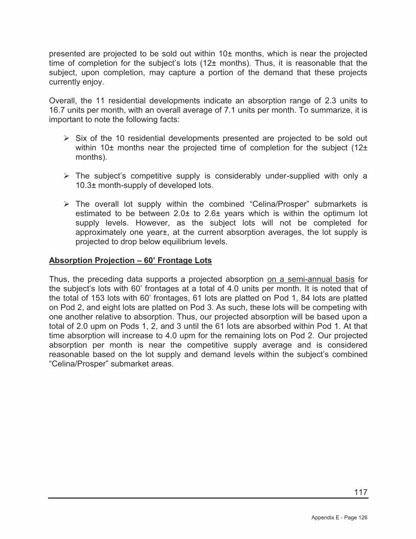
117
presented are projected to be sold out within 10± months, which is near the projected time of completion for the subject’s lots (12± months). Thus, it is reasonable that the subject, upon completion, may capture a portion of the demand that these projects currently enjoy.
Overall, the 11 residential developments indicate an absorption range of 2.3 units to 16.7 units per month, with an overall average of 7.1 units per month. To summarize, it is important to note the following facts:
Six of the 10 residential developments presented are projected to be sold out within 10± months near the projected time of completion for the subject (12± months).
The subject’s competitive supply is considerably under-supplied with only a 10.3± month-supply of developed lots.
The overall lot supply within the combined “Celina/Prosper” submarkets is estimated to be between 2.0± to 2.6± years which is within the optimum lot supply levels. However, as the subject lots will not be completed for approximately one year±, at the current absorption averages, the lot supply is projected to drop below equilibrium levels.
Absorption Projection – 60’ Frontage Lots
Thus, the preceding data supports a projected absorption on a semi-annual basis for the subject’s lots with 60’ frontages at a total of 4.0 units per month. It is noted that of the total of 153 lots with 60’ frontages, 61 lots are platted on Pod 1, 84 lots are platted on Pod 2, and eight lots are platted on Pod 3. As such, these lots will be competing with one another relative to absorption. Thus, our projected absorption will be based upon a total of 2.0 upm on Pods 1, 2, and 3 until the 61 lots are absorbed within Pod 1. At that time absorption will increase to 4.0 upm for the remaining lots on Pod 2. Our projected absorption per month is near the competitive supply average and is considered reasonable based on the lot supply and demand levels within the subject’s combined “Celina/Prosper” submarket areas.
Appendix E - Page 126
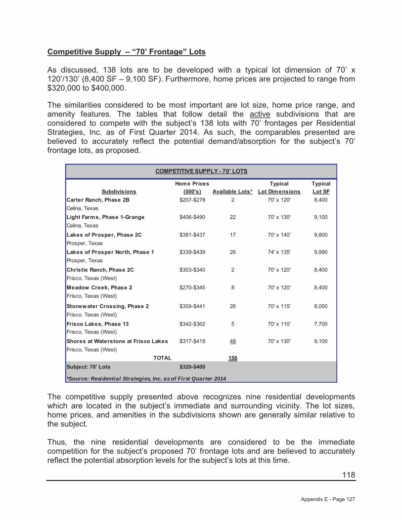
118
Competitive Supply – “70’ Frontage” Lots
As discussed, 138 lots are to be developed with a typical lot dimension of 70’ x120’/130’ (8,400 SF – 9,100 SF). Furthermore, home prices are projected to range from$320,000 to $400,000.
The similarities considered to be most important are lot size, home price range, and amenity features. The tables that follow detail the active subdivisions that are considered to compete with the subject’s 138 lots with 70’ frontages per Residential Strategies, Inc. as of First Quarter 2014. As such, the comparables presented are believed to accurately reflect the potential demand/absorption for the subject’s 70’ frontage lots, as proposed.
Home Prices Typical TypicalSubdivisions (000's) Available Lots* Lot Dimensions Lot SF
Carter Ranch, Phase 2B $207-$278 2 70' x 120' 8,400Celina, TexasLight Farms, Phase 1-Grange $406-$490 22 70' x 130' 9,100Celina, Texas
Lakes of Prosper, Phase 2C $381-$437 17 70' x 140' 9,800Prosper, TexasLakes of Prosper North, Phase 1 $339-$439 26 74' x 135' 9,990Prosper, Texas
Christie Ranch, Phase 2C $303-$340 2 70' x 120' 8,400Frisco, Texas (West)
Meadow Creek, Phase 2 $270-$345 8 70' x 120' 8,400Frisco, Texas (West)
Stonewater Crossing, Phase 2 $359-$441 26 70' x 115' 8,050Frisco, Texas (West)
Frisco Lakes, Phase 13 $342-$362 5 70' x 110' 7,700Frisco, Texas (West)
Shores at Waterstone at Frisco Lakes $317-$419 48 70' x 130' 9,100Frisco, Texas (West)
TOTAL 156Subject: 70' Lots $320-$400
*Source: Residential Strategies, Inc. as of First Quarter 2014
COMPETITIVE SUPPLY - 70' LOTS
The competitive supply presented above recognizes nine residential developments which are located in the subject’s immediate and surrounding vicinity. The lot sizes, home prices, and amenities in the subdivisions shown are generally similar relative to the subject.
Thus, the nine residential developments are considered to be the immediate competition for the subject’s proposed 70’ frontage lots and are believed to accurately reflect the potential absorption levels for the subject’s lots at this time.
Appendix E - Page 127
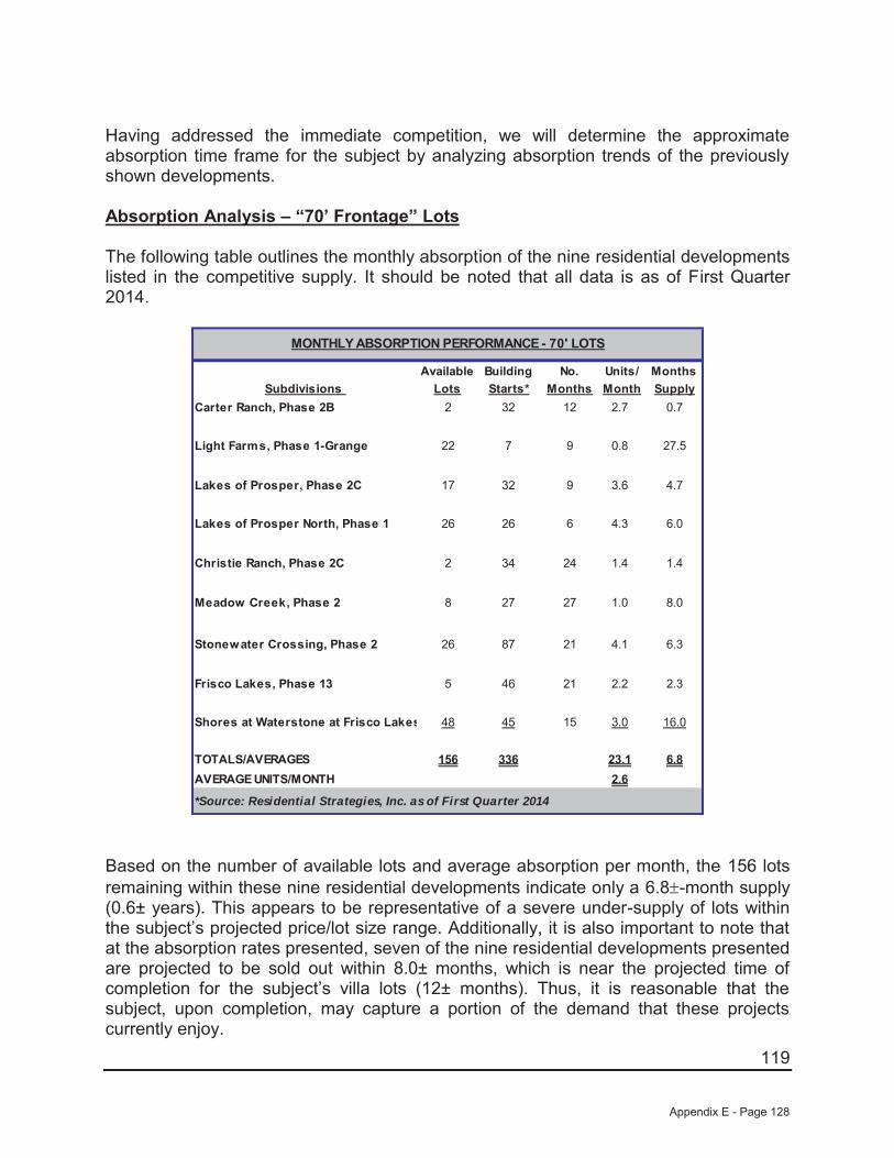
119
Having addressed the immediate competition, we will determine the approximate absorption time frame for the subject by analyzing absorption trends of the previously shown developments.
Absorption Analysis – “70’ Frontage” Lots
The following table outlines the monthly absorption of the nine residential developments listed in the competitive supply. It should be noted that all data is as of First Quarter 2014.
Available Building No. Units/ MonthsSubdivisions Lots Starts* Months Month Supply
Carter Ranch, Phase 2B 2 32 12 2.7 0.7
Light Farms, Phase 1-Grange 22 7 9 0.8 27.5
Lakes of Prosper, Phase 2C 17 32 9 3.6 4.7
Lakes of Prosper North, Phase 1 26 26 6 4.3 6.0
Christie Ranch, Phase 2C 2 34 24 1.4 1.4
Meadow Creek, Phase 2 8 27 27 1.0 8.0
Stonewater Crossing, Phase 2 26 87 21 4.1 6.3
Frisco Lakes, Phase 13 5 46 21 2.2 2.3
Shores at Waterstone at Frisco Lakes 48 45 15 3.0 16.0
TOTALS/AVERAGES 156 336 23.1 6.8AVERAGE UNITS/MONTH 2.6
*Source: Residential Strategies, Inc. as of First Quarter 2014
MONTHLY ABSORPTION PERFORMANCE - 70' LOTS
Based on the number of available lots and average absorption per month, the 156 lots remaining within these nine residential developments indicate only a 6.8 -month supply (0.6± years). This appears to be representative of a severe under-supply of lots within the subject’s projected price/lot size range. Additionally, it is also important to note that at the absorption rates presented, seven of the nine residential developments presented are projected to be sold out within 8.0± months, which is near the projected time of completion for the subject’s villa lots (12± months). Thus, it is reasonable that the subject, upon completion, may capture a portion of the demand that these projects currently enjoy.
Appendix E - Page 128
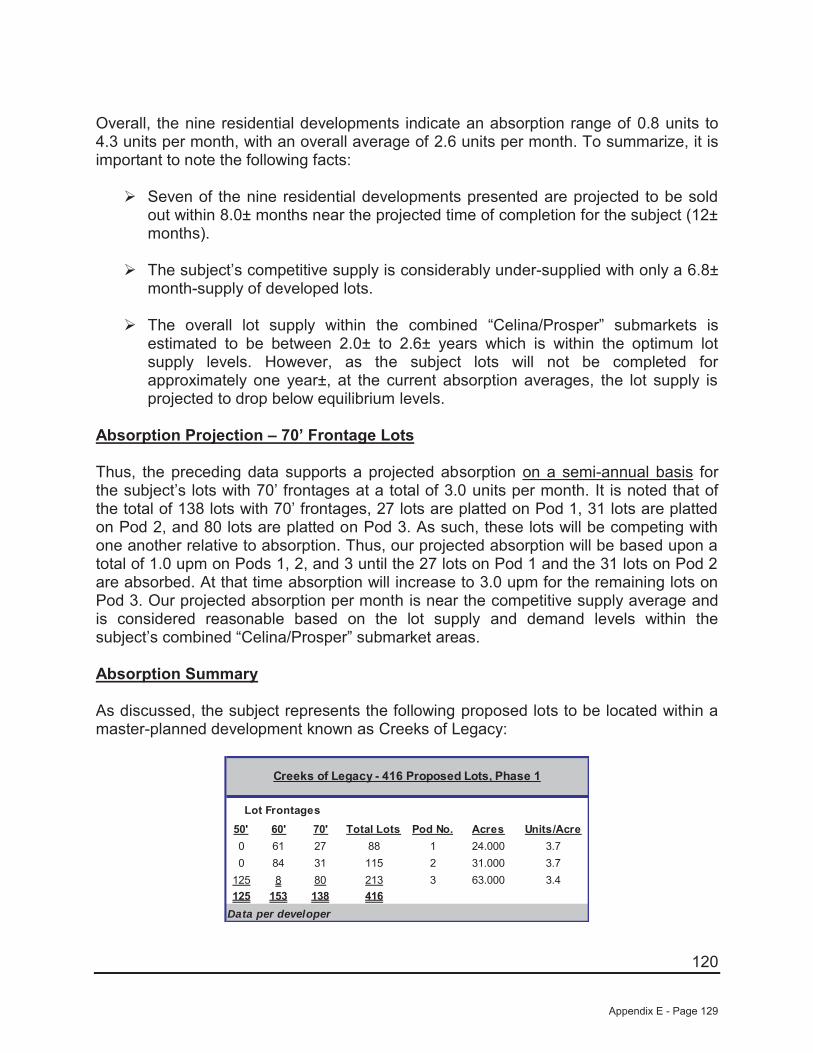
120
Overall, the nine residential developments indicate an absorption range of 0.8 units to 4.3 units per month, with an overall average of 2.6 units per month. To summarize, it is important to note the following facts:
Seven of the nine residential developments presented are projected to be sold out within 8.0± months near the projected time of completion for the subject (12± months).
The subject’s competitive supply is considerably under-supplied with only a 6.8±month-supply of developed lots.
The overall lot supply within the combined “Celina/Prosper” submarkets is estimated to be between 2.0± to 2.6± years which is within the optimum lot supply levels. However, as the subject lots will not be completed for approximately one year±, at the current absorption averages, the lot supply is projected to drop below equilibrium levels.
Absorption Projection – 70’ Frontage Lots
Thus, the preceding data supports a projected absorption on a semi-annual basis for the subject’s lots with 70’ frontages at a total of 3.0 units per month. It is noted that of the total of 138 lots with 70’ frontages, 27 lots are platted on Pod 1, 31 lots are platted on Pod 2, and 80 lots are platted on Pod 3. As such, these lots will be competing with one another relative to absorption. Thus, our projected absorption will be based upon a total of 1.0 upm on Pods 1, 2, and 3 until the 27 lots on Pod 1 and the 31 lots on Pod 2 are absorbed. At that time absorption will increase to 3.0 upm for the remaining lots on Pod 3. Our projected absorption per month is near the competitive supply average and is considered reasonable based on the lot supply and demand levels within the subject’s combined “Celina/Prosper” submarket areas.
Absorption Summary
As discussed, the subject represents the following proposed lots to be located within a master-planned development known as Creeks of Legacy:
50' 60' 70' Total Lots Pod No. Acres Units/Acre0 61 27 88 1 24.000 3.70 84 31 115 2 31.000 3.7
125 8 80 213 3 63.000 3.4125 153 138 416
Creeks of Legacy - 416 Proposed Lots, Phase 1
Data per developer
Lot Frontages
Appendix E - Page 129
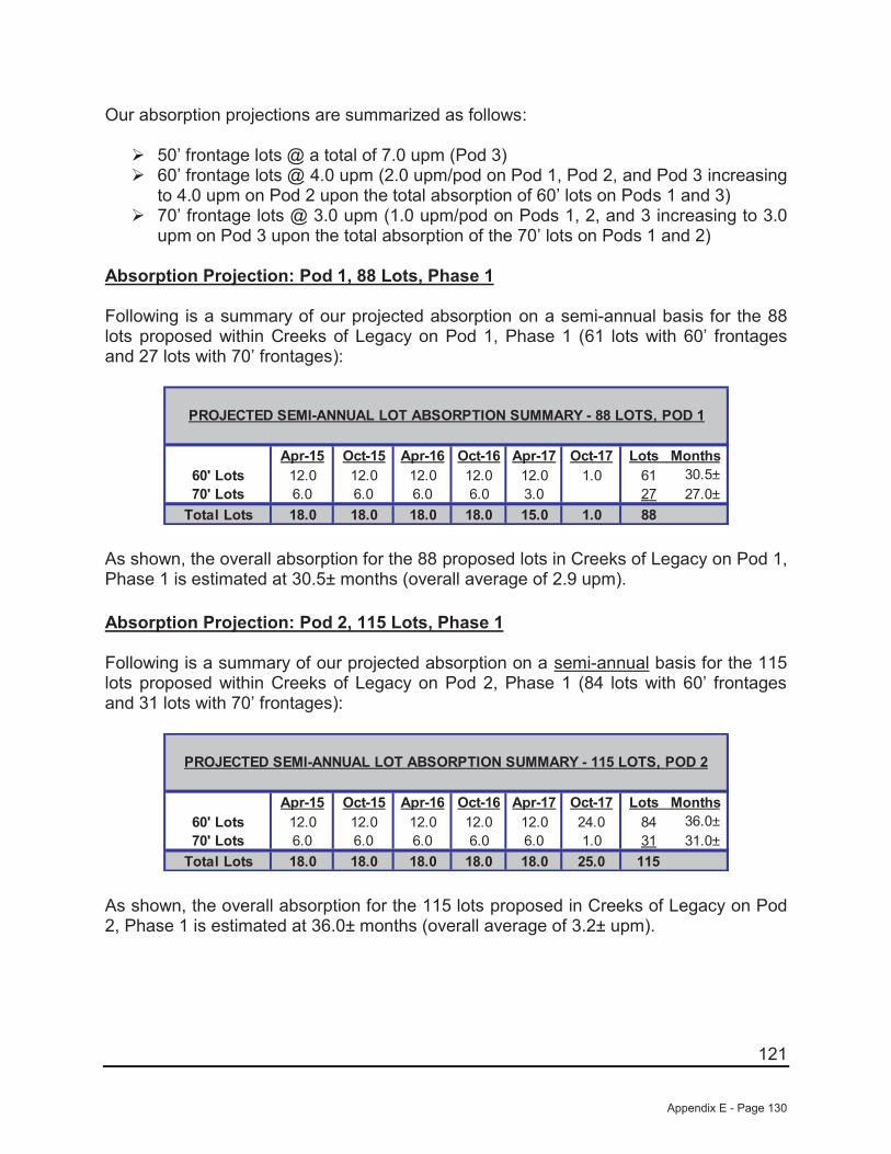
121
Our absorption projections are summarized as follows:
50’ frontage lots @ a total of 7.0 upm (Pod 3) 60’ frontage lots @ 4.0 upm (2.0 upm/pod on Pod 1, Pod 2, and Pod 3 increasing to 4.0 upm on Pod 2 upon the total absorption of 60’ lots on Pods 1 and 3) 70’ frontage lots @ 3.0 upm (1.0 upm/pod on Pods 1, 2, and 3 increasing to 3.0 upm on Pod 3 upon the total absorption of the 70’ lots on Pods 1 and 2)
Absorption Projection: Pod 1, 88 Lots, Phase 1
Following is a summary of our projected absorption on a semi-annual basis for the 88 lots proposed within Creeks of Legacy on Pod 1, Phase 1 (61 lots with 60’ frontages and 27 lots with 70’ frontages):
Apr-15 Apr-16 Oct-16 Apr-17 Oct-1760' Lots 12.0 12.0 12.0 12.0 12.0 1.0 61 30.5±70' Lots 6.0 6.0 6.0 6.0 3.0 27 27.0±
Total Lots 18.0 18.0 18.0 15.0 1.0 88
PROJECTED SEMI-ANNUAL LOT ABSORPTION SUMMARY - 88 LOTS, POD 1
Oct-15
18.0
Lots Months
As shown, the overall absorption for the 88 proposed lots in Creeks of Legacy on Pod 1, Phase 1 is estimated at 30.5± months (overall average of 2.9 upm).
Absorption Projection: Pod 2, 115 Lots, Phase 1
Following is a summary of our projected absorption on a semi-annual basis for the 115 lots proposed within Creeks of Legacy on Pod 2, Phase 1 (84 lots with 60’ frontages and 31 lots with 70’ frontages):
Apr-15 Apr-16 Oct-16 Apr-17 Oct-1760' Lots 12.0 12.0 12.0 12.0 12.0 24.0 84 36.0±70' Lots 6.0 6.0 6.0 6.0 6.0 1.0 31 31.0±
Total Lots 18.0 18.0 18.0 18.0 25.0 115
PROJECTED SEMI-ANNUAL LOT ABSORPTION SUMMARY - 115 LOTS, POD 2
Oct-15
18.0
Lots Months
As shown, the overall absorption for the 115 lots proposed in Creeks of Legacy on Pod 2, Phase 1 is estimated at 36.0± months (overall average of 3.2± upm).
Appendix E - Page 130
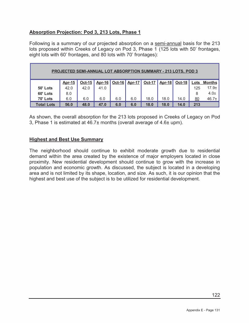
122
Absorption Projection: Pod 3, 213 Lots, Phase 1
Following is a summary of our projected absorption on a semi-annual basis for the 213 lots proposed within Creeks of Legacy on Pod 3, Phase 1 (125 lots with 50’ frontages, eight lots with 60’ frontages, and 80 lots with 70’ frontages):
Apr-15 Apr-16 Oct-16 Apr-17 Oct-17 Apr-18 Oct-1850' Lots 42.0 42.0 41.0 125 17.9±60' Lots 8.0 8 4.0±70' Lots 6.0 6.0 6.0 6.0 6.0 18.0 18.0 14.0 80 46.7±
Total Lots 56.0 47.0 6.0 6.0 18.0 18.0 14.0 213
PROJECTED SEMI-ANNUAL LOT ABSORPTION SUMMARY - 213 LOTS, POD 3
Oct-15
48.0
Lots Months
As shown, the overall absorption for the 213 lots proposed in Creeks of Legacy on Pod 3, Phase 1 is estimated at 46.7± months (overall average of 4.6± upm).
Highest and Best Use Summary
The neighborhood should continue to exhibit moderate growth due to residential demand within the area created by the existence of major employers located in close proximity. New residential development should continue to grow with the increase in population and economic growth. As discussed, the subject is located in a developing area and is not limited by its shape, location, and size. As such, it is our opinion that the highest and best use of the subject is to be utilized for residential development.
Appendix E - Page 131

123
SECTION 6 — VALUATION OF THE SUBJECT
The valuation process is defined as:
"The systematic set of procedures an appraiser follows to provide answers to a client’s questions about real property value.”3
Valuation is a term used interchangeably with appraisal. Real estate markets are a function of the location in which they are located. The overall market environment can have a profound effect on the manner in which buyers and sellers perform the act of transferring property rights. Considerations made by the participants are generally based on certain fundamental principles. Those principles and their definitions are as follows:
Anticipation: “The perception that value is created by the expectation of benefits to be derived in the future. Value is created by the anticipation of future benefits.
Change: The result of the cause and effect relationship among the forces that influence real property value.
Supply and Demand: In economic theory, the principle of supply and demand states that the price of a commodity, good, or service varies directly, but not necessarily proportionately, with demand and inversely, but not necessarily proportionately with supply. Thus, an increase in the supply of an item or decrease in the demand for an item tends to reduce the equilibrium price; the opposite conditions produce an opposite effect. The relationship between supply and demand may not be directly proportional, but the interaction of these forces is fundamental to economic theory. The interaction of suppliers and demanders, or sellers and buyers, constitutes a market.
Competition: Between purchasers or tenants, the interactive efforts of two or more potential buyers or tenants to make a sale or secure a lease; between sellers or landlords, the interactive efforts of two or more potential sellers or landlords to complete a sale or lease; among competitive properties, the level of productivity and amenities or benefits characteristic of each property considering the advantageous or disadvantageous position of the property relative to the competitors.
Substitution: The appraisal principle that states that when several similar or commensurate commodities, goods, or services are available, the one with the lowest price attracts the greatest demand and widest distribution. This is the primary principle upon which the cost and sales comparison approaches are based.
3 The Appraisal of Real Estate, 13th Edition, the Appraisal Institute, Chicago, Illinois (U.S., 2009)
Appendix E - Page 132
124
Balance: The principle that real property value is created and sustained when contrasting, opposing, or interacting elements are in a state of equilibrium.
Contribution: The concept that the value of a particular component is measured in terms of its contribution to the value of the whole property or as the amount that its absence would detract from the value of the whole.
Surplus Productivity: The net income that remains after the cost of various agents of production has been paid.
Conformity: The appraisal principle that real property value is created and sustained when the characteristics of a property conform to the demands of its market.
Externalities: The principle economies outside a property have a positive effect on its value while diseconomies outside a property have a negative effect upon its value.”4
The Cost Approach, wherein the land is appraised as if vacant and available for development to its highest and best use. To this result is added the improvements estimated cost of reproduction new less depreciation accruing from all causes.
The Income Approach, which requires a study of the earnings capacity of the real estate, and the conversion of such net income into value by means of a capitalization process.
The Sales Comparison Approach, involving an analysis of the sale of other property having similar attributes and/or improvements, and a comparison of such data with the property appraised, giving due consideration to the elements of dissimilarity.
Historical Background: “The appraisal procedures that are now identified as the three approaches to value were developed after the stock market crash of 1929. The economic crisis that ensued had an immediate impact on the appraisal practices of the time. The collapse of the real estate market in the 1930s seemed to discredit the notion that market price is central to value”.5
There are several accepted methods which can be used to provide an opinion of the value of land. However, only the Sales Comparison Approach is considered to be applicable in this instance.
The Sales Comparison Approach is a method that involves analyzing and comparing sales of sites that are similar to the subject and adjusting the sales prices for relative differences such as property rights conveyed, financing terms, conditions of sale, marketing conditions, location, and physical characteristics. This method is the most common technique of land valuation and is preferential to the other methods when comparable sales are available.
4 The Appraisal of Real Estate, 13th Edition, the Appraisal Institute, Chicago, Illinois (U.S., 2009) 5 Ibid.
Appendix E - Page 133
125
Under the Lot Development Approach, the subject is assumed to be developed into a subdivision, with the individual lots being sold over a projected period of time. Expenses that are incurred are deducted from the proceeds of the lot sales and the resulting income stream is discounted into a present value.
The following sections provide the rationale and assumptions inherent in the Sales Comparison Approach as well as the Lot Development Approach. We will utilize the Lot Development Approach to value to provide a bulk or wholesale value for the 162 proposed lots in Phase 11A/13. The Sales Comparison Approach of value will also be utilized for the subject’s individual phases of excess land after development is complete.
Appendix E - Page 134

126
LOT DEVELOPMENT APPROACH
The first step in the process of providing a market value opinion of the subject as developed and as proposed is to determine the market value of the individual lots (retail value). This will be done by using the Sales Comparison Approach.
Retail Lot Prices
Because of their size and potential uses, the sum of the individual lots in a subdivided parcel is more valuable than the site as a whole. The value of the individual lots is commonly referred to as the "retail value" of the lots, since this is essentially the value of the site to the end-user of the site. To estimate the value for the subject’s proposed 50’, 60’, and 70’ frontage lots, we will utilize lot sales from several different subdivisions located in the subject’s general market area with similar attributes relative to the subject’s lots. The sales that were verified can be found in the following summary.
Sale School Contract Lot BaseCurrent Price Base PriceNo. Subdivisions District Date Dimensions Lot SF Per Lot Per FF1 Carter Ranch Celina 2013 55' x 120' 6,600 $45,000 $818 Near Completion
Phase 2C 70' x 120' 8,400 $58,000 $829Celina, Texas
2 Light Farms Prosper 2013 50' x 115' 5,750 $57,500 $1,150 Completed 3Q13Celina, Texas 60' x 120' 7,200 $69,000 $1,150
70' x 130' 9,100 $80,500 $1,1503 Windsong Ranch Prosper 2013 60' x 130' 7,800 $69,000 $1,150 Completed 1Q14
Phase 1A 70' x 130' 9,100 $80,500 $1,150Prosper, Texas
4 Frisco Hills Frisco 2013 50' x 115' 5,750 $55,000 $1,100Phases 1B &1C 60' x 115' 6,900 $60,000 $1,000Little Elm ETJ, Denton County, Texas
Subject Creeks of Legacy Prosper 50' x 115'/130' 5,750-6,500Celina, Texas 60' x 120'/130' 7,200-7,800
70' x 120'/130' 8,400-9,100
Completed 1Q14
COMPARABLE LOT SALES
CurrentStatus
The lot comparables utilized range in base lot sales prices for 50’, 60’, and 70’ frontage competitive lots within the subject’s market area as follows:
50’ Frontage Lots: $45,000/lot to $57,500/lot or $818/FF to $1,150/FF
60’ Frontage Lots: $60,000/lot to $69,000/lot or $1,000/FF to $1,150/FF
70’ Frontage Lots: $58,000/lot to $80,500/lot or $829/FF to $1,150/FF
Appendix E - Page 135

127
In addition, all of the comparables are located in the subject’s immediate market area. Thus, all of the subdivisions are influenced by their similar proximity to shopping and employment districts. Finally, factors such as property rights conveyed, financing, conditions of sale, or market conditions did not influence the lot sales.
A map showing the location of the comparable lots relative to the subject is shown as follows.
LOT COMPARABLE MAP
Appendix E - Page 136
128
The individual subdivisions are detailed as follows:
1) Carter Ranch, Phase 2C represents Phase 2C of a multiphase subdivision located northeast of the subject on the south side of CR-88, east of Preston Road (SH-289), Celina, Collin County, Texas. Phase 2C is platted and being developed with 33 lots which are nearing completion. This subdivision is located within the Celina Independent School District, while the subject will be located within the Prosper ISD. Overall, this development is considered inferior in location relative to the subject, as proposed. Lots in Phase 2C are being developed with two typical lot dimensions with five lots as 55’ x 120’ (6,600 SF) and 28 lots as 70’ x 120’ (8,400 SF) which is similar in size relative to the subject’s 50’ and 60’ frontage lots. Lots in this phase are contracted to one volume homebuilder, First Texas Homes, at a base lot price of $45,000/lot ($818/FF) for the 55’ frontage lots and at a base lot price of $58,000/lot ($829/FF) for the 70’ frontage lots.Interest carry is scheduled at six percent annually. Based upon the preceding, the lot prices for the subject’s lots, as proposed, should be higher relative to the current lot prices for similar sized lots of this comparable.
2) Light Farms (aka Light Ranch) is a new 903-acre, master-planned development located northeast of the subject in Celina. Eventually, this development will have access from the future extension of the Dallas North Tollway. This development is located within the Prosper ISD which is similar relative to the subject, as proposed (Prosper ISD). Overall, this development is considered similar in location relative to the subject, as proposed. The community will offer a fitness center, four pools, tennis court complex, and central lawn with gazebo for events. As such, this development is considered similar in amenities relative to the subject, as proposed. Phase 1 was platted and developed with a total of 229 lots (123 lots with 50’ frontages (5,750 SF), 77 lots with 60’ frontages (7,200 SF), and 29 lots with 70’ frontages (9,100 SF). These lot sizes are considered similar relative to the subject’s 50’/60’/70’ lots, as proposed. Lots in this development were contracted in 2013 to American Legend Homes, Lionsgate Homes, Darling Home, Drees Homes, Highland Homes, and Shaddock Homes based on a “straight-line” basis with no interest carry at $1,150/front footage or the 50’ frontage lots at $57,500/lot; the 60’ frontage lots at $69,000/lot, and the 70’ frontage lots at $80,500). As such, the subject’s lots, as proposed, should be similar relative to the lot prices of this comparable.
3) Windsong Ranch (aka Three Stones/Mahard Ranch/Prosper Ranch) is a new $1.2 billion master-planned development located southwest of the subject on the north side of US-380 between FM-423 and Fields Road (future Teel Parkway) and approximately 2.5 miles west of the Dallas North Tollway in Prosper, Texas. This development is located within the Prosper ISD which is similar relative to the subject, as proposed (Prosper ISD). Overall, this development is considered similar in location relative to the subject. Eventually, this 2,030±-acre development is projected to include 3,500 single-family homes featuring 50 acres of park land, hike/bike trails and multiple lighted sports fields. The community is also planned to be developed with a three-building amenity complex which includes a community coffee shop, marketing center, outdoor gathering spaces, poolside pavilion with fireplace, a fitness center/exercise
Appendix E - Page 137
129
room, play areas, lap pool, and resort-style pool overlooking the lake. Overall, this development is considered similar in amenities relative to the subject, as proposed. Phase 1A was platted and developed with a total of 152 single-family lots with typical lot dimensions of 60’ x 130’ (7,800 SF) and 70’ x 130’ (9,100 SF) which is similar relative to the subject’s 60’ and 70’ frontage lots. Lots are contracted on a “straight-line” basis with no interest carry at $1,150/front footage (60’ frontage lots at $69,000/lot and 70’ frontage lots at $80,500/lot) to several homebuilders including Highland Homes, Darling Homes, Drees Homes, and Huntington Homes. As such, the subject’s lots, as proposed, should be similar relative to the lot prices for similar-sized lots of this comparable.
4) Frisco Hills, Phases 1B & 1C represents two new phases completed in First Quarter 2014 of a master-planned residential development located southwest of the subject on the south side of Rockhill Parkway, on the east and west sides of Frisco Hills Boulevard in Little Elm ETJ, Denton County, Texas. This development is located within the Frisco ISD, while the subject is located within the Prosper ISD. Overall, this development is considered similar in location relative to the subject. An amenity center was recently completed in this development. Overall, this development is considered similar in amenities relative to the subject, as proposed. Phases 1B and 1C were platted and developed with a total of 72 lots (33 lots with typical lot dimensions of 50’ x 115’ or 5,750 square feet and 39 lots as 60’ x 115’ or 6,900 square feet) which is generally similar relative to the subject’s 50’ and 60’ frontage lots. According to the contracts provided, all of the lots in both Phase 1B and Phase 1C are contracted on a takedown basis to two homebuilders (First Texas Homes and Grand Homes) at a base lot price of $55,000/lot ($1,100/FF) for the 50’ frontage lots and at $60,000/lot ($1,000/FF) for the 60’ frontage lots with a six percent annual interest carry escalations. It is noted, some lots are contracted at below market prices as they are tied to earlier contracts during the economic downturn. New phases are reflecting the market lot price increases. As such, the subject’s lots, as proposed, should be generally similar relative to the lot prices for similar-sized lots of this comparable.
Conclusion
In summary, the lot comparables utilized range in base lot sales prices for 50’, 60’, and 70’ frontage competitive lots within the subject’s market area as follows:
50’ Frontage Lots: $45,000/lot to $57,500/lot or $818/FF to $1,150/FF
60’ Frontage Lots: $60,000/lot to $69,000/lot or $1,000/FF to $1,150/FF
70’ Frontage Lots: $58,000/lot to $80,500/lot or $829/FF to $1,150/FF
As discussed, the subject’s lots, as proposed, are considered most similar to those lots within Light Farms and Windsong Ranch which are contracted based upon front footage size at $1,150/FF ($57,500/lot for 50’ frontage lots; $69,000/lot for 60’ frontage lots; and $80,500/lot for 70’ frontage lots).
Appendix E - Page 138
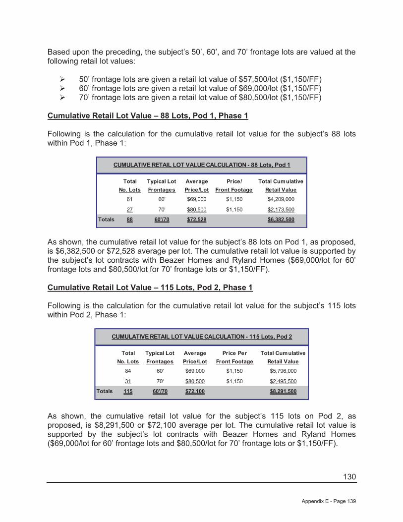
130
Based upon the preceding, the subject’s 50’, 60’, and 70’ frontage lots are valued at the following retail lot values:
50’ frontage lots are given a retail lot value of $57,500/lot ($1,150/FF) 60’ frontage lots are given a retail lot value of $69,000/lot ($1,150/FF)70’ frontage lots are given a retail lot value of $80,500/lot ($1,150/FF)
Cumulative Retail Lot Value – 88 Lots, Pod 1, Phase 1
Following is the calculation for the cumulative retail lot value for the subject’s 88 lots within Pod 1, Phase 1:
Total Typical Lot Average Price/ Total CumulativeNo. Lots Frontages Price/Lot Front Footage Retail Value
61 60' $69,000 $1,150 $4,209,000
27 70' $80,500 $1,150 $2,173,500
Totals 88 60'/70 $72,528 $6,382,500
CUMULATIVE RETAIL LOT VALUE CALCULATION - 88 Lots, Pod 1
As shown, the cumulative retail lot value for the subject’s 88 lots on Pod 1, as proposed, is $6,382,500 or $72,528 average per lot. The cumulative retail lot value is supported by the subject’s lot contracts with Beazer Homes and Ryland Homes ($69,000/lot for 60’ frontage lots and $80,500/lot for 70’ frontage lots or $1,150/FF).
Cumulative Retail Lot Value – 115 Lots, Pod 2, Phase 1
Following is the calculation for the cumulative retail lot value for the subject’s 115 lots within Pod 2, Phase 1:
Total Typical Lot Average Price Per Total CumulativeNo. Lots Frontages Price/Lot Front Footage Retail Value
84 60' $69,000 $1,150 $5,796,000
31 70' $80,500 $1,150 $2,495,500
Totals 115 60'/70 $72,100 $8,291,500
CUMULATIVE RETAIL LOT VALUE CALCULATION - 115 Lots, Pod 2
As shown, the cumulative retail lot value for the subject’s 115 lots on Pod 2, as proposed, is $8,291,500 or $72,100 average per lot. The cumulative retail lot value is supported by the subject’s lot contracts with Beazer Homes and Ryland Homes ($69,000/lot for 60’ frontage lots and $80,500/lot for 70’ frontage lots or $1,150/FF).
Appendix E - Page 139
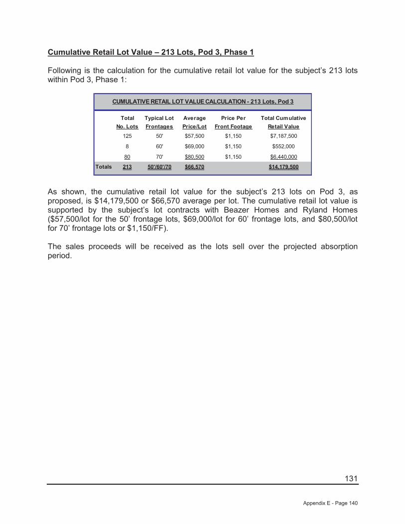
131
Cumulative Retail Lot Value – 213 Lots, Pod 3, Phase 1
Following is the calculation for the cumulative retail lot value for the subject’s 213 lots within Pod 3, Phase 1:
Total Typical Lot Average Price Per Total CumulativeNo. Lots Frontages Price/Lot Front Footage Retail Value
125 50' $57,500 $1,150 $7,187,500
8 60' $69,000 $1,150 $552,000
80 70' $80,500 $1,150 $6,440,000
Totals 213 50'/60'/70 $66,570 $14,179,500
CUMULATIVE RETAIL LOT VALUE CALCULATION - 213 Lots, Pod 3
As shown, the cumulative retail lot value for the subject’s 213 lots on Pod 3, as proposed, is $14,179,500 or $66,570 average per lot. The cumulative retail lot value is supported by the subject’s lot contracts with Beazer Homes and Ryland Homes ($57,500/lot for the 50’ frontage lots, $69,000/lot for 60’ frontage lots, and $80,500/lot for 70’ frontage lots or $1,150/FF).
The sales proceeds will be received as the lots sell over the projected absorption period.
Appendix E - Page 140
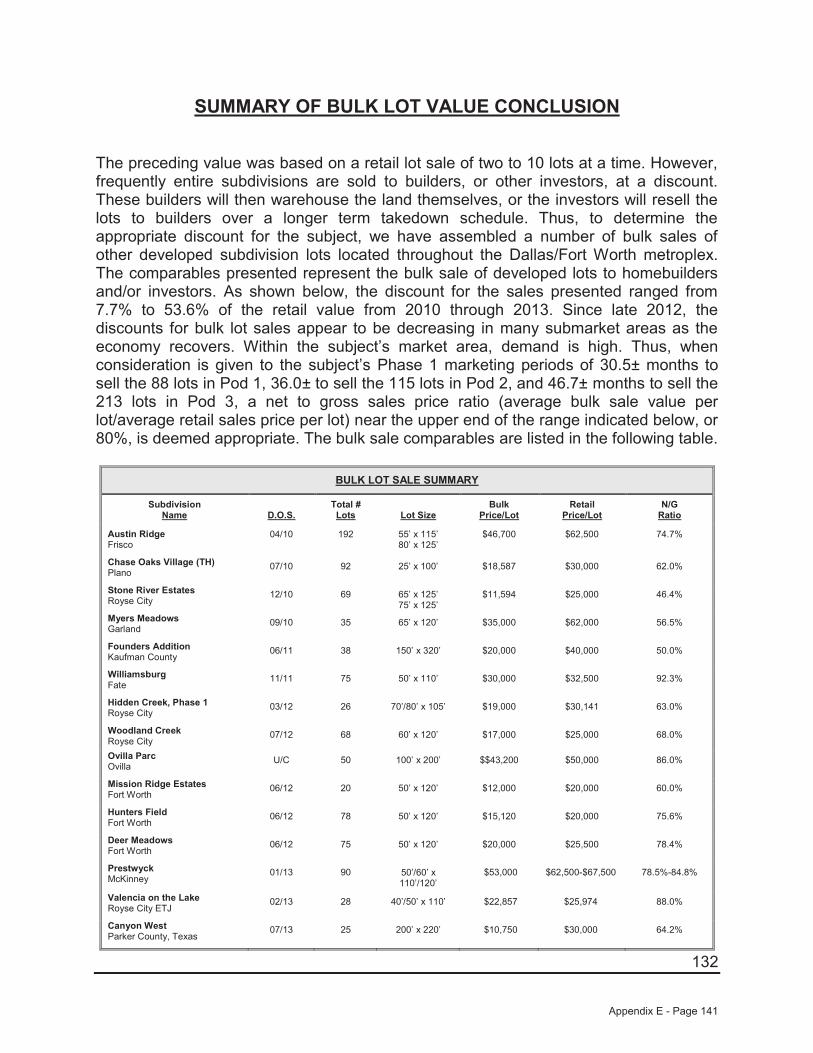
132
SUMMARY OF BULK LOT VALUE CONCLUSION
The preceding value was based on a retail lot sale of two to 10 lots at a time. However, frequently entire subdivisions are sold to builders, or other investors, at a discount. These builders will then warehouse the land themselves, or the investors will resell the lots to builders over a longer term takedown schedule. Thus, to determine the appropriate discount for the subject, we have assembled a number of bulk sales of other developed subdivision lots located throughout the Dallas/Fort Worth metroplex. The comparables presented represent the bulk sale of developed lots to homebuilders and/or investors. As shown below, the discount for the sales presented ranged from 7.7% to 53.6% of the retail value from 2010 through 2013. Since late 2012, the discounts for bulk lot sales appear to be decreasing in many submarket areas as the economy recovers. Within the subject’s market area, demand is high. Thus, when consideration is given to the subject’s Phase 1 marketing periods of 30.5± months to sell the 88 lots in Pod 1, 36.0± to sell the 115 lots in Pod 2, and 46.7± months to sell the 213 lots in Pod 3, a net to gross sales price ratio (average bulk sale value per lot/average retail sales price per lot) near the upper end of the range indicated below, or 80%, is deemed appropriate. The bulk sale comparables are listed in the following table.
BULK LOT SALE SUMMARY
Subdivision Name D.O.S.
Total # Lots Lot Size
BulkPrice/Lot
Retail Price/Lot
N/GRatio
Austin RidgeFrisco
04/10 192 55’ x 115’80’ x 125’
$46,700 $62,500 74.7%
Chase Oaks Village (TH)Plano
07/10 92 25’ x 100’ $18,587 $30,000 62.0%
Stone River EstatesRoyse City
12/10 69 65’ x 125’75’ x 125’
$11,594 $25,000 46.4%
Myers MeadowsGarland
09/10 35 65’ x 120’ $35,000 $62,000 56.5%
Founders AdditionKaufman County
06/11 38 150’ x 320’ $20,000 $40,000 50.0%
WilliamsburgFate
11/11 75 50’ x 110’ $30,000 $32,500 92.3%
Hidden Creek, Phase 1Royse City
03/12 26 70’/80’ x 105’ $19,000 $30,141 63.0%
Woodland CreekRoyse City
07/12 68 60’ x 120’ $17,000 $25,000 68.0%
Ovilla ParcOvilla
U/C 50 100’ x 200’ $$43,200 $50,000 86.0%
Mission Ridge EstatesFort Worth
06/12 20 50’ x 120’ $12,000 $20,000 60.0%
Hunters FieldFort Worth
06/12 78 50’ x 120’ $15,120 $20,000 75.6%
Deer MeadowsFort Worth
06/12 75 50’ x 120’ $20,000 $25,500 78.4%
PrestwyckMcKinney
01/13 90 50’/60’ x 110’/120’
$53,000 $62,500-$67,500 78.5%-84.8%
Valencia on the LakeRoyse City ETJ
02/13 28 40’/50’ x 110’ $22,857 $25,974 88.0%
Canyon WestParker County, Texas
07/13 25 200’ x 220’ $10,750 $30,000 64.2%
Appendix E - Page 141
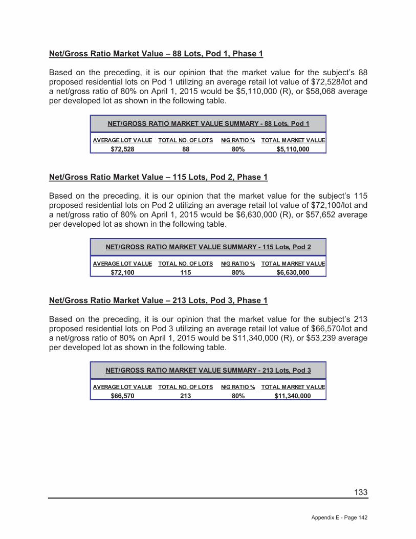
133
Net/Gross Ratio Market Value – 88 Lots, Pod 1, Phase 1
Based on the preceding, it is our opinion that the market value for the subject’s 88proposed residential lots on Pod 1 utilizing an average retail lot value of $72,528/lot and a net/gross ratio of 80% on April 1, 2015 would be $5,110,000 (R), or $58,068 average per developed lot as shown in the following table.
AVERAGE LOT VALUE TOTAL NO. OF LOTS N/G RATIO % TOTAL MARKET VALUE$72,528 88 80% $5,110,000
NET/GROSS RATIO MARKET VALUE SUMMARY - 88 Lots, Pod 1
Net/Gross Ratio Market Value – 115 Lots, Pod 2, Phase 1
Based on the preceding, it is our opinion that the market value for the subject’s 115 proposed residential lots on Pod 2 utilizing an average retail lot value of $72,100/lot and a net/gross ratio of 80% on April 1, 2015 would be $6,630,000 (R), or $57,652 average per developed lot as shown in the following table.
AVERAGE LOT VALUE TOTAL NO. OF LOTS N/G RATIO % TOTAL MARKET VALUE$72,100 115 80% $6,630,000
NET/GROSS RATIO MARKET VALUE SUMMARY - 115 Lots, Pod 2
Net/Gross Ratio Market Value – 213 Lots, Pod 3, Phase 1
Based on the preceding, it is our opinion that the market value for the subject’s 213 proposed residential lots on Pod 3 utilizing an average retail lot value of $66,570/lot and a net/gross ratio of 80% on April 1, 2015 would be $11,340,000 (R), or $53,239 average per developed lot as shown in the following table.
AVERAGE LOT VALUE TOTAL NO. OF LOTS N/G RATIO % TOTAL MARKET VALUE$66,570 213 80% $11,340,000
NET/GROSS RATIO MARKET VALUE SUMMARY - 213 Lots, Pod 3
Appendix E - Page 142
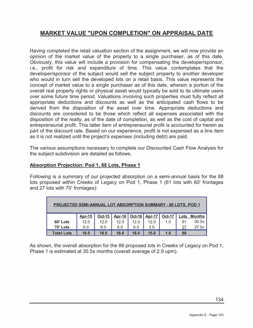
134
MARKET VALUE "UPON COMPLETION" ON APPRAISAL DATE
Having completed the retail valuation section of the assignment, we will now provide an opinion of the market value of the property to a single purchaser, as of this date. Obviously, this value will include a provision for compensating the developer/sponsor, i.e., profit for risk and expenditure of time. This value contemplates that the developer/sponsor of the subject would sell the subject property to another developer who would in turn sell the developed lots on a retail basis. This value represents the concept of market value to a single purchaser as of this date, wherein a portion of the overall real property rights or physical asset would typically be sold to its ultimate users over some future time period. Valuations involving such properties must fully reflect all appropriate deductions and discounts as well as the anticipated cash flows to be derived from the disposition of the asset over time. Appropriate deductions and discounts are considered to be those which reflect all expenses associated with the disposition of the realty, as of the date of completion, as well as the cost of capital and entrepreneurial profit. This latter item of entrepreneurial profit is accounted for herein as part of the discount rate. Based on our experience, profit is not expensed as a line item as it is not realized until the project’s expenses (including debt) are paid.
The various assumptions necessary to complete our Discounted Cash Flow Analysis for the subject subdivision are detailed as follows.
Absorption Projection: Pod 1, 88 Lots, Phase 1
Following is a summary of our projected absorption on a semi-annual basis for the 88 lots proposed within Creeks of Legacy on Pod 1, Phase 1 (61 lots with 60’ frontages and 27 lots with 70’ frontages):
Apr-15 Apr-16 Oct-16 Apr-17 Oct-1760' Lots 12.0 12.0 12.0 12.0 12.0 1.0 61 30.5±70' Lots 6.0 6.0 6.0 6.0 3.0 27 27.0±
Total Lots 18.0 18.0 18.0 15.0 1.0 88
PROJECTED SEMI-ANNUAL LOT ABSORPTION SUMMARY - 88 LOTS, POD 1
Oct-15
18.0
Lots Months
As shown, the overall absorption for the 88 proposed lots in Creeks of Legacy on Pod 1, Phase 1 is estimated at 30.5± months (overall average of 2.9 upm).
Appendix E - Page 143
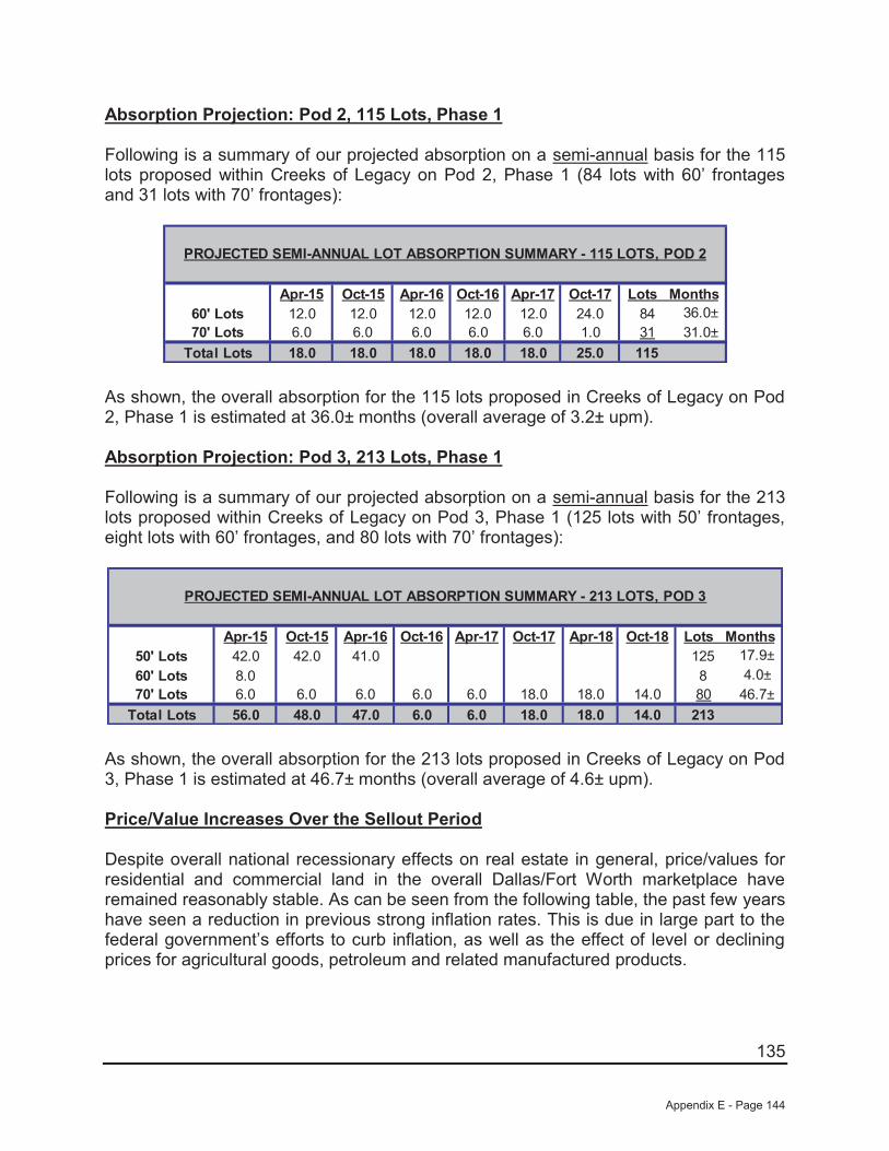
135
Absorption Projection: Pod 2, 115 Lots, Phase 1
Following is a summary of our projected absorption on a semi-annual basis for the 115 lots proposed within Creeks of Legacy on Pod 2, Phase 1 (84 lots with 60’ frontages and 31 lots with 70’ frontages):
Apr-15 Apr-16 Oct-16 Apr-17 Oct-1760' Lots 12.0 12.0 12.0 12.0 12.0 24.0 84 36.0±70' Lots 6.0 6.0 6.0 6.0 6.0 1.0 31 31.0±
Total Lots 18.0 18.0 18.0 18.0 25.0 115
PROJECTED SEMI-ANNUAL LOT ABSORPTION SUMMARY - 115 LOTS, POD 2
Oct-15
18.0
Lots Months
As shown, the overall absorption for the 115 lots proposed in Creeks of Legacy on Pod 2, Phase 1 is estimated at 36.0± months (overall average of 3.2± upm).
Absorption Projection: Pod 3, 213 Lots, Phase 1
Following is a summary of our projected absorption on a semi-annual basis for the 213 lots proposed within Creeks of Legacy on Pod 3, Phase 1 (125 lots with 50’ frontages, eight lots with 60’ frontages, and 80 lots with 70’ frontages):
Apr-15 Apr-16 Oct-16 Apr-17 Oct-17 Apr-18 Oct-1850' Lots 42.0 42.0 41.0 125 17.9±60' Lots 8.0 8 4.0±70' Lots 6.0 6.0 6.0 6.0 6.0 18.0 18.0 14.0 80 46.7±
Total Lots 56.0 47.0 6.0 6.0 18.0 18.0 14.0 213
PROJECTED SEMI-ANNUAL LOT ABSORPTION SUMMARY - 213 LOTS, POD 3
Oct-15
48.0
Lots Months
As shown, the overall absorption for the 213 lots proposed in Creeks of Legacy on Pod 3, Phase 1 is estimated at 46.7± months (overall average of 4.6± upm).
Price/Value Increases Over the Sellout Period
Despite overall national recessionary effects on real estate in general, price/values for residential and commercial land in the overall Dallas/Fort Worth marketplace have remained reasonably stable. As can be seen from the following table, the past few years have seen a reduction in previous strong inflation rates. This is due in large part to the federal government’s efforts to curb inflation, as well as the effect of level or declining prices for agricultural goods, petroleum and related manufactured products.
Appendix E - Page 144
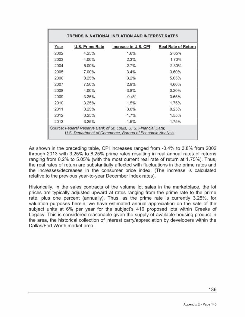
136
TRENDS IN NATIONAL INFLATION AND INTEREST RATES
Year U.S. Prime Rate Increase in U.S. CPI Real Rate of Return2002 4.25% 1.6% 2.65%2003 4.00% 2.3% 1.70%2004 5.00% 2.7% 2.30%2005 7.00% 3.4% 3.60%2006 8.25% 3.2% 5.05%2007 7.50% 2.9% 4.60%2008 4.00% 3.8% 0.20%2009 3.25% -0.4% 3.65%2010 3.25% 1.5% 1.75%2011 3.25% 3.0% 0.25%2012 3.25% 1.7% 1.55%2013 3.25% 1.5% 1.75%
Source: Federal Reserve Bank of St. Louis, U. S. Financial Data;U.S. Department of Commerce, Bureau of Economic Analysis
As shown in the preceding table, CPI increases ranged from -0.4% to 3.8% from 2002 through 2013 with 3.25% to 8.25% prime rates resulting in real annual rates of returns ranging from 0.2% to 5.05% (with the most current real rate of return at 1.75%). Thus, the real rates of return are substantially affected with fluctuations in the prime rates and the increases/decreases in the consumer price index. (The increase is calculated relative to the previous year-to-year December index rates).
Historically, in the sales contracts of the volume lot sales in the marketplace, the lot prices are typically adjusted upward at rates ranging from the prime rate to the prime rate, plus one percent (annually). Thus, as the prime rate is currently 3.25%, for valuation purposes herein, we have estimated annual appreciation on the sale of the subject units at 6% per year for the subject’s 416 proposed lots within Creeks of Legacy. This is considered reasonable given the supply of available housing product in the area, the historical collection of interest carry/appreciation by developers within the Dallas/Fort Worth market area.
Appendix E - Page 145

137
Expenses
Cost of Sales has been estimated at 0.5% of gross sales proceeds for various closing costs and title policies.
Taxes are paid by the developer annually. The estimation of taxes paid per period is based upon the premise that taxes are prorated at closing and are paid in arrears. Therefore, we have deducted taxes based upon the estimated retail market value of the unsold lots. The taxes are prorated in each calendar year based upon the projected sales in each period. Based upon our experience and information gathered from numerous reputable builders/ developers and taxing authorities, this methodology and percentage estimate (2.0%) is well founded. The taxes will be applied individually to the 60’ lots based on their projected absorption.
Marketing expense is not included in this analysis as all of the subject’s 416 proposed lots within Creeks of Legacy, Phase 1 are projected contracted to volume homebuilders that typically provide their marketing.
HOA - No HOA dues were considered within this report as the fees are to be paid by the future homeowners.
Entrepreneurial Coordination/Remuneration: The last major deduction is
that for Entrepreneurial (i.e., the developer/sponsor)/ coordination talent expenditure (see Hewitt: Condominium Developed Lot Discounting Concepts...Again; The Real Estate Appraiser and Analyst; SREA, January/February, 1980). Inasmuch as the discount rate will include a provision for return on the equity investment, this deduction will be for actual time and expenses only. Typically, the developer will allow a budgeted line item equal to 0.5% to 2.0%, of sales and/or costs, depending on the size of the project, expertise required and management developmental time involved. Because the site requires planning and development, an expense of 1.0% is deemed appropriate and will be a direct line-item deduction from the gross sales proceeds.
Appendix E - Page 146
138
Appendix E - Page 147
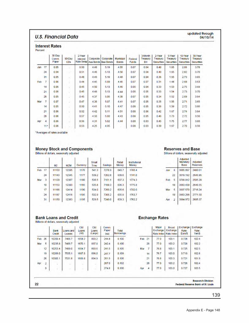
139
Appendix E - Page 148
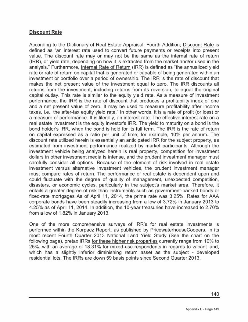
140
Discount Rate
According to the Dictionary of Real Estate Appraisal, Fourth Addition, Discount Rate is defined as “an interest rate used to convert future payments or receipts into present value. The discount rate may or may not be the same as the internal rate of return (IRR), or yield rate, depending on how it is extracted from the market and/or used in the analysis.” Furthermore, Internal Rate of Return (IRR) is defined as “the annualized yield rate or rate of return on capital that is generated or capable of being generated within an investment or portfolio over a period of ownership. The IRR is the rate of discount that makes the net present value of the investment equal to zero. The IRR discounts all returns from the investment, including returns from its reversion, to equal the original capital outlay. This rate is similar to the equity yield rate. As a measure of investment performance, the IRR is the rate of discount that produces a profitability index of one and a net present value of zero. It may be used to measure profitability after income taxes, i.e., the after-tax equity yield rate.” In other words, it is a rate of profit (or loss) or a measure of performance. It is literally, an interest rate. The effective interest rate on a real estate investment is the equity investor's IRR. The yield to maturity on a bond is the bond holder's IRR, when the bond is held for its full term. The IRR is the rate of return on capital expressed as a ratio per unit of time; for example, 10% per annum. The discount rate utilized herein is essentially an anticipated IRR for the subject property, as estimated from investment performance realized by market participants. Although the investment vehicle being analyzed herein is real property, competition for investment dollars in other investment media is intense, and the prudent investment manager must carefully consider all options. Because of the element of risk involved in real estate investment versus alternative investment vehicles, the prudent investment manager must compare rates of return. The performance of real estate is dependent upon and could fluctuate with the degree of quality of management, unexpected competition, disasters, or economic cycles, particularly in the subject's market area. Therefore, it entails a greater degree of risk than instruments such as government-backed bonds or fixed-rate mortgages As of April 11, 2014, the prime rate was 3.25%. Rates for AAA corporate bonds have been steadily increasing from a low of 3.72% in January 2013 to 4.25% as of April 11, 2014. In addition, the 10-year treasuries have increased to 2.70%from a low of 1.82% in January 2013.
One of the more comprehensive surveys of IRR’s for real estate investments is performed within the Korpacz Report, as published by PricewaterhouseCoopers. In its most recent Fourth Quarter 2013 National Land Yield Study (See the chart on the following page), pretax IRRs for these higher risk properties currently range from 10% to 25%, with an average of 18.31% for mixed-use respondents in regards to vacant land, which has a slightly inferior diminishing return asset as the subject - developed residential lots. The IRRs are down 59 basis points since Second Quarter 2013.
Appendix E - Page 149
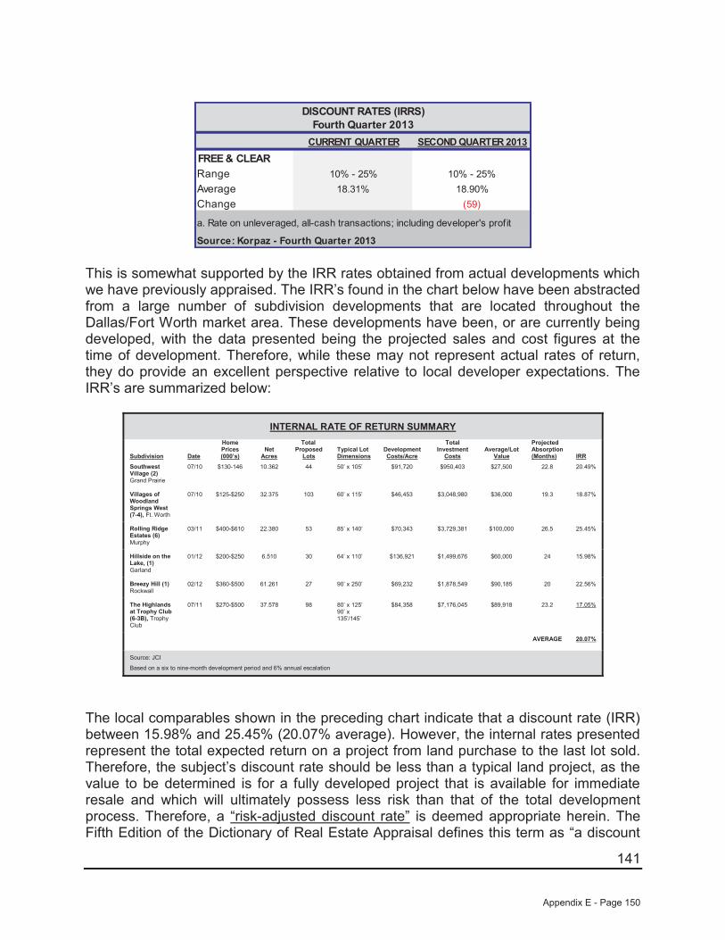
141
CURRENT QUARTER SECOND QUARTER 2013FREE & CLEARRange 10% - 25% 10% - 25%Average 18.31% 18.90%Change (59)
DISCOUNT RATES (IRRS)Fourth Quarter 2013
a. Rate on unleveraged, all-cash transactions; including developer's profit
Source: Korpaz - Fourth Quarter 2013
This is somewhat supported by the IRR rates obtained from actual developments which we have previously appraised. The IRR’s found in the chart below have been abstracted from a large number of subdivision developments that are located throughout the Dallas/Fort Worth market area. These developments have been, or are currently being developed, with the data presented being the projected sales and cost figures at the time of development. Therefore, while these may not represent actual rates of return, they do provide an excellent perspective relative to local developer expectations. The IRR’s are summarized below:
INTERNAL RATE OF RETURN SUMMARY
Subdivision Date
Home Prices(000’s)
Net Acres
Total Proposed
LotsTypical Lot Dimensions
Development Costs/Acre
Total Investment
CostsAverage/Lot
Value
Projected Absorption (Months) IRR
Southwest Village (2) Grand Prairie
07/10 $130-146 10.362 44 50’ x 105’ $91,720 $950,403 $27,500 22.8 20.49%
Villages of Woodland Springs West (7-4), Ft. Worth
07/10 $125-$250 32.375 103 60’ x 115’ $46,453 $3,048,980 $36,000 19.3 18.87%
Rolling Ridge Estates (6) Murphy
03/11 $400-$610 22.380 53 85’ x 140’ $70,343 $3,729,381 $100,000 26.5 25.45%
Hillside on the Lake, (1)Garland
01/12 $200-$250 6.510 30 64’ x 110’ $136,921 $1,499,676 $60,000 24 15.98%
Breezy Hill (1)Rockwall
02/12 $360-$500 61.261 27 90’ x 250’ $69,232 $1,878,549 $90,185 20 22.56%
The Highlands at Trophy Club (6-3B), Trophy Club
07/11 $270-$500 37.578 98 80’ x 125’90’ x 135’/145’
$84,358 $7,176,045 $89,918 23.2 17.05%
AVERAGE 20.07%
Source: JCI
Based on a six to nine-month development period and 6% annual escalation
The local comparables shown in the preceding chart indicate that a discount rate (IRR) between 15.98% and 25.45% (20.07% average). However, the internal rates presented represent the total expected return on a project from land purchase to the last lot sold. Therefore, the subject’s discount rate should be less than a typical land project, as the value to be determined is for a fully developed project that is available for immediate resale and which will ultimately possess less risk than that of the total development process. Therefore, a “risk-adjusted discount rate” is deemed appropriate herein. The Fifth Edition of the Dictionary of Real Estate Appraisal defines this term as “a discount
Appendix E - Page 150

142
rate that is adjusted to offset one or more risk factors, i.e., when a future downswing in the business cycle is likely, the risk associated with a project may increase near the end of its term, necessitating a special adjustment to the discount rate. Such discount rates include all of the elements of risk associated with an income stream for a specified period adjusted to offset additional term risk”.6 Thus, it is our opinion that a potential purchaser would expect to receive a much lower return on his investment for a completed project similar to the subject, which has a purchaser of the end product relative to that of a vacant tract of land awaiting eventual development (higher risk of escalating costs to site development and of the eventual timing of completion).
Based upon the preceding, an IRR that is slightly below the middle of the range as indicated in the National Land Yield Study as of Fourth Quarter 2013 (10% - 25%; 18.31% average) and which is supported by the returns indicated by the local comparables presented (15.98% to 25.45% or 20.07% average) is considered appropriate. Hence, taking into consideration the low supply and high demand levels within the subject’s submarket area, we have selected a discount rate of 15% for the subject’s 416 lots within Phase 1 (88 lots on Pod 1, 115 lots on Pod 2, and 213 lots on Pod 3) which also takes into consideration the degree of risk, developer profit, and the liquidity inherent in a project such as the subject, as well as the current market conditions. It should be noted that our cash flow also deducts a straight 1.0% entrepreneurial coordination/remuneration (management cost) from all sales proceeds, which effectively increases the discount rate to approximately 16% for the subject’s Phase 1 lots. To be consistent with the timing of the cash flows, the annual income stream is discounted semi-annually. With each of the required elements now identified, we are able to analyze the subject’s 416 developed lots within three DCF analyses as shown on the following pages.
6 The Dictionary of Real Estate Appraisal, Fifth Edition, the Appraisal Institute, Chicago, Illinois
Appendix E - Page 151

143
“As If Improved, As Proposed”, Pod 1 - 88 Lots, Creeks of Legacy, Phase 1
She
lley
Siva
kum
ar88
Scen
ario
:S
emi-A
nnua
l
Unit
Sale
sNo
.Un
it Sa
les
No.
Unit
Sale
sNo
.Un
it Sa
les
No.
Unit
Sale
sNo
.Un
it Sa
les
No.
Unit
Sale
sNo
.$6
9,00
012
$71,
070
12$7
3,20
212
$75,
398
12$7
7,66
012
$79,
990
1$4
,475
,954
61$8
0,50
06
$82,
915
6$8
5,40
26
$87,
965
6$9
0,60
33
$93,
322
0$2
,292
,502
27$0
0$0
0$0
0$0
0$0
0$0
0$0
0$0
0$0
0$0
0$0
0$0
0$0
0$0
0$0
0$0
0$0
0$0
0$0
0$0
0$0
0$0
0$0
0$0
0$0
0$0
0$0
0$0
0$0
0$0
0$0
0$0
0$0
0$0
0$0
0$0
0$0
0$0
0$0
0$0
0$0
0$0
0$0
0$0
0$0
0$0
0$0
0$0
0$0
0$0
0$0
0$0
0$0
0$0
0$0
0$0
0$0
0$0
0$0
0$0
0$0
0$0
0$0
0$0
0$0
0$0
0$0
0$0
0$0
0$0
0A
ppre
ciat
ion
-->3.
00%
3.00
%3.
00%
3.00
%3.
00%
Reve
nues
$1,3
11,0
0018
.0$1
,350
,330
18.0
$1,3
90,8
4018
.0$1
,432
,565
18.0
$1,2
03,7
3215
.0$7
9,99
01.
0$6
,768
,457
88
Expe
nses
Perio
d 1
Perio
d 2
Perio
d 3
Perio
d 4
Perio
d 5
Perio
d 6
$0$0
$0$0
$0$0
$0$0
$0$0
$0$0
$0$0
$0$0
$0$0
$0$0
$0$0
$0$0
$0$0
$0$0
$0$0
$0$0
$0$0
$0$4
2,09
0$3
4,82
4$2
7,08
5$1
8,85
0$1
0,09
6$8
00$1
33,7
45$2
1,73
5$1
7,41
2$1
2,81
0$7
,917
$2
,718
$0$6
2,59
20.
5%$6
,555
$6,7
52$0
$7,1
63$6
,019
$400
$26,
888
0.0%
$0$0
$0$0
$0$0
$01.
0%$1
3,11
0$1
3,50
3$1
3,90
8$1
4,32
6$1
2,03
7$8
00$6
7,68
5To
tal E
xpen
ses
$83,
490
$72,
491
$53,
803
$48,
255
$30,
870
$2,0
00$2
90,9
10Ne
t Inc
ome
$1,2
27,5
10$1
,277
,839
$1,3
37,0
37$1
,384
,310
$1,1
72,8
62$7
7,99
0$6
,477
,547
Annu
al D
isco
unt R
ate:
15.0
0%0.
9302
30.
8653
30.
8049
60.
7488
00.
6965
60.
6479
6Di
scou
nted
Val
ue$1
,141
,870
$1,1
05,7
56$1
,076
,262
$1,0
36,5
72$8
16,9
67$5
0,53
5$5
,227
,961
Net P
rese
nt V
alue
7.50
%Ro
unde
dP
ower
ed b
y @Va
lue
Softw
are
~ ww
w.at
valu
e.co
m
Cree
ks o
f Leg
acy,
Pod
1Ce
lina,
Tex
asA
s C
ompl
ete
Cash
Flo
ws
Begi
nnin
g
Prep
ared
By:
Num
ber o
f Uni
ts:
Perio
ds:
Inve
ntor
y60
' Lot
Sal
es
Apr-2
015
MA
RK
ETI
NG
MA
NA
GE
ME
NT
FEE
AXE
S O
N 6
0' D
EV
ELO
PE
D L
OTS
TAXE
S O
N70
' DE
VE
LOP
ED
LO
TSC
OS
T O
F S
ALE
S
70' L
ot S
ales
Perio
d 5
Perio
d 6
Oct
-201
7Ap
r-201
7
$5,2
27,9
61
Oct
-201
5Ap
r-201
6O
ct-2
016
$5,2
30,0
00
Proj
ect T
otal
sPe
riod
3Pe
riod
4
Appendix E - Page 152

144
“As If Improved, As Proposed”, Pod 2 - 115 Lots, Creeks of Legacy, Phase 1
She
lley
Siva
kum
ar11
5Sc
enar
io:
Sem
i-Ann
ual
Unit
Sale
sNo
.Un
it Sa
les
No.
Unit
Sale
sNo
.Un
it Sa
les
No.
Unit
Sale
sNo
.Un
it Sa
les
No.
Unit
Sale
sNo
.$6
9,00
012
$71,
070
12$7
3,20
212
$75,
398
12$7
7,66
012
$79,
990
24$6
,315
,722
84$8
0,50
06
$82,
915
6$8
5,40
26
$87,
965
6$9
0,60
36
$93,
322
1$2
,657
,634
31$0
0$0
0$0
0$0
0$0
0$0
0$0
0$0
0$0
0$0
0$0
0$0
0$0
0$0
0$0
0$0
0$0
0$0
0$0
0$0
0$0
0$0
0$0
0$0
0$0
0$0
0$0
0$0
0$0
0$0
0$0
0$0
0$0
0$0
0$0
0$0
0$0
0$0
0$0
0$0
0$0
0$0
0$0
0$0
0$0
0$0
0$0
0$0
0$0
0$0
0$0
0$0
0$0
0$0
0$0
0$0
0$0
0$0
0$0
0$0
0$0
0$0
0$0
0$0
0$0
0$0
0$0
0$0
0$0
0$0
0A
ppre
ciat
ion
-->3.
00%
3.00
%3.
00%
3.00
%3.
00%
Reve
nues
$1,3
11,0
0018
.0$1
,350
,330
18.0
$1,3
90,8
4018
.0$1
,432
,565
18.0
$1,4
75,5
4218
.0$2
,013
,079
25.0
$8,9
73,3
5611
5
Expe
nses
Perio
d 1
Perio
d 2
Perio
d 3
Perio
d 4
Perio
d 5
Perio
d 6
$0$0
$0$0
$0$0
$0$0
$0$0
$0$0
$0$0
$0$0
$0$0
$0$0
$0$0
$0$0
$0$0
$0$0
$0$0
$0$0
$0$0
$0$5
7,96
0$5
1,17
0$4
3,92
1$3
6,19
1$2
7,95
8$1
9,19
8$2
36,3
98$2
4,95
5$2
0,72
9$1
6,22
6$1
1,43
5
$6,3
42$9
33$8
0,62
00.
5%$6
,555
$6,7
52$0
$7,1
63$7
,378
$10,
065
$37,
913
0.0%
$0$0
$0$0
$0$0
$01.
0%$1
3,11
0$1
3,50
3$1
3,90
8$1
4,32
6$1
4,75
5$2
0,13
1$8
9,73
4To
tal E
xpen
ses
$102
,580
$92,
154
$74,
055
$69,
114
$56,
433
$50,
327
$444
,664
Net I
ncom
e$1
,208
,420
$1,2
58,1
76$1
,316
,785
$1,3
63,4
51$1
,419
,109
$1,9
62,7
52$8
,528
,692
Annu
al D
isco
unt R
ate:
15.0
0%0.
9302
30.
8653
30.
8049
60.
7488
00.
6965
60.
6479
6Di
scou
nted
Val
ue$1
,124
,112
$1,0
88,7
41$1
,059
,960
$1,0
20,9
53$9
88,4
93$1
,271
,788
$6,5
54,0
45Ne
t Pre
sent
Val
ue7.
50%
Roun
ded
Pow
ered
by @
Valu
e So
ftwar
e ~
www.
atva
lue.
com
$6,5
50,0
00
Proj
ect T
otal
sPe
riod
3Pe
riod
4Pe
riod
5Pe
riod
6O
ct-2
017
Apr-2
017
$6,5
54,0
45
Oct
-201
5Ap
r-201
6O
ct-2
016
CO
ST
OF
SA
LES
70' L
ot S
ales
Inve
ntor
y60
' Lot
Sal
es
Apr-2
015
MA
RK
ETI
NG
MA
NA
GE
ME
NT
FEE
AXE
S O
N 6
0' D
EV
ELO
PE
D L
OTS
TAXE
S O
N70
' DE
VE
LOP
ED
LO
TS
Cree
ks o
f Leg
acy,
Pod
2Ce
lina,
Tex
asA
s C
ompl
ete
Cash
Flo
ws
Begi
nnin
g
Prep
ared
By:
Num
ber o
f Uni
ts:
Perio
ds:
Appendix E - Page 153
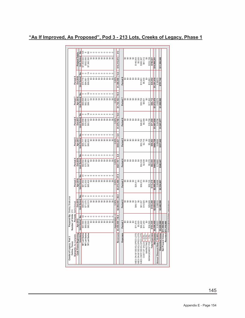
145
“As If Improved, As Proposed”, Pod 3 - 213 Lots, Creeks of Legacy, Phase 1
She
lley
Siva
kum
ar21
3Sc
enar
io:
Sem
i-Ann
ual
Unit
Sale
sNo
.Un
it Sa
les
No.
Unit
Sale
sNo
.Un
it Sa
les
No.
Unit
Sale
sNo
.Un
it Sa
les
No.
Unit
Sale
sNo
.Un
it Sa
les
No.
Unit
Sale
sNo
.$5
7,50
042
$59,
225
42$6
1,00
241
$62,
832
0$6
4,71
70
$66,
658
0$6
8,65
80
$70,
718
0$7
,403
,522
125
$69,
000
8$7
1,07
00
$73,
202
0$7
5,39
80
$77,
660
0$7
9,99
00
$82,
390
0$8
4,86
10
$552
,000
8$8
0,50
06
$82,
915
6$8
5,40
26
$87,
965
6$9
0,60
36
$93,
322
18$9
6,12
118
$99,
005
14$7
,360
,350
80$0
0$0
0$0
0$0
0$0
0$0
0$0
0$0
0$0
0$0
0$0
0$0
0$0
0$0
0$0
0$0
0$0
0$0
0$0
0$0
0$0
0$0
0$0
0$0
0$0
0$0
0$0
0$0
0$0
0$0
0$0
0$0
0$0
0$0
0$0
0$0
0$0
0$0
0$0
0$0
0$0
0$0
0$0
0$0
0$0
0$0
0$0
0$0
0$0
0$0
0$0
0$0
0$0
0$0
0$0
0$0
0$0
0$0
0$0
0$0
0$0
0$0
0$0
0$0
0$0
0$0
0$0
0$0
0$0
0$0
0$0
0$0
0$0
0$0
0$0
0$0
0$0
0$0
0$0
0$0
0$0
0A
ppre
ciat
ion
-->3.
00%
3.00
%3.
00%
3.00
%3.
00%
3.00
%3.
00%
Reve
nues
$3,4
50,0
0056
.0$2
,984
,940
48.0
$3,0
13,4
8647
.0$5
27,7
876.
0$5
43,6
216.
0$1
,679
,788
18.0
$1,7
30,1
8218
.0$1
,386
,068
14.0
$15,
315,
872
213
Expe
nses
Perio
d 1
Perio
d 2
Perio
d 3
Perio
d 4
Perio
d 5
Perio
d 6
Perio
d 7
Perio
d 8
$0$0
$0$0
$0$0
$0$0
$0$0
$0$0
$0$0
$0$0
$0$0
$0$0
$0$0
$0$0
$0$0
$0$0
$0$0
$0$0
$0$0
$0$0
$71,
875
$49,
157
$25,
011
$0$0
$0$0
$0$1
46,0
43$5
,520
$0$0
$0$0
$0$0
$0$5
,520
$64,
400
$61,
357
$58,
073
$54,
538
$5
0,73
8$4
6,66
1$3
0,75
9$1
3,86
1$3
80,3
870.
5%$1
7,25
0$1
4,92
5$0
$2,6
39$2
,718
$8,3
99$8
,651
$6,9
30$6
1,51
20.
0%$0
$0$0
$0$0
$0$0
$0$0
1.0%
$34,
500
$29,
849
$30,
135
$5,2
78$5
,436
$16,
798
$17,
302
$13,
861
$153
,159
Tota
l Exp
ense
s$1
93,5
45$1
55,2
88$1
13,2
19$6
2,45
5$5
8,89
2$7
1,85
8$5
6,71
2$3
4,65
2$7
46,6
21Ne
t Inc
ome
$3,2
56,4
55$2
,829
,652
$2,9
00,2
68$4
65,3
32$4
84,7
28$1
,607
,930
$1,6
73,4
70$1
,351
,416
$14,
569,
251
Annu
al D
isco
unt R
ate:
15.0
0%0.
9302
30.
8653
30.
8049
60.
7488
00.
6965
60.
6479
60.
6027
50.
5607
0Di
scou
nted
Val
ue$3
,029
,260
$2,4
48,5
90$2
,334
,601
$348
,441
$337
,642
$1,0
41,8
77$1
,008
,692
$757
,742
$11,
306,
846
Net P
rese
nt V
alue
7.50
%Ro
unde
dP
ower
ed b
y @Va
lue
Softw
are
~ ww
w.at
valu
e.co
m
Cree
ks o
f Leg
acy,
Pod
3Ce
lina,
Tex
asA
s C
ompl
ete
Cash
Flo
ws
Begi
nnin
g
Prep
ared
By:
Num
ber o
f Uni
ts:
Perio
ds:
Inve
ntor
y50
' Lot
Sal
es
Apr-2
015
MA
RK
ETI
NG
MA
NA
GE
ME
NT
FEE
AXE
S O
N 5
0' D
EV
ELO
PE
D L
OTS
AXE
S O
N 6
0' D
EV
ELO
PE
D L
OTS
TAXE
S O
N70
' DE
VE
LOP
ED
LO
TS
Oct
-201
8
CO
ST
OF
SA
LES
70' L
ot S
ales
60' L
ot S
ales
Perio
d 5
Perio
d 6
Oct
-201
7Ap
r-201
7
$11,
306,
846
Apr-2
018
Oct
-201
5Ap
r-201
6O
ct-2
016
$11,
310,
000
Proj
ect T
otal
sPe
riod
7Pe
riod
8Pe
riod
3Pe
riod
4
Appendix E - Page 154
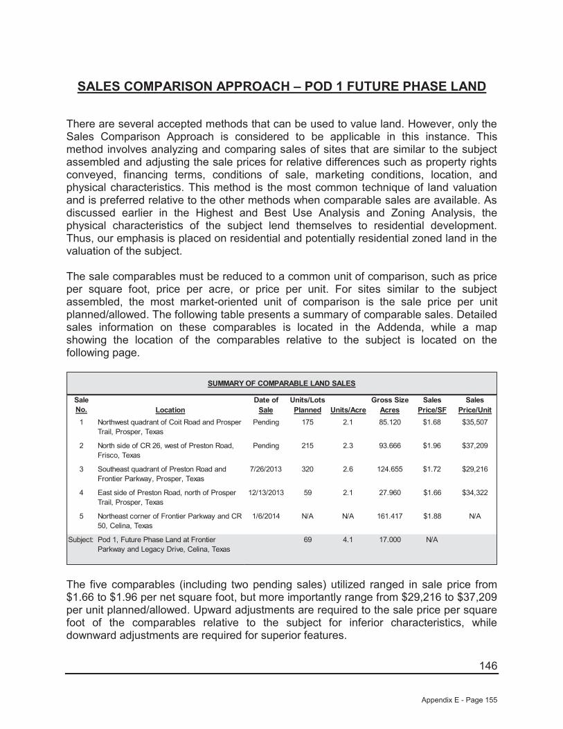
146
SALES COMPARISON APPROACH – POD 1 FUTURE PHASE LAND
There are several accepted methods that can be used to value land. However, only the Sales Comparison Approach is considered to be applicable in this instance. This method involves analyzing and comparing sales of sites that are similar to the subject assembled and adjusting the sale prices for relative differences such as property rights conveyed, financing terms, conditions of sale, marketing conditions, location, and physical characteristics. This method is the most common technique of land valuation and is preferred relative to the other methods when comparable sales are available. As discussed earlier in the Highest and Best Use Analysis and Zoning Analysis, the physical characteristics of the subject lend themselves to residential development. Thus, our emphasis is placed on residential and potentially residential zoned land in the valuation of the subject.
The sale comparables must be reduced to a common unit of comparison, such as price per square foot, price per acre, or price per unit. For sites similar to the subject assembled, the most market-oriented unit of comparison is the sale price per unit planned/allowed. The following table presents a summary of comparable sales. Detailed sales information on these comparables is located in the Addenda, while a map showing the location of the comparables relative to the subject is located on the following page.
Date of Units/Lots Gross Size Sales SalesLocation Sale Planned Units/Acre Acres Price/SF Price/Unit
1 Northwest quadrant of Coit Road and Prosper Trail, Prosper, Texas
Pending 175 2.1 85.120 $1.68 $35,507
2 North side of CR 26, west of Preston Road, Frisco, Texas
Pending 215 2.3 93.666 $1.96 $37,209
3 Southeast quadrant of Preston Road and Frontier Parkway, Prosper, Texas
7/26/2013 320 2.6 124.655 $1.72 $29,216
4 East side of Preston Road, north of Prosper Trail, Prosper, Texas
12/13/2013 59 2.1 27.960 $1.66 $34,322
5 Northeast corner of Frontier Parkway and CR 50, Celina, Texas
1/6/2014 N/A N/A 161.417 $1.88 N/A
Subject: Pod 1, Future Phase Land at Frontier Parkway and Legacy Drive, Celina, Texas
69 4.1 17.000 N/A
SUMMARY OF COMPARABLE LAND SALES
Sale No.
The five comparables (including two pending sales) utilized ranged in sale price from $1.66 to $1.96 per net square foot, but more importantly range from $29,216 to $37,209 per unit planned/allowed. Upward adjustments are required to the sale price per square foot of the comparables relative to the subject for inferior characteristics, while downward adjustments are required for superior features.
Appendix E - Page 155

147
COMPARABLE LAND SALES MAP
Appendix E - Page 156

148
A summary of the adjustments that are made is shown at the end of this section. Where possible, we have used the paired data set analysis to make adjustments to the sale price of the comparables relative to the subject. In using this analysis, adjustments are made by comparing sales that are similar to the subject in all but one respect. However, because of the narrow sampling of similar properties, it is sometimes difficult to accurately account for the impact of a single factor on value. Consequently, while this type of analysis is theoretically sound and is market derived, judgment must also be used.
The comparables are discussed as follows:
Sale No. 1 (Pending) is located southeast of the subject at the northwest quadrant of Coit Road and Prosper Trail in Prosper, Texas. This development site is located within the Prosper Independent School District, while the subject is also located within Prosper ISD. Overall, this site is considered generally similar in location relative to the subject. However, this site is considered inferior in size relative to the subject. This property is planned to be developed with 175 single-family lots (2.1 upa). As such, this site is considered inferior in zoning relative to the subject. However, as we are valuing the site on a per unit allowed/planned basis the adjustment will inverse as a higher density site will sell for less per unit while more per square foot. Finally, this site is considered inferior in existing improvements as it is not part of an existing development and will not benefit from the infrastructure in place as will the subject. It is also noted that this site is not located in a PID which will be considered after all other adjustments.
Sale No. 2 (Pending) is located south of the subject on the north side of CR 26, west of Preston Road in Frisco, Texas. This development site is located within the Prosper Independent School District, while the subject is also located within Prosper ISD. Overall, this site is considered slightly superior in location relative to the subject. However, this site is considered inferior in size relative to the subject. This property is planned to be developed with 215 single-family lots (2.3 upa). As such, this site is considered inferior in zoning relative to the subject. However, as we are valuing the site on a per unit allowed/planned basis the adjustment will inverse as a higher density site will sell for less per unit while more per square foot. Finally, this site is considered inferior in existing improvements as it is not part of an existing development and will not benefit from the infrastructure in place as will the subject. It is also noted that this site is not located in a PID which will be considered after all other adjustments.
Sale No. 3 is located east of the subject at the southeast quadrant of Preston Road and Frontier Parkway in Prosper, Texas. This development site is located within the Prosper Independent School District, while the subject is also located within Prosper ISD. Overall, this site is considered generally similar in location relative to the subject. However, this site is considered vastly inferior in size relative to the subject. This property is planned to be developed with 320 single-family lots (2.6 upa). As such, this site is considered inferior in zoning relative to the subject. However, as we are valuing the site on a per unit allowed/planned basis the adjustment will inverse as a higher density site will sell for less per unit while more per square foot. Finally, this site is
Appendix E - Page 157
149
considered inferior in existing improvements as it is not part of an existing development and will not benefit from the infrastructure in place as will the subject. It is also noted that this site is not located in a PID which will be considered after all other adjustments.
Sale No. 4 is located east of the subject on the east side of Preston Road, north of Prosper Trail in Prosper, Texas. This development site is located within the Prosper Independent School District, while the subject is also located within Prosper ISD. Overall, this site is considered generally similar in location relative to the subject. However, this site is considered vastly inferior in size relative to the subject. This property is planned to be developed with 59 single-family lots (2.1 upa). As such, this site is considered inferior in zoning relative to the subject. However, as we are valuing the site on a per unit allowed/planned basis the adjustment will inverse as a higher density site will sell for less per unit while more per square foot. This site is irregular in shape and has topography issues and is inferior in site utility to the subject. Finally, this site is considered inferior in existing improvements as it is not part of an existing development and will not benefit from the infrastructure in place as will the subject. It is also noted that this site is not located in a PID which will be considered after all other adjustments.
Sale No. 5 is located immediately east of the subject at the northeast corner of Frontier Parkway and CR-50 in Prosper, Texas. This development is located within the Prosper Independent School District, while the subject is also located within Prosper ISD. Overall, this site is considered similar in location. However, this site is substantially larger (inferior) in size while generally similar in site utility and zoning (planned for a similar density as the subject although the exact amount cannot be verified at this time) relative to the subject. Finally, this site is considered inferior in existing improvements as it is not part of an existing development and will not benefit from the infrastructure in place as will the subject. It is also noted that this site is not located in a PID which will be considered after all other adjustments.
Property Rights
The price paid by a purchaser is always predicated on the property interest conveyed. Differences between the property rights conveyed of the comparables relative to the subject could have an impact on the indicated value. We are appraising the fee simple interest in the subject, which is similar to the rights conveyed to all of the comparables. Therefore, no adjustments have been made for variances in property rights.
Appendix E - Page 158
150
Financing Terms
The price paid for a property may be different from an identical property because of different financing arrangements. If a purchaser received financing from the seller that was below what could typically be achieved from a third party, or if the purchaser assumed a loan that was at a favorable rate, a premium price was probably paid for the property. Conversely, if the financing obtained was higher than was typical for the market, a lower price was probably paid. All of the comparables were purchased on a cash or cash equivalent basis and, therefore, do not require adjustments for financing terms.
Conditions of Sale
Adjustments are made to the sale prices of the comparables for conditions of sale to reflect any extraneous motivations involved with the transaction. Examples include premiums paid for an assemblage, or sale of a property under duress would require adjustments for conditions of sale. An additional example might include a condition whereby a corporation may sell to a related entity or a family may sell property to another family member at a reduced price. All of the comparables are considered similar relative to the subject for this factor.
Market Conditions
Since market conditions change over time and the date of the appraisal is as of a specific time, the comparables must be analyzed in relation to the changes, which have occurred. While these adjustments are typically known as "time adjustments", time is not the adjustment. Rather, it is the change in market conditions over time that is adjusted. One of the sales utilized sold between July 2013 and January 2014 and two sales are pending. As such, all are considered to be influenced by the same market factors currently affecting the subject. As such, no adjustments have been made for market conditions.
Location
Location is one of the most important attributes that affect the value of real estate. For sites such as the subject, the most important locational features are accessibility, visibility, and the density and types of development surrounding the site.
As discussed previously, Sale Nos. 1, 3, 4, and 5 are considered superior in location, while Sale No. 2 is considered superior in location relative to the subject. As both Sale Nos. 1 and 2 are similar in all respects with the exception of location, an abstraction of adjustment from these sales indicates a downward adjustment of approximately 5% for Sale No. 2 in relation to Sale No. 1 and the subject.
Appendix E - Page 159
151
Physical Characteristics
The physical differences between the subject and the comparables must also be analyzed. These differences include size, site utility, and zoning.
Size
Size plays a part in the marketplace in creating more or less utility and limiting the market segment, which can afford each property. Therefore, size adjustments are generally required when there is a significant difference in the size of two properties. Generally, smaller sites sell for higher prices per square foot than their larger counterparts since the overall price is relatively modest in comparison to larger properties. However, when a site is too small to be developed except in conjunction with an adjacent property, this principle reverses and the smaller site becomes less valuable than its larger neighbors. In regard to the comparables presented, the five comparables range in size from 27.960 acres to 161.417 acres, while the subject site is 17.000 acres in size.
As discussed previously, Sale Nos. 1, 3, 4, and 5 are considered similar in location, while Sale No. 5 is considered inferior in location relative to the subject. However, none of the sales are truly similar to the subject overall so we were unable to show an abstraction of adjustment from the sales. Sale No. 1 and 2 (85.12 and 93.666 acres, respectively) are somewhat close in site size to the subject and we have subjectively adjusted these two sales upward by 10% each. Sale Nos. 3 and 5 (124.655 and 161.417 acres, respectively) are adjusted upward by 25% and 35% respectively for their substantially larger and inferior site sizes relative to the subject.
Site Utility/Floodplain
Also to be considered is the shape and/or frontage of a site, which has an impact upon its value, or land lost to a flood prone area. As discussed, the subject has typical road frontage as compared to its overall site size and has no know adverse site issues. Sale Nos. 1, 2, 3, and 5 are considered to be generally similar in this respect. However, Sale No. 4 is inferior to the subject in this respect and is adjusted upward by 10% for this factor.
Zoning
As mentioned earlier in this report, the subject’s highest and best use is future residential usages with a density of approximately 4.1 units per acre. As discussed previously, Sale Nos. 1, 2, 3, and 4 have allowed densities ranging from 2.1 to 2.6 units per acre. As such, each of these sales is adjusted downward by 25% to reflect this factor. It is noted that this adjustment is inverse to the other adjustments as the lower density sites sell for a higher price per unit, but lower price per square foot. Therefore, as we are valuing the site on a per unit allowed/planned basis, the adjustment is
Appendix E - Page 160
152
downward. No adjustment is considered necessary to Sale No. 5 as it is also planned for a similar high density of development like the subject. Existing Improvements
As previously discussed, the valuations found herein are subject to the completion of Phase 1 PID improvements. All five sales are considered inferior in existing improvements as none are a part of an existing development and do not benefit from the infrastructure in place as does the subject. Because of these site improvements, the subject will have lower overall development costs on a per unit basis. As such, we have adjusted Sale Nos. 1, 2, 3, and 4 upward by 10% to reflect their inferiority in this respect while Sale No. 5 was adjusted upward 20% for this factor.
Site Reimbursements/PID
As mentioned earlier in this report, the subject is located within a PID and is able to be reimbursed for its development costs. None of the five comparables have this attribute. As such, all are inferior in this respect. Instead of a straight line item adjustment for this factor. We have abstracted form the marketplace a per acre premium for this attribute.
As discussed, according to information provided from the owner/developer, the subject is in “Creeks at Legacy Public Improvement District” which allows for the right to receive reimbursements for the future development/maintenance costs of various on and off-site infrastructure improvements including but not limited to water, sanitary sewer, sewage treatment plants, storm drainage related to roads and road improvements for the community. Thus, the subject with assistance from the City of Celina, will be allow to sell bonds which will be used to repay the developers for a large majority of their expenses. There have been limited sales of properties with this attribute in the area over the past five years. As such, we have provided several separate comparisons to assist in determining the premium for having reimbursements. The first comparison consists of two known sales of similar properties located in the Kaufman County market area around Dallas that sold between 2007 and 2008 along with two sales of non-reimbursement sales. The second consists of two sales with reimbursements located in the Denton/Collin/Grayson County market area that sold in 2010 and 2012 along with two sales that lack this attribute. A summary of these sales along with a map of their locations follows:
Appendix E - Page 161
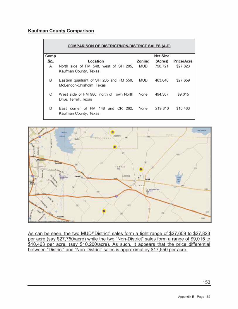
153
Kaufman County Comparison
Net SizeLocation Zoning (Acres) Price/Acre
A North side of FM 548, west of SH 205,Kaufman County, Texas
MUD 790.721 $27,823
B Eastern quadrant of SH 205 and FM 550,McLendon-Chisholm, Texas
MUD 463.040 $27,659
C West side of FM 986, north of Town NorthDrive, Terrell, Texas
None 494.307 $9,015
D East corner of FM 148 and CR 262,Kaufman County, Texas
None 219.810 $10,463
COMPARISON OF DISTRICT/NON-DISTRICT SALES (A-D)
Comp No.
As can be seen, the two MUD/”District” sales form a tight range of $27,659 to $27,823 per acre (say $27,750/acre) while the two “Non-District” sales form a range of $9,015 to $10,463 per acre, (say $10,200/acre). As such, it appears that the price differential between “District” and “Non-District” sales is approximatley $17,550 per acre.
Appendix E - Page 162
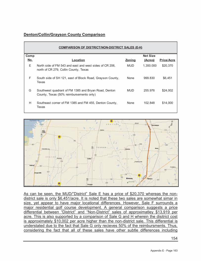
154
Denton/Collin/Grayson County Comparison
Net SizeLocation Zoning (Acres) Price/Acre
E North side of FM 543 and east and west sides of CR 206, north of CR 279, Collin County, Texas
MUD 1,350.000 $20,370
F South side of SH 121, east of Block Road, Grayson County, Texas
None 999.830 $6,451
G Southwest quadrant of FM 1385 and Bryan Road, Denton County, Texas (50% reimbursements only)
MUD 255.976 $24,002
H Southeast corner of FM 1385 and FM 455, Denton County, Texas
None 102.848 $14,000
COMPARISON OF DISTRICT/NON-DISTRICT SALES (E-H)
Comp No.
As can be seen, the MUD/”District” Sale E has a price of $20,370 whereas the non-district sale is only $6,451/acre. It is noted that these two sales are somewhat simar in size, yet appear to have major locational differences. However, Sale F surrounds a major residential golf course development. A general comparison suggests a price differential between “District” and “Non-District” sales of approximatley $13,919 per acre. This is also supported by a comparison of Sale G and H wherein the disitrict cost is approximately $10,002 per acre higher than the non-district sale. This differential is understated due to the fact that Sale G only recieves 50% of the reimbursments. Thus, considering the fact that all of these sales have other subtle differences including
Appendix E - Page 163
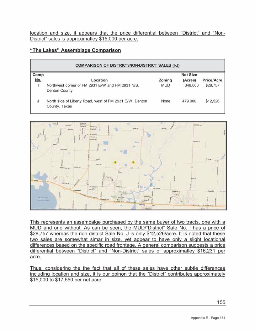
155
location and size, it appears that the price differential between “District” and “Non-District” sales is approximatley $15,000 per acre.
“The Lakes” Assemblage Comparison
Net SizeLocation Zoning (Acres) Price/Acre
I Northwest corner of FM 2931 E/W and FM 2931 N/S, Denton County
MUD 346.000 $28,757
J North side of Liberty Road, west of FM 2931 E/W, Denton County, Texas
None 479.000 $12,526
COMPARISON OF DISTRICT/NON-DISTRICT SALES (I-J)
Comp No.
This represents an assembalge purchased by the same buyer of two tracts, one with a MUD and one without. As can be seen, the MUD/”District” Sale No. I has a price of $28,757 whereas the non district Sale No. J is only $12,526/acre. It is noted that these two sales are somewhat simar in size, yet appear to have only a slight locational differences based on the specific road frontage. A general comparison suggests a price differential between “District” and “Non-District” sales of approximatley $16,231 per acre.
Thus, considering the the fact that all of these sales have other subtle differences including location and size, it is our opinon that the “District” contributes approximately $15,000 to $17,550 per net acre.
Appendix E - Page 164
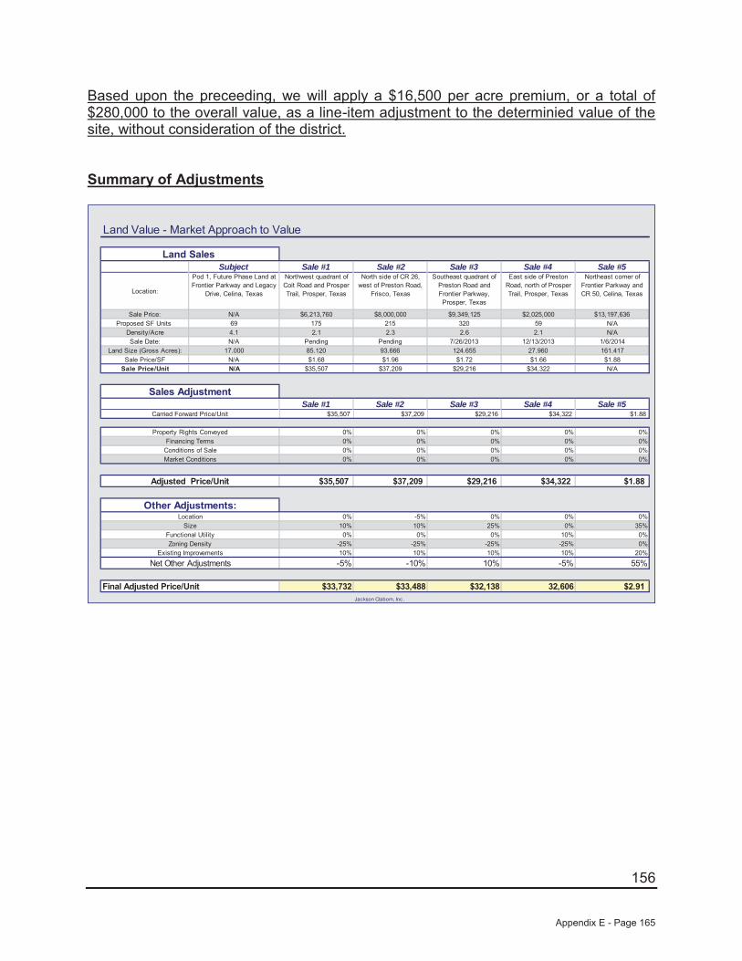
156
Based upon the preceeding, we will apply a $16,500 per acre premium, or a total of $280,000 to the overall value, as a line-item adjustment to the determinied value of the site, without consideration of the district.
Summary of Adjustments
Land Value - Market Approach to Value
Subject Sale #1 Sale #2 Sale #3 Sale #4 Sale #5
Location:
Pod 1, Future Phase Land at Frontier Parkway and Legacy
Drive, Celina, Texas
Northwest quadrant of Coit Road and Prosper Trail, Prosper, Texas
North side of CR 26, west of Preston Road,
Frisco, Texas
Southeast quadrant of Preston Road and Frontier Parkway, Prosper, Texas
East side of Preston Road, north of Prosper Trail, Prosper, Texas
Northeast corner of Frontier Parkway and CR 50, Celina, Texas
Sale Price: N/A $6,213,760 $8,000,000 $9,349,125 $2,025,000 $13,197,636 Proposed SF Units 69 175 215 320 59 N/A
Density/Acre 4.1 2.1 2.3 2.6 2.1 N/ASale Date: N/A Pending Pending 7/26/2013 12/13/2013 1/6/2014
Land Size (Gross Acres): 17.000 85.120 93.666 124.655 27.960 161.417 Sale Price/SF N/A $1.68 $1.96 $1.72 $1.66 $1.88
Sale Price/Unit N/A $35,507 $37,209 $29,216 $34,322 N/A
Sale #1 Sale #2 Sale #3 Sale #4 Sale #5$35,507 $37,209 $29,216 $34,322 $1.88
0% 0% 0% 0% 0%0% 0% 0% 0% 0%0% 0% 0% 0% 0%0% 0% 0% 0% 0%
$35,507 $37,209 $29,216 $34,322 $1.88
0% -5% 0% 0% 0%10% 10% 25% 0% 35%0% 0% 0% 10% 0%
-25% -25% -25% -25% 0%10% 10% 10% 10% 20%
-5% -10% 10% -5% 55%
$33,732 $33,488 $32,138 32,606 $2.91Jackson Claborn, Inc.
Final Adjusted Price/Unit
Functional Utility
Carried Forward Price/Unit
Property Rights Conveyed
Market Conditions
Net Other AdjustmentsExisting Improvements
Zoning Density
LocationSize
Sales Adjustment
Adjusted Price/Unit
Financing TermsConditions of Sale
Land Sales
Other Adjustments:
Appendix E - Page 165

157
Land Value Conclusion
In an analysis of comparable properties, five comparables were used as comparisons for the subject site in order to gain market insight into the sales prices of comparable properties. In addition to the adjusted base land value range of $32,138 to $33,732 per unit, we have added an additional value premium of $16,500 per acre, or approximately $280,000 to the site’s base value to compensate for the ability to receive reimbursements for the future development/maintenance costs (“District Premium”). The calculation of the land value estimate for the subject property is as follows:
Final Value Analysis - Sales Comparison Approach
$32,138 $2,217,496
$33,732 $2,327,497
P lus Contributory V alue of District
$2,250,000
$280,000
69
69
S ubject T otal Units
Jackson Claborn, Inc.
$2,530,000
$36,667
V alue Indication By M arket Approach:
X Adjusted V alue/Unit
69
S ay,
Based upon the preceding, our opinion of value for the subject site is $2,530,000, or $36,667 per unit which also equates to $3.42 per square foot on the subject’s acreage of 17.000 acres.
Appendix E - Page 166
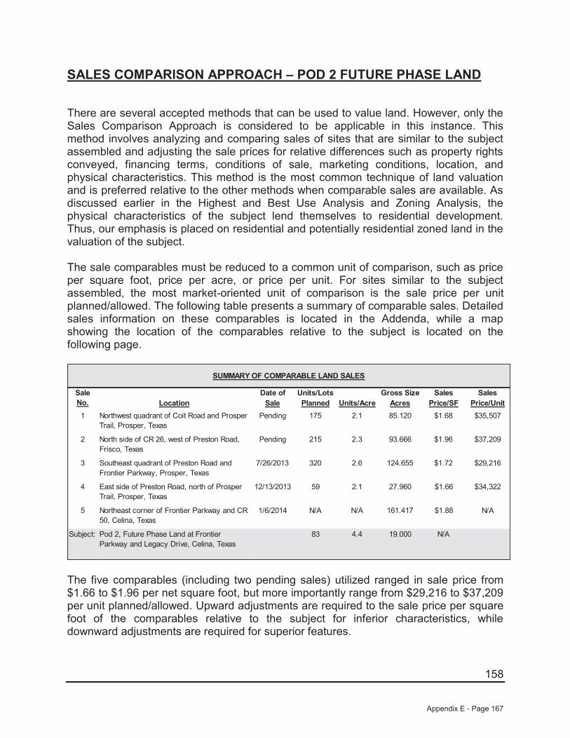
158
SALES COMPARISON APPROACH – POD 2 FUTURE PHASE LAND
There are several accepted methods that can be used to value land. However, only the Sales Comparison Approach is considered to be applicable in this instance. This method involves analyzing and comparing sales of sites that are similar to the subject assembled and adjusting the sale prices for relative differences such as property rights conveyed, financing terms, conditions of sale, marketing conditions, location, and physical characteristics. This method is the most common technique of land valuation and is preferred relative to the other methods when comparable sales are available. As discussed earlier in the Highest and Best Use Analysis and Zoning Analysis, the physical characteristics of the subject lend themselves to residential development. Thus, our emphasis is placed on residential and potentially residential zoned land in the valuation of the subject.
The sale comparables must be reduced to a common unit of comparison, such as price per square foot, price per acre, or price per unit. For sites similar to the subject assembled, the most market-oriented unit of comparison is the sale price per unit planned/allowed. The following table presents a summary of comparable sales. Detailed sales information on these comparables is located in the Addenda, while a map showing the location of the comparables relative to the subject is located on the following page.
Date of Units/Lots Gross Size Sales SalesLocation Sale Planned Units/Acre Acres Price/SF Price/Unit
1 Northwest quadrant of Coit Road and Prosper Trail, Prosper, Texas
Pending 175 2.1 85.120 $1.68 $35,507
2 North side of CR 26, west of Preston Road, Frisco, Texas
Pending 215 2.3 93.666 $1.96 $37,209
3 Southeast quadrant of Preston Road and Frontier Parkway, Prosper, Texas
7/26/2013 320 2.6 124.655 $1.72 $29,216
4 East side of Preston Road, north of Prosper Trail, Prosper, Texas
12/13/2013 59 2.1 27.960 $1.66 $34,322
5 Northeast corner of Frontier Parkway and CR 50, Celina, Texas
1/6/2014 N/A N/A 161.417 $1.88 N/A
Subject: Pod 2, Future Phase Land at Frontier Parkway and Legacy Drive, Celina, Texas
83 4.4 19.000 N/A
SUMMARY OF COMPARABLE LAND SALES
Sale No.
The five comparables (including two pending sales) utilized ranged in sale price from $1.66 to $1.96 per net square foot, but more importantly range from $29,216 to $37,209 per unit planned/allowed. Upward adjustments are required to the sale price per square foot of the comparables relative to the subject for inferior characteristics, while downward adjustments are required for superior features.
Appendix E - Page 167

159
COMPARABLE LAND SALES MAP
Appendix E - Page 168

160
A summary of the adjustments that are made is shown at the end of this section. Where possible, we have used the paired data set analysis to make adjustments to the sale price of the comparables relative to the subject. In using this analysis, adjustments are made by comparing sales that are similar to the subject in all but one respect. However, because of the narrow sampling of similar properties, it is sometimes difficult to accurately account for the impact of a single factor on value. Consequently, while this type of analysis is theoretically sound and is market derived, judgment must also be used.
The comparables are discussed as follows:
Sale No. 1 (Pending) is located southeast of the subject at the northwest quadrant of Coit Road and Prosper Trail in Prosper, Texas. This development site is located within the Prosper Independent School District, while the subject is also located within Prosper ISD. Overall, this site is considered generally similar in location relative to the subject. However, this site is considered inferior in size relative to the subject. This property is planned to be developed with 175 single-family lots (2.1 upa). As such, this site is considered inferior in zoning relative to the subject. However, as we are valuing the site on a per unit allowed/planned basis the adjustment will inverse as a higher density site will sell for less per unit while more per square foot. Finally, this site is considered inferior in existing improvements as it is not part of an existing development and will not benefit from the infrastructure in place as will the subject. It is also noted that this site is not located in a PID which will be considered after all other adjustments.
Sale No. 2 (Pending) is located south of the subject on the north side of CR 26, west of Preston Road in Frisco, Texas. This development site is located within the Prosper Independent School District, while the subject is also located within Prosper ISD. Overall, this site is considered slightly superior in location relative to the subject. However, this site is considered inferior in size relative to the subject. This property is planned to be developed with 215 single-family lots (2.3 upa). As such, this site is considered inferior in zoning relative to the subject. However, as we are valuing the site on a per unit allowed/planned basis the adjustment will inverse as a higher density site will sell for less per unit while more per square foot. Finally, this site is considered inferior in existing improvements as it is not part of an existing development and will not benefit from the infrastructure in place as will the subject. It is also noted that this site is not located in a PID which will be considered after all other adjustments.
Sale No. 3 is located east of the subject at the southeast quadrant of Preston Road and Frontier Parkway in Prosper, Texas. This development site is located within the Prosper Independent School District, while the subject is also located within Prosper ISD. Overall, this site is considered generally similar in location relative to the subject. However, this site is considered vastly inferior in size relative to the subject. This property is planned to be developed with 320 single-family lots (2.6 upa). As such, this site is considered inferior in zoning relative to the subject. However, as we are valuing the site on a per unit allowed/planned basis the adjustment will inverse as a higher density site will sell for less per unit while more per square foot. Finally, this site is
Appendix E - Page 169

161
considered inferior in existing improvements as it is not part of an existing development and will not benefit from the infrastructure in place as will the subject. It is also noted that this site is not located in a PID which will be considered after all other adjustments.
Sale No. 4 is located east of the subject on the east side of Preston Road, north of Prosper Trail in Prosper, Texas. This development site is located within the Prosper Independent School District, while the subject is also located within Prosper ISD. Overall, this site is considered generally similar in location relative to the subject. However, this site is considered vastly inferior in size relative to the subject. This property is planned to be developed with 59 single-family lots (2.1 upa). As such, this site is considered inferior in zoning relative to the subject. However, as we are valuing the site on a per unit allowed/planned basis the adjustment will inverse as a higher density site will sell for less per unit while more per square foot. This site is irregular in shape and has topography issues and is inferior in site utility to the subject. Finally, this site is considered inferior in existing improvements as it is not part of an existing development and will not benefit from the infrastructure in place as will the subject. It is also noted that this site is not located in a PID which will be considered after all other adjustments.
Sale No. 5 is located immediately east of the subject at the northeast corner of Frontier Parkway and CR-50 in Prosper, Texas. This development is located within the Prosper Independent School District, while the subject is also located within Prosper ISD. Overall, this site is considered similar in location. However, this site is substantially larger (inferior) in size while generally similar in site utility and zoning (planned for a similar density as the subject although the exact amount cannot be verified at this time) relative to the subject. Finally, this site is considered inferior in existing improvements as it is not part of an existing development and will not benefit from the infrastructure in place as will the subject. It is also noted that this site is not located in a PID which will be considered after all other adjustments.
Property Rights
The price paid by a purchaser is always predicated on the property interest conveyed. Differences between the property rights conveyed of the comparables relative to the subject could have an impact on the indicated value. We are appraising the fee simple interest in the subject, which is similar to the rights conveyed to all of the comparables. Therefore, no adjustments have been made for variances in property rights.
Financing Terms
The price paid for a property may be different from an identical property because of different financing arrangements. If a purchaser received financing from the seller that was below what could typically be achieved from a third party, or if the purchaser assumed a loan that was at a favorable rate, a premium price was probably paid for the property. Conversely, if the financing obtained was higher than was typical for the market, a lower price was probably paid. All of the comparables were purchased on a
Appendix E - Page 170

162
cash or cash equivalent basis and, therefore, do not require adjustments for financing terms.
Conditions of Sale
Adjustments are made to the sale prices of the comparables for conditions of sale to reflect any extraneous motivations involved with the transaction. Examples include premiums paid for an assemblage, or sale of a property under duress would require adjustments for conditions of sale. An additional example might include a condition whereby a corporation may sell to a related entity or a family may sell property to another family member at a reduced price. All of the comparables are considered similar relative to the subject for this factor.
Market Conditions
Since market conditions change over time and the date of the appraisal is as of a specific time, the comparables must be analyzed in relation to the changes, which have occurred. While these adjustments are typically known as "time adjustments", time is not the adjustment. Rather, it is the change in market conditions over time that is adjusted. One of the sales utilized sold between July 2013 and January 2014 and two sales are pending. As such, all are considered to be influenced by the same market factors currently affecting the subject. As such, no adjustments have been made for market conditions.
Location
Location is one of the most important attributes that affect the value of real estate. For sites such as the subject, the most important locational features are accessibility, visibility, and the density and types of development surrounding the site.
As discussed previously, Sale Nos. 1, 3, 4, and 5 are considered superior in location, while Sale No. 2 is considered superior in location relative to the subject. As both Sale Nos. 1 and 2 are similar in all respects with the exception of location, an abstraction of adjustment from these sales indicates a downward adjustment of approximately 5% for Sale No. 2 in relation to Sale No. 1 and the subject.
Physical Characteristics
The physical differences between the subject and the comparables must also be analyzed. These differences include size, site utility, and zoning.
Appendix E - Page 171
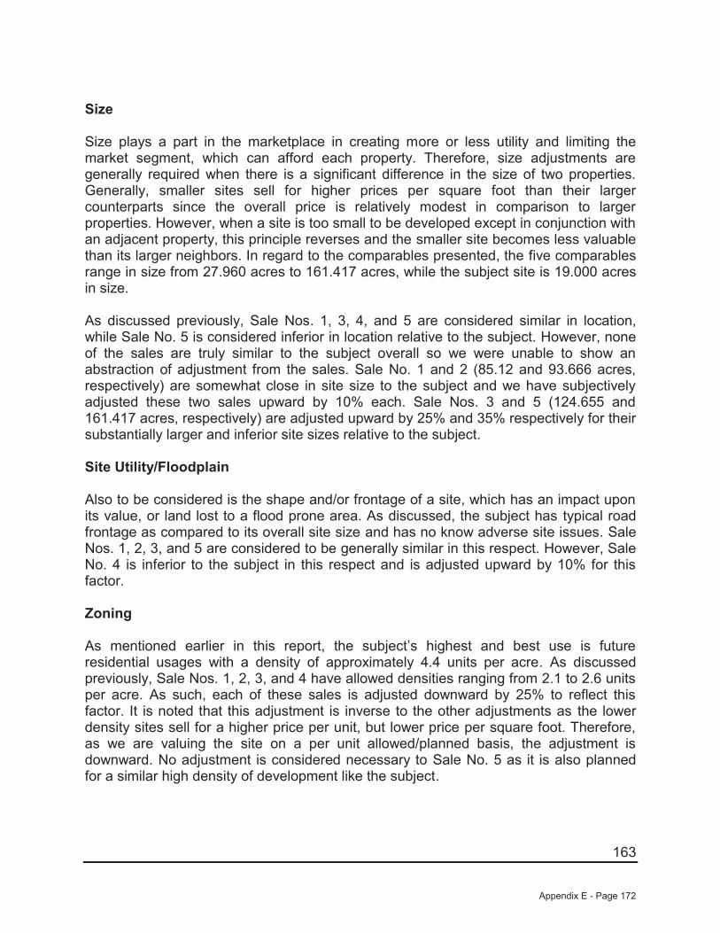
163
Size
Size plays a part in the marketplace in creating more or less utility and limiting the market segment, which can afford each property. Therefore, size adjustments are generally required when there is a significant difference in the size of two properties. Generally, smaller sites sell for higher prices per square foot than their larger counterparts since the overall price is relatively modest in comparison to larger properties. However, when a site is too small to be developed except in conjunction with an adjacent property, this principle reverses and the smaller site becomes less valuable than its larger neighbors. In regard to the comparables presented, the five comparables range in size from 27.960 acres to 161.417 acres, while the subject site is 19.000 acres in size.
As discussed previously, Sale Nos. 1, 3, 4, and 5 are considered similar in location, while Sale No. 5 is considered inferior in location relative to the subject. However, none of the sales are truly similar to the subject overall so we were unable to show an abstraction of adjustment from the sales. Sale No. 1 and 2 (85.12 and 93.666 acres, respectively) are somewhat close in site size to the subject and we have subjectively adjusted these two sales upward by 10% each. Sale Nos. 3 and 5 (124.655 and 161.417 acres, respectively) are adjusted upward by 25% and 35% respectively for their substantially larger and inferior site sizes relative to the subject.
Site Utility/Floodplain
Also to be considered is the shape and/or frontage of a site, which has an impact upon its value, or land lost to a flood prone area. As discussed, the subject has typical road frontage as compared to its overall site size and has no know adverse site issues. Sale Nos. 1, 2, 3, and 5 are considered to be generally similar in this respect. However, Sale No. 4 is inferior to the subject in this respect and is adjusted upward by 10% for this factor.
Zoning
As mentioned earlier in this report, the subject’s highest and best use is future residential usages with a density of approximately 4.4 units per acre. As discussed previously, Sale Nos. 1, 2, 3, and 4 have allowed densities ranging from 2.1 to 2.6 units per acre. As such, each of these sales is adjusted downward by 25% to reflect this factor. It is noted that this adjustment is inverse to the other adjustments as the lower density sites sell for a higher price per unit, but lower price per square foot. Therefore, as we are valuing the site on a per unit allowed/planned basis, the adjustment is downward. No adjustment is considered necessary to Sale No. 5 as it is also planned for a similar high density of development like the subject.
Appendix E - Page 172
164
Existing Improvements
As previously discussed, the valuations found herein are subject to the completion of Phase 1 PID improvements. All five sales are considered inferior in existing improvements as none are a part of an existing development and do not benefit from the infrastructure in place as does the subject. Because of these site improvements, the subject will have lower overall development costs on a per unit basis. As such, we have adjusted Sale Nos. 1, 2, 3, and 4 upward by 10% to reflect their inferiority in this respect while Sale No. 5 was adjusted upward 20% for this factor.
Site Reimbursements/PID
As mentioned earlier in this report, the subject is located within a PID and is able to be reimbursed for its development costs. None of the five comparables have this attribute. As such, all are inferior in this respect. Instead of a straight line item adjustment for this factor. We have abstracted form the marketplace a per acre premium for this attribute.
As discussed, according to information provided from the owner/developer, the subject is in “Creeks at Legacy Public Improvement District” which allows for the right to receive reimbursements for the future development/maintenance costs of various on and off-site infrastructure improvements including but not limited to water, sanitary sewer, sewage treatment plants, storm drainage related to roads and road improvements for the community. Thus, the subject with assistance from the City of Celina, will be allow to sell bonds which will be used to repay the developers for a large majority of their expenses. There have been limited sales of properties with this attribute in the area over the past five years. As such, we have provided several separate comparisons to assist in determining the premium for having reimbursements. The first comparison consists of two known sales of similar properties located in the Kaufman County market area around Dallas that sold between 2007 and 2008 along with two sales of non-reimbursement sales. The second consists of two sales with reimbursements located in the Denton/Collin/Grayson County market area that sold in 2010 and 2012 along with two sales that lack this attribute. A summary of these sales along with a map of their locations follows:
Appendix E - Page 173
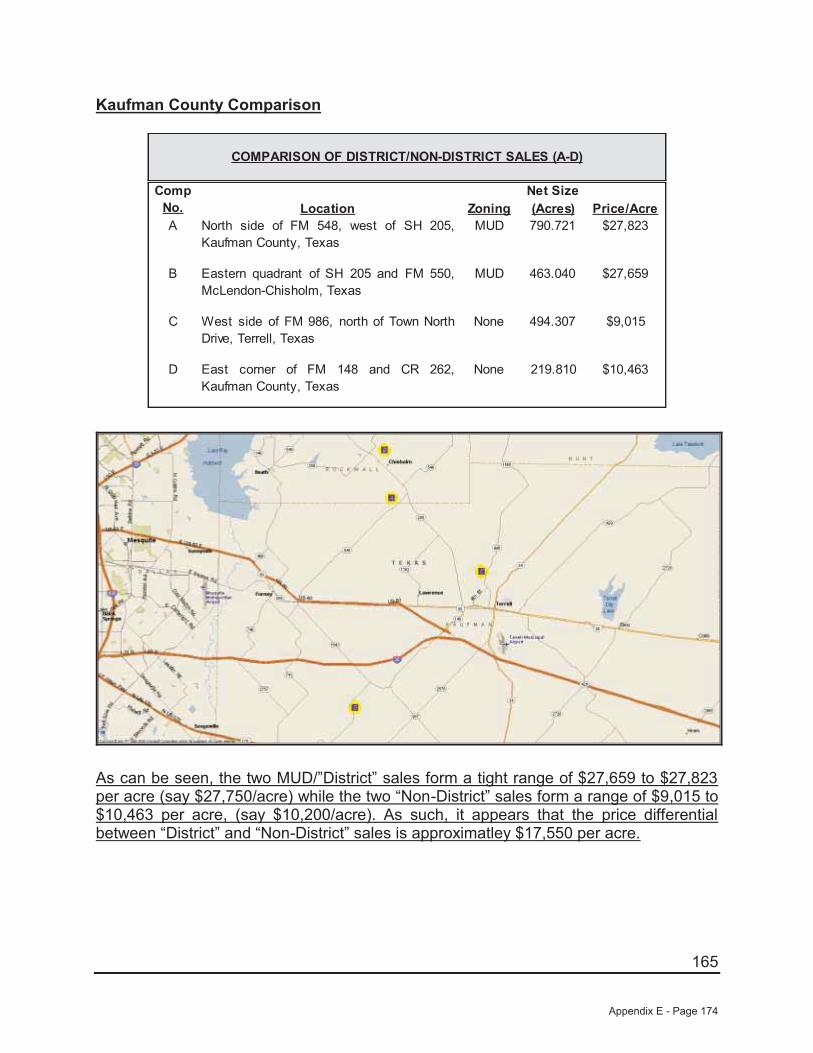
165
Kaufman County Comparison
Net SizeLocation Zoning (Acres) Price/Acre
A North side of FM 548, west of SH 205,Kaufman County, Texas
MUD 790.721 $27,823
B Eastern quadrant of SH 205 and FM 550,McLendon-Chisholm, Texas
MUD 463.040 $27,659
C West side of FM 986, north of Town NorthDrive, Terrell, Texas
None 494.307 $9,015
D East corner of FM 148 and CR 262,Kaufman County, Texas
None 219.810 $10,463
COMPARISON OF DISTRICT/NON-DISTRICT SALES (A-D)
Comp No.
As can be seen, the two MUD/”District” sales form a tight range of $27,659 to $27,823 per acre (say $27,750/acre) while the two “Non-District” sales form a range of $9,015 to $10,463 per acre, (say $10,200/acre). As such, it appears that the price differential between “District” and “Non-District” sales is approximatley $17,550 per acre.
Appendix E - Page 174
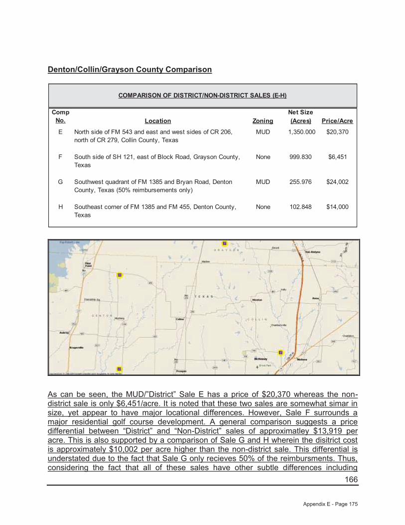
166
Denton/Collin/Grayson County Comparison
Net SizeLocation Zoning (Acres) Price/Acre
E North side of FM 543 and east and west sides of CR 206, north of CR 279, Collin County, Texas
MUD 1,350.000 $20,370
F South side of SH 121, east of Block Road, Grayson County, Texas
None 999.830 $6,451
G Southwest quadrant of FM 1385 and Bryan Road, Denton County, Texas (50% reimbursements only)
MUD 255.976 $24,002
H Southeast corner of FM 1385 and FM 455, Denton County, Texas
None 102.848 $14,000
COMPARISON OF DISTRICT/NON-DISTRICT SALES (E-H)
Comp No.
As can be seen, the MUD/”District” Sale E has a price of $20,370 whereas the non-district sale is only $6,451/acre. It is noted that these two sales are somewhat simar in size, yet appear to have major locational differences. However, Sale F surrounds a major residential golf course development. A general comparison suggests a price differential between “District” and “Non-District” sales of approximatley $13,919 per acre. This is also supported by a comparison of Sale G and H wherein the disitrict cost is approximately $10,002 per acre higher than the non-district sale. This differential is understated due to the fact that Sale G only recieves 50% of the reimbursments. Thus, considering the fact that all of these sales have other subtle differences including
Appendix E - Page 175

167
location and size, it appears that the price differential between “District” and “Non-District” sales is approximatley $15,000 per acre.
“The Lakes” Assemblage Comparison
Net SizeLocation Zoning (Acres) Price/Acre
I Northwest corner of FM 2931 E/W and FM 2931 N/S, Denton County
MUD 346.000 $28,757
J North side of Liberty Road, west of FM 2931 E/W, Denton County, Texas
None 479.000 $12,526
COMPARISON OF DISTRICT/NON-DISTRICT SALES (I-J)
Comp No.
This represents an assembalge purchased by the same buyer of two tracts, one with a MUD and one without. As can be seen, the MUD/”District” Sale No. I has a price of $28,757 whereas the non district Sale No. J is only $12,526/acre. It is noted that these two sales are somewhat simar in size, yet appear to have only a slight locational differences based on the specific road frontage. A general comparison suggests a price differential between “District” and “Non-District” sales of approximatley $16,231 per acre.
Thus, considering the the fact that all of these sales have other subtle differences including location and size, it is our opinon that the “District” contributes approximately $15,000 to $17,550 per net acre.
Appendix E - Page 176

168
Based on the preceeding, we will apply a $16,500 per acre premium, or a total of $315,000 to the overall value, as a line-item adjustment to the determinied value of the site, without consideration of the district.
Summary of Adjustments
Land Value - Market Approach to Value
Subject Sale #1 Sale #2 Sale #3 Sale #4 Sale #5
Location:
Pod 2, Future Phase Land at Frontier Parkway and Legacy
Drive, Celina, Texas
Northwest quadrant of Coit Road and Prosper Trail, Prosper, Texas
North side of CR 26, west of Preston Road,
Frisco, Texas
Southeast quadrant of Preston Road and Frontier Parkway, Prosper, Texas
East side of Preston Road, north of Prosper Trail, Prosper, Texas
Northeast corner of Frontier Parkway and CR 50, Celina, Texas
Sale Price: N/A $6,213,760 $8,000,000 $9,349,125 $2,025,000 $13,197,636 Proposed SF Units 83 175 215 320 59 N/A
Density/Acre 4.4 2.1 2.3 2.6 2.1 N/ASale Date: N/A Pending Pending 7/26/2013 12/13/2013 1/6/2014
Land Size (Gross Acres): 19.000 85.120 93.666 124.655 27.960 161.417 Sale Price/SF N/A $1.68 $1.96 $1.72 $1.66 $1.88
Sale Price/Unit N/A $35,507 $37,209 $29,216 $34,322 N/A
Sale #1 Sale #2 Sale #3 Sale #4 Sale #5$35,507 $37,209 $29,216 $34,322 $1.88
0% 0% 0% 0% 0%0% 0% 0% 0% 0%0% 0% 0% 0% 0%0% 0% 0% 0% 0%
$35,507 $37,209 $29,216 $34,322 $1.88
0% -5% 0% 0% 0%10% 10% 25% 0% 35%0% 0% 0% 10% 0%
-25% -25% -25% -25% 0%10% 10% 10% 10% 20%
-5% -10% 10% -5% 55%
$33,732 $33,488 $32,138 $32,606 $2.91Jackson Claborn, Inc.
Final Adjusted Price/Unit
Functional Utility
Carried Forward Price/Unit
Property Rights Conveyed
Market Conditions
Net Other AdjustmentsExisting Improvements
Zoning Density
LocationSize
Sales Adjustment
Adjusted Price/Unit
Financing TermsConditions of Sale
Land Sales
Other Adjustments:
Appendix E - Page 177
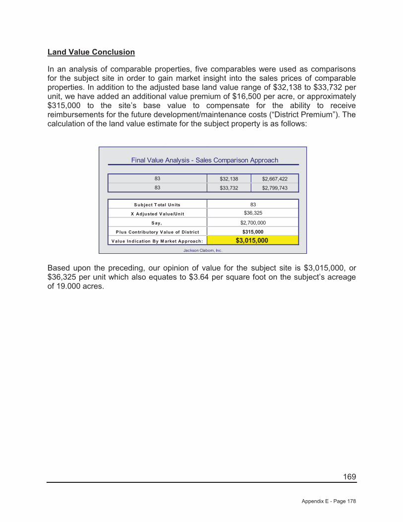
169
Land Value Conclusion
In an analysis of comparable properties, five comparables were used as comparisons for the subject site in order to gain market insight into the sales prices of comparable properties. In addition to the adjusted base land value range of $32,138 to $33,732 per unit, we have added an additional value premium of $16,500 per acre, or approximately $315,000 to the site’s base value to compensate for the ability to receive reimbursements for the future development/maintenance costs (“District Premium”). The calculation of the land value estimate for the subject property is as follows:
Final Value Analysis - Sales Comparison Approach
$32,138 $2,667,422
$33,732 $2,799,743
P lus Contributory V alue of District
$2,700,000
$315,000
83
83
S ubject T otal Units
Jackson Claborn, Inc.
$3,015,000
$36,325
V alue Indication By M arket Approach:
X Adjusted V alue/Unit
83
S ay,
Based upon the preceding, our opinion of value for the subject site is $3,015,000, or $36,325 per unit which also equates to $3.64 per square foot on the subject’s acreage of 19.000 acres.
Appendix E - Page 178
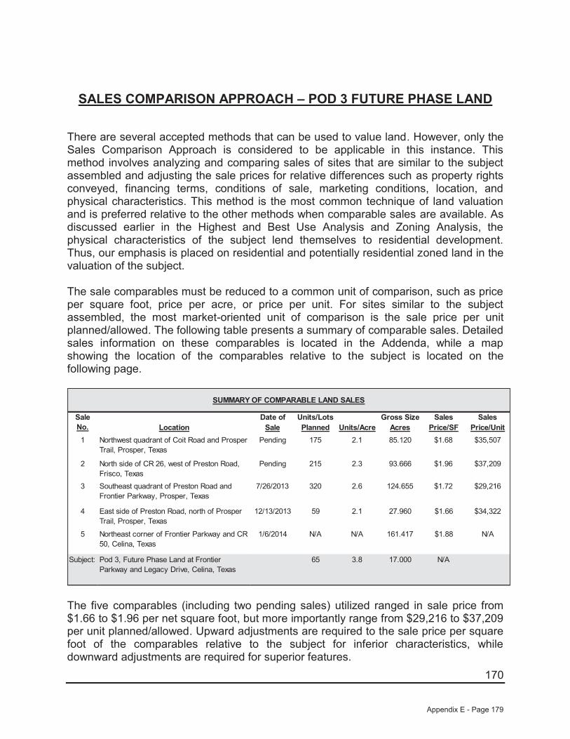
170
SALES COMPARISON APPROACH – POD 3 FUTURE PHASE LAND
There are several accepted methods that can be used to value land. However, only the Sales Comparison Approach is considered to be applicable in this instance. This method involves analyzing and comparing sales of sites that are similar to the subject assembled and adjusting the sale prices for relative differences such as property rights conveyed, financing terms, conditions of sale, marketing conditions, location, and physical characteristics. This method is the most common technique of land valuation and is preferred relative to the other methods when comparable sales are available. As discussed earlier in the Highest and Best Use Analysis and Zoning Analysis, the physical characteristics of the subject lend themselves to residential development. Thus, our emphasis is placed on residential and potentially residential zoned land in the valuation of the subject.
The sale comparables must be reduced to a common unit of comparison, such as price per square foot, price per acre, or price per unit. For sites similar to the subject assembled, the most market-oriented unit of comparison is the sale price per unit planned/allowed. The following table presents a summary of comparable sales. Detailed sales information on these comparables is located in the Addenda, while a map showing the location of the comparables relative to the subject is located on the following page.
Date of Units/Lots Gross Size Sales SalesLocation Sale Planned Units/Acre Acres Price/SF Price/Unit
1 Northwest quadrant of Coit Road and Prosper Trail, Prosper, Texas
Pending 175 2.1 85.120 $1.68 $35,507
2 North side of CR 26, west of Preston Road, Frisco, Texas
Pending 215 2.3 93.666 $1.96 $37,209
3 Southeast quadrant of Preston Road and Frontier Parkway, Prosper, Texas
7/26/2013 320 2.6 124.655 $1.72 $29,216
4 East side of Preston Road, north of Prosper Trail, Prosper, Texas
12/13/2013 59 2.1 27.960 $1.66 $34,322
5 Northeast corner of Frontier Parkway and CR 50, Celina, Texas
1/6/2014 N/A N/A 161.417 $1.88 N/A
Subject: Pod 3, Future Phase Land at Frontier Parkway and Legacy Drive, Celina, Texas
65 3.8 17.000 N/A
SUMMARY OF COMPARABLE LAND SALES
Sale No.
The five comparables (including two pending sales) utilized ranged in sale price from $1.66 to $1.96 per net square foot, but more importantly range from $29,216 to $37,209 per unit planned/allowed. Upward adjustments are required to the sale price per square foot of the comparables relative to the subject for inferior characteristics, while downward adjustments are required for superior features.
Appendix E - Page 179
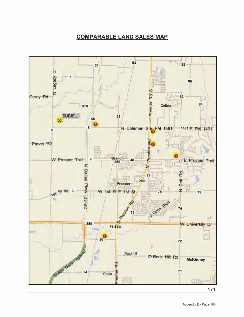
171
COMPARABLE LAND SALES MAP
Appendix E - Page 180
172
A summary of the adjustments that are made is shown at the end of this section. Where possible, we have used the paired data set analysis to make adjustments to the sale price of the comparables relative to the subject. In using this analysis, adjustments are made by comparing sales that are similar to the subject in all but one respect. However, because of the narrow sampling of similar properties, it is sometimes difficult to accurately account for the impact of a single factor on value. Consequently, while this type of analysis is theoretically sound and is market derived, judgment must also be used.
The comparables are discussed as follows:
Sale No. 1 (Pending) is located southeast of the subject at the northwest quadrant of Coit Road and Prosper Trail in Prosper, Texas. This development site is located within the Prosper Independent School District, while the subject is also located within Prosper ISD. Overall, this site is considered generally similar in location relative to the subject. However, this site is considered inferior in size relative to the subject. This property is planned to be developed with 175 single-family lots (2.1 upa). As such, this site is considered inferior in zoning relative to the subject. However, as we are valuing the site on a per unit allowed/planned basis the adjustment will inverse as a higher density site will sell for less per unit while more per square foot. Finally, this site is considered inferior in existing improvements as it is not part of an existing development and will not benefit from the infrastructure in place as will the subject. It is also noted that this site is not located in a PID which will be considered after all other adjustments.
Sale No. 2 (Pending) is located south of the subject on the north side of CR 26, west of Preston Road in Frisco, Texas. This development site is located within the Prosper Independent School District, while the subject is also located within Prosper ISD. Overall, this site is considered slightly superior in location relative to the subject. However, this site is considered inferior in size relative to the subject. This property is planned to be developed with 215 single-family lots (2.3 upa). As such, this site is considered inferior in zoning relative to the subject. However, as we are valuing the siteon a per unit allowed/planned basis the adjustment will inverse as a higher density site will sell for less per unit while more per square foot. Finally, this site is considered inferior in existing improvements as it is not part of an existing development and will not benefit from the infrastructure in place as will the subject. It is also noted that this site is not located in a PID which will be considered after all other adjustments.
Sale No. 3 is located east of the subject at the southeast quadrant of Preston Road and Frontier Parkway in Prosper, Texas. This development site is located within the Prosper Independent School District, while the subject is also located within Prosper ISD. Overall, this site is considered generally similar in location relative to the subject. However, this site is considered vastly inferior in size relative to the subject. This property is planned to be developed with 320 single-family lots (2.6 upa). As such, this site is considered inferior in zoning relative to the subject. However, as we are valuing the site on a per unit allowed/planned basis the adjustment will inverse as a higher density site will sell for less per unit while more per square foot. Finally, this site is
Appendix E - Page 181
173
considered inferior in existing improvements as it is not part of an existing development and will not benefit from the infrastructure in place as will the subject. It is also noted that this site is not located in a PID which will be considered after all other adjustments.
Sale No. 4 is located east of the subject on the east side of Preston Road, north of Prosper Trail in Prosper, Texas. This development site is located within the Prosper Independent School District, while the subject is also located within Prosper ISD. Overall, this site is considered generally similar in location relative to the subject. However, this site is considered vastly inferior in size relative to the subject. This property is planned to be developed with 59 single-family lots (2.1 upa). As such, this site is considered inferior in zoning relative to the subject. However, as we are valuing the site on a per unit allowed/planned basis the adjustment will inverse as a higher density site will sell for less per unit while more per square foot. This site is irregular in shape and has topography issues and is inferior in site utility to the subject. Finally, this site is considered inferior in existing improvements as it is not part of an existing development and will not benefit from the infrastructure in place as will the subject. It is also noted that this site is not located in a PID which will be considered after all other adjustments.
Sale No. 5 is located immediately east of the subject at the northeast corner of Frontier Parkway and CR-50 in Prosper, Texas. This development is located within the Prosper Independent School District, while the subject is also located within Prosper ISD. Overall, this site is considered similar in location. However, this site is substantially larger (inferior) in size while generally similar in site utility and zoning (planned for a similar density as the subject although the exact amount cannot be verified at this time) relative to the subject. Finally, this site is considered inferior in existing improvements as it is not part of an existing development and will not benefit from the infrastructure in place as will the subject. It is also noted that this site is not located in a PID which will be considered after all other adjustments.
Property Rights
The price paid by a purchaser is always predicated on the property interest conveyed. Differences between the property rights conveyed of the comparables relative to the subject could have an impact on the indicated value. We are appraising the fee simple interest in the subject, which is similar to the rights conveyed to all of the comparables. Therefore, no adjustments have been made for variances in property rights.
Financing Terms
The price paid for a property may be different from an identical property because of different financing arrangements. If a purchaser received financing from the seller that was below what could typically be achieved from a third party, or if the purchaser assumed a loan that was at a favorable rate, a premium price was probably paid for the property. Conversely, if the financing obtained was higher than was typical for the market, a lower price was probably paid. All of the comparables were purchased on a
Appendix E - Page 182
174
cash or cash equivalent basis and, therefore, do not require adjustments for financing terms.
Conditions of Sale
Adjustments are made to the sale prices of the comparables for conditions of sale to reflect any extraneous motivations involved with the transaction. Examples include premiums paid for an assemblage, or sale of a property under duress would require adjustments for conditions of sale. An additional example might include a condition whereby a corporation may sell to a related entity or a family may sell property to another family member at a reduced price. All of the comparables are considered similar relative to the subject for this factor.
Market Conditions
Since market conditions change over time and the date of the appraisal is as of a specific time, the comparables must be analyzed in relation to the changes, which have occurred. While these adjustments are typically known as "time adjustments", time is not the adjustment. Rather, it is the change in market conditions over time that is adjusted. One of the sales utilized sold between July 2013 and January 2014 and two sales are pending. As such, all are considered to be influenced by the same market factors currently affecting the subject. As such, no adjustments have been made for market conditions.
Location
Location is one of the most important attributes that affect the value of real estate. For sites such as the subject, the most important locational features are accessibility, visibility, and the density and types of development surrounding the site.
As discussed previously, Sale Nos. 1, 3, 4, and 5 are considered superior in location, while Sale No. 2 is considered superior in location relative to the subject. As both Sale Nos. 1 and 2 are similar in all respects with the exception of location, an abstraction of adjustment from these sales indicates a downward adjustment of approximately 5% for Sale No. 2 in relation to Sale No. 1 and the subject.
Physical Characteristics
The physical differences between the subject and the comparables must also be analyzed. These differences include size, site utility, and zoning.
Appendix E - Page 183

175
Size
Size plays a part in the marketplace in creating more or less utility and limiting the market segment, which can afford each property. Therefore, size adjustments are generally required when there is a significant difference in the size of two properties. Generally, smaller sites sell for higher prices per square foot than their larger counterparts since the overall price is relatively modest in comparison to larger properties. However, when a site is too small to be developed except in conjunction with an adjacent property, this principle reverses and the smaller site becomes less valuable than its larger neighbors. In regard to the comparables presented, the five comparables range in size from 27.960 acres to 161.417 acres, while the subject site is 17.000 acres in size.
As discussed previously, Sale Nos. 1, 3, 4, and 5 are considered similar in location, while Sale No. 5 is considered inferior in location relative to the subject. However, none of the sales are truly similar to the subject overall so we were unable to show an abstraction of adjustment from the sales. Sale No. 1 and 2 (85.12 and 93.666 acres, respectively) are somewhat close in site size to the subject and we have subjectively adjusted these two sales upward by 10% each. Sale Nos. 3 and 5 (124.655 and 161.417 acres, respectively) are adjusted upward by 25% and 35% respectively for their substantially larger and inferior site sizes relative to the subject.
Site Utility/Floodplain
Also to be considered is the shape and/or frontage of a site, which has an impact upon its value, or land lost to a flood prone area. As discussed, the subject has typical road frontage as compared to its overall site size and has no know adverse site issues. Sale Nos. 1, 2, 3, and 5 are considered to be generally similar in this respect. However, Sale No. 4 is inferior to the subject in this respect and is adjusted upward by 10% for this factor.
Zoning
As mentioned earlier in this report, the subject’s highest and best use is future residential usages with a density of approximately 4.4 units per acre. As discussed previously, Sale Nos. 1, 2, 3, and 4 have allowed densities ranging from 2.1 to 2.6 units per acre. As such, each of these sales is adjusted downward by 25% to reflect this factor. It is noted that this adjustment is inverse to the other adjustments as the lower density sites sell for a higher price per unit, but lower price per square foot. Therefore, as we are valuing the site on a per unit allowed/planned basis, the adjustment is downward. No adjustment is considered necessary to Sale No. 5 as it is also planned for a similar high density of development like the subject.
Appendix E - Page 184
176
Existing Improvements
As previously discussed, the valuations found herein are subject to the completion of Phase 1 PID improvements. All five sales are considered inferior in existing improvements as none are a part of an existing development and do not benefit from the infrastructure in place as does the subject. Because of these site improvements, the subject will have lower overall development costs on a per unit basis. As such, we have adjusted Sale Nos. 1, 2, 3, and 4 upward by 10% to reflect their inferiority in this respect while Sale No. 5 was adjusted upward 20% for this factor.
Site Reimbursements/PID
As mentioned earlier in this report, the subject is located within a PID and is able to be reimbursed for its development costs. None of the five comparables have this attribute. As such, all are inferior in this respect. Instead of a straight line item adjustment for this factor. We have abstracted form the marketplace a per acre premium for this attribute.
As discussed, according to information provided from the owner/developer, the subject is in “Creeks at Legacy Public Improvement District” which allows for the right to receive reimbursements for the future development/maintenance costs of various on and off-site infrastructure improvements including but not limited to water, sanitary sewer, sewage treatment plants, storm drainage related to roads and road improvements for the community. Thus, the subject with assistance from the City of Celina, will be allow to sell bonds which will be used to repay the developers for a large majority of their expenses. There have been limited sales of properties with this attribute in the area over the past five years. As such, we have provided several separate comparisons to assist in determining the premium for having reimbursements. The first comparison consists of two known sales of similar properties located in the Kaufman County market area around Dallas that sold between 2007 and 2008 along with two sales of non-reimbursement sales. The second consists of two sales with reimbursements located in the Denton/Collin/Grayson County market area that sold in 2010 and 2012 along with two sales that lack this attribute. A summary of these sales along with a map of their locations follows:
Appendix E - Page 185

177
Kaufman County Comparison
Net SizeLocation Zoning (Acres) Price/Acre
A North side of FM 548, west of SH 205,Kaufman County, Texas
MUD 790.721 $27,823
B Eastern quadrant of SH 205 and FM 550,McLendon-Chisholm, Texas
MUD 463.040 $27,659
C West side of FM 986, north of Town NorthDrive, Terrell, Texas
None 494.307 $9,015
D East corner of FM 148 and CR 262,Kaufman County, Texas
None 219.810 $10,463
COMPARISON OF DISTRICT/NON-DISTRICT SALES (A-D)
Comp No.
As can be seen, the two MUD/”District” sales form a tight range of $27,659 to $27,823 per acre (say $27,750/acre) while the two “Non-District” sales form a range of $9,015 to $10,463 per acre, (say $10,200/acre). As such, it appears that the price differential between “District” and “Non-District” sales is approximatley $17,550 per acre.
Appendix E - Page 186
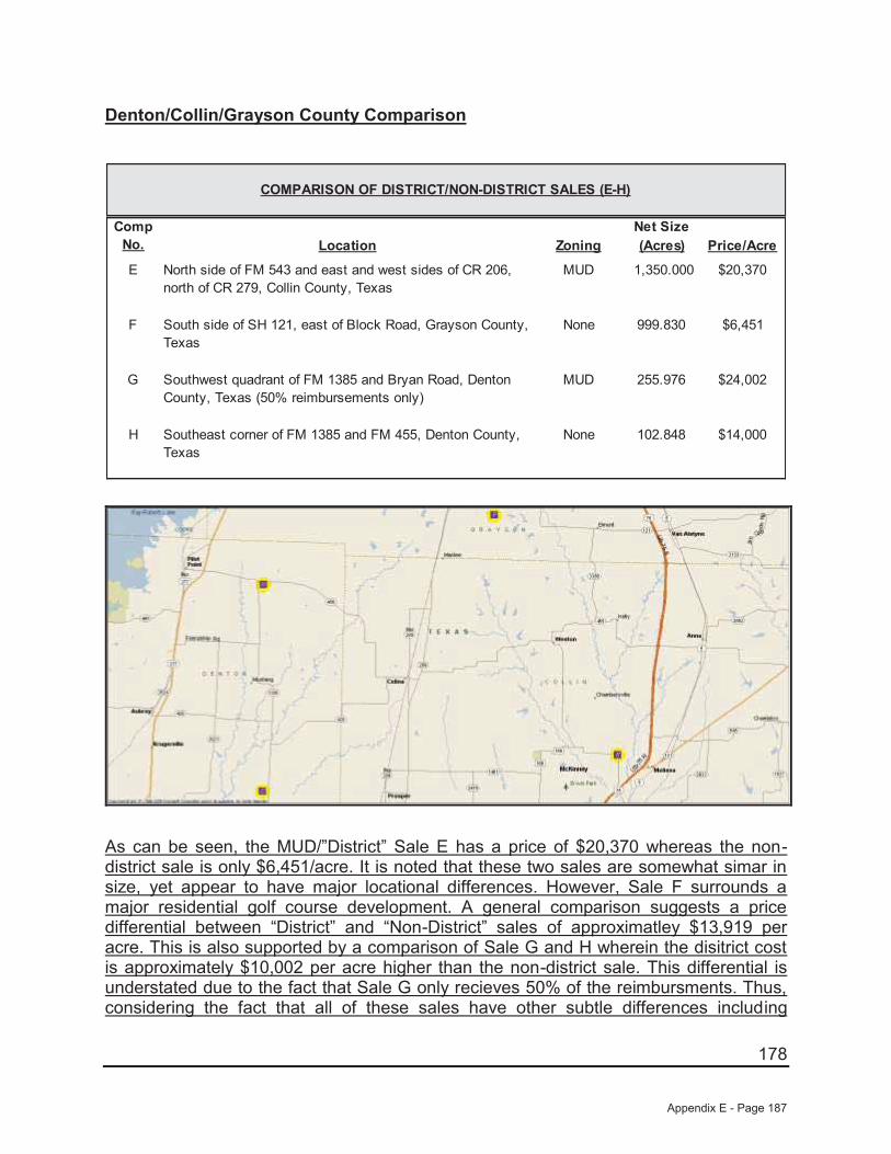
178
Denton/Collin/Grayson County Comparison
Net SizeLocation Zoning (Acres) Price/Acre
E North side of FM 543 and east and west sides of CR 206, north of CR 279, Collin County, Texas
MUD 1,350.000 $20,370
F South side of SH 121, east of Block Road, Grayson County, Texas
None 999.830 $6,451
G Southwest quadrant of FM 1385 and Bryan Road, Denton County, Texas (50% reimbursements only)
MUD 255.976 $24,002
H Southeast corner of FM 1385 and FM 455, Denton County, Texas
None 102.848 $14,000
COMPARISON OF DISTRICT/NON-DISTRICT SALES (E-H)
Comp No.
As can be seen, the MUD/”District” Sale E has a price of $20,370 whereas the non-district sale is only $6,451/acre. It is noted that these two sales are somewhat simar in size, yet appear to have major locational differences. However, Sale F surrounds a major residential golf course development. A general comparison suggests a price differential between “District” and “Non-District” sales of approximatley $13,919 per acre. This is also supported by a comparison of Sale G and H wherein the disitrict cost is approximately $10,002 per acre higher than the non-district sale. This differential is understated due to the fact that Sale G only recieves 50% of the reimbursments. Thus, considering the fact that all of these sales have other subtle differences including
Appendix E - Page 187
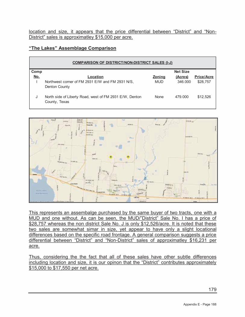
179
location and size, it appears that the price differential between “District” and “Non-District” sales is approximatley $15,000 per acre.
“The Lakes” Assemblage Comparison
Net SizeLocation Zoning (Acres) Price/Acre
I Northwest corner of FM 2931 E/W and FM 2931 N/S, Denton County
MUD 346.000 $28,757
J North side of Liberty Road, west of FM 2931 E/W, Denton County, Texas
None 479.000 $12,526
COMPARISON OF DISTRICT/NON-DISTRICT SALES (I-J)
Comp No.
This represents an assembalge purchased by the same buyer of two tracts, one with a MUD and one without. As can be seen, the MUD/”District” Sale No. I has a price of $28,757 whereas the non district Sale No. J is only $12,526/acre. It is noted that these two sales are somewhat simar in size, yet appear to have only a slight locational differences based on the specific road frontage. A general comparison suggests a price differential between “District” and “Non-District” sales of approximatley $16,231 per acre.
Thus, considering the the fact that all of these sales have other subtle differences including location and size, it is our opinon that the “District” contributes approximately $15,000 to $17,550 per net acre.
Appendix E - Page 188
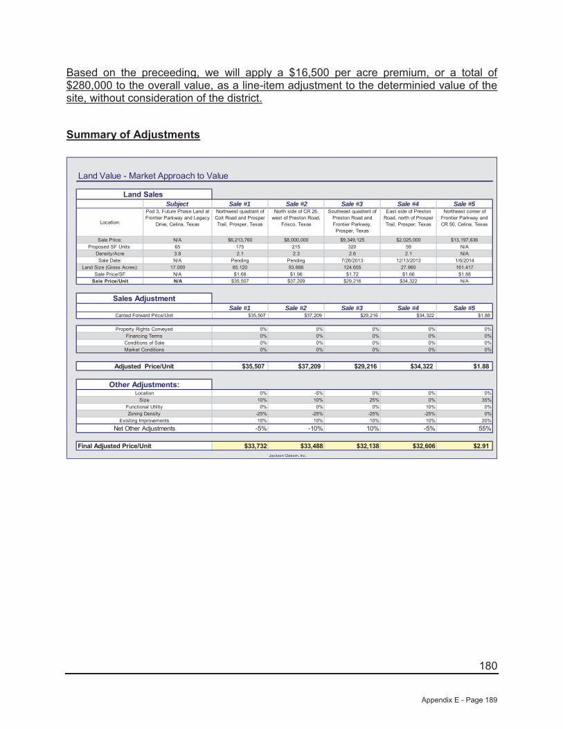
180
Based on the preceeding, we will apply a $16,500 per acre premium, or a total of $280,000 to the overall value, as a line-item adjustment to the determinied value of the site, without consideration of the district.
Summary of Adjustments
Land Value - Market Approach to Value
Subject Sale #1 Sale #2 Sale #3 Sale #4 Sale #5
Location:
Pod 3, Future Phase Land at Frontier Parkway and Legacy
Drive, Celina, Texas
Northwest quadrant of Coit Road and Prosper Trail, Prosper, Texas
North side of CR 26, west of Preston Road,
Frisco, Texas
Southeast quadrant of Preston Road and Frontier Parkway, Prosper, Texas
East side of Preston Road, north of Prosper Trail, Prosper, Texas
Northeast corner of Frontier Parkway and CR 50, Celina, Texas
Sale Price: N/A $6,213,760 $8,000,000 $9,349,125 $2,025,000 $13,197,636 Proposed SF Units 65 175 215 320 59 N/A
Density/Acre 3.8 2.1 2.3 2.6 2.1 N/ASale Date: N/A Pending Pending 7/26/2013 12/13/2013 1/6/2014
Land Size (Gross Acres): 17.000 85.120 93.666 124.655 27.960 161.417 Sale Price/SF N/A $1.68 $1.96 $1.72 $1.66 $1.88
Sale Price/Unit N/A $35,507 $37,209 $29,216 $34,322 N/A
Sale #1 Sale #2 Sale #3 Sale #4 Sale #5$35,507 $37,209 $29,216 $34,322 $1.88
0% 0% 0% 0% 0%0% 0% 0% 0% 0%0% 0% 0% 0% 0%0% 0% 0% 0% 0%
$35,507 $37,209 $29,216 $34,322 $1.88
0% -5% 0% 0% 0%10% 10% 25% 0% 35%0% 0% 0% 10% 0%
-25% -25% -25% -25% 0%10% 10% 10% 10% 20%
-5% -10% 10% -5% 55%
$33,732 $33,488 $32,138 $32,606 $2.91Jackson Claborn, Inc.
Final Adjusted Price/Unit
Functional Utility
Carried Forward Price/Unit
Property Rights Conveyed
Market Conditions
Net Other AdjustmentsExisting Improvements
Zoning Density
LocationSize
Sales Adjustment
Adjusted Price/Unit
Financing TermsConditions of Sale
Land Sales
Other Adjustments:
Appendix E - Page 189

181
Land Value Conclusion
In an analysis of comparable properties, five comparables were used as comparisons for the subject site in order to gain market insight into the sales prices of comparable properties. In addition to the adjusted base land value range of $32,138 to $33,732 per unit, we have added an additional value premium of $16,500 per acre, or approximately $280,000 to the site’s base value to compensate for the ability to receive reimbursements for the future development/maintenance costs (“District Premium”). The calculation of the land value estimate for the subject property is as follows:
Final Value Analysis - Sales Comparison Approach
$32,138 $2,088,945
$33,732 $2,192,570
P lus Contributory V alue of District
$2,100,000
$280,000
65
65
S ubject T otal Units
Jackson Claborn, Inc.
$2,380,000
$36,615
V alue Indication By M arket Approach:
X Adjusted V alue/Unit
65
S ay,
Based upon the preceding, our opinion of value for the subject site is $2,380,000, or $36,615 per unit which also equates to $3.21 per square foot on the subject’s acreage of 17.000 acres.
Appendix E - Page 190
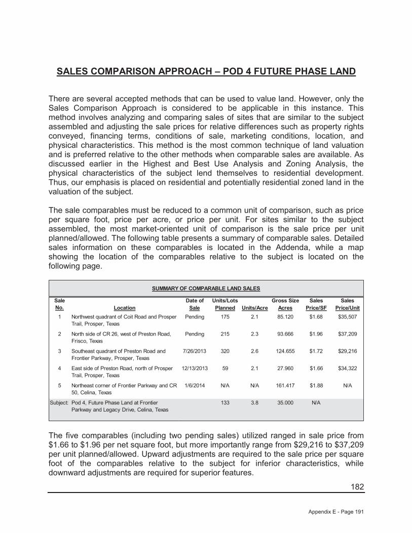
182
SALES COMPARISON APPROACH – POD 4 FUTURE PHASE LAND
There are several accepted methods that can be used to value land. However, only the Sales Comparison Approach is considered to be applicable in this instance. This method involves analyzing and comparing sales of sites that are similar to the subject assembled and adjusting the sale prices for relative differences such as property rights conveyed, financing terms, conditions of sale, marketing conditions, location, and physical characteristics. This method is the most common technique of land valuation and is preferred relative to the other methods when comparable sales are available. As discussed earlier in the Highest and Best Use Analysis and Zoning Analysis, the physical characteristics of the subject lend themselves to residential development. Thus, our emphasis is placed on residential and potentially residential zoned land in the valuation of the subject.
The sale comparables must be reduced to a common unit of comparison, such as price per square foot, price per acre, or price per unit. For sites similar to the subject assembled, the most market-oriented unit of comparison is the sale price per unit planned/allowed. The following table presents a summary of comparable sales. Detailed sales information on these comparables is located in the Addenda, while a map showing the location of the comparables relative to the subject is located on the following page.
Date of Units/Lots Gross Size Sales SalesLocation Sale Planned Units/Acre Acres Price/SF Price/Unit
1 Northwest quadrant of Coit Road and Prosper Trail, Prosper, Texas
Pending 175 2.1 85.120 $1.68 $35,507
2 North side of CR 26, west of Preston Road, Frisco, Texas
Pending 215 2.3 93.666 $1.96 $37,209
3 Southeast quadrant of Preston Road and Frontier Parkway, Prosper, Texas
7/26/2013 320 2.6 124.655 $1.72 $29,216
4 East side of Preston Road, north of Prosper Trail, Prosper, Texas
12/13/2013 59 2.1 27.960 $1.66 $34,322
5 Northeast corner of Frontier Parkway and CR 50, Celina, Texas
1/6/2014 N/A N/A 161.417 $1.88 N/A
Subject: Pod 4, Future Phase Land at Frontier Parkway and Legacy Drive, Celina, Texas
133 3.8 35.000 N/A
SUMMARY OF COMPARABLE LAND SALES
Sale No.
The five comparables (including two pending sales) utilized ranged in sale price from $1.66 to $1.96 per net square foot, but more importantly range from $29,216 to $37,209 per unit planned/allowed. Upward adjustments are required to the sale price per square foot of the comparables relative to the subject for inferior characteristics, while downward adjustments are required for superior features.
Appendix E - Page 191
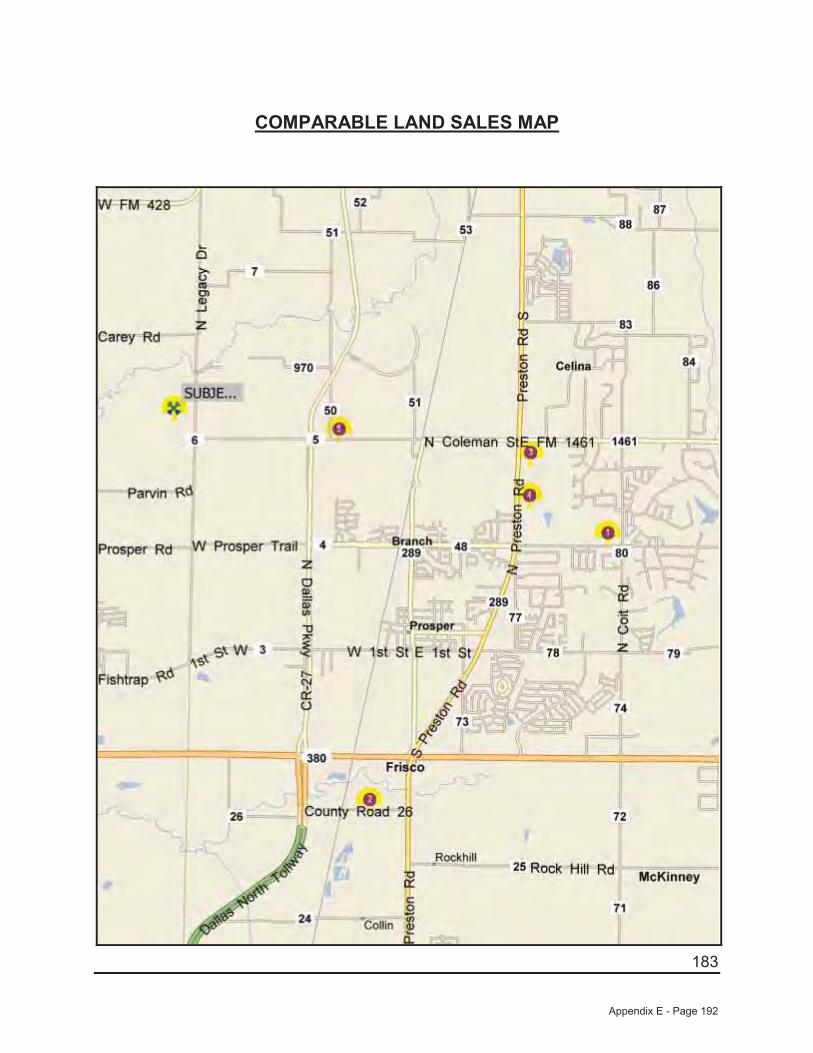
183
COMPARABLE LAND SALES MAP
Appendix E - Page 192

184
A summary of the adjustments that are made is shown at the end of this section. Where possible, we have used the paired data set analysis to make adjustments to the sale price of the comparables relative to the subject. In using this analysis, adjustments are made by comparing sales that are similar to the subject in all but one respect. However, because of the narrow sampling of similar properties, it is sometimes difficult to accurately account for the impact of a single factor on value. Consequently, while this type of analysis is theoretically sound and is market derived, judgment must also be used.
The comparables are discussed as follows:
Sale No. 1 (Pending) is located southeast of the subject at the northwest quadrant of Coit Road and Prosper Trail in Prosper, Texas. This development site is located within the Prosper Independent School District, while the subject is also located within Prosper ISD. Overall, this site is considered slightly superior in location relative to the subject. However, this site is considered inferior in size relative to the subject. This property is planned to be developed with 175 single-family lots (2.1 upa). As such, this site is considered inferior in zoning relative to the subject. However, as we are valuing the site on a per unit allowed/planned basis the adjustment will inverse as a higher density site will sell for less per unit while more per square foot. Finally, this site is considered similar in existing improvements as it is not part of an existing development. While the subject Pod will be part of existing subdivision on date of value, Phase 1 development will leave this Pod in a similar condition as this comparable. It is also noted that this site is not located in a PID which will be considered after all other adjustments.
Sale No. 2 (Pending) is located south of the subject on the north side of CR 26, west of Preston Road in Frisco, Texas. This development site is located within the Prosper Independent School District, while the subject is also located within Prosper ISD. Overall, this site is considered superior in location relative to the subject. However, this site is considered inferior in size relative to the subject. This property is planned to be developed with 215 single-family lots (2.3 upa). As such, this site is considered inferior in zoning relative to the subject. However, as we are valuing the site on a per unit allowed/planned basis the adjustment will inverse as a higher density site will sell for less per unit while more per square foot. Finally, this site is considered similar in existing improvements as it is not part of an existing development. While the subject Pod will be part of existing subdivision on date of value, Phase 1 development will leave this Pod in a similar condition as this comparable. It is also noted that this site is not located in a PID which will be considered after all other adjustments.
Sale No. 3 is located east of the subject at the southeast quadrant of Preston Road and Frontier Parkway in Prosper, Texas. This development site is located within the Prosper Independent School District, while the subject is also located within Prosper ISD. Overall, this site is considered slightly superior in location relative to the subject. However, this site is considered vastly inferior in size relative to the subject. This property is planned to be developed with 320 single-family lots (2.6 upa). As such, this site is considered inferior in zoning relative to the subject. However, as we are valuing
Appendix E - Page 193
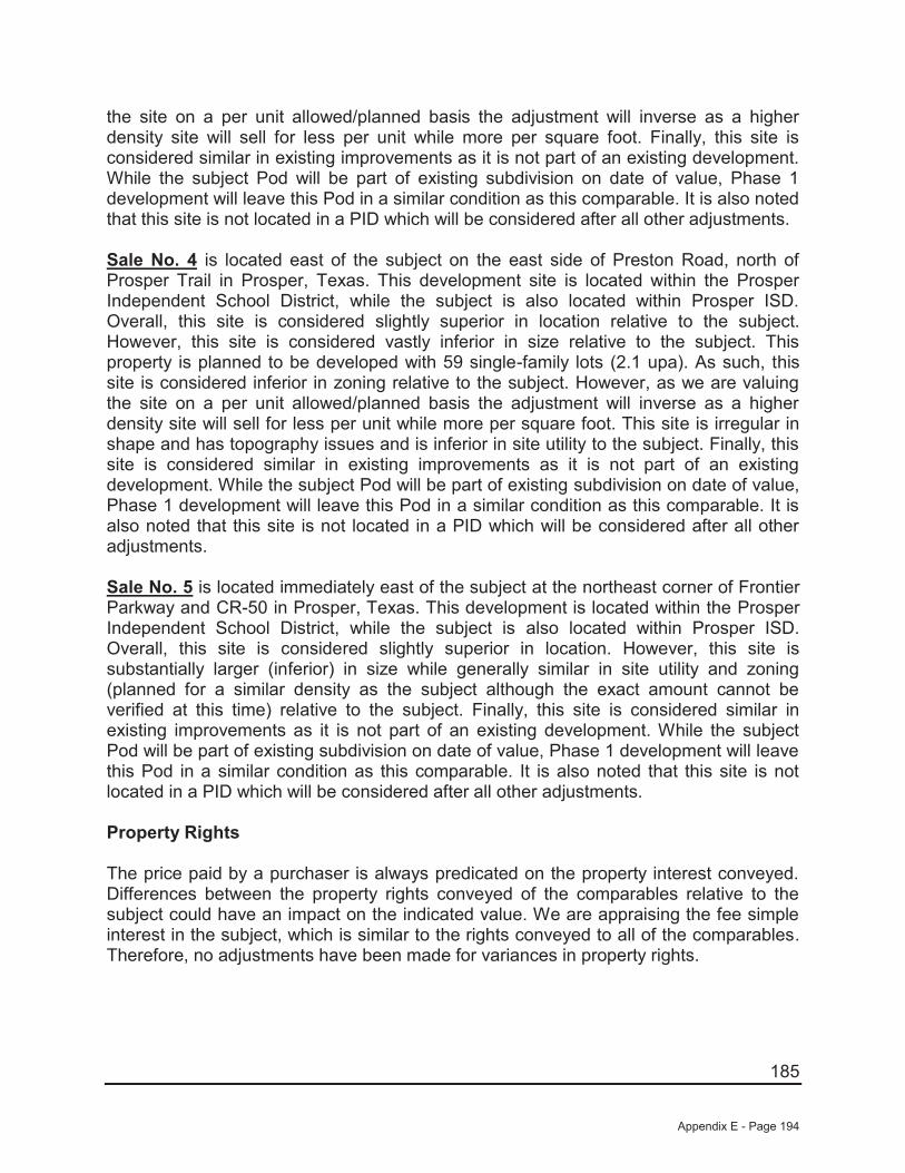
185
the site on a per unit allowed/planned basis the adjustment will inverse as a higher density site will sell for less per unit while more per square foot. Finally, this site is considered similar in existing improvements as it is not part of an existing development. While the subject Pod will be part of existing subdivision on date of value, Phase 1 development will leave this Pod in a similar condition as this comparable. It is also noted that this site is not located in a PID which will be considered after all other adjustments.
Sale No. 4 is located east of the subject on the east side of Preston Road, north of Prosper Trail in Prosper, Texas. This development site is located within the Prosper Independent School District, while the subject is also located within Prosper ISD. Overall, this site is considered slightly superior in location relative to the subject. However, this site is considered vastly inferior in size relative to the subject. This property is planned to be developed with 59 single-family lots (2.1 upa). As such, this site is considered inferior in zoning relative to the subject. However, as we are valuing the site on a per unit allowed/planned basis the adjustment will inverse as a higher density site will sell for less per unit while more per square foot. This site is irregular in shape and has topography issues and is inferior in site utility to the subject. Finally, this site is considered similar in existing improvements as it is not part of an existing development. While the subject Pod will be part of existing subdivision on date of value, Phase 1 development will leave this Pod in a similar condition as this comparable. It is also noted that this site is not located in a PID which will be considered after all other adjustments.
Sale No. 5 is located immediately east of the subject at the northeast corner of Frontier Parkway and CR-50 in Prosper, Texas. This development is located within the Prosper Independent School District, while the subject is also located within Prosper ISD. Overall, this site is considered slightly superior in location. However, this site is substantially larger (inferior) in size while generally similar in site utility and zoning (planned for a similar density as the subject although the exact amount cannot be verified at this time) relative to the subject. Finally, this site is considered similar in existing improvements as it is not part of an existing development. While the subject Pod will be part of existing subdivision on date of value, Phase 1 development will leave this Pod in a similar condition as this comparable. It is also noted that this site is not located in a PID which will be considered after all other adjustments.
Property Rights
The price paid by a purchaser is always predicated on the property interest conveyed. Differences between the property rights conveyed of the comparables relative to the subject could have an impact on the indicated value. We are appraising the fee simple interest in the subject, which is similar to the rights conveyed to all of the comparables.Therefore, no adjustments have been made for variances in property rights.
Appendix E - Page 194

186
Financing Terms
The price paid for a property may be different from an identical property because of different financing arrangements. If a purchaser received financing from the seller that was below what could typically be achieved from a third party, or if the purchaser assumed a loan that was at a favorable rate, a premium price was probably paid for the property. Conversely, if the financing obtained was higher than was typical for the market, a lower price was probably paid. All of the comparables were purchased on a cash or cash equivalent basis and, therefore, do not require adjustments for financing terms.
Conditions of Sale
Adjustments are made to the sale prices of the comparables for conditions of sale to reflect any extraneous motivations involved with the transaction. Examples include premiums paid for an assemblage, or sale of a property under duress would require adjustments for conditions of sale. An additional example might include a condition whereby a corporation may sell to a related entity or a family may sell property to another family member at a reduced price. All of the comparables are considered similar relative to the subject for this factor.
Market Conditions
Since market conditions change over time and the date of the appraisal is as of a specific time, the comparables must be analyzed in relation to the changes, which have occurred. While these adjustments are typically known as "time adjustments", time is not the adjustment. Rather, it is the change in market conditions over time that is adjusted. One of the sales utilized sold between July 2013 and January 2014 and two sales are pending. As such, all are considered to be influenced by the same market factors currently affecting the subject. As such, no adjustments have been made for market conditions.
Location
Location is one of the most important attributes that affect the value of real estate. For sites such as the subject, the most important locational features are accessibility, visibility, and the density and types of development surrounding the site.
As discussed previously, Sale Nos. 1, 3, 4, and 5 are considered slightly superior in location, while Sale No. 2 is considered superior in location to the other four comparables as well as the subject. As both Sale Nos. 1 and 2 are similar in all respects with the exception of location, an abstraction of adjustment from these sales indicates a downward adjustment of approximately 5% for Sale No. 2 in relation to Sale No. 1. However, Sale No. 1 is superior to the subject. As such, we have subjectively adjusted Sale Nos. 1, 3, 4, and 5 downward by 10% and Sale No. 2 downward by 15%.
Appendix E - Page 195

187
Physical Characteristics
The physical differences between the subject and the comparables must also be analyzed. These differences include size, site utility, and zoning.
Size
Size plays a part in the marketplace in creating more or less utility and limiting the market segment, which can afford each property. Therefore, size adjustments are generally required when there is a significant difference in the size of two properties. Generally, smaller sites sell for higher prices per square foot than their larger counterparts since the overall price is relatively modest in comparison to larger properties. However, when a site is too small to be developed except in conjunction with an adjacent property, this principle reverses and the smaller site becomes less valuable than its larger neighbors. In regard to the comparables presented, the five comparables range in size from 27.960 acres to 161.417 acres, while the subject site is 35.000 acres in size.
As discussed previously, Sale Nos. 1, 3, 4, and 5 are considered similar in location, while Sale No. 5 is considered inferior in location relative to the subject. However, none of the sales are truly similar to the subject overall so we were unable to show an abstraction of adjustment from the sales. Sale No. 1 and 2 (85.12 and 93.666 acres, respectively) are somewhat close in site size to the subject and we have subjectively adjusted these two sales upward by 10% each. Sale Nos. 3 and 5 (124.655 and 161.417 acres, respectively) are adjusted upward by 25% and 35% respectively for their substantially larger and inferior site sizes relative to the subject.
Site Utility/Floodplain
Also to be considered is the shape and/or frontage of a site, which has an impact upon its value, or land lost to a flood prone area. As discussed, the subject has typical road frontage as compared to its overall site size and has no know adverse site issues. Sale Nos. 1, 2, 3, and 5 are considered to be generally similar in this respect. However, Sale No. 4 is inferior to the subject in this respect and is adjusted upward by 10% for this factor.
Zoning
As mentioned earlier in this report, the subject’s highest and best use is future residential usages with a density of approximately 4.1 units per acre. As discussed previously, Sale Nos. 1, 2, 3, and 4 have allowed densities ranging from 2.1 to 2.6 units per acre. As such, each of these sales is adjusted downward by 25% to reflect this factor. It is noted that this adjustment is inverse to the other adjustments as the lower density sites sell for a higher price per unit, but lower price per square foot. Therefore, as we are valuing the site on a per unit allowed/planned basis, the adjustment is
Appendix E - Page 196
188
downward. No adjustment is considered necessary to Sale No. 5 as it is also planned for a similar high density of development like the subject.
Existing Improvements
As previously discussed, the valuations found herein are subject to the completion of Phase 1 PID improvements. Upon completion of Phase 1 improvements, this Pod will still require future off-site costs that are similar to four of the five comparable presented. Thus, Sale Nos. 1, 2, 3, and 4 are considered similar in existing improvements However, Sale no. 5 is still considered inferior to the subject as it is expected to have higher off-site costs than both the remaining comparables as well as the subject. As such, Sale No. 5 was adjusted upward 10% for this factor.
Site Reimbursements/PID
As mentioned earlier in this report, the subject is located within a PID and is able to be reimbursed for its development costs. None of the five comparables have this attribute. As such, all are inferior in this respect. Instead of a straight line item adjustment for this factor. We have abstracted form the marketplace a per acre premium for this attribute.
As discussed, according to information provided from the owner/developer, the subject is in “Creeks at Legacy Public Improvement District” which allows for the right to receive reimbursements for the future development/maintenance costs of various on and off-site infrastructure improvements including but not limited to water, sanitary sewer, sewage treatment plants, storm drainage related to roads and road improvements for the community. Thus, the subject with assistance from the City of Celina, will be allow to sell bonds which will be used to repay the developers for a large majority of their expenses. There have been limited sales of properties with this attribute in the area over the past five years. As such, we have provided several separate comparisons to assist in determining the premium for having reimbursements. The first comparison consists of two known sales of similar properties located in the Kaufman County market area around Dallas that sold between 2007 and 2008 along with two sales of non-reimbursement sales. The second consists of two sales with reimbursements located in the Denton/Collin/Grayson County market area that sold in 2010 and 2012 along with two sales that lack this attribute. A summary of these sales along with a map of their locations follows:
Appendix E - Page 197

189
Kaufman County Comparison
Net SizeLocation Zoning (Acres) Price/Acre
A North side of FM 548, west of SH 205,Kaufman County, Texas
MUD 790.721 $27,823
B Eastern quadrant of SH 205 and FM 550,McLendon-Chisholm, Texas
MUD 463.040 $27,659
C West side of FM 986, north of Town NorthDrive, Terrell, Texas
None 494.307 $9,015
D East corner of FM 148 and CR 262,Kaufman County, Texas
None 219.810 $10,463
COMPARISON OF DISTRICT/NON-DISTRICT SALES (A-D)
Comp No.
As can be seen, the two MUD/”District” sales form a tight range of $27,659 to $27,823 per acre (say $27,750/acre) while the two “Non-District” sales form a range of $9,015 to $10,463 per acre, (say $10,200/acre). As such, it appears that the price differentialbetween “District” and “Non-District” sales is approximatley $17,550 per acre.
Appendix E - Page 198
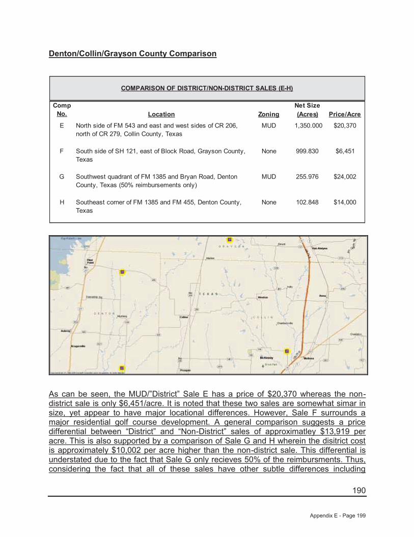
190
Denton/Collin/Grayson County Comparison
Net SizeLocation Zoning (Acres) Price/Acre
E North side of FM 543 and east and west sides of CR 206, north of CR 279, Collin County, Texas
MUD 1,350.000 $20,370
F South side of SH 121, east of Block Road, Grayson County, Texas
None 999.830 $6,451
G Southwest quadrant of FM 1385 and Bryan Road, Denton County, Texas (50% reimbursements only)
MUD 255.976 $24,002
H Southeast corner of FM 1385 and FM 455, Denton County, Texas
None 102.848 $14,000
COMPARISON OF DISTRICT/NON-DISTRICT SALES (E-H)
Comp No.
As can be seen, the MUD/”District” Sale E has a price of $20,370 whereas the non-district sale is only $6,451/acre. It is noted that these two sales are somewhat simar in size, yet appear to have major locational differences. However, Sale F surrounds a major residential golf course development. A general comparison suggests a price differential between “District” and “Non-District” sales of approximatley $13,919 per acre. This is also supported by a comparison of Sale G and H wherein the disitrict cost is approximately $10,002 per acre higher than the non-district sale. This differential is understated due to the fact that Sale G only recieves 50% of the reimbursments. Thus, considering the fact that all of these sales have other subtle differences including
Appendix E - Page 199

191
location and size, it appears that the price differential between “District” and “Non-District” sales is approximatley $15,000 per acre.
“The Lakes” Assemblage Comparison
Net SizeLocation Zoning (Acres) Price/Acre
I Northwest corner of FM 2931 E/W and FM 2931 N/S, Denton County
MUD 346.000 $28,757
J North side of Liberty Road, west of FM 2931 E/W, Denton County, Texas
None 479.000 $12,526
COMPARISON OF DISTRICT/NON-DISTRICT SALES (I-J)
Comp No.
This represents an assembalge purchased by the same buyer of two tracts, one with a MUD and one without. As can be seen, the MUD/”District” Sale No. I has a price of $28,757 whereas the non district Sale No. J is only $12,526/acre. It is noted that these two sales are somewhat simar in size, yet appear to have only a slight locational differences based on the specific road frontage. A general comparison suggests a price differential between “District” and “Non-District” sales of approximatley $16,231 per acre.
Thus, considering the the fact that all of these sales have other subtle differences including location and size, it is our opinon that the “District” contributes approximately $15,000 to $17,550 per net acre.
Appendix E - Page 200

192
Based upon the preceeding, we will apply a $16,500 per acre premium, or a total of $580,000 to the overall value, as a line-item adjustment to the determinied value of the site, without consideration of the district.
Summary of Adjustments
Land Value - Market Approach to Value
Subject Sale #1 Sale #2 Sale #3 Sale #4 Sale #5
Location:
Pod 4, Future Phase Land at Frontier Parkway and Legacy
Drive, Celina, Texas
Northwest quadrant of Coit Road and Prosper Trail, Prosper, Texas
North side of CR 26, west of Preston Road,
Frisco, Texas
Southeast quadrant of Preston Road and Frontier Parkway, Prosper, Texas
East side of Preston Road, north of Prosper Trail, Prosper, Texas
Northeast corner of Frontier Parkway and CR 50, Celina, Texas
Sale Price: N/A $6,213,760 $8,000,000 $9,349,125 $2,025,000 $13,197,636 Proposed SF Units 133 175 215 320 59 N/A
Density/Acre 3.8 2.1 2.3 2.6 2.1 N/ASale Date: N/A Pending Pending 7/26/2013 12/13/2013 1/6/2014
Land Size (Gross Acres): 35.000 85.120 93.666 124.655 27.960 161.417 Sale Price/SF N/A $1.68 $1.96 $1.72 $1.66 $1.88
Sale Price/Unit N/A $35,507 $37,209 $29,216 $34,322 N/A
Sale #1 Sale #2 Sale #3 Sale #4 Sale #5$35,507 $37,209 $29,216 $34,322 $1.88
0% 0% 0% 0% 0%0% 0% 0% 0% 0%0% 0% 0% 0% 0%0% 0% 0% 0% 0%
$35,507 $37,209 $29,216 $34,322 $1.88
-10% -15% -10% -10% -10%10% 10% 25% 0% 35%0% 0% 0% 10% 0%
-25% -25% -25% -25% 0%0% 0% 0% 0% 10%
-25% -30% -10% -25% 35%
$26,630 $26,047 $26,294 $25,742 $2.53Jackson Claborn, Inc.
Final Adjusted Price/Unit
Functional Utility
Carried Forward Price/Unit
Property Rights Conveyed
Market Conditions
Net Other AdjustmentsExisting Improvements
Zoning Density
LocationSize
Sales Adjustment
Adjusted Price/Unit
Financing TermsConditions of Sale
Land Sales
Other Adjustments:
Appendix E - Page 201
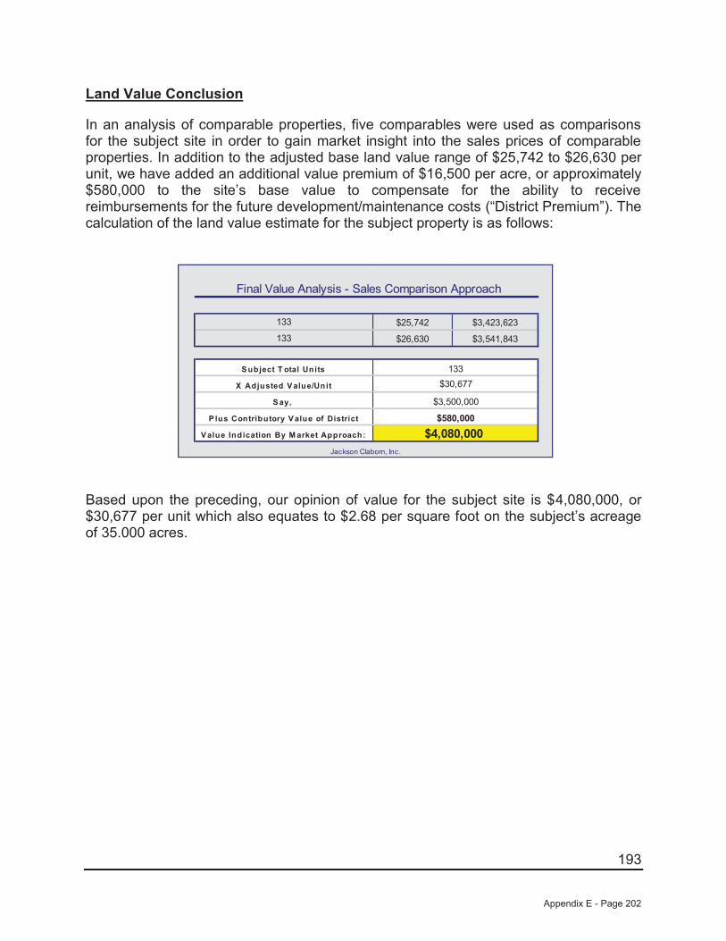
193
Land Value Conclusion
In an analysis of comparable properties, five comparables were used as comparisons for the subject site in order to gain market insight into the sales prices of comparable properties. In addition to the adjusted base land value range of $25,742 to $26,630 per unit, we have added an additional value premium of $16,500 per acre, or approximately $580,000 to the site’s base value to compensate for the ability to receive reimbursements for the future development/maintenance costs (“District Premium”). The calculation of the land value estimate for the subject property is as follows:
Final Value Analysis - Sales Comparison Approach
$25,742 $3,423,623
$26,630 $3,541,843
133
133
S ubject T otal Units
Jackson Claborn, Inc.
$4,080,000
$30,677
V alue Indication By M arket Approach:
X Adjusted V alue/Unit
133
S ay,
P lus Contributory V alue of District
$3,500,000
$580,000
Based upon the preceding, our opinion of value for the subject site is $4,080,000, or $30,677 per unit which also equates to $2.68 per square foot on the subject’s acreage of 35.000 acres.
Appendix E - Page 202
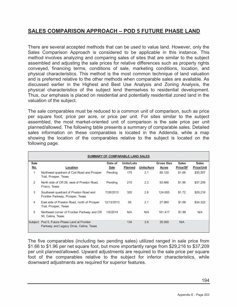
194
SALES COMPARISON APPROACH – POD 5 FUTURE PHASE LAND
There are several accepted methods that can be used to value land. However, only the Sales Comparison Approach is considered to be applicable in this instance. This method involves analyzing and comparing sales of sites that are similar to the subject assembled and adjusting the sale prices for relative differences such as property rights conveyed, financing terms, conditions of sale, marketing conditions, location, and physical characteristics. This method is the most common technique of land valuation and is preferred relative to the other methods when comparable sales are available. As discussed earlier in the Highest and Best Use Analysis and Zoning Analysis, the physical characteristics of the subject lend themselves to residential development. Thus, our emphasis is placed on residential and potentially residential zoned land in the valuation of the subject.
The sale comparables must be reduced to a common unit of comparison, such as price per square foot, price per acre, or price per unit. For sites similar to the subject assembled, the most market-oriented unit of comparison is the sale price per unit planned/allowed. The following table presents a summary of comparable sales. Detailed sales information on these comparables is located in the Addenda, while a map showing the location of the comparables relative to the subject is located on the following page.
Date of Units/Lots Gross Size Sales SalesLocation Sale Planned Units/Acre Acres Price/SF Price/Unit
1 Northwest quadrant of Coit Road and Prosper Trail, Prosper, Texas
Pending 175 2.1 85.120 $1.68 $35,507
2 North side of CR 26, west of Preston Road, Frisco, Texas
Pending 215 2.3 93.666 $1.96 $37,209
3 Southeast quadrant of Preston Road and Frontier Parkway, Prosper, Texas
7/26/2013 320 2.6 124.655 $1.72 $29,216
4 East side of Preston Road, north of Prosper Trail, Prosper, Texas
12/13/2013 59 2.1 27.960 $1.66 $34,322
5 Northeast corner of Frontier Parkway and CR 50, Celina, Texas
1/6/2014 N/A N/A 161.417 $1.88 N/A
Subject: Pod 5, Future Phase Land at Frontier Parkway and Legacy Drive, Celina, Texas
134 3.8 35.000 N/A
SUMMARY OF COMPARABLE LAND SALES
Sale No.
The five comparables (including two pending sales) utilized ranged in sale price from $1.66 to $1.96 per net square foot, but more importantly range from $29,216 to $37,209 per unit planned/allowed. Upward adjustments are required to the sale price per square foot of the comparables relative to the subject for inferior characteristics, while downward adjustments are required for superior features.
Appendix E - Page 203
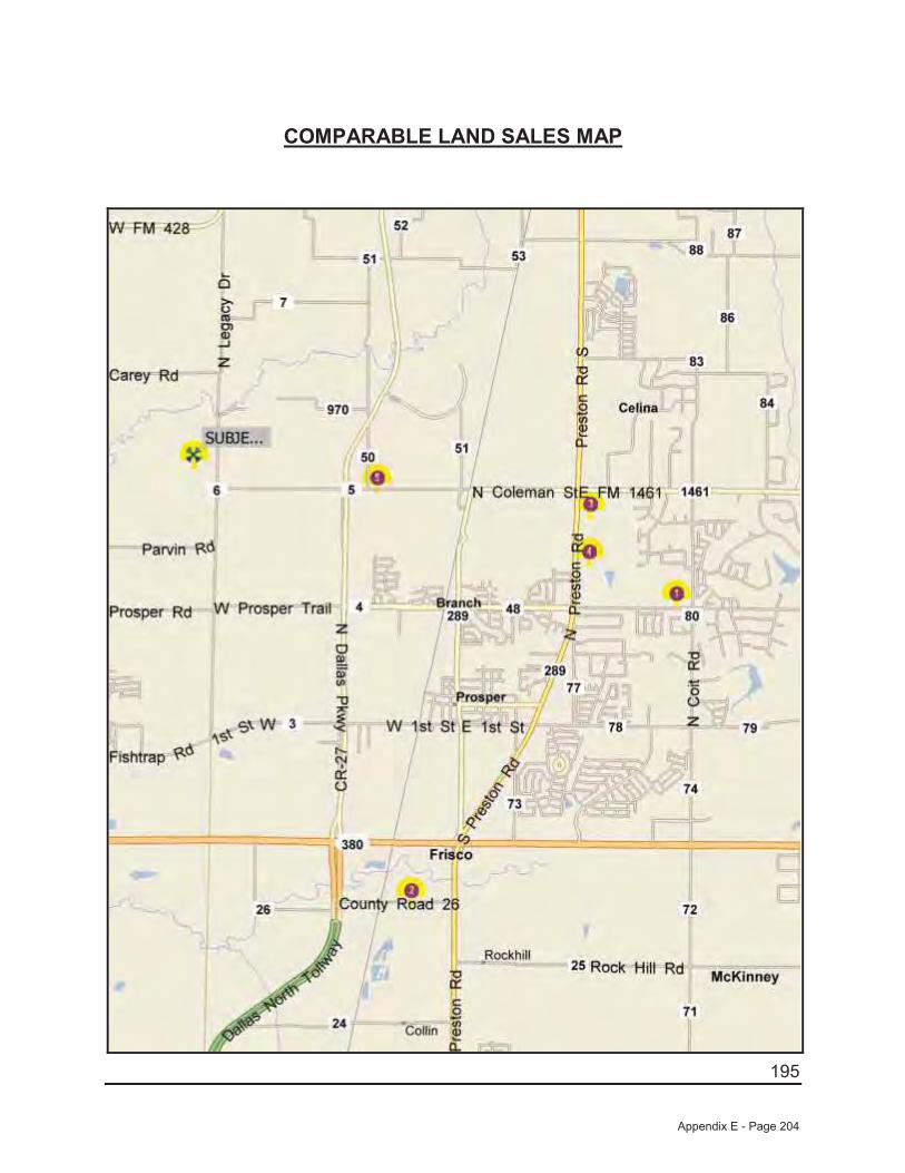
195
COMPARABLE LAND SALES MAP
Appendix E - Page 204

196
A summary of the adjustments that are made is shown at the end of this section. Where possible, we have used the paired data set analysis to make adjustments to the sale price of the comparables relative to the subject. In using this analysis, adjustments are made by comparing sales that are similar to the subject in all but one respect. However, because of the narrow sampling of similar properties, it is sometimes difficult to accurately account for the impact of a single factor on value. Consequently, while this type of analysis is theoretically sound and is market derived, judgment must also be used.
The comparables are discussed as follows:
Sale No. 1 (Pending) is located southeast of the subject at the northwest quadrant of Coit Road and Prosper Trail in Prosper, Texas. This development site is located within the Prosper Independent School District, while the subject is also located within Prosper ISD. Overall, this site is considered slightly superior in location relative to the subject. However, this site is considered inferior in size relative to the subject. This property is planned to be developed with 175 single-family lots (2.1 upa). As such, this site is considered inferior in zoning relative to the subject. However, as we are valuing the site on a per unit allowed/planned basis the adjustment will inverse as a higher density site will sell for less per unit while more per square foot. Finally, this site is considered similar in existing improvements as it is not part of an existing development. While the subject Pod will be part of existing subdivision on date of value, Phase 1 development will leave this Pod in a similar condition as this comparable. It is also noted that this site is not located in a PID which will be considered after all other adjustments.
Sale No. 2 (Pending) is located south of the subject on the north side of CR 26, west of Preston Road in Frisco, Texas. This development site is located within the Prosper Independent School District, while the subject is also located within Prosper ISD. Overall, this site is considered superior in location relative to the subject. However, this site is considered inferior in size relative to the subject. This property is planned to be developed with 215 single-family lots (2.3 upa). As such, this site is considered inferior in zoning relative to the subject. However, as we are valuing the site on a per unit allowed/planned basis the adjustment will inverse as a higher density site will sell for less per unit while more per square foot. Finally, this site is considered similar in existing improvements as it is not part of an existing development. While the subject Pod will be part of existing subdivision on date of value, Phase 1 development will leave this Pod in a similar condition as this comparable. It is also noted that this site is not located in a PID which will be considered after all other adjustments.
Sale No. 3 is located east of the subject at the southeast quadrant of Preston Road and Frontier Parkway in Prosper, Texas. This development site is located within the Prosper Independent School District, while the subject is also located within Prosper ISD. Overall, this site is considered slightly superior in location relative to the subject. However, this site is considered vastly inferior in size relative to the subject. This property is planned to be developed with 320 single-family lots (2.6 upa). As such, this site is considered inferior in zoning relative to the subject. However, as we are valuing
Appendix E - Page 205

197
the site on a per unit allowed/planned basis the adjustment will inverse as a higher density site will sell for less per unit while more per square foot. Finally, this site is considered similar in existing improvements as it is not part of an existing development. While the subject Pod will be part of existing subdivision on date of value, Phase 1 development will leave this Pod in a similar condition as this comparable. It is also noted that this site is not located in a PID which will be considered after all other adjustments.
Sale No. 4 is located east of the subject on the east side of Preston Road, north of Prosper Trail in Prosper, Texas. This development site is located within the Prosper Independent School District, while the subject is also located within Prosper ISD. Overall, this site is considered slightly superior in location relative to the subject. However, this site is considered vastly inferior in size relative to the subject. This property is planned to be developed with 59 single-family lots (2.1 upa). As such, this site is considered inferior in zoning relative to the subject. However, as we are valuing the site on a per unit allowed/planned basis the adjustment will inverse as a higher density site will sell for less per unit while more per square foot. This site is irregular in shape and has topography issues and is inferior in site utility to the subject. Finally, this site is considered similar in existing improvements as it is not part of an existing development. While the subject Pod will be part of existing subdivision on date of value, Phase 1 development will leave this Pod in a similar condition as this comparable. It is also noted that this site is not located in a PID which will be considered after all other adjustments.
Sale No. 5 is located immediately east of the subject at the northeast corner of Frontier Parkway and CR-50 in Prosper, Texas. This development is located within the Prosper Independent School District, while the subject is also located within Prosper ISD. Overall, this site is considered slightly superior in location. However, this site is substantially larger (inferior) in size while generally similar in site utility and zoning (planned for a similar density as the subject although the exact amount cannot be verified at this time) relative to the subject. Finally, this site is considered similar in existing improvements as it is not part of an existing development. While the subject Pod will be part of existing subdivision on date of value, Phase 1 development will leave this Pod in a similar condition as this comparable. It is also noted that this site is not located in a PID which will be considered after all other adjustments.
Property Rights
The price paid by a purchaser is always predicated on the property interest conveyed. Differences between the property rights conveyed of the comparables relative to the subject could have an impact on the indicated value. We are appraising the fee simple interest in the subject, which is similar to the rights conveyed to all of the comparables. Therefore, no adjustments have been made for variances in property rights.
Appendix E - Page 206
198
Financing Terms
The price paid for a property may be different from an identical property because of different financing arrangements. If a purchaser received financing from the seller that was below what could typically be achieved from a third party, or if the purchaser assumed a loan that was at a favorable rate, a premium price was probably paid for the property. Conversely, if the financing obtained was higher than was typical for the market, a lower price was probably paid. All of the comparables were purchased on a cash or cash equivalent basis and, therefore, do not require adjustments for financing terms.
Conditions of Sale
Adjustments are made to the sale prices of the comparables for conditions of sale to reflect any extraneous motivations involved with the transaction. Examples include premiums paid for an assemblage, or sale of a property under duress would require adjustments for conditions of sale. An additional example might include a condition whereby a corporation may sell to a related entity or a family may sell property to another family member at a reduced price. All of the comparables are considered similar relative to the subject for this factor.
Market Conditions
Since market conditions change over time and the date of the appraisal is as of a specific time, the comparables must be analyzed in relation to the changes, which have occurred. While these adjustments are typically known as "time adjustments", time is not the adjustment. Rather, it is the change in market conditions over time that is adjusted. One of the sales utilized sold between July 2013 and January 2014 and two sales are pending. As such, all are considered to be influenced by the same market factors currently affecting the subject. As such, no adjustments have been made for market conditions.
Location
Location is one of the most important attributes that affect the value of real estate. For sites such as the subject, the most important locational features are accessibility, visibility, and the density and types of development surrounding the site.
As discussed previously, Sale Nos. 1, 3, 4, and 5 are considered slightly superior in location, while Sale No. 2 is considered superior in location to the other four comparables as well as the subject. As both Sale Nos. 1 and 2 are similar in all respects with the exception of location, an abstraction of adjustment from these sales indicates a downward adjustment of approximately 5% for Sale No. 2 in relation to Sale No. 1. However, Sale No. 1 is superior to the subject. As such, we have subjectively adjusted Sale Nos. 1, 3, 4, and 5 downward by 10% and Sale No. 2 downward by 15%.
Appendix E - Page 207
199
Physical Characteristics
The physical differences between the subject and the comparables must also be analyzed. These differences include size, site utility, and zoning.
Size
Size plays a part in the marketplace in creating more or less utility and limiting the market segment, which can afford each property. Therefore, size adjustments are generally required when there is a significant difference in the size of two properties. Generally, smaller sites sell for higher prices per square foot than their larger counterparts since the overall price is relatively modest in comparison to larger properties. However, when a site is too small to be developed except in conjunction with an adjacent property, this principle reverses and the smaller site becomes less valuable than its larger neighbors. In regard to the comparables presented, the five comparables range in size from 27.960 acres to 161.417 acres, while the subject site is 35.000 acres in size.
As discussed previously, Sale Nos. 1, 3, 4, and 5 are considered similar in location, while Sale No. 5 is considered inferior in location relative to the subject. However, none of the sales are truly similar to the subject overall so we were unable to show an abstraction of adjustment from the sales. Sale No. 1 and 2 (85.12 and 93.666 acres, respectively) are somewhat close in site size to the subject and we have subjectively adjusted these two sales upward by 10% each. Sale Nos. 3 and 5 (124.655 and 161.417 acres, respectively) are adjusted upward by 25% and 35% respectively for their substantially larger and inferior site sizes relative to the subject.
Site Utility/Floodplain
Also to be considered is the shape and/or frontage of a site, which has an impact upon its value, or land lost to a flood prone area. As discussed, the subject has typical road frontage as compared to its overall site size and has no know adverse site issues. Sale Nos. 1, 2, 3, and 5 are considered to be generally similar in this respect. However, Sale No. 4 is inferior to the subject in this respect and is adjusted upward by 10% for this factor.
Zoning
As mentioned earlier in this report, the subject’s highest and best use is future residential usages with a density of approximately 4.1 units per acre. As discussed previously, Sale Nos. 1, 2, 3, and 4 have allowed densities ranging from 2.1 to 2.6 units per acre. As such, each of these sales is adjusted downward by 25% to reflect this factor. It is noted that this adjustment is inverse to the other adjustments as the lower density sites sell for a higher price per unit, but lower price per square foot. Therefore, as we are valuing the site on a per unit allowed/planned basis, the adjustment is
Appendix E - Page 208

200
downward. No adjustment is considered necessary to Sale No. 5 as it is also planned for a similar high density of development like the subject.
Existing Improvements
As previously discussed, the valuations found herein are subject to the completion of Phase 1 PID improvements. Upon completion of Phase 1 improvements, this Pod will still require future off-site costs that are similar to four of the five comparable presented. Thus, Sale Nos. 1, 2, 3, and 4 are considered similar in existing improvements However, Sale no. 5 is still considered inferior to the subject as it is expected to have higher off-site costs than both the remaining comparables as well as the subject. As such, Sale No. 5 was adjusted upward 10% for this factor.
Site Reimbursements/PID
As mentioned earlier in this report, the subject is located within a PID and is able to be reimbursed for its development costs. None of the five comparables have this attribute. As such, all are inferior in this respect. Instead of a straight line item adjustment for this factor. We have abstracted form the marketplace a per acre premium for this attribute.
As discussed, according to information provided from the owner/developer, the subject is in “Creeks at Legacy Public Improvement District” which allows for the right to receive reimbursements for the future development/maintenance costs of various on and off-site infrastructure improvements including but not limited to water, sanitary sewer, sewage treatment plants, storm drainage related to roads and road improvements for the community. Thus, the subject with assistance from the City of Celina, will be allow to sell bonds which will be used to repay the developers for a large majority of their expenses. There have been limited sales of properties with this attribute in the area over the past five years. As such, we have provided several separate comparisons to assist in determining the premium for having reimbursements. The first comparison consists of two known sales of similar properties located in the Kaufman County market area around Dallas that sold between 2007 and 2008 along with two sales of non-reimbursement sales. The second consists of two sales with reimbursements located in the Denton/Collin/Grayson County market area that sold in 2010 and 2012 along with two sales that lack this attribute. A summary of these sales along with a map of their locations follows:
Appendix E - Page 209
201
Kaufman County Comparison
Net SizeLocation Zoning (Acres) Price/Acre
A North side of FM 548, west of SH 205,Kaufman County, Texas
MUD 790.721 $27,823
B Eastern quadrant of SH 205 and FM 550,McLendon-Chisholm, Texas
MUD 463.040 $27,659
C West side of FM 986, north of Town NorthDrive, Terrell, Texas
None 494.307 $9,015
D East corner of FM 148 and CR 262,Kaufman County, Texas
None 219.810 $10,463
COMPARISON OF DISTRICT/NON-DISTRICT SALES (A-D)
Comp No.
As can be seen, the two MUD/”District” sales form a tight range of $27,659 to $27,823 per acre (say $27,750/acre) while the two “Non-District” sales form a range of $9,015 to $10,463 per acre, (say $10,200/acre). As such, it appears that the price differential between “District” and “Non-District” sales is approximatley $17,550 per acre.
Appendix E - Page 210
202
Denton/Collin/Grayson County Comparison
Net SizeLocation Zoning (Acres) Price/Acre
E North side of FM 543 and east and west sides of CR 206, north of CR 279, Collin County, Texas
MUD 1,350.000 $20,370
F South side of SH 121, east of Block Road, Grayson County, Texas
None 999.830 $6,451
G Southwest quadrant of FM 1385 and Bryan Road, Denton County, Texas (50% reimbursements only)
MUD 255.976 $24,002
H Southeast corner of FM 1385 and FM 455, Denton County, Texas
None 102.848 $14,000
COMPARISON OF DISTRICT/NON-DISTRICT SALES (E-H)
Comp No.
As can be seen, the MUD/”District” Sale E has a price of $20,370 whereas the non-district sale is only $6,451/acre. It is noted that these two sales are somewhat simar in size, yet appear to have major locational differences. However, Sale F surrounds a major residential golf course development. A general comparison suggests a price differential between “District” and “Non-District” sales of approximatley $13,919 per acre. This is also supported by a comparison of Sale G and H wherein the disitrict cost is approximately $10,002 per acre higher than the non-district sale. This differential is understated due to the fact that Sale G only recieves 50% of the reimbursments. Thus, considering the fact that all of these sales have other subtle differences including
Appendix E - Page 211

203
location and size, it appears that the price differential between “District” and “Non-District” sales is approximatley $15,000 per acre.
“The Lakes” Assemblage Comparison
Net SizeLocation Zoning (Acres) Price/Acre
I Northwest corner of FM 2931 E/W and FM 2931 N/S, Denton County
MUD 346.000 $28,757
J North side of Liberty Road, west of FM 2931 E/W, Denton County, Texas
None 479.000 $12,526
COMPARISON OF DISTRICT/NON-DISTRICT SALES (I-J)
Comp No.
This represents an assembalge purchased by the same buyer of two tracts, one with a MUD and one without. As can be seen, the MUD/”District” Sale No. I has a price of $28,757 whereas the non district Sale No. J is only $12,526/acre. It is noted that these two sales are somewhat simar in size, yet appear to have only a slight locational differences based on the specific road frontage. A general comparison suggests a price differential between “District” and “Non-District” sales of approximatley $16,231 per acre.
Thus, considering the the fact that all of these sales have other subtle differences including location and size, it is our opinon that the “District” contributes approximately $15,000 to $17,550 per net acre.
Appendix E - Page 212

204
Based upon the preceeding, we will apply a $16,500 per acre premium, or a total of $580,000 to the overall value, as a line-item adjustment to the determinied value of the site, without consideration of the district.
Summary of Adjustments
Land Value - Market Approach to Value
Subject Sale #1 Sale #2 Sale #3 Sale #4 Sale #5
Location:
Pod 5, Future Phase Land at Frontier Parkway and Legacy
Drive, Celina, Texas
Northwest quadrant of Coit Road and Prosper Trail, Prosper, Texas
North side of CR 26, west of Preston Road,
Frisco, Texas
Southeast quadrant of Preston Road and Frontier Parkway, Prosper, Texas
East side of Preston Road, north of Prosper Trail, Prosper, Texas
Northeast corner of Frontier Parkway and CR 50, Celina, Texas
Sale Price: N/A $6,213,760 $8,000,000 $9,349,125 $2,025,000 $13,197,636 Proposed SF Units 134 175 215 320 59 N/A
Density/Acre 3.8 2.1 2.3 2.6 2.1 N/ASale Date: N/A Pending Pending 7/26/2013 12/13/2013 1/6/2014
Land Size (Gross Acres): 35.000 85.120 93.666 124.655 27.960 161.417 Sale Price/SF N/A $1.68 $1.96 $1.72 $1.66 $1.88
Sale Price/Unit N/A $35,507 $37,209 $29,216 $34,322 N/A
Sale #1 Sale #2 Sale #3 Sale #4 Sale #5$35,507 $37,209 $29,216 $34,322 $1.88
0% 0% 0% 0% 0%0% 0% 0% 0% 0%0% 0% 0% 0% 0%0% 0% 0% 0% 0%
$35,507 $37,209 $29,216 $34,322 $1.88
-20% -25% -20% -20% -20%10% 10% 25% 0% 35%0% 0% 0% 10% 0%
-25% -25% -25% -25% 0%0% 0% 0% 0% 10%
-35% -40% -20% -35% 25%
$23,080 $22,326 $23,373 $22,309 $2.35Jackson Claborn, Inc.
Final Adjusted Price/Unit
Functional Utility
Carried Forward Price/Unit
Property Rights Conveyed
Market Conditions
Net Other AdjustmentsExisting Improvements
Zoning Density
LocationSize
Sales Adjustment
Adjusted Price/Unit
Financing TermsConditions of Sale
Land Sales
Other Adjustments:
Appendix E - Page 213

205
Land Value Conclusion
In an analysis of comparable properties, five comparables were used as comparisons for the subject site in order to gain market insight into the sales prices of comparable properties. In addition to the adjusted base land value range of $22,309 to $23,373 per unit, we have added an additional value premium of $16,500 per acre, or approximately $580,000 to the site’s base value to compensate for the ability to receive reimbursements for the future development/maintenance costs (“District Premium”). The calculation of the land value estimate for the subject property is as follows:
Final Value Analysis - Sales Comparison Approach
$22,309 $2,989,449
$23,373 $3,131,957
P lus Contributory V alue of District
$3,050,000
$580,000
134
134
S ubject T otal Units
Jackson Claborn, Inc.
$3,630,000
$27,090
V alue Indication By M arket Approach:
X Adjusted V alue/Unit
134
S ay,
Based upon the preceding, our opinion of value for the subject site is $3,630,000, or $27,090 per unit which also equates to $2.38 per square foot on the subject’s acreage of 35.000 acres.
Appendix E - Page 214
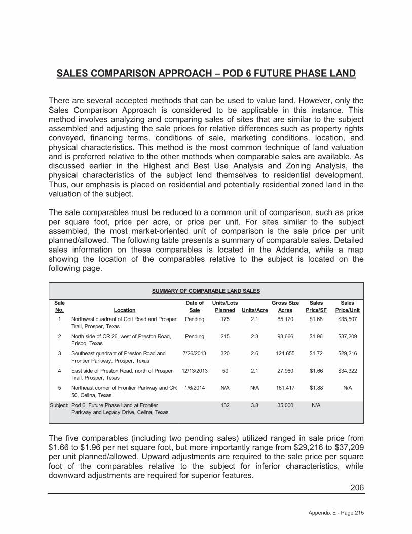
206
SALES COMPARISON APPROACH – POD 6 FUTURE PHASE LAND
There are several accepted methods that can be used to value land. However, only the Sales Comparison Approach is considered to be applicable in this instance. This method involves analyzing and comparing sales of sites that are similar to the subject assembled and adjusting the sale prices for relative differences such as property rights conveyed, financing terms, conditions of sale, marketing conditions, location, and physical characteristics. This method is the most common technique of land valuation and is preferred relative to the other methods when comparable sales are available. As discussed earlier in the Highest and Best Use Analysis and Zoning Analysis, the physical characteristics of the subject lend themselves to residential development. Thus, our emphasis is placed on residential and potentially residential zoned land in the valuation of the subject.
The sale comparables must be reduced to a common unit of comparison, such as price per square foot, price per acre, or price per unit. For sites similar to the subject assembled, the most market-oriented unit of comparison is the sale price per unit planned/allowed. The following table presents a summary of comparable sales. Detailed sales information on these comparables is located in the Addenda, while a map showing the location of the comparables relative to the subject is located on the following page.
Date of Units/Lots Gross Size Sales SalesLocation Sale Planned Units/Acre Acres Price/SF Price/Unit
1 Northwest quadrant of Coit Road and Prosper Trail, Prosper, Texas
Pending 175 2.1 85.120 $1.68 $35,507
2 North side of CR 26, west of Preston Road, Frisco, Texas
Pending 215 2.3 93.666 $1.96 $37,209
3 Southeast quadrant of Preston Road and Frontier Parkway, Prosper, Texas
7/26/2013 320 2.6 124.655 $1.72 $29,216
4 East side of Preston Road, north of Prosper Trail, Prosper, Texas
12/13/2013 59 2.1 27.960 $1.66 $34,322
5 Northeast corner of Frontier Parkway and CR 50, Celina, Texas
1/6/2014 N/A N/A 161.417 $1.88 N/A
Subject: Pod 6, Future Phase Land at Frontier Parkway and Legacy Drive, Celina, Texas
132 3.8 35.000 N/A
SUMMARY OF COMPARABLE LAND SALES
Sale No.
The five comparables (including two pending sales) utilized ranged in sale price from $1.66 to $1.96 per net square foot, but more importantly range from $29,216 to $37,209 per unit planned/allowed. Upward adjustments are required to the sale price per square foot of the comparables relative to the subject for inferior characteristics, while downward adjustments are required for superior features.
Appendix E - Page 215

207
COMPARABLE LAND SALES MAP
Appendix E - Page 216
208
A summary of the adjustments that are made is shown at the end of this section. Where possible, we have used the paired data set analysis to make adjustments to the sale price of the comparables relative to the subject. In using this analysis, adjustments are made by comparing sales that are similar to the subject in all but one respect. However, because of the narrow sampling of similar properties, it is sometimes difficult to accurately account for the impact of a single factor on value. Consequently, while this type of analysis is theoretically sound and is market derived, judgment must also be used.
The comparables are discussed as follows:
Sale No. 1 (Pending) is located southeast of the subject at the northwest quadrant of Coit Road and Prosper Trail in Prosper, Texas. This development site is located within the Prosper Independent School District, while the subject is also located within Prosper ISD. Overall, this site is considered slightly superior in location relative to the subject. However, this site is considered inferior in size relative to the subject. This property is planned to be developed with 175 single-family lots (2.1 upa). As such, this site is considered inferior in zoning relative to the subject. However, as we are valuing the site on a per unit allowed/planned basis the adjustment will inverse as a higher density site will sell for less per unit while more per square foot. Finally, this site is considered similar in existing improvements as it is not part of an existing development. While the subject Pod will be part of existing subdivision on date of value, Phase 1 development will leave this Pod in a similar condition as this comparable. It is also noted that this site is not located in a PID which will be considered after all other adjustments.
Sale No. 2 (Pending) is located south of the subject on the north side of CR 26, west of Preston Road in Frisco, Texas. This development site is located within the Prosper Independent School District, while the subject is also located within Prosper ISD. Overall, this site is considered superior in location relative to the subject. However, this site is considered inferior in size relative to the subject. This property is planned to be developed with 215 single-family lots (2.3 upa). As such, this site is considered inferior in zoning relative to the subject. However, as we are valuing the site on a per unit allowed/planned basis the adjustment will inverse as a higher density site will sell for less per unit while more per square foot. Finally, this site is considered similar in existing improvements as it is not part of an existing development. While the subject Pod will be part of existing subdivision on date of value, Phase 1 development will leave this Pod in a similar condition as this comparable. It is also noted that this site is not located in a PID which will be considered after all other adjustments.
Sale No. 3 is located east of the subject at the southeast quadrant of Preston Road and Frontier Parkway in Prosper, Texas. This development site is located within the Prosper Independent School District, while the subject is also located within Prosper ISD. Overall, this site is considered slightly superior in location relative to the subject. However, this site is considered vastly inferior in size relative to the subject. This property is planned to be developed with 320 single-family lots (2.6 upa). As such, this site is considered inferior in zoning relative to the subject. However, as we are valuing
Appendix E - Page 217

209
the site on a per unit allowed/planned basis the adjustment will inverse as a higher density site will sell for less per unit while more per square foot. Finally, this site is considered similar in existing improvements as it is not part of an existing development. While the subject Pod will be part of existing subdivision on date of value, Phase 1 development will leave this Pod in a similar condition as this comparable. It is also noted that this site is not located in a PID which will be considered after all other adjustments.
Sale No. 4 is located east of the subject on the east side of Preston Road, north of Prosper Trail in Prosper, Texas. This development site is located within the Prosper Independent School District, while the subject is also located within Prosper ISD. Overall, this site is considered slightly superior in location relative to the subject. However, this site is considered vastly inferior in size relative to the subject. This property is planned to be developed with 59 single-family lots (2.1 upa). As such, this site is considered inferior in zoning relative to the subject. However, as we are valuing the site on a per unit allowed/planned basis the adjustment will inverse as a higher density site will sell for less per unit while more per square foot. This site is irregular in shape and has topography issues and is inferior in site utility to the subject. Finally, this site is considered similar in existing improvements as it is not part of an existing development. While the subject Pod will be part of existing subdivision on date of value, Phase 1 development will leave this Pod in a similar condition as this comparable. It is also noted that this site is not located in a PID which will be considered after all other adjustments.
Sale No. 5 is located immediately east of the subject at the northeast corner of Frontier Parkway and CR-50 in Prosper, Texas. This development is located within the Prosper Independent School District, while the subject is also located within Prosper ISD. Overall, this site is considered slightly superior in location. However, this site is substantially larger (inferior) in size while generally similar in site utility and zoning (planned for a similar density as the subject although the exact amount cannot be verified at this time) relative to the subject. Finally, this site is considered similar in existing improvements as it is not part of an existing development. While the subject Pod will be part of existing subdivision on date of value, Phase 1 development will leave this Pod in a similar condition as this comparable. It is also noted that this site is not located in a PID which will be considered after all other adjustments.
Property Rights
The price paid by a purchaser is always predicated on the property interest conveyed. Differences between the property rights conveyed of the comparables relative to the subject could have an impact on the indicated value. We are appraising the fee simple interest in the subject, which is similar to the rights conveyed to all of the comparables. Therefore, no adjustments have been made for variances in property rights.
Appendix E - Page 218
210
Financing Terms
The price paid for a property may be different from an identical property because of different financing arrangements. If a purchaser received financing from the seller that was below what could typically be achieved from a third party, or if the purchaser assumed a loan that was at a favorable rate, a premium price was probably paid for the property. Conversely, if the financing obtained was higher than was typical for the market, a lower price was probably paid. All of the comparables were purchased on a cash or cash equivalent basis and, therefore, do not require adjustments for financing terms.
Conditions of Sale
Adjustments are made to the sale prices of the comparables for conditions of sale to reflect any extraneous motivations involved with the transaction. Examples include premiums paid for an assemblage, or sale of a property under duress would require adjustments for conditions of sale. An additional example might include a condition whereby a corporation may sell to a related entity or a family may sell property to another family member at a reduced price. All of the comparables are considered similar relative to the subject for this factor.
Market Conditions
Since market conditions change over time and the date of the appraisal is as of a specific time, the comparables must be analyzed in relation to the changes, which have occurred. While these adjustments are typically known as "time adjustments", time is not the adjustment. Rather, it is the change in market conditions over time that is adjusted. One of the sales utilized sold between July 2013 and January 2014 and two sales are pending. As such, all are considered to be influenced by the same market factors currently affecting the subject. As such, no adjustments have been made for market conditions.
Location
Location is one of the most important attributes that affect the value of real estate. For sites such as the subject, the most important locational features are accessibility, visibility, and the density and types of development surrounding the site.
As discussed previously, Sale Nos. 1, 3, 4, and 5 are considered slightly superior in location, while Sale No. 2 is considered superior in location to the other four comparables as well as the subject. As both Sale Nos. 1 and 2 are similar in all respects with the exception of location, an abstraction of adjustment from these sales indicates a downward adjustment of approximately 5% for Sale No. 2 in relation to Sale No. 1. However, Sale No. 1 is superior to the subject. As such, we have subjectively adjusted Sale Nos. 1, 3, 4, and 5 downward by 10% and Sale No. 2 downward by 15%.
Appendix E - Page 219

211
Physical Characteristics
The physical differences between the subject and the comparables must also be analyzed. These differences include size, site utility, and zoning.
Size
Size plays a part in the marketplace in creating more or less utility and limiting the market segment, which can afford each property. Therefore, size adjustments are generally required when there is a significant difference in the size of two properties. Generally, smaller sites sell for higher prices per square foot than their larger counterparts since the overall price is relatively modest in comparison to larger properties. However, when a site is too small to be developed except in conjunction with an adjacent property, this principle reverses and the smaller site becomes less valuable than its larger neighbors. In regard to the comparables presented, the five comparables range in size from 27.960 acres to 161.417 acres, while the subject site is 35.000 acres in size.
As discussed previously, Sale Nos. 1, 3, 4, and 5 are considered similar in location, while Sale No. 5 is considered inferior in location relative to the subject. However, none of the sales are truly similar to the subject overall so we were unable to show an abstraction of adjustment from the sales. Sale No. 1 and 2 (85.12 and 93.666 acres, respectively) are somewhat close in site size to the subject and we have subjectively adjusted these two sales upward by 10% each. Sale Nos. 3 and 5 (124.655 and 161.417 acres, respectively) are adjusted upward by 25% and 35% respectively for their substantially larger and inferior site sizes relative to the subject.
Site Utility/Floodplain
Also to be considered is the shape and/or frontage of a site, which has an impact upon its value, or land lost to a flood prone area. As discussed, the subject has typical road frontage as compared to its overall site size and has no know adverse site issues. Sale Nos. 1, 2, 3, and 5 are considered to be generally similar in this respect. However, Sale No. 4 is inferior to the subject in this respect and is adjusted upward by 10% for this factor.
Zoning
As mentioned earlier in this report, the subject’s highest and best use is future residential usages with a density of approximately 4.1 units per acre. As discussed previously, Sale Nos. 1, 2, 3, and 4 have allowed densities ranging from 2.1 to 2.6 units per acre. As such, each of these sales is adjusted downward by 25% to reflect this factor. It is noted that this adjustment is inverse to the other adjustments as the lower density sites sell for a higher price per unit, but lower price per square foot. Therefore, as we are valuing the site on a per unit allowed/planned basis, the adjustment is
Appendix E - Page 220

212
downward. No adjustment is considered necessary to Sale No. 5 as it is also planned for a similar high density of development like the subject.
Existing Improvements
As previously discussed, the valuations found herein are subject to the completion of Phase 1 PID improvements. Upon completion of Phase 1 improvements, this Pod will still require future off-site costs that are similar to four of the five comparable presented. Thus, Sale Nos. 1, 2, 3, and 4 are considered similar in existing improvements However, Sale no. 5 is still considered inferior to the subject as it is expected to have higher off-site costs than both the remaining comparables as well as the subject. As such, Sale No. 5 was adjusted upward 10% for this factor.
Site Reimbursements/PID
As mentioned earlier in this report, the subject is located within a PID and is able to be reimbursed for its development costs. None of the five comparables have this attribute. As such, all are inferior in this respect. Instead of a straight line item adjustment for this factor. We have abstracted form the marketplace a per acre premium for this attribute.
As discussed, according to information provided from the owner/developer, the subject is in “Creeks at Legacy Public Improvement District” which allows for the right to receive reimbursements for the future development/maintenance costs of various on and off-site infrastructure improvements including but not limited to water, sanitary sewer, sewage treatment plants, storm drainage related to roads and road improvements for the community. Thus, the subject with assistance from the City of Celina, will be allow to sell bonds which will be used to repay the developers for a large majority of their expenses. There have been limited sales of properties with this attribute in the area over the past five years. As such, we have provided several separate comparisons to assist in determining the premium for having reimbursements. The first comparison consists of two known sales of similar properties located in the Kaufman County market area around Dallas that sold between 2007 and 2008 along with two sales of non-reimbursement sales. The second consists of two sales with reimbursements located in the Denton/Collin/Grayson County market area that sold in 2010 and 2012 along with two sales that lack this attribute. A summary of these sales along with a map of their locations follows:
Appendix E - Page 221

213
Kaufman County Comparison
Net SizeLocation Zoning (Acres) Price/Acre
A North side of FM 548, west of SH 205,Kaufman County, Texas
MUD 790.721 $27,823
B Eastern quadrant of SH 205 and FM 550,McLendon-Chisholm, Texas
MUD 463.040 $27,659
C West side of FM 986, north of Town NorthDrive, Terrell, Texas
None 494.307 $9,015
D East corner of FM 148 and CR 262,Kaufman County, Texas
None 219.810 $10,463
COMPARISON OF DISTRICT/NON-DISTRICT SALES (A-D)
Comp No.
As can be seen, the two MUD/”District” sales form a tight range of $27,659 to $27,823 per acre (say $27,750/acre) while the two “Non-District” sales form a range of $9,015 to $10,463 per acre, (say $10,200/acre). As such, it appears that the price differential between “District” and “Non-District” sales is approximatley $17,550 per acre.
Appendix E - Page 222

214
Denton/Collin/Grayson County Comparison
Net SizeLocation Zoning (Acres) Price/Acre
E North side of FM 543 and east and west sides of CR 206, north of CR 279, Collin County, Texas
MUD 1,350.000 $20,370
F South side of SH 121, east of Block Road, Grayson County, Texas
None 999.830 $6,451
G Southwest quadrant of FM 1385 and Bryan Road, Denton County, Texas (50% reimbursements only)
MUD 255.976 $24,002
H Southeast corner of FM 1385 and FM 455, Denton County, Texas
None 102.848 $14,000
COMPARISON OF DISTRICT/NON-DISTRICT SALES (E-H)
Comp No.
As can be seen, the MUD/”District” Sale E has a price of $20,370 whereas the non-district sale is only $6,451/acre. It is noted that these two sales are somewhat simar in size, yet appear to have major locational differences. However, Sale F surrounds a major residential golf course development. A general comparison suggests a price differential between “District” and “Non-District” sales of approximatley $13,919 per acre. This is also supported by a comparison of Sale G and H wherein the disitrict cost is approximately $10,002 per acre higher than the non-district sale. This differential is understated due to the fact that Sale G only recieves 50% of the reimbursments. Thus, considering the fact that all of these sales have other subtle differences including
Appendix E - Page 223
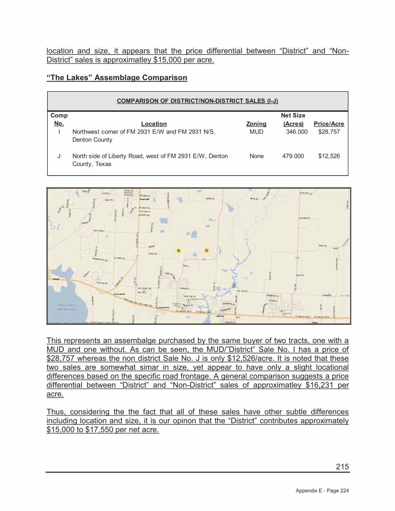
215
location and size, it appears that the price differential between “District” and “Non-District” sales is approximatley $15,000 per acre.
“The Lakes” Assemblage Comparison
Net SizeLocation Zoning (Acres) Price/Acre
I Northwest corner of FM 2931 E/W and FM 2931 N/S, Denton County
MUD 346.000 $28,757
J North side of Liberty Road, west of FM 2931 E/W, Denton County, Texas
None 479.000 $12,526
COMPARISON OF DISTRICT/NON-DISTRICT SALES (I-J)
Comp No.
This represents an assembalge purchased by the same buyer of two tracts, one with a MUD and one without. As can be seen, the MUD/”District” Sale No. I has a price of $28,757 whereas the non district Sale No. J is only $12,526/acre. It is noted that these two sales are somewhat simar in size, yet appear to have only a slight locational differences based on the specific road frontage. A general comparison suggests a price differential between “District” and “Non-District” sales of approximatley $16,231 per acre.
Thus, considering the the fact that all of these sales have other subtle differences including location and size, it is our opinon that the “District” contributes approximately $15,000 to $17,550 per net acre.
Appendix E - Page 224
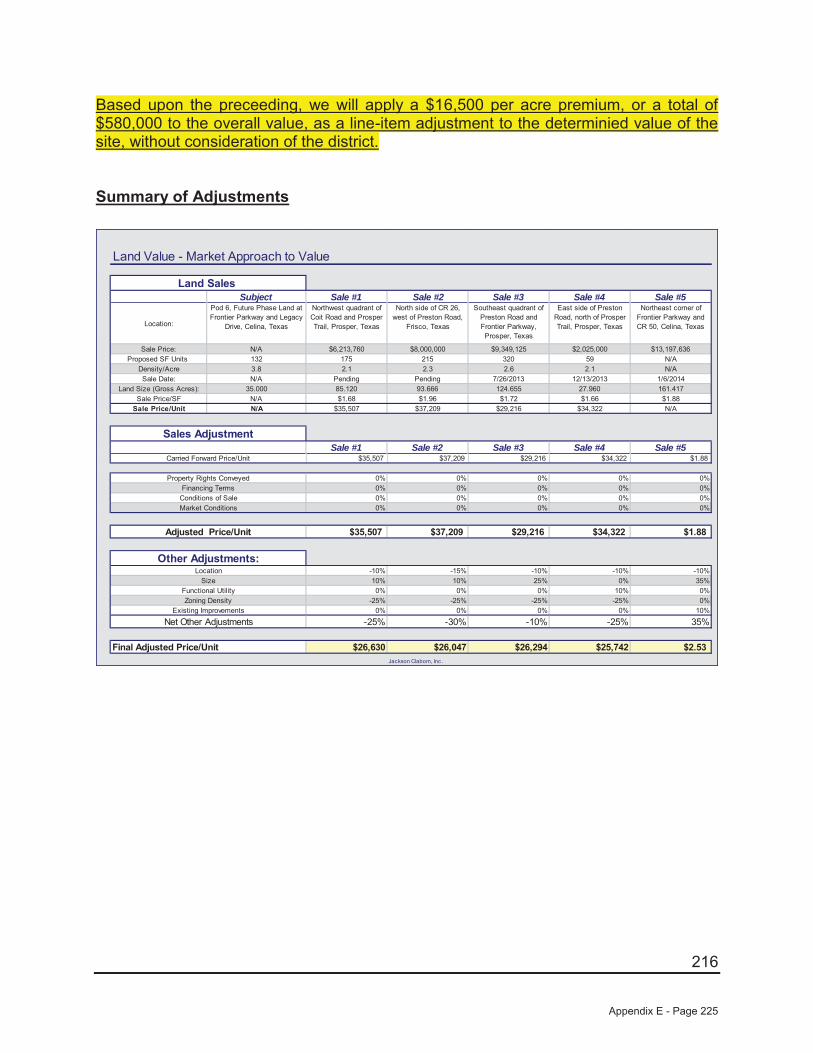
216
Based upon the preceeding, we will apply a $16,500 per acre premium, or a total of $580,000 to the overall value, as a line-item adjustment to the determinied value of the site, without consideration of the district.
Summary of Adjustments
Land Value - Market Approach to Value
Subject Sale #1 Sale #2 Sale #3 Sale #4 Sale #5
Location:
Pod 6, Future Phase Land at Frontier Parkway and Legacy
Drive, Celina, Texas
Northwest quadrant of Coit Road and Prosper Trail, Prosper, Texas
North side of CR 26, west of Preston Road,
Frisco, Texas
Southeast quadrant of Preston Road and Frontier Parkway, Prosper, Texas
East side of Preston Road, north of Prosper Trail, Prosper, Texas
Northeast corner of Frontier Parkway and CR 50, Celina, Texas
Sale Price: N/A $6,213,760 $8,000,000 $9,349,125 $2,025,000 $13,197,636 Proposed SF Units 132 175 215 320 59 N/A
Density/Acre 3.8 2.1 2.3 2.6 2.1 N/ASale Date: N/A Pending Pending 7/26/2013 12/13/2013 1/6/2014
Land Size (Gross Acres): 35.000 85.120 93.666 124.655 27.960 161.417 Sale Price/SF N/A $1.68 $1.96 $1.72 $1.66 $1.88
Sale Price/Unit N/A $35,507 $37,209 $29,216 $34,322 N/A
Sale #1 Sale #2 Sale #3 Sale #4 Sale #5$35,507 $37,209 $29,216 $34,322 $1.88
0% 0% 0% 0% 0%0% 0% 0% 0% 0%0% 0% 0% 0% 0%0% 0% 0% 0% 0%
$35,507 $37,209 $29,216 $34,322 $1.88
-10% -15% -10% -10% -10%10% 10% 25% 0% 35%0% 0% 0% 10% 0%
-25% -25% -25% -25% 0%0% 0% 0% 0% 10%
-25% -30% -10% -25% 35%
$26,630 $26,047 $26,294 $25,742 $2.53Jackson Claborn, Inc.
Final Adjusted Price/Unit
Functional Utility
Carried Forward Price/Unit
Property Rights Conveyed
Market Conditions
Net Other AdjustmentsExisting Improvements
Zoning Density
LocationSize
Sales Adjustment
Adjusted Price/Unit
Financing TermsConditions of Sale
Land Sales
Other Adjustments:
Appendix E - Page 225
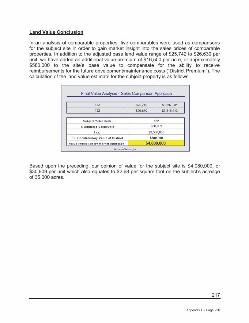
217
Land Value Conclusion
In an analysis of comparable properties, five comparables were used as comparisons for the subject site in order to gain market insight into the sales prices of comparable properties. In addition to the adjusted base land value range of $25,742 to $26,630 per unit, we have added an additional value premium of $16,500 per acre, or approximately $580,000 to the site’s base value to compensate for the ability to receive reimbursements for the future development/maintenance costs (“District Premium”). The calculation of the land value estimate for the subject property is as follows:
Final Value Analysis - Sales Comparison Approach
$25,742 $3,397,881
$26,630 $3,515,213
P lus Contributory V alue of District
$3,500,000
$580,000
132
132
S ubject T otal Units
Jackson Claborn, Inc.
$4,080,000
$30,909
V alue Indication By M arket Approach:
X Adjusted V alue/Unit
132
S ay,
Based upon the preceding, our opinion of value for the subject site is $4,080,000, or $30,909 per unit which also equates to $2.68 per square foot on the subject’s acreage of 35.000 acres.
Appendix E - Page 226
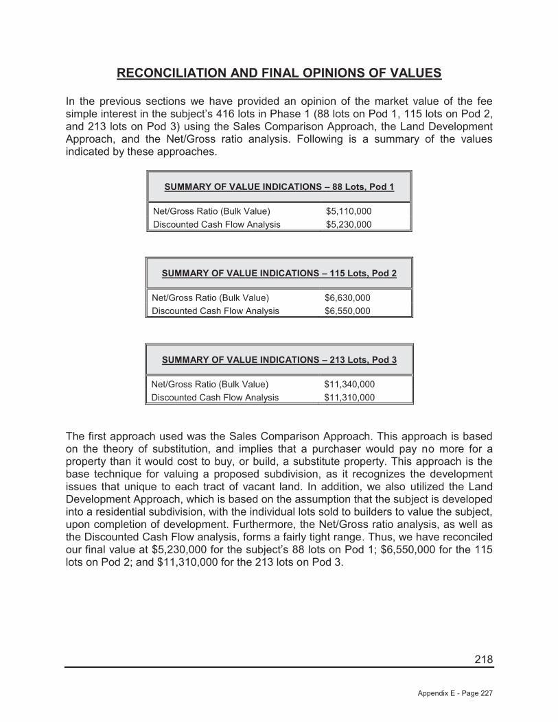
218
RECONCILIATION AND FINAL OPINIONS OF VALUES
In the previous sections we have provided an opinion of the market value of the fee simple interest in the subject’s 416 lots in Phase 1 (88 lots on Pod 1, 115 lots on Pod 2, and 213 lots on Pod 3) using the Sales Comparison Approach, the Land Development Approach, and the Net/Gross ratio analysis. Following is a summary of the values indicated by these approaches.
SUMMARY OF VALUE INDICATIONS – 88 Lots, Pod 1
Net/Gross Ratio (Bulk Value) $5,110,000Discounted Cash Flow Analysis $5,230,000
SUMMARY OF VALUE INDICATIONS – 115 Lots, Pod 2
Net/Gross Ratio (Bulk Value) $6,630,000Discounted Cash Flow Analysis $6,550,000
SUMMARY OF VALUE INDICATIONS – 213 Lots, Pod 3
Net/Gross Ratio (Bulk Value) $11,340,000Discounted Cash Flow Analysis $11,310,000
The first approach used was the Sales Comparison Approach. This approach is based on the theory of substitution, and implies that a purchaser would pay no more for a property than it would cost to buy, or build, a substitute property. This approach is the base technique for valuing a proposed subdivision, as it recognizes the development issues that unique to each tract of vacant land. In addition, we also utilized the Land Development Approach, which is based on the assumption that the subject is developed into a residential subdivision, with the individual lots sold to builders to value the subject, upon completion of development. Furthermore, the Net/Gross ratio analysis, as well as the Discounted Cash Flow analysis, forms a fairly tight range. Thus, we have reconciled our final value at $5,230,000 for the subject’s 88 lots on Pod 1; $6,550,000 for the 115 lots on Pod 2; and $11,310,000 for the 213 lots on Pod 3.
Appendix E - Page 227
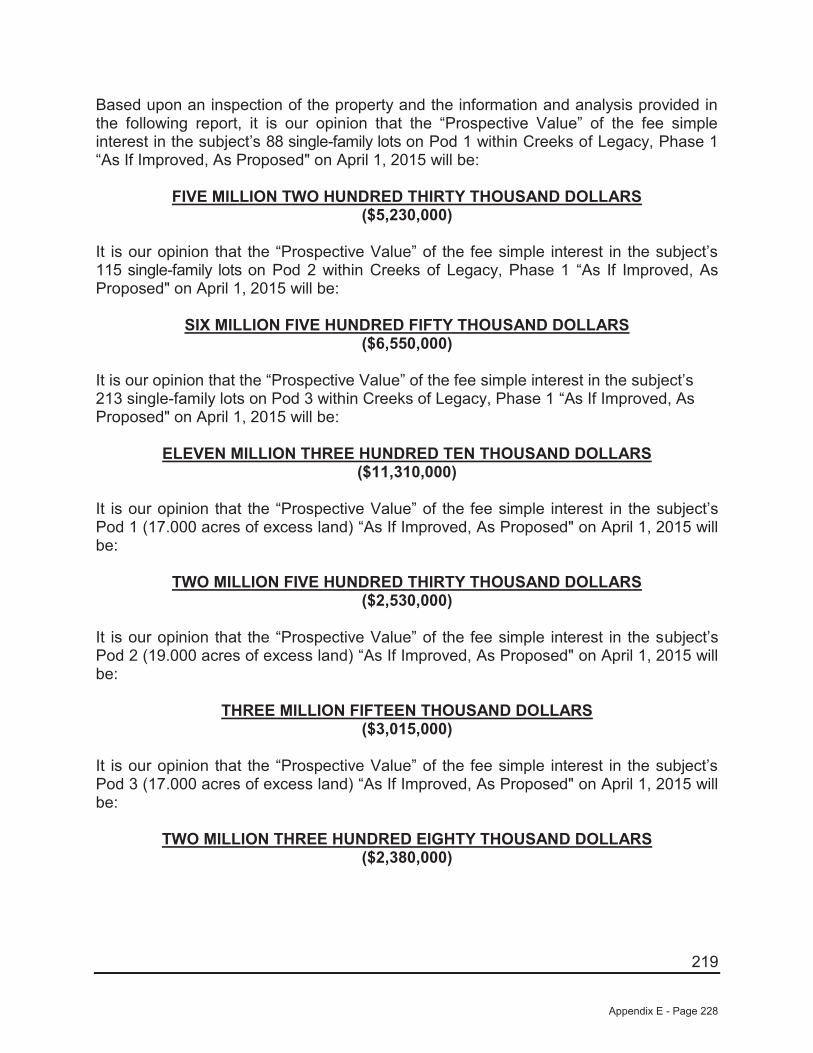
219
Based upon an inspection of the property and the information and analysis provided in the following report, it is our opinion that the “Prospective Value” of the fee simple interest in the subject’s 88 single-family lots on Pod 1 within Creeks of Legacy, Phase 1 “As If Improved, As Proposed" on April 1, 2015 will be:
FIVE MILLION TWO HUNDRED THIRTY THOUSAND DOLLARS ($5,230,000)
It is our opinion that the “Prospective Value” of the fee simple interest in the subject’s 115 single-family lots on Pod 2 within Creeks of Legacy, Phase 1 “As If Improved, As Proposed" on April 1, 2015 will be:
SIX MILLION FIVE HUNDRED FIFTY THOUSAND DOLLARS ($6,550,000)
It is our opinion that the “Prospective Value” of the fee simple interest in the subject’s 213 single-family lots on Pod 3 within Creeks of Legacy, Phase 1 “As If Improved, As Proposed" on April 1, 2015 will be:
ELEVEN MILLION THREE HUNDRED TEN THOUSAND DOLLARS ($11,310,000)
It is our opinion that the “Prospective Value” of the fee simple interest in the subject’s Pod 1 (17.000 acres of excess land) “As If Improved, As Proposed" on April 1, 2015 will be:
TWO MILLION FIVE HUNDRED THIRTY THOUSAND DOLLARS ($2,530,000)
It is our opinion that the “Prospective Value” of the fee simple interest in the subject’s Pod 2 (19.000 acres of excess land) “As If Improved, As Proposed" on April 1, 2015 will be:
THREE MILLION FIFTEEN THOUSAND DOLLARS ($3,015,000)
It is our opinion that the “Prospective Value” of the fee simple interest in the subject’s Pod 3 (17.000 acres of excess land) “As If Improved, As Proposed" on April 1, 2015 will be:
TWO MILLION THREE HUNDRED EIGHTY THOUSAND DOLLARS ($2,380,000)
Appendix E - Page 228
220
It is our opinion that the “Prospective Value” of the fee simple interest in the subject’s Pod 4 (36.000 acres of excess land) “As If Improved, As Proposed" on April 1, 2015 will be:
FOUR MILLION EIGHTY THOUSAND DOLLARS ($4,080,000)
It is our opinion that the “Prospective Value” of the fee simple interest in the subject’s Pod 5 (36.000 acres of excess land) “As If Improved, As Proposed" on April 1, 2015 will be:
THREE MILLION SIX HUNDRED THIRTY THOUSAND DOLLARS ($3,630,000)
It is our opinion that the “Prospective Value” of the fee simple interest in the subject’s Pod 6 (34.000 acres of excess land) “As If Improved, As Proposed" on April 1, 2015 will be:
FOUR MILLION EIGHTY THOUSAND DOLLARS ($4,080,000)
Appendix E - Page 229

221
SECTION 7 — ADDENDUMS
Appendix E - Page 230

222
AERIAL PHOTOGRAPHS
Appendix E - Page 231

223
Appendix E - Page 232
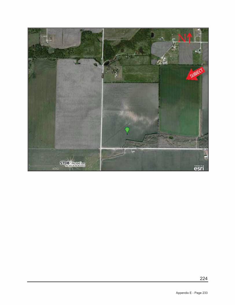
224
Appendix E - Page 233

225
SUBDIVISION/LOT SALE COMPARABLES
Appendix E - Page 234
226
SUBDIVISION COMPARABLE NO. 1
Computer ID Number: RDV14-04-068
Mapsco: Collin/Grayson 469-M
Development Name: Carter Ranch, Phase 2C
Location: South side of CR-88, east of Preston Road (SH-289), Celina, Collin County, Texas
School District: Celina Independent School District
Developer: 19 FM LTD
Home Builders: First Texas Homes
Platted Lots: 33*
Number of Available Lots: N/A (Near Completion)
Lots Sold to Date: N/A (Near Completion)
Estimated Lot Absorption: N/A (Near Completion)
Typical Lot Size: 6,600 SF – 8,400 SF
Typical Lot Dimensions: 55’ x 120’; 70’ x 120’
Home Prices: $225,000 to $285,000
Amenities: Community center with pool, playground and park, a large pond, and several open spaces
Representative Lot Sales: 55’ Lots: $45,000/lot ($818/FF) 70’ Lots: $58,000/lot ($829/FF)
Survey Date: 04/21/2014
Verified by: JCI Appraisal
Comments: *Per Residential Strategies, Inc. as of First Quarter 2014
This phase will eventually be developed with a total of 103 single-family lots within an existing multiphase subdivision.
Appendix E - Page 235
227
SUBDIVISION COMPARABLE NO. 2
Computer ID Number: RDV14-04-069
Mapsco: Collin/Grayson-469-S
Development Name: Light Farms (aka Light Ranch)
Location: East of future Dallas North Tollway at Light Farms Way, Celina, Collin County, Texas
School District: Prosper Independent School District
Developer: Republic Property Group
Home Builders: American Legend Homes, Lionsgate Homes, Darling Homes, Drees Homes, Highland Homes, and Shaddock Homes
Platted Lots: 229
Number of Available Lots: 148*
Lots Sold to Date: 81
Estimated Lot Absorption: 81 lots from 07/13 to 03/14 = 9 upm
Typical Lot Size: 5,750 SF – 7,200 SF– 9,100 SF
Typical Lot Dimensions: 50’ x 115’; 60’ x 120’; 70’ x 130’
Home Prices: $255,000 - $490,000
Future Amenities: Fitness center, four pools, tennis court complex, central lawn with gazebo
Representative Lot Sales: 50’ Lots: $57,500/lot ($1,150/FF)60’ Lots: $69,000/lot ($1,150/FF)70’ Lots: $80,500/lot ($1,150/FF)
Survey Date: 04/21/2014
Verified by: Erik Norgello (Drees Homes)
Appendix E - Page 236

228
Continued: Light Farms (aka Light Ranch)
Comments: *Per Residential Strategies, Inc. as of First Quarter 2014
Lots in this new development are contracted on a “straight-line” basis with no interest carry at $1,150/front footage. Light Farms is a 908-acre development in Celina located within the Prosper ISD. Phase 1 also was developed with 38 lots as 80’ x 135’ lots (10,800 SF).
Appendix E - Page 237
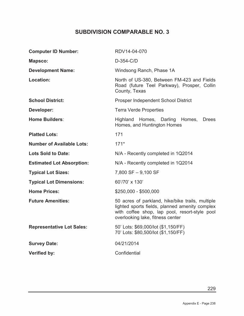
229
SUBDIVISION COMPARABLE NO. 3
Computer ID Number: RDV14-04-070
Mapsco: D-354-C/D
Development Name: Windsong Ranch, Phase 1A
Location: North of US-380, Between FM-423 and Fields Road (future Teel Parkway), Prosper, Collin County, Texas
School District: Prosper Independent School District
Developer: Terra Verde Properties
Home Builders: Highland Homes, Darling Homes, Drees Homes, and Huntington Homes
Platted Lots: 171
Number of Available Lots: 171*
Lots Sold to Date: N/A - Recently completed in 1Q2014
Estimated Lot Absorption: N/A - Recently completed in 1Q2014
Typical Lot Sizes: 7,800 SF – 9,100 SF
Typical Lot Dimensions: 60’/70’ x 130’
Home Prices: $250,000 - $500,000
Future Amenities: 50 acres of parkland, hike/bike trails, multiple lighted sports fields, planned amenity complex with coffee shop, lap pool, resort-style pool overlooking lake, fitness center
Representative Lot Sales: 50’ Lots: $69,000/lot ($1,150/FF)70’ Lots: $80,500/lot ($1,150/FF)
Survey Date: 04/21/2014
Verified by: Confidential
Appendix E - Page 238
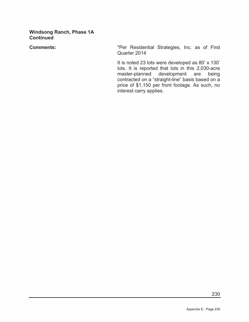
230
Windsong Ranch, Phase 1A Continued
Comments: *Per Residential Strategies, Inc. as of First Quarter 2014
It is noted 23 lots were developed as 80’ x 130’ lots. It is reported that lots in this 2,030-acre master-planned development are being contracted on a “straight-line” basis based on a price of $1,150 per front footage. As such, no interest carry applies.
Appendix E - Page 239
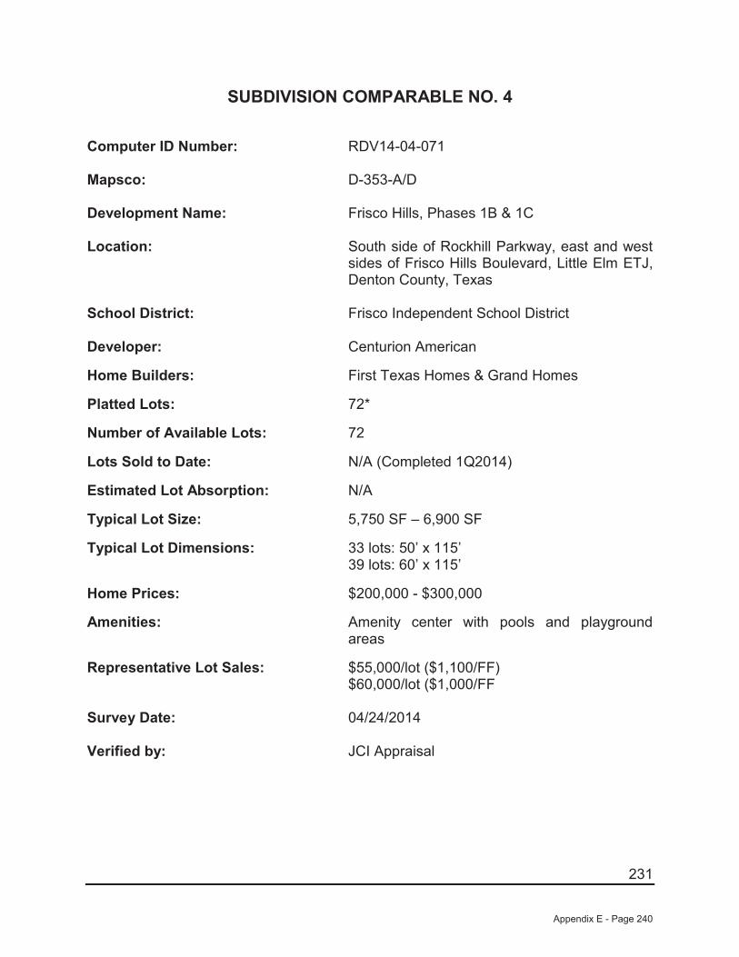
231
SUBDIVISION COMPARABLE NO. 4
Computer ID Number: RDV14-04-071
Mapsco: D-353-A/D
Development Name: Frisco Hills, Phases 1B & 1C
Location: South side of Rockhill Parkway, east and west sides of Frisco Hills Boulevard, Little Elm ETJ,Denton County, Texas
School District: Frisco Independent School District
Developer: Centurion American
Home Builders: First Texas Homes & Grand Homes
Platted Lots: 72*
Number of Available Lots: 72
Lots Sold to Date: N/A (Completed 1Q2014)
Estimated Lot Absorption: N/A
Typical Lot Size: 5,750 SF – 6,900 SF
Typical Lot Dimensions: 33 lots: 50’ x 115’39 lots: 60’ x 115’
Home Prices: $200,000 - $300,000
Amenities: Amenity center with pools and playground areas
Representative Lot Sales: $55,000/lot ($1,100/FF) $60,000/lot ($1,000/FF
Survey Date: 04/24/2014
Verified by: JCI Appraisal
Appendix E - Page 240
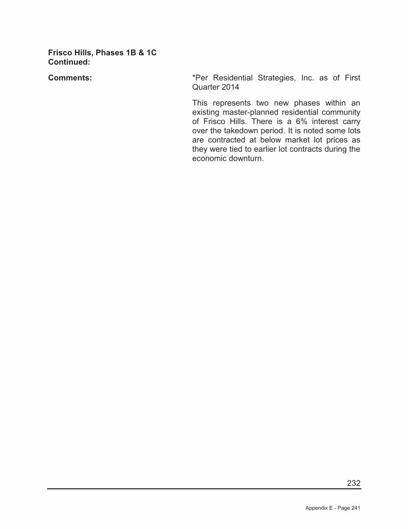
232
Frisco Hills, Phases 1B & 1CContinued:
Comments: *Per Residential Strategies, Inc. as of First Quarter 2014
This represents two new phases within an existing master-planned residential community of Frisco Hills. There is a 6% interest carry over the takedown period. It is noted some lots are contracted at below market lot prices as they were tied to earlier lot contracts during the economic downturn.
Appendix E - Page 241

233
LAND SALE COMPARABLES – EXCESS LAND
Appendix E - Page 242
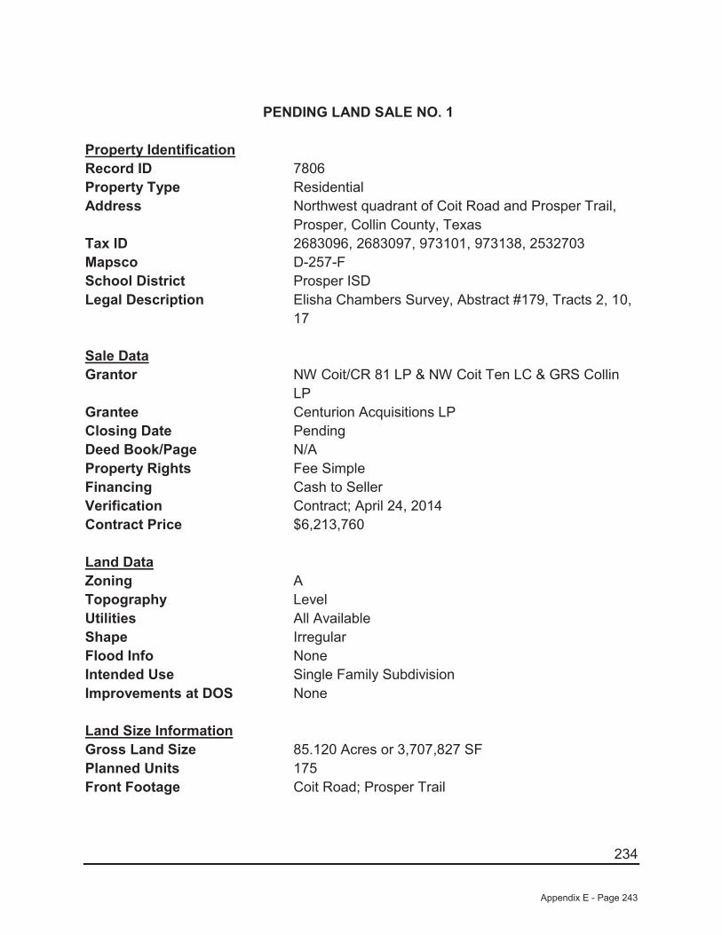
234
PENDING LAND SALE NO. 1
Property IdentificationRecord ID 7806Property Type ResidentialAddress Northwest quadrant of Coit Road and Prosper Trail,
Prosper, Collin County, TexasTax ID 2683096, 2683097, 973101, 973138, 2532703Mapsco D-257-FSchool District Prosper ISDLegal Description Elisha Chambers Survey, Abstract #179, Tracts 2, 10,
17
Sale DataGrantor NW Coit/CR 81 LP & NW Coit Ten LC & GRS Collin
LPGrantee Centurion Acquisitions LPClosing Date PendingDeed Book/Page N/AProperty Rights Fee SimpleFinancing Cash to SellerVerification Contract; April 24, 2014Contract Price $6,213,760
Land DataZoning ATopography LevelUtilities All AvailableShape IrregularFlood Info NoneIntended Use Single Family SubdivisionImprovements at DOS None
Land Size InformationGross Land Size 85.120 Acres or 3,707,827 SF Planned Units 175Front Footage Coit Road; Prosper Trail
Appendix E - Page 243
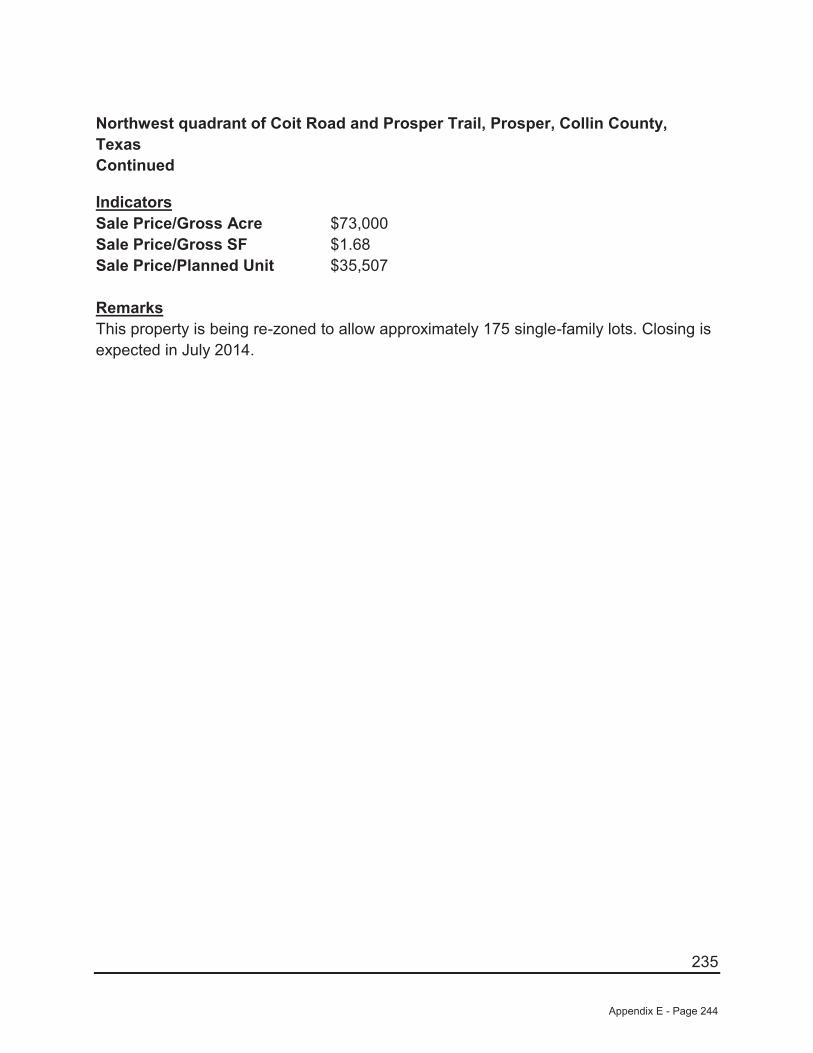
235
Northwest quadrant of Coit Road and Prosper Trail, Prosper, Collin County, TexasContinued
IndicatorsSale Price/Gross Acre $73,000Sale Price/Gross SF $1.68Sale Price/Planned Unit $35,507
RemarksThis property is being re-zoned to allow approximately 175 single-family lots. Closing is expected in July 2014.
Appendix E - Page 244

236
LAND SALE NO. 2
Property IdentificationRecord ID 7807Property Type ResidentialAddress North side of CR-26, west of Preston Road, Frisco,
Collin County, TexasTax ID 2687993Mapsco D-356-BSchool District Prosper ISDLegal Description Tract 1, German Immigration Co Survey, Abstract
#358
Sale DataGrantor 289 (Preston & 380 LPGrantee Centurion Acquisitions LPSale Date June 01, 2014 PendingDeed Book/Page N/AProperty Rights Fee SimpleFinancing Cash to SellerVerification Confidential; April 24, 2014Sale Price $8,000,000
Land DataZoning I, IndustrialTopography RollingUtilities All AvailableShape IrregularFlood Info NoneIntended Use Single-Family SubdivisionImprovements at DOS None
Land Size InformationGross Land Size 93.666 Acres or 4,080,078 SF Planned Units 215Front Footage None
Appendix E - Page 245
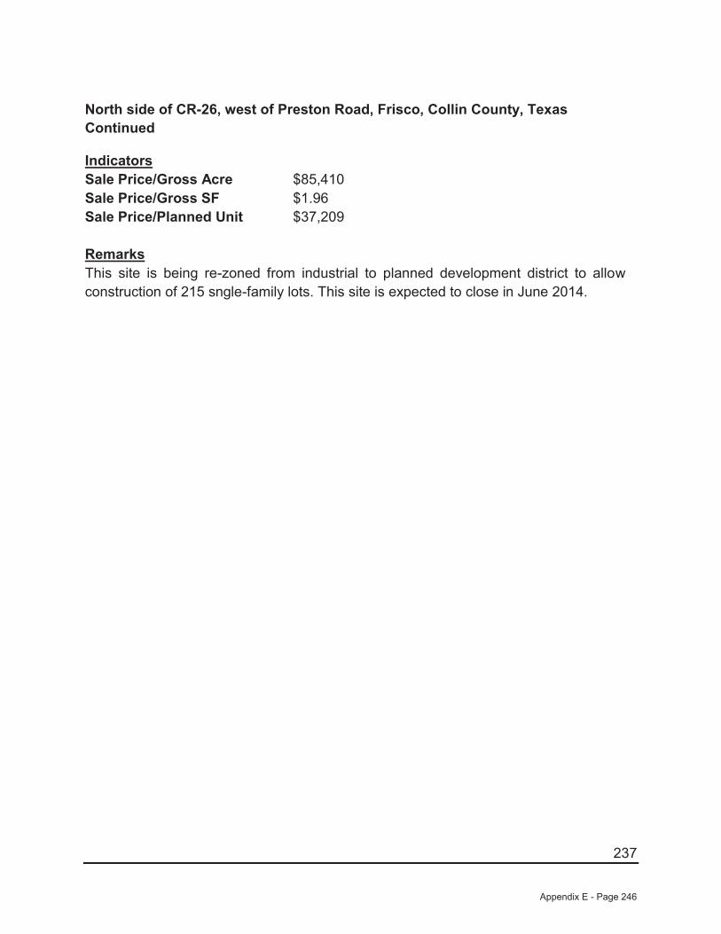
237
North side of CR-26, west of Preston Road, Frisco, Collin County, TexasContinued
IndicatorsSale Price/Gross Acre $85,410Sale Price/Gross SF $1.96Sale Price/Planned Unit $37,209
RemarksThis site is being re-zoned from industrial to planned development district to allowconstruction of 215 sngle-family lots. This site is expected to close in June 2014.
Appendix E - Page 246
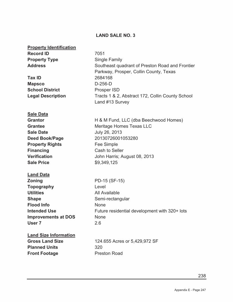
238
LAND SALE NO. 3
Property IdentificationRecord ID 7051Property Type Single FamilyAddress Southeast quadrant of Preston Road and Frontier
Parkway, Prosper, Collin County, TexasTax ID 2684168Mapsco D-256-DSchool District Prosper ISDLegal Description Tracts 1 & 2, Abstract 172, Collin County School
Land #13 Survey
Sale DataGrantor H & M Fund, LLC (dba Beechwood Homes)Grantee Meritage Homes Texas LLCSale Date July 26, 2013 Deed Book/Page 20130726001053280Property Rights Fee SimpleFinancing Cash to SellerVerification John Harris; August 08, 2013Sale Price $9,349,125
Land DataZoning PD-15 (SF-15)Topography LevelUtilities All AvailableShape Semi-rectangularFlood Info NoneIntended Use Future residential development with 320+ lotsImprovements at DOS NoneUser 7 2.6
Land Size InformationGross Land Size 124.655 Acres or 5,429,972 SF Planned Units 320Front Footage Preston Road
Appendix E - Page 247

239
Southeast quadrant of Preston Road and Frontier Parkway, Prosper, Collin County, TexasContinued
IndicatorsSale Price/Gross Acre $75,000Sale Price/Gross SF $1.72Sale Price/Planned Unit $29,216
RemarksThis site is being purchased forfeiture single family development with a typical lot sizes being 15,000 square feet. Approximately 320 units are eventually planned.
Appendix E - Page 248
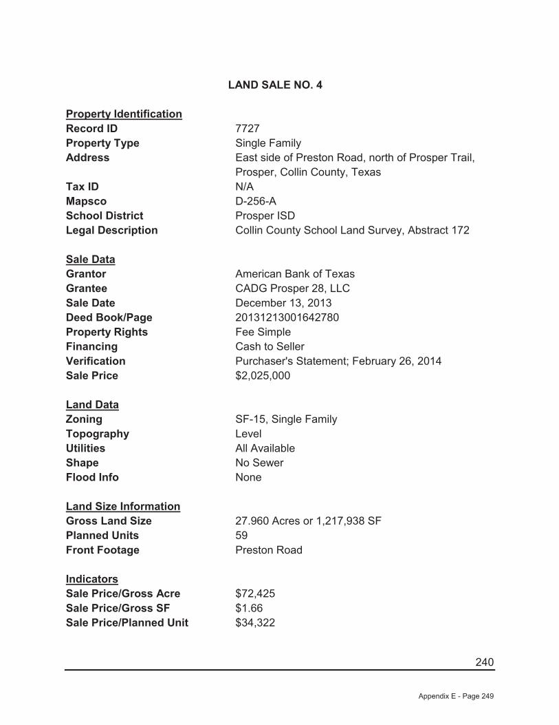
240
LAND SALE NO. 4
Property IdentificationRecord ID 7727Property Type Single FamilyAddress East side of Preston Road, north of Prosper Trail,
Prosper, Collin County, TexasTax ID N/AMapsco D-256-ASchool District Prosper ISDLegal Description Collin County School Land Survey, Abstract 172
Sale DataGrantor American Bank of TexasGrantee CADG Prosper 28, LLCSale Date December 13, 2013 Deed Book/Page 20131213001642780Property Rights Fee SimpleFinancing Cash to SellerVerification Purchaser's Statement; February 26, 2014Sale Price $2,025,000
Land DataZoning SF-15, Single FamilyTopography LevelUtilities All AvailableShape No SewerFlood Info None
Land Size InformationGross Land Size 27.960 Acres or 1,217,938 SF Planned Units 59Front Footage Preston Road
IndicatorsSale Price/Gross Acre $72,425Sale Price/Gross SF $1.66Sale Price/Planned Unit $34,322
Appendix E - Page 249
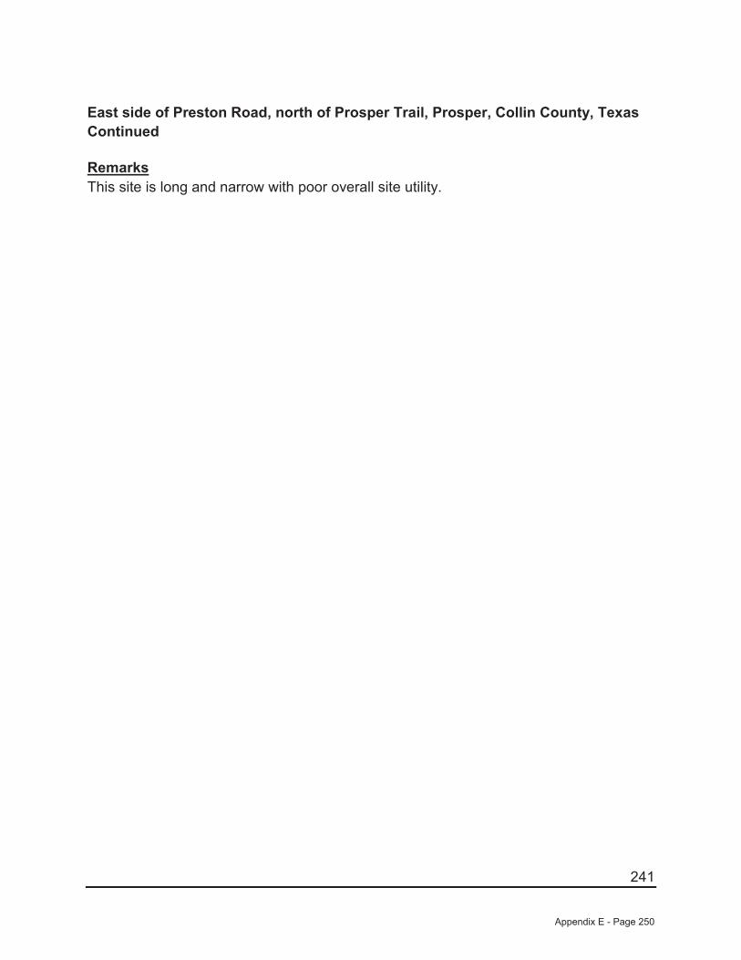
241
East side of Preston Road, north of Prosper Trail, Prosper, Collin County, TexasContinued
RemarksThis site is long and narrow with poor overall site utility.
Appendix E - Page 250
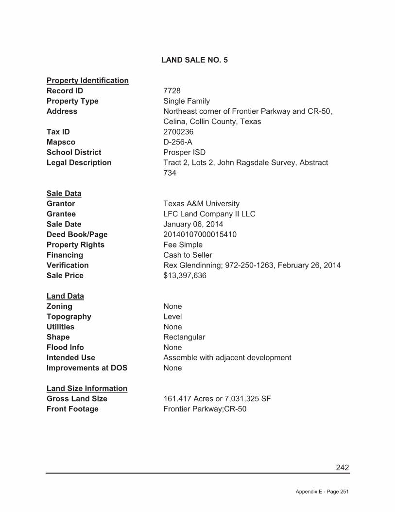
242
LAND SALE NO. 5
Property IdentificationRecord ID 7728Property Type Single FamilyAddress Northeast corner of Frontier Parkway and CR-50,
Celina, Collin County, TexasTax ID 2700236Mapsco D-256-ASchool District Prosper ISDLegal Description Tract 2, Lots 2, John Ragsdale Survey, Abstract
734
Sale DataGrantor Texas A&M UniversityGrantee LFC Land Company II LLCSale Date January 06, 2014 Deed Book/Page 20140107000015410Property Rights Fee SimpleFinancing Cash to SellerVerification Rex Glendinning; 972-250-1263, February 26, 2014Sale Price $13,397,636
Land DataZoning NoneTopography LevelUtilities NoneShape RectangularFlood Info NoneIntended Use Assemble with adjacent developmentImprovements at DOS None
Land Size InformationGross Land Size 161.417 Acres or 7,031,325 SF Front Footage Frontier Parkway;CR-50
Appendix E - Page 251
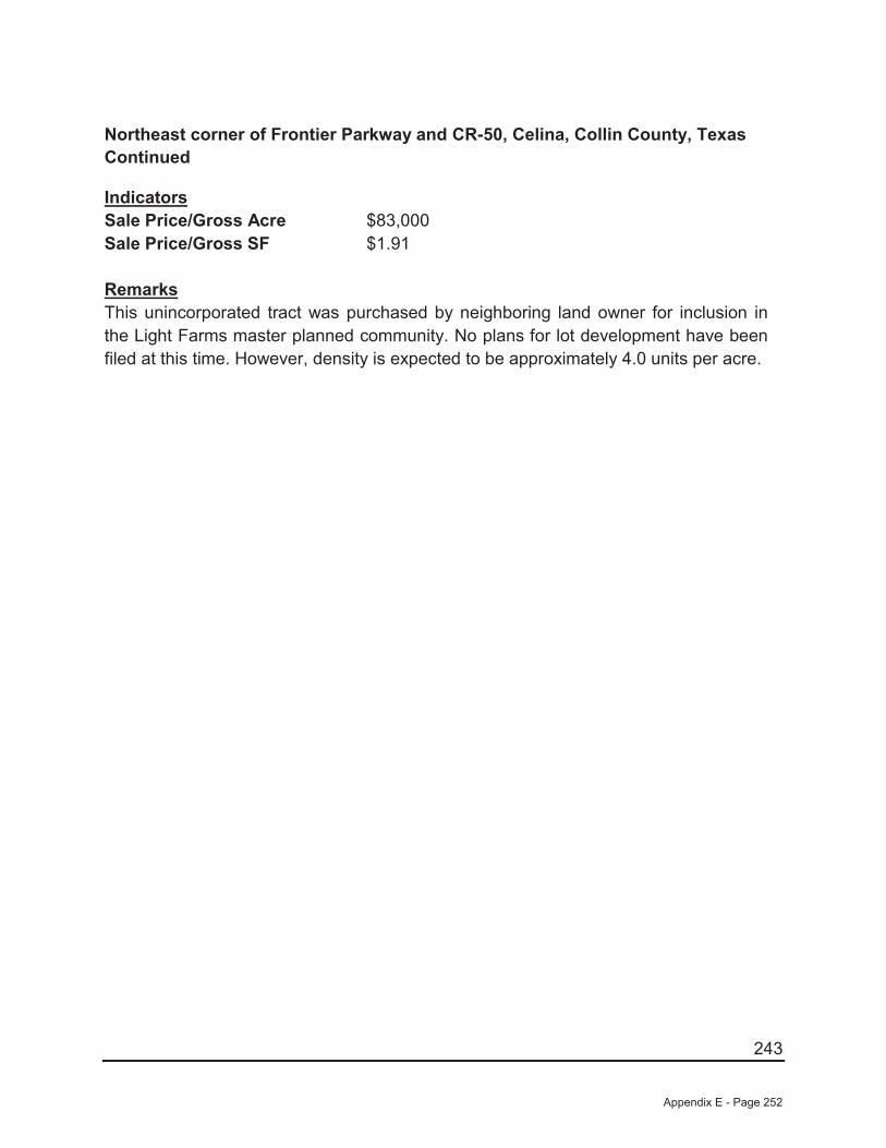
243
Northeast corner of Frontier Parkway and CR-50, Celina, Collin County, TexasContinued
IndicatorsSale Price/Gross Acre $83,000Sale Price/Gross SF $1.91
RemarksThis unincorporated tract was purchased by neighboring land owner for inclusion in the Light Farms master planned community. No plans for lot development have been filed at this time. However, density is expected to be approximately 4.0 units per acre.
Appendix E - Page 252

244
LEGAL DESCRIPTION WHOLE SITE
Appendix E - Page 253
245
DESCRIPTION OF 321.48
BEING that certain tract of land situated in the William Davenport Survey, Abstract Number 262, the F. D. Gray Survey, Abstract Number 361, Collin County Texas and being in the J. McKinn Survey, Abstract Number 889, the William Phillips Survey, Abstract Number 1029 and the A. Thomasson Survey, Abstract Number 1265 Denton County Texas and being all or parts of those tract of land described by deed to CADG Frontier 192, LLC recorded in Instrument Numbers 2013090300123830, 20130903001267570 and 2014-19516 of Deed Records, Denton County, Texas and being all of that tract of land described in deed to James Chan Wu, et vir recorded in Volume 2522, Page 1005 of said Deed Records and being more particularly described by metes and bound as follows:
COMMENCING at a point at the approximate intersection of County Road 6 (a variable width Right-of-Way) and County Road 5 (a variable width Right-of Way);
THENCE N 00°30’48”E, 1492.66 feet, along the approximate centerline of said County Road 6 to the POINT OF BEGINNING;
THENCE N 00°30’48”E, 131.77 feet, along said approximate centerline;
THENCE S 89°28’55”W, 227.45 feet, departing said approximate to the beginning of a curve to the left;
THENCE with said curve to the left, an arc distance of 167.94 feet, through a central angle of 40°56’46”, having a radius of 235.00 feet, the long chord which bears S 69°00’32”W, 164.39 feet;
THENCE S 48°32’09”W, 159.09 feet to the beginning of a curve to the right;
THENCE with said curve to the right, an arc distance of 194.09 feet, through a central angle of 19°40’57”, having a radius of 565.00 feet, the long chord which bears S 58°22’38”W, 193.14 feet, to the beginning of a curve to the left;
THENCE with said curve to the left, an arc distance of 119.79 feet, through a central angle of 34°19’00”, having a radius of 200.00 feet, the long chord which bears S 51°03’36”W, 118.01 feet;
THENCE S 33°54’06”W, 214.10 feet to the beginning of a curve to the left;
THENCE with said curve to the left, an arc distance of 81.66 feet, through a central angle of 33°25’18”, having a radius of 140.00 feet, the long chord which bears S 17°11’27”W, 80.51 feet;
THENCE S 00°28’48”W, 965.97 feet;
THENCE S 89°28’22”W, 845.25 feet;
Appendix E - Page 254
246
THENCE N 00°29’26”E, 3346.63 feet;
THENCE N 89°24’55”E, 1739.80 feet;
THENCE S 00°30’16”W, 854.78 feet;
THENCE N 89°09’02”E, 752.57 feet;
THENCE N 00°16’45”W, 600.61 feet;
THENCE N 88°13’57”E, 1062.60 feet;
THENCE S 89°51’14”E, 348.31 feet;
THENCE N 89°27’22”E, 753.95 feet;
THENCE N 89°45’31”E, 804.65 feet;
THENCE S 00°06’38”E, 2514.38 feet;
THENCE S 00°06’38”E, 249.81 feet;
THENCE S 85°36’04”E, 30.36 feet;
THENCE S 00°25’31”E, 412.89 feet;
THENCE S 89°34’04”W, 1555.97 feet;
THENCE S 89°18’38”W, 907.69 feet;
THENCE N 01°02’21”W, 97.52 feet to the beginning of a curve to the right;
THENCE with said curve to the right, an arc distance of 328.44 feet, through a central angle of 19°30’03”, having a radius of 965.00 feet, the long chord which bears N 05°39’24”E, 326.86 feet;
THENCE N 12°50’12”E, 146.71 feet to the beginning of a curve to the left;
THENCE with said curve to the left, an arc distance of 1634.25 feet, through a central angle of 115°44’32”, having a radius of 809.00 feet, the long chord which bears N 44°16’37”W, 1370.21feet to the beginning of a curve to the right;
THENCE with said curve to the right, an arc distance of 179.75 feet, through a central angle of 02°43’34”, having a radius of 3778.00 feet, the long chord which bears S 74°15’44”W, 179.73 feet to the beginning of a curve to the right;
Appendix E - Page 255
247
THENCE with said curve to the right, an arc distance of 139.28 feet, through a central angle of 10°35’52”, having a radius of 753.00 feet, the long chord which bears S 80°52’08”W, 139.08 feet;
THENCE N 89°39’26”W, 98.91 feet to the Point of Beginning and containing 14,003,122 square feet or 321.48 acres of land more or less.
Appendix E - Page 256

248
TAX DATA
Appendix E - Page 257
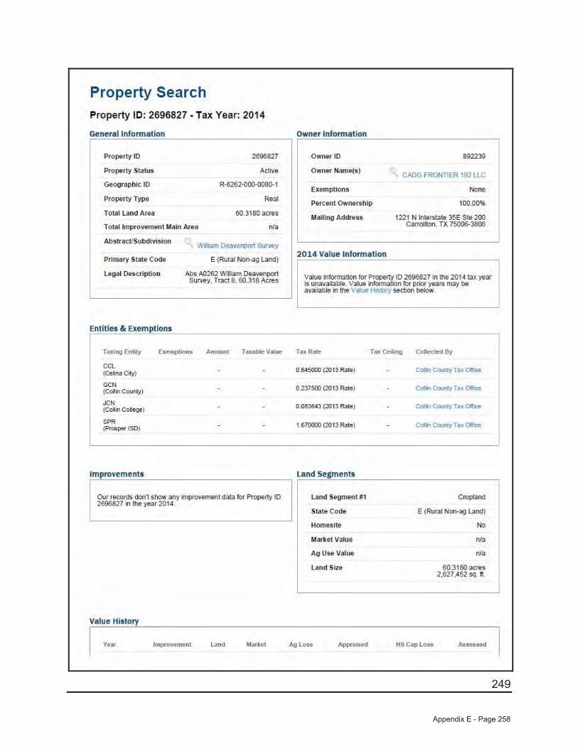
249
Appendix E - Page 258
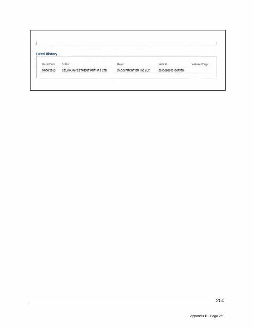
250
Appendix E - Page 259
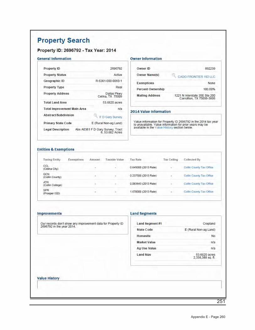
251
Appendix E - Page 260
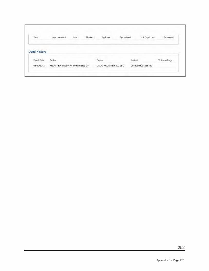
252
Appendix E - Page 261

253
Appendix E - Page 262
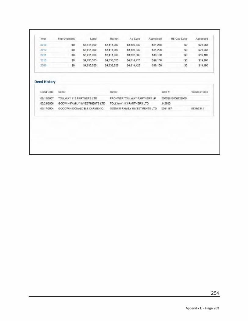
254
Appendix E - Page 263
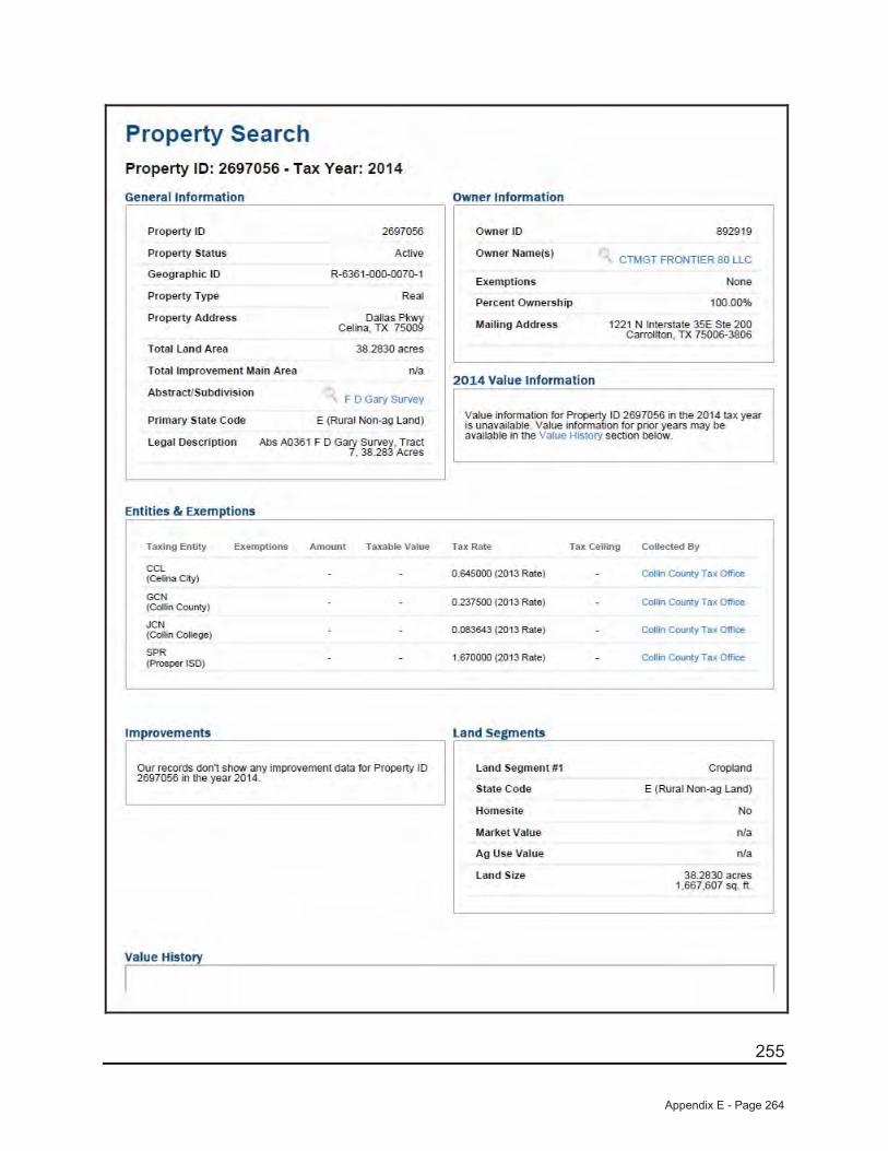
255
Appendix E - Page 264
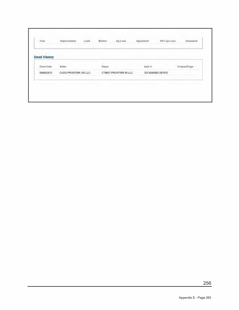
256
Appendix E - Page 265
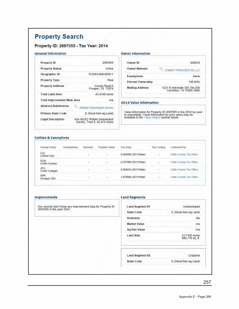
257
Appendix E - Page 266
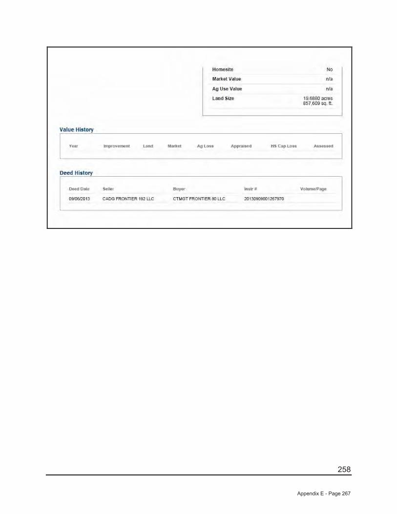
258
Appendix E - Page 267
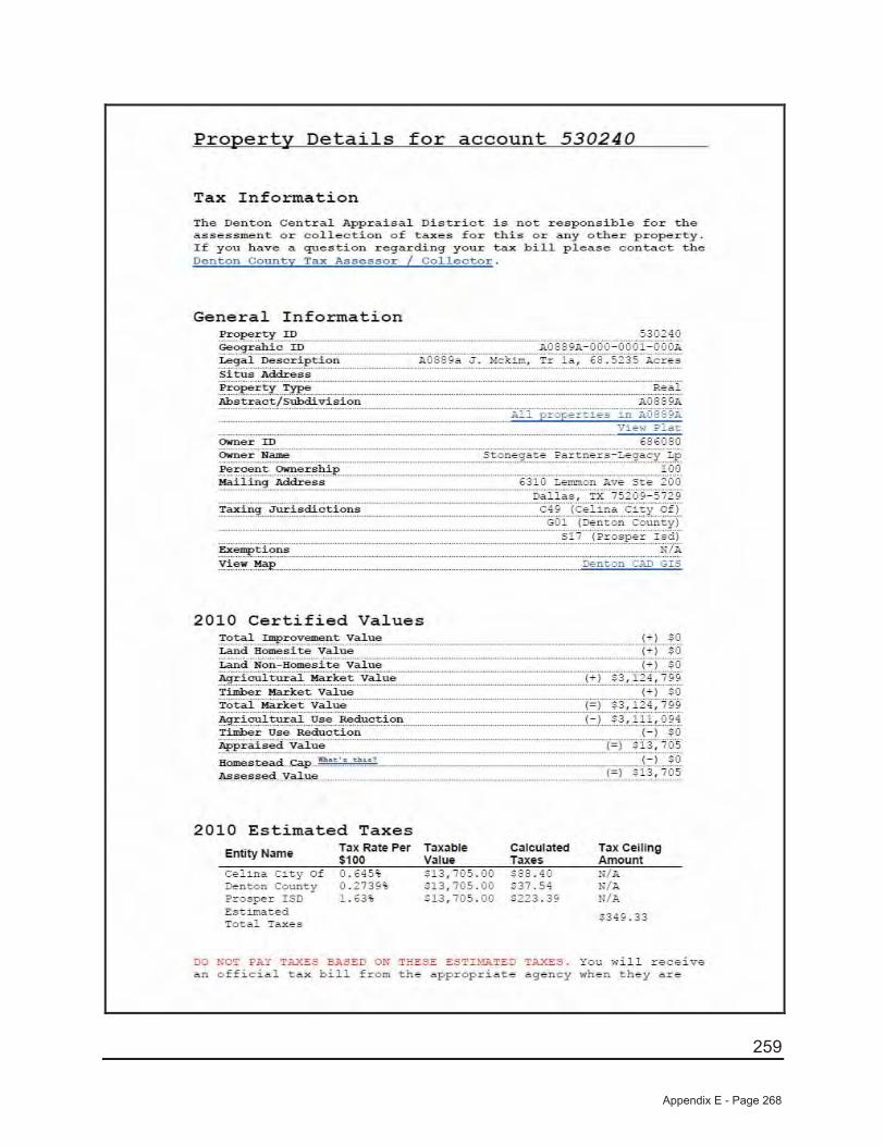
259
Appendix E - Page 268

260
Appendix E - Page 269
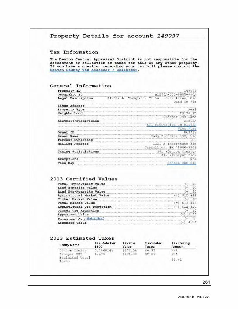
261
Appendix E - Page 270
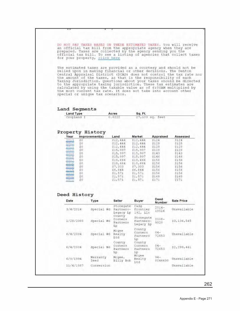
262
Appendix E - Page 271
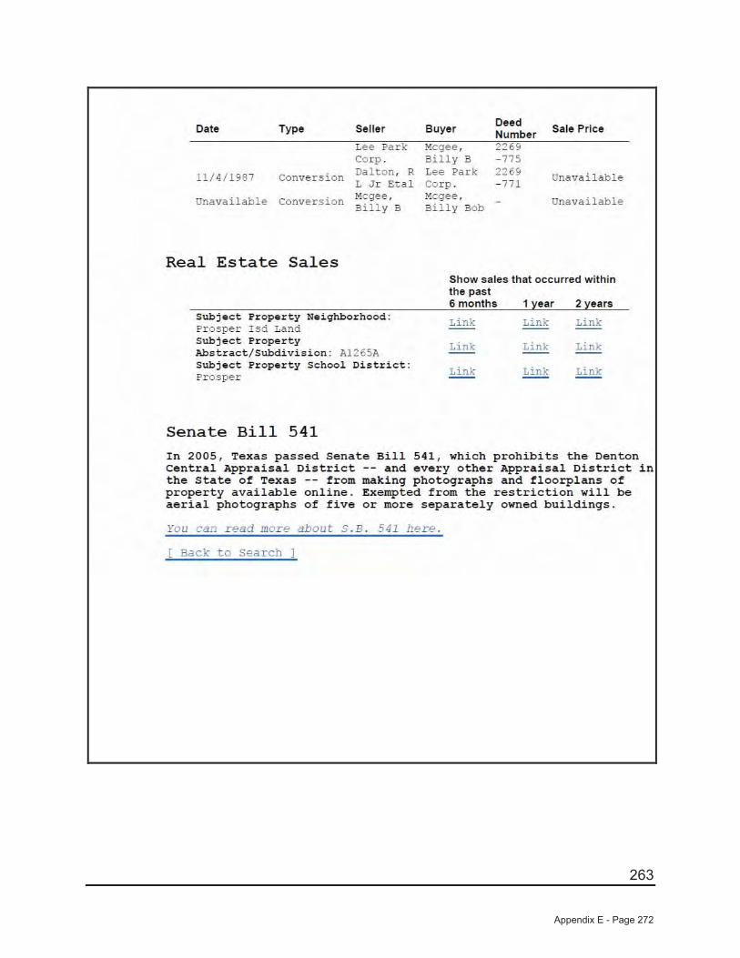
263
Appendix E - Page 272
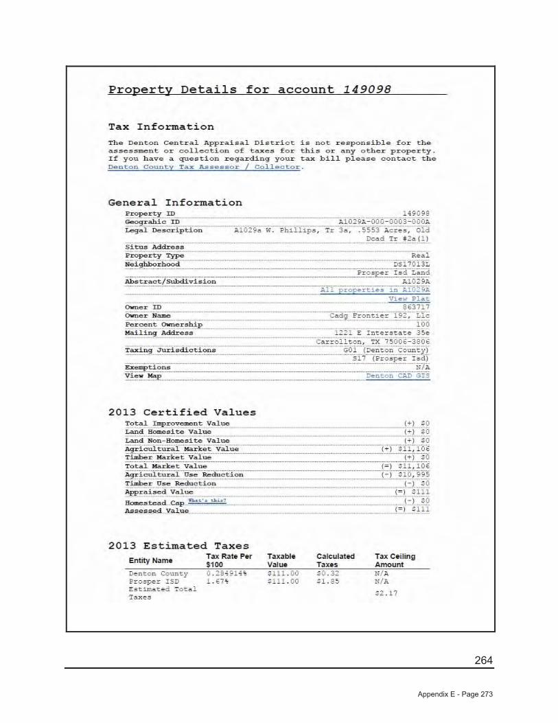
264
Appendix E - Page 273
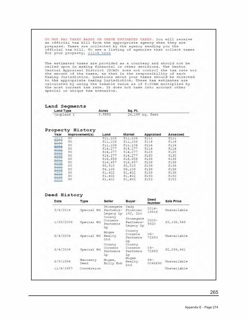
265
Appendix E - Page 274
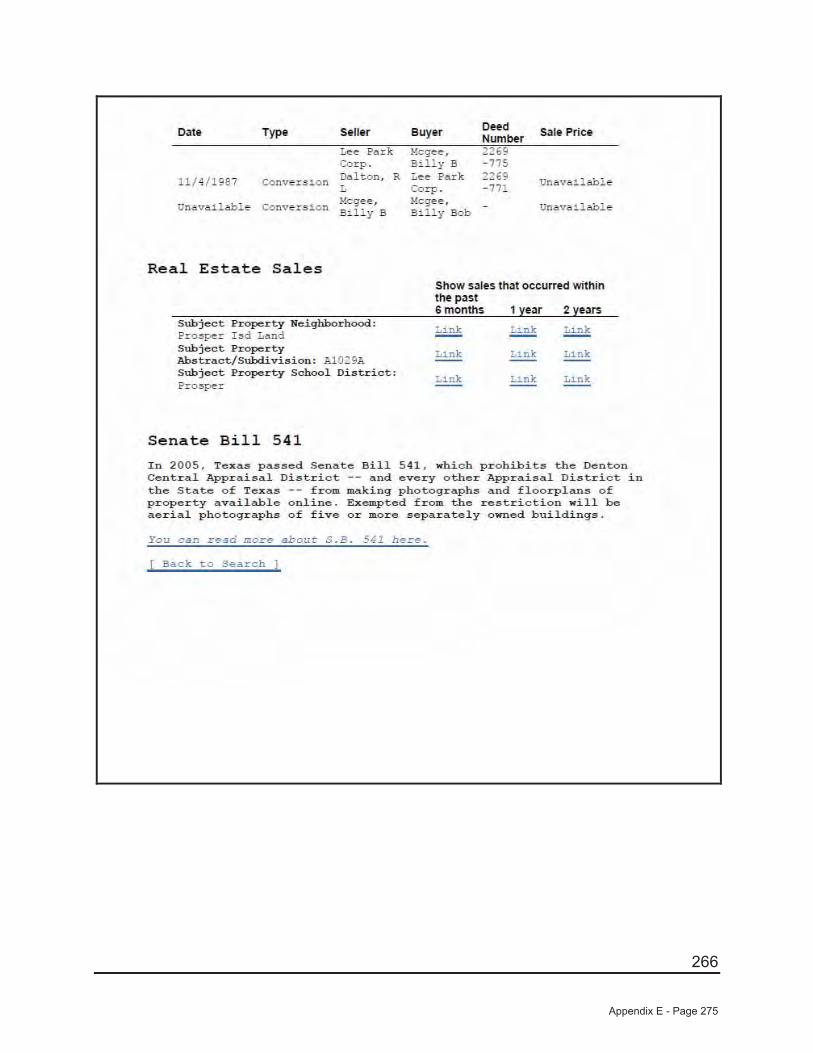
266
Appendix E - Page 275
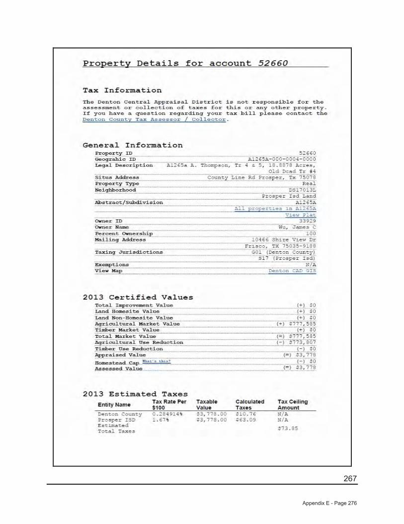
267
Appendix E - Page 276
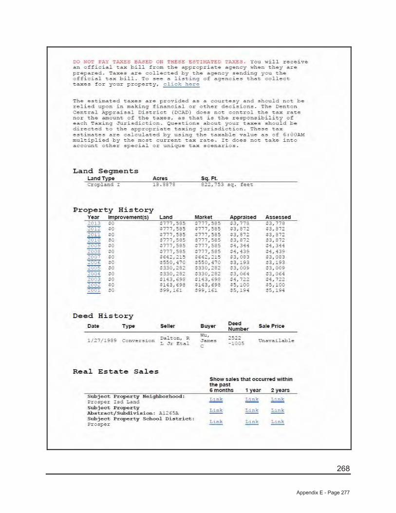
268
Appendix E - Page 277
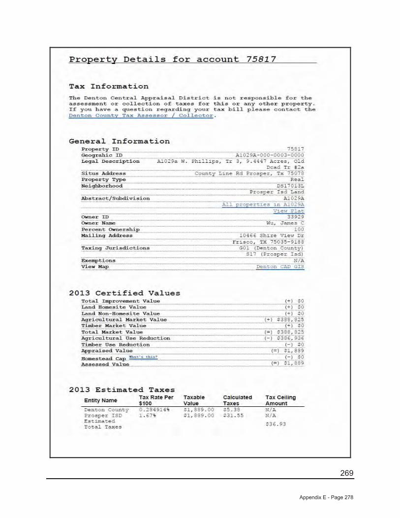
269
Appendix E - Page 278
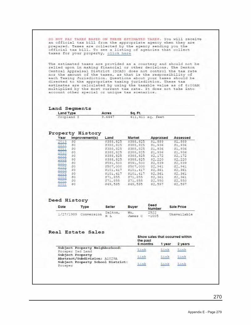
270
Appendix E - Page 279

271
Appendix E - Page 280
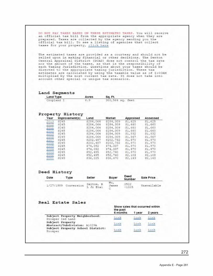
272
Appendix E - Page 281

273
QUALIFICATIONS AND STATE CERTIFICATIONS
Appendix E - Page 282
274
EXPERIENCE AND QUALIFICATIONS OF ERNEST E. GATEWOOD III
Education
Richland Junior College, Dallas, Texas University of North Texas, Denton, Texas
MAI Required Appraisal Institute Courses
Real Estate Appraisal Principles (I A-1) (1988) Basic Valuation Procedures (IA-2) (1988) Capitalization Theory and Technique Part A (1 B-A) (1989)
Various Seminars
See Attached – Education Transcript
Professional Licenses and Memberships
Licensed Real Estate Salesman in the State of Texas (Number 277705-32)
State Certified General Real Estate Appraiser (Certificate No. TX 1324355-G)
Professional History
1993-Present Jackson Claborn, Inc. Vice President - Commercial Division
1990-1993 Heartland Real Estate Group Director of Acquisitions
1980-1990 Crosson Dannis, Inc. Appraiser
Areas of Special Competence
Real estate appraisal, consulting and feasibility for income-producing properties including office buildings, shopping centers, apartment complexes, industrial properties, mixed-use developments, single-family subdivisions, and free-standing retail buildings. Also experienced in the appraisal of single-family residences, vacant land, right-of-way valuation and expert witness testimony for real estate. Additional expertise in market research, data analysis, feasibility coordination, site planning, purchase and sale negotiations, engineering coordination for single-family subdivisions.
Appendix E - Page 283
275
Appendix E - Page 284
276
Appendix E - Page 285
277
Appendix E - Page 286

278
Appendix E - Page 287
279
EXPERIENCE AND QUALIFICATIONS OFJlMMY H. JACKSON, MAI
Education Texas Tech University, Lubbock, TexasBachelor of Business Administration in Real Estate Finance - May 1984
Appraisal Institute Courses
Real Estate Appraisal Principles (1A-1) 1986)Basic Valuation Procedures (1A-2) (1986)
USPAP Standards of Prof. Practice (1989, 1996, 2000, 2002, 2004, 2006, 2008, 2010, 2012)
Capitalization Theory & Technique (A & B) ( 1988) Valuation Analysis and Report Writing (2-2) (1989)Case Studies in Real Estate Valuation (2-1) (1989) Advanced Applications (Course 550) (1997)
Various Seminars/Courses: See Attached AI Continuing Education Cycle (since 2007)
FHA/HUD Residential Appraisal Course (1994) Dynamics of Office Building Valuation (2001)Appr. of Nursing Home/Cong. Care Facilities (1997) Online Residential Design and Funct. Utility (2002)The Internet and Appraising (1997) Online Analyzing Operating Expenses (2002)The Appraisal of High End/Historical Homes (1997) Mark-to-Market: The Next FIRREA (2002)Small Hotel/Motel Valuation (1997) Valuation of Detrimental Conditions in RE (2002)Environ. Site Analysis – Impact on RE Trans. (1997) Fannie Mae and the Appraisal Process (2002)Dallas/Fort Worth Apartment Operating (1997) Roddy’s Barometer for Vacant Land Market (2004)TX Property Tax Law – Taxpayer Remedies (1998) Using Your HP-12C (2004)The FHA and the Appraisal Process (1999) Online Appraising from Blueprints (2004)Rebuilding the Inner City Neighborhoods (1999) Feasibility, Market Value, Inv. (2004)Networking Opportunities (2000) Subdivision Valuation Seminar (2006)Use of GIS Technology in RE Mkt. Research (2000) Scope of Work Seminar (2006)New Tech. for the Residential Appraiser (2001) Forecasting Revenue Seminar (2006)Appraisal of Local Retail Properties (2001) Business Practices and Ethics (2006)Texas Appraisal Licensing & Certification (2001) Analyzing Distressed Real Estate (2006)The Dallas/Fort Worth Apartment Market (2001)
Professional Licenses, LicensesMemberships, & Office Held Member of Appraisal Institute (MAI)
State Certified General Appraiser (No. TX-1324004-G)Member of Region 8 Ethics and Counseling Regional Panel (1992-1995)Chair – Public Relations North Texas Chapter (2003, 2004)Co-Chair – Public Relations North Texas Chapter (2005)Board Member – North Texas Chapter (2005-2007)
Professional History
1/93-Present Jackson Claborn, Inc.President/CEO
08/91-12/92 Travis, Wolff Consulting, Inc.Vice President, Real Estate Advisory Services
5/84-08/91 Crosson Dannis, Inc.Senior Appraiser (7 Years)
Areas Of Special Competence Real estate appraisal, consulting and feasibility for income-producing properties including hotels/motels, office buildings, shopping centers, apartment complexes, industrial properties, mixed-use developments, subdivisions, nursing homes, and free-standing retail buildings. Also experienced in appraisal of single-family residences.
Appendix E - Page 288
280
Program Title End Date Type Hours
How to Deal with an Aggressive Attorney at Deposition/Trial 09/10/2013 Program 2.00
Texas' Water Crisis 05/14/2013 Program 2.00
Metropolitan Transportation Update 03/12/2013 Program 2.00
Downtown Dallas: Urban Life Realized 02/12/2013 Program 2.00
The Trinity River Project-Today and the Future 01/08/2013 Program 2.00
Using MYRETA.COM as a Tool in Valuing Commercial RE
11/13/2012 Program 2.00
7-Hour National USPAP Update Course 10/12/2012 Classroom 7.00
Factoring Sustainability into Asset Valuation 09/11/2012 Program 2.00
The Parks Dallas & Data Center Real Estate Industry Trends
05/01/2012 Program 2.00
Online Business Practices and Ethics 05/15/2012 Online 7.0
Unusual Appraisal Challenges for IRS 02/14/2012 Program 2.0
Land Development in the DFW Metroplex and 2012 Outlook 01/10/2012 Program 2.0
3rd Annual North Texas Realty Symposium 12/07/2011 Program 8.0
Residential Green and Energy Efficient Addendum 11/17/2011 Online 2.0
The TALCB Complaint Process -The Defense Perspective 11/08/2011 Program 2.0
Understanding the Impact of the Interagency Appraisal and Evaluation Guidelines for Appraisers and Lenders
10/26/2011 Online 2.0
Appraisal Curriculum Overview (2-day General) 09/16/2011 Program 15.0
Real Estate Appraiser Enforcement & Discipline 09/13/2011 Program 2.0
Highest & Best Use/Expert Witnesses in Eminent Domain Cases
05/10/2011 Program 2.0
Loss Prevention Seminar 03/08/2011 Program 2.0
Regulatory Update: GSE, Dodd-Frank & Interagency Guidelines
02/08/2011 Program 2.0
Using MLS Data as a Tool in Valuing Properties 01/11/2011 Program 2.0
Recreational and Agricultural Land Value in North Texas 11/09/2010 Program 2.0
7-Hour National USPAP Update Course 10/14/2010 SPP 7.0
Economic Conditions in the Dallas/Fort Worth Region 05/11/2010 Program 2.0
Legislative Update for Appraisers 03/09/2010 Program 2.0
Expert Witness Testimony for Appraisers 02/09/2010 Program 2.0
Condemnation for Electric Power Lines 01/12/2010 Program 2.0
Real Estate Capital Gains Taxes 11/17/2009 Program 2.0
Cowboy Stadium Complex Development Project 10/13/2009 Program 2.0
Current Conditions in the Hospitality Market/Mkt. Adjust for Vacant Lands
09/15/2009 Program 2.0
Affects of IRS Filings on Cons. Easements & Appraisers/Dallas RED
02/10/2009 Program 2.0
2009 Economic Outlook: Impact on Valuation Issues 01/13/2009 Program 2.0
Appendix E - Page 289
281
2008 Commercial Real Estate Trends and 2009 Projections 11/11/2008 Program 2.0
Appraiser Liability: How to Avoid Litigation 10/14/2008 Program 2.0
7-Hour National USPAP Update Course 10/02/2008 SPP 7.0
Appraiser Independence, What Do HVCC and Reg. Z Mean to Me?
09/09/2008 Program 2.0
Overview of Appraisal Regulations from a Lender's Perspective
05/13/2008 Program 2.0
Barnett Shale: Truth and Consequences 03/11/2008 Program 2.0
Changes to USPAP for 2008 02/12/2008 Program 2.0
Committee CE Credit - Chapter level 12/31/2007 Meetings 7.0
Apartment Market Trends and Review 09/11/2007 Program 2.0
DFW Signposts to the Real Estate Market 05/10/2007 Program 2.0
Victory Dev. Update/Real Estate Development in Downtown Dallas
03/08/2007 Program 2.0
Conservation Easements, Land Trusts, and Appraisals 01/11/2007 Program 2.0
Appendix E - Page 290

282
Appendix E - Page 291
283
EXPERIENCE AND QUALIFICATIONS OF Shelley M. Sivakumar
Education University of Texas at Dallas, Dallas, Texas Bachelor of Science – Business & Public Administration – 12/1978
University of North Texas, Denton, Texas – 1977-1978 Marshall University, Huntington, West Virginia
Associate in Science – 12/1974
Appraisal Institute Courses
Residential Report Writing – 2014Modern Green Building Concepts - 2014
Ad Valorem Tax Consultation – 2014The Dirty Dozen - 2011
Essential Elements of Disclosure & Disclaimers - 2011 Land & Site Valuation - 2011Commercial Clients Want Appraisers to Know - 2009 Basic Income Capitalization - 2006Market Analysis/STD - 2005 Environmental Issues - 2005Fair Housing - 2005 Texas Real Estate Agency - 2004Texas Real Estate Contracts - 2004 Modern Real Estate Practice in Texas - 2004Income Property Appraisal - 2003 Appraising Residential Properties - 2003Real Estate Appraisal – 2002
Uniform Standards of Professional Appraisal Practices –2002, 2005, 20070, 2009, 2010, 2012, 2013
Appraisal Seminars
Texas’ Appraisal Industry Update - 2013Parks Dallas & Data Center R.E. Industry Trends - 2012
Factoring Sustainability into Asset Valuation - 2012Valuation Models & Your Future - 2012
The TALCB Complaint Process - 2011GSE, Dodd-Frank & Interagency Guidelines - 2011
Using MLS Data in Valuing Properties - 2011New Residential Market Conditions Form - 2009
Effects of IRS Rulings on Conservation Easements -2009Parks Dallas & Data Center R.E. Industry Trends - 2012
Challenges of Easements, Eminent Domain, ROW -2006
Professional License
State Licensed Real Estate Appraiser (No. TX-1333354-L)
Professional History
2000 - Present Jackson Claborn, Inc., Plano, Texas Commercial Real Estate Appraiser
1991-2012 Wyngate Development Corporation, Dallas, Texas Vice President/Asset Management
1978-1980 Adelstein, McBee & Co., CPA’s, Dallas, Texas Tax Accountant
1976-1978 Republic National Bank, Dallas, Texas Administrative Assistant – Metropolitan Corporate Group
Areas of Special Competence Real estate appraisal, consulting and feasibility for income-producing properties including office buildings, shopping centers, apartment complexes, industrial properties, mixed-use developments, subdivisions, schools, and free-standing retail buildings.
Appendix E - Page 292
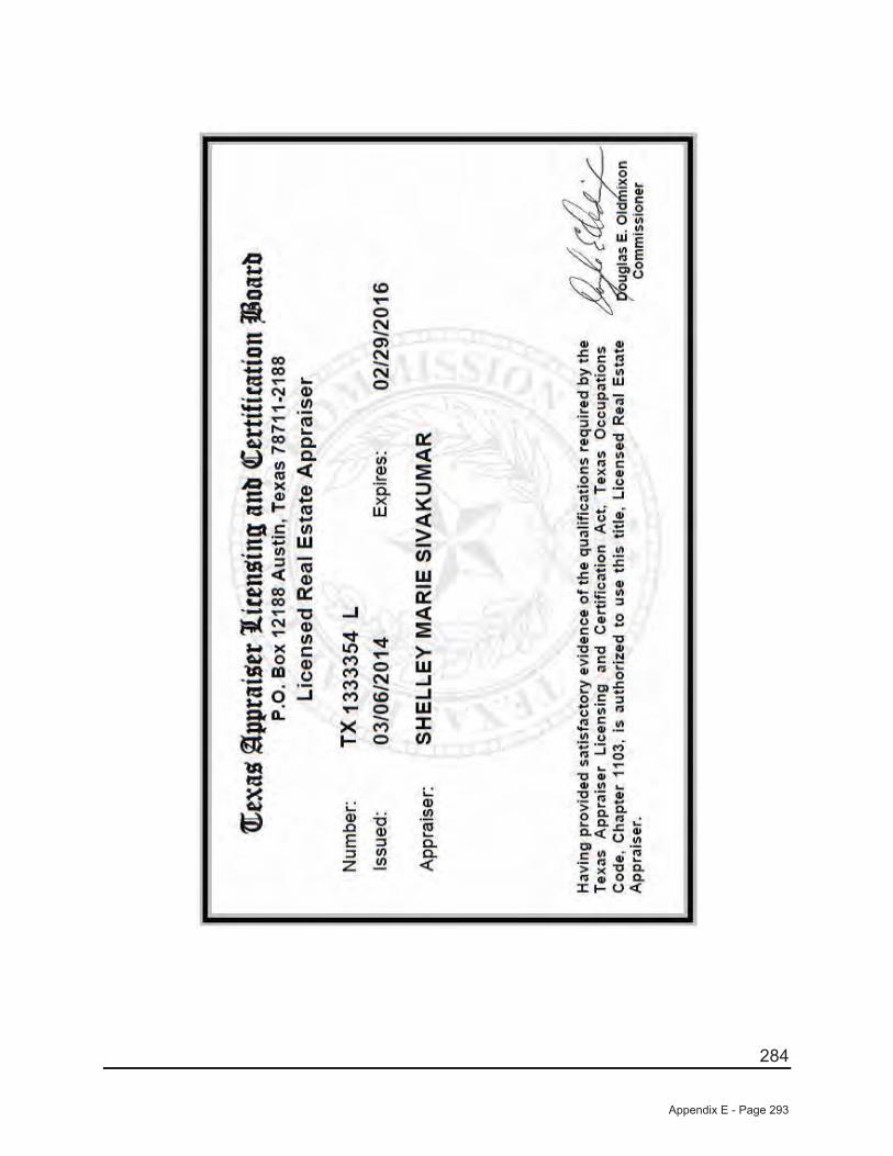
284
Appendix E - Page 293

(THIS PAGE IS INTENTIONALLY LEFT BLANK.)

APPENDIX F
FORM OF CONSTRUCTION, FUNDING, AND ACQUISITION AGREEMENT

(THIS PAGE IS INTENTIONALLY LEFT BLANK.)
Page 1 of 42
PHASE #1 CONSTRUCTION, FUNDING, AND ACQUISITION AGREEMENT
THIS CONSTRUCTION, FUNDING, AND ACQUISITION AGREEMENT (this “Agreement”), dated as of June 18, 2014, is by and between CITY OF CELINA, TEXAS, a home-rule municipality of the State of Texas (the “City”), and CTMGT FRONTIER 80, LLC, a Texas limited liability company, (the “Developer”).
ARTICLE I DEFINITIONS
The following terms shall have the meanings ascribed to them in this Article I for purposes of this Agreement. Unless otherwise indicated, any other terms, capitalized or not, when used herein shall have the meanings ascribed to them in the Indenture (as hereinafter defined).
"Act" means the Public Improvement District Assessment Act, Texas Local Government Code, Chapter 372, as amended.
“Actual Costs” means the costs of the Phase #1 Projects actually paid or incurred for construction and installation of the Phase #1 Projects.
“Administrator” means, initially, Municap, Inc., or any other individual or entity designated by the City to administer the District.
“Annual Service Plan Update” means the annual update to the Service and Assessment Plan conducted by the Administrator pursuant to Section IV of the Service and Assessment Plan.
"Bond Ordinance" means Ordinance No. 2014-29 adopted by the City Council on June 11, 2014 authorizing the issuance of the Bonds pursuant to the Indenture.
"Bonds" means the City’s bonds designated "City of Celina, Texas, Special Assessment Revenue Bonds, Series 2014 (Creeks of Legacy Public Improvement District Phase # 1 Project)".
“Budgeted Costs” means the costs shown on Exhibit A attached hereto.
“Certification for Payment” means a certificate, substantially in the form of Exhibit C hereto or otherwise agreed to by the City, executed by an engineer, construction manager or other person or entity acceptable to the City, as evidenced by the signature of a City Representative (as defined in the Indenture), provided each month to the City Representative and the Trustee, specifying the amount of work performed and the amount charged for that work, including materials and labor costs, presented to the Trustee to request payment from the Phase #1 Project Account of the Project Fund or the Phase #1 Major Improvement Account of the Project Fund for Actual Costs of Phase #1 Projects under the Indenture.
Appendix F - Page 1
Page 2 of 42
“City Representative” means that official or agent of the City authorized by the City Council to undertake the action referenced herein
"Closing Disbursement Request" means the certificate substantially in the form of Exhibit B hereto or otherwise mutually agreed to by the Developer and City Representative, executed by an engineer, construction manager or other person or entity acceptable to the City, as evidenced by the signature of a City Representative (as defined in the Indenture), specifying the amounts to be disbursed from the Costs of Issuance Account of the Project Fund for costs related to the creation of the District and the issuance of the Bonds.
“Construction Contracts” means the contracts for the construction of the Phase #1 Projects. “Construction Contract” means any one of the Construction Contracts.
“Cost” means the Budgeted Costs or the cost of a Phase #1 Project as reflected in a Construction Contract, if greater.
“Cost Overrun” means, with respect to each Phase #1 Project, the Cost or Actual Cost, as appropriate, of such Phase #1 Project in excess the Budgeted Cost.
“Development Agreement” means that certain Development Agreement executed by and between the Developer and the City effective June 18, 2014.
“Final Completion” means completion of a Phase #1 Project in compliance with existing City standards for dedication under the City’s ordinances and the Development Agreement.
“Indenture” means that certain Indenture of Trust between the City and U.S. Bank National Association, as trustee, dated as of June 15, 2014 relating to the Bonds.
“Inspector” means an individual employed, or third-party retained, by the City whose job is, in part or in whole, to inspect infrastructure for compliance with all rules and regulations applicable to the development and the infrastructure inspected.
“Land and Rights-of-Way” means the land, easements and rights-of-way described in the Service and Assessment Plan.
“Phase #1 Projects” mean, collectively, the Phase #1 Projects listed in Exhibit A to be constructed in compliance with City ordinances. An individual Phase #1 Project, including a completed segment or part, shall be referred to as a Phase #1 Project.
“POD 1 Projects” means the Phase #1 Projects to be constructed during Phase #1 within the area of land set forth in the metes and bounds attached as Exhibit D.
“POD 2 Projects” means the Phase #1 Projects to be constructed during Phase #1 within the area of land set forth in the metes and bounds attached as Exhibit E.
Appendix F - Page 2
Page 3 of 42
“POD 3 Projects” means the Phase #1 Projects to be constructed during Phase #1 within the area of land set forth in the metes and bounds attached as Exhibit F.
“Plans” means the plans, specifications, schedules and related construction contracts for the Phase #1 Projects, respectively, approved pursuant to the applicable standards, ordinances, procedures, policies and directives of the City, the Development Agreement, and any other applicable governmental entity.
“Project Fund” means the fund, including the accounts created and established under such fund, where monies from the proceeds of the sale of the Bonds, excluding those deposited in other funds in accordance with the Indenture, shall be deposited, and the fund by such name created under the Indenture.
"Reimbursement Agreement" means the Phase #1 Reimbursement Agreement dated as of June 18, 2014, by and between the City and the Developer providing for the construction and financing of certain Phase #1 Projects by the Developer for which the Developer will later be reimbursed by the City prepared pursuant to the Act.
“Service and Assessment Plan” means the Service and Assessment Plan adopted by Ordinance No.2014-26 on June 18, 2014 by the City Council, prepared pursuant to the Act.
“Substantial Completion” means the time at which the construction of a Phase #1 Project (or specified part thereof) has progressed to the point where such Phase #1 Project (or a specified part thereof) is sufficiently complete in accordance with the Construction Contracts related thereto so that such Phase #1 Project (or a specified part thereof) can be utilized for the purposes for which it is intended.
“Supplement” means a written document agreed upon by the parties to this Agreement amending, supplementing or otherwise modifying this Agreement and any exhibit hereto, including any amendments to the list of Phase #1 Projects in Exhibit A in a manner consistent with the Service and Assessment Plan, the Act, the Bond Ordinance, the Indenture, and this Agreement.
ARTICLE II RECITALS
Section 2.01. The District and the Phase #1 Projects.
(a) The City has created the District under the Act for the financing of, among other things, the acquisition, construction and installation of the Phase #1 Projects.
(b) The City has authorized the issuance of the Bonds in accordance with the provisions of the Act, the Bond Ordinance and the Indenture, the proceeds of which Bonds shall be used, in part, to finance all or a portion of the Phase #1 Projects.
Appendix F - Page 3

Page 4 of 42
(c) It is anticipated that there shall be two bond issues, the Bonds currently being issued and a subsequent issuance of bonds that are anticipated to be issued after some or all of the Phase #1 Projects are constructed (the "Phase #1B Bonds"). Concurrently with the issuance of the Bonds, the Developer and the City have entered into the Reimbursement Agreement to provide for the construction and financing of certain Phase #1 Projects prior to the issuance of the Phase #1B Bonds.
(d) All Phase #1 Projects are eligible to be financed with proceeds of the Bonds, the Reimbursement Agreement, or the Phase #1B Bonds to the extent specified herein.
(e) The proceeds from the sale of the Bonds shall be deposited in accordance with Section 6 of the Indenture.
(f) The Developer will undertake, oversee, or ensure the construction and development of the Phase #1 Projects for dedication to and acceptance by the City.
Section 2.02. Agreements. In consideration of the mutual promises and covenants set forth herein, and for other valuable consideration, the receipt and sufficiency of which are hereby acknowledged, the City and the Developer agree that the foregoing recitals, as applicable to each, are true and correct and further make the agreements set forth herein.
ARTICLE III FUNDING
Section 3.01. Bonds.
(a) The City, in connection with this Agreement, is proceeding with the issuance and delivery of the Bonds.
(b) The Phase #1 Projects to be financed with the Bonds include a pro-rata portion of certain "Major Improvement Projects" that will benefit the entire District. The payment of costs from the proceeds of the Bonds for such Major Improvement Projects shall be made from the Phase #1 Major Improvement Account of the Project Fund established under the Indenture with the remainder of the costs of such Major Improvement Projects to be paid from Phases #2-3 Major Improvement Project Fund established under the Phases #2–3 Major Improvement Bond Indenture (as defined in the Indenture). The costs of all other Phase #1 Projects shall be paid first from the Landowner Improvement Account of the Project Fund and then from the Phase #1 Project Account or the Phase #1 Major Improvement Account of the Project Fund all as provided in the Indenture.
(c) The City’s obligation with respect to the payment of the Phase #1 Projects shall be limited to the Budgeted Costs, and shall be payable solely from amounts on deposit for the payment of such costs as provided herein and in the Indenture. The Developer agrees and acknowledges that it is responsible for all Cost Overruns, Costs, Actual Costs and all expenses
Appendix F - Page 4
Page 5 of 42
related to the Phase #1 Projects, including but not limited to: (i) acquisition, engineering, designing, staking, installing, construction management, constructing, testing and inspecting the Phase #1 Projects, (ii) materials and labor, and (iii) all permits, licenses and other fees and charges of any governmental authorities, etc., that are not the City’s obligation..
(d) The City shall have no responsibility whatsoever to the Developer with respect to the investment of any funds held in the Project Fund by the Trustee under the provisions of the Indenture, including any loss of all or a portion of the principal invested or any penalty for liquidation of an investment. Any such loss may diminish the amounts available in the Project Fund to pay the Costs of the Phase #1 Projects in the District, including the Developer to the extent it owns any real property in the District. The Developer’s, or any other owners of property in the District, obligation to pay Assessments is not in any way dependent on the availability of amounts in the Project Fund to pay for all or any portion of the Costs of the Phase #1 Projects hereunder.
(e) The Developer acknowledges that any lack of availability of amounts in the funds or accounts established in the Indenture to pay the Costs of the Phase #1 Projects shall in no way diminish any obligation of the Developer with respect to the construction of or contributions for the Phase #1 Projects required by this Agreement, the Development Agreement, or any other agreement to which the Developer is a party or any governmental approval to which the Developer or any land within the District is subject.
(f) The Developer acknowledges that as a result of the bonds for the Phase #1 Projects being issued in two series, some funds may not be immediately available for reimbursement for project costs submitted and approved with an approved Certificate of Payment. Both parties acknowledge that these remaining amounts will be disbursed, to the extent of available monies in the Project Fund or Reimbursement Fund, as applicable under the terms of the Indenture and the Reimbursement Agreement, as money is deposited into the Project Fund or Reimbursement Fund for the payment of such costs. Both Parties acknowledge that the availability of funds in the Project Fund does not relieve the Developer from its responsibility to acquire, construct, or ensure the construction of the Phase #1 Projects in accordance with the Development Agreement, the Service and Assessment Plan, the Reimbursement Agreement and this Agreement.
Section 3.02. Disbursements and Transfers at Bond Closing.
a) The City and the Developer agree that from the proceeds of the Bonds and upon the presentation of evidence satisfactory to the Administrator and City, the City will cause the Trustee to pay at closing of the Bonds up to $___________ from the Cost of Issuance Account of the Project Fund to the persons entitled to the payment for costs of issuance and payment of costs incurred in the establishment, administration, and operation of the District and any other eligible items expended by the Developer as of the time of the delivery of the Bonds, as described in the Service and Assessment Plan.
Appendix F - Page 5

Page 6 of 42
Section 3.03 Accounts.
a) The Phase #1 Project Account of the Project Fund. Proceeds from the issuance and sale of the Bonds shall be deposited into the Phase #1 Project Account of the Project Fund in the amount shown in Section 6.2 of the Indenture.
b) The Phase #1 Major Improvement Account of the Project Fund. Proceeds from the issuance and sale of the Bonds shall be deposited into the Phase #1 Major Improvement Account of the Project Fund in the amount shown in Section 6.2 of the Indenture.
c) The Landowner Improvement Account of the Project Fund. On the Closing Date and pursuant to the terms of the Phase #1 Reimbursement Agreement, the Developer shall make an initial deposit to the Landowner Improvement Account of the Project Fund in the amount shown in Section 6.2 of the Indenture.
d) The Landowner Property Tax Account of the Administrative Fund. On the Closing Date and Pursuant to the Indenture, the Developer shall make a deposit to the Landowner Tax Account of the Administrative Fund in the amount shown in Section 6.2 of the Indenture.
e) Major Improvement Account of the Tax Increment Fund. This account shall receive the annual tax increment, if collected, generated by properties within Phase #1 (as defined in the Indenture), and the City shall distribute or credit, or shall cause to be distrusted or credited, such amounts in accordance with the Project and Finance Plan for the City of Celina Tax Increment Reinvestment Zone No. Two.
Section 3.04. Security for Phase #1 Projects. Prior to completion and conveyance to the City of a Phase #1 Project, the Developer or the Developer’s contractor shall provide to the City a two-year Maintenance Bond in the amount of 100% of each Phase #1 Project, which Maintenance Bond shall be for a term of two years from the date of final acceptance of the Phase #1 Project. Any surety company through which a bond is written shall be a Texas-domestic surety company duly authorized to do business in the State of Texas, provided that the City, through the City Attorney, shall retain the right to reject any surety company as a surety for any work hereunder regardless of such company’s authorization to do business in Texas. The Developer shall construct or ensure the construction of the Phase #1 Projects in accordance with the City’s established ordinances, regulations, policies, procedures, specifications, and the Development Agreement. Prior to City accepting any Phase #1 Project and/or approving a final disbursement for a Phase #1 Project, the Developer shall provide an “all bills paid/no liens” affidavit, in the form provided by the City and shall also provide such supporting documentation as required by the City, that affirms that all invoices and bills were paid for the Phase #1 Project.
Appendix F - Page 6
Page 7 of 42
ARTICLE IV DEDICATION OF LAND AND RIGHTS-OF-WAY; CONSTRUCTION OF
PHASE #1 PROJECTS
Section 4.01. Duty of Developer to Construct.
(a) All Phase #1 Projects shall be constructed by or at the direction of the Developer in accordance with the Plans and in accordance with this Agreement and the Development Agreement, including the POD 1 Projects and POD 2 Projects (which current plans contemplate will be constructed by third party contractors). The Developer shall perform, or cause to be performed, all of its obligations and shall conduct, or cause to be conducted, all operations with respect to the construction of Phase #1 Projects in a good, workmanlike and commercially reasonable manner, with the standard of diligence and care normally employed by duly qualified persons utilizing their commercially reasonable efforts in the performance of comparable work and in accordance with generally accepted practices appropriate to the activities undertaken. The Developer has sole responsibility of ensuring that all POD 1 Projects and POD 2 Projects are constructed in a good, workmanlike and commercially reasonable manner, with the standard of diligence and care normally employed by duly qualified persons utilizing their commercially reasonable efforts in the performance of comparable work and in accordance with generally accepted practices appropriate to the activities undertaken. The Developer shall employ at all times adequate staff or consultants with the requisite experience necessary to administer and coordinate all work related to the design, engineering, acquisition, construction and installation of all Phase #1 Projects, including Pod 1 Projects and Pod 2 Projects, to be acquired and accepted by the City from the Developer as provided in this Agreement.
(b) The Developer shall not be relieved of its obligation to construct or cause to be constructed each Phase #1 Project and, upon completion, inspection, and acceptance, convey each such Phase #1 Project to the City in accordance with the terms hereof, even if there are insufficient funds in the Project Fund to pay the Actual Costs thereof. In any event, this Agreement shall not affect any obligation of the Developer under any other agreement to which the Developer is a party or any governmental approval to which the Developer or any land described in the exhibits hereto is subject, with respect to the Phase #1 Projects required in connection with the development of the land and the Phase #1 Projects.
Section 4.02. No Competitive Bidding. Phase #1 Projects shall not require competitive bidding pursuant to Section 252.022(a)(9) of the Texas Local Government Code, as amended. All construction and design documents and plans, or amendments thereto, shall be reviewed and approved, in writing, by the City prior to Developer selecting the contractor. The City shall have the right to examine and approve the contractor selected by the Developer and the amount to be charged by such contractor prior to Developer executing a contract or change order (as defined in Section 4.05) with the contractor, which approval shall not be unreasonably delayed or withheld.
Appendix F - Page 7

Page 8 of 42
Section 4.03. Independent Contractor. In performing this Agreement, the Developer is an independent contractor and not the agent or employee of the City with respect to the Phase #1 Projects.
Section 4.04. Remaining Funds After Completion of a Phase #1 Project. Upon the Final Completion of a Phase #1 Project and payment of all outstanding invoices for such Phase #1 Project, if the Actual Cost of such Phase #1 Project is less than the Budgeted Cost (a “Cost Underrun”), any remaining Budgeted Cost may, at the sole option of the City, be made available to pay Cost Overruns on any other Phase #1 Project.
Section 4.05. Contracts and Change Orders. Subject to Section 4.02, the Developer shall be responsible for entering into all contracts and any supplemental agreements (herein referred to as “change orders”) required for the construction of the Phase #1 Projects. Developer or its contractors may approve and implement any change orders, even if such change order would increase the Cost of a Phase #1 Project, but the Developer shall be solely responsible for payment of any Cost Overruns resulting from such change orders. If any change order is for work that requires changes to be made by an engineer to the construction and design documents and plans previously approved under Section 4.02, then such revisions made by an engineer must be submitted to the City for approval by the City’s engineer prior to execution of the change order.
ARTICLE V ACQUISITION, CONSTRUCTION, AND PAYMENT
Section 5.01. Payment Requests for Disbursements at Closing. In order to receive the disbursement from the Costs of Issuance Account of the Project Fund described in Section 3.02, the Developer shall execute a Closing Disbursement Request, substantially in the form of Exhibit B hereto or otherwise acceptable and agreed to by the City, to be delivered to the City no less than five (5) business days prior to the scheduled Closing Date for the Bonds for payment in accordance with the provisions of the Indenture. In order to receive the disbursement from the Phase #1 Project Account of the Project Fund described in Section 3.02, the Developer shall execute a Certification for Payment, substantially in the form of Exhibit C hereto or otherwise agreed to by the City, to be delivered to the City no later than five (5) business days prior to the scheduled Closing Date for the Bonds for payment in accordance with the provisions of the Indenture. Upon approval by the City, the City shall submit a Closing Disbursement Request or a Certification for Payment, as applicable, to the Trustee for disbursement to be made from the Costs of Issuance Account of the Project Fund, the Phase #1 Project Account of the Project Fund, or the Phase #1 Major Improvement Account of the Project Fund, as applicable, upon closing of the Bonds.
Appendix F - Page 8

Page 9 of 42
Section 5.02. Certification for Payment for the Phase #1 Projects.
(a) POD 3 Project Payments. a. No payment hereunder shall be made from the Phase #1 Project Account of
the Project Fund for a POD 3 Project until a monthly Certification for Payment that has been approved by the City in accordance with this Article V is received by the Trustee.
b. Upon receipt of a Certification for Payment, substantially in the form of Exhibit C hereto, which Certification for Payment shall be submitted on a monthly basis (along with all accompanying documentation required by the City) from the Developer, the Inspector and/or City Representative shall conduct a review in order to confirm that such request is complete, to confirm that the work with respect to such Phase #1 Project identified therein for which payment is requested was performed in accordance with all applicable governmental laws, rules and regulations and applicable Plans therefor and with the terms of this Agreement and the Development Agreement, and to verify and approve the Actual Cost of such work specified in such Certification for Payment (collectively, the “Developer Compliance Requirements”), and shall forward the request to the City Representative. The Inspector and/or City Representative shall also conduct such review as is required in his discretion to confirm the matters certified in the Certification for Payment. The Developer agrees to cooperate with the Inspector and City Representative in conducting each such review and to provide the Inspector and City Representative with such additional information and documentation as is reasonably necessary for the Inspector and/or City Representative to conclude each such review.
c. Within 21 days following receipt of any Certification for Payment for POD 3, the City Representative shall either: (1) approve the Certification for Payment and forward it to the Administrator and Trustee for payment, or (2) provide the Developer with written notification of disapproval of all or part of a Certification for Payment, specifying the basis for any such disapproval. Any dispute as to the appropriateness of payment of all or a portion of the Certification for Payment may be appealed in writing sent by certified mail, within ten (10) calendar days of denial of any part of a payment, to the City Manager, who shall endeavor to hear such appeal within thirty (30) business days of receipt. Denial of the Certification for Payment by the City Manager
Appendix F - Page 9

Page 10 of 42
shall be attempted to be resolved by half-day mediation between the parties in the event an agreement is not otherwise reached by the parties, with the mediator’s fee being paid by Developer. The City Representative shall deliver the approved or partially approved Certification for Payment to the Trustee for payment, and the Trustee shall make such payment from the Phase #1 Project Account of the Project Fund or the Phase #1 Major Improvement Account of the Project Fund, as applicable, in accordance with Section 5.03 below.
(b) POD 1 Project and POD 2 Project Payments.
a. No payment hereunder shall be made from the Phase #1 Project Account of the Project Fund for a Phase #1 Project located in POD 1 or POD 2 until a Certification for Payment is received from the Developer representing that all Phase #1 Projects within the respective POD have been completed and inspected and accepted by the City, and approved for payment by the City.
b. Upon receipt of a Certification for Payment, substantially in the form of Exhibit C hereto, which Certification for Payment shall be submitted upon the completion of all Phase #1 Projects to be constructed during Phase #1 within an individual POD (along with all accompanying documentation required by the City) from the Developer, the Inspector and/or City Representative shall conduct a review in order to confirm that such request is complete, to confirm that the work with respect to such Phase #1 Project identified therein for which payment is requested was performed in accordance with all applicable governmental laws, rules and regulations and applicable Plans therefor and with the terms of this Agreement and the Development Agreement, and to verify and approve the Actual Cost of such work specified in such Certification for Payment (collectively, the “Developer Compliance Requirements”), and shall forward the request to the City Representative. The Inspector and/or City Representative shall also conduct such review as is required in his discretion to confirm the matters certified in the Certification for Payment. The Developer agrees to cooperate with the Inspector and City Representative in conducting each such review and to provide the Inspector and City Representative with such additional information and documentation as is reasonably necessary for the Inspector and/or City Representative to conclude each such review.
c. Within 30 days following receipt of the POD 1 Project or POD 2 Project Certification for Payment, the City Representative shall either: (1) approve the Certification for Payment and forward it to the Administrator and Trustee for payment, or (2) provide the Developer with written notification of disapproval
Appendix F - Page 10
Page 11 of 42
of all or part of a Certification for Payment, specifying the basis for any such disapproval. Any dispute as to the appropriateness of payment of all or a portion of the Certification for Payment may be appealed in writing by certified mail, within ten (10) calendar days of denial of payment, to the City Manager, who shall endeavor to hear such appeal within thirty (30) business days of receipt. Denial of the Certification for Payment by the City Manager shall be attempted to be resolved by half-day mediation between the parties in the event an agreement is not otherwise reached by the parties, with the mediator’s fee being paid by Developer. The City Representative shall deliver the approved or partially approved Certification for Payment to the Trustee for payment, and the Trustee shall make such payment from the Phase #1 Project Account of the Project Fund or the Phase #1 Major Improvement Account of the Project Fund, as applicable, in accordance with Section 5.03 below.
Section 5.03. Payment for Phase #1 Project.
(a) Upon receipt of a reviewed and approved Certification for Payment, the Trustee shall make payment from the following funds, in the order in which they are listed, until monies are no longer available in each fund: (1) the Landowner Improvement Account of the Project Fund; then (2) the Phase #1 Project Account or the Phase #1 Major Improvement Account of the Project Fund as designated in the Certification for Payment.
(b) Approved Certificates of Payment that await reimbursement shall not accrue interest. If Future Phase #1 Bonds (as defined in the Reimbursement Agreement) are issued, all outstanding Certifications for Payment that have been approved, if any, but not yet paid in full, shall be paid in accordance with the Reimbursement Agreement from the net proceeds (after payment of costs of issuance, including the costs paid or incurred by the City) of such Future Phase #1 Bonds.
(c) Notwithstanding any other provisions of this Agreement, when payment is made, the Trustee shall make payment directly to the general contractor or supplier of materials or services or jointly to Developer (or any permitted assignee of such Developer) and the general contractor or supplier of materials or services, as indicated in an approved Certification for Payment, out of available funds in the Project Fund. If the request for payment results in ninety percent (90%) or more of the Budgeted Costs for the Phase #1 Project(s) identified in such request for payment being paid, then Trustee shall hold the payment until the work with respect to the Phase #1 Project(s) has been completed and the City has inspected AND accepted the Phase #1 Project(s). If an unconditional lien release related to the items referenced in the Certification for Payment is attached to such Certification for Payment, the Trustee shall make such payment to the Developer or any designated party of the Developer. In the event the Developer provides a general contractor’s or supplier of materials’ unconditional lien release for a portion of the work covered by a Certification for Payment, the Trustee will make such
Appendix F - Page 11

Page 12 of 42
payment directly to the Developer or any designated party of the Developer to the extent of such lien release.
(d) Withholding Payments.
Nothing in this Agreement shall be deemed to prohibit the Developer or the City from contesting in good faith the validity or amount of any mechanics or materialman’s lien and/or judgment nor limit the remedies available to the Developer or the City with respect thereto so long as such delay in performance shall not subject the Phase #1 Project to foreclosure, forfeiture, or sale. In the event that any such lien and/or judgment with respect to a Phase #1 Project is contested, the Developer shall be required to post or cause the delivery of a surety bond in an amount determined by the City.
ARTICLE VI OWNERSHIP AND TRANSFER OF PHASE #1 PROJECT
Section 6.01. Phase #1 Project to be Owned by the City – Title Evidence. The Developer shall furnish to the City a preliminary title report for land with respect to the Rights-Of-Way and Phase #1 Projects to be dedicated to and accepted by the City from the Developer and not previously dedicated or otherwise conveyed to the City, for review and approval at least 60 calendar days prior to the transfer of title of a Phase #1 Project to the City. The City shall approve the preliminary title report unless it reveals a matter which, in the reasonable judgment of the City, could materially affect the City’s clean title or use and enjoyment of any part of the property or easement covered by the preliminary title report. In the event the City does not approve the preliminary title report, the City shall not be obligated to accept title to the Phase #1 Project until the Developer has cured such objections to title to the satisfaction of the City.
Section 6.02. Phase #1 Project Constructed on City Land or Developer Land. If the Phase #1 Project is on land owned by the City, the City hereby grants to the Developer a license to enter upon such land for purposes related to construction (and maintenance pending acquisition and acceptance) of the Phase #1 Project. The provisions for inspection and acceptance of such Phase #1 Project otherwise provided herein shall apply.
ARTICLE VII REPRESENTATIONS, WARRANTIES AND COVENANTS
Section 7.01. Representations, Covenants and Warranties of the Developer. The Developer represents and warrants for the benefit of the City as follows:
(a) Organization. The Developer consists of one limited liability company duly formed, organized and validly existing under the laws of the State of Texas, is in compliance with the laws of the State of Texas, and has the power and authority to own its properties and
Appendix F - Page 12
Page 13 of 42
assets and to fulfill its obligations in this Agreement and the Development Agreement and to carry on its business in the State of Texas as now being conducted as hereby contemplated.
(b) Authority. The Developer has the power and authority to enter into this Agreement, and has taken all action necessary to cause this Agreement to be executed and delivered, and this Agreement has been duly and validly executed and delivered by the Developer.
(c) Binding Obligation. This Agreement is a legal, valid and binding obligation of the Developer, enforceable against the Developer in accordance with its terms.
(d) Compliance with Law. The Developer shall not commit, suffer or permit any act to be done in, upon or to the lands in the District or the Phase #1 Projects in violation of any law, ordinance, rule, regulation or order of any governmental authority or any covenant, condition or restriction now or hereafter affecting the lands in the District or the Phase #1 Projects.
(e) Requests for Payment. The Developer represents and warrants that (i) it will not request payment from the Project Fund for the construction and installation of any improvements that are not part of the Phase #1 Projects or in excess of the amount of Budgeted Costs, and (ii) it will diligently follow all procedures set forth in this Agreement with respect to the Certification for Payments.
(f) Financial Records. For a period of four years after completion of the Phase #1 Projects, the Developer covenants to maintain proper books of record and account for the construction of the Phase #1 Projects and all Costs related thereto. Such accounting books shall be maintained in accordance with generally accepted accounting principles, and shall be available for inspection by the City or its agents at any reasonable time during regular business hours on reasonable notice.
(g) Plans. The Developer represents that it has obtained or will obtain approval of the Plans from all appropriate departments of the City and from any other public entity or public utility from which such approval must be obtained. The Developer further agrees that, subject to the terms hereof, the Phase #1 Projects have been or will be constructed in full compliance with such Plans and any change orders thereto consistent with the Act, this Agreement and the Development Agreement.
(h) Additional Information. The Developer agrees to cooperate with all reasonable written requests for nonproprietary information by the Purchaser of the Bonds, the Inspector and the City Representative related to the status of construction of Phase #1 Projects and improvements within the District, the anticipated completion dates for future improvements and any other matter that the Purchaser of the Bonds or City Representative deems material to the investment quality of the Bonds.
Appendix F - Page 13
Page 14 of 42
(i) Continuing Disclosure Agreement. The Developer agrees to provide the information required pursuant to the Continuing Disclosure Agreement executed by the Developer in connection with the Bonds.
(j) Tax Certificate. The City will deliver a certificate relating to the Bonds (such certificate, as it may be amended and supplemented from time to time, being referred to herein as the “Tax Certificate”) containing covenants and agreements designed to satisfy the requirements of Sections 103 and 141 through 150, inclusive, of the Code and the income tax regulations issued thereunder relating to the use of the proceeds of the Bonds or of any monies, securities or other obligations on deposit to the credit of any of the funds and accounts created by the Indenture or this Agreement or otherwise that may be deemed to be proceeds of the Bonds within the meaning of Section 148 of the Code (collectively, “Bond Proceeds”).
The Developer covenants to provide, or cause to be provided, such facts and estimates as the City reasonably considers necessary to enable it to execute and deliver its Tax Certificate. The Developer further covenants that (i) such facts and estimates will be based on its reasonable expectations on the date of issuance of the Bonds and will be, to the best of the knowledge of the officers of the Developer providing such facts and estimates, true, correct and complete as of that date, and (ii) the Developer will make reasonable inquires to ensure such truth, correctness and completeness. The Developer covenants that it will not make, or (to the extent that it exercises control or direction) permit to be made, any use or investment of the Bond Proceeds (including, but not limited to, the use of the Phase #1 Projects) that would cause any of the covenants or agreements of the City contained in the Tax Certificate to be violated or that would otherwise have an adverse effect on the tax-exempt status of the interest payable on the Bonds for federal income tax purposes.
(k) Financial Resources. The Developer represents and warrants that it has the financial resources, or the ability to obtain sufficient financial resources, to meet its obligations under this Agreement, the Service and Assessment Plan and the Development Agreement.
Section 7.02. Indemnification and Hold Harmless. THE DEVELOPER SHALL INDEMNIFY AND HOLD HARMLESS THE INSPECTOR, THE CITY, ITS OFFICIALS, EMPLOYEES, OFFICERS, REPRESENTATIVES AND AGENTS (EACH AN “INDEMNIFIED PARTY”), FROM AND AGAINST ALL ACTIONS, DAMAGES, CLAIMS, LOSSES OR EXPENSE OF EVERY TYPE AND DESCRIPTION TO WHICH THEY MAY BE SUBJECTED OR PUT: (I) BY REASON OF, OR RESULTING FROM THE BREACH OF ANY PROVISION OF THIS AGREEMENT BY THE DEVELOPER; (II) THE NEGLIGENT DESIGN, ENGINEERING AND/OR CONSTRUCTION BY THE DEVELOPER OR ANY ARCHITECT, ENGINEER OR CONTRACTOR HIRED BY THE DEVELOPER OF ANY OF THE PHASE #1 PROJECTS ACQUIRED FROM THE DEVELOPER HEREUNDER; (III) THE DEVELOPER’S NONPAYMENT UNDER CONTRACTS BETWEEN THE DEVELOPER AND ITS CONSULTANTS, ENGINEERS, ADVISORS, CONTRACTORS, SUBCONTRACTORS AND SUPPLIERS IN THE PROVISION OF THE PHASE #1 PROJECTS; (IV) ANY CLAIMS OF
Appendix F - Page 14
Page 15 of 42
PERSONS EMPLOYED BY THE DEVELOPER OR ITS AGENTS TO CONSTRUCT THE PHASE #1 PROJECTS; OR (V) ANY CLAIMS AND SUITS OF THIRD PARTIES, INCLUDING BUT NOT LIMITED TO DEVELOPER'S RESPECTIVE PARTNERS, OFFICERS, DIRECTORS, EMPLOYEES, REPRESENTATIVES, AGENTS, SUCCESSORS, ASSIGNEES, VENDORS, GRANTEES, AND/OR TRUSTEES, REGARDING OR RELATED TO THE PHASE #1 PROJECTS OR ANY AGREEMENT OR RESPONSIBILITY REGARDING THE PHASE #1 PROJECTS, INCLUDING CLAIMS AND CAUSES OF ACTION WHICH MAY ARISE OUT OF
THE SOLE OR PARTIAL NEGLIGENCE OF AN INDEMNIFIED PARTY (THE “CLAIMS”).
NOTWITHSTANDING THE FOREGOING, NO INDEMNIFICATION IS GIVEN HEREUNDER FOR ANY ACTION, DAMAGE, CLAIM, LOSS OR EXPENSE DETERMINED BY A COURT OF COMPETENT JURISDICTION TO BE DIRECTLY ATTRIBUTABLE TO THE WILLFUL MISCONDUCT OF ANY INDEMNIFIED PARTY. DEVELOPER IS EXPRESSLY REQUIRED TO DEFEND CITY AGAINST ALL SUCH CLAIMS, AND CITY IS REQUIRED TO REASONABLY COOPERATE AND ASSIST DEVELOPER IN PROVIDING SUCH DEFENSE.
IN ITS REASONABLE DISCRETION, CITY SHALL HAVE THE RIGHT TO APPROVE OR SELECT DEFENSE COUNSEL TO BE RETAINED BY DEVELOPER IN FULFILLING ITS OBLIGATIONS HEREUNDER TO DEFEND AND INDEMNIFY THE INDEMNIFIED PARTIES, UNLESS SUCH RIGHT IS EXPRESSLY WAIVED BY CITY IN WRITING. THE INDEMNIFIED PARTIES RESERVE THE RIGHT TO PROVIDE A PORTION OR ALL OF THEIR/ITS OWN DEFENSE, AT THEIR/ITS SOLE COST; HOWEVER, INDEMNIFIED PARTIES ARE UNDER NO OBLIGATION TO DO SO. ANY SUCH ACTION BY AN INDEMNIFIED PARTY IS NOT TO BE CONSTRUED AS A WAIVER OF DEVELOPER’S OBLIGATION TO DEFEND INDEMNIFIED PARTIES OR AS A WAIVER OF DEVELOPER’S OBLIGATION TO INDEMNIFY INDEMNIFIED PARTIES PURSUANT TO THIS AGREEMENT. DEVELOPER SHALL RETAIN CITY-APPROVED DEFENSE COUNSEL WITHIN SEVEN (7) BUSINESS DAYS OF WRITTEN NOTICE FROM AN INDEMNIFIED PARTY THAT IT IS INVOKING ITS RIGHT TO INDEMNIFICATION UNDER THIS AGREEMENT. IF DEVELOPER FAIL TO RETAIN COUNSEL WITHIN SUCH TIME PERIOD, INDEMNIFIED PARTIES SHALL HAVE THE RIGHT TO RETAIN DEFENSE COUNSEL ON ITS OWN BEHALF, AND DEVELOPER SHALL BE JOINTLY AND SEVERALLY LIABLE FOR ALL REASONABLE COSTS INCURRED BY INDEMNIFIED PARTIES.
THIS SECTION 7.02 SHALL SURVIVE THE TERMINATION OF THIS AGREEMENT. THE PARTIES AGREE AND STIPULATE THAT THIS INDEMNIFICATION COMPLIES WITH THE CONSPICUOUSNESS REQUIREMENT AND THE EXPRESS NEGLIGENCE TEST, AND IS VALID AND ENFORCEABLE AGAINST THE DEVELOPER.
Section 7.03. Use of Monies by City; Changes to Indenture. The City agrees not to take any action or direct the Trustee to take any action to expend, disburse or encumber the monies held in the Project Fund and any monies to be transferred thereto for any purpose other than the purposes permitted by the Indenture. Prior to the acceptance of all the Phase #1 Projects, the City agrees not to modify or supplement the Indenture without the approval of the Developer if
Appendix F - Page 15
Page 16 of 42
as a result or as a consequence of such modification or supplement: (a) the amount of monies that would otherwise have been available under the Indenture for disbursement for the Costs of the Phase #1 Projects is reduced, delayed or deferred, (b) the obligations or liabilities of the Developer is or may be substantially increased or otherwise adversely affected in any manner, or (c) the rights of the Developer is or may be modified, limited, restricted or otherwise substantially adversely affected in any manner.
Section 7.04. No Reduction of Assessments. The Developer agrees not to take any action or actions to reduce the total amount of such Assessments to be levied as of the effective date of this Agreement.
ARTICLE VIII TERMINATION
Section 8.01. Mutual Consent. This Agreement may be terminated by the mutual, written consent of the City and the Developer, in which event the City may either execute contracts for or perform any remaining work related to the Phase #1 Projects not accepted by the City or other appropriate entity and use all or any portion of funds on deposit in the Project Fund or other amounts transferred to the Project Fund under the terms of the Indenture to pay for same, and the Developer shall have no claim or right to any further payments for the Costs of a Phase #1 Project hereunder, except as otherwise may be provided in such written consent.
Section 8.02. City’s Election for Cause.
(a) The City, upon notice to Developer and the passage of the cure period identified in subsection (b) below, may terminate this Agreement, without the consent of the Developer if the Developer shall breach any material covenant or default in the performance of any material obligation hereunder.
(b) If any such event described in Section 8.02(a) occurs, the City shall give written notice of its knowledge of such event to the Developer, and the Developer agrees to promptly meet and confer with the Inspector and other appropriate City staff and consultants as to options available to assure timely completion, subject to the terms of this Agreement, of the Phase #1 Project. Such options may include, but not be limited to, the termination of this Agreement by the City. If the City elects to terminate this Agreement, the City shall first notify the Developer (and any mortgagee or trust deed beneficiary specified in writing by the Developer to the City to receive such notice) of the grounds for such termination and allow the Developer a minimum of 45 days to eliminate to the satisfaction of the City the grounds for such termination. Such period may be extended, at the sole discretion of the City, if the Developer, to the reasonable satisfaction of the City, is proceeding with diligence to eliminate or mitigate such grounds for termination. If at the end of such period (and any extension thereof), as determined reasonably by the City, the Developer has not eliminated or completely mitigated such grounds to the
Appendix F - Page 16
Page 17 of 42
satisfaction of the City, the City may then terminate this Agreement. In the event of the termination of this Agreement, the Developer is entitled to payment for work accepted by the City related to a Phase #1 Project only as provided for under the terms of the Indenture and this Agreement prior to the termination date of this Agreement. Notwithstanding the foregoing, so long as the Developer has breached any material covenant or defaulted in the performance of any material obligation hereunder, notice of which has been given by the City to the Developer, and such event has not been cured or otherwise eliminated by the Developer, the City may in its discretion cause the Trustee to cease making payments for the Actual Costs of Phase #1 Projects, provided that the Developer shall receive payment of the Actual Costs of any Phase #1 Project that was accepted by the City at the time of the occurrence of such breach or default by the Developer upon submission of the documents and compliance with the other applicable requirements of this Agreement.
(c) If this Agreement is terminated by the City for cause, the City may either execute contracts for or perform any remaining work related to the Phase #1 Project not accepted by the City and use all or any portion of the funds on deposit in the Project Fund or other amounts transferred to the Project Fund and the Developer shall have no claim or right to any further payments for the Phase #1 Project hereunder, except as otherwise may be provided upon the mutual written consent of the City and the Developer. The City shall have no obligation to perform any work related to a Phase #1 Project or to incur any expense or cost in excess of the remaining balance of the Project Fund.
Section 8.03. Termination Upon Redemption or Defeasance of Bonds. This Agreement will terminate automatically and with no further action by the City or the Developer upon the redemption or defeasance of all outstanding Bonds issued under the Indenture.
Section 8.04. Construction of Phase #1 Projects Upon Termination of this Agreement. Notwithstanding anything to the contrary contained herein, upon the termination of this Agreement pursuant to this Article VIII, the Developer shall perform its obligations with respect to the Phase #1 Projects.
Section 8.05. Force Majeure. Whenever performance is required of a party hereunder, that party shall use all due diligence and take all necessary measures in good faith to perform, but if completion of performance is delayed by reasons of floods, earthquakes or other acts of God, war, civil commotion, riots, strikes, picketing or other labor disputes, damage to work in progress by casualty or by other cause beyond the reasonable control of the party (financial inability excepted) (“Force Majeure”), then the specified time for performance shall be extended by the amount of the delay actually o caused. The extension of time to perform allowed by this Section 8.05 shall not apply unless, upon the occurrence of an event of Force Majeure, the party needing additional time to perform notifies the other party of the event of Force Majeure and the amount of additional time reasonably required within ten (10) business days of the occurrence of the event of Force Majeure.
Appendix F - Page 17
Page 18 of 42
ARTICLE IX MISCELLANEOUS
Section 9.01. Limited Liability of City. The Developer agrees that any and all obligations of the City arising out of or related to this Agreement are special obligations of the City, and the City’s obligations to make any payments hereunder are restricted entirely to the moneys, if any, in the Project Fund and from no other source. Neither the City, the Inspector, City Representative nor any other City employee, officer, official or agent shall incur any liability hereunder to the Developer or any other party in their individual capacities by reason of their actions hereunder or execution hereof.
Section 9.02. Audit. The Inspector, City Representative or a finance officer of the City shall have the right, during normal business hours and upon the giving of three business days’ prior written notice to a Developer, to review all books and records of the Developer pertaining to costs and expenses incurred by the Developer with respect to any of the Phase #1 Projects and any bids taken or received for the construction thereof or materials therefor.
Section 9.03. Notices. Any notice, payment or instrument required or permitted by this Agreement to be given or delivered to any party shall be deemed to have been received when personally delivered or transmitted by telecopy or facsimile transmission (which shall be immediately confirmed by telephone and shall be followed by mailing an original of the same within 24 hours after such transmission) or 72 hours following deposit of the same in any United States Post Office, registered or certified mail, postage prepaid, addressed as follows:
To the City: Attn: City Manager City of Celina, Texas 142 N. Ohio Celina, Texas 75009
With a copy to: Attn: Julie Fort
Messer, Rockefeller & Fort, PLLC 6351 Preston Road, Suite 350 Frisco, TX 75034 And to: Attn: Bond Counsel Fulbright & Jaworski, LLP 2200 Ross Avenue, Suite 2800 Dallas, TX 75201
To the Owner: CTMGT Frontier 80 LLC
1221 IH-35 W, Suite 200 Carrollton, Texas 75006
Appendix F - Page 18
Page 19 of 42
With a copy to: Attn: Robert Miklos Miklos Law, PLLC
1221 IH-35 W, Suite 200 Carrollton, Texas 75006
Any party may change its address or addresses for delivery of notice by delivering written notice of such change of address to the other party.
The City shall advise the Developer of the name and address of any Inspector who is to receive any notice or other communication pursuant to this Agreement.
Section 9.04. Severability. If any part of this Agreement is held to be illegal or unenforceable by a court of competent jurisdiction, the remainder of this Agreement shall be given effect to the fullest extent possible.
Section 9.05. Successors and Assigns. This Agreement shall be binding upon and inure to the benefit of the successors and assigns of the parties hereto. This Agreement shall not be assigned by the Developer without the prior written consent of the City, except pursuant to a collateral assignment to any person providing construction financing to the Developer for the Developer for the Phase #1 Projects, provided such person expressly agrees to assume all obligations of the Developer hereunder if there is a default under such financing and such person elects to complete the Phase #1 Projects. In connection with any consent of the City, the City may condition its consent upon the acceptability of the financial condition of the proposed assignee, upon the assignee’s express assumption of all obligations of the Developer hereunder and/or upon any other reasonable factor which the City deems relevant in the circumstances. In any event, any such assignment shall be in writing, shall clearly identify the scope of the rights and/or obligations assigned and shall not be effective until approved by the City. The City may assign by a separate writing its rights hereunder to the Trustee and the Developer hereby consents to such assignment.
Section 9.06. Other Agreements. The obligations of the Developer hereunder shall be those of a party hereto and not as an owner of property in the District. Nothing herein shall be construed as affecting the City’s or the Developer’s rights or duties to perform their respective obligations under other agreements, use regulations, ordinances or subdivision requirements relating to the development of the lands in the District, including the Development Agreement. To the extent there is a conflict between this Agreement and the Development Agreement, this Agreement shall control. To the extent there is a conflict between this Agreement and the Indenture, the Indenture shall control.
Section 9.07. Waiver. Failure by a party to insist upon the strict performance of any of the provisions of this Agreement by any other party, or the failure by a party to exercise its rights upon the default of any other party, shall not constitute a waiver of such party’s right to insist and demand strict compliance by such other party with the terms of this Agreement thereafter.
Section 9.08. Merger. No other statement or promise made by any party or any employee, officer or agent of any party with respect to any matters covered hereby that is not in writing and signed by all the parties to this Agreement shall be binding.
Appendix F - Page 19

Page 20 of 42
Section 9.09. Parties in Interest. Nothing in this Agreement, expressed or implied, is intended to or shall be construed to confer upon or to give to any person or entity other than the City and the Developer any rights, remedies or claims under or by reason of this Agreement or any covenants, conditions or stipulations hereof, and all covenants, conditions, promises and agreements in this Agreement contained by or on behalf of the City or the Developer shall be for the sole and exclusive benefit of the City and the Developer.
Section 9.10. Amendment. Upon agreement by the parties, this Agreement may be amended, from time to time in a manner consistent with the Act by written supplement hereto and executed in counterparts, each of which shall be deemed an original.
Section 9.11. Counterparts. This Agreement may be executed in counterparts, each of which shall be deemed an original.
Section 9.12. Effective Date. This Agreement has been dated as of the date first above written solely for the purpose of convenience of reference and shall become effective upon its execution and delivery, on the Closing Date, by the parties hereto. All representations and warranties set forth therein shall be deemed to have been made on the Closing Date.
Section 9.13 No Waiver of Powers or Immunity. The City does not waive or surrender any of its governmental powers, immunities, or rights except as necessary to allow Developer to enforce its remedies under this Agreement.
[Execution pages follow.]
Appendix F - Page 20
Page 21 of 42
IN WITNESS WHEREOF, the parties have executed this Agreement as of this the 18th
day of June, 2014.
CITY OF CELINA
By: ______________________________ Name: Carmen Roberts Title: Mayor Pro-Tem
ATTEST: By: ____________________________ Name: Vicki Faulkner Title: City Secretary APPROVED AS TO FORM Name: Julie Fort, Messer, Rockefeller & Fort, PLLC Title: Attorney for the City
Appendix F - Page 21

Page 22 of 42
[Signature Page for Phase #1 CFA]
Appendix F - Page 22
Page 23 of 42
DEVELOPER
CTMGT FRONTIER 80, LLC, a Texas limited liability company, By: Centamar Terras, LLC a Texas limited liability company its Manager
By: CTMGT, LLC, a limited liability company its Manager and Manager
By: Name: Mehrdad Moayedi Title: Manager and Member
[Signature Page for Phase #1 CFA]
Appendix F - Page 23
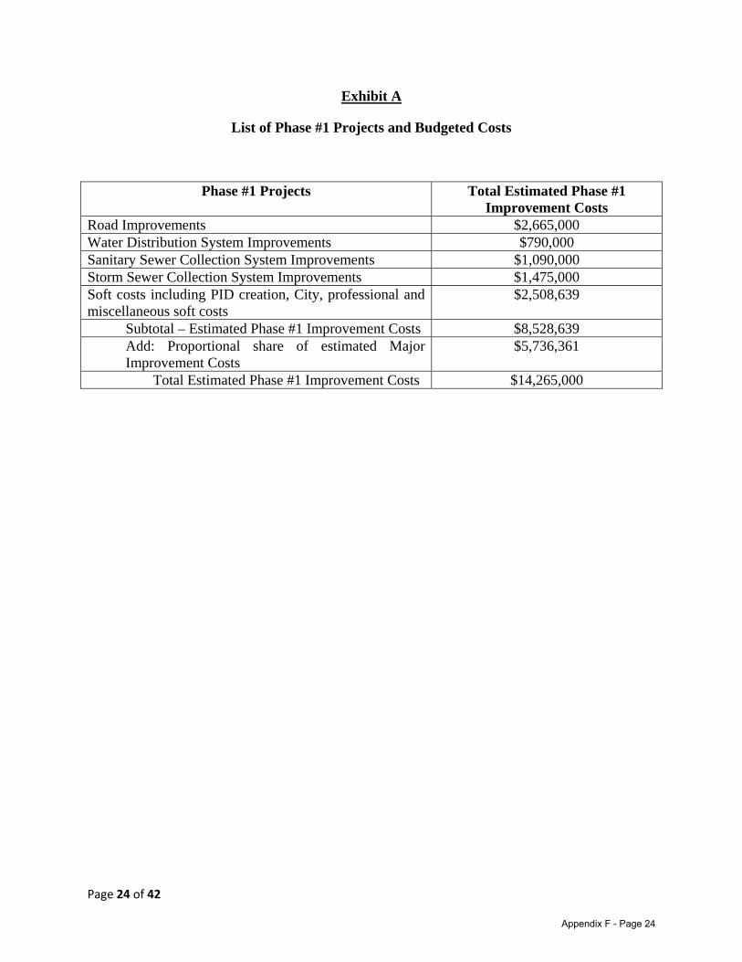
Page 24 of 42
Exhibit A
List of Phase #1 Projects and Budgeted Costs
Phase #1 Projects Total Estimated Phase #1 Improvement Costs
Road Improvements $2,665,000 Water Distribution System Improvements $790,000 Sanitary Sewer Collection System Improvements $1,090,000 Storm Sewer Collection System Improvements $1,475,000 Soft costs including PID creation, City, professional and miscellaneous soft costs
$2,508,639
Subtotal – Estimated Phase #1 Improvement Costs $8,528,639 Add: Proportional share of estimated Major Improvement Costs
$5,736,361
Total Estimated Phase #1 Improvement Costs $14,265,000
Appendix F - Page 24

Page 25 of 42
Exhibit B
FORM OF CLOSING DISBURSEMENT REQUEST
The undersigned is a lawfully authorized representative for CTMGT Frontier 80, LLC, (the “Developer”) and requests payment from the Costs of Issuance Account of the Project Fund (as defined in the Phase #1 Construction, Funding, and Acquisition Agreement) from _______________________________ (the “Trustee”) in the amount of ________________________ ($_____________) to be transferred from the Cost of Issuance Account of the Project Fund upon the delivery of the Bonds for costs incurred in the establishment, administration, and operation of the Creeks of Legacy Public Improvement District (the “District”), as follows.
In connection to the above referenced payment, the Developer represents and warrants to the City as follows:
1. The undersigned is a duly authorized officer of the Developer, is qualified to execute this Closing Disbursement Request on behalf of the Developer, and is knowledgeable as to the matters set forth herein.
2. The payment requested for the below referenced establishment, administration, and operation of the District at the time of the delivery of the Bonds have not been the subject of any prior payment request submitted to the City.
3. The amount listed for the below itemized costs is a true and accurate representation of the Actual Costs incurred by Developer with the establishment of the District at the time of the delivery of the Bonds, and such costs are in compliance with the Service and Assessment Plan. The itemized costs are as follows:
[insert itemized list of costs here]
TOTAL REQUESTED: $_________________________
4. The Developer is in compliance with the terms and provisions of the Phase #1 Construction, Funding, and Acquisition Agreement, the Indenture, the Development Agreement and the Service and Assessment Plan.
5. All conditions set forth in the Indenture (as defined in the Phase #1 Construction, Funding, and Acquisition Agreement), the Phase #1 Construction Funding and Acquisition Agreement, and the Development Agreement for the payment hereby requested have been satisfied.
6. The Developer agrees to cooperate with the City in conducting its review of the requested payment, and agrees to provide additional information and documentation as is reasonably necessary for the City to complete said review.
Appendix F - Page 25
Page 26 of 42
Payments requested hereunder shall be made as directed below:
[Information regarding Payee, amount, and deposit instructions]
I hereby declare that the above representations and warranties are true and correct.
CTMGT FRONTIER 80, LLC
By:_____________________________
Name: __________________________
Title: ___________________________
Date: ___________________________
Appendix F - Page 26
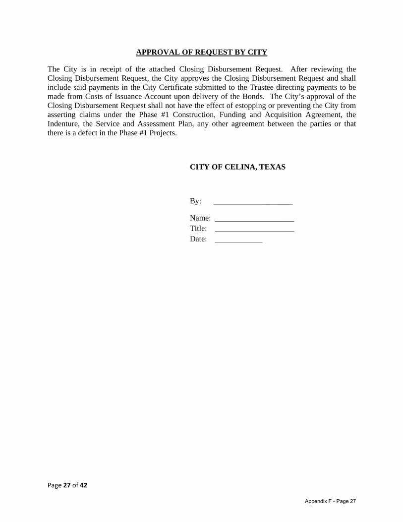
Page 27 of 42
APPROVAL OF REQUEST BY CITY
The City is in receipt of the attached Closing Disbursement Request. After reviewing the Closing Disbursement Request, the City approves the Closing Disbursement Request and shall include said payments in the City Certificate submitted to the Trustee directing payments to be made from Costs of Issuance Account upon delivery of the Bonds. The City’s approval of the Closing Disbursement Request shall not have the effect of estopping or preventing the City from asserting claims under the Phase #1 Construction, Funding and Acquisition Agreement, the Indenture, the Service and Assessment Plan, any other agreement between the parties or that there is a defect in the Phase #1 Projects.
CITY OF CELINA, TEXAS
By: ____________________
Name: ____________________ Title: ____________________
Date: ____________
Appendix F - Page 27
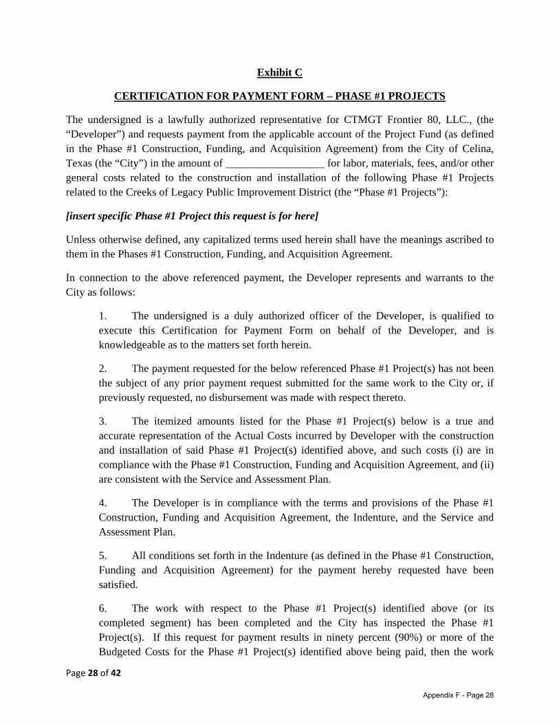
Page 28 of 42
Exhibit C
CERTIFICATION FOR PAYMENT FORM – PHASE #1 PROJECTS
The undersigned is a lawfully authorized representative for CTMGT Frontier 80, LLC., (the “Developer”) and requests payment from the applicable account of the Project Fund (as defined in the Phase #1 Construction, Funding, and Acquisition Agreement) from the City of Celina, Texas (the “City”) in the amount of __________________ for labor, materials, fees, and/or other general costs related to the construction and installation of the following Phase #1 Projects related to the Creeks of Legacy Public Improvement District (the “Phase #1 Projects”):
[insert specific Phase #1 Project this request is for here]
Unless otherwise defined, any capitalized terms used herein shall have the meanings ascribed to them in the Phases #1 Construction, Funding, and Acquisition Agreement.
In connection to the above referenced payment, the Developer represents and warrants to the City as follows:
1. The undersigned is a duly authorized officer of the Developer, is qualified to execute this Certification for Payment Form on behalf of the Developer, and is knowledgeable as to the matters set forth herein.
2. The payment requested for the below referenced Phase #1 Project(s) has not been the subject of any prior payment request submitted for the same work to the City or, if previously requested, no disbursement was made with respect thereto.
3. The itemized amounts listed for the Phase #1 Project(s) below is a true and accurate representation of the Actual Costs incurred by Developer with the construction and installation of said Phase #1 Project(s) identified above, and such costs (i) are in compliance with the Phase #1 Construction, Funding and Acquisition Agreement, and (ii) are consistent with the Service and Assessment Plan.
4. The Developer is in compliance with the terms and provisions of the Phase #1 Construction, Funding and Acquisition Agreement, the Indenture, and the Service and Assessment Plan.
5. All conditions set forth in the Indenture (as defined in the Phase #1 Construction, Funding and Acquisition Agreement) for the payment hereby requested have been satisfied.
6. The work with respect to the Phase #1 Project(s) identified above (or its completed segment) has been completed and the City has inspected the Phase #1 Project(s). If this request for payment results in ninety percent (90%) or more of the Budgeted Costs for the Phase #1 Project(s) identified above being paid, then the work
Appendix F - Page 28
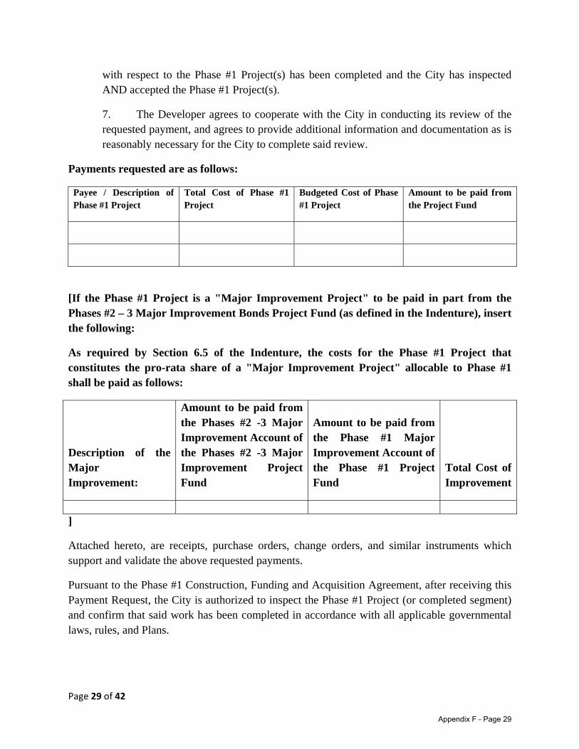
Page 29 of 42
with respect to the Phase #1 Project(s) has been completed and the City has inspected AND accepted the Phase #1 Project(s).
7. The Developer agrees to cooperate with the City in conducting its review of the requested payment, and agrees to provide additional information and documentation as is reasonably necessary for the City to complete said review.
Payments requested are as follows:
Payee / Description of Phase #1 Project
Total Cost of Phase #1 Project
Budgeted Cost of Phase #1 Project
Amount to be paid from the Project Fund
[If the Phase #1 Project is a "Major Improvement Project" to be paid in part from the Phases #2 – 3 Major Improvement Bonds Project Fund (as defined in the Indenture), insert the following:
As required by Section 6.5 of the Indenture, the costs for the Phase #1 Project that constitutes the pro-rata share of a "Major Improvement Project" allocable to Phase #1 shall be paid as follows:
Description of the Major Improvement:
Amount to be paid from the Phases #2 -3 Major Improvement Account of the Phases #2 -3 Major Improvement Project Fund
Amount to be paid from the Phase #1 Major Improvement Account of the Phase #1 Project Fund
Total Cost of Improvement
]
Attached hereto, are receipts, purchase orders, change orders, and similar instruments which support and validate the above requested payments.
Pursuant to the Phase #1 Construction, Funding and Acquisition Agreement, after receiving this Payment Request, the City is authorized to inspect the Phase #1 Project (or completed segment) and confirm that said work has been completed in accordance with all applicable governmental laws, rules, and Plans.
Appendix F - Page 29
Page 30 of 42
I hereby declare that the above representations and warranties are true and correct.
CTMGT FRONTIER 80 LLC,
By:_____________________________
Name: __________________________
Title: ___________________________
Date: ___________________________
Appendix F - Page 30
Page 31 of 42
APPROVAL OF REQUEST BY CITY
The City is in receipt of the attached Certification for Payment. After reviewing the Certification for Payment, the City approves the Certification for Payment and shall include said payments in the City Certificate submitted to the Trustee directing payments to be made from appropriate Project Fund account. The City’s approval of the Closing Disbursement Request shall not have the effect of estopping or preventing the City from asserting claims under the Phase #1 Construction, Funding and Acquisition Agreement, the Indenture, the Service and Assessment Plan, any other agreement between the parties or that there is a defect in the Phase #1 Projects.
CITY OF CELINA, TEXAS
By: ____________________
Name: ____________________ Title: ____________________
Date: ____________
Appendix F - Page 31
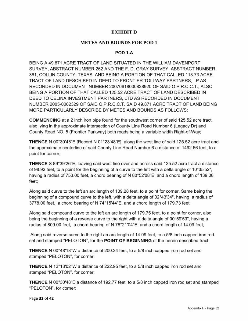
Page 32 of 42
EXHIBIT D
METES AND BOUNDS FOR POD 1
POD 1.A
BEING A 49.871 ACRE TRACT OF LAND SITUATED IN THE WILLIAM DAVENPORT SURVEY, ABSTRACT NUMBER 262 AND THE F. D. GRAY SURVEY, ABSTRACT NUMBER 361, COLLIN COUNTY, TEXAS. AND BEING A PORTION OF THAT CALLED 113.73 ACRE TRACT OF LAND DESCRIBED IN DEED TO FRONTIER TOLLWAY PARTNERS, LP AS RECORDED IN DOCUMENT NUMBER 20070618000828920 OF SAID O.P.R.C.C.T., ALSO BEING A PORTION OF THAT CALLED 125.52 ACRE TRACT OF LAND DESCRIBED IN DEED TO CELINA INVESTMENT PARTNERS, LTD AS RECORDED IN DOCUMENT NUMBER 2005-0062329 OF SAID O.P.R.C.C.T. SAID 49.871 ACRE TRACT OF LAND BEING MORE PARTICULARLY DESCRIBE BY METES AND BOUNDS AS FOLLOWS;
COMMENCING at a 2 inch iron pipe found for the southwest corner of said 125.52 acre tract, also lying in the approximate intersection of County Line Road Number 6 (Legacy Dr) and County Road NO. 5 (Frontier Parkway) both roads being a variable width Right-of-Way;
THENCE N 00°30’48”E [Record N 01°23’48”E], along the west line of said 125.52 acre tract and the approximate centerline of said County Line Road Number 6 a distance of 1492.66 feet, to a point for corner;
THENCE S 89°39’26”E, leaving said west line over and across said 125.52 acre tract a distance of 98.92 feet, to a point for the beginning of a curve to the left with a delta angle of 10°35'52", having a radius of 753.00 feet, a chord bearing of N 80°52'08"E, and a chord length of 139.08 feet;
Along said curve to the left an arc length of 139.28 feet, to a point for corner. Same being the beginning of a compound curve to the left, with a delta angle of 02°43'34", having a radius of 3778.00 feet, a chord bearing of N 74°15'44"E, and a chord length of 179.73 feet;
Along said compound curve to the left an arc length of 179.75 feet, to a point for corner, also being the beginning of a reverse curve to the right with a delta angle of 00°59'53", having a radius of 809.00 feet, a chord bearing of N 78°21'04"E, and a chord length of 14.09 feet;
Along said reverse curve to the right an arc length of 14.09 feet, to a 5/8 inch capped iron rod set and stamped “PELOTON”, for the POINT OF BEGINNING of the herein described tract.
THENCE N 00°48'18"W a distance of 200.34 feet, to a 5/8 inch capped iron rod set and stamped “PELOTON”, for corner;
THENCE N 12°13'02"W a distance of 222.95 feet, to a 5/8 inch capped iron rod set and stamped “PELOTON”, for corner;
THENCE N 00°30'48"E a distance of 192.77 feet, to a 5/8 inch capped iron rod set and stamped “PELOTON”, for corner;
Appendix F - Page 32

Page 33 of 42
THENCE N 89°11'42"E a distance of 343.68 feet, to a 5/8 inch capped iron rod set and stamped “PELOTON”, for corner;
THENCE N00°48'18"W a distance of 149.44 feet, to a 5/8 inch capped iron rod set and stamped “PELOTON”, for corner;
THENCE N 89°11'42"E, a distance of 484.51 feet, to a 5/8 inch capped iron rod set and stamped “PELOTON”, for corner;
THENCE N 00°48'18"W, a distance of 149.44 feet, to a 5/8 inch capped iron rod set and stamped “PELOTON”, for corner;
THENCE N 89°11'42"E, a distance of 597.56 feet, to a 5/8 inch capped iron rod set and stamped “PELOTON”, for corner;
THENCE S 00°48'18"E, a distance of 70.86 feet, to a 5/8 inch capped iron rod set and stamped “PELOTON”, for corner;
THENCE N 89°11'44"E, a distance of 204.23 feet, to a 5/8 inch capped iron rod set and stamped “PELOTON”, for corner;
THENCE S 00°48'18"E, a distance of 78.58 feet, to a 5/8 inch capped iron rod set and stamped “PELOTON”, for corner, and being the beginning of a curve to the left with a delta angle of 26°19'31", having a radius of 498.13 feet, a chord bearing of S 13°58'03"E, and a chord length of 226.86 feet;
Along said curve to the left an arc length of 228.87 feet, to a 5/8 inch capped iron rod set and stamped “PELOTON”, for corner;
THENCE S 27°07'49"E, passing at a distance of 254.91 feet, the common east west line of said Frontier Tollway and Celina Investment Partners tracts, continuing in all a total distance of 267.48 feet, to a 5/8 inch capped iron rod set and stamped “PELOTON”, for corner, also being the beginning of a curve to the right ; with a delta angle of 25°04'37", having a radius of 1804.71 feet, a chord bearing of S 14°35'30"E, and a chord length of 783.59 feet;
Along said curve to the right an arc length of 789.88 feet, to a 5/8 inch capped iron rod set and stamped “PELOTON”, for corner;
THENCE S 01°53'04"E, a distance of 121.09 feet, to a 5/8 inch capped iron rod set and stamped “PELOTON”, for corner, and being the beginning of a curve to the right with a delta angle of 10°15'27", having a radius of 298.88 feet, a chord bearing of S 02°53'08"W, and a chord length of 53.44 feet;
Along said curve to the right an arc length of 53.51 feet, to a 5/8 inch capped iron rod set and stamped “PELOTON”, for the southeast corner hereof;
THENCE S 88°07'15"W, a distance of 413.96 feet, to a 5/8 inch capped iron rod set and stamped “PELOTON”, for corner;
Appendix F - Page 33

Page 34 of 42
THENCE S 58°23'38"W, a distance of 415.11 feet, to a 5/8 inch capped iron rod set and stamped “PELOTON”, for corner;
THENCE N 77°09'49"W, a distance of 276.96 feet, to a 5/8 inch capped iron rod set and stamped “PELOTON”, for the most southerly southwest corner hereof;
THENCE N 12°50'12"E, a distance of 94.53 feet, to a 5/8 inch capped iron rod set and stamped “PELOTON”, for corner, and being the beginning of a curve to the left with a delta angle of 114°44'39", having a radius of 809.00 feet, a chord bearing of N 43°46'40"W, and a chord length of 1362.66 feet;
Along said curve to the left an arc length of 1620.15 feet, to the POINT OF BEGINNING and containing 49.871 Acres of land more or less.
Appendix F - Page 34
Page 35 of 42
POD 1.B BEING A 11.882 ACRE TRACT OF LAND SITUATED IN THE WILLIAM DAVENPORT SURVEY, ABSTRACT NUMBER 262 AND THE F. D. GRAY SURVEY, ABSTRACT NUMBER 361, COLLIN COUNTY, TEXAS. AND BEING A PORTION OF THAT CALLED 113.73 ACRE TRACT OF LAND DESCRIBED IN DEED TO FRONTIER TOLLWAY PARTNERS, LP AS RECORDED IN DOCUMENT NUMBER 20070618000828920 OF THE OFFICIAL PUBLIC RECORDS OF COLLIN COUNTY, TEXAS (O.P.R.C.C.T.), ALSO BEING A PORTION OF THAT CALLED 125.52 ACRE TRACT OF LAND DESCRIBED IN DEED TO CELINA INVESTMENT PARTNERS, LTD AS RECORDED IN DOCUMENT NUMBER 2005-0062329 OF SAID O.P.R.C.C.T. SAID 11.882 ACRE TRACT OF LAND BEING MORE PARTICULARLY DESCRIBE BY METES AND BOUNDS AS FOLLOWS;
COMMENCING at a 2 inch iron pipe found for the southwest corner of said 125.52 acre tract, also being the northeast corner of that certain tract of land described by deed to County Corners Partners, L.P. by deed recorded in Document Number 2004-0082310 of said O.P.R.C.C.T. Also lying in the approximate intersection of County Road No. 5 and County Line Road both being variable width Right-of-ways;
THENCE N 89°18’16”E, along the common line of said 125.52 acres and County Corners Tracts with the approximate centerline of said County Road No.5 a distance of 1316.23 feet, to a 5/8 inch capped iron rod set and stamped “PELOTON” for the POINT OF BEGINNING of the herein described tract;
THENCE N 01°02'21" W, leaving said center and common line a distance of 97.53 feet, to a 5/8 inch capped iron rod set and stamped “PELOTON” for corner, also being the beginning of a curve to the right with a delta angle of 19°30'03", having a radius of 965.00 feet, a chord bearing of N 05°39'24" E, and a chord distance of 326.86 feet; Along said curve to the right an arc length of 328.44 feet, to a 5/8 inch capped iron rod set and stamped “PELOTON” for corner;
THENCE N 12°50'12" E, a distance of 52.18 feet, to a 5/8 inch capped iron rod set and stamped “PELOTON” for the northwest corner hereof; THENCE S 77°09'49" E, a distance of 276.96 feet, to a 5/8 inch capped iron rod set and stamped “PELOTON” for corner;
THENCE N 58°23'38" E, a distance of 415.11 feet, to a 5/8 inch capped iron rod set and stamped “PELOTON” for corner;
THENCE N 88°07'15" E, a distance of 459.38 feet, to a 5/8 inch capped iron rod set and stamped “PELOTON” for the northeast corner hereof, also being the beginning of a non-tangent curve to the right with a delta angle of 28°57'47", having a radius of 343.71 feet, a chord bearing of S 21°11'42" W, and a chord distance of 171.90 feet;
Along said non-tangent curve to the right an arc length of 173.74 feet, to a 5/8 inch capped iron rod set and stamped “PELOTON” for corner;
Appendix F - Page 35
Page 36 of 42
THENCE S 35°40'35" W, a distance of 121.80 feet, to a 5/8 inch capped iron rod set and stamped “PELOTON” for corner also being the beginning of a curve to the left with a delta angle of 36°22'10", having a radius of 453.30 feet, a chord bearing of S 17°29'30" W, and a chord distance of 282.93 feet;
Along said curve to the left an arc length of 287.74 feet, to a 5/8 inch capped iron rod set and stamped “PELOTON” for corner;
THENCE S 00°36'01" E, a distance of 104.76 feet, to a 5/8 inch capped iron rod set and stamped “PELOTON” for corner, also lying in the south line of said Frontier Tollway tract and the approximate centerline of said County Road No.5;
THENCE S 89°34'04" W, a distance of 21.22 feet, to a 1/2 inch iron rod found, being the southeast corner of said 125.52 acre tract and the southwest corner of said Frontier Tollway tract, also lying in the north line of that certain tract of land describe din deed to Mike A. Myers Investment Holdings L.P. as recorded in Document Number 2004-0158476 of said O.P.R.C.C.T.;
THENCE S 89°18'16" W, along the south line of said 125.52 acre tract the north line of said Myers tract a distance of 886.47 feet, to the POINT OF BEGINNING and containing 11.882 acres of land more or less.
Appendix F - Page 36

Page 37 of 42
EXHIBIT E
METES AND BOUNDS FOR POD 2
BEING AN 80.701 ACRE TRACT OF LAND SITUATED IN THE WILLIAM DAVENPORT SURVEY, ABSTRACT NUMBER 262 AND THE F. D. GRAY SURVEY, ABSTRACT NUMBER 361, COLLIN COUNTY, TEXAS. AND BEING THE ENTIRE REMAINING PORTION OF THAT CALLED 33.0 ACRE TRACT OF LAND DESCRIBED IN DEED TO MARY C. MAYS AS RECORDED IN VOLUME 3415, PAGE 98 OF THE OFFICIAL PUBLIC RECORDS OF COLLIN COUNTY, TEXAS (O.P.R.C.C.T.). ALSO BEING A PORTION OF THAT CALLED 113.73 ACRE TRACT OF LAND DESCRIBED IN DEED TO FRONTIER TOLLWAY PARTNERS, LP AS RECORDED IN DOCUMENT NUMBER 20070618000828920 OF SAID O.P.R.C.C.T., ALSO BEING A PORTION OF THAT CALLED 125.52 ACRE TRACT OF LAND DESCRIBED IN DEED TO CELINA INVESTMENT PARTNERS, LTD AS RECORDED IN DOCUMENT NUMBER 2005-0062329 OF SAID O.P.R.C.C.T. SAID 80.701 ACRE TRACT OF LAND BEING MORE PARTICULARLY DESCRIBE BY METES AND BOUNDS AS FOLLOWS;
COMMENCING at a 2 inch iron pipe found for the southwest corner of said 125.52 acre tract, also lying in the approximate intersection of County Line Road (Legacy Dr) and County Road NO. 5 (Frontier Parkway) both roads being a variable width Right-of-Way;
THENCE N 00°30’48”E [Record N 01°23’48”E], along the west line of said 125.52 acre tract and the approximate centerline of said County Line Road a distance of 1492.66 feet, to a 5/8 inch iron rod set and stamped “PELOTON” being the southwest corner hereof and the POINT OF BEGINNING of the herein described tract;
THENCE N 00°30'48"E, continuing along said west line and North County line Road a distance of 1011.26 feet, to a 3/4 inch iron rod found, being the northwest corner of said 125.52 acre tract and the southwest corner of said Mays tract;
THENCE N 00°23'44"W, along the west line of said Mays tract and centerline of said County Line Road, passing at a distance of 30.65 feet a 1/2 inch iron rod found being the northeast corner of that certain tract of land described in deed to Stongate Partners-Legacy, LP as recorded in Document Number 2008-9820 of the Real property Records of Denton County, Texas. Continuing in all a total distance of 60.00 feet, to a 5/8 inch capped iron rod set and stamped “Peloton”, for the northwest corner hereof also being the southwest corner of that called 10.0 acre tract of land described in deed to Carl P. Parrish and dale Parrish as recorded in Volume 5335, page 7579 of said Collin County Records;
THENCE N 89°09'02"E, along the south line of said 10.0 acre tract a north line hereof and said Mays tract a distance of 753.03 feet, to a 5/8 inch capped iron rod found and stamped “BRENNAN”, for an angle point hereof;
THENCE N 00°16'45"W, along a common line of said 10.0 acre and Mays tracts a distance of 600.61 feet, to a 5/8 inch capped iron rod found, for the most northerly northwest corner hereof and lying in the south line of that certain tract of land described in deed to Donnye McCully as recorded in Document Number 2012032300033840 of said Collin County Records;
Appendix F - Page 37
Page 38 of 42
THENCE N 88°13'57"E, along the north line of said Mays tract a distance of 1062.60 feet, to a 1 inch iron rod found for corner;
THENCE S 89°51'14"E, continuing along the north line of said Mays tract a distance of 348.31 feet, to a 1 inch iron rod found, for corner. Also being the northeast corner of said Mays tract and the northwest corner of said Frontier Tollway tract and lying in the approximate common Abstract Line of said Davenport and Gray Surveys ;
THENCE N 89°27'22"E, along the north line of said Frontier Tollway tract a distance of 753.95 feet, to a 5/8 inch capped iron rod set and stamped “Peloton”, for corner;
THENCE N 89°45'31"E, continuing along said north line a distance of 804.65 feet, to a 1/2 inch iron rod found for the northeast corner hereof and said Frontier Tollway tract, also being the northwest corner of that certain tract of land described in deed to 117 Farm Tollway Ltd as recorded in Document Number 2005-0088512 of said Collin County Records. From which a 1/2 inch iron rod found bears N 89°23’49”E, a distance of 754.20 [Record 754.00], being an angle point in the north line of said 117 Farm tract;
THENCE S 00°06'38"E, along the common line of said Frontier and 117 Farm Tollway tracts passing at a distance of 1005.69 feet, a 1/2 inch square metal pipe being the common west corner for said 117 Farm Tollway and that certain tract of land described in deed to Parvin Ranchers LP as recorded in Document Number 20090707000849620 of said Collin County, Records, continuing in all a total distance of 1036.37 feet, to a 5/8 inch capped iron rod set and stamped “Peloton”, for the southeast corner hereof;
THENCE over and across said Frontier Tollway and Celina Investment Partners tracts the following twenty-one (21) courses and distances:
S 89°53'57"W a distance of 462.14 feet, to a 5/8 inch capped iron rod set and stamped “Peloton”, for corner;
N 00°06'03"W a distance of 18.17 feet, to a 5/8 inch capped iron rod set and stamped “Peloton”, for corner;
S 89°40'56"W a distance of 710.10 feet, to a 5/8 inch capped iron rod set and stamped “Peloton”, for corner;
S 89°09'11"W, passing at a distance of 97.73 feet, the common east and west line of said Frontier Tollway and Celina Investment Partner tracts, continuing in all a total distance of 288.91 feet, to a 5/8 inch capped iron rod set and stamped “Peloton”, for corner;
S 76°13'41"W a distance of 122.04 feet, to a 5/8 inch capped iron rod set and stamped “Peloton”, for corner;
S 89°11'42"W a distance of 144.83 feet, to a 5/8 inch capped iron rod set and stamped “Peloton”, for corner;
Appendix F - Page 38
Page 39 of 42
S 00°48'18"E a distance of 31.02 feet, to a 5/8 inch capped iron rod set and stamped “Peloton”, for corner;
S 89°11'44"W a distance of 204.23 feet, to a 5/8 inch capped iron rod set and stamped “Peloton”, for corner;
N 00°48'18"W a distance of 70.86 feet, to a 5/8 inch capped iron rod set and stamped “Peloton”, for corner;
S 89°11'42"W a distance of 597.56 feet, to a 5/8 inch capped iron rod set and stamped “Peloton”, for corner;
N 00°48'18"W a distance of 149.44 feet, to a 5/8 inch capped iron rod set and stamped “Peloton”, for corner;
S 89°11'42"W a distance of 484.51 feet, to a 5/8 inch capped iron rod set and stamped “Peloton”, for corner;
S 00°48'18"E a distance of 149.44 feet, to a 5/8 inch capped iron rod set and stamped “Peloton”, for corner;
S 89°11'42"W a distance of 343.68 feet, to a 5/8 inch capped iron rod set and stamped “Peloton”, for corner;
S 00°30'48"W a distance of 192.77 feet, to a 5/8 inch capped iron rod set and stamped “Peloton”, for corner;
S 12°13'02"E a distance of 222.95 feet, to a 5/8 inch capped iron rod set and stamped “Peloton”, for corner;
S 00°48'18"E a distance of 200.33 feet, to a 5/8 inch capped iron rod set and stamped “Peloton”, for corner, also being the beginning of a non-tangent curve to the left with a delta angle of 00°59'53", having a radius of 809.00 feet, a chord bearing of S 78°21'04"W, and a chord length of 14.09feet;
Along said non-tangent curve to the left an arc length of 14.09 feet, to a 5/8 inch capped iron rod set and stamped “Peloton”, for corner, Also being the beginning of a non-tangent curve to the right with a delta angle of 02°43'34", having a radius of 3778.00feet, a chord bearing of S 74°15'44"W, and a chord length of 179.73feet;
Along said non-tangent curve to the right an arc length of 179.75 feet, to a 5/8 inch capped iron rod set and stamped “Peloton”, for corner, the same being the beginning of a compound curve to the right with a delta angle of 10°35'52", having a radius of 753.00feet, a chord bearing of S 80°52'08"W, and a chord length of 139.08feet;
Appendix F - Page 39

Page 40 of 42
Along said compound curve to the right an arc length of 139.28 feet, to a 5/8 inch capped iron rod set and stamped “Peloton”, for corner;
N 89°39'26"W a distance of 98.92 feet, to the POINT OF BEGINNING and containing 80.701 Acres of land more or less.
Appendix F - Page 40
Page 41 of 42
EXHIBIT F
METES AND BOUNDS FOR POD 3
BEING A 52.275 ACRE TRACT OF LAND SITUATED IN THE F.D. GRAY SURVEY ABSTRACT NUMBER 361 AND THE WILLIAM DAVENPORT SURVEY, ABSTRACT NUMBER 262 OF COLLIN COUNTY, TEXAS. AND BEING A PORTION OF THAT CERTAIN TRACT OF LAND DESCRIBED IN DEED TO FRONTIER TOLLWAY PARTNERS, LP AS RECORDED IN DOCUMENT NUMBER 20070618800092890 OF THE OFFICIAL PUBLIC RECORDS OF COLLIN COUNTY, TEXAS, ALSO BEING A PORTION OF THAT CALLED 125.52 ACRE TRACT OF LAND DESCRIBED BY DEED TO CELINA INVESTMENT PARTNERS, LTD, RECORDED IN VOLUME 5916, PAGE 862 OF SAID COUNTY RECORDS. SAID 52.275 ACRE TRACT, BEING MORE PARTICULARLY DESCRIBED BY METES AND BOUNDS AS FOLLOW. COMMENCING at a 1/2 inch iron rod found for the southeast corner of said Frontier Tollway tract also being the southwest corner of that certain tract of land described by deed to Tom Mosey, recorded in Document Number 1999-0024276 of said County Records. Also lying in the approximate centerline of County Road No. 5 also known as Frontier Parkway a variable width Right-of-Way, from which a 1/2 inch iron rod found bears S 89°34’04”W [Record N 89°57’18”W], along the approximate centerline of said County Road Number 5 a distance of 1577.18 [Record 1577.35] feet; THENCE along the common line of said Frontier Tollway and Mosey tracts the following three (3) courses and distances:
N 00°25’31”W, passing at a distance of 30.49 feet, a 5/8 inch capped iron rod found and stamped “BRENNAN”, lying in the approximate north line of said County Road No. 5, continuing in all a total distance of 412.89 feet, to a 1/2 inch iron rod found for an angle point;
N 85°36’04”W, a distance of 30.36 feet, to a 1/2 inch iron rod found for an angle point hereof;
N 00°06’38”W, a distance of 249.81 feet, to a 5/8 inch capped iron rod set, stamped “PELOTON” for the southeast corner hereof and the POINT OF BEGINNING of the herein describe tract;
THENCE S 88°06'56"W, leaving said common line over and across said Frontier Tollway tract a distance of 1351.10 feet, to a 5/8 inch capped iron rod set and stamped “PELOTON”, for corner. Also being the beginning of a non-tangent curve to the left with a delta angle of 10°15'27", having a radius of 298.88 feet, a chord bearing of N 02°53'08"E, and a chord length of 53.44 feet; Along said non-tangent curve to the left an arc length of 53.51 feet, to a 5/8 inch capped iron rod set and stamped “PELOTON”, for corner; THENCE N 01°53'04"W, a distance of 121.09 feet, to a 5/8 inch capped iron rod set and stamped “PELOTON”, for corner. Also being the beginning of a curve to the left with a delta angle of 25°04'37", having a radius of 1804.71 feet, a chord bearing of N 14°35'30"W, and a chord length of 783.59 feet;
Appendix F - Page 41
Page 42 of 42
Along said curve to the left an arc length of 789.88 feet, to a 5/8 inch capped iron rod set and stamped “PELOTON”, for corner; THENCE N 27°07'49"W, passing at a distance of 12.56 the common line of said Frontier Tollway and Celina Investment tracts, continuing in all a total distance of 267.48 feet, to a 5/8 inch capped iron rod set and stamped “PELOTON”, for corner. Also being the beginning of a curve to the right with a delta angle of 26°19'31", having a radius of 498.13 feet, a chord bearing of N 13°58'03"W, and a chord length of 226.86 feet; Along said curve to the right an arc length of 228.87 feet, , to a 5/8 inch capped iron rod set and stamped “PELOTON”, for corner; THENCE N 00°48'18"W, a distance of 109.60 feet, to a 5/8 inch capped iron rod set and stamped “PELOTON”, for the northwest corner hereof; THENCE N 89°11'42"E, continuing over and across said Celina Investment tract a distance of 144.83 feet, to a 5/8 inch capped iron rod set and stamped “PELOTON”, for corner; THENCE N 76°13'41"E, passing at a distance of 24.32 feet, the common line of said Frontier Tollway and Celina Investment tract, continuing in all a total distance of 122.04 feet, to a 5/8 inch capped iron rod set and stamped “PELOTON”, for corner; THENCE N 89°09'11"E, over and across said Frontier Tollway tract a distance of 288.91 feet, to a 5/8 inch capped iron rod set and stamped “PELOTON”, for corner; THENCE N 89°40'56"E, over and across said Frontier Tollway tract a distance of 710.10 feet, to a 5/8 inch capped iron rod set and stamped “PELOTON”, for an angle point hereof for corner; THENCE S 00°06'03"E, a distance of 18.17 feet, to a 5/8 inch capped iron rod set and stamped “PELOTON”, for an angle point hereof for corner; THENCE N 89°53'57"E, a distance of 462.14 feet, to a 5/8 inch capped iron rod set and stamped “PELOTON”, for the northeast corner hereof, lying in the common line of said Frontier Tollway tract and that certain tract of land describe by deed to Parvin Ranchers, LP record in Document Number 20090707000849620 of said County, Records, from which a 1/2 inch iron rod found bears N 00°06’38”W, a distance of 1036.37 feet, being the northeast corner of said Frontier Tollway tract; THENCE S 00°06'38"E [Record S 00°16’42”W], along the east line of said Frontier Tollway tract passing at a distance of 417.17 feet, a 1/2 inch square pipe being the southwest corner of said Parvin Ranchers and the northwest corner of said Tom Mosey tract, continuing in all a total distance of 1478.02 feet, to the POINT OF BEGINNING and containing 52.275 Acres of land more or less.
Appendix F - Page 42

(THIS PAGE IS INTENTIONALLY LEFT BLANK.)

(THIS PAGE IS INTENTIONALLY LEFT BLANK.)
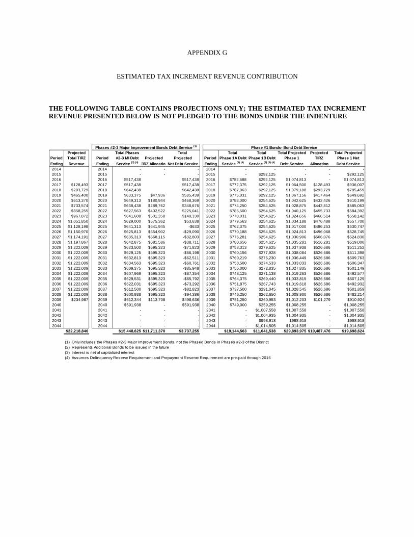
APPENDIX G
ESTIMATED TAX INCREMENT REVENUE CONTRIBUTION
THE FOLLOWING TABLE CONTAINS PROJECTIONS ONLY; THE ESTIMATED TAX INCREMENT REVENUE PRESENTED BELOW IS NOT PLEDGED TO THE BONDS UNDER THE INDENTURE
Projected Total Phases Total Total Total Total Projected Projected Total ProjectedPeriod Total TIRZ Period #2-3 MI Debt Projected Projected Period Phase 1A Debt Phase 1B Debt Phase 1 TIRZ Phase 1 NetEnding Revenue Ending Service (3) (4) TIRZ AllocationNet Debt Service Ending Service (3) (4) Service (2) (3) (4) Debt Service Allocation Debt Service2014 2014 - - - 2014 - - - - -2015 2015 - - - 2015 - $292,125 - - $292,1252016 2016 $517,438 $517,438 2016 $782,688 $292,125 $1,074,813 - $1,074,8132017 $128,493 2017 $517,438 $517,438 2017 $772,375 $292,125 $1,064,500 $128,493 $936,0072018 $293,729 2018 $642,438 $642,438 2018 $787,063 $292,125 $1,079,188 $293,729 $785,4592019 $465,400 2019 $633,375 $47,936 $585,439 2019 $775,031 $292,125 $1,067,156 $417,464 $649,6922020 $613,370 2020 $649,313 $180,944 $468,369 2020 $788,000 $254,625 $1,042,625 $432,426 $610,1992021 $733,574 2021 $638,438 $289,762 $348,676 2021 $774,250 $254,625 $1,028,875 $443,812 $585,0632022 $858,255 2022 $627,563 $402,522 $225,041 2022 $785,500 $254,625 $1,040,125 $455,733 $584,3922023 $967,872 2023 $641,688 $501,358 $140,330 2023 $770,031 $254,625 $1,024,656 $466,514 $558,1422024 $1,051,850 2024 $629,000 $575,362 $53,638 2024 $779,563 $254,625 $1,034,188 $476,488 $557,7002025 $1,128,198 2025 $641,313 $641,945 -$633 2025 $762,375 $254,625 $1,017,000 $486,253 $530,7472026 $1,150,970 2026 $625,813 $654,902 -$29,090 2026 $770,188 $254,625 $1,024,813 $496,068 $528,7452027 $1,174,191 2027 $635,313 $668,115 -$32,803 2027 $776,281 $254,625 $1,030,906 $506,076 $524,8302028 $1,197,867 2028 $642,875 $681,586 -$38,711 2028 $780,656 $254,625 $1,035,281 $516,281 $519,0002029 $1,222,009 2029 $623,500 $695,323 -$71,823 2029 $758,313 $279,625 $1,037,938 $526,686 $511,2522030 $1,222,009 2030 $629,125 $695,323 -$66,198 2030 $760,156 $277,928 $1,038,084 $526,686 $511,3982031 $1,222,009 2031 $632,813 $695,323 -$62,511 2031 $760,219 $276,230 $1,036,449 $526,686 $509,7632032 $1,222,009 2032 $634,563 $695,323 -$60,761 2032 $758,500 $274,533 $1,033,033 $526,686 $506,3472033 $1,222,009 2033 $609,375 $695,323 -$85,948 2033 $755,000 $272,835 $1,027,835 $526,686 $501,1492034 $1,222,009 2034 $607,969 $695,323 -$87,354 2034 $748,125 $271,138 $1,019,263 $526,686 $492,5772035 $1,222,009 2035 $629,531 $695,323 -$65,792 2035 $764,375 $269,440 $1,033,815 $526,686 $507,1292036 $1,222,009 2036 $622,031 $695,323 -$73,292 2036 $751,875 $267,743 $1,019,618 $526,686 $492,9322037 $1,222,009 2037 $612,500 $695,323 -$82,823 2037 $737,500 $291,045 $1,028,545 $526,686 $501,8592038 $1,222,009 2038 $600,938 $695,323 -$94,386 2038 $746,250 $262,650 $1,008,900 $526,686 $482,2142039 $234,987 2039 $612,344 $113,708 $498,636 2039 $751,250 $260,953 $1,012,203 $101,279 $910,9242040 2040 $591,938 - $591,938 2040 $749,000 $259,255 $1,008,255 - $1,008,2552041 2041 - - - 2041 - $1,007,558 $1,007,558 - $1,007,5582042 2042 - - - 2042 - $1,004,935 $1,004,935 - $1,004,9352043 2043 - - - 2043 - $998,918 $998,918 - $998,9182044 2044 - - - 2044 - $1,014,505 $1,014,505 - $1,014,505
$22,218,846 $15,448,625 $11,711,370 $3,737,255 $19,144,563 $11,041,538 $29,893,975 $10,487,476 $19,698,624
(1) Only includes the Phases #2-3 Major Improvement Bonds, not the Phased Bonds in Phases #2-3 of the District(2) Represents Additional Bonds to be issued in the future(3) Interest is net of capitalized interest(4) Assumes Delinquency Reserve Requirement and Prepayment Reserve Requirement are pre-paid through 2016
Phases #2-3 Major Improvement Bonds Debt Service (1) Phase #1 Bonds- Bond Debt Service

(THIS PAGE IS INTENTIONALLY LEFT BLANK.)

Print_^ \y: Roy]_ Printing www.roy]_printing.]om