9.1 broome countygobroomecounty.com/files/planning/_pdf/hazard mitigation/drafts for... · section...
TRANSCRIPT
SECTION 9.1: BROOME COUNTY
DMA 2000 Hazard Mitigation Plan Update –Broome County, New York 9.1-1 December 2013
9.1 BROOME COUNTY
This section presents the jurisdictional annex for Broome County.
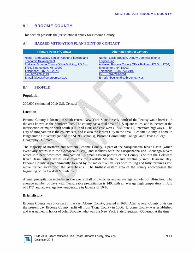
A.) HAZARD MITIGATION PLAN POINT OF CONTACT
Primary Point of Contact Alternate Point of Contact
Name: Beth Lucas, Senior Planner, Planning and Economic Development Address: Broome County Office Building, PO Box 1766, Binghamton, NY 13902 Telephone: 607-778-2375 Fax: 607-778-2175 E-mail: [email protected]
Name: Leslie Boulton, Deputy Commissioner of Engineering Address: Broome County Office Building, PO Box 1766, Binghamton, NY 13902 Telephone: _607-778-2490 Fax: _607-778-6051 E-mail: [email protected]
B.) PROFILE Population 200,600 (estimated 2010 U.S. Census) Location Broome County is located in south-central New York State directly north of the Pennsylvania border in the area known as the Southern Tier. The county has a total area of 715 square miles, and is located at the intersection of major north-south (I-81 and I-88) and east-west (I-86/Route 17) interstate highways. The City of Binghamton is the county seat, and is also the largest City in the area.. Broome County is home to Binghamton University (one of the SUNY schools), Broome Community College, and Davis College. Geography / Climate
The majority of northern and western Broome County is part of the Susquehanna River Basin (which eventually drains into the Chesapeake Bay), and includes both the Susquehanna and Chenango Rivers which join near downtown Binghamton. A small eastern portion of the County is within the Delaware River Basin which drains east towards the Catskill Mountains and eventually into Delaware Bay. Broome County is predominantly formed by the major river valleys with rolling and hilly terrain as you move further away from the river basins. The furthest eastern area of the county encompasses the beginning of the Catskill Mountains. Annual precipitation includes an average rainfall of 37-inches and an average snowfall of 58-inches. The average number of days with measureable precipitation is 149, with an average high temperature in July of 81°F, and an average low temperature in January of 16°F. Brief History
Broome County was once part of the vast Albany County, created in 1683. After several County divisions the present day Broome County split off from Tioga County in 1806. Broome County was established and was named in honor of John Broome, who was the New York State Lieutenant Governor at the time.

SECTION 9.1: BROOME COUNTY
DMA 2000 Hazard Mitigation Plan Update –Broome County, New York 9.1-2 December 2013
Governing Body Format The governing body of the County consists of a County Executive and a County Legislature with one representative from each of 15 districts. An elected Clerk also serves the County. Home rule is strong in New York State and thus, each town and village has its own governing body. Towns are made up of a Town Board and Supervisor. Villages generally have a Mayor, Clerk, andBoard. The City of Binghamton consists of a Mayor and City Council, along with a City Clerk. Along with town and village roads, public water and sewer systems are predominantly owned and operated by the local municipality, though they cooperate with County departments frequently. Through their municipal codes each municipality has control over its own planning and zoning laws, but many utilize County planning and engineering personnel as a resource. The County, as a governing entity, does not enact planning and zoning ordinances or other local land use control regulations. However, the County does review development proposals that qualify under New York State General Muncipal Law 239 which requires that certain types of municipal planning, zoning and subdivision projects be referred to the County prior to local action being taken. Growth/Development Trends The following table summarizes major residential/commercial development and major infrastructure development that are identified for the next five (5) years in the County. Those items listed with bold text are projects that the County (as an independent governing body) is planning. Other items listed are general growth/development trends expected within various municipalities. Refer to the map in section I.) of this annex which illustrates the hazard areas along with the location of potential new development.
New Development/Potential Development in Municipality
Property Name
Type (Residential
or Commercial)
Number of Structures
Address Block and
Lot Known
Hazard Zone Description/
Status
Upper Front Street
Both
Town of Chenango
Infill Development on Vestal Parkway
Commercial Town of Vestal
Downtown Binghamton
Both City of
Binghamton
Suburban Development
Residential Union, Vestal
Otsiningo Park Farmer’s Market
Commercial 1 Town of
Dickinson None
In planning / design – construction in 2013
High Tech Incubator
CNG Facility @ County Transit
Town of Vestal
Landfill / Airport Sewer Line
Major Infrastructure
N/A Towns of Barker, Nanticoke, Maine
& Union
Public ROW
None Sewer line for landfill leachate &

SECTION 9.1: BROOME COUNTY
DMA 2000 Hazard Mitigation Plan Update –Broome County, New York 9.1-3 December 2013
airport development
Development of Airport outparcels
Commercial various Town of Maine
Airport / County owned parcels
In Master Plan for development once sewer line has been designed / constructed

SECTION 9.1: BROOME COUNTY
DMA 2000 Hazard Mitigation Plan Update –Broome County, New York 9.1-4 December 2013
C.) NATURAL HAZARD EVENT HISTORY SINCE 2006 Broome County has a history of natural hazard events as detailed in Volume I, Section 5 of this plan. A summary of historical events is provided in each of the hazard profiles and includes a chronology of events affecting the County and its municipalities. Below is presented a summary of events dating from the year 2006 to indicate the range and impact of natural hazard events in this community. Specific damages have been indicated if available from reference or local sources. For details of events prior to 2006, refer to Volume I, Section 5 of this plan.
Type of Event
FEMA Disaster #
(if applicable)
County Designated?
Date Approximate Damage
Assessment
Severe Storms and Flooding
DR 1650 Yes - IA, PA June 26 —July 10, 2006
Damage occurred to numerous roads, public facilities, equipment, and infrastructure, and private residences. Multiple landfills reported over $100 in damages. Significant repairs were needed at Edson Road and Trim Street. Public recreational facilities, including the golf course and Grippen Ice Rink, were severely impacted. The Conklin trailer park reported over $100k in damages. In total, the County experienced approximately $5,503,283 in damages.
Severe Storms and Flooding
DR 1670 Yes - IA, PA November 16-17, 2006
April Nor'easter DR 1692 No April 14 - 18, 2007
Severe Storms and Flooding
DR 1710 No June 19, 2007
Severe Winter Storm
EM 3299 DR 1827
No December 11-31, 2008
Severe Storms and Flooding
DR 1857 No August 8-10, 2009
Severe Winter Storm and Snowstorm
DR 1957 No December 26-27, 2011
Severe Storms, Flooding, Tornado and Straight Line Winds
DR 1993 Yes - PA April 26 — May 8, 2011
Damage occurred to numerous roads and public facilities. The most significant damage occurred at Brady Hill Road, Old Newark Valley Road, Oquaga Lake Road, and Trim/Kent Street. In total, the County reported $333,082 in damages.
Hurricane Irene EM 3328 DR 4020
Yes - IA, PA August 26 — September 5, 2011

SECTION 9.1: BROOME COUNTY
DMA 2000 Hazard Mitigation Plan Update –Broome County, New York 9.1-5 December 2013
Type of Event
FEMA Disaster #
(if applicable)
County Designated?
Date Approximate Damage
Assessment
Remnants of Tropical Storm Lee
EM 3341 DR 4031
Yes - IA, PA September 7-11, 2011
Damage occurred to numerous roads, public facilities, equipment, and infrastructure. Major roadway repair and/or cleanup was required at Old Newark Valley Slope, South St Culvert, Shaw Road, and Old 17 (Grove St and Shed Road). Public facilities impacted included the Otsiningo Play Grounds & Ballpark. The Enjoie Golf Course also experienced significant damages. In total, the County was awarded $1,891,199 in highway damages, and $249,496 in park damages.
Note: N/A = Not applicable

SECTION 9.1: BROOME COUNTY
DMA 2000 Hazard Mitigation Plan Update –Broome County, New York 9.1-6 December 2013
D.) NATURAL HAZARD RISK/VULNERABILITY RISK RANKING
Hazard type Estimate of Potential Dollar Losses to Structures Vulnerable to the Hazard a, c
Probability of Occurrence
Risk Ranking
Score (Probability x Impact)
Hazard Ranking
b
Flood 1% Annual Chance: $1,355,932,058
Frequent 42 High 0.2% Annual Chance: $2,048,426,867
Severe Storm
100-Year MRP: $51,933
Frequent 39 High 500-Year MRP: $5,524,665
Annualized Loss: $57,255
Severe Winter Storm 1% of GBS: $242,247,630
Frequent 39 High 5% of GBS: $1,211,238,149
Drought Not available Frequent 36 High
Earthquake
500-Year MRP: $15,736,929
Occasional 20 Medium 2,500-Year MRP: $167,771,982
Annualized Loss: $209,529
Extreme Temperature Not available Frequent 27 Medium
a. Building damage ratio estimates based on FEMA 386-2 (August 2001) b. High = Total hazard priority risk ranking score of 31 and above Medium = Total hazard priority risk ranking of 20-30 Low = Total hazard risk ranking below 20 c. The valuation of general building stock and loss estimates was based on custom inventory for Broome County. d. Loss estimates are structural values only; does not include the value of contents. e. Loss estimates represent both structure and contents. f. The HAZUS-MH earthquake model results are reported by Census Tract.

SECTION 9.1: BROOME COUNTY
DMA 2000 Hazard Mitigation Plan Update –Broome County, New York 9.1-7 December 2013
E.) CAPABILITY ASSESSMENT This section identifies the following capabilities of the local jurisdiction:
Legal and regulatory capability
Administrative and technical capability
Fiscal capability
Community resiliency
Community political capability
Community classification. The county indicates that it has high administrative, technical, and fiscal capability; moderate planning, regulatory, and community resiliency, and community political capability; with a moderately willing political capability to enact policies or programs to reduce hazard vulnerabilities in the community. The County also notes that County Planning can assist municipalities, but is not able to enact ordinances to regulate outside its own County facilities and structures.

SECTION 9.1: BROOME COUNTY
DMA 2000 Hazard Mitigation Plan Update –Broome County, New York 9.1-8 December 2013
E.1) Legal and Regulatory Capability
Regulatory Tools (Codes, Ordinances., Plans)
Do you have this? (Y or N)
Enforcement Authority
Code Citation
(Section, Paragraph, Page Number, Date of adoption)
1) Building Code N Local
2) Zoning Ordinance N Local
3) Subdivision Ordinance N Local
4) NFIP Flood Damage Prevention Ordinance
N Local
4a) Cumulative Substantial Damages
N Local
4b) Freeboard N Local
5) Growth Management N Local
6) Floodplain Management / Basin Plan
N Local or Watershed
7) Stormwater Management Plan/Ordinance
Under development
Local: DPW - Engineering
MS4 Program Implemented – written plan in progress
8) Comprehensive Plan / Master Plan/ General Plan
Under development
Local: Planning Currently developing county comp plan. Est completion July 2013
9) Capital Improvements Plan Y
Local or County:Legislature with input
from Depts: Public Works, Planning, etc.
Adopted annually as part of County budget process
10) Site Plan Review Requirements
N Local
11) Open Space Plan Under
development
Local or County:Environmental
Management Council
EMC has been working on it for several years. Uncertain of when it will be complete.
12) Stream Corridor Management Plan
N Local or Watershed
13) Watershed Management or Protection Plan
Y - Regional
Local or Watershed:Southern Tier East
Regional Planning and Development Board
Have a regional plan, Susquehanna Chemung Action Plan. Not at county level but do have an inspection/ maintenance plan for County flood control structures.
14) Economic Development Plan Y County: Planning Will be updated as part of County Comp Plan
15) Comprehensive Emergency Management Plan
Under development
Local or County: Office of Emergency Services
Under active development
16) Emergency Response Plan Y Local or County: Office

SECTION 9.1: BROOME COUNTY
DMA 2000 Hazard Mitigation Plan Update –Broome County, New York 9.1-9 December 2013
Regulatory Tools (Codes, Ordinances., Plans)
Do you have this? (Y or N)
Enforcement Authority
Code Citation
(Section, Paragraph, Page Number, Date of adoption)
of Emergency Services
17) Post Disaster Recovery Plan N Local
18) Post Disaster Recovery Ordinance
N Local
19) Real Estate Disclosure Requirement
N State State Requirement
20) Other [Special Purpose Ordinances (i.e., critical or sensitive areas)]
N Local or County

SECTION 9.1: BROOME COUNTY
DMA 2000 Hazard Mitigation Plan Update –Broome County, New York 9.1-10 December 2013
E.2) Administrative and Technical Capability
Staff/ Personnel Resources
Ava
ilab
le
(Y o
r N
)
Department/ Agency/ Position
1) Planner(s) or Engineer(s) with knowledge of land development and land management practices
Y DPW-Engineering and Planning
2) Engineer(s) or Professional(s) trained in construction practices related to buildings and/or infrastructure
Y DPW-Engineering
3) Planners or engineers with an understanding of natural hazards
Y DPW-Engineering and Planning
4) NFIP Floodplain Administrator N Local municipalities have authority
5) Surveyor(s) N County contracts with consultants
6) Personnel skilled or trained in “GIS” applications Y Planning
7) Scientist familiar with natural hazards N
8) Emergency Manager Y Emergency Services
9) Grant Writer(s) Y Planning
10) Staff with expertise or training in benefit/cost analysis
N Some staff has a general understanding but not expertise.
E.3) Fiscal Capability
Financial Resources Accessible or Eligible to use
(Yes/No/Don’t know)
1) Community Development Block Grants (CDBG) Y
2) Capital Improvements Project Funding Y
3) Authority to Levy Taxes for specific purposes Y
4) User fees for water, sewer, gas or electric service Y
5) Impact Fees for homebuyers or developers of new development/homes
N
6) Incur debt through general obligation bonds Y
7) Incur debt through special tax bonds
Y – But not generally used by County [If Private activity is very minimal as a part of a multipurpose issuance the County could issue private activity bonds for capitalizing a County
owned asset. (County Finance, not to be included in text but just as an FYI)]
8) Incur debt through private activity bonds
Y – But not generally used by County [Counsel was unsure what special tax bonds
were meant but thought what they understood the concept to be as unfeasible in New York
State (County Finance, not to be included in text but just as an FYI)]

SECTION 9.1: BROOME COUNTY
DMA 2000 Hazard Mitigation Plan Update –Broome County, New York 9.1-11 December 2013
9) Withhold public expenditures in hazard-prone areas Y
10) State mitigation grant programs (e.g. NYSDEC, NYCDEP) Y
11) Other

SECTION 9.1: BROOME COUNTY
DMA 2000 Hazard Mitigation Plan Update –Broome County, New York 9.1-12 December 2013
E.4) Community Classifications
Program Classification Date Classified
Community Rating System (CRS) N/A
Building Code Effectiveness Grading Schedule (BCEGS) N/A
Public Protection N/A
Storm Ready Y 9/2005
Firewise
NP – FYI According to FIrewise map on their website, none located in upstate
NY
N/A = Not applicable. NP = Not participating. - = Unavailable. The classifications listed above relate to the community’s effectiveness in providing services that may impact it’s vulnerability to the natural hazards identified. These classifications can be viewed as a gauge of the community’s capabilities in all phases of emergency management (preparedness, response, recovery and mitigation) and are used as an underwriting parameter for determining the costs of various forms of insurance. The CRS class applies to flood insurance while the BCEGS and Public Protection classifications apply to standard property insurance. CRS classifications range on a scale of 1 to 10 with class one (1) being the best possible classification, and class 10 representing no classification benefit. Firewise classifications include a higher classification when the subject property is located beyond 1000 feet of a creditable fire hydrant and is within 5 road miles of a recognized Fire Station.
Criteria for classification credits are outlined in the following documents:
The Community Rating System Coordinators Manual
The Building Code Effectiveness Grading Schedule
The ISO Mitigation online ISO’s Public Protection website at http://www.isomitigation.com/ppc/0000/ppc0001.html
The National Weather Service Storm Ready website at http://www.weather.gov/stormready/howto.htm
The National Firewise Communities website at http://firewise.org/
F. MITIGATION STRATEGY
F.1) Past Mitigation Actions/Status The County noted that the 2007 Hazard Mitigation Plan is referenced in all plans that are developed by the County Planning Department. The 2007 HMP will also be incorporated in the County Comprehensive Plan, currently in development.
Other mitigation projects/activities that have been completed in Broome County include flood mitigation projects on many road and structure components, including mitigation as well as repair. For example:
At structures (bridges and culverts) where stone scour protection exists, we have repaired any dislocated stone, but also added drilling and pinning with rebar to keep the rock in place during the next event.

SECTION 9.1: BROOME COUNTY
DMA 2000 Hazard Mitigation Plan Update –Broome County, New York 9.1-13 December 2013
At structures where no rock existed prior to the flooding and where erosion occurred, the County has added drilled and pinned extra-heavy rock as a repair and as future protection against erosion and scour.
Where scour and erosion has created plunge pool at outlets – which threaten to undermine culverts or wingwalls, we have repaired these with dumped rock (riprap) or in some cases extra-heavy stone to minimize chances of future damage.
Where structure integrity is compromised due to scour and embankment loss behind wingwalls, extra-large stone repairs with drilling and pinning have been completed to protect the structure against future flooding.
In areas of significant embankment loss, we have put in armored slope protection, or constructed rock walls to provide permanent stabilization instead of simple earthen slopes which could potentially fail during another flood event.
Flood stage maps acquired for GIS.
Secure updates of topographic mapping by LIDAR.
Completed stormwater outfall mapping for all MS4 municipalities.
Participated in the Floodplain Remapping process with FEMA and NYSDEC by assisting and organizing outreach efforts to affected residents and municipal representatives. Maps were put on hold while FEMA updates its methodology. Will continue to assist when the process is resumed.
Other mitigation projects/activities that are planned or ongoing in Broome County include: Initiate and complete an inventory of localized flooding and drainage issues, along with developing
mitigation strategies for three key areas through a grant received through the NYS Department of State Local Waterfront Redevelopment Program.
Increasing communication and cooperation between county and local public works and highway departments so emergency response is more efficient and coordinated. Communication between municipalities through groups such as the Flood Task Force, Local Emergency Planning Committee and the Broome-Tioga Stormwater Coalition. Efforts have been made to start a DPW or Highway Superintendents roundtable meeting every few months to increase communication but this has not started yet.
Utilization of early warning and evacuations systems, including NY Alert and reverse 911, for reducing loss to life and property by giving people time to move personnel property and possessions to safety or to evacuate to safe areas.
Maintain database of ARC shelters and provide to public via GIS.
Maintain and encourage working relationships with ARC. Participate in table top exercises dealing with human needs such as sheltering and evacuations.
Continue training in the National Incident Command System (ICS), under the National Incident Management System (NIMS).
Continue support of the Local Emergency Planning Committee (LEPC) and coordinate the hazard mitigation plan update with efforts of the LEPC.
Review existing local plans and efforts to ensure consistency with this plan’s goals and objectives, and integrate the goals, objectives, and activities from this plan into existing regulatory documents

SECTION 9.1: BROOME COUNTY
DMA 2000 Hazard Mitigation Plan Update –Broome County, New York 9.1-14 December 2013
and programs, where appropriate (including zoning ordinances, building codes, and land use policies).
Develop an emergency management website that would provide information for public officials, emergency responders, and residents.
Continue review of water level data during critical periods (spring, major storm events).
Discourage development in hazard prone areas through 239 review process.
Encourage the reduction of impervious surfaces through the comprehensive plan technical assistance process.
Continue the annual River Bank clean-up.
Encourage adoption of zoning ordinances at the local level that ensure developments served by private wells have adequate well recharge area.
Review development plans through the 239 review process to ensure adequate water resources are available.
F.2) Hazard Vulnerabilities Identified The County identified certain hazard problems and problem areas where it has suffered damages/losses due to natural hazards. These problems and problem areas include:
A. County roads and infrastructure (bridges, culverts, closed drainage systems and road embankments).
B. Infrastructure damages due to flooding:
1. Embankment erosion and collapse
2. Bridge and culvert scour along footers, around wingwalls, and at inlet/outlet structures.
3. Structure and road collapse due to loss of fines in bedding materials.
It is estimated that in Broome County, 6,3989 residents live within the 1% annual chance flood area (NFIP Special Flood Hazard Area). Of the County's total land area, 5.4% is located within the 1% annual chance flood area. $4,778,613,278 (11.3%) of the County's general building stock replacement cost value (structure and contents) is located within the 1% annual chance flood area. There are 3040 NFIP policies in the County. There are 626 policies located within the 1% annual chance flood area (based on preliminary maps as noted in the methodology in Section 5.1 of this Plan). FEMA has identified 318 Repetitive Loss (RL) including 57 Severe Repetitive Loss (SRL) properties in the county’ Policies, claims, repetitive loss and severe repetitive loss statistics provided by FEMA Region 2, in April 2012. These statistics are current as of January 31, 2012. Please note the total number of repetitive loss properties includes the severe repetitive loss properties.
Further information regarding the community’s participation in the NFIP is provided in section J below.

SECTION 9.1: BROOME COUNTY
DMA 2000 Hazard Mitigation Plan Update –Broome County, New York 9.1-15 December 2013
NFIP Summary
Municipality
# Policies
(1)
# Claims (Losses)
(1) Total Loss
Payments (2)
# Rep. Loss Prop.
(1)
# Severe Rep. Loss Prop.
(1)
# Polices in 1%
Boundary (3)
# Polices in 0.2%
Boundary (3)
# Policies Outside the0.2% Flood
Hazard (3)
Broome County
3,040 2,741 $128,154,915 318 57 626 370 2,044
Source:
(1) Policies, claims, repetitive loss and severe repetitive loss statistics provided by FEMA Region 2, in April 2012 using the “Comm_Name”. These statistics are current as of January 31, 2012. Please note the total number of repetitive loss properties includes the severe repetitive loss properties.
(2) Total building and content losses from the claims file provided by FEMA Region 2 (current as of January 31, 2012). (3) The policy locations used are based on the latitude and longitude provided by FEMA Region 2.
HAZUS-MH estimates that for a 1% annual chance flood, $1,355,932,058 (3.2%) of the municipality's general building stock replacement cost value (structure and contents) will be damaged, 20,615 people may be displaced, 16,840 people may seek short-term sheltering, and an estimated 236,615 tons of debris could be generated. Please refer to the Hazard Profiles for additional vulnerability information relevant to this jurisdiction.

SECTION 9.1: BROOME COUNTY
DMA 2000 Hazard Mitigation Plan Update –Broome County, New York 9.1-16 December 2013
F.3) PROPOSED HAZARD MITIGATION INITIATIVES Note some of the identified mitigation initiatives in Table F are dependent upon available funding (grants and local match availability) and may be modified or omitted at any time based on the occurrence of new hazard events and changes in municipal priorities.
Init
iati
ve
Mitigation Initiative
Applies to New and/or
Existing Structures*
Hazard(s) Mitigated
Goals and Objectives
Met
Lead and Support
Agencies Estimated Benefits
Estimated Cost
Sources of Funding Timeline Priority M
itig
atio
n
Cat
ego
ry
1.
Continue to improve communication and cooperation between county and local public works and highway departments for more efficient and coordinated emergency response.
N/A All Hazards 3-1 4-5
Flood Task Force, Local Emergency
Planning Committee,
Broome-Tioga Stormwater
Coalition
High Low County
Budget (Staff Time)
On-going Medium ES
2.
Develop or assess a plan for the continuation of county services in the event of a disaster. This includes a plan for accommodating displaced departments due to impacted facilities, planning for information technology needs, and any other measures to minimize disruption to public services during a disaster.
N/A All Hazards 1-1 3-1
DPW (Buildings and Grounds and Solid Waste);
IT; County Executive;
OES
High Low/Med County
Budget (Staff Time)
Short term Medium ES
3.
Continue to utilize early warning and evacuation systems, including NY Alert and reverse 911, for reducing loss to life and property by giving people time to move personnel property and possessions to safety
N/A All Hazards 2-1 2-5
OES High Low/Med County
Budget (Staff Time)
On-going Medium ES

SECTION 9.1: BROOME COUNTY
DMA 2000 Hazard Mitigation Plan Update –Broome County, New York 9.1-17 December 2013
Init
iati
ve
Mitigation Initiative
Applies to New and/or
Existing Structures*
Hazard(s) Mitigated
Goals and Objectives
Met
Lead and Support
Agencies Estimated Benefits
Estimated Cost
Sources of Funding Timeline Priority
Mit
igat
ion
C
ateg
ory
or to evacuate to safe areas.
4. Maintain database of ARC shelters and provide to public via GIS.
N/A All Hazards 2-3 2-4
ARC, OES, County
Planning (GIS); County
Health
High Low County
Budget (Staff Time)
On-going Medium ES
5.
Maintain and encourage working relationships with ARC. Participate in table top exercises dealing with human needs such as sheltering and evacuations.
N/A All Hazards 3-1 3-2
ARC; OES; County Health
Medium Low County
Budget (Staff Time)
On-going Medium ES
6.
Continue training in the National Incident Command System (ICS), under the National Incident Management System (NIMS).
N/A All Hazards 4-1 4-3 4-8
OES High Low County Budget
(Staff Time) On-going High ES
7.
Update GIS data, including flood plains (including revisions), planimetrics (buildings and roads), and inundation mapping after actual events.
New and Existing
All Hazards 2-3
County Planning
(Divisions of GIS)
Medium Low County Budget
(Staff Time) On-going Medium
ES, PP, PE
8.
Continue support of the Local Emergency Planning Committee (LEPC) and coordinate the hazard mitigation plan update with efforts of the LEPC.
N/A All Hazards 3-1 4-2
OES; County Planning
Medium Low County
Budget (Staff Time)
On-going Medium ES, PP, PE
9. Review existing local plans and efforts to ensure consistency with
New and Existing
All Hazards 1-7 3-1
County Planning
Medium Low County
Budget (Staff Time)
Short Term Medium PP

SECTION 9.1: BROOME COUNTY
DMA 2000 Hazard Mitigation Plan Update –Broome County, New York 9.1-18 December 2013
Init
iati
ve
Mitigation Initiative
Applies to New and/or
Existing Structures*
Hazard(s) Mitigated
Goals and Objectives
Met
Lead and Support
Agencies Estimated Benefits
Estimated Cost
Sources of Funding Timeline Priority
Mit
igat
ion
C
ateg
ory
this plan’s goals and objectives, and integrate the goals, objectives, and activities from this plan into existing regulatory documents and programs, where appropriate (including zoning ordinances, building codes, and land use policies).
10.
Continue to Maintain the OES website on the county webpage to provide information for public officials, emergency responders, and residents. Also continue utilizing social media for better dissemination of information.
N/A All Hazards
2-2 2-3 2-5 2-6
OES Medium Low County
Budget (Staff Time)
On-going Medium ES, PP, PE
11.
Continue to assist in the update of floodplain (FIRM) maps – Jurisdictional Level. Specific assistance can be provided in the area of organization of municipal and public meetings and identification of flood-prone areas outside of currently designated areas
Yes Flood 1-1 1-3 2-3
County Planning
High Low County
Budget (Staff Time)
Short Term Medium PP
12. Include flood mitigation as a component of the open-space plan in
N/A Flood 1-1 1-7 3-1
Environmental Management
Council Medium Low
County Budget (Staff
Time)/ Volunteer
Short Term Low PP

SECTION 9.1: BROOME COUNTY
DMA 2000 Hazard Mitigation Plan Update –Broome County, New York 9.1-19 December 2013
Init
iati
ve
Mitigation Initiative
Applies to New and/or
Existing Structures*
Hazard(s) Mitigated
Goals and Objectives
Met
Lead and Support
Agencies Estimated Benefits
Estimated Cost
Sources of Funding Timeline Priority
Mit
igat
ion
C
ateg
ory
development. (Board Members)
13.
Continue to review water level data during critical periods (spring, major storm events).
N/A Flood 1-1 1-3
County Planning
(Division of GIS) & OES
Medium Low County
Budget (Staff Time)
On-going Medium ES
14.
Continue to discourage development in hazard prone areas through the 239 review process.
New Flood 1-8 1-9
County Planning
Low Low County
Budget (Staff Time)
On-going Medium PP
15.
Through providing technical assistance in the comprehensive plan process, encourage hazard mitigation practices including the reduction of impervious surfaces and use of green infrastructure practices.
N/A All Hazards
1-1 1-2 1-8 2-3
County Planning
Medium Low County
Budget (Staff Time)
On-going Medium PP
16. Continue annual River Bank clean up.
N/A Flood 1-1
Environmental Management
Council & Broome-Tioga
Stormwater Coalition
Low Low
County Budget (Staff
Time/ Supplies)
On-going Medium NR
17.
Encourage local zoning ordinances to ensure adequate well recharge area for developments served by private wells
N/A Flood/
Drought 1-4 1-5
County Planning
Medium Low County
Budget (Staff Time)
On-going Medium NR
18.
Review development plans through the 239 review process to ensure adequate water resources
New Drought 1-4
County Planning &
County Health Medium Low
County Budget (Staff
Time) On-going Medium PP
19. Consider flood hazard mitigation alternatives
Existing Flood 1-1 1-4
County DPW & County Planning
Medium Medium FEMA
mitigation grant
Short Term DOF
(Implementation) Medium PP

SECTION 9.1: BROOME COUNTY
DMA 2000 Hazard Mitigation Plan Update –Broome County, New York 9.1-20 December 2013
Init
iati
ve
Mitigation Initiative
Applies to New and/or
Existing Structures*
Hazard(s) Mitigated
Goals and Objectives
Met
Lead and Support
Agencies Estimated Benefits
Estimated Cost
Sources of Funding Timeline Priority
Mit
igat
ion
C
ateg
ory
for at risk County properties within the floodplain, including those that have been identified as repetitive loss properties,. These include the following:
Broome County Office Building
Veterens Memorial Arena
Broome Community College
opportunities
20.
Develop a program to continue erosion and scour protection / mitigation of structures (bridges and culverts) using native stone material and drilling & pinning prior to flooding events. .
Existing Flood 1-1 1-8
1-11
County DPW Engineering
Medium Medium
Federal, State,
County grant opportunities
On-going Medium SP
21. a
County-owned flood contol Watershed Program: Bathymetric surveys of all county-owned flood control watershed reservoirs for prioritization of dredging and cleaning.
Existing Flood 1-1 1-3
1-11
County DPW Engineering
High Medium County CIP
Funding Short Term
(survey phase) Medium SP
21. b.
County-owned flood control Watershed Program: Schedule & obtain funding for dredging and cleaning of the watershed reservoirs.
Existing Flood 1-1
1-11 County DPW-Engineering
High High
Federal, State,
County grant opportunities
Long Term DOF(clean-up
phase)/On-going (maintenance)
Medium SP
22. County-owned flood New and Flood 1-1 County DPW High High Federal, Long Term Medium SP
SECTION 9.1: BROOME COUNTY
DMA 2000 Hazard Mitigation Plan Update –Broome County, New York 9.1-21 December 2013
Init
iati
ve
Mitigation Initiative
Applies to New and/or
Existing Structures*
Hazard(s) Mitigated
Goals and Objectives
Met
Lead and Support
Agencies Estimated Benefits
Estimated Cost
Sources of Funding Timeline Priority
Mit
igat
ion
C
ateg
ory
control Watershed Program: Develop a program to determine ways to increase storage within the upstream watershed basins before water reaches the major streams & rivers.
Existing 1-3 1-11
Engineering State, County grant Opportunities
DOF
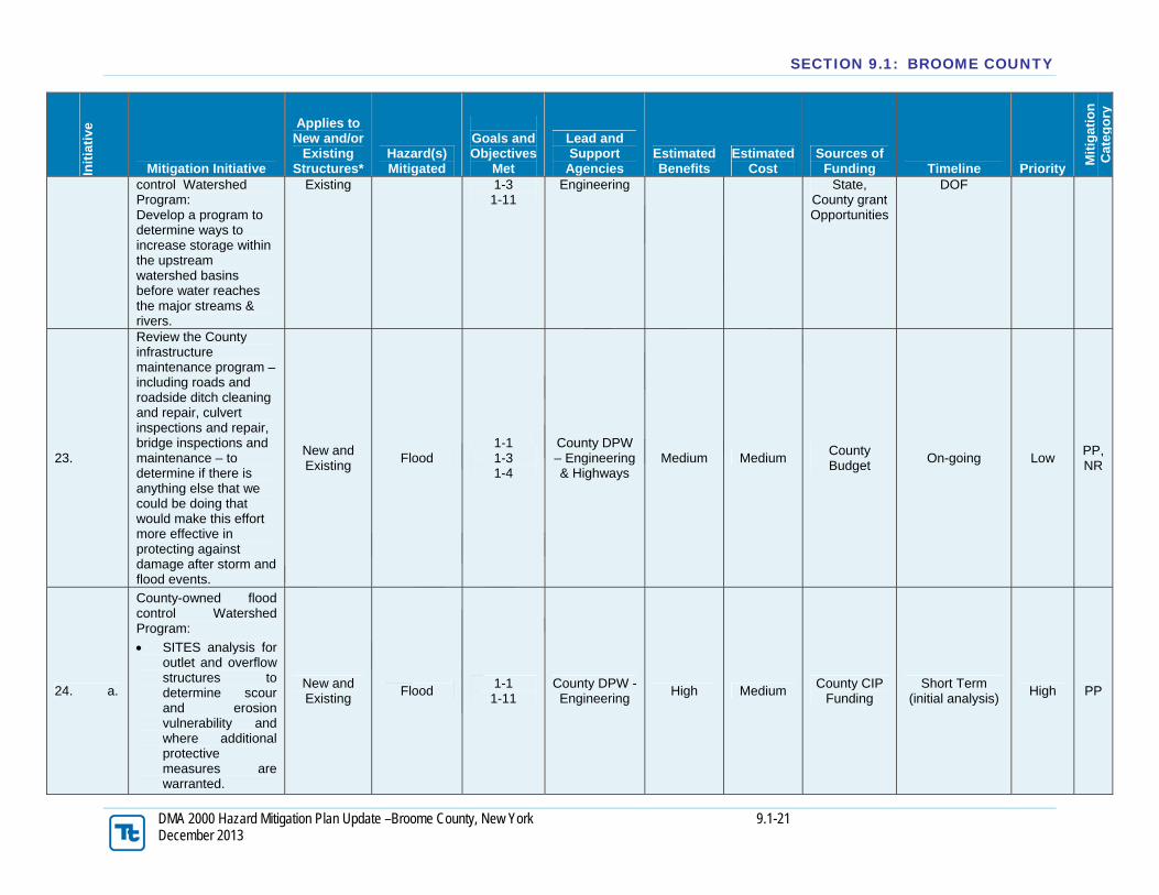
23.
Review the County infrastructure maintenance program – including roads and roadside ditch cleaning and repair, culvert inspections and repair, bridge inspections and maintenance – to determine if there is anything else that we could be doing that would make this effort more effective in protecting against damage after storm and flood events.
New and Existing
Flood 1-1 1-3 1-4
County DPW – Engineering & Highways
Medium Medium County Budget
On-going Low PP, NR
24. a.
County-owned flood control Watershed Program:
SITES analysis for outlet and overflow structures to determine scour and erosion vulnerability and where additional protective measures are warranted.
New and Existing
Flood 1-1
1-11 County DPW - Engineering
High Medium County CIP
Funding Short Term
(initial analysis) High PP

SECTION 9.1: BROOME COUNTY
DMA 2000 Hazard Mitigation Plan Update –Broome County, New York 9.1-22 December 2013
Init
iati
ve
Mitigation Initiative
Applies to New and/or
Existing Structures*
Hazard(s) Mitigated
Goals and Objectives
Met
Lead and Support
Agencies Estimated Benefits
Estimated Cost
Sources of Funding Timeline Priority
Mit
igat
ion
C
ateg
ory
24. b
County-owned flood control watershed program:
Results of SITES analysis will likely result in identification of further projects required to increase protective measures at overflow structures.
New and Existing
Flood 1-1
1-11 County DPW - Engineering
Medium Medium
Federal, State,
County grant opportunities
Long Term DOF
(repairs are identified)
High SP
25. a.
County-owned flood control Watershed Program:
Outlet pipe inspections using a video camera mounted on a small track-driven remote-controlled vehicle to be performed under low or no-flow conditions.
Existing Flood 1-1
1-11
Count DPW – Engineering
Medium Medium
County CIP Funding
Short Term (initial analysis)
Medium PP
25b.
County-owned flood control Watershed Program- Results of analysis could result in identification of upgrades and/or repairs that are needed in the outflow pipes to keep the dam outflow functioning correctly.
Existing Flood 1-1 1-3
1-11
County DPW - Engineering
Medium Medium
Federal, State,
County grant opportunities
Long Term DOF
(repairs as identified)
Medium SP
26. a. County-owned flood control Watershed
Existing Flood 1-1 1-3
1-11
County DPW – Engineering
Medium Medium
County CIP Funding –
may be Short Term Medium PP
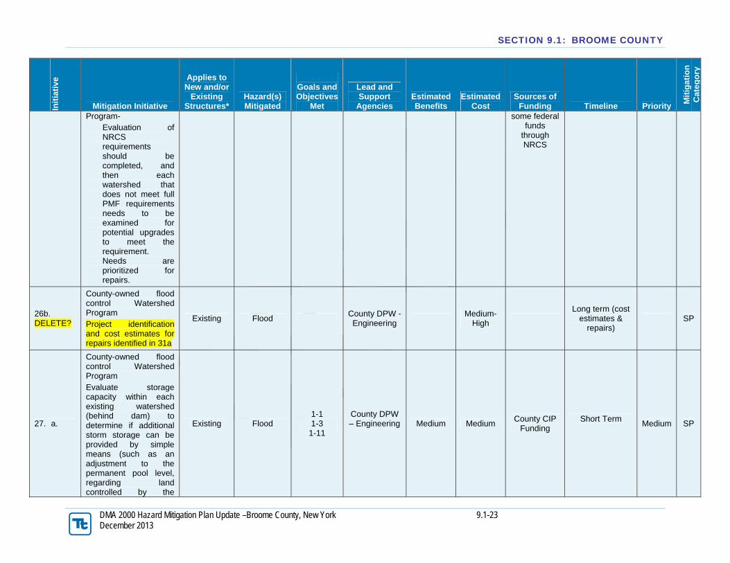
SECTION 9.1: BROOME COUNTY
DMA 2000 Hazard Mitigation Plan Update –Broome County, New York 9.1-23 December 2013
Init
iati
ve
Mitigation Initiative
Applies to New and/or
Existing Structures*
Hazard(s) Mitigated
Goals and Objectives
Met
Lead and Support
Agencies Estimated Benefits
Estimated Cost
Sources of Funding Timeline Priority
Mit
igat
ion
C
ateg
ory
Program- Evaluation of NRCS requirements should be completed, and then each watershed that does not meet full PMF requirements needs to be examined for potential upgrades to meet the requirement. Needs are prioritized for repairs.
some federal funds
through NRCS
26b. DELETE?
County-owned flood control Watershed Program Project identification and cost estimates for repairs identified in 31a
Existing Flood County DPW - Engineering
Medium-
High
Long term (cost estimates &
repairs) SP
27. a.
County-owned flood control Watershed Program Evaluate storage capacity within each existing watershed (behind dam) to determine if additional storm storage can be provided by simple means (such as an adjustment to the permanent pool level, regarding land controlled by the
Existing Flood 1-1 1-3
1-11
County DPW – Engineering
Medium Medium
County CIP Funding
Short Term
Medium SP

SECTION 9.1: BROOME COUNTY
DMA 2000 Hazard Mitigation Plan Update –Broome County, New York 9.1-24 December 2013
Init
iati
ve
Mitigation Initiative
Applies to New and/or
Existing Structures*
Hazard(s) Mitigated
Goals and Objectives
Met
Lead and Support
Agencies Estimated Benefits
Estimated Cost
Sources of Funding Timeline Priority
Mit
igat
ion
C
ateg
ory
County behind the dams, etc.). Identify and prioritize specific projects.
27b. DELETE??
County-owned flood control Watershed Program Implement specific projects identified in 30a above.
Existing Flood County DPW – Engineering
Medium/ High
Long term (second phase once required
repairs are identified)
PP
28.
Provide technical assistance and support to local municipalities applying to the CRS program.
N/A Flood 3-1 4-2
County Planning
Low Low County Budget
On-going Low PE
29.
Conduct workshops for residents regarding hazard mitigation, flood insurance, disaster preparedness and related topics.
N/A All Hazards
1-1 1-2 1-6 2-1
County Planning
Low Low County Budget
On-going High PE
30.
Provide technical assistance to municipalities on hazard mitigation planning, hazard mitigation funding, flood insurance, flood mapping, and related issues through the Flood Task Force
N/A Flood 2-1 2-2 2-3
County Planning
Medium Low County Budget
On-going Medium PE
31.
Participate in the Upper Susquehanna River Basin Flood Risk Management Study currently underway by the Army Corps of Engineers
N/A Flood 1-1 1-3 3-1
County Planning
Low Low County Budget
On-going DOF
Low NR, PP

SECTION 9.1: BROOME COUNTY
DMA 2000 Hazard Mitigation Plan Update –Broome County, New York 9.1-25 December 2013
Init
iati
ve
Mitigation Initiative
Applies to New and/or
Existing Structures*
Hazard(s) Mitigated
Goals and Objectives
Met
Lead and Support
Agencies Estimated Benefits
Estimated Cost
Sources of Funding Timeline Priority
Mit
igat
ion
C
ateg
ory
32.
Pursue green infrastructure initiatives as solutions to localized flooding and drainage issues for County-owned facilities and infrastructure.
New and Existing
Flood/ Drought
1-4 1-5
County Planning and
DPW Medium Medium
Federal, State,
County grant opportunities
On-going DOF
Low NR
33.
Continue public education efforts and municipal training for stormwater management, green infrastructure, and other related issues.
N/A
Flood/ Severe Storms/ Drought
2-1 2-2 2-4
Broome-Tioga Stormwater
Coalition Low Low
County Budget, Federal training
opportunities
On-going Medium PE
34. a
Watershed-based Mitigation Strategy: 1.) Identify and map areas of concern for localized flooding and drainage and prioritize target areas. 2.) Develop plans for mitigating issues in three target areas.
N/A Flood/ Severe Storms
1-1 1-8 2-3
County Planning
Medium Medium NYS Dept. of
State – LWRP
Short Term Medium NR
34. b
Watershed-based Mitigation Strategy: Assist municipalities in obtaining funding for the implementation of plans developed in the strategy for the three target areas.
N/A Flood/ Severe Storms
1-1 3-1 1-8
County Planning
Medium Medium
Federal grant opportunities
County Budget
Short Term DOF
Medium NR, PP
34. c
Watershed-based Mitigation Strategy: Utilize strategy to identify additional opportunities for planning and
N/A Flood/ Severe Storms
1-3 1-8
County Planning
Medium Medium
Federal, State, grant
opportunities County Budget
DOF Medium NR, PP

SECTION 9.1: BROOME COUNTY
DMA 2000 Hazard Mitigation Plan Update –Broome County, New York 9.1-26 December 2013
Init
iati
ve
Mitigation Initiative
Applies to New and/or
Existing Structures*
Hazard(s) Mitigated
Goals and Objectives
Met
Lead and Support
Agencies Estimated Benefits
Estimated Cost
Sources of Funding Timeline Priority
Mit
igat
ion
C
ateg
ory
implementation of mitigation actions for areas identified in the study.
35.
Evaluate available mapping data associated with stormwater and water resource infrastructure. Collect existing data and fill in gaps where information is missing.
N/A
Flood/ Severe Storms/ Drought/ Extreme Temps
1-3
County Planning and
GIS Medium Medium
County Budget
Short Term Low PP
36.
Continued support of consistent funding for river gages through inclusion as a Federal budget line item.
N/A Flood 1-1 1-3
Flood Task Force
Medium Low County
Budget (Staff Time)
Short Term DOF
High PP, PE
37.
Implement outreach and education efforts for realtors, municipalities and homebuyers regarding real estate disclosure in hazard areas.
N/A All Hazards 1-2 1-6 2-1
County Planning & Flood Task
Force
Low Low County
Budget (Staff Time)
Short Term Low PE
38.
Explore further opportunities to leverage flood inundation mapping to support emergency management and public awareness during flood events.
N/A Flood 1-3 2-1 2-3
County Planning
(GIS) Low Low/Med
County Budget
On-going Low ES
39.
Improve integration and coordination for protection of vulnerable populations.
N/A All Hazards
1-1 1-2 2-1 4-6
County Mental Health
Medium Low/Med County Budget
Short Term Medium ES

SECTION 9.1: BROOME COUNTY
DMA 2000 Hazard Mitigation Plan Update –Broome County, New York 9.1-27 December 2013
Init
iati
ve
Mitigation Initiative
Applies to New and/or
Existing Structures*
Hazard(s) Mitigated
Goals and Objectives
Met
Lead and Support
Agencies Estimated Benefits
Estimated Cost
Sources of Funding Timeline Priority
Mit
igat
ion
C
ateg
ory
40.
Use modeling to anticipate transportation routes expected to be impacted during flood events and identify/establish alternate routes. Identify alternate routes that are of a high priority due to presence of essential facilities (i.e. hospitals, shelters)
N/A Flood 4-4 4-5
County Planning/
BMTS/Transit High Low/Med
County Budget
Short Term Medium ES
41.
Develop plan for transition to alternate routes during a hazard event and dissemination of transportation information to the public and municipal agencies.
N/A Flood 4-4 4-6
County Planning/ BMTS/
NYSDOT/ OES/Transit
High Low/Med County Budget
Short Term DOF
Medium ES, PE
42.
Support NYS Department of Transportation and Federal Highway Administration vulnerability assessment for transportation infrastructure pilot project.
Existing Flood 3-1 3-3
NYSDOT/ FHWA
Low Low FHWA Short Term
DOF Low PP
Notes: *Does this mitigation initiative reduce the effects of hazards on new and/or existing buildings and/or infrastructure? Not applicable (NA) is inserted if this does not apply. Costs: Where actual project costs have been reasonably estimated:

SECTION 9.1: BROOME COUNTY
DMA 2000 Hazard Mitigation Plan Update –Broome County, New York 9.1-28 December 2013
Low = < $10,000 Medium = $10,000 to $100,000 High = > $100,000 Where actual project costs cannot reasonably be established at this time: Low = Possible to fund under existing budget. Project is part of, or can be part of an existing on-going program. Medium = Could budget for under existing work-plan, but would require a reapportionment of the budget or a budget amendment, or the cost of the project would have to be spread over multiple years. High = Would require an increase in revenue via an alternative source (i.e., bonds, grants, fee increases) to implement. Existing funding levels are not adequate to cover the costs of the proposed project. Benefits: Where possible, an estimate of project benefits (per FEMA’s benefit calculation methodology) has been evaluated against the project costs, and is presented as: Low = < $10,000 Medium = $10,000 to $100,000 High = > $100,000 Where numerical project benefits cannot reasonably be established at this time: Low = Long term benefits of the project are difficult to quantify in the short term. Medium = Project will have a long-term impact on the reduction of risk exposure to life and property, or project will provide an immediate reduction in the risk exposure to property. High = Project will have an immediate impact on the reduction of risk exposure to life and property. Potential FEMA HMA Funding Sources: PDM = Pre-Disaster Mitigation Grant Program FMA = Flood Mitigation Assistance Grant Program RFC = Repetitive Flood Claims Grant Program SRL = Severe Repetitive Loss Grant Program HMGP = Hazard Mitigation Grant Program Timeline: Short = 1 to 5 years. Long Term= 5 years or greater. OG = On-going program. DOF = Depending on funding. Notes (for Mitigation Type): 1. PP=Prevention and Property Protection: Government, administrative or regulatory actions or processes that influence the way land and buildings are developed and built. These actions also include public activities to reduce hazard losses or actions that involve (1) modification of existing buildings or structures to protect them from a hazard or (2) removal of the structures from the hazard area. Examples include planning and zoning, floodplain local laws, capital improvement programs, open space preservation, and storm water management regulations and acquisition, elevation, relocation, structural retrofits, storm shutters, and shatter-resistant glass. 2. PE=Public Education and Awareness: Actions to inform and educate citizens, elected officials, and property owners about hazards and potential ways to mitigate them. Such actions include outreach projects, real estate disclosure, hazard information centers, and school-age and adult education programs. 3. NR=Natural Resource Protection: Actions that minimize hazard loss and also preserve or restore the functions of natural systems. These actions include sediment and erosion control, stream corridor restoration, watershed management, forest and vegetation management, and wetland restoration and preservation. 4. SP=Structural Projects: Actions that involve the construction of structures to reduce the impact of a hazard. Such structures include dams, setback levees, floodwalls, retaining walls, and safe rooms. 5. ES=Emergency Services: Actions that protect people and property, during and immediately following, a disaster or hazard event. Services include warning systems, emergency response services, and the protection of essential facilities.

SECTION 9.1: BROOME COUNTY
DMA 2000 Hazard Mitigation Plan Update –Broome County, New York 9.1-29 December 2013
G.) PRIORITIZATION OF MITIGATION INITIATIVES
Init
iati
ve #
# o
f O
bje
ctiv
es M
et
Ben
efit
s
Co
sts
Do
Ben
efit
s eq
ual
or
exce
ed
C
ost
s?
(Yes
or
No
)
Is p
roje
ct G
ran
t el
igib
le?
(Y
es o
r N
o)
Can
Pro
ject
be
fun
ded
un
der
ex
isti
ng
pro
gra
ms/
bu
dg
ets?
(Y
es o
r N
o)
Pri
ori
ty
(Hig
h,
Med
., L
ow
)
1 2 H L Y N Y M
2 2 H L Y N N M
3 2 H M Y N Y M
4 2 H L Y N Y M
5 2 M L Y N Y M
6 3 H L Y N Y H
7 1 M L Y N Y M
8 2 M L Y N Y M
9 2 M L Y N N M
10 4 M L Y N Y M
11 3 H L Y N N M
12 3 M L Y N N L
13 2 M L Y N Y M
14 2 L L Y N Y M
15 4 M L Y N Y M
16 1 L L Y N Y M
17 2 M L Y N Y M
18 1 M L Y N Y M
19 2 M M Y N N M
20 3 M M Y N Y M
21a 3 H M Y Y N M
21b 2 H H Y Y N M
22 3 H H Y Y N M
23 3 M M Y N Y L
24a 2 H M Y Y N H
24b 2 M M Y Y N H
25a 2 M M Y Y N M
25b 3 M M Y Y N M
26a 3 M M Y Y N M
26b Delete?
27a 3 M M Y Y N M
27b Delete

SECTION 9.1: BROOME COUNTY
DMA 2000 Hazard Mitigation Plan Update –Broome County, New York 9.1-30 December 2013
28 2 L L Y N Y L
29 4 L L Y N Y H
30 3 M L Y N Y M
31 3 L L Y N N L
32 2 M M Y Y N L
33 3 L L Y Y Y M
34a 3 M M Y Y N M
34b 3 M M Y Y N M
34c 2 M M Y Y N M
35 1 M M Y N N L
36 2 M ML Y N N H
37 3 L L Y N N L
38 3 L L Y N Y L
39 3 M L Y N N M
40 2 H L Y N N M
41 2 H L Y N N M
42 2 L L Y Y N L
Notes: H = High. L = Low. M = Medium. N = No. N/A = Not applicable. Y = Yes.

SECTION 9.1: BROOME COUNTY
DMA 2000 Hazard Mitigation Plan Update –Broome County, New York 9.1-31 December 2013
Explanation of Priorities High Priority = A project that meets multiple objectives (i.e., multiple hazards), benefits exceeds cost, has funding secured or is an on-going project and project meets eligibility requirements for the Hazard Mitigation Grant Program (HMGP) or Pre-Disaster Mitigation Grant Program (PDM) programs. High priority projects can be completed in the short term (1 to 5 years). Medium Priority = A project that meets goals and objectives, benefits exceeds costs, funding has not been secured but project is grant eligible under, HMGP, PDM or other grant programs. Project can be completed in the short term, once funding is completed. Medium priority projects will become high priority projects once funding is secured. Low Priority = Any project that will mitigate the risk of a hazard, benefits do not exceed the costs or are difficult to quantify, funding has not been secured and project is not eligible for HMGP or PDM grant funding, and time line for completion is considered long term (1 to 10 years). Low priority projects may be eligible other sources of grant funding from other programs. A low priority project could become a high priority project once funding is secured as long as it could be completed in the short term. Prioritization of initiatives was based on above definitions: Yes
Prioritization of initiatives was based on parameters other than stated above: Not applicable.
H.) FUTURE NEEDS TO BETTER UNDERSTAND RISK/VULNERABILITY Studies and investigations have been included in Table F-3 (Proposed Hazard Mitigation Initiatives) which will assist Broome County in identifying needs, risks, and vulnerabilities of County infrastructure and flood control structures.
I.) HAZARD AREA EXTENT AND LOCATION A hazard area extent and location map has been to illustrate the probable areas impacted within Broome County and is provided on the next page. This map is based on the best available data at the time of the preparation of this Plan, and is considered to be adequate for planning purposes. Maps have only been generated for those hazards that can be clearly identified using mapping techniques and technologies, and for which the County has significant exposure. The Planning Area maps are provided in the hazard profiles within Section 5.4, Volume I of this Plan and in the municipal annexes in Section 9 of this plan.. J.) STATUS OF INCORPORATION OF MITIGATION PLANNING INTO EXISTING AND FUTURE PLANNING MECHANISMS It is the intention of the County to incorporate mitigation planning as an integral component of daily operations. Below is a list of planning mechanisms that have been/will be incorporated into procedures.

SECTION 9.1: BROOME COUNTY
DMA 2000 Hazard Mitigation Plan Update –Broome County, New York 9.1-32 December 2013

SECTION 9.1: BROOME COUNTY
DMA 2000 Hazard Mitigation Plan Update –Broome County, New York 9.1-33 December 2013
Planning Mechanisms
Has Been
Utilized Will Be Utilized
Operating Budget When constructing upcoming budgets, Hazard Mitigation Actions will be funded as budget allows. Construction projects will be evaluated to see if they meet the Hazard Mitigation goals and objectives.
X X
Capital Improvement Budget When constructing upcoming budgets Hazard Mitigation Actions will be funded as budget allows. Construction projects will be evaluated to see if they meet the Hazard Mitigation goals and objectives.
X X
Human Resource Manual Employee job descriptions may contain Hazard Mitigation Actions.
X
Building and Zoning Ordinances A variety of building and zoning regulations are used to restrict the uses of land and establish building specifications. Prior to land use, zoning changes or development permitting the city will review the hazard mitigation plan and other hazard analysis to ensure consistent and compatible land use.
N/A N/A
Comprehensive Land Use Plan A land use plan is intended to identify land use issues and to make recommendations on how to address these issues. When applicable the city will incorporate Hazard Mitigation Actions in the development and extent of the regulations.
X
Grant Applications Data and maps will be used as supporting documentation in grant applications
X X
Municipal Ordinances When updating municipal ordinances Hazard Mitigation will be a priority.
N/A N/A
Fire Plan The Hazard Mitigation Plan will be used as a resource for the development of future Fire Plans.
N/A? N/A?
Capital Improvement Planning The municipality will establish a protocol to review current and future projects for hazard vulnerability. The will incorporate hazard resistant construction standards into the design and location of projects.
X
Day to Day Operations Incorporate Hazard Mitigation Actions in daily operations and all projects will be a goal of the municipality.
X X
Local School Service Projects The County will work with the local school district(s) and assist with community service projects for the service organizations as they relate to Hazard Mitigation Actions.
X
Municipal Budget- Adopted annually the County will look at Mitigation Actions when allocating funding.
X
Economic Development- The local economic development group will utilize the identification of hazard areas when assisting new business in finding a location.
X X

SECTION 9.1: BROOME COUNTY
DMA 2000 Hazard Mitigation Plan Update –Broome County, New York 9.1-34 December 2013
K.) ADDITIONAL COMMENTS No additional comments at this time.