9.5 shasta valley region - university of oregon
TRANSCRIPT

9.5 Shasta Valley Region Information for this region is limited in this first version of the CWPP.
Table of Contents BOUNDARIES ....................................................................................................... 2 KEY STAKEHOLDERS ......................................................................................... 3 LANDSCAPE/LAND USE ...................................................................................... 4 TOPOGRAPHY, SLOPE, ASPECT, ELEVATION ................................................. 6 METEOROLOGY ................................................................................................... 6 HYDROLOGY ........................................................................................................ 6 ECOSYSTEM TYPES ........................................................................................... 7 THREATENED AND ENDANGERED HABITAT TYPES ....................................... 7 INFRASTRUCTURE .............................................................................................. 8 EMERGENCY SERVICES..................................................................................... 9 COMMUNITY LEGAL STRUCTURE, JURISDICTIONAL BOUNDARIES ............. 9 HAZARDOUS FUELS ............................................................................................ 9 FIRE HISTORY ...................................................................................................... 9 EVACUATION PLAN ........................................................................................... 11 COMMUNITY INFORMATION ............................................................................. 13 WATER SOURCES ............................................................................................. 13 COMMUNITY RISK ASSESSMENT .................................................................... 16 OVERALL COMMUNITY PRIORITY ................................................................... 17 COMMUNITY HAZARD REDUCTION PRIORITIES ........................................... 18 ACTION PLAN ..................................................................................................... 19 MAPS - See ShastaCWPP_Maps.pdf ................................................................. 21 SAFETY ZONES ................................................................................................. 22 EVACUATION SITES .......................................................................................... 23 TRANSPORTATION ............................................................................................ 32 COMMUNITY FIRE SAFE COUNCILS ................................................................ 38

BOUNDARIES
The Shasta Valley Region lies in central Siskiyou County in northern California. It separates the Klamath Mountain Province from the Cascade Province. For the purposes of this plan it represents the entire central region of Siskiyou County north of the Sacramento River divide to the Oregon border. It encompasses the Shasta River watershed plus the area that drains into Klamath River between the Shasta River and Copco Lake. The region is 710,257 acres or 1,110 mi2 in size, and encompasses 18% of the area within Siskiyou County. The Shasta River flows northerly to its confluence with the Klamath River north of the city of Yreka. Its headwaters include the north slopes of Mt. Shasta and the Eddys. In addition to the Shasta River watershed the region also includes the Bogus Creek and Cottonwood Creek drainages, as well as the area adjacent to Iron Gate and Copco reservoirs on the Klamath River.
KEY STAKEHOLDERS
Key stakeholders in the Shasta Valley Region are: The U.S. Department of Agriculture (USDA) Shasta-Trinity National Forest Klamath National Forest U. S. Fish and Wildlife Service NOAA Fisheries California Department of Forestry and Fire Protection California Department of Fish and Game California Department of Transportation California Department of Highway Patrol Regional Water Quality Control Board Siskiyou County Board of Supervisors Siskiyou Public Works, Planning and Education Departments Siskiyou County Air Quality Management District City of Yreka City of Montague City of Weed City of Grenada City of Hornbrook City of Gazelle Community of Lake Shastina Community of Hammond Ranch Community of South Yreka Community of Edgewood Community of Copco Community of Big Springs Union Pacific Railroad Fruit Growers Supply Company Timber Products Company Roseburg Forest Products Company

Greater Weed Area Fire Safe Council Lake Shastina Fire Safe Council Juniper Flat Fire Safe Council Copco Lake Fire Safe Council South Yreka Fire Safe Council Mid Klamath Watershed Council Save Our Shasta and Scott
LANDSCAPE/LAND USE
The principle land use within the Shasta Valley Region is agriculture. This includes cattle ranching as well as farming for hay and other crops. The foothills and mountains surrounding the valley are managed by the U.S. Forest Service for multiple use, and by private landowners for timber production. Cities and communities have been established along major transportation routes including Interstate 5, US 97, and county route A12. Industry is limited to two wood veneer and chip facilities in the cities of Yreka and Weed. Recreation includes big game and waterfowl hunting, fishing, boating, hiking, biking, birding, and horse back riding.
Land Use Square Miles (%)
Agriculture 418,571 58.9
Federal – Multipule Use 166,689 23.5
Timber 75,452 10.6
Rural Residential 33,054 4.7
Urban 8,176 1.2
Residential 2,867 0.4
Recreation 2,532 0.4
Commercial 552 0.1
Highway 1,187 0.2
Other 1,180 0.2
Total 710,270 100.0
*Landuse based on 2006 County Zoning

Hilt
Weed
Yreka
Grenada
Gazelle
Montague
Callahan
Hornbrook
Mount Shasta
Klamath River
°0 10 20 30Miles
Agriculture Preserve
Commercial
Federal
Recreational
Residential
Rural Residential
Timber Preserve
Highway
Other
Urban
RegionBoundary
River
Perineal Stream
Intermittent Stream
CountyRoads
Land Use Catagories Shasta Valley
Jan 27, 2008
TOPOGRAPHY, SLOPE, ASPECT, ELEVATION
The topography of this region can be characterized as a large broad valley surrounded by foothills. The valley also has a unique system of isolated hills of various sizes scattered throughout. These are the result of massive mudslides from the north slopes of Mt. Shasta over a million years ago. The eastern foothills are volcanic as part of the Cascade Province and the western foothills are metamorphic as part of the Klamath Province. The northern portion of this region includes some sedimentary rock in the Cottonwood Creek drainage where the divide between the provinces narrows to just a few miles. The range of elevation in this region is from 2,000 feet at the confluence with the Klamath to 14,169 feet at the top of Mt. Shasta. The valley floor, which encompasses 80% of this region, ranges from 2,000 feet to 3,000 feet. The surrounding foothills and mountains typically reach 6,000 feet with a few peaks over 8,000 feet. The foothills and mountains to the west are typically steep while those to the east are typically fairly gentle. Aspect (the direction a slope is facing) has a significant effect on potential fire behavior. South and southwest slopes receive the most solar radiation. Conditions on south slopes are the most favorable for fire ignition and spread because they are the hottest and driest. North aspects are normally the coolest and wettest, followed by east aspects.
METEOROLOGY
The region is generally in the rain-shadow of Mt. Shasta and the Eddys. Average annual precipitation ranges from as low as 5” in the central portion to a high of 40” in the mountains to the southwest. The majority of the area receives less than 20” annually mostly as rain. Snow is common above 3,000 feet for most of the winter months. Southerly storms, which carry most of the precipitation to this region, are typically drained by the orographic influence of Black Butte Pass on the divide between the Upper Sacramento River and the headwaters of the Shasta River. As a result, most of this precipitation is deposited in the upper reaches on both sides of the Pass.
HYDROLOGY
The Shasta River is approximately 48 miles from it‟s headwaters in the south to it‟s confluence with the Klamath River. Flow is controlled by an earthen dam in the upper reaches of the valley forming Lake Shastina, formerly known as Dwinnell Reservoir, and is sustained throughout the summer months by springs. The river is allowed to meander through much of its course below the dam. Much of the flow is diverted for
irrigation purposes by several diversions throughout the valley, some fairly significant in size. There are two hydroelectric dams on the Klamath River within this region, Iron Gate and Copco. These dams play a very significant role in controlling the flow of the Klamath River.
ECOSYSTEM TYPES
Due to the complex geology and diverse soils of this region, the Shasta Valley has a rich diversity of vegetation. There are three dominant vegetation types: Valley Floor Grasslands, including natural grasslands as well as seasonally irrigated pasture and hay crops; Foothill Chaparral and Oak Woodland; and Mountainous Conifer Forests (Mayer and Laudenslayer, 1988). The Valley Floor Grasslands occur on flat to gently rolling foothills and in some cases are naturally flooded, or seasonally irrigated. The Foothill Chaparral and Oak Woodland occur at lower elevations and dryer climatic regions on thin, well-drained soils. Many of these consist of decadent manzanita brush fields resulting from historical wildfires. The Mountainous Conifer Forests consist of tall, dense to moderately open coniferous forests with patches of broad-leaved evergreen and deciduous trees and shrubs.
THREATENED AND ENDANGERED HABITAT TYPES
The forested environment and open meadows of the area support a variety of wildlife and wildlife habitats. The following federally listed wildlife species occur in forested areas surrounding Shasta valley and may occur on a transient basis within the area:
• Bald eagle (Haliaeetus leucocephalus) • Northern spotted owl (Strix occidentalis caurina)
The National Forest list of Sensitive Wildlife Species includes several additional species that may occur in or near the area:
• Northern goshawk (Accipiter gentiles) • American marten (Martes americana) • Sierra Nevada red fox (Vulpes vulpes necator) • Wolverine (Gulo gulo) • Pallid bat (Antrozous pallidus) • Pale Townsend‟s big-eared bat (Corynorhinus townsendii pallescens)
Habitat for the above listed species could be negatively affected by severe wildfire. It is unlikely that fuels reduction projects would have substantial negative effects on these species, but surveys and protection measures may be required by regulatory agencies, depending on the location, season, and extent of treatments.

Federally listed fish species that occur within the Shasta Valley Region include coho salmon (Oncorhynchus kisutch). Coho are also State listed and currently confined to areas below dams at Iron Gate and Shastina. There is little likelihood of substantial impacts to these species due to severe wildfire or fuels treatments. Any project that is subject to the California Environmental Quality Act, that utilizes cost-share funds through any state or federal program, or where timber is harvested subject to the California Forest Practices Act should include consideration not only of the previously mentioned threatened, endangered, or sensitive wildlife species, but should include a recent query of the California Department of Fish and Game‟s California Natural Diversity Database, a list of documented species occurrences. Riparian habitat refers to the generally narrow band of trees, shrubs, and forbs occurring along rivers and streams. These areas not only provide important habitat for many wildlife species, but also serve important ecosystem processes such as sediment filtration, in-stream debris recruitment, channel morphology, and water retention. Potential negative effects of fuels management within these zones should be weighed against the possible risk that the fuels pose to human health and safety due to fuel load accumulations. Management actions within riparian areas should be evaluated on a case-by-case basis. As with riparian areas, meadows and wetlands provide critical wildlife habitat and serve a number of ecosystem functions. It is unlikely that these features would require fuels reduction treatments other than occasional mowing in dry meadows to reduce accumulations of dry grasses and weeds. Periodic removal of encroaching conifers may be necessary in areas to maintain this habitat type.
INFRASTRUCTURE
Central to this region, and to the county as a whole, running north-south through the heart of this region, is Interstate 5, which was constructed in the 1960‟s on the same general path as old US 99. It serves as the main artery of commerce for this county. One other federal highway serves this county, US 97, the “Alaska Highway” begins in Weed. Other regions of the county are reached by state highways 3, 89, 96, and 283. Most of the road system in this region is under the jurisdiction of the County. There are relatively few forest roads. Many of the communities have private roads, and Yreka, and Weed have city streets. There is a main railroad track running north-south through this region as well. Union Pacific and Amtrak utilize this route. Another route connecting Weed to Jacksonville, Oregon over the Siskiyou Mountains is utilized for freight only by CORP. Most of the air transport service to this county is located in this region. There is no airline service, but several airports serve this region for private flights. Siskiyou County airport is located in Montague, which also has a small metropolitan airport, and there is a larger metropolitan airport near Weed.

High-voltage power lines run north-south through the Shasta valley, and there are several communication towers that serve the valley.
EMERGENCY SERVICES
Most of this region is in State Responsibility Area for wildfire protection, but some portions of this region are under U.S. Forest Service jurisdiction for fire protection. Communities are also served by local volunteer fire and rescue providers, as well as ambulance services, which generally operate under mutual and automatic aid agreements. The cities of Yreka, Montague, Grenada, and Weed are also served by volunteer fire and rescue providers. Helicopter evacuation is provided by Mercy Air out of Weed and Medford Air.
COMMUNITY LEGAL STRUCTURE, JURISDICTIONAL BOUNDARIES
Most of the Shasta Valley Region is under the jurisdiction of the County of Siskiyou, but there are several incorporated cities including Weed, Montague, Grenada, and the County seat at Yreka. Federal and State lands located in this Region are administered by their respective land agencies. Jurisdiction for all emergencies is routed through the County Sheriff‟s office and is dependent on location and nature of the emergency. Those occurring on Federal, State, and County highways are controlled by the California Highway Patrol; those occurring within city limits are controlled by City Police; and those involving wildland fire are governed by Responsibility Area designations.
HAZARDOUS FUELS
For the most part hazardous fuels in the Shasta Valley Region are confined to flammable vegetation as described above. Other hazardous fuels include heating oils and propane used both for residential and commercial purposes. These are typically stored in tanks at the site in which they are used, and transported via truck and/or rail. There are no pipelines for these fuels situated in this Region. The same can be said for vehicular fuels.
FIRE HISTORY
Since 1915 there have been over 270 fires reported in the Shasta Valley Region for a total of over 137,500 acres. The average size wildfire is over 500 acres and the average acreage burned per year is also over 500. The largest of which was approximately 14,000 acres from a lightning strike in 1939. The primary cause is attributed to unknown or unidentified causes, but the largest fires are from lightning strikes and escaped prescribed burns.

CAUSE Acres Count (%)
Unknown/Unidentified 58,490 117 43.8%
Miscellaneous 37,692 64 28.2%
Lightning 26,000 23 19.5%
Escaped Prescribed Burn 3,448 7 2.6%
Smoking 3,174 8 2.4%
Railroad 3,005 18 2.3%
Arson 786 7 0.6%
Debris 586 11 0.4%
Habitat Restoration 158 2 0.1%
Powerline 96 1 0.1%
Equipment Use 88 3 0.1%
Playing with fire 18 2 0.0%
Total 133,524 261
Year Acres Count
1915 1,134 2
1917 3,189 2
1918 2,717 2
1919 11,186 17
1920 891 4
1922 10,918 10
1923 892 5
1924 10,398 9
1926 15,421 14
1928 1,165 3
1929 997 5
1930 682 5
1931 700 5
1932 394 2
1933 103 1
1934 1,421 5
1935 1,789 7
1936 671 5
1938 1,048 6
1939 21,950 10
1940 764 3
1942 2,310 3
1943 866 10
1944 236 2
1945 1,238 2
1946 10 1
1950 2,740 4
1953 236 1
1955 6,301 5
1957 9,734 15

1958 1,381 2
1959 3,596 7
1961 26 3
1962 544 1
1965 814 9
1967 543 1
1968 1,456 7
1970 118 2
1971 420 1
1972 2,346 3
1973 13 1
1979 24 1
1980 402 3
1984 284 2
1985 651 2
1987 435 4
1992 1,400 6
1994 848 2
1995 2 1
1996 281 3
1998 293 1
1999 184 5
2000 1,449 19
2001 443 7
2002 3,215 1
2003 274 4
2004 3277 6
2005 746 1
EVACUATION PLAN Emergency evacuation in the Shasta Valley Region will follow the general guidance provided in Section 3 of this CWPP. The success of an evacuation during an emergency is dependent on the readiness of those affected. Local Fire Safe Councils, in conjunction with Emergency Services have conducted numerous informational meetings and have distributed literature to aid in preparedness. Evacuation routes have been identified and include most of the County, State, and Federal roads in the region. Safe local access is the responsibility of individuals and communities who choose to work together. In instances when it is too late to evacuate, residences should be prepared to shelter-in-place. Safety Zones are areas that are large enough for people to gather and are not at risk for catching fire or filling with smoke from a fire. Desired facilities include restrooms and shelter accommodations. The Siskiyou County Fairgrounds in Yreka is the largest such facility available in this Region. Other Safety Zones have not been specifically identified but include many of the local schools, as well as localized clearings for short term evacuations.

Siskiyou County has many locations that are considered „evacuation sites‟, these are shelters that are available to families, elderly, invalid adults, and animals. Overall there are 56 locations throughout the County. The locations of these are described in Evacuation Sites table beginning on page 9.5-27 for the Shasta Valley Region.

COMMUNITY INFORMATION Community Location/Parcels/Population Structures/Resource Use Water Supply Valued Features Big Springs East-Central Shasta Valley Homes, Ranches, Hay Barns Tanker Fills Historic Church
Carrick Addition Hwy 97, east of Weed Rural Subdivision Tank
Copco East of I-5 on South side of Klamath River
Wildland Urban Interface
Edgewood I-5, North of Weed Rural Subdivision Tanker Fills School, Cemetery
Gazelle Old 99, North of Weed Homes, Ranches, Hay Barns Tank
Grenada I-5, South of Yreka Rural Subdivision Tank
Hammond Ranch Headwaters of Shasta River, base of Eddy Mountains
Wildland Urban Interface, Rural Subdivision
Tanker Fills Watershed
Hawkinsville CA Route 263, North of Yreka Rural Subdivision
Hilt West of I-5 at Oregon Border Rural Subdivision Hydrants Historic Church
Hornbrook I-5, North of Klamath River Incorporated City
Lake Shastina Central Shasta Valley Subdivision Hydrants
Montague CA Route 3, East of Yreka Incorporated City Hydrants
Mt. Shasta Vista East-Central Shasta Valley Homes, Ranches, Hay Barns Tanker Fills
South Yreka I-5, South end of Yreka Rural Subdivision Hydrants
Weed Intersection of I-5 and US 97, South end of Shasta Valley
Incorporated City Hydrants Schools, Cemetery, Churches, Historic Main Street
Yreka I-5, North end of Shasta Valley Incorporated City Hydrants Schools, Cemetery, Churches, Historic Main Street
The towns of the Shasta Valley region include Yreka, Weed, Montague, Gazelle, Grenada, Hornbrook, Big Springs, Lake Shastina, Copco, and Hilt. The combined population of these towns is on the order of 12,000 with again as many or more residents living in the unincorporated area between these towns. Because this region is on the “I-5 Corridor”, it also provides temporary residence to most of the tourists of Siskiyou County.
WATER SOURCES
Hotlum Siting (3 miles north of Weed on Highway 97) o Railroad Tank Car-good access
41.28.378 N 122.18 948 W
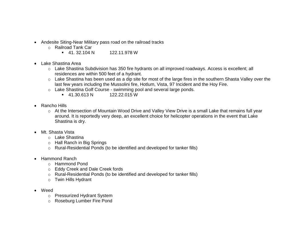
Andesite Siting-Near Military pass road on the railroad tracks o Railroad Tank Car
41. 32.104 N 122.11.978 W
Lake Shastina Area o Lake Shastina Subdivision has 350 fire hydrants on all improved roadways. Access is excellent; all
residences are within 500 feet of a hydrant. o Lake Shastina has been used as a dip site for most of the large fires in the southern Shasta Valley over the
last few years including the Mussolini fire, Hotlum, Vista, 97 Incident and the Hoy Fire. o Lake Shastina Golf Course - swimming pool and several large ponds.
41.30.613 N 122.22.015 W
Rancho Hills o At the Intersection of Mountain Wood Drive and Valley View Drive is a small Lake that remains full year
around. It is reportedly very deep, an excellent choice for helicopter operations in the event that Lake Shastina is dry.
Mt. Shasta Vista o Lake Shastina o Hall Ranch in Big Springs o Rural-Residential Ponds (to be identified and developed for tanker fills)
Hammond Ranch o Hammond Pond o Eddy Creek and Dale Creek fords o Rural-Residential Ponds (to be identified and developed for tanker fills) o Twin Hills Hydrant
Weed o Pressurized Hydrant System o Roseburg Lumber Fire Pond

Yreka o Pressurized Hydrant System
Montague o Rural – Residential Ponds
Carrick Addition o Tank
Copco o Klamath River o Rural – Residential Ponds
Edgewood o Rural – Residential Ponds
Gazelle o Tank at Fire Station o Rural – Residential Ponds
Grenada o Rural – Residential Ponds
South Yreka o Tank at Fire Station o Rural – Residential Ponds

COMMUNITY RISK ASSESSMENT (High, Medium, Low)
Community Fuel
Hazard Risk of Wildfire
Occurrence Structural Ignitability
Firefighting Capability
Access Overall
Risk Big Springs Med Med Med Med Med Carrick Addition High High High High High Copco High High Med Med Low Edgewood High Med Med Med Med Gazelle Med Med Med Med Med Grenada Med Med Med High High Hammond Ranch High High High Med Low Hawkinsville Med Med Med Med High Hilt High High Med Med Med Hornbrook Med Med Med Med High Lake Shastina High High High High Med Montague Med Med Med High High Mt. Shasta Vista High High Med Med Low South Yreka High High High High High Weed Med Med Med High High Yreka Med Med Med High High

OVERALL COMMUNITY PRIORITY (High, Medium, Low)
Community Overall Risk Community Value Cultural Value Overall Priority Big Springs Low High High High
Carrick Addition Medium High High High
Copco High High High High
Edgewood Low High High High
Gazelle Low High High High
Grenada Low High High High
Hammond Ranch High High High High
Hawkinsville Medium High High High
Hilt Low High High High
Hornbrook Low High High High
Lake Shastina High High High High
Montague Low High High High
Mt. Shasta Vista Medium High High High
South Yreka High High High High
Weed Low High High High
Yreka Low High High High

COMMUNITY HAZARD REDUCTION PRIORITIES
Community Project Type
Treatment
Overall Priority (High, Medium, Low)
Big Springs
Carrick Addition
Copco
Edgewood
Gazelle
Grenada
Hammond Ranch Emergency Preparedness Training Fuel Reduction Evacuation Routes Water Source for fire protection
Public Information Outreach Defensible Space, Strategic Fuel Breaks Shaded Fuel Break Pond and Tank Development
High High High High
Hawkinsville
Hilt
Hornbrook
Lake Shastina Fuel Reduction Evacuation Routes
Strategic Fuel Breaks Shaded Fuel Break
High High
Montague
Mt. Shasta Vista
South Yreka
Weed Fuel Reduction Strategic Fuel Breaks High
Yreka Fuel Reduction Strategic Fuel Breaks High
ACTION PLAN
The Shasta Valley Region of Siskiyou County is represented by several local fire safe councils. This Action Plan represents the priorities established by these fire safe councils. The overall goal of this Action Plan is to guide the tasks that implement and monitor the reinstatement of natural fire regimes in the Shasta Valley ecosystem in a manner that protects life, property, improves forest health, and enhances the resources valued by its stakeholders. Along with cooperators, the FSC is developing prescriptions for fuel reduction activities in WUI areas. These treatment variations are described below for the 5 different WUI area types that have been established.
1. Emergency Access Routes – Approximately 100 feet above and below road. 2. Property Buffers – Approximately 100 foot areas on public and private property surrounding individual properties, and neighborhoods. 3. Domestic Water Use – Use handpiling in jackpot areas, pullback from leave trees where appropriate, and underburning to achieve fuel reduction and watershed protection. 300 foot Shaded Fuel Breaks on ridge tops to protect watershed from outside fires, where appropriate. 4. ¼ Mile Buffers – On public property surrounding individual properties, neighborhoods, and towns. Use handpiling in jackpot areas, pullback from leave trees where appropriate, and underburning to achieve fuel reduction and watershed protection. 5. Special Areas – These would include areas below properties located high on slopes, as well as culturally or biologically significant.
These are suggested treatments; costs, fuel type and terrain will dictate treatments in specific areas. Treatment areas will also be prioritized based on maximum benefit to private residences, other high value areas and protection of public resources. Possible Actions Vegetation Management/Fuel Modification Projects – The following are the methods that will commonly be used:
Thinning and Brushing Prescribed Burning Fuel Breaks (Shaded, Strategic, DFPZ‟s) Industrial Resource Management Green Belts Debris Disposal
Community Capacity Building – The following are the methods that will commonly be used:
Job Training/Employment Integrated Development Funding Stakeholder Collaboration Green Belts Debris Disposal
Infrastructure Improvements Water Supply – Increase water storage Roads/Access – There is a need for periodic maintenance or improvement of emergency access routes to keep them functional
Communication – Develop a communication Plan, including a phone and CB tree Emergency Response Readiness Equipment and other resources Firefighter and Public Safety Training, Certification, and Qualification
Strategic Fuel Breaks/Defensible Polygons Defensible Space Roads: Ingress, Egress – identified and mapped Clearing, Fire-Resistant Landscaping – 100 ft.
Evacuation Plan Emergency Communication System/Neighborhood Teams/Phone Trees Safety Zones, Assembly areas – Identify and Map Emergency access Routes – Identify and Map
Education – Outreach, workshops, meetings, letters, flyers, posters. Fire Safe Councils – Support and promote involvement in local fire safe councils Emergency Response Resources – inventory existing community, agency, and local equipment and staffing. Fire Safe Inspector Program – Update Residential Risk Assessments for fire suppression and emergency response capability. Senior/Disabled Assistance – Identify Senior Citizens and Disabled individuals who may need special assistance during a fire emergency Watershed Protection – Encourage efforts to promote the natural fire regime of region. Permitting, Exemptions – Obtain all pertinent permits, permissions and exemptions needed to complete projects.

Prioritized Actions, Implementation Plan and Timeline (need Action Matrix)
Short Term (< 1 year) Medium Term (1- 10 years) Long Term (10+ years)
Monitoring and Evaluation (need Action Matrix)
MAPS - See ShastaCWPP_Maps.pdf
WUI Areas Fire Starts Fire Regime Condition Class Fire History

SAFETY ZONES

EVACUATION SITES
ADA NAME ADDRESS CITY CONTACT PHONE CAP H/CAP KIT NOTE
YES Hornbrook Elementary
Hornbrook
Physical Address: George Patti, Day:475-3598 175 Yes Full Gym and cafeteria.
15430 Oregon Rd Head Custodian Eve:475-3508
-10
Fold out tables and
96044 W/E:475-3508 chairs.
Mailing Address: Barbara Kirk, Day:475-3818
P.O. Box 169 Board President Eve:475-3818
96044 W/E:475-3818
YES Hornbrook
Grange
Main Street
Hornbrook
Charles Saunders Day:475-3185 50 Yes Full Tables, chairs,
P.O. Box 443 Eve:475-3185
Montague, CA 96064 W/E:475-3185
Carole Eastman Day:475-3734
14900 Hornbrook Rd. Eve:475-3734
Mailing Address: Hornbrook, CA 96044 W/E:475-3734
Use Marty Laine's Mary Thornton Day:475-3464
P.O. Box 364 P.O. Box 12 Eve:475-3464
Hornbrook, CA 96044 96044 W/E:475-3464
YES Lake Shastina
Community Bible Church
Physical Address: 5826 Jackson Ranch Rd
Lake Shastina
Pastor Nick Toroni
Day:938-2525 Eve:938-1877
96094 W/E:938-1877
Mailing Address: 5826 Jackson Ranch Rd
96094
YES Lake Shastina
Center
Physical Address: Lake Shastina
Jaime Lea Day:938-3281 86 Yes Yes Full Kitchen
16320 Everhart Drive General Mgr Eve:938-4113 Bathrooms

96094 Lake Shastina Property W/E:938-4113
Protected outdoor
Mailing Address: Owners Association seating area
16320 Everhart Drive
96094
YES Little Shasta Elementary
Physical Address: Montague Kathy Koon Day:459-3269 60 Yes Full Tables, chairs
8409 Lower Little Shasta
Rd Eve:459-3020 2 multi-bathrms
96064 W/E:459-3020
ADA NAME ADDRESS CITY CONTACT PHONE CAP H/CAP KIT NOTE
Mailing Address: Alternate Contact: Day: 459-3185
8409 Lower Little Shasta
Rd Hazel Brummett Eve: 459-3185
96064
W/E: 459-3185
NO Little Shasta
Church
Physical Address: Montague Ellen Wilson Day:459-3317 50 No No No Water. 8212 Lower Little Shasta
Permanent
Rd Eve:459-3317 PortaPotty W/E:459-3317
Mailing Address: Jack Cowley Day:459-5506 8217 Lower Little Shasta
Eve:459-5506
Rd 96064 W/E:459-5506
YES Delphic
Elementary Debbie
Physical Address:
Montague
Susan Beals, Day: 842-3653 25 2 Full Three
1420 Delphic Rd Secretary Eve: 938-2122 classrooms,
96064 W/E:938-2122 library, no
Rick or Stacey Brooks
Mailing Address: Day: 842-3653 power
1420 Delphic Rd Board Members Eve: 842-6251 back-up

96064 W/E:842-6251
YES Willow Creek
School
Physical Address: 5321 York Rd 96064
Montague
Ed Harris, Supt. Day: 459-3313 Eve: 340-1020 W/E:340-1020
75 3 Full Large gym area No power backup
Mailing Address: 5321 York Rd 96064
Corrine Sweet Janitor
Day: 459-3313 Eve: 459-0509 W/E:459-0509
YES Montague
Elementary
Montague
Kermith Walters
Physical Address: Day:459-3001 1,000 25 Full Tables -folddown
430 E. Prather District Superintendent Eve: 842-2991
Chairs, Bleachers
96064 W/E:842-2991 Back Temp Lights
Mailing Address: Chris Haas Day: 459-3001
P.O. Box 308 Maintenance Eve: 459-1457
96064 W/E:459-1457
NO United
Methodist Church
Physical Address: Montague Bob Buckner Day:459-0705 75 0 Partial United Methodist
150 S. 12th St.
Eve:459-0705
Church attached the
96064
W/E:459-0705
following comment:
ADA NAME ADDRESS CITY CONTACT PHONE CAP H/CAP KIT NOTE
Mailing Address: P.O. Box 187 96094
Velma Nelson Day:459-5414 Eve:459-5414 W/E:459-5414
Not suitable in case of an emergency.
YES Weed High
School
Physical Address:
Weed
Mike Ristusscia
909 Hillside Drive Principal Day:938-4774 500 Yes Full Chairs (200)
96094
Eve:
No Set
Tables, Bleachers
W/E: Limit No back up generator
Mailing Address: 909 Hillside Drive 96094
Mike Carpine Vice Principal
Day:938-4774 Eve:938-4631 W/E:938-4631

YES Weed Union Elementary
Physical Address: 575 White Ave 96094
Weed
Tag Pimentel, Principal
Day:938-2715 Eve:938-4287 W/E:938-4287
120 450 Yes Full 1. Multipurpose Rm 2. Gym Emergency Lights
Mailing Address: 575 White Ave 96094
Jack Liefer, Maintenance
Day:938-2715 Eve: 938-2743 W/E:938-2743
YES Grace
Presbyterian Church
Weed
Physical Address: Pastor Henry Degraff
Day:938-4571 40 Yes Full Tables, Chairs
1090 North Davis (Cell 530-925-1528) * Eve: *
-10
96094 (Home 541-899-4424)* W/E: *
Mailing Address: Day:938-4571
1090 North Davis Eve: N/A
96094 W/E: N/A
YES
Siskiyou Habitat for Humanity -
Weed
Physical Address:
Weed
Pastor Henry Degraff (Cell 530-925-1528) *
Day:938-4571 Eve: * 50 Yes 25 Full
877 N. Davis Pl 96094 541-899-4424)* W/E: *
Mailing Address: Chuck Coulson Day:938-2595
1090 N. Davis Pl 96094
Eve: N/A
W/E: N/A
YES Evergreen
School
Yreka
Multipurpose
Physical Address: Dave Parsons, Day:842-4912 300 25 Part Room
416 Evergreen Ln Principal Eve:841-0367
tables & chairs.
Mailing Address:
W/E:841-0367
Battery backup
416 Evergreen Ln lights
Larry Weidell
ADA NAME ADDRESS CITY CONTACT PHONE CAP H/CAP KIT NOTE

YES Gold Street
School
Physical Address:
Yreka
Dave Parsons, Day:842-2438 200 25 Part Cafeteria tables&
321 N. Gold Principal Eve:841-0367 benches, folding
96097
W/E:841-0367 chairs. Backup lights
in multipurpose rm.
Mailing Address: 321 N. Gold 96097
John Holleman Custodian
Day:842-2438 Eve:842-5167 W/E:842-5167
YES Jackson Street
School
Physical Address:
Yreka
Valerie Herman Day:842-3561 80 25 Full Backup lights, chairs,
405 Jackson Street Principal Eve:938-1868 MPR
tables, benches.
96097 W/E:938-1868
130200 GYM
Mailing Address: 405 Jackson Street 96097
Paul McCoy Asst Principal
Day:842-3561 Eve:842-6934 W/E:842-6934
YES Yreka Union High School
Physical Address: 400 Preece Way 96097
Yreka
Jennifer McKinnon Principal (842-6151 X101)
Day:842-6151 Eve:938-4349 W/E:918-0535
700 25 Full Table and Chairs
Mailing Address: 431 Knapp Street 96097
Mark Greenfield Superintendent (Office 842-2521)
Day: 842-2521 Eve: 842-1228 W/E:842-1228
Cell:598-0358
Cell:661-301
1939
YES Discovery High
School
Yreka
Physical Address: Marie Caldwell Day:842-6151 100 5 Part Five
504 West Lennox (842-6151 X301) Eve:598-0344 Classrooms
96097 W/E:905-0565
Mailing Address: 431 Knapp Street 96097
Mark Greenfield, Superintendent (842-6151 X404)
Day:842-1759 Eve: 842-1228 W/E:842-1228
No Seventh Day
Adventist School
Physical Address:
Yreka
Jan Nelson Day: 842-7071 Full
Tables, chairs,
346 Payne Lane
Eve: 842-1804
emergency
96097 W/E:842-1804 lights
Mailing Address: (alternate contact) 842-4536
346 Payne Lane 842-7035

96097
Ed Arami,
GingerLee Charles,
ADA NAME ADDRESS CITY CONTACT PHONE CAP H/CAP KIT NOTE
YES Butteville
Elementary
Physical Address:
Edgewood
Mike Michelon, Day:938-2255 150 Yes Full Gym
24512 Edgewood District Superintendent Eve:938-4184
-5
tables
96094 W/E:938-4184 chairs
Mailing Address: Betty Shaffer, Day:938-2255
24512 Edgewood Maintenance Supv. Eve:938-2673
96094 W/E:938-2673
YES Gazelle
Elementary
Physical Address:
Gazelle
Frank Clyburn, Day:435-2321 60 Yes Full Multipurpose/Cafeteria
25305 Gazelle-Callahan
Rd Safety Committee/ Eve:435-2400
-3
fold out tables and
96034 Lead Admin. Asst. W/E:435-2400 chairs.
Mailing Address: Rodney Wood, Day:435-2321
P.O. Box 6 Maintenance/ Eve:435-2347
96034 Custodian W/E:435-2347
Cell:340-1458
Jeannette Eiler Day:435-2321
Superintendent Eve:459-3138
Principal W/E:459-3138
Cell:340-2031
YES Gazelle Grange
Physical Address:
Gazelle
Larry Ferguson Day:435-2562 250 Yes Full Tables, chairs, lg
25328 Gazelle-Callahan
Rd. Eve:435-2562 -5 floor area
96034 W/E:435-2562

Mailing Address: Patricia Keyes Day:435-2254
P.O. Box 134 Eve:435-2254
96034 W/E:435-2254
YES Grenada
Elementary
Physical Address:
Grenada
Mike Michelon, Day:436-2233 800 Yes Full Gym -pull out tables
516 Shasta Blvd District Superintendent Eve:938-4184
-25
and chairs. Back up
96038 Mailing Address:
W/E:938-4184 lighting/generator.
Day:436-2233
P.O. Box 10 Maintenance Sup Eve:436-0101
96038 W/E:436-0101
Day:436-2233
Eve:842-0680
W/E:842-0680
ADA NAME ADDRESS CITY CONTACT PHONE CAP H/CAP KIT NOTE
YES Berean Church
Physical Address:
Grenada
John Wetzig Day:436-2529 200 Yes YES
512 6th Street 96038 Eve:436-2440 (FULL)
P.O. Box 248 96038
W/E:436-2526
Elderly ADA NAME ADDRESS CITY CONTACT PHONE CAP H/CAP KIT NOTE
YES Dutra Guest
House Physical Address: 170 N. 8th 96064
Montague Lynelle Dutra Day: 459-3266 Eve: 459-3266 W/E:459-3266
** ** Full ** Determined by Available Beds
YES Laurel Crest
Manor
Mt Shasta Dan Dimapilis
Physical Address: Day:926-5410 * * Full * Depends on
201 Eugene Avenue Eve:926-5410 Availability of Space
96067 W/E:926-5410 Mailing Address:
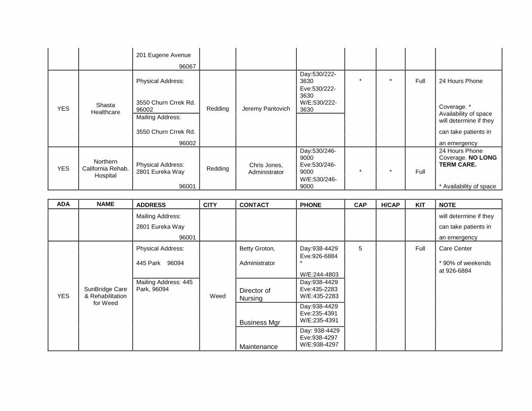
201 Eugene Avenue
96067
YES Shasta
Healthcare
Physical Address:
Redding Jeremy Pantovich
Day:530/222-3630 * * Full 24 Hours Phone
3550 Churn Crrek Rd. 96002
Eve:530/222-3630 W/E:530/222-3630
Coverage. * Availability of space will determine if they
Mailing Address:
3550 Churn Crrek Rd. can take patients in
96002 an emergency
YES Northern
California Rehab. Hospital
Physical Address: 2801 Eureka Way
Redding Chris Jones, Administrator
Day:530/246-9000 Eve:530/246-9000 * * Full
24 Hours Phone Coverage. NO LONG TERM CARE.
96001 W/E:530/246-9000
* Availability of space
ADA NAME ADDRESS CITY CONTACT PHONE CAP H/CAP KIT NOTE
Mailing Address: will determine if they
2801 Eureka Way can take patients in
96001 an emergency
YES SunBridge Care & Rehabilitation
for Weed
Physical Address:
Weed
Betty Groton, Day:938-4429 5 Full Care Center
445 Park 96094 Administrator Eve:926-6884 *
* 90% of weekends
W/E:244-4803 at 926-6884
Mailing Address: 445 Park, 96094 Director of
Nursing
Day:938-4429 Eve:435-2283 W/E:435-2283
Business Mgr
Day:938-4429 Eve:235-4391 W/E:235-4391
Maintenance
Day: 938-4429 Eve:938-4297 W/E:938-4297

Animals ADA NAME ADDRESS CITY CONTACT PHONE CAP H/CAP KIT NOTE
NO Larry & Frances
Stidham
Physical Address:
Gazelle Larry & Frances Stidham
Day:842-4161
Call first. They will put
Dogs: Eve:842-3268 animals up--have room
for
321 Payne Lane 24-Hr: horses and have
capability
Yreka, CA 96097 1-800-827-9500 of making cages for
dogs
on-site. They would be
willing to help with dog
Horses: food. Areas: Yreka,
10004 So. Hwy. 99 Grenada, CA or
Grenada, Gazelle, Horn-brook, Ft.Jones, Montague.
Day: 842-4161
11820 & 11822 Eve and 24 Hrs:
Old Hwy 99 1-800-827-9500
Grenada, CA
ADA NAME ADDRESS CITY CONTACT PHONE CAP H/CAP KIT NOTE
Mailing Address:
P.O. Box 308
Yreka, CA 96097
NO Rescue Ranch -
Animals
Physical Address: 4400 Black Mt Rd 96064
Montague Dan Viera Day: 459-0653 Eve: 459-0653 W/E:459-0653
Takes in dogs
Mailing Address:
NO Siskiyou Humane
Society, Inc.
Physical Address: 1208 N. Mt. Shasta Blvd 96067
Mt Shasta
Cathy Chastain Day:926-4052 Eve: W/E:
Animal Pound
Mailing Address:
P.O. Box 484
96067
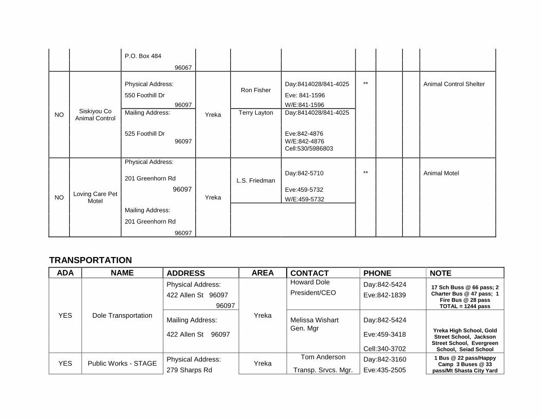
NO Siskiyou Co
Animal Control
Physical Address:
Yreka
Ron Fisher Day:8414028/841-4025 **
Animal Control Shelter
550 Foothill Dr Eve: 841-1596
96097 W/E:841-1596 Mailing Address: Terry Layton Day:8414028/841-4025
525 Foothill Dr Eve:842-4876
96097 W/E:842-4876 Cell:530/5986803
NO Loving Care Pet
Motel
Physical Address:
Yreka
L.S. Friedman
201 Greenhorn Rd Day:842-5710 ** Animal Motel
96097 Eve:459-5732
Mailing Address:
W/E:459-5732
201 Greenhorn Rd
96097
TRANSPORTATION
ADA NAME ADDRESS AREA CONTACT PHONE NOTE
YES Dole Transportation
Physical Address:
Yreka
Howard Dole Day:842-5424 17 Sch Buss @ 66 pass; 2 Charter Bus @ 47 pass; 1
Fire Bus @ 28 pass TOTAL = 1244 pass
422 Allen St 96097 President/CEO Eve:842-1839
96097
Mailing Address: Melissa Wishart Day:842-5424
Yreka High School, Gold Street School, Jackson
Street School, Evergreen School, Seiad School
422 Allen St 96097 Gen. Mgr
Eve:459-3418
Cell:340-3702
YES Public Works - STAGE Physical Address:
Yreka Tom Anderson Day:842-3160 1 Bus @ 22 pass/Happy
Camp 3 Buses @ 33 pass/Mt Shasta City Yard 279 Sharps Rd Transp. Srvcs. Mgr. Eve:435-2505

96097
North County
1 Bus @ 33 pass/Etna City Yard 1 Bus @ 25 pass/Lk
Shastina Public Works Yard 1 Bus @
33pass/Siskiyou Co Employee Parking Lot @
4th & Butte in Yreka 5 Buses @22 pass/Sisk Co Maint. Yard @ 279 Sharps
Rd.
Dick Keiser Day:842-3160
Mailing Address: Transp. Srvcs. Mgr. South County
Eve:435-2505
305 Butte St
96097
YES Human Services
Physical Address:
Yreka
Nadine Della Bitta Day: 841-2761 1 Van @ 6 pass; 4 SUVs @ 5 pass; 6 Cars @ 5 pass
818 Main St Director Eve: 459-1350
96097
Mailing Address:
818 Main St
96097
ADA NAME ADDRESS AREA CONTACT PHONE NOTE
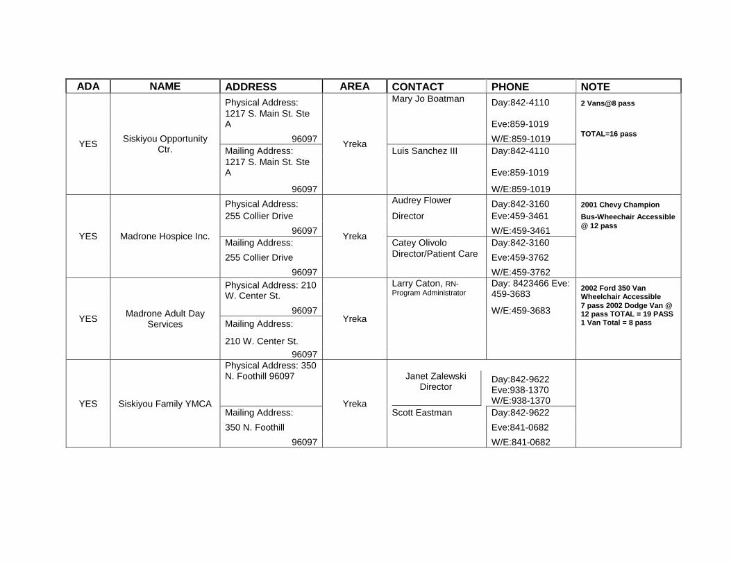
YES Siskiyou Opportunity
Ctr.
Physical Address:
Yreka
Mary Jo Boatman Day:842-4110 2 Vans@8 pass
1217 S. Main St. Ste A
Eve:859-1019
96097 W/E:859-1019 TOTAL=16 pass
Mailing Address: Luis Sanchez III Day:842-4110
1217 S. Main St. Ste A
Eve:859-1019
96097 W/E:859-1019
YES Madrone Hospice Inc.
Physical Address:
Yreka
Audrey Flower Day:842-3160 2001 Chevy Champion
255 Collier Drive Director Eve:459-3461 Bus-Wheechair Accessible
96097 W/E:459-3461 @ 12 pass
Mailing Address: Catey Olivolo Day:842-3160
255 Collier Drive Director/Patient Care Eve:459-3762
96097 W/E:459-3762
YES Madrone Adult Day
Services
Physical Address: 210 W. Center St.
Yreka
Larry Caton, RN-
Program Administrator Day: 8423466 Eve: 459-3683
2002 Ford 350 Van Wheelchair Accessible
96097 W/E:459-3683 7 pass 2002 Dodge Van @ 12 pass TOTAL = 19 PASS 1 Van Total = 8 pass Mailing Address:
210 W. Center St.
96097
YES Siskiyou Family YMCA
Physical Address: 350 N. Foothill 96097
Yreka
Janet Zalewski
Director
Day:842-9622 Eve:938-1370 W/E:938-1370
Mailing Address: Scott Eastman Day:842-9622
350 N. Foothill Eve:841-0682
96097 W/E:841-0682

ADA NAME ADDRESS AREA CONTACT PHONE NOTE
YES Montague Elementary
Physical Address:
Montague
Kermith Walters Day:459-3001
430 E. Prather District Superintendent Eve: 842-2991
2 Buses @ 72 Pass
96064 W/E:842-2991 Total =144 Passengers
Mailing Address: Day: 4593001 K thru 8th
P.O. Box 308 Chris Haas Eve: 459-1457
96064 Maintenance W/E:459-1457
YES Little Shasta Elementary
Physical Address:
Little Shasta
Kathy Koon Day:459-3269 NO BUSES
8409 Lower Little Shasta Eve:459-3020
96064
Mailing Address:
8409 Lower Little Shasta
96064
YES Butteville Elementary
Edgewood
Physical Address: Mike Michelon, Day:938-2255 1 Bus @ 70 pass
24512 Edgewood District Superintendent Eve:938-4184
96094 W/E:938-4184
Mailing Address: Betty Shaffer, Day:938-2255
24512 Edgewood Maintenance Supv. Eve:938-2673
96094 W/E:938-2673
ADA NAME ADDRESS AREA CONTACT PHONE NOTE
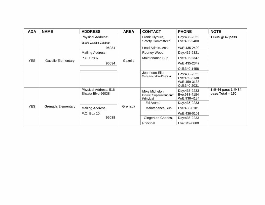
YES Gazelle Elementary
Physical Address:
Gazelle
Frank Clyburn, Day:435-2321 1 Bus @ 42 pass
25305 Gazelle-Callahan Safety Committee/ Eve:435-2400
96034 Lead Admin. Asst. W/E:435-2400
Mailing Address: Rodney Wood, Day:435-2321
P.O. Box 6 Maintenance Sup Eve:435-2347
96034 W/E:435-2347
Cell:340-1458
Jeannette Eiler, Superintendent/Principal
Day:435-2321 Eve:459-3138 W/E:459-3138 Cell:340-2031
YES Grenada Elementary
Physical Address: 516 Shasta Blvd 96038
Grenada
Mike Michelon, District Superintendent/ Principal
Day:436-2233 Eve:938-4184 W/E:938-4184
1 @ 66 pass 1 @ 84 pass Total = 150
Ed Arami, Day:436-2233
Mailing Address: Maintenance Sup Eve:436-0101
P.O. Box 10 W/E:436-0101
96038 GingerLee Charles, Day:436-2233
Principal Eve:842-0680
ADA NAME ADDRESS AREA CONTACT PHONE NOTE
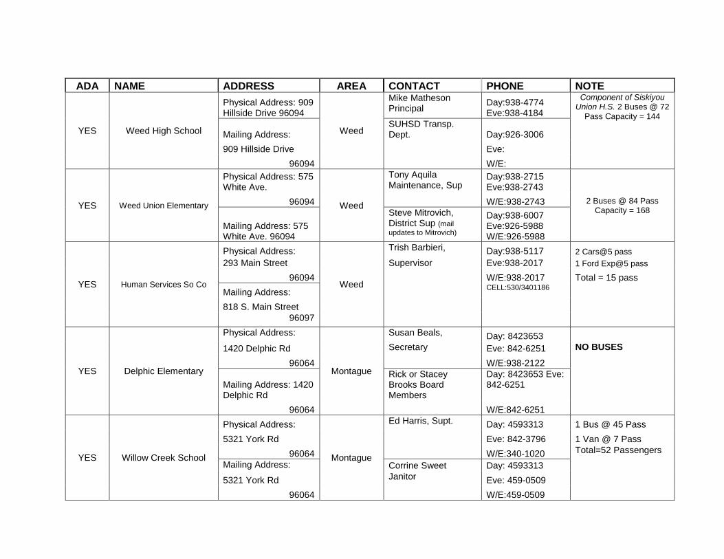
YES Weed High School
Physical Address: 909 Hillside Drive 96094
Weed
Mike Matheson Principal
Day:938-4774 Eve:938-4184
Component of Siskiyou Union H.S. 2 Buses @ 72
Pass Capacity = 144
Mailing Address: SUHSD Transp. Dept. Day:926-3006
909 Hillside Drive Eve:
96094 W/E:
YES Weed Union Elementary
Physical Address: 575 White Ave.
Weed
Tony Aquila Maintenance, Sup
Day:938-2715 Eve:938-2743
2 Buses @ 84 Pass Capacity = 168
96094 W/E:938-2743
Mailing Address: 575 White Ave. 96094
Steve Mitrovich, District Sup (mail
updates to Mitrovich)
Day:938-6007 Eve:926-5988 W/E:926-5988
YES Human Services So Co
Physical Address:
Weed
Trish Barbieri, Day:938-5117 2 Cars@5 pass
293 Main Street Supervisor Eve:938-2017 1 Ford Exp@5 pass
96094 W/E:938-2017 Total = 15 pass
Mailing Address: CELL:530/3401186
818 S. Main Street
96097
YES Delphic Elementary
Physical Address:
Montague
Susan Beals, Day: 8423653
1420 Delphic Rd Secretary Eve: 842-6251 NO BUSES
96064 W/E:938-2122
Mailing Address: 1420 Delphic Rd
Rick or Stacey Brooks Board Members
Day: 8423653 Eve: 842-6251
96064 W/E:842-6251
YES Willow Creek School
Physical Address:
Montague
Ed Harris, Supt. Day: 4593313 1 Bus @ 45 Pass
5321 York Rd Eve: 842-3796 1 Van @ 7 Pass
96064 W/E:340-1020 Total=52 Passengers
Mailing Address: Corrine Sweet Day: 4593313
5321 York Rd Janitor Eve: 459-0509
96064 W/E:459-0509

COMMUNITY FIRE SAFE COUNCILS Community Fire Safe Council Contact eMail
Big Springs Juniper Flats
Carrick Addition Greater Weed Area Kelly Conner [email protected]
Copco Copco
Edgewood Greater Weed Area Kelly Conner [email protected]
Gazelle
Grenada
Hammond Ranch Greater Weed Area Kelly Conner [email protected]
Hawkinsville
Hilt
Hornbrook
Lake Shastina Lake Shastina
Montague
Mt. Shasta Vista Juniper Flats
South Yreka South Yreka Larry Alexander
Weed Greater Weed Area Kelly Conner [email protected]
Yreka