97-98 ctuir grande ronde watershed restoration annual report/67531/metadc741072/m2/1/high_res... ·...
TRANSCRIPT
July 1999
CTUIR GRANDE RONDE RIVER BASIN WATERSHED RESTORATION PROGRAM
MCCOY CREEK/MCINTYRE CREEK ROAD CROSSING
THIS IS INVISIBLE TEXT TO KEEP VERTICAL ALIGNMENT THIS IS INVISIBLE TEXT TO KEEP VERTICAL ALIGNMENT THIS IS INVISIBLE TEXT TO KEEP VERTICAL ALIGNMENT THIS IS INVISIBLE TEXT TO KEEP VERTICAL ALIGNMENT THIS IS INVISIBLE TEXT TO KEEP VERTICAL ALIGNMENT
Annual Report July 1997 - June 1998
DOE/BP-00006229-1

This report was funded by the Bonneville Power Administration (BPA), U.S. Department of Energy, aspart of BPA's program to protect, mitigate, and enhance fish and wildlife affected by the development andoperation of hydroelectric facilities on the Columbia River and its tributaries. The views of this report arethe author's and do not necessarily represent the views of BPA.
This document should be cited as follows: Childs, Allen - Confederated Tribes of the Umatilla Indian Reservation, 1999, CTUIR Grande Ronde River BasinWatershed Restoration Program McCoy Creek/McIntyre Creek Road Crossing July 1997 - June 1998 Annual Report,Report to Bonneville Power Administration, Contract No. 00006229, Project No. 199608300, 29 electronic pages(BPA Report DOE/BP-00006229-1)
This report and other BPA Fish and Wildlife Publications are available on the Internet at:
http://www.efw.bpa.gov/cgi-bin/efw/FW/publications.cgi
For other information on electronic documents or other printed media, contact or write to:
Bonneville Power AdministrationEnvironment, Fish and Wildlife Division
P.O. Box 3621905 N.E. 11th Avenue
Portland, OR 97208-3621
Please include title, author, and DOE/BP number in the request.

ANNUAL REPORTJuly 1997 – June 1998
CTUIR Grande Ronde River Basin Watershed Restoration Program
McCoy Creek/McIntyre Creek Road Crossing
Confederated Tribes of the Umatilla Indian Reservationand
Bonneville Power Administration
Contract Project Number 199609300BPA IGA #97 BI 35164
Prepared by: Allen Childs, Project BiologistJuly 1999

ABSTRACT
The Confederated Tribes of the Umatilla Indian Reservation (CTUIR) and Bonneville PowerAdministration (BPA) entered into a contract agreement on July 1, 1997 to conduct watershedrestoration project activities in the Upper Grande Ronde River Basin. Contract work activitieswere focused on the McCoy Meadows Restoration Project, McIntyre Creek Road Relocation andObliteration Project, Upper Mainstem Grande Ronde River Large Wood Addition Project, andMiddle Mainstem Grande Ronde River Habitat Enhancement Project.
The McCoy Meadows Restoration Project effort was initiated in 1995 under a Clean Water Actgrant. Clean Water Act funds were focused on development of baseline conditions, developmentof a restoration analysis and strategy, and initiation of phase 1 construction of the projectinvolving relocation of an approximate 1 mile segment McCoy Creek out of its currentchannelized section into a Pre-1977 meander channel. BPA funds under this contract weredirected by the CTUIR to cost share and coordinate project efforts.
As part of the McCoy Creek subbasin restoration effort the CTUIR secured Early Action BPAfunds for the design and construction of an improved stream crossing on McCoy Creek toincrease capacity, reduce icing, and contribute to both upstream and downstream meadowrestoration efforts. In addition to the McCoy Meadows Restoration Project and the bridgeproject, the CTUIR directed BPA funding under this contract to the U.S. Forest Service ForestRoad 2137 Road Relocation and Obliteration Project which entails obliteration and relocationof approximately 2 miles of existing drawbottom road to improve water quality and instreamhabitat conditions in the McIntyre Creek subwatershed, upstream from the McCoy Meadowsrestoration project.
The CTUIR also participated as a project sponsor on a habitat restoration project with the U.S.Forest Service in the Upper Grande Ronde River Basin. The project (Upper Grande RondeRiver Large Wood Addition Project) involved large woody debris additions to the mainstemGrande Ronde on an approximate 2 mile reach located upstream of Starkey, Oregon adjacent toForest Road 51. Large wood placement objectives included enhancing instream structuraldiversity and large pool habitat quality.
An additional objective of this contact included identification and development of additionalrestoration opportunities in the mainstem Grande Ronde River on both federal and private lands.The Tribal focus area for near-term restoration project development includes the mainstemGrande Ronde River and major tributaries from Hilgard State Park adjacent to Interstate 84upstream to the Wallowa-Whitman National Forest Boundary near Starkey, Oregon. This riversection is one of several considered high priority for improving water quality, particularlyduring summer low flow and winter periods, enhancing large pool habitat, and increasingstructural complexity for juvenile rearing habitat.
Development and continuation of cooperative efforts with the Grande Ronde Model WatershedProgram, other agencies, and landowners are key elements in addressing limiting factors in theGrande Ronde River Basin. Under this contract, the CTUIR proposed to build on past effortsand focus restoration project development over the next few years in several key areas.

Specific tasks accomplished under the McCoy Meadows Restoration component of the contractincluded: 1) pre-construction preparation involving interagency project coordination,development of project engineering designs, development of a biological assessment andDivision of State Lands 401 Permit Application, preparation of requests for proposals andsubcontracts for project construction, collection and propagation of riparian tree and shrubstock for use in restoration efforts, and acquisition of materials and supplies; 2) restorationproject construction involving equipment rental contracts and revegetation activities; 3) ongoingmonitoring and evaluation to assess project effectiveness; and 4) initiation of phase 2 projectdesigns and preparation for additional project construction and implementation.
Planning and design for the McIntyre Creek Road Relocation and Obliteration Project and theMcCoy Creek Bridge Replacement Project was ongoing at the closure of this contract period.To date, engineering designs for both project activities have been completed. The U.S. ForestService is proceeding with contracting on the road relocation effort. The CTUIR are preparingto contract the McCoy Bridge Construction effort. Both project efforts are scheduled forimplementation beginning in July 1999.
The Upper Grande Ronde Large Wood Addition project was designed and implemented by theUSFS in July 1997 and included helicopter transport of approximately 120 whole trees/rootwadsfrom adjacent NationalForest System lands to the project site and placement with trackedexcavators. Project activities included installation of instream rock structures and large woodydebris, and anchoring large woody to minimize off-project transport.
Project activities under the Mainstem Grande Ronde River Restoration component of the projectwas initiated in late 1997 and involved coordination with landowners and interagency projectpartners on project development and site-specific project designs. Pre-project planning includeddevelopment of site-specific project objectives, development of conceptual and detailed projectdesigns, pre-construction preparation including development of requests for proposals,biological assessments and permits, identification of large woody debris and other constructionmaterials and layout of project designs, and initial collection and propagation of suitablevegetative material for use in revegetation efforts. Project activities also included coordinationand development of project proposals to solicit project partnerships and matching fundsincluding a proposal submitted to the Grande Ronde Model Watershed Program.

TABLE OF CONTENTS
PAGEINTRODUCTION 1
DESCRIPTION OF PROJECT AREAS 2McCoy Meadows Restoration Project Area 5Upper Mainstem Grande Ronde Large Wood
Addition ProjectMiddle Mainstem Grande Ronde Fish Habitat 6
Enhancement Project
METHODS AND MATERIALS 8McCoy Meadows Restoration Project 8Upper Mainstem Grande Ronde Large Woody Debris
Addition Project 11Middle Mainstem Grande Ronde Fish Habitat
Enhancement Project 11
RESULTS AND DISCUSSION 12McCoy Meadows Restoration Project 12Upper Mainstem Grande Ronde River Large Wood
Addition Project 16Middle Mainstem Grande Ronde Fish Habitat
Enhancement Project 16
SUMMARY AND CONCLUSIONS 18McCoy Meadows Restoration Project 18Upper Mainstem Grande Ronde Large Woody Debris
Addition Project 19Middle Mainstem Grande Ronde Fish Habitat
Enhancement Project 20

1
INTRODUCTION
This Annual Report provides a detailed overview of watershed restorationaccomplishments achieved by the Confederated Tribes of the Umatilla Indian Reservation(CTUIR) and project partners in the Upper Grande Ronde River Basin under contractwith the Bonneville Power Administration (BPA) during the period July 1, 1997 throughJune 30, 1998. The Contract Agreement entitled McCoy Meadows WatershedRestoration Project (Project #96-83-01) includes habitat restoration planning, design, andimplementation in two project areas—the McCoy Meadows Ranch located in theMeadow, McCoy, and McIntyre Creek subbasins on private land and the MainstemGrande Ronde River Habitat Enhancement Project located on private and National ForestSystem lands near Bird Tract Springs along the Grande Ronde River.
During the contract period, the CTUIR and partners (Mark and Lorna Tipperman,landowners), Oregon Department of Environmental Quality (ODEQ), U.S. EnvironmentalProtection Agency (EPA), Oregon Department of Fish and Wildlife (ODFW), and NaturalResource Conservation Service (NRCS) initiated phase 1 construction of the McCoyMeadows Restoration Project. Phase I involved reintroduction of a segment of McCoyCreek from its existing channelized configuration into a historic meander channel.
Project efforts included bioengineering and tree/shrub planting and protection,transporting salvaged cottonwood tree boles and limbs from offsite source to the projectarea for utilization by resident beaver populations for forage and dam constructionmaterials, relocation of existing BPA/ODFW riparian corridor fencing to outer edges ofmeadow floodplain, establishment of pre-project photo points, and coordination of othermonitoring and evaluation efforts being led by other project partners includinggroundwater monitoring wells, channel cross sections, water quality monitoring stations,juvenile population sampling index sites, redd surveys, and habitat surveys. Projectactivities also included coordination with the U.S. Forest Service, Wallowa-WhitmanNational Forest, LaGrande Ranger District (USFS( on the Forest Road 2137 (McIntyreRoad) Relocation and Obliteration Project and the McCoy Creek crossing. The USFScompleted engineering designs under the cooperative effort for the McCoy Creekcrossing.
Project activities accomplished on the Upper Mainstem Large Wood Addition Projectincluded placement of approximately 120 whole trees to enhance instream structuraldiversity, pool habitat quality, streambank stability, and improved floodplain morphology.
Project activities accomplished on the Mainstem Grande Ronde Habitat EnhancementProject included coordination with landowners (Shauna Musgrove of Cuhna Ranches,Dean Stone, and the Wallowa-Whitman National Forest, LaGrande Ranger District) todevelop a habitat enhancement/restoration project opportunity along a 3 mile section ofthe mainstem Grande Ronde River and major tributaries including the lower reaches ofBear Creek and Jordan Creek. Upon securing an agreement with the landowners, projectpartners including the CTUIR, ODFW, NRCS, and USFS initiated development of project

2
objectives and site-specific designs. By June 1998, project designs were completed andpreparations nearly complete to initiate onsite project construction.
DESCRIPTION OF PROJECT AREAS
McCoy Meadows Restoration Project Area
The McCoy Meadows Restoration Project is located on the approximate 2,500 acreMcCoy Meadows Ranch in the lower reaches of the Meadow, McCoy, and McIntyreCreek subbasins of the Upper Grande Ronde River Basin. The ranch encompasses about2 miles of McCoy Creek, 1 mile of McIntyre Creek, and 4 miles of Meadow Creek.McIntyre Creek is a tributary to McCoy Creek which is a tributary to Meadow Creek.Meadow Creek flows into the Grande Ronde River approximately 2 miles downstreamfrom Starkey. Meadow Creek contains historic Snake River spring chinook habitat. Allthree streams provide critical habitat for threatened Snake River summer steelhead trout.Threatened north bald eagles winter in the Upper Grande Ronde Basin including theMeadow and McCoy Creek subbasins and the project area contains the largest beaverwetland complex in the Upper Grande Ronde along Meadow Creek. McCoy Meadowssupports the highest concentration of nesting neotropic migrant yellow warblers in theGrande Ronde Basin and supports sensitive species such as the spotted frog. In addition,the project contains native tufted hairgrass plant communities, which are currently limitedto remnant wetland areas throughout the basin.
Impaired water quality and severely reduced quality and quantity juvenile salmonid rearinghabitat are currently limiting anadromous fish production in McCoy Creek, MeadowCreek, and in the Grande Ronde River downstream of the project area. An ODFWStream Report (1992) describes the project area reach, “[t]here is a high proportion ofunits with actively eroding stream banks. Stream shading is very low.” The report furtherindicates little to no large wood interacting with the channel, that 73.4 percent of thebanks are actively eroding and the average open sky is 90 percent.
Stream surveys conducted by CTUIR fisheries staff in the fall of 1995 documented similarconditions with about 40 percent glide habitat, 35 percent riffle habitat, and 25 percentpool habitat. Ground cover in the riparian area was estimated at about 2 percent shrubsand included 13 percent bare soil. Canopy closure ranged from 1-3 percent and open skyaveraged 91 percent. Large wood averaged 0.8 pieces per 100 meters (about 12 piecesper mile).
Water quality and biological resource monitoring in the project area was initiated byODFW in 1988 and by ODEQ in 1993. Examination of ODFW data collected between1988 and 1994 reveals that mean weekly maximum temperatures exceeded the newOregon Stream Temperature standard (64o F/17.8o C: salmonid rearing) from the start ofmonitoring each year (about May 15) through the end of October.

3
Hourly temperature data from thermographs showed that summer mean weekly maximumtemperatures were consistently higher in the lower portions of the meadow compared tothe upper meadow where McCoy Creek enters the meadow floodplain. This demonstratesthat, though summer stream temperatures consistently exceed state water qualitystandards as a result of upstream activities and conditions, additional thermal loadingoccurs within the project area.
In addition, data collected by the Oregon Department of Environmental Quality in 1992and 1993 illustrate that in 1993 the highest seven-day average of daily maximumtemperatures were 25.8, 24.9, and 26.1 degrees Celsius for Upper McCoy, MiddleMcCoy, and Lower McCoy, respectively. It is notable that there is little difference inwater temperatures between the three sites, which suggests that water temperatures in thisreach are in equilibrium with air temperature during this time of year.
Existing wildlife habitat conditions in the McCoy Meadows area are significantly differentthan historic conditions. The area is described in the Stuart Journals as a sinuous wetlandmeadow that contained such a high level of sinuosity, early explorers commonly becameconfused as to which streams they were following. Records maintained by early explorersand trappers also record the abundance of beaver commonly observed in the GrandeRonde River basin.
In current times, many streams in the upper basin contain primarily riffles and shallowglides, poor riparian habitat conditions with minimal overstory riparian tree and understoryriparian shrub, very little structural diversity, and a notable absence of beaver, except forsmall, isolated colonies. Historic land uses have signficantly reduced the extent andquality of wetland and riparian habitat resources in the McCoy Meadows area.
Channelization and agriculture in the area resulted in alteration of groundwater andsurface water regimes, loss of riparian/wetland vegetation, and decreased suitability forbeaver. The meadow area, portions of which historically contained a large, montanewetland complex, is currently grassland pasture with limited riparian/wetland complexity.The following photo illustrates historic McCoy Meadows (Channel and Land-UseAlterations between 1937 and 1980.

4

5
Key objectives of the McCoy Meadows Restoration Project include:• Increase stream channel sinuosity• Improve instream, riparian, floodplain/meadow conditions and functions, including
improved quality and utilization of riparian and meadow areas for native plantcommunities and wildlife, including beaver and other riparian dependent nativespecies
• Improve/increase vegetative cover/shade to decrease summer stream temperaturesand increase winter temperatures
• Improve/increase streambank stability• Improve water chemistry• Improve surface water and groundwater interaction• Improve properties of coldwater fish habitat and terrestrial and aquatic
macroinvertebrate community composition• Improve utilization of new stream channel segments by steelhead• Provide watershed restoration educational opportunities
Upper Mainstem Grande Ronde Large Wood Addition Project
This project is located upstream from Starkey, Oregon along the upper Mainstem GrandeRonde River on National Forest System lands. The CTUIR directed BPA funds to assistin funding helicopter transport of large wood to project site and installation large wooddebris and instream rock structures to restore instream structural diversity, large poolhabitat availability, and improved stream stability and floodplain morphology. Projectimplementation occurred during the instream work window beginning in July 1997.Approximately 120 whole trees with rootwads were flown in by helicopter and installedwith ground-based equipment. Instream rock structures (vortex weirs and rock clusters)were also installed to improve instream structure. Tribal and USFS crews anchored wholetrees with cable to minimize off-project transport of whole trees.

6
Middle Mainstem Grande Ronde Habitat Enhancement Project
This project area is located in the middle Upper Grande Ronde River Basin approximately4 miles upstream from Hilgard State Park on Longley Meadows near Bird Tract Springs.The project includes National Forest system lands and private lands. Two private ranches,including the Stone Ranch and Cunha Ranch, are part of the project. The middle UpperGrande Ronde River provides critical adult salmon and steelhead holding and juvenilewinter and summer rearing habitat. Major tributaries in the project area include BearCreek and Jordan Creek which provide important backwater habitats for juvenilesalmonids and critical spawning and rearing habitat for summer steelhead.
Past land uses such as railroad grade construction, channelization, removal of instreamstructure for waterway log transport (log fluming) and livestock grazing have altered andconstrained floodplain morphology, de-stabilized streambanks, removed instream habitatstructural diversity, and degraded riparian/floodplain conditions along the mainstemGrande Ronde and tributaries. Severe icing, high summer and low winter watertemperatures, and poor instream structural diversity including a lack of high quality largepool habitat currently limits habitat suitability for threatened Snake River salmon andsteelhead populations.
Project objectives for the Mainstem Grande Ronde Habitat Enhancement Project include:• Increase instream structural diversity and quantity and quantity of large pool habitat• Improve adult holding and juvenile summer and rearing habitat complexity• Improve water quality (decrease summer water temperatures and increase winter water
temperatures• Improve streambank stability• Improve/enhancement ability of private landowner (Cunha Ranch) to improve livestock
distribution and eliminate streambank degradation caused by livestock
Figure 1 illustrates the vicinity of individual watershed restoration projects discussedabove.

7
Figure 1 – Project Vicinity Map

8
METHODS AND MATERIALS
McCoy Meadows Restoration Project
Project development and implementation on the McCoy Meadows Project includedcoordination of project assessment and design, engineering and biological surveys,consultation and permitting with federal and state agencies, purchasing materials andsupplies, collection and propagation of vegetation for use in restoration, planting andbioengineering, project contracting preparations, project construction, monitoring andevaluation, and maintenance.
Task 1 Pre-Construction Preparation
Coordination
The CTUIR is performing as project coordinator on the McCoy Meadows RestorationProject. Coordination activities include scheduling, organizing, and conducting designteam meetings with multiple project partners including ODFW, NRCS, and GRMWP,maintaining communications with the landowner, and coordination and oversight ofvarious project components such as surveys, designs, consultations with federal agenciesunder the Endangered Species Act and permitting, purchasing materials and supplies,preparing contract requests for proposals, contracting, and contract administration.
Engineering designs for McCoy Bridge
Work performed under this contract included maintaining coordination with the USFS onthe McIntyre Creek Road Relocation and Obliteration Project. Under this project, theCTUIR directed BPA funding to cost-share the first phase of this project effort involvingdrawbottom road relocation. Future restoration efforts will be directed at restoring theMcIntyre Creek floodplain currently constrained by the drawbottom road. As part of thiscost-share effort, the USFS prepared engineering designs for the planned bridge crossingon McCoy Creek which is part of the McCoy Meadows Restoration Project. Engineeringdesigns and specifications have been completed. Work is progressing on solicitingcontract bids. Union County Public works is a project partner on the bridge replacementeffort and is scheduled to contribute in-kind services including hauling fill material,removal of existing culverts, and constructing a temporary route to accommodate trafficduring the bridge construction effort. Construction on the new bridge is scheduled tobegin in late July 1999.
Subcontracting
Project construction efforts involved subcontracting for heavy equipment. Workperformed under this contract included planning and development of contact scopes ofwork, drafting requests for proposals, advertising and solicitation for bids, review of bidproposals and contractor selection, contract awarding and coordination, and

9
administration of contract (maintaining daily logs, negotiation with contractors, andbillings/payments).
Collection and Propagation of Plant Materials
Project work involved collection and propagation of approximately 10,000 cuttings ofprimarily willow (salix spp.) which were conditioned and grown in the CTUIR NativePlant Nursery as containerized stock. An additional 6,000 riparian tree and shrub tublingswere purchased from an outside vender. Additional material is planned for collection andpropagation to support vegetative restoration needs on the McCoy Meadows ProjectArea. The CTUIR Nursery is currently storing 10,000 containerized shrubs for use in the1999 spring planting period.
Propagation material collection methods included pruning onsite source stock during thewinter dormancy period and conditioning at the CTUIR nursery in bark and soil tostimulate root nodule development. Following conditioning, cuttings were then handplanted into containers to grow out as containerized stocked.
In addition to collection of material for propagation, CTUIR staff also collected severalthousand whips for use in livestaking and bundle/fascine installation to help stabilizestreambanks and encourage accelerated shade development.
During the July 1997 construction period, 24 whole willow rootwads were transplantedinto an approximate 200 linear foot outside meander along McCoy Creek. The sourcematerial willow clumps were topped to minimize shock and to salvage whip material. Therootwads were excavated using a backhoe, loaded into a dumptruck, hauled to thetransplant location, and installed using a tracked excavator. In addition, approximately 40other tree and shrub clumps were salvaged and transplanted during the constructionperiod.
Between April and May 1998, approximately 8,000 riparian shrub and tree tublings(primarily willow, red osier dogwood, mock orange, and black cottonwood), 1,000conifer, 120 black cottonwood poles, and 800 linear feet of fascines were installed in thephase 1 project area. Methods included site preparation (scalping and excavation),planting, and installation of protection devices and shade cards. Bundles and fascineswere installed by hand or with the use of equipment (small backhoe). Cottonwoodlivestakes were installed using a backhoe mounted stinger.
Task 2 Restoration Project Construction
In July 1997, the CTUIR and partners initiated phase 1 of the McCoy Meadows Project.Designs included relocation of a channelized segment of McCoy Creek into a historicmeander channel segment. Methods involved heavy equipment to move and rearrange(cut and fill) approximately 3,000 cubic yards of cut and fill material. See Figure 2 forphase 1 construction.

10
In addition to the cut and fill activities associated with constructing and reconnectinghistoric meander channels, project work also involved filling drainage ditches developed inthe early 1900’s that were designed to drain the meadow floodplain and removal ofculverts and dikes. Activities were directed primarily to alleviate concentrated water flowin ditched configurations and spread out water in sheet flow to reduce erosive energy andincrease water storage in the upper meadow floodplain.
Task 3 Post construction activities and monitoring
Post construction activities included inspecting contracted work and determination ofproject completion. Contractor was then released from project site upon successfulcompletion of contract requirements.
Monitoring and evaluation activities on the McCoy Meadows Restoration Project isongoing. M&E includes water quality, groundwater, instream habitat, fish populations,photo points, aerial photography, permanent vegetation plots, and stocking survey plots.
CTUIR staff are responsible for photo points, vegetation plots, and stocking survey plots.ODEQ is conducting extensive water quality monitoring including water temperature andchemistry, macrointertebrates, and channel cross sections. NRCS is monitoringgroundwater. ODFW is monitoring instream habitat conditions and fish populations.Monitoring reports available at this time are included as appendices in this annual report.
Tasks 4 Phase 2 McCoy Meadows Project Designs
Phase 2 project design development is currently ongoing. Survey work has beencompleted under CTUIR contract by an engineering firm. The design team has completeddevelopment of channel design criteria and is currently developing channel alignmentstrategies. Activities include reviewing survey data, assessing historic channel locationsand physical dimensions, and analysis of suitable channel configurations. Additionalsurvey data including additional channel cross section data is currently being collected byNRCS and CTUIR staff to assist in development of phase 2 designs. Phase 2 designs arebeing closely integrated with the bridge construction effort described earlier. The newbridge will be located approximately 200 feet south of the current crossing due toconcerns associated with the lack of grade control in the channelized configuration. Phase2 channel design alignment integrates this features into the channel location andconfiguration. Designs also include provision for maintaining continuity of overflow in themeadow by integrating additional culverts (and meadow flood capacity) in the existingroad prism, which currently acts like a dam or dike. Final phase 2 engineering designs areanticipated to be completed by early to mid August. Initial construction activities areexpected to begin by early to mid September.
In conjunction with phase 2 project design development, the design team is currentlyassessing and developing additional work elements in the upper meadow, phase 1 projectarea. Project construction activities planned in the upper meadow include for the July
11
1999 work window include construction of an engineered debris jam at the 97’ channelentrance location and filling the portions of the channelized reach to direct additional flowinto the restoration channel.
CTUIR staff in conjunction with project partners are currently preparing biologicalassessments, permits, and NEPA compliance reports for the bridge, ongoing phase 1project activities, and phase 2 channel restoration work.
Upper Grande Ronde Large Woody Debris Addition Project
Methods employed under this project included identification of suitable whole trees fromadjacent National Forest System lands, contracting helicopter flight services, flying wholetrees to pre-determined locations along the Grande Ronde River floodplain, and instreamplacement of whole trees and rock structures with a tracked excavator. Whole trees werethen anchored to large rocks using stainless steel cable and epoxy by tribal and USFS staff.All woody debris installed under the project was mapped and counted as part of themonitoring program to assess wood transport through the system. Contracting andproject administration was provided by USFS staff.
Middle Mainstem Grande Ronde River Habitat Enhancement Project
Task 1 Project Development and Designs
Project proposal and conceptual designs have been developed cooperatively with GrandeRonde Model Watershed Program, NRCS, ODFW, USFS, and CTUIR Designs consistedof plan views, design drawings, and engineering specifications for individual projectreaches. Project designs were completed by the design team with NRCS taking the leadon engineering specifications. Project designs were completed in July 1998 withcontracting, permitting, NEPA compliance, and field preparations being completed byAugust 1998.
Initial project construction activities were implemented during August-September 1998.Project planning and preparations included: 1) contract preparation (USFS); 2)coordination with landowners on access routes and staging areas; 3) field reconnaissanceto locate large wood planned to be flown to project area via helicopters; and 4) planningfor range improvements and riparian conservation easement. BiologicalAssessment/Evaluations completed by USFS. ODFW has completed Section 404 permitapplication. NEPA and cultural review also completed by USFS.
Task 2 Project Implementation
Implementation activities included purchase and delivery of materials includingapproximately 1,500 cubic yards of 36 to 48 inch angular basalt and delivery ofapproximately 100 whole trees by helicopter and self loading log truck. Existing rockvortex weirs on National Forest System lands initially constructed in 1992 were repaired

12
and whole trees with rootwads were installed to improve instream structural diversityassociated with the large pool habitat formed by the rock weirs. Approximately 700 feetof streambank repair was accomplished through the installation of rootwad revetments.Gravel bars were stabilized by the additional of large whole trees.
RESULTS AND DISCUSSION
McCoy Meadows Restoration Project
In July, 1997 the McCoy Meadows design team initiated the first step in restoring thenatural character and function of McCoy Meadows by reintroducing McCoy Creek into apre-1977 stream channel, planting thousands of riparian shrubs and trees, and filling olddrainage ditches in order to allow spring runoff to flood the meadow and restoregroundwater storage.
In 1997 alone, over 1,200 linear feet of stream channel was restored above pre-project,channelized conditions. An additional 1,800 linear feet of existing stream channel (utilizedby McIntyre Creek following 1977 channelization efforts) was enhanced by increasedsummer baseflow provided by McCoy Creek. In dryer years, this stream segmentprovided intermittent stream flow. Post project conditions included perennial flowthroughout the season. Prior to project implementation, this reach contained a singlebeaver dam and associated lodge structure. During 1997 and through 1998 followingphase 1 project implementation, approximately 12 new beaver dams were established. Tofacilitate beaver dam development and their beneficial effects in the meadow complex,approximately 120 pieces of 4-8 inch diameter (up to 8 feet lengths) cottonwood limbsand boles salvaged from off-site were deposited near the existing beaver lodge by tribalstaff. Depositing this material was intended to provide a forage resource and largerdiameter material to re-enforce existing dam structures and potentially reduce depredationon both existing and planted shrubs. Without exception, all wood was utilized forforaging and incorporated into dam structures. Although carrying capacities for beaver inthis reach has not been determined, forage and dam construction resources of relativelyabundant supply are nearby and beaver control has not been identified as a project need.Monitoring efforts are ongoing.
Channel gradient in the phase 1 project reach decreased from approximately .7 feet/100feet to .5 feet/100 feet along the main McCoy Creek segment with a correspondingincrease in channel sinuosity from 1.08 to 1.33. Channel gradient in the restored channelof .3 feet/100 feet compares favorably to the channelized section which has a gradient of.8 feet/100 feet. Sinuosity of the restored channel is also much greater--1.52 compared to1.01 in the channelized segment. Physical habitat conditions in the restored channelsegments also compare favorably with channelized segments. Pool habitat availability hasincreased to over 50 percent compared to less than 12 percent in channelized segments,average pool depth is greater in the restored channel (by up to 40 percent), the width todepth ratio has decreased by an estimated 45 percent, and streambank stability is roughly
13
60 percent greater in the restored channel compared to channelized segments (ODFWAquatic Habitat Inventory, July 1998, Appendix B). Stream shade provided by vegetationon restored stream segments is currently similar to channelized segments. However, weanticipate stream shade to increase dramatically over the next decade over pre-projectconditions due to decreased stream gradient, greater streambank stability, improvedhydrologic conditions, and the aggressive revegetation program currently underway.
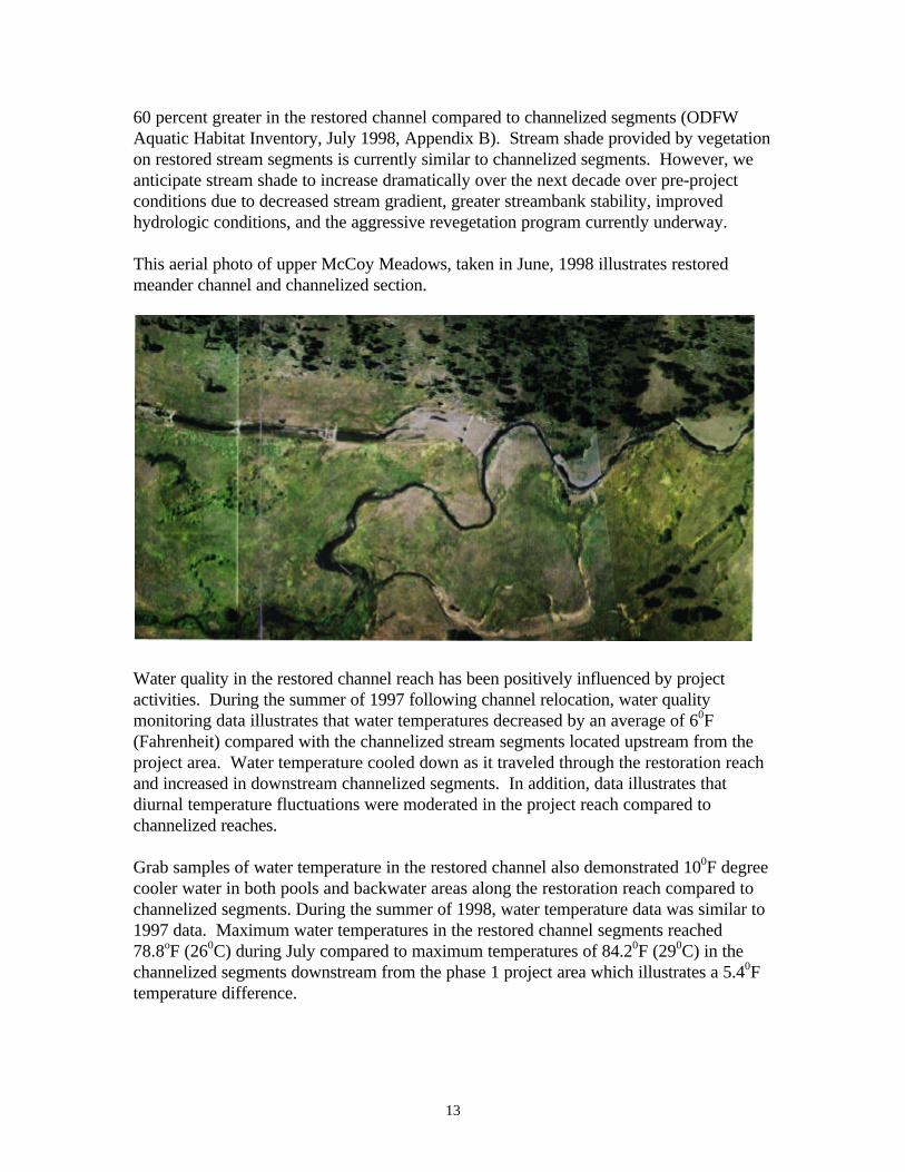
This aerial photo of upper McCoy Meadows, taken in June, 1998 illustrates restoredmeander channel and channelized section.
Water quality in the restored channel reach has been positively influenced by projectactivities. During the summer of 1997 following channel relocation, water qualitymonitoring data illustrates that water temperatures decreased by an average of 60F(Fahrenheit) compared with the channelized stream segments located upstream from theproject area. Water temperature cooled down as it traveled through the restoration reachand increased in downstream channelized segments. In addition, data illustrates thatdiurnal temperature fluctuations were moderated in the project reach compared tochannelized reaches.
Grab samples of water temperature in the restored channel also demonstrated 100F degreecooler water in both pools and backwater areas along the restoration reach compared tochannelized segments. During the summer of 1998, water temperature data was similar to1997 data. Maximum water temperatures in the restored channel segments reached78.8oF (260C) during July compared to maximum temperatures of 84.20F (290C) in thechannelized segments downstream from the phase 1 project area which illustrates a 5.40Ftemperature difference.

14
The following figure illustrates streambank stablilization and large woody debris additionson the upper reach of the phase 1 project area.
This photo illustrates a segment in the phase 1 restoration project reach. The segment ispart of the historic (pre-1977) McCoy Creek, which flowed intermittently prior to the1997 restoration effort.

15
Figure 2 – This figure illustrates parameters of water temperature, width:depthratio, and trout abundance in the restoration reach along Upper McCoy Creekcompared to segments upstream and downstream of the 1997 and 1998 restorationproject area.
Overall, reintroduction of McCoy Creek into the pre-1977 channel segments under phase1 of the project has initiated improvement in water quality and fish habitat compared topre-project conditions. The influence of increased groundwater storage in conjunctionwith a significant decrease in the width to depth ratio and an increase in average depth hasinitiated an improving trend in water quality and initiated the first major step towardsachieving the goals and objectives of the McCoy Meadows Restoration Project. Projectstaff speculate these conditions will continue on an improving trend in the restorationreach with additional groundwater storage (as more meadow floodplain is reactivated),increased shade provided by restored native riparian and wetland plant communities, andan increase in average depth resulting from continued beaver activity.
Current monitoring and evaluation efforts for water quality and groundwater is notsufficient to accurately portray the interaction of groundwater-surface water interactionsand the microhabitat effects provided by groundwater discharge throughout the projectreach. Efforts are currently underway to increase water quality and groundwater datacollection to better assess project effectiveness and to increase our understanding of theimportance of wet meadows in watershed restoration and recovery of endangeredsalmonids. Increased M&E may include installation of additional water temperatureprobes, installation of continuously recording temperature probes in existing groundwaterwells, and development of a groundwater map.

16
Upper Mainstem Grande Ronde River Large Wood Addition Project
Under this project approximately 3 miles of instream habitat work was accomplishedduring the 1998 instream work window. Approximately 140 whole trees and 35 instreamrock structures were installed. Whole trees with intact rootwads were flown to the projectsite by helicopter and temporarily placed in the floodplain for placement by trackedexcavator.
Whole tree placement was focused on existing gravel bars to assist in stabilization and topromote natural geomorphic channel migration and development and increasing instreamstructural diversity for rearing juvenile salmonids. Additional structural installationincluded placement of individual and clusters of large boulders to enhance instreamstructural diversity.
Middle Mainstem Grande Ronde Habitat Enhancement Project
Project development accomplished during the contract period consisted of working withprivate landowners and developing consensus on project designs, establishment of aninter-agency design team, development of project designs (including engineering surveyand development of design drawings and specifications), securing cost share funding forthe project (including Grande Ronde Model Watershed Program), and completion of pre-construction preparations. Pre-construction preparation included development andsolicitation of equipment rental contract bids, purchasing materials and supplies, locationand mapping of whole trees, on-site project layout, and initial delivery of materials to theproject site. Project materials included whole trees and approximately 1,500 cubic yardsof angular basalt. Whole trees were identified on adjacent National Forest System Lands,

17
and on private lands. Prior to initiation of helicopter flights, individual trees weredislodged using tracked excavators in order to ensure the helicopter could lift thestructure. Rock was secured by a contractor and hauled and stocked-piled at pre-designated locations. Initial project implementation was completed during the instreamwork window between August through September 1999. A complete assessment of theinitial phases of project implementation will be presented in the 1999 Annual Report forthis project. Project efforts are currently ongoing with bioengineering and extensive treeand shrub planting scheduled to begin in May 1999. Monitoring and evaluation includingphoto points, channel cross sections, habitat surveys, and juvenile population surveys areongoing. Additional monitoring efforts will include survival monitoring of bioengineeringand planting sites to determine stocking survival.
The following photos illustrate streambank stabilization efforts and backwater habitatdevelopment.

18
Additional project implementation activities include development of off-channel livestockwater sites and installation of riparian corridor and pasture cross fences. These activitiesare scheduled to be completed during summer 1999.
SUMMARY AND CONCLUSIONS
The goals and objectives of this contract have been achieved through implementation ofthe initial phase of the of the McCoy Meadows project, project development, designs, andinitial implementation of the mainstem Grande Ronde Habitat Enhancement Project, andimplementation of the Upper Mainstem Grande Ronde River Large Wood AdditionProject. Biological objectives of improving water quality, instream habitat diversity,floodplain function, and channel morphology are being achieved as planned. However,additional monitoring and evaluation will help us assess and track project benefits overtime Project designs and implementation efforts on both the McCoy and Mainstem GrandeRonde project are ongoing efforts involving several miles of key salmonid spawning andrearing habitat in the Upper Grande Ronde River Basin.
McCoy Meadows Project
Our initial assessment of the McCoy Meadows Project is that the project hasdemonstrated significant habitat and water quality restoration in McCoy Creek. Habitatquantity has been nearly doubled by reintroducing channelized segments into historicmeander segments, multiple instream and floodplain habitat variable are showingincreasing trends (width:depth ratio, pool depth, % streambank stability), groundwaterstorage has increased, and water temperatures have been reduced over pre-project

19
conditions. An overall water temperature reduction of 50F during the summer low flowperiod is an important indicator of the beneficial effects of enhanced groundwater storagein wetland meadow complexes. It is important to note that the temperature reduction hasbeen accomplished without the benefit of a significant amount of vegetative shade. Overtime, we expect these benefits to increase throughout the entire wetland meadow complexas additional channel reintroduction efforts are completed, beaver recolonization and damconstruction, and as native vegetation becomes established and matures.
Future restoration work planned on the McCoy Meadows project area includes initiationof reclamation activities associated with the channelized segments located in the uppermeadow into the historic floodplain. Techniques will involve construction of a debris jamon the channel structure located at the 97’ McCoy channel diversion, backfilling at least aportion of the upper channelized section, and contouring areas along the channelizedsection to create floodplain complexity and to encourage palustrine emergent wetlanddevelopment.
Additional planned restoration work during the 1999-2000 contracting periods includes:construction of a replacement bridge on McCoy Creek to improve fish passage, increasecapacity, and provide greater continuity of overland flow; channel construction andreintroduction activities in the lower meadow complex to expand the benefits describedabove throughout the lower meadow complex (over 3,000 linear feet of reclaimed channelover existing channelized condition); relocation of existing BPA/ODFW riparian corridorfencing to outer edges of floodplain meadow, and planting and bioengineering to facilitatevegetative recovery.
In addition, the 2137 Road Relocation and Obliteration project is planned to begin theconstruction phase during the summer of 1999. Relocation of approximately 2.5 miles ofexisting drawbottom to a ridgetop system will assist in restoring floodplain and riparianconditions in the McIntyre Creek subbasin. In conjunction with the road relocation effort,planning will be initiated to determine appropriate strategies to restore the existing roadprism and riparian habitat features. Coordination with a private landowner needs to beginto develop opportunities to restore floodplain conditions between the McCoy MeadowsProject and the upstream National Forest System lands effort.
Upper Mainstem Grande Ronde Large Woody Debris Addition Project
Implementation of this project increased stability of gravel bars and will assist in improvinglong-term geomorphic function. The project was designed to replace system components(large wood and structure) removed during the last century by logging and roaddevelopment and restore instream structural diversity and stability. The project isconsidered highly successful in achieving the short term objectives. Longer termobjectives will be achieved over time by natural processes (i.e., hydrologic andgeomorphic processes) to develop a naturally stable stream reach that provides abundanthigh quality pool habitat for rearing juvenile salmonids.

20
Middle Mainstem Grande Ronde Habitat Enhancement Project
Initial project implementation was completed in September 1999. Current activitiesinclude preparations for spring planting, additional floodplain restoration (railroad graderemoval), and installation of range developments including riparian fencing and off-channelwater developments. Instream structural additions, including streambank stabilizationusing rootwad revetments are performing well. Spring run-off is currently providing anopportunity to visually assess the function of these structures. We anticipate significantbenefits in terms of stabilization of actively eroding streambanks, improve geomorphicfunction, and enhanced instream structural diversity and complexity, and increased poolhabitat quality and quantity.

21

22
APPENDIX A - Expenditures

1
APPENDIX B – Supplemental Technical Documents
Appendix B.1 McCoy Meadows Restoration AnalysisAppendix B.2 Phase 1 Project Implementation MapAppendix B.3 McCoy Meadows Photo Point Monitoring Album (97’-98’)Appendix B.4 McCoy Meadows Habitat and Population Monitoring Data(ODFW)Appendix B.5 Water Quality Monitoring DataAppendix B.6 McCoy Bridge DesignsAppendix B.7 Phase 2 McCoy Meadows Conceptual DesignsAppendix B.8 Mainstem Grande Ronde Habitat Enhancement Project Designs and
Grande Ronde Model Watershed Project Proposal