|9rb ' ^^bmediaserver.dnrc.mt.gov/archive/fieldnotes/wheatland/t10n_r17e_thru_t... · h|...
TRANSCRIPT

|^9 ~*00***^ ' * ^ H
W ® - a S « 4 .,:,,„ , , _ STATE OF MONTANA , Coun^V^TV^L_ I I
H • T*p_iaL_RB..j^_ /.7 •.'.;,.:l;i.-':;"1iiST*<f< Cngineer'* Offffice <Z1uo. /* i H
• H Twp __ROe ,:.-, :.,r.i,,.! iho-.-.p. WATER RESOURCES SURVEY HB
U Twp Rge.__— FARM MAP Bg
B H Name of Land Owner Y.er:!2Qn.IL..LllC.?.S. Address Jua.;.tb...O.aP.,..iip.^.ti*._ _ BK
B H Nome of Operator. Sane Address HS
• Ugol Description Mh..™MZJ^.±™.l3?.:..™.!.*..^J™ HBM 9M^•9 HKofl Irrigated Land Non-Irrigated Land I W H Potential Land Under Existing Facilities BRI
j ^ B j North • ?:Bare cb.,ool- i l r , ' j ^ B
! H| ' : : "-^ )nr:r!. ' ^ H
' ^^B : ^^B
|9RB ' ^^B
I IB .• • ' i W\^m 'SBi|H| ' IBBBj^^B > ''^HB
BB| 77/0A-'-/?.;?,f • - 1 - - - — BH
^ H Code No..,/.^ Syslem^SX..e:Z£.y!£/{lM.c/.«Z>.:.£:<:.d.ft.lS:. Source of Water...Z//«?.<i^JS'.<r...J^:iS.{f-^... ; S B
^ H Basm....^^..::J^:^~^Ls^./S^.e.C...Preient..LV...C: Potential.. .?. Maxlmum..-£.?.:.2 R... F.f.Cp G.J^...S , ^ H
S ^ B ^-orfc N o System..... Source of Water. i ^^fl
flH Basin Present Potential Maximum R. F P G S I ^^B
^ ^ H Code No System Source of Water. j i^H
B | B B o s i" Present Potential Maximum R F P G. S t ^ ^ B
|^S8 Code No System _ Source of Woter j> I H B
^ ^ H Basin Present Potential AAaximum R F P G S » H H
^ B If under Ditch Company, irrigation District, or Government Project, state the number of shares or inches, acre feet, as the case may be % ^ ^ H |
• • • • i in said sysem ...... .. .. ri M B ^ H^ • B V J ™ — ,— .. . . . . . . . . . . . . . . . . . . . . . . . . . . . . . . . . . . . . . . . . . . . . . . . . . . . . . . . . . . . . . . . . . . . . . . . . . . . . . . . . . j^£ H ^ _ _ _^ ^ H NOTE: R—Denotes Regular Irrigation. F—Flood Irrigation. P—Woter diverted by means of pumping. G—Water diverted by gravity. j-| ^HB^•M S—Stored Water. •'•; j ^ ^ H
B H Information from ,<5^.....^S...^. ^aX^..^////^.^.. WR

fl^B ' Hi
H H ' ••• -• - z ' •: H H
^ H H | . FORK F-l - G m m lUS-SIM-" ultfwhtf ^BH
HBl Farm Checked HBj
•ft /-., STAIE OF MONTANA Code No.—LA H H
B By__^^ S T A T E E N G S N E ERjoFFiCE co ly ^ ^ L-^ •• • Area WATER RESOURCESsb&VEY T._Z,L/yLR._x2£Lsec_JC H
Hj Pnte A? - /• ~ •' '< Photo No ^ ' - • ^ ' • ^ - ^ H
| 9^R T^gn' THPTI "wti"- l ^ " ' r ; ' ' '''• •••'•* I u CO. I . Address—d.J^-J.l—L-1 il _*_i j H H
^^H ' ' ' IHIH^B Operator • Address J ^BRHH| Water is delivered by: I H H
< H H H Federal Project P«s Pot ; ^ H
i H Ditch Company • Pros Pot j | H |
I ^ 1 Irrigation District-, Pros Pot I j H H
] B | Private SysterrL^.^ _ . Pres_/.-i Pot—LJxl B H ji H B Totals i i H H!SB : !HB
H H Flood Pump Keservoir Gravity. </- "*'' JHlBHjs Size and Capacity, Pump, etc ^ ', ! H H
HHI • ' B HHHj Originnl Appropriator, Company Anp. No . H H
iflBj Original Appropriotor, Private . App. No.-ZX-Z-.rr.. r'/J_ I J H H
JM^^B IS the system an extension of another system? Yes . No ' i^^H
|HBB 'S a " 'an^ ""Sated from one system? Yes No , 'HflSiHH (If No, show break down on map) '. I^HE
IIHH ' i 8B1
^ ^ B Acres Irrigated 19.^-i-. L-£L _ _J { i | j i H H
s H J | Potential Acres C.A. Seeped i / [ j 3 | ,' B B B
H H xpain 7 :'"~: ' • ' "~~ "~~j j j | j i • •H H H Condition of System—L--_i-•.._•/- j | , | | ] ^ ^ B
H J B Adequate Supply ...—... Yes ._^^ No " "\'r" '• ~l | ! j H H
H H -- — ^ I ' '• '• H HH H Explain •-,••• • • • ' J2->^L*±-.—J4&J&£-t.-—'- ?£-•.- i I j | • ^ H
•HJ Topography J | | \ iflfl
H ^ K Information from^dcC£—^K--J:. /•.-il.C^A • ! j i j ^ H
H H 1 i i I ! HHJH Remarks j ! i i } H H
HH 1111111 fcrf-ij"1 £e<^ ^ a /7 • H |
H I '' i '"'•' KH
flH ^ •• I - « |
H i /y i | H
flfl ^ B

HHi * * ' ~ HH1^ ^ | <«SS5» 1 Form Ap. 1—10.V '1-4 S ; ^ H^M STATE ENGINEERS OFFICE : H•HJ ' v-^ Water Resources Survey '. HB
^H Notice of Appropriation HH f l 1. County..:.!hea:tlcr.a.(.Ucasb.) Book iU7. Page. 24- Record 'JR , ^ Z » jH
| BjjR 2. Name of Appropriator A;:ilr.e.\i..sL..Zi;±. Address ..J.!sls2&,...'Jojitar.a j ^ S
« • 3. Date Appropriated A.:2i:il.J3.';U..13S:> Date Filed April..2.UJ.S3f. H
j H H Amount Approp):iated, Miners Inches 65D. , Cubic Feet per second j^Hj ^ H 4. Name of Stream....Elk..Creak Tributary....v.acs!e.58..G;r.BS5J;.... Basin H B
I ^ H 5. Point of Diversion £itt&e.&..Qi.\k..Qa.;:.igk!;..J^^ • [ ^ H
i • • i BHj B Sec 1 Twp ID. Rge 17. Bank of Stream..J?d.3b.t i HH
• H 6. PuiTJOse A.:xicaL£nr;d. j flB
HH 7. Description of System ; Hfl
H ;KB
• H j 8. Land Description of Intended Place of Use SHBK Sac.^.±r±0.xi:L.?:.£l7.-?J...*.:iB^.c&.Lci^.£:..Tzus&.^ B H
| H H • Grant Van Salt J r . , Koylstt, L. I . , n..r. - /t00 A. BjB' M B Ios<i;^'TrMn^"l\iiiWWv\':'ioiit"-To'li''. I M l•Htt ~ I-v-?-.-:=a-i-iroa-d---39vl-€>"Av jWB
H B 9- Remarks (Pertaining to Use, etc.) : iHHj
!^m i ^HH
| m Decree H |flB 10. Case No Date Amt. Decreed: M. I C. F. S ' B H
B H 11. To Whom Decreed Address : H i
^BJ 12. Name of Ditch Maximum Capacity (C. F. S.) ! fll
H B 13. Date of Priority Purpose H H
H^H 14. Land Description of Place of Use as Decreed IBB
B H £ 9 I ^^^BH
H n 15, Remarks (Present Use Status, etc.) [ HUM
^HHHI '' HHH

i flfl ^* ' Hi
HHI ' * ' HH• B H <«aa» I Form Ap. 1—lOy 1-45 ^ H |HK ' STATE ENGINEERS OFFICE WMH H ' Water Resources Survey HH
dm Notice of Appropriation HH H l. CountyJi&satlsniQ'JSSXbJ Book A-2. Page 19.1 Record ilu -••'•'.,'-. : HH
H j j 2. Name of Appropriator. Cbaa....;L..n.Qnald3CJi Address....Dra-.aail : H J
H | 3. Date Appropriated }.tK>:..l.,...l$25. Date Filed &tX..2.,..J.395. i ^ H
^ H Amount Appropriated, Miners Inches 16.Q , Cubic Feet per second ', Hj|
H H 4. Name of Stream '£.i;;hC2V..5.T.SGk Tributary Basin I M B
| H M 5. Point of Diversion l/4.M.lA..a:3py.p...s.3l''!..:taani...a.<!..l9-.Tic'. | H[
I | f f l Sec 3.6 Twp 11 Rge 12 Bank of Stream.....Lo£:t. j M
I H H 6. Purpose l£rij^uin;:..an;L:;.:;nor ;• B B
| B H 7. Description of System P.ife';. • •H
B H 8. Land Description of Intended Place of Use : HJjB j S Lat.i3..^..:i..3.....3ac-..l-0-0»1.7...~../.'.ti.j:i—.U,3s?F*ni"i.osin"2>--T-j?a9«—^e-»-y--G«>o>skae~,—'lash. flH|HHJ 3.6-11-17..-. 64Q..ft.:..-..5tots..of..;;ontanr; ; |Hfl
•HH : ;|^HjHH 9. Remarks (Pertaining to Use, etc.) I H I
'HB HB
9 | Decree JHJH H 10. Case No Date Amt. Decreed: M. I C. F. S i ^ H
H H 11. To Whom Decreed Address j H J
H H 12. Name of Ditch Maximum Capacity (C. F. S.) ! H H
H H 13. Date of Priority Purpose | H J
H j j 14. Land Description of Place of Use as Decreed '. H H
jHJ 15. Remarks (Present Use Status, etc.) ; H H

HH '
HH -*S5~ Form WR-B , STATF OF MDNTRNS iM ^ B ^«» ^ » > ^ » * y County ' •••' ' ' - • ' • » > !
H TwP.._ii]i_Rge...j=zL y £tate ihgiheer J wtfftice r^ •*.HH Twp._10IL_RSc—OSE..' WATEH RESOURCES SURVEYH Twp Rgc F A H M M A p
• H Nome of Land Owner. l!l.].lsr>...ii.a3HC!:.'Ke Address. _
HH Name of Operator. _ - Address
t HHHM Lena) Description • - . . . . . . .
j m•' B j H Irrigated Land Non-Irrigated Land Potential Land Under Existing Facilities| HH ' North
\ Wm \i HBj "oe : .inter Mat) •*,-,& :'.T'orpa1,.lcn in !
: H H ?oldp.r ! io .5 . V'.-m. M::, Rp-e .1.7E. •! SH :; |HB ' '' ^HI 'iHH !i HH ''HB '
! •
'HIB ]
-•HHH
H H 7-./&//-,e-<'7£r f*,;„„.*<-)HHj Code No.... C-5'. System..^^..^^:^VK£./5^.<;.«i4?^>rfi;^.'a.lSourcc of Woter...iS55Kj .S?. ..S:5h.<S.«/ ;.SB Bosin..Z^K.-.v:^<f^^^^rf^.v?.^....Present...cf£..'2<?. Potentiol./-^S.-. .<?....Maximum^a.-^<.«A.R F.*^..P G.. T.S '|HB Co<^e N o System _ Source of Water. _ -^ ^ H Bosin Present. Potential Maximum R. F P G S j
|^^^^| Code No System...—. .—..... ........Source of V/ater................................................... 1 I
^ ^ B Basin Present. Potential Maximum R. F P G. -S < I
H^E Code No System _ Source of Water „ |HHj Basin Present. Potential Maximum R F P G S I^Bm FH J B If under Ditch Company, Irrigation District, or Government Project, state the number of shares or inches, acre feet, as the case may be |^ ^ | H in said sysem „. M^ ^ M NOTE: R—Denotes Regular Irrigation. F—Flood Irrigation. P—Water diverted by means of pumping. G—Water diverted by gravity. SH S—Stored Water.. ^ f:HH Information from J^K...^^i..^S.. _ XXtte.....<l/:.3'./.£.£.. *

H | Kcporur , w iK M, P " STATE OF MONTANA - ^ (Sea Form UR-B '
H - ^Tfofe Chfiheer'j Officejfljl , . WATER HESOUECE3 SURVEY •M B ' " WATER RIGHT DATA
• Nam* of Land Owner.... M.^M:J2^...iM^.^..^ Address 'jH^}J^..:.£B.^:H D breakdownHB Nome of Operator Address
•H ("ee forr. vP.-G)HR Legal Descriptor... -
' fl^B I. Our records show that the following woter rights were filed on the above described land: j
H H _ I Miner's j| ^ H | Code Name of Approprlator Stream Land Description Date App. Date Filed Inches |• H f • 1 Filed On
j ^ 8 £ )(^ee a'-.J-.-iC!-.c.id r.'roct) 1
\wa l :
fl^E 2. Are these filings in use: Yes No. Explain
^ ^ H l 3. Have any of the above filings or any part of them been sold: Yes No. !f yes, givo amount of inches sold and to whom trons-
| _ H H ferred and from what original filing
_B . .._ _ • 4. I have the following wuter rights that the State Engineer's Office have not shown in the obovc list: I<_n i1|HH Miner's )^ B _ _ | Name of Appropriator Stream Land Description Date App. Date Filed Inches|HB Filed On : \
^ | ^ H 5. In addition, ! have an irrigation system on which no recorded filing was ever made.
|HB Nome of First User Date of First Use Stream Place of Use
^HB 6. Da you buy supplemental water? • Yes. Q No. If yes, from whom and how many Inches, C.F.S., Acre Feet, as the case may be?
^^H i^ ^ B 7. Give any other information that you think should be included for the protection of your woter right j,
j ^^^B Information from - —.._........- Date. ....— .. '.

9RH
^ H Date Date Kiners
•H Code KOTe Stream Laiid 'Jescrj .nt ion Aptirop, ? i l e d Inches. :
H | 57 vim. T . Kord l ins Eas t Blake Creek S\-H- Sec . 30 i n 10-17 6-15-12 4-12-13 1&0 '
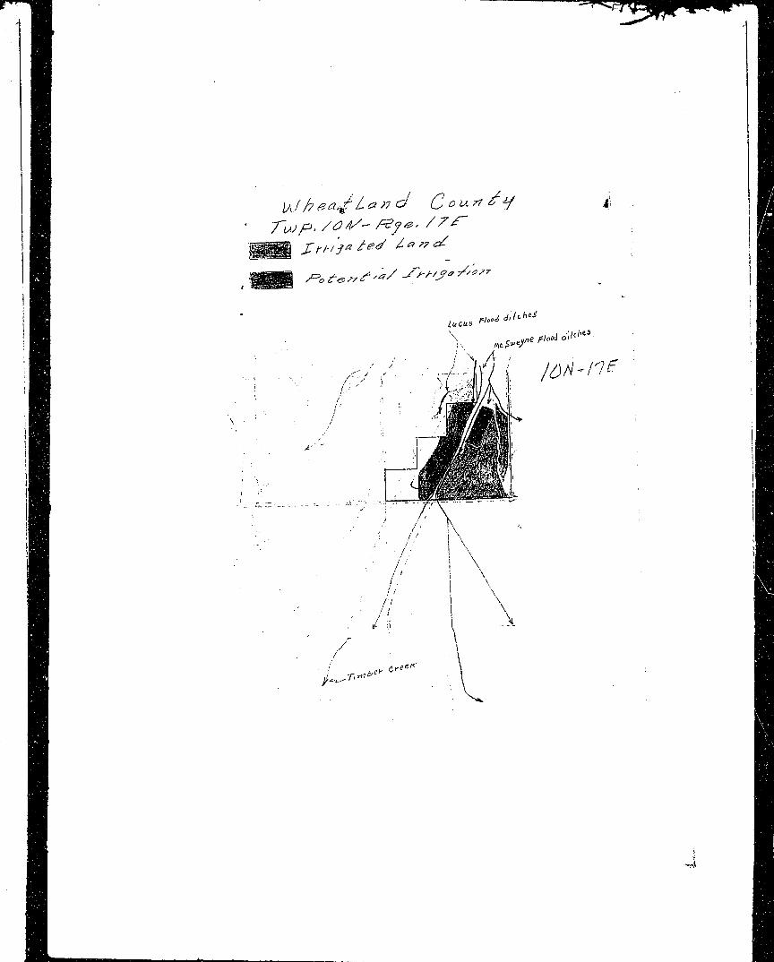
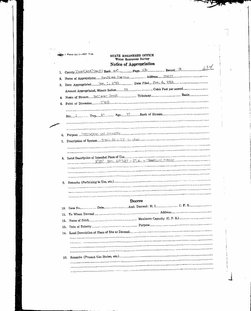
jH 234 Benjamin Charmnn Galloway'Creek E-.'-SEf Ssc. 4 in 10-1.7 11-1-11 11-6-11 SO J
j ^ H 235 Lolo Chapmar. Living Swings •T.JiSV.'-.j- Sec. 29. in 10-17 11-1-11 11-6-11 80
i H H ?- 6 Richard Charman Onllovrav Creek vr'y5'.'.'v, V!-.!,-53v,SEvSE:1 Sec.
• • 2?? ir>. in-17 5-16-12 5-21-12 160
| fijB 237 Richard Chapman Gr.Uowav "-reek V?£ Sec. 28 in 10-17 7-6-lb 2-27-23 200 |
' HS 239 James W. Lambert Oall-vifiy Creek Sac. 27 £: 28 in 10-17 6-10-37 11-6-39 100 iH | 243 Phi l ip I . Moule Gallov.-iv CreeV. SwSK-.i- Sec. 29. IKv . NEissi
JB ' Sec. 32 in 10-0 7 6-10-87 3-?.6-S9 100: ^ H 303 Philip I . MouTe U\dr,^ Snrinr.' CT. SWVS'IT Sec. 28. S-?.ST:-.' S°f:. jH | " 29, ':&'• 32 in 3.0-17 6-10-87 3-26-39 100 :
jffl . . . :MM 445 Henry Brovm Timber "reek n^-iv!,S?:-:-ir.'f,HE-;-3'.:- Sec. jM B 12 in 10-J.7 3-2-09 3-^-09 4.00
HI M 9 '-h.?.R. 53. Evans, T-.ots 3 ,4 , 5-rM* Sec . 2 , -9 -17 >| H | J enn ie !in.ll & SE-.kiW-' Sec. 34, If/I* Sec . 26 • Iifli 'Aoht. Hood Timbei- Creek ir. "iO-17 6-20-08 7-20-08 500 |
'B^B '< i ^ B 450 V.'arren & !!r>ro].'l S .-lffi-:--, SK:;-3Vh'- " a c . 26, N-VNVi- • Jljg| Evans Timber Creak Soc. 35 in 10-17 6-1-07 12-23-10 400 .. Iif^^H -i^B 453 0-.-a A. Griffith Timber Creek 1-IE Svlf, SVhVSV;-.'- SRC. 27 in " >.; H | 10-17 2-9-21 2-11-21 120{ H I 452 0-n. A; Gri^^f th Timber Cree!: IIE^SVK-, S;>.':"VV Sec . 27 i n iJB ' 10-17 2-9-21 2-11-21 120
| H 453 .Termie i :all and Lots 3 « 4 , S-'.-K.-. : Sec. 2^ H Robert, liood Timber Creek in 9-17;Sin6tt,'S-?,-3S-?:,Sii^5Si-HI S?;;1^.- Sec. 34, Wri- Sec. 26H | in 10-17 6-20-03 5-25-11 500 '
JH //jg Hnr^iret LP.v.Tenr-e Ti-ber Creek Uv Sec. 12 in 10-17 5-29-12 6-3-12 320
JH 459 Ar.na !•:. Lilloy Timber Creek I'j-.M'IEv Sec. 26 in 10-17 6-30-11 3-29-12 30
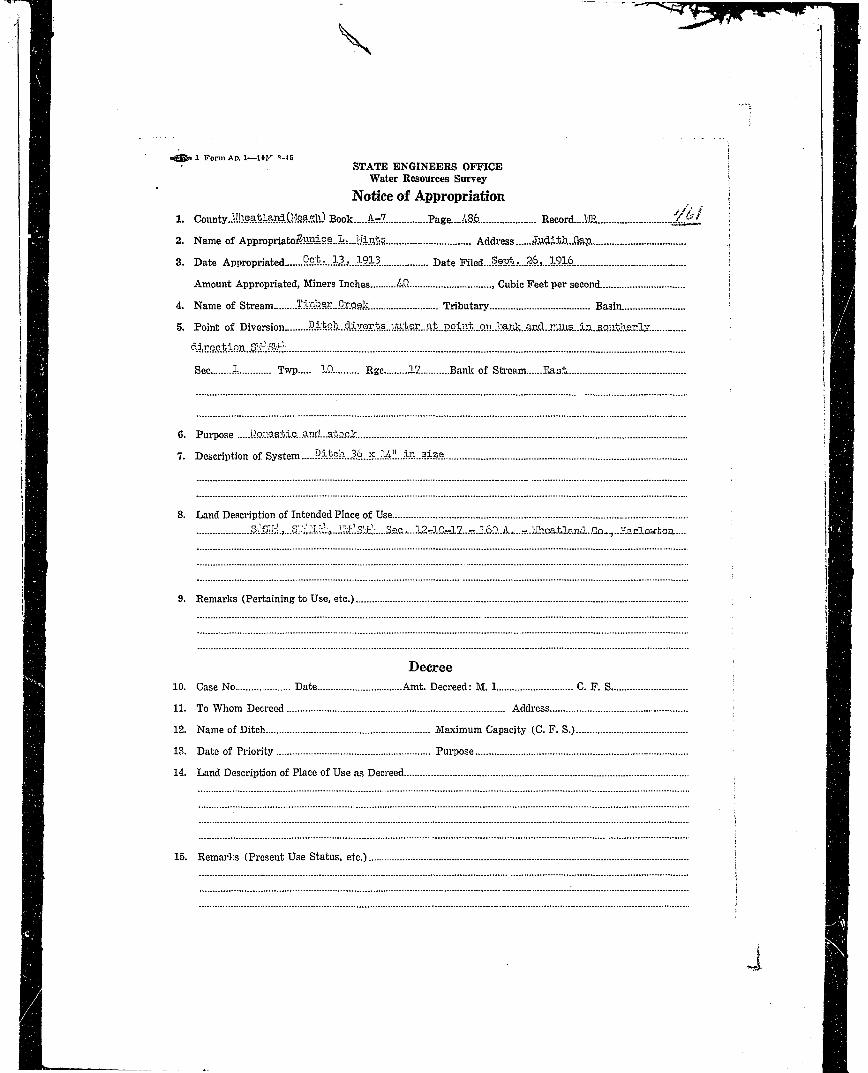
HI 461 Sun"ce L. Mouts*1 Timber Creek SASwv.S'-'inf'-jIK^SVH: Sec.^ H 12 in 10-17 10-13-13 9-6-16 40 •
^ H 462 Philir; I . "oiO.(i Ti l ler Creek S-'/SJhV Sec. 29, SilySWi Sec. •:;•.• • ' 2S, lIEi.ffi-'-SE-;;- Sec. 32 in ::'i•H 10-17 6-10-87 2-11-39 320 '.'

M B Date Date Miners
BJ Cede Hame Stream. JiSadJiesoriotion A-corop. Filed Inches •'
| H A32 Wim'm D. SrfRil Unnamed S+.raan D.'i Sep.. 2fi i-: 10-17^ 4-1890 l -H-91 j' lOOj
•H 2113 Sva.is, :'oo'l ft Hal3 Tinber Cresl: Lots T,A,3^r?,if Sec. 2-9-17; 6-20-38 5-25-11 500:flj[ Meatrher E-?.S;>:-,o".;>SR:K3I/';S'..'-;- Sec. 3i,tn-!:r 26 in 10-17 ;
H H A;ipropri;it5 ons in ?N., Spre. 17E
B8K 2^5' Clarence R. Stone G«Mo\m-'Cv. \iW- Sen. L ir. 9-17 87l-10 9-12-10 160 ;
j H | 265 VJ. A. Hefl oE Kodfjas Creek SU-J/Hl!-;- Sec. ?. in 9-17 6-^-02 10-3.6-90_? 60 ;
\ |M AA97' Cha-. B. Evnnn, r.,oi;F. 3 , i , S^i^ Sec. 2 \: Hi .Tonnr'.e Hall & in 9-17: SK-;;SVh; Sec. ?4, ' • ji H E P.obt licod Tin'ne:- f-.rfr.5V ir.v-'.- Sat-..- 2b in 10-17 6-20-08 7-20-08 500 '• j9B £53 ^ Jcnnio Hall and I' • | Robt. Hood T.lnibcr CreoTc Lot-, 3 I: L, o-'if'-'- Sec. 2 . :9 | in r)-17; E^E:1-, S'4SE - Sec. ;
j H B ' U, S:::-S'i-V Sec. 3i, F,-!v- Sec. I• ^ B 26 in 10-17 6-20-08 5-25-11 500 tj, H 467 'JloTcr.ce ?.. Stone 3 i r Timber Cvaa)' V iEO-, Vlv-SK-;- Sec. A in 9-17 5-1-03 /,,-23-OB 600 ,
'BBSI>B9B .
• • 9 '
••Hi

• • • t-r; • -r- • - v / f „„„,.,. M u m „„.,..,.„ _«fa,BE Ch JZA-.M8* 3ir3-z<ZirB J | M
r • STATE OF MONTANA CQ-.TX<,J?l§J-J2£>z£'>Asl&&:<?f®
H B y . ^ - _ ^ S T A T E E N G | N E E R S OFFICE cou ^ c ^ ^ / ^ _ _MB Area WATER RESOURCES SURVEY T—.l£M.R.—J-2JL-S<x.Jtz^Z.2
•B M ° /£• - 7 - <-,' i- Photo No.—^L-l'T- 7
H H Legal Land Own-r //2 _<£LJy..a,l n ,- 'Li-CjiJ^t -Address—UA^ILI.L '^-JJ~
j H| Operator— "lHaJ-LtLJzXJr . /d£-£Jj£J!L.'s-C\- Address 'J. |
i 99 •' B H j Water is delivered by: \
'• ^ H Federal Project . P r e s P o t |
i H Ditch Company . P r e s F o t ;
; H Irrigation District • P r E S P o t i
ijj Private System_i^i P res -3 ° a Pot jI^H Totals.
H |^ H FlnnH / - -^ Pump Reservoir Gra.ity—i«==
^ H Sue and Capacity, Pump, etc •
ifl|H Original Appropriator, Company App. No
H Origbal Appropriator, fthmte—^2L-_£3.J . App. TSb^^jg&£L£&g6^j^H Is the system an extension ot another system? Yes __.No £ 34- 3 O f- f £ i(-2.41 ;
i MM y rf - y s 3 - ^ // /1 y s i '!^H| Is all land irrigated .\u.n one system? Yes No ,y ^- q _ ;^ ^ H | (If No, show break down on map) ;H H ,-\ i . , ., . . . / .. ••» . . . . . . ' ,--.- , • A -
|BH Acres Irrigated 19_i_;_. 1-— ! \ | i \H B ] I i | iH H j Potential Acrc-s Seeped | \J> J? ^> \ i •
H9| Condition of System :*—•——• /} ~t~ •~r /•] /~> / , ' \'~~ ,• \ \ '•
B H J Adequate Supply ....— .. Yes No—/.-•?::—• i = | ! •
H Taxripin •-'-• /•? • -•<•-; ~—--'•:. --. t--..-'-.-.- i-s&r • ( . .,.i Md A Z3?.. ..J .. j . ''BH •' • j /57j / r 7 1 j •" i• J B Topography i j j | ':
H /,. . • - I ! 1 ! IB H J Information ^ o m •*/-' ' '— '—'~-- • — I i i j •BH i j. j _...j __.... !•Bl Remarks. : i | \ \ t

| H «^»- "•' •-' • «>"" "•••»'•" STATE OF MONTANA \
j B STATE ENGINEER'S OFFICE| H WATER RESOURCES SURVEY
jH Tov/nshi\>....Sc?.A?acJA Range.../Z/£ County...ii/A&Au£/..<^.O..^... ••
j Sgt | 6 I I & | | '—% j i-yA —I a I | i ! ; j
' H l [ j I j I | [ | | j _ I H I | i | : i
j | H | i i I i j j ^ } I i]o ] I •• 4 } ^ 1 1 | ; •
;Bg i 1 \ i \ \ j i I i \ I 1 1..- . .1- s j i
W B I l g I I I f j j 1J6 | I lp j j 1J4 ! | -148 1 :
i ^ B j j j \ \ L _ __4 \ i j i i L _ i j i ;1 J • • ] ! ! j I I I t :; • ! i I j ! j t i i> • • j l p i i 2b j 1 2ft •- -• 2B 1 1 2]a- j \ 214 } ;i H H ! I i i ; i j s } \ i | I i i •
WM !•• 3jO i i -Zp i j 2 8 - ••"$ 2lf 1 2 6 I -2J5 i :
M | | j j | .. \. I A '_ .. _.A I I I 1 1 i !
• H \ ; | i |/i b;.; I j | f i..7..j j j I i [ ; [
^H ^!...cZfcr.a./:'^r./2.«J.. |
n^B 5
Om Township..../^.../^ Range.../Z^£. ;

^ ^ B < \ ; ••• ••
^ ^ ^ B Farm Checked FORM F-I REPORTER JM 3.49 17390 ^ ^ H ^
H B STATE OF MONTANA r ^ . M, £fj ?2;jZ*Z£f :
H r State €Hti*ee?\& OU'icc C^-^&J^*/«,«<*HB ~ WATER RESOURCES SURVEY T. /<3/»_R.._Z£—Sec. K ? / . ^ . - ? O :
M B Date— , Photo No
• J H Legal Lond i>.fnrr / ^ ^ /^/p^A//?. Sr~//?j&s~ / P A^r... A/*'s/?a> r5*sjs~;/-//?r-?^ _ _ ^ -^ j - ^
^ | H Operator 2 . l i _ Address
! |^H Water Is delivered by:
! ^Xm Federal Project Pres Pot
! HH | Ditch Company Pres Pot
^ ^ B Irrigation District Pres Pot
, Hfl| Private System Pres Pot
^ H | Totals
! ^^B Flood- Pump Reservoir Gravity
^ ^ ^ K Size and Capacity, Pump, etc
H^B Original Appropriator, Company App. No
•^H Original Appropriator, Private App. M" •£ >
iflR^ ^ H Is the system an extension of another system? Yes No
^ ^ H Is all land Irrigated from one system? Yes No
|MB (If No, show break down on map)
iHH Source of Water_ •
^ ^ B — • — — i i • [ i i
BBJI Acres Irrigated 19 , — , \ i : i
• H H Potential Acres Seeped • i l l '
BVJj Explain _ ^ „ _ : i ; i
H^B Condition of System V " ) f t
| H Adequate Supply Yes No j ^ ^ A 'z^jW< ?^ j
H Explain [ b%2£._j L._..l£!f.^ H | Topography - : ; ; :
|HH Information From • • \ \ ;
^^^H Remarks_____ , .........i™...... i 1 j . ;'.

flffi .©(=",...,.««,«,.....«.•.., STATE OF MONTANA ! | H
• STATE ENGINEERS OFFICE j Iflfl WATER RESOURCES SURVEY \ ^ B
B B Township /^.<?.^.. Range....ZZ<f County...^4£,?£/&„&?_ \ B BI S 9 B I i i i I f • I | i i I ! I i I i i i j ! I I | i I ^ ^ |! ^ K j | j ; | I | | ' j ! i | : i ; i j • ^ H
i fi9 | 4 | I- i 1 1 4 1 3 i I i i j i { • I flfl
i HB I ! i i i i j i i I I I i i i i j I BB! J| | 7 — j — , j i I { 9 { ? i-p I I- •& i f ifa t : i BBI • & • \-~A i i i I i \ } ' i I i i i i i i . BB
B B i | j ! | i [ I I j j [ j I I [ ! [ \ 9 H
HI i i£ \ I ijr I j a); I j is I j iji j I -i|» \ ! B |
||^^H i I : ! ! t t j i : ! ! ! i f I : HflH
iBB 1 19 i !••• 2b i -x 2 1 1 ! 2 2 > !•• -2J3 i 1 2J4 !• l !BHIjgj | | ) ) ..% j ; ! j | j ] j j ! ; ; • W m
M ^ B I B 1 1 ' • ' i i i ; : ; • • • j ' H ^ ^ H I
M H i I 3p^-i j 2p | 1 2j8 i | 2|r j 26 j 4p \ [ H |
JBBM • I I j I I- I | I I | i I I i i \ { ] .; 8 HB H I 3|L I I 3^ \ i 3J3 ! 1 3k | ! -3J5 j 1 3'6 ] i B BS S j | | ! i ! \ \ i ! i j.. \ \ \ . \ • B BI ^ H ^ I r : : • i : : ; : : . : • • \ \ < H H B^•^H i : : . ' : ' • . : : : • : • ' : ' . ' . . r ' flfl^B
B H Tov/nshij>...j/.t?./%f. Kange /..Z/*T.. ; flfl

E B • > i^B
^^^B Farm Checked FORM F-I REPORTER IM 3>AO 17300 < 4 ^ ^ i ^^^H
B B STATE OF MONTANA ^ M, Jrjp/Zfsrf.&t \ •
H H A r e a WATER RESOURCES SURVEY T. / ^ ^ " R-^1Z—Sec.-g?-^.? V3" j H H
flBl Dote Photo No ! H H
SH Legal Land Owner M S? /?. /R / * * /ty- Z^" /*<&s*?. /F/m&r ,*p KAA.«** s£/f//7,'> JL?*>r~;r?a.? \ ^^M
^Kt Operator A ^ . » " ; : •, ^ ^ H
BH Water is delivered by: '. ^ H
i ^ H Federal Project Pres Pot i HH
•H • ' \ 8 S( | ^ W Ditch Company Pres Pot i ! ^^H; ^ B | Irrigation District Pres Pot , BBS
' B H ' '• ' 9HJ; H H H Private System _Pres -Pot '•• j jBHB
i IH fB\ • • • Totals ;' ; B |
BHI '' ' HBH
I BtB Flood Pump Reservoir Gravity ;: I • • ] •
R p B Size and Capacity, Pump, etc • ROB
• H B Original Appropriator, Company App. No ' H H BpSfl Original Appropriator, Private App. Mr. S7~ •'/• S"/- -^" jgg ••, | | B J BH H J j -: ' f l H H
{•JHJ Is the system an extension of another system? Yes No ; iBflBH B V IS all land irrigated from one system? Yes . No , . ' H H Jj S C K (If No, show break down on map) '• JHBM
iBi - ' • •jBHM Source of Water : i f l f l i
• B H Acres Irrigated 19 , I : ; ; H H B
• H j l Potential Acres Seeped j ' j : i •/ B B I
B | Explain ! i j i :.: MM
B9J Condition of System ': ~ 1 1 T '•. | ^ B |
H I . c , , '< S-T"<2<&. /?'iC£tZl*?<f><.>a! i Hi•D Adequate Supply Yes No ____!——— — _ i • ! . HHi• I j : • • • •.' B B B
BSJ Explain | &'!b®. 1 ' '' ' '''Vf'"'ft % Bjpj•RH Topography : ! ; I -; B B J• H B Information From ! : ; : •: • • •
E M : i i j H HH K H Remarks . .. J. X— ^ '• • Bflv
B H I | | " I I BBJH H I I i I i I | H H

^^IH ' M HH H «&& ,„„,,„.,. ...,m\.....».i... STATE OF MONTANA j ^ H
I STATE ENGINEER'S OFFICE I B^ H WATER RESOURCES SURVEY ; B |
^ H Township /./?..iV.. Range....ZZ<£ County..&/A.e.a:.£/.G.rt.<??..... '• I | H
^ H i i i i | i I t i I I I I ! I | i I : - ^ ^ B
I 9 H I 6 j i i i 1 4 { I £ i 1 2 1 j i I ; | R j' ^ H ^ H I i : : i : I j j j • : i : j i i i ' : ^ H H H
; K L S M : I : | ; | i l l i ; j i i ; I ' l l • ; ^•^fl
I J H | i j ~T' ; "i j i ] i j i i : I j i i I ] ! ; B H j
< ' l ^ ^ l I = ! i :- • ! ! I i i ! I i 1 i : i : - ^ ^ ^ |
) Mm i i i j j j I i ] i | ; I i •; i i i ; ; • •
H H 1 1J3 i 1 1J7- | | 1JS I I l p I I -l|t I | lJ3 1 ; jj
ij^^^H ! !"' ! '•' "T ] ! ! 1 ! ! I I ! 1 T T T i ^ ^ ^ B
i ^ H ! : I { j i "ft I i j 1 1 1 I I I I { H a; • • | ll \--0 \ ip | 2|L j 2p ! j 2J3 1 1 2jl I \ ''Mm|H| ! -//iiM j j i Me-s- j ! j i i j 1 i I \ i H B
BH ! 313 i 2 9 1 2JS ] 2[7 1 j 2j6 j 1 2^5 f ; | ^ lJ/ffl I j | j j | ! AL/^.A:.i&. i j i 1 1 i : J |^ • B B ': \ '• • • ! i ! ! I i i l l ! I ! ^ H R
I H I I 3b. ! I - 3 ^ i ! 3J8—j 1 3J* ! I 3|5 j \ 36 f : ^ HH H i I ! j i . i &AXA i S i ! i M ! i '•• ; : BHHH \ \ \ I \ i i ! | i 1 \//,?.&./?., \ \ i I B
| H Township...^<S?^: Range S..7.£. j ^ B

•
|WH.B • • - STATE OF MONTANA ' £ , C o u n t y _ ^ ^ I
potter mm iM-2-<9 • _ , jnjJi*. i K, 6p..7A.l.ttA,2OA, H |LRE iTL. £***« Cngineer* Ufifice ^ ^ i i f e i l •r ^ & i 2 J ^ ^ WATER BESOUKCES SURVEY ^r^rjKT^35i,,2.K, H
i p p r Twp :.RBe:.::_i'' FARM MAP ^ ^ f ^ ! k ^ & , H., , . ••„-•!„.;.:„ p ,~n- . (:;e* ntiD..:"•.=?• Add«=* i:^.*..^;...:!..^ -m-.-f:*/;T>'™- fl|
Name of Land Ov/nor . . ^ - ' •••••' • — • " " " • „ • . ; = - , n i l I H• T K * • ' " ••--' Address BH
Name of Operator .......-- ^ _ . r ! , ^ t - - , ^ -)0 c . ' - ' T ' " ' i j - S i ;ac. . . .2.7.». .Al . l H |I'.i i 5 e n . .^'^^ :v/. J ^G.»....<vJ.$..-^-'-";"""-?-—^1*i--—'••—.•-J~.W-..^—•...*-' —..*——— ,. •••^^' i v ^ ^ H l
- H ^ e d L a n d J T ] Non-lrriBafed Lend J g Potential Land Under Exis,in3 FociHties •^^21 North ^ ^ B
/ ' */' • • CL.- ~^>i • • • I I D
V>> '" '' i fll
"-;• • : H B
N^ ^^ c i HI> / —-* ] • •
!! ; - 7 ' ••. j ! _' J i ' . M l
.,,.. .... . .._ . ^ , I ^ ^ ; n j

HHI — ' H i
^^H 77 -'.-' 'V- &•/''£ . ^ H
^ H Code \<a..<Z.S./):.j:L2/lr<Z.ZB7..-J.<SM ^zmyt'?--v-£S.^M../£&.Z.<l'.J2/..£jz/!J££.Smit<x of '+la!K<.&/£.£.£.!ir.aS/.G/.<>.a.y..£c.<S&& SH
j^H Basin _<#>.•>;.:.•: Prcsent.iiA.i,.v:. Potential.,;::;,.'.:. Max!mum..-2.S.S-..& R F.zC.P G..^..S BH
9H Code No.- ti?',. 5ystem./^r?^/^f./^.^&.«;/.?l2.ii:r.^.7.S...Source of We iT.G?.a//.e.il/:3.y...£e.e.t2&. ^ H
fl^R Bos1n...<f?^Lffli?.Z. Present..jC ?otenticl.c.3,.D. Maximum.^.iU.Q R. F.. T...'P G.ier.'...S \ ^ H
•H Code No..,5^5>. System.^.^.^i:^.^...<S^r.^.;a'^.<-j£^:-.-;.Source of Woter^^kjr^.$S«^:.v.i-?^-..iXr.£a& ; flH
j^H Basin....^i^r^_^./^^.^?...5L(fL:.f?Aji.Present..:r..T..j.'.'. Potentlal...G. Nimumim..it.3...Q. R F.^.....P. G..ife'ls j 9H
|^^l Code No System _ Source of Woter j HH
|^fl| Basin Present. Potentiol Maximum R F P G S »' Hlj
| B If under Ditch Company, Irrigation District, or Government Project, state the number of shares or inches, acre feet, as the cose may be ? WKk
^ ^ H In said sysem „ _ „ | M^ ^ ^ B NOTE: R—Denotes Regular Irrigation. F—Flood Irrigation. P—Woter diverted by means of pumping, G—Water diverted by gravity. r> ^ ^ H^•B S—Stored Water.. ^ p ^ H^ H l Information from J^7^..:..£..^S..-. Date. ^/Z/.//..j^^?l. ^ H

flj^^H Farm Checked ' FORM F*I REPORTER IM 3-4B i7aao H 9 ^ :.
• B E STATE OF MONTANA codeNo_^££ !
H By' £ t a t e engineer \s Office r,,m.Y „;/•,*.«./•/* ,>,<* \H | Are° WATER BESOUHCES SURVEY T—<? MR. I7E Sec—2.
| H Dote . Ph»MMn/*/<4-y — V ^ * ;
^ H | Legal Land n*n»r /V^ / i /VU~ • Address ;
j HH Operator / • / • S C , / V r - 3 I /"> . / > /"#S. A^r.« / / • •' r> £> Sp rift at
i HH Water is delivered by:
j B H Federal Pro|ect Pres Pot j
; H^B Ditch Company Pres Pot I
i B Irrigation District Pres Pot
j H ^ B • Private System Pres -Pot j
. jBHB Totals
j H^9 Flood Pump Reservoir Gravity !
HJ9 Size and Capacity, Pump, etc
^ ^ ^ J Original Appropriator, Company t App. No
i HH Original Appropriator, Private App. Kin /re *') &- : I
HJ^V 's *n e system an extension of another system? Yes No : j
JI^HH IS oil land irrigated from one system? Yes- No • j
H H . :/ ' 1t^HB (If No, show break down on map)|Hfl| Source of Water : j
H H ~~~ " i i j i ,;^HJ Acres Irrigated 19 , : 1 ! -y -? ' ''•
HjB Potential Acres Seeped '; j i ;
j ^ ^ ^ l Explain ; ; i : '
HjB Condition of System '•" " '• 1 T
H^H Adequate Supply Yes No j j *""? ! '• ..:
gj Explain i ! I ! * S "4 U i t t a i "
B^H Topography _ _ _ ^ _ _ _ ^ _ ^ _ _ _ _ ^ _ _ - _ : \ \ \ :;
H^B Information Frnm 1 ! j j £
^ ^ ^ B Remarks . . I , j . X i .'
^ B . "'•''- >-•••••; 'i
HHk»«_ _—. .—,—.—

HnHtti
MM ••—-•.. . ... . ^
1 H B ' i'/ ••
^HH Form Checked ' ' ' * * FORM F>I REPORTER IM 3.4s :7aso ^ f f ^ ;
H STATE OF MONTANA CodeNo._2J3 ]
H By gtate fittjtiHeer'j Office couniy u^^&ay/^^d j^ H Are° WATER RESOURCES SURVEY iSJL-S.JLZJLset.-2. 1
H H Date Phn^ un / * / 4 - 9 — fr^ ;
^ H J Ugal Land rv..—r A/ -- '^* /^'•a. / /7 • t~> r t> $ A^r»« A. / 1// r> G S/->/*• I Da S \
HH Operator Address
• H Water Is delivered by:
j • H Federal Project Pres Pot I
1HH '! H^B Ditch Company - - Pres Pot • I
'; ^ ^ H Irrigation District Pres Pot _ _ _ \
• HH Private System Pres Pot . •
• Hflj ^Totals :
j ^ l ^ | Flood • - Pump Reservoir- Gravity— - ^ — ;
^ H H H Size and Cauaciry, Pump, etc , - — —— . .
H^B Original Approprlator, Company — • —App. No . ;
•B Original Appropriator, Private ; App. No, V^?' */.•$3 -Z±> 1 'Ae»j< • |
iflHj A.*?- - ; jjHJK Is the system an extension of another system? Yes No '. j
< H M ' )!HH| Is all land Irrigated from one system? Yes No ;, |
' I ^ ^ H (If No, show break down on map) * \
|HHj Source of Water ,'. !
HHJ Acres Irrigated 19 , - 1 1 i
HJB Potential Acres - Seeped ' j j i j
^HH Explain . • : /_p i I
^ • ^ H Condition Qf System — — ' ] 1 ' "; T ;•
HH Adequate Supply Yes No 1 j ••• j , f J i - I !;
| H Explain j I ^ I i ••«k:ifi i'
^ ^ ^ H Topography . _ _ ^ _ _ ; ; \ \ }
^ | ^ B Information From- - • • \ : :;
^ ^ ^ K Remarks - , ———^___^. .L , i. j . J. „.„ • •> ; '
•B ] 1 1 1 I

H - ^ / i - / •-. . / ^ "•"»'"• ««.«..»•..-» -S3*^ ^ H Farm Checked , ,• • STATE OF MONTANA Code No.-^/? ~
H B y ^z_^- STATE ENGINEERS OFFICE ^ ^ i ^ WHB Area WATER RESOURCES SURVEY T. 2_R._£Z£Lsec ._3^
H | n.«. / .4 - 7 - W Photo No g - *"7
B H Legal Land Owner, f¥f r sf^.A^t-//._C Q rp • -^ f\i Hi- M~ ("t bra, i/I AHrirre;: ^/y/rtj,—.JT/O cJ.gj^JL j
j j ^ H j Operator ' A"*,* / / a . /-i d .A'/.- <C.Z>'jXJ..Ir> Address. '. ' j
: Ml; BM Water is delivered by: >
i HB Federal Project . Pros Pol ! ;
i ^ ^ H Ditch Company. . Pres Pot : ;
|BH IrrigationJ3istr1cl_ Pres Pot ; !
: j ^ H Private System ' , Pres—.(2 Pot. ^ w i . . j
{ •Hn . Totals j
j ^ ^ H Flood—I^L Pump P.cservoir Gravity../ " .—. i
^ ^ B Size and Capacity, Pump, etc- —
iflH Original Appropriator, Company App. No
Ij^H Original Appropriator, Private App. Noj£j£fey~ "r #L-f— •
l^^^B Is the system an extension of another system? Ye& .-— No_. :
! ^^H Is all land irrigated from one system? Yes No_ i )^ ^ H | (If No, show break down on map) j
H Acres Irrigated 19 « I'., C>_ _ _ j \ j j.
• • H Potential Acres J..-.i.:^~ Seeped , 1 1 1 !
^ ^ B Condition of System. .J^iCC—^Lz -IStZ-L- ••:•••• Us. ! I | | !
| ^ B Adequate Supply ...-—... Yes No—C~~^-- j j JfK. I ~7""\ i
•^^^^^ Topography , ^ - -————.^————^__ i s i !
^ B • •. • s .-. ,••' , — | 1 i 1 — :
Hi Information ^ ^ m / ' • •' •' • - • / .--' ''. - - • » - • • • - • • > . | I I I j
^ ^ H Remarks . ! j j \ |
HV _ . ^ I i 1—i—' ' •'•• 1
I ;

HH ^ g t l FormAp. 1—10?' t-45 ;
H H ' STATE ENGINEERS OFFICE ' :^ H Water Resources Survey •
HR Notice of Appropriation ^ \H R 1. County.il!mt.te.™l(.L:SS£hj Book..k--7. Page...i£8 Record....WIi -~™zL. i i
| ^ R 2. Name of Appropriator. .\fe_JL....7.c>r.dli2d Address ....airilth..2ap \
BJ 3. Date Appropriated.....!™.?..13.*..IDX?, Date Filed.... Asr.il..l^^..l.?ja |
BB Amount Appropriated, Miners Inches.-lQ.O. , Cubic Feet per second !
^ H 4. Name of Stream ?.ast.3?l'A-;.e..Qrfisl:^ Tributary Basin ; !
I H | 5.. Point of Diversion 5AiP.!l..c!i7a^>J5...Y.^^^^ : !
i ^ H J .....V.r:';.5.fe..fe.9.u..."?x.hlivS.5J:..^ar.r.sr-./.\n I
', BB Sec .3.0. Twp 12 Ege 17. Bank of Stream....:.^,.-* '
' HI 'i H H ii B H 6. Purpose ...li:ri.r.?.:;i.^-:J...3lc-.*
j ^ H 7. Description of System I;i!is!;..l6.."..^!L..l^..5:.S^. j
^HB »
^ H 8. Land Description of Intended Place of Use jH H .5.£..-..;&.?...iA..3.as.....??-:,?.ri::..-..:.;::.^.«.:::^L...1o...,..."arlay£an ,
•HV
'HH : '• • j 9- Remarks (Pertaining to Use, etc.) |
jHj
Jgg DecreeH H 10. Case No Date Amt. Decreed: M. I C. F. S
^ H 11. To Whom Decreed Address :
ID 12. Name of Ditch Maximum Capacity (C. F. S.)
B H 13. Date of Priority Purpose ;
H H 14. Land Description of Place of Use as Decreed •
H B 15. Remarks (Present Use Status, etc.) \
B • ^» i romAp. i - ioy «-4» STATE ENGINEERS OFFICE ',H H Water Resources Survey ;
H Notice of Appropriation , \
H l. Countyi^S^l^-^S:*:) Book...fVrZ Page-M*?. Record...... •-£*• - \
H 2. Name of Appropriate* J>2nJ±:m3i.£ha::^n Address " ih i l l j
• 3. Date Appropriated JM.JU. im Date Filed M-USSi :
H Amount Appropriated, Miners Inches B,Q. Cubic Feet per second
B 4. Name of Stream SaUo^.Oree^ Tributary Basin •
j mm 5. Point of Diversion S].Svi ; [
i H !' ^^^H " i! jH S e c i Twp 1?: Rge 1.7. Bank of Stream \ [
< M B 6. Purpose ...Ir.r.lsii.ri;...^..1--•f;"':;"''-'ia j
1 H H 7. Description of System DJ.tci..2-V-~--l.'i1i...:.i:..s.i3S
i^SB|
ISH 8 Land Description of Intended Place of Use •••B s'-ss1- Soc 4 - n - i 7 - C^..AA..-.:iMa-i.i.S!:4..r:™J?^: j
I ^ B 9. Remarks (Pertaining to Use, etc.) jjHHH| '
^HJ I
H | Decree• 10. Case No Date Amt. Decreed: M. I C. F. S ,
H 11. To Whom Decreed Address j
H 12. Name of Ditch Maximum Capacity (C. F. S.)
| H 13. Date of Priority Purpose j
[H 14. Land Description of Place of Use as Decreed ;
^^M i
H H i iHI 15. Remarks (Present Use Status, etc.) \
HH^B —.........—•-"-——••-"--••-••"••••" [
^ ^ H i

H B ' <<3$» 1 Form Ap. 1—10&' «-45 ' ! ••X - STATE ENGINEERS OFFICE j '[HE Water Resources Survey
^fl Notice of Appropriation |HH 1. County.ilhnat3.MclLl.'sa.d-0 Book...A-7. Page....43.7. Record....'-Ui •^>-~-*""
jH 2. Name of Appropriator .Lola.C.hsmm Address I J i M l l \
H 8. Date Appropriated :,-5.Y.....l.,..l?.ll Date Filed Hm*..k,..2-S&> \ \
H M Amount Appropriated, Miners Inches .SQ , Cubic Feet per second ;
^ H 4. Name o£ Stream..3.al?..o.";!;ai:..."...Li:.ri.T.~...;vrr.;.n.r^ Tributary Basin
I H H 5. Point of Diversion .ITJj.SJi \
! H | Sec 32 T\vp....lQ Rge...i.l Bank of Stream
i ^8
!^H 6. Purpose Irr}j^;.R.-.aT)a.ahho;?
; H B 7. Description of System ...li±&..M.^..lS}lJ^..zXzs.,...z^z±::s..2..a£v£Ssj^:..s!L:^<iZ; BBS
HJ 8. Land Description of Intended Place of Usej U H '.T.J.la'.l.1 SQC-..2a=,llrl2...rr..iO..i-...T-..^...;.:....A;2:a^aiar.iirdj.::..:i^ia7S_.:i:^vh.... ':[MB
'B^R|Bfl 9. Remarks (Pe'.-taining to Use, etc.)
JIHHB9 _ _ _ _ mm . . . . . , . » _ „ i
• H DecreeB B j 10. Case No Date Amt. Decreed: M. I C. F. S
•H 11. To Whom Decreed Address
^ H 12. Name of Ditch Maximum Capacity (C. F. S.)
H B 13. Date of Priority Purpose
B M 14. Land Description of Place of Use as Decreed '.
HHJ iHfl 15. Remarks (Present Use Status, etc.) , t
• H iH J i^Hj i

fl^l ' «S©» 1 Form AP. 1—10j>' «-45B | ' STATE ENGINEERS OFFICE^ 1 1 Water Resources Survey '.
H | Notice of Appropriation j•H 1. County.i/iiea.tlaac!.(,"eagb.) Book..A-l ?atfe....£5".:...., Record....".!?. *J£J~Z~ [
H H 2. Name of Appropriator M^Qrd.SZmmn. Address ."AMU I
•H 3. Date Appropriated :^::..l±±.10±Z Date Filed •M'..Si,tJ,Dl^ ;
•H Amount Appropriated, Miners Inches .l60. , Cubic Feet per second
^ H 4. Name of Stream....;i%}.lQj;3;z..:]r.c.air. Tributary Basin
! • • 5. Point of Diveiision.....'.l ...cMfi..sacii..a?...;.ri;.'....cinr.uaEi ^aHi H H1 ^ H Sec ?£. Twp 1Q Rge L7. Bank of Stream....:^ar.t
i ^ ^ ^ H • ••
• m | 6. Purpose ^"S.i^.n-T^
i B H 7. Description of System 3J.S.c.':...l':,.:.:..l.?.'.l...in..s.lac
^DB 8. Land Description of Intended Place of Use< ^ H | !nv..3™......^c.a_...2£l™13jTiZ.m.i:!..t....m.:^
^ ^ H V.',""1 S?7j. ">"1-19-J.7 - f'° i.. - " " " " "•B SI;1O-:....S.;.5.A..ZW.:1T1V..-.A1.1...._....» « •;. :'. II
i H B 9. Remarks (Pertaining to Use, etc.)
S H Decree•H 10. Caf,e No Date Amt. Decreed: M. I C. F. S
^tm 11- "'o Whom Decreed Address
BH 12. Niimp of Ditch Maximum Capacity (C. F. S.)
BB 13. Date of Priority Pui-pose
•H 14. Land Description of Place of Use as Decreed
H H 15. Remarks (Present Use Status, etc.) •

V 9 ' aSSJe 1 Form AP. 1—10y °-45 ; BflMM ' STATE ENGINEERS OFFICE \ BflBH Water Resources Survey • H H
MB Notice of Appropriation i HIH I 1. County ••/hsatland Book...U Pag<s....Z1~7..'? i*ecord....'.fll £A2~ I | H
H H 2. Name of Appropriator...SJ.c:hard..Ghapi:an Address h},Y.inz3.nzixi?;s.y..;.'.Qnk ! JB
fl| 3. Date Appropriated :M:L.9.,...l?.lk Date Filed.XQh....2.7....1223 | Hj
H H Amount Appropriated, Miners Inches SDD.. , Cubic Feet per second I ^ H^ B 4. Name of Stream .?all?:;aT.r;r.eo;C. Tributary Basin ! H H
I • • 5. Point of Diveraion..M£eii.£irar.i5..i-v£or..Ai.^ : i H E
I mm Sec 2-1. Twp .13 Bge 11 Bank of Stream...:.Jaflt | | H
, BHJ j ^ HB | 6. Purpose Ixxi:sid.n:z...sd^ ^ K
• M l 7. Description of System Dlksh.lL.^.Sltt! ; • •
H f l 8. Land Description of Intended Place of Use ' B H• H Ijj:' 5.r.<:., .?.2.T1.0.T:1'7...~. lto..A.....r:..L.vni.. ..liSlua.-ln,...L.-i.v4.i-!."-...'?.v)r.;i,;i=s ..i.'.-.nt,.... iflB'[BH ilHB
;BB I jJHjBjBJ 9. Remarks (Pertaining to Use, etc.) ' S |
|BB • i SB
mill Decree H• B l 10. Case No Date Amt. Decreed: M. I C. F. S | H
| B B 11. To Whom Decreed Address ; HHj
B H 12. Name of Ditch Maximum Capacity (C. F. S.) B H
B H 13. Date of Priority Purpose H H
H H 14. Land Description of Place of Use as Decreed | H J
H H 15. Remarks (Present Use Status, etc.) ; K B

•••I ' ' " * > ••H
• • •iFtanAP.i-icw. STATE ENGINEERS OFFICE / \ IH | Water Resources Survey j H I
H Notice of Appropriation j H |H 1. County^sailanjlLUaasJa) Book...4-Z Pag3....25 Record...^ - di£l~. \ H |
•H 2. Name of Appropriator...JaT.S3..3I....'L3n!?.EE.v. Address ....E&3, j ^ B
H 3. Date Appropriated Jj.ins.-l'Vl&a Date Filed l:M:^A,..l?i29. j | H
j H Amount Appropriated, Miners Inches 2DD. , Cubic Feet per second • j H
[ H 4. Name of Stream .QallaKaz.^jr.as.'i Tributary .... Basin | Hj
| H S. Point of Diversion Lta^..£&ps..atacx;i..ar_.=i-}^^^^ ': H
j m i Sec 5f: Twp 2Si Rge 17. Bank of Stream .lli:M. I j J g
' H H 6. Purpose Irxiss-tl^rv i ' j ^ B
• ^ H 7. Description of System D.iteL.l"..z..!3!'....*.rL.siza. JSfm
iHH iHH'Hi 'IH! H 8. Land Description of Intended Place of Use 'BH
: H '•* ~' •"•""" "• > • •|HHJ T>_T_'>_T_7 - 6i.O jk_ " : i H H ljRH """ IHH| | H 9. Remarks (Pei-taining to Use, etc.) ^ B H
^^B SBM
| B Decree HBfl| 10. Case No Date Amt. Decreed: M. I C. F. S : JBt
IHf 11. To Whom Decreed Address | H I
MB 12. Name of Ditch Maximum Capacity (C. F. S.) j H j
H 13. Date of Priority Purpose ; H |
B H 14. Land Description of Place of Use as Decreed i ^ H
| H 15. Remarks (Present Use Status, etc.) j J g
H i ^ |^ ^ ^ H ^^HB

J B i! Warn
Hi Sec. -57-10-17 -Mm. ''cZlyain, Livin- Springs, V.onl. - oO A. | 8 M| H IT. 7". lUilrcaci - 560 A. j WUB
^H i HB' ^ H Sef 2"-l^-lV - Carsloss Ores:: Land ."- Livostock .'o., ,J F-arncord, "arlovrton, .W A. | n! MB ' " "" '.tra. t'oEl-ja?.-.!, Livinr Springs, "ont. -U0 A. H B! flfl \fc,. "• ;:. !.:. : 'cElv.iin, L5-vin:- Springs, ""ont. 160 A. i ^ H
' Hi ; HB
i ^ H ' ' ' '> ^ H B
^ .. » Hs^Li

H H ' o^$» 1 Form Ap. 1—10?' S-15 ! BJM J ' STATE ENGINEERS OFFICE ; B^ H Water Resources Survey i IJ
| H Notice of Appropriation • H• • 1. County...iIh3a*liin(3.(i:Ra^j)Book..A^ Page.-.lfeT. Record....\!B. idL~ \ B
aMm 2. Name of Appropriator Zail.l:;:...4.-...j.;9.ul.(j. Address ...S.SE.caSJ. i ^M
^ B 3. Date Appropriated.... J\ms..10i..1837 D a t e Filed ;Jar....3ik,...?:2?9 j H
I^B Amount Appropriated, Miners Inches 129. , Cubic Feet per second i B H
J HflB 4. Name of Strcam....:Aallsi;si:..3s.fiHft Tributary Basin i ! MB
B j 5. Point of T)iv^^on...J^^^.:^1..5^^?^..^.^::^A:l.^S..S^ i | H
: B B S e c -^" TwP ~- Rse 17- Bank of Stream....i;.ast; \ ! H
1 H 6. Purpose Irri^atlOTi H j
j H B 7. Description of System JAlhr;].L.4'.".1..^.J.Q...V-1.ah.Q,':...!.r...;7:..^a j H
i ^ H | 8. Land Description of Intended Place of Use ! ^ |^ ^ H .x.;.l(E-.: SaC......TArl0-?/;L.-...'.V.\..i.....n..;^XQl.Q~.r..rir....L..^..L..2.O...,.^ 1 ^ 1HflW :"•'-' n in nv lAi ,\ _ ii ii ii ii ii ;HBHH| iiW- i:.-.~^.-.rrf-.!...T...-!-.9..:..^.:.~ IBM
' ! • • ',!"?. "arncorcl, "arlovrtor. ' 'HB{ •B ; BBi ^ H 9. Remarks (Pertaining to Use, etc.) jHj
|H | Decree H• H 10. Case No Date Amt. Decreed: M. I C. F. S j H
^ H [ •"• > ^° Whom Decreed Address ^ H
H B 12. Name of Ditch Maximum Capacity (C. F. S.) B B
| ^ B 13. Date of Priority Purpose j H
• H 14. Land Description of Place of Use as Decreed \ IjB
H H 15. Eemai'ks (Present Use Status, etc.) j BH
^^^H „ ..: i ^HH^^^H * i HH[^BH ! BH^ H i WU

^^B * '< H BH H ' ^ T > 1 Form Ap. 1—10.V '-45 : ^HJ• • ' STATE ENGINEERS OFFICE ; wMBB Water Resources Survey ! ^H
BB Notice of Appropriation j H| H 1. County.A;kQatlsr4...i::.?a:i1-^Book k-2 Page....ls£ Record.../iJ?k -M&L. j M
^ B 2. Name of App.opriatc* .?.'.;iiliP..X...J.!r.i«i.1?. Address HoMiiAl.., , j ^M
| H 3. Date Appropriated £mi.M,.JMl Date Filed ]M,...?£,...l$$3. j H j
H B Amount Appropriated, Miners Inches 2-D3 , Cubic Feet per second j ^ B
^ H 4. Name of Stream...M.yis.:;..S;:ri.ln^5..:'J!r.E!Eh Tributary Basin ; H |j B B 5. Point of Diversion niicL.t^E.."ros:;..ali..-oini.on.j5^!-..or\..:;i:B..:S^ | • H |
|H i HB B Sec a? Twp ICl Rge 17. Bank of Stream./JAst ; j H
1BB ' ' ^B
i H B 6. Purpose .lEi-.i.^-iins- i I B B^B^^S ; Bi^B^ H 7. Description of System D.5.x?.!i..:C...^..U;..:l.'.;?.'.^A...l.ia...Sj..5.a ; B B
' j ^ B 8- L a n d Description of Intended Place of Use ' B |j B B Z-.'..S£. 5?.r,.,..2?..r2.27:i::...r.....Lr.\...:i t:..C.sx.a2.2zz...Qz....Z'......L....::-.-i ^ B j' ^ ^ ^ | j ' 3 1 ? 1 "r*c °9—10—X*7 - 3 " •• — '' " "' r: " ^ H! • • ""'••••••" " " • • • ! - " - - ; " - L •'••• , | B
MB •.:;•/.: •3ac.....2.'2.TiaTTL7...s..lfc^.-'i. v. ;'. '.'. 11 '!. .V i J j^ ^ B •' "'• iicirncorr!, :.!ar3.ovr!jon , i ^ B
I B H 9- Remarks (Pertaining to Use, etc.) ! i f lB
'{BB I BH
^ B Decree \ BB^ H 10. Case No Date Amt. Decreed: M. I C. F. S | ^ B
{BB !!• To Whom Decreed Address j j ^ H
9 H 12. Name of Ditch Maximum Capacity (C. F. S.) I B B
^ H 13- Date of Priority Purpose 1 B B
H H 14. Land Description of Place of Use as Decreed I j^fl
fl^^fl i ^^H
^ H " * • I B^ l
^ H 15. Remarks (Present Use Status, etc.) \ ^ HBBS ' HflH|B j B^B!

flHj " «^Jo 1 Form AD. 1—10Pr '-15 ^BHI STATE ENGINEERS OFFICE HHH Water Resources Survey : H
^ B Notice of Appropriation \ fljH B 1. Coun1y..^S5«3XiL::SS^<Book...ii-7 Page....?.?:?. Record...^. d^J^~ \ PJj
H H 2. Name of Appropriates J.Ier.r;.r..r.r.o:jn Address ...™2ria.iL,..:..'D:itajM. ! Hj
H | 3. Date Appropriated i'ar.....il-....l,'?:QS. Date Filed....l'a;:.,...4...19.Q3 i H
H H Amount Appropriated, Miners Inches '£2 , Cubic Feet per second ; ^H
I • B j 4. Name of Stream .i.ii:]:.:.r..r:mv.:.l". Tributary Basin • B
| J | 5. Point of Dive«ion...?.?...S.j:2i;iLA::T2:i..il5...?.as?...:;K^^^^^ I H
i Hnj ard..i!:sJi..r:!n.An..s...s.ri^aaKl.v...cl:lr:i.a!ii;:«^..j;Oie:r.c^ j B
I H Sec Twp Rge .Bank of Stream .1'S.Qi ; Hj
i MHJ • •
• H 6. Purpose ^s::^j;iia..:^r:.:c^cc..-:^...^.:...:^^j.^aic M
! B H 7. Description of System ]::7.j:S3£?...:?£.£.jiyi£^^ Hj] HHI ^ BHi M H l;i..s:.;;s...;^:l..aa".^.;3..r:r..^::n:^ia^s..l^2Jj:i:^2..iiJ^.A:a:v^a:..;r:^:..c..ii..nr:ial: 'Hj•HB 'HI
|JHB 8. Land Description of Intended Place of Use IBHBB ]:L^!iJ...5a:iv£i..3S:.S£ SQZ,..lZ:^^XX,-.lhD.A*..^Zisatt.ux:,.S:a.. | f l
HHT ' • •
j lHJ 9. Remarks (Pertaining to Use, etc.) !HJ
•B Decree HB S 10. Case No Date Amt. Decreed: M. I C. F. S H
HH 11. To Whom Decreed Address H J
R H 12. Name of Ditch Maximum Capacity (C. F. S.) H
H H • 13- Date of Pi'iority Purpose H J
HB 14. Land Description of Place of Use as Decreed [J
H V 15. Remarks (Pi'esent Use Status, etc.) \ H J

^ H f ' aJEJ» 1 Form Ap. 1—10P' «-45^ H ' STATE ENGINEERS OFFICE ]^ H Water Resources Survey ;
H | Notice of Appropriation !H 1. County.Uheatland(F?rs;,s}Book...A-l? Page...iQZ Record...!1?. d.ZjL \Q | ' and ;ioTst. Hood. ""*"" ;
| H 2. Name of Appropriator..X.ba5.....I:.l..^:-.ar.s*..J.ar.nis..i,..JJa-lA.ddress .Ssr.oaiX \
Hj 3. Date Appropriated £na..33.,..12?.S Date Filed &!lv...23.,..X23£. I
^ H Amount Appropriated, Miners Inches .?J?5 , Cubic Feet per second
^ H 4. Name of Stream £fc*£A...Cr&?A; Tributary. Basin I i! H H 5. Point of Dn^don....Sll^]:^&.^z±^..S2\^..si^aBSi..z^.^QX^..Q^..X^r^:..^.3l^ ' \
i R H ' 'i ^B Sec 1 Twp i.?. Rge 1.7. Bank of Stream 3&UJ; '
^ • K iH B 6. Purpose fe'.i.TfiM
m^B 7. Description of System.....?;:.:....c.:j::...iJ.i.':L.._'."..z..Li"...i^..c:li^
; R H 8. Land Description of Intended Place of Use j' • Lo^...3.,..^,...;:;;^.....2^:ir:lZ Ij ^ B ;;.•:.:;.; 2^.r3^..-."l.j^...^.:Zxa£Laz<i.Za^ B .5.5;.:"!i 2L-?~2~12.> • • '*••"' ''a-X'^-L? - 1L^ -I. - '•^••.'•ijvn'i'f1^
iJJ " " ">flB 9- Remarks (Pertaining to Use, etc.) I
•Hj Decree• • 10. Case No Date Amt. Decreed: M. I C. F. S i
H | 11. To Whom Decreed Address I
| H 12. Name of Ditch Maximum Capacity (C. F. S.) i
•H 13. Date of Priority Purpose i
• • 14. Land Description of Place of Use as Decreed j
^ H 15. Remarks (Present Use Status, etc.) j

• B ' «SgE«. 1 Form Ap. 1—10V <!-45 |
H 9 STATE ENGINEERS OFFICE IO H Water Resources Surrey
H | Notice of Appropriation•B 1. Countyy.heat3and..fe§3:aisiook 4.-7. Page 2§2 Record.....1:™. _ X " ™ j
• • 2. Name of Appropriator....Varr.3.n..;J:..IbT-o1.d J w n s Address Garniell i
H H 3. Date Appropriated iTu>ie...l*..19.Q.Z Date Piled Dec...23,.. 1910 \
HHJ Amount Appropriated, Miners Inchss 4-.Q.Q , Cubic F e e t p e r second
| H 4 . N a m e of S t r e a m lAiiO?.ar...C;r.c.s3;. Tributary Basin
j j ^ H 5. Point of Diversion D.iyRri.5...vrat.9.r...C.ron..;].a.nl;..a.t..a...-joint..noar..thg___oentor..of_
I HHI ^ H Sec i.4 Twp 10. Rge 1.7 Bank of Stveam...]?5!5j. |
' ^ H 6. Purpose Irri^tipn
|^H 7. Description of System .....13.ati.axi.1..!3ita!3../*&12.'.l..j5izs. '
:H8 8. Land Description of Intended Place of Use Jj^H ailEi,..5E:lsai...ieB^..26^L0.^12...t:..12a.A^....HliaaUand...C.QJ.|JH i^ffi-L...aaa...3.5^.0.rI2..-....aa..4,.....:ia5sa.tland...Co.,'HHI iiHJH I
I^Hj1HH 9. Remarks (Pertaining to Use, etc.) !
H |
j^B Decreej[ 10. Case No Date Amt. Decreed: M. I C. F. S
^ H 11. To Whom Decreed Address
•H 12. Name of Ditch Maximum Capacity (C. F. S.)
fl^B 13. Date of Priority Purpose
H H 14. Land Description of Place of Use as Decreed
H H 15. Remarks (Present Use Status, etc.) ;

^ ^ B ' odgSis. 1 Form Ap. 1—10K <?-I5 ;| H - STATE ENGINEERS OFFICE jH H Water Resources Survey ;
j H Notice of Appropriation \fl9 1- County VflieafcLmd.. Book 15 Page .45-46..;.,. Record M i^LfLL \8 8 B M ^* •
H H ' 2. Name of Appropriator. Dra/GriEfith. Address H&ri.9Hftm. ;
H 3. Date Appropriated E.etu...9.,...:L921 Date Filed...Z<?:b*..rU..19.?,i |
H9 Amount Appropriated, Miners Inches l.SQ t Cubic Feet per second
•9 4. Name of Stream AM>.SJ:...QES§3J. Tributaiy Basin ;^ H 5. Point of Diversioii....BlMl...4iYer.te..V!atar...fP.oi.\..gtream..at..noint of i i
i |Bi ... ... . ' ii H9B " " ; 1! BH Sec 2.7. Twp ID. Rge 17 Bank of Stream.lfef5i ! i
: IHj| 6. Purpose ...Jx.r.is&tien. ' i
^ B 7. Description of System n.ltch..2,;i...:--.3.6!! !
|[^H 8. Land Description of Intended Place of UseiHB tEvSliAT..S!iis;;7r.....SQJi-..27^a0=rl7...^...a!Dr:th.2En..P.....R-]l....Ga> -
9 9 • i
JP Decree9B| 10. Case No Date Amt. Decreed: M. I C. F. S ;
BH 11. To Whom Decreed Address i
B9 12. Name of Ditch Maximum Capacity (C. F. S.) •
^ J B 13. Date of Priority Purpose ;
j ^ B 14. Land Description of Place of Use as Decreed !.
• • i i
| ^ 8 15. Remarks (Present Use Status, etc.) i^ 9 ' i^^H i 1

• M l ' «5£J» 1 Form Ap. 1—10?' '-15 '• • • STATE ENGINEERS OFFICE ;•H Water Resources Survey ;
^ B Notice of Appropriation ^ \• • • / / • ' •'•' '•B 1. County VJmStend... Book .15. Page !&?!&... Record....UR 2..2~-^— \H H 2. Name of Appropriator. Qra/Gri£Ei*k Address HaT&QW&p.jj. : _' :
H | 3. Date Appropriated .Sfl\»«..9^..1923. Date Filed.. .Isb*..£U.,19.?l \
j ^ H Amount Appropriated, Miners Inches !?Q , Cubic Feet per second '
j ^ B 4. Name of Stream Tidoer .Creek Tributary Basin -. :
i | H | 5. Point of Diversion Dit.ah..diysr.te..y&t1ex.£r.qn^^ ', >
i m . i\ ^^H " ' i; ^ H Sec ?7. Twp 19 Rge .17. Bank of Stream East j
I H|BH 6. Purpose Ir.r,igat.ia'7--.et.a.. j
>«• 7. Description of System .Ci.t.ch..a4..X..36.!!
^^B • jMJBJ 8. Land Description of Intended Place of Use |
j H j )M^£::r.MmL.M^..Mr^T^..-JaA!...-.Xlo7:m^.J,..RJX,.S°l
HHT ' 'iHIItaHBJ ;Hi 9- Remarks (Pertaining to Use, etc.) \
• H Decree• H j 10. Case No Date Amt Decreed: M. I C. F. S ;
j ^ H 11. To Whom Decreed Address ;
HI 12. Name of Ditch Maximum Capacity (C. F. S.)
^ H | 13. Date of Priority Purpose
j ^ H 14. Land Description of Place of Use as Decreed
^ H 15. Remarks (Present Use Status, etc.) I
•fl

^ ^^^^> ^^^^9 -—
^ H B ' « ® » 1 Form Ap. 1—10,\r «-45 'B | • STATE ENGINEERS OFFICE^ • g Water Resources Survey
BB Notice of Appropriation :
m 1. County...:'feeatland(!:feaSh)Book &-1 Page 2.54 Record i® ^L..^ \
BB 2. Name of Appropriator.... Jennie, Jall..&. Robert. Hood... Address ...D.svcdil |
fl| 3. Date Appropriated...ime..2O,..19Q8 Da t e Filed i»y...25.i..19.ll i
• • Amount Appropriated, Miners Inches 5.0.Q , Cubic Feet per second
B | 4. Name of Stream XM>.SK..G.r.asJs. Tributary Basin
1 | H 5. Point of Diveraion.Tap.s..:,s.t.aE...^ ;
! • • Sec .I Twp 1.5 Rge ID.. Bank of Stream East
'In 6. Purpose .....&ri?ato
I^H 7. Dep.iription of System ....Mteh...AS..."..l;v.t.'...in..s.lae
•H 8. Land Description of Intended Place of UseB H Lnts..3...&..ii,...Si'xMi...Sac...2TT2Tl7...r..l&aA^.-;JI\aaaanl..aQ.
jH| .FiiSEi»..SIJ:!.SSi 3A-10.rl2...-.l?.:0.A-....-r..IlenjrBr...Ioiiit..S.tQtti.;..t.JJand.Eanlc, ColojHB Ki&SVk; 3^iaTl2...T....^0.A-...ff..ilQTrera:-:Qn.tJBB 1-Hi 26TTiaj.'2...T..l6.a.A....-.imea.tland...Go.
j ^ H 9. Remarks (Pertaining to Use, etc.) ;
'u^^H
U DecreeHI 10. Case No Date Amt. Decreed: M. I C. F. S
^ H 11. To Whom Decreed Address
j ^ B 12. Name of Ditch Maximum Capacity (C. F. S.)
| H | 13. Date of Priority Purpose
j ^ B 14. Land Description of Place of Use as Decreed
H B i
•H 15. Remarks (Present Use Status, etc.) !
B i

MH <*3$8?» 1 "oiTn Ap. 1—10V "-15• • • STATE ENGINEERS OFFICEj ^ H Water Resources Survey •
Bm Notice of Appropriationj^fl 1. County.'!;:-.?atlani.(iMi-h). Book .4-7 page M5 Record }M .jJjiLl^
•H 2. Name of Appropriator...J.^rraret.J;aOTence Address....•TMi*)?...59P. .
^ B 3. Date Appropriated IM.22,...1912-. Date Filed .fee. J.J...19.12 ,
'• H H Amount Appropriated, Miners Inches 32Q , Cubic Feet per second
i ^ HI • • 4. Name of Stream TM?G£..Creek Tributary - Basin
•H 5. Point of Diversion....Ditah..;K?J5i3.J;«ti ^
' ^ H iins..Xrari.M...".or.nGr...o.i:..syi
; H | Sec 36 Twp 1.1 Sge 17. Bank of Stream Safiti
OU 6. Purpose Jrri5atins
I Hi 7. Description of System...3£isk..3iLx.l2!L.in..B.i&&
iflH 8. Land Description of Intended Place of Use| | H :.ii..sag.,...^^Q-i7...-j.2O..Ai,...-.y.hesAliir.:I..aaJ.
i^B
jM^ ^ B 9. Remarks (Pertaining to Use, etc.)
HB DecreeH ^ 10. Case No Date Amt. Decreed: M. I C. F. S
Bfl 11. To Whom Decreed Address
g[| 12. Name of Ditch Maximum Capacity (C. F. S.)
9 l 13. Date of Priority Purpose
^Hj 14. Land Description of Place of Use as Decreed
^ H 15. Remarks (Present Use Status, etc.) ;
^^Hl " — — - ^ .
Hi "••*

BBS \ BBJHI ' >@>1 Form A|). 1—1.0iV «-45 , BH• | STATE ENGINEERS OFFICE : H |9J9 Water Resources Survey ; ^ H•^EBBI * ' BBBH
•B Notice of Appropriation ; BHBM 1. Couutyll^atlandCMea?1!.) Book....At?. Page....4£k Record....!!?. :Z-:i j \ W
BH 2. Name of Appropriator A.W!a..M....LiJ.lgx Address . J s & i S S S & j . 8 j BJ
•H 3. Date Appropriated.....fens..3.Q.>..19.U Date Filed.....I&r.ab..Z9.r..1912 I flj
HB Amount Appropriated, Miners Inches 80. , Cubic Feet per second j ^ H J1 ^ H 4. Name of Stream .tijabsr...Craek Tributary Basin | H B
H H 5. Point of Diversion Ili.tcii...tapE..:.ulcr..oa..ba'.±..£iear..j(ieirli2r...Oi;..:tho..SJ^ j H B
! j^H Sec J. Twp 10. Rge 12 Eank of Stream East i I Bi:BH ; j K l
j HJB ! i HBH H | 6. Purpose Irr.iga.t3.ng. i | HHHH ' ! H HPMM 7- Description of System 9it,Rb..M..:;..S''...siS5... : ! H I
inBJ 8. Land Description of Intended Place of Use ijftH! j ^ H lli:E:;....Se.c....26iJ.0^17...r,..;^..A »..i-.ar.i-.ha,.33...-.VIar.nc3?.,.-3oK-20.r.B«Be^a-n • , ' | H
i^Hj 9. Remarks (Pertaining to Use, etc.) I ^ H H
|SJ ; iJH
| S Decree \ BBBJH 10. Case No Date Amt. Decreed: M. I C. F. S I HJBHBB '; • • £
HH 11. To Whom Decreed Address i H O
j^M 12. Name of Ditch Maximum Capacity (C. F. S.) H H
•H 13. Date of Priority Pui-pose J B J
| H 8 14. Land Description of Place of Use as Decreed flj£
nBBW ' B H B
HH . . ^ BBH M 15. Remarks (Present Use Status, etc.) | • B J
nVJ ' BJ
• H ' °^&o 1 Form Ap. 1—10r '-15 . i 8HBH - STATE ENGINEERS OFFICE j B BMB Water Resources Survey ' flfl
H Notice of Appropriation j BBH 1. County..y]?eatlandlMea^) Book 4-7 Page....i&6. Record....lJR -JL^/ | ^ B
8 2. Name of Appropriator?"-nicQ..L...ja.nts Address JjASittl-.Gap. .; B B
H 3. Date Appropriated °?±:.Ah...l?M Date Filed...SejE* ....26,.. 12.1.6 j j H
^ B Amount Appropriated, Miners Inches .40 , Cubic Feet per second \ H
• H 4. Name of Stream 1MP.SS..feee.k Tributary Basin ! H H
j B B 5. Point of Diversion !?it:ch.divGrts.;,rater..at..poin.t..Qn..lTgj^..ansl..ElHia..ia.jaQirJ;Jl.erJLy. : ' «B
} H <y=renj;ion.S'£af;: | H
j l H Sec .1. Twp 1Q Rge 17 Bank of Stream East H BI HHI flHJ\ flHf ' * H Hi I I I : j •HJi ^HJ| : HBV! H [ 6. Purpose llQnest;.ic...anrL..stDcl'-. \ w/tS B 7. Description of System B.i't?.h..36.x..M
^ H | " otaCSp 1 Form Ap. 1—10M "-4a i HHB H ' STATE ENGINEERS OFFICE j | H9H| Water Resources Survey \ ^^J
^ B Notice of Appropriation ! Wm^ H 1. CountyJ&eatlaM&feajjh) Book 4-7 Page....l6<?. Kecord....'s/R .*jL<£J^L. \ flg
R| 2. Name of Appropriator JMltP-.Ix-.iisul.e. Address .Bsr.cail ! flj
m 3. Date Appropriated-.. June...IQ.,..IM1 Date Filed...F.SJJ.,...U.,..132S. :... ! P g
^ B Amount Appropriated, Miners Inehes...3.2Q. , Cubic Feet per second ' ^ ^ B
• H i 4. Name of Stream.....Tl31;ls?...feeQA? Tributary S.ar.slss.a Basin j jj^R
< H I 5. Point of Diversion Ditch..;bans..5txsam..on..tenV.lv;.jalss..afeoxe.^ i j^H' M B stege/8?pn&el.str?Air:.anrl.G.a§S..i^ffit,...o.£ I H |
| ^ H Sec a?. Twp 10 Rge .12 Bank of Stream....H.ast ; j B H
j ^ H 6. Pin-pose IrxiJ5a.ti.QH. '; ; ^ H
^ H 7. Description of System Ditah..^:i..;;..^. .'.'...^..si-Ba ; • H i
H9 8. Land Description of Intended Place of Use j mBmBH S.:>5I5;h....35a^..23.rl0rL7....T.....2Q...l....K..CiuiGlas3..Cr....X..^.L..Ca..r.^^ ! • •Hp SiLS'.I-.'- ?.8.Tiar?17...tr....^0.A....=. » .'.' !! !'. ft , iBB
i^H :ji!;;. 32.rlQrrL7...r:..lto..A-...K !' !'. !! !'. » i M lj ^ B 7J£MC. 3?-rlQ^17....T....i.0.A^..n'. .'.' .'.' !! '.! '.'. | | H: • • ;' Tarncord, Hariovrton, ilont. ' ^ ^ Bi |^B 9. Remarks (Pei-taining to Use, etc.) |HftiHH iHH;HB )H§
9B Decree 9HjB 10- C a s e N o -•• D a t e A m t - Decreed: M. I C. F. S i ^ H
9H 11. To Whom Decreed Address , W^M
BJ 12. Name of Ditch Maximum Capacity (C. F. S.) , BH
9B 13. Date of Priority Purpose i HH
^H 14. Land Description of Place of Use as Decreed '• HE
H i i B^H
9^0 ' i ^^^1
• • 15. Remarks (Present Use Status, etc.) ; | ^ B
• H I ^ R•• ! m

BB> i .... BJ
H H | ' « jB>» 1 Form Ap. 1—10f °-45 - , Bfl• • STATE ENGINEERS OFFICE i ; • •I^B Water Resources Surrey ! Hj
| H Notice of Appropriation I Hgfl 1. County. WJie&i&aaatlfe>i) Book A-2 Page....§£ Record....M il.tji:' j H
QB 2. Name of Appropriator. JIUli9£.J^..ShielJ. Address Sermil I B
Bj 3. Date Appropiiated Aijril.,..iS9.0. Date Filed Ja.n.,..14,..lS.9X | H
^ H j Amount Appropriated, Miners Inches .i§Q , Cubic Feet per second \ | H j
^ B 4. Name of Stream.....yS5S?.?A..?:^eM. 21r10-17E._.. Tributary Basin l H' HI 5. Point of DiversionP.iM;..feP.a..:-;3:b9.E.At.JJ9int..in..§\-;^l-^. | ^ H
^ H Sec 21 Twp 10 Rge 1.2 Bank of Stream Left Hj
i ^ ^ ^ H - ! ^^^|
| ^ B 6. Purpose Srr.i©.1i£j3S ' j ^B
Hi 7. Description of System .P.i.t'.<?h..l6.-.c. 10.'.'. , j H
I ^H 8. Land Description of Intended Place of Use BB
^H ItL\...Sr.c,...2a^ia^l3..m.a6u.A,-..^.Hia,..&.Iw-.U....lM:iTO.iny..Lx-v:i^--Sr^ I'.ont. | H
•H ijHl| B fl^B
^HH ; iB H'HJH ' !^Hi H H 9- Remarks (Pertaining to Use, etc.) ' i^B
MB Decree BH^ H 10. Case No Date Amt. Decreed: M. I C. F. S ; ^ H
HH 11. To Whom Decreed Address i HB
HH 12. Name of Ditch Maximum Capacity (C. F. S.) I jfj
^H 13. Date of Priority Purpose | H
B^B ^- Land Description of Place of Use as Decreed : fan
HH 15. Remarks (Pi-esent Use Sfotus, etc.) j ^ H

^ ^ H ' •»*£&» 1 Form Ap. 1—10?' "-45 I HR• • - STATE ENGINEERS OFFICE j •^^B Water Resources Survey . H
^ H Notice of Appropriation . j •^ B 1. County.. Jfeagnar Book 3 Page....ialQ. Record.-.J.L.Iu /Ikzltf^''-', \ H
SB 2. Name of Appropriator.j?ns.?/....?....JM&?.^^ @.arfiall*.J:ian:iaJna ~ " | B
^ H 3. Date Appropi-iated Jjma...2Qf...L9.Q8 Date Filed 2!ajr..25,...1.91] I H
• B B Amount Appropriated, Miners Inches 5.9.5 , Cubic Feet per second • ^B
•H 4. Name of Stream Tinib.3r..Qrgok Tributary Basin • H
i H 5. Point of Diversion .tlsar ..MiS...cgat?r...lfc;:..P.f...SE-.l. j H
• j ^ H Sec I Twp M Rffe 1.71 Bank of Stream.....I.ast | B
j H 6. Purpose feiS^ion. ! H
BB 7. Description of System...P.a!;i.ancl..clitch. - JS...inp.bs5..j:c..li?...inchas . H
• 1 9 8. Land Description of Intended Place of Use B HBH kot.s.J..&..4,..5:iiM;;:....ac.c.....;2.r2-17..-.i;L\aaSLii^ HflH E .3gT;J...S\J:vSEi San... ..14-10-17. iH
V^L Si^SU:;: 34-10^17 iH
| | ^ B 9. Remarks (Pertaining to Use, etc.) J.i.l.9d..ixi.J?.sr:;.U5..fi.Q.^..Jjily..2Q^..19DS ; ; H
8H Decree H• B B 10- Case No Date Amt. Decreed: M. I C. F. S : ^ B
wBg 11. To Whom Decreed Address B |
^ ^ B 12. Name of Ditch Maximum Capacity (C. F. S.) ^m
HH 13. Date of Priority Purpose H J
fflH 14. Land Desciuption of Place of Use as Decreed ; flH
I B H 15. Remarks (Present Use Status, etc.) • j ^ J
^ ^ • B j B B

B B B ' aijg^P 1 Form Ap. 1—10?' "-45 HH•M STATE ENGINEERS OFFICE HH^H Water Resources Survey j HJHH Notice of Appropriation ^ ! H
H i 1. County..llheatlaMfeagh.) Book k*a. Page.....3.98 Eecord....HE -s i iLJ— I B
[ • J 2. Name of Appropriator.....C.la.T.9.nca.B.-....§.tens Address.....Jv.S4i.b...Gftp. ; H j
^ H 3. Date Appropriated A.ujWs.t,..l.,..131.0. Date Filed .5.esptJ..J,S*..19.1.0. i H
H H Amount Appropriated, Miners Inches A.6Q , Cubic Feet per second ': | H
! ^ B 4. Name of Stream !?9-l^oira.;r..Creek Tributaiy Basin H
j H H 5. Point of Diversion J?j\tich..^pa..Kut.er...at..poi^:i...Qii..lm^..Sew..X.t^..sasS...o.f..S!'L.ttQrai5r...of. i H j
: H | Sec 21 Twp 10. Kge .....17. Bank of Stream.....&s.ii i 9
1 H .... . ' HI• ; H | 6. Purpose ferdr;ationJl..doge5tiG Bj
I B B 7. Description of System d.Lb.Gh.A&.z..lB.'!. • j H
ij^H 8. Land Description of Intended Place of Use j MH H .\f.!Et...Saa«../^.Qr-17...vTl6.0..A^...r:..ii;lv1r.QaiiQlis..Tr.ust..GQ^.,..i!i)maapDl^^ ^ H
^Hl jHj• H 9- Remarks (Pertaining to Use, etc.) ' H |
MM flH
[H Decree : H^ H 10. Case No Date Amt. Decreed: M. I C. F. S ^ R
Hfl | 11. To Whom Decreed Address H |
H H 12. Name of Ditch Maximum Capacity (C. F. S.) HH
H H 13. Date of Priority Purpose ; BJ
^ H - ^ Land Description of Place of Use as Decreed i HH
^ H 15. Remarks (Present Use Status, etc.) } HH
flHi '^ HHI

. H i ' ^JBS»1 Form Ap. 1—10K °-4S '• • STATE ENGINEERS OFFICE :HjB Water Resources Survey ;
H | Notice of AppropriationBH 1. County..y.Ueatlar)!a.(iIsaFJi.) Book A.-=7. Page 520. Record....A!B. ^Jz^*— |
K M 2. Name ?.i Apprcpriator....\'L..A....3fe.clgf3S. Address .....Xala !
Hj a. Date Appropriated .fene.l i..1.9O2 Date Filed....Qot ,..16,,..19.Q3 i
HI Amount Appropriated, Miners Inches SQ. , Cubic Feet per secondB H 4. Name of Stream H.edKes.Croek Tributary Basin !
: J | 5. Point of Biversion..JiYerts.wgt.pr..;te^ :
^ H wJlarB.J.t..a^"cs..itQa.^.QuM..ard...QiibQ.jac5scri.bed.J.and • i
j l H Sec 2 Twp D. Rge 17. Bank of Stream ; !
' I H ^ H ' •
, WU 6- Purpose Srr.iga.tiQn..aud..s.tad; \ \
HB 7. Description of System ?iksIl.I^Lx.lQ.J,3c.hss..5.n..n:La?. ' '<
i |H I1 ^^^H
j H H 8. Land Description of Intended Place of UseHB S;i-iLlJi....Scc-..2^a»l:7...^..iQ.A,...«.:j:iaaUiWi'l..Ca
i H B 9. Remarks (Pertaining to Use, etc.)
;••*ifi B !
gj DecreeH 10. Case No Date Amt. Decreed: M. I C. F. S \
H B ^ ' ^° Whom Decreed Address '
• J H 12. Name of Ditch Maximum Capacity (C. F. S.)
R H 13. Date of Priority Purpose
H H 14. Land Description of Place of Use as Decreed
B H i• H j 15. Remarks (Present Use Status, etc.) |
• H i

H B ' «SB*.l Form Ap. 1—10}' 1-4 6 >M B • STATE ENGINEERS OFFICE ;• H J Water Resources Surrey i
• H Notice of Appropriation '^M 1. County..!fcea.U^.nd.(E'.2rg;.^feook A.rl9. Page....lQ5 Record....M -MLJL. \
BB 2. Name of Appropriator. Qlarence..R....3tone Address.....7.§reail '•-, j
H | 3. Date Appropriated .iity..ll..1.9.Q§ Date Filed...A.H.:.il..23 ,...1.2.03 ;
i I ^ B Amount Appropriated, Miners Inches 9.9.9. , Cubic Feet per second I
Iflfl ! !j HI 4. Name of Stream B.i£j..TJjn'bsr...CrBBlr. Tributary Basin . I! B H 5. Point of Diversion MMl..tliTiQE.te..AS^ !. H H | ' i
' H | Sec .4 Tvvp 9. Rge 1.7 Bank of Stream .?';£& '; CBff^ Hl ' :
H H 6. Purpose lEri^aMi>n.....ao.v.:u^ic.^..s.took
B R i• • 7. Description of System..Ditc.....6..'...:;-.lC!!!...vo,..s.laa i•Bn '
Hjl 8. Land Description of Intended Place of Use IH j B ir- -lTE-l-j v.'-'SEv Sec. ^-9-17 - 160 A. - Miraieapolis Trust Co. , % Cor-.d.n,
: • • " " Gre"iO"£i.l"s',""Koiit;
IBB 'fflB 9- Remarks (Pertaining to Use, etc.)
BB DecreeBB 10- Case No Date At t l t Decreed: M. I C. F. SB9 11. To Whom Decreed Address
• H I 12. Name of Ditch Maximum Capacity (C. F. S.)
BB •1-3- C a t e o£ Priority Purpose
^ B [ 14. Land Description of Place of Use as Decreed
j ^ B 15- Remarks (Present Use Status, etc.) !
BB :
• M M II ^ H ^ B .. . . . . . . . . . . . . . . . . . . . . . . . . . . . . . . . . . . . . . . . . . . . . . . . . . . . . . . . . . . . . . . . . . ...... . . . . . . . . . . . . . . . . . . . . . ._... . .-.. . . . . . . . . . . . . . . . . . . . . . . . . . . . . . . t

H H ' ^j®» 1 PormAp. 1—10M s-45 • i• H J , STATE ENGINEERS OFFICE IHHj ' Water Resources Survey •
H j Notice of Appropriation |HH1 —"i ^ I J^R •HHj 1. County '/Matland Book Page Record U~^.... ^ |HHJ 2. Name of Appropriator. Ja.ii3a..li...Xanhsr.t Address i
..- HHJ :•H 3. Date Appropriated J3M!S..lCi,...lM7. Date Filed ;Jfiy:,...<?.,...l&&9. j
• • Amount Appropriated, Miners Inches 3,00. , Cubic Feet per second i
Jj 4. Name of Stream GaLlQv;ar.r...CEej3li Tributary....aah.ar.ta..Cr^ Basin Gallauay. Or. I
| ^ B 5. Point of Diversion ; j
I H M QL . ... : j
i ^B Sec .?£ T\vp 3.0 Rge 17 Bank of Stream...EJ.ghi. ! j• ^ H : •
H 6. Purpose & E H ? 5 i ™ : !
' Hj 7. Description of System P.iteli..l3..;.:..I.O.1.1.
i^H 8. Land Description of Intended Place of Use I
• H iiflB
;HB 9- Remarks (Pertaining to Use, etc.) ,
1H| ; |
^ B Decree '^ B 10. Case No...2^73 Date Amt. Decreed: M. I IQQ. C. F. S ' I
^ B 11. To Whom Decreed :J.UJ,i;-j7.i..l.'.ci-i.V7A:U'1. Addrcss....LiTd.ss.J3;irings,..J;:Qn±L... ; i
J | 12. Name of Ditch ]j™9. Maximum Capacity (C. F. S.) :
H H 13. Date of Priority &)i-;..J.0.,..l:''B.7. Purpose . . . Icriaatina i
• J B 14. Land Description of Place of Use as Decreed iH H {.:Jv;).(i!i3i).(.S^5Si).(Si::.S:^;}...ii..Seo,..2a-lQ-l? '• H J (SVIriJ. Kl'M-'S'.f.1) 27-10-17 ! jHHj ' 6so'X |
Wm IB J 9 15. Remarks (Present Use Status, etcO..--Si.?...Gass..!s...s:b^ 5•H Siy.?.5.A..ti2iiS.9.^Ey...^.Sir^ni.?iI..9y.l?.?.5A *

_ ~ ^ _ » ^^^^^H . . <
** •___• ^ _ j W ^ f ^ w ~~^ ' • ~~
mm i
H -^.-orm—-A ,', , --,„*, '•'heat.lana ;^ H • Kepoiur ITO3 IMs-« : STATE OF MONTANA _ 1C 2C,2E :
H £tate Cngineer'* Office \9 9 ': " '• •"'- WATER HESOURCES SURVF-Y ;
H WATER RIGHT DATA ' \
H Nom= of Land Owner L®^L::H™E Address ICMffiL _#.„__». Monb,.
fl^B Name of Operator ."...'. Address•H Ugol Description ]il^>E^.>I^EiJ^S/..2..2S^.i:Z..a^ffiLA,J:J3ert^j;am5XJ..S^iEij^SI?i
j B H Sec. 2, Ef.vS'..V.- Sec. 1 in Tvn. 1_OH., P.c0. 17!;I ^^D ij H^H 1. Our records show that the following water rights were filed on the above described land: j| ^ B i Miner's I; H^H Code Name of Appropriator Stream j Land Description Date App. Dote Filed Inches \
^mU ] I Filed On !: H H I i i~• [g| 16'7 Andrev J . Fink | ST: Gree".: ."en. ' i-i ''0-17 A-18-35 | ^-21-S5 650 ';
| BH 2/ 6 I Harlow V-irney flallovreiv Cr. Lot 2, S'.'.->;?-! • i'.'-1-: l iL :
B H j H^S'.'v- Soc. ?.-? P-3.r l?.-?A-?2 12-? 1-97 160 I
|BB 2. Are these filings in use: .Yes No. Explain
ifi[BBBL 3. Have any of the above filings or any part of them been sold: Yes No. If yes, give amount of inches sold and to whom trans- |
S B | ferred and from what original filing j
j^^H 4. I have ths following water rights that the State Engineer's Office have not shown in the above list: \
j^H Miner's ij|H^H Name of Appropriotor Stream Land Description Date App. Date Filed Inches• • Filed On
j ^ H H I^HB 5. In addition, I have en irrigation system on which no recorded filing was ever made.
H^9 Name of First User Dote of First Use Stream Place of Use
B^H 6. Do you buy supplemental water? • Yes. D No. If yes, from whom and how mony Inches, C.F.S., Acre Feet, as the case may be?
^ ^ H 7. Give any other information that you think should be included for the protection of your water right
j^H Information from Date .
HHBWi_— ^

H ' « • ' £ & , „ « STATE OF MONTANA , " County_JheaUand___
H TwP..i2i-!_RBa_j-7E. £Tf*te engineer 'A Office rUTi*. ic. ?.c .23•H 7wP Rgc WATER BESOUHCES SURVEY• • T WP Ra= ' F A R M M A P
•B Nome of Lond Owner. ^ED.^.J.^^1. Address M:Sill.^!?~l-...::2I}L.
9 | l Nome of Operator. .V.™.:S Address
H M Legal Description :4";;-'.&.:,.JI±;:73!?;;;4...i'j^^^
• J H KvIS::-,:^:^ -', Goc. ?., V:^::{- :joa. 1 in ?•.£. ?CW., :'>e. 17E
j ^H9| Irrigated Lond Noti-lrrigated Lund HSKKI Potential Land Under Existing Facilities
' BH North
i H i • y '
j B H uJ*.rt,f.Pl'°J •i'^ \ _ c r / / ^/C0J ; !
H -- / - ' Z' •' ' !
Hi /•• ( i ^ - ^ ^ J Bv i L^L'f; '([I : i
|BB o^. IN FcrJWcK . / \
H r-./a,v-,-' • J // | \ !
HB Code *ia....&*3./..lf!a./::/- '' / , \ S/.tlAiSjZM...C*F.£:SL<£..
HH Basin....^'.:^'Z , • • • ! • ' \ ;.F..^.'..P. G..<r.'.'..S j
HH Code No..^'.Z.'; •• . • ' / • \ 4&UX&.i.?~.<2&£JSJz....
BH Basin.....:/SV,.<;_.-..' . / / ' \ .F..£i.p! G...-^.S
^HH Code No . / ! / \ :
HJ Bosin ' .-•"• I \ ,• \ .F P G. S ;
HHJHV Cod6 No ., ' ¥?.....\i........................... „ «..juun.r- VI yyuiei
HB Basin Present Potential ^Aoximum R F P. G.... S. -
^ ^ H If under Ditch Company, Irrigation District, or Government Project, state the number of shares or inches, acrr feet, as the case may be ::
M^K in said sysem ,....„.,~^^^m NOTE: R—Denotes Regular Irrigation. F—Flcoc Irrigation. P—Water diverted by meons of pumping. G—Water diverted by gravity. ""'BH S—Stored Water.
U Information from 2&...£E^..i& ^X^^^/k^/^.t.

•fli '
B f l ' ^a» From WK-B / ' ' • ' ' H, j.-, ,
| H H ^"~" Reporter 17302 iM-2-40 ( fljheatland
Hi TwP._l^_R _V7Z_ ; g l C , 2C .2B ~
^ ^ ^ 1 Twp Roe : *Si
BB| Twp Rge iji
jdB Nome of Land Owner.' ?.' ,- & | .^ ^ B Nome of Operator. .?. faEIBB Leg"1 Description ¥ fiffeB H F.- iE-i-,iIE-l3:-i-, Sc §f:
j^^H Irrlgi Facilities
Hi ' $> H ' - .
I^^H
B9i
• ^ H Code Ho....&M./..k6.K/xt'^/zrS;M&.£cct<'&wem.&fa^^.&/.:.^ Source of VlcX<a..(jr.<?.//.iHl{/.>Z.&...(Z/.:tS.e-<k..
^ H Basin...-^K.S;2Z Present..;?. Potentlal.^fi:..Q _Maxlmum.^.*-..C; R F..^..P G.A?.:'..S i
H | Code Ho..£..Cy SysXm.&/aSMtt./^&^^S.X£dCx4iJ?J.Soune of Vla\&./^&.//at£/i?./j!...(2/:£.£/k.... !
^ H Basin...^.?^.1^./ Present..<2 Potfl ~Ha\.£:.(s. Maximum..£:.<2 R. F..^..P G..i.<.S '•
^ ^ B Code No System Source of Water }
^ H l Basin Present. Potential Maximum R F P G. S r.
^BS Code No System _ Source of Water i
^ ^ H Basin Present Potential .Maximum R F P G S ~
HK9 '' '^ H If under Ditch Company, Irrigation District, or Government Project, state the number of shores or inches, acre feet, as the case may be ;^^H|[ in said sysem „ ; .'<BHB NOTE: R—Denotes Resular Irrigation. F—Flood Irrigation. P—Water diverted by means of pumping. G—Water diverted by gravity. :•;•JP S—Stored Water,KB Information from ^Sz....*£Z...!<5.. Date.....<p^.^;^/f.
^ ^ — . .

HHJ Farm Checked 'UJJ* Ntt j• H . STATE OF MONTANA Code Nn I d - P r jH
H By " STATE ENGINEERS OFFICE c^^^^juk^.— •jH Atm WATER RESOURCES SURVEY -?-J&/)LTL-L2^&X-2*JU D
HH Legal Land Owner. .U/j-. r> r> .?, r • •/- <*. ,-, l j t > , V jtf A d d r e s s _ _ ' HH]
M B Operator _ AriHress-Zj ; n a \5>p i- In o <• I HH
' BnH Water is delivered by: \ H H
J n B Federal Project pres po t j H H
• H Ditch Company .__.._ Pres Pot. : • H H
^HH Irrigation District . Pres Pot. i ' H 9 B
j H H Private System_4= . Pres._._i2L Pnt. d?/) \ \ B |
| Rj^B • — • • - . . Totals j fl^B
1 H H Flood / ^ Pump_i^_ Rc-servoir Gravity—i C | H
I|BH Size and Capacity, Pump, etc iBBB
|IHH Original Appropriator, Company ^pp, JJ0 'B^aj
BBF Original Appropviator, Private , . . App. No L.(P.1 : B W
<HH Is the system nn extension of another system? Yes No ' i M H
' ^ ^ H Is all land irrigated from one system? Yes No ' • • •
^HH (If No, show break down on map) HHR
H Source of Water. LZ.-~i-Ll.ffiis «• .•/ ( / ' •"•-',/'£_ . HH
HH Acres Irrigated 19..'i'.Z, Cl , j j } BH
fl^H Potential Arrpi <y /^ Seeped 1 C \ \ H^H
HH „ „ —J—n j ' I : H j
^ H | Condition of System^ ._. . j -.«—< * j ^ ^ H
B H J Adequate Supply ....—... Yes No s... 1 . j j ! | B j
HH Explain __..__ j I ! j H H
Hfl Topography ^ . . ~___. __^.^_^_ ' i ! '* \ B 3 K
B H B Information ^rnrn -^—'~' ~- \~_ r • •' ^ —-. - . . ! ! | j ; H H I
H H ! i I I ! I H IHHI Remarks f f 1 ! \ SHB
HHI ""^ HHI

H I Lj2/-£-C-4 a.oJ—SZ-<>-jC<a--/Le7--UJ-£--i 6df^ucjn^e.er.—<2-d-u. <».<er_Zy 1 flflm \\J3-j!~jx-£,-.'£r-c--L& <^a-y__2S—f^-.r.-J-a-^£*t-^-et-ta-d. us—-JlCy^lM^S-^cL.// j B B
I ^ B y ° v'% &~ v PT I>TI r <% ** of ^Ls±_jt3n.^2. S-^Lo-.zi e c/-u^~£c£*.-i<z--O-ez-XU1> /g *i d. t ! HB! |H '. )_jOa.Xv.-^^G-o-M—j^ j ffl
I I ^ H • f '• SHI HBC ~ ' I i I ^ H
j H y V--^-t.S----J0~/a.Ms-~?5>-.--p.tx-n>t.-is> c^jD-e.^.-er.aJl-.3JZ£.jmL '; fflj
i 9 JL£jtJL&\-JJLjL0-6d£^-^-..-z£r?^ I MB
j B B —: ]Y$.-ac^44^7--f.*T,AF C-OS-Z^ : BBJ
iHH : H H
iHsl i H^B
|HH • . i i^RI
flH i v . : i ll HB

^^^^r ' _B_B
9H . - > HI
^ ^ H Farm Checked FORM F-I REPORTER IM _•«. ITSOO * g ^ > ' H^B
• By STATE OF MONTANA Code N o . _ 2 ^ J \ •
H By . <£"**& engineer'A Office .. u^*.*/* .nd \ «___________ Arcs *" *"• _________
•B WATER BESOTJRCES SURVEY T, /i?4^R. t?'t. Sec—iL ' B9H | Date : . Photo No._____2l___.__- - !j j H
^ H Legal Land " - " " K^ . i" r *•'* & n. •"/r> UJ A j-~ Tip *• /•/>.-> LAA.~* IZrf .f.nrw, s/ St>* frk- ;•. gJB
H H Operator T^*^—»->.. ., r-r'••*/? •' t-'.^ [^~r-i t.-.-' Arf mti; /^. - i/-/ < i a S n r > '-> •'- •S t ^BM
HB Water is delivered by: :; j • • •
^ B H Federal Project . . . Pres Pot — : 1 fl|
i ^H . . I '^H
! • • Ditch Company Pres Pot • j ^ H
' H^H Irrigation District A Pres Pot ;. ; ^ ^ B
| H H I PrlvoteSystem_Jc^ Lt Pr«, i> Pn> •') . : HB
H B i I . Totals . '• flH. ^BBUH ' ^ ^ ^ |
] ^ f f i H PlnnM L^' Pump Reservoir... fcrnvlty /^^* , ; -___ ^BH
'HB ' : ^ |'• ^Km Size and Capacity, Pump, etc . . . . j ^ ^ H
J BJ^HJ Original Appropriator, Company^___ „ App. N o . _ - • fl^H
• ^ H J Original Appropriator, Private . App. ^ i~. H <f> ifBH;n9 ^- • 'OnHH IS the system an extension of another system? Yes N o _ _ £ _ I IHBjB^M Is all land irrigated from one system? v— i . - ^ M^ sBm
'Hi - ^ HI ^ B J B (I? No, show break down on map) ; IBBBTj B B Source of w^f»r (?, r- //(i 's/a.ij O /- y f> /<*" , ! ^H |9 B | Acres Irrigated 19-4i£., Q ! [ '• L ; ; HB
^ ^ H Potential » T " •'//') Seeped___ . . : \ : i ' 1 ^ 1
gB ^ P 1 0 1 " I i L-. i •• ^ H^^m Condition of l?v^»m //.'":' :'.' '.: ' •'' ••' • ..-•.•/• .-> j • •f| \ ^Hj
B ^ H | Adequate Supply Yes . N o _ _ i ^ l l — — • ^ | ^ / j I ,' ^B| i
^ K Pvplnln ,• ' .- - •- . - / - / ^ ' - - / i I i ' ' • 'T j * ' ^ •; • »
HB Tnpnr,mrhy / '-••^ - / I/. ' - >',^ • . . j j \ • \-\ ^BS
H H V •' / •' • ! j yi 4 . '-•'•': M BE B B i . h » . f a . g ~ . y s ^ > < . . . . / - -*• c ^ ^ , - . ...•..,••...—• • ; s i TH f" \ ;'• ;•• B B
^HB^ Remarks - i 1 i '..'. .. .-...„ ^ ^ ______
B _ H B __— . _—_—. i : :. ':—'' \ : \ , 'C ____H•J-B I ' I t>\ t - \ • ' \ • ;j: | ^ M
L u (^•'•'' ^ ? . • - i i m
I JH

H H ' aJJ5» 1 1'onu Ap.!—10>* *-46 : HI•H STATE ENGINEERS OFFICE HJ^H Water Resources Survey ; Hfl
HP Notice of Appropriation \ HH• H 1. CountyJiisatiaixiiMsa^) Book .A-7 Page 24- Eecord KE :"--jl— - ^ 1
^ H 2. Name of Appropriator. i.5fes«..o.,..Fisfe Address Jfetex&»..&f»iisuSt j J j
• B 3. Date Appropriated A .Hii.M,..1335 Date Filed.....4prii..21.,...IS85. j H
H H Amount Appropriated, Miners Inches 655. , Cubic Feet per second ; HJi H I 4. Name of Stream....?.?^..??.?.^ Tributary.. Carele8g..Cre.(?k.... B a s i n \ . |H] J | 5. Point of Diversion .?.]£:rad..out..o^ ; j H j
I H H i |^B
i H H Sec 1 Twp 1Q Rge 3.7. Bank of Stream.Jtlght ! HJ|
i HHj i HHJH H 6. Purpose ^ iSi&SsHSl gj
l|H 7. Description of System i H H
gg| 8. Land Description of Intended Place of Use ' ^ Hi f lH Sec^.2-lCbl7..-M7..96...^.."sraoafc..I,oem.ii:..Tii\si..Ca.,..apoka2io..-.a^O.^ ilHBH Grant Van Sant J r . , Hewlett, L.I . , . W.Y. -4.00 A. H |SH ^ose^"R7'M^V'"^^^S"<Ep7"M(m:b\-"40"A".' H HH H Hv-P;-Ha±3troaa-w-39vlO-i;- H H
' H H 9. Remarks (Pertaining to Use, cii.) 'HH
HH Decree HH| H 10. Case No Date Amt. Decreed: M. I C. F. S i H H
H H 11- To Whom Decreed Address i H H
• H i 12. Name of Ditdi Maximum Capacity (C. F. S.) ; H H
H H 13. Date of Priority Purpose / v' H H
HJH 14. Land Description of Place of Use as Decreed (• h B H
|HH , »% H H
H H 15. Remarks (Present Use Status, etc.) i • HJH9 H H
l ' ^HB

B R •" «JJES» 1 Form Ap. 1—10J1 «-45 JBflH J , ' STATE ENGINEERS OFFICE \ H J |HJ Water Resources Survey : H J
H J Notice of Appropriation \ j Hflfl 1. County..Jlhea.5la..ndr?9r;TUSBook Arl Page i?.?. Record H3 h~~- \ ^ B
H f l 2. Name of Appropriator .IferlQW.J'axns.7. Address ..MMsV. ! H B
^ B 3. Date Appropriated VBa*..2.Lf...lS92 Date Filed JP.BC....J.I.,..!S9.7. j j H B
^ B J Amount Appropriated, Miners Inches 1.60. , Cubic Feet per second flfl
H B 4. Name of Stream QallQviav..Creek Tributary Basin ; MB
j j ^ B 5. Point of Diversion P.ifcfi]i&a..5W...S.ta.a ..&t.jM^ '. | | H
i ^ B Sec ?:. Twp... 1.0 Rge 11 Bank of Stream ! Hj
I l H 6. Purpose Irr.igai.lng , ' B^H
j j H 7. Description of System 2.ditehag..2/!...x..S1.1 Jfl
iRR . iHH; • • i^H^ H 8. Land Description of Intended Place of Use ; ' ^ H'•S k9b.2.,..S.hAj!?£_£<3c._Z-^ : ! B H
)|B|B J.v.-...'^^'..i...i:ij..j?.'.U. -•.tTrJ,...rvU/....~..i.:lJ..*!-.»...— .»..^.J»Sv.&j?.v.lv.>...v. u . ^^Hn
'KH 9- Remarks (Pertaining to Use, etc.) ;• B B
•HBH I ' ^ H; ^ H ; iH^H
W | Decree ! 9H^ H 10. Case No Date Amt. Decreed: M. I C. F. S : H n
H B 11. To Whom Decreed Address i H
H H 12. Name of Ditch Maximum Capacity (C. F. S.) • H B
am 13. Date of Priority Purpose • B H I
B B J 14. Land Description of Place of Use as Decreed [ H B
B H 15. Remarks (Present Use Status, etc.) I H J
HH - —4 H B

WR t©n.««.«miiii>.-i«.wi STAi'E OK MONTANA : I fl|
B STATE ENGINEERS OFFICE i IH | WATER RESOURCES SURVEY i H
• ^ H Township :..... Range /.!/..-. County.. '.,.;....:....". B |
I ^ R | | I yy(y^~\ • ••••••••.^-p yys- y/p/-^ fy; p j ••• |;- ~-r- . ; WU
: ^ H i si .1 ! L, I I I i ! i ! / \ / \ / V / K i | Hi HB ! | 7 J. ' j ' j / ' T ; •" ! I ] j ! I -••rf-j-yy -•? •• •••••r--y j , H
' ^ | ^ | ! : : : ; : I ! ! • ' - !' .'" • V*: / /' : ^ • ^ ^ ^ H
j HH I ij H | j if- -i | ijs I i # ! I iM;--| i ijR-4 j Hi H i i i i i i i i I .....L M ; ! j ; i ! .1 j H
\^m ! i j ; i i i i '"/•••? ! i •• i f • i i i : • •
l|H j '.ABLE;. I | | dtk-li f.j.-* (-iA ! \ ! I i'". 1 4 : H
• • | 3^ I y -zfi-l ' •-jS-^^p/-~/r- • 2|7 -; •'-/(-•if- p ^ • •• •; 2S--T Hj
j^^H ~~~ I " ~"' j " ' -r J^ y- ; i : :_ mTf^/^/ ^^^^ ~ ~ ^^H
Jp -- r Sp. 1 / f " ' 3 -"••}•'• - 1 3 J 3 - ^ = ^ - -ydif | 35 ] 36 - - wK
H H Township Range 1^1
HI ---• Hi

^ B STATE ENGINEERS OFFICE ' ,Jj Water Resources Survey^ ^ H ' Ownership of Irrigated JJands ;
H K < Township />'•> A J Range lliJ^ rv>..ntr 1A ) -i i f.'i ^/>?.:< M
^ ^ H g 5 Name or Owner Owner's Address Acr
i ^H sj i• H Xi..k l^JLj.^J.^Mu.:,.:.LJIi^:^j^Zi.di..l.^ 1;.H J^zJJU\:J2&iil£.UdCU.r...£LJL ^^d'lLlkL
I BH ..J.?/A /..'. u u. :
I H I lbo3AJ.c &J5JL J&jjd&!1....M,..IL ^uL:lL..^<;..>~. \1 ^^ f l j ""' '"", '"'• '"'.'•"" '"""{• *1 | H ....2^.J:.l,.2.:.:....:.:...;....^!:-.,:±:^!...i2iJ.^i^Lj,i.:,:L,^,:J._:. £.&.•-. :
> • • '•• * - \ ~!~:— ••- '••;-• v —.-....... - ...........~, .. i^^B ^ ' J..X?.... ..'. .:.: : ' J. • _ „ • J ._... -Li. ..I... ..:.. :. ;...;.:;„' .i~ ..:..'™;..:-..'.:....; ;.'...•.
H ^ H •••• . . ' .-• ' / i • i ' !
•H •£• ib:A~lA •~i.i.l\j^.J..:.::.SL.:i..L^:..i.L.: :^....L....LL.UM.:.^. ..::.;::.:,.:.v.^ui:iJ.(d...^.d..h..-::^^^J/J.c/.::L.
| H | Ip.h .'ii:'^.:.?_-...7...'..l./Lr..yJ...Ci...2j :..:....'..;..'.....;...{_ -..2.i_i.r..\
i ^ B , . __ •;•• ;•" : ~ " ;•"•• ""•; ; ;•": ; v " " ' ; ; I
IB^B — « — . . > • • -•• . . . . . . . .V . . . . , ..:.:..I.... ( •. A : . . : ....-/. - ....'.....%.'.............: ,/.:;.-'. . I
H|H Township - Rnnge ..„„ , ; H
^H -»SE5B1 Form D-2 1M S-45 ' fl

U ' •• '• •
KB • • \
B i I•H Township 10 North, Range 13 East j
HH Ho. Name of Anpropriatcr . Name of Stream Date Arp. Date Filed. M.I. :
, BJ| 4.54</ Hatch, Augustus Timber Creek 7-17-24 7-19-24 200 : '
< B B 455^ Hatch, Augustus Timber Creek 6-8-11 6-15-11 160 \
\ K H 4-58^ Lawrence, Margaret Timber Creek 5-29-12 6-3-12 320 \
• • 459 * Lilley, Anna M. Timber Creek 6-30-11 3-29-12 80 :
; j^B 461^ Mouts, Eunice L. Timber Creel: 10-13-13 9-26-16 40 l '
BW 462/" Moule, Philip I. Timber Creek 6-10-87 2-11-89 320 • !
;9H 464. Severance, Frederick Timber Creek 9-1-99 10-19-00 200 •
: BBS / ' :•H 4 6 5 ^ Seymour, Allen Timber Creek 8-24-09 4-28-10 160iHH 482^ Shiell, William Unnamed Creek 4- 1890 1-14-91 160 I
laH -2iaa-Meagher - Evans,Chas. B. & Hall, Jennie ;• M B yS and Hood, Robert - Timber Creek 6-20-08 5-25-11 500 | 1HH 21l6^1eagher - Lacock, William Timber Creek 4-1-06 1-14-10 200 \
HH 2125™agher -Shufelt, Lulu Timber Creek 4-1-06 1-14-10 200 :
Wm n^ M ';
BB -D-6.3 —i- Wilcox & Brack Timber Creek 3-24-83 , 350 i
• B J D-H Goodman, Lyle Careless Creek 7-12-82 100
9H /D-53 McEl^ain, William Galloway Creek 6-10-87 100 '•

HRC i
R B H K-1-A-5M-
• County.M .. Z STATE o p M O N T A N A T.^. . .R. .ZS£ P lat No...^.... \
| B Farm Checked: Date S T A T E ENGINEERS OFFICE p h o t o mA:,£y \I jpjH Water Resources Survey
; jD % =€S»' :
' ^ H Legal Land Owner.....C.iC..<:u'.L!t. '.'.U:.<i/i..C. Address
j BBM Operator .v.'. <•.'.£.' ::.:....:./.....<•':..:'..' Address ^.a-:^f..-:.Z.ic. Lir.3./2..' | H H Water is delivered by:— 1. Private System; 2. Ditch Company; 3. State Project; 4. Federal Project; 5. Irrigation District
•BH I Apl>. No. I SAME OF APPHOPR1ATOH i , , „ « n - « T n l - . , , Date App. Miner's j .„ , , „ I NAMK OF IIITCH . I „ ._ Present IrrlBilllTl, • • • Decree No. | TO WHOM HECHEKI) j NAMb Ot STBfcAM | Date Priority Inches | '" U s c 1 (Water r.ellvereil lly) Ho. | " / F Irr. Acres Acrcv
' | B | iSfc ^ ~i±£±M\jlJl..CLi:.aji-c. ivkZ-:b;.\5._i^i:^i;c jZi^zif-lij^^.-Li^L.^ IT"H R W§V il/2-£-J c ~>^~ ' ^-f±j^.- kk-jj^±:. ^ v l i ' - ^jiCz^Z': _/££ /V-6>A)
> M | j ~_" '_ '_'_ _ _ _ "
! • • • 1 ^
iB^H NOTE: R—Denotes Regular Irrigation. F—Flood Irrigation.
'flfefl; H H ^,. Adequate Supply: Yes No ExplainIBH '"''' Remarks \
H^H River Basin .;
Jg I Also in: Plat No Twp Rge || Plat No Twp Rge |Plat No Twp Rge " Information From: ••Bfl Plat No Twp Rge jj Plat No Twp Rge | Plat No T,vp Rge

• H 9 H __ ^ I J ^ i ,LH [ ] £_..„.[. j i j L_| i
trict B H I ! i i: i i i i 1 i- I I ' ! I I I~~ H R i l l i l l | ! 1 ! I ! ! | i ! i
B U I j i i ! i i ... J . . I . . 1 i .!.....! i .! ! i iH I " i i ; • • i ~| f " ; j i s "i j 1 1 j ' ! s
fl^^H I !_ i i, i _..! [ 1 _.i : \ „.• I j • t ; I, V...
^^^H i «ij : '• i h : ' \k ' i tit ...1 I U i i . . ..T&~. •-^ ^ ^ H [••""•li5S ; y l y i . • • • • j t ^ j - - ; • - • xp • r " i p t- y LTT p
^ ^ H i I • • i i ! I i i ; • i i i • ! j— I ^ B i l l i l l l i ! I • I i ! i l l
_ • • • i • i ! • • ] i , • i • .1 i , i ! i i
~ ~ n I j i I ? ? 1 t " ' ] i j i [ r ••••}• i j i •
. Z • • 1 1? i I '2Q \ 1 2f j 1 22 i ~i 23- \ |- 24 |B B __ j j I I I j ] i I J ]__ j I I l_ i i |
: ^ H so - w j 2^ t I 'if i j -sis I i~"2^ I"™••••.': fl^R . . . i 1 l i i 1 l ! i 1 i L. \
-^^^9 \ : ;- \ \ ! ! i • ! i • i l l i l l
| m - - ! 31- ; \ • - %% i 1 3^ \ 1 3^ j 1 Sji i \ 3*5 \j B j i ' ; I . ! .. '• L | I '' j i ! \ \ !.... ' ..[ .
IR^B Land Ownership

^ ^ B F-l-A—5M—
H CoUMy..Mci^l£ S T A T E 0 F M Q N T A N A T..^£.R...,4&£ Plal N o . . ^
• Farm Checked: D ^ ± l ^ £ S T A T E ENGINEERS OFFICE p h o t o ^ £•/££_HH] _._; • / Water Resources Survey
j J jg Legal Land Owner tJ..^.f./::..Aw.J^Cl/rM..",L& e...Lr!.:<. Address ^/.<S..±.:..%....(£f./Z?:.
^ H j Operator AddrossHH Water is delivered by:— 1. Private System; 2. Ditch Company; 3. State Project; 4. Federal Project; 5. Irrigation District
^ B B B A|>p. No. I NAME OF APPHOPMATOR \ v . . . v „.. o T . , p , M Date App. I Miner's .„ ,.„„ 1 XAMK OF DITCH _l „/,,. Present IrriB.iblc•H Decree No. | TO WHOM DECREED | NAiUfc Of STKEAM 1 ) a t c P r l J { H y | l n d t s In Use | (Wnler Drhvere.l By) |*Nir| " / F Irr. Acre.; Acres
M B •' ff-'/Q ^^y-r/'^ii^L'L7-:^' \r-^Ji£»-i'y i><j£s;£_ -l??-^±: J'i2. ^J/^-. Jd-z-Li-i£jr__^£--h / .-iT _^H &- -M | ?: J Mij2^-ZJLi1-rjuzjz l_iyVJviL?__,iri'/i' i£?l^Si _^5 ii4^2i 1.' _" L"_ "1_ I
( BH S H/9-9S? I Fr«s;/> l^r'A- hM&^LjiL?-likl' y'-Aiv^. /&a /V* OV) ,N 9 | l / ikt ! /!-,?,.->,:.•• __d>rrrfii J^L^^Zj2.±l£u£ll^£jL /_. .ifl_,l^k?___J5^....
B | IZZZZLZZ." ".'zz zz"rzziz.77. "zzrzzTzzzi zzzzr. zzi ziz izizzzzzzzzz ;z ;zz zzz zzz
H zzzJizzzzzrziziz" ~ZTZZZZZZZH ZZZZ: ZIZ rzz!rzzizz_zzzzz :z zz izizjzzr
HH NOTE: R—Denotes Regular Irrigation. F—Flood Irrigation.
^Hj fe. Adequate Supply: Yes No Explain, H^H v;' RemarksV, BB EP..Q.:...3.£J:A 6^-....^. 77//#.:/::.'.££. h/fr^'Ar. JZ-J:/.
• H Sriih&'i/l ...O.e.z <£. '/:.//:*'../.?/<?£. ^£\/z.J..J&..%:A "
•MB River Basin
^ H [ A^o in: Plat No Twp Rge ! Plat No Twp Rge jjPlat No Twp Rge I Information From:HH Plat No Twp Rge j Plat No Twp Rge j] Plat No Twp Rge ^Xfe?.-r7 A f f ^ - ^ V

r Irrigable I ^ ^ ^ H \ ! J i .1 • ! ! 1 ; ' ' i - I I I ._ ' 'ON Acres - ^ ^ H t i • • i i i j i j j » ; j > r j
"3" -H I ! i i l l i __ I i j j i j I j |t j
HB I i- 1 1 17 j ] if { I if •[ ijt j --is i
I ^9I^H .1 l' i i i !• ..j...——i i j *)._„....j 1 j i : i._ }.] HDf t ! I ! ! i j '• \ ! S \ \ ! 1 ; ! i i
m • I ib I i -20 f ] 21 ] | .'k •! - j - 23 i -i 2£ I
^ B ! Sb I 1 2& f 1 2$ ] 1 2if •; j 2p j ]—2^ f—
Bn •-••• \ 31 t 3? j | 1$ i i 34 | i 8j5 1 1 86 v
": IBB Land Ownership _ .'.