a case study on safety measures at median openings …
TRANSCRIPT
1(12)
A CASE STUDY ON SAFETY MEASURES AT MEDIAN OPENINGS
ON FOUR-LANE TRUNK ROADS IN CHINA
Chengcheng Tang
Research Institute of Highway, Ministry of Transport
No.8 Xitucheng Rd, Haidian District, Beijing, China
Phone: + 86 1062079505 E-mail: [email protected]
Lan Zhang, Tiejun Zhang, Xiaoyi Mi, Sui Chao, Han Hu; Research Institute of Highway, Ministry of
Transport
Wanchun Duan, Bihe Li; Hexian Highway Agency, Ma’anshan Transport Administration
Greg Smith, iRAP, [email protected]
ABSTRACT
This paper describes the safety improvements that were made to an 11km long section of Class-I
highway in Hexian county in the province of Anhui (chainage K45 to chainage K56) and summarizes
the results of tests used to evaluate the likely changes in risk.
Class-I highways mainly function as arterial highways with high design speeds (e.g. 80km/h, 100km/h)
but have at-grade intersections and access points (that is, they are not accessed controlled). They
typically have two lanes in each direction with a median.
Following the occurrence of two deaths and four injuries on the road section during a four month period,
conditions on the road were examined, including conducting a ChinaRAP assessment, and
improvements were rapidly made. The improvements included speed management, adjustment of
median openings, installation of protected turn lanes and delineation.
In the 12 months after the improvements were made, no fatal or serious crashes occurred. Evaluations
also show that there have been reductions in speed, improvements in the ChinaRAP risk scores and good
acceptance of the changes by the local community.
2(12)
Introduction
By the end of 2014, the total length of highways in China had reached 4.46 million kilometers, including
85,400 kilometers of Class-I highway (1.9% of the total length). In total there were 108,795 injury
crashes resulting in 40,676 fatalities in 2014, and Class-I highways accounted for 8.3% of the crashes
and 9.98% of the fatalities. Therefore, improving road safety on Class-I highways is crucially important.
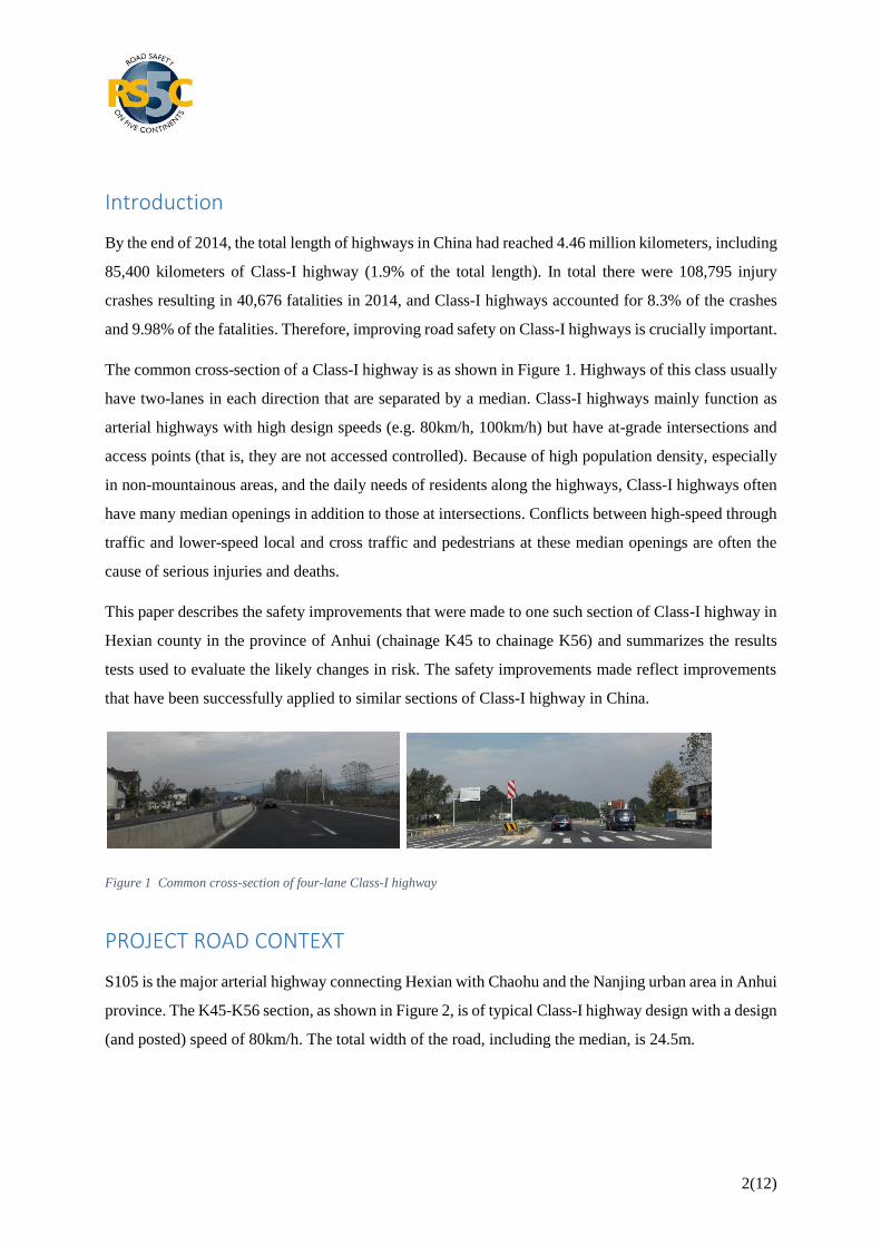
The common cross-section of a Class-I highway is as shown in Figure 1. Highways of this class usually
have two-lanes in each direction that are separated by a median. Class-I highways mainly function as
arterial highways with high design speeds (e.g. 80km/h, 100km/h) but have at-grade intersections and
access points (that is, they are not accessed controlled). Because of high population density, especially
in non-mountainous areas, and the daily needs of residents along the highways, Class-I highways often
have many median openings in addition to those at intersections. Conflicts between high-speed through
traffic and lower-speed local and cross traffic and pedestrians at these median openings are often the
cause of serious injuries and deaths.
This paper describes the safety improvements that were made to one such section of Class-I highway in
Hexian county in the province of Anhui (chainage K45 to chainage K56) and summarizes the results
tests used to evaluate the likely changes in risk. The safety improvements made reflect improvements
that have been successfully applied to similar sections of Class-I highway in China.
Figure 1 Common cross-section of four-lane Class-I highway
PROJECT ROAD CONTEXT
S105 is the major arterial highway connecting Hexian with Chaohu and the Nanjing urban area in Anhui
province. The K45-K56 section, as shown in Figure 2, is of typical Class-I highway design with a design
(and posted) speed of 80km/h. The total width of the road, including the median, is 24.5m.

3(12)
Note: Yellow colored roads are expressway
Figure 2 S105 K45~K56 Location
There are 4 expressways connecting to the project road: G4211 Ningwu expressway (east), S22 Changhe
expressway (south), G5011 Wuhe expressway (west) and G40 Hushan expressway (north). These four
expressways cater for long-distance transportation in Hexian, but in recent times urban growth has
weakened the arterial highway function of S105.
Since the opening of S105, the traffic volume has rapidly increased as has traffic crash frequency.
According to the traffic crash files, four traffic crashes occurred on the K45-K56 section from October
2013 to January 2014, which lead to two deaths and four injuries. All four traffic crashes occurred at
median openings and all involved through-traffic colliding with pedestrians or cross traffic.
Road conditions
The road traffic conditions along the section of road is complex: 39.1% of the length is urbanized; there
are 3 signalized intersections and 22 other median openings; and there are 41 access points on the
eastbound carriageway and 56 access points on the westbound carriageway.
Traffic volume
According to 24-hour 7-day continuous observation data, the daily traffic volume on the section of road
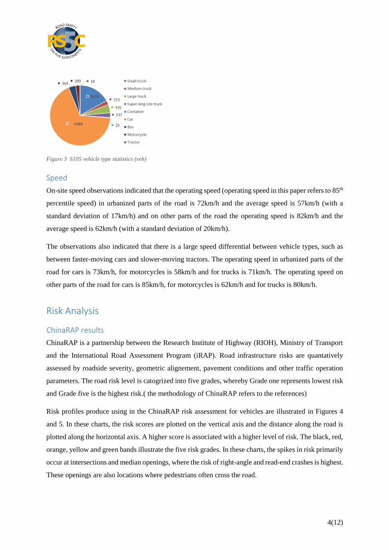
is 9,605 vehicles per day (vpd). As shown in Figure 3, numerous type of vehicles use the road though
passenger cars for the majority of traffic, accounting for 67.5%. The traffic volume of 22 openings at
median had been observed.
4(12)
Figure 3 S105 vehicle type statistics (veh)
Speed
On-site speed observations indicated that the operating speed (operating speed in this paper refers to 85th
percentile speed) in urbanized parts of the road is 72km/h and the average speed is 57km/h (with a
standard deviation of 17km/h) and on other parts of the road the operating speed is 82km/h and the
average speed is 62km/h (with a standard deviation of 20km/h).
The observations also indicated that there is a large speed differential between vehicle types, such as
between faster-moving cars and slower-moving tractors. The operating speed in urbanized parts of the
road for cars is 73km/h, for motorcycles is 58km/h and for trucks is 71km/h. The operating speed on
other parts of the road for cars is 85km/h, for motorcycles is 62km/h and for trucks is 80km/h.
Risk Analysis
ChinaRAP results
ChinaRAP is a partnership between the Research Institute of Highway (RIOH), Ministry of Transport
and the International Road Assessment Program (iRAP). Road infrastructure risks are quantatively
assessed by roadside severity, geometric alignement, pavement conditions and other traffic operation
parameters. The road risk level is catogrized into five grades, whereby Grade one represents lowest risk
and Grade five is the highest risk.( the methodology of ChinaRAP refers to the references)
Risk profiles produce using in the ChinaRAP risk assessment for vehicles are illustrated in Figures 4
and 5. In these charts, the risk scores are plotted on the vertical axis and the distance along the road is
plotted along the horizontal axis. A higher score is associated with a higher level of risk. The black, red,
orange, yellow and green bands illustrate the five risk grades. In these charts, the spikes in risk primarily
occur at intersections and median openings, where the risk of right-angle and read-end crashes is highest.
These openings are also locations where pedestrians often cross the road.

5(12)
The average risk value along the section of road is 8.71. In the eastbound direction the average value is
8.67 and in the westbound direction the average value is 8.74. Both directions are rated as Grade 3. The
westbound section has a higher risk value because of a greater degree of urbanization and access density,
which is associated with more potential conflicts.
Figure 4 Risk distribution for vehicle occupants on eastbound S105
Figure 5 Risk distribution for vehicle occupants on westbound S105
High risk spot analysis
Referring to Figures 4 and 5, relatively high-risk spots are as follows:
(1) Signalized controlled intersections, as in Figure 6, with high traffic volume and lack of
channelization.
(1) Lack of channelization

6(12)
(2) Inconsistency between traffic signs and road markings
Figure 6 Signalized controlled intersections
(2) Vehicles cross the openings without channelization, as in Figure7. The width of median is 2m and
the distance between the curb and markings is 0.5m. The median gap is not wide enough to safety
accomodate a stopped vehicle, which adds to the risk.
Figure 7 Opening crossings
(3) Pedestrian, non-motorized vehicle and motorcycles can cross through openings, as in Figure 8. The
movements are often not easily observed by faster-moving through traffic.
Figure 8 Pedestrian crossings
(4) Pedestrians crossing the median where there is no opening, as in Figure 9.
Figure 9 Pedestrian crossing at median with plantings and no opening

7(12)
(5) The section of road includes an 800m long curve that has an 850m radius and 46° left turn angle at
this curve, observed vehicle speeds increased between the tangent segment and curve segment. This
high speed at the curved segment leads to high risk of run-off or central crossing collisions. At the
location there is evidence of a traffic crash at the median, as shown in Figure10.
Figure 10 Central area crossing traffic crash spots at curve segments
Safety countermeasures
Strategy
As discussed earlier, urbanization has weakened the arterial function of the project road. The safety
strategy adopted for the road involves the formalization of that trend and shifts the function to more
safely meet the local commercial and residential road use. Key principles of the strategy were:
For low traffic volume, high risk and high access-density conditions, the number of median
openings should be consolidated.
For high traffic volume, high risk and low access-density conditions, median opening designs
should be optimized.
For high risk segments not involving median openings, prominent risk factors should be
eliminated or alleviated.
Improvements
Speed management
On sections where the median opening frequency is high, the speed limit was reduced from 80km/h to
70km/h in order to decrease the risk of vehicle crossing conflicts. At chainage K48+200, traffic police
installed speed camera.
Access management
According to the observed traffic volume data at the median openings, taking into account risk
assessment results and the spacing between openings, some of the openings for vehicles some of the

8(12)
openings for pedestrians were closed. In some cases, some openings originally used by vehicles were
restricted to pedestrian access only. Road side access points were closed or optimized depending on
appearance of farming roads, minor roads or conditions.
Design optimization
The designs of numerous openings was optimized so that visibility and sight distances were significantly
improved, reducing the risk of crashes.
At signalized intersections, left turn or right turn lanes were added and corresponding turn phases were
added to the signals. Traffic signs and road markings were also improved, such as adding traffic lane
guidance signs, increasing the spacing between stop lines and zebra crossings, as shown in Figure 12.
Figure 12 Signalized controlled intersection optimization
At unsignalized intersections, the following improvements were made (see figure 13): stop or yield signs
were installed on intersecting roads; left turn lanes were added at locations where intersecting traffic
volumes are high (see Figure 13 (1)); speed reduction line marking was installed on the through road at
locations where the intersecting traffic volumes are low (see Figure 13(2)).
(1) Left turn with high traffic volume

9(12)
(2) Minor road with low traffic volume
Figure13 At-grade intersection optimization
At median openings at pedestrian crossings, the following improvements were made (see Figure 14):
the opening with was reduced and bollards were installed to prevent vehicles from using the opening;
warning signs were installed; red and white retro-reflective sheeting was added to guardrails adjacent to
the pedestrian crossing which provides good warning to drivers both during daytime and night.
Figure 14 Pedestrian crossing optimization
Countermeasures at other high risk spots
Physical separation barriers were installed in the median from chainage K51 to K56 in order to prevent
from walking and direct pedestrians to safer crossing points. Longitudinal speed reduction road
markings and curve delineator signs were applied at the curve from chainage K54+126 to K54+817.
Effectiveness assessment
The results of an assessment of the effectiveness are summarized below in Table 1. The results indicate
that although traffic volumes were largely unchanged, improvements in crashes, speeds and risk scores
were recorded after the road upgrades.
Table 1 Effectiveness assessment results

10(12)
Metric Before After
Fatal and serious injury crashes 4 (Oct ‘13 – Jan ‘14) 0 (Nov ‘14 - Oct ‘15)
Average speed (urban) 57km/h (st. dev. 17km/h) 58km/h (st. dev. 17km/h)
85th percentile speed (urban) 72 km/h 73 km/h
Average speed (non-urban) 62km/h (st. dev. 20km/h) 58km/h (st. dev. 16km/h)
85th percentile speed (non-
urban)
82 km/h 73 km/h
Average ChinaRAP risk score 8.71 (Grade 3) 4.55 (Grade 2)
Traffic volume 9,605 vpd
In addition the reductions in speed reported in Table 1, average speeds decreased greatly at the curves
at chainage K48+790 (where the speed camera was installed) and chainage K54+600 curve (where speed
reduction markings and curve delineators were installed).
A survey of residents was also conducted by questionnaire and 36 valid questionnaires were received.
All the interviewees supported improvements and were accepting of the inconvenience due to closure
of some median openings.
Before-and-after photos
Examples of the road improvements are shown below in Figure 15. Images on the left are before the
improvements and images on the right are after the improvements.
(1) Vehicle cross-median harden and left-turn lane applied
(2) Vehicle cross-speed reduction road markings

11(12)
(3) Pedestrian cross-striking notice
(4) Access-sight distance improvement, and stop/yield signs
Figure 15 Before & After practice
Conclusions
This paper describes the safety improvements that were made to an 11km long section of Class-I
highway in Hexian county in the province of Anhui (chainage K45 to chainage K56) and summarizes
the results of tests used to evaluate the likely changes in risk.
Class-I highways mainly function as arterial highways with high design speeds (e.g. 80km/h, 100km/h)
but have at-grade intersections and access points (that is, they are not accessed controlled). They
typically have two lanes in each direction with a median.
Following the occurrence of two deaths and four injuries on the road section during a four month period,
conditions on the road were examined, including conducting a ChinaRAP assessment, and
improvements were rapidly made. In the 12 months after the improvements were made, no fatal or
serious crashes occurred. The improvements included:
consolidation of median openings and access points (including closure of some medians,
including to prevent jay-walking)
restricting movements at some median openings to pedestrians only
significantly enhancing the visibility of pedestrian crossings

12(12)
reducing the speed limit from 80km/h to 70km/h and installation of speed cameras at one
location
enhanced delineation at unsignalized intersections and at a significant curve
installation of protected turn lanes at larger intersections turn phases at signalized intersections.
Evaluations also show that there have been reductions in speed, improvements in the ChinaRAP risk
scores and good acceptance of the changes by the local community.
In this project several engineering improvements were introduced. However, to make further road safety
gains, particularly to prevent jay walking and conducting of agricultural activities on the paved shoulder,
systematic measures such as awareness campaigns, education and enforcement should be enhanced.
ACKNOWLEDGEMENT
The research is funded by NSFC funded project: No. 51308263 In-depth crash analysis and development
of traffic risk assessment model for "Highway Segments Passing Through Villages”.
REFERENCES
Chengcheng Tang. (2006). Guideline for implementation of highway safety enhancement project.
China communications press, Beijing.
Ministry of Transport. (2014). Statistical Bulletin of Highway and Waterway of China.
http://www.mot.gov.cn.
Ministry of Public Security. (2014). Statistical Report of Road Crash of China.
Tiejun Zhang,Chengcheng Tang, Greg Smith and Lingtao Wu (2014). Road Assessment Model and
Pilot Application in China. Discrete Dynamics in Nature and Society.