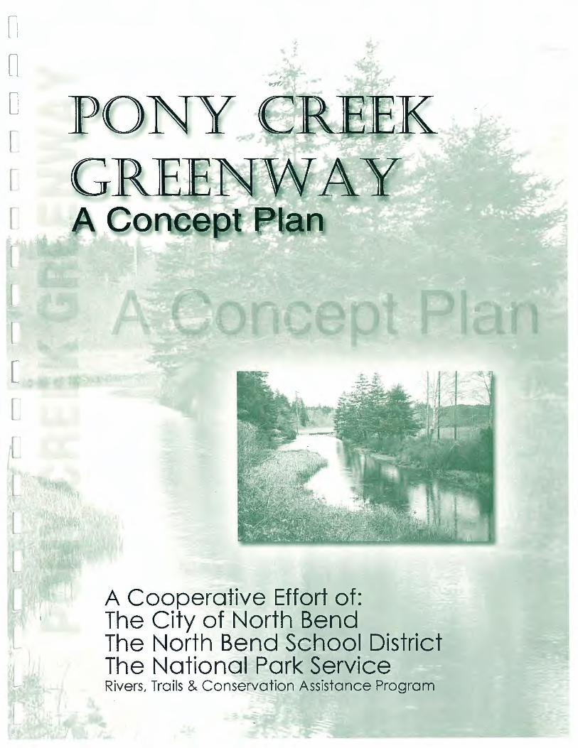
a cooperative effort of: the city of north bend...a cooperative effort of: the city of north bend...
TRANSCRIPT
l t l l. r r
L l
A Cooperative Effort of: The City of North Bend The North Bend School District The National Park Service Rivers, Trails & Conservation Assistance Program

n n TABLE OF CONTENTS
PONY CREEK GREENWAY MAP ....... ............. ........... .... ....... ............ ........... .... .... ......... ..... ........... .... . 2
n INTRODUCTION ... ................ ...... .... .. ..... ........ ..... .... ...... .................. ................... ......... ... ....... ............. 3 Background ...... ............ ... ... ....... ........ .. ...... ...... .. ..... .. .............. .. .. ....... ...... ....... ..... ..... ...... ....... .......... ........ ... .... .. .. .... .. ..... .. .... ....... ................ ...... .... 3 Planning Team ........ ... ... ..... ........ .... .... ...... ....... ....... .. ..... ......... ..... ........... .. ...... ........ ......... ... .. ... ................. ...... .. ..... ..... ... ... ..... ... ....... ... ... .. .... ..... .... 4
D Advisory Committee ... ... .. ............. ..... .... ...................... .................... ..... .... ....... .. ............. .......... .............. ........ ............ .......... .. ..... ....... ... .... .......... . 5
THE RESOURCES OF PONY CREEK....... ........ ...... ............ .... ......... ... ..... ................ ...... ..... ...... .... ........ 6 Natural Resources ......... ...... ............................... ....... .......... ... ........ ...... ....... ... ............... ................ ......... .... ..... ..... ..... .. .... .. ............... ....... ..... .. ...... 6 Cultural Re.w1urces .. ... ............... .. ........ .. ................ ....... .. ..... ... .... .... ........... ... .. ....... .. ....... ......... ...... .. ..... .. ... .... .............. .. .... ... ........ .... .. ....... ........... 7
0 Scenic & Recreational .. ..... .... ......................... .... ....... ... ...... ....... .......... ........ .. ..... .. ...... ........ .. .. ..... ........ ....... ... ........ ... ..... .................... ... .... .... ...... 8
COMMUNITY INVOLVEMENT ....................... ... .... ...... .... .. .... .... ...... ........ ........... ..... ....... ... ... ............ 9 Contacting Adjacent Landow11ers .................... ...... .............. ...... .. ...... ....... .. ...... ........ .. .... ........... .. ...... ....... .... .......... .... ... ....... ....... .................... I 0 Public Meetings .................. ..... ......... .......... .. ..... ...... ....... ..... ....... .. ... .................. ... ........... ........... .............. .......... ..... ....... .. .... ......... ... ... ..... ..... ... . I 0
0 VISION & GOALS ... ....... .... ..... ... ...... ................... ......... .......... ........ ............. ..... .. ............... ........ ... ...... 11 Vision .. .. ..... ............ ..... .................. ... .... .. ...... ................ ....... ............. .... ...... ... ...... ..... .... ...... ...... .. ... ........... .......... ... .. ... ..... ... ..... .. ..... .. .............. ..... 11 Goals ........ .... .. ......... .. ... .... .. ......... ....... ... .......... ..... ...... .. ..... .. ....... ............ .... .... ... .................... .. ............ ................ ....... ............. ..... ....... ... ...... .. ..... I I
C TRAIL DESIGN .... ... .. ......... ... ..... ............... ........................................................ ; .............. .... .......... ...... 12
Path Loca tion ..... .......... ... ...... ............ ............ ........ .. .. .. ... ....... ... ......... ........ ........ ....... ......... ........ ................ ......... ....... ...... ... ... ..... .. ..... ..... ... ......... 12 Surfctcing ......... .... ......... .. .... ......... .. ........ ... .. ...... ................. .......... ........ ..... ....... .. ... ....... ........... ..... .... .. .. ...... .. ......... ..... ...... .. ..... ....................... ..... 13 Accessibility .... ....... ... ......... .............. ...... ........ .. .......................... .. ......................................... .... ........... .... ............... .......... ......... ........ ...... ........... 13
C Linkage ...................... ...... .............. ........... ...... ... .. .... .. ...... ........ ....... ....... .................. .... .... ... ............... ........ ........ .. ..... ... ... ....... ....... ..... .... .......... ... 13 Re.murce Protection & Public Access .......... ... ....... .. ........ .... .. ...... .................. .... ... ......... .. ........ ........ ................ .. ... ........ ........... ... ....... .... .... .... .. 14 Support Facilities .. ... ... ... ..... ........... ...... .... ..... .... ............. ....... ..... .... ............ .................... ....... .. .......... .............................. ......... ...... .. ............ .... .. 14 lnte171retatim1 ................... ...... ........ ....... .... ... ...... ... .. ..... .. ....... ......... ........ ...... ... .......... ..... .... ..... .. ................ ...... ... ..... ...... ... .... ....... ..... ... ... .. ...... .... 16
n Interpre tive Themes ........... .... .................... .............. .. ................ ... ............... .. ........... ....... ............... .... ..... .................... ...... .... ..... ...... .. .. .. .. ..... .... 16
EDUCATION SCIENCE CENTER .............. ...... ....... ... .................. .................... ... .. ........... .. ........... .. ... . 17 Background ............. ...... ... ........... ..... ... .. ...................... ............. .... .. ... ...... .. .. ...... .. ... ..... ... ....... ... .... ... .... ... ........ ... ..... ............. .. ........ ...... ...... ......... 17 F1111ction ... ...... ... ...... .. .. ...... .. ...... .. ... ..... ......... ... ........ .. .. .. ...... ........ .......... .... ............ ...... ... .... ... ........ .. ....... .. ..... ................ .............. ........ .. ... .. .... .. .. f 7 Design .. ..... .. .... ................ ... .... ... .......... .. ......... ............. ........................ ......... ................ ....................... ... .. ................... .... ....... ......... .... ... .. .......... . 17 Loc:ation. .. ... ........... ........... ... .... ... .... ....................... ... ... ... ...... .. ....... ...... ........ ........ ... ... ..... ...... .. .... ...... ....... .... ....... ...... ... ... ..... ................. ....... .. ... ... 1 7
MAINTENANCE & MANAGEMENT ...... .... ........ ... ... ........... ..... ..... ...... ............ .. ................................ 18 Mwwge111e11t ...... ..... ........ ...... ........ .......... ............................. ..... .. ... ........ ..... ... ..... ... .. ......... ..... ....... .. ........ ... ...... .... ... ........... ....... ........ ... .. .. ... ........ 18
0 Hours of" Operation .. ........ ... .. ..................... ....... ...... ....... .................. ........ ......... ....... .... ............ .. ........ ......... .......... .... ............ ....... ............. .. .... .. 18 Litter ..... .......... .................... ...... ......... ....... .. ...... .. ....... .. .. ......... ..... ... ....... ........ .. .... ... ................ ....... ....... ....... .... ... ... ....... ............. .. ..... .. .. ...... ....... .. 18 Safety ........ ..... ...... .............. ........ ... ...... ... .... ..... ..... ........... ... ....... ....... .. ........... .. .. ....... ... .. .... .......... .. ... ... ...... .......... ..... ................. .......................... 18 Volu11teers .... ........... ........ .. ... .... ....... ...... ..... .............. ....... ...... .. ......... .. ...... ... ..... .... ...... ..... .... ...... ......... .. ....... ........ ....... ...... .. ........... .. ..... .. ... .. ..... ... 18
0 Law Enfi1rcemen t ...... ........ .... ...................... ......... ......... ... ....................... .... ............. .......................... .. ..................... ..... ................. ....... ........ .... 19 Pet Policy .... ..... .............. .... .. ... ............................. ............. ........... ... .. ....... ........ .. ...... .. .... ... .. ....... ................ .. ...... .. ..... ... ................ .................. ..... 19 Coordination. with Adjacent Lwzdmvners .. ........ ... ....... ........ ......................... ... ..... .......................... ........ .. ...... ... .... ... ........... .. ...... .................... 19
ENVIRONMENTAL REVIEW & PERMITTING .............. ......... ....... ................. .......... ... ...... ... ........... .... 20
C Wetlands .............. .. ....................... ........ ............................... ....... ......... ..... .. ..... ..... .. .. ............. .... ... ..... ....... .......... ...... .. ..... ....... ....... .... ....... ........... 20 Threatened & Enda11gered Species ........... ....... ................. .... ........... ..... ..... ....... ...... .. ....... ..... ......... .. ..... .......... ................... ...... ........ .. .. ... ........ 20 Water Quality .. ..... .................... ............. ..... ......... ................ ......... ....... ........ ...... ... ... ..... .... ............. ..... .. ..... ......... ........... ..... ......... .. ..... .. .. .... ........ 21 Building in Floodplains .... ............... ........ ........ .. ...... ... .... ... ........ ....... ....... ... ......... .. ..... .... ...... ....... ... ........ .. .... .. ..... ........ .......... ...... .......... ........... 21
[ Arclweology!Historic Preservation .. ....... .. ...... ........ ....... ....... ... ....... .. ....... ... ...... .......... .... ............... ..... ... .. .... .. ... ....... .......... ....... ...... .. ..... .......... 21 La11d Use Plamzing .......... ............. ... ... ......... ... .. .................... ....... ....... ......... ..... ... ..... .... ... .. ... ...... ... ... .... ..... ...... .... ..... .. ... .... ............. .......... ........ 2 2 Social-Eco1wmic ........ ......... ............. ....... .. ............... : ....... ......... ........ .. ....... ......... .. ....... ....... .... ....... .. ..... ..... .......... ... .... .. ...... ....... .. ... .... .. .. ... .. .. .. .. 2 2
FUNDING SOURCES ..... ....... ..... ...... ............... ... .. .... ... ...... ......... ..... .... ........ ........ ...... ....... ... ............... 23
[ Federal ................. ...... .... ........... ...... ........... ..... ... ..... .. ........ ..... ... ..... ..................... ................................. ........................ ... ..... ..... ........... ....... ... ..... 2 3 State ........................ ..... .... ...... .. ............ .. ..... ....................... .... .. .... ... .... ... ........... ........ ......... ... ...... .... ..... ........ .. ..... ....... .... ..... ...... .. .. .... .. ......... ....... 23 Private Business ........... .. ... ............. ........... ............ ........... ...... ......... ........ ........ ........... ....... ... .... .. ........ ...... ..... ....... .... ...... ....... .. ....... ... ......... ........ 24 Foundatio11s ...... ......... ... .... .. ......... ........ .. ....... .... .... ....... ....... ... ... ... ....... ......... ........ ........... ... .... .... ....... ......... ....... ....... .... ............ ...... ... ... .. ............ 24 In-Kind Contrabutimz.1· .. .... .. .. ....................... .... .... ... ..... ...... ... ...... ........... .... ..... .. ... .... ....... ... .. ..... ......... .... ... ... .... ....... ... .. ..... .... .... .... ........... ......... 25
L No11-Monetary Sources of" A.uistwzce ............. ........... .......................... ......... ............... ........... .......... .... ... ........ ..... ..... .... ....... .. ...... .. .... .. ...... .. .... 2 5 Commu nity Fundraising & Dmwtion.~ ............ .. ........... ....... .... ... ...... .......... ........ ......... ......... ...... ... ........ ........ ............ .................. .... ............. ... 26 lnf"omwtion Sources ....... .................... ............... ............. ... ..... ...... ................ ................ .. ................ ................................ ........ ..... .... .... .......... .... 26
l CONCLUSION ..... ........ .... ........ ... ..... ......... ............. .... ..... ..... .......... ........ ....... .......... .... ...... ... .......... ... . 27
APPENDICES ... ............ .... ... ... ...... ... .... ............ ..... .. ............ .. ........ .. ... ...... ....... ..................... ... ... ..... .... 28 Checklist r!( Birds .fi,r Pony Slough Marsh ... ................ ........ ................... ..... ........... .. ........ ....... ........... .... ...... ...... ...... ......... ....... ....... .. ... .... ... .. .. 2 8 Checklist of" Manu,wls .fi,r Pony S lough Marsh ... ................ .... ..... ......... ..... .. .. .... ....... ......... ...... ... ....... ...... ..... ..... .... ... ....... .. ............ .... ... ... ... .... 2 9
u Checklist of" Plants .fi,r Pony Slough Marsh ...... ........ .... ....... ......... .... ...... .. ...... ... ... .. .. ..... ... .... ......... .... ... .............. .. ..... ....... ....... .. .... ............ .... .. 30 Sample Letter Sent to Adjacen t Lwzdmvners ................ ............ ... .......... ................. ......... .................. ..................... .... ..... .... ........... ..... ....... ..... 31 Public Meeting Commen ts - Sep tember /998 .. .......... ............... ... ....... .. ....... ......... ......... ......... ......... ............ ... .... ........ ........ ............... ......... ... 3 2 Public Meeting Comments - September ! 999 .......... ....... ..... ... .. .................. ......... .. ........ ......... .. ...... ...... .. .. ....... .. .... ..... .......... ......... ... ...... ....... 3 3
u
I -t
> ~ c ~ ~ yt li 1 2 I ~ ij ~ i ~ i i ~ ' !
!~-< ~ > z 2 ~ !;I ~ ~~! ~2 ~ ~ ~ ~ ~ ! ~
O'CONNEU. ST. Ul=7 Cl Cl LJ 17 L] CJ CJ q IC\.,~~ {( ~,t, I 10¥ER ST./ /00 0 DB B B D DD D 0~11/JM~~\ ;~)\~ /{. _ _;f-::::__'1!;~-=! L f ;;
[ 7/7r-1 D ,-] o~,-o D rnr ,I.! \\ II hi \ -3 I J "J LOCKHART ST./ ID ~ Lll_J L L LS'~ V ~ \ \(/ ?-1 L / ~ . ,n~oo~ oo \LI~~,~\":,,../ -·- ---
EX~ST., /0~~ CJ 0
- ( ({;\~~J\ 1 ,_j .. -NE'MilARK ST. / / ~ lr_J 8 D O O dJ -~-_J ~~ ST1__c:::___J E
r I JO D c ·1 D - .... ..~wi.e------ ~AAAOO Hl<JiWAY
COMMERCIAL. ST / ti{; - _j CJ -· · uraN&o ST ! L_ . u DO o, r-i c=i [=:] c::=J D [] COM-.m ... no. • COMMERCIAL ST. -STAlE ST,( /, ·- EJ CJ CJ t:=:J ,, iC C
I c=-=i c:=i [l C.=J --i .- - D ~ : ~- ~ STATE ST., r-/// I~ Cl ..J CJL._JLJLJ ~ :-4 ~ i _,[_
cv.RKST. { / /r==ipoc·Jo[--JDD 1 [j > > ac: / ,t:=:Jc:5 -· - C. ~ ~ ~ST. / f[__j o o o BDDBB i []1 1---- --rr--- De
...... ST. / l-\ DBBBODBB Fil J__:- ~ [:J[X WAlLST\ flls:Jaooooo Jr ljJto1\t\lLJooc OtfOA~.\\~t;rnoo' [JDD,l' ~ DO~~ JDD~
\ '-"'l,w _ · ' Q DSJ r--, LJ []fl [
~.~fJDoouo~ 1~ f brtoorL
\J0DDDDD~~~ r~~-no, 0'[ ME~A~\\---·-,o· o-J1or11 fl; 1~1 . - ~-\l~ Li .J,~~-- , -~LJ[!IJ f"' ~ ,JLJDDD[I[]Ji ______ .: ·~ [1DJDJ ~ I
[
·-·"* ·"' 'LJtJ o o CID o o OtJ ~~: v-r rn Q o-[ _.,...._ " ~1 o [~ ono u 1 - ~rn n o r
CALFORNIA AVf.. I . ~ -I r-1 LJ i:.J D 0_ CJ ("'""'""' • I I r1 I LI L ; \ .-·~ ,, l IL CTICUT A\te
I n O ll O O [I· ·11 ~ coo.£CTICUT AV'- \:<>:\\ r M~TANA A~. I - D ~--ec rb/ ~ IKINTAHA • .._ \ \ \ \ \ .'.
!2 , q i ~ i I n ~ \ \ , } ·. i Ll ~ ~ u ! I FLORIDA AVE. \ \ ·.\-.. ~:·· \ .
~ C ~[ -·[] D ILJ ~ \ ') \ '· > I n · \ I ' .
• C: ~' I ; \ I'> ;) Li _ 11 [f 1 00.0RAOO AVE. ; ! i\ \ ;t uawo••t~ ~\] U LJ I j ! '\ .
} ~~~\~1~ 1- ~ fj"~ M~M.AN A~ ~ .! I / · .. / \ ~ - > ~ : ! j -.. \ l ~, I l : ! I ~ ,, l. ' ' I
iI t JI J ( I /7 r-, .-, "'O -o -o rri m . :::0 :::0 :::0 X X
lJJ\l f~ i c/Qfl ~~~~i ~ ~ , 1 f \ Jr ,
01 __
1 o o o ~ "'O Q
~~- )l "--J I mU>-ug~ -,:. \ __.;;,-" /i '--- :,::: 0 )> I ~
· . . ~ /I ' ~ j m m ~ ~ =: ,; ""' , : /' ' ~~=:r> i // I z )> )> A -< -t
I ~ mC:.J
i lo ~~
~ 0 z >-<
~
n< ~~ trj : tTj ~ ~~
~t ~~ ~4
~! ~ >C ~= t ~c ~(
0~ ~ trj n ~
n n n D C C D
D 0 D D D u C L L L L
BACKGROUND
Initiated in February 1998, this plan presents a
concept for developing and managing a greenway
corridor along Pony Creek and Pony Slough in North
Bend, Oregon. The term 'Greenway' is used to define
a corridor that is planned, developed and managed
to integrate various transportation, recreation,
environmental education, and resource conservation
components.
The idea for the project originated with a group
of members on the North Bend School Board who
wanted to explore the possibility of developing an
education science center on land owned by the
North Bend School District that includes a portion
of Pony Creek and its associated wetlands. This
group convened several meetings that included
representatives from the North Bend School District,
Northwest Steel headers Association, Bureau of Land
Management, and Oregon State Police Department.
Together they expanded the idea and developed
a preliminary proposal containing two primary
components:
!IJj Construction of an education science center for
school use as an outdoor classroom for conducting
various science and environmental education
projects and programs.
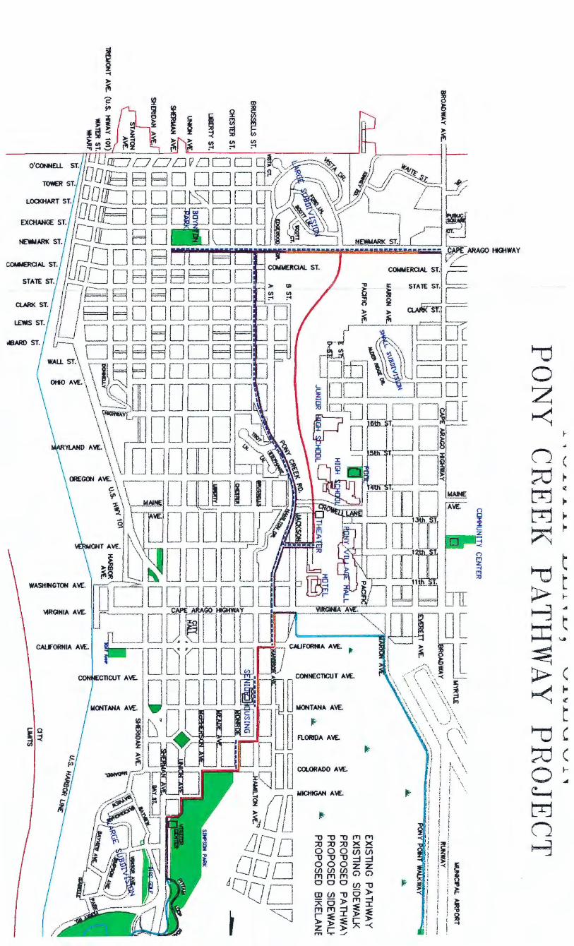
• Partner with the city of North Bend to develop
a continuous, non-motorized pathway along Pony
Creek from Newmark Street to Virginia Avenue,
that includes a connection to the existing public
pathway along Pony Slough Bay by the airport.
3
INTRODUCTION
To further the proposal, the group organized and
submitted an application for technical assistance
from the Rivers, Trails and Conservation Assistance
(RTCA) program of the National Park Service in
September 1997. The RTCA program provides
non-financial technical assistance on an invitational
basis to communities working on projects to
conserve, protect or restore open space and river
related resources and that provide local outdoor
recreation opportunities.
The Pony Creek Greenway application was
accepted and planning for this document first began
in February 1998, when two groups were formed.
The 'Planning Team' was organized to assume lead
responsibility for organizing the planning process,
informing and providing opportunities for public
comment and involvement, conducting research,
and writing the plan. The 'Advisory Committee' was
organized to represent key stakeholder groups in the
community and was asked to meet with the Planning
Team as required to provide advice and consultation
on the various stages of the planning process.
Representatives on these two groups are listed on the
following pages.
Tiu: c.·0111e111.,· of lhis puhlication clo 1w1 neccs.w,ri/y n.'}/e c.· t 1/,c opiniom· r?{ Jiu: Nulional Park Service or rhc /)cparlmcm rf the Interior.

PLANNING TEAM
Kelli Watson, Parks & Recreation Director, City of North Bend
The formation of the planning
team and advisory committee
had the immediate impact of
expanding the proposal to
develop a public pathway all
the way from Newmark Street to
the northern-most city limits at
the Simpson/Ferry Road Park
pathway where it connects to
Highway JOI . This idea has
long been identified in other
city planning documents
including the North Bend
Comprehensive Land Use Plan
and the 1991 Bikeway Master
Plan for North Bend.
PONY CREEK CREENWAY A Concept Plan 4
PLANNING TEAM
Kelli Watson Parks & Recreation Director
City of North Bend
Jim Pex North Bend School Board
Dennis Turowski North Bend School Board
Bryan Bowden RTCA Program National Park Service
*The Planning Team would like to acknowledge
the contributions of the following two individuals
who contributed greatly to the development of this
plan but were not officially members of the
Advisory Committee:
Anne Donnelly Coos Watershed Association
Mike Graybill Manager, South Slough National Estuarine Research Reserve
Jim Pex (PICTURED AT PODIUM) heads up the discussions of the issues
l l
l I I
1 l I
I '
J
LJ
n n n D D C D 0 C D D 0 C C L L u L L
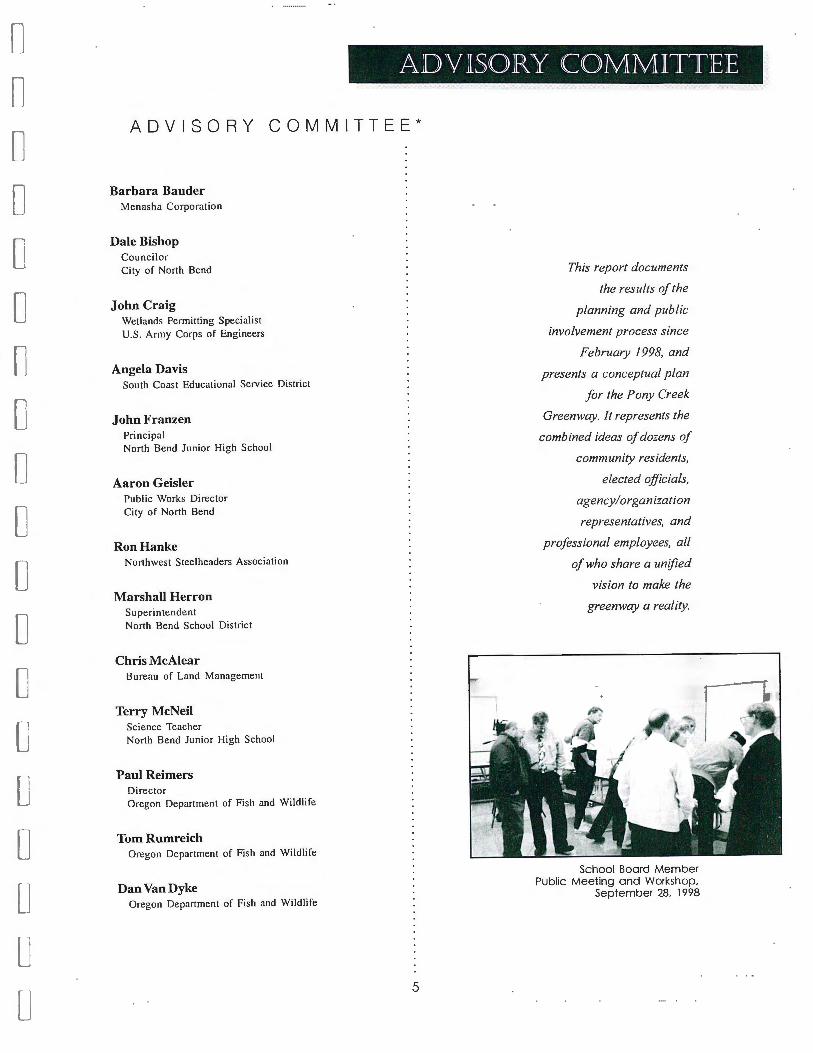
ADVISORY COMMITTEE
ADVISORY COMMITTEE*
Barbara Bauder Menasha Corporation
Dale Bishop Councilor City of North Bend
John Craig Wetlands Permitting Specialist U.S. Army Corps of Engineers
Angela Davis South Coast Educational Service District
John Franzen Principal North Bend Junior High School
Aaron Geisler Public Works Director City of North Bend
Ron Hanke Northwest Steelheaders Association
Marshall Herron Superintendent North Bend School District
Chris McAlear Bureau of Land Management
Terry McNeil Science Teacher North Bend Junior High School
Paul Reimers Director Oregon Department of Fish and Wildlife
Tom Rumreich Oregon Department of Fish and Wildlife
Dan Van Dyke Oregon Department of Fish and Wildlife
5
This report documents
the results of the
planning and public
involvement process since
February 1998, and
presents a conceptual plan
for the Pony Creek
Greenway. It represents the
combined ideas of dozens of
community residents,
elected officials,
agency/ organization
representatives, and
professional employees, all
of who share a unified
vision to make the
greenway a reality.
School Board Member Public Meeting and Workshop.
September 28. 1998

Tl--11E RESOURCES OF PONY CREEK
NATURAL RESOURCES
Pony Creek originates from Upper Pony Creek
Reservoir, located south of Coos Bay in mountains
referred to as the Coast Range. The reservoir was
established to provide a reliable public water supply
for the cities of North Bend and Coos Bay and is
operated and managed by a joint Coos Bay/North
Bend Water Board Agency. Consequently much of
the watershed containing the creek and
forestland of the upland watershed containing Pony
Creek is dominated by western hemlock and Douglas
fir forest. It is home to numerous species of birds
and animals including bald eagles, hawks, osprey,
waterfowl, woodpeckers, owls, Roosevelt elk, bobcat,
black-tailed deer, beaver, otter, mink and porcupine.
This forestland is a renewable resource that has, and
continues to be, a major force
reservoir is jointly owned by the two cities.
Pony Creek flows from the reservoir in a
northerly direction through Coos Bay and
North Bend and empties into the Pony
An estuary is a very rich natural environment where
of the Coos County economy
by providing jobs and a high
standard of living for local
residents. Additionally, it
fresh water meets and mixes with salt water.
Slough Estuary along the Coos River.
Natural resource and environmental education experts
generally agree there are eight distinct and significant
coastal environments along the Oregon Coast within
the narrow band of land between the Coast Range and
the Pacific Ocean. These are:
llt the near shore ocean and continental shelf
llt capes, sea stacks and rocky shores
llt beaches and dunes
llt coastal estuaries
llt coastal terraces
llt coastal valleys
llt forested Coast Range watersheds
llt the rivers and streams which link them together
Pony Creek is a significant natural resource because it
links three of the above environments. It begins in a
forested Coast Range watershed, is channeled through
a coastal valley, and drains into a coastal estuary where
fresh and salt water mix. Each of these areas provides
habitat for a great diversity of plants and wildlife
including fish, birds and invertebrates. This habitat is
the result of many complex biological processes that
contribute to the overall health and function of the
local environment and, thereby, the quality of life
enjoyed by residents and visitors to North Bend. The
PONY CREEK CREENWAY A Concept Plan 6
contributes greatly to the
quality of life enjoyed by residents and visitors to
North Bend by providing a scenic backdrop to the
community and abundant outdoor recreation opportu
nity. From its upland beginnings, Pony Creek quickly
flattens out into a broad coastal valley environment
characterized by a large wetland north of Newmark ·
Street. Pony Creek flows from this wetland as a slow,
meandering creek on its way to the Pony Slough
estuary. Much of this valley area was once a large,
marshy intertidal wetland subject to frequent flooding,
but over time it has been filled and developed. During
this process, Pony Creek was channeled into its current
configuration.
The valley wetland, creek and associated riparian
area are the primary conduit for the water and nutrients
flowing from the upland watershed to the sea.
Consequently it is dominated by water, marsh and
riverine dependent plants, trees and shrubs such as
sedges, reeds, cattails, willows and grasses. This
environment provides habitat to a diverse variety of
fish, birds, mammals, amphibians and invertebrates
that includes trout, ducks, geese, herons, bats, mink,
porcupine, beaver, and frogs.
At its mouth, Pony Creek empties into the Pony
Slough Estuary tideflats area. This is where fresh and
l l
I
l
I I
I I
J

n n
[
C [
[
C [
C 0 C [
L [
[
l L L
salt-water mix, rhythmically covered and uncovered
by the changing of the tides. These tideflats provide
unique habitat for many plants, animals and birds
such as seaweed, seagrasses, fish, snails, clams,
shrimp, crabs, gulls, and herons. Water, nutrients and
sunlight fertilize huge numbers of one-celled plants
(phytoplankton) in this area. These in turn feed large
numbers of small animals (zooplankton) which in turn
feed larger animals. The estuary
waters eventually flow into the
sea where the sun evaporates
some of the water, forming the
clouds that carry the rainwater
to replenish the watershed and
so continue· the cycle.
Pony Creek is also significant
because of the fact that it flows
through the heart of a highly
developed urban area. This
presents some exciting
opportunities but also poses
some difficult management
issues. The opportunities are
exciting because Pony Creek is
a healthy, functioning riparian
area located close to where
people live, work and play. If
managed properly, it can provide multiple community
benefits related to environmental education, conserva
tion, recreation, aesthetics, and mobility at a human
scale.
On the other hand, the fact that Pony Creek flows
through a developed urban area poses management
challenges. Chief among these is the potential for
gradual resource degradation resulting from the
cumulative impacts of human activity. For example,
the large wetland area adjacent to Newmark Street has
a serious infestation of purple loosestrife that is most
likely attributable to human development and
alteration of the environment over the course of many
years. Purple loosestrife threatens the integrity of the
wetland because it has the ability to out compete
native vegetation, thereby degrading nesting habitat
for waterfowl. If waterfowl disappear, then other
negative impacts will follow. 7
CULTURAL RESOURCES
The name 'Pony Slough' is attributed to Native
American presence, although there is some
disagreement over the exact source. Either Indians
watered their horses in it or a pony owned by an
Indian child drowned in the waterway. Contemporary
View towards dunes and railroad grade along the Pony Slough Estuary
tribal members have suggested a Coos village may
have been located near what is now North Bend
High School.
By the turn of the century, Pony Slough was a busy
place. The Grand Central Railroad organized in 1902
to build a rail line from this area to Salt Lake City.
Grand Central Land Company bought tracts of land
and began the townsite of Bangor. It was forecast as the
nucleus and commercial center of a large city, bringing
prosperity 'Where Rail Meets Sail.' Entrepreneur and
railroad trustee L.D. Kinney platted and sold lots in
Bangor. As Chief Engineer for the Belt Line Company,
he purchased acreage and built a railroad com-missary
and sawmill (the sawmill was located about where
Ken Ware Chevrolet is now).
Kinney also sold land to the North
Bend School District for the site of a
high school. Originally named
Kinney High School, the name
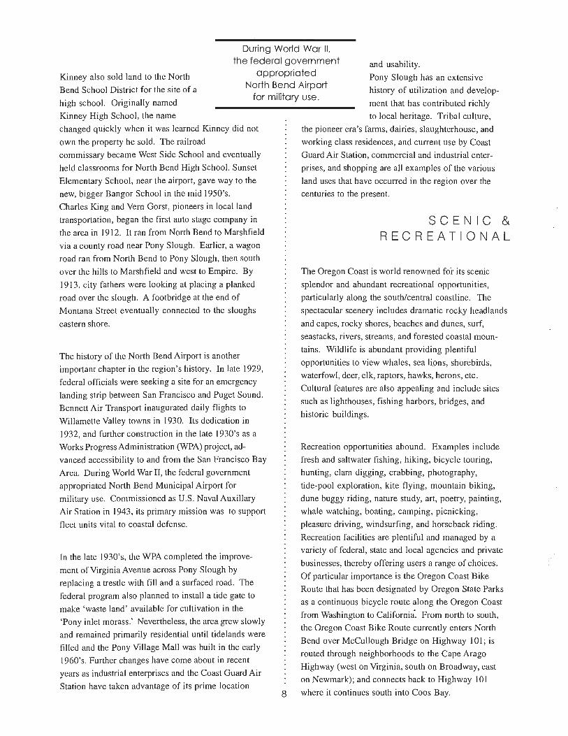
During World War II, the federal government
appropriated North Bend Airport
for military use.
and usability.
Pony Slough has an extensive
history of utilization and develop
ment that has contributed richly
changed quickly when it was learned Kinney did not
own the property he sold. The railroad
commissary became West Side School and eventually
held classrooms for North Bend High School. Sunset
Elementary School, near the airport, gave way to the
new, bigger Bangor School in the mid I 950's.
Charles King and Vern Gorst, pioneers in local land
transportation, began the first auto stage company in
the area in 1912. It ran from North Bend to Marshfield
via a county road near Pony Slough. Earlier, a wagon
road ran from North Bend to Pony Slough, then south
over the hills to Marshfield and west to Empire. By
1913, city fathers were looking at placing a planked
road over the slough. A footbridge at the end of
Montana Street eventually connected to the sloughs
eastern shore.
The history of the North Bend Airport is another
important chapter in the region's history. In late 1929,
federal officials were seeking a site for an emergency
landing strip between San Francisco and Puget Sound.
Bennett Air Transport inaugurated daily flights to
Willamette Valley towns in 1930. Its dedication in
I 932, and further construction in the late I 930's as a
Works Progress Administration (WPA) project, ad
vanced accessibility to and from the San Francisco Bay
Area. During World War II, the federal government
appropriated North Bend Municipal Airport for
military use. Commissioned as U.S. Naval Auxiliary
Air Station in 1943, its primary mission was to support
fleet units vital to coastal defense.
In the late I 930's, the WPA completed the improve
ment of Virginia Avenue across Pony Slough by
replacing a trestle with fill and a surfaced road. The
federal program also planned to install a tide gate to
make 'waste land' available for cultivation in the
'Pony inlet morass . .' Nevertheless, the area grew slowly
and remained primarily residential until tidelands were
filled and the Pony Village Mall was built in the early
I 960's. Further changes have come about in recent
years as industrial enterprises and the Coast Guard Air
Station have taken advantage of its prime location 8
to local heritage. Tribal culture,
the pioneer era's farms, dairies, slaughterhouse, and
working class residences, and current use by Coast
Guard Air Station, commercial and industrial enter-
prises, and shopping are all examples of the various
land uses that have occurred in the region over the
centuries to the present.
SCENIC & RECREATIONAL
The Oregon Coast is world renowned for its scenic
splendor and abundant recreational opportunities,
particularly along the south/central coastline. The
spectacular scenery includes dramatic rocky headlands
and capes, rocky shores, beaches and dunes, surf,
seastacks, rivers, streams, and forested coastal moun
tains. Wildlife is abundant providing plentiful
opportunities to view whales, sea li.ons, shorebirds,
waterfowl, deer, elk, raptors, hawks, herons, etc.
Cultural features are also appealing and include sites
such as lighthouses, fishing harbors, bridges, and
historic buildings.
Recreation opportunities abound. Examples include
fresh and saltwater fishing, hiking, bicycle touring,
hunting, clam digging, crabbing, photography,
tide-pool exploration, kite flying, mountain biking,
dune buggy riding, nature study, art, poetry, painting,
whale watching, boating, camping, picnicking,
pleasure driving, windsurfing, and horseback riding.
Recreation facilities are plentiful and managed by a
variety of federal, state and local agencies and private
businesses, thereby offering users a range of choices.
Of particular importance is the Oregon Coast Bike
Route that has been designated by Oregon State Parks
as a continuous bicycle route along the Oregon Coast
from Washington to California. From north to south,
the Oregon Coast Bike Route currently enters North
Bend over McCullough Bridge on Highway IO I; is
routed through neighborhoods to the Cape Arago
Highway (west on Virginia, south on Broadway, east
on Newmark); and connects back to Highway 101
where it continues south into Coos Bay.
l
l I
l
[ I
I I
! I
1 · ;
I I
' .J

n n tl [
[
[
C [
0 [
C
[
[
L [
u L L
COMMUNITY INVOLVEMENT
When staff from the National Park Service RTCA
program first met with the project proponents, a
strategy was developed for conducting the project
that included two parallel tracks . The first track was
to organize a small core 'Planning Team' to research
and write a draft concept plan for the Pony Creek
Greenway. The second track was to design and
conduct a community involvement process to provide
opportunities for stakeholders and the public to be
informed about the project and to contribute ideas and
suggestions in a timely manner as the plan was being
developed. It was also decided to form an 'Advisory
Committee' from key stakeholder groups in the
community to serve as a bridge between the planning
and public involvement tracks .
Pony Creek Greenway;. North Bend, Oregon
I.
If.
Ill.
Planning Process {Planning Team)
Vision & Goal Setting !. Greenway & Path System 2. Education Science Center 3. Wildlife Viewing/Environmental Education 4. Public Asset
lnrormation Gathering !. Resource {Natural, Cultural, Recreational}
Inventory 2. Mapping 3. Stake Holder Issues
Analysis !. Opportunities & Constraints 2. Concepts 3. Graphics 4. Funding Sources 5. Partnerships
I.
If.
Ill.
Community Involvement Process
Direct Involvement ofAc§acent landowners
Public Meeting to Outline the Planning Process !. Introduce Planning Team 2. Introduce Advisory Committee 3. Summarize the Process 4. Solicit Public Comment, Input Feedback,
Concems 5. &plain How the Public Stays Informed
Public 'Open House' !. Summarize Contents or the Preliminary Draft
Plan 2. Post Maps, Conceptual Graphics, Etc. 3. Ask for Input
Advisory Committee (Bridges the Two Processes)
IV. Action/Implementation Plan {Who, What When, How)
Planning Team Meets with the Advisory Committee as Needed
V. Release Draft and Final Plans
9

CONTACTING ADJACENT LANDOWNERS
The first step in the community involvement process
was to identify all of the adjacent landowners within
the project study area and send each household a
personal letter. The letters provided explanation about
the project and informed them who they could contact
if they had questions, concerns or comments. (See
Appendix IV for a sample of the adjacent landowner
letter.)
A few phone calls were received as a result of these
letters . Many callers expressed support for the project
and some had specific questions they wanted answered.
No one expressed opposition to the project and most
expressed a desire to be kept informed as the project
progressed.
PUBLIC MEETINGS
An initial public meeting was organized and
conducted on September 28, 1998, at the North Bend
Junior High School. A total of 25 people attended.
This meeting was planned for two purposes: 1) to share
information about the project; and 2) to give the public
an opportunity to review and comment on preliminary
ideas for major plan components. To accomplish these
goals, the first part of the meeting was organized to
PONY CREEK CREENWAY A Concept Pion 10
provide background information on the project (i.e.,
history and origin of the idea; role of the National Park
Service; and introductions of 'Planning Team' and
'Advisory Committee' members) . The remainder of the
meeting was designed to be more interactive and afford
participants the opportunity to review and comment on
preliminary ideas and research in each of five major
plan components. To accomplish this goal, Advisory
Committee members organized and staffed five work
stations, one for each major component. These were:
!It Vision/Management Issues
!It Trail Design
!It Education
!It Education science center
!It Permitting Process
Meeting participants were provided a questionnaire
and asked to visit each station and provide their
comments, concerns, ideas or reactions for each.
(A summary of the public comments received at this
workshop is provided in the 'Appendices' section.)
A second public meeting was organized and conducted
on September 30, 1999, at the North Bend Public
Library. Approximately 20 people attended. The
purpose of this meeting was to release a draft of the
concept plan and provide a public review period to
comment on its content prior to publishing the
final plan. Summary presentations on the major
chapters of the plan were provided followed by
an open discussion , question, and comment period.
Copies of the plan were available for public review
and comment through October 15, 1999. (A
summary of the public comments received at this
meeting is provided in the 'Appendices' section.)
Participants at the September, 1998, Public Meeting and Workshop reviewing a map of the proposed route
l 1
i I I
I I
r.1
I ~ I
1· • J
I I L
I J
i I
I L
I I
11
-J
n n n
D [
C [
[
[
C C
C [
C [
[j
lJ L
VISION
The Pony Creek Greenway is carefully managed as an important resource for the people, animals, plants and biological systems dependent on the benefits it provides .
• The Greenway is used by people for recreation and as a non-motorized transportation link to other parts of the community
• The Greenway provides habitat for plant and animal communities
• The Greenway allows important biological processes to occur that contribute to clean air and water
• The Greenway provides an opportunity for people to learn about natural systems and ecosystems
GOA LS
Goal 1: Provide re;ident and visitor access opportunities in the Pony Creek area and create a non-motorized transportation linkage between recreational, educational and commercial facilities in the community.
OBJECTIVES:
1. Build a pathway from Newmark Street to Virginia Avenue along Pony Creek.
2. Continue the pathway north from Virginia Avenue along Harrison Street to Pony Slough, up through Simpson Park, to the Simpson/Ferry Road Trail where it connects to Highway 101 at the foot of the McCullough Bridge.
3. Continue the pathway east from Newmark to link with Boynton Park.
4 . Continue the pathway west from Newmark to Broadway.
5. Provide directional signs along the pathway.
6. Build turnouts with seating for stopping, resting and viewing of the area.
11
VISIONS AND GOALS
Goal 2: Restore and manage Pony Creek wetland and riparian areas for their natural values.
OBJECTIVES:
I. Provide healthy habitat for native plant and animal communities.
2. Assure important biological processes occur unimpaired that contribute to clean air and water.
3. Plan and conduct restoration projects to improve wetland and riparian area function .
Goal 3: Provide opportunities for people to learn about the natural and cultural heritage of the area.
OBJECTIVES:
I. Develop an educational science center adjacent to Pony Creek in conjunction with North Bend School District programs and curriculum .
2. Plan and develop interpretive/edu~ational materials on significant natural and cultural resources of the area utilizing a variety of media.
Goal 4: Develop public stewardship for the Pony Creek Watershed.
OBJECTIVES:
1. Increase people's AWARENESS of the resource (plan and develop interpretive/ educational materials).
2. Increase people's OWNERSHIP of the resource (provide opportunities for different groups within the community to get involved with planning, development and management of the greenway [i.e., civic and youth groups, arts, education, business, health care, and neighborhood associations.] )
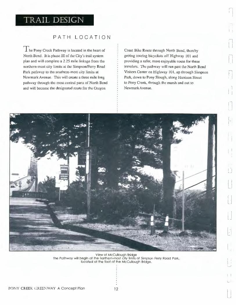
TRAIL DESIGN
PATH LOCATION
The Pony Creek Pathway is located in the heart of
North Bend . It is phase III of the City's trail system
plan and will complete a 2.25 mile linkage from the
northern-most city limits at the Simpson/Ferry Road
Park pathway to the southern-most city limits at
Newmark Avenue. This will create a three mile long
pathway through the most central parts of North Bend
and will become the designated route for the Oregon
Coast Bike Route through North Bend, thereby
getting touring bicyclists off Highway IO I and
providing a safer, more enjoyable route for these
travelers. The pathway will run past the North Bend
Visitors Center on Highway IO I, up through Simpson
Park, down to Pony Slough, along Harrison Street
to Pony Creek, through the marsh and out to
Newmark Avenue.
View of McCullough Bridge The Pathway will begin at the northern-most city limits at Simpson Ferry Road Park.
located at the foot of the McCullough Bridge.
PONY CREEK CREENWAY A Concept Plan 12
'
I I j
I~
, I
~ l I J
I·,
l j
l J I I I J
I "! · 1
_,
I \ L J

n n r [
[
D C
C
C
C
C
C 0 u L L:
SURFACING
A public multi-use pathway for pedestrian and
bicycle transportation will be developed through the
heart of North Bend . It will consist of a combination
of concrete sidewalk, bike lane striping, asphalt
paving, a wooden bridge,
and elevated boardwalk
(possibly built with plastic
lumber from recycled
materials) over wetlands.
Elevated boardwalk,
Wildwood Lake Sanctuary, Harrisburg,
Pennsylvania.
ACCESSIBILITY
The pathway will be designed to be accessible for
all users wherever possible, including people in
wheelchairs and those who walk with the assistance
of a walker or cane. In areas of steep terrain design
alternatives (e.g. , utilization of switchbacks or
provision of frequent rest area intervals) will be
utilized. All applicable laws governing the design
and construction of public facilities will be
adhered to.
It should be noted that the Architectural and
Transportation Barriers Compliance Board is
responsible for developing and adopting uniform
federal accessibility standards. Since passage of
the Americans With Disabilities Act an advisory
committee has been working to develop
recommendations to the Board for making recreation
facilities and outdoor developed areas (including paths
13
and trails) accessible to and usable by individuals
with disabilities . As of this writing , no such standards
have been formally adopted by the Board. Until final
standards are available it is recommended that an
earlier advisory committee
report 'Recommendations
for Accessibility Guidelines:
Recreational Facilities and
Outdoor Developed Areas'
(July 1994) be utilized as
a common sense guide for
addressing accessibility
issues in trail design and
construction .
It should also be noted that
while no standard has been
specifically developed for.
recreation , existing guidelines
for faciliti es such as parking
areas, restrooms, entrances and
accessible routes do exist and must be followed. The
benefits from providing accessible facilities are safer
and better conditions for all visitors , not just those with
disabilities, and the increased possibility for persons
with disabilities to not only have access , but to do so
along side their non-disabled fri ends and family.
LINKAGE
The project is a cooperative effort between the city
of North Bend, the North Bend School District and
local partners to enhance non-motorized surface
transportation by building a multi-use pathway
linking neighborhoods, business districts , parks and
schools for bicyclists and pedestrians. It will provide
access to a senior and disabled low income housing
complex with 60 residents; a junior high and high
school with 1,400 students ( 14% of the North Bend
population); the largest enclosed shopping mall on
the Oregon Coast; a brand new Safeway grocery store;
three city parks; a full-size municipal indoor swimming
Pedestrian bridges will help create important linkage between the greenway, schools and residential areas.
pool; a 119 room motel; a quad-screen movie
theatre; and several neighborhoods and sub-divisions.
Residents and visitors will benefit from the many
opportunities for non-motorized access to key
destinations throughout the community.
RESOURCE PROTECTION AND PUBLIC ACCESS
A major goal for greenway development is to carefully
design the pathway to avoid impacting sensitive
natural and/or cultural resource areas while providing
for public access. These two ideas do not necessarily
have to conflict with each other. Many techniques
exist that design engineers and landscape architects
can employ to minimize resource impacts while
providing for public access and enjoyment. Trail
construction may be able to enhance wildlife habitat
PONY CREEK CREENWAY A Concept Plan 14
through techniques such as building bat and bird
boxes, leaving nurse logs and dead snags in place,
placing woody debris in the creek, and developing
rocky areas for reptiles. Shorter spur trails can be built
off the main path that lead to sheltered wildlife
viewing areas (similar to a duck blind) . Construction
techniques utilizing native vegetation and natural
materials can be used to keep people on paths and
away from sensitive areas. Elevated boardwalks allow
people to travel over wetlands with minimal impact to
the resource.
SUPPORT FACILITIES
Along the three mile pathway are several types of
support facilities for residents, visitors, cyclists and
pedestrians. The North Bend Information Center will
be a main access point for visitors to get information
l 11
I~
Ii l
I l
l l
' '
I j
l_ J
( J
1 'J
I I
I ~
n n
[
[
0 u L
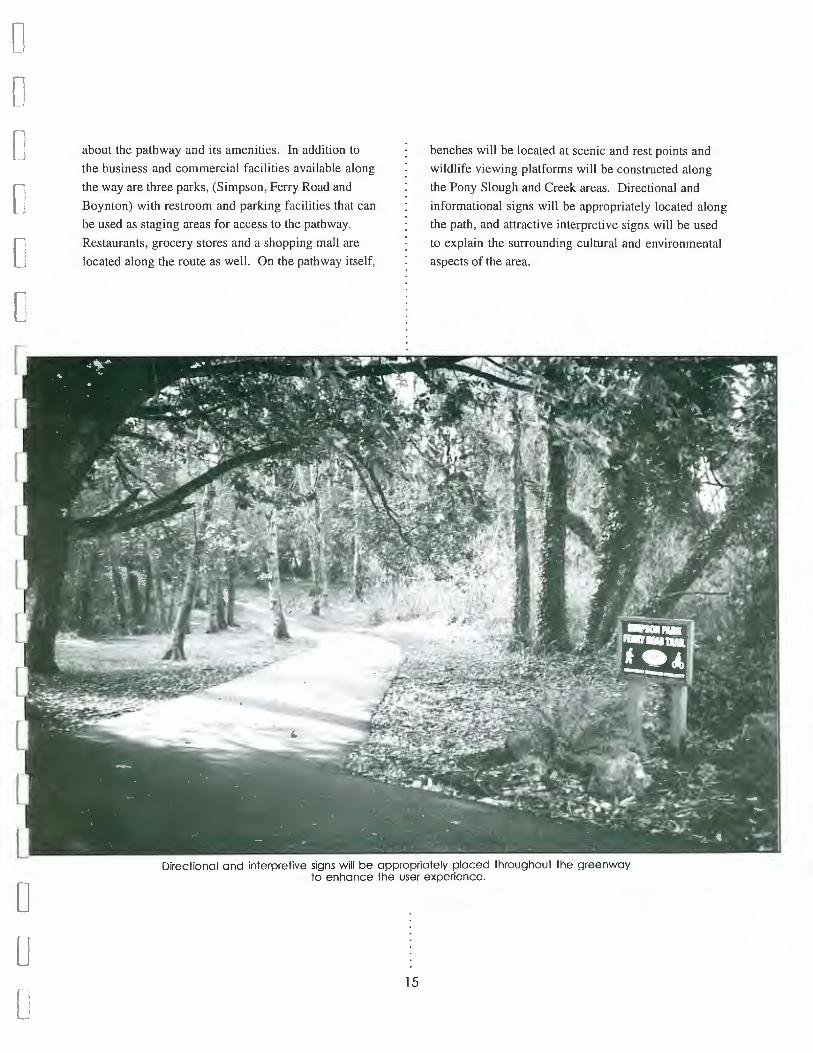
about the pathway and its amenities. In addition to
the business and commercial facilities available along
the way are three parks, (Simpson, Ferry Road and
Boynton) with restroom and parking facilities that can
be used as staging areas for access to the pathway.
Restaurants, grocery stores and a shopping mall are
located along the route as well. On the pathway itself,
benches will be located at scenic and rest points and
wildlife viewing platforms will be constructed along
the Pony Slough and Creek areas. Directional and
informational signs will be appropriately located along
the path, and attractive interpretive signs will be used
to explain the surrounding cultural and environmental
aspects of the area.
Directional and interpretive signs will be appropriately placed throughout the greenway to enhance the user experience.
15
Fl c oM ,", o ro r R \ \.
Interpretive signs inform and educate people on a variety of topics related to an areas natural and cultural resources.
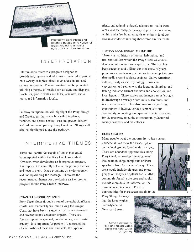
INTERPRETATION
Interpretation refers to a program designed to
provide informative and educational material to people
on a variety of topics related to an areas natural and
cultural resources . This information can be presented
utilizing a variety of media such as signs and displays,
brochures, guided walks and talks, web sites, audio
tours, and information kiosks.
Pathway interpretation will highlight the Pony Slough
and Creek areas that are rich in wildlife, plants,
fisheries, and scenic beauty. Past and present history
and culture encompassing Pony Creek and Slough will
also be highlighted along the pathway.
INTERPRETIVE THEMES
There are literally thousands of topics that could
be interpreted within the Pony Creek Watershed.
However, when developing an interpretive program,
it is important to carefully select a few primary themes
and keep to them. Many programs try to do too much
and end up diluting the message. These are the
recommended themes for developing an interpretive
program for the Pony Creek Greenway.
COASTAL ENVIRONMENTS Pony Creek flows through three of the eight significant
coastal environment types found along the Oregon
Coast that have been categorized by natural resource
and environmental education experts. These are
forested upland watershed, coastal valley; and coastal
estuary. It is important for people to understand the
characteristics of these environments, the types of
PONY CREEK CREENWAY A Concept Plan 16
plants and animals uniquely adapted to live in these
areas, and the complex biological processes occurring
within and a few hundred yards on either side of the
stream corridor connecting these three environments.
HUMAN LAND USE AND CULTURE There is a rich history of human habitation, land
use, and folklore within the Pony Creek watershed
deserving of research and expression. The area has
been occupied and utilized for thousands of years,
presenting countless opportunities to develop interpre
tive media around subjects such as : Native American
culture, lifestyles and mythology ; European
exploration and settlement; the logging, shipping, and
fishing industry; current business and economics; and
local legends. These stories and images can be brought
to life through a variety of art, music, sculpture, and
interpretive panels. This also presents a significant
opportunity to involve vµrious segments of the
community in creating a unique and special character
for the green way (e.g., the arts community, historical
society, teachers, and educators.)
FLORA/FAUNA Many people want the opportunity to learn about,
understand, and view the various plant
and animal species founq within an area.
There are abundant opportunities along
Pony Creek to develop 'viewing areas'
that could be large bump-outs or short
spur trails from the main pathway. These
areas could include pictures and photo
graphs of the types of plants and wildlife
commonly found in the area and could
include more detailed information for
those who are interested. Primary
opportunities for these areas are along the
Pony Slough Estuary
and the large wetland
area adjacent to
Newmark Street.
Some examples of flora and fauna visible along the Pony Creek
Greenway
:l n !l
11
!.l
i I r l
l . ·e-J
IJ

n n n I
C [
[
0 0 0 0
fj
C L u C
EDUCATION SCIENCJE CENTER
BACKGROUND
A significant portion of the area containing Pony
Creek and its associated wetlands is on land owned by
the North Bend School District. Consequently, many
members of the North Bend School Board have often
talked about the opportunity to develop an education
science center for school use as a 'hands-on' classroom
for science and environmental education classes. In
fact, the idea for creating a greenway along Pony
Creek originated from a series of focus group meetings
organized by the School Board to discuss environmen
tal education opportunities along Pony Creek.
FUNCTION
The education science center would function as a
living laboratory where students could get involved in
a variety of hands-on science projects.
Examples include:
/It Wetland restoration and long-term
monitoring for results
!It Fish and plant propagation
!It Water and air quality testing and
monitoring
!It Inventory and catalog various plant,
animal, bird and invertebrate species
in wetland, riparian and estuary
habitats
!It Monitor and control invasive,
non-native species
!It Other projects involving biology,
botany, geology, meteorology,
physics, chemistry, astronomy, etc.
17
It is also envisioned that the facility could function
as an education science center for populations outside
the North Bend student body. Pony Slough is readily
accessible which makes it an ideal setting for field
trips and outdoor learning. Programs could be
established whereby outside school districts bring in
students for one or more days to study topics related
to marine, estuary and coastal environments utilizing
Pony Creek, Pony Slough and other nearby resources
(e.g., South Slough National Estuary Reserve) .
DESIGN
The facility would be designed to accommodate
approximately thirty students at a time in a classroom/
laboratory type setting. The building itself would be
integrated into the greenway, providing opportunities
for trail users to learn about various student activities
and projects . This could include display windows for
school projects and periodic public open houses. It is
also envisioned that one entire outside wall would be
an aquarium containing native fish species, Inside,
the building would likely have concrete floors
with laboratory bench tops allowing for quick and
easy cleaning.
LOCATION
The proposed location for the education science
center would be close to Pony Creek in the area
between the two ballfields near where the pedestrian
bridge will cross the creek.
MAINTENANCE AND MANAGEMENT
MANAGEMENT
The Pony Creek Greenway will be jointly developed
and managed in partnership between the North Bend
Parks and Recreation Department and the North
Bend School District (hereinafter referred to as the
'Managers'). Close coordination between management
officials of both agencies will be a regular and
on-going occurrence. It is anticipated that both parties
will jointly sign a 'Memorandum of Agreement' for
sharing maintenance and operation costs, and
implementing operational procedures for the greenway.
Generally, the School District will manage the
green way over school property, and the Parks and
Recreation Department will manage the rest. There
will, however, be occasions when one agency or the
other will take the lead role in implementing certain
actions throughout the greenway corridor based on
the availability of needed expertise and resources.
HOURS OF OPERATION
The trail will operate on a 'dawn to dusk ' policy.
No night lighting will be used so darkness will deter
people from using the trail at night. Signs will be
posted at trailheads indicating the trail is closed
after dark.
LITTER
Litter and debris can be an issue where people have
access, and consequently there needs to be a joint
effort between the users, the City, the School District
and the community to keep the area clean . In
addition, students, volunteers, businesses and people
who live along the route can also help with litter
control and in reporting maintenance that needs to be
addressed. It is likely that an 'Adopt-A-Trail' program
will be implemented in which certain groups,
organizations and/or individuals would assume
PONY CREEK CREENWAY A Concept Plan 18
responsibility for maintaining a section of the trail.
Trash receptacles should be appropriately placed at
key locations throughout the route.
SAFETY
Trail safety is an area that will receive close attention
in the design phase of the project. Physical safety
issues will be addressed in the following areas: grade
and cross-slope dimensions; line of sight around
corners; brush clearance; railings; directional and
warning signs; at-grade crossings and intersections;
and congestion among multiple users. In addition,
vandal-resistant products and designs will be used
wherever possible to discourage illegal activity that
could lead to a hazard.
VOLUNTEERS
It is strongly recommended that the Managers develop
and implement a volunteer program that allows people
to get involved with the day-to-day operations of
the greenway. This would contribute to the goal of
developing public stewardship for the watershed.
For example:
• Civic groups, youth organizations, or
businesses might want to adopt a section of
trail and be responsible for litter patrol and
light maintenance
• Another group might build, install and
maintain signs and benches (according to a
standardized design - haphazard development
should not be allowed)
• The North Bend Police bike patrol might
be able to specially train a local bike club or
youth organization who could then patrol the
trail on bike (non-law enforcement) and
provide visitor information and assistance
11
11
n n 1 l r-1
l l
u l]
11
u LJ I I
Li
I '

n
[:
[
[
[
[
C [
C C [
L L L u L-
L
#There might be a local art community that
could incorporate art into the greenway (i.e.,
music , poetry, sculpture, painting, murals, and
dance.) A local conservation club or bird
watching group could lead nature walks or
help identify birds and wildlife
# Annual events could be
organized around 'Earth Day '
and 'National Trails Day ' for
activities like creek restoration ,
fun runs, purple Joosestrife
control , etc.
LAW ENFORCEMENT
The City of North Bend Police
Department will have jurisdiction over
the pathway because of its location within
the city limits. The area is under a current
patrol schedule; this will continue as it
has in the past. In addition, the North
Bend Police bike patrol will be able lo
frequently ride the trail. The bike patrol
will be a great aid to personal safety for
users, as well as a lookout for any potentially
hazardous maintenance situations that may need
attention.
PET POLICY
Pets will be allowed on the trail as Jong as they are on
a leash . Pet owners will be encouraged to clean up
after their pets through the use of signs, informational
brochures, etc.
19
COORDINATION WITH ADJACENT
LANDOWNERS
Establishing and maintaining a 'Good Neighbor'
policy will be a high priority for the Managers. It is
Volunteer bike patrols could be specially trained by the North Bend Police Bike Patrol Unit
critically important that everyone living adjacent
to the greenway know who they can contact with
questions, comments, suggestions or concerns; that
they will be listened to; and that they will be treated
reasonably and courteously. During the design and
construction phase, city staff will work directly with
adjacent landowners to incorporate their desires for
appropriate landscaping and screening. Once the trail
is open, city officials will encourage trail users to park
at designated parking areas rather than on residential
streets. Over time, as trust and confidence grows,
adjacent landowners can become a second set of eyes
and ears watching over the greenway and alerting
appropriate officials about maintenance, safety and
other operational matters of concern.

ENVIRONMENTAL REVIEW 1& PERMITTING
Implementing a project like the Pony Creek Greenway
will likely be subject to multiple environmental review
and permitting processes. It is important to realize
these processes are in place for good cause to protect
public interest in fundamental rights to clean air, water,
a healthy environment, and protection of a shared
cultural heritage.
Preliminary contact with officials at the Oregon
Division of State Lands indicated the following:
I) no permit will be required for a wooden boardwalk
that is above the vegetation ; 2) piling is okay ; 3) an
asphalt trail located near the edge of the creek is okay;
4) they would like to see a concept drawing of the
education science center and related functions of
this component.
Serious problems are not anticipated
with these processes because the
stated goals of the Pony Creek
Greenway are fully compatible with
these requirements. This document
reflects a strong desire to conserve,
Protecting species habitat is the most common and effective way of assisting listed species to survive.
Preliminary contact with officials at
the U.S . Army Corps of Engineers
indicated the following: 1) a permit
is required for any intrusion to
restore and wisely manage the natural and cultural
resources within the proposed corridor in a manner
fully consistent with the same values environmental
review and permitting processes are designed to
protect.
Following is preliminary information on topics that
may be subject to environmental review during the
planning and construction of the green way.
WETLANDS
Wetland areas were disappearing in the United States
at an alarming pace prior to enactment of laws
designed to protect against the net loss of further
wetland areas. Consequently, development proposals
that would negatively impact wetland areas are now
required to obtain a permit that demonstrates how
impacts to those wetlands will be mitigated.
The Pony Creek Greenway is envisioned to be located
directly over some wetland areas and designed in such
a manner that allows people visual access (for wildlife
observation) but will not have direct, negative impacts.
In addition , this plan envisions restoration and better
management of the existing wetland resources of Pony
Creek.
PONY CREEK CREENWAY A Concept Plan 20
wetlands; 2) the permit application
must describe type of materials, length , route, etc. of
the boardwalk; 3) they would want to see a description
of the education science center and then can say what
requirements are, if any. They did not foresee any
readily identifiable problems with the boardwalk
proposal.
THREATENED AND ENDANGERED SPECIES
The Threatened and Endangered Species Act was
passed by Congress to identify, list and protect species
of plants or animals considered to be threatened or
endangered with possible extinction . Protecting
species habitat is the most common and effective way
of assisting listed species to survive.
Preliminary consultations with wildlife biologists
and botanists reveal no knowledge of threatened or
endangered species within the proposed greenway
area. In addition, this plan envisions restoration and
better management of habitat areas to provide for
native plants and wildlife.
1 11
11
n
11
r :
n
r 1
Jj
I I LJ
l I
l_l
IJ

n n n
C
C 0 [J
C [
L [
u L
WATER QUALITY
Pony Creek is des ignated as Water Quality Limited,
which means it has high levels of fecal coliform. This
designation is based on 1983 data from the Oregon
Department of Environmental Quality (DEQ) that is
considered to be outdated. Recent water quality
testing conducted by the city shows that the water
quality is much improved and not a significant
problem. DEQ is not scheduled to address the Pony
Creek area in a water quality management plan until
the year 2002.
Preliminary contact with officials at DEQ revealed
they are less concerned with the proposed pathway
than the education science center that may be directly
utilizing the creek. DEQ will be asked to comment on
the project through the Army Corps of Engineers
permit process and will state problems and objections,
if any, at that time. They indicated a willingness to
participate in joint meetings designed to move the
project forward in such a manner that would not
impede any solutions to improving the water quality
in the future.
BUILDING IN FLOOD PLAINS
Laws covering the type of development that can or
cannot occur within noodplains have been passed to
protect society (and individuals) from the high cost of
recovering from a major nood event. The type of
development envisioned for the Pony Creek Greenway
(i .e ., boardwalk, asphalt path , and benches) is usually
compatible with these laws. Furthermore, development
of a green way along Pony Creek will enhance the areas
functional ability to absorb noodwater and thereby
help prevent damage to adjacent property in the case
of a major flood event.
21
ARCHAEOLOGY/HISTORIC PRESERVATION
Archaeology and historic preservation laws exist
to protect against unnecessary and unauthorized
disturbance of historical and/or pre-historical artifacts
and/or human remains. Preliminary discussions with a
cultural resource specialist from the Bureau of Land
Management about the proposed Pony Creek
Greenway project did not reveal any potential
problems with
archaeological
artifacts, primarily
because most areas
subject to
construction have
been previously
disturbed.
The city of North Bend will take all reasonable and
customary precautions to preserve the historic
surroundings.
Nevertheless, estuaries, rivers and headlands are
areas considered archaeologically 'sensitive' due to
Native American hunting and gathering practices.
Additionally, it has been suggested that a Coos village
may have been located at one time in the area near
what is now North Bend High School. Impacts to any
historic buildings or structures are not likely at all.
The city of North Bend will take all reasonable
and customary precautions to avoid impacting
archaeological sites and, in the event human remains
or artifacts are uncovered during construction, will
immediately cease construction activity, secure the
area, and initiate consultation with the State Historic
Preservation Office (SHPO) in Salem.
LAND USE PLANNING
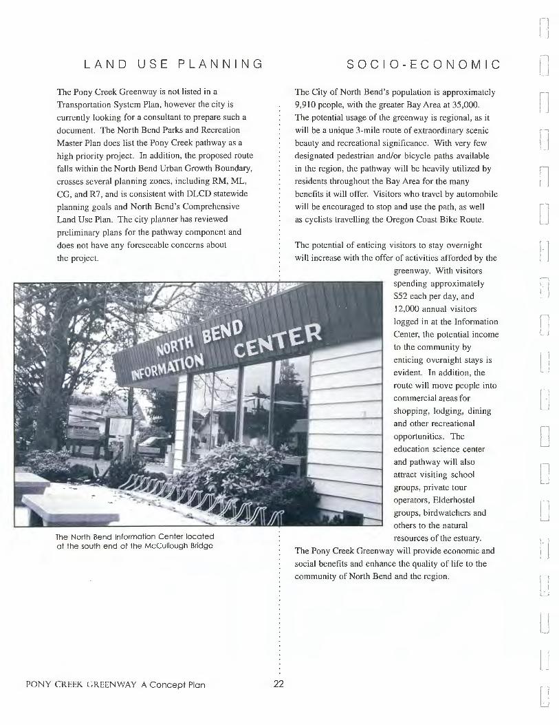
The Pony Creek Greenway is not listed in a
Transportation System Plan, however the city is
currently looking for a consultant to prepare such a
document. The North Bend Parks and Recreation
Master Plan does list the Pony Creek pathway as a
high priority project. In addition , the proposed route
falls within the North Bend Urban Growth Boundary,
crosses several planning zones, including RM, ML,
CG, and R7, and is consistent with DLCD statewide
planning goals and North Bend's Comprehensive
Land Use Plan. The city planner has reviewed
preliminary plans for the pathway component and
does not have any foreseeable concerns about
the project.
The North Bend Information Center located at the south end of the McCullough Bridge
PONY CREEK CREENWAY A Concept Plan 22
SOCIO-ECONOMIC
The City of North Bend's population is approximately
9,910 people, with the greater Bay Area at 35,000.
The potential usage of the green way is regional, as it
will be a unique 3-mile route of extraordinary scenic
beauty and recreational significance. With very few
designated pedestrian and/or bicycle paths available
in the region, the pathway will be heavily utilized by
residents throughout the Bay Area for the many
benefits it will offer. Visitors who travel by automobile
will be encouraged to stop and use the path, as well
as cyclists travelling the Oregon Coast Bike Route.
The potential of enticing visitors to stay overnight
will increase with the offer of activities afforded by the
greenway. With visitors
spending approximately
$52 each per day, and
12,000 annual visitors
logged in at the Information
Center, the potential income
to the community by
enticing overnight stays is
evident. In addition, the
route will move people into
commercial areas for
shopping, lodging, dining
and other recreational
opportunities. The
education science center
and pathway will also
attract visiting school
groups, private tour
operators, Elderhostel
groups, birdwatchers and
others to the natural
resources of the estuary.
The Pony Creek Greenway will provide economic and
social benefits and enhance the quality of life to the
community of North Bend and the region.
fl
11
n 11
n n [ 1
n
.] j
l J
LJ \ I LJ
l j
LJ
u [_ I
lJ

n
[
C
~
f i I
C [
D C D [
L l L L L
Putting together a greenway project of this magnitude
requires fundraising from numerous sources that will
likely include a combination of federal , state, local and
private grant programs, community fundraising and
creative non-monetary support. Most grant programs
are established for specific purposes (e.g., recreation,
environmental restoration, transportation , health and
fitness, education, and science) and the challenge is to
identify those elements of the green way that match
targeted funding sources.
Following is information on some of the better
known grant programs that can assist in greenway
development.
FEDERAL
TEA-21 The most significant source of money for the Pony
Creek Greenway is contained in the Transportation
Equity Act for the 21st Century (TEA-21 ). Congress
passed TEA-21 legislation in 1998, thereby
authorizing highway, highway safety, transit and
other surface transportation programs for the next six
years . Total TEA-21 funding is about $198 billion.
The reason this is important as a potential funding
source is because the legislation includes initiatives
to protect and enhance communities and the natural
environment as it provides for the nation's transporta
tion needs . These enhancement activities include
the provision of facilities for bicycles and pedestrians
as an integral part of communities' transportation
infrastructure.
TEA-21 contains several different "pots" of money for
specific program areas, but the one of most importance,
that includes 'Transportation Enhancements', is called
the Surface Transportation Program (STP), which was
funded at $33.3 billion over six years. STP is a block
grant-type program that makes money available to
state and local communities for a broad range of
transportation activities and includes a mandatory ten
23
FUNDING SOURCES
percent set-aside for transportation enhancement
activities ($3.33 billion!) . Clearly this is a significant
source of funding for bicycle and pedestrian facilities .
It has already had profound impacts in communities
across the country and its potential cannot be under
stated.
EDITOR 'S NOTE: During development o,fthis
concept plan, the City of North Bend applied for and
received a TEA-21 enhancement grant.from the Oregon
Department of Transportation in the amount of
$574,750. The grant will be used for development of
the pathway component of the Pony Creek Greenway.
A portion of the funds will be utilized in the fall of
1999 for engineering and design work, and actual
construction is expected to occur during the construc
tion season in the summer of 200 I. On behalf of the
Planning Team, Advisory Committee and residents
of North Bend, THANK YOU Oregon Department
of Transportation!
EPA Environmental Education Grants
The U.S. Environmental Protection Agency (EPA)
administers a grant program for environmental
education projects . Grants of under $5,000 are
encouraged, but can be higher. Contact: Sally Hanft,
(206) 553-1207 or 1-800 424-4EPA.
STATE
Oregon Bicycle and Pedestrian Program
I% of state gas taxes are set aside in a fund for
projects benefiting non-motorized bicycle and
pedestrian projects in Oregon. See 'Oregon Bicycle
and Pedestrian Plan' for detailed information on
guidelines and criteria for accessing these funds .
Contact: Michael Rankin, Manager
Oregon Bicycle and Pedestrian Program
Oregon Department of Transportation
Room 210 Transportation Building
Salem, Oregon 97310
(503) 378-3433

Land and Water Conservation Fund
The Land and Water Conservation Fund (L&WCF)
was enacted by Congress in 1964 to establish a
funding source for grants to state and local
crovernments for land acquisition and/or development b
of outdoor recreation areas and facilities. The program
is managed by the National Park Service but
administered in each state through a governor
appointed state agency responsible to the National
Park Service (i.e., federally funded/state administered
program). L&WCF grants require a 50% match from
state or local funds. Eligible applicants include cities,
counties, and recreation and park districts authorized
to provide public park and recreation facilities . Areas
funded through L&WCF grant assistance are required
to be dedicated in perpetuity for public recreation
use. In Oregon, the L&WCF is managed by the
Oregon Parks and Recreation Department.
NOTE: Funding for L&WCF has not been authorized
the past few years, so grant money is not currently
available. There are, however, several proposals before
Congress seeking to reinvent, reorganize, and/or
reestablish funding for the program.
Contact: Marilyn Lippincott
Oregon Parks and Recreation Department
I I 15 Commercial Street, NE
Salem, OR 97310-100 I
(503) 378-4168, ext. 241
Oregon State Lottery
Oregon voters passed an initiative in the fall of
1998 authorizing a percentage of state lottery money
to be dedicated to an acquisition and development
grant program for parks and recreation purposes. The
program will be administered by the Oregon Parks and
Recreation Department, which expects to launch it in
the spring of the year 2000.
Contact: Marilyn Lippincott
Oregon Parks and Recreation Department
1115 Commercial Street, NE
Salem, OR 97310-100 I
(503) 378-4168, ext. 241
PONY CREEK CREENWAY A Concept Plan 24
PRIVATE BUSINESS
The Phillips Petroleum Environmental Partnership
Awards program gives grants between $500-$5,000
to community organizations doing environmental
projects like stream restorations. Grants tend to be
given to educational projects with schools or groups
working with schools. Matching funds are required .
Contact: Patricia Marshall, (918) 661-5139
Coors Pure Water 2000 provides non-profit groups
nationwide with small grants for water quality im
provement projects such as river cleanups, restoration
projects and educational programs. Contact: Dave
Taylor, (800) 642-6116
FOUNDATIONS
The Brainerd Foundation awards grants for projects
that build citizen support for environmental protection
and have the potential to influence public policy.
These errants are awarded to incorporated 50l(c) b
(3) organizations only. Contact: (206) 448-7222,
The Harder Foundation is a small foundation that
funds environmental action projects in support of
habitat protection, especially prime habitat areas
facing immediate threats on public lands. Some of
the Harder Foundation's grants involve acquisition
of natural areas, especially when they are of regional
biological significance. Forty percent of their grants
are made to grantees in the states of Washington and
Oregon . Write for "Guidelines for Grant Proposals."
Contact: Del Langbauer (253) 593-2121,
The Give to the Earth Foundation funds a variety of
small environmental projects. Applicant organizations
must have minimal administrative overhead, and
results must be tangible. Typical grant size is $2,500.
Contact: Ellen Liberatori, (800) 933-9628
1 I I
n n n n r 1
r, /. ·1 I
fl
l l
lJ u I l LJ
l J
LJ
u u u

n n.
n
' [
D C C u 0 [i
[
[
[
L u L L
The Bullitt Foundation gives grants to a variety of
environmental projects in the Pacific Northwest.
Contact: Emory Bundy, (206) 343-0807
The Wilburforce Foundation funds wildlife and habitat
protection and environmental education projects.
Contact: Timothy Greyhavens, (206) 286-4554
The Kodak American Green ways Awards Program
provides small grants (from $500 to $2,500) for
green way and trail projects throughout America.
Contact: Denise Swol at The Conservation Fund,
(703) 525-6300 or [email protected].
IN-KIND CONTRIBUTIONS
Many grant programs require a local match to help
demonstrate the communities' commitment to the
project. Often this 'match' requirement can be met with
what is referred to as an 'in-kind' contribution. In-kind
contributions are donations of labor, equipment and
materials to the overall cost of completing a project
that can be translated to a dollar value used to meet the
matching requirement. Volunteer labor for tasks such
as clearing, brushing, construction, etc. , can go a long
way towards meeting local match requirements when
applying for grants.
Volunteers
NON-MONETARY SOURCES OF ASSISTANCE
Individuals, organizations, corporations and businesses
may volunteer for many of the tasks required for
development and maintenance of the greenway. A
few specific examples of possible volunteer sources
include: youth groups such as the boy and girl scouts;
historical societies; the arts community; senior citizen
groups; service clubs and organizations (e.g., Rotary,
Lions, etc.); church groups; and business and/or
employee associations.
25
To use volunteer assistance most effectively, it is
suggested that a volunteer program be established.
Such a program should consist of three components:
I) task identification; 2) training; and 3) rewards.
A volunteer or college intern could run the program.
Task Identification. It is important to clearly
identify tasks needed for greenway development and
maintenance. By knowing in advance what tasks need
to be completed and what labor, time, and skill are
required, volunteers can be used most effectively. It
is also important to establish construction and
maintenance guidelines and standards (i .e., design
styles, colors and materials) to avoid haphazard
development and achieve a uniform look and feel
throughout the greenway.
Training. Training makes volunteers more useful and
knowledgeable, feel needed, and serves as an incentive
for long term commitment. Following are ideas to
include in a training program:
• Safety and proper use of tools.
• Overview of management objectives and
policies
• Information on the natural and cultural
resources of the green way and how they are
helping protect and manage those resources
• Emergency preparedness (i.e., what actions
to take in an emergency, who to contact, first
aid and CPR, etc.) .
Rewards. It is important to reward people for their hard
work and commitment. Ways to show appreciation to
volunteers who donate their time and energy include:
• Certificates - acknowledge their
involvement with the trail
• Training or tools - not only shows
appreciation but also helps them to do a more
effective job
• Mementos - gifts such as baseball caps or
T-shirts are another way to say "thank you"
• Parties - annual picnics or barbecues are a
good opportunity for celebrating a job
well-done
Youth Corps
Youth corps work groups can provide assistance either
free of charge or at significantly reduced costs and can
support a variety of labor intensive projects such as
trail construction, stream restoration, habitat improve
ment, tree planting, etc.
Fundraisine
COMMUNITY FUNDRAISING AND
DONATIONS
Service clubs and organizations can be encouraged
to organize and conduct a wide range of activities to
generate revenue for construction and maintenance.
Car washes, bake sales, rummage sales, etc., are all
possibilities. One idea in particular is for an organiza
tion (like a scout troop) to implement a 'Recycle for
the Trail' project. Collection boxes could be
conveniently located throughout town encouraging
people to donate their recycled cans and bottles to the
trail. The organization would regularly collect
contributions and deposit the proceeds into an account
set up to support trail maintenance and construction.
Donations Donations are often a big part of funding a trail
project. Corporate sponsors can potentially contribute
thousands of dollars through direct contributions,
endowments, or employee challenge/match programs.
PONY CREEK CREENWAY A Concept Plan 26
INFORMATION SOURCES
The best source of information for all federal
grant programs is a catalog published by the U.S.
Government Printing Office called the 'Catalog of
Federal Domestic Assistance.' The catalog is a
compendium of federal programs, projects , services,
and activities, which provide assistance or benefits
to the American public. It contains information on
programs administered by departments and
establishments of the federal government organized
by agency, function, subject, and applicant eligibility.
The catalog is available at most libraries and is sold
on a subscription basis by the Superintendent of
Documents, U.S. Government Printing Office,
Washington, D.C. 20402.
The Environmental Protection Agency (EPA) and
the North American Association for Environmental
Education (NAAEE) have developed a publication
called "Grant Funding for Your Environmental
Education Project" which provides strategies for
identifying potential sources of funding. This
publication can be purchased for $5 from NAAEE,
Publications and Member Services, P.O. Box 400,
Troy, Ohio, 45373.
The 1996-97 Pacific Northwest Grantmakers
Forum Member Directory lists more than fifty major
foundations in the Pacific Northwest. It is available
from the Forum at (206) 624-9899, or you can contact
Seattle Public Library's Grantsmanship Center. The
Grantsmanship Center has a complete collection of
resources for anyone seeking grant funding . Seattle
Public Library, 1000 4th Avenue, Seattle, WA 98104.
Call: (206) 386-INFO.
The National Small Flows Clearinghouse operates a
computer bulletin board that can help "tread the murky
waters of environmental finance". The bulletin board
lists grant and loan opportunities, and provides
information on funding alternatives, highlights of
successful funding methods, and referrals to financing
experts. Contact: Brad Maust, (800) 624-8301 .
11
11
n ll n
f l
IJ
I I
I J
I , LJ
L l ]
LJ
I 1

n n
l: [
[
[
C [
C [
0 [
L L L L L
The Pony Creek Greenway will be a carefully
planned corridor along Pony Creek and Pony
Slough that blends and integrates various community
transportation, recreation , environmental education
and resource conservation goals . It will be used
by residents and visitors for recreation and as a
non-motorized transportation link to other parts of the
community. It will preserve habitat for native plant
CONCLUSION
and animal communities. It will serve as an outdoor
classroom where people can learn about natural
physical processes and ecosystems. Finally, it will
increase people's awareness and stewardship for the
important, but often forgotten, resources of Pony
Creek which flows through the heart of the City
of North Bend.
Proposed Pony Creek path that will run through the heart of the city.
27

APPENDICES
Pied-billed Grebe
Great Blue Heron
Great Egret
Green Heron
Turkey Vulture
Canada Goose
Wood Duck
Mallard
Bufflehead
Osprey
Bald Eagle
Northern Harrier
Sharp-shinned Hawk
Cooper's Hawk
American Kestrel
Merlin
Virginia Rail
Sora
American Coot
Common Snipe
Mew Gull
California Gull
Western Gull
Caspian Tern
Rock Dove
Band-tailed Pigeon
Mourning Dove
CHECKLIST OF BIRDS FOR PONY SLOUGH MARSH
(Adjacent to Pony Creek at NBHS & NBJH):
BIRDS
Common Nighthawk Swainson's Thrush Vaux's Swift Wrentit
Rufous Hummingbird European Starling
Belted Kingfisher Cedar Waxwing
Downy Woodpecker Orange-crowned Warbler
Hairy Woodpecker Yellow-rumped Warbler
Northern Flicker Townsend's Warbler
Olive-sided Flycatcher Common Yellowthroat
Western Wood-Pewee Wilson's Warbler
Pacific-slope Flycatcher Western Tanager
Hutton's Vireo Spotted Towhee
Steller's Jay Savannah Sparrow
American Crow Fox Sparrow
Common Raven Song Sparrow
Tree Swallow White-crowned Sparrow
Violet-green Swallow Dark-eyed Junco
N. Rough-winged Swallow Red-winged Blackbird
Barn swallow Western Meadowlark
Cliff Swallow Brewer's Blackbird
Black-capped Chickadee Brown-headed Cowbird
Chestnut-backed Chickadee House Finch
Bush tit
Red-brested Nuthatch
Winter Wren
Marsh Wren
Golden-crowned Kingly
Ruby-crowned Kingly
Red Crossbill
Pine Siskin
American Goldfinch
House Sparrow
(Compiled by Larry Thornburgh North Bend High School, 4/98)
PONY CREEK GREENWAY A Concept Plan 28
l 11
n :l 11
i I
I ]
I J
l j
I I
l J
LJ
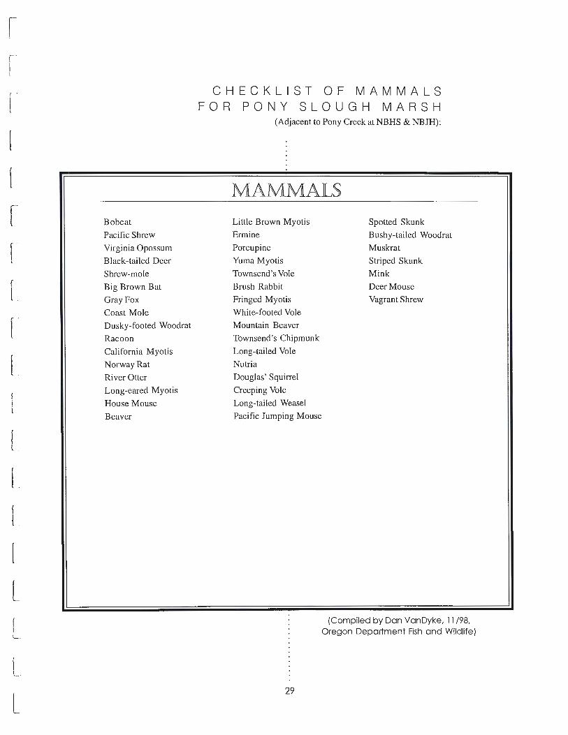
1!
n n
[
[
[
D D C [
[
[
[
L L L
Bobcat
Pacific Shrew
Virginia Opossum
Black-tailed Deer
Shrew-mole
Big Brown Bat
Gray Fox
Coast Mole
Dusky-footed Woodrat
Racoon
California Myotis
Norway Rat
River Otter
Long-eared Myotis
House Mouse
Beaver
CHECKLIST OF MAMMALS FOR PONY SLOUGH MARSH
(Adjacent to Pony Creek at NBHS & NBJH):
MAMMALS
Little Brown Myotis
Ermine
Porcupine
Yuma Myotis
Townsend's Vole
Brush Rabbit
Fringed Myotis
White-footed Vole
Mountain Beaver
Townsend's Chipmunk
Long-tailed Vole
Nutria
Douglas' Squirrel
Creeping Vole
Long-tailed Weasel
Pacific Jumping Mouse
29
Spotted Skunk
Bushy-tailed Woodrat
Muskrat
Striped Skunk
Mink
Deer Mouse
Vagrant Shrew
(Compiled by Dan VanDyke, 11 /98, Oregon Department Fish and Wildlife)

CHECKLIST OF PLANTS FOR PONY SLOUGH MARSH
On July 31 , 1998, a cursory survey was conducted infestation of purple loosestrife (Lythrum salicaria)
which, without any action in the near future (such as
establishment of biocontrols or herbicide application),
threatens the integrity of the wetland. Purple
loosestrife has the ability to outcompete native
vegetation and will degrade nesting habitat for
waterfowl. No federally endangered or threatened
plant species, or species on the Oregon Natural
Heritage List, were located during the survey.
of the plants of Pony Slough from the baseball field to
Newmark Street in the area along the west side of the
channel. This list should not be considered
comprehensive since only a small portion of the area
was surveyed. The plant communities could be
characterized as typical brackish/freshwater marshes
dominated by cattails (Typha latifolia) and slough
sedge (Carex obnupta). This area has a serious
PLANl_,S COMMON NAME SCIENTIFIC NAME
Silverweed Potentilla Anserina
Slough Sedge Carex Obnupta
Tall Fescue Festuca Arundinacea
Tufted Hairgrass Deschampsia Cespitosa
Cattail Typha Latifolia
Purple Loosestrife Lythrum Salicaria
Curly Dock Rumex Crispus
Bentgrass Agrostis Stolonifera
Dagger-leaf Rush Jancus Ensifolius
Meadow Barley Hordeum Branchyantherum
Bulrush Scirpus Tabernaemontani
Brass-buttons Cotula Coronopifolia
Pondweed Potomogeton Sp
Foxtail Alopecurus Pratensis
Lilaeopsis Lilaeopis Occidentalis
Lyngbye's Sedge Carex Lygnbyei
American Water-plantain Alisma Plantago-aquatica
Spike-rush Eleocharis Sp
Hooker's Willow Salix Hookeriana
Arrow-grass Triglochin Striata
Reed Canary Grass Phalaris Arundinacea
Speedwell Veronica Sp
Water Buttercup Ranunculus Flammula
Water Starwort Callitriche Sp
Burreed Sparganium Sp
Knotweed Polygonum Hydropiperoides
Rushes Jancus Spp
Creeping Buttercup Ranunculus Occidentalis
Gumweed Grindelia Sp
ABUNDANCE*
Common
Common
Uncommon
Uncommon
Common
Common
Uncommon
Common
Rare
Uncommon
Common
Uncommon
Uncommon
Uncommon
Rare
Uncommon
Uncommon
Common
Uncommon
Rare
Uncommon
Uncommon
Uncommon
Uncommon
Rare
Uncommon
Uncommon
Rare
Rare
* Refers to abundance within the survey area (List Compiled Courtesy of BLM 7 /98)
PONY CREEK CREENWAY A Concept Plan 30
IJ
11
n
n 11
I :
I·.
r l
I ]
u
_j
u
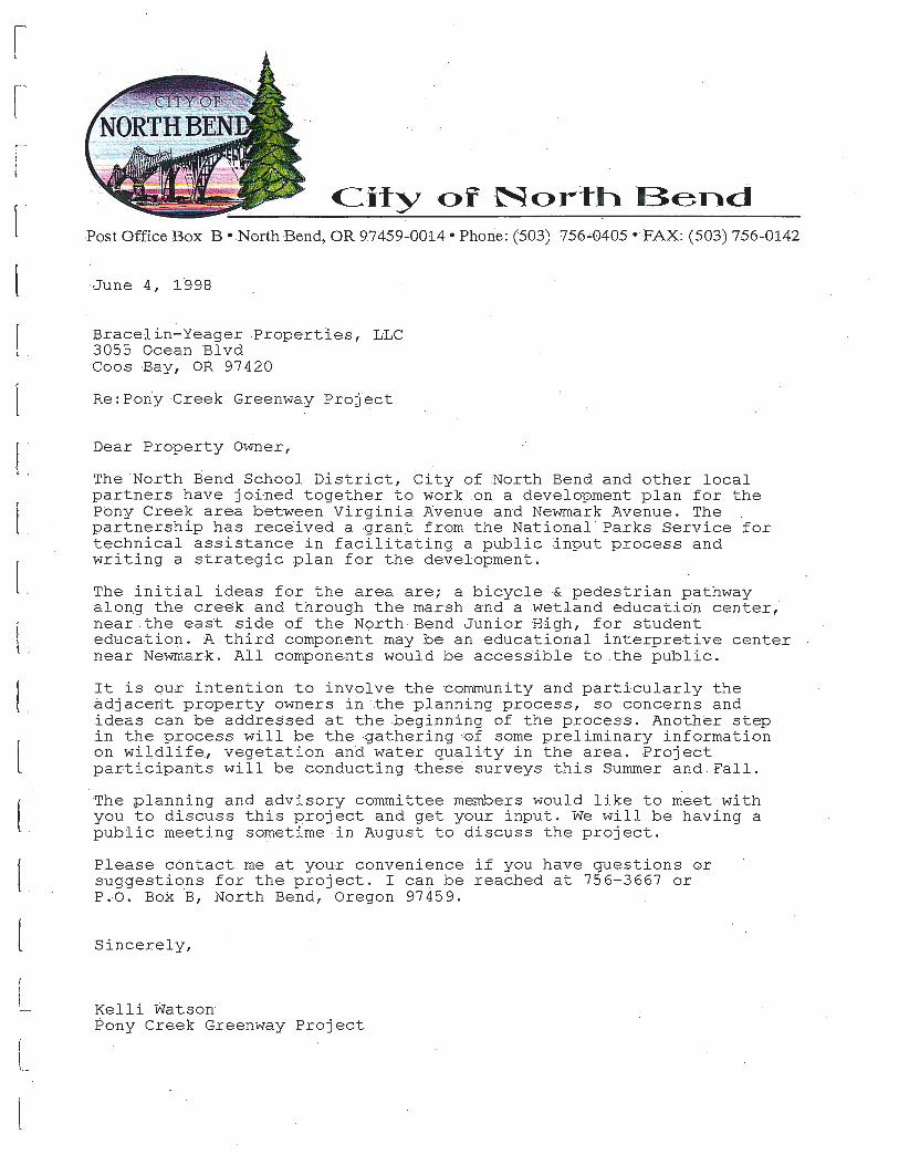
n n n [
C
u
0 0 C
u [
[
C u u
City o :r 'North Bend . . . . .
·,Post -Office Box B • North ·Bend, OR 9.7459 -=0014 • Phorie: (503) 756.:.0405 · ·,FAX: (503) 756..:0142
-June 4, 1998
Braceliri-Yeager :Propert:Les, LLC 3055 Ocean 'Blvd Coos Bay, .OR 97 420
Re: Pon:y Creek Greenway -Project
Dear Property Owner,
The 'North ~end School District, City of North Bend and other local partners have j oi-ned together to work on a development plan for the Pony Creek area between Vir_ginia Avenue and Newmark .Avenue. The partnership has rece·ived a ,grant from the National · Parks Service for technical assistance in facilitating a public :input process and writing a ~trategic ~lan for the development.
The initial ideas for the area are; a bicycle ,& pedestrian pathway along the creek and through the marsh and a ·.wetla·nd education center, near the east side of the .North :Bend ·Junior -High, £-or student e<:l.ucation. -A third component may be an educational interpretive center near Newmark. All components would be .access-ible to the public.
It is our. intention to involve the c.ommuni ty and particularly the adjacent ,property owners in :the '_planning process, so concerns and ideas can be addressed at the beginning of the process. Another step in the process will be the -gathering -0£ so~e preliminary informa~io:h on wildlife, vegetation and water quality· in the area. -Project parti·ci'pants will be conducting these surveys this ·summer and Fall.
The ,planning and . advisory committee ·members would like to meet with you to discuss this project and get your input. We will b~ ha~ing a public meeting sometime in August to discuss the project.
Please c6ntact me at your convenience if you have ~uestions oi suggestions for the .project. I can b~ reached at 756-3667 or P.O. Bo~ B, North Berid, Oregon 97459.
Sinceiely,
Kelli Watson ~brty Creek . Greenway Project

PUBLIC MEETING COMMENTS - SEPTEMBER 1998
Pony Creek Greenway Project Public Meeting and Workshop September 28, 1998
SUMMARY OF COMMENTS
Vision/Management Issues
I . Chuck Erwin - Concern about litter and vandalism
to area if opened to public.
2. Vision Statement is very good (oral comment)
3. Concern expressed about how maintenance and
upkeep will occur after trail is built. Where will
money come from and who will be responsible?
4. Safety for users of trail from criminal activity.
5. If young people could be made to feel they had a
stake in this project (a feeling of ownership) it might
go a long ways toward the issues of trash/litter
control, keeping vandalism down and keeping
things clean.
Trail Design
1. Development plans for 2 block area west of pump
station. Plans to build condos and needs all the land
base available and doesn't want the trail to be in
people's backyard. Would prefer trail be closer to
the creek in this area. He owns the wetland portion
too. He would be willing to possibly donate this
land for the project and wants to work closely with
the committee on this issue. Favors overall concept.
(Scott Lewis, owner).
2. Concerned about access off of trail onto his property.
Lives near Clark Street. Favors project concept.
(Unknown owner).
3. Concerned about access from trail onto his property.
Favors concept plan. (Pastor at Gold Coast
Academy).
4. Concerned about access to his property from the
trail. Lives on east side of Pony Creek area.
(Bill Poppe).
5. Do you agree with preliminary thinking about trail
location? Yes (2 people)
6. Do you agree with Advisory Committee vision for
a trail that accommodates both recreation and
non-motorized use? Yes (2 people)
PONY CREEK CREENWAY A Concept Plan 32
7. Do you favor construction of wildlife viewing
platforms off the main pathway? Yes (2 people).
8. Would like landscaping used to block views of
residences to discourage crime
9. Prefers wood fencing
Education
1. Do you support the Advisory Committee vision for
the green way to function as an outdoor classroom for
people to learn about the natural world?
Yes (2 people)
2. Send brochures to neighboring schools to invite
them to visit our community.
3. Interpretive Signs - include photos of what to
look for.
4. Curriculum Guide - Yes, yes, yes. Send to schools at
beginning of year so teachers can plan ahead.
5. Display student reports periodically at interpretive
centers to provide an added incentive for thorough
investigation and reporting. Maybe they could be
placed in a (glass) case to protect from weather along
the trail.
Education science center
1. Concerned about Fish Culture Facility being located
right next to her property. Lives at end of 'D' Street.
(Mrs. Nevin, owner).
2. Concern expressed about the school district's desire
to build a fish culture facility. The concern is that
hatchery operations have not proved to be the
answer for saving wild salmon runs, so what is the
lesson we want our students to learn?
3. Concern expressed about the potential conflict
between the Water Board's need to increase reservoir
capacity which could reduce the volume of flow into
Pony Creek and have an adverse impact on the
proposed Fish Culture Facility.
4. Provide public viewing opportunities.
5. Provide guided tours for school's field trips .
6. Would you be interested in learning about the Fish
Culture Facility when passing by while out enjoying
the trail? Yes (2 people).
7. Publicity in local papers.
l
l I 1
I )
,---,
I I
lj
1. J
l 1 L_J
LI
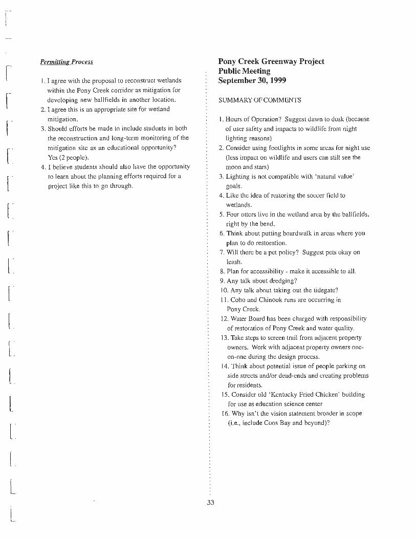
n n 0 0 0 D D 0 0 0 0 0 L Q
0 l u u u
Permitting Process
I. I agree with the proposal to reconstruct wetlands
within the Pony Creek corridor as mitigation for
developing new ballfields in another location .
2. I agree this is an appropriate site for wetland
mitigation .
3. Should efforts be made to include students in both
the reconstruction and long-term monitoring of the
mitigation site as an educational opportunity?
Yes (2 people) .
4. I believe students should also have the opportunity
to learn about the planning efforts required for a
project like this to go through.
33
Pony Creek Greenway Project Public Meeting September 30, 1999
SUMMARY OF COMMENTS
I. Hours of Operation? Suggest dawn to dusk (because
of user safety and impacts to wildlife from night
lighting reasons)
2. Consider using footlights in some areas for night use
(less impact on wildlife and users can still see the
moon and stars)
3. Lighting is not compatible with 'natural value'
goals.
4. Like the idea of restoring the soccer field to
wetlands.
5. Four otters live in the wetland area by the ballfields,
right by the bend.
6. Think about putting boardwalk in areas where you
plan to do restoration .
7. Will there be a pet policy? Suggest pets okay on
leash.
8. Plan for accessibility - make it accessible to all.
9. Any talk about dredging?
I 0. Any talk about taking out the tidegate?
I I. Coho and Chinook runs are occurring in
Pony Creek.
12. Water Board has been charged with responsibility
of restoration of Pony Creek and water quality.
13. Take steps to screen trail from adjacent property
owners. Work with adjacent property owners one
on-one during the design process.
14. Think about potential issue of people parking on
side streets and/or dead-ends and creating problems
for residents.
15. Consider old 'Kentucky Fried Chicken' building
for use as education science center
16. Why isn't the vision statement broader in scope
(i .e., include Coos Bay and beyond)?