a coral reef sub-theme for the igos partnership a coral reef sub-theme for the igos partnership...
TRANSCRIPT


A Coral Reef Sub-theme for the IGOS Partnership
DHW Chart for the end of March 1998 (left) and 2002 (right) showing the accumulation of HotSpots over the summer (Decemberthrough March). Units are in ∞C-weeks.

1Report from the Coral Reef Sub-theme Group
Feeding polyps on massivecoral head. Dr. James
McVey, NOAA Sea GrantProgram, 1974.

2 A Coral Reef Sub-theme for the IGOS Partnership
Table of ContentsExecutive SummaryThe Challenge of Observing Coral Reefs
Justification for Coral Reef Sub-theme
Background
The Coral Reef Sub-theme - Present Status and Challenges
Issues for a Coral Reef Observing Strategy 7
35
Coral Reef User Requirements
Mapping
Detecting Change
Early Warning
Local Reef Status
Implications for Observing System Design 10Optimal Configurations
In Situ Observations
Bridging the Observational Gap
Integration of Remote Sensing and In Situ Information
Improved Coordination Among Existing Programs and Networks
Operational Products and Services
Coral Reef Sub-theme in the Larger Framework 17Role in Initiating the Coastal Theme:
Relation to other themes:
Relation to other programs:
Institutional Responsibilities and Resources for Implementation 19Observations
Data Management
Development and Delivery of Products and Services
Conclusions 21Annex 1A 22Annex 1B 23
Annex 2 24Appendix 1A 25
In Situ Components of Coral Reef Monitoring
Manta Tow (or equivalent)
Line Intercept Transect or equivalent
Live Fish Census
Permanent Quadrat
Additional Components
Reef Check Protocol
Appendix 1B 26NOAA’s Coral Reef Early Warning System Stations
Appendix 2 27Detailed Objectives and User Requirements for Coral Reef Observations
Mapping
Detecting Change
Early Warning
Local Reef Status
Specific User Requirements of the Convention on BIiological Diversity
Appendix 3 32References

Executive SummaryCoral reefs appear to be the first major ecosystem type to show rapid degradation at a globalscale due to human impacts. Coral reefs are critically important because:
• They contain the world’s largest reservoir of marine biodiversity;
• They provide food security, cultural support and physical protection from storms forapproximately 500 million people;
• They are the major natural resource for many countries in the world such as small islanddeveloping States;
• They are the basis for one of the world’s fastest growing industries – coral reef tourism;
• They are declining rapidly from a range of human pressures; and
• There are already distinct signs of damage resulting from global climate change.
It has been predicted that, unless remedial action is taken soon, we could see the virtualdestruction of half of the world’s coral reefs within a generation. In response to this crisis, theIGOS Partners agreed to the immediate development of a Coral Reef Sub-theme inanticipation of a broader Coastal Theme to be developed for GOOS and GTOS. This reportprovides strategic recommendations for improved observations and information for decision-
making on coral reefs.
Observations in the coastal zone offer a variety of challenges typically associated when
working with land, ocean and atmospheric boundaries and their respective interfaces. Thesechallenges limit the possibilities for collecting both in situ and remote data. Coral reefspresent particular biological challenges for observations because of their great diversity, themixed spectral signatures of plant/animal symbioses, and their complex structures generatedby biological activity. There are also temporal challenges from the heterogeneous and dynamicvariations in coral reef communities over time, requiring long time-series observations withenough frequency to determine the state of health of coral reef ecosystems. While coral reef
remote sensing promises to address some of these difficulties, there are institutionalchallenges to integrating remote and in situ observations for coral reef monitoring.
Coral reef users need improved mapping of reefs. This will require the development of similaror harmonized classification systems for reef geomorphology and habitats, research into theirfunctional interpretation, higher resolution imagery to resolve reef features, multispectralimagery able to distinguish between reef habitats and conditions, and new approaches tounderwater remote sensing at intermediate scales. For detecting change, long-termmonitoring programs are required at multiple sites, using imagery with sufficient spatial and
spectral resolution to identify changes in communities, correlating observed changes withoceanographic, terrestrial, atmospheric and climatic trends, and linking present trends withthe reconstruction of past trends.
To improve early warning of coral bleaching, the operational NOAA “HotSpots” early warningsystem should be upgraded with higher resolution satellite sea surface temperaturemeasurements validated by in situ instrument platforms. Early warning for other reef-threatening events (turbidity, cyclones, pollution, etc.) should also be developed incollaboration with the user communities. To improve local reef management, information
products must be generated on the state of local reefs and the effectiveness of managementmeasures at a cost that local users can afford.
For satellite observations of coral reefs, there are two goals:
1. High spatial resolution (1-5 m) hyperspectral sensors with radiometric sensitivity betterthan 12 bits for mapping and monitoring ecosystem health, providing at least annualcoverage of representative coral reefs, and preferably all reefs.
2. Low resolution environmental monitoring of ocean color, sea surface temperature (1 km,0.05∞C), solar insolation, atmospheric sounding for temperature and humidity profilesand CO2 measurements of the water, more accurate sea surface salinity, windscatterometers with more frequent passes near the coast, wave height and direction fromSynthetic Aperture Radar (SAR), and altimetry to current standards.
These need to be accompanied by image processing methods able to differentiate reefsubstrates, a long-term acquisition plan for reef imagery for both annual monitoring of all
3Report from the Coral Reef Sub-theme Group

4 A Coral Reef Sub-theme for the IGOS Partnership
reefs and more frequent coverage for specific sites, procedures for emergency imaging andmonitoring of reefs subject to unusual stress or rapid change, new hyperspectral sensors able
to detect algal accessory pigments indicative of benthic communities, spectral libraries andclassifications of coral reef habitats and optical water quality, and further research on therelative importance of spatial resolution, spectral resolution and spectral sensitivity indiscriminating reef habitats and community changes.
Improved remote sensing imagery can assist by:
• Permitting the mapping and assessment of large and remote areas quickly;
• Assessing characteristics of reefs that have not been measured before;
• Performing near-real time assessments of the status of coral reefs around the world,thereby alerting governments and agencies to conduct in situ verification and targetedresearch, and if feasible, undertake preventive or remedial action.
A significant effort is needed to integrate satellite remote sensing into coral reef monitoring
and modelling programs, complementing and reinforcing in situ monitoring and assessmentthat provide critical in situ data, and supporting models to analyze circulation, sedimenttransport, bleaching-risk and other processes. This will require a strategy to optimize in situinformation flows from instrument platforms, scientific and volunteer monitoring, and todetermine the capacity of integrated information to be generalized over large reef areas.Regional centers able to develop and produce coral reef remote sensing products for users
are necessary. One specific need is for new instrument packages for underwater remotesensing able to bridge the observational gap in present technologies. Integrated informationwill require a strengthened ReefBase as an interactive coral reef information system, improvedscientific capacity to analyze and interpret observational information, and an increased use ofinstrumented monitoring stations on coral reefs.
Institutional requirements for effective and integrated coral reef observations include stablefunding for international coordination, the incorporation of coral reef monitoring intooperational coastal observing programs and information systems, as well as regularcoordination among global, regional and national programs and networks. These requirements
are common to the whole Coastal Theme, with some specific applications to coral reefs, andwill need to be integrated into GOOS and GTOS. The information system should produceaffordable products specific to the regional needs of fishers, the tourist industry, monitoringgroups, reserve managers, government agencies, planners and scientists. To aid in this effort, aweb-based inventory of sources of coral reef information is also desirable.
Thus the major needs are to:
• Improve coordination and information flow amongst current remote sensing, in situmonitoring and modeling players;
• Ensure adequate and sustainable funding for existing monitoring coordinationmechanisms and new mechanisms designed to improve information flow;
• Improve data management and exchange mechanisms and ensure sustainable funding tothe relevant key institutions and programs;
• Develop capacity in remote sensing and in situ monitoring to respond rapidly toreporting of unusual events on coral reefs;
• Develop a high spatial and spectral resolution capacity to assess coral reef communitychanges;
• Develop the capacity to map and monitor coral reefs remotely at the finer scales neededto match in situ monitoring e.g. 1 to 5m.
The recommended near-term observing requirements, integrating both remote and in situtechnologies, are summarized in Annex 2.
The report concludes with discussions of the relation of the coral reef sub-theme to otherthemes and programs, and of institutional responsibilities for its implementation.

site image of Middle Islandl Islands group, Great Barrieria, formed with
lly normalized IKONOS bandata, Agust 22, 2001.
Coral reefs arealso now asignificant
The Challenge ofObserving Coral ReefsReport to the IGOS Partnership from the CoralReef Sub-theme TeamJustification for Coral Reef Sub-theme
Coral reefs are one of the most ancient and productive global ecosystem
types, and are unique in their construction of major geological features such asbarrier reefs and atolls through biological activity. Coral reefs are also now asignificant ecosystem under major threat. Widespread episodes of coralbleaching and mortality are being reported from around the world. Thecombination of local stresses from overfishing, physical destruction, coastalpollution and sedimentation, together with the growing threat from climate
change, may result in permanent degradation of the coral reef ecosystem at aplanetary scale. In fact, coral reefs may be the first major biological system torespond to human and global change impacts at this scale and in such a shorttime.
Perhaps 500 million coastal dwellers in tropical countries depend on reefresources for food and livelihoods. Reefs are a major attraction for thedevelopment of the tourist industry, and they are important centers of marinebiodiversity. Improving the protection and management of coral reefs, and reversing theirdecline have become high international priorities. In the face of such rapid, large-scale change,
there is an urgent need to improve and coordinate observation capabilities for coral reefs andrelated coastal ecosystems such as seagrass beds and mangroves, and to integrate space-basedand in situ observing programs in support of management action.
Color compoin the KeppeReef, Australradimetricadifference d
coastal ecosystemunder major
threat.
BackgroundThe IGOS Partnership, in its meeting on 8 November 2001, decided to initiate discussions
among prospective participants that could lead to the development of a Coastal Theme. Thecoastal zone presents special challenges for both remote and in situ observations because ofthe land-water and air-water interfaces. Coastal observations also need to integrate theterrestrial, oceanic and coastal components, including land-based activities in watersheds andoffshore oceanic processes. Because of the complexity of coastal area types, and the diversity
of research and user communities dealing with coastal areas, there is logic in developing theCoastal Theme in steps, starting with a relatively narrow focus on a coherent user community.With the urgency of problems facing coral reef ecosystems around the world, the IGOSPartners approved a Coral Reef Sub-theme as the first step in the launching of strategicplanning for a Coastal Theme. The IGOS Partnership approved the development of a CoastalTheme in June 2003, at the same time that it approved this report. That theme will be
developed under the leadership of CEOS/NOAA/NASA with key roles also played by GOOS,GTOS and IGBP. This sub-theme will be integrated into the Coastal Theme as it is developed,without pre-empting the recommendations of that theme report. In the meantime, because ofthe urgency of the issues, the IGOS Partners will begin implementation of the Coral Reef Sub-theme.
UNEP and NOAA agreed to co-lead the preparation of an IGOS Coral Reef sub-themereport. A team of 16 members1 representing AIMS, CBD Secretariat, CSIRO, GCRMN, ICRAN,
5Report from the Coral Reef Sub-theme Group
1 Arthur Dahl (Co-leader), United Nations Environment Programme (UNEP) and International Coarl Reef Action Network (ICRAN);Alan E. Strong (Co-leader), National Oceanic and Atmospheric Administration (NOAA); Serge Adréfouët, University of SouthFlorida/Institut de Recherche pour le Développement (IRD); Felipe Arzayus, NOAA; Billy Causey, Florida Keys National MarineSanctuary; Ned Cyr, Global Ocean Observing System (GOOS), Intergovernmental Oceanographic Commission (IOC); Ed Green,UNEP-World Conservation Monitoring Centre (UNEP_WCMC); Georg Heiss, Reef Check; Tijt Kutser, University of Uppsala, Sweden(formerly CSIRO Office of Space Science & Applications, Australia); John McManus, National Center for Carribbean Coral ReefResearch (NCORE), Florida; Peter J. Mumby, University of Exeter, United Kingdom; Jamie Oliver, WorldFish Centre, Malaysia; BradOpdyke, International Geosphere Biosphere Programme (IGBP), Australian National University; Bernard Salvat, EPHE-CNRS,University of Perpignan, France; William Skirving, Australian Institute of Marine Science (AIMS); Marjo Vierros, Secretariat of theConvention on Biological Diversity (CBD); Clive Wilkinson, Global Coral Reef Monitoring Network (GCRMN), Australia.

6 A Coral Reef Sub-theme
IGBP, IOC/GOOS, IRD, NCORE, NOAA, Reef Check, UNEP-WCMC, WorldFish Center, and theacademic research and reef management communities was assembled, supported by
additional experts, with a balance between remote sensing and in situ observing experience.
The team carried out most of its work by e-
mail, in addition to holding partial meetings in thePhilippines (April 2001), Mozambique (November2001), Australia (January 2002) and Mexico (June2002) taking advantage of travel to othermeetings.
The development of the IGOS Coral ReefSub-theme is a component of the InternationalCoral Reef Action Network (ICRAN), apartnership of international organizations,
Regional Seas programs and non-governmentalorganizations working to reverse the decline incoral reefs (www.icran.org). ICRAN supports theimplementation of the International Coral ReefInitiative (ICRI) Framework for Action(www.icriforum.org), and has participated in the
preparation of this sub-theme report. The usercommunity for coral reef observations is thus wellorganized to collaborate with GOOS and GTOS inthe coordination and implementation of the sub-theme.
This MERIS image shows the complex river system inside Casamance,Africa with its heavy discharge into the sea. This scence covers thetransition zone between savannah in the north and tropical vegetation inthe south. Photo: ESA/Cluster.
“The complexsymbiosesbetween plantsand animals onthe reef mix theirspectralsignatures,creating specialchallenges formultispectralanalysis.”
The Coral Reef Sub-theme - Present Status and ChallengesDespite the proximity to the coastal area, coral reefs are relatively inaccessible for
observations, and present significant technical challenges in the design of an observingstrategy. Among the physical challenges, waves, currents and the complex forms of reefs makecoastal waters a challenging environment to research or monitor. SCUBA diving and
submersibles have made deeper reefs more accessible, but are very time-limited, so that onlysmall areas can be observed with any precision. The air-water interface and problems of lightattenuation with water depth limit the penetration of air- and satellite-borne instruments.
There are also biological challenges to reef observations. The diversity and patchy natureof coral reef communities require high-resolution observations for most biological features,resolutions that are at present difficult and expensive to achieve from satellites through thesurface water column. Until recently most widely available satellite imagery produced, at best,10-30 meter pixels and new higher resolution satellites have 2-4 meter pixels, whereas themost biologically interesting scales on reefs would be 0.5 to 5 meters when studying benthic
community structure. The complex symbioses between plants and animals on the reef mixtheir spectral signatures, creating special challenges for multispectral analysis. The similaritybetween spectral signatures for coral and seaweed requires that satellite sensors bespecifically designed to distinguish between the two. In addition, the major growing surfacesof reefs tend to be vertically rather than horizontally oriented, and may be deeper thanremote sensors can penetrate. Only now are new technological advances in remote sensing
resolving some of these issues, while others will require coordinated partnerships utilizingnew combinations of in situ and remote data collection.
Reef observing also presents temporal challenges. Because coral reefs are naturallyheterogeneous and dynamic in time and space, with significant shifts in populations andcoverage at various scales, it is difficult to define coral reef health or to distinguish naturalfrom anthropogenic variability. Long time series observations with a large number of datapoints are required to define community dynamics and thus to determine if a reef is stable,improving or degrading. Few such data series exist, making it difficult to understand and
interpret the rapid changes now taking place on many reefs. While monitoring of coral reefsover time is identified as a high priority user requirement, it will be technically difficult. An
for the IGOS Partnership
observing strategy for coral reefs must address these significant challenges as a priority, andthat is the focus of this report.
As with other IGOS themes, some of the most important challenges are institutional. Inan initial review of the present status of observations of coral reefs, it became apparent that
there was a general lack of integration of remote observations and in situ monitoringprograms. Many scientists researching and monitoring coral reefs have little or no remotesensing experience, and little appreciation of the new potential opening up as technologiesimprove. Direct reef remote sensing is a growing activity, but only a limited number of reefshave been investigated, and new ecological challenges require constant improvement in thealgorithms and data. There is an active group working on satellite and airborne remote sensingof coral reefs, but the process of transferring that experience to the wider coral reef research
and management community is slow, particularly in developing countries. Although thenumber of new users is increasing, the costs of remote sensing imagery, and the lack of thenecessary expertise to interpret it and to obtain useful information, are seen as majorimpediments. At the same time, the rapid development of the Internet is creating newpotential to connect data producers and users, to transfer technology, and to distributeobserving products more widely at a lower cost. Thus, this coral reef sub-theme report is
particularly timely.
Issues for a Coral Reef Observing StrategyThe following challenges and issues require attention from the IGOS Partners. A more detailedreview of objectives and user needs for a coral reef observing system is provided in
Appendix 2.
Coral Reef User RequirementsMapping
The most frequent current user requirement is for maps of the extent and distribution ofexisting reef habitats. Because of the incomplete knowledge of the coral reefs of the world,and the lack of a common definition of “coral reefs”, estimates of the world coral reef area
vary by an order of magnitude. In situ survey methods give only very local data, and thedeeper parts of the reef system are particularly poorly known. Quantification of coral reefareas by country and region is still a high priority. Global scale geomorphology mapping iscurrently in progress by several cooperating institutions and several countries have alreadyupdated their maps using consistent technologies and geomorphological classificationschemes (e.g. Indonesia). However, mapping biotopes (or habitats) is presently conducted on
an ad hoc basis, and the lack of coordination in defining the features mapped seriouslyhinders the integration of habitat maps from different sources. In order to relate mappedfeatures to management requirements, further research is also needed on the functionalinterpretation of mapped biotopes. If mapping is to go beyond the simple presence orabsence of coral reefs, satellite imagery with better spatial resolution (0.5-1 m) and/or highspectral resolution (many bands) will be required, with some tradeoff possible between the
two. Development of underwater remote sensing instruments would make possible fastermapping at intermediate scales and in deeper water.
The issues are:1. To agree on a common classification system for reef geomorphological features and
biotopes;
2. To research the functional interpretation of mapped biotopes and their importance forecological processes and resource use.
3. To obtain higher resolution imagery able to resolve reef habitats;
4. To develop sensors with high spectral resolution and processing methods (e.g. unmixing,modelling) able to distinguish between reef habitats and conditions.
5. To adapt remote sensing instruments or approaches to vessel-borne and underwater usefor observations at intermediate scales.
6. To develop in situ sensors capable of greater depth of penetration to enable locationand mapping of deeper reefs.
7Report from the Coral Reef Sub-theme Group

8 A Coral Reef Sub-them
Detecting ChangeFor management purposes, and to understand human impacts, it is essential to assess and
monitor the state or health of coral reefs over time. There is no absolute definition of a healthyreef, so only long-term time series observations can determine if a particular coral reef
ecosystem is stable, improving or declining. Only a few locations such as the Australian GreatBarrier Reef and the Florida Keys presently have the necessary long-term monitoringprograms at multiple sites.
Corals and coral reefs can be recorders of past changes, much like tree ring climaterecords, documenting paleoclimatic trends, sea levels, and the occurrence of pollutants. Thesereconstructed time series need to be linked with records in the present to relate them to thecurrent health status of reefs and continuing trends. Any changes detected also need to becorrelated with potential driving forces or human impacts.
The factors observed to detect change vary with the nature of the reef and the type ofchange, with percent live coral cover (or its ratio to recently killed coral) and fish abundance
being the most commonly used parameters. Pathological conditions such as coral bleaching,epidemics or algal overgrowth from eutrophication also need to be observed, sometimessignaled by changes in algal pigments. Some parameters may be detectable by remote sensing,while others require in situ observations. Given the difficulty to obtain sufficient biologicaldata in situ to characterize large-scale phenomena, the challenge to observe significantbiological reef changes from satellite platforms has particular importance.
Currently there are no clear mechanisms to link and transfer data from the two scales ofmonitoring: large scale remote sensing and smaller scale direct in situ observation. Directmonitoring is usually conducted by small groups operating through the GCRMN or Reef
Check in remote locations in developing countries. In contrast, remote sensing is generallyconducted from well-equipped centers in developed countries with excellent communicationfacilities. There is a need for better communication between the two levels of monitoring toensure that each is aware of priority needs and able to exchange information on unusualevents.
The issues are:1. To establish monitoring programs at multiple sites generating long-term time series of
observations able to establish the state or health of coral reefs at those sites.
2. To develop satellite instruments with the spatial and spectral resolution and thefrequency of imagery necessary to observe significant changes in coral reef ecosystems.
3. To correlate observed changes with trends in oceanographic, terrestrial, atmospheric andclimatic parameters.
4. To ensure that sensors accommodate other data requirements for reef research andmanagement, including physical variables at appropriate scales such as wave height anddirection, water quality, primary production and insolation.
5. To relate present changedetection to the reconstructionof past trends as recorded inthe corals and reef framework.
6. To develop informationtransfer mechanisms to ensurea rapid flow of informationbetween the two scales ofmonitoring; large scale remotesensing and smaller scale directin situ observation.
Heniochus acminatus - butterfly fish. Dr. James McVey, NOAA Sea
Early WarningAs human impacts on coral
reefs expand, there is a growingdemand for early warning andmonitoring of stressful events (SST,
e for the IGOS Partnership
Grant Program.

turbidity, algal blooms, etc.). NOAA’s NESDIS presently provides the only operationalinformation product intended for coral bleaching detection. It is based on sea surface
temperature (SST) anomalies as well as the number of weeks that reef areas have beenexposed to abnormally high temperatures to identify “HotSpot Bleaching Anomalies”, andtheir accumulations “Degree Heating Week Charts” (DHWs), associated with coral bleaching.Coral reefs are often small areas, less than the present 5-km resolution of SST data. In order formanagers and researchers to pinpoint the exact geographic area where a HotSpot isoccurring, an increase in the resolution of HotSpot detection is desired (4-km or less). It is
possible to distinguish spectral differences between living and recently-dead corals in veryfavorable conditions, but identifying bleached corals systematically and accurately may requiredifferent techniques (e.g. unmixing, optimization, modeling, etc.). The Convention onBiological Diversity work plan on coral bleaching includes calls to increase resolution inHotSpot and DHW mapping, to maintain deployment of the relevant sensors, to deployspecialized technology for shallow ocean monitoring, and to make the products of remote
sensing readily accessible at low cost to coral reef scientists and managers, especially indeveloping countries. Such an early warning mechanism will require the integration ofdiverse data, the development of models to provide advanced warning, and the use of web-based applications to make such early warning systems widely available. Local communitiesalso need increased capacity for validation exercises. The early warning mechanism needs tobe accompanied by a rapid response capability.
Other events for which early warning would be desirable include epidemic diseases andpopulation outbreaks, toxic plankton blooms and eutrophication causing excessive algalgrowth to smother the corals.
The issues are:1. To raise the resolution of sea surface temperature measurements to 1 km and 0.05∞C.
2. To issue automated early watches and warnings of HotSpots for coral bleaching on anoperational basis.
3. To explore other events on coral reefs for which observing systems could provide earlywarning.
4. To establish the necessary in situ and remotely sensed instruments and capacity forvalidation exercises to support the early warning system.
5. To involve the user communities in the development and operation of early warningsystems and to strengthen their response capacity.
Local Reef StatusLocal coral reef managers are responsible for
protected area management, controls on fishing andcoastal development, pollution abatement and otheractions to protect coral reefs and maintain theirproductivity. To determine the need for and effectivenessof these measures, they need detailed maps of their coralreefs and continuing data on local stresses, impacts and
the effects of protection. While such information productsare becoming technically possible, their cost is still far inexcess of what local users are able to pay.
The issue is to develop coral reef observing
systems able to deliver useful information on local reefs inan affordable, widely accessible and cost-effective way.
9Report from the Coral Reef Sub-theme Group
True color image of Florida Keys and the Bahamas providedby the SeaWiFS Project, NASA/Goddard Space Flight Center
and Orbimage. March, 1999.

10 A Coral Reef Sub-them
Image of Louisiana acquired bThematic Mapper +. Landsat distance into coastal water, wit flows off of the southern coaGulf of Mexico. The brightnessthe density of the silt and the dcurrents in the water.
Implications for Observing System DesignOptimal Configurations
Quantifying the loss of coral reefs, documenting the health of coral reef ecosystems,mapping reef habitats, and monitoring changes in coral reef ecosystems are essentially thesame from a remote sensing point of view. They all require detecting changes in coral reef
communities based on differences in optical properties of thebenthic habitats.
On many reefs, the most actively growing part with
maximum coral cover is on the outer reef slope at depths ofup to 15-25 meters. This area is largely out of reach for abovewater remote sensing because the almost vertical slopes lookvery narrow from above and because light cannot penetrateso deep. With present image processing methods, the usefuldepth of light penetration is about 6-7 meters in the
wavelength range of 600-750 nm where the differences inreflectance spectra are greatest between different benthichabitats. The depth of penetration is much greater at the blueend of the spectrum (100 m in the case of clear oceanicwater), and despite atmospheric correction and instrumentcalibration problems at this end of the visible spectrum, recent
research is revealing areas in the wavelength range 400-600nm which are also useful for distinguishing bottom types. Thepractical depth limitation of optical remote sensing fordifferentiating reef substrates depends on finding appropriateimage processing methods, and has yet to be determined.Underwater remote sensing instruments may be an alternative
to provide a faster mapping tool than divers’ visualobservations presently allow (see bridging the observationalgap below).
Routine mapping of coral reefs at a geomorphologicalscale is possible with existing medium spatial resolutionsensors (Landsat 5 TM, Landsat 7 ETM+, SPOT HRV, ASTER).
There are several regional mapping programs, many reef-scale mapping programs forindividual sites, and at least one global scale reef mapping based on ETM+ data. At the present
rate, a complete map of the geomorphology and basic habitats of most shallow coral reefsworld-wide should be completed in 3-5 years. A coral reef oriented Long Term AcquisitionPlan (LTAP) should be designed to schedule systematic global coverage of coral reefs, usingETM+ data supplemented by SPOT, TM and ASTER when necessary, or any future highresolution sensors. Most reefs only require seasonal or annual monitoring. A few identified forpermanent monitoring may require weekly monitoring if there are indications of potentiallyrapid change. Only a few research reefs still being identified by the GEF/World Bank targeted
research project may justify periods of daily/weekly monitoring. Temporary monitoringprograms could also be designed for specific research purposes. It would be desirable to havethe capacity to request emergency monitoring of a coral reef subject to unusual stress orrapid change.
The health of coral reef ecosystems can only be assessed through time, and will requiremore detailed image acquisitions than for global mapping. The most critical change to capturewith remote sensing is from living coral to dead coral (overgrown by different algae). Algalpigments, such as the main photosynthetic pigment chlorophyll a, determine the optical
properties of almost all coral reef benthic substrates. For example, the color of living hard andsoft corals can be mostly attributed to their symbiotic algae. Thin layers of algae cover deadcorals, rubble and even sand particles, and mud can also contain various types of algae.Separating each of these substrates from one another or from seagrasses is only possible bydetecting accessory pigments typical to each algal class. For example the zooxanthellae
y the LANDSAT 7 Enhanced7's blue band can see somehich makes silt appear blue asst of Louisiana and into the
and shade of blue depend onepth of the silt-carrying
e for the IGOS Partnership

11Report from the Coral Reef Sub-theme Group
belong to the Dinoflagellates and the typical pigment feature for these algae is the presenceof chlorophyll c2, whereas cyanobacteria (covering dead corals) contain phycobiliproteins,
etc. The spectral information required to resolve the various substrates has to be obtainedwith very fine spectral resolution (the pigment absorption bands are often narrow) andthrough a water column with variable depth and optical characteristics. Similar approachesare needed to distinguish plankton blooms.
Hyperspectral sensors with good spectral, radiometric, and spatial resolution are neededto be able to detect changes in such benthic communities. A sensor with continuous 10 nmbandwidths between 400-1300 nm, with a spatial resolution of 2-10 meters and highsensitivity (12 bits) would meet most requirements. Such sensors would not be limited to onespecific application, but could be used for water quality, atmospheric correction and benthic
discrimination, with infra-red bands useful for reefs exposed under very low tide conditionsand for atmospheric correction. A large number of bands will be required to discriminate thegreat diversity of reef community configurations world-wide.
Spectral libraries of different coral reef habitats and databases of optical water qualityoverlaying the reefs have to be collected to study what habitats are separable from each otherand to what water depth it can be done. Bio-optical classifications of reef habitats have to beelaborated on the basis of their optical signatures and biological importance. There may besubstrate classes that are separable on the basis of their reflectance, but not important from a
reef health or ecology point of view. Some important changes in reef habitats may also not bedetectable by remote sensing when the habitats are optically not separable.
Within-species variability in reflectance spectra of living reef-building corals is very high.Therefore, it is unlikely that remote sensing could be used to detect living corals routinely atthe species level. Spectral libraries of coral reef benthic substrates show very high variabilityin spectral shape and magnitude among similar substrate types. For example reflectancevalues of sand may be quite different from place to place, and reflectance spectra of livingcorals differ from each other remarkably in spectral shape and magnitude, etc.
High spatial resolution is needed for many ecological applications, but a suitable signal-to-noise ratio becomes more difficult to achieve without decreasing the spectral resolution. Landsensors (Ikonos, Landsat, ALI) are generally sufficient for shallow water targets. One
hyperspectral sensor is presently in space (Hyperion on EO-1), but with only 30 m resolution.It does allow comparison with Landsat imagery to explore spectral vs spatial resolution atseveral sites.
The relative importance of spatial resolution, spectral resolution and spectral sensitivityin discriminating reef benthos is probably site dependent, scale dependent (landscape,geomorphology, habitat, community) and definitely dependent on the level of precisiondesired in the classification scheme. However, the wealth of evidence to date suggests thathigh spectral resolution (at least 6 VIS bands with ca 20 nm width) is essential for mapping
benthos and that high spatial resolution with limited spectral resolution proves inadequate formost biological applications.
The requirement of a good coral reef sensor to document changes over time at high
spectral and spatial resolution implies other specifications:
- pre-launch calibration and post-launch on-board calibration systems;
- independent vicarious calibration field campaigns on land targets with knownatmospheric conditions;
- radiometric stability (bandwidths, band position);
- radiometrically and geometrically calibrated georeferenced products should provide ageodetic accuracy of 12 meters or better, if necessary by using along-track stereoimaging;
- stability of band-to-band registration;
- stability of image-to-image registration.
Advanced EarthObserving Satellite(ADEOS) "MIDORI" is thefirst international spaceplatform dedicated toEarth environmentalresearch developed andmanaged by the NationalSpace DevelopmentAgency of Japan (NASDA).At 10:53 (JST) August 17,1996, ADEOS waslaunched successfully byan H-II Launch Vehicle No.4, from TanegashimaSpace Center (TNSC), andgiven a name "MIDORI".www.eroc.nasda.go.jp/ADEOS

12 A Coral Reef Sub-theme for the IGOS Partnership
In summary, the immediate challenges for satellite observations of coral reefs need to aimat two goals:
1. High resolution for mapping and monitoring
a. Development of protocols to assess Ecosystem Health
b. Hyper 1 meter sensor with on-board calibration
c. Multi – non-pointable or Hyper pointable
d. Resolution between 1 – 5 meters with calibrated sensors on-board
e. Coverage:
- As a minimum, one cloud free image per year for representative coral reefs andpreferably for every coral reef
- Minimum pass, once a month but would prefer twice monthly
- Latitudinal coverage: from 35∞N to 35∞Sf. Radiometric Accuracy
- 12 bits or better
2. Low resolution for environmental research and calibration
Environmental monitoring
a. Ocean color
- Improve anomaly-detection algorithms, based on optical values (normalizedradiances) or bio-products (pigments, CDOM, sediments)
- Maintain consistent multi-sensor (CZCS, SeaWiFS, MODIS, etc.) time-series
b. SST
- Better spatial resolution. Current resolution on AVHRR sensors on GOES is 4 km.Would like 1 km resolution
- Accuracy: 0.05∞ C/0.1∞ F or better
c. Atmospheric Sounding
- Temperature and humidity profiles
- CO2 measurements of the water and in atmospheric section
d. Sea Surface Salinity
- Need development of more accurate instrument sensors (or local refinement ofCDOM/salinity relationships to use ocean color data and algorithms)
e. Wind scatterometers
- Near the coast requirements
- More frequent passes
f. Altimeters
- Current sensors are appropriate
g. Synthetic Aperture Radar (SAR)
- Current sensors are adequate
- Algorithms for wave height and direction analysis requireimprovement
The issues are:1. To develop image processing methods able to differentiate reefsubstrates at the maximum possible depth.
2. To establish a long-term acquisition plan for reef imageryproviding annual or seasonal coverage for all coral reefs, andweekly or even daily monitoring for specific monitoring orresearch sites.
3. To develop procedures for emergency monitoring of reefssubject to unusual stress or rapid change.
4. To develop and launch hyperspectral sensors with spectral,radiometric and spatial resolution necessary to detect algalaccessory pigments and thus to detect changes in benthiccommunities.
5. To establish spectral libraries and classifications of coral reefhabitats and optical water quality.Dr. Anthony R. Picciolo, NOAA NODC, June 1990. Caribean Sea.

6. To conduct further research on the relative importance of spatial resolution, spectralresolution and radiometric sensitivity in discriminating reef habitats and communitychanges.
7. To improve instrumentation and procedures for determining water characteristicsimportant in reef management and research at appropriately fine scales, including waves,productivity, pollutants, sediment load and others, and to develop systematic dataacquisition and distribution.
A significanteffort is needed to
quality-control,harmonize and
integrate the dataflows from the
different types ofmonitoring
programs.
In Situ ObservationsIn the last decade a series of in situ coral reef monitoring programs at regional or global
scale have been established. Most of these recommend and use similar methods and protocolsthat have been shown to provide valuable information on the health status of coral reefs. Thescale of monitoring varies from kilometers to meters. Since the methods are all laborintensive, the spatial and temporal coverage is very limited. The potential to complementthese programs with remote sensing is very great.
Specific in situ observing methods used by scientists and reef managers include mantatow, line transect, permanent quadrat, regional and global biotic and socio-economic
indicators, and fish census (Appendix 1A). Parameters recorded comprise a variety of differentcategories and indicators, like percent cover of live and dead corals, partial coral mortality, sizeand height, incidence of bleaching/diseases, causes of mortality, coral lifeforms, coral recruits,soft coral, algae, sponges, sediment, and regional specific parameters e.g. crown-of- thornsstarfish, Diadema, giant clams, large patches of damage to corals, major target organisms ofthe fishers, including indicator species and socio-economic information. The Global Coral Reef
Monitoring Network (GCRMN) has recommended the use of the manta tow, line intercepttransect using lifeform categories, and visual fish census methods (or equivalent methods) asthe baseline for global monitoring.
Simplified coral reef observing methods for use by non-specialists were first developed inthe 1970s and have now been standardized by Reef Check. The methods were designed toextract the maximum information about reef health in the minimum amount of time by non-scientist divers.
The recent development by NOAA of the Coral Reef Early Warning System (CREWS)fixed platforms or buoys is initiating the use of in situ instrumentation for coral reefmonitoring. While these provide continuity and time series data for specific coral reefs thatare essential for validation of satellite data, their cost will limit their generalization for other
monitoring purposes.
In situ monitoring of coral reefs has largely been ad hoc and driven by scientific
priorities rather than management requirements except in a few protected areas. A significanteffort is needed to quality-control, harmonize and integrate the data flows from the differenttypes of monitoring programs. Joint strategic planning by all of the principal programorganizers would help to optimize the information flow from the different programs and itsuse for coral reef protection and management.
The time is now ripe for a significant effort to integrate satellite remote sensing intocoral reef monitoring and assessment programs. This should make it possible to place fieldsites in their larger context and thus to extend the results from expensive and labor-intensivefield work over much larger areas, supporting more effective management action to respond
to the stresses threatening coral reef ecosystems. This will require improved access to remotesensing products, technical capacity building in reef monitoring programs, and targetedfinancial support, possibly assisted by regional image processing and coordinating centers.
The issues are:1. To develop a strategy identifying user’s present and future needs and optimizing the reef
information obtainable from buoys or fixed instrument platforms, scientific monitoringand amateur monitoring to fit those needs.
2. To complement and reinforce in situ coral reef monitoring and assessment programs byintegrating a remote sensing component.
13Report from the Coral Reef Sub-theme Group

14 A Coral Reef Sub-them
3. To determine the capacity of integrated in situ and remote sensing monitoring toprovide data that can be reliably generalized or extrapolated over large reef areas.
4. To establish or reinforce regional centers able to provide remote sensing products insupport of coral reef monitoring programs.
This gap incapacity toobserve verticalreef faces anddeeper reefs overlarge areas atappropriate scaleswill require thedevelopment ofnew instrumentscapable, forinstance, ofunderwaterremote sensingperpendicular tothe reef slope.
Bridging the Observational GapFor coral reefs, there is a significant gap between observations possible from satellite and
airborne platforms with a maximum resolution of 1-5 meters, and in situ observations such asvideo transects or manta-towed divers. To detect the extent and impact of a coral bleachingevent, for instance, or to observe shifts in surface cover from live corals to algae, a resolution
of about 10-30 cm would be ideal, requiring new in situ or proximate sensing techniques. Forsatellite sensing, much can potentially be learned with better analytical methods (e.g. spectralunmixing) that can retrieve sub-pixel components of coral/algal cover from larger pixels.Research on the latter and on radiative transfer modelling will assist in optical satelliteinstrument design. Detecting the presence and significance of coral bleaching events willrequire information also on the percent living coral cover, the amount of recovery of
pigmentation after the bleaching event, and the amount of recently dead coral shortly afterthe event, requiring good time series imagery with a hyperspectral sensor with 4-10 m pixelresolution, unmixing methods and good atmospheric correction. A nested set of observingtechniques including satellite remote sensing, intermediate sampling with high-resolutiontechniques, and traditional in situ methods would be ideal for intensively studied areas.
Also, the most significant zone for reef framework development on many coral reefs isthe seaward reef face, which slopes steeply and thus appears from the air as a narrow band ofwidely varying depths. This gap in capacity to observe vertical reef faces and deeper reefsover large areas at appropriate scales will require the development of new instruments
capable, for instance, of underwater remote sensing perpendicular to the reef slope.
Another significant need is to be able to detect reefs that are not obvious from the
surface. There are probably large areas of coral reefs growing on submerged limestone banks10 to 50 meters below the surface, which may prove to be important reservoirs of coral andfish larvae for shallow reefs damaged by coral bleaching or overfishing.
Underwater remote sensing instruments should be assembled to be used forindependent close range remote sensing, and also for fast ground truthing of satellite data. Fordiver use or deployment from a small boat or ROV, it is feasible to connect an underwaterspectrometer with an underwater laptop equipped with a depth sensor, GPS (through a smallbuoy attached to the PC), and a digital still or video camera, providing a fully autonomous
instrument capable of recording video transects together with reflectance spectra ofsubstrates, coordinates, and depth. An even more useful instrument would have an imagingunderwater spectrometer (based on CASI or AISA for example) in the package to cover widerreef areas and to get information about reef structure. Such an instrument should be capableof covering a 10 metre wide band with a resolution of 10 cm, as well as closer video transectwork. This would avoid problems of observing across the air-water interface, and, if artificial
illumination were incorporated, the problems of light attenuation in the water column.
Such an instrument could provide more detailed information about benthic habitat thanjust video transects, once algorithms are developed to resolve different substrates on the basis
of their reflectance spectra. For more extensive surveys, a similar instrument packagemounted on or towed behind a boat, with sonar to measure distance to the reef, could surveyextended reef faces at higher speed.
The issue is to fill the observational gap between 10 cm and 4 m resolution, to
overcome underwater light attenuation effects, and to survey sloping or vertical reef surfaces,requiring new instrument packages for underwater remote sensing.
e for the IGOS Partnership

The Polar OrbitingSatellites (POES) systemoffers the advantage ofdaily global coverage, bymaking nearly polar orbitsroughly 14.1 times daily.
Because of the polarorbiting nature of thePOES seriessatellites, thesesatellites are ableto collect globaldata on adaily basisfor a varietyof land,ocean, andatmosphericapplications. Data fromthe POES series supports abroad range ofenvironmental monitoringapplications includingweather analysis andforecasting, climateresearch and prediction,global sea surfacetemperature
Integration of Remote Sensing and In Situ InformationTo integrate in situ and remotely sensed data, the best tool is a Geographic Information
System (GIS). The existing global coral reef database, ReefBase, could evolve into an interactiveenvironmental management information system. Such an on-line GIS should have the ability
for “data mining” of all in situ data available. Users, scientists and participants in monitoringprograms should be able to click on a map and zoom in on their reef from separate layers ofsatellite images to even include close-up underwater photographs. They should be able toquery the health of the reef, input recent data and survey information, and obtain a responsein chart format, with management advice on what to do about problems observed. Wherepossible, these GIS systems augmented with remotely sensed data should be integrated into
decision support systems designed to identify the potential consequences of managementdecisions for reefs and reef-dependent people.
As observing systems improve, there is a growing need for specialist teams of scientiststo provide analytical advice on the analysis and interpretation of the observations and totranslate the results into management recommendations. In particular, the capacity ofscientists in developing countries responsible for reef systems requires strengthening,through education and training programs, and through joint research programs.
The National Oceanic and Atmospheric Administration’s (NOAA) Coral Reef Watchprogram is installing in situ monitoring stations at strategic coral reef areas for purposes ofestablishing long-term data sets, providing near real-time information products, and surface-
truthing NOAA satellite sea surface temperature (SST) products which are used for coralbleaching predictions (“HotSpots”) and early warnings. The suite of in situ instruments, whichtransmit data hourly, together with custom artificial intelligence software, are called CoralReef Early Warning System (CREWS) stations or buoys. The sea temperature sensor data areautomatically compared with satellite-monitored temperatures and thus provide near real-time feedback on the accuracy of the satellite-monitored temperatures. The CREWS stationsalso measure wind speed and direction, air temperature, barometric pressure, sea temperature,
and salinity, as well as photosynthetically active radiation and ultraviolet-B above and belowthe water. Data is presented daily on the Web as well as saved for access via an online databaseat http://www.coral.noaa.gov/crw.
The issues are:1. To strengthen ReefBase as an interactive coral reef management information system with
GIS tools and response capacities to support reef managers.
2. To strengthen programs to integrate a broad range of remotely-sensed products intoresearch, capacity-building and decision-support systems.
3. To build the scientific capacity in the coral reef community to provide analytical analysisand interpretation of observational information in support of management action.
4. To continue to develop instrumented monitoring stations on coral reefs providing dataseries bridging satellite remote sensing and information from field monitoring programs.
measurements,atmospheric soundings oftemperature and humidity,ocean dynamics research,volcanic eruptionmonitoring, forest firedetection, globalvegetation analysis, searchand rescue, and manyother applications.www.oso.noaa.gov/poes/index.htm
Improved Coordination Among Existing Programs and NetworksDeveloping early warning systems for coral bleaching and other signs of damage as
required by the Convention on Biological Diversity will require extensive coordination amonginternational partners and a significant effort to organize monitoring at the community level.
However obtaining funding for international coordination of such operational networks isvery difficult. The Global Coral Reef Monitoring Network (GCRMN), closely associated withIOC/GOOS and UNEP, is the existing framework for in situ scientific monitoring, while ReefCheck provides a similar standard network for surveys by teams of volunteers under scientificsupervision. Most coral reef remote sensing has been part of research programs rather thanoperational monitoring. The NOAA’s NESDIS operational remote sensing work on sea surfacetemperature and coral reef HotSpots, and the Coral Reef Watch stations for a Coral Reef Early
Warning System are the beginnings of a near-real-time operational system. ICRI and ICRAN arethe principal global mechanisms for coordinating management action on coral reefs. Oneessential step in a coherent coral reef observing strategy will be to establish mechanisms for
15Report from the Coral Reef Sub-theme Group
16 A Coral Reef Sub-them
regular coordination between these components, both globally and in specific countries andregions.
The issues are:1. To build global capacity and funding for international coordination through GOOS,
including for coral reef monitoring and assessment.
2. To begin to incorporate coral reef monitoring into operational coastal observingprograms.
3. To organize regular information exchanges for coordination and strategic planningamong global, regional and national programs and networks.
GeostationaryOperational
Environmental Satellites(GOES) provide half-hourly
observations with twoinstruments: an imager
and a sounder, whichmeasure Earth-emittedand reflected radiation
from which atmospherictemperature, winds,
moisture, and cloud coverdata can be derived. The
GOES system serves aregion covering thecentral and eastern
Pacific Ocean;North, Central,
and SouthAmerica; and
the central andwestern Atlantic
Ocean. Pacific coverageincludes Hawaii and the
Gulf of Alaska. Twosatellites accomplish this;
GOES West and GOES East.A common ground station
located at Wallops,Virginia, supports the
interface to both satellites.www.oso.noaa.gov/goes/
index.htm
Operational Products and ServicesThere are several user groups requiring specific coral reef observational products and
services:
- commercial and private entities that use coral reefs as a source of revenue, such ascommercial fishermen and the tourist industry. Tourism is a major economic activity formany developing countries, but too often, for lack of adequate information, it damagesthe very coral reef resources that help to attract tourists. Fishermen generally becomesupportive of coral reef management when they see that it ensures the sustainability oftheir catch.
- parks, marine reserves and other areas dedicated to the conservation of coral reefs.Managers and planners need information to maintain and enhance the state of coral reefsunder their care, to zone for various uses, and to monitor the effectiveness ofmanagement measures.
- environmental and resource managers in government and non-profit entities. Managersrequire information to create and enforce legislation and regulations in order to maintainenvironmental quality and resource productivity.
- research and international conservation organizations. Scientific organizations explorethe complex interactions and feedback systems (among others) relevant to ecosystemfunctions and anthropogenic impacts, as well as reef biodiversity, ecology, pharmaceuticalpotential, etc.
- planners. Government planners (national and local), non-governmental organizations andstakeholder groups need to integrate many kinds of information at various geographicand temporal scales, often in near real-time, with multiple database platforms andGeographic Information Systems.
These groups have different capacities to pay for observing data depending on theirinformational needs, requiring a careful consideration of the economics of delivering coralreef observations, and particularly of a hyperspectral space mission appropriate for coralreefs. Both public and commercial providers may develop capacities for this, with differentcosts and advantages. Given the public benefit from better reef management, it would bedesirable for image copyrights to be owned by a public or international entity, and for costs to
be subsidized or covered systematically for scientists, managers and end-users in developingcountries.
For bleaching prone reef areas, a single product combining in situ and remote sensed
data into “risk maps” for coral bleaching is needed (recent results in the Great Barrier Reefare promising). These maps would incorporate general hydrodynamic models of the ‘risk’ areacoupled with HotSpot information as well as other in situ or remote sensed products neededfor the particular area.
Operational data processing and management will be another requirement to beconsidered. Assuring repetitive global coverage is one thing; providing a mechanism totransfer large amounts of raw data and products to users is another. The characteristics to beincluded in an effective information delivery system are:
- free scientific use of the data;
- web or hard distribution;
- documentation of algorithms and performance (cal/val experiments);
e for the IGOS Partnership

- free availability of maintained graphic user interface (GUI) software for processing imagesfrom raw data into products;
- distribution of beta-products on CDs to users with poor Internet facilities;
- assistance in acquiring necessary computer infrastructure and training.
Given the diversity of coral reefs around the world, regional and thematic optimization ofthe products will require scientific inputs and controls at all stages. Even for the most routineapplications such as geomorphological mapping, classification schemes have to be adaptedand optimized to obtain thematically-relevant products from one region to another. Many ofthe end users who can most benefit from reef observing products may not have the skills and
facilities to produce them on their own at the present time. This will require establishingregional facilities for the development, production, distribution and archiving of informationproducts optimized for the region. Four such centers might be appropriate for the Caribbean/Atlantic, the Red Sea/Indian Ocean, South-East Asia, and the Pacific. Remote sensing algorithmscan also be developed and automated to enable non-specialists to process images quickly toprovide useful information for management use.
Consideration will have to be given to the daily data volume generated by the system,and the minimum and maximum extent of coverage, as related to the long-term acquisition
plan. Existing regional remote sensing facilities will need to be evaluated for their capacity tohandle the amount of data required for change detection analysis on a regional scale, and theirability to produce a line of information products relevant for their regions.
Given the widespread ignorance of the potential of observing systems in the coral reefresearch and management communities, a web-based inventory of observational activities,including sources of both basic and advanced coral reef information, should be establishedand maintained. This should include the current fleet of operational satellites and theiravailable products, research programs developing new types of observations, and archives,data sources, and public and private entities providing processed information products. Some
data for this is being assembled under NOAA-funded projects.
The issues are:1. To develop specific coral reef information products for fishers, the tourist industry,
reserve managers, government agencies, planners and scientists and to establish systems able
to make them available at prices the users can afford.
2. To design and establish an information delivery system on a regional basis, with
scientific quality control, able to provide appropriate information to reef users and managers.
3. To establish a web-based inventory of sources of basic and advanced coral reefinformation.
Many of the endusers who can
most benefit fromreef observing
products may nothave the skills
and facilities toproduce them ontheir own at the
present time.
Coral Reef Sub-theme in the Larger FrameworkRole in Initiating the Coastal Theme:
Some of the concerns for the coral reef sub-theme touch on generic issues that apply toall coastal areas, and will help to prepare the way for, and ultimately be integrated into, thebroader Coastal Theme. These include the approaches necessary to capture essentially linearphenomena along a coastline and the gradients from land to sea, the problems of accessacross the land/ocean interface and of penetration across the air/water interface, the coastal
dynamics of erosion and construction, the importance of detecting the benthos in somedetail, and the impacts of land-based activities, pollution, storm damage, sea-level rise, andcoastal development generally.
There are also dimensions of the coral reef sub-theme that are quite specific to coralreefs, such as the reef structure generated by biological activity and its morphologicalevolution relative to the ocean surface, coral bleaching, and the unique spectral signaturesproduced by the high level of symbioses in reef organisms.
17Report from the Coral Reef Sub-theme Group

18 A Coral Reef Sub-theme
Built by a consortium of50 companies led by
Astrium, Envisat is thesuccessor to ESA's ERS
satellites. With an array often instruments to
monitorland,
oceans,atmosphere
and icecaps, it
will providethe most complete set
of observations everachieved, to help scientistsunderstand how changes
affect our climate.
Relation to other themes:Since coral reefs are affected by oceanic phenomena, several aspects of the ocean theme
are particularly relevant, including current patterns relevant to larval transport, sea surfacetemperatures, wind patterns relevant to the movement of excessively warm water masses and
resulting coral bleaching, and observations relevant to storm damage. The Global OceanObserving System (GOOS), responsible for implementation of the Ocean Theme, has justcompleted its strategic design plan for its Coastal Oceans Observation Module.
The carbon cycle theme is particularly significant for coral reefs since anthropogenicshifts in carbon flows may impact reef building. Many reef organisms, both plant and animal,fix calcium carbonate in their skeletons, building reef frameworks into massive geologicalstructures, although healthy reefs are not believed to be significant carbon sources or sinks onshort time scales. This calcification process is sensitive to ambient carbon dioxide levels and
the pH of surface waters. Rising carbon dioxide is expected to reduce calcification rates ofprimary reef-building organisms and thus possibly to shift the balance on many reefs fromreef construction to reef erosion. Sediment loss from coral reefs to the deep sea is also apoorly quantified dimension of the carbon cycle.
The water cycle theme is less immediately relevant, but reefs are sensitive to heavyrainfall and storm runoff lowering the salinity of surface waters, and to the effects of cloudcover on solar radiance. For example, corals shaded during a high temperature episodecausing bleaching may suffer less mortality than those exposed to full sunlight.
Relation to other programs:The IGOS Coral Reef Sub-theme is an important response to the International Coral Reef
Initiative (ICRI) Framework for Action, and an integral part of the International Coral ReefAction Network (ICRAN). The recommendations of the Coral Reef Sub-theme report will beconsidered closely by the ICRAN Steering Committee and those elements relevant to their
activities will be integrated into their action programs. The Global Coral Reef MonitoringNetwork (GCRMN) will also benefit greatly from the more integrated observations resultingfrom the report, as will the related Reef Check programme. Representatives of ICRAN,GCRMN and Reef Check have all participated in the theme team and support itsrecommendations.
The Global Ocean Observing System (GOOS) and the Global Terrestrial ObservingSystem (GTOS) both have strong and complementary coastal interests that will be reflected inthe IGOS Coastal Theme under preparation, into which the Coral Reef Sub-theme will be
integrated. GOOS, through IOC, has also had a representative on the theme team. The work ofthe Global Climate Observing System (GCOS) is highly relevant to the threats to coral reefs ata global scale from rising carbon dioxide and global warming.
Of the international research programs, the International Geosphere-BiosphereProgramme (IGBP) is the one most involved with coral reefs. Its interests are on longertimescales and larger spatial scales than most other reef mapping and monitoring. Much ofthe IGBP work is concerned with the fluxes of material and elements through variousecosystems and across various geographic boundaries. Work to this end within and aroundcoral reef communities is still in its infancy and does not really lend itself to remote sensing.
It will require many hours of ship time, CTD work as well as sediment trap deployment. Forexample, IGBP is concerned with the amount of calcium carbonate that is swept off reefs intothe deep sea and quantifying how much dissolves and how much is buried on the shelf. Thissort of work is needed in order to fine tune the details of carbon cycling at the margins of thetropical oceans. Fluxes of this kind are the types of data IGBP would like to tabulate in orderto continue to build its global understanding of the carbon cycle.
There will of course be relations with national coral reef programs and agencies toonumerous to mention here.
for the IGOS Partnership

M
Institutional Responsibilities and Resources for ImplementationOverall leadership and management responsibility in the implementation of the Coral
Reef Sub-theme will be shared between the Global Ocean Observing System (GOOS) and theGlobal Terrestrial Observing System (GTOS) through whatever joint mechanisms they
establish under the IGOS Coastal Theme. GTOS will be responsible for the land componentsrelevant to coral reefs in its implementation plan, and GOOS for the ocean components.Under the leadership of these two observing systems, there are a number of existinginstitutions and programs directly involved in coral reefs that will take responsibility forcoordinating and implementing specific components of the Coral Reef Sub-theme. Some ofthese are IGOS Partners or directly include IGOS Partners in their frameworks and
membership; others work closely with one or more IGOS Partners. All of those to whomrecommendations have been directed in this report have participated in its preparation.
The International Coral Reef Initiative (ICRI) provides an informal coordination andplanning mechanism with regular meetings among all the governmental, intergovernmentaland nongovernmental partners concerned with coral reefs. It is the appropriate forum forlarge-scale global coordination among the organizations involved in sub-themeimplementation. Beyond that, partner roles and responsibilities can be broken down intothree general categories: observations, data management and product delivery. Within each of
these, a variety of partners have participated in the sub-theme development and will beinvolved in its implementation.
Observations - Observations comprise two components: remote sensingand in situ.
For remote sensing, NOAA’s NESDIS will have lead responsibility for coordinating remote
sensing observations identified in the theme report. This will involve coordinating theprovision of remotely sensed data from NOAA satellites and other sources. UNESCO/IOC andUNEP will assist by developing MOUs with space agencies for routine provision of data. CEOSwill ensure that future satellite missions incorporate coral reef observations into theirrequirements planning.
There may still be an institutional gap for the interpretation of remote sensing imagery,where work is presently led by individualresearchers and research teams. Noinstitution is presently responsible for the
coherent development of processed coralreef satellite imagery, its improvement withnew technologies, its integration with insitu data, and its conversion into operationalproducts. The World Bank/GEF targetedresearch project includes a remote sensing
component that is now providing somecoordinated leadership, but there is a needfor a more permanent institutional solution.
For in situ observations, the broadrange of institutions involved with coral reefmonitoring poses a tremendouscoordination challenge. National institutions(e.g. NOAA, AIMS, etc.) and scientists in
academic or research institutions providethe majority of in situ observations of reefs,associated ecosystems and environmentalparameters. However the number anddiversity of national observing programsmakes coordination with individual national
programs impractical. There are existing
19Report from the Coral Reef Sub-theme Group
r. Mohammed Al Momany, Gulf of Aqaba, Red Sea.

20 A Coral Reef Sub-theme
global coral reef monitoring and observing programs which are coordinating the collection ofrelevant data from national sources. The Global Coral Reef Monitoring Network (GCRMN),
while under-funded, provides a global coordination and assessment mechanism at thescientific level. Under GCRMN a system of regional coordinators is being developed toencourage and guide the development of reef monitoring in the Wider Indian Ocean,Southeast and East Asia, the Wider Pacific Ocean, and the Wider Caribbean and Atlantic Ocean.These should be based in existing institutions to give them access to maximum support. ReefCheck is building a complementary network that draws on volunteer support. Together with
more regional programs such as CORDIO in the Indian Ocean and AGRA, CARICOMP andNCORE in the Caribbean, there are structures that can potentially be linked into a networkedsystem able to respond to calls for regular or emergency focused monitoring. The GOOSCoastal Ocean Observations Module and the equivalent GTOS Coastal Terrestrial ObservationsModule can also take responsibility for certain common variables. It will be the responsibilityof these programs to coordinate their observations and ensure appropriate global coverage.
However none of these activities presently have stable operational funding. All are dependenton donor support that does not assure long-term continuity, and that in most cases isinadequate for the work required.ReefBase at the
WorldFish Centerand the UNEPWorldConservationMonitoringCentre (UNEP/WCMC) . . .willshare the lead forimplementing theinternationaldatamanagementresponsibilitiesfor coral reefinformationcalled for in thisreport . . .
Data Management- In collaboration with GOOS and GTOS, two institutions will share the lead for
implementing the international data management responsibilities for coral reefinformation called for in this report, in collaboration with national systems such asNOAA’s Coral Reef Information System (CoRIS).
- ReefBase at the WorldFish Center (formerly ICLARM) is an operational, on-line, GIS-basedglobal data centre and information system on coral reefs. It is designed to providerelevant data and information to reef managers and scientists, as well as the generalpublic. ReefBase is the data management arm of GCRMN and ICRAN. In implementationof the sub-theme, ReefBase will be responsible for maintaining a global database of coralreef observations, data and information products, including interactive maps withmultiple data layers, and providing these through its web site.
- In support of ReefBase, the UNEP World Conservation Monitoring Centre (UNEP/WCMC)has developed digital maps of coral reefs of the world, and will provide these duringimplementation of the sub-theme. Draft maps have been prepared for all countries, andfor 45 countries the reefs have now been mapped at scales of 1:250,000 or better. Thesemaps are available on ReefBase CD and on the Internet (http://www.unep-wcmc.org/marine/data/).
Development and Delivery of Products and ServicesNumerous institutions and programs develop, produce and deliver products and services
for use by coral reef resource managers, policy makers, commercial and private entities, and
the general public. These products include maps depicting coral condition and distribution,reports on global, regional and local coral reef status, and ‘HotSpot’ warnings.
The International Coral Reef Action Network (ICRAN) is developing an operational
structure for action in the field including all the above elements. It is also establishing theframework for regional coordination of coral reef action through the Regional Seas programs.
The Global Coral Reef Monitoring Network (GCRMN), in association with Reef Check,produces a biennial Status of the World’s Coral Reefs report, as well as regional status reports.
NOAA/NESDIS uses satellite sea surface temperature imagery to identify ‘HotSpot’ regions
of concern for coral bleaching events, with operational distribution since late 2002 ofHotSpot maps and their accumulations, DHWs, at its website (http://www.osdpd.noaa.gov/PSB/EPS/SST/climohot.html).
WorldFish Center (ICLARM) disseminates coral reef information products, includingmaps, through ReefBase.
The Institute of Marine Remote Sensing at the University of South Florida and othercenters maintain image servers to provide images and map products.
The National Center for Caribbean Coral Reef Research (NCORE) coordinates theCARRUS Alliance of research groups from many countries conducting long-term research on
for the IGOS Partnership

reefs and reef-dependent people, and developing decision support systems to integrateremotely sensed data with other information and active scenario-testing models to guide reef
management.
IOC/GOOS - Although Coastal GOOS does not presently provide direct observations of
coral reefs, it will provide data products which characterize coastal environments andecosystems in reef areas.
Coral reef observing, while it has some special characteristics, also needs to integrate into
observing systems for the whole coastal area, including both the land component whichshould capture many of the driving forces for coastal degradation, and the ocean componentwith its strong influence on the nature of and linkages between coastal ecosystems. TheGlobal Terrestrial Observing System (GTOS) and the Global Ocean Observing System (GOOS),already implementing the Ocean Theme for IGOS, should integrate the relevant dimensions ofthis Coral Reef Sub-theme into their implementation plans in collaboration with the partners
identified above, as a step towards the full implementation of the planned Coastal Themeunder IGOS.
IKONOS is derived from theGreek word for "image."The IKONOS satellite is theworld's first commercialsatellite to collect black-and-white images with 1-meter resolution andmultispectralimagery with 4-meter resolution.
The IKONOS satelliteorbits the Earth every 98minutes at an altitude ofapproximately 680kilometers or 423 miles.IKONOS was launched intoa sun-synchronous orbit,passing a given longitudeat about the same localtime (10:30 A.M.) daily.IKONOS can produce 1-meter imagery of the samegeography every 3 days.
ProductsStandard products include1-meter black-and-white,4-meter multispectral (allbands), 1-meter color (truecolor, false color, or 4-band), and a 1-meter and4-meter data bundle.
ConclusionsMuch can be accomplished by fully implementing a widely available suite of integrated
satellite and in situ derived products based on sensors presently available. At the same time,
space agencies should consider developing new remote sensors to increase the resolutionand accuracy needed to do coral reef monitoring.
Integration of remote and in situ sensors is essential to coral reef observations. There are
very few in situ sensing stations providing near-real-time data, and their number and thecoverage of critical reef areas need to be increased. Data assimilation techniques need to bedeveloped that can combine satellite data and traditional field data for coral reef monitoringacross the different scales necessary for management action.
The ability to obtain high-resolution imagery of coral reef areas is critical. The presentability to perform multiple scale mapping is limited, expensive and difficult to produce in atimely fashion. The ability to map coral reefs at high resolution in multiple geographicalscales would be an asset to reef managers and researchers because it would allow for three-
dimensional analysis of coral reefs and for visual confirmation of the health of the reef.
Finally, a high spatial and spectral resolution instrument is required to assess changes inthe community structure of affected reefs. An integrated remote sensing program that links
physical oceanographic processes (e.g. causes of disturbance on reefs) with biologicalmeasurements of the consequence of such disturbance (e.g. dead coral) would revolutionizeunderstanding of climate-induced phenomena on coral reefs. Furthermore, by identifyingphysical or biological regions that seem to resist particular disturbances, remote sensing willhelp governments and conservation agencies prioritize efforts to protect such ecosystems.
Thus the major needs are to:• Improve coordination and information flow amongst current remote sensing and in situ
monitoring activities;
• Ensure adequate and sustainable funding for monitoring coordination mechanisms andnew mechanisms designed to improve information flow;
• Improve data management and exchange mechanisms and ensure sustainable funding,e.g. NOAA’s NESDIS and CREWS, ReefBase etc.;
• Develop capacity in remote sensing and in situ monitoring to respond rapidly to reportsof unusual events on coral reefs;
• Develop a high spatial and spectral resolution capacity to assess coral reef communitychanges;
• Develop the capacity to map and monitor coral reefs remotely at the finer scales neededto match in situ monitoring, e.g. 1 to 4m.
The realistic near-term requirements for coral reef observations, integrating both remotesensing and in situ technologies and methods, are summarized in Annex 2.
21Report from the Coral Reef Sub-theme Group
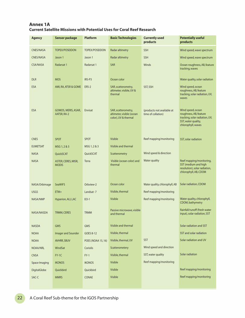
22
Agency
CNES/NASA
CNES/NASA
CSA/NASA
DLR
ESA
ESA
CNES
EUMETSAT
NASA
NASA
NASA/Orbimage
USGS
NASA/NMP
NASA/NASDA
NASDA
NOAA
NOAA
NOAA/NRL
CNSA
Space Imaging
DigitalGlobe
SAC-C
Sensor package
TOPEX/POSEIDON
Jason 1
Radarsat 1
MOS
AMI, RA, ATSR & GOME
GOMOS, MERIS, ASAR, AATSR, RA-2
SPOT
MSG 1, 2 & 3
QuickSCAT
ASTER, CERES, MISR, MODIS
SeaWiFS
ETM+
Hyperion, ALI, LAC
TRMM, CERES
GMS
Imager and Sounder
AVHRR, SBUV
WindSat
FY-1C
IKONOS
Quickbird
MMRS
Platform
TOPEX/POSEIDON
Jason 1
Radarsat 1
IRS-P3
ERS-2
Envisat
SPOT
MSG 1, 2 & 3
QuickSCAT
Terra
Orbview-2
Landsat- 7
EO-1
TRMM
GMS
GOES 8-12
POES (NOAA 15, 16)
Coriolis
FY-1
IKONOS
Quickbird
CONAE
Basic Technologies
Radar altimetry
Radar altimetry
SAR
Ocean color
SAR, scatterometry, altimeter, visible, UV & thermal
SAR, scatterometry, altimeter, visible (ocean color), UV & thermal
Visible
Visible and thermal
Scatterometry
Visible (ocean color) and thermal
Ocean color
Visible, thermal
Visible
Passive microwave, visible and thermal
Visible and thermal
Visible, thermal
Visible, thermal, UV
Scatterometery
Visible, thermal
Visible
Visible
Visible
Currently used products
SSH
SSH
Winds
SST, SSH
(products not available at time of collation)
Reef mapping/monitoring
Wind speed & direction
Water quality
Water quality, chlorophyll, AB
Reef mapping/monitoring
Reef mapping/monitoring
SST
Wind speed and direction
SST, water quality
Reef mapping/monitoring
Potentially useful products
Wind speed, wave spectrum
Wind speed, wave spectrum
Ocean roughness, AB, feature tracking, waves
Water quality, solar radiation
Wind speed, ocean roughness, AB, feature tracking, solar radiation, UV, waves
Wind speed, ocean roughness, AB, feature tracking, solar radiation, UV, SST, water quality, chlorophyll, waves
SST, solar radiation
Reef mapping/monitoring, SST (medium and high resolution), solar radiation, chlorophyll, AB, CDOM
Solar radiation, CDOM
Water quality, chlorophyll, CDOM, bathymetry
Rainfall/runoff (fresh water input), solar radiation, SST
Solar radiation and SST
SST and solar radiation
Solar radiation and UV
Solar radiation
Reef mapping/monitoring
Reef mapping/monitoring
Annex 1ACurrent Satellite Missions with Potential Uses for Coral Reef Research
A Coral Reef Sub-theme for the IGOS Partnership

Annexes1. Tables of current (1A) and future (1B) satellite missions/coral reef parameters
2. Table of recommended requirements for coral reef observing
Appendices[These appendices are not part of the IGOS Coral Reef Sub-theme Report itself, but contain additional information useful for itsimplementation.]
1. In situ components of coral reef monitoring
2. Detailed objectives and user requirements for coral reef observations, including for theConvention on Biological Diversity
3. References
Dr. Anthony R. Picciolo, NOAA NODC, June 1990. Caribean Sea.
Agency
CNES/NASDA
CNES
CSA
EUMETSAT
CAST/INPE
BNSC
BNSC
NASA/NASDA
NASA
NASDA
NASDA
NOAA
CNSA
CNSA
Orbimage
NSPO
Sensor package
Polder-2
SMOS
Radarsat 2
EPS METOP
CBRS-2
GANDER
TOPSAT
Seawinds
GPM
GLI, AMSR
AVNIR-2, PALSAR, PRISM
VIIRS, CMIS, OMPS
FY-1D
HY-1
Orbview-3
ROCSAT-2
Platform
ADEOS-II
Radarsat 2
EPS METOP
CBRS-2
GANDER
TOPSAT
ADEOS-II
GPM
ADEOS-II
ALOS
NPOESS
FY-1
Orbview-3
ROCSAT
Basic Technologies
Polarized visible/near infrared
Microwave imager
SAR
Visible, thermal, scatterometry, radar altimetry
Spectrometry
Radar altimetry
Visible
Scatterometry
Passive microwave
Visible (ocean color), thermal, passive microwave
Visible and SAR
Visible (ocean color), UV, thermal, microwave imagery/sounding
Visible, thermal
Visible (ocean color)
Visible
Visible
Potentially useful products
Water quality
SSS
Winds, ocean roughness, AB, feature tracking, waves
SST, wind, solar radiation, UV, SSH
Reef mapping/monitoring
SSH, Wind/waves
Reef mapping/monitoring
Wind speed and direction
Rainfall runoff (freshwater input)
SST, water quality, chlorophyll, CDOM, solar radiation, AB, rainfall runoff (freshwater input)
Reef mapping/monitoring, wind speed/direction, waves, ocean roughness, feature tracking
SST, water quality, AB, rainfall runoff (freshwater input), solar radiation, UV, wind speed/direction
SST, water quality, solar radiation
Water quality, solar radiation, AB, Chlorophyll
Reef mapping/monitoring
Reef mapping/monitoring
Annex 1BFuture Satellite Missions with Potential Uses for Coral Reef Research
23Report from the Coral Reef Sub-theme Group
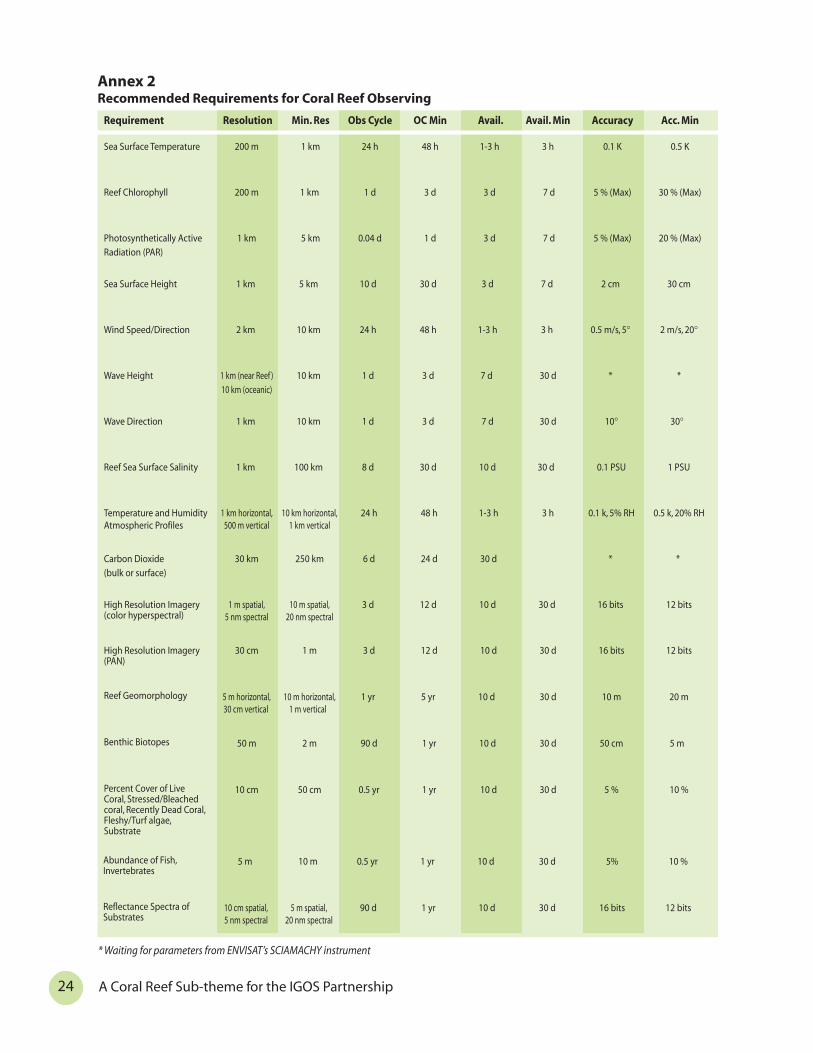
24
Annex 2Recommended Requirements for Coral Reef Observing
Requirement Resolution Min. Res Obs Cycle OC Min Avail. Avail. Min Accuracy Acc. Min
Sea Surface Temperature 200 m 1 km 24 h 48 h 1-3 h 3 h 0.1 K 0.5 K
Reef Chlorophyll 200 m 1 km 1 d 3 d 3 d 7 d 5 % (Max) 30 % (Max)
Photosynthetically Active
Radiation (PAR)
1 km 5 km 0.04 d 1 d 3 d 7 d 5 % (Max) 20 % (Max)
Sea Surface Height 1 km 5 km 10 d 30 d 3 d 7 d 2 cm 30 cm
Wind Speed/Direction 2 km 10 km 24 h 48 h 1-3 h 3 h 0.5 m/s, 5° 2 m/s, 20°
Wave Height 1 km (near Reef )
10 km (oceanic)
10 km 1 d 3 d 7 d 30 d * *
Wave Direction 1 km 10 km 1 d 3 d 7 d 30 d 10° 30°
Reef Sea Surface Salinity 1 km 100 km 8 d 30 d 10 d 30 d 0.1 PSU 1 PSU
Temperature and Humidity Atmospheric Profiles
1 km horizontal, 500 m vertical
10 km horizontal, 1 km vertical
24 h 48 h 1-3 h 3 h 0.1 k, 5% RH 0.5 k, 20% RH
Carbon Dioxide
(bulk or surface)
30 km 250 km 6 d 24 d 30 d * *
High Resolution Imagery (color hyperspectral)
1 m spatial, 5 nm spectral
10 m spatial, 20 nm spectral
3 d 12 d 10 d 30 d 16 bits 12 bits
High Resolution Imagery (PAN)
30 cm 1 m 3 d 12 d 10 d 30 d 16 bits 12 bits
Reef Geomorphology 5 m horizontal, 30 cm vertical
10 m horizontal, 1 m vertical
1 yr 5 yr 10 d 30 d 10 m 20 m
Benthic Biotopes 50 m 2 m 90 d 1 yr 10 d 30 d 50 cm 5 m
Percent Cover of Live Coral, Stressed/Bleached coral, Recently Dead Coral, Fleshy/Turf algae, Substrate
10 cm 50 cm 0.5 yr 1 yr 10 d 30 d 5 % 10 %
* Waiting for parameters from ENVISAT’s SCIAMACHY instrument
Abundance of Fish, Invertebrates
5 m 10 m 0.5 yr 1 yr 10 d 30 d 5% 10 %
Reflectance Spectra of Substrates
10 cm spatial, 5 nm spectral
5 m spatial, 20 nm spectral
90 d 1 yr 10 d 30 d 16 bits 12 bits
A Coral Reef Sub-theme for the IGOS Partnership

Appendix 1A
In Situ Components of Coral Reef Monitoring
Manta Tow (or equivalent)Broad scale monitoring (Manta tow, or a timed swim) is needed to:
* develop a broad picture of the reef;
* observe unusual phenomena (like blast damage, plagues); and
* ensure that more detailed monitoring sites are representative of the whole reef.
The Manta tow has been successful in many areas, and consists of 2 minute snorkel tows(minimum of 9) behind a boat at slow speed with stops to record percent cover of live and deadcorals, soft coral, and regional specific parameters e.g. crown-of- thorns starfish, Diadema, giantclams, large patches of damage to corals. These tows are used to select the transect monitoringsites to ensure that they are representative of the whole reef.
Line Intercept Transect or EquivalentThis major monitoring method assesses live coral, preferably with an estimation of coral types,
dead coral cover and sand, algae etc. All lifeforms and species must be capable of beingcompared statistically. Several lifeforms or species can be grouped into larger groups.
Similar techniques, like belt and video transects, are comparable and can be inter-calibratedwith the lifeform transects with little difficulty to provide baseline data.
Transects should be placed where coral density is highest e.g. 3 to 6 m depth and then used forfish census counts. If possible another set of transects can be done at 10 m depth.
Live Fish CensusLive fish visual censusing is also based on line transects, with fish assessed in a column 5 m
wide and 5 m high above the line (less in waters with poor visibility). The initial focus is oncounting all fish, especially those that are the major target of the fishers, and possibly includingsome indicator species like the Chaetodonts.
Permanent QuadratIf time permits, monitoring teams are encouraged to establish permanent, marked quadrats
(e.g. 1 m2) which are assessed regularly, either by photography or mapping to measure growthrates of corals and results of inter-specific interactions. Quadrats are particularly used to follownew coral recruits to determine the ability of a reef to recover from stress. A very important sitefor monitoring will be reef areas that are almost bare of corals e.g. reefs that have been damaged(storms, blast impacts, ship wrecks, fresh water flows, pollution, sediment damage).
Additional componentsThe installation of semi-permanent low-cost dataloggers for SST and irradiation at selected
monitoring sites could be of great use for ground truthing of satellite data, particularly inregions with high cloud cover. The network of monitoring teams (e.g. GCRMN, Reef Check,AGGRA, CORDIO) could be used to deploy and service the loggers, collect and submit the data toregional or global (ReefBase) data centers. In this way high quality data can be collected fromhundreds of reef sites at very low cost to calibrate and complement satellite derived data.
Reef Check ProtocolThe Reef Check protocol for surveys and data collection by volunteers under scientific
supervision includes the collection of four types of data: a site description including 37questions and additional anecdotal and historical information; a fish survey; an invertebratesurvey; and a substrate survey. The underwater surveys are made along two depth contours, 2-6and 6-12 m. For some fish, size limits are used to limit the work load and focus data collection onthe target size. The same belt transect is used for each of the surveys.
25Report from the Coral Reef Sub-theme Group

26 A Coral Reef Sub-them
Appendix 1B
NOAA’s Coral Reef Early Warning System StationsThe National Oceanic and Atmospheric Administration’s (NOAA) Coral Reef Watch program is
installing in situ monitoring stations at strategic coral reef areas for purposes of establishinglong-term data sets, providing near real-time information products, and surface-truthing NOAAsatellite sea surface temperature (SST) products which are used for coral bleaching predictions(“HotSpots”). The necessary companion chart NOAA produces along with the HotSpots is itsDegree Heating Weeks (DHWs) that accumulates these HotSpots over time to indicate regionswhere thermal stresses are most severe. The suite of in situ instruments, which transmit datahourly, together with custom artificial intelligence software, are called Coral Reef Early WarningSystem (CREWS) stations. At each CREWS station a critical part of the effort is the localmaintenance and calibration of the sea temperature sensor to ensure quality data; data can thenbe automatically compared with satellite monitored temperatures and thus provide near real-time feedback on the accuracy of the satellite-monitored temperatures. The local maintainersalso give critical feedback on the presence and progress of coral bleaching and thus validatecoral bleaching predictions made by HotSpot and CREWS information products. The CREWSstations slated for deployment in the Caribbean, initially at domestic locations, will also measurewind speed and direction, air temperature, barometric pressure, sea temperature, and salinity, aswell as photosynthetically active radiation and ultraviolet-B above and below the water. Theseenvironmental variables are important to local bleaching and other biological manifestations(e.g., spawning, migrations), but are also valuable in helping to assess the effect of global climatechange on local reefs.
In the Pacific, NOAA is implementing a CREWS buoy, designed to be a permanent installation.The Pacific buoy designs have the advantage that they can be deployed in the Pacific at moreremote sites where maintenance is often difficult and where a permanent station cannot beeasily installed. As presently configured, they are portable and relatively easy to deploy, and useArgos for their satellite relaying capabilities (thus reducing power requirements, among otherconsiderations). The permanent stations (re-designed to be much sleeker than earlierprototypes) have the advantage that they do not have to be swapped-out every year or two,utilize GOES satellite transmission which is powered by solar panels, and offer fixed orientationfor the light sensors (among other considerations, such as tide level), and will serve as anappropriate platform for Web Cam deployment. Permanent stations require occasionalmaintenance for the light, salinity and other oceanographic sensors. Both types have above andbelow water light (PAR and UV) sensors, as well as those for air temperature, wind speed anddirection, barometric pressure, sea temperature and salinity. All data from both stations will bepresented on the Web as well as saved for access via an online database (raw and quality-controlled data). NOAA’s current Web site for the daily data is at http://www.coral.noaa.gov/crw.
NOAA’s National Marine Fisheries Service (NMFS-Honolulu Lab) deployed several CREWSstations in the NW Hawaiian Islands (2001) and more recently American Samoa (2002). NOAA’sOceanic & Atmospheric Research Atlantic Oceanographic and Meteorological Labs (OAR/AOML)have deployed their initial CREWS test site at Lee Stocking Island, Bahamas, (NationalUnderwater Research Program - NURP) and will be deploying the first Caribbean domesticinstallation near Salt River Bay, St. Croix, in mid-2002. Plans for the second Atlantic site are stillbeing evaluated. If not at St. Croix, NOAA hopes to install a Web Cam at one of these earlyCaribbean CREWS installations, in addition to the standard sensors, and is considering makingpCO2 a component at future sites.
These CREWS stations serve several important functions. Primarily, they continue and enhancetime-series of environmental indices for coral reefs, making them available on-line over theInternet for early warnings. Quality in situ data serve as “anchors” or benchmark calibrations forsatellite remotely-sensed data, providing scientists and reef managers in the region highconfidence in extrapolations possible from remotely-sensed information throughout the entireregion. Often, in tidally active regions, remotely-sensed data coupled with CREWS data, and themuch higher temporal resolutions possible through in situ means, will provide valuable insighton point variabilities at the CREWS station. This has been documented at the Lee Stocking site, aslocal investigators were able to use the “Rainbow Gardens” hourly data to determine local “bank”SSTs during ebb tide and “sound” SSTs at flood tide – the local currents drawing waters fromthose respective locations where satellite observations of SST matched the flow past the CREWSstation.
e for the IGOS Partnership

illiam Harrigan, NOAA Corps National Marine Sanctuary.
Vase sponge with star coral inside. Commander W(retired). Florida Keys
Appendix 2
Detailed Objectives and User Requirements for Coral Reef Observations
MappingThe most frequent current use for reef observations is to map the extent, distribution and loss
or gain of reef habitats over time. At the largest scale, the total area covered by coral reefs is stilluncertain. Present estimates of world coral reef area range from less than 0.3 to 3.9 million sq.km. This order of magnitude difference is due to incomplete knowledge of all coral reefs in theworld, and to data sources varying from simple charts to remote sensing imagery. It also reflectsthe lack of a common definition of “coral reefs”, whether narrowly determined as hard substratecovered by reef-building calcified organisms, mainly scleractinians, or more widely as the wholecoral reef ecosystem with hard and sand substrates. The most accurate recent assessment ofcoral reef area, in the World Atlas of Coral Reefs, used data largely from shallow reef areas, whichare more easily charted, but not for deeper parts of the reef system.
There is a need to adopt a common classification of reef geomorphology and of biotopes (orhabitats) within geomorphological classes. Geomorphological structures such as outer slope,outer reef flat, spillway, lagoon structures, and pinnacles are functionally important, for example,in their role in building a reef framework. A similar need exists at the finer biological scale ofbiotopes. Much biotope mapping has beenconducted on an ad-hoc basis and often withlittle information on the derivation anddescription of the characteristics of eachbiotope class. This lack of coordinationseriously hinders the integration of habitatmaps originating from different data sources ororganizations. Unless, the categories are clearlydescribed, for example with quantitativedescriptors of characteristic features, it isdifficult to know which biotope categories aresynonymous and which are not. These sorts ofinter-map calibration issues are likely tobecome more important as government, non-profit and conservation agencies move tolarger-scale transboundary projects. In short,habitat or biotope classes should be describedas clearly as possible. Further, each of thesebiotopes and geomorphological classes needsto be quantified per country and per region, inorder to understand the structure of theworld’s coral reef ecosystems.
Perhaps one of the most important areas forfurther research is the functional interpretationof mapped biotopes; what do they tell usabout the ecosystem and conservation issues?For example, what do such maps reveal aboutpatterns of productivity or essential fishhabitat? To what extent can ecologicalprocesses (e.g. predation, herbivory) be given aspatially-explicit dimension through the use ofbiotope maps? How will such information leadto better design of marine reserve networks?Addressing these issues, through multi-disciplinary research, will undoubtedly raisethe value of biotope maps as an informativemanagement tool.
Mapping reef geomorphology and biotopes,and estimating their areas, is an objective at allscale levels. At small scale, in situ observationscan provide the necessary information. Largerscales require interpretation of aerial
27Report from the Coral Reef Sub-theme Group
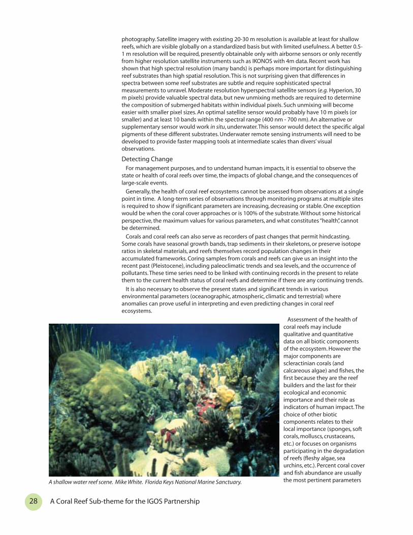
28 A Coral Reef Sub-theme for the IGOS Partnership
A shallow water reef scene. Mike White. Florida Keys National Marine Sanctuary.
photography. Satellite imagery with existing 20-30 m resolution is available at least for shallowreefs, which are visible globally on a standardized basis but with limited usefulness. A better 0.5-1 m resolution will be required, presently obtainable only with airborne sensors or only recentlyfrom higher resolution satellite instruments such as IKONOS with 4m data. Recent work hasshown that high spectral resolution (many bands) is perhaps more important for distinguishingreef substrates than high spatial resolution. This is not surprising given that differences inspectra between some reef substrates are subtle and require sophisticated spectralmeasurements to unravel. Moderate resolution hyperspectral satellite sensors (e.g. Hyperion, 30m pixels) provide valuable spectral data, but new unmixing methods are required to determinethe composition of submerged habitats within individual pixels. Such unmixing will becomeeasier with smaller pixel sizes. An optimal satellite sensor would probably have 10 m pixels (orsmaller) and at least 10 bands within the spectral range (400 nm - 700 nm). An alternative orsupplementary sensor would work in situ, underwater. This sensor would detect the specific algalpigments of these different substrates. Underwater remote sensing instruments will need to bedeveloped to provide faster mapping tools at intermediate scales than divers’ visualobservations.
Detecting ChangeFor management purposes, and to understand human impacts, it is essential to observe the
state or health of coral reefs over time, the impacts of global change, and the consequences oflarge-scale events.
Generally, the health of coral reef ecosystems cannot be assessed from observations at a singlepoint in time. A long-term series of observations through monitoring programs at multiple sitesis required to show if significant parameters are increasing, decreasing or stable. One exceptionwould be when the coral cover approaches or is 100% of the substrate. Without some historicalperspective, the maximum values for various parameters, and what constitutes “health”, cannotbe determined.
Corals and coral reefs can also serve as recorders of past changes that permit hindcasting.Some corals have seasonal growth bands, trap sediments in their skeletons, or preserve isotoperatios in skeletal materials, and reefs themselves record population changes in theiraccumulated frameworks. Coring samples from corals and reefs can give us an insight into therecent past (Pleistocene), including paleoclimatic trends and sea levels, and the occurrence ofpollutants. These time series need to be linked with continuing records in the present to relatethem to the current health status of coral reefs and determine if there are any continuing trends.
It is also necessary to observe the present states and significant trends in variousenvironmental parameters (oceanographic, atmospheric, climatic and terrestrial) whereanomalies can prove useful in interpreting and even predicting changes in coral reefecosystems.
Assessment of the health ofcoral reefs may includequalitative and quantitativedata on all biotic componentsof the ecosystem. However themajor components arescleractinian corals (andcalcareous algae) and fishes, thefirst because they are the reefbuilders and the last for theirecological and economicimportance and their role asindicators of human impact. Thechoice of other bioticcomponents relates to theirlocal importance (sponges, softcorals, molluscs, crustaceans,etc.) or focuses on organismsparticipating in the degradationof reefs (fleshy algae, seaurchins, etc.). Percent coral coverand fish abundance are usuallythe most pertinent parameters

29Report from the Coral Reef Sub-theme Group
selected. Optimum values will differ from one region to another, from one reef type to another,and from one habitat to another.
For example, in French Polynesia, research suggests that the most important part of the coralreef ecosystem is the outer slope at a depth of 15-25 meters with 45 to 55% maximum coralcover. But on the deepest hard substrate of this outer slope, where such substrate exists, someobservers report maximum cover ranging up to 90%. On the outer reef flats of atolls it is lessthan 10%. In other regions, countries and habitats, these optimum values for the parameters ofhealth will be different. In other words, a percent coral cover of 40% can indicate very goodhealth at one site but poor health at another; the percent coral cover has little significance interms of health without knowing the optimum value in that area or habitat. In some cases, asingle optimal value may not exist because of natural fluctuation in the measured variable. Inthese cases, the health of a coral reef must be assessed by examining how changes in keyparameters relate to known human impacts or trends in human activities. These parameters ofreef health can presently be observed only with in situ methods such as reef transects and fishcounts. Research should explore whether changes in living coral cover can be observed andquantified remotely with sufficient accuracy, and what technologies might make this possible.
To determine the health status of coral reefs according to their geographical situation, thecoral reef ecosystem of each region and country should be divided into a number ofgeomorphological types and many long-term monitoring surveys should be used to establishoptimum values for key parameters. Simultaneous monitoring of human-induced stress such aspollution, sedimentation or destructive fishing should also be carried out. This recommendationis for monitoring programs and especially for International Coral Reef Action Network (ICRAN)selected sites.
Determining optimum values for different coral reef habitats in different regions is only oneway to assess the health of any part of any coral reef anywhere. The ratio of live to recently killedcoral is an important indicator of changes in reef health, which explains why long-termmonitoring is essential. In addition, by documenting size classes of representative organisms(invertebrates and fish) present on reefs, a population trajectory can be determined andpredictions made regarding future health.
A second approach to reef health is to observe and quantify known pathological conditions orindicators of ecological imbalance, such as coral bleaching or disease, epidemics or die-offs ofechinoderms (Acanthaster, Diadema), algal overgrowth from eutrophication, etc. Some of theseconditions or indicators, such as coral bleaching and algal overgrowth, may be observed withhigh resolution remote imagery, while others require in situ observations of the organismsconcerned.
Image processing techniques for collecting relevant data and imagery on coral reefs withvarious sensors should be tested on some reefs which field surveys have shown to haveoptimum values of the considered parameters and, thus, very good health. It may be possible todetect some observational parameters, which will differ consistently according to good or poorreef health. The best approach will be to succeed in detecting by remotely sensing algalpigments, which are different in scleractinians, sand, dead corals, etc., with the use of highresolution hyperspectral sensors. These methods measure direct changes in the substratumcoverage of coral reefs. An alternative method is to acquire a long time series of satellite dataand identify areas that have shown the greatest degree of spectral change over time. Althoughthese indirect methods might not reveal how the reef has changed, they do take advantage ofthe long time series of satellite data (e.g. Landsat TM) and prioritise areas for investigation ofchange.
Satellite observations of this sort have the potential to reveal significant changes in coral reefhealth, both short-term alterations due to natural variability or human impacts, and the resultsof longer climate trends.
Early WarningAs human impacts on coral reef ecosystems expand, there is a growing demand for early
warning and monitoring of stressful events. This is already becoming operational for warning ofcoral bleaching events, when stressed corals lose their zooxanthellae (symbiotic algae) or at leastdemonstrate a lowering of photosynthetic pigments in their zooxanthellae. Bleached corals mayrecover, but if the stress is too extreme or lasts too long the corals may suffer high rates ofmortality. The most frequent recent stressor has been high water temperatures resulting fromaltered oceanographic features and enhanced by cloudless skies and low water column mixingassociated with the El Niño Southern Oscillation (ENSO) and possibly enhanced by globalwarming. NOAA’s NESDIS provides nearly continuous information on sea surface temperature

30 A Coral Reef Sub-theme for the IGOS Partnership
anomalies as well as the number of weeks geographic areas have been exposed to abnormaltemperatures, providing early warning information for “HotSpots” associated with coralbleaching. The companion chart NOAA produces along with the HotSpots is its Degree HeatingWeeks (DHWs) that accumulates these HotSpots over time to indicate regions where thermalstresses are most severe.
Other events for which early warning would be desirable include epidemic diseases, damagingpopulation outbreaks (such as the coral-eating starfish Acanthaster), toxic plankton blooms andeutrophication causing excessive algal growth smothering the corals.
With expanding and near-continuous monitoring of coral reefs on a near real-time basis, in thefuture we should be able to identify changes in magnitude and frequency of key environmentalvariables and their correlation to major damaging events such as coral bleaching. Thedevelopment of early warning models and effective broadcast networks for the warnings shouldallow preventive or mitigating measures to be put in place. The user communities should beinvolved in the development of these early warning systems.
Local Reef StatusMost efforts at coral reef management take place at the local level, and may involve integrated
coastal area management, the establishment of marine protected areas, controls on coastaldevelopment, anti-pollution measures and fisheries regulations, among others. To determine theneed for and the effectiveness of these measures, local coral reef managers need detailed mapsof their coral reefs and continuing data on local stresses, impacts, and the effects of protection.While such information tools for local decision-makers are now becoming technically possible,their cost is still far in excess of what local users are able to pay. The challenge is therefore todevelop observing systems able to deliver useful information at this scale in a cost-effective way.
Specific User Requirements of the Convention on Biological DiversityThe Parties to the Convention on Biological Diversity identified marine and coastal
biological diversity as one of the early priority areas for the work of the Convention, as reflectedin the Jakarta Mandate on Marine and Coastal Biological Diversity (1995). Decision IV/5 (1998) onthe conservation and sustainable use of marine and coastal biological diversity, emphasized theimportance of coral reefs. The Conference of the Parties was deeply concerned at the recentextensive and severe coral bleaching, and agreed to integrate coral reefs into its programme ofwork. This concerned two sub issues: (i) coral bleaching, and (ii) physical degradation anddestruction of coral reefs. There are three identified needs and activities in the coral reef workplans that would benefit from remote sensing technologies and integrated observing. Thesesections are: (1) assessment and monitoring; (2) early warning systems for coral bleaching; and(3) rapid response capability to bleaching.
1. Assessment and MonitoringThe work plan on physical degradation and destruction of coral reefs calls for the provision of a
comprehensive analysis of the status and trends of global coral-reef ecosystems. Such ananalysis will require the use of remote sensing data at a number of scales in conjunction withfield verification. A global assessment of the location and extent of reefs could use lowerresolution data. However, an analysis of status and trends would require data that is of highenough resolution to be used in change detection, particularly where the change is indicative ofcoral reef health, with spectral bands specific to such an analysis. The integration of fieldverification data, possibly collected by underwater video, with the higher resolution satellitedata would also be desirable, though undoubtedly complex.
The work plan on coral bleaching, in its activity 1(b) calls for “implementation and coordinationof baseline assessments and long-term monitoring to measure the biological andmeteorological variables relevant to coral bleaching, mortality and recovery, as well as the socio-economic parameters associated with coral-reef services”. The implementation of the monitoringcomponent of this activity would also require higher resolution data, with enough spectralsensitivity to distinguish between bleached and healthy reefs. In addition, the activity calls forintegration of meteorological data, and, by extension, the integration of oceanographic data. Theintegration of such diverse data would require sophisticated spatial modeling capabilities. Suchactivities should be carried out in conjunction with ongoing assessment and monitoringinitiatives, such as those of UNESCO, ICRAN, the regional seas conventions and action plans,GCRMN, UNEP and CORDIO.
The coral bleaching work plan also calls for “strengthening networks for data collection anddissemination of information on coral-reef status and interpretation of long-term trendsresulting from global climate change and anthropogenic stresses to assist effective

31Report from the Coral Reef Sub-theme Group
Steve Turek, Borneo.
management and conservation.” Not only should the appropriate data be made available, butalso information and conclusions resulting from the analysis of those data should be widelydisseminated, in particular for management purposes.
2. Early Warning SystemsThe coral bleaching work plan places an emphasis on the importance of early warning systems
for coral bleaching. In particular, the work plan includes the following activities:
“Extend the use of early-warning systems for coral bleaching by:(i) Enhancing current NOAA AVHRR HotSpot mapping by increasing resolution in targeted
areas and carrying out ground-truth validation exercises;
(ii) Encouraging space agencies and private entities to maintain deployment of relevantsensors and to initiate design and deployment of specialized technology for shallow-oceans monitoring;
(iii) Making the products of remote sensing readily accessible at low cost to coral-reef scientistsand managers worldwide, in particular tothose scientists and managers that arebased in developing countries.”
This would require higher resolution sensorswith appropriate spectral sensitivity formonitoring shallow-water areas, the integrationof diverse data, and the development of modelsthat could provide advance warning ofimpending bleaching events. The work plansupports using web-based applications formaking such early warning systems widelyavailable. It also calls for developing localcommunity capacity for remote and local levelvalidation exercises and for developing mechanisms to make accessible high-resolution multi-spectrum imagery worldwide.
3. Rapid Response Capability to BleachingThe work plan on coral bleaching also calls for the development of “a rapid response capability
to document coral bleaching and mortality in developing countries and remote areas includingestablishment of training programs, survey protocols, expert advice, and contingency fund orrapid release of special project funding.” Although some parts of this activity may be beyond thescope of the IGOS coral reef theme, it does highlight the need for capacity building and fundingfor remote sensing activities.

32 A Coral Reef Sub-them
Mary Lou Frost, 1995. Egypt.
Appendix 3
ReferencesAndréfouët, Serge (2002), IGOS: Coral reef theme; high resolution mapping and change
detection. (paper prepared for the IGOS Coral Reef Sub-theme team).
Andrefouet S. et. al., (in press), Multi-sites evaluation of IKONOS data for classification oftropical coastal environments. Remote Sensing of Environment.
Andréfouët, S., F. Muller-Karger, E. Hochberg, C. Hu & K. Carder (2001), Change detection inshallow coral reef environments using Landsat 7 ETM+ data. Remote Sensing ofEnvironment, 79: 150-162.
Arvidson, T., J. Gasch, and S.N. Goward (2001), Landsat 7’s long term acquisition plan- aninnovative approach to building a global imagery archive. Remote Sensing of Environment,78: 13-26.
Atkinson, M.J., et al. (2001), CRESPO: Coral Reef Ecosystem Spectro-Photometric Observatory,concept study report to the University Earth System Science Program, National Aeronauticsand Space Administration, University of Hawaii, 2001.
Atlantic and Gulf Rapid Reef Assessment (AGRRA) Program: http://coral.aoml.noaa.gov/agra.
Berkelmans, R. and J.K. Oliver (1999), Large scale bleaching of corals on the Great Barrier Reef.Coral Reefs, 18:55-60.
Berkelmans, R., and B.L. Willis (1999), Seasonal and local spatial patterns in the upper thermallimits of corals on the inshore central Great Barrier Reef. Coral Reefs, 18:219-228.
Brown, B.E. (1997), Coral bleaching: Causes and consequences. Coral Reefs, 16: S129-S138.
Brown, B.E. and J.C. Ogden (1993), Coral bleaching. Scientific American, 268: 64-70.
Capolsini, P., S. Andréfouët, C. Rion, and C. Payri (in press), A comparison of Landsat ETM+,SPOT HRV, Ikonos, ASTER and airborne MASTER data for coral reef habitat mapping in SouthPacific islands. Canadian J. Remote Sensing.
Caribbean Coastal Marine Productivity (CARICOMP) Programme: http://isis.uwimona.edu.jm/centers/cms/caricomp.
Causey, B.D. (1988), Observations of environmental conditions preceding the coral bleachingevent of 1987—Looe Key National Marine Sanctuary. In Proc Assoc Is Mar Lab Carib, 21:48.
Dahl, A.L. (1981), Coral Reef Monitoring Handbook. South Pacific Commission, Noumea, NewCaledonia, 21 p.
Dustan, P., E. Dobson & G. Nelson (2001), Landsat Thematic Mapper: detection of shifts incommunity composition of coral reefs. Conservation Biology, 15: 892-902.
English, S., C. Wilkinson and V. Baker (1997), Survey Manual for Tropical Marine Resources2nd ed. ASEAN-Australia Marine Science Project: Living Coastal Resources, Australian Instituteof Marine Science, PMB No. 3, Townsville, Australia, 390p.
Gleason, D.F. and G.M. Wellington (1993), Ultraviolet radiation and coral bleaching. Nature,365: 837-838.
Gleeson, M. W. and A. E. Strong, 1994, Applying MCSST to coral reef bleaching, EOS, 75: 156
Global Coral Reef Monitoring Network: http://www.gcrmn.org/ .
Glynn, P. (1993), Coral reef bleaching: Ecological perspectives. CoralReefs, 12: 1-17.
Goreau, T., T. McClanahan, R. Hayes, and A.E. Strong (2000),Conservation of coral reefs after the 1998 global bleaching event,Conservation Biology, 14(1): 5-15.
Hedley, J.D. and P.J. Mumby (2002), Biological and remote sensingperspectives of pigmentation in coral reefs. Adv. Mar. Biol., 43: 277-317.
Hedley, J.D. and P.J. Mumby (2003), Spectral unmixing and theresolution of depth from remotely sensed data of aquatic systems.Limnology & Oceanography, 48: 480-488.
e for the IGOS Partnership

33Report from the Coral Reef Sub-theme Group
Hendee, J.C. (1998a), An expert system for marine environmental monitoring in the FloridaKeys National Marine Sanctuary and Florida Bay, In Proc 2nd Int Conf Env Coastal Regions,ed. CA Brebbia, Computational Mechanics Publications/WIT Press, Southampton, 57-66.
Hendee, J.C., C. Humphrey, and T. Moore (1998b), A data-driven expert system for producingcoral bleaching alerts, In Proc 7th Int Conf Developm Applic Comp Techn Env Stud, eds.DW Pepper, CA Brebbia, P Zannetti, Computational Mechanics Publications/WIT Press,Southampton, 139-147.
Hendee, J.C. (2000), A data-driven soft real-time expert system for producing coral bleachingalerts. Ph.D. Thesis, Nova Southeastern University, 131 pp.
Hendee, J.C., E. Mueller, C. Humphrey, and T. Moore (2001), A data-driven expert system forproducing coral bleaching alerts at Sombrero Reef in the Florida Keys. Bulletin MarineScience, 69(2): 673-684.
Hochberg, E., & M. Atkinson (2003), Capabilities of remote sensors to classify coral, algae andsand as pure and mixed spectra. Remote Sensing of Environment, 85(2):174-189.
Hochberg E.J., M.J. Atkinson, and S. Andréfouët (2003) Spectral reflectance of coral reefbottom-types worldwide and implications for coral reef remote sensing. Remote Sensing ofEnvironment, 85: 159-173.
Hodgson, G. (1999), A global assessment of human effects on coral reefs. Marine PollutionBulletin, 38: 345-355.
Hodgson, G and C. Wilkinson (2001), Science as a basis for coral reef monitoring programs.Bulletin of Marine Science, 69(2): 327-328.
Hodgson, G. and J. Liebeler (2002), The Global Coral Reef Crisis, Trends and Solutions, 77 p.
Hoegh-Guldberg, O. (1999), Climate change, coral bleaching and the future of the world’scoral reefs. Mar. Freshw. Res., 50:839-866.
Hoegh-Guldberg, O., R. Berkelmans, and J. Oliver (1997), Coral bleaching: Implications for theGreat Barrier Reef Marine Park. In Proc Great Barrier Reef Conf, 24-29 November 1996,Great Barrier Reef Marine Park Authority, Townsville.
Hu C., K.E. Hackett, M.K. Callahan, S. Andréfouët, J.L. Wheaton, J.W. Porter, F.E. Muller-Karger.(2003), The 2002 ocean color anomaly in the Florida Bight: a cause of local coral reefdecline, Geophysical Research Letters, (in press).
Institute for Marine Remote Sensing, University of South Florida: http://imars.marine.usf.edu/corals .
International Coral Reef Action Network (ICRAN): http://www.icran.org .
International Coral Reef Initiative (ICRI): http://www.icriforum.org .
International Workshop on the Use of Remote Sensing Tools for Mapping and MonitoringCoral Reefs, Honolulu, Hawaii, 7-10 June 1999: http://coral.aoml.noaa.gov/corvil/coral_reefs/index.html.
Jaap, W.C. (1978), Observations on zooxanthellae expulsion at Middle Sambo Reef, FloridaKeys. Bull. Mar. Sci., 29(3): 414-422.
Jaap, W.C. (1988), The 1987 zooxanthellae expulsion event at Florida reefs. NOAA’s UnderseaResearch Program Research Report, 88(2): 24-29.
Jones, R.J. (1997), Zooxanthellae loss as a bioassay for assessing stress in corals. Mar. Ecol. Prog.Ser., 149: 163-171.
Jones, R.J., R. Berkelmans, and J. Oliver (1997), Recurrent bleaching of corals at Magnetic Island(Australia) relative to air and seawater temperatures. Mar. Ecol. Prog. Ser., 158: 289-292.
Joyce, K., M. Stanford and S. Phinn (n.d.), Remote Sensing for Coral Reef Monitoring: What isRequired? Biophysical Remote Sensing Group, University of Queensland, Australia.
Kushmaro, A., E. Rosenberg, M. Fine, and Y. Loya (1997), Bleaching of the coral Oculinapatagonica by Vibrio K-1. Mar. Ecol. Prog. Ser., 147(1-3): 159-165.
Kutser, Tiit, Arnold G. Dekker, William Skirving (2003), Modelling spectral discrimination ofGreat Barrier Reef benthic communities by remote sensing instruments. Limnology &Oceanography, 48(1, part 2): 497-510.

34 A Coral Reef Sub-theme for the IGOS Partnership
Lang, J.C. (1988), Apparent differences in bleaching responses by zooxanthellate cnidarians onColombian and Bahamian reefs. NOAA’s Undersea Research Program Research Report,88(2): 30-32.
Liu, Gang , A. E. Strong, and W. Skirving (2003), Remote Sensing of Sea Surface TemperaturesDuring 2002 Barrier Reef Coral Bleaching, EOS, 84:137-144.
Lesser, M.P., W.R. Stochaj, D.W. Tapley, and J.M. Shick (1990), Bleaching in coral reef anthozoans:Effects of irradiance, ultraviolet radiation, and temperature on the activities of protectiveenzymes against active oxygen. Coral Reefs, 8: 225-232.
Louchard, E.M., P.R. Reid, C.F. Stephens, C.O. Davis, R.A. Leathers, and V.T. Downes (2003),Optical remote sensing of benthic habitats and bathymetry in coastal environments at LeeStocking Island, Bahamas: a stochastic spectral classification approach. Limnology &Oceanography, 48(1, part 2):511-521 .
Mockler, R.J. and D.G. Dologite (1992), Knowledge-Based Systems: An Introduction to ExpertSystems, Macmillan Publishing, New York, 792 pp.
Mumby, P.J., S. Andréfouët, J.T. Hardy, E. Hochburg, E.F. LeDrew, W. Skirving, A.E. Strong, R. Stumpf(2003), Remote Sensing of Coral Reefs and their Physical Environment, Manuscript inpreparation.
Mumby, P.J., J.R.M. Chisholm, J.H. Hedley, C.D. Clark and J. Jaubert (2001), A bird’s-eye view ofthe health of coral reefs. Nature, 413: 36.
Mumby, P.J. and A.J. Edwards (2002), Mapping marine environments with IKONOS imagery:enhanced spatial resolution does deliver greater thematic accuracy. Remote Sensing ofEnvironment, 82: 248-257.
Mumby, P.J., E.P. Green, A.J. Edwards and C.D. Clark (1999), The cost-effectiveness of remotesensing for tropical coastal resources assessment and management. Journal ofEnvironmental Management, 55:157-166.
Mumby, P.J., E.P. Green, C.D. Clark and A.J. Edwards (1998), Digital analysis of multispectralairborne imagery of coral reefs. Coral Reefs, 17: 59-69.
Mumby, P.J., and A.R. Harborne (1999), Development of a systematic classification scheme ofmarine habitats to facilitate regional management and mapping of Caribbean coral reefs.Biological Conservation, 88: 155-163.
National Center for Caribbean Coral Reef Research (NCORE): http:www.ncoremiami.org
NOAA/NESDIS HotSpot maps and DHWs: http://www.osdpd.noaa.gov/PSB/EPS/SST/climohot.html.
Oliver, J.K. (1985), Recurrent seasonal bleaching and mortality of corals on the Great BarrierReef. In Proc 5th Int Coral Reef Congr, Tahiti, 4: 201-206.
Palandro, D., S. Andréfouët, P. Dustan & F. E. Muller-Karger (2003). Change detection in coralreef communities using the Ikonos sensor and historic aerial photographs. Int. J. RemoteSensing, 24(4): 873-878
Palandro, D., S. Andréfouët, F. Muller-Karger, P. Dustan, C. Hu & P. Hallock (in press). Detectionof changes in coral communities using Landsat 5/TM and Landsat 7/ETM+ data. Canadian J.Remote Sensing.
Pandolfi, J.M. (1999), Response of Pleistocene coral reefs to environmental change over longtemporal scales. American Zoologist, 39: 113-130.
Pandolfi, J.M., G. Llewellyn and J.B.C. Jackson (1999), Interpretation of ancient reefenvironments in paleoecological studies of community structure: Curaçao, NetherlandsAntilles, Caribbean Sea. Coral Reefs, 18: 107-122.
Pandolfi, J.M., J.B.C. Jackson and J. Geister (in press), Geologically sudden natural extinction oftwo widespread Late Pleistocene Caribbean reef corals, in Jackson J.B.C., S. Lidgard, and F.K.McKinney (eds.) Process from Pattern in the Fossil Record, University of Chicago Press,Chicago.
Reaser, J. K., R. Pomerance, and P. O. Thomas (2000), Coral bleaching and global climate change:Scientific findings and policy recommendations, Conservation Biology, 14, 1500-1511.
Reef Check global coral reef education, monitoring, and management program: http://www.reefcheck.org.

35Report from the Coral Reef Sub-theme Group
Report of AIMS/NOAA Workshop on Satellite Oceanography and Coral Bleaching, MagneticIsland, Australia, 30 January-1 February 2002.
Robinson, J.A., C.A. Evans, and S.K. Krikalev, Six-meters spatial resolution for remote sensing ofEarth from the International Space Station. EOS Trans. AGU, 83:185 and 188.
Spalding, Mark D., Corinna Ravilious and Edmund P. Green (2001), World Atlas of Coral Reefs.Prepared at the UNEP World Conservation Monitoring Centre. University of California Press,Berkeley, USA.
Strong, A.E., E. Kearns, K.K. Gjovig (2000), Sea Surface Temperature Signals from Satellites - AnUpdate. Geophys. Res. Lett., 27(11): 1667-1670.
Strong, A.E., G. Liu, J. Meyer, J.C. Hendee, and D. Sasko (2002), Coral Reef Watch 2002. PaperSubmitted – Bull. Marine Sci.
Strong, A.E., C.S. Barrientos, C. Duda, and J. Sapper (1997), Improved satellite Techniques forMonitoring Coral Reef Bleaching. In Proc 8th International Coral Reef Symposium, PanamaCity, Panama, p.1495-1498.
Sweatman, H., A. Cheal, G. Coleman, B. Fitzpatrick, I. Miller, R. Ninio, K. Osborne, C. Page, D.Ryan, A. Thompson, and P. Tomkins (2000), Long-term monitoring of the Great Barrier Reef.Status Report (4). Australian Institute of Marine Science, Townsville, Australia, 117pp.
Wachenfeld, D.R., J.K. Oliver, and J.I. Morrissey (eds) (1998), State of the Great Barrier ReefWorld Heritage Area, 1998. Great Barrier Reef Marine Park Authority, Townsville, Australia,139pp.
Walther G.R., E. Post, P. Convey, A. Menzel, C. Parmesan, T.J.C. Beebee, J.M. Fromentin, O. Hoegh-Guldberg, and F. Bairlein (2002), Ecological responses to recent climate change. Nature, 416(6879): 389-395, 28 March 2002.
Wellington, G.M., P.W. Glynn, A.E. Strong, S. Navarrete, and E. Wieters (2001), Crisis on coralreefs linked to climate change. EOS, 82(1), 1 and 5.
Wilkinson, C., O. Linden, H. Cesar, G. Hodgson, J. Rubens, and A.E. Strong (1999), Ecological andsocioeconomic impacts of 1998 coral mortality in the Indian Ocean: An ENSO impact and awarning of future change? Ambio, 28(2), 188-196.
Wilkinson, Clive (ed.) (2002), Status of Coral Reefs of the World 2002. Australian Institute ofMarine Science, Townsville.
WorldFish Center: http://www.worldfishcenter.org/.

36 A Coral Reef Sub-theme for the IGOS Partnership
The cover image and all images not otherwise credited are courtesyof the NOAA Photo Library at http://www.photolib.noaa.gov/.Cover: Brain coral and sea fan close up. Steven Cook, 1987. FloridaKeys National Marine Sanctuary. The photo has been altered usingAdobe® Photoshop®.

Report from the Coral Reef Sub-theme Group
Composite HotSpot charts of the summer seasons of 1998 and 2002 showing the distribution and magnitude of the maximumcomposite of HotSpots over the summer (December through March).
