a demonstration of the galileo e5b signalfor galileo e5b (250 sps). the ranging codes are built from...
TRANSCRIPT

58 InsideGNSS J A N U A R Y / F E B R U A R Y 2 0 1 8 www.insidegnss.com
P recise Point Positioning (PPP) techniques can be defined as processes where a single GNSS
receiver can precisely compute its posi-tion (down to centimeter level) by autonomously correcting its raw pseu-dorange and carrier phase measure-ments using the PPP correction message content. PPP corrections data include the constellations’ orbits, clocks, code, and phase biases. They are provided to the receiver via different types of com-munication channels. The PPP enabled receiver handles these corrections in a real-time process.
PPP based positioning techniques have been extensively investigated and
developed in recent years. These meth-ods are now rather mature and provide very good means to achieve in real-time a few centimeters of accuracy and preci-sion in remote areas, where other solu-tions like real-time kinematic (RTK) are impracticable or too expensive. One main advantage of PPP approaches is that they provide a global means to achieve high accuracy based on a global and low density network of base sta-tions. There is no need for a very dense network of stations in the vicinity of the user, which is often unfeasible in remote areas.
Although PPP algorithms are the cornerstones of these methods, another important issue for their practical use is the way the PPP corrections can be pro-vided to the user receiver. So far, typical solutions encompass:• Internet, using fixed or mobile internet connec-
tions like mobile phone networks (3G/4G). This is a simple solution that suffers froma number of telecommunicationsissues such as connection disconti-nuities, unavailability or bad qualityof the transmission in remote areas,and costs or limitations for datatransmission. Use of such a solutionfor PPP broadcast to users wouldalso generate a few gigabytes of datatransmission per user per month. A
In previous articles, an optimized method for providing additional service through the available EGNOS GEO payloads was presented. This current study assesses the opportunity for an L5 SoL service existing together with a non-SoL service on the E5 repeaters of SES GEO satellites, by using two different Navigation Land Earth Stations: the first is used to generate the L1-L5 SoL signals, and the second independently generates the E5b signal. In line with previous research on the subject, this article provides the first live test results of an end-to-end GEO E5b PPP testbed demonstration jointly carried out by the French Space Agency (CNES) and Thales Alenia Space, France, with the support of SES Networks, Luxembourg.
MARION AUBAULT-ROUDIER AND DENIS LAURICHESSE CNES
HANAA AL BITAR, MATHIEU RAIMONDI, PIERRE LESAGE, ARNAULT SFEIR, AND MICHAEL KLEIN THALES ALENIA SPACE
MATTHIEU SIHRENERESSP
NICOLAS RAMPONI SES NETWORKS
WORKING PAPERS
A Demonstration of the Galileo E5b Signalwith Real-Time PPP Information Broadcast via the SES Astra 5B GEO Satellite
Ast
ra

www.insidegnss.com J A N U A R Y / F E B R U A R Y 2 0 1 8 InsideGNSS 59
generalized use to millions of users (for example, in cars) could rapidly exceed the network capacity.
• Satellite-based PPP solutions. These chan-nels are more adapted to such abroadcast and do not suffer from theabove described limitations. Com-mercial broadcast of such propri-etary PPP service by specific Geosta-tionary satellite channels is available(see O. Heunecke and H. Heister inAdditional Resources) but requiresproprietary receivers and remainsexpensive, thus limiting its use.Broadcasts using other satellite orbits have also been tested on Highly Ellip-tic Orbits (HEO) on the Quasi-Zenith Satellite System (QZSS) (C. H. Wick-ramasinghe and L. Samarakoon;K. Harima et alia) or planned withthe Commercial Service (CS) on theGalileo constellation. Figure 1 showsthe architecture of this demonstra-tion, providing PPP via a Galileo E5b signal in real-time, through a geosta-tionary satellite. This demonstrationbenefited from the opportunity thatan EGNOS satellite in test was avail-able, and that an E5b channel wasfree on the EGNOS payloads.
Complementarity Between MEO and GEO Based PPP SolutionsA demonstration of the PPP message being broadcast on the Galileo E6 central frequency was carried out by I. Fernandez et alia, and showed thatbroadcasting a PPP message throughMedium Earth Orbit (MEO) satellites is meaningful. However, it also showed the weaknesses of such a scheme:• A relatively high time latency causing
decreased positioning performances;• A low availability of the E6 message.
Adding a Geostationary Orbit (GEO) PPP broadcast channel to a Galileo MEO E6 channel could have the follow-ing advantages:• A higher overall availability thanks to
both frequency and spatial diversity.Indeed, the E6 frequency band is notpart of the Aeronautical and RadioNavigation Satellite Service (ARNSS) band, and is more subject to interfer-ence than the E5b band. On the other hand, considering different types of
environments, GEO signals may be masked in harsh environments like urban or deep urban situations. As GEO satellites are stationary, the receiver must be in an unmasked area towards the GEO. Another solution would be to involve differ-ential measurements in the masked area with a second receiver. In such environments, MEO satellites have a clear advantage. It has to be noted that typically in urban areas, PPP is also accessible via wireless internet access such as 3G or Wi-Fi. In open sky environments, the GEO satel-lites have the advantage of providing a continuous service available in the whole GEO footprint;
• A higher geographic coverage thanks to the combination of MEO and GEOcoverage, as MEO satellites offerhigher latitudes coverage comparedto GEO coverage;
• A higher data rate, as the PPP mes-sage can be broadcast with an incre-mental precision using both the E5band E6 bandwidth. Using the GEOE5b bandwidth could alleviate theneeds of bandwidth on GALILEOMEO E6 for high accuracy service,thus allowing more room for othercommercial services like authentica-tion service.Most importantly, and apart from
this end user service complementarity between MEO and GEO satellite-based PPP solutions, the E5b channel available today on EGNOS GEO satellites may be used in the future for several Galileo E6 CS testing ends. This is especially true as it is pos-sible to use existing receivers compatible with Galileo E5b signals to process the PPP message by applying only a firmware update of the receiver, which greatly simplifies the needed infra-structure and thus allows for early test-ing of different pos-sible Galileo E6 CS functionalities.
In this context, we propose to evalu-ate the feasibility of broadcasting a sig-nal containing PPP information, via a Galileo signal through a GEO satellite, with a demonstration aiming at evalu-ating the obtained positioning perfor-mances in real conditions.
The demonstration principle con-sists of broadcasting an E5b signal con-taining value-added information into an ad-hoc user segment, using the SES Satellite-Based Augmentation System (SBAS) payload capacity to repeat such a signal. The value-added data incom-ing in real-time from a CNES hosted internet server are encapsulated in a message and signal structure similar to that of Galileo E5b.
Thales Alenia Space with the support of SES Networks implemented a pre-liminary demonstration of this capac-ity in early 2015. A second window of opportunity to broadcast the PPP signal through an EGNOS GEO payload was available in July 2016.
Following the context and dem-onstration presentation, this article describes the detailed test-bed architec-ture and presents results first obtained in factory and then in an on-site real time configuration.
GEO E5b SIS CHARACTERISTICSGEO E5b SIS Structure The E5b GEO signal center frequency is set to 5767.14 MHz for the uplink (NLES-to-Satellite RF link) and to 1207.14 MHz for the downlink (Satel-lite-to-users broadcast RF link). This is the same center frequency as that used
FIGURE 1 PPP service architecture through satellite (Thales Alenia Space ©)

60 InsideGNSS J A N U A R Y / F E B R U A R Y 2 0 1 8 www.insidegnss.com
for the Galileo E5b signals. Figure 2 below shows the frequen-cy plan used for this testbed, the resulting measured uplink EGNOS + PPP spectrum on site, and the spectral separation between the EGNOS L5 and the PPP E5b signals. A complete analysis of this spectral separation and interactions between both signals was assessed in H. Al Bitar et alia (2013).
The modulation used to generate the E5b signal is also the same as the one used for the nominal Galileo E5b signal, defined in the Galileo Open Service Signal In Space Interface
Control Document (OS SIS ICD) (see Additional Resources). Namely a BPSK(10) modulation is used on two quadraphase channels: one data and one pilot. The data rate is the same as for Galileo E5b (250 sps).
The ranging codes are built from so-called primary and sec-ondary codes by using a tiered codes construction (see Galileo OS SIS ICD).
The signal’s primary and secondary codes comply with the E5b ranging code characteristics. The Galileo PRN 38 as defined in the Galileo ICD is used. This PRN is not part of the Galileo PRNs that are assigned to Galileo satellites. Secondary codes CS41 and CS10088 as defined in the OS SIS ICD are allocated to the E5b GEO signal data and pilot components, respectively.
Tables 1 through 3 summarize the GEO E5b SIS structure and main RF characteristics.
It is important to note that the PPP corrections typically need a large bandwidth in order to achieve good performance, especially when providing corrections for several satellite con-stellations. Obviously, limiting the required data bandwidth is always necessary, due to the high cost of this scarce resource. But limiting the bandwidth may impact the resulting PPP per-formances such as solution accuracy and convergence time and the availability of PPP service to users. Thus a trade-off gener-ally must be found between these two constraints.
For this demonstration, innovative compression techniques developed by the CNES were used to broadcast PPP correc-tions with the data rate available on one E5b Galileo like sig-nal, i.e., 125 data bits/second, while keeping very good final accuracy and convergence time performances, as shown in the results presented later. These compression techniques are briefly described in the next paragraph.
GEO E5b PPP Message CharacteristicsThe E5b PPP message has the same structure as the Galileo E5b I/NAV message. The only difference is that the useful data bits of the Galileo E5b I/NAV message are replaced by the PPP cor-rections Radio Technical Commission for Maritime (RTCM) message, as described in Figure 3.
In the frame of this PPP demonstration campaign, the word type is set to 63, thus indicating a dummy message.
The PPP correction message contents are generated by the so-called CNES caster.
Indeed, in the framework of the International GNSS Ser-vice (IGS) Real Time Service (RTS) (see Additional Resources), CNES provides GNSS augmentation data in real-time. These data include the constellations’ orbits, clocks, code, and phase biases. The main goal of the participation in the IGS RTS for CNES is to promote a new precise point positioning technique that performs undifferenced ambiguity resolution (A. J. VanD-ierendonck et alia; D. Laurichesse et alia (2006)). It allows for the positioning of an isolated receiver with centimeter level accuracy in real-time.
In the IGS RTS, the dissemination of the different quantities is performed by means of an open standard, the RTCM. The quantities are defined in a State Space Representation (SSR) (D.
WORKING PAPERS
FIGURE 2 E5b testbed frequency plan
Carrier Frequency (MHz)
Receiver reference
bandwidth (MHz) Polarization
Reference carrier phase
1207.140 (downlink)20.46 RHCP 0
5767.14 (uplink)
Table 1 E5b GEO RF properties
Signal component
Total received minimum power
(dBW)
Total received maximum power
(dBW)
Total power I+Q –163 –157
Table 2 E5b received power levels on ground
Primary code Secondary code
38 CS41, CS10088
Table 3 PRN codes allocation
FIGURE 3 Construction of I/NAV pages from RTCM data
I/NAV Even Page I/NAV Odd Page
114 6
62 24 82
120
10 240 250
FEC coding rate = 1/2
+Interleaving
www.insidegnss.com J A N U A R Y / F E B R U A R Y 2 0 1 8 InsideGNSS 61
Laurichesse and A. Privat), as opposed to other techniques like RTK, which use an Observation State Representation.
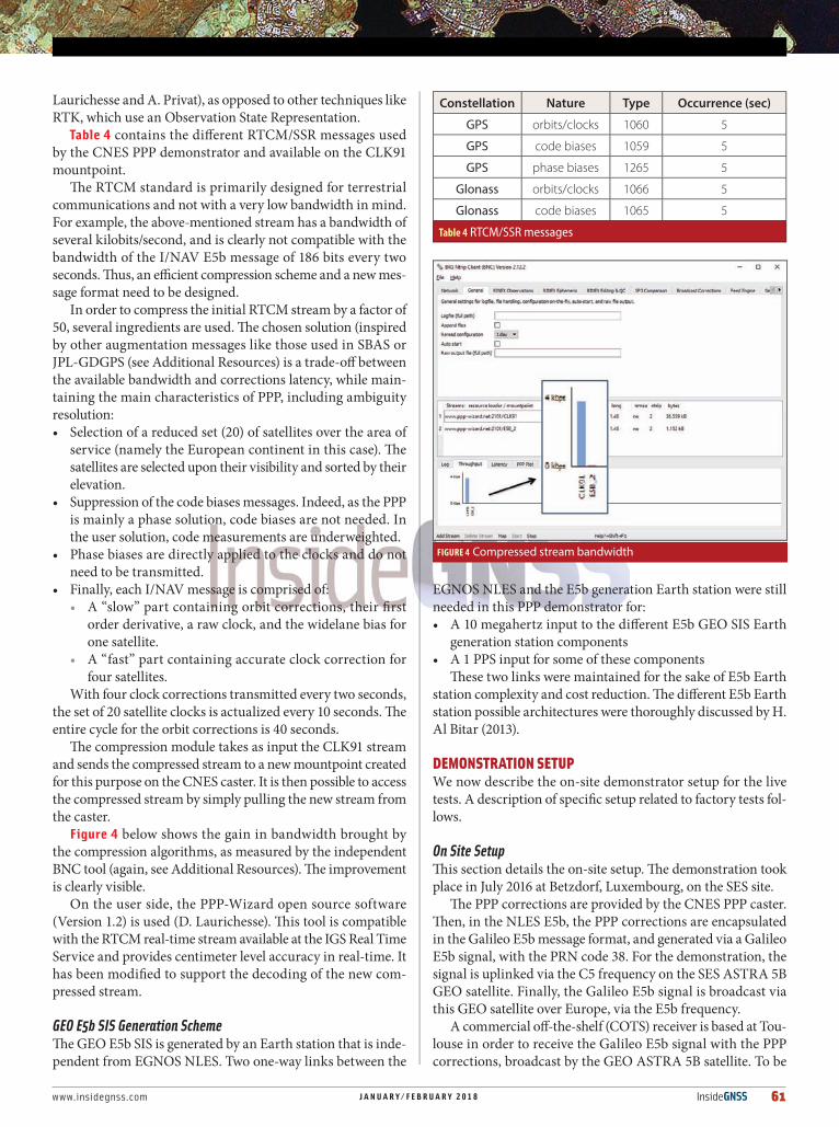
Table 4 contains the different RTCM/SSR messages used by the CNES PPP demonstrator and available on the CLK91 mountpoint.
The RTCM standard is primarily designed for terrestrial communications and not with a very low bandwidth in mind. For example, the above-mentioned stream has a bandwidth of several kilobits/second, and is clearly not compatible with the bandwidth of the I/NAV E5b message of 186 bits every two seconds. Thus, an efficient compression scheme and a new mes-sage format need to be designed.
In order to compress the initial RTCM stream by a factor of 50, several ingredients are used. The chosen solution (inspired by other augmentation messages like those used in SBAS or JPL-GDGPS (see Additional Resources) is a trade-off between the available bandwidth and corrections latency, while main-taining the main characteristics of PPP, including ambiguity resolution:• Selection of a reduced set (20) of satellites over the area of
service (namely the European continent in this case). The satellites are selected upon their visibility and sorted by their elevation.
• Suppression of the code biases messages. Indeed, as the PPP is mainly a phase solution, code biases are not needed. In the user solution, code measurements are underweighted.
• Phase biases are directly applied to the clocks and do not need to be transmitted.
• Finally, each I/NAV message is comprised of:• A “slow” part containing orbit corrections, their first
order derivative, a raw clock, and the widelane bias for one satellite.
• A “fast” part containing accurate clock correction for four satellites.
With four clock corrections transmitted every two seconds, the set of 20 satellite clocks is actualized every 10 seconds. The entire cycle for the orbit corrections is 40 seconds.
The compression module takes as input the CLK91 stream and sends the compressed stream to a new mountpoint created for this purpose on the CNES caster. It is then possible to access the compressed stream by simply pulling the new stream from the caster.
Figure 4 below shows the gain in bandwidth brought by the compression algorithms, as measured by the independent BNC tool (again, see Additional Resources). The improvement is clearly visible.
On the user side, the PPP-Wizard open source software (Version 1.2) is used (D. Laurichesse). This tool is compatible with the RTCM real-time stream available at the IGS Real Time Service and provides centimeter level accuracy in real-time. It has been modified to support the decoding of the new com-pressed stream.
GEO E5b SIS Generation Scheme The GEO E5b SIS is generated by an Earth station that is inde-pendent from EGNOS NLES. Two one-way links between the
EGNOS NLES and the E5b generation Earth station were still needed in this PPP demonstrator for:• A 10 megahertz input to the different E5b GEO SIS Earth
generation station components• A 1 PPS input for some of these components
These two links were maintained for the sake of E5b Earth station complexity and cost reduction. The different E5b Earth station possible architectures were thoroughly discussed by H. Al Bitar (2013).
DEMONSTRATION SETUP We now describe the on-site demonstrator setup for the live tests. A description of specific setup related to factory tests fol-lows.
On Site SetupThis section details the on-site setup. The demonstration took place in July 2016 at Betzdorf, Luxembourg, on the SES site.
The PPP corrections are provided by the CNES PPP caster. Then, in the NLES E5b, the PPP corrections are encapsulated in the Galileo E5b message format, and generated via a Galileo E5b signal, with the PRN code 38. For the demonstration, the signal is uplinked via the C5 frequency on the SES ASTRA 5B GEO satellite. Finally, the Galileo E5b signal is broadcast via this GEO satellite over Europe, via the E5b frequency.
A commercial off-the-shelf (COTS) receiver is based at Tou-louse in order to receive the Galileo E5b signal with the PPP corrections, broadcast by the GEO ASTRA 5B satellite. To be
Constellation Nature Type Occurrence (sec)
GPS orbits/clocks 1060 5
GPS code biases 1059 5
GPS phase biases 1265 5
Glonass orbits/clocks 1066 5
Glonass code biases 1065 5
Table 4 RTCM/SSR messages
FIGURE 4 Compressed stream bandwidth

62 InsideGNSS J A N U A R Y / F E B R U A R Y 2 0 1 8 www.insidegnss.com
able to use these PPP corrections, the user also needs GNSS constellation measurements. In this demonstration, the PPP corrections for GLONASS and GPS are used.
Thus, the receiver needs to receive GNSS measurements from the GPS and GLONASS constellations.
The E5b demonstrator functional architecture is shown in Figure 5.
The demonstrator is composed of:• The CNES PPP caster, in charge of the provision of the PPP
corrections via internet,• The NLES E5b, in charge of the Galileo E5b signal, in which
the PPP corrections are encapsulated, (Figure 6), This station is in turn composed of :
• A control PC developed by Thales Alenia Space for this dem• A signal generator developed by Thales Alenia Space and
Elta (NAVYS) providing the f lexibility to generate non-standard signals,
• An L-to-C band frequency converter,• An RF adapter in order to ensure that the transmitted signal
quality complies with the uplink and downlink Signal In Space interface requirements. It includes an analogic filter, attenuators and splitters and combiners when needed.
• The NLES G2, in charge of the provision of time (PPS) and frequency (10 megahertz) references to the NLES E5b, along with the generation of the EGNOS L1 and L5 signals,
• The SES broadcast means, in charge of the broadcast of the signals (EGNOS L1 and L5, and Galileo E5b) over Europe via the GEO ASTRA 5B satellite,
• An E5b analysis module, in charge of the verification of the emitted Galileo E5b signal, and
• A PPP solution module, in charge of the reception of the Galileo E5b signal, in addition to the GPS and GLONASS measurements, in order to compute the PPP solution.The CNES PPP caster provides PPP corrections via an inter-
net connection. Detailed information on the CNES PPP caster can be found in the Additional Resources section.
The NLES E5b Control PC has two main functions:• It manages the data interface by communicating with the
CNES caster, and• It manages the real-time interface with the NAVYS GNSS
signal generator, by sending the real-time data message to NAVYS appropriately formatted.
These functions are performed by:• TPACQ (standing for Thales PPP ACQuisition), in charge
of the connection to the remote server, the extraction of the payload, its convolutional encoding, the construction of a Galileo I/NAV-like format, latency management, and providing a data message each and every second,
• GATEWAY, in charge of receiving the messages and writing them in the GCS hard drive. It sends commands to the GCS, writes synchronization commands, and writes the naviga-tion message.The RF interface is managed by the NLES-E5b RF Adapter
elements. This RF interface is configured based on the given SES RF interface requirements, and the GSA downlink signal quality and characteristics requirements. It allows for control-ling the output signal center frequency, power, bandwidth, in and out of band interference, etc.
The RF adapter is composed of:• An RF filter. This is used at the output of the NAVYS genera-
tor in order to guarantee that the spectral characteristics of the L5 generated signal are compliant with the needed safety barriers for the uplink signal.
• An Advantech L to C tunable up-converter, borrowed from the NLES G2 factory platform. This equipment, originally designed to up-convert EGNOS L5 signals in the uplink transmission band with the desired amplification level, per-fectly fits the demonstrator needs because of its passband. It performs the L5 to C5b frequency translation of the signal generated by NAVYS.The NLES G2 is the new generation of EGNOS NLES
embedding the ability to generate L1/L5 dual-frequency GEO signals. As already stated, and in order to have a simplified architecture for the NLES E5b, it is foreseen for this station to share some outputs of the NLES G2, such as the 10 megahertz frequency reference and the 1 PPS signal.
The SES broadcast means include the uplink signal inter-face and the downlink signal interface. The uplink signal interface is a one way RF interface carrying the C5b signal to be uplinked to the GEO satellite. The power level must be adjusted so that, at the SES RF interface, the total power level in the C5 band is -5 dBm. In the demonstration configuration,
WORKING PAPERS
FIGURE 5 On-site GEO E5b PPP demonstrator setup for live tests
FIGURE 6 NLES E5b (NAVYS GNSS generator, L-to-C band frequency converter, Analogic filter, RF adapter)

www.insidegnss.com J A N U A R Y / F E B R U A R Y 2 0 1 8 InsideGNSS 63
the power of the C5b component equals -10 dBm. In order to obtain a resulting signal with a power of -5 dBm, the power of the C5a component must equal -6.5 dBm. This configura-tion is of high interest as authorities could dislike the idea of reducing the power budget allocated to the Safety of Life (SoL) component. The downlink signal interface is a one-way RF interface carrying the E5b signal received by the SES RF station from the ASTRA 5B satellite.
The E5b analysis module is composed of the Thales Alenia Space software receiver, GEMS, and a specific post-processing analysis tool, developed for the demonstration.
The PPP solution module is composed of a GNSS com-mercial off-the-shelf (COTS) receiver with a firmware patch to allow the processing of the Galileo PRN 38, and a PPP solution computation unit developed by CNES..
The GNSS receiver tracks the GPS and GLONASS constel-lation signals in order to provide dual-frequency GNSS mea-surements to the PPP solution computation unit (see Figure 7). In addition, the receiver tracks the Galileo E5b signal from satellite PRN38, corresponding to the E5b signal broadcast by the GEO ASTRA 5B satellite. As mentioned previously, this E5b signal provides the PPP corrections, associated with the GPS and GLONASS satellites and optimized for a user located in the GEO satellite ground track.
Factory Setup Prior to the on-site demonstration, a comprehensive set of fac-tory tests were performed.
The different objectives of this factory test campaign are recalled as follows:• Integration of all the demonstrator elements,• Verification of the feasibility of the demonstration,• First assessment of the demonstrator performances,• Demonstration that the demonstrator is compliant with SES
requirements,
• Demonstration that the demonstrator does not jeopardize the EGNOS SoL operations.During factory tests, a so-called GEO Payload Simulator was
used to replace the GEO satellite. The GEO Payload Simulator simulated the uplink-GEO-downlink path of both L1 and L5 signals, and was used to generate the E5b signal uplink and downlink paths as well.
DEMONSTRATION RESULTS Factory Live Tests ResultsThe factory test on Thales Alenia Space premises was per-formed on June 15, 2016. The conditions of the test were the same as those described in Figure 5, except that the GEO sat-ellite was simulated by means of an RF payload simulator as previously stated.
Figure 8 shows the error of the PPP, obtained by computing the difference between the PPP module output and the accurate reference coordinates of the receiver antenna, projected in the local frame.
These results are representative of a PPP processing. After a first convergence phase of about one hour, the accuracy is less than 10 centimeters. Fourteen satellites is typical of the dual-constellation (GPS, GLONASS). After convergence, the horizontal accuracy has a Root Mean Square (RMS) error of seven centimeters. Up to six satel-lites have ambiguities estimated to their integer value. The overall latency is about 30 seconds and explains the short-term noise of the solution.
This successful result demonstrates the validity of the imple-mentation.
On-Site Live Tests ResultsThe live experiment took place from July 21-27, 2016. The receiver was located on CNES premises, using a geodetic grade antenna on a roof of a building. The NLES E5b was installed on
FIGURE 8 PPP results during factory tests
20
16
12
8
4
0
200
100
0
-100
-200
# Satellites
PPP error
Epoch (1s)cm
0 4000 8000 12000 16000
0 4000 8000 12000 16000
VertEastNorth
TotalWidelane ambiguityAll ambiguities
FIGURE 7 Demonstration architecture showing the GNSS receiver used to demodulate the PPP message
SES GEO satellitesASTRA 5BSES-5
GPS and Glonassconstellations
Galileo E5b signal withPPP corrections
GPS L1/L2Glonass G1/G2

64 InsideGNSS J A N U A R Y / F E B R U A R Y 2 0 1 8 www.insidegnss.com
an SES site in Betzdorf, Luxembourg, together with the NLES G2 for the SES ASTRA 5B satellite.
On a typical one-day session (July 24, 2016), PPP results are identical to those obtained during the factory tests, in terms of convergence and accuracy (Figure 9):
After convergence, the RMS of the horizontal accuracy is approximately eight centimeters. The latency measured in this case is about 23 seconds. Note that the latency is mainly due to this testbed configuration, and will be reduced in any future deployment of such PPP corrections broadcast test.
In order to have a better understanding of the contribu-tion of the GEO transfer function in terms of accuracy, the same measurements were processed using the RTCM real-time corrections, before the stream compression. The results are presented on Figure 10. The horizontal RMS is equal to two centimeters. We can deduce that the noise of the transfer function (compression and end-to-end latencies) is equal to seven-and-a-half centimeters.
ConclusionThe main and novel aspect of this article is obviously the imple-mentation of a complete end-to-end GEO satellite-based PPP solution via real live tests.
A proof of concept was first assessed through a laboratory real-time testbed. Next, an on-site real-time end-to-end dem-onstration was held with different levels of implications of the concerned stakeholders (European GNSS Agency (GSA), SES, ESSP, CNES, and Thales Alenia Space).
The success of this demonstration first reminds us that an E5b non-SoL signal can co-exist with an SoL signal.
Second, and most importantly, the results presented here showed that with only 125 bits/second data rate available on a Galileo E5b-like message, the final accuracy and convergence time performance of the computed solution are still very sat-isfying (horizontal positioning error equal to eight centimeter RMS after a first convergence step of one hour).
This testbed further demonstrated that broadcasting an additional signal through an existing and transparent GEO payload requires neither heavy nor complex technical means. It is thus compatible with a possible fast deployment and could operate as a test platform for various functionalities to the upcoming CS E6 Galileo signal for example.
Ultimately, a GEO PPP broadcast channel and a Galileo MEO E6 channel used together could result in an improved accuracy service with better performance, thanks to an enhanced availability (frequency and spatial diversity), a higher geographic coverage, and a higher data rate.
Acknowledgements We would like to thank the GSA (European GNSS Agency), ESSP, and SES engineering and operations teams for their very valuable support to E5b signal testing on SES’s EGNOS uplink station and ASTRA 5B EGNOS payload. We would also like to thank Septentrio for their support in providing a new firmware version of the PolaRx5 receiver allowing for tracking of the Galileo PRN 38 code.
Additional Resources[1] Al Bitar, H., M. Raimondi, L. Ries, “NLES-NG: Augmenting EGNOS with an E5b Channel,” Proceedings of the 6th European Workshop on GNSS Signals and Signal Processing, Munich, December 2013[2] Al Bitar, H., M. Raimondi, D. Kubrak, L. Ries, “Augmenting EGNOS with an E5b Channel,” Proceedings of The Institute of Navigation International Technical Meeting (ION ITM 2014), San Diego, CA, 2014[3] Charlot, B., H. Delfour, D. Laurichesse, P. Lesage, “Efficient Message Coding To Broadcast PPP Corrections Through Satellite,” Proceedings of ISGNSS 2014, ICC Jeju, Korea, 2014[4] Fernandez, E. C. I., I. Rodriguez, G. Tobias, J. D. Calle, E. Carbonell, G. Seco-Granados, J. Simon, R. Blasi, “Galileo’s Commercial Service, Testing GNSS High Accuracy and Authentication,” Inside GNSS, January/February 2015[5] Galileo OS SIS ICD[6] Harima, K. et alia, “Performance of Real-Time Precise Point Positioning using MADOCA-LEX Augmentation Messages,” International Federation of Surveyors Congress, Kuala Lumpur, Malaysia, 2014
WORKING PAPERS
IGURE 10 PPP results without the stream compression (one day)
20
16
12
8
4
0
200
100
0
-100
-200
# Satellites
PPP error
Epoch (1s)
cm
0 20000 40000 60000 80000
VertEastNorth
0 20000 40000 60000 80000
TotalWidelane ambiguityAll ambiguities
FIGURE 9 PPP results during live tests (one day)
20
16
12
8
4
0
200
100
0
-100
-200
# Satellites
PPP error
Epoch (1s)
cm
0 20000 40000 60000 80000
0 20000 40000 60000 80000
VertEastNorth
TotalWidelane ambiguityAll ambiguities

www.insidegnss.com J A N U A R Y / F E B R U A R Y 2 0 1 8 InsideGNSS 65
[7] Heunecke, O. and H. Heister, “Worldwide Kine-matic Positioning using the OmniSTAR HP and XP Services,” Institute of Geodesy, University of the Bundeswehr, Munich, 2010[8] JPL GDGPS message: www.rtigs.net/rtigswg/doc/berne.doc[9] Laurichesse, D., “The CNES Real-time PPP with Undifferenced Integer Ambiguity Resolution Dem-onstrator,” Proceedings of ION GNSS 2011, Portland, OR, September 2011[10] Laurichesse, D., F. Mercier, J. P. Berthias, P. Broca, L. Cerri, “Integer Ambiguity Resolution on Undifferenced GPS Phase Measurements and its Application to PPP and Satellite Precise Orbit Determination,” NAVIGATION, Volume: 56, Issue: 2, Summer 2009[11] Laurichesse, D. and A. Privat, “An Open-source PPP Client Implementation for the CNES PPP-WIZ-ARD Demonstrator,” Proceedings of ION GNSS 2015,Tampa, FL, 2015[12] SC-159, “Minimum Operational Performance Standards for Global Positioning System/Wide Area Augmentation System Airborne Equipment,” RTCA DO 229 D, Annex A, December 13, 2006[13] Van Dierendonck, A. J. et alia, “Relationship between Allan Variances and Kalma Filter Param-eters,” Proceedings of the 16th Annual Precise Time and Time Interval (PTTI) Applications and Planning Meeting, NASA Goddard Space Flight Center, pp 273–293.[14] Wickramasinghe, C. H. and L. Samarakoon, “QZSS LEX Message Data for Precise Point Position-ing,” Coordinates, A Monthly Magazine on Position-ing, Navigation and Beyond, 2013
[15] https://igs.bkg.bund.de/ntrip/down-loadhttp://www.igs.org/rts, http://www.ppp-wizard.nethttp://www.rtca.org
[16] http://www.igs.org/rts
[17] http://www.ppp-wizard.net
[18] http://www.rtca.org
AuthorsMarion Aubault-Roudier is a RadioNavigation engineer in the navigation/location sig-nals department at CNES, the French Space Agency, where she is involved in the optimi-zation of GNSS signals as well as the assessment of GNSS
user segments (receivers, algorithms). She gradu-ated as an electronics engineer in 2011 from ENAC (Ecole Nationale de l’Aviation Civile) in Toulouse, France. She received her PhD in 2015 from the Department of Mathematics, Computer Science and Telecommunications of the INPT (Polytechnic National Institute of Toulouse), France.
Denis Laurichesse is a mem-ber of the navigation system service at CNES. He has been in charge of the DIOGENE GPS orbital navigation filter, and is now involved in navigation algorithms for GNSS systems. He is currently in charge of
the CNES IGS real time analysis center. He was the co-recipient of the 2009 ION Burka award for his work on phase ambiguity resolution.
Hanaa Al Bitar is a GNSS sys-tems engineer at Thales Ale-nia Space France (TAS-F). She is currently the technical man-ager of the GEO E5b PPP demonstration. She received her PhD in RadioNavigation in 2007 form the ENAC, in Tou-
louse, France, in the field of GNSS Receivers. She joined Thales Alenia Space in 2012. Her main activities focus on GNSS receivers signal process-ing, and EGNOS Land Earth Stations (NLES) signal processing and design.
Mathieu Raimondi is cur-rently a GNSS systems engi-neer at Thales Alenia Space. Raimondi received a PhD in signal processing from Uni-versity of Toulouse (France) in 2008. Since then, he has been working on various GNSS top-
ics. He joined the Thales Alenia Space navigation business unit in 2011.
Pierre Lesage is a GNSS sys-tems engineer at Thales Ale-nia Space France (TAS-F). He graduated as a Telecom engi-neer from INSA Lyon, and then studied Space Commu-nications Systems (SCS Mas-ter) at Supaero. He joined
Thales Alenia Space in 2015, working on EGNOS.
Arnault Sfeir is currently proj-ect manager of GNSS subsys-tems at Thales Alenia Space. He graduated as a Telecom Engineer from ENSEEIHT, Tou-louse, and joined Thales Ale-nia Space in 1996 as satellite payloads AIV (Assembly, Inte-
gration and Validation) manager for WoldStar PFM & FM2, XM Radio, GE12/14, Hispasat 1D. He subse-quently spent four years in French Guyana at the European spaceport as Ariane 5 Telemetry Opera-tions Manager, before managing the IOT (In-Orbit Test) monitoring system for the Globalstar 2 con-stellation.
Michaël Klein is currently in charge of GNSS subsystems validation and tests at Thales Alenia Space. He graduated as a senior technician from CRED IUT-A (Centre de Recherche et de Développement à l’Institut Universitaire de Technologie)
in Talence, near Bordeaux. He joined Thales Alenia Space in 1996 as a satellite equipment validation and tests conductor for Globalstar 1, Arabsat, Hyspasat, Worldstar, and many others.
Matthieu Sihrener has been the technical expert of the NLES (EGNOS uplink stations) at ESSP since 2009. Specializing in Ground Stations and Radio
Navigation Signals processing, he is also in charge of the Sig-nal in Space monitoring in collaboration with the satel-lite providers. He graduated in 2006 from ENAC (Ecole Natio-nale de l’Aviation Civile) in Toulouse, France.
Nicolas Ramponi is Program Manager at SES Networks, one highly focused business unit of SES, a world-leading satellite operator in Luxem-bourg. Nicolas joined SES in 1998 as a Multimedia Soft-ware Team Leader working on
SES satellite communications platforms. In 2008, he became Project Manager at SES Techcom, lead-ing ESA and EU projects in the domain of maritime surveillance such as Automatic Identification Sys-tem (AIS) via satellite. Since 2011, Nicolas has been the project manager of two EGNOS hosted pay-loads services on SES GEO satellites, SES-5 and ASTRA 5B. He led the SES teams for the design and implementation of EGNOS payloads on these two GEO satellites as well as the associated ground sta-tions and hosting sites. SES-5 and ASTRA 5B satel-lites are now in operation.
Em. Univ.-Prof. Dr.-Ing. habil. Dr. h.c. Guenter W. Hein is Professor Emeritus of Excel-lence at the University FAF Munich. He was ESA Head of EGNOS & GNSS Evolution Pro-gramme Dept. between 2008 and 2014, in charge of devel-
opment of the 2nd generation of EGNOS and Galileo. Prof. Hein is still organizing the ESA/JRC International Summerschool on GNSS. He is the founder of the annual Munich Satellite Navigation Summit. Prof. Hein has more than 300 scientific and technical papers published, carried out more than 200 research projects and educated more than 70 Ph. D.´s. He received 2002 the prestigious Johannes Kepler Award for “sustained and signifi-cant contributions to satellite navigation” of the US Institute of Navigation, the highest worldwide award in navigation given only to one individual each year. G. Hein became 2011 a Fellow of the US ION. The Technical University of Prague honoured his achievements in satellite navigation with a Doctor honoris causa in Jan. 2013. He is a member of the Executive Board of Munich Aerospace since 2016.
Follow us on Twitter
@insideGNSS