a design for 4 million greater langley: new buildings
TRANSCRIPT
LARC 504 Sustainable Urban Design Studio Fall, 2005
Greater Langley: NEW BUILDINGS
Greater Langley: Ryan Crago, Leigh Sifton, Kate Stefiuk
A Design for 4 Million
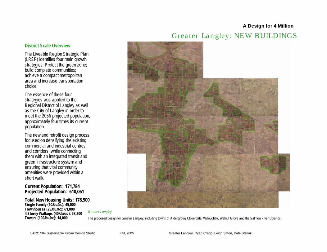
District Scale Overview
The Liveable Region Strategic Plan (LRSP) identifies four main growth strategies: Protect the green zone; build complete communities; achieve a compact metropolitan area and increase transportation choice.
The essence of these four strategies was applied to the Regional District of Langley as well as the City of Langley in order to meet the 2056 projected population, approximately four times its current population.
The new and retrofit design process focused on densifying the existing commercial and industrial centresand corridors, while connecting them with an integrated transit and green infrastructure system and ensuring that vital community amenities were provided within a short walk.
Current Population: 171,784Projected Population: 610,061
Total New Housing Units: 178,500Single Family (10/du/ac): 45,000Townhouses (25/du/ac): 61,0004 Storey Walkups (40/du/ac): 58,500Towers (100/du/ac): 14,000
Greater Langley
The proposed design for Greater Langley, including towns of Aldergrove, Cloverdale, Willoughby, Walnut Grove and the Salmon River Uplands.

LARC 504 Sustainable Urban Design Studio Fall, 2005
Greater Langley: NEW BUILDINGS
Greater Langley: Ryan Crago, Leigh Sifton, Kate Stefiuk
A Design for 4 Million
Greater Langley
The proposed design for Greater Langley, including towns of Aldergrove, Cloverdale, Willoughby, Walnut Grove and the Salmon River Uplands.
District Scale Overview
The Liveable Region Strategic Plan (LRSP) identifies four main growth strategies: Protect the green zone; build complete communities; achieve a compact metropolitan area and increase transportation choice.
The essence of these four strategies was applied to the Regional District of Langley as well as the City of Langley in order to meet the 2056 projected population, approximately four times its current population.
The new and retrofit design process focused on densifying the existing commercial and industrial centresand corridors, while connecting them with an integrated transit and green infrastructure system and ensuring that vital community amenities were provided within a short walk.
Current Population: 171,784Projected Population: 610,061
Total New Housing Units: 178,500Single Family (10/du/ac): 45,000Townhouses (25/du/ac): 61,0004 Storey Walkups (40/du/ac): 58,500Towers (100/du/ac): 14,000

LARC 504 Sustainable Urban Design Studio Fall, 2005
Greater Langley: NEW BUILDINGS
Greater Langley: Ryan Crago, Leigh Sifton, Kate Stefiuk
A Design for 4 Million
Smart Parking: The reconfiguration of large parking lots to smaller lots and capitalize on street parking.
Layered Living: Applying alternative housing solutions within existing parcels increases densities and builds community.
Dense Centres: Dense centres created along transit routes such as the expanded neighbourhood centre in Port Kells.
Linear Growth: Extend densification along key corridors of transit, connecting town and neighbourhood centres.
Neighbourhood scale solutions
The following strategies guided the design in proposing new buildings:
Dense Centres: The strategy of “build up, not out” was applied in particular to existing centres. The result of this strategy is evidenced in the City of Langley, where housing towers have been added above existing commercial.
Linear Growth: Dense growth in the design strategy for Langley is focused in both nodes and bands along major transit routes. This strategy is shown in areas with mixed-use zones along the corridor, stepping down to 4-story living down to row housing and finally to duplexes and single-family development.
Layered Living: Layered housing options such as the basement suite or infill housing on a parcel to increase local density without changing the face of the neighbourhood are proposed in the design. This includes live/work solutions, increasing commercial and business diversity.
Smart Parking: In existing commercial areas, existing street-side parking lots were reconfigured to the back of buildings, and onto the street itself, while pushing the buildings face closer to the street. This serves to enhance the life of the street, making shopping and business areas for people, not cars.
LARC 504 Sustainable Urban Design Studio Fall, 2005
Greater Langley: GREEN INFRASTRUCTURE
Greater Langley: Ryan Crago, Leigh Sifton, Kate Stefiuk
A Design for 4 Million
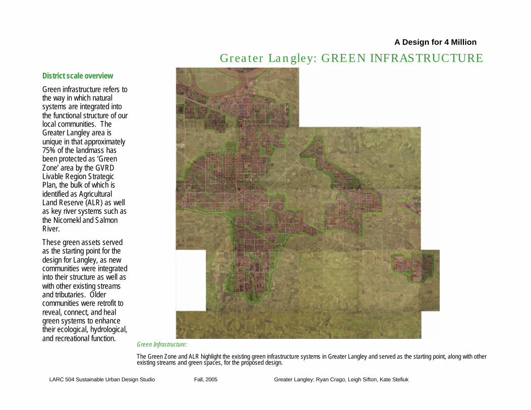
District scale overview
Green infrastructure refers to the way in which natural systems are integrated into the functional structure of our local communities. The Greater Langley area is unique in that approximately 75% of the landmass has been protected as ‘Green Zone’ area by the GVRD Livable Region Strategic Plan, the bulk of which is identified as Agricultural Land Reserve (ALR) as well as key river systems such as the Nicomekl and Salmon River.
These green assets served as the starting point for the design for Langley, as new communities were integrated into their structure as well as with other existing streams and tributaries. Older communities were retrofit to reveal, connect, and heal green systems to enhance their ecological, hydrological, and recreational function.
Green Infrastructure:
The Green Zone and ALR highlight the existing green infrastructure systems in Greater Langley and served as the starting point, along with other existing streams and green spaces, for the proposed design.

LARC 504 Sustainable Urban Design Studio Fall, 2005
Greater Langley: GREEN INFRASTUCURE
Group name: student 1, 2, 3, etc
A Design for 4 Million
Neighbourhood details
Rethinking the ALR – ‘The Edge Parkway’The ALR is clearly a vital resource to the entire lower mainland, but its current form creates a fragmented, under-resolved interface between its rural edge and urban settlement. In attempting to explore potential solutions for the ‘Edge’, the proposed design includes a Parkway which traverses, and delineates a new boundary between the rural and (sub)urban landscapes.
The result is a reorganization of the agricultural and developable land, without a reduction of either, leading to the creation of rural/urban interface with the potential for small scale or community agricultural, recreational, conservation, and institutional uses, in addition to a pleasure drive through the region in the spirit of Bartholomew and Olmsted.
Connectivity - Green infrastructure comes in all shapes and sizes, but its functionality as a key component of a sound ecological community relies on its interconnectivity. The design emphasized the connection of greenspacesfrom backyards to parks, to each other and to larger system in order to promote the restoration of natural processes, increased infiltration and reduction of impact to habitat and water quality.
The Edge Parkway: The image represents the diversity of potential land uses for the urban/rural interface delineated by the Parkway, including institutional, community agriculture and cluster housing.
Green Connections: Where feasible, connections were made between all scales of green infrastructure from local systems, to the larger regional systems.
Connections Applied: Proposed green infrastructure connections between riparian areas, green spaces and school yards/fields in Langley

LARC 504 Sustainable Urban Design Studio Fall, 2005
Greater Langley: JOBS CLOSE TO HOME
Greater Langley: Ryan Crago, Leigh Sifton, Kate Stefiuk
A Design for 4 Million
District scale overviewSustainable communities are complete communities, and a vital part of becoming a complete community is the provision of local jobs for local people.
Given its place in the region and limited potential for greenfield industrial expansion because of geographic and policy constraints, the proposed design for Greater Langley highlights a series of neighbourhood and town centres, where flexible zoning facilitates the provision of commercial and business employment within the fabric of the local community. In addition, existing industrial sites throughout the sub-region have been reorganized and densified, and opportunities for small scale agricultural jobs along the ALR edge have been identified in order to satisfy employment requirements.
The population estimates for the Greater Langley area require that 175,000 new jobs are provided to complete the community. The proposed design provides 201,000 jobs – a job to new housing ratio of 1.2:1
Jobs, Jobs, Jobs:
The proposed design focuses on providing jobs in a variety of town and employment centres across the sub-region. Their interconnectivity is key in providing efficient travel to and from work, encouraging working and living in the same community.

LARC 504 Sustainable Urban Design Studio Fall, 2005
Greater Langley: JOBS CLOSE TO HOME
Greater Langley: Ryan Crago, Leigh Sifton, Kate Stefiuk
A Design for 4 Million
Job Sites
The following principles guided the proposed design in providing local jobs for local people:
Flexible Zoning: The integration of commercial, industrial and mixed-use residential at town and neighbourhood centres increases the opportunities for the residents of Greater Langley to work close to home. This includes breaking up current zoning schemes into smaller, more flexible blocks where multiple land uses can exist, as well as providing potential areas for work/live solutions.
Dense Centres: The theory of densifying centres was also applied in considering jobs in the proposed design. Existing commercial and business centres and corridors were built up, not out, and existing industrial activities were reorganized and densified to provide a series of local and connected job centres for the people of Langley.
Flexible Zoning: Within the town and neighbourhoodcentres integrating industrial, commercial, and residential zoning.
Flexible Zoning Applied: This example from the proposed design of Aldergrove illustrates the possibilities of flexible zoning.
Dense Centres: Expanding and densifying commercial, industrial and business centresallows the people of Langley to live and work in their home communities.

LARC 504 Sustainable Urban Design Studio Fall, 2005
Greater Langley: TRANSPORTATION
Greater Langley: Ryan Crago, Leigh Sifton, Kate Stefiuk
A Design for 4 Million
Moving around the district
The Liveable Region Strategic Plan identifies ‘increasing transportation choice’ as an important strategy for creating a sustainable region.
Greater Langley is currently a car-based community and through the addition of transit lines and greenway systems, the proposed design has created an integrated network of all forms of transportation.
The focus of development was on the creation of an effective transit system operating on an interconnected street system. The existing transit system was expanded to create a grid system such that routes are within a 5 minute walking distance from all areas in the sub-region.
In areas where an integrated street network could not be restored we have attempted to connect areas through green connections, serving as opportunities for bike routes and pedestrian-ways.
Buses Everywhere:
This image highlights the existing and expanded bus routes throughout the sub-region. Though Greater Langley is currently a car-based community, expanding on transit opportunities can discourage local car use, and create better connections for work, live and play through the sub-region

LARC 504 Sustainable Urban Design Studio Fall, 2005
Greater Langley: TRANSPORTATION
Greater Langley: Ryan Crago, Leigh Sifton, Kate Stefiuk
A Design for 4 Million
Connect the Centres: Connect the flow of materials, goods and residents within and between communities as well as to the whole region.
The Rule Applied: An example of how this rule was applied in the proposed design.
Green Retrofitting: Transportation doesn’t mean just cars and buses. Greenspace in developed areas were retrofit to allow the flow of people on foot, bikes, skateboards etc.Moving around the
neighbourhoods
The following principles guided the proposed design in providing effective transportation throughout the sub-region:
Connect the Centres: Transit routes were added throughout the sub-region to create a connected network of regional and neighbourhoodcentres.
Five Minutes: Routes were established such that residences along with commercial and business areas are located within a 5 minute walking distance to transit service.
Green Retrofitting: Existing suburban neighbourhoods, such as Walnut Grove, were retrofit through the development of green corridors. These corridors serve as bike routes and pedestrian ways through neighbourhoods.
5 Minute Rule: The proposed design provides communities with local amenities such as transit, greenspace and commercial areas within a short walk.