a ducks unlimited canada summerberry marsh · this project would not have been possible without the...
TRANSCRIPT

Summerberry Marsh
APRIL 2011
A d u c k s u n L I m I t e d c A n A d A R e s e A R c h R e p o R t

Funding for the Summerberry Marsh Research Project was graciously provided
by Manitoba Hydro, Ducks Unlimited Canada, Manitoba Conservation, Natural
Sciences and Engineering Research Council of Canada, and Kelsey Conservation
District. In-kind support was also provided by University College of the North.
This project would not have been possible without the hard work and
contributions from numerous individuals. Mark Baschuk, Mike Ervin and Elise
Watchorn were the graduate students who undertook the field projects that
made up this project. The academic advisors were Dr. William Clark (Iowa State
University), Dr. Gordon Goldsborough (University of Manitoba), and Dr. Nicola
Koper (University of Manitoba).
We thank Dale Cross, Garth Ball, Cam Hurst, Derek Leask and Bob Uchtmann
of Manitoba Conservation; and Grant McVittie and Ron Campbell of Manitoba
Water Stewardship; and Dale Wrubleski, Robin Reader, Shaun Greer, Dave
Clayton, Chris Smith, Llwellyn Armstrong, Bill Tedford and John Milne of Ducks
Unlimited Canada.
Field help was provided by Harlen Andrews, Sheila Atchison, Martin Blades,
Heath Brown, Quinn Constant, Nola Geard, Jonathan Harris, Jonathan Hopkins,
Mokhtar Joundi, Jared Knockaert, Dave White, JeanAnne Pryslia and Paul
Ziesmann. Additional funding support of field assistants was provided by
ECO Canada.
A special thanks to the people of the Opaskwayak Cree Nation, Moose Lake
First Nation, Cormorant, Grand Rapids and Easterville for sharing their concerns
and wisdom on the area.
We also thank Terry Miles, Dave Olinyk, Shelly Matkowski, Gina North, Dennis
Peristy, Bob Monkman and the Saskatchewan River patrol crew from
Manitoba Hydro.
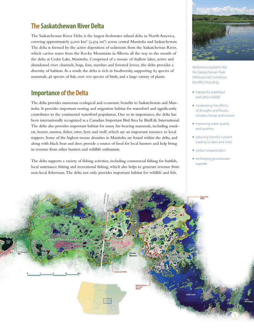
the Saskatchewan River DeltaThe Saskatchewan River Delta is the largest freshwater inland delta in North America, covering approximately 9,000 km2 (3,474 mi2) across central Manitoba and Saskatchewan. The delta is formed by the active deposition of sediments from the Saskatchewan River, which carries water from the Rocky Mountains in Alberta all the way to the mouth of the delta at Cedar Lake, Manitoba. Comprised of a mosaic of shallow lakes, active and abandoned river channels, bogs, fens, marshes and forested levees, the delta provides a diversity of habitats. As a result, the delta is rich in biodiversity, supporting 43 species of mammals, 48 species of fish, over 200 species of birds, and a large variety of plants.
Importance of the deltaThe delta provides numerous ecological and economic benefits to Saskatchewan and Man- itoba. It provides important nesting and migration habitat for waterfowl and significantly contributes to the continental waterfowl population. Due to its importance, the delta has been internationally recognized as a Canadian Important Bird Area by BirdLife International. The delta also provides important habitat for many fur-bearing mammals, including musk-rat, beaver, marten, fisher, otter, lynx and wolf, which are an important resource to local trappers. Some of the highest moose densities in Manitoba are found within the delta, and along with black bear and deer, provide a source of food for local hunters and help bring in revenue from other hunters and wildlife enthusiasts.
The delta supports a variety of fishing activities, including commercial fishing for baitfish, local sustenance fishing and recreational fishing, which also helps to generate revenue from non-local fisherman. The delta not only provides important habitat for wildlife and fish,
Wetland ecosystems like the Saskatchewan River Delta provide numerous benefits, including:
• habitat for waterfowl and other wildlife
• moderating the effects of droughts and floods, climate change and erosion
• improving water quality and quantity
• reducing harmful nutrient loading to lakes and rivers
• carbon sequestration
• recharging groundwater supplies
b

but the abundance of wetlands helps to store carbon, filter nutrients from our water and provides flood protection. Wetlands in the Manitoba portion of the delta are estimated to store 100 million tonnes of carbon – a significant factor helping to minimize the effects of climate change.
Challenges facing the deltaThe Saskatchewan River Delta is primarily nourished by the Saskatchewan River, which carries water drained from about 420,000 km2 (162,120 mi2) across Montana, Alberta, Saskatchewan, and Manitoba. Along the way, the Saskatchewan River is used for a variety of purposes, including hydroelectric production, petroleum production and refining, crop irrigation and drinking water. These combined uses have had a significant impact on the river and the downstream delta. The hydroelectric dams and consumption of water have altered the hydrology of the river. Before many of these developments, the Saskatchewan River had two annual high-water peaks, one in the spring from snowmelt and run-off from the Prairies, and another in early summer from snowmelt in the Rocky Mountains. These high-water events were critical for recharging wetlands in the delta, depositing nutrient-rich water and deltaic soils, and contributing to the high fertility of the wetlands. At other times, drought conditions would occur in the river, causing some wetlands to dry up. This flood-drought cycle is a key factor in the overall productivity of the delta.
The delta is a biologically-rich area that significantly contributes to the local and provincial economy by providing hunting, fishing and trapping opportunities.
Water-level fluctuations in wetlands are natural processes key to maintaining their health and quality.
1600
1400
1200
1000
800
600
400
200
JAn FeB mAR APR mAY Jun JuL AuG seP Oct nOV dec
1913-1959
1969-2009
Mea
n Fl
ow (m
3 /s)
Mean monthly water flow of the Saskatchewan River at The Pas, Manitoba before (red) and after (blue) upstream hydroelectrical developments.
The construction of the Grand Rapids generating station downstream of the delta resulted in the permanent flooding of about 100,000 ha (247,000 acres) of the lower delta that opens into Cedar Lake. Further, agricultural developments on the Manitoba side of the delta have drained over 30,000 ha (74,100 acres) of wetlands, and an additional 7,000 ha (17,290 acres) of wetlands have deteriorated due to river diversion projects.
c

Management in the deltaThe Saskatchewan River Delta has a history of management dating back 80 years. In the 1930s, the provincial governments of Manitoba and Saskatchewan, the federal government and several private investors – including Tom Lamb and the Hudson’s Bay Company –attempted to stabilize water levels to increase production of muskrats for trapping. In the 1940s, the importance of the delta to waterfowl was recognized by Ducks Unlimited Canada, which began managing and developing wetlands. Today, Ducks Unlimited Canada operates 75 water control structures and manages approximately 200,000 ha (494,000 acres) of delta wetlands in Manitoba and Saskatchewan. In the past, water-control structures were used to remove excess water and stabilize water levels in the summer to increase waterfowl produc- tion. In recent years, water control structures have been operated in an attempt to mimic the wetland wet/dry cycle, which has been altered by numerous human developments.
However, management efforts have had mixed success. Northern delta wetlands are quite different from the well-studied prairie wetlands in the south, and as a result the vegetation responses to management efforts have differed. Therefore, in order to properly manage the delta, a better understanding of the ecology of these wetlands is needed – information that will help guide future management decisions for benefit of all who use the delta’s resources.
Above: DUC operates numerous structures within the delta that control levels in individual basins and entire wetland complexes.
Below: Saskatchewan River Delta wetland with a water control structure (study wetland 14R).
d

Objectives of the summerberry marsh Research ProjectDue to the unique response of wetlands in the delta, it is important to gather scientific information on common management practices – such as water-level management – in order to maintain the health of the wetlands in the delta. To gather scientific information on water-level management in the delta, this project used an experimental approach to test the effects of different water-level treatments on ecologically and economically important aspects of wetland ecology.
Overall, there were four objectives of the Summerberry Marsh Research Project:
b Identify the water quality within the wetlands of the delta and how it is affected by water-level management.c Identify the response of wetland vegetation to water-level management.d Examine the populations of waterfowl and marsh birds in the area and their response to water-level management.e Examine muskrat populations within the delta and their response to water-level management.
the Summerberry Marsh ComplexThis research study took place in the managed wetlands of the Summerberry Marsh Com- plex, located about 25 kilometres southeast of The Pas, Manitoba. This wetland complex covers 15,000 ha (37,050 acres), mainly between the Summerberry and Saskatchewan Rivers. From 1979 to 1981, Ducks Unlimited Canada installed 28 water control structures, designed to mimic the historic flood and drought cycle of the delta. These structures allow water levels to be controlled by releasing water from wetlands into the Saskatchewan River, or by capturing water from the river during high-water periods or by retaining rainwater or snow melt.
Six wetlands in the Summerberry Marsh Complex were selected for the study: 14R, 21C, 32C, 34HI, 35HI and 37C. Wetlands were monitored in 2007 prior to any manipulations taking place. In the fall of 2007, three of the wetlands (14R, 37C and 35HI) were partially drawn down to copy natural drawdown conditions. Water levels in these wetlands were lowered by 30 cm, resulting in a depth of approximately 60 cm in the deepest part of the basin. The remaining three wetlands (21C, 32C, and 34HI) were managed to maintain their high-water levels and act as controls. The water levels in these basins remained at approxi-mately 100 cm in the deepest part of the basins.
From 2007 to 2010, water levels within these wetlands were held constant while researchers examined and compared the effects of these different treatments on vegetation, water quality, waterbirds and muskrats.
Above (top to bottom): Hill Island Camp, the base for the research project; Releasing water for the partial water-level drawdown in the Summerberry Marsh, 2007; Airboats were a key part of the project, and the only way to move within and between study wetlands.
e

Sum
mer
berry
M
arsh
Com
plex
Non-
Draw
dow
n
Part
ial D
raw
dow
n
f
0
0.5
1
2
3
4
kilo
met
res

the effects of Water-level management on Water chemistry and Algal ProductionElise Watchorn, University of Manitoba
The drainage basin of the Saskatchewan River encompasses 420,000 km2 (162,120 mi2) of Montana, Alberta, Saskatchewan and Manitoba and is home to three million people. Agri- cultural activity is prevalent in much of this region, with as much as 90 per cent of land within the South Saskatchewan River sub-basin being cropland or rangeland. Water runoff from this land can be a source of nutrients and pollutants into the Saskatchewan River, which will eventually reach the delta. Additional nutrients and pollutants in the river may also come from the many towns and several major urban areas, including Calgary, Edmonton, Lethbridge and Saskatoon through which the river and its tributaries pass. Industrial activity within the watershed, including forestry, mining and petrochemical resources may also affect the water quality within the river and delta.
Examining water quality within the delta and gathering information on the effects of water- level management on water quality is an essential component of wetland management. Water quality is the base for the productivity and overall health of wetlands. The types and amounts of nutrients in the water will affect the algae communities present in wetlands. Despite their small size, algae are a very important part of wetland ecology. Algae are the base of many wetland food webs, acting as food sources for aquatic invertebrates, which are, in turn, fed on by fish, waterfowl and other wildlife.
To examine the effects of water-level management on water quality in the delta, water clarity and nutrient concentrations were measured in 2007, prior to wetland manipulations, and in 2008, the first year of the partial water-level drawdowns. Water clarity was measured using a light meter. This instrument measures the amount of light that can penetrate the water column, which affects algae and plant growth beneath the surface. Nutrient concen-trations in the water column were measured using several different techniques. Water samples were collected and the amounts of nitrogen and phosphorous, the major nutrients affecting algae and plant growth, were determined in the laboratory. Researchers also used nutrient-diffusing substrata to determine if any nutrients were lacking in the water and limiting the growth of algae. This technique uses plastic tubes that are filled with agar enriched with different nutrients. The tubes are fitted with porous caps, and placed below the surface of the water. The nutrients in the agar leak out through the porous cap, providing algae with nutrients if they are lacking. The cap with the most algae shows which nutrients are limiting.
Researchers found that less wind velocity was needed to stir up bottom sediments in partial water-level drawdown wetlands. As wind passes over the water it produces bands of circu-lating water, able to disturb bottom sediments if the wind is strong enough. As the water depth decreases, the wind velocity needed to create bands large enough to disturb the bottom sediments also decreases, resulting in more sediment resuspension. The increased sediment resuspension reduced water clarity and increased the concentrations of nitrogen and phos-phorous in the water. Prior to the drawdown, wetland algal communities were limited by
Above (top to bottom): Water chemistry laboratory at Hill Island Camp; Performing nutrient analyses on water samples in the laboratory.
g

nitrogen or co-limited by nitrogen and phosphorus. Input of nutrients from the sediment resulted in a shift from nutrient deficiency to nutrient sufficiency, promoting the growth of algae in the partially drawn-down wetlands.
Other water-level manipulation studies have found that a reflood after a period of total drawdown caused a pulse of nutrients leaching from decomposing vegetation. Our work in the Summerberry marshes suggests that these changes may not require complete drying out of sediments, or the input of large amounts of litter from drowned annual vegetation, but rather can occur when depths are shallow enough that sediments are more frequently resuspended by wind. These findings have implications for future management of these marshes for waterfowl and muskrat production.
Amounts of nitrogen (left) and phosphorus (right) in the study wetlands in 2007, prior to the partial drawdown, and in 2008, the first year of the partial drawdown.
8
6
4
2
180160140120100
80604020
control2007
control2008
drawdown2007
drawdown2008
control2007
control2008
drawdown2007
drawdown2008
[TN]
(mg/
L)
[TRP
] (µg
/L)
Above: An example of algal growth response on the nutrient-diffusing substrata. The bottom-right tube was supplemented with nitrogen and phosphorous indicating nutrient limitation in the water.
Below: Sheila Atchison collects a water sample.
Above: Elise Watchorn displays the nutrient-diffusing substrata equipment

Vegetation Mapping in the summerberry marsh complexOne challenge faced by researchers on this project was developing a method to map the different vegetation types within the study wetlands. The ability to map vegetation within the wetlands is important to determine the response of vegetation to the partial water-level drawdowns and to gather information on the habitat quality and type available to wildlife in the wetlands, especially waterfowl, marsh birds and muskrats.
To accomplish this, researchers obtained high-resolution satellite imagery of the Summer-berry Marsh Complex during each year of the study, from 2007-2010. Because the area is so large, the six study wetlands were cut from the larger image to make mapping more efficient.
Next, researchers had to perform what is known as ground-truthing. This involved travelling through each of the wetlands and identifying different vegetation types and collecting water depths at numerous points. This allowed areas of different vegetation species to be accurately identified later from the satellite imagery. In each of the six study wetlands, researchers collected 500 ground-truthed points.
The next step involved using specialized computer software to outline, or segment, different colour areas within the satellite imagery. The computer program draws a line called a poly- gon around each group of pixels that represent a vegetation type (referred to as a segment). Because different vegetation species are different colours, this allows them to be identified from the imagery. The ground-truthed data was compared to the segmented image to create a reference of each different vegetation type.
However, since there were many more segments than ground-truthed points, many did not have a vegetation type assigned. Statistical analyses were used to model the spectral charac-teristics of the reference segments and determine the vegetation type within polygons lacking a ground-truthed point. This created a detailed vegetation map of each study wetland for each year of the study.
From these maps we were able to determine that the partial water-level drawdowns did affect the emergent vegetation in the wetlands. Senescent (dying) vegetation in the draw-down wetlands increased drastically after the first two years of decreased water levels. This was caused by the senescence of Carex (sedge) and Typha (cattail) in the shallower portions of the wetlands. After the third year, Carex and Typha adjusted to the change in water levels and areas of these species increased while areas of senescing vegetation decreased. While the senescence of the vegetation may reduce habitat for a short time, it allows other species of vegetation to take hold and can increase habitat diversity and quality. The partial draw-downs also promoted the growth of Sparganium (bur-reed), an important food source for waterfowl.
Above (top to bottom): An example of one wetland (32C) cut from the high-resolution satellite imagery; Locations of ground-truthed points taken in the wetland; Computerized segmentation of wetland 32C satel- lite imagery viewed close up, out- lining different vegetation features within the wetland image.
i

Hardstem Bulrush (Schoenoplectus tabernaemontani)
Cattail (Typha spp.)
Giant Reed Grass (Phragmites australis)
Horsetail (Equisetum spp.)
Sparganium
Carex
Senescent
Equisetum
Phragmites
Bur-reed (Sparganium spp.)
Common wetland vegetation in the Saskatchewan River Delta
2007
2008
2009
2010
2010
2009
2008
2007
Schoenoplectus
Trees
Typha
Water
Sedge (Carex spp.)
Annual vegetation maps of non-drawdown wetland 32C (left) and partial drawdown wetland 37C (right)
0 0.5 1 1.5 2 kilometres
j

the effects of Water-level management on Waterfowl and marsh BirdsMark Baschuk, University of Manitoba
The Saskatchewan River Delta supports about 500,000 ducks and geese every spring. Many of these waterfowl stay and nest, while for others the delta provides an important resting area for their journey further north. Despite the importance of the delta to waterfowl, population numbers in the area have been progressively declining. Annual surveys show an overall down- ward trend in waterfowl numbers within the delta. While the exact cause of this trend is unknown, it is suspected to be influenced by deterioration of habitat in the delta caused by numerous developments that have occurred along the Saskatchewan River in recent decades.
In addition to waterfowl, the delta also supports numerous species of marsh birds, including American bitterns, pied-billed grebes, American coots, yellow rails, Virginia rails and soras. These birds are seldom seen and only heard in spring. Despite their secretive nature, many of these species’ populations are declining as a result of wetland destruction. As wetlands continue to disappear, the importance of remaining wetland habitat is increased. Therefore, it is not only important to conserve remaining wetland habitat, but also to manage it effec-tively to provide the highest quality habitat possible. In order to accomplish this, we require a better understanding of waterfowl and marsh bird ecology in the delta so informed decisions can be made about its management. Therefore, the goal of this project was to determine how the different water-level treatments, changes in wetland vegetation, and available food resources affected waterfowl and marsh birds. This information could then be used to focus wetland management on the requirements of these species.
Some common marsh bird species found in the Saskatchewan River Delta. Top to bottom: American bittern, pied-billed grebe, sora, American coot.
1400
1200
1000
800
600
400
200
1955 1959 1963 1967 1971 1975 1979 1983 1987 1991 1995 1999 2003 2007
R2 = 0.1732
Tota
l Wat
erfo
wl (
thou
sand
s)
Waterfowl numbers in the Saskatchewan River Delta from 1955-2009 (U.S. Fish & Wildlife Service Migratory Bird Data Center 2009)
1)

To accomplish this goal we surveyed waterfowl within the study wetlands during the spring, summer, and fall of 2008 and 2009. We also used call-response surveys to count breeding marsh birds in the spring. Call-response surveys involve playing a recorded marsh bird call in an attempt to get the birds to respond. This allows marsh birds to be counted by sound rather than by sight.
We found that partial water-level drawdowns and high-water both had benefits and draw-backs associated with them. The partial drawdowns benefitted dabbler species of waterfowl, such as the mallard and blue-winged teal, but negatively impacted diver species of waterfowl, such as the ring-necked duck. However, both dabblers and divers chose wetlands with high invertebrate abundances in the spring. This is due to invertebrates being a good source of protein for birds preparing to lay eggs and recovering from their long migration. On the other hand, these birds avoided wetlands with high numbers of forage fish. Forage fish will compete against waterfowl for invertebrates and lower the amount of food available to water- fowl. In the summer, waterfowl numbers decreased due to waterfowl seeking out large, open water areas to moult. In the fall, waterfowl numbers increased to their highest levels. Dabbler species concentrated on the partially drawn-down wetlands at this time due to the availability of submerged aquatic vegetation, which provides a good source of carbohydrates needed to supply the energy for the long migration south.
Marsh birds, including American bitterns, American coots and pied-billed grebes preferred the deeper, high-water wetlands. Unlike waterfowl, American bitterns and pied-billed grebes feed primarily on small fish, which were abundant in the high-water wetlands. On the other hand, soras and Virginia rails avoided wetlands with high numbers of fish and chose wetlands with greater invertebrate abundances. Similar to waterfowl, wetlands with high fish abun-dance were avoided by these species due to competition for invertebrate prey.
From this study we learned that due to the high diversity of birds in the delta, no single management approach is capable of providing ideal habitat for all species. A wide range of habitat conditions needs to be present in the delta to provide the best habitats for the diverse range of bird species.
Top: Forage fish like the central mudminnow can survive in the low-oxygen conditions of wet- lands, where larger fish cannot.
Above: Invertebrates, such as amphipods, are an important food source for many species of waterfowl and marsh birds.
Below: Mark Baschuk performs a call-response survey for marsh birds.
1!

the effects of Water-level management on muskratsMike Ervin, Iowa State University
The Saskatchewan River Delta supports a variety of important furbearers, including muskrats. But given the changing habitat conditions in the delta, managing muskrat habitat in the delta is a complex task. Muskrat populations remain low in the Summerberry Marsh Complex and throughout the delta. Therefore, the focus of this study was to gain an understanding of the factors influencing muskrat abundance in relation to wetland conditions and management.
To accomplish this, we calculated population statistics on abundance and reproduction through mark-recapture trapping and compared these findings between the partial drawdown and high-water wetlands. The body condition of muskrats was examined to assess if there was any physiological stress. For each captured muskrat, body length, mass, and hind-foot length were measured to calculate a body-condition index. Blood samples were also taken to obtain white-blood cell ratios to check for signs of infection or stress. Habitat selection, vegetation condition, and the spatial distribution of house placement were also analyzed to highlight the types of habitats that should be the focus of muskrat management.
From 2008 to 2010, muskrats in the Summerberry Marsh Complex study wetlands were captured using live-traps and fitted with a small ear tag and leg band. The abundance of muskrats was expected to decline following a partial drawdown due to a reduced amount of habitat. However, researchers did not observe a complete elimination of muskrats during the years of the drawdown. It was found that muskrat densities did not differ between partial drawdown and high-water wetlands, nor did muskrat body condition indices or red-blood cell counts. However, white-blood cell ratios were higher in muskrats from the partially drawn down wetlands indicating some physiological response to the drawdown. Nevertheless, the partially drawn-down wetlands supported residual muskrat populations at similar densities as high-water wetlands during the years of the study.
0.70
0.60
0.50
0.40
0.30
0.20
0.10Abun
danc
e (ho
uses
/ha)
Population density estimates, with 95% confidence intervals, of muskrats in high-water (full supply level) and partial drawdown wetlands in June 2008, June 2009 and September 2009 in the Summerberry Marsh Complex.
June 2008 June 2009 september 2009
Full supply Level partial Drawdown
Top: Live traps were set on houses and feeding platforms in an attempt to catch muskrats.
Above: This captured muskrat was fitted with an ear tag and leg band, had a sample of blood taken, was weighed, measured and released.
1@
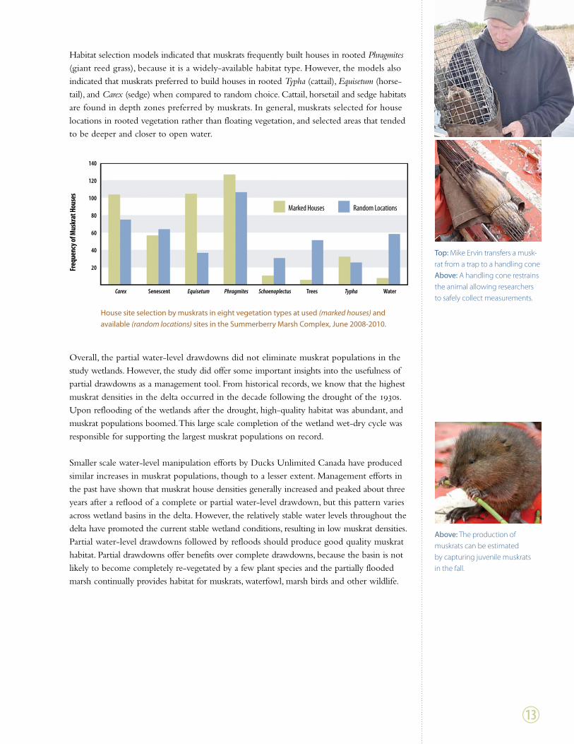
Habitat selection models indicated that muskrats frequently built houses in rooted Phragmites (giant reed grass), because it is a widely-available habitat type. However, the models also indicated that muskrats preferred to build houses in rooted Typha (cattail), Equisetum (horse- tail), and Carex (sedge) when compared to random choice. Cattail, horsetail and sedge habitats are found in depth zones preferred by muskrats. In general, muskrats selected for house locations in rooted vegetation rather than floating vegetation, and selected areas that tended to be deeper and closer to open water.
Overall, the partial water-level drawdowns did not eliminate muskrat populations in the study wetlands. However, the study did offer some important insights into the usefulness of partial drawdowns as a management tool. From historical records, we know that the highest muskrat densities in the delta occurred in the decade following the drought of the 1930s. Upon reflooding of the wetlands after the drought, high-quality habitat was abundant, and muskrat populations boomed. This large scale completion of the wetland wet-dry cycle was responsible for supporting the largest muskrat populations on record.
Smaller scale water-level manipulation efforts by Ducks Unlimited Canada have produced similar increases in muskrat populations, though to a lesser extent. Management efforts in the past have shown that muskrat house densities generally increased and peaked about three years after a reflood of a complete or partial water-level drawdown, but this pattern varies across wetland basins in the delta. However, the relatively stable water levels throughout the delta have promoted the current stable wetland conditions, resulting in low muskrat densities. Partial water-level drawdowns followed by refloods should produce good quality muskrat habitat. Partial drawdowns offer benefits over complete drawdowns, because the basin is not likely to become completely re-vegetated by a few plant species and the partially flooded marsh continually provides habitat for muskrats, waterfowl, marsh birds and other wildlife.
House site selection by muskrats in eight vegetation types at used (marked houses) and available (random locations) sites in the Summerberry Marsh Complex, June 2008-2010.
Marked houses Random Locations
Carex senescent Equisetum Phragmites Schoenoplectus trees Typha Water
140
120
100
80
60
40
20Freq
uenc
y of M
uskr
at H
ouse
s
Top: Mike Ervin transfers a musk- rat from a trap to a handling cone Above: A handling cone restrains the animal allowing researchers to safely collect measurements.
Above: The production of muskrats can be estimated by capturing juvenile muskrats in the fall.
1#

Summary of the summerberry marsh Research ProjectThe knowledge gained from this research project has important management implications for wetlands in the Summerberry Marsh Complex and wetlands throughout the Saskatch-ewan River Delta. From this research project we now know partial water-level drawdowns and high water can be effective management tools when used at the proper time and place. By understanding the benefits and drawbacks associated with each technique, management goals can be accomplished more easily.
Similar to a complete water drawdown and reflood, the partial drawdowns generated more nutrient-rich water as a result of sediment resuspension by wind. This promoted the growth of algae and submerged aquatic vegetation, providing good habitat for invertebrates and increasing food available for waterfowl. The shallower water also made it more difficult for forage fish to survive the winter. This benefitted waterfowl as it resulted in less prey comp- etition for invertebrates between waterfowl and fish. However, this was a drawback for some species of marsh birds as it resulted in less available food and lowered their numbers in these wetlands. The partial water drawdowns did not eliminate muskrat populations in the wet-lands. The temporary reduction in the area of living Typha (cattail) and Carex (sedge) – which were the preferred vegetation species of muskrats for building houses – caused some redistribution of muskrat use within the wetlands.
1$
The knowledge gained from this research project has important manage-ment implications for wetlands in the Summerberry Marsh Complex and wet-lands throughout the Saskatchewan River Delta.

In the non-drawdown, high-water wetlands, the nutrients in the water column were limited due to a lower amount of sediment resuspension. Due to the absence of water-level changes, wetland vegetation changed very little during the study. However, the deeper water did benefit diver species of waterfowl as well as American coots and several species of marsh birds that feed on small fish. The high water in these wetlands likely increased the chances of overwinter survival of forage fish, providing a greater amount of food for fish-eating birds, including American bitterns and pied-billed grebes. The high water did not affect densities of muskrats, and distribution was not affected.
These findings illustrate the complexity of wetland management within the Saskatchewan River Delta. Due to the high biodiversity supported by these wetlands, no single manage-ment technique provides the ideal habitat for all the wildlife within the wetlands. Instead, what is needed to support the high biodiversity in the delta is a diverse range of habitats, which would have occurred naturally in the past. Prior to the many developments on the Saskatchewan River, habitat diversity was likely maintained by the periodic flooding events that would occur in the delta. These flooding events would deposit nutrients and sediments, help carry away dead vegetation and alter water depth in wetlands. The location, extent, and duration of the flooding would likely vary according to the amount of water flow and potential ice jams in the river and in other channels. This variation in flooding would likely create a diverse range of wetland habitat by affecting wetlands in only certain parts of the delta and by creating new shallow lakes, oxbow lakes and channels through sediment depo-sition and river avulsions.
1%
These findings illustrate the complexity of wetland management within the Saskatchewan River Delta.

However, due to the numerous upstream developments on the Saskatchewan River, the frequency and extent of flooding and drought events in the delta has been diminished. In an attempt to mitigate this effect, active water-level management, using partial drawdowns and high water, could be used in the delta to create a diversity of wetland habitats and maintain the natural high-low water cycle of the wetlands. Ideally, water-level management would take place in a wetland complex rather than in individual wetland basins. This would allow water levels to be staggered in the wetland complex to provide a mosaic of deep and shallow wetlands, creating a diverse range of habitats available in relatively close proximity. This would help to meet the various requirements of many of the organisms living in the delta and, at the same time, maintain the water cycle of the wetlands.
A visual comparison of partial drawdown (top) and non-drawdown, high-water (bottom) wetlands in the Summerberry Marsh Compex. All photos were taken on the same day, 18 August 2009.
Total yearly flow of the Saskatchewan River at The Pas, Manitoba for the past 100 years.
50,000,000
45,000,000
40,000,000
35,000,000
30,000,000
25,000,000
20,000,000
15,000,000
10,000,000
5,000,000Volu
me (
dam
3)
1910 1920 1930 1940 1950 1960 1970 1980 1990 2000 2010
Yearly Volume
20-Year Average
Gardiner Dam Constructed
1^
Above and opposite page: Field tours were organized to inform local community members and project partners about the Summerberry Research Project.

Future ResearchThe Summerberry Research Project has provided numerous insights on wetland manage-ment in the Saskatchewan River Delta. This information can now be used to help guide future management decisions. However, there is still much to learn about the area and the impacts of management. Future research conducted by Alli Morrison from the University of Manitoba is aimed at gathering indigenous knowledge of the wetlands in the delta from people in the Opaskwayak Cree Nation. This project will involve gathering indigenous knowledge on the diversity, uses and relationships of organisms within the delta. This infor- mation will be used to provide researchers with a better understanding of the impacts of the changing habitat in the delta on the local people and will further support future manage-ment decisions.
A need also exists to examine effects of a reflood. This phase of the Summerberry Research Project focused on only part of a typical wetland wet-dry cycle. The next step is to refill the partially drawn down wetlands and study the response of water quality, vegetation and wildlife. The prediction that muskrat populations will respond positively to the reflooding of rejuvenated habitat should be documented by research. There is also an opportunity for future research to examine the effects of different water-level treatments, including various depths of partial drawdowns and complete water drawdowns. This type of research would provide further insight into the ideal depth of water drawdowns and give a clearer picture of the response of wetlands to the natural wet-dry cycle.
1&
The Summerberry Research Project has provided numerous insights on wetland management in the Saskatchewan River Delta.

Institute for Wetland and Waterfowl ResearchDucks Unlimited canadap.o. Box 1160, stonewall MBR0c 2Z0
tel: 1-204-467-3000toll-free: 1-800-665-3825Fax: 1-204-467-9028email: [email protected]
www.ducks.ca
Ducks Unlimited Canada conserves, restores and manages wetlands and associated habitats
for North America’s waterfowl. These habitats also benefit other wildlife and people.
Ducks Unlimited canadap.o. Box 1799, the pas MBR9A 1L5
tel: 1-204-627-7811Fax: 1-204-623-3398