a fire risk map for protected areas of mongolia: …
TRANSCRIPT

A FIRE RISK MAP FOR PROTECTED AREAS OF MONGOLIA: DORNOD MONGOL SPA, NUMRUG SPA, ZED-KHANTAI-BUTEELIIN NURUU SPA AND ONON-BALJ NP
Elbegjargal Nasanbat (1,2), Ochirkhuyag Lkhamjav (2), Amanjol Bulkhbai (1,2),
Chuluunbaatar Tsevee-Oirov (3), Odbayar Mishigdorj (1,2),
1 National Remote Sensing Center, Information and Research Institute of Meteorology Hydrology and Environment, Juulchiny street-5, Ulaanbaatar 15160, Mongolia
2 Mongolian Geospatial Association, P.O. Box-24/38, Ulaanbaatar 15141, Mongolia 3 The Ministry of Environment and Tourism, Government building II,
United Nations Street–5/2, Chingeltei District, Ulaanbaatar 15160, Mongolia
Email: [email protected], [email protected], [email protected], [email protected], [email protected]
KEY WORDS: LANDSAT, Burned area, Fire hotspot, Fire risk map, Multi-criteria analysis ABSTRACT: Wildfire is a cause of major disturbance to ecosystems and economies throughout the world. Hence, the wildfire is a vital issue of environment for creating natural disaster and socio-economic damage to affect in ecosystem and human lives. Moreover, the forest and steppe fires are one of biggest natural risks in issues of Mongolian protected areas, and its management. In this paper investigated to predict a spatial distribution of wildfire in the context of climate change and human impacts plays critical role in wildfire management and ecosystem-conservation for some protected areas, Dornod Mongol Strictly Protected Areas (SPA), Numrug SPA, Zed-Khantai-Buteeliin Nuruu SPA and Onon-Balj National Park (NP) of Mongolia. Moreover, we used long term of Landsat TM imagery from 1991 to 2019 which is obtained from the USGS Global Visualization Viewer (GloVis). In addition, to various parameters are considered by the risk analysis and among the driving factors, climate, socio-economic and human factors to integrate into the GIS tools. Therefore, these analyses are applied to the approach of decision-making support system, particularly as Spatial Multi-Criteria Analysis (SMCA). Consequently, wildfire risk map was created by five categories: very high, high, moderate, low and non-risk for particular the protected areas, it will be baseline data for protected areas managements, fire prevention plans and activities. As results showed that a percentage of the study area was predicted by wildfire risk in the natural protected area for above each category as follows. The fitting result of the SMCA model showed a prediction accuracy exceeding 80%, which represents that the model has a high ability to predict wildfire risks on highlighted the protected area. This study could provide a reference for predictions, make the strategy and prevention of wildfire hazard for the stakeholder, decision-making. 1. INTRODUCTION
Wildfire is a main natural disaster and greatly influences to the ecosystems and economies in Mongolia. Hence, the wildfire is an important issue for creating natural disaster and socio-economic damage to the ecosystem and human lives. Several researchers were mainly described to that are according to their issues (Yao et al., 2016, Dong et al., 2005). Fires usually occur in dry ecosystems, typically in steppe and grassland area, when are uncontrolled wildfires outbreak due to the physical or natural events and human actions. Also, researchers found that the wildfire becomes a threat to the biodiversity and human habitat and contributes to mortality reasons of them (Ochirkhuyag et al., 2008). Moreover, the frequency of natural disasters and their impacts have increased whole world in recent years including Mongolia. As a result of global warming has been changed the disturbance to ecological balance.
In contrast, the wildfire in Mongolia, especially the northern and eastern part of area has been frequented the wildfire occurrence in every dry season (spring and fall) of the last years and was caused by increasing accumulation of the fire impact to the environment and natural resources. Therefore, according to the scholarly surveys, about 56% of the study area is located in a zone

exposed to forest and grassland fires. About 98.5% of a considerable fraction of it covered with forests in a zone assessed as a high fire risk. In addition, Erdenetuya (2012) highlighted that about 95% of steppe and forest fires in Mongolia are caused by human activities. Wildfires constitute a major hazard that determine the spatial and temporal dynamics of forest ecosystems between 1981 and 1999, approximately 160 fires per year were recorded in Mongolia, such as each burnt area is an average of 2,933,659 ha (Goldammer, 1999). In Mongolia, fire is a major factor which determines the spatio-temporal dynamics of forest ecosystems and protected areas (Chuluunbaatar, 1998). Another point of economic aspect is illustrated by the wildfire might lead to disastrous consequences such as huge economic and ecological losses in the forest coverage of Mongolia (Ochirsukh, 2011). In recently, total 5600 hectares of the forest area were burnt the ecological loss which has been estimated by 30.6 million MNT. Total 1052918 hectares of the steppe area were burnt the ecological loss that appraised by 4 billion MNT, whereas the economic loss was estimated by 137.3 million MNT (Badamsuren et al., 2016).
The potential area was calculated by risk map, which certainly affected to the wildfire. According to the Huyen and Tuan (2008) method, the raw data of geospatial technology approaches that are mapped by fire risk map and integrated with socio-economic and environmental information. It underlines that the remote sensing and Geographic Information System (GIS) techniques support for the detection of active fires, estimation of burnt area and damage of geo-statistical analysis. In general, researchers are currently applied to use the approach of decision support which is the estimation of fire risk. It is used by hazard map and damage assessment on grassland and forest area and analyzed the various methods including the logistic regression, methods of weighted overlaying and decision support method. In addition, the decision support method includes the Multi-Criteria Evaluation Analysis (MCEA), analytic hierarchy process (AHP), fuzzy analysis, neural networks and classification tree etc. (Garavand and Yaralli, 2015; Chhetri et al., 2015; Cho et al., 2017; Elbegjargal and Ochirkhuyag, 2016). An advantage of our study was taken the complex aspect of the forest and steppe fire which considered to the high resolution risk distribution. The main goal of the study is to map a spatial distribution of the forest and steppe fire in natural protect area as well as Dornod Mongol Strictly Protected Areas (SPA), Numrug SPA, Zed-Khantai-Buteeliin Nuruu SPA and Onon-Balj National Park (NP) of Mongolia (Figure 1).
Figure 1. Study Area: Dornod Mongol Strictly Protected Areas (SPA), Numrug SPA, Zed-Khantai-Buteeliin Nuruu SPA and Onon-Balj National Park (NP) of Mongolia

Moreover, the purpose of an evaluation the result was divided into three group factors, namely social economic, environmental and climate, and wildfire including the seventeen input parameters (Table 2). These factors are contributed to the outbreak of the local and regional wildfire which is linked to the variables of biophysical and climate parameters were integrated to apply all into GIS application. These analyses are applied to use the approach of decision-making support system as well as a MCEA. 2. STUDY AREA
Protected areas in Mongolia fall into four categories: Strictly Protected Areas (SPAs), National Parks (NP), Nature Reserves (NR) and Historical Monuments (HM). These are areas of land dedicated to the protection and maintenance of biological diversity and of natural and associated cultural resources. Moreover, the forest and steppe fire are one of natural risks in issues of Mongolian protected areas, its management. This paper attempted to identify a spatial distribution of the wildfire risk such as, Dornod Mongol Strictly Protected Areas (SPA), Numrug SPA, Zed-Khantai-Buteeliin Nuruu SPA and Onon-Balj National Park (NP) of Mongolia. These protected areas are located forest steppe ecosystems of Mongolia (Figure 1).
Dornod Mongol Strictly Protected Area (SPA) was established in 1992 and spreads over 5,705 km² of mainly flat steppe habitat, and elevations range from 750 m to 1089 m in the south-east. The area is located along the Mongolian-Chinese border in eastern Mongolia. In respect to climatic conditions the area shows a clear west-east gradient, with more precipitation and colder temperatures in the east (average precipitation: 250 mm, average snow cover 100 days, average annual temperatures -2°C) and less precipitation and warmer temperatures in the west (average precipitation: 200 mm, average snow cover 50 days, average annual temperatures 0°C; Atlas of Mongolia 2004).
Numrug Strictly Protected Area (SPA) was established in 1992 and spreads over 3,112 km² of rolling hill country, elevations range from 900 m in the river valleys to almost 1500 m in the south, and the area is the eastern-most corner of Mongolia, surrounded by China in the north, east and west. The Numrug area is rather wet and on average receives 300 mm of precipitation and has 100 days of snow cover, temperature extremes range from -47°C in winter to +40°C in summer, with an annual average of -2°C (Atlas of Mongolia 2004).
Zed-Khantai-Buteeliin Nuruu Strictly Protected Area (SPA) was established in 2011 and 6,133 km² of mountainous areas located across the territory of Teshig, Khutag-Undur and Selenge soums of Bulgan aimag, which is north part of Mongolia. The main directions of the SPA administration are to protect biodiversity, reduce and prevent negative impacts on the environment, preserve the natural environment, protect historical and cultural monuments, flora and fauna, create favorable conditions for reproduction, and increase the participation of local people in environmental protection.
The Onon-Balj was taken under the State protection in 2000 as a National Park, with 4,157.5 km² area, to protect the biodiversity and its genetic bank and to develop environmentally friendly tourism based on natural and historical sites. The Onon-Balj basin is located at the southern edge of Siberian boreal coniferous forest and stretched into Daurian steppe. The forest and steppe landscape, its composition and specific ecological functions, also serves as a home to a number of rare and endangered species in Mongolia and the globally endangered birds such as white-napped crane, hooded crane and great bustard and a number of aquatic Asian species.
3. METHOD AND MATERIALS
3.1. Method In this study, we were used that the Multi-Criteria Evaluation Analysis (MCEA) is proposed
by Alejandro (2003) for decision making. For the image processing, the software of ArcMap was produced the map of wildfire. All data pre-processing and analysis of this study was used the image processing software as well as ERDAS imagine, IDRISI taiga and ArcMap. In order to identify the wildfire, the spatial distribution of the high risk or optimal location in particular area was included the several parameters can be separately divided into three main groups of factors. These factors of three main groups include social economic, environmental and climate, and wildfire damage and are

based on method of Malczewski (1999). Figure 2 presents a workflow of pre-processing and criteria selection to draw the mapping and statistical analysis for this study.
In workflow processing method, parameter selection was based to utilize on expert judgment that includes the experts of forest, ecological, remote sensing and botanic etc. However, after data processing filter, the six parameters (Table 1) were created from the seventeen parameters. In addition, the spatial analysis method was used the pre-processing data analysis, whereas the statistical analysis performed the rank and weighted overlay.
One of important parameter is that estimated by dryness index which climate factor, the Standardized Precipitation Index (SPI; Svoboda et al., 2012) and evaluate dryness. This SPI is based on precipitation data of meteorological station for the study period that includes from May to October of 2000–2017. SPI is calculated by following Equation (1).
𝑆𝑆𝑆𝑆𝑆𝑆 =𝑆𝑆 − 𝑆𝑆�𝜎𝜎
(1)
where, 𝑆𝑆 is the amount of monthly precipitation. 𝑆𝑆� is the multi-year average of the amount of monthly precipitation. 𝜎𝜎 is the standard deviation of the amount of monthly precipitation.
Figure 2. Flowchart of spatial distribution map of the wildfire for this study

The calculation of rank and weighted overlay of the wildfire criteria is computed by following Equation (2).
𝑤𝑤𝑖𝑖 =(n − 𝑟𝑟𝑘𝑘 + 1)
∑ (n − 𝑟𝑟𝑘𝑘 + 1)𝑛𝑛𝑘𝑘=1
(2)
where, 𝑤𝑤𝑖𝑖 is the normalized weight for the criterion. 𝑛𝑛 is the number of criteria under consideration (k = 1, 2…n). 𝑘𝑘 is equal to 1. 𝑟𝑟𝑘𝑘 is rank of the dimension.
The estimation of the Multi-Criteria Evaluation Analysis (MCEA) is used to calculate by normalized weight using Equation (2), as given in Equation (3) 𝑆𝑆 = �𝑤𝑤𝑖𝑖𝑥𝑥𝑖𝑖 (3)
where, 𝑆𝑆 is the Multi-Criteria Evaluation Analysis (MCEA). 𝑤𝑤𝑖𝑖 is the weight of factor i,
𝑥𝑥𝑖𝑖 is the score of class of factor i.
In order to compare between wildfire occurrence and SPI, the correlation coefficient (r) is calculated the following Equation (4):
𝑟𝑟𝑥𝑥𝑥𝑥 = �[(𝑥𝑥𝑖𝑖 − 𝑥𝑥)(𝑦𝑦𝑖𝑖 − 𝑦𝑦)]/��[(𝑥𝑥𝑖𝑖 − 𝑥𝑥)2(𝑦𝑦𝑖𝑖 − 𝑦𝑦)2]𝑛𝑛
𝑖𝑖=1
𝑛𝑛
𝑖𝑖=1
(4)
where, 𝑟𝑟𝑥𝑥𝑥𝑥 is the correlation coefficient. 𝑥𝑥𝑖𝑖 and 𝑦𝑦𝑖𝑖 are the variables of wildfire occurrence and SPI. 𝑥𝑥 and 𝑦𝑦 are the mean value of the variables of wildfire occurrence and SPI. 𝑛𝑛 is the number of variables in two parameters. Three main groups have the six parameters. These six parameters are to influence a spatial
distribution of the wildfire risk that was analysed by the following rank of importance; namely burnt area frequency, fire hotspot density, land cover type, fire danger level, Standardized Precipitation Index (SPI) and fire guard. In order to acquire data, the burnt area frequency, fire hotspot density and land cover type were derived by historical data of the Terra/Aqua MODIS satellite from 2000 to 2017. Also, they were obtained from fuel material; and fires break out easily and spread fast in the high frequented place. The fire danger level was created by the level of fire hazardous from Ministry of Nature, Environment and Tourism of Mongolia [MNET, 2017] and is based on the historical data of field-based such as botanic-ecological, forest-vegetation and forest fires [Chuluunbaatar et al., 2014]. Moreover, SPI is identified the weather condition. Also, another most important parameter is a fire guard which is a position of fire extinguisher. It is mainly an influence on ignition and spread the wildfire. Table 1 shows the rank and weight of all six parameters.
Table 1. The parameters of criteria in the study area
No Parameter of Criteria
Straight Rank
Numerator (n-ri+1) Normalized Weights
1 Burnt area 1 6 0.29 2 Fire hotspot density 2 5 0.24 3 Land cover type 3 4 0.19 4 Fire danger level 4 3 0.14 5 SPI 5 2 0.10 6 NDWI drought index 6 1 0.05
SUM 21 21 1
As shown in Table 1, the straight rank of criteria includes the six parameters are classified by weighted value according to their effects to spread the wildfire. The weighted value of these parameters indicates that a low value of percentage is less influence to the risk. In contrary, a high value of percentage is significantly relevant in this study. To obtain effective and more accurate conclusions, the mathematical operations were analysed in GIS analysis.
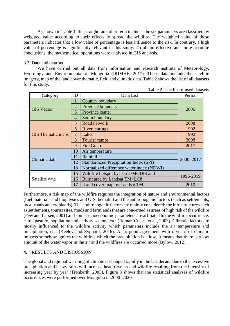
3.2. Data and data set We have carried out all data from Information and research institute of Meteorology,
Hydrology and Environmental of Mongolia (IRIMHE, 2017). These data include the satellite imagery, map of the land cover thematic, field and climatic data. Table 2 shows the list of all datasets for this study.
Table 2. The list of used datasets Category ID Data List Period
GIS Vector
1 Country boundary
2006 2 Province boundary 3 Province center 4 Soum boundary
GIS Thematic maps
5 Road network 2008 6 River, springs 1992 7 Lakes 1992 8 Tourist camps 2008 9 Fire Guard 2017
Climatic data
10 Air temperature
2000–2017 11 Rainfall 12 Standardized Precipitation Index (SPI) 13 Normalized difference water index (NDWI)
Satellite data 15 Wildfire hotspot by Terra /MODIS and
1996-2019 16 Burnt area by Landsat TM+LC8 17 Land cover map by Landsat TM 2010
Furthermore, a risk map of the wildfire requires the integration of nature and environmental factors (fuel materials and biophysics and GIS thematic) and the anthropogenic factors (such as settlements, local-roads and croplands). The anthropogenic factors are mainly considered: the infrastructures such as settlements, tourist sites, roads and farmlands that are concerned as areas of high risk of the wildfire (Pew and Larsen, 2001) and some socioeconomic parameters are affiliated to the wildfire occurrence: cattle pasture, population and activity sectors, etc. (Roman-Cuesta et al., 2003). Climatic factors are mostly influenced to the wildfire activity which parameters include the air temperature and precipitation, etc. (Keeley and Syphard, 2016). Also, good agreement with dryness of climatic impacts somehow ignites the wildfires which the precipitation is a low. It means that there is a low amount of the water vapor in the air and the wildfires are occurred more (Bylow, 2012).
4. RESULTS AND DISCUSSION
The global and regional warming of climate is changed rapidly in the last decade due to the excessive precipitation and heavy rains will increase heat, dryness and wildfire resulting from the intensity of increasing year by year (Trenberth, 2005). Figure 3 shows that the statistical analyses of wildfire occurrences were performed over Mongolia in 2000–2020.

Figure 3. Number of the wildfire occurrence in Mongolia, 2000–2019
In Figure 3, a trend of the wildfire occurrence has been increased by 3-4 fires per year in the study area. Therefore, we have considered the statistical analysis in the study area which is the linear equation regression was used for relationship between wildfire occurrences and climatic parameter. A climatic parameter has been measured by meteorological data such as precipitation was estimated by SPI (Svoboda et al., 2012) from 2000 to 2019 in Mongolia. A comparison analysis of the wildfire occurrence and SPI illustrates in Figure 4. In order to compare between the wildfire occurrence and SPI, the annual value was merged from May to October for the year 2000 to 2019 in both variables.
Figure 4. Temporal variation between wildfire occurrences and SPI, 2000–2020
Particularly, the attitude of the SPI was decreased in dry condition, whereas last 5 years of the SPI had been rapidly increased. In generally, these parameters between dryness and wild occurrence were well related with each other in the study period.
a) Zed-Khantai-Buteeliin Nuruu SPA

b) Dornod Mongol SPA
c) Numrug SPA
d) Onon-Balj NP Part A
e) Onon-Balj NP Part B
Figure 5. Spatial distribution map of the wildfire risk, the study area, 2019 Figure 5 presents a spatial distribution map of the wildlife risk of the study area is produced by the weighted overlay method of MCEA. In Figure 5, a spatial distribution map of the wildfire risk was classified into five categories of the wildfire risk; namely very high risk, high risk, moderate risk, low risk and none risk. A value of the wildfire risk in each category is expressed by percentage of the study area in 2019, as shown in Figure 6.
a) Zed-Khantai-Buteeliin Nuruu SPA

b) Dornod Mongol SPA
c) Numrug SPA

d) Onon-Balj NP Part A
e) Onon-Balj NP Part B
Figure 6. Spatial distribution of the wildfire with five categories by percentage, 2017
In Figure 6, a percentage of the study area was predicted by index of wildfire risk in each category as a proposed method. Mostly protect area is identified moderate and high risk. On the other hand highly represented to the very high risk in Onon-Balj National Park. 5. CONCLUSION
This study performs that our proposed method was used to integrate the various factors with different spatial and temporal resolutions. These integrated factors include the social economic, environmental and climate, and wildfire damage. We used the method of Multi-Criteria Evaluation Analysis (MCEA); these factor components are provided to be useful in the identification of suitable

areas for the wildfire risk within a GIS. A risk map of the study area was classified into five categories and is based on spatial statistics
adequately to assess a respective fire risk: very high risk, high risk, moderate risk, low and very low. Approximately from 70 to 90 per cent of the study area was occupied a very high and high risk zones of the wildfire. Others, the moderate and low risk of the protected areas are between 0 and 30 per cent, but zero per cent of it was observed as none risk.
This investigation is the spatial and temporal resolutions of biophysical evaluation and provides the information at a regional level. Consequently, the wildfire risk map would be used to prevent the reduction fire risk, private section and farmers care to prepare a risk reduction for the national and local government agency.
Moreover, other more important specifically aspects are could be establish to more and more the firefighters in sub local level. Also, another most important condition due to improve such as legal framework of the wildfire firefighter, foundation funds, capacity building, technical equipment, technological level, fire prevention zone, a water point and complex early warning system to provide on mobile device these are based on wildfire risk map. ACKNOWLEDGEMENTS
The researchers would like to thank the Earth Observing System Data and Information System (EOSDIS) is a key core capability in NASA's Earth Science Data Systems (ESDS) Program of United States of America (USA), eOsphere Limited (VxEos) of United Kingdom and National Remote Sensing Center (NRSC) of Mongolia for providing raw data and research work.
The authors are very thanking to the Department of Forest Management of Ministry of Environment and Tourism and the department was partially conducted to help the financial support for our work. REFERENCES Alejandro, C. A., 2003. Delineation of suitable areas for crops using a Multi-Criteria Evaluation approach and land use/cover mapping a case study in Central Mexico. Elsevier Science. pp: 77, 117-136. Altansukh, N., 2002. Plant genetic resources status and process of activities in Mongolia. Plant Genetic Resources in East Asia (IPGRI): Proceedings of the Meeting for the Regional Network for Conservation and Use of Plant Genetic Resources in East Asia, Ulaanbaatar, Mongolia. 13–16 August 2001, pp:27–34. Badamsuren,D. Amarzaya, P. Sodnomragchaa, D. Mendelmaa, CH. Chimedtseren, P. (2016). Data book on Natural and human induced hazards in Mongolia 2014, 2015. Batima, P.; Dagvadorj, D. (2000). Climate Change and Its Impacts in Mongolia; NAMHEM JEMR Publishing: Ulaanbaatar, Mongolia, Bylow, D., 2012. Modeling Wildfire Hazard in the Western Hindu Kush Himalayas. pp:41–26. Chhetri, S. K., & Kayastha, P. (2015). Manifestation of an analytic hierarchy process (AHP) model on fire potential zonation mapping in Kathmandu Metropolitan City, Nepal. ISPRS International Journal of Geo-Information, 4(1), 400–417. Cho, H. C., Lee, D. H., Ju, H., Park, H. C., Kim, H. Y., & Kim, K. S. (2017). Fire Damage Assessment of Reinforced Concrete Structures Using Fuzzy Theory. Applied Sciences, 7(5), 518. Chuluunbaatar, T., 1998. Fire in forest ecosystem of Mongolia. International Forest Fire News 19. pp:58–63

Chuluunbaatar, Ts., Tsedendash, G., Tuvshintogtokh, I., Manidari, D. 2014. Report of the danger level of Forest and steppe Fire, Ulaanbaatar, Mongolia. CIA. World Factbook of the Work of a Nation, Central Intelligence Agency: https://www.cia.gov (12 February 2018) Dong, X. U., Li-min, D., Guo-fan, S., Lei, T., & Hui, W. (2005). Forest fire risk zone mapping from satellite images and GIS for Baihe Forestry Bureau, Jilin, China. Journal of forestry research, 16(3), 169–174. Dorjsuren, M., Liou, Y. A., & Cheng, C. H. (2016). Time series MODIS and in situ data analysis for Mongolia drought. Remote Sensing, 8(6), 509. Elbegjargal, Nasanbat and Ochirkhuyag Lkhamjav., (2016). Wild fire risk map in the eastern steppe of Mongolia using spatial multi-criteria analysis. International Archives of the Photogrammetry, Remote Sensing & Spatial Information Sciences, 1-9. Erdenetuya, M., 2012. Fire occurrence and burning biomass statistics in Mongolia, The Proceedings of 33rd Asian Conference Remote Sensing. pp. 118–125. Garavand, S. and Yaralli, N., (2015). Assessment of Fire Risk in Central Zagros Forests in Chaharmahal Bakhtiari Province. International Journal of Review in Life Sciences 5(3). pp:538– 543. Goldammer, J.G., 1999. Fire Situation in Mongolia. Freiburg Germany. International Forest Fire News (IFFN) 36. pp:5–8. Huyen, D.Th.Th. and Tuan, V.A., (2008). Applying GIS and Multi Criteria Evaluation in forest fire risk zoning in SON LA PROVINCE, VIETNAM. International Symposium on Geoinformatics for Spatial Infrastructure Development in Earth and Allied Sciences. pp. 8. IRIMHE. 2017. Remote Sensing Product. Information and Research Institute of Meteorology, Hydrology and Environmental, Mongolia: http://irimhe.namem.gov.mn (22 January 2018). Keeley, J. E., & Syphard, A. D. (2016). Climate change and future fire regimes: examples from California. Geosciences, 6 (3), 37. Khudulmur, S., Elbegjargal, N., Tsogtbaatar, J., Dash, D., Mandakh, N. 2014. Desertification Atlas of Mongolia; Institute of Geoecology, Mongolian Academy of Sciences; Swiss Agency for Development and Cooperation SDC; Environmental Information Center; Ulaanbaatar, Mongolia; pp.38–41. Malczewski, J., 1999. GIS and Multicriteria Decision Analysis. John Wiley & Sons. pp.177–190. MNET. 2017. Ministry of Nature, Environment and Tourism of Mongolia. http://www.mne.mn (15 February 2018). NAMEM. 2018. Archive and Database Division. from National Agency for Meteorology and Environmental Monitoring, Mongolia: http://namem.gov.mn (22 January 2018). NEMA. 2016. Disaster Research Institute, National Emergency Agency of Mongolia: http://nema.gov.mn/ (10 November 2017). NEMA., 2010. The News Bulleting of Disasters. Ulaanbaatar.

Ochirkhuyag, L., Fine, A., Didier, K. and Sanderson, E., (2008). The Eastern Steppe’s Living Landscape, Mongolia. The Proceedings the ISPRS XXI Congress. pp.575–573. Ochirsukh, B., 2011. GIS mapping for forest fire risk zone in Selenge, Mongolia. Spring Korea Geospatial Information Society Conference. pp.53-56. Pew, K. L. and Larsen, C.P.S. (2001). GIS analysis of spatial and temporal patterns of human-caused wildfires in the temperate rain forest of Vancouver Island, Canada [J]. Forest Ecology and Management, 140: 1–18. Román-Cuesta, R.M., Gracia, M. and Javier, R. (2003). Environmental and human factors influencing fire trends in ENSO and Non-ENSO years in tropical Mexico [J]. Ecological Applications, 13(4): 1177–1192. Serjmyadag, D., Battulga, Z., Amarzaya, P., Sarantuya, R. (2010). The Bulleting of Disasters in Mongolia. pp:6-9 Svoboda, M., Hayes, M., & Wood, D. (2012). Standardized precipitation index user guide. World Meteorological Organization Geneva, Switzerland. Trenberth, K.E., 2005. The Impact of Climate Change and Variability on Heavy Precipitation, Floods, and Droughts. Encyclopedia of hydrological sciences. 1–2. Yao, J., & Zhang, X. (2016). Spatial-Temporal Dynamics of Urban Fire Incidents: A Case Study of Nanjing, China. ISPRS-International Archives of the Photogrammetry, Remote Sensing and Spatial Information Sciences, 63–69.