a framework for wayshowing
TRANSCRIPT

A Framework for Wayshowing:
Mount Evans Scenic & Historic Byway
Clear Creek County Colorado
June 2013

2
Acknowledgments
This plan would not have been possible without the contributions of the Byway Committee of the Mount Evans Scenic and Historic Byway: Bob and Jan Bowland, Mary Jane Loevlie, Omer Humber,
Lori Denton, Nicole Malandri, Deb Ryon, Cassandra Patton, JoAnn Sorensen.
Appreciation is also extended to the participants of the Mount Evans Wayfinding Project, who donated their time to spend a day behind the wheel on the byway. Thanks to Debbie Lininger, Grant Garstka,
Lenore Bates, and Scott Hoftiezer.
Special thanks to Lenore Bates, Scenic Byways Program Coordinator, Colorado Department of Transportation for her guidance throughout the project.
Document Produced By: Walden Mills Group Judy Walden, President Sally Pearce June 2013

3
Table of Contents Executive Summary.............................................................................................................................4 Introduction.........................................................................................................................................6 Keys to Effective Wayshowing.............................................................................................................6 Wayshowing Components...................................................................................................................7 History of Wayfinding Development on Mount Evans........................................................................7 Mount Evans Wayfinding Assessment………........................................................................................9 Summary of Key Observations from the Assessment Team……………………………………………………..…….10 Recommendations and Action Plan...................................................................................................12 Partnerships and Financial Resources ..............................................................................................12 Appendix…………………………………………………………………………………………………………………………………………14
4
Executive Summary Wayshowing is a collection of maps, signs and other media that have been developed to aid travelers in their journey. A system of such information is critical to help travelers successfully choose a destination and plan their itinerary as well as to help them navigate once they arrive. As such, efforts to enhance a regional tourism economy must consider the strengths and deficiencies of existing wayshowing elements located along the full length of a byway corridor. The plan that follows assesses the current elements of the wayshowing system that exists throughout the Mount Evans Scenic and Historic Byway in Clear Creek County. Utilizing a “front-seat back-seat” approach, travelers unfamiliar with the area took to the road with a list of significant historical, cultural and recreational sites to locate. Neophytes in the front seat searched for signs, used digital devices, studied maps and asked for directions. Meanwhile, transportation and tourism specialists in the back seat recorded the navigational challenges for those “new to the byway” travelers in the front. This four person team set out to assess the wayfinding system on the Mount Evans Scenic Byway.
An analysis of this formal assessment exercise, combined with the input of local officials, transportation and tourism specialists resulted in recommendations that can improve the ease of navigation for visitors and better capitalize on the potential for increasing travel-related revenues for the communities along the byway. Recommendations include:
A. As specified in the corridor management plan, byway signage needs to show that the byway begins at the east entrance to town off I-70 and passes through the historic downtown, and then continues up SH 103 past the US Forest Service Ranger District Office. Signs on I-70 should reflect this in both directions. Byway signs need to be installed on the extension from Bergen Park to Echo Lake.
B. The Visitor Center in Idaho Springs needs to be clearly and consistently marked for travelers both east bound and west bound because the Center serves as a gateway to the byway for I-70 travelers.
C. Interpretation can help keep people on the byway longer, pointing out more things to see and do, thus contributing potential customers for local businesses in the town itself. The byway needs to presented as more than just a scenic drive. Improved interpretation can establish a clear link between Idaho Springs and the mountain, specifying recreational opportunities and overnight possibilities.
5
D. Travelers want choices – navigational and interpretive information should convey that there are multiple decision points that go beyond just driving up and down the mountain. Upper Chicago Creek Picnic area should be developed with interpretive exhibits related to the historic road and CCC construction. In addition, both Upper Chicago Creek Picnic Area and Echo Lake Park can be developed as family oriented recreational destinations.
E. Correct inconsistent place names on signage and brochures, i.e. the Oh My God Road is also
called Virginia Canyon Road and Canyon Road; the M. Walter Pesman Trail is also called Upper Mt. Goliath on some signs; and the Idaho Springs Library is also called the Carnegie Library.
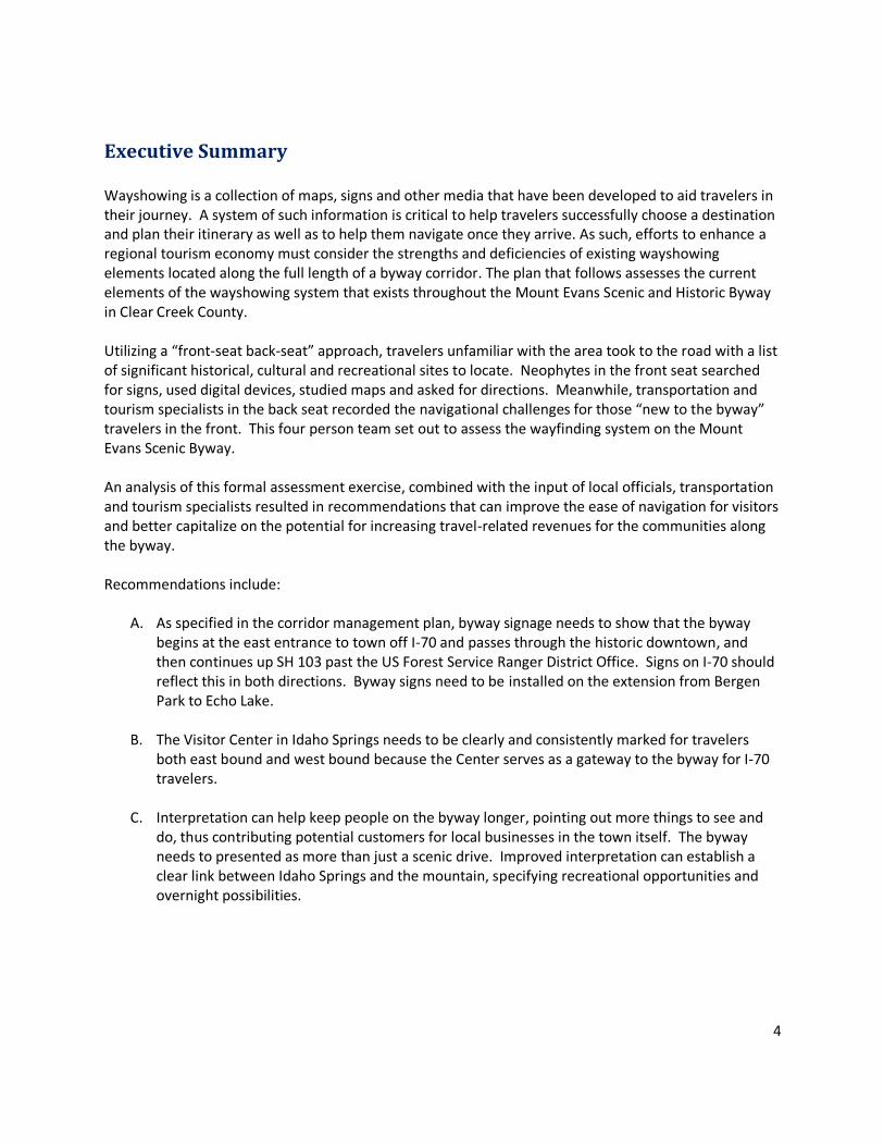
I-70 Signage The Mount Evans Scenic and Historic Byway is incredibly important to Colorado tourism, hosting travelers with widely divergent interests. Domestic and international travelers who come to Denver on business or for sporting events shift their schedules to fit in a half day or full day excursion to the mountains. Bicyclists in the thousands head to the foothills to gain some altitude training, motorcyclists seek tight turns on mountain roads, and families from the Denver metro area use the Denver Mountain Parks for family picnics and get-aways. Strengthening the existing wayshowing system can result in greater safety for cars, bicyclists, and motorcyclists alike. Enhancements to the excellent existing interpretive signage will deepen the understanding for visitors of historic and recreational assets. Finally, enhanced information will serve to connect travelers with local communities, thus giving local businesses more opportunities to sell their goods and services to travelers.

6
Introduction The deployment of an effective system of wayshowing is an essential component of successful regional tourism strategies. Wayfinding and wayshowing are related but distinct concepts. Wayfinding is the mental process performed by travelers in identifying and locating their travel destinations. Wayshowing, on the other hand, is the communication in the form of maps, signs, and other media intended to aid the traveler in their wayfinding. The purpose of this document is to provide a preliminary plan for an enhanced wayshowing system along the Mount Evans Scenic and Historic Byway in the Central Mountains of Colorado. In achieving this purpose, the plan aims to:
Provide an outline of key concepts of wayshowing and wayfinding
Assess the inventory of existing directional signage to key sites along Interstate 70, State Highways 103 and 5, Clear Creek County Road 103, and Jefferson County Road 66
Assess the inventory of designation signage along the same routes
Provide recommendations for enhancing directional signage to key sites
Provide an outline for subsequent action
Keys to Effective Wayshowing An effective system of wayshowing responds to the needs of travelers at all stages in their journey. At a minimum, effective wayshowing for the traveler must:
Support how people find their way in unfamiliar travel environments
Provide a guidance system of reliable and consistent components on the byway
Respond to the unique characteristics of the byway
Integrate pre-visit, visit, and post-visit stages of the byway experience
Contribute to a safe roadway and travel environment
Become a widely practiced body of knowledge among byway providers
Stages of Wayshowing Effective wayshowing is essential not only to ensuring good experiences for the visitor, but also in attracting that visitor in the first place. While wayshowing may seem to begin and end with the traveler on the road, it also plays an important role in attracting visitors, assisting in their trip planning, and in enhancing their recollections with others after their trip is complete. Consider the travel experience as five distinct stages: Choose The point at which the traveler decides his or her travel destination or destinations. Wayfinding Needs: What are the travel routes? What is there to see and do and where are these activities located? How much time is required for the trip? Prepare This is the stage in which the prospective traveler plans and prepares for their trip, including making reservations or other advance travel arrangements. Wayfinding Needs: How will we get there? Where will we stay, eat and stop? How much time should we allot to travel to and on the travel route? Where are the heritage, recreational, and cultural attractions of the area? Go/Do This stage is the event itself as the visitor makes his or her way to or around their destination. Wayfinding Needs: Where are the entry points to the route? How do we get back on track if we get off the route? Where are the attractions along the route? Where can we get information along the route? Where do we get gas, food, or lodging? Recall This is the stage in which the memories of the trip extend its enjoyment beyond the time spent away from home. With travel completed, visitors typically want pictures, maps, souvenirs or other items to assist their recollection of a memorable trip. Wayfinding Needs: What will help us recall the good times we had on the trip? Where were the sites we really enjoyed? Do Again It is hoped that with an enjoyable and memorable trip, many visitors will return. Wayfinding Needs: Where are those good maps from our last trip? We need to show our friends and family what they might like.

7
With the assistance of an effective wayshowing system, successful travelers should be able to:
1. Identify origin and destination 2. Determine turn angles 3. Identify segment links and directions of movement 4. Recognize on-route and distant landmarks 5. Mentally embed or visualize the route in a larger reference frame: a cognitive map.
Wayshowing Components A successful wayshowing system includes multiple components that not only direct the traveler, but provide interpretive information. Wayshowing does not start and stop on the road, but exists to provide the traveler with information to plan their trip and assist in the recollection of it afterwards through maps, websites and other media that can be accessed away from the physical roadway. Essential elements of a wayshowing system include the following:
Entrances, Exit and Gateway Signage- Identification of where to enter and exit a route or byway so that travelers know their position relative to accessing and leaving a byway or other route.
Orientation Stops- Pull-offs, turn-outs and other places for motorists to stop and help them create, refresh, and expand their mental maps of a byway or other route, its intrinsic qualities, and overarching interpretive theme with exhibits, maps, and other means of communication.
Repetitive Route Markers- A sequence of visual cues for motorists to follow along a byway or other route.
Direction Signage to Planned Destinations- Signs that alert and guide motorists to featured stops and attractions along or near a byway or other route.
A Portable Map- A carry-on map of a byway corridor or travel region and its various attractions and amenities.
History of Wayfinding Development on Mount Evans The Mount Evans Scenic and Historic Byway, from the town of Idaho Springs to the summit of Mt. Evans, was designated as a Colorado Scenic and Historic Byway in September 1991 and as a US Forest Service National Scenic Byway in July 1993. The route was extended from Echo Lake to Bergen Park in September 2005. The byway uses the directional signage with the State scenic byway logo (the Columbine sign). The byway is signed on Interstate 70 in both directions at Exit 240, the SH 103 link. There are no byway signs at the east end of Idaho Springs at Exit 241A nor are there signs through the downtown district of Idaho Springs. There are no byway signs on the extension of the route from Echo Lake to Bergen Park, nor are there byway signs on the road from Echo Lake to the summit. Mount Evans is also designated as a US Forest Service National Scenic Byway but the US Forest Service agreed to use only the Columbine signs for directional purposes. The Mount Evans Scenic Byway received a National Scenic Byways Program grant in 1993, administered by the Clear Creek County Tourism Board, to fund a variety of interpretive products including an audio tape, a brochure and map showing the byway with the mountain environment, a nature book with

8
illustrations and stories for children, and a video for inclusion in the region’s touch-screen video program. A corridor management plan (CMP) was completed in 1998 outlining management, preservation, marketing and interpretive needs. The plan was divided into two separate sections – the Upper Mount Evans portion from Echo Lake to the summit and a Lower Mount Evans section from Idaho Springs to Echo Lake. The US Forest Service, which was responsible for directing the byway in the early days after designation, also developed and implemented a comprehensive interpretive plan beginning in 1999 and completed in 2002. An interpretive master plan for the proposed Georgetown Interpretive Center was developed as part of the 1999 grant to feature interpretive exhibits about both Mount Evans and Guanella Pass byways at one location. A stand alone, tear-off recreation map to be available at both visitor centers (Idaho Springs and Georgetown) was also completed in 2001. The Dos Chappell Nature Center at Mt. Goliath was built under a National Scenic Byways Program grant to Volunteers for Outdoor Colorado (VOC) in partnership with the US Forest Service. The Center was completed and dedicated in August 2003. More recent grant projects have centered on interpretive exhibits at the Idaho Springs Visitor Center and Heritage Museum, managed by the Historical Society of Idaho Springs. On a regional scale, the Colorado Department of Transportation (CDOT) is responsible for signage along state highways throughout the area, including Interstate 70, and State Highways 103 and 5. Clear Creek County and Jefferson County share signage responsibilities along There is good signage for the major attractions, particularly in the national forest. Many of the trailheads, lakes, campgrounds, and picnic areas are signed using the standard brown or green recreational signage. There are a few point-of-interest signs but the usage is not consistent. Local signage was installed in Idaho Springs and directs visitors to several of the key attractions including the Narrow Gauge Train, the Water Wheel and the Visitor Center and Heritage Museum.
Directional Signage in Idaho Springs Idaho Springs Visitor Center/Heritage Center

9
Mount Evans Wayfinding Assessment Often the difficulty in providing effective wayshowing lies in understanding where travelers require assistance and in what form. Additionally, maps, signs, brochures and other media from multiple sources can often provide conflicting information. In May 2013 an on-the-road experiment was conducted along the Mount Evans Scenic Byway to answer some of these questions. Specifically, the experiment sought to:
• Identify gaps in navigational clues for travelers by identifying points of certainty, and points of confusion; and
• Identify points of disconnect between what a traveler sees through the windshield and what
they read from maps, brochures, mobile devices, web sites in their laps.
A list of significant historical, cultural, and recreational sites along the byway was developed for use during the Wayfinding Assessment. Many of these sites were identified by members of the Mount Evans Scenic Byway Committee at a meeting in early May 2013. A signage assessment survey of Committee members was also conducted. Representatives were asked to list the top ten heritage, cultural, and/or recreational sites in their respective counties and provide an assessment of the existing directional signage. Approximately 24 sites were chosen for the Wayfinding Assessment. The attractions and sites chosen for inclusion in this exercise appear in Table 1. Table 1: Mount Evans Wayfinding Assessment Route
Wayfinding Sites
Idaho Springs Visitor Center/Heritage Center Idaho Springs Downtown Historic District Underhill Museum Carnegie Library Central Hose House Narrow Gauge Train Water Wheel Tommy Knockers Brewery Oh My God Road Clear Creek Ranger District Visitor Center Jackson Monument Idaho Springs Cemetery
Chicago Forks Picnic Ground (Upper and Lower) Ponder Point Picnic Area Echo Lake Lodge Echo Lake Campground/Park Devils Canyon Trail Head Juniper Pass Picnic Ground Dos Chappell Nature Center/Mt Goliath M. Walter Pesman Trailhead Summit Lake Park Chicago Lakes Overlook Crest House Alpine Restaurant & Bar, Georgetown
A four member assessment team was assembled to travel the byway using a “front seat, back seat” approach. In the front seat were neophytes, new to the region with limited knowledge of the area. They were given the list of attractions and sites to locate using highway signage, verbal directions and printed materials such as brochures and maps available at Visitor Centers and other public outlets. The “front seaters” were also allowed to use any mobile devices available to them.

10
Transportation and tourism specialists occupied the backseat. The “back seaters” recorded the experience of the “front seaters” in detail. “Back seaters” recorded the exact locations where the “front seaters” encountered confusion or uncertainty in navigating the region. They also recorded any disparities between written information in maps, brochures and other media and actual conditions as observed through the windshield. While the neophytes in the front seat navigated their way through unfamiliar territory, the specialists in the back seat were given the following assignment:
Observe the actions and discussions of the “front seaters.”
Record locations where “front seaters” expressed uncertainties and confusion and note apparent reasons.
Quiz “front seaters” on effectiveness of signs, maps and other driving instructions.
Note which wayshowing devices “front seaters” are using most often and which they are not.
Resist giving any travel or driving advice unless an immediate safety issue warrants.
Conduct post-trip discussion with “front seaters.” After the conclusion of the wayfinding exercise, participants were asked to record observations and make recommendations based on their on-the-road experience. A full list of the comments and observations by the team is found in the Appendix.
Summary of Key Observations from the Assessment Team
Miner Street Signage Charlie Taylor Water Wheel
Navigational signs overview
I-70 East Bound
The only byway signs on I-70 are at the second exit
No byway signs at the top of the ramps at the second exit pointing to the byway (name sign with arrow but no byway sign)
I-70 West Bound
Distance signs do not show Idaho Springs until three miles out
There are no scenic byway signs at first exit
There is no directional sign to the historic district on Colorado Boulevard
There is no sign for the Visitor Center once you exit
Recommend distance sign to the Visitor Center at east exit off I-70
No byway signs on SH 103 in either direction from Bergen Park to Echo Lake
Cell phone coverage is spotty

11
Site specific navigational observations Visitor Center – no reassurance sign to VC along CO Blvd from first exit
Underhill Museum – hard to find; small sign on building; larger sign across top of building not noticed – recommend museum re-evaluate signage
Jackson Monument – couldn’t find it
Dos Chappell Nature Center – signage about leaving fee area confusing
M. Walter Pesman Trail - signs not visible on way up the road, but are on the way down
Carnegie Library – name on side street not Main Street
Idaho Springs Visitor Center - signage needs to be standardized on the multiple signs in and around the building
Charlie Taylor Water Wheel – trail goes to ranger district but there is no signage
Upper Chicago Creek Picnic Ground – not well signed, especially coming down the road Interpretive signs overview
Nothing to see or do between Idaho Springs and Echo Lake – no interpretation that ties road into town, to show how they relate to one another
Site specific interpretation signs
Underhill Museum – travelers not sure of the significance of this museum
Water Wheel – great potential for picnic area, additional interpretation Inconsistencies in attraction identification: signs, printed materials such as maps and brochures, and mobile devices
Map on byway brochure looks distorted, hard to read, not very useful
Nomenclature – Carnegie Library, Central Hose House called different things Oh My God Road also called Virginia Canyon Road; Canyon Road; H. Walter Pesman Trail called Upper Mt. Goliath on US Forest Service signs
Tear off map from Visitor Center showed picnic grounds with icons but did not show names of each
Consistency between printed materials, apps, websites, road signs – need to tighten the system
Underhill Museum Virginia Canyon Signage

12
Recommendations and Action Plan An analysis of this formal assessment exercise combined with the input of local officials, transportation and tourism specialists resulted in recommendations that can improve the ease of navigation for visitors and better capitalize on the potential for increasing travel-related revenues for the communities along the byway. This document recommends the following:
A. As specified in the corridor management plan, byway signage needs to show that the byway begins at the east entrance to town off I-70 and passes through the historic downtown, and then continues up SH 103 past the US Forest Service Ranger District Office. Signs on I-70 should reflect this in both directions. Byway signs need to be installed on the extension from Bergen Park to Echo Lake.
B. The Visitor Center in Idaho Springs needs to be clearly and consistently marked for travelers both east bound and west bound because the Center serves as a gateway to the byway for I-70 travelers.
C. Interpretation can help keep people on the byway longer, pointing out more things to see and do, thus contributing potential customers for local businesses in the town itself. The byway needs to presented as more than just a scenic drive. Improved interpretation can establish a clear link between Idaho Springs and the mountain, specifying recreational opportunities and overnight possibilities.
D. Travelers want choices – navigational and interpretive information should convey that there are
multiple decision points that go beyond just driving up and down the mountain. Upper Chicago Creek Picnic area should be developed with interpretive exhibits related to the historic road and CCC construction. In addition, both Upper Chicago Creek Picnic Area and Echo Lake Park can be developed as family oriented recreational destinations.
E. Correct inconsistent place names on signage and brochures, i.e. the Oh My God Road is also
called Virginia Canyon Road and Canyon Road; the Walter Pesman Trail is also called Upper Mt. Goliath on some signs; and the Idaho Springs Library is also called the Carnegie Library.
Partnerships and Financial Resources Projects to be developed in partnership with the Colorado Department of Transportation
Confirm designation of byway route starting at I-70 and Colorado Boulevard (Exit 241A) with State Byways Program Coordinator
Install byway signage at east entrance to town starting at Exit 241A
Relocate Start/End Byway sign from SH 103 to Exit 241A on Colorado Boulevard
Install byway signs on WBI-70 and EB I-70 and along Colorado Boulevard in both directions

13
Ensure directional signage for Idaho Spring Visitor Center and Museum is placed both east bound and west bound on I-70.
Install byway signs on SH 74 at Bergen Park to direct travelers to Mount Evans Scenic Byway Projects to be developed in partnership with County Government
Clear Creek County - Install byway signs on extension from County Line to Echo Lake on Clear Creek County Road 103
Jefferson County - Install byway signs on extension from Bergen Park to County Line on Jefferson County Road 66
City and County of Denver - Develop Echo Lake Park as family oriented recreational destination. Projects to be developed in partnership with the US Forest Service
Develop interpretive signage to establish a clear link between Idaho Springs and the mountain –specify recreational opportunities and overnight possibilities.
Develop Upper Chicago Creek Picnic area with interpretive exhibits related to the historic road and CCC construction.
Develop Upper Chicago Creek Picnic Area as family oriented recreational destinations.
Correct inconsistencies on signage, i.e. M. Walter Pesman Trail/Upper Mt. Goliath
Projects to be undertaken in partnership with the City of Idaho Springs
Install byway signs along Colorado Boulevard and Miner Street in both directions to direct byway travelers through downtown
Install directional signage for Idaho Springs Visitor Center both east bound and west bound on Colorado Boulevard and Miner Street
Correct inconsistencies on signage, i.e. the Oh My God Road/Virginia Canyon Road, Central Hose House, and Idaho Springs/Carnegie Library
Additional Projects to be undertaken by the Byway Organization
Correct inconsistencies on brochures, i.e. the Oh My God Road/Virginia Canyon Road, M. Walter Pesman Trail/Upper Mt. Goliath, Central Hose House, and Idaho Springs/Carnegie Library.
The recommendations included in this document represent only the first steps in the process of developing a more effective system of wayshowing. Recommendations concerning directional signage and interpretive signage can be acted upon in the short term by bringing together relevant stakeholders and CDOT officials. Representatives from the Mount Evans Committee can play a valuable role in working with relevant stakeholders and CDOT officials. Recommendations concerning interpretive signage will require additional effort to secure funding and achieve consensus on placement.

14
APPENDIX This section includes the list of sites identified by the Mount Evans Byway Committee as key heritage, recreational, and cultural attractions that are meaningful for travelers along the Mount Evans Scenic and Historic Byway. Also included are the notes and observations from the Wayfinding Assessment Teams during their tour on Mount Evans on May 30, 2013.
Assessment Team
Sites to be located: Idaho Springs Visitor Center/Heritage Center Idaho Springs Downtown Historic District Underhill Museum Carnegie Library Central Hose House Narrow Gauge Train Water Wheel Tommy Knockers Brewery Oh My God Road Clear Creek Ranger District Visitor Center Jackson Monument Idaho Springs Cemetery Chicago Forks Picnic Ground (Upper and Lower) Ponder Point Picnic Area Echo Lake Lodge Echo Lake Campground/Park Devils Canyon Trail Head Juniper Pass Picnic Ground Dos Chappell Nature Center/Mt Goliath M. Walter Pesman Trailhead Summit Lake Park Chicago Lakes Overlook Crest House Alpine Restaurant & Bar, Georgetown FRONT SEAT OBSERVATIONS Idaho Springs Visitor Center
Offered free maps, could buy others
Good gift shop and museum
Sold snacks
Scenic byway book for sale
Got directions to the road up Mt. Evans, mentioned fee

15
BACK SEAT OBSERVATIONS Observer #1 Picked up map from Hotel in Lakewood; also used iMaps, Car GPS On I-70 – distance signs don’t show Idaho Springs until 3 miles out Off I-70…no additional scenic byway signs in town Did not see directional signs to Historic District on Colorado Boulevard 1. Idaho Springs Visitor Center/Heritage Center
Sign on I-70 for visitor center/museum
No Scenic Byway sign
Recommend adding distance sign from exit to center or arrow signs
Easy to find – great resource 2. Idaho Springs Downtown Historic District
Easy to find from visitor center 3. Underhill Museum
Hard to find – sign pretty small (didn’t notice name on building)
Across from Tommy Knockers
Only open on weekends 4. Carnegie Library
Easy to find but not signed Carnegie 5. Central Hose House
Next to library but not the same name as on this list 6. Narrow Gauge Train
East to find 7. Water Wheel
Easy to find - next to the train 8. Tommy Knockers Brewery
Found in historic district 9. Oh My God Road
Confusion because it’s also called Virginia Canyon Road
No signs directing to Central City 10. Clear Creek Ranger District Visitor Center
Easy to find but closed
Bathrooms were open 11. Jackson Monument
Unable to find – looked on iMaps but were directed to location near Vail 12. Idaho Springs Cemetery
Easy to find off SH 103 13. Chicago Forks Picnic Ground (Upper and Lower)
Easy to find off SH 103 14. Ponder Point Picnic Area
Easy to find off SH 103 15. Echo Lake Lodge
Easy to find off SH 103

16
16. Echo Lake Campground/Park
Easy to find off SH 103 17. Devils Canyon Trail Head
Saw on map – did not have time to go to it 18. Juniper Pass Picnic Ground
Saw on map – did not have time to go to it 19. Dos Chappell Nature Center/Mt Goliath
Easy to find off SH 5
Signage saying “Leaving Fee Area” confusing – unsure what that means
Clarified on way back down through Fee Station 20. M. Walter Pesman Trailhead
Found pullout on way back down
No signs on SH 5 from either direction 21. Summit Lake Park
Easy to find off SH 5 22. Chicago Lakes Overlook
Located in Summit Lake Park 23. Crest House
Too much snow to make it to the top 24. Alpine Restaurant & Bar, Georgetown
Observer #2 1. Idaho Springs Visitor Center
GPS on car is hard to work
No reinforcement sign as traveling down Miner Street to get to welcome center/museum
Great children’s books to buy (local artists, local stories, placed based information)
Once you are in town, no Scenic Byway sign to head up
2. Assumed downtown district
Front-seater (Deb) stated that the town and store fronts looked good
3. Underhill Museum
Passed then circled around, sign stated closed and tourists are not sure of the significance of this
place
4. Carnegie Library
States Idaho Springs Library and name is on the side street instead of the main street
5. Central Hose House
Front seaters asked if this is the fire station.
6. Narrow Gauge Train
Adequate parking
7. Water Wheel Park
Short walk, paved (ADA), plenty of room for something to do while there (great interpretive sign
looking back at town, Scenic Byway overview, picnic or benches? Debbie said they needed
volunteers to pick up the trash along the fence and walkway.

17
8. Tommy Knockers Brewery
Grant knew location
9. Oh My God Road
Locals know, but no road signs, Virginia Canyon Rd, and just Canyon Road on Walking Map
10. Clear Creek Ranger District Visitor Center
Center closed, Interpretive Signs Outside stated byway by miles (should use time), Bathrooms
Open
11. Jackson Monument
Apple App provided map to Vail – White River, Not found
12. Idaho Springs Cemetery
Bicyclists on Road, Up ahead was a Share the Road Sign, (Is there Bike Friendly Businesses and
Facilities along the byway?)
13. Chicago Forks Picnic Ground
This is a great kid place to throw rock in creek and picnic for first timers – Could have some
improvements for pull-through, restrooms where hard to spot and no restroom sign on road
14. Ponder Point Picnic Area
Missed
15. Echo Lake Lodge
Looked at it, did not get out because of wind chill
No scenic byway sign to turn up Mount Evans or continue to Bergen Park.
16. Echo Lake Campground/Park
Stopped by this on a previous trip and had lunch before heading up the hill.
17. Devils canyon Trail Head
Found on Map but didn’t go
18. Juniper Pass Picnic Ground
Found on Map but didn’t go
19. Dos Chappell Nature Center/ Mt Goliath
Front seaters wondered what leaving Mt Goliath Fee was? Mt Goliath had a trailhead on the
turnout past the Nature Center. Did not cross over going up. No signs where to park or advance
notice of pullout.
20. M. Walter Pesman Trailhead
Saw the term on an interpretive sign at the Mt Goliath pullout.
21. Summit Lake Park
Turned around in snow drifts
22. Chicago Lakes Overlook
There was signage at the parking lot for Chicago Lakes
23. Crest House
N/A

18
Notes from the Debrief Session: Front Seat:
Could not find map of the byway but did find local town sites
Followed signs off the highway up to Echo Lake and the road to the summit
Ranger District office was not open but restrooms were and information found outside
Could not find Jackson Monument – Googled site and found a website that identified it as a site in Vail
Tear-off map from Visitor Center showed correct roads but had icons for picnic grounds and those sites were not named so it was hard to figure out which was which.
Picked up a USFS guidebook at the Gate House to the Summit
Most everything on the mountain was well signed although there were different names on some sites (M. Walter Pesman trail vs. Upper Mt. Goliath)
In Idaho Springs – Carnegie Library is not called that – it is the Idaho Springs Library
Hose House also has a different name on the building
Had trouble finding the Underhill Museum – didn’t notice the name written across the top of the building and the small museum sign hanging out front didn’t say Underhill
Walking Tour – picked up tear off map from Visitor Center which had numbered sites
Visitor Center staff very helpful – signage needs to be improved
Map did not highlight parking
Scenic byway signs are needed at the east end of town – need to clarify where the route starts and how it goes through town in both directions
Water wheel was easy to find – great public space with nothing there – nothing to connect the visitor to its meaning; how to tie this site into the rest of downtown – CDOT right-of-way and they won’t allow them to do anything at the site – would make a great picnic area
There is a trail by the water wheel that goes to the Ranger Station but there is no signage
“Oh My God Road” was not located until they found a local resident who told them where it was – not called that on any maps or signs – multiple names: Virginia Canyon, Canyon, Oh My God
Map on brochure is hard to read – distorted and not very useful
Found the cemetery was interesting - tour is available with self-guided map; would be good to have brochures out at the cemetery in a waterproof box
Didn’t feel there was much to see or do between Idaho Springs and Echo Lake – no interpretation, not much that ties the road to the town
USFS Picnic Ground signage is right in the picnic area and there are no advance warning signs
Upper Chicago Picnic area is not well signed – has interesting historic sites…CCC construction, Auto Tour, Stone cabins
No signage coming down the road towards Idaho Springs
Echo Lake Lodge has great signage
Need to have better clarification of fee structure – it was confusing as to when to pay - would be good to have that information on the tear off map
Should be marketed as a great day trip for tourists in Denver – but need to make them aware of mountain driving conditions
Time gauge on the maps instead of mileage would be more helpful – not a half day trip – get a more positive experience if marketed as a full day trip

19
Back Seat:
Found most things without too much trouble
Some sign confusion
More wayfinding signs needed – more advance warning signs especially
Stopped at the Idaho Springs Visitor Center – impressed with the knowledge of the staff; with the variety of items available including local books, local artists, local themes, snacks, etc.
Most important to use the visitor center as a gateway to byway
Getting back on the highway from town – Mt. Evans signs not byway signs
Bicyclists on road – noticed the Share the Road signs
Chicago Creek picnic areas are great family places; would be a good place to provide an introduction to the byway without going too high (for the flat landers)
No byway sign going up the road after Echo Lake
M. Walter Pesman trail/Upper Goliath parking was confusing
Idaho Springs needs to emphasize the byway signs General Comments/Wrap Up – One Critical Thought:
Scenic Byways are an economic driver to the county
50,000 – 60,000 visitors at the Idaho Springs Visitor Center a year
Signage is important to both byways
Get people up on byways and out of town to create a full experience and encourage overnight stays
Consider what would bring people back to visit – develop different stories to attract people into coming back over and over
We want tourists who get out of their car and not just drivers – don’t want too many signs
Need Visitor Center trainings for staff
Signage and cutting edge apps needed
Build regional connections to other byways – Guanella Pass, Lariat Loop, South Park Heritage Area – to connect a loop and demonstrate that they are not lost, avoid hesitation of should I or should I not drive this route?
Consistency between printed materials, apps, websites, road signs – need to tighten the system
Huge economic impact – give people more opportunities to stop
Counties lack web based apps for younger visitors
Walking tour book is not best guide for drivers
Provide a supply of Dramamine
Cell phone service can be spotty
Market concept of “spend the night in a mountain town”; encourage people to get out of their car
Improve services at USFS Visitor Center
The mountain does not need more weekend travelers – encourage mid week visitors
Get a visitor’s perspective – put ourselves in the visitor’s shoes! Don’t put our rules on visitors
No interstate signage for the byway at Exit 241A; WB-I70
Signage at Exit 241A for Museum and Visitor Center but no byway sign or other directional sign once off the interstate and on the Frontage Road and Colorado Boulevard

20
Mt. Evans Byway signage is located on WB/EB I-70 before and at Exit 240. No directional signage at the top of the ramp. There are signs to Mt. Evans, USFS Visitor Information and a Watchable Wildlife sign.
No byway signage into downtown Idaho Springs
Only byway signage is located on SH 103 past the USFS Visitor Center
Idaho Springs Visitor Center/Museum – good orientation; byway needs to start here
Because there are no byway signs directing visitor to the Visitor Center/Museum at Exit 241A, it feels like you have to know it is there – doubling back to find information.
One Idaho Springs directional panel that shows direction to the visitor center at Exit 240 ramp but no reassurance through Miner Ave. It’s easy to drive right by the center.
Four panel kiosk outside the museum plus mural map of byway and Clear Creek County map that shows both byways; does not show the extension of byway to Bergen Park
Mining exhibit outside is incomplete
“Oh My God Road” mural on side of building near road – only indication of this local name
All other signage directs traveler to Virginia Canyon Road – mileage sign to Central City
Train/Water Wheel – directional signs are illustrations, not words. Good parking – have to walk to the water wheel under the Interstate.
Joint Guanella Pass and Mount Evans Wayfinding Assessment Teams